i Offshore finfish mariculture in the Strait of Juan de Fuca J.E. Jack Rensel 1 , Dale A. Kiefer 2 John R.M. Forster 3 , Dana L. Woodruff 4 and Nathan R. Evans 4 1 Rensel Associates Aquatic Sciences, Arlington, WA 98223 [email protected] 2 University of Southern California, Los Angeles, CA 90089 3 Forster Consulting Inc., Port Angeles, WA 98362 4 Battelle Marine Sciences Laboratory, Sequim WA 98382 Abstract Finfish mariculture has existed in the Pacific Northwest for over thirty years, but for the past 15 years most effort has focused on culture of Atlantic salmon in a few protected, inshore cage sites. The Strait of Juan de Fuca (the “Strait”) is a large area with sparse shoreline development and several apparent advantages for mariculture using offshore technology. This study provides an overview of pertinent hydrographic conditions and possible impacts of marine or salmonid finfish culture in the Strait for commercial harvest or stock rehabilitation. Circulation studies, current and wave meter deployments, acoustic Doppler current profiles and phytoplankton assessments were conducted in three different regions distributed throughout the Strait near the southern shore. Results were compared to existing inshore fish farms nearby and analyzed with a simulation model that accounts for growth and metabolic oxygen demands of caged fish and the response of phytoplankton to nutrients and grazing. The field study results and modeling indicate no probable adverse effect of large scale fish mariculture in the Strait with regard to sedimentation or water column effects. Adverse benthic sedimentation will not occur in the studied areas due to strong currents that will disperse fish wastes for biological assimilation. Phytoplankton growth stimulation as a result of fish culture will not occur because nutrients do not limit microalgal growth. The area is naturally replete with dissolved inorganic nitrogen and sunlight is the primary factor limiting phytoplankton growth. Fish-killing harmful algae were rarely observed and then only in sparse numbers. Growing season phytoplankton abundance is much lower in the Strait than in nearby bays or Puget Sound. Previously undetected and persistently lower sea surface temperatures were observed in satellite imagery for the central Strait region, especially during the summer and early fall. Surface-layer water temperature was positively correlated with dissolved oxygen concentration during the same season. Accordingly, there could be significantly reduced dissolved oxygen content of surface waters of the central Strait during this period, but this finding requires field verification. Eastern and western areas of the Strait may be marginally better for fish culture on this account, depending on fish species cultured. We conclude that low or no impact marine fish mariculture is technically feasible in the Strait. However, the high energy environment and challenging conditions will necessitate revised and novel management techniques to insure successful operations.

Welcome message from author
This document is posted to help you gain knowledge. Please leave a comment to let me know what you think about it! Share it to your friends and learn new things together.
Transcript
i
Offshore finfish mariculture in the Strait of Juan de Fuca
J.E. Jack Rensel1, Dale A. Kiefer2 John R.M. Forster3, Dana L. Woodruff4 and Nathan R. Evans4
1 Rensel Associates Aquatic Sciences, Arlington, WA 98223 [email protected] 2 University of Southern California, Los Angeles, CA 90089
3 Forster Consulting Inc., Port Angeles, WA 98362 4 Battelle Marine Sciences Laboratory, Sequim WA 98382
Abstract Finfish mariculture has existed in the Pacific Northwest for over thirty years, but for the past 15 years most effort has focused on culture of Atlantic salmon in a few protected, inshore cage sites. The Strait of Juan de Fuca (the “Strait”) is a large area with sparse shoreline development and several apparent advantages for mariculture using offshore technology. This study provides an overview of pertinent hydrographic conditions and possible impacts of marine or salmonid finfish culture in the Strait for commercial harvest or stock rehabilitation. Circulation studies, current and wave meter deployments, acoustic Doppler current profiles and phytoplankton assessments were conducted in three different regions distributed throughout the Strait near the southern shore. Results were compared to existing inshore fish farms nearby and analyzed with a simulation model that accounts for growth and metabolic oxygen demands of caged fish and the response of phytoplankton to nutrients and grazing. The field study results and modeling indicate no probable adverse effect of large scale fish mariculture in the Strait with regard to sedimentation or water column effects. Adverse benthic sedimentation will not occur in the studied areas due to strong currents that will disperse fish wastes for biological assimilation. Phytoplankton growth stimulation as a result of fish culture will not occur because nutrients do not limit microalgal growth. The area is naturally replete with dissolved inorganic nitrogen and sunlight is the primary factor limiting phytoplankton growth. Fish-killing harmful algae were rarely observed and then only in sparse numbers. Growing season phytoplankton abundance is much lower in the Strait than in nearby bays or Puget Sound. Previously undetected and persistently lower sea surface temperatures were observed in satellite imagery for the central Strait region, especially during the summer and early fall. Surface- layer water temperature was positively correlated with dissolved oxygen concentration during the same season. Accordingly, there could be significantly reduced dissolved oxygen content of surface waters of the central Strait during this period, but this finding requires field verification. Eastern and western areas of the Strait may be marginally better for fish culture on this account, depending on fish species cultured. We conclude that low or no impact marine fish mariculture is technically feasible in the Strait. However, the high energy environment and challenging conditions will necessitate revised and novel management techniques to insure successful operations.
1
1 Introduction Though more than half the world's salmon and shrimp sold annually are now produced by aquaculture, very little of the marine white fish is farmed. Presently the world’s markets are well supplied with wild or farmed salmon, so the opportunity for further investment in salmon aquaculture is limited. As technical obstacles are overcome, many now believe that farming or stock enhancement of marine fish is a developing opportunity. It may be more than just a business opportunity; it potentially is the solution to a chronic problem of over-harvesting and resource depletion in many of the world’s wild capture fisheries. But done improperly, mariculture could destroy marine ecosystems and to deprive us of the seafood on which humans have come to depend. Modern, environmentally-sensitive aquaculture using low or no adverse environmental impact methods has been achieved at nearshore fish mariculture sites in Washington State (NOAA 2001, unpublished monitoring reports to State government). A goal for the future of all mariculture is one in which our seafood harvests and the environment that supports them are in natural balance. In recent years there has been increasing private and government interest in aquaculture “offshore” in the nation’s coastal waters. In many cases in the U.S. this could mean operating beyond the three mile State jurisdiction, in the Exclusive Economic Zone (EEZ). Advocates suggest that the only remaining opportunity for mariculture siting is offshore, due to space limitations and conflicting uses nearshore. Opponents raise several issues including nutrient enrichment and possible adverse benthic effects. Already a few such offshore projects are operating in the U.S. as research or commercial businesses, mostly in Hawaii and Puerto Rico but more are being located overseas. Although not truly “offshore” in terms of distance from the coast, or being outside state or province jurisdiction, the Strait of Juan de Fuca (The “Strait”) between Washington State and British Columbia is being considered for marine fish mariculture. The exposed, high energy nature of its waters means that offshore equipment and methods will have to be used if it is to be done successfully. Potential exists especially for the commercial culture and/or restoration of stocks of marine fish such as rockfish (Sebastes spp.), lingcod (Ophiodon elongates) or sablefish (“blackcod” Anoplopoma fimbria ), culture techniques for which have now been developed (Ikehara and Nagahara 1980, Whyte et al. 1994, Clark et al. 1999, Rust et al. in press). The results shown here are drawn from a literature review and annual reports prepared for the U.S. NOAA Sea Grant Office (Rensel and Forster 2002, 2003, 2004) that contain additional data and methodology. The literature review indicated that few multi-year hydrographic studies have been published for the western and central Strait and most were single year studies with monthly data collection. Studies conducted many decades ago, although done to high standards at the time, did not account for interannual and shorter temporal variation, which is known to be significant, as discussed below. Routine hydrographic monitoring of the eastern Strait began in 1999 and has shown some of this variability, such as occurred during a severe drought in 2000 and 2001 (Newton et al. 2003). Our sampling of the Strait began in the late summer of 2001, but as explained below, the system had apparently not returned to normal conditions by then. At that time we documented unusually low dissolved oxygen concentrations for surface and near surface waters in several locations . As a result, the subsequent year’s work highlighted dissolved oxygen conditions or surrogate measures, as discussed below. This paper considers the siting of fish mariculture projects in the Strait in relation to key physical (water depth, tidal velocity and near- field circulation), biological (phytoplankton) and
2
Western Strait
Central Strait
Cypress Island
Eastern Strait
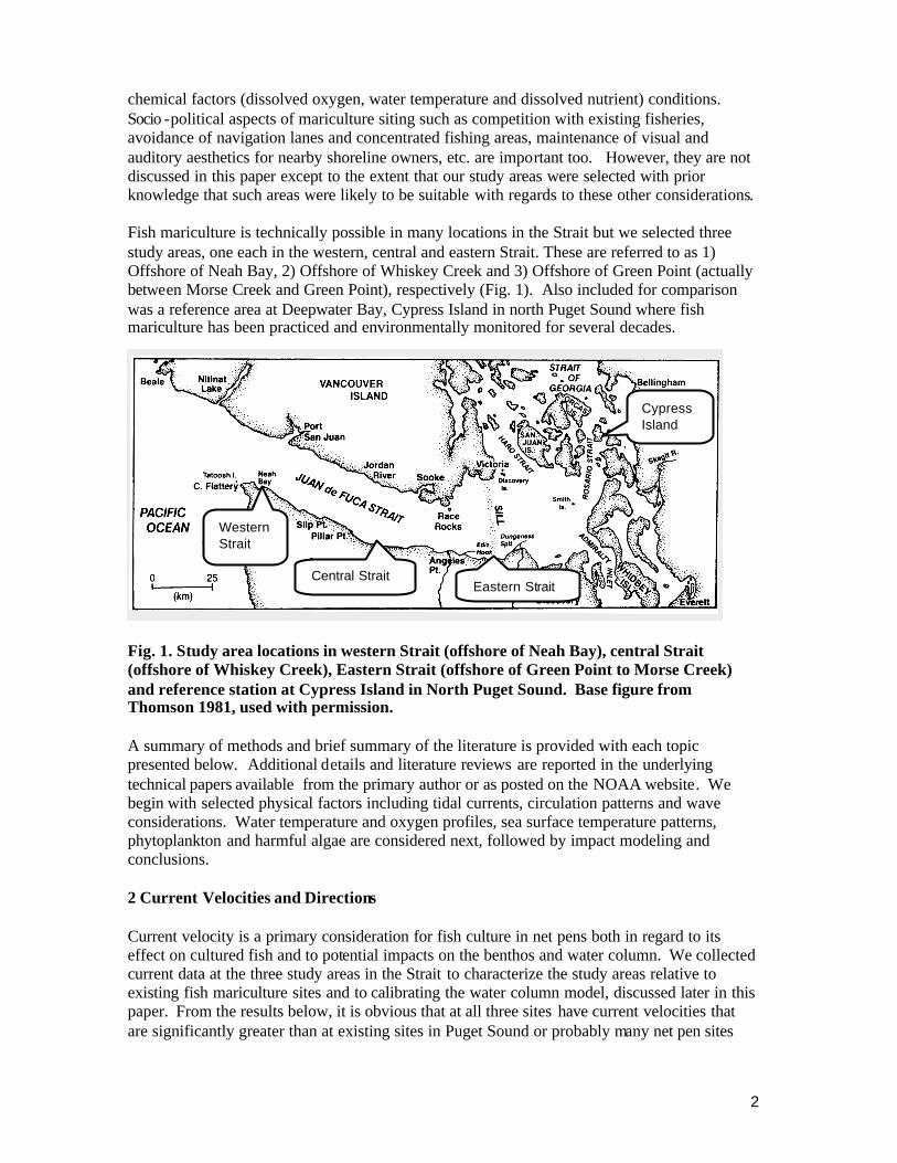
chemical factors (dissolved oxygen, water temperature and dissolved nutrient) conditions. Socio -political aspects of mariculture siting such as competition with existing fisheries, avoidance of navigation lanes and concentrated fishing areas, maintenance of visual and auditory aesthetics for nearby shoreline owners, etc. are important too. However, they are not discussed in this paper except to the extent that our study areas were selected with prior knowledge that such areas were likely to be suitable with regards to these other considerations. Fish mariculture is technically possible in many locations in the Strait but we selected three study areas, one each in the western, central and eastern Strait. These are referred to as 1) Offshore of Neah Bay, 2) Offshore of Whiskey Creek and 3) Offshore of Green Point (actually between Morse Creek and Green Point), respectively (Fig. 1). Also included for comparison was a reference area at Deepwater Bay, Cypress Island in north Puget Sound where fish mariculture has been practiced and environmentally monitored for several decades.
Fig. 1. Study area locations in western Strait (offshore of Neah Bay), central Strait (offshore of Whiskey Creek), Eastern Strait (offshore of Green Point to Morse Creek) and reference station at Cypress Island in North Puget Sound. Base figure from Thomson 1981, used with permission. A summary of methods and brief summary of the literature is provided with each topic presented below. Additional details and literature reviews are reported in the underlying technical papers available from the primary author or as posted on the NOAA website. We begin with selected physical factors including tidal currents, circulation patterns and wave considerations. Water temperature and oxygen profiles, sea surface temperature patterns, phytoplankton and harmful algae are considered next, followed by impact modeling and conclusions. 2 Current Velocities and Directions Current velocity is a primary consideration for fish culture in net pens both in regard to its effect on cultured fish and to potential impacts on the benthos and water column. We collected current data at the three study areas in the Strait to characterize the study areas relative to existing fish mariculture sites and to calibrating the water column model, discussed later in this paper. From the results below, it is obvious that at all three sites have current velocities that are significantly greater than at existing sites in Puget Sound or probably many net pen sites
3
worldwide. While this is an advantage to limit or even eliminate adverse benthic impact, it places a major strain of facilities and necessitates the use of more expensive, offshore style containment systems. It may also exceed the physiological ability of smaller sized fish of some species for routine swimming speed. We did not model the benthic effects of fish mariculture at the subject sites, but with recent advances in such models we recommend this be done prior to any possible facility installation. As shown below, the benthic impacts are likely to be minima l compared to inshore mariculture farms in Washington State that already are considered advanced in their performance and compliance with government standards. Presently, sites considered optimal for fish mariculture in pens have current velocity in the range of 10 to 60 cm s-1 but varies within this range depending on size and species of fish, stocking density and pen design or configuration. .At higher current velocity, fish may have to be sized appropriately and cage systems reinforced. At mean velocities lower than 5 to 10 cm s-1, significant adverse sedimentation effects on the benthos are possible beneath or adjacent to the cages, although some sites in other areas may be episodically flushed by storm events. The minimal recommended average current velocity for near surface and midwater depths combined in Washington State is 5 cm s-1 (SAIC 1986). These recommendations are not enforced, however, because State government regulations focus rather on performance standards that must be met at 30 m distance from the perimeter of the farm. Net pen sites have moved from poorly flushed backwater areas used in the 1970s to actively-flushed channels and bights utilized at present (Rensel 2001). A similar pattern of site shifting occurred in British Columbia, but in both areas a co-occurring goal was to escape backwater areas where harmful algal blooms were more prevalent due to vertical stratification and nutrient sensitivity (Anderson et al. 2001). Other physical factors besides current velocity factors have a bearing on site suitability too, such as depth beneath pens, but in the Pacific Northwest it is believed that current velocity is relatively more important than depth beneath cages to minimize benthic impacts (Cross 1993). To study currents at sur face-cage depths , an InterOceans Systems Inc. S4 current and wave meter was moored at 5 m depth below mean lower low water (MLLW) offshore of Neah Bay. Prior current meter records from an InterOceans Systems Inc. S3 meter at similar depths offshore of Whiskey Creek (Loverich and Croker 1997) were used for comparison (Table 1). No fixed-depth current meter data were collected from offshore of Green Point due to a leak, but more extensive studies of circulation and current velocity and direction at depth were performed there, as discussed below. To characterize currents throughout the water column, a 300 kHz RDI Acoustic Doppler Current Profiler (ADCP) with bottom tracking feature was used to collect underway current profiles in all three study areas. The purpose of these profiles was to detect unusual conditions such as unusually weak or strong subsurface currents or deviations of direction not sampled by the near-surface current meters or drogues. Vertical resolution was set to 0.5 m with profiles recorded every 3 seconds at vessel speeds of approximately 100 cm s-1. Transects were established perpendicular to the shoreline through the center of each study area, as well as parallel to the shore, or approximately along a constant isobath near the current meter locations.
Table 1 . Mooring and configuration details for current or current-wave meters.
4
0
2
4
6
8
10
12
5 15 26 36 46 56 66 77 87 97 107 117
Current Speed (cm/s)
Per
cent
of O
bser
vatio
ns Offshore of Whiskey CreekOffshore of Neah Bay
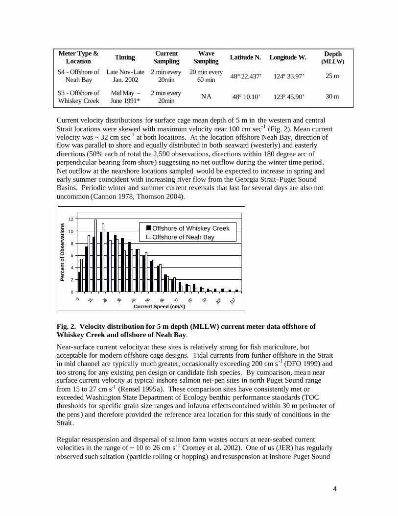
Meter Type &
Location Timing Current Sampling
Wave Sampling Latitude N. Longitude W. Depth
(MLLW)
S4 - Offshore of Neah Bay
Late Nov-Late Jan. 2002
2 min every 20min
20 min every 60 min 48° 22.437’ 124° 33.97’ 25 m
S3 - Offshore of Whiskey Creek
Mid May – June 1991*
2 min every 20min
NA 48° 10.10’ 123° 45.90’ 30 m
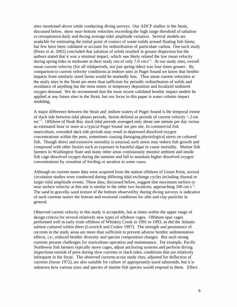
Current velocity distributions for surface cage mean depth of 5 m in the western and central Strait locations were skewed with maximum velocity near 100 cm sec-1 (Fig. 2). Mean current velocity was ~ 32 cm sec-1 at both locations. At the location offshore Neah Bay, direction of flow was parallel to shore and equally distributed in both seaward (westerly) and easterly directions (50% each of total the 2,590 observations, directions within 180 degree arc of perpendicular bearing from shore) suggesting no net outflow during the winter time period. Net outflow at the nearshore locations sampled would be expected to increase in spring and early summer coincident with increasing river flow from the Georgia Strait-Puget Sound Basins. Periodic winter and summer current reversals that last for several days are also not uncommon (Cannon 1978, Thomson 2004).
Fig. 2. Velocity distribution for 5 m depth (MLLW) current meter data offshore of Whiskey Creek and offshore of Neah Bay.
Near-surface current velocity at these sites is relatively strong for fish mariculture, but acceptable for modern offshore cage designs. Tidal currents from further offshore in the Strait in mid channel are typically much greater, occasionally exceeding 200 cm s-1 (DFO 1999) and too strong for any existing pen design or candidate fish species. By comparison, mea n near surface current velocity at typical inshore salmon net-pen sites in north Puget Sound range from 15 to 27 cm s-1 (Rensel 1995a). These comparison sites have consistently met or exceeded Washington State Department of Ecology benthic performance standards (TOC thresholds for specific grain size ranges and infauna effects contained within 30 m perimeter of the pens) and therefore provided the reference area location for this study of conditions in the Strait. Regular resuspension and dispersal of sa lmon farm wastes occurs at near-seabed current velocities in the range of ~ 10 to 26 cm s-1 Cromey et al. 2002). One of us (JER) has regularly observed such saltation (particle rolling or hopping) and resuspension at inshore Puget Sound
5
sites mentioned above while conducting diving surveys . Our ADCP studies in the Strait, discussed below, show near-bottom velocities exceeding the high range threshold of saltation or resuspension daily and during average tidal amplitude variation. Several models are available for estimating the initial point of contact of waste solids around floating fish farms, but few have been validated or account for redistribution of particulate carbon. One such study (Perez et al. 2002) concluded that saltation of solids resulted in greater dispersion but the authors stated that it was a minimal impact, which was likely related the low mean velocity during spring tides in midwater at their study site of only 7.6 cm s-1. At our study sites, overall mean current velocity (for all tidal periods, not just spring tides) was four times greater. By comparison to current velocity conditions at inshore sites in Puget Sound we know that benthic impacts from similarly sized farms would be markedly less. Thus mean current velocities at the study sites in the Strait are more than sufficient for periodic redistribution of solids and avoidance of anything but the most minor or temporary deposition and localized sediment oxygen demand. We do recommend that the most recent validated benthic impact models be applied at any future sites in the Strait, but our focus in this paper is water column impact modeling. A major difference between the Strait and inshore waters of Puget Sound is the temporal extent of slack tide between tidal phases periods, herein defined as periods of current velocity < 2 cm sec-1. Offshore of Neah Bay slack tidal periods averaged only about one minute per day versus an estimated hour or more at a typical Puget Sound net pen site. In commercial fish mariculture, extended slack tide periods may result in depressed dissolved oxygen concentrations within the pens, sometimes causing damaging physiological stress on cultured fish. Though direct and extensive mortality is unusual, such stress may reduce fish growth and compound with other factors such as exposure to harmful algae to cause mortality. Marine fish farmers in Washington State and many other areas continuously monitor ambient and inside fish cage dissolved oxygen during the summer and fall to maintain higher dissolved oxygen concentrations by cessation of feeding or aeration in some cases. Although no current meter data were acquired from the station offshore of Green Point, several circulation studies were conducted during differing tidal exchange cycles including diurnal or larger tidal amplitude events. These data, discussed below, suggest that maximum surface or near surface velocity at this site is similar to the other two locations, approaching 100 cm s-1. The sand to gravelly- sand texture of the bottom observed by during diving surveys is indicative of such currents nearer the bottom and erosional conditions for silts and clay particles in general. Observed current velocity in this study is acceptable, but at times within the upper range of design criteria for several relatively new types of offshore cages. Offshore spar cages performed well in early trials offshore of Whiskey Creek in 1991 to 1993, as did the Atlantic salmon cultured within them (Loverich and Croker 1997). The strength and persistence of cur rents in the study areas are more than sufficient to prevent adverse benthic sedimentation effects, i.e., reduced benthic diversity and species composition changes. But such strong currents present challenges for mariculture operation and maintenance. For example, Pacific Northwest fish farmers typically move cages, adjust anchoring systems and perform diving inspections outside of pens during slow currents or slack tides, conditions that are relatively infrequent in the Strait. The observed currents at our study sites, adjusted for deflection of currents (Inoue 1972), are also suitable for culture of appropriately-sized salmonids, but it is unknown how various sizes and species of marine fish species would respond to them. Effect
6
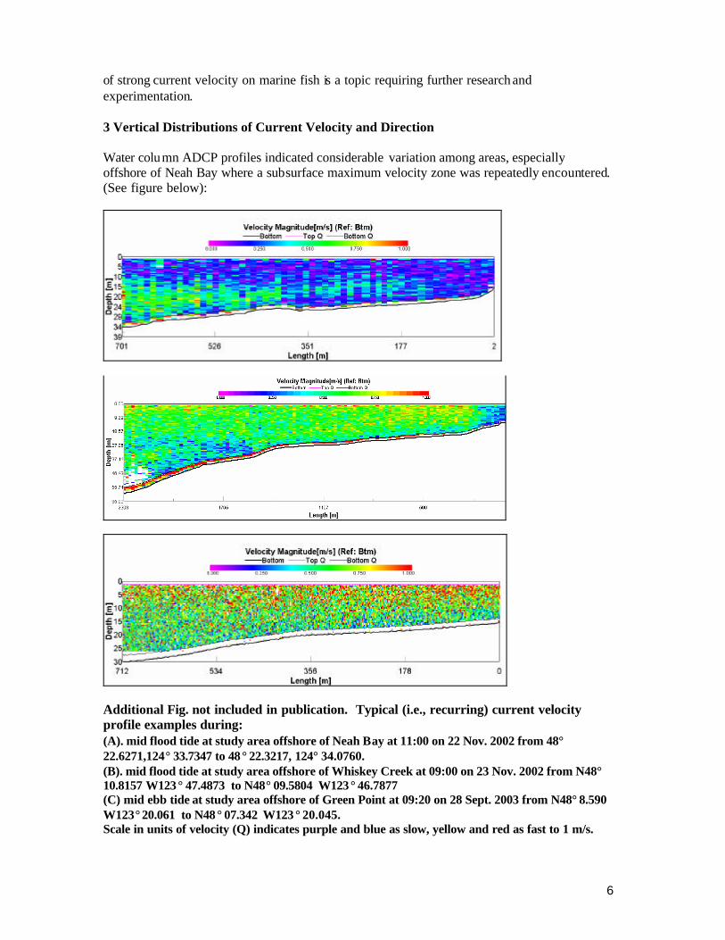
of strong current velocity on marine fish is a topic requiring further research and experimentation. 3 Vertical Distributions of Current Velocity and Direction Water column ADCP profiles indicated considerable variation among areas, especially offshore of Neah Bay where a subsurface maximum velocity zone was repeatedly encountered. (See figure below):
Additional Fig. not included in publication. Typical (i.e., recurring) current velocity profile examples during: (A). mid flood tide at study area offshore of Neah Bay at 11:00 on 22 Nov. 2002 from 48° 22.6271,124° 33.7347 to 48° 22.3217, 124° 34.0760. (B). mid flood tide at study area offshore of Whiskey Creek at 09:00 on 23 Nov. 2002 from N48° 10.8157 W123 ° 47.4873 to N48° 09.5804 W123 ° 46.7877 (C) mid ebb tide at study area offshore of Green Point at 09:20 on 28 Sept. 2003 from N48° 8.590 W123° 20.061 to N48 ° 07.342 W123 ° 20.045. Scale in units of velocity (Q) indicates purple and blue as slow, yellow and red as fast to 1 m/s.
7
Typically we would have expected water velocity to diminish slightly near the bottom As the subsurface maximum was observed during the middle stages of a relatively normal flood tide of 1.4 m amplitude, it may not be a nearshore tidal-change phenomenon. Fixed current meter data at the same time and depth matched the ADCP results and it was noted in other ADCP profiles too. Directional flow data indicates that the surface water was flowing to the east, but the subsurface water was moving westward with a shear depth of about 10m. Slower or moderate surface currents coupled with strong subsurface tidal currents are not an impediment for fish mariculture, and may be an advantage in reduction of stress on the pen assembly while allowing for broad dispersion and assimilation of solid wastes. Offshore of Whiskey Creek, during a modest amplitude flood tide estimated at 0.7m, a distinct but relatively minor mid water column to bottom reduction of flow was observed from a depth of 25 m and deeper. Other profiles made in the same series showed similar results. Offshore of Green Point, tidal currents were monitored with ADCP for several days including during a moderate ebb and flood of nearly equal amplitude difference (1.1 and 1.3 m, respectively compared to 1.2 m mean range) on 28 Sept 2003. Current direction was generally parallel to shore, with some minor exceptions. Horizontal current velocity gradients were more homogeneous near Green Point than the other two study locations which relates to the relatively uniform, smooth sea bottom and regular coastline structure. However, there was a consistent velocity decline on all days from surface to near bottom reaching a maximum factor of about two. Given the maximum observed velocity of surface waters of near 100 cm s-1 seen during drogue studies, the observed vertical distribution may allow for subsurface cages that generally are suited for areas of more modest current velocity. Maximum velocity occurred on the flood tide rather than the ebb, which is consistent with some other results from circulation studies nearby (Ebbesmeyer et al. 1979). 4 Tidal Circulation Patterns Knowledge of circulation patterns near mariculture cages is useful for modeling plume dispersal and Lagrangian particle tracking. As discussed above, all the study areas herein are all considered to have erosional, non-depositional bottoms. Therefore, the purpose of studying circulation in these cases was to detect the possible occurrence of near field gyres that might limit effective water exchange. Persistent, small scale gyres can cause water recycling, inadequate dispersion of organic wastes or reduced supply of dissolved oxygen-rich water. On the broad scale, surface waters to many tens of meters depth flows out of the Strait to the ocean while deeper waters flow in an inshore direction, a classic river fed estuarine circulation pattern. Windowshade drogues (1 m2) and attached surface floats and marker spars were released repeatedly over several tidal cycles from the same locations along a transect perpendicular to shore and through the center of the study area. A dGPS-depth sounder instrument (Garmin GPSMAP235) operating at < 3m accuracy onboard a high-speed sampling skiff was used for monitoring drogue positioning, depth and time of observations. Positions were plotted on a digital NOAA chart using GIS software. In all three study areas, most drogues were transported nearly parallel to the shoreline at high rates of speed except during slack tide. Surface drogues typically followed the same path as companion 5 m deep drogues, with two exceptions. Offshore of Neah Bay, 1m drogues, released from an area of about 20 m depth (MLLW) moved west and far into Neah Bay, while
8
the companion 5m drogue moved alongshore past the entry of the bay and toward the Pacific Ocean (Fig. 3A). Drogues released a few minutes later from 25m depth or greater moved westerly along a path similar to the 5m drogue discussed above (Fig. 3B). This suggests that if mariculture cages are to be located offshore of Neah Bay, they should be placed in 25m or greater depth to avoid oxygen-demanding solids from entering the bay. Fig. 3. Drogue paths from shallow 1 m and deeper 5 m drogues released simultaneously from: (upper set) 25m depth during early ebb tide offshore of Neah Bay on 10 September 2002 (left) and from 20 m depth (right). (lower set) during mid ebb tide offshore of study area near Green Point on 14 Aug 2003 (C 1.9m ebb) and 7 May 04 (D 2.9m ebb). Ten fathom isobath shown as faint line offshore. See technical report for more details.
Offshore of Green Point during the ebb tide, drogues often moved parallel to the shoreline and around Ediz Hook to the west (Fig. 3C). Yet on several occasions and days, some of the subsurface drogues would diverge from the normal alongshore pattern by circling south, then east outside the entrance to Port Angeles Harbor (e.g., Fig. 3D). This pattern was seen during various phases of the ebb tide on separate days of varying tidal amplitude and, therefore, is not thought to be merely the result of early phase of flood tide affecting nearshore waters (Rensel and Forster 2004). A prior study of this subject area using a scale hydraulic model and analysis of data from prior drogue studies concluded that there were flood tide eddies to the east of Ediz Hook, but none during the ebb tide, except small scale occurrences very nearshore at the end of the ebb tide (Ebbesmeyer et al. 1979). The prior study involved pooling of drogue data from different depths, which may have masked the surface versus subsurface differences we observed. We did not observe a flood tide gyre in this study, but our drogue release points were situated
Port Angeles Harbor
1 m drogue __________ 5 m drogue -----------
N
2 Km
Port Angeles Harbor
1 m drogue __________ 5 m drogue -----------
N
2 Km
N
Neah Bay
1 Km
1 m drogue __________ 5 m drogue -----------
N
Neah Bay 1 Km
1 m drogue __________ 5 m drogue -----------
9
0.0
0.5
1.0
1.5
2.0
2.5
20-Nov-02 30-Nov-02 10-Dec-02 20-Dec-02 30-Dec-02 9-Jan-03 19-Jan-03
Hs
(m)
0
5
10
15
20
25
20-Nov-02 30-Nov-02 10-Dec-02 20-Dec-02 30-Dec-02 9-Jan-03 19-Jan-03
Tp
(s)
roughly half- way between the base of Dungeness Spit and the tip of Ediz Hook, i.e., further to the east of the reported flood tide gyre(s). We theorize that the ebb tide eddy is a function of west-bound water parcels encountering ebbing waters from Port Angeles Harbor that shears the major west bound flow. It is not an insignificant eddy in terms of scale, and resulted in the return of water flow nearly to the drogue release point in one case. It is also not insignificant because the eddy appears to reach the general location of the existing outfall pipe that serviced a nearby, now dismantled industrial facility. If the outfall was reactivated to discharge pollutants harmful to fish, it could potentially compromise fish health and aquatic life because a freshwater discharge plume could rise to the near surface and be transported to the center of our study area. 5 Wave Exposure Wind waves and oceanic swell are major considerations for any form of mariculture. Oceanic swell is periodically encountered in the Strait, especially the west end, but large wind waves may be encountered anywhere in the Strait, depending on season and weather. Wind waves are particularly common in the afternoons from late spring through early autumn when westerly or sometimes easterly sea breezes funnel through the Strait (Renner 1993, Thompson 1994). Wave amplitude and frequency data offshore of Neah Bay were collected from December 2001 through January 2002 (Fig. 4). Significant wave height ranged from 0.2 to 2.2 m and was dominated by long period (~ 15 s) waves. These conditions do not exceed design criteria for several types of offshore cages. Moreover, wave frequency was not positively correlated with wave height (r2 = 0.02), which means that large waves were not usually of short period that may be more destructive to mariculture facilities. Oceanic swell observed in the field were much less toward shore at 25 m depth, compared to further offshore at 50 m depth. This may be due to protection provided by Waadah Island, located immediately west of the entry to Neah Bay.
Fig. 4. Wave frequency (Tp, left) and significant wave height (Hs, right) offshore of Neah Bay during a two month period in the winter 2002-03. Oceanic swell was also observed in the central Strait during our summer and fall field work but not in the eastern Strait on the same days. Significant wave height offshore of Whiskey Creek in a prior study in 1993 reached 3.6 m, but did not harm a prototype spar style offshore cage (Loverich and Croker 1997, Loverich and Forster 2000). Short frequency, choppy wind waves were relatively common during our field studies at all locations, particularly during
10
afternoon hours. Modern offshore cage and anchoring systems should be able to survive all probable weather extremes at our study areas. 6 Water Temperature and Dissolved Oxygen Dynamics The histor ical annual range of near-surface water temperatures in the Strait is approximately 7 to 12 C (e.g., Collias et al. 1974), more moderate than similar depths of north or central Puget Sound presently used for fish mariculture. The range is well suited to salmon and several other candidate marine fish species and is among the most moderate range of temperatures for all of temperate North America. Dissolved oxygen concentrations in surface waters of the Strait follow previously documented seasonal and spatial cycles, peaking in late winter and declining during summer and early fall. In general, surface waters of the eastern Strait tend to have higher dissolved oxygen concentrations in the summer and fall than waters to the west, but at many times no consis tent pattern is observable (Rensel and Forster 2002, 2003). We examined all available past surveys, studies and data reports, and could find no consistent trends within the central and western zones of the Strait at these times. Most prior studies were based on one year, once-per-month, multiple -day cruises or two year studies with less frequent cruises. Such monitoring is insufficient to describe the substantial change of dissolved oxygen that occurs in a few hours or a single tidal phase, as first noted by Herlinveaux and Tully (1961). Moreover, all prior published studies focused on deepwater areas, not in depths of 20 to 40 m as we did in our field studies. A preferred approach to describe variability of dissolved oxygen in the Strait would have been to install moored instrument packages at several locations. But given the difficulties and cost of such moorings, and the need to make repeated field observations of other factors, we chose two surrogate methods. The first was collection of vertical profiles of water quality during the potentially critical period of late summer and fall period in 2001 and 2002 as summarized in this section. The second utilized satellite sea surface temperature (SST) images, since it was shown that there is a strong posit ive correlation between near surface temperature and dissolved oxygen (see Section 7). All primary sampling stations were vertically profiled with an electronic multiprobe instrument (CTD) that was fitted with a SCUFA (Turner Inc.) in vivo fluorometer. Profiles were collected at all stations over short period of a single day, often approximating a single ebb or flood period. The oxygen probe was calibrated before and after use by one or more Winkler titrations combined with water-saturated air calibrations keyed to in situ barometric readings. The salinity probe was calibrated using reference water measured to 1/1000 psu using a Guidline Autosal 8400B salinometer. Three sets of measurements were collected in 2001 and six sets in 2002. This was not intended to be a complete seasonal description, but rather was performed to provide a snapshot of daily comparisons among stations and to the reference area at Cypress Island. In 2001, the lowest observed dissolved oxygen concentrations were encountered offshore of Neah Bay on September 20th (Fig. 5) and were nearly as low, concurrently, at other stations. Although salinity and temperature were vertically stratified in this case, similar salinity stratification was not observed in many other cases. Vertical profiles collected in 2001 further offshore at ~50 m depth indicated no differences compared to the shallower companion station (Rensel and Forster 2002).
11
-25
-20
-15
-10
-5
00 2 4 6 8 10 12
Measurement Units
Dep
th (
m)
Temperature (C) Dissolved Oxygen (mg/L)Chlorophyll a (ug/L) Salinity minus 25 (psu)DIN minus 20 (uM)
-30
-25
-20
-15
-10
-5
0
2 4 6 8 10Dissolved Oxygen (mg/L)
Dep
th (
m)
6-Aug
22-Aug
5-Sep
25-Sep
8-Oct
22-Nov
Fig. 5. Water temperature, in vivo chlorophyll a, dissolved inorganic nitrogen (add 20 µM), dissolved oxygen and salinity (add 25 psu) for station offshore of Neah Bay on 20 September 2001.
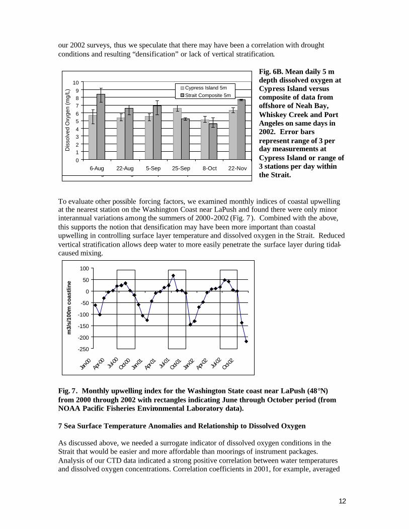
After comparing dissolved oxygen results for both years by station and depth we noted no consistent differences among stations. We then pooled single day data from all stations to show the seasonal progression of declining and subsequent rising dissolved oxygen concentrations, as shown in Fig. 6A for 2002. The lowest composite dissolved oxygen concentrations observed in 2002 were in early October; all depths were slightly less than 5 mg/L and depths below 30 m approached 3 mg/L as in 2001. The same data from 5 m depth composites is compared to reference station data from Cypress Island in Fig. 6B and illustrates the similarity.
Fig. 6A. Periodic dissolved oxygen profiles for composite results of offshore stations near Neah Bay, Whiskey Creek and Port Angeles in the Strait of Juan de Fuca during summer and fall 2002.
Dissolved oxygen results in 2001 likely represent near- minimal concentrations to be encountered at our study locations. Western Washington and British Columbia experienced a severe drought in 2000 and 2001. Rivers flowing into inshore waters connected to the Strait were very low in volume in year 2000. Newton et al. (2003) reported greatly reduced near surface densification in the eastern Strait along a cross-channel transect due south of San Juan Island during the fall of 2000. However, when considered cumulatively with the much larger Fraser River, the summer and fall of 2001 was also a drought period with regard to total freshwater flow to the central and western Strait. This may have influenced the relatively low results seen in our 2001 sampling. In general dissolved oxygen concentrations were higher in
12
0123456789
10
6-Aug 22-Aug 5-Sep 25-Sep 8-Oct 22-Nov
Dis
solv
ed O
xyge
n (m
g/L)
Cypress Island 5mStrait Composite 5m
0123456789
10
6-Aug 22-Aug 5-Sep 25-Sep 8-Oct 22-Nov
Dis
solv
ed O
xyge
n (m
g/L)
Cypress Island 5mStrait Composite 5m
-250
-200
-150
-100
-50
0
50
100
Jan-00
Apr-0
0Ju
l-00
Oct-00
Jan-01
Apr-0
1Ju
l-01Oct-0
1Jan
-02Ap
r-02
Jul-02
Oct-02
m3/
s/10
0m c
oast
line
our 2002 surveys, thus we speculate that there may have been a correlation with drought conditions and resulting “densification” or lack of vertical stratification.
Fig. 6B. Mean daily 5 m depth dissolved oxygen at Cypress Island versus composite of data from offshore of Neah Bay, Whiskey Creek and Port Angeles on same days in 2002. Error bars represent range of 3 per day measurements at Cypress Island or range of 3 stations per day within the Strait.
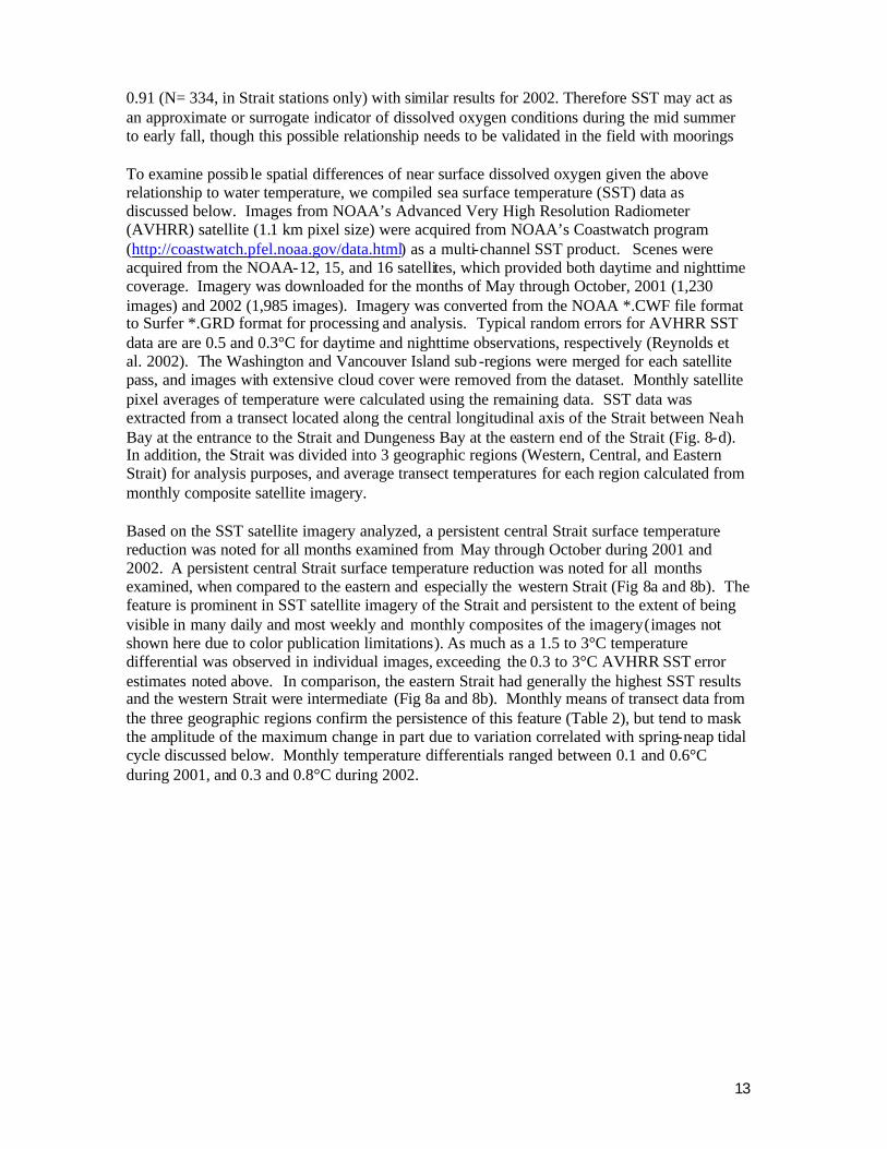
To evaluate other possible forcing factors, we examined monthly indices of coastal upwelling at the nearest station on the Washington Coast near LaPush and found there were only minor interannual variations among the summers of 2000-2002 (Fig. 7). Combined with the above, this supports the notion that densification may have been more important than coastal upwelling in controlling surface layer temperature and dissolved oxygen in the Strait. Reduced vertical stratification allows deep water to more easily penetrate the surface layer during tidal-caused mixing.
Fig. 7. Monthly upwelling index for the Washington State coast near LaPush (48°N) from 2000 through 2002 with rectangles indicating June through October period (from NOAA Pacific Fisheries Environmental Laboratory data). 7 Sea Surface Temperature Anomalies and Relationship to Dissolved Oxygen As discussed above, we needed a surrogate indicator of dissolved oxygen conditions in the Strait that would be easier and more affordable than moorings of instrument packages. Analysis of our CTD data indicated a strong positive correlation between water temperatures and dissolved oxygen concentrations. Correlation coefficients in 2001, for example, averaged
13
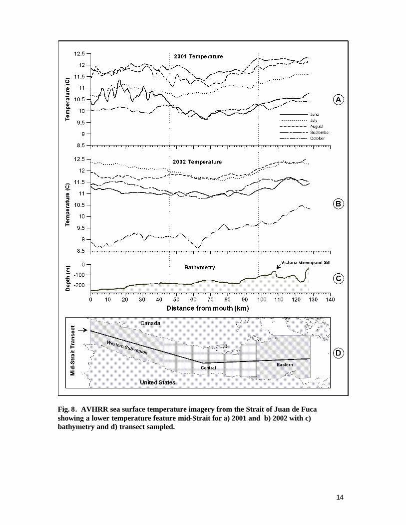
0.91 (N= 334, in Strait stations only) with similar results for 2002. Therefore SST may act as an approximate or surrogate indicator of dissolved oxygen conditions during the mid summer to early fall, though this possible relationship needs to be validated in the field with moorings To examine possib le spatial differences of near surface dissolved oxygen given the above relationship to water temperature, we compiled sea surface temperature (SST) data as discussed below. Images from NOAA’s Advanced Very High Resolution Radiometer (AVHRR) satellite (1.1 km pixel size) were acquired from NOAA’s Coastwatch program (http://coastwatch.pfel.noaa.gov/data.html) as a multi-channel SST product. Scenes were acquired from the NOAA-12, 15, and 16 satellites, which provided both daytime and nighttime coverage. Imagery was downloaded for the months of May through October, 2001 (1,230 images) and 2002 (1,985 images). Imagery was converted from the NOAA *.CWF file format to Surfer *.GRD format for processing and analysis. Typical random errors for AVHRR SST data are are 0.5 and 0.3°C for daytime and nighttime observations, respectively (Reynolds et al. 2002). The Washington and Vancouver Island sub -regions were merged for each satellite pass, and images with extensive cloud cover were removed from the dataset. Monthly satellite pixel averages of temperature were calculated using the remaining data. SST data was extracted from a transect located along the central longitudinal axis of the Strait between Neah Bay at the entrance to the Strait and Dungeness Bay at the eastern end of the Strait (Fig. 8-d). In addition, the Strait was divided into 3 geographic regions (Western, Central, and Eastern Strait) for analysis purposes, and average transect temperatures for each region calculated from monthly composite satellite imagery. Based on the SST satellite imagery analyzed, a persistent central Strait surface temperature reduction was noted for all months examined from May through October during 2001 and 2002. A persistent central Strait surface temperature reduction was noted for all months examined, when compared to the eastern and especially the western Strait (Fig 8a and 8b). The feature is prominent in SST satellite imagery of the Strait and persistent to the extent of being visible in many daily and most weekly and monthly composites of the imagery (images not shown here due to color publication limitations). As much as a 1.5 to 3°C temperature differential was observed in individual images, exceeding the 0.3 to 3°C AVHRR SST error estimates noted above. In comparison, the eastern Strait had generally the highest SST results and the western Strait were intermediate (Fig 8a and 8b). Monthly means of transect data from the three geographic regions confirm the persistence of this feature (Table 2), but tend to mask the amplitude of the maximum change in part due to variation correlated with spring-neap tidal cycle discussed below. Monthly temperature differentials ranged between 0.1 and 0.6°C during 2001, and 0.3 and 0.8°C during 2002.
14
Fig. 8. AVHRR sea surface temperature imagery from the Strait of Juan de Fuca showing a lower temperature feature mid-Strait for a) 2001 and b) 2002 with c) bathymetry and d) transect sampled.
15
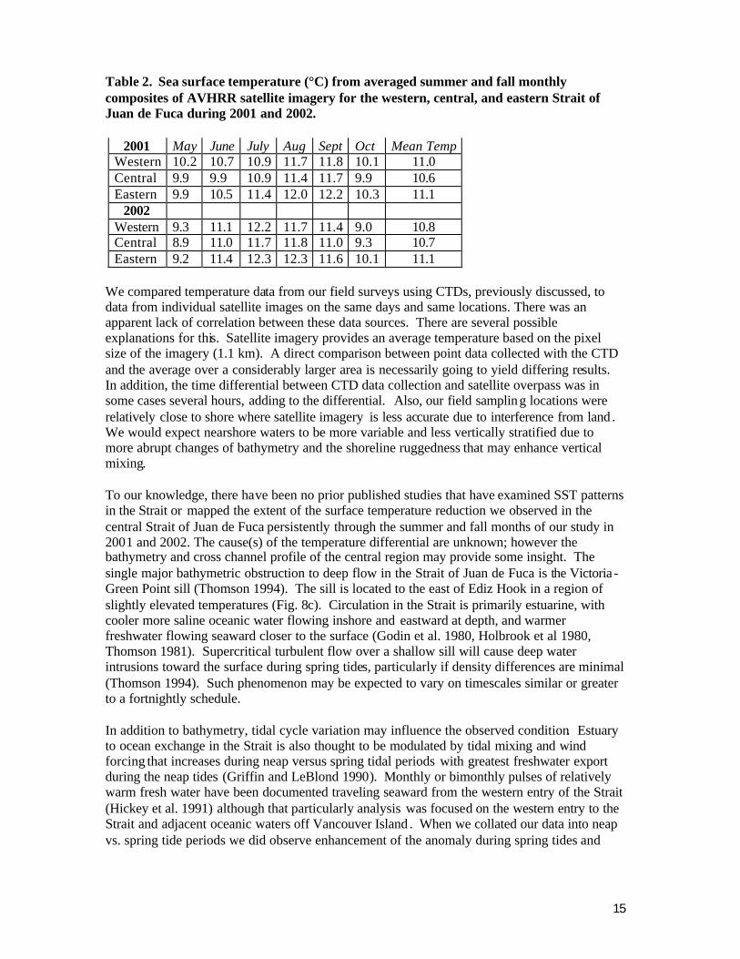
Table 2. Sea surface temperature (°C) from averaged summer and fall monthly composites of AVHRR satellite imagery for the western, central, and eastern Strait of Juan de Fuca during 2001 and 2002.
2001 May June July Aug Sept Oct Mean Temp
Western 10.2 10.7 10.9 11.7 11.8 10.1 11.0 Central 9.9 9.9 10.9 11.4 11.7 9.9 10.6 Eastern 9.9 10.5 11.4 12.0 12.2 10.3 11.1
2002 Western 9.3 11.1 12.2 11.7 11.4 9.0 10.8 Central 8.9 11.0 11.7 11.8 11.0 9.3 10.7 Eastern 9.2 11.4 12.3 12.3 11.6 10.1 11.1
We compared temperature data from our field surveys using CTDs, previously discussed, to data from individual satellite images on the same days and same locations. There was an apparent lack of correlation between these data sources. There are several possible explanations for this. Satellite imagery provides an average temperature based on the pixel size of the imagery (1.1 km). A direct comparison between point data collected with the CTD and the average over a considerably larger area is necessarily going to yield differing results. In addition, the time differential between CTD data collection and satellite overpass was in some cases several hours, adding to the differential. Also, our field sampling locations were relatively close to shore where satellite imagery is less accurate due to interference from land . We would expect nearshore waters to be more variable and less vertically stratified due to more abrupt changes of bathymetry and the shoreline ruggedness that may enhance vertical mixing. To our knowledge, there have been no prior published studies that have examined SST patterns in the Strait or mapped the extent of the surface temperature reduction we observed in the central Strait of Juan de Fuca persistently through the summer and fall months of our study in 2001 and 2002. The cause(s) of the temperature differential are unknown; however the bathymetry and cross channel profile of the central region may provide some insight. The single major bathymetric obstruction to deep flow in the Strait of Juan de Fuca is the Victoria -Green Point sill (Thomson 1994). The sill is located to the east of Ediz Hook in a region of slightly elevated temperatures (Fig. 8c). Circulation in the Strait is primarily estuarine, with cooler more saline oceanic water flowing inshore and eastward at depth, and warmer freshwater flowing seaward closer to the surface (Godin et al. 1980, Holbrook et al 1980, Thomson 1981). Supercritical turbulent flow over a shallow sill will cause deep water intrusions toward the surface during spring tides, particularly if density differences are minimal (Thomson 1994). Such phenomenon may be expected to vary on timescales similar or greater to a fortnightly schedule. In addition to bathymetry, tidal cycle variation may influence the observed condition. Estuary to ocean exchange in the Strait is also thought to be modulated by tidal mixing and wind forcing that increases during neap versus spring tidal periods with greatest freshwater export during the neap tides (Griffin and LeBlond 1990). Monthly or bimonthly pulses of relatively warm fresh water have been documented traveling seaward from the western entry of the Strait (Hickey et al. 1991) although that particularly analysis was focused on the western entry to the Strait and adjacent oceanic waters off Vancouver Island . When we collated our data into neap vs. spring tide periods we did observe enhancement of the anomaly during spring tides and
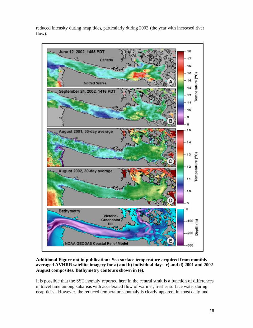
16
reduced intensity during neap tides, particularly during 2002 (the year with increased river flow).
Additional Figure not in publication: Sea surface temperature acquired from monthly averaged AVHRR satellite imagery for a) and b) individual days, c) and d) 2001 and 2002 August composites. Bathymetry contours shown in (e). It is possible that the SST anomaly reported here in the central strait is a function of differences in travel time among subareas with accelerated flow of warmer, fresher surface water during neap tides. However, the reduced temperature anomaly is clearly apparent in most daily and
17
weekly and all summer and fall monthly composite images, movies, and data. We are unaware of any data showing significant differences in surface water transport among the east, central and west subareas of the Strait although that is certainly possible. If there were patches of warm water that slowed considerably or resided at either end of the Strait, eventually they would influence the center of the Strait in the process of seaward outflow at the surface. Indeed the eastern Strait regularly appears wa rmer based on satellite imagery and our field collected data, however this was not apparent in the western Strait and pulses of warm water moving westerly were not apparent. Whatever the cause of the anomaly, apparent reduced water temperature in the ce ntral Strait may be biologically significant because as pointed out above , even a small temperature variation equates to a significant variation in dissolved oxygen. For example, using the 2001 regression (y = 1.5186x - 8.3368 where y = dissolved oxygen in mg/L and x is water temperatures in degrees C and r = 0.92 ) a decline of only one degree C water temperature from 10 to 9°C results in a reduction of dissolved oxygen of 1.5 mg/L from 6.8 to 5.3 mg/L. For wild and particularly cultured fishes, these are significant changes. Dissolved oxygen cycles have been observed at our reference station at Cypress Island , generally, but not exactly, correlated with the spring-neap cycles (Rensel and Forster 2003). In the case of the mid Strait anomaly, westward, estuarine flow of the surface layer may result in the shift of the surface water temperature anomaly to the west of the Green Point – Victoria Sill into the central Strait. Displacement of the feature so far to the west of the sill by tidal excursion may not be the only factor involved. Narrowing of the cross channel profile to the west of the sill and turbulence of high velocity flow near the south end of Vancouver Island may contribute by elevating the degree of vertical mixing. Occasional reversals of flow pattern allowing eastern transport of surface waters occur in winter and even summer (Thomson et al. 2004), although no low SST zone is persistently located to the east of the sill in the images we reviewed during the study periods of 2001 and 2002. The low temperature anomaly we have observed and measured in the central Strait warrants further investigation. Other studies in the past (Herlinveaux and Tully 1961, Collias et al. 1974) have measured vertical diversion of deepwater toward the surface by the Victoria-Greenpoint sill particularly on the ebb tide, however such results are typically sectional views and do not indicate regular breaching of the surface layer. The feature is highlighted in satellite imagery because of the greater temporal and spatial coverage of a feature in context to the surrounding water masses and topography. The seasonal and interannual nature of this feature and linkages to other parameters such as dissolved oxygen and salinity should be investigated to further understand basic water quality conditions and effects on marine resources. 8 Phytoplankton and Harmful Algae Few studies have documented the spatial or temporal occurrence of phytoplankton in the Strait. Fish mariculture interests have a special interest in phytoplankton and harmful algae as the former is a primary source of fish-sustaining dissolved oxygen in surface waters while the latter may cause occasional fish mortality (see Anderson et al. 2001 for case histories, Rensel and Whyte 2003 for overview of harmful algae and mariculture). In the Pacific Northwest, two genera of harmful algae have been involved in kills of wild or cultured fish. Large blooms of the raphidophyte microflagellate Heterosigma akashiwo have caused occasional fish losses of maricult ure fish and also wild fish in shallow bays. Blooms of H. akashiwo are somewhat predictable in north Puget Sound on a time scale of days, typically
18
occurring during especially warm, sunny periods marked by neap tides and calm winds (Rensel 1995b, Anderson et al. 2001). At such times the water column is often vertically stratified with nutrient depletion near the surface, allowing this vertically migrating species to cluster at the surface for sunlight and swim to depth at night for nutrients. Fish farmers in Puget Sound monitor waters near their farms and conduct remote aerial surveys during high risk periods to track bloom location and movement. A massive bloom in 1991 extended across the surface of north and central Puget Sound into the Strait and kille d fish in pens at several locations including Port Angeles Harbor. Etiology of fish mortality from H. akashiwo is not well understood. There is often damage to the gills, but not always and there is apparently no persistent toxin involved. Due to the tendency of cells to accumulate near the surface, relatively easy monitoring and mitigation means are possible (Rensel and Whyte 2003, Rensel et al. 2003). Second, large-bodied diatoms of the genus Chaetoceros (subgenus Phaeoceros including C. concavicornis and C. convolutus referred to here as “harmful Chaetoceros”) are capable of killing wild and cultured fish at relatively low concentrations (Bell 1961, Kennedy et al. 1976, Rensel et al. 1989). In acute exposures, fish death is due to clogging the gill secondary lamellae with cells and excessive gill mucus production that interferes with respiration (Rensel 1993). Scanning electron microscope studies indicated that penetration of the gills or excessive lesions and hemorrhaging, as speculated by Bell (1961) and several others based on wet mounts, is not apparent nor likely (Rensel 1993). Several species of non-harmful Chaetoceros (subgenus Hyalochaete, often smaller and less robust than the harmful species) occur regularly in Pacific Northwest waters, sometimes in great abundance, but are usually not related to fish mortality. Harmful Chaetoceros species are fairly common in areas used for fish mariculture in the Pacific Northwest but usually occur at very low densities with few records of “blooms”, i.e., high cell counts of monospecific composition. Though they grow relatively slowly, they are able to do so at reduced light levels compared with many other diatoms (Rensel 1991), often in a well mixed or mixing water column (Rensel et al. 1987, Haigh and Taylor 1990). Treatment or mitigation is not possible presently, except for locating in areas where these spec ies are less likely to occur. Neither H. akashiwo nor harmful Chaetoceros are known to cluster about or initiate as blooms near fish farms, but are typically advected by winds and currents from remote areas into a net pen facility (Rensel and Whyte 2003). The earliest published study of phytoplankton in the Strait was by Phifer (1934) who studied east, central and western Strait locations and found maximum abundance of all diatoms at 10 m depth. However, sampling was limited to the month of July. C. concavicornis was seen only in the eastern Strait at 1 meter (4.1 x 10³ cells L-1) and 10 meters (1.8 x 10³ cells L-1). A more extensive survey was conducted by Chester et al. (1978) who monitored phytoplankton and zooplankton abundance monthly at three sets of cross-channel stations for 19 months, including two summers. Seasonal dominants included unidentified microflagellates in winter to early spring, Skeletonema costatum in April, Thalassiosira spp. in May and June: these diatom species and some non-harmful Chaetoceros in August, and microflagellates again in September along with some diatoms. They recorded low concentrations of C. convolutus in summer, while C. concavicornis occurred sporadically throughout all seasons. An exception was on one occasion in late July when C. concavicornis was found at 2.8 x 10³ cells L-1at the surface in mid channel north of Port Angeles. Otherwise, concentrations of both species of harmful Chaetoceros were minimal, usually less than 0.2 x 10³ cells L-1. Chlorophyll a
19
concentrations in their study were generally low throughout the Strait, ranging from about 0 to 2 µg L-1. In late June, a single station in midchannel at the western entry to the Strait had a near surface result of 25 µg L-1, thought, possibly, to be related to an influx of productive water from the outer coast. For the present study we collected 1 and 10 m water sample composites from all three offshore stations during our 2001 field studies. For comparison, samples at the same depths were also collected in the approximate centers of adjacent bays included Neah Bay, Port Angeles Harbor and Inner Dungeness Bay (1 and 5 m composite). Samples were preserved to 1% final concentration of formalin and later identified and enumerated using settled subsamples and an inverted microscope (Hasle 1978). Overall, diatoms were represented by 55 species or ta xonomic groups, dinoflagellates by 27 species and taxonomic groups, and microflagellates by 15 species, taxonomic groups or size classes. At the offshore stations, total cell counts were relatively low compared to the bays. Total diatom counts offshore averaged 1.2 x 10⁵ cells L-1, about an order of magnitude less than in the nearby bays that averaged 1.3 x 10 6 cells L-1. Non-harmful species of Chaetoceros were dominant at the offshore stations composing 60.4% of the diatoms, with C. socialis more abundant than other diatoms. Inshore in the bays, non-harmful Chaetoceros composed 79.7% of the diatoms, followed by 7 species of Thalassiosira (9.9%) and Skeletonema costatum (5.3%). Approximately 2,000 cells L-1 of the harmful species Chaetoceros convolutus were counted from offshore of Neah Bay in early September but none were seen in additional samples from offshore of Clallam Bay at the same time. Such patchiness may be common with the harmful Chaetoceros in most cases. In vivo chlorophyll a measurements and laboratory extractions for offshore stations ranged from 1 to 4 µg L-1. Of the bays, Neah Bay exhibited the greatest phytoplankton densities, peaking on 8 October when diatoms were about 20 times more abundant than the nearby offshore station (3,100 x 103 vs. 160 x 103 cells L-1, respectively). Chlorophyll a concentrations at that time reached 14 µg L-1 at 7 m depth. We have noted on one other occasion that Neah Bay may become vertically stratified and hypoxic at depth, the apparent result of phytoplankton respiration at depth below a large surface bloom during limited flushing of neap tides. Within the dinoflagellate taxa, no single species was dominant, although an unidentified heterotrophic species was more common. For the microflagellate taxa, small (< 10 um) unidentified species were dominant but were about 5 times more abundant in the bays (570 x 103 cells L-1) than offshore (110 x 103 cells L-1). Cryptomonads were also prevalent in all locations. Recently in Dungeness Bay, Rensel (2003) found a very large subsurface bloom (~40 µg/L chlorophyll a) of unidentified microflagellates occurring from May through June. A few H. akashiwo cells were seen in October 2001 at very low concentrations at offshore stations (mean 0.5 x 10³ cells L-1, fish death sometimes occurs at 75 x 103 cells L-1). No cells were seen in Neah Bay or Port Angeles Harbor but 5 x 10³ cells L -1were observed from samples inside Dungeness Bay. Overall, we expect the offshore waters of the Strait to be more suited for fis h mariculture in regard to less frequency of fish-killing harmful algae. Increased phytoplankton in the bays does afford somewhat higher dissolved oxygen concentrations during the summer and fall (Rensel and Forster 2003), but if certain species of marine fish are selected this may not be a primary consideration due to their lower respiratory requirements for oxygen.
20
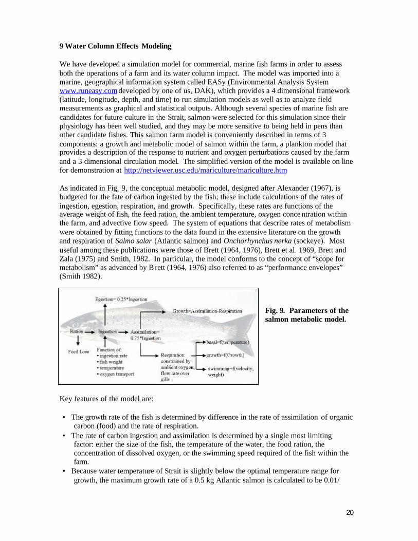
9 Water Column Effects Modeling We have developed a simulation model for commercial, marine fish farms in order to assess both the operations of a farm and its water column impact. The model was imported into a marine, geographical information system called EASy (Environmental Analysis System www.runeasy.com developed by one of us, DAK), which provides a 4 dimensional framework (latitude, longitude, depth, and time) to run simulation models as well as to analyze field measurements as graphical and statistical outputs. Although several species of marine fish are candidates for future culture in the Strait, salmon were selected for this simulation since their physiology has been well studied, and they may be more sensitive to being held in pens than other candidate fishes. This salmon farm model is conveniently described in terms of 3 components: a growth and metabolic model of salmon within the farm, a plankton model that provides a description of the response to nutrient and oxygen perturbations caused by the farm and a 3 dimensional circulation model. The simplified version of the model is available on line for demonstration at http://netviewer.usc.edu/mariculture/mariculture.htm As indicated in Fig. 9, the conceptual metabolic model, designed after Alexander (1967), is budgeted for the fate of carbon ingested by the fish; these include calculations of the rates of ingestion, egestion, respiration, and growth. Specifically, these rates are functions of the average weight of fish, the feed ration, the ambient temperature, oxygen conce ntration within the farm, and advective flow speed. The system of equations that describe rates of metabolism were obtained by fitting functions to the data found in the extensive literature on the growth and respiration of Salmo salar (Atlantic salmon) and Onchorhynchus nerka (sockeye). Most useful among these publications were those of Brett (1964, 1976), Brett et al. 1969, Brett and Zala (1975) and Smith, 1982. In particular, the model conforms to the concept of “scope for metabolism” as advanced by B rett (1964, 1976) also referred to as “performance envelopes” (Smith 1982).
Fig. 9. Parameters of the salmon metabolic model.
Key features of the model are: • The growth rate of the fish is determined by difference in the rate of assimilation of organic
carbon (food) and the rate of respiration. • The rate of carbon ingestion and assimilation is determined by a single most limiting
factor: either the size of the fish, the temperature of the water, the food ration, the concentration of dissolved oxygen, or the swimming speed required of the fish within the farm.
• Because water temperature of Strait is slightly below the optimal temperature range for growth, the maximum growth rate of a 0.5 kg Atlantic salmon is calculated to be 0.01/
21
day, similar to that actually achieved in Puget Sound net pens for similar-sized Atlantic salmon and significantly below the maximum rate of 0.021 reported by Brett et al. (1969) for smaller sockeye salmon. In our model, the growth rate of the fish is reduced as conditions vary from near optimum.
• Respiration rates increase with swimming speed. Such increases in respiration cause decreases in growth rate when swimming speed exceeds the optimum range of ~ 1 to 2 body lengths per second.
• The supply of oxygen to the fish is described mathematically as the product of the rate of flow of water across the gills (respiratory pumping at low speeds and ram ventilation at high speeds) and the ambient concentration of dissolved oxygen.
• The rate of oxygen consumption by the fish is linked to the rate of carbon dioxide production by a constant flux ratio of 1 mole O2/mole CO2, and the rate of nitrogen excretion by the fish is linked to the rate of carbon dioxide production by a constant flux ratio of 1 gm-at N/7 moles CO2.
A few comments regarding these features of the model are warranted. The ideal rate of flow for culturing Atlantic salmon is not known precisely, but is probably about 1 to 1.5 body lengths per second. In a literature review, Davison (1997) concluded that training at 1.5 body length per second (bl s-1) or less improved growth rate and food conversion for many teleost species, but cited some exceptions in the literature showing conflicting information for Atlantic salmon and other species. It can also be concluded with certainty that above optimum swimming speeds do not result in better food conversion and growth and we would estimate that this means above 2 bl s-1 for larger (> 500 g) Atlantic salmon. Salmonids do not require a rest period for optimum growth, survival and food conversion, continual exercise results in better growth than intermittent swimming (e.g., Azuma 2001).
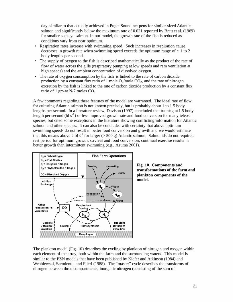
Fig. 10. Components and transformations of the farm and plankton components of the model.
The plankton model (Fig. 10) describes the cycling by plankton of nitrogen and oxygen within each element of the array, both within the farm and the surrounding waters. This model is similar to the PZN models that have been published by Kiefer and Atkinson (1984) and Wroblewski, Sarmiento, and Flierl (1988). The “master” cycle describes the transforms of nitrogen between three compartments, inorganic nitrogen (consisting of the sum of
22
concentrations for nitrate, nitrite and ammonia as well as urea as oxidized to nitrate), organic nitrogen in phytoplankton, and organic nitrogen in zooplankton. The three biological transforms consist of:
• photosynthetic assimilation of inorganic nitrogen by phytoplankton which is a function of temperature light levels, DIN concentration, and dissolved oxygen concentration
• grazing by zooplankton on phytoplankton which is a function of temperature and concentrations of dissolve oxygen concentration, zooplankton, and phytoplankton
• excretion of DIN by zooplankton, which is solely a function of the concentration of zooplankton
It is assumed that all three compartments are transported by advective and turbulent flow as described above. The model displays predator-prey oscillations which dampen over time and reach a steady state. The default simulations for DIN, phytoplankton, and zooplankton stabilize at roughly 12 mg-at N-at m-3, 2 mg-at N m-3, and 3 mg-at N m-3, respectively. In order to calculate the concentrations and rates of loss by respiration and production by photosynthesis, we have assumed a constant flux ratio of oxygen to nitrogen of 7 moles O 2/gm-at N, consistent with the Redfield ratio. As indicated in the accompanying table, the inputs to this model consist of the time series of exchange coefficients produced by the circulation model, sur face irradiance, and water temperature as well as concentrations of dissolved oxygen, dissolved inorganic nitrogen, cellular nitrogen in phytoplankton and zooplankton. Outputs of this model consist of a time series of the concentrations of dissolved inorganic nitrogen and oxygen, phytoplankton, and zooplankton. The inputs to the fish farm model are the dimensions and location of the farm in the array, daily feed ration, the initial average weight and density of the fish, as well as the water temperature, and the time series of outputs from the circulation and plankton models. The outputs consist of a time series of the average rates of growth, nitrogen excretion, and respiration. The dispersion and BOD of egested, solid material (fish feces) is not considered since, as discussed above, the study areas are not depositional zone and the BOD is distributed widely in the deep layer or on the bottom. The physical dimensions of the model are set by the user, and in our simulations the transport and transformations of variables was calculated for rectangular region or array that is aligned parallel to the coastline. The region is 10,000 meters in length, 2,500 meters in width, and 30 meters in depth (Fig. 11 ). This region consists of a 3 dimensional array of rectangular elements each of which is 50 meters in length, 25 meters in width, and 5 meters in depth. The farm itself with dimensions of 50m x 25m x 10m occupies 2 of the elements, both in the center of the array with one at the surface and one immediately below. Water as well as the chemical and biological variables of the model are transported between adjacent elements of the array by advection and turbulent dispersion. The region is bounded by the air-water interface at its surface, by the 30 meter bottom, and by ambient waters along its 4 sides. The concentrations of variables in the ambient waters are constant and invariant during the simulation. While there is exchange of water and materials across the boundary of the 4 sides of the region, there is no exchange at the bottom or surface. This simplification is justified by the short duration of the simulations. The circulation model is a simple finite element description of the movement of water and suspended and dissolved materials caused by advection and turbulent dispersion. Such
23
circulation is described in terms of a box model in which flow occurs across 5 sides of those elements found at the surface and bottom and across all 6 sides of all other elements at intermediate depths deeper elements. Advective flow in the Strait is largely driven by semidiurnal tides that are oriented along the central axis of the array. Advection is constant with depth and occurs only in the horizontal direction. We are able to run two types of simulation, one in whic h the time series of advective velocity was determined by the current meter records discussed above and another in which velocity was described by a sine function of 6-hour periodicity. Inputs to this model consist of the time series for advective flow, the depth of the surface mixed layer, and the dimensions of the region and location within the Strait. Outputs consist of exchange coefficients for advective and turbulent flow for all elements of the array. Turbulent dispersion was parameterized as an exchange velocity whose value was some fraction of the speed of advective flow. Horizontal dispersion was assumed isotropic, thus the exchange coefficients of the 4 vertical sides of element were of the same value, 1/10th the advective velocity. However, vertical dispersion varied depending upon whether the element lies within the surface mixed layer or within the underlying water column. The vertical turbulent exchange velocity within the surface mixed layer was 10 times greater that its value in deeper waters, and the horizontal exchange velocity was 5 times greater than the vertical exchange velocity within the mixed layer. We have run simulations for winter conditions when the mixed layer extends to 30 meters, and summer conditions when the mixed layer extends only to 5 meters. The vertical exchange coefficients at the surface and the bottom of the water column are zero. The EASy program provides several types of graphic displays of the dynamic 3-dimensional fields produced by the simulation model. These include plane 2-dimensional views of the waste plume produced by the farm at selected depths, 2-dimensional vertical transects or slices through the plume, 1-dimensional depth profiles at a given location, and time series plots of current speed, the mean growth rate of fish, and the concentration of any variable of within the farm. Fig. 11 is a representative screen of selected outputs for the farm simulation model. The green rectangle shown on the map is the boundary of a computational array placed offshore of Neah Bay at our study location. The location of a virtual farm, which contains a concentration of 90 fish m-3 whose average weight is 0.5 kg, is in the center of this rectangle. The resulting density of 45 kg m-3 is about double what is typically achieved in inshore pens, but is used here intentionally to illustrate worst-case possible effects. Total biomass is set at about 0.6 metric tons for this single large pen simulation. Larger amounts of fish may be cultivated in an area, but prese ntly offshore pens such as the Ocean Spar system are placed and moored separately, not in a series as with some nearshore pens. We show here a “snapshot” of the time series for a summer-time simulation during which the mixed layer is shallow, irradiance is sufficiently high to drive driving optimal rates of photosynthesis and grazing within near surface waters. The blue plume shows the horizontal distribution of waters with concentrations of dissolved oxygen that are below that of the surrounding waters. Such a plume is caused by the passage of water through the farm and subsequent mixing with surrounding waters. During a simulation the plume will spread toward the east during the flood tide and then recede and spread to the west during ebb tide. The magnitude of the oxygen reduction within the plumes will vary with tidal flow; highest during slack flow and lowest during peak tidal flow. These changes are complex
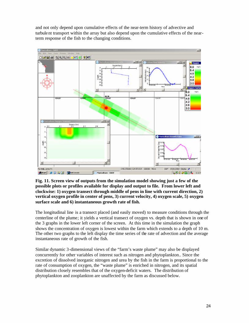
24
Salmon Farm detail
and not only depend upon cumulative effects of the near-term history of advective and turbulent transport within the array but also depend upon the cumulative effects of the near-term response of the fish to the changing conditions.
Fig. 11. Screen view of outputs from the simulation model showing just a few of the possible plots or profiles available for display and output to file. From lower left and clockwise: 1) oxygen transect through middle of pens in line with current direction, 2) vertical oxygen profile in center of pens, 3) current velocity, 4) oxygen scale, 5) oxygen surface scale and 6) instantaneous growth rate of fish. The longitudinal line is a transect placed (and easily moved) to measure conditions through the centerline of the plume; it yields a vertical transect of oxygen vs. depth that is shown in one of the 3 graphs in the lower left corner of the screen. At this time in the simulation the graph shows the concentration of oxygen is lowest within the farm which extends to a depth of 10 m. The other two graphs to the left display the time series of the rate of advection and the average instantaneous rate of growth of the fish. Similar dynamic 3-dimensional views of the “farm’s waste plume” may also be displayed concurrently for other variables of interest such as nitrogen and phytoplankton.. Since the excretion of dissolved inorganic nitrogen and urea by the fish in the farm is proportional to the rate of consumption of oxygen, the “waste plume” is enriched in nitrogen, and its spatial distribution closely resembles that of the oxygen-deficit waters. The distribution of phytoplankton and zooplankton are unaffected by the farm as discussed below.
25
10 Analyses of Model Simulations We have run the fish mariculture model for summer and winter conditions, and examined the results in terms of three key questions. First, will the operation of a single farm stimulate algal blooms within the farm’s nutrient enriched waste plume? Our simulations produced no phytoplankton enrichment much less a bloom. This result is easily explained by the fact that the amb ient concentration of the limiting nutrient in the Strait, dissolved inorganic nitrogen, is much higher than the concentrations that are know to limit phytoplankton growth (Bowie et al. 1985, Rensel Associates and PTI Environmental 1991, Mackas and Harrison 1997). Even though the concentration of dissolved inorganic nitrogen is higher in the waste plume than in the surrounding waters, there is no increase in the growth rate of phytoplankton, because their growth rate is already nutrient saturated. In addit ion, because rates of turbulent dispersion in the Strait are high, the residence time of the phytoplankton within the waste plume is relatively short, a few minutes to less than a day. The second question is: will the operation of a single farm form an oxygen-depleted waste plume that is of significant ecological concern? Our simulations showed that during times in the tidal cycle when flow is slow the concentrations of oxygen within the farm are much reduced, sufficient to temporarily reduce the metabolic rate of the fish. However, the simulation also revealed that the oxygen-deficit plume extended less than 50m downstream. Both the short duration of slack water and horizontal dispersion once flow accelerates limits the spatial extent of the plume. Many measurements up and downstream of commercial salmon farms by Rensel (1989) and more extensively by Heinig (1998, summarized by Normandeau Associates and Battelle 2003) indicate that reduction of downstream dissolved oxygen is extremely infrequent beyond about 5 m downstream and virtually non-existent at 100 m downstream. These data, nitrogen production data and horizontal dispersion measurements from drift objects are presently being used for model verification and sensitivity testing. Third, is the growth rate of salmon within the farm significantly affected by environmental conditions? Our simulations indicate that the growth rate of the fish in the farm is sensitive to both ambient and operating conditions. Specifically, growth rates decline as a mbient current velocities exceed ~ 60 cm s-1 for fish of the size modeled here, after considering minor deflection of currents around the nets (Inoue 1972). The metabolic cost of swimming against the increased current diminishes the reserves that support growth. Furthermore, growth rates decline when oxygen concentration within the farm falls. This occurs during slack water when water exchange within the farm is diminished, and the condition is exacerbated when the tidal flow reverses direction, thereby sweeping water from the oxygen-depleted waste plume through the farm. It is also exacerbated by decreases in the low concentrations of oxygen of ambient waters that occur during summer and early fall when cold, oxygen-depleted water is upwelled or advected to the surface of the Strait. 11 Discussion and Conclusions Maximum current velocity is similar among the three studied sites in the western, central and eastern Strait, but ADCP profiles suggest differing subsurface conditions ranging from reductions (offshore of Green Point) to increased subsurface current velocity (offshore of Neah Bay). Circulation patterns were generally alongshore, with some differences between 1m and 5m depth drogues. The differences were most notable offshore of Neah Bay where some
26
drogues placed nearer shore entered Neah Bay. Offshore of Green Point to the entry of Port Angeles Harbor we documented a large-scale ebb tide gyre, indicating that circulation patterns are more complex than previously reported. This study indicates that the high energy study zones near the south shore of the Strait are suitable for finfish mariculture with minimal or even no measurable adverse effects likely to be seen on benthic or plankton components. Dissolved nitrogen concentrations are consta ntly high, while standing stock of phytoplankton is relatively low. Light limitation and some grazing are the factors that limit phytoplankton growth in the Strait. Benthic impacts from fish mariculture facilities will be transient and limited in extent, as resuspension and fast transport rates will rapidly spread fish fecal matter for long distances downstream of the pens where it can be decomposed and biologically assimilated. Field data suggests no major differences in dissolved oxygen concentration during the late summer and early fall among the sites, or in comparison to a long-term fish mariculture site in north Puget Sound. However, we report a previously undetected, persistent reduction of sea surface temperature in the central Strait during summer and early fall, in an area several km west of the Victoria-Green Point sill. As water temperature was positively correlated with dissolved oxygen concentrations during the same season, we tentatively conclude that there could be reduced dissolved oxygen content of the central Strait. The finding requires field verification, e.g., through the use of moored instrumentation or hyperspectral imaging from aircraft. It also may not apply to the nearshore zone where fish mariculture must operate, as available satellite imagery is more accurate offshore. If there is reduced dissolved oxygen content of the nearshore waters of the central Strait, it could be an impediment for fish mariculture, depending on the physiological requirements of the selected fish species. Although environmental impacts discussed above should be very limited, rigorous conditions found in the Strait during storms will challenge fish culturists and demand use of offshore technology and methods. Operation, maintenance, grading and harvesting procedures in the cold waters of the Strait will demand innovation and careful consideration. The species of fish likely to be reared in such cages may include marine fish that have not been cultivated in offshore cages in the past. They may have an advantage over salmonids with regards to oxygen requirements (e.g., Sullivan and Smith 1982), but their physiological performance and stamina in high current conditions is not known. Creative configuration and arrays of pens to reduce surface currents or stocking of relatively large fish may be means to deal with elevated current velocity effects. There are many other factors besides those considered here in siting of fish mariculture in the coastal zone of the Strait. For example, the south shore of the central Strait has very prolific kelp beds that generate large rafts of floating, senescent material in the late summer and fall. Although test versions of offshore cages placed offshore of Whiskey Creek in 1991 where able to withstand forces generated by this material impinging on the nets, other regions of the south shore have much less kelp and resulting flotsam. Mariculture siting must also consider native Tribal fishing, sport fishing and commercial fish and shellfish areas, recreational and commercial navigation use, habitats of special significance, marine bird and marine mammal habitat and shoreline residents’ view and aesthetic concerns. Mariculture siting must also consider native Tribal fishing, sport fishing and commercial fish and shellfish areas, recreational and commercial navigation use, habitats of special significance, marine bird and marine mammal habitat and shoreline residents’ view and aesthetic concerns. There is precedence for dealing with site-specific topics such as these. Washington State government

27
has promulgated monitoring requirements, operation guidelines, a programmatic impact statement and 2 sets of NPDES permits (SAIC 1986, WDF 1990, WDOE 1996, WDOE 2002) to document impacts based on ten years of annual impact monitoring that led to strict impact limits and rules. This regulatory experience and set of rules can be applied to fish mariculture in the Strait of Juan de Fuca, an area that appears to have several notable advantages for marine fish mariculture. Acknowledgements This work was sponsored in part by funding from NOAA Office of Oceanic and Atmospheric Research. We thank Dr. Rita Horner of the University of Washington who provided expert analysis of phytoplankton species composition. The Makah Tribal Nation provided assistance through sampling vessel use. Two anonymous reviewers from British Columbia provided review and criticism of the SST portions of this manuscript. References
Alexander, R.M. 1967. Functional Design in Fishes. Hutchinson University Library, London. 160 pp.
Anderson, D.M., P. Andersen, V.M. Bricelj, J.J. Cullen, and J.E. Rensel. 2001. Monitoring and Management Strategies for Harmful Algal Blooms in Coastal Waters, Asia Pacific Economic Program #201-MR-01.1, Singapore, and Intergovernmental Oceanographic Commission Technical Series No. 59, Paris. 264 p. http://www.whoi.edu/redtide/Monitoring_Mgt_Report.html
Azuma, T. 2001. Can water-flow induce an excellent growth of fish; effects of water flow on the growth of juvenile masu salmon, Oncorhynchus masou. World Mariculture 32: 26-29.
Bell, G.R. 1961. Penetration of spines from a marine diatom into the gill tissue of lingcod (Ophiodon elongates) Nature (Lo nd.) 192:279-280.
Bowie, G. L., Mills, W. B., Porcella, D. B., Campbell, C. L., Pagenkopt, J. R., Rupp, G. L., Johnson, K. M., Chan, P. W. H., and Gherini, S. A. (1985). Rates, Constants and Kinetics Formulations in Surface Water Quality Modeling. 2nd Ed., US EPA, Athens, Georgia, EPA 600/3-85/040.
Brett, J.R. 1964. The respiratory metabolism and swimming performance of young sockeye salmon. J. Fish. Res. Bd. Can. 21:1183-1226.
Brett, J.R. 1976. Scope for metabolism and growth of sockeye salmon, Oncorhynchus nerka, and some related energetics. J. Fish. Res. Bd. Can. 33: 307-313.
Brett, J.R., Shelbourne, J.E. and C.T. Shoope. 1969. Growth rate and body composition of fingerling sockeye salmon, Oncorhynchus nerka, in relation to temperature and ration size. J. Fish. Res. Bd. Can.26:2363-2394
Brett. J.R. and C.A. Zala. 1975. Daily patterns of nitrogen excretion and oxygen consumption of sockeye salmon (Oncorhynchus nerka) under controlled conditions. J. Fish. Res. Board Can. 32:2479-2486.
Cannon, G.A. (Ed.). 1978. Circulation in the Strait of Juan de Fuca, some recent oceanographic observations. NOAA Technical Report EFL 399-PMEL 29. Pacific Marine Environmental Laboratory. Seattle. 49 pp.
28
Chester, A., D. Damkaer, D. Day, J. Larrance. 1978. Puget Sound energy related research project plankton studies. Final report for Research Unit A-3-1. Pacific Marine Environmental Laboratory, NOAA, Seattle, WA. 117 pp.
Clarke, W. C., J. O. T. Jensen, J. Klimek and Z. Pakula. 1999. Rearing of sablefish (Anoplopoma fimbria) from egg to Juvenile. Bull. Aquacul. Assoc. Can. 99(4) 11-12.
Collias, E.E., N. McGary and C.C. Barnes. 1974. Atlas of physical and chemical properties of Puget Sound and its approaches. Washington Sea Grant 74-1. Seattle.
Cromey, C. J., Nickell, T. D., Black, K. D., Provost, P. G. & Griffiths, C. R. 2002. Validation of a fish farm waste resuspension model by use of a particulate tracer discharged from a point source in a coastal environment. Estuaries 25, 916-929.
Cross, S. 1993. Oceanographic characteristics of net-cage culture sites considered optimal for minimizing environmental impacts in British Columbia. Aquametrix Research Ltd. 86 pp. and appendices
Davidson, W. 1997. The effects of exercise training on teleost fish, a review of recent literature. Comp. Biochem. Physiol. 117A:67-75.
DFO 1999. Current Atlas Juan de Fuca Strait to Strait of Georgia. Department of Fisheries and Oceans Canada, Canadian Hydrographic Service, Pacific Region. Sidney, B.C. 211 pp.
Ebbesmeyer, C.C., J.M. Cox, J.M. Helseth, L.R. Hinchey and D.W. Thomson. 1979. Dynamics of Port Angeles Harbor and Approaches, Washington. Evans Hamilton Inc. for Marine Ecosystems Analysis Puget Sound Project. EPA Interagency Agreement N. D6-E693-EN. USEPA. Office of Research and Development, Washington D.C.
Godin, G., J. Candela and R. de la Paz-vela. 1980. A scrutiny of the current data collected in a section of the Strait of Juan de Fuca in 1973. CICESE Informe Tecnico OC-8001: 138 pp. Not seen, cited by Thomson 1994.
Griffin, D.A. and P.H. LeBlond. 1990. Estuary/ocean exchange controlled by spring- neap tidal mixing. Estuarine, Coastal and Shelf Science 30:275-297.
Haigh, R. and F.J.R. Taylor. 1990. Distribution of potentially harmful phytoplankton species in the Northern Strait of Georgia, British Columbia. Can. J. Fish. Aquat.Sci. 47:2339-2350.
Hasle, G.R. 1978. The inverted- microscope method, pp. 88-96. In: A. Sournia (ed.) Phytoplankton Manual. Methods on Oceanographic Methodology 6. UNESCO, Paris.
Heinig, C.S. 2000. Overview of Maine Department of Marine Resources Finfish Aquaculture Program: Eight Years of Monitoring, 1992-99. Prepared for Maine Department of Marine Resources.
Herlinveaux, R.H. and J.P. Tully. 1961. Some oceanographic featur es of Juan de Fuca Strait. J. Fish. Res. Bd. Canada 18(6) 1027-1071.
Hickey, B.M., R.E. Thomson, H. Yih, and P.H. LeBlond. 1991. Velocity and temperature fluctuations in a buoyancy-driven current off Vancouver Island. J. Geop. Res. 96:10,507-10,538.
Holbrook, J.R., R.D. Muench, D.G. Kachel and C. Wright. 1980. Circulation in the Strait of Juan de Fuca: Recent oceanographic observations in the Eastern Strait. NOAA Tech. Rep. ERL 412-PMEL:42 pp.
Ikehara, Koji and M. Nagahara. (1980). Fundamental Stud ies of Establishing Rockfish Culture Techniques. Bull. Jap. Sea Reg. Fish. Res. Lab. 31: 65-72.
29
Inoue, H. 1972. On water exchange in a net cage stocked with the fish, Hamachi. Bull. Japan. Soc. Sci. Fish. 38:167-175
Kiefer, D.A. and C.A. Atkinson. 1984. Cycling of nitrogen by plankton: a hypothetical description based upon efficiency of energy conversion. J. Mar. Res. 42:655-675.
Kennedy, W.A., C.T. Shoop, W. Griffioen and A. Solmie. 1976. The 1974 crop of salmon reared on the Pacific Biological Sta tion experimental fish. Fish. Mar. Serv. Tech. Rep. 612. 19 p.
Loverich, G.F. and T.R. Croker. 1997. Ocean Spar net pen systems: 32 months of offshore operations. Proceedings, Fish Farming Technology Conference, Tronheim, Norway 9-12 August, 1993. Research Council of Norway.
Loverich, G.F. and J. Forster, 2000. Advances in Offshore Cage Design using Spar Buoys. J. Marine Tech. Soc. 34:18-28.
Mackas, D.L. and P.J. Harrison. 1997. Nitrogenous nutrient sources and sinks in the Juan de Fuca Strait/Strait of Georgia/Puget Sound Estuarine System: Assessing the potential for eutrophication. Estuarine, Coastal and Shelf Science 44, 1-21
Nash, C. 2001. The Net-pen salmon farming industry in the Pacific Northwest NOAA Technical Memorandum NMFS-NWFSC-49.
Newton, J.A., E. Siegel and S.L. Albertson. 2003. Oceanographic Changes in Puget Sound and the Strait of Juan de Fuca during the 2000–01 Drought. Can. Water Res. J.28:715-728.
NOAA 2001. The net-pen salmon farming Industry in the Pacific Northwest. C.E. Nash (editor). U.S. Dept. Commer., NOAA Tech. Memo. NMFS-NWFSC-49, 125 p.
Normandeau Associates and Battelle. 2003. Maine Aquaculture Review. Prepared for Maine Department of Marine Resources. Report R-19336.000 West Boothbay Harbor, Me, 54 pp.
Perez, O.M , T. C. Telfer, M. C. M. Beveridge and L. G. Ross. 2002. Geographical information systems (GIS) as a simple tool to aid modelling of particulate waste distribution at marine fish cage sites Estuarine, Coastal and Shelf Science 54: 761–768.
Phifer, L.D. 1934. Vertical distribution of diatoms in the Strait of Juan de Fuca. University of Washington Publications in Oceanography 1:83-96.
Renner, J. 1993. Northwest Marine Weather, from Columbia River to Cape Scott. The Mountaineers.
Rensel, J.E. 1989. Phytoplankton and nutrient studies near salmon net-pens at Squaxin Island, Washington. In: Fish culture in floating net-pens. Technical appendices, State of Washington Programmatic Environmental Impact Statement. Washington State Department of Fisheries. 312 pp. and appendices.
Rensel, J.E. 1991. Harmful effects of the marine diatom Chaetoceros concavicornis on Atlantic Salmon (Salmo salar). Ph.D. dissertation, University of Washington. Seattle. 140 pp.
Rensel Associates and PTI Environmental Servic es. 1991. Nutrients and Phytoplankton in Puget Sound. Monograph for U.S. EPA, region X, Seattle. EPA Report 910/9-91-002. 130 pp.
Rensel, J.E. 1993. Severe blood hypoxia of Atlantic salmon (Salmo salar) exposed to the marine diatom Chaetoceros concavicornis. pp. 625-630. In: Toxic Phytoplankton Blooms in the Sea. T.J. Smayda and Y. Shimizu (eds). Elsevier Science Publishers B.V., Amsterdam
30
Rensel, J.E 1995a. Final Report: 1994 annual environmental assessment of Scan Am Fish Farms net pen sites at Deepwater Bay and Skagit Bay, Washington. for Washington Dept. of Natural Resources. Rensel Associates, Arlington WA. 56 pp. Rensel, J.E. 1995b: Harmful algal blooms and finfish resources in Puget Sound. pp. 442-429 In: Puget Sound Research Volume 1. (E. Robichaud Ed.) Puget Sound Water Quality Authority. Olympia, Washington.
Rensel, J.E. 2001. Salmon net pens in Puget Sound: Rules, performance criteria and monitoring. Global Aqua. Adv. 4(1):66-69.
Rensel, J.E. 2003. Dungeness Bay Bathymetry, Circulation and Fecal Coliform Studies. Prepared by Rensel Associates, Arlington, WA for Jamestown S’Klallam Tribe, Sequim Washington and the U.S. Environmental Protection Agency. Seattle. 94 p. http://www.jamestowntribe.org/Dungeness%20Bay%20Final%20report%20P2,%2014%20Apr%2003.pdf
Rensel, J.E., R.A. Horner and J.R. Postel. 1989. Effects of phytoplankton blooms on salmon aquaculture in Puget Sound, Washington: initial research. NW Environ. J. 5:53-69.
Rensel, J.E., J. Campbell and D.M. Anderson. 2003. Effectiveness of clay flocculation for Heterosigma akashiwo bloom removal and benthic effects studies in Puget Sound, Washington. Second Symposium o n Harmful Marine Algae in the U.S. Dec.9-13, Woods Hole Oceanographic Institution, p. 54.
Rensel, J.E. and J.R.M. Forster. 2002. Strait of Juan de Fuca, offshore finfish mariculture: Literature review and preliminary field results. For U.S. National Oceanic and Atmospheric Administration. Office of Oceanic and Atmospheric Research. Rensel Associates. 87 pp.
Rensel, J.E. and J.R.M. Forster. 2003. Strait of Juan de Fuca, offshore finfish mariculture: feasibility study, Data report, Year two. Prepared for U.S. National Oceanic and Atmospheric Administration. Office of Oceanic and Atmospheric Research. 72 pp. Rensel, J. E. and J.N.C. Whyte. 2003. Finfish mariculture and Harmful Algal Blooms. Second Edition. In: UNESCO Manual on Harmful Marine Microalgae. pp. 693-722. In: D. Anderson, G. Hallegaeff and A. Cembella (eds). IOC monograph on Oceanographic Methodology. Paris.
Rensel, J.E. and J.R.M. Forster. 2004. Strait of Juan de Fuca, offshore finfish mariculture: year three study report. Prepared for U.S. National Oceanic and Atmospheric Administration. Office of Oceanic and Atmospheric Research. 42 pp.
Reynolds, R. W., N. A. Rayner, T. M. Smith, D. C. Stokes and W. Wang, 2002: An improved in situ and satellite SST analysis for climate. J. Climate, 15, 1609-1625.
Rust, M.B., K.C. Massee, P. Plesha, T.M. Scott, N.Ashton, L. Britt, M.A. Cook, K. Guthrie, R. Campbell and E. Kroger. (in press) Aquaculture of Lingcod (Ophiodon elongatus), In: A. Kelley and J. Silverstein (Eds.) Fish Culture in the 21st Century. American Fisheries Society Book Series.
SAIC. 1986. Recommended interim guidelines for the management of salmon net-pen culture in Puget Sound. Science Applications International Corp. for Washington Department of Ecology. 87-5. Ecology No. C-0087110. Olympia WA. 48 pp.
Smith, L. S. 1982. Introduction to Fish Physiology. T.F.H. Publications. New Jersey 352 pp.
Sullivan, K.M and K.L. Smith. 1982. Energetics of sablefish, Anoplopoma fimbria, under laboratory conditions. Can. J. Fish. Aquat. Sci. 39:1012-1020.
31
Thomson, R.E. 1981. Oceanography of the British Columbia Coast. Canadian Special Publications of Fisheries and Aquatic Sciences 56. Dept. of Fisheries and Oceans, IOS, Sidney B.C. and Ottawa.
Thomson, R.E. 1994. Physical oceanography of the Strait of Georgia-Puget Sound-Juan de Fuca Strait System. pp. 36-100. In: Review of the marine environment and biota of Strait of Georgia, Puget Sound and Juan de Fuca Strait. R.C.H. Wilson, R.J. Beamish, F. Aitkens and J. Bell (eds.). Can. Tech. Report Fish. Aquat. Sci. 1948.
Thomson, R.E., S.F. Mihaly, E.A. Kulikov and G.T. Mungov. 2004. Abstract: Seasonal and interannual variability of the estuarine circulation in the Juan de Fuca Strait. American Geophysical Union Ocean Sciences Meeting, Portland Oregon Feb 2004. Abstract OS32G-02.
WDF (Washington Department of Fisheries). 1990. Fish Culture in Floating Net-pens: Final Programmatic Environmental Impact Statement prepared by Parametrix, Inc , Battelle Northwest Laboratories and Rensel Associates. 173 pp. and appendices.
WDOE 1996. Washington Department of Ecology National Pollutant Discharge Elimination System Waste Discharge Permit. Fact sheets and permits issued to each commercial net pen farm. 18 September 1996. Olympia WA.
WDOE 2002. Washington Department of Ecology National Pollutant Discharge Elimination System Waste Discharge Permit. Fact sheets and permits issued to each commercial net pen farm. 20 March 2002. Olympia WA.
Whyte, J. N. C., W. C. Clarke, N. G. Ginther, J. O. I. Jensen and I. U. Townsend. 1994. Influence of composition of Brachionus plicatilis and Artemia on growth of larval sablefish (Anoplopoma fimbria). Aquaculture 119: 47-61.
Wroblewski, J.S., J. L. Sarmiento , and G. R. Flierl. 1988. An Ocean Basin Scale Model of Plankton Dynamics in the North Atlantic 1. Solutions for the Climatological Oceanographic Conditions in May. Global Biogeochemical Cycles, vol. 2(3): 199-218.
Related Documents