Regina OCP – Part B Part B.9 – Fleet Street Business Park Secondary Plan Page 1 of 21 OFFICIAL COMMUNITY PLAN PART B.16 Southeast Regina Neighbourhood Plan

Welcome message from author
This document is posted to help you gain knowledge. Please leave a comment to let me know what you think about it! Share it to your friends and learn new things together.
Transcript

Regina OCP – Part BPart B.9 – Fleet Street Business Park Secondary Plan
Page 1 of 21
OFFICIAL COMMUNITY PLAN
PART B.16Southeast Regina
Neighbourhood Plan

Prepared for: The City of Regina
Submitted by: Aurora Retail Corp. Dream Development Chuka Creek Developers City of Regina Long Lake Investment Nanaksar Gurdwara Gursikh Temple
Prepared by: B&A Planning Group

Southeast Regina Neighbourhood Plan |

Table of Contents1.0 Introduction 11.1 Background 1
1.2 Location 1
1.3 Land Ownership 3
1.4 Regulatory Framework 5
2.0 Attributes & Constraints 92.1 Plan Area Conditions 9
2.2 Surrounding Area Conditions 13
2.3 Constraints 19
3.0 Vision & Design Principles 233.1 Vision Statement 23
3.2 Design Principles 24
3.3 Land Use Concept 25
3.4 Neighbourhood Plan Statistics 29
4.0 Community & Neighbourhood Framework 314.1 Communities & Neighbourhoods 31
4.2 Neighbourhood Area 34
4.3 Commercial Area 36
4.4 Mixed-Use Area 37
4.5 Light & Medium Industrial 38
4.6 Prestige Industrial Area 39
4.7 Greens on Gardiner Expansion Area 40
4.8 Chuka Creek Corridor 41
4.9 Urban Centre 42
4.10 Neighbourhood Hub 43
4.11 Chuka Boulevard 44
4.12 Potential Interchange Area 45
4.13 Gateway Areas 46
4.14 Interface Areas 48

Southeast Regina Neighbourhood Plan |
1.0
5.0 Community Amenities 495.1 School Sites 49
5.2 High School Site 51
5.3 Zone Park 53
5.4 Neighbourhood Parks 54
5.5 Linear Stormwater Detention Facility 55
5.6 Ball Park Facility 56
5.7 Emergency Response Station 56
5.8 Municipal Reserve Requirements 57
6.0 Mobility 596.1 Pedestrian and Bicycle Circulation 59
6.2 Transit Network 61
6.3 Internal Road Network 63
6.4 Regional Road Network 67
6.5 Provincial Road Network 68
6.6 Road Closure Areas 69
7.0 Servicing 717.1 Water Servicing 71
7.2 Stormwater Management 74
7.3 Wastewater Collection System 77
7.4 Shallow Utility Servicing 83
8.0 Implementation 858.1 Development Phasing 85
8.2 Concept Plan Boundaries 87
8.3 Intermunicipal Coordination 88
8.4 Neighbourhood Plan Interpretation 90
Appendix A Non-Binding Information 91

List of Figures & Tables
F1 SE Regina Neighbourhood Plan Context 2
F2 Plan Area Ownership 4
F3 City of Regina 2014 Boundary Alteration 7
F4 Design Regina OCP - Growth Plan 8
F5 Existing Natural Conditions 11
F6 Completed ESA’s and Geotechnical Assessments 12
F7 SE Regina Adjacent Land Uses & Community Amenities 14
F8 Existing Transportation Context 16
F9 Design Regina OCP Transportation Network 18
F10 Land Use & Development Constraints 20
F11 Land Use Concept 26
F12 Community & Neighbourhood Boundaries 32
F13 Gateway and Interface Areas 47
F14 Southeast Regina Community Amenities 52
F15 Pathways & Corridors 60
F16 Potential Transit Roads 62
F17 Road Network 65
F18 Potential Traffic Signal Locations 66
F19 Future Road Closure Areas 70
F20 Water Servicing Concept 72
F21 Stormwater Management Concept 75
F22 Existing Sanitary Infrastructure 78
F23 Wastewater Catchments & Sanitary Servicing Concept 80
F24 Shallow Utilities Servicing 84
F25 Development Phasing Boundaries 86
F26 Concept Plan Boundaries 89
FIGURES

Southeast Regina Neighbourhood Plan |
T1 Land Use Concept Overview 27
T2 Neighbourhood Plan Land Use Statistics 29
T3 Population & Job Statistics 30
T4 Municipal Reserve Requirements 57
T5 Road Hierarchy & Right-of-Way Requirements 63
T6 Tie-In Locations & Pipe Sizes 71
TA1 Proposed Development Sub-Catchments 92
TA2 Storage Drainage Requirements for Sites 1+2 93
TA3 Storage Requirements for Linear Detention SWMF From Areas Draining Directly to SWMF
93
TA4 Storage Requirements for Linear Detention SWMF from Areas with a Controlled Release Rate to the SWMF
93
TA5 Storage Requirements for Sites 14-19 Draining to Chuka Creek 94
TABLES

Input PeopleThe Southeast Regina Neighbourhood Plan (SENP) provides a planning policy framework to guide the future development of 690 hectares of land within Southeast Regina. Significant inputs into development of the SENP have included:
■ Extensive stakeholder consultation and engagement
■ Retail Market Study
■ Phase 1 and Phase 2 Environmental Site Assessment(s)
■ Biophysical Review
■ Historical Resource Inventory
■ Transportation Impact Assessment
■ Servicing Study
■ Geotechnical Assessment(s)
Developing a Neighbourhood Plan involves balancing community, landowner, City, and other stakeholder interests within the objectives and principles of the Design Regina Official Community Plan (OCP). Many meaningful conversations occurred with the following stakeholders:
■ The project team
■ The landowner group
■ City of Regina Administration
■ Community Associations
■ The general public
■ School Boards
■ The Province of Saskatchewan
■ Regional Municipalities of Sherwood and Edenwold

Southeast Regina Neighbourhood Plan |
1.0
OutputProcessIn order to create a meaningful and effective framework for a complete community, collaboration and sharing of knowledge was essential in the development of the Southeast Regina NP. This SENP was undertaken with significant stakeholder and public engagement and included:
■ 1 full-day design workshop with all stakeholders
■ 2 stakeholder workshops
■ Over 800 conversations with various stakeholder groups
■ Over 30 meetings with plan area landowners
■ 2 online stakeholder surveys
■ 4 stakeholder newsletters
■ 2 open houses
■ Project website updates
The SENP sets the planning and development framework for a complete community. The key goals of the SENP are to:
■ Support the creation of a complete community that provides opportunities to live, work, and play.
■ Ensure new neighbourhoods integrated with and complement existing neighbourhoods.
■ Provide a diverse range of employment opportunities and lifestyle services that are accessible to all residents.
■ Develop a well-connected network of streets to encourage all modes of transportation.
■ Create neighbourhoods with a distinctive character and sense of place.
■ Create open spaces that are meaningful, compatible, and appeal to a variety of users.

1
1.1 Background The purpose of the SENP is as follows:
• Implement the policies contained in the Design Regina Official Community Plan Bylaw No. 2013-48 (OCP), and in doing so, provide the link between the OCP and the future development of the plan area.
• To guide and direct the preparation and approval of subsequent concept plans, land use amendment and subdivision applications within the plan area.
To accomplish this purpose, the SENP contains development objectives, a land use concept, and transportation and servicing frameworks which will ensure the SENP policy directives are achieved over time.
The key considerations for the SENP boundary included the ‘Growth Plan’ in the City of Regina’s Official Community Plan (OCP), the potential to service developments, and the need to undertake a coordinated planning approach for lands located on the east side of the city.
1.2 Location The plan area is located in the southeast sector of the City of Regina on the eastern boundary of the city limits. The area is bordered by Victoria Avenue to the north, Primrose Green Drive and Arcola Avenue to the south, Woodland Grove Drive to the west, and the CN-CP rail line and RM of Sherwood to the east. The plan area is adjacent to the existing neighbourhoods of Windsor Park and Woodland Grove to the west and The Greens on Gardiner and The Creeks to the southwest.

Southeast Regina Neighbourhood Plan |
1.0
2
F1 | SE Regina Neighbourhood Plan Context
DOWNTOWN
RM OF SHERWOOD
RM OF EDENWOLD
CP Railway
Tran
s-Can
ada H
wy
Victoria Ave Highway No.1
ReginaBypass
CN - CP Railway
Arcola Ave
Highway No.33
Prin
ce o
f Wal
es D
r
CITY OF REGINA
MUSKOWEKWAN RESERVE
Legend
SE Neighbourhood Plan Area
City of Regina Boundary
RM of Sherwood/ Edenwold Boundary
CITY OF REGINA

3
1.3 Land OwnershipThe NP area is comprised of approximately +/- 690.4 hectares (+/- 1705.9 acres) of land. The plan area is owned by 18 different landowners with a variety of legal parcels and ownership areas. A summary of plan area ownership is detailed in Figure 2: Plan Area Ownership.

Southeast Regina Neighbourhood Plan |
1.0
4
F2 | Plan Area Ownership
SW 12-17-19-W.2
SE 11-17-19-W.2
K
L
NW 12-17-19-W.2
160 159 158 155
NE 14-17-19-W.2NW 14-17-19-W.2
SE 14-17-19-W.2SW 14-17-19-W.2
CC134
BB
69 70 71
5859
126
131
99
94
67
62
127
130
98
95
66
63
128
129
97
96
65
64
SE 23-17-19-W.2SW 23-17-19-W.2
34 3538
32 31 30 2726
B
A
6 7
N1
C1
A
57
BB
NE 11-17-19-W.2
NW 1-17-19-W.2
Figure: Ownership
April 2016
2001000 300
SE Neighborhood Plan Area Boundary
Legend
May
25,
201
6 - 3
:41p
mW
:\169
7 R
egin
a S
E L
ands
\Dra
win
g C
AD
File
s\16
97-R
egin
a S
E _
May
201
6.dw
g
Southeast Regina Neighbourhood PlanLand Use Concept
NANAKSAR GURDWARA
GURSIKH TEMPLE
AURORA RETAIL CORP.
ARBOR MEMORIAL
INC.
PRIVATE LANDOWNER
PRIVATE LANDOWNER
PRIVATE LANDOWNER
TRACER PRODUCTIONS
HER MAJESTY THE QUEEN
HER MAJESTY THE QUEEN
NUTRASUN FOODS LTD.
ALLIANCE PULSE PROCESSORS INC.
GREENS ON GARDINER
DEVELOPMENT CORP.
PRIVATELANDOWNER
CHUKA CREEK DEVELOPERS LTD.
CITY OF REGINA
CITY OF REGINA
DREAM DEVELOPMENT
LONG LAKE INVESTMENT
INC.
LONG LAKE INVESTMENT
INC.
LONG LAKE INVESTMENT INC.
PRIVATE LANDOWNER
PRIVATELANDOWNER
Victoria Ave Highway No.1
Arcola Ave
Highway No.33
Legend
SE Neighborhood Plan Area Boundary
0 500m

5
1.4 Regulatory Framework
Design Regina OCP - Bylaw No. 2013-48
The SENP must be consistent with other policy documents approved by the City of Regina, including but not limited to the Design Regina OCP.
The OCP establishes two levels of planning required for new areas in the city; a secondary plan forms part of the OCP as a sub-area and is required to provide comprehensive policy governing land-use, servicing, and design solutions for a particular area. A neighbourhood plan (NP) is a type of secondary plan that applies to identified existing, new, or mixed-use neighbourhoods of approximately 200 hectares or more. As such, the SENP will be adopted by bylaw and form part of the Design Regina OCP. Following or concurrent with the SENP approval, the preparation of concept plans may occur within the SENP area.
The SENP area contains approximately +/- 690.4 hectares (+/- 1705.9 acres) of land and proposes a new neighbourhood area, therefore a NP is required to be prepared in accordance with the Design Regina OCP. The NP, in turn, contains direction relative to future concept plan boundaries and requirements. Concept plans shall be developed and submitted to provide further detail required to rationalize land use amendment, subdivision and development permit applications.
The 2014 annexation between the City of Regina and the RM of Sherwood altered the City’s eastern boundary and incorporated additional lands into the City and the NP area. The relationship of the SENP area to the January 2014 annexation is shown in Figure 3: City of Regina 2014 Boundary Alteration.
The relationship of the plan area to the Design Regina OCP is detailed in Figure 4: Design Regina OCP - Growth Plan. Under the OCP, a portion of the plan area is identified within the “Built or Approved Neighbourhoods” area which have been earmarked to accommodate future City growth up to 235,000 people and are considered by the City as a priority growth area. The 235K area has an existing concept plan identified as “The Towns” which was approved by Council in 2008. Concurrent with the SENP, the Towns Concept Plan has undergone amendments to align with the SENP.
The remaining lands within the NP are designated as “New Neighbourhood (300K)” and “Future Long-Term Growth (500K)” intended to accommodate future City population growth to 300,000 and 500,000 respectively. The OCP also identifies an “Urban Corridor” and “Urban Centre” straddling Victoria Avenue.
The OCP requires new neighbourhoods to be designed and planned as complete neighbourhoods, where residents of all ages, abilities, and backgrounds can access daily necessities, employment opportunities, transportation choices, and enjoy lifestyle choices within an adaptable urban environment. The SENP demonstrates conformity with the OCP, by establishing a future vision and direction for a complete community inclusive of residential and non-residential uses of varying intensities, employment lands, and a comprehensive parks and open space network.
Regina Zoning Bylaw No.9250
Lands within the SENP are currently zoned Urban Holding District. Prior to subdivision and development of the lands, a zoning bylaw amendment shall be required. Future zoning bylaw amendments shall be evaluated for consistency with the OCP, the SENP and corresponding concept plans.

Southeast Regina Neighbourhood Plan |
1.0
6
Timeframe of the Plan
This NP is future-oriented and establishes the overall pattern for how the Southeast Lands are to be developed over an extended period of time. Development is expected to occur over the next 20 years. However, the exact timing of the build out of the NP remains subject to market demand and other factors.
Map Interpretation
Unless otherwise specified within the NP, the boundaries or locations of any symbols or land use areas shown on a map are approximate only, not absolute, and will be interpreted as such. They are not intended to define exact locations except where they coincide with clearly recognizable physical features or fixed boundaries such as existing legal property lines, existing roads or existing utility rights-of-way.
The precise location of land use boundaries will be evaluated and determined by City administration at the time of concept plan, rezoning and subdivision applications. Where adjustments are made as a result of further delineation through the concept plan process, an amendment to the maps within this NP shall not be required.
Policy Interpretation
In the interpretation of the policies within this plan, the word ‘shall’ outlines mandatory compliance. ‘Should’ policy statements demonstrate that compliance is encouraged and recommended. However, ‘should’ statements may not always be practical and flexibility is provided in such circumstances. ‘May’ statements indicate no obligation to undertake what is proposed, but implies that the approving authority shall give due consideration to the policy.
Policy numbering within this plan coincides with the section or subsection numbering that immediately proceeds the policy.
Use Interpretation
To provide general direction to the intended use and development of areas throughout the NP area, the document references land uses that may require interpretation. Within this NP, when specific land uses are mentioned, please refer to the City of Regina’s OCP and/or Zoning Bylaw for further clarification. While the NP provides broad policy direction relative to the intended use and development of an area, the ultimate definition and approval of land uses shall be further delineated at the concept plan stage and implemented via zoning, subdivision and development approvals.
Amendment of the Plan
Where required, an amendment to the NP shall be held in accordance with the Planning and Development Act, 2007. If an amendment to the NP is proposed by an applicant, the applicant must submit the justification and information necessary to support the amendment.
Monitoring of the Plan
The policies within the NP will be monitored in relation to development activity. Where necessary, the policies will be amended either generally or in response to a specific issue.

7
F3 | City of Regina 2014 Boundary AlterationAppendix A
November 6, 2013
25
36
01
12
13
13
12
01
36
24
25
19 20 21 22 23 24 19 20 21 22 23
18 17 16 14 18 17 16 15 14
07 08 09 07 08 09 10 11
15 13
05
31 32
30 29
06
18 17 16
07 08 09 10
06 05 04 03
34 36 31 32 33 34 35
27 26 25 30 29 28 27 26
0203
35
26
23
020304
20
31 32 33 34 35
30 29 28 27 26
10
03
11
22 23
15 14
12
01
36
25
34 35
27 26
10
03
11
02
22 23
15 14
25
36 31 32
30 29
34 35
27 26
24 19 212022 23 22 23 24 19 20 21 22 23 24
12
01
36
25
36
25
13
24
3534
2627
36 31 32 33
25 30 29 28
33 34 35
28 27 26
24
13
30
19
18
07
31
30
19
07
06
18
19
31
30
06
02
35
MC
DONALD
ST
HIGHWAY33
HIGHWAY1
TS
AU
QS
AP
9TH AVE N
ARCOLA AVE
RING
RD
HIG
HW
AY6
HIGHWAY46
VICTORIA AVE
6YA
WH
GIH
HIG
HW
AY1
BYPA
SS
RD
NAV
WEL
HIGH
WAY11
TS T
RE
BLA
DEWDNEY AVE
HIGHWAY1
LegendAnnexation Areas:
EastSouthwest
West/Northwest
2013 City of Regina Boundary
Rge. 20 Rge. 19Rge. 21
Twp.
17
Twp.
18
Twp.
16
City of Regina - 2013 Boundary Alteration
Current City of Regina Boundary
Plan Area
Legend
East
Southwest
West/ Northwest
2013 City of Regina Boundary
Current City of Regina Boundary
Appendix ANovember 6, 2013
25
36
01
12
13
13
12
01
36
24
25
19 20 21 22 23 24 19 20 21 22 23
18 17 16 14 18 17 16 15 14
07 08 09 07 08 09 10 11
15 13
05
31 32
30 29
06
18 17 16
07 08 09 10
06 05 04 03
34 36 31 32 33 34 35
27 26 25 30 29 28 27 26
0203
35
26
23
020304
20
31 32 33 34 35
30 29 28 27 26
10
03
11
22 23
15 14
12
01
36
25
34 35
27 26
10
03
11
02
22 23
15 14
25
36 31 32
30 29
34 35
27 26
24 19 212022 23 22 23 24 19 20 21 22 23 24
12
01
36
25
36
25
13
24
3534
2627
36 31 32 33
25 30 29 28
33 34 35
28 27 26
24
13
30
19
18
07
31
30
19
07
06
18
19
31
30
06
02
35
MC
DONALD
ST
HIGHWAY33
HIGHWAY1
TS
AU
QS
AP
9TH AVE N
ARCOLA AVE
RING
RD
HIG
HW
AY6
HIGHWAY46
VICTORIA AVE
6YA
WH
GIH
HIG
HW
AY1
BYPA
SS
RD
NAV
WEL
HIGH
WAY11
TS T
RE
BLA
DEWDNEY AVE
HIGHWAY1
LegendAnnexation Areas:
EastSouthwest
West/Northwest
2013 City of Regina Boundary
Rge. 20 Rge. 19Rge. 21
Twp.
17
Twp.
18
Twp.
16
City of Regina - 2013 Boundary Alteration
Current City of Regina Boundary
Annexation Areas:
0 3,000m

Southeast Regina Neighbourhood Plan |
1.0
8
F4 | Design Regina OCP - Growth Plan
Legend
Plan Area
0 1,500m
Victoria Ave
Alb
ert S
t

2.1 Plan Area Conditions2.1.1 Existing Land Use and Development
The SENP area is comprised of predominantly agricultural lands for crop production. Other uses include residential farmyards, a former greenhouse site, Pacer’s Baseball Park, existing light industrial uses, and institutional facilities.
2.1.2 Historical Resources
No known archeological sites have been identified within the plan area and the likelihood of intact archeological sites is low due to cultivation or impacts by previous development. However, there is heritage potential for native prairie habitat adjacent to Chuka Creek. At the time of concept plan submission, an HRIA will be required for lands adjacent to Chuka Creek in SE11-17-19 W2M and SW 12-17-19 W2M.
2.1.3 Natural Features
The topography of the SENP is relatively flat with little topographic relief. The plan area has little natural vegetation or tree cover with the exception of existing residential yards. The high point is located in the northeast portion of the site and drainage runs to the south and southwest. Chuka Creek is the lowest point within the plan area. Surface drainage is collected in seasonal drainage channels that drain to Chuka Creek and subsequently to Wascana Creek. Figure 5: Existing Natural Conditions illustrates the site topography and notable natural features of the plan area.
A Biophysical Review of the SENP area was completed by Stantec Consulting Ltd in January 2015. Based on this review, there are a number of identified wetlands within the plan area. The majority of wetlands are Class 1-3 based on the Stewart and Kantrud Classification. Eleven wetlands were classified as Class 10 dugouts. Based on this initial review, the assessment has recommended that further analysis on Class 3 wetlands and Chuka Creek should be completed prior to development, as part of an Environmental Self Assessment, to confirm wetland classification and potential of these wetlands to support sensitive species or species at risk.
Policies
2.1.3(a) As a prerequisite for concept plan approval, the City may require further analysis of potential wetlands, and may require that important wetlands be dedicated as Environmental Reserve (ER) at the time of subdivision.
9

Southeast Regina Neighbourhood Plan |
2.0
10
2.1.4 Environmental Conditions
Phase I and Phase II Environmental Site Assessments (ESAs) have been completed for a portion of the plan area as detailed in Figure 6: Completed ESA’s and Geotechnical Assessments. Recommendations from the ESA reports indicate environmental impacts have been detected within the South 1/2 of Section 14, which requires remediation
prior to development. Proof of site remediation for impacted lands shall be required at the concept plan stage.
2.1.5 Geotechnical Conditions
Geotechnical Assessments have been completed for a portion of the plan area. The geotechnical assessments examined subsurface soil conditions, groundwater levels, and overall geotechnical conditions to arrive at development recommendations. The analysis found no significant geotechnical constraints to the development of residential, commercial, and industrial uses envisioned for the SENP lands. The analysis provided a number of considerations relative to the construction activities and requirements for future development. These considerations shall be considered at the time of implementation and development.
Policies
2.1.5(a) Prior to development, Geotechnical Assessments should be completed and submitted concurrently with each concept plan submission within the SENP area
2.1.5(b) Development within the SENP area should comply with the recommendations stemming from completed Geotechnical Assessments unless waived by the City of Regina.
Policies
2.1.4(a) Prior to development, Phase I Environmental Site Assessments should be submitted concurrently with each concept plan submission within the SENP area.
2.1.4(b) Prior to development, Phase II ESAs may be required by the City of Regina based on the results of Phase I ESAs, and should be submitted concurrently with each concept plan submission within the SENP area.
2.1.4(c) Environmental impacts identified within the South 1/2 of Section 14 shall be remediated prior to development.

11
F5| Existing Natural Conditions
Primrose Green Drive
WINDSOR PARK
WINDSOR GROVE
THE GREENS ON GARDINER
THE CREEKS
Victoria Ave Highway 1
Chuka Creek
Prin
ce o
f Wal
es D
rive
Arcola Ave
Highway 33
Chuka Boulevard
Haughton Road
Road
Arens Road
Cum
berla
nd
Buckingham Drive
RIVER BEND
WINDSOR PARK
WASCANA VIEW
Seasonal Drainage
ApprovedFloodway
Legend
SE Neighborhood Plan Area Boundary
City Boundary
Slope
Approved 1:500 Flood Plain
Approximate 1:500 Flood Plain
Approved Floodway
High Point
Low Point
Aquifer Sensitivity Zone
Approximate Floodway
Class III Wetlands
Class III Wetland
ApproximateFloodway
ApproximateFlood Fringe
Woo
dlan
d G
rove
Dri
ve

Southeast Regina Neighbourhood Plan |
2.0
12
F6| Completed ESA’s and Geotechnical Assessments
City Limits
P
C
Q
Existing Servicing
Jul
27,
201
5 - 1
:47p
m W
:\169
7 R
egin
a S
E L
ands
\Dra
win
g C
AD
File
s\16
97-C
once
pt O
ptio
ns J
uly
27, 2
015.
dwg
Lay
out:F
ig 8
- Exi
stin
g S
ervi
cing
Figure 8 -
Primrose Green Drive
Legend
SE Neighbourhood Plan Area Boundary
City Boundary
Phase I ESA
Phase II ESA
Geotechnical Assessment
P
C
Q
City Limits
Apr
07,
201
5 - 4
:15p
m W
:\169
7 R
egin
a S
E L
ands
\Dra
win
g C
AD
File
s\16
97-C
once
pt O
ptio
ns M
arch
17,
201
5.dw
g L
ayou
t:Fig
8 -
Land
Use
& D
evel
opm
ent C
onst
rain
ts (2
)
RIVER BEND
0 500m
WINDSOR PARK
WINDSOR GROVE
THE GREENS ON GARDINER
THE CREEKS
Victoria Ave Highway No.1
Prin
ce o
f Wal
es D
rive
Arcola Ave
Highway No.33
Chuka Boulevard
Haughton Road
Road
Arens Road
Cum
berla
nd
Buckingham Drive
Woo
dlan
d G
rove
Dri
ve

13
2.2 Surrounding Area Conditions
2.2.1 Adjacent Land Uses & Community Infrastructure
The SENP area is well-positioned in the southeast sector of Regina to accommodate forecast population growth over the next 20 years. With established and fully developed neighbourhoods to the west of the plan area and the Greens on Gardiner neighbourhood to the southwest approaching the final stages of development, the development of the SENP will represent contiguous growth within the city of Regina.
As illustrated in Figure 7: Southeast Regina Adjacent Land Uses & Community Amenities, the plan area is within close proximity to existing community and regional amenities and services. Regional retail, hospitality, and other commercial services are located west of the plan area within the Victoria Avenue urban corridor. This area is the largest and busiest commercial corridor in Regina, offering a variety of services to both residents of the City and surrounding region. Development of the subject lands along Victoria Avenue provides the opportunity to extend the existing urban corridor.
Neighbourhood hubs in adjacent communities include the Sandra Schmirler Leisure Centre/Regina Public Library, the Arcola East Community Centre, and other open space features that act as neighbourhood focal points. The Sandra Schmirler Leisure Centre is a community destination facility that serves as a hub of activity within the Arcola East community, providing recreation opportunities, multi-purpose and meeting spaces, and cultural activities. The Arcola East Community Centre is a neighbourhood recreation centre that provides a gymnasium, multi-purpose room and crafts room and is intended to serve local residents.
The nearest existing public and separate schools are located in the neighbourhood of Windsor Park and a proposed joint public and separate elementary school shall be located in the Greens on Gardiner neighbourhood.
The nearest existing fire station is located within the neighbourhood of Riverbend. This fire station is located approximately 2.5 km from the central portion of the SENP area. The fire station at 2700 Arens Road will service the fire response needs for the SENP prior to the construction of an additional emergency response station within the subject lands. The location of a future additional emergency response station within the plan area will remain subject to further analysis and discussions between the City of Regina and plan area landowners at the time of future concept plan submissions.
The location and type of the existing transportation network, land uses and community infrastructure has helped guide the preparation of the SENP land use concept and development vision.

Southeast Regina Neighbourhood Plan |
2.0
14
F7 | Southeast Regina Adjacent Land Uses & Community Amenities
F
LN
N
City Limits
Aug
11,
201
6 - 2
:04p
mW
:\169
7 R
egin
a S
E L
ands
\Dra
win
g C
AD
File
s\16
97-R
egin
a S
E _
May
201
6.dw
g
Southeast Regina Neighbourhood PlanLand Use Concept
F
NL
Figure: Southeast Regina Adjacent Land Use &Community Amennities
May 2016
2001000 300
Public Elementary SchoolSeparate Elementary School Memorial Gardens CemeteryJoint Public/ Separate Elementary School Regional Retail/ Hospitality UsesSandra Schmirler Leisure Centre Light Industrial & Service Commercial
City BoundarySE Neighborhood Plan Area Boundary
Neighborhood Centre
LibraryFire StationMedical Clinic
Local/ Neighbourhood CommercialResidential Uses
Water Course800m ("as the crow flies")Campground
Open Space/ ParksEnvironmental ReserveStormwater Facility
Legend
F
LN
N
City Limits
Aug
11,
201
6 - 2
:04p
mW
:\169
7 R
egin
a S
E L
ands
\Dra
win
g C
AD
File
s\16
97-R
egin
a S
E _
May
201
6.dw
g
Southeast Regina Neighbourhood PlanLand Use Concept
F
NL
Figure: Southeast Regina Adjacent Land Use &Community Amennities
May 2016
2001000 300
Public Elementary SchoolSeparate Elementary School Memorial Gardens CemeteryJoint Public/ Separate Elementary School Regional Retail/ Hospitality UsesSandra Schmirler Leisure Centre Light Industrial & Service Commercial
City BoundarySE Neighborhood Plan Area Boundary
Neighborhood Centre
LibraryFire StationMedical Clinic
Local/ Neighbourhood CommercialResidential Uses
Water Course800m ("as the crow flies")Campground
Open Space/ ParksEnvironmental ReserveStormwater Facility
0 500m
Primrose Green Drive
800m
800m
RIVER BEND
WINDSOR PARK
WOODLAND GROVE
GARDINER PARK
UNIVERSITY PARK
VARSITY PARK
GARDINER HEIGHTS
WASCANA VIEW
THE GREENS ON GARDINER
Victoria Ave
Regina Bypass
Prin
ce o
f Wal
es D
rive
Arcola Ave Chuka Creek
Woo
dlan
d G
rove
Driv
e
Arens Road
Chuka Blvd
Haughton Road

15
2.2.2 Existing Transportation Network
As illustrated in Figure 8: Existing Transportation Context, the existing transportation network in relation to the plan area consists of the boundary roads of Victoria Avenue to the north, Arcola Avenue and Primrose Green Drive to the south and Woodland Grove Drive to the west. Direct access to these roadways will connect the plan area to the regional road network and support the efficient movement of residents to and from the plan area.
In addition to these major boundary road conditions, there are a number of east - west roadways which have the potential to support development within the plan area including Haughton Road, Cumberland Road, Arens Road, Buckingham Drive and Primrose Green Drive. These roads will provide access points to and from the SENP lands and provide the connection and integration with surrounding neighbourhoods and existing commercial areas. An important north-south connection into the NP area will be the extension of Chuka Boulevard, which is presently under development within the Greens on Gardiner community.
Aside from these boundary conditions, the plan area is currently bisected by Tower Road which has been recently upgraded to handle heavy truck traffic associated with the existing agricultural processing operations. Additional existing developed roadways include Township Road 252 which is developed to a local industrial standard and provides access to existing agri-industrial operations and includes a constructed crossing over the CN-CP rail line and connections to adjacent lands situated in the RM of Sherwood No. 159 and the RM of Edenwold.

Southeast Regina Neighbourhood Plan |
2.0
16
F8 | Existing Transportation Context
Figure: Existing Transportation Context
April 2016
2001000 300
SE Neighborhood Plan Area Boundary
Legend
Oct
20,
201
7 - 1
:12p
mW
:\169
7 R
egin
a S
E L
ands
\Dra
win
g C
AD
File
s\16
97-R
egin
a S
E _
Sep
201
6.dw
g
Southeast Regina Neighbourhood PlanLand Use Concept
Green Apple Drive
Gre
en B
ank
Road
Legend
SE Neighbourhood Plan Area Boundary
Highway/Major Arterial
Arterial
Collector Road
Rural Industrial Road (Paved)
Rural Industrial Road (Gravel)
Bypass Service Road
Existing Intersections
Intersections under development with Bypass Project
Woodhams
0 500m
Primrose Green DriveDrive
WINDSOR PARK
WINDSOR GROVE THE GREENS ON
GARDINER
THE CREEKS
Victoria AveHighway No.1
Prin
ce o
f Wal
es D
rive
Arcola Ave
Highway No.33
Bypa
ss S
ervi
ce R
oad
Regina Bypass
Chuka Boulevard
Haughton Road
Road
Arens Road
Cum
berland
Buckingham Drive
Woo
dlan
d G
rove
Dri
ve
Tow
er R
oad

17
2.2.3 Future Transportation Network
The future transportation network to support development within the plan area has been established by the City of Regina through the completion of the Design Regina OCP and the City Transportation Master Plan (TMP). As illustrated by Figure 9: Design Regina OCP Transportation Network, Victoria Avenue and Arcola Avenue are identified as future Urban Expressways transitioning into Provincial Highways as they approach the City’s eastern boundary. They have also been identified as future Express Transit Corridors intended to support the growth and development of the City’s transit system. Aside from Victoria and Arcola Avenue, the OCP also recognizes Arens Road and Chuka Boulevard as potential arterial roads to support the development of the SENP area.
In addition to the City’s OCP and TMP, the Government of Saskatchewan (Province) has recently awarded construction and operation of the Regina Bypass which has a significant impact on the plan area. This Province-led initiative will increase connectivity between Highway No. 1 East to Highway No. 33 and act as the future Trans-Canada Highway for the portion south of Regina. The bypass is intended to alleviate traffic congestion on Victoria Avenue and maintain the high speed free flow of traffic on Highway No. 1. The Bypass will also provide an alternate route for vehicles to travel between Victoria Avenue and Arcola Avenue.
In addition to the Regina Bypass requirements within the plan area, the Province has recently expressed the need to consider the potential implications of the extension of the bypass northward along Anaquod Road (previously Tower Road). In support of this, the Province has provided preliminary design requirements and requested that the SENP establish a land use and policy response to these potential requirements. It is anticipated that a functional plan may be commissioned by the Province to explore the Northeast Bypass and associated design requirements within a 3 year period which will finalize the exact location and extent of right of way required to support this future infrastructure initiative.
The SENP has taken into account both the existing transportation network and the future transportation requirements necessary to support the development of the plan area.

Southeast Regina Neighbourhood Plan |
2.0
18
Plan Area
F9 | Design Regina OCP Transportation Network
0 1,500m

19
2.3 ConstraintsThe constraints section addresses items that may pose a potential limitation to development within the plan area and provides an appropriate policy response to address such limitations.
2.3.1 Regina Bypass
The Province has secured the right-of-way for the Regina Bypass, located within the plan area. The Bypass right-of-way and service road dedication is shown on Figure 10: Land Use & Development Constraints, consisting of approximately 105 hectares (259 acres) of land within the plan area. Residential, commercial, and industrial development within the vicinity of the Bypass will be subject to setback requirements as determined by the Province. Preliminary building setbacks from the nearest travel lane, provided by the Province, have been identified at 55 metres for commercial and industrial uses and 60 metres for residential uses.
To address the potential noise impacts stemming from traffic movements and volumes associated with the Bypass, MMM Group Limited undertook a Noise Control Study to predict the potential vehicular noise impacts within the plan area and to determine the extent of physical noise control measures necessary to attenuate projected noise from the proposed Bypass. The report concluded that development within the SENP will not be constrained by future traffic noise as forecast noise levels for adjacent development areas remain within City of Regina standards. Notwithstanding, certain noise attenuation measures for the control of outdoor and indoor sound levels were recommended.
In addition to the Regina Bypass, the Province has identified the potential to commence functional planning for the NE Regina Bypass within a 3 year period. The NE Regina Bypass may necessitate realignment of Anaquod Road and a future interchange at Anaquod Road and Victoria Avenue. In the absence of a completed functional plan, an analysis of the lands which may be impacted by a potential interchange area has been undertaken.
Policies
2.3.1(a) Lands for the Regina Bypass shall be provided as shown on Figure 10: Land Use & Development Constraints.
2.3.1(b) Should lands identified for the bypass development not be required, the lands may be used to accommodate appropriate types of land-use and development, as determined by the City.
2.3.1(c) Development shall be setback from bypass improvements in accordance with applicable Provincial requirements.
2.3.1(d) Noise attenuation measures for indoor and outdoor noise control should be in conformance with recommendations contained in noise impact assessments completed at the time of concept plan submissions.
2.3.1(e) Recommendations for outdoor living areas, sound barrier fences, and building and landscape treatments should be considered at the concept plan stage when land uses, lot siting, and lot orientation are available.
2.3.1(f) All developments occurring within 90 metres of the Regina Bypass and the Regina Bypass Service Road shall be subject to review and approval by the Ministry of Highways as per Provincial legislation.

Southeast Regina Neighbourhood Plan |
2.0
20
F10 | Land Use & Development Constraints
Figure: Land Use & Development Constraints
May 2016
2001000 300
SE Neighborhood Plan Area Boundary
Legend
Jul 2
6, 2
016
- 11:
00am
W:\1
697
Reg
ina
SE
Lan
ds\D
raw
ing
CA
D F
iles\
1697
-Reg
ina
SE
_M
ay 2
016.
dwg
Southeast Regina Neighbourhood PlanLand Use Concept
Primrose Green Drive
WINDSOR PARK
WINDSOR GROVE
WASCANA VIEW
THE GREENS ON GARDINER
Victoria Ave Highway No.1
Chuka Creek
Prin
ce o
f Wal
es D
rive
Arcola Ave
60m Residential Setback from Bypass Travel Lane
Transmission Gas Line
(High Pressure)
Bypa
ss S
ervi
ce R
oad
Regina Bypass
55m Commercial Setback from Bypass Travel Lane
55m Industrial Setback from Bypass Travel Lane
Potential Interchange Area
CN - CP Railway
ApprovedFloodway
ApproximateFloodway
ApproximateFlood Fringe
Legend
SE Neighborhood Plan Area Boundary
Approved Floodway
Approximate Floodway
Approximate Flood Fringe
Approved 1:500 Flood Plain
Approximate 1:500 Flood Plain
Aquifer Sensitivity Zone
Railway
Proposed New Gas Line
River Bend
Figure: Land Use & Development Constraints
May 2016
2001000 300
SE Neighborhood Plan Area Boundary
Legend
Jul 2
6, 2
016
- 11:
00am
W:\1
697
Reg
ina
SE
Lan
ds\D
raw
ing
CA
D F
iles\
1697
-Reg
ina
SE
_M
ay 2
016.
dwg
Southeast Regina Neighbourhood PlanLand Use Concept

21
Policies
2.3.2(a) The lands situated within the Chuka Creek floodway should be dedicated as Environmental Reserve; the use of land dedicated as Environmental Reserve shall be in accordance with the Planning and Development Act, 2007.
2.3.2(b) Future development within the Chuka Creek flood fringe shall be subject to development regulations as specified within the Regina Zoning Bylaw
2.3.2 Chuka Creek Floodplain
Chuka Creek runs east-west across the southern portion of the plan area, collecting regional drainage and conveying flows into the Wascana Creek system. The defined 1:500 floodway and the flood plain associated with Chuka Creek has been identified in Figure 10: Land Use & Development Constraints.
The floodway is the portion of the flood plain where the waters in the 1:500 year flood are projected to meet or exceed a depth of one metre or exceed a velocity of one metre per second. This area should be dedicated as Environmental Reserve (ER). Environmental Reserve is dedicated lands provided to the municipality or Crown based on lands deemed undevelopable due to environmentally significance, flooding,slope, etc. and as per the Planning and Development Act, 2007.
A portion of the Chuka Creek floodway has been defined and approved through the Greens on Gardiner Concept Plan. An approximate floodway has been identified in the plan area based on the elevation contours of the approved floodway. Further analysis and delineation of this floodway may be required at concept plan stage.
The flood fringe is the portion of the flood plain, outside the floodway, where the waters in the 1:500 year flood are projected to be less than a depth of one metre or a velocity of one metre per second. Those lands situated within the flood fringe area will be subject to special development considerations to ensure appropriate flood mitigation measures have been undertaken at the time of development.

Southeast Regina Neighbourhood Plan |
2.0
22
2.3.5 CN-CP Rail Line
The shared CN-CP rail line is located on the eastern edge of the plan area The presence of the railway and the future bypass restrict the viability and appropriateness of residential land uses within this area. Planning of these lands should consider an appropriate interface with the railway. Industrial uses would be a compatible land use adjacent to the railway.
Policies
2.3.5(a) Future land uses adjacent to the railway shall not include residential uses.
2.3.5(b) Development setbacks from railway corridors will be established by the City of Regina, and should be based on the FCM/RAC Guidelines for New Development in Proximity to Railway Operations, 2013.
Policies
2.3.4(a) Development adjacent to the high pressure gas line right-of-way shall be subject to the setback and development requirements as stipulated by the City of Regina.
Policies
2.3.3(a) Development within the Aquifer Sensitivity Area shall adhere to the Regina Zoning Bylaw.
2.3.4 High Pressure Gas Line
An existing high pressure TransGas transmission line is located in the southeast corner of the plan area. Consideration of this line should to be taken for any future development directly adjacent to the transmission line.
2.3.3 Aquifer Sensitivity Overlay
The Aquifer Protection Overlay Zone is located in the southeast corner of the plan area and is identified as a low sensitivity zone. Development within the aquifer sensitivity area will consider the aquifer sensitivity and adhere to the regulations outlined in the Regina Zoning Bylaw.

3.1 Vision StatementThe southeast community provides the opportunity for residents to live, work and play in an attractive and comfortable environment; where residents can walk or ride their bike to parks or local services; and where children can attend all levels of school in their own community. The southeast community is a complete community that provides choice and opportunity for all Regina residents.
The southeast lands shall support the development of a complete community comprised of several distinct neighbourhoods containing a range of housing options, commercial services, recreational opportunities, and institutional land uses. The Victoria Avenue corridor has become a busy activity centre that serves the commercial needs of area residents and the greater Regina region. Chuka Boulevard provides an attractive space for multi-modal forms of travel through the community. A vibrant hub at the centre provides higher residential densities, mixed- uses, and local and personal services to residents, creating a focal point for surrounding neighbourhoods.
Neighbourhood areas contain residential development of varying densities, complemented by an interconnected open space system that provides appealing public spaces and recreational opportunities for a variety of users. The linear stormwater facility creates an open space spine that connects residential areas and promotes pedestrian and cyclist activity. The Zone Park draws users from within the community and throughout the city, fostering sport and recreation and encouraging healthy and active lifestyles.
Industrial uses on the east side of the Bypass provide employment opportunities for area residents and foster the overall economic health of the southeast community and the city.
The southeast community will integrate with and complement existing neighbourhoods, corridors, and centres while providing new opportunities for employment, retail services, recreation, education, and housing.
23

Southeast Regina Neighbourhood Plan |
3.0
24
3.2 Design PrinciplesIn accordance with the approved priorities of the Design Regina OCP, the SENP has been planned as a complete community, incorporating residential development, employment lands, an Urban Centre, and a Transit Hub. Key design principles embodied in this Neighbourhood Plan include:
■ INTEGRATION WITH EXISTING USES - the plan area will consist of neighbourhoods that consider and respect existing development. Boundary conditions will complement and integrate with existing neighbourhoods, urban corridors, transportation networks, and open space systems.
■ LAND USE DIVERSITY - the Southeast lands will form a complete community by providing opportunities for recreation, cultural development, education, and employment. The plan area will accommodate a full range of residential and non-residential land uses.
■ HOUSING MIX - a range of housing product and housing density will be offered within the NP area to support a diverse population and allow residents to remain in the community through various stages of their life. Achieving or exceeding the OCP residential density target, the anticipated housing will range from low to high density residential development and include single detached residential, attached housing forms, and apartment units.
■ EMPLOYMENT AND HUBS - a variety of employment opportunities, lifestyle services, and commercial land uses will be integrated within the plan area to meet regional, community, and neighbourhood needs. Various employment opportunities and daily services will be offered in strategic locations within the plan area. Built forms will range from pedestrian-focused mixed-use development within the central Neighbourhood Hub to large-format retail uses within the Regional Retail Centre. Future Industrial lands will form a significant employment base within the plan area.
■ CONNECTIVITY - the street network will integrate the SENP with existing neighbourhoods and the regional transportation system. Connectivity with existing city development is ensured through multiple access points from surrounding neighbourhoods and direct access points off of Victoria Ave and Arcola Ave. The well connected network of streets (grid-like) and the comprehensive system of sidewalks, multi-use pathways, regional pathways, and greenways will encourage pedestrian and cyclist circulation within the community. A transit corridor and transit hub will promote public transit use and allow residents to access key community amenities.
■ OPEN SPACE & RECREATION - the SENP will offer a range of passive and active recreation opportunities and community gathering places through a comprehensive park and pathway system. An enhanced linear stormwater facility encompassing a pathway system will run north-south through the plan area and eventually connect with Chuka Creek and subsequently the Wascana Creek system. Neighbourhood parks will provide places to gather and socialize. A Zone Park will be a focal point for athletics, providing a variety of areas for both recreational and competitive activities.
■ SENSE OF PLACE - the design of the SENP will invoke a sense of place within its neighbourhoods through the creation of Neighbourhood Hubs, areas of activity, defined focal points, and view corridors to the open space system. Forming a portion of the regional gateway on both the north and south boundaries, the NP area will maintain a high standard of built form and architectural design.

25
3.3 Land Use ConceptFigure 11: Land Use Concept provides an overview of the general location of the land use and transportation framework envisioned to support the development of a complete community within the NP area. Table 1: Land Use Concept Overview provides a description of key land use elements, nodes, corridors and overlays which relate to the SENP.

Southeast Regina Neighbourhood Plan |
3.0
26
F11 | Land Use Concept
City Limits
ES ES
HS/ZR
Oct
30,
201
7 - 4
:50p
m\\b
row
nfp2
\Act
iveP
roje
cts\
1697
Reg
ina
SE
Lan
ds\D
raw
ing
CA
D F
iles\
1697
-Reg
ina
SE
_O
CT
2017
.dw
g
Southeast Regina Neighbourhood PlanLand Use Concept
ES
HS/ZR
Figure: Land Use Concept
May 2016
2001000 300
SE Neighborhood Plan Area Boundary
Legend
Neighborhood AreaCommercial Area
Mixed-Use AreaChuka Creek Corridor (Environmental Reserve)Light & Medium Industrial Area
Legend
Land Use Area
City BoundarySE Neighborhood Plan Area Boundary
Regional Retail CentreNeighbourhood HubTransit Hub (Approximate Location)
Nodes / Corridors / Overlays
Prestige Industrial AreaExisting Development to Remain
Primary Transit CorridorGreens on Gardiner Expansion Area
Urban Centre
Potential High School/ Zone Level ParkPotential Elementary School
Open Space System
Approved FloodwayApproximate Floodway
Ball Park Facility
Transportation Network
ArterialCollector Road
Highway
Other
High Pressure Gas Line ROW
Potential Collector RoadIntersectionPotential Interchange Area
Railway
Mixed-Use Area or Neighbourhood Area
No Connection to Bypass
0 500m
Ball Park Facility
Primrose Green Drive
WINDSOR PARK
WINDSOR GROVE
THE GREENS ON GARDINER
Greens on Gardiner
Expansion Area
THE CREEKS
Victoria Ave Highway No.1
Chuka Creek
Prin
ce o
f Wal
es D
rive
Arcola Ave
Highway No.33
Bypa
ss S
ervi
ce R
oad
Regina Bypass
Chuka Boulevard
Haughton Road
Road
Arens Road
Cum
berla
nd
Buckingham Drive
Woo
dlan
d G
rove
Dri
ve

27
T1 | Land Use Concept Overview
Neighbourhood Area A defined area within a community, containing a mix of residential uses of varying densities/forms and compatible non-residential uses.
Commercial Area Serves the retail, service and employment needs of area residents. Retail uses may include medium and large format uses. Other uses may include office, cultural, and recreational uses.
Mixed-Use Area Mixed use areas may contain a mix of commercial, residential and employment uses mixed either vertically or horizontally. Other complementary uses may include office, cultural, and recreational uses.
Industrial Areas Provide for prestige, light and medium industrial uses between the Regina Bypass and the CN/CP Railway.
Chuka Creek Corridor Includes the Chuka Creek floodway as Environmental Reserve and the flood fringe which will require special development considerations.
Existing Development to Remain Regina Memorial Gardens and Cemetery will remain as currently developed.
Urban Centre An area of focus for medium - high-density residential, retail and commercial uses, and transit-oriented development, that is easily accessible to a large segment of the population.
Regional Retail Centre An area of medium to large format retail uses located within the Urban Centre and containing predominantly single story, stand alone structures which may be supported by smaller format junior anchors.

Southeast Regina Neighbourhood Plan |
3.0
28
Neighbourhood Hub A focal point for all neighbourhoods within the Neighbourhood Plan. Provides a pedestrian-oriented environment and a mix of uses including medium-high density residential, retail and service uses, and transit-oriented development.
School Sites Areas identified for potential school sites, elementary and high school, combined with public recreation areas.
Ball Park FacilityThe new location for the existing Ball Park that was impacted by the construction of the Regina Bypass at Arcola Avenue. The Ball Park will be a regional facility containing a number of baseball diamonds.
Greens on Gardiner Expansion Area Expansion area of the approved Greens on Gardiner Concept Plan.
Transit Hub A point in the transit network that is a transfer location between multiple transit routes.
Primary Transit Corridor A route that is served by a higher level of transit operating at higher frequencies.
Regina Bypass The right-of-way required for the Regina Bypass. Development setbacks will apply to lands adjacent to the Bypass.
Potential Interchange Area An approximate area that may be required for a potential development of an interchange at Victoria Avenue and Anaquod Road (previously Tower Road) in order to connect to the future Northeast Bypass, north of Victoria Avenue.

29
T2 | Neighbourhood Plan Land Use Statistics
3.4 Neighbourhood Plan Statistics3.4.1 Land Use Statistics
Table 2: Neighbourhood Plan Land Use Statistics provides an overview of the land use statistics for the SENP. These statistics have been calculated based on the general land uses presented in Figure 11: Land Use Concept in order to provide clarity on anticipated land use yields and population projections.
Land Use Area (Hectares) Area (Acres) % of Plan Area
Neighbourhood Area 296.3 732.2 43.1%
Commercial Area 66.1 163.3 9.6%
Mixed-Use Area 53.9 133.1 7.8%
Prestige Industrial 59.3 146.7 8.6%
Light & Medium Industrial 74.6 184.4 10.8%
Existing Development to Remain 1.8 4.5 0.3%
Regina Bypass & Service Road 105.2 259.9 15.3%
Chuka Creek Corridor 8.0 19.7 1.2%
Ball Park Facility 22.6 55.8 3.3%
Total 687.8 1699.6 100%
Policies
3.4.1(a) The location and type of land uses, parks and open space and transportation network shall be in conformity with an approved concept plan which is in general compliance with this Neighbourhood Plan.
3.4.1(b) Notwithstanding Policy 3.4.1(a), minor variances to the generalized land use concept introduced at the time of a concept plan, rezoning and/or subdivision application shall not require an amendment to this Neighbourhood Plan.

Southeast Regina Neighbourhood Plan |
3.0
30
3.4.2 Population & Jobs
Table 3: Population & Job Statistics calculates the minimum population requirements and anticipated job projections for the Neighbourhood Plan. The gross developable residential area was calculated by deducting the non-developable areas and the regional land uses identified in the plan. The minimum population requirement for the SENP was determined using the gross developable residential area and the City’s OCP target of 50 persons per gross hectare1. Anticipated job projections were calculated based on assumed commercial and industrial net areas, floor area ratios, and corresponding employment assumptions.
T3 | Population & Job Statistics
2 Anticipated Job Projection is based on the following assumptions:
• Gross-Net Ratio: less 7% for Light/Medium Industrial, less 15% for Prestige Industrial, less 25% for commercial area
• Floor Area Ratio: 0.15 FAR for Industrial and 0.3 FAR for commercial
• Employment Ratio: 1 job per 100m2 of Industrial area, 1 job per 50m2 of commercial area
Employment Uses considered for Anticipated Jobs calculation include:
• Commercial Area (66.1 hectares, 163.3 acres)
• 20% of north Mixed-Use Area (7.0 hectares, 17.2 acres)
• 40% of the south Mixed-Use Area (7.6 hectares, 18.8 acres)
• Neighbourhood Hub (4.5 hectares, 11.0 acres)
• Prestige Industrial (59.4 hectares, 146.7 acres)
• Light & Medium Industrial (74.6 hectares, 184.4 acres)
Gross Developable Residential Area (Ha)
City Population Intensity Targets
Minimum Population Requirements
Anticipated Job Projection2
338.4 ha 50 persons per gross hectare 16,920 6,000
Hectares Acres
Total Plan Area 687.8 1699.6
Less Regina Bypass & Service Road ROW Dedication 105.2 259.9
Less Ball Park Facility 22.6 55.8
Less Zone Park 15.0 37.0
Less Chuka Creek Floodway (Future Environmental Reserve) 4.7 11.5
Less Existing Funeral Home Lands (Development to Remain) 1.8 4.5
Gross Developable Area 538.5 1330.9
Regional Land Uses
Less Regional Commercial Area 66.1 163.3
Less Industrial Areas 134.0 331.1
Gross Developable Residential Area 338.4 836.5
1 The initial Towns Concept Plan was approved prior to the adoption of Design Regina OCP. As such, the Towns is considered exempt from the minimum population intensity target set out in the OCP of 50 persons per gross residential hectare. Notwithstanding this exemption, the Towns Concept Plan area has been included in the overall population projection.

4.1 Communities & Neighbourhoods
Purpose
The plan area will incorporate one Community and one Employment/Industrial Area. Neighbourhood boundaries within the community are delineated to help inform future concept planning in order to create a sense of identity and facilitate logical and cohesive development.
4.1.1 Communities
The term ‘Community’ is typically used to describe a geographic area of between 5,000 and 20,000 residents that is planned comprehensively and developed over time. The approximate size of each neighbourhood relating to the SENP is shown on Figure 12: Community and Neighbourhood Boundaries.
The SENP will consist of a complete community containing a range of housing, commercial, recreational, and institutional land uses. The SENP community will be comprised of a series of neighbourhoods which, through careful planning, contribute to the realization of a complete community.
Policies
4.1.1(a) The Plan Area may consist of one (1) Community and one (1) Employment/Industrial Area, and six (6) Neighbourhoods, as generally shown on Figure 12: Neighbourhood Boundaries.
4.1.1(b) The SENP community should provide the following: a broad range of housing choices, commercial uses, school facilities, open space and parks, accessible transit, and distinctive and attractive neighbourhoods.
31
Complete neighbourhoods are places where residents enjoy their choice
of lifestyles, food, housing options, employment, services, retail and
amenities, multi-modal transportation, and educational and recreational
facilities and programs.
- Design Regina OCP,
Guidelines for Complete Neighbourhoods

Southeast Regina Neighbourhood Plan |
4.0
32
F12 | Community & Neighbourhood Boundaries
City Limits
Oct
20,
201
7 - 1
:45p
mW
:\169
7 R
egin
a S
E L
ands
\Dra
win
g C
AD
File
s\16
97-R
egin
a S
E _
OC
T 20
17.d
wg
Southeast Regina Neighbourhood PlanLand Use Concept
Figure: Community Neighborhood Boundaries
April 2016
2001000 300
SE Neighborhood Plan Area Boundary
Legend
Victoria Avenue
Arcola Ave
A
A1
A2
B
SE Neighborhood Plan Area Boundary
Neighbourhoods (to be refined at Concept Plan stage)
Employment/ Industrial Area
A3
A4
A1 A2
A6
A5
*Numbers and letters on this figure are used to identify community & neighbourhood areas and do not designate phasing or priority of lands for development purposes.
B
Legend
WINDSOR PARK
WINDSOR GROVE
THE GREENS ON GARDINER
THE CREEKS

33
4.1.2 Employment/Industrial Area
The Employment/Industrial area includes the lands east of the bypass, identified for industrial development. No residential development will be provided in this significant area of employment, therefore no neighbourhood boundaries have been delineated. The employment/industrial area, while separate and distinct, shall generate local and regional employment opportunities and thus contribute to the development of a complete community within the SENP.
4.1.3 Neighbourhoods
The term ‘Neighbourhood’ is commonly used to describe a distinct part of a community, containing an area of approximately 160 acres comprising residential and compatible non residential uses and supported by one or more neighbourhood hubs. Based on this guiding principle, there are six (6) neighbourhoods delineated in SENP Community.
The neighbourhood boundaries are approximate and may be refined at the time of a concept plan. The composition, size, intensity, and architectural style may vary between neighbourhoods.
When delineating neighbourhood boundaries, the SENP considered the general size of Neighbourhood Areas, infrastructure considerations, and boundary conditions such as existing development, the regional transportation system, and the internal street network.
Policies
4.1.3(a) The exact boundaries of neighbourhoods illustrated on Figure 12: Community & Neighbourhood Boundaries may be refined at the time of concept plan without amendment to this plan being required.
4.1.3(b) Neighbourhoods should include a range of residential uses and intensity and may be designed around a centralized neighbourhood hub.
Policies
4.1.2(a) The Employment/Industrial Area shall not contain residential uses and school facilities, and therefore does not require the delineation of neighbourhood boundaries.

Southeast Regina Neighbourhood Plan |
4.0
34
4.2 Neighbourhood Area
Purpose
The Neighbourhood Area allows for an appropriate mix of residential uses of varying densities and forms in a defined area. Neighbourhood Areas should be designed around a central neighbourhood hub, and should provide a distinct identity for its residents, created through the use of natural features, public parks, streetscape design, landmarks, and sightlines. Neighbourhood Areas should be pedestrian oriented, allow for diverse housing options, and create a sense of community.
Within the Neighbourhood Areas identified on Figure 11: Land Use Concept, a combination of low, medium, and high density residential development is envisioned. The majority of the medium and high density development is anticipated within the Urban Centre, along Chuka Boulevard, and in proximity to the Neighbourhood Hub. Medium and high density development may also be strategically located near open space amenities and major road networks. A range of housing types will be accommodated within the NP to provide housing choice to a diverse population and people at varying stages of life. Appropriate interface areas and gradients in density will be provided in order to ensure appropriate transitions and compatibility between various land uses and densities and in relation to existing development. Under the Design Regina OCP, new residential areas are required to achieve a minimum gross population density of 50 persons per gross hectare. Each residential concept plan area within the Southeast NP will reach or exceed this minimum population density. Based on City requirements and the general land use concept, the estimated minimum population target for the SENP is approximately 16,920.
Land Use AreasThe Land Use Areas identified on Figure 11: Land Use Concept are intended to define the overall intent and general land use framework for the main areas within the NP. Additional detail in the form of Nodes, Corridors, and Overlays are applied to Land Use Areas to provide further detail and direction which shall support and guide the preparation of subsequent concept plans.
Policies
Location of Neighbourhood Area
4.2(a) Neighbourhood Areas shall be generally located as shown on Figure 11: Land Use Concept.
Composition of Neighbourhood Area
4.2(b) Neighbourhood Areas shall consist of predominantly residential uses with limited and compatible non-residential uses.
4.2(c) Each Neighbourhood should contain a focal point within walking distance of all neighbourhood residents; the focal point should include a public open space and may contain a combination of medium-high density residential, recreational and cultural uses, and/or institutional uses.
4.2(d) All concept plans within the Neighbourhood Area shall achieve a minimum of 50 persons per gross developable residential hectare.
4.2(e) Medium (net density 25-50 units/hectare), and High density (greater than 50 units/hectare) multi-dwelling residential development should be located throughout the Neighbourhood Areas in locations that support transit and mixed use development; primarily within the Urban Centre, in proximity to Chuka Boulevard, the Neighbourhood Hub and major roadways throughout the NP area.

35
4.2(f) Low density development (net density less than 25 units/hectare) may represent the predominant (over 50%) residential housing form in the Neighbourhood Areas, outside of the Urban Centre and Neighbourhood Hub.
4.2(g) Alternative forms of housing (such as secondary suites, live-work housing, laneway housing and mixed-use housing) should be encouraged and supported within neighbourhood areas in order to meet the needs of different lifestyles and to support the delivery of affordable housing.
4.2(h) The provision of rental, affordable and special needs housing should, where applicable, be in accordance with the City’s Comprehensive Housing Strategy
4.2(i) The general categories of residential uses identified shall be refined through the land use districts applied at the time of a concept plan and land use rezoning application.
Design of Neighbourhood Area
4.2(j) Multi-dwelling residential development should have a strong street presence and should include appropriate transitions from higher density development to lower density development through the utilization of transitional land uses such as medium residential density uses or open space.

Southeast Regina Neighbourhood Plan |
4.0
36
4.3 Commercial Area
Purpose
The Commercial Area will serve the commercial, service and employment needs of both local and regional residents. The Commercial Area is comprised of those lands in proximity to Victoria Avenue, extending and enhancing the existing Urban Corridor. The Commercial Area is intended to provide flexibility in commercial and other employment uses within the designated corridor lands.
The Regional Retail Centre definition provides direction on the intent of retail uses within the Commercial Area. Since the area will benefit from the high visibility, large traffic volumes and ease of access to Victoria Avenue and Chuka Boulevard, large format retail uses will be the predominant form of development. Large-format uses typically include single story, stand alone structures, usually located on a single site. Higher volumes of traffic are anticipated to visit large format retail, therefore, the retail centre has two access points off Victoria Avenue and is served by a street network of arterial and collector roadways. Large-format retail uses will be supported by smaller - medium format, junior anchor tenants in a comprehensively planned and developed site.
Other compatible uses which may be permitted in the Commercial Area may include office, residential, cultural and recreational uses.
Policies
Location of Commercial Area
4.3(a) The Commercial Area shall be generally located as shown on Figure 11: Land Use Concept.
Composition of Commercial Area
4.3(b) The Commercial Area shall consist of predominantly large format retail uses and may consist of other compatible employment uses such as office or other commercial services.
4.3(c) Medium or high density residential uses may be permitted in the Commercial Area.
4.3(d) The general categories of commercial uses identified shall be refined through the land use districts applied to the Commercial area at the time of a concept plan and land use rezoning application.
4.3(e) Master Site Development Plans shall be required at the Development Permit stage which address the general location of building footprints, landscaping and lighting, parking, access, pedestrian connections, traffic signals and markings, and transit facilities, within the Commercial Area.
Size & Intensity of Commercial Area
4.3(f) The exact size of the Commercial Area will be determined at the concept plan stage.

37
4.4 Mixed-Use Area
Purpose
The two (2) Mixed-Use Areas comprise lands within the Urban Centre, directly south of the Commercial Area, and lands in proximity to Arcola Avenue and the Regina Bypass. The intent of the Mixed-Use Area is to provide flexibility to accommodate a combination of residential and commercial uses. Residential uses shall consist of predominantly medium and high density development.
Retail uses within the Mixed-Use Area adjacent to Arcola Avenue may include highway commercial development providing services to the travelling public as well as development catered to serve the needs of the surrounding neighbourhoods. Retail uses within the Mixed-Use Area of the Urban Centre may include retail and commercial services that complement the uses of the Commercial Area while providing an appropriate transition to residential uses.
Vertical and horizontal residential/retail mixed-use developments/sites are encouraged in both Mixed-Use Areas. Commercial and mixed-use development within the Mixed-Use Areas should consist of a high quality pedestrian environment.
Policies
Location of Mixed-Use Areas
4.4(a) The Mixed-Use Areas shall be generally located as shown on Figure 11: Land Use Concept.
Composition of Mixed-Use Areas
4.4(b) The Mixed-Use Areas may contain:
• Commercial uses
• Medium and high density residential development
• Other compatible uses
4.4(c) Vertical mixed-use development of residential uses/commercial uses and opportunities for live-work residential units should be encouraged within the Mixed-Use Areas.
4.4(d) Residential and commercial development shall be appropriately integrated, providing compatible interfaces and transitions between the uses.
4.4(e) The composition and extent of any permitted uses within the Mixed-Use Areas shall be further delineated and established at the time of a concept plan and rezoning.

Southeast Regina Neighbourhood Plan |
4.0
38
4.5 Light & Medium Industrial Area
Purpose
The purpose of the Light & Medium Industrial Area is to provide for a range of employment uses in the form of light and medium industrial uses. Industrial uses are generally high employment generators and inclusion of these services with the SENP area further enhances the concept of a complete community. The Light and Medium Industrial Area is strategically placed between the Regina Bypass and the CN/ CP Railway to minimize any potential impacts to residential uses. These boundary conditions restrict the feasibility of other land uses within the area and light industrial uses currently exist on the site. It is anticipated that the proximity to the existing CN/CP Railway shall also support industrial development in this area. Light and medium industrial uses could consist of storage, processing, packaging, distribution, service and repair activities, or other similar uses.
Policies
Location of Light & Medium Industrial Area
4.5(a) The Light and Medium Industrial Area shall be generally located as shown on Figure 11: Land Use Concept.
Composition of Light & Medium Industrial Area
4.5(b) The Light and Medium Industrial Area should be comprised of light industrial, medium industrial, and industrial-supportive uses.
4.5(c) The general categories of industrial uses shall be refined through the land use districts applied to the Light and Medium Industrial Area at the time of a land use rezoning application.
4.5(d) The City may consider private water and wastewater servicing for the Light and Medium Industrial Area as per policies 7.1(e) and 7.3(i) of this plan.

39
4.6 Prestige Industrial Area
Purpose
The purpose of the Prestige Industrial Area is to accommodate the opportunity for a well-designed business/ industrial park in the SE quadrant of the city. The Prestige Industrial Area forms part of an important gateway into the city, borders Chuka Creek and is highly visible from two major corridors: the Regina Bypass and Highway 33/Arcola Avenue. Because of its strategic location, the Prestige Industrial Area will consist of a thorough planning and site design process with the City of Regina at the concept plan stage.
Policies
Location of Prestige Industrial Area
4.6(a) The Prestige Industrial Area shall be generally located as shown on Figure 11: Land Use Concept.
Composition of Prestige Industrial Area
4.6(b) The Prestige Industrial Area should be comprised of light industrial and business service, and other industrial-supportive uses, and shall be further defined through the land use districts applied to the Prestige Industrial area.
4.6(c) The general categories of industrial uses identified shall be refined through the land use districts applied to the Prestige Industrial Area at the time of a land use rezoning application.
Compatible Interface & Coordinated Design
4.6(d) Any development within an interface area should present a visually attractive image to the public by coordinating the elements of site design and building architecture in a suitable and appropriate manner, and should provide for a compatible and appropriate interface treatment.
4.6(e) Site and building design guidelines should be identified at the concept plan stage to the satisfaction of the City of Regina.
Mobility in Industrial Areas
4.6(f) The transportation network should be designed to provide connectivity for pedestrians, cyclists and drivers within the Industrial Area and from surrounding areas to destinations within the Industrial Area.

Southeast Regina Neighbourhood Plan |
4.0
40
4.7 Greens on Gardiner Expansion Area
Purpose
The Greens on Gardiner Expansion Area is located between Anaquod Road and the western boundary of the plan area, adjacent to the existing Greens on Gardiner community. The expansion area will integrate with and take policy guidance from the approved Greens on Gardiner Concept Plan.
Policies
Location of Greens on Gardiner Expansion Area
4.7(a) The Greens on Gardiner Expansion Area shall be generally located as shown on Figure 11: Land Use Concept.
Composition of Greens on Gardiner Expansion Area
4.7(b) The Greens on Gardiner Expansion Area shall be guided by the approved Greens on Gardiner Concept Plan and shall consist of predominantly residential land uses.

41
4.8 Chuka Creek Corridor
Purpose
Chuka Creek represents an important drainage element, environmental feature and potential future recreational resource within the NP area. As development proceeds, it will be necessary to protect Chuka Creek for its utility, environmental and recreation benefits, and to ensure that adjacent development is not negatively affected by its floodwaters.
At its discretion, the City may claim, through the subdivision process, lands within the Chuka Creek floodplain, and lands constituting native prairie habitat, as “environmental reserve”. Through the applicable concept plan or rezoning process, further analysis of the Chuka Creek corridor will be required in order to determine heritage potential, including the potential for native prairie habitat. Furthermore, where mapping does not exist, the City may require that the floodway and flood fringe of Chuka Creek be delineated as a prerequisite for concept plan or rezoning approval. The City should review the potential for park designation and pathway development within, and adjacent to, the Chuka Creek corridor as part of any future concept plan or rezoning process.
Policies
4.8(a) The City, at its discretion, may claim, through the subdivision process, lands within the floodplain of Chuka Creek, or lands constituting native prairie habitat, as environmental reserve, as per the Planning & Development Act, 2007.
4.8(b) The City may require, as a prerequisite for concept plan or rezoning approval, affecting lands adjacent to Chuka Creek, that:
• The location of the floodway and flood fringe of Chuka Creek be delineated through mapping to the satisfaction of the City and the Province;
• The potential for native prairie habitat be assessed, in accordance with the requirements of the City and the Province;
• The potential for park designation and pathway development be assessed.
4.8(c) Direct pedestrian connections to the Chuka Creek environmental reserve area shall be considered during the concept plan stage.

Southeast Regina Neighbourhood Plan |
4.0
42
Nodes, Corridors and OverlaysThe Nodes, Corridors, and Overlays identified on Figure 11: Land Use Concept, are intended to provide additional detail and further direction for specific lands within the identified land use areas. Policies contained within the following sections provide a more comprehensive direction relative to the size, composition, and design of the nodes, corridors, and overlays as identified.
4.9 Urban Centre
Purpose
The purpose of the Urban Centre is to establish an area of focus for high-density, mixed-use, transit-oriented development that is easily accessible to a large segment of the population. The Urban Centre is situated at the intersection of major arterial roads, including Victoria Avenue and the future Chuka Boulevard. It will be an area of activity for the plan area and is a hub for both community and regional interaction. The Urban Centre is characterized by high residential densities, a Regional Retail Centre (including a variety of commercial and retail uses), and direct access to transit service via a Transit Hub. In order ensure an appropriate interface with low density neighbourhood areas to the south, low-medium residential densities may be situated on the southern boundary of the Urban Centre.
Policies
Location of Urban Centre
4.9(a) The Urban Centre shall be generally located as shown on Figure 11: Land Use Concept.
Composition of Urban Centre
4.9(b) The Urban Centre should be comprehensively planned to integrate:
• Small, medium, and large format retail uses
• Medium to high density residential developments
• An amenity space
• A transit hub
4.9(c) The Urban Centre may also contain:
• Appropriate commercial services
• Office and other employment uses
• Cultural, recreational, and institutional uses
• Other compatible uses
4.9(d) Residential development within the Urban Centre shall be predominantly medium and high density development.
4.9(e) Low density residential development may occur along the south boundary of the Urban Centre to ensure a transiton to lower density residential uses to the south.
4.9(f) Vertical mixed-use development of residential uses/commercial uses and opportunities for live-work residential units should be encouraged within the Urban Centre.
4.9(g) Residential and commercial development shall be appropriately integrated within the Urban Centre, providing compatible interfaces and transitions between uses.

43
4.10 Neighbourhood Hub
Purpose
The Neighbourhood Hub is envisioned as the focal point for all neighbourhoods within the NP area, located at the prominent intersection of Chuka Boulevard and Arens Road. The Neighbourhood Hub provides local goods and services and should support and facilitate community interaction and identity. The Hub should accommodate the more intense uses along Chuka Boulevard, providing a focus for mixed-use, pedestrian and transit-oriented development that is easily accessible to a large segment of the community. Commercial and retail uses could include a community-scale grocery store, drugstore, and a combination of street front retail and services uses including restaurants, banks, dental offices, hair salons, and other food and personal services. Strategically placed medium and high density residential uses and vertical mixed-use buildings will strengthen the vibrancy and activity within the Neighbourhood Hub and provide a transition to surrounding low density residential uses. The High School/Zone Park is positioned adjacent to the Neighbourhood Hub in order to integrate the activities of the zone park and provide open space near the Hub.
Policies
Location of Neighbourhood Hub
4.10(a) The Neighbourhood Hub shall be generally located as shown on Figure 11: Land Use Concept, at the intersection of Chuka Boulevard and Arens Road.
Composition of Neighbourhood Hub
4.10(b) The Neighbourhood Hub should be comprehensively planned to include mixed land uses and integrate a combination of:
• Small and medium-sized retail uses, service uses, and other similar uses
• A community-scale grocery store
• High density residential development
• An amenity space such as an urban plaza
• Other compatible uses
4.10(c) Other uses within the Neighbourhood Hub may include cultural, recreational, and institutional uses.
4.10(d) The general categories of uses identified shall be refined through the land use districts applied at the concept plan and land use rezoning stage.
Site Design of Neighbourhood Hub
4.10(e) The road pattern and pedestrian/bicycle routes from the surrounding neighbourhoods should provide multiple and convenient connections to the Neighbourhood Hub.
4.10(f) A transit stop shall be located in close proximity to the Neighbourhood Hub.
4.10(g) Commercial and retail buildings should be oriented towards the street and have direct pedestrian connections from the public sidewalk to building entrances.
4.10(h) Buildings should have an articulated street-facing facade.

Southeast Regina Neighbourhood Plan |
4.0
44
4.11 Chuka Boulevard
Purpose
Chuka Boulevard connects the SENP area to Victoria Avenue to the north and the Greens on Gardiner community to the south. Residential uses along Chuka Boulevard should consist of medium to high density development, supplemented by mixed-use development within the Neighbourhood Hub. The intensification of land uses and pedestrian-focused streetscapes are intended to support Chuka Boulevard as a transit corridor and an important link between the proposed neighbourhoods within the plan area.
Policies
Location
4.11(a) Chuka Boulevard shall be generally located as shown on Figure 11: Land Use Concept.
Land Uses adjacent to Chuka Boulevard
4.11(b) Residential development adjacent to Chuka Boulevard shall consists of a range of medium and high density residential units.
4.11(c) Mixed use residential/commercial development may be located adjacent to key nodes and intersections along Chuka Boulevard
4.11(d) Other uses considered in or near Chuka Boulevard may include cultural, recreational, and institutional uses, or other compatible uses.
Design of Chuka Boulevard
4.11(e) Chuka Boulevard shall be pedestrian-oriented with a well-designed public realm and buildings oriented towards the street.
Mobility along Chuka Boulevard
4.11(f) Chuka Boulevard may contain the primary transit network, linking surrounding neighbourhoods to city wide amenities and employment areas.
4.11(g) The street type of Chuka Boulevard shall be an arterial, which accommodates the safe movement of pedestrians, cyclists, transit vehicles, and private vehicles.

45
Policies
Location of Potential Interchange Area
4.12(a) The Potential Interchange Area may be located approximately as shown on Figure 11: Land Use Concept
Composition of Potential Interchange Area
4.12(b) The Potential Interchange Area shall remain undeveloped until such time as:
• The area is developed to accommodate transportation infrastructure, or
• The City of Regina determines that some or all of the area is not required for transportation infrastructure.
4.12(c) In order to temporarily limit development within the Potential Interchange Area, an appropriate zoning designation (e.g. Urban Holding Zone or Holding Overlay Zone + applicable commercial zone) shall apply to this area until the area transitions to highway infrastructure, or until it is determined, at the City’s discretion, that the area is not required for highway infrastructure.
4.12(d) Should the area identified for the Potential Interchange Area not be required, the land may be developed as per the underlying land use area identified on Figure 11: Land Use Concept without an amendment to this plan being required.
4.12 Potential Interchange Area
Purpose
The Province has indicated the need to protect for a future potential interchange at Anaquod Road and Victoria Avenue with the intent of connecting to the future Northeast Bypass, north of Victoria Avenue. The bypass and interchange would be grade separated and would require a portion of the plan area to accommodate additional lanes, ramps, and setbacks. The Potential Interchange Area identified on Figure 11: Land Use Concept is an approximate area based on preliminary information received from the Province and City of Regina. The exact area required for the interchange will be determined at the time of the northeast bypass functional design study, commissioned by the Province.

Southeast Regina Neighbourhood Plan |
4.0
46
4.13 Gateway Areas
Purpose
Gateway Areas are lands which landmark the entry to the City of Regina and serve as key entrance points to the SENP area. Appropriately planned and designed gateways should become the primary markers of passage and arrival for local, regional, and international residents to Regina. The gateway areas along Victoria Avenue and Arcola Avenue can offer an opportunity to highlight the transition into Regina and contribute to the city’s identity and sense of place. Gateway areas could be accentuated through public art features, lighting features, architectural features on buildings or structures, landscape treatment, or any combination of these features. The effective treatment of gateway areas remains a shared responsibility between private and public realm development. Gateway areas within or adjacent to the SENP can be classified into two types of scales:
• Primary Gateway: These areas are intended to denote and define the entry experience into the City. These gateways should be designed to cater to higher speed travellers as they enter Regina and can provide the cue for reduction in travellers speed and formally landmark the entrance to the city. In relation to the SENP, primary gateways have been identified at the intersection of the Regina Bypass with Victoria Ave and the Bypass intersection at Arcola Ave. At these locations, the significant transportation infrastructure under development provides the background for any gateway intervention and as such, any proposed gateway treatment should be proportionate in scale to surrounding features.
• Secondary Gateway: These areas include critical entry points to large industrial, commercial, or residential areas and should be identifiable to both the vehicle and pedestrian. The secondary gateways within the SENP are located at the entrances to the Prestige Industrial area on Arcola Ave and at the two entrances to the Commercial Area along Victoria Ave. At these critical entrance points, prominent corners with landmark architecture and medium-scale features incorporated at the street level could symbolically provide a sense of arrival to these areas. Travellers perceive more details at this scale than at the regional scale, therefore more texture, colours, and specific branding can be included.
Policies
Location of Gateway Areas
4.13(a) Gateway Areas shall be generally located as shown on Figure 13: Gateway and Interface Areas.
4.13(b) Section 4.13 policies herein shall apply to both sides of Victoria Avenue, notwithstanding any other Secondary Plan.
Design of Primary Gateway Areas
4.13(c) The City should clearly define Primary Gateway Areas through a combination of signage, architectural features, lighting, and landscaping to reinforce Regina as the capital city.
Design of Secondary Gateway Areas
4.13(d) Affected developers should emphasize Secondary Gateway Areas through a combination of signage/branding, landmark architecture, and landscaping.
4.13(e) Gateway Areas should be supplemented by a high quality built environment as defined through the City of Regina zoning bylaw and supported by master site development plans, architecture controls and design guidelines submitted in support of zoning, subdivision or development permit applications as may be required by the City of Regina.

47
F13 | Gateway and Interface Areas
Victoria Avenue
Arcola Ave
City Limits
ES ES
HS/ZR
Oct
20,
201
7 - 1
:50p
mW
:\169
7 R
egin
a S
E L
ands
\Dra
win
g C
AD
File
s\16
97-R
egin
a S
E _
OC
T 20
17.d
wg
Southeast Regina Neighbourhood PlanLand Use Concept
Figure: Pathways & Corridors
April 2016
2001000 300
SE Neighborhood Plan Area Boundary
Legend
Potential Bypass Area
SE Neighborhood Plan Area Boundary
Industrial - Bypass Interface
Mixed-Use - Bypass Interface
Residential - Bypass Interface
Commercial - Victoria Ave Interface
Ball Park - Bypass Interface
Primary Gateway
Seconday Gateway
Potential Secondary Gateway
Legend
WINDSOR PARK
WINDSOR GROVE
THE GREENS ON GARDINER
THE CREEKS

Southeast Regina Neighbourhood Plan |
4.0
48
4.14 Interface Areas
Purpose
Interface Areas within the SENP are lands that are highly visible to the travelling public from key transportation corridors. The interface areas within the SENP are highlighted in Figure 13: Gateway and Interface Areas and include residential and industrial lands adjacent to the Regina Bypass, commercial lands adjacent to Victoria Ave, and industrial and mixed-use lands alongside Arcola Ave.
The quality of the interface between highly visible lands uses and the public is important due to a combination of visual appeal, noise mitigation, safety, and sense of place considerations. Interface design should respond to adjacent transportation modes and speed, whereby less detailed treatment is required when adjacent speeds are over 60 km/h and more detailed treatment is required when travelling speeds are under 60 km/h. Interface treatments within the SENP should be customized to reflect each unique interface and should include a combination of natural landscaping elements, fencing, sound attenuation or decorative walls, and variation in built form.
Design elements and landscape treatments for each interface should be determined based on achieving the objectives of the specific interface to the satisfaction of the City. Interface design objectives could include one or more of the following:
• Visual Screening • Visual Enhancement • Noise Mitigation • Resident Safety • Property Security
Policies
Location of Interface Areas
4.14(a) Interface Areas shall be generally located as shown on Figure 13: Gateway and Interface Areas.
4.14(b) Section 4.14 policies herein shall apply to both sides of Victoria Avenue, notwithstanding any other Secondary Plan.
Composition of Interface Areas
4.14(c) Interface Areas should respond to the characteristics of each unique interface and required design objective and should consist of a treatment that includes a combination of natural landscaping elements and/or high quality fencing, sound attenuation, decorative walls, or security provisions.
4.14(d) The treatment of interface areas should be generally defined through concept plan submissions and finalized as part of the subdivision process via the preparation of detailed construction drawings.
4.14(e) Interface Areas should be supplemented with private realm development that consists of a high quality built environment as defined through the City of Regina zoning bylaw and supported by master site development plans, architecture controls and design guidelines submitted in support of zoning, subdivision or development permit applications as may be required by the City of Regina.
4.14(f) A landscaped buffer should be established along, and abutting, all portions of the Regina Bypass that abuts a proposed residential subdivision in accordance with:
• The City’s Subdivision Bylaw (Bylaw No. 7748, or as amended), or
• A solution, satisfactory to the City, which results in the establishment of an interface that includes tree and shrub plantings sufficient to provide a visual screen between the Regina Bypass and adjacent properties.

5.1 School Sites
Purpose
School Sites provide for the development of public and separate schools in combination with sports fields, community uses, and public recreational areas. The institutional needs have been assessed for the Southeast lands, in consultation with the appropriate agencies, and provided for accordingly in the Plan.
School sites within the plan area have been located within or adjacent to hubs of activity, are focal points within a neighbourhood, and incorporate strong connections to the parks and open space system.
The SENP accommodates one elementary school site and one high school site, intended to accommodate school requirements and associated open space areas.
The elementary school site may provide for the development of a joint public and separate elementary school in combination with playfields and recreational areas. The school site is positioned within the plan area to serve the educational needs of residents while considering the catchment areas of existing and proposed schools in surrounding communities.
One additional potential elementary school site has been identified within the plan area to accommodate a second elementary school site if the requirement is demonstrated by the appropriate school agency. If an additional school site is not deemed necessary, the open space may be developed into residential land uses.
The High School site is described in Section 5.2 of this Plan.
49

Southeast Regina Neighbourhood Plan |
5.0
50
Policies
Location of School Sites
5.1(a) School sites should be located, as generally shown on Figure 14: Southeast Regina Community Amenities, however, through the concept plan process, the City shall work with the school authorities to determine the need for, specific location of, and size of the school sites.
Composition of School Sites
5.1(b) The predominant use of land within a school site shall be for educational and recreational uses including, but not limited to, public and separate schools, sports fields, parks and playgrounds.
5.1(c) Stormwater management requirements may be integrated into open space components of a school site in a manner that is compatible with the intended primary function of the open space.
Design of School Sites
5.1(d) The exact size and design of the elementary school site(s) shall be determined at the concept plan stage.
5.1(e) The acquisition of land for school sites shall be considered through the subdivision process, and through negotiation with the school authorities and/or the Province.
5.1(f) The concept plan that applies to a proposed school site shall include a street and park configuration that will allow the school site to transition to an appropriate residential area, should the school not be required.
5.1(g) Notwithstanding any other policy of this Neighbourhood Plan, should the City and the school authority determine that a potential school site is not required, the concept plan may allow for those portions of the potential school site, identified for building and development purposes, to be developed into residential land uses without an amendment to this plan being required.
51
5.2 High School Site
Purpose
A High School Site has been identified as a regional educational need for students in the plan area and the surrounding communities in east Regina. The location of the High School Site is conceptually shown on Figure 14: Southeast Regina Community Amenities, and is situated to be compatible and complementary to surrounding land uses, including proximity to Chuka Boulevard and the Neighbourhood Hub. The High School Site is proposed to integrate with a municipal Zone Park, as described in Section 5.3 of this plan. The intent of the integrated site is to support efficient land utilization and to share the use of associated open space and amenities for both municipal and school purposes.
The location and size of the High School Site shown is conceptual. The provincial government and both school authorities have indicated a preliminary land requirement of approximately 6 hectares (14.8 acres) for the High School building and corresponding playfields/open space. It is anticipated that the corresponding playfields/open space requirements could be integrated as part of the municipal Zone Park. The exact location, size, configuration, and programming of the High School and Zone Park will be determined through the concept plan/land use rezoning process.
Policies
Location of High School Site
5.2(a) The High School Site should be located generally as shown on Figure 14: Southeast Regina Community Amenities.
5.2(b) The High School Site should be located on a transit route in close proximity to bus stops.
Composition of High School Site
5.2(c) The exact size of the High School Site shall be determined at the concept plan stage.
5.2(d) The acquisition of land for the High School Site shall be considered through the subdivision process, and through negotiation with the school authorities and/or the Province.
Design of High School Site
5.2(e) The High School Site should provide a compatible interface with adjacent development and have visually appealing site design and landscaping.
5.2(f) The High School Site should be well integrated with other land uses and provide direct pedestrian linkages to transit stops and the Neighbourhood Hub.
5.2(g) The High School Site should not abut an arterial roadway.

Southeast Regina Neighbourhood Plan |
5.0
52
City Limits
F
LN
N
ES ES
HS/ZR
Oct
20,
201
7 - 1
:54p
mW
:\169
7 R
egin
a S
E L
ands
\Dra
win
g C
AD
File
s\16
97-R
egin
a S
E _
OC
T 20
17.d
wg
Southeast Regina Neighbourhood PlanLand Use Concept
F
NL ES
HS/ZR
Figure: Southeast Regina Community Amenities
May 2016
Existing Community Amenities
Existing Open Space/ Parks
2001000 300
Public Elementary SchoolSeparate Elementary SchoolJoint Public/ Separate Elementary SchoolSandra Schmirler Leisure Centre
SE Neighborhood Plan Area Boundary
Legend
City Boundary
Potential Neighborhood Park/ Stormwater DetentionPotential High School/ Zone Level ParkPotential Elementary School
Proposed Community Amenities
Ball Park Facility
Multi-use Off-street PathwayMulti-use On-street Pathway
Neighborhood CentreLibraryFire StationMedical Clinic
Linear Stormwater DetentionExisting Pathway
SE NeighborhoodPlan Area Boundary
Bike LaneExisting Bike Lane
Potential Multi-use Pathway
Regional Retail CentreNeighbourhood Hub
0 500m
Primrose Green Drive
RIVER BEND
WINDSOR PARK
WOODLAND GROVE
GARDINER PARK
UNIVERSITY PARK
VARSITY PARK
WASCANA VIEW
THE GREENS ON GARDINER
Victoria Ave Highway No.1
Regina Bypass
Ball Park
Facility
Prin
ce o
f Wal
es D
rive
Arcola AveChuka Creek
Woo
dlan
d G
rove
Dri
ve
Arens Road
Chuka BlvdHaughton Road
City Limits
F
LN
N
ES ES
HS/ZR
Oct
20,
201
7 - 1
:54p
mW
:\169
7 R
egin
a S
E L
ands
\Dra
win
g C
AD
File
s\16
97-R
egin
a S
E _
OC
T 20
17.d
wg
Southeast Regina Neighbourhood PlanLand Use Concept
F
NL ES
HS/ZR
Figure: Southeast Regina Community Amenities
May 2016
Existing Community Amenities
Existing Open Space/ Parks
2001000 300
Public Elementary SchoolSeparate Elementary SchoolJoint Public/ Separate Elementary SchoolSandra Schmirler Leisure Centre
SE Neighborhood Plan Area Boundary
Legend
City Boundary
Potential Neighborhood Park/ Stormwater DetentionPotential High School/ Zone Level ParkPotential Elementary School
Proposed Community Amenities
Ball Park Facility
Multi-use Off-street PathwayMulti-use On-street Pathway
Neighborhood CentreLibraryFire StationMedical Clinic
Linear Stormwater DetentionExisting Pathway
SE NeighborhoodPlan Area Boundary
Bike LaneExisting Bike Lane
Potential Multi-use Pathway
Regional Retail CentreNeighbourhood Hub
Legend
F14| Southeast Regina Community Amenities

53
5.3 Zone Park
Purpose
A Zone Park is a community regional park which incorporates passive and active recreation activities and includes facilities to serve the zone and/or city wide level. Typically, Zone Parks contain higher quality facilities used for skilled organized sports. The Zone Park for the plan area is proposed to be connected to and/or integrated with the anticipated high school site and located near the Neighbourhood Hub. The Zone Park may include the following active recreation opportunities: multi-purpose athletic fields (soccer and football), baseball diamond, outdoor boarded rink with surfaced areas (for basketball, in-line skating, etc), skating rink, skateboard park, and accessible playground. The future delineation of the Zone Park shall be undertaken at the time of concept plan preparation in consultation with the City of Regina and local school authorities.
Policies
Location of Zone Park
5.3(a) The Zone Park should be located generally as shown on Figure 11: Land Use Concept, and planned in combination with the proposed High School Site.
Zone Park Acquisition
5.3(b) The Zone Park site may range in size from 12 hectares (30 acres) to 15 hectares (37 acres) and is subject to negotiations with the City of Regina.
5.3(c) The dedication of Municipal Reserve to accommodate Zone Park requirements shall be subject to negotiations with the City of Regina.
5.3(d) The City of Regina may defer Municipal Reserve requirements from other lands within the plan area at the time of subdivision in order to support land acquisition requirements necessary for the Zone Park.
5.3(e) Municipal reserve dedication requirements, deferral and/or land acquisition necessary to support the land assembly for the Zone Park shall be in accordance with the Planning & Development Act 2007.
Composition & Design of Zone Park
5.3(f) The composition, extent, and site design of any permitted uses within the Zone Park shall be further delineated and established at the time of a concept plan and/or servicing agreement.

Southeast Regina Neighbourhood Plan |
5.0
54
5.4 Neighbourhood Parks
Purpose
The open space system for the SENP lands has been designed to provide opportunities for outdoor passive and active recreation and areas for social interaction. Neighbourhood Parks can include playfields, playgrounds, pathways, plazas, or other areas for gathering and recreating. Neighbourhood Parks within the plan area may also support the stormwater management requirements for the plan area, designed to functionally capture and control storm water, while being compatible with the primary function of the park.
The location of the Neighbourhood Parks within the SENP ensures the coordinated distribution of green space throughout the community and promotes park spaces that are linked in a comprehensive manner. Neighbourhood Parks adjacent to the drainage channel/green corridor create a cohesive network of continuous open space that provides residents with direct public access to green spaces. Neighbourhood Parks can also form the focal point of a neighbourhood, providing an attractive and safe area for residents to gather and socialize within walking distance of their homes.
Policies
Location of Neighbourhood Parks
5.4(a) Neighbourhood Parks should be located generally as shown on Figure 14: Southeast Regina Community Amenities; however, alternate locations may be considered through the concept plan review process.
5.4(b) Neighbourhood Parks should be centralized within a neighbourhood and may provide the focal point of a Neighbourhood.
Composition & Design of Neighbourhood Parks
5.4(c) The composition, configuration, and programming of Neighbourhood Parks within the NP shall be confirmed at the concept plan, rezoning and subdivision stage to the satisfaction of the Approving Authority.
5.4(d) Where parks are intended to accommodate stormwater, a design solution and drainage study shall be submitted by the developer, as a prerequisite to subdivision, demonstrating to the City’s satisfaction how stormwater can be accommodated without detracting from the viability of the park as an active recreation space.

55
5.5 Linear Stormwater Detention Facility
Purpose
The Linear Stormwater Detention Facility runs north-south through the centre of the plan area, creating an open space system that supports storm water detention, storm water conveyance, and passive and active recreational opportunities. The stormwater drainage channel runs through the SENP area, conveying stormwater south into the Greens on Gardiner storm trunk. The drainage channel will be enhanced to create attractive open space within a continuous pathway system.
In combination with the neighbourhood parks/stormwater detention areas, the Linear Stormwater Detention Facility will create a comprehensive open space system that encourages healthy and sustainable modes of transportation through the plan area. The proposed pathway integrated with the Linear Stormwater Detention Facility will tie into the pedestrian linkage system in the Greens on Gardiner development and eventually to the Wascana Creek regional pathway system.
Policies
Location of Linear Stormwater Detention Facility
5.5(a) The Linear Stormwater Detention Facility should be located generally as shown on Figure 14: Southeast Regina Community Amenities, running north-south through the plan area.
Composition & Design of Linear Stormwater Detention Facility
5.5(b) Identified pathways and open space adjacent to the Linear Stormwater Detention Facility shall be constructed by the affected developer to City standards.
5.5(c) The size, composition, and configuration of the drainage channel and surrounding green space shall be determined at the concept plan, rezoning and subdivision stage to the satisfaction of the Approving Authority.
5.5(d) The area required for the Linear Stormwater Detention Facility, including the stormwater drainage channel and pedestrian pathways, shall be dedicated as Municipal Utility Parcel.

Southeast Regina Neighbourhood Plan |
5.0
56
5.7 Emergency Response Station
Purpose
An Emergency Response Station may be required to service the Southeast Plan Area and adjacent communities. The location of a future station will be evaluated by the City of Regina as part of the review of future concept plan submissions. If required, the future Emergency Response station should be situated to provide efficient response times to all plan area residents.
Policies
Location of Emergency Response Station
5.7(a) If deemed necessary by the City of Regina, an Emergency Response Station may be located within the SENP area.
5.7(b) The location of the potential Emergency Response station may be determined at the concept plan stage.
5.7(c) The City, at its discretion, may require the submission of an emergency response plan for the Industrial lands, as part of the concept plan or rezoning process.
5.6 Ball Park Facility
Purpose
The existing Pacers Ball Park is located directly north of Arcola Avenue and southeast of Chuka Creek (reference Figure 7). A significant portion of the existing Ball Park facility will be impacted by the travel lanes and interchange requirements of the southeast bypass, therefore, a new location for the Ball Park is required. The Ball Park will be relocated within the SENP, situated east of Anaquod Road and west of the bypass, as illustrated in Figure 11: Land Use Concept.
Policies
Location & Composition of Ball Park Facility
5.6(a) The Ball Park Facility shall be located as shown on Figure 11: Land Use Concept.
5.6(b) Integration between the Ball Park Facility and adjacent development shall be established at the concept plan stage.

57
5.8 Municipal Reserve Requirements
Purpose
Municipal Reserve (MR) requirements for the plan area are outlined in Table 4: Municipal Reserve Requirements. Provincial legislation requires 10% MR dedication for residential areas and 5% MR dedication for non-residential areas. City requirements for a Zone Park coupled with an evolving policy position relative to school site dedication as Municipal Reserve may have impacts on the MR distribution and utilization within the SENP area. As such, while the SENP provides broad direction relative to MR, it is anticipated that MR requirements and distribution will be determined through the concept plan and subdivision process.
Areas within the SENP that are considered undevelopable and not subject to Municipal Reserve credit include the Regina Bypass and Service Road Right-of-Way, the Environmental Reserve area along Chuka Creek, the existing Funeral Home, and the new location of the Ball Park Facility.
The SENP area requires a total MR dedication of approximately 45.1 hectares (111.6 acres).
Hectares Acres
Total Plan Area 687.8 1699.6
Less Regina Bypass & Service Road Right of Way Dedication 105.2 259.9
Less Environmental Reserve (Chuka Creek Floodway) 4.7 11.5
Less Existing Funeral Home 1.8 4.5
Less Ball Park Facility 22.6 55.8
Total area deducted from MR calculation 134.3 331.7
Gross Developable Area (for municipal reserve calculation purposes) 553.5 1367.9
Gross Residential Area of GDA* 349.0 862.5
MR Owing (10% Gross Residential Area) 34.9 86.3
Gross Non-Residential Area of GDA* 204.5 505.4
MR Owing (5% Gross Non-Residential Area) 10.2 25.3
Total Municipal Reserve Requirement (Residential & Non-Residential)
45.1 111.6
T4 | Municipal Reserve Requirements
*Assumptions:
Gross Residential Area for MR purposes = (Gross Developable Area less All Proposed Commercial & Industrial Land Uses)
Commercial/Industrial Land Uses include:
• For MR calculation purposes, the Mixed-Use Areas have been assumed as predominantly residential uses (53.9 hectares, 133.1 acres).• The Neighbourhood Hub will contain approximately 4.5 hectares (11.0 acres) of commercial uses.• The Commercial Area includes 66.1 hectares (163.3 acres) of commercial uses.• The Industrial Areas comprises 134.0 hectares (331.1 acres)

Southeast Regina Neighbourhood Plan |
5.0
58
Policies
Open Space Requirements - Composition
5.8(a) The open space system for the Southeast Regina Neighbourhood Plan shall consist of a combination of municipal reserve, municipal utility parcel(s), and environmental reserve, and may include municipal buffer.
5.8(b) Recreation program planning for the Open Space areas shall take place at the concept plan, zoning, and/or subdivision stage.
5.8(c) The total municipal reserve (MR) dedication outlined in Table 4: Municipal Reserve Requirements is illustrative and non-binding; the actual MR dedication will be determined at the concept plan and subdivision stages.
Open Space Requirements - Dedication of MR
5.8(d) A minimum of 10% for residential areas and 5% for non-residential areas within the plan area shall be devoted to municipal reserve; however, the City shall first deduct, from the area, land use elements that qualify, in accordance with the Planning and Development Act, 2007, for municipal reserve exemption.
5.8(e) Municipal Reserve may be provided as land dedication or cash-in-lieu at the discretion of the City of Regina.
6.1 Pedestrian and Bicycle Circulation
Purpose
Pathways in the plan area are identified as on-street or off-street pathways, as illustrated on Figure 15: Pathways & Corridors. Pathways are typically shared by all active transportation modes (pedestrian and/or cyclist, etc). The on-street pathway system is integrated within the road right-of-way area and follows the major street network, connecting residential and open space areas.
The off-street pathway identified on Figure 15 is located adjacent to the Linear Stormwater Detention Facility and integrated with the parks and open space system. The off street pathway will provide a continuous north-south connection through the plan area, connecting to the pathways within the Greens on Gardiner community and eventually to the larger Wascana Creek regional pathway system via Chuka Creek. This will create an attractive environment for pedestrians and cyclists and will support healthy modes of transportation throughout southeast Regina.
An on-street bike lane is identified on Chuka Boulevard from Primrose Green Drive to Arens Road. This will provide an extension of the existing bike lane located in the Greens on Gardiner community. The bike lane will then transition to a pathway system along Chuka Boulevard from Arens Road to Victoria Avenue.
A concept plan for lands north of Arens Road and south of Haughton Road will review the potential for an east-west pathway that links key plan amenities, including the Zone Park, Neighbourhood hub, Linear Stormwater Detention Facility and Ball Park Facility.
Policies
Pathway System
6.1(a) A pathway system should be established generally in conformance with Figure 15: Pathways & Corridors
6.1(b) A concept plan for lands directly north of Arens road should include an east-west pathway that links key plan amenities such as the Zone Park, Neighbourhood hub, and Ball Park Facility.
6.1(c) Chuka Boulevard, from Arens Road to Victoria Avenue, shall include a multi-use pathway within the road right-of-way.
6.1(d) Pathways and pedestrian infrastructure shall be illustrated in a concept plan for each area of development, and shall provide links to the overall SENP pathway system identified in Figure 15: Pathways & Corridors.
Pathway Design
6.1(d) Identified pathways can be on-street or off-street and shall be constructed by the developer to City standards.
6.1(e) As shown on Figure 15: Pathways & Corridors, the identified on-street pathways shall be designed and implemented as part of the road network to increase alternative modes of transportation.
59

Southeast Regina Neighbourhood Plan |
6.0
60
ES ES
HS/ZR
Figure: Pathways & Corridors
April 2016
2001000 300
SE Neighborhood Plan Area Boundary
Legend
Oct
20,
201
7 - 1
:58p
mW
:\169
7 R
egin
a S
E L
ands
\Dra
win
g C
AD
File
s\16
97-R
egin
a S
E _
OC
T 20
17.d
wg
Southeast Regina Neighbourhood PlanLand Use Concept
F15| Pathways & Corridors
Primrose Green Drive
Victoria Ave
Prin
ce o
f Wal
es D
rive
Arcola Ave
Bypa
ss S
ervi
ce R
oad
ReginaBypass
Chuka Boulevard
Haughton Road
Arens Road
Cum
berla
nd Road
Buckingham Drive
WINDSOR PARK
WINDSOR GROVE
THE GREENS ON GARDINER
THE CREEKS
Chuka Creek
Ball Park
Facility
Legend
SE Neighborhood Plan Area Boundary
Multi-Use Off-street Pathway
Multi-Use On-street Pathway
Potential Multi-Use Pathway
Existing Pathway
Bike Lane
Existing Bike Lane
Linear Stormwater Detention Facility
Creek

61
6.2 Transit Network
Purpose
The Plan Area will be served by a transit corridor and bus route(s). The modified grid network supports efficient transit service within the Neighbourhood Plan Area by allowing for direct routes and connecting loops with minimal turns. Main transit routes will be integrated with the community of Arcola East and may be accommodated on all collector and arterial roads within the plan area. As illustrated in Figure 16: Potential Transit Roads.
The Transit Corridor along Chuka Boulevard is a potential primary transit corridor that will be served by a higher level and higher frequency of transit. The Transit Hub located within the Urban Centre is intended to provide for pedestrian and bicycle connections and is a transfer between multiple transit routes.
Policies
Transit Network
6.2(a) Roads identified on Figure 16: Potential Transit Roads shall be constructed to support potential future transit routing; however, the City may allow other route options without an amendment to this Plan.
6.2(b) The layout of the collector streets shall accommodate effective transit routing.
6.2(c) The layout of local streets shall be detailed at the time of concept plan submission and should provide for multiple transit routing options throughout the Neighbourhood Plan Area.
Transit Stops
6.2(d) Transit bus routing and road alignments should ensure that 90% of dwelling units are located within a 400m walking distance from a transit stop
6.2(e) Transit stops should be located to serve multi-dwelling residential areas and activity centres (such as nodes) and achieve walking distance requirements as set out by the City of Regina.
6.2(f) Transit stops should be capable of accommodating suitable amenities such as benches, shelters, and bicycle racks.
6.2(g) The final location and design of transit stops shall accompany detailed plans and specifications which follow concept plan and rezoning approval.
Transit Hub
6.2(h) A transit hub facility is required within the SENP area in accordance with the following requirements:
i) The precise location of the transit hub shall be identified through the subdivision and development process, but shall be located within the Urban Centre;
ii) The transit hub should include the following elements: an area sufficient to accommodate at least three buses concurrently; a heated and enclosed shelter; a passenger drop off area; benches and waste receptacles; landscaping, lighting, and bicycle facilities;
iii) The transit hub may be included within the legal road right of way or acquired by the City at the time of subdivision.

Southeast Regina Neighbourhood Plan |
6.0
62
City Limits
Figure: Potential Transit Roads
April 2016
2001000 300
SE Neighborhood Plan Area Boundary
Legend
Oct
20,
201
7 - 2
:03p
mW
:\169
7 R
egin
a S
E L
ands
\Dra
win
g C
AD
File
s\16
97-R
egin
a S
E _
OC
T 20
17.d
wg
Southeast Regina Neighbourhood PlanLand Use Concept
F16 | Potential Transit Roads
Legend
SE Neighborhood Plan Area Boundary
Primary Transit Route
Potential Transit Road
Transit Hub (Approximate Location)
No Connection to Bypass
Primrose Green Drive
Victoria Ave
Prin
ce o
f Wal
es D
rive
Arcola Ave
Bypa
ss S
ervi
ce R
oad
ReginaBypass
Chuka Boulevard
Haughton Road
Arens Road
Cum
berla
nd Road
Buckingham Drive
WINDSOR PARK
WINDSOR GROVE
THE GREENS ON GARDINER
THE CREEKS

63
6.3 Internal Road Network
Purpose
The proposed road network for the plan area is shown on Figure 17: Road Network. The general street classifications within the NP are the following:
• Arterial: Chuka Boulevard, Arens Road (west of Chuka Boulevard), and Zinkhan Street (to be renamed).
• Collector: Haughton Road, Cumberland Road, Arens Road (east of Chuka Boulevard), Buckingham Drive, Primrose Green Drive, east-west commercial street and the new alignment of Anaquod Road.
• Local: Remaining roads not identified within the SENP will act as local streets within the neighbourhood.
The road network is designed based on a modified grid system, providing multiple routes and connections. A road hierarchy is applied to the modified grid network based on forecasted traffic volumes. Table 5 identifies the estimated right-of-way required per road hierarchy level, based on Regina’s Transportation Master Plan, and the anticipated traffic volumes per roadway.
Roadway Road Hierarchy*2040 Anticipated
Traffic VolumesRight-of-Way*
Requirement (metres)
Chuka Boulevard (Commercial) Arterial 21,400 40.0
Chuka Boulevard (Residential) Arterial 15,000 33.0 - 35.0
Zinkhan Street (Commercial) Arterial 19,300 35.0 - 40.0
Zinkhan Street (Residential) Arterial 3,300 22.0 - 24.0
Anaquod Road Collector 11,000 25.0 - 30.0
Arens Road (west) Arterial 7,400 24.0
Arens Road (east) Collector 7,400 22.0
Haughton Road Collector 6,200 24.0
Buckingham Drive Collector 5,600 22.0
Cumberland Road Collector 2,000 22.0
* Road Hierarchies and right-of-way requirements are preliminary and may be refined at the concept plan stage.
Given that the ultimate land requirements to support the identified zone park and accompanying potential school sites are to be finalized at the time of a future concept plan, the identified potential collector road between Arens Road and Cumberland Road will be reviewed at the time of a concept plan when these land requirements are explored in greater detail.
The existing Regina Funeral Home & Cemetery, located west of the SENP area and adjacent to Victoria Avenue, currently has access to their site through priority lights at the intersection of Victoria Avenue and the location of the future Chuka Boulevard. As development occurs in the SENP and Chuka Boulevard is connected to Victoria Avenue, the access to Funeral Home & Cemetery will have to be relocated. At the time of a subdivision proposal that connects Chuka Boulevard to Victoria Avenue, an access arrangement that is acceptable to the City of Regina, the Regina Funeral Home & Cemetery, and the affected landowner shall be determined.
T5 | Road Hierarchy & Right-of-Way Requirements

Southeast Regina Neighbourhood Plan |
6.0
64
Policies
Road Layout
6.3(a) Arterial and Collector streets within the proposed internal network are shown on Figure 17: Road Network; however, the final configuration of the collector network may be subject to amendments at the time of a concept plan, rezoning and subdivision application without an amendment to this plan being necessary, at the discretion of the City.
6.3(b) The internal road network and block pattern should be comprised of interconnected streets that are based on a modified or traditional grid development pattern.
6.3(c) All roads within the Commercial Area of this Plan shall be designed to accommodate transit.
6.3(d) The affected developer may be required to install interim ditches along the existing Anaquod Road until such time as the roadway is removed and relocated.
6.3(e) Driveway access to Anaquod Road (future alignment) will be considered only on the west side of the collector between Primrose Green Drive and Chuka Creek.
6.3(f) The Primrose Green Drive road right-of-way shall be maintained to the city’s east boundary.
6.3(g) As a prerequisite for the construction of the north segment of Chuka Boulevard (the segment between Haughton Road and Victoria Avenue), the existing access to the Regina Funeral Home & Cemetery site should be closed and a new access, within the SENP area, which connects directly to a public roadway and is satisfactory to the City of Regina and affected landowners, including Regina Funeral Home & Cemetery, shall be identified and provided.
Traffic Impact Assessment
6.3(h) A traffic impact assessment should be required to accompany concept plan applications in order to confirm internal road network requirements.
6.3(i) Roadway improvements shall be undertaken in a phased and staged manner as warranted by traffic impact assessments accompanying concept plan submissions.
6.3(j) All road right-of-way requirements shall be reviewed at the concept plan stage.
Key findings from the Traffic Impact Assessment are located in Appendix B.

65
City Limits
Figure: Road Network
April 2016
2001000 300
SE Neighborhood Plan Area Boundary
Legend
Oct
20,
201
7 - 2
:06p
mW
:\169
7 R
egin
a S
E L
ands
\Dra
win
g C
AD
File
s\16
97-R
egin
a S
E _
OC
T 20
17.d
wg
Southeast Regina Neighbourhood PlanLand Use Concept
F17 | Road Network
Legend
Highway/ Major Arterial
Arterial
Collector Road
Local Commercial Road
Service Road
Existing Intersection
Intersections Developed with Bypass Project
Recommended Intersection
Potential Collector Road
No Connection to Bypass
Primrose Green Drive
Victoria Ave
Prin
ce o
f Wal
es D
rive
Arcola Ave
Bypa
ss S
ervi
ce R
oad
ReginaBypass
Haughton Road
Arens Road
Cum
berla
nd Road
Buckingham Drive
Chuka Boulevard
WINDSOR PARK
WINDSOR GROVE
THE GREENS ON GARDINER
THE CREEKS
Ana
quod
Roa
d
Chuk
a Bo
ulev
ard
Zink
han
Stre
et

Southeast Regina Neighbourhood Plan |
6.0
66
City Limits
Figure: Traffic Signal
April 2016
2001000 300
SE Neighborhood Plan Area Boundary
Legend
Oct
23,
201
7 - 1
:43p
mW
:\169
7 R
egin
a S
E L
ands
\Dra
win
g C
AD
File
s\16
97-R
egin
a S
E _
OC
T 20
17.d
wg
Southeast Regina Neighbourhood PlanLand Use Concept
F18 | Potential Traffic Signal Locations
Legend
Highway/ Major Arterial
Arterial
Collector Road
Local Commercial Road
Service Road
Existing Intersection
Intersections Developed with Bypass Project
Recommended Intersection
Potential Traffic Signals
Potential Collector Road
No Connection to Bypass
Primrose Green Drive
Victoria Ave
Prin
ce o
f Wal
es D
rive
Arcola Ave
Bypa
ss S
ervi
ce R
oad
ReginaBypass
Haughton Road
Arens Road
Cum
berla
nd Road
Buckingham Drive
Chuka Boulevard
WINDSOR PARK
WINDSOR GROVE
THE GREENS ON GARDINER
THE CREEKS

67
6.4 Regional Road Network
Purpose
The Regional Road Network consists of major roadways carrying higher volumes of traffic and serving the surrounding regional area. These roads include the following:
• Victoria Avenue (portion within City limits is under the City’s jurisdiction)
• Arcola Avenue (portion within City limits is under the City’s jurisdiction)
• Southeast Regina Bypass
Two intersections along Victoria Avenue will provide necessary access to the commercial development within the Urban Centre and adequately serve the traffic volumes from the SENP area. To ensure adequate traffic operation for access and egress from the neighbourhood, dual left turn lanes will be required at all left turn movements along Victoria Avenue East (Chuka Boulevard and Zinkhan Street intersections). Additional requirements include eastbound right turn lanes (Chuka Boulevard and Zinkhan Street intersections), right turn bays for all remaining right turn movements and the installation of traffic signals along the corridor.
Two existing intersections along Arcola Avenue, at Woodland Grove Drive and Chuka Boulevard, will accommodate some of the traffic flows to and from the SENP Area. A third intersection, to connect Anaquod Road to Arcola Avenue, is shown; however, this would not be permitted as a full movement intersection, unless it can be demonstrated, to the satisfaction of the jurisdictional authority, that appropriate levels of safety and service, affecting both Arcola Avenue and the Regina Bypass, can be maintained.
In order to support an acceptable level of traffic management, the Arcola Avenue-Anaquod Road intersection may be designed as a “right-in, right-out” intersection. Further, a road right-of-way, connecting Anaquod Road to Chuka Boulevard, should be secured as part of the planning and build-out of lands south and east of Chuka Creek.
Key findings from the Traffic Impact Assessment are located in Appendix B.
Policies
Major Intersections
6.4(a) Two (2) all directional access points to Victoria Avenue shall be provided to support the ultimate development of the Neighbourhood Plan.
6.4(b) The intersection at Arcola Avenue (Highway 33) and Anaquod Road, as shown on Figure 17, shall be limited to “right-in, right-out” turning movements only.
6.4(c) Notwithstanding Policy 6.4(b), the intersection at Arcola Avenue (Highway 33) and Anaquod Road, as shown on Figure 17, may be designed to include additional turning movements, beyond “right-in, right-out”, where it can be demonstrated, to the satisfaction of the jurisdictional authority, that appropriate levels of safety and service, affecting both Arcola Avenue (Highway 33) and the Regina Bypass, can be maintained.

Southeast Regina Neighbourhood Plan |
6.0
68
6.5 Provincial Road Network
Purpose
The province has acquired the right-of-way dedication for the Regina Bypass within the east portion of the Neighbourhood Plan area. The alignment of the Regina Bypass and service road are shown on Figure 17: Road Network. Three major intersections along Arcola Avenue are planned to accommodate the bypass (exit ramps) and service road as well as one major intersection along Victoria Avenue.
Both Victoria Avenue and Arcola Avenue are part of the provincial highway system, which are under provincial jurisdiction outside of the City boundaries. The implications on the highway system with the development of the southeast neighbourhood are that Victoria and Arcola Avenue adjacent to these lands will become an urban roadway versus the existing rural landscape. This will be established with the inclusion of traffic signals and development adjacent to the roadway.
Noise Attenuation Studies should be completed at the concept plan stage in order to predict the potential vehicular noise impacts within the plan area and to determine the extent of physical noise control measures necessary to attenuate projected noise from the Regina Bypass.
Policies
6.5(a) Noise Impact/Attenuation studies may be required at the time of rezoning and subdivision of residential lands adjacent to the bypass in order to determine if and when an interface treatment between adjacent residential lands and the roadway is required.
Traffic Impact Assessment
6.4(d) A traffic impact assessment should be required to accompany concept plan applications in order to confirm regional road network requirements, and appropriate roadway and intersection treatments.
6.4(e) Roadway and intersection improvements shall be undertaken in a phased and staged manner as warranted by traffic impact assessments accompanying concept plan submissions.
6.4(f) The design of the Bypass Service Road to accommodate industrial development should be agreed upon by the affected developer, the City of Regina, and the Province.
Noise Attenuation
6.4(g) Noise Impact/Attenuation studies in conjunction with concept plans should inform interface treatments, any special building requirements, or other necessary measures to mitigate noise impacts to acceptable levels.

69
6.6 Road Closure Areas
Purpose
The majority of existing road rights-of-way within the SENP area may not support urban development and may need to be closed and consolidated as development of the lands occur and new road networks and road classifcations serve the plan area. Portions of the existing Anaquod Road ROW is anticipated to shift slightly to the east of its current location in order to accommodate the construction of Anaquod Road to an urban cross section. The service roads that provide access to the subdivided parcels on the east side of Anaquod Road will be consolidated as new residential development occurs.
Policies
6.6(a) The existing road rights-of-way as shown on Figure 19: Future Road Closure Areas, should be closed and consolidated with adjacent lands prior to development.

Southeast Regina Neighbourhood Plan |
6.0
70
Figure: Future Road Closure Area
April 2016
2001000 300
SE Neighborhood Plan Area BoundaryRoad Closure Area
Legend
Jul 2
1, 2
016
- 11:
44am
W:\1
697
Reg
ina
SE
Lan
ds\D
raw
ing
CA
D F
iles\
1697
-Reg
ina
SE
_M
ay 2
016.
dwg
Southeast Regina Neighbourhood PlanLand Use Concept
F19 | Future Road Closure Areas
Primrose Green Drive
WINDSOR PARK
WINDSOR GROVE
WASCANA VIEW
The Creeks
THE GREENS ON GARDINER
Victoria Ave
Prin
ce o
f Wal
es D
rive
Arcola Ave
Bypa
ss S
ervi
ce R
oad
ReginaBypass
Legend
SE Neighborhood Plan Area Boundary
Road Closure Areas
RIVER BEND

As part of the Southeast Regina NP, a servicing strategy is required to support development. The servicing strategies summarized in this section provide the ultimate approach proposed for water, wastewater, stormwater and utility infrastructure. An overview of the existing conditions, the ultimate servicing requirements to accommodate the proposed development, and the capital improvements necessary are described. Notwithstanding the ultimate servicing approach outlined, where appropriate, interim servicing solutions may be considered by the City of Regina. Interim servicing solutions may be proposed at the time of concept plan as supported through additional technical analysis.
7.1 Water Servicing7.1.1 Existing Conditions
The NP area can be serviced through eleven tie-in points with water mains ranging in size from 200 mm to 400 mm between Victoria Avenue and Arcola Avenue.
7.1.2 Proposed Development
Water servicing may be provided to the NP area as shown in Figure 20: Water Servicing Concept. The existing potential tie-in points and the proposed connections to them would be as follows:
Locations City Pipe Size (mm) Connection Pipe Size (mm)
Victoria Avenue east of Windsor Park Road 300/150 400
Woodland Grove Drive & Haughton Road 400 400
Cumberland Road & Woodland Grove Drive 200 250
Arens Road & Woodland Grove Drive 300 300
Primrose Green Drive and Green Bank Road 250 250
Primrose Green Drive and Green Stone Road 250 250
Primrose Green Drive and Chuka Boulevard 400/250/250 400
Primrose Green Drive near Anaquod Road 250 250/250/250
East Green Apple Drive near Anaquod Road 250 250/250
Arcola Avenue & Potential Roadway Connection (Anaquod Rd Extension)
400 250
Arcola Avenue southeast of Future Bypass 400 400
T6| Tie-In Locations & Pipe Sizes
71

Southeast Regina Neighbourhood Plan |
7.0
72
Future 400 Stubsto Tower Crossing
Figure: Pathways & Corridors
April 2016
2001000 300
SE Neighborhood Plan Area Boundary
Legend
Potential Bypass Area
Aug
19,
201
6 - 1
0:03
amW
:\169
7 R
egin
a S
E L
ands
\Dra
win
g C
AD
File
s\16
97-R
egin
a S
E _
May
201
6.dw
g
Southeast Regina Neighbourhood PlanLand Use Concept
F20 | Water Servicing Concept
Primrose Green Drive
Buckingham Drive
Haughton Road
Arens Road
Cumberland Road
Woo
dlan
d G
rove
Dri
ve
Ana
quod
Roa
d
WINDSOR GROVE
WINDSOR PARK
WASCANA VIEW
THE CREEKS
THE GREENS ON GARDINER
Victoria Ave
Prin
ce o
f Wal
es D
rive
Arcola Ave
Bypa
ss S
ervi
ce R
oad
Regina Bypass
CN - CP Railway
RIVER BEND
Legend
SE Neighborhood Plan Area Boundary
150mm Dia PVC
200mm Dia PVC
250mm Dia PVC
300mm Dia PVC
400mm Dia PVC
Tie-in Points
Chuk
a Bo
ulev
ard
0 500m

73
A network of minimum 200 mm diameter water mains in addition to the above noted larger mains would connect the neighbourhood. The area will be developed with various levels of density including Residential, Commercial, Mixed-Use, Institutional (schools), Prestige Industrial, and Light to Medium Industrial uses. A WaterCAD water model for the entire area was developed to assess consumptive and fire flow servicing. Three different water use scenarios were developed and analyzed including peak day (PDD), peak hour (PHD) and peak day plus fire flow using the City provided water model for the 235,000 population projection. The necessary fire flows for these land uses are 90 L/s, 150 L/s and 250 L/s (for institutional only) for levels 1, 2 and 3 fire protection respectively.
Analysis indicates that the Southeast Lands has pressure deficiencies for the PDD and PHD scenarios; however, there were no fire flow failures. The City of Regina has begun working on a Master Water Plan (MWP) in order to study the City’s water system. The City has indicated that the City-Wide Water Master Plan will lead to the preliminary design of a Pressure Solution, and will provide recommendations to improve the system.
Policies
7.1(a) The water system for the NP area shall be designed adequately and efficiently to address water servicing and fire flow requirements.
7.1(b) The water system should be in general accordance with Figure 20: Water Servicing Concept.
7.1(c) Future concept plans and detailed engineering design will refine the water system concept without an amendment to the NP required.
7.1(d) As a prerequisite for rezoning or subdivision approval, the City may require detailed modelling and analysis for water servicing that identifies network routing, capital improvements and solutions for providing an appropriate level of service both within the development and beyond.
7.1(e) The City may allow privately owned and managed water supply systems within the Light and Medium Industrial Area with the proviso that:
(i) Fire protection/suppression requirements can be met, as per the National Building Code;
(ii) As a prerequisite for, and as part of the development of, the Prestige Industrial Area, full city water service is installed withn the Light and Medium Industrial Area;
(iii) At the City’s discretion, if required, land shall be dedicated or reserved (e.g. easement) adjacent to and abutting, the Service Road for the purpose of installing future utility lines.
7.1(f) Following completion of conceptual design of a long term water solution which incorporates the Southeast Lands (through the Water Master Plan or similar study), the water solution for the Southeast Lands may be re-evaluated for lands that have not yet been subdivided.

Southeast Regina Neighbourhood Plan |
7.0
74
7.2 Stormwater Management7.2.1 Existing Conditions
The NP study area slopes gently from north to south, and drains to two catchment areas, Chuka Creek to the south, and Wascana Creek, via the Prince of Wales Stormwater Management Facility (SWMF), to the west of the plan area. The developed areas include the church and funeral home located east of the Regina Memorial Gardens Cemetery and several industrial sites east of Anaquod Road. The majority of the existing area is currently used for agricultural purposes.
The total relief is approximately 11 metres over the north-south distance, with elevations ranging from 585 m to 574 m. At the north end, the land generally slopes from north to south and from east to west, with an elevation of 585 m at the northeast corner and an elevation of 580 m at the northwest corner. There is a low point of 578 m at Primrose Drive, then the land slopes from north to south with a more noticeable drop in elevation occurring about 460 m west of Anaquod Road. The land between Anaquod Road and the future East Regina Bypass generally slopes from north to south but is relatively flat from east to west.
7.2.2 Proposed Development
The City of Regina’s stormwater management strategy follows the urban dual drainage concept where the minor (piped) system conveys flows from the 1 in 5 year storm event and the major (overland) system manages flows from the 1 in 100 year event. The City of Regina requires that for all new developments, the stormwater management system be designed to manage flows generated by the 1 in 100 year design storm, 24 hour Chicago distribution rainfall event. XPSWMM version 15.1 was used to simulate the impacts of various rainstorms and resulting storm water runoff on existing and proposed infrastructure. The model integrates the serviceable areas of the NP, as well as existing storm infrastructure and conveyance systems. The NP subcatchments analyzed in the model correspond to Figure 21: Stormwater Management Concept.
The onsite storm water management will be achieved by employing traditional storm water conveyance and detention practices to limit post-development runoff rates to less than or equal to pre-development runoff rates for the 1 in 100 year, 24 hour City of Regina Chicago distribution, rainfall event. Stormwater detention volumes are based on outflows at the predevelopment flow rates. They are understood as active storage volumes used for temporary runoff storage. These volumes were rounded to the next 1,000m3.
Areas Draining to the Prince of Wales SWMF
The storage requirements for the SE lands draining to the existing Prince of Wales SWMF are summarized in Table B2: Storage Drainage Requirements for Sites 1+2 in Appendix B.
Upon review of pre and post development scenarios, it can be concluded that Sites 1 and 2 in the northwest corner of SEL will have a minimal impact on the operation of the existing Prince of Wales and SWMF:
• With both Sites 1 and 2 releasing at 6.0 L/s/ha the maximum flow out of the Prince of Wales SWMF is 2.0 m3/s, below the maximum design flow of 2.2 m3/s.
• The maximum 1 in 100 year high water level(HWL) in the Prince of Wales SWMF is 575.60 m, with the addition of Site 1 and 2, which is 0.24 m higher than pre-development. The HWL is 1.40 m below the Prince of Wales SWMF freeboard.

75
TO WASCANACREEKTO WASCANACREEK
1350mm
750mm
1200
mm
1200
mm
1350
mm
1350
mm1350mm
1800mm1200mm
1800mm1200mm
300m
m37
5mm
600m
m
PRINCE OFWALES SWMF
GREENS ONGARDINER SWMF
SANDRASCHMIRLERSWMF
SITE 1 SITE 5
SITE 7SITE 2
SITE 6 SITE 12
SITE 13
SITE 3 SITE 8
SITE 9
SITE 10
SITE 4SITE 11
SITE 14
SITE 15
SITE 17
SITE
16
SITE
18
SITE
19
Figure: Existing Sanitary
April 2016
2001000 300
Aug
04,
201
6 - 1
1:13
amW
:\169
7 R
egin
a S
E L
ands
\Dra
win
g C
AD
File
s\16
97-R
egin
a S
E _
May
201
6.dw
g
Southeast Regina Neighbourhood PlanLand Use Concept
F21 | Stormwater Management Concept
Primrose Green Drive
Haughton Road
Arens Road
Woo
dlan
d G
rove
Dri
ve
Ana
quod
Roa
d
WINDSOR GROVE
WINDSOR PARK
WASCANA VIEW
THE CREEKS
Victoria Ave
Prin
ce o
f Wal
es D
rive
Arcola Ave
Bypa
ss S
ervi
ce R
oad
Regina Bypass
CN - CP Railway
RIVER BEND
0 500m
Chuka Blvd
Legend
SE Neighborhood Plan Area Boundary
Existing Storm Sewer
Proposed Outfall
Existing Storm Water Management Facility (SWMF)
Proposed Storm Water Management Facility (SWMF)
Non-serviceable Area
Serviced as Part of Greens on Gardener Subdivision
Linear Detention Storm Water Management Facility (SWMF)
PotentialJoinedStormWaterManagementFacilityforSite1andSite5
TO WASCANACREEKTO WASCANACREEK
1350mm
750mm
1200
mm
1200
mm
1350
mm
1350
mm1350mm
1800mm1200mm
1800mm1200mm
300m
m37
5mm
600m
m
PRINCE OFWALES SWMF
GREENS ONGARDINER SWMF
SANDRASCHMIRLERSWMF
SITE 1 SITE 5
SITE 7SITE 2
SITE 6 SITE 12
SITE 13
SITE 3 SITE 8
SITE 9
SITE 10
SITE 4SITE 11
SITE 14
SITE 15
SITE 17
SITE
16
SITE
18
SITE
19
Figure: Existing Sanitary
April 2016
2001000 300
Aug
04,
201
6 - 1
1:13
amW
:\169
7 R
egin
a S
E L
ands
\Dra
win
g C
AD
File
s\16
97-R
egin
a S
E _
May
201
6.dw
g
Southeast Regina Neighbourhood PlanLand Use Concept

Southeast Regina Neighbourhood Plan |
7.0
76
Areas Serviced by the Linear Detention SWMF
The areas within the future Towns 235k Concept Plan (Sites 3, 4, 8, 9, 10 and 11) will drain directly to the Linear Detention SWMF. The remainder of the areas will release to the Linear Detention SWMF at a controlled flow rate of 3.3 L/s/ha. The Linear Detention SWMF will also be controlled at 3.3 L/s/ha, prior to the tie-in point to the Greens on Gardiner 1350 mm storm trunk. The storage requirements for the areas serviced by the Linear Detention SWMF are summarized in Table B3: Storage Requirements for Linear Detention SWMF from Areas Draining Directly to SWMF and Table B4: Storage Requirements for Linear Detention SWMF from Areas with a Controlled Release Rate to SWMF in Appendix B.
• The estimated 100 year elevation for the Linear Detention SWMF is 577.85 m, corresponding to an active storage volume of 85,000 m3. The proposed back-of-lot elevation of 578.40 m at the south end of the Linear Detention SWMF results in a freeboard of 0.55 m for the 1:100 year design storm event.
• The development of the commercial land in the north half of Sites 1 and 5, in advance of the residential lands and LDF being developed to the south, can have one SWMF constructed and released at a controlled release rate to the Haughton Road storm trunk and the Prince of Wale SWMF, on an interim basis, pending the following:
• An alternative major system discharge location to service the lands until such time as the linear detention facility is completed.
• The facility be controlled at a reduced release rate and the outlet rerouted once the linear detention facility is completed.
• Pacer Park baseball field is located within the catchment area for Site 12. The storage requirement for this site was re-calculated to 7,000 m3 to reflect the change in imperviousness and land-use from the previous planning concept. On an interim basis, and until the LDF is completed, Site 12 SWMF may temporarily outlet into Anaquod Road ditch.
Areas Draining Directly to Chuka Creek
192 hectares of land will drain directly to Chuka Creek, through the use of dry bottom detention ponds to attenuate flows, at a controlled pre-development release rate of 3.3 L/s/ha.
Overall, the proposed stormwater management concept for the NP area accommodates existing externally generated flows and ensures that the post-development peak runoff flows leaving the plan area must be equal to or less than the pre-development peak flows.
Policies
7.2(a) The stormwater management system to service the plan area shall be designed adequately and efficiently to address all necessary stormwater management requirements and Municipal Reserve requirements where stormwater management facilities are located on Municipal Reserve.
7.2(b) The stormwater management system should be in general accordance with Figure 21: Storm Servicing Concept.
7.2(c) Refinements to the stormwater management plan may take place at the time of detailed engineering design concurrently with the concept plan, rezoning and subdivision process without an amendment to this NP.
7.2(d) As a prerequisite for rezoning or subdivision approval, the City may require detailed modelling and analysis for stormwater servicing that identifies network routing, capital improvements and solutions for providing an appropriate level of service both within the development and beyond.
7.2(e) As a prerequisite to subdivision, an impact assessment study shall be provided to the City of Regina for any stormwater management facility proposed on Municipal Reserve.

77
7.3 Wastewater Collection System
7.3.1 Existing Conditions
The domestic flows from both the Creeks and Greens on Gardiner communities drain to the Creeks Pump Station (PS). The Creeks PS feeds into the southeast trunk which discharges into the McCarthy Boulevard Pump Station. Previously completed studies have identified the need for downstream wastewater collection system upgrades in the City, as surcharging and flooding is experienced during major rainfall events. Thus, limited capacity is available within the downstream system during existing conditions. Future upgrades to the downstream system are expected to occur, but no timeline has been identified.
The Creeks PS currently consists of 2 pumps (1 duty and 1 standby) discharging at a maximum combined rate of approximately 109 L/s with a 350 mm diameter 1600 m long force main. A 1,000 m3 storage tank is also constructed and is meant to store the PS inflows in the event that the downstream collection system is surcharged. The Creeks PS was designed with the operational philosophy that no flow will be discharged into the Arcola Trunk sewer if the downstream system is operating at a flow depth equal to 80% of its pipe diameter at Lacon Street. The Creeks PS was constructed so that it could be expanded to accommodate future growth areas. The pump station expansion would require additional pumps and additional force main and force main and expanded offline storage facilities.
Figure 22: Existing Sanitary Infrastructure identifies the location of the existing sanitary trunk sewers located west and south of the study area.

Southeast Regina Neighbourhood Plan |
7.0
78
250mm
375mm
750m
m75
0mm
300m
m
250mm
600m
m750mm
600m
m
350mm
525mm
450mm
300m
m
375m
mFORCEMAIN CONNECTION
TO GRAVITY MAIN
TWIN EXISTING 350mm
FORCEMAIN
Figure: Existing Sanitary
April 2016
2001000 300
Aug
03,
201
6 - 1
1:09
amW
:\169
7 R
egin
a S
E L
ands
\Dra
win
g C
AD
File
s\16
97-R
egin
a S
E _
May
201
6.dw
g
Southeast Regina Neighbourhood PlanLand Use Concept
F22 | Existing Sanitary Infrastructure
Legend
SE Neighborhood Plan Area Boundary
City Boundary
Existing Sanitary Sewer
Existing Forcemain
The Creeks’s Pump Station
Primrose Green Drive
Haughton Road
Arens Road
Woo
dlan
d G
rove
Dri
ve
Ana
quod
Roa
d
WINDSOR GROVE
WINDSOR PARK
WASCANA VIEW
THE CREEKS
THE GREENS ON GARDINER
Victoria Ave
Prin
ce o
f Wal
es D
rive
Arcola Ave
Bypa
ss S
ervi
ce R
oad
Regina Bypass
CN - CP Railway
RIVER BEND
0 500m
Chuk
a Bl
vd

79
7.3.2 Proposed Development
The City’s calibrated InfoWorks CS Wastewater Hydraulic Model was used to determine the required wet weather flow capacity, the total volume generated, and the required storage volume. The SE Lands planning area was subdivided into catchments numbered 1 to 15 and are shown on Figure 23: Wastewater Catchments & Sanitary Servicing Concept.
The Creeks Pump Station Expansion
Catchments 5, 7 and 8 can be serviced by expanding the existing Creeks Pump Station. The Creeks PS was built to accommodate additional pumps and storage. The pumping capacity and offline storage would have to be increased to service those areas. Catchment 5 is part of the Greens on Gardiner Concept Plan Amendment area and can be serviced through the existing infrastructure in the Greens. Catchment 7 and 8 is the Towns Concept Plan area and can be serviced through the 600 mm trunk sewer on Chuka Boulevard.
The City is currently undertaking the predesign analysis of the Creeks Pump Station Expansion. That assessment will determine the maximum expandable capacity of the Creeks Pump Station and offline storage tank. It is possible expansion could accommodate additional catchment areas; however, that needs to be confirmed once the preliminary design has been completed.
The Existing Sub-trunk on Haughton Road
Catchments 10 to 15 can be serviced through the 375 mm sub-trunk on Haughton Road and Woodland Grove drive. Based on a preliminary grading concept completed in support of the East Victoria commercial corridor by Associated Engineering, all lands within Catchments 13 to 15 can be serviced by gravity.
An assessment of the Haughton Road sub-trunk was completed from Woodland Grove Drive to Prince of Wales Drive. The Haughton Road sub-trunk capacity is limited by the 375 mm diameter pipe section from Woodland Grove Drive to Windsor Park Road. If an additional 375 mm pipe was constructed between Windsor Park Road and Woodland Grove drive, there would be capacity to accommodate Catchments 10 to 15.
Potential Pump Station
A new pump station would be required to service Catchments 1 to 4 and 6. This pump station could also service Catchments 10, 11 and 12. The pump station would discharge into the 750 mm trunk sewer on Arcola Avenue.
A storage facility is required to maintain the storage servicing philosophy for all catchments unless downstream conveyance upgrades are made to increase the capacity of the downstream system.
Private Systems
Catchment 2 comprises the Light & Medium Industrial Area. This area may be serviced through privately owned on-site sewage treatment systems.
Recommendations
The recommended servicing scheme is shown on Figure 23: Wastewater Catchments & Sanitary Servicing Concept. A detailed serviceability report in support of this assessment has been provided to the City of Regina under separate cover.

Southeast Regina Neighbourhood Plan |
7.0
80
SUB-TRUNK
250mm
375mm
750m
m75
0mm
300m
m
250mm
600m
m750mm
600m
m
350mm
525mm
450mm
300m
m
375m
mFORCEMAIN CONNECTION
TO GRAVITY MAIN
TWIN EXISTING 350mm
FORCEMAIN
THE CREEKS
PUMPSTATION
POTENTIALPUMPSTATIONLOCATION
Figure: Existing Sanitary
April 2016
2001000 300
Aug
23,
201
6 - 2
:06p
mW
:\169
7 R
egin
a S
E L
ands
\Dra
win
g C
AD
File
s\16
97-R
egin
a S
E _
May
201
6.dw
g
Southeast Regina Neighbourhood PlanLand Use Concept
F23 | Wastewater Catchments & Sanitary Servicing Concept
Primrose Green Drive
Chuk
a Bl
vdHaughton Road
Arens Road Woo
dlan
d G
rove
Dri
ve
Ana
quod
Roa
d
WINDSOR GROVE
WINDSOR PARK
WASCANA VIEW
THE CREEKS
THE GREENS ON GARDINER
Victoria Ave
Prin
ce o
f Wal
es D
rive
Arcola Ave
Bypa
ss S
ervi
ce R
oad
Regina Bypass
RIVER BEND
Legend
0 500m
SE Neighborhood Plan Area Boundary
Serviced by Creeks Pump Station
Serviced by Haughton Road Sub-Trunk
Serviced by Pump Station*
Serviced by Pump Station*
Serviced by Pump Station* or Private Systems
Proposed Trunk
Existing Wastewater Main
Existing Forcemain
Linear Detention
Existing Pump Station
Potential Pump/Lift Station (Location within SENP to be determined)
SUB-TRUNK
250mm
375mm
750m
m75
0mm
300m
m
250mm
600m
m750mm
600m
m
350mm
525mm
450mm
300m
m
375m
mFORCEMAIN CONNECTION
TO GRAVITY MAIN
TWIN EXISTING 350mm
FORCEMAIN
THE CREEKS
PUMPSTATION
POTENTIALPUMPSTATIONLOCATION
Figure: Existing Sanitary
April 2016
2001000 300
Aug
23,
201
6 - 2
:06p
mW
:\169
7 R
egin
a S
E L
ands
\Dra
win
g C
AD
File
s\16
97-R
egin
a S
E _
May
201
6.dw
g
Southeast Regina Neighbourhood PlanLand Use Concept
14 15
13
11 10
8 7
9
6
4
31
5
12
2
Note
* New or existing, depending on further analysis
• Conceptual location of proposed pump station and trunk mains are shown, and subject to change.
• Only wastewater sewers extending to study area are shown.

81
Policies
Wastewater Collection System
7.3(a) The wastewater collection system to service the NP area shall be designed adequately and efficiently to address all required wastewater requirements.
7.3(b) The wastewater collection system should be in general accordance with Figure 23: Wastewater Catchments & Sanitary Servicing Concept
7.3(c) Where a new wastewater storage and/ or pumping facility is required:
(i) This facility should be strategically located in order to accommodate the largest and/ or most practical catchment area as possible;
(ii) Only one new facility shall be permitted in the Plan Area, except where the City, at its discretion, deems that an additional facility may be beneficial.
7.3(d) Refinements to the wastewater collection system may take place at the time of detailed engineering design concurrently with the concept plan, rezoning and subdivision process without an amendment to this NP.
7.3(e) Portions of the plan area may be set aside as a municipal utility parcel to accommodate the location and construction of a sanitary pumping station and/or forcemain requirements.
7.3(f) As a prerequisite for rezoning or subdivision approval, the City may require: detailed modelling and analysis for wastewater servicing, which identifies network routing; capital improvements; a pre-design of the sanitary pump station and forcemain; and solutions for providing an appropriate level of service both within the development and beyond.
7.3(g) As future development proceeds within the plan area, weeping tile discharge into the sanitary sewer system shall be prohibited.
7.3(h) Following completion of conceptual design of a long term wastewater solution which incorporates the Southeast Lands (through the Wastewater Master Plan or similar study), the wastewater solution for the Southeast Lands will be re-evaluated for lands that have not yet been subdivided.
7.3(i) The City may allow privately owned and managed wastewater systems within the Light and Medium Industrial Area with the proviso that it can be demonstrated to the City’s satisfaction that relevant City and Provincial requirements can be met.

Southeast Regina Neighbourhood Plan |
7.0
82
This page intentionally left blank

83
7.4 Shallow Utility ServicingExisting and proposed shallow utilities, including SaskEnergy, SaskTel, SaskPower, and Access Communications, in the SENP area are shown on Figure 24: Shallow Utilities Servicing.
SaskEnergy has proposed locations for two 40 m x 60 m regulator stations and one Town Border Station. In addition, SaskEnergy has identified the need to expand the SaskEnergy Elevated Pressure system distribution line within the SENP area. The gas distribution line is proposed to be located east of the Regina Bypass. The SaskEnergy line will require a 15 metre easement or right-of-way and will extend north across Victoria Avenue The exact location of the SaskEnergy distribution line will be identified at the Concept Plan and Land Use Rezoning stage.
SaskTel has planned for four 35 m or 45 m wireless towers to be distributed throughout the SENP area as shown. SaskTel has noted that the locations are subject to change based on changes in population density, and that the towers will be built as required and when capital is available.
SaskPower does not require major infrastructure in Phase 1 of the SENP (as illustrated on Figure 25: Development Phasing Boundaries) and requests to be contacted regarding Phase 2 at a later date.
Access Communications also does not require major infrastructure. Access’s equipment will be placed within road right-of-ways during the detailed design stages.
The four utility companies have noted that there may be significant lead times and appreciate as much notice as possible when it is time to install these facilities.
Policies
Shallow Utility Servicing
7.4(a) The City may require, as a prerequisite for concept plan approval, the submission of a risk assessment in order to determine land-use and setback implications associated with gas facilities if residential development is proposed within close proximity to a gas facility..
7.4(b) The location and design of cell towers within the SENP should ensure the presence of towers is minimized within a development

Southeast Regina Neighbourhood Plan |
7.0
84
WINDSORPARK
PR
INC
E O
F W
AL
ES
DR
IVE
ARENS ROAD
THEGREENS
ONGARDINER
ARCOLAAVE
THECREEKS
DRIVE
CH
UK
A
BLV
D
VICTORIAAVE
WASCANAVIEW
BUCKINGHAM
GARDINERHEIGHTS
RIVERBEND
CHUKACREEK
PRIMROSEGREEN DR
WO
OD
LA
ND
GR
OV
E D
RIV
E
WASCANACREEK
TOWN BORDERSTATION
CA
NA
DIA
N N
AT
ION
AL
RA
ILW
AY
HAUGHTONROAD
FU
TU
RE
SE
RV
ICE
RO
AD
TO
WE
R
RO
AD
*
CUMBERLANDROAD
FU
TU
RE
BY
PA
SS
FU
TU
RE
BY
PA
SS
FU
TU
RE
BY
PA
SS
FU
TU
RE
BY
PA
SS
FU
TU
RE
BY
PA
SS
FU
TU
RE
BY
PA
SS
FU
TU
RE
BY
PA
SS
FU
TU
RE
BY
PA
SS
Figure No.
Client/Project
Title
SOUTHEAST LANDSNEIGHBOURHOOD PLAN
F24
SHALLOW UTILITIES
www.stantec.com
1919 Rose StreetRegina, Sk S4P 3P1
N
LEGEND
W:\
1697
Reg
ina
SE L
and
s\D
raw
ing
CA
D F
iles\
from
_\st
ante
c\Ju
ly 2
016\
1131
0098
0 Sh
allo
w U
tiliti
es.d
wg
2016
/08/
12 3
:24
PM B
y: E
la S
krzy
pek
EXISTING OVERHEAD POWER
EXISTING BURIED POWER
EXISTING BURIED GAS
EXISTING BURIED TELEPHONE
DRAFTFOR DISCUSSION
PROPOSED REGULATOR STATION
PROPOSED CELL TOWER
(15.0m ROW REQUIRED)PROPOSED NEW GAS LINE
WINDSORPARK
PR
INC
E O
F W
AL
ES
DR
IVE
ARENS ROAD
THEGREENS
ONGARDINER
ARCOLAAVE
THECREEKS
DRIVE
CH
UK
A
BLV
D
VICTORIAAVE
WASCANAVIEW
BUCKINGHAM
GARDINERHEIGHTS
RIVERBEND
CHUKACREEK
PRIMROSEGREEN DR
WO
OD
LA
ND
GR
OV
E D
RIV
E
WASCANACREEK
TOWN BORDERSTATION
CA
NA
DIA
N N
AT
ION
AL
RA
ILW
AY
HAUGHTONROAD
FU
TU
RE
SE
RV
ICE
RO
AD
TO
WE
R R
OA
D
*
CUMBERLANDROAD
FU
TU
RE
BY
PA
SS
FU
TU
RE
BY
PA
SS
FU
TU
RE
BY
PA
SS
FU
TU
RE
BY
PA
SS
FU
TU
RE
BY
PA
SS
FU
TU
RE
BY
PA
SS
FU
TU
RE
BY
PA
SS
FU
TU
RE
BY
PA
SS
Figure No.
Client/Project
Title
SOUTHEAST LANDSNEIGHBOURHOOD PLAN
F24
SHALLOW UTILITIES
www.stantec.com
1919 Rose StreetRegina, Sk S4P 3P1
N
LEGEND
W:\
1697
Reg
ina
SE L
and
s\D
raw
ing
CA
D F
iles\
from
_\st
ante
c\Ju
ly 2
016\
1131
0098
0 Sh
allo
w U
tiliti
es.d
wg
2016
/08/
12 3
:24
PM B
y: E
la S
krzy
pek
EXISTING OVERHEAD POWER
EXISTING BURIED POWER
EXISTING BURIED GAS
EXISTING BURIED TELEPHONE
DRAFTFOR DISCUSSION
PROPOSED REGULATOR STATION
PROPOSED CELL TOWER
(15.0m ROW REQUIRED)PROPOSED NEW GAS LINE
F24 | Shallow Utilities Servicing
0 500m
Legend
Ana
quod
Roa
d

8.1 Development Phasing
Purpose
Development phasing boundaries are based on infrastructure considerations and planning logic. Phasing boundaries have been defined in Figure 25: Development Phasing Boundaries, and are based on logical and sequential key infrastructure considerations.
Phase 1 lands identified on Figure 25 include the existing Towns Concept Plan area, the commercial lands along Victoria Avenue, the industrial lands east of the Bypass, and the Ball Park Facility. Phase 2 lands consist of the remaining Residential and Mixed-Use areas within the SENP.
Industrial land uses may initially require minimal servicing infrastructure, thus, alternative and interim forms of servicing may be permitted for the development of lands east of the Bypass, as agreed upon with the City of Regina.
The Greens on Gardiner Expansion Area within this Neighbourhood Plan will be developed and integrated in conjunction with the existing Greens on Gardiner neighbourhood.
Lands identified as ‘Stage 2’ may be reviewed by the City of Regina on a per application basis. Priority of growth for these lands should be evaluated based on servicing and infrastructure requirements and upgrades, as well as considerations that may include readiness to proceed, contiguous development, and proximity to existing community amenities.
Lands within and directly adjacent to the Potential Interchange Area may be impacted by the potential future interchange at Anaquod Road and Victoria Avenue. Development of these lands shall be coordinated with the Province and the City of Regina once the Province has completed functional planning and determined right-of-way requirements for the future interchange.
85
Policies
8.1(a) Phasing within the Neighbourhood Plan shall generally comply with the boundaries as shown in Figure 25: Development Phasing Boundaries.
8.1(b) Pending conformity with the policies and/or growth plan of Part A of the City’s OCP respecting the phasing and timing of growth and concept plan approval, the City may consider approving residential development within Phase 2 as shown on Figure 25: Development Phasing Boundaries.
8.1(c) Pending conformity with the policies and/or growth plan of Part A of the City’s OCP respecting the phasing and timing of growth and concept plan approval, the City may consider approving residential development within Phase 1 commercial lands as shown on Figure 25: Development Phasing Boundaries.

Southeast Regina Neighbourhood Plan |
8.0
86
F25 | Development Phasing Boundaries
Figure: Pathways & Corridors
April 2016
2001000 300
SE Neighborhood Plan Area Boundary
Legend
Potential Bypass Area
Oct
20,
201
7 - 2
:13p
mW
:\169
7 R
egin
a S
E L
ands
\Dra
win
g C
AD
File
s\16
97-R
egin
a S
E _
OC
T 20
17.d
wg
Southeast Regina Neighbourhood PlanLand Use Concept
Legend
SE Neighborhood Plan Area Boundary
Phase 1
Phase 2
Potential Interchange Area
Victoria Ave
Arcola Ave
1
2
2Greens on Gardiner
Expansion Area
1
1
1WINDSOR
PARK
WINDSOR GROVE
THE GREENS ON GARDINER
THE CREEKS
Figure: Pathways & Corridors
April 2016
2001000 300
SE Neighborhood Plan Area Boundary
Legend
Potential Bypass Area
Oct
20,
201
7 - 2
:13p
mW
:\169
7 R
egin
a S
E L
ands
\Dra
win
g C
AD
File
s\16
97-R
egin
a S
E _
OC
T 20
17.d
wg
Southeast Regina Neighbourhood PlanLand Use Concept

87
8.2 Concept Plan Requirements
Purpose
To advance development on the subject lands, a concept plan must first be prepared in accordance with the Design Regina OCP and the Southeast Neighbourhood Plan. The purpose of a concept plan is to provide for more detailed land use, transportation and servicing framework which is consistent with the SENP. concept plan boundaries are referenced in Figure 26: Concept Plan Boundaries. Concept plan boundaries have been informed by the SENP community and neighbourhood framework and by previous concept plan approvals.
The concept plan boundaries are preliminary and subject to refinement based on discussions with the City. There is an approved concept plan for “Concept Plan C” as identified on Figure 26.
The Greens on Gardiner Expansion Area within the SENP has been incorporated within the approved Greens on Gardiner Concept Plan boundary.
Policies
8.2(a) As a prerequisite for rezoning approval, a concept plan shall be prepared and approved for the applicable areas as outlined in Figure 26: Concept Plan Boundaries.
8.2(b) The Greens on Gardiner Expansion Area within this Neighbourhood Plan shall be incorporated within the approved Greens on Gardiner Concept Plan.
8.2(c) Notwithstanding any other policy of this Plan, the City may allow rezoning and development of lands within the Phase 2 area as shown on Figure 25: Development Phasing Boundaries, in order to accommodate transportation or utility infrastructure or public facilities, at any time and without a concept plan being required
8.2(d) Notwithstanding Policy 8.2(a) concept plan boundaries may be adjusted without amendment to this Plan being required.
8.2(e) The location and type of land use, residential density, open space, park features and transportation networks within an approved concept plan should be in general compliance with this Neighbourhood Plan.
8.1(d) The Greens on Gardiner Expansion Area within this Neighbourhood Plan will be subject to phasing within the approved Greens on Gardiner Concept Plan.
8.1(e) Concept plan submissions shall include detailed staging plans to help direct and guide rezoning and subdivision applications and the logical extension of municipal services and infrastructure.
8.1(f) Notwithstanding any other policy of this Plan, specific rezoning applications should not be approved where the proposed development will, in the estimation of the City, result in an unsatisfactory level of service, either within the plan area or elsewhere in the city, for traffic management or utilities.

Southeast Regina Neighbourhood Plan |
8.0
88
8.2(f) Where the location and type of land use, open space, or transportation and servicing networks illustrated in a proposed concept plan varies from this Neighbourhood Plan, the City may approve the concept plan with the proviso that:
• The variation is deemed by the City to be minor in nature;
• The variation does not directly conflict with a particular policy statement; and
• The proposed concept plan substantially conforms with this Neighbourhood Plan.
8.2(g) Concept plans may be adopted or amended by resolution, in accordance with the Planning and Development Act, 2007 and shall be binding upon applicable rezoning and subdivision applications.
8.2(h) Concept plans shall contain for each applicable phase, a detailed land use plan and detailed circulation plan (road and street networks, transit routes, pedestrian and cycling routes, where applicable)
8.3 Intermunicipal CoordinationPurpose
The Neighbourhood Plan Area is directly bordered by the R.M. of Sherwood to the east. The Design Regina OCP shows the SE Regina Neighbourhood Plan area located within the Joint Planning Area and as such both municipalities (City of Regina and R.M. of Sherwood) will collaborate on planning and development matters where appropriate.
Policies
8.3(a) The City of Regina shall consult with the R.M. of Sherwood on intermunicipal planning, transportation and servicing matters that may arise during the implementation of the Neighbourhood Plan to achieve cooperative and coordinated outcomes.
8.3(b) The City of Regina shall circulate all development and planning proposals within the Joint Planning Area (within the Neighbourhood Plan Area) as per current R.M. of Sherwood/City of Regina intermunicipal policies.

89
City Limits
Figure: Concept Plan Boundaries
April 2016
2001000 300
SE Neighborhood Plan Area Boundary
Legend
Oct
20,
201
7 - 2
:15p
mW
:\169
7 R
egin
a S
E L
ands
\Dra
win
g C
AD
File
s\16
97-R
egin
a S
E _
OC
T 20
17.d
wg
Southeast Regina Neighbourhood PlanLand Use Concept
F 26 | Concept Plan Boundaries
A
B
C
D
E
F
Victoria Ave
Arcola Ave
Greens on Gardiner
Expansion Area
Legend
SE Neighborhood Plan Area Boundary
*Letters on this figure are used to identify Concept Plan areas and do not designate phasing or priority of development for the lands identified.
WINDSOR PARK
WINDSOR GROVE
THE GREENS ON GARDINER
THE CREEKS

Southeast Regina Neighbourhood Plan |
8.0
90
8.4 Neighbourhood Plan InterpretationPurpose
Interpretation of the Neighbourhood Plan is paramount to proper implementation. This section provides direction on maps, policies and limitations of the Plan:
• Unless otherwise specified in this Neighbourhood Plan, the boundaries or locations of any symbols or areas shown on a map are approximate and no measurements of distances or areas should be taken from the maps in this Neighbourhood Plan.
• Where a purpose or an intent statement accompanies a policy, it is provided only to illustrate the purpose of and enhance the understanding of a policy. Should an inconsistency arise between the intent statement and a policy, the policy will take precedence.
• Most policies are written in the active tense, as deliberate statements or plans indicative of the direction that the City is proposing for future development or desired outcomes. In some of these policies, the word “should” is explicitly used to clarify the directional nature of the statement. Policies that use the active tense or “should” will be applied to all situations, unless it can be clearly identified to the satisfaction of the Approving Authority that the policy is not reasonable, practical or feasible in a given situation. Proposed alternatives must be to the satisfaction of the Approving Authority.
• Policies in this Neighbourhood Plan are not to be interpreted as an approval for a use on a specific site. No representation is made herein that any particular site is suitable for a particular purpose, since detailed site conditions or constraints, including environmental constraints, must be assessed on a case-by-case basis as part of an application for concept plan, rezoning, subdivision or development permit approval.
• The appendices are provided for information only and do not form part of the statutory portion of this Neighbourhood Plan.
Policies
8.4(a) Unless otherwise specified in this Neighbourhood Plan, the boundaries or locations of any symbols or areas shown on a map are approximate only, not absolute, and will be interpreted as such.
8.4(b) The existing Regina Funeral Home & Cemetery owned by Arbor Memorial Inc. shall remain as its legally approved land use.
8.4(c) All proposed land use areas, phasing boundaries and road alignments may be subject to further review and will be further delineated at the concept plan/rezoning stage. No amendment to this Neighbourhood Plan will be required as long as the intent of the applicable policies is maintained.
8.4(d) All policies in this Neighbourhood Plan are binding; all other content is for information purposes only.

91
APPENDIX A - NON-BINDING INFORMATION
Internal Road Network:
Key findings and recommendations of the traffic impact assessment are as follows:
• All internal intersections within the Southeast Neighbourhood are anticipated to operate acceptably in the 2040-forecast scenario.
• Traffic signals will be required at full build out of the neighbourhood along Chuka Boulevard and Anaquod Road.
• Right and left turn lanes will be required along Chuka Boulevard for intersections located north of Haughton Road.
• Right and left turn lanes will be required along Zinkhan Street for intersections located north of the south commercial roadway.
• Chuka Boulevard, Zinkhan Street, and Anaquod Road will require a four-lane cross section with a six-lane cross section through the first links south of Victoria Avenue, along Chuka Boulevard and Zinkhan Street. A median will be required for both roads to store left turn lanes. The right-of-way width along these roads will be narrower south of Haughton Road as lower traffic volumes are expected south of the commercial areas.
• All remaining roads will require a two-lane cross section and right turn bays, with the exception of the intersection of Chuka Boulevard and Haughton Road which will require left turn lanes for the for the eastbound, westbound and southbound direction.
• Upgrades to Woodland Grove Drive will be required as per the requirements of the Traffic Impact Assessment.
• Right turn lanes will be required at Buckingham Drive and Arens Road to accommodate the projected traffic volumes at full build out; these intersections will also require traffic signals to reduce delay and congestion.
• The timing and implementation of traffic signals for the SENP as shown in Figure 18: Potential Traffic Signal Locations, will be determined by the rate of development and ultimately dictated by the traffic demand at each intersection.
Regional Road Network:
Key findings and recommendations of the traffic impact assessment are as follows:
• 6-lane cross section is required along Victoria Avenue East and likely through the first links south of Victoria Avenue along Chuka Boulevard and Zinkhan Street
• Zinkhan Road and Victoria Avenue East intersection is required
• Anaquod Road and Arcola Avenue East intersection is required
• All external access points to the Southeast Neighbourhood from Victoria Avenue and Arcola Avenue, with infrastructure improvements, are anticipated to accommodate the future traffic volumes
• Dual Left Turn Lanes required at all left turn movements along Victoria Avenue East (Chuka Boulevard and Zinkhan Street intersections)
• Dual Left Turn Lanes are required for all left turn movements along Arcola Avenue East (Woodland Grove Drive, Chuka Boulevard & Anaquod Road)
Appendix A.1- Traffic Impact Assessment Supplemental Information

Southeast Regina Neighbourhood Plan |
App
endi
x
92
Sub-catchment Area (ha) Land Use Outfall/Tie-in Point Drainage Basin
Site 1 50Commercial
Mixed-UseExisting minor system, Haughton Road
Wascana Creek
Site 2 47 neighbourhood areaExisting minor system, Cumberland Road
Wascana Creek
Site 3 19 neighbourhood area Linear Detention SWMF Chuka Creek
Site 4 29 neighbourhood area Linear Detention SWMF Chuka Creek
Site 5 41Commercial,
Mixed-UseLinear Detention SWMF Chuka Creek
Site 6 17 neighbourhood area Linear Detention SWMF Chuka Creek
Site 7 27 neighbourhood area Linear Detention SWMF Chuka Creek
Site 8 32 neighbourhood area Linear Detention SWMF Chuka Creek
Site 9 22 neighbourhood area Linear Detention SWMF Chuka Creek
Site 10 25 neighbourhood area Linear Detention SWMF Chuka Creek
Site 11 12 neighbourhood area Linear Detention SWMF Chuka Creek
Site 12 33 neighbourhood area Linear Detention SWMF Chuka Creek
Site 13 28 neighbourhood area Linear Detention SWMF Chuka Creek
Site 14 32 neighbourhood area Chuka Creek Chuka Creek
Site 15 20 mixed-use Chuka Creek Chuka Creek
Site 16 37light/medium
industrialChuka Creek Chuka Creek
Site 17 51 prestige industrial Chuka Creek Chuka Creek
Site 18 42light/medium
industrialChuka Creek Chuka Creek
Site 19 10 prestige industrial Chuka Creek Chuka Creek
Total 574 Serviceable Storm Area
TA1 | Proposed Development Sub-Catchments
Appendix A.2- Stormwater Management Supplemental Information
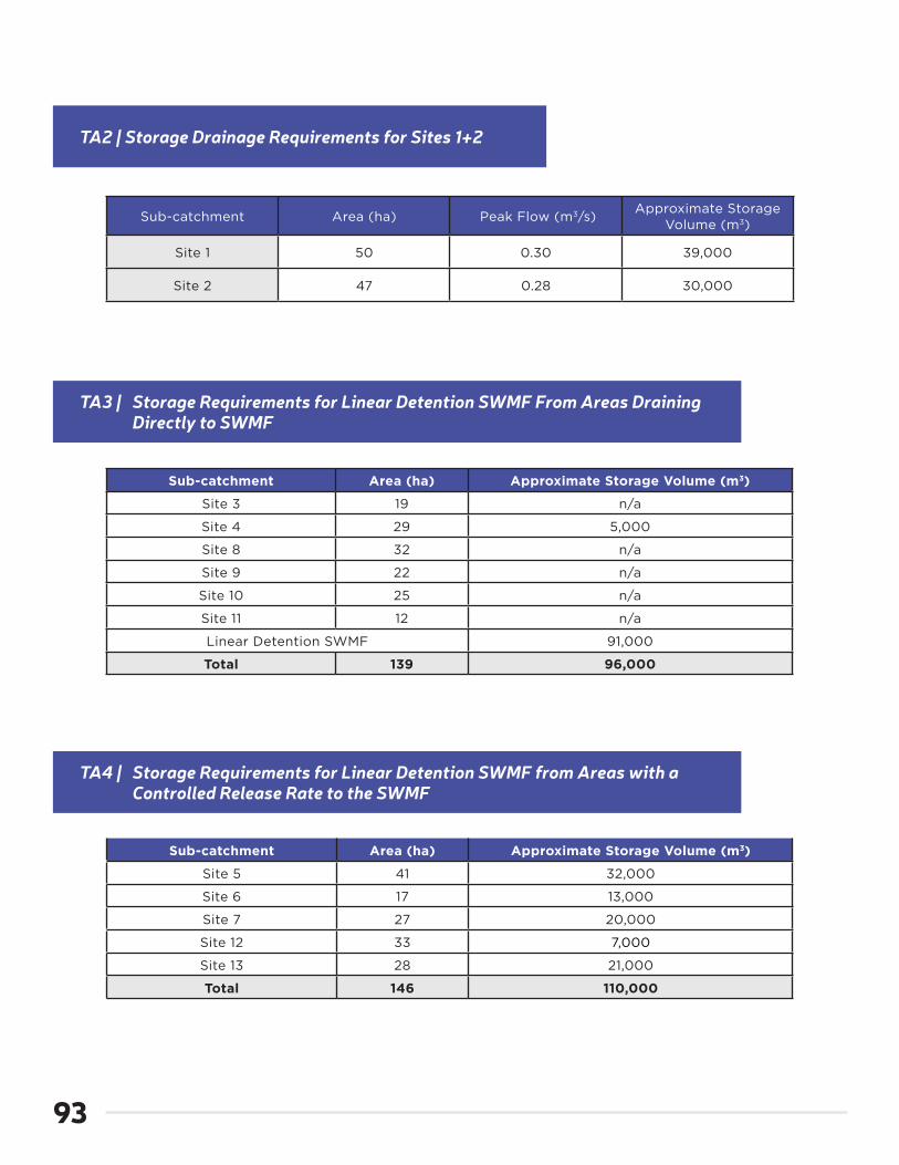
93
TA2 | Storage Drainage Requirements for Sites 1+2
Sub-catchment Area (ha) Peak Flow (m3/s)Approximate Storage
Volume (m3)
Site 1 50 0.30 39,000
Site 2 47 0.28 30,000
TA3 | Storage Requirements for Linear Detention SWMF From Areas Draining Directly to SWMF
TA4 | Storage Requirements for Linear Detention SWMF from Areas with a Controlled Release Rate to the SWMF
Sub-catchment Area (ha) Approximate Storage Volume (m3)
Site 3 19 n/a
Site 4 29 5,000
Site 8 32 n/a
Site 9 22 n/a
Site 10 25 n/a
Site 11 12 n/a
Linear Detention SWMF 91,000
Total 139 96,000
Sub-catchment Area (ha) Approximate Storage Volume (m3)
Site 5 41 32,000
Site 6 17 13,000
Site 7 27 20,000
Site 12 33 7,000
Site 13 28 21,000
Total 146 110,000

Southeast Regina Neighbourhood Plan |
App
endi
x
94
The domestic flows from both the Creeks and Greens on Gardiner communities drain to the Creeks Pump Station (PS). The Creeks Pump Station feeds into the southeast trunk which discharges into the McCarthy Boulevard Pump Station. Previously completed studies have identified the need for
TA5 | Storage Requirements for Sites 14-19 Draining to Chuka Creek
Sub-catchment Area (ha) Approximate Storage Volume (m3)
Site 14 32 23,000
Site 15 20 13,000
Site 16 37 18,000
Site 17 51 33,000
Site 18 42 19,000
Site 19 10 6,000
Total 192 112,000
Related Documents