October 2016

Welcome message from author
This document is posted to help you gain knowledge. Please leave a comment to let me know what you think about it! Share it to your friends and learn new things together.
Transcript

October 2016


Moraga Walk | Bike Plan
Adopted October 2016
Town of Moraga
Prepared by Eisen | Letunic


Moraga Walk | Bike Plan Page i
Table of contents
Acknowledgements ............................................................ iii
1 | Introduction ................................................................. 1
1. Overview of the plan ................................................................... 2
2. Planning process .......................................................................... 3
3. Contents of the plan ..................................................................... 4
4. Public outreach ............................................................................. 4
2 | Existing conditions ....................................................... 7
1. Chapter overview ........................................................................ 8
2. Setting and land use .................................................................... 8
3. Key destinations ......................................................................... 10
4. Commuting ................................................................................. 11
5. Traffic collisions ......................................................................... 12
6. Street network ............................................................................ 15
7. On-street pedestrian facilities .................................................. 16
8. On-street bicycle facilities ......................................................... 18
9. Off-street facilities ...................................................................... 19
10. Bike parking .............................................................................. 20
11. Programs and activities ........................................................... 21
12. Integration with other modes ................................................. 22
13. Related plans ............................................................................. 23
3 | Needs assessment ...................................................... 31
1. Chapter overview ....................................................................... 32
2. Opportunities for public input ................................................. 32
3. Key themes from the comments ............................................... 34
4. Community survey .................................................................... 35
5. Student survey ............................................................................ 40
6. Interactive map ........................................................................... 43
7. Meeting of the Citizens Advisory Committee ........................ 47
8. Public workshop ......................................................................... 48
9. Group bike ride ........................................................................... 51
10. Town Council hearing ............................................................. 53
11. NextDoor ................................................................................... 54
12. Email ........................................................................................... 55
4 | Pedestrian projects ..................................................... 57
1. Chapter overview ....................................................................... 58
2. Developing the recommendations ........................................... 58
3. Sidewalk projects ........................................................................ 59
4. Intersection crossing improvements ........................................ 64
5. Lower-priority or longer-term pedestrian projects ............... 70
5 | Bicycle projects ........................................................... 73
1. Chapter overview ....................................................................... 74
2. On-street bikeway network ....................................................... 75
3. Bikeway types ............................................................................. 76
4. Intersection improvements ....................................................... 83
5. Bicycle parking ............................................................................ 86
6. Lower-priority or longer-term bicycle projects ...................... 87

Moraga Walk | Bike Plan | Table of contents Page ii
6 | Support programs and other actions ............................ 89
1. Chapter overview ...................................................................... 90
2. Support programs ...................................................................... 90
3. Other actions ............................................................................... 93
4. Wayfinding signage program .................................................. 94
7 | Implementation ......................................................... 99
1. Chapter overview .................................................................... 100
2. Cost of proposed projects ....................................................... 100
3. Most likely funding sources ................................................... 103
Appendices
A. Comments from the community survey on needs ............. 107
B. Comments from the student survey on needs .................... 151
C. Comments from the interactive map ................................... 157
D. Comments on needs received by email ............................... 169
E. Results of the prioritization survey ...................................... 175
Tables
1. Commute mode split ................................................................ 11
2. Summary of collisions involving pedestrians or cyclists ......... 12
3. Collisions by age group ............................................................ 13
4. Collisions by party at fault ....................................................... 13
5. Collisions by primary collision factor .................................... 13
6. Collisions by time of day .......................................................... 13
7. Office of Traffic Safety 2012 rankings ..................................... 14
8. Sidewalk projects ....................................................................... 60
9. Other key pedestrian routes .................................................... 63
10. Intersections for crossing improvements ............................. 66
11. Segments for street light improvements .............................. 71
12. Streets on the bikeway network ............................................ 75
13. Bike route segments ................................................................. 76
14. Bike lane segments ................................................................... 81
15. Lower-priority or longer-term bikeway projects ................. 87
16. Estimated cost of improvements by project type .............. 100
17. Estimated cost of sidewalk projects ..................................... 101
18. Estimated cost of bike route segments ................................ 102
19. Estimated cost of bike lane segments .................................. 102
20. Most likely grant programs for improvements ................. 104
Figures
1. Planning area and context .......................................................... 9
2. Proposed pedestrian projects ................................................... 62
3. Sample pedestrian improvements ........................................... 67
4. Sample pedestrian crossing improvements ........................... 69
5. Proposed bikeway network ...................................................... 77
6. Sample bicycle improvements ................................................. 83
7. Wayfinding signage panels for drivers and pedestrians ...... 95
8. Wayfinding signage panels for cyclists ................................... 96
9. Proposed wayfinding signage locations ................................. 97

Moraga Walk | Bike Plan Page iii
Acknowledgments
Town Council
Michael Metcalf, Mayor
Dave Trotter, Vice Mayor
Phil Arth
Teresa Onoda
Roger Wykle
Planning Commission
Steve Woehleke, Chair
Tom Marnane, Vice Chair
Suzanne D'Arcy
Kymberleigh Korpus
Ferenc Kovac
Christine Kuckuk
Ravi Mallela
Walk | Bike Plan Citizens Advisory Committee
William Carman (Park & Recreation Commissioner)
Cordelia Crockett
Ramona Escano-Thompson (Design Review Board Member)
Rebecca Goodman
Ferenc Kovac (Planning Commissioner)
Lance Larson
Andy Scheck
Staff
Ellen Clark, Planning Director
Coleman Frick, Associate Planner
Consultants
Eisen | Letunic (lead; Niko Letunic, Project Manager)
Bike East Bay (outreach; Dave Campbell)
Image credits
Coleman Frick: Pages 3 and 48.
Google Street View: Page 65.
Erin Heath: Chapter cover pages and pages 8, 15, 16, 18, 20, 58, 74,
85 and 106.
Max Heim (Studio L’Image): Walk | Bike Plan logo.
laecovillage.wordpress.com: Page 74 (bottom left column).
lamorindaweekly.com: Page 22.
Niko Letunic: Pages 20, 51 and 52.
Richard Masoner / Cyclelicious (via flickr): Page 75 (top).
Moraga Police Department: Page 90.
Wendy Scheck: Page 86.
seattle.gov: Page 75 (bottom).
This project was funded in part by a Transportation Development
Act grant, through the Metropolitan Transportation Commission
and Contra Costa County.


Moraga Walk | Bike Plan Page 1
1 | Introduction

Moraga Walk | Bike Plan | Introduction Page 2
1 | Overview of the plan Moraga residents—like residents of many other cities around the
Bay Area and beyond—have expressed a growing interest in
walking and bicycling, not only for recreation but also for
transportation. At the same time, there has been greater recognition
by decision-makers and the broader public that non-motorized
transportation should be encouraged and promoted for the many
benefits it brings. Walking and biking improve the environment,
neighborhood livability and public health by reducing traffic, air
pollution, noise and energy consumption. Additionally, by offering
inexpensive ways of getting around, walking and biking promote
physical activity and contribute to a more balanced transportation
system for Moraga.
In mid-2015, the Town of Moraga—with the help of planning
consultants—embarked on a process to update the 2004 Moraga
Bicycle and Pedestrian Master Plan. Town staff felt that the original
plan no longer reflected Moraga’s needs, priorities and
expectations, and that it lacked the detail and specificity to be an
effective tool for the implementation of improvements, particularly
on-street facilities such as sidewalks and bike lanes (as opposed to
trails).
A note about capitalization: In lower case, “town” refers to the
geographic area of Moraga and to its community; in upper case,
“Town” refers to the government entity that administers the area
of Moraga.
The Moraga Walk|Bike Plan is the update to the 2004 Plan. It is a
long-range planning document meant to guide the Town’s
decisions about walking and biking over the next decade. Its
ultimate goal is to make walking and biking in Moraga safer and
easier so as to encourage more people to walk and bike for both
recreation and transportation.
To meet this goal, the plan contains a set of recommended physical
(infrastructure) projects and non-infrastructure-related actions
designed to improve conditions around town for pedestrians and
cyclists. Because the 2004 Bicycle and Pedestrian Plan identified an
extensive network of off-street paths and trails, the focus of the
Walk | Bike Plan is on on-street pedestrian and bicycle facilities.
The Walk | Bike Plan, including its work plan of recommended
improvements, has a “lifespan,” or time horizon, of approximately
fifteen years, from 2017 through 2031. It is expected that within this
period the Walk | Bike Plan would be updated to once again
address changes in residents’ needs, priorities and expectations
with regard to walking and biking.

Moraga Walk | Bike Plan | Introduction Page 3
2 | Planning process The planning process for the Walk | Bike Plan was meant to
provide a comprehensive framework for addressing the Town’s
key objectives with respect to walking and biking:
Determine the walking and biking needs and concerns of the
Moraga community: residents, workers, students, visitors,
Town staff, appointed and elected Town officials and other
stakeholders.
Respond to these needs and concerns by recommending a set
of walking and biking improvements that are effective,
affordable and otherwise realistic, with a focus on on-street
facilities.
Engage the local community of pedestrians and cyclists so as to
strengthen the constituency for investments and improvements
in non-motorized transportation.
Create a plan that serves as an advocacy document for securing
funds from federal, state, regional, local and private sources to
implement the desired improvements.
The planning process took place over approximately one year,
from July 2015 through August 2016. The process consisted of the
following six main tasks:
1. Inventorying existing conditions and issues relevant to non-
motorized transportation in Moraga to establish the “baseline”
state of walking and biking in the town and the planning
context for the project, and to provide initial insights into the
walking and bicycling experience in Moraga.
2. Conducting a needs assessment process to hear the concerns
and needs of local pedestrians and cyclists, learn about the
obstacles and challenges to walking and biking in Moraga, and
solicit residents’ ideas and suggestions for improving
conditions.
3. Formulating a range of improvement options, or preliminary
ideas, that address the community’s key needs and concerns, as
identified through the previous task.
4. Obtaining input from the public on the potential improvements,
and narrowing down and prioritizing the potential options based
on this input.
5. Preparing a draft plan document incorporating the work
products from the previous tasks and also preparing a draft
“Negative Declaration” for the project, pursuant to the
California Environmental Quality Act (CEQA). (Town staff
concluded that the Walk | Bike Plan will not have a significant
effect on the environment.)
6. Lastly, shepherding the draft plan and Negative Declaration
through the formal approval process, culminating with adoption
of the plan and approval of the Negative Declaration by the
Town Council.
Moraga Walk | Bike Plan | Introduction Page 4
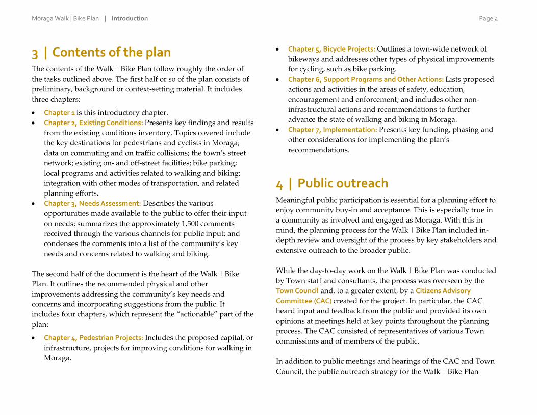
3 | Contents of the plan The contents of the Walk | Bike Plan follow roughly the order of
the tasks outlined above. The first half or so of the plan consists of
preliminary, background or context-setting material. It includes
three chapters:
Chapter 1 is this introductory chapter.
Chapter 2, Existing Conditions: Presents key findings and results
from the existing conditions inventory. Topics covered include
the key destinations for pedestrians and cyclists in Moraga;
data on commuting and on traffic collisions; the town’s street
network; existing on- and off-street facilities; bike parking;
local programs and activities related to walking and biking;
integration with other modes of transportation, and related
planning efforts.
Chapter 3, Needs Assessment: Describes the various
opportunities made available to the public to offer their input
on needs; summarizes the approximately 1,500 comments
received through the various channels for public input; and
condenses the comments into a list of the community’s key
needs and concerns related to walking and biking.
The second half of the document is the heart of the Walk | Bike
Plan. It outlines the recommended physical and other
improvements addressing the community’s key needs and
concerns and incorporating suggestions from the public. It
includes four chapters, which represent the “actionable” part of the
plan:
Chapter 4, Pedestrian Projects: Includes the proposed capital, or
infrastructure, projects for improving conditions for walking in
Moraga.
Chapter 5, Bicycle Projects: Outlines a town-wide network of
bikeways and addresses other types of physical improvements
for cycling, such as bike parking.
Chapter 6, Support Programs and Other Actions: Lists proposed
actions and activities in the areas of safety, education,
encouragement and enforcement; and includes other non-
infrastructural actions and recommendations to further
advance the state of walking and biking in Moraga.
Chapter 7, Implementation: Presents key funding, phasing and
other considerations for implementing the plan’s
recommendations.
4 | Public outreach Meaningful public participation is essential for a planning effort to
enjoy community buy-in and acceptance. This is especially true in
a community as involved and engaged as Moraga. With this in
mind, the planning process for the Walk | Bike Plan included in-
depth review and oversight of the process by key stakeholders and
extensive outreach to the broader public.
While the day-to-day work on the Walk | Bike Plan was conducted
by Town staff and consultants, the process was overseen by the
Town Council and, to a greater extent, by a Citizens Advisory
Committee (CAC) created for the project. In particular, the CAC
heard input and feedback from the public and provided its own
opinions at meetings held at key points throughout the planning
process. The CAC consisted of representatives of various Town
commissions and of members of the public.
In addition to public meetings and hearings of the CAC and Town
Council, the public outreach strategy for the Walk | Bike Plan
Moraga Walk | Bike Plan | Introduction Page 5
included community workshops, surveys, regular updates and
announcements on the Town’s website and to the project’s email
distribution list, and other varied activities. Public outreach
occurred throughout the planning process, but special efforts were
made during two tasks, or phases of the project: (i) to obtain input
on needs and concerns; and later, (ii) to obtain feedback on the
implementation options. Below is a summarized timeline of
outreach efforts carried out as part of the Walk | Bike Plan process:
May–June 2015: Preliminary outreach to the community to
introduce the project, build an email list for purposes of sending
out updates and announcements, and solicit membership
applications for the CAC.
July 21, 2015: Inaugural meeting of the CAC, to hear an overview
of the planning process, confirm objectives and expectations, hear
preliminary findings from the existing conditions inventory, and
discuss outreach strategies for the needs assessment process.
September–November 2015: Extensive outreach related to the
needs assessment process. Activities included:
Community survey, administered primarily online; ran for five
weeks and received 387 responses.
Supplemental survey aimed at school students; ran for ten days
and received 210 responses.
Online “pinnable” map on which people could post comments;
ran for five weeks and received 130 comments.
Second CAC meeting, held on September 22.
Hosting a booth at the Moraga Pear & Wine Festival on
Saturday, September 26.
Community workshop on the evening of Tuesday, September
29 at the Hacienda de las Flores; attended by approximately 20
members of the public.
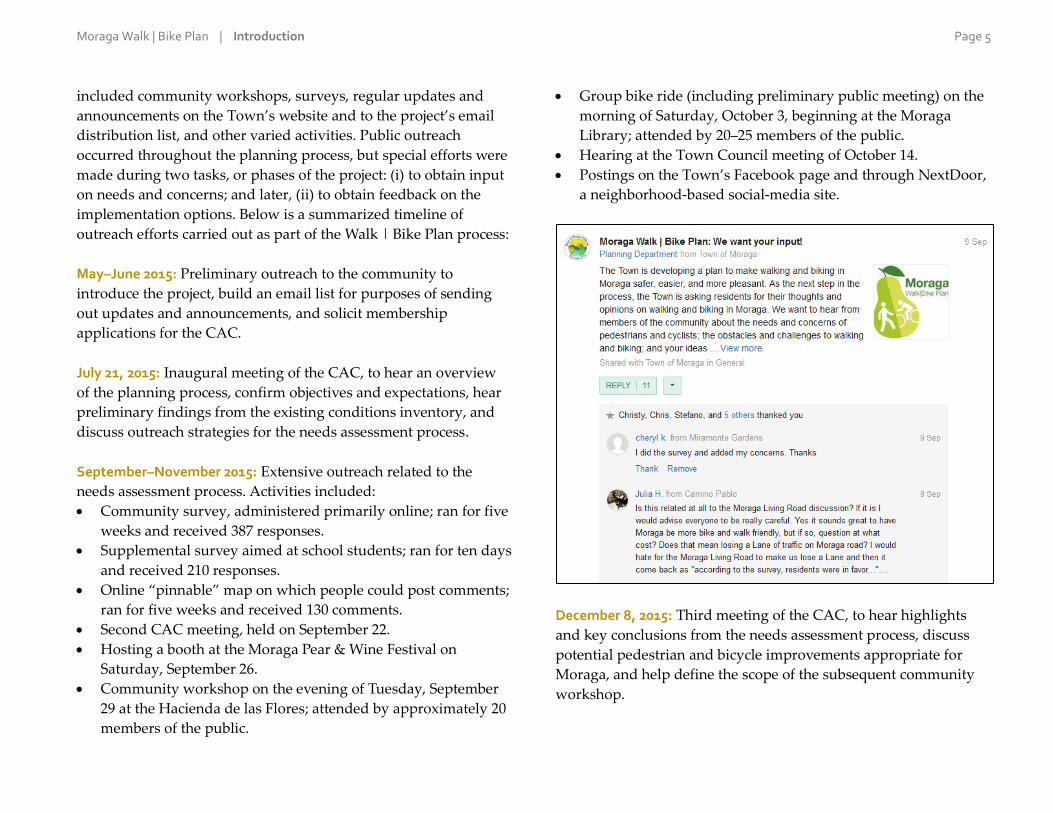
Group bike ride (including preliminary public meeting) on the
morning of Saturday, October 3, beginning at the Moraga
Library; attended by 20–25 members of the public.
Hearing at the Town Council meeting of October 14.
Postings on the Town’s Facebook page and through NextDoor,
a neighborhood-based social-media site.
December 8, 2015: Third meeting of the CAC, to hear highlights
and key conclusions from the needs assessment process, discuss
potential pedestrian and bicycle improvements appropriate for
Moraga, and help define the scope of the subsequent community
workshop.

Moraga Walk | Bike Plan | Introduction Page 6
February–April 2016: Outreach related to refining and prioritizing
the improvement options. Activities included:
Community workshop on the evening of Thursday, February 4
at the Hacienda de las Flores; attended by approximately 25
members of the public.
Online survey; ran for two and a half weeks in February and
March, and received 141 responses.
Town Council meeting of April 27, with an opportunity for
public comment.
August–October 2016: Outreach related to formal consideration by
the Town of the Walk | Bike Plan and Negative Declaration for the
project. This included presentations about the public draft version
of the Plan at three public meetings:
Fourth, and final, meeting of the CAC, on Tuesday, August 30.
Monday, October 3 meeting of the Planning Commission.
Wednesday, October 26 meeting of the Town Council.

Moraga Walk | Bike Plan | Introduction Page 7
2 | Existing Conditions

Moraga Walk | Bike Plan | Existing conditions Page 8
1 | Chapter overview The first task in the planning process for the Walk | Bike Plan was
an inventory of existing conditions. This chapter presents the
results of, and key findings from, that inventory. It summarizes
existing local conditions and issues relevant to non-motorized
transportation such as the key destinations for pedestrians and
cyclists in Moraga; data on commuting and on traffic collisions; the
town’s street network; existing on- and off-street facilities; bike
parking; local programs and activities related to walking and
walking; integration with other modes of transportation, and
related planning efforts (key physical conditions are shown in
Figure 1 on the next page). The inventory of existing conditions
provided initial insights into the walking and bicycling experience
in Moraga, and established the local planning context for the
project.
2 | Setting and land use The town of Moraga is located in southwest Contra Costa County,
in the heart of the San Francisco Bay Area. It is bordered by the
cities of Lafayette (to the north and northeast) and Orinda (to the
northwest) and by unincorporated areas of the county, including
the community of Canyon. The town’s central areas are relatively
flat, but hills rise both to the east and west of Moraga Road, which
bisects the town.
Moraga is a suburban and semi-rural community. It is one of the
smallest of Contra Costa County’s 19 cities, with a population of
approximately 17,000 people and a land area of 9.4 square miles.
Most of the land is taken up by low-density single-family
neighborhoods and by open space. Civic and community facilities
such as schools, parks and government buildings are found
throughout the town; Saint Mary’s College occupies a large area
south of St. Mary’s Road and Bollinger Canyon Road. There are
two commercial areas in the center of town, both of which are
designated for future mixed-use development. The town has no
industrial areas.
Moraga Walk | Bike Plan | Existing conditions Page 9
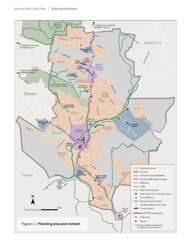
Figure 1 | Planning area and context

Moraga Walk | Bike Plan | Existing conditions Page 10
3 | Key destinations Typically, the most important destinations for pedestrians and
cyclists are residential neighborhoods; commercial areas and
employment sites; and community facilities and places of assembly
such as schools, parks and civic and government buildings.
Moraga has two commercial areas:
Rheem Valley Shopping Center, at the southwest corner of
Moraga Road and Rheem Boulevard.
Moraga Shopping Center, west of Moraga Road along Moraga
Way.
Residential neighborhoods include:
Campolindo (in the northwest corner of the town).
Rheem Valley Manor (in the center, bounded by Moraga Road,
Rheem Boulevard and St. Mary’s Road).
Corliss (northwest of Moraga Center).
Larch/Camino Pablo (southeast of Canyon Road).
Moraga Country Club (southwest of Country Club Drive and
Moraga Way)
The Bluffs (northeast of Bollinger Canyon Road).
Sanders Ranch (east of Camino Pablo).
Ascot Drive and Donald Drive (a neighborhood of multi-family
dwellings and apartments northwest of Moraga Road).
Moraga has a number of educational institutions:
Public schools: Donald Rheem, Los Perales and Camino Pablo
Elementary; Joaquin Moraga Intermediate; and Campolindo
High. In addition, some Moraga students attend Miramonte
High in Orinda, just across the town border.
Private schools: the Saklan School (pre-K through 8th grade) and
Orion Academy (grades 9–12) as well as several pre-schools.
Higher education: Saint Mary’s College, a private post-
secondary college that is also the largest employer in Moraga.
The town’s parks and other main recreational facilities are:
Moraga Commons Park, featuring picnic areas, band shell and
lawn, skate park, disc golf course, tot lot and various sports
courts. “The Commons” is the site of many of Moraga’s major
community events such as the 4th of July festival, summer
concert series and Pear Festival.
Rancho Laguna Park, with tot lots, swings, picnic areas,
amphitheater and large lawn.
Hacienda de las Flores, a historic estate featuring event rental
facilities, large lawn and landscaped gardens.
Mulholland Ridge Open Space Preserve, 250 acres of open
space, much of it open to the public, straddling Moraga and
Orinda.
Moraga Country Club, a private facility that includes an 18-hole
golf course and private swim and tennis club.
The area’s network of walking, hiking and biking trails (see the
“Off-street facilities” section).
The main government buildings serving the walk-in public are:
Main Town offices, which house the Police, Planning and Public
Works Departments, Town Clerk, Town Manager and
Administrative Services (329 Rheem Boulevard). In late 2015 the
Town opened the new Town Council Chambers and
Community Meeting Room in a renovated building at 335
Rheem Boulevard.
Hacienda de las Flores (also mentioned above, under
recreational facilities), which houses the Moraga Parks and
Recreation Department.
Moraga public library (1500 St. Mary’s Road).
The town’s post office (460 Center Street, in the Rheem Center).

Moraga Walk | Bike Plan | Existing conditions Page 11
4 | Commuting This section examines the number of pedestrian and bicycle
commuters in Moraga. It uses “journey-to-work” data from the 5-
year American Community Survey (ACS), an ongoing survey
conducted by the U.S. Census Bureau. The data is from 2009–2013,
the most recent five-year period for which ACS data is available.
According to the ACS, 3.6% of Moraga workers commuted
primarily on foot while 0.4% did so primarily by bike (see Table 1
below). Meanwhile, almost two thirds, 64.8%, drove alone; 6.6%
carpooled; 15.5% used public transportation; 8.7% worked from
home; and 0.4% used other means. For comparison purposes,
Moraga’s pedestrian share (3.6%) was higher than Contra Costa
County’s as a whole (1.6%) and than California’s (2.7%). On the
other hand, the bicycling share (0.4%) was lower than both the
county’s (0.5%) and the state’s (1.1%).
Table 1 | Commute mode split
* Includes taxicab, motorcycle and other means.
The ACS is the best source of travel data for Moraga. However, it
has two significant limitations. First, it provides information on the
number of commuters but not on the number of trips; more
importantly, it also does not provide information on non-work-
related travel, which in most communities makes up the large
majority of trips. Second, because the numbers of pedestrian and
bicycle commuters are small, the margin of error for these
estimates is quite large. (Margin of error is a measure of the
variability or range of an estimate. The larger the margin, the lower
the accuracy of the estimate and the less likely it is to be close to
the true value.)
Based on the margins of error for the data, the likely true
percentage of pedestrian commuters in Moraga is anywhere
between 2.1% and 5.1% while for bicycle commuters it is 0.0–0.8%.
Moraga C. C. County California
Commuters % Likely range % %
Drove alone 4,330 64.8%
Carpooled 439 6.6%
Public transportation 1,032 15.5%
Walked 242 3.6% 2.1 – 5.1% 1.6% 2.7%
Bicycled 24 0.4% 0.0 – 0.8% 0.5% 1.1%
Worked from home 583 8.7%
Other* 29 0.4%
Total 6,679 100.0%

Moraga Walk | Bike Plan | Existing conditions Page 12
5 | Traffic collisions This section analyzes traffic collisions in Moraga involving
pedestrians or cyclists. The data for the first part of this section
comes from the California Highway Patrol’s Statewide Integrated
Traffic Records System (SWITRS), a database of traffic collisions as
reported to and collected by local police departments and other
law enforcement agencies. The analysis covers the period from
2005 through 2014, the most recent ten-calendar-year period for
which SWITRS data is available.
SWITRS records
According to SWITRS, there were 19 traffic collisions during that
period resulting in pedestrian or cyclist injuries or fatalities. These
collisions resulted in seven pedestrians injured and one killed, and
11 cyclists injured and none killed (see Table 2 at right). It should
be noted that one of the pedestrians classified as injured died
within two months from complications related to the injury,
something not reflected in the SWITRS records. The 19 collisions
represent 16% of the 121 collisions in Moraga during 2005–2014
that resulted in traffic victims (the remainder were mostly
collisions between two or more cars, resulting in driver injuries or
fatalities).
It should be noted that minor collisions, especially those involving
property damage only, are less likely to be reported to a police
officer and to lead to police response. For this reason, the incidents
in SWITRS represent only a portion of all traffic collisions and are
more likely to be serious ones, typically involving pedestrians or
cyclists being struck by cars.
Of the 19 collisions involving pedestrians or cyclists, 15 (almost
80%) occurred on or at an intersection with one of the town’s seven
major streets (see the “Street network” section below for a list of
these arterials, and see Figure 1 for the locations of the collisions).
Seven of the 19 collisions were clustered in a very small area
around Moraga Shopping Center, indicating a likely collision
hotspot, or area of concern. (This does not necessarily mean that
this area is less safe for walking and bicycling; instead, it could
mean that more walking and biking occurs there because the
shopping center is a key destination for pedestrians and cyclists.)
Table 2 | Summary of collisions involving pedestrians or cyclists
Ped fatal
Ped injury
Bike fatal
Bike injury Total
2005 1 1 2
2006 0
2007 2 2 4
2008 1 1
2009 1 1
2010 2 2
2011 1 1 2
2012 1 3 4
2013 1 1 2
2014 1 1
Total 1 7 0 11 19
Annual average of collisions resulting in fatalities or injuries: 1.9.
As percentage of all collisions resulting in injuries: 16%.
Moraga Walk | Bike Plan | Existing conditions Page 13
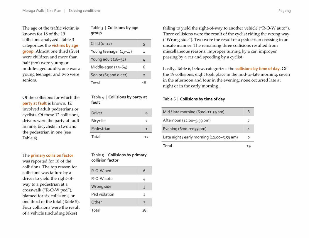
The age of the traffic victim is
known for 18 of the 19
collisions analyzed. Table 3
categorizes the victims by age
group. Almost one third (five)
were children and more than
half (ten) were young or
middle-aged adults; one was a
young teenager and two were
seniors.
Of the collisions for which the
party at fault is known, 12
involved adult pedestrians or
cyclists. Of these 12 collisions,
drivers were the party at fault
in nine, bicyclists in two and
the pedestrian in one (see
Table 4).
The primary collision factor
was reported for 18 of the
collisions. The top reason for
collisions was failure by a
driver to yield the right-of-
way to a pedestrian at a
crosswalk (“R-O-W ped”),
blamed for six collisions, or
one third of the total (Table 5).
Four collisions were the result
of a vehicle (including bikes)
failing to yield the right-of-way to another vehicle (“R-O-W auto”).
Three collisions were the result of the cyclist riding the wrong way
(“Wrong side”). Two were the result of a pedestrian crossing in an
unsafe manner. The remaining three collisions resulted from
miscellaneous reasons: improper turning by a car, improper
passing by a car and speeding by a cyclist.
Lastly, Table 6, below, categorizes the collisions by time of day. Of
the 19 collisions, eight took place in the mid-to-late morning, seven
in the afternoon and four in the evening; none occurred late at
night or in the early morning.
Table 6 | Collisions by time of day
Mid / late morning (6:00–11:59 am) 8
Afternoon (12:00–5:59 pm) 7
Evening (6:00–11:59 pm) 4
Late night / early morning (12:00–5:59 am) 0
Total 19
Table 3 | Collisions by age group
Child (0–12) 5
Young teenager (13–17) 1
Young adult (18–34) 4
Middle-aged (35–64) 6
Senior (65 and older) 2
Total 18
Table 4 | Collisions by party at fault
Driver 9
Bicyclist 2
Pedestrian 1
Total 12
Table 5 | Collisions by primary collision factor
R-O-W ped 6
R-O-W auto 4
Wrong side 3
Ped violation 2
Other 3
Total 18
Moraga Walk | Bike Plan | Existing conditions Page 14
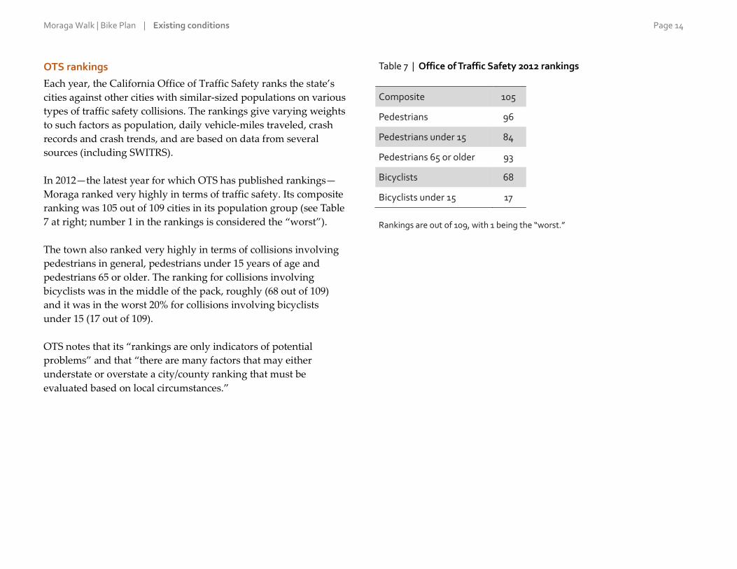
OTS rankings
Each year, the California Office of Traffic Safety ranks the state’s
cities against other cities with similar-sized populations on various
types of traffic safety collisions. The rankings give varying weights
to such factors as population, daily vehicle-miles traveled, crash
records and crash trends, and are based on data from several
sources (including SWITRS).
In 2012—the latest year for which OTS has published rankings—
Moraga ranked very highly in terms of traffic safety. Its composite
ranking was 105 out of 109 cities in its population group (see Table
7 at right; number 1 in the rankings is considered the “worst”).
The town also ranked very highly in terms of collisions involving
pedestrians in general, pedestrians under 15 years of age and
pedestrians 65 or older. The ranking for collisions involving
bicyclists was in the middle of the pack, roughly (68 out of 109)
and it was in the worst 20% for collisions involving bicyclists
under 15 (17 out of 109).
OTS notes that its “rankings are only indicators of potential
problems” and that “there are many factors that may either
understate or overstate a city/county ranking that must be
evaluated based on local circumstances.”
Table 7 | Office of Traffic Safety 2012 rankings
Composite 105
Pedestrians 96
Pedestrians under 15 84
Pedestrians 65 or older 93
Bicyclists 68
Bicyclists under 15 17
Rankings are out of 109, with 1 being the “worst.”

Moraga Walk | Bike Plan | Existing conditions Page 15
6 | Street network Rather than conform to a grid, most roads and streets in Moraga
curve and wind along natural contours and grades. This
contributes to the town’s suburban and semi-rural character.
However, the lack of a grid, combined with many dead-end streets
and cul-de-sacs, limits the connectivity of the network, especially
for pedestrians and cyclists.
A city’s streets may be classified by their function, which typically
corresponds with the amount and speed of traffic on them. This
functional classification includes, from busiest to least busy:
highways, arterials, collectors and local, or residential, streets.
The highest classification in Moraga is arterials, as there are no
highways within the town. According to the Moraga General Plan,
there are seven streets designated as arterials; they form the
backbone of Moraga’s circulation system. Roughly from north to
south, they are:
Moraga Road
Rheem Boulevard
St. Mary’s Road
Moraga Way
Canyon Road
Country Club Drive from St. Andrews Drive to Canyon Road
Camino Pablo
Collectors carry traffic between the arterials and smaller streets.
They include such streets as Campolindo Drive, Ascot Drive,
Fernwood Drive, Camino Ricardo, Corliss Drive, Larch Avenue
and quite a few others. The rest of the network is made up of local
streets. These are low-volume, neighborhood-serving streets
whose main purpose is to provide access to fronting properties.
Moraga has few traffic lights; they are limited to the arterials
mentioned above and are generally found at the intersection of two
arterials. None of the traffic lights are equipped with bicycle-
detection technology.
Most streets in the town consist of two travel lanes, one in each
direction. Not including short sections with turning and auxiliary
lanes, there are only three stretches of four lanes:
Moraga Road between Rheem Boulevard and Corliss Drive
Moraga Road/Canyon Road between St. Mary’s Road and just
south of Camino Pablo Moraga Way
Country Club Drive from School Street to Canyon Road
The posted speed limit on the arterials is 35 mph, except on
Country Club Drive and Camino Pablo and near schools and other
low-speed zones, where it is 25 mph. The speed limit on the non-
arterials is generally 25 mph.
Moraga Walk | Bike Plan | Existing conditions Page 16
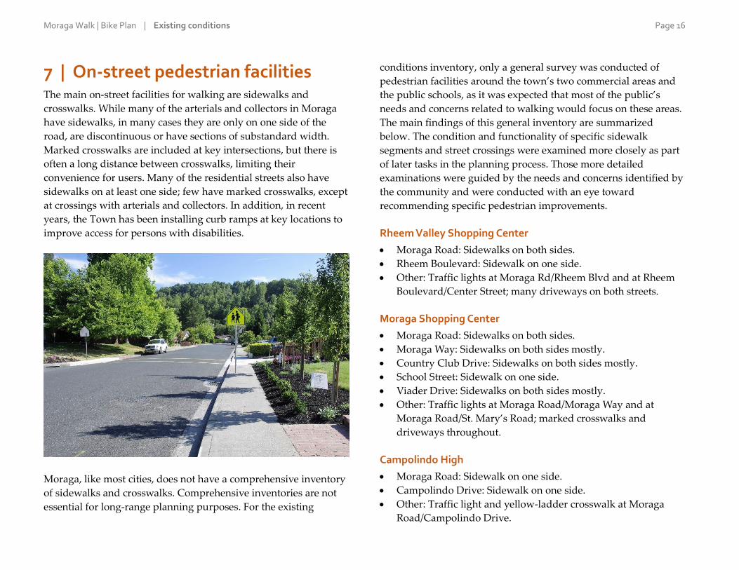
7 | On-street pedestrian facilities The main on-street facilities for walking are sidewalks and
crosswalks. While many of the arterials and collectors in Moraga
have sidewalks, in many cases they are only on one side of the
road, are discontinuous or have sections of substandard width.
Marked crosswalks are included at key intersections, but there is
often a long distance between crosswalks, limiting their
convenience for users. Many of the residential streets also have
sidewalks on at least one side; few have marked crosswalks, except
at crossings with arterials and collectors. In addition, in recent
years, the Town has been installing curb ramps at key locations to
improve access for persons with disabilities.
Moraga, like most cities, does not have a comprehensive inventory
of sidewalks and crosswalks. Comprehensive inventories are not
essential for long-range planning purposes. For the existing
conditions inventory, only a general survey was conducted of
pedestrian facilities around the town’s two commercial areas and
the public schools, as it was expected that most of the public’s
needs and concerns related to walking would focus on these areas.
The main findings of this general inventory are summarized
below. The condition and functionality of specific sidewalk
segments and street crossings were examined more closely as part
of later tasks in the planning process. Those more detailed
examinations were guided by the needs and concerns identified by
the community and were conducted with an eye toward
recommending specific pedestrian improvements.
Rheem Valley Shopping Center
Moraga Road: Sidewalks on both sides.
Rheem Boulevard: Sidewalk on one side.
Other: Traffic lights at Moraga Rd/Rheem Blvd and at Rheem
Boulevard/Center Street; many driveways on both streets.
Moraga Shopping Center
Moraga Road: Sidewalks on both sides.
Moraga Way: Sidewalks on both sides mostly.
Country Club Drive: Sidewalks on both sides mostly.
School Street: Sidewalk on one side.
Viader Drive: Sidewalks on both sides mostly.
Other: Traffic lights at Moraga Road/Moraga Way and at
Moraga Road/St. Mary’s Road; marked crosswalks and
driveways throughout.
Campolindo High
Moraga Road: Sidewalk on one side.
Campolindo Drive: Sidewalk on one side.
Other: Traffic light and yellow-ladder crosswalk at Moraga
Road/Campolindo Drive.

Moraga Walk | Bike Plan | Existing conditions Page 17
Donald Rheem Elementary
Donald Drive: Sidewalk on one side.
Laird Drive: Sidewalk on one side mostly.
Ascot Court: Sidewalk on both sides.
Ascot Drive: Sidewalk on both sides.
Other: Mid-block footpath connecting Ascot Court to the school
(also mentioned in the section below on off-street facilities).
Los Perales Elementary
Corliss Drive: Sidewalk on one side
Warfield Drive: No sidewalks.
Sullivan Drive: No sidewalks.
Camino Ricardo: Sidewalk on both sides.
Other: Mid-block footpath connecting Camino Ricardo to the
school.
Camino Pablo Elementary
Camino Pablo: Sidewalk on one side.
Larch Avenue: No sidewalks.
Other: Yellow-ladder crosswalks and specially textured and
colored crosswalks in the immediate school area.
Also: Mid-block footpaths connecting Larch Avenue to the
school; and Gaywood Place and Kazar Court to Camino Pablo.
Joaquin Moraga Intermediate
Canyon Road: Sidewalks on both sides.
Camino Pablo: Sidewalk on one side.
Rimer Drive: Sidewalks on both sides.
Other: Yellow-ladder crosswalks and specially textured and
colored crosswalks in the immediate school area.
Also: Mid-block footpaths connecting School Street to Canyon
Road and Rimer Drive to the school.
Miramonte High
Moraga Way: Sidewalk on one side.
Ivy Drive: Sidewalk on one side.
Other: Yellow-ladder crosswalks at Moraga Way and Ivy Drive.
The Town does not have dedicated policies and procedures for the
construction, installation or maintenance of pedestrian facilities.
Instead, it performs maintenance and repairs on an as-needed
basis; and constructs sidewalks and installs crosswalks and curb
ramps on an as-needed basis or as part of larger public works
projects. Some streets and sidewalks in the commercial areas and
in certain subdivisions are privately owned and maintained.

Moraga Walk | Bike Plan | Existing conditions Page 18
8 | On-street bicycle facilities Moraga lacks a
comprehensive network of
on-street designated
bikeways, though there are
facilities for cyclists on
several streets. Namely, all
the arterials (listed in the
earlier section on the
town’s street network)
have stretches of bike
lanes, relatively wide
shoulders or bike routes,
which have some bike
signage and pavement
markings but no dedicated
lane or area for cyclists,
typically because parking
is allowed on the
shoulders. The quality and
functionality of these bikeways vary greatly. Deficiencies include,
generally, discontinuity of facilities; and more specifically, lack of
signage and pavement markings, narrow shoulders, shoulders on
which parking is allowed, and segments of poor pavement quality.
Because of these deficiencies, it is unclear which roadway
segments meet Caltrans standards for bike lanes (known as Class II
facilities) and bike routes (Class III). However, it appears that the
extent of Moraga’s on-street bikeways can be categorized as
follows:
Bike lanes on Moraga Road from the Lafayette border to
Moraga Way (intermittent) and continued on Canyon Road
from Moraga Way to Constance Place.
Bike lanes on Moraga Way from the Orinda border to Moraga
Road/Canyon Road.
Bike route on Camino Pablo from Canyon Road to the County
border.
It is important to note that, whether bicycle facilities are present or
not, cyclists may use any public street in Moraga like any other
vehicle.
The main bicycle connector to Orinda is Moraga Way. Access to
Lafayette is provided mainly on the Lafayette-Moraga Regional
Trail.
The Town conducts routine maintenance of roadway surfaces but
does not give maintenance priority to roadways with bicycle
facilities. It does not have dedicated policies and procedures for the
maintenance of on-street bike facilities and instead performs
maintenance and repairs on an as-needed basis. The Town has not
implemented any major bicycle projects recently, but it spends an
undetermined amount of funds in any given year to resurface
streets, to fill in potholes, and for other street maintenance projects
that benefit cyclists.

Moraga Walk | Bike Plan | Existing conditions Page 19
9 | Off-street facilities While the Lafayette-Moraga Regional Trail is the best known,
Moraga has a number of other popular off-street walking, jogging
and biking trails. The town’s trail system is inventoried in the
“Moraga Area Trails Guidebook 2014,” published by the Moraga
Park Foundation. The guidebook lists the following trails in and on
the outskirts of Moraga:
Cindy Waxman Trail: At Hacienda de las Flores. Connects to
Mulholland Preserve.
Mulholland Ridge Trail: Along Donald Drive on the
Orinda/Moraga boundary, starting from the Hacienda parking
lot. Bicycles allowed on paved areas only.
Lafayette Reservoir trails: Paved lakeside trail and unpaved rim
trail, with connectors between the two. Accessible from a trail
at the end of Paseo Grande.
Lafayette-Moraga Regional
Trail: From Lafayette to the
Valle Vista staging area, off
Canyon Road just outside the
town. Runs through the center
of town parallel to St. Mary’s
Road, School Street and
Canyon Road. Part of the
Lamorinda Trail Loop, which
connects Moraga, Lafayette
and Orinda, mostly along on-
street bikeways. There are several trailheads, and the trail itself
is well signed but there are no signs pointing to the trail.
Old Moraga Ranch Trail: From Bollinger Canyon Road/Las
Trampas Creek, behind Saint Mary’s College, to the Rocky
Ridge Trail, south of Rancho Laguna Park. There are several
trailheads.
Connector between Rancho Laguna Park and Rocky Ridge
Trail: Accessible from the back of Rancho Laguna Park. East
Bay Municipal Utility District (EBMUD) trail use permit is
required.
Kings Canyon Trail: Along the north side of Upper San
Leandro Reservoir. Connects to, and forms a loop with, the
Rocky Ridge Trail. EBMUD trail use permit required.
Redwood Trail: Runs west from the Valle Vista staging area.
EBMUD trail use permit required.
Riche Trail: Short loop south of the Valle Vista staging area.
EBMUD trail use permit required.
Rimer Creek Trail: Runs behind Joaquin Moraga School and
along Rimer Creek, and connects to the Rocky Ridge Trail.
Accessible from the Valle Vista staging area. EBMUD trail use
permit required.
Rocky Ridge Trail: Runs southeast of the Valle Vista staging
area to the Kings Canyon Trail then northeast behind Rancho
Laguna Park to Buckhorn Creek. EBMUD trail use permit
required.
In addition to the trails listed above, there are footpaths in Moraga
Commons, West Commons Park, Rancho Laguna Park and
Hacienda de las Flores. Also, Moraga has a number of footpaths that
run through residential blocks. They serve as valuable shortcuts for
pedestrians, with several providing connections to schools. The
footpaths, identified by the streets or destinations they connect, are:
Calle la Montana and Lafayette Reservoir Recreation Area
Ascot Court and Donald Rheem Elementary
Moraga Walk | Bike Plan | Existing conditions Page 20
Camino Ricardo and Los Perales Elementary
School Street and Canyon Road
Rimer Drive and Joaquin Moraga Intermediate
Gaywood Place and Camino Pablo
Larch Avenue and Camino Pablo Elementary
Kazar Court and Camino Pablo
Tharp Drive and Walford Drive
The trails and footpaths mentioned above are on the property of
and maintained by, variously, the Town, East Bay Regional Park
District, East Bay Municipal Utility District and private property
owners. For its part, the Town does not have dedicated policies
and procedures for the maintenance of trails or footpaths and
instead performs maintenance and repairs on an as-needed basis.
The Town has not implemented any major trail projects recently,
but it spends an undetermined amount of funds in any given year
on minor trail maintenance and repair.
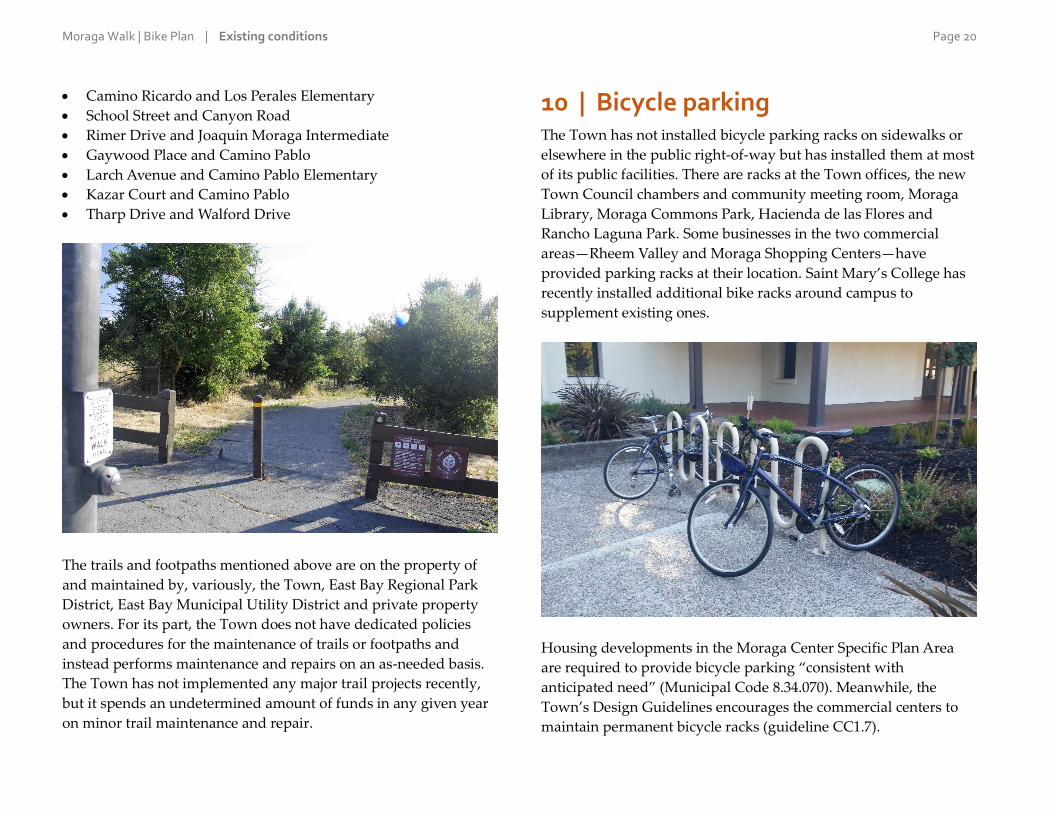
10 | Bicycle parking The Town has not installed bicycle parking racks on sidewalks or
elsewhere in the public right-of-way but has installed them at most
of its public facilities. There are racks at the Town offices, the new
Town Council chambers and community meeting room, Moraga
Library, Moraga Commons Park, Hacienda de las Flores and
Rancho Laguna Park. Some businesses in the two commercial
areas—Rheem Valley and Moraga Shopping Centers—have
provided parking racks at their location. Saint Mary’s College has
recently installed additional bike racks around campus to
supplement existing ones.
Housing developments in the Moraga Center Specific Plan Area
are required to provide bicycle parking “consistent with
anticipated need” (Municipal Code 8.34.070). Meanwhile, the
Town’s Design Guidelines encourages the commercial centers to
maintain permanent bicycle racks (guideline CC1.7).

Moraga Walk | Bike Plan | Existing conditions Page 21
11 | Programs and activities While facilities such as sidewalks, bikeways and trails are critical to
the pedestrian and bicycling experience, also valuable are non-
infrastructure programs and activities. These typically can be
categorized under the areas of education, safety, encouragement,
promotion or enforcement. Such programs and activities are few in
Moraga. They have not been a high priority for the Town
historically, and have suffered from limited resources and
insufficient coordination among agencies and organizations.
Bike to Work Day has been celebrated in Moraga since at least
2012, with the presence of “energizer stations,” where volunteers
have given away refreshments, bike commuting information and,
of course, encouragement to cyclists on their morning commutes.
In 2015, there were two energizer stations in Moraga: one
sponsored by the Town, at the corner of St. Mary’s Road and
Rheem Boulevard; and a second one sponsored by Saint Mary’s
College, at the entrance to the college.
Another example is walking and biking guidebooks and maps. The
Moraga Park Foundation (MPF) is an all-volunteer organization
that funds improvements to park facilities in Moraga and supports
recreational programs. With assistance from the Moraga Parks and
Recreation Department, East Bay Municipal Utility District and
East Bay Regional Park District, MPF publishes the “Moraga Area
Trails Guidebook.” The second version appeared in 2014.
Moraga’s Public Works Department makes “Transportation Action
Request” forms available (including online), through which the
public can report problems related to traffic and circulation, and
suggest changes or improvements. Requests for traffic-calming
measures must include the names and signatures of adult property
owners representing at least five properties in the neighborhood.
The Town’s Traffic Calming Guide (2008; updated in 2010) outlines
the process for identifying and implementing specific calming
measures. It provides for traffic-calming tools and methods at
three levels of cost and complexity:
Level 1: Education and enforcement. Typical methods include
neighborhood-specific education and increased police
presence.
Level 2: Changes to signage or pavement markings, including
stop signs and crosswalks.
Level 3: Generally physical modifications to a street, such as
curb extensions and raised crosswalks.
For its part, the Police Department trains its officers on pedestrian
and bicycle safety issues. The department has conducted public
outreach campaigns on such issues, most recently to inform drivers
about the new state law requiring at least three feet of clearance
when passing cyclists. The department uses specially equipped
mountain bikes to patrol special events as well as the town’s parks
and shopping centers. Also, from time to time, the Lafayette,
Moraga, and Orinda police departments collaborate on the “Slow
Down Lamorinda” campaign to address speeding and other
traffic-safety violations with targeted enforcement efforts.
Lastly, the Moraga School District has a list of links to safety-
related resources on its website. The list includes resources on
walking to school and biking to school.
Moraga Walk | Bike Plan | Existing conditions Page 22
12 | Integration with other modes Walking and bicycling become more practicable the better they are
integrated with other modes, or forms, of transportation, especially
transit. There are two BART stations within approximately five
miles of the center of Moraga: the Orinda and Lafayette stations.
Both BART stations have ample bicycle parking in the form of
racks and lockers. In addition, BART has recently updated its
policies to relax restrictions on carrying bikes on trains during
commute hours, although some limitations still apply.
According to BART’s most recent Station Profile Study (2008), 25%
of riders at the Orinda station on an average weekday who are
coming from home, or 523 people, live in Moraga. The comparable
figures for the Lafayette station are 6% of riders and 159 people.
Given the relatively short distances involved from Moraga to the
two stations, this is a travel “market,” or pattern, that bicycling
could tap into if better on-street facilities were available.
There is one regular bus line serving Moraga: County Connection’s
Route 6. It travels between the Orinda and Lafayette BART
stations, including on weekends, with stops along Moraga Road,
St. Mary’s Road and Moraga Way. To accommodate heavier
ridership, County Connection provides two supplemental routes
that operate on days when schools are in session, and with
schedules limited to a few hours before and after school. These are
Route 603, serving Saint Mary’s College and Campolindo High;
and Route 606, serving Saint Mary’s College and Miramonte High.
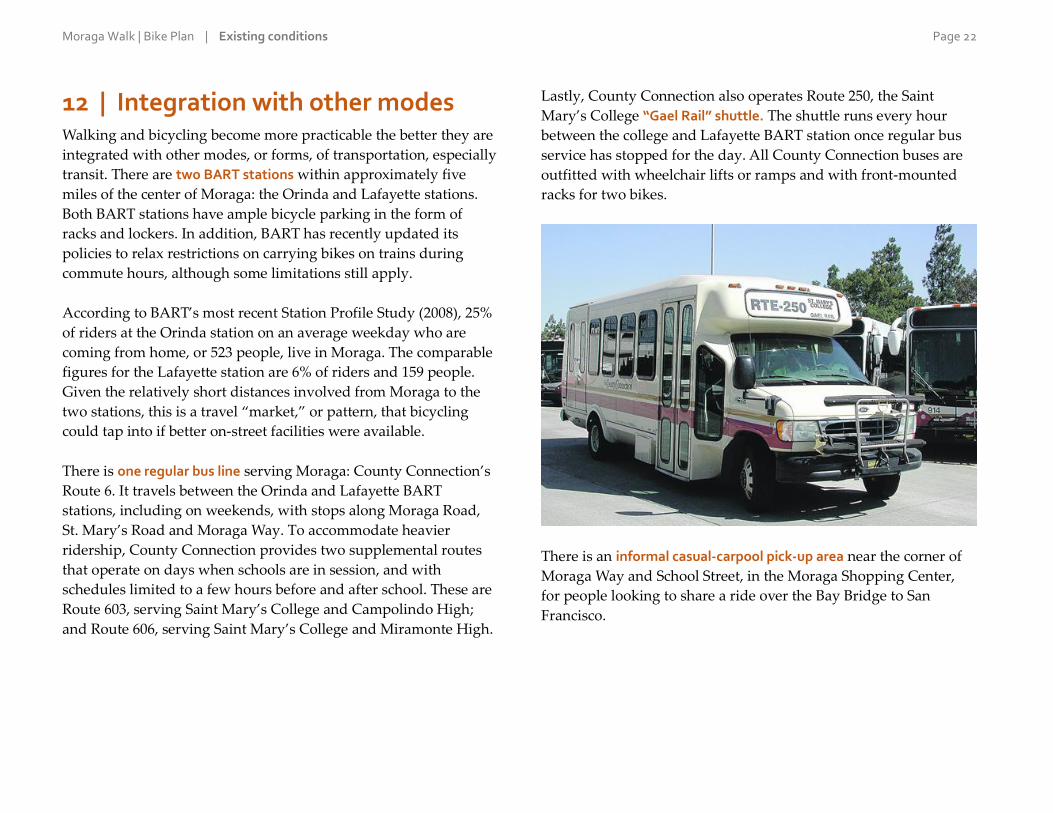
Lastly, County Connection also operates Route 250, the Saint
Mary’s College “Gael Rail” shuttle. The shuttle runs every hour
between the college and Lafayette BART station once regular bus
service has stopped for the day. All County Connection buses are
outfitted with wheelchair lifts or ramps and with front-mounted
racks for two bikes.
There is an informal casual-carpool pick-up area near the corner of
Moraga Way and School Street, in the Moraga Shopping Center,
for people looking to share a ride over the Bay Bridge to San
Francisco.

Moraga Walk | Bike Plan | Existing conditions Page 23
13 | Related plans The Moraga Walk | Bike Plan will be the main document
addressing walking and bicycling in the town. However, there are
several other planning documents and efforts that have, or could
have, a bearing on non-motorized transportation in Moraga. These
plans were reviewed for purposes of identifying recommended
projects and specific, “actionable” policies that could be carried
over into the Walk | Bike Plan or otherwise be reflected in it. The
main plans that were reviewed are listed and summarized below.
Unless noted otherwise, the plans refer to Moraga documents:
2004 Moraga Bicycle and Pedestrian Plan
General Plan (2002)
2014–2019 (Five-year) Capital Improvement Program (2014)
Climate Action Plan (2014)
Bicycle Safety Assessment (2015)
Livable Moraga Road (in progress)
Moraga Center Specific Plan (2010) and Implementation Project
(in progress)
Parks and Recreation Master Plan (2007)
Contra Costa Countywide Bicycle and Pedestrian Plan (2009)
Lamorinda Action Plan (2014)
Lamorinda Service Plan (in progress)
Orinda Bicycle, Trails and Walkways Master Plan (2011)
Lafayette Bikeways Master Plan (2006)
2004 Moraga Bicycle and Pedestrian Plan
The MBPP is the Town’s original bicycle and pedestrian plan,
which the Walk | Bike Plan will supersede. The MBPP includes
helpful tools such as planning and design guidelines for pedestrian
and bicycle facilities; a description of common funding sources for
pedestrian and bicycle improvements; and unit cost estimates for
facilities and projects. It does not include specific recommended
pedestrian improvements or support programs; instead, it outlines
general types of improvements and programs than jurisdictions
like Moraga may consider. In terms of bikeways, the MBPP
proposes a dozen projects but they lack specificity and consist
almost entirely of trail segments. One of the objectives of the
current Walk | Bike Plan effort is to address the MBPP’s
shortcomings by providing specific recommendations with a focus
on on-street facilities, both for pedestrians and cyclists.
General Plan (2002)
The General Plan is intended
to guide the town’s long-term
physical development. It does
not propose specific projects
to improve walking and
biking; however, it does
contain numerous policies—
particularly in the Circulation
Element or chapter—that are
supportive of these modes.
The most relevant policies are
listed below; some have been
edited for brevity. (“CD” refers to policies in the Community
Design Element; “C” in the Circulation Element; and “FS” in the
Community Facilities and Services Element.)
CD2.3 Commercial Centers as Community Places. Encourage
design improvements at the Moraga Center and Rheem Center
to create a stronger pedestrian orientation.
CD2.5 Connections. Designate pedestrian and bicycle routes
that connect selected public places with each other and with
residential neighborhoods, schools, and commercial centers.
Moraga Walk | Bike Plan | Existing conditions Page 24
CD5.1 Location. Locate new multi-family developments in
close proximity to commercial centers, transit stops, and
community facilities such as parks and schools, with site
design and landscaping to create buffers between adjacent uses
while providing connection to pedestrian and bicycle paths.
CD6.3 Pedestrian Orientation. Create a safe, inviting and
functional pedestrian environment in commercial areas, with
interconnected walkways and pedestrian amenities. Where
pedestrian paths cross parking areas or vehicle lanes, give clear
priority to pedestrians through pavement markings,
differentiation in the pavement surface, and signage.
C1.1 Roadway Engineering and Maintenance. Apply standard
engineering principles in the design, construction and
maintenance of all roadways to make them safe for all users. In
support of community design and environmental goals,
consider allowing narrower street widths, consistent with
Town standards, when it can be demonstrated that public
safety concerns are adequately addressed.
C1.6 Street Maintenance. Conduct street maintenance at
reasonably high standards to avoid long-term repair and
replacement costs and to ensure a safe and comfortable street
system.
C1.9 Traffic Enforcement. Provide sufficient resources to
maintain a high level of traffic safety through law enforcement.
C1.10 Traffic Education. Disseminate traffic educational
materials to transportation users to encourage ridesharing, bus
transit, and the safe use of streets and highways.
C4.1 Pedestrian Circulation. Provide a safe, continuous and
connected system of pedestrian pathways through the Town,
including sidewalks, paths, trails and appropriate crosswalks
along all principal streets.
C4.2 Bicycle Circulation. Develop a complete bicycle system
with direct, continuous, interconnected pathways between
residential and commercial areas, community facilities,
commuter corridors and transit hubs.
C4.4 Trip-Reduction Strategies. Encourage young people to
bike, walk or take the school bus to school.
FS3.6 Access for People of All Abilities. Design and manage
park and recreation facilities, including trail facilities, so that
people of all abilities can access and enjoy Moraga’s
recreational opportunities.
FS3.20 Trails Master Plan. Implement the Moraga Trails Master
Plan through ownership and easements to establish and
maintain a comprehensive trails network in the Town. Adjust
the plan as necessary to take advantage of any new trail
opportunities that may arise.
FS3.21 Trail Design and Maintenance. Consider the following
when planning, designing, implementing and maintaining trail
facilities: environmental impacts, fiscal impacts, safety and use
of fire trails.
FS3.22 Regional Trail System. Encourage and cooperate with
other jurisdictions and agencies to develop and maintain a
unified regional trail system, including hiking, biking and
equestrian trails. Support development of regional trail projects
such as the Bay Ridge Trail.
The General Plan includes many implementing programs for
putting the plan’s goals and policies into action. Several of these
are relevant to walking and bicycling:
Scenic Corridor Design Guidelines: Should address, among
other issues, pedestrian-oriented lighting and sidewalk design
along the frontage of residential and commercial areas.
Residential Design Guidelines: Should address the pedestrian
environment.

Moraga Walk | Bike Plan | Existing conditions Page 25
Multi-Family Residential Design Guidelines and Commercial
Design Guidelines: Should address the pedestrian environment
and pedestrian and bicycle linkages.
Pavement Management Program: Maintain a pavement
management program to identify and prioritize maintenance
projects in the Town’s Annual Budget. Maintenance should
also include regular cleaning of bicycle routes to remove debris
and poor pavement conditions that discourage bicycle riding.
Transportation Systems Management Plan: Review and Update
the Town’s Transportation Systems Management Plan to
identify/define level-of-service standards for traffic operations,
reflecting service levels for all street users.
Pedestrian, Bicycle and Trails Master Plan: Review, update and
expand upon the Town’s ‘Trails Master Plan’ to provide a
comprehensive plan for addressing pedestrian and bicycle
circulation issues as well as recreational trail use. The updated
and expanded Plan should, among other things, actively
involve the public in the process; establish annual priorities for
trail construction as well as pedestrian and bicycle
improvements, and identify the resources to build them; and
review pedestrian circulation issues to identify constraints to
walking, develop improvement plans at constrained locations,
and incorporate pedestrian enhancement projects into the
Town’s Annual Budget.
Bollinger Canyon Special Study: Consider opportunities for
pedestrian, bicycle and transit access from the site to the Town
center.
Lamorinda Transportation Planning: Coordinate with
Lafayette, Orinda, and the County to seek to expand and
enhance pedestrian and bike corridor connections.
Traffic Safety Education Program: Conduct a traffic safety and
education program to educate elementary school students on
traffic safety and adults on courteous driving behavior.
2014–2019 (Five-year) Capital Improvement Program (2014)
The Capital Improvement Program (CIP) outlines the Town’s
current and long-term needs in terms of substantial construction
projects and equipment purchases. The most recently adopted five
year CIP proposes a number of pedestrian- and bicycle-related
projects. These projects, including their budgeted amount(s) and
the fiscal year(s) for which they are budgeted, are:
Rancho Laguna Park pathway improvements
($70,000 in Fiscal Year 2015/16)
Various trail development and improvement projects
($4.5 million, with funding available at a date to be determined
or “unscheduled”)
Parks, trails, Hacienda and open space survey
($15,000 in FY15/16)
Canyon Road bicycle improvements from Constance Place to
the County border ($570,000, TBD/unscheduled)
Bicycle and Pedestrian Master Plan Update, which is the
subject of this existing conditions report ($73,000 in FY14/15)
Moraga Center pedestrian and bicycle improvements ($60,000
in FY15/16; $750,000, TBD/unscheduled)
Moraga Road pedestrian improvements ($40,000 in FY14/15;
$120,000, TBD/unscheduled)
Moraga Way bicycle and pedestrian improvements ($87,000,
TBD/unscheduled)
Rheem Boulevard bicycle and pedestrian improvements, from
Moraga Road to St. Mary’s Road ($259,000, TBD/unscheduled)
Rheem Boulevard bike route improvements, from the Orinda
border to Moraga Road ($44,000, TBD/unscheduled)
ADA compliance streets program ($10,000 annually)
Climate Action Plan (2014)

Moraga Walk | Bike Plan | Existing conditions Page 26
This is the Town’s roadmap
for reducing greenhouse gas
emissions. Under the Land
Use & Transportation (LU&T)
category, the plan contains a
number of strategies to
promote or facilitate walking
and biking:
Identify commercial and
public areas that lack
appropriate levels of bicycle
parking and install the
needed facilities, as funding
is available (under policy
LU&T.1).
Amend the zoning
ordinance to require adequate bicycle parking for tenants,
employees, and customers in new residential and non-
residential development (LU&T.1).
Require new bike paths through all new developments as
Conditions of Approval (LU&T.1).
Implement road improvements such as landscape medians and
street corner bulb outs to improve pedestrian safety, lower
traffic speeds and improve the pedestrian and bicycle
environment (LU&T.2).
Ensure that sidewalks or other bicycle and pedestrian facilities
on major roadways are continuous and complete, and
implement the Americans with Disabilities Act improvements,
such as installation of curb ramps at intersections (LU&T.2).
Require new and redeveloped street designs to be “complete
streets” that address the needs of all users where appropriate
(LU&T.2).
Work with schools to create trip reduction programs that
encourage walking, bicycling, carpooling, and public transit
use. Specific attention will be placed on expanding the walking
school bus programs throughout the community, where
children walk to school in adult supervised and school
coordinated groups (LU&T.2).
Expand the Safe Routes to School program to encourage
students to use alternative modes of transportation to get to and
from school. Focus on infrastructure improvements
surrounding schools on Town-maintained streets (LU&T.2).
Require new residential and non-residential development to
develop a transportation demand management plan and
ongoing program that provides incentives to individuals to
utilize alternative means of transportation (LU&T.7).
Through education and outreach, encourage existing employers
to provide bicycle facilities and other incentives to reduce
vehicle miles traveled (LU&T.7).
Bicycle Safety Assessment (2015)
With the help of consultants, the Institute of Transportation
Studies’ Technology Transfer Program at the University of
California, Berkeley, conducted a Bicycle Safety Assessment (BSA)
for the Town. Based on a one-day field visit and a thorough phone
interview of Moraga staff, the BSA suggested physical
improvements and policy changes to improve bicycle safety and
accessibility in the town. The BSA recommended specific
improvements on four street segments, chosen as representative of
a variety of street conditions of interest:
Moraga Road/Canyon Road, between St. Mary’s Road and
Camino Pablo.
Camino Pablo between Canyon Road and Shuey Drive.
Rimer Drive between Shuey Drive and Camino Pablo.

Moraga Walk | Bike Plan | Existing conditions Page 27
The (private) main access driveway through the Moraga
Shopping Center.
The BSA’s recommendations were considered in the formulation of
recommended projects and programs for the Walk | Bike Plan.
Livable Moraga Road (in progress)
This planning effort seeks to improve the function, character and
livability of Moraga Road between Campolindo High School and
St. Mary’s Road. The project seeks to address traffic flow, safety
and connectivity for all users; connections to neighborhoods,
schools and shopping areas; and the design and character of the
roadway as a gateway to the town and key destinations within it.
In June 2016, the Town
Council endorsed a
preferred project
alternative including a
continuous multi-use path
from the high school to
Moraga Commons; bike
lanes and sidewalks; new
pedestrian crossings;
various intersection improvements at Rheem Boulevard, Corliss
Drive and St. Mary’s Road; and working with the school district to
improve congestion around Campolindo High School. The
recommendations of the Livable Moraga Road project, as endorsed
by the Town Council, have been integrated into the Moraga Walk |
Bike Plan.
Moraga Center Specific Plan (2010) and Implementation Project (in progress)
The Moraga Center Specific Plan (MCSP) proposes to establish a
pedestrian-oriented commercial and residential district in the
center of Moraga, at the intersection of Moraga Road and Moraga
Way. The plan envisions a network of sidewalks and trails to
facilitate walking and biking in the area, and acknowledges the
opportunity to improve and relocate the Lafayette-Moraga
Regional Trail along the creek between St. Mary's Road and
Country Club Drive. For its part, the Implementation Project is in
the process of developing new zoning and design policies and
standards to resolve inconsistencies with existing ones, so as to
enable implementation of the MCSP. Among the aspects covered
in the new zoning regulations are “Walkable Neighborhood”
standards addressing issues such as thoroughfare design and civic
spaces to ensure that new projects incorporate these features in the
interest of creating a walkable and bikeable town center.
Parks and Recreation Master Plan (2007)
This is a comprehensive plan for the development of parks and
other recreational opportunities in the town. One of the plan’s key
recommendations is the creation of an internal network of soft-
and hard-surfaced trails to give residents access to EBRPD and
EBMUD trails. Related and other recommendations include:
Implement ADA accessibility improvements, expand bike
amenities and improve existing trails at Hacienda de las Flores.
Expand bike amenities at Moraga Commons.
Develop trails and amenities at Mulholland Preserve.
Expand bike amenities at Rancho Laguna Park and renovate
the creekside with ADA-accessible pathways.
Develop an ADA Transition Plan.
Maximize donations, grants, and partnerships to increase the
resources available for parks and recreation.

Moraga Walk | Bike Plan | Existing conditions Page 28
Contra Costa Countywide Bicycle and Pedestrian Plan (2009)
This plan designates a countywide network of existing and
proposed bikeways, both on- and off-street, to connect residential
neighborhoods throughout the county with employment and
shopping centers, schools, parks, transit hubs, downtowns and
other key activity centers. The network includes the following
segments within Moraga (listed roughly from north to south):
Moraga Road south of the Lafayette border
Rheem Boulevard west of Moraga Road
Lafayette-Moraga Regional Trail
Moraga Way
Lamorinda Action Plan (2014)
This plan assesses regional transportation issues in Orinda,
Lafayette, Moraga and unincorporated Contra Costa County,
serving as a guide for transportation planning in the area through
the year 2040. It also provides a framework for regional
transportation goals, policies and objectives.
Importantly, the plan identifies Moraga Way, Moraga Road and
the Lafayette-Moraga Regional Trail as “Interjurisdictional Routes”
in recognition of the important role they play in connecting the
three Lamorinda cities. The plan specifies projects and programs—
including improved pedestrian and bicycle amenities—intended to
promote the safety and reliability of these routes while increasing
multimodal mobility within the region.
The plan proposes the following actions related to pedestrian and
bicycle facilities and safety within Moraga for all three of the
interjurisdictional routes mentioned above (Moraga Way, Moraga
Road and the Lafayette-Moraga Regional Trail):
Support pedestrian and bicycle safety improvements around
schools, trailheads, and at intersections and along the bikeway
network (proposed action 3.02).
Improve and/or add sidewalks and/or pedestrian pathways
(3.03).
Support pedestrian and bicycle improvements including BART
access, to encourage alternative transportation modes, increase
transit ridership, and reduce auto demand (3.04).
Support the development of regional bicycle facilities (3.06).
Seek funding to provide bicycle parking infrastructure at
employment sites and activity centers throughout Lamorinda
(3.07).
Explore the feasibility of widening existing pedestrian/bike
facilities where appropriate to accommodate demand and
where technically and financially feasible. Improve north–
south bicycling by providing a continuous bikeway facility to
address the gap created by the Pleasant Hill Rd/Taylor Blvd
split (3.10).
In addition, the plan proposes the following actions for one or
two of the interjurisdictional routes:
Install, where appropriate, bicycle lanes as part of any future
roadway improvements to the corridor (for Moraga Way and
Moraga Road; 3.08).
Improve pedestrian connectivity to multi-use trails (for Moraga
Road and the Lafayette-Moraga Regional Trail; 3.09).
Improve Lafayette-Moraga Regional Trail street crossings and
striping (3.11).
Encourage commute use of the Lafayette-Moraga Regional
Trail and other trail systems as they are developed (3.12).

Moraga Walk | Bike Plan | Existing conditions Page 29
Lamorinda Service Plan (2016)
The plan was a joint effort by Orinda, Lafayette and Moraga,
initiated in 2014, to identify and investigate different
transportation alternatives in the Lamorinda area. The project
included community outreach in the form of a survey receiving
over 1,600 responses revealed strong support for increased County
Connection transit frequency and BART station accessibility.
Residents also expressed a strong desire to improve the bicycle and
pedestrian facilities adjacent to schools to provide safe routes for
students. Recommendations of the study include increasing transit
frequency, increasing availability of school bus services, and
developing improved non-fixed route transit options for seniors
and disabled residents.
Lafayette Bikeways Master Plan (2006)
The plan designates a bikeway network for the city that
incorporates the Lafayette-Moraga Regional Trail and proposes a
signed bike route on St. Mary’s Road to the Moraga border. These
are the only bikeways in the city’s network that reach Moraga.
Orinda Bicycle, Trails and Walkways Master Plan (2011)
Orinda’s plan proposes several projects near the border with
Moraga, in the vicinity of Miramonte High School:
Consider replacing on-street parking on one side of Ivy Drive
with a sidewalk.
Install a signed bike route with
“sharrows” on Ivy Drive
(sharrows are pavement
stencils denoting shared-use
travel lanes for drivers and
cyclists; see image at right).
Construct a sidewalk on
Moraga Way from the
Miramonte High School
entrance to El Camino Moraga
and work with the Town of
Moraga to construct a
sidewalk from Ivy Drive to the
bus stop on the northeast side.
Construct a pedestrian bridge across Moraga Creek from
Moraga Way to Miramonte High School, near the tennis courts.
Intersection improvements at Moraga Way / Ivy Drive (install
truncated domes on all corners, construct a pedestrian landing
pad on the southwest corner, provide for bicycle detection at
the signal and re-time the traffic signal to 2.8 feet per second).
In addition, the plan suggests a pedestrian walkway along Moraga
Way between downtown Orinda and the Moraga border. The
proposal is qualified as a more ambitious “vision” project, for
having significant environmental impacts or being too costly,
complex or controversial. Lastly, the plan suggests coordinating
with Moraga and Lafayette in the creation of a regional webpage
with resources for pedestrians, cyclists and hikers.


Moraga Walk | Bike Plan | Existing conditions Page 31
3 | Needs Assessment

Moraga Walk | Bike Plan | Needs assessment Page 32
1 | Chapter overview The second task in the development of the Moraga Walk | Bike
Plan—following the inventory of existing conditions—was the
needs assessment. This task consisted of gathering information
from the general public and from key stakeholders on the needs
and concerns of local pedestrians and cyclists; the barriers,
obstacles and challenges to walking and biking in Moraga; specific
problem areas and locations; and ideas and suggestions for
improving conditions.
This chapter describes the various opportunities that the Town
made available for the public to provide input on needs. More
importantly, the chapter presents and summarizes the
approximately 1,500 comments received through the various
channels for public input. These comments were used during the
next task in the Walk | Bike Plan process to develop a set of
recommended physical and non-physical improvements to
enhance walking and biking in Moraga.
2 | Opportunities for public input Community input on needs was gathered through the following
nine channels:
Community survey, administered primarily online, which ran
for nearly five weeks, from Sept 1 through Oct 4, 2015.
Supplemental student survey, administered online, which ran
for ten days, from Nov 13 through Nov 22, 2015.
Interactive map on which people could post comments. The
map was open for comments the same period as the survey.
Meeting of the Citizens Advisory Committee for the plan held on
September 22, 2015.
Public workshop, held on Tuesday, September 29, 2015.
Group bike ride on Saturday, October 3, 2015.
Hearing at the Town Council meeting of October 14, 2015.
NextDoor, a neighborhood-based social-media site.
By email to Town staff.

Moraga Walk | Bike Plan | Needs assessment Page 33
In order to inform and engage the public, the opportunities for
participation listed above were announced and publicized in
numerous ways:
Webpage for the Walk | Bike Plan on the Town’s website
(www.moraga.ca.us/WalkBikeMoraga).
Initial mass email in early September to the project’s email list
and reminder emails in mid-September and again in late
September.
Posts on the Town's Facebook page and on NextDoor (through
the Town’s account).
Message on the Town’s electronic marquee (situated on
Moraga Road across from Commons Park).
Flyers distributed by Planning Department staff from their
booth at the recent Pear Festival (September 26, 2015).
Paid advertisement in the September 23, 2015 issue of
Lamorinda Weekly (see image below).
Emails to Parent–Teacher Association members, to
representatives of the Acalanes and Moraga school districts
and, through these representatives, to the students.
Emails to the Sustainability Coordinator at Saint Mary’s
College and to representatives of local civic organizations
(namely Moraga Citizens Network, Moraga Juniors and
Moraga Movers) with a request that the Town’s announcement
be forwarded to their members or constituents.
Emails from Town staff to appropriate representatives of
potentially interested public agencies. Contacted agencies
included the City of Lafayette, City of Orinda, Contra Costa
County, Contra Costa Transportation Authority, East Bay
Regional Park District and East Bay Municipal Utility District.

Moraga Walk | Bike Plan | Needs assessment Page 34
3 | Key themes from the comments While it is difficult to effectively summarize approximately 1,500
comments in a few sentences, several themes emerged from the
needs assessment process as especially important areas of concern
regarding walking and biking in Moraga. These themes were:
A very high percentage of comments and concerns involved
just five streets: Moraga Road, Rheem Boulevard, St. Mary’s
Road, Moraga Way and Canyon Road. All five are among the
town’s seven arterials. Among these streets, Moraga Road
attracted the most comments by a fairly wide margin.
Many other comments related to what could be considered a
second tier of streets of concern. These include Moraga’s two
other arterials—Country Club Drive and Camino Pablo—and
several of the town’s collector streets, particularly Corliss
Drive, Bollinger Canyon Road and Larch Avenue.
The main issues and concerns regarding these streets were:
o Lack of, and gaps or discontinuities in, sidewalks and
bikeways (namely bike lanes and shoulders).
o Driver behavior, especially speeding and distracted driving.
In terms of destinations, access to Moraga Shopping Center
and the streets near and surrounding it attracted the most
comments; this is not surprising, since the shopping center is
perhaps the main destination in town, not only for drivers but
also for pedestrians and cyclists. Other destinations that drew
numerous comments include Rheem Center, Commons Park
and the public schools, especially Campolindo High.
The main pedestrian-related needs or concerns expressed
through the comments were:
o Lack of, and gaps or discontinuities in, sidewalks.
o More paths and trails to connect to more destinations, and
easier access to existing trails.
o More visible or otherwise safer crosswalks at key crossings.
o Speeding and distracted driving.
o Lack of respect for pedestrians by cyclists on shared-use
trails, particularly on the Lafayette-Moraga Trail.
The main bicycling-related concerns were:
o Lack of, and gaps or discontinuities in, bike lanes and
shoulders; also inadequate maintenance of the existing lanes
and shoulders.
o More paths and trails to connect to more destinations, and
easier access to existing trails.
o Driver behavior, particularly speeding, distracted driving,
and a general lack of respect toward cyclists and
unwillingness to “share the road” with them.
o Failure of cyclists to obey the rules of the road, particularly to
ride single-file.
o Traffic lights do not detect cyclists waiting for the light to
change.
The single need or suggestion cited most often is a continuous
pedestrian and bicycle facility along Moraga Road, particularly
from Corliss Drive to Rheem Valley Shopping Center.

Moraga Walk | Bike Plan | Needs assessment Page 35
4 | Community survey The Town ran a general, community-wide survey on walking and
biking needs for just over five weeks, from September 1 through
October 4, 2015. The survey was administered primarily online,
through SurveyMonkey.com, though the Town also distributed a
printed version and collected several completed paper copies. The
survey received 387 responses. Respondents were eligible to win
one of three $50 gift certificates for Amazon through a random
drawing, as long as they provided an email for this purpose. The
survey contained 14 questions, all of which were optional.
On the following pages are summaries of each question and of the
responses given for each. Also, as indicated below, all comments
submitted through the survey are listed in Appendix A. (The
comments appear largely as submitted; they have been edited only
to remove personal-identification information.)
Connection to Moraga
The first question asked: What is your connection to Moraga? (Check
all that apply.) 385 people responded to this question. As the chart
below shows, 76% of respondents live in Moraga. Respondents had
other significant connections to Moraga, including working in
Moraga (17% of respondents) and attending Saint Mary’s College
(8%). Almost 30% of respondents have kids in Moraga schools. 20
people responded “Other” and specified their answer; these
answers are listed in Appendix A-1.
I live in Moraga 294
I have kids in Moraga schools 113
I work in Moraga 64
I live and work elsewhere but bike to or through Moraga 47
I attend Saint Mary’s College 32
I live and work elsewhere but visit Moraga 30
I live and work elsewhere but drive to or through Moraga 20
I am a middle or elementary school student in Moraga 11
I am a student at Campolindo HS or Miramonte HS 3
Other 20

Moraga Walk | Bike Plan | Needs assessment Page 36
Walking or biking for transportation
Question 2 asked: How often do you walk or bike
in Moraga for transportation (to go to school, to
work, to the store, etc.)? 355 people responded
regarding walking and 338 responded
regarding biking. As the chart on the right
shows, almost twice as many respondents
walk frequently for transportation (a few
times a week; 24%) as bike (13%). At the other
end of the spectrum, 30% never walk, and
almost half (49%) never bike, for
transportation.
Walking or biking for fun or exercise
Question 3 asked: How often do you walk or bike
in Moraga for fun or exercise (in a park, around
the neighborhood, etc.)? 354 people responded
regarding walking and 334 responded
regarding biking. As the chart on the right
shows, more than twice as many respondents
walk frequently for fun or exercise (a few
times a week; 54%) as bike (25%). On the
other hand, 9% never walk, and one fourth
(25%) never bike, for fun or exercise.

Moraga Walk | Bike Plan | Needs assessment Page 37
Age
This question asked
respondents how old
they are. 383 people
responded to this
question. As the table on
the right shows, just over
half of respondents were
middle-aged (between
ages 45 and 64), and 17%
were seniors (age 65 or
older).
Challenges and obstacles to walking
Question 5 listed ten potential challenges and obstacles to walking
and asked respondents: In your opinion, how much do they discourage
people from walking in Moraga? (The challenges were always listed in
random order.) The answer choices were “a lot,” “somewhat” and
“not too much.” 354 people responded to this question.
Four challenges were seen by more than two thirds of respondents
as discouraging people “a lot” or “somewhat” from walking in
Moraga. These could be interpreted as the most important or
significant obstacles to walking in the town:
Missing or broken sidewalks (75% of respondents).
Speeding, aggressive or distracted drivers (74%).
Missing or unsafe crosswalks (70%).
Poor lighting (for walking at night; 67%).
The other challenges listed in the question were: few or no
amenities for pedestrians; destinations are too far; steep hills;
missing curb ramps; the wait time to cross the street is too long;
and the time to cross at traffic lights is too short.
This question allowed respondents to submit a comment in
response to the following sub-question: Have we forgotten any major
general challenges to walking? 76 comments were submitted, which
appear in Appendix A-2. Many of these comments did not bring
up new challenges or obstacles but rather echoed those listed in the
question, particularly missing or broken sidewalks. Among
additional challenges cited, common themes include:
Not enough trails and poorly maintained trails.
Bad traffic manners on the part of bicyclists.
Lack of shade.
Sidewalk obstructions.
Locations for sidewalk improvements
This open-ended question asked: Are there specific streets or blocks
that need new or improved sidewalks? 194 responses were submitted,
which are listed in Appendix A-3. The streets most commonly cited
in the comments were:
Many stretches of Moraga Road, particularly between Rheem
Center and Corliss Drive.
Stretches of Rheem Boulevard, particularly near the Town
offices and east of Moraga Road.
Several stretches of Moraga Way, particularly between Moraga
Road and Camino Ricardo.
Bollinger Canyon Road.
Corliss Drive, Sullivan Drive and Hardie Drive.
Larch Avenue.
Camino Pablo.
Response percent
Response count
Under 18 1% 5
18–34 12% 46
35–44 19% 74
45–54 25% 96
55–64 25% 96
65 and older 17% 66
100% 383

Moraga Walk | Bike Plan | Needs assessment Page 38
Locations for intersection improvements
This open-ended question asked: Are there specific intersections that
need to be made safer or easier to cross? 156 responses were submitted,
which are listed in Appendix A-4. The intersections or crossings
most commonly cited were:
Several intersections along Moraga Road, especially (from
north to south): Rheem Boulevard, Devin Drive, Draeger Drive,
Corliss Drive, St. Mary’s Road, Alta Mesa and Moraga Way.
Several additional intersections along St. Mary’s Road,
especially (from east to west): Bollinger Canyon Road, Rheem
Boulevard, St. Mary’s Parkway and Carter Drive; also crossing
St. Mary’s Road in front of the library.
Several intersections along Canyon Road, especially (from
north to south): Country Club Drive, Sanders Drive, Larch
Avenue and Camino Pablo.
Across Moraga Way between Moraga Road and Viader Drive.
Other walking-related problems or ideas for improvements
This open-ended question asked: Are there other specific problems
related to walking in Moraga? Do you have any ideas or suggestions to
improve conditions? 151 responses were submitted, which are listed
in Appendix A-5. Below is a summary of common themes in the
responses:
Many streets lack sidewalks; the arterials in particular have
sidewalk gaps or discontinuities.
More paths and trails, with better, easier access and that
connect to more destinations.
Traffic goes too fast; need more traffic enforcement, traffic-
calming measures, lower speed limits.
Distracted drivers and drivers who do not yield to pedestrians.
Need to improve safety for children walking to school.
Dark streets at night.
Install flashing lights at crosswalks.
Challenges and obstacles to biking
Question 9 listed 12 potential challenges and obstacles to biking
and asked respondents: In your opinion, how much do they discourage
people from biking in Moraga? (Challenges were always listed in
random order.) The answer choices were “a lot,” “somewhat” and
“not too much.” 323 people responded to this question.
Four challenges were seen by more than two thirds of respondents
as discouraging people “a lot” or “somewhat” from biking in
Moraga. These could be interpreted as the most important or
significant obstacles to biking in the town:
Speeding, aggressive or distracted drivers (79% of
respondents).
Few or no bike lanes, bike paths and bike routes (75%).
Poor pavement quality (71%).
Cars parked on shoulders (70%).
The other challenges listed in the question were: blind or otherwise
dangerous intersections; steep hills; poor lighting (for biking at
night); few or no safe places to park a bike; no bike detection at
traffic lights; poor or no directional signage; destinations are too
far; and few or no places to shower, change and store gear.
The question allowed respondents to submit a comment in
response to the following sub-question: Have we forgotten any major
general challenges to biking? 73 comments were submitted, which
appear in Appendix A-6. Many of these comments did not bring
up new challenges or obstacles but rather echoed those listed in the
question, particularly the lack of bike lanes and paths, speeding

Moraga Walk | Bike Plan | Needs assessment Page 39
and distracted drivers. Among additional challenges cited the most
common were that existing bike lanes are narrow and poorly
maintained (with broken glass and obstructed by overgrown
vegetation). While not an obstacle to bicycling, several people
mentioned the failure of cyclists to obey the rules of the road.
Streets for bicycling improvements
This open-ended question asked: Are there specific streets where you
would like to see improvements for cyclists such as bike lanes, traffic
calming, signage or pavement stencils? 155 responses were submitted,
which are listed in Appendix A-7. The streets most commonly cited
were:
Moraga Road, particularly from Rheem Center to Commons
Park (and also through Lafayette).
Rheem Boulevard.
St. Mary’s Road.
Moraga Way.
Canyon Road.
Locations for bike racks
This open-ended question asked: Are there specific locations where
you would like to see bike-parking racks? 98 responses were submitted,
which are listed in Appendix A-8. The locations most commonly
cited were:
Moraga Shopping Center, particularly Safeway and the
Farmers Market site.
Rheem Valley Shopping Center.
Parks, particularly Commons Park and Hacienda de las Flores.
Campolindo High School.
Bus stops.
Other biking-related problems or ideas for improvements
This open-ended question asked: Are there other specific problems
related to biking in Moraga? Do you have any ideas to improve
conditions? 107 responses were submitted, which are listed in
Appendix A-9. Below is a summary of common themes in the
responses:
Provide clearly marked bike lanes (on-street) and more paths
and trails (off-street).
Signage and markings to educate drivers about cyclists’ right to
be on the road.
Poor condition of bike lanes and shoulders: parked cars, debris,
overhanging vegetation, buckled pavement.
Traffic lights do not detect waiting bikes.
Intersection of Moraga Road and St. Mary’s Road is dangerous
for northbound cyclists continuing on Moraga Road
Cyclists who do not ride single-file, particularly on St. Mary’s
Road.
Concerns or additional comments
Near the end of the survey, respondents were given the chance to
express “any concerns about the project” or provide additional
comments. 44 comments were submitted, which are listed in
Attachment 10. Two themes were especially common among these
comments:
Opposition to the removal of travel lanes, particularly on
Moraga Road.
Thanks to the Town for conducting the survey.

Moraga Walk | Bike Plan | Needs assessment Page 40
Drawing for gift cards / sign-ups for updates and announcements
238 people indicated that they would like to be entered in the
drawing for one of three $50 gift cards for Amazon.com. (The
drawing was held using an online service for this purpose
called Random.org. Three winners were picked at random,
notified of having won and were emailed their gift card.)
185 people indicated that they would like to receive future
updates and announcements about the Walk | Bike Plan.
5 | Student survey In addition to the community-wide survey, the Town ran a
supplemental survey on walking and biking aimed at public-
school students. The survey was administered online, through
SurveyMonkey.com; it ran for ten days, from November 13
through November 22, 2015. The survey received 210 responses.
Respondents were eligible to win one of two $30 gift certificates for
Amazon.com through a random drawing, as long as they provided
an email address for this purpose. The survey contained eight
questions, all of which were optional.
Below are summaries of each question and of the responses given
for each. Also, as indicated below, all comments submitted through
the student survey are listed in Appendix B. (The comments
appear largely as submitted; they have been edited only to remove
personal-identification information.)
School attended
The first question
asked: Which school do
you go to? 210 people
responded to this
question. As the chart
on the right shows,
almost half (44%) of
respondents attend
Campolindo High
School—more than
attend any other
school.
Response percent
Response count
Campolindo HS 92 44%
Joaquin Moraga IS 66 31%
Rheem ES 19 9%
Los Perales ES 18 9%
Camino Pablo ES 15 7%
Miramonte HS 0 0%
210 100%

Moraga Walk | Bike Plan | Needs assessment Page 41
Walking or biking on trails
Question 2 asked: How often do you walk or bike
on trails in Moraga? 204 people responded
regarding walking and 179 responded
regarding biking. As the chart on the right
shows, almost a quarter of students use trails
a few times a week for walking while 15% do
so for biking. At the other end of the
spectrum, 10% never use trails for walking
and almost a third never do so for biking.
Walking or biking on streets or sidewalks
Question 3 asked: How often do you walk or bike
on streets or sidewalks in Moraga? 205 people
responded regarding walking and 176
responded regarding biking. As the chart on
the right shows, half of students walk on-
street (that is, not using paths or trails) a few
times a week while only 7% never do so.
Approximately one fifth (21%) of students
bike on-street a few times a week while
almost a quarter never do so.

Moraga Walk | Bike Plan | Needs assessment Page 42
Challenges and obstacles to walking
Question 4 listed ten potential challenges and obstacles to walking
and asked respondents: In your opinion, how much do these things
make it difficult for people to walk in Moraga? (The challenges were
always listed in random order.) The answer choices were “a lot,”
“somewhat” and “not too much.” 196 people responded to this
question.
Three challenges were seen by more than two thirds of students as
discouraging people “a lot” or “somewhat” from walking in
Moraga:
Poor lighting (for walking when it is dark out; 73% of
respondents).
Speeding or aggressive drivers (68%).
Missing or unsafe crosswalks (68%).
The other challenges listed in the question were: missing or broken
sidewalks; steep hills; destinations are too far; few or no amenities
for pedestrians; the wait time to cross the street is too long; and the
time to cross at traffic lights is too short.
Making it easier to walk to school
This open-ended question asked: Is there anything your school or the
Town can do that would make it easier for you to walk to school? Tell us
about it here. 65 responses were submitted, which are listed in
Appendix B-1. Below are key conclusions about these comments:
By far the most common theme in the responses was the need
for more, continuous or improved sidewalks, particularly on
the way to the schools (several specific locations were cited).
The second most common theme was the need for more visible
or otherwise safer crosswalks, including with flashing lights,
and for additional crosswalks (several specific locations were
cited).
Other needs mentioned more than once include:
o Safer driving behavior (particularly stopping at crosswalks
and not speeding).
o Better lighting.
o More crossing guards.
Challenges and obstacles to biking
Question 6 listed 12 potential challenges and obstacles to biking
and asked respondents: In your opinion, how much do these things
make it difficult for people to bike in Moraga? (The challenges were
always listed in random order.) The answer choices were “a lot,”
“somewhat” and “not too much.” 176 people responded to this
question.
Two challenges were seen by three quarters or more of
respondents as discouraging people “a lot” or “somewhat” from
biking in Moraga:
Speeding, aggressive or distracted drivers (79% of
respondents).
Blind or otherwise dangerous intersections (75%).
The other challenges listed in the question were: cars parked on
shoulders; steep hills; few or no bike lanes, paths and routes; poor
lighting (for biking at night); poor pavement quality; few or no safe
places to park a bike; no bike detection at traffic lights; poor or no
directional signage; destinations are too far; and few or no places
to shower, change and store gear.

Moraga Walk | Bike Plan | Needs assessment Page 43
Making it easier to bike to school
This open-ended question asked: Is there anything your school or the
Town can do that would make it easier for you to bike to school? Tell us
about it here. 51 responses were submitted, which are listed in
Appendix B-2. Below are key conclusions about these comments:
By far the most common theme in the responses was the need
for more bike lanes, paths/trails and, for younger respondents,
sidewalks; several specific locations were cited.
Other needs mentioned more than once included:
o Smoother pavement.
o More street lighting.
Drawing for gift cards / sign-ups for updates and announcements
112 people indicated that they would like to be entered in the
drawing for one of two $30 gift cards for Amazon.com. (The
drawing was held using an online service for this purpose
called Random.org. Two winners were picked at random. They
were notified of having won and were emailed their gift cards.)
34 people indicated that they would like to receive future
updates and announcements about the Walk | Bike Plan.
6 | Interactive map The Town made available an online map on which people could
pin markers with location-specific as well as general comments.
The map was available for just over five weeks, during the same
period as the survey, from September 1 through October 4, 2015. It
was administered through a service called zeemaps.com. While the
map is closed for posting, the map and comments submitted may
still be viewed at http://j.mp/1NOEqpo.
130 comments were posted on the map. Commenters were asked
to categorize their comments as walking-related, biking-related, or
about both walking and biking or another issue. The comments are
summarized below under those three categories. Also, they are
listed in Appendix C. (The comments have been edited to remove
personal-identification information; text in italics at the beginning
of comments clarifies the location of comments where necessary;
text in bold indicates the titles or summaries given to comments by
commenters.)

Moraga Walk | Bike Plan | Needs assessment Page 44
Walking
73 comments submitted through the map were categorized by
commenters as walking-related. These comments are listed in
Appendix C-1 and their locations are shown on the map on the
right. Below are the main conclusions about these comments:
The majority of walking-related comments pertained to the
town’s arterials.
These comments were concentrated along Moraga Road,
Canyon Road, Moraga Way, St. Mary’s Road and Camino
Pablo.
The densest concentrations of comments occurred around
Moraga Shopping Center, and around and between the two
public schools on Camino Pablo.
The following needs and concerns were mentioned several
times:
o No continuous sidewalk along the whole length of Moraga
Road.
o Sidewalk gaps on Moraga Way and on Camino Pablo.
o Generally, difficulty accessing trails.
o Continuous sidewalks needed on one or both sides of
Moraga Road.

Moraga Walk | Bike Plan | Needs assessment Page 45
Biking
29 comments were categorized as biking-related. These comments
are listed in Appendix C-2 and their locations are shown on the
map to the right. Key conclusions about these comments include:
As with the walking-related comments, most biking-related
comments pertain to the arterials.
Biking-related comments are especially prominent along
Moraga Road and around Moraga Shopping Center.
Two needs were mentioned repeatedly:
o Adequate bicycle facilities on or along Moraga Road between
Rheem Boulevard and Corliss Drive.
o Improvements to the west-bound bike lane on Moraga Way.

Moraga Walk | Bike Plan | Needs assessment Page 46
Both walking and biking or other issues
28 comments were categorized as being about both walking and
biking or about another issue. These comments are listed in
Appendix C-3 and their locations are shown on the map on the
right. Below are the main conclusions about these comments:
As with the walking- and biking-related comments, the
majority of comments of this type pertain to the town’s
arterials.
Comments of this type appear primarily on Rheem Boulevard,
Moraga Road, Canyon Road and, particularly, on and near
Moraga Way in the area of Moraga Shopping Center.
Two needs were mentioned repeatedly:
o Sidewalks and bike lanes or paths on Rheem Boulevard, both
west and east of Moraga Road.
o Fewer or narrower lanes on Moraga Road and Canyon Road
to make room for sidewalks and bike lanes or path.
o Improved access to the Lafayette-Moraga Trail from several
locations.
o Proper sidewalks and bike lanes on Moraga Way just west of
Moraga Road.

Moraga Walk | Bike Plan | Needs assessment Page 47
7 | Meeting of the Citizens Advisory Committee The Citizens Advisory Committee for the Walk | Bike Plan met on
September 22, 2015 to discuss the needs assessment process. At the
meeting, CAC members were asked to provide input on needs
related to walking and biking and the top priorities for
improvements. Comments made during the meeting are
summarized below; they are organized into comments mainly or
entirely about walking; mainly or entirely about biking; or about
both walking and biking or about other related issues.
There was fairly wide agreement among CAC members that the
most important pedestrian-related need or concern was missing or
discontinuous sidewalks, especially along the arterials and
particularly along Moraga Road. Opinions on biking needs were
more divided: missing or discontinuous bikeways (in the form of
bike lanes, bike routes or shoulders) were cited most often but also
mentioned were lack of bike parking, of bike detection at traffic
lights and of wayfinding signage.
Walking
Sidewalk connectivity and lack of continuous sidewalks are big
issues.
Need for continuous sidewalks on the arterials, at least on one
side.
Missing sidewalk on Viader Drive.
Install inexpensive sidewalks (of decomposed granite, for
example); it’s better than having no sidewalk.
Narrow sidewalks provide no buffer against traffic.
Need better access between the Rheem and main campuses of
Saint Mary’s College.
The perimeter of Moraga Shopping Center needs beautification
(along School Street, for example).
Need in-pavement lights at crosswalks, specifically across
Canyon Road at Camino Pablo.
Biking
When planning bike facilities, “bring to life” different types of
cyclists (for example, commuters, hard-core recreational riders
and parents with kids).
Protected or buffered bike lanes provide a feeling of safety
against fast or distracted drivers.
Need more, and more-secure, bike parking, including at the
nearby BART stations.
Need bicycle detection at traffic lights on the main streets used
as bikeways.
There is no bike parking at Campolindo High School, though
there are bike cages at Camino Pablo Elementary and Joaquin
Moraga Intermediate.
Need bike parking in front of Safeway and other businesses at
Moraga Shopping Center.
Parked cars take over the bike lane in front of St. Monica
Church.
Need curb cuts for kids riding on the sidewalk.
There is a possible opportunity for a cycle track (a protected or
buffered bike lane) on Camino Pablo.
There is a nice bike-parking rack outside Homemade Kitchen
Café and Bakery but there are never bikes parked at it.
Wayfinding signage raises awareness, especially of the trails.

Moraga Walk | Bike Plan | Needs assessment Page 48
Both walking and biking or other issues
Anything that slows traffic down is good.
Narrow bridges on Country Club Drive, Canyon Road and
Moraga Way (behind the Fire Department).
When considering improvements, look carefully at available
right-of-way: on some streets the extent of the right-of-way is
not always apparent and it might have been encroached upon
over the years.
Lack of lighting is another key obstacle or challenge.
The messaging around the need for improvements should
focus on safety.
Improve access and connections to trails.
Consider roundabouts on St. Mary’s Road at Rheem Boulevard
and at Bollinger Canyon Road.
The collision hotspot at Country Club Drive and Canyon Road
needs to be examined closely.
Prioritize projects that encourage people to shift from driving
to walking and biking.
Signage and paint are inexpensive improvements.
Discontinuous bike lanes, shoulders and sidewalks are a key
challenge.
There is no appetite for speed bumps.
8 | Public workshop A community workshop was held on Tuesday, September 29, 2015
at the Hacienda de las Flores. The workshop, attended by
approximately 21 members of the public, began with a slide
presentation providing background on the Walk | Bike Plan
process and illustrating types of potential pedestrian and bicycling
improvements appropriate for Moraga. Following the
presentation, attendees were broken up into four groups and were
asked to discuss the biggest obstacles and challenges to walking
and biking in Moraga and also their ideas and priorities for
improving conditions. As a way of facilitating the discussion,
large-scale maps of the town were provided and participants were
encouraged to mark them up.

Moraga Walk | Bike Plan | Needs assessment Page 49
Below is a summary of the comments heard at the discussion
stations. The comments echoed the main themes heard at the CAC
meeting and through the survey and interactive map. These are,
namely, that the main challenges to walking and biking are the
poor, discontinuous quality of the town’s sidewalks and on-street
bikeways and dangerous or illegal driver behavior, especially
speeding and distracted driving.
General comments about walking
There are different types of walkers: recreational, “destination
walkers,” neighborhood walkers and kids who walk to school.
Side streets and neighborhoods are quiet and relatively safe.
Obstacles and challenges to walking
Poor access and connections to trails, especially from the
neighborhoods.
Many sidewalk gaps, or sidewalks on only one side of the
street. This is especially challenging on the major streets, and is
a safety issue.
Poor connectivity between neighborhoods.
Speeding.
Distracted drivers.
Need to change the attitude of people are too dependent on
cars.
Stretches of Moraga Road and Rheem Boulevard that do not
have sidewalk are danger zones.
Distances to destinations are too great for walking.
Inadequate bus service; invest in a trolley; also, poor access to
the bus stops.
Drivers do not stop at crosswalks (specific streets mentioned:
Larch Avenue, Sanders Drive, Moraga Road, St. Mary’s Road in
front of the public library).
Drivers do not respect bicyclists and pedestrians.
Concerned about the safety of my kids walking to school.
Crossing Moraga Road is difficult because it is so wide.
Poor lighting makes it feel unsafe to walk from both a traffic
and personal-security perspective.
Ways to improve conditions for walking
Fix, build and maintain sidewalks and fill in sidewalk gaps
(variations of this theme were mentioned numerous times).
Enforce traffic laws.
Identify private versus public right-of-way to determine what
improvements are possible.
Provide better lighting, benches, other pedestrian amenities.
Make it cool to walk to school.
Improve sidewalks in key zones (for example, on Moraga
Road).
Enforce parking restrictions on roadway shoulders, install “no
parking” signs.
Install pedestrian-oriented signage with the distance and
estimated walking time to key destinations.
Make Moraga Road more pedestrian-friendly; this is a top
priority.
Encourage more people to get out of their cars.
Install more stop signs and marked crosswalks.
Install landscaping strips to provide a buffer from traffic.
Pedestrian-related priorities
Projects that prioritize safety improvements.
Sidewalks and crosswalks.
Better access to destinations.
Walking loop along St. Mary’s Road to Rheem Center to
Moraga Commons.
Require residents to build and maintain sidewalks.

Moraga Walk | Bike Plan | Needs assessment Page 50
Obstacles and challenges to biking
Lack of a town-wide network of bike lanes; lack of bike lanes
on Rheem Boulevard, parts of Moraga Road.
Cars parked in the few bike lanes that do exist.
Bike racks at few of the main destinations; also, no bike lockers
for longer-term parking.
Poor pavement quality, uneven road surfaces.
Speeding poses a safety challenge, especially for kids.
The turn at Moraga Road and St. Mary’s Road is problematic
for cyclists; need better marking.
Lack of good routes around schools.
Many kids riding the wrong way on the street, including in the
bike lane.
Rheem Boulevard is a problematic street for cyclists.
Fast traffic / speeding.
No or narrow roadway shoulders.
Little traffic enforcement and what there is of it is usually done
at the same places.
Moraga Road up from Lafayette is dangerous (narrow,
winding, with fast traffic).
It is hard to turn onto Moraga Way from Moraga Road.
The St. Mary’s Road shoulder is too narrow.
Ways to improve conditions for biking
An easy, inexpensive way to make Moraga more bike friendly
is with signs and sharrows.
Reduce Moraga Road between Corliss Drive and Donald Drive
to 2–3 lanes.
Encourage kids to bike to school.
Green-painted bike lanes in key corridors.
“Share the road” signs.
In Orinda, Moraga Way near Miramonte High School has a
separate bike path; this should serve as a model.
Bike-repair stands.
New trails along Moraga Road and Rheem Boulevard (bike
lanes would not be safe enough on these streets).
Dedicated bike lanes separated from traffic.
Wayfinding signage showing the best routes.
Need more friendly drivers, slower traffic.
More public outreach at schools and from parents.
Real bike lanes without parked cars along the curb.
Biking-related priorities
Continuous bikeways in the form of bike lanes, shoulders,
routes with signs and sharrows (variations of this theme were
mentioned numerous times).
Experiment with protected or buffered bike lanes.
Directional signage, particularly to the trails.
Facilities that serve both commuters and recreational riders.
Reduce conflict between cyclists and pedestrians.
Enforce no-parking in the bike lanes.
Better traffic and parking management at the schools during
student drop-off and pick-up times.
Traffic enforcement, especially against speeding.

Moraga Walk | Bike Plan | Needs assessment Page 51
9 | Group bike ride A group bike ride open to the public took place on the morning of
Saturday, October 3, 2015. The ride was preceded by a meeting at
the Moraga Library to discuss needs and potential improvements,
and to refine the planned route for the ride. The route consisted of
a mix of arterials, collectors and neighborhood residential streets,
mostly south of Moraga Commons Park, which presented
representative on-the-ground conditions in the town. The group
stopped several times at strategic points on the route to discuss
conditions and brainstorm ideas for improvements.
The pre-ride meeting was attended by 23 members of the public, of
whom 21 took part in the ride itself. Comments made by attendees
are summarized below; they are organized into comments made
during the pre-ride meeting and those made during the ride.
Pre-ride meeting
There is no reason for four lanes on Rheem Boulevard between
the town offices and Moraga Road. One lane should be
removed.
West of Moraga Road, Rheem Boulevard is fine in the
westbound direction but not eastbound. East of Moraga Road,
Rheem is problematic (hill, fast traffic, shoulder that
disappears), except for its middle stretch.
Neither St. Mary’s Road nor the trail alongside it is ideal.
The stretch of Moraga Road between the Commons and Rheem
Center should be a top priority. It is a logical route for
pedestrians and cyclists but it is dangerous (in particular, a
culvert on the west side near the Commons).
Moraga Way needs to be fixed between Moraga Road and
Camino Ricardo (the right-of-way is encroached on by
vegetation on the north side; on the south side, the bike lane
narrows and there is a ditch).
Cars park in the bike lane in front of St. Monica’s, even though
the church has a parking lot.
There is no curb cut on Canyon Road to access the mid-block
path at the end of School Street.
Narrow bridge on Canyon Road near the town limit.
Bike ride
St. Mary's Road needs bike lanes for faster people and a wider
trail for slower riders and families. Lots of people bike St.
Mary's Road; downhill they’re able to go fast.
Several stretches of St. Mary’s Road have narrow shoulders or
none at all. Also, the road is not banked properly, so debris
collects. Westbound, there are overhanging tree branches.
Need traffic calming at the roundabout proposed at Rheem
Boulevard and St. Mary’s Road so that cars slow down and are

Moraga Walk | Bike Plan | Needs assessment Page 52
more aware. The corner at St. Mary’s Road and Rheem
Boulevard has a curb that is a tripping hazard.
Rheem Boulevard is in bad
shape, and it needs bike
lanes. The shoulder varies
in width; it narrows, then
widens, then narrows. But
do not improve the road in
a way that encourages cars
to travel faster.
The intersection of Moraga
Road and St. Mary’s Road
needs better striping to
reduce conflicts between
cyclists going straight on
Moraga and cars turning
right on St. Mary’s.
Install a flashing crosswalk
across Moraga Road at Alta
Mesa Drive.
The sidewalk area of the School Street portion of the Lafayette-
Moraga Regional Trail is confusing; most people walk there and
do not bike. Curb cuts are needed.
Need wayfinding signage for finding the School Street portion
of the trail and the portion along Moraga Creek.
Need wayfinding maps on the trails.
Canyon Road in the area around the trail to the south is not a
priority for many because it does not go anywhere, and is not
very visible. One person suggested possibly a crosswalk at the
narrow bridge to get to and from the trail.
Need to focus more on getting people from their neighborhoods
to destinations rather than on through recreational traffic.
Cars speed on Camino Pablo past Dickenson Drive. The speed
tables were removed and one was lowered because they were
annoying to drivers. People on the ride supported the speed
tables.
Need flashing lights on Camino Pablo at Oxford Drive.
Too many cars parked in the bike lane on Camino Pablo from
church goers.
Too much speeding on Camino Pablo.
Need more wayfinding signage overall.
People generally felt the collector streets worked well; they felt
the arterials were the problem.
On neighborhood streets, all that is needed is “share the road”
signs and sharrows.
Many people wanted to see bicycle facilities with more
protection from traffic, not just bike lanes, but some recreational
riders said they would be happy with well-marked bike lanes.
At Moraga Road and Corliss Drive, bicycling in the southbound
direction is a problem, since people need to merge across a busy
right turn lane. Many people ride into Corliss Drive as well.
It is hard for northbound cyclists on Canyon Road to turn left
onto Country Club Drive, a street that many use to bypass the
Canyon Road/Moraga Way intersection.
The intersection of Moraga Road and Moraga Way needs to be
fixed.
Widening sidewalks and filling in sidewalk gaps also help
cyclists by getting pedestrians off the road.

Moraga Walk | Bike Plan | Needs assessment Page 53
10 | Town Council hearing At its October 14, 2015 meeting, the Town Council heard a status
report on the development of the Walk | Bike Plan—with an
emphasis on the needs assessment process—from Town staff and
the project consultant. Below is a summary of the comments made
at the hearing. They are organized into comments made by
members of the Town Council and those made by members of the
public. The comments have been edited for clarity and brevity.
Council members
The draft plan should include projects with a greater likelihood
of receiving grant funding: those are projects that include both
pedestrian and bicycle components, Safe Routes to School
projects and “shovel-ready” projects. Projects should be
“actionable” and there should be projects that can be done in
different time frames (short, medium and long terms).
When evaluating extension of the sidewalk on Corliss Drive
(see comments by members of the public, below), consider
whether people’s front yards are encroaching on the public
right-of-way.
Consider the Corliss Drive sidewalk improvements as part of a
future Safe Routes to Schools grant application.
Members of the public
Support sidewalk on the curve at the top of Corliss Drive
beyond Los Perales Elementary, for children to walk to school.
This is especially important because the area is busy during
drop-off and pick-up times, with parents rushing off to work.
Also in favor of extending the sidewalk on Corliss into Sullivan
Drive. It’s a dangerous hairpin turn, 180 degrees, downhill, a
blind hill, and then the intersection of Warfield, so drivers are
distracted looking for other car traffic and not seeing
pedestrians. There was a fatality here in the last nine years (a
pedestrian who was hit and eventually died from his injuries).
[The speaker submitted the picture below of the area.]
[Comment by a different speaker about the same area as the previous
comment.] That is a sharp, blind turn. Depending on the time of
the year, the sun adds to the blindness of that spot. It is a
second accident waiting to happen. Also in favor of extending
that sidewalk down Sullivan, but for me that hairpin turn is
really the most urgent as sort of a shovel-ready, short-term
project.
I use the exit from Bollinger Canyon Road crossing over St.
Mary’s Road to access the trail as a pedestrian but I am scared
to attempt it on my bike. To ride my kids to school in Lafayette,
I drive to my friend’s house in Lafayette with the bike trailer in
the car and access the trail from there. If this is not improved as
part of the plan, pursue the roundabout discussed for that area
or put in a crosswalk. We have the trail right outside our door
but it’s really hard to access on bikes.

Moraga Walk | Bike Plan | Needs assessment Page 54
11 | NextDoor Staff posted announcement about the public-engagement
opportunities for the Walk | Bike Plan on the Town’s Facebook
page and through the Town’s NextDoor account. Nine comments
about needs, concerns and conditions were posted in response to
the announcements, all on NextDoor. These comments appear
below, unedited. They have been organized into comments mainly
or entirely about walking; mainly or entirely about biking; or about
both walking and biking or about other related issues.
Walking
Please make a change to the crosswalk at Moraga Way and
Camino Ricardo. As is stands now, the break in the sidewalk
for bikes and strollers is past the corner, allowing for those
turning right in cars not to see pedestrians. We have almost
been hit many times. IF they could just cut the sidewalk closer
to the corner, within the white crosswalk lines, it would be
much safer.
I'd like to see wheelchair friendly sidewalks.
Biking
Before we worry about accommodating all the bike clubs from
Alameda and Contra Costa that like to ride through our town
(and run our red lights in front of our police department...) can
we just get reasonable sidewalks? For example, shouldn’t there
be a sidewalk on the east side of Moraga Rd on the east side of
Moraga Way and St. Mary’s? What about the lack of sidewalks
on the west side of Moraga Road Corliss and Devin?
Several of us Ride bicycles to the Farmers Market on Sundays
with our kids. It would be a big help if the Church members
parked in their half empty parking lot vs on the street forcing
my kids to ride in the middle of the road or illegally on the
sidewalk. Several family members attend Churches located in
neighborhoods and its a Church policy to park in the lot to
reduce impact on the local neighborhood out of respect for the
neighbors. Seems like an easy request and easy fix for the
Church going types on Sunday mornings.
If more kids were able to cycle safely to school there might be
less need for the extra lane during the rush hour. It's just a
thought.
Both walking and biking or other related issues
Is this related at all to the Moraga Living Road discussion? If it
is I would advise everyone to be really careful. Yes it sounds
great to have Moraga be more bike and walk friendly, but if so,
question at what cost? Does that mean losing a Lane of traffic
on Moraga road? I would hate for the Moraga Living Road to
make us lose a Lane and then it come back as “according to the
survey, residents were in favor…”…. When I went to a meeting
regarding the future of Moraga road, the meeting was literally,
do you want to lose a Lane and have these bushes and medians
or do you want to lose a Lane and have trees? And this was
because a prior meeting had determined that biking was
important to residents. So the two hour long meeting was
basically what option do we want out of all four bad options,
and there was no answer to how much and where the funding
would come from… Maybe this is an entirely different
discussion. But please be prudent because you never know
what this could lead to.
I urge everyone to fill out this brief survey to indicate if you
want changes made to our town! The silent majority needs to
speak up!
I'd rather the notice include “one plan that has advanced
through the discussion to date would eliminate lane/s on
Moraga Road.” Everyone wants a pleasant experience, but I'm

Moraga Walk | Bike Plan | Needs assessment Page 55
not so sure that most people in town want to see Moraga Road
lose a lane or two. This seems pretty far along.
The Livable Moraga Road Project is the one which includes
plans to redesign Moraga Road. One option is to eliminate a
driving lane, but this has not been decided yet. All residents are
supposed to receive a survey by email at some point to give
feedback… The Moraga Walk | Bike Plan is another project,
referenced above. They are looking to make changes to our
town to make it more walk/bike friendly. The survey does not
address the needs of drivers, only walkers and bikers. If you
want to express an opinion which is not represented on the
survey, email Coleman Frick at [email protected]. Make our
opinions known before decisions are made!
12 | Email In their outreach communications on the Walk | Bike Plan, the
Town encouraged residents to contact staff by email or phone as
another option for providing input. Fourteen needs-related
comments were submitted by email. They are listed in Appendix
D. They have been edited lightly to remove information not related
to needs, concerns and conditions, and also personal-identification
information. The comments are organized as being mainly or
entirely about walking; mainly or entirely about biking; or about
both walking and biking or about other related issues. (It should be
mentioned that several of the comments were submitted earlier in
the planning process, before the needs-assessment phase, but are
included in this report for thoroughness.)


Moraga Walk | Bike Plan | Pedestrian projects Page 57
4 | Pedestrian projects

Moraga Walk | Bike Plan | Pedestrian projects Page 58
1 | Chapter overview This chapter contains a set of recommended capital, or
infrastructure, projects to improve conditions for pedestrians in
Moraga. The recommended projects are meant to respond closely
to the needs, concerns and suggestions expressed by the
community through the needs assessment process. As described in
the “Needs Assessment” chapter, the community’s main
pedestrian-related needs and concerns were, in decreasing order of
importance:
1. Lack of, and gaps or discontinuities in, sidewalks.
2. More paths and trails to connect to more destinations, and
easier access to existing trails.
3. More visible or otherwise safer crosswalks at key crossings.
4. Speeding and distracted driving.
5. Lack of respect for pedestrians by cyclists on shared-use trails,
particularly on the Lafayette-Moraga Trail.
The single need or suggestion cited most often was a continuous
pedestrian and bicycle facility along Moraga Road, particularly
from Corliss Drive to the Rheem Valley Shopping Center.
To address the identified needs, this chapter proposes a set of
improvements focused mainly on two of the items on the list
above: filling in sidewalk gaps (to address item 1) and enhancing
intersection crossings (item 3). Item 4 (driver behavior) and item 5
(trail etiquette) are best addressed through non-physical means,
and are therefore the subjects of recommendations outlined in
Chapter 6, “Support Programs and Other Actions.” Lastly,
regarding item 2 (more trails), the focus of the Walk | Bike Plan is
on on-street facilities such as sidewalks, bike lanes and bike routes.
A decision was made before the start of the planning process that
because the 2004 Bicycle and Pedestrian Master Plan identified an
extensive network of off-street paths and trails, the focus of this
comprehensive update of the plan would be on on-street facilities.
2 | Developing the recommendations Based on the input received from the public on needs and
concerns, Town staff and the plan consultants developed initial
lists of key street segments and street crossings for pedestrians,
including potential improvements at these locations. (A similar
process was conducted for bicycling facilities, discussed in detail in
the next chapter.) Starting in December 2015 and concluding in
April 2016, feedback was sought from the public on the lists of
segments and crossings and on potential improvements through
four main channels:
Meeting of the Citizen’s Advisory Committee for the Walk |
Bike Plan on December 8, 2015.
Moraga Walk | Bike Plan | Pedestrian projects Page 59
Community workshop on February 4, 2016, attended by
approximately 25 members of the public.
Online prioritization survey administered in February–March
through the Town’s website, which received 141 responses.
While the survey is now closed, it may still be viewed, along
with responses, at www.moraga.ca.us/opentownhall (look for
“Moraga Walk | Bike Plan Prioritization Survey” under the
“Closed Topics” tab). The responses to the survey are also
presented in Appendix E.
Hearing at the Town Council meeting of April 27.
Feedback from these efforts was used to refine the lists of key
street segments and crossings and to formulate more specific
improvement recommendations at these locations. The
recommended pedestrian improvements are outlined in the rest of
this chapter in the form of (i) priority sidewalk projects, (ii) priority
intersection crossings and (iii) other potential projects, which are
generally lower-priority.
3 | Sidewalk projects It would be prohibitively expensive to build sidewalks on all of the
streets in Moraga that lack them. Instead, the Walk | Bike Plan
recommends sidewalk construction or completion of gaps on just
over a dozen strategic, high-priority roadway segments. The
proposed sidewalk projects are listed in Table 8 on the next page
and are shown in Figure 2. For cost-estimating purposes in
Chapter 7, “Implementation,” the combined length of these
segments is approximately 16,200 feet, or 3.1 miles. (In the cases of
sidewalk proposed on both sides of the street, the length accounts
for the frontage on both sides.)
The list emphasizes projects on the town’s arterials. These streets
tend to have the most foot traffic at the same time as the highest
traffic speeds. Almost half of the projects are on Moraga Road. It is
worth remembering that the single need or suggestion cited most
often during the needs assessment process was a continuous
pedestrian and bicycle facility along Moraga Road, particularly
from Corliss Drive to Rheem Valley Shopping Center (see key
themes from the comments in Chapter 3, “Needs Assessment”).
Given the importance of Moraga Road, the Walk | Bike Plan
assumes that there should generally be walking access along both
sides of the road. An exception is the segment between Corliss
Drive and St. Mary’s Road; this stretch has less development
around it, so sees less demand. Since a path exists on the east side,
through the Commons, building a sidewalk along this segment is a
lower priority.
An additional four sidewalk projects—S-7 through S-10—are on
other streets near Moraga Shopping Center. The remaining three
projects, S-11 through S-13, are high-need projects serving schools,
namely Miramonte High, Los Perales Elementary and Joaquin
Moraga Intermediate respectively. The table indicates the sidewalk
projects that serve schools directly and might therefore be good
candidates for grant applications to Safe Routes to School funding
programs and sources.
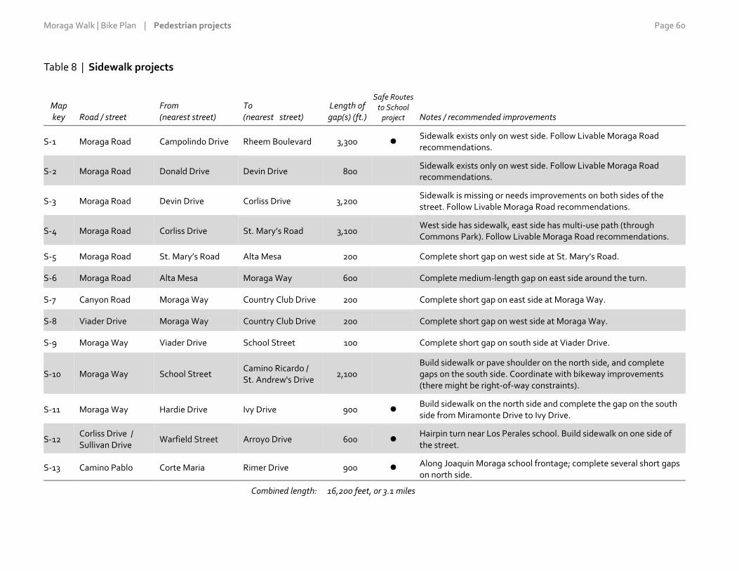
Moraga Walk | Bike Plan | Pedestrian projects Page 60
Table 8 | Sidewalk projects
Map key Road / street
From (nearest street)
To (nearest street)
Length of gap(s) (ft.)
Safe Routes to School
project Notes / recommended improvements
S-1 Moraga Road Campolindo Drive Rheem Boulevard 3,300 Sidewalk exists only on west side. Follow Livable Moraga Road recommendations.
S-2 Moraga Road Donald Drive Devin Drive 800 Sidewalk exists only on west side. Follow Livable Moraga Road recommendations.
S-3 Moraga Road Devin Drive Corliss Drive 3,200 Sidewalk is missing or needs improvements on both sides of the street. Follow Livable Moraga Road recommendations.
S-4 Moraga Road Corliss Drive St. Mary’s Road 3,100 West side has sidewalk, east side has multi-use path (through Commons Park). Follow Livable Moraga Road recommendations.
S-5 Moraga Road St. Mary’s Road Alta Mesa 200 Complete short gap on west side at St. Mary’s Road.
S-6 Moraga Road Alta Mesa Moraga Way 600 Complete medium-length gap on east side around the turn.
S-7 Canyon Road Moraga Way Country Club Drive 200 Complete short gap on east side at Moraga Way.
S-8 Viader Drive Moraga Way Country Club Drive 200 Complete short gap on west side at Moraga Way.
S-9 Moraga Way Viader Drive School Street 100 Complete short gap on south side at Viader Drive.
S-10 Moraga Way School Street Camino Ricardo / St. Andrew's Drive
2,100 Build sidewalk or pave shoulder on the north side, and complete gaps on the south side. Coordinate with bikeway improvements (there might be right-of-way constraints).
S-11 Moraga Way Hardie Drive Ivy Drive 900 Build sidewalk on the north side and complete the gap on the south side from Miramonte Drive to Ivy Drive.
S-12 Corliss Drive / Sullivan Drive
Warfield Street Arroyo Drive 600 Hairpin turn near Los Perales school. Build sidewalk on one side of the street.
S-13 Camino Pablo Corte Maria Rimer Drive 900 Along Joaquin Moraga school frontage; complete several short gaps on north side.
Combined length: 16,200 feet, or 3.1 miles

Moraga Walk | Bike Plan | Pedestrian projects Page 61

Moraga Walk | Bike Plan | Pedestrian projects Page 62
Figure 2 | Proposed pedestrian projects

Moraga Walk | Bike Plan | Pedestrian projects Page 63
In addition to the roadway segments listed above, the planning
process identified a number of additional segments as particularly
important pedestrian routes, generally because they are on
arterials and serve key destinations. These additional segments are
listed in Table 9 below. They already have adequate sidewalks—
often on both sides of the street—so no improvements are
proposed for these segments. At most, they might require minor
sidewalk fixes or repairs at specific locations, also described as
“spot improvements.”
Fixes might include clearing overgrown vegetation, replacing
small areas of buckled concrete and relocating sign posts away
from the middle of the sidewalk. Spot improvements could be
required by the Town of private property owners in front of their
homes or businesses (since property owners are required to
maintain the sidewalks along their frontages) or they could be
conducted as part of regular street maintenance by the Town’s
Public Works Department in response to resident requests.
Table 9 | Other key pedestrian routes
Road / street From To Notes / considerations
Moraga Road Lafayette city limits Campolindo Drive On arterial; connects to Campolindo High School
Moraga Road Rheem Boulevard Donald Drive On arterial; connects to Rheem Valley Shopping Center
Rheem Boulevard Moraga Road Elk Court On arterial; connects to Rheem Valley Shopping Center, Town offices
Moraga Way Moraga Road Viader Drive On arterial; connects to Moraga Shopping Center
Country Club Drive Canyon Road Moraga Creek On arterial; connects neighborhood to the south to Moraga Shopping Center
School Street Northern end of street Hazelwood Place Provides connection through Moraga Shopping Center
Canyon Road Country Club Drive Constance Place On arterial; connects areas to the south to Moraga Shopping Center
Camino Pablo Canyon Road Corte Maria On arterial; connects to Joaquin Moraga School
Camino Pablo Rimer Drive Hodges Drive On arterial; connects to Camino Pablo School

Moraga Walk | Bike Plan | Pedestrian projects Page 64
4 | Intersection crossing improvements Members of the public repeatedly mentioned challenging
conditions at intersection crossings resulting from long crossing
distances and drivers failing to see or stop for pedestrians. To
address these concerns, the Walk | Bike Plan proposes pedestrian
enhancements—and in some cases also bicycle enhancements—at
17 key intersections around the town.
The intersections proposed for enhancement are listed on the next
page and are shown on the map of pedestrian projects on the
previous page. The intersections are numbered in rough
geographic order, not in order of importance. They were selected
based on public suggestions and comments during the needs
assessment process and were refined based on public input during
the task on improvement options.
Like the sidewalk projects, the crossing improvements are focused
on the arterials, especially at intersections where two arterials meet
and those near a school. Arterials are the most direct, convenient
routes, and are the streets on which most key destinations are
located. For these reasons, the arterials attract the bulk of
pedestrian, bike and car traffic, and therefore experience the
majority of conflicts among users. The arterials also typically have
the highest traffic speeds.
As shown in Table 10 further below, of the 17 intersections, six
involve the crossing of two arterials. All the intersections have
marked crosswalks on at least one leg, while seven are equipped
with traffic signals. Five intersections pose particular challenges for
cyclists, so they would combine pedestrian and bicycle crossing
enhancements. The table also indicates the crossing improvements
that would serve schools directly and might therefore be good
candidates for grant applications to Safe Routes to School funding
programs and sources.
The locations listed in Table 10 may be further prioritized for
implementation by considering the intersection characteristics
indicated in the table with a dot (). Special consideration should
be given to intersections that: (1) involve the crossing of two
arterials (since these will tend to have more pedestrian and car
traffic); (2) incorporate bicycle crossing enhancements (since these
will benefit more than just pedestrians); or (3) serve schools
directly. Five intersections meet at least two of these
considerations; they are shown in dark gray shading in the table:
Moraga Road / Rheem Boulevard (intersection X-2).
Moraga Road / St. Mary’s Road (X-4).
Canyon Road / Country Club Drive (X-10).
Canyon Road / Camino Pablo (X-12).
St. Mary’s Road / Rheem Boulevard (X-16).
An additional six intersections meet one of these considerations;
they are shown in light gray shading in the table:
Moraga Road / Campolindo Drive (X-1).
Moraga Road / Corliss Drive (X-3).
Moraga Road / Canyon Road / Moraga Way (X-6).
Moraga Way / Ivy Drive (X-9).
Camino Pablo / Rimer Drive (X-13).
Camino Pablo / Oxford Drive (X-14).

Moraga Walk | Bike Plan | Pedestrian projects Page 65
Moraga Road at Corliss Drive
There are many measures to make crossings safer and easier for
pedestrians to navigate. Some of these are listed below and are
illustrated in Figures 3 and 4 following Table 10:
Specially colored and textured pavement at crosswalks.
Pedestrian-activated flashing crossing signs, flashing digital
speed signs on the approaches to the intersection and other
warning signage.
Advanced yield or stop lines, which encourage drivers to stop
further back from the crossing.
Sidewalk “bulb-outs” or extensions, which shorten the crossing
distance; they also reduce the corner radius, making drivers
slow down as they turn the corner. Bulb-outs provide
opportunities to incorporate landscaping. They should be
designed so as to not encroach into cyclists’ path of travel and to
accommodate fire trucks and other large vehicles.
Pedestrian refuges or islands in the center of the street.
Not all measures are appropriate for all intersections. Signalized
intersections call for different types of measures than unsignalized
ones, for example. Signalization makes traffic movements more
predictable, so there is less need for warning signs and signals. On
the other hand, signalized intersections tend to go hand in hand
with wider streets and busy, faster traffic. Such conditions often
warrant measures such as bulb-outs and median refuges.
Depending on the intersection and the issues involved,
enhancements may be implemented on one or both of the cross
streets, and on one or both approaches of the street. Enhancement
measures for a particular crossing should be determined based on
guidelines in the California Highway Design Manual, California
Manual on Uniform Traffic Control Devices and various street-
design publications from the National Association of City
Transportation Officials, and in consultation with affected
neighbors.
Figure 3 image credits:
Colored and textured crosswalks: Grand Lake Guardian (top), acstamp.com (bottom).
Signals and signage: Texas A&M Transportation Institute (top), Green SoCal blog (bottom).
Bulb-outs: sfbetterstreets.org (top), scpr.org (bottom).
Pedestrian refuge islands: Wikipedia (top), streets.mn (bottom). Figure 4 credit: Alta Planning + Design.

Moraga Walk | Bike Plan | Pedestrian projects Page 66
Table 10 | Intersections for crossing improvements
Dark shading: Intersection meets at least two of the additional prioritization considerations. Light shading: Intersection meets one additional prioritization consideration.
Map key Cross street 1 Cross street 2 Signal
(1) Two arterials
(2) Bike measures
(3) Safe Routes to
School Notes / considerations
X-1 Moraga Road Campolindo Drive At Campolindo High School; bus stop across the street.
X-2 Moraga Road Rheem Boulevard Large, especially busy intersection with many turning movements.
X-3 Moraga Road Corliss Drive Recent enhancements; new improvements would be mainly for cyclists.
X-4 Moraga Road St. Mary’s Road At Commons Park and at Lafayette-Moraga Trail connection to School Street.
X-5 Moraga Road Alta Mesa Planned Improves connection to Moraga Shopping Center for the neighborhood to the east; when signalized, pedestrian crossings and appropriate transitions for sidewalks and bike lanes should be provided.
X-6 Moraga Road / Canyon Road
Moraga Way Wide, especially busy intersection.
X-7 Moraga Way School Street Improves connection to Moraga Shopping Center for the neighborhood to the south; intersects with Lafayette-Moraga Trail.
X-8 Moraga Way Camino Ricardo / St. Andrews Drive
On busy arterial, with bus stops on both sides of Moraga Way.
X-9 Moraga Way Ivy Drive Next to Miramonte H.S.; bus stops on both sides of Moraga Way.
X-10 Canyon Road Country Club Drive Large, busy intersection near Moraga Shopping Center.
X-11 Canyon Road Sanders Drive Evaluate safety improvement options for the existing crosswalk or consider moving it from Sanders Drive to Larch Avenue.
X-12 Canyon Road Camino Pablo Near Joaquin Moraga Intermediate School.
X-13 Camino Pablo Rimer Drive Near Joaquin Moraga Intermediate School.
X-14 Camino Pablo Oxford Drive At Camino Pablo Elementary School.
X-15 St. Mary’s Road St. Mary’s Parkway At Saint Mary’s College and at trailhead to Lafayette-Moraga Trail.
X-16 St. Mary’s Road Rheem Boulevard At Lafayette–Moraga Regional Trail; a roundabout has been proposed for this intersection.
X-17 St. Mary’s Road Bollinger Canyon Road
Improves connection to the rest of Moraga for the Bluffs neighborhood; a roundabout has been proposed for this intersection.

Moraga Walk | Bike Plan | Pedestrian projects Page 67
Figure 3 | Sample pedestrian improvements
Colored and textured crosswalks
Signals and signage
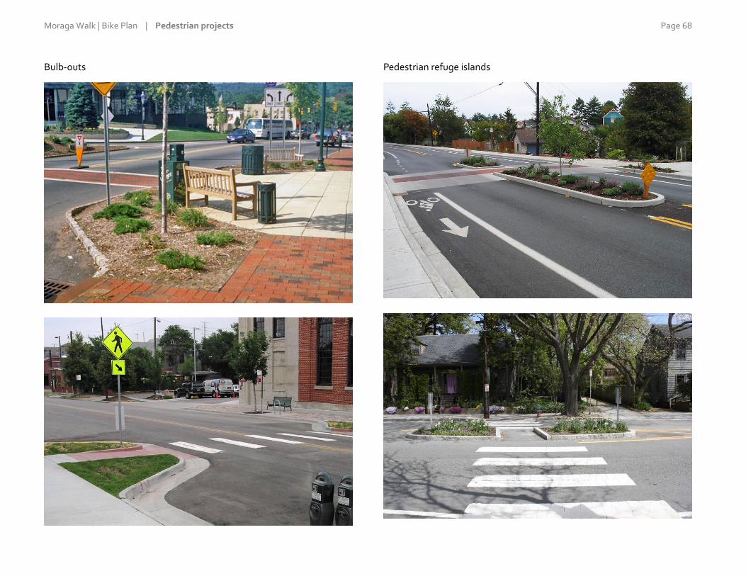
Moraga Walk | Bike Plan | Pedestrian projects Page 68
Bulb-outs
Pedestrian refuge islands

Moraga Walk | Bike Plan | Pedestrian projects Page 69
Figure 4 | Sample pedestrian crossing improvements

Moraga Walk | Bike Plan | Pedestrian projects Page 70
5 | Lower-priority or longer-term pedestrian projects The previous sections outline a set of projects that can reasonably
be expected to be completed during the 15-year lifetime of the
Walk | Bike Plan. Beyond these improvements, there are several
desirable projects suggested by the community that are likely less
feasible or realistic over the same time period. The main challenges
are their anticipated high cost or the need for extensive further
study and planning. These projects are described below.
Despite the challenges, it is important for the Walk | Bike Plan to
document these projects and flag their importance to the
community. The projects should be re-examined and re-evaluated
more closely for feasibility in the future. This should be done when
the Walk | Bike Plan is updated or sooner if planning conditions
change—for example, if significant new funding becomes available
or if development or redevelopment projects are proposed for the
areas in question. Before these projects could be implemented, they
would also be subject to project-specific review for environmental
impacts under the California Environmental Quality Act.
Sidewalks
Two sidewalk projects in particular stand out as being the subjects
of multiple comments during the needs assessment but also as
being unrealistic for the time being:
Sidewalk, at least on one side of the street, on Bollinger Canyon
Road from St. Mary’s Road east to Joseph Drive. The sidewalk
would connect the Bluffs neighborhood north of the road to the
Lafayette-Moraga Regional Trail and other points west.
Unfortunately, the right-of-way appears too narrow to
accommodate sidewalks; the road is flanked by steep grades,
which would likely necessitate the construction of retaining
walls. Also, widening of the road could impact the adjacent
seasonal wetlands, requiring an extensive environmental
permitting process. The cost of this project would likely be very
high, especially in relation to the small number of residents it
would serve.
Sidewalk, also at least on one side of the street, on Larch Avenue
from Canyon Road east to Shuey Drive, and possibly for its
entire length, to Camino Pablo. The street is an important
neighborhood connector serving many residences within easy
walking distance of Moraga Shopping Center, Rancho Laguna
Park, and the Joaquin Moraga and Camino Pablo schools. The
street has intermittent stretches of sidewalk but they are
sufficiently disconnected that they are mostly non-functional.
As a whole, the development was planned without sidewalks,
and front yards abut the roadway, with no space in between.
Installing sidewalks would be an expensive and complex
process, requiring residents to dedicate right-of-way (and lose
some private-frontage improvements) or for the Town to
purchase easements through private property.
Street lights
Beyond the key needs identified at the start of this chapter, a
common pedestrian-related complaint was the lack of street lights.
Street lights increase traffic safety by enabling drivers, pedestrians
and cyclists to see each other better; they also increase people’s
sense of personal comfort and security with regard to crime. On
the other hand, some people do not think street lights fit Moraga’s
suburban/semi-rural character.
Conventional street lights are expensive to purchase and also to
install, due to the trenching required to extend electrical service.
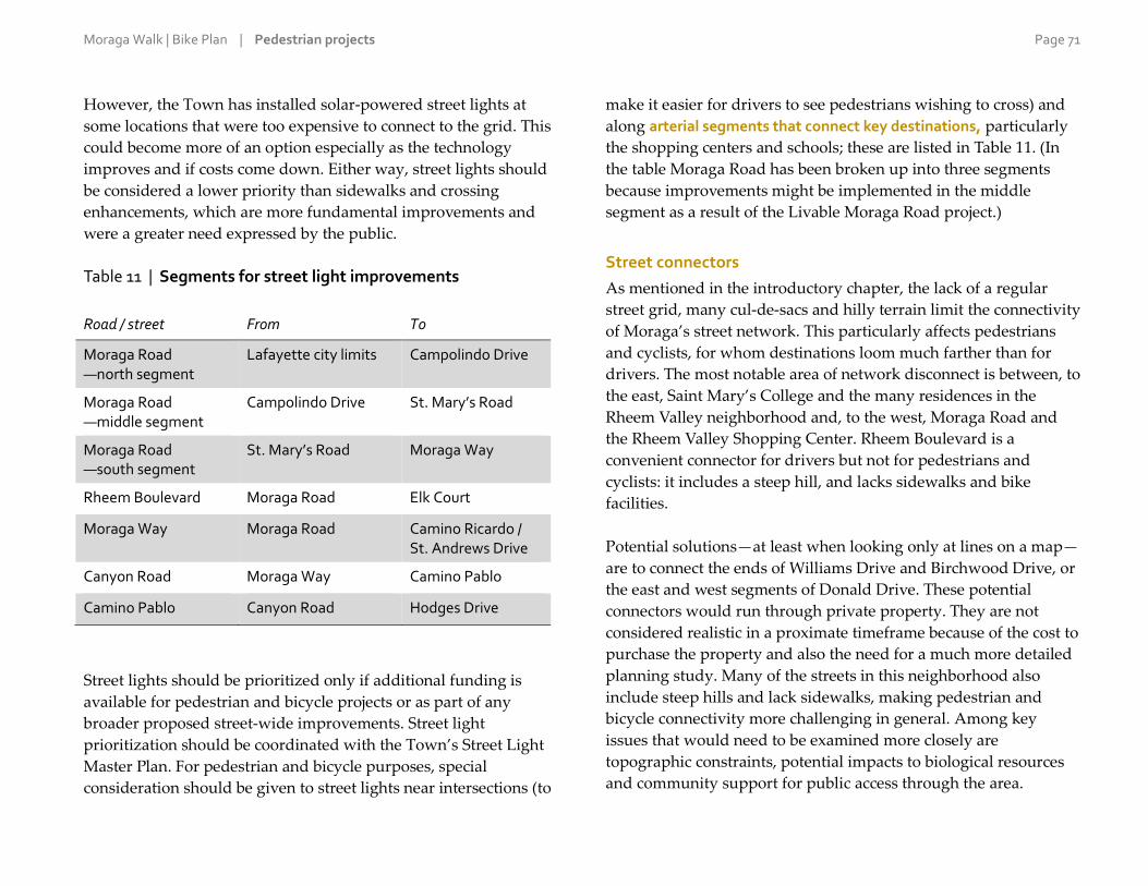
Moraga Walk | Bike Plan | Pedestrian projects Page 71
However, the Town has installed solar-powered street lights at
some locations that were too expensive to connect to the grid. This
could become more of an option especially as the technology
improves and if costs come down. Either way, street lights should
be considered a lower priority than sidewalks and crossing
enhancements, which are more fundamental improvements and
were a greater need expressed by the public.
Table 11 | Segments for street light improvements
Road / street From To
Moraga Road —north segment
Lafayette city limits Campolindo Drive
Moraga Road —middle segment
Campolindo Drive St. Mary’s Road
Moraga Road —south segment
St. Mary’s Road Moraga Way
Rheem Boulevard Moraga Road Elk Court
Moraga Way Moraga Road Camino Ricardo / St. Andrews Drive
Canyon Road Moraga Way Camino Pablo
Camino Pablo Canyon Road Hodges Drive
Street lights should be prioritized only if additional funding is
available for pedestrian and bicycle projects or as part of any
broader proposed street-wide improvements. Street light
prioritization should be coordinated with the Town’s Street Light
Master Plan. For pedestrian and bicycle purposes, special
consideration should be given to street lights near intersections (to
make it easier for drivers to see pedestrians wishing to cross) and
along arterial segments that connect key destinations, particularly
the shopping centers and schools; these are listed in Table 11. (In
the table Moraga Road has been broken up into three segments
because improvements might be implemented in the middle
segment as a result of the Livable Moraga Road project.)
Street connectors
As mentioned in the introductory chapter, the lack of a regular
street grid, many cul-de-sacs and hilly terrain limit the connectivity
of Moraga’s street network. This particularly affects pedestrians
and cyclists, for whom destinations loom much farther than for
drivers. The most notable area of network disconnect is between, to
the east, Saint Mary’s College and the many residences in the
Rheem Valley neighborhood and, to the west, Moraga Road and
the Rheem Valley Shopping Center. Rheem Boulevard is a
convenient connector for drivers but not for pedestrians and
cyclists: it includes a steep hill, and lacks sidewalks and bike
facilities.
Potential solutions—at least when looking only at lines on a map—
are to connect the ends of Williams Drive and Birchwood Drive, or
the east and west segments of Donald Drive. These potential
connectors would run through private property. They are not
considered realistic in a proximate timeframe because of the cost to
purchase the property and also the need for a much more detailed
planning study. Many of the streets in this neighborhood also
include steep hills and lack sidewalks, making pedestrian and
bicycle connectivity more challenging in general. Among key
issues that would need to be examined more closely are
topographic constraints, potential impacts to biological resources
and community support for public access through the area.


Moraga Walk | Bike Plan | Pedestrian projects Page 73
5 | Bicycle projects

Moraga Walk | Bike Plan | Bicycle projects Page 74
1 | Chapter overview As described in the “Needs Assessment” chapter, the community’s
main bicycle-related needs and concerns were, in rough decreasing
order of importance:
1. Lack of, and gaps or discontinuities in, bike lanes and
shoulders; and inadequate maintenance of the existing lanes
and shoulders.
2. More paths and trails to connect to more destinations, and
easier access to existing trails.
3. Driver behavior, particularly speeding, distracted driving, and a
general lack of respect toward cyclists and unwillingness to
“share the road” with them.
4. Failure of cyclists to obey the rules of the road and to ride
single-file.
5. Traffic lights do not detect cyclists waiting for the light to
change.
To address the top need on the list, the Walk | Bike Plan designates
a town-wide network of on-street bikeways and proposes a set of
segment-specific improvements. Town staff and the plan
consultants developed a preliminary bikeway network based on
the input received from the public on needs and concerns.
Feedback was then sought from the public on the preliminary
network through the same process used to formulate the
pedestrian projects (see Section 2, “Developing the
recommendations,” in the previous chapter). The feedback was
used to refine the network and the segment-specific improvements
presented in this chapter.
As for the other needs on the list above, maintenance of facilities
(part of item 1), driver behavior (item 3), cycling etiquette (item 4)
and bike detection (item 5) are addressed in Chapter 6, “Support
Programs and Other Actions.” Regarding paths and trails (item 2),
as mentioned in the previous chapter the focus of the Walk | Bike
Plan is on on-street facilities rather than on paths and trails.
(However, the on-street bikeway network was formulated with an
eye on providing connections to the town’s trail system, among
other key destinations.)
This chapter concludes with several recommendations regarding
bicycle parking, a low-cost way to promote cycling and another
common topic of public comments.

Moraga Walk | Bike Plan | Bicycle projects Page 75
2 | On-street bikeway network While cyclists will continue to be allowed on any street in Moraga
(consistent with State law), the designated on-street bikeway
network is meant to provide a higher level of service for cyclists in
terms of safety, comfort or convenience. The network was designed
with input from the public and Town staff and on the professional
judgement of the plan’s consultants. In selecting streets to serve as
bikeways, the following criteria were taken into consideration and
balanced against each other:
Directness of access to key destinations (including trails)
Street grades
Traffic speeds and volumes
Existing bicycling patterns
Table 12 at right lists in alphabetical order the 23 streets that make
up the proposed Moraga on-street bikeway network. The network
has an approximate total length of just over 20 miles. As explained
in the section that follows, the network includes bike routes and
bike lanes.
Table 12 | Streets on the bikeway network
Road / street From To Length
(miles)
Ascot Drive Moraga Road Ascot Court 0.4
Augusta Drive St. Andrews Drive Westchester Street 0.5
Bollinger Canyon Rd St. Mary’s Road Town limit 0.9
Camino Pablo Canyon Road Town limit 1.7
Camino Ricardo Corliss Drive Moraga Way 0.5
Campolindo Drive Moraga Road Calle La Montana 0.4
Canyon Road Moraga Way Town limit 1.2
Corliss Drive Moraga Road Wakefield Dr. 1.1
Country Club Drive Canyon Road St. Andrews Drive 0.5
Donald Drive Moraga Road Laird Drive 0.4
Laird Drive Donald Drive Donald Rheem E.S. 0.2
Larch Avenue Canyon Road Camino Pablo 1.4
Moraga Road Lafayette city limit Moraga Way 2.8
Moraga Way Moraga Road / Canyon Road
Orinda city limit 1.0
Rheem Boulevard Orinda city limit St. Mary’s Road 2.4
Rimer Drive Camino Pablo Shuey Drive 0.8
St. Andrews Drive Moraga Way Augusta Drive 0.2
St. Mary’s Road Moraga Road Lafayette city limit 1.4
Sanders Drive Canyon Road End of street 0.7
School Street Northern end, near Moraga Road
Southern end, near Canyon Road
0.8
Shuey Drive Rimer Drive Camino Pablo 0.3
Tharp Drive Rimer Drive Camino Pablo 0.7
Westchester Street Augusta Drive End of street 0.1
Total length: 20.4
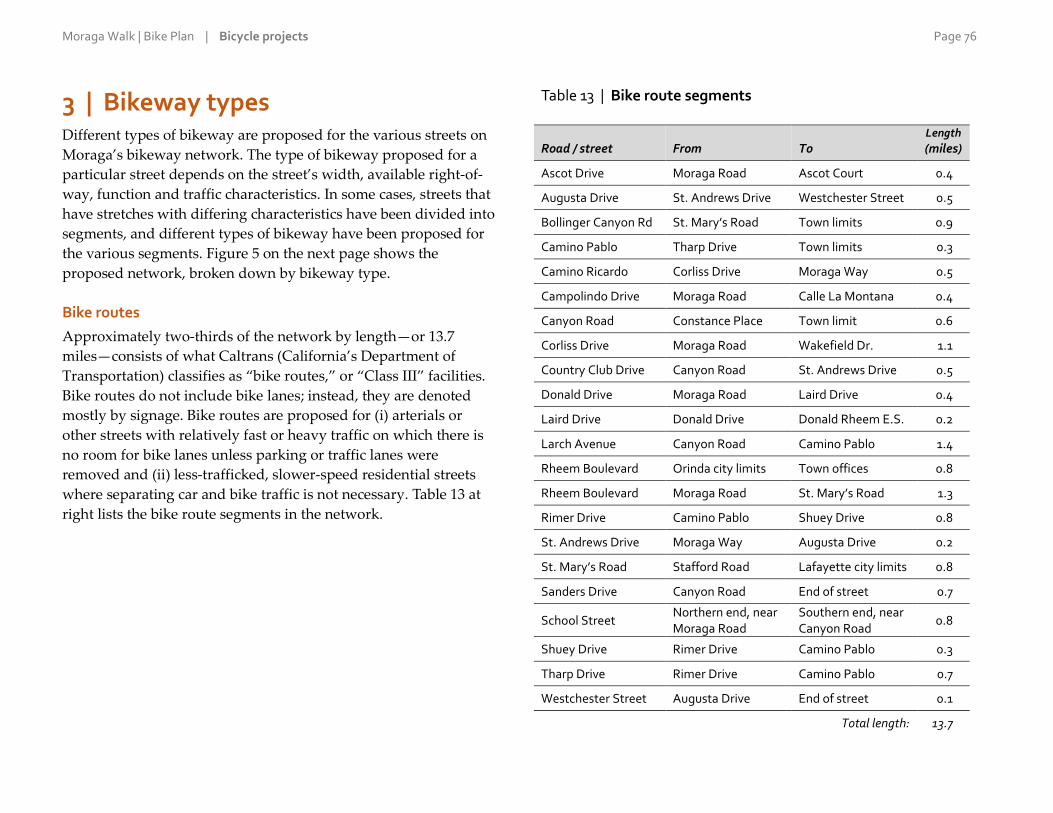
Moraga Walk | Bike Plan | Bicycle projects Page 76
3 | Bikeway types Different types of bikeway are proposed for the various streets on
Moraga’s bikeway network. The type of bikeway proposed for a
particular street depends on the street’s width, available right-of-
way, function and traffic characteristics. In some cases, streets that
have stretches with differing characteristics have been divided into
segments, and different types of bikeway have been proposed for
the various segments. Figure 5 on the next page shows the
proposed network, broken down by bikeway type.
Bike routes
Approximately two-thirds of the network by length—or 13.7
miles—consists of what Caltrans (California’s Department of
Transportation) classifies as “bike routes,” or “Class III” facilities.
Bike routes do not include bike lanes; instead, they are denoted
mostly by signage. Bike routes are proposed for (i) arterials or
other streets with relatively fast or heavy traffic on which there is
no room for bike lanes unless parking or traffic lanes were
removed and (ii) less-trafficked, slower-speed residential streets
where separating car and bike traffic is not necessary. Table 13 at
right lists the bike route segments in the network.
Table 13 | Bike route segments
Road / street From To Length
(miles)
Ascot Drive Moraga Road Ascot Court 0.4
Augusta Drive St. Andrews Drive Westchester Street 0.5
Bollinger Canyon Rd St. Mary’s Road Town limits 0.9
Camino Pablo Tharp Drive Town limits 0.3
Camino Ricardo Corliss Drive Moraga Way 0.5
Campolindo Drive Moraga Road Calle La Montana 0.4
Canyon Road Constance Place Town limit 0.6
Corliss Drive Moraga Road Wakefield Dr. 1.1
Country Club Drive Canyon Road St. Andrews Drive 0.5
Donald Drive Moraga Road Laird Drive 0.4
Laird Drive Donald Drive Donald Rheem E.S. 0.2
Larch Avenue Canyon Road Camino Pablo 1.4
Rheem Boulevard Orinda city limits Town offices 0.8
Rheem Boulevard Moraga Road St. Mary’s Road 1.3
Rimer Drive Camino Pablo Shuey Drive 0.8
St. Andrews Drive Moraga Way Augusta Drive 0.2
St. Mary’s Road Stafford Road Lafayette city limits 0.8
Sanders Drive Canyon Road End of street 0.7
School Street Northern end, near Moraga Road
Southern end, near Canyon Road
0.8
Shuey Drive Rimer Drive Camino Pablo 0.3
Tharp Drive Rimer Drive Camino Pablo 0.7
Westchester Street Augusta Drive End of street 0.1
Total length: 13.7
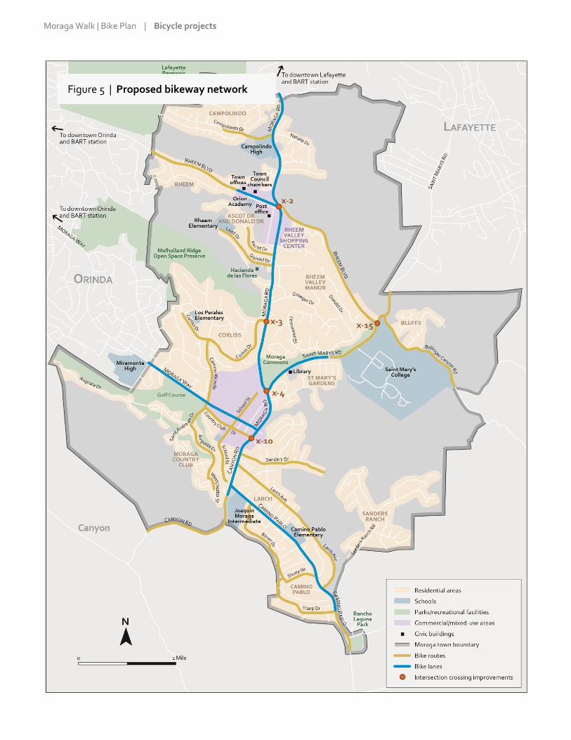
Moraga Walk | Bike Plan | Bicycle projects Page 77
Figure 5 | Proposed bikeway network

Moraga Walk | Bike Plan | Bicycle projects Page 78
All
b
i
k
e
r
o
u
t
e
s would be marked with “Bike
route” signs (see top image at right)
and any of a variety of “Share the
road” signs or signs instructing
drivers to leave a three-foot
clearance when passing a cyclist (see
middle image at right for an
example).
On bike routes where the speed
difference between cyclists and cars
is low—for example, on slower-
speed streets or on downhills—
“sharrows” would be added (bottom
image at right). These are stencils
that suggest to cyclists where in the
lane to ride, alert drivers to the
potential presence of cyclists and,
more generally, reinforce the
legitimacy of bike traffic and
encourage sharing of the road. They
would also be added to the outside
lanes of four-lane roads such as
Country Club Drive. Sharrows may
be painted on top of a green
background for greater visibility,
particularly in areas of conflict with
car traffic.
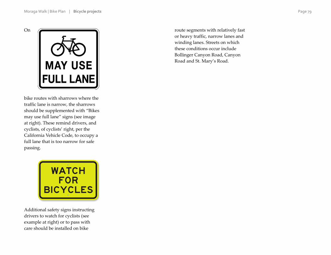
Moraga Walk | Bike Plan | Bicycle projects Page 79
On
bike routes with sharrows where the
traffic lane is narrow, the sharrows
should be supplemented with “Bikes
may use full lane” signs (see image
at right). These remind drivers, and
cyclists, of cyclists’ right, per the
California Vehicle Code, to occupy a
full lane that is too narrow for safe
passing.
Additional safety signs instructing
drivers to watch for cyclists (see
example at right) or to pass with
care should be installed on bike
route segments with relatively fast
or heavy traffic, narrow lanes and
winding lanes. Streets on which
these conditions occur include
Bollinger Canyon Road, Canyon
Road and St. Mary’s Road.

Moraga Walk | Bike Plan | Bicycle projects Page 80
Bike lanes
The rest of the on-street bikeway network—totaling 6.7 miles—
consists of bike lanes (classified by Caltrans as “Class II” facilities).
These are denoted by parallel white stripes several feet apart, a
stenciled bike symbol and bike lane signage.
Table 14 on the next page lists the bike lane segments in the
network. A number of these segments already have bike lanes.
However, in general, the bike lanes in Moraga need improvement,
as they are poorly marked and signed. The table includes segment-
specific recommended improvements. The table also indicates the
bike lane projects that would serve schools most directly and might
therefore be good candidates for grant applications to Safe Routes
to School funding programs and sources.
Bike lanes may be painted green to increase visibility for cyclists
through challenging intersections, to discourage drivers from
parking on them and, more generally, to reinforce bike priority in
areas of conflict with car traffic. On streets with sufficient room,
bike lanes may be separated from traffic by a painted buffer,
plastic posts, parking, concrete curb or other measures.
(Technically, physically separated bike lanes are classified by
Caltrans as Class IV facilities—not Class III—and are known as
separated bikeways or cycle tracks.) The Town should look for
opportunities to narrow travel lanes to 11 or 10.5 feet in order to
create room for wider bike lanes (where allowable based on design
speeds), possibly with a painted buffer.
Figure 6, following the table of bike lane segments, illustrates
several types of bicycle improvements that may be appropriate for
Moraga roadways. In addition, below are two online resources on
innovative bicycle improvements:
Urban Bikeway Design Guide (National Association of City
Transportation Officials): http://nacto.org/publication/urban-
bikeway-design-guide/
Green Lane Project (People for Bikes):
www.peopleforbikes.org/green-lane-project
Other enhancements
Since cyclists are allowed to use any street in Moraga, the purpose
of designated bikeways is to provide a higher level of safety,
comfort or convenience on certain streets. For this reason, the
Town should look for every opportunity to provide additional
enhancements on bikeways, beyond the striping and signage
described earlier in this section. Possible enhancements include:
Smoother pavement and more frequent maintenance and
repair.
Non-slip pavement markings and other surfaces.
Regular clearing of debris in bike lanes and shoulders.
Parking “T’s,” or “tick marks,” to delineate parking spots; these
encourage drivers to park closer to the curb and remind cyclists
of the possibility of opening car doors.
Other awareness and safety signs, including “No parking—
Bike lane.”
Flashing radar speed signs.
Solid white edge lines demarcating the travel lane from the
shoulder or parking lane (by visually narrowing the street,
edge lines cause drivers to drive somewhat more slowly).

Moraga Walk | Bike Plan | Bicycle projects Page 81
Table 14 | Bike lane segments
Road / street From To Length (miles)
Safe Routes to
School project Notes / recommended improvements
Moraga Road Lafayette city limits Woodford Drive 0.5 Bike lanes exist on both sides; follow Livable Moraga Road recommendations but consider more frequent signing and stenciling.
Moraga Road Woodford Drive Buckingham Drive 0.1 Bike lanes exist on both sides but the west-side lane is too close to parked cars. Follow Livable Moraga Road recommendations but also consider prohibiting parking on this short stretch.
Moraga Road Buckingham Drive Donald Drive 0.8 Bike lanes exist on both sides. Follow Livable Moraga Road recommendations but consider more frequent signing and stenciling.
Moraga Road Donald Drive Corliss Drive 0.5 Follow Livable Moraga Road recommendations, namely Class II bike lanes and/or multi-use path.
Moraga Road Corliss Drive St. Mary’s Road 0.6 Follow Livable Moraga Road recommendations, namely Class II bike lanes and/or multi-use path.
Moraga Road St. Mary’s Road Moraga Way 0.3 Sign and stencil the shoulders as bike lanes.
Rheem Boulevard Town offices Moraga Road 0.3 Shoulders wide enough to accommodate bike lanes were recently installed on both sides; these should be signed and stenciled as bike lanes.
Moraga Way Moraga Road School Street 0.2 Improve the existing bike lanes with more frequent signing and stenciling.
Moraga Way School Street Laguna Creek 0.1 Widen and pave the shoulders, and sign and stencil as bike lanes. Coordinate with sidewalk improvements (there might be right-of-way constraints).
Moraga Way Laguna Creek Camino Ricardo / St. Andrews
0.2 Sign and stencil the shoulders as bike lanes. Coordinate with sidewalk improvements (there might be right-of-way constraints).
Moraga Way Camino Ricardo / St. Andrews
Past Moraga Valley Lane
0.3
Improve the existing bike lanes with more frequent signing and stenciling. Narrow the painted median to widen the bike lanes. At Moraga Valley Lane, thread the bike lane between the through lane and the right-turn lane.
Moraga Way Past Moraga Valley Lane
Hardie Drive 0.1 Improve the existing bike lanes with more frequent signing and stenciling.
Moraga Way Hardie Drive Orinda city limits 0.1
On the north side, consider prohibiting parking, then signing and stenciling the shoulder as a bike lane; otherwise, this segment should be designated as a bike route (Class II). On the south side, install a proper bike lane.

Moraga Walk | Bike Plan | Bicycle projects Page 82
Road / street From To Length (miles)
Safe Routes to
School project Notes / recommended improvements
Canyon Road Moraga Way Constance Place 0.6
Improve the existing bike lanes with more frequent signing and stenciling, especially between Camino Pablo and Constance Place. In front of St. Monica’s Church, paint the bike lane green or line it with plastic posts to deter parking in the bike lane.
Camino Pablo Canyon Road Rimer Drive 0.2 Consider prohibiting parking except during school or church events, and signing and striping the shoulders as bike lanes; otherwise, this segment should be designated as a bike route (Class II).
Camino Pablo Rimer Drive Oxford Drive 0.4 Improve the existing bike lanes with more frequent signing and stenciling.
Camino Pablo Oxford Drive Hodges Drive 0.1 Improve the existing bike lanes with more frequent signing and stenciling. Consider prohibiting parking on the south side (to discourage jaywalking to the school) and installing a buffered or separated bike lane.
Camino Pablo Hodges Drive Moraga Creek 0.5
Improve the existing bike lanes with more frequent signing and stenciling. Consider prohibiting parking; then on the north side moving the bike lane to the curb and installing a buffered bike lane, and on the south side installing a separated bike lane.
Camino Pablo Moraga Creek Tharp Drive 0.2 Improve the existing bike lanes with more frequent signing and stenciling.
St. Mary’s Road Moraga Road Stafford Drive 0.6 Widen and pave the shoulders, and sign and stencil as bike lanes.
Total length: 6.7
Figure 6 image credits:
Green bike lanes: ibikenopa.blogspot.com (top), the Santa Barbara Independent (bottom).
Buffered bike lanes: Boston Cyclists Union (top), NACTO (bottom).
Separated bike lanes: B.I.K.A.S. blog (top), Federal Highway Administration (bottom).
Two-stage turn queue boxes: NACTO (top), City of Columbus, OH (bottom).

Moraga Walk | Bike Plan | Bicycle projects Page 83
Figure 6 | Sample bicycle improvements
Green bike lanes
Buffered bike lanes

Moraga Walk | Bike Plan | Bicycle projects Page 84
Separated bike lanes
Two-stage turn queue boxes

Moraga Walk | Bike Plan | Bicycle projects Page 85
4 | Intersection improvements Several intersections on the bikeway network present particular
challenges for cyclists. At five of the intersections listed in the
previous chapter to be improved for pedestrians, the Walk | Bike
Plan proposes additional measures to make them easier for cyclists
to navigate. These intersections are listed below and are shown on
the bikeway network map:
X-2: Moraga Road / Rheem Boulevard: This is the largest and one of
the most complex and confusing intersection in the town.
Both directions of both cross streets consist of at least four
through lanes at this location, streets intersect at skewed
angles and there are several turn lanes as well.
X-3: Moraga Road / Corliss Drive: Because of the sightlines and
because Corliss slopes downhill at this location, cyclists have
a difficult time turning left from Corliss onto Moraga Road.
The intersection was recently improved for pedestrians with
installation of a pedestrian crossing.
X-4: Moraga Road / St. Mary’s Road: There are conflicts at this
intersection between northbound cyclists continuing straight
on Moraga Road and northbound drivers turning right onto
St. Mary’s Road.
X-10: Canyon Road / Country Club Drive: This is another of the
largest intersections in Moraga and is one of the most
frequently used cycling routes. It is challenging for
northbound cyclists on Canyon Road wishing to turn left
onto Country Club Drive to move across two lanes of fast
traffic.
X-15: St. Mary’s Road / Rheem Boulevard: This location is one of the
busiest street crossings along the Lafayette-Moraga Regional
Trail through Moraga.
Intersection of Moraga Road and St. Mary’s Road
Ways to make intersections safer and easier for cyclists to navigate
include:
Green bike lanes to reinforce and accentuate cyclists’ path of
travel through an intersection.
Where bike lanes meet right-turn lanes, threading the bike lane
between the through lane and the turn lane.
Pole-mounted traffic mirrors at locations with poor or
obstructed sightlines.
Two-stage turn queue box to help cyclists make left turns at
multi-lane signalized intersections from a right side bike lane.
(A description of this device is available at
nacto.org/publication/urban-bikeway-design-guide/
intersection-treatments/two-stage-turn-queue-boxes.)

Moraga Walk | Bike Plan | Bicycle projects Page 86
5 | Bicycle parking After on- and off-street bikeways, bicycle parking is the most
important element of a community’s bicycling system. Parking for
bikes is a low-cost yet effective way to encourage cycling and
improve the functionality of the bikeway network. It reduces the
threat of theft, makes bicyclists feel welcome and increases the
visibility of bicycling.
Bike parking in Moraga is somewhat limited. As described in the
chapter on existing conditions, the Town has installed bike parking
at its facilities serving the public; there are parking racks at several
locations on the Saint Mary’s College campus; and some
businesses in the two commercial areas—Rheem Valley and
Moraga Shopping Centers—provide racks. While all official Town
facilities now have bike parking, there are additional ways in
which the Town can help expand the supply of parking:
Develop installation guidelines for installing bike racks on
public sidewalks in commercial areas. The guidelines should
address the design and placement of the racks, ensuring that
bikes have enough clearance from fixed objects and from other
bikes without creating obstacles for pedestrian and disabled
access. Consider “Moraga-branded” racks with a design or
symbol representative of the town. Enable merchants and the
broader public to request the installation of bike racks, to be
provided by the Town at no or minimal cost.
Encourage and support the Moraga and Acalanes Union High
School Districts to provide adequate, well-designed bike
parking at public schools.
Similarly, encourage and support the two shopping centers to
provide bike parking throughout their property (especially
near the location of the Sunday farmers market).
Require new commercial and multi-family development or
redevelopment projects to install bike parking as a condition of
approval of development permits. This might require
amending the Town’s Municipal Code to give the Planning
Department the necessary authority.

Moraga Walk | Bike Plan | Bicycle projects Page 87
6 | Lower-priority or longer-term bicycle projects The previous sections outline a set of bicycle projects that can
reasonably be expected to be completed during the ten-year
lifetime of the Walk | Bike Plan. However, as described in the
chapter on pedestrian projects, there are additional desirable
projects that might not be realistic over the next 15 years, primarily
due to anticipated lack of funds. These additional projects are
listed in Table 15 below. As with the longer-term pedestrian
projects, the projects below should be considered in the future
depending on available funding.
Table 15 | Longer-term or lower-priority bikeway projects
Road / street From To Length (miles) Notes / proposed improvements
Rheem Boulevard Orinda city limits Town offices 0.8 Look for spot opportunities to widen the paved shoulders where needed. Consider prohibiting parking, then signing and stenciling bike lanes along the segment.
Rheem Boulevard Moraga Road Fay Hill Road 0.5 Look for spot opportunities to widen the paved shoulders.
Rheem Boulevard Fay Hill Road St. Mary’s Road 0.8 Conduct a study to shorten or remove the segments of center turn lane in order to widen the shoulders.
Country Club Drive School Street Moraga Creek (incl. bridge)
0.1
Narrow the sidewalk planting strips to widen the roadway and install bike lanes; or redesign and reconstruct the sidewalks as multi-use paths.
Bridge: Reconstruct it to incorporate bike lanes. In the near-term, remove the yellow line on the left-hand side of the travel lane in each direction; add reflective signs, tape or paint to the median; and stripe a white edge line on the right-hand side, keeping the travel lanes to 11 feet or less.
Country Club Drive Moraga Creek St. Andrews Drive 0.2 Narrow the median to widen the roadway on each side and install bike lanes.
School Street Moraga Way Country Club Drive 0.1 Redesign and reconstruct the sidewalk as a two-way multi-use path. (The segment north of Moraga Way is a private street; it should be improved according to recommendations in the Moraga Center Specific Plan.)
St. Mary’s Road Stafford Road Bollinger Canyon Road
0.6 Look for spot opportunities to widen the paved shoulders where needed, particularly on the east-side (west-bound cyclists are more likely to use the Regional Trail). Sign and stencil continuous segments of sufficiently wide shoulder as bike lanes.

Moraga Walk | Bike Plan | Bicycle projects Page 89
6 | Support programs and other actions
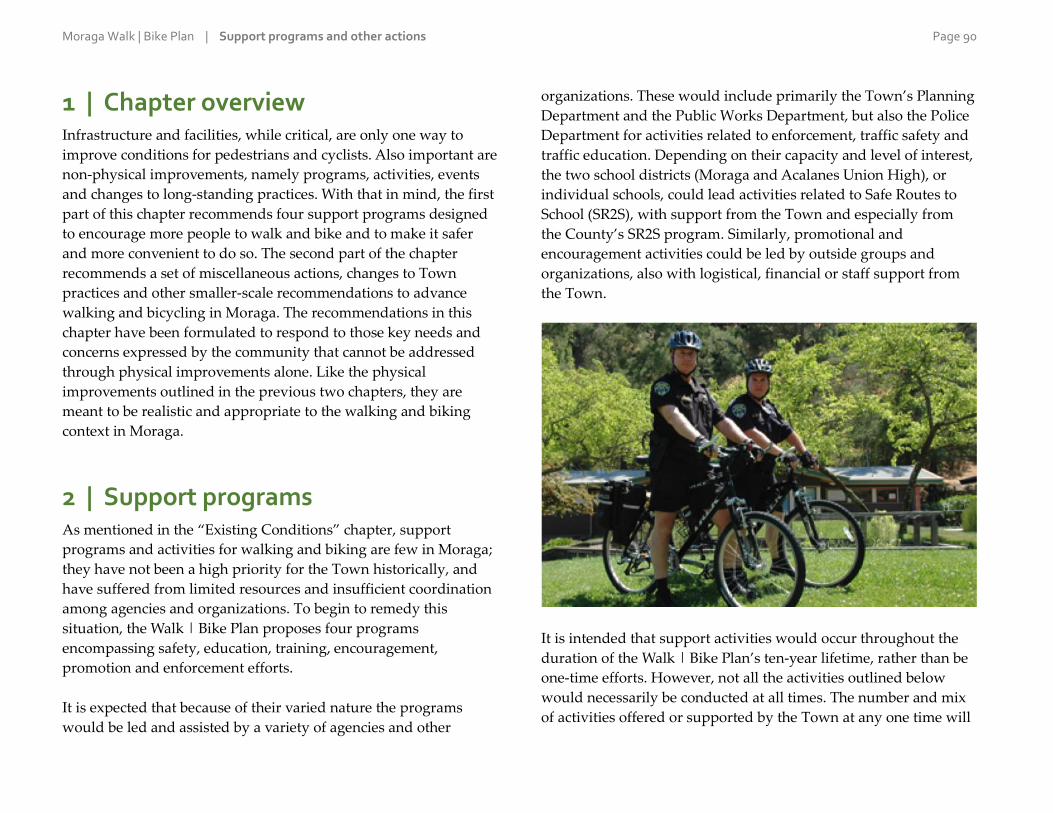
Moraga Walk | Bike Plan | Support programs and other actions Page 90
1 | Chapter overview Infrastructure and facilities, while critical, are only one way to
improve conditions for pedestrians and cyclists. Also important are
non-physical improvements, namely programs, activities, events
and changes to long-standing practices. With that in mind, the first
part of this chapter recommends four support programs designed
to encourage more people to walk and bike and to make it safer
and more convenient to do so. The second part of the chapter
recommends a set of miscellaneous actions, changes to Town
practices and other smaller-scale recommendations to advance
walking and bicycling in Moraga. The recommendations in this
chapter have been formulated to respond to those key needs and
concerns expressed by the community that cannot be addressed
through physical improvements alone. Like the physical
improvements outlined in the previous two chapters, they are
meant to be realistic and appropriate to the walking and biking
context in Moraga.
2 | Support programs As mentioned in the “Existing Conditions” chapter, support
programs and activities for walking and biking are few in Moraga;
they have not been a high priority for the Town historically, and
have suffered from limited resources and insufficient coordination
among agencies and organizations. To begin to remedy this
situation, the Walk | Bike Plan proposes four programs
encompassing safety, education, training, encouragement,
promotion and enforcement efforts.
It is expected that because of their varied nature the programs
would be led and assisted by a variety of agencies and other
organizations. These would include primarily the Town’s Planning
Department and the Public Works Department, but also the Police
Department for activities related to enforcement, traffic safety and
traffic education. Depending on their capacity and level of interest,
the two school districts (Moraga and Acalanes Union High), or
individual schools, could lead activities related to Safe Routes to
School (SR2S), with support from the Town and especially from
the County’s SR2S program. Similarly, promotional and
encouragement activities could be led by outside groups and
organizations, also with logistical, financial or staff support from
the Town.
It is intended that support activities would occur throughout the
duration of the Walk | Bike Plan’s ten-year lifetime, rather than be
one-time efforts. However, not all the activities outlined below
would necessarily be conducted at all times. The number and mix
of activities offered or supported by the Town at any one time will

Moraga Walk | Bike Plan | Support programs and other actions Page 91
depend on the community’s evolving needs and interests, on staff
resources and on available funding.
❶ Promotion and encouragement
To maximize its investments in walking and biking infrastructure,
the Town should sponsor, support or facilitate activities that
encourage the general population to walk and bike more
frequently, for both transportation and recreation. Below are
activities that could be included under a promotion and
encouragement program:
Implement the Town’s planned wayfinding signage program,
not only as a way to help pedestrians and cyclists find their
way to key destinations—including schools, parks and
trailheads—but also as a reminder to all of the viability of
walking and biking. See the section at the end of this chapter
for more information about the wayfinding program.
Install bike racks on public sidewalks in commercial areas
based on requests from the public; also, encourage and support
the schools and two shopping centers to provide adequate,
well-designed bike parking on their property.
Announce events and activities on the Town’s website, social
media channels and electronic marquee, on local media, and
through flyers and brochures at Town offices and the Library.
Continue to sponsor and provide support for morning and
evening “energizer stations” on Bike to Work Day (these are
tables that provide free snacks, beverages and small
promotional giveaways to cyclists).
Provide support to the Moraga Park Foundation to maintain
and update the Moraga Area Trails Guidebook or other town-
wide inventory and mapping of trails, in both print and online
forms.
❷ General traffic safety and education
The construction of facilities to encourage new walkers and cyclists
should be accompanied by safety and education efforts to promote
road safety among the general population. Traffic-safety programs
are typically implemented at the regional, state and national levels,
rather than by local jurisdictions. Nevertheless, there are ways for
the Town to have an impact at the local level:
Feature rotating traffic safety and educational messages on the
Town’s website, electronic marquee and social media channels.
Similar to bumper stickers available as part of the “Slow Down
Lamorinda” program, create posters and bumper stickers with
additional Moraga-specific traffic safety messages for use in
Town buildings and on Town vehicles, and make them
available to the public for free.
Install flashing digital speed signs on the arterials and deploy
speed trailers, as awareness and educational tools, on streets
with a history of speeding complaints.
Enlist the East Bay Regional Park District’s help in promoting
safe, respectful sharing of the Lafayette-Moraga Regional Trail
by cyclists. This could be done through improved signage and
markings and through education and visibility efforts by the
agency’s trail patrols and its “ambassadors” programs. Apply
similar strategies, as appropriate, to other shared-use trails.
Support or partner with advocacy groups such as Bike East Bay
in offering bicycle-skills trainings for children and adults.
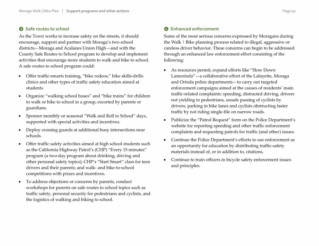
Moraga Walk | Bike Plan | Support programs and other actions Page 92
❸ Safe routes to school
As the Town works to increase safety on the streets, it should
encourage, support and partner with Moraga’s two school
districts—Moraga and Acalanes Union High—and with the
County Safe Routes to School program to develop and implement
activities that encourage more students to walk and bike to school.
A safe routes to school program could:
Offer traffic-smarts training, “bike rodeos,” bike skills-drills
clinics and other types of traffic safety education aimed at
students.
Organize “walking school buses” and “bike trains” for children
to walk or bike to school in a group, escorted by parents or
guardians.
Sponsor monthly or seasonal “Walk and Roll to School” days,
supported with special activities and incentives.
Deploy crossing guards at additional busy intersections near
schools.
Offer traffic safety activities aimed at high school students such
as the California Highway Patrol’s (CHP) “Every 15 minutes”
program (a two-day program about drinking, driving and
other personal safety topics); CHP’s “Start Smart” class for teen
drivers and their parents; and walk- and bike-to-school
competitions with prizes and incentives.
To address objections or concerns by parents, conduct
workshops for parents on safe routes to school topics such as
traffic safety, personal security for pedestrians and cyclists, and
the logistics of walking and biking to school.
❹ Enhanced enforcement
Some of the most serious concerns expressed by Moragans during
the Walk | Bike planning process related to illegal, aggressive or
careless driver behavior. These concerns can begin to be addressed
through an enhanced law enforcement effort consisting of the
following:
As resources permit, expand efforts like “Slow Down
Lamorinda”—a collaborative effort of the Lafayette, Moraga
and Orinda police departments—to carry out targeted
enforcement campaigns aimed at the causes of residents’ main
traffic-related complaints: speeding, distracted driving, drivers
not yielding to pedestrians, unsafe passing of cyclists by
drivers, parking in bike lanes and cyclists obstructing faster
traffic by not riding single-file on narrow roads.
Publicize the “Patrol Request” form on the Police Department’s
website for reporting speeding and other traffic enforcement
complaints and requesting patrols for traffic (and other) issues.
Continue the Police Department’s efforts to use enforcement as
an opportunity for education by distributing traffic-safety
materials instead of, or in addition to, citations.
Continue to train officers in bicycle safety enforcement issues
and principles.

Moraga Walk | Bike Plan | Support programs and other actions Page 93
3 | Other actions In addition to the programs proposed above, there are other
miscellaneous actions that the Town can take to further the state of
walking and biking in Moraga. Below is a list of such actions. They
have been organized under two approximate timeframes for
implementation (keeping in mind that an action’s realistic
timeframe might change due to circumstances): (i) near term,
which is the first two full years of the Walk | Bike Plan’s lifetime,
or 2017–2018; medium term, which is the subsequent three years:
2019–2021; and longer-term, which is 2022 and beyond. In
addition, there are several actions that are meant to be continuous
or recurring.
The actions are not listed in order of importance or priority, and
should be implemented as opportunities arise and as Town staff
time and other resources permit. Recommended actions related to
expanding bike parking around the town appear in Chapter 6,
“Bikeway Network.”
Near term: Years 2017–2018
Create a dedicated page on the Town’s website for news,
announcements and resources related to walking and biking
in and around Moraga. Include contact information for a staff
point person on pedestrian and bicycle issues.
Update the Town’s Five-Year Capital Improvement Programs to
incorporate the projects and programs recommended in the
Walk | Bike Plan.
Develop easy-to-understand written guidelines for evaluating
citizens’ requests for marked crosswalks, stop signs and lower
speed limits. Such guidelines would help educate and inform
the public on the constraints and trade-offs involved in
making changes to street operations.
Medium term: Years 2019–2021
Conduct a study exploring the possibility of establishing 15
mile-per-hour zones on streets around schools.
Working with the Metropolitan Transportation Commission
(which manages the pavement management system software
used by Moraga), consider adjusting the system so as to give
greater consideration for maintenance and repair to streets that
are part of the bikeway network.
Work with Lafayette and Orinda to jointly adopt a “Vision
Zero” policy promoting a comprehensive approach to traffic
safety in Lamorinda aimed at eliminating traffic-related deaths
and minimizing serious traffic injuries; create a multi-
jurisdictional Vision Zero task force—consisting of planning,
public works and police staff and of elected officials at the
three cities—to track collisions; analyze causes, trends and
hotspots; implement physical and non-physical traffic safety
improvements; and evaluate and report on progress.
Longer term: Year 2022 and beyond
Conduct an update of the Walk | Bike Plan ten years after the
current planning process, in the 2025–2026 timeframe. The
update should reassess the community’s needs, concerns and
expectations; reexamine the projects from the current plan that
remain to be implemented; and as necessary, recommend new
improvements.

Moraga Walk | Bike Plan | Support programs and other actions Page 94
Continuous
Publicize the Town’s transportation action request form as a
vehicle to request “spot improvements” to pedestrian and
bicycle facilities (these are minor fixes or repairs such as
restriping crosswalks and bike lanes, clearing overgrown
vegetation and fixing buckled pavement or sidewalk), request
bike parking on the public right-of-way, and submit ideas and
suggestions for improvements.
As traffic signals are upgraded or otherwise replaced, install
accessible pedestrian countdown signals and bike-detection
technology at intersections.
Provide annual reports to the Town Council outlining progress
in implementing the Walk | Bike Plan and, importantly, any
obstacles to implementation.
Stay informed about and coordinate with neighboring
jurisdictions on the development of bikeways that extend
beyond Moraga. These jurisdictions include the cities of
Lafayette and Orinda, Contra Costa County, East Bay Regional
Park District and East Bay Municipal Utility District.
4 | Wayfinding signage program In a separate process but coordinated with the Walk | Bike Plan
effort, the Town worked with another consultant—Studio
L’Image—to develop a town-wide wayfinding signage program.
(Wayfinding refers to the various ways in which people orient
themselves and navigate from place to place.) The signage
program is meant to help pedestrians, cyclists and drivers find
their way to key destinations; contribute to the town’s identity and
sense of place; and serve as a visible, everyday reminder of the
viability of walking and biking for transportation and recreation.
The months-long wayfinding design process incorporated
extensive public outreach, including presentations to the Walk |
Bike Plan CAC, the Town’s Design Review Board and the Town
Council, and an online survey administered through the Town’s
website, which received 154 responses. While the survey is now
closed, it may still be viewed, along with responses, at
www.moraga.ca.us/opentownhall (look for “Wayfinding Signage
Designs” under the “Closed Topics” tab).
Guided by input and subsequent feedback from the public, the
consultant developed initial graphic design concepts for the
wayfinding signs, then refined the designs. Figures 7 and 8 on the
next pages show the final conceptual layout designs for the sign
panels intended for different modes of travel; the panel and font
sizes vary for each type of sign, recognizing that different users
will be seeing the sign from different vantage points and while
travelling at different speeds. Figure 7 shows the signage design
intended for drivers (the three panels on the left) and for
pedestrians (the panel on the right) while Figure 8 shows the
design intended for cyclists.

Moraga Walk | Bike Plan | Support programs and other actions Page 95
Figure 7 | Example wayfinding signage panels for drivers and pedestrians
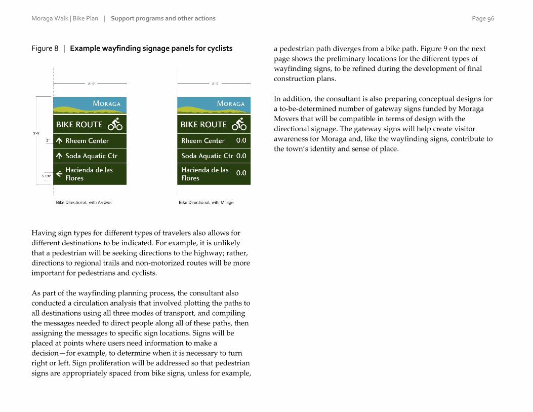
Moraga Walk | Bike Plan | Support programs and other actions Page 96
Figure 8 | Example wayfinding signage panels for cyclists
Having sign types for different types of travelers also allows for
different destinations to be indicated. For example, it is unlikely
that a pedestrian will be seeking directions to the highway; rather,
directions to regional trails and non-motorized routes will be more
important for pedestrians and cyclists.
As part of the wayfinding planning process, the consultant also
conducted a circulation analysis that involved plotting the paths to
all destinations using all three modes of transport, and compiling
the messages needed to direct people along all of these paths, then
assigning the messages to specific sign locations. Signs will be
placed at points where users need information to make a
decision—for example, to determine when it is necessary to turn
right or left. Sign proliferation will be addressed so that pedestrian
signs are appropriately spaced from bike signs, unless for example,
a pedestrian path diverges from a bike path. Figure 9 on the next
page shows the preliminary locations for the different types of
wayfinding signs, to be refined during the development of final
construction plans.
In addition, the consultant is also preparing conceptual designs for
a to-be-determined number of gateway signs funded by Moraga
Movers that will be compatible in terms of design with the
directional signage. The gateway signs will help create visitor
awareness for Moraga and, like the wayfinding signs, contribute to
the town’s identity and sense of place.

Moraga Walk | Bike Plan | Support programs and other actions Page 97
Figure 9 | Proposed wayfinding signage locations

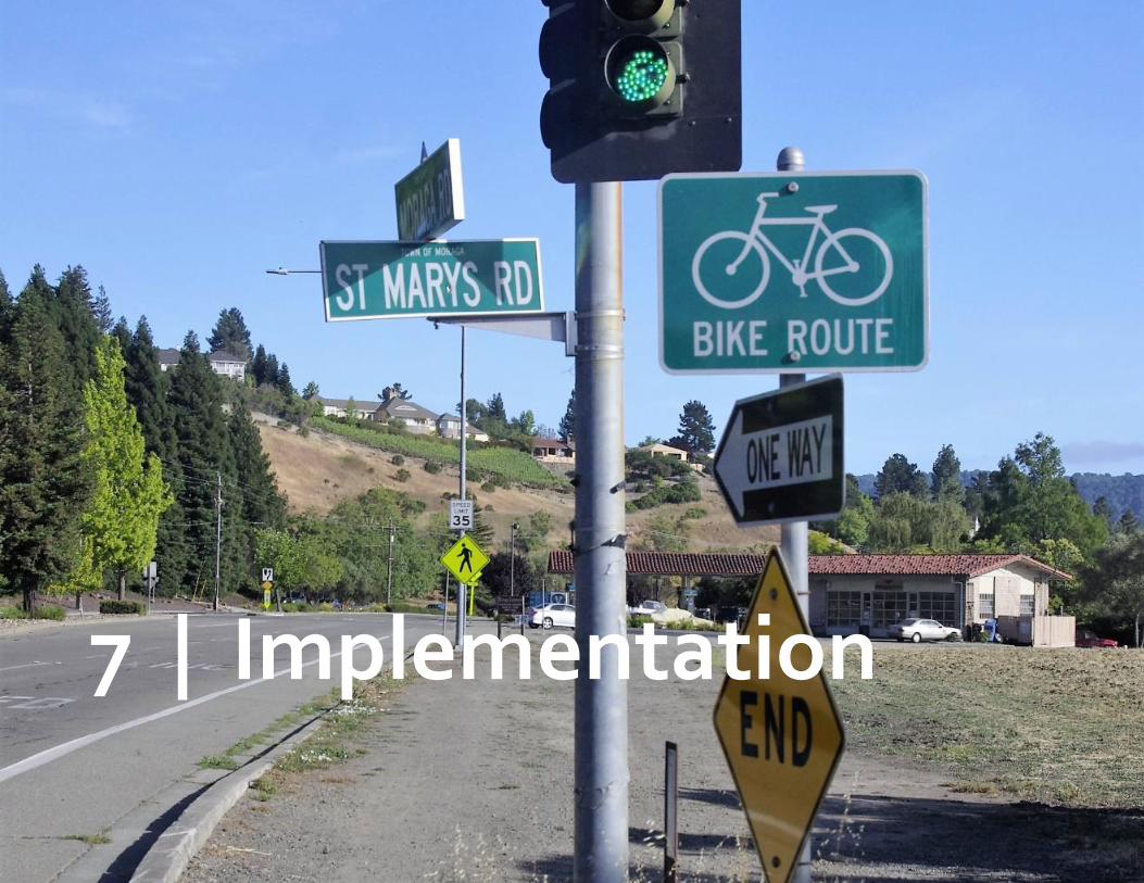
Moraga Walk | Bike Plan Page 99
7 | Implementation
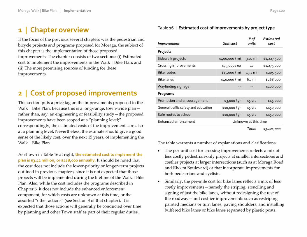
Moraga Walk | Bike Plan | Implementation Page 100
1 | Chapter overview If the focus of the previous several chapters was the pedestrian and
bicycle projects and programs proposed for Moraga, the subject of
this chapter is the implementation of those proposed
improvements. The chapter consists of two sections: (i) Estimated
cost to implement the improvements in the Walk | Bike Plan; and
(ii) The most promising sources of funding for these
improvements.
2 | Cost of proposed improvements This section puts a price tag on the improvements proposed in the
Walk | Bike Plan. Because this is a long-range, town-wide plan—
rather than, say, an engineering or feasibility study—the proposed
improvements have been scoped at a “planning level;”
correspondingly, the estimated costs of the improvements are also
at a planning level. Nevertheless, the estimate should give a good
sense of the likely cost, over the next 15 years, of implementing the
Walk | Bike Plan.
As shown in Table 16 at right, the estimated cost to implement the
plan is $3.42 million, or $228,000 annually. It should be noted that
the cost does not include the lower-priority or longer-term projects
outlined in previous chapters, since it is not expected that those
projects will be implemented during the lifetime of the Walk | Bike
Plan. Also, while the cost includes the programs described in
Chapter 6, it does not include the enhanced enforcement
component, for which costs are unknown at this time, or the
assorted “other actions” (see Section 3 of that chapter). It is
expected that those actions will generally be conducted over time
by planning and other Town staff as part of their regular duties.
Table 16 | Estimated cost of improvements by project type
Improvement Unit cost # of units
Estimated cost
Projects
Sidewalk projects $400,000 / mi 3.07 mi $1,227,500
Crossing improvements $75,000 / ea 17 $1,275,000
Bike routes $15,000 / mi 13.7 mi $205,500
Bike lanes $40,000 / mi 6.7 mi $268,000
Wayfinding signage -- -- $100,000
Programs
Promotion and encouragement $3,000 / yr 15 yrs $45,000
General traffic safety and education $10,000 / yr 15 yrs $150,000
Safe routes to school $10,000 / yr 15 yrs $150,000
Enhanced enforcement Unknown at this time
Total: $3,421,000
The table warrants a number of explanations and clarifications:
The per-unit cost for crossing improvements reflects a mix of
less costly pedestrian-only projects at smaller intersections and
costlier projects at larger intersections (such as at Moraga Road
and Rheem Boulevard) or that incorporate improvements for
both pedestrians and cyclists.
Similarly, the per-mile cost for bike lanes reflects a mix of less
costly improvements—namely the striping, stenciling and
signing of just the bike lanes, without redesigning the rest of
the roadway—and costlier improvements such as restriping
painted medians or turn lanes, paving shoulders, and installing
buffered bike lanes or bike lanes separated by plastic posts.
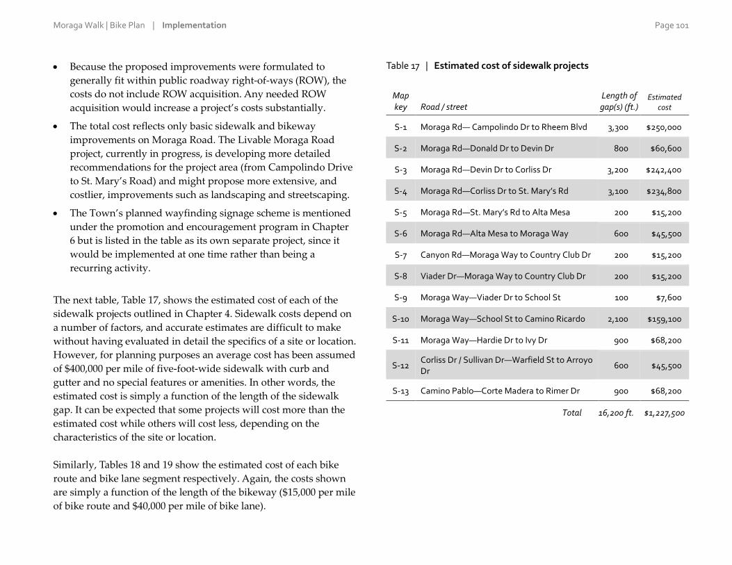
Moraga Walk | Bike Plan | Implementation Page 101
Because the proposed improvements were formulated to
generally fit within public roadway right-of-ways (ROW), the
costs do not include ROW acquisition. Any needed ROW
acquisition would increase a project’s costs substantially.
The total cost reflects only basic sidewalk and bikeway
improvements on Moraga Road. The Livable Moraga Road
project, currently in progress, is developing more detailed
recommendations for the project area (from Campolindo Drive
to St. Mary’s Road) and might propose more extensive, and
costlier, improvements such as landscaping and streetscaping.
The Town’s planned wayfinding signage scheme is mentioned
under the promotion and encouragement program in Chapter
6 but is listed in the table as its own separate project, since it
would be implemented at one time rather than being a
recurring activity.
The next table, Table 17, shows the estimated cost of each of the
sidewalk projects outlined in Chapter 4. Sidewalk costs depend on
a number of factors, and accurate estimates are difficult to make
without having evaluated in detail the specifics of a site or location.
However, for planning purposes an average cost has been assumed
of $400,000 per mile of five-foot-wide sidewalk with curb and
gutter and no special features or amenities. In other words, the
estimated cost is simply a function of the length of the sidewalk
gap. It can be expected that some projects will cost more than the
estimated cost while others will cost less, depending on the
characteristics of the site or location.
Similarly, Tables 18 and 19 show the estimated cost of each bike
route and bike lane segment respectively. Again, the costs shown
are simply a function of the length of the bikeway ($15,000 per mile
of bike route and $40,000 per mile of bike lane).
Table 17 | Estimated cost of sidewalk projects
Map key Road / street
Length of gap(s) (ft.)
Estimated cost
S-1 Moraga Rd— Campolindo Dr to Rheem Blvd 3,300 $250,000
S-2 Moraga Rd—Donald Dr to Devin Dr 800 $60,600
S-3 Moraga Rd—Devin Dr to Corliss Dr 3,200 $242,400
S-4 Moraga Rd—Corliss Dr to St. Mary’s Rd 3,100 $234,800
S-5 Moraga Rd—St. Mary’s Rd to Alta Mesa 200 $15,200
S-6 Moraga Rd—Alta Mesa to Moraga Way 600 $45,500
S-7 Canyon Rd—Moraga Way to Country Club Dr 200 $15,200
S-8 Viader Dr—Moraga Way to Country Club Dr 200 $15,200
S-9 Moraga Way—Viader Dr to School St 100 $7,600
S-10 Moraga Way—School St to Camino Ricardo 2,100 $159,100
S-11 Moraga Way—Hardie Dr to Ivy Dr 900 $68,200
S-12 Corliss Dr / Sullivan Dr—Warfield St to Arroyo Dr
600 $45,500
S-13 Camino Pablo—Corte Madera to Rimer Dr 900 $68,200
Total 16,200 ft. $1,227,500

Moraga Walk | Bike Plan | Implementation Page 102
Table 18 | Estimated cost of bike route segments
Road / street Length
(miles) Estimated
cost
Ascot Dr—Moraga Rd to Ascot Ct 0.4 $6,000
Augusta Dr—St. Andrew’s Dr to Westchester St 0.5 $7,500
Bollinger Canyon Rd—St. Mary’s Rd to town limits 0.9 $13,500
Camino Pablo—Tharp Dr to town limits 0.3 $4,500
Camino Ricardo—Corliss Dr to Moraga Way 0.5 $7,500
Campolindo Dr—Moraga Rd to Calle La Montana 0.4 $6,000
Canyon Rd—Constance Pl to town limit 0.6 $9,000
Corliss Dr—Moraga Rd to Wakefield Dr 1.1 $16,500
Country Club Dr—Canyon Rd to St. Andrew’s Dr 0.5 $7,500
Donald Dr—Moraga Rd to Laird Dr 0.4 $6,000
Laird Dr—Donald Dr to Donald Rheem E.S. 0.2 $3,000
Larch Ave—Canyon Rd to Camino Pablo 1.4 $21,000
Rheem Blvd—Orinda city limits to Town office 0.8 $12,000
Rheem Blvd—Moraga Rd to St. Mary’s Rd 1.3 $19,500
Rimer Dr—Camino Pablo to Shuey Dr 0.8 $12,000
St. Andrews Dr—Moraga Way to Augusta Dr 0.2 $3,000
St. Mary’s Rd—Stafford Rd to Lafayette city limits 0.8 $12,000
Sanders Dr—Canyon Rd to end of street 0.7 $10,500
School St—near Moraga Rd to near Canyon Rd 0.8 $12,000
Shuey Dr—Rimer Dr to Camino Pablo 0.3 $4,500
Tharp Dr—Rimer Dr to Camino Pablo 0.7 $10,500
Westchester St—Augusta Dr to end of street 0.1 $1,500
Total 13.7 mi. $205,500
Table 19 | Estimated cost of bike lane segments
Road / street Length (miles)
Estimated cost
Moraga Rd—Lafayette city limits to Woodford Dr 0.5 $20,000
Moraga Rd—Woodford Dr to Buckingham Dr 0.1 $4,000
Moraga Rd—Buckingham Dr to Donald Dr 0.8 $32,000
Moraga Rd—Donald Dr to Corliss Dr 0.5 $20,000
Moraga Rd—Corliss Dr to St. Mary’s Rd 0.6 $24,000
Moraga Rd—St. Mary’s Rd to Moraga Way 0.3 $12,000
Rheem Blvd—Town offices to Moraga Rd 0.3 $12,000
Moraga Way—Moraga Rd to School St 0.2 $8,000
Moraga Way—School St to Laguna Creek 0.1 $4,000
Moraga Way—Laguna Creek to Camino Ricardo 0.2 $8,000
Moraga Way—Camino Ricardo to past Moraga Valley Ln 0.3 $12,000
Moraga Way—past Moraga Valley Ln to Hardie Dr 0.1 $4,000
Moraga Way—Hardie Dr to Orinda city limits 0.1 $4,000
Canyon Rd—Moraga Way to Constance Pl 0.6 $24,000
Camino Pablo—Canyon Rd to Rimer Dr 0.2 $8,000
Camino Pablo—Rimer Dr to Oxford Dr 0.4 $16,000
Camino Pablo—Oxford Dr to Hodges Dr 0.1 $4,000
Camino Pablo—Hodges Dr to Moraga Creek 0.5 $20,000
Camino Pablo—Moraga Creek to Tharp Dr 0.2 $8,000
St. Mary’s Rd—Moraga Rd to Stafford Dr 0.6 $24,000
Total 6.7 mi. $268,000

Moraga Walk | Bike Plan | Implementation Page 103
3 | Most likely funding sources As mentioned above, implementing the Walk | Bike Plan will cost
roughly $3.42 million over 15 years. Because this is a large amount
for a jurisdiction of Moraga’s size, most of the funding to
implement the plan will need to come not from the Town’s own
funds but rather from government grant programs and other
outside sources.
Government grants
Table 20 on the next page lists the most promising grant programs
at the federal, state, regional and county levels for pedestrian and
bicycle improvements. The grant funding landscape changes
frequently, with new programs being created and old ones ceasing
to exist. While the table provides current information as of summer
2016, Town staff will need to make an effort to stay up to date on
news and announcements related to funding sources and
programs. Most of the grants are competitive, meaning that
Moraga will be vying for them against other municipalities. To
take full advantage of available outside funding, Town staff will
need to prepare and submit grant applications to the various
government agencies that administer these funds.
Development projects
In addition to applying for government grants, the Town should
look for opportunities to have improvements in the Walk | Bike
Plan constructed as part of development or redevelopment
projects. While Moraga is a slow-growing community, the planned
redevelopment of the Moraga Center Specific Plan area would
present a unique opportunity. The Specific Plan prepared for the
area proposes a pedestrian-oriented commercial and residential
district with a network of sidewalks and trails, possibly with
improvements to the Lafayette–Moraga Regional Trail. This would
be an unparalleled opportunity to improve walking and biking
conditions in Moraga because the Moraga Shopping Center and
the streets around it are the areas that pose the most concerns for
pedestrians and cyclists, at least based on input received during
the needs assessment process for the Walk | Bike Plan. Of the 13
sidewalk projects proposed in the plan, five (S-5 and S-7 through S-
10) and part of a sixth (S-4) are in the area covered by the Moraga
Center Specific Plan.
The Town should also require sidewalk improvements as a
condition of approval for smaller-scale development projects. One
opportunity site—notwithstanding its likelihood of being
developed—is the middle stretch of Moraga Road between Alta
Mesa and Moraga Way. The 600-foot sidewalk gap at that location
constitutes proposed sidewalk project S-6.

Moraga Walk | Bike Plan | Implementation Page 104
Table 20 | Most likely grant programs for improvements
Funding source Administering agency Availability of funding Notes
Potentially eligible improvements in the Walk | Bike Plan
State Active Transportation Program www.dot.ca.gov/hq/LocalPrograms/atp
Caltrans
Varies; most recent call for projects was in spring 2016.
Consolidation of several older grant programs, including State SR2S and Bicycle Transportation Account. Funds a wide range of capital and non-capital projects. Both programs give some preference to projects in disadvantaged communities. The state program is competitive among jurisdictions statewide; the regional program is competitive among Bay Area jurisdictions.
Sidewalks, bikeways, crossing improvements and most programmatic activities.
Regional Active Transportation Program www.mtc.ca.gov/funding/ATP
Metropolitan Transportation Commission
Varies; next call for projects will be later in 2016.
One Bay Area Grant County Program mtc.ca.gov/our-work/fund-invest/federal-funding/obag-2
Contra Costa Transportation Authority
Every four years; next call for projects expected soon.
Infrastructure projects that reduce vehicle trips, including pedestrian and bicycle facilities.
Sidewalks, bikeways and crossing improvements.
Transportation Development Act Article 3 ccag.ca.gov/opportunities/call-for-projects
Contra Costa Transportation Authority
Every 2–3 years; next call for projects could be as soon as fall 2016.
Competitive among Contra Costa County jurisdictions. Funds plans, safety education, and design and construction of capital projects.
Sidewalks, bikeways, crossing improvements and safety/education/training programs for school children and the general population.
Contra Costa Measure J Pedestrian, Bicycle and Trail Facilities http://ccta.net/_resources/detail/2/1
Contra Costa Transportation Authority
Every few years; next call for projects expected later in 2016.
Competitive among Contra Costa County jurisdictions.
Sidewalks, bikeways and crossing improvements, particularly on the arterials or along the Lafayette-Moraga Regional Trail.
Contra Costa Measure J Local Streets and Roads Maintenance http://ccta.net/_resources/detail/2/1
Contra Costa Transportation Authority
Annually. A portion of the available countywide funds are distributed to Moraga on a formula basis.
Funds are typically used for general roadway projects but may be used for sidewalks and bikeways.
Contra Costa Measure J Transportation for Livable Communities http://ccta.net/_resources/detail/2/1
Contra Costa Transportation Authority
Every few years; next call for projects expected in 2016.
Competitive among Contra Costa County jurisdictions.
Sidewalks, bikeways and crossing improvements.

Moraga Walk | Bike Plan | Implementation Page 105
Funding source Administering agency Availability of funding Notes
Potentially eligible improvements in the Walk | Bike Plan
California Office of Traffic Safety grants www.ots.ca.gov/Grants/default.asp
California OTS Annually (in recent years in January).
For traffic-safety education, awareness and enforcement programs aimed at drivers, pedestrians and cyclists.
Certain activities under the SR2S, safety/education and enforcement programs.
Highway Safety Improvement Program www.dot.ca.gov/hq/LocalPrograms/hsip.html
Caltrans Varies; most recent call for projects was in spring 2016.
For projects and programs that reduce traffic fatalities and serious injuries by correcting or improving a specific problem. Competitive at the state level (highly competitive).
Safety-related pedestrian, bikeway and crossing projects.
Certain activities under the SR2S, safety/education and enforcement programs; also, certain spot improvements.
Transportation Fund for Clean Air, Regional Fund www.baaqmd.gov/grant-funding/public-agencies/regional-fund
Bay Area Air Quality Management District
Annually (in recent years in April).
Funds bicycle facilities, including paths, lanes, routes, lockers and racks. The Regional Fund is competitive among Bay Area jurisdictions; the County Program Manager Fund is competitive among Contra Costa County jurisdictions.
Bikeways and bicycle crossing improvements.
Transportation Fund for Clean Air, County Program Manager Fund www.baaqmd.gov/grant-funding/public-agencies/county-program-manager-fund
Contra Costa Transportation Authority
Affordable Housing and Sustainable Communities Program www.sgc.ca.gov/Grant-Programs/AHSC-Program.html
California Strategic Growth Council
Annually; next call for projects expected in March 2017.
Projects that facilitate compact development, including pedestrian and bicycle infrastructure and amenities, with neighborhood-scale impacts. Available to government agencies and institutions (including local government, transit agencies and school districts), developers and non-profit organizations.
Sidewalks, bikeways and crossing improvements, particularly those in the area covered by the Moraga Center Specific Plan.
TIGER Discretionary Grants www.transportation.gov/tiger
U.S. Department of Transportation
Annually; next call for projects expected in February 2017.
For capital projects. Competitive at the national level (highly competitive).
Sidewalks, bikeways and crossing improvements.

Moraga Walk | Bike Plan | Implementation Page 106
Funding source Administering agency Availability of funding Notes
Potentially eligible improvements in the Walk | Bike Plan
511 Contra Costa Bike Rack and Locker Program 511contracosta.org/employers/make-your-workplace-bike-friendly/locker-project
511 Contra Costa Ongoing (applications reviewed on a first-come-first-served basis). Subject to availability of funds.
Reimburses 50% of the cost of purchasing and installing bike racks up to $500 per unit. Available to businesses, public agencies and non-profit organizations in Contra Costa County.
Bicycle parking racks and lockers (equipment but not installation).
Bicycle Rack Voucher Program www.baaqmd.gov/grant-funding/public-agencies/brvp
Bay Area Air Quality Management District
Ongoing (applications reviewed on a first-come-first-served basis). Subject to availability of grant funds, which are renewed annually July 1.
Vouchers for up to $60 per bicycle parking space created (up to $15,000 per applicant per year. Racks must be installed within one-tenth of a mile of at least one major activity center and maintained in service for at least three years. Available only to public agencies.
Bicycle parking racks.
Broader transportation projects
Many of the walking and biking needs in Moraga stem from the
fact that the roads were designed without full consideration of
pedestrians and cyclists. This is reflected in the scope of the
projects proposed in the Walk | Bike Plan, which for the most part
aim to simply make it easier to walk or bike down the street. The
way to begin to remedy this situation is by working to implement
the Town’s recently adopted Complete Streets policy. Complete
streets are those that are planned and designed for safe and
convenient access by all users (as appropriate, depending on the
context of the streets). Following its own policy, the Town should
consider the needs of pedestrians and cyclists in the planning and
design of all transportation projects and look for opportunities to
implement improvements in the Walk | Bike Plan as part of any
broader transportation projects. Again, perhaps the best
opportunity to do so during the lifetime of the Walk | Bike Plan is
the planned redevelopment of Moraga Shopping Center, when
some of the streets in the area would be redesigned.
Sidewalk gap on Viader Drive near Moraga Way

Moraga Walk | Bike Plan Page 107
Appendix A
Comments from the community survey on needs

Moraga Walk | Bike Plan | Appendix A Page 108
A-1 | What is your connection to Moraga?
20 responses
1. Kids wend through Moraga schools
2. 13 yr old grand son & family also live in Moraga...active users of rec
amenities
3. I live in Orinda, but like to walk the EBRPD trail through Moraga
with my dog, jog through Moraga either with or without my dog on
a frequent basis.
4. Campolindo Alumni
5. Commute to work in Oakland
6. I walk my dog daily
7. I grew up in Moraga
8. I teach at Saint Mary's College
9. I had a child who attended Moraga schools until 12th grade.
10. faculty at St. Marys
11. We had children at Campolindo high school - now graduated
12. I walk and bike in Moraga.
13. Work at Saint Mary's
14. I am a senior citizen and have lived here 45 years.
15. Own house on Paseo Del RIo in Campolindo. We live off of Rheem
near Gloietta in Orinda.
16. like to go to the theater in moraga and local restaurants
17. Own in Campolindo, we live at Rheem and Glorietta
18. I own in Campolindo. We live at Rheem and Glorietta
19. Please restore my residence and rental in Moraga and pay all future
expenses.
20. I work at a Moraga Elementary School

Moraga Walk | Bike Plan | Appendix A Page 109
A-2 | Have we forgotten any major general challenges to walking?
76 responses
1. Lots of traffic at school drop-off and pick-up times.
2. Bikes. Bikes are my main challenge to walking safely in Moraga.
3. branches and shrubs in the walking space forcing people to walk
closer to traffic or need to duck down. sometimes they are property
of commercial interst other times public lands and other times
overgrown private shrubs. in some areas there is inconsistency from
house to house. One has a sidewalk one does not. then back again.
4. Busy streets with lots of cars distract me from walking on them.
5. Need more and better bus shelters (as in keeping out rain, which
almost always blows into the few shelters we have)
6. Interruptions in paths
7. The street lights in the Rimer and Shuey neighborhoods are poor for
seeing walkers and kids in the early evening.
8. Locations of crosswalks, having to walk past where you really want
to go.
9. More trails
10. Way too many speeding cars, particularly where I live on St.
Andrew's Drive coming down the hill toward the basketball court on
Augusta. Few drivers stop at the stop signs. Dangerous, especially
now, walking new grand baby.
11. Sidewalks switch from one side of road to other. Inconsistant paths.
No. Consistant sidwalks between major attractions. Who ever
developed town did it to stop pedestrian access. Sidewalks should
be designed to allow fast walking between all major aminites. No
winding paths on artireal roads like goofy communities do.
12. Poor intersection design focused solely on cars, not pedestrian
safety.
13. change in road conditions like wide road becomes narrow, bike lane
stops, trail/sidewalk turns into an unpleasant area
14. Aggressive bikers on trail
15. Sketchy stretch in Moraga way between golf course and Safeway
light at school. Why no sidewalk? Also, why not connect the
Lafayette-Moraga trail to a sidewalk to get you into rheems?
16. Yes, bicyclists no longer call out "on your left" when whizzing past
walkers. A serious accident is going to happen.
17. lack of shade
18. Moraga Road
19. No
20. not enough sidewalks
21. Some trails not maintained for our pets. Too many foxtails. Dogs
are likely present on most outings.
22. Sidewalks end leaving you on the street
23. Cars do not stop at crosswalks
24. Water fountains more often on the lamorinda trail would be great.
25. Cars parking in bike lanes, particularly from Rheem to the
Commons. My JM child can ride, but he even gets nervous in this
stretch.
26. I work at Saint Mary's College so it's hard to walk anywhere easily
from here in a short time.
27. too close to autos
28. roads are unsafe to bike on because they're so bumpy i've fallen off
my bike too much
29. No sidewalk or path to walk along Rheem Blvd. Must walk in traffic
lane. Very dangerous.
30. Some people are just lazy, I walk 5 miles every day around town!
31. I think you got most, if not all!
32. Ideally there should be shaded areas, natural surroundings and
connected routes to make it easier to get around town.
33. Missing sidewalks in many portions of Moraga Road.
34. Lack of safe sidewalks and bike lanes. Lack of continuous sidewalks
and bike routes.
35. rude bicyclists
36. More sidewalks, more lighting, more bike lanes.
37. shaded walkways would be nice - some stretches of roads have no
tress; planting trees along major corridors would greatly improve the
environment, not just for walking.

Moraga Walk | Bike Plan | Appendix A Page 110
38. Extend existing sidewalks in neighborhoods to connect to Moraga
Road and or Moraga Way
39. Lack of contiguous sidewalks
40. There are many streets in Moraga that do not have sidewalks.
41. Few or no amenities as destinations, but that is another topic
entirely.
42. Most neighborhoods (especially in Southern Moraga) have no
sidewalks at all.
43. Lack of Safety, proximity to cars
44. I find no problem walking around in Moraga.
45. garbage bins being left on the sidewalks for the entire day.
Impossible to push a stroller along Moraga one day every week.
46. Bikers going far too fast on the bike path. Very unsafe for walkers
47. 1. Need sidewalks on both sides of Moraga Road between the
Moraga Commons and the Rheem Shopping Center. 2. The sidewalk
on Rheem Blvd. should extend all the way to St. Mary's Road from
Moraga Rd.
48. Many streets have no sidewalks and/or are unsafe to walk on.
49. As long as I stay in residential neighborhoods, there are not
challenges
50. No challenges to walking
51. We live at the top of Ascot Drive. Pretty hard to walk up or
down…but we can drive, then walk.
52. Corner homeowners who let their landscaping grow too high so that
it is difficult to see traffic ahead. Also, homeowners whose
landscaping covers part of the sidewalks.
53. Dog safe and friendly
54. Too much new construction going on in Moraga!
55. BIKING: MORAGA ROAD HAS LIMITED SPACE TO RIDE.
56. Lack of a trail through all of town that is easily accessible from most
neighborhoods
57. more trails off of streets would be great!
58. SIDEWALKS!!!!!! (You didn't forget them, but I just want to
emphasize how crucial they are!!!!)
59. Why can't we have continuous sidewalks, at least on one side of the
street throughout Moraga, but at least on the main roads to the
schools. I have lived here 25 years and it drives me nuts every day.
60. there are not sidewalks or paths on parts of Moraga Road
61. There are plenty of paths specifically for recreational walking that
are away from traffic.
62. Sidewalks. I love Moraga but the thought of having my kids walk on
the side of a road to get to school is very concerning.
63. Aside from distance and occasional hills, there are no challenges to
walking in Moraga. It is a quiet town, and a great walking town.
Any attempt by a committee, board, council or similar can only
screw things up. Leave it alone.
64. I want to emphasize the lack of Sidewalks on main streets like
Moraga Road, Rheem blvd and in the neighborhoods
65. Overgrown weeds, bushes and loose dirt are also a problem.
66. not that many destinations for non students. retail or grocery
shopping would require transportation of goods.
67. Has […] been making derogatory comments about […] which caused
invasion of privacy and financial hardship? On this basis please buy
Miss […] a new home in Moraga and pay all her living expenses for
the rest of her life and restore the property of the […] Family and the
[…] Family trust and provide her mother and father with continued
payments including to stop the financial and emotional lhardship
which the employees and associates of the Town of Moraga have
caused in 2015 retroactively to 1936. Since […] are listed as students
and graduats of Saint Marys College. I demand that the Town of
Moraga provide continued car e and financial restitution for all
members of the […] Family, The […] Family, The […] Family,The
[…] Family, especially […], etc. Interference with walking and hiking
in Moraga has definitely caused financial hardship to these families.
The Town Of Moraga must respond and provide restitution
immediately, since […] has established reall estate right aways and
easements with walking since 1956 before the Town of Moraga was
formed and also members of the […] family have established similar
right away access since approx. 1935.
68. allow for safe, connected walking routes between various town
centers: shopping centers, library, schools, trails
69. bike lanes not maintained - overgrown vegetation, debris, etc.
70. unattractiveness of some parts of the walk
71. I rarely walk so I'm imagining.

Moraga Walk | Bike Plan | Appendix A Page 111
72. when crossing busy streets in some areas it is almost too dangerous
to cross due to lack of blinking lights in cross walk and enough time
warning for cars to stop see Lafayette city cross walks Mt. Diablo
ect...
73. Moraga is a bedroom community that is car-centric. We should shut
down short-cut streets to through traffic like de la Cruz.
74. CONNECTIONS. Many neighborhoods are isolated by lack of
sidewalks/paths. For instance, in Rheem Valley Manor, we have a
direct visual lines to Rheem Center area, but NO SAFE WAY to get
there. Give us some walking/biking paths to get there and we can do
that instead of driving.
75. Dog poo on the walkway...
76. All the places to shop have giant parking lots and the stores are
spread throughout the lot and there is no nice walking paths.

Moraga Walk | Bike Plan | Appendix A Page 112
A-3 | Are there specific streets or blocks that need new or improved sidewalks?
194 responses
1. Rheem, from Moraga Road to St Mary's Road
2. Moraga Road and Moraga Way.
3. from the hacienda to Corliss on the north west side
4. Devin Dr
5. Moraga Road
6. Moraga Way
7. Bollinger Canyon Road and Rheem Blvd.
8. From Camino Recardo to Safeway should have continuous
sidewalks. From Corliss along Moraga Road to shops should have
continuous sidewalks.
9. I favor "dis-improved" sidewalks...get rid of the curbs and cement,
and used crushed granite or other more natural surfaces for "paths"
10. Corliss
11. Moraga road
12. Not that I know
13. None
14. No
15. Bollinger canyon to st Mary's. St. Mary's /Rheem Blvd to Moraga
way/moraga Rd
16. Walking to commons from overflow parking
17. Canyon need improved sidewalks
18. The stretch of road after moraga commons where path ends to
rheem shopping center. You should finish this connection, even if
you have to go thru Corliss neighborhood. If you can get it with a
stop at hacienda or connect to Donald ( for those brave to go uphill
on fire road ) you are golden. Connecting it to high school would be
greatly appreciated. Plus this is a huge jogging path with tons of
runners at St. Mary's and high school going thru here!!
19. Larch has many pedestrians that walk in the street for lack of a
sidewalk and under poor light.
20. Larch
21. Moraga Road, Moraga Way, St Mary's Road
22. Rheem and moraga road
23. Moraga Rd between Moraga Way and Moraga Commons park.
24. Opposite Moraga Commons heading toward the Chevron Station.
25. Camino pablo. Moraga way. Moraga road. Both sides of fire
department on Moraga Road. Between fire dept and golf course. No
side walk please make this a straight path not winding moraga road.
Station 41. Bridge to narrow for safe crossing between golf course
and OSH/Safeway parking lots, when new housing is installed there
will be increased risk of pedestrian injury. No lighting on the bridge
currently. No sidewalk on most rheem blvd betwn st marys and the
rheem center. Tharp no consistant sidewalk. No real trail access in
town.
26. I think we need sidewalk on both sides of Canyon/ Moraga Rd from
Country Club to St. Mary's Rd. Larch Rd. from Canyon to
Dickenson. Camino Pablo from Canyon to CP Elementary (both
sides of the road).
27. Moraga Road from the Commons to Rheem
28. 1) Camino Pablo between CP and JM schools. 2) Canyon intersection
with Moraga Way and Moraga Commons. 3) Moraga Rd /Corliss
intersection to Rheem Shopping Center
29. I'd like to see a sidewalk on Moraga Road between Donald Drive
and Moraga Commons
30. Canyon near Moraga Way
31. Please continue the sidewalk on canyon road/ Moraga road from
country club drive to the commons. We like biking/walking to the
park and library from our CP neighborhood. We would like to avoid
biking/walking in the shopping center.
32. Corliss
33. Rheem Blvd near town offices both sides of street.
34. Moraga Way between Country club and Alta Mesa, side walk ends.
35. Moraga Road is the main road through twon and needs continuous
sidewalks of a normal width that are unblocked by power poles and
mailboxes.
36. Moraga road between corliss And Donald drive
37. Rheem Blvd needs a sidewalk going over the hill.
38. around Moraga Shopping Center, access to and from regional trail

Moraga Walk | Bike Plan | Appendix A Page 113
39. Moraga Road between trail and Farmer's Market location--the stretch
at "parking lot" has no sidewalk
40. Rheem Blvd. No sidewalk makes walking to Rheem center
dangerous. No sidewalk or safe bike lane means children cannot
bike from their home to school or the park or friends. In Rheem Blvd
traffic is too fast to walk or bike safely without a sidewalk.
41. I often see people (frequently kids/teenagers) walking along the
shoulder of Moraga Rd. in the mornings on my way to St. Mary's
College.
42. Rheem Boulevard between Saint Mary's and Rheem. There is no
walking trail; limited length of sidewalk; and the road is terrible, too.
43. Rheem
44. Saint Mary's Road
45. Corliss between Warfield and turning into Sullivan Drive. Sullivan
Drive, Hardie Drive, Fieldbrook Pl.,
46. Not that I know of.
47. 1. Moraga Rd. (east side of the street) from about Paseo Linares to
Donald Dr. 2. The west side, too, has missing sections ( 660 Moraga
Rd to Donald Dr, and Corliss Dr. to Devin Dr)
48. Near the intersection of Moraga road and St Mary's road by the
Safeway parking lot. There is no sidewalk walking from the street
light to the parking lot and there is no walkway from the gas station
to the first stores.
49. Rheem Blvd
50. Rheem would be a good place for a sidewalk and improved roads.
51. Moraga Road (mostly heading towards Lafayette)
52. Moraga Road,
53. That dang curvy road on the way to st. mary's college. The kids
drive like crazy and there is no bike lane or walking lane along the
road.
54. Along the major corridors, Moraga Way and Moraga Road, and
Rheem Blvd, there aren't consistent sidewalks or even safe paths.
That would be the top priority.
55. From Moraga Commons to Rheem Center
56. The Moraga Commons park to Moraga shopping center.
57. Rheem Boulevard in between the College area and the Rheem
Shopping Center is in yet another dire need of repair, specifically the
section in the middle of the road.
58. The side of St Mary's road opposite the off-street trail is missing a
bike lane / side walk. Walking on the path is sometimes an issue
because of so many bikes. It's really difficult to walk on it at times.
But there is no other option for a quick walk down the road.
59. Saint Mary's road needs sidewalks !
60. Only half of the Rheem Hill has sidewalks at all
61. Country Club Drive
62. As a driver, I hate to be around bikes near Canyon Rd. and St.
Mary's Rd. not enough room and bikers don't obey traffic laws--
they side side by side and block the road too. They can have big
attitudes, but don't stop at lights, etc... Most of the trouble comes
from serious riders with team jersies, it seems. Please get them off
these narrow windy roads. They are a danger to themselves and
drivers!!!!!
63. Moraga Way between Camino Ricardo & Moraga Road. Moraga
Road between Moraga Way & St Mary's
64. Definitely Moraga Road bet Moraga Way and Campo.
65. Moraga Road - in many places. Canyon Road just before intersection
with Moraga Way
66. We bought on Larch Avenue because it has no street lights and no
sidewalks. Enforce the 25 mph speed limit on Larch Avenue on a
recurring basis and the walkers will do just fine.
67. Yes between Donald drive and mortgage commons is a dangerous
and unpleasant walk. I have a difficult time walking with my dogs
alongside me on that stretch of road
68. Moraga Rd from St. Mary's to Moraga Way have to walk through
dirt. Rheem by 24 fitness does not have ADA ramps to get to
crosswalk. Moraga Rd by Corliss needs crosswalk. Rheem toward St.
Mary's Rd to get to trail is dangerous
69. Larch ave, Camilo Pablo st,
70. We need consistent side walks the entire Moraga Road but
specifically there is a patch south of the park and before Moraga
Way. The side walk disappears on the east side.

Moraga Walk | Bike Plan | Appendix A Page 114
71. along moraga way after the Rheem shopping center - just needs a
sidewalk all the way to the commons
72. At the very least, the main roads (Moraga Way, Moraga Road,
maybe others) should have good, continuous sidewalks. Traffic is
too heavy on these roads for comfortable walking, and people need
to use these roads to walk to most Moraga destinations.
73. The east side of Moraga Road from Country Club to the Commons
needs sidewalk all the way. The west side of Moraga Road needs
sidewalk where in front of the overflow parking.
74. Moraga Road, Camino Pablo
75. Moraga Rd, Rheem Blvd
76. No sidewalks on Moraga Rd. between Corliss and Devin Drives. No
sidewalks on Rheem Blvd between Moraga and St. Marys Roads.
77. On Moraga Road! You cannot walk from Moraga Ranch
(Canyon/Larch) to the Commons Park without crossing Moraga
Road twice or walking in the street. We have walked several times
from our neighborhood to the Park and it is always scary with a
stroller and walking/scooting young child.
78. tharp augusta most roads are bad
79. No
80. Rheem Blvd. between Saint Mary's Road and Fernwood Drive!
There needs to be a sidewalk here! Ideally there should be a
sidewalk for the entire length of Rheem Blvd from Saint Mary's
Road to Moraga Road.
81. Moraga Road heading towards JM does not have sidewalks the
entire way on the northbound side of the road. The entrance to
Moraga Shopping center across from Alta Mesa could use a
sidewalk.
82. Any street without a sidewalk would seem safer with a sidewalk!
83. Camino Pablo only has one side with a crosswalk, it would be really
nice to have both sides with one
84. There are missing sections of sidewalks all over town.
85. on corliss (especially from lynwood to moraga rd). on moraga road
from the center to connect to the commons path - in case you want
to go to the shops instead of behind safeway.
86. Moraga Road
87. Most of Moraga does not have sidewalks.
88. Camino Ricardo between Moraga Way and Corliss. Lots of kids
walk to school and there are no mini ramps for crossing Hardie.
89. Moraga Rd b/w Corliss & Donald. Moraga Rd b/w St. Mary's and
Moraga Way
90. Larch on the canyon rd side of the hill. sidewalks are non existent.
91. Moraga Way desperately needs side walks between Moraga Road
and Camino Richardo. Moraga Road needs better connecting side
walks from Corliss down to the shopping center at Rheem.
92. Moraga Road.
93. Moraga Way south near School St, there is no sidewalk and no bike
lane
94. Camino Pablo, especially between the two schools JM and CP.
Moraga Road between the Safeway shopping center and Rheem
Blvd. Moraga Way from Miramonte HS to the Safeway shopping
center
95. anywhere there is a sidewalk problem. I once fell and injured my
back because of a sidewalk issue
96. Too many to list here in this small response box. The most
egregious is the residential road section of Moraga Road between
Ascot and St Mary's Road. It is unbelievable that Town Council has
removed consideration of this section of roadway from study and
comment in the Walk-Bike General Plan update. People have died
along this section and they take no action. Yet the Town Council
will vote in a heart beat to provide $6 million roundabouts at St
Mary Road / Rheem and Bolinger Canyon, or $26 million for a
Hacienda Entertainment Complex with Wine Caves, and millions
more for a ceramic tiled entry plaza, 4' tall urn spittoons, and
structural reinforcement for tile wainscot roofing on a rebuilt Town
meeting room that has nearly NO parking.
97. Moraga Road
98. Moraga Rd between Corliss and Rheem Blvd.
99. Rheem Blvd needs sidewalks.
100. Hardie Drive and Sullivan...so kids can walk to school safely and
avoid the speeding parents around the curve to LP. We also need a
safer way for kids in the LP area to bike to Campolindo HS.
101. Yes!! A side walk is needed along Moraga Road from Donald Drive
all the way to Moraga Way. Kids should be able to walk or ride

Moraga Walk | Bike Plan | Appendix A Page 115
their bikes SAFELY to middle school. Right now it isn't safe for
them to ride to school along Moraga Road. If a bike lane or
walking/bike path were available I would ride with my kids to
Moraga Commons park to play but right now it isn't safe. Rheem
Blvd is also a street (on both sides of Moraga Road) that would
benefit from a combined sidewalk/bike path (like what Orinda put
in along Moraga Way). There should be a sidewalk/bikepath all the
way from Moraga Road to St Mary's Road.
102. The short stretch of sidewalk on Moraga Rd. just north of
Campolindo is always a mess. The dirt runs onto the sidewalk or
there is debris - both of which make the sidewalk just about
impassable. The sidewalk should be maintained by the Town or the
School District; i.e. someone should take responsibility.
103. I am in the Sanders Dr neighborhood (on Carr Dr), and that whole
neighborhood plus Larch and I'm guessing pretty much any other
1960-era community all look the same.
104. Draeger Drive (Rheem Valley Manor subdivision in general).
Sections of Moraga Road
105. Camino Peral has some sidewalk issues, especially because we have
many older citizens in the neighborhood.
106. Continue the sidewalk on Corliss to Moraga Rd; Continue the
sidewalk from LP on Corless/Sullivan /Hardy to Moraga Way
107. Moraga Rd over by Corliss of course.
108. Moraga Way
109. Sidewalk from Devin Dr breaks up at Donald. Have to walk into
Moraga Rd with a stroller to get to Rheem Elementary or Rheem
shopping center.
110. Sullivan/Corliss--a sidewalk would be great. Lots of kids/parents
use street to walk to school.
111. Sanders Drive, Larch
112. Campolindo high school would benefit from having sidewalks on
both sides of Moraga Road. Rheem Blvd going to Saint Mary's
College should have a bike lane and sidewalks for students, staff
and faculty going to the college.
113. Larch Avenue
114. Cross Moraga Road at Draeger is dangerous. Walking or biking
along Moraga Road is dangerous from the Commons to Donald.
115. Rheem sidewalk needed between Moraga Road and St.Mary's --
from top of hill down to St. Mary's
116. Donald Dr from Moraga Rd to Rheem Elementary school. Widen
the existing sidewalk, and add a sidewalk on opposite side of street.
117. More lighting from Carroll Ranch to Rheem shopping. Very dark at
night.
118. Corliss above Los Perales School, Moraga Road between Moraga
Shopping Center and Rheem Shopping Center
119. A sidewalk/bike path along Bollinger Canyon from The Bluffs
neighborhood would make the Lafayette-Moraga trail more
accessible. It is dangerous to walk/bike along Bollinger Canyon to
get to the trail. Then there is the issue of crossing St. Mary's Road to
get to the trail.
120. No
121. Moraga Way
122. New sidewalk would be very helpful on Corliss Drive starting at
Moraga Road to about 223 Corliss when sidewalk starts. It would
make walking to the Commons more attractive. Currently, it is
dangerous to walk and cars speed at the end of Corliss. Sidewalks
and/or speed bumps are needed.
123. School street between Safeway and Country Club Road; curb cuts
are in the wrong place, sidewalk is uneven; there is no crosswalk
one one part of the Country Club Road and School St. Moraga Way
between Viader and School Street; need a complete sidewalk.
Moraga Road between Moraga Commons and Sanders road;
incomplete sidewalk
124. See above.
125. The end of Rimer Drive.
126. 1.Between Rheem and Moraga Commons. 2. Between Via Granada
and Lafayette
127. All neighborhoods that have a nearby school should have proper
sidewalks.
128. Corliss to Rheem shopping center.
129. It would be great if we could install a sidewalk at intersection of
Moraga Rd/St Mary's Road (across from the park) to connect with
the existing sidewalk on Moraga Road. Just need about 500 feet of
new sidewalk. This is a dangerous place for walkers and riders.

Moraga Walk | Bike Plan | Appendix A Page 116
Especially a problem as this field is used for Moraga Commons
overflow parking.
130. YES- the top of Larch Ave where children cross the street to the
back path to Camino Pablo school. Very dangerous area. No
sidewalks, no crosswalk, and it's at the top of the hill where drivers
cannot see children who are crossing.
131. Moraga road. From 7-11 to moraga commons. It's a busy road with
no sidewalks in places. We walk/bike between the shopping center
and park a lot, but its unsafe.
132. rheem from moraga road to st mary's
133. Moraga Road from the high school though downtown is a huge
issue.
134. Corliss from Lynwood to Moraga Rd. crosswalk; Moraga Rd. from
Corliss to Rheem Center
135. the trail around Rancho Laguna Park is heavily used for walking
and very unsafe
136. Sidewalks in Canyon (near the Country Club intersection) are
rutted and overgrown.
137. Pacific Bell utility access box on sidewalk between the Star Service
Station (corner of Rheem Blvd. and Moraga Road) and the Taco Bell
on Moraga Road is caving in causing a hazard for walkers,
particularly at night.
138. Moraga Rd between Donald and Corliss. Rheem blvd from Fay Hill
Rd (the top of the hill) to Fernwood.
Rheem blvd from ~325 Rheem to the top of the hill in Orinda.
Moraga Rd across from Campolindo High School - there's only a
sidewalk on one side of the road). Moraga Rd in Lafayette (the hilly
part). Anywhere that doesn't have sidewalks but does have fast
traffic
139. N/A
140. Sidewalk at Moraga road where it comes to Donald needs to be
completed. All the way to the commons is even better. The signage
and path from the Commons up to mulholland ridge could be
improved.
141. none that I can think of
142. Larch Ave has areas with no sidewalks at all.
143. Many of the sidewalks in the Campolindo HOA area are broken,
cracked, have large divots and pose a trip hazard particularly when
walking at night.
144. The bridge on Canyon over the Moraga Creek is a deathtrap for
pedestrians who frequently use it to connect to the Lafayette-
Moraga bike path or the EBMUD trail. Speeding cars in both
directions and a blind curve for vehicles entering Moraga. A low-
cost solution would be to just put a STOP sign on both sides of the
bridge, rather than to re-engineer the entire bridge and rebuild it,
which won't be happening soon because there is no money for it.
145. None I can name
146. Do not eliminate any Lanes on Moraga Riad
147. Sidewalk along Moraga Rd from Country Club all the way to St.
Mary's Rd to connect to Moraga Commons.
148. Continuous sidewalks are needed from Moraga Commons to
Rheem Center on Moraga Road on either one side of the street or
both!
149. Sidewalk on Rheem Bl from Moraga Rd to St. Mary's Rd would
make walking there much safer and more pleasant.
150. Moraga Road between Ascot and Devin/Draeger
151. Moraga Shopping Center to St. Mary's on Moraga Road
152. St. Mary's Road, Rheem Blvd
153. Moraga Road
154. rheem blvd
155. Corliss. Hardie. Moraga Way
156. Moraga Rd from Lafayette border to Commons. Moraga Way from
Moraga Rd intersection to Country Club. Rheem Blvd from Orinda
border to St. Mary's Rd
157. Moraga Rd between Rheem and the Commons yeah, no surprises.
Over the hill from Rheem to St Marys is pretty poor too
158. Moraga Road south of the Rheem Shopping Center
159. camino pablo. there were some new sidewalks put in recently
between cp & jm. there should be sidewalks on both sides of
camino pablo all the way from jm to rancho laguna
160. There are no sidewalks. If you want Moraga to be walk friendly,
this must be addressed. I grew up in a rural (not semi-rural)
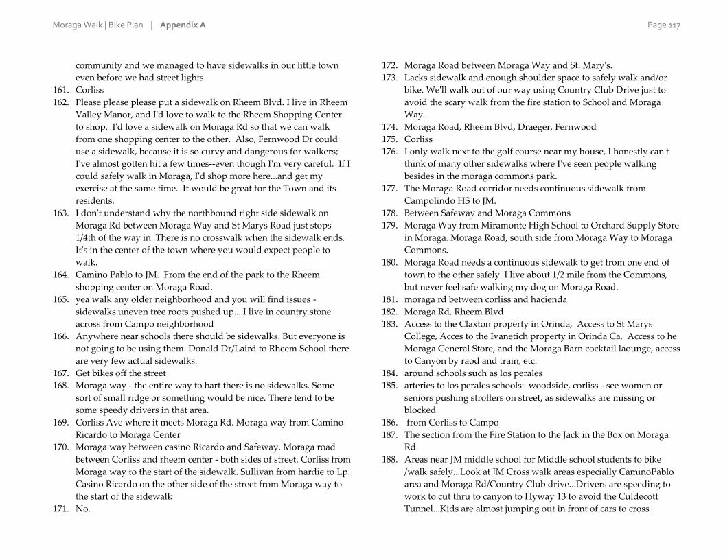
Moraga Walk | Bike Plan | Appendix A Page 117
community and we managed to have sidewalks in our little town
even before we had street lights.
161. Corliss
162. Please please please put a sidewalk on Rheem Blvd. I live in Rheem
Valley Manor, and I'd love to walk to the Rheem Shopping Center
to shop. I'd love a sidewalk on Moraga Rd so that we can walk
from one shopping center to the other. Also, Fernwood Dr could
use a sidewalk, because it is so curvy and dangerous for walkers;
I've almost gotten hit a few times--even though I'm very careful. If I
could safely walk in Moraga, I'd shop more here...and get my
exercise at the same time. It would be great for the Town and its
residents.
163. I don't understand why the northbound right side sidewalk on
Moraga Rd between Moraga Way and St Marys Road just stops
1/4th of the way in. There is no crosswalk when the sidewalk ends.
It's in the center of the town where you would expect people to
walk.
164. Camino Pablo to JM. From the end of the park to the Rheem
shopping center on Moraga Road.
165. yea walk any older neighborhood and you will find issues -
sidewalks uneven tree roots pushed up....I live in country stone
across from Campo neighborhood
166. Anywhere near schools there should be sidewalks. But everyone is
not going to be using them. Donald Dr/Laird to Rheem School there
are very few actual sidewalks.
167. Get bikes off the street
168. Moraga way - the entire way to bart there is no sidewalks. Some
sort of small ridge or something would be nice. There tend to be
some speedy drivers in that area.
169. Corliss Ave where it meets Moraga Rd. Moraga way from Camino
Ricardo to Moraga Center
170. Moraga way between casino Ricardo and Safeway. Moraga road
between Corliss and rheem center - both sides of street. Corliss from
Moraga way to the start of the sidewalk. Sullivan from hardie to Lp.
Casino Ricardo on the other side of the street from Moraga way to
the start of the sidewalk
171. No.
172. Moraga Road between Moraga Way and St. Mary's.
173. Lacks sidewalk and enough shoulder space to safely walk and/or
bike. We'll walk out of our way using Country Club Drive just to
avoid the scary walk from the fire station to School and Moraga
Way.
174. Moraga Road, Rheem Blvd, Draeger, Fernwood
175. Corliss
176. I only walk next to the golf course near my house, I honestly can't
think of many other sidewalks where I've seen people walking
besides in the moraga commons park.
177. The Moraga Road corridor needs continuous sidewalk from
Campolindo HS to JM.
178. Between Safeway and Moraga Commons
179. Moraga Way from Miramonte High School to Orchard Supply Store
in Moraga. Moraga Road, south side from Moraga Way to Moraga
Commons.
180. Moraga Road needs a continuous sidewalk to get from one end of
town to the other safely. I live about 1/2 mile from the Commons,
but never feel safe walking my dog on Moraga Road.
181. moraga rd between corliss and hacienda
182. Moraga Rd, Rheem Blvd
183. Access to the Claxton property in Orinda, Access to St Marys
College, Acces to the Ivanetich property in Orinda Ca, Access to he
Moraga General Store, and the Moraga Barn cocktail laounge, access
to Canyon by raod and train, etc.
184. around schools such as los perales
185. arteries to los perales schools: woodside, corliss - see women or
seniors pushing strollers on street, as sidewalks are missing or
blocked
186. from Corliss to Campo
187. The section from the Fire Station to the Jack in the Box on Moraga
Rd.
188. Areas near JM middle school for Middle school students to bike
/walk safely...Look at JM Cross walk areas especially CaminoPablo
area and Moraga Rd/Country Club drive...Drivers are speeding to
work to cut thru to canyon to Hyway 13 to avoid the Culdecott
Tunnel...Kids are almost jumping out in front of cars to cross

Moraga Walk | Bike Plan | Appendix A Page 118
camino pablo when school is letting out..Just do an observation for
a few days to see for yourself, one morning one at dismissal...Rimer
Rd Cars are speeding all the time I am on the street and kids and
adults are walking down the street..Look At Rheem blvd New
Homes are going there and look at the walking trail near Rheem
and St. Mary's Rd there is a major walking trail and stop sign , but
no 4 way traffic stop...Right at that intersection I often have to pull
right into the Cross Walk to peer out to make a left hand turn for
visual and saftey reasons ...Cars coming from Lafayette are going
very fast and it is difficult...Look at the bike riding as well. Very
Narrow and undesignated bike lanes...Everyone is still texting and
driving as well...
189. Fernwood and Donald. Bollinger up to the Old Ranch Trail should
have a good pedestrian and bike route (it does not currently). Also,
once they have the Las Trampas access available, it would be great
to be able to safely walk/bike TO that new access point.
190. Hardie Drive, Corliss Drive, Moraga Road
191. Moraga Road between Commons & Rheem
192. Moraga Rd across from shopping center (small section).
193. Moraga Road should have sidewalks from the Compolinda HS to
the Moraga library. Also whenever there is a bus stop should have
sidewalk, bench adn shade. I walk further to a safer bus stop.
194. Moraga Road needs a sidewalk from Devin Drive to Corliss Drive
so that people can walk to Moraga Commons Park. Sidewalks on
both sides of Moraga Road through this section would be ideal.

Moraga Walk | Bike Plan | Appendix A Page 119
A-4 | Are there specific intersections that need to be made safer or easier to cross?
156 responses
1. Alta Mesa Drive and Moraga Rd. is a fatality waiting to happen! Not
all drivers stop at crosswalk with pedestrian attempting to cross.
One car may stop while another continues through intersection not
slowing to figure out why a car has stopped. Pedestrians assume a
level of safety that's not there.
2. Corliss at moraga road has a flashing light that the first drivers do
not usually comply with.
3. Devin Dr across Moraga Way for kids getting school bus
4. Moraga Way and Moraga Rd
5. St Mary's Rd and Rheem Blvd... too many cars in too much of a
hurry.. not paying attention, especially those coming off of St Mary's
Rd from either direction, turning on to Rheem Blvd (and across the
trail). Bollinger Canyon / St Mary's Rd - would be best to create a
connection from Bollinger Canyon up to/through/around St Mary's
College - allowing walkers/cyclists already on that side of the road to
avoid having to cross St Mary's right there at Bollinger to get to the
trail... let them cross up by the St Mary's entrance
6. Between Bank of America and Wells Fargo - traffic is moving in
multiple directions. Drivers act like they have the right of way.
7. Rheem and St. Mary's
8. Bollinger Canyon Road, St. Mary's Road and Rheem Blvd.
9. Corliss at Moraga Road
10. Moraga Road at Corliss
11. No
12. none
13. No
14. Across st Mary's at Bollinger canyon rd.
15. Rheem shopping to where that new stupid development is being
built.
16. The corner of Canning Ct. intersecting Larch has poor visibility and
cars come down the hill very quickly toward Canning. There is no
pedestrian crosswalk to cross Larch here. The intersection would
benefit from having a stop sign.
17. St Mary's Road at Carter, St Mary's Road at the Library.
18. Rheem and moraga road
19. Crossing Moraga Rd at St Mary's (coming out of Moraga Commons
park and continuing on the walk/bike trail) is sketchy because cars
and crosswalk have same green. Cars come around right hand turn
(from St Mary's onto Moraga Rd) fast and are not looking for people
in crosswalk. Also crossing Moraga Rd onto Moraga Way (at
Chevron station) is problematic because cars turning left from
Moraga Way onto Moraga Rd have same green as crosswalk and do
not wait for pedestrians (even when I'm with my 4-year old son they
don't stop most of the time) because they want to make the light.
20. Moraga commons the sidewalk that will be placed in front of the
marquee town sign near the skate park...will have a fatality when
complete due to people looking at electronic sign and not people
crossing the street. Every corner on Moraga Road between the
commons park and the rheem center. Because sidewalks were placed
by psychopath or a person called Willy Nelly. Just put in sidewalks
on the town owned easment. No side walk on parts of upper camino
pablo. Missing sidewalk on all major arterial roads in town. Narrow
bridges multiple.
21. Canyon and Sanders. Canyon and Country Club. Moraga Way and
Moraga Rd.
22. Canyon and Larch (flashing lights indicating pedestrians in cross
walk needed)
23. A crosswalk at Donald Drive would make access to the Hacienda
Trail gate easier.
24. Camino Pablo street needs lights
25. Crossing Moraga Rd. in front of the Rheem shopping center
26. Corliss @ Moraga Rd
27. Rheem and Park. (street to plaza). Rheem and Moraga road. Yield
sign should be eliminated. It encourages drivers speed and merge
without looking for pedestrians.
28. All crosswalks as cars don't stop for pedestrians. Canyon Rd, In
front of Library to bike trail (I have seen accidents as cars don't want
to stop) St Mary's crosswalk, Cross walk at Lucas Drive

Moraga Walk | Bike Plan | Appendix A Page 120
29. Moraga Road and Corliss and Moraga Road and Rheem
30. Corliss is a death trap
31. create stop sign or traffic light at SMC and create stop sign at St
Mary's Rd and Rheem Blvd
32. Rheem Blvd after Town offices toward Orinda, Rheem Blvd after
Via Barcenona towards St. Mary's road, Draeger/Moraga Road,
Donald/Moraga Road
33. No, drivers just need to be courteous and stop at crosswalks to keep
pedestrians safe
34. I would add a crossing on Rheem Blvd before the intersection, close
to Moraga town offices maybe, or a little down. people park car next
to theater and cross the street for the gym or restaurant, or anyone
walking from Rheem Blvd from one side to the other need a safe
place to cross without needing to go all the way to the intersection.
35. entrance to SMC
36. That back entrance to Safeway by the Valero needs a facelift with
sidewalk to connect. Too many people walking in dirt and jumping
on that relatively busy road.
37. Hardie Drive intersecting Sullivan Drive/Fieldbrook Place
38. The intersection between the Moraga shopping center and the
adjacent parking lot (which features a Jack in the Box, etc.)
sometimes feels unsafe due to the length of the crosswalk and the
inattentive drivers.
39. Rheem in front of the theater.
40. A light at the exit of Saint Mary's parkway onto Saint Mary's rd.
41. Not that I can think of
42. St. Mary's Road, by St. Mary's college. St. Mary's Road, by library.
43. Corliss and Saint Mary's road is better with the flashing lights but I
still see people speeding through even when pedestrians are in the
cross-walk. The same is true in front of Campolindo High School
44. In front of Saint Mary's campus. Also at Rheem Blvd and Saint
Mary's Road. Also at Rheem Blvd and Moraga Road.
45. From bike/walk trail to Library and St. Marys
46. I would suggest some trimming of trees to make things easier to see,
especially around the Moraga park
47. Rheem Boulevard and Saint Mary's Road is quite scary for
pedestrians, bicyclists, and drivers. There should be a three way
stop for all parties, at least for their overall safety.
48. No
49. Moraga Road and Corliss. Moraga Rd and Rheem*** hard
intersection bike and walk
50. School St and Moraga Way. Junipers around yellow house and too
many parked cars make this a tough area to navigate.
51. At Moraga Road and St Mary's
52. School street and moraga way
53. St. Mary's Rd and Rheem Blvd.
54. It's difficult to navigate a bike at the end of the bike path near school
street. Ends into a sidewalk with no place for bikers to go.
55. The intersection at Moraga Road and Moraga Way needs a longer
time to let pedestrians cross.
56. It's difficult to cross Canyon Road at Sanders because the road
curves and plants in the median strip block the drivers' view.
57. There needs to be at least one crosswalk in the stretch from Moraga
Way to JM that has blinking lights and is safer. Nobody stops and
when I have stopped to let people cross, I have almost been hit. I
did almost hit someone in the crosswalk as I came out of Canyon as
they were blocked by the median landscaping. One of these needs
to be safer so that people have the option to at least go to that
crosswalk to cross.
58. Camino Pablo - Canyon intersection
59. Crosswalk on Moraga Rd. at Corliss Dr. is still pretty harrowing.
60. Bollinger Canyon rd and St. Mary's rd!!!!!!!! It is incredibly
dangerous to try to exit Bullinger Canyon Road because there are
curves in the road frim both directions and cars come around those
curves at high speeds and there are no stop signs or lights.
Furthermore there are no crosswalks there either. Pedestrians and
bicyclists take great risk trying to come out of that road onto St.
Mary's Road particularly turning left. You just hope and pray that a
car will not be coming around the curve that you cannot see or hear.
Is particularly sad because the Lafayette Moraga trail is literally
right there but accessing it is dangerous.
61. street towards dentist offices is dangerous to cross

Moraga Walk | Bike Plan | Appendix A Page 121
62. No
63. Rheem Blvd and Saint Mary's Road. There have been several car
accidents there over the years. It's almost impossible to make a left
turn from Rheem onto St. Mary's Road. There should be a round-
about. Many have recently been installed in the midwest. Initially
people were resistant, but once they became familiar with them,
they love them and realize the benefit.
64. St Mary's Rd--add the light-up crosswalks.
65. Canyon and Camino Pablo isn't too safe
66. Alta Mesa Drive at Moraga Road - an accident waiting to happen!
67. alternative to better sidewalks at shopping center noted above
would be to make moraga rd easier to cross at the crosswalk
midway between moraga way and the park to get to the crosswalk
on the other side of the street.
68. Moraga Road and Moraga Way, Larch Avenue and Canyon Road
69. Wish there was a parallel crosswalk to the one crossing Moraga
Way from Camino Ricardo to Country Club Drive. Kids would be
more apt to properly cross the busy street if they did not have to
make it a 3 crosswalk cross.
70. St. Mary's Rd, crossing Rheem
71. Bridge to Canyon Road
72. The intersection at School and Moraga Road is terrible for everyone
- cars, bikes and walkers!
73. Crossing Moraga Road at Alta Mesa.
74. just need the police to enforce speed limits -especially in
Campolindo development
75. Too many to list! All intersections with 4 traffic lanes and no traffic
lights are too wide to cross. Moraga has totally given up on
balancing the needs of pedestrians and bicyclist in favor of cars and
other vehicles. Many people have good ideas, but the leadership is
oblivious, geriatric, and too busy with their legacy and pet projects.
76. Devin Dr. and Moraga Road
77. N/A
78. Corliss and Moraga Rd
79. The cross walk crossing Moraga Road near Corliss is dangerous for
walkers and bikers. Rheem Blvd. It is scary when people walk
along that street or attempt to cross the street. St Mary's road where
it intersects with St Mary's college. It can be dangerous for people
turning left from the college onto St Mary's Road.
80. Alta Mesa and Moraga Road - trying to cross over to Safeway or
turning left from Alta Mesa to Moraga Road can be very dangerous.
81. Moraga rd & them blvd
82. Donald and Moraga Rd
83. St. Mary's Rd at Carter
84. Alta Mesa to Moraga Shopping Center
85. Moraga Road at Draeger
86. Crossing St. Mary's From library to trail and vice-versa. warning
light would help.
87. All near Campolindo.
88. St. Mary's Road and Bollinger Canyon Rd.
89. No
90. Moraga Way near Miramonte, Moraga Road near Campo
91. Several of the intersections on Moraga Way; the signaled one at
School street has some sight distance issues; the unsignaled ones
feel unsafe because drivers usually don't stop. Putting a signal at
Rimer and Camino Pablo might be worthwhile; it's a walking route
to both Camino Pablo ES and Joaquin Moraga MS and lots of kids
use it, but drivers are not in the habit of stopping for pedestrians at
unsignaled intersections
92. Crossbrook Dr. and Greenfield is a blind intersection coming up
Crossbrook Dr. Not safe to cross via car, bike or walking.
93. Canyon Road at both Country Club and Sanders Drive.
94. Country Club Drive and School Street. The crosswalk at Camino
Pablo and Rimer Drive.
95. St. Mary's Road and Moraga Road
96. Not for us.
97. We would like to see a crosswalk with flashing lights at St. Mary's
Rd and Carter Dr. (adjacent to St. Mary's Gardens). This can be
dangerous when the morning or afternoon sun is in the drivers
eyes.
98. Larch and Shuey
99. Camino Pablo and Canyon (where St. Monica's Church is)
100. Corliss Dr - from Moraga Rd to Crossbrook
101. moraga road at rheem

Moraga Walk | Bike Plan | Appendix A Page 122
102. Intersection of Moraga Rd. and Corliss
103. the intersection of Alta Mesa and St. Marys Road
104. Sanders at Canyon - speeding/distracted drivers
105. Crossing Moraga Road from Alta Mesa to the Moraga Shopping
Center across 4 lanes of traffic is pretty treacherous.
106. Draeger/Moraga Way. Devin/Moraga Way. Already dangerous for
cars - pedestrians make the intersection more dangerous for
everyone
107. No
108. St marys road and rheem
109. Oxford sidewalk partially covered by landscaping
110. Intersection of Shuey and Larch is dangerous. There should be a
stop sign on Shuey.
111. Campolindo Drive at the intersection of Paseo Del Rio and Paseo
Grande
112. No
113. Do not eliminate lanes on Moraga Road!
114. CAMPOLINDO DR & PASEO DEL RIO. PROBLEMS W/ROLLING
STOPS. ALSO PROBLEM AREA AT CAMPOLINDO HS LOTS.
115. Sanders Dr ( either make safe or remove), country club @ Moraga
rd/canyon rd (this is a must)!!!
116. 1. Rimer and Hodges - needs a 3-way stop sign. 2. Rimer and Tharp
- Needs a 4-way stop sign. 3. Canyon and Country Club Drive. 4.
Camino Pablo and Oxford (people don't stop for the raised
crosswalk when people are in it). 5. Larch and Shuey - needs 3-way
stop sign. 6. Larch and Dickenson - needs 3-way stop sign. General
traffic calming (i.e. stop signs) needed on Larch and Rimer to push
traffic back onto Camino Pablo Road and clear cross walks needed
on all corners where stop signs would be.
117. I don't use the crosswalk at Corless because it is dangerous and cars
don't stop. I walk up further towards draeger where I can at least
run to get my self out of trouble.
118. Country Club Drive and school street. I know a lot of kids cross
that road (double sided with median) and it should be safer.
119. Corner of Rheem Blvd and St. Mary's Rd
120. Camino Pablo and Canyon Road
121. St Mary's Rd and Maraga Way
122. We need another few cross walks to get to Rheem shopping center.
The Rheem - St. Mary's Rd intersection is very dangerous without a
3-way stop sign.
123. long stretch of Moraga Dr between Donald and the commons is
dangerous for a long ways
124. Between Rheem shopping center and the 5-A rent-a-space bus stop,
I see people crossing there a lot.
125. Buckingham Drive and Moraga Road
126. Moraga Road @ Corliss
127. If a pedestrian has a "cross, please" button to push, when the walk
sign is lit there needs to be time for seniors and small children to
cross.
128. Rheem Blvd and Moraga Rd. Corliss and Moraga Rd
129. St. Mary's at Bollinger
130. Rheem Blvd & St Mary's Road
131. get bikes off the street
132. From Miramonte Highschool down to bart. Seems that people tend
to cross in the middle of the road because the their is no pedestrian
walkways nor many stop lights.
133. Midway across Moraga way to rheem center. From Bank of America
to Safeway. From 24 hour fitness to rheem theater - really need a
much better connection than going back to Moraga road! Crossing
Corliss to get to Lp (need more crosses there!)
134. No.
135. Canyon at Sanders, Larch, and De La Cruz.
136. Draeger and Moraga Road needs a traffic island (one death there
already)
137. Corliss and Camino Ricardo and Corliss and Greenfield
138. Crossing Moraga Way near Si Si's
139. Many intersections are not sensitive to bikes.
140. Yes, the intersection of Devin & Moraga Road and Draeger and
Moraga Road.
141. moraga rd between corliss and 7 eleven
142. Moraga Rd & Rheem Blvd. Moraga Way & St Mary's Rd. Moraga
Rd & Moraga Way
143. Crossing ST. Mary's Road to the enterance to the park, the wait is
very long and the time to cross too short. Also, crossing at Moraga

Moraga Walk | Bike Plan | Appendix A Page 123
Road at the corner of the street that goes up to Rheem school is a
very long wait with short crossing time.
144. All of the above.
145. saint mary's college and trail. also see major problems with
pedestrian and bike safety at proposed roundabouts.
146. corliss and camino ricardo - distracted drivers, some even flying
through 4 way stop. woodside and hardy - miramonte high school
racetrack/bypass? i see problems for pedestrians and bikes in
proposed roundabouts.
147. Devin Dr. Kids in this neighborhood cross 4 lanes of speeding
traffic to get the school bus.
148. crossing Sanders Dr. / Canyon, Moraga Rd
149. The section from the Fire Station to the Jack in the Box on Moraga
Rd.
150. Moraga Rd. and Campolindo HS near PAC Bldg New cross walk
needs to be overhead lighting on this street too dark at night when
events take place, cars on curves...New cross walk near Corliss and
Moraga Rd...Should be a Full Signal light...Cars turning Left visual
is a telephone pole, Right people and bikes could be crossing and
cars clipping at greater than 40mpg can not stop especially on a wet,
rainy night, or day ...Especially Large Delivery Trucks... cross walk
near Valero Gas Station and Condos on Moraga Rd needs
Protection as well as better lighting. All Cross Walk areas in Moraga
need the flashing yellow lights. to see from a distance and at night..
151. De la Cruz and Canyon needs a crosswalk with white stripes. De
La Cruz and School street needs a stop sign with painted crosswalk.
School street in front of Saklan school needs 50 yards of painted
crosswalk on the street.
152. St. Mary's and Rheem.
153. Canyon at Country Club Drive and Canyon at Sanders because
Canyon is 4 lanes at both of these. Sometimes, one land stops for a
pedestrian, the pedestrian starts to go, and then someone not
paying attention drives through.
154. Crosswalk from Woodford to Campo HS, crossing Moraga Rd.
Nice cross walk but drivers DO NOT stop for it. Station a cop there
on and off to train drivers the hard way (with a ticket) to STOP
when lights are flashing. Sanders and Canyon - blind corner
155. Hardie Drive intersection to get to Miramonte HS
156. Crossing Moraga road and Rheem blvd is challenging and should
be safer.

Moraga Walk | Bike Plan | Appendix A Page 124
A-5 | Are there other specific problems related to walking in Moraga? Do you have any ideas or suggestions to improve conditions?
151 responses
1. BIke/multiuse lanes away from traffic.
2. Traffic calming during hours before and after school time.
3. The section of Moraga Road between Rheem Center and Corliss has
no sidewalk/running path on the side of the street where 7-11 is.
4. Speed Limit too high, encourages unsafe speeds which conflict with
biking and waking
5. When walking along Moraga Road i notice that on a specific side
many drivers only look in one direction
6. Tired of seeing cops sitting / setting speed traps... would really like
to see them pay more attention to distracted driving.. Drivers
failing to pay attention or failing to yield at intersections, seems to be
a bigger issue than speed... especially when you have children
trying to get around that are not as aware as adults.
7. There are many places in Moraga where the crosswalks are so poorly
lit and/or located that it's dangerous to use them. One in particular
is the one at St. Mary's Gardens...I barely saw a pedestrian in the
crosswalk due to the sun shining in my eyes. Additionally there is
no safe way for pedestrians to cross from Bollinger Canyon Road to
the trail. It's a shame! Every neighborhood in Moraga should have
safe access to the trail.
8. Moraga Road is a busy thoroughfare and more walking-friendly
sidewaks and traffic controls are needed.
9. Businesses to walk to -restaurants, shops.
10. No
11. Slower speed limits
12. Hard to see traffic, and it goes quite fast.
13. Need a sidewalk or footpath along Bollinger canyon and a safe way
to cross st. Mary's road.
14. one half of larch has sidewalks (near rancho Laguna end)... The other
half is a mess. It could be completed, most people just have
overgrown juniper in their yard.
15. Complete streets concept. Dedicated space for pedestrians
(sidewalk), cycling/skateboard etc., (multi purpose lanes) and motor
vehicles (single lane for traffic calming purposes). Make walking,
cycling, etc safer and a better option
16. more traffic enforcement. Hundreds of tickets could be given every
week in Moraga Country Club for speeders and those who don't
stop at stop signs.
17. Camio Pablo: put speed sign on the 25mph signs not the 35 mph
signs that are 25 feet away.
18. I think we need sidewalk on both sides of Canyon/ Moraga Rd from
Country Club to St. Mary's Rd. I would love sidewalks up and down
Larch and Sanders. Camino Pablo from Canyon to CP Elementary
(both sides of the road).
19. Walking is very unsafe when cars park on both sides of side streets
by JM. Perhaps cars can only park on one side? (This is on
cedarwood) it happens every weekend in fall and spring.
20. Better sidewalk route between JM Intermediate School and the
Safeway shopping center
21. 80 - 90 % of drivers ignore crosswalks
22. I live on Rheem and it is perhaps the most dangerous, least walk and
bike friendly street in Moraga. Speeding, illegal u turns, parked cars
blocking shoulder, ramps and driveways is the norm. Speed control,
limited and enforced parking control are a must. A ped/ bike lane
should be created from Scofield to Moraga road on both sides of
Rheem to encourage walking/biking to Campolindo High and both
shopping centers from adjoining neighborhoods.
23. We need continuous real sidewalks on both sides of the through
streets.
24. A center turning lane is desperately needed on moraga road
25. We need much wider sidewalks
26. better sidewalk across from park on way into shopping center
27. enforce cars not stopping at crosswalks. missing connection between
regional trail and rheem shopping center/Moraga Road
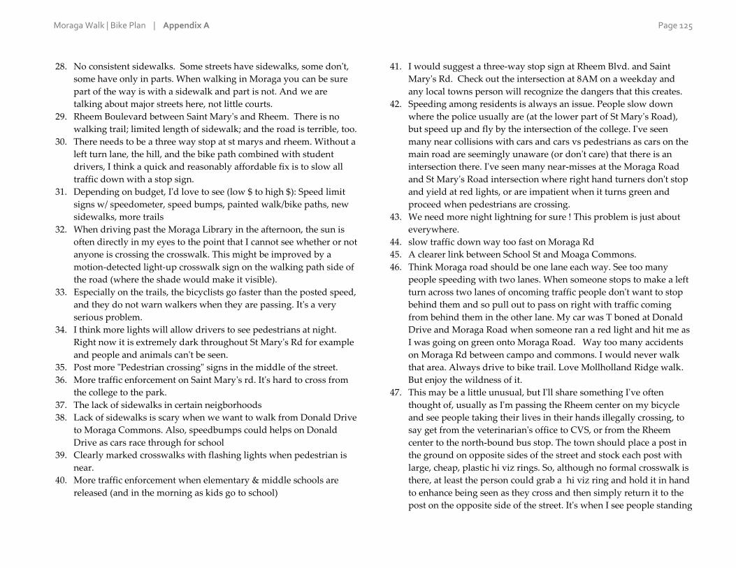
Moraga Walk | Bike Plan | Appendix A Page 125
28. No consistent sidewalks. Some streets have sidewalks, some don't,
some have only in parts. When walking in Moraga you can be sure
part of the way is with a sidewalk and part is not. And we are
talking about major streets here, not little courts.
29. Rheem Boulevard between Saint Mary's and Rheem. There is no
walking trail; limited length of sidewalk; and the road is terrible, too.
30. There needs to be a three way stop at st marys and rheem. Without a
left turn lane, the hill, and the bike path combined with student
drivers, I think a quick and reasonably affordable fix is to slow all
traffic down with a stop sign.
31. Depending on budget, I'd love to see (low $ to high $): Speed limit
signs w/ speedometer, speed bumps, painted walk/bike paths, new
sidewalks, more trails
32. When driving past the Moraga Library in the afternoon, the sun is
often directly in my eyes to the point that I cannot see whether or not
anyone is crossing the crosswalk. This might be improved by a
motion-detected light-up crosswalk sign on the walking path side of
the road (where the shade would make it visible).
33. Especially on the trails, the bicyclists go faster than the posted speed,
and they do not warn walkers when they are passing. It's a very
serious problem.
34. I think more lights will allow drivers to see pedestrians at night.
Right now it is extremely dark throughout St Mary's Rd for example
and people and animals can't be seen.
35. Post more "Pedestrian crossing" signs in the middle of the street.
36. More traffic enforcement on Saint Mary's rd. It's hard to cross from
the college to the park.
37. The lack of sidewalks in certain neigborhoods
38. Lack of sidewalks is scary when we want to walk from Donald Drive
to Moraga Commons. Also, speedbumps could helps on Donald
Drive as cars race through for school
39. Clearly marked crosswalks with flashing lights when pedestrian is
near.
40. More traffic enforcement when elementary & middle schools are
released (and in the morning as kids go to school)
41. I would suggest a three-way stop sign at Rheem Blvd. and Saint
Mary's Rd. Check out the intersection at 8AM on a weekday and
any local towns person will recognize the dangers that this creates.
42. Speeding among residents is always an issue. People slow down
where the police usually are (at the lower part of St Mary's Road),
but speed up and fly by the intersection of the college. I've seen
many near collisions with cars and cars vs pedestrians as cars on the
main road are seemingly unaware (or don't care) that there is an
intersection there. I've seen many near-misses at the Moraga Road
and St Mary's Road intersection where right hand turners don't stop
and yield at red lights, or are impatient when it turns green and
proceed when pedestrians are crossing.
43. We need more night lightning for sure ! This problem is just about
everywhere.
44. slow traffic down way too fast on Moraga Rd
45. A clearer link between School St and Moaga Commons.
46. Think Moraga road should be one lane each way. See too many
people speeding with two lanes. When someone stops to make a left
turn across two lanes of oncoming traffic people don't want to stop
behind them and so pull out to pass on right with traffic coming
from behind them in the other lane. My car was T boned at Donald
Drive and Moraga Road when someone ran a red light and hit me as
I was going on green onto Moraga Road. Way too many accidents
on Moraga Rd between campo and commons. I would never walk
that area. Always drive to bike trail. Love Mollholland Ridge walk.
But enjoy the wildness of it.
47. This may be a little unusual, but I'll share something I've often
thought of, usually as I'm passing the Rheem center on my bicycle
and see people taking their lives in their hands illegally crossing, to
say get from the veterinarian's office to CVS, or from the Rheem
center to the north-bound bus stop. The town should place a post in
the ground on opposite sides of the street and stock each post with
large, cheap, plastic hi viz rings. So, although no formal crosswalk is
there, at least the person could grab a hi viz ring and hold it in hand
to enhance being seen as they cross and then simply return it to the
post on the opposite side of the street. It's when I see people standing

Moraga Walk | Bike Plan | Appendix A Page 126
in that suicide lane is when I think they should have a hi viz hula
hoop in their hand.
48. More traffic enforcement. The speed limit is 25 mph on Larch
Avenue. My understanding is that MPD does not cite unless over 35
mph, something to do with the courts. Please get this changed if at
all possible, 35 mph is too fast on Larch. Larch is a cut-through street
for others outside of our neighborhood. One or more 4-way stops
(eg, 3-way Larch at Shuey) would alleviate the amount of cut-
through traffic and the average vehicle speed.
49. Yes, there are problems related to walking. Moraga residents are
addicted to their SUV's and imported luxury sedans. It's just too
easy to get in that vehicle and drive to where they are going. It will
never get any better even if gas goes to $20/gallon. And they are
prepping an entire generation of non-walkers. Just check out the
parents cars lining up at CP or JM after school so the kids don't have
to walk the few blocks home.
50. If the moraga road corridor from campo high school to mortgage
way we're made more pleasant for walking I believe more people
would use it. Currently the sidewalk is too close to fast cars to be
pleasant. And the lack of sidewalk from Donald drive to commons is
dangerous.
51. I witness lots of cars driving past when people are in the crosswalks.
Need to give tickets and/or have flashing lights. Need save path
along Rheem Blvd to St. Mary's.
52. To and from schools need much improvement. I think more parents
would let their kids walk and bike if it was safer. Too many cars, cars
not paying attention, etc. We are in a great community and need to
find a way to let kids bike and walk more. Getting to middle school
from the CP area seems okay but what about elsewhere in Moraga?
53. I love to walk, but I don't do it in part because there are no
sidewalks, and cars drive very fast on most roads. I want more speed
bumps on side roads. There's no need to speed down these
neighborhood streets.
54. As all these new developments go in, thought should be given to
how kids will safely walk and bike to school. Developers should be
required to put in paths and sidewalks.
55. I would like there to be No parking in the bike lanes between certain
times of the day in areas where there are no sidewalks or bike lanes.
Bikes are forced out into the streets and it isn't safe for younger
riders. At least one side of the street should be available for
pedestrians and bikers.
56. I appreciate the "on demand" blinking pedestrian lights on Moraga
Road at Corliss. I still watch to see that the cars actually stop!
57. In a Perfect world, the people should get the direct routes and cars
the "long way around"; like Sweden's priority
58. there needs to be a foot pass along Bullinger Canyon Road so that all
the residents that live back there could have a safe way to exit the
neighborhood on bike or on foot. There also needs to be a crosswalk
or some type of traffic intersection around there as well
59. The crosswalks could be more visible. The crosswalk with the
flashing lights just past Commons park (heading towards Rheem
Valley Shopping Center) is highly visible with the flashing lights and
signage. Even distracted drivers will notice and stop
60. make the roads safer
61. not a problem, but the area of path that runs from lafayette to the
commons park is not clearly established after you pass behind
safeway and make your way towards the path that connects MCC to
the Canyon walking path.
62. Slow vehicle speeds down. Nobody wants to walk next to highways.
63. I often see Campo students running up and down the length of
Rheem Blvd. (Moraga Rd to St. Mary's Road). Although I haven't
seen them much recently. Rheem is a beautiful corridor to walk and
it needs a full sidewalk along its entire length! Thank you.
64. Some of our hills are REALY steep, some of our sidewalks end and
then start again a block or so later, especially on Moraga Road.
65. Crossing guard needed at corner of Corliss and Camino Ricardo.
Kids dash across street without looking.
66. We live near Ivy and Miramonte Dr, kids go to LP elementary; the
walk to school is uphill without sidewalks on a street where drivers
are rushed in getting to work or school. Not safe and not welcoming.
Walking in Moraga on most residential streets is an adventure
without sidewalks; city planners that discouraged sidewalks and

Moraga Walk | Bike Plan | Appendix A Page 127
streetlights in favor of a "semi-rural" community just encourage
more driving.
67. More traffic enforcement please! Drivers are doing dangerous U-
turns near the schools at drop-off time when there is a lot of car
traffic and pedestrian traffic!
68. To improve conditions, Moragans need to realign their priorities in
favor of the interests of the #1 product of this cul-de-sac bedroom
community: the children and young people of Moraga. To protect
their safety and manage automobile and vehicle traffic, and promote
their health by proving more outdoor opportunities and self reliance,
not dependence on cars. The Town desperately needs leaders that by
example are walking and riding bikes, and as such find, locate and
install new footpaths, advocate more school crossing guards, and
promote balanced traffic enforcement.
69. St Andrews and Augusta Drive - a T with the Stop sign on St
Andrews - almost NO one stops for that, just zooms through !
70. Rheem Blvd needs sidewalks.
71. More designated bikepaths and walk paths to the Rheem shopping
area. The walk from Corliss to Rheem shopping area feeling like you
are walking on a freeway with the speed of the cars
72. The residential streets really need consistent mandated sidewalks.
It's a major deterrent to walk when one house has a sidewalk, the
next doesn't, the third has some gravel or other uneven surface, the
fourth has a mailbox in the middle. This forces any walker out into
the street where drivers are sometimes not paying enough attention
and makes me nervous to take my kids and dogs for walks when the
weather and surrounding scenery is so beautiful.
73. Missing sidewalks are the key safety issue our family has
encountered.
74. Continue paved path from the commons back field up and over the
hill to Moraga Road, there is currently a dirt oath, but strollers can't
get over
75. You have to be careful around Campo when school starts and ends
... but I don't really know that there is a solution to dealing with new
drivers and parents in a hurry.
76. Should be sidewalks all the way from Moraga Commons to Rheem
shopping. Sidewalks needed throughout Corliss.
77. Flashing lights at crosswalk to increase visibility/awareness.
Especially at St Mary's Rd at Carter
78. More school crossing guards would help to slow speeders around
schools.
79. Again, Campolindo high school would benefit from having
sidewalks on both sides of Moraga Road. Rheem Blvd going to Saint
Mary's College should have a bike lane and sidewalks for students,
staff and faculty going to the college.
80. Deeper walking lanes or bike lanes with clearly marked lanes.
Another Slow down Moraga campaign.
81. A lack of sidewalks in many of the residential neighborhoods
82. What I notice the most, is the lack of sidewalks as well as the
disrepair of existing sidewalks in Moraga.
83. Walking path on the south part of Rheem Blvd. Students from St.
Mary's should have a safe way to ride bikes/walk to shops in Rheem.
84. Sidewalk is needed on Corliss above Los Perales to Arroyo. Lots of
kids walking and cars racing including drivers who are driving their
kids to school. One man was already hit and seriously injured
around opening of school in am.
85. Flashing crosswalks, traffic light at Campo crosswalk, wheelchair
safe mini ramps at all crosswalks
86. Speed bumps or traffic enforcement on Camino Ricardo and Corliss
Drive
87. Stop sign at Greenfield and Crossbrook Drive
88. Making sidewalks/footpaths OFF of Moraga Road if possible is far
preferable to creating a crosswalk or bike lane from an existing
traffic lane:it's too congested during peak commute/school commute
times as it is!
89. We need wider walkways, more welcoming walkways.
90. I love our town the way it is. This is a community of residents of all
ages, not a bike destination. What is the matter with the present
footpaths? Sometimes change is necessary and appropriate.
Spending tax monies for unnecessary frills is a very bad idea.
91. Install flashing pedestrian lights at crosswalks, especially at the
crosswalks along Camino Pablo.
92. educating bicyclists as to calling out and realizing Seniors don't
always hear you coming
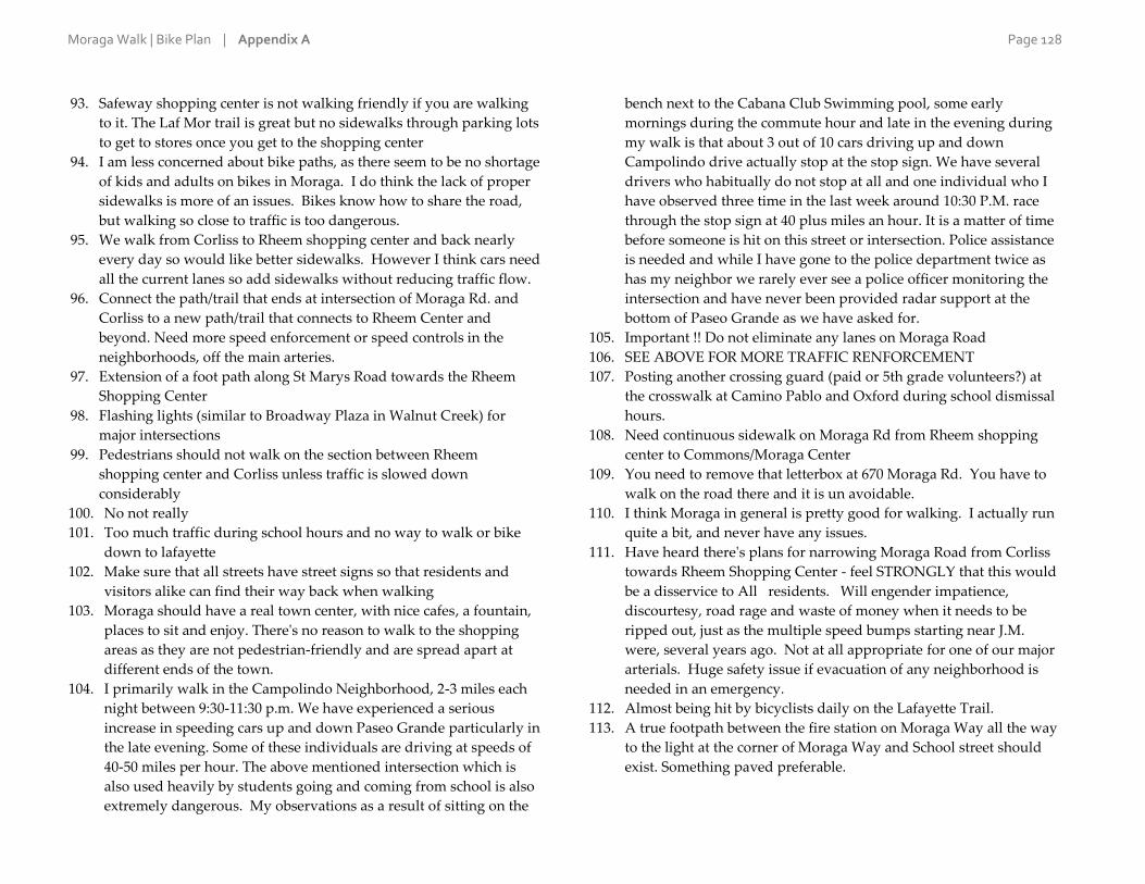
Moraga Walk | Bike Plan | Appendix A Page 128
93. Safeway shopping center is not walking friendly if you are walking
to it. The Laf Mor trail is great but no sidewalks through parking lots
to get to stores once you get to the shopping center
94. I am less concerned about bike paths, as there seem to be no shortage
of kids and adults on bikes in Moraga. I do think the lack of proper
sidewalks is more of an issues. Bikes know how to share the road,
but walking so close to traffic is too dangerous.
95. We walk from Corliss to Rheem shopping center and back nearly
every day so would like better sidewalks. However I think cars need
all the current lanes so add sidewalks without reducing traffic flow.
96. Connect the path/trail that ends at intersection of Moraga Rd. and
Corliss to a new path/trail that connects to Rheem Center and
beyond. Need more speed enforcement or speed controls in the
neighborhoods, off the main arteries.
97. Extension of a foot path along St Marys Road towards the Rheem
Shopping Center
98. Flashing lights (similar to Broadway Plaza in Walnut Creek) for
major intersections
99. Pedestrians should not walk on the section between Rheem
shopping center and Corliss unless traffic is slowed down
considerably
100. No not really
101. Too much traffic during school hours and no way to walk or bike
down to lafayette
102. Make sure that all streets have street signs so that residents and
visitors alike can find their way back when walking
103. Moraga should have a real town center, with nice cafes, a fountain,
places to sit and enjoy. There's no reason to walk to the shopping
areas as they are not pedestrian-friendly and are spread apart at
different ends of the town.
104. I primarily walk in the Campolindo Neighborhood, 2-3 miles each
night between 9:30-11:30 p.m. We have experienced a serious
increase in speeding cars up and down Paseo Grande particularly in
the late evening. Some of these individuals are driving at speeds of
40-50 miles per hour. The above mentioned intersection which is
also used heavily by students going and coming from school is also
extremely dangerous. My observations as a result of sitting on the
bench next to the Cabana Club Swimming pool, some early
mornings during the commute hour and late in the evening during
my walk is that about 3 out of 10 cars driving up and down
Campolindo drive actually stop at the stop sign. We have several
drivers who habitually do not stop at all and one individual who I
have observed three time in the last week around 10:30 P.M. race
through the stop sign at 40 plus miles an hour. It is a matter of time
before someone is hit on this street or intersection. Police assistance
is needed and while I have gone to the police department twice as
has my neighbor we rarely ever see a police officer monitoring the
intersection and have never been provided radar support at the
bottom of Paseo Grande as we have asked for.
105. Important !! Do not eliminate any lanes on Moraga Road
106. SEE ABOVE FOR MORE TRAFFIC RENFORCEMENT
107. Posting another crossing guard (paid or 5th grade volunteers?) at
the crosswalk at Camino Pablo and Oxford during school dismissal
hours.
108. Need continuous sidewalk on Moraga Rd from Rheem shopping
center to Commons/Moraga Center
109. You need to remove that letterbox at 670 Moraga Rd. You have to
walk on the road there and it is un avoidable.
110. I think Moraga in general is pretty good for walking. I actually run
quite a bit, and never have any issues.
111. Have heard there's plans for narrowing Moraga Road from Corliss
towards Rheem Shopping Center - feel STRONGLY that this would
be a disservice to All residents. Will engender impatience,
discourtesy, road rage and waste of money when it needs to be
ripped out, just as the multiple speed bumps starting near J.M.
were, several years ago. Not at all appropriate for one of our major
arterials. Huge safety issue if evacuation of any neighborhood is
needed in an emergency.
112. Almost being hit by bicyclists daily on the Lafayette Trail.
113. A true footpath between the fire station on Moraga Way all the way
to the light at the corner of Moraga Way and School street should
exist. Something paved preferable.

Moraga Walk | Bike Plan | Appendix A Page 129
114. Moraga is a great place to walk. Just stop the construction and
heavy trucks ripping up our roads and causing traffic problems.
Maybe someday before we become a big city.
115. More sidewalks, more competent and considerate drivers, more
traffic lights (ex., Moraga Road and Corliss)
116. Access to the Moraga-Lafayette trail from the Rheem shopping
center area requires either a very steep hike or a circuitous route
through the commons. Is there a less steep, more direct path that
can be built? There is no direct path from the Rheem area to
downtown Lafayette. Would love to see that.
117. No, there are plenty of safe places to walk for those interested.
118. more paths or trails that are not on streets. make sidewalks longer
(we seem to have lots of sidewalks for a few houses and then none).
focus on making walking around schools better - have sidewalks on
all main roads around schools for 1/2 mile or more from the school
(e.g. on camino pablo)
119. Lack of sidewalks.
120. Sidewalks and lighting in the locations listed above.
121. I live close to Camino Pablo Elementary. Drivers often don't expect
foot traffic in Moraga hence every intersection or crossing that does
not have traffic lights is dangerous in nature. I've seen flashing on
demand pedestrian crossing lights be very successful in other cities
for getting distracted and unsuspecting drivers' attention. In
addition drivers don't expect pedestrians and bicyclists on
intersections with traffic lights either. When a light turns green most
of the time the pedestrian light stays red and they simply do their
turn. Now when there is a pedestrian the driver doesn't expect to
yield anymore. Additional warning signs for drivers in the event
that a pedestrian has requested a green light would be beneficial.
122. Lack of adequate sidewalks, unsafe drivers
123. How do I get from Rheem Blvd to Safeway and stay on a side walk
or a flat trail ?
124. I think if you choose the EBMUD pathways or Mulholland Ridge
there is plenty of space to walk without the intrusion of cars.
125. More speed bumps to ensure that drivers slow down. I know it is a
pain but it will make it safer for bike riders. I only dare ride my bike
on the trail.
126. Access to Mulholland Ridge from Asot Drive: very steep entrance;
not too much prolem going up, but I'm in trouble trying to descend
-- how about grading it a bit less steep. Love!! that open space for
my dog walking! Adds to my good health a lot!
127. More footpaths! It would be so nice to have pedestrian paths
connecting camino Ricardo to Safeway without going on Moraga
way, same for pathways to rheem center that aren't right on Moraga
road. The paths to Moraga commons are great, more in that vein
connecting the two business areas and the commons and the schools
128. Please: Moraga is a great walking town. Please don't waste money
trying to make something good better - you will only get in your
own way.
129. More water fountains.
130. all major roads must have sidewalks and should have dedicated
bike lanes. BIKE LANES SHOULD BE DIVIDED BY RAISED
MARKERS AS VEHICLES ROUTINELY CROSS THE BIKE LANES.
131. Would be good to plan footpaths through the new developments, so
we can do loops and hike away from the roads
132. More school crossing guards for LP would be helpful. Especially at
Camino Ricardo entrance. More enforcements for speeding and
texting/talking/distracted driving. More enforcement around
crosswalks. I have encountered angered drivers more than once at
the Corliss crosswalk across Moraga road. People feel they don't
need to stop. Pedestrians should wait. I wod never let my kids
cross on their own because without a stoplight people don't take it
seriously and often drive through. Very dangerous!
133. I mean, Moraga rd feels scary to walk on but that doesn't really
seem like a road people should be walking on for fun anyways, it's
basically our highway. Moraga just feels really scenic, but I can't
think of many good places to walk.
134. The unsafe road conditions from our home to our daughter's
current preschool factored in our decision to switch preschools at
the end of this month. We'll be sending her to a daycare in
Lafayette instead as it will not be in the midst of two major
construction sites near MCC and the road conditions to the Moraga
preschool are not amenable to walking/biking.
Moraga Walk | Bike Plan | Appendix A Page 130
135. We have attended meetings about this in the past and hope that this
attempt will actually create much needed pedestrian friendly
sidewalks. It seems like it would be much safer to have turn lanes
on Moraga Road onto Devin and Draeger. Some type of median in
the road would also make it safer for children having to cross
Moraga Road to catch the school bus. One lane of traffic going each
direction with turn lanes in the middle and walking paths and bike
lanes on each side of the road would be perfect.
136. slower speeds on moraga rd between st mary's and rheem blvd
137. More benches. More wider sidewalks.
138. We need a complete, full end to end, sidewalk along Moraga road
from Camino Pablo to Campo. Currently there is no way to walk
that distance with walking along the road at multiple locations.
Doesn't make sence not tohave sidewalks that are safe for those who
would really like to walk.
139. Please restore access to the Moraga train station, as well as the train
station itself. Please insure that all the paths through the orchards
are maintained and that these right aways eare included in zoning
comments. Please maintain the pedestrian rights of Moraga citizens
in Moraga and through Orinda and Lafayette,within the U.S.A. and
globally outside the USA.
140. enforce stop signs and speed limits on corliss, woodside, camino
ricardo, hardy, etc.
141. looking forward to connectivity of trails - open mullholland atop
camino ricardo (an alternative to rheem-safeway along moraga
road?
142. Speed of cars is too high. When you walk on Moraga road between
Rheem shopping center and Moraga Common it feels like walking
on the side of a highway. Cars way too fast, rarely speed enforced,
no walking paths and bike path crumbling in places
143. create path protected from the arterials by a vegetated buffer
144. Large Hill and Curved Rd, Traveling up Moraga Rd to Campo HS
Has a limited Visual Field due to the land formation....Rheem Blvd
and St. Mary;s Rd the same thing..Moraga Rd in direction to JM
very high traffic due to Exiting Moraga to have access to Hwy
13,Campo Area High Traffic area due to local schools and workers
to Bart and or Colleges out of Moraga to Major Highways...
145. Issues of walking are similar to issues faced by cyclists. Too many
cars, cars going too fast, drivers distracted, bike lanes and sidewalks
too narrow, drivers feeling they own the right of way and get angry
when forced to share thoroughfares with any other form of
transportation.
146. create safe paths from all directions to or "downtown" - that would
be Rheem Center and Moraga Center, I guess. For example -
students in Rheem Valley Manor SHOULD be able to safely walk to
Campo right now, but I'm pretty sure they cannot, especially if you
are on the east end of RVM (closest to Rheem)
147. Traffic enforcement as mentioned above.
148. Lack of: streetlights
149. Road Diet for Moraga Road
150. Moraga Road, add sidewalks or walking paths from the High
school to the library. Add shade, exercise spots and benches along
the walk.
151. The design of the shopping centers are not conducive to walking.

Moraga Walk | Bike Plan | Appendix A Page 131
A-6 | Have we forgotten any major general challenges to biking?
73 responses
1. Traffic lights that are not working properly for bikes. Currently
south bound on Moraga Road at Ascot has a very delayed green
light compared to oncoming traffic. That means that a cyclist has to
get off their bike and press the button to cross legally when it really
just appears stuck. Ive been riding that same intersection 4 to 5 days
per week for three years. This is a new problem. Another main
problem is large chuncks of asphalt in the bike lane from newly
formed potholes. It gets move from traffic lanes and sits in the bile
lane for days, weeks, months. The new town sign at the commons is
very bright at 6 am. It makes it hard to see if you are wearing clear
cycling glasses.
2. Traffic speed seems to pick up in Moraga when the roads approach
the commercial centers, (road opens to more lanes which encourages
a higher flow rate.
3. Cars respecting cyclists
4. Poor road quality/storm grates in bike lane. ie roots under the road
approaching pinehurst entrance by Stanley.
5. Biking lanes are needed.
6. Again connecting paths. Loops would be great.
7. I don't bike
8. Area around Orinda BART is ridiculous for bike riding. Aggressive
Drivers -turning on on ramps and exiting off ramps.
9. Trash cans in the bike lanes leaving only the car lane to travel.
10. Bike lanes are important. Most people riding road bikes speeds are
to fast for what are referred to as bike paths. So, bike paths that are
multipurpose and road bikes don't always go together well.
11. Please try to not just focus on the 50 mile a day spandex wearers,
there are lots of families that want to bike with kids weekdays or
make doing errands include more exercise. Also middle schoolers at
JM could use a nice clear bike route to safely be social after school.
12. missing bike lanes, width of road.
13. Broken glass in streets and bikepaths
14. Bike lanes that allow parking are not real bike lanes.
15. Very bad roads, especially Bollinger Canyon.
16. no connection between regional trail and Rheem Shopping Center
17. St Mary's Road is too narrow for bikes and cars. Trail isn't wide
enough for bikes and pedestrians.
18. Mostly bike lanes are way too narrow. Parked cars in the "bike lane".
19. Clear road marks on pavement, and signs reminding motorists that
they have to share the road with bikers.
20. bike/walking lanes are not wide enough
21. Signage to alert drivers that bikes are present. Also, allowing
enough room on streets for bikes and 3' of clearance by a motor
vehicle (new law for 2015).
22. Is the trail from the commons to lafayette for bikes or walkers. I
believe it was designed originally for bikes but now the bikes use the
streets which is hazardous for bikes and cars
23. I don;t bike, but as a walker and driver I witness a lot of the above.
24. No
25. There is no bike lane for most of Moraga. With the amount of people
biking on one lane roads, it makes it dangerous and for bikers and
drivers alike. ESPECIALLY on the steep hills and bind corners.
26. Bikers don't seem challenged at all. They seem to ignore traffic laws
and do whatever they choose, leaving the poor auto driver to adjust
around them.
27. Bikers need law enforcement! Give them tickets for bad behavior
and give them safe lanes to keep them from blocking traffic and then
yelling at cars trying to pass them.
28. I put most bicycle conflicts on the bicyclists. Call out always when
passing pedestrians on the Moraga-Lafayette trail. Reduce speed.
Signal to let vehicles know what you are up to. Slow bicyclists
should stay off of main arterials.
29. Even as the biker I would argue that we are the annoying party
when riding on certain roads... However, I think this only applies to
roads that shouldnt be biked on because there is a perfectly good
trail right next to the road. My example is passing saint mary's going
towards burton valley. That trail is a beautiful ride and very well
maintained, yet some bikers continue to use the roadway instead of

Moraga Walk | Bike Plan | Appendix A Page 132
the trail. I dont think any biking amenities should be included on
this road, but rather focus should be on encouraging bikers to start
using the trail. That trail is very well maintained and I love riding on
it, so thank you :)
30. I'm not a biker so didn't answer.
31. Bike lane lacks cleaning. The side of the roads are covered with
debris, increasing the risk of flat tires. Also, trees and bushes need to
be trim on the side of the road so bikers don't have to duck.
32. other bikers not following traffic signs - like stop signs
33. The major challenge to biking is educating the Town Council. They
are egotistical, dictatorial, and geriatric cronies, out of touch with the
community as a whole and oblivious to reality. Term limits are a
must!
34. My only serious issue is with bike/pedestrian interactions on the
trails. When biking, I often find groups walking that cover >75% of
the trail. I don't like to scare them with my bell or saying "on your
left" unless they are taking over most of the trail. Can't blame
Moraga for the hills! I actually like them.
35. drinking fountains, bike racks
36. Bike detection at traffic lights is a BIG one. Especially at the turn
from Moraga to Campolindo.
37. many bike lanes are too narrow
38. Bike lanes often have glass and other objects dangerous to riders.
Lanes should be cleaned more frequently.
39. I do not bike in Moraga so I did not offer an opinion
40. Safer bike lanes on Moraga road between Corliss and Donald. A
path connecting Moraga road near Campolindo high school and the
Lafayette-Moraga trail near S Lucille Lane.
41. We have bike lanes, streets to bike on and a trail that bikers can use.
42. This is NOT the most important item on our agenda. I thought we
were working on repaving specific streets.
43. Ability to bike through shopping center parking lots safely is
lacking. People, I think would use trails more if you could bike
through shopping centers safely and have bike racks there.
44. Too much traffic and too narrow bike lanes.
45. Broken glass in bike lane
46. biking in Moraga is just plain scary, mainly because of hug SUVs
speeding along. I would love to bike more, but truly, I'm afraid to
navigate the streets. Sometimes I DRIVE my bike to the Commons
and bike along the path there to avoid traffic.
47. No
48. I am not a biker. I wish they would stop for stop lights and stop
signs and not ride 2 abreast, taking up much of my driving lane.
49. No lane down hill to lafayette and nowhere to even jump off if
needed
50. Why on earth are we talking about "few or no places to shower,
change and store clothes after biking"? What does that have to do
with the town, except possibly for town employees who wish to bike
to work, in which case it is a workplace issue for a very limited
number of people, NOT a question for a town interest survey. For
non-town employees who wish to bicycle to work in Moraga, this is
a workplace issue for their employer -- not for the Town of Moraga!
51. Motivation: People are not motivated to bike to work because they
want to arrive at work freshly showered and made up; biking to
work means getting up earlier and cleaning up away from home.
52. I am a walker. I have only biked in Moraga 3 times in 20 years. out to
Canyon
53. Too much new construction planned for Moraga!
54. Pinch over bridge to Canyon is really tight for walkers and bikers
alike. Need to better connect Canyon Rd to entrance to bike path
before bridge and/or widen bridge.
55. How about an option in the survey that says I don't bike, so I don't
have input?
56. Biking rules for children should be kept in consideration as many
children's parents do not feel safe with them riding in bike lanes.
57. Not enough enforcement for bicyclists that break road laws.
58. We need bike lanes.
59. No - the main challenge to biking (for my son to bike to school) are
distracted drivers. They are rather frightening.
60. N/A for me
61. bike lanes should be divided by raised pavement markers as vehicles
routinely cross into bike lane
62. No.

Moraga Walk | Bike Plan | Appendix A Page 133
63. Moraga Way bike shoulder is not wide enough, especially when cars
are parked there
64. Making a left onto Campolindo Drive from Moraga Road is difficult.
The left lane turn signal doesn't react to bikes. If you use the cross
walk you wind up on the wrong side of the road at Campolino
Drive. It would be great if the left land signals could be activate by
bikes. Glass and nails on the side of the road is a problem. It feels
like there is a long time between street sweeping. Flat tires from
junk on the road is no fun.
65. Failure of bike riders to observe rules of the road. Signs at major
intersections would be helpful. For instance, countless times I have
see bike riders sail down Rheem Blvd from St, Mary's Road, going
throug a red light. Moraga Way at Canyon is another one where they
sail around the corner without stopping.
66. Bike lanes blocked by parked cars, debris, untrimmed foliage, etc.
Difficulty making left turns on wide streets or with fast moving
traffic.
67. The bikes that I ordered by mail order arrived damaged and I coulod
not get them repaired properly. The speeding cars are not
considerate of my mother and father, especially the ones coming
from St Marys which include my […] who denied my father a new
bike, a new car, a new house and other irritating activities of the
speeding cars such as insulting my grandfathers and grandmothers
and making rthem have broken hearts. These auto drivers cause me
and my family members financial hardship which the Town of
Moraga must remedy.
68. need better maintenance and connectivity of bike lanes
69. Wish there were more dedicated bike paths.
70. bike lanes too narrow. bike lanes that disappear. no shoulder to ride
on or pavement broken on shoulder.
71. I was hit by a car crossing Sanders at Canyon. Driver has blind
corner and wasn't looking. Its confusing to navigate from bike path
side of road to other side easily and safely.
72. Mixing with skateboarders outside the skatepark
73. Not safe for inexperienced riders to get to places not on the moraga
lafayette trail.
Moraga Walk | Bike Plan | Appendix A Page 134
A-7 | Are there specific streets where you would like to see improvements for cyclists?
155 responses
1. Moraga Road from Rheem Center to Commons -- Lack of bike lane
or shoulder, poor pavement, cracks and potholes, constantly filled
with debris (stones, rubble) in shoulder of road. Rheem between
Moraga Road and St Mary's Road -- Poor pavement and lack of
shoulder to ride on.
2. Alta Mesa Dr. and Moraga Rd. Needs flashing warning lights for
bikes and pedestrians.
3. The branches on canyon road northbound from the "T" at Canyon
and Pinehurst are encroaching, pushing cyclists into the lane and not
allowing cars to get around.
4. ST MARY'S RD!!!!!
5. Moraga Way from JM Middle to Campo
6. bike lanes are ALWAYS good - The trail is multi use and often
crowded - walkers don't want bikes on there doing 15-20mph. many
cyclists ride on the street because we know that our speeds are too
fast/unsafe for the trail. Any signage, stencils, anything to promote
the idea that cyclists are ALLOWED and BELONG on the road in
drivers' minds is a good thing. Traffic Calming obstacles in my mind
are the WORST thing, look at stanley blvd in lafayette (near acalanes
HS) ... This road used to be a 2 lane road with wide shoulders, wide
enough for bikes, pedestrians, etc all to co-exist... I ride this road
frequently. NEVER had one issue before the "traffic calming" went
in. Now.. post traffic calming (center islands, sidewalks)
Pedestrians only have a safe place to walk on ONE side of the street,
forcing children to cross the street immediately from wherever they
are (including blind corners) to get to the sidewalk, or be forced to
walk in the traffic lane... Cyclists have NOWHERE to ride.. I've had
several very close calls with cars trying to pass me where there is NO
space. Narrowing the road is NOT AN ANSWER. Speedbumps... I
ride on roads with 15mph speed bumps and regularly see 5000lb
SUVs plow over them at 30mph like they aren't even there. All this
does is add wear and tear on cars, and create a few seconds of the car
being unsettled and in less control. Personally I feel the best answers
are signs, lights, awareness... then second to that, maybe speed
bumps.... but NEVER narrow the road...
7. St Mary's Rd
8. St. Mary's, Rheem and Moraga Way
9. Moraga Road
10. none
11. Moraga road
12. N/A
13. N/A
14. N/A
15. All around BART/Highway 24
16. Canyon Road leading to and from Moraga and the intersection
where Pinehurst meets could use some pavement stencils, traffic
calming and/or signage.
17. Where Moraga enters into Pinehurst Rd.
18. Pavement stencils would be good on St Mary's Road and Moraga
Road and Canyon Road.Left turn lanes at traffic lights should be
triggered by bikes when no cars are present.
19. St Mary's Road from the Common to Glenside could use more bike
lane striping. Moraga Way is great. Canyon to Pinehurst could use
more Share the road signs. Moraga Road to Lafayette is unsafe for
cyclist. So, it is hard to get in and out of Moraga as a cyclist safely
other then on Moraga Way.
20. getting into the Safeway shopping center from camino Pablo is a
difficult maze at best of avoiding cars turning in from everywhere.
Can you close off completely with curb and pavement and create a
bike only lane into the center?
21. The road repairs done in the last couple of years were poorly done.
Canning Ct. and Larch have cracks and holes already.
22. Street from Golf Course to Moraga Way (?) with Ci Ci's and Senior
Housing. Roadway from Pinehurst to LaFayette and by Saint Mary's
College.
23. St Mary's Road, Moraga Road, Moraga Way
24. School Street at Moraga Way. Canyon Rd between Camino Pablo &
Pinehurst

Moraga Walk | Bike Plan | Appendix A Page 135
25. Canyon between Pinehurst and the edge of housing development
26. The intersection of Rheem Blvd and St. Mary's Road needs
improving
27. St. Mary's. All roads in regional park: Canyon, Pinehurst, ...
28. Widen bike lane in front of Rheem shopping center.
29. Rheem Blvd, Moraga road Moraga way all need to be addressed first
as they are the main arteries through Moraga. They certainly pose
the greatest source of danger and are the main impediment to
residents not being able to safely enjoy their town via foot or bike.
30. See walking section
31. Moraga road need continuous bike lanes in both directions that are
not used for parking. Separation from the road might be nice if there
were space, but is less essential. Traffic calming is also needed.
32. Yes, Bollinger Canyon.
33. Rheem Blvd
34. St. Mary's Road needs a bike lane for all the bicyclists that use the
road rather than trail. Moraga Road could also use a bike lane, but
not if need to eliminate a car lane to do it.
35. Rheem Blvd between Glorietta and Moraga Road. Speedy drivers,
too narrow bike lane
36. Bike lanes are needed, period.
37. Just need more bike lanes
38. Rheem!!! From saint Mary's road over the hill. Put a sidewalk and
bike lane! Please!!
39. Going up the hill toward St. Mary's College (when driving away
from the shopping center), there are often bicyclists in the road on
the right side due to the unsafe offroad condition of the hill area.
40. 1. St Marys from the college to Glenside is always difficult for
bicyclists to negotiate because it is so narrow in a lot of places. 2.
Hopefully, the construction on the north side of Rheem between
Moraga Rd and St Marys Rd is re-doing/ changing the street- it is
really bad for cyclists as well as for motor vehicles.
41. Moraga Road to Lafayette.
42. Rheem rd needs bike lanes and Saint Mary's road could use a signal
near Saint Mary's parkway.
43. bike lanes so that they are not driving in the middle of the road and
blocking cars - creating hazards for both
44. Moraga Road (heading towards Lafayette)
45. Along the major corridors there is no bike lane, or if there is a bike
lane, parking is allowed, so the bike lane is occupied by a car. Even
when there is a bike path - the trail - , the bike path is occupied by
walkers so dangerous to mix bikes there. Moraga Road, Moraga
Way, Rheem Blvd and Saint Mary's Road.
46. Improvement from Moraga Commons to Rheem (and all the way to
Campo HS too)
47. the gravel off the path that goes from the moraga park to safeway
should be paved since on a bike that gravel is very dangerous.
48. St Mary's Road, again, is an issue. Through traffic starts to fly after
the usual police spot and continues to that first stop sign at Rheem
Valley Road (?). That's also where the sidewalk and bike lane
disappears, so it's that much more dangerous anyone not in a car.
49. None
50. Love to see bike lanes on all major streets in Moraga
51. No
52. I would like bike riders to be reminded to obey the rules of the road.
They seem to think they are not subject to stop signs, single-file
riding, turn signals, etc creating a hazardous environment for
themselves and cars.
53. Devon Drive
54. St Mary's and Canyon Rd past Moraga. Very scary driving with
bikes out there!
55. Moraga Road bet Campo and Commons. One lane for cars plus one
lane for bikes
56. Moraga Road and Way
57. I would like to see the police issue citations for people that drive
with one wheel in the bicycle lane. On Moraga Road, from 7-11 to
Campo high school, going in both directions, I'd like to see the edge
of the bicycle lane lined with Botts dots.
58. Improve bike lane on Canyon and Moraga Road, need a bit more
width. Provide better bike lanes to feed the Moraga-Lafayette trail to
get the cyclists off of the road.
59. Same comments as walking
60. Need signs that connect to trails leading in and out of Moraga from
Canyon & Lafayette. Signs to town so people know where to go to

Moraga Walk | Bike Plan | Appendix A Page 136
get a bite or a drink. Need to make the nice kind of trail used on
Laf/Moraga trail along Rheem and then along Moraga Rd, School St
out to hook up to trail by MCC to get out to Canyon.
61. Larch Avenue is very dangerous because it is narrow and cars often
speed.
62. The stretch between Rheem to the Moraga Commons is very difficult
for bikers, especially younger riders. Cars are parked in the bike
lane on both sides to the street and riders are forced into car lanes.
Drivers are rarely paying attention and it is scary.
63. Canyon Road heading out of Moraga towards Pinehurst and then
Oakland needs better paving.
64. Moraga Rd. between Corliss and Devin Dr. Rheem Blvd. between
Moraga and St Marys Roads.
65. less blind spots like the entrance to canyon near jm is really unsafe
and easy to hit a kid biking or walking to school off the trail
66. No
67. Any street leading to a school or retail strip; stop thinking of bikes as
just recreational toys.
68. Moraga Rd. Moraga Way
69. Paving on Rheem between St. Mary's Road and Moraga Road. Lots
of potholes, particularly on the shoulder. Green-striping from JM to
Campo on Moraga Road
70. I'd like to see more routes that aren't on the main streets. Moraga
Road could use a better bike lane and pavement, but it would be nice
to have scenic routes that get you around town and not just to
shopping.
71. Moraga Road, Moraga Way and Rheem Blvd.
72. Moraga Way and Moraga Road! There should be a large, safe bike
lane the entire length of these streets within Moraga -- especially to
facilitate students riding to/from school at JM Int. School,
Campolindo Hight School and Miramonte High School.
73. All major traffic collector routes need traffic calming and control.
Without it, improvements to walk and bike routes are mere band
aids and ineffective. People walking or biking need to have strict
priority and be respected and protected by vehicle operators.
74. No.
75. Segregated walking/bike path needed (like what Orinda put in)
along Moraga Road from Donald Dr all the way to Camino Pablo so
middle school students can bike to school safely.
76. bike lanes
77. - St. Mary's Road could use a dedicated bike lane and wider
shoulder in each direction. - Moraga Road and Moraga Way could
use brighter bike lane striping and pavement stencils, as well as
more consistent bike lane/shoulder widths. - A southbound bike
turning lane from Moraga Way onto Moraga Road would improve
intersection safety.
78. Wider bike lane on Moraga Way as approach School St. intersection
from north. (Lane is wide, then narrows a lot.)
79. Moraga Rd.
80. Rheem Blvd going to Saint Mary's College should have a bike lane
and sidewalks for students, staff and faculty going to the college.
81. Intersection of Moraga Road and Rheem is a very dangerous place
for young bikers, especially in the morning on the way to Campo!!
Can't ride on west side because of pedestrians and can't ride on east
side because of crazy motorists. This is a big problem. Maybe if
resolved more kids would ride to school and alleviate some of the
morning congestion!!
82. Moraga Road
83. Moraga Rd and Rheem Blvd and Moraga Rd and St. Mary's road
often feel dangerous to me given the speeds of drivers. Moraga Rd.
between Laird and St. Mary's has narrow, cracked, dangerous
pavement along with drivers going 35 mph.
84. Bike lanes on Rheem between Moraga Rd and St. Mary's. No parking
in bike lanes on Moraga Road --esp. southbound
85. The addition of more bike lanes would be very helpful.
86. Corliss up to Arroyo above Los Perales, Moraga Road between two
shopping centers, Country Club drive between Canyon and Saint
Andrew, Canyon to end of Moraga Town limit. Larch
87. A sidewalk/bike path along Bollinger Canyon from The Bluffs
neighborhood would make the Lafayette-Moraga trail more
accessible. It is dangerous to walk/bike along Bollinger Canyon to
get to the trail. Then there is the issue of crossing St. Mary's Road to
get to the trail.
Moraga Walk | Bike Plan | Appendix A Page 137
88. A green lane on Moraga Road between Donald Drive and Corliss.
The second lane should be green and marked as priority for bikes--
only for cars turning right.
89. No
90. Moraga Road along the Commons could use repaving and bike
lanes
91. I would like to keep the bicycle lanes on Camino Pablo and Canyon
near the Catholic Church free of parked cars throughout the week. I
think this could be accomplished if the middle school and church
shared their parking.
92. The should be no biking on Moraga road from Via Granada down
to Lafayette. Encourage people to use the Lafayette trail
93. No!
94. We really need bike detection at traffic lights at most signals.
Something also needs to be done at the intersection of Country Club
Dr. and School Street to make it easier for bikes (and peds) to cross
in all directions.
95. no bike lane between via granada and Lafayette. would be great to
cycle to Bart.
96. Moraga has a great bike trail and plenty of bike lanes.
97. Main street routes to schools
98. again, Rheem between Moraga Rd and St Mary's is just treacherous.
And perhaps the Moraga Lafayette trail could have some system to
separate the bikes from foot traffic. If there were good bike lanes on
the street, I would not bike on the trail. Also, I live in Campolindo,
anytime near school coming/going hours is death to someone on a
bike.
99. Moraga Road
100. Moraga Rd. between Commons Park and the Rheem Center
101. 1. Moraga Road in front of Campolindo HS needs a dedicated bike
lane between the traffic lights at Campolindo Dr. and where the
bike lane currently begins after the front entrance to the HS. 2. On
Moraga Rd., the left turn in front of Campolindo HS needs bike
detection. 3. The bike lane on Moraga Rd./Canyon Rd. should
extend all the way to the bridge just after Constance Place.
Currently overflow parking from St. Monica's Church line the
shoulder pushing bicyclists out into the traffic lane.
102. Moraga Rd between Lafayette and Moraga is very dangerous to
ride on. Taking the Lafayette-Moraga trail from Campolindo High
School to Lafayette requires riding all the way back to Moraga
Commons because Rheem Blvd is also very dangerous. We really
need a trail between Campolindo and St Mary's Rd - perhaps along
Rheem or perhaps out Buckingham.
103. Cars parked on shoulder on Moraga Rd south from along the front
of the Hacienda to the crosswalk can be a challenge but not for all
the serious out of town bicyclists as theyride in the traffic lanes
104. no
105. St Mary's Rd has limited or no shoulders from the Moraga border to
the light at the commons. It's a deathtrap for cyclists basically from
Rheem to the Lafayette border. When I ride on St Mary's, I always
get on the bike path at Rheem when leaving Moraga. When
entering Moraga on the St Mary's corridor, I always take the bike
path and get back on St Mary's Rd after Rheem. The bike path is
not always appropriate for some cyclists as they exceed the 15 MPH
bike path speed limit and prefer not to have to stop at the many
stop signs on the bike path and/or dodge the strollers, joggers, and
dogs.
106. main through o fares
107. Do not eliminate lanes on Moraga Road
108. Bike lanes needed on Moraga Road from Moraga Commons to
Rheem Center.
109. I don't really think it's necessary.
110. It would be nice to have a cross walk on St. Andrews Drive and
Country Club Drive intersection (the road with the median side
across from MCC) so that kids can cross there instead of going all
the way down pass the ravine to cross on an actual cross walk.
111. Rheem Blvd. There's no way to get to the plaza because there's
nowhere to walk or ride safely.
112. FIX THE BIKE LANE CRACKS on Moraga Road--in the direction
going South--between Corliss and St. Mary's Road. Minimally,
sweep that lane more often. The road is crumbling and pieces of it
end up in the bike lane and cyclists have to ride in the road to avoid
crashing.
113. St. Mary's road
Moraga Walk | Bike Plan | Appendix A Page 138
114. Instruct bicyclists not to ride abreast of each other.
115. Bikes speeding on St Mary's Rd on the S curve by Bollinger Canyon
Rd.
116. rheem
117. Glorieta to Rheem
118. Moraga Rd from Lafayette border to the Commons. Also from
Moraga Rd - Rheem Blvd intersection to Orinda border.
119. Moraga Road south of the Rheem Shopping Center.
120. Bike lanes help. Also, enforcement of traffic laws for bicyclist will
help. As a lifelong Bay area a resident, I am constantly amazed at
the aggressiveness of bicyclists and their total disregard for traffic
laws even while exhibiting road rage that I am shocked to see.
121. The bike lanes on Moraga's mayor roads are great. However I often
avoid them and divert to neighborhood streets when biking. Cars
on Canyon Road and Moraga Rd inside the town go very fast. Then
there are church visitors at St Monica and parents at Joaquin
Moraga parking in the bike lane forcing bikers into the road and
competing with speeding cars. I don't have an easy fix but signage
reminding drivers to share the road could help.
122. painting a white line is not a bike trail if cars are allowed to park
there !
123. bike lane on moraga road near Commons has large cracks and there
is always debri (glass, rocks, etc). the bike lanes are much too
narrow to be safe for kids.
124. While in general Moraga Way has wide-enough shoulders to ride
on, in several spots the street narrows dangerously - for example
between the fire station and Safeway. I always feel a little unsafe
when the shoulders are too narrow. Widening seems easy to do,
and would help.
125. Moraga Way toward Orinda bart. Def blind spots getting out of
bart. Cars go to fast so some speed bumps or additional stop signs
will help control that
126. If you do this, please do it right so bikers are safe which means no
parking in bike lanes and physical barriers between bike lanes and
cars - not just a stripe,on the road (even a really brightly colored
stripe is not adequate. Please map out the best routes for bikes that
avoid steep hills and provide signage accordingly.
127. at least major roads as moraga way/road should have bike lanes w
raised pavement markers to remind motorists not to cross as many
do w/o even knowing it.
128. NO! Stop thinking that you have to "do something."
129. Rheem Blvd
130. St Mary's and Moraga rd
131. St. Marys road is a problem. The bike path is good but for faster
riders it's not a good option but St. Mary's Rd has no bike lane and
is extremely narrow. The same can be said for Moraga Rd - it would
be nice to have bike lanes for better access to Lafayette. Canyon Rd
is a problem area too - the bridge is way too narrow with no
warning to bikers or cars that it's narrow. Then of course all bike
paths going to and from Pinehurst are nonexistent.
132. Moraga Way
133. Miramonte High School to Moraga Commons
134. Moraga Road. Make safer for cyclists.
135. moraga rd between camino pablo and rheem. rheem blvd is so
rutted it is dangerous for bikes. lack of bike activated traffic signals
creates uncertainty and danger.
136. All along Moraga Rd to Cannyon. All along Moraga Way.
137. The intersection of Moraga Road and Campolindo Drive
138. Loop detectors needed at Moraga Way and St. Andrews (at MCC)
and Camino Ricardo
139. See above
140. Cayon/Moraga Rd, Moraga Way, St Mary's Rd, Rheem Blvd.
141. no
142. overgrown vegetation and debris by creek at mofd station 41
143. Very clearly marked pavement that bike Lane exists, heavy fines for
drivers that hit cyclists in cars or threaten cyclists
144. path along Moraga Rd, crossing between Moraga Rd and St Marys
Rd
145. Please see statements regarding walking ...these apply to bikes too
146. Canyon - wider bike lanes. Moraga Road - wider bike lanes - slow
the cars down. Moraga Way - slow the cars down.
147. all teh major arteries (Moraga Rd, Moraga Way, Rheem, St. Mary's )
need safe, continuous bike lanes.

Moraga Walk | Bike Plan | Appendix A Page 139
148. If I could have just one thing it would be an AMAZING,
safeguarded bike path so my kids can ride bikes to Rheem school
SAFELY. They don't ride at all though we all want to, too
dangerous. Add bars or guardrails for protection.
149. Hardie Drive as it leads to Moraga Way needs traffic calming
150. Moraga Road
151. The bike/walking trail next to Moraga Rd. ends at Corliss Dr. but
does continue on the street as a bike lane. I would like to see a turn
around area at the end of the trail so bikes can make a u-turn
without turning into traffic. The side of Moraga Rd between the
intersection of St. Mary's Rd and Corliss has somewhat of a bike
lane but the pavement is in extremely bad shape and should be
fixed.
152. Canyon Rd between Moraga Way and the bridge over Moraga
Creek has a bike lane that is way too narrow for the amount of
pavement that there is on that super wide road. A bike lane on St
Mary's Rd would also be great.
153. 1. The intersection where Rheem Blvd exits to southbound Moraga
Road is extremely dangerous. There is a yield sign for drivers
coming from Rheem Blvd. But many drivers only seem to be
looking for cars and NOT bicycles. Something needs to be done to
make drivers more aware of bicyclists at that intersection. 2. Drivers
turning right from southbound Moraga Road at both Ascot Drive
and Donald Drive need to be made aware of the possibility of
bicyclists in the bike lane. All too often drivers make right hand
turns without looking or using turn signals. This is happens
routinely during morning commute hours.
154. There is no reason for any of the roads to be more than two lanes,
the major through fares look like you should go fast.
155. Moraga Way coming into town after St. Andrews through the
intersection at School St. -- bike lane disappears abruptly forcing
abrupt merge with fast car traffic, cars parked on side of road, poor
quality pavement

Moraga Walk | Bike Plan | Appendix A Page 140
A-8 | Are there specific locations where you would like to see bike-parking racks?
98 responses
1. Moraga Shopping Center and Rheem Shopping Center
2. Front of Campo HS, bus stops
3. 7/11 on Moraga Road, In the Moraga Shopping center
4. Each shopping center should have a bike/parking rack easily
accessed by all.
5. Safeway, CVS throughout shopping centers.
6. no
7. N/A
8. N/A
9. N/A
10. At the Commons and shopping centers. I most take my bike into
stores to ensure its safe or lock it to a tree.
11. near loards Icecream, in front of Safeway, orchard supply, rheem
shopping center both ends.
12. Shopping Center
13. Near Terzettos and SiSi's where our cycling groups often stop for
coffee and snacks
14. Near Safeway would be good.
15. Shopping centers, public spaces, public offices
16. Safeway
17. Near food/water stops - longer rides you need to refuel and having a
place to keep the bike while you get a water/snack is great.
18. Shopping centers, Campolindo HS
19. All parks and shopping centers.
20. Moraga Commons, Shopping Centers
21. Shopping centers, parks, library, Hacienda. Not a huge priority for
me.
22. Yes, Safeway, other locations in Moraga Shopping Center; Rheem
Shopping Center.
23. Any shopping center in town at a couple of locations in each center.
24. Safeway, Theatre
25. No
26. More at St. Marys
27. Safeway.
28. No.
29. At the Commons- maybe two or three, spread out.
30. More throughout trail for easy access to breaks
31. Rheem Shopping Center, Moraga Shopping Center
32. Moraga commons
33. More in the shopping centers and near the park
34. Rheem and Moraga shopping centers
35. Rheem Center
36. None
37. all over at safeway complex. moraga park. St Marys Campus
38. The rheem center needs more bike racks.
39. Commons. Safeway. Cvs.
40. Safeway and 1 other spot in the Moraga Center. Several in the
Rheem Center. Library. Commons and Rancho Laguna Park.
Hacienda
41. In both the Rheem center and also Safeway.
42. Moraga Center by Safeway and by farmers market, by Loards,
Rheem Center in a few locations. Campolindo HS
43. Moraga Shopping Center, Rheem Shopping Center
44. Valle Vista staging area
45. At shopping malls such as the Rheem center and Moraga Center,
particularly because students stop there to get ice cream or snacks
and have no place to put their bikes.
46. rheem shopping center, moraga shopping center
47. No, relatively safe areas everywhere. I dont have to much concern
leaving my bike unattended
48. Moraga Center. Rheem Center
49. I'd like to see bike parking racks at the common, the library and both
shopping centers. Who knows, if the riding was safer in the school
drop off time, and there were bike racks, maybe more kids would
ride to school.
50. Moraga Commons
51. at Rheem shopping center

Moraga Walk | Bike Plan | Appendix A Page 141
52. Every commercial and community facility should be required to
provide bike racks, as well as points of destination and collector
areas such as commuter areas and bus stops.
53. more in shopping centers
54. No.
55. from the Moraga commons to the Rheem shopping areas
56. Moraga Commons Park. Rancho Laguna Park. Moraga Center near
location of Farmer's Market
57. Both Shopping Centers
58. OSH parking lot. At Sisi's
59. Moraga Center
60. Safeway, the bus stops near Moraga Town Center,
61. Shopping centers, individual stores.
62. No!
63. At all the bus stops in town, especially near the bus stop at Viader
Dr. and Moraga Way.
64. Shopping centers.
65. Moraga has a great bike trails and plenty of bike lanes.
66. shopping centers.
67. No, I would never leave my bike unattended.
68. No
69. At the high s hools. At the stores. And participate in outreach and
bike days and prizes etx.
70. no
71. Safeway has no bike racks and no facilities for bikes at all. 90% of
Moraga residents live within 3 miles of Safeway and shop there
frequently. This means it is well within the physical capabilities of
even the most sedentary residents to ride a bike there and bring their
purchases home in a trailer, panniers, or cargo bike. However, only
a handlfull have ever used their bicycle to shop at Safeway.
Removing a few parking spaces right in front of the store and
putting in some bike racks might just encourage a few residents to
bike to Safeway. Giving away free cargo-bike loaners would
probably encourage them even more.
72. no
73. RHEEM SHOPPING CENTER
74. Maybe near Safeway or something. I tend to just ride recreationally
in Moraga, and don't really leave my bike anywhere.
75. More at Safeway.
76. At the plaza
77. In front of commercial establishments.
78. moraga village shops
79. at shopping centers - near safeway or mccallous for farmers market
(or have the farmers market have a bike valet).
80. Safeway.
81. the shopping areas, park.
82. all moraga parks should have them
83. No.
84. Perhaps around the restrooms at the Moraga commons.
85. By Terzetto's and by Si Si's
86. rheem shopping, moraga shopping, hacienda, commons
87. All shopping centers like Rheem and Moraga Way.
88. Some where ear the farmers market would be nice.
89. All major shopping centers (Safeway, Rheem, parks)
90. Most definately at Moraga and Rheem shopping centers. After all,
there used to be a hitching post in the field next to the harware store
when I moved here in 1978
91. In front of the train stations at St Marys College and near the
Moraga Barn on Country Club drive, also near the newly rebuilt
train station near the Canyon Store, in Canyon, Ca..
92. i take my bike inside safeway - use it as a shopping cart :-)
93. Front of high school, at Moraga common
94. shopping centers (current are inadequate), library (current out of the
way), Hacienda (current unpractical for some types of locks)
95. Too few bike lockers in Orinda makes bike commuting impossible.
96. Rheem shopping center
97. Rheem current racks are hopelessly inadequate & insecure
98. No place to park bike at Sunday farmers market, I can see why most
people would come by car.

Moraga Walk | Bike Plan | Appendix A Page 142
A-9 | Are there other specific problems related to biking in Moraga? Do you have any ideas to improve conditions?
107 responses
1. Tickets for cars parking in bike lanes.
2. see above
3. having a secure area for leaving your bike when shopping or going
to work...of more importance, signage and reminders that cyclists
have a right to be on the road. Promote and support cycling by
making bike lanes more obvious...green lanes??
4. Biking trails specific for walking, biking maybe through Summerhill
project, other shortcuts.
5. N/A
6. N/A
7. N/A
8. Canyon Rd, steep downhill part going into Moraga near Via Vista
staging area has dangerous cracks.
9. there seems to be plenty of space road width wise to continue the
bike path. Bike paths are really much safer than bike lanes as they
keep bike riders totally separate from cars. Anywhere that can be
done is ideal. The current bike path is a great ride, however it
doesn't take you to a specific place. It needs to go to breakfast, the
movies, cvs, Icecream, and the grocery store.
10. Cyclists fear cars. Dedicated lanes for cycling and adequate signage
which increases safety is essential.
11. Wide Smooth Bike Lanes on St Mary's Road, Moraga Road
12. Driver awareness of bike routes might be enhanced by sharrows
stenciled in the roadway to make drivers share the road with
bicycles
13. There is a left turn onto Moraga Way where Canyon Rd. turns into
Moraga Road. It is hard for a cyclist to cross to the left-turn lane.
Traffic calming would help out here as its a fast road. The
intersection of Moraga Rd. and St. Mary's Rd. is dangerous for bikes
turning left onto Moraga Road. The green light is too short, and
there is a danger from the right: an extra lane of traffic that a bike has
to cross after making the left turn. The pavement on Canyon Rd. on
the way down towards the bridge and St. Monica's Church is unsafe.
It is a fast downhill and there are dangerous longitudinal cracks.
14. The connections to the Lafayette trail could be much better and the
intersection of St. Mary's road and the trail is difficult.
15. Same as my answer in the pedestrian section.
16. I think there are two types of bikers in Moraga. There are
families/children and then there are the Super Extreme Weekend
Biker. I could care less about the latter--they do not follow the rules
of the road at all, so I would be very opposed to using resources for
them.
17. Drivers are encouraged to share the road. It would be nice if
bicyclists did the same - it is common to see bicyclists ride two
abreast and outside of the bike lanes.
18. Generally, I appreciate the bike lanes that exist and the courtesy of
everyone -- drivers and peer cyclists and walkers -- which makes
getting around Moraga a true pleasure. Thank you all for this, and
thank you for your work on the areas that still need bike lanes and
visibility improvements.
19. The intersection in front of Campo, turning from Moraga Rd in the
direction going out of town into the Campolindo neighborhood
needs bike detection.
20. Broken glass on Corliss Drive, Moraga Road and bikepaths
21. Dedicated bike lanes, green bike lane indicators that are taking effect
in major cities, continuing the bike trails, improving crosswalks, (I
am mentioning things for commuting on bikes, I find road biking in
area is quite good but could be better with barrier between cars and
bikers) Moraga could be a leader in the bay area for bike friendly
community.
22. Moraga Road and Rheem is not safe, especially because of the slip
lane.
23. Crossing St. Mary's from Bollinger Canyon. Very difficult for the
residents of the Bluffs.
24. Very concerned by cyclists on St. Mary's Road from St. Mary's
College to Lafayette. They have no bike lane, force slow down of

Moraga Walk | Bike Plan | Appendix A Page 143
auto traffic, and with curves & riding side-by-side risk getting hit. If
cars pass, risk head-on collision. Saw a rider almost get sideswiped
by bus. HOW CAN WE MAKE THEM USE THE BIKE TRAIL
THAT RUNS PARALLEL TO ST. MARY'S ROAD!!!! When I ride the
Lamorinda Loop (1-2x/week) I always use the trail. My tax dollars
helped build this fantastic trail system and it irritates me to no end
seeing other cyclists avoid it at a risk to themselves and motorists.
Same concerns, even more, for riders on Glenside Dr. and Reliez
Station Road. USE THE TRAIL!
25. intersection St Mary's/Moraga Road direction north on MR. South on
MR crossing the shopping center entrances should be street color
change to indicate bike lane. Same at Rheem Shopping center
26. Bicyclists need to share the road. Some travel 2-3 abreast on roads
that make it impossible for drivers to pass safely.
27. Cyclists are as much of the problem as motorists on the hills up to
SMC. Bike lanes are necessary.
28. While this is not a direct reply to this question, perhaps traffic
enforcement could be applied to bicyclists so that they adhere to the
traffic laws just like cars have to (e.g.,stopping at stop signs and
signaling turns).
29. Biking to work...we need a family critical mass on Moraga way and
Moraga road.
30. No.
31. I don't understand those who bike on St Mary's road right next to
the beautiful biking and walking path.
32. Visible road marks (on pavement), designating a bike lane in a very
clear way.
33. Cross Saint Mary's rd from Saint Mary's parkway.
34. The lack of sidewalks / extremely narrow bike lanes
35. Across Canyon at Larch
36. I doubt that there are many people who live an work in moraga
other than the college...
37. None
38. We need more night street lights!
39. Start ticketing bikes for not riding according to local laws.
40. Give them and keep them on bike trails. Keep them off narrow
roads that are steep and full of blind spots-? Can we mandate no
bikes in these areas?
41. Ways to promote biking to do errands in town
42. Yes. Please sweep the bicycle lanes regularly. They are so full of
broken glass, broken pavement, sometimes dead animals, that it's
not unusual for me to dodge out into traffic to avoid getting a flat
tire. I once picked up and disposed of a dozen needle-exposed
hypodermic needles where kids walk every day (this was across
from the skate park) that were laying in the bicycle lane. Please
sweep clean (more than once or twice per year) the lanes that the
town already has, it would make a BIG difference.
43. Bicyclists seem to prefer St. Mary's Road to the Moraga-Lafayette
trail. This is dangerous for both bicyclists and autos. Perhaps better
signage/information for cyclists that do not know about the parallel
trail. I plan to start bicycling more and would use the Moraga-
Lafayette trail extensively as it is one of a kind in Moraga. More off-
road pedestrian-bicycle paths would be appreciated.
44. If you are trying to encourage residents to bike more often, that's
great. I assume you already know this stuff, but anyway here is my
input. You need to know there are 3 groups of individuals who use
Moraga roads via bicycles. By far, the biggest group is recreational
cyclists, some more serious than others, who ride almost exclusively
on 4 Moraga streets: Canyon, Moraga Way, a small portion of
Moraga Rd between Moraga Way and the commons, and St Mary's
Rd. My guess is 90% of theses cyclists are not Moraga residents and
are simply passing through on their way to/from the
Oakland/Berkeley hills. The 2nd group are kids in K-8 riding to
school. A much smaller number ride to 9-12 schools as there is social
pressure. The 3rd group, and by far the smallest, are those who
commute, primarily to the Orinda BART station. I have done that
when I was working and will occasionally do it when going to BART
for ball games or vivits to the City. My estimate by looking at the
number of bikes parked at the BART station, would be that this is a
VERY small number, probably a dozen regulars, and a few dozen
that occasionally do it. An insignificant number of residents will

Moraga Walk | Bike Plan | Appendix A Page 144
ride bikes for shopping, perhaps to the Moraga farmers market, but
the number is very small.
45. Need to make it easier to bike to Campo with nice wide safe trails
instead of a super highway.
46. Traffic laws for bicyclists should be enforced. Bikes often ride on the
wrong side of the road and on sidewalks and run stop signs.
Children often ride without helmets. Davis is a great example of a
town that keeps cyclists safe with extensive bike lanes, properly
planned intersections, and enforcement of bicycle traffic laws and
you should consider studying it if you're serious about increasing
bike traffic in Moraga.
47. As stated above, the corner of Bollinger Canyon Road and St. Mary's
Road is a death trap for pedestrians and cyclists. There is no safe
way to cross St. Mary's Road with traffic coming around blind
curves from both sides. No crosswalk nor stop sign there so you
have to cross your fingers that you won't get hit.
48. roads are bad, etc
49. Answered in question above
50. Bikers are part of their own problem. Too many fail to obey traffic
rules. They go through stop signs, turn in front of cars. On our trails
they can be aggressive and not call out as they pass. Everyone needs
to do his/her part for bike/walk/drive safety!
51. I bike for exercise and sometimes for light shopping/errands. It
seems like the only roads one can use that connect to the shopping
areas and don't have big hills are Moraga Rd and Moraga Way. It
would be nice to have a scenic bike path, more like the trail, that
goes around town and through neighborhoods.
52. the greatest issue I see (probably out of town bikers) is the bikers not
following traffic signs - esp red lights & stop signs
53. The single most abhorrent problem with biking and everything else
in Moraga is the sickness in government, in particular the Town
Council. The Council believes that they are appointed royalty, they
exist on cronyism, they are paranoid and do not assign or delegate
power, they want to make all decisions themselves, they take no
input as they know everything, they constantly waste money and
resources due to their ineptness, they have no concept of democracy
or find no need to involve or engage the community in a meaningful
way, they have no respect for and fail to recognize experts or
experienced professionals, they exercise their own agenda to benefit
from honey pots for personal gain. It's totally disgusting! This
whole Walk-Bike General Plan update is a charade which will have
no positive or physical result. It is a diversion to keep some
constituents occupied and hopeful for change that will never arrive.
Many people have already made endless suggestions at workshops
exerting community involvement, all of which are ignored and
subverted.
54. No.
55. I don't bike in Moraga.
56. It might be worth marking bike lanes along high-traffic areas of the
Lafayette-Moraga Trail, particularly where pedestrians and bicyclists
share the trail in Moraga Commons Park.
57. I want to ride bikes with my kids to school (drop them off at
elementary school), but as it is i don't believe it is safe for us to ride
our bikes. Many people speed on the streets we would need to cross,
and there is generally poor public education about how to share the
road.
58. A way to bike to downtown Lafayette from the Campo area that
doesn't involve trying to go down Moraga Rd with no bike lanes or
having to go all the way up and over Donald to get the to the
Moraga-Lafayette trail and then hook back down to the downtown
area.
59. Make a wider, safer bike path for Campo kids to use.
60. The trees and bushes need to be trimmed so bikers can stay in the
bike lane without risking going into traffic to avert the limbs of the
trees and bushes that are in the way.
61. I think that Moraga Road to Lafayette and Canyon are dangerous for
bikers, the roads are too narrow to safely share with vehicles
62. Grleater visibility from streets entering Canyon between light and
Camino Pablo. Prompt clean up of fallen pine needles in bike lane on
Caminol Pablo
63. Road conditions on south Rheem Blvd.
64. I think both car drivers and bikers need much more information on
safety. I find bikers who pass on the right with no bike lane need to
be more cautious. I think the campaign where we had bumper

Moraga Walk | Bike Plan | Appendix A Page 145
stickers reminding us to slow down and other continuous reminders
Lamorinda Weekly, About Town, MCN, info to organizations
65. Thinking of our bike/walk paths as part of the overall trail system
would be good so that everything is interconnected. For example, it
would be interesting to connect the trails above St. Mary's to the
Lafayette-Moraga Trail via Bollinger Canyon. This would also foster
connections to the trails in the San Ramon Valley.
66. Making the segment of Moraga Road between Donald and Corliss
safe for kids biking to school.
67. Colored paint for bike lanes at or close to intersections
68. The entire circuitous route bikes are forced to take from the bike trail
at Country Club Drive all the way to the Moraga Commons needs to
be addressed. If there was a way to continue the class 1 bike path all
the way through, that would be ideal. If that can't be done, then
other improvements to give bikes more priority along this
vulnerable stretch need to be considered. With regard to promoting
biking to work, make sure there is good bike access to bus stops and
add bike racks at all bus stops. Lastly, better bike (and ped.) access to
the bike trail on Canyon Road, by the bridge, is sorely needed.
69. I would like to see Bikes off of St. Mary's road. The current situation
is dangerous where you have bike riders in groups not rinding
single file. Perhaps put a bike lane in and enforce that they need to
stay it for their safety and our ability to get somewhere without
delay
70. Moraga has a great bike trail and plenty of bike lanes.
71. Bikers need to follow all laws. Bikers should not be allowed to ride
as a group (but rather single file) blocking a full lane of traffic and
creating hazardous conditions for drivers and pedestrians.
72. we need designated bike lanes that are broad enough to use, not
filled with parked cars and flow from one area to another.
73. Bikers do not ride single file and create major traffic issues, to say
nothing of potential accidents.
74. Heading south on Moraga Rd., just before the Moraga Commons, the
pavement on the right edge of the road is crumpled, repaired
somewhat, and crumpled again. Not safe for bicyclists.
75. I often don't feel safe riding in Moraga. Even though most of Moraga
Rd has bike lanes, the traffic is very fast. I'd ride my bike to the stores
much more often if I felt safer - the distances really aren't that far.
Also, it's very difficult & unsafe to ride my bike from my home on
Campolindo Dr to Lafayette.
76. Moraga traffic is often busy, steady and heavy and cyclists need to
be cognizant they are in a busy suburb and take necessary
precautions but I do not not support any changes to traffic patterns
or monetary investment for improvements that would probably
benefit cyclists passing thru more than residents.
77. Bikers traveling on Moraga Way cause danger to themselves and
cars -
78. no
79. The traffic light at the intersection of St Andrews and Moraga Way
does not detect the presence of bikes. It's not a problem if you're on
Moraga Way as there are always plenty of cars to trip the signal. The
problem is if you're on St Andrews and want to cross Moraga Way
or turn left. There are frequently long periods of no vehicles in
which case I will always invoke the "inoperable traffic light" clause
in the CVC and ride against the red light.
80. no
81. Do not eliminate lanes on Moraga Road
82. I think some sort of way to organize biking in groups for kids might
be nice.
83. Some way to deal with the massive bike groups that come thru town
on weekends.
84. Too many large groups of bikers on the roads, esp. on weekends.
85. Cyclists need to adhere to traffic lights.
86. No bike sensors for traffic lights are a big problem.
87. more off street trails would be great. the 1 main trail is perfect for
biking. make more of these. we should NOT reduce lanes for cars,
but should make more bike trails
88. As an avid bicycler, I would say promoting better etiquette from
*some* of my fellow bicyclers. If my fellow riders were diligent
about keeping to the far right of the road, for example, it would keep
automobile traffic moving and generally reduce driver stress, thus
making it safer for cyclists. I've seen many examples of bad behavior
from both cyclists and drivers towards each other - helping both get
along with each other would be good ;)

Moraga Walk | Bike Plan | Appendix A Page 146
89. More bathroom avail on the trails.
90. The bike lane on Moraga road is a joke, with just a white line and
half the time there are cars parked in the lane and the constant threat
of a car pulling out of a driveway - if you do this area (which you
must if you want people to serious consider biking to rheem center),
please please make a dedicated biking lane with physical barriers
such as within a median or with a median on the side and car
parking outside the lane.
91. raised pavement markers on moraga way/road would increase
safety and promote more biking to bart. advertising of electric bikes
would also greatly help people living in hilly areas or less in shape
92. Any attempt to "improve conditions" will only make other
conditions worse. You are operating under the false premise that
something has to "be done."
93. no bike lanes. Distracted drivers
94. Rheem and Moraga Rds has a lot of traffic given the businesses and
shops. Marked bike lanes and signage around that area would be
great.
95. The bike path needs to get completed between the LaMoraga Trail
from Moraga Commons and by the Saklan School area
96. road conditions in shoulder are often bumpy, contain much broken
glass, and therefore dangerous. It's a shame that newly re-paved
streets are ripped up by EBMUD? for underground work and the
patch work is terrible.
97. Parked cars in the bike lanes are an issue. It forces bikers into the
road with traffic.
98. A campaign to raise the awareness of both drivers and bike riders.
99. Traffic signals do not detect bicycles, especially in left turn pockets.
Merging across multiple or fast moving traffic lanes before making
a left turn can be very tricky. Existing bike lanes are sometimes
blocked by parked cars, untrimmed foliage, or debris.
100. Yes, I would advise the Town of Moraga to invest in proper French
and English light weight touring bikes for its residents and citizens.
101. kids should be able to ride their bikes safely to schools, starting with
elementary schools.
102. intersection Moraga Rd and St Marys, going North bound on
Moraga Rd
103. Texting while driving ,,,drunk driving, speeding young people
104. I challenge any of you to bike along Moraga Road or Moraga Way
and feel safe. Cars come within inches of you going 30 - 40 mph.
What happened to 3 ft law? Start enforcing it!!
105. Road diet & segregated bike lanes on routes to/from schools.
106. I think there should be classes about proper biking procedures in
town for both bikers and drivers. Most people do not understand
what is allowable or not for bikes and what type of riding is
incorrect or against the law...this applies to both bike riders and
auto drivers.
107. One significant step would be traffic enforcement, particularly at
stop signs around schools. Cars roll into or through crosswalks and
create a dangerous situation for people on bikes and walking
Moraga Walk | Bike Plan | Appendix A Page 147
A-10 | Concerns about the project or additional comments?
44 responses
1. No wheeled vehicles on walking trails. They don't mix.
2. I run (weekly) in the pre-dawn hours from Starbuck's to the
Commons, and return via Rheem Blvd. from St. Mary's Rd. to Rheem
Center. I don't mind the lack of lighting, as I wear a headlamp and
plenty of reflective gear. It is sometimes challenging due to the fact
that Moraga Rd. has no sidewalk on the east side where I run facing
traffic, and what sporadic sidewalks there are on the west side are
frequently obstructed by poles, weeds, and the like. Rheem Blvd. has
no sidewalks and minimal shoulders between St. Mary's Rd. and the
top of the hill. Since I run in the dark, I find both these locations
potentially dangerous, due to my having to share the road with
motor vehicles.
3. I would like more ways to encourage bike riders not to threaten
walkers and walkers with children or dogs. More enforcement of
rude and illegal cycling is in order in Moraga.
4. I would like to talk about it some more.
5. I ride everywhere; recreationally and for transportation. I notice
more cyclists w cargo bikes and pedal assists. This is GREAT, but
some cargo bikes w PA are a little much for the trail, yet I wouldn't
feel safe on St Mary's Rd on one. More people are hoping to ride not
drive... Thank you for trying to make it safer!
6. I believe the law states that pedestrians have the right of way.
Drivers seem to disregard this law at crosswalks. Bike riders
disregard all stop signs and ride two abreast on two lane roads. Both
should be made aware of rules designed for safety.
7. Appreciate the forward thinking. More and more motor vehicles in a
finite space isn't the answer to making our communities more
liveable or healthy.
8. Thank you so much for the chance to give my point of view.
9. Thank You for looking into this. I hope we can make Moraga a great
biking community!
10. Thank you for making the initiative to make Moraga safer for
walking and biking!
11. It's mostly unrelated but Rheem could use some new pavement.
12. Thanks for sending out this survey! It shows that the town cares
about continuing to make improvements. I hope something comes of
it.
13. If traffic lanes are going to be reduced to provide ease of
walking/biking, serious thought has to be given to how much will tie
up traffic, particularly at school delivery (am) and school pickup
(pm). Right now 7:30am to 8:30am are a mess.
14. I plan to start bicycling more and would use the Moraga-Lafayette
trail extensively as it is one of a kind in Moraga. More off-road
pedestrian-bicycle paths would be appreciated.
15. Might have been nice to promote SHOP MORAGA FIRST by giving
a local gift card instead of Amazon. Just saying.......
16. Moraga's geography does not lend itself to being a good
walking/biking town and automobile traffic congestion at school
times is a significant problem. I'm all for improving pedestrian and
cyclist safety, but please don't make car traffic congestion worse in
the process.
17. I'm concerned if we add bike lanes and side walks on Moraga Road
and reduce the number of lanes, the vehicle backup will increase (a
lot). So will tempers and gas emissions.
18. I'm pretty uncomfortable getting a bike into and out of Moraga. I
never consider, for instance, riding to Lafayette - I don't know how
anyone is brave enough to ride Moraga Road to Mt. Diablo Blvd!
19. Don't know if it's related but a sign alerting drivers along Canyon
road that Camino Pablo is the next left (and right coming from
Canyon) would be very helpful!
20. I am an experienced cyclist and enjoy riding and walking in Moraga.
My casual-riding family does not enjoy the busy main streets but
don't have an alternative to avoid them.
21. Good luck Coleman, we all need it.
22. Bikers sometime wiz right past me on the trail coming from behind,
without ringing their bell or calling out. This is very dangerous,
particularly when walking a dog who may not maintain as straight
of a pace as a person.

Moraga Walk | Bike Plan | Appendix A Page 148
23. Thank you!
24. I would be opposed to decreasing the number of lanes on Moraga
Road through Moraga. I believe the impact on traffic would be
substantial and negative.
25. Excellent Survey, comprehensive, open ended non biased questions,
short enough. THANK YOU
26. This is a great initiative.
27. We are against this project and oppose any money going to
implement it.
28. We are one of the few couples that walk to/from Corliss to the
Rheem Center on a daily basis so support better sidewalks. Don't
suppose the bike trail could be extended all the way.
29. Please do NOT close or reduce the number of lanes currently in place
in order to accommodate bikers. This would make traffic even worse
than it already is.
30. I'd love to help and get involved. Feel free to e-mail me.
31. I do not support any lane reductions in Moraga as I feel our
roadways and those arterials thru Lafayette and Moraga that we all
use are at maximum capacity; and we have not yet experienced the
impact of all the new housing/shopping units approved and the
vehicular impacts of that.
32. Adding bike/pedestrian lanes to Moraga Way will make travel less
safe for bikes/pedestrians and drivers.
33. Do NOT under ANY circumstances remove lanes from Moraga Road
because you think it is necessary for a better bike/walk experience.
Most town residents do not know that this planning process is
actually considering removing driving lanes on busy roads to and
from schools. At one point, it was suggested by a member of the
Town Council that if the town was seriously considering
closing/removing lanes, that the lanes should be closed (w/cones) for
a few days to demonstrate what is being considered, so that you
would get realistic feedback on the idea from everyday users -- not
just the very few who attend planning meetings that are not
particularly clear about the scope of their deliberations. What
happened to that very practical idea? There is plenty of space on the
sides of our roads to put in decent, complete sidewalks (even if only
on one side of a street with adequate crossings), without losing
traffic lanes. That would go a long way towards improving walking.
There is no reason that bikes cannot use either the existing trails (for
recreational purposes) or the streets (for regular transportation
purposes) when riding a bicycle. The volume of traffic is not so high
that bicycles on the current roads is not viable, but not so low that
we can afford to lose key traffic lanes, especially at school times --
and the volume of bicycle use by residents is not even close to being
enough to justify major reduction of driving lanes. The only crunch
times are when groups of outside bicyclists ride through town on
weekends. These groups (1) should not be our primary concern, and
(2) have the option to choose their route, such that if Moraga is not
particularly well suited for their use, they could simply avoid it.
There is plenty of space for local bicycling with the existing roads as
they are.
34. Where there are now two lanes going each direction on Moraga
Road, leave them alone. Do not create scenic spaces/specific bike
lanes that change the connector routes. Biking to work should not be
the Town's priority. I live by Camino Pablo School and work in
Lafayette. If I want to bike to work, I can ride down the bike lane on
Camino Pablo, hop onto the existing Moraga/Lafayette trail and go
all the way to work. My reason for not doing this has nothing to do
with biking conditions. Time and distance are my reasons; I'd rather
drive for 15 minutes, arrive fresh and focus on my work. As for
walking, Most of us are able to walk for pleasure near our homes or
at the parks, but the shops are often too far away to walk to & walk
back (with purchases).
35. My main concern is that after all your surveys and meetings and
plans, that nothing will ever be done because there is no money for
any changes in the budget because of cutbacks. Or that the town
has no regulatory authority on any changes affecting vehicular
traffic or whatever. Good luck.
36. Big mistake if any lanes are eliminated on Moraga Road!
37. Do NOT remove any lanes of traffic on Moraga Rd, it's already too
congested.
38. While I'm very pro walking and biking, I am very much against
reducing a lane on Moraga Road between Moraga Commons and
Rheem Shopping Center in order to get it. Traffic out of Moraga

Moraga Walk | Bike Plan | Appendix A Page 149
during peak times is already bad. Please don't make it worse by
reducing that stretch from four to two lanes.
39. I am out running most mornings at 5.30am and there are cars
regularly hitting 50mph on Moraga Road. If the police can't police it
put some speed cameras in and they will slow traffic right down.
40. I ride my bike daily to Bart from Moraga. I also quite a bit of
recreational cycling and running (I'm a triathlete, so I do quite a bit
of both here). One of the things I love about Moraga is my ability to
do so safely. I'm surprised frankly that people think there is an
issue. I think that the most pressing issue facing Moraga is traffic,
and any action to remove car lanes and such would certain
exacerbate that problem.
41. Totally opposed to reducing lanes on Moraga Road and I see this
project as pushed by a narrow group.
42. The town does not have a lot of money so lets not waste it on
projects that do not improve safety of walkers or bikers.
43. I would like the bike laws enforced in regard to speeding and riding
two to three abreast.
44. Does this project overlap with the Livable Moraga Rd project?


Moraga Walk | Bike Plan Page 151
Appendix B
Comments from the student survey on needs

Moraga Walk | Bike Plan | Appendix B Page 152
B-1 | Is there anything your school or the Town can do that would make it easier for you to walk to school?
65 responses
1. I live close to my school so I walk every day.
2. The big intersection at the Rheem Shopping Center is a little
dangerous. I bike to Campo sometimes and the cars are zooming
across just a feet or two from me. Not sure how to make it better.
3. If school started later I could probably walk. I'm just not sure if it's
practical to walk to school though because we have so many things
to carry and very heavy backpacks. Also there are no sidewalks on
my street (Rheen Blvd) so walking seems dangerous.
4. If I lived closer
5. Speeding, distracted, impatient drivers scare me more than anything
else. I would like to ride my bike, but I do not feel safe in the bike
lane (especially on Moraga Rd.) because traffic is too fast.
6. My friend […] and I both have had bad accidents when we were
each rode home from Campo on our bikes. The bike lanes have big
potholes and we fell hard. Both of our bikes even broke.
7. Help crossing the busy street at the corner of Donald Drive and
Moraga Road in the morning and when school gets out. Cars go fast
and don't always see me in the crosswalk before turning at that
intersection. It is a scary intersection to cross. I would like a
crossing guard to help.
8. Make more trails
9. Put a trail on Bollinger Canyon Rd.! Also, in the Bluffs neighborhood
please put a sidewalk! Someone I know got run over by a car!
10. No, because I live too far away to walk, I ride the bus. Also, I don't
have time to walk or bike, because of homework.
11. Make more crosswalks so it is safer when people walk.
12. To croos the street their should be more lighting croosalks so the
drivers could see from far distance that there is a person is crossing
the cross walk. For example, the cross walk near Campolindo High
school is good bec. it has strong lights from far distance. We should
have more all over Moraga
13. Just walk safely, if a student gets hurt in any way, try to learn from
the event instead of banning walking on sidewalks or streets
14. to walk to school from my house, I have to walk through a parking
lot at a church, which can sometimes make me feel unsafe, do to cars
coming in and out of the parking lot.
15. If the school could put a traffic light at the crosswalk on the way to
school, not a man with a stop sign, it would go much easier and
safer.
16. For every street we can have a good condition sidewalk. My street
only has 1/3 of a sidewalk.
17. The drivers do not always pay attention to the kids crossing on the
crosswalks. I think the cross walks should improve to be more safe
for kids to walk, I also think they should put sidewalks everywhere
so there is a safe place to walk instead of walking in the bike lane.
18. Things that would help us: - Bigger sidewalks -longer traffic lights -
more speed limit signs.
19. The real problem is the person that tried to pick up those kids.
20. more than one crossing gaurd
21. Less speeding and drivers stopping at crosswalks.
22. No there is not anything.
23. Nothing It is Perfect:)
24. better systems for biking to school from across town, the biking itself
would not take very long, however crossing all of the streets and
dealing with traffic does take a lot of time
25. I was hit by a car and now am in a wheelchair for a month with two
sprained ankles and a broken foot. I was in a crosswalk at 3PM.
Three lanes stopped for me and my friend but the car in the fourth
and farthest lane never stopped. This is a problem. When cars wave
you on, you're never sure if the other cars will stop. More blinking
sidewalks are needed like the one near Campo. The Moraga Rd. and
Alta Mesa intersection is very dangerous, especially at school start
and stop. We have seen several kids biking to school almost hit here.
In my old town the police were super strict about cars stopping for
pedestrians, and drivers were much more cautious.

Moraga Walk | Bike Plan | Appendix B Page 153
26. I think it would be very beneficial to increase the lighting throughout
the park and on the trails, so others and people like myself who like
to run in the morning or night can feel safer and see farther in front
of them. Also, it's nice to have multiple water fountains throughout
the area!
27. More crosswalks leading to Campolindo
28. Construct and operate Ski lift/tram type system that runs up and
down ascot dr
29. The corner of center street and rheem really sucks, almost got run
over a couple times walking to school. I suggest putting yellow lines
telling drivers it's a school zone. The time to walk cross the street
should be longer. Thank you
30. There could be a drinking fountain. Also, longer crosswalk times.
31. At night, install more light along the trails making it easier to go on
runs/walks/bike rides later in the night, hence day light savings.
Also, maybe make a trail from the community center that is shorter
to the Rheem shopping centers so we don't have to cross busy roads/
bike along the streets when trying to get there.
32. Add sidewalks down every road, not just the main ones.
33. Don't spend my tax money on this.
34. crossing the street would be easier and also it's weird to be the only
one, like if everyone was doing it I would too
35. If the town or school would identify additional intersections near
school that are heavy with traffic and assign a traffic guard. Why
not a Moraga police officer? A good way for a community to get to
know our law enforcement and it would only take 20 minutes out of
their day. Also, MOR SIDEWALKS please. Streets are nice and
wide but lack sidewalks in so many places.
36. side walks on Rheem Blvd
37. It would be great to have sidewalks on both sides of Donald Dr/
Laird Dr.
38. Sidewalks!
39. It would be nice if we could have less traffic as I would feel safer
walking and crossing streets.
40. Put the school in a more central location
41. Walking into JM is dangerous with all the crazy drivers there. If
there was a crossing guard by the English building it would be safer.
42. The corner of Country Club Dr and School Street, kitty corner to the
MSD office, there is no crosswalk in either direction. This makes it
impossible to cross the street in a crosswalk. I sometimes use this
road to get home, and it would be easier if there was a crosswalk.
43. Develop a plan for Rheem Boulevard. We can not access the trails
safely because we do not have crosswalks and many people speed
down that street.
44. Making sure that there are sidewalks on the way to school would be
helpful. The streets are just too busy to walk on without having
sidewalks.
45. Put flashing lights at Rimer/Camio Pablo crosswalk. Put a stop sign
on Rimer at the field entrance to JM.
46. Wider and better sidewalks.
47. provide sidewalks to school and safer crosswalks (possibly a
pedestrian flashing light) at Camino Pablo and Rimer
48. There should be a stop sign or some type of traffic slow down,
blinking cross walk at the interaction of Camino Pablo and Canyon.
It is a very scary intersection to cross.
49. sidewalks
50. Need sidewalks
51. It would be great if the crosswalks on Camino Pablo by JM and near
Rimer were made more visible to drivers so they respect them and
slow and stop more when I want to cross. It's scary that many just
drive the same and ignore the crossing sign and that I am there
waiting to cross. It can take quite a while before drivers stop both
ways and I feel safe to start crossing, especially in the morning.
52. complete the sidewalks and put proper cross-walks with flashing
lights and rumble strips. Moraga still feels like a place made for cars,
but the kids want to use it and cannot safely do so. We will have a
tragedy. I ride a bike 4-5 time per week and the traffic on the main
roads is frightening for a bicycle
53. Safe cut through from Moraga Commons to Camino Ricardo
54. *new* sidewalks along Moraga Road, Moraga Way and Rheem Blvd.
55. designated bike paths. some how make drivers aware of bikers. IT IS
NOT SAFE AS IS!!!!!!!!!!!!!
56. In the Bluffs neighborhood, it would be much better to have
sidewalks or trails in the neighborhood. Also, on Bollinger Canyon
Moraga Walk | Bike Plan | Appendix B Page 154
Rd. and a cross walk on Saint Mary's Rd. I can never walk or bike to
school because it is too dangerous for me. I wish I could, but I
cannot.
57. More sidewalks near the school
58. put sidewalks and and safe crossing on Moraga Road to Rheem
School
59. repaint sidewalks that have faded.
60. I already bike to school
61. there needs to be sidewalks in the residential neighborhood for
children to walk safely. Many streets do not have sidewalks and
there is very poor lighting at night.
62. Please, please, please put in a cement curb like on Moraga Way that
they have near Miramonte! Then my sister and I could get down
Rheem to the shopping center. We're trapped at our house on
Rheem!
63. We need sidewalks on Moraga Rd from Draeger Dr to Donald Dr.
The road is very busy and walking in the bike lane feels unsafe,
crossing the road is even more unsafe. Missing or overgrown
sidewalks is the main reason why we are limited in walking/biking
to school.
64. If there was a sidewalk between Ascot and Corlis.
65. More monitoring of speeders on Camino Pablo and people who pass
a car stopped for pedestrians and almost run over,those in the
crosswalk.
Moraga Walk | Bike Plan | Appendix B Page 155
B-2 | Is there anything your school or the Town can do that would make it easier for you to bike to school?
51 responses
1. Biking up moraga road is annoying. All the cars are parked on the
side of the road cover up the entire bike lane. The cars rushing to
work are zooming past me just a foot from my body. If there was
some parking lot for the cars parked by the road, it would be better.
2. There is so much traffic around the school in the morning that biking
seems really unsafe.
3. Fix the potholes in the road.
4. Have a dedicated bike lane all the way to JM from Rheem shopping
center. It feels unsafe to bike on the road with the cars.
5. Same answer for walking, need a crossing guard at the corner of
Donald Drive and Moraga Road. And need a bike lane on Donald
Drive and Laird Drive to Rheem school.
6. I think biking is AMAZING in Moraga. Its a great for kids like me to
go to stores with friends. Oh, and the park! Without biking, I
would've NEVER go to the park just for a non scheduled fun time
7. No.
8. at my house, there is a big hill, which is hard to go up and down
with a bike, and often, I feel more safe if I bike on sidewalks, but
there is often no side walks.
9. Put sidewalks bike trails and bike paths on unsafe roads!
10. Same thing with walking to school, put a light on the intersection to
school so it will be safe
11. Make a bike line on Rimer and on Larch for students
12. slower cars
13. Make the road on rheem boulevard paved well.
14. We should get better sidewalks.
15. No i dont think so.
16. It would be easier if the side walks were longer so there was more
space to bike
17. Same as last answer, make a specific bike trail out of the way of
traffic so children dont need to worry about waiting for cars and can
just go
18. Biking could be improved by providing more bike lanes
19. There is one stretch of road between Moraga Way and Alta Mesa on
the not Safeway plaza side that doesn't have a sidewalk. A sidewalk
there would save so many students from having to cross Moraga rd.
To get to/from school. Lots of Campo students are driving in the
AM, and crossing Moraga Rd is scary.
20. Expand lanes going to Campolindo
21. Some type of incentive
22. Better lighting of main roads in the Camino Pablo neighborhood will
enable riding bikes especially in the winter time/ when it is foggy or
for kids who come early for music or go late to sports at JM.
23. There could be more directional signage.
24. Same as walking. Install better lighting for biking at night/ create
more efficient routes to get to places like the Moraga and Rheem
shopping centers.
25. Create a bigger and more secure bike lock area at Campolindo High
School
26. Add bike lanes.
27. bikers make me angry on the road
28. Bike lanes! Or, sidewalks the kids can ride on. If there were trails
for the kids that lead to school through out the community that
would be amazing.
29. It would be very helpful to have a safe bike lane on Rheem Blvd (St
Mary's St end in our case)
30. More bike lanes and crossing guards at major intersections
31. Less traffic, encouraging people to carpool in the mornings.
32. Make the roads wider so cars and bikes both have room
33. a better bike ramp at all schools
34. Please make Rheem Boulevard safe and than all four of my kids can
bike to school.
35. More bike lanes that are wider.
36. I think this is the least of the worries in Moraga. There is far too
much traffic already in the morning commute on both Moraga Road
and Way due to congestion at the schools and is bound to get worse

Moraga Walk | Bike Plan | Appendix B Page 156
with more community housing going in. Making roads smaller for a
bike lane should be the last thing Moraga focuses on.
37. Bike lanes
38. Later start time
39. Cars at the Ox Ford /Camino Pablo crossing speed by while people
wait to cross. People also park in the cross walk and make it difficult
to cross.
40. I like biking around with family at the weekend but I'm close enough
to school to walk.
41. there are bike paths, but they are inadequately marked, too rare, and
too narrow
42. Create bike lanes that are big enough for bikers to ride safely. The
""lanes"" from our house either don't exist or are too small. Town
should also encourage bikers to use the paved paths instead of the
roads. Biking where no bike lanes exist is unsafe for drivers and
bikers alike.
43. BIKE LANES
44. Make drivers aware of bikes. Cut back bushes on Laird drives so
apartment dwellers can see bikes and not run over them. IT IS NOT
SAFE and I would love to ride my bike but i cant.
45. Yes! Put a biking lane on Bollinger Canyon Rd. Also, put a crosswalk
on Saint Mary's Rd. It is very dangerous. Even when I bike with my
parents on Bollinger I don't feel very safe.
46. safe bike lanes to school would be nice
47. roads are terrible in many spots and again no sidewalks for children
to be able to bike to school.
48. It would be wonderful to actually be able to bike to school from my
house on Rheem! What a dream.
49. Biking to school rarely happens just because I'm young and Moraga
Rd is too busy with cars driving too fast.
50. It would be great if there was a sidewalk between Ascot and Corlis
on Moraga Road.
51. Add bike paths in my neighborhood - Rimer Dr and Tharp Dr

Moraga Walk | Bike Plan Page 157
Appendix C
Comments from the interactive map

Moraga Walk | Bike Plan | Appendix C Page 158
C-1 | Comments categorized as
walking-related
73 comments
1. [Canyon Road at Sanders Drive] Crosswalk difficult to see: Crosswalk
difficult to see, maybe a pushbutton flashing light? The problem here
is that one driver may stop for a pedestrian, but a driver in another
lane thinks "that guy is an idiot, I'm putting the hammer down" and
goes to drive past in the other lane. The pedestrian will have started
crossing, but may be hidden by the stopped car.
2. [Moraga Road at Moraga Way] Usual 4-lane crosswalk challenging:
Pedestrians in the crosswalk are difficult to see if another car is
already stopped for the pedestrian.
3. [Canyon Road] Bridge difficult for kids walking: When kids walk
down from the country club here to go to JM, walking along the
edge of the bridge is rather sketchy. Cars going towards the hills are
going fast and the bridge is very narrow. Widening the bridge would
likely be too much to take on, but maybe a "Slow, Pedestrians on
bridge" sign would help?
4. [Camino Pablo] The humps were better: Yes, yes, speeders bottom
out their cars. But that was the point, wasn't it?
5. Safe crossing needed, or path up to Rheem crosswalk Tough
for kids from the Bluffs/Bollinger to get across St. Mary's in order to
get to the bike path to get to JM.
6. [Rimer Drive at Cedarwood Drive] Red needs repainting: The red
segment painted along 10 feet of curb here needs to be redone. This
was added a number of years ago so that kids crossing to JM could
be seen better.
7. can't walk here: you can't walk safely along Fernwood at all. Kids
need to get the the bus stop, but it's treacherous. Jogging to the trail
is unpleasant because of this section.
8. possible walk/bike path from here to Moraga Rd?: There seems to
be pretty clear access from the top of Birchwood down to Moraga
Rd.? Can we have a walking path down to Rheem Center do we
don't have to jump in the car all the time? Alternatively, perhaps
access from the end of Donald would work, although it would be
nice to connect the ends of Donald and Birchwood with a path in
that case.
9. No safe way to walk to Old Moraga Ranch Trail: The east end of
the Old Moraga Ranch trail is about 1 mile up on Bollinger, but there
is no good way to get to it. There is no parking there (fine with me),
and there is no safe way to walk/bike along Bollinger. A sidewalk or
walking path along Bollinger would help.
10. [Moraga Road] Devin crossing: Kids in this neighborhood cross 4
lanes of speeding traffic to get the school bus with no cross walk
11. [Camino Pablo just south of Rimer Drive] So close ... just finish the
sidewalk: There was one new segment of sidewalk added this
summer helping kids walk safely to JM. Please complete the effort
and add a sidewalk to the one remaining residence. It will complete
this segment of the walking network and allow kids to get to school
without walking on one of our busiest roads.
12. [Moraga Road] We need a continuous sidewalk from one end of
Moraga to the other. Pedestrians should be able to safely walk from
the JM neighborhood to the Campolindo neighborhood.
13. [Moraga Way at Miramonte Drive] No sidewalk and cars parked on
street force anyone with a stroller to walk on the road. There is only
a very narrow dirt path overgrown with weeds for walkers.
14. [Country Club Drive just west of School Street] Neglected sidewalk:
Sidewalk covered in dirt making it uneven for walkers and strollers
15. [Country Club Drive just west of School Street] Crumbling sidewalk
16. [East side of Moraga Road just north of Alta Mesa] Lacking sidewalk
17. [West side of Moraga Road at St. Mary’s Road] No sidewalk
18. [Moraga Way] Scary to walk/bike here: Lacks sidewalk and enough
shoulder space to safely walk and/or bike. We'll walk out of our way
using Country Club Drive just to avoid the scary walk from the fire
station to School and Moraga Way.
19. Difficult to see/avoid bikers using St Mary's Rd instead of the
Regional Trail: Adding a bike lane would be fantastic as that would
free up the trail for walkers and make the bicyclists safer on the road
20. Continuous Sidewalk: We need a continuous sidewalk from
Campolindo HS to JM.
Moraga Walk | Bike Plan | Appendix C Page 159
21. [Moraga Commons Park] Can we use these paths when the park is
closed? Clarify whether it is legal to walk here when the park is
closed. The Moraga PD has previously ejected me from other paths
int he park after dark, but these serve as the nearest thing to a
sidewalk on Moraga Road and this side of St Mary's road
22. [Just east of Rimer Drive] complete the sidewalk: there is new
sidewalk on most of one side of camino pablo here, just need to add
to a couple other properties
23. add sidewalk to other side of camino pablo: there should be a
sidewalk on both sides of camino pablo between cp & jm schools.
24. [Moraga Road] Ascot lights: These lights turning on to Ascot
sometimes don't detect cars and almost never detect bicycles.
25. This area is hard to cross especially with morning traffic and
sometimes can take awhile. It would be nice to have a crosswalk
further down on St. Andrews that crosses between St. Andrews and
Country Club Dr. For anyone traveling by foot or wheel that wishes
to avoid the Moraga way unpaved areas or congested nature.
26. [Moraga Road at Donald Drive] Footpath: The letterbox here forces
you onto the road into on coming traffic and could easily be moved.
I have seen young kids here from Rheem in the path of traffic
navigating around this letter box
27. Footpath: Car exiting in the morning cannot see pedestrians due to
the existing trees. There needs to be mirrors for drivers to see people
walking towards the exit before they exit Campolindo high school
onto Moraga road
28. Campolindo High Exit: Cars exiting right or left onto Campolindo
Dr can't see traffic heading towards Moraga Road. Simple fix is
mirrors opposite the school that give visibility of approaching traffic
29. Continuous Sidewalk Needed: Continuous sidewalks needed on
one or both sides of Moraga Road between Moraga Commons and
Rheem Shopping Center.
30. [Rimer Drive and Hodges Drive] 3-way Stop Sign Needed: Cars
routinely come down this stretch too quickly. Kids walking solo to
and from school come up and down Hodges from other parts of the
neighborhood because of the crossing guard posted at Hodges and
Camino Pablo. A stop sign will help kids better judge the
intersection in order to cross safely.
31. [Camino Pablo at Oxford Drive] Post Another Crossing Guard Here
During School Hours: Cars routinely don't stop for kids and parents
that are walking IN the crosswalk during school drop off and pick
up hours.
32. Repaint crosswalk at Rimer and Cedarwood to allow safe crossing of
JM students, and hopefully slow down traffic through that section of
road to 25 mph or less durning school start/end.
33. [Moraga Road] finish sidewalk to Donald: The mailboxes and gravel
force you o. To busy Donald drive. A small sage route to rheem
school should fix this quickly. A sidewalk all the way to the
crosswalk over to the commons. Would be even better
34. Moraga Rd./ Corliss Traffic Light: Additional traffic light needed at
intersection of Moraga Rd. and Corliss.
35. Cars eexiting Campolindo High School cannot see pedestrians or
traffic on Campolindo Dr. Need to eliminate 5 parking spaces
between drieways in and out of lot.
36. [Moraga Way at Villa Lane] Sidewalk ends
37. Campolindo sidewalks on both sides of Moraga Rd.: It would be
helpful for students to have a sidewalk on both sides of Moraga Rd
between Buckingham Dr. and Natalie Dr. across from Campolindo
High School.
38. [East side of Canyon Road just south of Moraga Way] No sidewalk:
Lacks a paved sidewalk to safely walk on. Right now it is just
crumbling, uneven dirt.
39. Left turn lane and crosswalk interference: Traffic turning left from
Moraga Way to Moraga Road and pedestrians crossing Moraga
Road have a green light at the same time, and the two conflict. The
constant stream of left-turning cars makes it difficult to cross as a
pedestrian. It would be an improvement if the two went at separate
times.
40. Unnecessary stop signs on Campolindo Drive: I was always
puzzled by the additions of stop signs on Campolindo Drive at Calle
La Montana. Does it really help for cars to come to a complete stop
on Campolindo Drive at this intersection? I always thought it was
fine with stop signs only on Calle La Montana.

Moraga Walk | Bike Plan | Appendix C Page 160
41. [Canyon Road at Camino Pablo] A pushbutton flashing light or stop
light is needed. Cars frequently exceed the speed limit creating a
dangerous situation for those in the cross walk.
42. Lacking side walk: There should be consistent side walks
throughout the main roads in the city.
43. St Mary's Students need to bike: need to encourage St. Mary's to
encourage their students to bike to town by having a bike sharing
program.
44. No Right Turn 6am-9am M-F Camino Pablo onto Larch: Add No
Right Turn Monday-Friday 6am-9am (or so) sign at/near corner of
Camino Pablo turning right onto Larch. This will alleviate higher
speed cut-through traffic on Larch. Camino Pablo is the main
arterial, Larch is residential. Improved safety for walkers/children
on Larch.
45. Speed Limit 25 signs both directions, Larch near Shuey: Add
25mph signs on both sides of Larch at top of hill near Shuey.
Reminds Moraga drivers to watch their speed going downhill in
either direction from Shuey. Improved safety for walkers, children,
minmizes T-boning residents on Larch.
46. Add Stop Sign: Stop sign need at Shuey and Larch
47. [East side of Canyon Road just south of Moraga Way] Lack of sidewalk
48. No sidewalks and lighting: The section of Larch between the top of
the hill and Canyon lacks sidewalks and lighting
49. [St. Mary’s Road and St. Mary’s Parkway] Traffic light essential for
pedestrians
50. [Lafayette-Moraga Regional Trail] Lighting: Essential to have the trail
well lit and open at night
51. [Moraga Way at Villa Lane] Bushes overgrown and blocking path:
Property owners need to trim back their hedges
52. [Corliss Drive / Sullivan Drive] blind corner / speeding cars: Very
dangerous curve with no sidewalk, cars speeding, cars parked on
both sides of street. Heavy foot and car traffic to LP Elementary. This
remains problematic all the way to Hardie Dr., but this curve is the
worst section. I feel its a matter of if/not when someone is injured.
53. Canyon Road Bridge Repairs: It would be great to smooth out both
sides of the bridge area on the road for bicyclists.
54. [Camino Pablo] Glad the humps are gone.
55. [Along Moraga Shopping Center] Need sidewalk on both sides of
Moraga Rd. Most bike/walkers are coming from the Camino Pablo
subdivisions and would be on the right/east side.
56. [Camino Pablo at Dickenson Drive] Mid-Block Crossing to Nowhere:
A convenient connection is provided between Camino Pablo and
Gaywood for kids heading home from Camino Pablo Elementary
School, but the only way to get there is to jaywalk or walk on an
informal path beside the road.
57. Vegetation Blocking Sidewalk: On the west side of Canyon,
vegetation blocks the sidewalk in some places so pedestrians have to
walk in the street
58. Parked Cars in the Bicycle Lane: There are regularly cars parked in
the bicycle lanes on Canyon and Camino Pablo, typically during
events at the Joaquin Moraga Middle School or at St. Monica's
Catholic Church. I've noticed that the curbs are painted red in some
locations (e.g. around fire hydrants and at the approach to
intersections), but there is no red paint in other places, so perhaps
this invites parkers. What makes this particularly vexing is that
between the two venues (the middle school and the church), there is
likely enough parking to accommodate most events. So, if people
going to the sports events at JM were directed to park in St Monica's
Parking lot, the bicycle lanes might remain accessible.
59. [Rimer Drive at Cedarwood Drive] Informal Drop-off Zone Creates
Hazard: Some people drop their kids off at the back entrance to the
middle school. The cars that stop block the crosswalk.
60. [Moraga Way at Viader Drive] Pedestrian Crossing is Difficult: There
are several issues with this crosswalk here. First, it's incomplete,
with only a crossing from the southeast corner to the north side, and
not one from the southwest corner. Another issue here is that at
night, people who are waiting to cross are not visible. I think this is
in part due to the fact that trees are blocking the light from the
overhead lamps.
61. So Many Driveways in Moraga Town Center: There are so many
driveways into the Moraga Town Center, and many of them are not
marked and are generously spaced. This encourages drivers to enter
them at high speeds. And it makes using the sidewalk seems
dangerous.

Moraga Walk | Bike Plan | Appendix C Page 161
62. [Camino Pablo and Sanders Ranch Road] Trail Signage: There is a
trailhead that starts within the Sanders Ranch community, but no
one knows it's there!
63. Missing Sidewalk: There is no sidewalk here on part of the northern
edge of the block and part of the east side of the block that is defined
by School Street, Moraga Way, Viader, and Country Club Boulevard.
64. Missing Curb Cuts: There are several locations where curb cuts are
missing on School Street (e.g. Kinston Ct).
65. [Camino Pablog] Repair walkway: Walkway from Gaywood needs
resurfacing. Sidewalk needed on CP to the cross walk.
66. [Camino Pablo] Add speed bump to cross walk at CP and
Dickenson: The crosswalk across CP at the end of Dickenson should
be raised with a speed bump because cars don't notice it and it
would slow them down for the other school crossings approaching
the school.
67. [Moraga Road between Corliss Drive and St. Mary’s Road] MOST
DANGEROUS WALK-BIKE SECTION: This is the MOST
DANGEROUS walk-bike section in Moraga! Located on the west
side of Moraga Road heading south is a section of raised curb. The
walk-bike path along here is narrow, vehicular traffic is very fast, a
manhole cover that is not flush, and the roadway is in poor shape
with deep ruts and chunks of asphalt debris ready to knock a bike
over, If a biker was to seek refuge on the raised curb -- LOOK OUT,
there is a fence with exposed wires at neck height ready to decapitate
a head. In addition, the raised "sidewalk" has pits in it large enough
to swallow a person or at least cause major injury, broken bones and
bruising. It is unconscionable that this structure exists and must be
flagged and remedied immediately. The top of the fence needs
smooth surfaces such as 2X boards on each side and top, and the
"sidewalk" surface needs to be reinforced and filled. Of course the
roadway also needs to be resurfaced and kept clean of debris.
68. [Lakefield Place] EBMUD TRAIL ACCESS: Provide Public access to
the EBMUD trail behind the end of this court would be a big benefit
to the neighborhood. EBMUD trail is so close yet so far due to no
local access.
69. connect to rim trail: this area of Rheem is rather close to the Rim
Trail (around reservoir), but the only access is at Zander (water tank)
and crossing there is treacherous. Can we provide some other right
of way in this area ot give us walking/jogging access to the rim trail?
70. [Lafayette-Moraga Regional Trail] Bikers need to respect
walkers/runners on Moraga trail! Too many bikers are disrespectful
of walkers, dogs, elderly, and people with children. They go too fast,
do not call out, and pass by too close!!! Bikers who bike side by side
talking on a crowded trail should be cited!
71. Shrubbery blocks sidewalk: Shrubbery and overhanging tree
branches encroach on the sidewalk on Rheem Blvd. between Moraga
Rd. and Chalda Way.
72. [Moraga Road] Sidewalks needed: There is no continuous usable
sidewalk between Rheem Center and Corliss. I run on this stretch
regularly during the pre-dawn hours, and I find it dangerous.
73. Multiuse land, parking and bike friendly commercial: 1) Turn this
empty eyesore region into a multiuse connector lane from the main
bike trail through Moraga Commons Park across Moraga Road, over
the creek and connecting to the new Camino Ricardo development
as well as connecting to School Street. 2) Add parking for use as both
starter site for biking/walking the Moraga-Lafayette trail and as
overflow parking for Moraga Commons Park. 3) Add small
restaurant(s) with outdoor seating, bike-friendly access and bike-
racks. 4) Move the Sunday morning Farmer's Market to this region.

Moraga Walk | Bike Plan | Appendix C Page 162
C-2 | Comments categorized as biking-related
29 comments
1. [Moraga Road] Safer bike path for kids here to Rheem needed: A
proper bike path between he Commons and Rheem would make that
segment MUCH safer for kids.
2. Traffic signal does not detect bicycles: Traffic signal does not detect
bicycles, especially in the left turn lane headed from northbound
Moraga Rd onto westbound Moraga Way. Merging across multiple
lanes of fast-moving traffic to access the left turn pocket can also be
very tricky on a bike.
3. [Between School Street and Moraga Creek] Moraga Way bike lane
narrow/blocked: The westbound Moraga Way bike lane here
narrows considerably and is sometimes blocked by parked cars.
4. Bicycles on sidewalk: Bicyclists riding on the Lafayette/Moraga Trail
are directed to continue along the narrow sidewalk beside Country
Club Drive and School Street, putting them in conflict with
pedestrians and with drivers at intersections. Continuing the path
off-street, or providing an on-street, protected facility for bikes to
connect the existing off-street sections would be preferable.
5. Traffic from Rheem Blvd entering Moraga Rd: Traffic from Rheem
Blvd entering southbound Moraga Rd must yield to traffic including
bicyclists on Moraga Rd. There have been many occasions where
vehicles exiting Rheem Blvd either do not see or fail to yield
bicyclists at this location.
6. Moraga Rd and Ascot Dr: Vehicles southbound on Moraga Rd
turning right onto Ascot Dr need to be made aware that there is a
bicycle lane. If drivers would use their turn signal that would be an
immense help for bicyclists. Absent that practice, painting the
immediate bike lane would hopefully increase visibility.
7. Moraga Rd and Donald Dr: Vehicles southbound on Moraga Rd and
turning right onto Donald Dr need to be made aware of the bicycle
lane and potential for bicyclists occupying that lane when drivers are
making the turn. If drivers simply used their turn signals that would
be an immense help to bicyclists. Otherwise the city should consider
painting the immediate bike lane area to improve visibility of the
bicycle lane to drivers.
8. Rheem Blvd. is almost safe: Rheem Blvd. is wide and often has a
good shoulder, but sometimes the shoulder disappears, or cars are
parked there. Given how wide the lanes are (which encourages
speeding) it wouldn't be hard to narrow them and mark a bike line
on each side.
9. [Moraga Way between School Street and Moraga Creek] Narrow bike
lane: Bike lane narrows dangerously after the lights heading west. In
addition the road side vegetation is not kept cut back making it even
more hazardous
10. [Just east of Stewart Court] Rheem downhill: There is a massive, lane
wide bump/dip in the road here- it makes cars do stupid things to
avoid it.
11. Traffic light needs a bicycle sensor: The wait to make a left turn from
Moraga Road onto Campolindo is long. Too long for some cyclists
and they make the left hoping a car won't hit them.
12. Green bike lane: Consider
a green bike lane between
Campo and Corliss. There
are two lanes for cars on
Moraga Road from
Raheem blvd to Corliss;
the outer lane should have
a green bike path and be
made a "merge only" lane
for cars. [The image to the
right was uploaded alongside
the comment.]
13. Connect Rheem/Campo area to Moraga Commons: The
Rheem/Campo area is not well connected to Moraga Commons and
the Lafayette-Moraga trail on Moraga Road for bicyclists. There
should be a safer bike lane between Donald Dr. And Corliss where
the trail begins, made especially safe for kids!
14. Bike/walk trail connecting the Campo area to the Lafayette-Moraga
trail: There should be a bike/walk trail connecting the Campo
neighborhood to the Lafayette-Moraga trail without having to go

Moraga Walk | Bike Plan | Appendix C Page 163
through Moraga Commons or up and over dangerous Rheem Blvd.
Perhaps a trail connecting Woodford and Lucille Lane?
15. Realign Roadway: Realign and re-stripe roadway to allow 5'+ wide
bike lane north bound on Moraga Way consistently from Camino
Ricardo to Ivy Dr. For some inexplicable reason the north bound
traffic lane wanders towards the east side curb reducing the bike
lane to 2 feet wide or so. There is plenty of space, move the traffic
lane back to the center and provide a decent buffer for bike traffic.
16. [Southern end of School Street] curb cut needed: this pass through is
hard to maneuver- the curb needs a cut so that kids on bikes can
more easily ride this path
17. Provide safe bike lanes each way: Provide safe bike lanes each way.
Traffic ticket convicts park on the west side of Moraga Road along
the Hacienda in the bike lane forcing bicyclists into the car traffic
lane. Fix this dangerous situation by reducing traffic from 4 lanes to
2 lanes each way, providing a center traffic turn lane, and new 5'
wide green bike lanes along each side.
18. dangerous crossing for bike - north bound: bikers going north bound
on Moraga Rd have to cross the right lane in order to continue their
ride at the crossing with Saint Mary's Rd. There is no bike path
marked there. It is pretty dangerous.
19. Clean the bike lanes from debris: The debris on the bike lanes and
side of the roads are a risk for bike tire puncture and falls. In many
parts of Moraga Rd, the side of the roads are filled with rocks and
broken pieces of the road, the size of a tennis ball, which is very
dangerous for cyclists.
20. [Moraga Shopping Center] Clearly marked bike area for locking up
while shopping: This commercial center needs a common area for
locking bikes. The intent is to encourage people to shop using their
bikes or ride their bikes to public transportation.
21. Use The Bike Trail: Any way to encourage cyclists to use our
fantastic bike trail alongside St Mary's Road rather than riding on the
road itself which has no bike lane after St. Mary's College turnoff?
Dangerous to rider and drivers, also some very inconsiderate as they
bike side-by-side blocking any attempt to pass in car.
22. Use The Bike Trail – 2: Any way to encourage cyclists to use our
fantastic bike trail rather than riding on Reliez Station Road? This is
terribly dangerous and slows car traffic. Walking trail beside the
road is too narrow and very steep to ride up as well. The bike trail
bypasses all this safely.
23. Any safe passage?: Is there any way to provide a safe passage from
Campo area to Lafayette along Moraga Road? It is so dangerous to
cycle down or up this road and fortunately I rarely see anyone doing
it. The few times I have biked down I vow never to again! Suspect
Bike Trail along St Mary's Road is only safe way.
24. [Moraga Road] Addition of Marked Bike Lanes: It would be great to
have bike lanes added at the stoplight here, going from St. Mary's
Road left onto Moraga Road and going straight on Moraga Road
from the south. Bikers currently need to cross traffic (it's often quite
busy with right hand turners) from the bike lane on the side of the
road and are left in the middle of the road with no dedicated lane.
Given the popularity of these routes, something akin to the new
Camino Pablo area in Orinda would be good.
25. Garbage Cans in Bicycle Lanes: This is a problem I've run into on
Moraga Way in Orinda, but it likely happens around Moraga, as
well. On garbage days, some households leave their garbage cans in
the bicycle lanes.
26. Crossing is Difficult for Cyclists: The mid block crossing is a bit hard
for cyclists who want to stay on their bicycle. Maybe it's okay if
people want to get off their bicycles and walk their bikes, though.
But what I think it tricky and dangerous is that whether you are on
your bike or walking it, when you're crossing Canyon after gong
through the mid-block crossing, you have to turn your head more
than 90 degrees to see on-going cars. And due to the median, I don't
think cars are always visible by drivers coming north on Canyon.
Another issue here is that if you're trying to get to the mid-block
crossing from Camino Pablo, you have to get into the left turn lane,
go south on Canyon for a bit, then get on the sidewalk, and turn
your bike 180 degrees. It's just technically difficult, and if the desired
user is elementary and middle schoolers, it's asking a lot of them.
27. [Moraga Road at Moraga Way] Stormwater Grates in Bicycle Lanes:
This location is just an example, but throughout town, there are
stormwater grates in the bicycle lanes that could create a hazard if

Moraga Walk | Bike Plan | Appendix C Page 164
someone got their road bike tire in there or if it was wet. I think there
are grates that have better designs if placed in a bicycle lane.
28. Safeway Bicycle Parking: The bicycle parking at the Safeway is not
secure. I've ended up using the railings next to the accessible
walkway, which I feel guilty about, but I want to see my bicycle
when I'm done shopping!
29. Protected bike lane to Campo: Bikes are not consistently served and
encouraged in Moraga. There should be more protected bike lanes.
Particularly there should be a protected bike lane all the way from
Camino Pablo to Campo both ways on Moraga Road/Canyon.
Something similar to what has been done near Miramonte on
Moraga Way would work. This would encourage kids to ride to
Campo safely and reduce traffic on Moraga Way. It would also
encourage other people to use bikes to get around the town.

Moraga Walk | Bike Plan | Appendix C Page 165
C-3 | Comments categorized as being about both walking and biking or about another issue
28 comments
1. Walk Hazard even with crossing lights: Cars need to be ticketed left
and right for driving through flashing lights of crosswalk. Turning
left onto Moraga Road from Woodford Drive, there should be a DO
NOT BLOCK INTERSECTION sign. Students and their parents
constantly block cars in making it impossible to turn left.
2. Block Street: Street needs to be blocked. De La Cruz is a major short-
cut for cars coming and going to Camino Pablo. Lots of speeding
cars at rush hour. There should only be one exit - at Country Club
Drive.
3. Dangerous on Bollinger Canyon to St. Mary's Rd: It is very
dangerous for bicyclists and pedestrians to walk along Bollinger
Canyon to get to St. Mary's Rd and the Lafayette-Moraga trail. Also
this may be a good opportunity to connect to trails above St. Mary's
College.
4. [Country Club Drive at St. Andrew’s Drive] Cross Walk on this side of
the road between the medians would be useful. Especially for kids
who do not want to bike past the "creepy" house.
5. [Oxford Drive and Selborne Way] Landscaping creating a safety
hazard: Landscaping is too tall for drivers to see over and also covers
a good portion of the sidewalk; this creates a hazard for walkers and
cyclists alike. Approaching strollers/wheelchairs cannot use the
sidewalk or access the new corner ramp that the town has installed.
6. [Moraga Road] A path that goes to the high school from
downtown/moraga way intersection, both for bikers and walkers,
would be very helpful.
7. Add sidewalks and bike lane on Rheem Blvd to St. Mary's College:
Add sidewalks and bike lane on Rheem Blvd going towards Saint
Mary's College. The stretch of Rheem Blvd between Moraga Rd and
St. Mary's Rd needs pedestrian and bike access to help students,
faculty and staff who travel to the college daily.
8. Crossbrook connector to Commons Park: Provide multi-path
connector from Crossbrook to future bridge and Commons Park.
Trapped area of Ashbrook /upper Camino Ricardo /Lynwood
/Greenfield /Corliss /Crossbrook neighborhood needs direct
connection at turn of Crossbrook. Most of this area can't get out on
foot or bike to go to the park or the shopping center. What's the point
of the future connection of south Camino Ricardo through new
subdivision? This less than half-measure is totally inadequate,
shortsighted, and lacks imagination and leadership. Do something
right for once!
9. Provide Center Left-Turn Lane: Provide a center left turn lane in
front of fire station and proposed new housing project. Widen
Moraga Way from St Andrews to School Street, and provide proper
bike lanes and sidewalks on each side. On the south end, remove
old willow trees and bushes that are in the right-of-way on both
sides. This bottleneck is the main entry to Town and the commercial
area, and it is totally unsafe, hazardous, and looks terrible.
10. Pave and Landscape Multi-Path Connector: Pave and landscape
multi-path connector from center-island curb cut at Country Club
Drive along 60' wide right-of-way heading east across empty lot to
Moraga Way just north of Fire Station. The right-of-way is ideal for
pedestrian, bicycle, golf-cart or wheelchair use to connect the west
Country Club neighborhood to Safeway and the Moraga Shopping
Center. The right-of-way is now illegally posted as Private Property.
In fact the 60' wide strip of land comprises about 1/2 acre and is
irrevocably dedicated to the public by Russel and Joanne Bruzzone
in exchange for subdivision and development rights already granted
to them years ago. The 1/2 acre belongs to the people of Moraga.
Remove any Town Council member that even considers vacating or
giving back the 1/2 acre right-of-way which would allow an
additional 6 high-density worker units to be built there by out-of-
town developers ready to exploit Moraga.
11. Provide Center Turn-Lane: Provide center turn lane north bound
into Hacienda. Using a north bound traffic lane for left turns is
hazardous, stops and snarls traffic. There only needs to be one traffic
lane north bound and south bound in the residential section of
Moraga Road between the 2 shopping centers..

Moraga Walk | Bike Plan | Appendix C Page 166
12. [Larch Avenue] To and From School: Traffic in the AM, especially on
garbage pick yo, days creates unsfae conditions for walker and
bikers heading to Cp and JMIS
13. Must add sidewalk or bike path: It is actually dangerous to walk to
the trail on St. Mary's Road. The stretch of Rheem Blvd. from
Fernwood Drive to St. Mary's Road has no shoulder, no path, no
sidewalk, i.e., nowhere to walk other than in the traffic lane. There is
much traffic here, and it will only increase with the new housing
developments underway on Rheem. Please add a walking path and
bike path for the length of this. Ideally, we should have a
sidewalk/bikepath for the entire length of Rheem Blvd., from
Moraga Road to St. Mary's Road. Thank you.
14. add a walking/bike path along Rheem: It would be great to create a
paved walking/family bike friendly trail on one side of Rheem Blvd
and a side walk/line for street bikes on the other side. I think that the
town might have easements along Rheem by St. Mary's that have
meanwhile been used by some homeowners as their front yards, and
this area could be reclaimed to make Rheem much safer and fun to
traverse.
15. [Moraga Road and Draeger Drive] already dangerous - don't add
bikes/pedestrians to this intersection: adding bikes and pedestrians
to an intersection already dangerous will make it more dangerous - if
you add bikes/pedestrians to Moraga Rd, you must slow down
traffic
16. [Hardie Drive and Fieldbrook Place] bushes overgrown/speeding
cars/blind intersection: very unsafe intersection for walking or
biking. Cars speed up Hardie, which is relatively blind coming over
the hill. Overgrown bushes on corners make it a blind corner.
17. 3 way stop: Put in a three way stop sign at rheem and st marys. Too
many students and pedestrians combined with a blind left and no
turn lanes. Slow it down!
18. Install flashing lights at crosswalk: Crossing from St Marys Gardens
to the trail and back is dangerous. Cars speed past and do not yield
to pedestrians or bikes crossing. The sunrise or sunset also makes it
difficult to be seen when attempting to cross St Mary's Rd. Drivers
need flashing lights at the crosswalk (similar to Corliss at Moraga
Rd) to notice someone trying to safely cross.
19. [School Street at Moraga Way] Intersection does not feel safe for
cyclists or pedestrians: This is a part of the Moraga-Lafayette
Regional Trail, but it is difficult to use for cyclists and pedestrians. A
cyclists typically has to get off their bike to push a pedestrian button
to activate the green light. Then, if they are using the sidewalk/curb
cut, they are directed into the middle of the intersection instead of
the sidewalk across the street.
20. S Curve in Moraga/Lafayette Trail: Right between the Mulberry
Treehouse Preschool and the Moraga Commons parking lot, there is
an S Curve in the trail. There could be a collision here at some point.
21. Narrow Roadway - Widen Walk Bike lane: Inside traffic lane each
way along Moraga Road at the Moraga Shopping Center is 16' wide!
Wide traffic lanes cause vehicles to speed up! Control cars and
reduce lane to standard 11-12'. Use extra width to widen bike lanes
from Commons Parks all the way to JM school; use extra width for
multi-path and sidewalks.
22. [Moraga Way] Bike Lane and Sidewalk Missing: Bike lane and
sidewalk are missing for the first block entering the Moraga Center
shopping district on south side from Kindergarten at School Street to
Lafayette Academy at Viader. This is the unsightly and embarrassing
entry gate to Moraga and an easy fix.
23. Eliminate Vehicle Traffic Lanes: Eliminate 2nd vehicle traffic lanes in
both directions along Canyon Road. Two lanes encourage car racing
to reach Camino Pablo, which is doubly dangerous as this is a school
area. The lane along the sidewalk should be dedicated entirely to
bicycles and painted green. As in other cities (Oakland, Berkeley,
etc), vehicle traffic would be in the inside lane and car would only be
allowed in the right lane for right hand turns. There is no need for 2
traffic lanes each way as Camino Pablo and and all other streets are
only 1 lane.
24. Narrow streets and widen bike/walk/park lanes: Width of traffic lane
along west side of Camino Pablo is HUGE. Wide lanes encourage
speeding. This is a school area! Repaint traffic lanes to 11-12'
maximum. The rest of the paving should be a green bike lane. The
west side of Camino Pablo is nearly 20' wide! Make the rest into
parking, or better yet, rip out the asphalt which we can't afford to
repave all the time and let the earth breathe, make it into a park.

Moraga Walk | Bike Plan | Appendix C Page 167
25. Eliminate extra vehicle traffic lanes: Eliminate extra traffic lane each
side of Rheem Boulevard west of Moraga Road. Change 4-lane
roadway to 3 lanes: One trafic lane each way and a center turn lane
to prevent blocking of traffic while turning. This would allow 1/2
lane each way for a 5' bike lane connecting upper Rheem residential
neighborhoods to the Moraga Road/Rheem intersection. This is an
important connection both too shopping and schools, and an
essential connection to the walk-bike routes to lower Moraga. (And
NO, do not allow parking in the bike lanes.)
26. [Tharp Drive] Close off pathway: Close off the dangerous pathway.
Site of injury to elderly woman who fell due to uneven and missing
pavement. Largely unused pathway that benefits perhaps only
about 14 residents living at the end of Larch. Serves no other
purpose. Property is in disrepair, and with no means of
maintenance, repair, or sanitation services. Currently a public
hazard and nuisance.
27. [Canyon Road near De La Cruz Way] Maintain Parking: While the
other comment about a bike lane has some merit, restricting parking
would be a major impact upon weekly overflow church parking, and
JM special event, and JM located sporting events. Parking must be
maintained or further problems will arise.
28. Sidewalks on Rheem: Rheem Blvd is wide enough to accommodate
its existing traffic lanes with new bike lanes and sidewalks that
would connect the Rheem Valley Shopping Center with the EBMUD
Rim Trail access point near the Zander Drive intersection.


Moraga Walk | Bike Plan Page 169
Appendix D
Comments on needs received by email

Moraga Walk | Bike Plan | Appendix D Page 170
Comments about walking
There are many of us in the Los
Perales neighborhood who
are very concerned about the
area above Los Perales
School off Corliss.
Every other elementary school
and middle school in
Moraga, JM, CP, and Rheem,
all have sidewalks from both
directions. LP has a sidewalk
below the school, but coming
from above the school (a
different direction) there is
only a small portion of a
sidewalk.
The challenge is that the sidewalk currently ends at the most
dangerous part of the street which becomes a blind curve. It is a
blind curve that people tend to speed around. Also residents
and other parents dropping off their children park their car on
the street. This means children must literally walk into the street
and traffic in order to get to school.
This is terribly unsafe. It is an accident waiting to happen. In fact 3
years ago a man was hit and eventually died from injuries while
walking along this corridor.
The curve on Corliss between Wakefield and Arroyo is extremely
dangerous!
We are asking that a sidewalk be added around the blind-curve on
Corliss between Wakefield to Arroyo Drive.
I have attached a picture of the blind-curve above Wakefield on
Corliss. [See image above.]
[This comment was submitted to staff as a non-public message through
NextDoor.] I personally would like more sidewalks than bike
paths. I worry about the cyclists in town, but if we had very
wide sidewalks some kids might be able to ride their bikes on
them. I absolutely am against allocating more resources to bike
paths for adults along the main roads in town. They are
hazardous. If more sidewalks (and preferably wider sidewalks)
were installed in Moraga, I would like the priority for
installation to be around the schools so that parents can safely
drop their kids off along the sidewalks rather than clogging the
school entrances. There are not enough sidewalks around the
Los Perales school. I think that there should be sidewalks on
both sides of Corliss from the intersection of Corliss and
Camino Ricardo, up to the LP school, and wrapping around the
corner along Sullivan Street and all the way down Sullivan to
Hardie. In fact, there is not even one sidewalk that allows
pedestrians to walk safely around the corner of Sullivan/Corliss
and that is a blind curve. A couple of years ago a man was hit by
a car at the Sullivan/Corliss curve (bottom of Warfield Drive). It
would be terrible if the town waits until a child is killed before
taking action on this lack of sidewalks around the Los Perales
school.

Moraga Walk | Bike Plan | Appendix D Page 171
Comments about biking
I had a few ideas that I thought should be explored.
1) currently the lights that are controlled by cameras do not detect
a bike at an intersection. This is dangerous for bicyclist for a
number of reasons. A couple are listed. First because in order
to proceed through an intersection, it is not uncommon that one
has to cautiously proceed through a red light (I use turning left
onto Moraga road from Rheem Blvd as an example). Also while
traveling quickly on a bicycle you can have to abruptly stop
because a light turns yellow then red when a bicycle only is on
the road. There are times when bicycles are asked to act like a
pedestrian (need to use cross-walk button to turn lights) but
then bicycles are asked to share the road with cars and this
represents a conundrum.
2) New technology needs to be deployed. I would recommend
checking with someone like Google. Like there are cross-walk
signals to indicate that there is a pedestrian in a cross walk, at
some of these winding curves (especially on hills) there should
be an indicator that there is a bicycle on the road way. If a
bicycle could have some sort of RFID to advertise it presence
then that could save lives. This should be a California statewide
initiative. But perhaps while working with someone like
Google, a pilot project could be undertaken in a place like
Moraga. Many of our residents bike and cars and motorcycles
frequently whip by at dangerous speeds and too closely. There
will be more fatalities. But if there were some sort of way to
warn traffic of upcoming bicyclist, we could make a big
difference in bicycle safety, fatalities and medical costs.
3) Rheem School has major problems with pedestrian and bike
access. Every elementary school should have a bicycle path so
children can safely bike to school. This bike commute is
particularly dangerous with the tight roads, the volume of cars
and the restricted sidewalks. Moreover, given the limited girth
of the side walk, all signs and mailboxes should not be further
encroaching on the space.
My family and I have recently moved to Moraga […] and we are
avid bike commuters. We live off Larch avenue and my wife
rides her bike to St Mary's everyday while dropping the kids off
at the day care in Moraga town center. We ride more than we
drive and have found it quite dangerous to ride in Moraga with
families.
I have actually been in contact with the planning department about
the crosswalks in Moraga as cars do not stop for people walking
or riding their bikes. I spoke to them about putting in flashers
at crosswalks and they are looking into it.
We also found that the bike trails are great but they abuptly end
which puts you on major streets while towing a burley trailer
with multiple cars speeding and definitely not paying attention
to bikers. (i.e. the trail leading from Moraga commons to
Rheem center)
Side walks also just end forcing you to go over to the other side of
the street where traffic is heavier and riding through parking
lots. Moraga Rd between Country Club Drive and Alta Mesa.
We are adjacent to the Moraga-Lafayette bike path, and I think it is
unfortunate that there is no bike path that connects the Rheem
Center businesses and Campolindo High with the bike path on
the St. Mary's side of Rheem. It seems like condemning an
easement and building such a path would be a top priority for
the area, especially as Rheem Blvd. gets re-built and the housing
development adjacent to Rheem gets constructed. I couldn't
believe it when I learned a few months ago that no such path
had been exacted from the builder of the new homes as a

Moraga Walk | Bike Plan | Appendix D Page 172
condition of approval. For safety, traffic, environmental, and
public health reasons, we need to do everything we can to get
the high school kids out of cars and onto bikes or walking to
school. The lack of a dedicated bike path between Moraga Rd
and St. Mary's Road over Rheem prevents that goal.
One thing Moraga can do to improve bikeability is to stencil
sharrows on the pavement of roads that are heavily traveled by
cyclists but there is no room for a separate bike lane. Perfect
examples are Canyon Road and Pinehurst Road, which connect
Moraga with Oakland, Berkeley, and Castro Valley. Those roads
are especially popular cycling routes on weekends and holidays
but are also used for commuting on weekdays when there is
significant auto traffic during commute hours.
It would also help if the center lane of Canyon Road could be
repaired in the section between EBMUD's Valle Vista Staging
Area and Pinehurst Rd (in the direction heading to Pinehurst).
The road is steeply downhill there, and the there are two
marked gouges in the middle of that narrow lane that are
dangerous to unaware cyclists.
Sharrows are used in downtown Lafayette on Mt. Diablo Blvd near
its intersection with Moraga Rd.
“What is a ‘sharrows’? Sharrow is short-form for ‘shared lane
bicycle marking’. This pavement marking includes a bicycle
symbol and two white chevrons and is used to remind
motorists that bicyclists are permitted to use the full lane. There
are no striped bicycle lanes on streets marked with sharrows.
However, with or without marked sharrows, bicyclists are
encouraged to travel on streets and follow traffic laws just as
any other vehicle on the road. This includes bicyclists avoiding
riding on sidewalks. Source: http://ttm.osu.edu/bike-sharrows”
As an avid cyclist who lives in Lafayette but has cycled to Moraga
several times a week since the Lafayette-Moraga Trail was built
in 1977, I can mention one place for improvement that would
make Moraga more bikeable.
I'm speaking about the intersection of Moraga Way and School
Street, which is a key intersection for cyclists because the
Lafayette-Moraga Trail crosses Moraga Way at School Street.
Also, many cyclists coming from Orinda on Moraga Way want
to turn left at School Street to access the trail heading for
Lafayette.
What is needed there are bicycle-sensitive sensors in the roadway
so that cyclists can cross or turn safely. The current sensors
respond only to motor vehicles, not to bicycles with carbon
frames. Is there any easy way to increase their sensitivity?
Here's how I get irritated every time I reach that intersection on my
bike:
1. If I'm coming from Orinda on Moraga Way and want to turn left
onto School Street to go past Safeway, the traffic light doesn't
recognize me when I'm in the left-turn lane alone.
2. The pedestrian buttons for the traffic signals are on posts that
are not reachable by bicyclists. They are away from the road and
require a bike to get on the sidewalk at a distance from the
traveled route. By the time I get back on the roadway, the signal
may have changed against me.
If you can do something about the traffic lights at that key
intersection for bikes, Moraga will certainly be more bikeable.
[This comment refers to the previous two comments, above.] [My friend]
shared his two emails to you regarding bikeability in Moraga. I
live in Oakland and cycle regularly in Moraga with a group of
cyclists called the VeloRaptors who twice a week visit your
town and enjoy its restaurants and cafes.

Moraga Walk | Bike Plan | Appendix D Page 173
I heartily endorse his comments and have had the same
experiences he has, particularly regarding the pavement on
Canyon Road between the town center and Pinehurst. Some of
the gaps in the road have serious separations to the extent that
they could be deadly for an unsuspecting cyclists--deep enough
to catch a tire and throw a cyclist of the bike and possibly into
traffic.
So, I am writing to endorse Mr. […]’s comments and ask you to
multiply them by the dozens of riders in our group who
regularly ride to Moraga for coffee and snacks at Terzetto's and
SiSi's.
Not only can we not easily access the bike trail from the bluffs,
junior highshool aged children cannot ride their bikes to school
as parents do not feel safe with their riding down Bollinger
Canyon Road. It is only a little over 3 miles to JM, which is
completely doable (I rode from Burton Valley to Stanely, which
was 3 miles each way) if there were safe access to the existing
bike trail.
Thank you so much for all your efforts on this. It sounds like an
exciting project and the more people we can get on bikes, the
less congested our roads will be!
Comments about both walking and biking or other related issues
Who in the Town staff would I speak to about the possibility of
adding a walkway / sidewalk along Bollinger Canyon Rd.
running from the Bluffs to St. Mary's Road?
This would make the Lafayette-Moraga Trail much more accessible
for the residents of Bollinger Canyon and it would make
Bollinger Canyon much safer for pedestrians.
I'd like to speak with someone about what it would take to make
this happen especially given the fact that Bollinger Canyon will
be repaved in the next year or two. This seems like the right
time to do this if it is feasible.
[This comment was emailed several months after the previous one by the
same person.] I live over in the Bluffs off of Bollinger Canyon Rd.
near St. Mary's College. I spoke to Edric [Kwan, Moraga Public
Works Director/Town Engineer] about the possibility of a bike
path along Bollinger Canyon as it currently is very dangerous
for young and old residents to walk and/or bike along there to
get to the Lafayette-Moraga Regional Trail.
My main suggestions would be to have a pedestrian bridge to
cross Moraga Rd from Commons to Safeway area.
A bike trail going from Commons to Rheem would also be ideal.
Less important—In addition easier access to Canyon Bike trail and
consider a path that goes back to Rancho Laguna from the
Commons.

Moraga Walk | Bike Plan | Appendix D Page 174
[This comment was submitted as two separate emails on the same day by
the same person.] I am in favor of making Moraga more walk
and bike friendly, but not at the expense of increasing traffic or
making it more difficult to drive. With the hundreds of new
homes the Town Council has approved, traffic is getting worse
and this will only increase as the housing is built.
I am also not in favor of encouraging cyclists to Moraga from other
towns or cities, as I have seen the devastating consequences in
cities like Morgan Hill.
I also think that, to be fair and balanced, your survey should
include getting input from drivers about these issues. The
majority of Moraga residents primarily drive and are very
happy with the present walk/bike opportunities in our town.
Perhaps a Part 2 survey?
Today when I was driving home from Campo HS and entering the
Pedestrian Walk way Intersection Near Golden Palace
Restaurant And a person in a car was attenmpting to make a
Left hand turn into the parking lot that crosses a Pedistrian
Cross Walk . The parking lot entry goes into the Home Goods
Store area.
This time to make a Left Hand Turn in this area at a critical Busy
time of Students Walking and or Biking and People Driving is a
pretty Risky time to make a left hand turn at this time of the
Day.
So the Reason I was E-Mailing You to think about mentioning a
time to Make Left Hand Turns and a Time Not to Make Left and
turns ......I know that Berkely has these signs in there school
areas and walking areas to govern the traffic flow and safety.

Moraga Walk | Bike Plan Page 175
Appendix E
Results of the prioritization survey
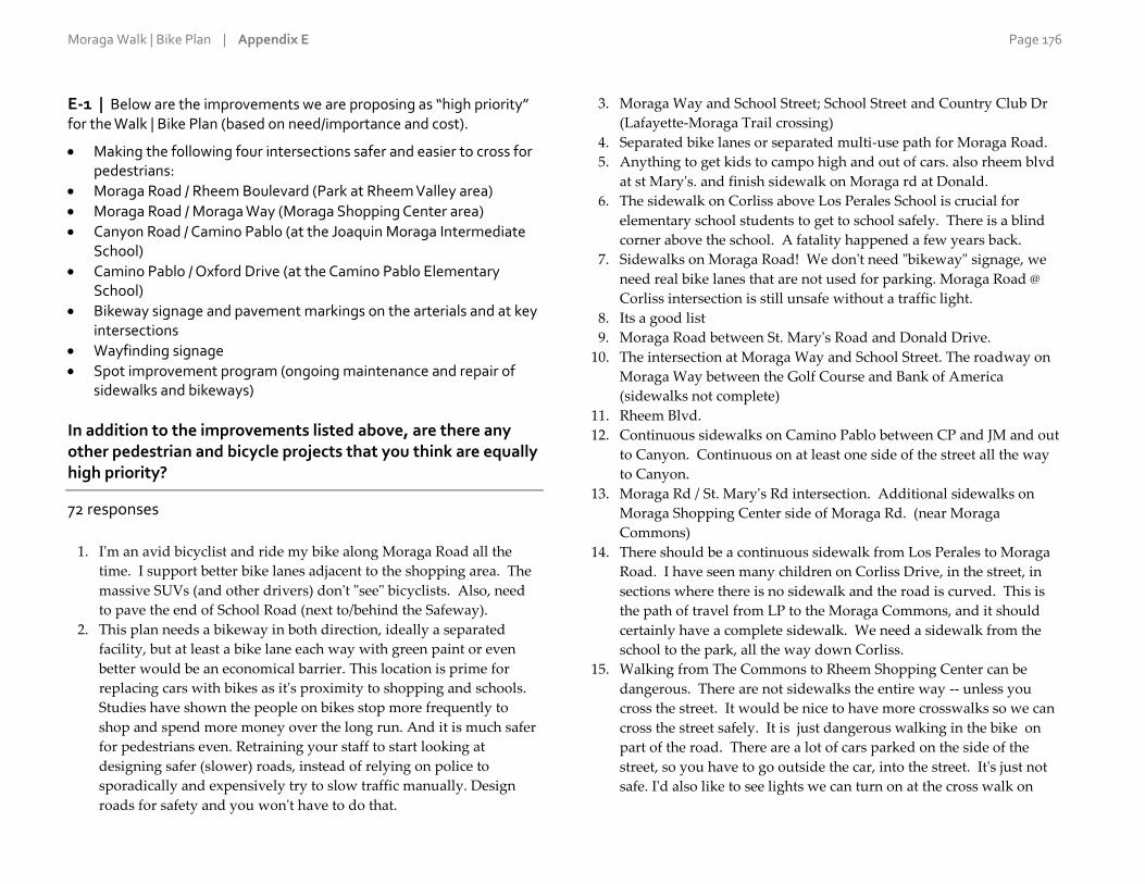
Moraga Walk | Bike Plan | Appendix E Page 176
E-1 | Below are the improvements we are proposing as “high priority” for the Walk | Bike Plan (based on need/importance and cost).
Making the following four intersections safer and easier to cross for pedestrians:
Moraga Road / Rheem Boulevard (Park at Rheem Valley area)
Moraga Road / Moraga Way (Moraga Shopping Center area)
Canyon Road / Camino Pablo (at the Joaquin Moraga Intermediate School)
Camino Pablo / Oxford Drive (at the Camino Pablo Elementary School)
Bikeway signage and pavement markings on the arterials and at key intersections
Wayfinding signage
Spot improvement program (ongoing maintenance and repair of sidewalks and bikeways)
In addition to the improvements listed above, are there any other pedestrian and bicycle projects that you think are equally high priority?
72 responses
1. I'm an avid bicyclist and ride my bike along Moraga Road all the
time. I support better bike lanes adjacent to the shopping area. The
massive SUVs (and other drivers) don't "see" bicyclists. Also, need
to pave the end of School Road (next to/behind the Safeway).
2. This plan needs a bikeway in both direction, ideally a separated
facility, but at least a bike lane each way with green paint or even
better would be an economical barrier. This location is prime for
replacing cars with bikes as it's proximity to shopping and schools.
Studies have shown the people on bikes stop more frequently to
shop and spend more money over the long run. And it is much safer
for pedestrians even. Retraining your staff to start looking at
designing safer (slower) roads, instead of relying on police to
sporadically and expensively try to slow traffic manually. Design
roads for safety and you won't have to do that.
3. Moraga Way and School Street; School Street and Country Club Dr
(Lafayette-Moraga Trail crossing)
4. Separated bike lanes or separated multi-use path for Moraga Road.
5. Anything to get kids to campo high and out of cars. also rheem blvd
at st Mary's. and finish sidewalk on Moraga rd at Donald.
6. The sidewalk on Corliss above Los Perales School is crucial for
elementary school students to get to school safely. There is a blind
corner above the school. A fatality happened a few years back.
7. Sidewalks on Moraga Road! We don't need "bikeway" signage, we
need real bike lanes that are not used for parking. Moraga Road @
Corliss intersection is still unsafe without a traffic light.
8. Its a good list
9. Moraga Road between St. Mary's Road and Donald Drive.
10. The intersection at Moraga Way and School Street. The roadway on
Moraga Way between the Golf Course and Bank of America
(sidewalks not complete)
11. Rheem Blvd.
12. Continuous sidewalks on Camino Pablo between CP and JM and out
to Canyon. Continuous on at least one side of the street all the way
to Canyon.
13. Moraga Rd / St. Mary's Rd intersection. Additional sidewalks on
Moraga Shopping Center side of Moraga Rd. (near Moraga
Commons)
14. There should be a continuous sidewalk from Los Perales to Moraga
Road. I have seen many children on Corliss Drive, in the street, in
sections where there is no sidewalk and the road is curved. This is
the path of travel from LP to the Moraga Commons, and it should
certainly have a complete sidewalk. We need a sidewalk from the
school to the park, all the way down Corliss.
15. Walking from The Commons to Rheem Shopping Center can be
dangerous. There are not sidewalks the entire way -- unless you
cross the street. It would be nice to have more crosswalks so we can
cross the street safely. It is just dangerous walking in the bike on
part of the road. There are a lot of cars parked on the side of the
street, so you have to go outside the car, into the street. It's just not
safe. I'd also like to see lights we can turn on at the cross walk on

Moraga Walk | Bike Plan | Appendix E Page 177
Moraga Road at Alta Mesa. Every time I cross there, I feel as if it
may be my last walk. Cars speed and don't stop. It's frightening.
16. Making the following intersection safer and easier to cross for
pedestrians: Carter Drive/St Mary's Road
17. Safe sidewalk/walkway from Moraga center to Rheem Center.
Canyon crossing at Sanders.
18. Safety measures for bike lanes on Canyon Road. More clearly
marked bike lanes on a stretch of road that often has cars violating
speed limit in both directions. Not safe for kids.
19. No
20. No
21. MAKING SURE ALL RIDERS HAVE A BELL! A LAMP AND
REFLECTORS ON THEIR CLOTHING! Maybe there could be a
reflector decal with the pear symbol/Bike + walker? That would be a
great help... On helmets and backs of riders. I can see pretty well, but
the dark loathing on a dark foggy AM. Or at dusk make it precarious
for me as a local taxpayer, ESP. If the riders pid up into twos and
threes...the bike lanes are too narrow...can't there be signage that
says SINGLE FILE. That was the rule we learnt and followed from
elementary School onward...in BERKELEY!
22. I like the flashing lights found at Corliss and Moraga Rd when a
pedestrian is trying to cross the road. I see this as important
especially at Moraga Rd/Moraga Way
23. Right turn from St. Mary's onto Moraga Rd. can be dangerous for
pedestrians.
24. The Crosswalk at St Mary's Road and Carter.
25. Sidewalks should continue along Moraga Way from Miramonte
High School towards the Moraga Country Club area. There is no
continuous sidewalk from Moraga Way@Ivy Dr. and this poses risks
to pedestrians, students, etc. every day! Ideally, the sidewalk would
continue all the way from Moraga Way @ Ivy Drive to the
intersection at Moraga Road (by the Moraga Shopping Center).
Similarly, there is no continuous sidewalk along Moraga Road
between the intersection at Moraga Way@Moraga Road (by the
Moraga Shopping Center) towards Moraga Commons along Moraga
Road. This is a very busy street and pedestrians are forced to walk
on private property/around parked cars in order to walk from the
shopping center down to the park.
26. Make Rimer/Camino Pablo (near JM) and Rimer/Cedarwood (near
JM field entrance) safer for pedestrians.
27. Wayfind signage is a waste of money.
28. no
29. intersections on Moraga Road near Campo high school
30. No
31. Making it safer to cross St. Mary's by the library and St. Mary's
gardens. Better bike path along Moraga Rd. and making signals
responsive to bikes when turning left from Moraga Way to Camino
Ricardo and from Moraga Rd. to St. Mary's.
32. Bollinger Canyon is in really poor condition there is no connection at
all with the trail close by. Furthermore, there is a fence that protects
rocks from falling over that nobody seems to maintain. This is the
worst section I've seen in all Lamorinda.
33. No
34. new home development will have an out let made and be opened
onto Moraga Rd. By the Skate Park! Already, near the skate park
entry it is very important to know that a sign should go up stating
"Slow Cars May Turn Left Here for Skate Park" And this should be
in both directions...Sometimes cars just stop and then turn left to go
and park...
35. Rheem Blvd. between Moraga Rd. and St. Mary's road. I see people
walking, jogging, biking at all times, even in the dark. It's
treacherous at all hours, especially in the dark. We MUST provide a
safe, continuous walk and bikeway along this route. I'm
disappointed that the new Rancho Laguna project does not provide
for a CONTINUOUS pathway along this route. The last thing we
need in Moraga is more terminating sidewalks.
36. I'm surprised to see the projects surrounding elementary schools
listed as Tier 2. I think areas where children will be walking should
be bumped up to Tier 1.
37. I don't feel signage should be a ""priority "" for Moraga. Road repair
and maintenence is much more important for residents
38. Traffic light and additional sidewalks at intersection of Corliss and
Moraga Road.
Moraga Walk | Bike Plan | Appendix E Page 178
39. Stuidies by Professor J. Gilderbloom, Ph.D. of the university of
Lousiville proves that forming a parternership between colleges and
business by providing not only bike paths but bikes too, increase
revenue for local business, provides excercise and is good for the
environment. How and have you talk to St. Mary's College.
40. No. Most of the other places already have crosswalks or traffic
lights. Maybe the middle entrance to Rheem Shopping center and
the new housing project across the street.
41. #1 You do not mention Sullivan/Corliss near Los Perales, but it
shows on your map as a yellow upside down U. It is dangerous for
parents and children to walk this stretch, and there needs to be a
sidewalk. Second, if you walk on Moraga Road from Rheem to
Corliss there is no continuous sidewalk and at night it is very poorly
lit. This would not be too expensive to add a sidewalk and lights so
people could walk this stretch easily. It is now very dangerous at
night- very dark, lots of bumps and holes.
42. South Rheem Road repair.. Feel like my car is going to explode
everytime I drive down it.
43. The walk/bike paths from the commons park to the Rheem shopping
center along Moraga Rd. should be improved.
44. Improve bicycle and pedestrian pathways to all public schools in
Moraga to incent more alternatives to driving personal cars to
school. Fewer cars on Moraga roads will help everyone.
45. Street lighting
46. A better, more direct connection from the bike trail entrance on
Country Club Drive and the Moraga Commons. Preferably, a class I
path.
47. St. Mary's and Rheem, along the trail. Cars try to turn very fast
during breaks in traffic but risk hurting the pedestrians using the
trail
48. New bicycle signage should follow bike use on School Street to
canyon.
49. Pedestrian crosswalk at the Bus stop on Moraga Road and
Buckingham Drive.
50. No. Looks good.
51. Pedestrian safe white bridge that crosses over the creek leading into
the watershed. Delineated bike land on Country Club Drive from
Aegis to MCC.
52. Intersection of Hardie and Camino Ricardo. There is only a yield
sign on Hardie and a major path for kids walking to LP.
53. How did these get prioritized over the Ascot- Commons stretch that
the huge survey was all about? That's much bigger than these ideas.
54. the bridge on Canyon, heading to Canyon, is very dangerous for
pedestrian because drivers speed over the bridge (especially in the
morning). Steps should be taken to prevent that, such as signs,
radar, cameras, etc., in addition to the periodic police presence there.
55. What happened to the Livable Moraga Road project - the area
between Campolindo High School and St. Mary's Road where there
are gaps in the sidewalk or non-existing sidewalks? I've been to 2 of
these meetings and everyone agreed that being pedestrian friendly
begins with sidewalks. This is definitely a top priority.
56. The blind curve where Sullivan becomes Corliss. We need a
sidewalk before a child Gets hurt or killed.
57. Moraga road from Donald to Corliss. I'm surprised this isn't already
on the list. The outer lane in both directions should be a green lane
designated for bikes to use the whole lane. These are common in
cities everywhere. It's the only road between the entire Rheem area
and Moraga Commons.
58. Campolindo to Donald dr / Rheem elementary.
59. I would add the Ivy Drive/Moraga Way intersection, but that is a
shared city zone.
60. No.
61. The 2 Moraga Rd. intersections already have stop signs and
crosswalks (nothing needs to be done there). The 2 Camino Pablo
intersections need reduced speed signs, speed bumps and pedestrian
crosswalks. Maybe you should put in a flashing yellow sign
activated by pedestrians like the one by Campolindo at these
Camino Pablo crossings.
62. Moraga Rd/Corliss intersection. Del Monte Way/St. Mary's Rd
63. - continuous bike lane along Moraga Way and Moraga Road. -
improve safety at the crossing of Canyon and Country Club Drive:
it's one of the most dangerous in town!

Moraga Walk | Bike Plan | Appendix E Page 179
64. Bike and Pedestrian access on Rheem Boulevard Between Fernwood
Dr and St Marys Rd.
65. Improving the sidewalk situation at all schools MUST be a Tier 1
priority. There is still no plan to effectively improve the lack of
sidewalks on a blind curve approaching Los Perales. There has
already been one death on this curve. We are now being told this is a
Tier 2 priority which means it will be funded ONLY IF the money is
available. Sorry but that is the absolute WRONG decision. It is not a
question of IF an accident will occur here, it's a question of WHEN.
66. Provide sidewalks on more streets in town.
67. No
68. Livable Moraga Rd walkway improvement
69. I think a sign before Camino Pablo would be helpful to let drivers
know it is the next left. The sign is way too small and people end up
doing unsafe U turns
70. need traffic signal at st.mary's and rheeme blvd now more homes are
being built on rheem blvd. too hard for bikes and cars to turn left ...
cars driving up slope and down slope. it neesds to be made safer and
allow left hand turns easier,
71. flashing lights as it is more noticable as it gets dark and or during
cloudy rainy weather. left arrow turn signals.....more traffic signals
since we now have more homes going up for new construction.
72. Agree that the #3 Canyon Road / Camino Pablo & #4 Camino Pablo /
Oxford Drive should be improved. Sidewalk should be extended the
entire length of Camino Pablo between CP elementary & JM. The
recent changes to Rheem boulevard reducing to 1 lane each direction
is bad - should be switched back to 2 lanes there. Those parking
spots added are almost never used!

Moraga Walk | Bike Plan | Appendix E Page 180
For Appendices E-2 to E-4, refer to the figure below:

Moraga Walk | Bike Plan | Appendix E Page 181
E-2 | Are there any other intersections that should be
considered a higher priority for pedestrian improvements than any of these four?
Moraga Road / Rheem Boulevard (Park at Rheem Valley area)
Moraga Road / Moraga Way (Moraga Shopping Center area)
Canyon Road / Camino Pablo (at the Joaquin Moraga Intermediate School)
Camino Pablo / Oxford Drive (at the Camino Pablo Elementary School)
62 responses
1. End of Draeger Drive on Moraga Road (site of a fatality)
2. Moraga Way / Viader DR
3. I don't really care about pedestrian stuff - I'm only on my bike in
moraga.
4. Moraga Way and School Street
5. Anything to get kids to campo high and out of cars. it takes 40
minutes in the morning to get down the hill
6. Moraga Road / Corliss still has poor visibility, kids, no traffic signal
and drivers completely disinterested in yielding to pedestrians - with
or without a blinking yellow ligh to remind them.
7. Moraga Road / Corliss still has poor visibility, kids, no traffic signal
and drivers completely disinterested in yielding to predestined
8. no
9. Moraga Road between St. Mary's Road and Donald Drive.
10. No
11. No
12. Corliss and Moraga Road
13. Moraga Road between The Commons and Rheem Shopping Center.
14. No, however, my response to #1 should be considered equal to those
four, given the danger it poses to our neighborhood.
15. No.
16. Canyon Road at Country Club Drive
17. No
18. No
19. Moraga Road / Moraga Way (Moraga Shopping Center area)
20. Moraga Way near Miramonte Gardens
21. The two near schools. School kids need to be safe crossing the
streets.
22. St. Mary's Road and Carter Drive
23. Moraga Road, north of St Marys Road to Rheem is more important
than South of St. Mary's Road.
24. intersections near Campo HS
25. No
26. No
27. The ones on St Mary's road. See my comment above.
28. Bollinger/St Marys
29. Moraga Rd and St Mary's Road
30. no
31. RHEEM BLVD all the way to St Mary's
32. same as Q1.
33. No
34. Corliss / Moraga Road
35. Enterance into SMC
36. Not necessarily higher priority and not pedestrian, but crossing by
car between Safeway shopping center to OSH shopping center is
very dangerous.
37. Moraga Rd from commons park to Rheem shopping center.
38. no
39. No
40. Country Club Drive and School Street. Need another crosswalk
across CC Drive on the east side.
41. No
42. 1
43. I think the first two intersections are well marked now and feel
where bus stops are located on Moraga Road there should be a
convenient cross walk near them, i.e., buckingham Drive & Moraga
Road.
44. No. Looks good.
45. Hardie and Camino Ricardo intersection.
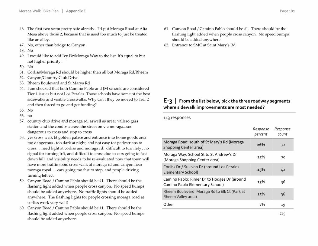
Moraga Walk | Bike Plan | Appendix E Page 182
46. The first two seem pretty safe already. I'd put Moraga Road at Alta
Mesa above those 2, because that is used too much to just be treated
like an alley.
47. No, other than bridge to Canyon
48. No
49. I would like to add Ivy Dr/Moraga Way to the list. It's equal to but
not higher priority.
50. No
51. Corliss/Moraga Rd should be higher than all but Moraga Rd/Rheem
52. Canyon/Country Club Drive
53. Rheem Boulevard and St Marys Rd
54. I am shocked that both Camino Pablo and JM schools are considered
Tier 1 issues but not Los Perales. Those schools have some of the best
sidewalks and visible crosswalks. Why can't they be moved to Tier 2
and then forced to go and get funding?
55. No
56. no
57. country club drive and moraga rd, aswell as nrear vallero gass
station and the condos across the street on via moraga...soo
dangerous to cross and stop to cross
58. yes cross wa;k bt golden palace and entrance into home goods area
too dangerous , too dark at night, abd not easy for pedestrians to
cross.... need light at corliss and moraga rd. difficult to turn lefy , no
signal for turning lrft, and difficult to cross due to cars going to fast
down hill, and visibility needs to be re-evaluated now that town will
have more traffic soon. cross walk at moraga rd and canyon near
moraga royal .... cars going too fast to stop, and people driving
turning left ect
59. Canyon Road / Camino Pablo should be #1. There should be the
flashing light added when people cross canyon. No speed bumps
should be added anywhere. No traffic lights should be added
anywhere. The flashing lights for people crossing moraga road at
corliss work very well!
60. Canyon Road / Camino Pablo should be #1. There should be the
flashing light added when people cross canyon. No speed bumps
should be added anywhere.
61. Canyon Road / Camino Pablo should be #1. There should be the
flashing light added when people cross canyon. No speed bumps
should be added anywhere.
62. Entrance to SMC at Saint Mary's Rd
E-3 | From the list below, pick the three roadway segments
where sidewalk improvements are most needed?
113 responses
Response percent
Response count
Moraga Road: south of St Mary's Rd (Moraga Shopping Center area)
26% 72
Moraga Way: School St to St Andrew's Dr (Moraga Shopping Center area)
25% 70
Corliss Dr / Sullivan Dr (around Los Perales Elementary School)
15% 42
Camino Pablo: Rimer Dr to Hodges Dr (around Camino Pablo Elementary School)
13% 36
Rheem Boulevard: Moraga Rd to Elk Ct (Park at Rheem Valley area)
13% 36
Other 7% 19
275

Moraga Walk | Bike Plan | Appendix E Page 183
E-4 | Another roadway segment requiring sidewalk
improvement?
35 responses
1. Moraga Road: Devin Dr to Corliss Dr.
2. finish sidewalk on Moraga road at donald. so kids can go to rheem
3. Places with no paved sidewalk on Moraga Road between Donald
and St. Mary's.
4. Moraga Rd Corliss to Rheem center
5. no
6. Moraga Road between St. Mary's Road and Donald Drive.
7. Camino Pablo: Rimer Dr to Canyon
8. All of Larch Rd. This road is heavily used and there are no
sidewalks at all. This may also help curb the speed of cars up and
down Larch.
9. Moraga Road between Corliss & Devin Drive where there is no
sidewalk on either side of the street.
10. Corliss Drive, from LP to Moraga Road
11. Moraga Road between The Commons and Rheem Shopping Center
12. None
13. Donald Drive by Rheem Elemenrary
14. Lower Corliss before Moraga Rd.
15. Bollinger Canyon, there is no pedestrian or bike lane at all!
16. near JM to Cross, and Country Club Drive to cross , need a full stop
light there and light flashing signal to cross cars are going too fast to
leave moraga to back roads to canyon to and from ...Big expanse to
try to cross or walk a bike across the street....
17. It would great if the sidewalk being proposed at Corliss and Sullivan
stretched all the way down Sullivan to Hardie, since this is a route
that children take when walking to school. It would only need to be
on one side of the street.
18. Continuous sidewalks from Corliss to Rheem Center along Moraga
Road
19. not qualified
20. If CV high density project is coming, then CV should pay for
improvements & this dev't should be part of the planning process
before any decisions/plans are made. As I said in Q1, Moraga Road
from Rheem to Corliss needs sidewalk and lights. Very dangerous
right now and it gets a lot of foot traffic.
21. moraga road between corliss and ascot
22. Moraga Road: Devin to Corliss
23. Moraga Road: Devin to Corliss
24. Improvement on Moraga Road bet/ Buckingham and Woodford
across from the High school.
25. Make sidewalk consistent and extend from White Bridge on Canyon
all the way to Moraga Commons on the southeast side of the road
(the non shopping center side). Sidewalk stops and starts along that
way. Then, people could cross at controlled intersections rather than
across Canyon which is too wide and people drive way too fast.
26. Canyon bridge
27. Where is the Livable Moraga Road Project on this list? As I said
above, that is the top priority.
28. Bridge over the river to canyon
29. Rheem Boulevard from St Marys Rd
30. Hardie Dr.
31. Moraga Rd between Corlis and Donald.
32. campolindo hs moraga rd, near performing arts center
33. need signal at st.mary's rd and rheeme...there is a limitted sight
areaasthr
34. Camino Pablo: needs a good sidewalk all the way from CP
elementary to JM
35. Entrance to SMC at Saint Mary's Rd

Moraga Walk | Bike Plan | Appendix E Page 184
For Appendices E-5 to E-6, refer to the figure below:
Moraga Walk | Bike Plan | Appendix E Page 185
E-5 | Looking at the map of the draft town-wide bikeway
network, are there any streets that should be added to, or removed from, the network? Which one(s) and why?
50 responses
1. These are OK. here's the thing, though. If I'm riding east along
Moraga Road, trying to take a left-hand turn onto School Street or
even to get into the lefthand lane to turn from Moraga Way onto
Moraga Road is like suicide. Cars are barreling down moraga way
like crazy. I'd also like to see better signage so cyclists know
how/where to take short cuts through neighborhoods to avoid some
of the worst intersections.
2. The "network" is exteremely spartan and the map doesn't explain
what facilities will be on the proposed network. These need to be
separated facilities or highly-visible bike lanes. Sharrows are not
facilities - these can cause more danger than good, and certainly
don't qualify in this day and age as an improvement. They don't
belong on major roads. We have a chance here to get kids biking to
school, college students biking to campus and to do their shopping,
the elderly biking to their church or coffee hangout. Please look to
the future and not the past for guidance on improving this.
3. Looks good, but existing and potential off-street trails should also be
indicated.
4. Further extension of bikeway northeast on St. Mary's road. No areas
should be removed from the network. Greater steps should be taken
to separate automobile traffic from bike and pedestrian traffic.
5. Anything to get kids to campo high and out of cars. also rheem blvd
at st Mary's. and finish sidewalk on Moraga rd at Donald.
6. As long as there are cars parked in the supposed bike lanes, what
does a bikeway even mean?
7. no
8. No
9. Moraga Road between St. Mary's Road and Donald Drive. It is a
major throughway for cyclists and pedestrians alike both north and
south bound.
10. Before committing to the Rheem to Orinda segment - is Orinda's
bicycle plan consistent with this?
11. Add: Larch. Add: Camino Pablo. A complete sidewalk on both
sides of the street are needed from Camino Pablo Elementary all the
way to Canyon Rd.
12. As far as usage, we have many, many more pedestrians who are
residents of the Town, than bicyclists. So if we need to prioritize, we
should make pedestrian improvements Tier I and have bicycle
improvements for Tier II and III.
13. Not that I can see.
14. Every single one of the secondary bikeways on the map are
unnecessary and should be removed, and seem to me to be the sort
of social engineering intended to force people out of their cars. Every
single secondary bikeway on the map is an alternative roadway for
avoiding main thoroughfares (or are rural streets not needing any
special designations because they are low use streets.) AND all main
bikeways running on Rheem Blvd. (both north and south of Moraga
Road) are equally unsound ideas. Rheem Blvd is a heavily trafficked
roadway and that is NEEDED because the town planning
commission keeps allowing new housing to increase the population
in town. SLOWING traffic and forcing cars to further compete for
roadways with Bikes, while at the same time permitting more and
more housing is a recipe for disaster and gridlock.
15. Alta Mesa. Yes it needs to be repaved in 20 years, but its a dead end
for cyclists, unless it becomes open for travel to the OMRT. If that
happens, repaving will maje it Mt Bike friendly. Corless to st
Andrews ??? 2nd teir priority. Rheem rd/blvd. Needed its a high risk
game of craps in the pants. Donald dr. Just needs maintence to
prevent MAmma nature from taking over.
16. See answer to Question 1
17. Please do not eliminate any of the four traffic lanes from Rheem to
Corliss.
18. No
19. LOVE the way MORAGA RD is no longer a MAIN BIKE ROUTE!!!
20. Canyon Rd all the way to Pinehurst needs improvement. This is a
heavily biked road and needs wider shoulder and repaving
21. looks great!

Moraga Walk | Bike Plan | Appendix E Page 186
22. Corliss Dr / Sullivan Dr (around Los Perales Elementary School):
This area needs serious help. Not for pedestrian crossings, but for
vehicular flow. During school pick-up/drop-off hours, the entire
path along Corliss is blocked off by parents idling in their SUVs and
blocking all through traffic. There needs to be a separate turnaround
lane or organization with the school to promote parents walking to
pick up children. Drivers should not be allowed to idle at the stop
sign until they can turn into the school to pick up their child
curbside, as it prevents any through traffic from safely driving by.
Drivers are forced onto the wrong side of the street, with poor
visibility, in order to get past.
23. No bikes should be allowed on Moraga Road north of Sky Hi and
into Lafayette. So access to that point on Moraga Road should be
discouraged.
24. Remove the Rheem Blvd section between Moraga Road and St
Marys. Hill too steep and narrow. People can bike around through
the park.
25. No
26. Alta Mesa should be removed. Too steep.
27. Ask the Moraga Police Dept what they think should be included for
traffic pattern, pedestrian /bike get their imput on it too.
Camoplindo area near the entrance to and from performing arts
building is dangerous to try to cross during school time and or make
a Left hand turn to go out...maybe this needs to be looked at....
28. no
29. Why are we making this project a priority for Moraga when the vast
majority of cyclists are not Moragans? they usually ride in the traffic
lanes anyway and what is the value to our citizens to increase more
out of town bicycle traffic. I'm not seeing the benefit of the spend.
30. Looks good as drawn
31. Will there be a bike path down the windy moraga rd from Rheem to
Mt Diablo? Would love to ride my bike to bart going that way
(downhill).
32. Until Rheem Road is repaired I don't see doing much to this for the
bikes and I hope the builder would be gifting part of it.
33. #1 Sanders Drive and Alta Mesa seem unnecessary or pick one or the
other, but both are not needed.... but I may not know something that
makes both critical? #2 It would seem logical to extend the bike lane
on Corliss up to Los Perales School so it is bike friendly. There are
even now some children biking to school and it's dangerous w/ cars
so close. This might encourage parents to also ride their bikes to
bring their children to school. #3 With the new Summerhill dev't on
Camino Ricardo, there is going to be a path through it to the
shopping center and I believe a bridge over to the Commons. It
would be a good idea to make this bike friendly as well. It would
strongly encourage that whole side of town to use a bike to shop and
go to the Commons.
34. Add Moraga road from commons to Rheem shopping center.
35. moraga road between corliss and ascot
36. Looks pretty good. It wouldn't hurt to have the bike network
continue all the way up Donald Dr. to Mulholland Ridge.
37. Add Canyon and Camino Pablo (Moraga triathlon route)
38. No problem with bikeway improvements but please ensure that
bicyclists follow the rules of the road.
39. No. Looks good.
40. Since the section of Canyon Road that is in front of Saint Monica's
church is a primary route, I suggest we continue the red paint on the
curb in that area. It is very dangerous on sunday mornings for
churchgoer cars to be parked there, and it is unnecessary because the
church has ample parking.
41. Looks good.
42. this is good.
43. None I can think of
44. The area between Donald Drive and Corliss Drive needs a sidewalk
along Moraga Road that connects pedestrians between the north side
of town and the Commons Park. This is a priority.
45. No
46. No.
47. Your bike map does not load, the little view below is hard to figure
out!
48. No
49. no
50. The bike route on sanders drive should be extended through the
field to connect to the end of sanders ranch road. why didn't you put
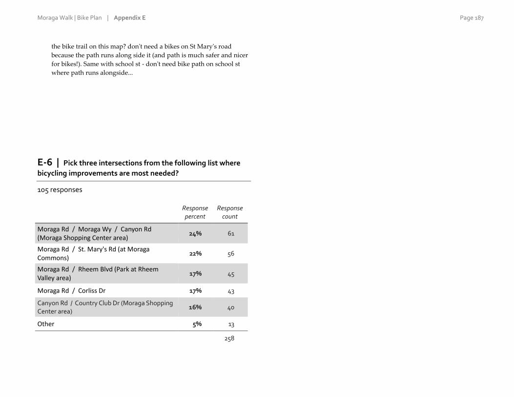
Moraga Walk | Bike Plan | Appendix E Page 187
the bike trail on this map? don't need a bikes on St Mary's road
because the path runs along side it (and path is much safer and nicer
for bikes!). Same with school st - don't need bike path on school st
where path runs alongside...
E-6 | Pick three intersections from the following list where
bicycling improvements are most needed?
105 responses
Response percent
Response count
Moraga Rd / Moraga Wy / Canyon Rd (Moraga Shopping Center area)
24% 61
Moraga Rd / St. Mary's Rd (at Moraga Commons)
22% 56
Moraga Rd / Rheem Blvd (Park at Rheem Valley area)
17% 45
Moraga Rd / Corliss Dr 17% 43
Canyon Rd / Country Club Dr (Moraga Shopping Center area)
16% 40
Other 5% 13
258

Moraga Walk | Bike Plan | Appendix E Page 188
E-7 | Another intersection requiring bicycling improvements?
28 responses
1. Moraga Rd/Donald Dr
2. Moraga Way and School Street; School Street and Country Club Dr;
Moraga Way and Cam Ricardo; Moraga Way and Moraga Valley Ln
3. rheem at st marys
4. None
5. Moraga Road between St. Mary's Road and Donald Drive.
6. All bicycling improvements should be Tier II and III
7. Rheem. St marys to moraga rd.
8. None
9. Canyon Rd all the way to Pinehurst
10. none
11. Moraga Way between Camino Ricardo and School Street
12. Bollinger to St Mary's
13. Moraga Way eastbound at School St, where the bike land and
sidewalks disappear
14. None needed
15. Rheem Blvd at St. Mary's Rd, Need a Traffic Signal there to have
more safe flow of traffic and cars turning Left onto St. Mary's Rd to
go thru to Lafayette, It is a Main Bike Walk path that is there right at
the stop sign ,...
16. At Mary's rd
17. not qualified
18. Moraga Rd and Draeger
19. Only comment: The blue line that leads into the watershed should
extend to the Town Limits sign, which is over the hill and in Indian
Valley, not by Valle Vista as shown.
20. I don't think bicycling improvements are needed.
21. Ascot through to Moraga Commons
22. The bike path heading towards Canyon on Canyon Rd is too narrow;
cars drive down that street very fast.
23. Rheem Boulevard and St Marys Rd
24. Moraga Way / School St
25. rheeme rd and st.mary's rd near bollingercanyon rd too
26. canyon & camino pablo
27. Entrance at SMC
28. Moraga Rd/School St.
E-8 | Pick the one answer that best describes what you think
about this idea:
Increase Police Department enforcement of traffic laws
129 responses
Response percent
Response count
Yes, the streets feel unsafe because drivers speed and don't stop at crosswalks.
36% 47
Yes, but the focus should be on cyclists who don’t obey the rules of the road.
21% 27
No, traffic safety isn't a problem here; the Police Department is already on top of it.
29% 38
I'm indifferent or not sure how I feel—I can see different sides of the argument.
13% 17
100% 129

Moraga Walk | Bike Plan | Appendix E Page 189
E-9 | Pick the one answer that best describes what you think
about this idea:
Put up signs and sharrows to indicate bike routes (sharrows are pavement stencils showing cyclists where to ride and reminding drivers to expect cyclists)
129 responses
Response percent
Response count
Yes, that’s a simple, inexpensive way to legitimize cycling and make it safer.
71% 91
No, it’s visual pollution and not in keeping with Moraga’s character.
14% 18
No, it will confuse drivers 3% 4
I'm indifferent or not sure how I feel—I can see different sides of the argument.
12% 16
100% 129
A "sharrow" is the pavement marking shown in the photo below:
E-10 | Pick the one answer that best describes what you think
about this idea:
Restrict parking on short stretches of roadway shoulders where it is essential to provide a safe bikeway route
129 responses
Response percent
Response count
Yes, that’s an easy, inexpensive way to make biking (and walking) safer.
72% 93
No, there isn’t enough street parking as it is. 15% 19
I'm indifferent or not sure how I feel—I can see both sides of the argument.
13% 17
100% 129

Moraga Walk | Bike Plan | Appendix E Page 190
E-11 | In your opinion, what would constitute success for the
Moraga Walk | Bike Plan ten years from now? Be as specific and as descriptive as possible
87 responses
1. More bike usage by residents. No bike accidents for recreational
cyclists
2. To not reduce the any lanes of traffic, specifically on Moraga Rd.
between Rheem Blvd. and St Marys. Rd.
3. Moraga is a crossroads for many avid cyclists' routes (Oakland
through Canyon, Orinda to Lafayette, etc). You should really make
Moraga a bike-friendly "destination." Just visit the Danville Peet's
sometime and see how vibrant the cycling community is there.
Moraga could be the same (except that the coffee shops are hidden in
the bowels of the car-intensive shopping center). In ten years, there
should be bikes everywhere in Moraga. It's mostly flat for gosh
sakes! Kids should be riding, adults should be OUT of their cars, etc.
You should put up signs saying "Moraga: Bike-Friendly City"
4. A plan that actually improves cycling - set a metric for how many
people you want to divert from driving and then build out the
infrastructure and programs to make that possible. You should aim
for 10-20% commute by bike or foot within the next ten years. You
should have no sharrows. You should have protected bicycle paths
on the main thoroughfare. You should have kids biking to school in
excess of 10%.
5. Sharrows should only be used on narrow, single lane streets and in
conjunction with other traffic calming improvements. Faster, multi-
lane streets should use physical separation between the bikeway and
the travel lane to ensure that it is safe and comfortable for bike riders
of all ages/abilities, but also to prevent it from being blocked by
parked cars. If Moraga's bike/walk plan is a success then the number
of people walking and biking in the city should go up, while also
being a representative cross section of the city (kids, families, seniors,
etc). If the streets continue to feel unsafe for biking and walking then
these demographics will not be represented.
6. More pedestrian and cyclist trips, safer streets, and less automobile
accidents.
7. all of the sidewalks to the schools would be complete, and the bike
paths clear so that more kids would walk and bike to school. and the
police would not be afraid to give out a lot of tickets to the people
who are speeding like crazy to get to school. and to get to have their
nails done, after they drop off their kids at school. More tickets. More
green and pod pullouts to slow traffic.
8. Safe pathways for kids and adults to walk and bike.
9. Real sidewalks and real bike lanes on the main roads and some sort
of enforcement and education for the majority of Moraga drivers
who refuse to yield to pedestrians unless the pedestrian throws him
or herself in front of the car.
10. Increased safety measures that make biking and walking safer while
still allowing for parking and traffic flow
11. Cyclists and peds. have safe routes, and cyclist follow traffic laws !!!
12. No comment
13. Clearly marked and wide bike / pedestrian lanes. Crosswalks that
are not at traffic light controlled intersections to be provided with
button activated "flash lighting" as the one crossing Moraga Road at
Campolindo high school.
14. Bicycle lanes are free of cars and well used by cyclists; lots of kids
ride their bikes to school; lots of adults ride their bikes to BART;
bicycle parking is provided throughout town and at events; the
sidewalk system along the major roads is complete
15. You need sidewalks & bikepaths on the major arteries. Making
bikers obey the laws like they would if they were in a car. No more
cruising through red lights or stops signs.
16. I would be able to walk on a sidewalk from Oxford and Camino
Pablo to the Rheem Center. These would be ADA accessible
sidewalks so I can take my grandchildren for walks in a stroller.
17. Better sidewalks on both sides of the street on the major roads.
18. I understand that a large part of the plan is to reduce the section of
Moraga Rd to one lane in each direction between Corliss and
Campolindo - this is a TERRIBLE idea. Traffic in the morning is
already horrible and it is a gross misconception to assume that many
of the people who are currently driving this road in the morning

Moraga Walk | Bike Plan | Appendix E Page 191
could, instead, be walking or biking. MANY of us are dropping off
kids at Campo on our way to work and biking/walking is not
feasible. I get the sense that this is some outside environmental
group (al la ABAG) pushing this agenda on our town to make some
environmental statement. There is already a bike lane to be used.
Consider, instead, spending some quality time over SEVERAL days
observing the cluster-F**K that is the Campo drop off and doing
something about the configuration of how cars and
cyclists/pedestrians enter and exist that school. It wouldn't take
someone long to realize that this is the crux of the entire traffic back
up in the morning that carries back for many blocks. The crosswalk
at Campo by the performing arts bldg is in the worst possible
location - the moment a student crosses over Moraga Road they are
stopping both directions of traffic (obviously) but then they take two
steps towards school and then block both lanes of traffic leaving the
school, further backing up traffic -- the moment they cross over those
lanes, inevitably another pedestrian starts thru the crosswalk and the
whole back up starts again. Cars leaving the school in both
directions on Moraga Road are stopped by those same pedestrians to
the point sometimes where traffic in and out of the school in all lanes
is completely backed up by one or two pedestrians. It's a crazy
configuration. The crosswalk should be moved. Or, there should be a
drop off lane off to the side in Lafayette-bound directions of Moraga
Road so at least these cars could pull into a safe area, drop off
students and then continue down to Moraga without the 3-ring
circus of pulling into and out of Campolindo. That land is for sale at
this time - something to consider. That said, I would much prefer
these funds go to paving the rest of the streets in this town instead of
throwing funds at a bike/pedestrian problem that does't exist. Last I
looked, our street and many others in terrible disrepair in our
neighborhood are still is not on the list to be paved.
19. If the citizens of Moraga feel that their resources are best used to
benefit them and their children - drivers and pedestrians. We do
not, and never will, have the resources to create fully protected bike
paths on Moraga Way and Moraga Road, so we should focus on
what we can do - protect children on their most common routes of
travel: around schools and from schools to parks. It will be
successful if we focus our resources and make great improvements
for pedestrians, not split our resources and make half measures for
pedestrians and bicyclists.
20. If more children were walking and/or biking to school because there
parents felt it was safe for them do so.
21. Provide safe places to walk and cycle without limiting car traffic.
With 1,200 residences already approved for development, traffic
(already bad) will get much worse!
22. That the walk/bike path be consistently used by cyclists (instead of
the road) in places where the road is too narrow or no bike-lane at all
exists, and is near the path. (i.e. most strectches of St. Mary's Road)
23. Safe passage across town for children on bikes.
24. What would constitute success for the Moraga Walk/Bike Plan is
something that in no way impedes Moraga's already very, very
crowded roadways, but which absolutely affords cyclists and
pedestrians a true expectation of safety. I am all in favor safety
measures that help pedestrians and cyclists but am simultaneously
troubled by the incredible growth of traffic in town AND the fact
that the planning commission continues to approve more and more
developments which, of course, brings more residents and more cars
to the road.
25. No one dying. Minor injury is an opportunity to learn. You learn
nothing by dying. 2.reduced risk when traveling on Moragas roads.
Bike. Pedestrian. Cars. will work with self driving cars. Minimal cost.
Munimal traffic impact.
26. I think a comprehensive biking network that supports safety and
encourages cycling throughout the Town of Moraga. It's an active
and progressive community, and fully embracing the benefits of
becoming a bike-friendly community is positive for our kids and will
help set this town apart from less progressive communities in the
area.
27. Increased awareness of pedestrians and bikers by drivers, separate
bike lanes and dedicated walking lanes
28. For the main thoroughfares- create separate paths off of the road for
pedestrians and bikes to coexist. This will encourage increased
recreational cycling and get cars off the road. Increased education
and enforcement of bike laws for those riding on the road. Currently
Moraga Walk | Bike Plan | Appendix E Page 192
the overwhelming ignorance of the law from cyclists creates unsafe
driving conditions and traffic and increased resentment towards
cyclists.
29. To improve biking and pedestrian areas without removing traffic
lanes. Eliminate parking from Ascot to Corliss. Every house in this
area has a driveway and garage. Street parking should be eliminated
on the North side of the street without consequences to homeowners
and would improve bike and pedestrian safety.
30. IF BIKE RIDERS would understand that they are making it very
difficult for people to get to work or home AND realize that their
presence causes a HUGE danger in a 2 lane well travelled road, so
that THEY should ride ONLY single file. OR ELSE get the same $500
ticket a driver gets for endangering an intersection. STOP signs
MUST be heeded. By all road users! Do bikers pay to use Moragas
roads? Well maybe they should have an annual County TAX levied.
Which would bring in a little more county revenue?! .
31. I like what Orinda did and paint a green bike lane where lanes
merge to get onto hwy 24. this easily spells out the bike lane.
32. If i'm safely able to ride with my wife and two girls between St
Mary's College, the Rheem Center, and Camino Pablo.
33. If bikers obey the traffic laws without the government impinging
further on drivers money and ability to get from here to there. How
much do bikers pay for the roads??? ZIP, NADA, ZILCH!!!
34. Let's institute these in busy areas first and not necessarily in areas
that are low traffic (relatively) like Camino Pablo Rd, etc. The
Moraga Way and Moraga Rds are higher traffic lanes that people
could use safety support via separate and visible paths or sidewalks.
thanks
35. increase percentage of population that bikes / walks. Safety should
be primary concern as that's why many residents don't bike more
frequently for commuting which would greatly benefit traffic issues.
Sharrows are better than nothing but bike lanes separated by
pavement reflective markers would be a huge improvement for
distracted drivers as they would not see sharrows but would be
alerted crossing a bike lane.
36. Creating paths/lanes that DO NOT use current lanes for traffic or
reduce street parking. Ideally we would actually ADD traffic lanes to
eliminate congestion and make it safer for bikes and pedestrians to
enjoy our beautiful town as well. Eliminating lanes and reducing
street parking in a town adding new housing elements is a mistake.
37. Getting more people ON their bikes for regular commuting or
activities. Shallows and lanes are not going to help if people don't
get on their bikes....
38. bike, walkway connecting from School Street all the way to Rheem
Shopping center
39. If more people were safely walking/biking in Moraga. With all the
new housing being built, we need more people biking/walking in
order to have less congestion.
40. No fatalities. The number of people, adults and children biking and
walking has tripled.
41. A dedicated expansion of a safe bike/walk path that is separated
from cars both parked and moving. Something aesthetically
pleasing.
42. Everybody should be able to walk or bike to the trails, schools and
main shopping areas.
43. At most, probably communication to drivers about their
responsibility of accommodating cyclists. I commute by bike daily to
Orinda Bart, and all of my conflicts with motorists occur well
beyond Moraga boundaries, but most are Moraga drivers. Using
mobile phones, veering into the very wide and marked bike lane,
allowing cars to turn in and from Moraga Way to and from side
streets without looking for cyclists... For me, I see it mostly as
stressing how to be aware and how to handle situations.
44. Less traffic to high school. More use of bikes along Moraga Road
45. if 95% of residents can get SAFELY to any of our schools and 2
shopping centers on foot or bike.
46. I'm a walker (not a biker) so more sidewalks everywhere are
important to me.
47. 1--To have safe bicycle traffic on major roads (esp. Moraga Road
from St. Mary's Road to Rheem Blvd WITHOUT REDUCING
EXISTING TRAFFIC LANES. This could be achieved with a small
number of bicycle lane additions and stronger marking, and with
improved respect to existing vehicle and pedestrian traffic by bicycle
riders.This might require regular police enforcement by bicycle
Moraga Walk | Bike Plan | Appendix E Page 193
riders of traffic rules and safety standards. Pedestrians frequently are
endangered by bicycle riders who do not respect their presence--yet
expect vehicle drivers to defer to bicyclists.
48. Don't encourage increased out of town/thru bicycle traffic and spend
our funding on this project. The bike lanes ( save for a few sections
where parked cars can block the lane) and regional bike/walk trails
are great.
49. I wish I knew! But the cyclicts are out of control. They run all stop
signs, hold up traffic and most are not from Moraga as they drive in
to cycle.
50. Success would be the addition of new sidewalks, bike lanes or multi
purpose trails that connect the all parts of town to each other.
Priority should be extending and connecting to the existing
sidewalks, trails and bike lanes near all the major roads of Moraga.
51. Being able to ride bike down moraga rd to the bart station off Mt.
Diablo or shops would help with congestion and pollution. And
since the bus company refuses to be bart commuter friendly in the
morning commute hours, being able to bike gives another alternative
to driving.
52. Working with the college, having a bike safety class for all kids
(goggle Solon City, Ohio for their outstanding program), education
of adults on car and biker responsibilities
53. More people are biking and feeling safer
54. Not having any pedestrians or cyclists hit by cars.
55. Reduce the number of accidents involving bicyclists and pedestrians.
Provide an infrastructure that invites using alternative means of
transportation like bicycling by making it safe to travel.
56. -Easy transit in/out of Moraga on 2 main arteries, Moraga Way and
Moraga Road. -More sidewalks & better lighting plus room for bikes
on all main pathways in town to encourage walking/biking. -Easy-
to-rent bikes in town. -Fewer cars on roads during commut
57. Clear path to walk and bike around all corners of Moraga.. Make it
safe for kids to see their friends in Rheem if they live by ST. Marys.
example
58. Fewer bike accidents and injuries.
59. Simple, safe pathway and sidewalk improvements are needed to
make pedestrian, bike and cars safer. Do it without making our
town look like every other city. Keep in town character.
60. increase in pedestrian and bike for school commute and for
increased shopping and commerce. Fewer cars, especially with
single drivers, will greatly enhance the safety and congestion on
roads.
61. Kids biking safely to school, parents to work/BART and senior
citizens walking all within safe areas where these activities are done
simultaneously
62. A measured increase in bicycle and pedestrian use, and a decrease in
automobile traffic (VMT) in the town.
63. Pedestrians and bicyclists should be able to criss-cross Moraga safely
using continuous sidewalks and clearly designated bike lanes along
all arterial roadways, streets leading to and from each school, and
around public parks and shopping districts.
64. Allows more citizens of all ages to walk around town.
65. Easy and safe bicycle traffic through Moraga
66. Seeing more walkers on our roads and courteous bicyclists on the
road who understand they are sharing it with others--walkers and
drivers.
67. Success of the Plan would mean that pedestrians feel safe crossing
the roadways (where indicated) and there are no injuries or
accidents reported. Also, if bicyclists understand and are obeying the
rules of the road i.e., biking single file in designated lane, stopping at
all stop signs and calling out when passing walkers on the
trails/pathways.
68. Ability to safely bike/walk around Moraga without undue
inconvenience/risk to drivers, as with cyclists on St Mary's Rd.
69. 20 percent of kids riding bikes to HS. 50 percent of kids riding bikes
to Elementary + Middle schools. Moms and dads walking and
riding bikes 3-4 days per week. Zero instances of car-bike accidents.
Zero instances of pedestrian-car (or bike) accidents.
70. Success would be mostly leaving things the way they are now.
Moraga is a safe and healthy place to walk, run and ride, and I worry
that too much government intervention is likely to not have the
effect you think it will.

Moraga Walk | Bike Plan | Appendix E Page 194
71. Moraga is a destination point - and a through point - for bikers, who
like to come because it is beautiful and safe.
72. see above
73. 1. Increasing overall local bicycle traffic tenfold. 2. Increasing
bicycling to and from schools fivefold.
74. Railings or guards or raised concrete to protect kids who want to
ride to elementary school in most dangerous spots.
75. Having more residents of Moraga: walking to do their errands,
walking and biking for exercise, experiencing fewer accidents
76. Dedicated bike lanes and sidewalks all the way from the Rheem
Shopping center to the Moraga Commons Park.
77. Safe routes for children to get from their homes to bike trails, parks
and schools.
78. improve safety of walkers, bikers and drivers, without impeding
traffic. Organically correct speeding drivers cutting through &
speeding through neighborhoods
79. A more safe, liveable, healthy community with 50% increase in
walking, bicycling, alternative transportation options and 50%
decline in motor vehicle use.
80. Double the number of cyclists on the road and bring traffic calming
to Moraga.
81. Kids can safely walk and ride around Moraga without feeling like
they are playing frogger. Kids as well as parents fear crossing the
streets here.
82. I can let my children ride their bikes from the Campolindo HS area
to JM without the numerous dangerous intersections that they will
need to traverse.
83. At least 50% of all students at the Moraga Schools bike to school and
49.8% walk!
84. get a bike safety expert and some cyclists to add their opinions, as
well as some safety experts to ride around the moraga during the
morning when everyone is on the road , or driving home ect
85. More bike paths and walking paths off the streets. The path that
starts out in canyon and goes by safeway to connect to lafayette-
moraga trail is great - we need more like this. And better access for
these. also should have more flashing light cross walks on moraga
road / canyon / moraga way - these make pedestrians safer without
an additional traffic light to waste drivers time...
86. I wouldn't have to run or walk in the roadway when travelling the
major thoroughfares. I wouldn't have to ride around cars parked in
the bike lanes on the major thoroughfares.
87. More commuter use, less need for parking spaces
Related Documents