Buru Energy Keraudrenia exastia in Buru’s proposed Commodore West seismic area Low Ecological Services P/L September, 2012 Occurrence of Keraudrenia spp. in Buru’s proposed Commodore West seismic area Prepared by Jane Addison September 2012 DOCUMENT NO REVISION Final DATE OF REVISION 07/09/2012

Welcome message from author
This document is posted to help you gain knowledge. Please leave a comment to let me know what you think about it! Share it to your friends and learn new things together.
Transcript

Buru Energy
Keraudrenia exastia in Buru’s proposed Commodore West seismic area
Low Ecological Services P/L September, 2012
Occurrence of Keraudrenia spp.
in Buru’s proposed Commodore
West seismic area
Prepared by Jane Addison
September 2012
DOCUMENT NO
REVISION
Final
DATE OF REVISION
07/09/2012

Buru Energy
Keraudrenia exastia in Buru’s proposed Commodore West seismic area
Low Ecological Services P/L September, 2012
ORIGINATORS
Approvals Name Signature Date
Originators: Jane Addison
Low Ecological Services P\L
25/08/2012
1.1.1.1
REVISION DETAILS
Revision Reviewer Comments Date
A Lauren Young
Low Ecological Services P/L Review 25/08/2012
B Jade Herwig and Melanie Dixon
Buru Energy Suggested revisions 02/09/2012
C Jane Addison
Low Ecological Services P/L Incorporated revisions 07/09/2012
DISTRIBUTION
Electronic Copies:
Name Position Company
Damian Ogburn Environmental Advisor Buru Energy Limited
Melanie Dixon Environmental Advisor Buru Energy Limited
Jade Herwig Environmental Advisor Buru Energy Limited

Buru Energy
Keraudrenia exastia in Buru’s proposed Commodore West seismic area
Low Ecological Services P/L September, 2012
CONTENTS 1. Executive Summary ...................................................................................................................... 1
2. Introduction ................................................................................................................................... 2
2.1 The distribution and ecology of K. exastia and K. katatona .................................................... 2
2.2 This report ............................................................................................................................... 4
3. Methods .......................................................................................................................................... 4
3.1 Site description ........................................................................................................................ 4
3.2 Methodology ............................................................................................................................ 9
4. Results ......................................................................................................................................... 11
4.1 Presence/absence ................................................................................................................ 11
4.2 Distribution ............................................................................................................................ 15
5. Discussion ................................................................................................................................... 15
6. References ................................................................................................................................... 16
APPENDIX 1: Site descriptions ......................................................................................................... 18
APPENDIX 2: Helicopter Log ............................................................................................................. 22

Buru Energy
Keraudrenia exastia in Buru’s proposed Commodore West seismic area
Low Ecological Services P/L September, 2012
TABLE OF TABLES
Table 1 Distinguishing features of K. exastia, as per Wilkins (1999), and whether specimens showed
any indication of these features. ........................................................................................................... 13
LIST OF FIGURES
Figure 1 Proposed Commodore West Seismic Area, showing main access tracks. .............................. 5
Figure 2 Rainfall patterns at Nita Downs Station (Bureau of Meteorology 2012). Data includes monthly
means and monthly rainfall figures for the 2011/2012 wet season that preceded the survey. ............... 6
Figure 3 Fire scars for the period 2010 - 2012 in the proposed Commodore West seismic area (North
Australian Fire Information 2012). The proposed Commodore West seismic area is located is the
central section of the figure. .................................................................................................................... 8
Figure 4 Location of sites assessed for the presence of Keraudrenia spp., showing vegetation
communities of the area. ......................................................................................................................... 9
Figure 5 Location of Keraudrenia spp. sampled, as distinguished by phenology. This map was created
using the identifying features shown in Table 1, and with the advice of Carolyn Wilkins (WA
Herbarium). The map does not imply that K. exastia was not present at sites in which Keraudrenia
spp. were not flowering. ........................................................................................................................ 11
DISCLAIMER
This document has been prepared by Low Ecological Services (LES) for Buru Energy Limited (Buru)
in accordance with an agreement with Buru. LES has prepared this document using the skill and care
expected from professional scientists to provide factual and technical information and reasonable
solutions to identified risks. It does not constitute legal advice.
.

Buru Energy
Keraudrenia exastia in Buru’s proposed Commodore West seismic area
Low Ecological Services P/L Page 1
September, 2012
1. EXECUTIVE SUMMARY
Buru Energy is an oil exploration company operating in the Canning Basin area of northern Western
Australia. In May 2011, Buru Energy commissioned Low Ecological Services to conduct a Level 1
flora and fauna survey on its Commodore lease. In two sites, flowering Keraudrenia spp. were
provisionally identified by Low Ecological Services (Le Feuvrve et al. 2011). Of the two populations,
one was identified by the WA Herbarium as K. exastia, and one as K. katatona. Prior to further
exploration in the newly created Commodore West lease, Buru commissioned Low Ecological
Services to further identify the abundance and extent of K. exastia in and around the seismic area.
The results of this commissioned work are presented here.
Sixty four locations covering an area 50% wider and 50% longer than the proposed Commodore West
seismic area were surveyed. Approximately 20 minutes was spent at each location, with the presence
of Keraudrenia spp. assessed. Ten locations that were cleared as part of seismic surveys in 1982 or
2011 were also assessed. If Keraudrenia spp. inflorescence were present, these were sampled.
Specimens were then taken to the Perth Herbarium where they were identified using the taxonomic
key of Kimberley Keraudrenia spp. (Wilkins 1999) and reference specimens under microscope.
Twenty two percent of all surveyed locations contained Keraudrenia spp. Fourteen percent of
surveyed locations included Keraudrenia spp. that were flowering, and were therefore sampled.
Keraudrenia spp. were generally found in the red sands of the swale/dune complexes typical of the
Great Sandy Desert. They were generally associated with Corymbia zygophylla, Gardenia pyriformis,
Grevillea wickhammi, Erythrophleum chlorostachys, Jacksonia aculeata, Calytrix carinata, Triodia sp.,
and sometimes Owenia reticulata and Melaleuca lasiandra. These species are also common
throughout the proposed Commodore West seismic area. Keraudrenia spp. were not found in
locations that had been burnt within the last two years, but did not appear to prefer a particular time
since fire. Keraudrenia spp. was found to be recruiting at one location on a seismic line cleared in
2011.
None of the sampled Keraudrenia spp. were positively identified as K. exastia by Low Ecological
Services. However the taxonomic key did not adequately represent the sampled Keraudrenia spp.
That is, the set of distinguishing features for the different Keraudrenia spp. that were identified by the
taxonomic key were sometimes only partially present. After previously viewing other Keraudrenia spp.
from the Commodore and proposed Commodore West seismic area, the author of the taxonomic key,
Carolyn Wilkins, suggested that the species status of K. exastia may be taxonomically uncertain. That
is, it is possible that it is not an entirely different species to, for example, K. katatona. This may
explain the difficulties encountered in identifying the species of specimens.

Buru Energy
Keraudrenia exastia in Buru’s proposed Commodore West seismic area
Low Ecological Services P/L Page 2
September, 2012
2. INTRODUCTION
2.1 The Commodore and Commodore West Seismic Areas
Buru Energy Limited (Buru) is an Australian ASX listed company focused on exploring and developing
petroleum and gas resources in the Canning Basin in the Kimberley region of north-east Western
Australia. Buru holds interests and rights in tenements covering more than 75,000 km² throughout the
Canning Basin, including the Blina and Meda facilities.
Buru’s Commodore lease is located approximately 130km south of Broome, east of the Nita Downs
pastoral lease. The Commodore lease originally consisted of both the Commodore and Commodore
West seismic area, but was later split into two separate leases. The Commodore lease was surveyed
by Buru in 2011. The Commodore West area is currently proposed to be explored, with eight
proposed seismic lines of a total length of 167.2 km.
In May 2011, Buru Energy commissioned Low Ecological Services to conduct a Level 1 flora and
fauna survey on its Commodore lease. In two sites, flowering Keraudrenia spp. were provisionally
identified by Low Ecological Services (Le Feuvrve et al. 2011). They were then sent to Carolyn
Wilkins at the WA Herbarium in Perth for further identification. Of these two species, one was
identified by Carolyn as K. exastia, and one as K. katatona.
1.2 The distribution and ecology of K. exastia and K. katatona
There are three species of Keraudrenia spp. that have the potential to occur in the Commodore West
area. These are: K. nephrosperma, K. exastia and K. katatona. K. nephrosperma is considered to be
relatively common, and has a known distribution in Western Australia from IBRA regions Pilbara,
Central Ranges, Gascoyne, Great Sandy Desert, Ord Victoria Plain, Tanami and Dampierland
(Department of Environment and Conservation 2012). The species is also known from the Northern
Territory, and is not listed as threatened or rare under WA or Commonwealth law. For these reasons,
it is not described further in this report.
Keraudrenia exastia was first described by Wilkins (1999). Prior to 2011, it was only known from
seven subpopulations covering 0.04km2 near the Broome Wharf, WA (Department of Sustainability,
Environment, Water, Population and Communities, 2011). The Broome Wharf site is pindan (red
sandy soil), with subpopulations growing on both flat and dune sites. The understorey is dominated by
Triodia sp., the midstorey by Acacia spp. and the overstorey by Eucalyptus spp. The species is known
to flower between April and December, but is not known to readily fruit (Wilkins 1999). This feature,
combined with stems sprouting from lateral roots in the Broome population, suggests that it
reproduces clonally. This tendency means that the number of ‘true’ individuals, as opposed to suckers
Buru Energy
Keraudrenia exastia in Buru’s proposed Commodore West seismic area
Low Ecological Services P/L Page 3
September, 2012
or genetic clones, may be far less than 3360 (Broome Botanical Society 1995), and indeed closer to
300 (Trudgen 1998).
The small population size, restricted range and possible lack of genetic diversity mean that this
species is listed as critically endangered under the Commonwealth’s Environmental Protection and
Biodiversity Conservation Act (1999), and declared rare flora under WA’s Wildlife Conservation Act
1950 with a ranking of Critically Endangered. Threats to the Broome population were identified by
Department of Sustainability, Environment, Water, Population and Communities (2011) as road
maintenance as all subpopulations are located close to the road, invasive weeds and development.
The population originally sampled by Low Ecological Services and provisionally identified as K.
exastia by Carolyn Wilkins in May 2011 was along the main access track to the Kalgara Zinc mineral
lease. Like the Broome Wharf population, this population was found in the red sands of a dune/swale
complex. The understorey at this site was dominated by Triodia schinzii, with Sorghum plumosom,
Aristida hygrometrica and Ptilotus sp. The mid and upperstorey was dominated by Acacia spp, and
Corymbia zygophylla.
Keraudrenia katatona is officially known from only a few locations. These locations include Broome,
southern areas of the Dampierland Biogeographic Region and the far northern border of the Great
Sandy Desert (Department of Environment and Conservation, 2011). These areas are desert dunes in
pindan, ranges or disturbed areas. Keraudrenia katona was previously found along old seismic lines
in the Edgar Ranges (Wilkins, personal communication). The species is known to proliferate in newly
burnt areas. Keraudrenia katatona is listed as a Priority Three species under the Wildlife Conservation
Act 1950. Species in this category are generally not considered to be under imminent threat, but are
poorly known, or are known from only a few locations.
Sterile Keraudrenia spp were found at three locations by Le Feurve et al (2011) during the May
survey and may have been either K. exastia or K. katatona. Understorey species in these sites
included Triodia schinzii, Aristida hygrometrica, Setaria apiculata, Panicum decompositum, Eriachne
ciliata and Goodenia sepalosa midstorey species included Grevillea wickhamii, Senna notabilis,
Calytrix exstipulata, Acacia adoxa, Acacia hilliana and Acacia monticola, with the overstorey including
Corymbia zygophylla and Gardenia pyriformis.
In response to the report of K. exastia by Le Feurve et al. (2011), Buru commissioned Low Ecological
Services to re-visit the Commodore seismic area in 2011 for the specific purpose of locating K.
exastia and K. katatona. Addison (2011) conducted a targeted search along the main access track
into the area, around the original site at which K. exastia was provisionally identified, and at randomly
selected intersections of proposed seismic lines. Of the 17 specimens collected, 3 were identified by
Carolyn Wilkins as K. nephrosperma, 2 were sterile (and therefore unable to be identified) and 12
were K. katatona. No K. exastia were positively identified.

Buru Energy
Keraudrenia exastia in Buru’s proposed Commodore West seismic area
Low Ecological Services P/L Page 4
September, 2012
After viewing the specimens collected for Addison (2011), Carolyn Wilkins suggested that the original
K. exastia identification may be less certain than she original thought, particularly given the minimal
number of flowers on the original specimen. Given her advice, the original K. exastia identification
was subsequently reclassified as provisional.
1.3 This report
Prior to the further exploration in the Commodore West area, Buru wishes to further identify the
abundance and extent of K. exastia in and around the seismic area. In July 2012, Buru commissioned
Low Ecological Services to:
• Undertake a flora survey to identify and map the occurrence of K. exastia at selected sites
within the proposed Commodore West seismic survey area, including an appropriate control
site and examination of existing seismic lines;
• Determine the pattern of occurrence of K. exastia so that potential mitigation measures for
avoiding the species whilst laying out seismic lines, can be evaluated; and
• Provide advice on additional potential impact mitigation measures for K. exastia in conducting
the proposed seismic survey.
The results of this commissioned work are presented, and discussed, in this report.
3. METHODS
3.1 Site description
The Commodore West lease is located on Crown Land on the northern edge of the Great Sandy
Desert, in the Kimberley region of WA. Access to the lease is difficult due to the lack of roads. The
closest road to the area is the graded, main access road to the Kalgara Zinc deposit. This road runs
east-west, and is located to the north of the proposed Commodore West lease (Figure 1).

Buru Energy
Keraudrenia exastia in Buru’s proposed Commodore West seismic area
Low Ecological Services P/L Page 5
September, 2012
Figure 1 Proposed Commodore West Seismic Area, showing main access tracks.

Buru Energy
Keraudrenia exastia in Buru’s proposed Commodore West seismic area
Low Ecological Services P/L Page 6
September, 2012
The proposed Commodore West seismic area is located in the Great Sandy Desert bioregion
(Australian Natural Resources Atlas 2009) and has been geologically described by Beard (1990) as
“gently undulating plain dominated by longitudinal dunes of varying frequency tending mainly WNW-
ESE. Chief soils are red earthly sands and red siliceous sands, with exposures of ironstone gravels
locally”. Jurassic and Cretaceous sandstone found in the Canning and Amadeus Basins are covered
by Quaternary red siliceous sand dunes. The soils surrounding the low ranges are clayey and silty
(Australian Natural Resources Atlas 2009).
The proposed survey area lies within the Great Sandy catchment, which covers an area of
approximately 404,000 km2. Drainage is limited to short ephemeral creeks and rivers, which only flow
after heavy rainfall (Australian Natural Resources Atlas 2009). There are salt lakes in some areas,
which represent the course of former rivers (Beard 1990). There are also a series of springs on Nita
Downs station, to the west of the proposed Commodore West seismic area.
The area’s climate is seasonally wet/dry. The long-term average annual rainfall at Nita Downs is 510
mm, with the vast majority falling between December and March (Bureau of Meteorology 2012).
Rainfall patterns can affect the flowering periods of some species. For this reason, Figure 2 compares
the wet season preceding the 2011/2012 survey period with long term rainfall averages. The
2011/2012 wet season total was similar to the long-term mean, but March was unusually wet following
a drier than usual February.
Figure 2 Rainfall patterns at Nita Downs Station (Bureau of Meteorology 2012). Data includes monthly means and monthly rainfall figures for the 2011/2012 wet season that preceded the survey.
The proposed Commodore West seismic area is located within the Great Sandy Desert IBRA Region
in the Canning Botanical District, as defined by Beard (1990). The Botanical District is defined as
“tree-steppe grading to shrub steppe in the southeast, comprising open hummock grassland of Triodia

Buru Energy
Keraudrenia exastia in Buru’s proposed Commodore West seismic area
Low Ecological Services P/L Page 7
September, 2012
pungens and Plectrachne (now Triodia) schinzii with scattered trees of Owenia reticulata, Eucalyptus
spp. and shrubs of Acacia and Grevillea”. This district covers the undulating plains of the Great Sandy
Desert, dominated by longitudinal dunes of varying frequency (Beard 1990). Vegetation systems
within the region were broadly mapped and described by Beard (1974) at a scale of 1:1,000,000.
Specifically the vegetation is in the Owenia reticulata – Triodia spp. steppe.
The area is floristically similar to pindan, but the Acacia spp. layer is sparse and never forms the
typical dense thickets of the pindan. Pindan is described by Beard (1979) as a “grassland wooded by
a sparse upper layer of trees and a dense, thicket-forming middle layer of unarmed, phyllodal Acacia”.
There are scattered low (4 – 7.5 m) trees (mainly Owenia reticulata and to a lesser extent Gardenia
keartlandii, now Gardenia pyriformis). There is a sparse shrub layer of Acacia and Grevillea and other
species and a ground layer of hummock grasses (Triodia spp.) and bunch grasses (Beard 1974).
The proposed Commodore West seismic area it is located within the GSD1-McLarty sub-region and
encounters three vegetation types, based on vegetation community associations related to
physiognomy (Shepherd et al. 2002). These vegetation types are:
• 104: Hummock grasslands, shrub steppe, Grevillea refracta and hakea over soft spinifex.
• 699: Shrublands, pindan, Acacia eripoda shrubland with scattered low bloodwood (E.
dicromophloia) and E. setosa (now Corymbia zygophylla) over soft and curly spinifex on
sandplain.
• 713: Mosaic, hummock grasslands, open low tree steppe; bloodwood (E. dichromophloia)
over soft spinifex/hummock grasslands, open low tree steppe; desert walnut over soft spinifex
between sand ridges
• 1271: Bare areas; claypans
Northern Australian landscapes are prone to frequent burning. This can affect the likelihood of flora
being present or absent during surveys. Figure 3 shows the 3 year fire history of the proposed
Commodore West seismic survey area.

Buru Energy
Keraudrenia exastia in Buru’s proposed Commodore West seismic area
Low Ecological Services P/L Page 8
September, 2012
Figure 3 Fire scars for the period 2010 - 2012 in the proposed Commodore West seismic area (North Australian Fire Information 2012). The proposed Commodore West seismic area is located is the central section of the figure.

Buru Energy
Keraudrenia exastia in Buru’s proposed Commodore West seismic area
Low Ecological Services P/L Page 9
September, 2012
3.2 Methodology
Sixty four locations covering an area 50% wider and 50% longer than the proposed Commodore West
seismic area were surveyed (
Figure 4 Location of sites assessed for the presence of Keraudrenia spp., showing vegetation
communities of the area. ).

Buru Energy
Keraudrenia exastia in Buru’s proposed Commodore West seismic area
Low Ecological Services P/L Page 10
September, 2012
Figure 4 Location of sites assessed for the presence of Keraudrenia spp., showing vegetation communities of the area.
Approximately 20 minutes was spent at each location, with the presence of Keraudrenia spp.
assessed. Ten locations that were cleared as part of seismic surveys in 1982 or 2011 were also
assessed. If Keraudrenia spp. inflorescence were present, these were sampled. Specimens were
then taken to the Perth Herbarium where they were identified using the taxonomic key of Kimberley
Keraudrenia spp. (Wilkins 1999) and reference specimens under microscope.

Buru Energy
Keraudrenia exastia in Buru’s proposed Commodore West seismic area
Low Ecological Services P/L Page 11
September, 2012
Buru Energy
Keraudrenia exastia in Buru’s proposed Commodore West seismic area
Low Ecological Services P/L Page 12
September, 2012
4. RESULTS
4.1 Presence/absence
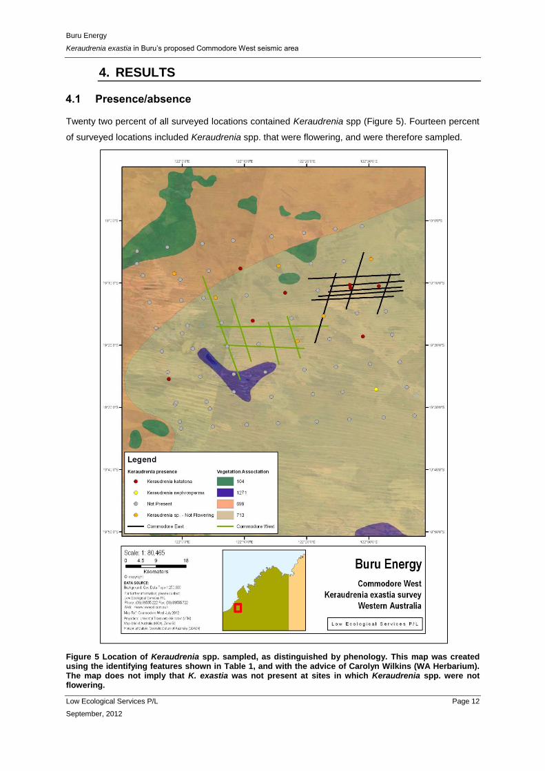
Twenty two percent of all surveyed locations contained Keraudrenia spp (Figure 5). Fourteen percent
of surveyed locations included Keraudrenia spp. that were flowering, and were therefore sampled.
Figure 5 Location of Keraudrenia spp. sampled, as distinguished by phenology. This map was created using the identifying features shown in Table 1, and with the advice of Carolyn Wilkins (WA Herbarium). The map does not imply that K. exastia was not present at sites in which Keraudrenia spp. were not flowering.
Buru Energy
Keraudrenia exastia in Buru’s proposed Commodore West seismic area
Low Ecological Services P/L Page 13
September, 2012
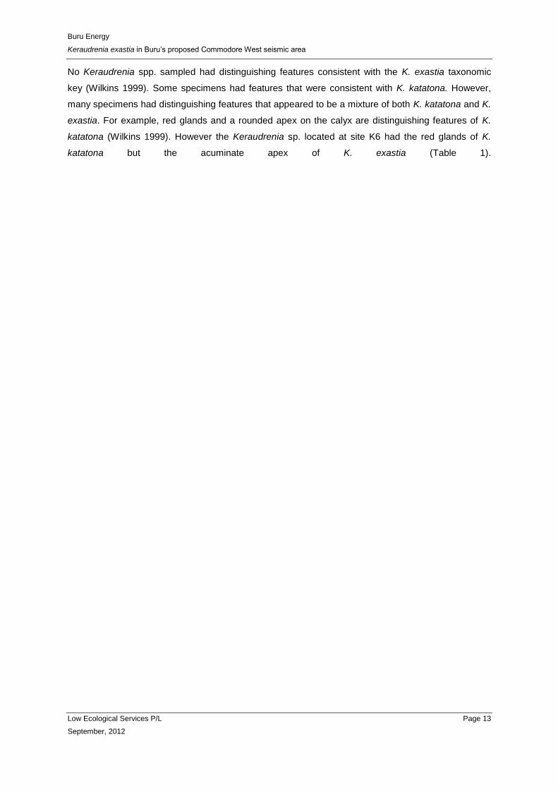
No Keraudrenia spp. sampled had distinguishing features consistent with the K. exastia taxonomic
key (Wilkins 1999). Some specimens had features that were consistent with K. katatona. However,
many specimens had distinguishing features that appeared to be a mixture of both K. katatona and K.
exastia. For example, red glands and a rounded apex on the calyx are distinguishing features of K.
katatona (Wilkins 1999). However the Keraudrenia sp. located at site K6 had the red glands of K.
katatona but the acuminate apex of K. exastia (Table 1).

Buru Energy
Keraudrenia exastia in Buru’s proposed Commodore West seismic area
Low Ecological Services P/L Page 14
September, 2012
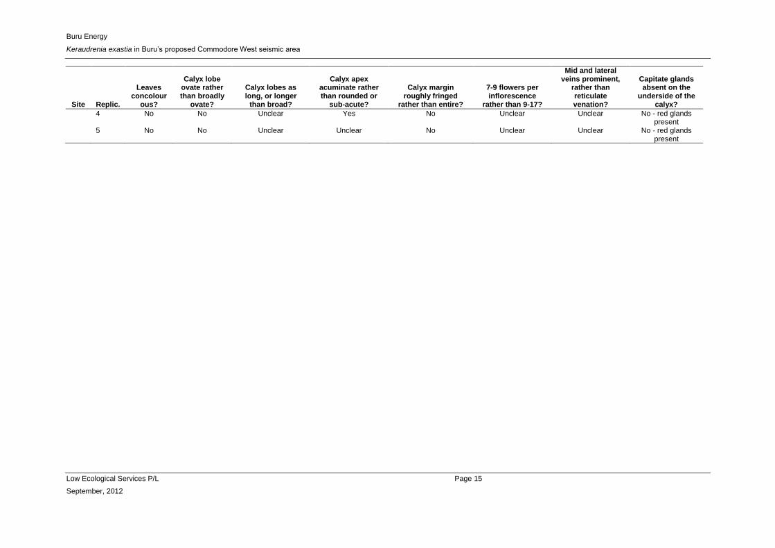
Table 1 Distinguishing features of K. exastia, as per Wilkins (1999), and whether specimens showed any indication of these features.
Site Replic.
Leaves concolour
ous?
Calyx lobe ovate rather than broadly
ovate?
Calyx lobes as long, or longer
than broad?
Calyx apex acuminate rather than rounded or
sub-acute?
Calyx margin roughly fringed
rather than entire?
7-9 flowers per inflorescence
rather than 9-17?
Mid and lateral veins prominent,
rather than reticulate venation?
Capitate glands absent on the
underside of the calyx?
K11 1 No Unclear Unclear No No Unclear No No obvious glands
2 No No Possibly No No Possibly Unclear No - red glands present
K13 1 No Yes Yes Yes Possibly Yes Unclear No obvious glands
2 No No No Unclear Possibly - Unclear No obvious glands
K15 1 No No No No No No Unclear No - red glands present
K27 1 No - - - - - - -
2 No Unclear Unclear No Possibly - Unclear No - red glands present
3 No No No Unclear Unclear - Unclear No obvious glands
4 No Unclear Unclear No No No - red glands present
K37 1 No Unclear Yes No No - Unclear No - red glands present
2 No Unclear Unclear Unclear Unclear Unclear Unclear No obvious glands
K39 1 No Unclear Possibly No No Unclear No No obvious glands
2 No Yes No No No Unclear Unclear No - red glands present
K6 1 No Possibly No Yes No Unclear No No - red glands present
2 No Yes Yes Yes No Unclear No No obvious glands
K62 1 No No No Yes Possibly - No No - red glands present
2 No No No Yes Yes No Unclear No - red glands present
3 No No No Yes No No Unclear No - red glands present
4 No No No No No No Unclear No - red glands present
SL1 1 No No Possibly Yes Yes Unclear Unclear No obvious glands
2 No No No No No No No obvious glands
3 No No Unclear Unclear Unclear Unclear Unclear No - red glands present
Buru Energy
Keraudrenia exastia in Buru’s proposed Commodore West seismic area
Low Ecological Services P/L Page 15
September, 2012
Site Replic.
Leaves concolour
ous?
Calyx lobe ovate rather than broadly
ovate?
Calyx lobes as long, or longer
than broad?
Calyx apex acuminate rather than rounded or
sub-acute?
Calyx margin roughly fringed
rather than entire?
7-9 flowers per inflorescence
rather than 9-17?
Mid and lateral veins prominent,
rather than reticulate venation?
Capitate glands absent on the
underside of the calyx?
4 No No Unclear Yes No Unclear Unclear No - red glands present
5 No No Unclear Unclear No Unclear Unclear No - red glands present

Buru Energy
Keraudrenia exastia in Buru’s proposed Commodore West seismic area
Low Ecological Services P/L Page 16
September, 2012
4.2 Distribution
Keraudrenia spp. were found in the red sands of the swale/dune complexes and sandplains typical of
the Great Sandy Desert. Small sample sizes make statistical tests inappropriate, but Keraudrenia spp.
did not appear to favour any particular landform or vegetation association. Keraudrenia spp. were
equally as likely to occupy dune crests, swales or plains. They were generally associated with
Corymbia zygophylla, Gardenia pyriformis, Grevillea wickhammi, Erythrophleum chlorostachys,
Jacksonia aculeata, Calytrix carinata, Triodia sp., and sometimes Owenia reticulata and Melaleuca
lasiandra. These species are common throughout the proposed Commodore West seismic area, and
surroundings.
Keraudrenia spp. were not found in locations that had been burnt within the last two years (see Figure
3 and Appendix 1), but otherwise did not appear to prefer a particular time since fire. A Keraudrenia
sp. was found to be recruiting at one location on a seismic line cleared in 2011 (SL1 – see Table 1).
The seismic line was cleared through a pre-existing Keraudrenia sp. population. An inflorescence was
able to be collected from the remains of the existing population as recruiting juveniles were not
flowering. At another location, a Keraudrenia sp. population had been partially cleared by a 2011
seismic line but had not yet recruited. Additional Keraudrenia spp. were not sighted along, or
immediately adjacent to, the other seismic lines surveyed.
5. DISCUSSION
An assessment of the likely impact that the clearing of seismic lines at Commodore West would have
on K. exastia cannot be specifically determined given the taxonomic uncertainty described in this
report. However, the majority of this area is in vegetation community 713, which has not been subject
to substantial clearing (Shepherd et al. 2002). The proposed area to be cleared represents a very
small proportion of the total area of the vegetation community (Shepherd et al. 2002) in which K.
exastia was provisionally identified by Le Feurve et al. (2011). Similarly, the mixture of fire patterns

Buru Energy
Keraudrenia exastia in Buru’s proposed Commodore West seismic area
Low Ecological Services P/L Page 17
September, 2012
within the one to three year time period (
Figure 4 Location of sites assessed for the presence of Keraudrenia spp., showing vegetation
communities of the area. ) is typical of large areas of the southern Kimberley in which this vegetation
community is located. The proposed Commodore West seismic area is therefore unlikely to be unique
in having a fire regime that selects for K. exastia. The three aims of the commissioned work described
here are now addressed directly.

Buru Energy
Keraudrenia exastia in Buru’s proposed Commodore West seismic area
Low Ecological Services P/L Page 18
September, 2012
Undertake a flora survey to identify and map the occurrence of K. exastia at selected sites, including
an appropriate control site and examination of existing seismic lines
The pre-existing taxonomic key (Wilkins 1999) makes it difficult to adequately differentiate between K.
exastia and other Keraudrenia spp. It is possible that K. exastia is a hybrid species (Wilkins, personal
communication, 2011). This makes it difficult to definitively map the distribution or density of the
species through the proposed Commodore West seismic area at the present time. As such, Figure 5
does conclusively imply that K. exastia does not exist in the area. Further taxonomic work on K.
katatona/K. exastia is needed.
Determine the pattern of occurrence of K. exastia
The issues around positively identifying K. exastia mean that the pattern of occurrence of K. exastia
cannot be determined. However, Keraudrenia spp. in general appeared to be randomly located within
the survey area. Keraudrenia spp. were not specifically associated within any one vegetation
community or fire history within the survey area. There appears to be nothing atypical about the
vegetation or landform type in which the original K. exastia specimen was provisionally identified by
Le Feuvre (2011). If that specimen was indeed K. exastia (see Section 1.2 for why this may not be the
case), this means that it is reasonably likely to be located throughout the entire proposed Commodore
West seismic area. However, neither the results presented in this report, nor Addison (2011),
positively identified K. exastia throughout the area.
Provide advice on additional potential impact mitigation measures for K. exastia in conducting the
proposed seismic survey.
The issues described above make it difficult to suggest potential impact mitigation measures for K.
exastia within the proposed Commodore West seismic area. The literature reviewed in this report, and
the results of this report, highlight no particular landform or vegetation type within the proposed
Commodore West area that can be specifically avoided due to a likelihood of Keraudrenia spp being
present. To the untrained eye, K. exastia can be very easily confused with the two other Keraudrenia
spp. and non-related purple flowering shrubs/subshrubs such as Solanum spp. Even if they could be
positively identified, the tendency of Keraudrenia spp. individuals to be densely clumped within a
single population would also make it highly impractical to avoid them whilst laying seismic lines. A 1
km radial buffer around the original, provisionally identified K. exastia species is one of the few
mitigation measures that is likely to be practical. Buru’s usual precautions against igniting fires, and
strong weed hygiene controls, may be other potential mitigation measures.
6. REFERENCES
Addison, J. (2011). Keraudrenia exastia and K. katatona populations on Buru Energy’s Commodore
Lease. Report to Buru Energy by Low Ecological Services. July 2011.

Buru Energy
Keraudrenia exastia in Buru’s proposed Commodore West seismic area
Low Ecological Services P/L Page 19
September, 2012
Australian Natural Resources Atlas (2009). Rangelands Overview - Great Sandy Desert. Available at:
http://www.anra.gov.au/topics/rangelands/overview/nt/ibra-gsd.html#soils [Accessed June 2,
2011].
Beard, J.S. (1974). Vegetation survey of Australia: Great Sandy Desert. 1:1000 000 Vegetation
Series. Map and Explanatory Notes., Perth, Western Australia: University of Western
Australia Press.
Beard, J.S. (1979). Vegetation survey of Australia: Kimberley. 1:1000 000 Vegetation Series. Map
and Explanatory Notes., Perth, Western Australia: University of Western Australia Press.
Beard, J.S. (1990). Plant Life of Western Australia, Kenthurst, NSW: Kangaroo Press.
Bureau of Meteorology (2012). Bureau of Meteorology. Available online: http://www.bom.gov.au/.
Accessed: July 18, 2012.
Broome Botanical Society (1995). Port of Broome Flora Survey, Keraudrenia species B. Unpublished
report.
Department of Environment and Conservation (2011). Keraudrenia katatona C.F.Wilkins. Available
online: http://florabase.calm.wa.gov.au/browse/profile/19028 . Accessed: 12/07/2011
Department of Environment and Conservation (2011). Keraudrenia nephrosperma. Available online:
http://florabase.dec.wa.gov.au/browse/profile/5024. Accessed: 07/09/2012
Department of Sustainability, Environment, Water, Population and Communities (2011). Keraudrenia
exastia in Species Profile and Threats Database, Department of Sustainability, Environment,
Water, Population and Communities, Canberra. Available from:
http://www.environment.gov.au/sprat. Accessed Sat, 9 Jul 2011 19:07:33 +1000.
Le Feuvre, M., Addison, J. Newsome, T. 2011. Commodore 2D Seismic Area Fauna, Flora and
Vegetation Survey. Report to Buru Energy by Low Ecological Services July 2011.
North Australian Fire Information (2012). NAFI: North Australian Fire Information. Available online:
http://www.firenorth.org.au/nafi2/. Accessed: July 19, 2012.
Trudgen, M. (1998). A review of the status of Keraudrenia species B with advice on an appropriate
plan of management and assessment of the significance of a stand of Mangarr (Pouteria
sericea) trees. Unpublished report prepared for ERM Mitchell McCotter
Wilkins, C.F. (1999). Keraudrenia exastia and Keraudrenia katatona (Malvaceae: Byttnerioideae),
new species from the Kimberley region of Western Australia. Nuytsia. 13 (1):233-242.

Buru Energy
Keraudrenia exastia in Buru’s proposed Commodore West seismic area
Low Ecological Services P/L Page 20
September, 2012
APPENDIX 1: SITE DESCRIPTIONS
Site Soil type Land type
Vegetation
Dominant species Fire
history Weeds
Keraudrenia spp.
Specht (1970)
Shepherd et al. (2002) Present Flowering
K1 Red sand
Swale Tall open-shrubland
713 Jacksonia aculeata, Grevillea wickhammi, Gardenia pyriformis, Erythrophleum chlorostachys, Triodia spp.
< 3 years 0 0 0
K2 Clayey sand loam
Salt lake edge
Open-heath
713 Melaleuca lasiandra, Grevillea sp., Acacia translucens, Eragrostis sp., Tecticornia sp., Xerochloa laniflora
< 3 years 0 0 0
K3 Red sand
Swale Tall shrubland
713 Corymbia sp., Gardenia pyriformis, Grevillea wickhammii, Erythrophleum chlorostachys, Acacia sp., Triodia sp., Jacksonia aculeata, Crotalaria cunninghami, Triodia sp.
< 3 years 0 0 0
K4 Red sand
Swale/dune edge
- 713 Triodia sp., Crotalaria cunninghammi, Calytrix exstipulata, Grevillea wickhammii, Acacia sp., Grevillea eriostachya, Corchorus sidoides, Owenia reticulata,
< 3 years 0 0 0
K5 Red sand
Swale/dune edge
Tall shrubland
713 Corymbia zygophylla, Acacia sp., Grevillea wickhammi, Calytrix exstipulata, Triodia sp., Aristida sp., Corchorus sidoides
< 3 years 0 0 0
K6 Red sand
Swale Tall shrubland
713 Corymbia zygophylla, Gardnia pyriformis, Acacia tumida, Calytrix exstipulata, Grevillea sp, Triodia sp., Aristida inequiglumis, Eragrostis
< 3 years 0 1 1
K7 Red sand
Swale/plain Tall shrubland
713 Corymbia zygophylla, Gardenia pyriformis, Grevillea sp., Acacia sp., Acacia tumida, Grevillea wickhammi, Erythrophleum chlorostachys, Triodia sp., Hacksonia aculeata, Aristida holathera
< 3 years 0 1 0
K8 Red sand
Swale/plain Low woodland
713 Corymbia zygophylla, Acacia holosericea, Gardenia pyrifromis, Acacia tumida, Grevillea wickhamii, Grevillea refracta, Erythrophleum chlorostachys, Triodia sp., Aristida sp.,
< 3 years, hot
0 0 0
K9 Red sand
Swale/plain Low woodland
699 Corymbia zygophylla, Gardenia pyriformis, Grevillea sp., Eucalyptus dichromophloia, Erythrophleum chlorostachys, Acacia eriopoda, Grevillea refracta, Triodia spp.
< 3 years 0 0 0
K10 Red sand
Swale/plain Tall shrubland
713 Corymbia zygophylla, Gardenia pyriformis, Eucalyptus dichromophloia, Acacia sp., Grevillea wickhammi, Acacia colei, Erythrophleum chlorostachys, Triodia sp., Chrysopogon sp., Eriachne obtusa
< 3 years, hot
0 0 0
K11 Red sand
Swale/plain Low woodland
713 Corymbia zygophylla, Gardenia pyriformis, Acacia tumida, Erythrophleum chlorostachys, Grevillea wickhammi, Triodia sp., Chrysopogon sp., Calytrix exstipulata
< 3 years 0 1 1
K12 Red sand
Swale/plain Tall shrubland
713 Eucalyptus dichromophloia, Melaleuca lasiandra, Grevillea wickhammi, Jacksonia aculeata, Acacia sp., Triodia sp., Newcastelia cladotricha
< 3 years 0 0 0
K13 Red sand
Swale Tall open-shrubland
713 Gardenia pyriformis, Jacksonia aculeata, Acacia spp., Grevillea wickhammi, Triodia spp., Newcastelia cladotricha., Solanum sp.
< 3 years 0 1 1
K14 Red sand
Swale Tall open-shrubland
713 Corymbia zygophylla, Erythrophleum chlorostachys, Acacia sp., Grevillea wickhammi, Triodia spp., Chrysopogon sp., Indigofera sp., Jacksonia aculeata
< 3 years 0 0 0
K15 Red sand
Swale Tall shrubland
713 Owenia reticulata, Calytrix exstipulata, Grevillea wickhammi, Gardenia pyriformis, Grevillea eriostachya, Triodia sp.
> 3 years 0 1 1

Buru Energy
Keraudrenia exastia in Buru’s proposed Commodore West seismic area
Low Ecological Services P/L Page 21
September, 2012
Site Soil type Land type
Vegetation
Dominant species Fire
history Weeds
Keraudrenia spp.
Specht (1970)
Shepherd et al. (2002) Present Flowering
K16 Red sand
Swale/dune edge
Tall shrubland
713 Corymbia zygophylla, Grevillea wickhammi, Erythrophleum chlorostachys, Acacia sp., Triodia sp., Spermococe sp., Stackhousia intermedia
< 3 years 0 0 0
K17 Red sand
Swale Tall open-shrubland
713 Gardenia pyriformis, Owenia reticulata, Erythrophleum chlorostachys, Acacia translucens, Grevillea wickhammi, Triodia sp., Trianthema, Cyperus sp.
< 1 year 0 0 0
K18 Red sand
Swale Tall shrubland
713 Corymbia zygophylla, Erythrophleum chlorostachys, Gardenia pyriformis, Grevillea wickhammi, Triodia sp., Newcastelia cladotricha, Corchorus sidoides
< 3 years 0 0 0
K19 Red sand
Swale Low woodland
713 Corymbia zygophylla, Eucalyptus dichromophloia, Gardnia pyriformis, Grevillea wickhammi, Grevillea refracta, Calytrix exstipulata, Triodia sp., Aristida inequiglumis, Erythrophleum chlorostachys
> 3 years 0 0 0
K20 Red sand
Swale Tall shrubland
713 Corymbia zygophylla, Acacia colei, Acacia sp., Erythrophleum chlorostachys, Gardenia pyriformis, Triodia sp., Newcastlia sp., Tricodesma zeylandia
> 3 years 0 0 0
K21 Red sand
Swale/dune edge
Low woodland
713 Corymbia zygophylla, Gardenia pyriformis, Jacksonia aculeata, Acacia sp., Calytrix exstipulata, Triodia sp., Aristida inequiglumis, Newcastelia cladotricha
> 3 years 0 1 0
K22 Red sand
Swale/dune edge
Low woodland
713 Eucalyptus dichromophloia, Corymbia zygophylla, Acacia monticola, Acacia colei, Gardenia pyriformis, Triodia sp., Chrysopogon sp., Eriachne obtusa
> 3 years 0 1 0
K23 Red sand
Swale Low woodland
713 Corymbia zygophylla, Gardenia pyriformis, Acacia sp., Grevillea wickhammi, Triodia sp., Acacia adoxa
> 3 years 0 0 0
K24 Red sand
Plain Tall shrubland
699 Corymbia zygophylla, Owenia reticulata, Acacia sp., Grevillea refracta, Gardenia pyriformis, Triodia sp., Newcastelia cladotricha
- 0 0 0
K25 Red sand
Plain Low woodland
699 Corymbia zygophylla, Owenia reticulata, Gardenia pyriformis, Erythrophleum chlorostachys, Hakea sp., Triodia sp.
> 3 years 0 0 0
K26 Red sand
Plain Low open-woodland
713 Melaleuca lasiandra, Triodia sp., Jacksonia aculeata, Trianthema sp. < 2 years, cool
0 1 ?
K27 - - Low woodland
713 Corymbia zygophylla, Acacia sp., Triodia sp., Acacia adoxa < 3 years 0 1 1
K28 Red sand
Swale/dune edge
Low woodland
713 Corymbia zygophylla, Jacksonia aculeta, Corchorus sp., Erythrophleum chlorostachys, Triodia sp., Crotalaria cunninghammi
< 3 years 0 0 0
K29 Red sand
Swale Low woodland
713 Owenia reticulata, Corymbia zygophylla, Acacia sp., Erythrophleum chlorostachys, Grevillea wickhami, Triodia sp.
< 3 years 0 1 0
K30 Sandy clay loam
- Tall shrubland
713 Acacia monticola, Acacia colei, Grevillea refracta, Gardenia pyriformis, Acacia hilliana, Triodia sp.
> 3 years 0 0 0
K31 Red sand
Swale/plain Low open-woodland
713 Owenia reticulata, Gardenia pyriformis, Acacia sp., Triodia sp. > 3 years 0 0 0
K32 Red sand
Swale Tall shrubland
713 Corymbia zygophylla, Acacia sp., Acacia monticola, Eriachne sp., Acacia adoxa, Triodia sp.
< 1 year 0 0 0
K33 Red sand
Swale Tall open-shrubland
713 Erythrophleum chlorostachys, Grevillea wickhamii, Gardenia pyriformis, Calytrix exstipulata, Trianthema sp., Triodia sp., Eragrostis
< 1 year 0 0 0

Buru Energy
Keraudrenia exastia in Buru’s proposed Commodore West seismic area
Low Ecological Services P/L Page 22
September, 2012
Site Soil type Land type
Vegetation
Dominant species Fire
history Weeds
Keraudrenia spp.
Specht (1970)
Shepherd et al. (2002) Present Flowering
sp.
K34 Red sand
Swale Tall shrubland
713 Corymbia zygophylla, Owenia reticulata, Erythrophleum chlorostachys, Grevillea wickhammi, Acacia sp., Triodia sp., Indigofera sp., Trianthema sp.
< 1 year 0 0 0
K35 Sandy clay loam
Salt lake edge
Low open-woodland
1271 Owenia reticulata, Melaleuca lasiandra, Acacia colei, Portulaca sp., Triodia sp., Tecticornia sp.,
> 2 years 0 0 0
K36 Red sand
Dune blow-out
Low open-shrubland
713 Erythrophleum chlorostachys, Gardenia pyrifromis, Gardenia pyriformis, Crotalaria cunninghammi, Triodia sp.
< 3 years 0 0 0
K37 Red sand
Swale Low open-woodland
713 Corymbia zygophylla, Owenia reticulata, Acacia sp., Grevillea wickhammi, Erythrophleum chlorostachys, Calytrix exstipulata, Triodia sp.
> 3 years 0 1 1
K38 Red sand
Swale Low woodland
713 Gardenia pyriformis, Corymbia zygophylla, Acacia sp., Grevillea wickhammi, Grevillea eriostachya, Triodia sp., Solanum sp., Jacksonia aculeata
< 1 year 0 0 0
K39 - - Low open-woodland
713 Owenia reticulata, Corymbia zygophylla, Acacia sp., Gardenia pyriformis, Clerodendrum floribundom, Triodia sp., Trianthema sp., Eriachne sp.
< 1 year 0 1 1
K40 Red sand
Low open-woodland
699 Corymbia zygophylla, Acacia adoxa, Acacia colei, Gardenia pyriformis, Triodia sp., Stackhousia intermedia, Trianthema sp.
< 1 year 0 0 0
K41 Red sand
Plain Tall shrubland
699 Acacia colei, Gardenia pyriformis, Acacia sp., Acacia wickhammi, Triodia sp., Jacksonia sp., Acacia hilliana
> 3 years 0 0 0
K42 Red sand
Plain Low open-woodland
699 Corymbia zygophylla, Gardenia pyriformis, Acacia sp., Calytrix exstipulata, Triodia sp., Solanum sp., Jacksonia aculeata
< 1 year 0 0 0
K43 Red sand
Swale Low woodland
713 Corymbia zygophylla, Acacia sp., Erythrophleum chlorostachys, Triodia sp., Trianthema sp., Acacia adoxa, Aristida inequiglumis
> 3 years 0 1 0
K44 Red sand
Swale Low open-woodland
713 Corymbia zygophylla, Acacia colei, Gardenia pyriformis, Grevillea refracta, Triodia sp., Acacia adoxa
- 0 0 0
K45 Red sand
Swale Tall open-shrubland
713 Gardenia pyriformis, Triodia sp., Trianthema sp. > 3 years 0 0 0
K46 Sandy clay loam Tall shrubland
1271 Owenia reticulata, Acacia ampliceps, Melaleuca lasiandra, Acacia colei, Eragrostis sp., Eriachne obtusa, Triodia spp., Tecticornia sp.
> 3 years 0 0 0
K47 Red sand
Swale/dune edge
Low open-woodland
713 Owenia reticulata, Corymbia zygophylla, Melaleuca lasiandra, Acacia translucens, Acacia colei, Triodia sp.
> 3 years 0 0 0
K48 Red sand
Swale/dune edge
Tall shrubland
713 Corymbia zygophylla, Owenia reticulata, Grevillea wickhammi, Gardenia pyriformis, Grevillea refracta, Calytrix exstipulata, Triodia sp., Jacksonia aculeta, Aristida inequiglumis
- 0 0 0
K49 Red sand
Swale/dune edge
Low open-woodland
713 Corymbia zygophylla, Erythrophleum chlorostachys, Corchorus sidoides, Acacia sp., Triodia sp., Aristida sp., Eriachne obtusa
> 3 years 0 0 0
K50 Red sand
Swale/dune edge
Low open-woodland
713 Corymbia zygophylla, Owenia reticulata, Acacia adoxa, Acacia tumida, Gardenia pyriformis, Jacksonia aculeata, Triodia sp., Calytrix exstipulata
< 2 years 0 0 0
K51 Red Plain Tall 713 Owenia reticulata, Corymbia zygophylla, Acacia sp., Gardenia - 0 0 0

Buru Energy
Keraudrenia exastia in Buru’s proposed Commodore West seismic area
Low Ecological Services P/L Page 23
September, 2012
Site Soil type Land type
Vegetation
Dominant species Fire
history Weeds
Keraudrenia spp.
Specht (1970)
Shepherd et al. (2002) Present Flowering
sand shrubland pyriformis, Erythrophleum chlorostachys, Triodia sp.
K52 Red sand
Plain Low open-woodland
713 Owenia reticulata, Acacia sp., Codonocarpus cotinifolius, Triodia sp., Newcastelia cladotricha, Solanum sp.
< 2 years 0 0 0
K53 Sandy clay loam Low open-shrubland
713 Grevillea refracta, Acacia translucens, Grevillea wickhammi, Triodia sp., Stackhousia intermedia, Melaleuca lasiandra
< 3 years 0 0 0
K54 Red sand
Tall shrubland
699 Melaleuca lasiandra, Acacia sp., Hakea sp., Jacksonia aculeata, Grevillea refracta, Triodia sp.,
> 3 years 0 0 0
K55 Red sand
Swale/dune edge
Low open-woodland
699 Melaleuca lasiandra, Grevillea striata, Triodia sp., Trianthema sp., Ptilotus sp., Chrysopogon sp.
< 2 years 0 1 1
K56 Sandy clay loam Tall open-shrubland
104 Gardenia pyriformis, Melaleuca lasiandra, Acacia colei, Hakea sp., Triodia sp., Chrysopogon sp., Eriachne obtusa
- 0 0 0
K57 Clay loam
- 104 Bauhinia cunninghammi, Eucalyptus dichromophloia, Acacia monticola, Acacia colei, Gossypium australa, Carissa lanceolata, Chrysopogon sp., Triodia sp., Acacia hilliana
> 3 years 0 0 0
K58 Red sand
Swale/dune edge
- 699 Corymbia zygophylla, Grevillea eriostachya, Crotalaria cunninghammi, Gardenia pyriformis, Triodia sp., Acacia sp., Acacia adoxa
< 2 years 0 0 0
K59 Red sand
Tall open-shrubland
699 Eucalyptus dichromophloia, Melaleuca lasiandra, Grevillea refracta, Acacia colei, Acacia hilliana, Triodia sp., Jacksonia aculeata, Newcastelia cladotricha
> 3 years 0 0 0
K60 Red sand
Tall open-shrubland
699 Grevillea refracta, Triodia sp. < 1 year 0 0 0
K61 Red sand
Swale Tall open-shrubland
713 Melaleuca lasiandra, Acacia adoxa, Corchorus sidoides, Grevillea eriostachya, Triodia sp., Ptilotus sp., Senna sp., Trianthema sp.
< 3 years 0 0 0
K62 Red sand
Dune crest Tall shrubland
713 Corymbia zygophylla, Calytrix exstipulata, Triodia sp., Sida arenicola, Trianthema sp., Spermococoe sp., Eragrostis sp., Goodenia sepalosa
< 2 years 0 1 1
K63 Red sand
Dune crest Low open-woodland
713 Owenia reticulata, Corymbia zygophylla, Jacksonia aculeata, Acacia sp., Calytrix exstipulata, Sida arenicola, Triodia sp., Acacia adoxa
> 3 years 0 0 0
K64 Red sand
Swale/dune edge
Tall open-shrubland
713 Corymbia zygophylla, Grevillea refracta, Gardenia pyriformis, Acacia sp., Triodia sp., Acacia hilliana, Erichachne obtusa
> 3 years 0 0 0
Buru Energy
Keraudrenia exastia in Buru’s proposed Commodore West seismic area
Low Ecological Services P/L Page 24
September, 2012
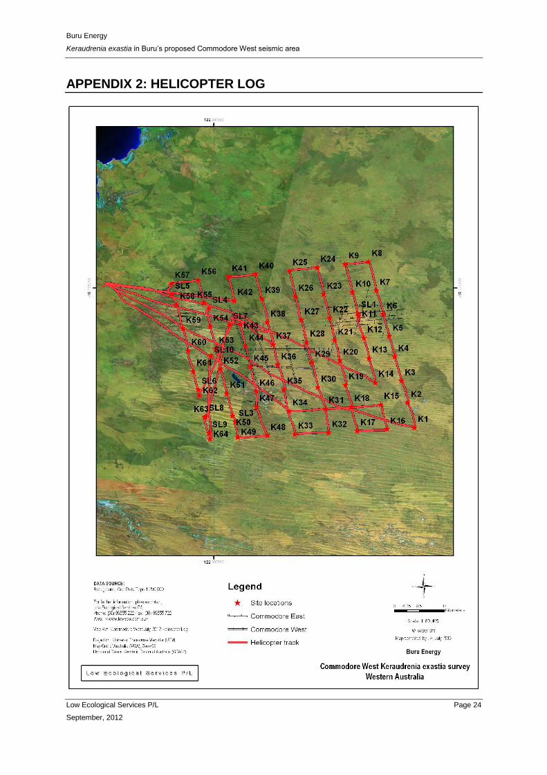
APPENDIX 2: HELICOPTER LOG
Related Documents


