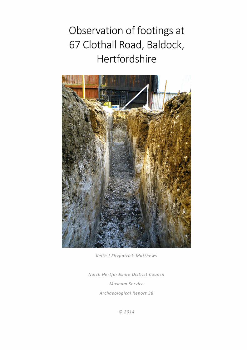
Observation of footings at 67 Clothall Road, Baldock, Hertfordshire Keith J Fitzpatrick-Matthews North Hertfordshire District Council Museum Service Archaeological Report 38 © 2014

Welcome message from author
This document is posted to help you gain knowledge. Please leave a comment to let me know what you think about it! Share it to your friends and learn new things together.
Transcript
Observation of footings at 67 Clothall Road, Baldock,
Hertfordshire
Keith J Fitzpatrick-Matthews
North Hertfordshire District Council
Museum Service
Archaeological Report 38
© 2014
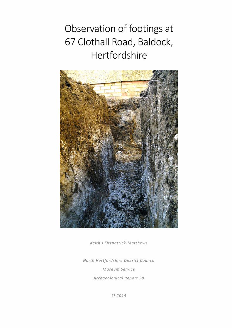
Observation of footings at 67 Clothall Road, Baldock,
Hertfordshire
Keith J Fitzpatrick-Matthews
North Hertfordshire District Council
Museum Service
Archaeological Report 38
© 2014
Metadata
Title: Observation of Footings at 67 Clothall Road, Baldock, Hertfordshire
Description: Report on archaeological recording of features exposed in footings trenches.
Subject: Archaeology, Baldock
Coverage: Hertfordshire, Baldock (NGR TL 2497 3365), Iron Age, Roman
Creators: Keith J Fitzpatrick-Matthews (Archaeology Officer, North Hertfordshire District Council,
Identifiers: BAL/67CR’13
Fieldwork Date:
Origination Date: 2013-11-22
Version: 1.1
Date of last revision: 2014-08-29
Reviser(s): Keith J Fitzpatrick-Matthews
Status: Final
Summary of Changes: Small scale corrections
Circulation: Public
Required Action: None
Approval: Not required
Copyright: North Hertfordshire District Council
Language: English
Resource Type: Interpretation of data
Format: Microsoft Word 365; Adobe Portable Document Format

i
Contents Contents ......................................................................................................................................................... i
Figures in the text ....................................................................................................................................... i
Acknowledgements ................................................................................................................................... ii
Introduction .................................................................................................................................................. 1
Baldock ..................................................................................................................................................... 1
Geology ................................................................................................................................................. 1
Topography .......................................................................................................................................... 2
Archaeological background ...................................................................................................................... 3
The site ..................................................................................................................................................... 3
The planning context ............................................................................................................................ 5
Fieldwork .............................................................................................................................................. 6
Project aims and methodology .................................................................................................................... 8
General aims ............................................................................................................................................. 8
Research objectives .................................................................................................................................. 8
Methodology ............................................................................................................................................ 8
Requirements ....................................................................................................................................... 8
Standards .............................................................................................................................................. 8
Methods ............................................................................................................................................... 8
Artefacts and ecofacts .......................................................................................................................... 9
Fieldwork results ........................................................................................................................................ 10
Recorded deposits and features ............................................................................................................ 10
Spread deposits .................................................................................................................................. 10
Cut features ........................................................................................................................................ 10
Discussion ................................................................................................................................................... 17
Interpretation of the buried archaeology .............................................................................................. 17
The local context and significance of the buried archaeology ............................................................... 17
Conclusions ............................................................................................................................................. 20
Bibliography ................................................................................................................................................ 21
Appendices ................................................................................................................................................. 23
Appendix 1: context records .................................................................................................................. 23
Appendix 2: Historic Environment Record Data ..................................................................................... 24
Appendix 3: Hertfordshire Historic Environment record summary sheet ............................................. 28
Figures in the text Figure 1: Baldock location (Roman roads and other Roman towns shown) ................................................ 1
Figure 2: The Iron Age town (scale 1:5000) .................................................................................................. 4
Figure 3: The Roman town (scale 1:5000) .................................................................................................... 5
Figure 4: Site location plan (1:1250) ............................................................................................................ 7
Figure 5: Archaeological features recorded in the footings trenches (scale 1:100) .................................. 11
Figure 6: Late Iron Age ditch, Clothall Road, 1968 (scale 1:20) .................................................................. 17
Figure 7: Rim of bowl from D 115 (scale 1:4) (after Stead & Rigby 1986, Fig 107) .................................... 17
Figure 8: Beehive-shaped pit D116 at Clothall Road, 1968 (scale 1:20) .................................................... 18
Figure 9: Pottery from pit D116 (scale 1:4) (after Stead & Rigby 1986, 274) ............................................ 18
Figure 10: Probable roadside ditches at Clothall Road, 1968 (scale 1:20) ................................................. 19
Figure 11: Roman Lane ditch [101] section (scale 1:20) (after Rothwell 2005) ......................................... 19
Figure 12: Pit [30] BAL-60 (after Fenton 1997) .......................................................................................... 20
Figure 13: First century BC jar from pit [30], BAL-60 (after Fenton 1997) ................................................. 20
Acknowledgements Thanks must go to the householder, Mr E Hartley, for notifying the writer about the work and allowing
access to the property, and to the builder, David Timms of D Timms Building Services for permitting entry
to the footings trenches and stopping work while recording took place.
1
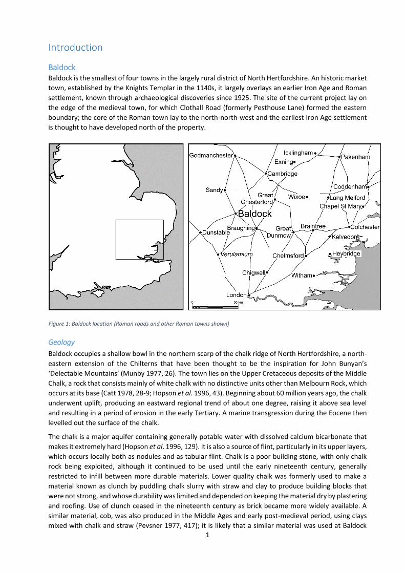
Introduction
Baldock Baldock is the smallest of four towns in the largely rural district of North Hertfordshire. An historic market
town, established by the Knights Templar in the 1140s, it largely overlays an earlier Iron Age and Roman
settlement, known through archaeological discoveries since 1925. The site of the current project lay on
the edge of the medieval town, for which Clothall Road (formerly Pesthouse Lane) formed the eastern
boundary; the core of the Roman town lay to the north-north-west and the earliest Iron Age settlement
is thought to have developed north of the property.
Geology
Baldock occupies a shallow bowl in the northern scarp of the chalk ridge of North Hertfordshire, a north-
eastern extension of the Chilterns that have been thought to be the inspiration for John Bunyan’s
‘Delectable Mountains’ (Munby 1977, 26). The town lies on the Upper Cretaceous deposits of the Middle
Chalk, a rock that consists mainly of white chalk with no distinctive units other than Melbourn Rock, which
occurs at its base (Catt 1978, 28-9; Hopson et al. 1996, 43). Beginning about 60 million years ago, the chalk
underwent uplift, producing an eastward regional trend of about one degree, raising it above sea level
and resulting in a period of erosion in the early Tertiary. A marine transgression during the Eocene then
levelled out the surface of the chalk.
The chalk is a major aquifer containing generally potable water with dissolved calcium bicarbonate that
makes it extremely hard (Hopson et al. 1996, 129). It is also a source of flint, particularly in its upper layers,
which occurs locally both as nodules and as tabular flint. Chalk is a poor building stone, with only chalk
rock being exploited, although it continued to be used until the early nineteenth century, generally
restricted to infill between more durable materials. Lower quality chalk was formerly used to make a
material known as clunch by puddling chalk slurry with straw and clay to produce building blocks that
were not strong, and whose durability was limited and depended on keeping the material dry by plastering
and roofing. Use of clunch ceased in the nineteenth century as brick became more widely available. A
similar material, cob, was also produced in the Middle Ages and early post-medieval period, using clays
mixed with chalk and straw (Pevsner 1977, 417); it is likely that a similar material was used at Baldock
Figure 1: Baldock location (Roman roads and other Roman towns shown)
during the Roman period. This suffers from the same limitations as clunch. Flint was also used as a building
material in churches during the Middle Ages, although it is not now exploited.
Chalk has also been used in the production of cement, plaster and mortar, especially the marly deposits
from the Lower Chalk, as they are highly silicaceous and contain alumina, requiring only minimal additions
of clay. Uses of the lime produced from roasting chalk have included building materials, as fertiliser and
in the tanning process (Wilmore et al. 1925, 13).
To the south-east, towards Clothall, the chalk has been cut by a buried channel of Anglian date draining
into the River Beane (part of the Thames catchment) and containing glaciofluvial deposits, but these do
not extend to Baldock (Hopson et al. 1996, 89). The northern end of the channel contains the source of
the River Ivel and its associated alluvial deposits; this watercourse drains into the Great Ouse.
Superficial geology, soils and land use potential
The subarctic periglacial conditions of much of the later Pleistocene caused considerable heaving of the
chalk, with seasonal flushes of meltwater creating solution features, such as the numerous dolines found
throughout Upper Walls Common. These solution features can range from a few millimetres across to
fifty metres in diameter (Hopson et al. 1996, 124). Solifluction resulted in the redistribution of slope
deposits and was perhaps the source of some of the gravel fans in the Baldock area. There is also a little
löss (loess), sometimes incorporated into solifluction deposits, but also occasionally overlying the chalky
boulder clay (Catt 1978, 34).
These deposits were the source of the soils that formed in the late and post-glacial periods. Changes in
the climate and natural vegetation together with human induced alterations have led to constant
development of the soils. Most of those based on from the Middle Chalk belong to the rendzina (or
rendsina) and pelosol types, although there are also pockets of leached argillic brown earths and alluvial
soils.
The topsoil at 67 Clothall Road is a rendzina of the Upton Association (Catt et al. 2010, 208), a soil that
occurs in an irregular band between Letchworth to the west and Royston to the east. They are mostly
shallow and tend to occur directly above the Middle Chalk (Davis et al. 1992). The pre-cultivation
vegetation of these soils would perhaps have been beech woodland in areas where they were relatively
deep and moist, and lime tolerant shrub and grass species in drier areas. Such soils may have been
attractive to early farmers because of their ease of cultivation and high initial fertility; indeed, those of
the first type can only be shallow ploughed, as deep ploughing incorporates shattered chalk bedrock.
However, they are easily depleted of potassium, a number of other trace elements and organic content,
and they are rapidly parched in drought conditions. This can lead to a loss of soil structure, deflation and
erosion by wind or water.
Since the end of the Roman period, there has been considerable disturbance to the A Horizon of the soils,
mainly through medieval and later cultivation. This was exacerbated with the advent of deep ploughing
during the twentieth century. As a result, few, if any, features from the ancient settlements survive as
surface features. Nevertheless, this disturbance does not appear to have altered the depths of the soils
to any great extent. In Walls Field, there is evidence for considerable post-Roman hillwash, as many of the
cremations discovered there in the 1920s were buried to a depth of over four feet (1.2 m), while on Upper
Walls Common, at the top of the slope, there was rarely more than 0.3 m of soil above the surface of the
chalk and often rather less. Only in the dolines did any depth of stratified deposits survive, often ranging
in date from the Late Neolithic to the sub-Roman or later periods, albeit in discontinuous sequences.
Topography
Baldock lies at the northern end of a buried channel of Anglian date, north of the watershed between the
Thames and Great Ouse drainage basins. To the south-east, the conical Bird Hill is a prominent landmark
on the edge of the uplands, which form a low, rolling plateau landscape beyond. The ancient settlement
3
partly occupies the slope of a low ridge marking the eastern edge of the palaeochannel, the bulk of it lying
on the level ground below. The land drops slowly toward the north-east, forming the upper valley of the
River Ivel, while the Roman road to Sandy follows a ridge of higher ground to the east, continuing the
edge of the palaeochannel on a more northerly alignment. West of the town, the land rises gently to a
low plateau occupied now by Letchworth Garden City, while to the south-south-west, the ridge of the
Weston Hills, running west-south-west to east-north-east, dominates the landscape.
The ancient settlement occupied roughly level ground, between the low ridge now occupied by the
Clothall Common estate to the north-north-east, the Weston Hills to the south and the upland plateau
where Letchworth Garden City was established. The site at 67 Clothall Road lies toward the south-eastern
edge of this flat area.
Archaeological background The present town of Baldock was founded by the Knights Templar in the 1140s, who named it Baudac,
the Old French form of the name Baghdad (Arabic غداد ,Baġdād; Salmon 1728, 178; Gover et al. 1938 ب
120). This probably reflects their aspirations for the town, as Baghdad was then reputed to be the most
prosperous city in the world. Although Baldock did prosper, it seems never to have ranked higher than
sixth position among Hertfordshire towns, with the nearby Hitchin and Ashwell in second and third places
respectively in the first half of the sixteenth century (Goose 2008, 106 Table 5.2). What is unclear is
whether the Templars founded their market on a virgin site or whether there was some form of pre-
existing settlement, perhaps even with market functions (Williamson 2008, 44).
Baldock has been known as the site of an ancient settlement since Roman burials were discovered in Walls
Field at Easter 1925. Excavations by Letchworth Museum revealed an extensive cemetery and,
subsequently, the remains of buildings, roads and rubbish pits. Since then, there have been two major
campaigns of excavations: one by the Ministry of Public Buildings and Works from 1968 to 1972 and
another by North Hertfordshire Museums from 1978 to 1994. In addition to this, there have been
numerous smaller excavations and recording exercises, particularly since the publication in November
1990 of Planning Policy Guidance Note 16, which made the presence of buried archaeology a material
consideration in determining planning applications. As a result, Baldock is one of the best explored
Romano-British ‘small towns’ (Burleigh 1995, 177) and is particularly well known for the number and
variety of its burials (Esmonde Cleary 2000, 129).
It is now evident that the town developed long before the Roman conquest of AD 43 and that a nucleated
settlement of some kind existed in the first half of the first century BC, if not before (Stead & Rigby 1986,
60). It is associated with an extensive system of dykes and other linear features (now known only as
cropmarks) that show it to have been an oppidum, a class of settlement associated with tribal rulers,
imported high-status goods and wealthy burials. By the 20s BC, it was developing the trappings of a Roman
town, including metalled roadways and a street grid. Its growth continued into the second century AD,
when it reached its maximum extent of around 50 ha. The area of settlement began to contract in the
third century, although it is not known if this was a result of falling population or the consolidation of the
core; certainly, the most substantial buildings in the town centre date from the fourth century. Unusually
for a small town in eastern England, it survived the collapse of Roman rule in Britain and managed to
maintain a Roman identity into the sixth century, after which it was abandoned (Fitzpatrick-Matthews
2010, 134).
The site In the light of what is currently known about the importance of the archaeology of the town, planning
applications—even for small-scale development—are generally subject to a condition requiring some type
of archaeological response. The small-scale observation and recording exercise reported here follows the
imposition of such a condition in an application for a house extension.
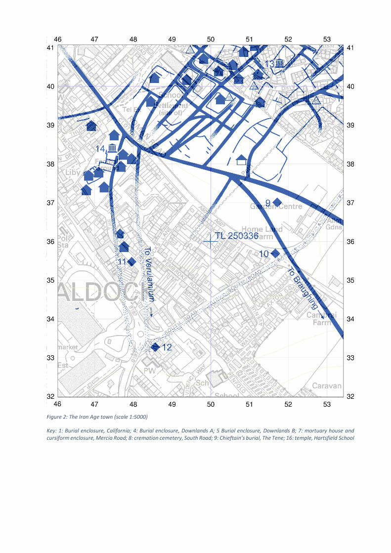
Figure 2: The Iron Age town (scale 1:5000)
Key: 1: Burial enclosure, California; 4: Burial enclosure, Downlands A; 5 Burial enclosure, Downlands B; 7: mortuary house and cursiform enclosure, Mercia Road; 8: cremation cemetery, South Road; 9: Chieftain’s burial, The Tene; 16: temple, Hartsfield School
5
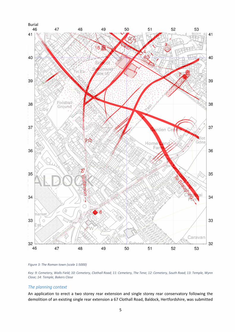
Burial
Figure 3: The Roman town (scale 1:5000)
Key: 9: Cemetery, Walls Field; 10: Cemetery, Clothall Road; 11: Cemetery, The Tene; 12: Cemetery, South Road; 13: Temple, Wynn Close; 14: Temple, Bakers Close
The planning context
An application to erect a two storey rear extension and single storey rear conservatory following the
demolition of an existing single rear extension a 67 Clothall Road, Baldock, Hertfordshire, was submitted
to the Planning Department of North Hertfordshire District Council on 27 March 2008 (reference
08/00670/1HH). Permission was granted on 21 May 2008. In 2011, an application to extend the time
allowed for the permission was granted on 24 June (11/01137/1HH). Both applications contained the
following conditions:
3 No demolition/development shall take place/commence until an Archaeological Written
Scheme of Investigation has been submitted to and approved by the local planning authority in
writing. The scheme shall include an assessment of archaeological significance and research
questions; and:
1. The programme and methodology of site investigation and recording
2. The programme for post investigation assessment
3. Provision to be made for analysis of the site investigation and recording
4. Provision to be made for publication and dissemination of the analysis and records of the
site investigation
5. Provision to be made for archive deposition of the analysis and records of the site
investigation
6. Nomination of a competent person or persons/organisation to undertake the works set out
within the Archaeological Written Scheme of Investigation.
Reason: To properly record matters of public interest for the archaeological record.
4 The development shall not be occupied/used until the archaeological investigation and post
investigation assessment has been completed in accordance with the programme set out in the
Archaeological Written Scheme of Investigation approved under condition 3 and the provision
made for analysis.
Reason: To properly record matters of public interest for the archaeological record.
These are standard conditions typical for this type of recording work on a small development site as issued
under the former Planning Policy Guidance Note until it was superseded by Planning Policy Statement 5
in March 2010, itself superseded by the National Planning Policy Framework in March 2012.
Fieldwork
The house is currently owned by Mr Ed Brayton, whose builder, Mr David Timms, contacted the author
on Monday 21 October to state that he was going to commence work on digging footings trenches later
in the week. An arrangement to visit the site at 9.30 am on Wednesday 23 October was made. In the
event, the work had only just started, so a second visit was made, on the afternoon of Friday 25 October
2013. All the recording took place on this occasion.
7
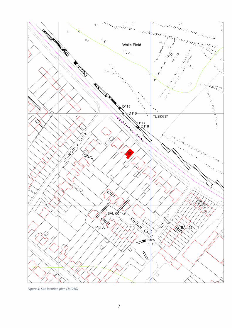
Figure 4: Site location plan (1:1250)
Project aims and methodology
General aims The archaeological work was undertaken as a response to development work that involved the demolition
of a single-storey extension and its replacement by a two-storey extension. Its principal aim was to record
any remains that are likely to be lost, damaged or disturbed by the excavation of new foundation trenches.
Research objectives Owing to the site’s location close to the edge of the Iron Age oppidum and Roman town of Baldock, it was
thought likely that the recording exercise might illustrate themes in these periods. In the recent revision
to the Research Framework for the East of England, a number of themes have been identified as of major
significance (Medlycott ed. 2011, 31 and 48):
The Iron Age/Roman transition;
Settlement types, especially the zonation of use and the role and function of settlement
complexes;
The origins of Roman towns;
The Roman/Anglo-Saxon transition.
It was considered that the small scale nature of the work would not make a significant contribution to
these topics but that it might fit into a wider pattern when considered alongside nearby archaeological
interventions that had taken place before the adoption of an initial research framework in 2000 (Brown
& Glazebrook eds 2000).
Methodology
Requirements
The aim of the watching brief was to observe the groundworks carried out by the building contractor and to record any stratigraphy revealed by them.
Standards
The work was undertaken in conformity with standards set out in the Association of Local Government
Archaeological Officers’ Standards for Field Archaeology in the East of England (Gurney 2003).
The site was assigned a unique alphanumeric code to identify all records, finds and samples relating to
the project. This was: BAL/67CR ’13.
Methods
All the foundation trenches were sketched in the field and related to the existing house structure during
the site visit on 24 October 2013. Measurements over a metre were taken using a hand-held laser
measuring tool, while those under a metre were taken with a hand tape. All measurements were made
to an accuracy of 0.05 m.
Exposed archaeological stratigraphy was recorded initially on sketch sections with measurements as
annotations; these were recorded to an accuracy of 0.01 m. Exposed features were subsequently drawn
up in the office. However, owing the narrowness of the trenches, it proved impossible to photograph the
exposed features.
A continuous context numbering system was used for all archaeological contexts, recorded individually
on pre-printed pro-forma record sheets. Each context was described in terms of soil matrix, stratigraphic
position and dimensions; an initial interpretation was also added in the field. The context record sheets

9
are cross-referenced to all other records, including plans, sections and sketches. Soil descriptions were
standardised as far as possible.
Artefacts and ecofacts
No finds were visible in the exposed sections of archaeological features and rapid trowelling of the soil
did not reveal any. Only later twentieth-century material was visible in the topsoil and modern
foundations trenches, which was not recovered.
Fieldwork results
Recorded deposits and features Altogether, nineteen deposits were recorded on site, most of which were the fills of archaeological
features. These features had been cut through the chalk bedrock. Most contained no visible artefacts or
ecofacts, with the exception of deposits (10) and (37); both contained twentieth-century material, which
was noted but not collected.
All the section drawings are at a scale of 1:10, with the exception of Cut [24], which is reproduced at a
scale of 1:20 owing to the width of the feature.
Spread deposits
Deposit (10)
Covering the whole site was a mid grey brown sandy loam, (10), containing twentieth-century brick, tile,
plastics and wire, none of which were retained. The upper part had largely been removed before the initial
site visit. On the outer edges of the footings, where the deposit had not been removed, it was an average
of 0.4 m thick. On the northern face of the south-westernmost foundation trench, it was thicker than
elsewhere.
This deposit was the topsoil across the development site. It had been partly removed by mini digger to
allow better cutting of the foundation trenches. The area that was thicker appeared to occupy a slight
hollow in the underlying chalk bedrock, although this could not be determined to be archaeological in
origin.
Cut features
Cut [20]
A U-shaped cut, [20], 0.30 m wide made into the chalk bedrock with near-
vertical sides curving down into a base with a distinct angle, 0.30 m deep.
It contained a single fill, (1), a mid brown sandy loam with no visible
coarse components. There were no artefacts or ecofacts apparent in the
section.
This feature lay opposite a similar feature of identical dimensions, [21],
albeit of different profile, on the south-western side of the footings
trench. It is likely that they are part of a single feature, perhaps a shallow
gully running approximately east-north-east to west-south-west. It is also trending towards features [28],
[29] and [30], but it is unclear which, if any, might be related.
Cut [21]
A cut with one vertical side and one sloping at around 70°, [21], 0.30 m wide
with a rounded base, 0.30 m deep. It contained a single fill, (2), a mid brown
sandy loam with no visible coarse components. There were no artefacts or
ecofacts apparent in the section.
As noted above, this feature is probably the same as that seen in the opposite
(north-eastern) side of the footings trench, [20].
11
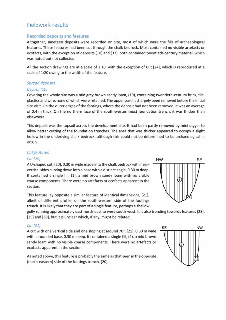
Figure 5: Archaeological features recorded in the footings trenches (scale 1:100)
Cut [22]
A U-shaped cut, [22], 0.25 m wide with near vertical sides and a rounded base,
cut 0.30 m into the chalk bedrock. It contained a single fill, (3), a mid brown
sandy loam containing no visible coarse components. There were no artefacts
or ecofacts apparent in the section.
This feature lay opposite one in the south-western edge of the footings trench,
[23]. Although of different profile and dimensions, they are probably parts of
a single feature, perhaps a gully running north-north-east to south-south-
west. It is likely that they are also related to feature [26] to the south. It is also possible that feature [36]
is part of the same gully. If they are indeed part of the same feature as [26]/[36], it suggests that the gully
changed direction in the southern part of the footings trenches.
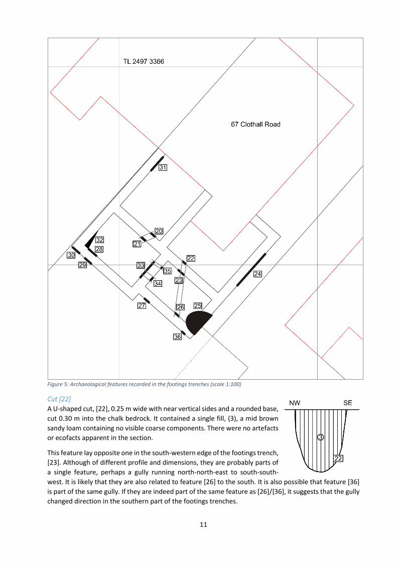
Cut [23]
A cut, [23], 0.45 m wide with a break of slope on the south-
eastern side and a slope of around 75° to the north-west, cut
0.25 m into the chalk bedrock. It appeared to contain a single
fill, (4), a mid brown sandy loam containing no visible coarse
components. There were no artefacts or ecofacts apparent in
the section.
The profile of this feature suggests that it may have been two separate features, a shallower one to the
south-east and a deeper one to the north-west, although no distinction was visible between the fills if this
was the case. It lay opposite one in the north-eastern edge of the footings trench, [22], which is of similar
profile and dimensions to the putative north-western feature. These two in turn line up with feature [26]
to the south, as already noted.
Cut [24]
A broad cut, [24],
2.45 m long with
shallow sloping sides, that to the north-east around 20° and that to the south-west around 10°, and cut
0.2 m into the chalk bedrock. It contained a single fill, (5), a mid brown sandy loam containing no visible
coarse components. There were no ecofacts or artefacts apparent in the section.
NB: the section drawing above is at a scale of 1:20, half that of the other section drawings.
Despite the length of the feature, it did not extend into the opposite (north-western) face of the footings
trench, suggesting that the greater part of it lay to the south-east. The shallow slope of the edges is
probably not a reflection of the profile of the feature as a whole, which may have been a broad quarry
pit, “working hollow” or even the weathering cone of an abandoned well, all rather deeper than the
section would suggest.
Cut [25]
A wide cut, [25], which was 1.40 m wide in the section on the south-eastern side of the footings trenches.
On the opposite face, it was more than 1.00 m wide, although the south-western edge had been cut
through by a footings trench at right angles to it. The maximum depth, seen in the south-eastern section,
was 0.40 m. Although the fill was given different numbers on opposite faces of the footings trench, (6) to
13
south-east and (7) to the north-west, they were evidently the same fill, a mid brown sandy loam with no
visible inclusions. There were no artefacts or ecofacts apparent in the section.
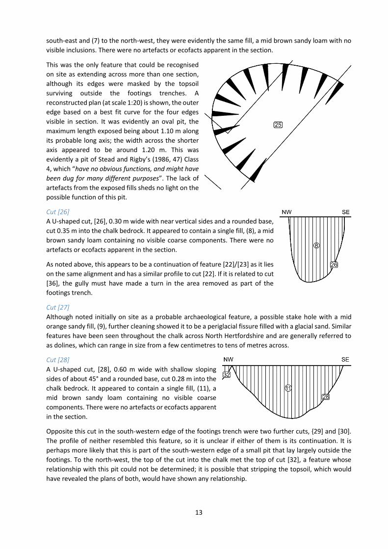
This was the only feature that could be recognised
on site as extending across more than one section,
although its edges were masked by the topsoil
surviving outside the footings trenches. A
reconstructed plan (at scale 1:20) is shown, the outer
edge based on a best fit curve for the four edges
visible in section. It was evidently an oval pit, the
maximum length exposed being about 1.10 m along
its probable long axis; the width across the shorter
axis appeared to be around 1.20 m. This was
evidently a pit of Stead and Rigby’s (1986, 47) Class
4, which “have no obvious functions, and might have
been dug for many different purposes”. The lack of
artefacts from the exposed fills sheds no light on the
possible function of this pit.
Cut [26]
A U-shaped cut, [26], 0.30 m wide with near vertical sides and a rounded base,
cut 0.35 m into the chalk bedrock. It appeared to contain a single fill, (8), a mid
brown sandy loam containing no visible coarse components. There were no
artefacts or ecofacts apparent in the section.
As noted above, this appears to be a continuation of feature [22]/[23] as it lies
on the same alignment and has a similar profile to cut [22]. If it is related to cut
[36], the gully must have made a turn in the area removed as part of the
footings trench.
Cut [27]
Although noted initially on site as a probable archaeological feature, a possible stake hole with a mid
orange sandy fill, (9), further cleaning showed it to be a periglacial fissure filled with a glacial sand. Similar
features have been seen throughout the chalk across North Hertfordshire and are generally referred to
as dolines, which can range in size from a few centimetres to tens of metres across.
Cut [28]
A U-shaped cut, [28], 0.60 m wide with shallow sloping
sides of about 45° and a rounded base, cut 0.28 m into the
chalk bedrock. It appeared to contain a single fill, (11), a
mid brown sandy loam containing no visible coarse
components. There were no artefacts or ecofacts apparent
in the section.
Opposite this cut in the south-western edge of the footings trench were two further cuts, {29] and [30].
The profile of neither resembled this feature, so it is unclear if either of them is its continuation. It is
perhaps more likely that this is part of the south-western edge of a small pit that lay largely outside the
footings. To the north-west, the top of the cut into the chalk met the top of cut [32], a feature whose
relationship with this pit could not be determined; it is possible that stripping the topsoil, which would
have revealed the plans of both, would have shown any relationship.
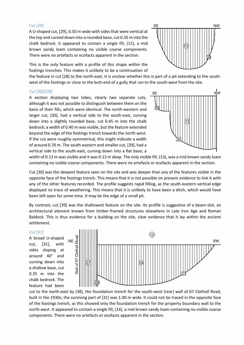
Cut [29]
A U-shaped cut, [29], 0.50 m wide with sides that were vertical at
the top and curved down into a rounded base, cut 0.35 m into the
chalk bedrock. It appeared to contain a single fill, (12), a mid
brown sandy loam containing no visible coarse components.
There were no artefacts or ecofacts apparent in the section.
This is the only feature with a profile of this shape within the
footings trenches. This makes it unlikely to be a continuation of
the feature in cut [28] to the north-east. It is unclear whether this is part of a pit extending to the south-
west of the footings or close to the butt-end of a gully that ran to the south-west from the site.
Cut [30]/[39]
A section displaying two lobes, clearly two separate cuts,
although it was not possible to distinguish between them on the
basis of their fills, which were identical. The north-western and
larger cut, [30], had a vertical side to the south-east, curving
down into a slightly rounded base, cut 0.45 m into the chalk
bedrock; a width of 0.40 m was visible, but the feature extended
beyond the edge of the footings trench towards the north-west.
If the cut were roughly symmetrical, this might indicate a width
of around 0.70 m. The south-eastern and smaller cut, [39], had a
vertical side to the south-east, curving down into a flat base; a
width of 0.13 m was visible and it was 0.13 m deep. The only visible fill, (13), was a mid brown sandy loam
containing no visible coarse components. There were no artefacts or ecofacts apparent in the section.
Cut [30] was the deepest feature seen on the site and was deeper than any of the features visible in the
opposite face of the footings trench. This means that it is not possible on present evidence to link it with
any of the other features recorded. The profile suggests rapid filling, as the south-eastern vertical edge
displayed no trace of weathering. This means that it is unlikely to have been a ditch, which would have
been left open for some time. It may be the edge of a small pit.
By contrast, cut [39] was the shallowest feature on the site. Its profile is suggestive of a beam-slot, an
architectural element known from timber-framed structures elsewhere in Late Iron Age and Roman
Baldock. This is thus evidence for a building on the site, clear evidence that it lay within the ancient
settlement.
Cut [31]
A broad U-shaped
cut, [31], with
sides sloping at
around 40° and
curving down into
a shallow base, cut
0.35 m into the
chalk bedrock. The
feature had been
cut to the north-east by [38], the foundation trench for the south-west (rear) wall of 67 Clothall Road,
built in the 1930s; the surviving part of [31] was 1.00 m wide. It could not be traced in the opposite face
of the footings trench, as this showed only the foundation trench for the property boundary wall to the
north-west. It appeared to contain a single fill, (14), a mid brown sandy loam containing no visible coarse
components. There were no artefacts or ecofacts apparent in the section.
15
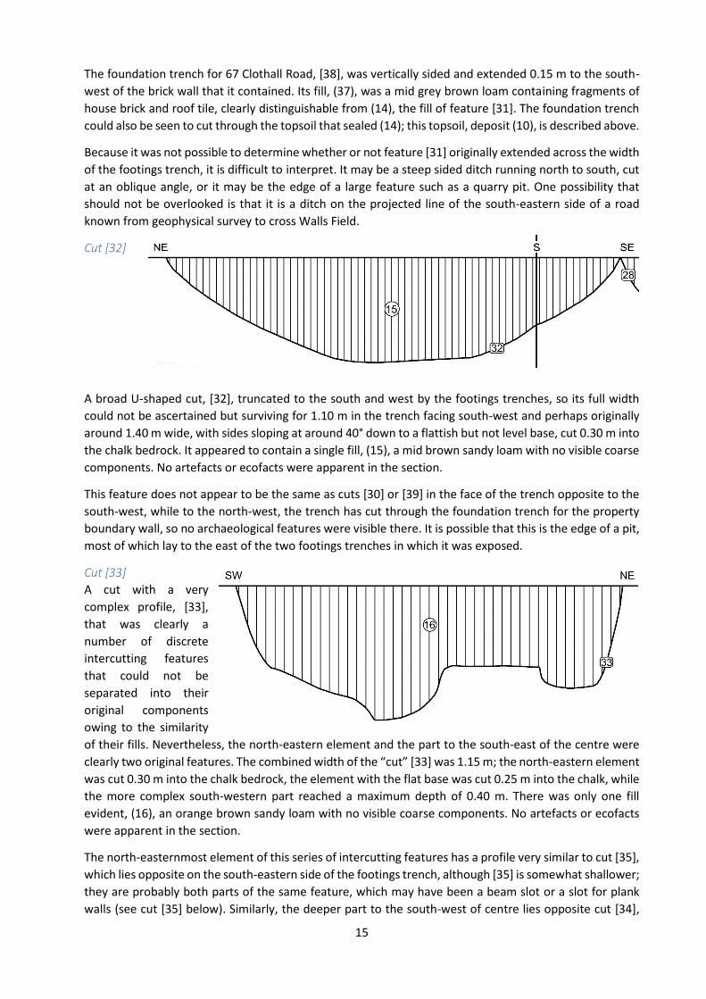
The foundation trench for 67 Clothall Road, [38], was vertically sided and extended 0.15 m to the south-
west of the brick wall that it contained. Its fill, (37), was a mid grey brown loam containing fragments of
house brick and roof tile, clearly distinguishable from (14), the fill of feature [31]. The foundation trench
could also be seen to cut through the topsoil that sealed (14); this topsoil, deposit (10), is described above.
Because it was not possible to determine whether or not feature [31] originally extended across the width
of the footings trench, it is difficult to interpret. It may be a steep sided ditch running north to south, cut
at an oblique angle, or it may be the edge of a large feature such as a quarry pit. One possibility that
should not be overlooked is that it is a ditch on the projected line of the south-eastern side of a road
known from geophysical survey to cross Walls Field.
Cut [32]
A broad U-shaped cut, [32], truncated to the south and west by the footings trenches, so its full width
could not be ascertained but surviving for 1.10 m in the trench facing south-west and perhaps originally
around 1.40 m wide, with sides sloping at around 40° down to a flattish but not level base, cut 0.30 m into
the chalk bedrock. It appeared to contain a single fill, (15), a mid brown sandy loam with no visible coarse
components. No artefacts or ecofacts were apparent in the section.
This feature does not appear to be the same as cuts [30] or [39] in the face of the trench opposite to the
south-west, while to the north-west, the trench has cut through the foundation trench for the property
boundary wall, so no archaeological features were visible there. It is possible that this is the edge of a pit,
most of which lay to the east of the two footings trenches in which it was exposed.
Cut [33]
A cut with a very
complex profile, [33],
that was clearly a
number of discrete
intercutting features
that could not be
separated into their
original components
owing to the similarity
of their fills. Nevertheless, the north-eastern element and the part to the south-east of the centre were
clearly two original features. The combined width of the “cut” [33] was 1.15 m; the north-eastern element
was cut 0.30 m into the chalk bedrock, the element with the flat base was cut 0.25 m into the chalk, while
the more complex south-western part reached a maximum depth of 0.40 m. There was only one fill
evident, (16), an orange brown sandy loam with no visible coarse components. No artefacts or ecofacts
were apparent in the section.
The north-easternmost element of this series of intercutting features has a profile very similar to cut [35],
which lies opposite on the south-eastern side of the footings trench, although [35] is somewhat shallower;
they are probably both parts of the same feature, which may have been a beam slot or a slot for plank
walls (see cut [35] below). Similarly, the deeper part to the south-west of centre lies opposite cut [34],
although this is twice the depth; nevertheless, they may be parts of a single original feature. Beyond these
suggestions, the flat bottomed element of the “feature”, north-east of the centre, and the complex shape
of the profile to the south-west are not easy to interpret. Without stripping the topsoil, this section is
impossible to resolve into its component parts.
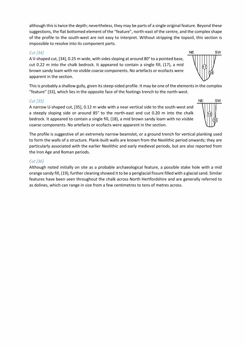
Cut [34]
A V-shaped cut, [34], 0.25 m wide, with sides sloping at around 80° to a pointed base,
cut 0.22 m into the chalk bedrock. It appeared to contain a single fill, (17), a mid
brown sandy loam with no visible coarse components. No artefacts or ecofacts were
apparent in the section.
This is probably a shallow gully, given its steep-sided profile. It may be one of the elements in the complex
“feature” [33], which lies in the opposite face of the footings trench to the north-west.
Cut [35]
A narrow U-shaped cut, [35], 0.12 m wide with a near vertical side to the south-west and
a steeply sloping side or around 85° to the north-east and cut 0.20 m into the chalk
bedrock. It appeared to contain a single fill, (18), a mid brown sandy loam with no visible
coarse components. No artefacts or ecofacts were apparent in the section.
The profile is suggestive of an extremely narrow beamslot, or a ground trench for vertical planking used
to form the walls of a structure. Plank-built walls are known from the Neolithic period onwards; they are
particularly associated with the earlier Neolithic and early medieval periods, but are also reported from
the Iron Age and Roman periods.
Cut [36]
Although noted initially on site as a probable archaeological feature, a possible stake hole with a mid
orange sandy fill, (19), further cleaning showed it to be a periglacial fissure filled with a glacial sand. Similar
features have been seen throughout the chalk across North Hertfordshire and are generally referred to
as dolines, which can range in size from a few centimetres to tens of metres across.
17
Discussion
Interpretation of the buried archaeology The interpretation of buried remains revealed only in section and only in narrow foundation trenches is
fraught with uncertainties. This is compounded in the case of the present project by the complete lack of
finds that might enable the features to be dated and functions suggested. In circumstances such as these,
any interpretation is merely a best guess based on nearby sites with a better data set.
Nevertheless, the lack of finds offers clues as to what the buried archaeology is unlikely to represent. Sites
of recent date (after about 1750) tend to contain a great deal of material, generally rubbish; Roman period
deposits and features generally also contain significant quantities of finds, especially potsherds and animal
bones. That none of the features (other than the twentieth-century foundation trenches) contained any
detectable material remains strongly suggests that the recorded features do not belong to these periods.
Sites immediately surrounding this development have revealed activity from only two periods: the Late
Iron Age through to the Roman period followed by a hiatus until the nineteenth century. In view of the
lack of finds and the known archaeology of the immediate vicinity, it is therefore most likely that most of
the features identified belong to the Late Iron Age and, more specifically, the first century BC.
Several of the narrower features visible only in section lay on the same two alignments. This may indicate
that the foundation trenches cut through linear features, such as ditches or gullies. Insufficient detail
survived, though, to enable a meaningful plan of archaeological features to be constructed.
The local context and significance of the buried archaeology The earliest report of discoveries in this area is recorded by Erik Applebaum (1933, 257) as a “cobbled
pavement reported by Mr Page” at Prospect Terrace; a Page family is known to have been resident at
number 6 in the early twentieth century, an address that is now probably 95 Clothall Road. The character
of the cobbles is not explained (were they river pebbles, larger water-worn cobbles or chalk?) nor are the
location and extent known. Whether it represents the line of the Baldock to Braughing road (Margary
1973, 203 Road 22; Hertfordshire Historic Environment Record, hereafter HHER, 4686), some other road
running off it or an entirely different type of surface cannot be determined on present evidence.
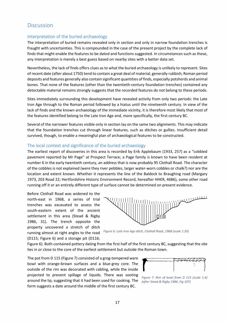
Before Clothall Road was widened to the
north-east in 1968, a series of trial
trenches was excavated to assess the
south-eastern extent of the ancient
settlement in this area (Stead & Rigby
1986, 31). The trench opposite the
property uncovered a stretch of ditch
running almost at right angles to the road
(D115; Figure 6) and a storage pit (D116;
Figure 6). Both contained pottery dating from the first half of the first century BC, suggesting that the site
lies in or close to the core of the earliest settlement but outside the Roman town.
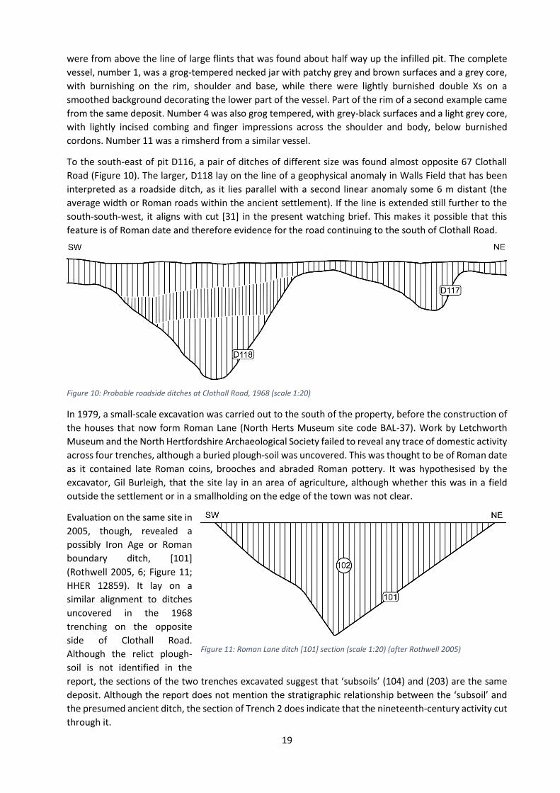
The pot from D 115 (Figure 7) consisted of a grog-tempered ware
bowl with orange-brown surfaces and a blue-grey core. The
outside of the rim was decorated with cabling, while the inside
projected to prevent spillage of liquids. There was sooting
around the lip, suggesting that it had been used for cooking. The
form suggests a date around the middle of the first century BC.
Figure 6: Late Iron Age ditch, Clothall Road, 1968 (scale 1:20)
Figure 7: Rim of bowl from D 115 (scale 1:4) (after Stead & Rigby 1986, Fig 107)

Stead’s storage pit D116 (Figure
8) is remarkable as the only
beehive-shaped Iron Age
storage pit so far identified in
the town. These are regarded
as the typical storage pit form
of the period in southern
Britain (Cunliffe 2005, 411),
although the majority appear
to belong to the Early and
Middle Iron Ages. An early date
is confirmed by the pottery
recovered from its fills.
Figure 9: Pottery from pit D116 (scale 1:4) (after Stead & Rigby 1986, 274)
The pottery recovered from this pit was all of early date, from the first half of the first century BC (Figure
9). Item 1 was a complete pot from the lowest of the fills; 2-4 were recovered from the second fill; 5-11
Figure 8: Beehive-shaped pit D116 at Clothall Road, 1968 (scale 1:20)
19
were from above the line of large flints that was found about half way up the infilled pit. The complete
vessel, number 1, was a grog-tempered necked jar with patchy grey and brown surfaces and a grey core,
with burnishing on the rim, shoulder and base, while there were lightly burnished double Xs on a
smoothed background decorating the lower part of the vessel. Part of the rim of a second example came
from the same deposit. Number 4 was also grog tempered, with grey-black surfaces and a light grey core,
with lightly incised combing and finger impressions across the shoulder and body, below burnished
cordons. Number 11 was a rimsherd from a similar vessel.
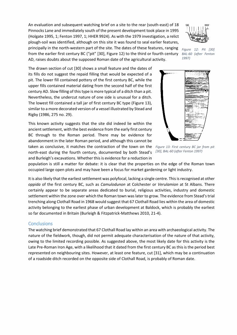
To the south-east of pit D116, a pair of ditches of different size was found almost opposite 67 Clothall
Road (Figure 10). The larger, D118 lay on the line of a geophysical anomaly in Walls Field that has been
interpreted as a roadside ditch, as it lies parallel with a second linear anomaly some 6 m distant (the
average width or Roman roads within the ancient settlement). If the line is extended still further to the
south-south-west, it aligns with cut [31] in the present watching brief. This makes it possible that this
feature is of Roman date and therefore evidence for the road continuing to the south of Clothall Road.
In 1979, a small-scale excavation was carried out to the south of the property, before the construction of
the houses that now form Roman Lane (North Herts Museum site code BAL-37). Work by Letchworth
Museum and the North Hertfordshire Archaeological Society failed to reveal any trace of domestic activity
across four trenches, although a buried plough-soil was uncovered. This was thought to be of Roman date
as it contained late Roman coins, brooches and abraded Roman pottery. It was hypothesised by the
excavator, Gil Burleigh, that the site lay in an area of agriculture, although whether this was in a field
outside the settlement or in a smallholding on the edge of the town was not clear.
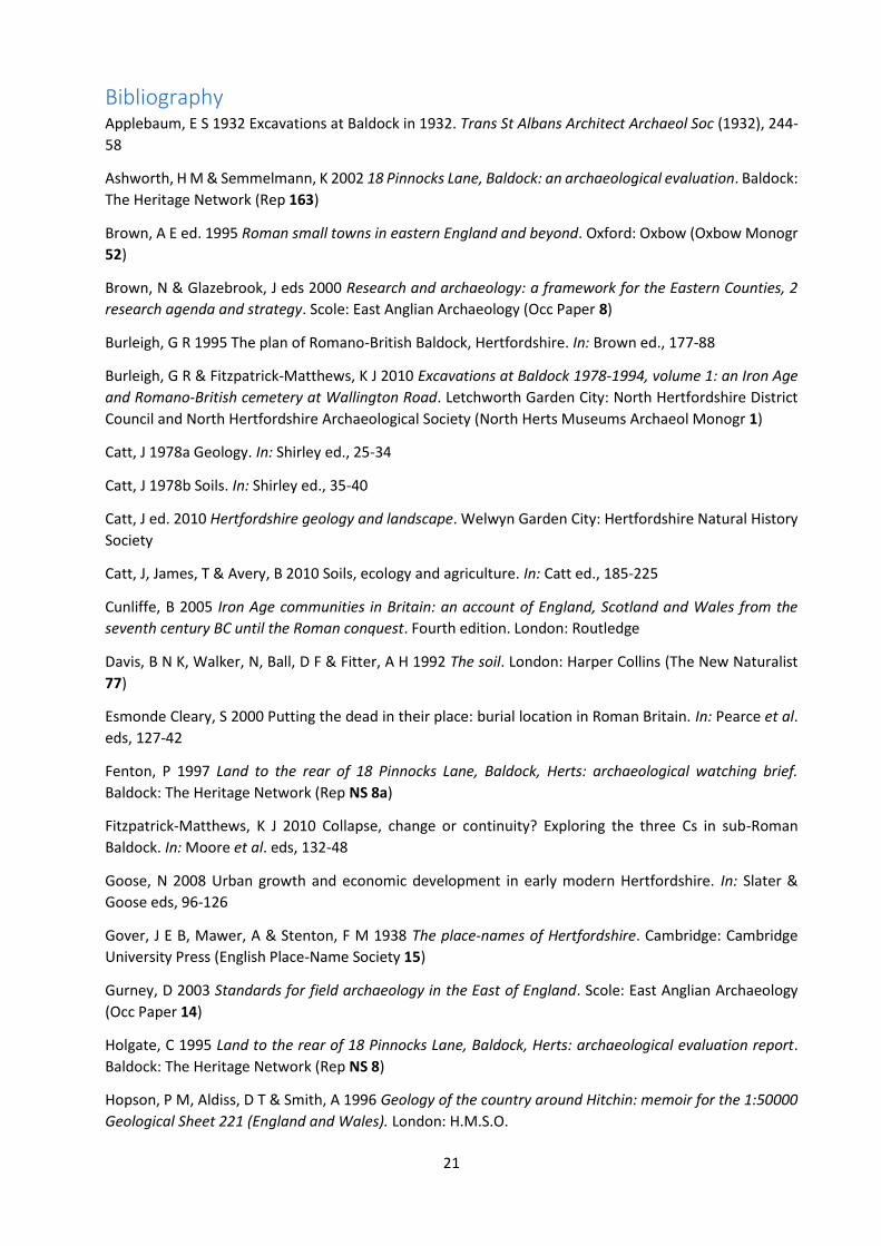
Evaluation on the same site in
2005, though, revealed a
possibly Iron Age or Roman
boundary ditch, [101]
(Rothwell 2005, 6; Figure 11;
HHER 12859). It lay on a
similar alignment to ditches
uncovered in the 1968
trenching on the opposite
side of Clothall Road.
Although the relict plough-
soil is not identified in the
report, the sections of the two trenches excavated suggest that ‘subsoils’ (104) and (203) are the same
deposit. Although the report does not mention the stratigraphic relationship between the ‘subsoil’ and
the presumed ancient ditch, the section of Trench 2 does indicate that the nineteenth-century activity cut
through it.
Figure 10: Probable roadside ditches at Clothall Road, 1968 (scale 1:20)
Figure 11: Roman Lane ditch [101] section (scale 1:20) (after Rothwell 2005)
An evaluation and subsequent watching brief on a site to the rear (south-east) of 18
Pinnocks Lane and immediately south of the present development took place in 1995
(Holgate 1995, 1; Fenton 1997, 1; HHER 9924). As with the 1979 investigation, a relict
plough-soil was identified, although on this site it was found to seal earlier features,
principally in the north-western part of the site. The dates of these features, ranging
from the earlier first century BC (“pit” [30], Figure 12) to the third or fourth century
AD, raises doubts about the supposed Roman date of the agricultural activity.
The drawn section of cut [30] shows a small feature and the dates of
its fills do not suggest the repaid filling that would be expected of a
pit. The lower fill contained pottery of the first century BC, while the
upper fills contained material dating from the second half of the first
century AD. Slow filling of this type is more typical of a ditch than a pit.
Nevertheless, the undercut nature of one side is unusual for a ditch.
The lowest fill contained a tall jar of first century BC type (Figure 13),
similar to a more decorated version of a vessel illustrated by Stead and
Rigby (1986, 275 no. 29).
This known activity suggests that the site did indeed lie within the
ancient settlement, with the best evidence from the early first century
BC through to the Roman period. There may be evidence for
abandonment in the later Roman period, and although this cannot be
taken as conclusive, it matches the contraction of the town on the
north-east during the fourth century, documented by both Stead’s
and Burleigh’s excavations. Whether this is evidence for a reduction in
population is still a matter for debate: it is clear that the properties on the edge of the Roman town
occupied large open plots and may have been a focus for market gardening or light industry.
It is also likely that the earliest settlement was polyfocal, lacking a single centre. This is recognised at other
oppida of the first century BC, such as Camulodunon at Colchester or Verulamion at St Albans. There
certainly appear to be separate areas dedicated to burial, religious activities, industry and domestic
settlement within the zone over which the Roman town was later to grow. The evidence from Stead’s trial
trenching along Clothall Road in 1968 would suggest that 67 Clothall Road lies within the area of domestic
activity belonging to the earliest phase of urban development at Baldock, which is probably the earliest
so far documented in Britain (Burleigh & Fitzpatrick-Matthews 2010, 21-4).
Conclusions The watching brief demonstrated that 67 Clothall Road lay within an area with archaeological activity. The
nature of the fieldwork, though, did not permit adequate characterisation of the nature of that activity,
owing to the limited recording possible. As suggested above, the most likely date for this activity is the
Late Pre-Roman Iron Age, with a likelihood that it dated from the first century BC as this is the period best
represented on neighbouring sites. However, at least one feature, cut [31], which may be a continuation
of a roadside ditch recorded on the opposite side of Clothall Road, is probably of Roman date.
Figure 12: Pit [30] BAL-60 (after Fenton 1997)
Figure 13: First century BC jar from pit [30], BAL-60 (after Fenton 1997)
21
Bibliography Applebaum, E S 1932 Excavations at Baldock in 1932. Trans St Albans Architect Archaeol Soc (1932), 244-
58
Ashworth, H M & Semmelmann, K 2002 18 Pinnocks Lane, Baldock: an archaeological evaluation. Baldock:
The Heritage Network (Rep 163)
Brown, A E ed. 1995 Roman small towns in eastern England and beyond. Oxford: Oxbow (Oxbow Monogr
52)
Brown, N & Glazebrook, J eds 2000 Research and archaeology: a framework for the Eastern Counties, 2
research agenda and strategy. Scole: East Anglian Archaeology (Occ Paper 8)
Burleigh, G R 1995 The plan of Romano-British Baldock, Hertfordshire. In: Brown ed., 177-88
Burleigh, G R & Fitzpatrick-Matthews, K J 2010 Excavations at Baldock 1978-1994, volume 1: an Iron Age
and Romano-British cemetery at Wallington Road. Letchworth Garden City: North Hertfordshire District
Council and North Hertfordshire Archaeological Society (North Herts Museums Archaeol Monogr 1)
Catt, J 1978a Geology. In: Shirley ed., 25-34
Catt, J 1978b Soils. In: Shirley ed., 35-40
Catt, J ed. 2010 Hertfordshire geology and landscape. Welwyn Garden City: Hertfordshire Natural History
Society
Catt, J, James, T & Avery, B 2010 Soils, ecology and agriculture. In: Catt ed., 185-225
Cunliffe, B 2005 Iron Age communities in Britain: an account of England, Scotland and Wales from the
seventh century BC until the Roman conquest. Fourth edition. London: Routledge
Davis, B N K, Walker, N, Ball, D F & Fitter, A H 1992 The soil. London: Harper Collins (The New Naturalist
77)
Esmonde Cleary, S 2000 Putting the dead in their place: burial location in Roman Britain. In: Pearce et al.
eds, 127-42
Fenton, P 1997 Land to the rear of 18 Pinnocks Lane, Baldock, Herts: archaeological watching brief.
Baldock: The Heritage Network (Rep NS 8a)
Fitzpatrick-Matthews, K J 2010 Collapse, change or continuity? Exploring the three Cs in sub-Roman
Baldock. In: Moore et al. eds, 132-48
Goose, N 2008 Urban growth and economic development in early modern Hertfordshire. In: Slater &
Goose eds, 96-126
Gover, J E B, Mawer, A & Stenton, F M 1938 The place-names of Hertfordshire. Cambridge: Cambridge
University Press (English Place-Name Society 15)
Gurney, D 2003 Standards for field archaeology in the East of England. Scole: East Anglian Archaeology
(Occ Paper 14)
Holgate, C 1995 Land to the rear of 18 Pinnocks Lane, Baldock, Herts: archaeological evaluation report.
Baldock: The Heritage Network (Rep NS 8)
Hopson, P M, Aldiss, D T & Smith, A 1996 Geology of the country around Hitchin: memoir for the 1:50000
Geological Sheet 221 (England and Wales). London: H.M.S.O.
Margary, I D 1973 Roman roads in Britain. Third edition. London: John Baker
Medlycott, M ed 2011 Research and archaeology revisited: a revised framework for the East of England.
Scole: East Anglian Archaeology (Occ Paper 24) and ALGAO East of England
Moore, A, Taylor, G, Harris, E, Girdwood, P & Shipley, L eds 2010 TRAC 2009: proceedings of the nineteenth
annual Theoretical Roman Archaeology Conference. Oxford: Oxbow
Munby, L 1977 The Hertfordshire landscape. London: Hodder & Stoughton
Pearce, J, Millett, M & Struck, M eds Burial, society and context in the Roman world. Oxford: Oxbow
Pevsner, N 1977 Hertfordshire. Second edition, revised by Bridget Cherry. Harmondsworth: Penguin (The
Buildings of England)
Rothwell, A 2005 Land between 10 and 19 Roman Lane, Baldock, Herts. Letchworth Garden City: The
Heritage Network (Rep 299)
Salmon, N 1728 The history of Hertfordshire; describing the county, and its antient monuments. London:
privately printed
Shirley, D ed. 1978 Hertfordshire: a guide to the countryside. Letchworth: Egon Publishers
Slater, T & Goose, N eds 2008 A county of small towns: the development of Hertfordshire’s urban
landscape to 1800. Hatfield: Hertfordshire Publications
Stead, I M & Rigby, V 1986 Baldock: the excavation of a Roman and pre-Roman settlement, 1968-72.
London: Society for the Promotion of Roman Studies (Britannia Monogr 7)
Williamson, T 2008 Urban origins: location, topography and the documentary record. In: Slater & Goose
eds, 27-45
Wilmore, A, Wilmore, A N, Graveson, W, Morse, R & Bickerton, W 1925. The natural history of
Hertfordshire. London: G Bell & Sons Ltd
23
Appendices
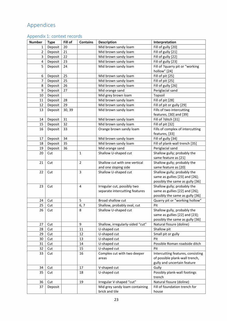
Appendix 1: context records Number Type Fill of Contains Description Interpretation
1 Deposit 20 Mid brown sandy loam Fill of gully [20]
2 Deposit 21 Mid brown sandy loam Fill of gully [21]
3 Deposit 22 Mid brown sandy loam Fill of gully [22]
4 Deposit 23 Mid brown sandy loam Fill of gully [23]
5 Deposit 24 Mid brown sandy loam Fill of ?quarry pit or “working hollow” [24]
6 Deposit 25 Mid brown sandy loam Fill of pit [25]
7 Deposit 25 Mid brown sandy loam Fill of pit [25]
8 Deposit 26 Mid brown sandy loam Fill of gully [26]
9 Deposit 27 Mid orange sand Periglacial sand
10 Deposit Mid grey brown loam Topsoil
11 Deposit 28 Mid brown sandy loam Fill of pit [28]
12 Deposit 29 Mid brown sandy loam Fill of pit or gully [29]
13 Deposit 30, 39 Mid brown sandy loam Fills of two intercutting features, [30] and [39]
14 Deposit 31 Mid brown sandy loam Fill of ?ditch [31]
15 Deposit 32 Mid brown sandy loam Fill of pit [32]
16 Deposit 33 Orange brown sandy loam Fills of complex of intercutting features, [33]
17 Deposit 34 Mid brown sandy loam Fill of gully [34]
18 Deposit 35 Mid brown sandy loam Fill of plank-wall trench [35]
19 Deposit 36 Mid orange sand Periglacial sand
20 Cut 1 Shallow U-shaped cut Shallow gully; probably the same feature as [21]
21 Cut 2 Shallow cut with one vertical and one sloping side
Shallow gully; probably the same feature as [20]
22 Cut 3 Shallow U-shaped cut Shallow gully; probably the same as gullies [23] and [26]; possibly the same as gully [36]
23 Cut 4 Irregular cut, possibly two separate intercutting features
Shallow gully; probably the same as gullies [22] and [26]; possibly the same as gully [36]
24 Cut 5 Broad shallow cut Quarry pit or “working hollow”
25 Cut 6, 7 Shallow, probably oval, cut Pit
26 Cut 8 Shallow U-shaped cut Shallow gully, probably the same as gullies [22] and [23]; possibly the same as gully [36]
27 Cut 9 Shallow, irregularly-sided “cut” Natural fissure (doline)
28 Cut 11 U-shaped cut Shallow pit
29 Cut 12 U-shaped cut Small pit or gully
30 Cut 13 U-shaped cut Pit
31 Cut 14 U-shaped cut Possible Roman roadside ditch
32 Cut 15 U-shaped cut Pit
33 Cut 16 Complex cut with two deeper areas
Intercutting features, consisting of possible plank-wall trench, gully and uncertain feature
34 Cut 17 V-shaped cut Gully
35 Cut 18 U-shaped cut Possibly plank-wall footings trench
36 Cut 19 Irregular V-shaped “cut” Natural fissure (doline)
37 Deposit Mid grey sandy loam containing brick and tile
Fill of foundation trench for house
38 Cut Vertically sided cut Foundation trench for 67 Clothall Road
39 Cut 13 Shallow U-shaped cut Beam-slot
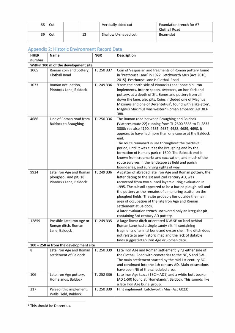
Appendix 2: Historic Environment Record Data HHER number
Name NGR Description
Within 100 m of the development site
1065 Roman coin and pottery, Clothall Road
TL 250 337 Coin of Vespasian and fragments of Roman pottery found in ‘Pesthouse Lane’ in 1922. Letchworth Mus (Acc 2016, 2015). Pesthouse Lane is Clothall Road
1073 Roman occupation, Pinnocks Lane, Baldock
TL 249 336 ‘From the north side of Pinnocks Lane; bone pin, iron implements, bronze spoon, tweezers, an iron fork and pottery, at a depth of 3ft. Bones and pottery from all down the lane, also pits. Coins included one of Magnus Maximus and one of Decentetius1, found with a skeleton’. Magnus Maximus was western Roman emperor, AD 383-388.
4686 Line of Roman road from Baldock to Braughing
TL 250 336 The Roman road between Braughing and Baldock (Viatores route 22) running from TL 2500 3365 to TL 2835 3000; see also 4190, 4685, 4687, 4688, 4689, 4690. It appears to have had more than one course at the Baldock end. The route remained in use throughout the medieval period, until it was cut at the Braughing end by the formation of Hamels park c. 1600. The Baldock end is known from cropmarks and excavation, and much of the route survives in the landscape as field and parish boundaries, and surviving rights of way.
9924 Late Iron Age and Roman ploughsoil and pit, 18 Pinnocks Lane, Baldock
TL 249 336 A scatter of abraded late Iron Age and Roman pottery, the latter dating to the 1st and 2nd century AD, was recovered from two subsoil layers during evaluation in 1995. The subsoil appeared to be a buried plough-soil and the pottery as the remains of a manuring scatter on the ploughed fields. The site probably lies outside the main area of occupation of the late Iron Age and Roman settlement at Baldock. A later evaluation trench uncovered only an irregular pit containing 3rd century AD pottery.
12859 Possible Late Iron Age or Roman ditch, Roman Lane, Baldock
TL 249 335 A large linear ditch orientated NW-SE on land behind Roman Lane had a single sandy silt fill containing fragments of animal bone and oyster shell. The ditch does not relate to any historic map and the lack of datable finds suggested an Iron Age or Roman date.
100 – 250 m from the development site
8 Late Iron Age and Roman settlement of Baldock
TL 250 339 Late Iron Age and Roman settlement lying either side of the Clothall Road with cemeteries to the NE, S and SW. The main settlement started by the mid 1st century BC and continued into the 4th century AD. Main excavations have been NE of the scheduled area.
106 Late Iron Age pottery, Homelands, Baldock
TL 252 336 Late Iron Age tazza (1BC – AD1) and a white butt beaker (AD 1-50) found at ‘Homelands’, Baldock. This sounds like a late Iron Age burial group.
217 Palaeolithic implement, Walls Field, Baldock
TL 250 339 Flint implement. Letchworth Mus (Acc 6023).
1 This should be Decentius.

25
529 Roman coins, 33 Clothall Road, Baldock
TL 248 337 Rather worn 4th century coin found in 1977. OBV: head of emperor wearing diadem; REV: ?Winged Victory standing, facing right holding ?wreath in right hand. North Herts DC record cards refer to several coins found in this garden: AE Magnentius LRBC 8, Amiens mint and a late 4th century Securitas Republicae type (card 1057); and a small contemporary copy of Constantius II, rev. 2 Victorius type 341-6, and a German reckoning counter, ‘Reichsapel’, the commonest type and dating to c. 1600 (card 1506). See also 1055, 1056, 1057 for coins found in neighbouring areas.
770 Romano-Celtic temple and other buildings, Baker’s Close, Baldock
TL 247 338 Romano-Celtic temple and other buildings visble as cropmarks. See <1>2 for the plan, including a possible earlier structure beneath the temple. Also in the field is a winged house, metalled roads, walled enclosures, courtyards, and a trapezoidal walled enclosure with internal sub-divisions, perhaps a second temple This has the appearance of a large religious complex.
1055 Roman coins, 35 Clothall Road, Baldock
TL 248 337 Two asses of Constantius II, found in the garden at 35 Clothall Road. OBV: D.N.CONSTANIUS PP.AUG; head draped right with diadem; REV: FEI TEMP REPARATIO; Emperor standing in vessel holding phoenix on globe and labarum with victory in the stern. Found December 1973. See 529, 1056, 1057 for adjacent finds.
1056 Roman coins, 37 Clothall Road, Baldock
TL 248 337 Six 4th century coins (including two minimi) and a radiate possibly of Carausius or Gallienus, found in the garden at 37 Clothall Road. One of the coins, thought to be of Constantius II, has a reverse from depicting two soldiers leaning on shields and holding a single standard with the inscription GLOR IAEXERC ITVS. See also 529, 1055, 1057 for neighbouring finds.
1057 Roman coin, 39 Clothall Road, Baldock
TL 248 337 Roman coin of Gratian, found in the garden at 39 Clothall Road. ‘DN GRATIANUS PF AUG; GLORIA ROMANORUM, Emperor standing right holding ? and dragging captive. See 529, 1055, 1056 for neighbouring finds.
1060 Roman coin, 27 Pinnocks Lane, Baldock
TL 248 336 Coin of Constantine the Great (307-337) found in July 1963 in the garden.
1063 Roman coins, Walls Field, Clothall Road, Baldock
TL 248 338 Coins of Constans, Constantine I, Constantine II, Valentinian, Gallienus and Antoninus Pius reported as having come from the cemetery.
1077 Early Roman cremation burial, 18-20 South Road, Baldock
TL 249 334 An iron object described as being 8¾” long with a barb on one side. Found close to a 2nd century burial. This is counted as part of the South Road cremation cemetery 4280 (SR8) by <2>3.
1081 Thistle/Rosette brooch, Baldock
TL 252 337 A thistle or rosette brooch, AD 25-50, found in a ditch adjacent to Walls Field cemetery 2 ft below the surface in December 1934.
1843 Late Iron Age pottery, Walls Field, Baldock
TL 250 339 ‘An urn of Belgic character’ found in a baulk alongside Walls Field. The North Herts DC museums record card (1525) refers to the pot as having ‘outspread mouth and neck cordons’, and coming from the ‘baulk to the NE side’ of the field at TL 2507 3398.
2 Unpublished document: Burleigh, Gil, & Stevenson, M D. 2000. A decade of archaeological fieldwork in North Hertfordshire, 1989-1999. RNO 1352, p50-52. 3 Unpublished document: Fitzpatrick-Matthews, Keith J, & Burleigh, Gilbert R. 2007. Excavations at Baldock 1978-1994: fieldwork by G R Burleigh. Draft. RNO 1779 p46, 70, fig. 36.
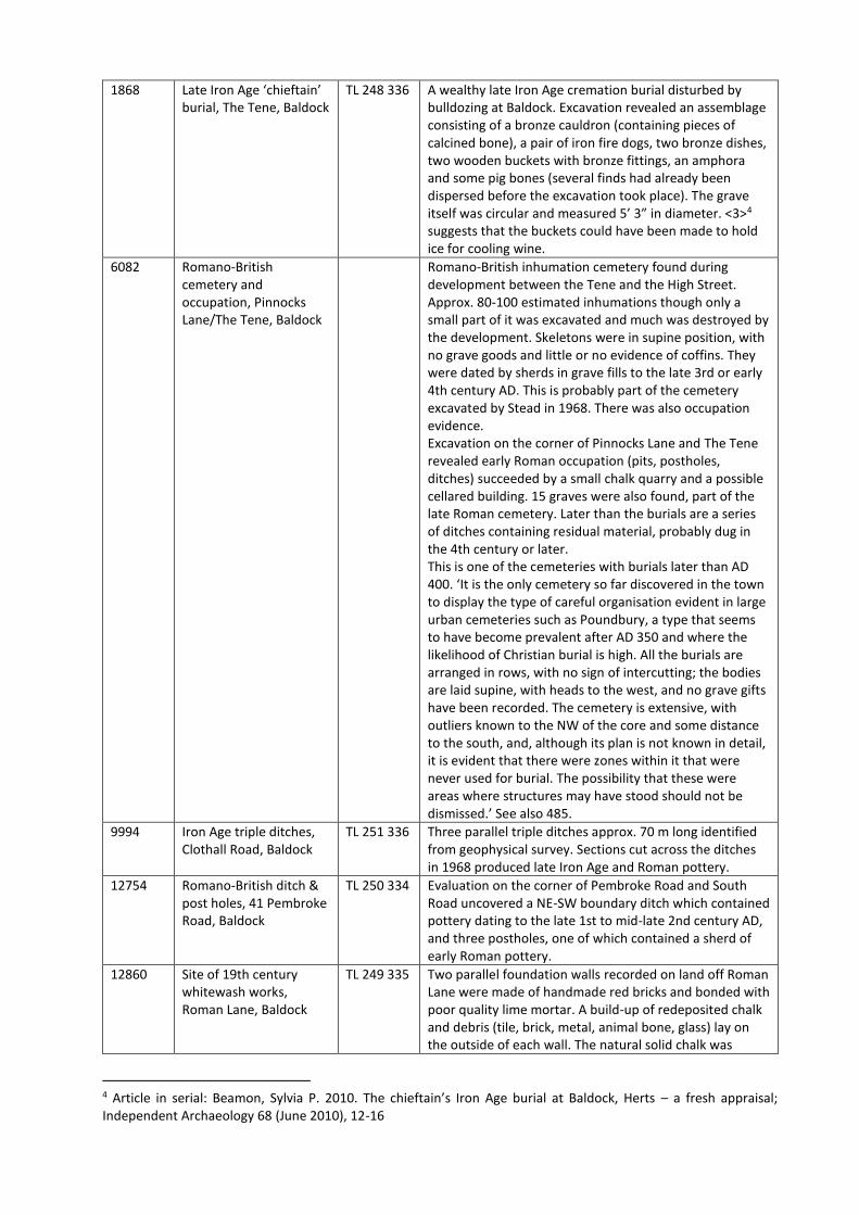
1868 Late Iron Age ‘chieftain’ burial, The Tene, Baldock
TL 248 336 A wealthy late Iron Age cremation burial disturbed by bulldozing at Baldock. Excavation revealed an assemblage consisting of a bronze cauldron (containing pieces of calcined bone), a pair of iron fire dogs, two bronze dishes, two wooden buckets with bronze fittings, an amphora and some pig bones (several finds had already been dispersed before the excavation took place). The grave itself was circular and measured 5’ 3” in diameter. <3>4 suggests that the buckets could have been made to hold ice for cooling wine.
6082 Romano-British cemetery and occupation, Pinnocks Lane/The Tene, Baldock
Romano-British inhumation cemetery found during development between the Tene and the High Street. Approx. 80-100 estimated inhumations though only a small part of it was excavated and much was destroyed by the development. Skeletons were in supine position, with no grave goods and little or no evidence of coffins. They were dated by sherds in grave fills to the late 3rd or early 4th century AD. This is probably part of the cemetery excavated by Stead in 1968. There was also occupation evidence. Excavation on the corner of Pinnocks Lane and The Tene revealed early Roman occupation (pits, postholes, ditches) succeeded by a small chalk quarry and a possible cellared building. 15 graves were also found, part of the late Roman cemetery. Later than the burials are a series of ditches containing residual material, probably dug in the 4th century or later. This is one of the cemeteries with burials later than AD 400. ‘It is the only cemetery so far discovered in the town to display the type of careful organisation evident in large urban cemeteries such as Poundbury, a type that seems to have become prevalent after AD 350 and where the likelihood of Christian burial is high. All the burials are arranged in rows, with no sign of intercutting; the bodies are laid supine, with heads to the west, and no grave gifts have been recorded. The cemetery is extensive, with outliers known to the NW of the core and some distance to the south, and, although its plan is not known in detail, it is evident that there were zones within it that were never used for burial. The possibility that these were areas where structures may have stood should not be dismissed.’ See also 485.
9994 Iron Age triple ditches, Clothall Road, Baldock
TL 251 336 Three parallel triple ditches approx. 70 m long identified from geophysical survey. Sections cut across the ditches in 1968 produced late Iron Age and Roman pottery.
12754 Romano-British ditch & post holes, 41 Pembroke Road, Baldock
TL 250 334 Evaluation on the corner of Pembroke Road and South Road uncovered a NE-SW boundary ditch which contained pottery dating to the late 1st to mid-late 2nd century AD, and three postholes, one of which contained a sherd of early Roman pottery.
12860 Site of 19th century whitewash works, Roman Lane, Baldock
TL 249 335 Two parallel foundation walls recorded on land off Roman Lane were made of handmade red bricks and bonded with poor quality lime mortar. A build-up of redeposited chalk and debris (tile, brick, metal, animal bone, glass) lay on the outside of each wall. The natural solid chalk was
4 Article in serial: Beamon, Sylvia P. 2010. The chieftain’s Iron Age burial at Baldock, Herts – a fresh appraisal; Independent Archaeology 68 (June 2010), 12-16
27
reached only 1m from the surface. The foundations are early to mid 19th century and may relate to buildings on the 1884 OS map. These are believed to have been associated with the manufacture of whitewash.
13190 Roman cemetery, Walls Field, Baldock
TL 251 336 This cemetery, one of the larger of the many Roman cemeteries in Baldock, lay between the two main roads entering the town from the SE. About 316 cremations and 35 inhumations were excavated in the 1920s, and it is certain that part of the cemetery remains intact. The cremations, many of which had urns, dated from the later 1st century to the later third; the inhumations, which were poorly recorded, ‘probably date from the second to fourth centuries’. They were in two main groups, a SE group established by c.AD 70, and a NE group a little later. They may each have related to their adjacent main road. One of the graves, of the early 2nd century, contained three pots and a lead curse tablet apparently cursing someone called Tacita.
13191 Early Roman cemetery, Clothall Road, Baldock
TL 251 335 Eight cremation burials were found during trial trenches in advance of road widening in 1968. The extent of the cemetery is unknown, but it ran along the main Roman road between Baldock and Braughing. All the burial dated to the later 1st and 2nd centuries AD. Some contained more grave goods and accessory pots than usual amongst the many Baldock cemeteries. Two had the bone in urns, three in wooden boxes with bronze fittings. Five were accompanied by animal bone (fowl, sheep/pig, calf). Evaluation found that the cemetery did not extend as far south as the corner of South Road.
13475 Roman soil horizon, 25 Clothall Road, Baldock
TL 248 338 A buried soil, sealing the chalk natural, covered the entire area investigated behind 25 Clothall Road. It contained oyster shell, animal bone, and Roman potsherds including Hadham ware and Verulamium Region ware.
16123 19th century farmstead, 74 South Road, Baldock
TL 251 335 The farm first appears on mapping in 1880, and was then at the south-east corner of the town (and technically in Weston parish); it was built on previously undeveloped land. The farmhouse, no.74 South Road, dates to c.1870, and is double-fronted in brick with gable ends, end chimney stacks, and slate roof. Much of its vernacular appearance survives, despite a large 20th century single-storey extension at the back. The stable block may be contemporary with the house, but has been altered. The former granary also survives, a small rectangular single-storey structure in yellow brick; it is slightly later than the house, with a 20th century lean-to added, and retains much of its original plan and fabric. No.72 was built in the grounds c.1925, when the farm appears to have ceased operating. Farm buildings south-east of the house were reduced or demolished at the same time. Monitoring during construction of new housing recorded a brick-lined post-medieval well.
16252 Bronze Age scraper, Walls Field, Baldock
TL 251 335 ‘A presumably Bronze Age side-scraper on a naturally shattered flake, found at the junction of Wallington Road and Clothall Road on the Tapps Garden Centre (north) side of Wallington Road… many years ago’.
Appendix 3: Hertfordshire Historic Environment record summary sheet
Site name and address:
67 Clothall Road
Baldock
Herts
SG
County: Hertfordshire District: North Hertfordshire
Village/Town: Baldock Parish: Baldock
Planning application reference: 08/00670/1HH, 11/01137/1HH and 13/02264/1DOC
HER Enquiry reference:
Funding source: None
Nature of application:
Erection of a two-storey extension and single-story conservatory following demolition of an existing
single-storey ground floor extension.
Present land use: Domestic/garden
Size of application area: 56.25 m2 Size of area investigated: <5 m2
NGR (to 8 figures minimum): TL 24974 33653
Site code (if applicable): BAL/67CR ’13
Site director/Organization: Keith Fitzpatrick-Matthews, North Hertfordshire Museums
Type of work
Watching brief (recording following foundation cutting)
Date of work: October 2013 Start: 23.10.2013 Finish: 25.10.2013
Location of finds & site archive/Curating museum:
North Hertfordshire Museum, Museums Resource Centre, Burymead Road, Hitchin, Herts SG5 1RT
Related HER Nos:
Periods represented:
?Late Iron Age, ?Roman, twentieth century
Relevant previous summaries/reports
None.
Summary of fieldwork results:
Observation of foundation trenches revealed a number of chalk-cut features, several of which
plausibly represent enclosure gullies; others appear to be pits, quarries or ‘working hollows’. No finds
were recovered from any of the features, so dating remains speculative. In view of the known
archaeology of the vicinity, which is almost exclusively of earlier first century BC activity, it is likely that
the features observed also date from the earlier part of the Late Iron Age, although one Roman
roadside ditch may also be present.

29
Author of summary:
Keith Fitzpatrick-Matthews
Date of summary:
11 August 2014
Related Documents