NTS 36N TECHNICAL REPORT FOR THE BUJAGALI AND KILEMBE PROPERTIES, REPUBLIC OF UGANDA Prepared For: M2 Cobalt Corp. Suite 2000 - 1177 West Hastings Street Vancouver, British Columbia, Canada, V6E 2K3 Prepared by: Dean J Besserer, P.Geol. 110, 8429 24 th Street NW Edmonton, Alberta, Canada, T6P1L3 D.Besserer, B.Sc., P. Geol. Effective Date: December 5, 2017 Edmonton, Alberta, Canada

Welcome message from author
This document is posted to help you gain knowledge. Please leave a comment to let me know what you think about it! Share it to your friends and learn new things together.
Transcript
NTS 36N TECHNICAL REPORT FOR THE BUJAGALI AND KILEMBE
PROPERTIES, REPUBLIC OF UGANDA
Prepared For: M2 Cobalt Corp.
Suite 2000 - 1177 West Hastings Street Vancouver, British Columbia, Canada, V6E 2K3
Prepared by: Dean J Besserer, P.Geol.
110, 8429 24th Street NW
Edmonton, Alberta, Canada, T6P1L3
D.Besserer, B.Sc., P. Geol.
Effective Date: December 5, 2017 Edmonton, Alberta, Canada
TECHNICAL REPORT FOR THE BUJAGALI AND KILEMBE PROPERTIES, REPUBLIC OF UGANDA
December 2017 ii
Contents
1 Summary ................................................................................................................... 1 2 Introduction ................................................................................................................ 5 3 Reliance on Other Experts ......................................................................................... 5 4 Property Description and Location ............................................................................. 6 5 Accessibility, Climate, Local Resources, Infrastructure and Physiography .............. 11
5.1 Access, Local Resources, and Infrastructure ................................................... 11 5.2 Climate and Physiography ................................................................................ 11 5.3 Bujagali Property .............................................................................................. 12 5.4 Kilembe Property .............................................................................................. 12
6 History ...................................................................................................................... 12 6.1 Government Surveys ........................................................................................ 12
6.1.3 Government Geophysical Surveys ......................................................... 15 6.1.4 Industry Geophysical Surveys ................................................................ 15
7 Geological Setting and Mineralization ...................................................................... 16 7.1 Regional Geology ............................................................................................. 16 7.2 Property Geology ............................................................................................. 22
8 Deposit Types .......................................................................................................... 25 8.1 Sediment-Hosted Stratiform Copper or Katanga Style Copper-Cobalt Deposits
......................................................................................................................... 25 8.2 Iron Oxide Copper Gold (“IOCG”) Deposits ...................................................... 26 8.3 Volcanogenic Massive Sulphide (“VMS”) or Kilembe Style Copper-Cobalt
Deposits ........................................................................................................... 26 8.4 Lode Gold ......................................................................................................... 27 8.5 Epithermal Gold ................................................................................................ 27
9 Exploration ............................................................................................................... 27 9.1 Airborne Geophysics ........................................................................................ 36 9.2 Structures ......................................................................................................... 42
10 Drilling ...................................................................................................................... 42 11 Sample Preparation, Analyses and Security ............................................................ 42
11.1 ALS Limited Laboratory Preparation Protocols (Authors Samples) .................. 43 11.1.1 ALS Quality Assurance Overview ............................................... 43
12 Data Verification....................................................................................................... 46 12.1 Data Verification and Quality Control Conclusion ............................................. 47
13 Mineral Processing and Metallurgical Testing .......................................................... 48 14 Mineral Resource Estimates .................................................................................... 48 15 Adjacent Properties .................................................................................................. 48
15.1 Kilembe Mine Area ........................................................................................... 48 16 Other Relevant Data and Information ...................................................................... 50 17 Interpretation and Conclusions ................................................................................ 51
17.2 Rejuvenated and Developing a Copper-Cobalt Region: ................................... 52 17.2.1.1 Rejuvenating a Copper-Cobalt Region (The Kilembe Property):
52 17.2.1.2 Developing a Copper-Cobalt Region (The Bujagali Property): 52
17.3 Mining Friendly Jurisdiction: ............................................................................. 53

TECHNICAL REPORT FOR THE BUJAGALI AND KILEMBE PROPERTIES, REPUBLIC OF UGANDA
December 2017 iii
17.4 Access: ............................................................................................................. 53 17.5 Timing of Mineralization and Structure: ............................................................ 53 17.6 Concluding Statement: ..................................................................................... 53
18 Recommendations ................................................................................................... 54 19 Date and Signature Page ......................................................................................... 58 20 References .............................................................................................................. 59 21 Certificate of Author ................................................................................................. 61
Tables
Table 1: Exploration License descriptions and status for M2 Cobalt Corp’s Properties....7 Table 2: Sample Results…………………………………..……………………………….....47 Table 3: Detailed Budget for Recommended Exploration……………………………….....57
Figures
Figure 1. Project Location………………………………………………………………………8 Figure 2. Bujagali Exploration Licenses………………………………………………………9 Figure 3. Kilembe Exploration Licenses………………………………………………………9 Figure 4. GTK Observation Points, The Bujagali Property………………………………...14 Figure 5. GTK Observation Points, The Bujagali Property………………………………..14 Figure 6. Regional Geology………..…………………………………………………………17 Figure 7. Detailed Geology, Bujagali Property………………………………………..……24 Figure 8. Detailed Geology, Kilembe Property ………………………………….…………24 Figure 9. Rock Samples, Cobalt Results, Bujagali Property………………………………30 Figure 10. Rock Samples, Copper Results, Bujagali Property ……………………………31 Figure 11. Rock Samples, Gold Results, Bujagali Property ………….……………………31 Figure 12. Stream Sediment and HMC Sample Cobalt Results, Bujagali Property...….32 Figure 13. Stream Sediment and HMC Sample Copper Results, Bujagali Property...…32 Figure 14. Stream Sediment and HMC Sample Gold Results, Bujagali Property………33 Figure 15. 2010 GTK Soil Sample Locations, Bombo Target, Bujagali Property.………33 Figure 16. 2010 GTK Soil Samples XRF Nickel Results, Bombo Target, Bujagali Property…………………………………………………………………………………………34 Figure 17. 2010 GTK Soil Samples XRF Cobalt Results, Bombo Target, Bujagali Property…………………………………………………………………………………………34 Figure 18. 2010 GTK Soil Samples XRF Copper Results, Bombo Target, Bujagali Property…………………………………………………………………………………………35 Figure 19. Airborne Survey by Name and Year……………………………………………38 Figure 20. Regional Total Magnetic Intensity………………………………………………38 Figure 21. Regional Airborne Magnetics showing curvilinear dyke swarm…………...…39 Figure 22. Total Magnetic Intensity, Bujagali Property……………………………………40 Figure 23. Total Magnetic Intensity, Kilembe Property……………………………………40 Figure 24. Total Magnetic Intensity and structures, Bujagali Property……………………41 Figure 25. Total Magnetic Intensity and structures, Kilembe Property……………………41 Figure 26. Adjacent Properties, Uganda…..………………………………………………..48
TECHNICAL REPORT FOR THE BUJAGALI AND KILEMBE PROPERTIES, REPUBLIC OF UGANDA
December 2017 iv
Figure 27. Ugandan Craton…………………………………………………………………..50 Plates
Plate 1: Hydrothermal Breccia boulder with trace chalcopyrite at the Bujagali Property...29 Plate 2: Boulder with malachite, native copper and chalcocite………………………..…..36 Appendices
Appendix 1: Exploration Licenses and Legal Title Opinion..…………………………..At End Appendix 2: Other Relevant Data………………………………………………………..At End

1 Summary
Following interpretation of airborne geophysical surveys and geochemical sampling programs conducted by the Finnish Geological Survey Consortium (or “GTK”), as part of a seven-year World Bank funded project, the areas surrounding the past producing Kilembe Mine (which the Company refers to as “Kilembe”), and another area in west-central Uganda (which the Company refers to as “Bujagali”), were ranked by GTK among the country’s highest exploration priorities for cobalt and copper.
In November 2017 M2 Cobalt Corp. (“the Company”) signed definitive agreements to acquire seven Exploration Licenses (“EL’s” or “Licenses”) in Uganda from 1126302 B.C. Ltd., 0972697 B.C. Ltd., and Manuforty Holding Company Limited (collectively, the “Vendors”), each arms length parties to the Company and which collectively hold the rights to the Exploration Licenses in Uganda through their respective subsidiaries. The properties are subject to a two percent net smelter return (“NSR”) royalty, held by 0972697 B.C. Ltd., Beta Minerals Limited and Intrepid Minerals Limited.
During 2017 the Company engaged Mr. D. Besserer (“the Author”) to visit the Uganda Licenses (the “properties” or “Property”) and complete a technical report (the “Technical Report” or “the Report”). The Author visited the properties on behalf of the Vendors in 2015 and more recently on behalf of the Company in August 2017.
The Bujagali Property consists of five Exploration Licenses (“EL’s” or “Licenses”) totalling 1371 square kilometers (“km2”). The Kilembe Property consists of two Exploration Licenses totalling 193 km2.
Many deposit types are applicable within the Bujagali and Kilembe properties. They include: 1. Volcanogenic massive sulphides; 2. Sedimentary hosted copper; 3. Iron oxide copper gold (“IOCG”); 4. Lode gold; and 5. Epithermal gold.
The Company intends to launch an extensive exploration program with the goal of discovering cobalt mineral deposits in Uganda. More specifically the exploration licenses are underlain by Proterozoic rocks which exhibit important similarities to the major producing cobalt mines in the Democratic Republic of Congo (“DRC”). The Uganda Craton lies within the African Plate, which is one of the largest areas of continental crust on the globe. The Plate consists of the accretion of small cratons welded together by mobile belts. This includes the metallogenically important Congo Craton and the Tanzanian Craton which contain numerous economic mineral deposits.
The Bujagali and Kilembe properties:
(1) The Bujagali Property: (a) is underlain by the important Buganda-Toro Proterozoic meta-sedimentary and volcanic rocks. These rocks are of significance such the they host the past producing Kilembe Copper-Cobalt Mine; (b) covers a portion of the contact with the Singo granite and overlying sedimentary rocks, which is important as this is the host of the Kamalenge Gold occurrences (which is a large artisanal mining camp); (c)
TECHNICAL REPORT FOR THE BUJAGALI AND KILEMBE PROPERTIES, REPUBLIC OF UGANDA
December 2017 2
contains wide spread alteration throughout the licenses similar in style to that of IOCG type deposits and Proterozoic sedimentary-hosted Katanga Cu-Co deposits in the DRC; (d) has a major crustal shear zone transecting two of the licenses which could be important with respect to mineralization and fluid migration; (e) has reconnaissance rock grab samples containing 0.31% Co; 3.49 grams per tonne gold (“g/t Au”) and 0.17% Cu. Eight rock grab samples contain greater than 0.12% Co from multiple locales, with the highest cobalt concentrations in sulphide-bearing Proterozoic metasedimentary rocks with similarities to those in the Katanga district copper-cobalt mines in the DRC; (f) has a nickel, copper, cobalt anomaly with 1938 parts per million nickel in soils, at the Bombo area which was delineated by GTK and is, “clearly indicative of nickel-cobalt mineralization” in the underlying volcanic and/or ultramafic rocks; and, (g) a curvilinear dyke swarm of regional extent extends from Tanzania through Uganda into the DRC as seen on the regionally compiled magnetics. The Kabanga nickel deposits in Tanzania occur along these structures. The structures continue into Uganda and underlie the exploration licenses. (2) The Kilembe Property: (a) is underlain by the important Buganda-Toro Proterozoic meta-sedimentary and volcanic rocks. These rocks are of significance such the they host the Kilembe Copper-Cobalt Deposit. More so, the amphibolites which host the Kilembe Deposit have been mapped within M2’s Exploration Licenses; (b) contains distinctive magnetic characteristics of the Buganda-Toro System, within which the Kilembe copper-cobalt district lies, suggesting potential to host base metal mineralization; and (c) has boulders near the exploration licenses containing copper mineralization where the source has yet to be discovered (The Author has been unable to verify the information from other properties and therefore the information is not necessarily indicative of the mineralization on the properties that are the subject of this Technical Report).
The Author has been unable to verify the information from other properties and therefore the information is not necessarily indicative of the mineralization on the properties that are the subject of this Technical Report.
It is the opinion of the Author that the Bujagali and Kilembe properties are properties of merit and represent an opportunity to both rejuvenate a copper-cobalt district and/or develop a newly emerging copper-cobalt district. Many deposit types are important and valid. Recent advancements in geophysics and geochemistry and systematic exploration will lead to the discovery of an important deposit(s) in Uganda. The Company intends to launch an extensive exploration program with the goal of discovering cobalt mineral deposits in Uganda.
The properties are not contiguous in the context of NI43-101 companion policy, Part 1, 1.1(6). However, the properties all within the Proterozoic rocks in Uganda based on: previous work by GTK, the Vendors and the Author and, unique structures. The properties are all early stage exploration properties and are being considered one group with respect to development and an exploration campaign. Therefore, the author considers them one property in the context of NI43-101 and 43-101CP.

TECHNICAL REPORT FOR THE BUJAGALI AND KILEMBE PROPERTIES, REPUBLIC OF UGANDA
December 2017 3
Therefore, an aggressive exploration program is warranted. The properties are high priority for follow-up exploration.
The exploration should include but not be limited to the following recommendations:
Phase 1a: Property data, including the known geology, geophysics, sample data, open file data, aerial photographs, remote sensing data and all the prior exploration data should be digitally compiled and re-interpreted using Micromine (or equivalent) and ArcGIS (or equivalent). This data should include, but not be limited to: airborne geophysical survey data; historic interpretations; geochemical soil sample data; known geology; occurrence information; surface rock sample information; remote sensing data and ortho-rectified aerial photographs. As well, an initial structural interpretation should be completed utilizing the existing airborne geophysics for each property ($220,000).
Phase 1b:
a. Detailed systematic exploration at Bujagali and Kilembe. This would include but not be limited to: a. Flying the entire property with drones to determine access, culture, outcrops, old workings, gossans by making high-resolution photo mosaics (assumes 4 months $100,000); b. A large mobile sampling program utilizing two, 3-man crews consisting of 1 geologist and 2 geological assistants. The program should include Heavy Mineral Concentrate (“HMC”), stream sediment, soil and rock grab sampling as well as concurrent ground magnetics. Specifically, anomalous areas known from recent and historic work with favorable geology would be the initial focus followed by systematic sampling throughout the licenses. Since the properties are all accessible, ground traverses in north-south lines should be completed in three-person teams. HMC and stream sediment samples would be collected in all primary drainages. Soil samples would be collected at regular spaced intervals along lines. As part of traversing, prospecting (rock grab sampling) and rudimentary mapping would be completed concurrently to the HMC and stream sediment sampling. Ground magnetics would be completed using a walking magnetometer with a built in DGPS. As well, a ground magnetic map and rudimentary local geology map would be produced for each license (assumes 7500 samples and approximately nine months of field work including geophysics) ($1,395,000); c. Trenching and reconnaissance drilling as part of bedrock mapping and sampling to help better understand the nature of mineralization and geology. In areas where existing soil and rock sample anomalies exist with limited outcrop, utilize a rotary drill to test anomalies and/or top of bedrock for geochemical and geological mapping ($1,150,000); d. Complete a high-resolution magnetics and electromagnetics helicopter borne airborne geophysical survey at the Kilembe and Bujagali properties. The surveys should be flown at a minimum 200-meter line spacing. The goal of the surveys would be to discover a massive sulphide body(s) of similar style to that of the past producing Kilembe Mine ($1,835,000), and; e. Complete regional ground gravity surveys throughout the Kilembe and Bujagali properties ($350,000). Gravity surveys are often used as a follow-up to electromagnetic

TECHNICAL REPORT FOR THE BUJAGALI AND KILEMBE PROPERTIES, REPUBLIC OF UGANDA
December 2017 4
surveys and can help with sub-surface/geological mapping and prioritization of electromagnetic anomalies. The total cost to complete the recommended Phase 1 exploration is $5,250,000Cnd., including a $200,000 contingency. Phase 2. A comprehensive follow-up program (dependent on the results of the Phase 1 exploration), should include drilling, trenching and detailed sampling as part of a completing a maiden resource(s) at one or more areas.
TECHNICAL REPORT FOR THE BUJAGALI AND KILEMBE PROPERTIES, REPUBLIC OF UGANDA
December 2017 5
2 Introduction In November 2017 M2 Cobalt Corp (“the Company”) signed definitive agreements to acquire seven Exploration Licenses (“EL’s” or “Licenses”) in Uganda from 1126302 B.C. Ltd., 0972697 B.C. Ltd., and Manuforty Holding Company Limited (collectively, the “Vendors”), each arms length parties to the Company and which collectively hold the rights to the Licenses in Uganda through their respective subsidiaries. In consideration for the acquisition of the EL’s, the Company will issue 19,700,000 common shares (the “Consideration Shares”) and will complete a series of cash payments totaling $1,100,000. Upon issuance, the Consideration Shares will .be subject to a pooling arrangement from which they will be released in tranches every six months over thirty-six months. The properties are subject to a two percent net smelter return (“NSR”) royalty, held by 0972697 B.C. Ltd., Beta Minerals Limited and Intrepid Minerals Limited.
The Bujagali Property consists of five Exploration Licenses totalling 1371 square kilometers (“km2”). The Kilembe Property consists of two Exploration Licenses totalling 193 km2. The properties are considered early stage exploration prospects. The author and a Qualified Person (“QP”), visited the properties in 2015 on behalf of the Vendors and more recently from August 16 to 22, 2017. The visit included field checks at various outcrops and confirmation sampling at selected rock sample sites. All rock sample sites with elevated or anomalous cobalt and gold were visited and the author collected rock grab samples at those sites to confirm mineralization. The field work included visiting all licenses at both the Bujagali and Kilembe properties. All sample sites were accessible and were accessed by truck and foot traverse as necessary. As well, the author visited the Kilembe Copper-Cobalt Mine on August 18, 2017.
3 Reliance on Other Experts
The author of this Technical Report has summarized information with respect to legal agreements, royalties, permitting and environmental matters, where the author has relied upon the representations and documentations as supplied by the Company’s management and its legal counsel. This includes: Solicitors Report on Corporate Standing and Mining Tenements held by Beta Minerals Limited, dated December 6, 2017; Solicitors Report on Corporate Standing and Mining Tenements held by Eurasian Capital Limited, dated December 6, 2017; Solicitors Report on Corporate Standing and Mining Tenements held by Intrepid Minerals Limited, dated December 6, 2017 (Adukule & Company Advocates); and Transaction Summary Form 5C. The author relied on these documents with respect to the details of the Definitive Agreement and to verify that the properties are in good standing. The author is not qualified to provide an opinion or
During 2017 the Company engaged Mr. D. Besserer (“the Author”) to visit the Uganda Licenses (the “properties” or “Property”) and complete a technical report (the “Technical Report” or “the Report”). The Author visited the properties on behalf of the Vendors in2015 and more recently on behalf of the Company in August 2017.

TECHNICAL REPORT FOR THE BUJAGALI AND KILEMBE PROPERTIES, REPUBLIC OF UGANDA
December 2017 6
comment on issues related legal agreements, royalties, permitting and environmental matters, and therefore, disclaim ‘certain’ portions associated with Section 4 herein, ‘Property Description and Location’. The reports which were used for background information are reviewed and referenced in the sections below.
The Author has been unable to verify the information from other properties and therefore the information is not necessarily indicative of the mineralization on the properties that are the subject of this Technical Report.
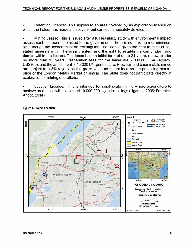
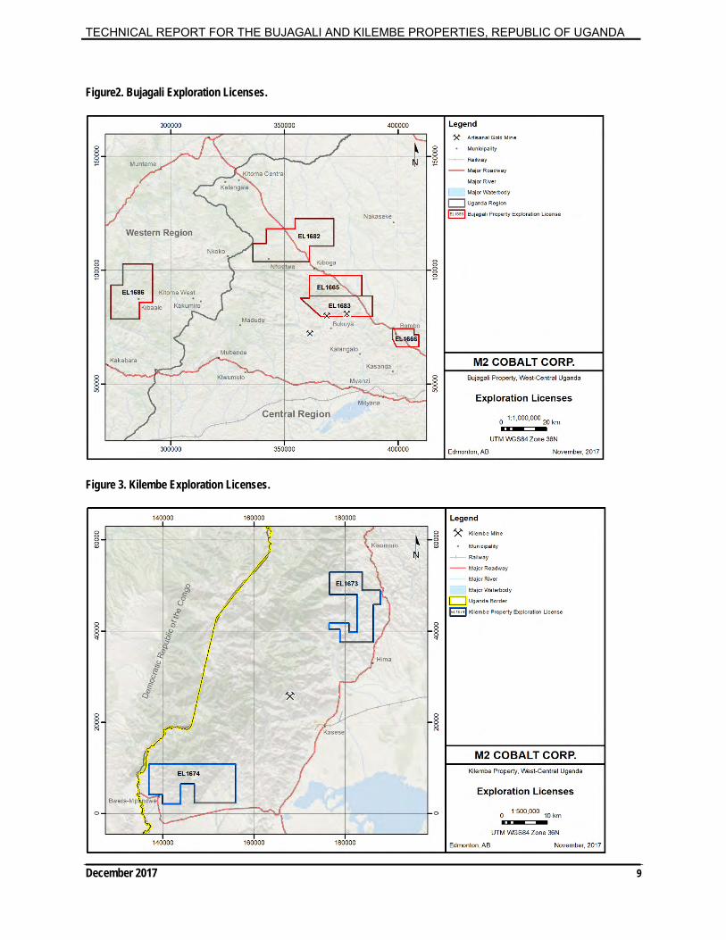
4 Property Description and Location
The author has not attempted to verify the legal status of the properties, nor is he qualified to do so. The exploration licenses are listed on the Uganda Mining Cadastre Portal (http://www.portals.flexicadastre.com/uganda/), which is the data source for all the EL’s, and shows that the map designated licenses are active and in good standing as of November 28, 2017. The properties (Exploration Licenses) are shown on Figures 1, 2 and 3, are listed in Table 1 and copies of the licenses and a legal title opinion are in Appendix 1. The author is not aware of any environmental liabilities specific to the properties. The properties are located within Universal Transverse Mercator (“UTM”) system relative to Zone 36N of the World Geodetic System (“WGS”). In November 2017 M2 Cobalt Corp (“the Company”) signed definitive agreements to acquire seven Exploration Licenses (“EL’s” or “Licenses”) in Uganda from 1126302 B.C. Ltd., 0972697 B.C. Ltd., and Manuforty Holding Company Limited (collectively, the “Vendors”), each arms length parties to the Company and which collectively hold the rights to the Licenses in Uganda through their respective subsidiaries. In consideration for the acquisition of the EL’s, the Company will issue 19,700,000 common shares (the “Consideration Shares”) and will complete a series of cash payments totaling $1,100,000. Upon issuance, the Consideration Shares will be subject to a pooling arrangement from which they will be released in tranches every six months over thirty- six months. The properties are subject to a two percent net smelter return (“NSR”) royalty, held by 0972697 B.C. Ltd., Beta Minerals Limited and Intrepid Minerals Limited. All the properties are Exploration Licenses and are 100 per cent owned by the Vendors.
The Government of Uganda has recognised the importance of the mineral sector in the development of the country. Mineral Sector policy items identified in 2001 were: to stimulate mining sector development by promoting private sector participation; to ensure that mineral wealth supports national economic and social development; to regularize and improve small-scale mining by local artisans; to minimise and mitigate the adverse social and environmental impacts of mineral exploitation; to remove restrictive practices on women participating in the mineral sector and protect children against mining hazards; to develop and strengthen local capacity for mineral development; and, to add value to mineral ores and increase mineral trade. The revision of the Mining Act in 2003 and the Mining Regulations in 2004 were directed at attracting private sector investment in the

TECHNICAL REPORT FOR THE BUJAGALI AND KILEMBE PROPERTIES, REPUBLIC OF UGANDA
December 2017 7
exploration, mining development, mineral beneficiation and marketing of Uganda's mineral resources (Mining Act, 2003; Fournier-Angot, 2014).
Table 1. Exploration License descriptions and status for M2 Cobalt Corp’s Properties.
Exploration License & Number*
Exploration License Size in Square Kilometers
Anniversary Date
Bujagali Property 1665 207.9 23 August, 2020 1666 82.9687 23 August, 2020 1686 354.34 16 October, 2020 1682 479.415 04 October, 2020 1683 246.4 04 October, 2020 Kilembe Property 1673 95.365 18 October, 2020 1674 97.92 07 September, 2020 TOTAL 1564 km2
From: http://portals.flexicadastre.com/uganda/ November, 2017 (* granted for base metals and gold)
Title to minerals in the ground is vested in the Republic of Uganda, and no prospecting or mining operations can be carried out without the appropriate mineral rights licence granted by the government. The mineral rights licences come in five forms:
• Prospecting Licence: A general licence enabling the holder to prospect for suitable mineral exploration areas anywhere in the country, except in areas of existing mineral licences, National Parks or Game Reserves. A company may only prospect if it employs at least one individual with such a licence who must also act as an agent.
• Exploration Licence: Issued to a Ugandan citizen or company registered in Uganda, who must hold a valid Prospecting Licence, with any individual or company allowed to hold one exploration licence if suitable financial resources can be demonstrated. Els cover rectangular areas not exceeding 500 sq. km, and are exclusive for the stated minerals within the area granted (all the EL’s discussed in this report are granted for all base metals and gold). The licence gives the holder right of access and the right to camp within the licence. They cannot overlap an existing retention licence or mining lease. They are issued for up to three years and renewable for two periods of two years each, with a 50% reduction in area with each renewal. The application process is thorough and must include a detailed program with proposed employment of Ugandans and potential environmental impacts (the “Project Brief”). Once the EL is approved along with the Project Brief the work program can commence. Application fees are 650,000 U/= (approx. US$260 as of April 2012), with annual rental 10,000 U/= per sq. km. On expiry a company should apply for a retention licence or mining lease.
TECHNICAL REPORT FOR THE BUJAGALI AND KILEMBE PROPERTIES, REPUBLIC OF UGANDA
December 2017 8
• Retention Licence: This applies to an area covered by an exploration licence on which the holder has made a discovery, but cannot immediately develop it.
• Mining Lease: This is issued after a full feasibility study with environmental impact assessment has been submitted to the government. There is no maximum or minimum size, though the licence must be rectangular. The licence gives the right to mine or sell stated minerals within the area granted, and the right to establish a camp, plant and dumps within the licence. The lease has an initial term of up to 21 years, renewable for no more than 15 years. Preparation fees for the lease are 2,000,000 U/= (approx. US$805), and the annual rent is 10,000 U/= per hectare. Precious and base metals mined are subject to a 3% royalty on the gross value as determined on the prevailing market price of the London Metals Market or similar. The State does not participate directly in exploration or mining operations.
• Location Licence: This is intended for small-scale mining where expenditure to achieve production will not exceed 10,000,000 Uganda shillings (Uganda, 2006; Fournier-Angot, 2014).
Figure 1. Project Location.
TECHNICAL REPORT FOR THE BUJAGALI AND KILEMBE PROPERTIES, REPUBLIC OF UGANDA
December 2017 9
Figure2. Bujagali Exploration Licenses.
Figure 3. Kilembe Exploration Licenses.
TECHNICAL REPORT FOR THE BUJAGALI AND KILEMBE PROPERTIES, REPUBLIC OF UGANDA
December 2017 10
• Retention Licence: This applies to an area covered by an exploration licence on which the holder has made a discovery, but cannot immediately develop it.
• Mining Lease: This is issued after a full feasibility study with environmental impact assessment has been submitted to the government. There is no maximum or minimum size, though the licence must be rectangular. The licence gives the right to mine or sell stated minerals within the area granted, and the right to establish a camp, plant and dumps within the licence. The lease has an initial term of up to 21 years, renewable for no more than 15 years. Preparation fees for the lease are 2,000,000 U/= (approx. US$805), and the annual rent is 10,000 U/= per hectare. Precious and base metals mined are subject to a 3% royalty on the gross value as determined on the prevailing market price of the London Metals Market or similar. The State does not participate directly in exploration or mining operations.
• Location Licence: This is intended for small-scale mining where expenditure to achieve production will not exceed 10,000,000 Uganda shillings (Uganda, 2006; Fournier-Angot, 2014).
With respect to units of measure, unless otherwise stated, this Technical Report uses:
Abbreviated shorthand consistent with the International System of Units (International Bureau of Weights and Measures, 2006);
Distance and ‘small’ weights presented in metric units;
Geographic coordinates are projected in the Universal Transverse Mercator
(“UTM”) system relative to Zone 36N of the World Geodetic System (“WGS”) is consistent with its usage in Uganda;
Analytical values are in grams/tonne (“g/t”); parts per million (“ppm”); parts per
billion (“ppb”); and, per cent (“%”);
Currency in Canadian dollars (“CDN$”).
The Project Briefs for the properties have been approved and therefore all the necessary permits to conduct exploration have been obtained. Prior to commencing work the municipalities must be notified. The author is not aware of any other significant factors or risks that may affect access, title, or the right or ability to perform work on the properties.
The properties are not contiguous in the context of NI43-101 companion policy, Part 1, 1.1(6). However, the properties all within the Proterozoic rocks in Uganda based on: previous work by GTK, the Vendors and the Author and, unique structures. The properties are all early stage exploration properties and are being considered one group with respect to development and an exploration campaign. Therefore, the author considers them one property in the context of NI43-101 and 43-101CP.

TECHNICAL REPORT FOR THE BUJAGALI AND KILEMBE PROPERTIES, REPUBLIC OF UGANDA
December 2017 11
This Technical Report was completed pursuant to the National Instrument (“NI”) 43-101 regulations and guidelines, and in the form prescribed by Form 43-101F1 of the Canadian Securities Administrators (“CSA”). At present, there is no estimated Mineral Resources on the properties. The effective date of this Technical Report is the 5th day of December 2017.
5 Accessibility, Climate, Local Resources, Infrastructure and Physiography
5.1 Access, Local Resources, and Infrastructure
Uganda's economy is based on agriculture. The major commercial crops are coffee, tea, tobacco, cotton, corn, beans, bananas and sesame. Flowers and other horticultural products play an increasing role. Most of the population practices subsistence farming and the country is self-sufficient with respect to basic foods. Tourism plays less of a role than in neighboring countries of Kenya and Tanzania, however Queen Elizabeth and Murchison National Parks and gorilla watching at Bwindi in the west, are gaining popularity.
The properties are all road accessible and have nearby services including food, lodging and basic services. As well, the properties are all readily accessible by truck and foot from multiple access points. Small villages exist throughout the properties (Figures 2 and 3). There is no local skilled labour force with respect to mining and/or exploration.
5.2 Climate and Physiography
Most of Uganda has a mean high temperature of 25-30 degrees Celsius (“oC”) and a mean low of about 15°C. Temperatures tend to be higher in the Lake Victoria basin and in the Nile lowlands and drier areas in the north. The highland areas in the southwest along the Kenyan border and the Ruwenzori Mountains tend to have a milder climate. Annual precipitation ranges from less than 500 millimeters (“mm”) in the northeast to 700 - 1500 mm over much of the central plateau and exceeding 2,000 mm in parts of the Lake Victoria basin and the western mountains. In the south there are two distinct rainy seasons with peaks in April and November while in the north there is a more continuous rainy season from April to November. Microclimates occur around the major lakes and especially at elevations above 2,500 m. Precipitation on the upper Ruwenzori Mountains falls as snow as well as rain and the higher peaks have permanent snow-caps. Exploration can be conducted year-round although access in low-lying areas may be restricted in May and November due to heavy rain.
Uganda is one of six African states that lies on the equator. Most of Uganda is north of the equator. Uganda is a landlocked country in East Africa. It is bordered to the east by Kenya, to the north by South Sudan, to the west by the Democratic Republic of the Congo, to the southwest by Rwanda, and to the south by Tanzania. Uganda is the world's second most populous landlocked country after Ethiopia. The southern part of the country includes a substantial portion of Lake Victoria, shared with Kenya and Tanzania. Uganda
TECHNICAL REPORT FOR THE BUJAGALI AND KILEMBE PROPERTIES, REPUBLIC OF UGANDA
December 2017 12
is in the African Great Lakes region. Uganda also lies within the Nile basin, and has a varied but modified equatorial climate (https://en.wikipedia.org/wiki/Uganda) (Figures 1, 2 and 3).
Uganda consists of a central plateau from 900-1,500 metres above sea level (averaging about 1,200 m), sloping gently to the north with a central down warp occupied by Lake Kyoga. Mountain ranges occur along the western and eastern sides of the country. The western arm of the Great Rift Valley runs down the west side of the plateau and contains Lakes Albert and Edward. The Lake Victoria basin lies in the southeast of the country. Much of the plateau, other than the drier north, has fertile soils and is covered by a mix of farmlands, woodlands and forest.
5.3 Bujagali Property
The topography at the Bujagali Property consists of rolling hills with incised river valleys. The EL’s have a range of elevations from about 1100m to 1200m. Some small patches of dense vegetation occur, however, the vast majority of the EL’s are sparsely vegetated and/or are developed for agriculture (mostly bananas). There are secondary roads throughout the EL’s connecting small villages. With respect to EL 1686, Kibaale is the nearest population centre; with respect to EL’s 1682, 1665, 1683 and 1666 Kiboga is the nearest population centre (Figure 2). Water sources and power are available throughout all of the EL’s. Both Kibaale and Kiboga have food, lodging and basic services necessary to conduct early stage exploration. There is no local skilled labour force with respect to mining and/or exploration.
5.4 Kilembe Property
The topography at the Kilembe Property consists of rolling hills on the eastern portion of the EL’s which steadily increases to the west into the base of the Ruwenzori Mountains. The EL’s have a range of elevations from about 1000m in the east to 1500m in the west. The vast majority of the EL’s are sparsely vegetated and/or are developed for agriculture. There are secondary roads throughout the western portion EL’s connecting small villages. With respect to EL 1676 and 1674, Kasese is the nearest major population centre (approximated 15km from each EL; Figure 3). Water sources and power are available throughout all of the EL’s. Kasese has food, lodging and advanced services necessary to conduct early stage exploration. There is an existing local skilled labour force with respect to mining from the Kilembe Mine.
6 History The Bujagali Property has had some reconnaissance exploration conducted by the vendors (also known as Auranda). This work is documented in Section 9 ‘Exploration’ of this report. Other work conducted is documented below. 6.1 Government Surveys
TECHNICAL REPORT FOR THE BUJAGALI AND KILEMBE PROPERTIES, REPUBLIC OF UGANDA
December 2017 13
Uganda was the recipient of a seven-year world bank funded mineral initiative named ‘Geological Mapping, Geochemical Surveys and Mineral Resources Assessment in selected areas of Uganda’. The contract was awarded to the Finnish Geological Survey Consortium (“GTK”) (GTK, 2011). This included geological mapping, geochemical and geophysical surveys and mineral resource assessments in selected areas of Uganda. The initiative produced a set of high quality geological and geophysical maps (and related products), covering the majority of Uganda as part of an oriented geoscience database to attract investment for the further discovery of mineral deposits (Westerhof et al., 2014).
Following interpretation of airborne geophysical surveys and geochemical sampling programs conducted by GTK, the areas surrounding Kilembe, and another area in west-central Uganda (which the Company refers to as “Bujagali”), were ranked by GTK among the country’s highest exploration priorities for cobalt. 6.1.1 Government Geochemical Surveys GTK conducted many geochemical surveys throughout Uganda:
Specifically, one survey named the ‘Bombo Target’ is within the Bujagali Property.
There are highly anomalous soil samples at the Bombo Target with respect to
nickel, cobalt and copper. These represent a strong target which has yet to be explored (Figures 15, 16, 17 and, 18).
The Bombo Target is further described in Section 9 of this report. 6.1.2 Government Site Inspections GTK conducted reconnaissance mapping and site inspection spot checks to confirm the validity of the geological maps in Uganda:
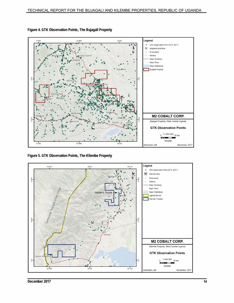
Geological field mapping in the IDA contract area was mainly carried out during 2009 and 2010. Mineral occurrences were recorded during the mapping and the data concerning the mineral occurrences has been stored in the DGSM library and archive.
Geological field work within the IDA area has resulted in a total of 8113 geological
observations/documented field sites. Rock samples and digital photos have been taken at most of the locales. All the data was spatially correlated so that the geologists’ field forms, photos of outcrops and rock samples have coordinates and can be viewed in ArcGIS (GTK, 2011). The sample sites are shown on Figures 4 and 5.
TECHNICAL REPORT FOR THE BUJAGALI AND KILEMBE PROPERTIES, REPUBLIC OF UGANDA
December 2017 14
Figure 4. GTK Observation Points, The Bujagali Property
Figure 5. GTK Observation Points, The Kilembe Property

TECHNICAL REPORT FOR THE BUJAGALI AND KILEMBE PROPERTIES, REPUBLIC OF UGANDA
December 2017 15
As part of the field mapping, more than 200 sites were visited within what is now called the Bujagali Property and 9 sites were visited within what is now called the Kilembe Property. As an example of the importance of this work to M2 Cobalt, volcanic rocks were documented within the Kilembe Property (Figure 5).
6.1.3 Government Geophysical Surveys
The High-Resolution Airborne Geophysical Survey Program for Uganda commenced in 2006. With financial support in the form of loans and grants from World Bank Organization (“WBO”), African Development Bank (“AFDB”), and Government of Uganda, totalling $47 million US dollars, seven blocks, totalling 630,622-line kilometres of magnetic and radiometric surveys were completed. Line spacing for Blocks 1 (southeast-Bugiri and Busia), 2 (west-central-Mubende/Fort Portal/Kamwenge), 3 (southwest-Kabala and Ntungamo), 5 (northwest-West Nile) and 7 (southcentral-Masaka) are 200m and the terrain clearance is 80m. Block 4 (Northcentral-Gulu/Kitgum) has 400m line spacing with 80m terrain clearance. Block 6 (central Uganda), never flown before and therefore considered reconnaissance data, was acquired with 500m line spacing and 80m terrain clearance (Fugro, 2009; Westerhof et al., 2014).
Eight smaller blocks totaling approximately 23,200 line-kilometers were flown with a time domain electromagnetic system (“TDEM”). They were selected based on their potential for hosting mineral deposits that may be characterized by TDEM. These surveys had 200-meter line spacing and system-dependent terrain clearance. Two blocks were flown early in the project using the fixed-wing Tempest system. The remaining six blocks were flown using the heli-Geotem system, in areas of more rugged terrain (Fugro, 2009; Westerhof et al., 2014). The magnetic and radiometric data products have been released to the public. These products should not only assist with geological mapping but have also proven their worth to Ugandan and international mining companies exploring for the extension of the Tanzanian goldfields, the Kilembe copper-cobalt deposit and other mineral commodities (Fugro, 2009). 6.1.4 Industry Geophysical Surveys Back in 1961, a regional airborne geophysical survey was conducted for mineral exploration and was funded by the United Nations Development Programme (“UNDP”) and the government of Uganda which achieved almost 50% coverage by 1980. These surveys were typically flown with 1 km line spacing, 10 km tie lines and 120 m terrain clearance. All magnetic data of the regional programme was subsequently compiled into one data set during the African Magnetic Mapping Project in 1992 (Vangold, 2009).
TECHNICAL REPORT FOR THE BUJAGALI AND KILEMBE PROPERTIES, REPUBLIC OF UGANDA
December 2017 16
7 Geological Setting and Mineralization The geology of Uganda is very varied and spans more than three billion years. It comprises Meso- and Neoarchaean lithospheric fragments, welded together by Paleo-, Meso- and Neoproterozoic fold belts. Extension gave rise to the development of the East African Rift System with the emplacement of some of the world’s most potassium- rich rocks in its Eastern Branch. The latter, of which the northern segment is called the Albertine Rift, is also the locus of the Rwenzori Mountains, a promontory of up to 5,109 meters in altitude and most extreme expression of rift-flank uplift on earth (Westerhof et al., 2014; Auranda, 2015; Figure 6).
7.1 Regional Geology
The Archaean Ugandan Craton is part of the African Plate, a large area of continental crust consisting of the accretion of small cratons (e.g. Uganda, Tanzania) welded together by Proterozoic mobile belts. Much of northern and central Uganda is underlain by Archaean basement gneisses. The southwest part of the country is largely underlain by Proterozoic sediments, minor volcanics and intrusive granites. Major rift faulting commenced in the Tertiary and continued to the present. Tertiary volcanism of mafic to intermediate composition and minor carbonatites also occurred. This includes the formation of large shield volcanoes, the most prominent in Uganda being Mt. Elgon on the Kenyan border. Great thicknesses of Tertiary to Recent sediments fill the fault valleys, especially along the Western, or Albertine Rift, in western Uganda (T. Schluter, 1997; Figure 6).
Precambrian rocks underlie two-thirds of Uganda. Archaean rocks are exposed in the south-east where they are part of the extensive granite-greenstone terrane of the Tanzanian Craton. Three major Proterozoic belts underlie central and west Uganda: the Paleoproterozoic Buganda-Toro metasediments, the Mesoproterozoic Karagwe-Ankolean (Kibaran) Belt and Neoproterozoic Pan-African rocks. The Neoproterozoic includes the Bunyoro Series with tillites and argillites, and the shallow water sediments of the Bukoban Supergroup. Tertiary to Recent sediments filled parts of the down-faulted Western Rift. Tertiary carbonatites and Cenozoic volcanics are related to rift activities and occur along the eastern and western borders of the country (Fournier-Angot, 2014).

TECHNICAL REPORT FOR THE BUJAGALI AND KILEMBE PROPERTIES, REPUBLIC OF UGANDA
December 2017 17
Figure 6. Regional Geology.
7.1.1 Archaean
The oldest rocks of the craton are highly metamorphosed and migmatized sediments and minor igneous rocks originally given the name of "Basement Complex". Some 60% of the rocks outcropping in Uganda are of this group, especially across the northern half of the country and as inliers within the Proterozoic rocks to the south. A regional tectono-metamorphic event took place around 2.9 Ga (Watian Event in northern Uganda) that generated granulites and migmatites. The early Aruan tectono-thermal event in northwest Uganda introduced migmatites around 2.7 Ga, coincident with the collision of an oceanic plate with the continental crust. Shearing and post-tectonic magmatism occurred around 2.6-2.55 Ga. The rocks of the Gneissic-Granulitic Complex are mostly of amphibolite or granulite facies, the latter being older formations that resisted the deformations in the younger rocks. Retrogressive metamorphism is common, though no evidence of progression from amphibolite to granulite facies has been found.
The Archaean Nyanzian System volcanic rocks and associated sediments that form the extensive greenstone belts around the south and east of Lake Victoria in Tanzania are almost absent from Uganda, only occurring in the southeast corner of the country, east of Jinja. Similarly, the conglomerates, arkoses and quartzites of the Kavirondian System that unconformably overlie the Nyanzian are only found in southeast Uganda (Fournier-Angot, 2014).

TECHNICAL REPORT FOR THE BUJAGALI AND KILEMBE PROPERTIES, REPUBLIC OF UGANDA
December 2017 18
7.1.2 Proterozoic
The Paleoproterozoic Buganda-Toro System covers much of southern Uganda and is also known as the Ruwenzori Fold Belt ("RFB") from the common structural event. The RFB extends for about 1,000 kilometers west from Jinja into the Democratic Republic of Congo ("DRC") and is prominently exposed in parts of the Ruwenzori Mountains on the western boundary of Uganda. It is bounded by the Gneissic-Granulite Complex to the north and is unconformably overlain in southwest Uganda by the Mesoproterozoic Karagwe-Ankolean System. The Buganda-Toro System is a broad complex syncline with a gently plunging WSW axis. Age-dating suggests the Buganda Group was formed between 2,536±24 to 1,850±40 Ma (Cahen et al., 1984), with the Toro Supergroup within the same time range.
The name Buganda Group is given to a series of low-grade shales, argillites, phyllites, mica-schists and quartzites in Central Uganda. The basal series comprises quartzitic horizons separated by pelitic rocks, overlain by slates, phyllites and shales, in turn succeeded by mafic volcanics and amphibolites. A lack of marker horizons and unclear base and top make estimates of overall thickness rather speculative, though the group may be 1,000 m near Jinja in the east and up to 7,000 m in central Uganda. The rocks have a general east-west strike, though more SW-NE in southern Uganda.
The term "Toro" was first used in 1933 to describe quartzites in western Uganda. The Toro Supergroup rocks were originally thought to be separate from the Buganda Group due to the higher grade of metamorphism, more migmatization and generally more complex structure, but are now considered to be stratigraphically and lithologically equivalent and the term 'Buganda-Toro System' is preferred for the rocks in western and central Uganda. The Toro Supergroup is characterised by tight folding with steep axial planes, with a greater degree of overturning in the Ruwenzori Mountains. At least two phases and directions of folding are evident throughout the Toro Supergroup.
The Mesoproterozoic Karagwe-Ankolean System forms part of a major intracontinental mobile belt situated between the Congo Craton to the west and the Tanzanian Craton to the east and extends north-northeast to south-southwest for over 2,000 km from southwestern Uganda to northern Angola, west of Lake Victoria and includes much of Burundi. This was traditionally described as the Kibaran Belt (the name derives from the Kibara Mountains in southeast DRC) and is one of the major geological features of central and eastern Africa, with a general north-northeast alignment. It is primarily composed of elastic metasedimentary rocks with minor carbonates and metavolcanic rocks, intruded by voluminous S-type granitoid massifs and subordinate mafic bodies.
Recent work by Tack et al., (2010) and others, has shown that the Kibaran Belt consists of a mosaic of distinct structural and metamorphic terranes, rather than being a homogeneous sedimentary system. Tack et al., (2010) assume the term Kibaran Belt (“KIB”) should be applied to the southern section while the term Karagwe-Ankole Belt (“KAB”) should be applied to the northern section that includes Burundi, Rwanda, and
TECHNICAL REPORT FOR THE BUJAGALI AND KILEMBE PROPERTIES, REPUBLIC OF UGANDA
December 2017 19
Uganda. The break between the sections occurs where a northwest trending Paleoproterozoic rise of Rusizian (DRC) and Ubende (Tanzania) terranes is exposed.
The northern boundary in Uganda of the Karagwe-Ankolean System with the Buganda-Toro System and the Gneissic-Granulite Complex is poorly defined. The argillaceous rocks of the Karagwe-Ankolean in Uganda show a progressive increase in metamorphism up the succession, enhanced by their proximity to granites emplaced in anticlinal cores. In Uganda the Karagwe-Ankolean is characterised by two major fold trends. The predominant Kibaran trend swings to NW, with generally open folds that become tighter between adjacent arena granites. A Northeast cross-folding trend causes doming. Much of the Karagwe-Ankolean is affected by low-grade regional metamorphism, with the grade generally increasing towards the base of the system. Contact metamorphic minerals are rare, even next to the granites.
Early Proterozoic sedimentation was followed in 2,100 Ma to 1,800 Ma by the Eburnean Orogeny, with the development of the northwest-southeast Ubendian-Rusizian tectonic trend. From about 1,780 Ma, sediment from erosion of the Eburnean Mountains was deposited in several shallow-water intra- cratonic basins on the west of the Tanzanian Craton, developing a thickness of over 10 km and a fabric parallel to bedding (Pohl, 1994). Wide deltaic fans, coastal mudflats, and sandbars together with deeper basins containing turbidites and black shales were typical sedimentary environments. Crustal thinning and bimodal magmatism occurred in an extensional regime from 1,375 Ma to 1,370 Ma, with the intrusion of large S-type granites throughout as well as layered mafic/ultramafic rocks along the Kabanga-Musongati suture on the western edge of the Tanzanian Craton. The Bushveld-type nickel-PGE mineralization in the KAB can be ascribed to the 1,375 Ma Kibaran magmatic event.
At approximately 1,100 Ma, major strike-slip shearing occurred, as well as molasse sedimentation within the belt. Around 1,000 Ma the main northeast-southwest trend of the Kibaran Belt developed due to far-field effects of the Rodinian amalgamation, with the development of an S2 fabric cutting Sl/S0. Small geochemically-specialized granites were emplaced, which were dated by Tack et al., (2010) at 986 Ma ±10 Ma. These included "tin granites" that produced numerous rare-metal mineralized (niobium- tantalum-tin (“Nb-Ta-Sn”)) pegmatites and tin-tungsten mineralized quartz veins. Many of the gold deposits occur near major shear zones (possibly associated with deep basement structures) rather than spatially related to the tin granites. Fernandez-Alonso et al., (2012) suggest that most of the gold mineralization is related to the Gondwanan amalgamation around 550 Ma (Fournier-Angot, 2014). Fernandez-Alonso et al., (2012) present a revised lithostratigraphy for the KAB based on Western (“WD”) and Eastern (“ED”) structural domains, separated by the Kabanga-Musongati alignment. Each has an independent sedimentary sub-basin(s) and depositional conditions, the ED over Archaean and the WD over Paleoproterozoic basement. The rocks of the ED are described as the Kagera Supergroup; deposition of an Eburnean-age "molasse" from 1.78 Ga to 1.37 Ga, with Archaean and Paleoproterozoic detrital components consistent with nearby derivation. The rocks of the
TECHNICAL REPORT FOR THE BUJAGALI AND KILEMBE PROPERTIES, REPUBLIC OF UGANDA
December 2017 20
WD are described as the Akanyaru Supergroup, with the lowest two groups deposited between 1.42 Ga to 1.37 Ga. Detrital components are largely Paleoproterozoic, suggesting there is Paleoproterozoic basement and that it contains reworked Eburnean-aged molasse. In the Kivu-Maniema area of the WD in the DRC (including the area of Banro's Twangiza Mine), later sedimentation periods around 1,222 Ma and 710 Ma are documented. The Neoproterozoic Bukoban System, composed of sediments from conglomerates to sandstones, shales and minor basalts, largely occurs in western Tanzania. The only rocks of unquestionable Bukoban age in Uganda are in the southwest on Lake Victoria, but several possible Bukoban outliers occur in central Uganda. These outliers of the Singo, Mityana and Bunyoro Series are of flat-lying essentially unmetamorphosed sediments that are similar to the known Bukoban and younger than the neighbouring granites. The Neoproterozoic of the Mozambique Belt, the longest zone of crustal mobility in Africa, is restricted to northeastern Uganda. The Karasuk Group, an assemblage of gneisses, amphibolites, marbles, quartzites and ultramafic rocks occupies a strip of about 200 km by 40 km along the Uganda/Kenya border in the Karamoja area. In addition, the Aswa Shear Belt within the Gneissic-Granulite Complex may be a major intra-continental transform fault associated with the Pan-African event. This belt runs southeast from Nimule on the Sudan border through Mt. Elgon, a length of about 600 km by 8-9 km wide (Fournier-Angot, 2014).
7.1.3 Palaeozoic-Mesozoic
The Karoo Supergroup is represented in Uganda by three small exposures west of the Western Rift, and at Bugiri, Entebbe and Dagusi in the southeast. It consists of a variety of continental sediments, deltaic wedges interfingering with lacustrine deposits and fluvial and aeolian beds. The Karoo in Uganda appears to be in faulted contact with the Precambrian basement, and was preserved in grabens as tectonic traps. Continental glaciation culminating around the end of the Carboniferous has been recorded from much of Gondwanaland.
7.1.4 Cenozoic-Recent
The East African Rift System ("EARS") runs from the Afar triangle of Ethiopia to the Zambezi River in Mozambique, part of the Afro-Arabian Rift that extends north into Turkey. The eastern branch of the EARS or Gregory Rift runs to the east of Lake Victoria. The Western or Albertine Rift runs from the north of Uganda along the western borders of Uganda, Rwanda, Burundi and Tanzania and is a graben bounded by fault zones around 40-50 km apart. The Western Rift reaches its highest altitude in the middle near Lake Kivu (which has an elevation of 1,460 m ASL) and drops away to the north (Lake Albert is at 617 m ASL) and to the south (Lake Tanganyika is at 774 m ASL). The southern basin of Lake Tanganyika is about 1,500 m deep putting the base of the rift over 700 m below sea level at this point. Lakes Edward and Albert drain north to the river Nile, while Lakes Kivu and Tanganyika eventually drain westwards to the river Congo.

TECHNICAL REPORT FOR THE BUJAGALI AND KILEMBE PROPERTIES, REPUBLIC OF UGANDA
December 2017 21
Steep fault scarps rise from the graben floor; Mt. Margherita in the Ruwenzori Mountains at 5,110 m rises more than 4,000 m from the Semliki Plains. Most of the faults defining the rifts are steep normal or dip-slip faults, frequently offset in en-echelon arrangement. Usually the grabens are asymmetric, with a single large fault on one side and sets of smaller step faults or a monoclonal flexure on the other side. Grid faulting with an average spacing of 1.5 km is common along the graben floor.
The direction and position of the EARS is related to ancient lineaments, and the two arms of the Rift appear to wrap around the Tanzania Craton and overlie the younger mobile belts, presumably following ancient lines of weakness. In Uganda the northern end of the Western Rift is deflected eastwards around the West Nile Craton, and Lake Albert lies parallel to the grain of the basement complex. The Precambrian Ruwenzori block, a horst some 120 km long by 50 km wide, lies to the south between Lakes Albert and Edward and is about 3 km above the Tertiary African Plateau. It is a structural node at the intersection of the E-W Buganda-Toro System with the Western Rift. The Rift has been deflected westwards around this node as the faulting failed to cut the Buganda-Toro units.
The tectonic history of the Western Rift is less well-known than that of the Gregory Rift, in part due to the lesser amount of volcanics which provide critical dating information. Western Uganda lay at about 500 m asl prior to the development of the Rift. A shallow down warp in the middle Miocene (15-16 Ma) formed a basin that filled with the Kasogi Formation sediments (Pickford et al., 1993). The oldest volcanics are lavas from the Vicuna Field in the extreme southwest of the country, at about 12.6 Ma. Pickford et al., (1993) suggest lacustrine conditions began about 10-11 Ma with the formation of Lake Obweruka, about 550 km long, as the rate of downthrow exceeded that of sedimentation. Ultimately over 4 km of sediments built up in the Albert Basin. In the Late Pliocene-Pleistocene uplift of the Ruwenzori Massif caused the compartmentalisation of the Albertine depression, breaking up Lake Obweruka into smaller lakes around 2.6 Ma ago. Pickford et al., (1993) also suggest there was a third stage of rift development around 12-14 Ka BP that led to the present drainage patterns. The Beni Gap through which Lake Albert drained to the Congo Basin was raised by 300 m, causing the Lake to flow out to the north into the Nile. Back tilting of the Rift walls raised the Ruwenzori Massif by about 1,000 m, reversing rivers and leading to the formation of Lake Victoria.
Tertiary volcanics cover about 5% of Uganda. No areas in Uganda are currently active, though the Virunga Field just across the border in the DRC has several active centres. In eastern Uganda, close to the Kenyan border, six main volcanoes occur with Mt. Elgon the highest at 4,321 m asl. Most are nephelinites, phonolites and trachytes, with minor carbonatites. Ages range from 32±1.3 Ma for the oldest carbonatites to 12.5±0 .3 Ma for the nephelinites and alkaline olivine basalts at Moroto. The volcanoes in western Uganda largely occur in four distinct fields; Fort Portal, Ndale, Katwe-Kitorongo and Bunyaruguru, and Bufumbira which is the Uganda section of the Virunga Field. Fort Portal is largely lapilli tuffs with minor carbonatites; Ndale, just north of Lake George, appears to be largely ashes and tuffs of pulverized basement; Katwe-Kitorongo and Bunyaruguru lie on either side of the Kazinga Channel that joins Lake George to Lake Edward and are ultra-potassic with 3-7% K2O; and Bufumbira is an extinct section of the active Virunga Field with the

TECHNICAL REPORT FOR THE BUJAGALI AND KILEMBE PROPERTIES, REPUBLIC OF UGANDA
December 2017 22
cones largely composed of angular and vesicular lava lapilli and bombs, unlike the other fields of western Uganda in having few ejected lava blocks or basement xenoliths, and extensive lava flows. The rocks at Bufumbira include trachytes, leucites, basanites and phonolites, though no true basalts. Ages of the western Uganda volcanics are generally Late Pleistocene to Holocene, including less than 10 Ka BP for Katwe and 4-6 Ka BP at Fort Portal.
Much of the Archaean craton and surrounding rocks was subject to extensive lateritic weathering in the Tertiary. The resulting ferricretes and saprolites, and their subsequent weathering products, are an important focus of mineral exploration efforts in Uganda given the general paucity of outcrop (Fournier-Angot, 2014).
7.2 Property Geology
The Bujagali Property area is comprised of shales, phyllites, schists and sandstones of the lower Proterozoic Buganda‐Toro system, belonging to Kibalian orogeny. The Nile Formation shales, slates and phyllites are the oldest units in the area. Across the central portion of the ELs, the Paleoproterozoic Bujagali Basalt of the Nile Formation trends roughly WNW‐ENE. North of the Bujagali Basalt, the Victoria orthoquartzites are found occasionally interspersed within Archaean shales, siltstone, chert and ironstones in the north. The eastern portion of the area is overlain by the slightly younger Kiryamuddo sandstone‐conglomerate (a plateau characterized by steep escarpments).
The basalt unit is primarily comprised of the mafic volcanics of the Bujagali Basalt member of the Buganda system. Believed to represent a continuation of the Kilembe mafic volcanics, the Bujagali Basalt crosscuts the ELs and is generally comprised of a variably thick sequence of basaltic volcanic extruded on, or intruded in low‐grade meta- pelites of the Nile Formation. However, Archaean shales‐siltstones‐cherts‐ironstones within the area of the ELs immediately south of Kiboga Town, comprise a continuous, coherent belt of basaltic pyroclastic rocks and lava flows, measuring 50 km long and up to 5 km wide, forming a distinct, weak signature on radiometric maps. Due to poor exposure, the footwall contact between basaltic rocks and associated meta-sediments is not fully established. Several outcrops of fine‐grained pyroclastic material, found in the basal part of a volcanic succession west of Kabongezo hill hints to a transitional contact between the volcanic succession and underlying phyllitic rocks. The nature of the upper contact of the basaltic sequence is also not clear but a gradational contact could be established. In the eastern portion of the area, the younger Kiryamuddo Formation conglomerate overlies both the basalt and shale‐phyllite units. The conglomerates form prominent hills easily observable on the ground and on topographic maps and, given their high degree of competence, extend for great distances maintaining their strike and dip. Of additional significance, both the mafic volcanics and sedimentary rock complexes are intruded by a series of subparallel dolerite dykes, which represent zones of pre-existing weakness/extensional cracks that could prove to be highly effective conduits for mobile elements (e.g. gold or selected base metals), fluids and/or important structures with respect to the emplacement of ore deposits.

TECHNICAL REPORT FOR THE BUJAGALI AND KILEMBE PROPERTIES, REPUBLIC OF UGANDA
December 2017 23
A major thrust belt separates the isoclinally folded units of the Victoria orthoquartzite (immediately north of the basalt) and the Nile shale- phyllite formation and the Bujagali basalt formation from the unit to the north comprising shale, siltstone, chert and ironstone, of possible Archaean age. This unit is competent, and forms elevated areas with sparse drainage. This fold and thrust belt is thought to be the first deformational event in the area coincident with the Ubendian Orogeny (Auranda, 2015). The Mubende-Singo Suite in central Uganda includes two extensive granite batholiths. The larger batholith called Mubende (3,000 km2) is located west of Mubende town, and the smaller, Singo (700 km2), occurs NW of the town of Mityana. The latter also includes a small satellite further to the SW. These granite bodies can easily be recognized from airborne geophysical maps. In comparison to the surrounding country rocks, the granites have weaker positive signatures on the magnetic maps. On radiometric images, however, they appear as high potassium anomalies. These plutons have been emplaced into meta-pelites of the Buganda Group and they represent a phase of post-tectonic magmatism in the Rwenzori Fold Belt (Westerhof et al., 2014; Auranda, 2015; Figure 7). At the Kilembe Property area, the Buganda-Toro Sequence forms the host-rocks for the most important base metal deposit in Uganda, the Kilembe Copper-Cobalt Mine, which was opened in 1956. Despite numerous Ph.D., M.Sc. and B.Sc. theses having been written on Kilembe geology over the past 40 years, very few papers on Kilembe have been published (Master, 1997). The highly deformed and faulted Kilembe orebodies consist of massive sulphide lenses composed of chalcopyrite, pyrrhotite and cobaltiferous pyrite, enclosed within banded amphibolites and metasedimentary gneisses and schists of the Buganda-Toro Sequence (Master, 1997). The Ruwenzori Mountains, which form an uplifted horst block on the border between Uganda and Zaire in the Western Rift Valley of the East African Rift System are composed of basement (Archaean) gneisses together with the Buganda-Toro Sequence (Master, 1997; Figure 8). 7.3 Mineralization
Because the Company has just acquired the properties, it is difficult to include a complete discussion on mineralization at the individual properties at this time. Based on the historical compilation and review of sample sites within the boundaries of the properties, cobalt can generally be attributed to areas or zones that have: brecciation; silicification; and iron alteration. Mineralization can include disseminated or blebs of pyrite and chalcopyrite. The alteration patterns and mineralization can occur in any number of rock types but were mainly in meta-sedimentary rocks.
Future exploration work conducted by M2 Cobalt Corp. will focus on cobalt-copper mineralization associated with sediment-hosted, Iron Oxide Copper Gold, and volcanogenic massive sulphide copper cobalt deposit models; these major deposit types are described in the following Section 8, ‘Deposit Types’.

TECHNICAL REPORT FOR THE BUJAGALI AND KILEMBE PROPERTIES, REPUBLIC OF UGANDA
December 2017 24
Figure 7. Detailed Geology, Bujagali Property.
Figure 8. Detailed Geology, Kilembe Property.

TECHNICAL REPORT FOR THE BUJAGALI AND KILEMBE PROPERTIES, REPUBLIC OF UGANDA
December 2017 25
8 Deposit Types
Many deposit types are applicable throughout the Exploration Licenses. While focussing on copper-cobalt mineralization the following deposit types should be considered:
8.1 Sediment-Hosted Stratiform Copper or Katanga Style Copper-Cobalt Deposits
The copper-cobalt minerals hosted in rocks of the Neoproterozoic Katanga Basin in the Central African copper belt metallogenic province of the DRC are a classic example of (low energy) sediment-hosted stratiform copper (“SSC”) ore system deposits. These deposits are economically significant, as they account for approximately 23% of the world’s copper production and known Mineral Reserves being second only to porphyry copper deposits in terms of copper production and the most important global cobalt resource.
The copper-cobalt deposits contained in a sedimentary series of rocks known as the Mines Group in the Katanga sequence and the Roan Group in Zambia. The sediments are shallow-water shales, dolomitic shales, reefal dolomites and possible evaporitic lagoonal mudstones, formed on a platform marginal to a subsiding basin. Rhythmic layering is common. The rocks are exposed in a series of tightly folded and thrusted anticlines and synclines, which generally trend east-west or southeast and are often overturned to the north. Despite this deformation overprint, the mineralized zones, although sometimes lenticular along strike and down dip, as well as showing local diapiric forms, display remarkable large-scale continuity within the Mines Group.
The primary mineralisation, in the form of copper sulphides, is thought to be syn-sedimentary in origin. Typical primary copper sulphide minerals are bornite, chalcopyrite, chalcocite and occasional native copper while cobalt is in the form of carrolite. The mineralisation occurs as disseminations or in association with hydrothermal carbonate alteration and silicification.
Supergene mineralisation is generally associated with the levels of oxidation in the sub-surface sometimes deeper than 100 m below surface. The most common secondary supergene minerals for copper and cobalt are malachite, spherocobaltite and heterogenite.
The mineralization at Tilwezembe Mine is atypical being hosted by the Mwashya or R4 Formation. The mineralization generally occurs as infilling of fissures and open fractures associated with the brecciation. The typical mineralization consists mainly of copper minerals (chalcopyrite, malachite and pseudomalachite), cobalt minerals (heterogenite, carrolite and spherocobaltite) and manganese minerals (psilomelane and manganite).
Despite the large number of variables in the basinal settings of these deposits, most SSC deposits are remarkably similar in terms of their mineralization style, morphology and mineralogy and the critical factors in the exploration for economically viable.
TECHNICAL REPORT FOR THE BUJAGALI AND KILEMBE PROPERTIES, REPUBLIC OF UGANDA
December 2017 26
Historically and currently, the primary metal for extraction is copper. Cobalt mineralisation is present, but the concentrations are typically low (Kamoto Copper Company, 2017).
The Author has been unable to verify the information from other properties and therefore the information is not necessarily indicative of the mineralization on the properties that are the subject of this Technical Report.
8.2 Iron Oxide Copper Gold (“IOCG”) Deposits
Iron oxide copper-gold (IOCG) deposits (Hitzman et al., 1992) are a diverse family of mineral deposits characterised by the following features: (1) Cu with or without Au, as economic metals, (2) hydrothermal ore styles and strong structural controls, (3) abundant magnetite and/or hematite, (4) Fe oxides with Fe/Ti greater than those in most igneous rocks, and (5) no clear spatial associations with igneous intrusions as, for example, displayed by porphyry and skarn ore deposits. In addition, most IOCG deposits display a broad space-time association with batholithic granitoids, occur in crustal settings with very extensive and commonly pervasive alkali metasomatism, and many are enriched in a distinctive, geochemically diverse suite of minor elements including various combinations of uranium, rare earth elements, fluorite, phosphorus, molybdenum, silver, barite, cobalt, nickel and arsenic.
These ore bodies tend to express as cone-like, blanket-like breccia sheets within granitic margins, or as long ribbon-like breccia or massive iron oxide deposits within faults or shears. The tremendous size, relatively simple metallurgy and relatively high grade of IOCG deposits can produce extremely profitable mines. Iron oxide copper-gold deposits are also often associated with other valuable trace elements such as uranium, bismuth and rare-earth metals, although these accessories are typically subordinate to copper and gold in economic terms (Wikipedia, 2017; Hitzman et al., 1992).
8.3 Volcanogenic Massive Sulphide (“VMS”) or Kilembe Style Copper-Cobalt Deposits
Massive sulphides deposits are currently forming in undersea locations characterized by “Black Smokers”. These Black Smokers are plumes of sulphide-rich fluids and represent the venting of hydrothermal fluids, rich in base and precious metals, onto the ocean floor. In contrast to other volcanic-hosted deposits, many Besshi-type deposits (named after a the Besshi Copper Mine in Japan) form thin, laterally extensive sheets of pyrrhotite- and (or) pyrite-rich massive sulfide rock; however, the characteristics of Besshi-type deposits vary considerably. Besshi deposits are notable for their ore concentrations of copper and cobalt and only minor concentrations of zinc.
The highly deformed and faulted Kilembe orebody consists of massive sulphide lenses composed of chalcopyrite, pyrrhotite and cobaltiferous pyrite, enclosed within banded amphibolites and metasedimentary gneisses and schists of the Buganda-Toro Sequence. The Kilembe Deposit is a VMS deposit of the Besshi type (Maiden, 1993). The Ruwenzori Mountains which form the border between Uganda and the DRC in the Western Rift Valley

TECHNICAL REPORT FOR THE BUJAGALI AND KILEMBE PROPERTIES, REPUBLIC OF UGANDA
December 2017 27
of the East African Rift System, and are composed of basement Archaean gneisses together with the Buganda-Toro Sequence (S. Master, 1997 and 1998).
Specific to gold, many deposit types are also applicable:
8.4 Lode Gold
Gold may occur as deposits called lodes, or veins, in fractured rocks. Lode deposits are considered primary gold deposits because they are bedrock deposits that have not been moved. They come in a range of shapes and sizes and can form tabular cross-cutting vein deposits but also may be breccia zones, irregular replacement bodies, pipes, stockworks, and other shapes.
8.5 Epithermal Gold Epithermal gold deposits are a type of lode deposit that contain economic concentrations of gold, silver and in some cases base metals including copper , lead and zinc. Gold is the principal commodity of epithermal deposits, and can be found as native gold, or alloyed with silver. As a lode deposit, epithermal deposits are characterized as having minerals either disseminated through the ore-body, or contained in a network of veins. Epithermal deposits are distinctive from low-grade bulk tonnage deposits such as porphyries in that they are typically high-grade, small size deposits. A few characteristics distinguish epithermal deposits. These deposits are found near the surface and mineralization occurs at a maximum depth of 1 km, but rarely deeper than 600 m. Due to their shallow depth, it can also be noted that epithermal gold deposits form under moderate crustal temperatures of 50-300 o C, and under medium pressure. These deposits commonly occur in island arcs and continental arcs associated with subduction. However, they can also be found in shallow marine environments and associated with hot springs. Due to their shallow-depth location, epithermal gold deposits are more susceptible to erosion; accordingly, these deposits represent a high-grade, easily mineable source of gold (excerpt from ‘an overview of Epithermal Gold Deposits; www.nasdaq.com).
9 Exploration
The property vendors (collectively called “Auranda”) did conduct limited amounts of exploration within the Bujagali Property in 2014 and 2015. Artisanal gold camps exist near the southern boundary of the exploration licenses (Figure 2). The local miners (activity is now suspended by the government) are mining a series of gold-bearing lodes across a large area hosted in Buganda-Toro meta-sedimentary rocks. Approximately 20,000 artisanal miners were active in the area. Two gold-bearing quartz veins have been discovered within and near the licenses. The artisanal sites have similar mineralization as that found in Kisita and Kamalenge Mines (quartz veinlets associated with hematite within sandstones and shales). The area is structurally complex. The Author has been unable to verify the information from other properties and therefore the
TECHNICAL REPORT FOR THE BUJAGALI AND KILEMBE PROPERTIES, REPUBLIC OF UGANDA
December 2017 28
information is not necessarily indicative of the mineralization on the properties that are the subject of this Technical Report.
Auranda completed reconnaissance mapping and selective rock sampling (27 samples) targeting the Bujagali Basalt and its southern contact with phyllite‐shale units. Samples were mainly collected at rock exposures along roads and trails within EL 1665, 1666 and 1683 (figures 9 to 13 show all the samples). Seven of 27 rock grab samples were assayed at ALS Chemex (S. Africa) yielding 1950 parts per million cobalt (“ppm Co”) or 0.19% Co, 332 ppm copper (“Cu”), and 245 ppm zinc (“Zn”). These samples all had a range of values starting at detection to maximum values listed above and shown on figures 9 to 13. The most anomalous samples were associated with extensive brecciation, hematization and/or manganese rich rocks.
Follow‐up rock grab sampling (210 rock samples) spanned a broader area where previously unmapped amphibolites were observed. Stream sediment samples (27 samples) of first and second order streams was conducted, and samples were assayed at ALS Chemex.
Highly anomalous results were most commonly found near to the phyllite‐basalt contact (Kitumbi Fault Zone along an extensive quartz dyke) and within amphibolites (typically near dolerite dykes). Subsequently, reconnaissance rock grab samples contain 0.31% Co; 3.49 grams per tonne gold (“g/t Au”) and 0.17% Cu. Eight rock grab samples contain greater than 0.12% Co from multiple locales, with the highest cobalt concentrations in sulphide-bearing Proterozoic metasedimentary rocks with similarities to those in the Katanga district copper-cobalt mines in the DRC.
As well, 102 heavy mineral concentrates were collected, all of which were analyzed using a simultaneous X-Ray Fluorescence Spectrometer (“XRF”). Seventeen samples were sent for confirmatory assay at Intertek Genalysis in Australia (Figures 9 to 14 show all the samples and results thereon).
More recently the author collected 13 rock grab samples within the Bujagali Property. Most importantly, one rock grab sample contains 0.15 % cobalt, 0.37 % Barium (Ba) and 827 ppm Copper (Plate 1). Other rock grab samples from within the Bujagali Property contain anomalous cobalt (559 ppm Co); copper (220 ppm Cu); iron (31.8% Fe); Manganese (2.95% Mn); barium (0.37% Ba); lithium (213 ppm Li); nickel (133 ppm Ni); zinc (389 ppm Zn) and should be considered important (Figures 9 to 14 show all the samples and results thereon; ranges include values from detection to the maximum values listed above and shown on figures 9 to 14).
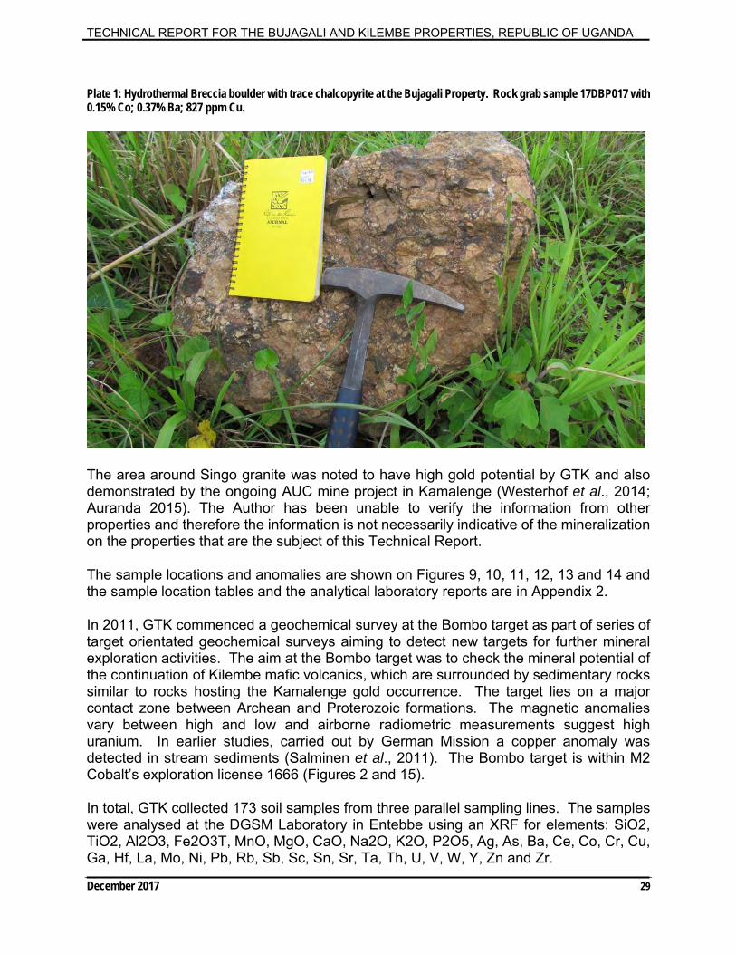
TECHNICAL REPORT FOR THE BUJAGALI AND KILEMBE PROPERTIES, REPUBLIC OF UGANDA
December 2017 29
Plate 1: Hydrothermal Breccia boulder with trace chalcopyrite at the Bujagali Property. Rock grab sample 17DBP017 with 0.15% Co; 0.37% Ba; 827 ppm Cu.
The area around Singo granite was noted to have high gold potential by GTK and also demonstrated by the ongoing AUC mine project in Kamalenge (Westerhof et al., 2014; Auranda 2015). The Author has been unable to verify the information from other properties and therefore the information is not necessarily indicative of the mineralization on the properties that are the subject of this Technical Report.
The sample locations and anomalies are shown on Figures 9, 10, 11, 12, 13 and 14 and the sample location tables and the analytical laboratory reports are in Appendix 2.
In 2011, GTK commenced a geochemical survey at the Bombo target as part of series of target orientated geochemical surveys aiming to detect new targets for further mineral exploration activities. The aim at the Bombo target was to check the mineral potential of the continuation of Kilembe mafic volcanics, which are surrounded by sedimentary rocks similar to rocks hosting the Kamalenge gold occurrence. The target lies on a major contact zone between Archean and Proterozoic formations. The magnetic anomalies vary between high and low and airborne radiometric measurements suggest high uranium. In earlier studies, carried out by German Mission a copper anomaly was detected in stream sediments (Salminen et al., 2011). The Bombo target is within M2 Cobalt’s exploration license 1666 (Figures 2 and 15).
In total, GTK collected 173 soil samples from three parallel sampling lines. The samples were analysed at the DGSM Laboratory in Entebbe using an XRF for elements: SiO2, TiO2, Al2O3, Fe2O3T, MnO, MgO, CaO, Na2O, K2O, P2O5, Ag, As, Ba, Ce, Co, Cr, Cu, Ga, Hf, La, Mo, Ni, Pb, Rb, Sb, Sc, Sn, Sr, Ta, Th, U, V, W, Y, Zn and Zr.
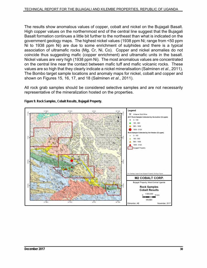
TECHNICAL REPORT FOR THE BUJAGALI AND KILEMBE PROPERTIES, REPUBLIC OF UGANDA
December 2017 30
The results show anomalous values of copper, cobalt and nickel on the Bujagali Basalt. High copper values on the northernmost end of the central line suggest that the Bujagali Basalt formation continues a little bit further to the northeast than what is indicated on the government geology maps. The highest nickel values (1938 ppm Ni; range from <50 ppm Ni to 1938 ppm Ni) are due to some enrichment of sulphides and there is a typical association of ultramafic rocks (Mg, Cr, Ni, Co). Copper and nickel anomalies do not coincide thus suggesting mafic (copper enrichment) and ultramafic units in the basalt. Nickel values are very high (1938 ppm Ni). The most anomalous values are concentrated on the central line near the contact between mafic tuff and mafic volcanic rocks. These values are so high that they clearly indicate a nickel mineralisation (Salminen et al., 2011). The Bombo target sample locations and anomaly maps for nickel, cobalt and copper and shown on Figures 15, 16, 17, and 18 (Salminen et al., 2011).
All rock grab samples should be considered selective samples and are not necessarily representative of the mineralization hosted on the properties.
Figure 9. Rock Samples, Cobalt Results, Bujagali Property.

TECHNICAL REPORT FOR THE BUJAGALI AND KILEMBE PROPERTIES, REPUBLIC OF UGANDA
December 2017 31
Figure 10. Rock Samples, Copper Results, Bujagali Property.
Figure 11. Rock Samples, Gold Results, Bujagali Property.

TECHNICAL REPORT FOR THE BUJAGALI AND KILEMBE PROPERTIES, REPUBLIC OF UGANDA
December 2017 32
Figure 12. Stream Sediment and HMC Sample Cobalt Results, Bujagali Property.
Figure 13. Stream Sediment and HMC Sample Copper Results, Bujagali Property.
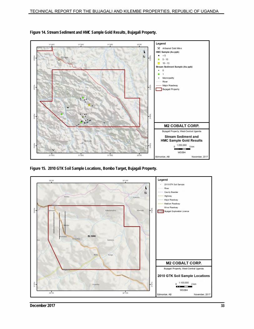
TECHNICAL REPORT FOR THE BUJAGALI AND KILEMBE PROPERTIES, REPUBLIC OF UGANDA
December 2017 33
Figure 14. Stream Sediment and HMC Sample Gold Results, Bujagali Property.
Figure 15. 2010 GTK Soil Sample Locations, Bombo Target, Bujagali Property.

TECHNICAL REPORT FOR THE BUJAGALI AND KILEMBE PROPERTIES, REPUBLIC OF UGANDA
December 2017 34
Figure 16. 2010 GTK Soil Samples XRF Nickel Results, Bombo Target, Bujagali Property.
Figure 17. 2010 GTK Soil Samples XRF Cobalt Results, Bombo Target, Bujagali Property.
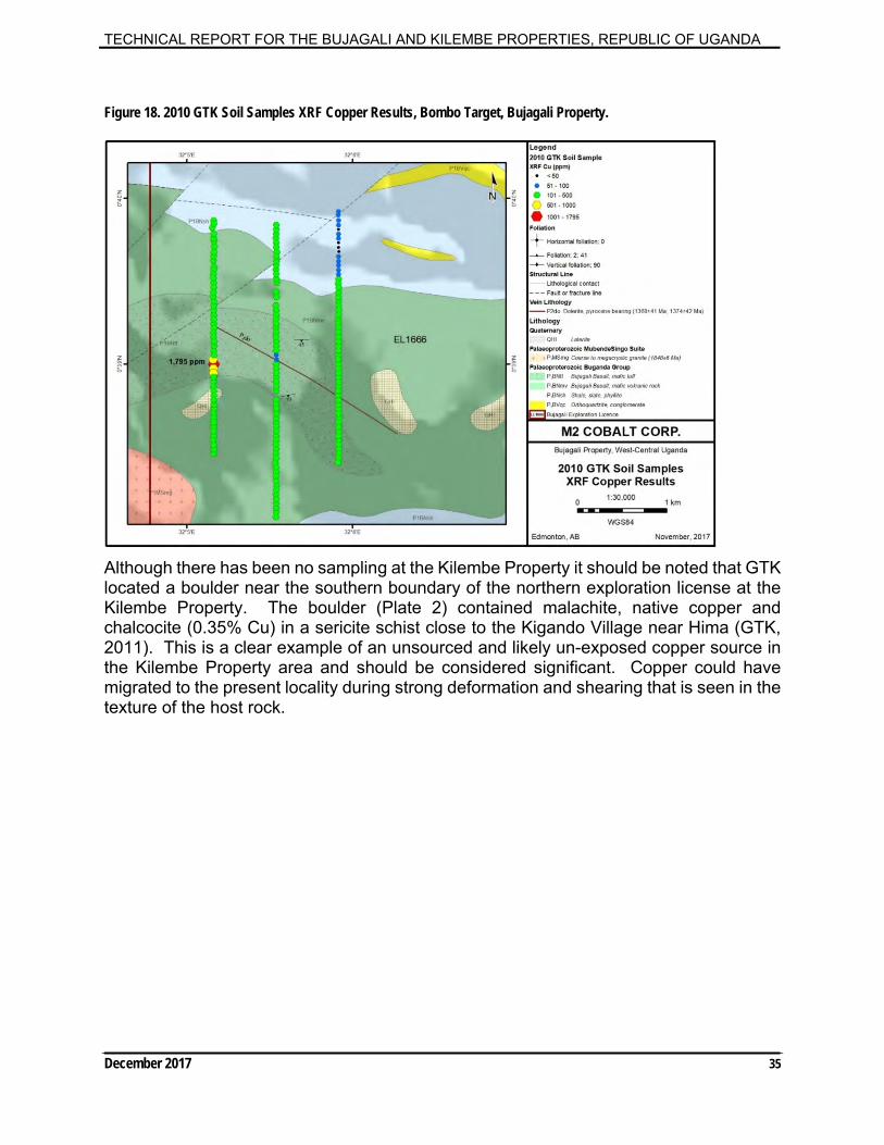
TECHNICAL REPORT FOR THE BUJAGALI AND KILEMBE PROPERTIES, REPUBLIC OF UGANDA
December 2017 35
Figure 18. 2010 GTK Soil Samples XRF Copper Results, Bombo Target, Bujagali Property.
Although there has been no sampling at the Kilembe Property it should be noted that GTK located a boulder near the southern boundary of the northern exploration license at the Kilembe Property. The boulder (Plate 2) contained malachite, native copper and chalcocite (0.35% Cu) in a sericite schist close to the Kigando Village near Hima (GTK, 2011). This is a clear example of an unsourced and likely un-exposed copper source in the Kilembe Property area and should be considered significant. Copper could have migrated to the present locality during strong deformation and shearing that is seen in the texture of the host rock.

TECHNICAL REPORT FOR THE BUJAGALI AND KILEMBE PROPERTIES, REPUBLIC OF UGANDA
December 2017 36
Plate 2: Boulder with malachite, native copper and chalcocite containing 0.35% Cu (From GTK, 2011).
As part of the field mapping, more than 200 sites were visited within the Bujagali Property and 9 sites were visited within the Kilembe Property (Figures 4 and 5; See Section entitled ‘History’). The Author has been unable to verify the information from other properties and therefore the information is not necessarily indicative of the mineralization on the properties that are the subject of this Technical Report.
Even though all samples should be considered selective samples and are not necessarily representative of the mineralization hosted on the properties, they should be considered important. A limited amount of reconnaissance sampling has been conducted thus far and all anomalous sample sites require follow-up sampling to determine their importance and determine if there is greater continuity with respect to mineralization.
9.1 Airborne Geophysics
The High-Resolution Airborne Geophysical Survey Program for Uganda commenced in 2006. With financial support in the form of loans and grants from World Bank Organization (“WBO”), African Development Bank (“AFDB”), and Government of Uganda, totaling $47 million US dollars, seven blocks, totaling 630,622-line kilometers of magnetic and radiometric surveys were completed. Line spacing for Blocks 1 (southeast-Bugiri and Busia), 2 (west-central-Mubende/Fort Portal/Kamwenge), 3 (southwest-Kabala and Ntungamo), 5 (northwest-West Nile) and 7 (southcentral-Masaka) are 200m and the terrain clearance is 80m. Block 4 (Northcentral-Gulu/Kitgum)

TECHNICAL REPORT FOR THE BUJAGALI AND KILEMBE PROPERTIES, REPUBLIC OF UGANDA
December 2017 37
has 400m line spacing with 80m terrain clearance. Block 6 (central Uganda), never flown before and therefore considered reconnaissance data, was acquired with 500m line spacing and 80m terrain clearance (Fugro, 2009; Westerhof et al., 2014).
Eight smaller blocks totaling approximately 23,200 line-kilometers were flown with a time domain electromagnetic system (“TDEM”). They were selected based on their potential for hosting mineral deposits that may be characterized by TDEM. These surveys had 200-meter line spacing and system-dependent terrain clearance. Two blocks were flown early in the project using the fixed-wing Tempest system. The remaining six blocks were flown using the heli-Geotem system, in areas of more rugged terrain (Fugro, 2009; Westerhof et al., 2014).
The magnetic and radiometric data products have been released to the public. These products should not only assist with geological mapping but have also proven their worth to Ugandan and international mining companies exploring for the extension of the Tanzanian goldfields, the Kilembe copper-cobalt deposit and other mineral commodities (Fugro, 2009). The magnetic and radiometric data products have been released to the public. These products should not only assist with geological mapping but have also proven their worth to Ugandan and International mining companies exploring for the extension of the Tanzanian goldfields and other mineral commodities (Fugro, 2009). As well, two historic airborne surveys exist (Geosurvey 1980 and Hunting, 1981; Figure 19 and 20). These surveys are not significant considering the new surveys and high-resolution dataset are available to the public (Fugro, 2009). A curvilinear dyke swarm of regional extent extends from Uganda into Tanzania. Field evidence for this swarm is lacking but evidence from airborne magnetic surveys strongly supports the interpretation of a system of ring dykes of continental proportions. The supposed dykes form a striking picture of a series of parallel features open to the west. The geometrical center of the dyke swarm, lies in the DRC deep below a thick cover of the sediment filling the Congo basin (Uganda, 2006; Figure 21 and 24).
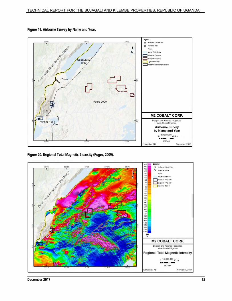
TECHNICAL REPORT FOR THE BUJAGALI AND KILEMBE PROPERTIES, REPUBLIC OF UGANDA
December 2017 38
Figure 19. Airborne Survey by Name and Year.
Figure 20. Regional Total Magnetic Intensity (Fugro, 2009).

TECHNICAL REPORT FOR THE BUJAGALI AND KILEMBE PROPERTIES, REPUBLIC OF UGANDA
December 2017 39
Two arcuate magnetic anomalies related to nickel and cobalt sulphide-rich ultramafic bodies straddle Burundi, northwest Tanzania and southwest Uganda. The anomalies suggest they might form part of the dyke swarm and/or structure and may have economic significance (Uganda, 2006). The distinctive magnetic characteristics of rocks of the Toro System, within which the Kilembe copper-cobalt district lies, appear to extend eastward suggesting potential for copper and other base metals in the area (Uganda 2006; GTK, 2011).
Figure 21. Regional Airborne Magnetics showing curvilinear dyke swarm. (Modified from Uganda, 2006)

TECHNICAL REPORT FOR THE BUJAGALI AND KILEMBE PROPERTIES, REPUBLIC OF UGANDA
December 2017 40
Figure 22. Total Magnetic Intensity, Bujagali Property.
Figure 23. Total Magnetic Intensity, Kilembe Property.
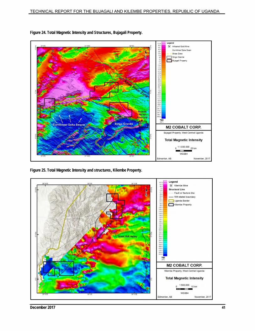
TECHNICAL REPORT FOR THE BUJAGALI AND KILEMBE PROPERTIES, REPUBLIC OF UGANDA
December 2017 41
Figure 24. Total Magnetic Intensity and Structures, Bujagali Property.
Figure 25. Total Magnetic Intensity and structures, Kilembe Property.
TECHNICAL REPORT FOR THE BUJAGALI AND KILEMBE PROPERTIES, REPUBLIC OF UGANDA
December 2017 42
9.2 Structures The Bujagali Property has: a major crustal shear zone transecting two of the licenses which could be important with respect to mineralization and fluid migration; covers a portion of the contact with the Singo granite and overlying sedimentary rocks, which is important as this is the host of the Kamalenge Gold occurrences (which is a large artisanal mining camp); and, a curvilinear dyke swarm of regional extent extends from Uganda into Tanzania. Field evidence for this swarm is lacking but evidence from airborne magnetic surveys strongly supports the interpretation of a system of ring dykes of continental proportions. The supposed dykes form a striking picture of a series of parallel features open to the west. The geometrical center of the dyke swarm, lies in the DRC deep below a thick cover of the sediment filling the Congo basin (Uganda, 2006; Figures 21 and 24). The Kabanga nickel deposits in Tanzania occur along these structures. Two arcuate magnetic anomalies related to nickel and cobalt sulphide-rich ultramafic bodies (VMS) straddle Burundi, northwest Tanzania and southwest Uganda. The anomalies suggest they might form part of the dyke swarm and/or structure and may have economic significance (Uganda, 2006). The structures continue into Uganda and underlie the Bujagali exploration licenses (Figures 21 and 24). The Kilembe licenses are underlain by the Nyamwamba Fault which is an important but poorly understood structure with respect to the Kilembe Mine (Figure 25). The distinctive magnetic characteristics of rocks of the Toro System, within which the Kilembe copper-cobalt district lies, appear to extend eastward suggesting potential for copper and other base metals in the area (Uganda 2006).
10 Drilling
The author has no knowledge of any drilling conducted within the properties.
11 Sample Preparation, Analyses and Security Typically, Auranda prepared samples and analyzed them using X-ray Fluorescence (hand held XRF) at their laboratory in Entebbe. In addition, various samples were analyzed at one or more of: Intertek Genalysis Laboratory Services, Western Australia; ALS Laboratories Ltd., Vancouver, Canada; ALS Chemex South Africa (Pty) Ltd., Johannesburg, South Africa; AGAT Laboratories, Mississauga, Canada; and Activation Laboratories Ltd., Ancaster, Canada. Samples were either sent to one of these ISO Accredited laboratories for: 1. Primary analysis; or, 2. Check analysis for one or more elements. The author did not visit the laboratories but based on field visits has no reason to question the validity of the results to date. Each of the ISO Accredited Laboratories have their procedures readily available on their respective websites with respect to Standards, Blanks and Quality Assurance – Quality Control (“QA-QC”).

TECHNICAL REPORT FOR THE BUJAGALI AND KILEMBE PROPERTIES, REPUBLIC OF UGANDA
December 2017 43
Sampling was conducted by vendors and which was verified to be of industry standard by the author. 11.1 ALS Limited Laboratory Preparation Protocols (Authors Samples) For rock grab samples, approximately 1 kg of material was collected. Samples were bagged with labels on both sides of the bags and a sample tag in the bag. The bags were closed with a tamper proof seal. The samples were kept in the possession of the author in a sealed rice bag and were sent to ALS Laboratories in Vancouver, BC for preparation and analysis, by the author. The samples remained with the author during the site visit and were taken as excess baggage back to Canada. None of the bags were tampered with while in possession of the author and the laboratory reporting nothing unusual with respect to the samples. ALS is accredited by the Standards Council of Canada (SCC) for specific tests listed in the Scopes of Accreditation to ISO/IEC 17025, the General Requirements for the Competence of Testing and Calibration Laboratories, and the PALCAN Handbook (CAN-P-1570). All samples were dried, crushed to 2mm, pulverized with ring and puck to 75 microns and riffle split prior to analysis. The samples were assayed using 50 g nominal weight fire assay with atomic absorption finish (Au-ICP21) and multi-element four acid digest ICP-AES/ICP-MS method (ME-MS41). Rock grab samples were randomly collected, and are selective by nature; the results therefore, are unlikely to represent average grades on the property. The author did not insert any blanks or duplicates. The laboratory completes regimented QA/QC as documented below and listed on the laboratory reports. Laboratory Reports are in Appendix 2. The author is independent of the laboratory and has no reason to question the adequacy of the sample preparation, security and/or analytical procedures. ALS documents their Quality Assurance in a document (ALS Quality Assurance Overview, Revision:8.0, October 23, 2015).
11.1.1 ALS Quality Assurance Overview
The quality assurance program is an integral part of all day-to-day activities at ALS Geochemistry and involves all levels of staff. Responsibilities are formally assigned for all aspects of the quality assurance program.
As part of the program, checks are made to monitor quality at both sample preparation and analytical stages.
Standard specifications for sample preparation are clearly defined and monitored. The specifications for our most common methods are as follows:
Crushing (CRU-31)
> 70% of the crushed sample passes through a 2 mm screen
TECHNICAL REPORT FOR THE BUJAGALI AND KILEMBE PROPERTIES, REPUBLIC OF UGANDA
December 2017 44
Ringing (PUL-31)> 85% of the ring pulverized sample passes through a 75 micron screen (Tyler 200 mesh)
Samples Received as Pulps
>85% of the sample passes through a 75 micron screen (Tyler 200 mesh)
These characteristics are measured and results reported to verify the quality of sample preparation. Our standard operating procedures require that samples at every preparation station are tested regularly throughout each shift. Measurement of sample preparation quality allows the identification of equipment, operators and processes that are not operating within specifications.
QC results from all global sample preparation laboratories are captured by the LIM System and the QA Department compiles a monthly review report for senior management on the performance of each laboratory from this data.
In addition to routine screen tests, sample preparation quality is monitored at ALS Geochemistry through the insertion of sample preparation duplicates. For every 50 samples prepared, an additional split is taken from the coarse crushed material to create a pulverizing duplicate. The additional split is processed and analyzed in a similar manner to the other samples in the submission. The precision of the preparation duplicate results is highly dependent on the individual sample mineralogy, analytes of interest and procedures selected for sample preparation. Therefore the data is most relevant at the client /project level.
All preparation duplicate data is automatically captured, sorted and retained in the QC Database and available on Webtrieve™ for client review. The data is also available on the QC Data Certificates.
The LIMS inserts quality control samples (reference materials, blanks and duplicates) on each analytical run, based on the rack sizes associated with the method. The rack size is the number of sample including QC samples included in a batch. The blank is inserted at the beginning, standards are inserted at random intervals, and duplicates are analysed at the end of the batch. Quality control samples are inserted based on the following rack sizes specific to the method:

TECHNICAL REPORT FOR THE BUJAGALI AND KILEMBE PROPERTIES, REPUBLIC OF UGANDA
December 2017 45
Rack Size Methods Quality Control SampleAllocation
20 Specialty methods including specificgravity, bulk density, and
acid insolubility
2 standards, 1 duplicate, 1blank
28 Specialty fire assay, assay-grade, umpire and concentratemethods
1 standard, 1 duplicate, 1blank
39 XRF methods 2 standards, 1 duplicate, 1blank
40 Regular AAS, ICP-AES and ICP-MS
methods
2 standards, 1 duplicate, 1blank
84 Regular fire assay methods 2 standards, 3 duplicates, 1blank
Laboratory staff analyse quality control samples at least at the frequency specified above. If necessary, they may include additional quality control samples above the minimum specifications.
All data gathered for quality control samples – blanks, duplicates and reference materials are automatically captured, sorted and retained in the QC Database.
Quality Control Limits for reference materials and duplicate analyses are established according to the precision and accuracy requirements of the particular method. Data outside control limits are identified and investigated and require corrective actions to be taken. Quality control data is scrutinised at a number of levels. Each analyst is responsible for ensuring the data submitted is within control specifications. In addition, there are a number of other checks.
If any data for reference materials, duplicates, or blanks falls beyond the control limits established, it is automatically flagged red by the computer system for serious failures, and yellow for borderline results. The Department Manager(s) conducting the final review of the Certificate is thus made aware that a problem may exist with the data set.
TECHNICAL REPORT FOR THE BUJAGALI AND KILEMBE PROPERTIES, REPUBLIC OF UGANDA
December 2017 46
12 Data Verification Sampling was conducted by vendors and the Author. The Qualified Professional site inspection, which was conducted by the author, D. Besserer, P.Geol., on August 16 to 22, 2017, satisfies the National Instrument 43-101 criteria. Furthermore, data verification procedures include:
1. I physically stood on all the properties; 2. I observed some of the initial findings on the Properties including: a) Hydrothermal Breccias with sulphides and cobalt mineralization exist within the
Bujagali Properties. The results are attached below and further described in the section entitled “Exploration”. The results which include anomalous iron, manganese, cobalt, and barium, are consistent with previous results and iron oxide altered meta-sedimentary rocks;
b) A road network exists throughout the properties making the areas readily accessible for exploration;
c) I conducted foot traverses within the properties and reviewed local geology. Proterozoic meta-sedimentary rocks of the Toro Group underlie portions of the exploration licenses; and,
d) Past producing small scale artisanal gold mining camps exist within the Bujagali Property and larger artisanal gold mining camps exist south of but in close proximity to the Bujagali Property. I visited a number of these mining camps.
3. I observed the rocks at the past producing Kilembe Mine; 4. Verify that previous sampling was conducted in according to industry standards.
The author relied on the summary pamphlets provided by Auranda and field observations as recorded on sample cards. More specifically the summaries are entitled: “Info sheets”. Specific showings were visited at each Property. Based on a review of: the local geology; sample sites from previous exploration; and, artisanal workings, the author has no reason to question the validity of the exploration conducted and/or the results thereon. In total, 13 rock samples were collected during the field visit to the properties by the author as part of the verification process. The Author of this report has assumed, and relied on the fact, that all the information and existing technical documents listed in the References Section of this Technical Report are accurate and complete in all material aspects. While the Authors has carefully reviewed all the available information presented to him, he cannot guarantee its accuracy and completeness. The Author reserves the right, but will not be obligated, to revise the Technical Report and conclusions if additional information becomes known to them after the effective date of this report. Analytical work for the authors 2017 rock grab sampling program was conducted at ALS Laboratory in Vancouver, BC. The laboratory is accredited in accordance with the recognized International Standard ISO/IEC 17025 and a conventional analytical method was employed that is standard in rock exploration studies. The author has reviewed the

TECHNICAL REPORT FOR THE BUJAGALI AND KILEMBE PROPERTIES, REPUBLIC OF UGANDA
December 2017 47
geotechnical and geochemical data and found no significant issues or inconsistencies that would cause one to question the validity of the data. 12.1 Data Verification and Quality Control Conclusion Although limited data exists, assay results for the duplicate samples and lab repeat assays show that there is good correlation between the original assays and the duplicate assays. It is concluded that the overall consistency and duplication of the standard reference material assays reflect the laboratory’s ability to reproduce the analytical method routinely. It is the conclusion of D. Besserer, P. Geol., therefore, that the sampling and assaying program employed by the vendors and the certified laboratories during the exploration program produced sample and assay information that meets industry standards for accuracy and reliability. The authors samples are attached below. Table 2. Sample Results

TECHNICAL REPORT FOR THE BUJAGALI AND KILEMBE PROPERTIES, REPUBLIC OF UGANDA
December 2017 48
13 Mineral Processing and Metallurgical Testing
There has been no Mineral Processing or Metallurigical testing completed.
14 Mineral Resource Estimates
There are no Mineral Resource Estimates.
15 Adjacent Properties There are many adjacent properties although to the best of the authors knowledge, aside from artisanal miners, there are no active exploration projects, only artisanal mining. Figure 26 shows an image of all the Mining Leases, Location Licenses, Exploration Licenses and Retention Licenses as of November 27th in Uganda. Although there are many adjacent properties to both the Bujagali and Kilembe properties, the author is not aware of any active exploration programs at this time. Figure 26. Adjacent Properties, Uganda. (Modified from portals.flexicadastre/uganda/ November 2017)
15.1 Kilembe Mine Area
The Kilembe Mine, located in the foothills of Ruwenzori Mountain of western Uganda, consists of a fully permitted Mining License 2151 and a surrounding Exploration License.
TECHNICAL REPORT FOR THE BUJAGALI AND KILEMBE PROPERTIES, REPUBLIC OF UGANDA
December 2017 49
The past producing Kilembe copper-cobalt mine, previously operated by Falconbridge Ltd., which produced over 16 million tons of ore grading 1.98% copper and 0.17% cobalt between 1956 and 1977 (Westerhof et al., 2014). The Author has been unable to verify the information from the Kilembe Mine and therefore the information is not necessarily indicative of the mineralization on the properties that are the subject of this Technical Report.
Uganda Gold Mining Ltd. (“UGM”) entered into an exploration and feasibility study agreement on September 27, 2004 with Kilembe Mines Limited under which it acquired the option to earn a 70% interest in the Kilembe Copper-Cobalt Mine in western Uganda and a 5 km area of interest exploration license surrounding the Mining Lease #2151. UGM was obligated to undertake a specified exploration program and complete a positive feasibility study within three years. A 70-30 joint venture would then be formed with available annual profits as defined in the agreement split initially as follows: 50% to the UGM, the remaining 50% to the vendor until certain facilities and utilities charges borne by the vendor under the agreement are recouped. The mine offices, including all the mine plans from the historic operations remain in useable condition. Kilembe Mines Ltd. owns a hydro electric facility that produces between 2.3 and 6.0 megawatts of electricity depending on seasonal water flows. This power is used internally by Kilembe Mines and any surplus is delivered into the national grid and sold. Revenue from the electricity has historically paid the mine maintenance costs. The mine’s location and climate are excellent. The elevation at over 1500 meters makes for attractive living conditions. The mine is 300 km by paved highway from Kampala, the capital of Uganda. There is an airstrip at Kasese, 13 km from the Kilembe mine site. UGM initiated exploration at the Kilembe Mine as recommended within the RPA report using a team consisting of Canadian and Ugandan geologists along with a technical support staff conducting surface exploration and diamond drilling. The digital data base for the 15,000 meters of underground drilling carried out from 1995 to 1997 by Banff Resources together with the existing data base was computer modelled. During 2005, 24 surface diamond drill holes totalling 3510 metres were completed by UGM. In 2006, UGM terminated its Kilembe agreement due to market conditions (Uganda Gold Mining Ltd., 2006). In 2013, after nearly 30 years of dormancy and after several failed attempts to privatize the mine, a consortium led by Tibet-Hima Mining Company Limited, won the competitive bid to manage, rehabilitate and operate Kilembe Mines Limited for 25 years from 2013 until 2038. In exchange for those rights, the consortium paid a cash down payment of US$4.3 million and is expected to make an annual payment of US$1 million until the end of the concession. Also, the consortium will invest US$135 million into rehabilitating and improving the mine and will increase the capacity of Mubuku Power Station to 12 megawatts. In addition to the cash payments above, the Ugandan government will
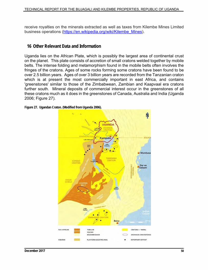
TECHNICAL REPORT FOR THE BUJAGALI AND KILEMBE PROPERTIES, REPUBLIC OF UGANDA
December 2017 50
receive royalties on the minerals extracted as well as taxes from Kilembe Mines Limited business operations (https://en.wikipedia.org/wiki/Kilembe_Mines).
16 Other Relevant Data and Information Uganda lies on the African Plate, which is possibly the largest area of continental crust on the planet. This plate consists of accretion of small cratons welded together by mobile belts. The intense folding and metamorphism found in the mobile belts often involves the fringes of the cratons. Ages of some rocks forming some cratons have been found to be over 2.5 billion years. Ages of over 3 billion years are recorded from the Tanzanian craton which is at present the most commercially important in east Africa, and contains 'greenstones' similar to those of the Zimbabwean, Zambian and Kaapvaal era cratons further south. Mineral deposits of commercial interest occur in the greenstones of all these cratons much as it does in the greenstones of Canada, Australia and India (Uganda 2006; Figure 27). Figure 27. Ugandan Craton. (Modified from Uganda 2006).
TECHNICAL REPORT FOR THE BUJAGALI AND KILEMBE PROPERTIES, REPUBLIC OF UGANDA
December 2017 51
During colonial times Uganda had extensive, semi‐industrial gold production with artisanal activities extending across the country. Due to a variety of factors, post‐colonial production has been limited, except for, Falconbridge’s Kilembe copper‐cobalt mine, which operated until the early‐mid 1970’s when political instability halted all formal mining. Mineral production of gold in Uganda is currently dominated by over 70,000 artisanal miners across the country. Today, Uganda is politically stable and despite its mineral potential, has never been properly explored. In colonial times it was a significant mineral producer and across its borders in the DRC, Rwanda, Tanzania, South Sudan and Kenya are numerous world‐class deposits of strategic minerals, gold and base metals. This mineralization does not stop at the border. Cobalt has many commercial, industrial and military applications. The leading use of cobalt is for rechargeable battery electrodes. The temperature stability and heat- and corrosion-resistance of cobalt-based super-alloys makes them suitable for use in turbine blades for jet turbines and gas turbine engines. Other uses of cobalt include: vehicle airbags; catalysts for the petroleum and chemical industries; cemented carbides and diamond cutting and abrasion tools; drying agents for paints; varnishes and inks; dyes and pigments; ground coats for porcelain enamels; high-speed steels; magnetic recording media; magnets; and steel-belted radial tires. More than half of the global refined production of cobalt comes from the DRC. 17 Interpretation and Conclusions
17.1 General Observations The Company has signed definitive agreements to acquire seven Exploration Licenses in Uganda. This is a large land position in both revitalized and developing metallic mineral districts in Uganda. That is, the Exploration Licenses are comprised of two separate groups that collectively consist of seven EL’s totaling 1564 square kilometers, named the Bujagali and Kilembe properties. The Company’s cobalt project is classified as an early stage exploration project. Having only recently signed agreements to acquire the EL’s the Company has yet to conduct any formal geophysical, drilling; or mineral resource estimate work on the properties. Accordingly, the intent and purpose of this Technical Report is to prepare a geological introduction to the Properties that is in accordance with the Canadian Securities Administration’s National Instrument 43-101.
A preliminary observation of this Technical Report is that Uganda, and in particular the properties, have tremendous exploration potential. Attributing factors to support this broad statement include: a rejuvenated copper-cobalt (VMS) region near Kilembe; a mining friendly jurisdiction; ease of access to the properties; and, the important Buganda-Toro Proterozoic meta-sedimentary and volcanic rocks which underlie all the properties.

TECHNICAL REPORT FOR THE BUJAGALI AND KILEMBE PROPERTIES, REPUBLIC OF UGANDA
December 2017 52
These rocks are of significance such the they host the Kilembe Copper-Cobalt Deposit and are analogous to important Copper-Cobalt deposits in neighboring DRC. Following interpretation of airborne geophysical surveys and geochemical sampling programs under a seven-year World Bank funded project, as well as follow-up studies by the ITC, the properties selected and acquired by the Company are ranked as the highest priority cobalt exploration targets in Uganda.
The intent of this conclusion and interpretations section is to touch on these factors, followed by some general observations and conclusions regarding the overall potential of the properties. The Property observations result from compilation work that was completed during the preparation of this Technical Report and include selected examples of historical Government surveys, exploration work and, the Property visits conducted thereon by the Author. 17.2 Rejuvenated and Developing a Copper-Cobalt Region:
17.2.1.1 Rejuvenating a Copper-Cobalt Region (The Kilembe Property):
Since the closing of the Kilembe Copper-Cobalt Mine, base metal exploration in Uganda has been virtually non-existent. VMS deposits remain an attractive exploration target however, current copper-cobalt specific target evaluation approaches include a broader span of deposit types including: Sediment-Hosted Stratiform Copper or Katanga Style Copper-Cobalt Deposits and, IOCG style targets. In addition, multiple pulses of fluid along faults/major structures can overprint deposit types, for example, early mesothermal textures can be overprinted by later epithermal textures. The Kilembe Property: is along the same major structure (the Nyamwamba Fault) as the past producing Kilembe Mine; underlain by the important Proterozoic Toro System rocks which host the Kilembe Mine; has boulders containing 0.35% Copper which are unsourced; and, the distinctive magnetic characteristics of rocks of the Proterozoic Toro System rocks, within which the Kilembe Mine lies, appear to extend both northeast and southwest. This suggests potential for copper-cobalt mineralization in the area and specifically within the Kilembe Property. More so, the amphibolites which host the Kilembe Deposit have been mapped within M2 Cobalt’s Exploration Licenses. Recent advancements in geophysics and geochemistry and systematic exploration will lead to the discovery of an important deposit(s) in the Kilembe area. 17.2.1.2 Developing a Copper-Cobalt Region (The Bujagali Property): The Bujagali Property: contains altered hydrothermal breccias which are mineralized (samples with 0.31% Co and 0.17%Cu) and are analogous to important copper-cobalt deposit types in the previously unexplored important Proterozoic Toro System rocks; contains a nickel-copper-cobalt soil anomaly indicative of nickel mineralization; and, is underlain by major structural crustal shear zone. Recent advancements in geophysics and geochemistry and systematic exploration will lead to the discovery of an important deposit(s) in the Bujagali area.
TECHNICAL REPORT FOR THE BUJAGALI AND KILEMBE PROPERTIES, REPUBLIC OF UGANDA
December 2017 53
17.3 Mining Friendly Jurisdiction: Uganda has several advantages for mineral exploration and development: there is excellent geoscience database (including geological, geochemical and geophysical data); there is a transparent methodology for acquiring mineral properties; there are clear and concise mining laws (Mining Act, 2003); and, there is a well-developed Cadastre system. 17.4 Access: Access to the properties can be achieved many ways. All the Exploration Licenses have road access via both major and secondary roads. A series of small farming villages exist throughout the properties making them virtually 100 per cent accessible for exploration via truck and foot traverses. The emergence of a newly developing oil and gas sector in Uganda is certain to further develop the already excellent infrastructure in Uganda. 17.5 Timing of Mineralization and Structure: The Uganda Craton lies within the African Plate, which is one of the largest areas of continental crust on the globe. The Plate consists of the accretion of small cratons welded together by mobile belts. This includes the metallogenically important Congo Craton and the Tanzanian Craton which contain numerous economic mineral deposits. We know from the presence of important copper-cobalt deposits in the neighboring DRC and the presence of the Kilembe Mine that the Proterozoic Toro System rocks are important with respect to hosting copper-cobalt mineralization and likely other yet undiscovered deposits. As well, the properties are underlain by important structures likely responsible for mineralization as fluids migrate and pulse. As a result, nearly all known copper-cobalt deposit types are valid and important with respect to developing a new cobalt district in Uganda and more specifically within the M2 Cobalt properties. 17.6 Concluding Statement: It is the opinion of the Author that the Bujagali and Kilembe properties are properties of merit and represent an opportunity to both rejuvenate a copper-cobalt district and/or develop a newly emerging copper-cobalt district. Many deposit types are important and valid. Recent advancements in geophysics and geochemistry and systematic exploration will lead to the discovery of an important deposit(s) in Uganda. The author is not aware of any risks or uncertainties that could affect the reliability or confidence of the exploration information, nor does he see any foreseeable impacts with respect to the projects viability or continued viability at this time.
TECHNICAL REPORT FOR THE BUJAGALI AND KILEMBE PROPERTIES, REPUBLIC OF UGANDA
December 2017 54
18 Recommendations The Company intends to launch an extensive exploration program with the goal of discovering cobalt mineral deposits in Uganda. More specifically the exploration licenses are underlain by Proterozoic rocks which exhibit important similarities to the major producing cobalt mines in the Democratic Republic of Congo (“DRC”). The Uganda Craton lies within the African Plate, which is one of the largest areas of continental crust on the globe. The Plate consists of the accretion of small cratons welded together by mobile belts. This includes the metallogenically important Congo Craton and the Tanzanian Craton which contain numerous economic mineral deposits. The Bujagali and Kilembe properties: (1) The Bujagali Property: (a) is underlain by the important Buganda-Toro Proterozoic meta-sedimentary and volcanic rocks. These rocks are of significance such the they host the past producing Kilembe Copper-Cobalt Mine; (b) covers a portion of the contact with the Singo granite and overlying sedimentary rocks, which is important as this is the host of the Kamalenge Gold occurrences (which is a large artisanal mining camp); (c) contains wide spread alteration throughout the licenses similar in style to that of IOCG type deposits and Proterozoic sedimentary-hosted Katanga Cu-Co deposits in the DRC; (d) has a major crustal shear zone transecting two of the licenses which could be important with respect to mineralization and fluid migration; (e) has reconnaissance rock grab samples containing 0.31% Co; 3.49 grams per tonne gold (“g/t Au”) and 0.17% Cu. Eight rock grab samples contain greater than 0.12% Co from multiple locales, with the highest cobalt concentrations in sulphide-bearing Proterozoic metasedimentary rocks with similarities to those in the Katanga district copper-cobalt mines in the DRC; (f) has a nickel, copper, cobalt anomaly with 1938 parts per million nickel in soils, at the Bombo area which was delineated by GTK and is, “clearly indicative of nickel-cobalt mineralization” in the underlying volcanic and/or ultramafic rocks; and, (g) a curvilinear dyke swarm of regional extent extends from Tanzania through Uganda into the DRC as seen on the regionally compiled magnetics. The Kabanga nickel deposits in Tanzania occur along these structures. The structures continue into Uganda and underlie the exploration licenses. (2) The Kilembe Property: (a) is underlain by the important Buganda-Toro Proterozoic meta-sedimentary and volcanic rocks. These rocks are of significance such the they host the Kilembe Copper-Cobalt Deposit. More so, the amphibolites which host the Kilembe Deposit have been mapped within M2’s Exploration Licenses; (b) contains distinctive magnetic characteristics of the Buganda-Toro System, within which the Kilembe copper-cobalt district lies, suggesting potential to host base metal mineralization; and (c) has boulders near the exploration licenses containing copper mineralization where the source has yet to be discovered (The Author has been unable to verify the information from other properties and therefore the information is not necessarily indicative of the mineralization on the properties that are the subject of this Technical Report).

TECHNICAL REPORT FOR THE BUJAGALI AND KILEMBE PROPERTIES, REPUBLIC OF UGANDA
December 2017 55
It is the opinion of the Author that the Bujagali and Kilembe properties are properties of merit and represent an opportunity to both rejuvenate a copper-cobalt district and/or develop a newly emerging copper-cobalt district. Many deposit types are important and valid. Recent advancements in geophysics and geochemistry and systematic exploration will lead to the discovery of an important deposit(s) in Uganda. The Company intends to launch an extensive exploration program with the goal of discovering cobalt mineral deposits in Uganda. Therefore, an aggressive exploration program is warranted. The properties are high priority for follow-up exploration.
The exploration should include but not be limited to the following recommendations:
Phase 1a: Property data, including the known geology, geophysics, sample data, open file data, aerial photographs, remote sensing data and all the prior exploration data should be digitally compiled and re-interpreted using Micromine (or equivalent) and ArcGIS (or equivalent). This data should include, but not be limited to: airborne geophysical survey data; historic interpretations; geochemical soil sample data; known geology; occurrence information; surface rock sample information; remote sensing data and ortho-rectified aerial photographs. As well, an initial structural interpretation should be completed utilizing the existing airborne geophysics for each property ($220,000).
Phase 1b:
a. Detailed systematic exploration at Bujagali and Kilembe. This would include but not be limited to: a. Flying the entire property with drones to determine access, culture, outcrops, old workings, gossans by making high-resolution photo mosaics (assumes 4 months $100,000); b. A large mobile sampling program utilizing two, 3-man crews consisting of 1 geologist and 2 geological assistants. The program should include Heavy Mineral Concentrate (“HMC”), stream sediment, soil and rock grab sampling as well as concurrent ground magnetics. Specifically, anomalous areas known from recent and historic work with favorable geology would be the initial focus followed by systematic sampling throughout the licenses. Since the properties are all accessible, ground traverses in north-south lines should be completed in three-person teams. HMC and stream sediment samples would be collected in all primary drainages. Soil samples would be collected at regular spaced intervals along lines. As part of traversing, prospecting (rock grab sampling) and rudimentary mapping would be completed concurrently to the HMC and stream sediment sampling. Ground magnetics would be completed using a walking magnetometer with a built in DGPS. As well, a ground magnetic map and rudimentary local geology map would be produced for each license (assumes 7500 samples and approximately nine months of field work including geophysics) ($1,395,000); c. Trenching and reconnaissance drilling as part of bedrock mapping and sampling to help better understand the nature of mineralization and geology. In areas where existing soil and rock sample anomalies exist with limited outcrop, utilize a rotary drill to test anomalies and/or top of bedrock for geochemical and geological mapping ($1,150,000);
TECHNICAL REPORT FOR THE BUJAGALI AND KILEMBE PROPERTIES, REPUBLIC OF UGANDA
December 2017 56
d. Complete a high-resolution magnetics and electromagnetics helicopter borne airborne geophysical survey at the Kilembe and Bujagali properties. The surveys should be flown at a minimum 200-meter line spacing. The goal of the surveys would be to discover a massive sulphide body(s) of similar style to that of the past producing Kilembe Mine ($1,835,000), and; e. Complete regional ground gravity surveys throughout the Kilembe and Bujagali properties ($350,000). Gravity surveys are often used as a follow-up to electromagnetic surveys and can help with sub-surface/geological mapping and prioritization of electromagnetic anomalies. The total cost to complete the recommended Phase 1 exploration is $5,250,000Cnd., including a $200,000 contingency. Phase 2. A comprehensive follow-up program (dependent on the results of the Phase 1 exploration), should include drilling, trenching and detailed sampling as part of a completing a maiden resource(s) at one or more areas.
The detailed budget for the recommended exploration is shown in Table 2.
TECHNICAL REPORT FOR THE BUJAGALI AND KILEMBE PROPERTIES, REPUBLIC OF UGANDA
December 2017 57
Table 3. Detailed Budget for Recommended Exploration

TECHNICAL REPORT FOR THE BUJAGALI AND KILEMBE PROPERTIES, REPUBLIC OF UGANDA
December 2017 58
19 Date and Signature Page
Dated this 5th day of December 2017 Edmonton, Alberta, Canada
Signed and Sealed Dean J. Besserer, P.Geol.
TECHNICAL REPORT FOR THE BUJAGALI AND KILEMBE PROPERTIES, REPUBLIC OF UGANDA
December 2017 59
20 References
Auranda (2015). Info sheet for the Bujagali Properties. Unpublished internal document.
L. Cahen, N.J., Shelling, J. Delhal, J.R. Vail, M. Bonhomme, and D. Ledent, (1984). Geochronology and Evolution of Africa. Clarendon, Oxford, 512p.
M. Fernandez-Alonso et al., (2012). The Mesoproterozoic Karagwe-Ankole Belt (formerly the NE Kibara Belt): The result of prolonged extensional intracratonic basin development punctuated by two short-lived far-field compressional events. Precambrian Research 216-219 (2012), pp. 63-86.
B. Fournier-Angot, (2014). Technical Report on the Murchison Mineral Exploration Property, Republic of Uganda, East Africa.
Fugro (2009). Ministry of Energy & Mineral Development African Development & World Bank MRMCBP/SMMRP– Airborne Geophysics UGANDA. PowerPoint Presentation (Kampala 16 & 17 July 2009 – Martin Frere).
GTK (2011). Geological Mapping, Geochemical Surveys and Mineral Resources Assessment in Selected Areas of Uganda. IDA Final Technical Report 2008-2011.
Hitzman, M.W., Oreskes, N. and Einaudi, M.T. (1992). Geological characteristics and tectonic setting of Proterozoic iron oxide (Cu-U-Au-REE) deposits; Precambrian Research, v. 58, p. 241–287.
Kamoto Copper Company (2017). Katanga Mining Limited, NI 43-101 Technical Report on the material assets of Latanga mining limited, lualaba province, Democratic Republic of Congo.
K.J. Maiden (1993). Exploration models for Besshi-type deposits. Resource Geology Special Issue, No. 17, pages 324-330.
S. Master, (1998). New developments in understanding the origin of the Central African Copperbelt. Abstract, Mineral Deposits Studies Group Meeting, University of Greenwich, 5-6 January 1998.
S. Master, (1997). Bibliography of the Geology and Mineral Resources of the Paleoproterozoic Buganda-Toro sequence, the kilembe mine, and the Ruwenzori Mountains, Uganda and Zaire (1890-1997). Information Circular No. 308. Department of Geology, University of the Witwatersrand, South Africa.
J. Nyakaana (1994). Ground Geophysical Studies Near the Kilembe Mine, Uganda and Their Relation to the Interpretation of Regional Aeromagnetic Data in Central Africa, SW Uganda, Rwanda, Burundi, NW Tanzania. ITC, 110 pages.
M. Pickford, et al. (1993). Geology and paleobiology of the Albertine Rift Valley, Uganda-Zaire. 1: Geology, International Centre Training Exchange Geoscience, pp. 1–190.

TECHNICAL REPORT FOR THE BUJAGALI AND KILEMBE PROPERTIES, REPUBLIC OF UGANDA
December 2017 60
R. Salminen, B. Backman, J. Elsenbroek, H. Savolainen, and E. Korkiakoski (2011). Report of Geochemical Surveys at Bombo Target. GTK Consortium.
T. Schluter (1997). Geology of East Africa. Edition 1. 484 pages.
L. Tack et al. (2010). The 1375 Ma “Kibaran Event” in Central Africa: Prominent emplacement of bimodal magmatism under extensional regime. Precambrian Research, v.180, pp.63-84.
Uganda Gold Mining Ltd. (2006). Consolidated Financial Statements April 30, 2006 and 2005.
The Republic of Uganda (2006). Opportunities for Mining Investment. Public document circulated in 2006. 76 pages, 2000 copies.
The Republic of Uganda (2003). Uganda - Mining Act.
Vangold (2009). Uganda Launches High Resolution Airborne Geophysical Data. Press release date January 8, 2009.
A.B. Phil Westerhof, Paavo Härmä, Edward Isabirye, Edwards Katto, Tapio Koistinen, Eira Kuosmanen, Tapio Lehto, Matti I. Lehtonen, Hannu Mäkitie, Tuomo Manninen, Irmeli Mänttäri, Yrjö Pekkala, Jussi Pokki, Kerstin Saalmann and Petri Virransalo (2014). Geology and Geodynamic Development of Uganda with Explanation of the 1:1,000,000 Scale Geological Map. GTK - Geological Survey of Finland, Special Paper 55.
TECHNICAL REPORT FOR THE BUJAGALI AND KILEMBE PROPERTIES, REPUBLIC OF UGANDA
December 2017 61
21 Certificate of Author
I, Dean J. Besserer, P.Geol., of 8429 24 St. NW, Edmonton, Alberta, do hereby certify that: 1. I am a Senior Geologist and consultant M2 Cobalt Corp. 2. I graduated with B.Sc. in Earth Sciences (Geology) from the University of Western Ontario in 1995. 3. I am registered as a Professional Geologist with the Association of Professional Engineers and Geoscientists of Alberta (APEGA) and with the Northwest Territories and Nunavut Association of Professional Engineers and Geoscientists (NAPEG). 4. I have worked as a geologist for 22 years since my graduation from university. 5. I have read the definition of “qualified person” set out in National Instrument 43-101 and certify that due to education, experience, independence and affiliation with a professional association, I meet the requirements of an Independent Qualified Person as defined in National Policy 43-101. 6. I am responsible for and have supervised the preparation of the Report titled “Technical Report for The Bujagali and Kilembe Properties, Republic of Uganda”, and dated December 5, 2017. I visited the Properties in 2015 and conducted exploration and internal reporting thereon on behalf of the Vendors and again in August 2017, as described in this Report. 7. I am not aware of any material fact or material change with respect to the subject matter of the Technical Report that is not reflected in the Report, the omission to disclose which makes the Assessment Report misleading. 8. I am independent of the issuer and the vendors applying all the tests in section 1.5 of NI 43‐101. 9. I have read National Instrument 43‐101 and Form 43‐101F1, and the Technical Report has been prepared in compliance with that instrument and form. 10. I consent to the filing of the Technical Report with any stock exchange and other regulatory authority and any publication by them for regulatory purposes, including electronic publication in the public company files or their websites. Dated this 5th day of December 2017 Edmonton, Alberta, Canada
Signed and Sealed Dean J. Besserer, P.Geol.
Related Documents