NPS Form 10·900 (Oct. 1990) United States Department of the Interior National Park Service National Register of Historic Places Registration Form OMB·No. 11124'=00 t.r ...... <:.f) 2280 [ PR NAT. R EGi STLH OF HISTORIC PlACES PARK SERVICE This form Is for use In nominating or requesting determinatrons of eligibility lor Individual properties or dlstrlcls. 1 10na agister of Historic Places Reglstrefion Form (National Register BulleUn 1 eA) . Complete each item by marki ng "x" in the appropriate box or by entering the information requested. II an Item does not apply to the property bei ng documented , enter "N/A" fo r "not applicable.' ' For functions , architectural classification , materials and areas of significance, enter onl'y categories and subcategories listed In the Instructions. Place additional entries an d narrative Items on continuation sheets (NPS Form 10-900a). Use a typewriter, word processor, or computer, to complete all items. 1. Name of Property: historic name Meetinghouse Green Road Cemetery other names/site number 2. Location street & number Cross Road and Meeting House Rd . city or town Meetinghouse Green state New York code NY county Herkimer 3. State/Federal Agency Certification code 043 0 not for publication [RI vicinity zip code 13491 As the designated authority under the National Historic PreseNation Act, as amended, I certify that this 0 nomination 0 request for determination of eligibility meets the documentation standards for registering_properties in the National Register of Historic Places and meets the procedural and professional requirements set forth in 36 CFR Part 60 . In my opinion, the property 0 meets D does not meet the National Register criteria. I recommend that this property be considered significant D na i nally D atewide [K] locally. D See continuation sheet for additional comments. w State or Federal a enc and bureau In my epinion, the property 0 meets D does not meet the National Register criteria. 0 See continuation sheet for additional comments. Signature of certifying officialffitle entered in the National Register. D See continuation sheet. 0 determined eligible for the National Register. D See continuation sheet. D determined not eligible for the National Register. 0 removed from the National Register. 0 other, (explain:) Date

Welcome message from author
This document is posted to help you gain knowledge. Please leave a comment to let me know what you think about it! Share it to your friends and learn new things together.
Transcript

NPS Form 10·900 (Oct. 1990)
United States Department of the Interior National Park Service
National Register of Historic Places Registration Form
OMB·No. 11124'=00
REC•w-~··.
~-··' t.r ...... ~ <:.f) 2280
[ PR 19~013 NAT. REGiSTLH OF HISTORIC PlACES
AT1CX~AL PARK SERVICE This form Is for use In nominating or requesting determinatrons of eligibility lor Individual properties or dlstrlcls. l~ll~llf'FfCj'W'flj 1 10na agister of
Historic Places Reglstrefion Form (National Register BulleUn 1 eA). Complete each item by marking "x" in the appropriate box or by entering the information requested. II
an Item does not apply to the property being documented, enter "N/A" for "not applicable.'' For functions, architectural classification, materials and areas of significance,
enter onl'y categories and subcategories listed In the Instructions. Place additional entries and narrative Items on continuation sheets (NPS Form 10-900a). Use a
typewriter, word processor, or computer, to complete all items.
1. Name of Property:
historic name Meetinghouse Green Road Cemetery
other names/site number
2. Location
street & number Cross Road and Meeting House Rd.
city or town Meetinghouse Green
state New York code NY county Herkimer
3. State/Federal Agency Certification
code 043
0 not for publication
[RI vicinity
zip code 13491
As the designated authority under the National Historic PreseNation Act, as amended, I certify that this 0 nomination
0 request for determination of eligibility meets the documentation standards for registering _properties in the National Register
of Historic Places and meets the procedural and professional requirements set forth in 36 CFR Part 60. In my opinion, the property
0 meets D does not meet the National Register criteria. I recommend that this property be considered significant
D na i nally D atewide [K] locally. D See continuation sheet for additional comments.
w State or Federal a enc and bureau
In my epinion, the property 0 meets D does not meet the National Register criteria. 0 See continuation sheet for
additional comments.
Signature of certifying officialffitle
entered in the National Register. D See continuation sheet.
0 determined eligible for the National Register. D See continuation sheet.
D determined not eligible for the National Register.
0 removed from the National
Register.
0 other, (explain:)
Date

Meetinghouse Green Road Cemetery
Herkimer County, New York
Name of Property County and State
5. Classification
Ownership of Property Category of Property Number of Resources within Property (Check as many boxes as apply) (Check only one box) (Do not include previously listed resources in the count.)
private building(s) Contributing Noncontributing
X public-local district 0 0 buildings
public-State X site 1 0 sites
public-Federal structure 0 0 structures
object 0 0 objects
1 0 Total
Name of related multiple property listing (Enter "N/A" if property is not part of a multiple property listing.)
Number of contributing resources previously listed in the National Register
N/A 0
6. Function or Use
Historic Functions (Enter categories from instructions)
Current Functions (Enter categories from instructions)
FUNERARY: Cemetery FUNERARY: Cemetery
7. Description
Architectural Classification (Enter categories from instructions)
Materials (Enter categories from instructions)
N/A foundation N/A
walls N/A
roof N/A
other
Narrative Description (Describe the historic and current condition of the property on one or more continuation sheets.)
See continuation Sheet
Meetinghouse Green Road Cemetery
Herkimer County, New York
Name of Property County and State
8 Statement of Significance
Applicable National Register Criteria Areas of Significance (Mark "x" in one or more boxes for the criteria qualifying the property for National Register listing.)
(Enter categories from instructions)
EXPLORATION/SETTLEMENT
X A Property is associated with events that have made
a significant contribution to the broad patterns of
our history.
B Property is associated with the lives of persons
significant in our past.
C Property embodies the distinctive characteristics
of a type, period or method of construction or Period of Significance
represents the work of a master, or possesses 1801-1963
high artistic values, or represents a significant and
distinguishable entity whose components lack
individual distinction.
D Property has yielded, or is likely to yield, Significant Dates
information important in prehistory or history. 1801, 1963
Criteria considerations (mark "x" in all the boxes that apply.)
Property is: Significant Person (Complete if Criterion B is marked above)
A owned by a religious institution or used for N/A
religious purposes.
B removed from its original location. Cultural Affiliation
N/A
C a birthplace or grave.
X D a cemetery.
E a reconstructed building, object or structure. Architect/Builder
N/A
F a commemorative property.
G less than 50 years of age or achieved significance
within the past 50 years.
Narrative Statement of Significance (Explain the significance of the property on one or more continuation sheets.)
9. Major Bibliographical References
Bibliography (cite the books, articles, and other sources used in preparing this form on one or more continuation sheets.)
Previous documentation on file (NPS): Primary location of additional data preliminary determination of individual listing (36 x State Historic Preservation Office
CFR 67) has been requested Other State agency
previously listed in the National Register Federal agency
previously determined eligible by the National Local government
Register University
designated a National Historic Landmark Other
recorded by Historic American Buildings Survey Name of repository:
#
recorded by Historic American Engineering
Record #
Meetinghouse Road Cemetery
Herkimer County, New York Name of Property County and State
10. Geographical Data
Acreage of property 1.3 Acres
UTM References (Place additional UTM references on a continuation sheet.)
1 18 486621 4751812 3 Zone Easting Northing Zone Easting Northing
2 4
See continuation sheet
Verbal Boundary Description (Describe the boundaries of the property on a continuation sheet.)
Boundary Justification (Explain why the boundaries were selected on a continuation sheet.)
11. Form Prepared By
name/title Travis Bowman, Historic Preservation Program Analyst
organization New York State Parks and Recreation and Historic Preservation date 7/13/2012
street & number PO Box 189 telephone 518-237-8643 x 3259________
city or town Waterford ________________________________ state New York zip code 12188
Additional Documentation
Submit the following items with the completed form:
Continuation Sheets
Maps
A USGS map (7.5 or 15 minute series) indicating the property's location.
A Sketch map for historic districts and properties having large acreage or numerous resources.
Photographs
Representative black and white photographs of the property.
Additional items (Check with the SHPO or FPO for any additional items)
Property Owner
(Complete this item at the request of the SHPO or FPO.)
name Town of Winfield
street & number telephone
city or town West Winfield state NY zip code 13491
Paperwork Reduction Act Statement: This information is being collected for applications to the National Register of Historic Places to
nominate properties for listing or determine eligibility for listing, to list properties and to amend existing listings. Response to this request is required to obtain a benefit in accordance with the National Historic Preservation Act, as amended (16 U.S.C.470 et seq.)
Estimated Burden Statement: Public reporting burden for this form is estimated to average 18.1 hours per response including time for
reviewing instructions, gathering and maintaining data and completing and reviewing the form. Direct comments regarding this burden estimate or any aspect of this from to the Chief, Administrative Services Division, National Park Service, P.O. Box 37127, Washington, DC 20013-7127; and the Office of Management and Budget, Paperwork Reductions Projects (1024-0018), Washington, DC 20503.
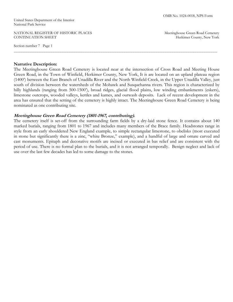
OMB No. 1024-0018, NPS Form United States Department of the Interior National Park Service NATIONAL REGISTER OF HISTORIC PLACES Meetinghouse Green Road Cemetery CONTINUATION SHEET Herkimer County, New York Section number 7 Page 1 _________________________________________________________________________________________
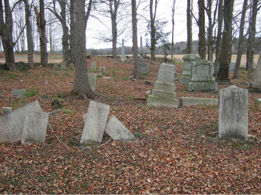
Narrative Description: The Meetinghouse Green Road Cemetery is located near at the intersection of Cross Road and Meeting House Green Road, in the Town of Winfield, Herkimer County, New York, It is are located on an upland plateau region (1400’) between the East Branch of Unadilla River and the North Winfield Creek, in the Upper Unadilla Valley, just south of division between the watersheds of the Mohawk and Susquehanna rivers. This region is characterized by hilly highlands (ranging from 500-1500’), broad ridges, glacial flood plains, low winding embankments (eskers), limestone outcrops, wooded valleys, kettles and kames, and outwash deposits. Lack of recent development in the area has ensured that the setting of the cemetery is highly intact. The Meetinghouse Green Road Cemetery is being nominated as one contributing site. Meetinghouse Green Road Cemetery (1801-1967, contributing). The cemetery itself is set-off from the surrounding farm fields by a dry-laid stone fence. It contains about 140 marked burials, ranging from 1801 to 1967 and includes many members of the Brace family. Headstones range in style from an early shouldered New England example, to simple rectangular limestone, to obelisks (most executed in stone but significantly there is a zinc, “white Bronze,” example), and a handful of large and ornate carved and cast monuments. Epitaph and decorative motifs are incised or executed in bas relief and are consistent with the period of use. There is no formal plan to the burials, and it is not arranged temporally. Benign neglect and lack of use over the last few decades has led to some damage to the stones.

OMB No. 1024-0018, NPS Form United States Department of the Interior National Park Service NATIONAL REGISTER OF HISTORIC PLACES Meetinghouse Green Road Cemetery CONTINUATION SHEET Herkimer County, New York Section number 8 Page 1 _________________________________________________________________________________________
Statement of Significance: The Meetinghouse Green Road cemetery is historically significant as a surviving assemblage of resources that chronicle the settlement, growth and development of the town of Winfield. The families buried in the cemetery are among the earliest European settlers of the area, settling in the region as early as the 1790s. The initial settlement of these families is reflective of the trend of New England Revolutionary War veterans settling central NY during the immediate post-war period. The nominated Meetinghouse Green Road Cemetery was established alongside a 1799 Congregational Church that might have anchored a typical New England Green common-space if the Great Western Turnpike had not drawn concentrated settlement farther south in the town. It is the oldest established cemetery in the town and contains the graves of many of the town’s earliest settlers. The cemetery continued to be used until the mid-twentieth century representing changing burial practices from the settlement era to contemporary times. Gravestones and epitaphs chronicle several families’ connection to the area during the eighteenth, nineteenth and twentieth centuries and provide genealogical and biographical information that is not available in other sources. The cemetery is being nominated concurrently with the neighboring Brace Farm, but under a separate context and boundary. The period of significance, 1801 to 1967, has been framed to include the earliest (1801) and latest (1967) burials in the cemetery, representing the end of the historic use of the cemetery. History and Development of the Cemetery Like most localities in central New York, the Town of Winfield contained only sporadic and impermanent European, non-military, inhabitation prior to the Revolutionary War. This lack of settlement of the region was influenced by several factors. The important geography of the region made it a strategic location, marking its history with decades of conflicts among the British, the French and groups of American Indian nations. Central among the latter were the Haudenosaunee (Iroquois), whose presence had a tremendous impact on the political, military and economic affairs of the various European colonial powers. The Iroquois used European settlement in their traditional homelands as a diplomatic tool—sanctioning it in exchange for economic and military benefits. The region’s status as a warzone and as a crucial component in international diplomacy made it too important for colonial or imperial governments to allow or encourage individual homesteading. Land acquisition and title securement was under the control of Crown and provincial officials who parceled out massive land grants to small numbers of investors or speculators. In turn, these investors were ultimately responsible for organizing settlement, generally through a landlord and tenant farmer system. In 1771, William Bayard, Alexander Ellis, and fifty-three others obtained a 50,000 acre parcel in central New York, known as Bayard’s Patent; a comprehensive survey of the patent was never undertaken, but nineteenth century maps indicate the cemetery is located in what was Lot #26 of this patent. Any plans to encourage permanent settlement in Bayard’s Patent were quickly cut short by the outbreak of the American Revolution. The region was far too dangerous to attract new settlers, and established settlers—Tory and Patriot alike—often fled the war-torn area. In addition, William Bayard and two of the grantees were attainted by the 1779 New York Act of Attainder and portions of Bayard’s patent were confiscated by the state. Although the Commissions of Forfeitures often resold seized Tory lands quickly, neither the state nor the buyers were in a position to foster settlement. Post war conditions, however, removed every pre-war impediment to settlement of places like the Town of Winfield. The Revolution simultaneously pushed the threat of international war farther west towards the central Great Lakes region and ended the dominance of the Iroquois Confederacy in the northern frontier. The cash-strapped and debt-heavy states of New York and Massachusetts suddenly found themselves in possession of massive amounts of land unfettered by Indian tittle or Imperial control; where the Crown had sought to carefully

OMB No. 1024-0018, NPS Form United States Department of the Interior National Park Service NATIONAL REGISTER OF HISTORIC PLACES Meetinghouse Green Road Cemetery CONTINUATION SHEET Herkimer County, New York Section number 8 Page 2 _________________________________________________________________________________________
manage western movement, the new states saw only the potential for revenue. New York and Massachusetts quickly settled their centuries’ old boundary dispute by exchanging proceeds from land sales for a precisely defined border. Land was quickly sold to investors and speculators, who in turn resold it as quickly as possible. The lure of cheap and available land in New York was the perfect outlet for New Englanders who had been running low on land for generations. It was this combination of circumstances that led to the largest migration of people in US history to that point. The possibility of homesteading in upstate and western New York turned out to be particularly appealing to Revolutionary War veterans who had been rewarded with bounties or service payments at the exact right moment to take advantage of obtainable lands. The story of the settlement of Winfield is archetypical of this model. Meetinghouse Green Cemetery In 1799, Abel Brace and several other local citizens organized the Second Congregational Church of Litchfield (the Town of Winfield was part of Litchfield until it was separated in 1816).1 Brace was named as the first deacon and later his son, Asahel, and grandson, Henry L., would also serve as deacons in the church. An edifice was constructed about 1800 on Meeting House Green, near the nominated cemetery. Although nineteenth century histories are unclear, is appears that prior to the construction of the Cherry Valley Turnpike (the third leg of the Great Western Turnpike, roughly modern-day Route 20) settlement in the Town of Winfield was centered in the northern portion of the town, near the nominated farmstead. The New England model of a town green surrounded by important civic and religious buildings might had developed at this spot if not for the turnpike’s construction in 1805. In 1816 the church was moved south, to a more central location along the turnpike near East Winfield, but the nominated cemetery stayed in its original location. A second cemetery (the East Winfield Cemetery) was begun at the church’s new location, but generations of the early settler families of northern Winfield continued to use the nominated one. Mid-nineteenth century milling and tannery operations in West Winfield led to that village becoming the most prominent settlement in the town and in 1876 the old Congregational Church was moved again—to West Winfield—where it was rebuilt and modernized.2 The church was torn down in the 1960s, but the two cemeteries (the nominated one established at the time of its original construction and the East Winfield Cemetery established when the church moved the first time) are still extant. The nominated cemetery is the only physical remnant of the earliest religious institution in the town of Winfield, from the building’s original location, although maps of the area and the local road still retain the vestigial place name of Meeting House Green. The Meeting House Green Cemetery was a site of burial for residents of northern Winfield from the earliest European settlement period until the mid-twentieth century. As a settlement-era cemetery it records the lives of the families who settled the town and who were prominent in its early history. Abel Brace, his wife, and some of his children are interred in the cemetery, as are several generations of the Brace family—including Henry L. Brace who had the nominated house constructed in 1861. Other settlement-era families who used the cemetery include the Stuarts, Harwoods, Huntleys, Eldreds, Catlins and Leachs. The cemetery contains the graves of individuals who were significant in determining the course of the community’s political and economic history and who had outstanding impacts on the nature and direction of the development of the Town of Winfield. In other words, the individuals in these plots are not just the early settlers, but also the founders of the community. As noted, Abel Brace was a founder of the town; he served as Litchfield’s first town supervisor (an office he held for three years straight), constable and common school commissioner, and he was an organizer and Deacon in the Congregational Church. Zenas Eldred, Asahel Brace, Jacob Leach, William Stuart and Revolutionary War Veteran Lt. Roger Catlin all held important town offices in the first decades of European settlement—the cemetery includes burials of town
1 Hamilton Child, Gazetteer and Business Directory of Herkimer County, N.Y. 1869-70. (Hamilton Child: Syracuse, NY), 2870.
http://herkimer.nygenweb.net/winfield.html. 2 The Utica Morning Herald & Daily Gazette, May 27, 1876. www.fultonhistory.com.; H Paul Draheim, “Service Tomorrow to End Church’s Colorful History,” Utica Daily Press, September 11, 1965. www.fultonhistory.com.
OMB No. 1024-0018, NPS Form United States Department of the Interior National Park Service NATIONAL REGISTER OF HISTORIC PLACES Meetinghouse Green Road Cemetery CONTINUATION SHEET Herkimer County, New York Section number 8 Page 3 _________________________________________________________________________________________
supervisors, town clerks, assessors, overseer of highways/path-masters, overseers of the poor, collectors, commissioners and inspectors of common schools, and pound keepers. By the time the Town of Winfield had been set off from Litchfield in 1816 it was, in many ways, a thriving community because of the individuals buried in the nominated cemetery. One generation after European settlement, the town of Winfield had been transformed. Horatio Gates Spafford’s Gazetteer of the State of New York profiled the town in 1824 and noted:
The public buildings are 3 meeting-houses;—1 for Presbyterians, and 2 for Baptists; and 10 schoolhouses…The lands are owned by the cultivators. Staple productions, clover seed, beef, pork, butter and cheese, and most kinds of grain. The inhabitants are Yankees, or immigrants from New-England, of good morals, and very industrious. - Population, 1752; taxable property, $240,752; 323 electors, 6131 acres improved land, 1585 cattle, 434 horses, 4267 sheep; 18209 yards cloth; 4 grist mills, 13 saw mills, 5 fulling mills, 3 carding machines, 1 trip hammer, 5 distilleries, and 7 asheries.—The farmers, including buildings, fences and husbandry, in this town, are entitled to particular notice and commendation.3
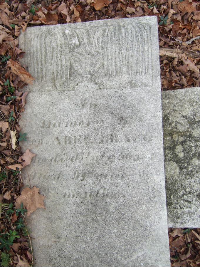
The epitaphs and vital data (birth, death, familial relationships, etc.) included on the stones document the lives of the residents of the town from the settlement period through the mid-twentieth century and the grave markers themselves present an opportunity to study changing styles of tombstone design and funeral art over more than a century and a half of continuous use. The earliest marked burial (still legible) in the Meeting House Green Cemetery is Betsey Catlin, the six year old daughter Sarah and Roger Catlin, who died in 1801. The Catlins, like other New England immigrants, brought their ideals towards death and cemeteries with them, and many of the earliest grave markers in the Meetinghouse Green Road cemetery clearly reflect a New England influence. The cemetery has examples of both simple, rectangular stones and more elaborate rounded tympanum/shouldered examples with bas relief ovals and long epitaphs. Willow and urn motifs are seen on many of the stones from the 1820s and 30, and their appearance is uniform enough that they look to have been done by the same carver. Markers from the first half of the century are consistent in terms of materials, and most appear to be locally quarried stone. By the latter half of the century, new materials like sandstone and polished granite appear. Other changes in stylistic tastes are evident in motifs like books and architectural columns, more varieties of lettering and grave furniture shapes. For example, the cemetery contains a handful of obelisks and larger family monuments not seen in the earlier era. An excellent illustration of changing attitudes towards death is seen in the large Stuart family obelisk. The marker is a prominent example of a zinc monument produced by the White Bronze Company of Bridgeport, CT, and must have replaced several earlier, individual headstones for various members of the Stuart family. The individuals memorialized on the tablets on the plinth of the moment include members of the Stuart family who died as early as 1802 (the infant William D. Stuart), 1817 (another generation of William D. Stuart) and 1822 (Jane Campbell Stuart)—all of whom died at least fifty years before the first zinc monument was ever produced. The monument was probably purchased for or by yet another William D. Stuart, who died in 1885. That later generations of the family were willing to re-memorialize their ancestors through the use of the newest and most-fashionable technology is indicative of the process of social transformation. The quantity of the elaborate monument is also unusual for smaller cemeteries in the area. The twentieth century markers are consistent with the technology of period and are often made of machine-polished granite or cast materials. In the 1920s, the local Winfield Scott chapter of the Daughters of the American Revolution installed decorative plaques to mark the graves of veterans. The date of the latest visible/legible interment is 1967.
3 Horatio Gates Spafford, Gazetteer of the State of New York (D.B. Packard: Albany, NY, 1824), 576-77. http://archive.org.

OMB No. 1024-0018, NPS Form United States Department of the Interior National Park Service NATIONAL REGISTER OF HISTORIC PLACES Meetinghouse Green Road Cemetery CONTINUATION SHEET Herkimer County, New York Section number 8 Page 4 _________________________________________________________________________________________
Integrity The cemetery appears to retain high integrity. Some of the stones have toppled from benign neglect and decades of inactivity, but they appear to be in their original placement and configuration and overall the cemetery retains all of its factors of integrity. The original dry laid stone wall with a single entrance is intact and in good condition.
OMB No. 1024-0018, NPS Form United States Department of the Interior National Park Service NATIONAL REGISTER OF HISTORIC PLACES Meetinghouse Green Road Cemetery CONTINUATION SHEET Herkimer County, New York Section number 9 Page 1 _________________________________________________________________________________________
BIBLIOGRAPHY: Benton, Nathaniel. A History of Herkimer County. Albany, NY: J Munsell, 1856. http://archive.org. Bowman, Travis. Bobs’ Folly: Fulton, Livingston and the Steamboat. Germantown, NY: Friends of Clermont, 2008. Brunger, Eric. “Dairying and Urban Development in New York State, 1850-1900.” Agricultural History Vol. 29, No. 4. 1955. http://www.jstor.org. Child, Hamilton, Gazetteer and business directory of Herkimer County, N.Y. Syracuse: NY: Hamilton Child, 1870. http://herkimer.nygenweb.net/winfield.html. Cooney, Edward ed. Little Falls Sesqui-Centennial 1811-1961: One Hundred Fifty Years of Progress. Little Falls, NY: Journal & Courier Press, 1961. http://www.threerivershms.com. Davis, Neil “Cultural Resources Reconnaissance Survey PIN 2009.13.121, BIN 4-03892-0, BIN 4-03892-0A, BIN 4-03892-0B NYS Route 167/Mohawk River, Route 5 & Conrail Railroad, City of Little Falls, Herkimer County, New York.” Albany, NY: New York State Museum, 1997. Draheim, H. Paul. “Press Scrapbook.” Utica Daily Press. July 14, 1959. www.fultonhistory.com. Draheim, H. Paul. “Service Tomorrow to End Church’s Colorful History.” Utica Daily Press. September 11, 1965. www.fultonhistory.com. Durand, Loyal Jr. “The Cheese Manufacturing Regions of Wisconsin, 1850-1950.” Transactions of the Wisconsin Academy of Sciences, Arts and Letters Vol. 42. 1953. http://images.library.wisc.edu. Durand, Loyal Jr. “The Historical and Economic Geography of Dairying in the North Country of New York State.” Geographical Review Vol. 57, No. 1. 1967. http://www.jstor.org. French, JH. Historical and Statistical Gazetteer of New York State Syracuse: R Pearsall Smith, 1860. http://archive.org. Gerlander, Todd L. “Understanding the Connecticut Militia during The American Revolution.” Connecticut Society of the Sons of the American Revolution, 2010. http://www.connecticutsar.org/articles/connecticuts_militia.htm. Grinnell, Josiah Bushnell and Joseph H. Reall, “The cattle industries of the United States—Dairying and Dairy Improvements.” Agricultural Review and Journal of the American Agricultural Association. New York: Joseph Reall, 1882. www.googlebooks.com. Hardin, George Anson. History of Herkimer county, New York Vol. 2. Syracuse, NY: D. Mason & co., 1893. http://archive.org. Hastings, Hugh compiler. Military minutes of the Council of appointment of the state of New York, 1783-1821 Vol. 2. Albany, NY: J.B. Lyon, state printer, 1901. http://archive.org. History of Herkimer County, N.Y.: With Illustrations Descriptive of Scenery, Private Residences, Public Buildings, Fine Blocks, and Important Manufactories, from Original Sketches by Artists of the Highest Ability; and Portraits of Old Pioneers and Prominent Residents. New York: F. W. Beers & Co., 1879. New York State Library: Digital Collections. http://www.nysl.nysed.gov.

OMB No. 1024-0018, NPS Form United States Department of the Interior National Park Service NATIONAL REGISTER OF HISTORIC PLACES Meetinghouse Green Road Cemetery CONTINUATION SHEET Herkimer County, New York Section number 9 Page 2 _________________________________________________________________________________________
Hoadly, Charles J, trans. The Public Records of the Colony of Connecticut from October 1772 to April 1776, Inclusive. Hartford, CT: Case, Lockwood and Brainard Co., 1887. www.googlebooks.com. Johnston, Henry P., ed. The Record of Connecticut Men in the Military and Naval Service During the War of the Revolution 1775-1783. Baltimore, MD: Clearfield Genealogical Publishing Company, 2009. www.googlebooks.com. Kriger, Thomas J. “The 1939 Dairy Farmers Union Milk Strike in Heuvelton and Canton, New York: The Story in Words and Pictures.” The Journal for MultiMediaHistory Vol. 1, No. 1. Albany, NY: University at Albany, 1998. http://www.albany.edu/jmmh/vol1no1/dairy1.html#fn10. McNulty, Larraine compiler. Saving Our Valley, Preservation and Conservation in Central New York Expanded Second Edition. Brookfield, NY: Worden Press, 2006. “Milk without Honey.” Time Vol. XXXIV No. 9, August 28, 1939. www.time.com. Reed, O. E. “Research in the Bureau of Dairy Industry.” The Scientific Monthly Vol. 38, No. 3. American Association for the Advancement of Science, 1934. http://www.jstor.org. Seymour, Mary Jane. A.A.D.A.R. Lineage Book Vol. 11. Washington, DC: Daughters of the American Revolution, 1900. http://archive.org. Smiley, Gene. "US Economy in the 1920s." EH.Net Encyclopedia Santa Clara, CA: Economic History Association, Santa Clara University, 2008. http://eh.net/encyclopedia/article/Smiley.1920s.final. Snell, Charles W. “Oliver Wolcott House National Register of Historic Places Nomination.” 1971. nps.gov. Spafford, Horatio Gates. Gazetteer of the State of New York. Albany, NY: D.B. Packard, 1824. http://archive.org. Townsend, Ted. “Our Farms.” Utica Daily Press. July 17, 1952. www.fultonhistory.com. The Utica Morning Herald & Daily Gazette. May 27, 1876. www.fultonhistory.com. “West Winfield Star. Brace Farm W. Winfield in Family 153 Years.” Richfield Springs Mercury. Vol. 81 No. 48. March 28, 1946. www.fultonhistory.com. Workers of the Writers’ Program of the Works Progress Administration in the State of New York. New York: A Guide to the Empire State. New York: New York State Historical Association, 1940. www.googlebooks.com. Young, Catherine. “Dairy Farmers Plea for Support from Legislative Leaders.” New York State Senate, 2009. http://www.nysenate.gov.

OMB No. 1024-0018, NPS Form United States Department of the Interior National Park Service NATIONAL REGISTER OF HISTORIC PLACES Meetinghouse Green Road Cemetery CONTINUATION SHEET Herkimer County, New York Section number 10 Page 1 _________________________________________________________________________________________
BOUNDARY DESCRIPTION: As indicated by the heavy black line on the attached boundary map, the nominated property consists entirely of tax parcel lot number 130.2-1-38 in the Town of West Winfield, Herkimer County, NY. BOUNDARY JUSTIFICATION: The nominated property includes the entire parcel (1.3 acres) historically and currently associated with the cemetery as bounded by its dry laid stone wall.

OMB No. 1024-0018, NPS Form United States Department of the Interior National Park Service NATIONAL REGISTER OF HISTORIC PLACES Meetinghouse Green Road Cemetery CONTINUATION SHEET Herkimer County, New York _________________________________________________________________________________________

OMB No. 1024-0018, NPS Form United States Department of the Interior National Park Service NATIONAL REGISTER OF HISTORIC PLACES Meetinghouse Green Road Cemetery CONTINUATION SHEET Herkimer County, New York _________________________________________________________________________________________

OMB No. 1024-0018, NPS Form United States Department of the Interior National Park Service NATIONAL REGISTER OF HISTORIC PLACES Meetinghouse Green Road Cemetery CONTINUATION SHEET Herkimer County, New York _________________________________________________________________________________________
Photo

OMB No. 1024-0018, NPS Form United States Department of the Interior National Park Service NATIONAL REGISTER OF HISTORIC PLACES Meetinghouse Green Road Cemetery CONTINUATION SHEET Herkimer County, New York _________________________________________________________________________________________
Log (Prints from Digital Photos)
Name of Property: Meetinghouse Green Road Cemetery Location: Herkimer County, New York Photographer: Travis Bowman Date: November 8, 2012 Location of Negatives: CD-R Included NY_HerkCo_MHGCem PHOTO LOG
PHOTO DESCRIPTION
0001 Exterior view, S; Meetinghouse Green Road Cemetery setting.
0002 Exterior view, S-SW; Cemetery graves.
0003 Exterior view, N-NW; Cemetery graves.
0004 Exterior view, Headstone of Revolutionary War veteran Capt. Abel Brace.


Related Documents