Northern Platinum Ltd. SUMMARY REPORT Prospecting, Road Maintenance and Drilling ON 1997 EXPLORATION LINDA PROPERTY (KL U 1 - 71 CLAIMS) Grant Numbers YA94404-YA94419 YA95012-YA95013 YA9645 1 -YA96472 YA9688 1 -YA96896 YA97925-YA97929 YB8272 -YB8281 Whitehorse Mining District NTS 115/G/6 61° 28' N. 139O 26' E Performedfor Linda Joint Venture By Northern Platinum Ltd. From July 10,1997 to Aug 28,1997 J.P. McGoran B.Sc. P. Geo. December, 1997

Welcome message from author
This document is posted to help you gain knowledge. Please leave a comment to let me know what you think about it! Share it to your friends and learn new things together.
Transcript

Northern Platinum Ltd.
SUMMARY REPORT
Prospecting, Road Maintenance and Drilling
ON
1997 EXPLORATION
LINDA PROPERTY
(KL U 1 - 71 CLAIMS)
Grant Numbers YA94404-YA94419 YA95012-YA95013 YA9645 1 -YA96472 YA9688 1 -YA96896 YA97925-YA97929 YB8272 -YB8281
Whitehorse Mining District
NTS 115/G/6
61° 28' N. 139O 26' E
Performed for
Linda Joint Venture
By Northern Platinum Ltd.
From July 10,1997 to Aug 28,1997
J.P. McGoran B.Sc. P. Geo.
December, 1997


Table of Contents
Introduction .... ...... .. .. .... .. .. .. .. ..... .. .... .. 1
Figure 1 Location Map
Property, Location and Access ................ 2
Figure 2 Claim Location Map
History and Previous Work .................... 3
General. .. .. .. .. .... .. .. ....... . .. ....... .. .. ....... 4
Bulldozer Work ................................... 4
Prospecting ... .. . ... ...... .. .... .. .. .. ... .. .. ...... 4
Figure 3 Bulldozer Work
Drilling ....... .. ...... ...... .. .... .. .. .. ....... ...... 5
Conclusion. .. .. .... .. .. .. ...... .. ....... .. .......... 5
Recommendations .... .. .. .... .. .... ..... .......... 5
Figure 4 Drill Hole Locations
Figure 5 Drill Log # 1
Figure 6 Drill Log # 2
Figure 7 Drill Log # 3
Table 1 Expenditures
Appendix 1 Analysis
Statement of Qualifications

Introduction
The Linda property was staked as the Klu claims in May, 1986 by Archer, Cathro &
Associates (1981) Limited on behalf of Kluane Joint Venture (Chevron Minerals
Ltd. and All-North Resources Ltd.) to cover extensions of the Quill Creek
Ultramafic Complex east of the Wellgreen property. In December 1986, the joint
venture optioned the property to 2001 Resource Industries Ltd. and Rockridge
Mining Corporation.
Exploration in 1987 was funded by 2001 and Rockridge and was directed toward
nickel, copper and platinum group elements (PGE). It consisted of additional claim
staking, grid layout, geological mapping, geochemical soil sampling, rock sampling,
geophysical surveys and road construction. Mapping showed that a series of
irregularly shaped, subparallel ultramafic sills occur within an up to 1300 m wide,
3400 m long belt that extends the length of the property. The geochemical and
geophysical surveys covered approximately twenty percent of the property and most
of the ultramafic bodies. Soil response was strongly anomalous and well clustered in
the eastern part of the grid but was weaker and more erratic in the lower, western
part ofthe grid where the favourable host rocks are largely obscured by
unmineralized talus and slump debris. Numerous magnetic highs and EM
conductors were outlined but the results are difficult to interpret because of differing
overburden depths, the complex geometry of the sills and the presence of faults.
Prospecting and rock sampling located six showings with the best assay (1.02% Cu,
1.80% Ni, 0.064 odton Pt and 0.047 odton Pd over 1.3 m) coming from the Upper
Showing.
An Archer, Cathro crew based at the Wellgreen camp, performed the 1988
exploration program under the supervision of Rob Came between mid-June and
early September. Work was again funded by 2001 and Rockridge and consisted of
road construction, bulldozer trenching, continued soil geochemical and geophysical
grid surveys, aerial photography and three diamond drill holes totalling 246.2 m.

Figure 1
LOCATION
KLUANE NI-CU-PGE BELT
Y U K O N , CANADA
Northern Platinum Lid. International All-North Resources Ltd.
Property, Locntion and Access
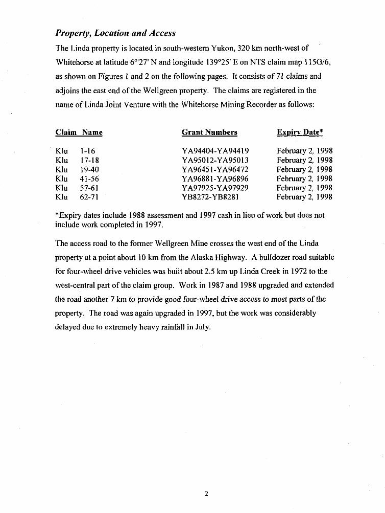
The Linda property is located in south-westem Yukon, 320 km north-west of
Whitehorse at latitude 6"'27' N and longitude 139'25' E on NTS claim map 115Gt6,
as shown on Figures I and 2 on the following pages. It consists of 71 claims and
adjoins the east end of the Wellgreen property. The claims are registered in the
name of Linda Joint Venture with the Whitehorse Mining Recorder as follows:
Claim Name Grant Numbers Expirv Date*
Klu 1-16 Klu 17-18 Klu 19-40 Klu 41-56 Klu 57-61 Klu 62-71
YA94404-YA944 19 February 2, 1998 YA95012-YA95013 February 2, 1998 YA9645 1-YA96472 February 2. 1998 YA9688 1 -YA96896 February 2, 1998 YA97925-YA97929 February 2, 1998 YB8272-YB8281 February 2, 1998
*Expiry dates include 1988 assessment and 1997 cash in lieu of work but does not include work completed in 1997.
The access road to the former Wellgreen Mine crosses the west end of the Linda
property at a point about 10 km from the Alaska Highway. A bulldozer road suitable
for four-wheel drive vehicles was built about 2.5 km up Linda Creek in 1972 to the
west-central part of the claim group. Work in 1987 and 1988 upgraded and extended
the road another 7 km to provide good four-wheel drive access to most parts of the
property. The road was again upgraded in 1997, but the work was considerably
delayed due to extremely heavy rainfall in July.

Figure 2
CLAIM LOCATION LINDA PilOPEaTY Northern Platinum Ltd.
International All-North Resources Ltd.

History and Previous Work
The Linda property was originally staked as the Jeep claims in October, 1952 by
Yukon Mining Company Limited and was optioned to Hudson Bay Mining and
Smelting Company Limited and explored in conjunction with the Wellgreen
property. Prospecting, geological mapping and geophysical surveys were carried out
during 1953 and four holes were drilled in 1953-54 before the claims were allowed
to lapse.
The area was restaked in October, 1965 by P. Versluce and H. Versluce, who
prospected and sampled. In 1966 a new company, Quill Creek Copper Mines
Limited, was formed to develop the property in conjunction with a copper showing
in Triassic volcanic rocks on adjoining claims to the south. Quill Creek Copper
Mining Limited optioned the property to Newmont Mining Corporation of Canada
Ltd., which performed mapping and sampling in 1967-68, and the Nickel Syndicate
(Canadian Superior Exploration Ltd., Aquitaine Co. Canada Ltd., Home Oil Limited
and Getty Mines Limited) which carried out mapping, sampling and bulldozer
trenching in 1972.
Archer Cathro, on behalf of the Linda Joint Venture, drilled several holes and
exposed several mineral occurrences while following up on geophysical and
geochemical surveys as well as following-up on mineralized float in 1987 and 1988.

General
In early 1997, very little recorded data was available to the exploration crew. Only
a copy of Figure 2 was available to the field crew showing roughly where
mineralization occurred. At the end of the field season, some assessment reports
were located in the Vancouver Archer Cathro & Associates office in Vancouver.
During 1997, $40,333.34 was spent on prospecting, drilling and bulldozer work.
See Table 1.
Bulldozer Work
In order to access the Linda claims it was necessary to rebuild the access road,
which had sloughed in. A D7 Caterpillar tractor of H.R. Vance Construction was
hired to perform this task as well as to freshen up trenches along the road. Table 1
shows the cost of the above work as well as the time spent building drill pads and
towing the drill and compressor. See Figure 3.
Prospecting
From July 15 to Sept 3, prospecting was conducted by David Javorsky, PO Box
806 Stewart, BC, who supplied the following equipment.
1 1992 4 x 4 Chevrolet Suburban
1 Beep mat (G.D.D. Inc Serial No. 7043)
1 Self potential geophysical system
Miscelaneous picks, hammers and shovels, compass
1 Sokkisha TM-20C Theodolite
0 1 VLF E.M.
David Javorsky stayed at Kluane Wilderness Village and commuted daily with his
equipment to the Linda property. Northern Platinum Ltd. supplied his
accommodation and fuel. His mandate was to locate and sample all mineral
occurrences as well as to locate any new occurrences. His report is filed with this
report.

Figure 3 Bulldozer 1997 Work
LINDA PaO?EFLTY Northern Platinum kd.
international All-North Resources Ud.

Drilling
An Ingersoll Rand drill ECM-350 set up for 3.5-inch reverse circulation and an
Ingersoll Rand compressor XHP-750 was used. Three holes were drilled; L97-01
to 40 feet before hitting water, L97-02 to 113 feet and 97-03 to 45 feet. See
figures 5,6 and 7 for logs and Appendix 1 for assays. Prior to completion of hole
3 the compressor failed and the drill program was suspended for the remainder of
1997, when it was discovered that the repairs would be extensive. Paul Wray
operated the drill as driller and Mark Hunnie was drill helper and mechanic. Rory
Calhoun spotted the holes and logged and split cuttings. A split was sent to
ACME Analytical Lab for assay. Splits of the rejects are stored at the Wellgreen
mine site. This equipment is owned by Northern Platinum.
The D7 tractor which cleared the road, prepared the drill pad and moved the drill
equipment was owned by H.R. Vance Construction and was rented by Northern
Platinum.
Conclusion
Insufficient prospecting and drilling was conducted to evaluate this area.
Recommendations
The 1997 prospecting and drill data should be evaluated along with earlier work
prior to commencing further work on these claims.
p' / ,I
hn P. McGoran, B.Sc., P. Geo. i I- !/ 5


Figure 6
C r b , ~ ~ q
t % r s . r f f c ~ d 3 % a c ~ 3 % 1 5 . m c r v 1 % at& 5 % T5 . 2 % c p v
v % T S . r l % c P u . 1 % O I L '/ 7. TJ . 170 rn.0 . I % W I L
~ % T S . T R ~ ~ ~ , ? Z / r n t ,
TU%TS . T d c o u . > 0 % 0 t r TU ZT 5 , 2070 0 4 ,
9 % 75 , i ' r % e p v . 3% Otr
5 % T I . I % c p v
~ Z T S a?oc, , ,
2 =& 7-5 )/I./.',%, 7 % 0 t l
I % TS r# e n d J % atl 3 % rr I % sc.
b % r5 . J * / O ~ , . l /%all. I 96 7 s m ..., . 2% at* Ti it% 7-5 T R en.!
7-8 70 1s <a Y % at, T R $'* 75 , 2 % a h r , % 1 5 1 % Q t + End - P hole -
p,%tiddJi fe ; ,, r p r d .r*JcJ p r r i J J ~ ;lc
a n c / , m ~ / 9 5 ~ J ; ~ e - fi
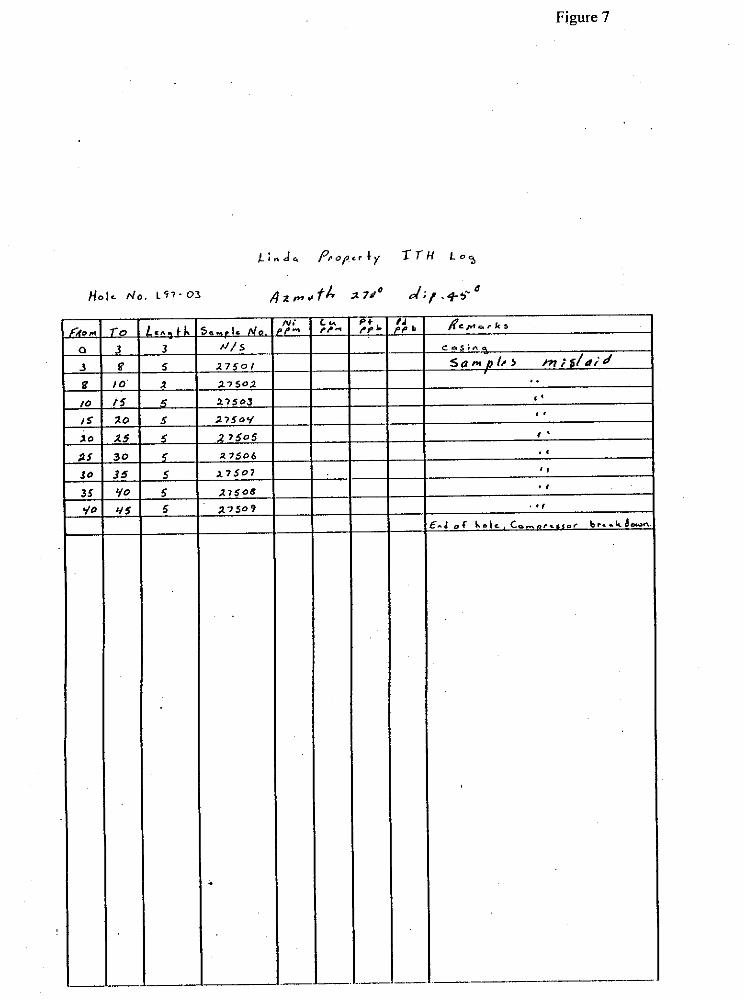
Figure 7

Expenditures
Drilling
Table 1
Driller: Paul Wray Aug 12 - Aug 21
Helper and Mechanic: Mark Hunnie Aug 14 - Aug 21
Geologist: Rory Calhoun
Assays and Freight
Transportation to Site 10 days x 2 4x4 pickups fuel for pickups
Drill costs: bit, lube, hyd fluid Compressor fuel
Moving drill between holes 1,2 & 3 With D7 Cat (incl. mob.& demob.) Fuel for Cat
Accommodation and board Cat skinner / Drill Helper Driller Geologist
Total DriNing costs
Prospecting By David Javorsky
Prospecting, vehicle & equipment July 10 to Aug 28
Accommodation 37 days
Road Rebuilding, clearing D7 Cat Aug 3 to Aug 14 (incl. partial mob.& demoh.) Fuel for Cat 195.00
Assays freight & analysis 4.833.83 Total Prospecting Costs $25.216.78
Report Preparation $1,317.85
Total Expenditures $40,333.34

7"N
TV
N
NN
NN
N
NU
NN
N
UN
NN
N
YN
.
"V
II
V
""
""
V
""
""
I
vv
v-
%r+
ae
-26-256 46-25?
z.:~? a",.."'
----- ---*
,?
??
?
??
??
%
??
??
* 6%888 8S"S
$4965 3ggg ygn: eq#gs z:s$
?qeqs R
qs?z, ?:q$E
qqsqq
Nn
-N
-
O"
*N
N
-**"
In
*
O*
-N
-*-
55
?8
$
pz55: 5s:::
--- --- S
XS
R:
!2:!2g 7
'3""-
~g
vj
n
-n
-n
n
vl
sl
v
"n
nn
n
vl
ll
v
nn
ne
lllC
70
7-7
*'3
37
3
O"I7
'33
3
?'3
3°
'33
'32
??
??
?
??
??
?
??
??
? ??yq?
??
??
"
v-
"
"
- - X
zraetx W
S$E
% asgpg
cs
gza
a
%::
NN
NN
N
NN
NN
N
NN
NN
N
.,",N
UN
N
NN
.
""
"1
"
"I"
"
""
V"
"
"I"
""
"
""
-
77
77
7
77
77
7
77
77
7
71
77
7
77
77
99
99
9
99
99
9
99
99
9
99
99
9
99
9M
7-s
-e
E
sa
oz
ryo
nn
~
DS
B~
~
CA
:
- $
!$y~
~
csgs ?sq
?$
-ma
-- a
**
--
-"""-
a-.n
n
zm
a zg
pc ncxe5 ggss
RU
B~
B LC
LY
BX
%S
IR4
aa
nc
s
- 62*1:
52
55
t s3m Z
W=
--- ---
"I
??
??
?
??
??
?
??
??
? Yi???
" v
-
V"
"
" N
"
se
er*
ere:: rs
se
r 8
sEg
a
a-0
8.0
P
OT
**
--h
ot
gg.."M
BE
~~
S
&&
3zz $3
5~
5 ZSg;!
- -9
-n
-
-N
---
N---N
---N
N
" "
-
Appendix 1

ACHE ANXLrPICAL LABORATDRIES LTD. 8 5 2 E. HASTINGS ST. VANCOUVER BC V6A l R 6 P H O N E ( 6 0 4 ) 2 5 3 - 3 1 5 8 F A X ( 6 0 4 1 2 5 3 - 1 7 1 6
ASSAY CEIlTIFICATE
North atinum Ltd. Flle # 97-4974R 3 0 5 - 155 G n n v l l l e Sf.. Vancower BCV6C l T l
,253 GN SAMPLE DIGESTED I N 30 ML AWA - REGIA. DILUTE TO 100 ML. ANALYSIS BY ICP. - SAnPLE3YPE: ROCK PULP s a m l e r beainninq *REz are Rerun9 am 'RRE' are R e i e s t R e M s . 0
DATE RECEIVED: SEP 18 1997 DATE REPORT MAILPI: 9 f 20 q7 SIGNED D.TDYE. LLEONG. I.YANG; CERTIFIED B.C. ASSAYERS
Q l
ALL r e s u l t s are c-i&red the crnfid.nti .1 p m m y of rhe $ L i n t . A- *%'us the l i a b l l l t i n for a c r w l cost of the -1.ysia only . 0. FA L . - , ,

STATEMENT OF OUALIFICATIONS
I, John P. McGoran of 21 11 West 34th Avenue, Vancouver, B.C. , hereby certify that:
1. I am a graduate of Carleton University (1972) and hold a B.Sc. Degree in Geology.
2. I am a member in good standing of the following assocations:
Canadian Institute of Mining and Metallurgy Geological Association of Canada American Institute of Mining Engineers Prospectors and Developers Association of Canada Association of Professional Engineers and Geoscientists of BC.
3. I have prospected for twelve years.
4. I have been employed in my profession as an exploration geologist, geochemist and consultant for the last forty years.
DATED at Vancouver, British Columbia, this /day of ,/ /A , '-/ . 1 4. 4 4

PROSPECTING REPORT
1997 EXPLORATION PROGRAM
ON THE LINDA PROPERTY (KLU I TO 71 QUARTZ CLAIMS)
Located: NTS 1 15/G/6 Latitude 61°28' North, Longitude 139"26' East
Southwestern Yukon Territory, Canada Within the Whitehorse Mining District p
L ,> & "i 1
Work Performed on behalf of
NORTHERN PLATINUM LTD. 1066 West Hastings Street
Suite 2140 Vancouver, BC
V6E 3 x 1
(604) 687-6875
Work done from July 10 through August 28, 1997 By David Javorsky, Prospector
P.O. Box 806 Stewart, BC VOT 1 WO
August 28, 1997

TABLE OF CONTENTS
INTRODUCTION .......................
PROPERTY. LOCATION AND ACCESS
HISTORY AND PREVIOUS WORK ...................................................................... 3
PROSPECTING .................................................................................................... 4
...................................................................... LINE CUTTING AND PICKETING 4
ASSAYING ....................................... ....................................................................... 4
SOIL SAMPLING ................................................................................................... 5
........................................................................................... BEEP MAT SURVEY 5
................................... ......................................... SAMPLE LOCATION, MAP A .... 6
BEEP MAT SURVEY St . 1 to 10 ............................................................................ 8
BEEP MAT SURVEY St . 11 to 23 ........................................................................... 9
. ......................................................................... BEEP MAT SURVEY St 24 to 25 10
.......................................................................... ROCK SAMPLE DESCRIPTIONS 11
. ........................................................................ BEEP MAT SURVEY St 26 to 36 13
BEEPMATSURVEY St . 37to45 ......................................................................... 14
BEEP MAT SURVEY St . 51 to 59 ......................... .. ........................................... I5
. ............................... ................................... BEEP MAT SURVEY St 60 to 61 ......... 17
........ IHETDROTHERMAL ALTERATION 18
.......................................................................... BEEP MAT SURVEY St . 62 to 75 19
.......................................................................... ROCK SAMPLE DESCRIPTIONS 21
......................................................... SELF POTENTIAL SURVEY ................... .. 22
............................................................................................. MAGNETIC SURVEY 22
SILT SAMPLE LOCATION, MAP B ..................................................................... 23
........... BEEP MAT SURVEY, SILT SAMPLES AND PANNED CONCENTRATE 25
........................................................... ..................................... TRACTOR WORK ... 27
DRILLING ...................... .. .................................................................................. 28
CONCLUSION ...................................................................................................... 28
............................................... AUTHOR'S STATEMENT OF QUALIFICATIONS 30
......................................................................................................... REFERENCES 31
ASSAYS ................... .. .......................................................................................... 34

LINDA PROPERTY
INTRODUCTION
Northern Platinum Limited has-taken an option on the KLU 1 to 71 quartz claims,
known as the Linda Creek claim group. The KLU claims cover an area of similar geology to that found at the Wellgreen ~ i c k i e Copper Mine, located on the adjoining claim block to the northwest.
The Wellgreen Mine operated during 1972 and 1973 mining 171,652 tonnes of ore; grading 2.23% nickel, 1.39% copper, 0.065 ozlton platinum and 0.073%
cobalt. Production was suspended in July 6, 1997 due to falling metal prices.
With favourable market prices the Wellgreen Mine could be reopened.
The geology of the Linda Creek property is quite similar to that on the Wellgreen
and is mapped as a continuation of the same Quill Creek ultramafic complex.
Previous work has outlined six mineralized copper-nickel-platinum showings on the KLU claims. The form of nickle mineralization ranges from massive
sulphides to mariposite.
Northern Platinum has financed the 1997 exploration program on the KLU 1 to
71 claims outlined in this Report. The program operated from July 10 through
August 28, 1997. Four people participated in the exploration program and they were supported by a D-7E tractor. Two 4 x 4 trucks were used for transportation.
The use of the Beep Mat, a geophysical prospecting tool, and'thd auility to get repeatable platinum assays greatly aided this exploration program. These tools
Are improvements on what was available to the 1988 exploration crews.

PROPERTY, LOCATION AND ACCESS
The Linda Creek property adjoins the east end of the Wellgreen Mine property.
The Linda Creek claim block consists of 71 full-size contiguous and fractional
claims that are registered with the Whitehorse Mining Recorder and plotted on
Quartz Claim Map 1 15G-6.
The center of the claim block has co-ordinates of 61°28' North Latitude and
13g026' East Longitude.
The Linda Creek claim block is located in the southwest section of the Yukon
Territory, approximately 310 kms. westerly from Whitehorse, the economic hub of the Yukon.
The claims are accessed from the paved Alaska Highway onto the old Wellgreen Mine gravel road that runs along Quill Creek. On the KLU # I claim a 4 x 4 trail fords across Quill Creek to the east and runs up the Linda Creek Valley. The
4 x 4 cat trail runs from the 3,500' elevation at the Quill Creek ford to 6,500' in
the headwaters of Linda Creek.
The Linda Creek claim block consists of the KLU 1 to 71 group of quartz claims.
KLU 1 through KLU 16
KLU 17-1 8
KLU 19-40
KLU 41 -56
KLU 57F - 61 F
KLU 62
KLU 63F
KLU 64-71
Record Numbers
Record Numbers
Record Numbers
Record Numbers
Record Numbers
Record Number
Record Number
Record Numbers

HISTORY AND PREVIOUS WORK
The Linda Creek intrusive complex is located approximately 3.2 km southeast of
the Wellgreen Mine.
The intrusive complex is mainly confined to the drainage basin of a westerly flowing tributary of Quill Creek, known as Linda Creek. The terrain is characterized by long, steep (approximately 25" to 45") slopes cut by numerous dry creeks. Elevations range from 1,980 meters (6,494 feet) along the ridge crest to 1,070 meters (3,509 feet) on the floor of Quill Creek. Outcrops in the area are rare, and confined to Ridge Crest and eroded creek cut exposures.
The presence of mafic and uitra-mafic rock and their potential to host Quill Creek
complex (Wellgreen) type mineralization was first recognized by Yukon Mining
Company Limited, who in 1952 staked the area as the Jeep claims. It was
subsequently optioned to Hudson Bay Mining and Smelting Company Limited.
Hudson Bay explored the Linda Creek area in connection with their Wellgreen
Mine exploration. The area was restaked in 1965 and a company was formed
called Quill Creek Copper Mines in 1966 to do further exploration. The area was restaked again in 1986 by Archer Cathro and Associates (1981) Limited, as the
KLU claims. The Kluane Joint Venture Group worked on the KLU claims in 1986, 1987 and 1988. Currently, the KLU claims are optioned to Northern
Platinum Ltd.
Over the years, prospecting, geochemical sampling, geophysical surveys, bulldozer trenching and drilling and geological mapping have identified six areas of Ni-CU-PGE mineralization, similar in style to that found on the adjoining Wellgreen Mine property.

PROSPECTING
The 1997 prospecting exploration program on the Linda Creek Claim Group,
KLU 1 to 71 Quartz Claims, consist of both traditional "boots and hammer"
prospecting, supplemented by Geochemistry and geophysical methods and access to a D-7 tractor for trenching and road rehabilitation. An air track
d T J percussion drill and compressor were used -s.
f'"fr-'r' f 3
The lines were walked, the roads were walked, the creeks were walked and the outcrops were inspected. All interesting rock was broken and examined.
Prospectors were given a free hand to try and find mineralization by whatever
method they could think of.
LINE CUTTING AND PICKETING
The old grid that was suweyed by Archer Cathro and Associates 1981 Ltd., outlined in Assessment Report #092633 was resurveyed in. Some pickets were
replaced, or stood up. Many had been crushed by snow since 1988. The work
was done by chain and compass and supplemented by radios and a Sokkisha
TM-20C, Theodolite with 30 power magnification.
ASSAYING
All samples were sent to Acme Analytical Laboratories Ltd., Vancouver, British Columbia, for 30 element ICP annalysic and gold, platinum and pladinum by fire
assay.

SOIL SAMPLES
Soil samples were taken from the "0" horizon. Some areas on the KLU claims - Linda Property does not have a good soil profile. In some areas the permafrost
includes all of the soils. However each of the 70 soil samples were taken from the " 0 horizon. The locations of the soil samples are plotted on the maps as sample stations 1 to 45, and 51 to 75. The sample procedures outlined in "Exploration Geochemistry, Design and Interpretation of Soil Survey", Vol. 3,
1986, by the Society of Economic Geologists; were followed.
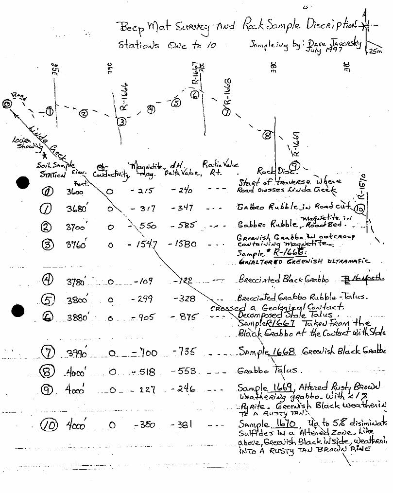
BEEP MAT SURVEY
The Beep Mat is an electromotive-magnetic prospecting tool. It recognizes both
conductors and magnetics. The massive sulphides were found under both moss
and talus at depths of up to one meter. The Beep Mat was able to easily identify
the magnetite in the greenish grabbo at depths of over 2 meters of overburden, talus and sod. The Beep Mat measures a 1 meter cubic volume of rock under the probe (antenna). A reading of -1,000 Mag. indicates approximately a one
percent magnetite content of the rock. This is equivalent to about 1,000
gammas. The equivalence exists up to a magnetic value of -20,000, which is
equivalent to 20,000 gammas or 20% magnetite. The conductive value (OL) is a
measurement in hertz, the reaction of the Beep Mats signal to the presence of a
conductor near the probe (antenna). The Beep Mat #4+ (Serial #7043) was built
by Instrumentation G.D.D. Inc., of Ste-Foy, Quebec.

S a m le I Lkq, f t&~J &Sly & c d h 5 e4i4.3 J g p b b o - LJi44/%
u C n e & 1, Black ~ e u % a i d A R u 3 q -4.I:. .
I I , ep 5Z d i 5 ; ; d
~i , l f i d cs LI a ~&?& Zode, L;ke abaca,Q-eedisr\ ghc k Lk?&, ~ ~ k a % . a : r ;&Jra A R ~ T L J TAd ~I2.ddd \ . T ~ ? J E


% ,,a .st&!, '4 Abew . . .- ---- .............. --87 ...-,& 2.-.*l. . .k&-...----, . . . . .
~. : . P A - ~ % O & ; , J ~ - : . 5 ~ ~ i - i ~ - ac c c m p . . . . . - . -- . .v-*--k-*,d;J .. s , ,dLs . . . . . . . &P,,,, y *ea&esed . - ; . 1 . 1
. . ' , Sqyk3 ~j553(q4S31vesu@&5 . #
...... - -. t R o ..- r e c - p k

ROCK SAMPLES
Location Description
R-1684, Listwanite, mineralized
R-1685, Listwanite, mineralized R-1686, Listwanite, with marisposite
Samples from lower showing Using Beep Mat to outline area of conductivity
Low. Sh. R-1658. Banded decomposed silvery sulphides, in quartz veining
L.S. R-1659. Decomposed bands of mineralized material. Foliated
L.S. R-1660. Decomposed bands of sulphides, very siliceous material.
R-I 655: Selected from very rusty shear zone, decomposed sulphides, calcite veining, some purple material - soft, perhaps fluoride.
Total rock is very weathered.
R-1656: Selected, picked black sulphides from the mineralized zone. Very
decomposed.
R-1657: Selected high grade, decomposed mineralization

R-1663:
R-I 661 :
R-1662:
R-I 664:
R-1665:
A bolder, at lease one ton, sluffed downhill probably from the S.K. showing (above). Disseminated sulphides. Uncovered while
building road.
Traversing along Line 64 near where it crosses Baseline 85. Mineralized grabbo float found in a small creek bed.
Trying to chase float mineralization up to creek, approximately 100m above R-1661, mineralized grabbo float (64+20, 7+05N).
A large boulder in the hillside above the drill station-pad for drilling the upper showing. This two-meter diameter boulder was exposed
in the permafrost in the cut out area for the drill pad. Disseminated sulphides in a grabbo (Map A - 28+30E, 13+75N).
At 4,100' elevation on Linda Creek, basalt boulder in creek bed with chalcopyrite mineralization.


. -- F 6od .Ld ~l&e-,ff5zo,l S~nl $e- R- l6YL ,a aSLuX Jg . _.
191-5; ~a 5 c t l pde, dddLJ;de , ~ a l c o ~ e ; . . . . . . .
.... ........ :Lmple R- / ~ q 7 . + : . f . m ~ s s i ~ S u l W ~ d u S ' f ~ 4b.u~ - G o o d Codducfoa qL-803- .
. . . ~ S m p l e M , . t o d & f d t a ~ ~ a b 6 i . & & l / , . ~ ... . .%. . - ..........
Saw&. C&CJ a c ~ o ~ s c-+nfefP~; m;&+aftke=l- . . . . .


S n ~ p l e A?-&$% L ; { . J O J ; S ~ , A ~ P G ~ . Z ~ . J ~ ~ J . maqn.pov'& a(f=*a)ls. m 4IA eastc U O C ~ . A+ StR eo &faLf d&, HR Skle - ~ / a e k ~ e ' e ; J ; 3 , 5 ? d c a ; f e ?
- ~ u M k . t a L J P f i e ZO&. Be+- J
Basic Rock aud dele . h m p k - b531 n p 1 ~ 5 I?&=-A~. saw R- 6532 mar7;POs;k J;&
h a d ~qlpbc~afe-S; .k~ i fc? d i 4 B l a c k specks.
&I m p l c 4- 6533 R;pd~;&, B l 4 -. _-dofs, ;ROJ&Q&A/~~~C Q JJ LLdBI
q u a ~ f z & ' J ; J ~ . S a w p / c u f N- COJ&=+ (JA
4 - k S h a l e , i ~ d u d ; d ~ a~kned SAP k add L;$.LU.K~ .
*rob: %r a g a w rn;~&-l J ar car/;* m o n ; p s ; h Aaa Ne a V e n d ??a kg a p p e a ~ a u c e a? a m i c a . X e ~ ; J L J a m ; f e Xbss a
. . q u a e k ~ ~ a 4 b o d a + e QKea-kod ~ c k a ~ e iS de&ens f4JBwr~J.
................. 1). .......... - . .- . .- .- .... - .............. .
cl~de~-taflt~a B,-UJS U o b 6 ; J e d i;?i( did/e &urn . . scl~,les- ;.I 4 ; s M e a . - hf- * & I ' J , ~ c.clene -Fbu~d fo do4 dkze . - -


HYDROTHERMAL ALTERATION
A basic grabbo crossed by a fractured up fault zone showed hydrothermal
alteration at 43+80E and 10+50N. A hand dug trench was put in to expose the alteration zone and its wallrock.
The visible deterioration of the altered and sheared up rock, and the remobilization of the iron minerals from the center of the clay zone to the
hangingwall indicates some form of hydrothermal alteration along this shear zone.
After digging around in the highly altered clay zone a siliceous replacement, banded quartz vein was found near the footwall of the cooked up clay zone. The
quartz was chalcedony, banded, and showed minor specks of mineralization. The Beep Mat also indicated that something in this alteration zone was
conductive. Further, a pale greenish material was found. While this alteration zone looks very barren, it is certainly a plumbing system where hot solutions were transported. The pale greenish material looks like it could be a
magnesium-nickel-hydrosilicate. For references of ultrabasic hydrothermal
deposits see "Platinum Metals Associated with Hydrothermal Copper Ores of the
New Rambler Mine", Medicine Bow Mountains, Wyoming, U.S.A. 1976, Economic Geology, Vo. 71, 1976 p. 1429-1450, by McCallum, M.E., et al.


SELF POTENTIAL SURVEY
The self potential or spontaneous polarization method is based on the surface
measurement of the natural potential d~fferences resulting from electrochemical
reaction in the subsurfaces Typical self potential anomalies arise from the
oxidation of sulphide bodies in the oxygen-water table with respect to the non-
oxygen sulphides below the zone of oxidation.
A "S.P." survey was ran over the area of the geophysical conductor located to
the SE of the Tex showing The S.P. reaction was to go from a positive voltage
in the unaltered grabbo to a negative voltage across the Listwanite alteration zone then back to a positive voltage in the unaltered shale. The negative
voltage obtained a high of -40 to -50 milivolts across the altered zone. The
Listwanite-quartz carbonate alteration zone was mineralized with small
disseminated silvery metallics.
No concentrations of massive sulphides were indicated in the area of this
survey.
MAGNETIC SURVEY
A protron magnometer was experimented with. The mag is very good at
mapping the high magnetite content of the grabbo.
Assaying for platinum is beginning to show that some of the platinum is
associated with magnetite.
Once those magnetic platinum zones are located they will be easy to follow up
and define with the magnometer, or the mag channel on the Beep Mat.


PANNEDCONCENTRATEDSAMPLES
Samples were taken from Nickle Creek and Linda Creek. The samples were
concentrated as much as possible in order to end up with one quarter cup of -10
mess concentrate showing considerable black sand.
The Nickle Creek samples should show that they drain the Wellgreen Mine site. The comparison with Linda Creek material taken from the area immediately
below the upper showing and that found below the Wellgreen Mine should give some idea of nickle-copper-gold-PGE values upstream from the sample location.
These samples are highly concentrated.
P.C. 6523: The plus 10 material, taken from gravel directly below the upper
showing. From Linda Creek.
P.C. 6524: The minus 10 material taken from gravel directly below the upper
showing. From Linda Creek.
P.C. 6526: Taken of bedrock a few yards below the upper showing on Linda
Creek, the plus 10 mess material.
P.C. 6527: Taken off bedrock a few yards below the upper showing on Linda
Creek, the minus 10 mess material.
P. C.
P.C.
1701: A good sample site on the bedrock of Nickle Creek. Plus 8 mess
material.
1702: Nickle Creek, minus 8 and plus 15 mess material.
P.C. 1703: Nickle Creek. Minus 15 mess material.
P.C. 1704: Nickle Creek. Plus 4 (% inch) sulphide nuggets.

TRACTOR WORK
All roads and 4 x 4 trails on the Linda Creek group of claims were maintained
and upgraded with a D-7E Caterpillar Tractor. The tractor was equipped with
winch and "corner bit" teeth on the blade. The roadbed was improved, the
sluffing over the road due to permafrost and downhill creep was removed. And
the sluffed in trenches were cleaned up.

DRILLING
Drilling and further prospecting are scheduled for the 1997 exploration season, weather permitting, afler the assay results are obtained.
CONCLUSION
1. There are zones of massive sulphide mineralization on the Linda claim
group that probably form close to the bottom of an ultra mafic sill. The floor of the sill contains disseminated mineralization. The upper showing
is a good example.
2. There is disseminated sulphides in the grabbo-ultramafic rock.
3. There is alteration zones along the ultramafic grabbo contact with the
adjoining sediments and volcanics. These alteration zones appear to be similar to northern California-Klamath River type, Listwanites and may or may not be on the bottom of the ultramafic sill. The Listwanites are composed of quartz-carbonate with mariposite. The listwanites have a
very high amount of nickle in the mariposite zones. The nickle is in the
form of a mica. The listwanites weather tan brown and show up against
the unaltered black grabbo. Mariposite samples should be assayed
carefully. If assayed for dissoluble nickle sulphide method they will only
show low nickle values. If assayed by hydrofloric acid total digestion, the
same sample will assay high in nickle content.
4. There is a major alteration zone along a sheared up area east of the Tex
and Mex showings. These zones resemble the epithermal gold style alteration zones described by Buchannan. However, instead of gold, the
chalcedony quartz contained a pale green mineral.

5. Sampling by Archer-Cathro crews in 1988 found a high platinum report in their soil geochemistry. Following up these samples put us on a steel ridge, at 6,000 feet elevation, on a nondescript basic black grabbo. The grabbo was mineralized with silver metallics. This area was intensely
prospected and sampled to try and find the source of the platinum
mineralization.
6. The Beep Mat showed itself it be a very useful geophysical exploration tool. The various rock types could be mapped as to their magnetic content, even under a meter of moss and permafrost. The massive sulphides showed up as a conductor. Even a 2 vein of massive
sulphides was found under a meter of talus.
The Beep Mat was run across the Wellgreen Mine #1 showing where it gave a very good-accurate reading over the known showing. Also downstream from the Wellgreen Mine in Nickle Creek the Beep Mat found
numerous sulphide boulders, and in Aird Creek the pup that drains the
mine, the Beep Mat was able to locate one inch cubes of massive
sulphides. The Beep Mat could easily be used to hand mine Aird or
Nickle Creek.
7. The traverse down Aird Creek produced hundreds of river rocks that
contained massive sulphides. The traverse with the Beep Mat down
Linda Creek produced only a few rocks containing massive sulphides. To
try and understand the potential of Linda Creek better, panned
concentrated samples were taken and compared with similar samples from Nickle Creek. Also silts were taken from Linda Creek.
8. With Voisey's Bay on the horizon, this property should be mined for its
high grade as soon as possible.
cl
Dave Javorsky

STATEMENT OF QUALIFICATIONS
I, David Javorsky, residing on Glacier Avenue at Stewart, British Columbia, and
receiving mail at P.O. Box 806, Stewart, B.C., Canada, VOT IWO, state as
follows:
That I have worked as a Prospector, Miner, Mine Millwright, or Mine Developer for most of the past 30 years.
That I have completed the British Columbia, Ministry of Energy, Mines and Petroleum Resources school in "Advanced Prospecting".
That I have completed the British Columbia and Yukon Chamber of Mines "Prospecting School".
That I have completed the "Prospecting" and the "Petrology and Alteration for Prospector's" courses presented by the Chamber of Mines for Eastern British Columbia, and the British Columbia Geological Survey.
That I have been trained in the use of the Beep Mat by the manufacture; instrumentation G.D.D. of Ste-Foy, Quebec.
That I have been trained in the use of self potential surveys, magnetic surveys and VLF-EM surveys by geophysics working for the British Columbia Ministry of Energy, Mines and Petroleum Resources.
That I did the work described in this Report during July and August 1997, as a contractor Prospector for Northern Platinum Ltd. That 1 took each of the samples myself. I have prepared this Report and believe the contents to be true.
Dated at Vancouver, British Columbia, this 28th day of August, 1997.
David Javorsky, ~rospkktor Whitehorse,
Yukon Territory, Canada

31
REFERENCES
On Prospecting:
Lang, PROSPECTING IN CANADA, Geological Survey of Canada
Falkner, HANDBOOK OF PROSPECTING, British Columbia Ministry of Energy, Mines and Petroleum Resources.
Wolf, Handbook for the ALASKA PROSPECTOR, University of Alaska.
On Geophysics:
Kelly, Sherwin, 1957, SPONTANEOUS POLARIZATION, OR SELF POTENTIAL. Methods and Case Histories in Mining Geophysics, 1957 Canada Institute of Mining and Metallurgy.
Burr, S.V., 1982, A GUIDE TO PROSPECTING BY THE SELF POTENTIAL METHOD. Ontario Geological Survey, Miscellaneous Paper 99.
Gaucher, Pierre, Eng. 1997, PROSPECTING MANUAL FOR BEEP MAT MODEL BM4+ INSTRUMENTATION G.D.D. INC.
On Geochemistry:
Hawkes, H. and Webb, J., 1962, GEOCHEMISTRY IN MINERAL EXPLORATION.
Hoffman, et al, 1986, EXPLORATION GEOCHEMISTRY DESIGN AND INTERPRETATION OF SOIL SURVEYS, Review in Economic Geology, Vol. 3, Society of Economic Geology.
G.S.C., 1977. Geophysics and Geochemistry in THE SEARCH FOR METALLIC ORES. Geological Survey of Canada, Economic Geology Report 31.
Rose, A.W., Hawkes, H.E. and Webb, J.S., 1980. GEOCHEMISTRY IN MINERAL EXPLORATION, 2 Ed. Academic Press.

REFERENCES (cont'd)
D. On the Local Geology:
Hulbert, L.J., 1977. GEOLOGY AND METALLOGENY OF THE KLUANE MAFIC-ULTRAMAFIC BELT, Yukon Territory, Canada, Eastern Wrangellia - A New Ni-CU-PGE Metallogenic Terrace. Geological Survey of Canada Bulletin 506.
Campbell, S.W., 1981. GEOLOGY OF COPPER DEPOSITS AND SOME RELATED HOST ROCKS IN AND NEAR THE QUILL CREEK AREA, Kluane Range, S.W. Yukon. PhD Thesis, University of British Columbia.
Campbell, S.W., 1976. NICKLE COPPER SULPHIDE DEPOSITS IN KLUANE RANGE, YUKON (1 15F, G) E.G.S.D. Open file 1976-10, Geological Survey of Canada.
Eaton, W.D., 1988, GEOLOGY REPORT ON THE LINDA PROPERTY, KLU 1 to 71 claims. Archer Cathro and Associates (1981) Limited. Assessment Report Number 092633.
Cabri, et al, 1993, PROCESS MINERALOGY OF SAMPLES from the Wellgreen Cu-Ni-Pt-Pd deposit, Yukon, CANMET, Report MSL- 191 -8 (CR)
Eaton, W.D., 1988, GEOLOGY REPORT ON THE ARCH PROPERTY (Barny, Mus, Amp and Eugene claims). Assessment Report #092645.
Muller, J.E., 1967. KLUANE LAKE MAP AREA, Yukon Territory, G.S.C. Memoir 340.
Vincent, J.S., 1987. A SUMMARY REPORT ON THE KLU PLATINUM - NICKLE PROSPECT. Assessment Report 0931 08.
Cabri, L.J. PLATINUM GROUP ELEMENTS; MINERALOGY, GEOLOGY, RECOVERY; CIM Special Vol. 23, 1981.
ECONOMIC GEOLOGY Volume 81, No. 5, August 1986; an issue devoted to platinum deposits.

REFERENCES (cont'd)
D. On the Local Geology: (cont'd)
Carne, R.C., 1988, GEOLOGICAL ASSESSMENT REPORT ON THE LINDA GROUP. GEOCHEMICAL, KLU 1 to 16 claims. Assessment Report 092483.
Also
McCallum, M.E., 1976, PLATINUM METALS ASSOCIATED WITH HYDROTHERMAL COPPER ORES OF THE NEW RAMBLER MINE, Medicine Bow Mountains, Wyoming, U.S.A. Economic Geology Volume 71, pages 1,429 to 1,450.


Related Documents