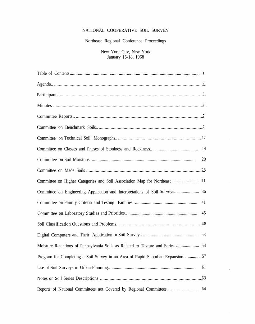
NATIONAL COOPERATIVE SOIL SURVEY Northeast Regional Conference Proceedings New York City, New York January 15-18, 1968 Table of Contents .................................................................................................................. 1 Agenda.. ................................................................................................................................ 2 Participants ........................................................................................................................... 3 Minutes ................................................................................................................................. 4 Committee Reports.. ............................................................................................................. 7 Committee on Benchmark Soils.. ......................................................................................... 7 Committee on Technical Soil Monographs.. ........................................................................ 12 Committee on Classes and Phases of Stoniness and Rockiness.. ......................................... 14 Committee on Soil Moisture.. ............................................................................................... 20 Committee on Made Soils .................................................................................................... 28 Committee on Higher Categories and Soil Association Map for Northeast ........................ 3 1 Committee on Engineering Application and Interpretations of Soil Surveys.. .................... 36 Committee on Family Criteria and Testing Families.. ......................................................... 41 Committee on Laboratory Studies and Priorities.. ............................................................... 45 Soil Classification Questions and Problems.. ....................................................................... 48 Digital Computers and Their Application to Soil Survey.. .................................................. 53 Moisture Retentions of Pennsylvania Soils as Related to Texture and Series ..................... 54 Program for Completing a Soil Survey in an Area of Rapid Suburban Expansion ............. 57 Use of Soil Surveys in Urban Planning.. .............................................................................. 61 Notes on Soil Series Descriptions ........................................................................................ 63 Reports of National Committees not Covered by Regional Committees.. ........................... 64

Welcome message from author
This document is posted to help you gain knowledge. Please leave a comment to let me know what you think about it! Share it to your friends and learn new things together.
Transcript
NATIONAL COOPERATIVE SOIL SURVEY
Northeast Regional Conference Proceedings
New York City, New YorkJanuary 15-18, 1968
Table of Contents .................................................................................................................. 1
Agenda.. ................................................................................................................................2
Participants ...........................................................................................................................3
Minutes .................................................................................................................................4
Committee Reports.. .............................................................................................................7
Committee on Benchmark Soils.. .........................................................................................7
Committee on Technical Soil Monographs.. ........................................................................12
Committee on Classes and Phases of Stoniness and Rockiness.. ......................................... 14
Committee on Soil Moisture.. ............................................................................................... 20
Committee on Made Soils ....................................................................................................28
Committee on Higher Categories and Soil Association Map for Northeast ........................ 3 1
Committee on Engineering Application and Interpretations of Soil Surveys.. .................... 36
Committee on Family Criteria and Testing Families.. ......................................................... 41
Committee on Laboratory Studies and Priorities.. ............................................................... 45
Soil Classification Questions and Problems.. .......................................................................48
Digital Computers and Their Application to Soil Survey.. .................................................. 53
Moisture Retentions of Pennsylvania Soils as Related to Texture and Series ..................... 54
Program for Completing a Soil Survey in an Area of Rapid Suburban Expansion ............. 57
Use of Soil Surveys in Urban Planning.. .............................................................................. 61
Notes on Soil Series Descriptions ........................................................................................63
Reports of National Committees not Covered by Regional Committees.. ........................... 64

Soil Conservation Districts - Their Shift in Program and Responsibilities . . . . . . . . . . . . . . . . . . . . . . . . . . 66
Report of Soil Research Committee Liaison .I..... . . . . . . . . . . . . . . . . . . . . . . . . . . . . . 67
The Soil Factor in Sanitary Land Fill . . . . . . . . . . . . . . . . . . . . . . . . . . . . . . . . . . . . . . . . . . . 68
Summary Remarks . . . . . . . . . . . . . . . . . . . . . . . . . . . . . . . . . . . . . . . . . . . . . . . . . . . . . . . . . . . . . . . . . . . . . . . . . . . . . . . . . . . . . . . . . . . . . . . . . . . . . . . . . . . . . . . . 69

PROCEEDINGSOFTHE
NORTHEASTCOOPERATIVESOILSURVEY
-11
WORK-PLANNINGCONFERENCE
NEW YORK CITYJANUARY 15-18, 1968
U. S. DEPARTMENT OF AGRICULTURE
SOIL CONSERVATION SERVICE

.
NKIONAL COOPERATIVE SOIL SURVEYNORTHRAST SOIL SURVEY WORK PLANNING CONFERENCE
January 15-18, 1968
TABLE OF CONTENTS
Agenda
Participants
Minutes
Committee Reports
1. Benchmark Soils2. Technical Soil Monographs3. Classes and Phases of Stonfness and Rockiness4. Soil Moisture5. Made Soils6. Higher Categories and Soil Association Map for
the Northeast7. Engineering Application and Interpretation8. Family Criteria and Testing Families9. Laboratory Studies and Priorities
Other Reports
(4
(b)
Cc)
Cd)
I$::;(0
liti
Application and Interpretation of the SoilClassification System
Digital Computers and Their A~pplication to SailSurvey
Moisture Characteristics of Pennsylvania Soils asRelated to Texture and Series
Program for Completing a Survey in an Area of RapidIndustrial Expansion
Use of Soil Surveys in Urban PlanningSoil Descriptions - ProblemsNational Committee ReportsSot1 Conservatton Districts - Shfft in Program
and ResponsibilitiesReport of Northeast Soil Survey CommitteeSoil Factor in Sanitary Land FillSumnary of Remarks - A. J. Baur

. f
AGENDA - NORTHEAST SOIL SURVEY WOX Pk’NNING CONFERENCE - JAN 15-18, 1968
MONDAY - JANUARY
8:30-9:009:00-12:oo12:00-l:ool:OO-5:oo
15
Announcements, Appointments, and Opening BusinessMeeting o f Connnittees 3, 4. 5 .LunchMeeting o f Committees 6, 7, 8, 9.
TUESUAY - JANUARY 16
8: 30-9:00 Business Meeting - Report of Nominating Committee9:00-12:oo Reports of Committees 1, 2, 3, 4 and 5.12:00-l:oo Lunch
/ l:OO-5:oo Reports of Connnittees 6, 7, 8 and 9.
WEDNESDAY - JANUARY 17
8:30-12:00 Application an2 Interpretation of the New ClassificationSys tern. Dr. Guy Smith
12:00-l:oo Lunchl:OO-2:oo Digital Computers an+ Their lpplication to Soil Survey.
Dr. L.J. blathers2:00-3:00 Moisture Characteristics of Pennsylvania Soils as Related
to Texture and Series. Dr. Gary Peterson3:00-4:oo Program for Completing a Survey in an Area of Rapid
Industrial Expansion. John W. Wsrners, Jr.4:00-5:oo Use of Soil Surveys in Urban Planning. Glenn B. Anierson
THURSDAY - JANUARY 18
.
8:30-10:1510:30-11:30
11:30-12:oo
12:00-l:oo1:00-l: 15
1: 15-1:451:45-3:oo
3:00-3:30
Soil Descriptions - Problems. P.H. Paschal1Discussion of (1) National Cownittee Reports not covered
by Northeast Regional Committees. Dr. D.E. HillSoil Conservation Districts - Their Shift in Program and
Responsibilities. S.L. TinsleyLunchReport of Northeast Soil Survey Committee - Dr. R.
StruchtemeyerThe Soil Factor in Sanitary Lanl Fill. Dr. F.G. LoughryExperiences in Foreign Lank and Soil Survey and Relate.1
Piells. R.P. Struchtemeyer, F. Cleveland, B.J. PattonConcluding Statements and Adjournment

Participants " Northeast Soil Survey Work Planning ConferenceNew York City - January 15-18, 1968
R. Arnold, Dept. of Agronomy, Cornell University, Ithaca, N.Y. 14850R. J. Bartlett, Agr. Experiment Station, U. of Vt., Burlington, Vt. 05401A. J. Baur, SCS, 7600 West Chester Pike, Upper Derby, Pa. 19082I?. S. Bell, Agronomy Dept., U. of R.I., Kingston, Rhode Island 02881P,. L. Blevins, Dept. Agronomy, U. of Kentucky, Lexington, Kentucky 40506E. Ciolkosz, Agronomy Dept., Penn State Univ., University Park, Pa. 16802F. W. Cleveland, SCS, 7600 West Chester Pike, Upper Darby, Pa. 19082R. E. Daniell, SCS, 1409 Forbes Road, Lexington, Kentucky 40505J. N. Elder, A ronomy Dept., Va. Polytech Institute, Blacksburg, Virginia 24061
" D. S. Fanning@Agronomy Dept., U. of Maryland, College Park, Md. 20542R. A. Farrington, Dept. of Forests and Waters, Montpelier, Verrsont 05602J. E. Fossfl4d. Agri. Exp. Sta., Agronomy Dept., U. of Md., College Park, Md. 20742
J D. E. Hill/Corm. Agr. Exp. Station, Box 243, Windsor, corm. 06095N. B. Pfeiffer, SCS, 400 N. 8th Street, P.O. Box 10026, Richmond, Virginia 23240L. Kick, SCS, 14idtown Plaza, 700 E. Water Street, Syracuse, N.Y. 13210J. Kubota, SCS, Cornell University, Ithaca, N.Y. 14850G. J. Latshaw, SCS, 100 N. Cameron Street, Harrisburg, Pa. 17101F. G. Loughry, Penn. Dept. of Health, P.O. Box 90, Harrisburg, Pa, 17120W. H. LyfordfHarvard Forest, Petersham, Mass. 01366M, Marklej, SCS, Box 670, New Brunswick, N.J. 08903R. L. Marshall, SCS, Midtown Plaza,R. P. MatelskwAgronomy Dept.,
700 E, Water Street, Syracuse, N.Y. 13210Penn. State Univ., University Park, Pa. 16802
E. D. Matthews, SCS, Univ. of Maryland, College Park, Maryland 20742J. J. Nell, SCS, 100 N. Cameron Street, Harrisburg, Pa. 17101A, H. Psschall, SCS, 7600 West Chester Pike, Upper Darby, Pa. 19082B. J. Patton, SCS, 209 Prairie Ave., Morgantown, W. Virginia 26505G. PetersonYAgronomy Dept., Penn. State University, University Park, Pa. 16802N. K. Peterson)/Dept. Soil h Water Science, Univ. of N.H., !;urham, N.H. 03824H. C. Por er,C.Engle I/”
Agronomy Dept., Virginia Polytech Institute, Blacksburg, Va. 24061Univ. of W. Virginia, Morgantown, W. Va. 26505
G. Quakenbush) SCS, P.O. Box 670, New Brunswick, N.J. 08903E. J. Rubins; Plant Science Dept., Univ. of COM., Storrs. Conn. 06268A. E. Shear-in, SCS, Agr. Exp. Sta., P.O. Box 248, Windsor, Conn. 06095H. S. Sinclair, SCS, 39 Park Street, Essex Junction, Vermont 05452G. Smith, SCS, Washington, D.C. 20250W. J. Steputis, SCS, USDA Bldg., Univ. of Maine, Orono, Maine 04473
. R. A. Struchtemeyertiept. of Plants h Soils, Univ. of i4aine, Orono, Maine 04473S. L. Tinsley. SCS, 7600 West Chester Pike, Upper Darby, Pa. 19082J. W. Warners, Jr,, SCS, Riverhead, Long Island, N.Y. 11901
. E. Newman:'U,S.F.S., 633 W. Wisconsin Ave., Milwaukee, Wisconsin 53203B. Watson, SCS, Burlington, Vermont 05401K. P. Wilson, SCS. P.O. Box 670, New Brunswick, N.J. 08903S. J. layach, SCS, 29 Cottage Street, Amherst, Mass. 01002
3

NORTHUST SOIL SURVEY WORK PLANNING CONFERENCE
THE PENN GARDEN HOTELNE7r YORK, h'. Y.
January 15-18, 1968
The meeting was called to order by Chairman, l,$Jalter J. Steputis at8:30 A.?!., January 15. Conference participants introduced themselves tothe voup.
G. J. Latshaw was nrlmed recorder for the business sessions. WalterSteputis appointed a committee consisting of A. H. Paschall, Chairman,H. L. Marshall, and R S, Bell to nominate a new vice chairman.
Room locations were assigned to the scheduled committee meetings.
Jchn J. NO11 announced that committee 9, Laboratory Studies andPriorities, was to meet at s:OO P.M.
A. J. Baw requested committee 2, Technical Soil Monographs, to meetat 1:00 P.!,I. preceeding the rfternoon session.
CominiC;Lee chairmen were given the responsibility for preparingsumrmries of .Lhc?i.i- committee meetings.
The business moetiny was re-opened by chairman !ralter Steputis at8:30 A,.?.!,, u'anunrg 16. Late arrivals to the meeting introduced themselvesto the conference.
Committee chairman were directed to send their committee reports toWalter Steputis by February 15.
:i~* H. Paschal1 announced that the nominating committee had selectedS. A. L. Pilgrim as the new iice chai,r.%n, The group urx&mously approved
i~e~-ni~;li~~~~~~~~~oi;uni.ttee's selection for the vice chairman which.is for t 1l~
1969 and 70. ') i* "~,y: ,.. 3~2
,I, ;p ,1&‘,’
R, A. Struchtemeyer, Vice Chairman,the remainder of ihe days' session.
took over the chairmanship for !?(.Y-Dr. Struchtemeyer said he would act
as liaison rcpreser!trrtive to the Northeast Soil Research Committee khichIs also maetins in the city*
A. J. Flaw asked when the next meeting was to be held.
R. A., Struchtemsyer said the next meeting would probably be heldabou-t, the swa time of the year in and at the same location. I
Roy ::atelski moved that an extra correlator be added to the North-east staff so the correlation staff can visit the field more often.M&ion was 2nd. and passed.
A. J. Baur stated the work load of descriptions and correlationshas prevented his staff from getting to the different states often enough.
Committee reports were requested by Vice Chairman, Struchtsmeyer.
Committee report summaries are located in a separate section of theproceedings.
Wednesday - January 17, the meeting was reconvened at 8:30 A.M.
Dr. Guy Smith discussed the "Application and Interpretations of theNew Classification System."
Dr. T. J. Mathers reviewed digital computers and their applicationto soil survey.
Moisture characteristics of Pennsylvania soils, as related to textureand series, was given by Dr. Gary Peterson.
John W. Warner, Jr. discussed the program for completing a soilsurvey in an area of rapid urban expansion,
Olen B. Anderson discussed the use of soil surveys in urban planning.
Thursday - January 18, the meeting was reconvened.
A. H. Paschal1 discussed problems in preparing soil series descriptions.
Dr. D. E. Hill discussed committee reports not covered by NorthEastern Regional Committees and NCR - 3 Project - Bibliography of SoilSurvey Information,
S. L. Tinsley discussed the shift in the program andnssponsibilitiesof Soil Conservation Districts.
The soil factor in sanitary land fill was presented by Dr. F. G.Loughry.
Experiences in foreign lands and soil survey and related fields werediscussed and illustrated with slides by R. A. Struchtemeyer, F. Oleveland,and B. J. Patton,
Concluding statements made during the last day of the session,Thursday, January 18:
R. A. Struchtemeyer reported that the Northeast Soil ResearchCommittee is going to have a committee to discuss possible mineralogystudy project in Northeast. Dr. Brady would like the Northeast PlanningConference to suggest a specific mineralogy study project.
A. 3. Baur stated that soil survey areas containing more than oneintensity of survey need separate mapping units and legends for each
2
5
I
mapping intensity. The separate legends alce to be labeled as to theintensity - low, medium or high. Users must be able to differentiatebetween intensities because of differences in combinations of slope andcomplexes. Interpretations will also vary between different mappingintensities.
A. J. Daur stated interstate coordination will be made on mappingunits for all XLRA~s in the northeast. State representatives are invitedto the workshops.
Francis Cleveland stated that individual states may subdivide degreeof limitation ratings for soils. Example would be the division of a severerating into severe and very severe.
Dr. Baur stated the work of the committees were very good at theNortheast Conference. He pointed out the outstanding work of the experi-mental station representative in making the meeting a success. Thepresence of Kentucky and West Virginia had been a very important factorin success of the meeting.
Walter Steputis thanked the group for the cooperation in making themeeting a success.
Conference adjourned 3:OO P.M. on January 18.
.
3
6
,
NATIONAL COOPERATIVE SOIL SURVEY
NORTHEAST SOIL SURVEY ti@E PlANNING CONFERENCE
February 15-18, 1968.
REPORT OF COMMITTEE ON BENCHMARK SOILS
The committee on benchmark soils is e standing coernittee that providestechnical liaison to coordinate the benchmark soil report program inthe states of the Northeast SCS Region. The carmittee was asked toreview progress ln the benchmark soil program throughout the Northeastand to obtain plans and priorities for preparation of benchmark reportsfor the next biennium.
The committee chairman did not request time et the conference for acoernittee meeting. the felt e satisfactory committee report could beprepared from information solicited from each committee member priorto the conference. Unfortunately, only 6 states responded. The infor-mation for the remainder of the states was obteined at the conference,
The following is e report on tha status of benchmark soil reports andplans.for the next biennium.
1.. Reports published ._’ *a,,
a. 1963 or earlier
Vergennes (Vermont)Caribou Walne)Canf ield (Ohio)
b, 1963 - Paxton (Connecticut)
c. 1967 - Bridgehampton (Rhode Island)
2. Reports not published but in press in 1967 - none.
3. Reports being prepared or to be prepared in the next biennium.
Hegerstown (Maryland - 1968)Charlton (Connecticut - 1968)Gloucester (kiassechusetts - 1968)Hermon (New Hampshire - 1969)Gilpin (west Virgjnia - 1969) 8Panton (Vermont - 1969)Matspeake (Maryland - 1969)Cheshire (Connecticut - 1969 or 1970)
Attached to this report is Appendix I,.whIch lists the benchmark soilsassigned to each state in the Northeast for.compillng and preparingbenchmark soil reports. Maine requested to delete the Adams, Seco, endSuffleld series from their assigned list due to small acreage of thesoils in the state end also to delete the Easton series because of man-power shortage. Kentucky suggests that the Tllsit series be shifted toWest Virginia es a result of decisions made recently in regard to theseries. Maine and Kentucky were the only two states that requested achange In benchmark soil esslgnments,
Committee Members
P.S.
S. Ji Zeyach, Chairman C. J. KochD. E. Hill, Vice Chairman R. L. Marshal?R. S. Bell J.J.NoIlL. J. Cotnqir N. I(. PetersonR.. E. Danlell G. C, PohlmanR. A. ,Farrlngton R. A, Struchtemeyer.J. E. FOSS K. P. W i l s o nR. L. Googlns
from Chalrmanr R. A. Ferrington requested at the conference tobe released as a member of the committee. Bruce Watson, the newState Soil Scientist for Vermont, accepted to replace Bob Ferrlngtonas a member of this committee.
.
Notes on dlscusslon by the Conference following committee report
D. E, Hill, Recorder
zeyech:
Hill:
Beurt
Nollr
Should the states of Kentucky, Ohio, end Virginia be representedon the committee? They are associated with thesoutheast dueto the make-up of reglona for Land Grant Colleges.
Representation is desirable so members can serve as contact men *for date for benchmark soil reports.
Assignments of benchmark soils should probably correspond to thestates responsible for updating official series descriptions.
Benchmark soils are for selected series with detailed data.For interpretive purposes. too many other soils have to beinterpolated. Pennsylvania has an excellent sol1 cheracterlza-tion laboratory. Most soils, pre#o,usl_ylnterpolated, havedete.~ aval lable now. Therefore? wc “feei .that benchmark reports:di not have’applicatlon under these .cir&nstonccs.
.., .,,

APPENDIX I
List of benchmark soils assigned to the Northeast States for compilingand preparing benchmark soil reports.
Connecticut and Rhode Island Pennsylvania
Brldgehampton L/ Paxton 11Charlton 21 StockbrTdgeCheshire Windsor .’Enf ield Woodbridge
A l l i sBerksBrinkerton
B u r g l nCattaraugusCavodeCrotonCulversDuff ieldDunning
EdgemontErnestLawrenceMiddleburyMontevalloMorrisNorwichOquagaReadingtonWestmoreland
,Delaware and Maryland
BaileBeltsvil leChesterChristiansCookportFranks town
LeonardtcwnManorMatapeakeMattspexMontaltoOthelloPocomokeSsssaf ras
New Hampshire
GlenvilleHagerstown 21legore
AgawamHarmon 2/HollisLeicester
PeruRidgeburySuttonWhitman
EdenMaury
KentuckyNew Jersey
Pembroke
Maine
Biddef ordBuxtonCaribou A/Howland
PlaistedscanticSuff ield
. Massachusetts
Gloucester 2/HinckleyMerrimacNinlgret
scarboroSudburyWalpole
AdelphiCoIlingtonElktonEvesboroFallsington
KeyportPennWestphallaWoodstown
New York
AdamsAmeni aCanandaiguaCaneadeaChenangoCo1 lamerHolly
MardinPapakatingPhelpsRed HookTiogaUnadillavo1usia
i/ Report published
r/ Report being prepared
smltht DOea Pennsylvania also’have crop response data on thesesoils In addition to physical and chemical data? This isvery important for operational farm planning.
Matthews: Agree wlth Pennaylvania.in thai the benchmark Soil programis a temporary one and should be phased out.
~itlr To increase output of benchmark sot1 reports, the,comolttaecan serve as a worklng committee at the conference to activelyassemble data. This will decrease long correspondence andsave considerable time. Also soil series, high on priorityljst for individual states, should be updated and revised assoon as possible to avoid delay’~in compiling data and con-
.
firming its inclusion in the report.
.
Report of the corrmittee on benchmark soils was accepted by the Conference.
_-
,
Ohio
Brookston Hoytvi lleCanfield I/ KeeneCeline MahoningCrosby Venango
Vermont
BerkshireColtonHadleyLimerickLivingston
LymanPantonVergennes lJWinooski
virginis
GarboFrederick
Tatum
West Virginia
BlagoDekalbElliberGilpin 2-lGinatHartsellsHolstonHuntingtonLaidlgLakin
LindsldeMelvinMonongahelaMu-r111TllsitTylerUpshurWhartonWheeliag
:.. :’ NATIONAL:COO’(E;~~ZVE S O I L SL’RVEY ,~’ .’ -.~.r.5;. ‘,._‘,, !~i.~. ‘. !
NORTHEAST SOIi SURVEY iWURK”PLANflING C&PERE??CE ’,:.~ ‘l,‘. :;..:.I:; ,, ,. ,....,
January 15-18, 1968
REPORT OF COlWI~iW:Qil .TB$HIUCAL SOIL MONQGRA!?HS :
Preparation of soil monographs is a continuing responsibility of tha~Soi1Survey. Monograph writing should be fZbtad into the schedule of soil surveyjobs as opportunity permits. :At~.prasant:.wor.k is in progress on four:laonographsin the United States, but,.oone :of L (hasa :,are :in the Northeast. .~L
Soil scientists in the Northeast era asked to watch for land resource areas i nwhich circumstances appear favorable for development of a monograph. According
, to the January 1967 National Cowlttee Report on Soil Monographs, thesecircumstances include:
a) The area should include important soils of different soil orders.b) A competent author should be available in the area,c) A considerable body of knowledge about soil properties already exists.d) A number of soil surveys in the area are on the 10 year publication
schedule,
The 1967 National Corwittea recommended investigation of a number of ateasbased on the 1963 United States Major Land Resource Areae:.Hap as possib,ilitiesfor monographs, These included the following areas in which the Northeast hasa major interest: :. ._*.; :;ii:i ,-‘I’.,,.’ _,
I: h.,js::‘.~ :;, i’l Ti::::!..~. .~,. .’Technical Land Resource Areas1 S t a t e s Primarily:,:. ,. :Monograph (1963 Map) Involved .:z>, , . :
No. 79 124, 125, 127, 126” P a . , W.Va. ) Ky. .:,( Term. ).8 9 143, 144, 145, 146 New England, New :York .
71 111 Ohio ( Ind. 181 128 Va. (Term.)
J/ LRA 126 not listed in 1967 National Report
Numbers 79 and 89 are of special interest to us. According to the August 1967General Soil Hap of the United States, scale 1:17,000,000, the only extensiveregion in the United States dominated by Ochrepts is in monograph area No. 79plus adjoining LRA No. 140. Ochrapts also dominate in the Ozark region ofArkansas and Missouri, but this area is not extensive. A monograph on theOchrepts in area No. 79 would contribute substantially to the body of infonna-tion for this suborder.
Monograph area No, 89, New England and New York is one of the two extensiveregions dominated by Otthods, The other region is in northern parts of Michigan,Nisconsin, and Minnesota, A monograph in area No, 89 would deal with Orthodsin mesic and frigid families whereas Orthods in the parts of Michigan, Wiscon-sin, and tlinnesota ate primarily in frigid families.

‘.’
The Committee on Technical Soil~Mondgraphs should be.continucd. It shouldgive encouragement, advice,,.and guidance to,+ny potential work on soilmonographs in the North&t. ~’ Ln hddition’, ‘the Committee ~bh&ld serve 8sliaison between the National Committee on ifonographs and our NortheastConference.
Dr. C. D. Smith reported on the status of the four monographs now in progress.These are:
!<’1. Slacklands A r e a i n Texas
:.. i:.. ,ii
2.. Nashville Basin in Tennessee : .:,_. :,
3. Red River - North inMInnesota, North Dakota,;and South Dekota4. Miss iss ippi Delta in Miss iss ippi , lauisansj ‘Arkansas, and Tennessee - _
-a? ,., ., :,_ ,.~ ‘~I.. ,‘.~ ” .,,:, .~ .., ;:.
3 ‘C :q, ,’ !<..’ i; :.,I)
i .i: i...- .;,,.
,’ ,!.. ,I!
,: ” :y ;,::.;
: ; i d
co;na;tt& M e m b e r s : . ! ; :_ ;,, : _ j
Dr. A. J. Baur, ChairmanR . P. Matelsk)t Vice .Ch+manII. H. Lyford ,., ,:. I
. . !, I :;,
R . L . M a r s h a l lJ. :.I., NoLlD . S . F a n n i n g ‘~ :.R . L . Blevins
I ..~
.I.
,
NATIONALCOOPlTE SOSJa SORVEY
NOBTHEAST SOIL SURVEY mRK PLANNWO -CONFERlBCE
January 15-18, 1968
REPORT OF C0NMITTE.K ON CLASSES AND PHASESOF STONINESS AND RDCKINESS
The 1967 National Committee has made the following charges to Our
committee:
B.
b.
C.
d.
Test the criteria for stoniness classes and phases en different
size and shape of stones.
Study the problem of rockiness with special attsntion to size
of rook, spacing between rocks and percent of surface covered
by rocks.
Make recommendations for classes and nomenolature for the
classes of rockiness.
Suggest ways and means for broader phases in addition SKI the
narrow phase name proposed.
Chames a and b
To assist the conmdttee in its study of these two charges, I am
soliciting any new data collected or rasults of the testing of the
criteria that has been accomplished in the past two years. I am
hopeful that State Soil Scientists in the Northeast will respond to
this request and provide available information to the comzlttee.
-Report ofcoImRittoeonclasses-and~sofStoninessand Rockiness - Continued
Charge c
The National Committee recommends that rockiness classes muet cen-
eider the spacing between rock outcrops and size of the area covered
by rock outcrop.
Charge d
The National Committee recommends that stoniness classes be based on
average spacing between stones.
We need to give further consideration to both the limits of etoniness
classes and the naming of stoniness phases as proposed by the National
Committee.
Responses to the questionaire submitted to State Soil Scientists show
but tw pieces of additional information. A field party in New
Hampshire used three methods to check the quantity of stones present
in mapping delineations. All three methods were used on the sares
sites. Method 1 consisted of measuring stones in areas 100 feet square,
10,000 square feet; Method 2 consisted of determining average distance
-between stones, and average size of stones; and Method 3 oonsieted of
using a 100 foot transect selected at random within the test area.
On test area 1, Method 1 shows the largest percentage of the surface
covered by stones; Methods 2 and 3 gave a somewhat lower percentage
of surface covered but were quite similar in results.
. -
,
Report of Committee on Classes and Phases of Stoniaessand Rockiness - Continued
On test area 2 all three methods gave similar results. Method 3
was the most rapid.
Kentucky presented a number of transects showing the spacing of open
land and rock outcrop. These studies show a considerable range and
indicate the need to consider parcent of land occupied by rock
outcrop and the pattern of occurrence of the rock outcrops.
The comnrittee discussion indicated that there is considerable simi-
larity between the spacing of stones given for the various stoniness
classes in the manual and the spacings reported for stones of 0.83
and 5.0 square feet of area in the 1967 National Committee Report.
As a result, the committee recommended the follordng spacings for the
various classes of stoniness (or boulders):
Class Spacing
0 100 or more feet
1 30 to 100 feet
2 5 to 30 feet
3 2.5 to 5 feet
L 1 to 2.5 feet
5 less than 1 foot
Report of ccmmittee on clsasea snd phases of Stoninessand Rockiness - Continued
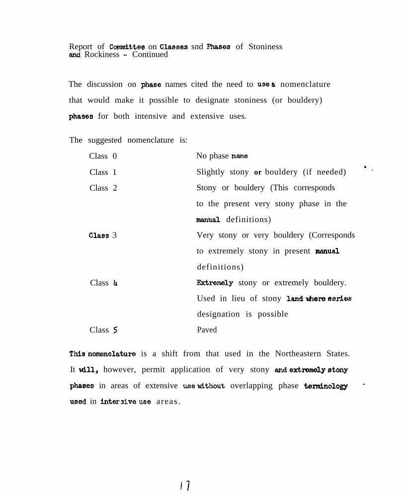
The discussion on phase names cited the need to use a nomenclature
that would make it possible to designate stoniness (or bouldery)
phases for both intensive and extensive uses.
The suggested nomenclature is:
Class 0
Class 1
Class 2
Class 3
Class Ll
Class 5
No phase name
Slightly stony or bouldery (if needed) ’ -
Stony or bouldery (This corresponds
to the present very stony phase in the
manual definitions)
Very stony or very bouldery (Corresponds
to extremely stony in present manual
definitions)
Jktremely stony or extremely bouldery.
Used in lieu of stony land tier% serlea
designation is possible
Paved
This nomenclsture is a shift from that used in the Northeastern States.
It will, however, permit application of very stony end extmmaly atony
phases in areas of extensive use without overlapping phase teenninology -
used in inter3ive u8e areas.
b$@Tt Of cOmmith-39 on Cb3988s and Phases Of StOnin8fJ#and F&oIdness -Contim~ed
.
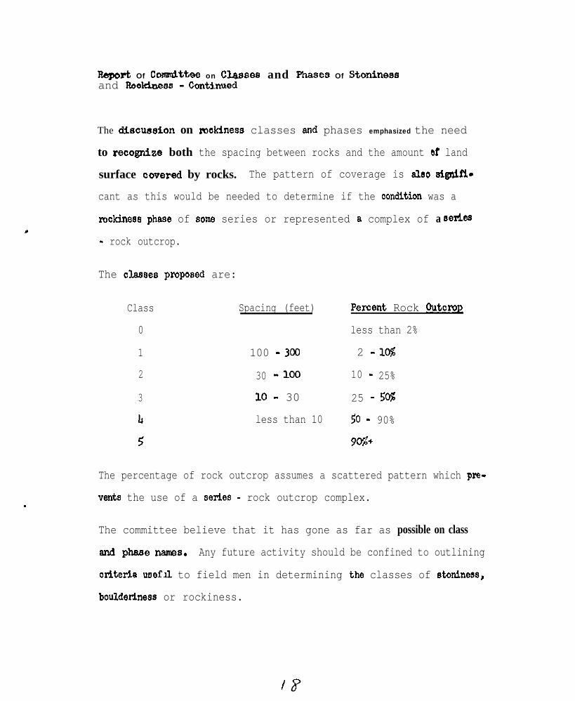
The ditmmion on makiness classes and phases emphasized the need
to recogniee both the spacing between rocks and the amount af land
surface cwersd by rocks. The pattern of coverage is aleo elgnifi-
cant as this would be needed to determine if the Condition was a
rockinees phase of Some series or represented a complex of a aeties
- rock outcrop.
The o&S88 propOS8d are:
Class Spacing (feet) PerCent Rock OutcroR
0 less than 2%
1 100 -300 2 -lC%
2 30 -100 10 - 25%
3 10 - 30 25 - 50%
Ir less than 10 50 - 90%
5 9C%+
The percentage of rock outcrop assumes a scattered pattern which pre-
vents the use of a series - rock outcrop complex.
The committee believe that it has gone as far as possible on class
and phss8WUW. Any future activity should be confined to outlining
Ctit8ri.a usefll to field men in determining the classes of stminess,
bouldetiness or rockiness.

deport of Conin&tbe on Classes and Phases of Sto&=ss .: ,’ _,,,,~~,
and Rockiness 1 Continued "' .,~ .
Committee timbers present: ,::
A..H, Paschall, Vice Chairman
R.
J.
R, A.
.' /. ,“’ ., ,,yl:J. H,
M.
,' R.L.
Rrnold
Elder, Jr.
Farrington
Lyford..‘,
Narkley (Recdrder)
Marshall
.., ,; /:,.
I~.lnes~,,prevented Mr. Pilgrim from'beinET present.so I4x-r ~PBsChdl
.
E. D. Matthews ~,.
Visitors present;
J. Kubota ”
R. Sinclair
.r.::: :.:.:~~: ,~ M. J. Steputis
-The conunittee report &s adopted b;y the conf6rence. .~, j,,:
.
tq
NATIONAL COOPERATIVE SOIL SURVEY
NORTHEAST SOIL SURVEY WORK PLANNING CONFERENCE
J a n u a r y 15-18, 1968
REPORT OF COMMITTEE ON SOIL MOISTURE
The soi l moisture commit tee met for one-hal f day and severaladditional worthwhile comments were made by committee and non-committee members when the oral committee report was presented beforea l l the Nor theas t Confe rence par t i c ipan ts . The soi l moisture commit-tee concerned i t se l f ma in ly w i th the charges g iven to i t by the na-t iona l so i l mo is tu re commi t tee ,
Water Table Reqime Classes
The commit tee was asked to at tempt to formulate descr ipt ivestatements of the water table regime in terms of k ind of water table,depth of occurrence and season of the year which would replace thedrainage classes of the soi l survey manual and to explore the useof these de f in i t ions in the new c lass i f i ca t ion sys tem in p lace o fmorpho log ic fea tu res in f raming de f in i t i ons .
No s ta tements were deve loped on the k ind o f wa te r tab le . I twas agreed that the kind of water table observed depends on themethod of measurement and that some standardization of methods ofwater table measurement is needed. This appears to be one stumbl ingb lock to the deve lopment o f wa te r tab le de f in i t i ons to supp lemento r rep lace the p resen t d ra inage c lasses . A t i t s l a s t m e e t i n g t h i scommittee agreed that most water table studies in the Northeast wereobserv ing apparen t water tab les . The apparent water table has beend e f i n e d (Proc. of 1965 Nat iona l Con fe rence) as the leve l a t wh ichwater stands (adequate t ime al lowed for adjustments) in an unl inedboreho le . A l though the we l l s in many s tud ies a re l ined , a watertab le resembl ing an apparen t wa te r tab le i s p robab ly s t i l l observedi f the l i ne r i s per fo ra ted o r i f the sea l be tween the l i ne r and thes u r r o u n d i n g s o i l i s n o t t i g h t .
The commit tee chairman fe l t that a l l water tables are perched(at some depth). Inves t iga t ions shou ld be made to de te rmine i fsoi ls wi th the same water table depth and durat ion could be usedd i f f e r e n t l y i f t h e y h a d d i f f e r e n t d e p t h s o f p e r c h i n g .
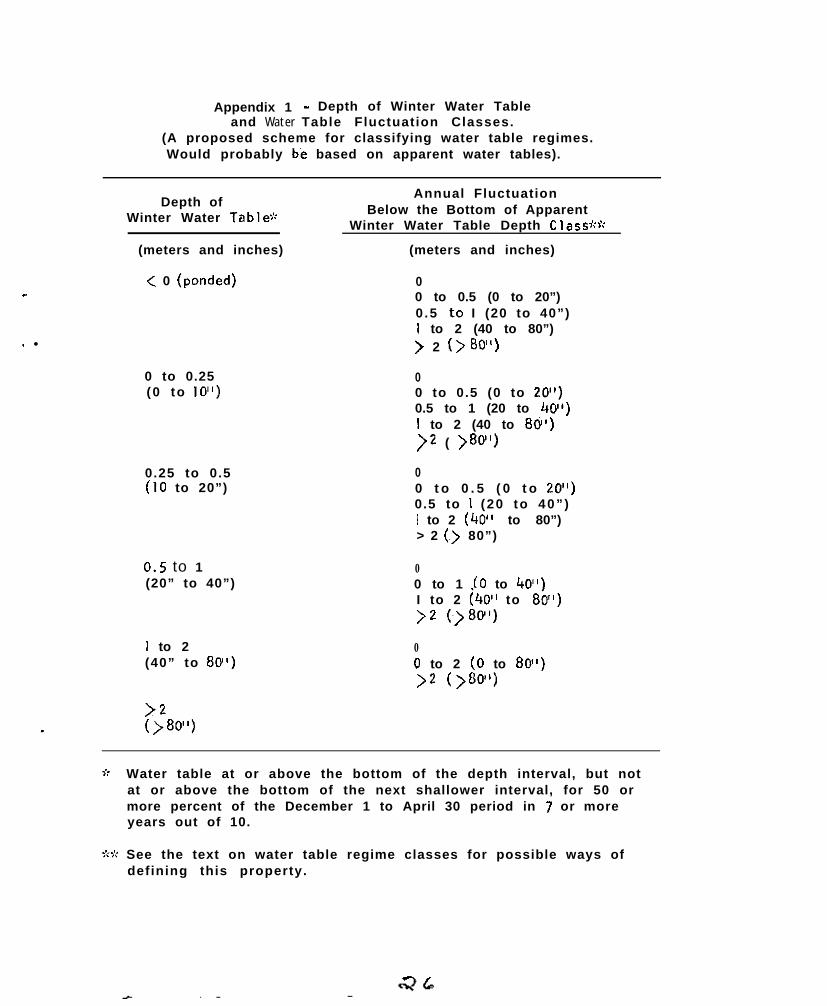
Attempts were made to formulate some water table regime classesbased on wate r tab le f luc tua t ion pa t te rns . One o f these schemes i spresented in the appendix 1. Annua l wa te r tab le f l uc tua t ion pa t -te rns fo r so i l s in the Nor theas t (e .g . Ly fo rd , 1964) h a v e s h o w n t h a tw a t e r t a b l e s i n t h e s e s o i l s a r e h i g h e s t i n l a t e f a l l , w i n t e r a n de a r l y s p r i n g . The water tables drop in late spr ing and summer andr i s e a g a i n i n t h e f a l l . F rom f luc tua t ion pa t te rns (g raphs o f dep thvs t ime) the percen t o f the year , o r o ther de f ined per iod , tha t thewater table remains at or above a speci f ied depth may be determined.In the system presented in appendix 1, winter water table depthclasses are based on the percentage of a winter per iod that thewater table remains above speci f ied depths.
An addit ional category was added (appendix 1) to show the amountannua l f l uc tua t ion be low the bottomof the w in te r water tab le dep thc l a s s . This could be defined as the maximum drop below the bottomof the w in te r dep th c lass o r on the bas is o f a debth tha t the watertab le rema ins above dur ing mos t (perhaps 90%) of the year.
The committee fel t that the system presented in appendix Ishould be included in the commit tee report so that i t could be con-s i d e r e d b y o t h e r s o i l s c i e n t i s t s . Some of the Plain problems with,the appendix 1 system that have been noted are:
1)
7-j
3)
4)
5)
There a rc too few IQng te rm water tab le s tud ies toa l l ow a thorc);Igh tes t ing o f the sys tem and the se t t ingo f meaningrut c l a s s l i m i t s , e s p e c i a l l y i n r e g a r d t opresent drainage c lasses. The need for long termstudies is emphasized because the data avai lable showthat per iods that water tables remain above givendepths vary considerably between wet and dry years:
The water table data that are available have not. b e e nevaluated in terms of such a system;
Prac t i ca l app l i ca t ions shou ld be g iven fu r ther con-s i d e r a t i o n i n s e t t i n g c l a s s l i m i t s ;
The w in te r per iod wou ld de f in i te ly have to he de-f ined d i f fe ren t l y in o ther par ts o f the wor ld andthe whole system might break down i f tested world-wide; and
Considerat ion needs to be given to the handl ing ofwate r tab le da ta ob ta ined by d i f fe ren t methods .
Some o f the be t te r a t t r ibu tes o f the append ix 1 sys tem are :
1 ) I t i s a r a t h e r s i m p l e s y s t e m t h a t i n i t s p r e s e n t o rin a mod i f ied fo rm cou ld be used to c lass i f y so i l s ,
b y t h e i r w a t e r t a b l e f l u c t u a t i o n p a t t e r n s ; a n d
2) The sys tem cou ld lend i t se l f to simplification bywhich a soi l could be classed on the basis of afew winter and summer water table measurements ifcare ware taken to avoid excessively wet and dryp e r i o d s . ”
Wi th regard to the comprehenslve s o i l s c l a s s i f i c a t i o n s y s t e m ,i t wou ld appear tha t so i l s w i th a w in te r water tab le depths (as de-f ined in appendix I) above 0.5 meters (20 inches) could be placed inthe aqu suborders . So i ls w i th w in te r water tab le depths be tween 0 .5a n d I meter might be placed in the’aquic subgroups o f the be t te rd r a i n e d ( n o n aqu s u b o r d e r ) g r e a t g r o u p s . Typic shbgroups o f the be t te rdrained great groups might be def ined as having winter water tablesbelow a depth of 1 me te r .
.
” Th is th ink ing i s par t l y based on a sugges t ion by le t te r f rom Dr .R. 8. Grossman.
- -
.
The commit tee was of the opinion that a water table system fordef in ing drainage classes should be considered as a supplemental ora l te rna te sys tem to the p resen t l y used morpho log ica l c r i te r ia and no tas a replacement. A problem, wh ich needs to be cons idered , i s tha tpoor ly d ra ined so i l s tha t have been ar t i f i c ia l l y d ra ined cou ld beplaced in the same drainage class as a natural ly wel l drained soi l bya w a t e r t a b l e c l a s s i f i c a t i o n s y s t e m , However, r e f l e c t i n g w h a t D r . R.W . Simonson h a s c a l l e d p e d o g e n i c i n e r t i a , t h e a r t i f i c i a l l y d r a i n e dsoi l would probably have higher organic matter and lower f ree i ronox ide con ten ts than the o r ig ina l l y we l l d ra ined so i l fo r a long per iodo f t ime a f te r d ra inage . These di f ferences between the two soi ls wouldbe shown by soi l color. Thus both the water table and the morphologi-ca l c r i te r ia may be needed to adequate ly c lass i fy the so i l . However,soi l wetness might be best indicated by a water table system.
Terminology for Describinq W a t e rMovement Throuqh So i l s
The commit tee was asked to consider al ternat ive terminology forthe descr ipt ion of water movement through the soi l that
1) i s in keep ing wi th termtnology used by so i l phys ic is ts and
74 is descr ip t i ve o f the cond i t ions under wh ich the measure-ments were made.
Dr. D. E. Hi l l headed up the commit tee’s response to th is charge.This response is summarized in the fol lowing quote ,(slightly mod i f iedaf ter commit tee discussion) f rom a memorandum that Dr. Hi l l sent to thecommittee members prior to the meeting.
“To meet the requ i rements o f i t em (1) (of the charge), i t wouldb e n e c e s s a r y t o u s e t e r m s c u r r e n t l y a v a i l a b l e i n t h e l i t e r a t u r e . T h i sp o i n t i s w e l l t a k e n . New terminology could be devised that would bemore descr ip t i ve bu t th is migh t on ly serve to con found. The movementof water through a soi l has been expressed by var ious terms by soi lp h y s i c i s t s . Each term descr ibes a given set of boundary condit ions,The terms most appropr iate to our use must have an element of t imeassociated with them. T h e t e r m s ‘ p e r m e a b i l i t y ’ a n d ‘ c o n d u c t i v i t y ’a re poor cho ices because they mere ly descr ibe the charac te r i s t i cs o fa porous medium. These te rms a re per fec t l y accep tab le fo r desc r ib ingthe qua l i t y o f the med ium to t ransmi t wa te r . They should not, how-ever, be used to express f low rates because they do not contain theelement of t ime.
The terms commonly used to describe flow rates are:
H y d r a u l i c c o n d u c t i v i t yP e r c o l a t i o n r a t eS o i l w a t e r d i f f u s i v i t y
The term hydraul ic conduct iv i ty can be used to express water f lowin the sa tu ra ted or unsa tura ted s ta te . If the geomet ry o f the tes t i sd e f i n e d a n d Darcy’s law can be appl ied, the term is a useful one. Un-der cond i t i ons o f unsa tu ra ted f l ow, some p re fe r the te rm soil w a t e r
: In suggest ing usable terms (1 ) to be consistent,with p r e s e n tterminology and (2) to be descriptive, those suggested by the NationalCommittee seem suitable with slight modification.
(1) For rates determined by the Uhiand Method (laboratorysaturated cores), the precise descriptive term wouldbe ‘one dimensional saturated hydraulic conductivity’or ‘confined saturated hydraulic conductivity’ . Bothare obviously too long and could be shortened to‘saturated hydraul ic conduct iv i ty ’ . At the NationalMeetings even this term was thought too long fortable headings, but I believe it is unfortunatelyunavoidable. The simple term ‘hydraulic conductivity’is not descriptive enough.
(2) For rates determined by the auger method in the field,the term ‘percolat ion ra te ’ is yatisfnctory. The ad-jeetive ‘unsaturated’ as proposed by the NationalCommittee could be used for emphasis, however, it isnot necessary because, by definition, the term impliesunsaturation.
(3)
The
The term ‘saturated percolation rate’ cannot be used.If a water table is present in the auger hole, a per-colation rate cannot be determined except by conven-tional,hydraullc conductivity measurements below awater table. Such rates.should be properly labeled*three dimensional saturated hydraulic conductivity’or ‘unconfined saturated hydraulic conductivity’ .” 2
committee supported Dr. Hil l ’s recommendations.
di ffusivi ty. This is a restrictive term implying unsaturation.
In the conduction of percolation tests, the geometry of the sys-tem is i l l -defined. although modification of the test could permitmore accurate definit ion. The term hydraulic conductivity, appliedto ,these tests , is not a suitable.one. The term ’ percolat ion ra te ’is satisfactory because itis simply, defined as downward movement ofwater in the soil’at hydrauiic gradients of 1 .0 or less . This im-plies unsaturation, a’ fact consistent~with the conditions underwhich most percolation tests are run.
-
.
In the discussion it was pointed out that, assuming that thesuggestions of this and the National Committee are approved, the soilpermeabil ity classes of the Soil Survey Manual (p. 168) should becalled “saturated hydraulic conductivity” classes since they weremeant to apply to rates determlned by the Uhiand method.
Information on Field Soil Moisture Reqimes
The committee was asked to collect information on field soilmoisture regimes. This was a very broad charge and the committeeonly attempted to bring the l ist of studies inthe Northeast , g ivenin the 1966 committee report, up to date. This supplemental l ist
i s g iven in appendix 2 .
The s tud ies b rought to the commi t tee ’s a t ten t ion were mainlyw a t e r t a b l e s t u d i e s . Of the cur ren t s tud ies , those ment ioned fo rConnecticut and New York state apparently have been going on forthe longest per iods and have the best chance of observing theeffect of year to year weather changes,.
The studies of soi l moisture regimes dur ing crop growth inMaryland by Dr. E. Strickling and co-workers are of interest onthe top ic o f ava i lab le water . These s tud ies ind ica ted tha t c ropssuf fered from lack of water even though there was considerable“ a v a i l a b l e w a t e r ” i n t h e s o i l p r o f i l e s . During drought per iodscrops wi l ted (non permanent ly) enough to severely lower cropy ie lds , bu t the so i l on ly reached the permanent w i l t ing po in t(on a 15 a tmosphere tens ion bas is ) a t the so i l su r face , T h i sdata supports the suggest ion in the1967 Nat ional Committee ~.a-port that the di f ference between the l/3 and I5 a t m o s p h e r e w a t e rc o n t e n t s b e c a l l e d “water r e t e n t i o n d i f f e r e n c e ” i n s t e a d o f “ a v a i l -ab le wa te r ” , These studies indicate that much remains to belearned about water ex t rac t ion f rom so i l s by p lan ts .
The National Committee also recommended that the regionalmo is tu re commi t tee coord ina te ac t i v i t ies w i th any reg iona l c l imatecommittee. The Northeast has no regional c l imate commit tee wi th inthe soi l survey work planning conference. There has been an activer e g i o n a l c l i m a t e p r o j e c t i n t h e N o r t h e a s t ( N E - 3 5 ) . E f f o r t s t o c o -ord ina te ac t iv i t ies w i th workers o f tha t projrct need to be made .S e v e r a l p u b l i c a t i o n s hive resu l ted f rom I$.-35 that shou ld be re -v i e w e d t o d e t e r m i n e box they relate to the work o f the so i l mo is tu recommittee.
Mois ture Cr i te r ia in the New Class i f i ca t ion Sys tem
The committee was asked to review the moisture cr i ter ia in thenew classification system and make recommendations for changes i fneeded, A n e v a l u a t i o n o f t h e k i n d of field s o i l m o i s t u r e d a t a a v a i l -able and what would be most applicable to the new system was considereddes i rab le by the na t iona l commi t tee .
-
.
So i l mo is tu re p rob lems w i th the new c lass i f i ca t ion sys tem in theNor theas t have a l ready been d iscussed by A. H. Paschal1 in the 1967Nat ional Commit tee Report .
One of the problems ci ted by Paschal1 was the apparent fa i lureof the wetness classes (suborders and subgroups), as def ined by soi lmorphology, to adequately descr ibe the degree of wetness of some oft h e s o i l s o f t h e r e g i o n . I f t h i s i s t r u e , and some supporting com-ments were made when this committee report was presented orally beforea l l t h e N o r t h e a s t p a r t i c i p a n t s , then fu r ther a t tempts to deve lop aw a t e r t a b l e s y s t e m f o r d e f i n i n g d r a i n a g e c l a s s e s a r e j u s t i f i e d . I fth is is to be done, the water table regime data already avallablewi l l be valuable and more data wi l l be needed. Long term data toeva lua te the e f fec ts upon water tab les o f d ry vs . wet vs . “norma l ”seasons w i l l be necessary i f good de f in i t ions o f c lasses a re to bedeveloped. A lso fu r ther examina t ions o f the re la t ionsh ip be tween
soi l morphology and water tables are needed.
Committee Members
R . J . B a r t l e t t“R. S. B e l lXI, E . Hill+rL. K i c k
K. ‘LaFlamme
,.
w7. P . H a t e l s k iG. G. Poh lmanN. K. Peterson
t’rH. c . P o r t e r,E. J . Rubins$rR. A . S t ruc temeye i
M. E. W e e k s+A . E . Shearin. V. Chairman
+o. s. Fanning; Chairman
“Present at the commit tee
O t h e r p a r t i c i p a n t s a t t h e
C. F.
meet ing...’
committee meeting:
Engle,L.‘Johnson.W. Steputis
S u m m a r y of comments on the oral ‘report:
G. D. Smi th - a w in te r water tab le wou ld g ive you t roub le in thet r o p i c s .
E. D. Matthews - perhaps the rainy season could replace the wintert h e r e .
Others - Could it ,be done by months , ignor ing w’inter?~
- In Flor ida water tablesmay ha highei~ in summer than ,i n w i n t e r .
+ P r o b a b i l i t y P r e d i c t i o n s a re , ri,eeded, ekpecially,for:themaximum hlgh water table.
W. Lyford - Morphological evidence of wetness has weaknesses.M o t t l i n g i n t h e l o w e r portlon’of some so i ls in the,
Nor theas t may be f rom fo rmer l y h igher wa te r tables,~associated with beaver ponds.
Someone - What abou t co r re la t ing “avat Iable” water w i th soi 1 t e x t u r e ?
G. D. Smith - V e r y p o o r c o r i e l o t i o n .
R. P. Mate lsk i -Seem to be f inding a good correl’ation in Pennsyl-’van ia . D r . ~G. P e t e r s o n w’ill show th is in h is repor t .
G. D. Smith - May be poss ib le i f m inera logy is re la t i ve ly cons tan t ,b u t b e w a r e o f t r y i n g t o e x t e n d r e s u l t s t o a l l s o i l s .
-
. l
Appendix 1 - Depth of Winter Water Tableand Water Table Fluctuation Classes.
(A proposed scheme for classifying water table regimes.Would probably be based on apparent water tables).
Depth ofWinter Water Table-:;
(meters and inches)
< 0 (ponded)
0 to 0.25(0 to IO”)
0.25 to 0.5(IO to 20”)
0.5 to 1(20” to 40”)
I to 2(40” to 80”)
>2()80”)
Annual FluctuationBelow the Bottom of Apparent
Winter Water Table Depth Class$c:;rc
(meters and inches)
00 to 0.5 (0 to 20”)0 .5 ,to I (20 to 40”)1 to 2 (40 to 80”)> 2 (> 80”)
00 to 0.5 (0 to 20”)0.5 to 1 (20 to 40”)I to 2 (40 to 80”)>2 ( >80”)
00 t o 0 . 5 ( 0 t o 20”)0.5 to I (20 to 40” )I to 2 (40” to 80”)> 2 (.> 80”)
00 to 1 (0 to 40”‘)I to 2 (40~’ to US&)>2 (~)80”)
00 to 2 (0 to 80”)>2 (>80”)
Water table at or above the bottom of the depth interval, but notat or above the bottom of the next shallower interval, for 50 ormore percent of the December 1 to April 30 period in 7 or moreyears out of 10.
See the text on water table regime classes for possible ways ofdefining this property.
Appendix 2
List of Soi I Mo is tu re . Reg ime Stud ies
Th is lis’t supp lements and b r ings up to da te the list.published inthe 1966 Northeast soi l moisture c o m m i t t e e r e p o r t . I t u n d o u b t e d l y i sincomplete.
In Connect icut water table studies have been cont inued on theW h i t m a n , kidgebury and Sutton soi ls. Da ta b rough t to the.meeting in-dicated water table di f ferences in the expected dlrection b e t w e e nthese so i l s o f d i f fe ren t d ra inage c lass by so i l morpho logy .
In Maryland both of the water table studies ment ioned in the 1966repor t have been d iscont inued in the f ie ld because the so i l s surveysin the respect ive count ies have been completed and the SCS soi l scien-tists who made the measurements have moved to other counties. TheTa lbo t County s tudy o f th ree poor ly d ra ined so i l se r ies (Typ ic Ochra-quu l ts ) d i f fe r ing In tex tu re has been summar ized and w i l l be pub l i shedin the spr ing of 1968:
Fann ing , D. S. and Reybold, W. U., III ( 1 9 6 8 ) W a t e r T a b l eF luc tua t ions in Poor ly Dra ined Coasta l P la in So i l s , Md.Ag r i c . Exp t . Sta,. Misc. Publ. N o . 6 6 2 .
Data from the 2 year water table study of soi ls of the Sassafras ca-tena (2 or 3 sites one each o f 4 so i l se r ies ) in Worces te r County ,Maryland, have been part ia l ly summarized.
Studies of the f ie ld soi l moisture r e g i m e d u r i n g c r o p g r o w t hon some Maryland soi ls have been conducted by Dr. E. Str lckl lng andco-workers of the Universi ty of Maryland, Department of Agronomy,
In New York State water table studies of 7 soi l ser ies in BroomeCounty, started by Huddleston, have apparent ly been cont inued by theBroome County Health Department. A to ta l o f abou t four years da tashould now be avai lable and measurementsare apparent ly cont inuing.Th is cou ld be an especial,ly va luab le s tudy i f i t con t inues longenough so that years of d i f ferent ra infal l may be compared.
In Pennsylvania Penn State has a research project on watertables at the new Agronomy Department farm and at a branch stationfarm. A lso s tud ies a re be ing cont inued on severa l so i l ser ies inMontgomery County, near Phi ladelphia.
In Rhode Is land, Or. J im Brown, in the Department of Forestryat the Universi ty of Rhode Is land has been measuring soi l moisture,p robab ly w i th a neu t ron p robe, in fo res ts .
I n V i r g i n i a , measurements of water tables are now being made atabout 200 s i tes represent ing 48 d i f fe ren t so i l t ypes . Most of theses i tes a re in Ches te r f ie ld , Pr ince Wi l l i am and Loudon C o u n t i e s . Sevenwel ls a re be ing fo l lowed a t Exper iment S ta t ions .
NATIONAL COOPERATIVE SOIL SURVEY
-
NORTHEAST SOIL SURVEY WORK PLANNING CONFERENCE
February IS- 18, 1968
REPORT OF COMMITTEE ON MADE SOILS
This committee reviewed the recommendations of the NationalCommittee on “Criteria for Classif ication and Naenclature ofMade Soi Is.”
This committee agreed with the definition of MADE LAND in item Iof the National Committee recommendations. There was some dis-cussion on the matter that the definit ion neither includes norexcludes the abil i ty of the material to grow plants. I t wasfeltthat it was best to leave this unsaid because lack of such a b i l i t ycannot be diagnostic. Some Made Land materials will eventuallypermit plant growth and some won’t. Generally it does not.
The Northeast Committee recommended that the name MADE LAND be re-placed by the term “Fill” modified by an appropriate term such as“ industr ia l waste , sani tary , s tony, t rash, e tc .
In the past the term MADE LAND has had such varied meanings coveringsuch a wide variety of conditions that a new term would help dis-t inguish these kinds of materials from earthy materials which thecommittee still prefers to call MADE SOILS..
The Northeast Committee accepted without change recommendations2, 3, 4 and 5 of the National Committee report of 1967.
The National Committee did not cover the heterogeneous areas ofcuts and fills intermixed with urban areas which are such a bigproblem In the Northeast. This matter was discussed briefly incommittee and at some length by the conference as a whole. Anumber of examples had been made available to the committee bythe several states.
Where there are mixtures or complexes of spots of recognizable seriesextensive areas of cut and fi l l made soil , both intermixed withurban areas of streets, houses and industrial areas, a name combiningthe identified series and urban land was used. An example is Aura-Urban land complex.
In large areas where the diagnostic horizons have been completelydestroyed by extensive cuts and fi l ls (not usually including roadcuts and fills) the most recent correlated names are somewhat asfo1lows:
Cut and fi l l land, sandy.C u t a n d f i l l l a n d , s i l t y .Or whatever appropriate modifier is deemed useful.
#33
The conrnittee generally would prefer t,he term. Made soil, (plusadject ives) in’such cases. The conference as a whole appearedto prefer i t a lso . The participants seemed to feel that theterm “Cut and fill land” was connotative of deep cuts and fillsalong highways and not particularly descriptive of areas developingfor housing and commercial uses.
The Soi1 Survey Manual on page 276 defines Urban land use as in-cluding areas used for factories, warehouses, trading centers,houses, roads, streets, cemeteries, parks, and other publicf a c i l i t i e s .
On page 311 It defines the land type Urban land as land so alteredand obscured by urban works and structures that identification ofsoi ls 1s not feas ib le , It further states that “Soil boundariesshould be extended into urban areas wherever it is possible to doso with reasonable accuracy, and the use of this miscellaneousland type Is restricted to the closely built-up parts of the cit ies.! ’
I t was agreed by the committee that the last part of this definit iondoes not adequately cover the needs in areas of rapid suburbandevelopment where large areas have had diagnostic horizons des-troyed yet the percentage of land covered by roofs, pavements, etc.,is generally less than 25 percent even on l/8 acre lots.
As used in the more recent correlations In the Northeast, the term“Urban land” when used in combination with a series name or madesoi l designation does not meet the criteria of the last lines ofthe definition on page 311 of the Manual.
It was recommended by the committee that the definition of Urbanland be l iberalized to help f it the conditions so prevalent inthe Northeast.
Committee Members
Cha i rman : K. P. WilsonVice Chairman: Or. John E. FossSecretary: R. E. DanIelIA. J. BaurH. R. S incla i r , Jr .N . B . Pfe i f ferJ . J . No11B. J, Patton (arrived after commfttee m e e t i n g )S. J. ZayachF. W. ClevelandJ. F. Tedrow ( a b s e n t )R. GooginsG. A. QuakenbushG. J. LatshawF. G. Loughry
- .
Samples of mapping unit descriptions involving certain miscell-aneous land types and urban land complexes were submitted bycommittee members. Reproduction of these in amount of 150copies 1s not considered desirable. If copies are desired foruse by the National Committee, a supply of 15 copies each isavailable through the Northeast Conference chairman.
Discussion by conference members:
Marshall pointed out that the suggested term “Fil l” confl ictswi th “Cut and fill land” now being used in corre la t ions.
Baur indicated that a change to Made soils for earthy materialwaspart of the suggestion.
Paschal1 stated that the Urban land definition in the manualcould be interpreted two ways, depending on which sentence isused.
There was general discussion on (1) drawing boundaries acrossmult i lane, divided highways and into built-up areas versus (2)delineating these areas as some kind of “Made soils.” Apparently1 or 2 states delineate such highways, particularly interchanges(as large as 80 acres), Most states draw ilnes across theseareas, letting the highway symbol and photo mosaic show users thes i t u a t i o n . Someone stated that delineation of highways as cutand fi l l land tel l one less than if l ines were extended across.This was questloned in case of deep cuts and fills.
It was brought out more than once that heterogeneity of the areasof Made soils (cuts and fills) in the Northeast makes themdiff icult to classify other than in some miscellaneous land type.The name series - Urban land complex seems to be quite satis-factory for many areas.
_C_leveiand suggested that the term Made land be changed to Fill andthat then Made soils with an appropriate modifier be used forear thy mater ia l . This would eliminate conflict between Madeland and Made soil on the one hand and avoid conflict between“Fi 11” and “Cut and Fi 11 land” on the other.
The Report of the Committee was accepted by the conference.
# 33
3@
NATICNAL COOPERATIVE SOIL SURVEY
-
. .
NORTHHAST SOIL. SURVEY WORK PLANNING CONFERENCE,.
January 15-18, 1968
REPORT OF CQlMITTEE CN HIGHER CATFGORIES AND SOIL ASSOCIATICH MAPFOR NORTHEAST'
The committee met on Monday afternoon, Jnnuary 15, 1%8,
:Our committee concentrated efforts on topics suggested by the 1967National Committee on Soil Interpretations at the Higher Categories ofthe Current Classification Scheme.
1. To e,xplore interpretations for farm and nonfarm uses th3t could bemade from maps at higher categories.
This charge was carried through by the committee, The results arediscussed in this committee report.
2. Examine existing general soil maps, both State and Regional, th3tcould be adapted or modified for making interpret&ions for farm andnonfarm uses at the higher categories of the classification system,
The following State General Soil Maps were discussedl Delaware,Maryland, New Jersey, New York, Pennsylvania, and West Virginia.The interpretations can be made by using phases of Great Groups far311 the general soil maps except for WestVirginia.
Regional general soil maps were not disuussed beaause of insuffleienttime., ,~
Dr. G. D. Smith acquainted the ccmmittee with the general soil mapsthat are now available or will be avialable in the next few months,The coverage of the general soil maps 'ranges from region31 for theUnited States to the whole world. The soil legend~s for some generalsoil maps 3re different than normally used in the United States.
3. Select a county where 3 detailed soil survey map and a general soilmap are available and are p3rt of 3 State or Regional map.
The committee chose the published soil survey of Franklin County,Massachusetts. The County General Soil Map is port of the StateGeneral Soil Map. There isn't a recent Regional General Soil Mapfor the New England States.
,Some of the~cnmnittee proposed combining soil associations 8 3nd 12into one.association.
3.2. Describe the mapping units of the county general soil map in thenomenclature of tha current classification system and propcrr6 3 legend.
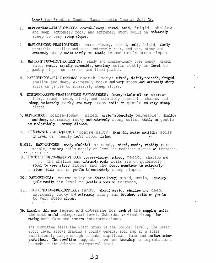
Legends for Franklin County, Massachusetts General Soil MLIP
1. HAPLORTHODS-FRAGIORTHODSI' coarse-lo~y,~mixed,~acid, frigid, shallowand deep, extremely rocky and extremely stony soils on moderatelysteep to very steep~slopes. _:
2. HAPLORTHODS-FRAGIORTHOCG: coarse-loamy, mixed, aci?, frigid, slowlypermeable, shallow and deep, extremely rocky and very stony andextre$iel~ stony soils"mostly on gent16 to moderately steep slopes.
3. HAPLORTKODS-DYSTROCHREPTS: sandy and coarse-loamy over sandy, mixed,acid, mesw, rapidly~cpermeable, nonstony soils mostly on ~level to
,.' gentle slopes on terraces and flood plains.I. ..:
4. HAPLORTHODS-FRAGIORTHODS~ coarsk-loamy; intiea',, tiainly h&acid,' frigid,shallow and deep, extremely rocky and.verj stony dna .extremely *tonysoils on gentle to moderately steep slopes.
_’
5, DYSTROCHREXTS-F'RAGIORTHODS-HAPLORTHODS!: lo&my-$kelatnl'w edarsc-loamy, mixed, mesic, slowly and moderately permeable, shallow and
.deep,,:oxtremely rocky a&very stony soils oh gentle to'eery ,stiepslopes,
6. HAPLORTflODSr coarse-loamy,, mixed, meslc;'moderately permeable', ShallOw~and.deep, extremely rocky and~extremely' stony soils. titistly ti gentle
tomoderately steep~~slopes. .,
7. UDIFLWFIiTS44PLAQUEPTS: 'coarse-silty; nonacid, mesiononstony soilsonlevel or. nearly level, flood plaAri6. ('
~~I..; ., ,,~.
8.&12. HAPLGRTHODS: , shndy&keletal; or sandy, mtied~,~,mesio~, ,rapidly per-meable, nonstony soils mostly on level to moderate slopes on terraces.
i .~ 1. J’. :~ .,i ., : .
9. DYS'I6CH&P'&!&,ORTHOAS: coarse-loamy, mixed, mesic, shallow Bnddeep. The shallow and extremely~rocky soils are on moderately
~','steep,to'very.:steop slopes and the d@e$;&istony t&'extremely. :, ,Stony +Oils are on gentle td~moderately steep slopes. "
10.; HAPLORTHODSt coarse-silty or &ar&+1oamy, mixed, mosio, nonstonys.oil.smostly tin level to .gentle slope'son terraces,
11. .HAP~~THOaS-FKAGIORTIiODS: sandy, mtied;mesic,~ shalloti,~and deep,extremely rocky and'extremely stony and bouldery soils'on gentleto very steep slopos.
: i .~
3b. &aminethis.new legend and dotermine for es&of the msppin& ,units,the most useful categorical level, Suborder OCR Great Group, for'making, both farm and nonfarm interpretations.
The committee feels the Great Group is the logical level., The GreatGroup level allows drawing a county general soil map at a scalesufficiently large enough to make significant farm and nonfarm inter-pretatibns; .The oommittee suggests town and township interpretationsbe made at the Subgroup categorical level,
- .
- .
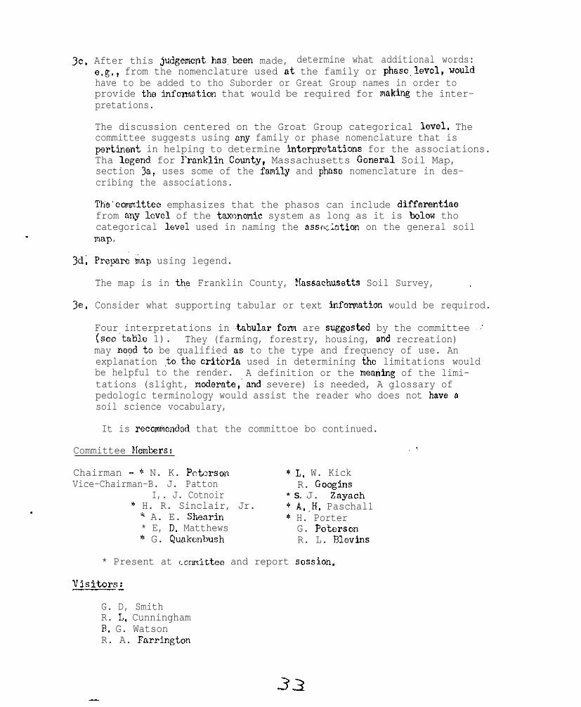
3c.
3d.
3e.
After this judgement has~bcen made, determine what additional words:e.g., from the nomenclature used nt the family or phnse.level, wouldhave to be added to tho Suborder or Great Group names in order toprovide the infonnntion that would be required for making the inter-pretations.
The discussion centered on the Groat Group categorical level. Thecommittee suggests using any family or phase nomenclature that ispert&ant in helping to determine interpretntions for the associations.Tha lcgend for FranklinCounty, Massachusetts Goner&l Soil Map,section 3a, uses some of the family and phase nomenclature in des-cribing the associations.
The'committco emphasizes that the phasos can include differentiacfrom any level of the taxonomic system as long as it is below thocategorical level used in naming the nssoc2ation on the general soilmnp.
Prepare &ip using legend.
The map is in then Franklin County, &ssochusetts Soil Survey, .
Consider what supporting tabular or text information would be requirod.
Four interpretations in tnbular fozm are suggestad by the committee ~:'(seo'tnblc 1). They (farming, forestry, housing, and recreation)may need $0 be qualified as, to the type and frequency of use. Anexplanation .to,~the crit&in used in determining the limitations wouldbe helpful to the render. A definition or the meatiing of the limi-tations (slight, modorato,'nnd severe) is needed, A glossary ofpedologic terminology would assist the reader who does not haves dsoil science vocabulary,
It is r&b&ended that the committoe bo continued.
Committee PIembers:
Chairman - * N. K. Potorson * L. W. KickVice-Chairman-B. J. Patton R. Googins
I,. J. Cotnoir * S. J. Zayach* H. R. Sinclair, Jr.. * A.,H. Paschal1
* A. E. Shearin * H. Porter* E, D; Matthews G. Poterson* G. Quakunbush R. L. Rlevins
* Present at ~~cmmittee and report session.
Visitorsi
G. D, SmithR. L, CunninghamB. G. WatsonR. A. Fnrrington
-3.3
A brief discussion ensued following presentation of the report byChairman N. K. Peterson.
E. D. Matthews:
F. 14. Cleveland:
S. J . Zayach:.
H. R. Sinclair:.
I!. H. Lyfordl
Dr. G. D. Smith:
Dr.,~A. J. Baur:
A. H. Pas&all:
I,
G. Qunkenbush!
H. R. Sinclair8
Dr. G. D. Smith:
The limitation given in table 1 Is for the mostsevere use for that specific interpretation.
The tcnn recreation includes so many activities,a person should not try to make the interpretation.
The recreational interpretation is being made ona county general soil map.
In the text the typo or typos of recreationalinterpretations can bo spelled out.
Define the word - farming.
Farming - The active cngogement in raising corn,soybeans, etc.
Must lay ground rules and explain the method inproparing the interpretative materials and soillegends,
Preparing general soil maps at the Subgroup cats-gor$+al level creates too much detail, As thescale becomes smaller, as with a county generalsoil map,~ the, categorical love1 used mustbe abovethe Subgroup level.'
The committoe did not'have t&e to find all theanswers on how to do it butt they,did demonstrategeneral soil maps could be prcparod and inter-prctatod at higher catcgoricnl levels,
Should a general soil map bo prepared for the'NortHoastorn States?
After seeing the general soil maps that are nowavailable or will bc'availablc in the next fewmonths, the committee can maka a decision onpreparing one for the Northeastern states.
.
34
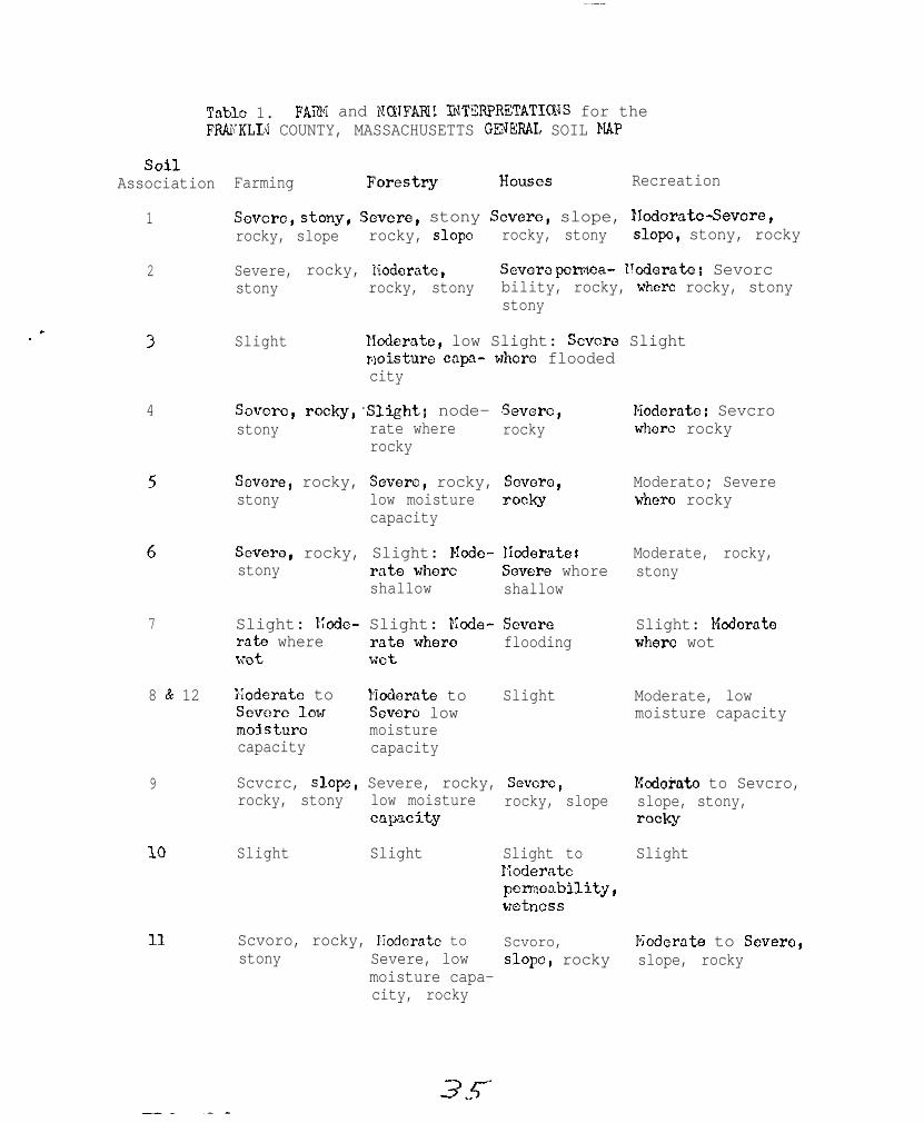
Table 1. FARM and IJQIFAIIII lNT%F'RETATICFJS for theFR&KLLd COUNTY, MASSACHUSETTS G3XERAL SOIL MAP
SOilAssociation
1
2
3
4
5
6
7
8 L? 12
9
10
11
Farming FOreStSy Houses Recreation
Savcro, stony, SCVC~O, stony Sevmc, slope, EZodoratc-Severe,rocky, slope rocky, slop0 rocky, stony slope, stony, rocky
Severe, rocky, liodcratc, Sevora perma- l!cderato; Sevorcstony rocky, stony bility, rocky, where rocky, stony
stony
Slight Ncderntc, low Slight: Scvcrs Slightmisturo capa- whore floodedcity
Scverc, rocky'Slight: node- Sevorc,stony rate where rocky
rocky
Noderatc; Sevcrowhcrc rocky
Sovcre, rocky, Severe, rocky, Scvorc,stony low moisture TOCky
capacity
Moderato; Severewhom rocky
Severe, rocky, Slight: Nodo- Nodcratei Moderate, rocky,stony rate where S~verc whore stony
shallow shallow
Slight: I;cdc- Slight: W&e- Scvore Slight: &&raterate where rate where flooding whore wotwet wet
Xodernte to Modorate to Slight Moderate, lowScvcre low Sevflrc low moisture capacitymoisture moisturecapacity capacity
Scvcrc, slope, Severe, rocky, Sevcrc, Mcdohdo to Sevcro,rocky, stony low moisture rocky, slope slope, stony,
capxity lTK$f
Slight Slight Slight to SlightI;oderatcpermcnbility,wetness
Scvoro, rocky, Hoderatc to Scvoro, pioderatc to Severa,stony Severe, low slope, rocky slope, rocky
moisture capa-city, rocky
3.r
NATIONAL COOPERATIVESOIL SURVEX-NORTHEAST SOIL SURVEY WORK PLANNING_CONFEREN&~
February 15 - lR, 196A
REPORT OF COIMITTEE ON ENGINEERING APPLICATIOJAND INTERPRETATIONS OF SOIL SURVEYS
Objectives
The committee on engineeri.ng application and interpretations of soilsurveys had the following objectives:
. ’
. -
1. Review replies to questionnaire submitted by R. L. Marshall,Chairman, to State Soil Scientists in the Northeast. Thequestionnaire posed three questions as follows:
a. Should t,he committee recorenend that nonfarm uses such as campsites, athletic fields, p1,a.y and picnic areas, lawns, landscaping,golf, sanitary landfill, cemeteries, etc., be added to the presentGuide for Interpreting Engineering Uses of Soils?
b. Should the cosnnittee recommend columns 15 and 16 be deleted fromtable 7 of this guide and, a, new table be added to list soillimitat.ions for sewage disposal a,long with uses such as campsi.tes, at.hlet.ic fi,elds, e t c . ?
c. Should the committee recommend that the engineering applicationsection in soil survey reports be expanded to include the nonfanuuse section to help eliminate any duplication on contradictorysta,tements in, these: sections?
2. Make reconmmndations for improving and expanding guidelines to soilscientists for the purpose of making soil interpretations.
3. Consider dif,ferent formats of tables for presenting the interpretations.
DiscussioR
Replies to the questionnaire mentioned in objectives 1 were reviewed.All states gave an affirmat,ive r~esponse to qu,esti.ons a and b. In answerto question c most states reported that interpretations for communitydevelopment and recreation should be presented in a separate section oft,he published soil. survey i,f t,hese interpretations are important in thecounty.
In considering the expansion of the Guide for Interpreting Engineering Usesof Soils, the committee felt that an addi.tional table (table 8) should be
made a part of the gui,de. An appropriate title would be ttEstimated Degreeof Soil Limitati,ons for Community Development and Recrea,tional Use”. The
0
table would show the degree oft soil limitation and factors causing thelimitation for t,he following i,tema:
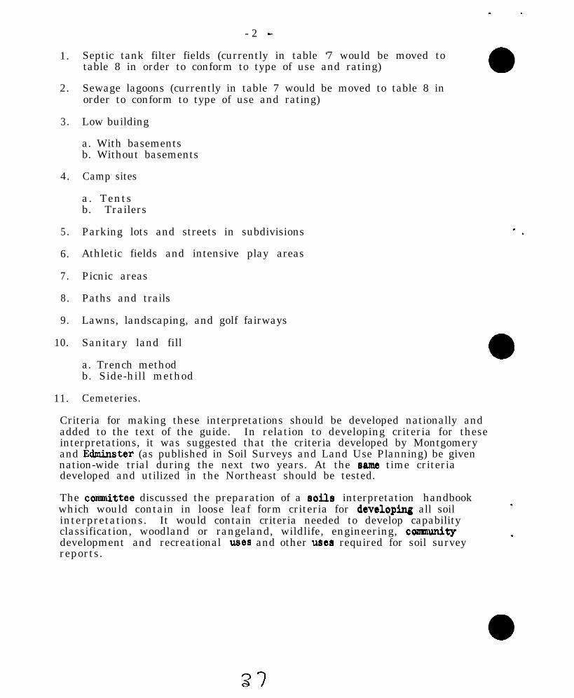
- 2 -
1. Septic tank filter fields (currently in table ‘7 would be moved totable 8 in order to conform to type of use and rating)
2. Sewage lagoons (currently in table 7 would be moved to table 8 inorder to conform to type of use and rating)
3. Low building
a. With basementsb. Without basements
4. Camp sites
a. Tentsb. Trailers
5. Parking lots and streets in subdivisions
6. Athletic fields and intensive play areas
7. Picnic areas
8. Paths and trails
9. Lawns, landscaping, and golf fairways
10. Sanitary land fill
a. Trench methodb. Side-hill method
11. Cemeteries.
Criteria for making these interpretations should be developed nationally andadded to the text of the guide. In relation to developing criteria for theseinterpretations, it was suggested that the criteria developed by Montgomeryand Edminster (as published in Soil Surveys and Land Use Planning) be givennation-wide trial during the next two years. At the asme time criteriadeveloped and utilized in the Northeast should be tested.
The connnittee discussed the preparation of a eoile interpretation handbookwhich would contain in loose leaf form criteria for developdng all soilinterpretations. It would contain criteria needed to develop capabilityclassification, woodland or rangeland, wildlife, engineering, consaunitydevelopment and recreational usea and other used required for soil surveyreports.
-3-
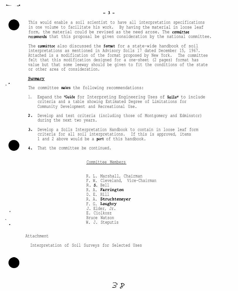
This would enable a soil scientist to have all interpretation specificationsin one volume to facilitate his work. By having the material in loose leafform, the material could be revised as the need arose. The cotitteereconunends that this proposal be given consideration by the national committee.
The connnittee also discussed the format for a state-wide handbook of soilinterpretations as mentioned in Advisory Soils 17 dated December 15, 1967.Attached is a modification of the format proposed by New York. The committeefelt that this modification designed for a one-sheet (2 pages) format hasvalue but that some leeway should be given to fit the conditions of the stateor other area of consideration.
The
1.
committee nukes the following recommendations:
Expand the "Guide for Interpreting Engineering Uses of Soilsl' to includecriteria and a table showing Estimated Degree of Limitations forCommunity Development and Recreational Use.
Develop and test criteria (including those of Montgomery and Edminstcr)during the next two years.
Develop a Soils Interpretation Handbook to contain in loose leaf formcriteria for all soil interpretations. If this is approved, items1 and 2 above would be a part of this handbook.
That the committee be continued.
Committee Members
R. L. Marshall, ChairmanF. W. Cleveland, Vice-ChairmanR. S. BellR. A. FarringtonD. E. HillR. A. StruchtemeyerF. G. LoughryJ. Elder, Jr.E. CiolkoszBruce WatsonW. J. Steputis
Attachment
Interpretation of Soil Surveys for Selected Uses
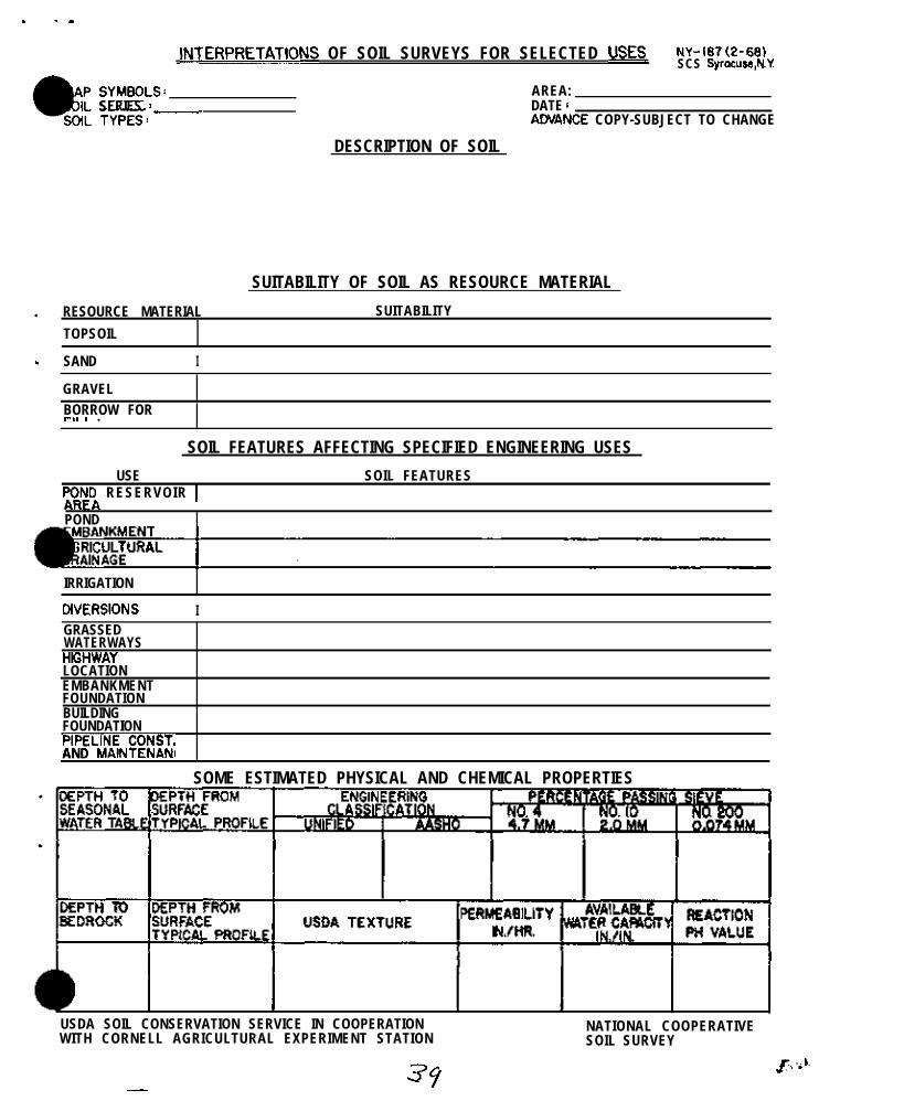
. . a
INTERPRETJTIONS OF SOIL SURVEYS FOR SELECTED USES< NY-18?(2-661SCS Syrocuw,NY
AREA:SERIES : _ DATE 1
AWANCE COPY-SUBJECT TO CHANGE
DESCRIPTION OF SOIL
SUITABILITY OF SOIL AS RESOURCE MATERIAL
. RESOURCE MATERIAL SUITABILITY
TOPSOIL
. SAND I
GRAVEL
BORROW FORt-l, I .
SOIL FEATURES AFFECTING SPECIFIED ENGINEERING USES
USE SOIL FEATURESpO_l$ RESERVOIR 1
POND
IRRIGATION
CiVERSlONS IGRASSEDWATERWAYSHK;HWAYLOCATIONEMBANKMENTFOUNDATIONBUILDINGFOUNDATIONPIPEL~;ltN~ONST.AND
SOME ESTIMATED PHYSICAL AND CHEMICAL PROPERTIES
USDA SOIL CONSERVATION SERVICE IN COOPERATIONWITH CORNELL AGRICULTURAL EXPERIMENT STATION
NATIONAL COOPERATIVESOIL SURVEY
35-
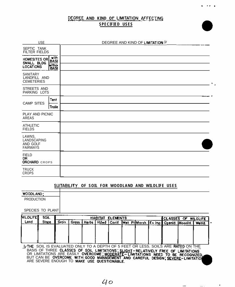
USE
SEPTIC TANKFILTER FIELDS
SANITARYLANDFILL ANDCEMETERIES
STREETS ANDPARKING LOTS
TentCAMP SITES
tTroile
PLAY AND PICNICAREAS
ATHLETICFIELDS
LAWNS,LANDSCAPINGAND GOLFFAIRWAYS
FIELD
Z~CHARD C R O P S
TRUCKCROPS
DLEGBEE AND KIND Of’ LlMlTATlO~_~~_~ECTlNG-...- -7 - . - -SPECIFIED USES
DEGREE AND KIND OF LIBATIONS .~~__
-.
a-
SUlTAE?lLITY_ OF SOIL FOR WOODLAND AND WILDLIFE USES
~~~ODLAND;PRODUCTION
SPECIES TO PLANT
&THE SOIL IS EVALUATED ONLY TO A DEPTH OF 5 FEET OR LESS. SOILS ARE RATED ON THEBASIS OF THREEOR LIMITATIONS ARE EASILYBUT CAN BEARE SEVERE ENOUGH TO
National Cooperative Soil Survey
Northeast Sol1 Survey Work-Planning Conference
1 9 6 8
Report of Committee on Family Criteria end Testing Families
In response to a request from the National Committee to in-vestigate suggested changes in mineralogy this regional committeewas activated.
The charges were to consider the effects of (a) increasing thecontrol section, (b) employing a split control section,‘end (c)~forsome soils using both clay end non-clay mineraiogy. The detailedcharges are 8s follows:
“Control section td extend from the top of the firstmineral horizon to a lithic contact or to one meter,whichever is shallower, except for soils having er-gillic, netric, or oxic horieons, the midpoint forwhich occurs below one meter. For these lettersoils, the bottom of the control section is eitherthe base of the above diagnostic horizons or twometers whichever is shallower.”
The Control section shall be divided et 25 cm exceptfor lithic subgroups; and at one meter for ‘soi.,ls tiithcontrol sections over one meter thick.‘!
Use mineralogy of the clay fraction partially todetermine placement for soils with, one-fourth ormore of the control section having over (5?, 181)percent clay. Clay mineralogy to be indicated in-dividually for the parts of the control sect,ion ifd i f f e rences are contrasting~. If clay minerelbgy isnot contrasting, then one term based on average pro-perties of the control section is used to describe theclay mineralogy. Mineralogy of the noncley to be det-ermined on the average properties of the controlsect ion.”
Work sheets for selected series were filled in by the membersprior to the meeting. The following guidelines were suggested forthe initial collection of data (a) if family is sandy or sandy skeletalalso consider clay mineralogy forthose horizons having more then5% clay, (b) if family textures are coarse silty or coarse loamy (<18%clay), use only non-clay mineralogy. (c) if, family textures ere fineloamy or fine silty (l&35% clay) consider both the non-clay end claymineralogy, end (d) if family textures are fine or very fine consider
. ’
.
.
_

the effect of not using clay mineralogy for horizons having lessthan 35% clay.
It was not possible to su&arise the data on the 57 nedonsbefore the meeting, so the informationwas circulated to memberslater and served as a basis for the following comments and recommend-ations:
Utility of Mineralogy
The committee discussed the utility of mineralogy classes at’the family level. The concensus was that clay mineralogy is an im-portant seat of exchange phenonema and is also fairly well correlatedwith other soil pronerties of interest. It was pointed out,that .initially family criteria were,,skletted to reflect’physical pro-perties rather than chemical properties as the current emphasisappears to be. The majority believe that much more attention should .
be given to increasing the available data of,,both non-clay and claymineralogy. It was noted, however,‘that,organic matter~‘also prob-ably deserves more attention than at present.
Methodology and guidelinesI
It was the general opinion ‘that recomnending’procedures andnames for mineralogy classes is not a function of’this’ committee.Such a responsibility rests with the soil mineralogists and we urgethem to expl,ore various ways of making mineralogy more meaningful.It seems that some guidelines or explanations concerning the amountof acceptable variations due to identification techniques’as well asrange of variability cosnnonly exhibited amongpedons of the samepolypedon, and among polypedons of, the same series,,would enable usto make better value ‘judgements. ‘There was some concernthat bysample treatment and cleaning~tie are losing sight of some veryimportant features of the “real” soil’entiironment.
Most of the committee’thought that the present mineralogyclasses seem adequate for grouping soils, however, there were somereservations about the “lumping- together” of dissimilar nedons inthe mixed clay mineralogy class. It was noted that many of theclasses have an accuracy of identification ‘far beyond simple fielddeterminations but probably provide broad enough groupings for themethods currently used in most laboratories.
.
Current nonclay mineralogy .
In those families where non-clay mineralogy is diagnostic; anexpansion of the control section to 0 to 100 cm did not reeuit'inany changes except for those ‘soils’with arenic or drenic-likeepi,pedons. In the latter cases the mineralogy was be,lie\ied to becontrasting, e. g. siliceous over mixed, Our suppprting dataon’non-clay mineralogy is meager, hotiever, it was ~the opinionof, thosesupplying information that a split control section, 0 to 25 cm and25 to 100 cm, seldom altered the non-clay mineralogy class exceptfor those soils having arenic horizons.
. ’
.
We did not have enough samples of pedqns having thin diagnosticsections.to observe the effect of increasing and/or splitting a controlsection. It is fe~lt that a further testing of Fragiochrepts,Fragiudalfs, and Fragiudults would be desirable.
Current Clay Minera_Loqy_____._,_______ -__--._._
,I” clayey or fine families the expansion of the control section to0 to 1.00 cm ct;anged the ,class of I. out of 8 pedons,,, primarily in the
~Illtisols. This is supported by additional data from Pennsylvania whichindicates a potential, shift of about,,t4% of ,the soils, which have morethan 18% clay in the control section although these are not all inthe clayey family. The committee recommends that the control sectionnote be expanded to 0,to 100 cm and no subdivision of the controlset: ion be made in fine or clayey familie,s until buch time asfur~!,~~. review merits such a change.
Most of our,test.ing was made for sof<s classified o” the basisof no”-clay mineralogy in the mixed c\ass.- - These soils are primarilyAlfisols and Ultisols with 18-357, clay in::t:he current control section(argillic horizon). Of the Alfisols 11 pedons were fine loamy and 7were fine silty; of the Llltisols 11 pedons were fine lo+ny and 3 weref ine silt~y. (a) p_to 100 cm contr$_ section, By using clay miner-alogy of the 0 to 100 cm the Alfisols separated into 7 mixed, 6 illitic,3 ka0linitic, and 2 kaolintLc over $llitYc; in similar manner, the.IJltisols separated into 12 mixed and 2,kaoli”itic. (b) Go 25 cmP.xC!.!_.. We fould it very, diffixult to apply the res!rictive chargeof considering clay mineralogy when only one-fourth or more of thesection has more,than a specified clay content, consequently we ig-nored the peri-cc, of section. If we considered the clay mineralogy ofthe 0 to 25 cm portion the Alfibols subdivide into 13 mixbd, 2i~llitic, and 3 k.aolinitic whereas, the Ultisols divide into 12 mixedand 2 kaolinitic. Five of the 18 Alfisols have,contrasting clay min-eralogy in ths, 0 to ,100 cm control section but none of the Ultisolswere contrsst~ing.
[cj withi” one family, Bau,r and Paschal1 summarized the clay. . . . . . ..__. _ _._._._._ - ___mi,“eralogy for 8 serie?. in the fine~loamy, mixed, mesic Typic Haplu-dults which incltide.: 39 series. On th.e basis of available data from18 pedons there were three subdivisions of this family using claymineralogy of the? 0 to 100 cm control sect-ion: mixed, illitic, andkaolinitir. &ly 3 of the 18 profil,es have contrasting mineralogywhen splitting 1:c section into 0 to 25 and 25 to 100 cm segments.
(d) ?~+_Y_~~;~t,, A majority df the rommittee felt that the claymineralogy in the 0 to 25 c,m portion is probably important, however,
:we were unable to agree whether i,t. should (a) always be given, (b)t,:sed only when a soil has specified range of clay,content, (c) shouldonly be averaged in a 0 to 100 cm control section, or fd) othernlt;.rna!ivcs _;x:h as using as additions1 series information.
Alt:ho.,gV, clay mineralogy may be tiseful supplement to the “on
- --
clay mineralogy classes in the fine loamy and fine silty texturedfamilies we feel that further evaluation, primarily within families,should be made before a national or even a regional policy is adopted.
Mineralogy in Sandy Families
For sandy textured families in the Northeast the nonclay taineralogyis not particularly meaningful for interpretation as the main choiceis between mixed and siliceous. It appears that the clay mineralogy isat least, if not more, informative than the nonclay mineralogy. Thecommittee believes that additional evaluation should be made of usingclay rather than nonclay mineralogy in sandy families.
In many instances we noted a name change for a whole family, whereas .in some cases each change of criteria will subdivide the familyinto several segments. We have, therefore, a mechanism that could .prove useful for changing group names to be more connotative oruseful, or for subdividing other groups if and when such changesare thought to be desirable. Just because we can observe and measurea property does not automatically justify its use at a given cate-gori.cal level . We encourageour soil mineralogists to help us under-stand and interpret the significance’of mineralogical findings.
We recommend caution in implementing changes>in the mineralogycriteria and classes. We found no compelling reasons to justify changesof the control section, and conversely, we found no compelling reasonsother than precedence to retain the present control sections. ,We notethat in those soils where nonclay is diagnostic that the use of claymineralogy appears to be a good supplement or even a substitute fort.he nonclay mineralogy. If clay mineralogy is used in conjunctionwith the nonclay as a family crite,ria we would recommend thatthe reference to absolute amount of clay and proportion of controlsection having same, be dropped.
Overall we recommend that no changes be msde at present and thatthe reasoning for suggested changes be clearly stated. Most ofus are somewhat disturbed by our knowledge of mineralogy and our lackof data in some cases, yet we are more uncertain as to the illness andremedy of mi,neralogy as a family criteria.
We <upport t,he concept of a mineralogy committee and/or projectin the Northeast and recognize the need to continue data collection of .both clay and nonclay mineralogy.
We recommend that more mineralogistr be assigned to the committee *and that the committee be continued in view of the many unresolvedquesti,ons concerning soil mine~ralogy.Committee Membe,rs: Guests:
R. W. Arnold, Chr. G. J. Latshaw *J. C. F. Tedrow R. L. Cunningham.J . .J. Noll, V-chr. W. H. Lyford .J. W. Warner Jr. .C. EngleA . .J. Baur M. Markley. M. E. Weeks L. JohnsonR. F. Daniel1 R. P. Matelski :G:. P. Wilson G. PetersonD. S. Fanning *S . Pilgrim N. B. PeifferJ. E. Foss *G. G. Pohlman G. D. Smith
*Not Present
. -
NATIONAL COOPERATIVE SOIL SURVEY
NORTHEAST SOIL SURVEY WORK PLANNING CONFERENCE
February 15-113, 1968
REPORT OF COMMITTEE ON LARCRATORYSTUDIES AND PRIORITIES
The Committee on Laboratory Studies and Priorities is a temporary workingcommittee. Assignment of this committee is an outgrowth of the report of theaudit of the Soil Survey Laboratories by the Inspector General that includedthe recommendation that procedures be developed for planning, programing andbudgeting laboratory work. There is a need to determine long-range and annualestimates of laboratory work required to support soil classification and inter-pretations. Committee work at this time is mainly to search the subject andformulate objectives for future committee work.
Things the committee can do are:
1. List problems requiring special laboratory study.
2. List specific laboratory projects and determine priorities.
3. Determine annual work load on projects and procedures forplanning and programing laboratory work.
4. Develop procedures for coordinating research work of the SCSlaboratory with research of other agencies.
5. Recommend methods for improved publication and distribution ofresearch findings.
6. Establish priorities for studies of benchmark soils by states.
Committee members, state soil scientists and others were asked to list speciallaboratory studies which would help solve problems of classification and inter-pretation. Some of the suggested projects are part laboratory-part fieldstudies or may be primarily field studies.are listed below:
Some suggested research projects
1. Determination of mineralogy of the non-clay fraction of soils,
2. Studies related to unstable soils.
3. Separating Entic Raplorthods from Typic Raplorthods.
4. Characterization of Ochreptic FragiWa and Aqueptic FragiudaIfs.
5.
6.
7.
8.
9.
10.
11.
12.
13.
14.
15.
16.
17.
18.
19.
20.
21.
Laboratory and field investigation to determine limits usablein the field for designating fragipans. What features shouldbe present (bulk density, structure, consistence, permeability,etc.) and what are the ranges in these properties? What effectdo these properties have on plant growth and water movement overthe entire year?
Study of paleosols in the northeast.
Study of the relationship between amounts of coarse fragmentsand moisture holding capacity.
Significance of contrasting textures occurring within five footsection for nonfarm interpretations.
Study of soils developed in glauconitic material.
Laboratory studies and companion field studies to determine thepercent base saturation under normal farming operations as com-pared with base saturation of undisturbed soils.
Study of relationship of mottling, reduced colors and otherfeatures used to determine natural drainage classes, and theirrelationship to fluctuating water tables and plant development.
Effect of sewage effluent on soil characteristics.
Relating particle size distribution and exchange capacity.
Identification of cambic horizons.
Improved criteria for recognizing argillic horizons.
A study of the comparison of percolation rates determined bythe Uhland Laboratory method and auger hole field method.
Study of clay mineralogy and organic carbon.
High priority on characterization of benchmark soils.
Identification of loess deposits and their significance on theAllegheny Plateau.
Weatherable minerals in paleudults.
Available Moisture -- Most available moisture estimations arenow made using one-third atmosphere of tension on soil clodsor cores. Much of the work that established the figure ofone-third atmosphere was done many years ago on crushed samplesand on soils with no coarse fragments. It has been shown thatone-third atmosphere is too high a tension to use for very sandysoils. Correlations between direct measurements of fieldcapacity and present methods of laboratory estimation need to bemade--particularly on soils with coarse fragments. This wouldinvolve a good many tests to cover the range of textures andcoarse fragment content and would require considerable logisticeffort hauling water to sites, etc.
Yb

. .
. -
22. Fine clay determination -- Reliable detection of argillic hori-sons poses many problems, Stratification of parent material,heavy texture in the C horizon, difficulty in detecting claycoats and other problems often leave the classification of asoil uncertain. Known argillic horizons have been shown tohave more fine clay (0.24) than accompanying eluvial horizonsor C horizons. Routine determination of fine clay would testthe universality of this and probably would help settle ques-tions about soil classification. It may be possible to adopta density gradient method (A. H. Beavers, Univ. of Illinois)with centrifugation to the conventional particle size analysisand get the desired information without prohibitive increase inwork load.
23. Organic Carbon -- Organic Matter Conversion Factor -- Organicmatter is usually assumed to contain 58 percent carbon. Mostinvestigations, including preliminary work in Pennsylvania,seem to indicate that on the average It is closer to 50 percentfor surface soils. Direct determinations of organic mattershould be made on pilot soil samples in the various soil regionsto see if the conversion factors being used are correct, Fororganic samples, above 10 percent carbon, ignition is usuallysatisfactory for direct determination of organic matter. Formore usually, low-organic samples, however, it is very diffi-cult to determine organic matter directly.
The conference was divided into four groups having common problems for con-sideration of interstate research projects. The groups were:
1. New York - New England2. New York - Pennsylvania3. Piedmont - Coastal Plain4. Allegheny Plateau - Ridge and Valley
Each group examined the list of submitted projects and prepared a report,evaluating each and giving priority to several. For those given priority,estimates of the numbers of profiles required for study were then made. Fromthese reports, the Principal Correlator compiled a list of interstate projects(TSC Advisory SOILS-LID-l, l-29-68). Each state Is expected to incorporate itsportion of laboratory work into the ten-year plan for laboratory investigations.Each state is expected to prepare a reply to Washington Advisory SOILS-16 dated11-21-f?/. When answering this memorandum the states should include their por-tion of interstate projects compiled by the Principal Correlator. In addition,each state may want to add one or more special problems and list its benchmarksoils for characterization.
Committee Members:
John J. Nell, ChairmanA. J. BaurD. E. HillJ. E. FossB. J. Patton
-
-
NATIONAL COOPeRATIVE SOIL SURVEYNCRTRSAST SOIL SURVRY WORK PIAWNING CONPERENCE
January ls-18, 1968,,,:,., ,, ‘:,s ~, ..~ ‘.
: ‘. Soil Classifipat.ion Questions and Problems, ’.Dri~ Cuy’Smith,:Diacussion leader .’
: t:‘~ .,\. .~.:~ .,~Status of new classification system: ,.
‘,. . ‘,.I .~xpeot&d. to,go:rto:pl’intbt’Lhis calendar year. It will .be at least
18 months before printed copies are available. Will be ~1~ twovolumes 4: .:, .~( ;:. ,’ j .1. Outline of system, like “Brown Book”, ’2. Outline of taxa with placement of series.
.The .second volume will’probhbly be in spiral bind& so it canbe kept up’ to date-i The ~list bf family groups will include allseries in the United States.
> , . :’ ! I’ ,,.-iThe Northeast has completed placement of series’.
Dr. Baur’s’office will issue an interim placement of.l&theaist series.
Several months prior. to the confererice the State Soi. Scientiam were polledfor problems encountered during the recent placement’of series in thevarious families and for questions on any part of the. new classificationscheme that was not understood by ‘them.stated followed by Dr. Smith’s answers.
The questions are herein briefly
.~. : ‘: ~Discussi&,of Ouestions ‘on System..~,
The following notes are keyed to the .list of problems distributed .at thecon,f,erence , :
9. 1. Where contrasting family texture classes are within control: : sections, what is minimum thickness before. they are recognieed?
Smith - Referred to Soila Memo-66.; No exact numbcr~can beg i v e n . , :,
:. i
Uae principle of reliability of observations.
.’ Example No., 1 - Loamy finesrird over coarse -silty,..at 26” wouldbe contrasting, sandy over loamy,
,~ Example No.. 2 2’ -. .&xSmpli’ N,,. 3 z1 Example No;. 4 2’
O-8 fsl O-9 fsl q+vfslS-10 sil ’ ; :,9-13 l i g h t ail:” 3-1.0 vfsllo-22 clay 13-30 clay22-45 clay 30-40 sandy loam
lUI4Uvfs‘:
L/ This.‘example has iiostrongly ‘contrasting particle’~sise clsssea.;‘q,B.!‘, :‘., .‘? :“: ;, ; *:
This actually has two strongly contrasting boundaries, but thesuggested classification is clayey over loamy, ignortng the9-13 inch horizon, for texture class,ffication.
This example lacks strongly contrasting textures,
On page 38, definition of “sandy”, the text should read: “sandsand loamy sands exclusive of very fine sand and loamy very finesands.”
Very fine sand needs to be added to “coarse-loamy”, following“silt loam”.
9. 2. Need for recogqizfng a parelithic contact between 20 and 40ii:cheo - whit?. defi;res moderately deep soils.
A. This is not present7.y s family criteria. It ia a series andfamily phase crfteria.
9. 3. Differentfae for degrees of wetness. The criteria ,do notalways result in clsssificetion which corresponds with observeddc:grees of we:nessc Some of wettest s:lLls are classed as aerfcdzd soma impe?fectl-j drained soils fall in wettest groups.
Dr. Smith made the ifo&:ing ,points:
1. Mottling is not an infellable criteria for degree of wetness.2. There ere defects in definitions but we do not yet know the cure.3. Use phases of drainage classes ‘for interpretation.
The sams kinds of problems exist in the distinction between aquicand typic groups.
On page 94, ,Typfc Haplaquepts, a(l) should have~the addition: liandthe organic matter decreases regulerly with depth”.
. .
-.
The needed parallel change for a(2) has been sent to @Northeasternstates in TSC Advisory IJD-Soils 17, November 27, 1967:
*0. 4. Paschal1 - What is texture control section for alfic or aqualfichaplorthods?
argillicIs it 10 to 40 fnches~without regard to underlyinghorizon?
Description of Briggs Serf98 was used a8 exanr,:le.
The answer is yes.
Page 38, b-2ie applicable for the BriggS Series example.
Q. 5. When is fine and very fine used ss against clayey?cry
.-
-
A .
9. 6.
Q. 7.
Q. 8,9;i..~ ,,
.~. ,:
-.
Q. 10:
A.
Q. 11. .
3
Clayey. classes are. presently used in. UItLsols an?< Oxisols(see p, 41’of ‘67 Supplement).
:Similerly,,: they .ere used in
families of lithic, arenic and grosssrenic_.‘subgroups in theother prd.ers, and in ehallw: families in: the other or&s;,OtheFfse, ye u6e the firib!~an2 very f in s par$icle s$a6:classes.:..:..Aqualf - I t e m (a) (p’ 160) :rcquires domin,pnt ch.rimas ~of d o rless on surface of peds accompanied by marries witl#?.&s, etc...: ;
G. ties this’~apply’ to’.the whole. srgilltc horieonregard.less ~of thickaees. ; .,~’ *~,
A. Domfnant chromas on &3 faces ref& to the &tiresrf+ic borimop. If, most of the ped .facas lia more thanha f oft the erglkklc hotiztm have lar dhrorms ‘tie wouid
, haye,,wre low than “ h i g h ” chromas and' *t+,.low c,h%&s wotild:, bg, +minsnt. Ndte, thst we di,l IKC 6ay ~?&ninant t h r o u g h -
out,,.all parts o f t h e argil,lic horimn”.j,, ,, .:
(p 169) Typic FragiuZalfs. The question’,heke ‘cor)cernedthe inclusion of the. fragipsn with the argillic. The answerresulted in a revision of the definition an2 ‘the deletion ofcert+n, ftep)s, u+er Typic pragiuielfs and Typic Frag+udults,These revisions are not.5inclu:@d in this,,~report as it is plmne3to make official ~list’rributioh of the changes from the PrfnclpalCorrelator’s office before *is report is circulate;.
Question8 relative ,to wording of definitions oi .Ultiapls anlAquljlts, ;,: :> ,’
8 . Page 184 Ultisols. parts a and b - the’~kollowing,i ~b(l%,should be.akie.l.. “or that underlies” an
aigillic h&iLzon and - - .
9 . P~~.~&k Aq@Its -- Thir ~1 line - remove word “‘J&‘.., ..;%,\Impo&ance of’clsy films in C horieons. :,
Such c+y skins are .eviJance of clay.,mov+rw& Present definl-tions of argilltc’ho~i~ori does not-:~raquir+F,$lay skins in Bhorizon, but does require evLdencg.;of ~clay.~a&wpula~ion so~)a-_-~;where in profile. But clay skin6 alone’.may not be adequatee v i d e n c e o f a n [email protected],. j . . ‘< I : .
,: .
4
Q. 13.
A.
Q. 14.
A.
Q. 15.
A.
A.
A.
A.
9. 16.
A .
9. 17.
A.
Question on recognition of palcosols.~’ +a series use:’ asexample. Palsudults?
Data on weatherable minerals exclu,ies this profile fromPaleudultsi .Mineralogy on non-clay fraction might changeclassif ication. Mineralogy is key to classification asPaleosol,
Proposal suggested to intergrade between texture families,
No. Extremes in textura may be a taxajunct or, if bigepouzh, end important enough, two series.
Page 92 ~Aquepts - item 2 (1) .at depths of less than 50 cm.
a.
b.
c.
d.
Does above mean ,that there can be an intervening horizonbdtveen eplpedon an3 .50 cm that .does not meet require-ments of wetness. .Reviaions for Northeast have beendistiibute:l.
‘ Y e s .
Does it imply that if an umbric or’histic epipedon is50 cm thick there can be no car&c.
No - but rloesn’t matter.
Does a cmnbic (wetness) have to (1) imnediately underlyan u&ic, hfstic or ochric or be at the surface to be anAquept .
No * except if umbric is greater than 50 cm - then yes.
Should a soil with a csmblc horizon (not due to wetness) ata depth of 10-15” overlying a gleyed horison at a depth of15-20” be classified as Pqupets or an Aquic aubgroup ofOchrepts? . ‘,
-Aquepts, but probably in an aeric subgroup.
Page 98 - Ochrepts Item 4..
Delete reference to hms too red.
Page 92 - March Supp. Aquepts - I tem 2 .“are sa tura ted a t _some period of the year,” Most soils in the Northeast,Including well drained soils, are saturated with water at ..some time during the year. With this knowledge hov ehouldthe above statement relative to Aqupets be interpreted2
Temperature must be above 41’ F (Biological eero). If sat-urated when below 410 F aaturation is not to bi conridered. .
See page 37 March Supp, for statement regarding maturatedsoils during cold periods.
-5)

9. 18.
A.
-Q. 19.
A .
A .
Qt 20.
A .
Q. 21.
A.
Q. 22.
Question on sementics of mineralogy vs. mineral classes.
Mineralogy is preferred.
Page 40 vf sands are treated as silt for family groupings.Does this apply only to fine loamy, fine silty, loose loamy,and coarse silty.
vfa treated as loamy material,
Page 41 - 1st para. “Note that sandy includes fine as well ascoarser sands. Doesn’t sandy also include vfs,
Same as above.
Page 23 - Spodic horizon. Definition does not account foralbic horizons less than 18 cm thick. Definition revised asfollows:
(Page 23) March supp. - Sunmary of the limits of the spodichorison - Item 2. Change to read as follows: If an 0 or anAp or an Al rests on the spodlc horizon or on an albic horizonthinner than 18 cm (7 inches), the spodic horieon has therequirements of (1) above and in addition has (a) Either (1)a PH (parts per H20) of less than 5.0 and a pli in RCL in somepart that is at least 0.5 pH units lower than in H2, or (2)a 15 bar water content less than 20% and (b) enough depththat - - (continue as in c in Supp.)
Organic carbon page 47, 7th approx.; page 23, March supp.Contradict each other.Is 0.297. OC still in effect?
Requirements on p 23 - March 1967 supp. is to be used.
New Hampshire - Progress on Histosols - Not yeat completebut expect a review edition in near future,
Conference adjourned 9:00 p.m.

E!ATIOilAL COOPEPATIVE SOIL SUFVFY
NOkTHEAST SOIL SuIlVEY WOPX PIANNING CONFiXENCE
January 15-10, 1968
DIGITAL COMPUIr:RS AND THEIfc APPLICATION TO SOIL SUGVEYDr. L. J. Mathers, Assistant Professor,
Villanova University
Dr. i<ather outlined the capabilities and limitations of computers.He recommended an article in the October, 1967 issue of Playboy Magazinefor a non-technical explanation of the digital computer. A~ commonapplication of a digital computer is the telephone system with the dialbeing a simple console, gailroads use computers to keep track of cars,and airlines use them to keep track of reservations and ticket sales.Scientific application is largely as a means of data storage and informa-tion retrieval. Chemistry and medicine have led in this use of digitalcomputers.
The principal limitation of a computer is that it cannot think, andits product is only as good as the data it receives and the programmingfor handling these data. The digital computer is a counting machine us-ing addition, subtraction, multiplication, and division as basic processesapplied to discrete units. A mechanical illustration is the desk calcu-lator , The more sophisticated equipment uses electronic impulses and there-by gains in speed and range. The analog computer has the capability ofdealing with continuous functions.
The computer uses machine language. Several special procedural lang-uages are simplified combinations of English and machine language tobridge between groups of users and the computer in setting up detailedinstructions, called a program, for a computation or the retreival ofcertain data,
Computers can store, sort, and report soil data, The field is openfor application of the computer to processing soils data, to make themmore accessible and useful,
With the help of statisticians and computers the validity of soildata can be tested and similarities and differences measured.
NATIONAL COOPERATIVE SGIL’StK:VSY .’
January 15-18, 1968.~. ,,., .’
Moisture Retention5 of Pennsylvania Soil5as Related to Texture and Series
Gary W. Petersen‘. :.
NORTHEAST SOIL SURVKY WORK PLAWNING CONFERENCE
,‘App~oximately.1,300 sarhpl’e5 from 27~countfes were s tudied withthe aid of a ,computer to obtain a better understanding of the ‘moisturecharacteristics of Pennsylvania soils.
: ‘. ., . .
Available water (WA,) was:determined:by subtrecting Dldisture re- ’tained in the less than 2mm sieved soil material equilibrated at 15atmospheres .of-tension (W 3) from the moisture retained in’undisturbedcores’ equilibrated at l! 8 atmospheres of tension (V1/3).
., .:~WA was lowest in the ‘coarser textured soils, increased to a maximum
in .the siedlum texture5 and decreased in the ‘ffner textures (Table 1).WA was highest in the silt and silt loam’textutal-clasaes”snd decreasedin any direction from this corner of the textural triangle. Correlationstudies also indicated :that $JA’increased ss silt &ntent increased.
Coarse fragments are alS0 Of great importance in Controlling WAand their presence should be accounted for when calculating WA. Thiscan be accomplished by correcting Hi/3 for fragment5 within the coreand thereby determining WA on a less than 2mm basis, This value of “JAcan then be corrected for fragments within the sample as follows:
(Wlf3 - W15) (% <2nrs material) - WA (percent by weight
100 corrected for fragments)
This weight percentage can be multiplied by the bulk density toconvert PJb. to a volume basis.
ldditions of organic matter to coarser textured soils usually in-creases WA. This does not appear to be true for Pennsylvania’s siltloam5 as increeses in organic carbon did not appreciably change WA,which may indicate that the addition of organic matter to texture5finer than silt loams may not increase WA.
WA was also determined on over 400 Pennsylvania soil profiles andthe cm of WA per cm of soil everaged for each series (Table 2). Theseprofiles were subdivided into the following soil parent material groups:glacial-f luvial, alluvial, loessial, limestone, sandstone, shale andtill. VA was averaged for P, B and C horizons for each parent materialgroup with the relative amounts of WA within each horizon as follows:
A horieons
Sandstone -= Glacial - Fluvial~~Shale<Lime5tone~:l1luvial~iTill~I.oes5ial
Moisture P.etentions of Pennsylvania Soils-2
B horizons
Sandstone <Glacial - Fluvial <IShale C,Till <Alluvial <Limestone (Ioessial
C horizons
Glacial - Fluvial<Shale <Sandstone <Till< &hn~ial< Limestone (Loessial
For all groups, except those soils developed from limestone and loess,WA decreased in going from the A to the B to the C horizons.
Cumulative WA with depth was also calculated resulting in thefollowing relative order for the parent material groups:
Glacial - Fluvial< Sandstono<Shale <Till<Limestone<Allwial<Loessfal
This same group of soil profiles were also subdivided into theirrespective drainage classes. Within each drainage class WA, was highestin the I-< less in the B and lowest in the C horizons. Cm a cumulativebasis, WA increases as follows:
Wellc_Somewhat poorlyz, Moderately Well<Very Poorly< Poorly
-_
.
5-a”
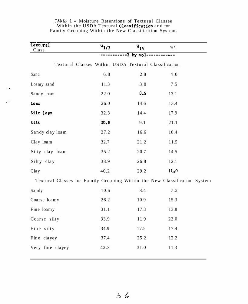
_.
.I
TADIE l- Moisture Retentions of Textural ClasseeWithin the USDA Textural Clsssification and for
Family Grouping Within the New Classification System.
Z&turalClass WI/3 w15 WA
-----------% by Vol------------
Textural Classes Within USDA Textural Classification
Sand 6.8 2.8 4.0
Loamy sand 11.3 3.8 7.5
Sandy loam 22.0 8.9 13.1
Loam 26.0 14.6 13.4
Silt losm 32.3 14.4 17.9
Silt 30.8 9.1 21.1
Sandy clay loam 27.2 16.6 10.4
Clay loam 32.7 21.2 11.5
Silty clay loam 35.2 20.7 14.5
Silty clay 38.9 26.8 12.1
Clay 40.2 29.2 11.0
Textural Classes for Family Grouping Within the New Classification System
Sandy 10.6 3.4 7.2
Coarse loamy 26.2 10.9 15.3
Fine loamy 31.1 17.3 13.8
Coarse silty 33.9 11.9 22.0
Fine silty 34.9 17.5 17.4
Fine clayey 37.4 25.2 12.2
Very fine clayey 42.3 31.0 11.3
NORTHBAST COOPERATIVE SOIL SURVEY
NORTHeAST SOIL SURVEY WORK PLANNING CONFERENCE
January 15-18, 1968
Program for Completing a Soil Survey in an Areaof Rapid Suburban Expansion
J. W. Warner, Jr.
The following is a re’sume’ of the presentation at the meeting.
Suffolk County, New York is located on the eastern end of Long Island.The large area& of housing developments are located, primarily, in thewestern part of the county. With a large area under concrete and rooftops, it became apparent that a normal mapping legend and mapping tech-niques would be inadequate for our needs.
Because of the ease of reshaping and remolding the landscape, it becamenecessary to add mapping units to the legend, especially for the purposeof mapping the housing developments.
A person may be inclined to ask: “Why map these areas at all; the damageis done and the houses built.” There are two main reasons for mappinginto the urbanized areas. The large areas of urban expansion have madeit desirable to provide soils information to home owners in the suburbandevelopments. Extension agents, landscape architects, lawn and gardenmaintenance companies, etc. could use the information for seeding, lawnirrigation, and fertilizer recommendations as well as selections forvarieties for tolerance to different soil conditions. The other reasonis minor; however, it has a bearing. There would be large vacant areasin the soil maps and there would always be the ever present problem ofwhere to make the cut off between mappable and unmappable areas.
There are numerous requests from individual homeowners asking forassistance or advice on lawn and shrub plantings, bank stabilieation,preventing wet basements, and what to do about sinking homes and lawns.
To provide information to these people, the existing legend was expandedto provide broad mapping units that could be used for mapping in thedisturbed areas.
From observation and studies of the various types of housing developments,it seemed that there would be about three main types of disturbed areasto map. These three types of units would cover what I call, high, medium,and low intensity housing developments. High intensity developmentshave every acre disturbed. Medium intensity developments contain areasof both disturbed and undisturbed soils. Low intensity developments srelargely undisturbed.
_
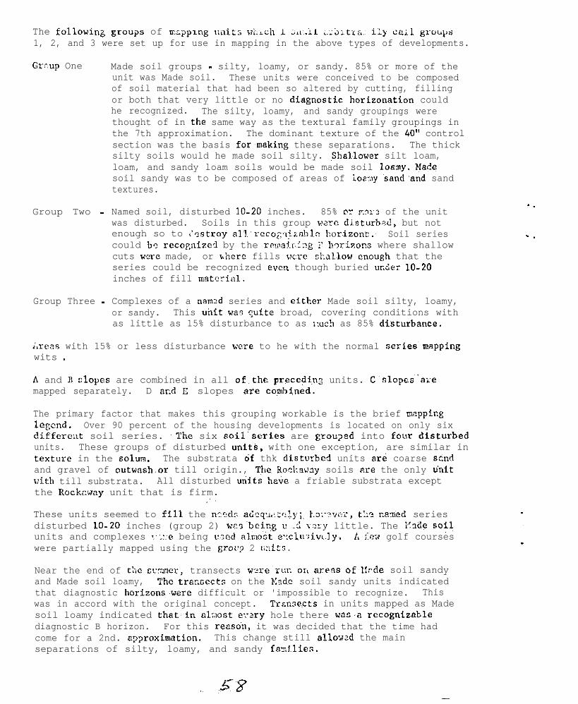
The followin-b groups of rxpp~ng units v;lich I ;L~:.L~ ;.;Y;tt&.~ ily ca;l groqs1, 2, and 3 were set up for use in mapping in the above types of developments.
Grrup One Made soil groups - silty, loamy, or sandy. 85% or more of theunit was Made soil. These units were conceived to be composedof soil material that had been so altered by cutting, fillingor both that very little or no diagnostics horizonation couldhe recognized. The silty, loamy, and sandy groupings werethought of in the same way as the textural family groupings inthe 7th approximation. The dominant texture of the 40" controlsection was the basis formaking these separations. The thicksilty soils would he made soil silty. ~~Shallower silt loam,loam, and sandy loam soils would be made soil loany. Had<soil sandy was to be composed of areas of ioaT:ly 'sand.and sandtextures.
Group Two -
Group Three -
Named soil, disturbed lo-20 inches. 85% CT P.>I~~? of the unitwas disturbed. Soils in this group w?rc di.sturb.?d, but notenough so to <'-stray all-rccog:~l~za~>lc bor.izon::.~ Soil seriescould be recognfzed by the remair~ing T hxizons where shallowcuts were made, or where fills wrf shallow enough that theseries could be recognized even though buried ur.der lo-20inches of fill material.
Complexes of a named series and either Made soil silty, loamy,or sandy. This unit was quite broad, covering conditions withas little as 15% disturbance to as v,uch as 85% dtsturbance.
;xeas with 15% or less disturbance were to he with the normal series'mappingwits .
A and B elopes are combined in all of.the precedi,nz units. C'slopes~‘a:emapped separately. D ar.d C slopes are~com~ined.
The primary factor that makes this grouping workable is the brief mappinglegend. Over 90 percent of the housing developments is located on only sixdifferwt soil series. .The six soil~series are groped into four'disturhedunits. These groups of disturbed units, with one exception, are similar intextxre in the solum. The substrata 6f thk disturhcd units ard coarse szndand gravel of outwash.or till origin., Then Ro~.I:a~uy soils are the only tinitvith till substrata. All disturbed units ha.&? a friable substrata exceptthe Rockzway unit that is firm.
These units seemed to fIl1 the nrcdr aiq~,::,z:l)i;, ~.~:~~vn~, t::? r.a-ned seriesdisturbed lo-20 inches (group 2) ws~being u .i ?xy little. The E~da sofJunits and complexes :"_::e being r-ed al.x&t e.:ci.u:.v<_I~y* 1% ::cx golf courseswere partially mapped using the grot'p 2 u-it::.
Near the end of the CC!XII~~, transects wo-re'rur. or< areas of,i!-de soil sandyand Made soil loamy, The traxects on the K3d.e soil sandy units indicatedthat diagnostic horlzonsswere difficult or 'impossible to recognize. Thiswas in accord with the original concept. Trawects in units mapped as Madesoil loamy indicated that,in nlxos~t e:-21-y hole there was,'a recognizsblediagnostic B horizon. For this reason, it was decided that the time hadcome for a 2nd. a??roximation. This change still allow-d the mainseparations of silty, loamy, and sandy fazi.?ies.
., :58_
I.
- .
DIS’&lRBED UNITS IN MAPPING LEGEND
ORIGINAL
Made soil siltyBridgehampton soi:ls disturbedBridgShampton - Made soil silty
Made soil loamyHaven’&‘&ls disturbedHaven - Made soil loamyRiverhead soils disturbedRiverhead - Made soil loamy
Made soil sandyCarver & Plymouth - Made soil sandy
Rockeway soils disturbedRockaway - Made soil loamy
PReSENT
Bridgehampton soilsdisturbed
leaven and Riverheadsoils disturbed
Made soil sandy
Rockaway soils disturbed
Percentage of inclusions was increased with the last change. Inclusionsmay now go as high as 25%. These inclusions can be areas that were previouslyconsidered as made soil or areas of undisturbed soils in a disturbed unit orvice versa.
Mapping techniques:
Adjoining undisturbed areas are mapped first. This helps the soil scientistto obtain the soil patterns; however, map unit boundaries cannot be drawnon the basis of neighboring undisturbed areas. Some developers completelyscalped tracts prior to building. The clues given by the undisturbed areasmust be tested by borings throughout the development.
In determining proportions of disturbed and undisturbed soils in a unit,the areas covered by street and houses are not considered. The aerialphoto shows these features. Our maps show only what the soil conditionsare around the buildings.
It has proven worth while to work with two soil scientists in each vehicle.Not only is mapping efficiency expedited; the prime factor of safety isan important consideration. The driver does not have to look at thelandscape and field sheet and watch for suitable sites to make borings.He can give his undivided attention to other vehicles, pedestrians, stopl ights , and stop si.gns.
Other clues to look for that help arc:
1) Houses with basements probably have more sandy materialin yard due to excavation.
2) Developments on C or steeper slopes usually necessitategreater excavation, hence, a greater likelihood of Madesoil sandy.
3) Areas of snail summer cottages, even though crowdedtogether, may have wry little disturbed soil in thedevelopment.
4) Older developments built prior to the building boom inthe post World War II era usually have relatively undisturbedso i l s . This was due to builders not clearing large areasand putting,houses up in a mass production basis. Thesehouses were usually built one by one wer a longer periodand about the only disturbance was directly under the house.
Areas where we originally used the complexes are sometimes difficult toseparate into the various components. Such areas must be mapped out basedprimarily on land USE. Small, disturbed or undisturbed areas must beseparated so that you do not exceed the 25% inclusions allowed in any ofthe units. To do this, we have set a lower limit of 5 acres in a unitwhich we will map to obtain the proper proportions. Separations made onthis basis are strictly cartographic in nature.
Progress in a mixed urbanized arca has been wry good. Mapping rates haveaveraged 38 acres per hour of code 31 time. To better utilize the time ofmen on detail to Suffolktime is computed using acost per acre is reduced
County, Saturday work has been authorized. Whenconstructed salary rate and 7 days per diem, theby about 1 cent per acre by working on Saturdays.
. .
. .
NATIONAL COOPlXbTIVE SOIL SURVEY
. .
.I
NOZTHEAST SOIL SUX’EY WOFX PLANNING C%iFET,ENCE ,.
January 15:18., 1968 ~‘.
Use of Soil Surveys in Urban ~Platining :Glenn B. Anderson :,.
ClennB. Anderson, Work Unit Conservationist in Fairfax County,Virginia, gave an informetive address on the above subject. It wasbased on developments since 1953 in Fairfax County. Some points fromthe address follow.
Interest in the soil survey developed as a result of circumstanceslike the following:
Costly damage to a school erected on unstable land.
Flooding of housing on flood plains.
Land slippage on slopes,
A $20,000,000 bond issue to solve health problems resultantfrom septic disposal in unsuitable soils.
Want of a gravel and sand for mining, control of mining,and reclamation of mined areas.
The extent to which soil surveys are being used is indicated bythe approximate 2000 services rendered about soils last year. Thesewere sought by county, state, and federal agencies; by land developers,builders, and contractors; by such professional persons as planners andarchitects; by civil organizations, institutions, and industrial andcommerciel units; and by individual home owners. The district governingboard designates priorities for time, giving the highest priority topublic agencies and lowest to individual persons.
The major categories of assistance given during 1967 included:
Soil stabilization, erosion control.
Agronomy, plant materials, forestry.
Sedimentation of water resources, including ponds and lakes, onlots of 3 acres up to tracts exceeding 1000 acres.
Basic land use planning, as with park authorities
Watershed planning
Planning development for recreation, with private groups andpublic agencies.
Xegional and County planning
Use of Soil Surveys in Urban Planning-2
Regional and county planners are interested in the following typesof maps: flood plain, slope, general water hazard including water table,percolation, depth to rock, bearing strength for buildings, gravel, suft-ability for agriculture.
In the beginning there was notable reluctance on the part of thepublic to use the soil survey. This has been considerably overcomethrough intensive promotion by members of the district board. The CountyAgent is a member of the Board and is himself a strong advocate of usaof the survey.
. .
. .
NATIONAL COOPERATIVE SOIL SDFVEY
_.
NORTHEAST S3IL SURVEY WORK PLANNING CONFEPENCE
January 15-18, 1968
Notes on Soil Series DescriptionsA.H. Paschal1
Soils 11
Some series descriptfons do not follow format for soil seriesdescriptions.
Soils Memo 66
Some series descriptions do not follow accumulated criteria on theconcept of the series. Some do not follow rules for concept of thecontrol section as outlined. B3 horizons are part of the solum but maynot. be wfthin the control section.
A real problem is allowfng ranges in the range in characteristicssectton that cross subgroups and family boundarfes. This section is aproblem in many series descriptions.
Very few are doing a good job of reviewfng neighbor series descrfp-tions. Many series including Ridgebury, Whitman, Walpole and Scarboroare gfving us trouble because of changes in concepts and ranges allowedin the series over the years.
The section on competing series also causes trouble in series des-cr ipt ions.
Series descriptfons are too long. 2 pages is about the right lengthbut some are 3 or 4 pages.
An edited series descrLpti.on in the Appleton series was circulatedto show how words and phrases could be deleted.

NATIONAL COOPERATIVE SOIL SURVEY
NORTREMT SOIL SURVEY WORK +4NNRJG CONFERENCE
January 15-18, 1969
. .
.=
REPORTS OF NATIONAL COMHITTEES NOT COVERED BY
REGIONAL COMMIT~lkS
Bavid E. Kill
Abstracts of the following National Committee Reports werepresented to the conference:
1. Criteria for aeries and phases.2.3.
App!i,cat.ioa of the ~nev c l a s s i f i ca t i on crystem.Soil survey procedures.
4. Climate in relation to cloil c lass i f icat ion andinterpretat ion.
6. Updating soil correlations of old but goodpubliehed maps.
Northeast regional commfttees did not operate in these areaefor a variety of reasons. 1) The application of the new olese i f icat ioosystem was a special topic end the’entire conference devoted one-halfday and one evening to this subject. 2) Meny recommendations of thecommitteea “Soil survey procedures”, and “Updating soil correlationsof old but good published surveys” are now establiahed practice,embodied in varioue Soila Memoa and Advisory Noticea.
A brief discussion fol lowed the’abstract of the report of,the National Committee on Application of the New Clasaifioation System.In this report, the Southern Regional Committee presented a list ofcharacter is t ics associated with fragipnne. Recogniz ing that fragipanhorizons form under widely varying conditions in different prte ofthe country, the Northeast suggested additiona and modifioatione ofthe Southern Region’s lint. Comments on some items (a through a) arenoted :
b. A polygonal oolor p&tern is often obeervablebut color may be patternless.
c . Some frvlaipone are Resoci.at.ed with bisequslcham*t.orist ico; other8 are not. T h e luxer eequun israrely a part of the fragipno.
/ ! / ,
i . Textures in g lac iated areas a lso include f inesandy loam and loamy sand.
.p l a t e ; .
Dominant structure in glaciated areaa ia
a. Fragipane in glaciated area8 are common onslopes to 35% but occasionally occur on steeper slopes.
PROPOSED NCR-3 PROJECT
BIBLIOGRAPHY OF SOIL SURVEY INF’OFIMATION /’
NCR-3 is investigating development of a bibliography ofavailable soil survey information. Preeumebly this w i l l inclodepublished soil survey maps and technical papera on morphology,class i f icat ion, and genesis . Bibliographical accumulations mny beaccomplished 1
1.
2.
in two ways:
Each state submit contributions concerninghis own &ate;
A tentative bibliography can be prepared by aUniversity Library, and each atate can c h e c kthe contents, adding or deleting items.
No other information wae available at this time. Dr. Kubota euggeetedtbat data processing systems could be used to advantage in informationr e t r i e v a l . Dr. Smith indicated that the National Agricultural Libraryis planning to apply data proceeaing to informat ion retr ieval .
..I
v.
. .
.
NATIONAL COOPERATIVE SOIL SUX’RY
NORTHEAST SOIL SURVEY worn PUNNING CONFERFNCR
Janusry 15-18, 1968
Soil Conservation Districts -Their Shift in Program and Responsibilities
S.L. Tinsley
. .
. .
Gradual change from rural oriented program to community approach.
Ressons for changes.
1. Communicetion up-dated and speeded up.2. Transportation speeded.3. Education enjoyed by more people4 . Affluence enjoyed by more people5. Changing ettitudes of people toward work, benefit-cost
ratio of projects.
Changes reflected in:
1. “The Future of Districts” by National ESsocistiOn ofSoil Conservation Districts
2. “Resources in Action” by U.S. Department of Agriculturein Agriculture in 2000.
3. “Communities of Tomorrow’ from U.S. Department of Agricul-ture in Agriculture in 2000.
Progress in Goal
1. Dredging of silted pond2. Planting program under power line instead of spraying3. Levegetation of gravel pits and mine spoil banks4 . Natural resource planning5. Conservation plans for urban sress as Ln Fairfax County,
Virginia end Montgomery County, Maryland
. -
.
. .
. .
NPTIOp!AL COOPER~TIVF SOIL SUYJEY
NORTHXAST SOIL SULVEY WORK PUNNING CONFE?.ENCE
January 15-18, 196C
Report of Soil Research Committee LiaisonR. A. S truchtemeyer
Proposed for establishment of regional committee on soil miner-alogy - to include not only clays but coarser fractions as well.
There appears to be much Interest in the Northeast on this matter.The proposal presented to the Northeast Regional Committee was declinedafter much discussion. The proposal was ton much of an umbrella typestudy and not designed to tackle specific problems,
In view of the interest, however, it was recommended that an interimcommittee be established and that travel funds be recommended for alloca-tion to those interested, In order that those interested could get to-gether and develop a proposal of specific projects to be presented tothe Experiment Station director for consideration.
-

. ._-
. .
NATIONAL COOPERATIVE SOIL SURVEY
NORTHEAST SOIL SIJRVEY GIORK PLANNING CONFERENCE
1968
The Soil Factor in Sanitary Land Fill L/
F. G. Loughry
Nany materials placed in land fills today are resistant to decomposition;therefore, it is doubtful if land fills can be reused within a generation.
Several methods of solid waste disposal include:
1. Dump in Remote Area -.__._~_______ This presents vector and odor problems.
2. Incineration-- This process can reduce volume of solid waste__-to about 20 percent of original volume. This process can resultin air pollution.
3. Cqmi,osting - To obtain useable product.-._.
4. Hog Feeding - Limited because of glass and metal content.-11-_-1
5. -@&n&Trash at Sea - This has been stopped because of pollution.__-_.-___problems.
6. Sanitary Land Fill - This is a waste disposal area which operatessoodors, smoke;-rodents, insect pests, blowing paper, and waterpollution are avoided. The waste material is placed in a trenchor other areas where the soil has been stripped. Soil materialis placed and compacted over the waste material daily.
Much of the land in the Northeast does not have soil that is suitablefor making a good sanitary land fill. It is estimated that about 27 percentof the Sta.te of Pennsylvania is suitable for sanitary land fills.
Listed below are the main soil factors used by the Pennsylvania Depart-ment of Realth in determining the suitability of soils for sanitary land fills:
1.
::4.5.6.
G7:9.
10.11.
Depth of solum and hard rock.Drainage class.Depth to seasonal high water table.Soil texture.Slope.Stoniness.Flooding hazard.Risk of free flow to ground.water.Acidity.Cation exchange.Base saturation.
Sanitary land fill operations appear to be a profitable business inPennsylvania.
l_/ F. G. Loughry has prepared a paper on this subject.
WORTHEAST SOIL SURVEY WORK PLANNING CONFERENCE
January 15- 18, 1968Summary Remar!:s by -mold J. Baur
Lo” intensity mapping. We can usa lo” intensity mapping in parts of largewooded areas, especially in hew England, and Hew York. Some survey *raas mayrequire medium intensity survey for part of the land, and low intensity forthe remainder. We must distinguish clearly between low and medium intensitysurveys:
1, Composition of the mapping units differ (mostly undifferentiatedunits or soil associations in low intensity legends);
2. Mapping intensity is at different levels;3, Interpretations are written differently;4. If a survey area contains two intensities, a separate mapping legend
is needed for each intensity. Label and date each legend. Mappingunit symbols must be different and distinctive for each intensity.Each soil symbol can be used in only one of the legends.
5. A low intensity legend should contain an explanation of the methodof mapping, frequency of observations, and reliability of delineations.
6. Soils Memo 3 (Rev. 21, and Soils Memo 62.include directives for lowintensity surveys.
Interstate coordination, We are beginning our second round of interstatecoordination of interpretations; a series of meetings ~has been set up. In ourfirst round, we laid a solid foundation for this work by use of benchmark soils.There has been time to test this first work, so now we are ready to improve andexpand the interpretations as needed, Francis Cleveland and other men from theRTSC will work on this, but State Offices have.much more responsibility in thissecond round than in the first. We are doing this by Land Resource Areas ratherthan on a regional basis.
General. This has been.a.productive conference. The committee reports containedsome good recommendations, and the discussion topics were timely and wellpresented. Participation and contributions by Agricultural Experiment Stationpeople was especially helpful on committees, and in presentation of specialtopics. We should keep Glade, L., and Walter, L. as participants in ourconference, We need Walter to needle us from time to ,time, and we need Gladeto keep us sanitary.
. .
.-_’
. .
.
. :
: 3
I hope that Virginia, Kentucky, and Ohio will continue to send representativesto our Northeast meetings. Participation from these states strangthans ourconference. We need you.
. Walter Steputis - we thank you for a job well done in developing and runningthis conference. You had help from Dave Hill, and Dr. Struchtemayer, but youdid the lions share of the work.
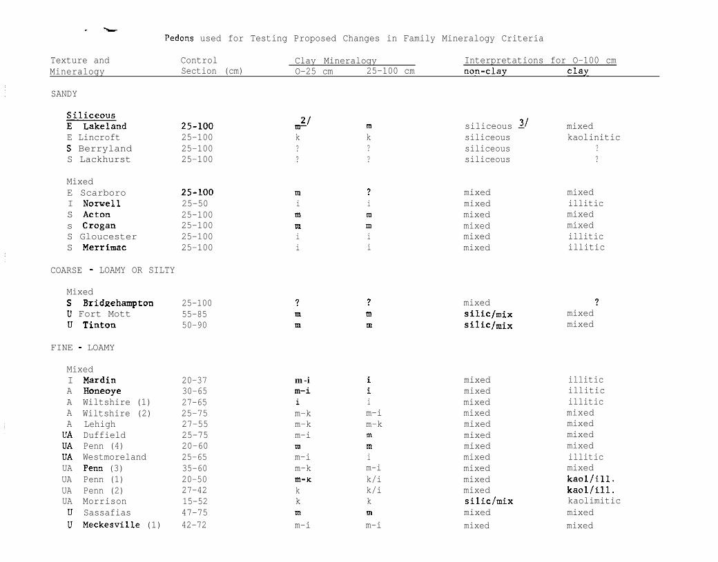
- L
Pedons used for Testing Proposed Changes in Family Mineralogy Criteria
Texture andMineralogy
SANDY
Control Clay Mineralogy Interpretations for O-100 cmSection (cm) O-25 cm 25-100 cm tlon-clay Clay
m siliceous 31 mixedE Lincroft 25-100 k k siliceous kaoliniticS Berryland 25-100 ? ? siliceous ?S Lackhurst 25-100 ? ? siliceous ?
MixedE Scarboro m ? mixed mixedI Norwell 25-50 i i mixed illiticS Acton 25-100 m m mixed mixeds Crogan 25-100 m m mixed mixedS Gloucester 25-100 i i mixed illiticS Merrimac 25-100 i i mixed illitic
COARSE - LOAMY OR SILTY
MixedS BridgehamptonU Fort MottU Tinton
FINE - LOAMY
MixedI MardinA HoneoyeA Wiltshire (1)A Wiltshire (2)A LehighUA DuffieldUA Penn (4)UA WestmorelandUA Penn (3)UA Penn (1)UA Penn (2)UA MorrisonU SassafiasU Meckesville (1)
25-100 ? 1 mixed ?55-85 m m silic/mix mixed50-90 m m SiliC/mix mixed
20-37 m-i i mixed illitic30-65 m-i i mixed illitic27-65 i i mixed illitic25-75 m-k m-i mixed mixed27-55 m-k m-k mixed mixed25-75 m-i m mixed mixed20-60 m m mixed mixed25-65 m-i i mixed illitic35-60 m-k m-i mixed mixed20-50 m-K k/i mixed kaollill.27-42 k k/i mixed kaol/ill.15-52 k k siliclmix kaolimitic47-75 m m mixed mixed42-72 m-i m-i mixed mixed
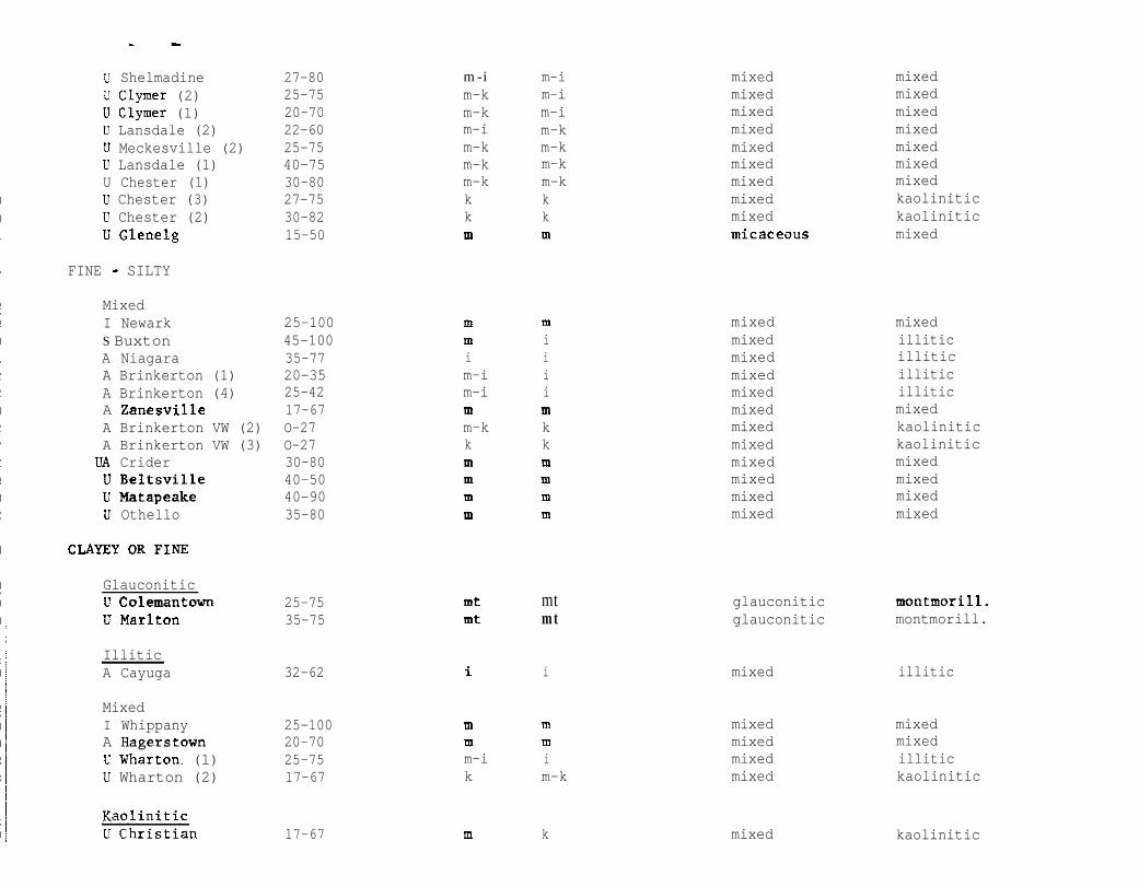
U Shelmadine 27-80 m-i m-i mixed mixedU Clymer (2) 25-75 m-k m-i mixed mixedu Clymer (1) 20-70 m-k m-i mixed mixedU Lansdale (2) 22-60 m-i m-k mixed mixedIJ Meckesville (2) 25-75 m-k m-k mixed mixedU Lansdale (1) 40-75 m-k m-k mixed mixedU Chester (1) 30-80 m-k m-k mixed mixedU Chester (3) 27-75 k k mixed kaoliniticLl Chester (2) 30-82 k k mixed kaoliniticU Glenelg 15-50 m m micaceous mixed
FINE - SILTY
MixedI NewarkS BuxtonA NiagaraA Brinkerton (1)A Brinkerton (4)A ZanesvilleA Brinkerton VW (2)A Brinkerton VW (3)
VA CriderU BeltsvilleU MatapeakeU Othello
CLAYEYORFINE
Glauconiticu ColemantownU Marlton
IlliticA Cayuga
25-100 m m mixed mixed45-100 m i mixed illitic35-77 i i mixed illitic20-35 m-i i mixed illitic25-42 m-i i mixed illitic17-67 m m mixed mixedO-27 m-k k mixed kaoliniticO-27 k k mixed kaolinitic30-80 m m mixed mixed40-50 m m mixed mixed40-90 m m mixed mixed35-80 m m mixed mixed
25-7535-75
mt mtmt mt
glauconitic montmorill.glauconitic montmorill.
32-62 i i mixed illitic
MixedI WhippanyA HagerstownU Wharton. (1)LI Wharton (2)
25-10020-7025-7517-67
17-67
m m mixed mixedm m mixed mixedm-i i mixed illitick m-k mixed kaolinitic
m k mixed kaolinitic
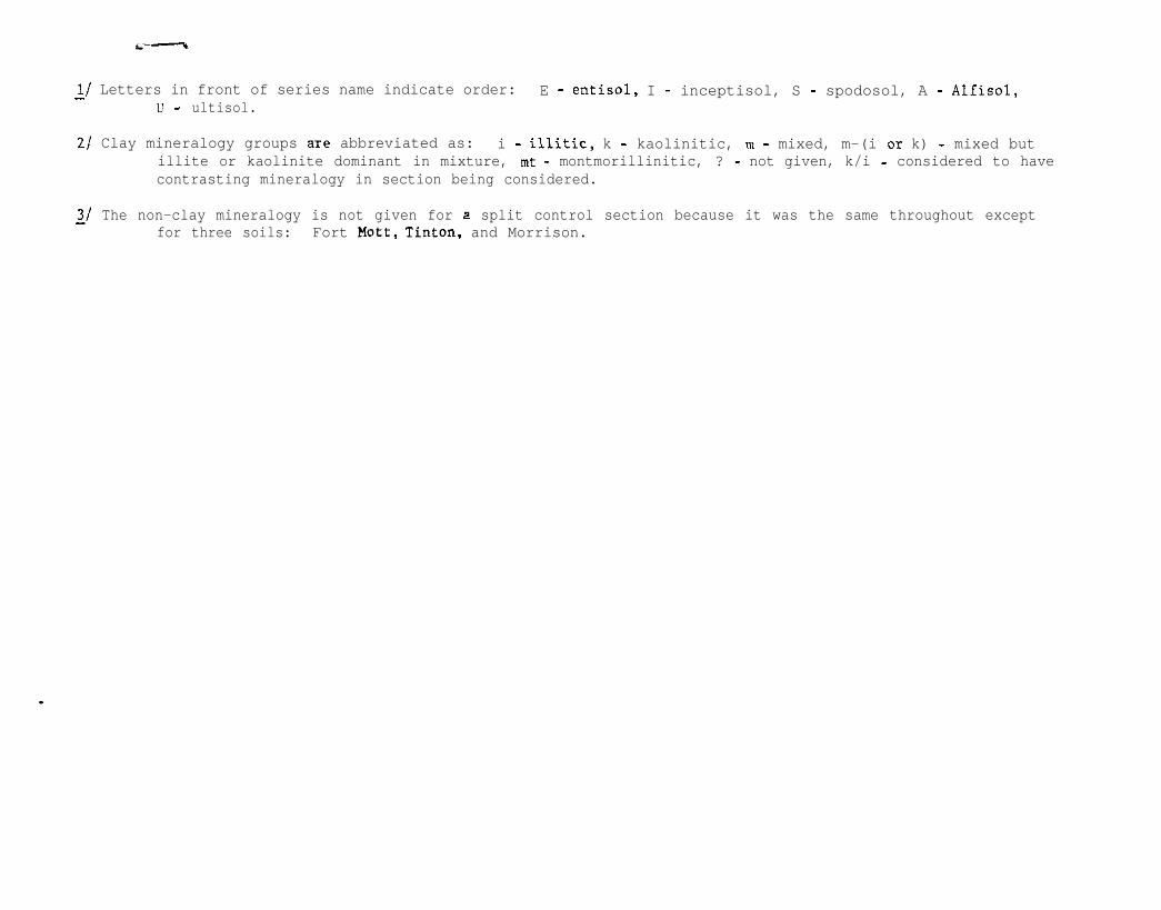
L/ Letters in front of series name indicate order: E - entisol, I - inceptisol, S - spodosol, A - Alfisol,l! - ultisol.
2/ Clay mineralogy groups are abbreviated as: i - illitic, k - kaolinitic, m - mixed, m-(i 011 k) - mixed butillite or kaolinite dominant in mixture, mt - montmorillinitic, ? - not given, k/i - considered to havecontrasting mineralogy in section being considered.
21 The non-clay mineralogy is not given for 2 split control section because it was the same throughout exceptfor three soils: Fort Mott, Tinton, and Morrison.
NATIONAL COOPERATIVE SOIL SURVEY
Northeast Regional Conference Proceedings
New York CityJanuary 24-27, 1966
Table of Contents .................................................................................... 1
Agenda.. ................................................................................................. 2
Conference Participants.. .......................................................................... 3
Conference Minutes.. ............................................................................... 4
Committee Reports .................................................................................. 7
Northeast Soil Research.. .......................................................................... 7
Benchmark Soils.. .................................................................................... 9
Technical Soil Monographs.. ...................................................................... 15
Series, Types and Phases ......................................................................... 18
Classes and Phases of Stoniness and Rockiness.. ........................................ 20
Soil Moisture.. ......................................................................................... 23
Made Soils.. ............................................................................................ 31
Northeast Soil Association Map.. ............................................................... 35
Other Reports -_ Variety of Them.. ............................................................. 38
Organization and Operation of Northeast Cooperative Soil Survey Work.. ....... 57Planning Conference
.
PROCEEDINGS OF THE
NORTHEAST COOPERATIVE SOIL SURVEY
WORK-PLANNING CONFERENCE
NEW YORK CITY
JAN. 2427, @46
NATION4L CO-OPERATIVE SOIL SURVJ!XNORTHFASTTECHNICALhUtE PIANNINC CONFERENCE
1966
Table of Contents
Agenda
Participants
Minutes
Report to Northeast Soil Survey Committee
Committee Reports
1. Benchmark Soils2. Technical Soil Monographs3. Series, Types, and PhasesIJ. Classes and Phases of Stoniness and Rockiness5. Soil Moisture6. Made Soils7. Northeast Soil Association Map
Other Reports
Symposium on Soil Percolation Testing
Discussion by D. B. FrsnemeierDiscussion by R. P. MatelskiDiscussion by D. E. Hill
Guidelines in the Application of the New Classification SystemSoil Correlation Proceduresl$rgineering Applicationa and InterpretationsClimate in Relation to Soil Classification and InterpretationOrganic SoilsProgress Report on New Classification SystemRevision of Soil Series DescriptionsProjected Soil Survey Schedule
. .
.AGENDA - NORTHEAST SOIL SURVEY WORK PLANNING CONFERENCE - JAN 2!.1-27, 1966
MONDAY- JANUARY 2h
a:30 - 9:oo Announcements, appointment5 and opening business9:oo - 1'Z:OO Meeting of committees 3, b, and 512:oo - l.:OO Lunch1:00 - 5:OO Meeting of committees 5, 6, and 7
TUESMY- JANUARY 25
8:30 - 9:oo Business meeting - Report of nominating committee9:oo - 12:00 Report5 of committee512:oo - l:oo Lunchl:oo - 5:oo Reports of committees
WEDNESDAY - JANJARY 26
8:30 - 12:00 Symposium on soil percolation testing
Dr. Franzmeier - Sustained percolation testingDr. Matelski - Effect of variable and constant
heads and seasonal variationDr. Hill - Principals of the percolation test,
site and seasonal variationOpen conference discussion
12:oo - l:oo Lunchl:oo - 3:oo Guideline5 in the application of the new classifica-
tion system - Dr. Simonson3:oo - &:oo Soil Correlation procedures - Dr. Baurh:OO - 5:CO Engineering applications and interpretation5 - Dr. Van Eck
THURSDAY - JANUARY 27
8:30 - 9:15 Climate in relation to soil classification and inter-pretation - Dr. Bailey
9:15 - 10:00 Organic soils - Mr. Wilsonlo:oo - lo:30 Progress report on the new classification system -
Dr. Simonsonlo:30 - 11:OO Revision5 of soil series descriptions - Mr. Paschal111:oo - 11:30 Projected soil survey schedule 1 Mr. Garland11:30 - 12:OO Concluding statements and adjournment
.;.
PARTICITANTS NORTHEAST SOIL SURVEY WORK PIANNING CONFERENCE
January 24-27, 1966[, &I, (_.,:I; ,& 42 A
.'R. Arnold, Dept. of Agronomy, Cornell University, Ithaca, N. Y.,~A. J. Baur, SCS, 7600 West Chester Pike, Upper Dar-by, Pa.H. H. Bailey, Dept. of Agrono;ny, University of Kentucky, Lexington, Ky.
L. J. Cotnoir, Agronomy Degt., University of Delaware, Newark, Del.R. E. Daniell, SCS, 1409 Forbes Rd., Lexington, Ky.C. Eby, SCS, Court House, Morristown, N. J.J. H. Elder, Jr., Va. Polytechnic Institute, Blacksburg, Va.
,D. S. Fanning, Agronomy Dept., University of Maryland, College Park, Md..-R. A. Farrington, Vermont Dept. of Forests and Waters, Montpelier, Vt.
? L. 6. Garland, SCS, 7600 West Chester Pike, Upper Darby, Pa._ M. F. Hershberger, SCS, University of Maryland, College Park, Md.r.,D. E. Hill, Conn. Agr. Expt. Sta., Box 2lr3, Windsor, Corm.
! M. Howard, Jr,, SCS, Burlington, VermontC. 3. Koch, SCS, LOO I!. 8th St., P. 0. Box 10026, Richmond, Va.F. 0. Loughry, SCS, 100 N, Cameron St., Harrisburg, Pa.
Z~ R. L. Marshall, SCS, Midtown Plaza, 700 E. Water St., Syracuse, N. Y.9. P. Mateleki, Agronomy Dept., Penn:. Siitc Univoreity, Univ. Park, Pa;
J. R. Mott, SCS, 29 Cottage St., Amherst, Mass.L' A. H. Paschall, SCS, 7600 West Chester Pike, Upper Dar-by, Pa.L--B. J. Patton, SCS, 209 Prairie Avenue, Morgantown, W. Va.R. Pennock, Agronomy Dept., Penna. State Univ., University Park, Pa.
&I. Peterson, Agronomy Dept., Penna. State Univ., University Park, Pa.,N. K. Peterson, Dept. of Soil & Water Science, University of New
Hampshire, Durham, New HampshireL-S. Pilgrim, SCS, Durham, New HampshireH. C. Porter, Vn. Polytechnic Institute, Blacksburg, Va.0. A. Quackenbush, SCS, Box 670, New Brunswick, N. J.
yE. J. Rubins, Plant Science Dept., University of Corm., Storrs, COM.0. M. Schafer, SCS, 300 Old Federal Bldg., 3rd & State Sts., Columbus, Ohio
+--A. E. Shear-in, SCS, Gonn. Agr. Expt. Sta.,..W. J. Steputis, SCS, Orono, Jlr.ine
P.O. Rox 248, Windsor, Conn.
R. S, Struchtemeyer, Agronow Dept.,~&$& A. V
Univ. of Maine, Orono, Mainean Eck, Agronomy Dept., Univ. of W. Va., Morgantown, W. Va.
JtJ. Werte, USFS, Milwaukee, WisconsinY.K. P. Wilson, SCS, P. 0, Box 620, New Brunswick, N. J.L.--S. J. Zayach, SDS, 29 Cottage St., Amherst, Mass.
/j: J y(;j-,f<?
GUESTS:
D. B. Franzmeier, SCS, Helstville, Md.J. Kubota, SCS, Tthaca, N. Y..3. J;,. &&$&JMEMBERS 0 C NFEREPJCE GRGUP NOT PRESENT:
v*M. G. Cline, Agrcnomy Dept., Cornell University, Ithaca, N. Y.T. W. Green, USFS, 50 7th Street NE, Atlanta, Ga.
-. L .'-W. J. Lyford, Harvard Forest, Petersham, Mass.v'J. C. F. Tedrow, Dept. of Soils & Crops, Rutgers Univ., New Brunswick, N.3.
M. E. Weeks, Agroncmy Dept., University of Mass., Amherst, Mass..
. . .I -
I
MINUTES OF THE NORTHEAST SOIL SURVEY TECHNICAL WORK PLANNING CONFERENCE
Governor Clinton Hotel, New York, N. Y.
January 24-27, 1966
The meeting was called to order by Chairman David Hill at 8:30 A.M.,January 24.
Members of the Conference were introduced. Representatives fromVirginia, Ohio, and Kentucky :iere welcomed by the Chairman as newmembers of the Northeast group.
F. G. Loughry, Vice Chairman of the Conference, was named Recorderfor the business sessions.
G. A. Quackenbush, Past Chairman, was named as Liaison Representativeto the Northeast Soil Research Committee, and instructed to reportto that committee during its Wednesday Morning session in the samehotel.
Roy P. Matelski and Montague Howard were appointed as a NominatingCommittee and instructed to present the names of two ExperimentStation Representatives as candidates for the office of Vice Chairmanfor the next two years.
Business meeting adourned and Technical Committees met as scheduledin the program. In addition, Committee 2, Soil Monographs, held ashort meeting at the request of Chairman Ray Marshall.
The business Meeting was reconvened at 8~30 A.M., January 25.
Members who had been late because of the blizzard were introduced.
R. P. Matelski reported for the Nominating Committee and put innominations for Vice Chairman: R. S. Structemeyer
H. C. Porter
It was moved and seconded that nominating be closed.
W. 0. Van Eck and G. M. Schafer were appointed tellers.
. . l
Elected Vice Chairman for the next two years and Chairman Elect for1969 and 1970: R. S. Structemeyer
The business meeting was followed by committee reports.
Y

.-
.
Committee 1. Benchmark Soils - S. J. Zayach, Chairman
It was moved, seconded and voted that the committee be continued.The report of the Committee was accepted.
Conanittee 2. Technical Soil Monographs - R. L. Marshall, Chairman
The conference suggested that the committee (1) add a statementon procedu,,e .:., r initiating acti.on on a monograph, (2) adopt therecommendation of the Nztional Colrtittee on composition of theindividual monograph committees to be activated when an authoris found.
It was moved, secc..xdcd and passed that the committee report beadopted.
Committee 3. Series, Types, and Phases - B. J. Patton, Chairman
It was moved, seconded and voted that the Committee be continuedand the report bc accepted.
Committee h. Classeo & Phases of Stoniness & Rockiness - A. H. Paschall,Chairman
It was moved and seconded that the Committee be continued andthat the corrmittee work on Rockiness Classes and Phases to maketests and report to the National Committee by September. Passed.
Committee report adopted.
Committee 5. Soil Moisture - A. E. Shearin, Chairman
It was reconqended that the conimittee be continued. It was movedand seconded that the report be accepted. Passed.
Committee 6. Made Soils . . M. F. Hershberger, Chairman
The report included a request that transects of representativeareas of made soils be described in each state and forwardedto the comrrittee by June 1, 1966 to be summarized as an appendixto the roport.
It was moved and seconded and voted that the report be adopted.
Committee 7. Nxthcast Soil Association Map - Committee Report givenby De E:, H i l l
It was moved and seconded that the report be accepted. MotiondI. carried.
Meeting adjourned I. S:OO P-M..
__
.
At 8:30 A.M., January 26 the meeting reconvened for a symposiumon Soil Percolation Testing. Speakers were: D. B. Franzmeier
R. P. MatelskiD. E. Hill
At 1:00 P.M., January 26, William Wertz, Soil Scientist, U. S.Forest Service, Milwaukee, explained new Forest Service regionalboundaries and changes in headquarters organization.
Roy D. Simonson discussed application of the New Classification System.
A. J. Baur discussed current field correlation procedures.
W. A. Van Eck discussed engineering applications and interpretations.
The final session of the conference started at 8:30 A.M., Thursday,January 27.
The Chairman announced that all Committee Reports and abstracts ofpapers should be sent to F. G. Loughry by the middle of February.
H. H. Bailey reviewed the National Committee Report on Climate inRelation to Soil Classification.
K. P. Wilson reviewed the National Committee Report on Organic SOilS.
A. H. Paschalldiscussed the Revision of Soil Series Descriptions.
R. D. Simonson made a progress report on the application of the NewClassification System.
L. E. Garland reviewed the projected soil survey publication schedule.
There was a motion from the floor by R. P. Matelski than an additionalcorrelator be added to the Principal Correlatorls office to incrassefield contacts in preparing correlations and to reduce the amount ofSpecial assistance that is now being required to handle the increasedwork load due to increased area of the region.
The motion was seconded by H. C. Porter. It was discussed, voted,and unanimously passed.
It was determined that 150 copies of the report would be needed.
.
Conference adjourned 12:CC Noon.
6
NATIONAL COOPERATIVE SOIL SURVEY
NORTHEAST SOIL SURVEY WORK PLANNING CONFERENCE
SUMMARY TO THE NORTHEAST SOIL RESEARCH COMMITTEE
Members of the So11 Survey Work Plannlng Conference appreciatethe opportunity to report on Its activities to the Soil ResearchCommlttee.
Following is a brlef r’esume of the activit ies of each committeeconducted first In committee sessions and then dlscussed by the fullconference:
1. Benchmark Soils. This concerns assembling and publishingdata on individual soil serfes chosen for their regional extent andagronomic Importance. Publlshed to date are Caribou, by Maine:Vergennes, by Vermont; Paxton, by Connecticut: and Canfield, by Ohio.Work is underway on eight other benchmark reports. The conferencereviewed the uses of these publlcatlons, the methods and problemsof getting them done,
2 . Technical Soil Honoqraphs. These would be comprehenslvetechnlcal publications on the soils of major physiographic reglons.Seven areas have been dellneated in the Northeast, West Virginia toMaine; ten if Ohlo, Kentucky, and Virglnla are Included. Af ter fouryears of plannlng, there has been no actlon in the Northeast for wantof authors and allotted time. N e w posslblllties arise. using thetalents of retired scientists as authors.
3. Crlterla for Sol1 Ser ies , Types, and Phases. A need was fe l tfor a s tudy of cr i ter ia used by d i f ferent so i l scientists In differ-entiating series, types, and phases in the new soil classif icationsystem. The committee outllned a program of study to be tested thisSummer and reported to the National Committee this autumn.
4. Classes and Phases of Stoniness and Rockiness. Followlng arequest by the Northeast Region In 1964 that these be reviewed, anatlonwlde study has been underway to establish uniform standards ofmeasurement and nomenclature. r(aJor attention was glven stoninessduring the past biennium; the study will now be directed towardsimi lar s tudies of rockiness.
3
5. Soil Moisture . Among topics considered were (1) possiblechanges in class limits of permeablllty necessitated by the use ofthe auger hole method of measurement; (2) need for standardizationof the auger hole method: (3) kinds and deflnltions of water tables;(4) classification of water tables as to depth, duration, and seasonand use of graphic representations of the same; (3) review of fieldstudies of soil molsture, some of which are in progress; (6) theneed for a more operational term for “available moisture.”
6 . M a d e s o i l s . The committee was concerned with the problem ofclassification of solIs and materlals a f ter urban a l terat lon, sca lp ing,“borrowing”, cutting and fil.ling of the landscape, mine spoil . etc.The new soil classification system provides a place where some of thesecan be fitted where diagnostic horizons have not been completelyo b l i t e r a t e d . The committee will continue to field check made sol1areas to determine the presence and uniformity of diagnostic horizonsand make recommendations to the National Committee.
7 . Northeast Soil Association Map. Publication of ~a regionalsoil association map from the Western Region prompted consideration ofa similar project in the Northeast. Anticipated areas of use include:teaching, commercial surveys, and regional,public planning. Lessdetailed than state association maps, this regional map should notcompete with them, A soil association map of New York-New Englandwas compiled several years ago but the level of cartographic detailmay be too great for its intended use. A pending SCS national maps e e m s satisfactory in outlining the major sol1 areas. Such a mapextracted for the Northeast might have six ma]or dlvlslons and 30-35subdivisions. Participation by Ohlo, Kentucky, and Vlrginla in thismap would be a matter for decision in vlew,of their relation to otherland-grant regions. The map should be accompanied by descriptions ofphysfography, classifications of soil into the new and old systems,descriptions of representqtlve soil series from each of the sub-div is ions, and broad interpretations for agriculture, forestry, wlld-Iife,‘recreation, and urban d.evelopment.
The Soil Survey Work,Planning,Conference endorsed the proJect andbelieves that information to~be used in.corqposlng the map and text iSreadi ly avai lable . I t be l ieves, however , that the in i t ia t ive andleadership must come from the Experiment Stations. Although repre-sentatlves from the SCS could not make commitments, they thought thatcooperation could be anticipated.
Cranvi 1 le A. QuakenbushRepresentative to the N.E.Soil Research Committee
.
NATIONAL COOPERATIVE SOIL SURVEY
NORTHEAST SOIL SURVEY WORK-PLANNING CONFERENCE
1966
REPORT OF COMMITTEE ON BENCHMARK SOIL,S
The committee on benchmark soils is charged primarily with the coor-dination and the advancement of the benchmark soil report program inthe Northeastern States, Dr. David E. Hill, chairman of the 1966conference, has requested the conmlttee to:
a. review progress in the benchmark soil program sinceour meeting in 1964,
b. review benchmark soil priorities, and
c. seek to obtain positive comnltaents for progressduring the coming biennium.
A questionnaire was sent to all members of the committee requestinginformation on the status of the benchmark soil program in theirstates. Since only 6 of the 15 states indicated a need for a com-mittee meeting at the conference , this report Is based on the infor-mation obtained from the questlonnalres completed by representativesfrcnl all of the Northeastern States.
Status of benchmark soil reports.
1. Rapcrts released in 1963 or earlier..Caribou (Maine)Vergennes (Vermont )Canfleld ( O h i o )
2. Reports released in 1964.Paxton (Connecticut)
3. Reports in press or released in 1965.None
4. Reports being prepared, or to be prepared, and anticipatedyear of release.
Suffield ( M a i n e - ?)RDrmon (New Hampshire - 1967)Gloucester (Massachusetts - 1966)Charlton (Connecticut - 1967)Cheshire (Connecticut - preparetfon in 1967)
/Bridgehampton (Rhode Island - 1966)Westmoreland (Pennsylvania - 2)
,/Hagerstown (Maryland - 7)” G l l p l n (West Vl;glnla
Upshur (West Virginiapublished in 1967)
-‘;966)- to be prepared in 1966 and
7
It is assumed.~that.the above reports haw a,high priority for com-pletion by the states concerned. Ten of the fifteen states haveno plans for starting new reports during 1966 or 1967 and threestetes were noncommittal. Only two states (Connecticut and WestVirginia) indtcated that they plan to prepare reports for highpriority soil series,during 1966 and 1967.
Except for a comment from West Virginia and Maryland, there were~no requests for.changing benchmark soil priorities assigned to thestates. Dr. Van Eck suggests’ that Pennsylvania instead of WestVirginia should prepare,the report’for ~the’ Dekalb ser5es becauee agraduate student ~ha+ made a study of then stills in PennsylvaniaiMr,,Hershberger feels that priarlties and reassignments should beconsidered at a committee,meeting. Since,& meeting of the com-mittee will not be held, priorities could be discussed after thereport is submitted at the conference. Attached to this reportis Appendix I, which indicates the benchmark ‘soils assigned toeach state.
The problem of finding the time and the people to work on bench-mark reports appears to be getting wotise ~instead of better. Mostof the states do not plan to schedule such work for 1966 or 1967.The following ‘are excerpts taken from statements made by membersof the committee from s&xal.states regarding benchmark reports,
“It will. be difficult to obtain cooperation from ‘theI:ean’s Office in assigtiing. time, to write. the reports.”
“Series are in such a state of’flux that anythingwritten now will be,.obsole&e in a,year. L i k e w i s ep r i o r i t i e s are h y p e r c r i t i c a l tiow.”
*‘I feel that there should be a temporary mora<oriumon these reports, I think our full effort should,beplaced on getting soil serieq into shape. Many of thebenchmark soils need to be better defined before anypublications are consddered.~!’
“Benchmark soil report is not partl of regular ass?gnedduties. More or less dependent on free time available.”
“We liave beep unable to schedule personnel from Soil Con-servation ser&e or from our cooperating agencies forwork on a benchmark soil report tit the expense of com-pletion of fie!d.soil surveyb, sbil survey tisnuscripts,series descriptions; sail correlation, etc.*@
“Finding the time for going through the +teps of maklnga benchmsrk. repor’t fork a.singlP soil and justifying theeffort and expense put an it will b@ difficult when wehave moved so fast into a ~larg{r field of descriptiona n d interpretatioii . . ..~. .’ It may,be that we shou ldlbok at’ the benchmark soils $th a broader def initian.”
.,..ii
b

‘$1 hope you get more encouraging reports from otherstates. some rejuvenation is needed to make thesestudies bear fruit.”
The participants at this conference should take a hard look at theproblems involved in preparing and. releasing benchmark reports.Should the program be continued or abandoned? Are the reports ofsuch value that they warrant the time and,cost to compile and release?
Around 100 man-days were spent in compiling each of the Paxton andHagerstosm reports. The 100 man-days. spent on the Hagerstoxr reportwas as of January 1964. It has not been completed as of December1965” The chairman of this coarnittee does not know how many addi-tional days have been spent on the report.
T!!e cowittee members ware not canvassed about plans for preparingreports beyond 1967. It appears that most states do not plan tostart new reports for benchmark soils assigned to them, ‘IhIs iscertainly the case in 1966 and 1967 and may be the case in succeed-in3 years.
The majority of the members recommend that the committee should becontinued. Actually this is a permanent committee and will be dis-continued only when the benchmark soil report program is abnndoned.
Committee Members
R. S. Bell F. G. LoqhryL, J. Cotnoir R. L. MarshallR. E. Daniel N. K. PetersonR. A, Farrington G. M. SchaferL. E. Garland, Vice Chm. R. S. StruchtemeyerMe F. Hershberger W. A. Van EckD. E. Hi11 K. P. WilsonC. J. Koch S. J. Zayach , Chairman
iii
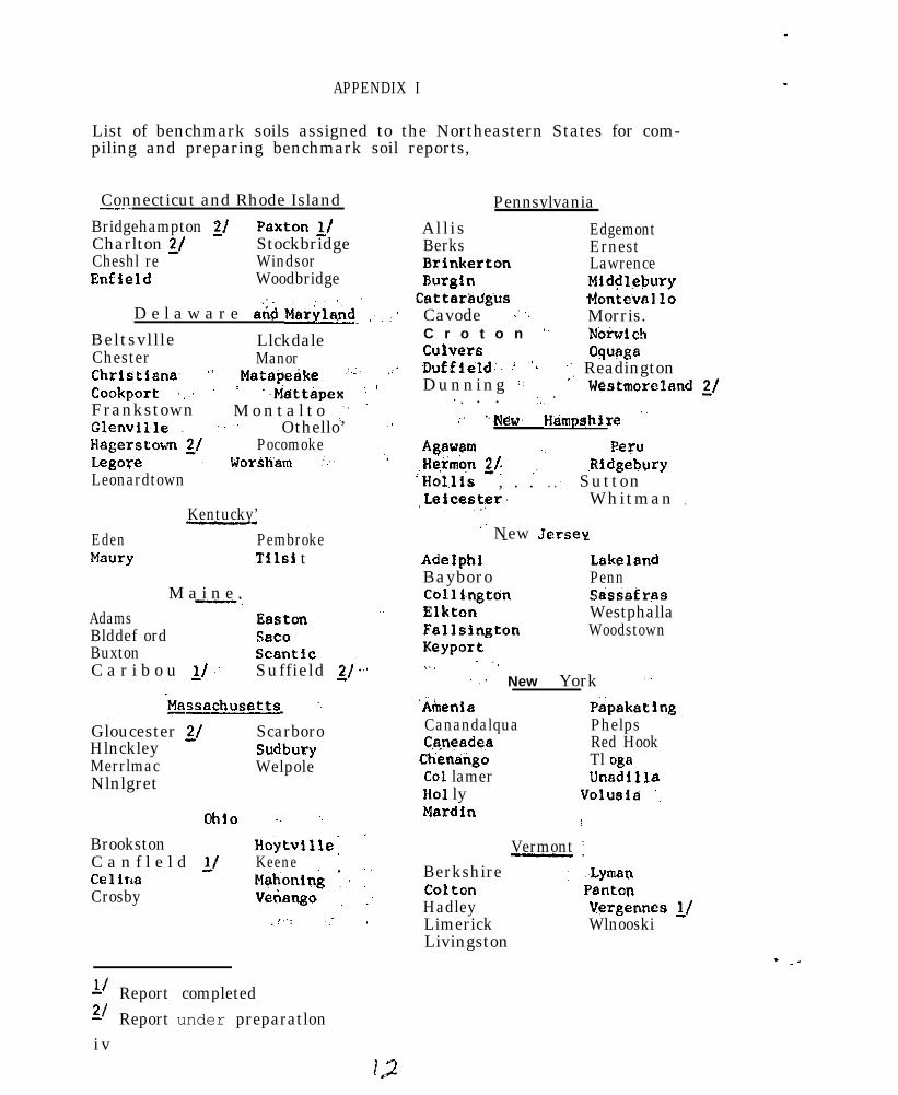
APPENDIX I
List of benchmark soils assigned to the Northeastern States for com-piling and preparing benchmark soil reports,
Connecticut and Rhode Island_.,.Bridgehampton 2/Charlton ?/
Paxton rlStockbridge
Cheshl re WindsorEnfield Woodbridge
:D e l a w a r e and Ma&I& .~ ; :’
Beltsvllle LlckdaleChester ManorChristlana, .( Matspe&e ,:.:. .:’
Cookport :,~. : ,’ ‘.Mattapex ‘1 1
Frankstown M o n t a l t o ,~”Glenvll.le ., .~ ” Othello’ ~’Hsgerstown 2/ PocomokeLegore : lJor~,i&afi :... “.
Leonardtown
Kentucky’-_Eden PembrokeMaury ,Tl~lsi t
M a i n e ,-.Adams Easton ”Blddef ord Sac0Buxton scanticC a r i b o u 11 : Suffield z/ ‘.’
&sachusetts ..
Gloucester z/ ScarboroHlnckley SudburyMerrlmac WelpoleNlnlgret
ohlo -. ‘,
BrookstonC a n f l e l d L/
Hoytvllle: ’Keene
Cellns Mahoning :; :’Crosby Vetiango , :
,!..: / ,
11 Report completed21 Report under preparatloniv
Pennsylvania
Allis EdgemontBerks ErnestBrinkerton LawrenceBurgln Middlebury
CettarMgbs t4ontev~lloCavode .’ ~, Morris.C r o t o n ‘. Notid chCulver6 wagaD”ffiel&‘: “IDunning ::
‘,‘, ReadingtonWestmoreland z/
., . . ::~’:’ knew Himpshire ”
Agavem .~ Peru,He.+mbn 21: ,. ,Rldgebury‘Hol,lis , . . . . : Sutton,Leicester. Whitman .,~
.’ New Jersey- -Adelphi LakelandBayboro PennCo11 1,ngtdn sassefr.asElkton WestphallaFallsington WoodstownKeyport,.. .‘.
: ~. New York ”
‘Amenia PspakatingCanandalqua PhelpsC,+neadea Red Hook
Ctiendkgo Tl ogaCo1 lamer UnadillaHo1 ly voiusia ‘.Mardin I
Vermont ’-.Berkshire : ~~LymanColton PantonHadley Vergennes L/Limerick WlnooskiLivingston

(AppanSfx cent)
Virginia--_-
CaJ-bO SassafrasFTederick 21 Tatum
west Vi~nia-Blag0 LakinFekalb LindsideElliber (Bodine) M e l v i nGilpin 2/ MonongahelaGlnat HurrillHartsells TylerHolston UpshurHuntington IJhartonI.aidjg ‘Jhee 11 ng
. . - !.I Report completed,/ Report under preparation
”

Notes on discussion after_ committee report.
A. G. A. Quakenbush: What use has been made of the benchmarkreports?
1. Answers
a.
b.
C.
d.
e.
f .
D. E. Hill: 3500 copies were printed of the Paxtonreport. About one-half distributed.withinCqnnecticut,primarily to planning boards and c,ommissions, and aboutone-half distributed to Soil Conservation Service andExperiment Stations throughout the United States. Onlyten copies left for distribution,. It is d’ifficult toassess the use made of the report except by implicationof distribution.
A. H. Paschall: When published in a numbered seriesby Experiment Station, the demand is good: otherwisethe demand is slight.
W. 3. Fteputis: The Caribou report was mimeographed.Not many requests for it.
R. S. Struchtemeyer: When published as a numberedseries, the report goes to a fixed mailing list. Thismay not indicate use.
D. E. Hill: Fame foreign countries have requested thePaxton report.
R. W. Simonson: Foreign countries use such reportsto get a better idea of series concepts in the UnitedStates.
a
g. D. S. Fanning: Graduate students use the reports.
h. A. J. Baur: We need these reports in libraries,same as other disciplines. Actually we are weak onthts item in our discipline.
1. S . -1. Zayach: We should complete and release thereports that have been started. Then perhaps declarea moratorium for a while.
B. D. S. Fanning: Funds are a problem in getting the reportspublished by Experiment Stations.
C. D. E. Hill moved that the committee be continued. Secondedby R. S. Be l l .
vi
NATIONAL COOPERATIVE SOIL SURVEY
NORTHEAST SOIL SURVEY WORK PLANNING CONFERENCE
1966
REPORT OF COMMITTEE ON TECHNICAL SOIL MONOGRAPHS
The committee reviewed proposals of the 1965 National Committee on TechnicalSoil Monographs. All items were discussed by the committee and those worthyof action were recommended for implementation in order to move ahead with thepreparation of Soil Monographs in the Northeast.
The National Committee recommended a permanent committee be established foreach soil monograph area. This committee would consist of the State soilscientist and the State soil survey leader for each State which forms a partof the monograph area. Thus, the committee for a particular soil monographarea may consist of men from one, two or more States,
The Regional Committee agreed with this proposal. It also recognized thatsuch a committee wuld remain inactive until a suitable author(s) was secured.
The committee took the following action to clearly identify committee members,select authors and activate committees when authors are obtained:
1. The 1962 Northeast soil monograph areas were redefined in terms of theJanuary 1963 “Land Resource Regions and Major Land Resource Areas Mapof the United States” and areas were extended to include major areas in
Ohio and Virginia recently added to the Northeast Region,%~?~~&dix. )
2. Authors for each soil monograph area were solicited from the conferenceas a whole as suggestions to the area soil monograph cotittees.(See appendix for names of authors suggested by the conference,)
3. When an author(s) is proposed the following procedure is suggested:
a. The State soil scientist and State soil survey leader in the Statewhere the author(s) is residing make initial determination oncompetence of the prospective author(s) for writing a technicalsoil monograph.
b. If the author(s) is considered suitable submit name(s) toState Conservationist to transmit to Dr. Kellogg’s office forapproval and operating procedure.
c. If Dr. Kellogg’s office approves, the State Conservationist shouldnotify the author(s) involved.
d. After notification by the State Conservationist the State soilscientist and State soil survey leader should jointly activate thearea soil monograph committee for preparation of a work procedure,which Muld include items pertinent to getting the soil monographunderway.
.: The committee report was accepted by the conference,(Over)
IS
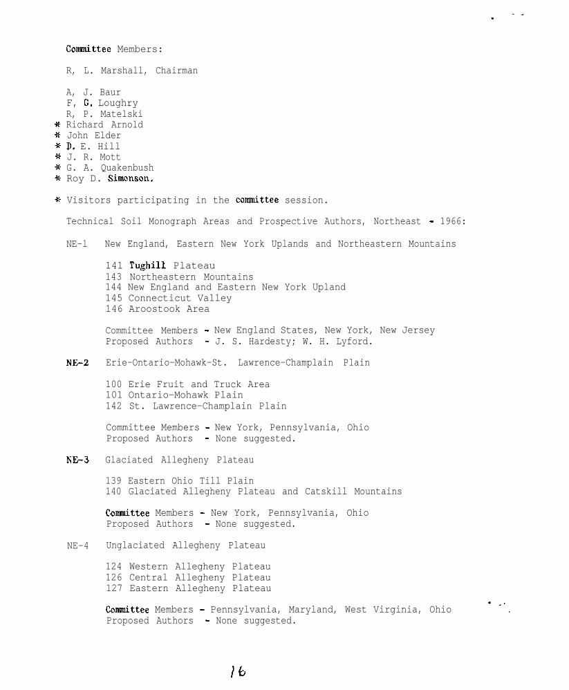
Connnittee Members:
R, L. Marshall, Chairman
A, J. BaurF, G. LoughryR, P. MatelskiRichard ArnoldJohn ElderD. E. HillJ. R. MottG. A. QuakenbushRoy D. Simonson.
Visitors participating in the cotittee session.
Technical Soil Monograph Areas and Prospective Authors, Northeast - 1966:
NE-l New England, Eastern New York Uplands and Northeastern Mountains
141 Tughill Plateau143 Northeastern Mountains144 New England and Eastern New York Upland145 Connecticut Valley146 Aroostook Area
Committee Members - New England States, New York, New JerseyProposed Authors - J. S. Hardesty; W. H. Lyford.
NE+2 Erie-Ontario-Mohawk-St. Lawrence-Champlain Plain
100 Erie Fruit and Truck Area101 Ontario-Mohawk Plain142 St. Lawrence-Champlain Plain
N63
Committee Members - New York, Pennsylvania, OhioProposed Authors - None suggested.
Glaciated Allegheny Plateau
139 Eastern Ohio Till Plain140 Glaciated Allegheny Plateau and Catskill Mountains
NE-4
Comaittee Members - New York, Pennsylvania, OhioProposed Authors - None suggested.
Unglaciated Allegheny Plateau
124 Western Allegheny Plateau126 Central Allegheny Plateau127 Eastern Allegheny Plateau
Connnittee Members - Pennsylvania, Maryland, West Virginia, OhioProposed Authors - None suggested.

_ .
NE-S
N&6
NE-7
N&8
NE-9
NJ&l0
147 Northern Appalachian Ridges and Valleys
Committee Members - Pennsylvania, Maryland, West Virginia, Virginia,New Jersey
Proposed Authors - Howard W. Higbee; David C. Taylor; Robert Devereaux.
148 Northern Piedmont
Committee Members - New Jersey, Pennsylvania, Delaware, Maryland,Virginia
Proposed Authors - None suggested.
149 Northern Coastal Plain
Committee Members - Massachusetts, New York, New Jersey,Delaware, Maryland, Virginia
Proposed Authors - None suggested.
125 Cumberland Plateau and Mountains
Committee Members - West Virginia, Virginia, Ohio, Kentucky,Tennessee, Alabama
Proposed Authors - None suggested.
121 Kentucky Bluegrass
Committee Members - Kentucky, Ohio, IndianaProposed Authors - Willard Carpenter.
120 Kentucky and Indiana Sandstone and Shale Hills and Valleys
Comaittee Members -. Kentucky, IndianaProposed Authors - Willard Carpenter.
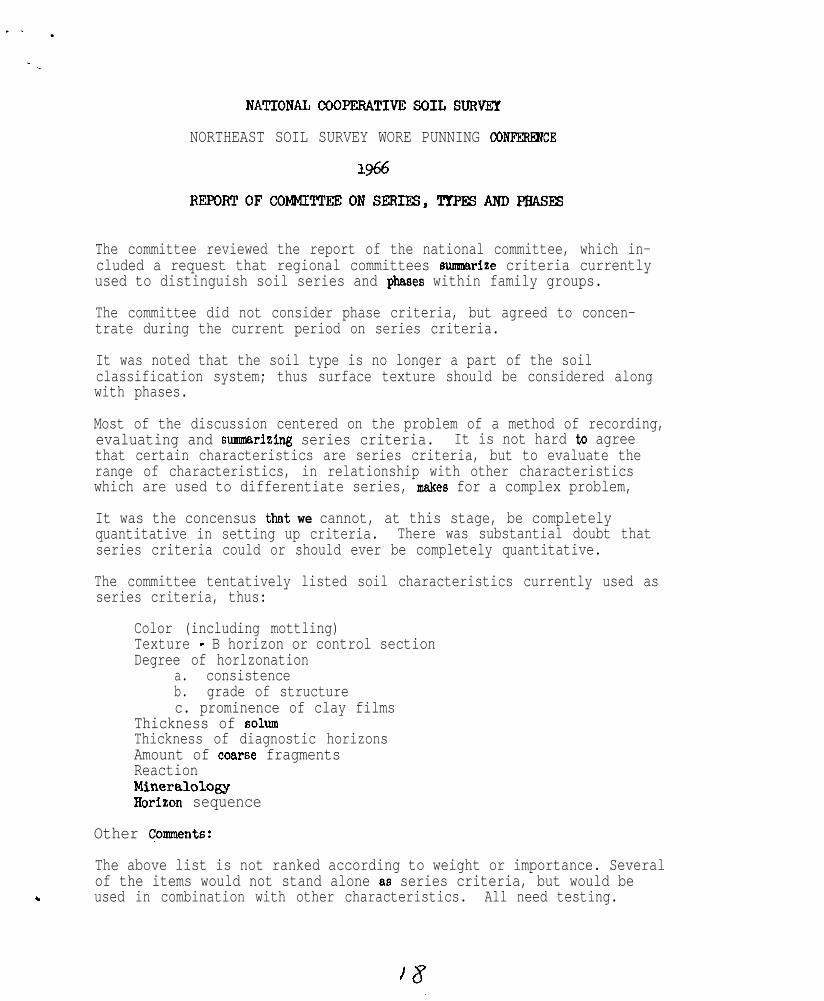
NATIONALCOOPERATIVESGILSURVEY
NORTHEAST SOIL SURVEY WORE PUNNING CGNFERl3JCE
1966
REPGRTOFCONMITl'EEONSERIFS,TTPESANDPBASES
The committee reviewed the report of the national committee, which in-cluded a request that regional committees sunssarise criteria currentlyused to distinguish soil series and phases within family groups.
The committee did not consider phase criteria, but agreed to concen-trate during the current period on series criteria.
It was noted that the soil type is no longer a part of the soilclassification system; thus surface texture should be considered alongwith phases.
Most of the discussion centered on the problem of a method of recording,evaluating and summarizing series criteria. It is not hard to agreethat certain characteristics are series criteria, but to evaluate therange of characteristics, in relationship with other characteristicswhich are used to differentiate series, makes for a complex problem,
It was the concensus that we cannot, at this stage, be completelyquantitative in setting up criteria. There was substantial doubt thatseries criteria could or should ever be completely quantitative.
The committee tentatively listed soil characteristics currently used asseries criteria, thus:
Color (including mottling)Texture - B horizon or control sectionDegree of horlzonation
a. consistenceb. grade of structurec. prominence of clay films
Thickness of solumThickness of diagnostic horizonsAmount of co*rse fragmentsReactionMineralolosyBorison sequence
Other Comnents:
The above list is not ranked according to weight or importance. Severalof the items would not stand alone 86 series criteria, but would be
c used in combination with other characteristics. All need testing.
..
The above properties apply, in most Instances, to B horieons or controlsections. Surface color and texture are, in a few cases, used as seriescriteria if strongly contrasting with subJacent horizons.
The committee agreed that each member will list, for selected series inrepresentative families, the criteria used to separate series. The
/CgnggitiWL c9&lman will develop a format for use in list&n& this infor-__-.__._._._
.,_n@&nn, A meeting of the c%iii%Ze~~--L--or a representative subcommittee,will be needed in September or October to evaluate and summarize thevarious reports.
Dr. Simenson, or ,a representative of his office, will be asked to meetwith this summary committee. Tabulation of series criteria will be onthe basis of series having standard description approved or circulatedfor review according to the new classification system.
A summary of the committee's work will be submitted to the nationalcommittee prior to the next national work planning conference.
The report of the committee was accepted by the conference. It wasagreed that the committee be continued.
Committee Members
Richard Arnold (for Dr. Cline) G. A. QuackenbushA. J. BaurRobert Googins (absent)
W. J. SteputisRoy Simenson, Consultant
M. F. Hershberger Charles Koch, SecretaryMontagne Howard ’ George Schafer, Vice ChairmanJ. R. Mott Doyd J. Patton, Chairman
,
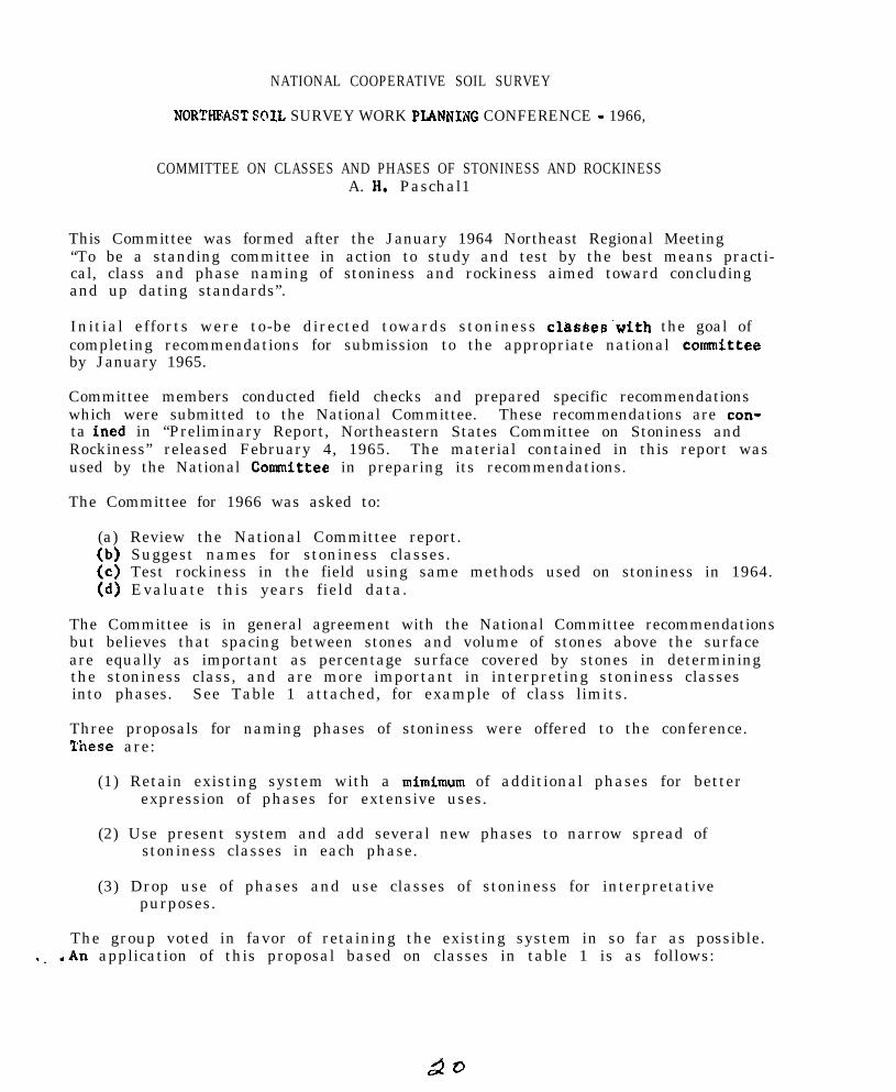
NATIONAL COOPERATIVE SOIL SURVEY
NORTHRAST SOIL SURVEY WORK PLANNIKG CONFERENCE - 1966,
COMMITTEE ON CLASSES AND PHASES OF STONINESS AND ROCKINESSA. H. Paschal1
This Committee was formed after the January 1964 Northeast Regional Meeting“To be a standing committee in action to study and test by the best means practi-cal, class and phase naming of stoniness and rockiness aimed toward concludingand up dating standards”.
Initial efforts were to-be directed towards stoniness clesses’with the goal ofcompleting recommendations for submission to the appropriate national ~committeeby January 1965.
Committee members conducted field checks and prepared specific recommendationswhich were submitted to the National Committee. These recommendations are con-ta ined in “Preliminary Report, Northeastern States Committee on Stoniness andRockiness” released February 4, 1965. The material contained in this report wasused by the National Cosrnittee in preparing its recommendations.
The Committee for 1966 was asked to:
(a) Review the National Committee report.(b) Suggest names for stoniness classes.(c) Test rockiness in the field using same methods used on stoniness in 1964.(d) Evaluate this years field data.
The Committee is in general agreement with the National Committee recommendationsbut believes that spacing between stones and volume of stones above the surfaceare equally as important as percentage surface covered by stones in determiningthe stoniness class, and are more important in interpreting stoniness classesinto phases. See Table 1 attached, for example of class limits.
Three proposals for naming phases of stoniness were offered to the conference.These are:
(1) Retain existing system with a mimimum of additional phases for betterexpression of phases for extensive uses.
(2) Use present system and add several new phases to narrow spread ofstoniness classes in each phase.
(3) Drop use of phases and use classes of stoniness for interpretativepurposes.
The group voted in favor of retaining the existing system in so far as possible.._ <An application of this proposal based on classes in table 1 is as follows:
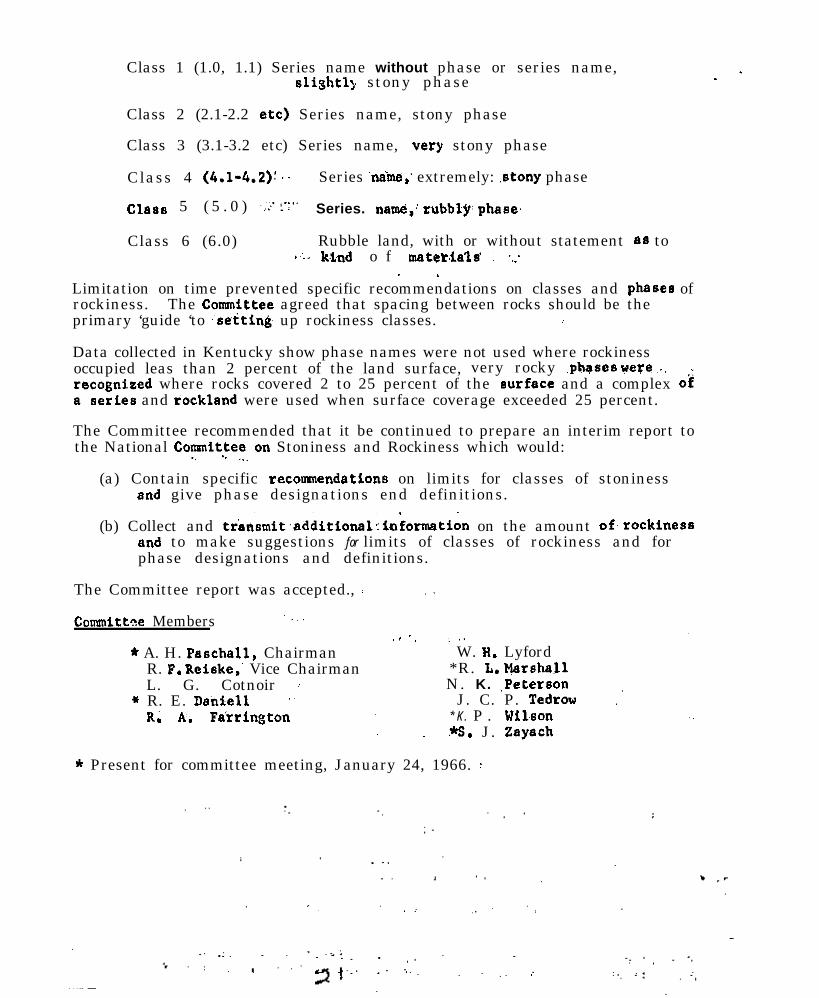
Class 1 (1.0, 1.1) Series name without phase or series name,slightl: stony phase . .
Class 2 (2.1-2.2 etc) Series name, stony phase
Class 3 (3.1-3.2 etc) Series name, ,very stony phase
Class 4 (4.1-4.2): .. Series ‘name,‘ extremely: .stony phase
Class 5 ( 5 . 0 ) ~>.‘:‘:‘. Series. name+,: rubbly: phase,
Class 6 (6.0) Rubble land, with or without statement as toI~:. ktnd o f mater~ials’ :~ ‘,:
. .Limitation on time prevented specific recommendations on classes and phases ofrockiness. The Committee agreed that spacing between rocks should be theprimary ‘guide ‘to :setting up rockiness classes. i
Data collected in Kentucky show phase names were not used where rockinessoccupied leas than 2 percent of the land surface, very rocky .phases were ,:. ~..recognised where rocks covered 2 to 25 percent of the surface and a complex O#a’series and rockland were used when surface coverage exceeded 25 percent.
The Committee recommended that it be continued to prepare an interim report tothe National Committeaon Stoniness and Rockiness which would:
(a) Contain specific recoannendatlons on limits for classes of stoninessand give phase designations end definitions.
(b) Collect and trensmit.additionelrin;ormstion on the amount of,rockinessand to make suggestions for limits of classes of rockiness and forphase designations and definitions.
The Committee report was accepted., :.
Connnittee Members Y,.
.I ‘, : ,.* A. H. Paschall, Chairman W. H. Lyford
R. P. Reiske,’ Vice Chairman *R. L. MarshallL. G. Cotnoir : N. K. ,Peterson
+ R. E. Den&e11 ” J. C. P. Tedrow .’R. h. Farrington * K . P . Wil.son
*s. J. Zaysch
* Present for committee meeting, January 24, 1966. :
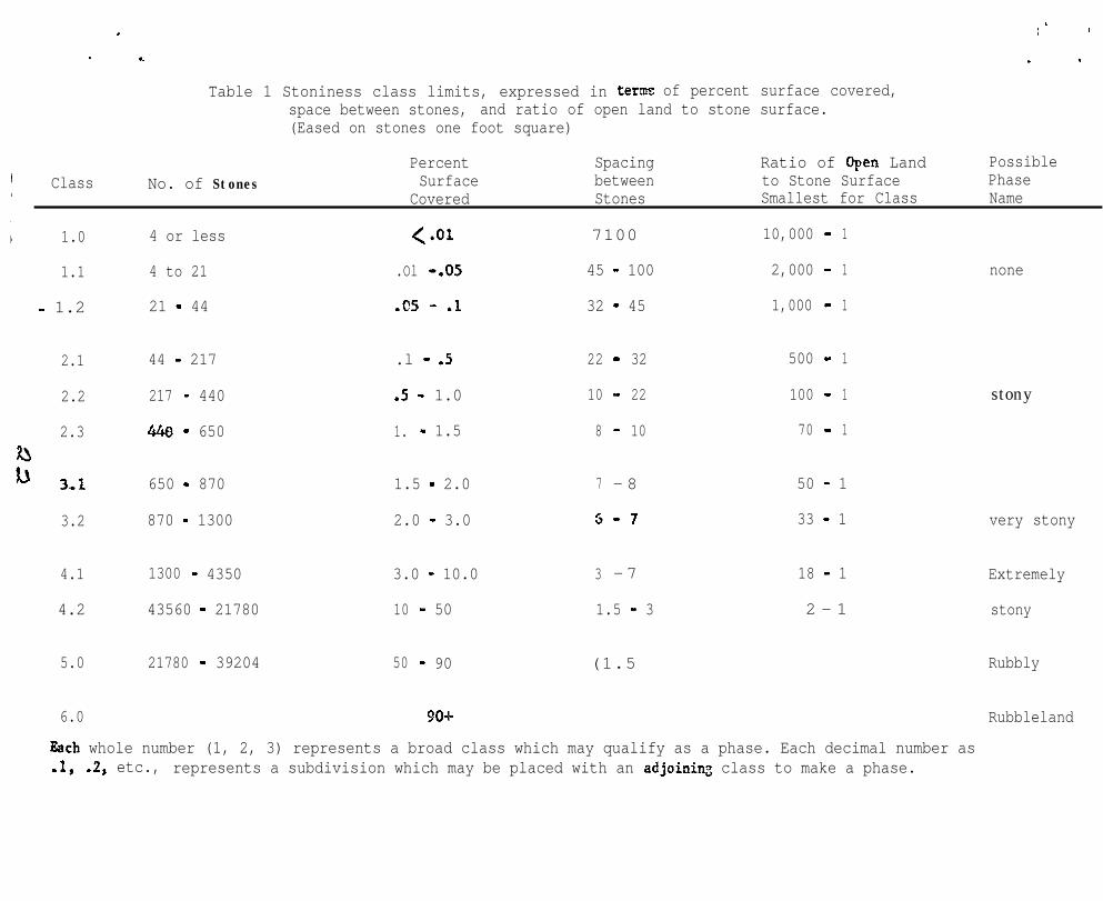
I
i ’
. I
1
Table 1 Stoniness class limits, expressed in term= of percent surface covered,space between stones, and ratio of open land to stone surface.(Eased on stones one foot square)
Class No. of StonesPercent Spacing Ratio of open Land PossibleSurface between to Stone Surface Phase
Covered Stones Smallest for Class Name
1.0 4 or less <*or 7100 10,000 - 1
1.1 4 to 21 .Ol -.05 45 - 100 2,000 - 1 none
- 1.2 21 - 44 .c5 - .l 32 - 45 1,000 - 1
2.1 44 - 217 .l - .5 22 - 32 500 - 1
2.2 217 - 440 .5 - 1.0 10 - 22 100 - 1
2.3 440 - 650 1. - 1.5 8 - 10 70 - 1
stony
3.2 870 - 1300
1.5 - 2.0 7 - 8
2.0 - 3.0 5-7
50 - 1
33 - 1 very stony
4.1 1300 - 4350 3.0 - 10.0 3 - 7 18 - 1 Extremely
4.2 43560 - 21780 10 - 50 1.5 - 3 2 - 1 stony
5.0 21780 - 39204 50 - 90 (1.5 Rubbly
6.0 90-k Rubbleland
650 - 870
Zach whole number (1, 2, 3) represents a broad class which may qualify as a phase. Each decimal number as.lr .2, etc., represents a subdivision which may be placed with an adjoining class to make a phase.
.
NATICNAL COOPERATIVE SOIL SURVSY
NORTHRAST SOIL SURVEX WORK PLANNING C~ERRNCB
1966
REPORT Op C@lMfTTBE ON SOIL MOISTURE
Our committee concentrated efforts on topics suggested by the 1965 NationalSoil Moisture Committee. These included soil permeability, water tabledefinitions and depth and duration classes, available information on waterta.ble studies, available moisture and suggested field moisture studies.
Permeability- -
Permeability classes based upon the Uhland core method and the auger holemethod were discussed. The committee feels that the permeability classesproposed by the National Committee in 1963 based on the Uhland core methodare n0.l: applicable to the auger hole method. More inEormation onpercolation rates using the auger hole method i.s needed before meaningfulcl.asses can be estab?.ished. The two methods of measuring permeability arenot comparable in theory. The Uhland core method measures one dimensionalsaturated flow in a confined core while the auger hole method, used as ameasure of septic tank drainage field performance, measures threedimensions.1 unsaturated unconfined flow (except in the presence of awater tahlel. Comparisons of the tvD methods were made in Fairfax CountyVirginia by the Virginia Agricultural Sxperiment Station and it isreported that the two methods were fairly comparable except in soils withswelling clays and those with lithologic discontinuities. Studies inConnecticut indicated that in soils with lithologic discontinuities the twomethods could not be compared. Auger hole rates were higher than Uhlandrates by a factor ranging between 1.6 and 3.7 for the limited number ofsoil,s studied.
The committee feels that percolation tests by the auger hole method gives~a better’ expression of the probable performance of a septic tank filterfield under similar weather conditions. The auger hole method, however,
~needs to be standardized as to:
1. Size and depth of auger hole.2. Length of presoaking period.3. Height and maintenance of a constant head of water.4. Time of year tests are made, etc.
In New Jersey attempts have been made in two locations to relate auger holepercolation tests with interpreted limitations based on standard soil surveys.At one location results were not satisfactory probably in part because thepercolation tests were not standardized and were made by a number of people.At the other location the soils were examined in 2’ x 2’ pits and percolationrates were interpreted, In this case interpreted percolation rates basedon the soil profile characteristic were supported by percolation tests.
At the conference a symposium on soil percolation testing was held. T h eparticipants were Dr. D. P. Fransmeier of the Soil Survey Laboratory,Beltsville, Maryland, Dr. R. P. Matelskf, Pennsylvania State University,and Dr. D. E. Hill of the Connecticut Agricultural Experiment Station.Suuuuaries of their discussions appear in a separate report,
Water Table Classes, Depth and Duration
The conmittee recommends adoption of classes as listed below:
Very shallow 0 - 10 inchesShallow 1 0 - 2 0 ”Moderately shal low 20 - 40 ”Moderately deep 40 _ 80 ”Deep 8 - 240 ”Very deep 5240 I,
Hy oversight duration &asses proposed bjr the 1963 National Committeewere not discussed. The corrmittee feels that water tables should bedefined in terms of depth, duration and time of the year. On soilsthat are ponded the duration and time of pending should be noted. Insoil survey reports and other publications the committee suggests that
.water table data be presented in chart form.
The committee was divide9 on whether measurement of water tables inmineral soils should be from the top of the 0 horizon or to top of themineral soil. It was pointed out that the 0 horizons are subject tochange due to burning, subsidence, etc. This is something that shouldbe noted in the description of the sail profile and other notes concetn-ing the site where water table data is recorded.
Perched and Virtual Water Tables- - - - -.,
The need for recognizing perched and virtual water tables was discussed.The comnlittee feels that perched water tables should be distfnguishedfrcm apparent or true w&e:: tables in well, maderatcly well and probablysomewhat poorly drained soils but not in poorly and very poorly drainedso i l s . It is realized that in deep bore holes unlined or lined andsealed a perched water table may be missed. The committee feels thatt.here is a need for recognizing and naming the condition describedunder the heading “Virtual Water Table” in the 1965 National Committeereport.. The committee has no good suggestions for a better term thanvirtual .
The committee feels that in the northeast water table measurements aremostly apparent water tables or a combination of apparent and perched.The data. by Gile (see Appendix I) in New Hsmpshire is probably mostlyperched water tables and the data in Ohio and Broome County, New York(see Appendix I) is probably a combination of apparent and perched. Thecommittee assumes that the definition for true water tables means thatthe bore hole is lined and sealed. It is the concensus of the committeethat measurement of apparent and perched water tables are the mostmeaningful. In Appendix I available information of water table studiesand l,ong time moist,ure studies in progress or completed are ‘listed.
a y
Available Moisture
The committee discussed briefly the request from the National Committeefor suggestions for a more operational term for available moisture. Nosuggestions were made but the term readily available moisture was mentionedfor moisture held at tensions between 0.1 or l/3 and 6 bar values. Onesuggestion was made that more points on moisture release curves between.06 and 15 bar values would be helpful. Some moisture data by the NewJersey Agricultural Experiment Station show moisture retention value of0.02, 0.06, 0.1, 0.33, 1.2, 6 and 15 bars. It is well know that l/3bar tension values do not represent field capacity for coarse texturedsoils and it may under estimate field capacity for other soils in coarseloamy and coarse silty families. Scnne data .from New Jersey suggests that0.06 bar retention values may more nearly express field capacity in coarsetextured soils and 0.1 bar values in some coarse loamy and coarse siltys o i l s .
Several w.mbers of the committee explored the possibilities of stratifyingl/3 .- 1.S bar retention values by classification of soils in the newsystem. Compl.et~e laboratory data is available for quite a few profilesbut l/3 bar tensian values were determined on fragmented rather thancore samples. In many profiles bulk densities were not determined andin mazy l/3 and 1.5 bar retention values were not determined for theentire 40 inch coatrol section. In Appendix II available moisture (l/3 -IS atmos.> is tabLate for the 40 inch control section or to the top ofa horizon that restricts roots for a number of soils profiles.
Field Moisture Field Study- -
Possible field moisture studies that could be conducted by a soil scientistin c.harge of a sxvey were discussed.
1. Water table studies is probably the simpliest and the one involvingthe least time that a soil scientLst Ln charge of a survey couldundertake. This would involve selecting the sites, preparing boreholes, describing the soil profiles, taking water table readings atregular intervals and keeping precipitation records.
2. Permeability studies is a project that a soil scfentist in the fieldcould undertake. Comparison of the auger hole and Uhland core methodson selected soils would be a good project. A project of this kind tobe of value would require considerable time,
3. Another project mentioned was a study showing moisture values andpercolation rates by horizons for selected soils over a period oft.ime.
The commi.ttee feels that field soil scientists should be encouraged andgiven time to work on such projects. Giving them more responsibilitywou1.d make, their job more interesting and make for better soil scientists.
‘_ .
Commi.tt~ee Members*H. H. Bailey"Ft. S. Bell*C. Ehy*D. s. Fanning“2. E. Garland*R. P. MatelskiS. A. L. Pilgrim
*H. C. PorterE. J. RubinsR. A. Struchtemeyer
*W. A. Van EckM. B. Weeks, V. Chairman*A. E. Sheesrin, Chairman
.
Qtesent at the cxumni,t:tee meeting,
. _’
Appendix I. Available Information on Water-Table Studies and Long-TimeMoisture Studies in Progress or Completed.
In 1957 Midgley reported on water-table fluctuations in cultivated soilsof the Hadley and Suffield series and the closely associated soils.Midgley, A. R., 1957. Water-table studies on some Vermont soils.
Vermont Agricultural Experiment Station Bulletin 597.
In 1958 Gile reported on a short study (Sept. ‘56 - June ‘57) on fragipanand water-table relationships of Paxton, Scituata and Ridgebury seriesin southern New Hampshire. The soil classified as Ridgebury in this studyprobably would be classified as Norwell now.Gile, L. H., Jr., 1958. Pragipan and water-table relationships of some
Brown Podzolic and Low Humic Glei soils. Soil Science Socfety ofAmerica Proceedings 22:.560-565.
*The Ohin Department of NaturaI Resources, Division of Lands and Soilst,:rt<. 1 ,a w>t~.l:.~.‘~,& l;le sl;;dy i.n 1961 on a number of series includingBrookscon, Crosby, Celina, Miami, Clermont, Avonbury, and Russmoyneseries. Tie soil and water table studies were summarized for theyears 1961, 1962 and 1963. A copy of this summary is available from theOhio Department of Natural Resources, Division of Lands and Soil.
In 1964 LyEord reported on water-table studies over 4 to 6 year periodsat two locati,ons, one. at Fremont, New Hampshire and the other etHarvard Forest, Peter&am, Massachusetts. The study included soilsclassified in the Woodbridge, Ridgebury, Elmwood, Swanton, Whatley,Sudbirry and Ninigret series. Sudbury loamy coarse sand and Ninigretloamy sand are outside the range of the Sudbury and Ninigret seriesas now defined.LyEnrd, W. H., 1964. Water-table fluctuations in periodically wet soils
cf central New England, Harvard University, Harvard Forest Paper No. 8.
In Browne County, New York, Huddlcston studied the depth to free water overa perii;d of 2 years ar. weekly or semi-weekly intervals at one site eachon Canaseraga, Cxlvers, Dalton, Mardin, Morris, Scio and Valusia series.Huddleston, J. H., 1965. Soil Survey Interpretation for subsurface
sewage disposal in Broome Co., N.Y. A thesis presented to thefaculty of the Graduate School of Cornell University for a degreeof Master or Science.
*The University of Maryland and the. Soil Conservation Service initiateda stildy on ground water levels and fluctuations about 2 years ago. Thestudy is being conducted on 3 poorly drained series, Fallsington,Othello and Rlkton in Talbot County and on Sassafras, Woodstown,Fallsington and Pokomoke series in Worceste~r County. Some data for thefirst. two years of t~he. study has been summarized in rough draft form.
*In New Jersey Rutgers University in cooperation with the Soil ConservationService have a study entitled ‘Water-table levels and physical characteris-t.ic of wet soils in New Jersey”. This study has been in progress for
*_ . several years but no data has been summarized to date.

In Connecticut water table levels have been measured for a period of 3years on one site on Sutton, 2 years on one site each on Ridgebury,Whi.tman and Walpole series.
The Department of Agricultural Engineering of the University of Connecti-cut has a project on Individual Water Disposal Systems. Preliminarylaboratory investigation on non-saturated flow in soils on II. Colimovement due to temperature differential are now in progress.
In addition to the long-time moisture studies now in progress listedabove the following have been initiated recently or will be at an earlydate:
The Soil Conservation Service in Pennsylvania started water table studiesin Montgonery County in October.
In Delaware t.he State oE Delaware Drainage Commission plane to initiatea soil moisture and water table study in drained areas that seem to beovar drai.ned due to the continued drought over the last few years.
The Kentucky Agricultural Experiment Station is initiating a long-timestudy concerned with soil moisture, temperature and rainEal1.
The Virginia Agricultural Rxperiment Station is starting a water studyon a number of series.
*Long-time moisture studies.
Long-Time Moisture Studies Canpleted.
.S47 Project, Southern Region, dealing with rainfall, aoil moisture,evaporation and temperature in 5 locations: 1 in Kentucky, 2 in Tennessee,1 in Virginia and 1 in Florida. The project was for 4 years in Kentuckyand for 5 years at the other locations.
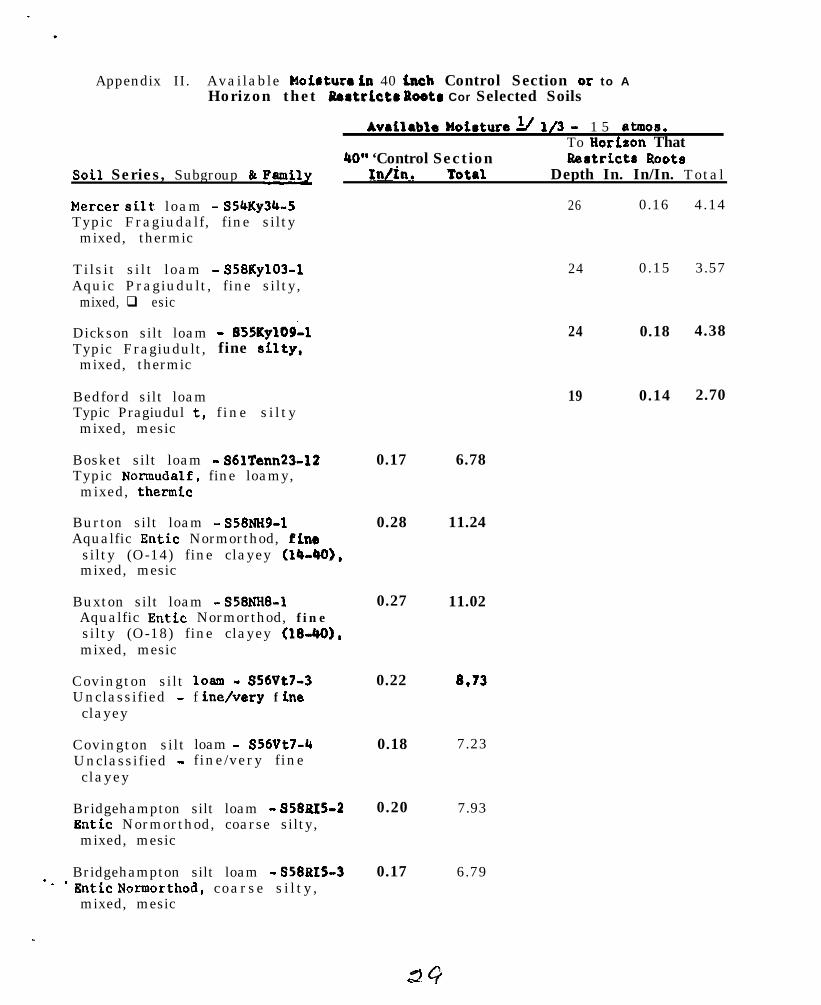
Appendix II. Available Hoiaturo in 40 Lnch Control Section or to AHorizon thet Eeatrlctr Pootr Cor Selected Soils
AVAilAblA HoiAturA 1/ l/3 - 1 5 atmos.To HorLaon That
40” ‘Control Section Rertrictr RootaSoil Series, Subgroup 81 Family l;n/h. TotAl Depth In. In/In. Total
Mercer silty loam - S54Ky34-5Typic Fragiudalf, fine siltymixed, thermic
Tilsit silt loam - S58Ky103-1Aquic Pragiudult, fine silty,
mixed, q esic
Dickson silt loamTypic Fragiudult,mixed, thermic
Bedford silt loamTypic Pragiudul t,mixed, mesic
- SssKylod-1fine silty,
f ine s i l ty
Bosket silt loam - SblTenn23-12Typic Normudalf, fine loamy,mixed, thermfc
Burton silt loam - .558NH9-1Aqualfic Entic Normorthod, fine
silty (O-14) fine clayey (14-401,mixed, mesic
Buxton silt loam - S58NI-W1Aqualfic Entic Normorthod, finesilty (O-18) fine clayey (l&443),mixed, mesic
Covington siltUnclassified -
clayey
Covington siltUnclassified -clayey
1Oalll - S56Vt7-3f indvery f he
loam - s5wt7-4fine/very fine
Bridgehampton silt loam - 958&X5-2Entic Normorthod, coarse silty,mixed, mesic
*. .Bridgehampton silt loam - S58815-3Entic Noraorthod, coarse s i l ty ,mixed, mesic
0.17
0.28
0.27 11.02
0.22
0.18
0.20
0.17
6.78
11.24
8.73
7.23
7.93
6.79
26 0.16 4.14
24 0.15 3.57
24 0.18 4.38
19 0.14 2.70
AvrLlabla Woimture A’ l/3 - 1 5 atmc_ ._ _ $8.TO Horizon That
40” Control Saction Restricts RootsSoLl Series, Subgroup h PmLly In/In. Total Dapth In. In/In. Total
Hartlend very fLne sandy loanr -S57NH?-4
Rntic Normorthod, coarse sLlty,mixed, mesic
0.26 10.50
Paxton loam - S60NH5-5Rntic Fragiorthod, coarse loamy,mixed, mesic
Paxton loam - S60NH5-7Entic Fragi.orthod, coarse loamy,mixed, mcsic
Cherlton loam - S60NH5-8Entic FragLorthod, coarse loamy,mixed, mesic
0.15 6.00
Leicester stony fLne aandy loam -SSBMassB-6 0.13
AerLc NollLc Normaquept, coaraaloamy, mixed, acLd, mesLc
Leicester stony fine aandy loam -S5SMassS-4
AerLc Mollic Normaquept, coarseloamy, mixed, acid, medic
0.11
5.01
4.30
23 0.18 5.14
23 0.14 3.22
i/ l/3 bar tension values determLned on fragmented aamplaa
DiscussLon of the Report on SoLl Hofature
HLll -Laboratory q oiatura rehan eurw~a do not adequately daacribe whatmoisture is available for tha plant, This can only ba l pproxLmated. I tbecomes necessary to evaluate aoila in tk field to oatLate what Laavailable. Samples from a roil horiron, mmovd and avaluatad. are oftenpoor meaaurea because the aount’bf moisture bald tn a l oL1 horLeon ienot only related to tha charactorfotlcr of the horiaon ftaalf but whatIs above and below Lt. Laboratory data aaldan reflsctr them relatlon-ships.
Franzmeier - In sofl moiatura etudfer the groatart need in for releasecurves showing moisture valuea and parcolation ratta by horizons forselected soils over a perLod of tb. . .’
NATIONAL COOPKR.$TI,VB SOIL SURVKY
NOW.RRAST SOIL SURV& WORK PLANKING-CCNFERRNCE
1966
RWORT OF, CCMKIMEE ON MADE SOILS
Regional Committees were not~given specific charges by the NationalCommittee on Made soils. It was stated, however, that, what was neededwa8 detai led descript ions of speci f ic examples of d i f ferent ki,nde ofthe so-cal led %isce’llaneoua~ land classes” such as”lFalluvial .iand”,“strip mines”, “urban land”, and “cut and fill land.” It r& s u g g e s t e dthat the studies be made by transects afroa@ the entire delineated*re* , that transects be divided into 10 equal eections with observa-t ions at each l/10 ioterisl.
Several examplea were submitted from most of the atatea. Nearly everyone was of a different kind of land. Those from-Kentucky~, Maryland,and Delaware, were in the form of tranaecta. Others were of more uniformconditions which were described by representative profile@. Some weregeneral deacriptiona of extremely variable conditions. One was of atype of “ohaped land.”
The Soil Survey Manual definition of Hade land is am follows:
“ M a d e l a n d con&eta of areaa filled~‘artificially vith earth, trash,or both, and smoothed. It OCCWII moat commonly in and aroundurban arean,
Stabilized land areas with clearly’defined aoil’~characteristics oreven those with young soila, if definable and uniform’enough tomap, should be c lass i f ied atr soila, even though originally made orreworked by man.”
The 1962 Northeast Committee on “Soil Surveys in Urban Fringe Areas”suggested that mont urban areas developed for housing.or’industry aredisturbed to come extent and in many places the diagnostic noil horizon8have been destroyed or obliterated. This Committee suggested that 3categories of disturbed aoils should be recogni&d .in mapping.
1. Dump8 and fills containing Dome earthy material but with ahigh proportion of trash.
2. Cut nnd fill material where the diagnostic soil horizonshave been largely obliterated over a high percentage of thearea.
-_ .3. Areaa disturbed somewhat but not~to then extant that all the
diagnostic aoil horizons have been obliterated over alargepercentage of the area.
The Commit tee propoeed that the first category be called “Made land”,the second Wade soil”, and the th i rd “phases of soil eerien.”
31
It war suggeeted that in the~aecond category mapping units establishedbe beeed on texture, etructure,,cone’i&enca, drainage, lithology,coaree skeleton, etc., depending on local conditions.
In 1965, at the National Work Planning Conference of the CooperativeSoil Survey, the Committee bn”~Cl~eifi&ation and Ncu,enclature of MadeSoila” discuoeed the definition’of Wade lend.” It w&e a g r e e d -that the term wee rertrictive and that in practice mapping unite haveincluded areae ranging from tubbiah’dumpe to eoila which have beenaltered largely by moving equipment in urbenixcd ccmmunitiee. In comesurvey ateae these variouo,kinde of %nda land” were recognized b u tmay not have been properly named. Therefore, one of the main objectivesof this Committee wae to develop guidelinei for recognition and n’emingof ereae which might fell outaide,the revised definition of ‘Made land.”
Recommendationa in the Nartheaetern and Weetem Regional Ccmauitteereporta were accepted. These recolnnendetione were:
1. Restrict Made lend to eaeentidlly non-earthy material.- -
2. Uee Made roil as a broad clees .tieme for materiel coneiting of- -a mixture of eolume and underlying~material or artificial fillsof earthy materials,
Recommendations of the National Comaittst are:
1. Reviee the definition of Made land ar follows:
Made lend consists of areas filled or covered artificially- -vith miecelleneoue material including traeh. stones, nodinduatriel ua_ete, but excluding erees of eaaentiallyearthy materiel, Hade land ie not suitable for cropproduction.
2. Adopt a new term, ‘Mede aoil” vith the following definition:
neda eoil coneiate of areas of earthy material whichhave been greatly dieturbed or changed by men. Ae arceult their cherecterietice are ao diveree or variablethat it ie not practical to place them in existing series.Likewise, it is not feaeible to write new eeriaa descrip-tione to fit them. Nevertheless, certain generalcharacteristics can be described and alternate ueee canbe euggeated for these dieturbed ereee.
3. Recognize ae named roils those arcae con&sting of earthy- -material disturbed or modified by man in which the character-ietics are such ee to enable placement in existing soil seriesor recognition of a new series.
. :4. Where two or more classes of Wade coil” are established in e
survey area. nodifyfng adjectivee must be added for differenti-ation. The modifiare should follow the term Wade soil” in
3 3
order to keep these units in alphabetical aequaace in thepublished report. Modifying adjectives reflecting a soilcharacteristic or mode of origin may be used, for example:
Made soil, sand and clayMade soil, calcareousMade soil, smoothed
The above rule applies to Made land.
The 1966 Northeast Committee reviewed the history of ‘Made land”, therecommendations of the 1965 National Committee, and the descriptionsand transects submitted by the several atatee in 1966.
This Committee thought that there is a place for the term Wade soil”,,particularly in the Northeast where there is a great demand for interpre-tive information in urbanized areas and where much of the original soilprofiles have been greatly altered. Therefore, the Committee proceededto develop guidelinea based on the recommendations of the NationalCommittee which are as follow:
1. Ident i f iable ser ies (new).
cu t s - greater than thickness of diagnostic horizon.Fi l l s (deep) - deeper than 40” control section.Cuts and Fills - complex of the above.
2. Identiffable series and modifications (established series andphases) .
cuts - less than depth of diagnostic horizon.F i l l s - less than 40” th i ck .Cuts and Fills - complex of the above.
These soils could be classified as Arents or Anthropants 1/
3. Made soil - mixtures of materials - variations wider thanfamily l imits . Usually fills greater than 4U” thick andhaving no repetitive pattern of profiles making up a pedon.
4. Made land - trashy, non-earthy materials.
Paschal1 suggested, and the Committee approved, that two descriptions oftransects of “Made soils” frun each state be added to this report as anappendix. These examples should be well documented as to color, texture,coarse fragments, structure consistence, reaction, thickness, composi-tion, and depth to water table. These descriptions are to be forwardedto the Committee chairman by June 1, 1966.
L/ “Arents” have displaced and mixed but identifiable diagnostichorizons.
“Anthropents” have no diagnostic horieons but are uniform.

Discussion After Committee Report .~
Much discuesion followed the Committee report.
Quakenbuah was afraid that series would proliferate. In answer to thinthe 2,000 acre minimum limltation~ for establishment of a series wasquoted.
Zayach queried the 40” f i l l l imitat ions .
It wae generally agreed that there tiere bonditiona uniform enough andwidespread enough to need a correlatable’name.
The group as a whole started by; being antipathetic but as discuss ionproceeded, comment became niore favorable as the recommendations werediacuased and be t t e r underatbod.
Many examples were described to the &up along with the ways in whichthe new suggestions would be applied to .tihei.
Committee Members: H. F . Hershberger; ~ChairmanK. P. Wilson_, Vice Chairman
R. E. Daniel1 B; ‘Jo;. patronH. H o w a r d J . C; F. ‘l’edrowC. J. Koch ~. C. SchaferA. H. Paschal1 S. J. Zayach

?8ATIONALCCOPEHATIVE SOIL SURVEY
NORTHEAST SOIL SURVEY WORK PLANNING CONFHRFNCE
1966
REPORT OF CCMMIll'EE ON NORTHEAST SOIL ASSOCIATION MAP
The commLttee met onmembers of this committeewere increased by severalcommittee assignments.
I. Review of Progress.
Monday afternoon, Janusly.23, 1966.'~ Manywere delayed by snow. However, its ranksmembers of the conference whd'had no specific
Prior to 1960, a corenittee on Small Scale f%aps 'circulated and com-piled a soil association map of that portion of the Northeast regioncovering New York and the New England states. Walter lyford and Morris'Austin, S.C.S. representatives, were instrunental in the compilation ofthe amp and accompanying legend. For this portion of the Northeast alonethere were some 33'mapping units. The project was suspended by action ofthe 1960 conference.as recommended by the Committee on Small Scale Wapspending completion and adoption of the new classification system. : ,_-Interest was revived soon after the new classification system waa adopted'and was further stimulated by.publication of the Western Regional SoilAssociation Map. Interestwasgenerated both by members of the NortheastResearch Committee and the Northeast Soil Survey Work Planning Conference.A committee was formed within the framework of the NESSWPC and charged toevaluate the need for such a publication and to assess the feasibility of.attempting such a project.
II. Uses of the Association Hap and Accompanying Text.
Among the uses discussed were:
A. Use in teaching: The usefulness of the map alone would dependuponthef the map and the level of cartographic detail.The merits of large wall maps fnr group demonstrations vs. &Qlmaps that could be used as handouts for personal use were freelydiscussed but no strong preference for either developed. Therewas general agreement that the number of map units and level ofcartographic detail be kept to a minimum, The basic function ofthe map wouldbe to demonstrate that regional differences exist'and can be delineated on the basis of geographical extent' andgeneral land use.
B. Commercial Surveys: Many members of the committee relatedpersona1 contacts with representatives bf commercial interestsin which a regional association map would have proven useful.
C. Regional Planners: The usefulness ~to regional planners woulddepend upon the extent of regional,respons%bility. RegionalTanning .gencies operating across state lines would gain morevalue of such a map than an agency involved in planning within
as

III.
Iv.
a state. State agencies would appreciate more cartographicdetail within the confines of'their respective states.
D. A Promotional Publication: 'An association map has value incalling people's attention to the fact that there is a branchof science which deals with the classification of soils andinterpretation of soil information.
TheMap
The we of the associaticn%p, already partially completed fort&e Northeastwas discussed. At present in New York-New Englandthere were some 33 map units. Expanding this to cover the re-maining portions of the Northeast, it was estimated that 50 to6.3 map units would be required to maintain the present level ofcartographic detail. As the number of map units increase? itseffectiveness as a teaching aid would diminish.
The SiC&i,is tiurrentiy~ preparing a general soil tip of theUnited States, It is now in draft form& The d&census of thecommittee was to Ltxpltire the use of this map. .~
The genePa map bid sufficient oartographic.detail to high-light the regional differences in soils and delinate the highercategories of the new classification systm. It was estimatedthat for the entire Northeast Region, there would bs six majorunits and some 31 subunits.
The Text
The S.C.S. General Soil Mep will probably be issued withouttext except for a legend which would appear on the back. Thiswill give very brief descriptions of the map units. To usethe map effectively in teaching, amplification would be desirable.Using the Western Regional map as an example, the committee re-commended inclusion of the following kinds of information.
1.2.
3 .
', lb.
Description of general physidgraphy of each area.Eroad classification of soils in each unit with emphasison the new system, yet with a tie-in with the old systemwhenevgr.possible~Profile description of a representative soil series ineach unit,Broad .interpre,tations for agriculture, forestry, wildlife,recreation, and urban development.
It was estimated that a corm&tee of about 6 can accomplishthe task in a reasonable amount of time with one designatedas cha)ramn and coordinator of the project.
Recommendations:
1. The committee found that the project is a feasible oneboth in terms of need and execution and that a favorablereport be passed on to the Northeast Soil Research Corn-mittee for further study.
2. Project financing and personnel assignments should comefrom Experiment Station and University organizations. Itis reasonable to assume that if the Northeast Soil ResearchCommittee acts favorably to the project, the S.C.S. wouldlend some measure of cooperative support.
3. The region beRegional areainclude Ohio,cooperation.
Committee members:
Chairman - N. K. Peterson
confined to the present Experiment Stationunit, but that provisions should be made toKentucky and Virginia if they wished to lend
9 R. L. MarshallVice-chairman - W. J. Steputis 3 J. R. Mott
* L. G. Cotnoir * 0. A. Quakenbush* J. H. Elder W. Wertz
R. A. FarringtonW. H. Lyford
Visitors: A. J. RaurF. G. LoughryR. W. SlmoneonD. E. Hi'11 (Chairman Pro-tern)
* Present at committee meeting and report session.
Brief discussions ensued following presentation of the report byChairman Pro-tern D. E. Hill.
Comments from members of Experiment Stations arki Universities notrepresented in committee were solicited. Most Experiment Stationrepresentatives expressed interest in the project. The question aroseconcerning possible conflicts with state soil association maps but therewas general agreement that conflicts muld be minimal because car-to-graphic detail is considerably less than found at the state level. Therewas concern, however, that several states might not accept, in principal,the lines which have already been delineated on the S.C.S. general soilmap.

.
NATIONAL COOPERATIVE SOIL SURVEY
NORTHFAST SOIL SURVhY WORK F’LANNINO CONFWENCE
SYMPCSIUM ON SOIL PERCOLATION TESTING
Introductory remarks by D. E. Hill
In our interpretations of soils for urban use, we attach great importance tosoil permeability as it affects effluent disposal from septic tank drain fields.To evaluate soil permeability at any given site, the sanitary engineer has de-vised the percolation test, a method accredited to Henry Ryon of the New YorkState Department of Health some /+O years ago. The percolation test has changedlittle from its original form, Subsequent investigations have led' to improvedstandardization and adjustmsnt of the empirical evaluation of sewage loadingrates and design of disposal systems,
With urban expansion into the rural fringe, both sanitary engineers and soilscientists have been taking a harder look at percolation testing. Many have oon-eluded that the percolation test, as wa know it, is a poor measure of the per-meability in a disposal field. The purpose of our symposium today is not tobelabor the percolation tsst, but to understand it more fully. It is importantto know how it operates and what it measures. Once we have a firm understandingof the principles involved, we have three choices: we can use the test as is andadjust our interpretations according to its limitations; we can r&sign the testto overcome its limitations; we can attempt to use an entirely new tool in evalu-ating soil permeability. Across the nation, energy is now being expended in eachof these three directions.
Today's speakers have been intimately involved in programs of study ofpercolation testing. Dr. Franemeier, our first speaker, comes from the SoilSurvey Laboratory in Reltsville, where studies have been made in long-rangeor sustained percolation tests. Dr. Matelski, Penn State University, willdiscuss percolation studies being made relative to their active soil character-ization program. Finally, I will tell of studies in Connecticut involving theprinciples ofmater flow in the percolation test holes, site and seasonal.variations.
NATIONAL COGPERATIVE SOIL SURVEYNORTHEAST SOIL SURVEY WORK PLWNINC CONFERENCE
1966SYMPGSIUM ON PERCOLATION TESTING
SUSTAINED TESTS
Percolation tests designed to study some of the test variablessuch as diameter of hole, depth of water, and methods of preparingthe surface were conducted on a uniform area of Christiana silt loam(series classified Typic Normudult; clayey, kaolinitic, mesic). Thetests were continued for one month and all the water added was measur-ed. Differences in rate as great as lGG-fold were observed amongthree replicates of some treatments. The trend was for the percola-tion rate to decrease until it maintained some constant rate, but theconstant rate in many cases was not reached for 7 to 10 days. (Inmost studies, rates are reported to become constant in a few hours.)Different methods of preparing the surface of the test hole greatlyinfluenced the measured percolation rates. Details of the study areincluded in a report that can be obtained from the Soil SurveyLaboratory.
A report by Coulter, et al.*, was reviewed. After examiningexisting seepage beds the authors of this report drew curves of theexpected survival of seepace beds in certain soils. For the soilsthey encountered, from 5 to 65 percent of the systems failed after5 years. This emphasized the point that a septic tank drainage fieldis only a temporary method for disposing of sewage effluent, even incoarse-texture soils (10 to 25 percent of the seepaCc beds in Plain-field sand failed after 5 years).
The problem of pollution of soil and water was presented fordiscussion. Apparently, few studies and surveys have been made toestablish the magnitude of the problem. Perhaps future Work PlanninEConferences should consider to what extent the Cooperative SoilSurvey should be concerned with the problem. If we are to be more
* Coulter, J. B., Bcndixen, T. W., Fdwards, A. B., Jones, J. II., nndMuhich, A. J.Report of a Study Sponsored by the Federal Housing Administrationto Develop Practical Design Criteria for Seepage Beds as a Methodfor Disposal of Septic Tank Effluent. Taft Sanitary En&.nccringCenter, U. S. Public Health Service. December 15, 1960
. .
39
2
concerned, one possible course of action would be to document ourobservations of pollution and to conduct studies of the magnitude ofthe problem or to encourage that such studies be done. In many caseswe may know that the problem is already sufficiently important to re-quire something to be done about it. In these cases, the course ofaction could be to recommend against using the soil for septic tankdrainage fields, even if the soil is "suitable" according to som?technical standards, and to educate the public about the importanceof installing central or commit); sewer systems as the urban fringeexpands.
It seems to me that by making recomendations regarding the suit-ability of soils for septic tanks, we are giving tacit approval to thepractice of using the soil as an absorbing medium for effluent withoutknowing the consequences of the practice. It is possible that seriousproblem may result in areas of high concentrations of septic tanksystems, such as some urban-fringe areas.
D. P. FTanzmeier, SCSSoil Survey LaboratoryBeltsville, Maryland
___ __
NATIONAL COOPERATfVE SOIL SURVEY
NORTHEAST SOIL SURVEY WORK PLANNfNG CONFERENCE1966
SVMPOSIUM ON SOIL PERCOLATION TESTINGR. P. Matelskl, The Penn State University
A total of 72 modal soil types in duplicate from I6 counties in Pennsyl-vania were field percolated. Percolation was usually at the 36” depth forthe deep soils and to the maximum sol1 orchard auger augerable depth for themoderately deep and shallow solIs.
Surrounding the modal site plt usually at least six test holes weredri I led and percolated. The minimum, maxlmum and average percolation wererecorded, Procedures of the U.S. Public Health Service were followed. Soil0were wetted over night and tests continued at least four hours beyond thepoint at which the percolation rate became constant.
Data showed In almost all mderately well to poorly drained PennsylvaniaSoils the percolation was below the minimum of the l”/hr. rate. Not all welldrained deep, moderately deep and shallow solls were above the IJr/hr. rate.In some SOJIS, in the R horizon, (Gilpin, CaJvln, Westmoreland) percolationrate also was reduced to less than I”/hr. Laboratory characterlzatlon suchas percent of coarse fragments, clay content, and sand fractionation of somesoils helped explain variatlons in percolation.
Percolation tests determined ln dry Augusts on some poorly and somewhatpoorly drained soils showed that on some sttes percolation approached theI”/hr. rate .
In the winter months. with sol I and water temperature at the percolatinglevel at 2 to 4O C., the percolation rate was greatly reduced, A modalHagerstown was reduced from an average of 4.5 to 0.5 In./hr.; a modal HJ llheimfrom 1 .5 to 0.4; a modal Harrison from 3.3 to 0.5; a modal Gatesburg from 21 .Oto 14.0 with some showing no percolation.
On a modal Hublersburg, the percolation rate increased with an increasein constent head; 0.37 for the 4 inches to 3.0 for the IO inches of head.Likewise the percolation rate increased with an increase in the variable head.There was a tendency for the comparable constant head to more rapldly percolatethan the variable head.
A pilot computer study showed that percolation was related to the contentof coarse fragments, sands, fine silts, clays, and bulk density. Other anal-yses for predlctlon of the percolation rate and the relative Importance ofthe soil factors are being made.
Research on a uniform modal Hublersburg soil showed considerable varia-tions in percolation (0.19 to over 9.84 In./hr.) and In percent of sand, silt,clay, coarse fragments, and bulk density. After seven weeks of almost con-tlnuous percolation the following:
In./hr.5% calgon --- 0
State College effluent --- 0.2Water - - - 0 .5
91
PERCOLATION STUDIES IN CONNECTICUT
D. E. Hill b
Recent investigation5 were designed to elucidate the following points:
1. How water moves away from the test hole.
2. How percolation rate5 vary with time during the test and throughoutthe seasons.
3. How percolation rates vary within and between sites of the same soiland with depth at the same site.
Percolation tests were conducted in the nmnner prescribed by theManual of Se tic Tank Practice, modified to create a constant head in aFi-KleA---ole duringthepre-soaking period. Three soils, Wethers-field (till with fragipan), Cheshire (till without fragipan) and Werrimac(stratified terrace) were studied.
Some result5 are summarized as follows:
1.
2.
3.
k.
S.
6.
7.
The details of this study will coon be published by The Connecticut_. .Agricultural Fxperiment statlon.
Water flows from a percolation test hole through msaturated soil, andits movement is governed more by capillary forces than by gravity.
Constant heads of water in test holes during pre-soaking reduces soilslumping and prevent5 air from entering the pores of the hole wall,thus slowing percolation rates,
Structural support of the hole wall with deep gravel fill reduce5slumping and provides an effective trap for suspended soil particle5which tend to clog pores in the wall.
Percolation rates are significantly affected by moisture content(seasonal effect). They are low in the wet soil of early spring,increase as the soil dries during late spring and Sumner and maydecrease again if the soil dries excessively in late summer.
Percolation rates are more variable at 36-inch depths than at M-inchdepths except in soils with fragipans (Wethersfield).
Short term equilibrium rates were established in about )J hours in mostsoils. In soils with fragipans (Wethersfield) equilibrium rates wereattained after a longer pre-soaking period, often 16 hours.
Percolation testing in early spring conservatively estimates thecapacity of the soil to transmit effluent. Percolation rates withina site are less variable at this time and high water tables, ifpresent, rray be observed.
NATIONAL COOPERATIVR SOIL SURVEY
NORTHEAST SOIL SURVEY WORK PLANNING CONFERENCE
1966
SPECIAL REPORT
Guidelines in the Application of the New Classification SystemRy: Dr. I?. W. Simonson
Dr. Simonson reviewed the 1965 National Report of the Committee onApplication of New Classification System.
Dr. Simonson briefly reviewed SOILS MEMORANDUM 11 (Rev. 1) relative toformat, content and the preparation of series descriptions.
He also reviewed the September 1965 statement on the Application of theNew Soil Classification System. The following points were emphasized:
1. The September statement has been revised and the new draft will bereleased soon for a six-month trial period.
2. Dr. Simonson commented that he expects that there will be about a50s increase in the number of series from what we presently have.This 5046 increase does not include new series for new survey areas.
Notes on Discussions After Presentation of the Special Report to theConference:
Howard: Nil1 this statement on the Application of theNew Soil Classification System be published as aSoilsRemorandum?
Simonson: After the six-month trial, the statement will beissued as a Soils Memorandum.
Paschall: Would you elaborate upon "taxonomic inclusions"relative to the naming and recognition of new soilseries?
Simonson: We should be cautious in establishing new seriesfor soils that are of limited extent if they arejust outside the defined limits of a family.
Hersberger:
Simonson:
In Prince Georges County we have set up a variantfor such situations and then find that we do notjoin up with adjoining counties or even along statelines.
It may be better to go to a series in this case.Ile will have examples of this.
Respectfully submitted,
43/6/ Sidney A. L. PilgrimRecorder

NATIONAL COOPERATIVE SOIL SURVEY
NORTHSAST SOIL SURVEY WORK PLANNING COhTERENCE -
SOIL CORREIATION WORK IN THE PRINCIPAL CORREIATORSA. J. Baur
1966
OFFICE
Cooperation has been good between the states and our office onand report work. Men who have been in our office on temporarybeen very helpful. Materials being sent in are better than incontinued improvement is needed.
soi l correlat ionassignment havethe past, but
Twelve final correlations have been completed in the Principal Correlator’s o f f i cein Upper Darby in the seven months period July 1965 - January 1966. Ten correla-tions are scheduled for completion during the period February 1966 to June 1966and twenty-nine are scheduled for completion during July 1966 to June 1967.
Time has been scheduled for two major steps for each of these correlations whichare to be completed. At present the time lapse between the two steps is one tothree months; beginning in Narch the schedule allows three months or more betweenthe two steps, The steps are:
1. Review and check the field correlation and supporting material. Thisincludes activities such as preparing a list showing status of seriesdescriptions used as basis for correlation; checking placement ofseries in the new system; testing supporting material for validity ofseries and mapping units; requesting additional information fromstates; and corresponding with Dr. Simonson’s office about establish-ment of new series or change in status of series.
2. Compose the final correlation. This involves mainly checking responsesfrom the states and from Dr. Simonson, completing all testing, compilingthe final correlation in proper format , and distribution of the document.
The above outline of steps used in our office should guide the states in providingbetter information for preparation of final correlations. Some areas which havebeen especially troublesome are:
1.
2.
3.
4.,
5.
Description for soil series for which concepts are undergoing change.
Incomplete series descriptions in the supporting material or conflictsbetween “technical” and “popular” descriptions.
Mapping units - total number needed; combining units with small acreageand describing inclusion; and doubtful justification in description.State office can make better combinations of units than the PrincipalCorrelator.
Names for miscellaneous land types.
Amendments to the final correlation can be made, but careful checkingof map symbols, spelling, etc. will reduce the number of amendmentsneeded.
NATIONAL COOPERATIVE SOIL SURVEY
NORTHEAST SOIL SURVEY WORK PLANNING CONFERENCE
1966
Engineering applicaticur and interprebation
W. A. “an Eck
From the 1965 national report there cannot be much extracted that is ofapeciffc ioteuoet to the regional committee. Suffice it to mention that thenational committee once again struggled with the evaluation of soil percola-tion tests, and that it sponsored the distribution of a laboratory method topredict shrink-swell behavior of soils. It recommended the preparation byS.C.S. lnhoratories of literature summaries on recent research in soil watermovement. It also recommended the preparation of a nationwide guide for soilengineering interpretations, to be compiled from up-to-date information, es-pecially two existing guides for the Great Plains and the North Central States.Lloyd Garland is a member of the committee charged with this project and theyare making good progress. The S.C.S. will circulate edited drafts of the guideto all concerned for their comments and review.
Other recommendations of the national committee were proposals for S.C.S.sponsorship of joint training sessions for State leaders in the non-agriculturaluses of soil surveys, to concur with the publication of soil interpretationguides.
This conferee attempted to summarize recent progress to a better rapportwith non-agricultural interests in soil survey. There wa* a special sessionat the Columbus A.S.A. meetings where S.C.S.A. members conferred with repre-sentatives of the Highway Research Board, the American Society of Civil En-gineers, the American Society& Testing Materials and the Society of EconomicPaleontologists and Mineralogists, in an attempt to come to agreement on particlesize standards. But many other concepts and standards divide the disciplinesthat deal with soils, and terms such as “soil”, “structure”, “granular”, etc.have widely different meanings.
The County soil report often fails to fit the engineer’s needs because ofsuch limitations as: insufficient data for unconsolidated materials, variablehomogeneity of mapping units, lack of detail for specific construction sites,variable accuracy and information for rights-of-way in adjoinging counties, etc.
Certain examples of efforts to bring soil interpretation to the non-agri-cultural user should be mentioned here. West Virginia University may have theonly integrated engineering soils course (“Geotechnics”) offered in the country.From the experience have stemmed suggestions to improve the contents and use ofsoil survey information. Where it is known, the geology and mineralogy of soilsshould be covered in more detail in the report. The need for pooling engineering
4 s
soils data by State or region is urgent. Such bulletins can also show howsoil maps can be converted to interpretive maps for specific applications (seePelzner’s paper for Jackson-Mason County, W. Va.) In residual soil area6 themodern soil map is an accurate guide in geologic surveys of formation8 withoutsurface outcrops and this indirectly helps the engineer who relies on this in-formation.
The teaching experiment with the Engineering College deserves duplicationelsewhere as it has led to faculty exchange on research committees, conference6on soil research priorities, joint sponsorshin of a foreign lecturer on soilmineralogy, membership of regional and local planning and zoning boards andconferences, exchange of relevant literature, etc.
The last few years we have participated in the Appalachian UndergroundCorrosion Short Course which is attended by some 700 engineers and the largestof its kind in the country. To illustrate how this contact can lead to newideas, let me mention our conclusions from a study of pipeline corrosion inN.Y. glacial till soils. Resistivity nor any static soil property explainedcorrosivity as well as a fluctuating water table in imperfectly drained soilor the occurrence of wet and dry soils side by side. (Proc. 9th and 10thUnderground Corrosion Short Course, W. Va. Univ.)
.
46

.
NATIONAL COOPERATIVE SOIL SURVEYNORTHEAST SOIL SURVEY WORK PLANNING CONFERENCE
1966
Climate in Relation to Soil Classification and Interpretation
Climate in relation to soil classification and interpretation has beenof great interest to the workers in soils during the past few years. Withthe advent of the new classification scheme, we have become keenly aware ofmany gaps in our knowledge of the basic characteristics of climate as wellas their implications in soil classification and interpretation. Today wemust know, for example, the temperature and moisture regimes of all of ourindividual soil series (Soils Memorandum ll-Rev. December 21, 1965).
The national committee on climate has recommended that the regionalcommittees “encourage each State to make soil temperatdre measurements inaccordance with prescribed methods and with the technical guidance of thePrincipal Soil Correlators and that a progress report be made at the nextregional work planning conference".
Several studies have been undertaken to gain a better idea of the microand macro climatic environment under which soils occur. In 1965, Dr. D. P.Franzmeier, and others, reported on the effects of north-south aspect inrelation to soil temperature. Their method of obtaining temperature measure-ments was to dig a hole about 17 inches deep and insert a dial thermometerinto the soil so that the center of its sensitive area was at the 20 inchdepth. Readings were made about the 15th of each month, and new holes weredug for each reading. Well water temperatures-were ~a1s.o obtained from nearbyused dug wells. The Weather Bureau air temperature data from nearby stationswere obtained. The cumulative data thus obtained were adjudged to be quitereliable even though the instrumentation was not elaborate. Perhaps similarstudies would be appropriate in some of the survey areas of the region.
A more elaborate instrumentation was recently used at five sites(Lexington, KY., Knoxville and Jackson, Ten"., Blacksburg, Va., and Gaines-ville, Fla.) for Southern Regional Project S-47. In this work, air temper-atures 5 feet and 3 inches above the ground, and 1 and 4 inches below theground were obtained as well as precipitation, evaporation, wind velocity,and solar radiation. This project is being terminated and results are due forpublication in mid-1966. In conjunction with this work, the Kentucky stationfarmed an adjacent plot of Maury silt loam soil using supplemental irrigationso that the only known Limiting factors to crop growth would be available solarenergy and the genetic limitations of the plants themselves. Some data fromthis work will serve to illustrate our need to be careful in interpretativework when we rely wholly on standard Weather Bureau air temperature data.
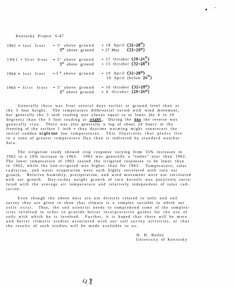
. .
Kentucky Project S-47
1961 - l a s t f r o s t - 5 ’ above ground3” above ground
1 9 6 1 - f i rs t f rost - 5 ’ above ground3” above ground
1964 - l a s t f r o s t - 5 ’ above ground
1964 - f i r s t f r o s t - 5 ’ above ground3” above ground
- 18 Apr i l (32-28’)- 27 May (32-28O)
- 27 October (28-24’)- 15 October (32-28’)
- 10 Apr i l (32-28’)10 April (below 24’)
- 10 October (32-28’)- 6 O c t o b e r (28-24’=)
Generally there was frost several days earlier at ground level than atthe 5 foot height. The temperature differential varied with wind movement,but generally the 3 inch reading was always equal to or lower (by 6 to 10degrees) than the 5 foot reading at &&. During the b the reverse wasgeneral ly t rue . There was also generally a lag of about 24 hours in thefreezing of the surface 1 inch - thus daytime warming might counteract theinitial sudden nightime low temperatures. This i l lustrates that p lants l ivein a zone of greater temperature flux than is indicated by standard weatherdata.
The irrigation study showed crop response varying from 55% increases in1962 to a 10% increase in 1963. 1963 was generally a “cooler” year than 1962.The lower temperature of 1963 caused the irrigated responses to be lower thanin 1962, while the non-irrigated was higher than for 1962. Temperature, solarr a d i a t i o n , and water evaporation were each highly correlated with corn eargrowth. Relative humidity, precipitation, and wind movement were not correlatedwith ear growth. Day-to-day weight growth of corn kernels was positively corre-lated with the average air temperature and relatively independent of solar rad-i a t i o n .
Even though the above data are not directly related to soils and soilsurvey they are given to show that climate is a complex variable in which ours o i l s e x i s t . Thus, the soil scientist needs to comprehend some of the complex-i t ies invo lved in order to prov ide bet ter interpretat ive guides for the use o fsoils with which he is involved. Further, it is hoped that there will be moreand better c l imat ic s tudies assoc iated with our so i l survey act iv i t ies , or thatthe results of such studies will be made available to us.
H. H. BaileyUniversity of Kentucky
NATIONAL COOPERATIVE SOIL SURVEY
NORTHEAST SOIL SURVEY WORK PLANNING CONFERENCE
1966
ORGANIC SOILS
REVIEW OF JANUARY 1968 REPORT OF THE NATIONAL COKHITTEE
By K. P. Wilson
Dr. R. S. Farnh&took over the chalrmanshlp of the 1965 nationalcommlttee from Dr. J. E. Lawson and presented revisions of the proposedscheme for classification of Histosols. Reports from all four regionswere rev Iewed. All four had conducted field trials of some nature, usingthe new system.
A. His tosol : - current definitlon (organic carbon vs. loss onignition were dlscussed es methods to use in determlnlng minlmum organiccontent. Soil Survey Laboratories to assist in deciding best method.)
B. The diagnostic horizon must be more than I2 Inches thick Ifdrained and more than 18 if undrained because of estimated inltlai sub-s idence. The surface 12 and 18 Inches are excluded. Whiteslde suggestedthat to avold unnecessary splitting of series where the organic layer isshallow to mineral, the upper 12 Inches If drained or 18 inches if notdrained not be Included with the diagnostic horizon except where theorganic horizons are less than 12 Inches thick.
C. The term “drained” should specify evidence of a plowed surfacelayer or other evidence of dralnage Indicating that Inltlal subsidence hasoccurred.
D. The National Committee discussed the problem of pH determlnatlon.A correlation of various methods was presented. It was pointed out thatpH in salt solutions was preferable to pN In water because (a) replacingpower of cations follows Iyotroplc series and (b) pH with water fluctuatesseasonally, generally increasing on drying. The commlttee suggested thepHydrion system with salt solution for quick fleld test or possibly theHelllge methods.

E. Diagnostic horizons: some changes made from 1963.
Type I Fibrlc Horizons - least decomposed.
(1 ) More than Z/3 fibers In total mass,’ bore than half ofwhich must be so well;preserved as to not change chromawhen rubbed wet or must resist becamtng disintegrated orgreasy.
(2) Increase one or more units In color value (Munsell) w h e n” press.ed w e t .
(3) Sodium pyrophosphate ext ract on white f l l ter paper ishigher in value~and lower In chroma than IOYR 7/3.
Type II Hemic (formerly Lenlc) - intermediate decomposition.
( 1 ) F i b e r content,between l/3 a n d Z/3 of total~mass.(2) If f iber more than 2/3, over half of fibers wi l l decrease
at least one unit fin chroma (fkmsell) when rubbed w e t .(3) If fiber more than 2/3~.qf total mass and does change
color when rubbed, then more than half of fibers areeasily broken down or become greasy when rubbed wet.
T y p e Ill Saprlc- most decomposed stage.
( 1 ) L e s s t h a n l/3 fiber In total’mass.(2) No color change when rubbed wet.
( 3 ) S o d i u m pyrophosphate,extract on white fflter paper Islower In value and htgh,er ,ln chroma than 1OYR 7/3.
.(4) The hlgh mineral content ,sapric horizons (more than50 percent mineral) have dry color values of 5 ormore. . .
F. Taxa of suborders
10.1 Saprists ‘.’1 0 . 2 Hemists1 0 . 3 Flbrists1 0 . 4 L e p t i s t s - lack diagnostic horizons which are sufficiently
thicki
G. Taxa ,of qreat qroups,.
Crylc. class - permafrost or Ice w,!thln control sectlon.Sphagno (Sphagnum moss) and Hypno Flbrists - unique, easy to
identify by their nature, Sphagno Is pH 5 or.less, Hypno isover 5.
The Dyslc and Eulc classes based on pH were removed from thegreat group level to the Typic subgroup only.
.
Ii.
I.
Taxa of Subqroups
Typic - Kind of horizon of Great Group dominates.Thaptlc - Buried mineral soil .in contro l sect ion.Limmic - Bog i r o n , marl etc. horizonClast lc - High mineral content in organic part of control
sect ion.Cumuiic - Alternate layers of organic and mineral.Stratic - Al ternat ing d i f ferent kinds of organic horizons.Lithic - Rock In control sectlon.Hydric - Like typic except HZ0 layer in control section.
Family criteria
CarbonatlcCalcareousSu iphurousFersuginousWoodyT o x i c e l e m e n t s - Al, Zn, etc.iE;;;;e of substratum - (weighted average)
Minnesota is piecing Hlstosols into series. Florlda has made goodprogress In placing series but has not proposed family names. In bothareas f ield men were able to use established criteria in f leid. inMinnesota a coded legend was used to train sol1 scientists in use ofsystem. Experience has shown that field estimates of organic matterare frequently too hlgh. Thls 1s not considered serious and willyield to correction as laboratory checking Is available.
New Jersey has done some detalled. trial mapplng of Tidal marshes,many of which wil l qualify as histosols. Usual d i f f icu l ty is quest ionof whether or not the partlcuiar soil wll l make a hlstosol. Muchalluvial silt is common. Mostnof these solls are Leptists with Inter-mixed kinds of horizons. The really big problem in the tidal marshesis access. A boat is needed at high tide and one is marooned at lowtide by the soft mud In the empty tidal guts. it Is a two-man jobfor safetys’ s a k e .
The inland mucks and peats the Wisconsin tlil area of North Jerseyare gradually being absorbed by urbanization. The Inland, extremelyacid, mucks of the South Jersey Coastal Plain are not being used much.
In a newly accelerated survey for Cape May the SCS has agreed torun profi le traverses across the tidal marshes at wide intervals.These are concerned mainly with depth to mineral which ranges from1 to 60 ft. It has been decided that more detalied studies willawait specif ic requests for on-site investigations.

.
- . NATIONAL COOPhmTIVE SOIL SURVEY
NORTHEAST SOIL SURVEY WORK PLANNING CONFERENCE
SPECIAL REPORT
Progress Report on the New Classification SystemBy: Dr. R. W. Simonson
Dr. Simonson summarized the level of generalization at each category inthe new system as follow:
Order _Suborder ::Great Groups - 170SUbgrOups 600FamilySeries 8,500
He also reviewed some of the changes in the June 1964 Supplement to the 7thApproximation. These included the following:
1. Fntisols
One suborder has been added (Fluvents). Five great groups have beenestablished in this suborder.
2. Vertisols
Two suborders have been added.
3. Inceptisols
There are no changes in suborders. Some great groups have been drop-ped and others added.
Some subgroups have been added.
4 . Aridosols
There are no changes in suborders. l%e great group "Paleargids" hasbeen added.
5. Kollisols
There are no changes in suborders. The following great groups havebeen added:
a. Bleustollsb. Palexerolls
Each great group has several subgroups.
.

.
6 . Spodosols
There are no changes in suborders. The following great groupshave been added:
I:. Tropaquods. Ropohumods
7. Alfisols
There are no changes in suborders. The following great groups havebeen added:
a. Tropaqualfsb. PaleustalfsC. Plinthustalfs
8 . Ultisols
There are no changes in suborders. The following great groups havebeen added:
a. Normihumultsb. Tropohumultsc. Tropoudultsd. Tropoustults
9. Oxisols
The old definition of the oxic horizon is not operational. A newdefinition is currently being developed.
Considerable work is needed to work out concepts of suborders andGreat groups in the order Oxisols.
Dr. Simonson made the following concluding statements: _._., .~,.
It will probably be three years before the classification scheme ispublished again. This publication will probably be composed of twoparts. The first part will consist of the general structure of thescheme (order to the subgroups). The second part will consistof.placement of series into families and those into subgroups.
Plans are to issue as soon as possible in the spring of 1966 asupplement to the 7th Approximation to replace the one Issued in19611.
Respectfully submitted,
/s/ Sidney A. L. PilgrimRecorder
.
.

NATIONAL COOPERATIVE SOIL SURVEYI
- .
. NORTHEAST SOIL SURVEY WORK PLANNING CONFERENCE - 1966
REVISIONS OF SOIL SERIES DESCRIPTIONSA. H. Paschal1
The recently revised SCS Soils Memo 11 outlines in detail the format, content,and the order for discussing items in the series description. The format, contentand order of items should be followed carefully.
The section on competing series needs to be complete. Some descriptions sub-mitted to the Principal Correlators office fail to mention the most obviouscompetitor. In contrasting competing series be sure to mention the soil charac-teristics which differentiate the soils - do not use family or class names.These may change.
The procedure for review of series descriptions should be followed. The Initialdraft should be prepared within the state and sent to neighboring and other inter-ested states for comment and review. These reviewers should give a carefulreview - check the proposed descriptions against somewhat similar soils withinthe state. The proposed series or revision may overlap the ranges of soilsrecognized in your state. Comments returned to the originating states should becomplete and should cover all conflicts or overlapping ranges. The originatingstate reviews these comments and incorporates or rejects them. A revised draftis then prepared for submission to the Principal Correlator for approval andduplication. The originating state prepares a statement summarizing all commentsreceived from outside states and the action taken on each comment. This shouldbe one statement and not merely a copy of each individuals comment. Three copiesof this sumnary statement should accompany the eight copies of the revised draftsent to the Principal Correlators office.

c
- .
.
NATIONAL COOPEKATIVE SOIL SURVEY
NORTHFAST SOIL SURVEY WORK PLANNING CONFERENCE - 1966
PROJECTED SOIL SURVEY SCHEDULEL. E. Garland
The publication schedule for fiscal years 1966, 1967, 1968 and 1969 indicates adecided attempt to increase the number of surveys to be published annually. Thisescalation procedure involves all phases of the soil survey program if we are tosubmit the proposed numbers of manuscripts and maps to the printers in the fiscalyears indicated, Scheduled dates for field correlations, final correlations,submission of field sheets to cartographic and submission of report manuscriptsfor editing have to be realistic in terms of meeting the objectives of a qualityproduct as well as increase in quantity. If we are to increase our output andmaintain an acceptable level of quality we must have adequately prepared materialfor each stage of the process. It is not sufficient to forward corralations orreport manuscripts simply to meet a deadline. We must emphasize both qualityand quantity and recommend realistic submission dates that will provide both.Once the timing of the steps in the publication process has been agreed upon itis imperative that they be completed as scheduled in order to maintain an orderlyflow of published surveys, Table 1 susrnarires the survey areas (mainly bycounties) that are presently scheduled for submission to the printers in thefiscal year indicated.
Table 1 - Projected Soil Survey Publication Schedule(B:$:.e,i upon submission to printers in fiscal year indicatedgruerally 18 to 24 additional months will be required in theprinting process)
A. Manuscripts and maps to be submitted to printers in fiscal 1966
1. Franklin, Mass. 7. Metcalfe, Ky.2. Somerset, Md. 8. Tucker and Northern Randolph, W.Va.3. Queen Anne’s, Md. 9. Indiana, Penno.4. Caldwell, Ky. 10. Columbia, Penna.5. Henderson, Ky. 11. Prince Georges, Md.6. Adams, Penna. 12. Montgomery, Penna.
13. Columbiana, Ohio
B. Manuscripts and maps to be submitted to printers in fiscal 1967
1. Ross, Ohio2. Barbour, W.Va.3. Carroll , Va.4. Fayette, Ky.5. Harrison, Ky.6. Westmoreland, Penna.7. Howard, Md.8. Montgomery. Va.
.
l .
.
l
9. Carroll, Md.10. Genesee, N.Y.11. Schoharie, N.Y.12. Preble, Ohio13. Plymouth, MSS.8.14. Androscoggin-Sagadahoc, Me.15. Berks, Penna.16. Salem, N.J.17. Belknap, N.H.
55
C . Manuscripts and maps to be submitted to printers in fiscal 1968( p r e l i m i n a r y )
1.2.3.
;:6.
::9.
Barren, Ky. 104Pike, Penna. 11.Wicomico, Nd 6 1 2 .Delaware, Ohio 13.McCreary-Whitley, Ky. 14.Ore&e, Va. .15.Mahoning, Ohio 16.Talbot. Nd. 17.Pulton, Penna. 18 . .
Wood-Wirt, W.Va.Mercer, N.J.Champaign, OhioNew Castle, Del.Litchf ield, Corm.Cayuge, N.Y. .
Addison, Vt.Seneca, N.Y.Broome, N.Y.
D. Manuscripts and maps to be submitted to printers in fiscal 1969‘.‘.(preliminary)
~. ‘2.
1.2.3.
::6.7.
11,’ Calvert, Md.12. Forest, Ky.
1 3 . Mercer’, Penn%.1 4 . Greenbriar, W.Va.15. Kent, Del.ljj..;,Mqnroe, N-T.17. Burllnnton. N.J.
Erie, OhioM a d i s o n , V a .Van Wert, OhioHancock, OhioWorcester, Md.Fayet te , Penna.Dauphin, Penna.
,, a. Nelson, Kg.:9. ~~-P.&tnbuu!.a,. Ohi6:~.10. Sb.‘Sbinerset, Me.
. .
. .
18.19.
Prince-Wilifam,: Va;Warren, Ohio, ‘..’ ’
:,23, S~terk, bhf’o
.
*
. I
.
.“,
.
. ’
.
l
l .Ithaca, New York,Rev. Upper Darby,_ __ __ _ -
5-8-63Pa.
Z-11-bb - A. J. Baur
NORTHFAST COOPERATIVE SOIL SURVEY WORK PLAtiNING CONFERENCE
Organization and Operation
This is a brief statement on the organization end operation of the NortheastCooperative Soil Survey Work Planning Conference. The statement is based oncorrespondence and available minutes of meetings beginning in 1955. Prior to1955 the Soil Survey Subcommittee of the Northeast Soil Research Committee ingeneral handled some of the kinds of activities now conducted by the NortheastCooperative Soil Survey Work Planning Conference. Due to overlapping ofactivities the Northeast Soil Research Cowittee discharged its Soil SurveySubcommittee in 1964. Written and verbal liaison is, however, being maintainedbetween the Northeast Soil Research Committee and our Conference.
1. Purposes: This conference provides an opportunity for direct contributionof ideas and information for improvement of the technical aspects of soilsurvey. It also contributes to uniformity in understanding concepts aboutsoils, their classification, mapping and interpretation. Since soil surveyis cooperative among several agencies, it is necessary to have exchange ofideas. An effective soil survey must be coordinated in our own states andthroughout the United States.
Most of the work of the conference is done by committees; committee reportsare presented to the conference and if approved are disseminated to soilscientists in the Northeast and they are also made available to the NationalCooperative Soil Survey Technical Work Planning Conference. In addition tothe Committee reports, special topics are presented in lectures, discussions,or in the form of a symposium.
2. Participants:(a) Soil Survey leaders from cooperating agencies (SCS, Am. Wt. Sta.,
Other agencies)
(b) One or more Administrative Officer of SCS attends meetings of theConference. Administrative officers of other agencies are welcometo attend.
3. Meetings: The current pattern is for the conference to meet bi-annuallyin alternation with the bi-annual meetings of the National Cooperative SoilSurvey Technical Work Planning Conference.
In order to economiee travel funds for Experiment Station Soil SurveyRepresentatives the scheduling of the conference is coordinated with theNortheast Soil Research Committee Meeting. This usually falls in the lastweek in January. Three or four days are allotted for the work of the
. conference.
.
* Page 2 - Northeast Cooperative Soil Survey Work Planning Conference- Organization 6r.d Operation.
4. Officers and Dut&i: Activities >f the conference are directed by anexecutive board consisting of the chairman, vice chairmen, past chairmenand the Principal Soil Correlator, ex officio, A secretary pro tern isdesignated for each meeting of the conference (the executive board wascreated by vote of the conference in ‘1957, amended in 1958). A vicechairman is elected at each bi-annual meeting and he automatically succeedsas chairman. The common practice is to rotate election of the vice chair-man between the SCS and a representative of one of the other cooperatingagencies.
The chairmen takes leadership with help from the executive board indeveloping programs for conference meetings and other activities.
5. Past Officers:
Date of ConferenceJanuary 1955January 1956February 1957January 1958January 1960January 1962January 1964January 1966
ChairmanLyfordLyfordDonahueCotnbirHowardMetelskiQuakenbushD. E. Hill
Vice chairman_
PattonHowardRourbesuQuakenbushD. B. HillF. G. Loughry

. . .
UNITEU STATSS DEPARTMENT OF AGRICULTURESoil Coneervatfon Service
MEMORANDUM DAT&: August 9, 1966
TO : state CnnGervntionlsts, SC.5Northeastern States
FROH: Dr. Arnold J. Baur, Principal Soil CorrelatorRTSC. Upper Darby, Pennsylvania
RE : SOILS -. Supplement to NE Committee Report on "Made Soils"
ATTENTION: State Soil Scientists
lincloscd are copies of descriptions of "Made Soils" whichare a supplement to the "Made Soils" Committee Report ofour Northeast &operative 6011 Survey Work Planning Cw-ference. Mr. Hershbergar as Chairman of this Committeeassembled these materials vhlch includes sample descrip-tions from Kentucky, Maryland, Delaware, Massachusetts,and West Virgfnia.
cet R. D. HocksnsmithD. E. HillH, E. Tower
. .
West Ill'rginia5-23-66
DESCRIPTION OF MADE SOIL ON STRIP MINE SPOIL
The following descriptions are from a randomly selected transect onan area of graded strip mine spoil. The transect was perpendicular tothe high wall, to provide a cross section of the spoil material. Thehigh wall is approximately on the contour, parallel with the coal seam.The coal had been covered and the spoil material graded in acoordancewith regulations governing s
!!face mining of coal in West Virginia.
The area had been graded in 964.
The adjacent soils are mainly in the Gilpin and Wharton series.
The transect crossed the whole graded area. As the transect was onlyabout 150 feet long, only 5 sample points are recorded. These are spacedat 30 foot intervals.
Profile No. 1 (nearest high wall)
O-2"--Very dark grayish-brown (2.5Y 3/2) very shaly light silty clayloam, massive; friable; 50-60s fine shale fragments; pH 4.2;clear smooth boundary.
2-40"+--Olive brown (2.5Y 4/4) silty clay loam; common lumps of gray(2.5Y 5/O) silty clay; slightly plastic; non-sticky; few blackcoal and shale fragments; approximately 805 coarse fragments;pH 4.4.
Approximate size distribution of coarse fragments:30$ larger than 3"30% l/2" to 3"20$ less than l/2"20$ less than 2mm
Profile No. 2
0-l"--Dark grayish-brown (2.5Y 4/2) very shaly light silty clay loam;massive; friable; approximately 60% fine shale fragments; pH 4.5;clear smooth boundary.
l-40"+--Dark grayish-brown (2.5Y 4/2) silty clay loam; co-n lumpsof gray (2.5Y 4/O) silty clay; plastic; slightly sticky;approximately 755 coarse fragments. pH 4.0.
Approximate size distribution of coarse fragments:10s larger than 3"3051 1/2'larger than 3"35$ less than 112"25% less than 2s~~
Profile No. 3
0-l"--Dark grayish-brown (2.5Y 4/2) very shaly silty clay loam;massive; friable; 50-66 fine shale fragments; pH 4.8; clearsmooth boundary.
. ..
2
i-4ov+--owe brown (2.5Y 4/4) silty d.8~ loam; 10% hi3p OP pay(2.5Y 4/O) clay; massive; firm; plastic and non-sticky;approximately EK$ coarse fragments; pH 4.0.
Size distribution of coarse fragments:lO$ larger than 3"209 l/2" to 3"50s less than l/2"205 less than 2mm
Profile No. 4
0-l"--Dark grayish-brown (2.5Y 4/2) very shaly silty clay loam;massive; friable; 50-60$ fine shale fragments; clear smoothboundary; pH 4.0.
l-40"L-Olive brown (2.5Y 4/4) very shaly silty clay loam; massive;friable; plastic and non-sticky; 20$ gray (2.5Y 4/O) silty clay;approximately 805 coarse fragments; clear smooth boundary.pH 4.2.
Size distribution of coarse fragments:20$ larger than 3"205 l/2" to 3"40% less than l/2"20s less than 21mn
Profile No. 5 (near outer slope)
0-l"--Olive brown (2.5Y 4/4) very shaly silty clay loam; massive;friable; 50-60% fine shale fragments; clear smooth boundary;pH 4.5.
l-40"+--Olive brown (2.5Y 4/4) silty clay loam with lumps of clayloam and gray (2.5Y 4/O) clay; nwsive; friable; plastic andnon-sticky; &3$ coarse fragments; smooth clear boundary.pH 4.2.
Size distribution of coarse fragments:;io*lp larger than 3"20s l/2" to 3"40s less than l/2"205 less than 2mm
NOTE: This profile is noticably less compacted and more moist thanthe others.
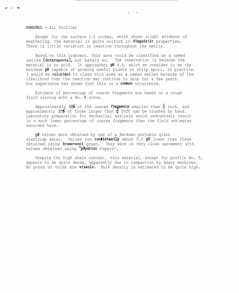
,# ., -.. .
REMARKS - All Profiles
Except for the surface l-2 inches, which shows slight evidence ofweathering, the material is quite uniform in diagnistic properties.There is little variation in reaction throughout the matrix.
Based on this transect, this area could be classified as a namedseries (Arthropents), but barely so. The reservation is because thematerial is so acid. It approaches pH 4.0, which we consider to be theminimum pH capable of growing useful plants on strip spoil. In practice,I would be relwztant to class this area as a named series because of thelikelihood that the reaction may continue to drop for a few years.Our experience has shown that this is a cormnon occurrence.
Estimate of percentage of coarse fragments are based on a roughfield sieving with a No. 4 sieve.
Approximately 504: of the coarse frapents smaller than $ inch, andapproximately 25s of those larger than r inch can be crushed by hand.Laboratory preparation for mechanical analysis would undoubtedly resultin a much lower percentage of coarse fragments than the field estimatesrecorded here.
pH values were obtained by use of a Beckman portable glasselectrode meter. Values run consistantly about 0.5 pH lower than thoseobtained using Bromeresol green. They were in very close agreement withvalues obtained using "pHydrion Papers".
Despite the high shale content, this material, except for profile No. 5,appears to be quite dense, apparently due to compaction by heavy machines.No pores or voids are visable. Bulk density is estimated to be quite high.
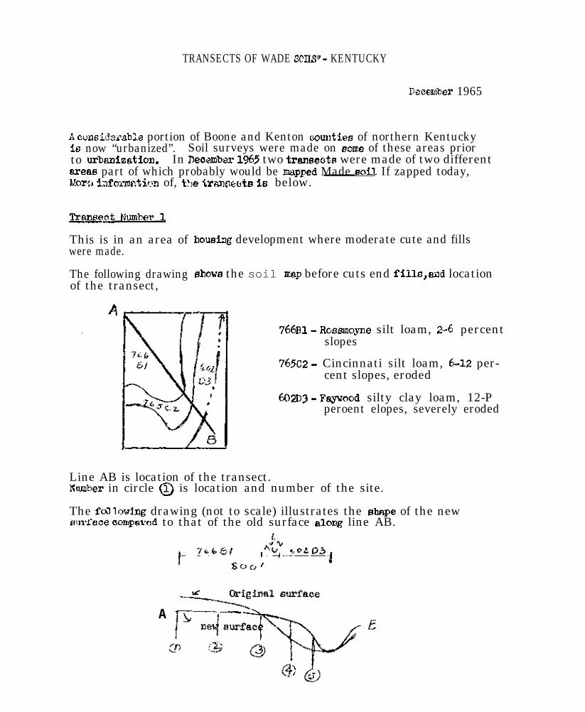
TRANSECTS OF WADE SCIIS” - KENTUCKY
Decer&er 1965
A ooosidmable portion of Boone and Kenton kxmtiee of northern Kentuckyis now “urbanized”. Soil surveys were made on some of these areas priorto urbanization. In Beomber 1965 two transeotfl were made of two differentareas part of which probably would be mapped Made soF1 If zapped today,Mom ~;lfoimcti~~n of, t?le trameeets ie below.
Trsnpeat Number 1
This is in an area ofwere made.
The following drawingof the transect,
housiag development where moderate cute and fills
showa the soil zap before cuts end fillo,mwd location
766~1 - Bosmoyne silt loam, 2-C percentslopes
765~2 - Cincinnati silt loam, 6-12 per-cent slopes, eroded
602D3 - Fayvood silty clay loam, 12-Pperoent elopes, severely eroded
Line AB is location of the transect.Kmber in circle (iJ is location and number of the site.
The fa’llowing drawing (not to scale) illustrates the shape of the newslmkce contpavod to that of the old surface along line AB.
A
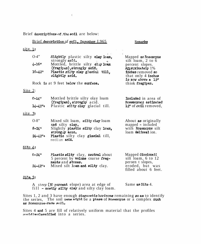
.
Brief desoriptima r&_tha eail are below:
Brief desarintion of woil&e~~r I.965- -
site 1.-._*
O-4” Slightly plastic silty Ki.ay loam,strongly a&L
4-X6* Mottled, brittle silty c&y ld&
16-42fl(fragipan),strongly aoid.Plmtic oilty clay g?.rici&l 2111,~llghtly aaid.
Rock ia at 9 feet below the surfaoe.
Site 2:
0-l4”
l&42%
site 3:
O-8”
8-24”
Z-42”+
F&te$
O-24”
24-42’+
Mottled brittle silty olay loam(fragipm), s:rongly acid.Plastic silty olay glacial till.
Mixed silt loam,and silty olay.Slightly plastic
rri1ty alay loam
silty clay lo&qmrongg runa,Plaetio silty clay glaoial till,medium aaid.
Plastio silty clay,5 percent by vollrmeme&s and stone%.Mixed silt Loam and
neutral aboutcoarse freg-
silty clay.
A s t e e p (3 peraentf i l l - meetly silty
elope) area at edge ofalay and silty clay loam.
Mapped BE Roesmclynesilt loam, 2 to 6percent slopes.Aw#Cxircately 1%inoheo removed eothat only 4 inohesiB llOW above B 12”thiok fragipan.
Inoluded in area ofRossmoyno; e&mated12” of ceil removed,
About aa originallymapped - includedwith Roswmoyne siltloam delineat ion.
Mapped Cincimatisilt loam, 6 to 12peroen t slopes,eroded, but wasfilled about 6 feet.
Same aa Site 4.
Sites 1, 2 and 3 have enough diwyostio hori~.cm remaining 80 a8 to identifythe series, The soil XWJUIB mQht be a phase of Roeemoyne or a complex such86 Rosmope-Made POJL
Sites 4 and 5 are fill of relatively uniform material that the profilesnmrld be *l.afdfied into a series.
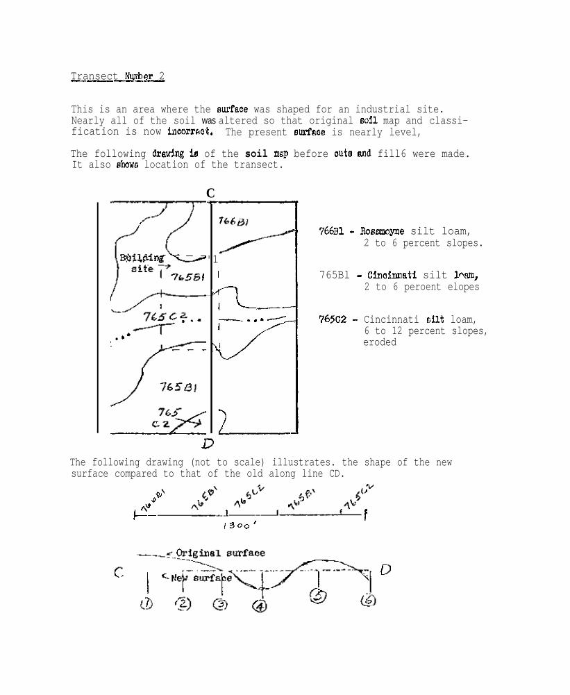
Transect Nuzber 2-_----I_
This is an area where the surfaoe was shaped for an industrial site.Nearly all of the soil was altered so that original soil map and classi-fication is now incorrsct. The present surfnoe is nearly level,
The following draw- is of the soil map before oute and fill6 were made.It also &owe location of the transect.
CC
'1I
A
I
I
1
3
L--L--.,.-
I//i!_---
766al - RosEnnoyae silt loam,2 to 6 percent slopes.
765Bl - Cinoinnati silt Pam,2 to 6 peroent elopes
765C2 - Cincinnati silt loam,6 to 12 percent slopes,eroded
The following drawing (not to scale) illustrates. the shape of the newsurface compared to that of the old along line CD.
YP'
~+z-1300’
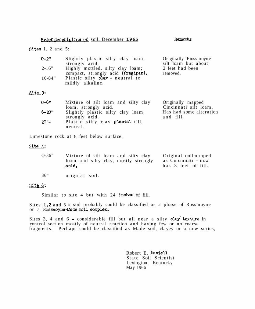
&&J deaorirt3.on& soil. December 1965
sites 1. 2 and 5:
O-2” Slightly plastic silty clay loam,strongly acid.
2-16” Highly mottled, silty clay loam;compact, strongly acid (fragipan).
16-84” Plastic silty olay - neutral tomildly alkaline.
Originally Fiossmoynesilt loam but about2 feet had beenremoved.
o-6” Mixture of silt loam and silty clayloam, strongly acid.
6-2~’ Slightly plastic silty clay loam,strongly acid.
20”+ Plastio silty clay glaoial till,neutral.
Originally mappedCincinnati silt loam.Has had some alterationand fill.
Limestone rock at 8 feet below surface.
SLte 4:
O-36” Mixture of silt loam and silty clay Original ooilmappedloam and silty clay, mostly strongly as Cincinnati - nowaoid. has 3 feet of fill.
36” original soil.
-6:
Similar to site 4 but with 24 inohes of fill.
Sites 1,2 and 5 - soil probably could be classified as a phase of Rossmoyneor a Rossmoyne-Made s$L complex.~.
Sites 3, 4 and 6 - considerable fill but all near a silty clay‘texture incontrol section mostly of neutral reaction and having few or no coarsefragments. Perhaps could be classified as Made soil, clayey or a new series,
Robert E. Daniel1State Soil ScientistLexington, KentuckyMay 1966
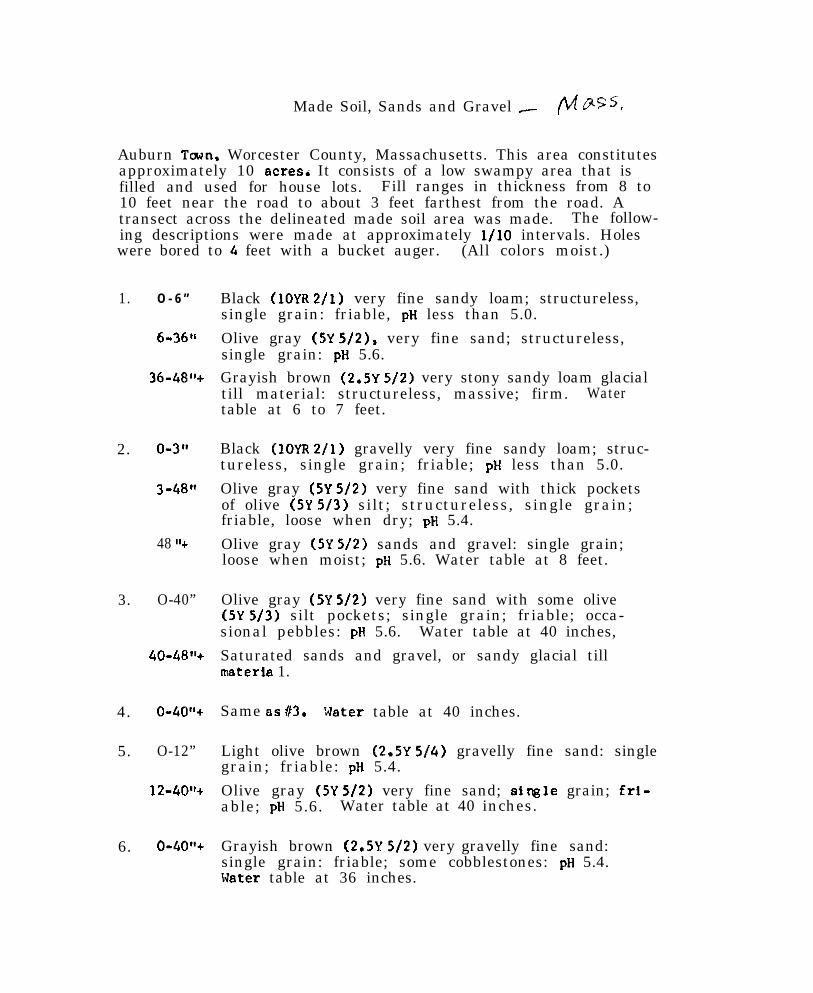
Made Soil, Sands and Gravel _ /Lz G*ss,
Auburn Town. Worcester County, Massachusetts. This area constitutesapproximately 10 acres6 It consists of a low swampy area that isfilled and used for house lots. Fill ranges in thickness from 8 to10 feet near the road to about 3 feet farthest from the road. Atransect across the delineated made soil area was made. The follow-ing descriptions were made at approximately l/10 intervals. Holeswere bored to 4 feet with a bucket auger. (All colors moist.)
1. O - 6 ”
6-36”
36-40%
2. O-3”
3-48”
48 “+
3. O-40”
&O-f&“+
4.
5.
O-40”+
O-12”
12-40’~
6. O-40”+
Black (10YR 2/l) very fine sandy loam; structureless,single grain: friable, pH less than 5.0.
Olive gray (5Y 5/2), very fine sand; structureless,single grain: pH 5.6.Grayish brown (2.5Y 5/Z) very stony sandy loam glacialtill material: structureless, massive; firm. Watertable at 6 to 7 feet.
Black (IOYR 2/l) gravelly very fine sandy loam; struc-tureless, single grain; friable; pH less than 5.0.
Olive gray (5Y 5/2) very fine sand with thick pocketsof olive (5Y S/3) silt; structureless, single grain;friable, loose when dry; pH 5.4.
Olive gray (5Y 5/2) sands and gravel: single grain;loose when moist; pH 5.6. Water table at 8 feet.
Olive gray (5Y S/2) very fine sand with some olive(5Y 5/3) silt pockets; single grain; friable; occa-sional pebbles: pH 5.6. Water table at 40 inches,
Saturated sands and gravel, or sandy glacial tillmateria 1.
Same BS 63. 51ater table at 40 inches.
Light olive brown (2.5Y 5/4) gravelly fine sand: singlegrain; friable: pH 5.4.
Olive gray (5Y 5/2) very fine sand; single grain; frl-able; pH 5.6. Water table at 40 inches.
Grayish brown (2.5Y 5/2) very gravelly fine sand:single grain: friable; some cobblestones: pH 5.4.Nater table at 36 inches.
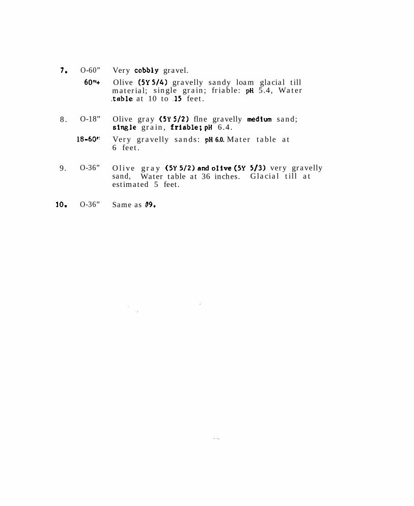
7. O-60”
60”+
8. O-18”
18-60’:
9. O-36”
10. O-36”
Very cobbly gravel.
Olive (5Y S/4) gravelly sandy loam glacial tillmaterial; single grain; friable: pH 5.4, Water,table at 10 to .15 feet.
Olive gray (5Y 5/Z) flne gravelly medium sand;single grain, frfable; pH 6.4.
Very gravelly sands: pH 6.0. Mater table at6 feet.
Olive gray (SY 5/Z!) mid oIive (5Ysand, Water table at 36 inches.estimated 5 feet.
Same as 89.
513) very gravellyGlacial till at
..,
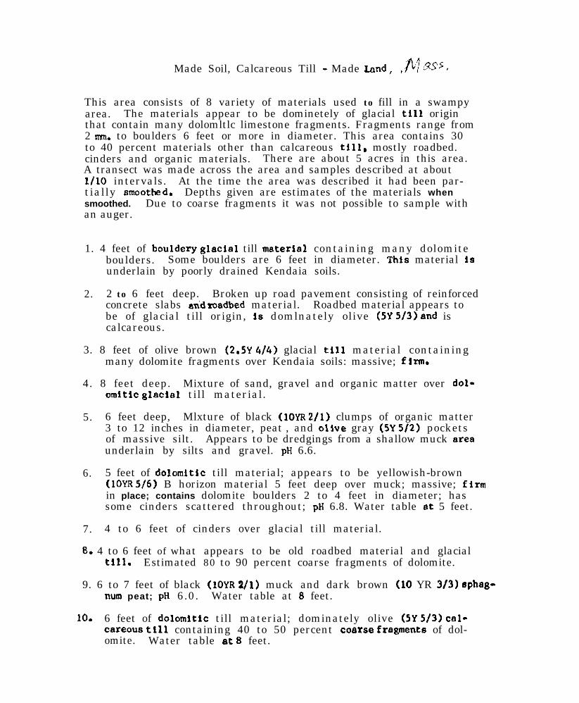
Made Soil, Calcareous Till - Made Land, fij &ss,,’
This area consists of 8 variety of materials used to fill in a swampyarea. The materials appear to be dominetely of glacial till originthat contain many dolomltlc limestone fragments. Fragments range from2 run. to boulders 6 feet or more in diameter. This area contains 30to 40 percent materials other than calcareous till, mostly roadbed.cinders and organic materials. There are about 5 acres in this area.A transect was made across the area and samples described at aboutl/l0 intervals. At the time the area was described it had been par-tially smootkd. Depths given are estimates of the materials whensmoothed. Due to coarse fragments it was not possible to sample withan auger.
1. 4 feet of bouldery glacial till material containing many dolomiteboulders. Some boulders are 6 feet in diameter. This material isunderlain by poorly drained Kendaia soils.
2. 2 to 6 feet deep. Broken up road pavement consisting of reinforcedconcrete slabs androadbed material. Roadbed material appears tobe of glacial till origin, is domlnately olive (5Y 5/3) and iscalcareous.
3. 8 feet of olive brown (2.5Y 4/4) glacial till material containingmany dolomite fragments over Kendaia soils: massive; firm.
4. 8 feet deep. Mixture of sand, gravel and organic matter over dol-omltic glaclsl till material.
5. 6 feet deep, Mlxture of black (1OYR 2/l) clumps of organic matter3 to 12 inches in diameter, peat , and olive gray (5Y 5/2) pocketsof massive silt. Appears to be dredgings from a shallow muck are8underlain by silts and gravel. pH 6.6.
6. 5 feet of dolomltIc till material; appears to be yellowish-brown(IOYR 5/6) B horizon material 5 feet deep over muck; massive; firmin place; contains dolomite boulders 2 to 4 feet in diameter; hassome cinders scattered throughout; ptl 6.8. Water table 8t 5 feet.
7. 4 to 6 feet of cinders over glacial till material.
8. 4 to 6 feet of what appears to be old roadbed material and glacialtill. Estimated 80 to 90 percent coarse fragments of dolomite.
9. 6 to 7 feet of black (IOYR 1/l) muck and dark brown (10 YR 3/3) spheg-num peat; pH 6.0. Water table at 8 feet.
10. 6 feet of dolomltic till material; dominately olive (5Y 5/3) cal-careous tIl1 containing 40 to 50 percent co8rse fregments of dol-omite. Water table 8t 8 feet.

TRANSECT OF WADR SOIL”, Sandy over Organic - MARYLMD
Transect of an area mapped ae Made Land. Site appears on WorcasterCounty soil map ANN 25-136, 1938 flight. eoutheaet eide of thePocomoka River, in the tow of Snow Aill, Maryland.
Site #l: 10 feet from edne of river.
;::;;,,olive gray (5Y 4/2) candy loam.light yellowish brown (1OYR 6/4) loany eand.
18-2CF’ very dark grayish brown (IOYR 3/2) mucky eand.20-36” light brownish gray (2.5Y 6/2) rand, wet below 30 inchee.36-66” light brownish gray (2.5Y 612) sand mixed with aaw duet
and larger chipa of wood.
Site P2: 20 feet routheaet of aite 61.
O-8” olive gray (5Y 412) aandy loam.8-14” light yellowish brown (IOYR 6/4) loamy rend.14-20” black (1OYR 2/l) mucky rilt loam and wood chipe.20-36” greyiah brown (2.5Y S/2) eand mixed with come black
material and wood chips.36-60” light brownish gray (2.5Y 6/2) sand, wet.60-6@’ dark brown (7.5YR 3/2) muck end wood chipe.
Site #3: 20 feet aoutheaet of eite #a,
O-5” olive gray (5Y 4/2) aandy loam.5-2W’ light yellowlrh brown (1OYR 6/4) loemy rend.20-42” light brownfeh gray (2.5Y 6/2) light loamy aand, wet
below 35 incher.42-54” very dark grayieh brown (1OYR 3/2) muck and wood chipe.54- 66” black (IOYR 2/l) muck, wood chfpr with sand lenree.
s i t e 84: 2 0 f e e t southeaet of cite #J.
O-5” olive gray (5Y 4/2) candy loam.s-3(Y’ light yellowirh brown (1OYR 6/4) light loamy r end .30-66” black (1OYR 2/l) muck with a few fine sand lcnree end
wood fragments.
s i t e #5: 3O_fest southeast of rite 14.
O-6” light olive brown (2.5Y 514) sandy loam.6-24” olive gray (5Y S/2) loamy sand.24-60” l ight yellowieh brovn (1OYR 6/4) light loemy rend, wet
below 50 incher.
- ,. .
TRARSPCT OF “PIADE SOIL”, Sandy and Clsysy - DELAWARR
This area wss mapped as Made Land. Sites examined 100 feet apartnear Summit Bridge in material dredged from the Chesapeake andDelaware Canal.
s i t e il. o- 18”
18-30”
30-48”+
Site P2. o- 12”
12- 18”
18-36”+
Site #3. O-6”
6- 18”
l&24”+
Site 64. o- 12”
12-24”
24-36%
Site #S. O-24”
24-30’9
Yellowish brown (1OYR S/4) and light brownishgray (1OYR 6/2) in equal proport ions; f inesandy loam with moderste amounts of gravel up tot”; structureless and loose.
Dark brown (7.5YR 414) with 10% gray (1OYR 6/O),silt loam; massive and somewhat firm.
Dark grayish brown (1OYR 4/2) and light brovniahgray (IOYR 6/2) in equal amounts; fine sandyloam; maesive.
Equal proportiona of brown (7.5YR 4/4) and red(2,SYR 4/6), silty clay; msssive; s o m e f i n egravel .
G r a y (1OYR 6/l), silt loam; massive.
Rounded gravel ranging from v’ to 1”.
Yel lowish brown (1OYR S/6) with 30% light gray(1OYR 7/l), fine sandy loam; etructureless andloose.
B l a c k (1CYR 2/l), silty clay; masaive; f i rm;hiShly p l a s t i c .
Equal proportiona of pinkish brown (7.5YR 7/2)and red (2.5YR 4/6), clay; massive; very firm.
Dark yellowish brown (1OYR 4/4). loamy finesand; s tructureless ; loose.
L i g h t g r a y (1OYR 7/2), s i l t ; s t r u c t u r e l e s s ,f r i ab l e .
Dark yellowish brown (1CYR 4/4) with 20% brown(IOYR S/3), loose sand.
Dark yellowish brown (IOYR 4/4), gravelly sandyloem; s tructureless ; loose.
Pale brown (1OYR 6/3), looae send.
. ..+
Site #b.
site f7.
Site #a.
. site 89.
O-.24”
24-40”+
O-20’
20-34”
0- 18”
o- 18”
18-30”+
Site 110. O-36“
Brmmish yellow (IMR 6/6), loose fin6 64.
LQht brOunish,gray (I(?fR 6/2), 10~166 f i n e 6Md.
Yellowish brown (IOYR s/4). Cosree loamy sandistructurelescl; loose.
Grayish brown (1OYR S/2). loose fine Sand.
Yellowish brown (IOYR S/4) loamy sand and Srey(1OYR 6/l), silt; rtrufturelero b u t f r i a b l e .
Equal proportions of yellowirh brown (1OYR S/6)and dark grayish brown (IOYR 4/2), sandy clay;musive; slightly sticky and pla6tic.
Yellowish brown (IOYR S/6) loose loamy sand vith20% very dark grayish brown (IOYR 3/2) massivesandy Clay.
Same a6 above but in equal proportions.
Yellovirh brown (1OYR S/6), loose fine sand.
NATIONAL COOPERATIVE SOIL SURVEY
Northeast Regional Conference Proceedings
New York CityJanuary 20-23, 1964
Planned Actions Benchmark Soils and Technical Soil Monographs, . . . . . . . . . . . . . . 1Stoniness, Rockiness
Minutes of Meeting . . . . . . . . . . . . . . . . . . . . . . . . . . . . . . . . . . . . . . . . . . . . . . . . . . . . . . . . . . . . . . . . . . . . . . . . . . . . . . . . . .4
Benchmark Soils.. .................................................................................... 7
Soil Correlation.. ...................................................................................... 12
Laboratory Characterization of Soils.. ......................................................... 18
Soil Moisture.. ......................................................................................... 21
Technical Soil Monographs ........................................................................ 31
Soil Surveys in Urban-fringe Areas.. ........................................................... 35
National Committee Reports Discussed Organic Soils.. ................................. 4 2
Climate - Soil Classification and Interpretation.. ........................................... 45
Criteria for Series, Types and Phases ......................................................... 4 5
Soil Morphology.. ..................................................................................... 4 5
Shape of Soil Areas .................................................................................. 4 6
Soil Texture.. ........................................................................................... 4 6
Special Topics.. ....................................................................................... 50

4
i
PROCEEDINGS OF THE
NORTHEAST COOPERATIVE SOIL SURVEY4
WORK-PLANNING CONFERENCE, !!“A y’.
NEW YORK CITY
JAN. 2@23,1%4
NATIONAL COOPERATIVE SOIL SURVEY
NORTHEAST SOIL SURVEY WORK PLANNING CONFERENCE
1964
.
SUM’ARY OF PLANNED ACTIONS AND ASSIGNMENTS
The Conference di rected the Chairman to summarize all subjects thatwou ld ho ld spec ia l concern fo r admin is t ra to rs . These fol I ow.
REPORTS ON DENCi-llM?K SOILS
This no ta t ion is to assure tha t D i rec tors o f Exper iment S ta t ions andState Conservat ionists, SCS, are informed about these reports onbenchmark soi is. These pub l i ca t ions b r ing in to s ing le vo lumesa v a i l a b l e d e s c r i p t i v e , a n a l y t i c a l , a n d I n t e r p r e t a t i v e d a t a o n i n d i -v i d u a l k e y s o i l s , Th is da ta o therw ise remains la rge ly sca t te redand unava i lab le . Usually it would come from more than one stateand more than one agency.
E igh ty -one key so i l s o f the Nor theas t a re a l lo t ted among the s ta tesf o r t h e s e r e p o r t s . Compi la t ion o f the da ta fo r each o f two so i l sfo r wh ich repor ts a re in p rogress , is est imated to have taken ap-p r o x i m a t e l y 100 man-days . Wr i t ing , o f course , wou ld take add i t iona lt i m e . In te res t in these compi la t ions an tedates the 1960 reg iona lconference at which t ime at least one report per state per year wasproposed. As of January 1964 two had been completed, one was atpress, and f ive others were in progress. Assignment of men andschedu l ing o f t ime are impor tan t i f th is work i s to be done.
The subject is covered more fu l ly in the accompanying Report of theCommittee on Benchmark Soi Is,
TECHNICAL SOIL WONCGRPFHS
Assignment of an author, o r au thors , w i th re lease f rom o ther du t iesis needed i f these monographs wi l l be wri t ten.
Techn ica l so i l monographs by so i l a reas a re p rov ided fo r in So i l sMemorandum 39, March 29, 1961, of the Soil Conservation Service.That memorandum states the SCS policy to publish the monographs andsuggests aul-hors f rom other agencies.
These monographs are proposed to make conveniently available dataon the b road range o f so i l s over ma jo r a reas o f so i l s im i la r i t i es .This data would concern soi l morphology, environment and analyses.From i t i n te rp re ta t ions cou ld Ije made in to so i l genes is and use .The monographs would provide reference mater ia l . They should beuse fu l i n teach ing and p lann ing research ,
Summary - 2 -
The 1962 Conference establ ished seven areas in the Northeast for eachof which a monograph would be wri t ten, I t p repared an ou t l i ne fo rt h e w r i t i n g . I t p roposed au thors . I t developed a schedule for com-plet ion of s ix of the monographs dur ing 1964 through 1967. Essen-t ia l ly no progress can now be reported.
Six to twelve man-months of uninterrupted work by the pr incipalau thor a re es t imated to be requ i red . There likely would be some workof associate authors and those supplying data.
Th is sub jec t i s p resented rrore fu l l y i n the repor t o f the Commi t teeon Techn ica l So i l k!onographs.
REVIEW OF THE CLASSIFICATION OF STONINESS, ROCKINESS
P r o p o s a l s f o r a r e v i s i o n o f t h e c l a s s i f i c a t i o n o f s t o n i n e s s o f s o i l swere submit ted. A s tudy o f the c lass i f i ca t ion o f s ton iness androckiness was deemed to be warranted. A committee was named to makesuch a study and to report to an appropr iate nat ional committee byJanuary 31, 1965. Th is reg iona l commi t tee cons is ts o f A .H. PaschalI,Cha i rman: R . A . Far r ing ton , R . T . Marsha l l , 8. J . Pat ton ,J. A. Pomerening, R. F. Reiske, and A. E. Shearin.
Accompanying in the report of the Conference is a paper by Robert F.R e i s k e o n “ C l a s s i f i c a t i o n o f S t o n i n e s s ” .
PROVISIONS FCR THE FUTURE OF THE CONFERENCE
I . I t was planned that the Conference should be cont inued. Thenext meet ing wou ld ten ta t i ve ly be he ld in 1966.
2 . The Committee on Benchmark Soils would be a working committeedur ing the in te rva l be tween con fe rence meet ings , to coord ina te thework on the reports on these soi Is. Wembers, one f rom each state,are l is ted in the report of that commit tee but some changes arep o s s i b l e .
2. The commi t tee to s tudy the c lass i f i ca t ion o f s ton iness androck iness , s ta ted in the fo rego ing , i s a work ing commi t tee .
4 . The Chairman of the 1966 meet ings and the intervening interestsis Dr . Dav id E . H i l l , Connect icu t Agr icu l tu ra l Exper iment S ta t ion .The V ice Cha i rman Is Dr. F. Glade Loughry. On the Execut iveCommi t tee a re Dr . H i l l , D r . Loughry , Dr . A rno ld J . Baur, P r i n c i p a lC o r r e l a t o r i n t h e N o r t h e a s t , e x - o f f i c i o , a n d r e t i r i n g C h a i r m a nGranville A. Quakenbush.
5 . A recommenda t ion was adopted to propose that the Directors ofthe Agr icu l tu ra l Exper iment S ta t ions have one o r more o f the i rgroup at tend the meet ings of the Conference at a t ime of discussingprograms o f spec ia l admin is t ra t i ve concern .
.
.
.
a

NATIOML CO-OPkXkTIVE SOIL SURVFX
NGRTHE.4ST SOIL SlJRVkY WORK PLJWJING CISNFE?FX\'SE
1961r
Table of Contents
. %.nutes of Meeting
Committee Reports. Eenchwork Soils
Soil CorrelationLaboratory Characterization of SoilsSoil ?loistureTechnical Soil PbnographsSoil Surveys in Urban-fringe Areas
Review of National Committee Reports not coveredby connnittees in the Northeast
Cqenic SoilsClkvute in Relation to Soil Classification
ard InterpretationCriteria for Series, Types and PhasesSo:?. 1XorpholcgyShape of Soil AreasSoil Texture
Special TopicsClassification of StoninessSoils LandscapesLithologic DisconformitiesNomenclature of Soil HorizonsPhasing of Soils for Forestry, Construction,Urbanization and Agriculture
Soil Survey Interpretations - Hanover Town, l%ss.Low Intensity Standard Surveys in VermontSoil Series Descriptions
1
Ir
1;132832
NATIONAL COOPERATIVE SOIL SURVEY
NCRTHEAST SOIL SURVEY WORK PLANNING CONFERENCE
MINUTES
This conference was held in New York City, a t the Governor C l in tonHotel , January 20-23, 1964. The conference was cal led to order at8:30 a .m. , the 20th, and ad jou rned a t noon , the 23rd . Wa l te r J .Steput I s was appoi nted recorder.
PARTICI PAT1 ON
I. Department of Forests and Parks, Vermont; R. A. Farr ington2 . Sta te Agr icu l tu ra l Exper iment S ta t ions and Co l leges :
Connect icut, at New Haven; D. E. Hi l lC o n n e c t i c u t , a t S t o r r s ; E . J . RubinsDelaware; not representedMaine; representa t ive , R.S.Struchtemeyer, s to rm-bound in
Maine for t ime scheduled to at tend.Mary land; J . A . PomereningMassachusetts; M. E. WeeksNew Hampshire; N. K. PetersonNew Jersey; not representedNew York; G. W. 01 sonPennsy lvan ia ; R. P. Mate lsk iRhode Is land ; R . 5. Bel lVermont; not representedWest Virginia; W. A. van Eck
3. Fores t Serv ice , U.S.D.A. ; R. F . Reiske4 . So i l Conservat ion Serv ice , U.S.D.A. ;
A. J. Eaur, t h e N o r t h e a s t , s o i l c o r r e l a t i o nM . F . H e r s h b e r g e r , D e l . , M d . A . E . Shearin; Corm., R.I.M. Howard, Vt. W. J . S teput is , Me.F. G. Loughry, Pa. F . J . V i e i r a , N. H .R. L . Marsha l l , N .Y. I;. P. Wi Ison, N. J.B. J. Patton, W. Va. 5. J. Zayach, Mass.B. I s g u r5, L . T i n s l e yR. W. S i m o n s o n , W a s h i n g t o n o f f i c e , s o i l COtTelatiOn
G. A. Quakenbush, Conference Chairman
LIAISON
The Northeast Soil Research Committee, in session during the 22nd a n d23rd, was represented by Dr. N.K. Peterson as l ia ison to t h eConference.
4
AGENDA
January 20, 8:30-9:00 a.m. - Assembly, announcements, appointment ofNominating Committee.
9:00-5:00 p.m. - Work of committees, as follows:
:*Benchmark soi I reports
3 :Soi l Corre lat ionLaboratory Characterization
4 . Sof I f4oi sture5. Technlcal soi I monographs6. Soil survey procedures. (This committee
yielded its time to extended work of thecommittee on urban-fringe a r e a s . )
7 . Soil surveys In urban-fringe areas.
January 20. night work, unassembled - preparation of committeeFeports.‘
January 21, 8:00-8:30 a.m. -8:30-3:00 p.m. -3:00-5:oo p.m. -
7:3C-9:30 p.m. -
business session.repor ts o f Corrmittees I through 5 .sympos i urn on
Soil t e x t u r eSoi I morphologyShape of soil areas
symposi urn onCl imate In re la t ion to soi l c lassi -
f icat ion and in terpretat ion,Cr i ter ia for so i l ser ies , types,
and phases.Organic soils,
(The six subjects under the symposium were studled by the NationalSoil Survey Work Planning Conference that met in Chicago, March,1963, for which this regional Conference had no committees.1
J a n u a r y 2 2 , 8:30 a.m. - 5:45 p.m.Report of Committee 7, urban-fringe areasClassif ication of Stoniness - by Robert F. Reiske,
U. S. Forest Service. Contained proposals forrev is ions In th is c lassi f icat ion.
S o i l landscapes*. - A discussion of the concept andIts usefulness.
Lithologic discontinuities*. - Meaning and applicationof the phrase,
Symbols for identification and nomenclature ofsoi I horizons*. - intended and conventional usesthereof .
Phasing of soils for forestry, construction, urbaniza-t ion , e tc . as wel l as for agr icu l ture .B.J. Patton, A.E. Shearin, K.P. Wilson, of the SCS.
Soil survey interpretations, urban areas, experiencesin Hanover Town, Plymouth Co., Mass. - S. J. Zayach, SCS.
*Discussion topics . R . W. Simonson, Director of S o i l C l a s s i f i c a t i o nand Correlation, and A. J. Baur, Principal Correlator for theNortheast, were looked to for expert guidance.
January 23 , 8 :00 a .m. - 12:OO noonLow-intensity standard surveys in Vermont - M. Howard
An explanat ion and discussion thereon.
W r i t i n g o f s o i l s e r i e s d e s c r i p t i o n s - A. J. BaurPreceded by general remarks by R. W. Simonson.
GUSlNESS ACTIONS
Elect ion of Vice Chairman:N o m i n a t i n g C o m m i t t e e : Boyd Patton, Mart in Weeks.Nominees: GI ade Loughry, Stephen Zayach.Vice Chairman Elect : Glade Loughry.
PROPOSITIONS :
I . That recoemendations and plans f rom the Conference that wouldrequire time of staf f members or funds be summarized as an assistto admin is t ra to rs . - A d o p t e d .
2 . That recommendat ion be made to Directors of Agr icul tural Exper i -m e n t Stations that they have representat ion from their own group atmeet ings o f fu tu re Confe rences when mat te rs o f spec ia l admin is t ra t i veconcern might be considered. Adopted. (The SCS s e n d s a d m i n i s t r a -t i v e r e p r e s e n t a t i o n . )
3 . That the Conference Chairman convey to the AdminIstration oft h e SCS, t h e D i r e c t o r s o f A g r i c u l t u r a l Experiment S t a t i o n s , a n d t h eNortheast Soi l Research Commit tee need for assignment of personsand a l l o tmen t o f time fo r wr i t i ng the techn ica l so i l monographs . -Adopted. (So l i c i ta t ion sen t to the Nor theas t So i l Research Com-mit tee at once through Dr. N. K. Peterson, l ia ison from the ResearchCommittee. The p ropos i t ion i s t rea ted fu r ther in the accompany ingSummary and in the Report of the Committee on Technical SoilMonographs.)
4 . Tha t , i n the fu tu re , fo r purposes o f in fo rmat ion , a represen ta -t ive f rom the Conference at tend meet ings of the Northeast Soi lResearch Committee. Th is p ropos i t ion was rece ived out of s e s s i o n .I t was announced in sess ion but w i thout an oppor tun i ty fo r d is -c u s s i o n .
5 . Tha t there be an ac t ion commi t tee to s tudy and to tes t , by thebes t means p rac t i ca l , classes and phase naming of stoniness andr o c k i n e s s , t o w a r d u p d a t i n g o f s t a n d a r d s , t h e f i r s t c o n s i d e r a t i o n t obe g iven to s ton lness c lasses , and the goal to be to completerecommendat ions for submission to the appropr iate nat ional com-m i t t e e b y J a n u a r y 31, 1965 . Adopted . Th is ac t ion fo l lowed thepaper by R. F. Reiske. (The commit tee announced later by Dr. Hi l l ,incoming Chairman of the Conference, is stated in the Summary.1
6

Northeast Soil Survey work Planning Conference
Report of the Comltteo on Bench ttark Solls
I. Background
The conmlttee on bench mark sells Is charged with the coordinationand advancement of the bench mark soil report program In the North-eastern States. Coordinatlag ahd advancing actlvftles Include suchmatters as, selecting the bench mark soils, allocatlng the bench marksoils among the states, daveloping ao outline for the reports, planningfor characterization studies, dlsseminatlng informatlon to be used inthe reports, planning for personnel and time assignments for compilingthe reports, doing the compiling of the reports, reviewing the manu-scripts, planntng publication and dlssemmlnatlon procedures, evaluatingthe valldlty of available Information In view of current classificationconcepts, and evaluating the usefulness of the bench mark soil reportprogram.
In order to effectively carry out these ectlvitles, it was decidedat the 1962 NESGWPC that the cunmittea on bench mark sofls would be aworktng comittee during the 1962-1964 interval wtth a membership of I3persons cosprisnd of indfvlduals from each of the 12 Northeastern Statesand Lloyd Garland, Soil Correlator (Interpretations), NES. as e msber-at-large.
Il. Progress in report wrltlng
A. Reports released In I962 or earl ler
::Vergennes (Vermont)Carfbou (Halne)
8. Reports released In 1963Worn,
C. Reports In press1. Paxton (Connect icut)
D. Reports under preparation1. Gloucester (Massachusetts)2. Hagerstown (Maryland)3. Suffleld (Maine)4. Volusla (New Vork, reviewed and discarded because of correla-
t Ion adjurtmants)5. Gllpln (West VIrglnla)
E. Reports with high priorities for completion1. Cheshire, Charlton (Connecticut and Rhode Island)2. Chester (Delaware and Naryland)3. Scantlc (Matne)4. Ninckley (Massachusetts)5. Nermon (New Hampshire)6. Sassafras (or CoIlIngton or Penn) (New Jersey)7. Volusla, hardin (New York)8. Westmoreland, Cavode, Rsadlngton (Pennsylvania)9. Hadley (Venmnt)
10. Monongahela (West Vlrginia)
7
,
III. Chqw In the list of bench mark rotlr In the horthorstem States r_..!
Ths list of bench mrk soils in the Northrnstem Ststrm WRS ~WIWWJIn 1963 under the supervIsIon of Lloyd OeriMd. Yhe revlsod list wesma& to provide a frwnn of rsfsrms for ell of the vjor soil Intsr-pcetat tons. It cmly Includor soi ls that occur In t*o or mor. states e n dcontains Sony addltlons to Ed d e l e t i o n s frun ecriler l i s ts . Tha rol lsthat ware added hwrvo been tontatlvoly al located to Indivldunl stems..Exhibit h is a listing of the bench mark sollr eccarding to stator.Each state is reccwrnended to take the wjor rerponrlbillty for writingthe reports for those soils rsrlgrwd to it. individual states willwmronly have soi ls In addit ion to ttrc;s llrtad In appandtx A on thrlrm lists of bench nrrk rolls.
IV. Coordlnclt Ing actlvltlos of Comlttr mcdwrr
Mat of the cwwittea nemberr hew contr ibuted ta the bench uark,program by supplying mouested InformslIon and revIe4ng wnuscrlptrduring the I*-1964 Interval . nMy have participated in plwningsessions concerning schcduTing for compiTmtlon snd pP-ae&res forpubi lcst ion. The Connectiwt. Hasrechuretts, end Marylend Experl-manta! Statlom hws Indicated that they will publish the Poxton,Gloucester , and Hegerrtow reports, rospectlvely. In Wsu Jersey the1964 SC5 survey PiM of operrtlonr will lncludr 0 awinita l sslgnnlentfor a bench arrk sol 1 report,
V. Uses and urofulnesr of the reports
The flnlshed rqxwts hew been used, to B_ extent, es sources o flnforvt Ion for roll corroiation problam, end for uktrrg soil use endunagewmrit rwdotlons. They hew km used lntucslvoly as rrfer-l rices to coeqilors of bench cwk ref.wtr for ucuples of fonmt andsubstance.
The usefulness of the report8 in the Hortheestern region connot beproperly evaluated untll wre betas evrilable. They are costly towke. Around 100 mm-dyr vmre spent in cwpltlng euh of tb Partonend Nbgprrtnw, r+cWts.
Some have expressed wncern about ovmrlepping in the content6 ofthe bench mark reports with thet of the technlerl mmogrephr, the trblorof the rrJor sol1 intrrpretatlonr. l d published soil S~N~YI.
VI . necolmendet ions
I. The Comnlttw should be oontlnuod 41 l working ccnnlttwduring t h e J~uary 1964 to Jenurry I%6 interval.
2. Administretiva officers should be e.ncwrwd to Irsu definiteassignrnentr of personnel and aI\ottod tir for writing there roporta.
3. Stwr should be t&en to coordinate lists of bench urk sollsbetween regions. Saa of the soils usI& to Northeastern St4t.sbordering other reglowNorthustarn Region.
ore centered on concegts occurrlrq cutsldo the
8
Cod ttee Nembers
il. S. B e l l *
L. J. Cotnolr
R. A. Farrington*
L. E. Garland, V. Chairman
G. A. Quakenbush*
D. E. Hill*
F. C. LoughrV*
R. L; Harshall*
B. J. Patton* _y
N. Paterson*
J. A. Pomarening*, Cha I man
R. S. Struchtemeyer
S. J. Zayach*
, 4Present at the Conference.
1’ U. A. van Lck was addad to the commlttee at the conference to ftll theposition being vacated by B. J. Patton.
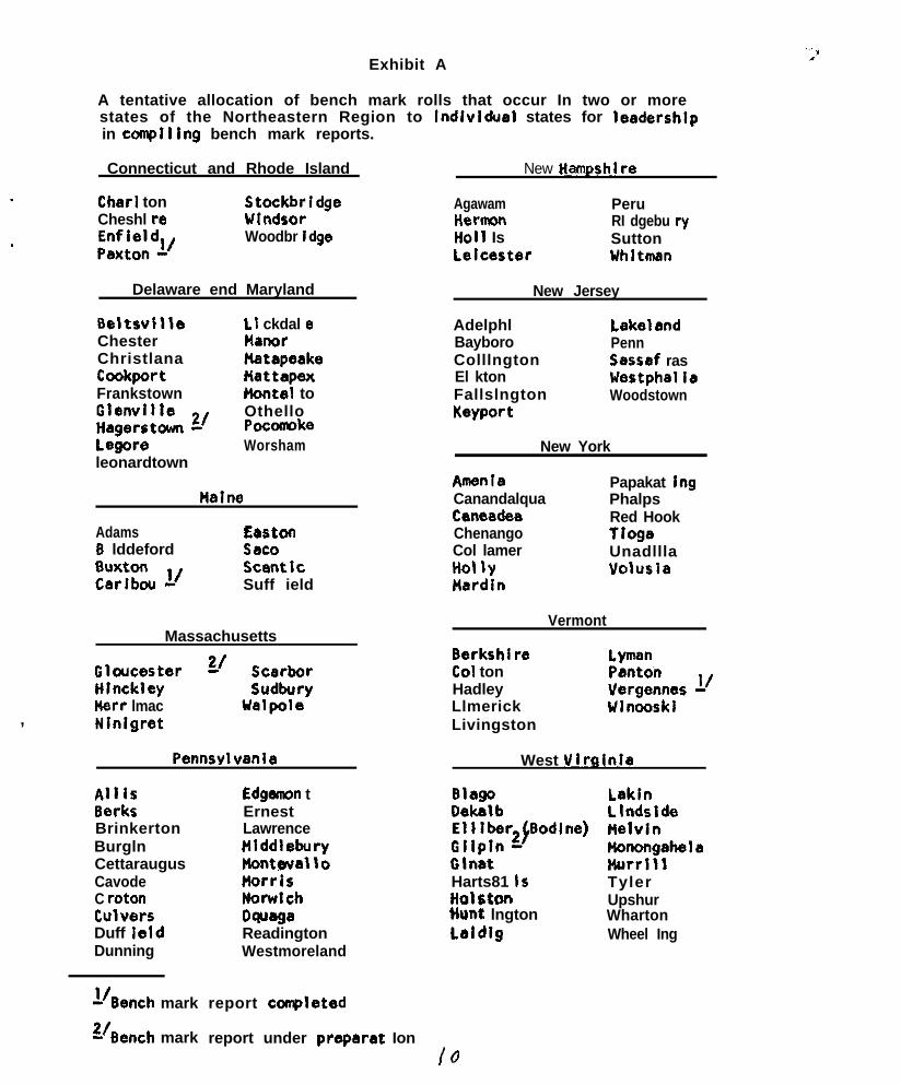
Exhibit A
A tentative allocation of bench mark rolls that occur In two or morestates of the Northeastern Region to lndlvldual states for leadershlpin complllng bench mark reports.
Connecticut and Rhode Island New Hampshl re
Char1 tonCheshl re
,“:;;;;“l/
StockbridgeWfndsorWoodbr idge
Delaware end Maryland
Agawam PeruHarmon RI dgebu ryHo1 I Is Suttonlelcaster Whltman
New Jersey
fleltsvllle L I ckdal eChester ManorChristlana HatapeakeCcokport KettapexFrankstown Hontel to
;i;;;;& 2/ OthelloPocomoke
legore Worshamleonardtown
AdelphlBayboroColllngtonEl ktonFallslngtonKeyport
LakelandPennSessaf rasWestphallaWoodstown
New York
Halne
AdamsD lddeford
;::::w Y
LastonSac0ScenticSuff ield
AmenlaCanandalquaCanaadaaChenangoCol lamerHot \yNardin
Papakat lngPhalpsRed HookTiogaUnadlllaVolusia
Massachusetts
fi;iEzer g’ ;:;L.x;
Kerr lmac Walpole, Nfnlgrat
Pennsylvanla
AllisBerksBrinkertonBurglnCettaraugusCavodeC rotonCulversDuff IeldDunning
l/Bench mark
g/Bench mark
Edgsmon tErnestLawrencetllddleburyhonteval\oMorrisNorwichDwegaReadingtonWestmoreland
report coapletad
Vermont
Berkshl reCal tonHadleyLlmerickLivingston
LymanPantonVergennes 1’Wlnooskl
West VlrGinla
Blago LaklnDekalb Llndside;(;;~r&Bodine) gziahela
Glnat HurrlllHarts81 1s Tylerli0lstt3l9hunt lngton
UpshurWharton
laldlg Wheel Ing
report under preparat Ion/Q

,
Discussion of Report of Cormnittee on bench mark sollo.
Marshall: Is there any chance of wmblnlng two or more soils In
one bench mark report? I’m thinking of soils like
flsrdln and Volusls, both of which are extenslve soils
that are members of the same drainage catena and
occur in the same areas. it would probably save
time and effort If reports for such soils were
combined.
Hershberger: How many series could be combined? In the Ptedmont,
soils of the Manor, Glenelg, and Chester series are all
extensive and closely associated. Perhaps one report
would suffice for those solls.
Marshal 1: The number of bench mark soils combined Into one report
would depend on the solis Involved.
Wllson: Isn’t there same danger of maklng ft difficult to file
the reports If they contain informatlon about several
soils?
Pomerenlng: At the rate we are going In canplating the reports
that should be no problem for awhile. I thlnk
combining date of two or more closely assocleted
bench mark soils into one report Is an Idea worthy
of consideration.
‘.
0.
-0
0
NATIONAL COOPERATlVE SOIL SURVEYNORTHEAST WORK PLANNING CONFFRENCE
January 20 - 21, 1964
ReDort of the Committee on Soil Correlation
A. Objective of Committee
This committee was to review responsibilities for correlation.To study efficient scheduling of correlation with regard tostages in the course of a survey and the writing of the surveyreport. To examine information needed for correlation as follows:
1. Content2. Time and methods and preparation
::Form of presentationCornnon deficiencies and possibilities for eliminating deficiencies.
B. Discussion and Recommendations
, Content of field correlations
Under present operating procedures a field correlation requires thepreparation of certain documents and supporting evidence. These itemsare outlined in Soils Memorandum SCS-44, Requirements for Field Correla-tions .
The committee studied the relevance of each item and concluded that allare essential for a field correlation but items may vary in importancein different localities. No recommendations were made for improvementsof the current requirements.
2. Time and methods of preparation
The comaittee discussed the great amount of time required atall levelsto up-date or revise soil series descriptions and concluded that thiswill remain a continuing need. Delays in this phase of the work addto correlation problems if not handled prior to the final field correli,-tion. To assist in overcoming these problems the cmmittee recommende3the
(a)
(b)
foll.oting :
List the status of all soil series appe’aring in a soil surveylegend on form SCS-233 during all initial and progress reviews.Soil series that require up-dating or revising that are modalin the survey area would be indicated. Plans for revision wouldlist assignments and target dates for initial drafts. Seriesconsidered modal outside of the survey area would list the countyor counties where the information should be collected.
Schedule the final field review and field correlation approxi-mately one year in advance of the completion of the fieldmapping. The gain in time should offset the small amount ofchanges in the correlation that may be needed at the completionof the field work.
(OVER)
2 ,
cc) Schedule the ,interme,di,%.te corr.elet,lon shortly after thecomplet~ion of t.he field mapping
This one-year i.nterim would be used for revi,sion oftechnical. and mapping unit descriptions as shawn in thefin*1 field correlation. Pescriptiocs of new seriesset up as a result, of the fir& fielzd correla~ti,on wouldbe wri?ten during t,his period. It would also s.U.owtime for checking the adequacy of the proposed corr~ela-tion and collect,ion of br~d~dit~ionz.1, data when needed.
(d) Increased emphasis on regional and inter-reg?.sna,lsoil studies to improve soil series cwcept,s End reviseseries descript,ians. hes;dership for. int,er--regionalstudies shouJtd be assumed by the Washington correl,ati,ons t a f f , an,? Besdership of region& stuiies should b ewith the Principal Correlator-1s office. To crchievethe a.bove goaLI it is reconrmenled that the a,bove staffsbe increased. Firat pri.orit,y should be for i,ncrel.singthe staff of t.he Principzl:, C,orreL,a,t,or .
(e) A punch ca,r’d syst.em of f2iang end so,rt.ing descriptions,le., numerous descripti.on,s ,?f the ssme soi,B ser~ies,wa,s dLwussed by *Xr. Reisk,e. ‘The c,amm~.ttee suggestedthat Mr. Rei,sk,e ront,inue t3 t.est. thi,s proce,dure andmake a rep,:r t, irt, ,the next wnferen,re.
3. Form of present+.tion
The form of present,ation of c~orreLti:>ns IS not. u,ni.formi.n the Northewt~. ‘This does n’o t @pe.;;r to be a, pwblemso no suggestions for i.mprwrng curren’t pracedures weremade.
4. Common deficiencies an? possl.bilities f,w eliminatingdeficiencies.
Causes of delay in soil cwrel.Ltion lii,st.ed, b,y the 1963Nati.onal Work Plwning conference were discussed.The committee was in gener&! agreement tha,t delays incorrelation could be e,xplsine.d by t.he items Pist.ed i.nthe nati,onal, report.
A regional proposal. that ,the Wa,shington correl,ation staffdirect i,ts a,ctivities tc the seri,es Ilevel end depend onstate and regi,onel staffs for phase deci,sXons was discusse,d.Di.scussion brought out, the fact t,b.s,r. the W,& shington st,affexamined phases on a sampIe b6.si.s inn+. this ~3.~3 not a mi.jortime consuming item for most surveys. No ch,anges inpresent operating procedures were rec,amended.
.
. .,
Washin.gton:--_-_- .._I
(1)
.
(2)
(3)
(4)
(5)
(6)
,
Examination review and approval of all series descriptions.This would be a continuing process - undertaken where a seriesdescription is submitted and not tied to any specific correlation.These are the real standards for control of correlation work.Checking of the field work against these standards can be done atlevels below Washington.
Approve and change if necessary - nomenclature of mapping units.This is needed if we are to maintain any uniformity in nomenclature.
Make special field studies of duplication or overlapping soil series.
Consult with and instruct Principal Soil Correlators on use andrecognition of soil series not common to his correlation area.
Spot check and review work of the Principal Correlator to see thathe maintains concepts of soil series expressed in official seriesdescriptions.
Work with Principal Correlators involved in any changes in conceptfor established series or for proposed new series.
Principal Correlator’s Office
(1) Examine all descriptions of taxonomic units and mapping units forsurvey areas for consistence with standards established by approvedseries descriptions.
(2) Check nomenclature of mapping units and be sure that adequateinformation is passed to Washington to serve as basis forfinal. determination of nomenclatur~e.
(3) Join Washington office in special studies of overlapping series orneeded changes in concepts of approved series.
(4) Work with sta,tes on information needed to prepare documents.neededin correlation.
sate Level.:
No changes in duties, but changes in timing of activities.
I believe that some changes in our present procedures are needed to preventdelays, avoid duplication of effort and to remove the need for rewritingsurvey reports where there is a considerable change in correlations -.from the Field to the Final Correlation. 1 believe my proposals have somemerit along this line.
2J Suggestions by A. H. Paschali, Chai.rman, not revi,ewed by cormnittee.
. . -
z? Northeastern Work Planning Conference - Committ.ee on Soi,l Correlat,ion
A. H. Paschall, Chairman
If it were possible to have nearly all series descriptions approved in arelatively short time (3 to 6 months) and have all duplicating or over-lapping series noted and listed. 3 believe that some alterations ofcorrelation procedures would shorten the time between completion of asurvey and the preparation of an “approved correl,ati.on. !’
The starting point for these alterations would be the scheduled time forthe work we now call Fi,eld Correlation. This might be move,d up to oneyear before the estimated completion date for the survey. Steps involvedhere would be:
1.
2.
3.
4.
5.
Submit to the Principal Correlator’s office for his examinationthe descriptive legend and supporting documents now require,3for the Field Correlati.on (at l,east 3 months before a fie1.dreview is to be scheduled).,
The Principal Correlator wou3.d examine t,hese, raise questions andparticipate in a field review of questionable points.
Recommendations made as reslll.t of this field review and eximina,tionof supporting documents then becomes the Intermediate Correlationand is to be checked for usability during the completion of thesurvey.
Upon completion of the survey another fiePd or office review willbe scheduled. This wipl invslve a representa,tive from the Frincipa.1.Correlator’s office and will be for the purpose of making additionsor correcting weaknesses that show up 3,s a result of the one-yextest . The document prepared as a resu~lt of t.his step wou6,d be theFinal Correlation.
The Final Correlation would be submitted t3 the Washington officefor preparation of the “Approved Correlation,” by(a) checking and approving or correcting concepts of series not
normally occurring i.n the correlation area of cloncepts whi,chhave been questioned by the Principal, Correlator, St~ite Soril~
(b)Scientist, or cooperating agency; andchecking nomenclature of mapping units(Note that checking of proposed series is not mentioned -such series should be checked with the Washington 0ffic.eduring the preparation of the Intermediate Ciorrelation,and either approved or dropped).
It is much easier to outline these steps th,an it is to set up thelogisti,cs to carry them out. These suggestions would alterprocedures and emphasis on various phases of the work. I don’tthink it alters any responsibility or authority at any level.As I see it, the special emphasis at the various levels would be:
_-

A/ Adjustment of Program Steps for a S 0 I L S U R V E Y .‘i : I
Soil Series
i-OF
Field Correlation
Final Fie1.d Reviewand Field Correle,tion(one year i,n advance ofcompPetion of field work)
Party L,ea,der s R,evised Technical LnpS.etinn of Soil Mapping Checke. _draft Report, t-_;~~cw~:~;sUnitManuscript
Mar~ea measwement~s) yfi,eldsheet.s
.
IJJPublished
Soil Survey
0lf If final field carrel.ation is made one year in adva.nce of compIet~~!~r~r~~ of
field work.

5. It was reconanended that the committee be continued.
Membership of Committee:
+. M. G. Cline, Vice Chairman
3: L. J. Cotnoir
M. Howard, Jr.
R. La. Marshall, Acting Chairman
R. P. Matelski
-i!. A. H. Paschall, Chairman
B. J. Patton, Secretary
G. A. Quakenbush
R. F. Reiske
+ E. J. Rubins
+:. Absent.
Visitors - Roy W. Simonson and Frank Veira
0
0 .
The cotittee report was discussed by the conference and accepted.
,
Attachments
NATIONAL COOPERATIVE SOIL SURVEY
NORTHEAST SOIL SURVEY WORK PLANNING CONFERENCE
1964.REPORT OF THE COnHlTTEE ON LABORATORY ClMACTERIZATION OF SOILS
1 The charge to thfs cotmmlttee as outllned by the executive cotnnlttee of theNESSWPC was:
To examine laboratory procedures for characterltation of sol1 for thelradequacy and the comparison of data by dlfferent methods.
To revlew methods and procedures of sampling of solls to be analyzed, foradequacy and relleblllty of the samples.
To revlew requirements of field descrlptlons to accompany laboratory datafor Its lnterpretatlon, lncludlng any deflciencles and recomnendatlons formeeting the needs,
To review Interpretation of laboratory data, lncludlng any possible meansto extend the Interpretation and to assure Its soundness.
To examine Integration of analyses for characterlsatlon wlth analyses forother specl f Ic purposes.
To make recomnehdatlons for lmprovlng laboratory data, Its use and methodso f obtalnlng I t .
After revlewlng the Natlonal Conmlttee’s report on laboratory characterlza-tlon and dlscusslng the charge, thls comlttee recoennended and the NortheastReglonal Comml ttee approved the fol lowlng:
I. That a report be made at the next NE meeting of a revlew of the laboratorymethods used by the Sol1 Survey Laboratory and other Iaboretorles, such asthose In the Experiment Statlon. These to particularly Include:
, a. Catlon exchange cepacltyb. Bulk densltyc. Oetermlnatlon of coarse fragmentsd. ptie. Type of clay
It was brought out by Dr. Slmonson that a reason for determining pH wlththe I N KC1 solution was that a comparison of data could be made wlththat obtained In Europe.
2. That the recommendation of the NatIonaL Committee which states:
Recomnendatlon: The committee recommends that the sample takento the laboratory should contain all material smaller than 3/ui n c h (19 IMI.) In diameter - excluding r o o t s . A detalled estimateof the volume of material larger than 3/A Inch should be made andrecorded In the profile descrlptlon.

3.
4.
5.
be approved, While this recommendation Is Incomplete It is an Improvementover the present no-sieving of coarse fragments between 2 mm. and 3/4 Inch. .However, Dr. A. J. Baur questioned the use of the 314 Inch sieve since Itdld not sleve out the 314 to 3 inch fragments. Perhaps the f inch sieves h o u l d b e u s e d , since It Is the upper llmlt of flne gravel In the Sol1Survey Manual. It was also suggested by 5. J. Zayach that the f and 3/4inch sieves be used to assist In the determlnatlon of the engineer lng
.
characterlstlcs.
The commlttee also recognized the recommendation of the Natlonal Committeeon “Soil Texture; Coordination of Textural Classes and Grain Sires” whichsta tes - -
RECOMMENDS that the percentage by weight of fine gravel and coarsegravel be determlned by the necessary sieving and welghlng in thefleld, unless the sample Is large enough to include all the gravel.
Thls recommendation needs to be reconciled with the National CommIttee’s“ L a b o r a t o r y Characterlzatlon of Soils” rocomnendatlon,
Thls commIttee recommended that the profile descriptfon accompany thepublished laboratory data and that I t also contain Information on the site;such as, slope, aspect, macro- and micro-topography, present vegetation,e t c .
The committee recommended that the guide to the use of characterlzatlondata being prepared by the Sol1 Survey Laboratory be circulated In thenear fu ture . The corrmlttee was acquainted with Dr. C. E. Kellogg’spub1 Icatlon on this subject.
The commlttee recommended the Interchange of pertinent analyses. Itfurther recommended that those performing analyses receive the data onsimilar samples made In other laboratorles.
The commlttee studled the recommendations for continually Improving labo-ratory data, I ts use and methods of obtalnlng It . The following wereconsidered: \
free Iron oxide determrnatlonextractable aluminum determinationthe coordtnatlon wlth bench mark ‘solIsa t lme table for laboratory characterlratlonl a b o r a t o r y guide lines for the so11 s u r v e y o rrepresentation from the sol1 survey laboratoryprocedures for characterfzlng organic sol Is
6. T h e c o m m i t t e e recommended that Its functions be continued.
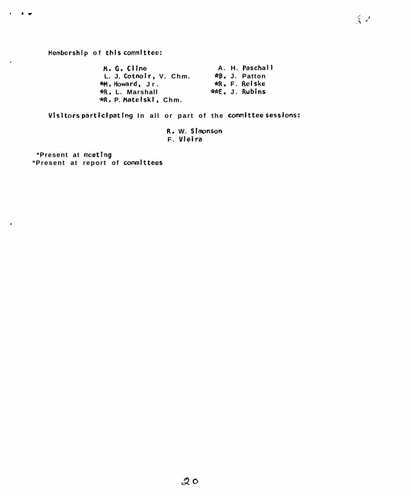
. 4”
Hembershlp o f this committee:.
H. C. Cllne A. H . PaschallL. J. Cotnolr, V. Chm. *B. J. Patton
*H. Howard. J r . I%. F . Reiske%. L. Marshall ME. J . Rublns*R. P. Hatelski. Chm.
Visitors partlclpatlng I n a l l o r p a r t o f t h e convnlttee sessions:
R. W. SImonsonF . Vleira
*Present at meetlng*Present a t repor t o f commlttees
NATIONAL COOPERATXVB SOIL SURVW
NORTBBAST SOIL SURVEY WORK PLANNING CONAXiEi’iCE
REPORT OF COlWTTSE ON SOIL MOISTDRB
I . Definition of water tablet,
Definitions as proposed by the national report were considered.There was considerable discussion on the merits of “free” versus“true” as adjectives. “Freedom” of water is a question of freedomof movement in response to atmospheric pressures.
Inasmuch as the nomenclature of hydrologic professionals shouldhave preference in order to avoid confusion, several specialists werecontacted. As a rule, they themselves follow Meineer’s classicdefinitions and question the accuracy and the need of the definitionspresented by Dr. Miller. The need for and validity of the terms“artesian” and “perched” water tables is generally recognized. Onehydrologist prefers “artesian water surface” for our artesian watertable concept.
A list of current definitions amongAppendix I.
hydrologists is attached as
Dr. Bmerick, groundwater geologist, Penn. Dept. of Health, hascorerented “that ‘virtual water table’ is not really a water table andusing the term needlessly complicated the nomenclature. Because of thecapillary fringe and the effect of gravity, the point of zero tensionis not at the surface of the water. Miller may have had this in mindwhen he referred to a level that can be computed, but, as written,it is not clear.“ The same hydrologist pointed out that “the definitionof perched water table as defined would apply to a water table over aless permeable stratum which is saturated and which, in turn, is over anartesian aquifer with insufficient head to hold the former level. Inother words, the water table would fall, but it would merge with anartesian water table.”
“Virtual water table” is a difficult concept which needs to beillustrated es well as defined. The committee suggests two illustrations:(a) en organic soil consisting of well decomposed muck over peat doesnot drain because of a break in capillary flow; (b) silt loam or loamsoils over gravelly or coarse sandy substrata show accumulation ofcarbonates or of iron and manganese in the zone, where pores becomecoarser indicating a capillary discontinuity.
“Perched water table” and “artesian water table” were thought tobe adequately defined in the national report,
There is a need for considering slope limits where the ordinaryconcepts of watertable apply. In mountainous areas there are flowingwaters which appear in cuts or ae springs at the surface which may be
.
outside of the definition 0: the various kinds of hroundwaterdiscussed in the national committee report. A statement should beincluded to cover these conditions.
Recommendation
1. Recognize priority rights of hydrologists in the matter of watertable nomenclature.
2. Soil scientists should be specific in describing kind of water table,Thus, we prefer the use of “apparent water table” to “water table”in the national report.
3. In each instance where watertable is described, the method ofdetermination should be listed.
4. Favor change from “true” to “free” if choice is open.
5. The definition of virtual water table should be provided withspecific examples for clarification.
6. The specialcaseof water table in sloping land should be recognieed.
II. JPanth to water table
The coranittee concurred with the national report, and found the30 and 60 inch breaks especially convenient for engineering andsanitation interpretations. However, the relatiou to the controlsection in a revised 7th approximation is appreciated. For forestryand certain agroncmlc uses a precise description of water table depthis desirable. For two examples of continuous measurement of watertable depth see Appendix II-III.
.
Recommendations
1. The setting of water table limits should be deferred until a finaldecision on the control section is reachad.
2. Depths in the “very shallow” range should be precisely describedor measured rather than that more classes are added in this criticalrange.
III. J&ration of water table
A full description of water table would require measurement of itsduration at specific depths. Two examples of water table fluctuationsare shown in Appendix II-III as observed by A. B. Shearin in Sutton fsland Walpole sl over periods of 18 and 12 months, respectively, at Tollandand Windsor, Conn. A detailed description follows:

Sutton soils are moderately well drained. Theyhave developed in glacial till derived fromschist and gnefse. The soil at the site is inthe lower range of moderately well drained or in-regrading to somewhat poorly drafned. Thesurface layer is very dark gray fsl underlain byyellowish brown fol B21 horieon ranging in depthfrom a few inches to about 10 inches. The under-lying horieons are strongly moetIed. Slope o-spercent to east-southeast. Area idle at presentbut was used for hay and pasture.
Walpole soils are poorly drained. hey havedeveloped in moderately coarse textured flwialdeposits over sand and gravel or sand. Thesurface soil is very dark gray to black overmottled subsurface horizons. This particularsite is a small pocket associated with somewhatexcessively and excessively drained soils. Thearea is tile drained with the outlet, in a deepopen ditch. The area is nearly level, and hadbeen used for tobacco, vegetables and other crops.
A summary of the data for the Sutton soil shows that when usingthe 1963 classification, depth and duration over one year period arerelated as follows:
3 months (in two periods) very shallow3 months (in four periods) shallow3 months (in three periods) mod. shallow3 months (in one period) mod. deep
Recosssendationp
1. A fluctuating water table needs to be described in terms ofdepth, duration and oeason of occurrence.
2. The first class “vary brief” needs to be defined in terms ofspecific durations as these may be related to the tolerancelimits of specific crops, or to the performance limits ofhighwayo in winter and functioning of septic tanks during anytime of the year.
IV. Available soil moistue
The coarsittee discussed reliability of available soil moistureclasses for specific texture classes. Specific correlations fornortheastern soils are attached to the report as Appendix IV A, IV B,end IVC. The data ware segregated for low and high humus contents.
BecommendatioQ
1. In view of disagreement on methodology or definition of availablemoisture, method of analysis should always be reported vith the data.

.
v.
I V .
,
1
2. In volume-basis moisture analysis a correction for coarse fragmentaneeds to be made.
soil aeration and drainsse classes
The committee felt that more precise description of depth,duration, aeasoruaand kind of water table in soil description ispreferable and would eventually reduce or eliminate the need forspecific classes.
1. The study of kind, depth, duration and 6ea8on of veter tableshould preferably be concentrated in related soils of epecificdrainage catenas.
Soil aermeability
The relative merits of the Dhland core method and the FRA augerhole method were discussed. The core method reeistere slower perme-ability and there is need for comparing the two method% on the sawsite. For aoil characterization we should adopt a method result6 ofwhich can be duplicated and which is largely independent of time ofte6t, environment and other changeable factor-a. The auser holemethod is limited in it6 application. It is an empirical test ofprobable performance of a septic tank distribution field under similarweather conditions. The t&land core method is a m6a6ure of verticalhydraulic conductivity through a plane under standard conditions. Itis recogniced that both method6 have high standard error6 becau6e ofthe variability of the relatively 6mall area6 sampled.
$ecomendations
1.
2.
3.
The two conventional methods for permaability measurement deservecomparison on the same site.
The committee favors 5 permeability classes a8 listed in thenational report. Tha committee ia aware that for specific u6e6fewer classee would suffice but submit6 this propoeal a5 acompromise serving widest usefulness.
Subclas6es are not recommended. However, specific values can belisted in the “slow” and “rapid” ciasser where such refinementis desired.
The conrmittee finally recormnends that it be continued.
Absent: W. J. LyfordThe committeeA. J. Baur
A. R. MidgelyR. S. StruchtemeyerJ. C. P. TedrowD. van der Voet
R. S. BellP. G. LoughryG. A. QuakenbuahA . E. ShearinP. VeieraY. A. van Bck, Chmn.
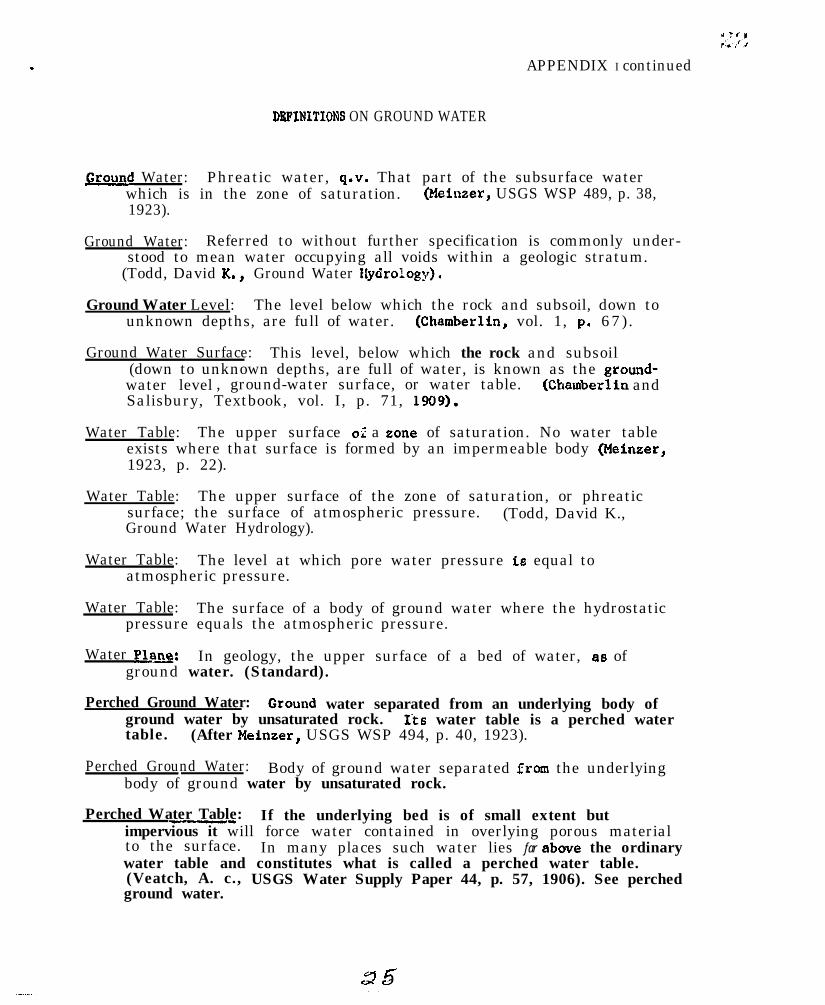
APPENDIX I continued
DRPINITIONS ON GROUND WATER
Ground Water: Phreatic water, q.v. Thatwhich is in the zone of saturation.1923).
part of the subsurface water(Meinzer, USGS WSP 489, p. 38,
Ground Water: Referred to without further specification is commonly under-stood to mean water occupying all voids within a geologic stratum.
(Todd, David K., Ground Water Uydrology).
Ground Water Level: The level below which the rock and subsoil, down tounknown depths, are full of water. (Chamberlin, vol. 1, p. 67).
Ground Water Surface: This level, below which the rock and subsoil(down to unknown depths, are full of water, is known as the ground-water level , ground-water surface, or water table. (Chamberlin andSalisbury, Textbook, vol. I, p. 71, 1909).
Water Table: The upper surface of a zone of saturation. No water tableexists where that surface is formed by an impermeable body (Meineer,1923, p. 22).
Water Table: The upper surface of the zone of saturation, or phreaticsurface; the surface of atmospheric pressure. (Todd, David K.,Ground Water Hydrology).
Water Table: The level at which pore water pressure is equal toatmospheric pressure.
Water Table: The surface of a body of ground water where the hydrostaticpressure equals the atmospheric pressure.
Water P1.a~: In geology, the upper surface of a bed of water, aa ofground water. (Standard).
Perched Ground Water: Grouud water separated from an underlying body ofground water by unsaturated rock.table.
Its water table is a perched water(After Meinaer, USGS WSP 494, p. 40, 1923).
Perched Ground Water: Body of ground water separated from the underlyingbody of ground water by unsaturated rock.
Perched Water Table:-_ If the underlying bed is of small extent butimpervious it will force water contained in overlying porous materialto the surface. In many places such water lies far above the ordinarywater table and constitutes what is called a perched water table.(Veatch, A. c.,ground water.
USGS Water Supply Paper 44, p. 57, 1906). See perched
.
.
.
Perched Water Table: A ground water body separated from the main groundby a relatively lmperweable stratum and by a zone of aeration above~. . . . - .~tne main body of ground water, (Todd., David K., Ground Water Hydrology).
Perched Water Table: Phreatic water table of limited dimensions, found ata higher level than the continuous phreatic level.
&tesian wata: Ground water that is under sufficient pressure to riseabove the level at which it is encountered by a well, but which doesnot necessarily rise to or above the surface of the ground. (AfterSayre, USGS WSP 678, p. 33, 1936).
_

APPENDIX IV ASunwry of Available Moisture Calculated from Soil Profile Characterira-tion Data for the New England States*
Table Cl. Summary of all Soil Horizons
. Mean Available H20Texture Class Ho. Samples 1(1/3-15 atm.) i n . iln.
COS 3 .02
fe 4 .cJs
vfs 1 .07
lcos 2 .09
IS 6 .a9
Ifs 10 .ll
61 6 .16
fs l 45 .li
vfs l 16 .15
1 50 .22
Sil 70 .26
c l 7 .17
sic1 8 .21
SiC 12 .23
c 9 .18I
.
J&l@
.01 - .03
.04 - .08
-_--
.09 - .09
.06 - .13
.a3 - .20
.I1 - .21
.06 - .31
.04 - .30
.lO - .30
.12 - .36
.16 - .19
.18 - .30
.14 - .34
.14 - .19
*Available moisture calculated from soil horizon data from the characteciza-tion reports of the Soil Survey Laboratories, S.C.S. for:
Aroostook & Pennobscot Counties, Me., 1959Aroostook & Pennobscot Counties, Me., 1961Franklin & Hampshire Counties, Mass., 1960Grand Isle County, Vt., 1960Hartford 6 Tolland Countiee, Corm., 1951Litchfield County, Conn., 1957Merrimac, Rockingham 6 Strafford Counties, N. H., 1960Merrimac 6 Strafford Counties, N. H.Tolland County, Corm.Washington 6 Rent Counties, R. I.Worcester, Franklin and Hampshire Counties, Mass., 1960
Data provided by Mr. A. R. Shearin.
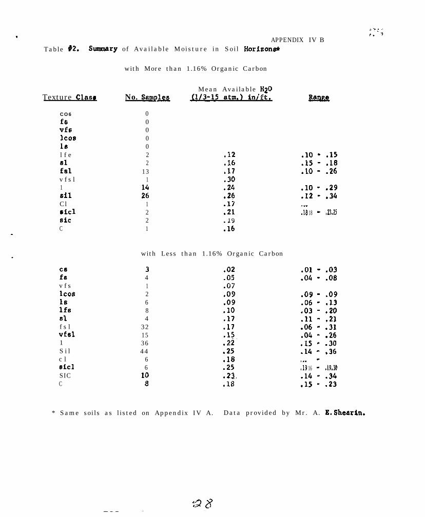
.APPENDIX
Table #2. Summary of Available Moisture in Soil Horizons*
with More than 1.16% Organic Carbon
Texture Claw
CO6
fsvfslcosISl f e81fslv f s l1SilClriclSiCC
ixv f sICOS16IfsSlf s lVfSl1S i lc lSiClSICC
No. Sampa
0000022
131
::1221
Mean Available K20u/3-15 atm.) inlft.
.12
.I6
.17
.30
.24
.26
.17
.2119
:16
with Less than 1.16% Organic Carbon
3 .024 .051 .072 .096 .098 .lO4 .17
32 .1715 .l!~36 .2244 .25
6 .186 .25
10 .23.5 .18
IV B
.lO - .15
.15 - .18
.lO - .26
.lO - .29
.I2 - .34
:I.8 18 -- .23 .25
.Ol - .03
.04 - .08
-09 - .09.06 - .13.03 - .20.ll - .21.06 - .31.04 - .26.I5 - .30.14 - .36
:19 16-- .19 .30
.14 - .34
.15 - .23
* Same soils as listed on Appendix IV A. Data provided by Mr. A. E. Shearin.

APPlINDIX IV CAVERAGE AVAILABLR MOISTU[(E (113 - 15 AIM.) BY SOIL TEXTURE CLASS
Pennsylvania Data 1957-1963 *
Soil Texture-
Sandy loam
Fine sandy loam
Loam
all samples
Silt loam
all samples
Silty clay loam
all samples
Sandy clay loam
Clay loam
Silty clay
Clay
TOTAL
Percent Numbero r g a n i c o fCarbon
- - t
Samples-.
Cl.2 30
< 1.2 13.-I
41.2 84p1.2 15
39
(1.2 187> 1.2 69
t
256
---x.-119
< 1.2 12
t-
q1.2 39
(1.2 17
-__.~Moisture
Mean StandardPercent Deviation---._
9.5 5.6
10.1 2.5
9.4 3.613.7 3.0_
10.1 3.e
12.6 3.815.6 3.4
13.4 I 4.4
,tg:i +-10.6 .
I
-=-P-l8.3 ! 3.0
8.2 1 3.6 1
Inches o7Water perInch of Soil.-.
.14
.15 .’
1 5:17
.15
.19 ‘
.20
.19
. 10
.12 !
I.13
-48.2
I3.5
I.I2
* Data prepared by Mr. John Carey and submitted by Mr. F. C. Loughry.

.
,
.
.
Northeast Cooperatjve Foil Survey Work Planning ConferenceNev YorkCity, January 20 and 21, 1964
REPORT OFTHECOMMITPEEONT~IINICALSOILMONOGRAPHS
The Committee report of 1962 defined geographic areas of the Northeastfor which monographs are to be developed, established priorities andtarget dates, proposed authors , and presented a tentative outline. Forthe record, the pertinent recommend.ations of areas, target dates, andauthors are repeated here:
Area NE-l--New England, Eastern New Pork Uplands, and Adirondack Mount,sins--W. H. Lyford, A. E. Shearin, and K. W. Flaoh--Target date Apri1,1$67.
Area NE-2--Erie, Ontario, Mohawk, St. Lawrence, and Champlain plains--M. G. Cline, R. L. Marshall, and A. H Paschall--Target date Apri1,1965.
Area NE-3--Glaciated Allegheny Plateau--A. J. Baun, R. L. Marshall, and.F. G. Loughry--Target date April, 1967.
Area NE-44Jnglaciated Allegheny Plateau--F. G. Loughry, R. P. Matelski,and B. 3. Patton--Target date April, 1966.
Area NE+-Northern Appalachian Ridges and Valleys--F. G. Loughry, R. P.Matelski, John Noll, Southeastern States Representative, and LaboratoryRepresentative--Target date open.
Area NE-b-Northern Piedmont--3. A. Pomerening, JohnCady, and SoutheasternStates Representative--Target date April, 1964.
Area NEl--Northern Coastal Plain--J. A. Pomerening, E. 3. Pederson,and J. C. F. Tedrow--Target date April, 1967.
The 1962 committee stressed that a senior author must expect to devotetime equivalent to a significant part of a year to complete any single mcno-graph. It also stressed that it is necessary for responsible administrativeofficers to take action in releasing personnel from regular duties ifmonographs are to be completed.
The 1963 National work planning conference reviewed the report ofthe committee of the Northeast, as well as others, and made recommendationsfor outlines and other details. These were not entirely consistent withthe recommendations of the Northeastern committee, but neither were theyof a nature that would affect sigtiicantly the proposals for the Northeastin terms of progress.
Since 1963, the project has been mainly inactive in the Northeast,though contributing studies have proceeded in the normal course of workand continue to assemble data that are the essential bases of the monographs.
(A)
No attempt is made here to enumerate these sources of information, butthey are substantial. Mr. Marshall has enumerated 13 major sources ofinformation for the areas inwhioh he works, and others could equal orexceedthatnumbar. Nevertheless, the fact remains that each member ofthe committee has reported no progress on actual development of the mono-graph with which he is concerned.
In each case, committee members report the same reason for lack ofprogress. It is swly that work loads in the course of normal operationsconstantly increase, and the monographs have not been given prioritiesby administrators that would justify laying aside other work in theirfavor. Neither have they had personal priorities in the minds of theindividuals concerned that would compel authors to saorifioe personalaffairs or professional activities in their favor outside of working hours.
Soil Conservation Service policy relative to the monographs isolearly stated in Soil Survey Memorarvjum 39 dated March 1961. If thatpolioy is to be implemented insofar as Soil Conservation Servioe. Personnelare involved, itwill be necessary that administrative action be takenat a high level to free authors from some other duties. The Conferenceis urged to authoriee its Chairman to transmit a recommendation for actionto appropriate administrative offioers of the Soil Conservation Servioeat the Washington level.
No policy statement relative to the monographs on the part of thevarious State agencies concerned exists to the knowledge of the Committee.The Bonference is urged to authoriee its ohairman to inform the NortheasternSoil Researoh Cotittee at its meeting January 22 of the problem and tosolicit its good officers in urging the State Administrative personnelconcerned to make neoessav# provision for partioipation of the individualson their staffs in authorship.
The Committee cannot visualiee ha3 it, as a oommittee, oan oontributetoward further progress. As the Committee is composed of potential authors,this is perhaps a refleotion of Inability to disaipline itself to thetask before it. Certainly there are few among its members who could notif they willed it make sorue progress during nights, Saturdays and Sundaysat the expense of personal affairs. The faot that they have not must meanthat the prospect of future professional recognition and personal satis-faotion inherent in authorship is less valuable to the individuals aoncernedthen the aggregate of other personal satisfactions out of offioe hours.
W. H.R. L.A. J.
:: ::J. A.M. G.
LyfordMarshallBWrLoughW
3.3
GONPWEXCE ACTION - Technical Soil Monographs
Due to Dr. Cline's absence the above report, prepared by him, was pre-sonted to the oonference by A. J. Baur. The Conference took thefollowing actions:
1. Chairman Quakenbushwas directed to transmit a request to theSC3 Administrator, through proper channels, asking foradministrative action aimed at making available qualifiedpersonnel for writing monographs.
2. Chairman Quakenbush was also direoted to write ExperimentStation Directors about the need and importance of monographs,assignment of authors and target dates, and ask them to considermaking individuals on their staffs available for this work.
3. Dr. N. K. Peterson wss requested to explain the topic of soilmonographs and problems of authorship to the Northeast SoilResearch Committee. (He later informed the group that this wasdone January 22, 1963).
4. The committee on monographs is a continuing oommittee.
DUZUSSION - Technical Soil Monographs
General agreement that if monographs are to be written men must be re-leased from other duties so that continuous time can be devoted to the job.
Pomerening: Would like to do the job, but oan't see how time will beassigned. Would like to be relieved of senior authorship for areaNos. 6 and7.
Matelski: Opposed to the proposal that Experiment Station personnel dothe job of writing because other responsibilities such as teaching takeprecedenoe .
Marshall: The same problem faces SCS men. Regular operations and speoialjobs like soil survey report writing get high priority.
Quakenbush: Writing will take 6 months to one year. Administrativedecisions and actions are required to get the job done.
Baur: Monographs present an area of soil survey in which AgriculturalExperiment Stations can make a real aontribution to the cooperative soilsurvey. The Stations have personnel with qualifications and skills at alevel required for this kind of work.
35 3(Cl
Van Eck: Experiment Station personnel can best operate within the8.rown states; have limitation on travel, etc.
Baur: Preoedents have been established for regional work, - examples:regional soil research projects, publication of soil characterizationdata for Northeast by NW Hampshire Agricultural Experiment Station.
Baur: Monographs will be published by SC6 in a USDA series.
Eimonson: Monographs are one means of presenting soil survey information- should be useful in areas like teaohing, researoh planning and land.resource inventory. Need to present soils information at differentlevels.
Baur: Target dates and authors listed on page 1 of the Committee Report(as of 1962) are now not entirely valid. Need to re-evaluate thesituation.
Notes by Dr. G. Olson
NATIONAL COOPERATIVE SOIL SURVEYNORTHEAST SOIL SURVEY WORK PLANNING CONFERENCE
1964
REPORT OF COhNITTEE ON SOIL SURVEYS IN URBAN-FRINGE AREAS
The committee on Soil Surveys in Urban-Fringe Areas was establishedand met for the first time in January 1962. The membership of thecommittee at this conference ie new, except for two members, fromthat in 1962. All members were present, except L. E. Garland andD. E. Hill. Dr. Hill was at the conference but was sick when thecommittee met.
The committee was charged to review and initiate a response to themany items contained in the 1963 report of the national cosmlttee.Lack of time prevented the review and discussion of about half theitems. The following are the items reviewed and the action takenby the committee.
A. Soil Corrosivity (Attachment A - l/10/64)
1. Untreated Steel Pipes
a. The criteria for each class of corrosiveness is some-what vague and should be clarified. It is uncertainwhether one, two, or all soil properties or qualitiesmust be considered to place soils into classes.
b. It appears that the criteria used to separate classesare not comparable with the information in the publica-tion “Underground Corrosion, ‘I Circular 579, U. S. Depart-ment of Commerce. National Bureau of Standards (basisfor the five soil corrosivity classes) and a technicalpaper presented by B. J. Whiteley, Jr. of the TennesseeGas Pipeline Company. Both of these sources indicatethat electrical resistivity is quite variable in anygiven soil. Moisture content, overburden pressure,and particularily temperature can cause a great varia-tion in resistivity throughout the year for a soil atgiven site.
It appears that the differential in resistivity fromone point to another along a pipeline is more signifi-cant than the actual electrical resistivity at any onepoint in the soil along the pipeline. The informationin Circular 579 indicates that total acidity is variableand does not appear to be a good indicator for placementof soi ls into c lasses .
_

c. The information in the guide (Attachment A) seems tostress textures of the B horizon and subsoil. It alsostates that the corrosivity will be determined for eachsoil horizon to the depth of pipe installation. Thisis somewhat confusing when trying to place soils intoclasses. Is the corrosivity of the B horizon, thesubstratum, or the layer where the pipe is installedthe basis for placement of soils into classes? Pipesare generally installed at depth5 greater than 3 feetfrom the surface. Why is there such an emphasis onthe B horizon and subsoil when their characteristicsare not diagnostic of the character of the substratumin many soils?
d. The committee feels that the data and our presentknowledge of soil corrosivity warrant only 3 classesinstead of five.
2. Concrete Tilea. The second sentence in the first paragraph on page 1
of Attachment A refers to ‘metal or concrete pipe.”However, this section on page 4 is headed **Concretetile.” The committee suggests the heading be changedto Yoncrete conduits.” In fact, the interpretationcould be expanded to include all concrete structuresimbedded in soil material.
b. The committee suggests that source or sources ofinformation be indicated for the criteria on sodiumand magnesium sulphate.
B. Presumptive Bearing Values
The guide attached to Advisory Notice W-402, dated July 3, 1963.was not reviewed. The national committee feels that some revi-sions are needed before the guide is sent out for review andcomments.
C. Research Needs for Interpreting Soils for Urban Uses
Research for non-agricultural uses of soils differs from thatfor agricultural uses, primarily in the interpretation andrelative importance of the soil factors involved. The costper unit of area involved is high in soil interpretation5 fornon-agricultural uses as compared to agricultural uses. There-fore, errors in interpretation can be much more costly. Research
ii
36

.
for non-agricultural purposes should make for greater use ofdata on soil permeability. percolation, infiltration, chemicalreactions, coarse fragments, frost susceptibility, water tablelevels, etc.
Data are needed on behavior of septic tank filter fields,especially for dispersal and filtration of sewage effluentthrough a given kind of soil, and the effect of organic col-loidal complexes on the continued satisfactory functioningof disposal systems. At the present time, soil scientistsmust make interpretations based on inadequate basic data andunderstanding of the factors involved. This inadequacy orweakness applies to many other non-agricultural interpretations.Sometimes these estimates are no better than educated guesses.The soil scientists would like to have greater precision insuch interpretations. The information is needed to give guld-ante to planning boards, planning cosrnisslons, planning consult-ants, and other individuals, groups, and agencies for makingwise land use decisions.
The problems mentioned above are of mutual interest to the SoilConservation Service and the Experiment Stations. They are themain groups making interpretations based on sol1 properties orqualities. The committee wishes to bring to the attention ofthe Experiment Stations in the Northeast the research needs forinterpreting soils for non-agriculture1 uses. It is suggestedthat these needs be examined as practical areas for study andthat high priority be given to them. The research should bedone on the benchmark soils to provide a better basis for inter-preting and predicting the behavior of other similar soils. Awell coordinated program would eliminate research on any givensoil in more than one State. This does not preclude doingresearch on other than benchmark soils that are of particularinterest in the various States. First priority should be givento the review, assembly, and dissemination of existing basicdata.
To relterate, the committee suggests the need for basic dataon such items as:
1. Permeability, percolation, and infiltration.
2. Water table levels and their fluctuations throughoutthe year.
3. Sulphetes, chlorides, and other chemical, biological,and physical characteristics and qualities of soils asrelated to corrosion potential.
4. A procedure for estimating coarse fragments in soils andtheir effects on interpretations for various uses.
i l l
37
5.
6 .
7.
Disposal and filtration of sewage effluent through soilsand their relstionsiip to size of house lots.
The effect of organic colloidal complexes caused by sewageeffluent on the satisfactory functioning of on-site disposalsystems.
Frost susceptibility of soils a5 related to foundation stability,septic tank disposal systems, road construction etc.
D. Training Programs and Outlines for Soil Scientists Mapping andInterpreting Soils for Urban Uses
The committee did not spend much time on this item and did notcome up with an outline for training soil scientists. Two mem-bers of the committee submitted their comments on training ofsoil scientists as follows:
1.
2.
3.
4.
5.
6.
7.
8.
Develop criteria for all the various interpretettons forurban-fringe uses and correlate within region5 and thennationally. This includes rationale and assumptions.
Practice sessions in applying these criteria to soils inthe survey area, using benchmark soils a5 guidelines.
Compile a comprehensive list of reference material.
Training needed in development and presentation of soilinterpretations.
Training relative to the requirement5 of Health andSanitation Boards, Public Health Service, FederalHousing Administration, etc.
Modus operandi for dealing with governing bodies, planningboards, planning consultants, tax evaluators, etc. Train-ing is also needed for these people in the understandingand use of soil interpretations.
A symposium on the subject having representatives of differ-ent organization5 discuss the various aspects of soils inurban-fringe development.
More training is needed in the AASHO and Unified classifica-tion systema.
iV
33d
E. General Soil Maps for Use in Directing Expansion of Conununltles
Sol1 factors to be considered In developing map units are:
1. Natural soil drainage.
2. Soil permeability and/or percolation
3. Depth to horizons that retard downward movement of water,such as fraglpens, silts and clays, etc.
4. Slope
5. Degree of rockiness and depth to bedrock
6. Depth to seasonal water table
7. Stream overflow (flooding)
8. Degree of stoniness
The llmltatlon use-ratings of each general soil area shouldbe expressed in general terms to conform with the make-up ofthe map units. The map units can be interpreted for suchuses as
1. Residential
2 . Comnerclal
3. Industrial
4. Recreational
5. Agricultural
6. Woodland
The comnlttee felt that the speclficatlons as to scale, size,legends, etc. of a general sol1 map were too variable to makespecific reconanendations.
F. Septic Tank Filter Fields (Attachment B - l/10/64)
The comnlttee feels that assumptlons are needed relative todensity of housing before the criteria on permeability andpercolation can be evaluated and applied in this guide. Itrecomnends to the national committee that such assumptionsbe stated.
V
‘: ,,j. ‘
The comnlttee questioned the range of permeability (1.0 to0.63 inches per hour) in the moderate limltetlon class. Apercolation rate slower than 1 inch in 60 minutes (approximatepermeability is less than 1 inch per hour) is unsuitable forany type of soil-absorption disposal system according to the‘Manual of Septic-Tank Precticevv by U. S. Department of Health,Education, and Welfare. Furthermore,the moderate limitation class is onlyThe comnlttee feels the range is muchuse.
G. Future Status of Committee
the allowable range for0.37 inches per hour.too narrow for practical
It is recommended that the committee be continued.
Commlttee:- -R. A. Farrlngton J. A.L. E. Garland W. J.D. E. Hill. Vice-Chairman M. E.M. F. Hershberger K. P.N. Peterson s. .I.
Visitors participating in part of the
B. IsgurR. W. SimonsonS. C. Tlnsley
PomerenlngSteputisWeeksWilsonZayach, Chairman
coinnittee meeting:
Dlscusslon of the report of the Urban-FringeAreas Committee by the conference
Soil Corroslvlty
In Connecticut the corroslvlty problems to date are of privateindividuals or contractors rather than of public officials.They feel that in developments they are dealing with deepsubstrata, 5 to 10 feet from the surface.
The cost of anodes is high in laying pipelines by the Nlagra-Mohawk Power Company in New York. They will use any informationthat will reduce costs. The Company states that if the Soil Con-servation Service will supply the soils information, they willmake the interpretations. Furthermore, they will make a soilsurvey of the area involved if the Service does not do it. Theyfeel that the soil association and topographic relationships arevery important.
It was the consensus of the conference that there are some soilswhich are obvious problems and soma which have few problems.These represent the narrow extremes. The range between thesetwo extremes is broad. The criteria for subdividing this broadrange are not well established and are contradictory. Rat lngsoils within the broad, middle range is on shaky ground. Thecommittee and the conference recommends the use of only threeclasses with the middle class being quite broad. They alsorecommend that the field soil scientists work on the problem.
No comnents were made on concrete tile.
General Soil Maps for Use iii Directly Expansion of Communitiee
The conference reiterated caution on the use of general soil mapsfor operational planning, even though considerable explanation hasbeen made to users that such maps are useful only for general planning.It was also brought out’by the conference that emphasis should beplaced on the proportion of non-conforming inclusions as well aspercentage of dominant soils in the general soil areas.
V i i
NATIONAL COCPERATIVE SOIL SURVEYNORTHEAST SOIL SDRVKY WRK PLANNING CONFgRENCE%
1964Review and Notes on Subjects from National Conference
not Covered by Cooimittees
ORGANIC SOILS
Review of thi”March 1963iReport of the National Committee onOrganic Soils
By A. J. Baur
Dr. J. E. Dawson presented to the 1963 National Committee an outline ofmajor kinds of horizons and layers found in organic soils. These are:
,.
1. Genetic A horizons. Horizons that contain more than 50% organicmatter, have fineaggregate structure, and other evidence ofadvanced stages of decomposition.
2. Genetic A horizons which contain inorganlc material. Main featuresare dry color values more than 5 and loss on ignition values ofless than 50%.
3. Genetic B horizons. Contain illuvial material derived from Ahorizons.
4. Layero of Histosols.
a. Layers composed of plant material.
1.2.
SphagnumOther layers of plant material with a coarse system ofvoids.
b. Layers composed of fine to very fine secondary particles.
1. Sedimentary peat,2. Dis,integrated peat
A cohesive disintegrated layer,
c. Disintegrated layers of Histosols containing inorganic materials.L
1. Peat-mineral layer2. Peat-diatom layer3. Peat-calcium carbonate layer (marl)
Dr. Rouse Farnham presented to the 1963 National Committee a proposed systemfor classifying organic soils. His system is built on recognition of threediagnostic master horizons based on degree of decomposition of organic remainsand one non-master horizon.
.
43
Organic Soils - ,
Four important ground rules are:
1.
2.
3.
4.
The upper12 inches of organic soil, if drained, or the upper 18 inches, .undrained, are not used as diagnostic horizons. (These thinknessesare excluded from the top levels of the system down through theSubgroup level. It may be that they can be used at the family orseries level or outside the, system at the type ‘or phase level).
A diagnostic master horizon must be at least 12 inches thick indrained and 18 inches thick in undrained Histosols.
If there are two diagnostic horieons in a soil the most decomposedhas precedence for classifying the soil.
Thickness of the control section in organic soils is 40 inches ifdrained and 60 inchesif undrained. Where organic horizons are lessthan 40 or 60 inches;respectively’,‘and there..ie no lithic contact,the control section extends into the underlying mineral soil.(Intermediate thicknesses are used,for organic,soils that have beendrained to depths ,of :lass than ,onei~~meter).
The three kinds of master horizons are:
1. Fibric. Fibrous structure;: formerly -*eat. L. f ibra, f iber.2. Lenic . Semi-fibrous (Itructure, formerly peaty muck at&mucky
peat. L. lenis, soft .3. Sapric. Amorphous, formerly muck. Gr. sapros, rotten.. ..,
These horizons are the basis for classif.ication at the Order, and Suborderlevels.
Non master hor iron,: ;,
1. Limnic. Includes both organic,and inorganic material deposited inwater : marl, diatomaceoue earth; sedimentary peat, bog iron.andpossibly others. Separation based on these kinds of material aremade at the family level. .‘~
Temperature, reaction, lithic contact, presence of limnic’horieon, sphagnummoss and a few other eel&ted features are used for separation at theGreat Grotip' and Subgroup levels,
,: :~Suggested family criteria are:
1. Nature of limnic horison, example marl, diatomaceous earth, bog iron,sedimentary peat,
2. Texture of mineral horieons that are within the control eection.3. Sulphurous family for pH 3.5 or!‘less, d r a i n e d .
organic Soils *
4. Distinctions in Fibriats and Lenista according to the botaniccomposition of the plant remains should be made et the serieslevel for the most part. However, distinctions between woodymaterials and fine fibrous aiateriala such aa sedges, tule, mosses,etc. may be useful at the family level. Thia would be particu-larly true in Fibriata where the woody materials behave somewhatas do coarse fragments in m’+eral soils. For those Fibrists thatare more than half wood, faiqiliea designated as woody may be useful.
Suborders of Hiatoaola:
10.1 Hiatoaols having a aapric horizon within the control section.
Sapriats
10.2 Other Hiatosola having a lenic horizon within the control section.
Leniata
10.3 Other Hiatosola having fibric horizon.
Fibrista
10.4 Other Histosols lacking master horieona.
Leptiats
Etr. Frank Vieira reports that a trial of Dr. Fart&am’s system was madeat four sites of organic soils in New Hampabtre. Three of these fell inthe Typic Dysleniat subgroup. The fourth site had a dense layer of logsat about 36 inches. It was Typic Dyaleniat, but would be separated fromthe other three at the series or phase level,
Mr. Walter Steputia reported that he and Mr. A. H. Paschal1 exsmined one sitein Maine. It also fell into the Typic Dyaleniat subgroup.
Notes by Walter Steputie and M. F. Hershberger
Climate In Relation to Soil~Cl&sif&zion and Innte&retation
The Northeest Statesare coneinuing *work on establishment and testingof a climatic line for determining capability classifications and croppredictions. It was reported that Lloyd Garland has not completed workon a climate line. He is”working: with climato&.ogists. Information isnot ready for publication;’ PreaeFt line is based on 120-day frost freegrowir$ beeson. The new line is ;to be based on growing degree days,with SOOF as a base, However, it!is being worked on, it is not developednor concluded as definite. No action by the conference wea found to benecessary.
Ph$eipg of Soils on Micro-Climate
Ray Marshall suggested a climate $ine for grapes around lakes.There was some discussion on the probl&is to be encountered Pf micro-climate is made a mapping factor. No conclusions or action was takenby the g&p.
criteria for Series. Types and Phases
Discussi& was brief on this subject. It was confined mainly tothe suggestion to use 10 to 30 inches for control section of mineralsoils that lack argillic, natric, or spodic horizons:. There was somequestion as to why cambric was not included in the above exclusions.Different sit+ations were discussed relative to classification inthe 7th approximation. The northeast is mainly concerned with Entisolsend Inceptisols.
The lo-30 inch control section was accepted by the group a6satisfactory after applying criteria to several series in question.
It wes’recqgxsended that cla&es of rockiness be redefined.Classification 6f rockiness wati’iiicluded with stoniness for study bya special Committee-in-4ction. This Committee is to make its firstreport by January 31, 1965.
Soil Morphology
A check was made to determine how many persons from the Northeaststates had made any field trial tests of the proposed s,tandard classifice-tion of clay films es proposed inithe 1963 report of the “NationalTechnical Wo+ Planning Confere&ci’bf the Cooperative Soil Survey”.No testing was reported in any of the states, Some use has beenmade of the frequency classes.
45
There wae some discussion as to whether more than three classeswill be needed. The ability~of the field Soil Scientist to determinethe thickness of clay films for the five clasees, was questioned. Itwas agreed that this should ‘be field tested,
Dr. Baur requested that’the State Soil Scientists test thisclassification in, the field and report the results to A. H. Pascballduring the current year.
Shape of Soil Areas
This committee recommended in the National report that @me tests :.be conducted to see how to eatimate or calculate most. efficiently in asurvey area the division of total acreagee into two parts:
(1) Acreage of areas so large or so situated with respect t oother soils’that they can andprobably will be used so as toachieve the technologicelly~maMmue~production; and
(2) Acreage of areas so small or irregular in shape, and fielddominated by soils of lower.potential productivity, that theywill be used less intensively and therefore will produce lessthan would be techno&ogically possible.
The conference’wreed that this was a good recommendation andcould be used as% good tool in i&provit$mapping unit descriptions,and interpretations’with respect to,the units.~ Although, it has beenused to some extent’in unit descriptions, It has not been used to itsfullest extent.
Dr. W. A. vanEck recommended that any recoarnendations of theNational Ccnvifttee or directione from the Washington Office of theSoil Survey, should include examples, illustrations, and emphasizethe use of ‘block ~diagrsma, relative to size and shape of soil areas.
: ,. i_ i, !
Soil Texture ’
The Conference group discuesed criteria proposed for groupingsoil series into family data on the bases of soil texture6 tentativelyidentified as,light loamy, light silty, heavy loamyand heavy silty.The “light” ‘is to,be differentiated from the,,“heavy” on the basis ofclay conteat’;‘“the flight having less ‘than 18 percent clay, the heavymore than 18 percent clay. The yational camnittee had ‘recommendedthat the groupir@of soil’eerfes into fernflies be tested tisin# 18percent’clay content-~& the critita1’limf.t for separating lightloamy from heavy loamy soils and ligtit’silty frbm heavy silty soils.This committee had reccmmended that a test be made of the accuracywith which the additional textural classes can be determined by themanual field method.
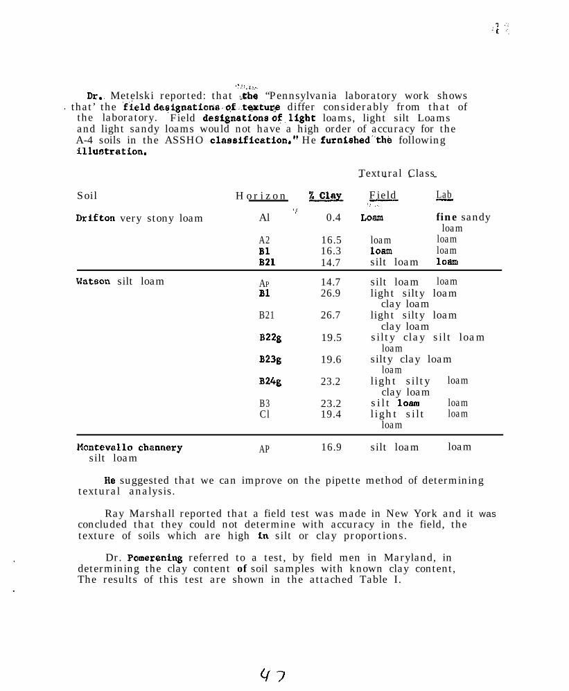
,:,I!.‘I...~
Dr., Metelski reported: that :tbe “Pennsylvania laboratory work shows~. that’ the ‘field designations,~gf,;,taxtUr~ differ considerably from that of
the laboratory. Field deSignatiOns of~ligbt loams, light silt Loamsand light sandy loams would not have a high order of accuracy for theA-4 soils in the ASSHO classification.” He furnished”the followingilluotration.
Textural Class- - - -
Soil H o r i z o n %clay Field Lab,-..?7-- -
Drifton very stony loam Al ” 0.4 LOam fine sandyloam
A2 16.5 loam loamBl 16.3 loam loamB21 14.7 silt loam loam
Watson silt loam AP 14.7 silt loam loamBl 26.9 light silty loam
clay loamB21 26.7 light silty loam
clay loamB22g 19.5 silty clay silt loam
loamB23g 19.6 silty clay loam
loamB24g 23.2 light silty loam
clay loamB3 23.2 silt loam loamCl 19.4 light silt loam
loam
Mantevallo channery AP 16.9 silt loam loamsilt loam
He suggested that we can improve on the pipette method of determiningtextural analysis.
Ray Marshall reported that a field test was made in New York and it wasconcluded that they could not determine with accuracy in the field, thetexture of soils which are high Ln silt or clay proportions.
Dr. Pomerening referred to a test, by field men in Maryland, indetermining the clay content of soil samples with known clay content,The results of this test are shown in the attached Table I.
The National Committee recommended that a etudy be made of the setof soil survey grain-sise limits to determine which changes can be madeto obtain closer agreament with other physical eyatems witbout eigntfi-cant impairment to mapping, characterisition, and interpretation of soilsby the soil survey.
Also, the committee recommended that research be undertaken to developguidance for textural designation for scils’high in allophane as well asfor soils that contain Kaolinite pseudomorphs of other minerals.
The, conference, gro;lp recommended that research be conducted on theserecommendations in agreement with thoee of the National committee.

Sample
12345678
-c 1:
4
Comparison between estimates of clay percentages and clay contents determined by Mechanical Analyses.1962 Soil S&&ist Training Session, College Park, Maryland
Mechanical AnalysisSand Silt Clay% % 9.
13 67 207 61 3260 27 1357 13 3035 42 2329 37 3426 21 539 45 4689 5 685 3 12
TexturalClam
silsic:
SlSC1
1clC
sic
1:
Times T.Class
CorrectlyEstimated
IlO.
64
1244528
107
1
3535355
10
Estimates* of percent clay by 13 individuals2 3 4 5 6 7 8 9 I.0 11 12
20 20 10 30 28 35 25 28 16 6 10 25 21- 30 32 50 35 33 8 45 30 28 - 30 32- 110 13 30 12 12 15 18 6 - 15 10 13- 22 20 25 23 20 12 28 10 - 10 20 19- 25 22 25 20 22 10 28 10 28 20 30 22
38 22 40 40 36 28 15 35 25 1 35 40 3060 32 36 35 45 52 20 50 30 9 30 40 3753 50 50 30 75 42 60 60 45 40 60 45 502 3 5 5 8 3 2 3 5 0 1 0 38 518 7 8 5 21011 0 1 2 7
13Mean ofEstimates
*ash indicates an estimate was not made.
NATIONAL COOPERATIVE SOIL SURVRY
NORTHEAST SOIL SURVEY WORK PLANNING CONFERENCE1964
UNITED STATES DEPARRIENT OF AGRICULTUREForest Service ” Northeastern Region
Classification of StoninessDiscussion ” Analysis .. Proposal
Robert F. Reiske
Gentlemen. for the benefit of those in the conference who are not familiarwith the soils program of the Forest Service in Region 7, I should liketo take a minute or two to tell you something about it.
lt started five years ago and consists of two parts - soil survey and soilmanagement. 0x first survey was in cooperation with the Soil ConservationServide on the Monongahela National Forest, West Virginia. The survey areaconsisted of aome,300,000 acrea of which approximately one third is admin-istered by the Forest Service. The remainder ia in private ownership.At present we ere on the Cumberland National Forest in Kentucky, workingon a” area approaching one million acrea. Approximately fifty percent oftthis survey is on private land. ~11 surveye to date have been of mediumintensity and are being mapped at a scale of 4 inches to the mile.
The soil management program consists of what we call “hotspotting” onareas where a soil problem exists or where management could contribute todeterioration of the soil; for example, reforestation projects, timbersales, locating roads, impoundments and other engineering structures, etc.In addition we have been called on by our Division of,State and PrivateForestry to asaiet in their program with the State8 throughout the Region.If ~“y~e has any questions about our program I would be more than willingto answer them after this seesion or any free time during the conference.I” order that you may have sufficient time to croe.s examine me about myt,opic, I had better get on with the presentation.
A S all of you know, the increased pressure for land use is resulting inthe need for more accurate soil surveys. gvidence of this is apparentfrom the interpretations being developed for standard soil survey reporte.Interpretations are being made, not only for 1aDd use classification foragriculture, but also for engineering and forestry. Some reports haveinterpretations for wildlife management, urban planning, irrigation,watershed management, etc. Standard soil eurveys ate fast becomingmultipurpose inventories of the soil resource to be us&d by all landmanagers.

In the past, determination of mapping units, which may be referred to asphases of taxonomic units, has been guided primarily by agricultural use.Areas not suitable for crops or improved pasture received the mfniawm ofattention. As already mentioned, this situation ia quickly changing.With these changes, we need to more accurately classify segments of thelandscape formerly not considered suitable or Zikely to be used for agri-culture. Therefore, we may find it necessary t.o re-define slope classes,stony and boulde:ry classes, miscellaneo~a land types, etc., not generallyconeidered important to agriculture, but very impc~rtant to other landuses.
The following discussian is limited to stony and bouldery cteeses. andbecause miscellaneous land types are closely associated. it is necessary :t.o include them also. The use of coarse fragments in this discussionincludes the mineral fraction larger than two mtliimeters. All refer-ences, undeas st:ated otherwise, wi.PR be found i,n the Soil Survey Manual,USDA Handbook No. 18.
On Page 205, Paragraph 5, Item 3 of the Handbook, coarse fragments largerthan 10 inches in diameter are not considered pert of the aoil. profile.I believe that all. fragment.6 are as much of a soil taxonomic unit asslope, aspect, and other feat,ures of th total landscape and the soilprofile, because they have a direct infYuence on soil genesis and soil
. behavi,or. The use uf coarse fragments between two millimeters and1.0 inches is fairly walk defined objectively in the Manual by size andvolume. However, fragments larger than 10 inches are classified onlysubjectively, with a single use in mind, namely, agronomic land use.
As already mentioned, miscellaneous land typea are closely associatedwith stony and bouldery classes and 1. feel that there is much confusion,as they are now defined in the Manual. For example, on Page 310,Stony land includes segments of the landscape with a stone and/orI~. . _~.._~. .,bnul.dar cover of 15 t.o 90 percent . CM Page 222, Table 5, Class 3,St,onineas is claasiffed aa having 3 t.o 15 percent stone cover and maybe classified as one of the fo%luwdng:
sc.ony landExtremel.y st.ony phase of a soil type~tdny land (series) soil material
According to this definition , Sgnland could be interpreted aa, areasI_.wit:h mw.e t.han three percent st:one cover rather than 15 to 90 percent.I thi.nk that swat of you will agree that three percent atone cover isnot significant enough to delegate a soil to a miscellaneous land typa.The. same is also truf~ for 15 percent.. 1’1% say mote about this later onin this discussion.
0~ Page 219 of the Pkvwal, the abwe is defined further. “Distinctionsbetween soil series and the miscellaneous land type, Stony land, usualiycome between classes 2 and 3, but may come between Classes 3 and 4 if
.
;Z’$
the soil is otherwise unusually responsive to management practices forimproved pasture, or for forestry. If difference8 in potential uwfor wild pe,sture, or for forestry, related to the parent material,exist among kinds of soil having Class 3 stoniness, Class 3 stoninessmay be called Stony land. (seriea name) material. If the dirtinctionbetween CLass 3 and Clans 4 stdnineaa has no significance, all theland of both classes should be included as one unit, Stony land. But,if land with CYa.ss 3 stoniness iie: separated, from that with Class 48 toninesa, eit.her as an extremely eteny phase, or as Stony land(series name) materi,al, or if a real difference exf.ste of importancet.o grazing or forestry, Class 4 is ceLled Very *tony land.”
This, 1~ feel, ib an attempt to define stony classes for other uees.However, we. need to ask ouraelver the following questions:
I. * What det.erml.ne:a the lack c;f: significance bet.ween Class 3 andClass 4 that permIta them t,u be. lumped as one unit - Stony land?Tt dotan’t seem pcasdb3.e t,bat we would get the same soil’andrelated sail be:hav:tat with a, e&B that: has 3 to 25 percent. etonecover, a s one with I.5 t.o 90 pe.rcelalt. Forest, research, althoughmeager, &how that nit:e ptoductivit:y does not change considerablyunt.il ntone cover cesnrr{ats of 40 t.o 60 percent, This ua8 foundto be true in ow survey b”n the M,:nnngahela National Forest inWest Virginia and hae aPan been found in other areas i.n thenortheast.
2. How can we justify classi.fyiwg the same ontt, Class 3 stnnin~~ss,with 3 to 15 percent at.one ce~ver either
(a) GLcuceat,er extremely stony E.oam
(b) Stony land
(c) Stony l.and (GZauce~her s&l mater laYI when t.hs soilbehs.v!.or $8 the eame7
IR i,t or ian” t it. a ILarad typ,ez? Is t:hwx a &a&l profile that c%n beidentLfi,ed?
(aa,) GLoweecaLw extrea!e%y atnny Ylaam indicates t h e r e i s
(2b) Stwy land irdieat,as there is none
(2~) Stony l:g.nd (Gloucester soil material) is quebtioaable.
3. Are we cuSrrect in, s%ying, f&r CYass 3 stoniness, 2(a), (b), or (c)above may be used de.pelnd.lrlg up~x parer& ruaterial poteratial?
. ;I’)
.
4. Can we continue to classify stcvny soils for multipurpose standardsoil surveys, based upon an agricultural or forestry subjective useclsesi f icat ion?
It is readily admitted in the Manuel that the distinction between soilseries at Class 2 and Class 3 stoniness is arbitrary and has a singleland use in mind _ agronomic land use. It is also implied in the Manualthat land with more than three percent aune cover is unsuited forcultivation or for cultivated pasture, but may have some use for wildpasture or forests. If we are to make multipurpose standard soilaurveya, these arbitrary decisions need to be expanded upon to includeother wes. By using a mI@cellananus land type for area8 with morethan 15 percent. stone cover awd, io s~ome cases, with more than threepercent, we indicate that there is little, or no, natural soil to bec lass i f i ed uz tha.t the area i,hi nearRy inacceaaibfe for orderly exami-nation (mi~acellaneous land t,ype defi.nition, Page 306, Soil SurveyManual).
fife tine of reasonj.ng twams tcr be in error if it is used in connectionwith a standard detailed suib ewrvey because
(1) Soil8 wit.h more t.han 3 to 15 percent. coarse fragments (largerthan IO inches) on the surface, a8 wet1 as throughout theprofile, can be ident.ifl,ed and cla~ssified.
(2) Frequently, t:he amount of stone on the surface is no indicationof the amaunt ctf st:one in the sol .1 prof i le . Oft.en, thir, st,onecover has accumulated a8 “mulch” on top of the aoil and thereare few eoaree fragments within the soil profile,
Bawd upon the above analyses and diacusaion, the following suggestionsare made:
2.
2, .
3.
~br: size:. awunt. and pattero of al!E. warae fragments on thesurface as well as those in the aoil profile need to bede8cribe.d for taxowmie unLt.8 or ph&w.a t h e r e o f .
Stony phases for taxunc&e units and phases should not bedeterrrJ.ned aad d.eacrfbe:d arbi,trariYy by a single land uee.They abwld be described and reported a& t.hey occur on thelandscape ._ average and racge need t.o be i.nc2uded.
There ia sufficient evidence that the break between ataxonomir unit (pier~isa) and a miscellaneous Land type shouldnot be made betwe.en stone Classes 2 and 3 or Class 4, butrather, betwe$w C%s~asas 4 and 5 of,, the present classification.

4 .
5.
6.
7.
‘Poe present cl&ssification for stony classes and miscellaneousland type, Stony land, appears to be inadequate and needs tobe re-defined so that it tag be used more objectively to describethe soil landscape from a genetic soil behavior standpoint,rather than hy a subjecti,ve land use classi,fication.
When developtng lnteaprstatian for stony phases of taxanomicunits, t,he limits of the phases need t.o be developed to meett:he signi.ficant lend use:& of th.e survey area and not onlythose of agriculture or forestry.
A cmtttee be appvinted t.d study preeent classification of“rockiness” classes. as w4.V *s ‘@aton~ineas” presented in thisdiscussion.
The attached propc,sed @lahslfLcatioa for stoni.ness classes 1,ssuggest.ed 8s a hegjnniag. Yt is ~wt; intended to he complete,
In. conclusion, Y would like to take thd.s opport,uaity to thank you foryour interest, in t,hls diB@ussicjn, and I hope that it may be of assistancein revising t,he: Manuual, as wggaatcd by Dr. Kellogg in his talk at. theNational Technical Work-Plarrsaing C~,nference of the Cooperative SoilSurvey in Chfcsgo last ~srch.
-s-
54
PRESl’BT STONINESS CLASSIFICATION (l)
,ass 0
a
.
:1ass 1 (0.01 to 0.1%)lloucester Stony loam
;, _ (I )
ri ‘,
cllaee 3 (3 to 15%)Gloucester Ext:remely Stony loamStony landVery~ Stony kan!d
._ :..
Clam 5Ruhbk ?.snd
PROPOSED STONINESS CLASSIFICATION ,(l)
IClass 1 (0.1 to 3%)Gloucester Slightly Stony
loam
Class 3 (15-301)Gl.ouccster Stony loam
r .,... __ ..,.... _ . . . . . ~___.__
Class 2 (3 to 15%)~Gloucester Moderately Stony
10alU
Class 4 (30 to 50-60X)Gloucester Very Stony loam
Class 5 (50-,6D to 90%)GLo?w.est.er Ext~remly stony
Y.oam
Class 6 (90% plus)stony land
(1.) Percent of stones and/or boulders.
Blocks reprksens 1 acre.
Bzz Inwer l.lmit, (%) 7 m Dpper limit. (2)-, -
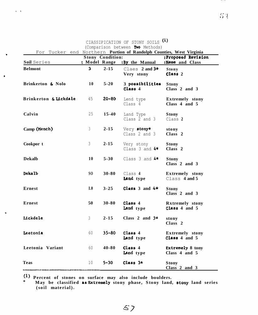
. .
.
.
_
CIASSIPICATION OF STONY SOILS (l)(Comparison between lWo Methods)
For Tucker end Northern Portion of Randolph Counties, West VirginiaStony Condition: :Proposed Revieion
Soil Series : Model Range :By the Manual :Name and ClassBelmont
Brinkerton h Nolo
Brinkerton h lickdale
Calvin
Camp (Mench)
Cookpor t
Dekalb
Dekalb
Ernest
Ernest
Llckdale
Leetonia
Leetonia Variant
Teas
3
10
45
25
3
3
10
SO
I.0
50
3
60
60
10
2-15
5-20
20-80
15-40
2-15
2-15
5-30
30-80
3-25
30-80
2-15
35-80
40-80
S-30
Claes 2 and 3*Very stony
3 possibilitiesClass 4
Lend typeClass 4
Land TypeClass 2 and 3
Very stony*Class 2 and 3
Very stonyClass 3 and 4*
Class 3 and 4*
Class 4Land type
Class 3 and 4*
Class 4Zand type
Class 2 and 3*
Class 4Iand type
Class 4Iand type
Class 3*
StonyClass 2
StonyClass 2 and 3
Extremely stonyClass 4 and 5
StonyClass 2
stonyClass 2
StonyClass 2
StonyClass 2 and 3
Extremely stonyClass 4 and 5
StonyClass 2 and 3
Rxtremely stonyClass 4 and 5
stonyClass 2
Extremely stonyClaw 4 and 5
Rxtremely 8 tonyClass 4 and 5
StonyClass 2 and 3
-------1---
(l) Percent of stones on surface may also include boulders.* May be classified a8 Rxtremely stony phase, Stony land, lstony land series
(soi l mater ia l ) .
s7
.
.
.
NATIONAL COOPERATIPE’SGIL SURVEYNORTRRAST SOIL SURVRY WORR PUNNING CONPUUWCE
1964
Notes on general discussions of
Soil landscapes
Lithologic discontinuitias
pses of symbols for identification and nomenclaturesof soi l hori,zons
Soil landscapes were discussed, with amphasia put on thedefinition of soil being a three-dimensional body with character-istic geomorphological features. When such geomotphologicalfeatures are correctly interpreted and understood, they canbe used to great advantage in soil surveys.
L i t h o l o g i c a l discontinuities and uses of symbola for identi-~fication and nomenclat_ure of soil horizons wsre discussed,very briefly as outlined in the Supplement to AgriculturalHandbook No. 18. Way 1962.
One correction to the supplement was noted: Page 183,.x - Fragipan character, Paragraph 2, first sentence shouldread - “All lower case symbols except p and x follow the lastarabic number used, as B3ca, A2g, AZlg.”
c U. S. DEPARTMENT OF AGRICULTURESoil Conservation Service
.
.
February 20, 1964
NORTHFAST SOIL SURVEY WORK PLANNING CONFERENCENew York City - January 20 to 23, 1964
Phasing of Soils for Forestry, Construction, Urbanieation and Agriculturel3. J. Patton, K. P. Wilson, R. F. Reiske and A. E. Shearin
Patton:
Aspect: Aspect is a phase. In new surveys I would be tempted to map twoaspect phases. Aspect can be taken from soil survey maps. This can bedone easier from soil survey field sheets using a steroscope than frompub1 ished mosaics.
Aspect may be reflected in a thicker, darker A, or Ao but this will needsome testing.
Slope position: Ridge phase or narrow upper ridges, on some soils, have alower site index than the rest of the landscape. This is actually a depthdifference.
Calluvial soils: Elimination of mode of origin and characteristic phys’io-graphy as series criteria may require phasing, such as bench phases, on upperslopes.
Engineering: Kind of bedrock such as soft shale versus hard rock may beimportant enough to phase in places.
Flood haeard: Frequency of flooding phases needed in some alluvial soils.
blade land : Phase names should be as descriptive as possible, consistent withbrevity .
Wilson:
In my opinion, (even after Simonson explained slops phasing and afterhaving reread the manual), no phases should be recognized which cannot bedetermined objectively in the field by examining the soil and its sub-stratum features affecting the uses in question.
I would like to apply this philosophy to slope phases, but because of thelong history of slope mapping and because some insist that alope is part ofthe soil, an exception probably has to be made. Personally, I considerslope to be an environmental factor and not’a soil characteristic. Inpractice slope phases are not tied closely to the individual soil seriesor type because the percent limits are kept the same for a very wide rangeof soils. This implies that slope is an independent variable.
If we do not establish some such iron-clad limitation on phases, theirnumbers could proliferate in all directions.
5 Y
The use of climatLc phases without distinctLone in the soil itselfconstitutes the entering of another discipline to make an interpretivemap. There La no law against makLng all tha interpretations you can, butdon’t make them soL1 phase criteria. Who can establish the field boundarLesof mapping unit based solely on a climatLc distLnction7
If it is reflected in the profile as a within-rerlea varfatLon, and isclearly mappable, such a distLnction is reasonable at the phase level. Ifnot, it should be avoided.
In mapping marshland we have the same problem in determlnlng salinity levels.Generally vegetatLon works by applying certaLn rules of plant-site assocla-tion, however, the only safe,criterion is the salinity of the soil rolutlon.The vegetation may represent history. The same problem cropa up with allvegetative criteria - woodland especially. We must dirtingutrh clearlybetween soil phasing and mapping by vegetative or other non-soil crttaria.
In urban-fringe eraes any spatial soil condLtLons era better kept es specialland type varLations at t& phase level but should reflect soil characterir-tics, not soma LnterpretLve evaluation for usa. Lat.‘8 not confusa basicsoil surveying wLth LntarpretLva mapping.
As I understand phasing Ln e natural or basic roil classLfLcatLon system,one should attempt to use only those phases which have sLgnLficant effectson use and management for meny important uses - not just one.
.
Feiske:
Phasing for forestry is needed when the taxonomic unit does not reflect(accurate interpretations cannot be made) changas in tha followtng whenthey occur on the same unLt.
a.
b.
c.
d.
Vegetative, major end minor, assoclatlons. Example: oak, northernhardwoods.
SLgnificant dLfference in prodlcting potential which may be masurad bysite index. ThLs may be reflected by slope position and/or aspect.Example: lower third, middle. third, uppar third; N(hW-Xdre), &(NE-SE),S@W-SE) end WC%-NW) .
Stony, boulder-y or rocky phases whare they cover 4040% or more ofthe surface.
Slope phases, O-25% to 3070, angle of rapore and above angle of repose.
Shaarin:
In mediw density surveys phasLng for urbanization occur mainly Ln ateesr~hara the soils have been disturbed. These can be dLvLded into two broadcl.as.ses.
1. Areas where the dLagnostLc soil horieons have been obliterated overa large percentage of the areas.
.
.
.
.
.* -- 3 - 1 i '$
2. Cut and fill area8 or otherwise disturbed to some extent but all thediagnostic soil horizons have not been obliterated over a large per-centage of the areas.
It is suggested that in the first category mapping units established bebased on texture, consistence, drainage, lithology, coarse skeleton, etc.,depending on local conditions.
In the second category the soils may be classified as phases of soilseries.
Examples of mapping units or phases of series in disturbed soil area8 wereproposed in the 1962 committee report on "Improving Soil Survey Operations"of the Northeast Soil Survey Work Planning Conference.
In high density surveys in urban areas probably more depth phases overbedrock or fragipan would be desirable in places than are normallyrecognized in medium density surveys.
.
.
.
NATION4L CO-OPERATIVE SOIL SURVEY
NORTHEAST SOIL SURVEY WCRK PUNNING COfJFZRRENCE
1961r
Note6 on soil survey interpretations, urbsn areas, and cmeriencesin Hanover Town; Plymouth County, Faasachuoetts.
Mr. S. J. Zayach distributed copies of a document entitledWail Interpretation for cbmmvnity Planning”, a case study forthe Town of Hanover, Massachusette pr+ared jointly by the Irass-achusetts Department of Conrmerce and the Soil Conservation Ssrvice.
The lack of time prevented an evaluation of this dccument althcughcomparisons were drawn between general form, scope of informz+,ion,and map quality,
Notes on low-intensity standard survey in Vermont.
MY. M. Howard distributed a document OutlWng th3 CWe$opx%tof legends for low intensity standard survq~ in ?xtons2.ve fz”es;_edareas in Vermont. Legends have been derelopod in four ~ou:!ti.cs zndwi3.1. be developed for six more in t.he netr future. A br5~e.f d-s-cwqinn followed with no general conclusions or evaluatla:x dra~rm.
c d
..
Y
&; I
.
L
.
NATIONkLCO4PEiRATIVE SOILSURVEYl?XTHFAST SOIL SURV!X WORK PLANNIt& CONWREKE -196h
Notes on the discussion of Soil Series Descriptions lead by Dr. SoySimonson and Dr. Arnold DBU~.
me introductory statement or sunmmry. A wnparison is dram betweenthe series being described and its geographically and morphologicaUyrelated associates. There are three types of associates:
1. Competing series - related zmrphologically but not geographically.2. Related series - related morphologically and g5ographically.3. Geographical series - related geographically but not morphologically.
The wrphological charactaristics of the eerie5 may be used in describingrelationship5 between competing and related a55ooiate5.
The profile descriptlon.Acomplete description, horizon by horizon, isgiven of the nnxphological characteristics of the profile. All charactar-istics are set apart by semi-colons. The range in thickness of each hor-izon is given and reflecta the range for the series as a whole and notthe range for the Individual profile being described. This informationis set apart from the preceding descriptive terms by a period. The modalprofile of a particGl.ar area or county need not be typical for each of thedistinguishing characteristics of the official series description.
The range of charaateristics. Descriptive CheraCteriStiCB thzt have beenused in the introductory statement need not be repeated enrcept for olari-fiCatiOn and eZIpha8i.B. An outline prepared by the Principal CorrelatorQOffice for uBe as a guide for the %ange of characteriBticsv paragrapim.forstandard series descriptions ~8s discussed.
Dr. l%aur reviewed the status of profile description revisions in theNortheast. Lists of 5011 series were prepared by the principal Sorrelator~soffice, each categorizing the status of revised drafts, their circulationand duplication for dietribution.
.
G 3
Related Documents