Northbank BID Green Infrastructure Audit Prepared by LUC June 2014

Welcome message from author
This document is posted to help you gain knowledge. Please leave a comment to let me know what you think about it! Share it to your friends and learn new things together.
Transcript

Northbank BID Green Infrastructure Audit
Prepared by LUC June 2014
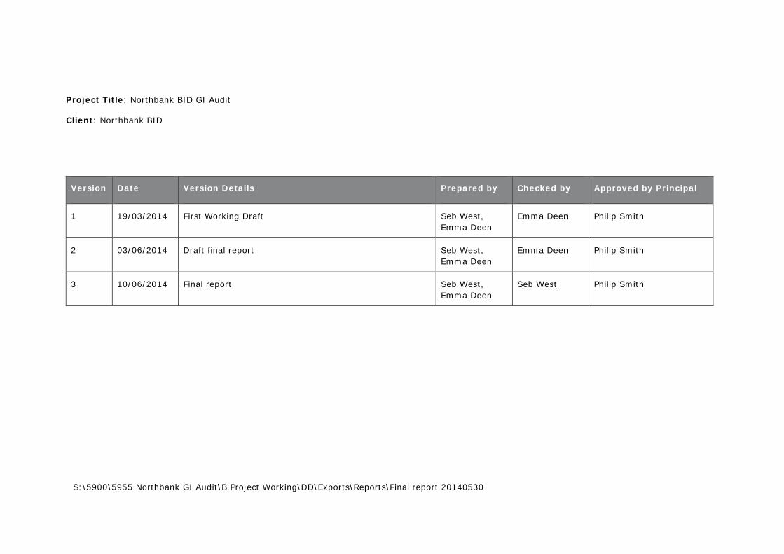
Project Title: Northbank BID GI Audit
Client: Northbank BID
Version Date Version Details Prepared by Checked by Approved by Principal
1 19/03/2014 First Working Draft Seb West, Emma Deen
Emma Deen Philip Smith
2 03/06/2014 Draft final report Seb West, Emma Deen
Emma Deen Philip Smith
3 10/06/2014 Final report Seb West, Emma Deen
Seb West Philip Smith
S:\5900\5955 Northbank GI Audit\B Project Working\DD\Exports\Reports\Final report 20140530
Northbank BID Green Infrastructure Audit
Prepared by LUC June 2014
Planning & EIA Design Landscape Planning Landscape Management Ecology Mapping & Visualisation
LUC LONDON 43 Chalton Street London NW1 1JD T 020 7383 5784 F 020 7383 4798 [email protected]
Offices also in: Bristol Glasgow Edinburgh
FS 566056 EMS 566057
Land Use Consultants Ltd Registered in England Registered number: 2549296 Registered Office: 43 Chalton Street London NW1 1JD LUC uses 100% recycled paper
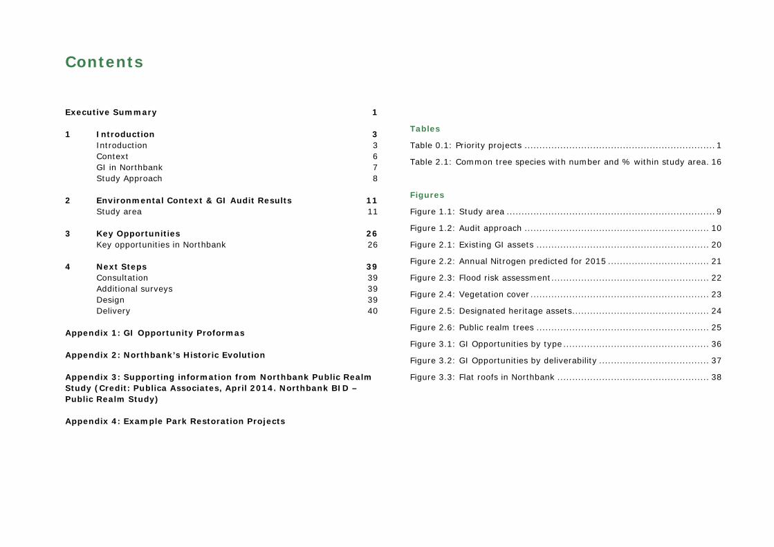
Contents
Executive Summary 1
1 Introduction 3 Introduction 3 Context 6 GI in Northbank 7 Study Approach 8
2 Environmental Context & GI Audit Results 11 Study area 11
3 Key Opportunities 26 Key opportunities in Northbank 26
4 Next Steps 39 Consultation 39 Additional surveys 39 Design 39 Delivery 40
Appendix 1: GI Opportunity Proformas
Appendix 2: Northbank’s Historic Evolution
Appendix 3: Supporting information from Northbank Public Realm Study (Credit: Publica Associates, April 2014. Northbank BID – Public Realm Study)
Appendix 4: Example Park Restoration Projects
Tables
Table 0.1: Priority projects ................................................................ 1 Table 2.1: Common tree species with number and % within study area . 16
Figures
Figure 1.1: Study area ...................................................................... 9 Figure 1.2: Audit approach .............................................................. 10 Figure 2.1: Existing GI assets .......................................................... 20 Figure 2.2: Annual Nitrogen predicted for 2015 .................................. 21 Figure 2.3: Flood risk assessment ..................................................... 22 Figure 2.4: Vegetation cover ............................................................ 23 Figure 2.5: Designated heritage assets .............................................. 24 Figure 2.6: Public realm trees .......................................................... 25 Figure 3.1: GI Opportunities by type ................................................. 36 Figure 3.2: GI Opportunities by deliverability ..................................... 37 Figure 3.3: Flat roofs in Northbank ................................................... 38

Northbank BID GI Audit 1 June 2014
Executive Summary
In December 2013, Northbank BID commissioned LUC to undertake an audit of green infrastructure (GI) in the area. This report summarises the findings of the audit, and makes recommendations for enhancing green space and delivering additional green features in the area.
Greening has the potential to deliver many environmental benefits to the Northbank area, creating a more attractive working and living environment. Headline findings of the audit include:
Existing Green Infrastructure
The Northbank BID area covers 51.5 hectares, and includes 2.75 hectares of existing parks and other green space (Fig. 2.1). This includes Victoria Embankment Gardens, Savoy Chapel Gardens, Temple Gardens, St Mary le Strand Gardens and the Royal Courts of Justice Gardens. There are many mature trees within the area, particularly along the Victoria Embankment and Aldwych, 60% of which are Plane trees. There are 10 buildings which have green roofs on part of the roof surface (Fig. 3.4). There are no green walls in the area at present.
The area suffers from poor air quality (Fig. 2.2), particularly along Strand, Aldwych and Victoria Embankment. The area is also prone to localised flooding during periods of heavy rainfall (Fig. 2.3), including around Somerset House and the Adelphi.
Potential for greening
The audit has identified potential to enhance 3.4 ha of existing green space, and create 0.6 ha of new green space. It has also identified significant potential for building-mounted green features, including green walls, plus 45 flat or partially flat roofs without obstructions, that may be suitable for green roof installation.
Priority projects
The priority projects for Northbank are outlined in Table 0.1, and are shown in Figure 3.1. These eleven projects include two sites of existing green space which have potential for enhancement, plus nine sites where new green features could be created.
Table 0.1: Priority projects
Project Summary Cost Ref.
Embankment Station
Green roof and living wall at this key gateway location
£30-50k 43 & 44
Victoria Embankment Gardens
Enhance gardens to deliver people, wildlife and cultural improvements
£50k+ 1 & 18
Savoy Gardens
Open up this attractive green space to the public during daylight
<£10k 45
Strand Planters and new planting around St Mary le Strand and St Clement Danes Churches
£10-30k 7, 15, 19, 20
Temple Station
Temporary greening through planting and seating
<£10k 38
Hungerford Railway Bridge
Specialised planters to be installed at elevated position on the buttresses
£10-30k 42
Victoria Embankment and Cycle Cross Route
Integrate additional green features alongside new cycle route
£50k+ 1
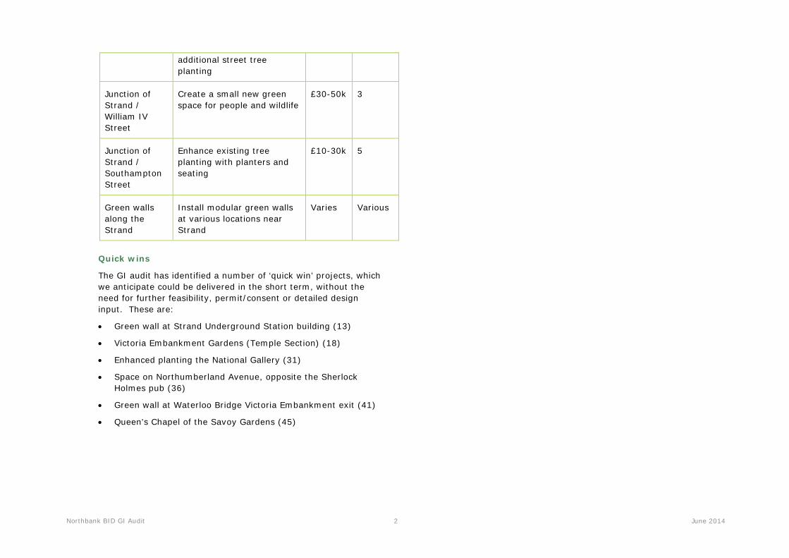
Street trees Various opportunities for Varies Various
Northbank BID GI Audit 2 June 2014
additional street tree planting
Junction of Strand / William IV Street
Create a small new green space for people and wildlife
£30-50k 3
Junction of Strand / Southampton Street
Enhance existing tree planting with planters and seating
£10-30k 5
Green walls along the Strand
Install modular green walls at various locations near Strand
Varies Various
Quick wins
The GI audit has identified a number of ‘quick win’ projects, which we anticipate could be delivered in the short term, without the need for further feasibility, permit/consent or detailed design input. These are:
• Green wall at Strand Underground Station building (13)
• Victoria Embankment Gardens (Temple Section) (18)
• Enhanced planting the National Gallery (31)
• Space on Northumberland Avenue, opposite the Sherlock Holmes pub (36)
• Green wall at Waterloo Bridge Victoria Embankment exit (41)
• Queen's Chapel of the Savoy Gardens (45)

Northbank BID GI Audit 3 June 2014
1 Introduction
Introduction
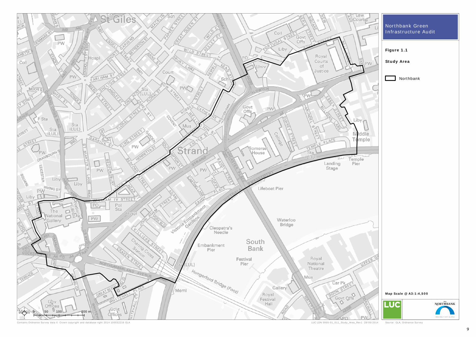
1.1 In December 2013, the Northbank BID commissioned LUC to undertake an audit of green infrastructure (GI) in the area. The study area comprised the Northbank BID area, as shown on Figure 1.1. The study included a desk-based and site audit of the area, to identify existing and potential green features. These green features include:
• Green spaces, including parks and gardens, street trees and planters
• Green roofs
• Green walls.
1.2 The study will support the Northbank BID in delivering environmental enhancements in the area and to help address current environmental issues, such as poor air quality and localised flooding. These enhancements will improve the attractiveness of the area for business, residents and visitors.
1.3 The BID identified the following priorities for new green features in the area:
• Visibility – highly visible features
• Deliverability – including potential for short term enhancements
• Overall enhancement – particularly for pedestrians and cyclists.
Why green Northbank?
1.4 This study reflects the Northbank BID’s recognition of the various benefits of increasing green infrastructure in the study area. In
cities across the UK, companies have begun to recognise the value offered by green infrastructure. In cities across the UK, companies have begun to recognise the value of green infrastructure. For example, Rubens Hotel in Victoria has successfully installed a large green wall, and John Lewis also has plans to deliver one of London’s first rain gardens at its HQ in Victoria, as well as celebrating its 150 anniversary at Oxford Street by installing a roof garden.1
1.5 The Northbank area has relatively little green infrastructure. Green infrastructure is an essential part of creating more comfortable and ‘liveable’ urban environments in the face of climate change. In the case of Northbank, well-considered green infrastructure can also be used to complement and set off the significant architectural and historical assets of the area – a contribution to sense of place and experience.
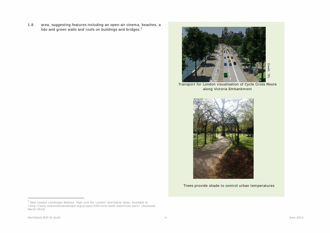
1.6 There are plans to redevelop Arundel Street, plus adjacent development of the proposed Garden Bridge as proposed by Thomas Heatherwick and Arup, with construction proposed for 2016. The aim of the Garden Bridge is to improve connectivity between the North and South Banks, improve economic activity, provide a popular tourist destination and enhance flood storage and biodiversity. This will be complemented by the Cycle Cross Route, which is planned to run along the Victoria Embankment, creating a safe cycling environment and bringing large numbers of cycle commuters and visitors along the Northbank on a daily basis. Although the Transport for London (TfL) image above does not include new green features, Northbank BID is keen to work with TfL and others to incorporate green elements to this exciting scheme.
1.7 Recently, a proposal for the North Bank Waterfront Park was submitted to the London High Line Green Infrastructure ideas competition. This proposes to unlock the potential of the riverside
1 Victoria BID Website. Available at: <http://www.victoriabid.co.uk/news-and-press/first-rain-garden-approved-for-victoria/> [Accessed March 2014]
Northbank BID GI Audit 4 June 2014
1.8 area, suggesting features including an open-air cinema, beaches, a lido and green walls and roofs on buildings and bridges.2
2 New London Landscape Website ‘High Line For London’ shortlisted ideas. Available at: <http://www.newlondonlandscape.org/project/235/north-bank-waterfront-park> [Accessed March 2014]
Transport for London visualisation of Cycle Cross Route along Victoria Embankment
Credit: TFL
Trees provide shade to control urban temperatures

Northbank BID GI Audit 5 June 2014
What will greening do?
1.9 A study by Exeter University recently demonstrated that the benefits of living near a green space included improvements to mental health which continue for at least three years after moving to the area.3 Even small green spaces can provide an opportunity for relaxation and quiet reflection, away for the bustle of London’s streets. Larger spaces have the additional benefit of providing a venue for activities including exercise, sports and a range of events.
1.10 The UK Climate Impact Projections indicate that London is likely to experience hotter, drier summers and warmer, wetter winters. In addition, climate change models suggest that increased variability and unpredictability in the weather will be the result of predicted climate change. The observed effects of these climatic changes in central London include:
• Surface water flooding during periods of heavy rain;
• Urban heat island effects increasing temperatures during warm periods;
• Wind tunnel effects combined with dry spells, which create excessive dust;
• Drought conditions leading to water shortages and affecting existing parks and gardens;
• Warm weather which exacerbates air pollution.
1.11 Unless mitigated, the impacts for businesses of these climatic changes could include disrupted travel as a result of flash flooding, increased costs of cooling business premises and potential health impacts for employees.
Meeting BID objectives
1.12 Green infrastructure will help to deliver the Northbank BID’s ’Cleaner and Greener’ initiative. It will also help meet many of the BID’s other objectives, including:
3 Alcock, I. et al 9 December 2013. Longitudinal Effects on Mental Health of Moving to Greener and Less Green Urban Areas, Journal of Environmental Science and Technology.
• Assisting with way finding and signage;
• Encouraging more footfall in the area and dwell time;
• Capturing the large numbers of tourists that pass through, to stay in the area;
• Promote a better trading environment
• Facilitating local benefit for residents, visitors and employees within Northbank.
1.13 Increased GI could help address the following local environmental issues. This includes:
• Localised flood risk and drainage issues. This is partly caused by a lack of green space to absorb water during periods of heavy rainfall.
• Poor air quality. The air quality in and around this part of London is amongst the worst in the UK. Trees and other well-positioned green spaces can help alleviate the health impacts of this by dispersing and absorbing pollutants, reducing the effects on people.
• Wildlife deficiencies. This part of London is identified as deficient in wildlife in the All London Green Grid. Enhancing existing green spaces and investing in new habitats such as green walls, green roofs and tree avenues can help to make space for urban wildlife.
1.14 Delivery of these opportunities will also help to meet the following objectives:
• Reduce carbon emissions through insulation of buildings and moderating temperature, thereby reducing the need for air conditioning and heating;
• Introduce exciting and inspiring green infrastructure solutions – these could include green walls and roofs, rain gardens, urban orchards and wildlife experiences for children and adults alike;
• Increase the appeal of Northbank to businesses and visitors, through improving viewpoints and enhancing the

Northbank BID GI Audit 6 June 2014
environment, creating green oases where people can escape traffic noise and pollution;
• Encourage sustainable travel through creating a more pleasant environment for pedestrians and cyclists.
Pockets of open spaces and garden squares create space in the city for people and wildlife.
Context
1.15 London Charing Cross Station is an important Gateway to London, with over 38 million people passing through in 2012-2013. Whilst there are many UK attractions within walking distance of London Charing Cross Station, including Trafalgar Square, the National Gallery, Somerset House and the numerous theatres. The Northbank is also home to a huge range of important London institutions including LSE and Kings College, The Savoy and Corinthia, the Queen’s bank Coutts, corporate offices such as PWC and Shell, and restaurant The Delaunay, all of which are partners in the Northbank BID.
1.16 Northbank is one of the cultural heartlands of London and offers a thriving commercial community.
Mayoral initiatives
1.17 The Mayor’s London Plan and his Climate Change Adaptation Strategy calls for the protection, promotion, and management of London’s green infrastructure – its green and open spaces, river corridors and greenways, green roofs and street trees - in order to deliver a range of benefits including:
• Increased access to open space and contact with nature;
• Adaptation to the impacts of climate change;
• Sustainable travel connections and promotion of cycling and walking;
• Healthier living;
• Sustainable food growing;
• Enhanced destinations and streetscape supporting the visitor economy and commercial footfall;
• Promotion of green skills and sustainable approaches to design, management and maintenance.
1.18 Northbank lies within Green Grid Area 12 (Central London), as defined in the Mayor’s recently published All London Green Grid Supplementary Planning Guidance (March 2012). The Draft SPG
Northbank BID GI Audit 7 June 2014
highlights the importance of “delivering GI benefits in relation to surface water flood management, mitigating the urban heat island effect and increasing access to open space”.
Westminster
1.19 The study area lies within the City of Westminster, and the policies and priorities of the City Council have influenced the identification of opportunities. The majority of the area is situated within the Thames Policy Area. Westminster’s Core Strategy includes the following commitments in relation to open space and green infrastructure (policies CS34 – Open Space and CS37 – Green Infrastructure):
• Protect and enhance Westminster’s open space network, and work to develop further connections between open spaces;
• Address active play space deficiency;
• Secure contributions to improving the quality, ecological value and accessibility of local public open spaces and delivering new open spaces from under-used land;
• Biodiversity and green infrastructure will be protected and enhanced… and opportunities to extend and create new wildlife habitat as part of development will be maximised.
The Blue Ribbon Network
1.20 Westminster’s Core Strategy includes the following commitments in relation to the Blue Ribbon Network (policy CS36 Westminster’s Blue Ribbon Network).
1.21 “The Blue Ribbon Network will be protected and improved by:
• Enhancing biodiversity and waterside habitats;
• Protecting and enhancing the character, appearance, heritage and landscape value of the Blue Ribbon Network and its setting; and
• Enhancing the linear qualities of the Blue Ribbon Network, particularly in relation to heritage, landscape and views, biodiversity, and modes of sustainable transport;
• and, where it is consistent with these priorities;
• Improving access for pedestrians and cyclists, use for leisure, sport and education especially for local communities; and
• Water-based transport.
1.22 Development alongside the Blue Ribbon Network must address the waterside, with a focus on enhancing the waterside location and improving access to and enjoyment of the waterfront.”
London View Management Framework
1.23 The Northbank BID area is included in The London View Management Framework which is part of the Mayor's strategy to preserve London's character and built heritage. It highlights the “policy framework for managing the impact of development on key panoramas, river prospects and townscape views”.4
GI in Northbank
Existing greening initiatives in Northbank
1.24 Consultation with partners of the Northbank BID has highlighted a number of existing initiatives already underway in the area. These include:
1.25 Northbank BID: The BID is already engaged in a number of greening initiatives in the area. This includes:
• Proposed construction of the Garden Bridge at the southern end of Arundel Street.
• Proposed installation of a green roof on Embankment Underground Station.
• Potential for a green roof at the Adelphi Theatre.
• Proposed green roof at the Savoy Pier.
• Cycle Cross Route proposed for the Victoria Embankment.
4 GLA Website. Available at: <http://www.london.gov.uk/priorities/planning/supplementary-planning-guidance/view-management> [Accessed 13 March 2014]
Northbank BID GI Audit 8 June 2014
1.26 Northbank BID has also developed a Public Realm Strategy for the area, and the recommendations of this study have informed this GI audit.
1.27 Ongoing and planned regeneration in the area will influence the timescales for some GI delivery, and means that opportunities on specific streets such as Villiers Street and Arundel Street are best delivered alongside other regeneration.
Study Approach
1.28 The study included several key elements:
• A desk-based study, using Geographical Information Systems (GIS) and aerial photography to map existing GI assets. This included an audit of flat roofs to highlight potential for green roof installation and the terrestrial GI resource (including trees based on tree location data supplied by Westminster City Council and TfL) and opportunities, together with an identification of existing management issues and high level management options for tree stock.
• The development of a GIS-linked database, which enables records of all existing and potential GI assets to be linked to a map.
• Consultation with local businesses and stakeholders to identify any existing GI initiatives which are underway, and their aspirations for their part of the study area.
• Ground truthing/site audit to confirm the accuracy of the mapped data. The ground-truthing exercise also enabled the gathering of more detailed information on the current quality and quantity of GI and potential opportunities to enhance GI in the study area.
• A walking workshop to discuss potential opportunities to the steering group and key partners, and highlight any priorities or barriers.
• Report compilation to highlight the key opportunities in the area and more specifically:
o Key strategic and thematic opportunities to enhance or increase the GI resource.
o Identification of opportunities to retrofit GI in areas of high flood risk as defined in the Westminster Flood Strategy.
o Indicative scoring of GI opportunities and outline costs to inform prioritisation for delivery.
o Broad guidance on the potential feasibility of delivering GI, surface water drainage and urban flood management features, green roofs and walls within the study area.
o Accurate GIS mapping linked to a database, which could be readily updated in the future.
Contains Ordnance Survey data © Crown copyright and database right 2014 100032216 GLA
0 100 20050 m
LUC LDN 5955-01_011_Study_Area_Rev1 28/05/2014
Map Scale @ A3:1:4,500
²
Study Area
Source: GLA, Ordnance Survey
Northbank Green Infrastructure Audit
Northbank
Figure 1.1
9
Northbank BID GI Audit 10 June 2014
A desk-based assessment and street audit of terrestrial GI; Existing green roofs and flat roofs; Trees.
Consultation with relevant partners of the Northbank BID.
Walking workshop with selected partners to discuss potential GI
options.
Prioritise opportunities in relation to benefits
and costs.
Broad guidance on the potential feasibility of
delivering GI.
Reporting: All opportunities described
and mapped in GIS database.
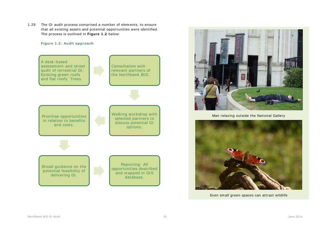
1.29 The GI audit process comprised a number of elements, to ensure that all existing assets and potential opportunities were identified. The process is outlined in Figure 1.2 below:
Figure 1.2: Audit approach
Man relaxing outside the National Gallery
Even small green spaces can attract wildlife
Northbank BID GI Audit 11 June 2014
2 Environmental Context & GI Audit Results
Study area
2.1 The study area is located in the City of Westminster in central London, shown in Figure 1.1; the Northbank BID site covers an area of around 50 hectares (0.5 km2). Existing green spaces are indicated in Figure 2.1.
Character and evolution of the area
2.2 The evolution of the Northbank area centred on the Strand, the ancient processional route between the cities of London and Westminster. The river was historically the focus for a series of palaces of Royalty and the nobility, and this legacy has continued to shape the character and form of the area to this day (Somerset House, Savoy, Adelphi, last remnants of York House).
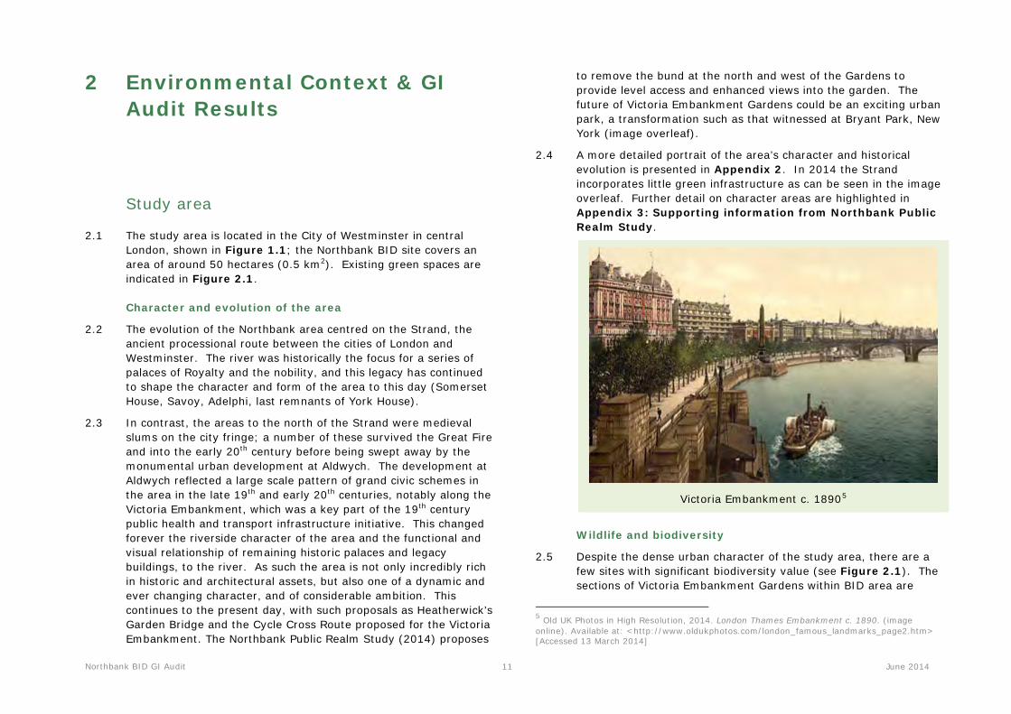
2.3 In contrast, the areas to the north of the Strand were medieval slums on the city fringe; a number of these survived the Great Fire and into the early 20th century before being swept away by the monumental urban development at Aldwych. The development at Aldwych reflected a large scale pattern of grand civic schemes in the area in the late 19th and early 20th centuries, notably along the Victoria Embankment, which was a key part of the 19th century public health and transport infrastructure initiative. This changed forever the riverside character of the area and the functional and visual relationship of remaining historic palaces and legacy buildings, to the river. As such the area is not only incredibly rich in historic and architectural assets, but also one of a dynamic and ever changing character, and of considerable ambition. This continues to the present day, with such proposals as Heatherwick’s Garden Bridge and the Cycle Cross Route proposed for the Victoria Embankment. The Northbank Public Realm Study (2014) proposes
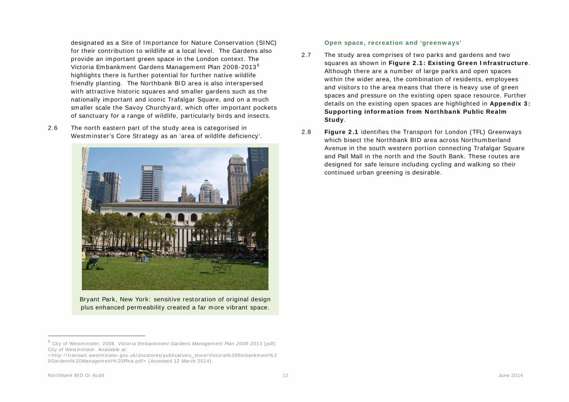
to remove the bund at the north and west of the Gardens to provide level access and enhanced views into the garden. The future of Victoria Embankment Gardens could be an exciting urban park, a transformation such as that witnessed at Bryant Park, New York (image overleaf).
2.4 A more detailed portrait of the area’s character and historical evolution is presented in Appendix 2. In 2014 the Strand incorporates little green infrastructure as can be seen in the image overleaf. Further detail on character areas are highlighted in Appendix 3: Supporting information from Northbank Public Realm Study.
Victoria Embankment c. 18905
Wildlife and biodiversity
2.5 Despite the dense urban character of the study area, there are a few sites with significant biodiversity value (see Figure 2.1). The sections of Victoria Embankment Gardens within BID area are
5 Old UK Photos in High Resolution, 2014. London Thames Embankment c. 1890. (image online). Available at: <http://www.oldukphotos.com/london_famous_landmarks_page2.htm> [Accessed 13 March 2014]
Northbank BID GI Audit 12 June 2014
designated as a Site of Importance for Nature Conservation (SINC) for their contribution to wildlife at a local level. The Gardens also provide an important green space in the London context. The Victoria Embankment Gardens Management Plan 2008-20136
highlights there is further potential for further native wildlife friendly planting. The Northbank BID area is also interspersed with attractive historic squares and smaller gardens such as the nationally important and iconic Trafalgar Square, and on a much smaller scale the Savoy Churchyard, which offer important pockets of sanctuary for a range of wildlife, particularly birds and insects.
2.6 The north eastern part of the study area is categorised in Westminster’s Core Strategy as an ‘area of wildlife deficiency’.
Bryant Park, New York: sensitive restoration of original design plus enhanced permeability created a far more vibrant space.
6 City of Westminster, 2008. Victoria Embankment Gardens Management Plan 2008-2013 [pdf] City of Westminster. Available at: <http://transact.westminster.gov.uk/docstores/publications_store/Victoria%20Embankment%20Gardens%20Management%20Plna.pdf> [Accessed 12 March 2014].
Open space, recreation and ‘greenways’
2.7 The study area comprises of two parks and gardens and two squares as shown in Figure 2.1: Existing Green Infrastructure. Although there are a number of large parks and open spaces within the wider area, the combination of residents, employees and visitors to the area means that there is heavy use of green spaces and pressure on the existing open space resource. Further details on the existing open spaces are highlighted in Appendix 3: Supporting information from Northbank Public Realm Study.
2.8 Figure 2.1 identifies the Transport for London (TFL) Greenways which bisect the Northbank BID area across Northumberland Avenue in the south western portion connecting Trafalgar Square and Pall Mall in the north and the South Bank. These routes are designed for safe leisure including cycling and walking so their continued urban greening is desirable.

Northbank BID GI Audit 13 June 2014
The Strand in 2014
Climate change adaptation
2.9 Situated close to the heart of London, Northbank is vulnerable to a range of climate change impacts, particularly urban heat island effects, wind tunnels and localised surface water flooding.
2.10 Evidence indicates that the urban heat island effect can result in ambient temperatures in central London being up to 10oC higher than in the surrounding countryside.7 A study in Toronto, Canada indicated that during the summer months, the temperature on standard roofs exceeded 40oC on over 44% of days, the temperature on green roofs never exceeded 40oC, and only
7 GLA Website. Available at: <http://www.london.gov.uk/lccp/ourclimate/overheating.jsp> [Accessed 22 January 2014]
exceeded 30oC on 3% of days.8 There are a number of green roofs already installed in the area; however these represent a tiny percentage of the total area with potential to be greened. Opportunities to reduce urban heat island, wind tunnel and surface water flooding effects should be prioritised, in order to create a more comfortable and climate-proofed environment for residents and workers. Trees and green spaces also contribute to the dispersion and absorption of air pollutants.
Air quality
2.11 Parts of the study area which suffer from particularly poor air quality, are shown in Figure 2.2: Air Quality. Nitrogen dioxide (NO2) is a key indicator of poorer air quality, caused mainly by traffic. It can be seen that the key transport routes including Aldwych, Kingsway, Strand, Waterloo Bridge, Northumberland Avenue and Victoria Embankment has higher annual predicted Nitrogen dioxide levels so their greening could help alleviate the concentration of pollutants in the air.
Air quality funding
2.12 In February 2013 the Mayor launched the Air Quality Fund to help improve air quality in London. “The fund will provide match-funding for boroughs and partners that produce innovative new schemes and projects designed to improve air quality. £6 million of funding will be initially available from 2013/14 to 2015/16, with the expectation this will continue to £20 million over the next 10 years. In order to access the Mayor’s Air Quality Fund boroughs will need to apply to become Cleaner Air Boroughs”.9
8 Dunnett, N. and Kingsbury, N. (2005) Planting Green Roofs and Living Walls. 9 GLA Website. Available at: <https://www.london.gov.uk/priorities/environment/clearing-londons-air/mayors-air-quality-fund> [Accessed 20 February 2014]
Northbank BID GI Audit 14 June 2014
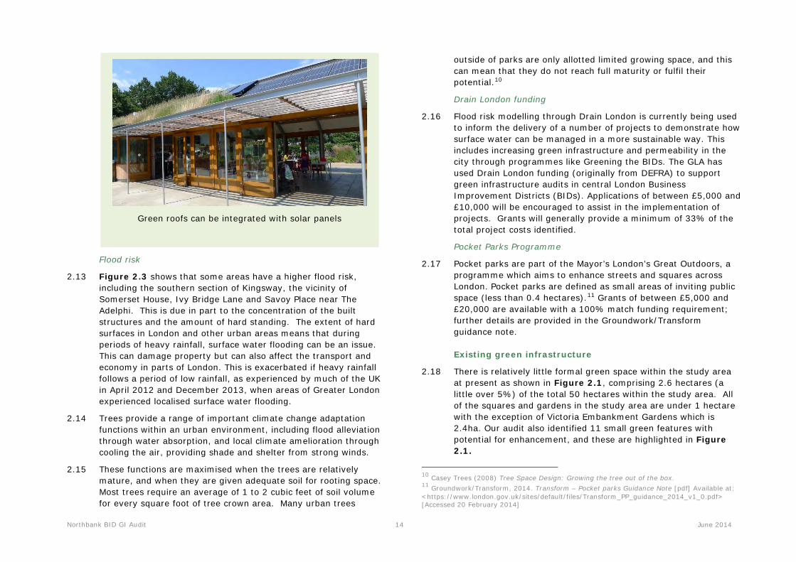
Green roofs can be integrated with solar panels
Flood risk
2.13 Figure 2.3 shows that some areas have a higher flood risk, including the southern section of Kingsway, the vicinity of Somerset House, Ivy Bridge Lane and Savoy Place near The Adelphi. This is due in part to the concentration of the built structures and the amount of hard standing. The extent of hard surfaces in London and other urban areas means that during periods of heavy rainfall, surface water flooding can be an issue. This can damage property but can also affect the transport and economy in parts of London. This is exacerbated if heavy rainfall follows a period of low rainfall, as experienced by much of the UK in April 2012 and December 2013, when areas of Greater London experienced localised surface water flooding.
2.14 Trees provide a range of important climate change adaptation functions within an urban environment, including flood alleviation through water absorption, and local climate amelioration through cooling the air, providing shade and shelter from strong winds.
2.15 These functions are maximised when the trees are relatively mature, and when they are given adequate soil for rooting space. Most trees require an average of 1 to 2 cubic feet of soil volume for every square foot of tree crown area. Many urban trees
outside of parks are only allotted limited growing space, and this can mean that they do not reach full maturity or fulfil their potential.10
Drain London funding
2.16 Flood risk modelling through Drain London is currently being used to inform the delivery of a number of projects to demonstrate how surface water can be managed in a more sustainable way. This includes increasing green infrastructure and permeability in the city through programmes like Greening the BIDs. The GLA has used Drain London funding (originally from DEFRA) to support green infrastructure audits in central London Business Improvement Districts (BIDs). Applications of between £5,000 and £10,000 will be encouraged to assist in the implementation of projects. Grants will generally provide a minimum of 33% of the total project costs identified.
Pocket Parks Programme
2.17 Pocket parks are part of the Mayor’s London’s Great Outdoors, a programme which aims to enhance streets and squares across London. Pocket parks are defined as small areas of inviting public space (less than 0.4 hectares).11 Grants of between £5,000 and £20,000 are available with a 100% match funding requirement; further details are provided in the Groundwork/Transform guidance note.
Existing green infrastructure
2.18 There is relatively little formal green space within the study area at present as shown in Figure 2.1, comprising 2.6 hectares (a little over 5%) of the total 50 hectares within the study area. All of the squares and gardens in the study area are under 1 hectare with the exception of Victoria Embankment Gardens which is 2.4ha. Our audit also identified 11 small green features with potential for enhancement, and these are highlighted in Figure 2.1.
10 Casey Trees (2008) Tree Space Design: Growing the tree out of the box. 11 Groundwork/Transform, 2014. Transform – Pocket parks Guidance Note [pdf] Available at: <https://www.london.gov.uk/sites/default/files/Transform_PP_guidance_2014_v1_0.pdf> [Accessed 20 February 2014]
Northbank BID GI Audit 15 June 2014
Green roofs and gardens
2.19 There is little data available on existing green roofs within the study area. Figure 3.4: Green and Flat Roofs identifies the existing green roofs, the larger roofs being a green roof (in part) on the following sites:
• The Adelphi
• No. 80, Strand
• The Savoy Theatre
Green walls
2.20 There are no green walls within the study area although situated to the south west alongside Green Park on Piccadilly there is one of the tallest green walls in London at the Athenaeum Hotel (image below).
Green walls can alleviate flood risk
Terrestrial green infrastructure
2.21 Throughout the study area and the vicinity there is a good range of smaller scale seasonal greening including hanging baskets, climbers, tubs and planters (images below) by local residents and
businesses. This should be encouraged in an uncluttered fashion for its cumulative green infrastructure benefits to the study area, large areas of which have little or no vegetation, as shown in Figure 2.4: Vegetation Cover.
Kingsway Burleigh Street
Strand Essex Street
off Houghton Street Kemble Street (just outside of the study area)
Trees
2.22 Figure 2.6: Public Realm Trees details the public realm trees within the study area. Data on trees within the study area
Northbank BID GI Audit 16 June 2014
indicates that there are 579 recorded trees, both street trees and those within parks and grounds in the public realm. This data has been extracted from the Westminster City Council Ezytreev tree management database. The data for the locations of the TfL trees along Victoria Embankment were supplied by John Parker (Transport for London (Central) Tree Officer).
2.23 Half of the trees have been inspected in 2013 and the other half was last inspected in 2010. It is possible therefore that the data provided on trees may not reflect all new recent street tree planting and all tree removals that have taken place around the study area. Our audit identified twelve trees that have been removed. There is currently no information on tree canopy size or age groups but there are a large proportion of trees which support a canopy of more than 10m particularly within the vicinity of the historic squares and gardens. Tree canopies are generally smaller along the more intimate streets such as Southampton Street as shown in Figure 2.4. This is likely to reflect the limited root space provided when planting trees. The current benefits of tree cover are therefore limited in these areas. Table 2.1 below highlights seven species which form the majority (78%) of tree species found within the study area based upon the tree survey data supplied and on-site findings.
Tree spp. Northbank BID – Tree No. TOTAL
%
Plane 348 60
Cherry 28 5
Maple 27 5
Holly 13 2
Privet 13 2
Oak 12 2
Maidenhair Tree 10 2
Table 2.1: Common tree species with number and % within study area

Northbank BID GI Audit 17 June 2014
2.24 Various streets throughout the study area had a good range of street tree planting. Figure 2.4 details those sites with tree vegetation cover which appear to be centred on key historic boulevards and gardens notably Aldwych, Kingsway, Victoria Embankment and Victoria Embankment Gardens. There are fewer trees given the size of the area in the proximity of the Strand, Somerset House and Trafalgar Square.
2.25 Westminster City Council’s Westminster Way – Public realm strategy 201112 highlights the context of the tree planting within the area. Victoria Embankment and Victoria Embankment Gardens are deemed as areas for enhanced planting potential whereas for the majority of the Northbank area tree planting should be
12 Westminster City Council, 2011. Westminster Way – Public realm strategy – Design principles and practice – Supplementary Planning Document [pdf] Westminster City Council. Available at: <http://transact.westminster.gov.uk/docstores/publications_store/Westminster_Way_Public_Realm_Strategy_Adopted_September_2011.pdf> [Accessed 22 January 2014].
pursued in moderation as there are few areas suitable for further street planting.
Tree anomalies
2.26 The ground-truthing exercise identified that there were a number of roads where the tree data supplied did not reflect the trees identified on site. These are listed below, and their removal has been reflected in the figures in Table 2.1.
• Arundel Street – Six trees on the eastern side have been removed, possibly to aid the adjacent development.
• Strand – Two trees have been removed outside no. 191, Strand at the Arundel Street junction.
• Kingsway – Two trees appear not be present along the east side of Kingsway.
Tree pits/suitable locations
2.27 Figure 2.6 identifies those potential tree planting locations still deemed suitable for tree planting after the on-site survey. Kingsway is one principal site which is deemed suitable for planting trees.
Heritage and Townscape
2.28 The study area is located within the central area of Greater London adjoining the ancient City of London. Located within the City of Westminster there is an interesting juxtaposition of old and new buildings and features. The designated heritage assets are identified in Figure 2.5: Cultural heritage.
Listed structures
2.29 The predominant features of the Northbank BID area include the following Grade I Listed structures of exceptional/international significance; Somerset House (image below), Royal Courts of Justice, Saint Mary-le-Strand Church, Saint Clement Danes Church and The National Gallery. There is a wide distribution of important historic buildings with 18 Grade I listed structures of exceptional interest, 35 at Grade II* of more than special interest and 137 at Grade II of national importance. These listed buildings are shown
Trees create shade and shelter, but need to be managed appropriately.

Northbank BID GI Audit 18 June 2014
in Figure 2.5. There are also a number of unlisted buildings of merit throughout the area.
Grade I Listed Somerset House
2.30 Today, the historic parts of the study area remain in contrast with a range of newer buildings, creating a diverse and interesting townscape. Therefore when carrying out the audit it was necessary to consider the options of installing green infrastructure features so as to avoid damaging the individual sensitive historic character of buildings within the street scene. This can be achieved through low level and sympathetic installations which are not out of scale and do not interfere with historic viewpoints or alter the historic fabric of listed buildings. Listed building consent to the fabric of the building and/or planning permission will be required in the case of alterations to listed buildings and its curtilage.
Conservation areas
2.31 There are four conservation areas which combine to cover the whole of the Northbank area. The GI opportunities identified have been selected as they can enhance the character of these conservation areas, and should not negatively affect the wider
setting, viewpoints and character of the conservation area (described below). In terms of the listed buildings within these areas, it’s important not to alter their historic fabric where feasible.
2.32 Because many of the trees are within conservation areas and subject to Tree Preservation Orders, all future tree works can only be carried out with permission from the City Council.
2.33 The four conservation areas include:
• Adelphi - The Adelphi takes its name from the 18th century development of residential terraces by the Adam brothers (of which parts still survive) and is located immediately to the south of the Strand.13
• Covent Garden – The north western sections of the area encompass the southern parts of the Covent Garden conservation area. Covent Garden forms the area north of the ancient processional route of the Strand which supplied food for Westminster Abbey, succeeded by the later fruit, vegetable and flower market for which the area became famous.
• Savoy – This occupies the site of the medieval Savoy Palace and neighbouring riverside palaces, most of which were only lost to 19th century development, and Rennie’s Waterloo Bridge of 1817, itself replaced by Gilbert Scott’s design in the 1930s.
• Strand - this area is centred on the formal urban layouts of Aldwych and Kingsway. The area also includes a considerable amount of important ancient built fabric, such as Somerset House and other notable buildings such as G.E. Street’s Royal Courts of Justice.
2.34 The Northbank BID area is included in The London View Management Framework. Key Metropolitan views are views towards the river front from Waterloo Bridge and the Hungerford Bridge. There are a number of local views throughout the area but there are no protected vistas.
13 City of Westminster, 2003. Adelphi Conservation Area Audit 31. Available at: <http://transact.westminster.gov.uk/docstores/publications_store/Adelphi%20CAA%20SPG.pdf> [Accessed 27 February 2014].

Northbank BID GI Audit 19 June 2014
Register of Parks and Gardens of Special Historic Interest in England
2.35 Victoria Embankment Gardens (image below) is publicly accessible and contains many listed structures. It is included as Grade II* on English Heritage’s Register of Parks and Gardens of Special Historic Interest in England. The implications of this designation are outlined in Section 3 but essentially English Heritage and the Garden History Society will require statutory input in to any proposals to the gardens. It is of national importance partly due to the associations with Bazalgette’s large civil engineering project that included the reclaiming of riverside for sewers, highway access and underground railway tunnels in the 1860s. The formal design of the gardens was created by Alexander McKenzie and the site has since been popular for erecting memorials and the York House Water Gate (c. 1626).
Grade II* Listed Victoria Embankment Gardens

!
!
!
!
!
!
!
!
!
!
!!
!!
!
!
!
!
!
!
!
!
!
!
!
!
!
!
!
!
!
!!
! ! ! ! ! ! !! !
!!
!
!
!
!
!
!!
!
!
!
!
!
!
!!
!! !
!!
! ! !! !
!!
!!
!!
!!
!!
!
!
!
!
!
!
!
!
!
!
!
!
!
!!
!
!
!
!
!
!!
!
!
!
!!
!
!!
!!
!!
!!
!!!!
!!
!
!
!
!
!!
!!
!!
!!
!!
!
!
!! !
! !!
!!
!
!
!
!
!
!
!
!
!
!
!
!
!
!
!
!
!
!!
!!
!
!
!
!!
!
!
!
!
!
!
!
!! !
!!
!!
!!
!!
!!
!
!!
!!!
!!
!!
!!
!!
!!
!!
!
!!!
!
!!
!!
!!!
!!!
!!
!!!
!!!!!
!
!
!!
!!
!!!
!
!!
! !!
!
!
!
!
!
!!
!!!!!
!
!
!!
!!!!
!!
! !
!!!
!!
!! !
!!!!
!!
!!!!!!!!
!!
!!!!
!!!
!!!
!!!!!!!
!!
!!!
!!!!
!!!!!
!!
!
!!!
!!!!!!
!!!
!!!!!
!!
!
!
!!!!!
!!!
!!!
!!!
!!!!
!
!!!
!
!!
!
!!
!
!
!
!
!!
!! !
!!!
!
!!!!
! !
!!!!
!!!!
!! !
! !! !
!!!
!!
!!!
!
!!!!
!!
!!
!!!!
!!!
!!!
!
!
!
!
!
!
!
!
!
!!
!
!!
!
!
!
!
!
!
!!
!
!
!
!
!
!
!!
!!
!!
!
!
!
!
!!
!
!
!
!
!
!
!
!!
!! !!
!
!
!
!
!
!
!
!!!
!
!
! !
!
!
!
!
!
!
!
!
!
!
!
!!
!
!
!
!
!
!
!
!
!
!
!
!
!
!
!
!!
!
!
!
!
!
!
!
!
!
!
!
! ! ! !
!
!!
!
!
!
!
!!
!
!
!
!
!
!
!
!
!
!
!
!!
!
!
!
!
!
")
")
")
")
")
")
")
")
")
")
Contains Ordnance Survey data © Crown copyright and database right 2014 100032216 GLA
0 100 20050 m
LUC LDN 5955-01_012_Existing_GI_Rev2 10/06/2014
Map Scale @ A3:1:4,500
²
Existing Terrestrial GI Assets
Source: GLA, Ordnance Survey, GIGL, TfL, WCC
Northbank Green Infrastructure Audit
Northbank
") Existing green roofs
TfL Greenways
! Public realm trees
London Square
Site of Importance for Nature Conservation
Existing green open space identified during audit*
GiGL open space by PPG17 category
Amenity
Civic spaces
Green corridors
Other
Parks and gardens
Figure 2.1
*Not identified in GiGL mapping
20

LUC LDN 5955-01_013_Air_Quality_Rev1 28/05/2014
Map Scale @ A3:1:4,500
Annual Nitrogen Predicted for 2015
Source: GLA, Ordnance Survey, WCC
Northbank Green Infrastructure Audit
Northbank
Figure 2.2
NO2 annual mean 2015
Low
High
Contains Ordnance Survey data © Crown copyright and database right 2014 100032216 GLA
0 100 20050 m²21 21

Contains Ordnance Survey data © Crown copyright and database right 2014 100032216 GLA
0 100 20050 m
LUC LDN 5955-01_014_Flood_Rev1 28/05/2014
Map Scale @ A3:1:4,500
²
Flood Risk Assessment (Drain London)
Source: GLA, Ordnance Survey, Drain London
Northbank Green Infrastructure Audit
Northbank
100cc flood depth (m)
0 - 0.10.11 - 0.250.26 - 0.50.51 - 11.01 - 1.5>1.5
Figure 2.3
22 22

Contains Ordnance Survey data © Crown copyright and database right 2014 100032216 GLA
0 100 20050 m
LUC LDN 5955-01_015_Veg_cover_Rev2 10/06/2014
Map Scale @ A3:1:4,500
²
Vegetation Cover
Source: GLA, Ordnance Survey, Geoinformation Group
Northbank Green Infrastructure Audit
Northbank
Trees
Low lying vegetation (<2.5m above ground level)
Figure 2.4
Vegetation cover data produced by The GeoInformation Group for the GLA
23
Contains Ordnance Survey data © Crown copyright and database right 2014 100032216 GLA © English Heritage
0 100 20050 m
LUC LDN 5955-01_016_Cultural_heritage_Rev1 28/05/2014
Map Scale @ A3:1:4,500
²
Designated Heritage Assets
Source: GLA, Ordnance Survey, English Heritage
Northbank Green Infrastructure Audit
Northbank
Registered Park and Gardens
Scheduled Monuments
London Square
Listed Building grade
IIIII*
Figure 2.5
24 24
"
"
)
)
D
DD
D
DD
D
D
DD
DD
Contains Ordnance Survey data © Crown copyright and database right 2014 100032216 GLA
0 100 20050 m
LUC LDN 5955-01_017_Public_realm_trees_Rev3 10/06/2014
Map Scale @ A3:1:4,500
²
Public Realm Trees
Source: GLA, Ordnance Survey, WCC
Northbank Green Infrastructure Audit
Northbank
Common name
PlaneCherryMapleMaidenhair TreeHollyPrivetOakOther
") Vacant tree pit
D Trees that have been removed
Figure 2.6
25
Northbank BID GI Audit 26 June 2014
3 Key Opportunities
3.1 This section of the report outlines the key opportunities for green infrastructure within the Northbank area (figure reference in brackets). These have been prioritised as a result of consultation with the BID, as well as an informal review of the potential benefits that will be delivered.
3.2 The opportunities listed below are considered to be deliverable in the short term, are highly visible within the Northbank area, and will help to enhance the experience of pedestrians and cyclists visiting and passing through Northbank.
3.3 The GI opportunities by type are identified in Figure 3.1 and Figure 3.2 indicates the anticipated ease of deliverability for each opportunity. Useful information from the Northbank Public Realm Study on ‘lost spaces’ and ‘key spaces’ which have the potential to be restored to enhance the public realm is provided in Appendix 3.
Key opportunities in Northbank
3.4 The following sites have been identified as priorities for delivering GI improvements in Northbank (further details follow):
• Embankment Station
• Victoria Embankment Gardens
• Savoy Gardens
• Strand
• Temple Station
• Hungerford Railway Bridge
• Victoria Embankment and Cycle Cross Route
• Street trees
• Junction of Strand/William IV Street
• Junction of Strand/Southampton Street
• Green walls along the Strand
Embankment Station (43 and 44)
3.5 Embankment Station is a key gateway to Northbank, which is currently undergoing refurbishment. The opportunity for greening at this location would provide a positive visual impact to those in the bustling and historic Villiers Street or the elevated footway which connects Charing Cross Station and Victoria Embankment.
3.6 There is potential to create a green wall along the northern elevation of the foundations to the Hungerford Bridge adjacent to Embankment Station. This will enhance the appearance of the area and create a more welcoming approach. The plant species will have to be shade tolerant. The living wall could reflect the floristic diversity of the nearby Victoria Embankment Gardens. Key partners may include Transport for London, adjacent businesses and Westminster Council.
3.7 There is also potential for installing a green roof on Embankment Station, which is predominately flat. The treatment of the roof would need to respond to the building and its scale and to emphasise connections between the new proposed green wall and Victoria Embankment Gardens. There would be visual benefits in terms of screening the equipment located on the roof, and encouraging wildlife with nectar rich planting such as lavender.
3.8 Structural surveys and engineer support would be required to assess the feasibility and scale of proposed works in implementing sufficient foundations for planting.
Northbank BID GI Audit 27 June 2014
Victoria Embankment Gardens (1 and 18)
3.9 Victoria Embankment Gardens is a Grade II* Registered Park and Garden of Special Historic in England and is at the heart of the Northbank area. There is a need to reinforce the gardens heritage in a number of ways which will benefit both the users of the garden and its wildlife. A conservation management plan and accompanying management and maintenance plan would help to secure its preservation, conservation and ongoing management. A useful comparable case study would be the restoration of Russell Square by LUC. Set in the heart of Bloomsbury, the square was originally designed by Humphry Repton in 1801 for the 5th Duke of Bedford. Today the square is Grade II listed and included on the English Heritage Register of Historic Parks & Gardens. Further details of the project and the nearby Gordon and Woburn Square Gardens are provided in Appendix 4.
3.10 There is an opportunity to level the southern entrance to improve connectivity, access (including disabled access) and visual appearance; there could also be access points from the north, with some improvements to the eastern entrance. Gates and railings could be in a more cohesive and welcoming style. Improving and increasing groundcover planting could reduce weeds and water loss and enhance appearance. There is an opportunity to cut back leggy shrubs to a more compact and balanced form (predominately non-native dominant evergreen varieties) which currently darken the gardens and obscure views between the gardens and adjacent historic buildings. Nectar rich native shrub varieties should be planted and more natural corners could be created with long grass and dead wood in more informal and secluded areas to encourage biodiversity. The turf is currently experiencing wear and some waterlogging so renovation/reseeding are suggested.
3.11 The proposed café extension and refurbishment could provide further opportunity for small scale greening in terms of planters and green trellis/screening for visual improvement. An image of the open formal park in 2014 is shown below and suitable plant species which could complement its historic design and benefit wildlife follow.
A view across the formal lawns towards Charing Cross Station and the York House Water Gate

Northbank BID GI Audit 28 June 2014
3.12 The Garden History Society and English Heritage should be engaged in this opportunity, due to being a Grade II* registered landscape. Other potential partners include The Association of Gardens Trusts, the London Parks and Gardens Trusts and the local Neighbourhood Forum. Potential constraints include the site being a registered park and garden and the tube network beneath.
Savoy Chapel Gardens (45)
3.13 Savoy Chapel Gardens is a small, well managed green space adjoining the Savoy Chapel, on Savoy Street. It is currently not accessible for the public, although there is some visual access through the gates. Opening this space for public access during daylight hours would create an appealing green space for use by employees, residents and visitors to the area, within easy reach of Strand, an area which lacks green spaces for people. Small adaptations to the management of the gardens could also enhance its value to wildlife, through a planting palette comprising nectar rich and native plants. The site is managed by the Duchy of Lancaster.
Proposed additional plant varieties for Victoria Embankment Gardens that are beneficial for wildlife and/or native
• Dryopteris filix-mas (native)
• Carex elata 'Aurea' (native)
• Achillea millefolium (native)
• Campanula glomerata ‘Superba’ (native)
• Digitalis purpurea ‘Alba’ (native)
• Euphorbia amygdaloides var robbiae (native)
• Helleborus argutifolius (native)
• Iris foetidissima (native)
• Cornus sanguinea ‘Midwinter Fire’ (native)
• Rosa canina (native)
• Sambucus nigra ‘Black Lace’ (native)
• Viburnum opulus ‘Compactum’ (native)
• Waldsteinia ternata
• Hedera helix 'White Ripple'
• Lonicera pericyclemum ‘Serotina’
• Deschampsia cespitosa 'Bronzeschleier'
• Acanthus hungaricus
• Aquilegia vulgaris alba
• Penstemon ‘Apple Blossom’
• Sedum telephium ‘Purple Emperor’
Queen’s Chapel of the Savoy
Gardens
Northbank BID GI Audit 29 June 2014
Strand
3.14 Key opportunities identified by the audit are as follows:
• There is potential for additional planting to enhance the setting of the two listed churches of the Strand (St Mary le Strand (G19) and St Clement Danes (G20)). This complements the proposals outlined in the Northbank Public Realm Study.
• Arundel Street/Strand junction (7) could be enhanced with low level splay shrub planting at wide footway junctions and adjacent to the toilet to enhance appearance and improve flood storage.
• Site 15 has potential for groups of new formal planters to the central reservation, to enhance visual amenity whilst still maintaining safe pedestrian flow. Subject to longer term discussion with TfL, a review of the vehicular space needed along the Strand corridor may however be a more effective way to secure urban greening with a review of the edge/interface between the traffic lanes and the pavement (potential focus for tree planting which would benefit pedestrians). This could also link to consideration of more generous planting to the two churches of the Strand, to emphasise their role as visual set pieces, and to create calmer and more serene spaces around them, befitting their architecture.
• Planters could be utilised adjacent to shop and building fronts in a proposed consistent palette of Northbank ‘blue’, white and silver with seasonal interest through bedding plants. These would not obstruct free flow of pedestrian movement and would be located in appropriate wider sections of footway to enhance the visual appeal and attract pollinators.
Attractive floral planting as part of the Chelsea Fringe 2014

Northbank BID GI Audit 30 June 2014
Planters with a consistent colour palette could be installed by businesses along Strand, as well as new trees.
Northbank BID GI Audit 31 June 2014
3.15 Some seasonal plant varieties for use along the Strand are suggested below.
Proposed seasonal bedding plant varieties for the Strand
Spring/Summer
Ageratum ‘Blue Champion’
Lobelia ‘Cambridge Blue’
Cineraria ‘Silver Dust’
Lobelia ‘Riviera Midnight Blue’
Petunia ‘Dark Blue’
Bacopa ‘Blue Topia’
Bacopia ‘Snowtopia’
Nemesia ‘Nuvo Blue’
Nemesia ‘Nuvo White’
Salvia ‘Victoria Blue’
Nepeta glechoma hederacea
Lavandula augustifolia ‘Hidcote Blue’
Autumn/Winter
Pansy Matrix White Blotch
Blue Polyanthus
White Polyanthus
Pansy Matrix True Blue
White Cyclamen
Bellis (white)
Euonymus ‘Emerald 'n' Gold’
Ornamental Cabbages and Kale
Northbank BID GI Audit 32 June 2014
Temple Station (38)
3.16 The Temple Station terrace will become an increasingly high profile focal point for the area of Northbank with the adjacent Garden Bridge proposals.
3.17 Prior to the implementation of the Garden Bridge there could be an opportunity for temporary greening in the form of planters on the terrace. Public benches integrated with planters and low maintenance groundcover and shrubs could be used to provide multi-functional benefits for seating, wildlife encouragement and visual improvement.
3.18 Transport for London and nearby Somerset House could be key partners alongside the local Neighbourhood Forum. Structural surveys and conservation architect input may be required depending on the scale of proposals.
Hungerford Railway Bridge (42)
3.19 The 19th century bridge foundations including the original brick pile buttresses of Brunel's footbridge are still in use, and are an important historical asset within the Northbank area. The site forms a key gateway to the area which currently suffers from poor air quality.
3.20 In addition to interpretation for visitors about the Brunel foundations, the Bridge could be sympathetically greened and brightened on its western-facing wall. Elevated planters could provide the opportunity for ornamental colourful shade resistant trailing plants such as ornamental Ivy alongside artistic lighting installations. The extent of urban greening should be limited to complement the formal classical architecture of the original Brunel bridge and to interpret its original footprint/width. Green wall planting would enhance the appearance of the wall. There would also be some degree of absorbance of pollutants.
3.21 Charing Cross Hotel, Network Rail and Transport for London could be key partners alongside the adjacent businesses. The shade and access to services may create some restrictions.
Victoria Embankment and Cycle Cross Route (1)
3.22 Victoria Embankment is a major feature within the Northbank area. For more than three centuries a plaque on Trafalgar Square has marked the traditional centre point of London from which all distances to the capital are measured but new mapping has now revealed that the capital’s central point is situated approximately 900 metres to the east on a pavement on the Victoria Embankment next to the Thames near Somerset House.14 Useful information from the Northbank Public Realm Study on ‘key spaces spaces: The Victoria Embankment’ provides a review of ways to enhance the public realm within this vicinity in Appendix 3.
3.23 The area currently suffers from deteriorating benches and plinths. Northbank BID should engage TfL to ensure that additional green features are incorporated in detailed design of the new Cycle Cross Route. One approach could include installation of planters to the rear and sides of the elevated benches along Victoria Embankment, subject to conforming to the Equality Act and disability access for seating. There are also some areas of empty hard standing (currently litter prone) adjacent to Waterloo Bridge between rows of embankment walling. Planting at these locations would enhance the visual appearance and improve flood storage of the area which is currently lacking in colour and opportunities for reducing the hard standing. A variety of colourful bedding plants or less maintenance intensive/drought tolerant plants could be used at these locations.
3.24 At the junction with Temple Place (site 17) there is the opportunity to create low shrub bed visibility splay shrub planting (e.g. Euonymus fortunei ‘silver queen’) which could help improve appearance and increase flood storage in an area susceptible to flash flooding.
3.25 Restrictions could include the presence of services/utilities and the requirement for disabled access to proposed seating improvements.
14 London Evening Standard Website. Available at: <http://www.standard.co.uk/news/london/londons-real-centre-point-is-next-to-bench-on-the-victoria-embankment-by-the-thames-9381800.html> [Accessed 30 May 2014]

Northbank BID GI Audit 33 June 2014
Street trees
3.26 Principal street tree opportunities identified by the audit are as follows:
• Strand/William IV Street (3) and Strand/Southampton Street (5) – existing tree pits could have further topping up with gravel or suitable mulch to prevent collection of litter between grille.
• Intermittent tree planting along the Strand to improve urban biodiversity and to enhance the visual appearance of the streetscape (14).
• Exeter Street – opportunities for some tree planting (small scale) along the western section of Exeter Street (east side of road) to enhance the visual link with the Strand, improve flood storage and encourage biodiversity (21).
• William IV Street – the audit has identified potential for some small scale tree planting along the northern side of the road to enhance its visual appearance and line/direct views towards the National Portrait Gallery (33).
• John Adam Street, within the Adelphi – potential scope for some small scale tree planting in more generous areas of the footway to help promote these side streets as attractive walking routes and to frame/guide views to the very fine surviving listed 18th century Adam buildings (part of their famous Adelphi scheme) at the eastern end of John Adam Street (27).
• Aldwych – enhancement of tree pits and their surfaces to improve visual cohesion and enhance their formal appearance/presentation (8).
• Catherine Street – potential for some tree planting (small scale) along wide north side of road alongside the Novello Theatre to encourage biodiversity and enhance the street’s visual appearance (22).
• Kingsway – replacement of trees in empty pits (with appropriate larger grade tree stock) to enhance visual continuity and connectivity, plus shading and cooling (23).
Pocket Park at junction of William IV Street/Strand (3)
3.27 There is potential to create a small green space at the large area of paved space outside the Zimbabwean Embassy on the corner of the Strand and William VI Street. This is located in a part of the Northbank where there are very few spaces in which pedestrians can escape the noise and bustle of the Strand. Installation of planting and well-designed seating at this location could create a green space for people to spend time in, whilst also increasing habitat for pollinating insects and birds.
3.28 Public benches with integrated planters would provide an opportunity for planting shrubs whilst preventing potential damage at ground level due to the relatively high levels of foot fall in the area. Planting could comprise low level shrub planting to complement the existing trees. Scented, low maintenance and nectar rich varieties of plant could be used such as Thyme and Lavender. These would also encourage wildlife in to the area. Planting beds should be within the ground if feasible, to help with rainwater drainage during periods of heavy rainfall.
3.29 Any feature would need to be carefully designed to not create a barrier to the heavy footfall in this area, in discussion with TfL and Westminster Council. Other feasibility considerations include underground utilities.
Pocket Park at junction of Southampton Street and Strand (5)
3.30 This wide paved junction has potential for streetscape enhancements to create a small green feature just off the Strand. This is part of a key route between the main gateway to the area at Embankment and Charing Cross stations, and Covent Garden. These routes are a priority for public realm improvements to enable visitors to navigate more easily between the two. The benefits of creating a green feature here include enhanced visitor experience, and creation of habitat for pollinators and bird species.
Northbank BID GI Audit 34 June 2014
3.31 The design of this site should protect the strategic view down Carting Lane to the Thames, and planting should not obstruct this view. There is currently a row of cycle racks at this location, which could be relocated, possibly through replacement of a car parking space on the highway as recommended by Sustrans15 and practiced in Cambridge (see image opposite). In addition, some London Boroughs, including Camden have been trialling planters which double up as cycle racks (see image opposite). Transport for London (TfL) and Westminster Council should be engaged in developing this opportunity .
Green walls along the Strand
3.32 There are several opportunities to create green walls within the Northbank, including on large buildings along the Strand. Green walls can have a dramatic and visible greening effect, and have the added advantage of screening unattractive buildings, whilst they can also provide habitats for wildlife. However, to be a sustainable greening feature it is also important that a watering system is employed that does not rely on mains water, for example using rainfall runoff (and thereby potentially reducing surface flooding), or using waste water such as from refrigeration units.
3.33 There is potential to install a number of green walls along this stretch of the Strand, which are designed to complement each other, creating continuity and re-branding the Strand as a green street. Key buildings include:
• 22 Strand (28 on map)
• 112 Strand (25 on map)
• Lyceum Theatre/ Burleigh Street (10)
• York Place (2 and 28)
• Corner of Savoy Street (25)
• The old Strand Underground Station Building (13)
15 Sustrans Website. Available at: <http://www.sustrans.org.uk/sites/default/files/images/files/scotland/legacy_2014/Legacy-2014%20Cycle-Parking-Guidelines.pdf> [Accessed May 2014]
Credit: Cycle streets
Credit: London Borough of Camden
Northbank BID GI Audit 35 June 2014
3.34 The selection of specific building to support a series of green walls should be informed by the Northbank Public Realm Study in relation to improving legibility of the streetscape here, and green walls could be used as indicators to the primary/upgraded routes through this part of the study area. Building owners should be engaged to assess their interest in this opportunity, and structural assessments of all buildings should be completed to inform
feasibility.
3.35 The most economical way of achieving a green wall is with climbing plants, which could cost approximately £50 per m²; whilst the alternative is to install a ‘modular green wall’, where plug plants are established within a vertical growing system. The latter is a more expensive option with a more immediate effect, and costs approximately £400 per m². Important considerations when planning green walls are the aspect (north-facing walls need less maintenance and use less water than south-facing walls) and having a nearby water source, preferably harvested greywater or rainwater. For modular systems it is important to confirm with a structural engineer that the wall can support the weight and take any necessary fixings.
Green roofs
3.36 The audit included a desk-based audit of the roofs within the study area, the findings of which are outlined in Figure 3.3. The purpose of this audit was to highlight where existing green (or partially green) roofs are located, and to identify which roofs are flat, and therefore have potential for green roof installation. This data can be used to by the BID to consult with building owners, who might have an interested in green roof installation. These buildings can then be visited by a structural engineer, who can provide detailed guidance on the potential for green roof installation, the type of green roof that the building could support, and any potential challenges.
Attractive green wall created for the Chelsea
Fringe 2014
19
36
3737
44
42
39 38
40
41
43
45
1
6
18
8
8
8 8
3
1115
5
33
35
15
8
15
15
22
32
8
17
2
31
21
27
15
34
7
31
10
19
29
12
17
24
4
30
9
28
16
23
14
1414
2614
14
26
20
25
16
20
13
14
Contains Ordnance Survey data © Crown copyright and database right 2014 100032216 GLA
0 100 20050 m
LUC LDN 5955-01_020_Type_of_site_Rev2 10/06/2014
Map Scale @ A3:1:4,500
²
GI Opportunities - Type ofOpportunity
Source: GLA, Ordnance Survey
Northbank Green Infrastructure Audit
Northbank
Type of opportunity
Ground-level Tree-relatedGreen wallsRoof-level
Figure 3.1
36
19
36
3737
44
42
39 38
40
41
43
45
1
6
18
8
8
8 8
3
1115
5
33
35
15
8
15
15
22
32
8
17
2
31
21
27
15
34
7
31
10
19
29
12
17
24
4
30
9
28
16
23
14
1414
2614
14
26
20
25
16
20
13
14
Contains Ordnance Survey data © Crown copyright and database right 2014 100032216 GLA
0 100 20050 m
LUC LDN 5955-01_019_Ease_delivery_Rev2 10/06/2014
Map Scale @ A3:1:4,500
²
GI Opportunities - Ease of Delivery
Source: GLA, Ordnance Survey
Northbank Green Infrastructure Audit
Northbank
Ease of delivery
Easy/quick winModerateChallenging
Figure 3.2
37
Contains Ordnance Survey data © Crown copyright and database right 2014 100032216 GLA
0 100 20050 m
LUC LDN 5955-01_018_Flat_roofs_Rev1 28/05/2014
Map Scale @ A3:1:4,500
²
Flat Roofs in Northbank
Source: GLA, Ordnance Survey
Northbank Green Infrastructure Audit
Northbank
Flat roofFlat roof with obstructionsPartial flat roofPartial flat roof withobstructionsExisting green roof (part only)
Figure 3.3
38 38

Northbank BID GI Audit 39 June 2014
4 Next Steps
Consultation
4.1 Consultation has already commenced, and a range of key stakeholders have been engaged in this consultation process. To date, this includes Westminster Council, plus a number of local businesses. Communication with these key stakeholders should continue, and potential project partners should be identified. In order to take forward the priority GI projects, it will be important to consult the following additional groups and organisations:
• Residents and building occupiers – design of the green features.
• Local schools and youth groups – engage in delivery of key opportunities.
• Transport for London– consult on all opportunities affecting pavements and roads.
• Westminster Council – continue to consult on all opportunities.
Additional surveys
4.2 For many of the identified opportunities, additional surveys will be required to determine the feasibility of delivering the opportunity at the site. For ground-level opportunities, Westminster Council should be engaged in this process, as they will hold data on underground utilities, land ownership and other issues. For some terrestrial proposals, surveys should be undertaken to identify the presence of soil or substrate under the existing hard surface, as well as any underground infrastructure. This will help to prioritise opportunities further, as some may be more easily delivered due
to the presence of appropriate soil/substrate, and absence of any underground infrastructure.
4.3 For building-related opportunities, such as green walls and roofs, a structural engineer should be engaged to provide an assessment of the additional loading that the structure can support. Westminster City Council should also be consulted on the potential requirement for planning permission for green wall and roof proposals and for listed building consent (where appropriate). Other important considerations when planning green walls are the aspect (north-facing walls need less maintenance and use less water than south-facing walls) and having a nearby water source, preferably harvested grey water or rainwater. For modular systems it is important to confirm with a structural engineer that the wall can support the weight and take any necessary fixings. It is also important that the living wall is separated from the structure by a waterproof barrier.
Design
4.4 Many of the smaller terrestrial proposals can be delivered without the need for design input from specialists. For the larger features however, design advice should be sought. Appropriate types of design guidance include:
• Planting advice, including species which are beneficial to wildlife. The Council may be able to provide this expertise in-house.
• Horticultural/landscape expertise will be important for most features, in order to ensure that an appropriate suite of species is identified for the conditions.
• Townscape assessment and design plans to ensure continuity with existing streetscape enhancement proposals.
• Independent environmental consultants (as opposed to contractors and suppliers) should be consulted prior to installing green roofs, as they can advise on the creation and design based on the roof style and a range of environmental factors.
Northbank BID GI Audit 40 June 2014
4.5 For the larger opportunities, such as roof gardens where public access is being introduced, and creation of new green spaces, it is also possible that planning permission may be required.
4.6 Anti-social behaviour can pose a threat to effective GI delivery. This should be considered in the design of all green features and associated street furniture. Maintaining visibility through or across a site is critical in this regard.
Delivery
4.7 Delivery of the priority GI opportunities should be coordinated by Northbank BID; however the project delivery may be taken on by project partners, including businesses, landowners, Westminster Council and TfL. It will be important to maintain contact with potential delivery partners, and partner with them in securing funding. It will also be invaluable to maintain the GI coordinator role to oversee the delivery of these GI opportunities, and to maximise the publicity associated with these projects. This approach has been very successful for the Victoria BID, where an Environment and Sustainability Manager has been in post for 3 years.
4.8 There are several existing funding sources to which Northbank BID could bid for funds, including the GLA’s RE:LEAF fund, which is available from May 2014 and aims to fund 10,000 new trees in London; and the Clean Air Fund, which is designed to support investment that will improve London’s air quality. Other funding mechanisms may be available for the delivery of community based environmental enhancements, including Lottery initiatives. Where enhancements will deliver direct benefits to specific companies, it may be appropriate for the BID to negotiate for the enhancement to be partly or wholly funded by these business partners. This will maximise the enhancements that can be delivered with other funding sources.
Quick wins
4.9 The audit identified a number of ‘quick wins’, where urban greening opportunities could be delivered quickly and easily,
without the need for further structural assessment, planning permission or significant investment. Many of these involve adapting the management of existing green spaces, and key opportunities include:
• Green wall at the Underground Strand Station building (13)
• Victoria Embankment Gardens (Temple Section) (18)
• Enhanced planting at the National Gallery (31)
• Space on Northumberland Avenue, opposite the Sherlock Holmes pub (36)
• Green wall at Waterloo Bridge Victoria Embankment exit (41)
• Queen's Chapel of the Savoy Gardens (45)
Climate adapted planting
4.10 The Met Office released a new report in March 2014, which supports the previous predictions from the UK Climate Impacts Programme (UKCIP) that the UK will experience hotter, drier summers, and warmer, wetter winters, as well as more ‘extreme’ weather events, such as the floods of February 2014, and June 2012.16 This unpredictable climate in the future highlights the need to design new green spaces to be adapted to extended periods of wet and dry weather. It is therefore important to ensure that the appropriate approach to planting is carried through to ensure that the cities green spaces are better adapted to the predicted effects of climate change. The information below summarises the key considerations:
Plant species
• Plant robust species and cultivars which can tolerate potential temperature and climatic extremes and increased use of parks.
• Plant a suite of both native and exotic species which are known to support London’s wildlife (examples below).
16 Met Office Hadley Centre, March 2014. Too hot, too cold, too wet, too dry - Drivers and impacts of seasonal weather in the UK [pdf] Met Office Available at: <http://www.metoffice.gov.uk/media/pdf/4/8/Drivers_and_impacts_of_seasonal_weather_in_the_UK.pdf> [Accessed 22 January 2014]

Northbank BID GI Audit 41 June 2014
Bee-friendly plants for Northbank
The plant species listed below are beneficial to pollinators, and suitable for use in Northbank:
• Aster (Aster spp.)
• Black-eyed Susan (Rudbeckia hirta or R. fulgida)
• Cinquefoil (Potentilla fruticosa)
• Echinacea (Echinacea purpurea)
• Escallonia (Escallonia spp.)
• Foxglove (Digitalis purpurea varieties, D. lutea, D. x mertonensis)
• French Marigold (Tagetes patula)
• Globe thistle (Echinops ritro)
• Sedum species
• Purple Verbena (Verbena bonariensis)
• Red valerian (Centranthus rubra)
• Russian Sage (Perovskia atriplicifolia)
• Soapwort (Spanoria officinalis)
• Sweet rocket (Hesperis matronalis)
• Teasel (Dipsacus fullonum)
• Tobacco plant (Nicotiana affinis)
• Promote planting designs and habitats which reflect the likely change in geographical range of some species.
• Plant trees and plants which are adapted to climatic change, particularly those deep-rooting species which can survive periods of drought, or species tolerant to waterlogging in in areas liable to increased flooding.
Design of green features
• Where possible, incorporate natural water storage areas, such as swales/rain gardens, ponds and ditches within the urban context (image below).
• Include technologies such as rainwater harvesting and water-recycling to maximise water efficiency.
• Recognise the increasing value of large canopy trees to provide shading and evapo-transpirative cooling.
Visualisation of a roadside swale or rain garden
Northbank BID GI Audit 42 June 2014
• Planting should be designed in keeping with the character of the park where possible, whilst maximising potential for biodiversity and contributing to the wider landscape character.
Management and Use
• Selection of species should take into account the predicted future climate and their management needs to negate the need for increased management costs.
• Maximise the potential for self-sustaining habitats (e.g. through structured planting with a canopy and under layer) to minimise soil moisture loss by frequent cultivation.
• Recognise that the growing season and the months during which parks are frequently used may extend into early spring and late autumn.
• Soils should be de-compacted to provide better infiltration of rainwater and reduce plant stress.
Maintenance and monitoring
4.11 Maintenance of the new GI features will be essential to ensure the provision of functions such as alleviation of surface water flooding, and also maintain their visual appearance. There should be a clear plan in place for maintenance prior to delivery, and the key partner organisations which will be responsible for maintaining the features should be agreed. As many of the identified opportunities are within the public realm, Westminster Council will have a key role to play in agreeing responsibility for management and maintenance. An ‘adopt a feature’ scheme could also be implemented, with local businesses and community groups encouraged to adopt and look after GI features installed within the vicinity as these features will provide local benefits. This could include, for example, watering street trees and planters, litter picking, and reporting any damage or vandalism.
4.12 In the case of green roofs and modular green walls, it is often advisable to recruit a specialist green roof/green wall maintenance contractor to undertake a maintenance check of the feature. This could take place on a yearly or twice yearly basis, and helps to ensure the plants are healthy and well maintained.
4.13 A monitoring approach should be agreed for the delivery of the identified opportunities. This should monitor the delivery of the GI features and the extent of green features across the BID. Monitoring will help inform priorities for future investment, and should seek to provide quantified information to enable the success and outputs of investment to be measured. Importantly this would require some baseline data against which to compare any changes. Monitoring the outputs will support the promotion of this innovative approach as an inspiring example of retrofitting GI into the inner city environment.

Appendix 1: GI Opportunity Proformas

Northbank Green Infrastructure Audit
Text112:
Text114:
Phot \\D
MapName: \\
Survey date: 27/01/2014 Surveyor: S. West
Type of site:
Site ID: 1 Name/ location: Victoria Embankment Gardens
Area of greening
(sqm):21621
Local park
Pocket park
Garden or square
Community garden/ Allotment
Shrub plantings
Wetland/ standing water
Derelict building plot
Highway infrastructure
e.g. traffic island
Street tree in pit
Grass verge
Hedge
Planter/ raised bed
Pavement or other hard surface
Site category (tick box)
Condition of GI (select one)
Current management (tick box)
Mowing/grass cutting (please specify)
Specify here: Amenity grass cut - 16 cuts approx.
Pruning or other tree maintenance
No obvious signs of management
Appears unmanaged/overgrown
Productive use for food
Landcover / habitat types (tick box)
Building
Pavement/paved area
Highway
Amenity grassland
Semi-natural grassland
Woodland
Condition:
Green wall
© Crown Copyright and database right 2014. Ordnance Survey 100032216 GLA
Desk-based information
Highest surface water flood hazard category: Areas with depths >1.5m
Are there any heritage features in or adjacent to the site:
Is the site within a GLA Area of Wildlife Deficiency:
Is the site a SINC
Existing
Potential
Existing with potential for enhancement
Good (signs of active management)
Moderate (signs of limited management)
Poor (few signs of management)
May 2014
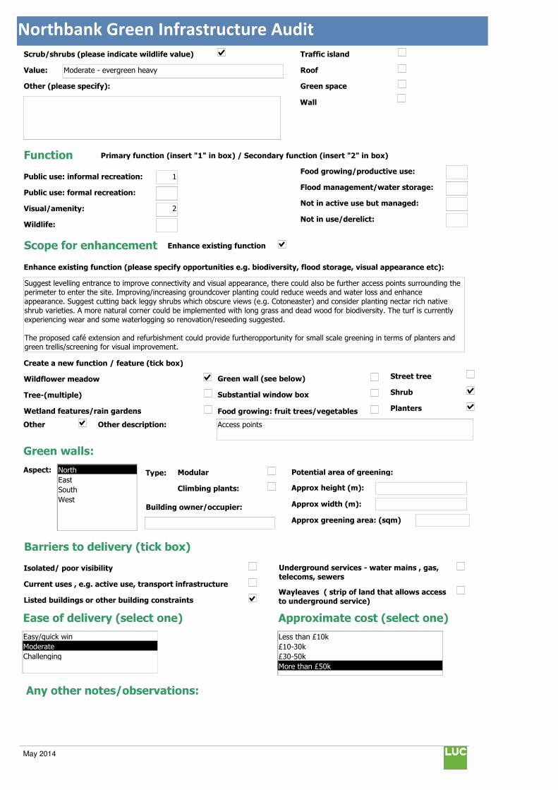
Northbank Green Infrastructure Audit
Traffic island
Roof
Green space
Scrub/shrubs (please indicate wildlife value)
Value: Moderate - evergreen heavy
Other (please specify):
Function Primary function (insert "1" in box) / Secondary function (insert "2" in box)
Public use: informal recreation: 1
Public use: formal recreation:
Visual/amenity: 2
Wildlife:
Food growing/productive use:
Flood management/water storage:
Not in active use but managed:
Not in use/derelict:
Scope for enhancement
Enhance existing function (please specify opportunities e.g. biodiversity, flood storage, visual appearance etc):
Suggest levelling entrance to improve connectivity and visual appearance, there could also be further access points surrounding the perimeter to enter the site. Improving/increasing groundcover planting could reduce weeds and water loss and enhance appearance. Suggest cutting back leggy shrubs which obscure views (e.g. Cotoneaster) and consider planting nectar rich native shrub varieties. A more natural corner could be implemented with long grass and dead wood for biodiversity. The turf is currently experiencing wear and some waterlogging so renovation/reseeding suggested.
The proposed café extension and refurbishment could provide furtheropportunity for small scale greening in terms of planters and green trellis/screening for visual improvement.
Create a new function / feature (tick box)
Wildflower meadow
Tree-(multiple)
Wetland features/rain gardens
Green wall (see below)
Substantial window box
Food growing: fruit trees/vegetables
Barriers to delivery (tick box)
Isolated/ poor visibility
Current uses , e.g. active use, transport infrastructure
Listed buildings or other building constraints
Underground services - water mains , gas,
telecoms, sewers
Wayleaves ( strip of land that allows access
to underground service)
Approximate cost (select one)
Any other notes/observations:
Enhance existing function
Street tree
Shrub
Planters
Wall
Other Other description: Access points
Green walls:
Aspect: Modular
Climbing plants:
Type:
Building owner/occupier:
Approx height (m):
Approx width (m):
Approx greening area: (sqm)
Potential area of greening:
Ease of delivery (select one)
Less than £10k
£10-30k
£30-50k
More than £50k
North
East
South
West
Easy/quick win
Moderate
Challenging
May 2014
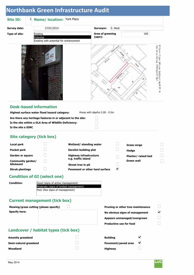
Northbank Green Infrastructure Audit
Text112:
Text114:
Phot \\D
MapName: \\
Survey date: 27/01/2014 Surveyor: S. West
Type of site:
Site ID: 2 Name/ location: York Place
Area of greening
(sqm):160
Local park
Pocket park
Garden or square
Community garden/ Allotment
Shrub plantings
Wetland/ standing water
Derelict building plot
Highway infrastructure
e.g. traffic island
Street tree in pit
Grass verge
Hedge
Planter/ raised bed
Pavement or other hard surface
Site category (tick box)
Condition of GI (select one)
Current management (tick box)
Mowing/grass cutting (please specify)
Specify here:
Pruning or other tree maintenance
No obvious signs of management
Appears unmanaged/overgrown
Productive use for food
Landcover / habitat types (tick box)
Building
Pavement/paved area
Highway
Amenity grassland
Semi-natural grassland
Woodland
Condition:
Green wall
© Crown Copyright and database right 2014. Ordnance Survey 100032216 GLA
Desk-based information
Highest surface water flood hazard category: Areas with depths 0.26 - 0.5m
Are there any heritage features in or adjacent to the site:
Is the site within a GLA Area of Wildlife Deficiency:
Is the site a SINC
Existing
Potential
Existing with potential for enhancement
Good (signs of active management)
Moderate (signs of limited management)
Poor (few signs of management)
May 2014

Northbank Green Infrastructure Audit
Traffic island
Roof
Green space
Scrub/shrubs (please indicate wildlife value)
Value:
Other (please specify):
Function Primary function (insert "1" in box) / Secondary function (insert "2" in box)
Public use: informal recreation:
Public use: formal recreation:
Visual/amenity: 1
Wildlife:
Food growing/productive use:
Flood management/water storage:
Not in active use but managed:
Not in use/derelict:
Scope for enhancement
Enhance existing function (please specify opportunities e.g. biodiversity, flood storage, visual appearance etc):
Suggest creating a green wall to soften wall and footway and improve visual appearance. This can be enhanced with further lighting.
Create a new function / feature (tick box)
Wildflower meadow
Tree-(multiple)
Wetland features/rain gardens
Green wall (see below)
Substantial window box
Food growing: fruit trees/vegetables
Barriers to delivery (tick box)
Isolated/ poor visibility
Current uses , e.g. active use, transport infrastructure
Listed buildings or other building constraints
Underground services - water mains , gas,
telecoms, sewers
Wayleaves ( strip of land that allows access
to underground service)
Approximate cost (select one)
Any other notes/observations:
Enhance existing function
Street tree
Shrub
Planters
Wall
Other Other description:
Green walls:
Aspect: Modular
Climbing plants:
Type:
Building owner/occupier:
Approx height (m): 4
Approx width (m): 40
Approx greening area: (sqm) 160
Potential area of greening:
Ease of delivery (select one)
Less than £10k
£10-30k
£30-50k
More than £50k
North
East
South
West
Easy/quick win
Moderate
Challenging
May 2014

Northbank Green Infrastructure Audit
Text112:
Text114:
Phot \\D
MapName: \\
Survey date: 27/01/2014 Surveyor: S. West
Type of site:
Site ID: 3 Name/ location: Strand / William IV Street junction
Area of greening
(sqm):263
Local park
Pocket park
Garden or square
Community garden/ Allotment
Shrub plantings
Wetland/ standing water
Derelict building plot
Highway infrastructure
e.g. traffic island
Street tree in pit
Grass verge
Hedge
Planter/ raised bed
Pavement or other hard surface
Site category (tick box)
Condition of GI (select one)
Current management (tick box)
Mowing/grass cutting (please specify)
Specify here:
Pruning or other tree maintenance
No obvious signs of management
Appears unmanaged/overgrown
Productive use for food
Landcover / habitat types (tick box)
Building
Pavement/paved area
Highway
Amenity grassland
Semi-natural grassland
Woodland
Condition:
Green wall
© Crown Copyright and database right 2014. Ordnance Survey 100032216 GLA
Desk-based information
Highest surface water flood hazard category: Low risk
Are there any heritage features in or adjacent to the site:
Is the site within a GLA Area of Wildlife Deficiency:
Is the site a SINC
Existing
Potential
Existing with potential for enhancement
Good (signs of active management)
Moderate (signs of limited management)
Poor (few signs of management)
May 2014

Northbank Green Infrastructure Audit
Traffic island
Roof
Green space
Scrub/shrubs (please indicate wildlife value)
Value:
Other (please specify):
Function Primary function (insert "1" in box) / Secondary function (insert "2" in box)
Public use: informal recreation: 2
Public use: formal recreation:
Visual/amenity: 1
Wildlife:
Food growing/productive use:
Flood management/water storage:
Not in active use but managed:
Not in use/derelict:
Scope for enhancement
Enhance existing function (please specify opportunities e.g. biodiversity, flood storage, visual appearance etc):
Potential for creating low level shrub planting and Pocket Park environment to provide a space for relaxation, enhancing appearance and creating visual links along pivotal roads adjacent the Strand. Public benches with integrated planters would provide an opportunity for planting shrubs whilst preventing potential damage at ground level due to the relatively high levels of foot fall in the area. Scented, low maintenance and nectar rich varieties of plant could be used such as Thyme and Lavender. These would also encourage wildlife in to the area.
Create a new function / feature (tick box)
Wildflower meadow
Tree-(multiple)
Wetland features/rain gardens
Green wall (see below)
Substantial window box
Food growing: fruit trees/vegetables
Barriers to delivery (tick box)
Isolated/ poor visibility
Current uses , e.g. active use, transport infrastructure
Listed buildings or other building constraints
Underground services - water mains , gas, telecoms, sewers
Wayleaves ( strip of land that allows access
to underground service)
Approximate cost (select one)
Any other notes/observations:
Tree pits could have further topping up with gravel to prevent collection of litter between grille.
Enhance existing function
Street tree
Shrub
Planters
Wall
Other Other description: Pocket Park
Green walls:
Aspect: Modular
Climbing plants:
Type:
Building owner/occupier:
Approx height (m):
Approx width (m):
Approx greening area: (sqm)
Potential area of greening:
Ease of delivery (select one)
Less than £10k
£10-30k
£30-50k
More than £50k
North
East
South
West
Easy/quick win
Moderate
Challenging
May 2014
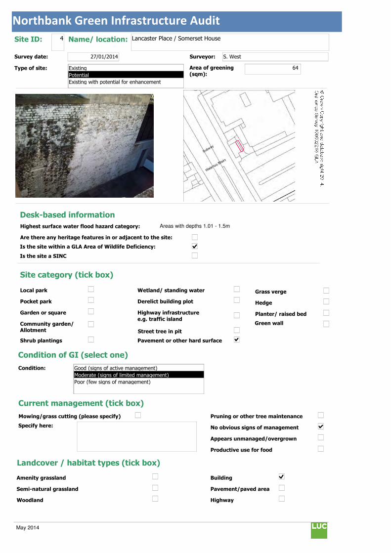
Northbank Green Infrastructure Audit
Text112:
Text114:
Phot \\D
MapName: \\
Survey date: 27/01/2014 Surveyor: S. West
Type of site:
Site ID: 4 Name/ location: Lancaster Place / Somerset House
Area of greening
(sqm):64
Local park
Pocket park
Garden or square
Community garden/ Allotment
Shrub plantings
Wetland/ standing water
Derelict building plot
Highway infrastructure
e.g. traffic island
Street tree in pit
Grass verge
Hedge
Planter/ raised bed
Pavement or other hard surface
Site category (tick box)
Condition of GI (select one)
Current management (tick box)
Mowing/grass cutting (please specify)
Specify here:
Pruning or other tree maintenance
No obvious signs of management
Appears unmanaged/overgrown
Productive use for food
Landcover / habitat types (tick box)
Building
Pavement/paved area
Highway
Amenity grassland
Semi-natural grassland
Woodland
Condition:
Green wall
© Crown Copyright and database right 2014. Ordnance Survey 100032216 GLA
Desk-based information
Highest surface water flood hazard category: Areas with depths 1.01 - 1.5m
Are there any heritage features in or adjacent to the site:
Is the site within a GLA Area of Wildlife Deficiency:
Is the site a SINC
Existing
Potential
Existing with potential for enhancement
Good (signs of active management)
Moderate (signs of limited management)
Poor (few signs of management)
May 2014

Northbank Green Infrastructure Audit
Traffic island
Roof
Green space
Scrub/shrubs (please indicate wildlife value)
Value:
Other (please specify):
Function Primary function (insert "1" in box) / Secondary function (insert "2" in box)
Public use: informal recreation:
Public use: formal recreation:
Visual/amenity: 1
Wildlife:
Food growing/productive use:
Flood management/water storage:
Not in active use but managed:
Not in use/derelict:
Scope for enhancement
Enhance existing function (please specify opportunities e.g. biodiversity, flood storage, visual appearance etc):
Existing wall currently unattractive and with deterioration to paintwork. Suggest creating a green wall with planting stations to enhance appearance.
Create a new function / feature (tick box)
Wildflower meadow
Tree-(multiple)
Wetland features/rain gardens
Green wall (see below)
Substantial window box
Food growing: fruit trees/vegetables
Barriers to delivery (tick box)
Isolated/ poor visibility
Current uses , e.g. active use, transport infrastructure
Listed buildings or other building constraints
Underground services - water mains , gas,
telecoms, sewers
Wayleaves ( strip of land that allows access
to underground service)
Approximate cost (select one)
Any other notes/observations:
Enhance existing function
Street tree
Shrub
Planters
Wall
Other Other description:
Green walls:
Aspect: Modular
Climbing plants:
Type:
Building owner/occupier:
Approx height (m): 8
Approx width (m): 8
Approx greening area: (sqm) 64
Potential area of greening:
Ease of delivery (select one)
Less than £10k
£10-30k
£30-50k
More than £50k
North
East
South
West
Easy/quick win
Moderate
Challenging
May 2014

Northbank Green Infrastructure Audit
Text112:
Text114:
Phot \\D
MapName: \\
Survey date: 27/01/2014 Surveyor: S. West
Type of site:
Site ID: 5 Name/ location: Strand / Southampton Street junction
Area of greening
(sqm):150
Local park
Pocket park
Garden or square
Community garden/ Allotment
Shrub plantings
Wetland/ standing water
Derelict building plot
Highway infrastructure
e.g. traffic island
Street tree in pit
Grass verge
Hedge
Planter/ raised bed
Pavement or other hard surface
Site category (tick box)
Condition of GI (select one)
Current management (tick box)
Mowing/grass cutting (please specify)
Specify here:
Pruning or other tree maintenance
No obvious signs of management
Appears unmanaged/overgrown
Productive use for food
Landcover / habitat types (tick box)
Building
Pavement/paved area
Highway
Amenity grassland
Semi-natural grassland
Woodland
Condition:
Green wall
© Crown Copyright and database right 2014. Ordnance Survey 100032216 GLA
Desk-based information
Highest surface water flood hazard category: Areas with depths 0.11 - 0.25m
Are there any heritage features in or adjacent to the site:
Is the site within a GLA Area of Wildlife Deficiency:
Is the site a SINC
Existing
Potential
Existing with potential for enhancement
Good (signs of active management)
Moderate (signs of limited management)
Poor (few signs of management)
May 2014

Northbank Green Infrastructure Audit
Traffic island
Roof
Green space
Scrub/shrubs (please indicate wildlife value)
Value:
Other (please specify):
Function Primary function (insert "1" in box) / Secondary function (insert "2" in box)
Public use: informal recreation: 2
Public use: formal recreation:
Visual/amenity: 1
Wildlife:
Food growing/productive use:
Flood management/water storage:
Not in active use but managed:
Not in use/derelict:
Scope for enhancement
Enhance existing function (please specify opportunities e.g. biodiversity, flood storage, visual appearance etc):
Potential for creating low level shrub planting and Pocket Park environment to provide space for relaxation, enhancing appearance, flood storage and creating a visual link towards Victoria Embankment with Carting Lane opposite. Public benches with integrated planters would provide an opportunity for planting shrubs whilst preventing potential damage at ground level due to the relatively high levels of foot fall in the area which lead to Covent Garden. Scented, low maintenance and nectar rich varieties of plant could be used alongside more ornamental herbs (Purple Sage, Santolina) and vegetables (Red Stem Chard) to complement the adjacent café and market/retail culture. These would also encourage wildlife in to the area.
Create a new function / feature (tick box)
Wildflower meadow
Tree-(multiple)
Wetland features/rain gardens
Green wall (see below)
Substantial window box
Food growing: fruit trees/vegetables
Barriers to delivery (tick box)
Isolated/ poor visibility
Current uses , e.g. active use, transport infrastructure
Listed buildings or other building constraints
Underground services - water mains , gas,
telecoms, sewers
Wayleaves ( strip of land that allows access
to underground service)
Approximate cost (select one)
Any other notes/observations:
Tree pits could have further topping up with gravel to prevent collection of litter between grille.
Enhance existing function
Street tree
Shrub
Planters
Wall
Other Other description: Pocket Park
Green walls:
Aspect: Modular
Climbing plants:
Type:
Building owner/occupier:
Approx height (m):
Approx width (m):
Approx greening area: (sqm)
Potential area of greening:
Ease of delivery (select one)
Less than £10k
£10-30k
£30-50k
More than £50k
North
East
South
West
Easy/quick win
Moderate
Challenging
May 2014
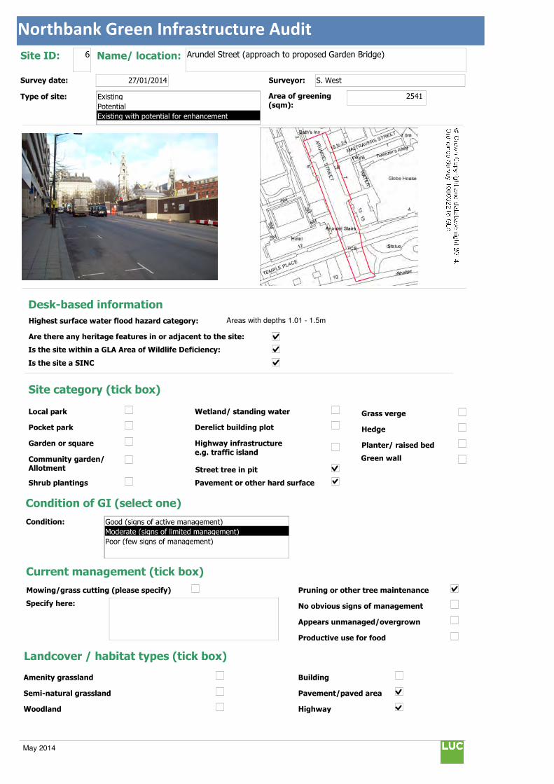
Northbank Green Infrastructure Audit
Text112:
Text114:
Phot \\D
MapName: \\
Survey date: 27/01/2014 Surveyor: S. West
Type of site:
Site ID: 6 Name/ location: Arundel Street (approach to proposed Garden Bridge)
Area of greening
(sqm):2541
Local park
Pocket park
Garden or square
Community garden/ Allotment
Shrub plantings
Wetland/ standing water
Derelict building plot
Highway infrastructure
e.g. traffic island
Street tree in pit
Grass verge
Hedge
Planter/ raised bed
Pavement or other hard surface
Site category (tick box)
Condition of GI (select one)
Current management (tick box)
Mowing/grass cutting (please specify)
Specify here:
Pruning or other tree maintenance
No obvious signs of management
Appears unmanaged/overgrown
Productive use for food
Landcover / habitat types (tick box)
Building
Pavement/paved area
Highway
Amenity grassland
Semi-natural grassland
Woodland
Condition:
Green wall
© Crown Copyright and database right 2014. Ordnance Survey 100032216 GLA
Desk-based information
Highest surface water flood hazard category: Areas with depths 1.01 - 1.5m
Are there any heritage features in or adjacent to the site:
Is the site within a GLA Area of Wildlife Deficiency:
Is the site a SINC
Existing
Potential
Existing with potential for enhancement
Good (signs of active management)
Moderate (signs of limited management)
Poor (few signs of management)
May 2014
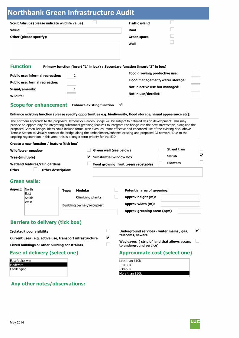
Northbank Green Infrastructure Audit
Traffic island
Roof
Green space
Scrub/shrubs (please indicate wildlife value)
Value:
Other (please specify):
Function Primary function (insert "1" in box) / Secondary function (insert "2" in box)
Public use: informal recreation: 2
Public use: formal recreation:
Visual/amenity: 1
Wildlife:
Food growing/productive use:
Flood management/water storage:
Not in active use but managed:
Not in use/derelict:
Scope for enhancement
Enhance existing function (please specify opportunities e.g. biodiversity, flood storage, visual appearance etc):
The northern approach to the proposed Hetherwick Garden Bridge will be subject to detailed design development. This may provide an opportunity for integrating substantial greening features to integrate the bridge into the new streetscape, alongside the proposed Garden Bridge. Ideas could include formal tree avenues, more effective and enhanced use of the existing deck above Temple Station to visually connect the bridge along the embankment/enhance existing and proposed GI network. Due to the ongoing regeneration in this area, this is a longer term priority for the BID.
Create a new function / feature (tick box)
Wildflower meadow
Tree-(multiple)
Wetland features/rain gardens
Green wall (see below)
Substantial window box
Food growing: fruit trees/vegetables
Barriers to delivery (tick box)
Isolated/ poor visibility
Current uses , e.g. active use, transport infrastructure
Listed buildings or other building constraints
Underground services - water mains , gas, telecoms, sewers
Wayleaves ( strip of land that allows access
to underground service)
Approximate cost (select one)
Any other notes/observations:
Enhance existing function
Street tree
Shrub
Planters
Wall
Other Other description:
Green walls:
Aspect: Modular
Climbing plants:
Type:
Building owner/occupier:
Approx height (m):
Approx width (m):
Approx greening area: (sqm)
Potential area of greening:
Ease of delivery (select one)
Less than £10k
£10-30k
£30-50k
More than £50k
North
East
South
West
Easy/quick win
Moderate
Challenging
May 2014

Northbank Green Infrastructure Audit
Text112:
Text114:
Phot \\D
MapName: \\
Survey date: 27/01/2014 Surveyor: S. West
Type of site:
Site ID: 7 Name/ location: Arundel Street / Strand junction
Area of greening
(sqm):51
Local park
Pocket park
Garden or square
Community garden/ Allotment
Shrub plantings
Wetland/ standing water
Derelict building plot
Highway infrastructure
e.g. traffic island
Street tree in pit
Grass verge
Hedge
Planter/ raised bed
Pavement or other hard surface
Site category (tick box)
Condition of GI (select one)
Current management (tick box)
Mowing/grass cutting (please specify)
Specify here:
Pruning or other tree maintenance
No obvious signs of management
Appears unmanaged/overgrown
Productive use for food
Landcover / habitat types (tick box)
Building
Pavement/paved area
Highway
Amenity grassland
Semi-natural grassland
Woodland
Condition:
Green wall
© Crown Copyright and database right 2014. Ordnance Survey 100032216 GLA
Desk-based information
Highest surface water flood hazard category: Low risk
Are there any heritage features in or adjacent to the site:
Is the site within a GLA Area of Wildlife Deficiency:
Is the site a SINC
Existing
Potential
Existing with potential for enhancement
Good (signs of active management)
Moderate (signs of limited management)
Poor (few signs of management)
May 2014

Northbank Green Infrastructure Audit
Traffic island
Roof
Green space
Scrub/shrubs (please indicate wildlife value)
Value:
Other (please specify):
Function Primary function (insert "1" in box) / Secondary function (insert "2" in box)
Public use: informal recreation: 2
Public use: formal recreation:
Visual/amenity: 1
Wildlife:
Food growing/productive use:
Flood management/water storage:
Not in active use but managed:
Not in use/derelict:
Scope for enhancement
Enhance existing function (please specify opportunities e.g. biodiversity, flood storage, visual appearance etc):
Suggest creating low level visibility splay shrub planting / ground cover plantings at wide footway junction and adjacent toilet to enhance appearance and improve flood storage.
Create a new function / feature (tick box)
Wildflower meadow
Tree-(multiple)
Wetland features/rain gardens
Green wall (see below)
Substantial window box
Food growing: fruit trees/vegetables
Barriers to delivery (tick box)
Isolated/ poor visibility
Current uses , e.g. active use, transport infrastructure
Listed buildings or other building constraints
Underground services - water mains , gas,
telecoms, sewers
Wayleaves ( strip of land that allows access
to underground service)
Approximate cost (select one)
Any other notes/observations:
Enhance existing function
Street tree
Shrub
Planters
Wall
Other Other description:
Green walls:
Aspect: Modular
Climbing plants:
Type:
Building owner/occupier:
Approx height (m):
Approx width (m):
Approx greening area: (sqm)
Potential area of greening:
Ease of delivery (select one)
Less than £10k
£10-30k
£30-50k
More than £50k
North
East
South
West
Easy/quick win
Moderate
Challenging
May 2014

Northbank Green Infrastructure Audit
Text112:
Text114:
Phot \\D
MapName: \\
Survey date: 27/01/2014 Surveyor: S. West
Type of site:
Site ID: 8 Name/ location: Aldwych
Area of greening
(sqm):2251
Local park
Pocket park
Garden or square
Community garden/ Allotment
Shrub plantings
Wetland/ standing water
Derelict building plot
Highway infrastructure
e.g. traffic island
Street tree in pit
Grass verge
Hedge
Planter/ raised bed
Pavement or other hard surface
Site category (tick box)
Condition of GI (select one)
Current management (tick box)
Mowing/grass cutting (please specify)
Specify here:
Pruning or other tree maintenance
No obvious signs of management
Appears unmanaged/overgrown
Productive use for food
Landcover / habitat types (tick box)
Building
Pavement/paved area
Highway
Amenity grassland
Semi-natural grassland
Woodland
Condition:
Green wall
© Crown Copyright and database right 2014. Ordnance Survey 100032216 GLA
Desk-based information
Highest surface water flood hazard category: Areas with depths 0.26 - 0.5m
Are there any heritage features in or adjacent to the site:
Is the site within a GLA Area of Wildlife Deficiency:
Is the site a SINC
Existing
Potential
Existing with potential for enhancement
Good (signs of active management)
Moderate (signs of limited management)
Poor (few signs of management)
May 2014

Northbank Green Infrastructure Audit
Traffic island
Roof
Green space
Scrub/shrubs (please indicate wildlife value)
Value:
Other (please specify):
Function Primary function (insert "1" in box) / Secondary function (insert "2" in box)
Public use: informal recreation:
Public use: formal recreation:
Visual/amenity: 1
Wildlife: 2
Food growing/productive use:
Flood management/water storage:
Not in active use but managed:
Not in use/derelict:
Scope for enhancement
Enhance existing function (please specify opportunities e.g. biodiversity, flood storage, visual appearance etc):
Suggest creating consistent tree pit surfaces with resin bonded aggregate (porous) or gravel with sufficient width and levels. This is to enhance appearance, tree health and path safety.
Create a new function / feature (tick box)
Wildflower meadow
Tree-(multiple)
Wetland features/rain gardens
Green wall (see below)
Substantial window box
Food growing: fruit trees/vegetables
Barriers to delivery (tick box)
Isolated/ poor visibility
Current uses , e.g. active use, transport infrastructure
Listed buildings or other building constraints
Underground services - water mains , gas,
telecoms, sewers
Wayleaves ( strip of land that allows access
to underground service)
Approximate cost (select one)
Any other notes/observations:
Current tree management to be assessed. Some tree pits have been tarmaced to the base of the tree which is generally not good
practice and can adversely affect the health of the tree.
Enhance existing function
Street tree
Shrub
Planters
Wall
Other Other description:
Green walls:
Aspect: Modular
Climbing plants:
Type:
Building owner/occupier:
Approx height (m):
Approx width (m):
Approx greening area: (sqm)
Potential area of greening:
Ease of delivery (select one)
Less than £10k
£10-30k
£30-50k
More than £50k
North
East
South
West
Easy/quick win
Moderate
Challenging
May 2014
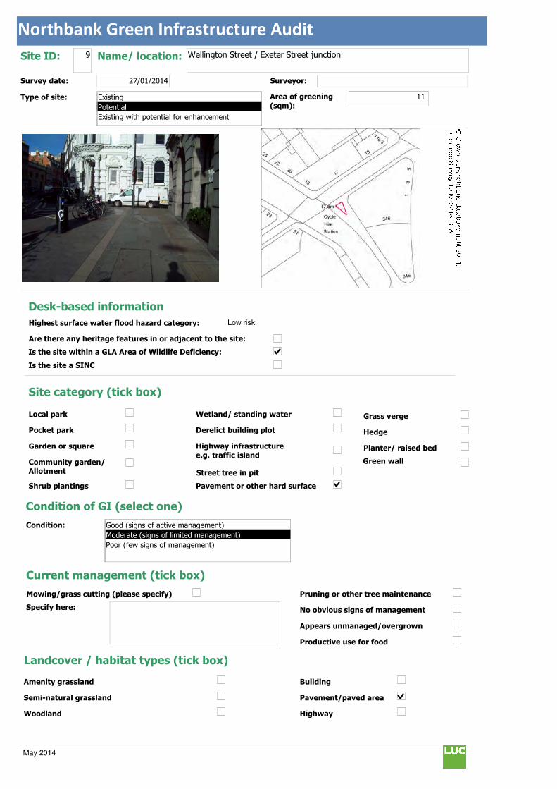
Northbank Green Infrastructure Audit
Text112:
Text114:
Phot \\D
MapName: \\
Survey date: 27/01/2014 Surveyor:
Type of site:
Site ID: 9 Name/ location: Wellington Street / Exeter Street junction
Area of greening
(sqm):11
Local park
Pocket park
Garden or square
Community garden/ Allotment
Shrub plantings
Wetland/ standing water
Derelict building plot
Highway infrastructure
e.g. traffic island
Street tree in pit
Grass verge
Hedge
Planter/ raised bed
Pavement or other hard surface
Site category (tick box)
Condition of GI (select one)
Current management (tick box)
Mowing/grass cutting (please specify)
Specify here:
Pruning or other tree maintenance
No obvious signs of management
Appears unmanaged/overgrown
Productive use for food
Landcover / habitat types (tick box)
Building
Pavement/paved area
Highway
Amenity grassland
Semi-natural grassland
Woodland
Condition:
Green wall
© Crown Copyright and database right 2014. Ordnance Survey 100032216 GLA
Desk-based information
Highest surface water flood hazard category: Low risk
Are there any heritage features in or adjacent to the site:
Is the site within a GLA Area of Wildlife Deficiency:
Is the site a SINC
Existing
Potential
Existing with potential for enhancement
Good (signs of active management)
Moderate (signs of limited management)
Poor (few signs of management)
May 2014

Northbank Green Infrastructure Audit
Traffic island
Roof
Green space
Scrub/shrubs (please indicate wildlife value)
Value:
Other (please specify):
Function Primary function (insert "1" in box) / Secondary function (insert "2" in box)
Public use: informal recreation: 2
Public use: formal recreation:
Visual/amenity: 1
Wildlife:
Food growing/productive use:
Flood management/water storage:
Not in active use but managed:
Not in use/derelict:
Scope for enhancement
Enhance existing function (please specify opportunities e.g. biodiversity, flood storage, visual appearance etc):
Suggest creating a pocket park area with level highway / footway surfaces and further shrub planting to enhance appearance and flood storage.
Create a new function / feature (tick box)
Wildflower meadow
Tree-(multiple)
Wetland features/rain gardens
Green wall (see below)
Substantial window box
Food growing: fruit trees/vegetables
Barriers to delivery (tick box)
Isolated/ poor visibility
Current uses , e.g. active use, transport infrastructure
Listed buildings or other building constraints
Underground services - water mains , gas,
telecoms, sewers
Wayleaves ( strip of land that allows access
to underground service)
Approximate cost (select one)
Any other notes/observations:
Good pivotal viewpoints towards Waterloo Bridge, Strand, Aldwych and Exeter Street.
Enhance existing function
Street tree
Shrub
Planters
Wall
Other Other description: Pocket Park
Green walls:
Aspect: Modular
Climbing plants:
Type:
Building owner/occupier:
Approx height (m):
Approx width (m):
Approx greening area: (sqm)
Potential area of greening:
Ease of delivery (select one)
Less than £10k
£10-30k
£30-50k
More than £50k
North
East
South
West
Easy/quick win
Moderate
Challenging
May 2014
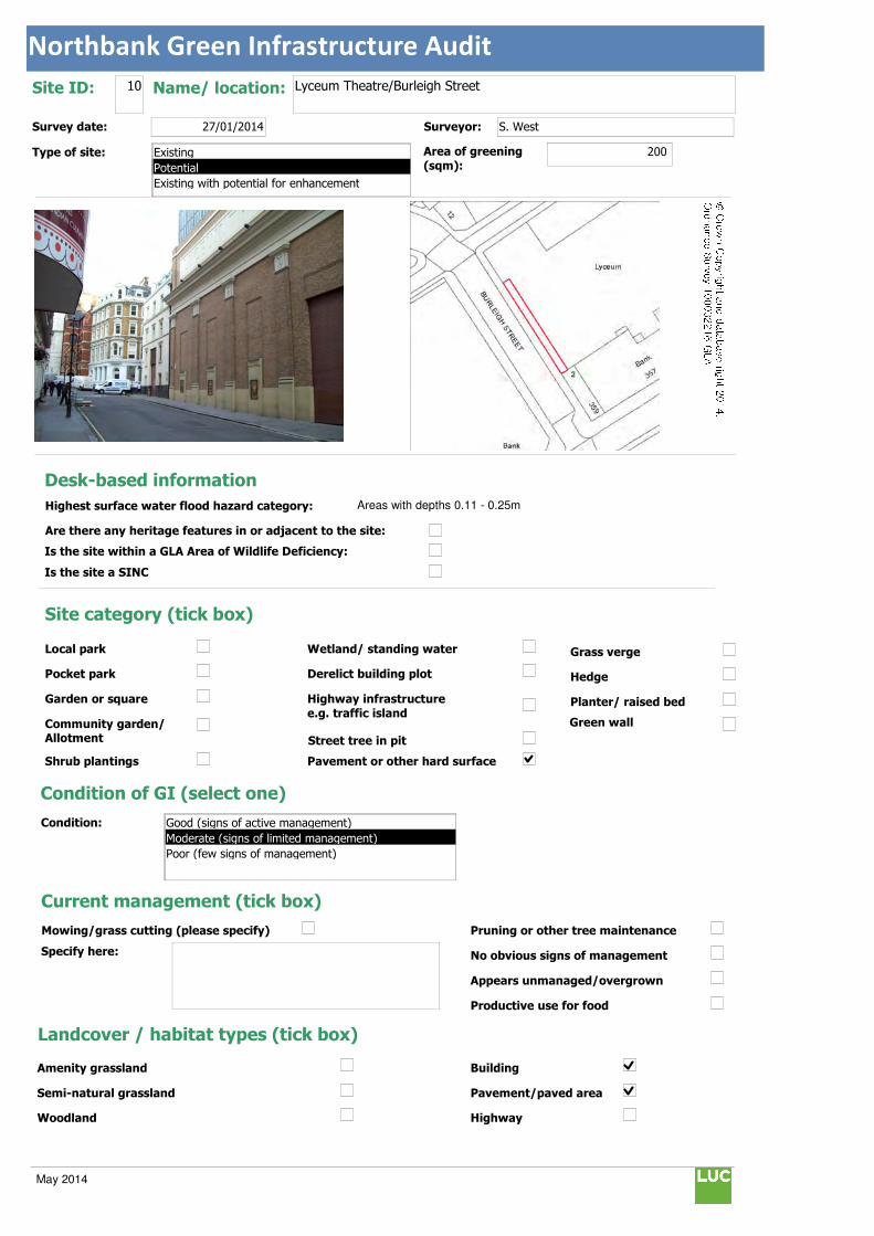
Northbank Green Infrastructure Audit
Text112:
Text114:
Phot \\D
MapName: \\
Survey date: 27/01/2014 Surveyor: S. West
Type of site:
Site ID: 10 Name/ location: Lyceum Theatre/Burleigh Street
Area of greening
(sqm):200
Local park
Pocket park
Garden or square
Community garden/ Allotment
Shrub plantings
Wetland/ standing water
Derelict building plot
Highway infrastructure
e.g. traffic island
Street tree in pit
Grass verge
Hedge
Planter/ raised bed
Pavement or other hard surface
Site category (tick box)
Condition of GI (select one)
Current management (tick box)
Mowing/grass cutting (please specify)
Specify here:
Pruning or other tree maintenance
No obvious signs of management
Appears unmanaged/overgrown
Productive use for food
Landcover / habitat types (tick box)
Building
Pavement/paved area
Highway
Amenity grassland
Semi-natural grassland
Woodland
Condition:
Green wall
© Crown Copyright and database right 2014. Ordnance Survey 100032216 GLA
Desk-based information
Highest surface water flood hazard category: Areas with depths 0.11 - 0.25m
Are there any heritage features in or adjacent to the site:
Is the site within a GLA Area of Wildlife Deficiency:
Is the site a SINC
Existing
Potential
Existing with potential for enhancement
Good (signs of active management)
Moderate (signs of limited management)
Poor (few signs of management)
May 2014

Northbank Green Infrastructure Audit
Traffic island
Roof
Green space
Scrub/shrubs (please indicate wildlife value)
Value:
Other (please specify):
Function Primary function (insert "1" in box) / Secondary function (insert "2" in box)
Public use: informal recreation:
Public use: formal recreation:
Visual/amenity: 1
Wildlife:
Food growing/productive use:
Flood management/water storage:
Not in active use but managed:
Not in use/derelict:
Scope for enhancement
Enhance existing function (please specify opportunities e.g. biodiversity, flood storage, visual appearance etc):
Suggest creating a green wall on back of Lyceum theatre between Columns to enhance appearance and encourage wildlife.
Create a new function / feature (tick box)
Wildflower meadow
Tree-(multiple)
Wetland features/rain gardens
Green wall (see below)
Substantial window box
Food growing: fruit trees/vegetables
Barriers to delivery (tick box)
Isolated/ poor visibility
Current uses , e.g. active use, transport infrastructure
Listed buildings or other building constraints
Underground services - water mains , gas,
telecoms, sewers
Wayleaves ( strip of land that allows access
to underground service)
Approximate cost (select one)
Any other notes/observations:
Enhance existing function
Street tree
Shrub
Planters
Wall
Other Other description:
Green walls:
Aspect: Modular
Climbing plants:
Type:
Building owner/occupier:
Lyceum Theatre
Approx height (m): 10
Approx width (m): 20
Approx greening area: (sqm) 200
Potential area of greening:
Ease of delivery (select one)
Less than £10k
£10-30k
£30-50k
More than £50k
North
East
South
West
Easy/quick win
Moderate
Challenging
May 2014
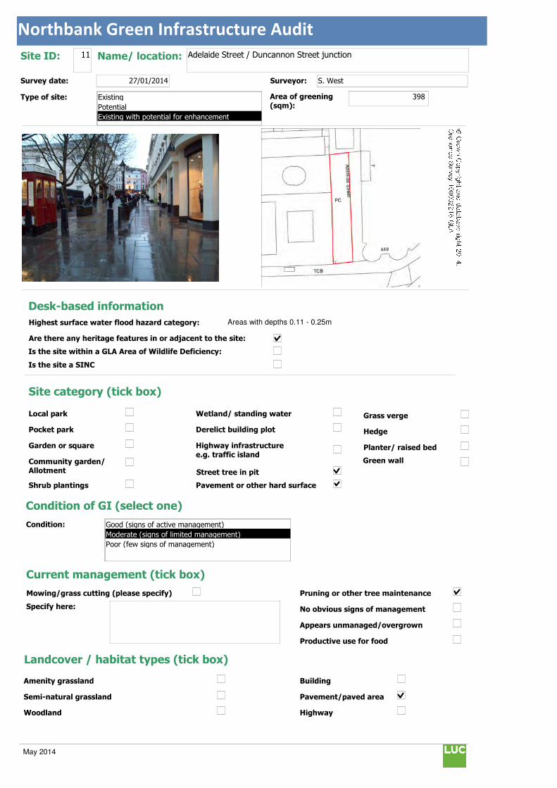
Northbank Green Infrastructure Audit
Text112:
Text114:
Phot \\D
MapName: \\
Survey date: 27/01/2014 Surveyor: S. West
Type of site:
Site ID: 11 Name/ location: Adelaide Street / Duncannon Street junction
Area of greening
(sqm):398
Local park
Pocket park
Garden or square
Community garden/ Allotment
Shrub plantings
Wetland/ standing water
Derelict building plot
Highway infrastructure
e.g. traffic island
Street tree in pit
Grass verge
Hedge
Planter/ raised bed
Pavement or other hard surface
Site category (tick box)
Condition of GI (select one)
Current management (tick box)
Mowing/grass cutting (please specify)
Specify here:
Pruning or other tree maintenance
No obvious signs of management
Appears unmanaged/overgrown
Productive use for food
Landcover / habitat types (tick box)
Building
Pavement/paved area
Highway
Amenity grassland
Semi-natural grassland
Woodland
Condition:
Green wall
© Crown Copyright and database right 2014. Ordnance Survey 100032216 GLA
Desk-based information
Highest surface water flood hazard category: Areas with depths 0.11 - 0.25m
Are there any heritage features in or adjacent to the site:
Is the site within a GLA Area of Wildlife Deficiency:
Is the site a SINC
Existing
Potential
Existing with potential for enhancement
Good (signs of active management)
Moderate (signs of limited management)
Poor (few signs of management)
May 2014
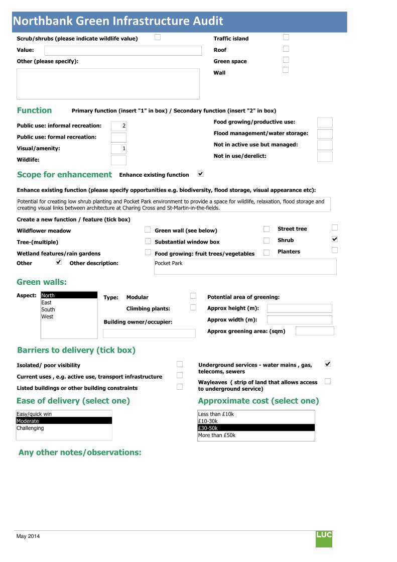
Northbank Green Infrastructure Audit
Traffic island
Roof
Green space
Scrub/shrubs (please indicate wildlife value)
Value:
Other (please specify):
Function Primary function (insert "1" in box) / Secondary function (insert "2" in box)
Public use: informal recreation: 2
Public use: formal recreation:
Visual/amenity: 1
Wildlife:
Food growing/productive use:
Flood management/water storage:
Not in active use but managed:
Not in use/derelict:
Scope for enhancement
Enhance existing function (please specify opportunities e.g. biodiversity, flood storage, visual appearance etc):
Potential for creating low shrub planting and Pocket Park environment to provide a space for wildlife, relaxation, flood storage and creating visual links between architecture at Charing Cross and St-Martin-in-the-fields.
Create a new function / feature (tick box)
Wildflower meadow
Tree-(multiple)
Wetland features/rain gardens
Green wall (see below)
Substantial window box
Food growing: fruit trees/vegetables
Barriers to delivery (tick box)
Isolated/ poor visibility
Current uses , e.g. active use, transport infrastructure
Listed buildings or other building constraints
Underground services - water mains , gas,
telecoms, sewers
Wayleaves ( strip of land that allows access
to underground service)
Approximate cost (select one)
Any other notes/observations:
Enhance existing function
Street tree
Shrub
Planters
Wall
Other Other description: Pocket Park
Green walls:
Aspect: Modular
Climbing plants:
Type:
Building owner/occupier:
Approx height (m):
Approx width (m):
Approx greening area: (sqm)
Potential area of greening:
Ease of delivery (select one)
Less than £10k
£10-30k
£30-50k
More than £50k
North
East
South
West
Easy/quick win
Moderate
Challenging
May 2014
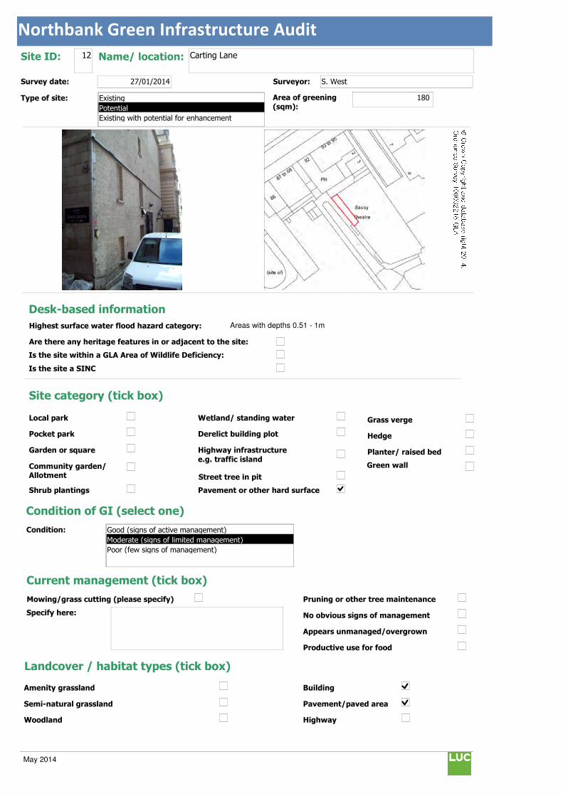
Northbank Green Infrastructure Audit
Text112:
Text114:
Phot \\D
MapName: \\
Survey date: 27/01/2014 Surveyor: S. West
Type of site:
Site ID: 12 Name/ location: Carting Lane
Area of greening
(sqm):180
Local park
Pocket park
Garden or square
Community garden/ Allotment
Shrub plantings
Wetland/ standing water
Derelict building plot
Highway infrastructure
e.g. traffic island
Street tree in pit
Grass verge
Hedge
Planter/ raised bed
Pavement or other hard surface
Site category (tick box)
Condition of GI (select one)
Current management (tick box)
Mowing/grass cutting (please specify)
Specify here:
Pruning or other tree maintenance
No obvious signs of management
Appears unmanaged/overgrown
Productive use for food
Landcover / habitat types (tick box)
Building
Pavement/paved area
Highway
Amenity grassland
Semi-natural grassland
Woodland
Condition:
Green wall
© Crown Copyright and database right 2014. Ordnance Survey 100032216 GLA
Desk-based information
Highest surface water flood hazard category: Areas with depths 0.51 - 1m
Are there any heritage features in or adjacent to the site:
Is the site within a GLA Area of Wildlife Deficiency:
Is the site a SINC
Existing
Potential
Existing with potential for enhancement
Good (signs of active management)
Moderate (signs of limited management)
Poor (few signs of management)
May 2014

Northbank Green Infrastructure Audit
Traffic island
Roof
Green space
Scrub/shrubs (please indicate wildlife value)
Value:
Other (please specify):
Function Primary function (insert "1" in box) / Secondary function (insert "2" in box)
Public use: informal recreation:
Public use: formal recreation:
Visual/amenity: 1
Wildlife:
Food growing/productive use:
Flood management/water storage:
Not in active use but managed:
Not in use/derelict:
Scope for enhancement
Enhance existing function (please specify opportunities e.g. biodiversity, flood storage, visual appearance etc):
Suggest creating a green wall to enhance visual link between Covent Garden and Victoria Embankment Gardens.
Create a new function / feature (tick box)
Wildflower meadow
Tree-(multiple)
Wetland features/rain gardens
Green wall (see below)
Substantial window box
Food growing: fruit trees/vegetables
Barriers to delivery (tick box)
Isolated/ poor visibility
Current uses , e.g. active use, transport infrastructure
Listed buildings or other building constraints
Underground services - water mains , gas,
telecoms, sewers
Wayleaves ( strip of land that allows access
to underground service)
Approximate cost (select one)
Any other notes/observations:
Enhance existing function
Street tree
Shrub
Planters
Wall
Other Other description:
Green walls:
Aspect: Modular
Climbing plants:
Type:
Building owner/occupier:
Savoy Theatre
Approx height (m): 15
Approx width (m): 12
Approx greening area: (sqm) 180
Potential area of greening:
Ease of delivery (select one)
Less than £10k
£10-30k
£30-50k
More than £50k
North
East
South
West
Easy/quick win
Moderate
Challenging
May 2014
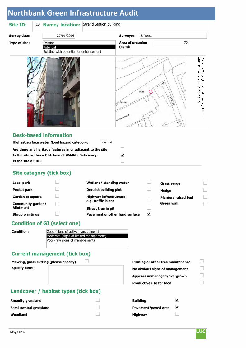
Northbank Green Infrastructure Audit
Text112:
Text114:
Phot \\D
MapName: \\
Survey date: 27/01/2014 Surveyor: S. West
Type of site:
Site ID: 13 Name/ location: Strand Station building
Area of greening
(sqm):72
Local park
Pocket park
Garden or square
Community garden/ Allotment
Shrub plantings
Wetland/ standing water
Derelict building plot
Highway infrastructure
e.g. traffic island
Street tree in pit
Grass verge
Hedge
Planter/ raised bed
Pavement or other hard surface
Site category (tick box)
Condition of GI (select one)
Current management (tick box)
Mowing/grass cutting (please specify)
Specify here:
Pruning or other tree maintenance
No obvious signs of management
Appears unmanaged/overgrown
Productive use for food
Landcover / habitat types (tick box)
Building
Pavement/paved area
Highway
Amenity grassland
Semi-natural grassland
Woodland
Condition:
Green wall
© Crown Copyright and database right 2014. Ordnance Survey 100032216 GLA
Desk-based information
Highest surface water flood hazard category: Low risk
Are there any heritage features in or adjacent to the site:
Is the site within a GLA Area of Wildlife Deficiency:
Is the site a SINC
Existing
Potential
Existing with potential for enhancement
Good (signs of active management)
Moderate (signs of limited management)
Poor (few signs of management)
May 2014

Northbank Green Infrastructure Audit
Traffic island
Roof
Green space
Scrub/shrubs (please indicate wildlife value)
Value:
Other (please specify):
Function Primary function (insert "1" in box) / Secondary function (insert "2" in box)
Public use: informal recreation:
Public use: formal recreation:
Visual/amenity: 1
Wildlife:
Food growing/productive use:
Flood management/water storage:
Not in active use but managed:
Not in use/derelict:
Scope for enhancement
Enhance existing function (please specify opportunities e.g. biodiversity, flood storage, visual appearance etc):
Suggest creating a green wall to enhance visual appearance and views towards historic listed church (St Mary le Strand).
Create a new function / feature (tick box)
Wildflower meadow
Tree-(multiple)
Wetland features/rain gardens
Green wall (see below)
Substantial window box
Food growing: fruit trees/vegetables
Barriers to delivery (tick box)
Isolated/ poor visibility
Current uses , e.g. active use, transport infrastructure
Listed buildings or other building constraints
Underground services - water mains , gas,
telecoms, sewers
Wayleaves ( strip of land that allows access
to underground service)
Approximate cost (select one)
Any other notes/observations:
Enhance existing function
Street tree
Shrub
Planters
Wall
Other Other description:
Green walls:
Aspect: Modular
Climbing plants:
Type:
Building owner/occupier:
Unknown
Approx height (m): 18
Approx width (m): 4
Approx greening area: (sqm) 72
Potential area of greening:
Ease of delivery (select one)
Less than £10k
£10-30k
£30-50k
More than £50k
North
East
South
West
Easy/quick win
Moderate
Challenging
May 2014
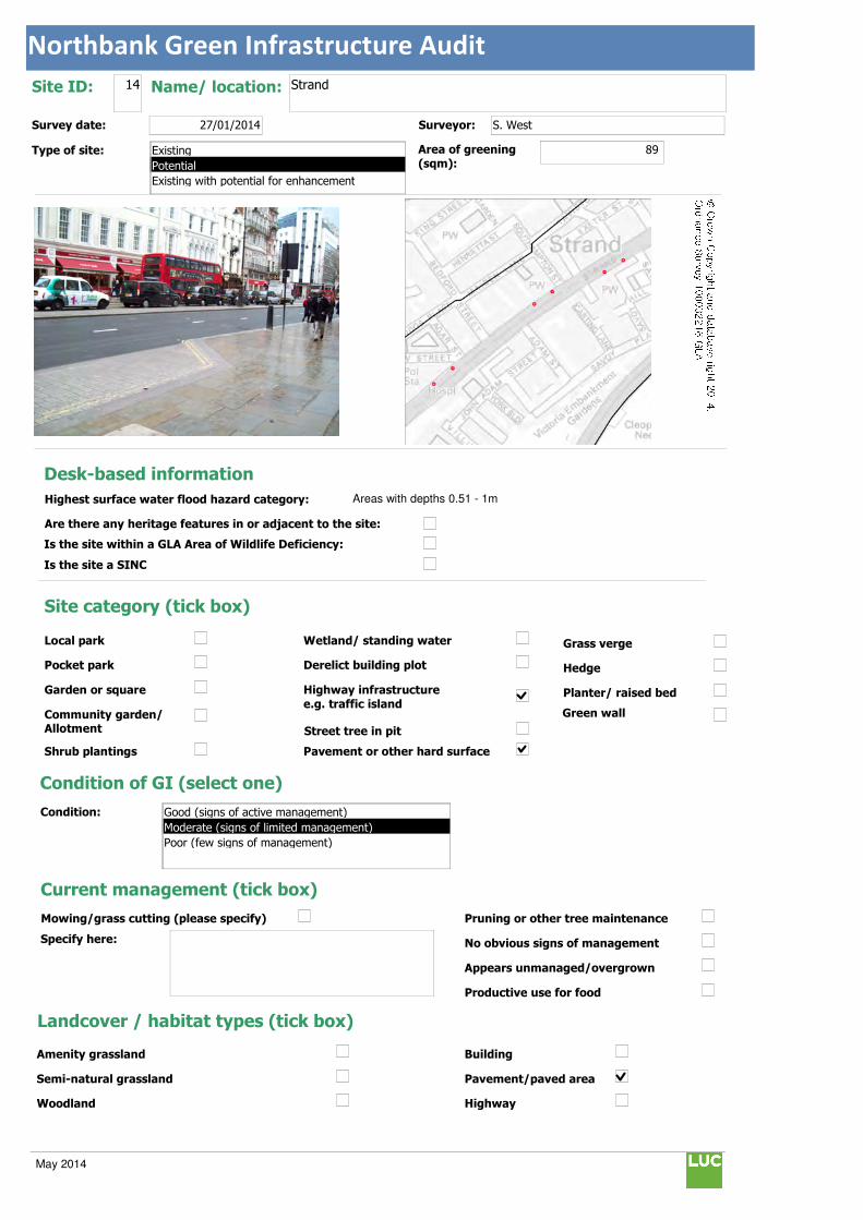
Northbank Green Infrastructure Audit
Text112:
Text114:
Phot \\D
MapName: \\
Survey date: 27/01/2014 Surveyor: S. West
Type of site:
Site ID: 14 Name/ location: Strand
Area of greening
(sqm):89
Local park
Pocket park
Garden or square
Community garden/ Allotment
Shrub plantings
Wetland/ standing water
Derelict building plot
Highway infrastructure
e.g. traffic island
Street tree in pit
Grass verge
Hedge
Planter/ raised bed
Pavement or other hard surface
Site category (tick box)
Condition of GI (select one)
Current management (tick box)
Mowing/grass cutting (please specify)
Specify here:
Pruning or other tree maintenance
No obvious signs of management
Appears unmanaged/overgrown
Productive use for food
Landcover / habitat types (tick box)
Building
Pavement/paved area
Highway
Amenity grassland
Semi-natural grassland
Woodland
Condition:
Green wall
© Crown Copyright and database right 2014. Ordnance Survey 100032216 GLA
Desk-based information
Highest surface water flood hazard category: Areas with depths 0.51 - 1m
Are there any heritage features in or adjacent to the site:
Is the site within a GLA Area of Wildlife Deficiency:
Is the site a SINC
Existing
Potential
Existing with potential for enhancement
Good (signs of active management)
Moderate (signs of limited management)
Poor (few signs of management)
May 2014

Northbank Green Infrastructure Audit
Traffic island
Roof
Green space
Scrub/shrubs (please indicate wildlife value)
Value:
Other (please specify):
Function Primary function (insert "1" in box) / Secondary function (insert "2" in box)
Public use: informal recreation:
Public use: formal recreation:
Visual/amenity: 1
Wildlife:
Food growing/productive use:
Flood management/water storage:
Not in active use but managed:
Not in use/derelict:
Scope for enhancement
Enhance existing function (please specify opportunities e.g. biodiversity, flood storage, visual appearance etc):
Suggest creating locations for small tree planting at either edge of intermittent laybys along Strand to improve appearance and encourage wildlife.
Create a new function / feature (tick box)
Wildflower meadow
Tree-(multiple)
Wetland features/rain gardens
Green wall (see below)
Substantial window box
Food growing: fruit trees/vegetables
Barriers to delivery (tick box)
Isolated/ poor visibility
Current uses , e.g. active use, transport infrastructure
Listed buildings or other building constraints
Underground services - water mains , gas,
telecoms, sewers
Wayleaves ( strip of land that allows access
to underground service)
Approximate cost (select one)
Any other notes/observations:
Enhance existing function
Street tree
Shrub
Planters
Wall
Other Other description:
Green walls:
Aspect: Modular
Climbing plants:
Type:
Building owner/occupier:
Approx height (m):
Approx width (m):
Approx greening area: (sqm)
Potential area of greening:
Ease of delivery (select one)
Less than £10k
£10-30k
£30-50k
More than £50k
North
East
South
West
Easy/quick win
Moderate
Challenging
May 2014
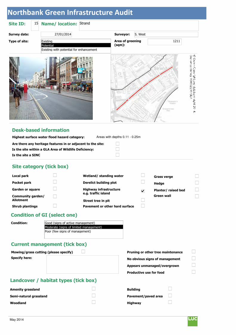
Northbank Green Infrastructure Audit
Text112:
Text114:
Phot \\D
MapName: \\
Survey date: 27/01/2014 Surveyor: S. West
Type of site:
Site ID: 15 Name/ location: Strand
Area of greening
(sqm):1211
Local park
Pocket park
Garden or square
Community garden/ Allotment
Shrub plantings
Wetland/ standing water
Derelict building plot
Highway infrastructure
e.g. traffic island
Street tree in pit
Grass verge
Hedge
Planter/ raised bed
Pavement or other hard surface
Site category (tick box)
Condition of GI (select one)
Current management (tick box)
Mowing/grass cutting (please specify)
Specify here:
Pruning or other tree maintenance
No obvious signs of management
Appears unmanaged/overgrown
Productive use for food
Landcover / habitat types (tick box)
Building
Pavement/paved area
Highway
Amenity grassland
Semi-natural grassland
Woodland
Condition:
Green wall
© Crown Copyright and database right 2014. Ordnance Survey 100032216 GLA
Desk-based information
Highest surface water flood hazard category: Areas with depths 0.11 - 0.25m
Are there any heritage features in or adjacent to the site:
Is the site within a GLA Area of Wildlife Deficiency:
Is the site a SINC
Existing
Potential
Existing with potential for enhancement
Good (signs of active management)
Moderate (signs of limited management)
Poor (few signs of management)
May 2014

Northbank Green Infrastructure Audit
Traffic island
Roof
Green space
Scrub/shrubs (please indicate wildlife value)
Value:
Other (please specify):
Function Primary function (insert "1" in box) / Secondary function (insert "2" in box)
Public use: informal recreation:
Public use: formal recreation:
Visual/amenity: 1
Wildlife:
Food growing/productive use:
Flood management/water storage:
Not in active use but managed:
Not in use/derelict:
Scope for enhancement
Enhance existing function (please specify opportunities e.g. biodiversity, flood storage, visual appearance etc):
Suggest positioning intermittent movable planters to prevent pedestrian crossing at inappropriate points along central reservation. These will also enhance appearance and encourage wildlife.
Create a new function / feature (tick box)
Wildflower meadow
Tree-(multiple)
Wetland features/rain gardens
Green wall (see below)
Substantial window box
Food growing: fruit trees/vegetables
Barriers to delivery (tick box)
Isolated/ poor visibility
Current uses , e.g. active use, transport infrastructure
Listed buildings or other building constraints
Underground services - water mains , gas,
telecoms, sewers
Wayleaves ( strip of land that allows access
to underground service)
Approximate cost (select one)
Any other notes/observations:
Enhance existing function
Street tree
Shrub
Planters
Wall
Other Other description:
Green walls:
Aspect: Modular
Climbing plants:
Type:
Building owner/occupier:
Approx height (m):
Approx width (m):
Approx greening area: (sqm)
Potential area of greening:
Ease of delivery (select one)
Less than £10k
£10-30k
£30-50k
More than £50k
North
East
South
West
Easy/quick win
Moderate
Challenging
May 2014
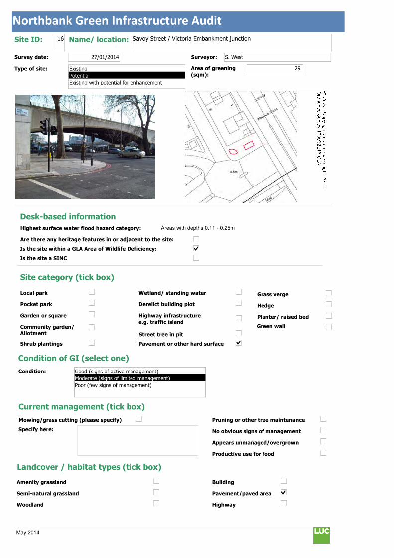
Northbank Green Infrastructure Audit
Text112:
Text114:
Phot \\D
MapName: \\
Survey date: 27/01/2014 Surveyor: S. West
Type of site:
Site ID: 16 Name/ location: Savoy Street / Victoria Embankment junction
Area of greening
(sqm):29
Local park
Pocket park
Garden or square
Community garden/ Allotment
Shrub plantings
Wetland/ standing water
Derelict building plot
Highway infrastructure
e.g. traffic island
Street tree in pit
Grass verge
Hedge
Planter/ raised bed
Pavement or other hard surface
Site category (tick box)
Condition of GI (select one)
Current management (tick box)
Mowing/grass cutting (please specify)
Specify here:
Pruning or other tree maintenance
No obvious signs of management
Appears unmanaged/overgrown
Productive use for food
Landcover / habitat types (tick box)
Building
Pavement/paved area
Highway
Amenity grassland
Semi-natural grassland
Woodland
Condition:
Green wall
© Crown Copyright and database right 2014. Ordnance Survey 100032216 GLA
Desk-based information
Highest surface water flood hazard category: Areas with depths 0.11 - 0.25m
Are there any heritage features in or adjacent to the site:
Is the site within a GLA Area of Wildlife Deficiency:
Is the site a SINC
Existing
Potential
Existing with potential for enhancement
Good (signs of active management)
Moderate (signs of limited management)
Poor (few signs of management)
May 2014

Northbank Green Infrastructure Audit
Traffic island
Roof
Green space
Scrub/shrubs (please indicate wildlife value)
Value:
Other (please specify):
Function Primary function (insert "1" in box) / Secondary function (insert "2" in box)
Public use: informal recreation: 2
Public use: formal recreation:
Visual/amenity: 1
Wildlife:
Food growing/productive use:
Flood management/water storage:
Not in active use but managed:
Not in use/derelict:
Scope for enhancement
Enhance existing function (please specify opportunities e.g. biodiversity, flood storage, visual appearance etc):
Suggest creating low level visibility splay shrub planting / ground cover plantings at wide footway junction to enhance appearance and improve flood storage.
Create a new function / feature (tick box)
Wildflower meadow
Tree-(multiple)
Wetland features/rain gardens
Green wall (see below)
Substantial window box
Food growing: fruit trees/vegetables
Barriers to delivery (tick box)
Isolated/ poor visibility
Current uses , e.g. active use, transport infrastructure
Listed buildings or other building constraints
Underground services - water mains , gas,
telecoms, sewers
Wayleaves ( strip of land that allows access
to underground service)
Approximate cost (select one)
Any other notes/observations:
Enhance existing function
Street tree
Shrub
Planters
Wall
Other Other description:
Green walls:
Aspect: Modular
Climbing plants:
Type:
Building owner/occupier:
Approx height (m):
Approx width (m):
Approx greening area: (sqm)
Potential area of greening:
Ease of delivery (select one)
Less than £10k
£10-30k
£30-50k
More than £50k
North
East
South
West
Easy/quick win
Moderate
Challenging
May 2014

Northbank Green Infrastructure Audit
Text112:
Text114:
Phot \\D
MapName: \\
Survey date: 27/01/2014 Surveyor: S. West
Type of site:
Site ID: 17 Name/ location: Victoria Embankment / Temple Place junction
Area of greening
(sqm):185
Local park
Pocket park
Garden or square
Community garden/ Allotment
Shrub plantings
Wetland/ standing water
Derelict building plot
Highway infrastructure
e.g. traffic island
Street tree in pit
Grass verge
Hedge
Planter/ raised bed
Pavement or other hard surface
Site category (tick box)
Condition of GI (select one)
Current management (tick box)
Mowing/grass cutting (please specify)
Specify here:
Pruning or other tree maintenance
No obvious signs of management
Appears unmanaged/overgrown
Productive use for food
Landcover / habitat types (tick box)
Building
Pavement/paved area
Highway
Amenity grassland
Semi-natural grassland
Woodland
Condition:
Green wall
© Crown Copyright and database right 2014. Ordnance Survey 100032216 GLA
Desk-based information
Highest surface water flood hazard category: Areas with depths 0.11 - 0.25m
Are there any heritage features in or adjacent to the site:
Is the site within a GLA Area of Wildlife Deficiency:
Is the site a SINC
Existing
Potential
Existing with potential for enhancement
Good (signs of active management)
Moderate (signs of limited management)
Poor (few signs of management)
May 2014
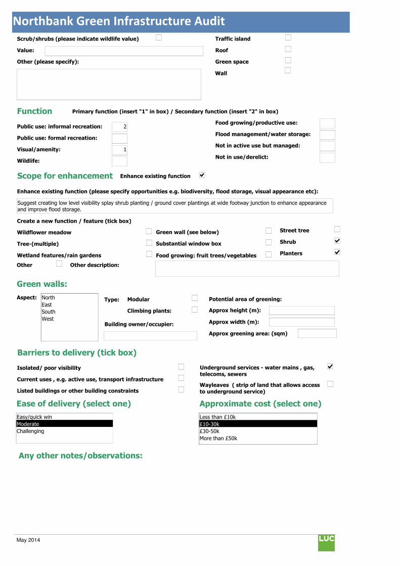
Northbank Green Infrastructure Audit
Traffic island
Roof
Green space
Scrub/shrubs (please indicate wildlife value)
Value:
Other (please specify):
Function Primary function (insert "1" in box) / Secondary function (insert "2" in box)
Public use: informal recreation: 2
Public use: formal recreation:
Visual/amenity: 1
Wildlife:
Food growing/productive use:
Flood management/water storage:
Not in active use but managed:
Not in use/derelict:
Scope for enhancement
Enhance existing function (please specify opportunities e.g. biodiversity, flood storage, visual appearance etc):
Suggest creating low level visibility splay shrub planting / ground cover plantings at wide footway junction to enhance appearance and improve flood storage.
Create a new function / feature (tick box)
Wildflower meadow
Tree-(multiple)
Wetland features/rain gardens
Green wall (see below)
Substantial window box
Food growing: fruit trees/vegetables
Barriers to delivery (tick box)
Isolated/ poor visibility
Current uses , e.g. active use, transport infrastructure
Listed buildings or other building constraints
Underground services - water mains , gas,
telecoms, sewers
Wayleaves ( strip of land that allows access
to underground service)
Approximate cost (select one)
Any other notes/observations:
Enhance existing function
Street tree
Shrub
Planters
Wall
Other Other description:
Green walls:
Aspect: Modular
Climbing plants:
Type:
Building owner/occupier:
Approx height (m):
Approx width (m):
Approx greening area: (sqm)
Potential area of greening:
Ease of delivery (select one)
Less than £10k
£10-30k
£30-50k
More than £50k
North
East
South
West
Easy/quick win
Moderate
Challenging
May 2014
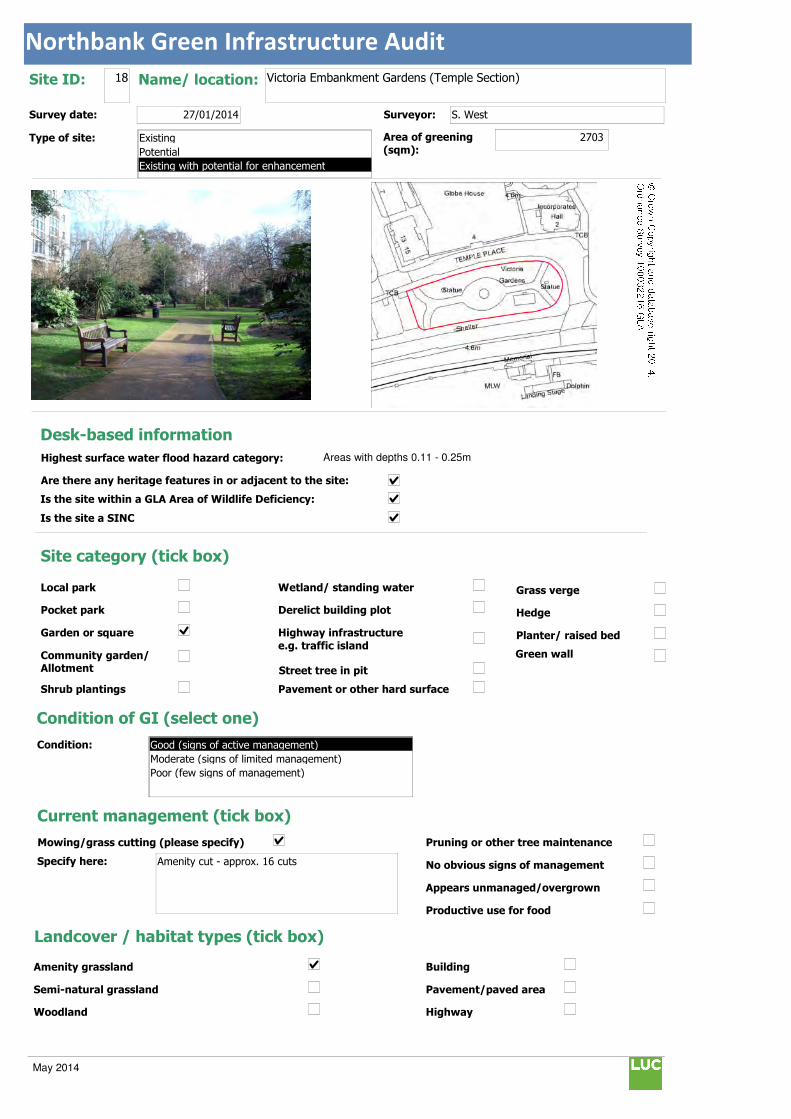
Northbank Green Infrastructure Audit
Text112:
Text114:
Phot \\D
MapName: \\
Survey date: 27/01/2014 Surveyor: S. West
Type of site:
Site ID: 18 Name/ location: Victoria Embankment Gardens (Temple Section)
Area of greening
(sqm):2703
Local park
Pocket park
Garden or square
Community garden/ Allotment
Shrub plantings
Wetland/ standing water
Derelict building plot
Highway infrastructure
e.g. traffic island
Street tree in pit
Grass verge
Hedge
Planter/ raised bed
Pavement or other hard surface
Site category (tick box)
Condition of GI (select one)
Current management (tick box)
Mowing/grass cutting (please specify)
Specify here: Amenity cut - approx. 16 cuts
Pruning or other tree maintenance
No obvious signs of management
Appears unmanaged/overgrown
Productive use for food
Landcover / habitat types (tick box)
Building
Pavement/paved area
Highway
Amenity grassland
Semi-natural grassland
Woodland
Condition:
Green wall
© Crown Copyright and database right 2014. Ordnance Survey 100032216 GLA
Desk-based information
Highest surface water flood hazard category: Areas with depths 0.11 - 0.25m
Are there any heritage features in or adjacent to the site:
Is the site within a GLA Area of Wildlife Deficiency:
Is the site a SINC
Existing
Potential
Existing with potential for enhancement
Good (signs of active management)
Moderate (signs of limited management)
Poor (few signs of management)
May 2014

Northbank Green Infrastructure Audit
Traffic island
Roof
Green space
Scrub/shrubs (please indicate wildlife value)
Value: Moderate - Evergreen heavy
Other (please specify):
Function Primary function (insert "1" in box) / Secondary function (insert "2" in box)
Public use: informal recreation: 2
Public use: formal recreation:
Visual/amenity: 1
Wildlife:
Food growing/productive use:
Flood management/water storage:
Not in active use but managed:
Not in use/derelict:
Scope for enhancement
Enhance existing function (please specify opportunities e.g. biodiversity, flood storage, visual appearance etc):
Suggest improving / increasing ground cover planting to reduce weeds and water loss and enhance appearance. Leggy shrubs could be cut back and non-evergreen nectar rich shrub varieties could be considered.
Create a new function / feature (tick box)
Wildflower meadow
Tree-(multiple)
Wetland features/rain gardens
Green wall (see below)
Substantial window box
Food growing: fruit trees/vegetables
Barriers to delivery (tick box)
Isolated/ poor visibility
Current uses , e.g. active use, transport infrastructure
Listed buildings or other building constraints
Underground services - water mains , gas,
telecoms, sewers
Wayleaves ( strip of land that allows access
to underground service)
Approximate cost (select one)
Any other notes/observations:
Enhance existing function
Street tree
Shrub
Planters
Wall
Other Other description:
Green walls:
Aspect: Modular
Climbing plants:
Type:
Building owner/occupier:
Approx height (m):
Approx width (m):
Approx greening area: (sqm)
Potential area of greening:
Ease of delivery (select one)
Less than £10k
£10-30k
£30-50k
More than £50k
North
East
South
West
Easy/quick win
Moderate
Challenging
May 2014

Northbank Green Infrastructure Audit
Text112:
Text114:
Phot \\D
MapName: \\
Survey date: 27/01/2014 Surveyor: S. West
Type of site:
Site ID: 19 Name/ location: St Mary Le Strand
Area of greening
(sqm):180
Local park
Pocket park
Garden or square
Community garden/ Allotment
Shrub plantings
Wetland/ standing water
Derelict building plot
Highway infrastructure
e.g. traffic island
Street tree in pit
Grass verge
Hedge
Planter/ raised bed
Pavement or other hard surface
Site category (tick box)
Condition of GI (select one)
Current management (tick box)
Mowing/grass cutting (please specify)
Specify here:
Pruning or other tree maintenance
No obvious signs of management
Appears unmanaged/overgrown
Productive use for food
Landcover / habitat types (tick box)
Building
Pavement/paved area
Highway
Amenity grassland
Semi-natural grassland
Woodland
Condition:
Green wall
© Crown Copyright and database right 2014. Ordnance Survey 100032216 GLA
Desk-based information
Highest surface water flood hazard category: Areas with depths 0.11 - 0.25m
Are there any heritage features in or adjacent to the site:
Is the site within a GLA Area of Wildlife Deficiency:
Is the site a SINC
Existing
Potential
Existing with potential for enhancement
Good (signs of active management)
Moderate (signs of limited management)
Poor (few signs of management)
May 2014

Northbank Green Infrastructure Audit
Traffic island
Roof
Green space
Scrub/shrubs (please indicate wildlife value)
Value: Moderate - few wildlife friendly plants
Other (please specify):
Function Primary function (insert "1" in box) / Secondary function (insert "2" in box)
Public use: informal recreation:
Public use: formal recreation:
Visual/amenity: 1
Wildlife:
Food growing/productive use:
Flood management/water storage:
Not in active use but managed:
Not in use/derelict:
Scope for enhancement
Enhance existing function (please specify opportunities e.g. biodiversity, flood storage, visual appearance etc):
Suggest creating surrounding low level pockets of planter shrub planting to emphasise church building, enhance appearance and improve flood storage.
Create a new function / feature (tick box)
Wildflower meadow
Tree-(multiple)
Wetland features/rain gardens
Green wall (see below)
Substantial window box
Food growing: fruit trees/vegetables
Barriers to delivery (tick box)
Isolated/ poor visibility
Current uses , e.g. active use, transport infrastructure
Listed buildings or other building constraints
Underground services - water mains , gas,
telecoms, sewers
Wayleaves ( strip of land that allows access
to underground service)
Approximate cost (select one)
Any other notes/observations:
Enhance existing function
Street tree
Shrub
Planters
Wall
Other Other description:
Green walls:
Aspect: Modular
Climbing plants:
Type:
Building owner/occupier:
Approx height (m):
Approx width (m):
Approx greening area: (sqm)
Potential area of greening:
Ease of delivery (select one)
Less than £10k
£10-30k
£30-50k
More than £50k
North
East
South
West
Easy/quick win
Moderate
Challenging
May 2014

Northbank Green Infrastructure Audit
Text112:
Text114:
Phot \\D
MapName: \\
Survey date: 27/01/2014 Surveyor: S. West
Type of site:
Site ID: 20 Name/ location: St Clement Danes Church
Area of greening
(sqm):25
Local park
Pocket park
Garden or square
Community garden/ Allotment
Shrub plantings
Wetland/ standing water
Derelict building plot
Highway infrastructure
e.g. traffic island
Street tree in pit
Grass verge
Hedge
Planter/ raised bed
Pavement or other hard surface
Site category (tick box)
Condition of GI (select one)
Current management (tick box)
Mowing/grass cutting (please specify)
Specify here:
Pruning or other tree maintenance
No obvious signs of management
Appears unmanaged/overgrown
Productive use for food
Landcover / habitat types (tick box)
Building
Pavement/paved area
Highway
Amenity grassland
Semi-natural grassland
Woodland
Condition:
Green wall
© Crown Copyright and database right 2014. Ordnance Survey 100032216 GLA
Desk-based information
Highest surface water flood hazard category: Low risk
Are there any heritage features in or adjacent to the site:
Is the site within a GLA Area of Wildlife Deficiency:
Is the site a SINC
Existing
Potential
Existing with potential for enhancement
Good (signs of active management)
Moderate (signs of limited management)
Poor (few signs of management)
May 2014

Northbank Green Infrastructure Audit
Traffic island
Roof
Green space
Scrub/shrubs (please indicate wildlife value)
Value:
Other (please specify):
Function Primary function (insert "1" in box) / Secondary function (insert "2" in box)
Public use: informal recreation:
Public use: formal recreation:
Visual/amenity: 1
Wildlife:
Food growing/productive use:
Flood management/water storage:
Not in active use but managed:
Not in use/derelict:
Scope for enhancement
Enhance existing function (please specify opportunities e.g. biodiversity, flood storage, visual appearance etc):
Suggest creating surrounding low level pockets of planter shrub planting to emphasise church building, enhance appearance and improve flood storage.
Create a new function / feature (tick box)
Wildflower meadow
Tree-(multiple)
Wetland features/rain gardens
Green wall (see below)
Substantial window box
Food growing: fruit trees/vegetables
Barriers to delivery (tick box)
Isolated/ poor visibility
Current uses , e.g. active use, transport infrastructure
Listed buildings or other building constraints
Underground services - water mains , gas,
telecoms, sewers
Wayleaves ( strip of land that allows access
to underground service)
Approximate cost (select one)
Any other notes/observations:
Mature trees too close to listed building. Ideally check impact on church structure and viewpoints.
Enhance existing function
Street tree
Shrub
Planters
Wall
Other Other description:
Green walls:
Aspect: Modular
Climbing plants:
Type:
Building owner/occupier:
Approx height (m):
Approx width (m):
Approx greening area: (sqm)
Potential area of greening:
Ease of delivery (select one)
Less than £10k
£10-30k
£30-50k
More than £50k
North
East
South
West
Easy/quick win
Moderate
Challenging
May 2014
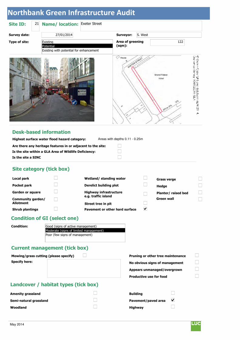
Northbank Green Infrastructure Audit
Text112:
Text114:
Phot \\D
MapName: \\
Survey date: 27/01/2014 Surveyor: S. West
Type of site:
Site ID: 21 Name/ location: Exeter Street
Area of greening
(sqm):122
Local park
Pocket park
Garden or square
Community garden/ Allotment
Shrub plantings
Wetland/ standing water
Derelict building plot
Highway infrastructure
e.g. traffic island
Street tree in pit
Grass verge
Hedge
Planter/ raised bed
Pavement or other hard surface
Site category (tick box)
Condition of GI (select one)
Current management (tick box)
Mowing/grass cutting (please specify)
Specify here:
Pruning or other tree maintenance
No obvious signs of management
Appears unmanaged/overgrown
Productive use for food
Landcover / habitat types (tick box)
Building
Pavement/paved area
Highway
Amenity grassland
Semi-natural grassland
Woodland
Condition:
Green wall
© Crown Copyright and database right 2014. Ordnance Survey 100032216 GLA
Desk-based information
Highest surface water flood hazard category: Areas with depths 0.11 - 0.25m
Are there any heritage features in or adjacent to the site:
Is the site within a GLA Area of Wildlife Deficiency:
Is the site a SINC
Existing
Potential
Existing with potential for enhancement
Good (signs of active management)
Moderate (signs of limited management)
Poor (few signs of management)
May 2014

Northbank Green Infrastructure Audit
Traffic island
Roof
Green space
Scrub/shrubs (please indicate wildlife value)
Value:
Other (please specify):
Function Primary function (insert "1" in box) / Secondary function (insert "2" in box)
Public use: informal recreation:
Public use: formal recreation:
Visual/amenity: 1
Wildlife:
Food growing/productive use:
Flood management/water storage:
Not in active use but managed:
Not in use/derelict:
Scope for enhancement
Enhance existing function (please specify opportunities e.g. biodiversity, flood storage, visual appearance etc):
Small tree planting along Western section of Exeter Street (east side of road) to enhance visual link with the Strand, improve flood storage and encourage biodiversity.
Create a new function / feature (tick box)
Wildflower meadow
Tree-(multiple)
Wetland features/rain gardens
Green wall (see below)
Substantial window box
Food growing: fruit trees/vegetables
Barriers to delivery (tick box)
Isolated/ poor visibility
Current uses , e.g. active use, transport infrastructure
Listed buildings or other building constraints
Underground services - water mains , gas,
telecoms, sewers
Wayleaves ( strip of land that allows access
to underground service)
Approximate cost (select one)
Any other notes/observations:
Enhance existing function
Street tree
Shrub
Planters
Wall
Other Other description:
Green walls:
Aspect: Modular
Climbing plants:
Type:
Building owner/occupier:
Approx height (m):
Approx width (m):
Approx greening area: (sqm)
Potential area of greening:
Ease of delivery (select one)
Less than £10k
£10-30k
£30-50k
More than £50k
North
East
South
West
Easy/quick win
Moderate
Challenging
May 2014
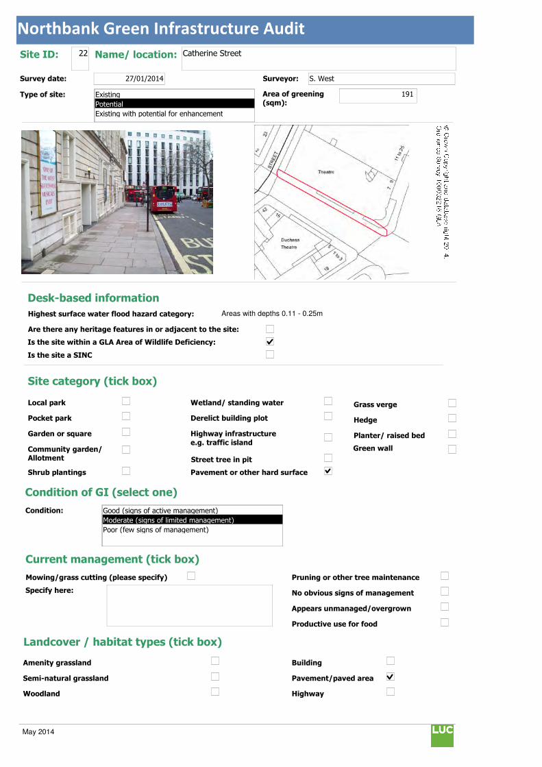
Northbank Green Infrastructure Audit
Text112:
Text114:
Phot \\D
MapName: \\
Survey date: 27/01/2014 Surveyor: S. West
Type of site:
Site ID: 22 Name/ location: Catherine Street
Area of greening
(sqm):191
Local park
Pocket park
Garden or square
Community garden/ Allotment
Shrub plantings
Wetland/ standing water
Derelict building plot
Highway infrastructure
e.g. traffic island
Street tree in pit
Grass verge
Hedge
Planter/ raised bed
Pavement or other hard surface
Site category (tick box)
Condition of GI (select one)
Current management (tick box)
Mowing/grass cutting (please specify)
Specify here:
Pruning or other tree maintenance
No obvious signs of management
Appears unmanaged/overgrown
Productive use for food
Landcover / habitat types (tick box)
Building
Pavement/paved area
Highway
Amenity grassland
Semi-natural grassland
Woodland
Condition:
Green wall
© Crown Copyright and database right 2014. Ordnance Survey 100032216 GLA
Desk-based information
Highest surface water flood hazard category: Areas with depths 0.11 - 0.25m
Are there any heritage features in or adjacent to the site:
Is the site within a GLA Area of Wildlife Deficiency:
Is the site a SINC
Existing
Potential
Existing with potential for enhancement
Good (signs of active management)
Moderate (signs of limited management)
Poor (few signs of management)
May 2014

Northbank Green Infrastructure Audit
Traffic island
Roof
Green space
Scrub/shrubs (please indicate wildlife value)
Value:
Other (please specify):
Function Primary function (insert "1" in box) / Secondary function (insert "2" in box)
Public use: informal recreation:
Public use: formal recreation:
Visual/amenity: 1
Wildlife:
Food growing/productive use:
Flood management/water storage:
Not in active use but managed:
Not in use/derelict:
Scope for enhancement
Enhance existing function (please specify opportunities e.g. biodiversity, flood storage, visual appearance etc):
Suggested small tree planting along wide north side of road alongside the Novello theatre to encourage biodiversity and enhance appearance.
Create a new function / feature (tick box)
Wildflower meadow
Tree-(multiple)
Wetland features/rain gardens
Green wall (see below)
Substantial window box
Food growing: fruit trees/vegetables
Barriers to delivery (tick box)
Isolated/ poor visibility
Current uses , e.g. active use, transport infrastructure
Listed buildings or other building constraints
Underground services - water mains , gas,
telecoms, sewers
Wayleaves ( strip of land that allows access
to underground service)
Approximate cost (select one)
Any other notes/observations:
Enhance existing function
Street tree
Shrub
Planters
Wall
Other Other description:
Green walls:
Aspect: Modular
Climbing plants:
Type:
Building owner/occupier:
Approx height (m):
Approx width (m):
Approx greening area: (sqm)
Potential area of greening:
Ease of delivery (select one)
Less than £10k
£10-30k
£30-50k
More than £50k
North
East
South
West
Easy/quick win
Moderate
Challenging
May 2014

Northbank Green Infrastructure Audit
Text112:
Text114:
Phot \\D
MapName: \\
Survey date: 27/01/2014 Surveyor: S. West
Type of site:
Site ID: 23 Name/ location: Kingsway
Area of greening
(sqm):15
Local park
Pocket park
Garden or square
Community garden/ Allotment
Shrub plantings
Wetland/ standing water
Derelict building plot
Highway infrastructure
e.g. traffic island
Street tree in pit
Grass verge
Hedge
Planter/ raised bed
Pavement or other hard surface
Site category (tick box)
Condition of GI (select one)
Current management (tick box)
Mowing/grass cutting (please specify)
Specify here:
Pruning or other tree maintenance
No obvious signs of management
Appears unmanaged/overgrown
Productive use for food
Landcover / habitat types (tick box)
Building
Pavement/paved area
Highway
Amenity grassland
Semi-natural grassland
Woodland
Condition:
Green wall
© Crown Copyright and database right 2014. Ordnance Survey 100032216 GLA
Desk-based information
Highest surface water flood hazard category: Areas with depths 0.51 - 1m
Are there any heritage features in or adjacent to the site:
Is the site within a GLA Area of Wildlife Deficiency:
Is the site a SINC
Existing
Potential
Existing with potential for enhancement
Good (signs of active management)
Moderate (signs of limited management)
Poor (few signs of management)
May 2014

Northbank Green Infrastructure Audit
Traffic island
Roof
Green space
Scrub/shrubs (please indicate wildlife value)
Value:
Other (please specify):
Function Primary function (insert "1" in box) / Secondary function (insert "2" in box)
Public use: informal recreation:
Public use: formal recreation:
Visual/amenity: 1
Wildlife:
Food growing/productive use:
Flood management/water storage:
Not in active use but managed:
Not in use/derelict:
Scope for enhancement
Enhance existing function (please specify opportunities e.g. biodiversity, flood storage, visual appearance etc):
Suggest planting replacement trees in empty tree pit locations to enhance appearance.
Create a new function / feature (tick box)
Wildflower meadow
Tree-(multiple)
Wetland features/rain gardens
Green wall (see below)
Substantial window box
Food growing: fruit trees/vegetables
Barriers to delivery (tick box)
Isolated/ poor visibility
Current uses , e.g. active use, transport infrastructure
Listed buildings or other building constraints
Underground services - water mains , gas,
telecoms, sewers
Wayleaves ( strip of land that allows access
to underground service)
Approximate cost (select one)
Any other notes/observations:
Enhance existing function
Street tree
Shrub
Planters
Wall
Other Other description:
Green walls:
Aspect: Modular
Climbing plants:
Type:
Building owner/occupier:
Approx height (m):
Approx width (m):
Approx greening area: (sqm)
Potential area of greening:
Ease of delivery (select one)
Less than £10k
£10-30k
£30-50k
More than £50k
North
East
South
West
Easy/quick win
Moderate
Challenging
May 2014
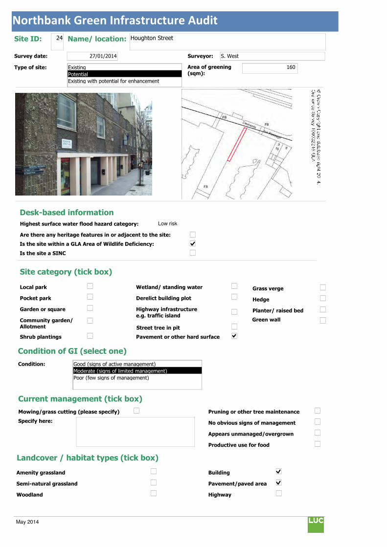
Northbank Green Infrastructure Audit
Text112:
Text114:
Phot \\D
MapName: \\
Survey date: 27/01/2014 Surveyor: S. West
Type of site:
Site ID: 24 Name/ location: Houghton Street
Area of greening
(sqm):160
Local park
Pocket park
Garden or square
Community garden/ Allotment
Shrub plantings
Wetland/ standing water
Derelict building plot
Highway infrastructure
e.g. traffic island
Street tree in pit
Grass verge
Hedge
Planter/ raised bed
Pavement or other hard surface
Site category (tick box)
Condition of GI (select one)
Current management (tick box)
Mowing/grass cutting (please specify)
Specify here:
Pruning or other tree maintenance
No obvious signs of management
Appears unmanaged/overgrown
Productive use for food
Landcover / habitat types (tick box)
Building
Pavement/paved area
Highway
Amenity grassland
Semi-natural grassland
Woodland
Condition:
Green wall
© Crown Copyright and database right 2014. Ordnance Survey 100032216 GLA
Desk-based information
Highest surface water flood hazard category: Low risk
Are there any heritage features in or adjacent to the site:
Is the site within a GLA Area of Wildlife Deficiency:
Is the site a SINC
Existing
Potential
Existing with potential for enhancement
Good (signs of active management)
Moderate (signs of limited management)
Poor (few signs of management)
May 2014
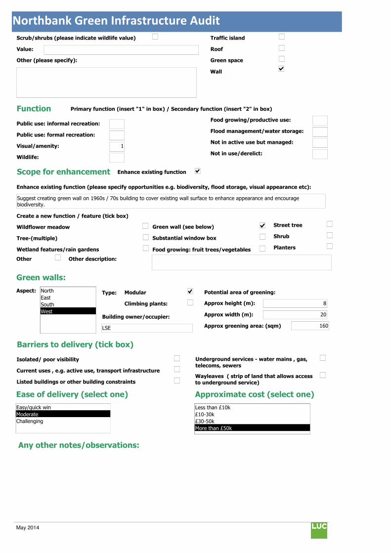
Northbank Green Infrastructure Audit
Traffic island
Roof
Green space
Scrub/shrubs (please indicate wildlife value)
Value:
Other (please specify):
Function Primary function (insert "1" in box) / Secondary function (insert "2" in box)
Public use: informal recreation:
Public use: formal recreation:
Visual/amenity: 1
Wildlife:
Food growing/productive use:
Flood management/water storage:
Not in active use but managed:
Not in use/derelict:
Scope for enhancement
Enhance existing function (please specify opportunities e.g. biodiversity, flood storage, visual appearance etc):
Suggest creating green wall on 1960s / 70s building to cover existing wall surface to enhance appearance and encourage biodiversity.
Create a new function / feature (tick box)
Wildflower meadow
Tree-(multiple)
Wetland features/rain gardens
Green wall (see below)
Substantial window box
Food growing: fruit trees/vegetables
Barriers to delivery (tick box)
Isolated/ poor visibility
Current uses , e.g. active use, transport infrastructure
Listed buildings or other building constraints
Underground services - water mains , gas,
telecoms, sewers
Wayleaves ( strip of land that allows access
to underground service)
Approximate cost (select one)
Any other notes/observations:
Enhance existing function
Street tree
Shrub
Planters
Wall
Other Other description:
Green walls:
Aspect: Modular
Climbing plants:
Type:
Building owner/occupier:
LSE
Approx height (m): 8
Approx width (m): 20
Approx greening area: (sqm) 160
Potential area of greening:
Ease of delivery (select one)
Less than £10k
£10-30k
£30-50k
More than £50k
North
East
South
West
Easy/quick win
Moderate
Challenging
May 2014

Northbank Green Infrastructure Audit
Text112:
Text114:
Phot \\D
MapName: \\
Survey date: 27/01/2014 Surveyor: S. West
Type of site:
Site ID: 25 Name/ location: Savoy Street
Area of greening
(sqm):80
Local park
Pocket park
Garden or square
Community garden/ Allotment
Shrub plantings
Wetland/ standing water
Derelict building plot
Highway infrastructure
e.g. traffic island
Street tree in pit
Grass verge
Hedge
Planter/ raised bed
Pavement or other hard surface
Site category (tick box)
Condition of GI (select one)
Current management (tick box)
Mowing/grass cutting (please specify)
Specify here:
Pruning or other tree maintenance
No obvious signs of management
Appears unmanaged/overgrown
Productive use for food
Landcover / habitat types (tick box)
Building
Pavement/paved area
Highway
Amenity grassland
Semi-natural grassland
Woodland
Condition:
Green wall
© Crown Copyright and database right 2014. Ordnance Survey 100032216 GLA
Desk-based information
Highest surface water flood hazard category: Low risk
Are there any heritage features in or adjacent to the site:
Is the site within a GLA Area of Wildlife Deficiency:
Is the site a SINC
Existing
Potential
Existing with potential for enhancement
Good (signs of active management)
Moderate (signs of limited management)
Poor (few signs of management)
May 2014

Northbank Green Infrastructure Audit
Traffic island
Roof
Green space
Scrub/shrubs (please indicate wildlife value)
Value:
Other (please specify):
Function Primary function (insert "1" in box) / Secondary function (insert "2" in box)
Public use: informal recreation:
Public use: formal recreation:
Visual/amenity: 1
Wildlife:
Food growing/productive use:
Flood management/water storage:
Not in active use but managed:
Not in use/derelict:
Scope for enhancement
Enhance existing function (please specify opportunities e.g. biodiversity, flood storage, visual appearance etc):
Suggest creating green wall to soften harsh building line and enhance appearance.
Create a new function / feature (tick box)
Wildflower meadow
Tree-(multiple)
Wetland features/rain gardens
Green wall (see below)
Substantial window box
Food growing: fruit trees/vegetables
Barriers to delivery (tick box)
Isolated/ poor visibility
Current uses , e.g. active use, transport infrastructure
Listed buildings or other building constraints
Underground services - water mains , gas,
telecoms, sewers
Wayleaves ( strip of land that allows access
to underground service)
Approximate cost (select one)
Any other notes/observations:
Enhance existing function
Street tree
Shrub
Planters
Wall
Other Other description:
Green walls:
Aspect: Modular
Climbing plants:
Type:
Building owner/occupier:
unknown
Approx height (m): 20
Approx width (m): 4
Approx greening area: (sqm) 80
Potential area of greening:
Ease of delivery (select one)
Less than £10k
£10-30k
£30-50k
More than £50k
North
East
South
West
Easy/quick win
Moderate
Challenging
May 2014

Northbank Green Infrastructure Audit
Text112:
Text114:
Phot \\D
MapName: \\
Survey date: 27/01/2014 Surveyor: S. West
Type of site:
Site ID: 26 Name/ location: Queen's Chapel of the Savoy Gardens
Area of greening
(sqm):30
Local park
Pocket park
Garden or square
Community garden/ Allotment
Shrub plantings
Wetland/ standing water
Derelict building plot
Highway infrastructure
e.g. traffic island
Street tree in pit
Grass verge
Hedge
Planter/ raised bed
Pavement or other hard surface
Site category (tick box)
Condition of GI (select one)
Current management (tick box)
Mowing/grass cutting (please specify)
Specify here: Amenity - approx. 16 cuts
Pruning or other tree maintenance
No obvious signs of management
Appears unmanaged/overgrown
Productive use for food
Landcover / habitat types (tick box)
Building
Pavement/paved area
Highway
Amenity grassland
Semi-natural grassland
Woodland
Condition:
Green wall
© Crown Copyright and database right 2014. Ordnance Survey 100032216 GLA
Desk-based information
Highest surface water flood hazard category: Low risk
Are there any heritage features in or adjacent to the site:
Is the site within a GLA Area of Wildlife Deficiency:
Is the site a SINC
Existing
Potential
Existing with potential for enhancement
Good (signs of active management)
Moderate (signs of limited management)
Poor (few signs of management)
May 2014

Northbank Green Infrastructure Audit
Traffic island
Roof
Green space
Scrub/shrubs (please indicate wildlife value)
Value: Moderate
Other (please specify):
Function Primary function (insert "1" in box) / Secondary function (insert "2" in box)
Public use: informal recreation: 2
Public use: formal recreation:
Visual/amenity: 1
Wildlife:
Food growing/productive use:
Flood management/water storage:
Not in active use but managed:
Not in use/derelict:
Scope for enhancement
Enhance existing function (please specify opportunities e.g. biodiversity, flood storage, visual appearance etc):
Remove Ivy from trees so that potential defects do not become obscured as they are situated close to the highway. Ivy should be removed outside of the bird nesting season (bird nesting season: March to July).
Create a new function / feature (tick box)
Wildflower meadow
Tree-(multiple)
Wetland features/rain gardens
Green wall (see below)
Substantial window box
Food growing: fruit trees/vegetables
Barriers to delivery (tick box)
Isolated/ poor visibility
Current uses , e.g. active use, transport infrastructure
Listed buildings or other building constraints
Underground services - water mains , gas,
telecoms, sewers
Wayleaves ( strip of land that allows access
to underground service)
Approximate cost (select one)
Any other notes/observations:
Enhance existing function
Street tree
Shrub
Planters
Wall
Other Other description:
Green walls:
Aspect: Modular
Climbing plants:
Type:
Building owner/occupier:
Approx height (m):
Approx width (m):
Approx greening area: (sqm)
Potential area of greening:
Ease of delivery (select one)
Less than £10k
£10-30k
£30-50k
More than £50k
North
East
South
West
Easy/quick win
Moderate
Challenging
May 2014

Northbank Green Infrastructure Audit
Text112:
Text114:
Phot \\D
MapName: \\
Survey date: 27/01/2014 Surveyor: S. West
Type of site:
Site ID: 27 Name/ location: John Adam Street
Area of greening
(sqm):240
Local park
Pocket park
Garden or square
Community garden/ Allotment
Shrub plantings
Wetland/ standing water
Derelict building plot
Highway infrastructure
e.g. traffic island
Street tree in pit
Grass verge
Hedge
Planter/ raised bed
Pavement or other hard surface
Site category (tick box)
Condition of GI (select one)
Current management (tick box)
Mowing/grass cutting (please specify)
Specify here:
Pruning or other tree maintenance
No obvious signs of management
Appears unmanaged/overgrown
Productive use for food
Landcover / habitat types (tick box)
Building
Pavement/paved area
Highway
Amenity grassland
Semi-natural grassland
Woodland
Condition:
Green wall
© Crown Copyright and database right 2014. Ordnance Survey 100032216 GLA
Desk-based information
Highest surface water flood hazard category: Areas with depths 0.26 - 0.5m
Are there any heritage features in or adjacent to the site:
Is the site within a GLA Area of Wildlife Deficiency:
Is the site a SINC
Existing
Potential
Existing with potential for enhancement
Good (signs of active management)
Moderate (signs of limited management)
Poor (few signs of management)
May 2014
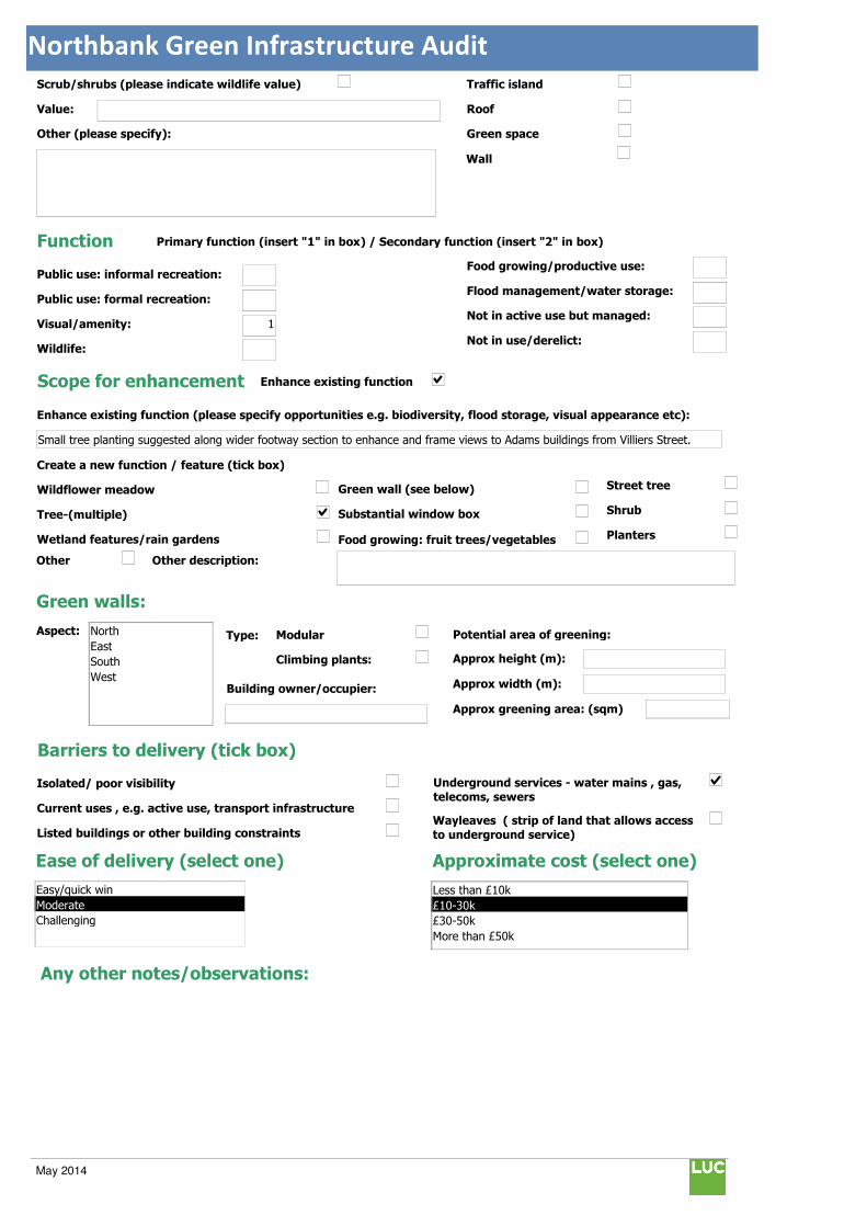
Northbank Green Infrastructure Audit
Traffic island
Roof
Green space
Scrub/shrubs (please indicate wildlife value)
Value:
Other (please specify):
Function Primary function (insert "1" in box) / Secondary function (insert "2" in box)
Public use: informal recreation:
Public use: formal recreation:
Visual/amenity: 1
Wildlife:
Food growing/productive use:
Flood management/water storage:
Not in active use but managed:
Not in use/derelict:
Scope for enhancement
Enhance existing function (please specify opportunities e.g. biodiversity, flood storage, visual appearance etc):
Small tree planting suggested along wider footway section to enhance and frame views to Adams buildings from Villiers Street.
Create a new function / feature (tick box)
Wildflower meadow
Tree-(multiple)
Wetland features/rain gardens
Green wall (see below)
Substantial window box
Food growing: fruit trees/vegetables
Barriers to delivery (tick box)
Isolated/ poor visibility
Current uses , e.g. active use, transport infrastructure
Listed buildings or other building constraints
Underground services - water mains , gas,
telecoms, sewers
Wayleaves ( strip of land that allows access
to underground service)
Approximate cost (select one)
Any other notes/observations:
Enhance existing function
Street tree
Shrub
Planters
Wall
Other Other description:
Green walls:
Aspect: Modular
Climbing plants:
Type:
Building owner/occupier:
Approx height (m):
Approx width (m):
Approx greening area: (sqm)
Potential area of greening:
Ease of delivery (select one)
Less than £10k
£10-30k
£30-50k
More than £50k
North
East
South
West
Easy/quick win
Moderate
Challenging
May 2014
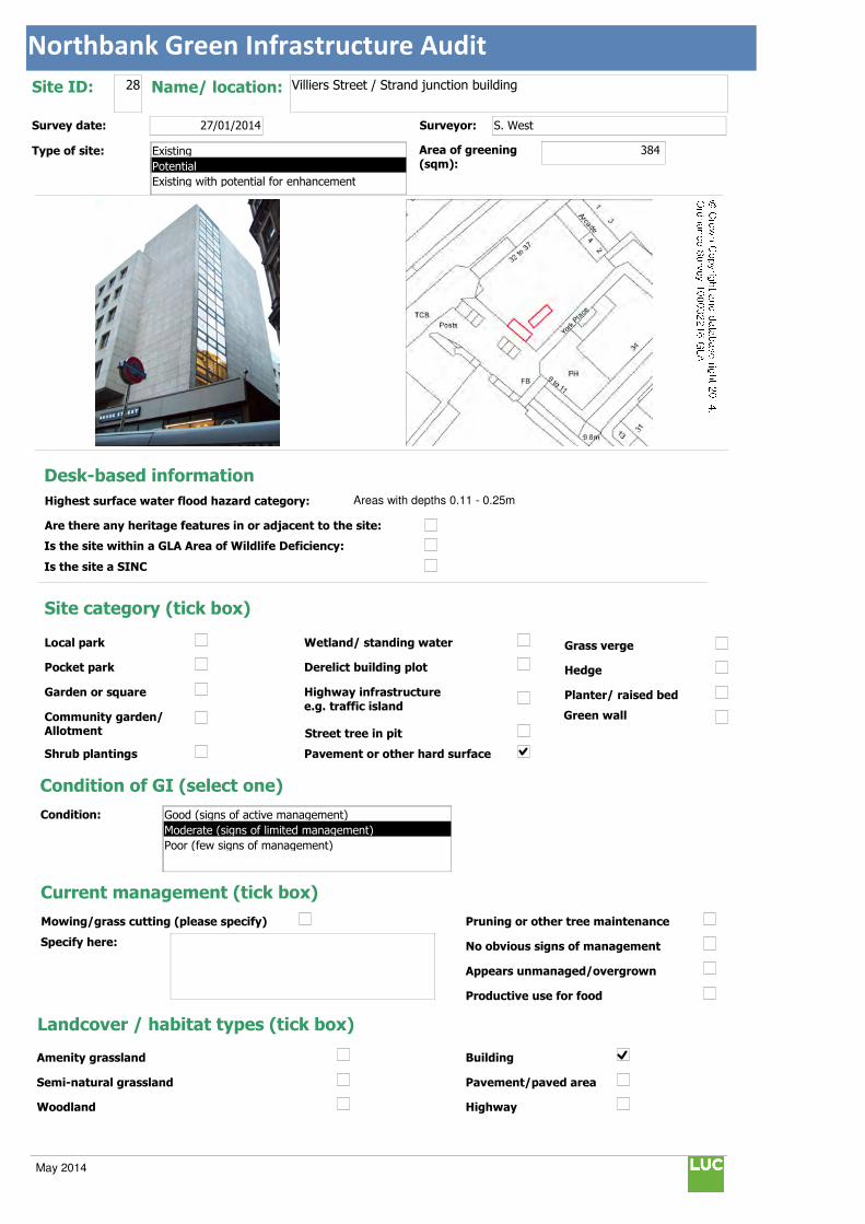
Northbank Green Infrastructure Audit
Text112:
Text114:
Phot \\D
MapName: \\
Survey date: 27/01/2014 Surveyor: S. West
Type of site:
Site ID: 28 Name/ location: Villiers Street / Strand junction building
Area of greening
(sqm):384
Local park
Pocket park
Garden or square
Community garden/ Allotment
Shrub plantings
Wetland/ standing water
Derelict building plot
Highway infrastructure
e.g. traffic island
Street tree in pit
Grass verge
Hedge
Planter/ raised bed
Pavement or other hard surface
Site category (tick box)
Condition of GI (select one)
Current management (tick box)
Mowing/grass cutting (please specify)
Specify here:
Pruning or other tree maintenance
No obvious signs of management
Appears unmanaged/overgrown
Productive use for food
Landcover / habitat types (tick box)
Building
Pavement/paved area
Highway
Amenity grassland
Semi-natural grassland
Woodland
Condition:
Green wall
© Crown Copyright and database right 2014. Ordnance Survey 100032216 GLA
Desk-based information
Highest surface water flood hazard category: Areas with depths 0.11 - 0.25m
Are there any heritage features in or adjacent to the site:
Is the site within a GLA Area of Wildlife Deficiency:
Is the site a SINC
Existing
Potential
Existing with potential for enhancement
Good (signs of active management)
Moderate (signs of limited management)
Poor (few signs of management)
May 2014

Northbank Green Infrastructure Audit
Traffic island
Roof
Green space
Scrub/shrubs (please indicate wildlife value)
Value:
Other (please specify):
Function Primary function (insert "1" in box) / Secondary function (insert "2" in box)
Public use: informal recreation:
Public use: formal recreation:
Visual/amenity: 1
Wildlife:
Food growing/productive use:
Flood management/water storage:
Not in active use but managed:
Not in use/derelict:
Scope for enhancement
Enhance existing function (please specify opportunities e.g. biodiversity, flood storage, visual appearance etc):
Create green wall to soften harsh building line (no. 32-37) and enhance appearance. This is highly visible along top end of Villiers Street. Due to the planned regeneration activities along Villiers Street, this is likely to be a longer term opportunity for the BID.
Create a new function / feature (tick box)
Wildflower meadow
Tree-(multiple)
Wetland features/rain gardens
Green wall (see below)
Substantial window box
Food growing: fruit trees/vegetables
Barriers to delivery (tick box)
Isolated/ poor visibility
Current uses , e.g. active use, transport infrastructure
Listed buildings or other building constraints
Underground services - water mains , gas,
telecoms, sewers
Wayleaves ( strip of land that allows access
to underground service)
Approximate cost (select one)
Any other notes/observations:
Note - height and width has been doubled as on two faces of building close to each other.
Enhance existing function
Street tree
Shrub
Planters
Wall
Other Other description:
Green walls:
Aspect: Modular
Climbing plants:
Type:
Building owner/occupier:
Approx height (m): 32
Approx width (m): 12
Approx greening area: (sqm) 384
Potential area of greening:
Ease of delivery (select one)
Less than £10k
£10-30k
£30-50k
More than £50k
North
East
South
West
Easy/quick win
Moderate
Challenging
May 2014

Northbank Green Infrastructure Audit
Text112:
Text114:
Phot \\D
MapName: \\
Survey date: 27/01/2014 Surveyor: S. West
Type of site:
Site ID: 29 Name/ location: Embankment Station
Area of greening
(sqm):165
Local park
Pocket park
Garden or square
Community garden/ Allotment
Shrub plantings
Wetland/ standing water
Derelict building plot
Highway infrastructure
e.g. traffic island
Street tree in pit
Grass verge
Hedge
Planter/ raised bed
Pavement or other hard surface
Site category (tick box)
Condition of GI (select one)
Current management (tick box)
Mowing/grass cutting (please specify)
Specify here:
Pruning or other tree maintenance
No obvious signs of management
Appears unmanaged/overgrown
Productive use for food
Landcover / habitat types (tick box)
Building
Pavement/paved area
Highway
Amenity grassland
Semi-natural grassland
Woodland
Condition:
Green wall
© Crown Copyright and database right 2014. Ordnance Survey 100032216 GLA
Desk-based information
Highest surface water flood hazard category: Areas with depths 0.11 - 0.25m
Are there any heritage features in or adjacent to the site:
Is the site within a GLA Area of Wildlife Deficiency:
Is the site a SINC
Existing
Potential
Existing with potential for enhancement
Good (signs of active management)
Moderate (signs of limited management)
Poor (few signs of management)
May 2014

Northbank Green Infrastructure Audit
Traffic island
Roof
Green space
Scrub/shrubs (please indicate wildlife value)
Value:
Other (please specify):
Function Primary function (insert "1" in box) / Secondary function (insert "2" in box)
Public use: informal recreation:
Public use: formal recreation:
Visual/amenity: 1
Wildlife:
Food growing/productive use:
Flood management/water storage:
Not in active use but managed:
Not in use/derelict:
Scope for enhancement
Enhance existing function (please specify opportunities e.g. biodiversity, flood storage, visual appearance etc):
Suggest creating green wall on 1960s / 70s face of building to lead the eye when approaching station and enhance appearance.
Create a new function / feature (tick box)
Wildflower meadow
Tree-(multiple)
Wetland features/rain gardens
Green wall (see below)
Substantial window box
Food growing: fruit trees/vegetables
Barriers to delivery (tick box)
Isolated/ poor visibility
Current uses , e.g. active use, transport infrastructure
Listed buildings or other building constraints
Underground services - water mains , gas,
telecoms, sewers
Wayleaves ( strip of land that allows access
to underground service)
Approximate cost (select one)
Any other notes/observations:
Enhance existing function
Street tree
Shrub
Planters
Wall
Other Other description:
Green walls:
Aspect: Modular
Climbing plants:
Type:
Building owner/occupier:
Approx height (m): 10
Approx width (m): 16
Approx greening area: (sqm) 165
Potential area of greening:
Ease of delivery (select one)
Less than £10k
£10-30k
£30-50k
More than £50k
North
East
South
West
Easy/quick win
Moderate
Challenging
May 2014
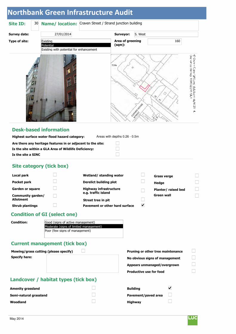
Northbank Green Infrastructure Audit
Text112:
Text114:
Phot \\D
MapName: \\
Survey date: 27/01/2014 Surveyor: S. West
Type of site:
Site ID: 30 Name/ location: Craven Street / Strand junction building
Area of greening
(sqm):160
Local park
Pocket park
Garden or square
Community garden/ Allotment
Shrub plantings
Wetland/ standing water
Derelict building plot
Highway infrastructure
e.g. traffic island
Street tree in pit
Grass verge
Hedge
Planter/ raised bed
Pavement or other hard surface
Site category (tick box)
Condition of GI (select one)
Current management (tick box)
Mowing/grass cutting (please specify)
Specify here:
Pruning or other tree maintenance
No obvious signs of management
Appears unmanaged/overgrown
Productive use for food
Landcover / habitat types (tick box)
Building
Pavement/paved area
Highway
Amenity grassland
Semi-natural grassland
Woodland
Condition:
Green wall
© Crown Copyright and database right 2014. Ordnance Survey 100032216 GLA
Desk-based information
Highest surface water flood hazard category: Areas with depths 0.26 - 0.5m
Are there any heritage features in or adjacent to the site:
Is the site within a GLA Area of Wildlife Deficiency:
Is the site a SINC
Existing
Potential
Existing with potential for enhancement
Good (signs of active management)
Moderate (signs of limited management)
Poor (few signs of management)
May 2014
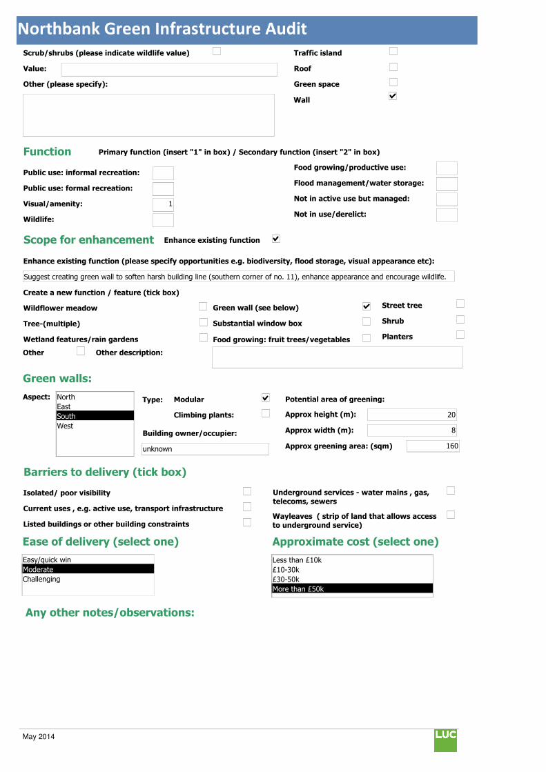
Northbank Green Infrastructure Audit
Traffic island
Roof
Green space
Scrub/shrubs (please indicate wildlife value)
Value:
Other (please specify):
Function Primary function (insert "1" in box) / Secondary function (insert "2" in box)
Public use: informal recreation:
Public use: formal recreation:
Visual/amenity: 1
Wildlife:
Food growing/productive use:
Flood management/water storage:
Not in active use but managed:
Not in use/derelict:
Scope for enhancement
Enhance existing function (please specify opportunities e.g. biodiversity, flood storage, visual appearance etc):
Suggest creating green wall to soften harsh building line (southern corner of no. 11), enhance appearance and encourage wildlife.
Create a new function / feature (tick box)
Wildflower meadow
Tree-(multiple)
Wetland features/rain gardens
Green wall (see below)
Substantial window box
Food growing: fruit trees/vegetables
Barriers to delivery (tick box)
Isolated/ poor visibility
Current uses , e.g. active use, transport infrastructure
Listed buildings or other building constraints
Underground services - water mains , gas,
telecoms, sewers
Wayleaves ( strip of land that allows access
to underground service)
Approximate cost (select one)
Any other notes/observations:
Enhance existing function
Street tree
Shrub
Planters
Wall
Other Other description:
Green walls:
Aspect: Modular
Climbing plants:
Type:
Building owner/occupier:
unknown
Approx height (m): 20
Approx width (m): 8
Approx greening area: (sqm) 160
Potential area of greening:
Ease of delivery (select one)
Less than £10k
£10-30k
£30-50k
More than £50k
North
East
South
West
Easy/quick win
Moderate
Challenging
May 2014
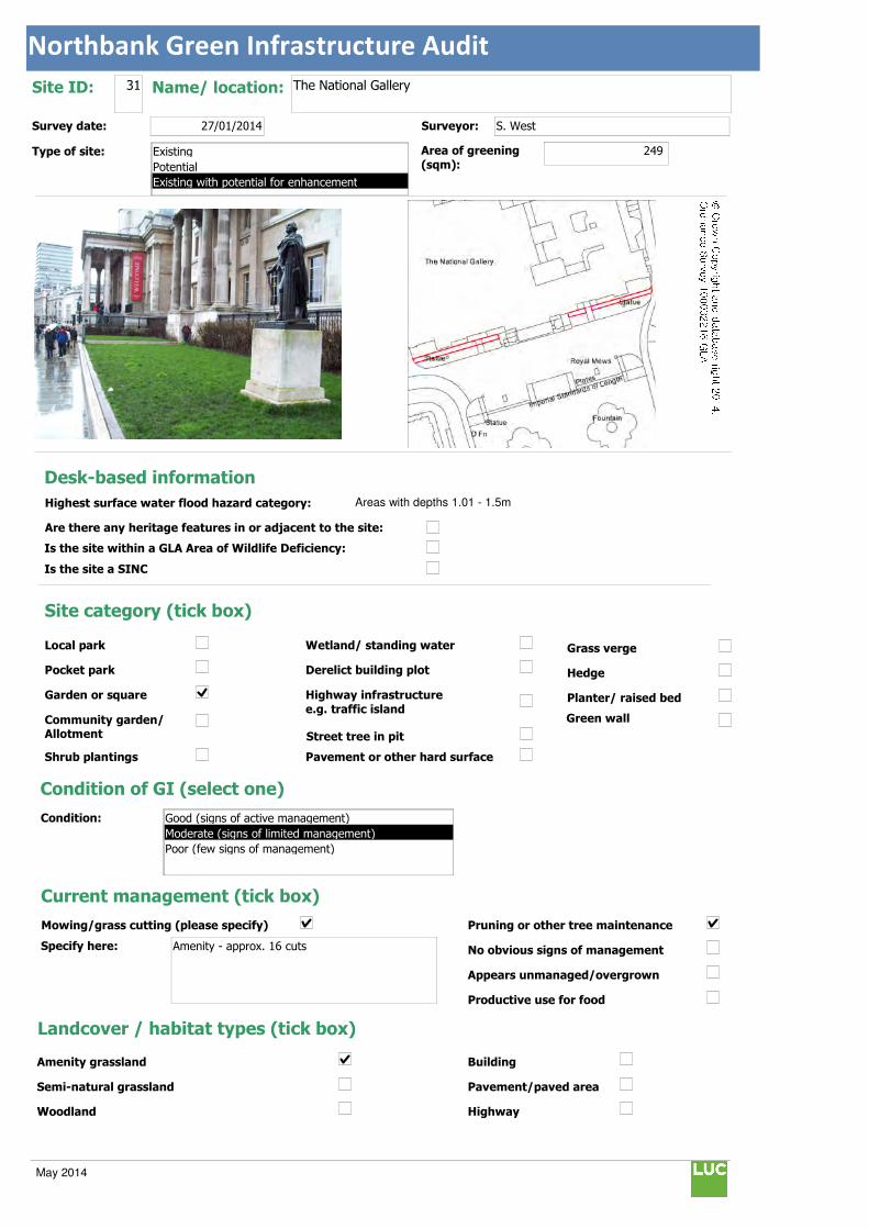
Northbank Green Infrastructure Audit
Text112:
Text114:
Phot \\D
MapName: \\
Survey date: 27/01/2014 Surveyor: S. West
Type of site:
Site ID: 31 Name/ location: The National Gallery
Area of greening
(sqm):249
Local park
Pocket park
Garden or square
Community garden/ Allotment
Shrub plantings
Wetland/ standing water
Derelict building plot
Highway infrastructure
e.g. traffic island
Street tree in pit
Grass verge
Hedge
Planter/ raised bed
Pavement or other hard surface
Site category (tick box)
Condition of GI (select one)
Current management (tick box)
Mowing/grass cutting (please specify)
Specify here: Amenity - approx. 16 cuts
Pruning or other tree maintenance
No obvious signs of management
Appears unmanaged/overgrown
Productive use for food
Landcover / habitat types (tick box)
Building
Pavement/paved area
Highway
Amenity grassland
Semi-natural grassland
Woodland
Condition:
Green wall
© Crown Copyright and database right 2014. Ordnance Survey 100032216 GLA
Desk-based information
Highest surface water flood hazard category: Areas with depths 1.01 - 1.5m
Are there any heritage features in or adjacent to the site:
Is the site within a GLA Area of Wildlife Deficiency:
Is the site a SINC
Existing
Potential
Existing with potential for enhancement
Good (signs of active management)
Moderate (signs of limited management)
Poor (few signs of management)
May 2014

Northbank Green Infrastructure Audit
Traffic island
Roof
Green space
Scrub/shrubs (please indicate wildlife value)
Value: Poor
Other (please specify):
Function Primary function (insert "1" in box) / Secondary function (insert "2" in box)
Public use: informal recreation: 2
Public use: formal recreation:
Visual/amenity: 1
Wildlife:
Food growing/productive use:
Flood management/water storage:
Not in active use but managed:
Not in use/derelict:
Scope for enhancement
Enhance existing function (please specify opportunities e.g. biodiversity, flood storage, visual appearance etc):
Current Fig hedge unusual. Native and / or nectar rich shrub planting suggested to encourage wildlife and enhance appearance.
Create a new function / feature (tick box)
Wildflower meadow
Tree-(multiple)
Wetland features/rain gardens
Green wall (see below)
Substantial window box
Food growing: fruit trees/vegetables
Barriers to delivery (tick box)
Isolated/ poor visibility
Current uses , e.g. active use, transport infrastructure
Listed buildings or other building constraints
Underground services - water mains , gas,
telecoms, sewers
Wayleaves ( strip of land that allows access
to underground service)
Approximate cost (select one)
Any other notes/observations:
Enhance existing function
Street tree
Shrub
Planters
Wall
Other Other description:
Green walls:
Aspect: Modular
Climbing plants:
Type:
Building owner/occupier:
Approx height (m):
Approx width (m):
Approx greening area: (sqm)
Potential area of greening:
Ease of delivery (select one)
Less than £10k
£10-30k
£30-50k
More than £50k
North
East
South
West
Easy/quick win
Moderate
Challenging
May 2014
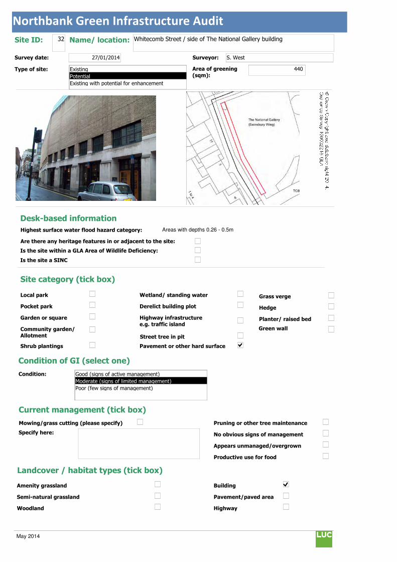
Northbank Green Infrastructure Audit
Text112:
Text114:
Phot \\D
MapName: \\
Survey date: 27/01/2014 Surveyor: S. West
Type of site:
Site ID: 32 Name/ location: Whitecomb Street / side of The National Gallery building
Area of greening
(sqm):440
Local park
Pocket park
Garden or square
Community garden/ Allotment
Shrub plantings
Wetland/ standing water
Derelict building plot
Highway infrastructure
e.g. traffic island
Street tree in pit
Grass verge
Hedge
Planter/ raised bed
Pavement or other hard surface
Site category (tick box)
Condition of GI (select one)
Current management (tick box)
Mowing/grass cutting (please specify)
Specify here:
Pruning or other tree maintenance
No obvious signs of management
Appears unmanaged/overgrown
Productive use for food
Landcover / habitat types (tick box)
Building
Pavement/paved area
Highway
Amenity grassland
Semi-natural grassland
Woodland
Condition:
Green wall
© Crown Copyright and database right 2014. Ordnance Survey 100032216 GLA
Desk-based information
Highest surface water flood hazard category: Areas with depths 0.26 - 0.5m
Are there any heritage features in or adjacent to the site:
Is the site within a GLA Area of Wildlife Deficiency:
Is the site a SINC
Existing
Potential
Existing with potential for enhancement
Good (signs of active management)
Moderate (signs of limited management)
Poor (few signs of management)
May 2014

Northbank Green Infrastructure Audit
Traffic island
Roof
Green space
Scrub/shrubs (please indicate wildlife value)
Value:
Other (please specify):
Function Primary function (insert "1" in box) / Secondary function (insert "2" in box)
Public use: informal recreation:
Public use: formal recreation:
Visual/amenity: 1
Wildlife:
Food growing/productive use:
Flood management/water storage:
Not in active use but managed:
Not in use/derelict:
Scope for enhancement
Enhance existing function (please specify opportunities e.g. biodiversity, flood storage, visual appearance etc):
Suggest creating a green wall on 1960s / 70s building to enhance appearance and encourage biodiveristy.
Create a new function / feature (tick box)
Wildflower meadow
Tree-(multiple)
Wetland features/rain gardens
Green wall (see below)
Substantial window box
Food growing: fruit trees/vegetables
Barriers to delivery (tick box)
Isolated/ poor visibility
Current uses , e.g. active use, transport infrastructure
Listed buildings or other building constraints
Underground services - water mains , gas,
telecoms, sewers
Wayleaves ( strip of land that allows access
to underground service)
Approximate cost (select one)
Any other notes/observations:
Enhance existing function
Street tree
Shrub
Planters
Wall
Other Other description:
Green walls:
Aspect: Modular
Climbing plants:
Type:
Building owner/occupier:
National Gallery
Approx height (m): 8
Approx width (m): 55
Approx greening area: (sqm) 440
Potential area of greening:
Ease of delivery (select one)
Less than £10k
£10-30k
£30-50k
More than £50k
North
East
South
West
Easy/quick win
Moderate
Challenging
May 2014
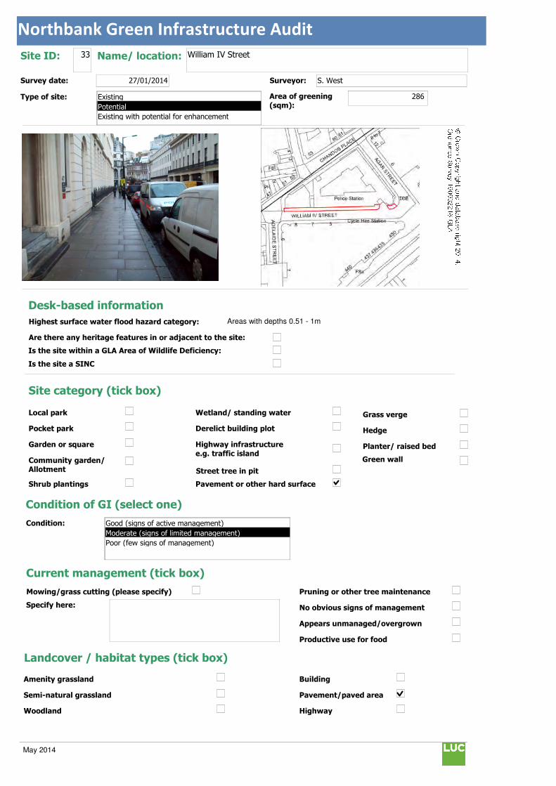
Northbank Green Infrastructure Audit
Text112:
Text114:
Phot \\D
MapName: \\
Survey date: 27/01/2014 Surveyor: S. West
Type of site:
Site ID: 33 Name/ location: William IV Street
Area of greening
(sqm):286
Local park
Pocket park
Garden or square
Community garden/ Allotment
Shrub plantings
Wetland/ standing water
Derelict building plot
Highway infrastructure
e.g. traffic island
Street tree in pit
Grass verge
Hedge
Planter/ raised bed
Pavement or other hard surface
Site category (tick box)
Condition of GI (select one)
Current management (tick box)
Mowing/grass cutting (please specify)
Specify here:
Pruning or other tree maintenance
No obvious signs of management
Appears unmanaged/overgrown
Productive use for food
Landcover / habitat types (tick box)
Building
Pavement/paved area
Highway
Amenity grassland
Semi-natural grassland
Woodland
Condition:
Green wall
© Crown Copyright and database right 2014. Ordnance Survey 100032216 GLA
Desk-based information
Highest surface water flood hazard category: Areas with depths 0.51 - 1m
Are there any heritage features in or adjacent to the site:
Is the site within a GLA Area of Wildlife Deficiency:
Is the site a SINC
Existing
Potential
Existing with potential for enhancement
Good (signs of active management)
Moderate (signs of limited management)
Poor (few signs of management)
May 2014

Northbank Green Infrastructure Audit
Traffic island
Roof
Green space
Scrub/shrubs (please indicate wildlife value)
Value:
Other (please specify):
Function Primary function (insert "1" in box) / Secondary function (insert "2" in box)
Public use: informal recreation:
Public use: formal recreation:
Visual/amenity: 1
Wildlife:
Food growing/productive use:
Flood management/water storage:
Not in active use but managed:
Not in use/derelict:
Scope for enhancement
Enhance existing function (please specify opportunities e.g. biodiversity, flood storage, visual appearance etc):
Small tree planting suggested along north side of road to enhance appearance and line views towards the National Portrait Gallery.
Create a new function / feature (tick box)
Wildflower meadow
Tree-(multiple)
Wetland features/rain gardens
Green wall (see below)
Substantial window box
Food growing: fruit trees/vegetables
Barriers to delivery (tick box)
Isolated/ poor visibility
Current uses , e.g. active use, transport infrastructure
Listed buildings or other building constraints
Underground services - water mains , gas,
telecoms, sewers
Wayleaves ( strip of land that allows access
to underground service)
Approximate cost (select one)
Any other notes/observations:
Enhance existing function
Street tree
Shrub
Planters
Wall
Other Other description:
Green walls:
Aspect: Modular
Climbing plants:
Type:
Building owner/occupier:
Approx height (m):
Approx width (m):
Approx greening area: (sqm)
Potential area of greening:
Ease of delivery (select one)
Less than £10k
£10-30k
£30-50k
More than £50k
North
East
South
West
Easy/quick win
Moderate
Challenging
May 2014
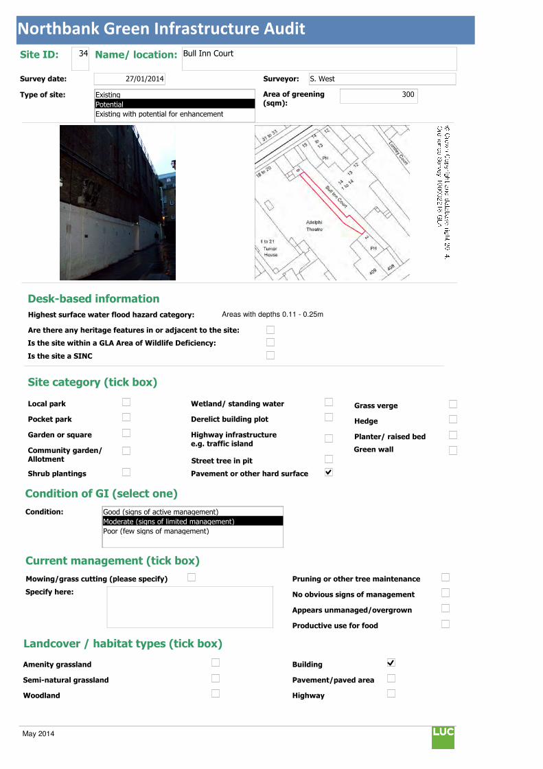
Northbank Green Infrastructure Audit
Text112:
Text114:
Phot \\D
MapName: \\
Survey date: 27/01/2014 Surveyor: S. West
Type of site:
Site ID: 34 Name/ location: Bull Inn Court
Area of greening
(sqm):300
Local park
Pocket park
Garden or square
Community garden/ Allotment
Shrub plantings
Wetland/ standing water
Derelict building plot
Highway infrastructure
e.g. traffic island
Street tree in pit
Grass verge
Hedge
Planter/ raised bed
Pavement or other hard surface
Site category (tick box)
Condition of GI (select one)
Current management (tick box)
Mowing/grass cutting (please specify)
Specify here:
Pruning or other tree maintenance
No obvious signs of management
Appears unmanaged/overgrown
Productive use for food
Landcover / habitat types (tick box)
Building
Pavement/paved area
Highway
Amenity grassland
Semi-natural grassland
Woodland
Condition:
Green wall
© Crown Copyright and database right 2014. Ordnance Survey 100032216 GLA
Desk-based information
Highest surface water flood hazard category: Areas with depths 0.11 - 0.25m
Are there any heritage features in or adjacent to the site:
Is the site within a GLA Area of Wildlife Deficiency:
Is the site a SINC
Existing
Potential
Existing with potential for enhancement
Good (signs of active management)
Moderate (signs of limited management)
Poor (few signs of management)
May 2014

Northbank Green Infrastructure Audit
Traffic island
Roof
Green space
Scrub/shrubs (please indicate wildlife value)
Value:
Other (please specify):
Function Primary function (insert "1" in box) / Secondary function (insert "2" in box)
Public use: informal recreation:
Public use: formal recreation:
Visual/amenity: 1
Wildlife:
Food growing/productive use:
Flood management/water storage:
Not in active use but managed:
Not in use/derelict:
Scope for enhancement
Enhance existing function (please specify opportunities e.g. biodiversity, flood storage, visual appearance etc):
Suggest creating a green wall to cover existing unattractive wall and encourage biodiversity.
Create a new function / feature (tick box)
Wildflower meadow
Tree-(multiple)
Wetland features/rain gardens
Green wall (see below)
Substantial window box
Food growing: fruit trees/vegetables
Barriers to delivery (tick box)
Isolated/ poor visibility
Current uses , e.g. active use, transport infrastructure
Listed buildings or other building constraints
Underground services - water mains , gas,
telecoms, sewers
Wayleaves ( strip of land that allows access
to underground service)
Approximate cost (select one)
Any other notes/observations:
Enhance existing function
Street tree
Shrub
Planters
Wall
Other Other description:
Green walls:
Aspect: Modular
Climbing plants:
Type:
Building owner/occupier:
Adelphi Theatre
Approx height (m): 10
Approx width (m): 30
Approx greening area: (sqm) 300
Potential area of greening:
Ease of delivery (select one)
Less than £10k
£10-30k
£30-50k
More than £50k
North
East
South
West
Easy/quick win
Moderate
Challenging
May 2014

Northbank Green Infrastructure Audit
Text112:
Text114:
Phot \\D
MapName: \\
Survey date: 27/01/2014 Surveyor:
Type of site:
Site ID: 35 Name/ location: India Place / Montreal Place
Area of greening
(sqm):262
Local park
Pocket park
Garden or square
Community garden/ Allotment
Shrub plantings
Wetland/ standing water
Derelict building plot
Highway infrastructure
e.g. traffic island
Street tree in pit
Grass verge
Hedge
Planter/ raised bed
Pavement or other hard surface
Site category (tick box)
Condition of GI (select one)
Current management (tick box)
Mowing/grass cutting (please specify)
Specify here:
Pruning or other tree maintenance
No obvious signs of management
Appears unmanaged/overgrown
Productive use for food
Landcover / habitat types (tick box)
Building
Pavement/paved area
Highway
Amenity grassland
Semi-natural grassland
Woodland
Condition:
Green wall
© Crown Copyright and database right 2014. Ordnance Survey 100032216 GLA
Desk-based information
Highest surface water flood hazard category: Areas with depths 0.26 - 0.5m
Are there any heritage features in or adjacent to the site:
Is the site within a GLA Area of Wildlife Deficiency:
Is the site a SINC
Existing
Potential
Existing with potential for enhancement
Good (signs of active management)
Moderate (signs of limited management)
Poor (few signs of management)
May 2014

Northbank Green Infrastructure Audit
Traffic island
Roof
Green space
Scrub/shrubs (please indicate wildlife value)
Value:
Other (please specify):
Function Primary function (insert "1" in box) / Secondary function (insert "2" in box)
Public use: informal recreation: 2
Public use: formal recreation:
Visual/amenity: 1
Wildlife:
Food growing/productive use:
Flood management/water storage:
Not in active use but managed:
Not in use/derelict:
Scope for enhancement
Enhance existing function (please specify opportunities e.g. biodiversity, flood storage, visual appearance etc):
Potential for creating low level shrub planting and Pocket Park environment to provide a space for relaxation, enhancing appearance, flood storage and creating visual links between the Strand, Somerset House and Aldwych.
Create a new function / feature (tick box)
Wildflower meadow
Tree-(multiple)
Wetland features/rain gardens
Green wall (see below)
Substantial window box
Food growing: fruit trees/vegetables
Barriers to delivery (tick box)
Isolated/ poor visibility
Current uses , e.g. active use, transport infrastructure
Listed buildings or other building constraints
Underground services - water mains , gas,
telecoms, sewers
Wayleaves ( strip of land that allows access
to underground service)
Approximate cost (select one)
Any other notes/observations:
Enhance existing function
Street tree
Shrub
Planters
Wall
Other Other description: Pocket Park
Green walls:
Aspect: Modular
Climbing plants:
Type:
Building owner/occupier:
Approx height (m):
Approx width (m):
Approx greening area: (sqm)
Potential area of greening:
Ease of delivery (select one)
Less than £10k
£10-30k
£30-50k
More than £50k
North
East
South
West
Easy/quick win
Moderate
Challenging
May 2014
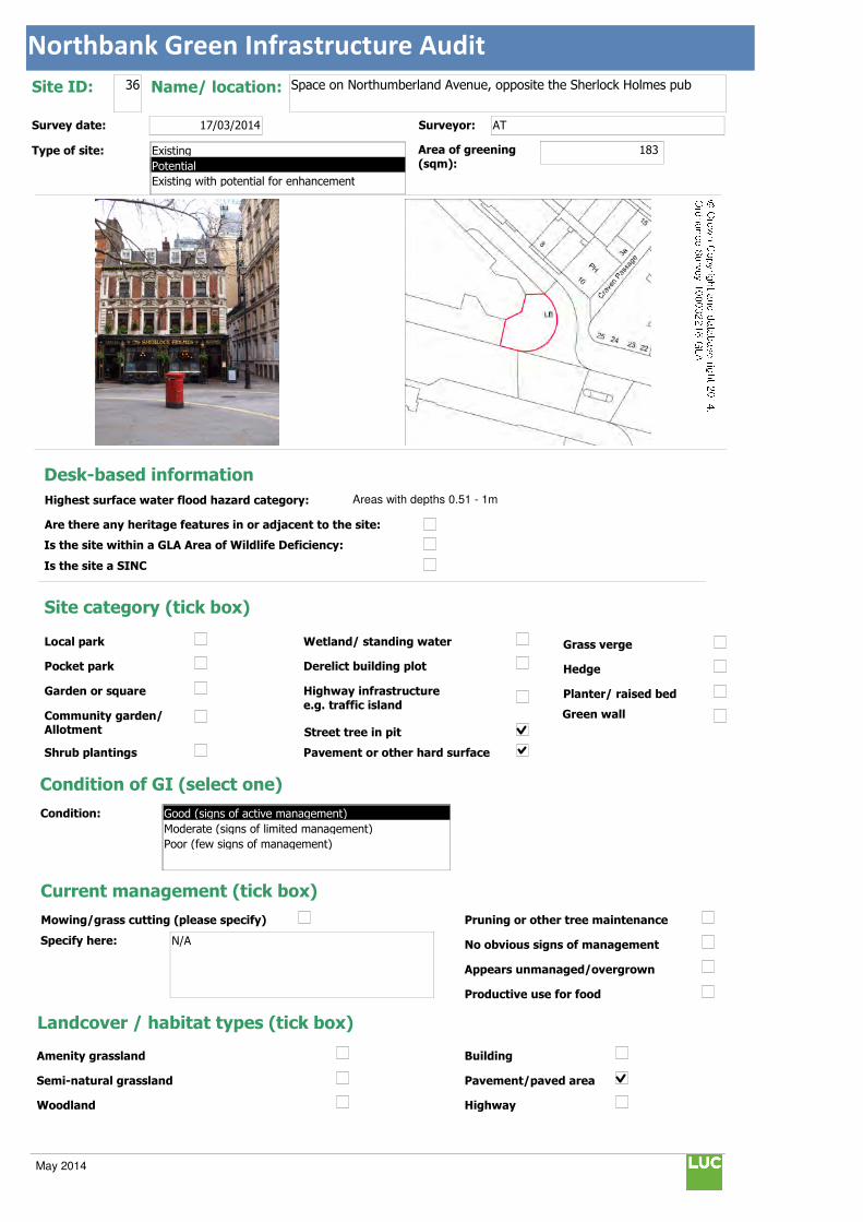
Northbank Green Infrastructure Audit
Text112:
Text114:
Phot \\D
MapName: \\
Survey date: 17/03/2014 Surveyor: AT
Type of site:
Site ID: 36 Name/ location: Space on Northumberland Avenue, opposite the Sherlock Holmes pub
Area of greening
(sqm):183
Local park
Pocket park
Garden or square
Community garden/ Allotment
Shrub plantings
Wetland/ standing water
Derelict building plot
Highway infrastructure
e.g. traffic island
Street tree in pit
Grass verge
Hedge
Planter/ raised bed
Pavement or other hard surface
Site category (tick box)
Condition of GI (select one)
Current management (tick box)
Mowing/grass cutting (please specify)
Specify here: N/A
Pruning or other tree maintenance
No obvious signs of management
Appears unmanaged/overgrown
Productive use for food
Landcover / habitat types (tick box)
Building
Pavement/paved area
Highway
Amenity grassland
Semi-natural grassland
Woodland
Condition:
Green wall
© Crown Copyright and database right 2014. Ordnance Survey 100032216 GLA
Desk-based information
Highest surface water flood hazard category: Areas with depths 0.51 - 1m
Are there any heritage features in or adjacent to the site:
Is the site within a GLA Area of Wildlife Deficiency:
Is the site a SINC
Existing
Potential
Existing with potential for enhancement
Good (signs of active management)
Moderate (signs of limited management)
Poor (few signs of management)
May 2014
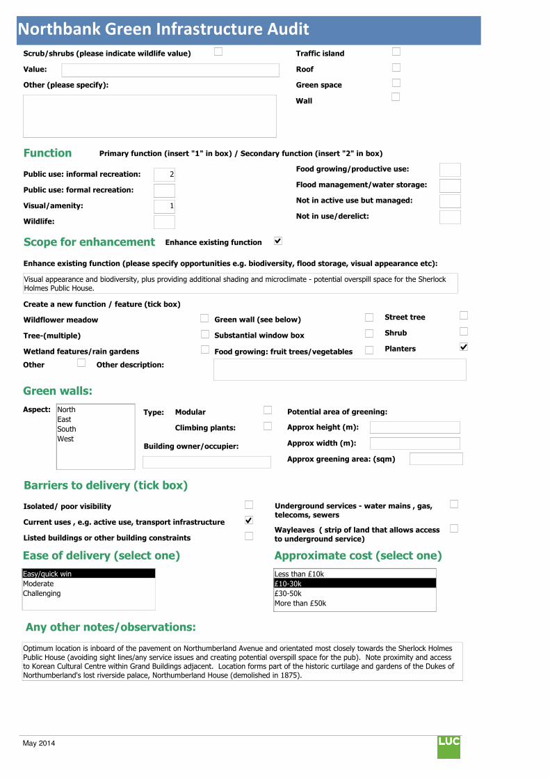
Northbank Green Infrastructure Audit
Traffic island
Roof
Green space
Scrub/shrubs (please indicate wildlife value)
Value:
Other (please specify):
Function Primary function (insert "1" in box) / Secondary function (insert "2" in box)
Public use: informal recreation: 2
Public use: formal recreation:
Visual/amenity: 1
Wildlife:
Food growing/productive use:
Flood management/water storage:
Not in active use but managed:
Not in use/derelict:
Scope for enhancement
Enhance existing function (please specify opportunities e.g. biodiversity, flood storage, visual appearance etc):
Visual appearance and biodiversity, plus providing additional shading and microclimate - potential overspill space for the Sherlock Holmes Public House.
Create a new function / feature (tick box)
Wildflower meadow
Tree-(multiple)
Wetland features/rain gardens
Green wall (see below)
Substantial window box
Food growing: fruit trees/vegetables
Barriers to delivery (tick box)
Isolated/ poor visibility
Current uses , e.g. active use, transport infrastructure
Listed buildings or other building constraints
Underground services - water mains , gas,
telecoms, sewers
Wayleaves ( strip of land that allows access
to underground service)
Approximate cost (select one)
Any other notes/observations:
Optimum location is inboard of the pavement on Northumberland Avenue and orientated most closely towards the Sherlock Holmes
Public House (avoiding sight lines/any service issues and creating potential overspill space for the pub). Note proximity and access to Korean Cultural Centre within Grand Buildings adjacent. Location forms part of the historic curtilage and gardens of the Dukes of
Northumberland's lost riverside palace, Northumberland House (demolished in 1875).
Enhance existing function
Street tree
Shrub
Planters
Wall
Other Other description:
Green walls:
Aspect: Modular
Climbing plants:
Type:
Building owner/occupier:
Approx height (m):
Approx width (m):
Approx greening area: (sqm)
Potential area of greening:
Ease of delivery (select one)
Less than £10k
£10-30k
£30-50k
More than £50k
North
East
South
West
Easy/quick win
Moderate
Challenging
May 2014

Northbank Green Infrastructure Audit
Text112:
Text114:
Phot \\D
MapName: \\
Survey date: 17/03/2014 Surveyor: AT
Type of site:
Site ID: 37 Name/ location: Exchange Court - to the east side of the Porter House pub forecourt and at the rear of the Adelphi Theatre
Area of greening
(sqm):40
Local park
Pocket park
Garden or square
Community garden/ Allotment
Shrub plantings
Wetland/ standing water
Derelict building plot
Highway infrastructure
e.g. traffic island
Street tree in pit
Grass verge
Hedge
Planter/ raised bed
Pavement or other hard surface
Site category (tick box)
Condition of GI (select one)
Current management (tick box)
Mowing/grass cutting (please specify)
Specify here: N/A
Pruning or other tree maintenance
No obvious signs of management
Appears unmanaged/overgrown
Productive use for food
Landcover / habitat types (tick box)
Building
Pavement/paved area
Highway
Amenity grassland
Semi-natural grassland
Woodland
Condition:
Green wall
© Crown Copyright and database right 2014. Ordnance Survey 100032216 GLA
Desk-based information
Highest surface water flood hazard category: Areas with depths 0.11 - 0.25m
Are there any heritage features in or adjacent to the site:
Is the site within a GLA Area of Wildlife Deficiency:
Is the site a SINC
Existing
Potential
Existing with potential for enhancement
Good (signs of active management)
Moderate (signs of limited management)
Poor (few signs of management)
May 2014
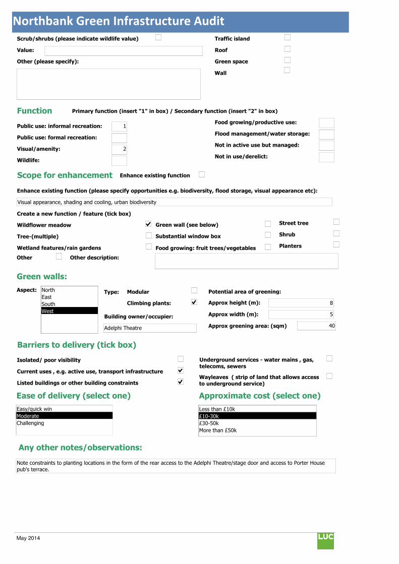
Northbank Green Infrastructure Audit
Traffic island
Roof
Green space
Scrub/shrubs (please indicate wildlife value)
Value:
Other (please specify):
Function Primary function (insert "1" in box) / Secondary function (insert "2" in box)
Public use: informal recreation: 1
Public use: formal recreation:
Visual/amenity: 2
Wildlife:
Food growing/productive use:
Flood management/water storage:
Not in active use but managed:
Not in use/derelict:
Scope for enhancement
Enhance existing function (please specify opportunities e.g. biodiversity, flood storage, visual appearance etc):
Visual appearance, shading and cooling, urban biodiversity
Create a new function / feature (tick box)
Wildflower meadow
Tree-(multiple)
Wetland features/rain gardens
Green wall (see below)
Substantial window box
Food growing: fruit trees/vegetables
Barriers to delivery (tick box)
Isolated/ poor visibility
Current uses , e.g. active use, transport infrastructure
Listed buildings or other building constraints
Underground services - water mains , gas,
telecoms, sewers
Wayleaves ( strip of land that allows access
to underground service)
Approximate cost (select one)
Any other notes/observations:
Note constraints to planting locations in the form of the rear access to the Adelphi Theatre/stage door and access to Porter House
pub's terrace.
Enhance existing function
Street tree
Shrub
Planters
Wall
Other Other description:
Green walls:
Aspect: Modular
Climbing plants:
Type:
Building owner/occupier:
Adelphi Theatre
Approx height (m): 8
Approx width (m): 5
Approx greening area: (sqm) 40
Potential area of greening:
Ease of delivery (select one)
Less than £10k
£10-30k
£30-50k
More than £50k
North
East
South
West
Easy/quick win
Moderate
Challenging
May 2014
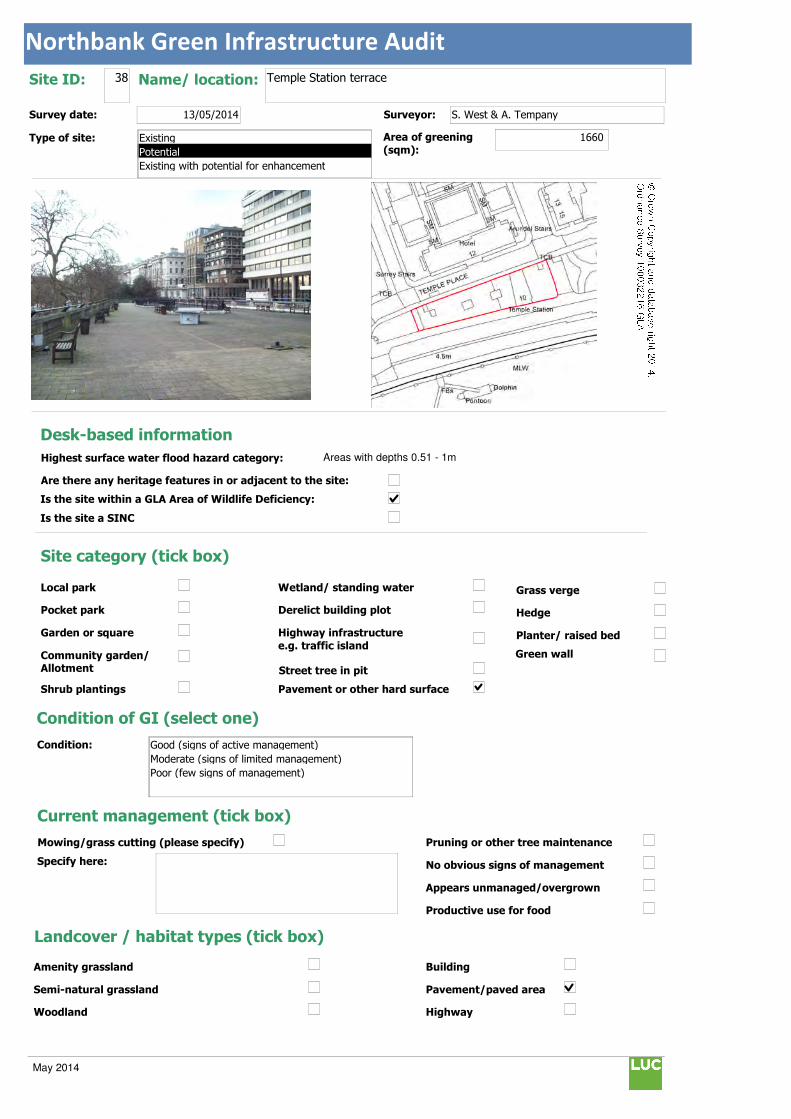
Northbank Green Infrastructure Audit
Text112:
Text114:
Phot \\D
MapName: \\
Survey date: 13/05/2014 Surveyor: S. West & A. Tempany
Type of site:
Site ID: 38 Name/ location: Temple Station terrace
Area of greening
(sqm):1660
Local park
Pocket park
Garden or square
Community garden/ Allotment
Shrub plantings
Wetland/ standing water
Derelict building plot
Highway infrastructure
e.g. traffic island
Street tree in pit
Grass verge
Hedge
Planter/ raised bed
Pavement or other hard surface
Site category (tick box)
Condition of GI (select one)
Current management (tick box)
Mowing/grass cutting (please specify)
Specify here:
Pruning or other tree maintenance
No obvious signs of management
Appears unmanaged/overgrown
Productive use for food
Landcover / habitat types (tick box)
Building
Pavement/paved area
Highway
Amenity grassland
Semi-natural grassland
Woodland
Condition:
Green wall
© Crown Copyright and database right 2014. Ordnance Survey 100032216 GLA
Desk-based information
Highest surface water flood hazard category: Areas with depths 0.51 - 1m
Are there any heritage features in or adjacent to the site:
Is the site within a GLA Area of Wildlife Deficiency:
Is the site a SINC
Existing
Potential
Existing with potential for enhancement
Good (signs of active management)
Moderate (signs of limited management)
Poor (few signs of management)
May 2014

Northbank Green Infrastructure Audit
Traffic island
Roof
Green space
Scrub/shrubs (please indicate wildlife value)
Value:
Other (please specify):
Function Primary function (insert "1" in box) / Secondary function (insert "2" in box)
Public use: informal recreation:
Public use: formal recreation:
Visual/amenity: 1
Wildlife:
Food growing/productive use:
Flood management/water storage:
Not in active use but managed:
Not in use/derelict:
Scope for enhancement
Enhance existing function (please specify opportunities e.g. biodiversity, flood storage, visual appearance etc):
Prior to the implementation of the green bridge there could be an opportunity for temporary greening in the form of planters on the terrace which would add quite a sculptural dimension to the roof if of sufficient scale and could be recycled elsewhere at a later
stage if required. Public benches integrated with planters and low maintenance groundcover and shrubs could be used to provide
multi-functional benefits for seating, wildlife encouragement and visual improvement.
Create a new function / feature (tick box)
Wildflower meadow
Tree-(multiple)
Wetland features/rain gardens
Green wall (see below)
Substantial window box
Food growing: fruit trees/vegetables
Barriers to delivery (tick box)
Isolated/ poor visibility
Current uses , e.g. active use, transport infrastructure
Listed buildings or other building constraints
Underground services - water mains , gas,
telecoms, sewers
Wayleaves ( strip of land that allows access to underground service)
Approximate cost (select one)
Any other notes/observations:
Enhance existing function
Street tree
Shrub
Planters
Wall
Other Other description: Green roof
Green walls:
Aspect: Modular
Climbing plants:
Type:
Building owner/occupier:
Approx height (m):
Approx width (m):
Approx greening area: (sqm)
Potential area of greening:
Ease of delivery (select one)
Less than £10k
£10-30k
£30-50k
More than £50k
North
East
South
West
Easy/quick win
Moderate
Challenging
May 2014

Northbank Green Infrastructure Audit
Text112:
Text114:
Phot \\D
MapName: \\
Survey date: 13/05/2014 Surveyor: S. West & A. Tempany
Type of site:
Site ID: 39 Name/ location: Somerset House terrace
Area of greening
(sqm):814
Local park
Pocket park
Garden or square
Community garden/ Allotment
Shrub plantings
Wetland/ standing water
Derelict building plot
Highway infrastructure
e.g. traffic island
Street tree in pit
Grass verge
Hedge
Planter/ raised bed
Pavement or other hard surface
Site category (tick box)
Condition of GI (select one)
Current management (tick box)
Mowing/grass cutting (please specify)
Specify here:
Pruning or other tree maintenance
No obvious signs of management
Appears unmanaged/overgrown
Productive use for food
Landcover / habitat types (tick box)
Building
Pavement/paved area
Highway
Amenity grassland
Semi-natural grassland
Woodland
Condition:
Green wall
© Crown Copyright and database right 2014. Ordnance Survey 100032216 GLA
Desk-based information
Highest surface water flood hazard category: Areas with depths 0.51 - 1m
Are there any heritage features in or adjacent to the site:
Is the site within a GLA Area of Wildlife Deficiency:
Is the site a SINC
Existing
Potential
Existing with potential for enhancement
Good (signs of active management)
Moderate (signs of limited management)
Poor (few signs of management)
May 2014

Northbank Green Infrastructure Audit
Traffic island
Roof
Green space
Scrub/shrubs (please indicate wildlife value)
Value:
Other (please specify):
Function Primary function (insert "1" in box) / Secondary function (insert "2" in box)
Public use: informal recreation:
Public use: formal recreation:
Visual/amenity: 1
Wildlife:
Food growing/productive use:
Flood management/water storage:
Not in active use but managed:
Not in use/derelict:
Scope for enhancement
Enhance existing function (please specify opportunities e.g. biodiversity, flood storage, visual appearance etc):
There is potential for a complementary proposal to tie the Garden Bridge into the local urban GI network. This would comprise an inter-linking aerial connection between Somerset House terrace, Victoria Embankment Gardens (western end of temple section)
and Temple Station terrace. There could be increased greening with planters within this connection to improve visual appearance
and links. This is subject. to necessary consents, consultation, investigations and design development.
Create a new function / feature (tick box)
Wildflower meadow
Tree-(multiple)
Wetland features/rain gardens
Green wall (see below)
Substantial window box
Food growing: fruit trees/vegetables
Barriers to delivery (tick box)
Isolated/ poor visibility
Current uses , e.g. active use, transport infrastructure
Listed buildings or other building constraints
Underground services - water mains , gas,
telecoms, sewers
Wayleaves ( strip of land that allows access to underground service)
Approximate cost (select one)
Any other notes/observations:
Enhance existing function
Street tree
Shrub
Planters
Wall
Other Other description:
Green walls:
Aspect: Modular
Climbing plants:
Type:
Building owner/occupier:
Approx height (m):
Approx width (m):
Approx greening area: (sqm)
Potential area of greening:
Ease of delivery (select one)
Less than £10k
£10-30k
£30-50k
More than £50k
North
East
South
West
Easy/quick win
Moderate
Challenging
May 2014
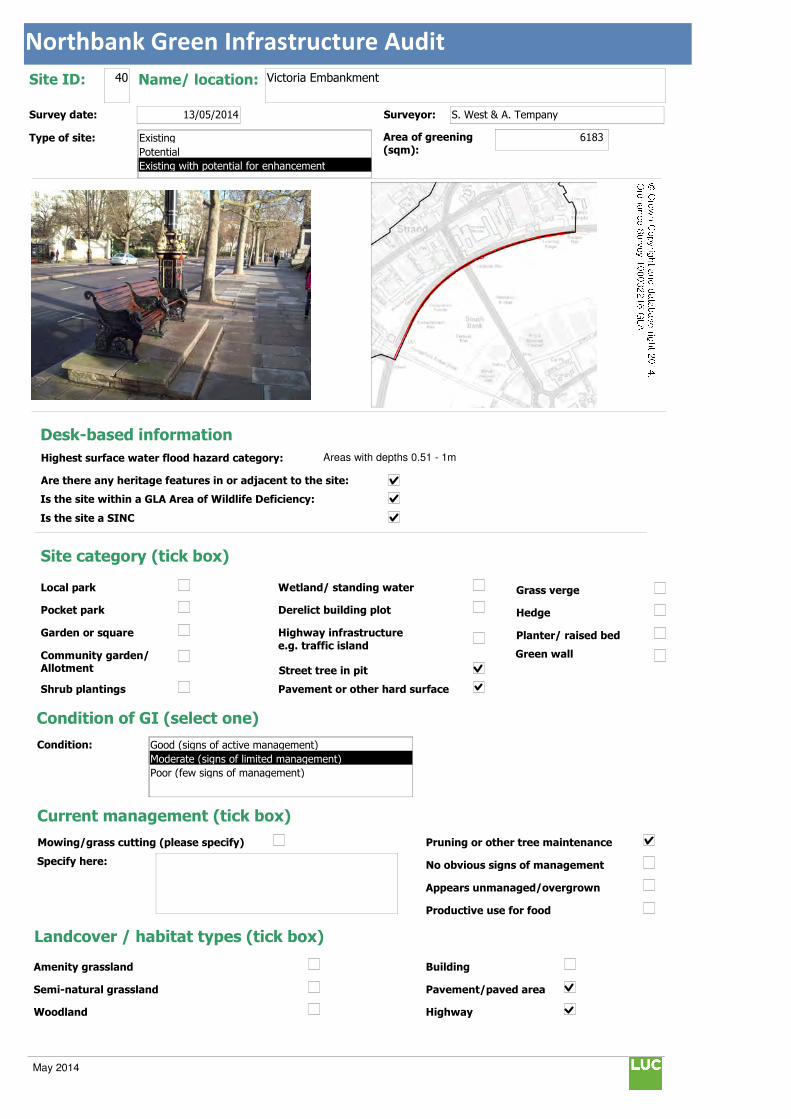
Northbank Green Infrastructure Audit
Text112:
Text114:
Phot \\D
MapName: \\
Survey date: 13/05/2014 Surveyor: S. West & A. Tempany
Type of site:
Site ID: 40 Name/ location: Victoria Embankment
Area of greening
(sqm):6183
Local park
Pocket park
Garden or square
Community garden/ Allotment
Shrub plantings
Wetland/ standing water
Derelict building plot
Highway infrastructure
e.g. traffic island
Street tree in pit
Grass verge
Hedge
Planter/ raised bed
Pavement or other hard surface
Site category (tick box)
Condition of GI (select one)
Current management (tick box)
Mowing/grass cutting (please specify)
Specify here:
Pruning or other tree maintenance
No obvious signs of management
Appears unmanaged/overgrown
Productive use for food
Landcover / habitat types (tick box)
Building
Pavement/paved area
Highway
Amenity grassland
Semi-natural grassland
Woodland
Condition:
Green wall
© Crown Copyright and database right 2014. Ordnance Survey 100032216 GLA
Desk-based information
Highest surface water flood hazard category: Areas with depths 0.51 - 1m
Are there any heritage features in or adjacent to the site:
Is the site within a GLA Area of Wildlife Deficiency:
Is the site a SINC
Existing
Potential
Existing with potential for enhancement
Good (signs of active management)
Moderate (signs of limited management)
Poor (few signs of management)
May 2014
Northbank Green Infrastructure Audit
Traffic island
Roof
Green space
Scrub/shrubs (please indicate wildlife value)
Value:
Other (please specify):
Function Primary function (insert "1" in box) / Secondary function (insert "2" in box)
Public use: informal recreation:
Public use: formal recreation:
Visual/amenity: 1
Wildlife:
Food growing/productive use:
Flood management/water storage:
Not in active use but managed:
Not in use/derelict:
Scope for enhancement
Enhance existing function (please specify opportunities e.g. biodiversity, flood storage, visual appearance etc):
Subject to the final design of Transport for London's Cycle Cross Route development there could be enhancement to terrestrial green infrastructure. An idea could include planter greening to the rear and sides of the elevated benches along the Victoria
Embankment subject to conforming with Equality Act and disability access for seating. There are also some areas of empty hard
standing (currently litter prone) adjacent to Waterloo Bridge between rows of embankment walling. Planting at these locations
would enhance the visual appearance and improve flood storage of the area which is currently lacking in colour and opportunities
for reducing the hard standing. A variety of colourful bedding plants or less maintenance intensive/drought tolerant plants could be
used at these locations.
Create a new function / feature (tick box)
Wildflower meadow
Tree-(multiple)
Wetland features/rain gardens
Green wall (see below)
Substantial window box
Food growing: fruit trees/vegetables
Barriers to delivery (tick box)
Isolated/ poor visibility
Current uses , e.g. active use, transport infrastructure
Listed buildings or other building constraints
Underground services - water mains , gas,
telecoms, sewers
Wayleaves ( strip of land that allows access
to underground service)
Approximate cost (select one)
Any other notes/observations:
Enhance existing function
Street tree
Shrub
Planters
Wall
Other Other description:
Green walls:
Aspect: Modular
Climbing plants:
Type:
Building owner/occupier:
Approx height (m):
Approx width (m):
Approx greening area: (sqm)
Potential area of greening:
Ease of delivery (select one)
Less than £10k
£10-30k
£30-50k
More than £50k
North
East
South
West
Easy/quick win
Moderate
Challenging
May 2014
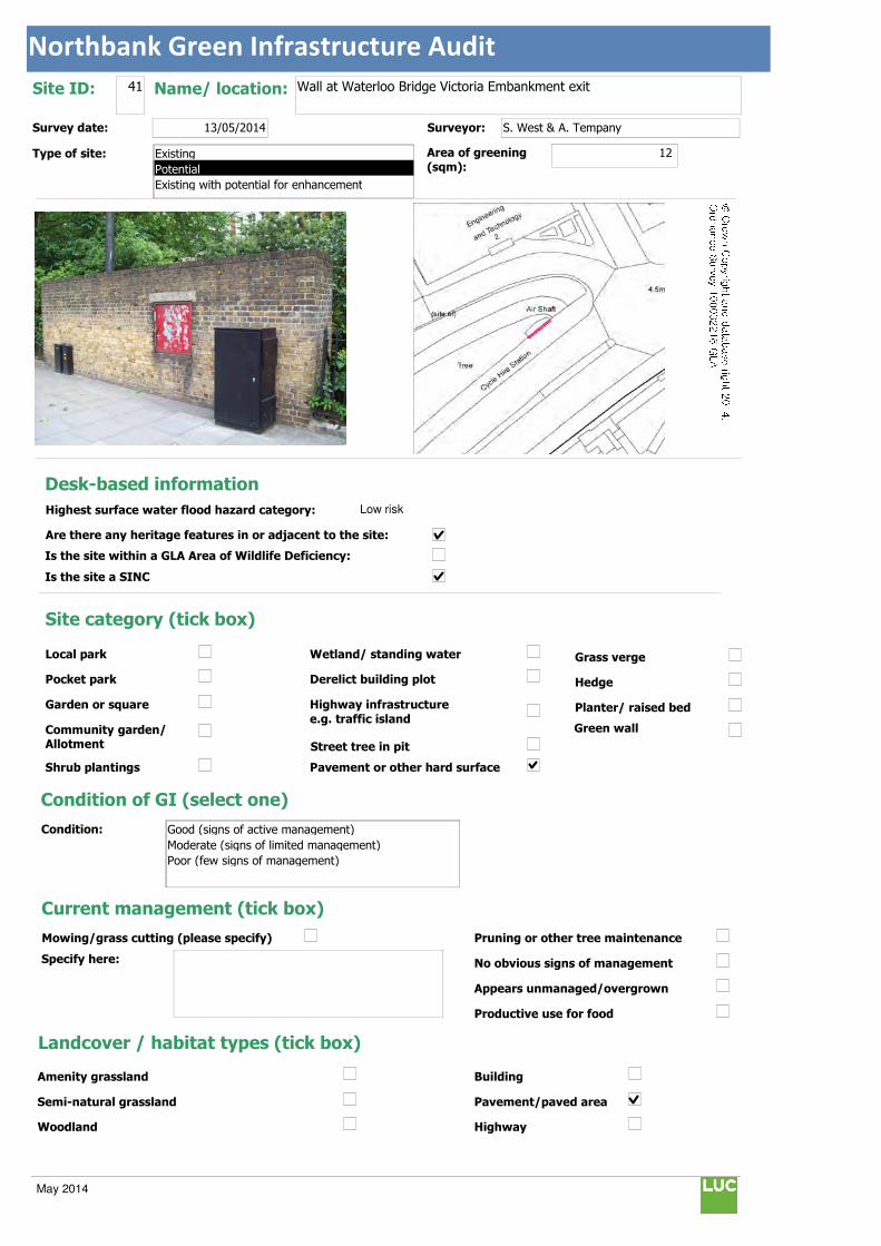
Northbank Green Infrastructure Audit
Text112:
Text114:
Phot \\D
MapName: \\
Survey date: 13/05/2014 Surveyor: S. West & A. Tempany
Type of site:
Site ID: 41 Name/ location: Wall at Waterloo Bridge Victoria Embankment exit
Area of greening
(sqm):12
Local park
Pocket park
Garden or square
Community garden/ Allotment
Shrub plantings
Wetland/ standing water
Derelict building plot
Highway infrastructure
e.g. traffic island
Street tree in pit
Grass verge
Hedge
Planter/ raised bed
Pavement or other hard surface
Site category (tick box)
Condition of GI (select one)
Current management (tick box)
Mowing/grass cutting (please specify)
Specify here:
Pruning or other tree maintenance
No obvious signs of management
Appears unmanaged/overgrown
Productive use for food
Landcover / habitat types (tick box)
Building
Pavement/paved area
Highway
Amenity grassland
Semi-natural grassland
Woodland
Condition:
Green wall
© Crown Copyright and database right 2014. Ordnance Survey 100032216 GLA
Desk-based information
Highest surface water flood hazard category: Low risk
Are there any heritage features in or adjacent to the site:
Is the site within a GLA Area of Wildlife Deficiency:
Is the site a SINC
Existing
Potential
Existing with potential for enhancement
Good (signs of active management)
Moderate (signs of limited management)
Poor (few signs of management)
May 2014
Northbank Green Infrastructure Audit
Traffic island
Roof
Green space
Scrub/shrubs (please indicate wildlife value)
Value:
Other (please specify):
Function Primary function (insert "1" in box) / Secondary function (insert "2" in box)
Public use: informal recreation:
Public use: formal recreation:
Visual/amenity: 1
Wildlife:
Food growing/productive use:
Flood management/water storage:
Not in active use but managed:
Not in use/derelict:
Scope for enhancement
Enhance existing function (please specify opportunities e.g. biodiversity, flood storage, visual appearance etc):
Opportunity to create a small green wall with climbers in raised planters to improve visual appearance and prevent graffiti at this susceptible location.
Create a new function / feature (tick box)
Wildflower meadow
Tree-(multiple)
Wetland features/rain gardens
Green wall (see below)
Substantial window box
Food growing: fruit trees/vegetables
Barriers to delivery (tick box)
Isolated/ poor visibility
Current uses , e.g. active use, transport infrastructure
Listed buildings or other building constraints
Underground services - water mains , gas,
telecoms, sewers
Wayleaves ( strip of land that allows access
to underground service)
Approximate cost (select one)
Any other notes/observations:
Enhance existing function
Street tree
Shrub
Planters
Wall
Other Other description:
Green walls:
Aspect: Modular
Climbing plants:
Type:
Building owner/occupier:
unknown
Approx height (m): 2
Approx width (m): 6
Approx greening area: (sqm) 12
Potential area of greening:
Ease of delivery (select one)
Less than £10k
£10-30k
£30-50k
More than £50k
North
East
South
West
Easy/quick win
Moderate
Challenging
May 2014

Northbank Green Infrastructure Audit
Text112:
Text114:
Phot \\D
MapName: \\
Survey date: 13/05/2014 Surveyor:
Type of site:
Site ID: 42 Name/ location: Hungerford Railway Bridge
Area of greening
(sqm):60
Local park
Pocket park
Garden or square
Community garden/ Allotment
Shrub plantings
Wetland/ standing water
Derelict building plot
Highway infrastructure
e.g. traffic island
Street tree in pit
Grass verge
Hedge
Planter/ raised bed
Pavement or other hard surface
Site category (tick box)
Condition of GI (select one)
Current management (tick box)
Mowing/grass cutting (please specify)
Specify here:
Pruning or other tree maintenance
No obvious signs of management
Appears unmanaged/overgrown
Productive use for food
Landcover / habitat types (tick box)
Building
Pavement/paved area
Highway
Amenity grassland
Semi-natural grassland
Woodland
Condition:
Green wall
© Crown Copyright and database right 2014. Ordnance Survey 100032216 GLA
Desk-based information
Highest surface water flood hazard category: Low risk
Are there any heritage features in or adjacent to the site:
Is the site within a GLA Area of Wildlife Deficiency:
Is the site a SINC
Existing
Potential
Existing with potential for enhancement
Good (signs of active management)
Moderate (signs of limited management)
Poor (few signs of management)
May 2014
Northbank Green Infrastructure Audit
Traffic island
Roof
Green space
Scrub/shrubs (please indicate wildlife value)
Value:
Other (please specify):
Function Primary function (insert "1" in box) / Secondary function (insert "2" in box)
Public use: informal recreation:
Public use: formal recreation:
Visual/amenity: 1
Wildlife:
Food growing/productive use:
Flood management/water storage:
Not in active use but managed:
Not in use/derelict:
Scope for enhancement
Enhance existing function (please specify opportunities e.g. biodiversity, flood storage, visual appearance etc):
The Brunel foundations to the Hungerford Bridge could be sympathetically greened and brightened on its western facing wall. Elevated planters could provide the opportunity for ornamental colourful shade resistant trailing plants alongside complimentary
lighting. The extent of urban greening should be limited to complement the formal classical architecture of the Brunel bridge and to
interpret its original footprint/width. Green wall planting would enhance the appearance of the current wall face which is marred by
the current downpipe and wall markings.
Create a new function / feature (tick box)
Wildflower meadow
Tree-(multiple)
Wetland features/rain gardens
Green wall (see below)
Substantial window box
Food growing: fruit trees/vegetables
Barriers to delivery (tick box)
Isolated/ poor visibility
Current uses , e.g. active use, transport infrastructure
Listed buildings or other building constraints
Underground services - water mains , gas, telecoms, sewers
Wayleaves ( strip of land that allows access
to underground service)
Approximate cost (select one)
Any other notes/observations:
Enhance existing function
Street tree
Shrub
Planters
Wall
Other Other description:
Green walls:
Aspect: Modular
Climbing plants:
Type:
Building owner/occupier:
unknown
Approx height (m): 5
Approx width (m): 12
Approx greening area: (sqm) 60
Potential area of greening:
Ease of delivery (select one)
Less than £10k
£10-30k
£30-50k
More than £50k
North
East
South
West
Easy/quick win
Moderate
Challenging
May 2014
Northbank Green Infrastructure Audit
Text112:
Text114:
Phot \\D
MapName: \\
Survey date: 13/05/2014 Surveyor: S. West & A. Tempany
Type of site:
Site ID: 43 Name/ location: Embankment Station
Area of greening
(sqm):688
Local park
Pocket park
Garden or square
Community garden/ Allotment
Shrub plantings
Wetland/ standing water
Derelict building plot
Highway infrastructure
e.g. traffic island
Street tree in pit
Grass verge
Hedge
Planter/ raised bed
Pavement or other hard surface
Site category (tick box)
Condition of GI (select one)
Current management (tick box)
Mowing/grass cutting (please specify)
Specify here:
Pruning or other tree maintenance
No obvious signs of management
Appears unmanaged/overgrown
Productive use for food
Landcover / habitat types (tick box)
Building
Pavement/paved area
Highway
Amenity grassland
Semi-natural grassland
Woodland
Condition:
Green wall
© Crown Copyright and database right 2014. Ordnance Survey 100032216 GLA
Desk-based information
Highest surface water flood hazard category: Areas with depths 0.11 - 0.25m
Are there any heritage features in or adjacent to the site:
Is the site within a GLA Area of Wildlife Deficiency:
Is the site a SINC
Existing
Potential
Existing with potential for enhancement
Good (signs of active management)
Moderate (signs of limited management)
Poor (few signs of management)
May 2014
Northbank Green Infrastructure Audit
Traffic island
Roof
Green space
Scrub/shrubs (please indicate wildlife value)
Value:
Other (please specify):
Function Primary function (insert "1" in box) / Secondary function (insert "2" in box)
Public use: informal recreation:
Public use: formal recreation:
Visual/amenity: 1
Wildlife:
Food growing/productive use:
Flood management/water storage:
Not in active use but managed:
Not in use/derelict:
Scope for enhancement
Enhance existing function (please specify opportunities e.g. biodiversity, flood storage, visual appearance etc):
There is potential for installing a green roof at the Embankment Station location which is predominately flat. The treatment of the roof would need to respond to the building and its scale and to emphasise connections between the new proposed Living Wall and
Victoria Embankment Gardens. There would be visual benefits in terms of obscuring from view some of the less attractive TfL roof
equipment and encouraging wildlife with nectar rich planting such as lavender.
Create a new function / feature (tick box)
Wildflower meadow
Tree-(multiple)
Wetland features/rain gardens
Green wall (see below)
Substantial window box
Food growing: fruit trees/vegetables
Barriers to delivery (tick box)
Isolated/ poor visibility
Current uses , e.g. active use, transport infrastructure
Listed buildings or other building constraints
Underground services - water mains , gas,
telecoms, sewers
Wayleaves ( strip of land that allows access to underground service)
Approximate cost (select one)
Any other notes/observations:
Enhance existing function
Street tree
Shrub
Planters
Wall
Other Other description: Green roof
Green walls:
Aspect: Modular
Climbing plants:
Type:
Building owner/occupier:
Approx height (m):
Approx width (m):
Approx greening area: (sqm)
Potential area of greening:
Ease of delivery (select one)
Less than £10k
£10-30k
£30-50k
More than £50k
North
East
South
West
Easy/quick win
Moderate
Challenging
May 2014
Northbank Green Infrastructure Audit
Text112:
Text114:
Phot \\D
MapName: \\
Survey date: 13/05/2014 Surveyor: S. West & A. Tempany
Type of site:
Site ID: 44 Name/ location: Embankment Station/Hungerford Bridge
Area of greening
(sqm):120
Local park
Pocket park
Garden or square
Community garden/ Allotment
Shrub plantings
Wetland/ standing water
Derelict building plot
Highway infrastructure
e.g. traffic island
Street tree in pit
Grass verge
Hedge
Planter/ raised bed
Pavement or other hard surface
Site category (tick box)
Condition of GI (select one)
Current management (tick box)
Mowing/grass cutting (please specify)
Specify here:
Pruning or other tree maintenance
No obvious signs of management
Appears unmanaged/overgrown
Productive use for food
Landcover / habitat types (tick box)
Building
Pavement/paved area
Highway
Amenity grassland
Semi-natural grassland
Woodland
Condition:
Green wall
© Crown Copyright and database right 2014. Ordnance Survey 100032216 GLA
Desk-based information
Highest surface water flood hazard category: Low risk
Are there any heritage features in or adjacent to the site:
Is the site within a GLA Area of Wildlife Deficiency:
Is the site a SINC
Existing
Potential
Existing with potential for enhancement
Good (signs of active management)
Moderate (signs of limited management)
Poor (few signs of management)
May 2014
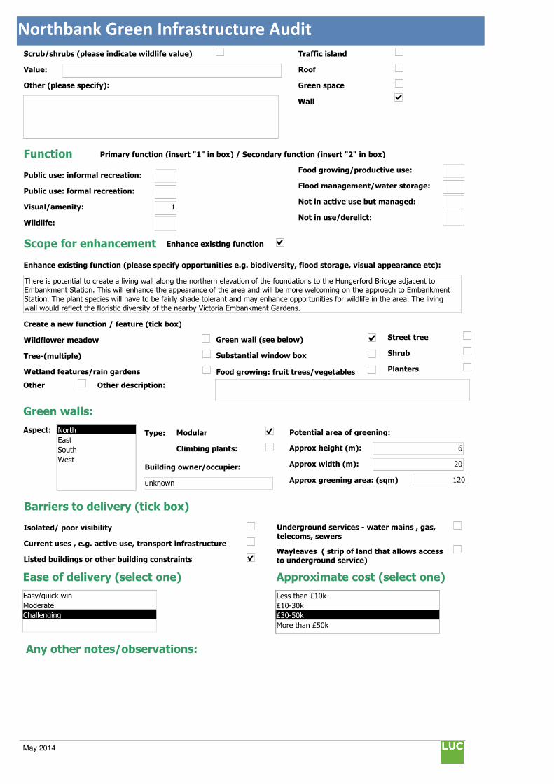
Northbank Green Infrastructure Audit
Traffic island
Roof
Green space
Scrub/shrubs (please indicate wildlife value)
Value:
Other (please specify):
Function Primary function (insert "1" in box) / Secondary function (insert "2" in box)
Public use: informal recreation:
Public use: formal recreation:
Visual/amenity: 1
Wildlife:
Food growing/productive use:
Flood management/water storage:
Not in active use but managed:
Not in use/derelict:
Scope for enhancement
Enhance existing function (please specify opportunities e.g. biodiversity, flood storage, visual appearance etc):
There is potential to create a living wall along the northern elevation of the foundations to the Hungerford Bridge adjacent to Embankment Station. This will enhance the appearance of the area and will be more welcoming on the approach to Embankment
Station. The plant species will have to be fairly shade tolerant and may enhance opportunities for wildlife in the area. The living
wall would reflect the floristic diversity of the nearby Victoria Embankment Gardens.
Create a new function / feature (tick box)
Wildflower meadow
Tree-(multiple)
Wetland features/rain gardens
Green wall (see below)
Substantial window box
Food growing: fruit trees/vegetables
Barriers to delivery (tick box)
Isolated/ poor visibility
Current uses , e.g. active use, transport infrastructure
Listed buildings or other building constraints
Underground services - water mains , gas,
telecoms, sewers
Wayleaves ( strip of land that allows access to underground service)
Approximate cost (select one)
Any other notes/observations:
Enhance existing function
Street tree
Shrub
Planters
Wall
Other Other description:
Green walls:
Aspect: Modular
Climbing plants:
Type:
Building owner/occupier:
unknown
Approx height (m): 6
Approx width (m): 20
Approx greening area: (sqm) 120
Potential area of greening:
Ease of delivery (select one)
Less than £10k
£10-30k
£30-50k
More than £50k
North
East
South
West
Easy/quick win
Moderate
Challenging
May 2014
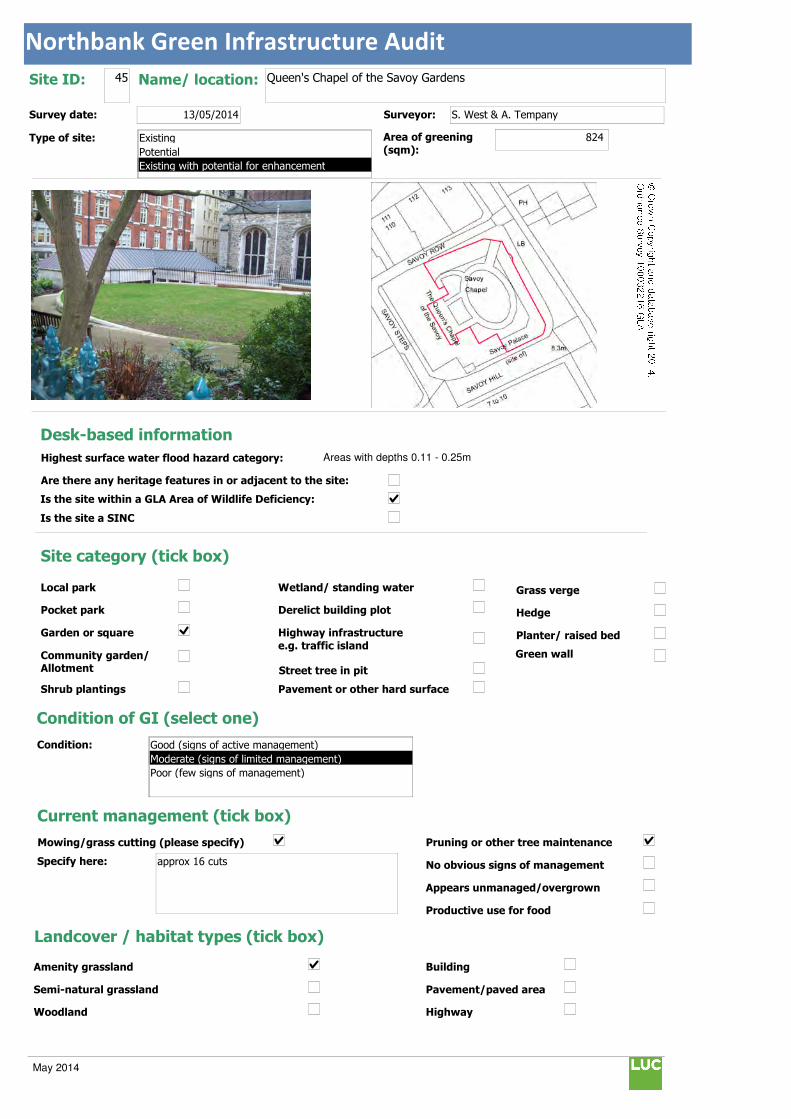
Northbank Green Infrastructure Audit
Text112:
Text114:
Phot \\D
MapName: \\
Survey date: 13/05/2014 Surveyor: S. West & A. Tempany
Type of site:
Site ID: 45 Name/ location: Queen's Chapel of the Savoy Gardens
Area of greening
(sqm):824
Local park
Pocket park
Garden or square
Community garden/ Allotment
Shrub plantings
Wetland/ standing water
Derelict building plot
Highway infrastructure
e.g. traffic island
Street tree in pit
Grass verge
Hedge
Planter/ raised bed
Pavement or other hard surface
Site category (tick box)
Condition of GI (select one)
Current management (tick box)
Mowing/grass cutting (please specify)
Specify here: approx 16 cuts
Pruning or other tree maintenance
No obvious signs of management
Appears unmanaged/overgrown
Productive use for food
Landcover / habitat types (tick box)
Building
Pavement/paved area
Highway
Amenity grassland
Semi-natural grassland
Woodland
Condition:
Green wall
© Crown Copyright and database right 2014. Ordnance Survey 100032216 GLA
Desk-based information
Highest surface water flood hazard category: Areas with depths 0.11 - 0.25m
Are there any heritage features in or adjacent to the site:
Is the site within a GLA Area of Wildlife Deficiency:
Is the site a SINC
Existing
Potential
Existing with potential for enhancement
Good (signs of active management)
Moderate (signs of limited management)
Poor (few signs of management)
May 2014

Northbank Green Infrastructure Audit
Traffic island
Roof
Green space
Scrub/shrubs (please indicate wildlife value)
Value: Minimal currently
Other (please specify):
Function Primary function (insert "1" in box) / Secondary function (insert "2" in box)
Public use: informal recreation: 2
Public use: formal recreation:
Visual/amenity: 1
Wildlife:
Food growing/productive use:
Flood management/water storage:
Not in active use but managed:
Not in use/derelict:
Scope for enhancement
Enhance existing function (please specify opportunities e.g. biodiversity, flood storage, visual appearance etc):
There could be further nectar rich and native planting to encourage wildlife. The gardens could also be opened to the public to provide passive recreation benefits and improve understanding of green and open space within the vicinity for locals and tourists.
Create a new function / feature (tick box)
Wildflower meadow
Tree-(multiple)
Wetland features/rain gardens
Green wall (see below)
Substantial window box
Food growing: fruit trees/vegetables
Barriers to delivery (tick box)
Isolated/ poor visibility
Current uses , e.g. active use, transport infrastructure
Listed buildings or other building constraints
Underground services - water mains , gas,
telecoms, sewers
Wayleaves ( strip of land that allows access
to underground service)
Approximate cost (select one)
Any other notes/observations:
Enhance existing function
Street tree
Shrub
Planters
Wall
Other Other description:
Green walls:
Aspect: Modular
Climbing plants:
Type:
Building owner/occupier:
Approx height (m):
Approx width (m):
Approx greening area: (sqm)
Potential area of greening:
Ease of delivery (select one)
Less than £10k
£10-30k
£30-50k
More than £50k
North
East
South
West
Easy/quick win
Moderate
Challenging
May 2014
Appendix 2: Northbank’s Historic Evolution
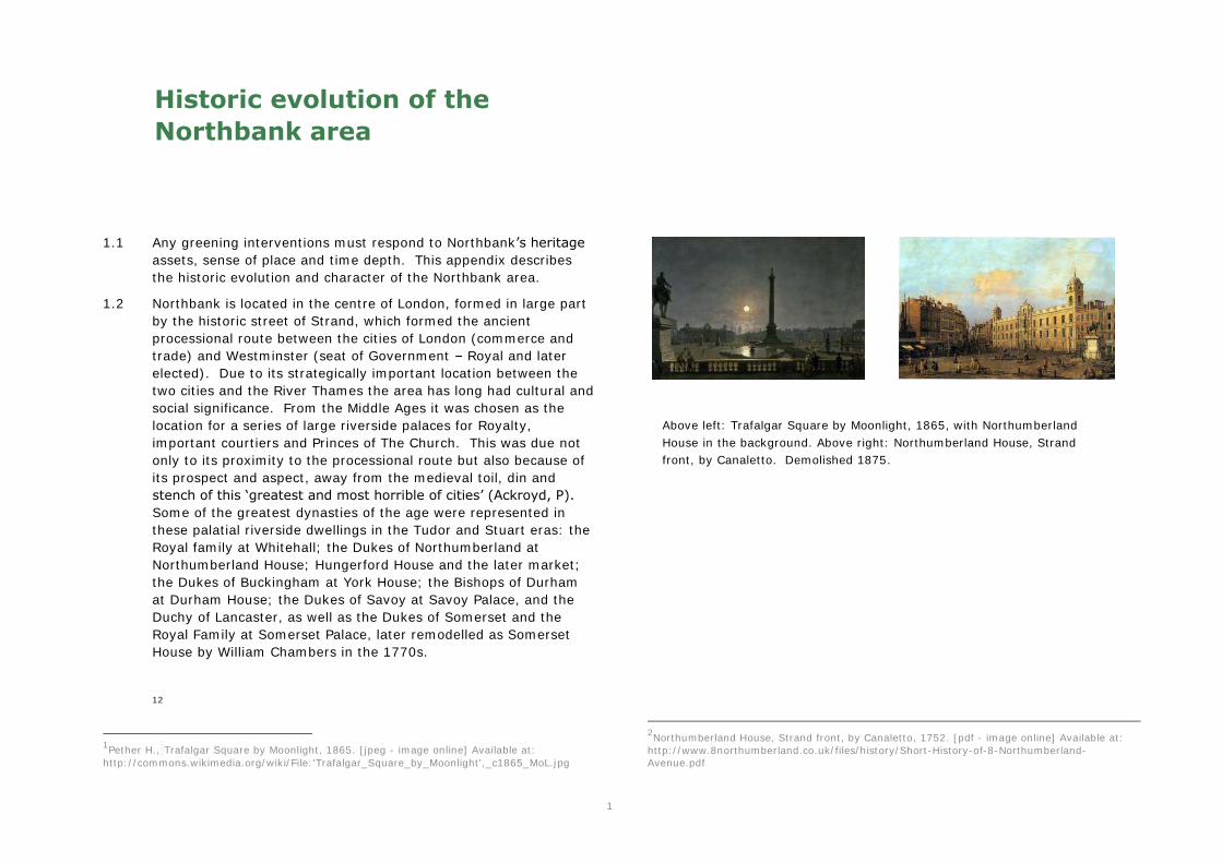
1
Historic evolution of the
Northbank area
1.1 Any greening interventions must respond to Northbank’s heritage
assets, sense of place and time depth. This appendix describes the historic evolution and character of the Northbank area.
1.2 Northbank is located in the centre of London, formed in large part by the historic street of Strand, which formed the ancient processional route between the cities of London (commerce and trade) and Westminster (seat of Government – Royal and later elected). Due to its strategically important location between the two cities and the River Thames the area has long had cultural and social significance. From the Middle Ages it was chosen as the location for a series of large riverside palaces for Royalty, important courtiers and Princes of The Church. This was due not only to its proximity to the processional route but also because of its prospect and aspect, away from the medieval toil, din and stench of this ‘greatest and most horrible of cities’ (Ackroyd, P).
Some of the greatest dynasties of the age were represented in these palatial riverside dwellings in the Tudor and Stuart eras: the Royal family at Whitehall; the Dukes of Northumberland at Northumberland House; Hungerford House and the later market; the Dukes of Buckingham at York House; the Bishops of Durham at Durham House; the Dukes of Savoy at Savoy Palace, and the Duchy of Lancaster, as well as the Dukes of Somerset and the Royal Family at Somerset Palace, later remodelled as Somerset House by William Chambers in the 1770s.
12
1Pether H., Trafalgar Square by Moonlight, 1865. [jpeg - image online] Available at: http://commons.wikimedia.org/wiki/File:'Trafalgar_Square_by_Moonlight',_c1865_MoL.jpg
2Northumberland House, Strand front, by Canaletto, 1752. [pdf - image online] Available at: http://www.8northumberland.co.uk/files/history/Short-History-of-8-Northumberland-Avenue.pdf
Above left: Trafalgar Square by Moonlight, 1865, with Northumberland House in the background. Above right: Northumberland House, Strand front, by Canaletto. Demolished 1875.
2
1.3 Such houses were positioned on prominent, elevated locations on the Thames gravel/valley terrace, well away from the hustle and bustle of London’s streets, and with their principal frontages
orientated towards the river – access was provided for Royal and court barges via a network of riverside stairs. These stairs are sometimes perpetuated in the surrounding street names as are the lost palaces themselves. The York House Water Gate, the sole surviving feature of the London seat of the Dukes of Buckingham, forms an imposing, curious Baroque/Rococo relic with the construction of Bazalgette’s late 19th century Victoria Embankment having displaced it from the river. The great water gate at Somerset House is also visible, although again now cut off from the water.
34
3The Watergate at Somerset House. [image online] Available at: http://www.somersethouse.org.uk/history/since-the-18th-century 4The Watergate/stairs to York House, c1237. [jpeg - image online] Available at: http://www.gardenvisit.com/garden/york_house_watergate_steps
Above left: The Watergate at Somerset House. Both features survive although now cut off from the river by The Embankment. Above right: The Watergate/stairs to York House.

3
5 6
5Panoramic view of the historic riverside palaces of the Strand and associated water gates/stairs (Wyngaerde, 1543) [jpeg - image online] Available at: http://www.ladyjanegrey.info/?page_id=5061 6 Tudor Somerset House. [jpeg - image online] Available at: http://www.somersethouse.org.uk/history/the-tudor-palace
Above: Panoramic view of the historic riverside palaces of the Strand and associated water gates/stairs (Wyngaerde, 1543)
Above: View of the Tudor Somerset House and associated river stairs
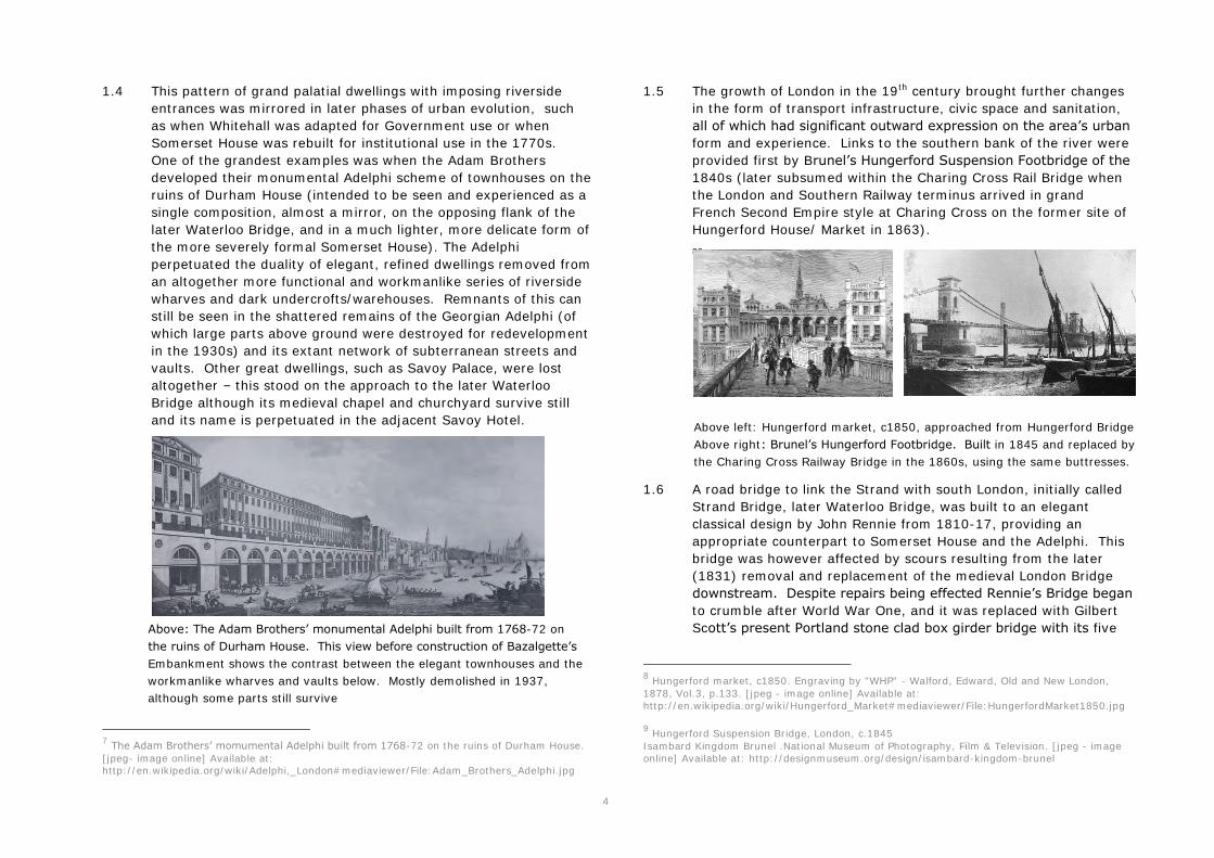
4
1.4 This pattern of grand palatial dwellings with imposing riverside entrances was mirrored in later phases of urban evolution, such as when Whitehall was adapted for Government use or when Somerset House was rebuilt for institutional use in the 1770s. One of the grandest examples was when the Adam Brothers developed their monumental Adelphi scheme of townhouses on the ruins of Durham House (intended to be seen and experienced as a single composition, almost a mirror, on the opposing flank of the later Waterloo Bridge, and in a much lighter, more delicate form of the more severely formal Somerset House). The Adelphi perpetuated the duality of elegant, refined dwellings removed from an altogether more functional and workmanlike series of riverside wharves and dark undercrofts/warehouses. Remnants of this can still be seen in the shattered remains of the Georgian Adelphi (of which large parts above ground were destroyed for redevelopment in the 1930s) and its extant network of subterranean streets and vaults. Other great dwellings, such as Savoy Palace, were lost altogether – this stood on the approach to the later Waterloo Bridge although its medieval chapel and churchyard survive still and its name is perpetuated in the adjacent Savoy Hotel. 7
7 The Adam Brothers’ momumental Adelphi built from 1768-72 on the ruins of Durham House. [jpeg- image online] Available at: http://en.wikipedia.org/wiki/Adelphi,_London#mediaviewer/File:Adam_Brothers_Adelphi.jpg
1.5 The growth of London in the 19th century brought further changes in the form of transport infrastructure, civic space and sanitation, all of which had significant outward expression on the area’s urban
form and experience. Links to the southern bank of the river were provided first by Brunel’s Hungerford Suspension Footbridge of the
1840s (later subsumed within the Charing Cross Rail Bridge when the London and Southern Railway terminus arrived in grand French Second Empire style at Charing Cross on the former site of Hungerford House/ Market in 1863). 89
1.6 A road bridge to link the Strand with south London, initially called Strand Bridge, later Waterloo Bridge, was built to an elegant classical design by John Rennie from 1810-17, providing an appropriate counterpart to Somerset House and the Adelphi. This bridge was however affected by scours resulting from the later (1831) removal and replacement of the medieval London Bridge downstream. Despite repairs being effected Rennie’s Bridge began
to crumble after World War One, and it was replaced with Gilbert Scott’s present Portland stone clad box girder bridge with its five
8 Hungerford market, c1850. Engraving by "WHP" - Walford, Edward, Old and New London, 1878, Vol.3, p.133. [jpeg - image online] Available at: http://en.wikipedia.org/wiki/Hungerford_Market#mediaviewer/File:HungerfordMarket1850.jpg 9 Hungerford Suspension Bridge, London, c.1845 Isambard Kingdom Brunel .National Museum of Photography, Film & Television. [jpeg - image online] Available at: http://designmuseum.org/design/isambard-kingdom-brunel
Above: The Adam Brothers’ monumental Adelphi built from 1768-72 on the ruins of Durham House. This view before construction of Bazalgette’s Embankment shows the contrast between the elegant townhouses and the workmanlike wharves and vaults below. Mostly demolished in 1937, although some parts still survive
Above left: Hungerford market, c1850, approached from Hungerford Bridge Above right: Brunel’s Hungerford Footbridge. Built in 1845 and replaced by the Charing Cross Railway Bridge in the 1860s, using the same buttresses.
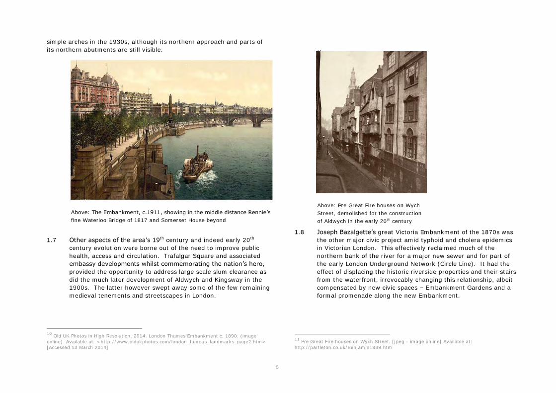
5
simple arches in the 1930s, although its northern approach and parts of its northern abutments are still visible.
10
1.7 Other aspects of the area’s 19th century and indeed early 20th century evolution were borne out of the need to improve public health, access and circulation. Trafalgar Square and associated embassy developments whilst commemorating the nation’s hero,
provided the opportunity to address large scale slum clearance as did the much later development of Aldwych and Kingsway in the 1900s. The latter however swept away some of the few remaining medieval tenements and streetscapes in London.
10 Old UK Photos in High Resolution, 2014. London Thames Embankment c. 1890. (image online). Available at: <http://www.oldukphotos.com/london_famous_landmarks_page2.htm> [Accessed 13 March 2014]
11
1.8 Joseph Bazalgette’s great Victoria Embankment of the 1870s was the other major civic project amid typhoid and cholera epidemics in Victorian London. This effectively reclaimed much of the northern bank of the river for a major new sewer and for part of the early London Underground Network (Circle Line). It had the effect of displacing the historic riverside properties and their stairs from the waterfront, irrevocably changing this relationship, albeit compensated by new civic spaces – Embankment Gardens and a formal promenade along the new Embankment.
11 Pre Great Fire houses on Wych Street. [jpeg - image online] Available at: http://partleton.co.uk/Benjamin1839.htm
Above: The Embankment, c.1911, showing in the middle distance Rennie’s
fine Waterloo Bridge of 1817 and Somerset House beyond
Above: Pre Great Fire houses on Wych Street, demolished for the construction of Aldwych in the early 20th century

7
12
13
12 Embankment Construction of the Thames Embankment ILN 1865. [jpeg- image online] Available at: http://en.wikipedia.org/wiki/Thames_Conservancy#mediaviewer/File:Embankment_Construction_of_the_Thames_Embankment_ILN_1865.jpg 13Schematic section through the embankment 1970 ILN. [jpeg - image online] Available at: http://en.wikipedia.org/wiki/Victoria_Embankment#mediaviewer/File:Section_through_Victoria_Embankment.png
1.9 As such, what we see today at Northbank is a complex composite or palimpsest, multi layered townscape, with a considerable sense of richness and time depth. It is these factors which provide at once the most notable opportunity and significant constraint with regard to public realm enhancement in the BID area. Opportunities are provided by the formality and monumental character of the architecture, the need to showcase the area’s
significant distribution of grade I and II* listed buildings and to conserve and enhance important views such as from the South Bank. Constraints are provided not only by archaeology but also by the subterranean complexity of the infrastructure in the area. It is also clear that whilst the Northbank is firmly rooted in and respectful of its great past it is not static – certain parts are in a constant state of flux. New grand visions also echo the area’s
heritage, scale and the scope and ambition of previous patrons and designers who have shaped the area, as well as creating notable public realm opportunities. These include the proposed Garden Bridge at the foot of Arundel Street and the Cycle Cross Rail link (Embankment).
Above: Bazalgette’s Embankment under construction in the 1870s. Below:
Schematic section through the Embankment, showing cut and cover tube line and sewer locations, reclaimed from the river
Appendix 3: Supporting information from Northbank Public Realm Study (Credit: Publica Associates, April 2014. Northbank BID – Public Realm Study)
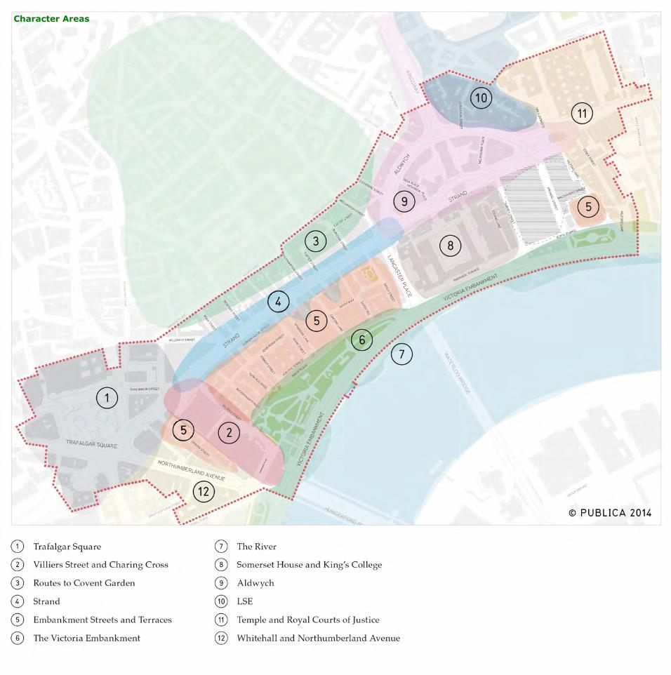
Character Areas

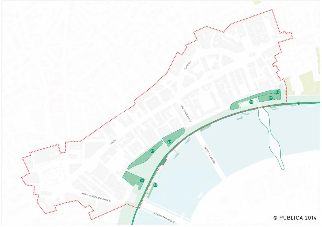
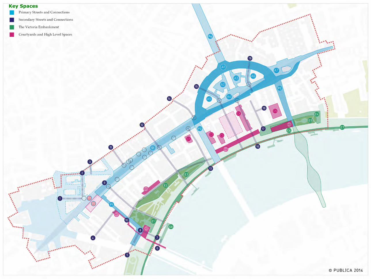
Key Spaces
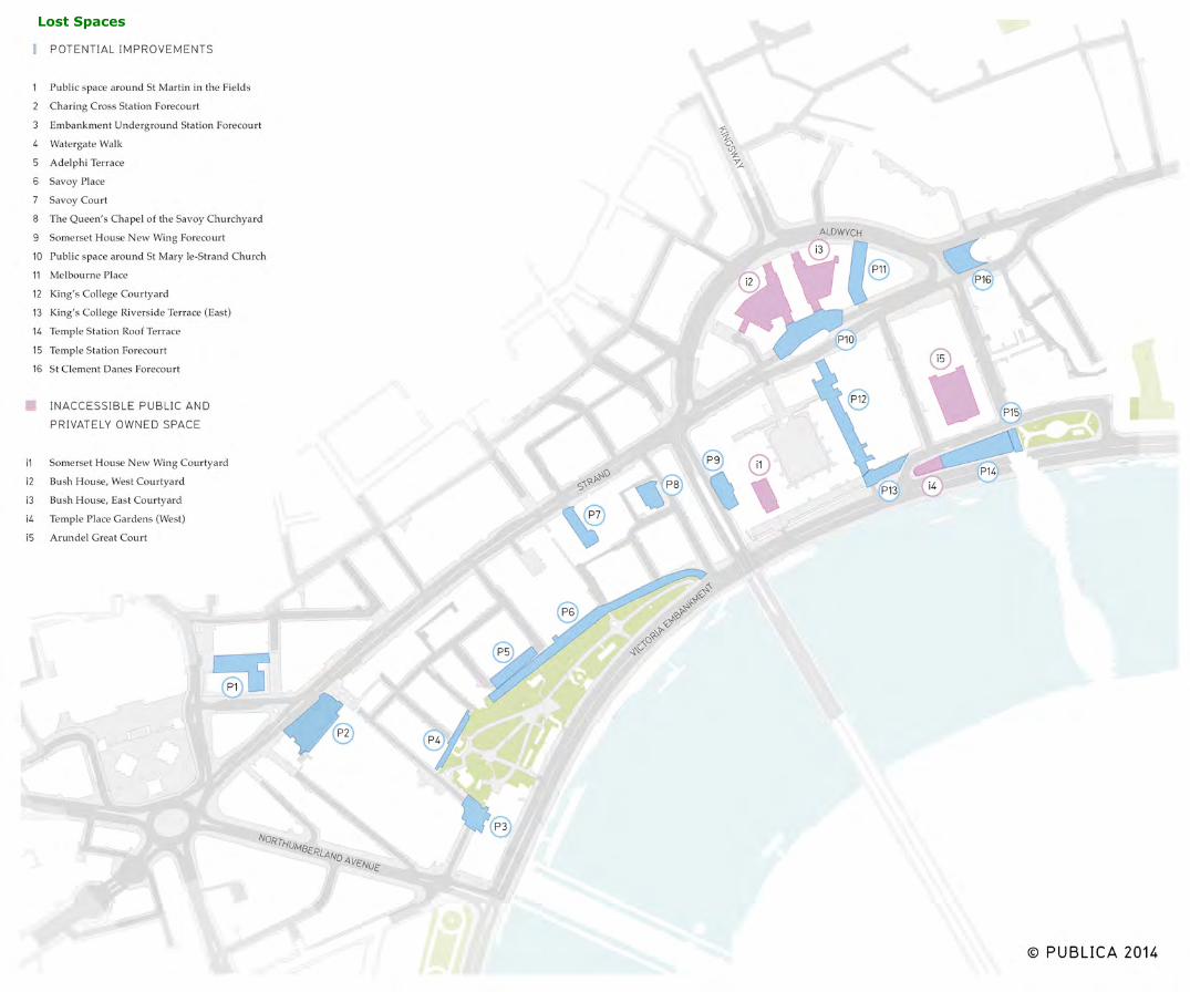
Lost Spaces
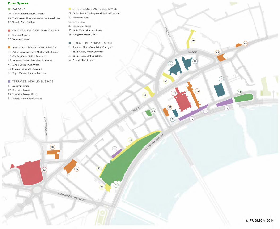
Open Spaces
Appendix 4: Example Park Restoration Projects
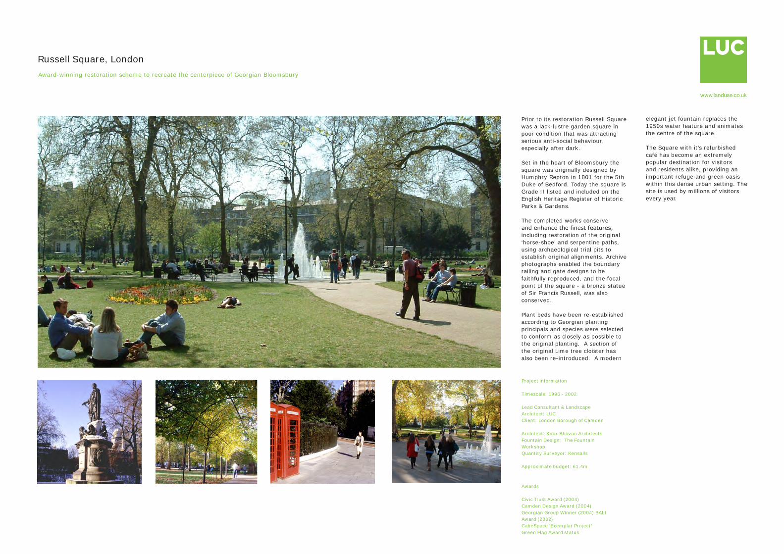
Project information
Timescale: 1996 - 2002
Lead Consultant & Landscape Architect: LUCClient: London Borough of Camden
Architect: Knox Bhavan ArchitectsFountain Design: The Fountain WorkshopQuantity Surveyor: Kensalls
Approximate budget: £1.4m
Awards
Civic Trust Award (2004)Camden Design Award (2004)Georgian Group Winner (2004) BALI Award (2002) CabeSpace ‘Exemplar Project’Green Flag Award status
Russell Square, LondonAward-winning restoration scheme to recreate the centerpiece of Georgian Bloomsbury
Prior to its restoration Russell Square was a lack-lustre garden square in poor condition that was attracting serious anti-social behaviour, especially after dark.
Set in the heart of Bloomsbury the square was originally designed by Humphry Repton in 1801 for the 5th Duke of Bedford. Today the square is Grade II listed and included on the English Heritage Register of Historic Parks & Gardens.
The completed works conserve and enhance the finest features, including restoration of the original ‘horse-shoe’ and serpentine paths, using archaeological trial pits to establish original alignments. Archive photographs enabled the boundary railing and gate designs to be faithfully reproduced, and the focal point of the square - a bronze statue of Sir Francis Russell, was also conserved.
Plant beds have been re-established according to Georgian planting principals and species were selected to conform as closely as possible to the original planting. A section of the original Lime tree cloister has also been re-introduced. A modern
elegant jet fountain replaces the 1950s water feature and animates the centre of the square.
The Square with it’s refurbished café has become an extremely popular destination for visitors and residents alike, providing an important refuge and green oasis within this dense urban setting. The site is used by millions of visitors every year.
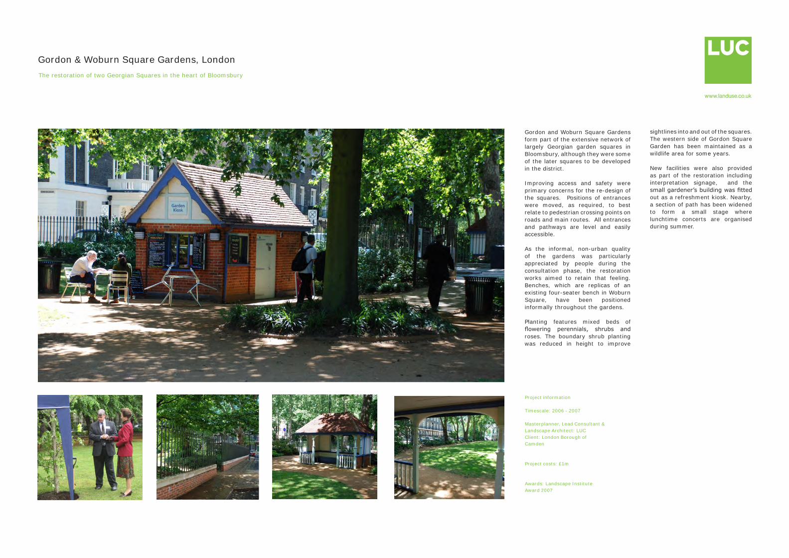
Project information
Timescale: 2006 - 2007
Masterplanner, Lead Consultant & Landscape Architect: LUCClient: London Borough of Camden
Project costs: £1m
Awards: Landscape Institute Award 2007
Gordon & Woburn Square Gardens, LondonThe restoration of two Georgian Squares in the heart of Bloomsbury
Gordon and Woburn Square Gardens form part of the extensive network of largely Georgian garden squares in Bloomsbury, although they were some of the later squares to be developed in the district.
Improving access and safety were primary concerns for the re-design of the squares. Positions of entrances were moved, as required, to best relate to pedestrian crossing points on roads and main routes. All entrances and pathways are level and easily accessible.
As the informal, non-urban quality of the gardens was particularly appreciated by people during the consultation phase, the restoration works aimed to retain that feeling. Benches, which are replicas of an existing four-seater bench in Woburn Square, have been positioned informally throughout the gardens.
Planting features mixed beds of flowering perennials, shrubs and roses. The boundary shrub planting was reduced in height to improve
sightlines into and out of the squares. The western side of Gordon Square Garden has been maintained as a wildlife area for some years.
New facilities were also provided as part of the restoration including interpretation signage, and the small gardener’s building was fitted out as a refreshment kiosk. Nearby, a section of path has been widened to form a small stage where lunchtime concerts are organised during summer.
Related Documents