North Road, Ormond Development Urban Context Report Prepared for DEAL CORPORATION David Lock Associates JULY 2016

Welcome message from author
This document is posted to help you gain knowledge. Please leave a comment to let me know what you think about it! Share it to your friends and learn new things together.
Transcript
North Road, Ormond DevelopmentUrban Context Report Prepared for DEAL CORPORATION David Lock Associates JULY 2016

Urban Context ReportNorth Road, Ormond DevelopmentJuly 2016
David Lock Associates
2 3
Contents
1.0 Introduction ................................................................................................................................................3
2.0 Urban Context ............................................................................................................................................4
3.0 OpportunitiesandConstraints ...................................................................................................................5
4.0 Character ...................................................................................................................................................6
5.0 Public Realm ............................................................................................................................................10
6.0 Neighbouring interfaces ...........................................................................................................................15
7.0 Design principles .......................................................................................................................................17
Urban Context ReportNorth Road, Ormond Development
July 2016
David Lock Associates
2 3
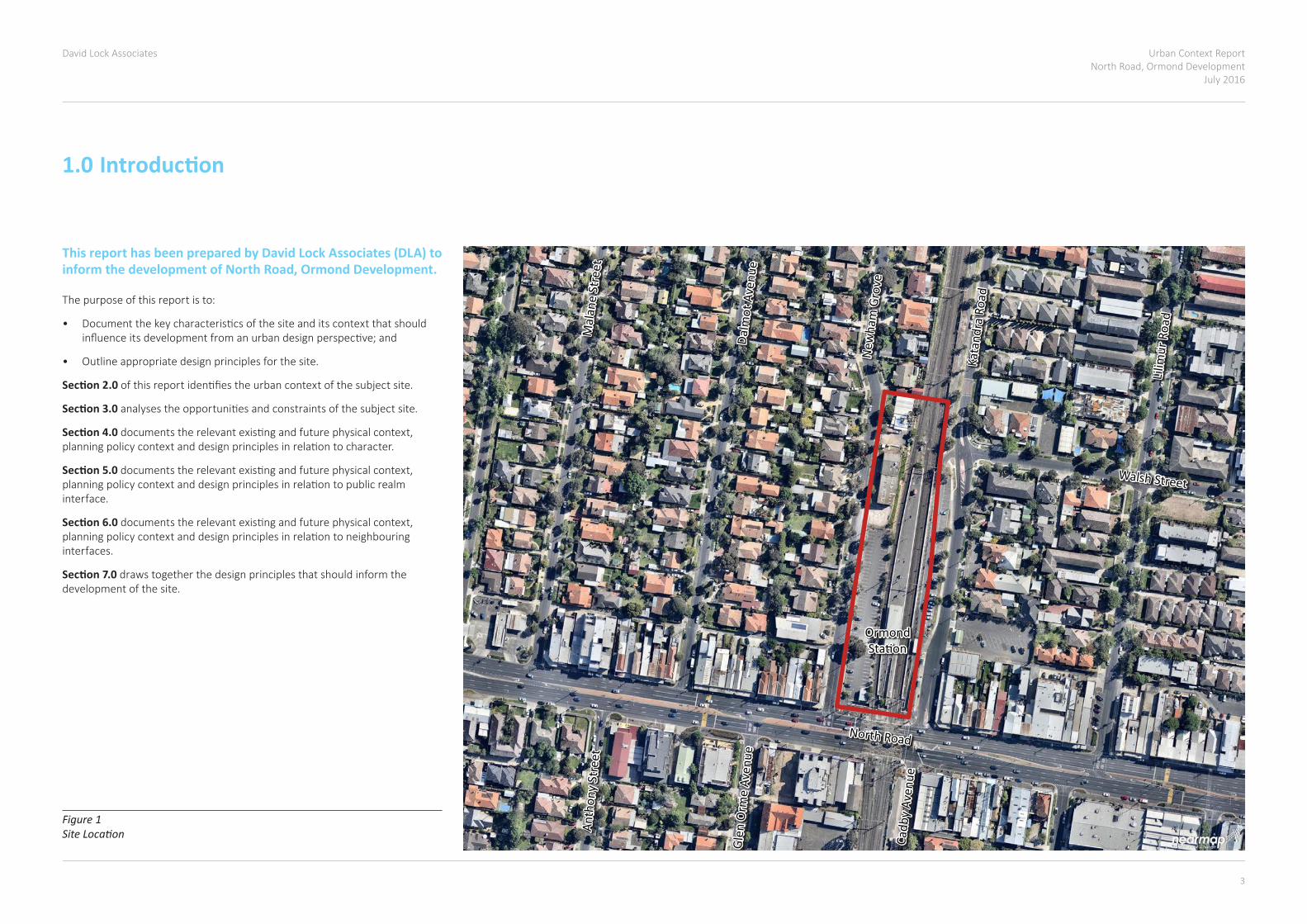
Figure 1 Site Location
North Road
Kata
ndra
Roa
d
Lilim
ur R
oad
Walsh Street
Cadb
y Av
enue
Glen
Orm
e Av
enue
Anth
ony
Stre
et
Dalm
ot A
venu
e
New
ham
Gro
ve
Mal
ane
Stre
et
OrmondStation
North Road
Kata
ndra
Roa
d
Lilim
ur R
oad
Walsh Street
Cadb
y Av
enue
Glen
Orm
e Av
enue
Anth
ony
Stre
et
Dalm
ot A
venu
e
New
ham
Gro
ve
Mal
ane
Stre
et
OrmondStation
1.0 Introduction
This report has been prepared by David Lock Associates (DLA) to inform the development of North Road, Ormond Development.
The purpose of this report is to:
• Documentthekeycharacteristicsofthesiteanditscontextthatshouldinfluenceitsdevelopmentfromanurbandesignperspective;and
• Outline appropriate design principles for the site.
Section 2.0 ofthisreportidentifiestheurbancontextofthesubjectsite.
Section 3.0 analysestheopportunitiesandconstraintsofthesubjectsite.
Section 4.0 documentstherelevantexistingandfuturephysicalcontext,planningpolicycontextanddesignprinciplesinrelationtocharacter.
Section 5.0 documentstherelevantexistingandfuturephysicalcontext,planningpolicycontextanddesignprinciplesinrelationtopublicrealminterface.
Section 6.0documentstherelevantexistingandfuturephysicalcontext,planningpolicycontextanddesignprinciplesinrelationtoneighbouringinterfaces.
Section 7.0 draws together the design principles that should inform the development of the site.
Urban Context ReportNorth Road, Ormond DevelopmentJuly 2016
David Lock Associates
4 5
64
BOO
RAN
RO
AD
GLEN
ORM
E AV
ENU
E
BETH
ELL
STRE
ET
HODD
ER S
TREE
T
THO
MAS
STR
EET
WHI
TMU
IR R
OAD
NIC
HOLS
ON
STR
EET
BALM
ORA
L AV
ENU
E
TUCK
ER R
OAD
STAT
ION
AVE
NU
E
HALL
STR
EET
GRAN
GE R
OAD
WALSH STREET
MURRAY ROAD
BRUCE STREET
FITZROY STREET
EXHIBITION STREET FIELD STREET
McKINNON ROAD
OAKLEY ROAD
LEILA ROAD
MARARA ROAD
FOCH STREET
SHEFFIELD STREET
BAM
BRA
ROAD
KilvingtonGrammar
School
KilvingtonGrammar
SchoolBrighton
Cemetery
McKinnonReserve
St Kevin’sPrimarySchool
McKinnonSecondary
College
OrmondPrimarySchool
Caulfield SthPrimarySchool
BOO
RAN
RO
AD
GLEN
ORM
E AV
ENU
E
BETH
ELL
STRE
ET
HODD
ER S
TREE
T
THO
MAS
STR
EET
WHI
TMU
IR R
OAD
NIC
HOLS
ON
STR
EET
BALM
ORA
L AV
ENU
E
TUCK
ER R
OAD
STAT
ION
AVE
NU
E
HALL
STR
EET
GRAN
GE R
OAD
WALSH STREET
MURRAY ROAD
BRUCE STREET
FITZROY STREET
EXHIBITION STREET FIELD STREET
McKINNON ROAD
OAKLEY ROAD
LEILA ROAD
MARARA ROAD
FOCH STREET
SHEFFIELD STREET
BAM
BRA
ROAD
HAW
THO
RN R
OAD
NORTH ROAD
BrightonCemetery
Princes Park
AllnuttPark
McKinnonPark
EE Gunn Reserve
Lord Reserve
Joyce Park
McKinnonReserve
Wattle ParkWattle Park
St Kevin’sPrimarySchool
McKinnonSecondary
College
OrmondPrimarySchool
Caulfield SthPrimarySchool
NORTH ROAD
HAW
THO
RN R
OAD
LEVEL 2, 166 ALBERT ROADSOUTH MELBOURNE VIC 3205t 03 9682 8568 f 03 9682 1221www.dlaaust.com
VALUE CAPTURE SITE AT ORMOND STATION
BDCR005
9 OCTOBER 2015
NTS
JOB :
CODE :
DATE :
SCALE :
URBAN CONTEXT
LEGEND
SUBJECT SITE
PUBLIC OPEN SPACE
NEIGHBOURHOOD CENTRE
COMMERCIAL CORE
MIXED USE
EDUCATION
RESIDENTIAL
TRAIN LINE
TRAIN STATION
TRAM ROUTE
BUS ROUTE
OFF-ROAD SHARED PATH
PRIMARY ARTERIAL ROAD
SECONDARY ARTERIAL ROAD
MAJOR ROAD
KEY JUNCTION
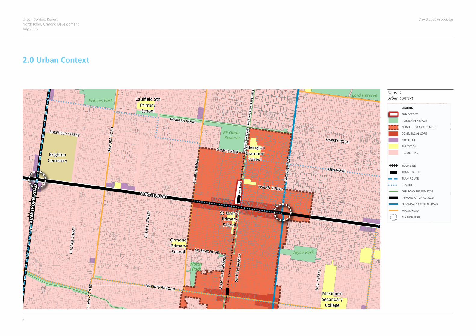
Figure 2 Urban Context
2.0 Urban Context

Urban Context ReportNorth Road, Ormond Development
July 2016
David Lock Associates
4 5
1
1
1
1
2
4
4
3
5 6
1 5 6
7
88
8
9
9
10
124
12
10 11
11
10
2
33
2
4
1
2
3
4
1
2
3
4
5
6
8
9
10
11
12
7
Subject Site
OpportunitiesThe site is located within Ormond Neighbourhood Centre and sits in the centre of the commercial core, supporting higher density development.
The site benefits from good public transport accessibility, including Ormond Station and buses running along North Road and Katandra Road. It is located in close proximity to two arterial roads, North Road and Grange Road.
The site is the largest within the activity centre.
The site has three street frontages of approximately 50m to North Road and 220m to Newham Grove and Katandra Road.
Properties on North Road are within the Commercial 1 Zone, which supports development for a range of commercial and residential uses.
North Road presents a continuous street wall with zero front and side setbacks and active frontages, supporting similarly intense development.
North Road has an approximately 35m wide road reserve, avoiding the risk of development overwhelming the street.
There is a lack of sensitive uses immediately abutting the site that might constrain its development due to the need to protect existing amenity, except the residential property to the north.
There are supporting uses including a school, childcare and car park along Katandra Road.
There is an opportunity to imporve the visual and physical amenity of the area around the station.
There is an opportunity to better connect the east and west sides of the train line through development and new connections.
There is an opportunity to repair the poor spatial definition of Newham Grove and Katandra Road caused by open car parks on one side of each street.
ConstraintsDevelopment needs to respond to the different characters of North Road, Katandra Road and Newham Grove.
Development needs to avoid unreasonable impacts on the amenity of the surrounding residential properties.
Properties along Newham Grove and Katandra Grove are within the General Residential Zone (GRZ1), limiting their potential intensification.
There is a Heritage overlay west and north of Newham Grove, limiting the likelihood of redevelopment.
North Road
Kata
ndra
Roa
d
Walsh Street
New
ham
Gro
ve
KatandraSchool
OrmondKinder Haven
Ormond SeniorCitizens Centre
Walsh Street
New
ham
Gro
ve
KatandraSchool
OrmondKinder Haven
Ormond SeniorCitizens Centre
Kata
ndra
Roa
d
North Road
1
1
1
1
2
4
4
3
5 6
1 5 6
7
88
8
9
9
10
124
12
10 11
11
10
2
33
2
4
1
2
3
4
1
2
3
4
5
6
8
9
10
11
12
7
Subject Site
OpportunitiesThe site is located within Ormond Neighbourhood Centre and sits in the centre of the commercial core, supporting higher density development.
The site benefits from good public transport accessibility, including Ormond Station and buses running along North Road and Katandra Road. It is located in close proximity to two arterial roads, North Road and Grange Road.
The site is the largest within the activity centre.
The site has three street frontages of approximately 50m to North Road and 220m to Newham Grove and Katandra Road.
Properties on North Road are within the Commercial 1 Zone, which supports development for a range of commercial and residential uses.
North Road presents a continuous street wall with zero front and side setbacks and active frontages, supporting similarly intense development.
North Road has an approximately 35m wide road reserve, avoiding the risk of development overwhelming the street.
There is a lack of sensitive uses immediately abutting the site that might constrain its development due to the need to protect existing amenity, except the residential property to the north.
There are supporting uses including a school, childcare and car park along Katandra Road.
There is an opportunity to imporve the visual and physical amenity of the area around the station.
There is an opportunity to better connect the east and west sides of the train line through development and new connections.
There is an opportunity to repair the poor spatial definition of Newham Grove and Katandra Road caused by open car parks on one side of each street.
ConstraintsDevelopment needs to respond to the different characters of North Road, Katandra Road and Newham Grove.
Development needs to avoid unreasonable impacts on the amenity of the surrounding residential properties.
Properties along Newham Grove and Katandra Grove are within the General Residential Zone (GRZ1), limiting their potential intensification.
There is a Heritage overlay west and north of Newham Grove, limiting the likelihood of redevelopment.
North Road
Kata
ndra
Roa
d
Walsh Street
New
ham
Gro
ve
KatandraSchool
OrmondKinder Haven
Ormond SeniorCitizens Centre
Walsh Street
New
ham
Gro
ve
KatandraSchool
OrmondKinder Haven
Ormond SeniorCitizens Centre
Kata
ndra
Roa
d
North Road
Figure 3 Opportunities and Constraints
3.0 Opportunities and Constraints
Urban Context ReportNorth Road, Ormond DevelopmentJuly 2016
David Lock Associates
6 7
North Road
Gran
ge R
oad
Jasp
er R
oad
Kata
ndra
Roa
d
Lilim
ur R
oad
Walsh Street
Wicklow StreetDu
nlop
Ave
nue
Oakleigh
Crescent
Cadb
y Av
enue
Glen
Orm
e Av
enue
Carly
on S
tree
t
Whe
eler
Str
eet
Que
en S
tree
t
Leinster Street
Holloway Streetulup
na R
oad
Orm
ond
Road
Dalm
ot A
venu
e
New
ham
Gro
ve
Mal
ane
Stre
et
Foch Street
KatandraSchool
OrmondStation
OrmondKinder Haven
KilvingtonGrammar
School
OrmondSeniorCitizensCentre
OrmondAnglicanChurch
St Kevin’sPrimarySchool
Boor
an R
oad
Whe
atle
y Ro
ad
Leila Road
Glen Eira Adult Learning Centre
Lilim
ur R
oad
Walsh Street
Wicklow StreetDu
nlop
Ave
nue
Oakleigh
Crescent
Cadb
y Av
enue
Glen
Orm
e Av
enue
Carly
on S
tree
t
Whe
eler
Str
eet
Que
en S
tree
t
Leinster Street
Holloway StreetUlu
pna
Road
Orm
ond
Road
Dalm
ot A
venu
e
New
ham
Gro
ve
Mal
ane
Stre
et
Foch Street
KatandraSchool
OrmondKinder Haven
KilvingtonGrammar
School
OrmondSeniorCitizensCentre
OrmondAnglicanChurch
Glen Eira Adult Learning Centre
St Kevin’sPrimarySchool
Gran
ge R
oad
Jasp
er R
oad
Kata
ndra
Roa
d
Boor
an R
oad
Whe
atle
y Ro
ad
Leila Road
North Road
OrmondStation
JoycePark
E.E. GunnReserve
LEVEL 2, 166 ALBERT ROADSOUTH MELBOURNE VIC 3205t 03 9682 8568 f 03 9682 1221www.dlaaust.com
436-442 MT ALEXANDER ROAD, ASCOT VALE
PMP001
21 SEPTEMBER 2015
NTS
JOB :
CODE :
DATE :
SCALE :
CHARACTER
LEGEND
SUBJECT SITE
FINE GRAIN MIXED-USE
MEDIUM-LARGE GRAIN MIXED-USE
PUBLIC OPEN SPACE
CIVIC FACILITIES
MULTI-UNIT LOW RISE RESIDENTIAL
DETACHED LOW RISE RESIDENTIAL
CAR PARK
HERITAGE OVERLAY
1-2 STOREY STREET WALL
3-4 STOREY STREET WALL
COMMERCIAL PRECINCT
RESIDENTIAL PRECINCT
RESIDENTIAL PRECINCT WITHIN HERITAGE OVERLAY
TRAIN LINE
TRAIN STATION
BUS ROUTE
PRIMARY ARTERIAL ROAD
SECONDARY ARTERIAL ROAD
MAJOR ROAD
COLLECTOR ROAD
OFF-ROAD SHARED PATH
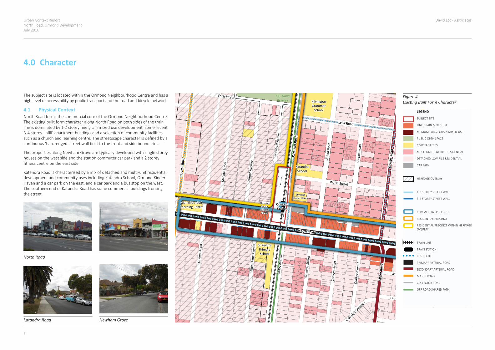
Figure 4 Existing Built Form Character
North Road
Gran
ge R
oad
Jasp
er R
oad
Kata
ndra
Roa
d
Lilim
ur R
oad
Walsh Street
Wicklow Street
Dunl
op A
venu
e
Oakleigh
Crescent
Cadb
y Av
enue
Glen
Orm
e Av
enue
Carly
on S
tree
t
Whe
eler
Str
eet
Que
en S
tree
t
Leinster Street
Holloway Streetulup
na R
oad
Orm
ond
Road
Dalm
ot A
venu
e
New
ham
Gro
ve
Mal
ane
Stre
et
Foch Street
KatandraSchool
OrmondStation
OrmondKinder Haven
KilvingtonGrammar
School
OrmondSeniorCitizensCentre
OrmondAnglicanChurch
St Kevin’sPrimarySchool
Boor
an R
oad
Whe
atle
y Ro
ad
Leila Road
Glen Eira Adult Learning Centre
Lilim
ur R
oad
Walsh Street
Wicklow Street
Dunl
op A
venu
e
Oakleigh
Crescent
Cadb
y Av
enue
Glen
Orm
e Av
enue
Carly
on S
tree
t
Whe
eler
Str
eet
Que
en S
tree
t
Leinster Street
Holloway StreetUlu
pna
Road
Orm
ond
Road
Dalm
ot A
venu
e
New
ham
Gro
ve
Mal
ane
Stre
et
Foch Street
KatandraSchool
OrmondKinder Haven
KilvingtonGrammar
School
OrmondSeniorCitizensCentre
OrmondAnglicanChurch
Glen Eira Adult Learning Centre
St Kevin’sPrimarySchool
Gran
ge R
oad
Jasp
er R
oad
Kata
ndra
Roa
d
Boor
an R
oad
Whe
atle
y Ro
ad
Leila Road
North Road
OrmondStation
JoycePark
E.E. GunnReserve
LEVEL 2, 166 ALBERT ROADSOUTH MELBOURNE VIC 3205t 03 9682 8568 f 03 9682 1221www.dlaaust.com
436-442 MT ALEXANDER ROAD, ASCOT VALE
PMP001
21 SEPTEMBER 2015
NTS
JOB :
CODE :
DATE :
SCALE :
CHARACTER
LEGEND
SUBJECT SITE
FINE GRAIN MIXED-USE
MEDIUM-LARGE GRAIN MIXED-USE
PUBLIC OPEN SPACE
CIVIC FACILITIES
MULTI-UNIT LOW RISE RESIDENTIAL
DETACHED LOW RISE RESIDENTIAL
CAR PARK
HERITAGE OVERLAY
1-2 STOREY STREET WALL
3-4 STOREY STREET WALL
COMMERCIAL PRECINCT
RESIDENTIAL PRECINCT
RESIDENTIAL PRECINCT WITHIN HERITAGE OVERLAY
TRAIN LINE
TRAIN STATION
BUS ROUTE
PRIMARY ARTERIAL ROAD
SECONDARY ARTERIAL ROAD
MAJOR ROAD
COLLECTOR ROAD
OFF-ROAD SHARED PATH
Katandra Road
North Road
Newham Grove
4.0 Character
ThesubjectsiteislocatedwithintheOrmondNeighbourhoodCentreandhasahigh level of accessibility by public transport and the road and bicycle network.
4.1 Physical ContextNorth Road forms the commercial core of the Ormond Neighbourhood Centre. TheexistingbuiltformcharacteralongNorthRoadonbothsidesofthetrainlineisdominatedby1-2storeyfinegrainmixedusedevelopment,somerecent3-4storey‘infill’apartmentbuildingsandaselectionofcommunityfacilitiessuchasachurchandlearningcentre.Thestreetscapecharacterisdefinedbyacontinuous‘hard-edged’streetwallbuilttothefrontandsideboundaries.
ThepropertiesalongNewhamGrovearetypicallydevelopedwithsinglestoreyhousesonthewestsideandthestationcommutercarparkanda2storeyfitnesscentreontheeastside.
KatandraRoadischaracterisedbyamixofdetachedandmulti-unitresidentialdevelopmentandcommunityusesincludingKatandraSchool,OrmondKinderHavenandacarparkontheeast,andacarparkandabusstoponthewest.ThesouthernendofKatandraRoadhassomecommercialbuildingsfrontingthe street.

Urban Context ReportNorth Road, Ormond Development
July 2016
David Lock Associates
6 7
Figure 6 Planning Overlays
N O R T H R D
KA
TA
ND
RA
R
D
BO
OR
AN
R
D
UL U
PN
A
RD
AN
TH
ON
Y
S
T
NE
WH
AM
G
R
WH
EE
L ER
ST
N O R T H R D
KA
TA
ND
RA
R
D
BO
OR
AN
R
D
UL U
PN
A
RD
AN
TH
ON
Y
S
T
NE
WH
AM
G
R
WH
EE
L ER
ST
LEGEND
SUBJECT SITE
HERITAGE OVERLAY
PARKING OVERLAY
SPECIAL BUILDING OVERLAY
LEVEL 2, 166 ALBERT ROADSOUTH MELBOURNE VIC 3205t 03 9682 8568 f 03 9682 1221www.dlaaust.com
436-442 MT ALEXANDER ROAD, ASCOT VALE
PMP001
21 SEPTEMBER 2015
NTS
JOB :
CODE :
DATE :
SCALE :
URBAN CONTEXT
N O R T H R D
KA
TA
ND
RA
R
D
BO
OR
AN
R
D
UL U
PN
A
RD
AN
TH
ON
Y
S
T
NE
WH
AM
G
R
WH
EE
L ER
ST
N O R T H R D
KA
TA
ND
RA
R
D
BO
OR
AN
R
D
UL U
PN
A
RD
AN
TH
ON
Y
S
T
NE
WH
AM
G
R
WH
EE
L ER
ST
LEGEND
SUBJECT SITE
HERITAGE OVERLAY
PARKING OVERLAY
SPECIAL BUILDING OVERLAY
LEVEL 2, 166 ALBERT ROADSOUTH MELBOURNE VIC 3205t 03 9682 8568 f 03 9682 1221www.dlaaust.com
436-442 MT ALEXANDER ROAD, ASCOT VALE
PMP001
21 SEPTEMBER 2015
NTS
JOB :
CODE :
DATE :
SCALE :
URBAN CONTEXT
4.2 Policy ContextThere is extensive policy at State and local level that requires new development to respect the character and heritage values of the surrounding area(forexample,seeclauses15,16,21.04and22.07).However,thispolicymustbeconsideredalongsideotherpolicythatsupportsurbanconsolidationandincreasedhousingdensityinthislocation(seeclauses11,16,21.04and22.07).Inparticular,thepolicysupportsincreaseddensityinwell-servicedlocationssuchasOrmondNeighbourhoodCentre.
PlanMelbournerecognisesthepotentialforredevelopmentinprecinctsaround train corridors and where level crossings are to be removed. It plans fortheremovaloftheNorthRoad,Ormondlevelcrossing.
TheMSSseekstofacilitateresidentialdevelopmentinappropriatelocationsincludingactivitycentres,nearpublictransportandservices,keyredevelopmentsitesandotherstrategiclocations(Clauses21.03,21.04and21.06).
Clause22.07identifiesthelocationofhousingdiversityareasinthemunicipality.Itseekstoprovidearangeofhousingtypesincludingmulti-unitdevelopmentsinstrategiclocationsthathavegoodaccesstopublictransport(includingincloseproximitytofixedpublictransport),commercial,communityandinstitutionalservices.Thepolicyseekstoensurethatthedensityofresidentialdevelopmentiscommensuratetothelocation,roleandneighbourhoodcharacterofeachdiversity area.
Thelandat483ANorthRoad&1NewhamGrove,OrmondiszonedPublicUseZone–Transport(PUZ4).Thislandistobeusedforpublicutilityandcommunityservicesandfacilities.ThePUZseekstoprovideforassociatedusesthatareconsistentwiththeintentofthepubliclandreservationorpurpose.
AsmallportionofthesiteiszonedGeneralResidentialZone1,whichseekstoprovideadiversityofhousingtypesandmoderatehousinggrowthinlocationsofferinggoodaccesstoservicesandtransport.ThescheduletotheGRZcontainsamandatorymaximumheightof10.5m,or11.5mwheretheslopeofthenaturalgroundatanycrosssectionwiderthan8metresis2.5degreesormore.
MostpropertiesalongNorthRoadarewithintheCommercial1ZoneorMixedUseZone.SomepropertiesimmediatelywestofthesitearewithintheHeritageOverlay.TheresidentialareaalongNewhamGrove(includingthepropertyimmediatelynorthofthesite)iswithintheHeritageOverlay.TheresidentialareasurroundingthesubjectsiteiswithinGeneralResidentialZone(GRZ1)thatallowsforamaximumheightof3storeys.However,theHeritageOverlayalongNewhamGrovewilllimitdevelopmentopportunitiesandretaintheexistinglow-risebuiltcharacter.
Figure 5 Planning Zones
N O R T H R D
KA
TA
ND
RA
R
D
BO
OR
AN
R
D
UL U
PN
A
RD
AN
TH
ON
Y
S
T
NE
WH
AM
G
R
WH
EE
L ER
ST
N O R T H R D
KA
TA
ND
RA
R
D
BO
OR
AN
R
D
UL U
PN
A
RD
AN
TH
ON
Y
S
T
NE
WH
AM
G
R
WH
EE
L ER
ST
GRZ1 GRZ1
PUZ4
GRZ1 GRZ1
C1Z
C1Z
MUZ
GRZ1 GRZ1
PUZ4
GRZ1 GRZ1
C1Z
C1Z
MUZ
LEGEND
SUBJECT SITE
PUBLIC PARK AND RECREATION ZONE
PUBLIC USE ZONE - TRANSPORT
COMMERCIAL 1 ZONE
MIXED USE ZONE
GENERAL RESIDENTIAL ZONE
NEIGHBOURHOOD RESIDENTIAL ZONE
ROAD ZONE
LEVEL 2, 166 ALBERT ROADSOUTH MELBOURNE VIC 3205t 03 9682 8568 f 03 9682 1221www.dlaaust.com
436-442 MT ALEXANDER ROAD, ASCOT VALE
PMP001
21 SEPTEMBER 2015
NTS
JOB :
CODE :
DATE :
SCALE :
URBAN CONTEXT
N O R T H R D
KA
TA
ND
RA
R
D
BO
OR
AN
R
D
UL U
PN
A
RD
AN
TH
ON
Y
S
T
NE
WH
AM
G
R
WH
EE
L ER
ST
N O R T H R D
KA
TA
ND
RA
R
D
BO
OR
AN
R
D
UL U
PN
A
RD
AN
TH
ON
Y
S
T
NE
WH
AM
G
R
WH
EE
L ER
ST
GRZ1 GRZ1
PUZ4
GRZ1 GRZ1
C1Z
C1Z
MUZ
GRZ1 GRZ1
PUZ4
GRZ1 GRZ1
C1Z
C1Z
MUZ
LEGEND
SUBJECT SITE
PUBLIC PARK AND RECREATION ZONE
PUBLIC USE ZONE - TRANSPORT
COMMERCIAL 1 ZONE
MIXED USE ZONE
GENERAL RESIDENTIAL ZONE
NEIGHBOURHOOD RESIDENTIAL ZONE
ROAD ZONE
LEVEL 2, 166 ALBERT ROADSOUTH MELBOURNE VIC 3205t 03 9682 8568 f 03 9682 1221www.dlaaust.com
436-442 MT ALEXANDER ROAD, ASCOT VALE
PMP001
21 SEPTEMBER 2015
NTS
JOB :
CODE :
DATE :
SCALE :
URBAN CONTEXT
Urban Context ReportNorth Road, Ormond DevelopmentJuly 2016
David Lock Associates
8 9
North Road
New
ham
Gro
ve
Kata
ndra
Roa
d
North Road
New
ham
Gro
ve
Kata
ndra
Roa
d
A
B
C
A
B
C
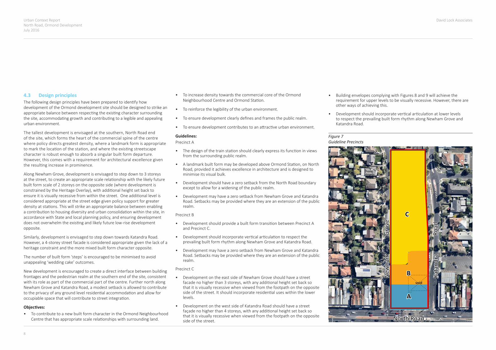
Figure 7 Guideline Precincts
void
4.3 Design principlesThefollowingdesignprincipleshavebeenpreparedtoidentifyhowdevelopment of the Ormond development site should be designed to strike an appropriatebalancebetweenrespectingtheexistingcharactersurroundingthesite,accommodatinggrowthandcontributingtoalegibleandappealingurban environment.
Thetallestdevelopmentisenvisagedatthesouthern,NorthRoadendofthesite,whichformstheheartofthecommercialspineofthecentrewherepolicydirectsgreatestdensity,wherealandmarkformisappropriatetomarkthelocationofthestation,andwheretheexistingstreetscapecharacter is robust enough to absorb a singular built form departure. However,thiscomeswitharequirementforarchitecturalexcellencegiventheresultingincreaseinprominence.
AlongNewhamGrove,developmentisenvisagedtostepdownto3storeysatthestreet,tocreateanappropriatescalerelationshipwiththelikelyfuturebuilt form scale of 2 storeys on the opposite side (where development is constrainedbytheHeritageOverlay),withadditionalheightsetbacktoensureitisvisuallyrecessivefromwithinthestreet.Oneadditionallevelisconsidered appropriate at the street edge given policy support for greater densityatstations.Thiswillstrikeanappropriatebalancebetweenenablingacontributiontohousingdiversityandurbanconsolidationwithinthesite,inaccordancewithStateandlocalplanningpolicy,andensuringdevelopmentdoesnotoverwhelmtheexistingandlikelyfuturelow-risedevelopmentopposite.
Similarly,developmentisenvisagedtostepdowntowardsKatandraRoad.However,a4-storeystreetfacadeisconsideredappropriategiventhelackofaheritage constraint and the more mixed built form character opposite.
Thenumberofbuiltform‘steps’isencouragedtobeminimisedtoavoidunappealing‘weddingcake’outcomes.
New development is encouraged to create a direct interface between building frontagesandthepedestrianrealmatthesouthernendofthesite,consistentwith its role as part of the commercial part of the centre. Further north along NewhamGroveandKatandraRoad,amodestsetbackisallowedtocontributetotheprivacyofanygroundlevelresidentialaccommodationandallowforoccupiablespacethatwillcontributetostreetintegration.
Objectives:• To contribute to a new built form character in the Ormond Neighbourhood
Centrethathasappropriatescalerelationshipswithsurroundingland.
• To increase density towards the commercial core of the Ormond NeighbourhoodCentreandOrmondStation.
• To reinforce the legibility of the urban environment.
• Toensuredevelopmentclearlydefinesandframesthepublicrealm.
• Toensuredevelopmentcontributestoanattractiveurbanenvironment.
Guidelines: Precinct A
• Thedesignofthetrainstationshouldclearlyexpressitsfunctioninviewsfrom the surrounding public realm.
• AlandmarkbuiltformmaybedevelopedaboveOrmondStation,onNorthRoad,provideditachievesexcellenceinarchitectureandisdesignedtominimise its visual bulk.
• DevelopmentshouldhaveazerosetbackfromtheNorthRoadboundaryexcept to allow for a widening of the public realm.
• DevelopmentmayhaveazerosetbackfromNewhamGroveandKatandraRoad. Setbacks may be provided where they are an extension of the public realm.
Precinct B
• DevelopmentshouldprovideabuiltformtransitionbetweenPrecinctAand Precinct C.
• DevelopmentshouldincorporateverticalarticulationtorespecttheprevailingbuiltformrhythmalongNewhamGroveandKatandraRoad.
• DevelopmentmayhaveazerosetbackfromNewhamGroveandKatandraRoad. Setbacks may be provided where they are an extension of the public realm.
Precinct C
• DevelopmentontheeastsideofNewhamGroveshouldhaveastreetfacadenohigherthan3storeys,withanyadditionalheightsetbacksothat it is visually recessive when viewed from the footpath on the opposite sideofthestreet.Itshouldincorporateresidentialuseswithinthelowerlevels.
• Development on the west side of Katandra Road should have a street façadenohigherthan4storeys,withanyadditionalheightsetbacksothat it is visually recessive when viewed from the footpath on the opposite side of the street.
• Building envelopes complying with Figures 8 and 9 will achieve the requirementforupperlevelstobevisuallyrecessive.However,thereareother ways of achieving this.
• DevelopmentshouldincorporateverticalarticulationatlowerlevelstorespecttheprevailingbuiltformrhythmalongNewhamGroveandKatandra Road.

Urban Context ReportNorth Road, Ormond Development
July 2016
David Lock Associates
8 9
Figure 8 Preferred built form along Newham Grove within Precinct C
Figure 9 Preferred built form along Katandra Road within Precinct C
Need to update
15m Newham Grove
Road Reserve Front Setback Foot-
pathNature
StripFoot-path
On-street car park
Front Setback0-2m
General Residential Zone (GRZ1)
20m Katandra Road
Road Reserve Verge Front SetbackVergeFront Setback
0-2m
General Residential Zone (GRZ1)On-street
car park
• Developmentmayhaveazerostreetsetback,orifthereistobeasetbackit can be up to 2m.
General
• Developmentshouldmaintainacoherentoverallbuiltformcompositionbyminimisingthenumberofelementswithdifferentsetbacks.
Urban Context ReportNorth Road, Ormond DevelopmentJuly 2016
David Lock Associates
10 11
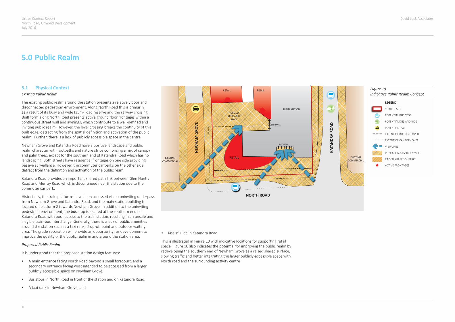
• Kiss‘n’RideinKatandraRoad.
ThisisillustratedinFigure10withindicativelocationsforsupportingretailspace.Figure10alsoindicatesthepotentialforimprovingthepublicrealmbyredevelopingthesouthernendofNewhamGroveasaraisedsharedsurface,slowingtrafficandbetterintegratingthelargerpublicly-accessiblespacewithNorthroadandthesurroundingactivitycentre
TRAIN STATION
ENTRANCE
ENTRANCE
EXISTING COMMERCIAL
EXISTING COMMERCIAL
RETAILRETAIL
NORTH ROAD
RETAIL
KATA
NDR
A RO
AD
NEW
HAM
GRO
VE
INDICATIVE PUBLIC REALM CONCEPT
PUBLICLY ACCESSIBLE
SPACE
LEVEL 2, 166 ALBERT ROADSOUTH MELBOURNE VIC 3205t 03 9682 8568 f 03 9682 1221www.dlaaust.com
VALUE CAPTURE SITE AT ORMOND STATION
BDCR005
9 OCTOBER 2015
NTS
JOB :
CODE :
DATE :
SCALE :
INDICATIVE PUBLIC REALM CONCEPT
LEGEND
SUBJECT SITE
POTENTIAL BUS STOP
POTENTIAL KISS AND RIDE
POTENTIAL TAXI
EXTENT OF BUILDING OVER
EXTENT OF CANPOPY OVER
VIEWLINES
PUBLICLY ACCESSIBLE SPACE
RAISED SHARED SURFACE
ACTIVE FRONTAGES
5.0 Public Realm
5.1 Physical ContextExisting Public Realm
Theexistingpublicrealmaroundthestationpresentsarelativelypooranddisconnected pedestrian environment. Along North Road this is primarily asaresultofitsbusyandwide(35m)roadreserveandtherailwaycrossing.BuiltformalongNorthRoadpresentsactivegroundfloorfrontageswithinacontinuousstreetwallandawnings,whichcontributetoawell-definedandinvitingpublicrealm.However,thelevelcrossingbreaksthecontinuityofthisbuiltedge,detractingfromthespatialdefinitionandactivationofthepublicrealm.Further,thereisalackofpubliclyaccessiblespaceinthecentre.
NewhamGroveandKatandraRoadhaveapositivelandscapeandpublicrealm character with footpaths and nature strips comprising a mix of canopy andpalmtrees,exceptforthesouthernendofKatandraRoadwhichhasnolandscaping.Bothstreetshaveresidentialfrontagesononesideprovidingpassivesurveillance.However,thecommutercarparksontheothersidedetractfromthedefinitionandactivationofthepublicream.
KatandraRoadprovidesanimportantsharedpathlinkbetweenGlenHuntlyRoadandMurrayRoadwhichisdiscontinuednearthestationduetothecommuter car park.
Historically,thetrainplatformshavebeenaccessedviaanuninvitingunderpassfromNewhamGroveandKatandraRoad,andthemainstationbuildingislocatedonplatform2towardsNewhamGrove.Inadditiontotheuninvitingpedestrianenvironment,thebusstopislocatedatthesouthernendofKatandraRoadwithpooraccesstothetrainstation,resultinginanunsafeandillegibletrain-businterchange.Generally,thereisalackofpublicamenitiesaroundthestationsuchasataxirank,drop-offpointandoutdoorwaitingarea.Thegradeseparationwillprovideanopportunityfordevelopmenttoimprovethequalityofthepublicrealminandaroundthestationarea.
Proposed Public Realm
Itisunderstoodthattheproposedstationdesignfeatures:
• AmainentrancefacingNorthRoadbeyondasmallforecourt,andasecondary entrance facing west intended to be accessed from a larger publiclyaccessiblespaceonNewhamGrove;
• BusstopsinNorthRoadinfrontofthestationandonKatandraRoad;
• AtaxirankinNewhamGrove;and
TRAIN STATION
ENTRANCE
ENTRANCE
EXISTING COMMERCIAL
EXISTING COMMERCIAL
RETAILRETAIL
NORTH ROAD
RETAIL
KATA
NDR
A RO
AD
NEW
HAM
GRO
VE
INDICATIVE PUBLIC REALM CONCEPT
PUBLICLY ACCESSIBLE
SPACE
LEVEL 2, 166 ALBERT ROADSOUTH MELBOURNE VIC 3205t 03 9682 8568 f 03 9682 1221www.dlaaust.com
VALUE CAPTURE SITE AT ORMOND STATION
BDCR005
9 OCTOBER 2015
NTS
JOB :
CODE :
DATE :
SCALE :
INDICATIVE PUBLIC REALM CONCEPT
LEGEND
SUBJECT SITE
POTENTIAL BUS STOP
POTENTIAL KISS AND RIDE
POTENTIAL TAXI
EXTENT OF BUILDING OVER
EXTENT OF CANPOPY OVER
VIEWLINES
PUBLICLY ACCESSIBLE SPACE
RAISED SHARED SURFACE
ACTIVE FRONTAGES
Figure 10 Indicative Public Realm Concept
Urban Context ReportNorth Road, Ormond Development
July 2016
David Lock Associates
10 11
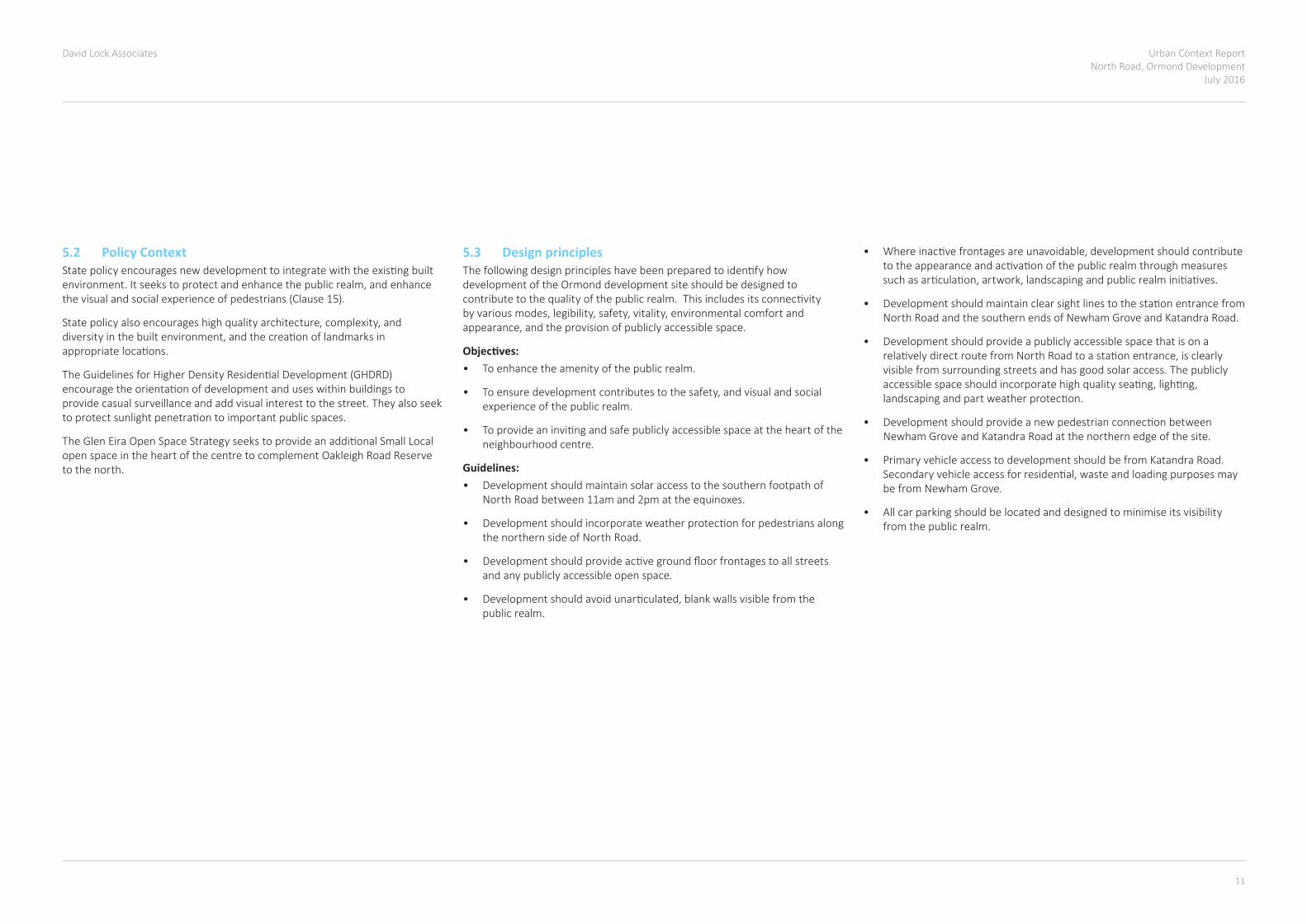
5.2 Policy Context Statepolicyencouragesnewdevelopmenttointegratewiththeexistingbuiltenvironment.Itseekstoprotectandenhancethepublicrealm,andenhancethevisualandsocialexperienceofpedestrians(Clause15).
Statepolicyalsoencourageshighqualityarchitecture,complexity,anddiversityinthebuiltenvironment,andthecreationoflandmarksinappropriatelocations.
TheGuidelinesforHigherDensityResidentialDevelopment(GHDRD)encouragetheorientationofdevelopmentanduseswithinbuildingstoprovide casual surveillance and add visual interest to the street. They also seek toprotectsunlightpenetrationtoimportantpublicspaces.
TheGlenEiraOpenSpaceStrategyseekstoprovideanadditionalSmallLocalopen space in the heart of the centre to complement Oakleigh Road Reserve to the north.
5.3 Design principles Thefollowingdesignprincipleshavebeenpreparedtoidentifyhowdevelopment of the Ormond development site should be designed to contributetothequalityofthepublicrealm.Thisincludesitsconnectivitybyvariousmodes,legibility,safety,vitality,environmentalcomfortandappearance,andtheprovisionofpubliclyaccessiblespace.
Objectives:• To enhance the amenity of the public realm.
• Toensuredevelopmentcontributestothesafety,andvisualandsocialexperience of the public realm.
• Toprovideaninvitingandsafepubliclyaccessiblespaceattheheartoftheneighbourhood centre.
Guidelines:• Development should maintain solar access to the southern footpath of
North Road between 11am and 2pm at the equinoxes.
• Developmentshouldincorporateweatherprotectionforpedestriansalongthe northern side of North Road.
• Developmentshouldprovideactivegroundfloorfrontagestoallstreetsand any publicly accessible open space.
• Developmentshouldavoidunarticulated,blankwallsvisiblefromthepublic realm.
• Whereinactivefrontagesareunavoidable,developmentshouldcontributetotheappearanceandactivationofthepublicrealmthroughmeasuressuchasarticulation,artwork,landscapingandpublicrealminitiatives.
• DevelopmentshouldmaintainclearsightlinestothestationentrancefromNorthRoadandthesouthernendsofNewhamGroveandKatandraRoad.
• Development should provide a publicly accessible space that is on a relativelydirectroutefromNorthRoadtoastationentrance,isclearlyvisible from surrounding streets and has good solar access. The publicly accessiblespaceshouldincorporatehighqualityseating,lighting,landscapingandpartweatherprotection.
• DevelopmentshouldprovideanewpedestrianconnectionbetweenNewhamGroveandKatandraRoadatthenorthernedgeofthesite.
• Primary vehicle access to development should be from Katandra Road. Secondaryvehicleaccessforresidential,wasteandloadingpurposesmaybefromNewhamGrove.
• All car parking should be located and designed to minimise its visibility from the public realm.
Urban Context ReportNorth Road, Ormond DevelopmentJuly 2016
David Lock Associates
12 13
NORTH ROAD
KATANDRA ROAD
NEWHAM GROVE
PRECINCT BPRECINCT C
PRECINCT C
PRECINCT A
PRECINCT APRECINCT B
PRECINCT A76M AHD
PRECINCT B67M AHD
PRECINCT C57M AHD
Shadow diagrams have been generatedon an estimated urban topography andwill defer in existing conditions.
TOW
N PLAN
NIN
G
DR
AWIN
G TITLE
PRO
JECT N
AME
Builders/Contractors shall verify job dim
ensions before any job comm
ences. Figured dimensions shall take precedence over scaled w
ork. Work shall also conform
to the specification, other drawings and job
dimensions. All shop draw
ings shall be submitted to the Architect/C
onsultant and manufacture shall not com
mence prior to the return of inspected shop draw
ings signed by the Architect/Consultant. ©
Copyright
2008 All rights reserved
Hayball Pty Ltd4/ 135 Sturt Street SouthbankVictoria Australia 3006T 03 9699 3644 F 03 9699 3708w
ww
.hayball.com.au
NSW Nom
inated Architects:Tom
Jordan 7521,R
ichard Leonard 7522,R
obert Stent 7523,G
eoffrey Ham
mer 5147
ABN 84 006 394 261
CH
ECKED
SCALE
DR
AWN
BYPR
OJEC
T NO
DW
G N
OR
EVISION
DATE PR
INTED
STATUS
PRO
JECT AD
DR
ESS 1 : 500@
A0O
RMO
ND STATION DEVELO
PMENT
CDP SUN STUDY EQUINO
X 22 SEPTEMBER
10AM
AuthorC
hecker2026
A2507/26/16
NORTH ROAD
KATANDRA ROAD
NEWHAM GROVE
PRECINCT BPRECINCT C
PRECINCT C
PRECINCT A
PRECINCT APRECINCT B
PRECINCT A76M AHD
PRECINCT B67M AHD
PRECINCT C57M AHD
Shadow diagrams have been generatedon an estimated urban topography andwill defer in existing conditions.
TO
WN
PLA
NN
ING
DR
AW
ING
TIT
LE
PR
OJE
CT
NA
ME
Bu
ilders
/Con
tracto
rs s
ha
ll verify jo
b d
imen
sio
ns b
efo
re a
ny jo
b c
om
men
ces. F
igu
red
dim
en
sio
ns s
hall ta
ke p
rece
den
ce o
ver s
cale
d w
ork
. Wo
rk s
hall a
lso c
on
form
to th
e s
pecific
atio
n, o
ther d
raw
ings a
nd jo
bdim
en
sio
ns. A
ll sh
op d
raw
ings s
hall b
e s
ubm
itted to
the A
rch
itect/C
on
su
ltan
t an
d m
an
ufa
ctu
re s
hall n
ot c
om
me
nce p
rior to
the re
turn
of in
sp
ecte
d s
ho
p d
raw
ing
s s
ign
ed b
y the A
rch
itect/C
on
su
ltan
t. © C
opyrig
ht
20
08
All rig
hts
rese
rved
Hayb
all P
ty Ltd
4/ 1
35 S
turt S
treet S
outh
ba
nk
Vic
toria
Austra
lia 3
006
T 0
3 9
69
9 3
644
F 0
3 9
699
37
08
ww
w.h
ayb
all.c
om
.au
NS
W N
om
inate
d A
rch
itects
:T
om
Jord
an 7
521,
Ric
ha
rd L
eonard
752
2,
Robe
rt Ste
nt 7
52
3,
Geoffre
y Ha
mm
er 5
147
AB
N 8
4 0
06 3
94 2
61
CH
EC
KE
D
SC
ALE
DR
AW
N B
YP
RO
JE
CT
NO
DW
G N
OR
EV
ISIO
N
DA
TE
PR
INT
ED
ST
AT
US
PR
OJE
CT
AD
DR
ES
S
1 : 5
00@
A0
OR
MO
ND
ST
AT
ION
DE
VE
LO
PM
EN
TC
DP
SU
N S
TU
DY
11A
MA
uth
or
Checker
2026
A26
11/1
0/1
5
NORTH ROAD
KATANDRA ROAD
NEWHAM GROVE
PRECINCT BPRECINCT C
PRECINCT C
PRECINCT A
PRECINCT APRECINCT B
PRECINCT A76M AHD
PRECINCT B67M AHD
PRECINCT C57M AHD
Shadow diagrams have been generatedon an estimated urban topography andwill defer in existing conditions.
TOW
N PLAN
NIN
G
DR
AWIN
G TITLE
PRO
JECT N
AME
Builders/Contractors shall verify job dim
ensions before any job comm
ences. Figured dimensions shall take precedence over scaled w
ork. Work shall also conform
to the specification, other drawings and job
dimensions. All shop draw
ings shall be submitted to the Architect/C
onsultant and manufacture shall not com
mence prior to the return of inspected shop draw
ings signed by the Architect/Consultant. ©
Copyright
2008 All rights reserved
Hayball Pty Ltd4/ 135 Sturt Street SouthbankVictoria Australia 3006T 03 9699 3644 F 03 9699 3708w
ww
.hayball.com.au
NSW Nom
inated Architects:Tom
Jordan 7521,R
ichard Leonard 7522,R
obert Stent 7523,G
eoffrey Ham
mer 5147
ABN 84 006 394 261
CH
ECKED
SCALE
DR
AWN
BYPR
OJEC
T NO
DW
G N
OR
EVISION
DATE PR
INTED
STATUS
PRO
JECT AD
DR
ESS 1 : 500@
A0O
RMO
ND STATION DEVELO
PMENT
CDP SUN STUDY EQUINO
X 22 SEPTEMBER
9AM
AuthorC
hecker2026
A2411/10/15
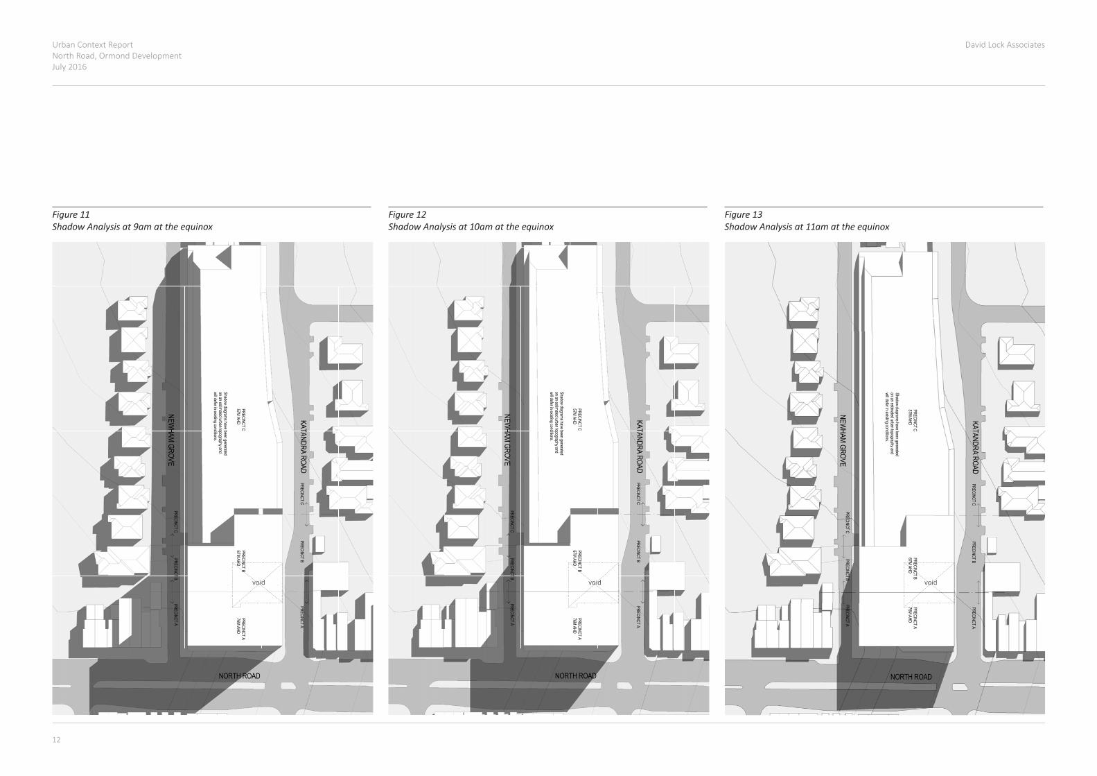
Figure 13 Shadow Analysis at 11am at the equinox
Figure 11 Shadow Analysis at 9am at the equinox
Figure 12 Shadow Analysis at 10am at the equinox
void void void
Urban Context ReportNorth Road, Ormond Development
July 2016
David Lock Associates
12 13
NORTH ROAD
KATANDRA ROAD
NEWHAM GROVE
PRECINCT BPRECINCT C
PRECINCT C
PRECINCT A
PRECINCT APRECINCT B
PRECINCT A76M AHD
PRECINCT B67M AHD
PRECINCT C57M AHD
Shadow diagrams have been generatedon an estimated urban topography andwill defer in existing conditions.
TO
WN
PLA
NN
ING
DR
AW
ING
TIT
LE
PR
OJE
CT
NA
ME
Bu
ilders
/Con
tracto
rs s
ha
ll verify jo
b d
imen
sio
ns b
efo
re a
ny jo
b c
om
men
ces. F
igu
red
dim
en
sio
ns s
hall ta
ke p
rece
den
ce o
ver s
cale
d w
ork
. Wo
rk s
hall a
lso c
on
form
to th
e s
pecific
atio
n, o
ther d
raw
ings a
nd jo
bdim
en
sio
ns. A
ll sh
op d
raw
ings s
hall b
e s
ubm
itted to
the A
rch
itect/C
on
su
ltan
t an
d m
an
ufa
ctu
re s
hall n
ot c
om
me
nce p
rior to
the re
turn
of in
sp
ecte
d s
ho
p d
raw
ing
s s
ign
ed b
y the A
rch
itect/C
on
su
ltan
t. © C
opyrig
ht
20
08
All rig
hts
rese
rved
Hayb
all P
ty Ltd
4/ 1
35 S
turt S
treet S
outh
ba
nk
Vic
toria
Austra
lia 3
006
T 0
3 9
69
9 3
644
F 0
3 9
699
37
08
ww
w.h
ayb
all.c
om
.au
NS
W N
om
inate
d A
rch
itects
:T
om
Jord
an 7
521,
Ric
ha
rd L
eonard
752
2,
Robe
rt Ste
nt 7
52
3,
Geoffre
y Ha
mm
er 5
147
AB
N 8
4 0
06 3
94 2
61
CH
EC
KE
D
SC
ALE
DR
AW
N B
YP
RO
JE
CT
NO
DW
G N
OR
EV
ISIO
N
DA
TE
PR
INT
ED
ST
AT
US
PR
OJE
CT
AD
DR
ES
S
1 : 5
00@
A0
OR
MO
ND
ST
AT
ION
DE
VE
LO
PM
EN
TC
DP
SU
N S
TU
DY
12P
MA
uth
or
Checker
2026
A27
11/1
0/1
5
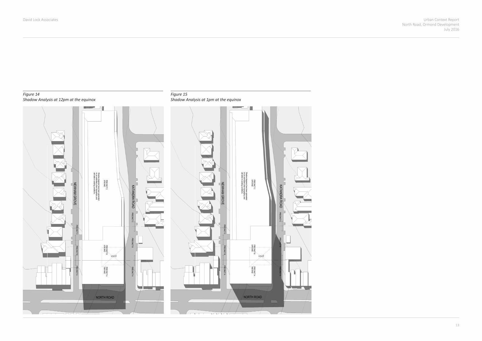
Figure 14 Shadow Analysis at 12pm at the equinox
NORTH ROAD
KATANDRA ROAD
NEWHAM GROVE
PRECINCT BPRECINCT C
PRECINCT C
PRECINCT A
PRECINCT APRECINCT B
PRECINCT A76M AHD
PRECINCT B67M AHD
PRECINCT C57M AHD
Shadow diagrams have been generatedon an estimated urban topography andwill defer in existing conditions.
TO
WN
PLA
NN
ING
DR
AW
ING
TIT
LE
PR
OJE
CT
NA
ME
Bu
ilders
/Con
tracto
rs s
ha
ll verify jo
b d
imen
sio
ns b
efo
re a
ny jo
b c
om
men
ces. F
igu
red
dim
en
sio
ns s
hall ta
ke p
rece
den
ce o
ver s
cale
d w
ork
. Wo
rk s
hall a
lso c
on
form
to th
e s
pecific
atio
n, o
ther d
raw
ings a
nd jo
bdim
en
sio
ns. A
ll sh
op d
raw
ings s
hall b
e s
ubm
itted to
the A
rch
itect/C
on
su
ltan
t an
d m
an
ufa
ctu
re s
hall n
ot c
om
me
nce p
rior to
the re
turn
of in
sp
ecte
d s
ho
p d
raw
ing
s s
ign
ed b
y the A
rch
itect/C
on
su
ltan
t. © C
opyrig
ht
20
08
All rig
hts
rese
rved
Hayb
all P
ty Ltd
4/ 1
35 S
turt S
treet S
outh
ba
nk
Vic
toria
Austra
lia 3
006
T 0
3 9
69
9 3
644
F 0
3 9
699
37
08
ww
w.h
ayb
all.c
om
.au
NS
W N
om
inate
d A
rch
itects
:T
om
Jord
an 7
521,
Ric
ha
rd L
eonard
752
2,
Robe
rt Ste
nt 7
52
3,
Geoffre
y Ha
mm
er 5
147
AB
N 8
4 0
06 3
94 2
61
CH
EC
KE
D
SC
ALE
DR
AW
N B
YP
RO
JE
CT
NO
DW
G N
OR
EV
ISIO
N
DA
TE
PR
INT
ED
ST
AT
US
PR
OJE
CT
AD
DR
ES
S
1 : 5
00@
A0
OR
MO
ND
ST
AT
ION
DE
VE
LO
PM
EN
TC
DP
SU
N S
TU
DY
1P
MA
uth
or
Checker
2026
A28
11/1
0/1
5
Figure 15 Shadow Analysis at 1pm at the equinox
void void

Urban Context ReportNorth Road, Ormond DevelopmentJuly 2016
David Lock Associates
14 15
NORTH ROAD
KATANDRA ROAD
NEWHAM GROVE
PRECINCT BPRECINCT C
PRECINCT C
PRECINCT A
PRECINCT APRECINCT B
PRECINCT A76M AHD
PRECINCT B67M AHD
PRECINCT C57M AHD
Shadow diagrams have been generatedon an estimated urban topography andwill defer in existing conditions.
TO
WN
PLA
NN
ING
DR
AW
ING
TIT
LE
PR
OJE
CT
NA
ME
Bu
ilders
/Con
tracto
rs s
ha
ll verify jo
b d
imen
sio
ns b
efo
re a
ny jo
b c
om
men
ces. F
igu
red
dim
en
sio
ns s
hall ta
ke p
rece
den
ce o
ver s
cale
d w
ork
. Wo
rk s
hall a
lso c
on
form
to th
e s
pecific
atio
n, o
ther d
raw
ings a
nd jo
bdim
en
sio
ns. A
ll sh
op d
raw
ings s
hall b
e s
ubm
itted to
the A
rch
itect/C
on
su
ltan
t an
d m
an
ufa
ctu
re s
hall n
ot c
om
me
nce p
rior to
the re
turn
of in
sp
ecte
d s
ho
p d
raw
ing
s s
ign
ed b
y the A
rch
itect/C
on
su
ltan
t. © C
opyrig
ht
20
08
All rig
hts
rese
rved
Hayb
all P
ty Ltd
4/ 1
35 S
turt S
treet S
outh
ba
nk
Vic
toria
Austra
lia 3
006
T 0
3 9
69
9 3
644
F 0
3 9
699
37
08
ww
w.h
ayb
all.c
om
.au
NS
W N
om
inate
d A
rch
itects
:T
om
Jord
an 7
521,
Ric
ha
rd L
eonard
752
2,
Robe
rt Ste
nt 7
52
3,
Geoffre
y Ha
mm
er 5
147
AB
N 8
4 0
06 3
94 2
61
CH
EC
KE
D
SC
ALE
DR
AW
N B
YP
RO
JE
CT
NO
DW
G N
OR
EV
ISIO
N
DA
TE
PR
INT
ED
ST
AT
US
PR
OJE
CT
AD
DR
ES
S
1 : 5
00@
A0
OR
MO
ND
ST
AT
ION
DE
VE
LO
PM
EN
TC
DP
SU
N S
TU
DY
2P
MA
uth
or
Checker
2026
A29
11/1
0/1
5
NORTH ROAD
KATANDRA ROAD
NEWHAM GROVE
PRECINCT BPRECINCT C
PRECINCT C
PRECINCT A
PRECINCT APRECINCT B
PRECINCT A76M AHD
PRECINCT B67M AHD
PRECINCT C57M AHD
Shadow diagrams have been generatedon an estimated urban topography andwill defer in existing conditions.
TOW
N PLAN
NIN
G
DR
AWIN
G TITLE
PRO
JECT N
AME
Builders/Contractors shall verify job dim
ensions before any job comm
ences. Figured dimensions shall take precedence over scaled w
ork. Work shall also conform
to the specification, other drawings and job
dimensions. All shop draw
ings shall be submitted to the Architect/C
onsultant and manufacture shall not com
mence prior to the return of inspected shop draw
ings signed by the Architect/Consultant. ©
Copyright
2008 All rights reserved
Hayball Pty Ltd4/ 135 Sturt Street SouthbankVictoria Australia 3006T 03 9699 3644 F 03 9699 3708w
ww
.hayball.com.au
NSW Nom
inated Architects:Tom
Jordan 7521,R
ichard Leonard 7522,R
obert Stent 7523,G
eoffrey Ham
mer 5147
ABN 84 006 394 261
CH
ECKED
SCALE
DR
AWN
BYPR
OJEC
T NO
DW
G N
OR
EVISION
DATE PR
INTED
STATUS
PRO
JECT AD
DR
ESS 1 : 500@
A0O
RMO
ND STATION DEVELO
PMENT
CDP SUN STUDY EQUINO
X 22 SEPTEMBER
3PM
AuthorC
hecker2026
A3011/10/15
Figure 16 Shadow Analysis at 2pm at the equinox
Figure 17 Shadow Analysis at 3pm at the equinox
void void

Urban Context ReportNorth Road, Ormond Development
July 2016
David Lock Associates
14 15
KA
TA
ND
RA
R
D
NE
WH
AM
GR
N O R T H R D
KA
TA
ND
RA
R
D
W A L S H S T
NE
WH
AM
GR
LEVEL 2, 166 ALBERT ROADSOUTH MELBOURNE VIC 3205t 03 9682 8568 f 03 9682 1221www.dlaaust.com
436-442 MT ALEXANDER ROAD, ASCOT VALE
PMP001
21 SEPTEMBER 2015
NTS
JOB :
CODE :
DATE :
SCALE :
NEIGHBOURING INTERFACE
LEGEND
SUBJECT SITE
LARGE POTENTIAL REDEVELOPMENT SITE
POTENTIAL REDEVELOPMENT THROUGH SITE AMALGAMATION
LIMITED POTENTIAL REDEVELOPMENT (DUE TO HERTIAGE OVERLAY)
SENSITIVE RESIDENTIAL LAND
SENSITIVE RESIDENTIAL LAND WITH HERITAGE OVERLAY
DIRECT ABUTTAL WITH RESIDENTIAL PROPERTY
COMMUNITY USE
KA
TA
ND
RA
R
D
NE
WH
AM
GR
N O R T H R DK
AT
AN
DR
A
RD
W A L S H S T
NE
WH
AM
GR
LEVEL 2, 166 ALBERT ROADSOUTH MELBOURNE VIC 3205t 03 9682 8568 f 03 9682 1221www.dlaaust.com
436-442 MT ALEXANDER ROAD, ASCOT VALE
PMP001
21 SEPTEMBER 2015
NTS
JOB :
CODE :
DATE :
SCALE :
NEIGHBOURING INTERFACE
LEGEND
SUBJECT SITE
LARGE POTENTIAL REDEVELOPMENT SITE
POTENTIAL REDEVELOPMENT THROUGH SITE AMALGAMATION
LIMITED POTENTIAL REDEVELOPMENT (DUE TO HERTIAGE OVERLAY)
SENSITIVE RESIDENTIAL LAND
SENSITIVE RESIDENTIAL LAND WITH HERITAGE OVERLAY
DIRECT ABUTTAL WITH RESIDENTIAL PROPERTY
COMMUNITY USE
6.0 Neighbouring interfaces
6.1 Physical ContextThesiteonlyhasonedirectabuttalwitharesidentialproperty–thatwith3NewhamGroveatitsnorthernend.DevelopmentofthesitemayalsoinfluencetheamenityoftheresidentialpropertiesacrossNewhamGroveandKatandra Road.
6.2 Policy ContextState policy requires new development to minimise detrimental impact on neighbouringproperties(seeClause15).
The MSS encourages new development to be responsive to its surroundings (Clause21.04).Further,localpolicyatClause22.07providesdesignobjectiveswhichencouragedevelopmenttoachieveabalancedoutcomethatreflectssensitivitytobothsurroundinglandusesandexistingneighbourhoodcharacter whilst providing greater diversity of housing choice.
Inrelationtovisualbulk,Objective2.7oftheGuidelinesforHigherDensityResidentialDevelopment(GHDRD)seeks“Toensurevisualimpactstodwellingsattherearareappropriatetothecontext”.Designsuggestion2.7.1isto“Considerviewsfromdwellingsattherearorsidesofthedevelopment”.
Inrelationtoovershadowing,Objective2.6oftheGHDRDseeks“Toensureareas can develop with equitable access to outlook and sunlight”. Design suggestion2.6.2isto“maintainsunlightanddaylightaccesstoadjoiningprivate open spaces of dwellings in accordance with Clause 55 of Planning Schemes”.
Inrelationtooverlooking,Objective2.9oftheGHDRDseeks“tomaximizeresidentialamenitythroughtheprovisionofviewsandprotectionofprivacywithinthesubjectsiteandonneighbouringproperties”.Designsuggestion2.9.1isto“Locatelivingareas,windowsandprivateopenspacestominimizethepotentialforoverlooking”.
Figure 18 Neighbouring Interfaces

Urban Context ReportNorth Road, Ormond DevelopmentJuly 2016
David Lock Associates
16 17
6.3 Design principles Thefollowingdesignprincipleshavebeenpreparedtoidentifyhowdevelopment of the Ormond development site should be designed to respond appropriatelytoneighbouringproperties.Thisincludesensuringdevelopmentavoidsunreasonableimpactsontheamenityofresidentialproperties.
Objectives:• Tomaintainreasonableamenityinnearbyresidentialproperties.
Guidelines:• Development should maintain solar access to the secluded private open
spaceofnearbyresidentialpropertiesinaccordancewithResCodeStandard B21.
• Developmentshouldavoidunreasonableoverlookingof3NewhamGrovein accordance with ResCode Standard B22.
Urban Context ReportNorth Road, Ormond Development
July 2016
David Lock Associates
16 17
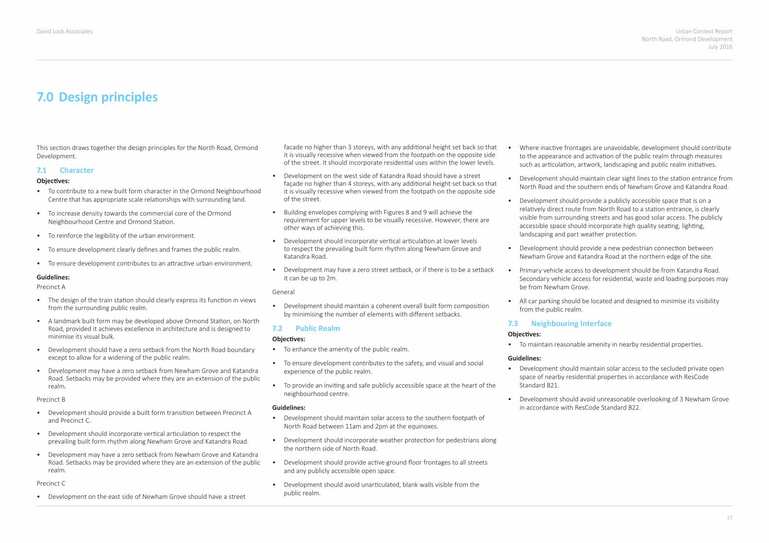
7.0 Design principles
ThissectiondrawstogetherthedesignprinciplesfortheNorthRoad,OrmondDevelopment.
7.1 CharacterObjectives:• To contribute to a new built form character in the Ormond Neighbourhood
Centrethathasappropriatescalerelationshipswithsurroundingland.
• To increase density towards the commercial core of the Ormond NeighbourhoodCentreandOrmondStation.
• To reinforce the legibility of the urban environment.
• Toensuredevelopmentclearlydefinesandframesthepublicrealm.
• Toensuredevelopmentcontributestoanattractiveurbanenvironment.
Guidelines: Precinct A
• Thedesignofthetrainstationshouldclearlyexpressitsfunctioninviewsfrom the surrounding public realm.
• AlandmarkbuiltformmaybedevelopedaboveOrmondStation,onNorthRoad,provideditachievesexcellenceinarchitectureandisdesignedtominimise its visual bulk.
• DevelopmentshouldhaveazerosetbackfromtheNorthRoadboundaryexcept to allow for a widening of the public realm.
• DevelopmentmayhaveazerosetbackfromNewhamGroveand Katandra Road. Setbacks may be provided where they are an extension of the public realm.
Precinct B
• DevelopmentshouldprovideabuiltformtransitionbetweenPrecinctAand Precinct C.
• DevelopmentshouldincorporateverticalarticulationtorespecttheprevailingbuiltformrhythmalongNewhamGroveandKatandraRoad.
• DevelopmentmayhaveazerosetbackfromNewhamGroveandKatandraRoad. Setbacks may be provided where they are an extension of the public realm.
Precinct C
• DevelopmentontheeastsideofNewhamGroveshouldhaveastreet
facadenohigherthan3storeys,withanyadditionalheightsetbacksothatit is visually recessive when viewed from the footpath on the opposite side ofthestreet.Itshouldincorporateresidentialuseswithinthelowerlevels.
• Development on the west side of Katandra Road should have a street façadenohigherthan4storeys,withanyadditionalheightsetbacksothatit is visually recessive when viewed from the footpath on the opposite side of the street.
• Building envelopes complying with Figures 8 and 9 will achieve the requirementforupperlevelstobevisuallyrecessive.However,thereareother ways of achieving this.
• DevelopmentshouldincorporateverticalarticulationatlowerlevelstorespecttheprevailingbuiltformrhythmalongNewhamGroveandKatandra Road.
• Developmentmayhaveazerostreetsetback,orifthereistobeasetbackit can be up to 2m.
General
• Developmentshouldmaintainacoherentoverallbuiltformcompositionbyminimisingthenumberofelementswithdifferentsetbacks.
7.2 Public RealmObjectives:• To enhance the amenity of the public realm.
• Toensuredevelopmentcontributestothesafety,andvisualandsocialexperience of the public realm.
• Toprovideaninvitingandsafepubliclyaccessiblespaceattheheartoftheneighbourhood centre.
Guidelines:• Development should maintain solar access to the southern footpath of
North Road between 11am and 2pm at the equinoxes.
• Developmentshouldincorporateweatherprotectionforpedestriansalongthe northern side of North Road.
• Developmentshouldprovideactivegroundfloorfrontagestoallstreetsand any publicly accessible open space.
• Developmentshouldavoidunarticulated,blankwallsvisiblefromthepublic realm.
• Whereinactivefrontagesareunavoidable,developmentshouldcontributetotheappearanceandactivationofthepublicrealmthroughmeasuressuchasarticulation,artwork,landscapingandpublicrealminitiatives.
• DevelopmentshouldmaintainclearsightlinestothestationentrancefromNorthRoadandthesouthernendsofNewhamGroveandKatandraRoad.
• Development should provide a publicly accessible space that is on a relativelydirectroutefromNorthRoadtoastationentrance,isclearlyvisible from surrounding streets and has good solar access. The publicly accessiblespaceshouldincorporatehighqualityseating,lighting,landscapingandpartweatherprotection.
• DevelopmentshouldprovideanewpedestrianconnectionbetweenNewhamGroveandKatandraRoadatthenorthernedgeofthesite.
• Primary vehicle access to development should be from Katandra Road. Secondaryvehicleaccessforresidential,wasteandloadingpurposesmaybefromNewhamGrove.
• All car parking should be located and designed to minimise its visibility from the public realm.
7.3 Neighbouring InterfaceObjectives:• Tomaintainreasonableamenityinnearbyresidentialproperties.
Guidelines:• Development should maintain solar access to the secluded private open
spaceofnearbyresidentialpropertiesinaccordancewithResCodeStandard B21.
• Developmentshouldavoidunreasonableoverlookingof3NewhamGrovein accordance with ResCode Standard B22.
Urban Context ReportNorth Road, Ormond DevelopmentJuly 2016
David Lock Associates
18
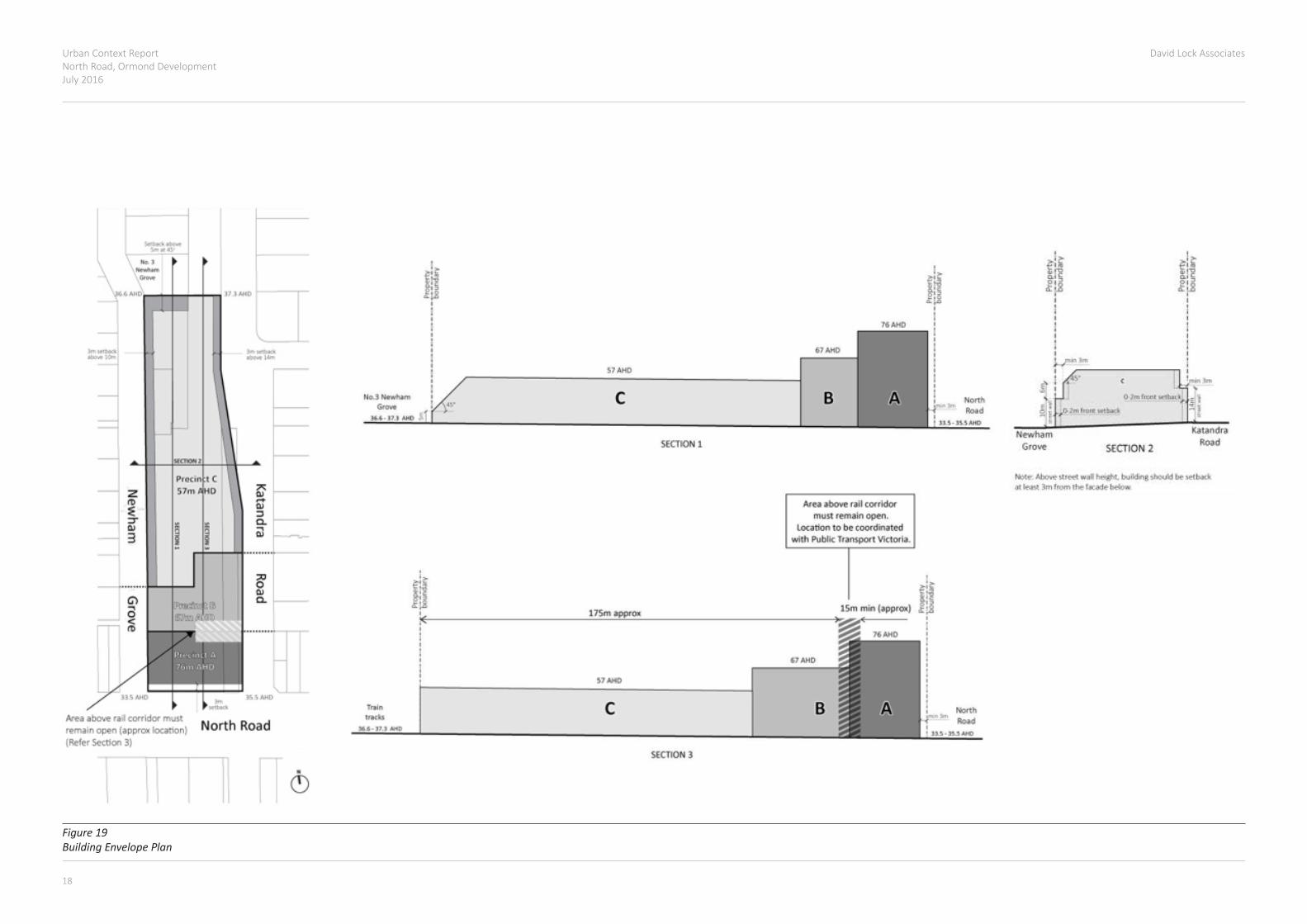
Figure 19 Building Envelope Plan


Level 2/166 Albert Road South Melbourne 3205
Victoria
Australia
t: +61 3 9682 8568
Studio111,50HoltStreet
Surry Hills 2010
NSW
Australia
t: +61 2 9699 2021
www.dlaaust.com
Twitter:@DLA_Australia
PlantasticBlog:dla-plantastic.blogspot.com.au/
Melbourne | Sydney | United Kingdom | Norway | Sweden
Related Documents