GHD | Report for Adani Mining Pty Ltd - North Galilee Basin Rail, 41/26457 | 1 Executive summary Project overview Adani Mining Pty Ltd (Adani) proposes the construction and operation of the North Galilee Basin Rail Project (NGBR Project), a multiuser, standard gauge, greenfield rail line that will transport coal from mines in the northern Galilee Basin to the Port of Abbot Point. The NGBR Project is approximately 300 km in length and connects the proposed Carmichael Coal Mine and Rail Project’s east-west rail corridor, approximately 70 km east of the proposed Carmichael Coal Mine in the vicinity of Mistake Creek, with supporting infrastructure at the Port of Abbot Point (Figure 1). The NGBR Project will have an operational capacity of up to 100 million tonnes per annum (mtpa) of coal product expected to be sourced from both Adani and third-party mines in the northern Galilee Basin. The NGBR Project is proposed in accordance with the Galilee Basin Coal Infrastructure Framework. For the purpose of this Environmental Impact Statement (EIS), the NGBR Project begins at chainage 3.49 km, in the vicinity of the Adani Terminal 0 balloon loop at the Port of Abbot Point in the north. The NGBR Project runs south from this point to its connection with the Carmichael Project (Rail) infrastructure at chainage 306.9 km, west of the Gregory Developmental Road towards Mistake Creek. Need for the Project The Queensland Government’s Queensland Infrastructure Plan guides the development of major infrastructure within the State. Supporting Queensland’s resource regions is a key initiative of the infrastructure plan, with improving rail access between the Galilee Basin and the Port of Abbot Point a specific focus. The NGBR Project is aligned with the State Government’s support for a single north-south and multi-user common access rail corridor in accordance with the Galilee Basin Coal Infrastructure Framework and the Galilee Basin Development Strategy. The NGBR Project provides a more direct route to the Port of Abbot Point in comparison with the existing Goonyella and Newlands rail systems, and meets Adani’s objective of providing a long-term standard gauge rail solution for the northern Galilee Basin. The NGBR Project will also align with the Queensland Governments draft Moving Freight Strategy, which is designed to enable more efficient freight movement across Queensland. The NGBR Project will be strategically significant in a local, regional and state context. The Queensland Regionalisation Strategy considers the development of critical infrastructure associated with the expansion of mining in the Galilee Basin to be a great opportunity for the Mackay, Isaac and Whitsunday region. Opportunities for local employment and business development in the local community will be provided by the NGBR Project, consistent with the Queensland Regionalisation Strategy.

Welcome message from author
This document is posted to help you gain knowledge. Please leave a comment to let me know what you think about it! Share it to your friends and learn new things together.
Transcript
GHD | Report for Adani Mining Pty Ltd - North Galilee Basin Rail, 41/26457 | 1
Executive summary
Project overview
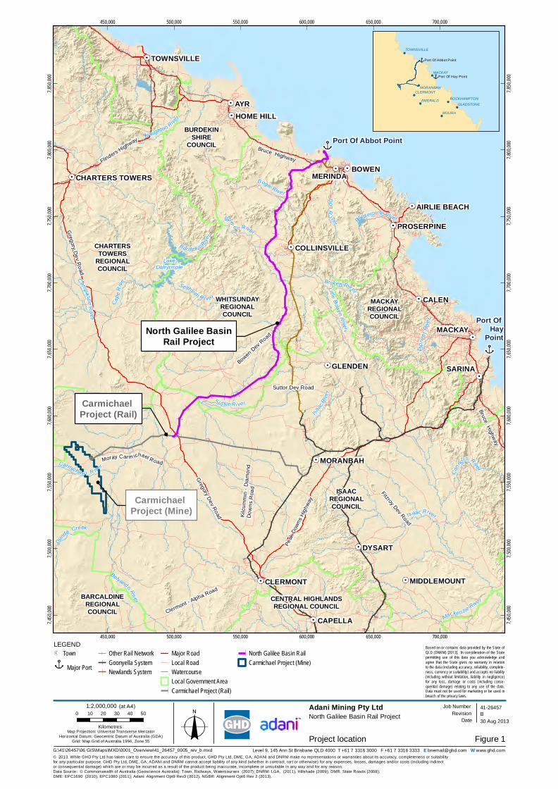
Adani Mining Pty Ltd (Adani) proposes the construction and operation of the North Galilee Basin Rail Project (NGBR Project), a multiuser, standard gauge, greenfield rail line that will transport coal from mines in the northern Galilee Basin to the Port of Abbot Point. The NGBR Project is approximately 300 km in length and connects the proposed Carmichael Coal Mine and Rail Project’s east-west rail corridor, approximately 70 km east of the proposed Carmichael Coal Mine in the vicinity of Mistake Creek, with supporting infrastructure at the Port of Abbot Point (Figure 1). The NGBR Project will have an operational capacity of up to 100 million tonnes per annum (mtpa) of coal product expected to be sourced from both Adani and third-party mines in the northern Galilee Basin.
The NGBR Project is proposed in accordance with the Galilee Basin Coal Infrastructure Framework. For the purpose of this Environmental Impact Statement (EIS), the NGBR Project begins at chainage 3.49 km, in the vicinity of the Adani Terminal 0 balloon loop at the Port of Abbot Point in the north. The NGBR Project runs south from this point to its connection with the Carmichael Project (Rail) infrastructure at chainage 306.9 km, west of the Gregory Developmental Road towards Mistake Creek.
Need for the Project
The Queensland Government’s Queensland Infrastructure Plan guides the development of major infrastructure within the State. Supporting Queensland’s resource regions is a key initiative of the infrastructure plan, with improving rail access between the Galilee Basin and the Port of Abbot Point a specific focus.
The NGBR Project is aligned with the State Government’s support for a single north-south and multi-user common access rail corridor in accordance with the Galilee Basin Coal Infrastructure Framework and the Galilee Basin Development Strategy. The NGBR Project provides a more direct route to the Port of Abbot Point in comparison with the existing Goonyella and Newlands rail systems, and meets Adani’s objective of providing a long-term standard gauge rail solution for the northern Galilee Basin. The NGBR Project will also align with the Queensland Governments draft Moving Freight Strategy, which is designed to enable more efficient freight movement across Queensland.
The NGBR Project will be strategically significant in a local, regional and state context. The Queensland Regionalisation Strategy considers the development of critical infrastructure associated with the expansion of mining in the Galilee Basin to be a great opportunity for the Mackay, Isaac and Whitsunday region. Opportunities for local employment and business development in the local community will be provided by the NGBR Project, consistent with the Queensland Regionalisation Strategy.
Carmichael Project (Rail)
Carmichael Project (Mine)
North Galilee BasinRail Project
Bow
e n RiverDonR
iver
Port Of Hay
Point
Port Of Abbot Point
ISAACREGIONALCOUNCIL
CHARTERSTOWERS
REGIONALCOUNCIL
BURDEKINSHIRE
COUNCIL
WHITSUNDAYREGIONALCOUNCIL
BARCALDINEREGIONALCOUNCIL
CENTRAL HIGHLANDSREGIONAL COUNCIL
MACKAYREGIONALCOUNCIL
Suttor Dev Road
Bowen Dev Road
Bruce Highway
Gregory Dev Road
Fitzroy Dev Road
Bruce Highway
Peak
Down
s High
way
Gregory Dev Road
Flinders Highway
Clermont - Alpha Road
Kilcu
mmin
- Diam
ond
Down
s Roa
d
Moray Car m ichael Road
LakeDalryrmple
Dunda Creek
Carmicha e l R iver
AYR
BOWEN
CALEN
DYSART
SARINA
MACKAY
CAPELLA
GLENDEN
CLERMONT
MORANBAH
HOME HILL
TOWNSVILLE
PROSERPINE
MIDDLEMOUNT
COLLINSVILLE
AIRLIE BEACH
CHARTERS TOWERS
Isaac River
Bur d ekin River
Bogie River
Su ttor Ri ve r
Broken River
Haughton RiverCa
peRi
ve r
Belyando River
Sellheim R ive r
Conno
rs River
Campaspe Ri v er
Pione
erRiv
er
Macke nzie River
Little Bowen River
Proserpine River
Isaac
River
450,000
450,000
500,000
500,000
550,000
550,000
600,000
600,000
650,000
650,000
700,000
700,000
7,450,
000
7,450,
000
7,500,
000
7,500,
000
7,550,
000
7,550,
000
7,600,
000
7,600,
000
7,650,
000
7,650,
000
7,700,
000
7,700,
000
7,750,
000
7,750,
000
7,800,
000
7,800,
000
7,850,
000
7,850,
000
Figure 1
LEGEND
© 2013. While GHD Pty Ltd has taken care to ensure the accuracy of this product, GHD Pty Ltd, DME, GA, ADANI and DNRM make no representations or warranties about its accuracy, completeness or suitabilityfor any particular purpose. GHD Pty Ltd, DME, GA, ADANI and DNRM cannot accept liability of any kind (whether in contract, tort or otherwise) for any expenses, losses, damages and/or costs (including indirector consequential damage) which are or may be incurred as a result of the product being inaccurate, incomplete or unsuitable in any way and for any reason.
Adani Mining Pty LtdNorth Galilee Basin Rail Project
Project location
Data Source: © Commonwealth of Australia (Geoscience Australia): Town, Railways, Watercourses (2007); DNRM: LGA, (2011), Hillshade (2009); DMR: State Roads (2008); DME: EPC1690 (2010), EPC1080 (2011); Adani: Alignment Opt9 Rev3 (2012), NGBR: Alignment Opt6 Rev 2 (2013).
Level 9, 145 Ann St Brisbane QLD 4000 T +61 7 3316 3000 F +61 7 3316 3333 E [email protected] W www.ghd.com
B41-26457
30 Aug 2013Map Projection: Universal Transverse Mercator
Horizontal Datum: Geocentric Datum of Australia (GDA)Grid: Map Grid of Australia 1994, Zone 55
0 10 20 30 40 50
Kilometres
Based on or contains data provided by the State ofQLD (DNRM) [2013]. In consideration of the Statepermitting use of this data you acknowledge andagree that the State gives no warranty in relationto the data (including accuracy, reliability, complete-ness, currency or suitability) and accepts no liability(including without limitation, liability in negligence)for any loss, damage or costs (including conse-quential damage) relating to any use of the data.Data must not be used for marketing or be used inbreach of the privacy laws.
Job NumberRevision
Date
TownMajor Port
Other Rail NetworkGoonyella SystemNewlands System
Major RoadLocal RoadWatercourseLocal Government AreaCarmichael Project (Rail)
North Galilee Basin RailCarmichael Project (Mine)
EMERALD
MOURA
TOWNSVILLE
ROCKHAMPTONGLADSTONE
CLERMONT
MACKAY
MORANBAH
Port Of Hay Point
Port Of Abbot Point
1:2,000,000 (at A4)
G:\41\26457\06 GIS\Maps\MXD\0001_Overview\41_26457_0005_rev_b.mxd
MERINDA
GHD | Report for Adani Mining Pty Ltd - North Galilee Basin Rail, 41/26457 | 3
Alternatives considered
While the development of the proposed NGBR Project is considered the preferred option for standard gauge rail infrastructure to transport coal product out of the northern Galilee Basin, alternatives to the NGBR Project have also been investigated, as well as exploring a ‘do nothing’ option.
Adani has separately considered developing and / or utilising a consolidated corridor with Waratah Coal’s proposed China First Project, or Hancock Coal Infrastructure’s proposed Alpha Coal Project, both of which provide for standard gauge rail infrastructure. However, uncertain development timeframes and the identification of a more direct rail route has left Adani with limited potential for co-use of these railways. Transportation to the Port of Abbot Point, via the proposed Carmichael Coal Mine and Rail Project requires access and utilisation of the existing Aurizon narrow gauge network which presents a number of constraints. The current Goonyella and Newlands systems are narrow gauge, having a much lower axle load with limited capacity for upgrade, all of which combined would act to increase coal prices and reduce the cost-competitiveness of Galilee Basin coal in the global market.
Aurizon is proposing to develop a Central Queensland Integrated Rail Project to service proposed coal mines in the Galilee Basin. This rail project alignment proposed to connect to already congested rail systems, while being a longer and operationally less efficient narrow gauge system compared to the heavy haul standard gauge proposed for the NGBR Project. Opportunities to consolidate the Aurizon and Adani alignments have been explored however, due to uncertainty with regard to Aurizon’s development timelines in addition to the above technical aspects, Adani has decided to propose the much shorter, standard gauge, NGBR Project.
The ‘do nothing’ option will result in increased traffic on Aurizon’s Goonyella and Newlands rail systems and thus increase the bottleneck situation currently being experienced on the existing rail system near Moranbah. Subsequent upgrades to sections of rail are envisaged to be larger in scale and lead to further social and environmental disturbances. Longer rail routes would also increase the cost of producing the coal, which would in turn impact the competitive pricing of coal from the Galilee Basin in the global market.
Project description
Overview
Key features of the NGBR Project include:
Approximately 300 km of standard gauge, bi-directional rail track located within a nominal 100 m wide rail corridor (the final rail corridor)
A rail maintenance access road running parallel to the rail track for approximately 300 km and wholly within the final rail corridor
Seven passing loops, each 4.3 kilometres in length
Signalling infrastructure
Approximately 4.5 kilometres of fill greater than 15 m in depth (11 locations) and approximately 3.4 kilometres of cut greater than 15 m in depth (nine locations)
At-grade and grade-separated road, rail, stock and occupational crossings
4 | GHD | Report for Adani Mining Pty Ltd - North Galilee Basin Rail, 41/26457
Bridge and culvert structures at major waterways and drainage lines, and various other longitudinal and cross drainage structures
A rolling stock maintenance facility near the Port of Abbot Point including provisioning line, train maintenance line, wagon and locomotive service sheds, wash bay and queuing line
Five temporary accommodation camps for construction workers
A temporary construction depot at the southern end of NGBR Project
Temporary construction yards, concrete batching plants, bridge and track laydown areas and heavy vehicle turning circles.
During construction, quarries and borrow pits within acceptable haulage distances will be required to provide a cost effective source of fill, gravel, aggregate and ballast. The number and location of borrow pits and quarries will be investigated further during detailed design and each may require screening and crushing plants to process material.
Pre-construction and construction phase
Construction of the NGBR Project will occur over four phases, summarised in Table 1.
Table 1 Construction schedule
Phase Timeframe (estimated)
Phase 1, Site preparation Late 2014 – 2nd quarter 2015
Phase 2, Drainage structure, earthworks and bridges
4th quarter 2014 – 1st quarter 2016
Phase 3, Track laying 4th quarter 2015 – 3rd quarter 2016
Phase 4, Signalling and communications 3rd quarter 2016 – 4th quarter 2016
Operation phase
The utilisation of the capacity of the NGBR Project will reflect the production of coal from the Carmichael Project (Mine) and utilisation by third-party users. The operation of the NGBR Project is expected commence in 2016 and reach peak capacity of 100 mtpa by 2026. At full capacity (100 mtpa) the following will occur daily:
Nine loaded and unloaded train movements
Five loaded and unloaded train movements.
Decommissioning and rehabilitation
Temporary construction infrastructure will be decommissioned as soon as they cease to serve their intended purpose. The sites of the decommissioned infrastructure will then be rehabilitated to a state consistent with the natural environment.
Statutory framework
Following the lodgement of an initial advice statement, the Coordinator General (CG) on 14 June 2013 declared the NGBR Project to be a coordinated project requiring assessment under the State Development and Public Works Organisation Act 1971 (SDPWO Act) via an EIS. On 26 June 2013, the Department of Sustainability, Environment, Water, Population and
GHD | Report for Adani Mining Pty Ltd - North Galilee Basin Rail, 41/26457 | 5
Communities (SEWPaC) issued a referral decision declaring the NGBR Project to be a controlled action. SEWPaC later advised that the NGBR Project would require assessment via an EIS under the Environment Protection and Biodiversity Conservation Act 1999 (EPBC Act), in parallel to the EIS assessment process being undertaken by the CG under the SDPWO Act.
This EIS has been prepared to meet the Terms of Reference issued by the CG under the SDPWO Act. This EIS also includes a Matters of National Environmental Significance chapter which assesses impacts on controlling provisions under the EPBC Act including World Heritage Properties, Natural Heritage Places, Commonwealth Marine Areas, EPBC listed threatened ecological communities, listed threatened species and listed migratory species under Commonwealth legislation. The Matters of National Environmental Significance chapter has been prepared in accordance with the final Guidelines for an Environmental Impact Statement for the North Galilee Basin Rail Project (EPBC 2013/6885).
This EIS will be submitted to both the CG and SEWPaC for assessment under the SDPWO Act and EPBC Act respectively.
Environmental impact assessment methodology
Environmental impact assessment is the process undertaken to identify, evaluate and mitigate potential environmental impacts of a proposed development. As the environmental assessment for the NGBR Project included input from a wide range of technical disciplines, a systematic approach was required to ensure consistency in describing the scale of impacts across the range of studies such that significance of impacts were comparable.
The standardised approach employed for the NGBR Project involved:
Defining and determining the sensitivity of environmental and social values, resources and receptors
Defining the potential impacts caused by the NGBR Project and their magnitude
Evaluating the significance of each potential impact
Identifying mitigation measures and calculating residual impact.
The environmental and social systems, resources and receptors potentially affected by the NGBR Project were defined through desktop-based research, field surveys and preliminary consultation with state agencies, local councils, regional stakeholders, affected landholders and local communities. Various study areas were identified for assessment across the range of technical disciplines; however the EIS generally considers a preliminary investigation corridor nominally 1,000 m wide, and a final rail corridor nominally 100 m wide (situated within the preliminary investigation corridor), in addition to temporary and permanent ancillary infrastructure (generally located within the preliminary investigation corridor). The preliminary investigation corridor was generally used as the basis for existing environment studies, while the assessment of impacts was generally carried out on the final rail corridor and ancillary infrastructure footprints (NGBR Project footprint), depending on the nature of the individual technical discipline. Impact assessment focuses on two primary phases of project development, namely construction and operation.
Magnitude and significance of potential impacts were determined based on scale and likelihood of the impact and sensitivity of the surrounding environment, social value and/or receptor. In the instances where limited baseline data was available, a conservative approach was taken by assuming the highest likely value and highest likely magnitude of impact. Appropriate mitigation and management measures were developed, including actions to be taken at various stages,

6 | GHD | Report for Adani Mining Pty Ltd - North Galilee Basin Rail, 41/26457
recommendations for further studies, reassessment once further information becomes available and/or a robust monitoring program. The application of mitigation and management measures should reduce the magnitude and/or likelihood of the impact and hence result in a reduced residual impact.
Community and stakeholder consultation
Stakeholder and community consultation has been an integral component of the NGBR Project development and EIS process. The aim of consultation has been to inform stakeholders and the broader community regarding the NGBR Project, and actively seek their involvement in the identification of potential impacts and development of mitigation and management measures. A consultation plan was developed for the NGBR Project to ensure effective and timely consultation activities during the EIS process. The consultation plan outlined:
The types of consultation activities to be undertaken
The timing of activities
Identification of key stakeholder and community representatives
Integration with other EIS activities and the project development process
Consultation responsibilities
Communication protocols
Reporting and feedback arrangements.
Relevant stakeholders identified for the NGBR Project included Commonwealth, State and local government representatives, potentially affected landowners, local businesses and residents, community interest groups, industry representatives, environmental groups, media and surrounding communities. A variety of communication tools were used to initially engage with stakeholders, as well as in providing feedback mechanisms. Community and stakeholder consultation has been undertaken throughout the EIS process to ensure that multiple opportunities were provided for stakeholders and the wider community to participate and comment on the NGBR Project. Adani is committed to communicating with stakeholders throughout the life of the NGBR Project. A range of communication tools and techniques will continue to be considered to establish and maintain stakeholder relationships and continue meaningful engagement.
Legislation and approvals
The NGBR Project comprises a range of activities which will trigger approval across multiple planning instruments at the Commonwealth, State and local government level. To simplify this process and achieve consistency in conditioning, it is the preferred option to have the NGBR Project declared as a State Development Area and/or Private Infrastructure Facility by the CG under the SDPWO Act, and/or via a Ministerial designation of community infrastructure. This approach will coordinate and simplify matters associated with acquisition of contiguous land tenure, Native Title, and a significant number of the State and local government approvals required prior to and/or during the construction and/or operation of the NGBR Project.
Where one or more of these declarations or designations are not granted, approval will be sought under the relevant local planning schemes and will subsequently require several different applications for each component of the NGBR Project, thereby increasing the regulatory burden on the relevant assessment managers.
GHD | Report for Adani Mining Pty Ltd - North Galilee Basin Rail, 41/26457 | 7
This EIS seeks to obtain endorsement, via recommendations and conditions within the CG’s evaluation report, for the NGBR Project. Some aspects, the subject of the EIS, are also deemed assessable development under schedule 3 of the Sustainable Planning Act 2009, a regulation, a local planning scheme or local by-laws (refer Volume 1 Chapter 20 Legislation and approvals).
It is acknowledged that further information (in the form of detailed site layout designs and final site-based management material) to support future approvals will be provided prior to formal lodgement of applications with the relevant assessment manager/s. This process is not expected to commence until after the CG has issued an evaluation report under the SDPWO Act.
Environmental impact assessment
Land use and tenure
The majority of the preliminary investigation corridor occurs within the Whitsunday Regional Council Local Government Area (LGA), with the southern portion occurring within the Isaac Regional Council LGA, and the northern portion occurring in the Abbot Point State Development Area. The main residential areas occur in the towns of Moranbah, Collinsville and Bowen, which are over 18 km from the NGBR Project final rail corridor. Properties traversed by the final rail corridor include leasehold lots, freehold lots and one lot deemed to be ‘Unallocated State Land’, totalling 64 properties (individual lots).
The NGBR Project is located within the Regional Landscape and Rural Production Area land use category under the Mackay, Isaac and Whitsunday Regional Plan, which includes land with significant biodiversity and agricultural values. Land use is predominantly for the purposes of cattle breeding and fattening. Non-rural land comprises land that is not for a rural purpose, including but not limited to land zoned as rural-residential, residential, urban, industrial and commercial. Towards the Port of Abbot Point, the NGBR Project traverses land designated for industrial use including port handling activities and environmental buffers.
The NGBR Project traverses tenements comprising exploration permits for coal, minerals and petroleum. The NGBR Project final rail corridor does not cross any existing mining lease or mineral development licence areas. Strategic port land is traversed by the NGBR Project and will require development assessment against the Port of Abbot Point Land Use Plan 2010. Development assessment will also be required against the APSDA Development Scheme, Bowen Shire Planning Scheme and Belyando Shire Planning Scheme. Various State-controlled and local roads, stock routes and other infrastructure, including existing rail lines, gas and water pipelines and power lines, will also be intersected by the NGBR Project.
Construction and operation of the NGBR Project has the potential to directly impact land use and tenure within the local study area, including:
Land use and accessibility
Good Quality Agricultural Land (GQAL) and Strategic Cropping Land (SCL)
Existing and proposed infrastructure
Mining tenure and resource areas
Restricted areas
Native Title.
8 | GHD | Report for Adani Mining Pty Ltd - North Galilee Basin Rail, 41/26457
Operation of the NGBR Project will directly impact approximately 3,248 hectares (ha) of land across 64 properties resulting in a permanent land use change for impacted areas. The land use change would be from predominantly cattle breeding and fattening activities to rail infrastructure. During construction, temporary laydown areas, a construction depot, vehicle turning circles, concrete batching sites and construction camps will require a further 280 ha however this will be temporary and the sites will be rehabilitated to a state consistent with their original land use following decommissioning of construction infrastructure. Ongoing consultation will be undertaken with affected landowners regarding potential loss of land during construction and operation.
The NGBR Project will potentially constrain the movement of stock within properties, increasing wait times for stock on foot and incurring delays for landholders, particularly where at-grade stock crossings are proposed. Consultation with the Department of Natural Resources and Mines (DNRM), relevant LGAs and affected landholders will continue regarding existing stock routes traversed by the NGBR Project and appropriate crossing treatments. Where deemed necessary, holding yards either side of stock crossings or underpasses will be incorporated into detailed design.
The NGBR Project final rail corridor intersects with existing energy and telecommunication infrastructure. Any disturbance or potential damage to existing underground infrastructure specifically telecommunication cables, gas and water pipelines, or above ground infrastructure such as power lines will be temporary, appropriately managed and confined to the proposed construction period. Ongoing consultation will be undertaken with relevant infrastructure providers to establish the most effective protection, relocation or modification for each service crossing in accordance with the relevant Australian Standards.
Scenic amenity and lighting
Six broad landscape character units (LCUs) were identified to occur within the study area. For the purpose of the scenic amenity and lighting assessment, the study area is defined by a visual catchment that extends five kilometres from the final rail corridor. Within the LCUs, 32 viewing locations were selected based on a representative sample of potential views of the NGBR Project. These viewing locations included nine roads and 23 homesteads. The study area has little existing anthropogenic lighting influences, with the exception of areas in the vicinity of existing roads, mines, rail lines and port infrastructure.
Construction of the NGBR Project will aim to minimise the visual impact on sensitive receptors through the implementation of appropriate mitigation and management measures. These measures will include using directional lighting during night works to minimise light spill and minimising vegetation clearing to preserve natural screening of construction works.
During operation, changes to landscape character due to cut and fill activities and the rail embankment will be permanent. However they are not considered significant in the context of the broader local area due the low-lying topography and overall lack of significant landscape elements. During operation, bridge structures over major waterways, cut and fill locations, the rail embankment, freight trains carrying coal, and the rolling stock maintenance yard all have the potential to impact scenic amenity for sensitive receptors. However, no sensitive receptors are anticipated to have a high level of visual impact during operation due to the distance from the NGBR Project (approximately 1.1 kilometres to the closest homestead).
The majority of sensitive receptors within the study area are expected to experience a minor or negligible level of visual impact as a result of the NGBR Project during construction and
GHD | Report for Adani Mining Pty Ltd - North Galilee Basin Rail, 41/26457 | 9
operation. In summary, three sensitive receptors would experience a moderate visual impact. The moderately impacted sensitive receptors are as follows:
Viewing location 11 (Homestead 2)
Viewing location 20 (Homestead 11)
Viewing location 31 (Homestead 22).
Topography, geology, soils and land contamination
A range of landscape features will be intersected by the final rail corridor. Distinctive topographical features from north to south include the coastal floodplain, Clarke Range, Bowen River Valley, Leichhardt Range and the Suttor River floodplain. Geology is varied in the study area and is closely related to topography and soil type. Soil types to be intersected by the final rail corridor include Rudosols, Tenosols, Kandosols, Hydrosols, Chromosols, Sodosols, Dermosols and Vertosols. Available soil mapping has identified the occurrence of reactive clays, sodicity and gilgai microrelief, amongst other physical and chemical limitations, in the final rail corridor.
Land categorised as GQAL, SCL, Potential Acid Sulfate Soils (PASS) and contaminated land have been identified within the study area. A total of 1,669 ha of land intersected by the final rail corridor is classified as GQAL, Class A, B and C1. The SCL assessment identified 18 individual polygons within the final rail corridor and eight polygons within the ancillary infrastructure footprints encompassed by ten properties within the Western Cropping zone and Coastal Queensland zone. Only one property, Birralee, occupying 17 ha of triggered SCL has passed the History of Cropping Assessment. Two areas of PASS have been identified from a desktop level, and occur between chainages three km to 13 km and chainages 19 km and 23 km. A review of the Department of Environment and Heritage Protection Environmental Management Register (EMR) and Contaminated Land Register was conducted for all allotments intersected by the final rail corridor. Six lots were listed on the EMR, four of which were lots split from a single parent lot.
Design of the final rail corridor has incorporated the minimisation of disturbance to topography and landform through route selection to avoid key features. However, cut and fill activities will alter the existing topography, specifically where infrastructure is proposed to traverse steep low hills in the vicinity of the Clarke Ranges.
Potential for erosion exists through numerous landscape functions. Erosion and Sediment Control Plans will be developed to provide underlying principles to limit erosion and contain sedimentation from entering waterways.
Adani will minimise impacts to areas of GQAL and SCL intersected by the final rail corridor through ongoing design and management strategies. Areas impacted by the permanent disturbance created by the rail infrastructure are not expected to be returned to pre-development equivalent conditions. In this instance, mitigation fees will be paid according to outcomes of consultation with the DNRM.
A series of sub-plans will be developed within the NGBR Project Environmental Management Plan (EMP) to mitigate impacts resulting from construction and operation activities of the NGBR Project. A soil survey will be undertaken to provide detailed information for management plans. Minimal residual impacts, predominantly of local significance, are anticipated to affect the topographical, geological, soils, GQAL, SCL, ASS and land contamination environmental values.
10 | GHD | Report for Adani Mining Pty Ltd - North Galilee Basin Rail, 41/26457
Nature conservation
The NGBR Project is located in the far north of the Brigalow Belt bioregion, traversing five subregions of the Brigalow Belt North bioregion (Townsville Plains, Bogie River Hills, Northern Bowen Basin, Wyarra Hills and Belyando Downs) and two Basins (Burdekin River and Don River). These subregions correlate to five major landscapes traversed by the preliminary investigation corridor.
The preliminary investigation corridor crosses a diverse range of vegetation communities, including seven endangered regional ecosystems (REs) (regulated under the Vegetation
Management Act 1999 (VM Act)), 18 of concern REs and the constituent REs of three endangered threatened ecological communities. During construction, the NGBR Project will require clearing of approximately 4,215 ha of vegetation, of which approximately 2,571 ha is mapped remnant vegetation. The individual REs that will likely undergo the greatest extent of clearing are least concern REs 11.12.1 (622 ha) and 11.5.3 (296 ha). Approximately 44.4 ha of regulated high value regrowth vegetation will be cleared during construction. In addition, 42.77 ha of riparian vegetation and 10.6 ha of wetland vegetation will require clearing.
A total of 297 least concern flora species (regulated under the Nature Conservation Act 1992
(NC Act)) were recorded within the preliminary investigation corridor during field surveys. Individuals and/or populations of some of these species will be lost from the local environment due to vegetation clearing during construction of the NGBR Project. A total of 22 threatened flora species (listed under the NC Act and/or EPBC Act) were identified within the preliminary investigation corridor or wider study area. Two priority plant species (Cochorus hygrophilus and black ironbox (Eucalyptus raveretiana)) were identified. One conservation significant flora species (Bonamia dietrichiana), listed as near threatened under the NC Act, was considered likely to occur within the preliminary investigation corridor. A total of 71 plant families and 333 flora species were identified in the preliminary investigation corridor during field surveys.
A combined total of 33 threatened fauna species (listed under the NC Act and/or EPBC Act) were previously recorded or are predicted to occur within the preliminary investigation corridor. This includes six mammals, 10 reptiles and 17 birds. The NGBR Project will result in the direct loss of potential habitat for five EPBC Act-listed threatened fauna species confirmed present or considered ‘likely to occur’ within the preliminary investigation corridor. The NGBR Project will also result in the direct loss of potential habitat for 16 NC Act-listed threatened fauna species that were confirmed present or considered ‘likely to occur’ within the preliminary investigation corridor. The NGBR Project impacts an environment that is already highly fragmented by decades of broadscale vegetation clearing. Within that context, habitat fragmentation resulting from the NGBR Project is unlikely to have a regional impact on fauna diversity.
Operation of the NGBR Project has the potential to create long-term habitat fragmentation. However, the impacts of fragmentation attributed to construction and operation of the NGBR Project are considered to be relatively minor, within a regional context, as it is located in a landscape that has been extensively fragmented by historical broad scale vegetation clearing. By implementing the construction and operation mitigation and management measures outlined in the EMP, the impacts on the identified nature conservation values are not expected to be significant in nature. Where management measures are unable to avoid, reduce or mitigate impacts to state significant biodiversity values, offsets under State legislation will be required. In particular, it is likely that offsets will be required for remnant vegetation clearing and loss of potential threatened species habitat, for which an Offsets Strategy has been developed as part of the NGBR Project EIS as part of the NGBR Project.
GHD | Report for Adani Mining Pty Ltd - North Galilee Basin Rail, 41/26457 | 11
Matters of national and environmental significance
Matters of National Environmental Significance are controlled under the EPBC Act and relevant provisions determined by SEWPaC. The controlling provisions relevant to the NGBR Project include:
World Heritage Areas
National Heritage Places
Commonwealth Marine Areas
The Great Barrier Reef Marine Park
Listed ecological communities
Listed threatened species
Listed migratory species.
While there is no direct intersection by the NGBR Project, the Great Barrier Reef World Heritage Area (GBRWHA) has been identified by SEWPaC as a controlling provision for the NGBR Project due to the potential for indirect impacts as a result of the hydrological connection of the watercourses crossed by the preliminary investigation corridor and the GBRWHA. At its closest point the GBRWHA lies within 500 m of the northern-most part of the final rail corridor near the Port of Abbot Point.
Three EPBC Act listed Threatened Ecological Communities (TECs) are predicted to occur, are mapped, or confirmed to occur within the preliminary investigation corridor. Two EPBC listed threatened species are confirmed as present and a further four species are considered likely to occur within the preliminary investigation. Three EPBC listed migratory species are confirmed as present and a further 25 species are considered likely to occur within the preliminary investigation corridor.
Construction works will affect watercourses that are hydrologically connected to the coast. Key impacts to ecological values likely to result from the construction of the NGBR Project are as follows:
Loss and/or fragmentation of vegetation and fauna habitat
Degradation of retained areas of vegetation and habitat adjacent to NGBR Project infrastructure, as a result of edge effects
Injury and/or mortality of fauna during construction
Disruption and disturbance of fauna presence and movements
Introduction of weeds and/or pest species
Disturbance to and altered use of existing water resources plus changes to surface water flow patterns and connections.
There are no significant impacts predicted for TECs or listed threatened or migratory species confirmed to be present, as neither the construction nor operation of the NGBR Project will result in a significant reduction in the extent of, increased fragmentation of, or degradation in the quality of these communities and species. The NGBR Project Offset strategy addresses the unavoidable loss of TEC areas and habitat for EPBC Act listed threatened flora and fauna resultant from the construction of the NGBR Project.
12 | GHD | Report for Adani Mining Pty Ltd - North Galilee Basin Rail, 41/26457
Coastal environment
The assessment of the coastal environment of Abbot Point, in relation to the NGBR Project, refers to the coastal zone identified in the Coastal Protection and Management Act 1995 (Coastal Act). Abbot Point is located approximately 32 km to the north-west of Bowen, in central Queensland, and is characterised as a rocky outcrop with a variety of sand and rock beaches. Other coastal habitats identified at Abbot Point include coastal scrub regions which were characterised as having moderate to high ecological significance for the area and were potential habitat for a variety of fauna including birds, reptiles and small mammals. Protected areas within the coastal region of Abbot Point include the Caley Valley Wetland and sections of the Great Barrier Reef.
Various coastal flora and fauna species are supported in the region of Abbot Point, including amphibians, aquatic and terrestrial reptiles, fish, crustaceans, avifauna, and terrestrial and aquatic mammals. Coastal hazard areas are also identified to the east and west of the preliminary investigation corridor; beaches to the east are erosion prone, while erosion and permanent tidal inundation is indicated to the west, due to potential sea level rise. Coastal beaches in this region are categorised as high hazard areas for storm inundation. Potential acid sulfate soils are also identified within the preliminary investigation corridor. Abbot Point is generally not exposed to high energy or long period swell waves, being inshore of the Great Barrier Reef, though extreme wave and wind action can be experienced during cyclone events.
The NGBR Project is not expected to trigger approval under the Coastal Act for tidal works. However, the NGBR Project footprint does occur within a coastal management district, and elements of the NGBR Project such as filling and excavating will trigger the requirement for assessment against the Coastal Act under the Sustainable Planning Act 2009.
Water resources
The assessment of water resources identified four associated major catchment areas traversed by the NGBR Project, namely the Suttor River, Bowen River and Lower Burdekin River catchments (all within the Burdekin Basin), and the Don River Basin. Waterway hydrology is mainly influenced by the pattern of rainfall in the catchment areas. While there are more flow events in the wet season, periods of zero flow can occur in any month of the year. Large, short duration flood events, which can occur anytime from November to May, dominate the discharge regime and long-term flow averages. Waterways along the preliminary investigation corridor are predominately set within rural or semi-rural/bushland settings and have been substantially modified over time by land clearance and other agricultural practices. Catchment changes due to land clearance include increased runoff, increased drainage density, and increased erosion and sediment yields within the catchment.
Groundwater bores were identified within a two kilometre buffer of the preliminary investigation corridor. Groundwater management units (GMU) and unincorporated areas (UA) were also found to be intersected by the NGBR Project, namely in the Don River GMU and Yarraman and Bowen UAs. Groundwater use in these areas ranges from domestic supply, irrigation and agriculture and mining, to applications in the local sugar industry in the Yarraman UA. Assessment of surface water quality identified land use as a primary factor of influence on water quality parameters at a local scale, in particular cattle in waterholes and riparian vegetation known to be particularly degrading to water quality. Water usage within the Don River Basin and Burdekin Basin is dominated by urban, industrial, stock watering and domestic uses, supplied through infrastructure such as channels, pipelines, pumps and pumping stations, and weirs and dams.
GHD | Report for Adani Mining Pty Ltd - North Galilee Basin Rail, 41/26457 | 13
The water resource values that have the potential to be directly and indirectly impacted by the NGBR Project include:
Surface water flow
Surface water quality
Flood regime
Surface water quality
Water use
Groundwater flow and quality.
It is expected that any residual ‘adverse’ impacts on the morphology of waterways and water quality may include ongoing local minor erosion and scour limited to crossing locations of the final rail corridor. Infrastructure associated with the NGBR Project has the potential to alter the characteristics of the flooding regime within the study area; however, the extent of these changes in the vicinity of existing infrastructure (including homesteads and roads) is predicted to be within acceptable levels. Works involving operational maintenance within and adjacent to the waterways have the potential to introduce contaminants to the aquatic environment in the event there are accidental spills or leaks from equipment. At a regional level, the downstream impact of additional sediment released from any ongoing localised erosion at waterway crossings is expected to be significantly less than the impact from other land uses and existing sediment sources in the catchment.
To minimise potential impacts, works within and around waterways will be kept to a minimum and managed through appropriate control measures and plans, as outlined in the NGBR Project EMP. No residual impacts have been predicted to stock watering and farm use. Through the implementation of proposed management and mitigation measures the potential residual impacts on surface water, flood regime, water quality, water use and groundwater are anticipated to be minimal.
Air quality
All sensitive receptors within approximately six kilometres of the preliminary investigation corridor were considered as part of the air quality assessment undertaken for the NGBR Project. Twenty-three potential sensitive receptors (homesteads) were identified within the study area. The nearest sensitive receptor to the centreline of the NGBR Project final rail corridor was approximately 1.1 kilometres away, whereas the average distance of all identified sensitive receptors was approximately 3.7 kilometres.
Dispersion of air emissions is mainly dependent on the meteorological parameters of wind speed, direction, atmospheric stability and mixing height. Annual wind roses analysed for the NGBR Project are dominated by south-easterly trade winds, with greatest exposure to these winds in the coastal region. Analysis of background air quality showed the coastal region had a low background dust concentration, yet higher gaseous emissions, due to industrial and motor vehicle sources associated with regional population centres. Background dust concentration in the drier, inland regions was higher, whereas the gaseous emissions were low.
Primary particulate sources during the construction of the NGBR Project will include:
Mechanical disturbance by vehicles and equipment
Erosion of exposed soil surfaces under high wind speeds
Exhaust emissions from vehicles and mobile plant.
14 | GHD | Report for Adani Mining Pty Ltd - North Galilee Basin Rail, 41/26457
Impacts of particulate emissions during construction are expected to be fully mitigated to avoid any potential health risks at the construction camps, given the timing and transient nature of construction works in sections of the final rail corridor adjacent to the camps. The distance of the nearest sensitive receptor to the centreline of the NGBR Project final rail corridor also indicates no expected adverse impact from particulate emissions during construction or operation. The impact from exhaust emissions during construction and operation is also expected to be negligible.
Primary emissions sources during the operation of the NGBR Project include:
Particulate exhaust emissions from loaded and unloaded locomotives
Coal dust wind erosion from loaded wagons in transit
Coal dust leakage from loaded wagons (bottom-dump unloading doors)
Coal dust wind erosion from spilled coal in the final rail corridor.
Air quality assessments and modelling of dust deposition and exhaust emissions indicated maximum predicted values were below the set criteria at all locations within the model area, taken from an indicative one kilometre segment of the final rail corridor, at up to 200 m from the centreline.
Although the separation distances between the NGBR Project and identified sensitive receptors in the region are likely to provide an adequate buffer from any potential impacts, a number of mitigation measures will be applied to reduce the likelihood and consequence of such events occurring. Mitigation measures for operation will be developed to be generally consistent with the Aurizon Coal Dust Management Plan, and include veneering, wagon loading systems and monitoring of coal dust emissions to air in the event of a complaint.
Greenhouse gas
The study area for the greenhouse gas (GHG) assessment was defined by the final NGBR Project footprint, including the final rail corridor and all ancillary infrastructure. The GHG emissions for the construction phase of the NGBR Project were calculated based on estimated energy usage from plant and machinery and vegetation removal.
The total GHG emissions for the construction phase of the NGBR Project were estimated to be 1,070 kt CO2-e. Removal of vegetation for the final NGBR Project footprint was estimated to be the largest emission source for the construction phase of the NGBR Project, accounting for 74.9 per cent of emissions, followed by diesel use associated with the operation of plant and machinery accounting for 25.1 per cent.
The GHG emissions for the operations phase of the NGBR Project were calculated based on estimated energy usage from plant and machinery, operation of the rail line and electricity requirements. The total GHG emissions for each year of operation of the NGBR Project were estimated to be 782.82 kt CO2-e per year. Operational diesel accounted for 81.6 per cent of operational emissions, with 18.4 per cent attributed to electricity imported from the grid.
While GHG emissions are an unavoidable consequence of the construction and operation of the NGBR Project, a number of mitigation measures are proposed that will reduce these emissions as much as practicable. The approach for mitigation of GHG emissions by the NGBR Project will be as follows:
Avoidance of activities that generate additional GHG in the first instance, if practicable
Reduce the scale of the activity where it cannot be avoided, if practicable
GHD | Report for Adani Mining Pty Ltd - North Galilee Basin Rail, 41/26457 | 15
Substitute emission-intensive plant, equipment, fuel and power for energy-efficient alternatives, if practicable
Maintain plant and equipment to maximise their efficiency
Consider sequestration of GHG emissions through revegetation and the purchase of carbon offsets.
Noise and vibration
Assessment of noise and vibration of the NGBR Project identified potential sensitive receptors within approximately six kilometres of the preliminary investigation corridor, to which relevant noise and vibration criteria were applied to assess the impacts of the NGBR Project. Attended and unattended monitoring was undertaken to determine rating background levels for noise and vibration.
Potential impacts from noise emissions and vibration sources at the construction camps are likely to be minimal given the timing and transient nature of construction works in sections of the final rail corridor adjacent to the camps. While anticipated background traffic is expected to increase traffic noise, this is not expected to exceed the 40 dB(A) criterion at sensitive receptors. Blasting is anticipated to be used during construction within the final rail corridor and also at quarries and borrow pits outside the final rail corridor, although blast related impacts are not expected at the assessed sensitive receptors given where such activities would take place. Impacts of operational noise and vibration are predicted to be within the acceptable limits.
During construction, actual noise and vibration levels will be monitored to validate the predictions in this EIS in response to incidents or complaints. Blasting in particular will be monitored to ensure that blast design is appropriate to site conditions and considers any potential sensitive receptors. A number of standard mitigation measures are proposed to further mitigate impacts, and these will form the Noise and Vibration Management Plan, incorporated into the NGBR Project EMP. A monitoring program will also be developed for operational noise to check actual emissions are consistent with modelled predictions and/or in the event of a complaint and provide corrective actions where required.
Waste
The assessment of waste included the development of a waste inventory for the NGBR Project footprint, comprising the final rail corridor and ancillary infrastructure. In addition, a broader search for regional waste management facilities was conducted to identify options for managing generated waste. Waste facilities are located in local government areas of Whitsunday Regional Council and Isaac Regional Council; charges and disposal fees apply to all commercial operators.
The following waste generating activities were considered likely to occur during various phases of the NGBR Project:
Clearing and grubbing vegetation
Topsoil stripping
Construction camp establishment and operation
Construction of haul roads, access roads and laydown construction
Installation of fencing (temporary and permanent)
Cut and fill earthworks
16 | GHD | Report for Adani Mining Pty Ltd - North Galilee Basin Rail, 41/26457
Plant and equipment operation and maintenance
Maintenance works of track and rolling stock.
Waste generated as part of the NGBR Project may also include green waste, chemical waste, clinical waste and wastewater. Waste is likely to include regulated, trackable and recyclable waste, and classified according to relevant environmental and waste legislation. Management of waste will be subject to the waste and resource management hierarchy defined in the Waste
Reduction and Recycling Act 2011.
Waste auditing and monitoring will be conducted so that the waste management strategy for the NGBR Project scales with actual waste volumes. The waste management strategy will follow the waste and resource management hierarchy and will be incorporated into the NGBR Project EMP.
Transport
The NGBR Project final rail corridor will intersect a State-controlled road (SCR) or local road at 15 locations, and intersect 54 occupational (private) tracks. Key intersections that will facilitate access to the NGBR Project final rail corridor, construction camp sites and other ancillary infrastructure include new access roads and existing SCR and local roads. Rail transport networks also exist in the vicinity of the NGBR Project, namely the North Coast Line and Newlands rail system. The final rail corridor is situated to the west of the Newlands rail system, primarily interacting with this rail service and the North Coast Line via grade-separated crossings towards Abbot Point. There are currently seven airports located within the vicinity of the NGBR Project that could potentially serve the predominantly fly-in fly-out construction workforce. There are also existing bulk ports within the vicinity of the NGBR Project, namely the Port of Townsville, Port of Mackay and Port of Hay Point.
Construction of the NGBR Project is anticipated to occur over approximately two years (late 2014 to 2016). Construction generated traffic is expected to peak in months nine and 10 of the construction schedule. The periods of highest construction traffic volumes on key roads within the study area will vary according to the construction activities and location of works being undertaken during any given month. Operational workforce traffic was modelled to provide an indicative summary of annual coal tonnage and full-time equivalent workers during this phase. The number of train drivers required during operation will vary with the number of train consists in operation and frequency of train cycles.
Construction and operation of the NGBR Project has the potential to impact the existing transport network that will be utilised for transporting material and personnel, including:
Key roads
Key intersections
Public and active transport
Proposed infrastructure
Rail infrastructure
Air infrastructure
Port infrastructure.
The transport impact assessment was conducted in accordance with the Guidelines for the
Assessment of Road Impacts of Developments, published by the Department of Transport and Main Roads. Construction traffic will increase the daily traffic volumes on all approach roads,
GHD | Report for Adani Mining Pty Ltd - North Galilee Basin Rail, 41/26457 | 17
with some anticipated to experience substantial increases (Gregory Developmental Road, Stratford Road, Suttor Developmental Road, Bowen Developmental Road and Glenore Road). However, due to the relatively low existing traffic volumes on these roads the performance of all key roads is anticipated to operate satisfactorily. Due to the relatively small number of operational workforce, and the current capacity of the existing road network, operation traffic is anticipated to have minimal impact on the performance of key roads and key road intersections.
The NGBR Project will require the construction of crossings where the final rail corridor intersects with public roads, stock routes, road reserves and occupational crossings. Any impact on the road network during construction will be managed through the provision of site specific traffic management plans highlighting specific treatments and staged works. To minimise the potential impacts of the NGBR Project on key intersections, various treatment types will be considered as part of the traffic assessment for key intersections where there is potential operational and safety risk associated with larger construction vehicles, particularly on an intersection with a SCR. Treatments types have been assessed in accordance with the Road Planning and Design Manual 2nd edition.
Cultural heritage
A contextual study of environment, land use, historic data and archaeological evidence indicates that Indigenous cultural heritage places are likely to occur within a four kilometre wide study area, with particularly high concentrations expected upon raised terraces overlooking the many permanent fresh water sources that are traversed by the final rail corridor. Previous archaeological investigations conducted and searches of cultural heritage databases indicate the presence of Indigenous and non-Indigenous cultural heritage values.
The NGBR Project footprint has the potential to damage or disturb Indigenous cultural heritage material at both the ground surface and in watercourses. As the NGBR Project does not cross any identified non-Indigenous cultural heritage sites, it is not expected that these values will be directly impacted. It is envisaged that operation activities will be contained within areas already significantly disturbed during construction of the final rail corridor. Operation activities are therefore unlikely to result in the damage or removal of previously unexpected items or places of Indigenous or non-Indigenous cultural heritage significance.
Mitigation measures will be undertaken in accordance with the relevant Traditional Owner group requirements prior to and during surface construction works planned to occur near or within these areas. It is considered that the implementation of mitigation measures incorporated into Cultural Heritage Management Plans for the NGBR Project will eliminate impacts to identified Indigenous cultural heritage sites. The only residual impact with potential to occur is damage to cultural heritage that is unregistered or unexpected. Surveys will be conducted to attempt to identify these sites prior to construction; however, if damage occurs, appropriate measures will be implemented to avoid further damage. All other cultural heritage impacts can be alleviated through the implementation of proposed mitigation and management measures.
Social and economic impacts
The construction and operation of the NGBR Project has the potential to generate social and economic benefits as well as adverse impacts to affected local and regional study areas. A social and economic baseline was developed to establish a base case and provide a point from which the impacts of the NGBR Project could be reported against. Information was collected on the current status of the region’s population and the state of its economy.
18 | GHD | Report for Adani Mining Pty Ltd - North Galilee Basin Rail, 41/26457
NGBR Project consultations with landholders in the local study area identified a number of social values, including a strong connection to properties and rural lifestyle, a high importance placed on social networks and working together, and the view that location seclusion was seen as an advantage. Assessment of the regional study area encompassed a desktop review of the Mackay region and identification of community characteristics for the Whitsunday Regional Council LGA, Isaac Regional Council LGA and the key urban localities identified to be closest to the NGBR Project - namely Bowen, Collinsville and Moranbah. This was supported by targeted stakeholder consultation field works.
The potential social and economic impacts associated with the NGBR Project in both the construction and operation phases relate to:
Regional development, local and regional business and employment
Workforce
Landholders
Housing and accommodation
Community health and wellbeing.
It is estimated that at a regional level, the NGBR Project is expected to generate a significant and positive economic impact in the larger Mackay, Isaac and Whitsunday region. Local employment opportunities are also likely to be generated as a result of the NGBR Project, according to modelled workforce profiles. In terms of impacts to landholders, the number of properties to be traversed by the NGBR Project presents the potential for property management issues, particularly in relation to access to various parts of the properties, and movement of stock and equipment across and between properties. Other potential impacts to landholders include alteration to the economic viability of the land, the spread of weeds, and impacts to lifestyle, amenity and livestock.
As part of community health and wellbeing, the social impact assessment has considered impacts on population, lifestyle and amenity, health services, emergency services and traffic safety. It is anticipated that the NGBR Project will cause changes to the natural environment within the local study area and primarily impact on the lifestyle and amenity of the landholders there. Health and emergency services are not likely to be directly impacted by the NGBR Project, though there may be a cumulative contribution to existing issues around existing provision of these services. Traffic and safety impacts are recognised as a significant aspect of the NGBR Project for the community. The increases in road traffic may cause delays during construction and inconvenience to the local communities, as well as heightened safety risks to workers and the local community.
Potential adverse impacts on landholders will be minimised through the implementation of a range of NGBR Project design elements, for example occupational crossings and design features to minimise impacts of land fragmentation, land access protocols, and negotiation and compensation mechanisms. It is expected that the implementation of a Local Content Strategy will leverage a range of economic and social benefits for the regional study area through increased employment and business development opportunities. Various engagement and development strategies will also be implemented to minimise the impact to amenity, lifestyle change and wellbeing in the community.
GHD | Report for Adani Mining Pty Ltd - North Galilee Basin Rail, 41/26457 | 19
Climate and natural hazards
Existing climatic conditions relevant to NGBR Project were analysed, including rainfall, temperature and humidity observations, from Bureau of Meteorology (BOM) climatic stations inland and along the coastal plains. Long-term monthly mean temperatures observed at the inland sites show that daytime summer temperatures are mostly in the range of 29 to 38 °C, with winter overnight temperatures dropping to between 3 and 16 °C with a mean centred near 8 °C. Temperatures in the inland region vary between -3.2 °C and 44.4 °C.
Long-term rainfall records obtained from BOM indicate annual rainfall decreases with distance inland from the coast, with potential for short duration flood events from the months September through to May. The mean annual rainfall at all sites is dominated by the wet season (December to March) producing convectively driven rainfall. Assessment of prevailing winds in this geographical location north of the Tropic of Capricorn shows the trade winds out of the south-east sector are dominant, particularly when approaching the coast. The strongest winds in all seasons are mostly from the south-east direction.
Based on the NGBR Project study area and regional geography, there are a number of natural hazards which have the potential to affect construction, operation or maintenance of the NGBR Project, including tropical cyclones, flooding, bushfires and earthquakes. In addition, the NGBR Project has the potential to be affected by climate change. Queensland has one of the most naturally variable climates in the world and its climate is projected to become more variable and extreme in the future, potentially affecting the frequency or severity of natural hazards.
A high-level risk assessment was undertaken for natural hazard and climate change events, with each identified risk analysed by estimating its likelihood and consequence of occurrence. Following adaptation and responsive measures, three hazards were identified to have a medium residual risk, including extreme heat affecting tracks, and extreme precipitation causing flooding or inundation and/or damage to critical infrastructure. To mitigate the risk of such events occurring, management plans will be developed and implemented for the NGBR Project to significantly reduce the likelihood and consequence of potential impacts occurring during natural hazard events. Management plans will be incorporated into the NGBR Project EMP, and periodically updated and expanded as design progresses, and as risks and climate predictions are further refined.
Hazard, risk, health and safety
Hazard identification focused on non-routine (abnormal) hazardous events that may result in impacts on identified sensitive receptors and environmental values. The purpose of undertaking the preliminary assessment was to identify hazards and risks associated with the NGBR Project at a level of detail commensurate with the present stage of the project’s planning.
Existing environmental values, including land use, existing infrastructure, nature conservation and water resource values and sensitive receptors were based on the findings from other assessments conducted as part of the EIS for the NGBR Project. A hazardous substances inventory provides an indicative list of the hazardous substances that will be used, the likely quantities to be stored on site and the purpose for the substance. For each identified potential hazard, a risk assessment was undertaken which includes consideration of the likelihood and consequence of the hazard occurring, to feed into appropriate management measures.
Following the implementation of proposed mitigation measures, two hazards remain ranked with a high residual risk given the measure of consequence, namely the risk of a traffic incident and risk of a vehicle being washed away by flood waters. Eleven hazard events were ranked with a
20 | GHD | Report for Adani Mining Pty Ltd - North Galilee Basin Rail, 41/26457
residual risk rating of medium, with the remaining 18 hazard events regarded as having a low residual risk. The implementation of a risk management plan within the scope of the NGBR Project EMP will serve to significantly reduce the likelihood of such events occurring. The risk management plan will be periodically updated and expanded as required throughout the life of the NGBR Project as design progresses and risks are further defined.
Health and safety values identified for the NGBR Project are based on environmental factors that have the potential to impact human health, public safety and quality of life. Environmental factors include air, noise, lighting and amenity, traffic and roads, water and disease vectors. The potential impacts to public health and safety from these factors include:
Exposure to dust and particulates
Impacts from sources of odour
Exposure to excessive noise and vibration, affecting health and amenity
Exposure to increased light, affecting amenity
Increased likelihood of traffic related incidents
Impacts to water quality
Potential for increased breeding sites for disease vectors.
Many of the potential impacts to public health and safety would occur indirectly as a result of NGBR Project activities. For this reason, the overarching management plans and procedures that will be developed for the NGBR Project will inherently reduce the risk to public health and safety at the same time that risks to other receptors and environmental values are minimised.
Cumulative impacts
A review of proposed projects in the region of the NGBR Project was conducted as part of a cumulative impact assessment. A number of these proposed projects are incorporated in the Galilee Basin Coal Infrastructure Framework, which significantly reduces the likelihood of cumulative impacts occurring between these proposed projects and the NGBR Project. This framework will promote the minimisation of impacts to landholders and the broader region and thereby reduce potential cumulative impacts that may have otherwise resulted; cumulative impacts have thus been assessed based on these projects being supported by a single rail corridor.
Cumulative impacts during construction are likely to be short-term. Operational impacts are more likely to be medium to long-term (e.g. continuing for more than two years after the activity has ceased, or ongoing). It is considered that the mitigation and management measures incorporated into the NGBR Project EMP will address and manage potential cumulative impacts, such that residual consequences were low.
Management plans will be periodically updated, expanded or reduced as required throughout the life of the NGBR Project as the potential consequences change between pre-construction, construction and operation and in response to future refinements and changes to legislation and policies. The unavoidable residual impacts with the greatest potential to result in cumulative impacts involved the disturbance of protected conservation values associated with terrestrial ecology. The NGBR Project will provide offsets in accordance with Commonwealth and State policies, to compensate for these impacts.
GHD | Report for Adani Mining Pty Ltd - North Galilee Basin Rail, 41/26457 | 21
Environmental management plan
All mitigation and management measures identified within this EIS are included in the EMP for the NGBR Project. The EMP contains management plans that include management and mitigation measures, as well as monitoring requirements and corrective actions, covering a range of potential environmental impacts.
Management plans will be developed in accordance with the detail provided in Volume 2 Appendix P Environmental management plan framework for the following environmental management issues:
Air quality
Flora and fauna
Greenhouse gas emissions
Soils, erosion and sediment
Waste
Noise and vibration
Surface water and groundwater
Scenic amenity and lighting
Traffic management
Community and stakeholder engagement
Cultural heritage
Hazardous substances.
Proponent commitments
Adani has detailed several commitments to be upheld during the life of the NGBR Project. A detailed summary has been provided in Volume 2 Appendix S Commitments with further detail outlined in Volume 2 Appendix P Environmental management plan framework. The key commitments proposed in the EIS are outlined below.
Land use and tenure
Consultation with the Department of Natural Resources and Mines (DNRM), local government authorities and landholders will continue regarding existing stock routes to be traversed by the NGBR Project and appropriate crossing treatments
Discussions with the relevant telecommunications, water and gas infrastructure owners and service providers will be undertaken during detailed design to establish the most effective protection, relocation or modification for each service crossing
Ongoing consultation will be undertaken with the relevant electricity infrastructure owners regarding potential disruptions to their infrastructure, including appropriate and acceptable protection measures
Infrastructure agreements will be developed with all relevant infrastructure owners prior to construction commencing
Topography, geology, soils and land contamination
22 | GHD | Report for Adani Mining Pty Ltd - North Galilee Basin Rail, 41/26457
A soil survey will be undertaken prior to construction commencing to verify soil types and develop a Soils Management Plan and an Erosion and Sediment Control Plan (ESCP).
An acid sulfate soils (ASS) investigation will be undertaken for areas of PASS between chainages 3.4 km and 9.9 km for areas < 20 mAHD in accordance with State Planning Policy 2/02 - Planning and managing development involving acid sulfate soils and associated guidelines
An ASS Management Plan will be prepared and specifically tailored to the construction activities based on the results of the ASS investigation in accordance with State Planning Policy 2/02 - Planning and managing development involving acid sulfate soils and associated guidelines
Additional investigations on all land within the final rail corridor will be undertaken in order to assess the potential contamination status and develop appropriate procedures to manage identified potential or actual contamination.
Decommissioning and Rehabilitation Management Plan will be developed for the NGBR Project with the overall aim of minimising the amount of land disturbed at any one time during the life of the final rail corridor and ensuring progressive rehabilitation of disturbed areas is implemented. It will be developed in accordance with the legislative requirements current at the time of developing the plan
Nature conservation
Baseline field surveys of identified hotspots within and near construction areas will be undertaken prior to commencement of construction
A Construction Flora and Fauna Management Plan will be developed prior to construction commencing and incorporating the results of baseline field surveys. This plan will include development of Species Management Plans for identified threatened species, and will be implemented during construction to manage and mitigate the potential adverse impacts on flora and fauna
Weed mapping will be undertaken prior to commencement of construction. Mapping will cover the final rail corridor and ancillary infrastructure areas but will be particularly focused at high risk locations
A Weed and Pest Management Plan will be developed prior to construction commencing. The Weed and Pest Management Plan will include details relating to the monitoring, management and where necessary, eradication of weeds, disposal of green waste and vehicle/plant weed wash down procedures.
An Operation Weed and Pest Management Plan will be developed to manage pest and weed species during operation
Matters of National Environmental Significance
Ground-truthing in the form of baseline field surveys will be undertaken to determine if the potential TEC areas identified in the EIS meet the criteria for TEC status
Targeted additional field studies are to be undertaken to determine the presence of individuals, populations/colonies and/or important habitat areas for threatened species not detected during field surveys for the EIS, where considered likely to occur. The findings of such studies will be incorporated in the development of Species Management Plans
GHD | Report for Adani Mining Pty Ltd - North Galilee Basin Rail, 41/26457 | 23
Water resources
A Water Quality Management Plan will be developed and implemented prior to construction commencing
Additional hydrology and hydraulic modelling will be undertaken during detailed design to refine bridge design, culvert design and afflux values, and ensure the minimisation of hydraulic of impacts
At quarry locations, further investigation into potential groundwater impacts will be undertaken to better characterise the groundwater conditions and potential impacts at these locations
Air quality
A Dust Management Plan will be developed and implemented for the construction phase of the NGBR Project.
A Coal Dust Management Plan will be developed by Adani to be generally consistent with the Aurizon Coal Dust Management Plan
Noise and vibration
Operational noise monitoring will be undertaken to validate noise predictions
Transport
A construction Traffic Management Plan (TMP) will be developed and implemented prior to construction commencing on site. Development of the TMP will include consultation with Department of Transport and Main Roads (DTMR), Whitsunday Regional Council (WRC), Isaac Regional Council (IRC) and the Queensland Police Service.
A Road Use Management Plan (RUMP) will be developed in conjunction with relevant infrastructure owners.
A Road Impact Assessment (RIA) will be prepared prior to construction commencing for all key roads and approaches to key intersections in the study area. The RIA will identify locations on the road network where a detailed pavement impact assessment (PIA) is required. A PIA will be prepared and submitted to DTMR/Council prior to construction commencing. The PIA will assess the impact of construction traffic on the life of the affected road pavements and recommend remedial measures. The extent of the remedial measures and compensation will be discussed and agreed with DTMR/Council
Infrastructure agreements will be developed with all relevant infrastructure owners prior to construction commencing
Cultural heritage
A Cultural Heritage Management Plan will be developed with each relevant traditional owner group in accordance with the Aboriginal Cultural Heritage Act 2003 and the Department of Aboriginal and Torres Strait Islander and Multicultural Affairs (DATSIMA) guidelines
Ongoing consultation will be conducted with Native Title and Traditional Owner stakeholders including development of Indigenous Land Use Agreements
Social and economic impacts
Adani will monitor and review impacts and management strategies on an annual basis during the construction phase and the first two years of operation.
24 | GHD | Report for Adani Mining Pty Ltd - North Galilee Basin Rail, 41/26457
Adani will extend its existing community development plan to the NGBR Project
Adani will develop a Local Content Strategy in accordance with Queensland Resource Council’s Queensland Resources and Energy Sector Code of Practice for Local Content 2013 and associated implementation guidelines. In developing the Local Content Strategy, Adani will work with the WRC, IRC, the economic development groups in the region and local businesses in conjunction with the Queensland Government and the Industry Capability Network
Adani will develop a Workforce Management Plan (WMP) for the NGBR Project in consultation with the Department of Education, Training and Employment. The WMP will be applicable to Adani, as well as the contractors engaged for the NGBR Project.
A stakeholder engagement plan for the NGBR Project will be developed within Adani’s overall stakeholder engagement strategy
Hazard, risk, health and safety
A Risk Management Plan will developed and implemented for the NGBR Project and include preventative and responsive mitigation measures to reduce the overall risk of potential hazards identified as high risk.
Offsets strategy
A property map of assessable vegetation will be prepared and certified by the Queensland Herbarium, to confirm potential impact areas.
Biocondition assessment of potential impact areas and potential offset sites will be undertaken to determine their ecological equivalence.
Conclusion and recommendations
The NGBR Project will provide significant capital investment of approximately $2.2 billion and will generate approximately 6,150 jobs (1,700 direct and 4,452 indirect) in the region. The NGBR project aligns with a number of key State and Federal government policies that guide and inform the development of Queensland’s coal resources including:
Galilee Basin Coal Infrastructure Framework (DSDIP 2013b)
The Galilee Basin Development Strategy (DSDIP 2013g)
Coal Plan 2030 (DSDIP 2010)
Queensland Government’s Queensland Infrastructure Plan (DLGP 2011a)
Queensland Governments Draft Moving Freight strategy (DTMR 2013)
Queensland Regionalisation Strategy (DLGP 2011b).
In consideration of the EIS assessment outcomes with respect to the benefits and impacts of the NGBR Project, Adani is seeking approval of the NGBR Project, subject to:
All necessary approvals and permits being obtained for the NGBR Project
Developing, implementing and maintaining management and mitigation measures outlined in the EIS
Developing and implementing detailed environmental management plans consistent with the principles, objectives and performance criteria outlined in Volume 2 Appendix P

GHD | Report for Adani Mining Pty Ltd - North Galilee Basin Rail, 41/26457 | 25
Environmental management plan framework, for the construction and operation phase of the NGBR Project
Developing and implementing the Offset strategy to offset residual impacts.
Related Documents


![P567 Not Adani Deal - The Australia Institute Not Adani Deal [WEB]_… · Not Adani Deal Queensland Government subsidies to Adani The Queensland Labor Government has offered Adani](https://static.cupdf.com/doc/110x72/5edfdb34ad6a402d666b26e7/p567-not-adani-deal-the-australia-institute-not-adani-deal-web-not-adani.jpg)