North Dakota Department of Transportation Bridge Vertical Clearance List The permitted clearance measurements listed are approximately four inches less than actual measurement based on available information. However, the vertical clearance listings are not guaranteed for complete accuracy due to construction activities and weather that may affect bridge or road conditions. The vertical clearances in this list are provided for informational purposes only. The North Dakota Department of Transportation is not responsible for changes in conditions. It is the permit holders’ responsibility to verify the clearances on the route traveled. Definitions of Terms used in Vertical Clearance List: 1. Reference Point - refers to marker on roadway. This is the method of referencing a location on a highway on the state highway system. Reference points can be closely correlated to distance in miles, however this is not always the case. On Interstates within North Dakota, exit numbers closely correlate to that exit’s reference point location. Reference points can be seen along the state highways as small green signs with a number on it. 2. BNRR - Burlington Northern Railroad 3. Cloverleaf - Interstate highway interchange that doesn’t provide a way to get around vertical clearance restrictions. 4. Crossover - A structure whereby a state highway crosses over another state highway. There are no ramps to go around a crossover. 5. Interchange (INT.) - A structure with overhead clearance restrictions that has exit ramps and/or entrance ramps to get around the vertical clearance restrictions. 6. Separation - A structure whereby another highway or street crosses over the state highway. There is no way to get around a separation. 7. Underpass (UP) - A structure where a railroad crosses over the highway. 8. Underclearance - To indicate when the state highway is crossing over another highway or street. The vertical clearance is for the highway or street passing underneath. 9. Overclearance - A structure with an overhead clearance restriction.

Welcome message from author
This document is posted to help you gain knowledge. Please leave a comment to let me know what you think about it! Share it to your friends and learn new things together.
Transcript

North Dakota Department of TransportationBridge Vertical Clearance List
The permitted clearance measurements listed are approximately four inches less than actual measurement based
on available information. However, the vertical clearance listings are not guaranteed for complete accuracy due
to construction activities and weather that may affect bridge or road conditions.
The vertical clearances in this list are provided for informational purposes only. The North Dakota
Department of Transportation is not responsible for changes in conditions.
It is the permit holders’ responsibility to verify the clearances on the route traveled.
Definitions of Terms used in Vertical Clearance List:
1. Reference Point - refers to marker on roadway. This is the method of referencing a location on a highway
on the state highway system. Reference points can be closely correlated to distance in miles, however this
is not always the case. On Interstates within North Dakota, exit numbers closely correlate to that exit’s
reference point location. Reference points can be seen along the state highways as small green signs with
a number on it.
2. BNRR - Burlington Northern Railroad
3. Cloverleaf - Interstate highway interchange that doesn’t provide a way to get around vertical clearance
restrictions.
4. Crossover - A structure whereby a state highway crosses over another state highway. There are no ramps
to go around a crossover.
5. Interchange (INT.) - A structure with overhead clearance restrictions that has exit ramps and/or entrance
ramps to get around the vertical clearance restrictions.
6. Separation - A structure whereby another highway or street crosses over the state highway. There is no
way to get around a separation.
7. Underpass (UP) - A structure where a railroad crosses over the highway.
8. Underclearance - To indicate when the state highway is crossing over another highway or street. The
vertical clearance is for the highway or street passing underneath.
9. Overclearance - A structure with an overhead clearance restriction.
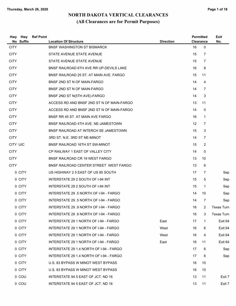
Page 1 of 18Thursday, March 26, 2020
NORTH DAKOTA VERTICAL CLEARANCES
(All Clearances are for Permit Purposes)
Permitted
ClearanceLocation Of Structure
Hwy
No
Hwy
Suffix Direction
Ref Point Exit
No.
BNSF WASHINGTON ST BISMARCK 16 0CITY
STATE AVENUE STATE AVENUE 15 7CITY
STATE AVENUE STATE AVENUE 15 7CITY
BNSF RAILROAD 6TH AVE RR UP-DEVILS LAKE 16 8CITY
BNSF RAILROAD 25 ST. AT MAIN AVE. FARGO 15 11CITY
BNSF 2ND ST N OF MAIN-FARGO 14 4CITY
BNSF 2ND ST N OF MAIN-FARGO 14 7CITY
BNSF 2ND ST N(5TH AVE)-FARGO 14 3CITY
ACCESS RD AND BNSF 2ND ST N OF MAIN-FARGO 13 11CITY
ACCESS RD AND BNSF 2ND ST N OF MAIN-FARGO 14 0CITY
BNSF RR 45 ST. AT MAIN AVE FARGO 16 1CITY
BNSF RAILROAD 4TH AVE. NE-JAMESTOWN 12 7CITY
BNSF RAILROAD AT INTERCH SE JAMESTOWN 15 3CITY
3RD ST. N.E. 3RD ST NE-MINOT 14 7CITY
BNSF RAILROAD 16TH ST SW-MINOT 15 2CITY UIC
CP RAILWAY 1 EAST OF VALLEY CITY 14 0CITY
BNSF RAILROAD CR 19 WEST FARGO 13 10CITY
BNSF RAILROAD CENTER STREET WEST FARGO 13 6CITY
US HIGHWAY 2 5 EAST OF US 85 SOUTH 17 70 CITY Sep
INTERSTATE 29 2 SOUTH OF I-94 INT 15 50 CITY Sep
INTERSTATE 29 2 SOUTH OF I-94 INT 15 10 CITY Sep
INTERSTATE 29 .5 NORTH OF I-94 - FARGO 14 100 CITY Sep
INTERSTATE 29 .5 NORTH OF I-94 - FARGO 14 70 CITY Sep
INTERSTATE 29 .9 NORTH OF I-94 - FARGO 16 20 CITY Texas Turn
INTERSTATE 29 .9 NORTH OF I-94 - FARGO 16 30 CITY Texas Turn
INTERSTATE 29 1 NORTH OF I-94 - FARGO 17 10 CITY East Exit 64
INTERSTATE 29 1 NORTH OF I-94 - FARGO 16 60 CITY West Exit 64
INTERSTATE 29 1 NORTH OF I-94 - FARGO 16 40 CITY West Exit 64
INTERSTATE 29 1 NORTH OF I-94 - FARGO 16 110 CITY East Exit 64
INTERSTATE 29 1.4 NORTH OF I-94 - FARGO 17 60 CITY Sep
INTERSTATE 29 1.4 NORTH OF I-94 - FARGO 17 60 CITY Sep
U.S. 83 BYPASS W MINOT WEST BYPASS 16 100 CITY
U.S. 83 BYPASS W MINOT WEST BYPASS 16 100 CITY
INTERSTATE 94 5 EAST OF JCT. ND 16 13 110 COU Exit 7
INTERSTATE 94 5 EAST OF JCT. ND 16 13 110 COU Exit 7
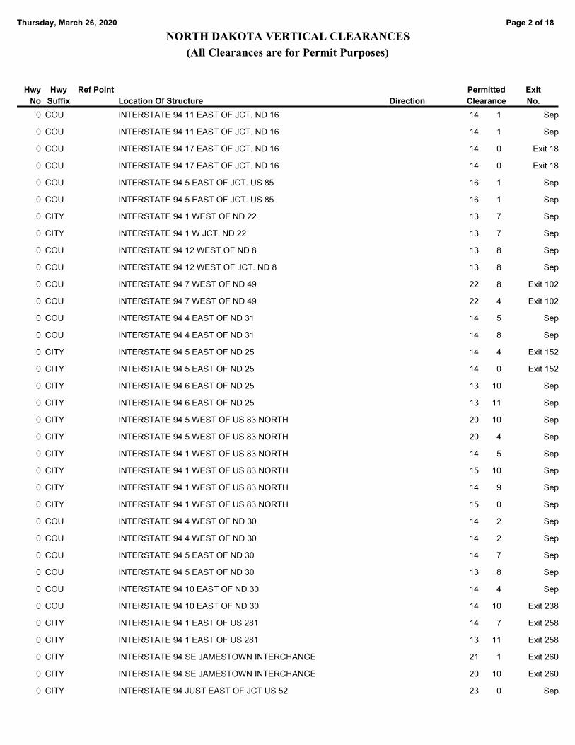
Page 2 of 18Thursday, March 26, 2020
NORTH DAKOTA VERTICAL CLEARANCES
(All Clearances are for Permit Purposes)
Permitted
ClearanceLocation Of Structure
Hwy
No
Hwy
Suffix Direction
Ref Point Exit
No.
INTERSTATE 94 11 EAST OF JCT. ND 16 14 10 COU Sep
INTERSTATE 94 11 EAST OF JCT. ND 16 14 10 COU Sep
INTERSTATE 94 17 EAST OF JCT. ND 16 14 00 COU Exit 18
INTERSTATE 94 17 EAST OF JCT. ND 16 14 00 COU Exit 18
INTERSTATE 94 5 EAST OF JCT. US 85 16 10 COU Sep
INTERSTATE 94 5 EAST OF JCT. US 85 16 10 COU Sep
INTERSTATE 94 1 WEST OF ND 22 13 70 CITY Sep
INTERSTATE 94 1 W JCT. ND 22 13 70 CITY Sep
INTERSTATE 94 12 WEST OF ND 8 13 80 COU Sep
INTERSTATE 94 12 WEST OF JCT. ND 8 13 80 COU Sep
INTERSTATE 94 7 WEST OF ND 49 22 80 COU Exit 102
INTERSTATE 94 7 WEST OF ND 49 22 40 COU Exit 102
INTERSTATE 94 4 EAST OF ND 31 14 50 COU Sep
INTERSTATE 94 4 EAST OF ND 31 14 80 COU Sep
INTERSTATE 94 5 EAST OF ND 25 14 40 CITY Exit 152
INTERSTATE 94 5 EAST OF ND 25 14 00 CITY Exit 152
INTERSTATE 94 6 EAST OF ND 25 13 100 CITY Sep
INTERSTATE 94 6 EAST OF ND 25 13 110 CITY Sep
INTERSTATE 94 5 WEST OF US 83 NORTH 20 100 CITY Sep
INTERSTATE 94 5 WEST OF US 83 NORTH 20 40 CITY Sep
INTERSTATE 94 1 WEST OF US 83 NORTH 14 50 CITY Sep
INTERSTATE 94 1 WEST OF US 83 NORTH 15 100 CITY Sep
INTERSTATE 94 1 WEST OF US 83 NORTH 14 90 CITY Sep
INTERSTATE 94 1 WEST OF US 83 NORTH 15 00 CITY Sep
INTERSTATE 94 4 WEST OF ND 30 14 20 COU Sep
INTERSTATE 94 4 WEST OF ND 30 14 20 COU Sep
INTERSTATE 94 5 EAST OF ND 30 14 70 COU Sep
INTERSTATE 94 5 EAST OF ND 30 13 80 COU Sep
INTERSTATE 94 10 EAST OF ND 30 14 40 COU Sep
INTERSTATE 94 10 EAST OF ND 30 14 100 COU Exit 238
INTERSTATE 94 1 EAST OF US 281 14 70 CITY Exit 258
INTERSTATE 94 1 EAST OF US 281 13 110 CITY Exit 258
INTERSTATE 94 SE JAMESTOWN INTERCHANGE 21 10 CITY Exit 260
INTERSTATE 94 SE JAMESTOWN INTERCHANGE 20 100 CITY Exit 260
INTERSTATE 94 JUST EAST OF JCT US 52 23 00 CITY Sep

Page 3 of 18Thursday, March 26, 2020
NORTH DAKOTA VERTICAL CLEARANCES
(All Clearances are for Permit Purposes)
Permitted
ClearanceLocation Of Structure
Hwy
No
Hwy
Suffix Direction
Ref Point Exit
No.
INTERSTATE 94 JUST EAST OF JCT.US-52 21 80 CITY Sep
INTERSTATE 94 8 EAST OF US 281 16 60 COU Sep
INTERSTATE 94 8 EAST OF US 281 16 70 COU Sep
INTERSTATE 94 9 EAST OF US 52 16 60 COU Exit 269
INTERSTATE 94 9 EAST OF US 52 17 50 COU Exit 269
INTERSTATE 94 1 EAST OF ND 1 NORTH 14 20 COU Sep
INTERSTATE 94 1 EAST OF ND 1 NORTH 14 20 COU Sep
INTERSTATE 94 4 EAST OF ND 1 SOUTH 16 30 COU Exit 292
INTERSTATE 94 4 EAST OF ND 1 SOUTH 16 80 COU Exit 292
INTERSTATE 94 5 EAST OF ND 1 SOUTH 15 10 CITY Sep
INTERSTATE 94 5 EAST OF ND 1 SOUTH 14 00 CITY Sep
INTERSTATE 94 3 WEST OF I-29 16 20 Exit 346
INTERSTATE 94 3 WEST OF I-29 16 100 North Exit 346
INTERSTATE 94 3 WEST OF I-29 11 70 South Exit 346
INTERSTATE 94 1 EAST OF US 81 - FARGO 13 110 CITY Sep
I-94 BUS LP BISMAR WEST MAIN & WASHINGTON ST 14 80 CITY
12 AVE NO FARGO 1 EAST I-29 16 30 CITY
ND 297/DEMERS AVE 4TH AVE SOUTH-GRAND FORKS 14 60 CITY
BISMARCK EXPWY MCKENZIE DRIVE INT. 16 20 CITY
BISMARCK EXPWY MCKENZIE DRIVE INT. 15 80 CITY
INTERSTATE 94 JCT I 94 & ND 1 NORTH 15 71 RSR 76.423 Exit 283
INTERSTATE 94 JCT I 94 & ND 1 NORTH 15 111 RSR 76.423 Exit 283
US HIGHWAY 52 JCT. 2 AND 52 WEST 23 52 UIC East 133.443 Sep
US HIGHWAY 52 JCT. 2 AND 52 WEST 17 42 UIC West 133.443 Sep
16TH ST. SW-MINOT 1 WEST OF U.S. HWY 83 16 02 UIC West 145.343 16th St Int
16TH ST. SW-MINOT 1 WEST OF U.S. HWY 83 16 32 UIC East 145.343 16th St Int
US HIGHWAY 83 JCT US 83 & US 2-52 16 12 UIC East 146.366 US83 Exit
US HIGHWAY 83 JCT US 83 & US 2-52 19 02 UIC West 146.366 US83 Exit
US HIGHWAY 52 JCT 2 & 52 EAST 16 62 UIC East 148.930 US52 Exit
US HIGHWAY 52 JCT 2 & 52 EAST 16 72 UIC West 148.930 US52 Exit
COUNTY HIGHWAY 13 WEST OF I-29 15 92 RIC West 342.782 AFB Exit
COUNTY HIGHWAY 13 WEST OF I-29 15 112 RIC East 342.782 AFB Exit
INTERSTATE 29 JUNCTION US 2-GF 16 62 UIC East 355.470 Exit 141
INTERSTATE 29 JUNCTION US 2-GF 16 52 UIC West 355.470 Exit 141
INTERSTATE 29 JUNCTION US 2-GF 16 22 UIC West 355.487 Exit 141

Page 4 of 18Thursday, March 26, 2020
NORTH DAKOTA VERTICAL CLEARANCES
(All Clearances are for Permit Purposes)
Permitted
ClearanceLocation Of Structure
Hwy
No
Hwy
Suffix Direction
Ref Point Exit
No.
INTERSTATE 29 JUNCTION US 2-GF 16 22 UIC East 355.487 Exit 141
US HIGHWAY 2 EAST OF US 81 19 12 UIC 358.014 Kennedy
US 2 BUSINESS LOOP GRAND FORKS 16 42 UIC 911.133 Sorlie
BNRR 1 NORTH US 2 15 23 RIC 202.391
NO OVERHEAD OBSTRUCTIONS4
NO OVERHEAD OBSTRUCTIONS5
NO OVERHEAD OBSTRUCTIONS6
BN RAILROAD STANLEY, MAIN STREET 13 78 RSR 157.424
NO OVERHEAD OBSTRUCTIONS9
BNRR 1 WEST OF ND 18 13 410 RCL 2.021
NO OVERHEAD OBSTRUCTIONS11
ND HIGHWAY 67 AT SCRANTON 20 012 RIC 46.415
NO OVERHEAD OBSTRUCTIONS13
BN RAILROAD TOWNER 13 214 RCL 114.982
CP RAILWAY FESSENDEN 15 215 RCN 0.899
NO OVERHEAD OBSTRUCTIONS16
ND HIGHWAY 17 3 EAST OF I-29 15 617 RCR 140.342
NO OVERHEAD OBSTRUCTIONS18
NO OVERHEAD OBSTRUCTIONS19
BN & CP RAILWAY 1 NORTH JUNCTION US 2 16 420 UCR 103.378
NO OVERHEAD OBSTRUCTIONS21
BNRR DICKINSON 13 522 USC 70.811
NO OVERHEAD OBSTRUCTIONS23
NO OVERHEAD OBSTRUCTIONS24
NO OVERHEAD OBSTRUCTIONS25
NO OVERHEAD OBSTRUCTIONS26
NO OVERHEAD OBSTRUCTIONS27
NO OVERHEAD OBSTRUCTIONS28
RAMP TO I-94 EB I-29 & I-94 INTCHG-FARGO 20 129 UI West Exit 63
RAMP TO I-94 EB I-29 & I-94 INTCHG-FARGO 16 729 UI East Exit 63
COUNTY HIGHWAY SOUTH DAKOTA BORDER 16 229 RI North 0.013 Exit 1
COUNTY HIGHWAY SOUTH DAKOTA BORDER 16 729 RI South 0.013 Exit 1
COUNTY HIGHWAY 2 NORTH OF SD BORDER 16 429 RI North 2.074 Exit 2
COUNTY HIGHWAY 2 NORTH OF SD BORDER 16 429 RI South 2.074 Exit 2
COUNTY HIGHWAY 4 SOUTH OF ND 11 16 329 RI North 4.087 Sep
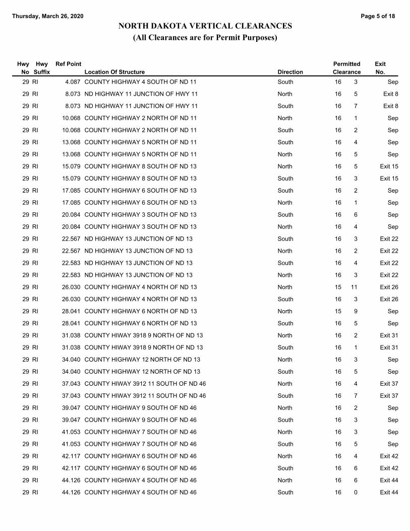
Page 5 of 18Thursday, March 26, 2020
NORTH DAKOTA VERTICAL CLEARANCES
(All Clearances are for Permit Purposes)
Permitted
ClearanceLocation Of Structure
Hwy
No
Hwy
Suffix Direction
Ref Point Exit
No.
COUNTY HIGHWAY 4 SOUTH OF ND 11 16 329 RI South 4.087 Sep
ND HIGHWAY 11 JUNCTION OF HWY 11 16 529 RI North 8.073 Exit 8
ND HIGHWAY 11 JUNCTION OF HWY 11 16 729 RI South 8.073 Exit 8
COUNTY HIGHWAY 2 NORTH OF ND 11 16 129 RI North 10.068 Sep
COUNTY HIGHWAY 2 NORTH OF ND 11 16 229 RI South 10.068 Sep
COUNTY HIGHWAY 5 NORTH OF ND 11 16 429 RI South 13.068 Sep
COUNTY HIGHWAY 5 NORTH OF ND 11 16 529 RI North 13.068 Sep
COUNTY HIGHWAY 8 SOUTH OF ND 13 16 529 RI North 15.079 Exit 15
COUNTY HIGHWAY 8 SOUTH OF ND 13 16 329 RI South 15.079 Exit 15
COUNTY HIGHWAY 6 SOUTH OF ND 13 16 229 RI South 17.085 Sep
COUNTY HIGHWAY 6 SOUTH OF ND 13 16 129 RI North 17.085 Sep
COUNTY HIGHWAY 3 SOUTH OF ND 13 16 629 RI South 20.084 Sep
COUNTY HIGHWAY 3 SOUTH OF ND 13 16 429 RI North 20.084 Sep
ND HIGHWAY 13 JUNCTION OF ND 13 16 329 RI South 22.567 Exit 22
ND HIGHWAY 13 JUNCTION OF ND 13 16 229 RI North 22.567 Exit 22
ND HIGHWAY 13 JUNCTION OF ND 13 16 429 RI South 22.583 Exit 22
ND HIGHWAY 13 JUNCTION OF ND 13 16 329 RI North 22.583 Exit 22
COUNTY HIGHWAY 4 NORTH OF ND 13 15 1129 RI North 26.030 Exit 26
COUNTY HIGHWAY 4 NORTH OF ND 13 16 329 RI South 26.030 Exit 26
COUNTY HIGHWAY 6 NORTH OF ND 13 15 929 RI North 28.041 Sep
COUNTY HIGHWAY 6 NORTH OF ND 13 16 529 RI South 28.041 Sep
COUNTY HIWAY 3918 9 NORTH OF ND 13 16 229 RI North 31.038 Exit 31
COUNTY HIWAY 3918 9 NORTH OF ND 13 16 129 RI South 31.038 Exit 31
COUNTY HIGHWAY 12 NORTH OF ND 13 16 329 RI North 34.040 Sep
COUNTY HIGHWAY 12 NORTH OF ND 13 16 529 RI South 34.040 Sep
COUNTY HIWAY 3912 11 SOUTH OF ND 46 16 429 RI North 37.043 Exit 37
COUNTY HIWAY 3912 11 SOUTH OF ND 46 16 729 RI South 37.043 Exit 37
COUNTY HIGHWAY 9 SOUTH OF ND 46 16 229 RI North 39.047 Sep
COUNTY HIGHWAY 9 SOUTH OF ND 46 16 329 RI South 39.047 Sep
COUNTY HIGHWAY 7 SOUTH OF ND 46 16 329 RI North 41.053 Sep
COUNTY HIGHWAY 7 SOUTH OF ND 46 16 529 RI South 41.053 Sep
COUNTY HIGHWAY 6 SOUTH OF ND 46 16 429 RI North 42.117 Exit 42
COUNTY HIGHWAY 6 SOUTH OF ND 46 16 629 RI South 42.117 Exit 42
COUNTY HIGHWAY 4 SOUTH OF ND 46 16 629 RI North 44.126 Exit 44
COUNTY HIGHWAY 4 SOUTH OF ND 46 16 029 RI South 44.126 Exit 44

Page 6 of 18Thursday, March 26, 2020
NORTH DAKOTA VERTICAL CLEARANCES
(All Clearances are for Permit Purposes)
Permitted
ClearanceLocation Of Structure
Hwy
No
Hwy
Suffix Direction
Ref Point Exit
No.
ND HIGHWAY 46 JUNCTION ND 46 & I-29 15 1129 RI South 48.182 Exit 48
ND HIGHWAY 46 JUNCTION ND 46 & I-29 16 729 RI North 48.182 Exit 48
COUNTY HIGHWAY 2 NORTH OF ND 46 16 829 RI North 50.186 Exit 50
COUNTY HIGHWAY 2 NORTH OF ND 46 16 029 RI South 50.186 Exit 50
COUNTY HIGHWAY 6 NORTH OF ND 46 16 329 RI North 54.167 Exit 54
COUNTY HIGHWAY 6 NORTH OF ND 46 16 429 RI South 54.167 Exit 54
COUNTY HIGHWAY 7 SOUTH OF I-94 15 1029 RI North 56.249 Exit 56
COUNTY HIGHWAY 7 SOUTH OF I-94 16 329 RI South 56.249 Exit 56
US HIGHWAY 81 3 SOUTH OF I-94 17 029 UI South 60.352 Exit 60
US HIGHWAY 81 3 SOUTH OF I-94 16 529 UI North 60.352 Exit 60
US HIGHWAY 81 3 SOUTH OH I-94 16 329 UI North 60.368 Exit 60
US HIGHWAY 81 3 SOUTH OH I-94 16 929 UI South 60.368 Exit 60
32ND AVE S FARGO 1 SOUTH OF I 94 16 1129 UI North 62.249 Exit 62
32ND AVE S FARGO 1 SOUTH OF I 94 16 1129 UI South 62.249 Exit 62
INTERSTATE 94 I-94-I-29 INTCHNGE-FARGO 16 429 UI South 63.267 Exit 347
INTERSTATE 94 I-94-I-29 INTCHNGE-FARGO 16 529 UI North 63.267 Exit 347
INTERSTATE 94 I-94-I-29 INTERCHNG FARGO 16 729 UI South 63.267 Exit 347
INTERSTATE 94 I-94-I-29 INTERCHNG FARGO 16 729 UI North 63.267 Exit 347
US HIGHWAY 10 FARGO 16 529 UI North 65.249 Exit 65
US HIGHWAY 10 FARGO 16 629 UI South 65.249 Exit 65
US HIGHWAY 10 FARGO 18 629 UI South 65.265 Sep
US HIGHWAY 10 FARGO 18 629 UI North 65.265 Sep
BNSF RAILROAD NORTH OF US 10 16 729 UI North 65.372 Sep UP
BNSF RAILROAD NORTH OF US 10 16 529 UI South 65.372 Sep UP
BNSF RAILROAD NORTH OF US 10 16 529 UI South 65.372 Sep UP
BNSF RAILROAD NORTH OF US 10 16 529 UI North 65.372 Sep UP
7TH AVE. NORTH 1 NORTH OF US 10 16 129 UI South 65.757 Sep
7TH AVE. NORTH 1 NORTH OF US 10 16 129 UI North 65.757 Sep
ND 294-12TH AVE N JCT I-29-12TH AVE N FARGO 16 429 UI South 66.255 Exit 66
ND 294-12TH AVE N JCT I-29-12TH AVE N FARGO 16 629 UI North 66.255 Exit 66
BNRR 1 NORTH US 10 16 729 UI North 66.691 Sep UP
BNRR 1 NORTH US 10 16 429 South 66.691 Sep UP
CITY ST.19TH AVE. 2 NORTH OF US 10 16 429 UI North 67.258 Exit 67
CITY ST.19TH AVE. 2 NORTH OF US 10 16 329 UI South 67.258 Exit 67
CASS COUNTY 20 3 SOUTH OF HARWOOD 16 929 RI South 69.374 Exit 69

Page 7 of 18Thursday, March 26, 2020
NORTH DAKOTA VERTICAL CLEARANCES
(All Clearances are for Permit Purposes)
Permitted
ClearanceLocation Of Structure
Hwy
No
Hwy
Suffix Direction
Ref Point Exit
No.
CASS COUNTY 20 3 SOUTH OF HARWOOD 19 329 RI North 69.374 Exit 69
CASS COUNTY NO 22 7 NORTH OF US 10 16 1029 RI North 72.778 Exit 73
CASS COUNTY NO 22 7 NORTH OF US 10 16 529 RI South 72.778 Exit 73
COUNTY HIGHWAY 2 NORTH HARWOOD INTERCHG 16 329 RI South 74.991 Sep
COUNTY HIGHWAY 2 NORTH HARWOOD INTERCHG 16 429 RI North 74.991 Sep
COUNTY HIGHWAY ARGUSVILLE CITY LIMITS 16 629 RI South 78.542 Exit 78
COUNTY HIGHWAY ARGUSVILLE CITY LIMITS 16 729 RI North 78.542 Exit 78
COUNTY HIGHWAY 4 NORTH OF ARGUSVILLE 16 329 RI North 82.709 Sep
COUNTY HIGHWAY 4 NORTH OF ARGUSVILLE 16 329 RI South 82.709 Sep
COUNTY HIGHWAY GARDNER CITY LIMITS 16 329 RI North 85.826 Exit 85
COUNTY HIGHWAY GARDNER CITY LIMITS 16 329 RI South 85.826 Exit 85
COUNTY HIGHWAY 11 SOUTH OF ND 200 16 129 RI North 88.947 Sep
COUNTY HIGHWAY 11 SOUTH OF ND 200 15 1029 RI South 88.947 Sep
COUNTY HIGHWAY 8 SOUTH OF ND 200 15 629 RI North 92.142 Exit 92
COUNTY HIGHWAY 8 SOUTH OF ND 200 15 729 RI South 92.142 Exit 92
COUNTY HIGHWAY 6 SOUTH OF ND 200 15 1029 RI South 94.196 Sep
COUNTY HIGHWAY 6 SOUTH OF ND 200 15 829 RI North 94.196 Sep
COUNTY HIGHWAY 3 SOUTH OF ND 200 15 929 RI South 97.333 Sep
COUNTY HIGHWAY 3 SOUTH OF ND 200 15 1029 RI North 97.333 Sep
ND HIGHWAY 200A JUNCTION OF 200A & I29 16 329 RI North 100.391 Exit 100
ND HIGHWAY 200A JUNCTION OF 200A & I29 16 329 RI South 100.391 Exit 100
COUNTY HIGHWAY 4 NORTH OF ND 200 SOUTH 16 029 RI North 104.155 Exit 104
COUNTY HIGHWAY 4 NORTH OF ND 200 SOUTH 16 229 RI South 104.155 Exit 104
COUNTY HIGHWAY 3 SOUTH OF ND 200 NORTH 16 329 RI North 107.685 Sep
COUNTY HIGHWAY 3 SOUTH OF ND 200 NORTH 16 329 RI South 107.685 Sep
ND HIGHWAY 200 JUNCTION ND 200 16 329 RI South 110.795 Exit 110
ND HIGHWAY 200 JUNCTION ND 200 16 029 RI North 110.795 Exit 110
COUNTY HIGHWAY 1 NORTH OF ND 200 16 529 RI North 111.835 Sep
COUNTY HIGHWAY 1 NORTH OF ND 200 16 029 RI South 111.835 Sep
COUNTY HIGHWAY 5 NORTH OF ND 200 15 1129 RI South 115.969 Sep
COUNTY HIGHWAY 5 NORTH OF ND 200 16 329 RI North 115.969 Sep
COUNTY HIGHWAY 7 NORTH OF ND 200 16 029 RI South 117.987 Sep
COUNTY HIGHWAY 7 NORTH OF ND 200 16 429 RI North 117.987 Sep
COUNTY HIGHWAY 9 SOUTH ND 15 16 429 RI North 120.989 Sep
COUNTY HIGHWAY 9 SOUTH ND 15 16 229 RI South 120.989 Sep

Page 8 of 18Thursday, March 26, 2020
NORTH DAKOTA VERTICAL CLEARANCES
(All Clearances are for Permit Purposes)
Permitted
ClearanceLocation Of Structure
Hwy
No
Hwy
Suffix Direction
Ref Point Exit
No.
COUNTY HIGHWAY 7 SOUTH ND 15 16 229 RI South 123.001 Exit 123
COUNTY HIGHWAY 7 SOUTH ND 15 16 829 RI North 123.001 Exit 123
COUNTY HIGHWAY 3 SOUTH ND 15 16 529 RI North 123.036 Sep
COUNTY HIGHWAY 3 SOUTH ND 15 16 429 RI South 127.036 Sep
ND HIGHWAY 15 JUNCTION ND 15 16 429 RI South 130.043 Exit 130
ND HIGHWAY 15 JUNCTION ND 15 16 329 RI North 130.043 Exit 130
COUNTY HIGHWAY 3 NORTH ND 15 16 329 RI North 133.060 Sep
COUNTY HIGHWAY 3 NORTH ND 15 16 329 RI South 133.060 Sep
COUNTY HIGHWAY 5 NORTH ND 15 16 229 RI North 135.082 Sep
COUNTY HIGHWAY 5 NORTH ND 15 16 429 RI South 135.082 Sep
US HIGHWAY 81 3 SOUTH US 2 16 129 UI North 138.146 Exit 138
US HIGHWAY 81 3 SOUTH US 2 17 129 UI South 138.146 Exit 138
CITY STREET 1 SOUTH US 2 17 029 UI South 140.458 Sep
CITY STREET 1 SOUTH US 2 16 129 UI North 140.458 Sep
RAILROAD NORTH US 2 INTERCHANGE 16 729 UI North 141.703 UP
RAILROAD NORTH US 2 INTERCHANGE 16 729 UI South 141.703 UP
US 81 JUNCTION US 81 MANVEL 16 629 RI South 152.337 Exit 152
US 81 JUNCTION US 81 MANVEL 16 229 RI North 152.337 Exit 152
COUNTY HIGHWAY 4 NORTH OF MANVEL 16 529 RI South 156.680 Exit 156
COUNTY HIGHWAY 4 NORTH OF MANVEL 16 329 RI North 156.680 Exit 156
COUNTY HIGHWAY 3 NORTH ND 54 16 729 RI South 163.699 Exit 163
COUNTY HIGHWAY 3 NORTH ND 54 15 1029 RI North 163.699 Exit 163
COUNTY HIGHWAY 5 NORTH ND 54 16 329 RI South 165.701 Sep
COUNTY HIGHWAY 5 NORTH ND 54 15 1029 RI North 165.701 Sep
COUNTY HIGHWAY 7 NORTH ND 54 16 629 RI South 167.722 Exit 168
COUNTY HIGHWAY 7 NORTH ND 54 15 1029 RI North 167.722 Exit 168
COUNTY HIGHWAY 6 SOUTH ND 17 16 429 RI North 169.723
COUNTY HIGHWAY 6 SOUTH ND 17 16 429 RI South 169.723
COUNTY HIGHWAY 4 SOUTH OF ND 17 16 429 RI South 171.723 Exit 171
COUNTY HIGHWAY 4 SOUTH OF ND 17 16 529 RI North 171.723 Exit 171
COUNTY HIGHWAY 2 SOUTH OF ND 17 16 729 RI North 173.790 Sep
COUNTY HIGHWAY 2 SOUTH OF ND 17 16 429 RI South 173.790 Sep
ND HIGHWAY 17 JCT OF ND 17 16 729 RI North 175.792 Exit 176
ND HIGHWAY 17 JCT OF ND 17 16 729 RI South 175.792 Exit 176
COUNTY HIGHWAY 2 NORTH OF ND 17 16 629 RI North 177.794 Sep

Page 9 of 18Thursday, March 26, 2020
NORTH DAKOTA VERTICAL CLEARANCES
(All Clearances are for Permit Purposes)
Permitted
ClearanceLocation Of Structure
Hwy
No
Hwy
Suffix Direction
Ref Point Exit
No.
COUNTY HIGHWAY 2 NORTH OF ND 17 16 1029 RI South 177.794 Sep
COUNTY HIGHWAY 4 NORTH ND 17 16 729 RI South 179.876 Exit 180
COUNTY HIGHWAY 4 NORTH ND 17 16 529 RI North 179.876 Exit 180
ND HIGHWAY 44 3 SOUTH ND 66 16 929 RI North 184.038 Exit 184
ND HIGHWAY 44 3 SOUTH ND 66 16 629 RI South 184.038 Exit 184
RAILROAD 3 SOUTH ND 66 16 829 RI North 184.094 Sep UP
RAILROAD 3 SOUTH ND 66 16 429 RI South 184.094 Sep UP
ND HIGHWAY 66 JUNCTION ND 66 16 129 RI South 186.881 Exit 186
ND HIGHWAY 66 JUNCTION ND 66 16 329 RI North 186.881 Exit 186
COUNTY HIGHWAY 4 NORTH OF ND 66 16 429 RI North 190.955 Exit 191
COUNTY HIGHWAY 4 NORTH OF ND 66 16 529 RI South 190.955 Exit 191
COUNTY HIGHWAY 6 NORTH OF ND 66 16 229 RI South 192.960 Exit 192
COUNTY HIGHWAY 6 NORTH OF ND 66 16 129 RI North 192.960 Exit 192
COUNTY HIGHWAY 7 SOUTH OF ND 5 16 429 RI North 196.014 Exit 196
COUNTY HIGHWAY 7 SOUTH OF ND 5 16 529 RI South 196.014 Exit 196
COUNTY HIGHWAY 5 SOUTH OF ND 5 16 229 RI North 198.090 Sep
COUNTY HIGHWAY 5 SOUTH OF ND 5 16 029 RI South 198.090 Sep
COUNTY HIGHWAY 3 SOUTH OF ND 5 16 1029 RI South 200.243 Exit 200
COUNTY HIGHWAY 3 SOUTH OF ND 5 16 329 RI North 200.243 Exit 200
US 81 & ND 5 JCT US 81 AND ND 5 16 529 RI South 203.413 Exit 203
US 81 & ND 5 JCT US 81 AND ND 5 16 329 RI North 203.413 Exit 203
COUNTY HIGHWAY 3 NORTH OF ND 5 16 429 RI South 206.463 Sep
COUNTY HIGHWAY 3 NORTH OF ND 5 16 329 RI North 206.463 Sep
COUNTY HIGHWAY 5 NORTH OF ND 5 16 429 RI North 208.473 Exit 208
COUNTY HIGHWAY 5 NORTH OF ND 5 16 329 RI South 208.473 Exit 208
COUNTY HIGHWAY 3 SOUTH OF ND 59 16 029 RI South 212.717 Exit 212
COUNTY HIGHWAY 3 SOUTH OF ND 59 16 229 RI North 212.717 Exit 212
ND HIGHWAY 59 JCT ND HIGHWAY 59 16 229 RI North 215.237 Exit 215
ND HIGHWAY 59 JCT ND HIGHWAY 59 15 929 RI South 215.237 Exit 215
NO OVERHEAD OBSTRUCTIONS30
BNRR 2 SOUTH OF STANTON 14 831 RCL 110.850
NO OVERHEAD OBSTRUCTIONS32
NO OVERHEAD OBSTRUCTIONS34
NO OVERHEAD OBSTRUCTIONS35
NO OVERHEAD OBSTRUCTIONS36
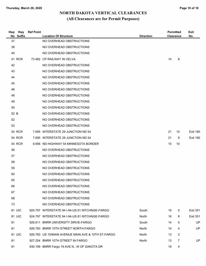
Page 10 of 18Thursday, March 26, 2020
NORTH DAKOTA VERTICAL CLEARANCES
(All Clearances are for Permit Purposes)
Permitted
ClearanceLocation Of Structure
Hwy
No
Hwy
Suffix Direction
Ref Point Exit
No.
NO OVERHEAD OBSTRUCTIONS37
NO OVERHEAD OBSTRUCTIONS38
NO OVERHEAD OBSTRUCTIONS40
CP RAILWAY IN VELVA 14 841 RCR 73.482
NO OVERHEAD OBSTRUCTIONS42
NO OVERHEAD OBSTRUCTIONS43
NO OVERHEAD OBSTRUCTIONS44
NO OVERHEAD OBSTRUCTIONS45
NO OVERHEAD OBSTRUCTIONS46
NO OVERHEAD OBSTRUCTIONS48
NO OVERHEAD OBSTRUCTIONS49
NO OVERHEAD OBSTRUCTIONS50
NO OVERHEAD OBSTRUCTIONS52 B
NO OVERHEAD OBSTRUCTIONS52
NO OVERHEAD OBSTRUCTIONS53
INTERSTATE 29 JUNCTION ND 54 21 1054 RCR 7.695 Exit 160
INTERSTATE 29 JUNCTION ND 54 21 954 RCR 7.695 Exit 160
ND HIGHWAY 54 MINNESOTA BORDER 15 1054 RCR 9.956
NO OVERHEAD OBSTRUCTIONS56
NO OVERHEAD OBSTRUCTIONS57
NO OVERHEAD OBSTRUCTIONS58
NO OVERHEAD OBSTRUCTIONS59
NO OVERHEAD OBSTRUCTIONS60
NO OVERHEAD OBSTRUCTIONS65
NO OVERHEAD OBSTRUCTIONS66
NO OVERHEAD OBSTRUCTIONS67
NO OVERHEAD OBSTRUCTIONS68
NO OVERHEAD OBSTRUCTIONS73
INTERSTATE 94 I-94-US 81 INTCHNGE-FARGO 16 581 UIC South 924.797 Exit 351
INTERSTATE 94 I-94-US 81 INTCHNGE-FARGO 16 881 UIC North 924.797 Exit 351
BNRR UNIVERSITY DRIVE-FARGO 14 581 South 926.611 UP
BNRR 10TH STREET NORTH-FARGO 14 481 North 926.783 UP
US 10/MAIN AVENUE MAIN AVE & 10TH ST-FARGO 13 281 UIC North 926.783
BNRR 10TH STREET IN FARGO 13 781 North 927.254 UP
BNRR Fargo 19 AVE N., W OF DAKOTA DR 16 481 930.199

Page 11 of 18Thursday, March 26, 2020
NORTH DAKOTA VERTICAL CLEARANCES
(All Clearances are for Permit Purposes)
Permitted
ClearanceLocation Of Structure
Hwy
No
Hwy
Suffix Direction
Ref Point Exit
No.
BNRR UNIV DR & 7TH AVE N-Fargo 13 1081 South 932.468
BN R/R WASHINGTON ST 14 1081 UIC South 943.798
BN R/R WASHINGTON ST 14 981 UIC North 943.798
INTERSTATE 29 JUNCTION US 81- GF 17 481 UIC 949.222 Exit 144
INTERSTATE 29 JUNCTION US 81-GF 17 281 UIC 949.222 Exit 144
PED.CROSSOVER NORTH MINOT 16 683 201.696
PED.CROSSOVER NORTH MINOT 16 683 South 201.696
BNRR 9TH ST-SOUTH OF MAIN-Bism 13 883 UIC North 900.729
BNRR 7TH ST-SOUTH OF MAIN-Bism 13 583 UIC South 903.335
NO OVERHEAD OBSTRUCTIONS85 B
US HIGHWAY 85 16 SOUTH OF ND 23 15 885 RIC 126.535 Long X
NO OVERHEAD OBSTRUCTIONS89
NO OVERHEAD OBSTRUCTIONS91
INTERSTATE 94 West River Rd W of Medora 15 194 COU Exit 23
INTERSTATE 94 W River Road W of Medora 15 194 COU Exit 23
ND HIGHWAY 16 JUNCTION OF I-94 & ND 16 16 294 RI East 1.849 Exit 1
ND HIGHWAY 16 JUNCTION OF I-94 & ND 16 16 394 RI West 1.849 Exit 1
COUNTY HIGHWAY 3 EAST OF JCT. ND 16 15 1094 RI East 4.829 Sep
COUNTY HIGHWAY 3 EAST OF JCT. ND 16 15 1194 RI West 4.829 Sep
COUNTY HIGHWAY 9 EAST OF JCT. ND 16 16 494 RI East 10.478 Exit 10
COUNTY HIGHWAY 9 EAST OF JCT. ND 16 16 194 RI West 10.478 Exit 10
NATIONAL PARK ROAD 16 WEST OF JCT. US 85 15 894 RI West 26.204 Sep
NATIONAL PARK ROAD 16 WEST OF US 85 15 1094 RI East 26.204 Sep
I-94 BUSINESS LOOP East Medora Int 15 994 RI West 27.243 Exit 27
I-94 BUSINESS LOOP East Medora Int 18 494 RI East 27.243 Exit 27
COUNTY ROAD 9 WEST OF JCT. US 85 15 894 RI West 32.963 Exit 32
COUNTY ROAD 9 WEST OF JCT. US 85 15 794 RI East 32.963 Exit 32
COUNTY ROAD 6 WEST OF JCT. US 85 16 294 RI East 36.861 Exit 36
COUNTY ROAD 6 WEST OF JCT. US 85 16 894 RI West 36.861 Exit 36
US HIGHWAY 85 JCT. OF I-94 & US 85 16 294 RI West 42.366 Exit 42
US HIGHWAY 85 JCT. OF I-94 & US 85 16 194 RI East 42.366 Exit 42
COUNTY ROAD 9 EAST OF JCT. ND 85 16 994 COU West 51.476 Exit 51
COUNTY ROAD 9 EAST OF JCT. ND 85 16 794 RI East 51.476 Exit 51
116th Avenue SW 5 west of Hwy 22 17 194 RI East 56.668 Exit 56
116th Avenue SW 5 west of Hwy 22 17 094 RI West 56.668 Exit 56

Page 12 of 18Thursday, March 26, 2020
NORTH DAKOTA VERTICAL CLEARANCES
(All Clearances are for Permit Purposes)
Permitted
ClearanceLocation Of Structure
Hwy
No
Hwy
Suffix Direction
Ref Point Exit
No.
STATE HWY/BUS. 94 2 WEST OF ND 22 17 294 UI East 59.485 Exit 59
STATE HWY/BUS. 94 2 WEST OF ND 22 16 994 UI West 59.485 Exit 59
STATE HIGHWAY 22 JCT. ND 22 & I-94 16 494 UI West 61.476 Exit 61
STATE HIGHWAY 22 JCT. ND 22 & I-94 16 094 UI East 61.476 Exit 61
PED.CROSSOVER 1 EAST OF ND 22 16 294 UI East 62.479 Ped Cross
PED.CROSSOVER 1 EAST OF ND 22 17 594 UI West 62.479 Ped Cross
10 AVENUE EAST 1 EAST OF JCT. ND 22 16 594 UI West 62.486 Sep
10 AVENUE EAST 1 EAST OF JCT. ND 22 15 1194 UI East 62.486 Sep
COUNTY ROAD 2 EAST OF JCT. ND 22 15 1194 UI East 64.204 Exit 64
COUNTY ROAD 2 EAST OF JCT. ND 22 16 294 UI West 64.204 Exit 64
COUNTY ROAD 5 EAST OF JCT. 22 16 294 UI West 66.118 Sep
COUNTY ROAD 5 EAST OF JCT. 22 15 1094 UI East 66.118 Sep
COUNTY ROAD 8 EAST OF JCT. 22 19 994 RI West 69.714 Sep
COUNTY ROAD 8 EAST OF JCT. 22 15 1094 RI East 69.714 Sep
COUNTY ROAD 13 WEST OF ND 8 16 294 RI East 72.253 Exit 72
COUNTY ROAD 13 WEST OF ND 8 17 094 RI West 72.253 Exit 72
COUNTY HIGHWAY 9 WEST OF JCT. ND 8 16 294 RI West 75.873 Sep
COUNTY HIGHWAY 9 WEST OF JCT. ND 8 16 094 RI East 75.873 Sep
COUNTY ROAD 6 WEST OF JCT ND 8 16 294 RI West 78.901 Exit 78
COUNTY ROAD 6 WEST OF JCT ND 8 16 294 RI East 78.901 Exit 78
COUNTY ROAD 3 WEST OF JCT ND 8 16 094 RI West 81.899
COUNTY ROAD 3 WEST OF JCT ND 8 15 1194 RI East 81.899
ND HIGHWAY 8 JCT. I-94 & ND 8 16 294 RI East 84.885 Exit 84
ND HIGHWAY 8 JCT. I-94 & ND 8 16 194 RI West 84.885 Exit 84
COUNTY HIGHWAY 3 EAST OF JCT. ND 8 16 294 RI East 88.077 Sep
COUNTY HIGHWAY 3 EAST OF JCT. ND 8 16 194 RI West 88.077
COUNTY HIGHWAY 5 EAST OF JCT. ND 8 16 294 RI West 90.110 Exit 84
COUNTY HIGHWAY 5 EAST OF JCT. ND 8 15 1194 RI East 90.110 Exit 84
COUNTY HIGHWAY 7 EAST OF JCT. ND 8 16 494 RI East 92.241 Sep
COUNTY HIGHWAY 7 EAST OF JCT. ND 8 16 394 RI West 92.241 Sep
COUNTY ROAD 10 EAST OF ND 8 16 394 RI West 95.234 Sep
COUNTY ROAD 10 EAST OF ND 8 15 994 RI East 95.244 Sep
COUNTY HIGHWAY 12 EAST OF ND 8 16 694 RI East 97.188 Exit 97
COUNTY HIGHWAY 12 EAST OF ND 8 16 094 RI West 97.188 Exit 97
COUNTY HIGHWAY 10 WEST OF ND 49 16 294 RI East 100.274 Sep

Page 13 of 18Thursday, March 26, 2020
NORTH DAKOTA VERTICAL CLEARANCES
(All Clearances are for Permit Purposes)
Permitted
ClearanceLocation Of Structure
Hwy
No
Hwy
Suffix Direction
Ref Point Exit
No.
COUNTY HIGHWAY 10 WEST OF ND 49 16 094 RI West 100.274 Sep
COUNTY HIGHWAY 5 WEST OF ND 49 15 994 RI East 105.376 Sep
COUNTY HIGHWAY 5 WEST OF ND 49 16 294 RI West 105.376 Sep
COUNTY HIGHWAY 2 WEST OF ND 49 16 194 RI East 108.354 Exit 108
COUNTY HIGHWAY 2 WEST OF ND 49 16 694 RI West 108.354 Exit 108
ND HIGHWAY JUNCTION OF ND 49 & I-94 16 194 RI West 110.367 Exit 110
ND HIGHWAY JUNCTION OF ND 49 & I-94 16 1094 RI East 110.367 Exit 110
COUNTY HIGHWAY 3 EAST OF ND 49 16 1194 RI East 113.389 Exit 110
COUNTY HIGHWAY 3 EAST OF ND 49 16 294 RI West 113.389 Exit 110
COUNTY HIGHWAY 7 EAST OF ND 49 17 394 RI East 117.197 Exit 117
COUNTY HIGHWAY 7 EAST OF ND 49 17 394 RI West 117.197 Exit 117
COUNTY HIGHWAY 7 WEST OF ND 31 16 994 RI West 120.204 Exit 120
COUNTY HIGHWAY 7 WEST OF ND 31 16 1194 RI East 120.204 Exit 120
COUNTY HIGHWAY 5 WEST OF ND 31 17 294 RI West 123.200 Exit 123
COUNTY HIGHWAY 5 WEST OF ND 31 17 394 RI East 123.200 Exit 123
ND HIGHWAY JUNCTION OF ND 31 & I-94 17 194 RI East 127.662 Exit 127
ND HIGHWAY JUNCTION OF ND 31 & I-94 17 094 RI West 127.662 Exit 127
COUNTY HIGHWAY 6 EAST OF ND 31 16 294 RI West 134.115 Exit 134
COUNTY HIGHWAY 6 EAST OF ND 31 16 394 RI East 134.115 Exit 134
COUNTY HIGHWAY 8 EAST OF ND 31 15 1194 RI East 136.143 Sep
COUNTY HIGHWAY 8 EAST OF ND 31 16 494 RI West 136.143 Sep
COUNTY HIGHWAY 7 WEST OF ND 25 16 494 RI East 140.158 Exit 140
COUNTY HIGHWAY 7 WEST OF ND 25 16 494 RI West 140.158 Exit 140
ND HIGHWAY JCT OF I-94 & ND 94 & 25 16 694 RI East 147.183 Exit 147
ND HIGHWAY JCT OF I-94 & ND 94 & 25 16 794 RI West 147.183 Exit 147
I-94 BUSINESS LOOP 4 WEST OF US 83 NORTH 15 1094 UI East 155.026 Sep
INTERSTATE 94 3 WEST OF US 83 NORTH 16 294 UI East 156.069 Exit 156
INTERSTATE 94 3 WEST OF US 83 NORTH 17 994 UI South 156.069 Exit 156
DIVIDE/TYLER PKWY 2 WEST OF US 83 NORTH 16 594 UI East 157.328 Exit 157
DIVIDE/TYLER PKWY 2 WEST OF US 83 NORTH 16 194 UI West 157.328 Exit 157
US HIGHWAY JUNCTION OF US 83N & I-94 16 194 UI West 159.419 Exit 159
US HIGHWAY JUNCTION OF US 83N & I-94 16 994 UI East 159.419 Exit 159
CITY STREET 1 EAST OF US 83 NORTH 16 694 UI East 159.926 Sep
CITY STREET 1 EAST OF US 83 NORTH 16 194 UI West 159.926 Sep
BIS EXPWY/CENT DR 2 EAST OF US 83 NORTH 16 494 UI East 161.439 Exit 161

Page 14 of 18Thursday, March 26, 2020
NORTH DAKOTA VERTICAL CLEARANCES
(All Clearances are for Permit Purposes)
Permitted
ClearanceLocation Of Structure
Hwy
No
Hwy
Suffix Direction
Ref Point Exit
No.
BIS EXPWY/CENT DR 2 EAST OF US 83 NORTH 17 694 UI West 161.439 Exit 161
INTERSTATE 94 5 EAST OF US 83 NORTH 15 794 RI West 164.527 Sep
INTERSTATE 94 5 EAST OF US 83 NORTH 15 794 RI East 164.527 Sep
COUNTY HIGHWAY 7 EAST OF US 83 NORTH 15 1094 RI East 166.531 Sep
COUNTY HIGHWAY 7 EAST OF US 83 NORTH 16 194 RI West 166.531 Sep
COUNTY HIGHWAY 11 EAST OF US 83 NORTH 16 094 RI East 170.519 Exit 170
COUNTY HIGHWAY 11 EAST OF US 83 NORTH 16 094 RI West 170.519 Exit 170
COUNTY HIGHWAY 6 WEST OF US 83 SOUTH 15 994 RI East 176.501 Exit 176
COUNTY HIGHWAY 6 WEST OF US 83 SOUTH 15 1094 RI West 176.501 Exit 176
COUNTY HIGHWAY 3 WEST OF US 83 SOUTH 18 394 RI West 179.502 Sep
COUNTY HIGHWAY 3 WEST OF US 83 SOUTH 18 294 RI East 179.502 Sep
US HIGHWAY 83 JUNCTION US 83 S-STERLING 15 1094 RI East 182.488 Exit 182
US HIGHWAY 83 JUNCTION US 83 S-STERLING 16 594 RI West 182.488 Exit 182
COUNTY HIGHWAY 3 EAST OF US 83 SOUTH 15 1194 RI East 186.022 Sep
COUNTY HIGHWAY 3 EAST OF US 83 SOUTH 15 1094 RI West 186.022 Sep
COUNTY HIGHWAY 8 EAST OF US 83 SOUTH 16 194 RI East 190.110 Exit 190
COUNTY HIGHWAY 8 EAST OF US 83 SOUTH 16 094 RI West 190.110 Exit 190
COUNTY HIGHWAY 6 WEST OF ND 3 NORTH 15 1094 RI East 195.090 Exit 195
COUNTY HIGHWAY 6 WEST OF ND 3 NORTH 15 1094 RI West 195.090 Exit 195
COUNTY HIGHWAY 4 WEST OF ND 3 NORTH 15 1194 RI West 197.099 Sep
COUNTY HIGHWAY 4 WEST OF ND 3 NORTH 16 594 RI East 197.099 Sep
ND HIGHWAY 3 ND 3 & STEELE INTERCHANGE 15 1094 RI West 200.760 Exit 200
ND HIGHWAY 3 ND 3 & STEELE INTERCHANGE 15 1094 RI East 200.760 Exit 200
COUNTY HIGHWAY 4 EAST OF ND 3 NORTH 15 794 RI West 205.071 Exit 205
COUNTY HIGHWAY 4 EAST OF ND 3 NORTH 15 1194 RI East 205.071 Exit 205
ND HIGHWAY 3 SOUTH JCT. ND 3 SOUTH 15 894 RI West 208.702 Exit 208
ND HIGHWAY 3 SOUTH JCT. ND 3 SOUTH 16 294 RI East 208.702 Exit 208
COUNTY HIGHWAY 5 EAST OF ND 3 SOUTH 16 394 RI West 214.126 Exit 214
COUNTY HIGHWAY 5 EAST OF ND 3 SOUTH 19 294 RI East 214.126 Exit 214
COUNTY HIGHWAY 8 EAST OF ND 3 SOUTH 16 794 RI West 217.145 Exit 217
COUNTY HIGHWAY 8 EAST OF ND 3 SOUTH 16 694 RI East 217.145 Exit 217
COUNTY HIGHWAY 7 WEST OF ND 30 16 294 RI West 221.733 Exit 221
COUNTY HIGHWAY 7 WEST OF ND 30 17 194 RI East 221.733 Exit 221
ND HIGHWAY 30 JCT. ND 30 16 394 RI West 228.321 Exit 228
ND HIGHWAY 30 JCT. ND 30 15 1094 RI East 228.321 Exit 228

Page 15 of 18Thursday, March 26, 2020
NORTH DAKOTA VERTICAL CLEARANCES
(All Clearances are for Permit Purposes)
Permitted
ClearanceLocation Of Structure
Hwy
No
Hwy
Suffix Direction
Ref Point Exit
No.
COUNTY HIGHWAY 2 EAST OF ND 30 16 394 RI West 230.288 Exit 230
COUNTY HIGHWAY 2 EAST OF ND 30 16 094 RI East 230.288 Exit 230
COUNTY HIGHWAY 9 EAST OF ND 30 16 194 RI West 237.322 Sep
COUNTY HIGHWAY 9 EAST OF ND 30 15 1094 RI East 237.322 Sep
COUNTY HIGHWAY 15 WEST OF JAMESTOWN 16 994 RI East 242.672 Exit 242
COUNTY HIGHWAY 15 WEST OF JAMESTOWN 17 294 RI West 242.672 Exit 242
COUNTY HIGHWAY 13 WEST OF JAMESTOWN 15 1094 RI West 245.191 Exit 245
COUNTY HIGHWAY 13 WEST OF JAMESTOWN 16 994 RI East 245.191 Exit 245
COUNTY HIGHWAY 9 WEST OF JAMESTOWN 16 494 RI West 248.991 Exit 248
COUNTY HIGHWAY 9 WEST OF JAMESTOWN 16 194 RI East 248.991 Exit 248
COUNTY HIGHWAY 6 WEST OF JAMESTOWN 16 494 RI West 251.686 Exit 251
COUNTY HIGHWAY 6 WEST OF JAMESTOWN 16 194 RI East 251.686 Exit 251
US 52 BYPASS 2 WEST OF JAMESTOWN 16 794 UI West 256.224 Exit 256
US 52 BYPASS 2 WEST OF JAMESTOWN 16 394 UI East 256.224 Exit 256
I-94 OFF RAMP 1 WEST OF US 281 16 394 UI West 257.002 Exit 257
US HIGHWAY 281 JCT US 281 & I-94 16 194 UI West 258.055 Exit 258
US HIGHWAY 281 JCT US 281 & I-94 16 094 UI East 258.055 Exit 258
COUNTY HIWAY 4739 2 EAST OF US 52 16 794 UI West 262.361 Exit 262
COUNTY HIWAY 4739 2 EAST OF US 52 16 894 UI East 262.361 Exit 262
COUNTY HIWAY 0203 11 WEST OF ND 1 NORTH 16 394 RI West 272.369 Exit 272
COUNTY HIWAY 0203 11 WEST OF ND 1 NORTH 16 394 RI East 272.369 Exit 272
MINOR ROAD 9 WEST OF ND 1 NORTH 16 494 RI East 274.376 Sep
MINOR ROAD 9 WEST OF ND 1 NORTH 16 494 RI West 274.376 Sep
COUNTY HIWAY 0207 7 WEST OF ND 1 NORTH 16 294 RI West 276.385 Sep
COUNTY HIWAY 0207 7 WEST OF ND 1 NORTH 16 394 RI East 276.385 Sep
COUNTY HIGHWAY 4 WEST OF ND 1 NORTH 16 094 RI West 279.636 Sep
COUNTY HIGHWAY 4 WEST OF ND 1 NORTH 15 1194 RI East 279.636 Sep
COUNTY HIWAY 0211 2 WEST OF ND 1 NORTH 16 194 RI West 281.640 Exit 281
COUNTY HIWAY 0211 2 WEST OF ND 1 NORTH 16 094 RI East 281.640 Exit 281
ND HIGHWAY 1 JCT ND 1 SOUTH 15 1194 RI West 288.636 Exit 288
ND HIGHWAY 1 JCT ND 1 SOUTH 16 594 RI East 288.636 Exit 288
I-94 BUSINESS LOOP 6 EAST OF ND 1 SOUTH 16 194 UI East 294.283 Exit 294
I-94 BUSINESS LOOP 6 EAST OF ND 1 SOUTH 16 394 UI West 294.283 Exit 294
CO.HIWAY 0227 6 WEST OF N.D.32 16 594 RI East 296.741 Exit 296
CO.HIWAY 0227 6 WEST OF N.D.32 17 294 RI West 296.741 Exit 296

Page 16 of 18Thursday, March 26, 2020
NORTH DAKOTA VERTICAL CLEARANCES
(All Clearances are for Permit Purposes)
Permitted
ClearanceLocation Of Structure
Hwy
No
Hwy
Suffix Direction
Ref Point Exit
No.
COUNTY HIGHWAY 4 WEST OF ND 32 16 094 RI East 298.746 Exit 298
COUNTY HIGHWAY 4 WEST OF ND 32 16 394 COU West 298.746 Exit 298
COUNTY HIGHWAY 2 WEST OF ND 32 16 994 RI West 300.750 Sep
COUNTY HIGHWAY 2 WEST OF ND 32 16 794 RI East 300.750 Sep
ND HIGHWAY 32 JCT. ND 32 16 294 RI East 302.712 Exit 302
ND HIGHWAY 32 JCT. ND 32 16 694 RI West 302.712 Exit 302
COUNTY HIGHWAY 3 EAST N.D.32 16 694 RI East 305.701 Sep
COUNTY HIGHWAY 3 EAST N.D.32 17 594 RI West 305.701 Sep
COUNTY ROAD 0237 5 EAST OF ND 32 16 894 RI East 307.679 Exit 307
COUNTY ROAD 0237 5 EAST OF ND 32 16 594 RI West 307.679 Exit 307
COUNTY HIGHWAY 4 WEST OF ND 38 16 594 RI East 310.456 Exit 310
COUNTY HIGHWAY 4 WEST OF ND 38 16 294 RI West 310.456 Exit 310
COUNTY HIGHWAY 2 WEST OF ND 38 16 794 RI East 312.857 Sep
COUNTY HIGHWAY 2 WEST OF ND 38 16 294 RI West 312.857 Sep
ND HIGHWAY 38 JCT. ND 38 16 194 RI West 314.863 Exit 314
ND HIGHWAY 38 JCT. ND 38 16 294 RI East 314.863 Exit 314
COUNTY HIGHWAY 3 EAST OF ND 38 16 194 RI West 317.846 Exit 317
COUNTY HIGHWAY 3 EAST OF ND 38 16 294 RI East 317.846 Exit 317
COUNTY HIGHWAY 6 EAST OF ND 38 16 894 RI East 320.837 Exit 320
COUNTY HIGHWAY 6 EAST OF ND 38 16 794 RI West 320.837 Exit 320
COUNTY HIGHWAY 8 WEST OF ND 18 16 994 RI East 322.827 Exit 322
COUNTY HIGHWAY 8 WEST OF ND 18 16 894 RI West 322.827 Exit 322
COUNTY HIGHWAY 6 WEST OF N.D.18 16 594 RI East 324.821 Exit 324
COUNTY HIGHWAY 6 WEST OF N.D.18 16 494 RI West 324.821 Exit 324
COUNTY HIGHWAY 3 WEST OF ND 18 16 194 RI East 328.710 Exit 328
COUNTY HIGHWAY 3 WEST OF ND 18 16 194 RI West 328.710 Exit 328
BNRR 1 WEST OF ND 18 16 194 RI West 330.709 UP
BNRR 1 WEST OF ND 18 16 294 RI East 330.709 UP
ND HIGHWAY 18 JUNCTION OF ND 18 16 394 UI East 331.226 Exit 331
ND HIGHWAY 18 JUNCTION OF ND 18 16 394 UI West 331.226 Exit 331
COUNTY HIGHWAY 3 M EAST OF 18 16 694 UI East 333.715 Sep
COUNTY HIGHWAY 3 M EAST OF 18 15 1094 UI West 333.715 Sep
COUNTY HIGHWAY 8 EAST OF ND 18 17 194 UI West 338.737 Exit 338
COUNTY HIGHWAY 8 EAST OF ND 18 16 1194 UI East 338.737 Exit 338
COUNTY HIGHWAY 10 EAST OF ND 18 16 694 UI East 340.717 Exit 340
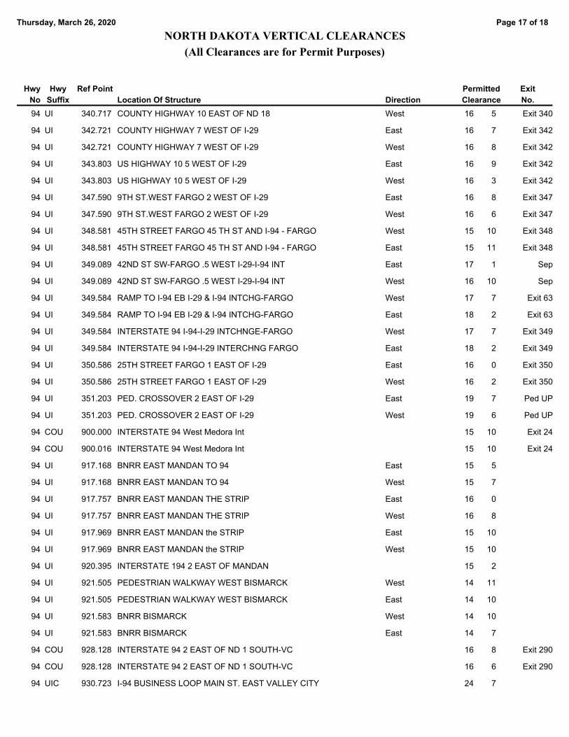
Page 17 of 18Thursday, March 26, 2020
NORTH DAKOTA VERTICAL CLEARANCES
(All Clearances are for Permit Purposes)
Permitted
ClearanceLocation Of Structure
Hwy
No
Hwy
Suffix Direction
Ref Point Exit
No.
COUNTY HIGHWAY 10 EAST OF ND 18 16 594 UI West 340.717 Exit 340
COUNTY HIGHWAY 7 WEST OF I-29 16 794 UI East 342.721 Exit 342
COUNTY HIGHWAY 7 WEST OF I-29 16 894 UI West 342.721 Exit 342
US HIGHWAY 10 5 WEST OF I-29 16 994 UI East 343.803 Exit 342
US HIGHWAY 10 5 WEST OF I-29 16 394 UI West 343.803 Exit 342
9TH ST.WEST FARGO 2 WEST OF I-29 16 894 UI East 347.590 Exit 347
9TH ST.WEST FARGO 2 WEST OF I-29 16 694 UI West 347.590 Exit 347
45TH STREET FARGO 45 TH ST AND I-94 - FARGO 15 1094 UI West 348.581 Exit 348
45TH STREET FARGO 45 TH ST AND I-94 - FARGO 15 1194 UI East 348.581 Exit 348
42ND ST SW-FARGO .5 WEST I-29-I-94 INT 17 194 UI East 349.089 Sep
42ND ST SW-FARGO .5 WEST I-29-I-94 INT 16 1094 UI West 349.089 Sep
RAMP TO I-94 EB I-29 & I-94 INTCHG-FARGO 17 794 UI West 349.584 Exit 63
RAMP TO I-94 EB I-29 & I-94 INTCHG-FARGO 18 294 UI East 349.584 Exit 63
INTERSTATE 94 I-94-I-29 INTCHNGE-FARGO 17 794 UI West 349.584 Exit 349
INTERSTATE 94 I-94-I-29 INTERCHNG FARGO 18 294 UI East 349.584 Exit 349
25TH STREET FARGO 1 EAST OF I-29 16 094 UI East 350.586 Exit 350
25TH STREET FARGO 1 EAST OF I-29 16 294 UI West 350.586 Exit 350
PED. CROSSOVER 2 EAST OF I-29 19 794 UI East 351.203 Ped UP
PED. CROSSOVER 2 EAST OF I-29 19 694 UI West 351.203 Ped UP
INTERSTATE 94 West Medora Int 15 1094 COU 900.000 Exit 24
INTERSTATE 94 West Medora Int 15 1094 COU 900.016 Exit 24
BNRR EAST MANDAN TO 94 15 594 UI East 917.168
BNRR EAST MANDAN TO 94 15 794 UI West 917.168
BNRR EAST MANDAN THE STRIP 16 094 UI East 917.757
BNRR EAST MANDAN THE STRIP 16 894 UI West 917.757
BNRR EAST MANDAN the STRIP 15 1094 UI East 917.969
BNRR EAST MANDAN the STRIP 15 1094 UI West 917.969
INTERSTATE 194 2 EAST OF MANDAN 15 294 UI 920.395
PEDESTRIAN WALKWAY WEST BISMARCK 14 1194 UI West 921.505
PEDESTRIAN WALKWAY WEST BISMARCK 14 1094 UI East 921.505
BNRR BISMARCK 14 1094 UI West 921.583
BNRR BISMARCK 14 794 UI East 921.583
INTERSTATE 94 2 EAST OF ND 1 SOUTH-VC 16 894 COU 928.128 Exit 290
INTERSTATE 94 2 EAST OF ND 1 SOUTH-VC 16 694 COU 928.128 Exit 290
I-94 BUSINESS LOOP MAIN ST. EAST VALLEY CITY 24 794 UIC 930.723
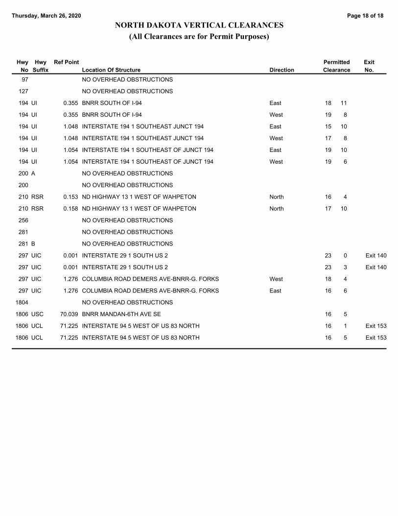
Page 18 of 18Thursday, March 26, 2020
NORTH DAKOTA VERTICAL CLEARANCES
(All Clearances are for Permit Purposes)
Permitted
ClearanceLocation Of Structure
Hwy
No
Hwy
Suffix Direction
Ref Point Exit
No.
NO OVERHEAD OBSTRUCTIONS97
NO OVERHEAD OBSTRUCTIONS127
BNRR SOUTH OF I-94 18 11194 UI East 0.355
BNRR SOUTH OF I-94 19 8194 UI West 0.355
INTERSTATE 194 1 SOUTHEAST JUNCT 194 15 10194 UI East 1.048
INTERSTATE 194 1 SOUTHEAST JUNCT 194 17 8194 UI West 1.048
INTERSTATE 194 1 SOUTHEAST OF JUNCT 194 19 10194 UI East 1.054
INTERSTATE 194 1 SOUTHEAST OF JUNCT 194 19 6194 UI West 1.054
NO OVERHEAD OBSTRUCTIONS200 A
NO OVERHEAD OBSTRUCTIONS200
ND HIGHWAY 13 1 WEST OF WAHPETON 16 4210 RSR North 0.153
ND HIGHWAY 13 1 WEST OF WAHPETON 17 10210 RSR North 0.158
NO OVERHEAD OBSTRUCTIONS256
NO OVERHEAD OBSTRUCTIONS281
NO OVERHEAD OBSTRUCTIONS281 B
INTERSTATE 29 1 SOUTH US 2 23 0297 UIC 0.001 Exit 140
INTERSTATE 29 1 SOUTH US 2 23 3297 UIC 0.001 Exit 140
COLUMBIA ROAD DEMERS AVE-BNRR-G. FORKS 18 4297 UIC West 1.276
COLUMBIA ROAD DEMERS AVE-BNRR-G. FORKS 16 6297 UIC East 1.276
NO OVERHEAD OBSTRUCTIONS1804
BNRR MANDAN-6TH AVE SE 16 51806 USC 70.039
INTERSTATE 94 5 WEST OF US 83 NORTH 16 11806 UCL 71.225 Exit 153
INTERSTATE 94 5 WEST OF US 83 NORTH 16 51806 UCL 71.225 Exit 153

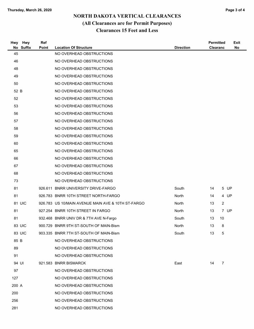
Page 1 of 4Thursday, March 26, 2020
NORTH DAKOTA VERTICAL CLEARANCES
(All Clearances are for Permit Purposes)
Clearances 15 Feet and Less
Permitted
ClearancLocation Of Structure
Hwy
No
Hwy
Suffix Direction
Ref
Point
Exit
No
BNSF 2ND ST N OF MAIN-FARGO 14 7CITY
BNSF 2ND ST N OF MAIN-FARGO 14 4CITY
BNSF 2ND ST N(5TH AVE)-FARGO 14 3CITY
ACCESS RD AND BNSF 2ND ST N OF MAIN-FARGO 14 0CITY
ACCESS RD AND BNSF 2ND ST N OF MAIN-FARGO 13 11CITY
BNSF RAILROAD 4TH AVE. NE-JAMESTOWN 12 7CITY
CP RAILWAY 1 EAST OF VALLEY CITY 14 0CITY
BNSF RAILROAD CR 19 WEST FARGO 13 10CITY
BNSF RAILROAD CENTER STREET WEST FARGO 13 6CITY
INTERSTATE 29 .5 NORTH OF I-94 - FARGO 14 70 CITY Sep
INTERSTATE 94 5 EAST OF JCT. ND 16 13 110 COU Exit 7
INTERSTATE 94 5 EAST OF JCT. ND 16 13 110 COU Exit 7
INTERSTATE 94 11 EAST OF JCT. ND 16 14 10 COU Sep
INTERSTATE 94 11 EAST OF JCT. ND 16 14 10 COU Sep
INTERSTATE 94 17 EAST OF JCT. ND 16 14 00 COU Exit 18
INTERSTATE 94 17 EAST OF JCT. ND 16 14 00 COU Exit 18
INTERSTATE 94 1 WEST OF ND 22 13 70 CITY Sep
INTERSTATE 94 1 W JCT. ND 22 13 70 CITY Sep
INTERSTATE 94 12 WEST OF ND 8 13 80 COU Sep
INTERSTATE 94 12 WEST OF JCT. ND 8 13 80 COU Sep
INTERSTATE 94 4 EAST OF ND 31 14 50 COU Sep
INTERSTATE 94 5 EAST OF ND 25 14 40 CITY Exit 152
INTERSTATE 94 5 EAST OF ND 25 14 00 CITY Exit 152
INTERSTATE 94 6 EAST OF ND 25 13 100 CITY Sep
INTERSTATE 94 6 EAST OF ND 25 13 110 CITY Sep
INTERSTATE 94 1 WEST OF US 83 NORTH 14 50 CITY Sep
INTERSTATE 94 4 WEST OF ND 30 14 20 COU Sep
INTERSTATE 94 4 WEST OF ND 30 14 20 COU Sep
INTERSTATE 94 5 EAST OF ND 30 14 70 COU Sep
INTERSTATE 94 5 EAST OF ND 30 13 80 COU Sep
INTERSTATE 94 10 EAST OF ND 30 14 40 COU Sep
INTERSTATE 94 1 EAST OF US 281 14 70 CITY Exit 258
INTERSTATE 94 1 EAST OF US 281 13 110 CITY Exit 258
INTERSTATE 94 1 EAST OF ND 1 NORTH 14 20 COU Sep
INTERSTATE 94 1 EAST OF ND 1 NORTH 14 20 COU Sep

Page 2 of 4Thursday, March 26, 2020
NORTH DAKOTA VERTICAL CLEARANCES
(All Clearances are for Permit Purposes)
Clearances 15 Feet and Less
Permitted
ClearancLocation Of Structure
Hwy
No
Hwy
Suffix Direction
Ref
Point
Exit
No
INTERSTATE 94 5 EAST OF ND 1 SOUTH 14 00 CITY Sep
INTERSTATE 94 3 WEST OF I-29 11 70 South Exit 346
INTERSTATE 94 1 EAST OF US 81 - FARGO 13 110 CITY Sep
ND 297/DEMERS AVE 4TH AVE SOUTH-GRAND FORKS 14 60 CITY
NO OVERHEAD OBSTRUCTIONS4
NO OVERHEAD OBSTRUCTIONS5
NO OVERHEAD OBSTRUCTIONS6
BN RAILROAD STANLEY, MAIN STREET 13 78 RSR 157.424
NO OVERHEAD OBSTRUCTIONS9
BNRR 1 WEST OF ND 18 13 410 RCL 2.021
NO OVERHEAD OBSTRUCTIONS11
NO OVERHEAD OBSTRUCTIONS13
BN RAILROAD TOWNER 13 214 RCL 114.982
NO OVERHEAD OBSTRUCTIONS16
NO OVERHEAD OBSTRUCTIONS18
NO OVERHEAD OBSTRUCTIONS19
NO OVERHEAD OBSTRUCTIONS21
BNRR DICKINSON 13 522 USC 70.811
NO OVERHEAD OBSTRUCTIONS23
NO OVERHEAD OBSTRUCTIONS24
NO OVERHEAD OBSTRUCTIONS25
NO OVERHEAD OBSTRUCTIONS26
NO OVERHEAD OBSTRUCTIONS27
NO OVERHEAD OBSTRUCTIONS28
NO OVERHEAD OBSTRUCTIONS30
NO OVERHEAD OBSTRUCTIONS32
NO OVERHEAD OBSTRUCTIONS34
NO OVERHEAD OBSTRUCTIONS35
NO OVERHEAD OBSTRUCTIONS36
NO OVERHEAD OBSTRUCTIONS37
NO OVERHEAD OBSTRUCTIONS38
NO OVERHEAD OBSTRUCTIONS40
NO OVERHEAD OBSTRUCTIONS42
NO OVERHEAD OBSTRUCTIONS43
NO OVERHEAD OBSTRUCTIONS44
Page 3 of 4Thursday, March 26, 2020
NORTH DAKOTA VERTICAL CLEARANCES
(All Clearances are for Permit Purposes)
Clearances 15 Feet and Less
Permitted
ClearancLocation Of Structure
Hwy
No
Hwy
Suffix Direction
Ref
Point
Exit
No
NO OVERHEAD OBSTRUCTIONS45
NO OVERHEAD OBSTRUCTIONS46
NO OVERHEAD OBSTRUCTIONS48
NO OVERHEAD OBSTRUCTIONS49
NO OVERHEAD OBSTRUCTIONS50
NO OVERHEAD OBSTRUCTIONS52 B
NO OVERHEAD OBSTRUCTIONS52
NO OVERHEAD OBSTRUCTIONS53
NO OVERHEAD OBSTRUCTIONS56
NO OVERHEAD OBSTRUCTIONS57
NO OVERHEAD OBSTRUCTIONS58
NO OVERHEAD OBSTRUCTIONS59
NO OVERHEAD OBSTRUCTIONS60
NO OVERHEAD OBSTRUCTIONS65
NO OVERHEAD OBSTRUCTIONS66
NO OVERHEAD OBSTRUCTIONS67
NO OVERHEAD OBSTRUCTIONS68
NO OVERHEAD OBSTRUCTIONS73
BNRR UNIVERSITY DRIVE-FARGO 14 581 South 926.611 UP
BNRR 10TH STREET NORTH-FARGO 14 481 North 926.783 UP
US 10/MAIN AVENUE MAIN AVE & 10TH ST-FARGO 13 281 UIC North 926.783
BNRR 10TH STREET IN FARGO 13 781 North 927.254 UP
BNRR UNIV DR & 7TH AVE N-Fargo 13 1081 South 932.468
BNRR 9TH ST-SOUTH OF MAIN-Bism 13 883 UIC North 900.729
BNRR 7TH ST-SOUTH OF MAIN-Bism 13 583 UIC South 903.335
NO OVERHEAD OBSTRUCTIONS85 B
NO OVERHEAD OBSTRUCTIONS89
NO OVERHEAD OBSTRUCTIONS91
BNRR BISMARCK 14 794 UI East 921.583
NO OVERHEAD OBSTRUCTIONS97
NO OVERHEAD OBSTRUCTIONS127
NO OVERHEAD OBSTRUCTIONS200 A
NO OVERHEAD OBSTRUCTIONS200
NO OVERHEAD OBSTRUCTIONS256
NO OVERHEAD OBSTRUCTIONS281
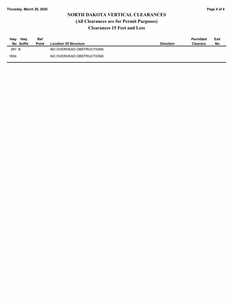
Page 4 of 4Thursday, March 26, 2020
NORTH DAKOTA VERTICAL CLEARANCES
(All Clearances are for Permit Purposes)
Clearances 15 Feet and Less
Permitted
ClearancLocation Of Structure
Hwy
No
Hwy
Suffix Direction
Ref
Point
Exit
No
NO OVERHEAD OBSTRUCTIONS281 B
NO OVERHEAD OBSTRUCTIONS1804
Related Documents