NOAA’s National Weather Service NOAA’s National Weather Service Flood and Flash Flood Warning Flood and Flash Flood Warning Program Program Michelle Schmidt Michelle Schmidt Western Region Hydrology Western Region Hydrology and Climate Services Division and Climate Services Division

NOAA’s National Weather Service Flood and Flash Flood Warning Program Michelle Schmidt Western Region Hydrology and Climate Services Division.
Dec 31, 2015
Welcome message from author
This document is posted to help you gain knowledge. Please leave a comment to let me know what you think about it! Share it to your friends and learn new things together.
Transcript

NOAA’s National Weather Service NOAA’s National Weather Service Flood and Flash Flood Warning ProgramFlood and Flash Flood Warning Program
Michelle SchmidtMichelle SchmidtWestern Region Hydrology Western Region Hydrology
and Climate Services Divisionand Climate Services Division
OutlineOutline
• Mission of the NWS Hydrology ProgramMission of the NWS Hydrology Program• Impacts of floods in the United StatesImpacts of floods in the United States• Field Structure for the Hydrology ProgramField Structure for the Hydrology Program• Watches and WarningsWatches and Warnings• Floods versus Flash FloodsFloods versus Flash Floods• Improving the hydrology programImproving the hydrology program
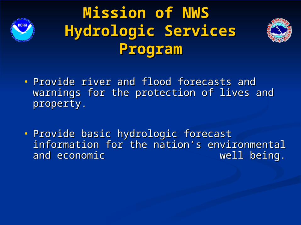
• Provide river and flood forecasts and warnings Provide river and flood forecasts and warnings for the protection of lives and property.for the protection of lives and property.
• Provide basic hydrologic forecast information for Provide basic hydrologic forecast information for the nation’s environmental and economic the nation’s environmental and economic well being. well being.
Mission of NWS Mission of NWS Hydrologic Services ProgramHydrologic Services Program
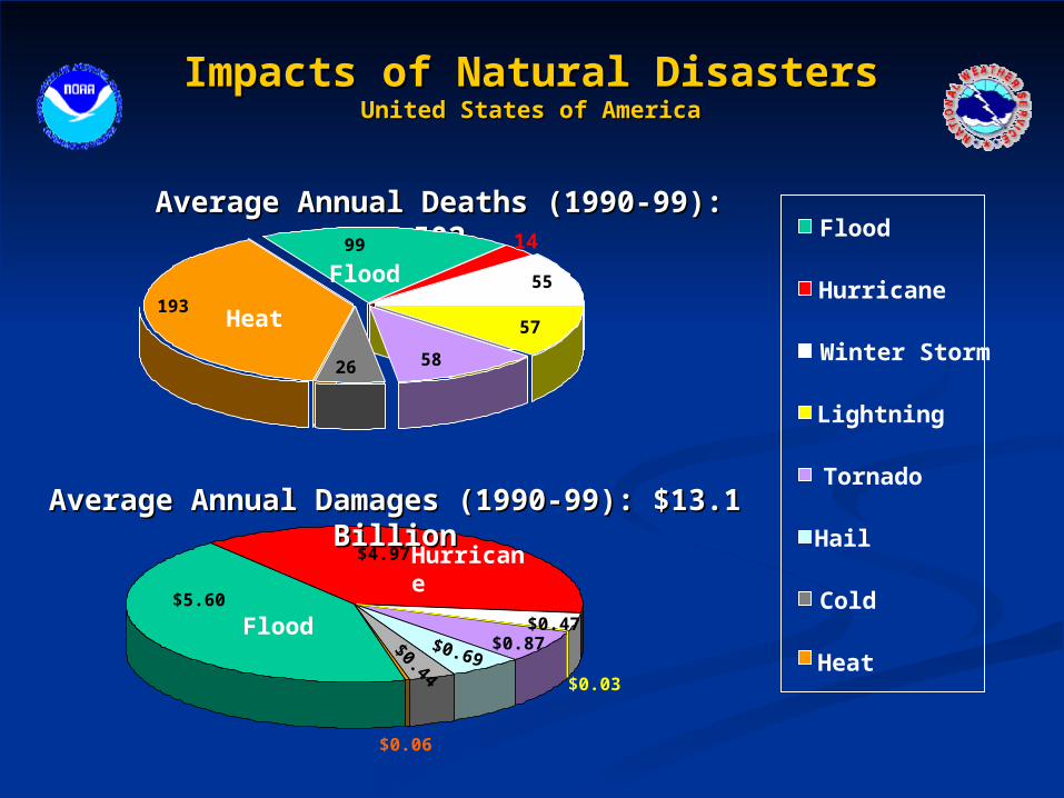
$0.03
$0.69
$0.06
$0.44
$0.87
$5.60
$4.97
Impacts of Natural DisastersImpacts of Natural DisastersUnited States of AmericaUnited States of America
Tornado
Hail
Cold
Lightning
Heat
Flood
Hurricane
Winter Storm
Average Annual Deaths (1990-99): 502Average Annual Deaths (1990-99): 502
Average Annual Damages (1990-99): $13.1 BillionAverage Annual Damages (1990-99): $13.1 Billion
Flood
Hurricane
14
193
99
26 58
57
55Flood
Heat
$0.47

National Weather Service National Weather Service Hydrology ProgramHydrology Program
• Flash Flood ProgramFlash Flood Program• Flood ForecastingFlood Forecasting• Snowmelt ForecastingSnowmelt Forecasting• Water Supply ForecastingWater Supply Forecasting• Dam Break SupportDam Break Support

Hydrology Program Hydrology Program Field Office SupportField Office Support
Services provided through collaborative efforts of National Centers, River Services provided through collaborative efforts of National Centers, River
Forecast Centers (RFCs), and Weather Forecast Offices (WFOs)Forecast Centers (RFCs), and Weather Forecast Offices (WFOs)
Hydrometeorological Hydrometeorological Prediction Center (HPC)Prediction Center (HPC)
Camp Springs, MDCamp Springs, MD
Storm Prediction Center Storm Prediction Center (SPC)(SPC)
Norman, OKNorman, OK
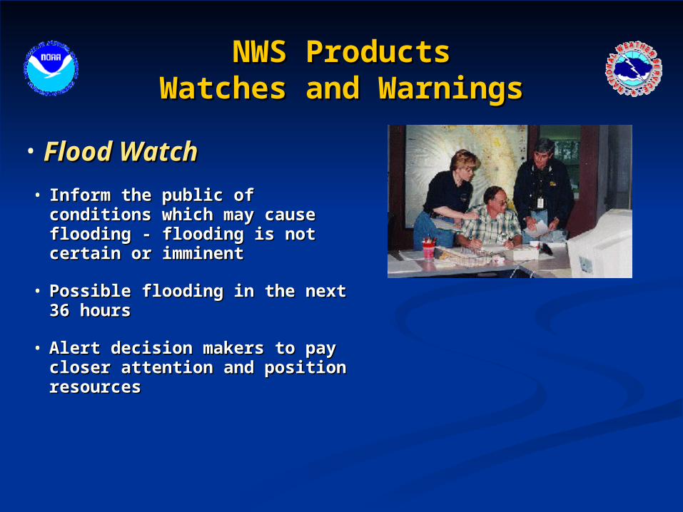
NWS ProductsNWS ProductsWatches and WarningsWatches and Warnings
• Flood WatchFlood Watch
• Inform the public of conditions which Inform the public of conditions which may cause flooding - flooding is not may cause flooding - flooding is not certain or imminent certain or imminent
• Possible flooding in the next 36 hoursPossible flooding in the next 36 hours
• Alert decision makers to pay closer Alert decision makers to pay closer attention and position resourcesattention and position resources

NWS ProductsNWS ProductsWatches and WarningsWatches and Warnings
• Flash Flood and Flood WarningsFlash Flood and Flood Warnings
• Flooding is imminentFlooding is imminent
• Provide advance notification of flood events which require immediate Provide advance notification of flood events which require immediate action to protect lives and propertyaction to protect lives and property
• Allow customers and partners to take immediate mitigation actions such Allow customers and partners to take immediate mitigation actions such as evacuation to higher groundas evacuation to higher ground

Floods Floods versusversus Flash Floods Flash Floods
• River FloodRiver Flood• River rises to flood stage River rises to flood stage
over many hours or days (6 over many hours or days (6 hours or more)hours or more)
• Longer lasting eventsLonger lasting events• Hydrologic eventHydrologic event
• Flash FloodFlash Flood • Quick responding streams Quick responding streams
and rivers – 6 hours or less and rivers – 6 hours or less after the heavy rain started after the heavy rain started
• Meteorological eventMeteorological event
Different Events Different program
Different tools

Floods Floods River Flood ProgramRiver Flood Program

Spring snowmelt flooding
Heavy rain flooding

Flood Warning MissionFlood Warning Mission
1. National Center: Hydrometeorological 1. National Center: Hydrometeorological Prediction CenterPrediction Center
http://www.hpc.ncep.noaa.gov/http://www.hpc.ncep.noaa.gov/
Quantitative Precipitation Quantitative Precipitation ForecastsForecasts
Temperature Temperature ForecastsForecasts
Flood Warning MissionFlood Warning Mission
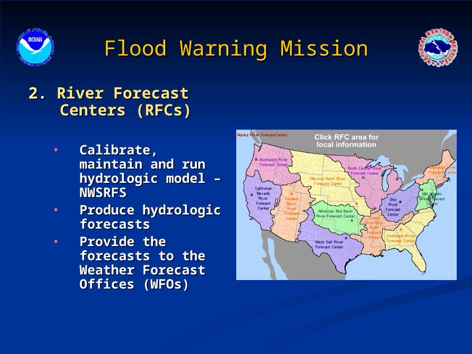
2.2. River Forecast Centers River Forecast Centers (RFCs) (RFCs)
• Calibrate, maintain and Calibrate, maintain and run hydrologic model – run hydrologic model – NWSRFSNWSRFS
• Produce hydrologic Produce hydrologic forecastsforecasts
• Provide the forecasts Provide the forecasts to the Weather to the Weather Forecast Offices Forecast Offices (WFOs)(WFOs)

River Forecast Center ToolsRiver Forecast Center Tools
Flood Warning MissionFlood Warning Mission
3.3. Weather Forecast Offices (WFOs)Weather Forecast Offices (WFOs)• Customer outreach Customer outreach • Field work to keep information up to date (flood Field work to keep information up to date (flood
stage, impacts, etc..)stage, impacts, etc..)• Monitor situationMonitor situation• Issue flood watches and warnings based on Issue flood watches and warnings based on
forecasts from the River Forecast Centersforecasts from the River Forecast Centers
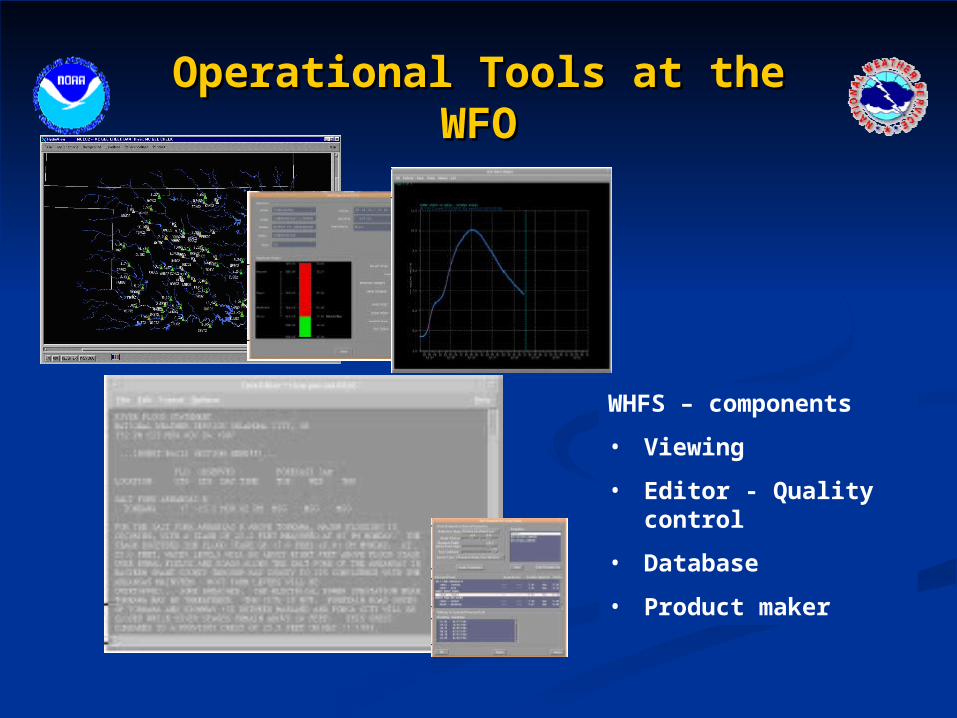
Operational Tools at the WFOOperational Tools at the WFO
WHFS – components
• Viewing
• Editor - Quality control
• Database
• Product maker

UTC043-250400-
FLOOD WARNING
NATIONAL WEATHER SERVICE SALT LAKE CITY UT
115 PM MDT TUE MAY 24 2005
...RIVER FLOOD WARNING FOR THE UPPER WEBER RIVER UNTIL FURTHER NOTICE..
THE NATIONAL WEATHER SERVICE IN SALT LAKE CITY HAS ISSUED A RIVER FLOOD WARNING FOR THE UPPER WEBER RIVER FROM THE OUTLET OF SMITH MOREHOUSE RESERVOIR TO ROCKPORT RESERVOIR. THIS WARNING IS IN EFFECT UNTIL FURTHER NOTICE.
THE LATEST STAGE FOR THE WEBER RIVER NEAR OAKLEY IS 4.3 FEET AT 12 PM TUESDAY. MINOR FLOODING IS FORECASTED...WITH A MAXIMUM STAGE OF 4.5 FEET AT 6 AM WEDNESDAY...WHICH IS EQUAL TO THE FLOOD STAGE. THE RIVER IS FORECAST TO CONTINUALLY RISE THROUGH SUNDAY...MAY 29TH.
FLOODING IS EXPECTED TO IMPACT STRUCTURES ADJACENT TO THE RIVER BELOW SMITH MOREHOUSE RESERVOIR TO ROCKPORT RESERVOIR.
THESE WATERS ARE VERY COLD...FAST...AND DANGEROUS. PLEASE USE CAUTION WHEN RECREATING NEAR THESE WATERS. ALSO...PLEASE MONITOR ANY CHILDREN WHO MAY VENTURE TOO CLOSE TO THESE RIVERS AND STREAMS.
STAY TUNED TO NOAA WEATHER RADIO...YOUR FAVORITE LOCAL MEDIA SOURCE...OR ON THE INTERNET AT WEATHER.GOV FOR THE LATEST HYDROLOGIC INFORMATION.
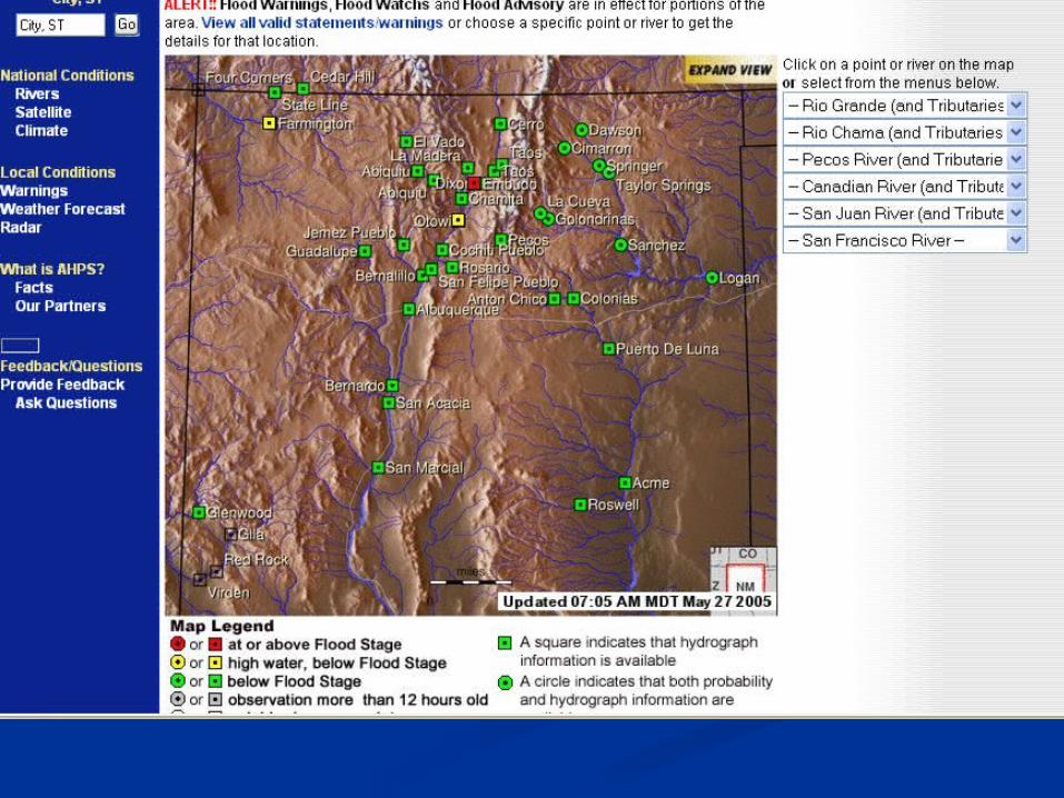
Advanced Hydrologic Prediction Advanced Hydrologic Prediction Services – AHPSServices – AHPS
Improving Hydrologic ServicesImproving Hydrologic Services
• Improving disseminationImproving dissemination• More graphicsMore graphics• More standard formatsMore standard formats• Better use of the InternetBetter use of the Internet• User friendlyUser friendly

http://www.weather.gov/rivers_tab.php


Flash Flood ProgramFlash Flood Program
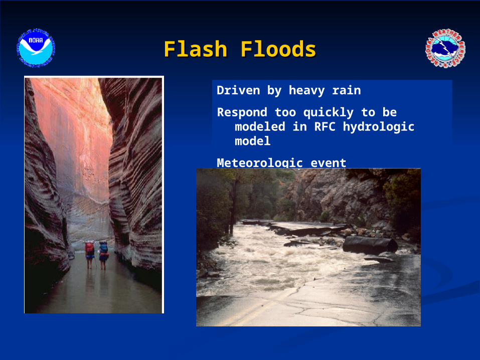
Flash FloodsFlash Floods
Driven by heavy rain
Respond too quickly to be modeled in RFC hydrologic model
Meteorologic event

Flash Flood Warning ProgramFlash Flood Warning Program
1.1. National Centers National Centers • Storm Prediction Center - Storm Prediction Center -
heavy rain meso-scale heavy rain meso-scale discussiondiscussion
• Hydrometeorologic Hydrometeorologic Prediction CenterPrediction Center - - excessive rainfall product excessive rainfall product and quantitative and quantitative precipitation productprecipitation product

Flash Flood Warning ProgramFlash Flood Warning Program
2. River Forecast Centers (RFCs)2. River Forecast Centers (RFCs) - Flash Flood Guidance- Flash Flood Guidance
Flash Flood Warning ProgramFlash Flood Warning Program
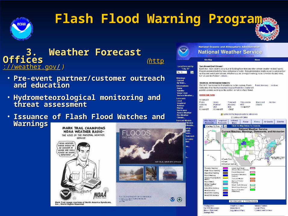
3. Weather Forecast Offices3. Weather Forecast Offices ((hhttpttp://weather.gov://weather.gov// ))
• Pre-event partner/customer outreach and Pre-event partner/customer outreach and educationeducation
• Hydrometeorological monitoring and threat Hydrometeorological monitoring and threat assessmentassessment
• Issuance of Flash Flood Watches and Issuance of Flash Flood Watches and WarningsWarnings

Advanced Hydrologic Prediction Advanced Hydrologic Prediction Services - AHPSServices - AHPS
Improving Hydrologic ServicesImproving Hydrologic Services
• Flash Flood Monitoring and Prediction – FFMPFlash Flood Monitoring and Prediction – FFMP• Continuous monitoring of rainfall rates and Continuous monitoring of rainfall rates and
accumulations compared to flash flood guidance for accumulations compared to flash flood guidance for high resolution basinshigh resolution basins
• Automated alerts when dangerous flash flood Automated alerts when dangerous flash flood situations may be developingsituations may be developing
• Distributed to the Weather Forecast Offices in 2002 Distributed to the Weather Forecast Offices in 2002
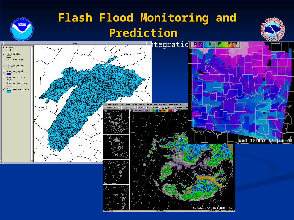
Flash Flood Monitoring and PredictionFlash Flood Monitoring and Prediction
FFMP Data IntegrationFFMP Data Integration

2130 – 2135 UTC Rainfall (in/hr)
.41
.38
.39 .37
.29 .14
.20
.30.16
.24
Grid size 1o x 1km
Flash Flood Monitoring and PredictionFlash Flood Monitoring and Prediction Mapping Radar Bins to a BasinMapping Radar Bins to a Basin
Watershed
Boundary
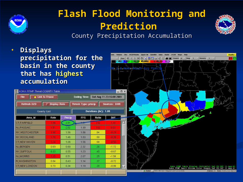
Flash Flood Monitoring and PredictionFlash Flood Monitoring and Prediction County Precipitation AccumulationCounty Precipitation Accumulation
• Displays precipitation for Displays precipitation for the basin in the county the basin in the county that has that has highesthighest accumulation accumulation
FFMP 1.0 Hour Basin Avg Precip

Flash Flood Monitoring and PredictionFlash Flood Monitoring and Prediction Basin Precipitation AccumulationBasin Precipitation Accumulation
• Displays basin Displays basin precipitation within precipitation within the selected countythe selected county FFMP 1.0 Hour Basin Avg Precip

SummarySummary
• National Weather Service mission is to save National Weather Service mission is to save lives and propertylives and property
• National, regional and local offices work together National, regional and local offices work together to carry out this missionto carry out this mission
• Weather Forecast Offices issue watches and Weather Forecast Offices issue watches and warning to the publicwarning to the public
• Continuously improving our servicesContinuously improving our services

Thank youThank you
Related Documents