‘NO TERMS BUT UNCONDITIONAL SURRENDER’: ARCHAEOLOGICAL AND GEOPHYSICAL ASSESSMENT OF THE FORT DONELSON CONFEDERATE MONUMENT LANDSCAPE, STEWART COUNTY, TENNESSEE Shawn M. Patch, Christopher T. Espenshade, Sarah Lowry, and Patrick Severts Recent archaeological and geophysical work conducted around the Confederate Monument at Fort Donelson National Battlefield yielded significant information. An integrated approach was used that included close-interval shovel testing, intensive metal detecting, and ground penetrating radar (GPR). Results indicate a very high density of military artifacts and features in a narrowly confined area that witnessed major action during the Battle of Fort Donelson in 1862. Interpretations are offered regarding different phases before and after the battle and subsequent activities associated with monument construction in the 1930s, as well as an evaluation of the effectiveness of systematic, intensive metal detecting and the potential of geophysics on battlefield sites. New South Associates conducted a detailed archaeological and geophysical assessment of the Confederate Monument landscape at Fort Donelson National Battlefield in Stewart County, Tennessee (Figures 1-3). The study was conducted on behalf of the National Park Service (NPS). The purpose of this paper is to discuss results of an integrated approach to battlefield landscape assess- ment using multiple methods on a small scale, including close interval shovel testing, intensive metal detecting, and ground penetrating radar survey. No professional archaeological work had been conducted prior to the current study and little was known of the area beyond historic accounts. Historic Overview Extensive research has been conducted on the history of Fort Donelson during the Civil War. The Cultural Landscape Report (Jaeger Company 2009) provides an overall summary of the Fort as well as an administrative history of the park and its current condition. For purposes of the current study, only a brief summary of the Battle of Fort Donelson is presented; greater detail is provided in Patch et al. (2012) and Knight (2011). Bearss (1959a-g) provides detailed mapping of unit locations. In mid-February, 1862, the Confederates were desperately attempting to retain control of river traffic along the Cumberland River. The river was a major supply route, and the federal efforts in Tennessee would be bolstered if they could move equipage and personnel along the Cumberland. The Confederates considered Fort Donelson as their seat of power on the Cumberland. In mid- February, the complex included: Fort Donelson proper, an earthwork fort; water batteries that could fire on river traffic; and a partially completed outer line of defenses including infantry trenches and abatis (defensive obstacles formed by felled trees with sharpened branches facing the enemy). The battle occurred over five days, February 12-16, 1862. 110

Welcome message from author
This document is posted to help you gain knowledge. Please leave a comment to let me know what you think about it! Share it to your friends and learn new things together.
Transcript
‘NO TERMS BUT UNCONDITIONAL SURRENDER’: ARCHAEOLOGICAL AND GEOPHYSICAL ASSESSMENT OF THE
FORT DONELSON CONFEDERATE MONUMENT LANDSCAPE, STEWART COUNTY, TENNESSEE
Shawn M. Patch, Christopher T. Espenshade, Sarah Lowry, and
Patrick Severts Recent archaeological and geophysical work conducted around the Confederate Monument at Fort Donelson National Battlefield yielded significant information. An integrated approach was used that included close-interval shovel testing, intensive metal detecting, and ground penetrating radar (GPR). Results indicate a very high density of military artifacts and features in a narrowly confined area that witnessed major action during the Battle of Fort Donelson in 1862. Interpretations are offered regarding different phases before and after the battle and subsequent activities associated with monument construction in the 1930s, as well as an evaluation of the effectiveness of systematic, intensive metal detecting and the potential of geophysics on battlefield sites.
New South Associates conducted a detailed archaeological and geophysical assessment of the Confederate Monument landscape at Fort Donelson National Battlefield in Stewart County, Tennessee (Figures 1-3). The study was conducted on behalf of the National Park Service (NPS). The purpose of this paper is to discuss results of an integrated approach to battlefield landscape assess-ment using multiple methods on a small scale, including close interval shovel testing, intensive metal detecting, and ground penetrating radar survey. No professional archaeological work had been conducted prior to the current study and little was known of the area beyond historic accounts.
Historic Overview
Extensive research has been
conducted on the history of Fort Donelson during the Civil War. The Cultural Landscape Report (Jaeger Company 2009) provides an overall summary of the Fort as well as an administrative history of
the park and its current condition. For purposes of the current study, only a brief summary of the Battle of Fort Donelson is presented; greater detail is provided in Patch et al. (2012) and Knight (2011). Bearss (1959a-g) provides detailed mapping of unit locations.
In mid-February, 1862, the Confederates were desperately attempting to retain control of river traffic along the Cumberland River. The river was a major supply route, and the federal efforts in Tennessee would be bolstered if they could move equipage and personnel along the Cumberland. The Confederates considered Fort Donelson as their seat of power on the Cumberland. In mid-February, the complex included: Fort Donelson proper, an earthwork fort; water batteries that could fire on river traffic; and a partially completed outer line of defenses including infantry trenches and abatis (defensive obstacles formed by felled trees with sharpened branches facing the enemy). The battle occurred over five days, February 12-16, 1862.
110

Fort Donelson
FIGURE 1. Location of study area within Fort Donelson National Battlefield.
111
Tennessee Archaeology 7(2) Winter 2015
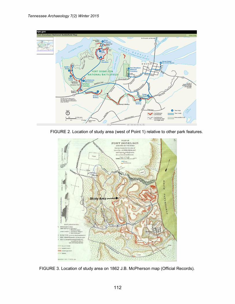
FIGURE 2. Location of study area (west of Point 1) relative to other park features.
FIGURE 3. Location of study area on 1862 J.B. McPherson map (Official Records).
112
Fort Donelson
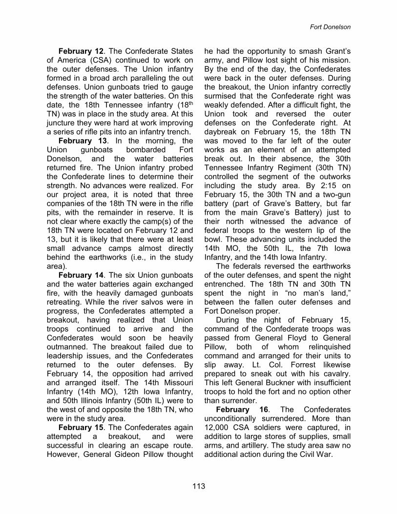
February 12. The Confederate States of America (CSA) continued to work on the outer defenses. The Union infantry formed in a broad arch paralleling the out defenses. Union gunboats tried to gauge the strength of the water batteries. On this date, the 18th Tennessee infantry (18th TN) was in place in the study area. At this juncture they were hard at work improving a series of rifle pits into an infantry trench.
February 13. In the morning, the Union gunboats bombarded Fort Donelson, and the water batteries returned fire. The Union infantry probed the Confederate lines to determine their strength. No advances were realized. For our project area, it is noted that three companies of the 18th TN were in the rifle pits, with the remainder in reserve. It is not clear where exactly the camp(s) of the 18th TN were located on February 12 and 13, but it is likely that there were at least small advance camps almost directly behind the earthworks (i.e., in the study area).
February 14. The six Union gunboats and the water batteries again exchanged fire, with the heavily damaged gunboats retreating. While the river salvos were in progress, the Confederates attempted a breakout, having realized that Union troops continued to arrive and the Confederates would soon be heavily outmanned. The breakout failed due to leadership issues, and the Confederates returned to the outer defenses. By February 14, the opposition had arrived and arranged itself. The 14th Missouri Infantry (14th MO), 12th Iowa Infantry, and 50th Illinois Infantry (50th IL) were to the west of and opposite the 18th TN, who were in the study area.
February 15. The Confederates again attempted a breakout, and were successful in clearing an escape route. However, General Gideon Pillow thought
he had the opportunity to smash Grant’s army, and Pillow lost sight of his mission. By the end of the day, the Confederates were back in the outer defenses. During the breakout, the Union infantry correctly surmised that the Confederate right was weakly defended. After a difficult fight, the Union took and reversed the outer defenses on the Confederate right. At daybreak on February 15, the 18th TN was moved to the far left of the outer works as an element of an attempted break out. In their absence, the 30th Tennessee Infantry Regiment (30th TN) controlled the segment of the outworks including the study area. By 2:15 on February 15, the 30th TN and a two-gun battery (part of Grave’s Battery, but far from the main Grave’s Battery) just to their north witnessed the advance of federal troops to the western lip of the bowl. These advancing units included the 14th MO, the 50th IL, the 7th Iowa Infantry, and the 14th Iowa Infantry.
The federals reversed the earthworks of the outer defenses, and spent the night entrenched. The 18th TN and 30th TN spent the night in “no man’s land,” between the fallen outer defenses and Fort Donelson proper.
During the night of February 15, command of the Confederate troops was passed from General Floyd to General Pillow, both of whom relinquished command and arranged for their units to slip away. Lt. Col. Forrest likewise prepared to sneak out with his cavalry. This left General Buckner with insufficient troops to hold the fort and no option other than surrender.
February 16. The Confederates unconditionally surrendered. More than 12,000 CSA soldiers were captured, in addition to large stores of supplies, small arms, and artillery. The study area saw no additional action during the Civil War.
113
Tennessee Archaeology 7(2) Winter 2015
Methods
Background research included review of existing literature and previous work at Fort Donelson (Cornelison and Legg 1993; Jaeger Company 2009; Parsons 2011, 2012; Tankersley and Gregory 2010). No prior archaeological work had been conducted directly in the study area. However, Cornelison and Legg (1993) investigated several different areas of the park, including a possible road location immediately northeast of the monument. The most recent synthesis of the park is a cultural landscape report (Jaeger Company 2009).
Archaeological fieldwork consisted of multiple methods, including shovel testing, intensive metal detecting, total station mapping, and ground penetrating radar survey. Although the field effort used three methods, the work was integrated through the use of the same grid system and total station mapping.
Systematic metal detecting has been shown to be the best method for investigating battlefields and other military sites (Balicki and Espenshade 2010; Conner and Scott 1998; Scott and Fox 1987; Scott et al. 1989). This approach has become the standard for all systematic investigations of military sites. Balicki and Espenshade (2010) identified five major traits characteristic of this approach, including: 1) careful review of the archival record and oral history to identify potential search areas; 2) intensive metal detector survey to locate metal military artifacts; 3) use of instruments that are well suited to local conditions and operators with significant expertise; 4) careful and precise mapping of all individual finds; and, 5) analysis of fired and dropped munitions and other diagnostic artifacts to reconstruct locations and movements within a battle.
Previous studies on similar sites both locally and regionally have been conducted in recent years (Cornelison 2007; Espenshade et al. 2008, 2011; Parsons 2011, 2012; Tankersley and Gregory 2010). The most closely related is Fort Heiman, a unit of Fort Donelson National Battlefield located on the west side of the Tennessee River in Kentucky. Tankersley and Gregory (2010) investigated a portion of the battlefield that was approximately 30 acres in size. Metal detecting concentrated on areas adjacent to existing historic landscape features and level areas that could have supported military activities. The level of effort for this phase included a four-person crew working for five days. The results recorded 395 metal detector finds and 533 artifacts, the vast majority of which were cut nails and fragments. The survey also identified 31 period arms related artifacts, including rifle and pistol bullets, a copper cartridge, dropped canister, and an artillery shell fragment. Artifact recovery locations supported the interpretation that the entire area had been heavily targeted by local collectors. However, it was also possible to infer the locations of a winter encampment based on the presence of brick, ferrous metal, and stove and cooking parts that correlated with historic accounts.
Parsons (2011, 2012) investigated a portion of the Federal fort northwest of Fort Heiman. In late 2010, after the earlier survey by Tankersley and Gregory (2010), the Southeast Archeological Center (SEAC) investigated a portion of Fort Heiman with a particular emphasis on the Federal fort area. The survey area was approximately 36 acres in size and focused largely around an existing road (Parsons 2011). The metal detection survey was conducted by three SEAC personnel and two local volunteers over
114

Fort Donelson
two days covering an area approximately 30 acres in size. Results indicated the presence of 169 individual finds and 242 artifacts, with cut nails comprising the overwhelming majority. Additional artifacts included brass percussion caps, canister shot, musket and Minié balls, and one 1856 silver coin. New landscape features were also identified, including dugouts that were likely used for huts, hut pads, earthworks, and historic road segments.
Cornelison (2007) reported on a multi-year investigation at multiple locations at Shiloh National Battlefield in Hardin County, Tennessee. This study provides and invaluable source of comparative data because it was a major battle that occurred only a few months after the fall of Fort Donelson, it was early in the war and produced a similar artifact assemblage, and at least a few of the individual study units had not previously been targeted by relic hunters. Experienced volunteers were used extensively under direct supervision of NPS and SEAC staff. The survey identified 5821 unique finds and 7113 artifacts. Artifact analysis indicated high frequencies of round lead shot (primarily 0.69 caliber), Minié balls, carbine and pistol bullets, artillery, clothing, weaponry and gun parts, and other personal items. Extensive spatial analysis was conducted to look for patterning of particular artifact types. Overall, this study added considerably to overall interpretations of the battle.
The present study is somewhat unusual because of the focus on an area that saw battle action and use as an expedient, forward position camp. Most archaeological studies of camps have examined full regimental camps, generally in safe locations well removed from battle actions (e.g., Balicki 2009; Balicki et al. 2007; Garrow et al. 2000; Geier 2003;
Geier et al. 2006; Geier and Winters 1994; Higgins et al. 1995; Jensen 2000; Jolley 2008; Jones 1999; Legg et al. 1991; Legg and Smith 1989; McBride 1994; McBride and Sharp 1991; O’Neal and Reid 2007). There has been little research into expedient camps in harm’s way.
GPR was used to prospect for the reported mass grave and other archaeological features. GPR data are acquired by transmitting pulses of radar energy into the ground from a surface antenna, reflecting the energy off buried objects, features, or bedding contacts and then detecting the reflected waves back at the ground surface with a receiving antenna (Conyers 2004:1). Greater contrast in electrical and magnetic properties between two materials at an interface will result in stronger reflected amplitudes (Conyers 2004).
GPR data processing followed standard steps such as frequency filtering, setting time zero (telling the software the location of the surface in relation to the first pulse), and removal of antenna energy ringing and horizontal banding, as well as the creation of amplitude slice-maps (Conyers 2004). Amplitude slice-maps are a three-dimensional tool for viewing differences in reflected amplitudes across a given surface at various depths. The result is a map that shows amplitudes in plan view at various depths below ground surface. Two-dimensional reflection profiles were also analyzed to determine the nature of the features identified on the amplitude slice maps. The final step in the data processing was to integrate the depth slices with the other geophysical and spatial data. Individual GPR anomalies were digitized as features in a unique shapefile with corresponding attributes to facilitate interpretation. The end result
115

Tennessee Archaeology 7(2) Winter 2015
was multiple spatial datasets including GPR anomalies, metal detector finds, shovel test locations, and aerial photography and topographic maps.
Military artifacts were classified based a system modified from previous studies (Legg et al. 1991; Legg and Smith 1989). Briefly, it is organized as a functional system based on broad groups and sub-groups, including Clothing (military and civilian), Arms (ammunition and accoutrements), Personal (jewelry, writing implements), Kitchen (food preparation, consumption and storage), Indulgences (alcohol and tobacco), Medicine, Tools, Architecture, Transportation, and Miscellaneous.
Attributes recorded for small arms included whether they were fired or dropped and army affiliation (Federal, Confederate, indeterminate). The plotting of fired and dropped bullets has long been a standard procedure of battlefield archaeology and is useful in distinguishing troop positions and other battle aspects. Assigning small arms to the Federal or Confederate armies was based on the type, the caliber, and the manufacturing traits of the bullet, which all allowed inference on the weapon type. Artillery shell fragments were measured and then typed using the guide of Melton and Pawl (1996). As feasible, the shell fragments were attributed to Federal or Confederate.
Results
Ninety-eight shovel tests were
excavated, and the results indicate a relatively sparse distribution of artifacts across the study area (Figure 4). Of these, 22 were positive, 66 were negative, and 10 were not excavated because of surface obstacles (e.g., concrete), earthworks, or extreme slope. Positive tests generally yielded only low
frequencies of artifacts (mean is 2.0 artifacts per positive test). This phase of the study yielded both prehistoric (n=11) and historic (n=34) material.
Historic artifacts (n=34) recovered from this phase include a range of container glass, plain and decorated whiteware, cut and wire nails, corroded iron, wire, and one kettle or pot fragment (Table 1). Most of these artifacts are consistent with a Civil War period occupation. However, some of the clear container glass, corroded metal, and wire may date from subsequent occupations or use. Spatially, historic artifacts were recovered in several locations, although the higher density shovel tests were located east of, and downslope from, the monument.
Two areas with historic artifacts yielded shovel test profiles that suggested organically enriched deposits. Both of these are east of, and downslope from,
FIGURE 4. Shovel test locations and results.
116
Fort Donelson
the monument, in an area of increased slope. The first, at grid point 485N 520E, included multiple cut nails and a cow or deer bone. The second, at grid point 520N 525E, was very similar, with 0-30 centimeters of dark brown silt over 30-35 centimeters of yellowish brown silty clay. The top layers in both locations were noticeably darker than other shovel tests. In both cases the artifacts and enriched soil horizon clearly indicated refuse deposits/possible midden. No obvious feature outlines were observed, which suggested that the refuse may have been tossed downslope in an informal manner.
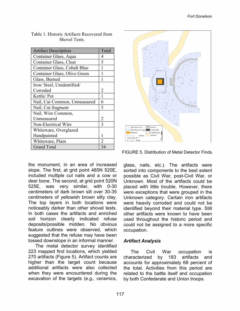
The metal detector survey identified 223 mapped find locations, which yielded 270 artifacts (Figure 5). Artifact counts are higher than the target count because additional artifacts were also collected when they were encountered during the excavation of the targets (e.g., ceramics,
glass, nails, etc.). The artifacts were sorted into components to the best extent possible as Civil War, post-Civil War, or Unknown. Most of the artifacts could be placed with little trouble. However, there were exceptions that were grouped in the Unknown category. Certain iron artifacts were heavily corroded and could not be identified beyond their material type. Still other artifacts were known to have been used throughout the historic period and could not be assigned to a more specific occupation.
Artifact Analysis
The Civil War occupation is
characterized by 183 artifacts and accounts for approximately 68 percent of the total. Activities from this period are related to the battle itself and occupation by both Confederate and Union troops.
Table 1. Historic Artifacts Recovered from Shovel Tests.
Artifact Description Total Container Glass, Aqua 4 Container Glass, Clear 5 Container Glass, Cobalt Blue 1 Container Glass, Olive Green 1 Glass, Burned 1 Iron/ Steel, Unidentified/ Corroded 2 Kettle/ Pot 1 Nail, Cut Common, Unmeasured 6 Nail, Cut fragment 5 Nail, Wire Common, Unmeasured 2 Non-Electrical Wire 3 Whiteware, Overglazed Handpainted 1 Whiteware, Plain 2 Grand Total 34
FIGURE 5. Distribution of Metal Detector Finds.
117
Tennessee Archaeology 7(2) Winter 2015
Table 2. Metal Detector Find Artifacts from the Civil War Period by Military Group.
118

Fort Donelson
The nature of the post-Civil War occupation is less clear and is characterized by 48 artifacts (18% of total). Activities from this period are attributed to the general maintenance of the park and monument landscape, as well as visitors. The bulk of the artifacts likely date from the 1920s-1940s, after the park was created and the monument was erected.
The remaining class of Unknown is not a unique component. It is represented by 39 artifacts (14% of total).
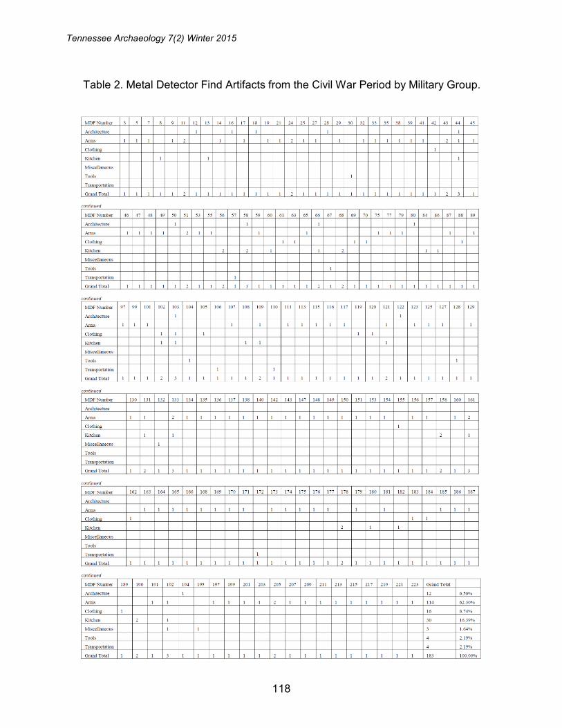
Military artifacts were further sorted into broad functional categories as defined by Legg and Smith (1989). Table 2 shows metal detector finds (MDFs) from the Civil War period (n=183). The highest frequencies are in the Arms Group (n=114, 62.3%), followed by Kitchen (n=30, 16.4%), Clothing (n=16, 8.7%), Architecture (n=12, 6.6%), Tools (n=4, 2.2%), Transportation (n=4, 2.2%), and Miscellaneous (n=3, 1.6%). The high frequency of Arms and Ammunition is consistent with expectations for a battlefield setting.
Architecture Group (n=12; Table 3). The name for this group is slightly misleading because very few of these artifacts are associated with structures (Figure 6). Cut nails (n=7) and fragments (n=2) are the most common type. Other items include a bolt/bracket, hinge, and
spike. Based on the volume of iron noted in the metal detector survey this class is under-represented. Recent surveys at Fort Heiman identified high frequency nail scatters and similar patterns were observed at the Confederate Monument (Parsons 2011, 2012; Tankersley and Gregory 2010). Although size variation was noted in the current sample of nails, the majority probably originated from boxes and crates that were used for a range of supplies. As the supplies were expended the boxes likely served as sources of firewood.
FIGURE 6. Architecture Group artifacts.
Table 3. Military Architecture Group Artifacts.
MDF Number 12 16 18 28 44 50 58 66 80 103 122 194 Total % Total
Bolt and/or Bracket
1
1 8.33%
Hinge
1
1 8.33%
Nail, Cut
1
1 1
1
1 1 1 7 58.33%
Nail, Cut fragment 1
1
2 16.67%
Spike
1
1 8.33%
Total 1 1 1 1 1 1 1 1 1 1 1 1 12 100.00%
119
Tennessee Archaeology 7(2) Winter 2015
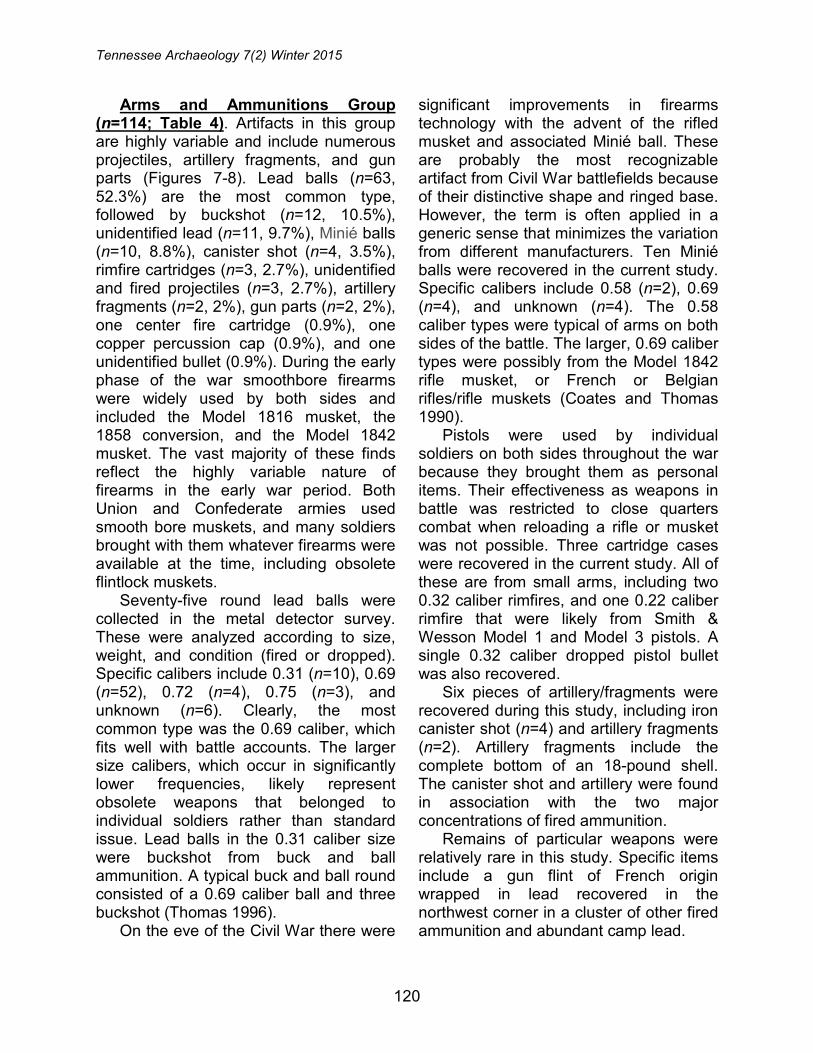
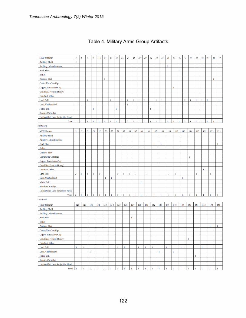
Arms and Ammunitions Group (n=114; Table 4). Artifacts in this group are highly variable and include numerous projectiles, artillery fragments, and gun parts (Figures 7-8). Lead balls (n=63, 52.3%) are the most common type, followed by buckshot (n=12, 10.5%), unidentified lead (n=11, 9.7%), Minié balls (n=10, 8.8%), canister shot (n=4, 3.5%), rimfire cartridges (n=3, 2.7%), unidentified and fired projectiles (n=3, 2.7%), artillery fragments (n=2, 2%), gun parts (n=2, 2%), one center fire cartridge (0.9%), one copper percussion cap (0.9%), and one unidentified bullet (0.9%). During the early phase of the war smoothbore firearms were widely used by both sides and included the Model 1816 musket, the 1858 conversion, and the Model 1842 musket. The vast majority of these finds reflect the highly variable nature of firearms in the early war period. Both Union and Confederate armies used smooth bore muskets, and many soldiers brought with them whatever firearms were available at the time, including obsolete flintlock muskets.
Seventy-five round lead balls were collected in the metal detector survey. These were analyzed according to size, weight, and condition (fired or dropped). Specific calibers include 0.31 (n=10), 0.69 (n=52), 0.72 (n=4), 0.75 (n=3), and unknown (n=6). Clearly, the most common type was the 0.69 caliber, which fits well with battle accounts. The larger size calibers, which occur in significantly lower frequencies, likely represent obsolete weapons that belonged to individual soldiers rather than standard issue. Lead balls in the 0.31 caliber size were buckshot from buck and ball ammunition. A typical buck and ball round consisted of a 0.69 caliber ball and three buckshot (Thomas 1996).
On the eve of the Civil War there were
significant improvements in firearms technology with the advent of the rifled musket and associated Minié ball. These are probably the most recognizable artifact from Civil War battlefields because of their distinctive shape and ringed base. However, the term is often applied in a generic sense that minimizes the variation from different manufacturers. Ten Minié balls were recovered in the current study. Specific calibers include 0.58 (n=2), 0.69 (n=4), and unknown (n=4). The 0.58 caliber types were typical of arms on both sides of the battle. The larger, 0.69 caliber types were possibly from the Model 1842 rifle musket, or French or Belgian rifles/rifle muskets (Coates and Thomas 1990).
Pistols were used by individual soldiers on both sides throughout the war because they brought them as personal items. Their effectiveness as weapons in battle was restricted to close quarters combat when reloading a rifle or musket was not possible. Three cartridge cases were recovered in the current study. All of these are from small arms, including two 0.32 caliber rimfires, and one 0.22 caliber rimfire that were likely from Smith & Wesson Model 1 and Model 3 pistols. A single 0.32 caliber dropped pistol bullet was also recovered.
Six pieces of artillery/fragments were recovered during this study, including iron canister shot (n=4) and artillery fragments (n=2). Artillery fragments include the complete bottom of an 18-pound shell. The canister shot and artillery were found in association with the two major concentrations of fired ammunition.
Remains of particular weapons were relatively rare in this study. Specific items include a gun flint of French origin wrapped in lead recovered in the northwest corner in a cluster of other fired ammunition and abundant camp lead.
120

Fort Donelson
FIGURE 7. Arms and Ammunition Group artifacts.
FIGURE 8. Arms and Ammunition Group artifacts.
121
Tennessee Archaeology 7(2) Winter 2015
Table 4. Military Arms Group Artifacts.
122

Fort Donelson
No sword fragments, scabbard tips, or other gun parts were identified, suggesting those items may have been collected after the battle.
Clothing Group (n=16; Table 5). Buckles (n=7) of various material and style comprise the largest category. Within this category there is one brass belt buckle, three iron belt buckles, one brass clothing buckle, one iron clothing buckle, and one brass knapsack buckle (Figure 9). Many of the belt buckles appear to have come from uniform accouterments such as knapsacks. One clear example of an early war Confederate waist buckle is present.
Additional clothing items include two brass uniform buttons, both of which were
classified as three-piece eagle “I” infantry style. In early War contexts, such buttons could be either CSA or Federal issue. Both were found very close together in the northwest corner of the survey area with extensive evidence for combat. This group also includes a well-preserved brass pin/clasp with an ornate floral motif that was likely a personal effect rather than military issue.
The survey also recovered a U.S. regulation 1861 shoulder belt-plate. It was issued to non-commissioned infantry and worn on shoulder belts that supported cartridge boxes and/or swords. This particular example is in relatively good condition with a strongly embossed eagle on the obverse. The reverse side is
Table 4 (continued). Military Arms Group Artifacts.
123

Tennessee Archaeology 7(2) Winter 2015
missing the attachment loops. It has a brass front and lead back. It was recovered east of the monument and downslope in an area that may have been a refuse deposit. Its origin and context are not completely clear, although it likely reflects a brief Union occupation on February 15-16, or after the battle. Another artifact of particular interest is a brass cap pouch finial.
Kitchen Group (n=30; Table 6). This group includes food preparation, consumption, and storage items, all of which tend to reflect camps or camp activities (Figure 10). The most common artifact type is ceramics such as whiteware and porcelain (n=10, 33.3%).
The next most common type is kettle/pot/skillet (n=9, 30%). At least three unique vessels are represented by these artifacts and additional fragments may
have been present but not collected. One example consists of the kettle shape and an attached foot and another has a handle element. A few examples of container glass (n=4) were collected, although generally incidental to metal artifacts in the same location. For that reason, the frequencies are artificially low. However, their presence suggests food storage activities occurred. Glass containers for preserved foods are common in Civil War camps.
Several eating utensils were recovered, including two separate forks, one of which has a bone handle, and a knife blade. These items offer direct evidence of food preparation and/or consumption. A single deer bone was recovered and offers direct evidence of animal butchery as well as good preservation.
FIGURE 9. Clothing Group artifacts.
124
Fort Donelson
The relatively high frequencies noted in this group compared to others is unexpected. The artifact data clearly indicate a camp existed and a few shovel test profiles suggested potential features. At Folly Island, South Carolina, a well documented and extensively excavated Union camp, Legg and Smith (1989) noted a virtual absence of ceramic tablewares and high frequencies of tinned sheet iron vessels and container glass. It is possible that soldiers at Fort Donelson had greater access to common tablewares because of their proximity to Dover.
Miscellaneous Group (n=3). Three of the Civil War period artifacts could not be assigned to specific groups because of
their size, condition, or lack of comparable examples. For these reasons, they were assigned to the Miscellaneous Group. One is a possible pewter artifact that may have been an adornment or served a decorative function. A second is a copper/brass fragment that was too small to identify with any confidence. The third is a copper/brass stamped disc or cap with a floral pattern that may have come from a chest or box.
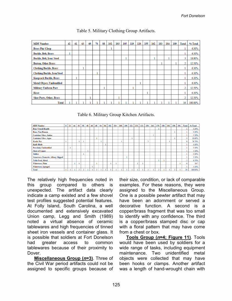
Tools Group (n=4; Figure 11). Tools would have been used by soldiers for a wide range of tasks, including equipment maintenance. Two unidentified metal objects were collected that may have been hooks or clamps. Another artifact was a length of hand-wrought chain with
Table 5. Military Clothing Group Artifacts.
Table 6. Military Group Kitchen Artifacts.
125
Tennessee Archaeology 7(2) Winter 2015
wire attached. The last artifact was a wrench that was used for an unknown function.
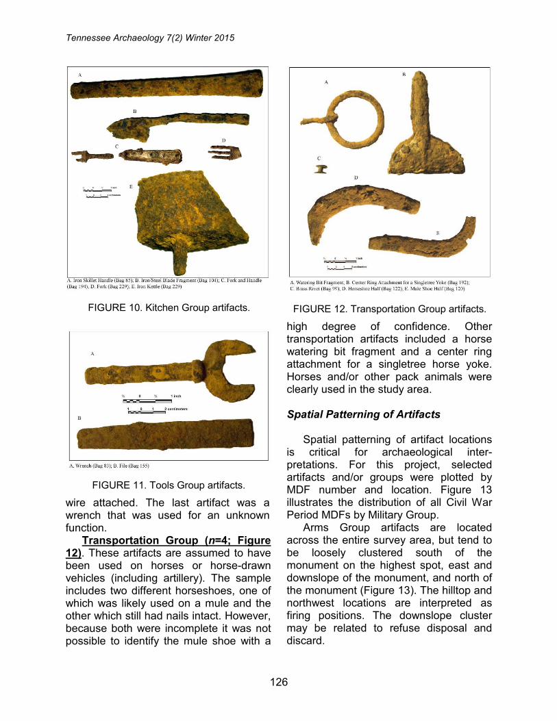
Transportation Group (n=4; Figure 12). These artifacts are assumed to have been used on horses or horse-drawn vehicles (including artillery). The sample includes two different horseshoes, one of which was likely used on a mule and the other which still had nails intact. However, because both were incomplete it was not possible to identify the mule shoe with a
high degree of confidence. Other transportation artifacts included a horse watering bit fragment and a center ring attachment for a singletree horse yoke. Horses and/or other pack animals were clearly used in the study area.
Spatial Patterning of Artifacts
Spatial patterning of artifact locations is critical for archaeological inter-pretations. For this project, selected artifacts and/or groups were plotted by MDF number and location. Figure 13 illustrates the distribution of all Civil War Period MDFs by Military Group.
Arms Group artifacts are located across the entire survey area, but tend to be loosely clustered south of the monument on the highest spot, east and downslope of the monument, and north of the monument (Figure 13). The hilltop and northwest locations are interpreted as firing positions. The downslope cluster may be related to refuse disposal and discard.
FIGURE 10. Kitchen Group artifacts.
FIGURE 11. Tools Group artifacts.
FIGURE 12. Transportation Group artifacts.
126

Fort Donelson
Kitchen Group artifacts are much more restricted, with a loose cluster east and downslope of the monument along the north and south arcs of the walkway (Figure 13). It is also important to note that these are the same areas that yielded positive shovel test results for historic material, organically enhanced soils, and dense clusters of low conductivity iron objects (i.e., nails) that were not collected. Together, these data suggest the presence of refuse deposits and sheet
midden that may also contain intact features. The downslope location, away from the highest point, was likely a favorable place for trash disposal on an informal or ad hoc basis. Although formal camp procedures were well established before the war, the distributions here suggest they were not necessarily followed and enforced in the study area.
Clothing Group artifacts occur in much lower frequencies. Although they are dispersed around the survey area, they
FIGURE 13. Distribution of Civil War period artifacts by military group.
127
Tennessee Archaeology 7(2) Winter 2015
tend to follow the same clusters noted above (Figure 13). The densest area is east and downslope of the monument, with six individual items, and then southeast of the monument in a relatively restricted area with four items. These two locations may represent refuse deposits. A third cluster is present in the northwest corner, in a potential firing position, with three artifacts (i.e., two buttons and a buckle). In this case, it appears that these artifacts may have originated from a soldier who became a casualty.
Distribution of Architecture Group artifacts is less than complete because of the biased collection strategy (Figure 13). The plotted artifacts are generally clustered south and east of the monument. Based on metal detector hits noted in the field, nails are distributed throughout the study area. However, the denser concentrations were noted immediately south of the monument (with recovered artifacts), east and downslope of the monument (with recovered artifacts) and along the northern boundary (no recovered artifacts). In certain cases it would be possible to essentially mark the broad outlines of nail clouds (or at least the densest parts) without excavation. Although not replicable, experience from this study suggests that the areas already noted have the densest concentrations.
Tools and Transportation Group artifacts occur in frequencies that are too low to permit meaningful analyses (Figure 13). They are distributed across the survey area except the northern
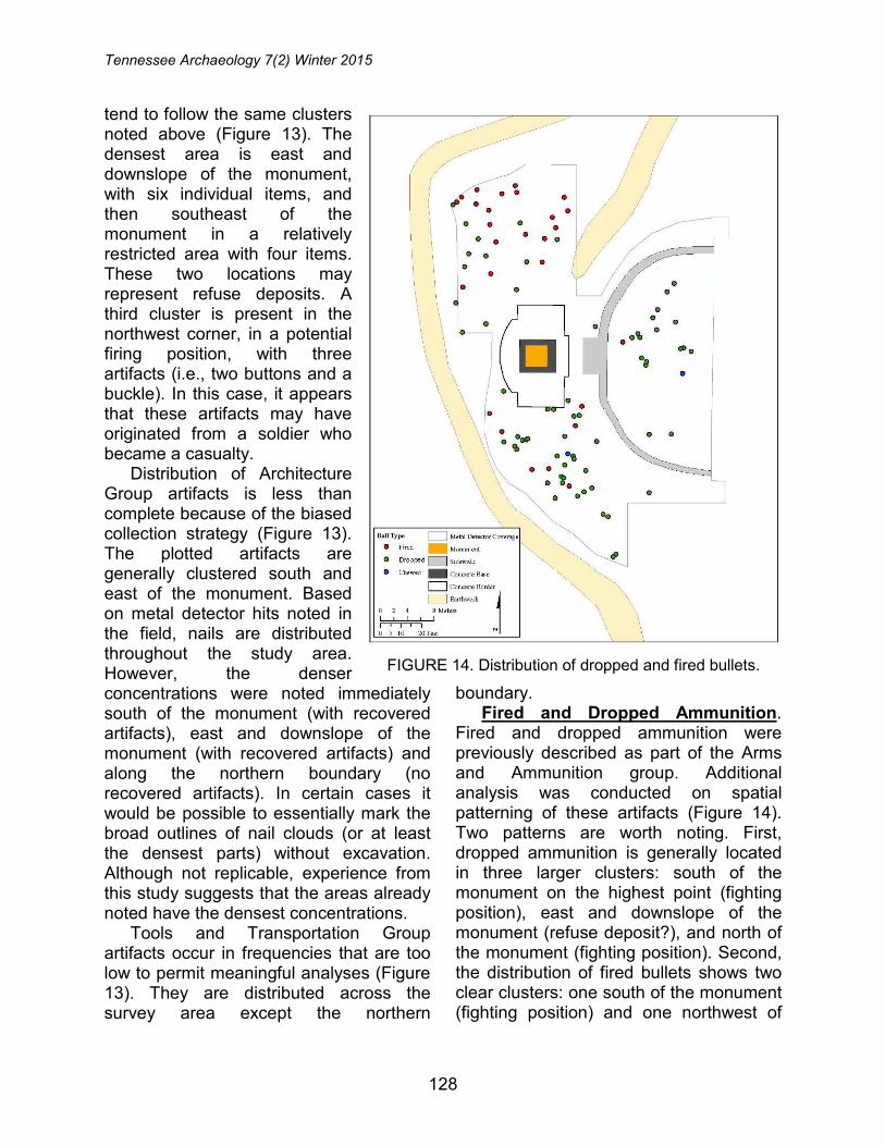
boundary. Fired and Dropped Ammunition.
Fired and dropped ammunition were previously described as part of the Arms and Ammunition group. Additional analysis was conducted on spatial patterning of these artifacts (Figure 14). Two patterns are worth noting. First, dropped ammunition is generally located in three larger clusters: south of the monument on the highest point (fighting position), east and downslope of the monument (refuse deposit?), and north of the monument (fighting position). Second, the distribution of fired bullets shows two clear clusters: one south of the monument (fighting position) and one northwest of
FIGURE 14. Distribution of dropped and fired bullets.
128
Fort Donelson
the monument (fighting position). Of these two, the northern cluster shows a much higher density. This corresponds well to the landform because of its increased exposure to Union fire.
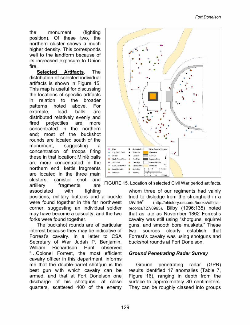
Selected Artifacts. The distribution of selected individual artifacts is shown in Figure 15. This map is useful for discussing the locations of specific artifacts in relation to the broader patterns noted above. For example, lead balls are distributed relatively evenly and fired projectiles are more concentrated in the northern end; most of the buckshot rounds are located south of the monument, suggesting a concentration of troops firing these in that location; Minié balls are more concentrated in the northern end; kettle fragments are located in the three main clusters; canister shot and artillery fragments are associated with fighting positions; military buttons and a buckle were found together in the far northwest corner, suggesting an individual soldier may have become a casualty; and the two forks were found together.
The buckshot rounds are of particular interest because they may be indicative of Forrest’s cavalry. In a letter to CSA Secretary of War Judah P. Benjamin, William Richardson Hunt observed “…Colonel Forrest, the most efficient cavalry officer in this department, informs me that the double-barrel shotgun is the best gun with which cavalry can be armed, and that at Fort Donelson one discharge of his shotguns, at close quarters, scattered 400 of the enemy
whom three of our regiments had vainly tried to dislodge from the stronghold in a ravine” (http://ehistory.osu.edu/books/official-records/127/0965). Bilby (1996:135) noted that as late as November 1862 Forrest’s cavalry was still using “shotguns, squirrel guns, and smooth bore muskets.” These two sources clearly establish that Forrest’s cavalry was using shotguns and buckshot rounds at Fort Donelson.
Ground Penetrating Radar Survey
Ground penetrating radar (GPR)
results identified 17 anomalies (Table 7, Figure 16), ranging in depth from the surface to approximately 80 centimeters. They can be roughly classed into groups
FIGURE 15. Location of selected Civil War period artifacts.
129

Tennessee Archaeology 7(2) Winter 2015
including features visible on the modern surface, buried compacted surfaces, disturbed soils (point reflections), a ditch or trench, iron kettle fragments, and naturally occurring features. Within each feature class there are many possible interpretations depending on the anomalies location relative to other features, anomaly geometry, and possibly even metal detecting results from the anomaly.
Not surprisingly, the sidewalk (anomaly 1) and concrete border (anomalies 2 and 3) near the monument resulted in high amplitude reflections. Even with their high amplitude reflections it is still possible to detect and image features buried below if they are of sufficient contrast and have not been destroyed.
Two buried, compacted surfaces are present. Anomaly 4, east of the monument, is likely an historic road surface. It is also characterized by point reflections, which indicate imperfections within the road surface. The possibility of a trench or secondary earthwork was considered but ultimately ruled out based on topography and historic accounts. It is not a perfectly level feature, but this is consistent with its use as a dirt road that would have eroded with weather and as traffic used the road. The Cultural Landscape Report discusses the creation of Fort Donelson Road in relation to Lock Road, which was an earlier incarnation (Jaeger Company 2009).
Anomaly 9, northeast of the monument, is close to the walkway and concrete borders. For this reason, it is difficult to offer a firm interpretation. It could be a battlefield feature or related to monument construction.
Southwest of the monument there are two smaller collections of point reflections (Anomalies 11 and 12). These correlate extremely well with a large number of lead balls, buck shot, and nails identified by metal detecting. Consideration of both datasets suggests that these might be trash piles or activity areas associated with the battle. Northwest of the monument there is a large area composed of disturbed soils (anomaly 10). There was no metal detecting in this area so there is only the geophysical signature. However, comparison with anomalies 11 and 12 suggests it could be another dense artifact cluster.
Further east from the monument two areas of disturbed soils are located on either side of the sidewalk (Anomalies 16 and 17). These two separate anomalies are likely a single location that was later bisected during sidewalk construction. During the metal detecting survey multiple
Table 7. Identified GPR Anomalies.
ID Description Estimated Depth
1 Sidewalk Surface
2 Concrete Border Surface
3 Concrete Border Surface
4 Compacted Surface and Disturbed Soils 20-70 cm
5 Earthwork Debris 0-25 cm
6 Earthwork Debris 0-25 cm
7 Earthwork Debris 0-16 cm
8 Earthwork Debris 0-20 cm
9 Compacted Surface 8-22 cm
10 Disturbed Soils (Point reflections) 15-70 cm
11 Disturbed Soils (Point reflections) 45-65 cm
12 Disturbed Soils (Point reflections) 45-65 cm
13 Ditch or Trench 30-70 cm
14 Tree Roots - Disturbed Soils (Point reflections) 15-80 cm
15 Tree Roots - Disturbed Soils (Point reflections) 15-80 cm
16 Disturbed Soils (Point reflections) 15-30 cm
17 Disturbed Soils (Point reflections) 15-30 cm
18 Iron Kettle Fragments 10-15 cm
130

Fort Donelson
pieces of iron, buckles, nails, and a zinc lid were found here. The soils in this area were also much darker than the rest of the surveyed area, suggesting they are richer in organic materials. This evidence, combined with the disturbed subsurface and point reflections found in the GPR suggests that this area may have been a midden of some sort during the Civil War era.
The monument itself has earthworks from the battle on three sides of it. The extent of modern stabilization and reconstruction in these sections is unknown, although they are thought to be in their original location. GPR anomalies 5 and 8 indicate areas on both sides of the standing earthworks that were likely borrowed and/or filled. In these areas the subsoil is closer to the surface than in
FIGURE 16. Interpretation of ground penetrating radar survey.
131
Tennessee Archaeology 7(2) Winter 2015
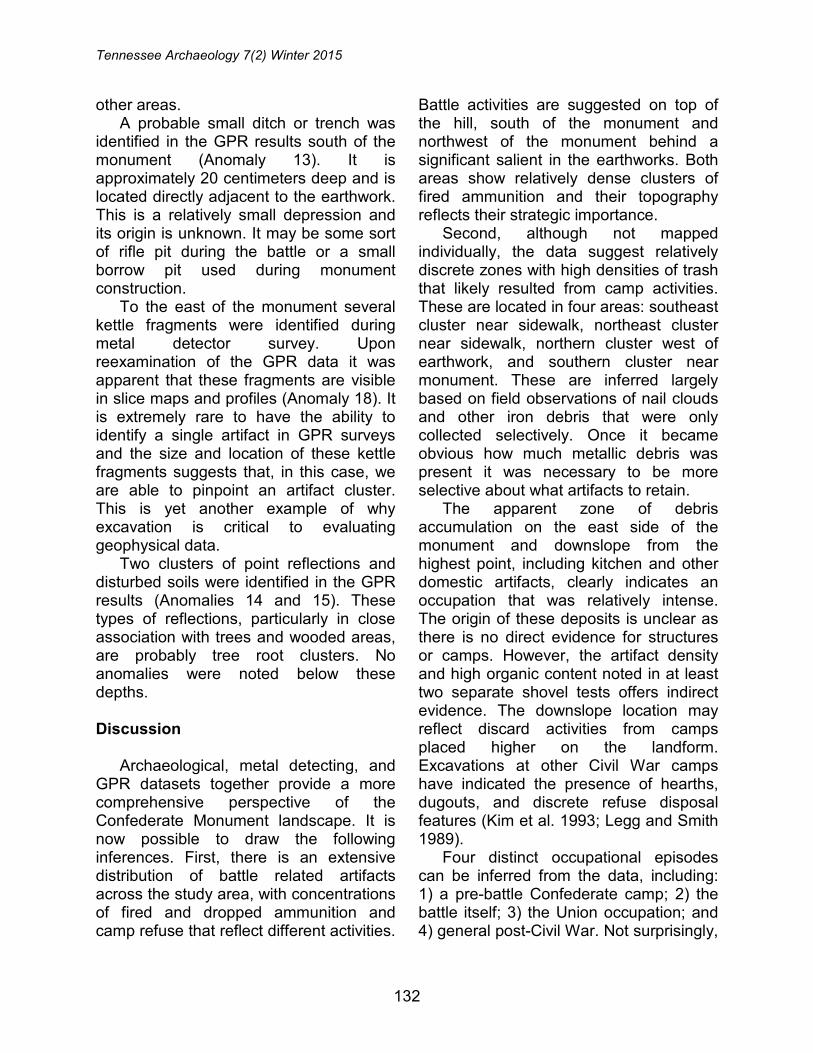
other areas. A probable small ditch or trench was
identified in the GPR results south of the monument (Anomaly 13). It is approximately 20 centimeters deep and is located directly adjacent to the earthwork. This is a relatively small depression and its origin is unknown. It may be some sort of rifle pit during the battle or a small borrow pit used during monument construction.
To the east of the monument several kettle fragments were identified during metal detector survey. Upon reexamination of the GPR data it was apparent that these fragments are visible in slice maps and profiles (Anomaly 18). It is extremely rare to have the ability to identify a single artifact in GPR surveys and the size and location of these kettle fragments suggests that, in this case, we are able to pinpoint an artifact cluster. This is yet another example of why excavation is critical to evaluating geophysical data.
Two clusters of point reflections and disturbed soils were identified in the GPR results (Anomalies 14 and 15). These types of reflections, particularly in close association with trees and wooded areas, are probably tree root clusters. No anomalies were noted below these depths.
Discussion
Archaeological, metal detecting, and
GPR datasets together provide a more comprehensive perspective of the Confederate Monument landscape. It is now possible to draw the following inferences. First, there is an extensive distribution of battle related artifacts across the study area, with concentrations of fired and dropped ammunition and camp refuse that reflect different activities.
Battle activities are suggested on top of the hill, south of the monument and northwest of the monument behind a significant salient in the earthworks. Both areas show relatively dense clusters of fired ammunition and their topography reflects their strategic importance.
Second, although not mapped individually, the data suggest relatively discrete zones with high densities of trash that likely resulted from camp activities. These are located in four areas: southeast cluster near sidewalk, northeast cluster near sidewalk, northern cluster west of earthwork, and southern cluster near monument. These are inferred largely based on field observations of nail clouds and other iron debris that were only collected selectively. Once it became obvious how much metallic debris was present it was necessary to be more selective about what artifacts to retain.
The apparent zone of debris accumulation on the east side of the monument and downslope from the highest point, including kitchen and other domestic artifacts, clearly indicates an occupation that was relatively intense. The origin of these deposits is unclear as there is no direct evidence for structures or camps. However, the artifact density and high organic content noted in at least two separate shovel tests offers indirect evidence. The downslope location may reflect discard activities from camps placed higher on the landform. Excavations at other Civil War camps have indicated the presence of hearths, dugouts, and discrete refuse disposal features (Kim et al. 1993; Legg and Smith 1989).
Four distinct occupational episodes can be inferred from the data, including: 1) a pre-battle Confederate camp; 2) the battle itself; 3) the Union occupation; and 4) general post-Civil War. Not surprisingly,
132

Fort Donelson
these are not evenly represented.
Confederate Camp The first occupational episode is
related to Confederate occupation and defense of the fort in early February 1862. The 18th Tennessee was assigned to this spot beginning approximately February 8, 1862, and continued through the fighting. Correlating artifacts with this occupation is difficult because camp-related activities may have occurred in subsequent occupations as well. However, the inference presented here is that the bulk of the artifact assemblage was deposited at this time.
Battle of Fort Donelson
The second occupation represented is
the actual battle (February 14-16th). This episode is represented by the numerous fired and dropped bullets, particularly northwest and south of the monument. The high density of fired bullets and overall diversity of artifacts (e.g., musket balls, Minié balls, buckshot, pistol, gun flint, canister shot, artillery) all indicate intense activity and reflect both offensive and defensive tactics. In addition, the artifacts reflect different phases of the battle, including the use of artillery that was likely fired on Confederate defenses, musket/rifle exchanges between individual soldiers, and ending with close quarters combat (as evidenced by fired/dropped pistol cartridges and bullet).
Union Occupation
The third episode included a late battle
and post-battle occupation by Union troops beginning in mid-February 1862. The duration and intensity of this occupation is unknown and there are very
few specific artifacts that can be directly correlated. However, the U.S regulation shoulder-plate was likely deposited by a Union soldier. An alternative explanation for the dense deposits of potential trash refuse downslope and east of the monument is a cleaning episode by the Union of former Confederate positions. Union camp deposits from February 15 would not be east of the earthworks, as that location would have been exposed to CSA sniping. However, following the surrender, the Union troops occupying the outer defenses would probably have moved inside (east of) the earthworks.
Post-Civil War
The fourth occupation includes activity
related to overall park maintenance and monument erection (1860s-1940s), with the bulk of the activity likely refined to the 1920s-1940s, after the park was officially created. There are very few artifacts that can be directly linked to this period aside from a range of coins. The Cultural Landscape Report discusses maintenance activities including clearing brush and other vegetation from the outer defenses and the presence of seasonal laborers between 1932 and 1933 (Jaeger Company 2009:22). A major focus of the work at this time was stabilization of the earthworks. It is unknown to what extent the monument area may have been used prior to creation of the park, although limited farming is likely. Since the monument’s creation it has been an active visitor’s stop, a fact that is supported by the numerous coins, pull tabs, foil, and other modern debris identified in the current study.
Feature Potential
Excavations at the Sevierville Hill site
133
Tennessee Archaeology 7(2) Winter 2015
outside Knoxville identified 48 features from the Civil War period, including 41 hearths and 7 dugout structures (Kim et al. 1993). Hearths were variable, with several exhibiting only burned subsoil and no obvious bases, and other with dense fill deposits and well-defined morphology. Almost all hearths contained artifacts and faunal material. One common occurrence was the presence of relatively high frequencies of cut nails. The dugout structures were likely the remains of log and canvas winter huts with partially excavated or trampled floors and attached chimneys (Kim et al. 1993). Hearths were often found in direct association. They were divided into two classes based on feature form and fill volume. All of these contained artifacts and faunal remains. Category I structures had rectangular, oval, or irregular shaped dugout sections in plan view. Category II structures had rectangular or square with rounded corners in plan view and vertical to in-slanting walls and flat bases in profile.
Similar results were found at Morgan Hill site on the University of Tennessee campus in Knoxville (Angst et al. 2012). This site consisted of a Confederate Army position from the Siege of Knoxville in 1863 and included two trenches, two gun emplacements, and associated features. Excavations revealed numerous hearths and artifacts reflecting a very short-term occupation associated with a forward Confederate position. One of the interesting aspects of the study was the conclusion that many of the hearths and entrenchments were not necessarily constructed in accordance with existing regulations (Angst et al. 2012).
Archaeological work at the Sevierville Hill and Morgan Hill sites yielded significant information on camp activities in comparable settings to the present study at Fort Donelson. These types of
features may also exist in the current study area. The high artifact density and diversity, organically enhanced soils in select locations, and potential GPR targets all support the potential for features.
It must be stressed that this location was probably not a typical regimental camp for either the CSA or USA. For the CSA, there was probably only a limited, expedient camp location for units occupying the earthworks through the night. The accounts of the 18th TN suggest that most of the nights leading up to and during the battle were spent on the ground, without tents. Once Fort Donelson fell, the Union troops probably established their regimental camps within the inner defenses, and again, only short-term, expedient camps are expected at the outer defenses.
It is also interesting that refuse was allowed to accumulate in surface deposits. Later in the War, both armies had regulations regarding the careful policing of camps and the disposal of all refuse in sinks (subsurface refuse pits). The lack of such policing may reflect either the expedient nature of the CSA encampment or the general lack of military discipline among green, early-war troops.
Conclusions
The current study included multiple
methods and techniques to assess the Confederate Monument landscape, including systematic, close interval shovel testing; intensive metal detecting; and GPR. New and significant information was produced that enhanced interpretation of this particular portion of the Fort Donelson landscape. In addition to the results and interpretations discussed above, several conclusions can be drawn.
134
Fort Donelson
As noted by other researchers, shovel testing is generally not productive on military/battlefield sites, even at close intervals (Cornelison 2007; Espenshade et al. 2002). There is very little correlation between positive shovel tests and MDF results. As a general observation, shovel testing requires extensive effort for very little return, and the time spent shovel testing could better be used for additional metal detecting. The results produced here are consistent with similar studies of other battlefields (Cornelison 2007; Espenshade et al. 2008; Espenshade et al. 2011).
Systematic metal detecting is the best approach for military/battlefield sites. Although there are different definitions for systematic, at a minimum it requires a well-defined sampling strategy, dedicated grid, physical recording of all find locations, experienced operators, and professional equipment. The current study focused on very intensive sampling of a small area using slow, controlled sweeps, experienced personnel, and multiple instruments with overlapping coverage. It is important to note that it did not intend to achieve 100% coverage (if that is even possible). One of the important outcomes of this project is that multiple instruments with different settings yield complementary results with little overlap (Figure 17). In other words, each of the instruments identified different objects and materials at different depths. Specifically, the Minelab metal detector recovered approximately 80 percent of the lead artifacts and the Teknetics metal detector recovered approximately 80 percent of the iron artifacts. Consideration of the artifacts recovered from only a single instrument may have resulted in different (and erroneous) interpretations.
The results achieved here are due in part to a landscape that has been well
protected from unauthorized relic hunting and collecting. It demonstrates the tremendous information potential of these landscapes and, conversely, the damage caused by relic hunting. On one end of the spectrum is Fort Heiman, which has been heavily collected, and on the other the current study and Shiloh, which have been under NPS control for several decades each. It is clear that undisturbed landscapes have greater information potential. The results presented here should serve as an example of what can be learned from systematic and archaeological studies focused on contextual information.
GPR was an excellent method for identifying buried features and probable artifact clusters. Additional geophysical techniques, particularly magnetometry, may also be applicable to military and battlefield sites. One of the emerging hypotheses from the current study is the ability of GPR to image and detect individual artifacts and clusters. The reasons for this are not clear at present; however, it is possible that the conductivity of certain materials and their aggregation may produce a halo effect that enhances the reflected waves. This is unexpected and generally not recognized in the literature. It also suggests that geophysical methods should be used prior to metal detecting when artifacts are still in the ground. Heckman (2004), in a simulated test environment, concluded that certain geophysical methods were not useful for military/battlefield sites. The current study directly challenges that conclusion and should be tested in the future, especially on sites that have not been heavily collected.
There is no evidence for a mass grave or individual battlefield graves in the areas examined by GPR. A mass grave, in particular, would be expected to have a
135

Tennessee Archaeology 7(2) Winter 2015
high-amplitude geophysical signature, similar to what was noted at Andersonville (Pomfret 2005). Of course, there is still a distant possibility that graves may exist in the study area, but the GPR results were high resolution and convincing. Therefore, at this time it appears that the mass grave is in a different location that is still unknown.
The Confederate Monument land-scape comprises a very small part of site
40SW190 as it is officially recorded (i.e., larger than 400 acres and encompassing the core battlefield and fort areas). The historic component at site 40SW190 can be assigned to three broad periods: the Battle of Fort Donelson (February 1862), Confederate Monument construction (1933), and generic mid- to late-twentieth century maintenance (1940s-1970s). Of these occupations, the period related to the battle and its immediate aftermath is
FIGURE 17. Distribution of metal detector finds by instrument.
136
Fort Donelson
best represented. The historic component contains high artifact density and diversity, and features are likely. The artifact assemblage includes a range of types and materials and reflects both battle related and domestic activities (pre- and post-battle). Subsequent periods are also represented, although in lower frequencies.
Overall, the Confederate Monument landscape has excellent integrity and is relatively undisturbed from modern activities, especially unauthorized metal detecting and relic hunting. This study has demonstrated that intact deposits are present. Potential features are expected that may indicate camp and domestic activities, as well as previously undocumented military features (e.g., wagon road, rifle pits). Preservation appears to be relatively high as indicated by the recovery of a single faunal specimen. All of these factors suggest that other areas of Fort Donelson may be expected to have similar deposits. Therefore, the entire landscape has significant research and interpretive potential.
References
Angst, Michael G., Gail L. Luymon, Kandace
Hollenbach, and Jessica L. Vavrasek 2012 Archaeological Investigations at Morgan
Hill, Site 40KN298, University of Tennessee, Knox County, Tennessee. Archaeological Research Laboratory, University of Tennessee, Department of Anthropology, Knoxville, Tennessee.
Balicki, Joseph 2009 The Confederate Cantonment at
Evansport, Virginia. In Fields of Conflict, edited by Douglass Scott, Lawrence Babits, and Charles Haecker, pp. 255–277. Potomac Books, Dulles, Virginia.
Balicki, Joseph, and Christopher T. Espenshade 2010 Doug Scott Military Archaeology, Eastern
Style: Status 2010. Journal of Middle
Atlantic Archaeology 26:1–6. Balicki, Joseph, S. Traum, K. Holland, and B.
Corle 2007 Archaeological Investigations at Site
44CU146: The Bivouac of the 14th Connecticut Infantry. John Milner Associates, Inc., Alexandria, Virginia.
Bearss, Edwin C. 1959a Troop Movement Map--Fort Donelson, Feb.
12, 1862. Fort Donelson National Military Park, Dover, Tennessee.
1959b Troop Movement Map--Fort Donelson, Feb. 13, 1862. Fort Donelson National Military Park, Dover, Tennessee.
1959c Troop Movement Map--Fort Donelson, Feb. 14, 1862. Fort Donelson National Military Park, Dover, Tennessee.
1959d Troop Movement Map--Fort Donelson, Feb. 15, 1862, 2:15-3:15 PM. Fort Donelson National Military Park, Dover, Tennessee.
1959e Troop Movement Map--Fort Donelson, Feb. 15, 1862, 5:00 PM. Fort Donelson National Military Park, Dover, Tennessee.
1959f Troop Movement Map--Fort Donelson, Feb. 15, 1862, 8:00-9:15 AM. Fort Donelson National Military Park, Dover, Tennessee.
1959g Troop Movement Map--Fort Donelson, Feb. 16, 1862, 9:00 AM. Fort Donelson National Military Park, Dover, Tennessee.
Bilby, Joseph G. 1996 Civil War Firearms: Their Historical
Background, Tactical Use and Modern Collecting and Shooting. Combined Books, Conshohocken, Pennsylvania.
Coates, E.J., and D.S. Thomas 1990 An Introduction to Civil War Small Arms.
Thomas Publications, Gettysburg, Pennsylvania.
Conner, Melissa and Douglas D. Scott 1998 Metal Detector Use in Archaeology: An
Introduction. Historical Archaeology 32(4):68-82.
Conyers, Lawrence 2004 Ground-Penetrating Radar for
Archaeology. AltaMira Press, Walnut Creek CA.
137

Tennessee Archaeology 7(2) Winter 2015
Cornelison, John E., Jr. 2007 An Archaeological Report on a Metal
Detecting Survey and Limited Site Testing at Shiloh National Battlefield, Shiloh, Tennessee. Southeast Archaeological Center, National Park Service, Tallahassee, Florida.
Cornelison, John E., Jr., and Scott S. Legge 1993 Report on Archeological Investigations of
the Possible Graves, Exterior Earthworks, and Historic Roads at Fort Donelson National Battlefield, Dover, Tennessee. Southeast Archaeological Center, National Park Service, Tallahassee, Florida.
Espenshade, Christopher T., Robert L. Jolley, and
J. B. Legg 2002 The Value and Treatment of Civil War
Military Sites. North American Archaeologist 23:39–68.
Espenshade, Christopher T., Shawn Patch, and
Mark Swanson 2008 Intensive Archaeological Investigations of
a Proposed Access Road Corridor and Interpretive Center Location, Resaca Battlefield, Gordon County, Georgia. Report on file, New South Associates, Stone Mountain, Georgia. Georgia Department of Natural Resources.
Espenshade, Christopher T., Patrick Sullivan, and
Mark Swanson 2011 Intensive Archaeological Investigations of
Proposed Park Improvements, Resaca Battlefield, Gordon County, Georgia. Report on file, New South Associates, Stone Mountain, Georgia. Georgia Department of Natural Resources.
Garrow, Patrick H., Jeffrey L. Holland, and Larissa
A. Thomas 2000 Camp Lincoln of the Army of Southeastern
Missouri: Historical and Archaeological Studies of 23CT355, Van Buren, Missouri. TRC Garrow Associates, Inc., Atlanta, Georgia.
Geier, Clarence R. 2003 Confederate Fortification and Troop
Deployment in a Mountain Landscape: Fort Edward Johnson and Camp Shenandoah, April 1862. Historical Archaeology 37(3):31–45.
Geier, Clarence R., David R. Orr, and Matthew Reeves
2006 Huts and History: The Historical Archaeology of Military Encampment during the American Civil War. University Press of Florida, Gainesville, Florida.
Geier, Clarence R., and Susan R. Winters 1994 Look to the Earth: Historical Archaeology
and the American Civil War. University of Tennessee Press, Knoxville, Tennessee.
Heckman, Elsa 2004 Geophysical Methodologies and Test Site
for Battlefield Archaeology. Master’s Thesis, University of Arkansas, Fayetteville, Arkansas.
Higgins, Thomas F., III, Charles M. Downing,
Kenneth E. Stuck, Gregory J. Brown, and Karl J. Reinhard
1995 The Civil War at Glouchester Point: Mitigation of Site 44GL358 Associated with the Proposed Route 17 Coleman Bridge Project, Glouchester County, Virginia. William and Mary Center for Archaeological Research, Williamsburg, Virginia.
Jaeger Company, The 2009 Fort Donelson National Battlefield Cultural
Landscape Report (90% Draft). The Jaeger Company, Athens, Georgia.
Jensen, Todd L. 2000 Civil War Archaeology at Fort Pocahontas:
Life between the Trenches. Quarterly Bulletin of the Archaeological Society of Virginia 55(3):126–134.
Jolley, Robert L. 2008 An Archaeological Survey of an 1864
Union Civil War Earthwork and Encampment (44FK111), Frederick County, Virginia. Quarterly Bulletin of the Archaeological Society of Virginia 63(1):18–40.
Jones, Joe B. 1999 “Our Brigade Has Never Been in Winter
Quarters, But Always in Tents & Moving About...” Lessons Learned from the Archaeological Evaluation of Camp Mason, an Early Confederate Winter Encampment near Winchester, Virginia. Quarterly Bulletin of the Archaeological
138
Fort Donelson
Society of Virginia 54(1):20–35. Kim, Yong W., Gary D. Crites, Charles H.
Faulkner, Lance K. Greene, and Amy Lynne Young
1993 The Sevierville Hill Site: A Civil War Encampment on the Southern Heights of Knoxville, Tennessee. Transportation Center, University of Tennessee, Knoxville, Tennessee.
Knight, James R. 2011 The Battle of Fort Donelson: No Terms But
Unconditional Surrender. The History Press, Charleston, South Carolina.
Legg, James B., Christopher T. Espenshade, and
Lynn M. Snyder 1991 Camp Baird: Archaeological and Historical
Investigations of the Autumn 1864 Camp of the 32nd U.S. Colored Infantry, Hilton Head Island, South Carolina. Brockington and Associates, Inc., Atlanta, Georgia.
Legg, James B., and Steven D. Smith 1989 “The Best Ever Occupied...”,
Archaeological Investigations of a Civil War Encampment on Folly Island, South Carolina. Research Manuscript Series 209. South Carolina Institute of Archaeology and Anthropology.
McBride, W. Stephen 1994 Civil War Material Culture and Camp Life
in Central Kentucky. In Look to the Earth, pp. 130–157. University of Tennessee Press, Knoxville, Tennessee.
McBride, W. Stephen, and William E. Sharp 1991 Archaeological Investigations at Camp
Nelson: A Union Quartermaster Depot and Hospital in Jessamine County, Kentucky. University of Kentucky, Program for Cultural Resource Assessment, Lexington, Kentucky.
Melton, J.W. and L.E. Pawl 1996 Melton & Pawl’s Guide to Civil War
Artillery Projectiles. Thomas Publications, Gettysburg, Pennsylvania.
O’Neal, Michael K., and Dawn Reid 2007 Limited Excavations at 44IW0204: The
Fort Huger Encampment Site, Isle of Wight County, Virginia. Archaeological Consultants of the Carolinas, Clayton,
North Carolina. Parsons, Timothy A. 2011 Archaeological Investigations at Fort
Heiman, Fort Donelson National Battlefield, Calloway County, Kentucky. Southeast Archaeological Center, National Park Service, Tallahassee, Florida.
2012 Rivers and Rifles: The Role of Fort Heiman in the Western Theater of the Civil War. Journal of Kentucky Archaeology 1(2):16–38.
Patch, Shawn, Sarah Lowry, Patrick Severts, and
Christopher Espenshade 2012 Archaeological and Geophysical Survey
and Assessment, Fort Donelson Confederate Monument Landscape, Fort Donelson National Battlefield, Stewart County, Tennessee. New South Associates, Inc., Stone Mountain, Georgia.
Pomfret, James E. 2005 Ground Penetrating Radar Survey at
Andersonville National Historic Site. Georgia Department of Transportation, Atlanta, Georgia.
Scott, Douglass D., and R.A. Fox Jr. 1987 Archaeological Insights into the Custer
Battle: An Assessment of the 1984 Field Season. University of Oklahoma Press, Norman, Oklahoma.
Scott, Douglass D., R.A. Fox Jr., Melissa A.
Conner, and D. Harmon 1989 Archaeological Perspective on the Little
Big Horn. University of Oklahoma Press, Norman, Oklahoma.
Tankersley, Matthew, and Danny Gregory 2010 Archaeological Characterization of the
Fort Heiman Landform, Calloway, Kentucky. New South Associates, Inc., Stone Mountain, Georgia.
Thomas, D.S. 1996 A Handbook of Civil War Bullets and
Cartridges. Thomas Publications, Gettysburg, Pennsylvania.
Shawn M. Patch New South Associates, Inc. 408-B Blandwood Avenue Greensboro, North Carolina, 27401
139
Tennessee Archaeology 7(2) Winter 2015
Christopher T. Espenshade Commonwealth Cultural Resources Group, Inc., 2530 Spring Arbor Road Jackson, Michigan 49203 Sarah Lowry New South Associates, Inc. 408-B Blandwood Avenue Greensboro, North Carolina, 27401 Patrick Severts New South Associates, Inc. 6150 East Ponce de Leon Avenue Stone Mountain, Georgia, 30083
140
Related Documents