r r r r r r r r r r r r r e e 1 2 3 4 5 6 7 8 9 11 12 10 Qfl2 Qfl2 Qs A 13 15 14 16 17 18 19 20 21 22 Qn 23 24 25 26 27 28 29 30 31 Qfl2 Qn Qic Qfl2 Qs Qs Qfl3 35 36 34 33 32 37 38 Qfl2 39 40 Qryt r r r r r r r r r r r Qs r r r r r r r Qs r r Qryt Qta r r Qta r r 67 68 69 66 r r r Qfl3 Qs 41 42 26 45 44 43 501 Qal Qfl3 Qs Qs Qfl2 Qfl1 Qfl2 Qfl2 25 47 46 r r Qs 72 73 70 71 74 Qn Qfl1 62 63 64 65 r r Qn Qryt 61 48 49 50 51 60 52 53 59 58 54 55 56 57 Qn 24 78 77 76 75 79 Qs 80 82 81 84 83 85 87 88 Qs Qr Qr Qr 86 91 93 96 97 98 99 Qrt r r 400 350 300 300 350 400 400 400 350 300 350 400 Qho1 22 89 90 Qr 101 102 Qal Qal 100 Qho2 Qho2 116 Qho3 Qho3 Qho3 Qho3 Qho3 103 104 Qs 92 94 95 Qr Qrt Qn Qn Qn Qn Qn Qr Qmt Qmt 105 106 107 108 109 110 111 112 113 114 117 118 r r r r 121 122 350 400 300 250 250 300 250 300 200 150 r r 119 124 123 120 Qr 300 250 200 150 100 21 126 127 Qn 125 141 140 139 138 137 132 131 133 130 134 135 136 142 143 144 Qal Qic Qic Qpr Qpr Qr 146 145 Qpr 129 128 Qal 190 r r r r Qmf Qaf 147 Qpr Qr Qpr Qal 19 148 149 191 192 193 Qr Qr A' 100 100 100 100 150 200 r r r r r r r r r r r r r r r r r r r r r r r Qs Qs Qs r r r r r r r r Qal r r Qrt Qryt Qr Qry Qryt r r 20 23 196 194 195 197 202 201 204 203 200 199 198 214 215 216 217 218 219 221 220 222 240 241 223 224 242 225 226 r 227 229 228 209 210 230 231 232 212 211 244 245 243 246 498 213 206 207 208 205 Qs r r Qta 497 Qs Qs 256 27 r Qryt 400 350 300 250 250 300 350 400 r r r r r r Qs r r Qs r Qta r r r Qs Qs r r r r r r Qs r r r r r r r r r r r r 29 r r Qta r r r r r r r Qryt Qpm Qpm 265 Qal Qryt 13 270 15 14 r Qry Qry Qal 271 Qpm 274 Qpm 279 278 281 280 275 269 268 300 250 200 Qs 272 273 276 B 300 300 12 Qryt 277 282 283 284 285 286 287 291 288 289 267 266 11 263 Qpg 262 258 259 261 260 257 Qmt Qmt Qry Qry Qpm Qal Qry 292 290 Qryt Qryt 293 294 Qr Qry 10 Qpm r r r r r r r r r r r r r r r r Qal Qal r r Qs r r r r r r r r r r r r r r r r r Qic r Qs Qs Qta r Qnh 250 251 250 Qr 255 254 253 Qal Qr Qal 248 Qaf 237 238 239 341 Qaf Qmt r r r r r r r r r r r r r r r 234 235 233 249 247 Qryt 236 r 300 250 200 200 250 300 200 200 Qrt 17 Qr Qal 16 155 18 154 Qpr 156 157 Qpt 159 160 Qpr r Qr 162 150 151 152 153 163 164 165 393 166 394 392 161 170 Qpr 200 150 100 50 50 0 0 173 172 171 169 168 174 175 164 176 177 178 179 180 181 499 Qpr Qr 50 50 0 E' B' 184 189 187 188 185 186 395 399 398 400 401 402 182 183 500 158 389 388 387 386 385 391 397 396 Qpt Qpt Qal Qpr Qpr 390 Qpt Qr Qpr Qpt Qpt Qsh1 404 405 406 408 422 Qpt Qal 403 Qr Qr 100 50 0 50 50 100 0 0 r 340 343 342 344 345 339 496 337 336 407 r r r r Qsh1 Qrt Qmt Qmt Qal Qpg Qpg Qmt Qr Qs r Qs r r r r r r r r r r r r Qs r Qpg r Qryt r r r 384 100 150 200 150 150 150 0 50 100 150 r r Qpm 296 298 299 297 332 295 r Qs r r r Qryt Qry 5 Qry 6 7 Qmt Qpm Qst Qal 300 301 302 304 306 Qmt 303 Qmt Qr Qpm Qal 150 150 200 250 300 200 250 300 100 r r r r r 305 311 Qry Qryt Qry 307 308 313 312 310 309 314 315 316 317 318 319 1 Qpm Qry 328 Qry Qmt Qry Qal Qpml C D 105 75 65 65 57 52 70 67 125 115 100 86 106 Qst Qryt Qmt 320 329 331 r r r r r r Qs 8 Qry/Qpml Qry/Qpm 256 Qry 150 200 100 50 50 100 50 100 150 200 200 150 100 50 333 334 336 r r r Qry 346 Qe Qpt Qe Qpt Qr Qal Qpt Qmt Qpg r r r r r r 380 r r r r r r r r 421 r r r r r r r r r r Qta r r Qrt Qrt 383 381 Qsh1 50 100 150 414 415 420 495 417 416 418 419 412 409 410 411 413 440 Qr 423 424 494 425 Qsh1 431 433 438 439 435 436 432 434 448 437 50 100 150 100 443 4 Qr 426 427 428 429 430 449 450 452 453 454 451 r Qsh2 Qpr 9 r Qpt Qpr Qpt Qr Qr 50 0 0 50 455 456 464 459 458 457 460 465 466 461 462 463 468 470 468 447 473 472 474 475 476 477 478 471 490 491 Qpr Qpr Qal Qpt Qpr Qr Qpr Qpt Qpt Qpt r r Qr r Qr 479 C' 0 0 50 0 50 100 100 150 446 r 467 442 444 445 441 481 483 480 Qr Qs Qr r r r r r Qta Qta r r r r r r r r r r r r r r r r r r r r r r Qta Qta Qrt Qryt 150 150 100 2 382 r r r r r r r r r r r r r r r r r r r 378 369 370 371 367 368 375 374 373 376 Qpt Qpt Qpg Qpg Qal Qst Qryt Qryt Qpg Qpg Qry Qry/Qpml 353 354 351 352 325 327 326 349 347 348 350 355 356 366 365 364 363 362 361 360 358 359 357 Qpgl Qpml Qpt Qal 372 Qst Qr Qr r r r r r r r r r r r r Qry Qal Qr 50 100 150 200 150 150 150 100 50 100 150 Qpt Qpml 377 r r r r r 31 323 324 322 321 Qpt Qry Qst Qryt Qry 200 r r r r r r 3 Qrt r 482 r Qr r r Qrt r r 488 487 486 484 485 150 489 492 493 Qdw r Qve Qve r r 100 115 Qho1 Qho2 Qho3 Qfl1 Qn Qsp Qb Qfl2 264 r Qpt r Qsh1 Qsh1 Qsh2 r Qpt D' E Qn 28 30 Qta 379 r r 338 330 500 400 300 200 100 0 ELEVATION (feet) Bedrock Qfl2 Qfl2f Qfl2l 2 3 4 1 12 15 16 SECTION DD' BEND IN SECTION Qfl3 Qs Qs Qfl2 Qfl1 43 44 501 Qs Qfl2l FRANKLIN LAKE HIGH MOUNTAIN RD Qfl2 Qn Qr Qn Qho3 Qn EWING AVE SICOMAC RD NJ ROUTE 208 GRANDVIEW AVE Bedrock 91 101 BEND IN SECTION Qr 117 118 126 127 141 140 138 142 Qr Qn Qal Qsp Qr Qic Qal Qpr Qr Bedrock GOFFLE BROOK LINCOLN AVE DIAMOND BROOK 0 100 200 300 400 500 A A' VERTICAL EXAGGERATION 20X 0 100 200 300 400 VERTICAL EXAGGERATION 20X 500 ELEVATION (feet) 600 276 275 278 279 280 281 SECTION DD' Qry Qpg Qpl Qal 267 266 Qpm Qry readvance till 265 ALPS RD PREAKNESS BROOK Qal Qryt Qryt 246 247 250 249 248 Qal Qryt 235 234 236 233 Qry Qsp Qrt MOLLY ANN BROOK Qryt Qr Qal 149 150 Qpr Qr Qal 172 173 Qr Qpr Bedrock GOFFLE BROOK LINCOLN AVE DIAMOND BROOK 600 500 400 300 200 100 0 Bedrock Bedrock B B' Qrt 600 500 400 300 200 100 0 -100 ELEVATION (feet) VERTICAL EXAGGERATION 20X Bedrock SECTION DD' readvance till 315 316 317 319 Qpml Qry Qry Qpm NAACHPUNKT RD MINISINK RD INTERSTATE ROUTE 80 Qal Qst Qpml Qry Qpgl Qpg 347 348 Qry 367 369 370 Qpt Qpt Qpgl Qpg Qal Qpg Qryt SECTION EE' PASSAIC RIVER MC BRIDE AVE BEND IN SECTION RIFLE CAMP RD VALLEY RD 481 Bedrock Qryt Qrt Qta Qr 480 Qs Qr Bedrock 476 477 Qr NJ ROUTE 19 GARDEN STATE PARKWAY WABASH BROOK DUNDEE LAKE 475 474 472 Qal Qpr Qr Qpt 0 100 -100 200 300 400 500 600 C' C Qrt 500 400 300 200 100 0 ELEVATION (feet) SECTION CC' BEND IN SECTION VERTICAL EXAGGERATION 20X Bedrock 315 313 312 310 309 308 307 306 304 302 301 300 Qmt Qpml Qal Qal Qry Qpm Qr PREAKNESS BROOK PREAKNESS RD Qal Qmt Qr Qpl Qpg 288 281 excavated SECTION BB' BEND IN SECTION BARBOUR POND excavated Qry Qal Qpm Qpm Qryt Bedrock Bedrock Qn Qs Qfl2 31 Qs SECTION AA' Qs Qfl2l Qfl2f Qfl2 Qic Qfl2l 32 33 34 35 36 Qfl3 Qfl2 FRANKLIN LAKE 500 400 300 200 100 0 D' D 300 200 100 0 -100 ELEVATION (feet) 373 374 372 371 370 369 excavated SECTION CC' Qve Qst Qpgl Qpg Qpgl Qpt Qal Qal Qpg 346 US ROUTE 46 MC BRIDE AVE PASSAIC RIVER VERTICAL EXAGGERATION 20X E Bedrock Qpt Qpt Qpgl Qpg Qe Qsh1 Qal Qmt Qal Qpg BEND IN SECTION Bedrock MOLLY ANN BROOK UNION AVE TOTOWA RD BROADWAY HALEDON ST PASSAIC RIVER PASSAIC RIVER PASSAIC RIVER Qr Qsh1 Qpt 385 388 390 389 158 392 161 Qpt Qpr Qal Qal Qpr Bedrock 393 Qpt excavated 166 165 Qpr Qal 164 167 168 169 174 Qpr Qr Qr 300 200 100 0 -100 MAPLE AVE NJ ROUTE 208 E' Qrt PATERSON QUADRANGLE ORANGE QUADRANGLE Great Notch Garrett Mountain Passaic River Preakness Brook Molly Ann Brook Passaic River Preakness Mountain Goffle Brook Deep Brook Diamond Brook FL1 FL2 FL2 FL3 FL3 HO1 HO2 HO3 NH MH MH MH MH GN GN GN GN SH1 PR PR PR SH1 SH1 GN SH2 SH1 PR DW GN MH MH GN 0 1 mile maximum extent of glacial lake glaciofluvial plain glacial-lake spillway glacial-lake drainage recessional ice margin readvance ice margin M1 M3 M3 M2 M4 M5 M6 M7 M8 M9 M2 M1 M3 M4 M5 M1 M9 Figure 1.--Recessional ice margins, glacial lakes, and meltwater drainage routes in the Paterson quadrangle. Lakes are identified by the following abbreviations on their shorelines: MH=Moggy Hollow stage of Lake Passaic, GN=Great Notch stage of Lake Passaic, SH1=high stage of Sandy Hill lake, SH2=low stage of Sandy Hill lake, FL1=high stage of Franklin Lake, FL2=intermediate stage of Franklin Lake, FL3=low stage of Franklin Lake, DW=Lake Delawanna, PR=Lake Paramus, HO1= high stage of Lake Hohokus, HO2=intermediate stage of Lake Hohokus, HO3=low stage of Lake Hohokus. Ice-margin abbreviations are: M1=last margin before Great Notch is uncovered and Lake Passaic drops from the Moggy Hollow stage to the Great Notch stage. Delta and ice-contact deposits laid down at the head of Preakness Valley. M2=approximate limit of readvance from M1, as inferred from readvance till localities. M3=last margin before draining of Great Notch stage. North Haledon deposits and deposits in high stage of Franklin Lakes laid down. Meltwater drainage through the gap in Preakness Mountain deposits a non-ice-contact delta in Lake Passaic at the head of Preakness Valley. M4=last margin before high stage of Sandy Hill lake lowers to the low stage, and before intermediate stage of Franklin Lake lowers to the low stage. M5=last margin before Lake Delawanna and low stage of Sandy Hill lake lower to Lake Paramus level. M6=ice margin during high stage of Lake Hohokus. M7=ice margin during intermediate stage of Lake Hohokus. M8=last ice margin before low stage of Lake Hohokus drains. M9=Fair Lawn ice margin. Deltas built into Lake Paramus in the Goffle and Diamond Brook valleys. Ice-contact deposits laid down in Ridgewood. Qaf CORRELATION OF MAP UNITS Qal Qe Qst Qpt Qta Qs Qho3 Qho2 Qho1 Qpr Qfl3 Qsh2 Qdw Qmt Qic Qn Qr, Qrt Qry, Qryt Qsh1 Qfl2f Qfl1 Qpg Qpm Qve Qsp Qnh Qb Holocene late Pleistocene (late Wisconsinan) middle Pleistocene (Illinoian?) Qpl Qfl2l Qfl2 Qpml Qpgl INTRODUCTION Surficial deposits in the Paterson quadrangle include artificial fill, alluvial, alluvial- fan, swamp, talus, and stream-terrace deposits, all of postglacial age; glaciolacustrine and glaciofluvial deposits of late Wisconsinan age; and till of late Wisconsinan and possible Illinoian age. Postglacial deposits are generally less than 30 feet thick. Glaciofluvial sand and gravel deposits are also generally less than 30 feet thick. The glaciolacustrine deposits include stratified sand, gravel, silt, and clay and are as much as 180 feet thick. Till is as much as 100 feet thick. The accompanying map and sections show the surface extent and subsurface relations of these deposits. The composition and thickness of the deposits, and the glacial and postglacial events they record, are described in the Description of Map Units. Well and boring data used to construct bedrock-surface elevation contours and to infer the subsurface distribution of the deposits are provided in table 1 (in pamphlet). The composition of pebbles in the surficial deposits is shown in table 2 (in pamphlet). The chronologic relationships of the deposits are shown in the Correlation of Map Units. Aquifer properties of the deposits are briefly described below. AQUIFER PROPERTIES Hydraulic conductivities of the surficial deposits may be estimated from statewide glacial aquifer-test data on file at the N. J. Geological Survey (Mennel and Canace, 2001) and published aquifer-test and laboratory data summarized by Stanford and Witte (in press). Sand and gravel deposits (units Qho1, Qho2, Qho3, Qfl1, Qfl2, Qfl3, Qfl2f, Qpm, Qpg, Qnh, Qpr, Qpt, Qmt, Qve, Qdw, Qsh1, Qsh2, Qic, Qst, Qaf, and parts of Qal and Qsp) are highly permeable, having estimated hydraulic conductivities that range from 10 to 10 feet per day (ft/d). Sandy till and silty sand 1 3 till (Qn, parts of Qr and Qry) are also permeable, having estimated hydraulic conductivities from 10 to 10 ft/d. Silt and clay lake-bottom deposits (parts of units -1 2 Qpml, Qpgl, Qpl) are of low permeability, having estimated hydraulic conductivities of 10 to 10 ft/d. Fine sand and silt lake-bottom, alluvial, and wetland deposits -5 -3 (Qfl2l and parts of units Qpml, Qpgl, Qpr, Qal, Qsp, and Qs) and sandy silt till (parts of units Qr and Qry) are somewhat more permeable, having estimated hydraulic conductivities of 10 to 10 ft/d. Swamp deposits (Qs) and fill (af) have variable -3 -1 hydraulic conductivities that depend on the clay and silt content of the material. Peats with little mineral soil, and fill composed of sand, cinders, gravel, demolition debris, slag, and trash, may be highly permeable. DESCRIPTION OF MAP UNITS Postglacial Deposits--These include man-made fill (af), stream deposits in fans (Qaf), terraces (Qpt, Qst), and modern channels and floodplains (Qal), talus (Qta), and wetland deposits in swamps (Qs). They were all deposited since retreat of the late Wisconsinan glacier about 18,000 yrs B. P. (years before present). ARTIFICIAL FILL--Artificially emplaced sand, gravel, silt, clay, and rock fragments, and man-made materials including cinders, ash, brick, concrete, wood, slag, asphalt, metal, glass, and trash. Color variable but generally dark brown, gray, or black. As much as 60 feet thick but generally less than 20 feet thick. Many small areas of fill are not mapped. Some areas of fill are inferred from the extent of swamps and alluvial deposits shown on manuscript geologic and topographic maps on file at the N. J. Geological Survey (ca. 1900). Qal ALLUVIUM--Sand, silt, pebble-to-cobble gravel, minor clay; dark brown, brown, reddish-brown, gray; moderately to well sorted, stratified to massive. Contains variable amounts of organic matter, demolition debris, and trash. As much as 20 feet thick. Qaf ALLUVIAL FAN DEPOSITS--Pebble-to-cobble gravel, sand, minor silt; brown to yellowish-brown; moderately sorted, stratified. As much as 20 feet thick (estimated). Qst STREAM TERRACE DEPOSITS--Sand, pebble-to-cobble gravel, minor silt; brown, yellowish-brown, reddish-brown; moderately to well sorted, stratified. As much as 20 feet thick (estimated). Forms terraces with surfaces slightly above the modern floodplain along Peckman River and Preakness Brook. Qpt PASSAIC TERRACE DEPOSIT--Sand, pebble-to-cobble gravel, minor silt; reddish-brown to yellowish-brown, brown; moderately to well- sorted, stratified. Deposited by the Passaic River after glacial lakes drained. As much as 30 feet thick. Qs SWAMP DEPOSITS--Peat and organic silt, clay, and fine sand; black, dark brown, and gray. As much as 40 feet thick (Waksman and others, 1943, p. 200), but generally less than 20 feet thick. Qta TALUS--Angular chips, flagstones, cobbles, and, locally, boulders, of basalt, with little or no matrix material. Forms aprons at base of cliffs. As much as 10 feet thick (estimated). Many small talus deposits not mapped. Qe EOLIAN SAND--Fine sand, yellowish-brown to very pale brown. Forms small dunes on surface of the Passaic terrace in Totowa and Paterson. As much as 15 feet thick. Glacial Deposits--These include till and stratified sediments. Till is a poorly sorted, nonstratified sediment containing gravel clasts and boulders, deposited directly from glacial ice (units Qn, Qr, Qry, Qb). The stratified sediments are generally well sorted. They include sand and gravel laid down by glacial meltwater in river plains (Qmt) and in glacial-lake deltas and fans (Qho1, Qho2, Qho3, Qfl1, Qfl2, Qfl3, Qfl2f, Qpm, Qpg, Qhn, Qpr, Qve, Qdw, Qsp). The stratified sediments also include silt, clay, and fine sand deposited on the bottoms of glacial lakes (Qfl2l, Qpml, Qpgl, Qpl) and moderately to poorly sorted sand and gravel deposited in ice-walled basins and ponds (Qic). All of these deposits are of late Wisconsinan age except Qb, which may be of Illinoian age. The orientation of striations and distribution of till indicates that late Wisconsinan ice advanced toward the southwest across the Paterson quadrangle. This ice was on the west side of an advancing lobe channeled between the Palisades Ridge to the east and the Watchung Mountains to the west (Salisbury, 1902; Stanford and Harper, 1991). During advance the land surface was shaped by glacial erosion. Throughout most of the quadrangle, older glacial deposits and soils were stripped off and the underlying sandstone and basalt bedrock was eroded into streamlined forms. Elevation contours of the bedrock surface, plotted at 50-foot interval on the map, show this streamlined topography. Sandstone and shale were locally eroded into closed-basin troughs beneath the Passaic Valley east of First Watchung Mountain, in West Paterson and Totowa, and at the south end of Preakness Valley. Where the ice did not erode deeply, for example, beneath the drumlin in Ridgewood, along the east slope of Preakness Mountain and Second Watchung Mountain, and in scattered locations east of First Watchung Mountain, earlier glacial deposits (Qb, Qsp) are locally preserved beneath till. Till was deposited discontinuously on the bedrock surface. It is thickest on the east- and northeast-facing slopes of the Watchung ridges, which faced the advancing ice, and on sandstone uplands east of First Watchung Mountain, where it forms drumlins or contributes to the streamlined shape of bedrock ridges. It is thin and patchy on the top and west slopes of the Watchung ridges, where bedrock outcrop is abundant. The late Wisconsinan till includes three varieties: a yellowish- brown to gray silty sand till (Netcong till, Qn) derived mostly from the gneiss bedrock of the Hudson Highlands, just north of the quadrangle, a reddish-brown silty sand to sandy silt till (Rahway till, Qr) derived from the local red sandstone bedrock, and a yellow to reddish-yellow sandy silt till (Rahway till, yellow phase, Qry) derived from local basalt. Netcong till was deposited chiefly on uplands in the northern part of the quadrangle where the base of the glacier had not travelled far in contact with the local bedrock, whereas Rahway till (both Qr and Qry) was deposited elsewhere in the quadrangle, where ice had travelled some distance in contact with local bedrock. Late Wisconsinan ice advanced to its southernmost position at Perth Amboy, about 40 miles south of Paterson. The ice front began to retreat from this position before 20,000 yrs B. P., and had likely retreated north of the Paterson quadrangle by 18,000 yrs B. P. (Stanford and Harper, 1991). The retreating ice margin maintained a lobate form with an apex centered in the broad lowland east of the quadrangle. Recessional ice margins, which are marked by ice-contact glaciolacustrine deposits, trend north-south or slightly northwest-southeast in the Paterson quadrangle (fig. 1). The retreating ice margin dammed east- or north-draining valleys, including the main Passaic Valley, to form the glacial lakes in which most of the recessional deposits were laid down. Glacial-stream deposits were laid down in three valleys after lakes drained. Details of the history of glacial lakes and glacial streams are provided in the following description of map units. Names of the lakes follow those of Stone and others (2002). Till overlying deformed lacustrine deposits was observed in two exposures in the Preakness Valley and was formerly exposed in two clay pits in Totowa. These exposures, and westerly striations on Second Watchung Mountain in Totowa that cut across the earlier southwesterly regional striations, suggest a local readvance of the ice margin (from M1 to M2 on figure 1) during retreat. This readvance was just before Lake Passaic lowered from its highest stage, and may have occurred in part because the deep water in the lake at this time (over 200 feet) buoyed the ice margin, permitting easier movement. Glacial-Lake Deposits--These are stratified and generally well-sorted. They include sand and gravel laid down in deltas and lacustrine fans; and clay, silt, and fine sand laid down on lake-bottom plains and in the basal parts of deltas. Bedding in the deltas includes inclined foreset beds of sand, pebbly sand, and minor pebble-to- cobble gravel, overlain at the surface of some deltas by horizontal topset beds of sand and pebble-to-cobble gravel. Lacustrine fans contain gently dipping beds of sand and pebble-to-cobble gravel. Bedding in deltas and fans may be deformed locally by collapse, slumping, or shoving by glacial ice. Bedding in lake-bottom deposits is generally horizontal, laminated to thin-bedded, and undeformed. Nongravel sediment is yellowish-brown, light reddish-brown, and light gray. Sand consists chiefly of quartz, feldspar, mica, and fragments of gray and red-brown sandstone and mudstone, gray gneiss, and basalt. Gravel is chiefly white-to-gray gneiss and gray mudstone and sandstone, with some reddish-brown sandstone and conglomerate, white quartz, purple quartzite, and basalt. HOHOKUS DEPOSITS--Deltaic deposits laid down in three lake stages in the ice- dammed headwaters of the Goffle Brook valley. Spillways are across a sandstone escarpment at elevations of about 420 feet (Qho1), 355 feet (Qho2), and 330 feet (Qho3). Drainage from the Qho3 spillway carved the ravine in sandstone along Deep Brook. The portion of the lake in the Paterson quadrangle drained when the Goffle Brook valley in Midland Park was deglaciated. Qho3 Very fine-to-coarse sand, pebbly sand, minor silt and cobbles. As much as 30 feet thick. Qho2 Fine-to-medium sand. As much as 30 feet thick. Qho1 Fine-to-medium sand, some pebble-to-cobble gravel. As much as 40 feet thick. GLACIAL LAKE PARAMUS DEPOSITS--Deltaic and lake-bottom deposits, undifferentiated, laid down in glacial Lake Paramus. Lake Paramus occupied the Passaic Valley downstream from Hawthorne and was controlled by a spillway at an elevation of about 35 feet across a dam of previously deposited deltaic sediment that blocked the Passaic Valley at Rutherford, about 5 miles south of Paterson. Lake level in the Paterson quadrangle rises northward from about 45 feet in Clifton to 60 feet in the Hawthorne area due to postglacial rebound. Lake Paramus drained when the Musquapsink Brook valley near Westwood, 8 miles northeast of Paterson, was deglaciated, opening eastward drainage into the Hackensack Valley. Unit Qpr includes glaciofluvial deposits in the Diamond Brook and Goffle Brook valleys that grade downstream to deltaic deposits. Qpr Fine-to-medium sand, pebbly sand, minor coarse sand and pebble-to- cobble gravel. Well and boring logs indicate that silt, very fine sand, and clay occur locally in the subsurface. As much as 70 feet thick. SANDY HILL DEPOSITS--Deltaic and lake-bottom deposits, undifferentiated, laid down in two lake stages in the main Passaic Valley. The high stage (Qsh1) was controlled by one or two spillways at between 140-150 feet in elevation across a sandstone upland, draining south into the Weasel Brook valley. The lower stage (Qsh2) was controlled by a spillway at 85-90 feet that drained south into Lake Delawanna. The lower stage lowered to the Lake Paramus level when ice melted off the west slope of the Passaic Valley at Cedar Lawn Cemetery. Qsh2 Fine-to-medium sand and pebbly sand. As much as 40 feet thick. Qsh1 Fine-to-medium sand and pebbly sand, minor silt, clay, and pebble-to- cobble gravel. As much as 60 feet thick. Includes an erosional remnant of a nonglacial delta at Mount Nebo and Laurel Grove cemeteries in Totowa deposited by the Passaic River. GLACIAL LAKE DELAWANNA DEPOSIT--Deltaic deposits laid down in Lake Delawanna. This lake occupied the Passaic Valley and western tributary valleys between Clifton and Belleville, which is about 6 miles south of Clifton. The lake was held in by a sediment dam across the Passaic Valley near Belleville. The lake level in the Paterson quadrangle was about 70 feet. Lake Delawanna lowered to the Lake Paramus level when the Belleville dam was eroded. Qdw Fine-to-medium sand and pebbly sand. As much as 40 feet thick. FRANKLIN LAKES DEPOSITS--Deltaic (Qfl1, Qfl2, Qfl3), lake-bottom and deltaic (Qfl2l) and lacustrine-fan (Qfl2f) deposits laid down in three stages of a glacial lake occupying the Pond Brook valley. The northwest-draining preglacial valley is west of the present Pond Brook and is entirely filled with lacustrine deposits. The highest spillway (Qfl1) is at about 460 feet, along the base of High Mountain, into the Molly Ann Brook valley. The intermediate spillway (Qfl2) is at about 435 feet, through Franklin Clove, a deep gap in Preakness Mountain, into the Preakness Valley. The lowest spillway (Qfl3) is at about 420 feet, across Qfl2 deposits, into the Molly Ann Brook valley. The lake drained into the Ramapo Valley when the Ramapo and Pond Brook valleys at Oakland, about 2 miles northwest of Franklin Lake, were deglaciated. Qfl3 Fine-to-coarse sand and pebble-to-cobble gravel. As much as 20 feet thick. Qfl2 Fine-to-coarse sand and pebble-to-cobble gravel. As much as 120 feet thick. Includes deltaic foreset and topset beds laid down in the intermediate lake stage. Qfl2l Very fine-to-fine sand, minor silt and clay. As much as 120 feet thick. Includes deltaic bottomset beds and lake-bottom deposits laid down in the intermediate lake stage. In subsurface only. Inferred from water-well records. Qfl2f Sand and pebble-to-cobble gravel. As much as 70 feet thick. Includes lacustrine-fan deposits laid down in the intermediate lake stage. In subsurface only. Inferred from water-well records. Qfl1 Fine-to-coarse sand, pebble-to-cobble gravel. As much as 130 feet thick. Includes possible crevasse-fill deposits forming the ridge east of High Mountain Road. NORTH HALEDON DEPOSIT--Deltaic deposit laid down in a small lake between the ice margin and east slope of Second Watchung Mountain, with a spillway to the south along the ice-walled valley side at an elevation of about 380 feet. Qnh Fine-to-coarse sand, minor pebble-to-cobble gravel. As much as 30 feet thick. GLACIAL LAKE PASSAIC DEPOSITS--Deltaic, lake-bottom, and lacustrine-fan deposits laid down in two stages of glacial Lake Passaic. Lake Passaic filled the central Passaic River basin between Second Watchung Mountain and the Highlands. The high, or Moggy Hollow, stage (Qpm) was controlled by a spillway at Moggy Hollow near Far Hills, 30 miles southwest of Paterson. Elevation of the lake level at this stage in the Paterson quadrangle was 390 to 410 feet. The lower, or Great Notch, stage (Qpg) was established when the retreating ice front uncovered Great Notch, a gap in First Watchung Mountain just south of the quadrangle boundary. The Great Notch spillway is at an elevation of about 305 feet, and the elevation of the lake level at this stage in the Paterson quadrangle ranges from 305 to about 320 feet. The Great Notch stage lowered to the level of stage 1 of the Sandy Hill lake (see above) when the north end of Garrett Mountain was deglaciated. Discharge from this lowering cut a large channel that forms the valley east of Broad Street in Clifton. For a short time after this lowering, the lacustrine-fan deposit at Laurel Grove Cemetery in Totowa may have dammed the Passaic Valley upstream of that point, holding in a postglacial lake (here named the “Totowa stage”) with a spillway at an elevation of about 190-195 feet. The channel cut into the deposit along Dewey Avenue may be this spillway. Erosion, however, soon breached this dam. Qpm Fine-to-coarse sand and pebble-to-cobble gravel, minor silt and very fine sand. As much as 120 feet thick. Deposited in the Moggy Hollow stage of Lake Passaic. Includes lacustrine-fan, delta, and ice-contact deposits. A readvance till was observed within these deposits at two places in the northern end of the Preakness Valley (indicated by symbols on the map), and is also reported by several water-well logs in the same area. This readvance deformed the underlying sediments and may account for the hummocky, ridged topography of the deposits between Point View Reservoir and Ratzer Road. Qpml Silt, clay, fine sand. As much as 100 feet thick. Deposited on the lake bottom during the Moggy Hollow stage. Readvance till was formerly observed overlying and deforming these deposits at two pits in Totowa (indicated by symbols on the map). Qpg Fine-to-coarse sand and pebble-to-cobble gravel, minor very fine sand, clay, and silt. As much as 100 feet thick. Deposited in the Great Notch stage of Lake Passaic. Includes lacustrine-fan deposits between West Paterson and Haledon, and a delta in the Preakness Valley deposited by meltwater flowing through the gap in Preakness Mountain and eroding the earlier Moggy Hollow-stage deposits. Qpgl Silt, clay, fine sand. As much as 50 feet thick. Deposited on the lake bottom during the Great Notch stage. Qpl Silt, clay, fine sand. As much as 70 feet thick. Lake-bottom deposits undifferentiated as to stage. In northern Preakness Valley only. GLACIAL LAKE VERONA DEPOSITS--Deltaic deposits laid down in Lake Verona. This lake occupied the north-draining Peckman River valley and was controlled by a spillway at an elevation of about 400 feet on the drainage divide at the head of the valley in West Orange, about 5 miles southwest of Little Falls. It lowered slightly to the Moggy Hollow stage of Lake Passaic when the north end of Second Watchung Mountain in Cedar Grove and North Caldwell was deglaciated. Qve Fine-to-coarse sand, minor silt and pebble-to-cobble gravel. As much as 50 feet thick. PRE-ADVANCE STRATIFIED DEPOSITS--Deltaic and lake-bottom deposits, undifferentiated. In subsurface only, beneath late Wisconsinan till. Laid down in proglacial ponds that were dammed, and then overrun, by the advancing ice. Exposed in a ravine in the valley south of High Mountain; elsewhere inferred from water-well records. Qsp Fine-to-coarse sand, pebble-to-cobble gravel, some silt and clay. As much as 40 feet thick. ICE-CONTACT DEPOSITS-- These deposits form hummocky ridges above the level of adjacent lakes or fluvial plains. They may have been deposited in ice-walled basins and ponds or by glacial pushing and deformation of previously deposited sediment. Qic Pebble-to-cobble gravel and sand, locally cobble-to-boulder gravel and sandy, cobbly diamicton; moderately sorted; variably stratified. As much as 100 feet thick. Glacial Stream Deposits--These are stratified and generally well-sorted. They include sand and gravel forming plains and terraces in the Preakness, Molly Ann Brook, and upper Goffle Brook valleys, which were exposed after glacial lakes drained. Color and sand and gravel composition similar to that of glacial-lake deposits. MELTWATER TERRACE DEPOSITS--Glacial-stream deposits forming terraces in the Preakness, Molly Ann Brook, and upper Goffle Brook valleys. Deposits in the Preakness Valley were laid down after draining of the Great Notch stage of Lake Passaic by meltwater discharging through the gap in Preakness Mountain from spillway Qfl2. This meltwater channeled into the Lake Passaic deltas at the head of the valley and deposited the eroded sand and gravel in a plain on the former lake bottom. The downstream part of this plain may be a shallow-water delta deposited in the Totowa stage of Lake Passaic (see above) before the Passaic River completed downcutting through the lacustrine fan in Totowa. The terrace deposit in the Molly Ann Brook valley was laid down after draining of the Great Notch stage of Lake Passaic. The downstream end of this deposit may be a shallow-water delta laid down in the upper stage of the Sandy Hill glacial lake (Qsh1). The terrace deposit in the upper Goffle Brook valley was laid down after draining of stage 3 of Lake Hohokus. Qmt Fine-to-coarse sand, pebbly sand, minor pebble-to-cobble gravel. As much as 30 feet thick. Till--Poorly sorted, nonstratified sediment deposited directly by glacial ice or by sediment flows from glacial ice. Sediment is matrix-supported and is generally compact below the soil zone due to consolidation by the weight of overlying ice. The matrix may show a coarse subhorizontal platy structure. Four tills are distinguished on the basis of color, grain-size, and age. The late Wisconsinan tills are in gradational contact with each other. Netcong till in places grades downward into Rahway till. Qn NETCONG TILL--Yellow, yellowish-brown, reddish-yellow, very pale brown (oxidized) to grayish- brown and brown (unoxidized) silty sand to sandy silt with many (10-40 percent by volume) subrounded to subangular pebbles and cobbles, and few (less than 5 percent) to some (5-10 percent) boulders. Depth of oxidation ranges from 10 to about 50 feet. Till matrix is generally compact, nonplastic, nonsticky, nonjointed, and may have subhorizontal fissility. As much as 80 feet thick. Gravel is chiefly gray-to-white gneiss and gray mudstone and sandstone, with a little red sandstone and conglomerate, basalt, and purple-to-gray quartzite. Boulders are chiefly gneiss; very few are quartzite, basalt, or gray and red sandstone. Clast composition reflects southerly glacial transport from the Wallkill and Hudson Valleys underlain by Paleozoic sedimentary rock, and from the Hudson Highlands, underlain by Proterozoic gneiss. Qr RAHWAY TILL--Reddish-brown, light reddish-brown, reddish-yellow silty sand to sandy silt containing some to many subrounded and subangular pebbles and cobbles and few subrounded boulders. Matrix is compact, nonsticky, nonplastic to slightly plastic, nonjointed, and may have subhorizontal fissility. Gravel clasts include chiefly red and gray sandstone and siltstone, gray gneiss, and a little white quartz, purple quartzite, and basalt. Boulders are chiefly gneiss; a very few are quartzite, gray and red sandstone, and basalt. As much as 80 feet thick. Unit Qrt delineates areas where Qr is discontinuous and generally less than 20 feet thick. Qry RAHWAY TILL, YELLOW PHASE--Reddish-yellow, yellow, very pale brown silty sand, sandy silt, and silt with some to many subangular and subrounded pebbbles and cobbles and few subrounded boulders. Matrix is compact, nonsticky to slightly sticky, slightly plastic, nonjointed, and may have subhorizontal fissility. Gravel clasts include chiefly gray (weathering reddish-yellow) basalt and gray gneiss, with some gray and red sandstone and siltstone and purple quartzite. Boulders are chiefly gneiss and basalt, with few quartzite and sandstone. As much as 60 feet thick. Unit Qryt delineates areas where Qry is discontinuous and generally less than 20 feet thick. On steep slopes on Preakness Mountain, particularly in the gap just south of Franklin Lake, Qryt includes thin rubbles of angular basalt cobbles and flagstones with little or no till cover. These rubbles were formed by both postglacial mechanical weathering and glacial deformation of finely jointed basalt Qb BERGEN TILL--Reddish-brown to reddish-yellow sandy clayey silt to sandy clay. Gravel content and composition similar to Rahway till. Matrix is compact, moderately sticky and plastic, and weakly jointed. Gneiss, sandstone, and mudstone clasts have weathering rinds or are fully decomposed. As much as 30 feet thick. In subsurface only. Exposed in ravine in the valley on the south side of High Mountain, and likely occurs elsewhere under thick late Wisconsinan till. Of pre-Wisconsinan (possible Illinoian) age. MAP SYMBOLS Contact--Long-dashed where approximately located, short-dashed where gradational or feather-edged, dotted where concealed by fill or water. Drumlin--Line along crest, symbol on summit. Striation--Observation at dot. Solid dot indicates striation measured on bedrock surface. Open dot indicates striation measured on surface of large boulder. On outcrops with multiple striations, older striations are indicated by broken arrow. Meltwater channel--Line in base of channel, arrow indicates flow direction. Dashed where uncertain. Scarp cut by glacial meltwater--Line at top, ticks on slope. Excavation scarp--Line at top of slope, ticks toward excavation. Outlines quarries and former sand and gravel pits. Topography within these areas may differ from that on the base map. Active quarry (in 2001) Inactive quarry (in 2001) Inactive sand and gravel pit (in 2001) Spillway for glacial lake--Symbol in spillway area, arrow indicates direction of drainage. Well with log in table 1--Location accurate within 100 feet. Well with log in table 1--Location accurate within 500 feet. Elevation of bedrock surface from seismic survey--From Lacombe and Duran (1988). Large gneiss boulder--Noteworthy erratic boulder transported from the Hudson Highlands. Readvance till observed--Solid triangle indicates exposures where Rahway till, yellow phase (Qry) overlies deformed deltaic sand and gravel (Qpm). Observed in 1987 and 2001. Open triangle indicates former exposure s where Rahway till (Qr and Qry) overlies deformed lake-bottom silt and clay (Qpml) (Salisbury, 1902; N. J. Geological Survey permanent notes 26-1-639 and 26-2-187). Subsurface unit exposed--In ravine banks, observed in 2001. Site of pebble lithology count--Data in table 2. Elevation of bedrock surface--Contour interval 50 feet. Bedrock outcrop--Many small outcrops on the Watchung Mountains, within units Qrt and Qryt, are not shown. Well on sections--Projected to line of section. REFERENCES Lacombe, P., and Duran, P. B., 1988, Map of bedrock-surface topography in parts of the Paterson and Pompton Plains quadrangles, New Jersey: U. S. Geological Survey Water-Resources Investigations Report 88-4061, 1 map sheet. Mennel, W. J., and Canace, R.. J., 2001, New Jersey Geological Survey hydro database: N. J. Geological Survey Digital Geodata Series DGS 01-4, http://www.state.nj.us/dep/geodata/dgs01-4.htm. Salisbury, R. D., 1902, The glacial geology of New Jersey: N. J. Geological Survey Final Report v. 5, 802 p. Stanford, S. D., and Harper, D. P., 1991, Glacial lakes of the lower Passaic, Hackensack, and lower Hudson valleys, New Jersey and New York: Northeastern Geology, v. 13, no. 4, p. 271-286. Stanford, S. D., and Witte, R. W., in press, Geology of the glacial aquifers of New Jersey: N. J. Geological Survey Geologic Report Series. Stone, B. D., Stanford, S. D., and Witte, R. W., 2002, Surficial geologic map of northern New Jersey: U. S. Geological Survey Miscellaneous Investigations Map I-2540-C, scale 1:100,000. Waksman, S. A., Schulhoff, H., Hickman, C. A., Cordon, T. C., and Stevens, S. C., 1943, The peats of New Jersey and their utilization: N. J. Department of Conservation and Development, Bulletin 55, Part B, 278 p. Surficial deposits in the quadrangle yield ground water to domestic, industrial, and public-supply wells in several areas and affect the movement of water and pollutants from the land surface into lakes, streams, and underlying bedrock and glacial aquifers. Yields and screened intervals for wells tapping glacial deposits are provided in table 1. In the Franklin Lake area, wells draw water from glaciolacustrine sand and gravel (units Qfl1, Qfl2, and Qfl2f), with yields of as much as 400 gallons per minute (gpm). Fine sand and silt in this area (unit Qfl2l) are much less productive, and may locally act as a semi-confining layer. A few wells also draw water from glaciolacustrine sand and gravel (units Qpm and Qpg) in the Preakness Valley. Much of this valley, however, is underlain by fine-grained lake-bottom sediment that is not an aquifer. Glaciolacustrine sand and gravel (unit Qpg) is also tapped by a few wells in the Passaic and Peckman River valleys in Totowa and West Paterson, where the producing beds may be locally confined by overlying silt and clay (unit Qpgl). Elsewhere, sand and gravel deposits are generally too thin to be productive aquifers. Till is not sufficiently thick or permeable to be an aquifer, although a few wells withdraw small quantities of water from either sandy till or sand and gravel beds (unit Qsp) beneath till. Boulder lag--On till surface washed by meltwater, with thin alluvium. Qal Qaf Qst Qpt Qs Qta Qe Qho3 Qho2 Qho1 Qpr Qsh2 Qsh1 Qdw Qfl3 Qfl2 Qfl2l Qfl2f Qfl1 Qnh Qpm Qpml Qpg Qpgl Qpl Qve Qsp Qic Qmt Qn Qr Qrt Qry Qryt Qb 247 47 75 e Qry/Qpm Qry/Qpml Qb 6 50 r 47 Qsh1 7000 FEET 1000 1000 0 2000 3000 4000 5000 6000 .5 1 KILOMETER 1 0 SCALE 1:24 000 1/2 1 0 1 MILE MAGNETIC NORTH APPROXIMATE MEAN DECLINATION, 1970 TRUE NORTH LOCATION IN NEW JERSEY 11.5 SURFICIAL GEOLOGY OF THE PATERSON QUADRANGLE, PASSAIC, BERGEN, AND ESSEX COUNTIES, NEW JERSEY by Scott D. Stanford 2003 Geology mapped 2000-2001 74 o 07'30" 40 o 52'30" 10' ORANGE 12'30" 74 o 15' 40 o 52'30" 55' POMPTON PLAINS 57'30" 41 o 00' 74 o 15' 12'30" RAMSEY 10' 74 o 07'30" 41 o 00' 57'30" HACKENSACK 55' Base map from U. S. Geological Survey, 1955 Photorevised 1970 SURFICIAL GEOLOGY OF THE PATERSON QUADRANGLE PASSAIC, BERGEN, AND ESSEX COUNTIES, NEW JERSEY OPEN FILE MAP OFM 54 Pamphlet containing tables 1 and 2 accompanies map Prepared in cooperation with the U. S. GEOLOGICAL SURVEY NATIONAL GEOLOGIC MAPPING PROGRAM DEPARTMENT OF ENVIRONMENTAL PROTECTION NEW JERSEY GEOLOGICAL SURVEY CONTOUR INTERVAL 10 FEET NATIONAL GEODETIC VERTICAL DATUM OF 1929

Welcome message from author
This document is posted to help you gain knowledge. Please leave a comment to let me know what you think about it! Share it to your friends and learn new things together.
Transcript

r
r
r
rr
r
rr
r
r
r
r
r
e
e
123
45
67
89
11
12
10
Qfl2
Qfl2
Qs
A
13
1514
16
17
1819
202122
Qn
23242526
2728 29
30
31
Qfl2
Qn
Qic
Qfl2
Qs
Qs
Qfl3
35
36
3433
32
3738
Qfl2
39
40
Qryt
r
rr
r
r
r
r
r
rr
r
Qs
rr
r
r
rr
r
Qs
r
r
Qryt
Qtar
r Qta
rr 67
68
69
66
r
r
r
Qfl3
Qs
41 42
26
4544
43
501
Qal
Qfl3
Qs
Qs
Qfl2
Qfl1
Qfl2
Qfl225
47
46
r
rQs 72
73
7071
74
Qn
Qfl1
62
63
6465
r
r
Qn
Qryt
61
48 49
5051
6052
53
59 58
54 55
56
57
Qn
24
78
7776
7579
Qs
8082
81
8483
8587
88
Qs
Qr
Qr
Qr
86
91
93
96
9798
99
Qrt
r
r
400
350
300
300
350
400
400
400350
300
350
400
Qho1
2289
90
Qr
101
102
Qal
Qal
100Qho2
Qho2116
Qho3
Qho3
Qho3
Qho3
Qho3103
104
Qs
92
94
95
QrQrt
Qn
Qn
Qn
Qn
Qn
Qr
Qmt
Qmt
105106
107108109 110
111
112
113 114
117
118
r
r r
r
121
122
350
400
300
250
250
300
250
300
200
150
rr
119
124
123
120
Qr
300
250
200
150
100
21
126
127
Qn
125
141
140139
138137
132131133
130 134 135136 142
143
144
QalQic
Qic
Qpr
QprQr
146145
Qpr129
128Qal
190
r
r
r
r
Qmf
Qaf
147
Qpr
Qr
QprQal
19
148
149
191
192
193
Qr
Qr
A'
100
100
100
100
15020
0r
r
r
r
r
r
r
rr r
r
rr
r
r
rr
r rr
r
r
rQs
Qs
Qsr r
r
r
r
r
rr
Qal
r
r
Qrt
Qryt
Qr
Qry
Qryt
r
r
20
23
196
194195
197
202
201 204
203200
199198
214215
216217218
219221
220
222
240
241
223224
242
225
226r
227
229
228
209210
230
231
232
212211
244245
243
246
498
213
206
207208
205
Qsr
r
Qta
497Qs
Qs
256
27
r
Qryt
400
350
300
250
250
300
350
400
rr
r
r
r
r
Qs
r
r
Qs r
Qta
r
r
r
Qs
Qsr
r
rr
r
r
Qs
r
rr
rr
r
r
r
r
r r r29
r
r
Qta
r
rr
r
r
rr
Qryt
Qpm
Qpm
265Qal
Qryt13
270
15
14
r
Qry
Qry
Qal
271
Qpm
274
Qpm
279278
281280
275
269
268
300
250
200
Qs
272
273
276B
300
300
12
Qryt
277 282
283284
285286
287
291
288
289
267266
11
263
Qpg
262
258
259
261260
257
Qmt
Qmt
Qry
Qry
Qpm
Qal
Qry
292
290
Qryt
Qryt
293294
Qr
Qry
10
Qpm
r
r
r
r r
r
rr
rr
r
r
r
r
r
r
QalQal
r
r
Qsr
r
r
r r
rr
r
r
r
r
r
r
r
r
r
r
Qic
r
Qs
Qs
Qta
r
Qnh
250
251250
Qr
255254
253
Qal
Qr
Qal
248
Qaf
237
238
239
341Qaf
Qmt
r
r
r
r
r
r
r
r
r
r
r
r
r
r
r
234
235 233
249
247
Qryt
236
r
300 25
0
200
200 250
300
200
200
Qrt
17
Qr
Qal
16155
18
154
Qpr
156157
Qpt159
160
Qpr
r
Qr
162
150151
152
153
163164
165
393166
394392
161
170
Qpr
200
150
100
50
50
0
0
173172
171
169
168
174
175164
176
177 178
179180181
499
Qpr
Qr
50
500
E'
B'
184
189 187 188
185186
395
399
398
400
401
402
182183
500
158
389
388387
386
385 391
397
396
Qpt Qpt
Qal
Qpr
Qpr
390
Qpt
Qr
Qpr
Qpt
Qpt
Qsh1
404405
406408 422
Qpt
Qal
403Qr
Qr
100
50
0
50
50
100
0
0
r
340
343
342
344
345
339
496
337
336407
r
r
r
r
Qsh1
Qrt
Qmt
Qmt
Qal
Qpg
Qpg
Qmt
Qr
Qsr
Qs
r
r
r
r
r
r
r
r
r
r
r
rQs
r
Qpg
r
Qryt
r
r
r 384
100
150
200
150
150
150
05010
015
0
r
r
Qpm
296
298
299
297
332
295
rQs
rr
r
Qryt
Qry
5
Qry6
7
Qmt
Qpm
QstQal
300
301302
304
306
Qmt
303
Qmt
Qr
QpmQal
150
150
200
250
300
200
25030
0
100
r
r
r
r
r
305
311
Qry
Qryt
Qry
307
308
313 312
310309
314
315
316
317
318 3191
Qpm
Qry
328
Qry
Qmt
Qry
Qal
Qpml
C
D
105 75
65
65
57
52
70
67
125115100
86
106
Qst
Qryt
Qmt
320
329331
r
r
r
r
r
r
Qs
8
Qry/Qpml
Qry/Qpm
256
Qry
150
200
100
50
50
100
50
100
150
200
200
150
100
50
333
334336r
r
r
Qry
346
Qe
Qpt
Qe
Qpt
Qr
Qal
Qpt
Qmt
Qpg
r
rr
rr
r380
r
rr
r
r
r
r
r
421
r
r
r
r
r
rr
r r
r
Qta
r
r
Qrt
Qrt383381
Qsh1
50 100
150
414
415420
495
417
416418
419412
409 410411
413
440
Qr
423
424
494425
Qsh1
431
433
438439
435 436
432434
448
437
50
100
150
100
443
4
Qr
426427
428
429
430
449450
452
453
454
451
r
Qsh2
Qpr
9r
QptQpr
QptQr
Qr
50
0
0
50
455
456
464 459458
457
460465466
461462
463
468470
468
447
473472
474475
476
477
478
471
490491
Qpr
Qpr
Qal
QptQpr
Qr
Qpr
QptQpt
Qptr
r
Qr
r
Qr
479
C'
0 0
50
050
100
100
150
446
r
467
442
444445
441
481
483
480
Qr
Qs
Qr
r
r
r
r
r
Qta
Qtar
r
r
r
r
r
rr
r
rr
r
rr
r
r
rr
r r r
rQta
Qta
Qrt
Qryt
150
150
100
2
382
r
rr
r
r
r
r r
r
rr
rr
r
rr
r
r
r
378
369
370371
367
368
375
374
373
376
QptQpt
Qpg
Qpg
Qal
Qst
Qryt
Qryt
Qpg
Qpg
Qry
Qry/Qpml
353354
351
352
325327
326 349 347348
350
355356
366
365
364363
362
361
360
358359
357
Qpgl
Qpml
Qpt
Qal
372
Qst
Qr
Qr
r
r
r
r
rr
r
r
r
r
r
r
Qry
Qal
Qr
50
100
150
200
150
150
150
100
50
100
150
Qpt
Qpml
377
r rr
r
r
31
323
324322321
Qpt
Qry
Qst
Qryt Qry200
rr
r
rr
r
3Qrtr
482
r
Qr
r
rQrt r
r
488487
486
484
485150
489
492493
Qdw
r
QveQver r
100
115
Qho1
Qho2
Qho3
Qfl1
QnQsp Qb
Qfl2
264
r
Qpt
r
Qsh1
Qsh1
Qsh2
r
Qpt
D'
E
Qn
28
30
Qta
379r
r
338
330
500
400
300
200
100
0
EL
EVA
TIO
N (
feet
)
Bedrock
Qfl2
Qfl2f
Qfl2l
2 3 4 1 12 15 16 SE
CT
ION
DD
'
BE
ND
INS
EC
TIO
N
Qfl3
Qs Qs
Qfl2
Qfl1
43 44
501
Qs
Qfl2l
FR
AN
KL
IN L
AK
E
HIG
H M
OU
NTA
IN R
D
Qfl2
QnQr
Qn
Qho3
Qn
EW
ING
AV
E
SIC
OM
AC
RD
NJ
RO
UT
E 2
08
GR
AN
DV
IEW
AV
E
Bedrock
91
101
BE
ND
INS
EC
TIO
N
Qr
117
118
126
127
141
140
138
142
Qr
QnQal
Qsp
Qr
Qic
Qal
Qpr
Qr
Bedrock
GO
FF
LE
BR
OO
K
LIN
CO
LN
AV
E
DIA
MO
ND
BR
OO
K
0
100
200
300
400
500
A A'
VERTICAL EXAGGERATION 20X
0
100
200
300
400
VERTICAL EXAGGERATION 20X
500
EL
EVA
TIO
N (
feet
)
600
276
275
278
279
280
281
SE
CT
ION
DD
'
Qry
Qpg
Qpl
Qal
267
266
Qpm
Qry
readvance till
265
AL
PS
RD
PR
EA
KN
ES
S B
RO
OK Qal
Qryt
Qryt
246
247
250
249
248
Qal
Qryt 235 23
4 236 23
3
Qry
Qsp
Qrt
MO
LLY
AN
N B
RO
OK
Qryt
Qr
Qal
149 15
0
Qpr
Qr
Qal
172
173
Qr
Qpr
Bedrock
GO
FF
LE
BR
OO
K
LIN
CO
LN
AV
E
DIA
MO
ND
BR
OO
K
600
500
400
300
200
100
0
BedrockBedrock
B B'
Qrt
600
500
400
300
200
100 0
-100
ELEVATION (feet)
VE
RT
ICA
L E
XA
GG
ER
AT
ION
20X
Bed
rock
SECTION DD'
read
van
ce t
ill
315
316
317
319
Qp
ml
Qry
Qry
Qp
m
NAACHPUNKT RD
MINISINK RD
INTERSTATE ROUTE 80
Qal
Qst
Qp
ml
Qry
Qp
gl
Qp
g
347348
Qry
367
369370 Q
pt
Qp
t
Qp
gl
Qp
g
Qal
Qp
g
Qry
t
SECTION EE'
PASSAIC RIVER
MC BRIDE AVE
BEND INSECTION
RIFLE CAMP RD
VALLEY RD 481
Bed
rockQ
ryt
Qrt
Qta
Qr
480
Qs
Qr
Bed
rock
476477
Qr
NJ ROUTE 19
GARDEN STATE PARKWAY
WABASH BROOK
DUNDEE LAKE
475
474
472
Qal
Qp
rQ
r
Qp
t
0100
-100
200
300
400
500
600
C'
C
Qrt
500
400
300
200
100
0
EL
EVA
TIO
N (
feet
)
SE
CT
ION
CC
'
BE
ND
INS
EC
TIO
N
VERTICAL EXAGGERATION 20X
Bedrock
315
313
312
310
309 30
8
307
306 30
4 302
301
300
Qmt
Qpml
Qal Qal
Qry
Qpm
Qr
PR
EA
KN
ES
S B
RO
OK
PR
EA
KN
ES
S R
D
QalQmt
Qr
Qpl
Qpg
288
281
excavated
SE
CT
ION
BB
'B
EN
D IN
SE
CT
ION
BA
RB
OU
R P
ON
D
excavated
Qry
Qal
Qpm
Qpm
Qryt
Bedrock
Bedrock
Qn
Qs
Qfl2
31
Qs
SE
CT
ION
AA
'
Qs
Qfl2l
Qfl2f
Qfl2
Qic
Qfl2l
32 33 3435
36
Qfl3Qfl2
FR
AN
KL
IN L
AK
E
500
400
300
200
100
0
D'D
300
200
100
0
-100
EL
EVA
TIO
N (
feet
) 373
374
372
371
370
369
excavated
SE
CT
ION
CC
'
Qve Qst
QpglQpg
Qpgl
Qpt
Qal Qal
Qpg
346US
RO
UT
E 4
6
MC
BR
IDE
AV
E
PAS
SA
IC R
IVE
R
VERTICAL EXAGGERATION 20X
E
Bedrock
Qpt Qpt
Qpgl Qpg
QeQsh1
QalQmt
Qal
Qpg
BE
ND
INS
EC
TIO
N
Bedrock
MO
LLY
AN
N B
RO
OK
UN
ION
AV
E
TOTO
WA
RD
BR
OA
DW
AY
HA
LE
DO
N S
T
PAS
SA
IC R
IVE
R
PAS
SA
IC R
IVE
R
PAS
SA
IC R
IVE
R
Qr
Qsh1
Qpt
385 38
8
390
389
158
392
161
Qpt
Qpr
Qal
Qal
Qpr
Bedrock
393
Qpt
excavated
166
165
Qpr
Qal
164 167
168
169
174
Qpr
Qr
Qr
300
200
100
0
-100
MA
PL
E A
VE
NJ
RO
UT
E 2
08
E'
Qrt
PATERSONQUADRANGLE
ORANGEQUADRANGLEGreat
Notch
Gar
rett
Mo
un
tain
Pass
aic
River
Preak
ness
Bro
ok
Mol
lyAnn
Bro
ok
Pas
saic
Riv
er
PreaknessMountain
Go
ffle
Bro
ok
Dee
pB
rook
Dia
mon
dB
roo
k
FL1
FL2
FL2FL3
FL3
HO1
HO
2H
O3
NH
MH
MH
MHMH
GN G
N
GN
GN SH
1
PR
PR PR
SH1
SH1
GN
SH2
SH
1
PR
DW
GN M
H
MH
GN
0 1 mile
maximum extentof glacial lakeglaciofluvialplain
glacial-lakespillway
glacial-lakedrainage
recessionalice marginreadvance ice margin
M1
M3
M3
M2M4
M5
M6
M7 M8 M9
M2
M1
M3
M4
M5
M1
M9
Figure 1.--Recessional ice margins, glacial lakes, and meltwater drainage routes in the Paterson quadrangle. Lakes are identified by the following abbreviations on their shorelines: MH=Moggy Hollow stage of Lake Passaic, GN=Great Notch stage of Lake Passaic, SH1=high stage of Sandy Hill lake, SH2=low stage of Sandy Hill lake, FL1=high stage of Franklin Lake, FL2=intermediate stage of Franklin Lake, FL3=low stage of Franklin Lake, DW=Lake Delawanna, PR=Lake Paramus, HO1= high stage of Lake Hohokus, HO2=intermediate stage of Lake Hohokus, HO3=low stage of Lake Hohokus. Ice-margin abbreviations are: M1=last margin before Great Notch is uncovered and Lake Passaic drops from the Moggy Hollow stage to the Great Notch stage. Delta and ice-contact deposits laid down at the head of Preakness Valley. M2=approximate limit of readvance from M1, as inferred from readvance till localities. M3=last margin before draining of Great Notch stage. North Haledon deposits and deposits in high stage of Franklin Lakes laid down. Meltwater drainage through the gap in Preakness Mountain deposits a non-ice-contact delta in Lake Passaic at the head of Preakness Valley. M4=last margin before high stage of Sandy Hill lake lowers to the low stage, and before intermediate stage of Franklin Lake lowers to the low stage. M5=last margin before Lake Delawanna and low stage of Sandy Hill lake lower to Lake Paramus level. M6=ice margin during high stage of Lake Hohokus. M7=ice margin during intermediate stage of Lake Hohokus. M8=last ice margin before low stage of Lake Hohokus drains. M9=Fair Lawn ice margin. Deltas built into Lake Paramus in the Goffle and Diamond Brook valleys. Ice-contact deposits laid down in Ridgewood.
Qaf
CORRELATION OF MAP UNITS
Qal
Qe Qst QptQta Qs
Qho3
Qho2
Qho1
Qpr
Qfl3 Qsh2 Qdw
Qmt
Qic
Qn Qr,Qrt
Qry,Qryt
Qsh1Qfl2f
Qfl1
Qpg
Qpm
Qve
Qsp
Qnh
Qb
Holocene
late Pleistocene(late Wisconsinan)
middle Pleistocene(Illinoian?)
Qpl
Qfl2lQfl2
Qpml
Qpgl
INTRODUCTION
Surficial deposits in the Paterson quadrangle include artificial fill, alluvial, alluvial-fan, swamp, talus, and stream-terrace deposits, all of postglacial age;glaciolacustrine and glaciofluvial deposits of late Wisconsinan age; and till of lateWisconsinan and possible Illinoian age. Postglacial deposits are generally less than30 feet thick. Glaciofluvial sand and gravel deposits are also generally less than 30feet thick. The glaciolacustrine deposits include stratified sand, gravel, silt, and clayand are as much as 180 feet thick. Till is as much as 100 feet thick.
The accompanying map and sections show the surface extent and subsurfacerelations of these deposits. The composition and thickness of the deposits, and theglacial and postglacial events they record, are described in the Description of MapUnits. Well and boring data used to construct bedrock-surface elevation contoursand to infer the subsurface distribution of the deposits are provided in table 1 (inpamphlet). The composition of pebbles in the surficial deposits is shown in table2 (in pamphlet). The chronologic relationships of the deposits are shown in theCorrelation of Map Units. Aquifer properties of the deposits are briefly describedbelow.
AQUIFER PROPERTIES
Hydraulic conductivities of the surficial deposits may be estimated from statewideglacial aquifer-test data on file at the N. J. Geological Survey (Mennel and Canace,2001) and published aquifer-test and laboratory data summarized by Stanford andWitte (in press). Sand and gravel deposits (units Qho1, Qho2, Qho3, Qfl1, Qfl2,Qfl3, Qfl2f, Qpm, Qpg, Qnh, Qpr, Qpt, Qmt, Qve, Qdw, Qsh1, Qsh2, Qic, Qst, Qaf,and parts of Qal and Qsp) are highly permeable, having estimated hydraulicconductivities that range from 10 to 10 feet per day (ft/d). Sandy till and silty sand1 3
till (Qn, parts of Qr and Qry) are also permeable, having estimated hydraulicconductivities from 10 to 10 ft/d. Silt and clay lake-bottom deposits (parts of units-1 2
Qpml, Qpgl, Qpl) are of low permeability, having estimated hydraulic conductivitiesof 10 to 10 ft/d. Fine sand and silt lake-bottom, alluvial, and wetland deposits-5 -3
(Qfl2l and parts of units Qpml, Qpgl, Qpr, Qal, Qsp, and Qs) and sandy silt till (partsof units Qr and Qry) are somewhat more permeable, having estimated hydraulicconductivities of 10 to 10 ft/d. Swamp deposits (Qs) and fill (af) have variable-3 -1
hydraulic conductivities that depend on the clay and silt content of the material.Peats with little mineral soil, and fill composed of sand, cinders, gravel, demolitiondebris, slag, and trash, may be highly permeable.
DESCRIPTION OF MAP UNITS
Postglacial Deposits--These include man-made fill (af), stream deposits in fans(Qaf), terraces (Qpt, Qst), and modern channels and floodplains (Qal), talus (Qta),and wetland deposits in swamps (Qs). They were all deposited since retreat of thelate Wisconsinan glacier about 18,000 yrs B. P. (years before present).
ARTIFICIAL FILL--Artificially emplaced sand, gravel, silt, clay, and rockfragments, and man-made materials including cinders, ash, brick,concrete, wood, slag, asphalt, metal, glass, and trash. Color variable butgenerally dark brown, gray, or black. As much as 60 feet thick butgenerally less than 20 feet thick. Many small areas of fill are not mapped.Some areas of fill are inferred from the extent of swamps and alluvialdeposits shown on manuscript geologic and topographic maps on file atthe N. J. Geological Survey (ca. 1900).
Qal ALLUVIUM--Sand, silt, pebble-to-cobble gravel, minor clay; dark brown,brown, reddish-brown, gray; moderately to well sorted, stratified tomassive. Contains variable amounts of organic matter, demolition debris,and trash. As much as 20 feet thick.
Qaf ALLUVIAL FAN DEPOSITS--Pebble-to-cobble gravel, sand, minor silt;brown to yellowish-brown; moderately sorted, stratified. As much as 20feet thick (estimated).
Qst STREAM TERRACE DEPOSITS--Sand, pebble-to-cobble gravel, minorsilt; brown, yellowish-brown, reddish-brown; moderately to well sorted,stratified. As much as 20 feet thick (estimated). Forms terraces withsurfaces slightly above the modern floodplain along Peckman River andPreakness Brook.
Qpt PASSAIC TERRACE DEPOSIT--Sand, pebble-to-cobble gravel, minorsilt; reddish-brown to yellowish-brown, brown; moderately to well-sorted, stratified. Deposited by the Passaic River after glacial lakesdrained. As much as 30 feet thick.
Qs SWAMP DEPOSITS--Peat and organic silt, clay, and fine sand; black,dark brown, and gray. As much as 40 feet thick (Waksman and others,1943, p. 200), but generally less than 20 feet thick.
Qta TALUS--Angular chips, flagstones, cobbles, and, locally, boulders, ofbasalt, with little or no matrix material. Forms aprons at base of cliffs. Asmuch as 10 feet thick (estimated). Many small talus deposits not mapped.
Qe EOLIAN SAND--Fine sand, yellowish-brown to very pale brown. Formssmall dunes on surface of the Passaic terrace in Totowa and Paterson. Asmuch as 15 feet thick.
Glacial Deposits--These include till and stratified sediments. Till is a poorly sorted,nonstratified sediment containing gravel clasts and boulders, deposited directlyfrom glacial ice (units Qn, Qr, Qry, Qb). The stratified sediments are generally wellsorted. They include sand and gravel laid down by glacial meltwater in river plains(Qmt) and in glacial-lake deltas and fans (Qho1, Qho2, Qho3, Qfl1, Qfl2, Qfl3, Qfl2f,Qpm, Qpg, Qhn, Qpr, Qve, Qdw, Qsp). The stratified sediments also include silt,clay, and fine sand deposited on the bottoms of glacial lakes (Qfl2l, Qpml, Qpgl,Qpl) and moderately to poorly sorted sand and gravel deposited in ice-walledbasins and ponds (Qic). All of these deposits are of late Wisconsinan age exceptQb, which may be of Illinoian age.
The orientation of striations and distribution of till indicates that late Wisconsinanice advanced toward the southwest across the Paterson quadrangle. This ice wason the west side of an advancing lobe channeled between the Palisades Ridge tothe east and the Watchung Mountains to the west (Salisbury, 1902; Stanford andHarper, 1991). During advance the land surface was shaped by glacial erosion.Throughout most of the quadrangle, older glacial deposits and soils were strippedoff and the underlying sandstone and basalt bedrock was eroded into streamlinedforms. Elevation contours of the bedrock surface, plotted at 50-foot interval on themap, show this streamlined topography. Sandstone and shale were locally erodedinto closed-basin troughs beneath the Passaic Valley east of First WatchungMountain, in West Paterson and Totowa, and at the south end of Preakness Valley.Where the ice did not erode deeply, for example, beneath the drumlin in Ridgewood,along the east slope of Preakness Mountain and Second Watchung Mountain, andin scattered locations east of First Watchung Mountain, earlier glacial deposits (Qb,Qsp) are locally preserved beneath till.
Till was deposited discontinuously on the bedrock surface. It is thickest on theeast- and northeast-facing slopes of the Watchung ridges, which faced theadvancing ice, and on sandstone uplands east of First Watchung Mountain, whereit forms drumlins or contributes to the streamlined shape of bedrock ridges. It is thinand patchy on the top and west slopes of the Watchung ridges, where bedrockoutcrop is abundant. The late Wisconsinan till includes three varieties: a yellowish-brown to gray silty sand till (Netcong till, Qn) derived mostly from the gneissbedrock of the Hudson Highlands, just north of the quadrangle, a reddish-brownsilty sand to sandy silt till (Rahway till, Qr) derived from the local red sandstonebedrock, and a yellow to reddish-yellow sandy silt till (Rahway till, yellow phase,Qry) derived from local basalt. Netcong till was deposited chiefly on uplands in thenorthern part of the quadrangle where the base of the glacier had not travelled farin contact with the local bedrock, whereas Rahway till (both Qr and Qry) wasdeposited elsewhere in the quadrangle, where ice had travelled some distance incontact with local bedrock.
Late Wisconsinan ice advanced to its southernmost position at Perth Amboy,about 40 miles south of Paterson. The ice front began to retreat from this positionbefore 20,000 yrs B. P., and had likely retreated north of the Paterson quadrangle by18,000 yrs B. P. (Stanford and Harper, 1991). The retreating ice margin maintaineda lobate form with an apex centered in the broad lowland east of the quadrangle.Recessional ice margins, which are marked by ice-contact glaciolacustrine deposits,trend north-south or slightly northwest-southeast in the Paterson quadrangle (fig.1). The retreating ice margin dammed east- or north-draining valleys, including themain Passaic Valley, to form the glacial lakes in which most of the recessionaldeposits were laid down. Glacial-stream deposits were laid down in three valleysafter lakes drained. Details of the history of glacial lakes and glacial streams areprovided in the following description of map units. Names of the lakes follow thoseof Stone and others (2002).
Till overlying deformed lacustrine deposits was observed in two exposures in thePreakness Valley and was formerly exposed in two clay pits in Totowa. Theseexposures, and westerly striations on Second Watchung Mountain in Totowa thatcut across the earlier southwesterly regional striations, suggest a local readvanceof the ice margin (from M1 to M2 on figure 1) during retreat. This readvance wasjust before Lake Passaic lowered from its highest stage, and may have occurred inpart because the deep water in the lake at this time (over 200 feet) buoyed the icemargin, permitting easier movement.
Glacial-Lake Deposits--These are stratified and generally well-sorted. They includesand and gravel laid down in deltas and lacustrine fans; and clay, silt, and fine sandlaid down on lake-bottom plains and in the basal parts of deltas. Bedding in thedeltas includes inclined foreset beds of sand, pebbly sand, and minor pebble-to-cobble gravel, overlain at the surface of some deltas by horizontal topset beds ofsand and pebble-to-cobble gravel. Lacustrine fans contain gently dipping beds ofsand and pebble-to-cobble gravel. Bedding in deltas and fans may be deformedlocally by collapse, slumping, or shoving by glacial ice. Bedding in lake-bottomdeposits is generally horizontal, laminated to thin-bedded, and undeformed.Nongravel sediment is yellowish-brown, light reddish-brown, and light gray. Sandconsists chiefly of quartz, feldspar, mica, and fragments of gray and red-brownsandstone and mudstone, gray gneiss, and basalt. Gravel is chiefly white-to-graygneiss and gray mudstone and sandstone, with some reddish-brown sandstone andconglomerate, white quartz, purple quartzite, and basalt.
HOHOKUS DEPOSITS--Deltaic deposits laid down in three lake stages in the ice-dammed headwaters of the Goffle Brook valley. Spillways are across a sandstoneescarpment at elevations of about 420 feet (Qho1), 355 feet (Qho2), and 330 feet(Qho3). Drainage from the Qho3 spillway carved the ravine in sandstone alongDeep Brook. The portion of the lake in the Paterson quadrangle drained when theGoffle Brook valley in Midland Park was deglaciated.
Qho3 Very fine-to-coarse sand, pebbly sand, minor silt and cobbles. As muchas 30 feet thick.
Qho2 Fine-to-medium sand. As much as 30 feet thick.
Qho1 Fine-to-medium sand, some pebble-to-cobble gravel. As much as 40 feetthick.
GLACIAL LAKE PARAMUS DEPOSITS--Deltaic and lake-bottom deposits,undifferentiated, laid down in glacial Lake Paramus. Lake Paramus occupied thePassaic Valley downstream from Hawthorne and was controlled by a spillway at anelevation of about 35 feet across a dam of previously deposited deltaic sedimentthat blocked the Passaic Valley at Rutherford, about 5 miles south of Paterson. Lakelevel in the Paterson quadrangle rises northward from about 45 feet in Clifton to 60feet in the Hawthorne area due to postglacial rebound. Lake Paramus drained whenthe Musquapsink Brook valley near Westwood, 8 miles northeast of Paterson, wasdeglaciated, opening eastward drainage into the Hackensack Valley. Unit Qprincludes glaciofluvial deposits in the Diamond Brook and Goffle Brook valleys thatgrade downstream to deltaic deposits.
Qpr Fine-to-medium sand, pebbly sand, minor coarse sand and pebble-to-cobble gravel. Well and boring logs indicate that silt, very fine sand, andclay occur locally in the subsurface. As much as 70 feet thick.
SANDY HILL DEPOSITS--Deltaic and lake-bottom deposits, undifferentiated, laiddown in two lake stages in the main Passaic Valley. The high stage (Qsh1) wascontrolled by one or two spillways at between 140-150 feet in elevation across asandstone upland, draining south into the Weasel Brook valley. The lower stage(Qsh2) was controlled by a spillway at 85-90 feet that drained south into LakeDelawanna. The lower stage lowered to the Lake Paramus level when ice melted offthe west slope of the Passaic Valley at Cedar Lawn Cemetery.
Qsh2 Fine-to-medium sand and pebbly sand. As much as 40 feet thick.
Qsh1 Fine-to-medium sand and pebbly sand, minor silt, clay, and pebble-to-cobble gravel. As much as 60 feet thick. Includes an erosional remnantof a nonglacial delta at Mount Nebo and Laurel Grove cemeteries inTotowa deposited by the Passaic River.
GLACIAL LAKE DELAWANNA DEPOSIT--Deltaic deposits laid down in LakeDelawanna. This lake occupied the Passaic Valley and western tributary valleysbetween Clifton and Belleville, which is about 6 miles south of Clifton. The lake washeld in by a sediment dam across the Passaic Valley near Belleville. The lake levelin the Paterson quadrangle was about 70 feet. Lake Delawanna lowered to the LakeParamus level when the Belleville dam was eroded.
Qdw Fine-to-medium sand and pebbly sand. As much as 40 feet thick.
FRANKLIN LAKES DEPOSITS--Deltaic (Qfl1, Qfl2, Qfl3), lake-bottom and deltaic(Qfl2l) and lacustrine-fan (Qfl2f) deposits laid down in three stages of a glacial lakeoccupying the Pond Brook valley. The northwest-draining preglacial valley is westof the present Pond Brook and is entirely filled with lacustrine deposits. Thehighest spillway (Qfl1) is at about 460 feet, along the base of High Mountain, intothe Molly Ann Brook valley. The intermediate spillway (Qfl2) is at about 435 feet,through Franklin Clove, a deep gap in Preakness Mountain, into the PreaknessValley. The lowest spillway (Qfl3) is at about 420 feet, across Qfl2 deposits, into theMolly Ann Brook valley. The lake drained into the Ramapo Valley when theRamapo and Pond Brook valleys at Oakland, about 2 miles northwest of FranklinLake, were deglaciated.
Qfl3 Fine-to-coarse sand and pebble-to-cobble gravel. As much as 20 feetthick.
Qfl2 Fine-to-coarse sand and pebble-to-cobble gravel. As much as 120 feetthick. Includes deltaic foreset and topset beds laid down in theintermediate lake stage.
Qfl2l Very fine-to-fine sand, minor silt and clay. As much as 120 feet thick.Includes deltaic bottomset beds and lake-bottom deposits laid down inthe intermediate lake stage. In subsurface only. Inferred from water-wellrecords.
Qfl2f Sand and pebble-to-cobble gravel. As much as 70 feet thick. Includeslacustrine-fan deposits laid down in the intermediate lake stage. Insubsurface only. Inferred from water-well records.
Qfl1 Fine-to-coarse sand, pebble-to-cobble gravel. As much as 130 feet thick.Includes possible crevasse-fill deposits forming the ridge east of HighMountain Road.
NORTH HALEDON DEPOSIT--Deltaic deposit laid down in a small lake betweenthe ice margin and east slope of Second Watchung Mountain, with a spillway to thesouth along the ice-walled valley side at an elevation of about 380 feet.
Qnh Fine-to-coarse sand, minor pebble-to-cobble gravel. As much as 30 feetthick.
GLACIAL LAKE PASSAIC DEPOSITS--Deltaic, lake-bottom, and lacustrine-fandeposits laid down in two stages of glacial Lake Passaic. Lake Passaic filled thecentral Passaic River basin between Second Watchung Mountain and theHighlands. The high, or Moggy Hollow, stage (Qpm) was controlled by a spillwayat Moggy Hollow near Far Hills, 30 miles southwest of Paterson. Elevation of thelake level at this stage in the Paterson quadrangle was 390 to 410 feet. The lower,or Great Notch, stage (Qpg) was established when the retreating ice frontuncovered Great Notch, a gap in First Watchung Mountain just south of thequadrangle boundary. The Great Notch spillway is at an elevation of about 305 feet,and the elevation of the lake level at this stage in the Paterson quadrangle rangesfrom 305 to about 320 feet. The Great Notch stage lowered to the level of stage 1 ofthe Sandy Hill lake (see above) when the north end of Garrett Mountain wasdeglaciated. Discharge from this lowering cut a large channel that forms the valleyeast of Broad Street in Clifton. For a short time after this lowering, the lacustrine-fandeposit at Laurel Grove Cemetery in Totowa may have dammed the Passaic Valleyupstream of that point, holding in a postglacial lake (here named the “Totowastage”) with a spillway at an elevation of about 190-195 feet. The channel cut intothe deposit along Dewey Avenue may be this spillway. Erosion, however, soonbreached this dam.
Qpm Fine-to-coarse sand and pebble-to-cobble gravel, minor silt and very finesand. As much as 120 feet thick. Deposited in the Moggy Hollow stageof Lake Passaic. Includes lacustrine-fan, delta, and ice-contact deposits.A readvance till was observed within these deposits at two places in thenorthern end of the Preakness Valley (indicated by symbols on the map),and is also reported by several water-well logs in the same area. Thisreadvance deformed the underlying sediments and may account for thehummocky, ridged topography of the deposits between Point ViewReservoir and Ratzer Road.
Qpml Silt, clay, fine sand. As much as 100 feet thick. Deposited on the lakebottom during the Moggy Hollow stage. Readvance till was formerlyobserved overlying and deforming these deposits at two pits in Totowa(indicated by symbols on the map).
Qpg Fine-to-coarse sand and pebble-to-cobble gravel, minor very fine sand,clay, and silt. As much as 100 feet thick. Deposited in the Great Notchstage of Lake Passaic. Includes lacustrine-fan deposits between WestPaterson and Haledon, and a delta in the Preakness Valley deposited bymeltwater flowing through the gap in Preakness Mountain and erodingthe earlier Moggy Hollow-stage deposits.
Qpgl Silt, clay, fine sand. As much as 50 feet thick. Deposited on the lakebottom during the Great Notch stage.
Qpl Silt, clay, fine sand. As much as 70 feet thick. Lake-bottom depositsundifferentiated as to stage. In northern Preakness Valley only.
GLACIAL LAKE VERONA DEPOSITS--Deltaic deposits laid down in Lake Verona.This lake occupied the north-draining Peckman River valley and was controlled bya spillway at an elevation of about 400 feet on the drainage divide at the head of thevalley in West Orange, about 5 miles southwest of Little Falls. It lowered slightlyto the Moggy Hollow stage of Lake Passaic when the north end of SecondWatchung Mountain in Cedar Grove and North Caldwell was deglaciated.
Qve Fine-to-coarse sand, minor silt and pebble-to-cobble gravel. As much as50 feet thick.
PRE-ADVANCE STRATIFIED DEPOSITS--Deltaic and lake-bottom deposits,undifferentiated. In subsurface only, beneath late Wisconsinan till. Laid down inproglacial ponds that were dammed, and then overrun, by the advancing ice.Exposed in a ravine in the valley south of High Mountain; elsewhere inferred fromwater-well records.
Qsp Fine-to-coarse sand, pebble-to-cobble gravel, some silt and clay. Asmuch as 40 feet thick.
ICE-CONTACT DEPOSITS-- These deposits form hummocky ridges above the levelof adjacent lakes or fluvial plains. They may have been deposited in ice-walledbasins and ponds or by glacial pushing and deformation of previously depositedsediment.
Qic Pebble-to-cobble gravel and sand, locally cobble-to-boulder gravel andsandy, cobbly diamicton; moderately sorted; variably stratified. As muchas 100 feet thick.
Glacial Stream Deposits--These are stratified and generally well-sorted. Theyinclude sand and gravel forming plains and terraces in the Preakness, Molly AnnBrook, and upper Goffle Brook valleys, which were exposed after glacial lakesdrained. Color and sand and gravel composition similar to that of glacial-lakedeposits.
MELTWATER TERRACE DEPOSITS--Glacial-stream deposits forming terraces inthe Preakness, Molly Ann Brook, and upper Goffle Brook valleys. Deposits in thePreakness Valley were laid down after draining of the Great Notch stage of LakePassaic by meltwater discharging through the gap in Preakness Mountain fromspillway Qfl2. This meltwater channeled into the Lake Passaic deltas at the head ofthe valley and deposited the eroded sand and gravel in a plain on the former lakebottom. The downstream part of this plain may be a shallow-water delta depositedin the Totowa stage of Lake Passaic (see above) before the Passaic River completeddowncutting through the lacustrine fan in Totowa. The terrace deposit in the MollyAnn Brook valley was laid down after draining of the Great Notch stage of LakePassaic. The downstream end of this deposit may be a shallow-water delta laiddown in the upper stage of the Sandy Hill glacial lake (Qsh1). The terrace depositin the upper Goffle Brook valley was laid down after draining of stage 3 of LakeHohokus.
Qmt Fine-to-coarse sand, pebbly sand, minor pebble-to-cobble gravel. Asmuch as 30 feet thick.
Till--Poorly sorted, nonstratified sediment deposited directly by glacial ice or bysediment flows from glacial ice. Sediment is matrix-supported and is generallycompact below the soil zone due to consolidation by the weight of overlying ice.The matrix may show a coarse subhorizontal platy structure. Four tills aredistinguished on the basis of color, grain-size, and age. The late Wisconsinan tillsare in gradational contact with each other. Netcong till in places grades downwardinto Rahway till.
Qn NETCONG TILL--Yellow, yellowish-brown, reddish-yellow, very palebrown (oxidized) to grayish- brown and brown (unoxidized) silty sand tosandy silt with many (10-40 percent by volume) subrounded tosubangular pebbles and cobbles, and few (less than 5 percent) to some(5-10 percent) boulders. Depth of oxidation ranges from 10 to about 50feet. Till matrix is generally compact, nonplastic, nonsticky, nonjointed,and may have subhorizontal fissility. As much as 80 feet thick. Gravel ischiefly gray-to-white gneiss and gray mudstone and sandstone, with alittle red sandstone and conglomerate, basalt, and purple-to-grayquartzite. Boulders are chiefly gneiss; very few are quartzite, basalt, orgray and red sandstone. Clast composition reflects southerly glacialtransport from the Wallkill and Hudson Valleys underlain by Paleozoicsedimentary rock, and from the Hudson Highlands, underlain byProterozoic gneiss.
Qr RAHWAY TILL--Reddish-brown, light reddish-brown, reddish-yellowsilty sand to sandy silt containing some to many subrounded andsubangular pebbles and cobbles and few subrounded boulders. Matrixis compact, nonsticky, nonplastic to slightly plastic, nonjointed, and mayhave subhorizontal fissility. Gravel clasts include chiefly red and graysandstone and siltstone, gray gneiss, and a little white quartz, purplequartzite, and basalt. Boulders are chiefly gneiss; a very few arequartzite, gray and red sandstone, and basalt. As much as 80 feet thick.Unit Qrt delineates areas where Qr is discontinuous and generally lessthan 20 feet thick.
Qry RAHWAY TILL, YELLOW PHASE--Reddish-yellow, yellow, very palebrown silty sand, sandy silt, and silt with some to many subangular andsubrounded pebbbles and cobbles and few subrounded boulders. Matrixis compact, nonsticky to slightly sticky, slightly plastic, nonjointed, andmay have subhorizontal fissility. Gravel clasts include chiefly gray(weathering reddish-yellow) basalt and gray gneiss, with some gray andred sandstone and siltstone and purple quartzite. Boulders are chieflygneiss and basalt, with few quartzite and sandstone. As much as 60 feetthick. Unit Qryt delineates areas where Qry is discontinuous andgenerally less than 20 feet thick. On steep slopes on PreaknessMountain, particularly in the gap just south of Franklin Lake, Qrytincludes thin rubbles of angular basalt cobbles and flagstones with littleor no till cover. These rubbles were formed by both postglacialmechanical weathering and glacial deformation of finely jointed basalt
Qb BERGEN TILL--Reddish-brown to reddish-yellow sandy clayey silt tosandy clay. Gravel content and composition similar to Rahway till. Matrixis compact, moderately sticky and plastic, and weakly jointed. Gneiss,sandstone, and mudstone clasts have weathering rinds or are fullydecomposed. As much as 30 feet thick. In subsurface only. Exposed inravine in the valley on the south side of High Mountain, and likelyoccurs elsewhere under thick late Wisconsinan till. Of pre-Wisconsinan(possible Illinoian) age.
MAP SYMBOLS
Contact--Long-dashed where approximately located, short-dashed wheregradational or feather-edged, dotted where concealed by fill or water.
Drumlin--Line along crest, symbol on summit.
Striation--Observation at dot. Solid dot indicates striation measured onbedrock surface. Open dot indicates striation measured on surface of largeboulder. On outcrops with multiple striations, older striations are indicatedby broken arrow.
Meltwater channel--Line in base of channel, arrow indicates flowdirection. Dashed where uncertain.
Scarp cut by glacial meltwater--Line at top, ticks on slope.
Excavation scarp--Line at top of slope, ticks toward excavation. Outlinesquarries and former sand and gravel pits. Topography within these areasmay differ from that on the base map.
Active quarry (in 2001)
Inactive quarry (in 2001)
Inactive sand and gravel pit (in 2001)
Spillway for glacial lake--Symbol in spillway area, arrow indicatesdirection of drainage.
Well with log in table 1--Location accurate within 100 feet.
Well with log in table 1--Location accurate within 500 feet.
Elevation of bedrock surface from seismic survey--From Lacombe andDuran (1988).Large gneiss boulder--Noteworthy erratic boulder transported from theHudson Highlands.
Readvance till observed--Solid triangle indicates exposures where Rahwaytill, yellow phase (Qry) overlies deformed deltaic sand and gravel (Qpm).Observed in 1987 and 2001. Open triangle indicates former exposureswhere Rahway till (Qr and Qry) overlies deformed lake-bottom silt and clay(Qpml) (Salisbury, 1902; N. J. Geological Survey permanent notes 26-1-639and 26-2-187).
Subsurface unit exposed--In ravine banks, observed in 2001.
Site of pebble lithology count--Data in table 2.
Elevation of bedrock surface--Contour interval 50 feet.
Bedrock outcrop--Many small outcrops on the Watchung Mountains,within units Qrt and Qryt, are not shown.
Well on sections--Projected to line of section.
REFERENCES
Lacombe, P., and Duran, P. B., 1988, Map of bedrock-surface topography inparts of the Paterson and Pompton Plains quadrangles, New Jersey: U. S. GeologicalSurvey Water-Resources Investigations Report 88-4061, 1 map sheet.
Mennel, W. J., and Canace, R.. J., 2001, New Jersey Geological Survey hydrodatabase: N. J. Geological Survey Digital Geodata Series DGS 01-4,http://www.state.nj.us/dep/geodata/dgs01-4.htm.
Salisbury, R. D., 1902, The glacial geology of New Jersey: N. J. GeologicalSurvey Final Report v. 5, 802 p.
Stanford, S. D., and Harper, D. P., 1991, Glacial lakes of the lower Passaic,Hackensack, and lower Hudson valleys, New Jersey and New York: NortheasternGeology, v. 13, no. 4, p. 271-286.
Stanford, S. D., and Witte, R. W., in press, Geology of the glacial aquifers ofNew Jersey: N. J. Geological Survey Geologic Report Series.
Stone, B. D., Stanford, S. D., and Witte, R. W., 2002, Surficial geologic map ofnorthern New Jersey: U. S. Geological Survey Miscellaneous Investigations MapI-2540-C, scale 1:100,000.
Waksman, S. A., Schulhoff, H., Hickman, C. A., Cordon, T. C., and Stevens, S.C., 1943, The peats of New Jersey and their utilization: N. J. Department ofConservation and Development, Bulletin 55, Part B, 278 p.
Surficial deposits in the quadrangle yield ground water to domestic, industrial, andpublic-supply wells in several areas and affect the movement of water andpollutants from the land surface into lakes, streams, and underlying bedrock andglacial aquifers. Yields and screened intervals for wells tapping glacial deposits areprovided in table 1. In the Franklin Lake area, wells draw water from glaciolacustrinesand and gravel (units Qfl1, Qfl2, and Qfl2f), with yields of as much as 400 gallonsper minute (gpm). Fine sand and silt in this area (unit Qfl2l) are much lessproductive, and may locally act as a semi-confining layer. A few wells also drawwater from glaciolacustrine sand and gravel (units Qpm and Qpg) in the PreaknessValley. Much of this valley, however, is underlain by fine-grained lake-bottomsediment that is not an aquifer. Glaciolacustrine sand and gravel (unit Qpg) is alsotapped by a few wells in the Passaic and Peckman River valleys in Totowa andWest Paterson, where the producing beds may be locally confined by overlying siltand clay (unit Qpgl). Elsewhere, sand and gravel deposits are generally too thin tobe productive aquifers. Till is not sufficiently thick or permeable to be an aquifer,although a few wells withdraw small quantities of water from either sandy till orsand and gravel beds (unit Qsp) beneath till.
Boulder lag--On till surface washed by meltwater, with thin alluvium.
Qal
Qaf
Qst
Qpt
Qs
Qta
Qe
Qho3
Qho2
Qho1
Qpr
Qsh2
Qsh1
Qdw
Qfl3
Qfl2
Qfl2l
Qfl2f
Qfl1
Qnh
Qpm
Qpml
Qpg
Qpgl
Qpl
Qve
Qsp
Qic
Qmt
Qn
Qr
Qrt
Qry
Qryt
Qb
247
47
75
e
Qry/Qpm
Qry/Qpml
Qb
6
50
r
47
Qsh1
7000 FEET1000 10000 2000 3000 4000 5000 6000
.5 1 KILOMETER1 0
SCALE 1:24 0001/ 21 0 1 MILE
MA
GN
ET
IC N
OR
TH
APPROXIMATE MEANDECLINATION, 1970
TR
UE
NO
RT
H
�
LOCATION IN NEW JERSEY
11.5
SURFICIAL GEOLOGY OF THE PATERSON QUADRANGLE,PASSAIC, BERGEN, AND ESSEX COUNTIES, NEW JERSEY
byScott D. Stanford
2003
Geology mapped 2000-200174o07'30"
40o52'30"10'ORANGE12'30"74o15'
40o52'30"
55'
PO
MP
TON
PL
AIN
S
57'30"
41o00'74o15' 12'30" RAMSEY 10' 74o07'30"
41o00'
57'30"
HA
CK
EN
SA
CK
55'
Base map from U. S. Geological Survey, 1955Photorevised 1970
SURFICIAL GEOLOGY OF THE PATERSON QUADRANGLEPASSAIC, BERGEN, AND ESSEX COUNTIES, NEW JERSEY
OPEN FILE MAP OFM 54
Pamphlet containing tables 1 and 2 accompanies map
Prepared in cooperation with theU. S. GEOLOGICAL SURVEY
NATIONAL GEOLOGIC MAPPING PROGRAM
DEPARTMENT OF ENVIRONMENTAL PROTECTIONNEW JERSEY GEOLOGICAL SURVEY
CONTOUR INTERVAL 10 FEETNATIONAL GEODETIC VERTICAL DATUM OF 1929

1
Surficial Geology of the Paterson QuadranglePassaic, Bergen, and Essex Counties, New Jersey
New Jersey Geological SurveyOpen-File Map 54
2003
pamphlet to accompany map
Table 1.--Selected well and boring records.
Well Identifier Depth to bedrock or driller’s log with depth and description1 2
No.--------------------------------------------------------------------------------------------------------------------------------------1 23-5378 0-110 sand and gravel (Qfl2)
110-297 trap rock--------------------------------------------------------------------------------------------------------------------------------------2 23-5693 155--------------------------------------------------------------------------------------------------------------------------------------3 23-2393 0-97 layers of sand and gravel (Qfl2)
cased to 97, yield 6 gpm--------------------------------------------------------------------------------------------------------------------------------------4 23-5802 170--------------------------------------------------------------------------------------------------------------------------------------5 23-4383 0-105 sand and hardpan(Qfl2)
105-112 gravel bed (Qfl2f)cased to 112, yield 15 gpm
--------------------------------------------------------------------------------------------------------------------------------------6 23-5857 129--------------------------------------------------------------------------------------------------------------------------------------7 23-5473 0-127 bouldery overburden turning to hardpan, then layers of hardpan and gravel (Qfl2 over
Qfl2f)127-172 bedrock
--------------------------------------------------------------------------------------------------------------------------------------8 23-3815 0-103 layers of hardpan, sand, and gravel (Qfl2)
cased to 103, yield 9 gpm --------------------------------------------------------------------------------------------------------------------------------------9 23-3731 0-100 sand and gravel
cased to 100, yield 15 gpm--------------------------------------------------------------------------------------------------------------------------------------10 23-2650 0-70 sand and gravel (Qfl2)
yield 7.5 gpm--------------------------------------------------------------------------------------------------------------------------------------11 23-2799 0-80 sand and gravel (Qfl2)
cased to 80, yield 8 gpm--------------------------------------------------------------------------------------------------------------------------------------12 23-5430 164--------------------------------------------------------------------------------------------------------------------------------------13 23-5830 0-70 sand and gravel (Qfl2)
70-140 hardpan (Qfl2f?)140-215 bedrock
--------------------------------------------------------------------------------------------------------------------------------------14 23-5756 126--------------------------------------------------------------------------------------------------------------------------------------15 23-5869 0-135 sand and gravel (Qfl2 over Qfl2f)
135-170 red shale170-265 trap rock

2
--------------------------------------------------------------------------------------------------------------------------------------16 23-2576 0-8 sand and gravel (Qfl2 topset beds)
8-152 dead sand (Qfl2 over Qfl2l)152-160 gravel and sand (Qfl2f)cased to 160, yield 20 gpm
--------------------------------------------------------------------------------------------------------------------------------------17 23-5169 0-175 sand and gravel (Qfl2 over Qfl2l over Qfl2f)
175-240 red shale and sandstone--------------------------------------------------------------------------------------------------------------------------------------18 23-5263 85--------------------------------------------------------------------------------------------------------------------------------------19 23-5167 85--------------------------------------------------------------------------------------------------------------------------------------20 23-5266 0-109 sand and gravel (Qfl2)
109-170 red shale--------------------------------------------------------------------------------------------------------------------------------------21 23-5267 25--------------------------------------------------------------------------------------------------------------------------------------22 23-5221 48--------------------------------------------------------------------------------------------------------------------------------------23 23-5203 40
--------------------------------------------------------------------------------------------------------------------------------------24 23-5202 56--------------------------------------------------------------------------------------------------------------------------------------25 23-5205 63--------------------------------------------------------------------------------------------------------------------------------------26 23-5264 56--------------------------------------------------------------------------------------------------------------------------------------27 23-4502 49--------------------------------------------------------------------------------------------------------------------------------------28 23-4091 0-20 gravel and sand (Qfl2)
20-69 hardpan with boulders (Qn)69-158 red sandstone
--------------------------------------------------------------------------------------------------------------------------------------29 23-4956 60--------------------------------------------------------------------------------------------------------------------------------------30 23-4159 0-50 hardpan (Qn)
50-158 shale--------------------------------------------------------------------------------------------------------------------------------------31 23-4710 0-155 gravel and boulder overburden (Qfl2 over Qfl2f)
155-245 bedrock--------------------------------------------------------------------------------------------------------------------------------------32 23-7857 0-22 sand and gravel (Qfl2)
22-48 sandy soil with boulders (Qfl2)48-160 hard packed sand (Qfl2l)160-165 sand with some gravel (Qfl2f)
--------------------------------------------------------------------------------------------------------------------------------------33 23-5328 0-28 gravel with cobbles (Qfl2)
28-80 dirty sand (Qfl2 or Qic)80-113 very fine sand (Qfl2l)113-115 sand (Qfl2f)cased to 115, yield 20 gpm
--------------------------------------------------------------------------------------------------------------------------------------34 23-4931 0-105 sand (Qic over Qfl2l)
105-107 gravel (Qfl2f)cased to 105, yield 12 gpm
--------------------------------------------------------------------------------------------------------------------------------------35 23-5830 0-70 sand and gravel (Qic)
70-140 hardpan (Qfl2l over Qfl2f?)140-215 bedrock
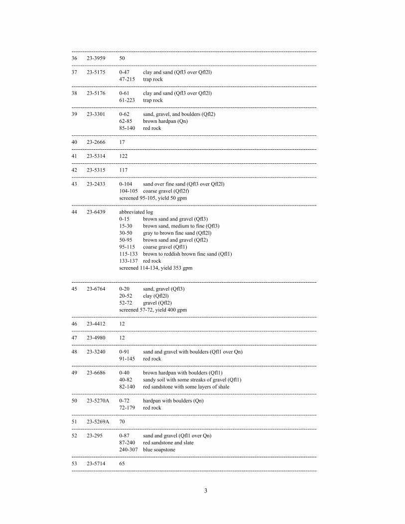
3
--------------------------------------------------------------------------------------------------------------------------------------36 23-3959 50--------------------------------------------------------------------------------------------------------------------------------------37 23-5175 0-47 clay and sand (Qfl3 over Qfl2l)
47-215 trap rock--------------------------------------------------------------------------------------------------------------------------------------38 23-5176 0-61 clay and sand (Qfl3 over Qfl2l)
61-223 trap rock--------------------------------------------------------------------------------------------------------------------------------------39 23-3301 0-62 sand, gravel, and boulders (Qfl2)
62-85 brown hardpan (Qn)85-140 red rock
--------------------------------------------------------------------------------------------------------------------------------------40 23-2666 17--------------------------------------------------------------------------------------------------------------------------------------41 23-5314 122--------------------------------------------------------------------------------------------------------------------------------------42 23-5315 117--------------------------------------------------------------------------------------------------------------------------------------43 23-2433 0-104 sand over fine sand (Qfl3 over Qfl2l)
104-105 coarse gravel (Qfl2f)screened 95-105, yield 50 gpm
--------------------------------------------------------------------------------------------------------------------------------------44 23-6439 abbreviated log
0-15 brown sand and gravel (Qfl3)15-30 brown sand, medium to fine (Qfl3)30-50 gray to brown fine sand (Qfl2l)50-95 brown sand and gravel (Qfl2)95-115 coarse gravel (Qfl1)115-133 brown to reddish brown fine sand (Qfl1)133-137 red rockscreened 114-134, yield 353 gpm
--------------------------------------------------------------------------------------------------------------------------------------45 23-6764 0-20 sand, gravel (Qfl3)
20-52 clay (Qfl2l)52-72 gravel (Qfl2)screened 57-72, yield 400 gpm
--------------------------------------------------------------------------------------------------------------------------------------46 23-4412 12--------------------------------------------------------------------------------------------------------------------------------------47 23-4980 12--------------------------------------------------------------------------------------------------------------------------------------48 23-3240 0-91 sand and gravel with boulders (Qfl1 over Qn)
91-145 red rock--------------------------------------------------------------------------------------------------------------------------------------49 23-6686 0-40 brown hardpan with boulders (Qfl1)
40-82 sandy soil with some streaks of gravel (Qfl1)82-140 red sandstone with some layers of shale
--------------------------------------------------------------------------------------------------------------------------------------50 23-5270A 0-72 hardpan with boulders (Qn)
72-179 red rock--------------------------------------------------------------------------------------------------------------------------------------51 23-5269A 70--------------------------------------------------------------------------------------------------------------------------------------52 23-295 0-87 sand and gravel (Qfl1 over Qn)
87-240 red sandstone and slate240-307 blue soapstone
--------------------------------------------------------------------------------------------------------------------------------------53 23-5714 65--------------------------------------------------------------------------------------------------------------------------------------

4
54 23-5362 74--------------------------------------------------------------------------------------------------------------------------------------55 23-5375 66--------------------------------------------------------------------------------------------------------------------------------------56 23-5581 0-75 hardpan, boulders (Qn)
75-232 trap rock--------------------------------------------------------------------------------------------------------------------------------------57 23-5347 43--------------------------------------------------------------------------------------------------------------------------------------58 23-4105 0-80 red hardpan with boulders (Qn over Qr)
80-145 red sandstone--------------------------------------------------------------------------------------------------------------------------------------59 23-5398 0-105 sand, gravel, and boulders (Qn)
105-115 red hardpan with boulders (Qr)115-199 red sandstone
--------------------------------------------------------------------------------------------------------------------------------------60 23-3319 0-68 hardpan and boulders (Qn)
68-91 coarse sand and gravel (Qsp)91-145 mixture of red trap and blue trap
--------------------------------------------------------------------------------------------------------------------------------------61 23-3239 0-35 hardpan (Qfl1)
35-50 hardpan and gravel (Qn)50-125 red rock
--------------------------------------------------------------------------------------------------------------------------------------62 23-4124 0-56 hardpan with boulders (Qn)
56-140 red sandstone--------------------------------------------------------------------------------------------------------------------------------------63 23-4320 0-67 hardpan (Qn)
67-165 red sandstone--------------------------------------------------------------------------------------------------------------------------------------64 23-5404 76--------------------------------------------------------------------------------------------------------------------------------------65 23-5271 0-73 hardpan and boulders (Qn)
73-225 red shale and gray slate--------------------------------------------------------------------------------------------------------------------------------------66 23-5265 0-79 boulders, sand, gravel, hardpan (Qn)
79-198 red shale--------------------------------------------------------------------------------------------------------------------------------------67 23-8398 3--------------------------------------------------------------------------------------------------------------------------------------68 23-5003 45--------------------------------------------------------------------------------------------------------------------------------------69 23-4005 64
--------------------------------------------------------------------------------------------------------------------------------------70 23-5470 28--------------------------------------------------------------------------------------------------------------------------------------71 23-5708 15--------------------------------------------------------------------------------------------------------------------------------------72 23-5527 0-22 bouldery overburden (Qn)
22-153 bedrock--------------------------------------------------------------------------------------------------------------------------------------73 23-5048 45--------------------------------------------------------------------------------------------------------------------------------------74 23-2604 0-4 brown hardpan (Qn)
4-98 trap rock98-248 red rock
--------------------------------------------------------------------------------------------------------------------------------------75 23-3040 0-47 hardpan (Qn)
47-82 trap rock--------------------------------------------------------------------------------------------------------------------------------------
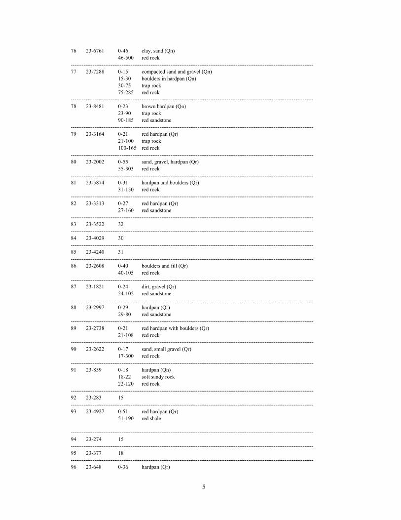
5
76 23-6761 0-46 clay, sand (Qn)46-500 red rock
--------------------------------------------------------------------------------------------------------------------------------------77 23-7288 0-15 compacted sand and gravel (Qn)
15-30 boulders in hardpan (Qn)30-75 trap rock75-285 red rock
--------------------------------------------------------------------------------------------------------------------------------------78 23-8481 0-23 brown hardpan (Qn)
23-90 trap rock90-185 red sandstone
--------------------------------------------------------------------------------------------------------------------------------------79 23-3164 0-21 red hardpan (Qr)
21-100 trap rock100-165 red rock
--------------------------------------------------------------------------------------------------------------------------------------80 23-2002 0-55 sand, gravel, hardpan (Qr)
55-303 red rock--------------------------------------------------------------------------------------------------------------------------------------81 23-5874 0-31 hardpan and boulders (Qr)
31-150 red rock--------------------------------------------------------------------------------------------------------------------------------------82 23-3313 0-27 red hardpan (Qr)
27-160 red sandstone--------------------------------------------------------------------------------------------------------------------------------------83 23-3522 32--------------------------------------------------------------------------------------------------------------------------------------84 23-4029 30--------------------------------------------------------------------------------------------------------------------------------------85 23-4240 31--------------------------------------------------------------------------------------------------------------------------------------86 23-2608 0-40 boulders and fill (Qr)
40-105 red rock--------------------------------------------------------------------------------------------------------------------------------------87 23-1821 0-24 dirt, gravel (Qr)
24-102 red sandstone--------------------------------------------------------------------------------------------------------------------------------------88 23-2997 0-29 hardpan (Qr)
29-80 red sandstone--------------------------------------------------------------------------------------------------------------------------------------89 23-2738 0-21 red hardpan with boulders (Qr)
21-108 red rock--------------------------------------------------------------------------------------------------------------------------------------90 23-2622 0-17 sand, small gravel (Qr)
17-300 red rock--------------------------------------------------------------------------------------------------------------------------------------91 23-859 0-18 hardpan (Qn)
18-22 soft sandy rock22-120 red rock
--------------------------------------------------------------------------------------------------------------------------------------92 23-283 15--------------------------------------------------------------------------------------------------------------------------------------93 23-4927 0-51 red hardpan (Qr)
51-190 red shale
--------------------------------------------------------------------------------------------------------------------------------------94 23-274 15--------------------------------------------------------------------------------------------------------------------------------------95 23-377 18--------------------------------------------------------------------------------------------------------------------------------------96 23-648 0-36 hardpan (Qr)

6
36-143 red rock--------------------------------------------------------------------------------------------------------------------------------------97 23-800 0-24 dirt and boulders (Qr)
24-75 trap rock75-180 red rock
--------------------------------------------------------------------------------------------------------------------------------------98 23-1434 0-31 gravel (Qr)
31-100 red rock--------------------------------------------------------------------------------------------------------------------------------------99 23-1475 14--------------------------------------------------------------------------------------------------------------------------------------100 23-2555 0-17 red hardpan (Qn over Qr)
17-90 red sandstone--------------------------------------------------------------------------------------------------------------------------------------101 23-1244 0-26 hardpan (Qho3 over Qn)
26-79 bedrock--------------------------------------------------------------------------------------------------------------------------------------102 23-4273 0-14 sand and stones, clay (Qho3)
14-300 sandstone--------------------------------------------------------------------------------------------------------------------------------------103 23-4256 0-34 sand, gravel (Qho3)
34-300 red rock--------------------------------------------------------------------------------------------------------------------------------------104 23-596 0-38 coarse sand with plenty of small boulders (Qmt over Qho3)
38-142 red rock--------------------------------------------------------------------------------------------------------------------------------------105 23-3677 0-32 hardpan (Qn)
32-91 red sandstone--------------------------------------------------------------------------------------------------------------------------------------106 23-7158 abbreviated log
0-19 brown coarse-to-fine sand, some fine gravel (Qal over Qmt)19-22 brown medium-to-fine sand, some silt, occasional boulders (Qn)
--------------------------------------------------------------------------------------------------------------------------------------107 23-3787 0-18 red hardpan (Qr)
18-35 red sandstone--------------------------------------------------------------------------------------------------------------------------------------108 23-3782 0-23 red hardpan (Qr)
23-100 red sandstone--------------------------------------------------------------------------------------------------------------------------------------109 23-3523 20--------------------------------------------------------------------------------------------------------------------------------------110 23-3210A 0-34 glacial drift with boulders (Qr)
34-100 red sandstone--------------------------------------------------------------------------------------------------------------------------------------111 23-1 28--------------------------------------------------------------------------------------------------------------------------------------112 23-997 22--------------------------------------------------------------------------------------------------------------------------------------113 23-5916 0-22 boulders (Qr)
22-95 sandstone--------------------------------------------------------------------------------------------------------------------------------------114 23-7384 0-10 compact sand and gravel (Qmt over Qr)
10-205 red sandstone--------------------------------------------------------------------------------------------------------------------------------------115 23-1203 0-8 gray hardpan (Qr)
8-10 soft sandstone10-300 red sandstone
--------------------------------------------------------------------------------------------------------------------------------------116 23-5158 0-14 yellow sand (Qho2)
14-24 sand and hardpan (Qho2)24-28 sand and gravel (Qho2)
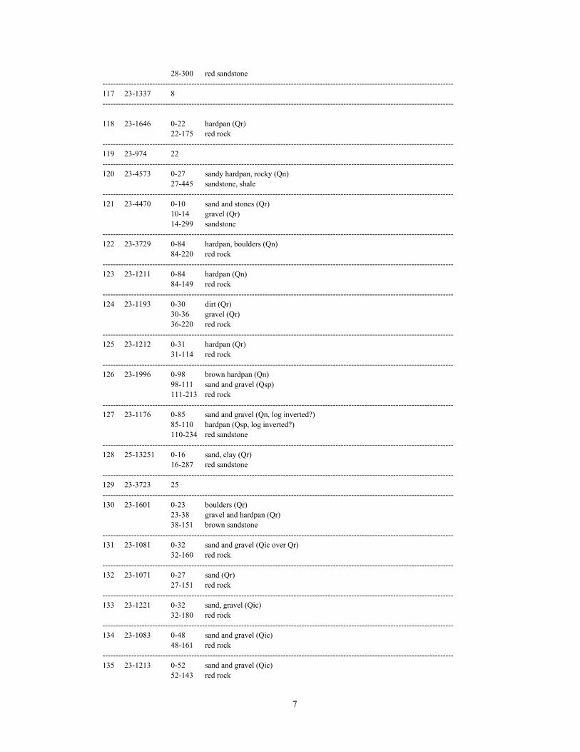
7
28-300 red sandstone--------------------------------------------------------------------------------------------------------------------------------------117 23-1337 8--------------------------------------------------------------------------------------------------------------------------------------
118 23-1646 0-22 hardpan (Qr)22-175 red rock
--------------------------------------------------------------------------------------------------------------------------------------119 23-974 22--------------------------------------------------------------------------------------------------------------------------------------120 23-4573 0-27 sandy hardpan, rocky (Qn)
27-445 sandstone, shale--------------------------------------------------------------------------------------------------------------------------------------121 23-4470 0-10 sand and stones (Qr)
10-14 gravel (Qr)14-299 sandstone
--------------------------------------------------------------------------------------------------------------------------------------122 23-3729 0-84 hardpan, boulders (Qn)
84-220 red rock--------------------------------------------------------------------------------------------------------------------------------------123 23-1211 0-84 hardpan (Qn)
84-149 red rock--------------------------------------------------------------------------------------------------------------------------------------124 23-1193 0-30 dirt (Qr)
30-36 gravel (Qr)36-220 red rock
--------------------------------------------------------------------------------------------------------------------------------------125 23-1212 0-31 hardpan (Qr)
31-114 red rock--------------------------------------------------------------------------------------------------------------------------------------126 23-1996 0-98 brown hardpan (Qn)
98-111 sand and gravel (Qsp)111-213 red rock
--------------------------------------------------------------------------------------------------------------------------------------127 23-1176 0-85 sand and gravel (Qn, log inverted?)
85-110 hardpan (Qsp, log inverted?)110-234 red sandstone
--------------------------------------------------------------------------------------------------------------------------------------128 25-13251 0-16 sand, clay (Qr)
16-287 red sandstone--------------------------------------------------------------------------------------------------------------------------------------129 23-3723 25--------------------------------------------------------------------------------------------------------------------------------------130 23-1601 0-23 boulders (Qr)
23-38 gravel and hardpan (Qr)38-151 brown sandstone
--------------------------------------------------------------------------------------------------------------------------------------131 23-1081 0-32 sand and gravel (Qic over Qr)
32-160 red rock--------------------------------------------------------------------------------------------------------------------------------------132 23-1071 0-27 sand (Qr)
27-151 red rock--------------------------------------------------------------------------------------------------------------------------------------133 23-1221 0-32 sand, gravel (Qic)
32-180 red rock--------------------------------------------------------------------------------------------------------------------------------------134 23-1083 0-48 sand and gravel (Qic)
48-161 red rock--------------------------------------------------------------------------------------------------------------------------------------135 23-1213 0-52 sand and gravel (Qic)
52-143 red rock

8
--------------------------------------------------------------------------------------------------------------------------------------136 23-1470 0-30 boulders (Qic)
30-55 hardpan and gravel (Qr)55-141 sandstone
--------------------------------------------------------------------------------------------------------------------------------------137 23-1768 0-15 gravel and hardpan (Qic)
15-30 boulders and gravel (Qr)30-36 gravel (Qr)36-118 sandstone
--------------------------------------------------------------------------------------------------------------------------------------138 23-2033 0-35 sand, gravel (Qpr)
35-92 red rock--------------------------------------------------------------------------------------------------------------------------------------139 23-1467 0-20 hardpan and boulders (Qr)
20-147 sandstone
--------------------------------------------------------------------------------------------------------------------------------------140 23-1583 0-47 hardpan and gravel (Qr)
47-112 sandstone--------------------------------------------------------------------------------------------------------------------------------------141 23-1197 0-30 dirt and boulders (Qr)
30-48 gravel (Qr or Qsp)48-180 red rock
--------------------------------------------------------------------------------------------------------------------------------------142 23-1591 0-41 gravel, boulders (Qpr over Qr)
41-80 red rock--------------------------------------------------------------------------------------------------------------------------------------143 23-968 0-25 coarse sandy soil (Qpr)
25-103 red rock--------------------------------------------------------------------------------------------------------------------------------------144 23-4172 0-41 sand and gravel (Qpr)
41-300 red sandstone--------------------------------------------------------------------------------------------------------------------------------------145 23-42-626 0-20 hardpan (Qr)
20-32 gravel (Qr or Qsp)32-300 red rock
--------------------------------------------------------------------------------------------------------------------------------------146 23-1073 0-25 hardpan (Qr)
25-149 red rock--------------------------------------------------------------------------------------------------------------------------------------147 23-7721 0-15 red hardpan (Qr)
15-350 red and brown sandstone--------------------------------------------------------------------------------------------------------------------------------------148 23-4691 0-15 hardpan (Qpr)
15-405 shale and sandstone--------------------------------------------------------------------------------------------------------------------------------------149 23-4692 0-17 sand and gravel (Qpr)
17-22 hardpan (Qr?)22-400 brown shale
--------------------------------------------------------------------------------------------------------------------------------------150 23-5380 15--------------------------------------------------------------------------------------------------------------------------------------151 23-6763 0-10 sandy, rocky soil (Qpr)
10-15 hardpan (Qr)15-17 sand and gravel (Qr or Qsp)17-150 sandstone
--------------------------------------------------------------------------------------------------------------------------------------152 23-318 27--------------------------------------------------------------------------------------------------------------------------------------153 23-3101 0-18 hardpan and sand (Qpr over Qr)
18-300 red rock
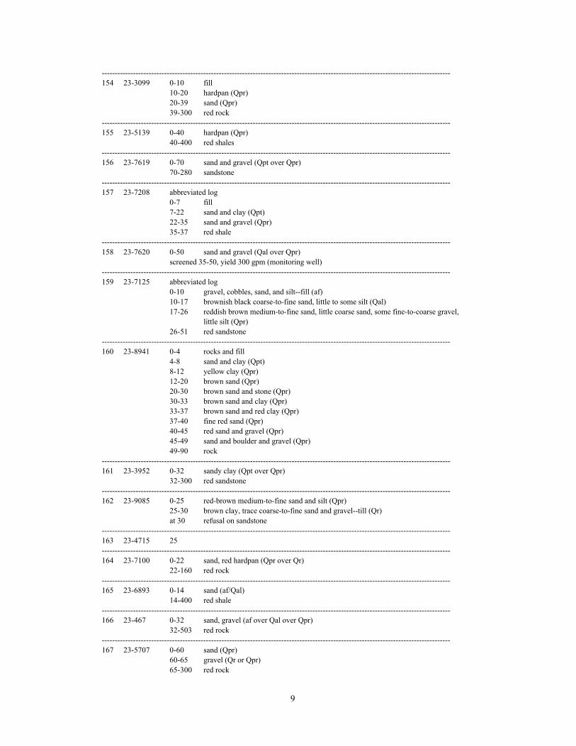
9
--------------------------------------------------------------------------------------------------------------------------------------154 23-3099 0-10 fill
10-20 hardpan (Qpr)20-39 sand (Qpr)39-300 red rock
--------------------------------------------------------------------------------------------------------------------------------------155 23-5139 0-40 hardpan (Qpr)
40-400 red shales--------------------------------------------------------------------------------------------------------------------------------------156 23-7619 0-70 sand and gravel (Qpt over Qpr)
70-280 sandstone--------------------------------------------------------------------------------------------------------------------------------------157 23-7208 abbreviated log
0-7 fill7-22 sand and clay (Qpt)22-35 sand and gravel (Qpr)35-37 red shale
--------------------------------------------------------------------------------------------------------------------------------------158 23-7620 0-50 sand and gravel (Qal over Qpr)
screened 35-50, yield 300 gpm (monitoring well) --------------------------------------------------------------------------------------------------------------------------------------159 23-7125 abbreviated log
0-10 gravel, cobbles, sand, and silt--fill (af)10-17 brownish black coarse-to-fine sand, little to some silt (Qal)17-26 reddish brown medium-to-fine sand, little coarse sand, some fine-to-coarse gravel,
little silt (Qpr)26-51 red sandstone
--------------------------------------------------------------------------------------------------------------------------------------160 23-8941 0-4 rocks and fill
4-8 sand and clay (Qpt)8-12 yellow clay (Qpr)12-20 brown sand (Qpr)20-30 brown sand and stone (Qpr)30-33 brown sand and clay (Qpr)33-37 brown sand and red clay (Qpr)37-40 fine red sand (Qpr)40-45 red sand and gravel (Qpr)45-49 sand and boulder and gravel (Qpr)49-90 rock
--------------------------------------------------------------------------------------------------------------------------------------161 23-3952 0-32 sandy clay (Qpt over Qpr)
32-300 red sandstone--------------------------------------------------------------------------------------------------------------------------------------162 23-9085 0-25 red-brown medium-to-fine sand and silt (Qpr)
25-30 brown clay, trace coarse-to-fine sand and gravel--till (Qr)at 30 refusal on sandstone
--------------------------------------------------------------------------------------------------------------------------------------163 23-4715 25--------------------------------------------------------------------------------------------------------------------------------------164 23-7100 0-22 sand, red hardpan (Qpr over Qr)
22-160 red rock--------------------------------------------------------------------------------------------------------------------------------------165 23-6893 0-14 sand (af/Qal)
14-400 red shale--------------------------------------------------------------------------------------------------------------------------------------166 23-467 0-32 sand, gravel (af over Qal over Qpr)
32-503 red rock--------------------------------------------------------------------------------------------------------------------------------------167 23-5707 0-60 sand (Qpr)
60-65 gravel (Qr or Qpr)65-300 red rock

10
--------------------------------------------------------------------------------------------------------------------------------------168 26-4533 0-60 sand (Qpr)
60-75 hardpan (Qr)75-400 red rock
--------------------------------------------------------------------------------------------------------------------------------------169 23-1907 0-53 sand, gravel and fill (Qpr over Qr)
53-301 sandstone--------------------------------------------------------------------------------------------------------------------------------------170 23-407 0-40 sand (Qpr)
40-200 red rock--------------------------------------------------------------------------------------------------------------------------------------171 23-7885 0-23 medium brown sand (Qpr)
23-30 gravel in hardpan (Qr)30-310 red sandstone
--------------------------------------------------------------------------------------------------------------------------------------172 23-1954 0-35 sand, hardpan (Qpr over Qr)
35-100 red rock--------------------------------------------------------------------------------------------------------------------------------------173 23-1585 0-19 gravel (Qpr)
19-80 red rock--------------------------------------------------------------------------------------------------------------------------------------174 23-2785 0-33 sand (Qpr)
33-38 gravel (Qr or Qpr)38-302 red rock
--------------------------------------------------------------------------------------------------------------------------------------175 23-1946 0-14 red hardpan (Qpr, log inverted?)
14-40 coarse sand and gravel (Qr, log inverted?)40-390 red sandstone
--------------------------------------------------------------------------------------------------------------------------------------176 23-250 0-54 sand, gravel, and boulders (Qpr over Qr)
54-400 red rock--------------------------------------------------------------------------------------------------------------------------------------177 23-251 0-40 hardpan (Qpr over Qr)
40-400 red rock--------------------------------------------------------------------------------------------------------------------------------------178 23-249 0-35 sand, clay, gravel (Qpr over Qr)
35-300 bedrock--------------------------------------------------------------------------------------------------------------------------------------179 23-4635 0-3 sandy clay (Qpr)
3-20 sand (Qpr)20-24 red shale and hardpan (Qr)24-230 red sandstone
--------------------------------------------------------------------------------------------------------------------------------------180 23-1432 0-40 sand, gravel, hardpan, fine sand (Qpr)
40-275 red rock--------------------------------------------------------------------------------------------------------------------------------------181 23-4164 0-30 sand, gravel (Qpr)
30-400 red rock--------------------------------------------------------------------------------------------------------------------------------------182 23-404 0-12 sand and fill (Qpr over Qr)
12-150 red rock--------------------------------------------------------------------------------------------------------------------------------------183 26-1112 0-20 hardpan (Qpr over Qr)
20-200 red rock--------------------------------------------------------------------------------------------------------------------------------------184 26-2925 0-40 sand, boulders, hardpan (Qpr over Qr)
40-500 red rock--------------------------------------------------------------------------------------------------------------------------------------185 26-1032 0-52 sand, gravel (Qpt over Qpr)
52-350 red shale--------------------------------------------------------------------------------------------------------------------------------------
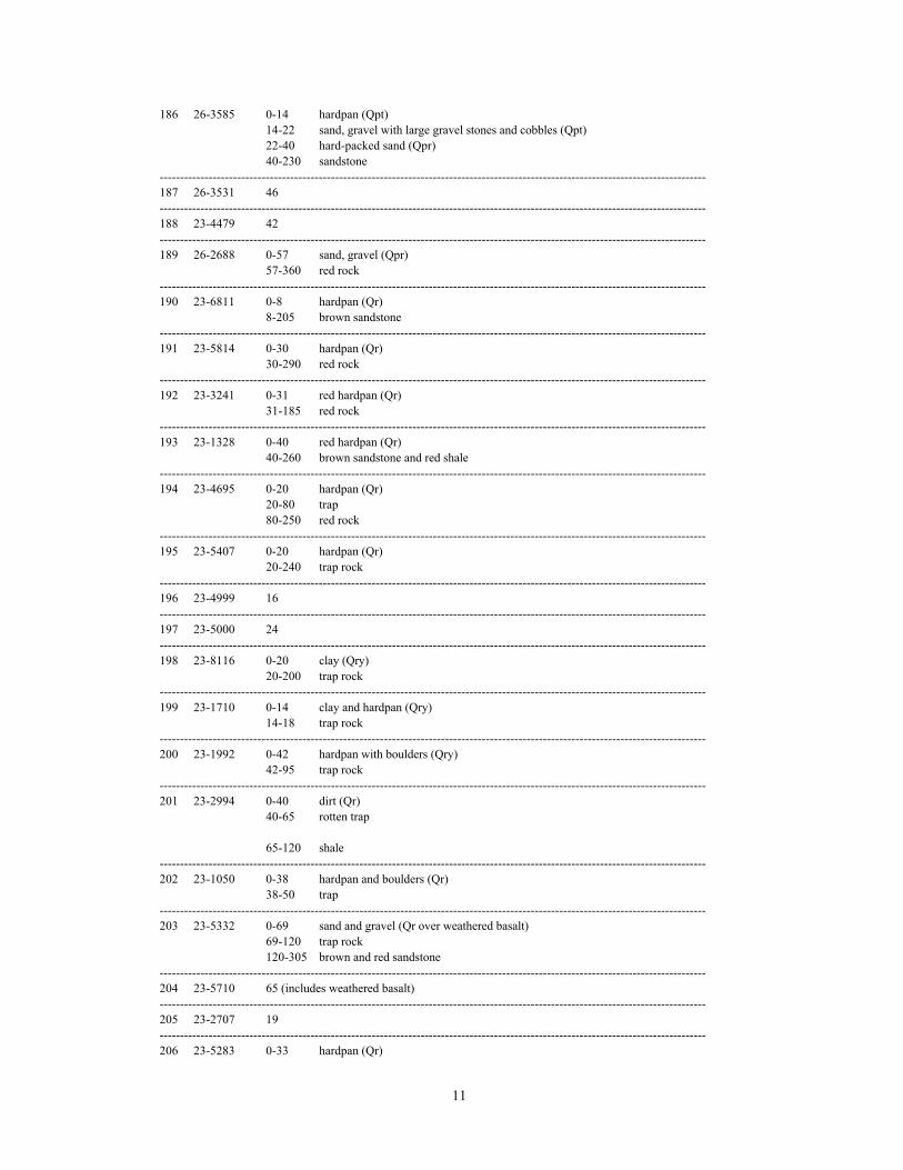
11
186 26-3585 0-14 hardpan (Qpt)14-22 sand, gravel with large gravel stones and cobbles (Qpt)22-40 hard-packed sand (Qpr)40-230 sandstone
--------------------------------------------------------------------------------------------------------------------------------------187 26-3531 46--------------------------------------------------------------------------------------------------------------------------------------188 23-4479 42--------------------------------------------------------------------------------------------------------------------------------------189 26-2688 0-57 sand, gravel (Qpr)
57-360 red rock--------------------------------------------------------------------------------------------------------------------------------------190 23-6811 0-8 hardpan (Qr)
8-205 brown sandstone--------------------------------------------------------------------------------------------------------------------------------------191 23-5814 0-30 hardpan (Qr)
30-290 red rock--------------------------------------------------------------------------------------------------------------------------------------192 23-3241 0-31 red hardpan (Qr)
31-185 red rock--------------------------------------------------------------------------------------------------------------------------------------193 23-1328 0-40 red hardpan (Qr)
40-260 brown sandstone and red shale--------------------------------------------------------------------------------------------------------------------------------------194 23-4695 0-20 hardpan (Qr)
20-80 trap80-250 red rock
--------------------------------------------------------------------------------------------------------------------------------------195 23-5407 0-20 hardpan (Qr)
20-240 trap rock--------------------------------------------------------------------------------------------------------------------------------------196 23-4999 16--------------------------------------------------------------------------------------------------------------------------------------197 23-5000 24--------------------------------------------------------------------------------------------------------------------------------------198 23-8116 0-20 clay (Qry)
20-200 trap rock--------------------------------------------------------------------------------------------------------------------------------------199 23-1710 0-14 clay and hardpan (Qry)
14-18 trap rock--------------------------------------------------------------------------------------------------------------------------------------200 23-1992 0-42 hardpan with boulders (Qry)
42-95 trap rock--------------------------------------------------------------------------------------------------------------------------------------201 23-2994 0-40 dirt (Qr)
40-65 rotten trap
65-120 shale--------------------------------------------------------------------------------------------------------------------------------------202 23-1050 0-38 hardpan and boulders (Qr)
38-50 trap--------------------------------------------------------------------------------------------------------------------------------------203 23-5332 0-69 sand and gravel (Qr over weathered basalt)
69-120 trap rock120-305 brown and red sandstone
--------------------------------------------------------------------------------------------------------------------------------------204 23-5710 65 (includes weathered basalt)--------------------------------------------------------------------------------------------------------------------------------------205 23-2707 19--------------------------------------------------------------------------------------------------------------------------------------206 23-5283 0-33 hardpan (Qr)

12
33-128 trap128-265 red rock
--------------------------------------------------------------------------------------------------------------------------------------207 23-791 3--------------------------------------------------------------------------------------------------------------------------------------208 23-4180 10--------------------------------------------------------------------------------------------------------------------------------------209 23-4030 0-42 fine sand and boulders (Qry)
42-123 trap rock--------------------------------------------------------------------------------------------------------------------------------------210 23-1523 60--------------------------------------------------------------------------------------------------------------------------------------211 23-1384 14--------------------------------------------------------------------------------------------------------------------------------------212 23-569 12--------------------------------------------------------------------------------------------------------------------------------------213 23-3424 0-20 hardpan (Qry)
20-115 trap rock115-245 red rock
--------------------------------------------------------------------------------------------------------------------------------------214 23-1763 12--------------------------------------------------------------------------------------------------------------------------------------215 23-5261 14--------------------------------------------------------------------------------------------------------------------------------------216 23-5147 12--------------------------------------------------------------------------------------------------------------------------------------217 23-5329 8--------------------------------------------------------------------------------------------------------------------------------------218 23-6057 17--------------------------------------------------------------------------------------------------------------------------------------219 23-741 0-19 sand and gravel (Qry and weathered basalt)
19-43 trap rock--------------------------------------------------------------------------------------------------------------------------------------220 23-42-534 0-17 sand, gravel (Qry and weathered basalt)
17-32 trap rock--------------------------------------------------------------------------------------------------------------------------------------221 23-740 0-7 sand, gravel (Qry and weathered basalt)
7-41 trap rock--------------------------------------------------------------------------------------------------------------------------------------222 23-42-284 8--------------------------------------------------------------------------------------------------------------------------------------223 23-7292 0-7 gray hardpan (Qry)
7-205 trap rock--------------------------------------------------------------------------------------------------------------------------------------224 23-795 0-20 clay and hardpan (Qry)
20-150 trap rock--------------------------------------------------------------------------------------------------------------------------------------225 23-815 10--------------------------------------------------------------------------------------------------------------------------------------226 23-6095 8--------------------------------------------------------------------------------------------------------------------------------------227 23-775 0-8 hardpan (Qry)
8-137 trap rock--------------------------------------------------------------------------------------------------------------------------------------228 23-3659 0-12 hardpan (Qry)
12-213 trap rock--------------------------------------------------------------------------------------------------------------------------------------
229 23-425 14--------------------------------------------------------------------------------------------------------------------------------------230 23-5489 0-25 hardpan (Qry)
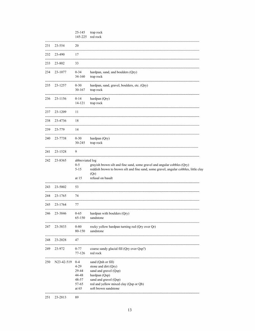
13
25-145 trap rock145-225 red rock
--------------------------------------------------------------------------------------------------------------------------------------231 23-554 20--------------------------------------------------------------------------------------------------------------------------------------232 23-490 17--------------------------------------------------------------------------------------------------------------------------------------233 23-802 33--------------------------------------------------------------------------------------------------------------------------------------234 23-1077 0-34 hardpan, sand, and boulders (Qry)
34-160 trap rock--------------------------------------------------------------------------------------------------------------------------------------235 23-1257 0-30 hardpan, sand, gravel, boulders, etc. (Qry)
30-167 trap rock--------------------------------------------------------------------------------------------------------------------------------------236 23-1156 0-14 hardpan (Qry)
14-121 trap rock--------------------------------------------------------------------------------------------------------------------------------------237 23-1209 11--------------------------------------------------------------------------------------------------------------------------------------238 23-4736 18--------------------------------------------------------------------------------------------------------------------------------------239 23-779 14--------------------------------------------------------------------------------------------------------------------------------------240 23-7738 0-30 hardpan (Qry)
30-245 trap rock-------------------------------------------------------------------------------------------------------------------------------------241 23-1528 9--------------------------------------------------------------------------------------------------------------------------------------242 23-8365 abbreviated log
0-5 grayish brown silt and fine sand, some gravel and angular cobbles (Qry)5-15 reddish brown to brown silt and fine sand, some gravel, angular cobbles, little clay
(Qr)at 15 refusal on basalt
--------------------------------------------------------------------------------------------------------------------------------------243 23-5002 53--------------------------------------------------------------------------------------------------------------------------------------244 23-1765 74--------------------------------------------------------------------------------------------------------------------------------------245 23-1764 77--------------------------------------------------------------------------------------------------------------------------------------246 23-3846 0-65 hardpan with boulders (Qry)
65-150 sandstone--------------------------------------------------------------------------------------------------------------------------------------247 23-3833 0-80 rocky yellow hardpan turning red (Qry over Qr)
80-150 sandstone--------------------------------------------------------------------------------------------------------------------------------------248 23-2028 47--------------------------------------------------------------------------------------------------------------------------------------249 23-972 0-77 coarse sandy glacial fill (Qry over Qsp?)
77-126 red rock--------------------------------------------------------------------------------------------------------------------------------------250 N23-42-519 0-4 sand (Qnh or fill)
4-29 stone and dirt (Qry)29-44 sand and gravel (Qsp)44-48 hardpan (Qsp)48-57 sand and gravel (Qsp)57-65 red and yellow mixed clay (Qsp or Qb)at 65 soft brown sandstone
--------------------------------------------------------------------------------------------------------------------------------------251 23-2813 89

14
--------------------------------------------------------------------------------------------------------------------------------------252 23-1667 58--------------------------------------------------------------------------------------------------------------------------------------253 23-367 0-15 dirt (Qnh)
15-49 gravel (Qnh over Qry)49-120 shale rock
--------------------------------------------------------------------------------------------------------------------------------------254 23-145 80--------------------------------------------------------------------------------------------------------------------------------------255 23-592 0-64 hardpan and boulders (Qr, over Qsp?)
cased to 62, yield 7 gpm --------------------------------------------------------------------------------------------------------------------------------------256 23-2384 0-23 boulders and sand (Qry)
23-140 trap rock--------------------------------------------------------------------------------------------------------------------------------------257 23-6116 0-31 hardpan, boulders (Qry)
31-170 trap rock--------------------------------------------------------------------------------------------------------------------------------------258 23-470 0-10 boulders (Qpm)
10-30 hardpan (Qry, readvance till?)30-33 gravel, sand (Qpm)33-45 sand and clay (Qpm)45-70 sand (Qpm)70-108 trap rock
--------------------------------------------------------------------------------------------------------------------------------------259 23-7162 abbreviated log
0-17 brown coarse-to-fine sand (Qpm)at 17 basalt
--------------------------------------------------------------------------------------------------------------------------------------260 23-5232 114
cased to 114, no penetration into rock, yield 25 gpm--------------------------------------------------------------------------------------------------------------------------------------261 23-5258 0-97 sand and gravel (Qpm)
97-250 trap rock--------------------------------------------------------------------------------------------------------------------------------------262 23-8623 34--------------------------------------------------------------------------------------------------------------------------------------263 23-8152 0-18 sand, gravel (Qpm)
18-500 granite (basalt)--------------------------------------------------------------------------------------------------------------------------------------264 23-2540 0-38 sand, gravel (Qpm)
38-45 trap rockscreened 28-38, yield 150 gpm
--------------------------------------------------------------------------------------------------------------------------------------265 23-2319 0-23 boulders and hardpan (Qry, readvance till?)
23-45 gravel (Qpm)45-476 granite (basalt)
--------------------------------------------------------------------------------------------------------------------------------------266 23-5607 0-26 sand, clay (Qry)
26-453 trap rock--------------------------------------------------------------------------------------------------------------------------------------267 23-5461 0-30 hardpan and gravel (af over Qal)
30-43 sand, then hardpan (Qpm overQry)43-213 trap rock
--------------------------------------------------------------------------------------------------------------------------------------268 23-5301 0-20 hardpan (Qry)
20-453 trap rock--------------------------------------------------------------------------------------------------------------------------------------269 23-5685 34--------------------------------------------------------------------------------------------------------------------------------------

15
270 23-5409 0-38 boulders (Qpm)38-54 gravel (Qpm)54-85 boulders (Qpm)85-315 trap
--------------------------------------------------------------------------------------------------------------------------------------271 23-5561 0-80 gravel (Qpm)
80-103 hardpan (Qry)103-204 trap
--------------------------------------------------------------------------------------------------------------------------------------272 23-537 0-80 very fine sand (Qpm)
80-235 trap rock--------------------------------------------------------------------------------------------------------------------------------------273 23-290 0-30 boulders (Qpm)
30-68 sand and gravel (Qpm)68-72 very fine sand (Qpm)72-150 red rock
--------------------------------------------------------------------------------------------------------------------------------------
274 23-908 0-60 sand (Qpm)60-171 red shale
--------------------------------------------------------------------------------------------------------------------------------------275 23-3458 0-35 sand (Qpm)
35-50 clay (Qpml)50-325 red and gray shale
--------------------------------------------------------------------------------------------------------------------------------------276 23-213 23--------------------------------------------------------------------------------------------------------------------------------------277 23-4353 0-20 sand and gravel (Qry)
20-120 red shale--------------------------------------------------------------------------------------------------------------------------------------278 23-5706 0-115 sand, gravel(Qpg)
115-125 broken rock125-270 red rock
--------------------------------------------------------------------------------------------------------------------------------------279 N23-41-639 0-51 sand, gravel, small boulders (Qpg)
51-136 blue clay (Qpl)136-141 coarse gravel, no water (Qpm or Qry)141-317 shale317-340 trap
--------------------------------------------------------------------------------------------------------------------------------------280 23-164 95--------------------------------------------------------------------------------------------------------------------------------------281 23-160 0-20 boulders, coarse gravel (Qpg, topset beds)
20-80 fine sand (Qpg, foreset beds)80-160 blue clay, some fine sand (Qpl)160-190 red and blue hardpan (Qr or weathered rock)190-193 red shale
--------------------------------------------------------------------------------------------------------------------------------------282 26-3057 0-49 sand (Qpg)
49-75 brown clay (Qpl)75-175 red rock
--------------------------------------------------------------------------------------------------------------------------------------283 23-5162 0-30 bankrun (Qpg sand and gravel)
30-75 sand (Qpg over Qpl)75-145 shale
--------------------------------------------------------------------------------------------------------------------------------------284 23-4270 0-5 overburden (Qry)
5-12 sand (Qry)12-200 red shale
--------------------------------------------------------------------------------------------------------------------------------------285 23-4269 0-3 overburden (Qry)
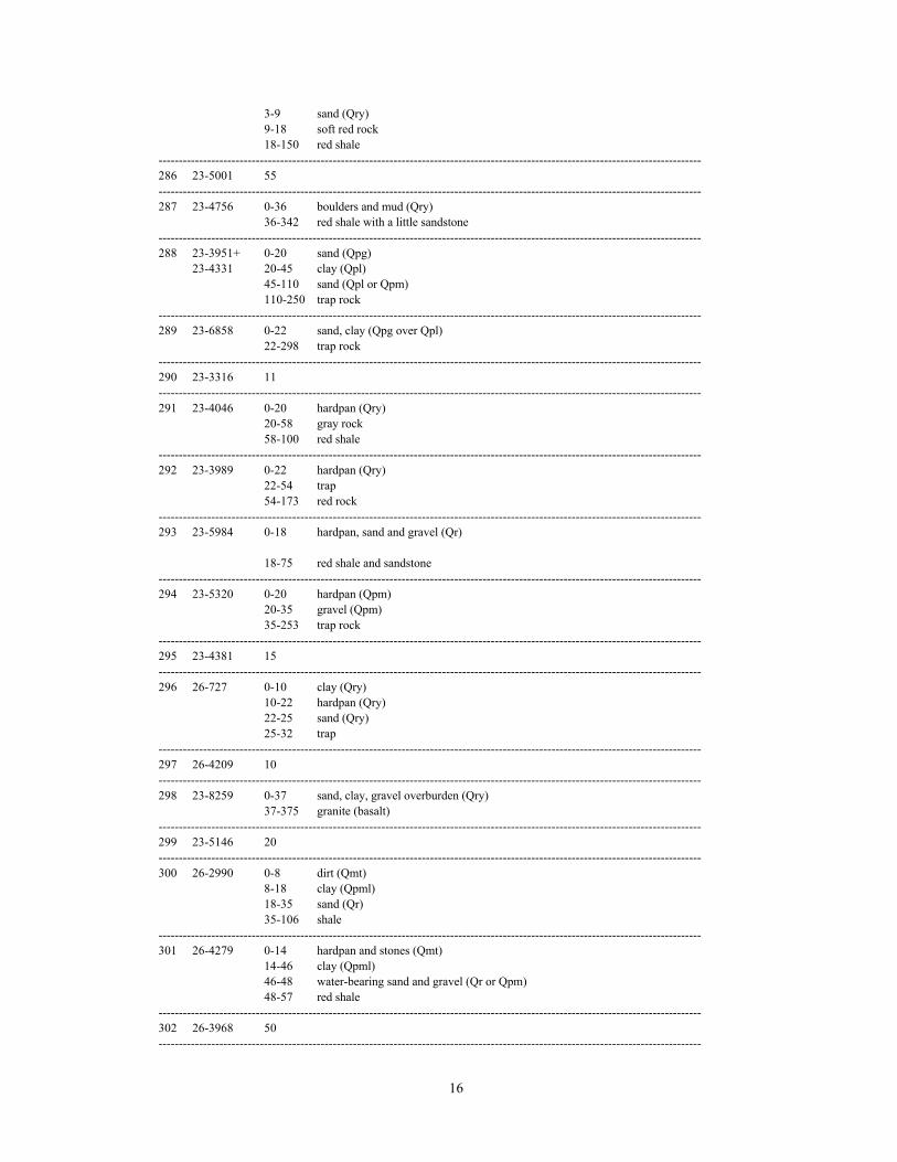
16
3-9 sand (Qry)9-18 soft red rock18-150 red shale
--------------------------------------------------------------------------------------------------------------------------------------286 23-5001 55--------------------------------------------------------------------------------------------------------------------------------------287 23-4756 0-36 boulders and mud (Qry)
36-342 red shale with a little sandstone--------------------------------------------------------------------------------------------------------------------------------------288 23-3951+ 0-20 sand (Qpg)
23-4331 20-45 clay (Qpl)45-110 sand (Qpl or Qpm)110-250 trap rock
--------------------------------------------------------------------------------------------------------------------------------------289 23-6858 0-22 sand, clay (Qpg over Qpl)
22-298 trap rock--------------------------------------------------------------------------------------------------------------------------------------290 23-3316 11--------------------------------------------------------------------------------------------------------------------------------------291 23-4046 0-20 hardpan (Qry)
20-58 gray rock58-100 red shale
--------------------------------------------------------------------------------------------------------------------------------------292 23-3989 0-22 hardpan (Qry)
22-54 trap 54-173 red rock
--------------------------------------------------------------------------------------------------------------------------------------293 23-5984 0-18 hardpan, sand and gravel (Qr)
18-75 red shale and sandstone--------------------------------------------------------------------------------------------------------------------------------------294 23-5320 0-20 hardpan (Qpm)
20-35 gravel (Qpm)35-253 trap rock
--------------------------------------------------------------------------------------------------------------------------------------295 23-4381 15--------------------------------------------------------------------------------------------------------------------------------------296 26-727 0-10 clay (Qry)
10-22 hardpan (Qry)22-25 sand (Qry)25-32 trap
--------------------------------------------------------------------------------------------------------------------------------------297 26-4209 10--------------------------------------------------------------------------------------------------------------------------------------298 23-8259 0-37 sand, clay, gravel overburden (Qry)
37-375 granite (basalt)--------------------------------------------------------------------------------------------------------------------------------------299 23-5146 20--------------------------------------------------------------------------------------------------------------------------------------300 26-2990 0-8 dirt (Qmt)
8-18 clay (Qpml)18-35 sand (Qr)35-106 shale
--------------------------------------------------------------------------------------------------------------------------------------301 26-4279 0-14 hardpan and stones (Qmt)
14-46 clay (Qpml)46-48 water-bearing sand and gravel (Qr or Qpm)48-57 red shale
--------------------------------------------------------------------------------------------------------------------------------------302 26-3968 50--------------------------------------------------------------------------------------------------------------------------------------
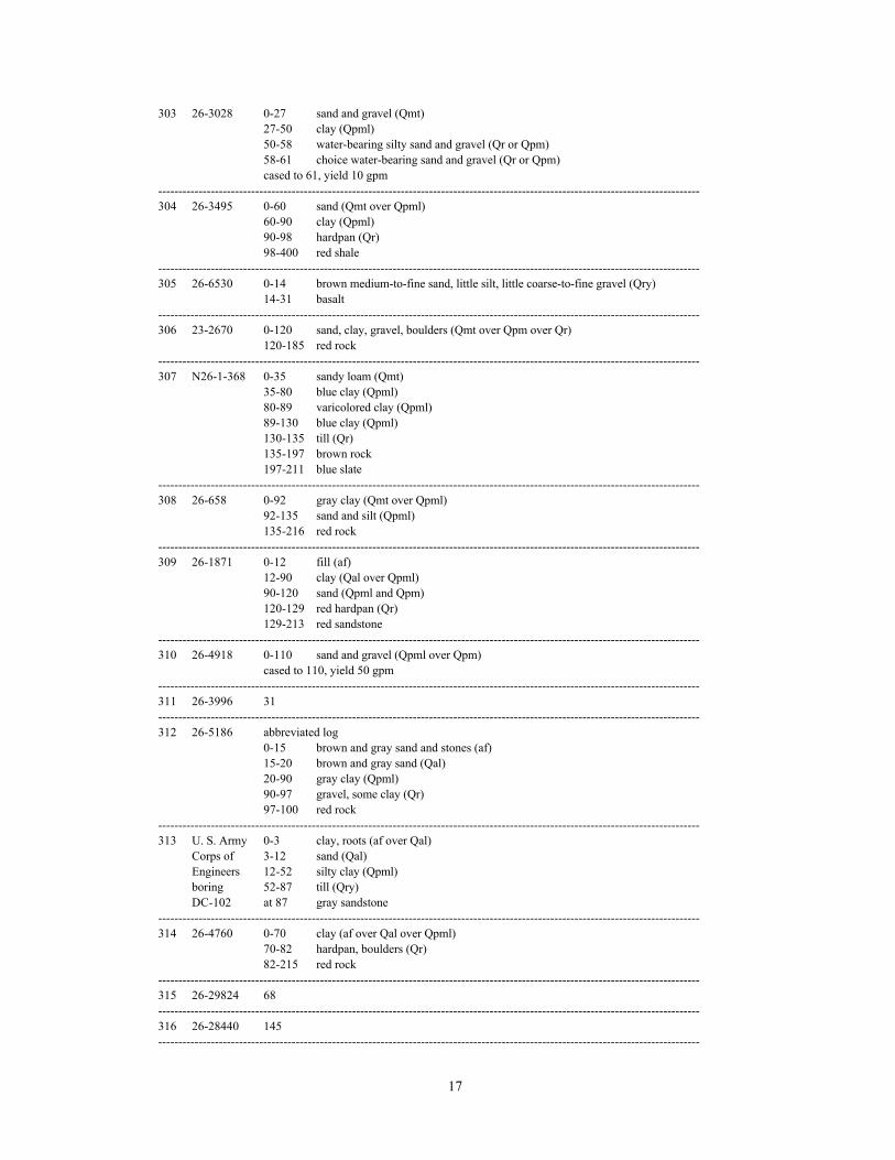
17
303 26-3028 0-27 sand and gravel (Qmt)27-50 clay (Qpml)50-58 water-bearing silty sand and gravel (Qr or Qpm)58-61 choice water-bearing sand and gravel (Qr or Qpm)cased to 61, yield 10 gpm
--------------------------------------------------------------------------------------------------------------------------------------304 26-3495 0-60 sand (Qmt over Qpml)
60-90 clay (Qpml)90-98 hardpan (Qr)98-400 red shale
--------------------------------------------------------------------------------------------------------------------------------------305 26-6530 0-14 brown medium-to-fine sand, little silt, little coarse-to-fine gravel (Qry)
14-31 basalt--------------------------------------------------------------------------------------------------------------------------------------306 23-2670 0-120 sand, clay, gravel, boulders (Qmt over Qpm over Qr)
120-185 red rock--------------------------------------------------------------------------------------------------------------------------------------307 N26-1-368 0-35 sandy loam (Qmt)
35-80 blue clay (Qpml)80-89 varicolored clay (Qpml)89-130 blue clay (Qpml)130-135 till (Qr)135-197 brown rock197-211 blue slate
--------------------------------------------------------------------------------------------------------------------------------------308 26-658 0-92 gray clay (Qmt over Qpml)
92-135 sand and silt (Qpml)135-216 red rock
--------------------------------------------------------------------------------------------------------------------------------------309 26-1871 0-12 fill (af)
12-90 clay (Qal over Qpml)90-120 sand (Qpml and Qpm)120-129 red hardpan (Qr)129-213 red sandstone
--------------------------------------------------------------------------------------------------------------------------------------310 26-4918 0-110 sand and gravel (Qpml over Qpm)
cased to 110, yield 50 gpm--------------------------------------------------------------------------------------------------------------------------------------311 26-3996 31--------------------------------------------------------------------------------------------------------------------------------------312 26-5186 abbreviated log
0-15 brown and gray sand and stones (af)15-20 brown and gray sand (Qal)20-90 gray clay (Qpml)90-97 gravel, some clay (Qr)97-100 red rock
--------------------------------------------------------------------------------------------------------------------------------------313 U. S. Army 0-3 clay, roots (af over Qal)
Corps of 3-12 sand (Qal)Engineers 12-52 silty clay (Qpml)boring 52-87 till (Qry)DC-102 at 87 gray sandstone
--------------------------------------------------------------------------------------------------------------------------------------314 26-4760 0-70 clay (af over Qal over Qpml)
70-82 hardpan, boulders (Qr)82-215 red rock
--------------------------------------------------------------------------------------------------------------------------------------315 26-29824 68--------------------------------------------------------------------------------------------------------------------------------------316 26-28440 145--------------------------------------------------------------------------------------------------------------------------------------
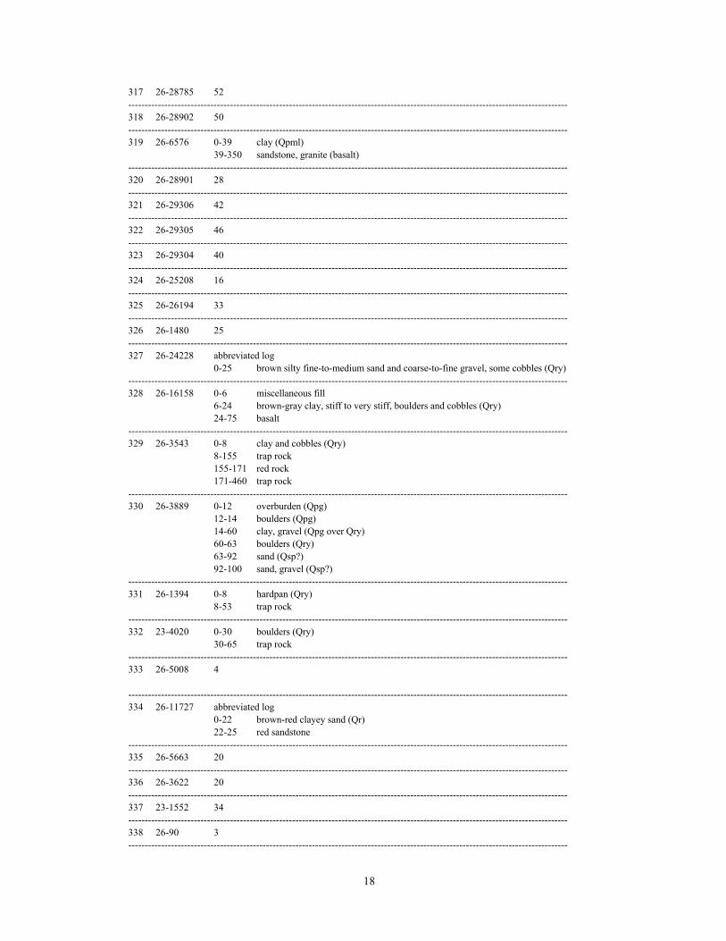
18
317 26-28785 52--------------------------------------------------------------------------------------------------------------------------------------318 26-28902 50--------------------------------------------------------------------------------------------------------------------------------------319 26-6576 0-39 clay (Qpml)
39-350 sandstone, granite (basalt)--------------------------------------------------------------------------------------------------------------------------------------320 26-28901 28--------------------------------------------------------------------------------------------------------------------------------------321 26-29306 42--------------------------------------------------------------------------------------------------------------------------------------322 26-29305 46--------------------------------------------------------------------------------------------------------------------------------------323 26-29304 40--------------------------------------------------------------------------------------------------------------------------------------324 26-25208 16--------------------------------------------------------------------------------------------------------------------------------------325 26-26194 33--------------------------------------------------------------------------------------------------------------------------------------326 26-1480 25--------------------------------------------------------------------------------------------------------------------------------------327 26-24228 abbreviated log
0-25 brown silty fine-to-medium sand and coarse-to-fine gravel, some cobbles (Qry)--------------------------------------------------------------------------------------------------------------------------------------328 26-16158 0-6 miscellaneous fill
6-24 brown-gray clay, stiff to very stiff, boulders and cobbles (Qry)24-75 basalt
--------------------------------------------------------------------------------------------------------------------------------------329 26-3543 0-8 clay and cobbles (Qry)
8-155 trap rock155-171 red rock171-460 trap rock
--------------------------------------------------------------------------------------------------------------------------------------330 26-3889 0-12 overburden (Qpg)
12-14 boulders (Qpg)14-60 clay, gravel (Qpg over Qry)60-63 boulders (Qry)63-92 sand (Qsp?)92-100 sand, gravel (Qsp?)
--------------------------------------------------------------------------------------------------------------------------------------331 26-1394 0-8 hardpan (Qry)
8-53 trap rock--------------------------------------------------------------------------------------------------------------------------------------332 23-4020 0-30 boulders (Qry)
30-65 trap rock--------------------------------------------------------------------------------------------------------------------------------------333 26-5008 4
--------------------------------------------------------------------------------------------------------------------------------------334 26-11727 abbreviated log
0-22 brown-red clayey sand (Qr)22-25 red sandstone
--------------------------------------------------------------------------------------------------------------------------------------335 26-5663 20--------------------------------------------------------------------------------------------------------------------------------------336 26-3622 20--------------------------------------------------------------------------------------------------------------------------------------337 23-1552 34--------------------------------------------------------------------------------------------------------------------------------------338 26-90 3--------------------------------------------------------------------------------------------------------------------------------------

19
339 26-27964 0-72 light brown medium-to-fine silty sand, some gravel (Qr)--------------------------------------------------------------------------------------------------------------------------------------340 23-4449 0-32 yellow hardpan (Qmt over Qpg or Qry)
32-56 sand and gravel (Qpg or Qsp)56-83 red rock83-88 trap rock
--------------------------------------------------------------------------------------------------------------------------------------341 23-9069 abbreviated log
0-30 brown fine-to-coarse sand and gravel (Qaf over Qmt)--------------------------------------------------------------------------------------------------------------------------------------342 23-7509 0-24 sand and gravel (Qmt)--------------------------------------------------------------------------------------------------------------------------------------343 26-3052 0-27 clay (Qmt over Qr)
27-58 bedrock--------------------------------------------------------------------------------------------------------------------------------------344 23-8801 abbreviated log
0-15 brown sandy loam, trace cobbles, pebbles (Qmt)15-25 sand and gravel (Qmt over Qpg)
--------------------------------------------------------------------------------------------------------------------------------------345 26-15796 0-23 glacial till with boulders (Qmt over Qr)
23-43 loose red shale--------------------------------------------------------------------------------------------------------------------------------------346 22-9483 0-20 hardpan (Qsh1)
20-125 sand and gravel (Qpg)cased to 124, yield 30 gpm
--------------------------------------------------------------------------------------------------------------------------------------347 26-5043 abbreviated log
0-25 brown sand and gravel (Qpg)25-250 trap rock250-500 sandstone
--------------------------------------------------------------------------------------------------------------------------------------348 26-5081 0-13 sand, boulders (Qpg)
13-210 trap rock210-395 sandstone
--------------------------------------------------------------------------------------------------------------------------------------349 26-3392 0-40 hardpan (Qry)
40-45 sand (Qry or Qsp)45-405 granite (basalt)
--------------------------------------------------------------------------------------------------------------------------------------350 26-7883 0-11 brown clayey silt and reddish brown medium-to-fine sand, occasional cobbles (Qry)
at 11 bedrock --------------------------------------------------------------------------------------------------------------------------------------351 26-26449 25--------------------------------------------------------------------------------------------------------------------------------------352 26-1101 0-27 clay (Qpt)
27-58 bedrock--------------------------------------------------------------------------------------------------------------------------------------353 26-25207 11--------------------------------------------------------------------------------------------------------------------------------------354 26-3974 5--------------------------------------------------------------------------------------------------------------------------------------355 25-1500 0-8 hardpan (Qry)
8-88 trap rock88-125 shale
--------------------------------------------------------------------------------------------------------------------------------------356 26-25795 0-3 sandy clay (Qry)
3-227 basalt
--------------------------------------------------------------------------------------------------------------------------------------357 26-3513 22--------------------------------------------------------------------------------------------------------------------------------------
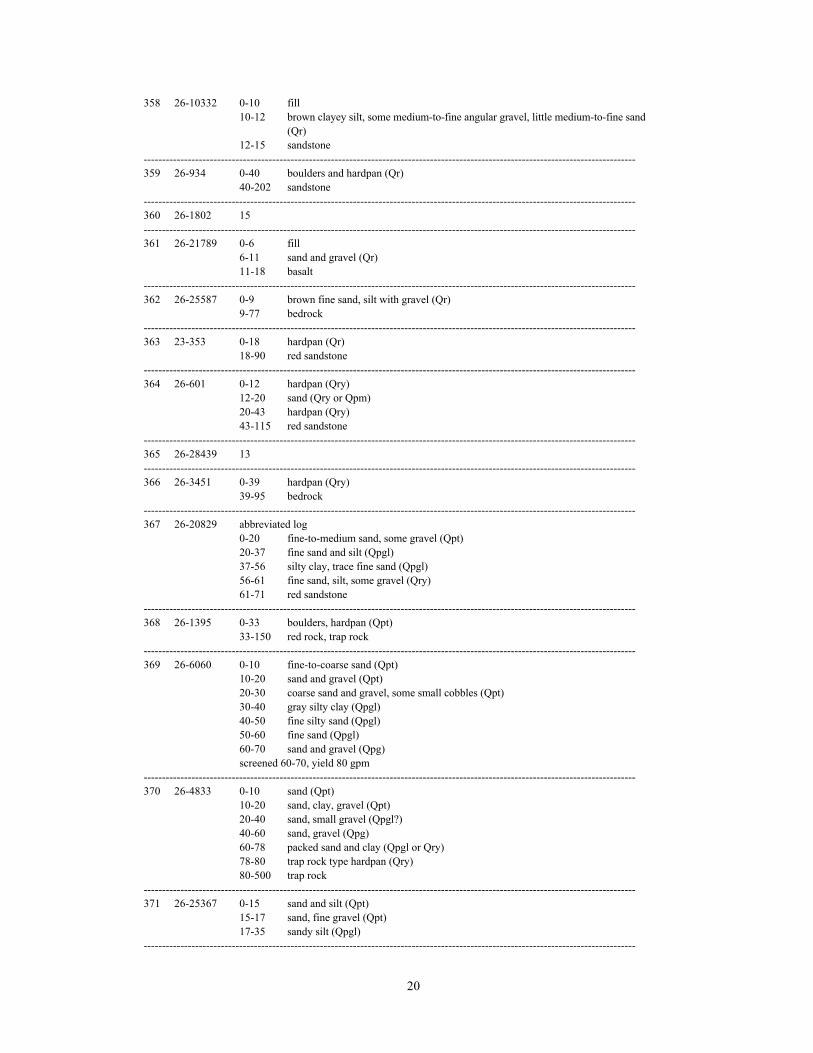
20
358 26-10332 0-10 fill10-12 brown clayey silt, some medium-to-fine angular gravel, little medium-to-fine sand
(Qr)12-15 sandstone
--------------------------------------------------------------------------------------------------------------------------------------359 26-934 0-40 boulders and hardpan (Qr)
40-202 sandstone--------------------------------------------------------------------------------------------------------------------------------------360 26-1802 15--------------------------------------------------------------------------------------------------------------------------------------361 26-21789 0-6 fill
6-11 sand and gravel (Qr)11-18 basalt
--------------------------------------------------------------------------------------------------------------------------------------362 26-25587 0-9 brown fine sand, silt with gravel (Qr)
9-77 bedrock--------------------------------------------------------------------------------------------------------------------------------------363 23-353 0-18 hardpan (Qr)
18-90 red sandstone--------------------------------------------------------------------------------------------------------------------------------------364 26-601 0-12 hardpan (Qry)
12-20 sand (Qry or Qpm)20-43 hardpan (Qry)43-115 red sandstone
--------------------------------------------------------------------------------------------------------------------------------------365 26-28439 13--------------------------------------------------------------------------------------------------------------------------------------366 26-3451 0-39 hardpan (Qry)
39-95 bedrock--------------------------------------------------------------------------------------------------------------------------------------367 26-20829 abbreviated log
0-20 fine-to-medium sand, some gravel (Qpt)20-37 fine sand and silt (Qpgl)37-56 silty clay, trace fine sand (Qpgl)56-61 fine sand, silt, some gravel (Qry)61-71 red sandstone
--------------------------------------------------------------------------------------------------------------------------------------368 26-1395 0-33 boulders, hardpan (Qpt)
33-150 red rock, trap rock--------------------------------------------------------------------------------------------------------------------------------------369 26-6060 0-10 fine-to-coarse sand (Qpt)
10-20 sand and gravel (Qpt)20-30 coarse sand and gravel, some small cobbles (Qpt)30-40 gray silty clay (Qpgl)40-50 fine silty sand (Qpgl)50-60 fine sand (Qpgl)60-70 sand and gravel (Qpg)screened 60-70, yield 80 gpm
--------------------------------------------------------------------------------------------------------------------------------------370 26-4833 0-10 sand (Qpt)
10-20 sand, clay, gravel (Qpt)20-40 sand, small gravel (Qpgl?)40-60 sand, gravel (Qpg)60-78 packed sand and clay (Qpgl or Qry)78-80 trap rock type hardpan (Qry)80-500 trap rock
--------------------------------------------------------------------------------------------------------------------------------------371 26-25367 0-15 sand and silt (Qpt)
15-17 sand, fine gravel (Qpt)17-35 sandy silt (Qpgl)
--------------------------------------------------------------------------------------------------------------------------------------

21
372 26-3044 0-5 fill5-26 sand and gravel (Qal over Qst)26-67 clay (Qpgl)67-71 silty sand, water-bearing and heaving (Qpgl)71-81 water-bearing sand, clay, and gravel (Qry)81-201 trap rock
--------------------------------------------------------------------------------------------------------------------------------------
373 26-26066 49--------------------------------------------------------------------------------------------------------------------------------------374 26-28244 0-7 silty sand and clay (af)
7-17 medium-to-fine sand, some silt and gravel (Qst)17-26 red-brown silt and fine sand (Qpgl)26-31 red-brown silty clay, little coarse-to-fine sand and gravel (Qpgl or Qr)at 31 possible rock
--------------------------------------------------------------------------------------------------------------------------------------375 26-29993 0-5 light brown clayey silt (Qpt or Qpgl)
5-14 dark gray clay (Qpgl)14-20 light gray sand (Qpg)20-23 shale
--------------------------------------------------------------------------------------------------------------------------------------376 26-25490 19--------------------------------------------------------------------------------------------------------------------------------------377 26-28438 6--------------------------------------------------------------------------------------------------------------------------------------378 26-18660 0-4 clay, sand, boulder (Qry)
4-275 trap rock275-290 red sandstone
--------------------------------------------------------------------------------------------------------------------------------------379 26-29724 0-6 brown clay silt, trace medium-to-fine sand (Qry)
6-18 basalt--------------------------------------------------------------------------------------------------------------------------------------380 26-17143 abbreviated log
0-8 brown fine-to-coarse sand, pea gravel, some silt (Qpg)8-16 basalt
--------------------------------------------------------------------------------------------------------------------------------------381 26-1183 5--------------------------------------------------------------------------------------------------------------------------------------382 26-5540 18--------------------------------------------------------------------------------------------------------------------------------------383 26-4780 4--------------------------------------------------------------------------------------------------------------------------------------384 26-18997 abbreviated log
0-15 silty fine sand (Qpt)15-28 coarse sand and gravel (Qpt)28-43 sandy clay with some gravel from 35-43 (Qsh1)
--------------------------------------------------------------------------------------------------------------------------------------385 26-24562 abbreviated log
0-45 sand and gravel (Qpt over Qsh1)--------------------------------------------------------------------------------------------------------------------------------------386 23-6672 0-50 sand and big gravel (Qpt over Qpr)
50-198 red rock--------------------------------------------------------------------------------------------------------------------------------------387 23-7106 0-20 sand, gravel, boulders (Qpt)
20-45 sand, gravel, and silt (Qpr)45-300 red shale
--------------------------------------------------------------------------------------------------------------------------------------388 23-7137 0-16 wood fill
16-31 clay, sand, rocks (Qpt)31-300 red shale
--------------------------------------------------------------------------------------------------------------------------------------
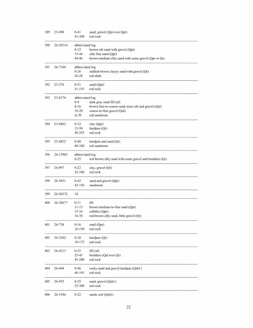
22
389 23-498 0-41 sand, gravel (Qpt over Qpr)41-200 red rock
--------------------------------------------------------------------------------------------------------------------------------------390 26-28214 abbreviated log
0-15 brown silt sand with gravel (Qpt)15-44 silty fine sand (Qpr)44-46 brown medium silty sand with some gravel (Qpr or Qr)
--------------------------------------------------------------------------------------------------------------------------------------391 26-7184 abbreviated log
0-26 reddish brown clayey sand with gravel (Qr)26-28 red shale
--------------------------------------------------------------------------------------------------------------------------------------392 23-276 0-51 sand (Qpr)
51-155 red rock--------------------------------------------------------------------------------------------------------------------------------------393 23-8176 abbreviated log
0-4 dark gray sand fill (af)4-16 brown fine-to-coarse sand, trace silt and gravel (Qal)16-20 coarse-to-fine gravel (Qal)at 20 red sandstone
--------------------------------------------------------------------------------------------------------------------------------------394 23-6863 0-12 clay (Qpr)
12-50 hardpan (Qr)50-355 red rock
--------------------------------------------------------------------------------------------------------------------------------------395 23-4825 0-40 hardpan and sand (Qr)
40-100 red sandstone--------------------------------------------------------------------------------------------------------------------------------------396 26-15965 abbreviated log
0-25 red-brown silty sand with some gravel and boulders (Qr)--------------------------------------------------------------------------------------------------------------------------------------397 26-997 0-22 clay, gravel (Qr)
22-100 red rock--------------------------------------------------------------------------------------------------------------------------------------398 26-3831 0-42 sand and gravel (Qpr)
42-156 sandstone--------------------------------------------------------------------------------------------------------------------------------------399 26-26372 18--------------------------------------------------------------------------------------------------------------------------------------400 26-28677 0-11 fill
11-13 brown medium-to-fine sand (Qpr)13-16 cobbles (Qpr)16-30 red-brown silty sand, little gravel (Qr)
--------------------------------------------------------------------------------------------------------------------------------------401 26-738 0-16 sand (Qpr)
16-150 red rock--------------------------------------------------------------------------------------------------------------------------------------402 26-3202 0-10 hardpan (Qr)
10-175 red rock--------------------------------------------------------------------------------------------------------------------------------------403 26-4313 0-25 fill (af)
25-43 boulders (Qal over Qr)43-200 red rock
--------------------------------------------------------------------------------------------------------------------------------------404 26-604 0-46 rocky sand and gravel hardpan (Qsh1)
46-191 red rock--------------------------------------------------------------------------------------------------------------------------------------405 26-955 0-25 sand, gravel (Qsh1)
25-300 red rock--------------------------------------------------------------------------------------------------------------------------------------406 26-3346 0-22 sandy soil (Qsh1)
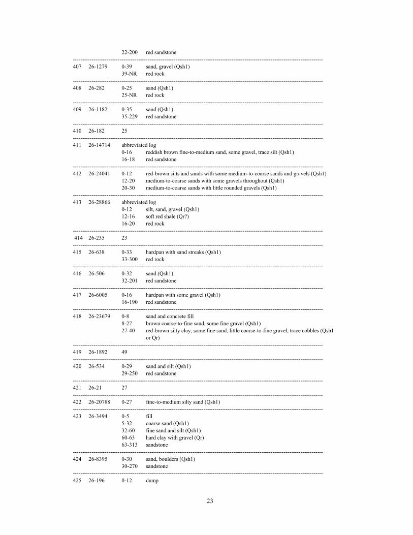
23
22-200 red sandstone--------------------------------------------------------------------------------------------------------------------------------------407 26-1279 0-39 sand, gravel (Qsh1)
39-NR red rock--------------------------------------------------------------------------------------------------------------------------------------408 26-282 0-25 sand (Qsh1)
25-NR red rock--------------------------------------------------------------------------------------------------------------------------------------409 26-1182 0-35 sand (Qsh1)
35-229 red sandstone--------------------------------------------------------------------------------------------------------------------------------------410 26-182 25--------------------------------------------------------------------------------------------------------------------------------------411 26-14714 abbreviated log
0-16 reddish brown fine-to-medium sand, some gravel, trace silt (Qsh1)16-18 red sandstone
--------------------------------------------------------------------------------------------------------------------------------------412 26-24041 0-12 red-brown silts and sands with some medium-to-coarse sands and gravels (Qsh1)
12-20 medium-to-coarse sands with some gravels throughout (Qsh1)20-30 medium-to-coarse sands with little rounded gravels (Qsh1)
--------------------------------------------------------------------------------------------------------------------------------------413 26-28866 abbreviated log
0-12 silt, sand, gravel (Qsh1)12-16 soft red shale (Qr?)16-20 red rock
-------------------------------------------------------------------------------------------------------------------------------------- 414 26-235 23--------------------------------------------------------------------------------------------------------------------------------------415 26-638 0-33 hardpan with sand streaks (Qsh1)
33-300 red rock--------------------------------------------------------------------------------------------------------------------------------------416 26-506 0-32 sand (Qsh1)
32-201 red sandstone--------------------------------------------------------------------------------------------------------------------------------------417 26-6005 0-16 hardpan with some gravel (Qsh1)
16-190 red sandstone--------------------------------------------------------------------------------------------------------------------------------------418 26-23679 0-8 sand and concrete fill
8-27 brown coarse-to-fine sand, some fine gravel (Qsh1)27-40 red-brown silty clay, some fine sand, little coarse-to-fine gravel, trace cobbles (Qsh1
or Qr)--------------------------------------------------------------------------------------------------------------------------------------419 26-1892 49--------------------------------------------------------------------------------------------------------------------------------------420 26-534 0-29 sand and silt (Qsh1)
29-250 red sandstone--------------------------------------------------------------------------------------------------------------------------------------421 26-21 27--------------------------------------------------------------------------------------------------------------------------------------422 26-20788 0-27 fine-to-medium silty sand (Qsh1)--------------------------------------------------------------------------------------------------------------------------------------423 26-3494 0-5 fill
5-32 coarse sand (Qsh1)32-60 fine sand and silt (Qsh1)60-63 hard clay with gravel (Qr)63-313 sandstone
--------------------------------------------------------------------------------------------------------------------------------------424 26-8395 0-30 sand, boulders (Qsh1)
30-270 sandstone--------------------------------------------------------------------------------------------------------------------------------------425 26-196 0-12 dump

24
12-20 gravel (Qsh1)20-22 hardpan (Qr)22-190 red rock
--------------------------------------------------------------------------------------------------------------------------------------426 23-1290 0-26 fill, ashes, sand and gravel (Qsh1)
26-NR red rock--------------------------------------------------------------------------------------------------------------------------------------427 26-16475 15--------------------------------------------------------------------------------------------------------------------------------------428 26-1297 24--------------------------------------------------------------------------------------------------------------------------------------429 26-668 0-28 sandy red soil (Qsh2)
28-199 red rock--------------------------------------------------------------------------------------------------------------------------------------430 26-1455 0-37 sand (Qsh2)
37-140 red sandstone--------------------------------------------------------------------------------------------------------------------------------------431 26-6130 abbreviated log
0-15 brown to reddish brown silty coarse-to-fine sand, trace fine gravel (Qr)at 15 weathered sandstone
--------------------------------------------------------------------------------------------------------------------------------------432 26-279 0-18 hardpan (Qr)
18-220 red rock--------------------------------------------------------------------------------------------------------------------------------------433 26-29005 0-18 red coarse sand and gravel (Qr)
18-62 red shale and sandstone--------------------------------------------------------------------------------------------------------------------------------------434 26-24819 0-8 brown silty sand with some clay (Qr)
8-16 red-brown medium-to-coarse sand with some sandstone (Qr)16-34 shale and sandstone beds
--------------------------------------------------------------------------------------------------------------------------------------435 26-25889 0-9 brown gravel and silt (Qr)
9-12 light brown silt (Qr)12-20 red shale
--------------------------------------------------------------------------------------------------------------------------------------
436 26-2116 0-14 hardpan (Qr)14-200 red shale and sandstone
--------------------------------------------------------------------------------------------------------------------------------------437 26-1274 18--------------------------------------------------------------------------------------------------------------------------------------438 26-712 8--------------------------------------------------------------------------------------------------------------------------------------439 26-29286 0-18 sandy silt and small gravel (Qr)
18-26 large gravel and silt (Qr)26-36 soft red rock36-200 red rock
--------------------------------------------------------------------------------------------------------------------------------------440 26-25588 0-5 brown fine sand (Qr)
5-12 brown-red fine sand (Qr)12-53 bedrock
--------------------------------------------------------------------------------------------------------------------------------------441 26-26403 0-12 red-brown clay, trace coarse-to-fine gravel (Qr)
12-70 sandstone--------------------------------------------------------------------------------------------------------------------------------------442 26-23011 0-34 red-brown clay with trace gravel (Qr)
34-40 brown clay and sand (Qr)40-47 coarse sand and gravel (Qsp?)47-67 fine sand with trace gravel (Qsp?)
--------------------------------------------------------------------------------------------------------------------------------------443 26-24570 0-5 clay, silt, tan-orange (Qr)

25
5-30 sandstone with red shale lenses--------------------------------------------------------------------------------------------------------------------------------------444 26-3656 0-3 hardpan (Qr)
3-9 fine sand (Qr)9-16 hardpan and boulders (Qr)16-58 sand and gravel (Qsp?)cased to 58, yield 30 gpm
--------------------------------------------------------------------------------------------------------------------------------------445 26-20439 0-3 red gray silty clay, little fine sand (Qr)
3-5 weathered sandstone5-15 red, hard sandstone
--------------------------------------------------------------------------------------------------------------------------------------446 26-21933 abbreviated log
0-7 red-tan silty fine sand (Qr)7-16 red silt, weathered siltstone16-20 weathered red siltstone
--------------------------------------------------------------------------------------------------------------------------------------447 26-26586 0-10 sand (Qr)
10-26 bedrock--------------------------------------------------------------------------------------------------------------------------------------448 26-712 8--------------------------------------------------------------------------------------------------------------------------------------449 26-3539 18--------------------------------------------------------------------------------------------------------------------------------------450 26-10548 abbreviated log
0-25 reddish brown fine-to-coarse sand with gravel (Qsh2)--------------------------------------------------------------------------------------------------------------------------------------451 26-1165 0-15 gravel (Qsh2)
15-231 red rock--------------------------------------------------------------------------------------------------------------------------------------452 26-29099 abbreviated log
0-2 gravel (Qpr)2-20 sand (Qpr)
--------------------------------------------------------------------------------------------------------------------------------------453 26-3374 20--------------------------------------------------------------------------------------------------------------------------------------454 26-4991 0-4 fill
4-12 hardpan (Qpr)12-26 silty gray sand (Qpr)26-28 red hardpan (Qr)28-300 red sandstone
--------------------------------------------------------------------------------------------------------------------------------------455 26-755 0-11 clay (Qr)
11-402 red sandstone--------------------------------------------------------------------------------------------------------------------------------------456 26-29030 abbreviated log
0-24 brown and red sand and boulders (Qr)24-30 red sandstone
--------------------------------------------------------------------------------------------------------------------------------------457 26-4779 0-8 sand (Qr)
8-200 red shale and sandstone--------------------------------------------------------------------------------------------------------------------------------------458 26-29308 0-13 sandy clay, gravel (Qr)
13-17 red stone--------------------------------------------------------------------------------------------------------------------------------------459 26-27866 0-18 reddish brown silty sand and cobbles, some clay (Qr)
18-19 red shale--------------------------------------------------------------------------------------------------------------------------------------460 26-3345 0-23 sand and gravel (Qr)
23-140 red sandstone--------------------------------------------------------------------------------------------------------------------------------------

26
461 26-4220 8--------------------------------------------------------------------------------------------------------------------------------------462 26-29307 0-7 sandy clay (Qr)
7-20 red stone--------------------------------------------------------------------------------------------------------------------------------------463 26-4960 0-5 fill
5-10 hardpan (Qr)10-20 silty sand some clay (Qr)20-23 sticky red clay with sand (Qr)23-180 sandstone
--------------------------------------------------------------------------------------------------------------------------------------464 26-5239 0-2 fill
2-7 yellow grayish sandy clay (Qr)7-200 sandstone
--------------------------------------------------------------------------------------------------------------------------------------465 26-29661 0-4 red-brown clay, trace medium-to-fine sand (Qr)
4-17 red sandstone--------------------------------------------------------------------------------------------------------------------------------------466 26-15125 0-16 till and red clay with red sand (Qr)
at 16 rock--------------------------------------------------------------------------------------------------------------------------------------467 26-2916 4--------------------------------------------------------------------------------------------------------------------------------------468 26-29192 0-12 brown red silt (Qr)
12-35 red sandstone--------------------------------------------------------------------------------------------------------------------------------------469 26-27232 0-20 reddish brown silty sand (Qr)
20-42 light brown medium sand (Qsp?)--------------------------------------------------------------------------------------------------------------------------------------470 26-4223 0-8 clay overburden (Qr)
8-120 red sandstone--------------------------------------------------------------------------------------------------------------------------------------471 26-29145 0-23 red-brown medium-to-fine sand, trace silt (Qpt over Qpr)
23-50 siltstone--------------------------------------------------------------------------------------------------------------------------------------472 26-3883 0-30 hardpan and boulders (Qpr)
30-50 fine sand (Qpr)50-65 gravelcased to 65, yield 15 gpm
--------------------------------------------------------------------------------------------------------------------------------------473 26-18518 0-20 boulders, cobbles, gravel (Qr)
20-30 fine-to-medium silty sand with sandstone and shale fragments (Qr)30-40 red shale rock
--------------------------------------------------------------------------------------------------------------------------------------474 26-5300 6--------------------------------------------------------------------------------------------------------------------------------------475 26-21093 3--------------------------------------------------------------------------------------------------------------------------------------476 26-10983 0-6 fill--sand, gravel, bricks, cinders
6-25 red-brown medium-to-fine sand, trace fine gravel and silt (Qr)25-29 red-brown sandstone
--------------------------------------------------------------------------------------------------------------------------------------477 26-12640 0-21 red-brown medium-to-fine sand and silt, trace coarse-to-fine gravel (Qr)
21-30 sandstone-------------------------------------------------------------------------------------------------------------------------------------- 478 26-28009 0-9 sand fill (Qr)
9-27 shale and sandstone--------------------------------------------------------------------------------------------------------------------------------------479 26-902 32--------------------------------------------------------------------------------------------------------------------------------------480 26-1293 0-8 clay and hardpan (Qr)
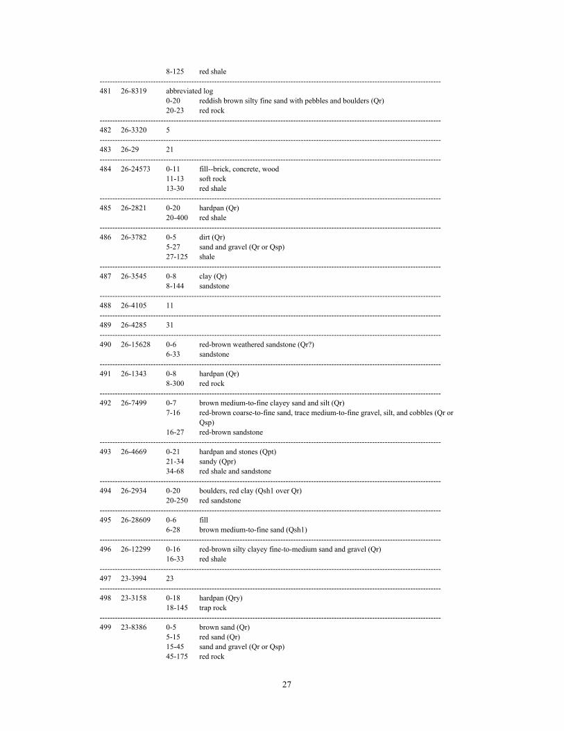
27
8-125 red shale--------------------------------------------------------------------------------------------------------------------------------------481 26-8319 abbreviated log
0-20 reddish brown silty fine sand with pebbles and boulders (Qr)20-23 red rock
--------------------------------------------------------------------------------------------------------------------------------------482 26-3320 5--------------------------------------------------------------------------------------------------------------------------------------483 26-29 21--------------------------------------------------------------------------------------------------------------------------------------484 26-24573 0-11 fill--brick, concrete, wood
11-13 soft rock13-30 red shale
--------------------------------------------------------------------------------------------------------------------------------------485 26-2821 0-20 hardpan (Qr)
20-400 red shale--------------------------------------------------------------------------------------------------------------------------------------486 26-3782 0-5 dirt (Qr)
5-27 sand and gravel (Qr or Qsp)27-125 shale
--------------------------------------------------------------------------------------------------------------------------------------487 26-3545 0-8 clay (Qr)
8-144 sandstone--------------------------------------------------------------------------------------------------------------------------------------488 26-4105 11--------------------------------------------------------------------------------------------------------------------------------------489 26-4285 31--------------------------------------------------------------------------------------------------------------------------------------490 26-15628 0-6 red-brown weathered sandstone (Qr?)
6-33 sandstone--------------------------------------------------------------------------------------------------------------------------------------491 26-1343 0-8 hardpan (Qr)
8-300 red rock--------------------------------------------------------------------------------------------------------------------------------------492 26-7499 0-7 brown medium-to-fine clayey sand and silt (Qr)
7-16 red-brown coarse-to-fine sand, trace medium-to-fine gravel, silt, and cobbles (Qr orQsp)
16-27 red-brown sandstone--------------------------------------------------------------------------------------------------------------------------------------493 26-4669 0-21 hardpan and stones (Qpt)
21-34 sandy (Qpr)34-68 red shale and sandstone
--------------------------------------------------------------------------------------------------------------------------------------494 26-2934 0-20 boulders, red clay (Qsh1 over Qr)
20-250 red sandstone--------------------------------------------------------------------------------------------------------------------------------------495 26-28609 0-6 fill
6-28 brown medium-to-fine sand (Qsh1)--------------------------------------------------------------------------------------------------------------------------------------496 26-12299 0-16 red-brown silty clayey fine-to-medium sand and gravel (Qr)
16-33 red shale--------------------------------------------------------------------------------------------------------------------------------------497 23-3994 23--------------------------------------------------------------------------------------------------------------------------------------498 23-3158 0-18 hardpan (Qry)
18-145 trap rock--------------------------------------------------------------------------------------------------------------------------------------499 23-8386 0-5 brown sand (Qr)
5-15 red sand (Qr)15-45 sand and gravel (Qr or Qsp)45-175 red rock

28
--------------------------------------------------------------------------------------------------------------------------------------500 26-18932 0-18 glacial till with brown fine sand (Qpr over Qr)
18-80 bedrock--------------------------------------------------------------------------------------------------------------------------------------
501 23-3216 0-84 fill, sand and gravel (Qfl3 over Qfl2)screened 62-82, yield 250 gpm
--------------------------------------------------------------------------------------------------------------------------------------
Identifiers of the form 26-xxxx and 23-xxxx are well permit numbers issued by the 1
N. J. Department of Environmental Protection, Bureau of Water Allocation. Identifiers of the formNxx-xx-xxx are N. J. Atlas Sheet grid coordinates of entries in the N. J. Geological Survey permanentnote collection.
A number without a log is the depth, in feet below land surface, to bedrock reported for wells where2
the surficial material is either not identified or identified only as “overburden” or “glacial fill”. Forwells and borings with logs of the surficial materials, the depth (in feet below land surface) anddriller’s or logger’s description is provided. Inferred map units and comments by author are inparentheses. All descriptions are reproduced as they appear in the original source, except for minorformat, punctuation, and spelling changes. Logs identified as “abbreviated” have been condensedfor brevity. Many bedrock descriptions have been condensed; these are not identified asabbreviated. The notation “NR” indicates “not reported”. For wells completed in surficial materials,the screened interval or length of well casing and yield (in gallons per minute, gpm) are reportedbeneath the log. Map units are inferred from the known extent of materials at the surface and fromknown depositional settings, in addition to the drillers’ descriptions.
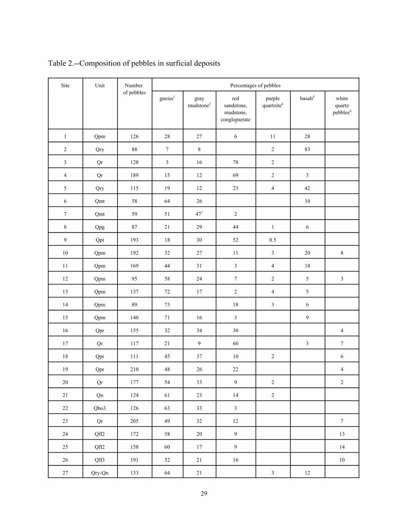
29
Table 2.--Composition of pebbles in surficial deposits
Site Unit Number Percentages of pebblesof pebbles
gneiss gray red purple basalt white1
mudstone sandstone, quartzite quartz2
mudstone, pebblesconglomerate
3
4
5
6
1 Qpm 126 28 27 6 11 28
2 Qry 88 7 8 2 83
3 Qr 128 3 16 78 2
4 Qr 189 15 12 69 2 3
5 Qry 115 19 12 23 4 42
6 Qmt 58 64 26 10
7 Qmt 59 51 47 27
8 Qpg 87 21 29 44 1 6
9 Qpt 193 18 30 52 0.5
10 Qpm 192 32 27 11 3 20 8
11 Qpm 169 44 31 3 4 18
12 Qpm 95 58 24 7 2 5 3
13 Qpm 137 72 17 2 4 5
14 Qpm 89 73 18 3 6
15 Qpm 140 71 16 3 9
16 Qpr 155 32 34 30 4
17 Qr 117 21 9 60 3 7
18 Qpr 111 45 37 10 2 6
19 Qpr 210 48 26 22 4
20 Qr 177 54 33 9 2 2
21 Qn 124 61 23 14 2
22 Qho3 126 63 33 3
23 Qr 205 49 32 12 7
24 Qfl2 172 58 20 9 13
25 Qfl2 158 60 17 9 14
26 Qfl3 191 52 21 16 10
27 Qry-Qn 133 64 21 3 12

30
28 Qn-Qry 150 37 14 49
29 Qry 149 19 13 1 67
30 Qfl2 152 57 33 4 6
31 Qr 157 13 20 32 35 Proterozoic gneiss from the Hudson Highlands.1
Paleozoic sedimentary rocks from the Wallkill and Hudson valleys.2
Local sedimentary rocks from the Newark Basin.3
Quartzite-conglomerate from the Green Pond and Skunnemunk formations in the Hudson Highlands. 4
Local basalt and gabbro from the Watchung basalt flows of the Newark Basin.5
Quartz pebbles are chiefly from local weathered conglomerates of the Newark Basin. Some may be from the6
Pensauken Formation, a preglacial fluvial deposit that formerly occupied lowland areas of the Newark Basin.
Includes 1% chert from Paleozoic carbonate rocks in the Wallkill Valley or Hudson Highlands.7
Related Documents