Nigg East Quay - Best Practicable Environmental Option Report February 2022

Welcome message from author
This document is posted to help you gain knowledge. Please leave a comment to let me know what you think about it! Share it to your friends and learn new things together.
Transcript

Nigg East Quay -
Best Practicable Environmental Option Report
February 2022

Nigg East Quay -
Best Practicable Environmental Option Report
Client: Global Energy Group Nigg
Document number: 8691
Project number: 671906
Status: Final R2
Author: Campbell Stewart
Reviewer: Graeme Duff
Date of issue: 9 February 2022
Filename: Nigg East Quay BPEO_Final Rev 2
Glasgow Aberdeen Inverness Edinburgh
Craighall Business Park
8 Eagle Street
Glasgow
G4 9XA
0141 341 5040
www.envirocentre.co.uk
Banchory Business
Centre
Burn O’Bennie Road
Banchory
AB31 5ZU
01330 826 596
Alder House
Cradlehall Business Park
Inverness
IV2 5GH
01463 794 212
This report has been prepared by EnviroCentre Limited with all reasonable skill and care, within the terms of
the Contract with Global Energy Group Nigg (“the Client”). The report is confidential to the Client, and
EnviroCentre Limited accepts no responsibility of whatever nature to third parties to whom this report may be
made known.
No part of this document may be reproduced or altered without the prior written approval of EnviroCentre
Limited.

Contents 1 Introduction ..................................................................................................................................................... 1
1.1 Scope of Report ....................................................................................................................................... 1 1.2 Chemical Assessment .............................................................................................................................. 1
2 Discussion of available disposal options .......................................................................................................... 2 2.1 Identification and screening of Available Disposal Options .................................................................... 2 2.2 Summary of Identified BPEO Options ..................................................................................................... 5
3 Further consideration of remaining disposal options ..................................................................................... 7 3.1 Detailed BPEO Assessment ..................................................................................................................... 7 3.2 BPEO Assessment Discussion ................................................................................................................ 12 3.3 Conclusions ........................................................................................................................................... 13
4 Sediment Further Assessment ....................................................................................................................... 14 4.1 Dredge Material Characteristics ............................................................................................................ 14
5 Water Framework Directive Assessment ...................................................................................................... 15 6 Conclusions .................................................................................................................................................... 17 References ............................................................................................................................................................. 18
Appendices A Fugro Report
Tables Table 2.1: Initial Best Practicable Available Options ............................................................................................... 3 Table3.1: BPEO Detailed Assessment Criteria ......................................................................................................... 7 Table 3.2: BPEO Strategic Assessment .................................................................................................................... 8 Table 3.3: BPEO Environmental Assessment .......................................................................................................... 9 Table 3.4: BPEO Cost Analysis (based on 100,000 tonnes only) ........................................................................... 12 Table 3.5: BPEO Summary ..................................................................................................................................... 12 Table 5.1: Receptor Risk Assessment .................................................................................................................... 15

Global Energy Group Nigg February 2022
Nigg East Quay -; Best Practicable Environmental Option Report
1
1 INTRODUCTION
1.1 Scope of Report
Global Energy Nigg Ltd are required to undertake a Best Practicable Environmental Option (BPEO) assessment
for the dredging and disposal of material from the proposed development of Nigg East Quay (‘the proposed
development’).
Site investigation works were undertaken by Fugro Ltd. and the results are provided in Fugro Report G191005U,
May 2019 which is provided in Appendix A of this report. Borehole locations are detailed within Figure B.1 within
Appendix B of the Fugro report. The relevant laboratory analytical data from the marine boreholes is included in
Appendix F of the Fugro report, and this data has been reviewed in line with the current Action Levels for
disposing of sediment at sea.
The site investigation comprised 8 boreholes progressed to depths between 2.5 to 13m below seabed level with
4 of those boreholes progressed further into rock. The sediments overlying bedrock can be generally described
as mixtures of sand and gravel, with sandy clay horizons also noted. Borehole logs are provided within Appendix
C of the Fugro report.
The dredge for the development will remove ≤199,500m3 of material from the seabed All of this material is
proposed to be disposed at sea. Previous plans had allowed for the reuse of up to 30,000m3 within the
development, but this is no longer required due to further detailed review and design of the works.
The following report considers the available options for reuse and disposal of material in the context of the
project.
1.2 Chemical Assessment
Review of the data provided by Fugro is summarised as follows:
• 24 samples collected from 8 boreholes between surface and 13.0m below surface;
• Samples were dominated in general by the presence of the sand sized fractions;
• No samples recorded metal concentrations greater than their respective Revised Action Level1 (RAL 1)
• No samples recorded tributyltin (TBT) levels above RAL1;
• 1 of 24 samples recorded an exceedance of RAL 1 for Dibenz(ah)anthracene in sample BH2 2.50-
3.00m, no other exceedances were recorded;
• No samples recorded polychlorinated biphenyl (PCB) levels above RAL1;
• No samples recorded Total Hydrocarbon levels above RAL1.
In conclusion all 24 samples recorded contaminants of concern below RAL 1 with the exception of a single sample
which recorded Dibenz(ah)anthracene in exceedance of RAL 1. There were no exceedances of RAL 2 where they
are available.

Global Energy Group Nigg February 2022
Nigg East Quay -; Best Practicable Environmental Option Report
2
2 DISCUSSION OF AVAILABLE DISPOSAL OPTIONS
The BPEO process is geared towards identifying a preferred overall strategy from the perspective of the environment
as a whole, as opposed to detailed optimisation of any one selected scheme. It is a structured and systematic process
to identify and compare strategic options in a transparent manner. Alternatives are evaluated in terms of their
projected implications for the environment together with consideration of practicability, social and economic issues
as well as within a wider strategic context.
The key stages of a BPEO are:
• Identification of options;
• Screening of options;
• Selection of assessment criteria;
• Analysis and evaluation of criteria; and
• Evaluation of BPEO.
2.1 Identification and screening of Available Disposal Options
A number of options are available for disposal of dredged sediments. The options considered are provided in
Table 2.1 along with justification for screening out those options which have not been taken forward for
further consideration.

Global Energy Group Nigg February 2022
Nigg East Quay -; Best Practicable Environmental Option Report
3
Table 2.1: Initial Best Practicable Available Options
Location Options Screening Assessment Carry
forward?
Coast /
Harbour
Do nothing
Scenario/ Leave
in situ
Not an option due to the intentions to develop the quay facility. No
Infilling of an
existing dry
dock/harbour
facility
There are no suitable dry dock or harbour facilities requiring infill in the vicinity of the project and on this
basis this option is not considered viable.
No
Beach
Nourishment
Specific beach nourishment projects would require to be supported by Environmental Assessments as a
minimum to inform how the project could affect the environment as a result of disturbance to the
intertidal area, changes to the sediment levels, the variable composition and quality of the material and
measures devised from the assessment outcomes to minimise impacts on the environment.
There are no known beach nourishment projects in proximity to the proposed project.
No
Land Landfill Disposal This is possible but it is unlikely that this option will offer long term solution due to lack of space at
landfills. Landfill space is currently at a premium and does not offer a sustainable solution either
financially or environmentally for the disposal of dredged arisings. Dredged material is likely to require
treatment first in a dewatering facility. There is significant cost associated with set up of dewatering
facility at the quayside plus transportation and additional costs associated with gaining the necessary
planning and regulatory consents.
Yes
Recycling/Re-use Further review of the design has indicated that no dredged material is required for the construction
project.
No
Land Incineration The dredged material consists of non-combustible material (silts) with a low combustible component and
very high water content.
No

Global Energy Group Nigg February 2022
Nigg East Quay -; Best Practicable Environmental Option Report
4
Location Options Screening Assessment Carry
forward?
Application to
Agricultural Land
The dredged material would need to be treated to reduce salt concentrations to acceptable levels. There
would be a requirement for a detailed chemical analysis and assessment as well as a Waste Management
License Exemption. Special precautions would be required during spreading in relation to the risk of
odour and watercourses / aquifers. The availability of land for this option will be limited within a
reasonable haulage distance of the dredge arisings.
No
Sea Aquatic disposal
direct to seabed.
All of the dredged material is proposed for sea disposal at CR019 – Sutors. Further consideration of this
route is provided in Section 3.
Yes

Global Energy Group Nigg February 2022
Nigg East Quay -; Best Practicable Environmental Option Report
5
2.2 Summary of Identified BPEO Options
Three options were identified for further assessment as follows:
• Landfill; and
• Sea Disposal.
2.2.1 Landfill Disposal
Dredged material is considered to be controlled waste for the purpose of transport, storage and disposal as per
Section 34 (7) of the Environmental Protection Act 1990. The Landfill (Scotland) Regulations 2003 require the
classification and characterisation (i.e. inert, non-hazardous or hazardous) of the dredged material to be
determined prior to landfill acceptance.
Disposal to landfill would require several stages in material handling operations:
• Dredging and transport to shore;
• Transfer to shore to a dewatering facility;
• Dewatering;
• Transfer of dewatered material to storage area for stockpiling;
• Loading of lorries and transport to landfill site; and
• Disposal at Landfill site.
Transport to the shore would require the identification of an available jetty facility suitable for receiving material
directly to the dewatering facility. Two options are available for off-loading; namely grabbing the spoil from the
barge or hopper or pumping directly ashore.
The dewatering facility would require being purpose built and capable of receiving large quantities of bulk
material. Currently no facility exists in proximity to the site in the Cromarty Firth. Settlement tanks, with the aid
of sluices and rotational management, would allow solids to settle out and the water element drain off and return
to the Cromarty Firth. Temporary mobilisation of bespoke mechanical dewatering equipment could also be
utilised but at greater cost. The dewatered dredged sediment would then be removed from the facility and
stockpiled for transfer via lorry to a suitably licensed landfill.
We understand that the type of vehicle most suitable for transporting the dewatered dredged material is either
a rigid bodied tipper or an articulated tanker both with a 16 tonne load capacity. It is estimated that the dredge
volume which cannot be utilised within the development equates to c. 390,000 tonnes of material and would
require approximately 24,375 return trips would typically be required to transport the dewatered dredged
material to landfill.
The number of landfills within a viable distance of the site at Nigg is considered to be low. In addition, the
available capacity of each site is limited by the amount of material it can receive per annum. Due to the proposed
quantity of material to be dredged it is therefore unlikely that any landfill within viable distance of the site will
have the capacity to receive the dredged material.

Global Energy Group Nigg February 2022
Nigg East Quay -; Best Practicable Environmental Option Report
6
2.2.2 Sea Disposal
This option handles material in a single stage namely transport to the disposal site. The existing licensed
disposal site is approximately 0.9 nautical miles north-west of CR019 – Sutors disposal site. It is located in
naturally deep water with ease of access, has capacity and is anticipated to be active for the foreseeable future.

Global Energy Group Nigg February 2022
Nigg East Quay -; Best Practicable Environmental Option Report
7
3 FURTHER CONSIDERATION OF REMAINING DISPOSAL OPTIONS
3.1 Detailed BPEO Assessment
Each of the identified options was assessed against the criteria detailed in Table 3.1 below.
Table3.1: BPEO Detailed Assessment Criteria
Primary Criteria Description and Attributes
Strategic Operational aspects, including handling, transport etc.
Availability of suitable sites/facilities
General Public/local acceptability
Legislative Implications
Summary of the outcome of consultation with third parties
Environmental Safety Implications
Public Health Implications
Pollution/ Contamination Implications
General Ecological Implications
Interference with other legitimate activities e.g. fishing
Amenity/Aesthetic Implications
Costs Operating costs e.g. labour, site operations, environmental
monitoring
Capital e.g. Transport, equipment hire
3.1.1 BPEO Strategic Assessment
Table 3.2 below provides details of the strategic assessment for each option taken forward for the detailed
BPEO assessment:

Global Energy Group Nigg February 2022
Nigg East Quay -; Best Practicable Environmental Option Report
8
Table 3.2: BPEO Strategic Assessment
Criteria Landfill Sea Disposal
Operational
Aspects (inc.
handling and
transport)
Would involve double handling of material through dewatering and
transportation to landfill. A facility would need to be built for
dewatering purposes. Would also increase the number of HGVs on
the road network.
There would be no double handling of the dredged material. Transportation
to the disposal site would be by dredger or barge(s) depending on
methodology.
Availability of
suitable
sites/facilities
The geotechnical composition of the dewatered dredged material is
considered to be suitable for disposal via this route. However, there
is typically a limit to the amount of waste that can be accepted both
on a daily and annual basis at a landfill. The landfill capacity will
therefore not be able to accommodate the quantity of material
generated by the East Quay dredging activities and another disposal
option will be required for the surplus material.
The marine disposal site has been designed to accommodate the quantities
typically generated by dredging operations. The geotechnical composition of
the proposed dredged material is suitable for disposal via this route.
General Public
/Local
acceptability
Increase traffic on haul routes therefore potential for increase in
public complaints.
Traditionally accepted disposal route for dredged material and limited public
impact.
Legislative
Implications
Contravenes the principles of minimising waste and long term
commitments by the government to reduce land filling.
This is an accepted disposal route as long as a licence is obtained.

Global Energy Group Nigg February 2022
Nigg East Quay -; Best Practicable Environmental Option Report
9
3.1.2 BPEO Environmental Assessment
Table 3.3 details the environmental assessment for each option taken forward for detailed BPEO assessment.
Table 3.3: BPEO Environmental Assessment
Criteria Landfill Sea Disposal
Safety Implications Double handling of material increases the potential for
accidents to occur.
Work would be undertaken in accordance with H&S
legislation.
Minimal handling of material required as it is directly placed at the disposal
site.
Work would be undertaken in accordance with H&S legislation.
Public Health Measures will be required to limit human contact during
transfer of material from dredger to dewatering facility and
transportation to landfill.
Security measures typically employed at licensed landfills
which will minimise human contact once accepted and
placed at site.
Low potential for human contact during dredging and disposal operations.
Once deposited at disposal site pathways for human contact greatly reduced.
Pollution/contamination Pumping /loading ashore to dewatering facility and
transportation to landfill will all require energy. Road
transport increases the carbon footprint of this disposal
option. Potential for spillages to occur.
Pollutant concentrations limited to acceptable levels through regulatory
licensing processes. Low disturbance of sediments by natural processes limits
spread in existing disposal ground, although it is acknowledging some
dispersal will occur.
General Ecological
Implications
Licensed landfill would be away from protected species and
habitats with measures in place to prevent or minimise
pollution of the surrounding environment.
Disposal at Sutors disposal site has historically been used and is the closest
licensed disposal site.

Global Energy Group Nigg February 2022
Nigg East Quay -; Best Practicable Environmental Option Report
10
Criteria Landfill Sea Disposal
Interference with other
legitimate activities
Potential from limited short term local impact to
commercial operations in the area of the dredged material
handling and road hauling principally related to noise and
dust potential.
Designated disposal site, as such there is considered no significant impact to
commercial vessels or commercial fishing.
Amenity / Aesthetic
Implications
Odour release from dewatering facility. Increase traffic
noise during transportation from dewatering facility to
landfill facility. Potential for spillages on haul route.
No significant additional visual/ odour/noise effects as
using existing landfill site.
Limited short term visual / odour / noise effects as dredged material is
transported by dredger and disposed of below sea level.

Global Energy Group Nigg February 2022
Nigg East Quay -; Best Practicable Environmental Option Report
11
3.1.3 BPEO Cost Assessment
Costs were assessed for each of the options taken forward for detailed BPEO assessment. The BPEO assessment
considered the typical costs associated with dredging, transportation to the disposal site, construction of
treatment facilities (where applicable) and methods employed to protect the environment for each of the
identified options. As costs are generally “Commercially Sensitive” the rates are based on experience within
industry (as opposed to formal quotations).
For the purposes of comparing costs associated with each option a benchmark of 100,000 tonnes (approximately
50,500m3) of dredged material has been set.
The assumptions to calculate the costs are as follows:-
• Dredging costs are estimated to be £3.21 per m3;
• Ship transportation costs from the dredged area to disposal / transfer site have been calculated based
on £1.85 per tonne;
• Costs associated with construction and operation of a dewatering facility are estimated to be in the
order of £1,000,000 or greater;
• Cost associated with transfer of dewatered material to lorry are based on a wheeled shovel (costing £47
per hour) operating 2 hours per day for 6 days per week for ten weeks;
• It is assumed that handling of material for placement within the construction project is £3 per tonne;
• Transportation costs from a dewatering facility to landfill are estimated to be £4.85 per tonne; and
• Landfill gate fees are estimated to be £30 per tonne for a non-hazardous landfill (Note Maintenance
dredgings are currently exempt from landfill tax as defined in HM Customs and Excise Notice LFT1, A
general guide to landfill tax, November 2018, Section 81).
Table 3.4 provides details on the Cost assessment for each option taken forward for detailed BPEO assessment.
1 https://www.gov.uk/government/publications/excise-notice-lft1-a-general-guide-to-landfill-tax/excise-notice-lft1-a-general-guide-to-landfill-tax#exemptions

Global Energy Group Nigg February 2022
Nigg East Quay -; Best Practicable Environmental Option Report
12
Table 3.4: BPEO Cost Analysis (based on 100,000 tonnes only)
Activity Landfill Disposal
(£)
Sea Disposal
(£)
Dredging 160,500 160,500
Transport by vessel to disposal
site
185,000 185,000
Reception facility 70,000 -
Harbour / Dock Closure - -
Dewatering Facility 1,000,000 -
Onshore handling and
Placement
- -
Transfer of material to lorry 5,640 -
Transportation Cost 485,000 -
Landfill Gate Fee 3,000,000 -
Total Costs 4,906,140 345,500
Note: The above costs do not take into account the cost required to gain planning or licensing consents or potentially
to purchase land (where applicable). They also do not take account of the influence volumes will have on costs
(economies of scale).
3.2 BPEO Assessment Discussion
For each of the above assessment criteria the options were qualitatively and semi-quantitatively (for costs)
assessed against feasibility/preference and awarded a ranking ranging from 1 – 4; 1 being the most acceptable
and 4 being the least acceptable option. The assignment of rank was on the basis of professional judgement.
The individual assessment criteria rankings for each option were added up to give an overall hierarchy of
preference. Table 3.5 below provides a summary of the BPEO assessment.
Table 3.5: BPEO Summary
Criteria Landfill Disposal Sea Disposal
Environment 4 2
Strategic 4 2
Costs 4 1
TOTAL SCORE 12 5

Global Energy Group Nigg February 2022
Nigg East Quay -; Best Practicable Environmental Option Report
13
Disposal to landfill is considered to be the least suitable option for the dredged material. It contravenes the
principles of minimising waste and reducing landfilling. Several stages in material handling operations would be
required to dispose of the material by this route. The cost associated with setting up a suitable treatment facility
to dewater the dredged material is significant. Transportation of material by road is also undesirable as a result
of increased traffic and the potential for accidental spillages. Landfill capacity is also typically limited and
potentially unable to accommodate the quantities of material typically generated by this project. Any surplus
dredged material would likely therefore require to be considered for disposal via an alternative route.
Deposition of the dredged material at a licensed marine disposal site is traditionally acceptable. The licensed
marine disposal site has been designed to allow easy access as well as being capable of accommodating the
quantities of material typically generated by dredging activities. Material handling is limited to transportation
thereby reducing the risk for pollution incidences occurring. Pollutant concentrations are also limited to
acceptable levels through regulatory requirements. On comparison with other disposal options the cost
associated with sea disposal of the dredged material is considered to be the most financially viable.
3.3 Conclusions
The Best Practicable Environmental Option based on those reviewed for disposal of the East Quay dredge area
has therefore been assessed as sea based disposal. As identified in the sediment chemical quality section, further
assessment is deemed necessary to confirm the suitability of the sediment for sea disposal. The following section
details this assessment.

Global Energy Group Nigg February 2022
Nigg East Quay -; Best Practicable Environmental Option Report
14
4 SEDIMENT FURTHER ASSESSMENT
4.1 Dredge Material Characteristics
Chemical analysis of the sediments to be dredged have shown key contaminants of concern below revised Action
Level 1 in all cases with the exception of a single sample BH2 2.50-3.00m which recorded Dibenz(ah)anthracene
at a concentration of 18µg/kg. RAL 1 for Dibenz(ah)anthracene is 10µg/kg.
Average concentrations of Dibenz(ah)anthracene are 2.2µg/kg which are well below RAL1.
The individual sample concentration and average concentration is considered to be well below the Canadian
Probable Effects level (PEL) of 135µg/kg. PELs (Marine) have been adopted from the Canadian Environmental
Quality Guidelines2If a concentration is recorded above the PEL this is the probable effect range within which
adverse effects frequently occur.
4.2 Chemical Assessment Conclusions
Analytical data for the proposed dredge material concludes that the material has little in the way of
contamination with only 1 sample recording a single exceedance of RAL1. Average concentrations for all
contaminants of concern are below RAL1 in all instances and it is considered that the material is suitable for sea
based disposal.
2 http://www.ccme.ca/en/resources/canadian_environmental_quality_guidelines/

Global Energy Group Nigg February 2022
Nigg East Quay -; Best Practicable Environmental Option Report
15
5 WATER FRAMEWORK DIRECTIVE ASSESSMENT
This section details the assessment the dredge and disposal sites within the context of the Water Framework
Directive as required by Marine Scotland.
As outlined in the Water Framework Directive Assessment: estuarine and coastal waters, there are several key
receptors which can be impacted upon including the following:
• Hydromorphology;
• Biology – habitats;
• Biology – fish;
• Water quality; and
• Protected areas
Each of these points are considered in Table 5.1 below:
Table 5.1: Receptor Risk Assessment
Key Receptor Brief Summary of Potential Effects on Receptor
Further Consideration Required?
Comment
Hydromorphology Morphological conditions, for example depth variation, the seabed and intertidal zone structure tidal patterns, for example dominant currents, freshwater flow and wave
exposure.
Yes Hydromorphology is discussed
within Chapter 5: Water
Environment, Soils and Coastal
Processes in the supporting EIA
Report.
.
Biology - habitats Included to assess potential impacts to sensitive/high value
habitats.
Yes Habitats and fish are covered in
Chapter 4: Marine Ecology in the
supporting EIA Report. Biology - fish Consideration of fish both
within the estuary and also potential effects on migratory fish in transit through the
estuary.
Yes
Water Quality Consideration must be given to water quality when contaminants are present in exceedance of CEFAS RAL1.
No Contaminants noted to be below CEFAS RAL1 within all sediment samples with the exception of one minor low level exceedance for a single PAH species. Organic contaminants like PAHs have a greater affinity for the organic materials which they are bound to, and are more likely to remain strongly bound to the sediment, or if become dissolved, quickly adsorbed onto organic matter. It is considered unlikely that there would be any water quality impact at the dredge or disposal site from the contaminant levels recorded within the sediments.

Global Energy Group Nigg February 2022
Nigg East Quay -; Best Practicable Environmental Option Report
16
Key Receptor Brief Summary of Potential Effects on Receptor
Further Consideration Required?
Comment
Protected Areas If your activity is within 2km of any WFD protected area, include each identified area in your impact assessment.
• special areas of conservation (SAC)
• special protection areas (SPA)
• shellfish waters
• bathing waters
• nutrient sensitive areas
Yes Protected areas can be viewed
within Figure 1.3 of Volume 2 of
the EIA – there are no protected
areas within the site boundary.
Further consideration of key
protected areas is provided in
section 5.1 below.
Source: Taken from https://www.gov.uk/guidance/water-framework-directive-assessment-estuarine-and-coastal-waters
5.1 Protected Areas
The development site is not within a protected area. The Moray Firth SAC is located just to the south of the
proposed development and the disposal site is located within the SAC.
There are no designated bathing waters in close proximity to the development site or disposal site with the
closest being noted at Rosemarkie3.
Shellfish protected waters are located at Udale and Cromarty Bay south of Invergordon and approximately 2.6
Km south west from the development site4.
The key potential risk to the sensitive features are considered to be attributed to the transport of suspended
material from the dredge site during dredging and disposal operations. Sample results have indicated that there
are very low levels of key contaminants of concern within the dredge material and on this basis the risks to
protected areas from fugitive contamination are considered to be low.
3 https://apps.sepa.org.uk/bathingwaters/Locations.aspx 4 https://www.gov.scot/binaries/content/documents/govscot/publications/map/2016/09/shellfish-water-protected-areas-maps/documents/323d3324-f111-4fe0-a702-59ac4bf28953/323d3324-f111-4fe0-a702-59ac4bf28953/govscot%3Adocument/Cromarty%2BBay%2B-%2Bshellfish%2Bwater%2Bprotected%2Barea%2Bmap.pdf

Global Energy Group Nigg February 2022
Nigg East Quay -; Best Practicable Environmental Option Report
17
6 CONCLUSIONS
In summary, the BPEO for the proposed disposal of ≤199,500m3 of dredged material is sea based disposal at
Sutors Disposal Site. Chemical analysis of the dredge material recorded 1 minor exceedance of Action Level 1 in
a single sample from a total of 24 samples tested. None of the samples recorded exceedances of adopted
Probable Effect Levels (where considered) or Action Level 2. On this basis there is not considered to be a
significant risk associated with dredging or sea based disposal of the material.
Following the review of available information including chemical quality and consideration of potential impacts
on the water environment, the potential risks associated with dredging and sea based disposal are considered
to be Low.

Global Energy Group Nigg February 2022
Nigg East Quay -; Best Practicable Environmental Option Report
18
REFERENCES
Canadian Council for Minsters of the Environment (CCME), Canadian Environmental Quality Guidelines, https://www.ccme.ca/en/resources/canadian_environmental_quality_guidelines/
Marine Scotland (2017). Pre-DredgeSampling Guidance Version 1: Scottish Government.
Marine Scotland (2018), National Marine Plan Interactive (NMPI), https://marinescotland.atkinsgeospatial.com/nmpi/

Global Energy Group Nigg February 2022
Nigg East Quay -; Best Practicable Environmental Option Report
APPENDICES

Global Energy Group Nigg February 2022
Nigg East Quay -; Best Practicable Environmental Option Report
A FUGRO REPORT

Contract No. G191005U Page 1 of 14
FUGRO
Ground Investigation without
Geotechnical Evaluation Report
East Quay Development - Marine
Ground Investigation
Nigg Bay, Scotland
Contact No.: G191005U
Issue Date 1 May 2019
Global Energy Nigg Limited
Draft for Comment

Contract No. G191005U
Prepared for: Arch Henderson LLP
142 St Vincent Street
Glasgow
G2 5LA
United Kingdom
Issue Document Status Prepared Checked Approved Date
FUGRO
Ground Investigation without
Geotechnical Evaluation Report
East Quay Development - Marine
Ground Investigation
Nigg Bay, Scotland
Contract No.: G191005U
1 May 2019
Draft for Comment
Redacted

GLOBAL ENERGY NIGG LIMITED
EAST QUAY DEVELOPMENT - MARINE GROUND INVESTIGATION
Contract No. G191005U
Our ref: G191005U(01)
Date: 1 May 2019
Arch Henderson LLP
142 St Vincent Street
Glasgow
G2 5LA
United Kingdom
Attention: Mr Michael Shuttleworth
Dear Sir,
Ground Investigation without Geotechnical Evaluation Report: East Quay Development - Marine Ground
Investigation, Nigg Bay, Scotland.
We have the pleasure of submitting our draft report on the above. This report was prepared by B Marsden under
the supervision of N H Armstrong. This report contains all testing completed to date.
We hope that you find this report to your satisfaction; should you have any queries, please do not hesitate to
contact us.
Yours faithfully,
B Marsden
Reporting Engineer
N H Armstrong
Engineering and Reporting Manager
Distribution: One electronic copy to Mr Michael Shuttleworth
Fugro GeoServices Limited Fugro House
Hithercroft Road Wallingford OX10 9RB
United Kingdom Tel:+44(0)1491820400
www.fugro.com

GLOBAL ENERGY NIGG LIMITED
EAST QUAY DEVELOPMENT - MARINE GROUND INVESTIGATION
Contract No. G191005U Page i of iii
CONTENTS
1. INTRODUCTION 4
2. THE SITE AND GEOLOGY 5
2.1 Site Location and Description 5
2.2 Geology 5
3. MARINE GEOTECHNICAL INVESTIGATION 6
3.1 Scope of Work 6
3.2 Vessels, Plant and Equipment 6
3.3 Marine Activities 7
3.3.1 Site Activities 7
3.3.2 Health, Safety and Environment 7
3.3.3 Grouting Operations 7
3.4 Navigation and Positioning Survey 8
3.5 Geodetic and Projection Parameters and Vertical Datum 8
3.5.1 Project Coordinate Reference System 8
3.5.2 Vertical Datum 8
3.5.3 Depth Measurement 8
4. GEOTECHNICAL ACTIVITIES 9
4.1.1 General 9
4.1.2 Boreholes 9
4.1.3 Sampling and Core Subsampling 9
4.1.4 Photographic Records 10
4.1.5 Standard Penetration Tests 10
4.1.6 Groundwater Observations during Boring and Drilling 10
5. BOREHOLE RECORDS AND DESCRIPTION OF STRATA 11
6. GEOENVIRONMENTAL TESTING 12
7. DIGITAL DATA DELIVERABLES 13
8. REFERENCES 14

GLOBAL ENERGY NIGG LIMITED
EAST QUAY DEVELOPMENT - MARINE GROUND INVESTIGATION
Contract No. G191005U Page ii of iii
APPENDICES
A. LIMITATIONS ON USE OF DATA
B. DRAWINGS
C. EXPLORATORY HOLE RECORDS
C.1 Keysheets
C.2 Borehole Records
D. CORE PHOTOGRAPHS
E. FIELD TEST RECORDS
E.1 Calibration Certificates
E.2 Standard Penetration Test Results
F. GEOENVIRONMENTAL TESTING
G. SURVEY
H. MARINE ACTIVITIES
I. VESSEL AND PLANT DATA SHEETS
TABLES IN THE MAIN TEXT
Table 3.1: Schedule of Exploratory Boreholes 6
Table 3.2: Summary of Activities 7
Table 3.3: Health and Safety Statistics 7
Table 7.1: Digital Data Deliverables 13

GLOBAL ENERGY NIGG LIMITED
EAST QUAY DEVELOPMENT - MARINE GROUND INVESTIGATION
Contract No. G191005U Page iii of iii
ABBREVIATIONS
ATN Abortive Test Notice
BS British Standard
bsl Below seabed level
bgl Below ground level
bml Below mud level
CD Chart Datum
CM Central Meridian
GRS Geodetic Reference System
LAT Lowest Astronomical Tide
MSL Mean Sea Level
OD Ordnance Datum Newyln
OpCo Operating Companies
RQD Rock Quality Designation
SCR Solid Core Recovery
TCR Total Core Recovery
UKAS United Kingdom Accreditation Service
UKHO United Kingdom Hydrographic Office
UTM Universal Transverse Mercator
WGS84 World Geodetic System 1984

GLOBAL ENERGY NIGG LIMITED
EAST QUAY DEVELOPMENT - MARINE GROUND INVESTIGATION
Contract No. G191005U Main Text Page 4 of 14
1. INTRODUCTION
On the instructions and under the supervision of Arch Henderson LLP (the Investigation Supervisor)
acting on behalf of Global Energy Nigg Limited (the Employer), a site investigation has been carried
out by Fugro GeoServices Limited (FGSL) at Nigg Bay, Scotland.
It is proposed to construct a quay on the southern border of Global Energy Nigg Limited’s Energy
Park. The objective of the investigation was to determine the geotechnical and geoenvironmental
conditions at the site and to provide information that would assist the Investigation Supervisor in the
design of the proposed works. The scope of the investigation was determined by the Investigation
Supervisor.
A ground investigation without geotechnical evaluation report, was requested including exploratory
hole and field-testing records, laboratory test results, photographs and site plan. The report has been
provided in .pdf format.
The nearshore site work was undertaken from the FGSL jack-up barge Skate 3A from 2 March to 18
March 2019, and comprised eight light cable tool percussion boreholes four of which were extended
by rotary core drilling techniques to a maximum depth below seabed level (bsl) of 23.35 m.

GLOBAL ENERGY NIGG LIMITED
EAST QUAY DEVELOPMENT - MARINE GROUND INVESTIGATION
Contract No. G191005U Main Text Page 5 of 14
2. THE SITE AND GEOLOGY
2.1 Site Location and Description
The proposed quay is to be located on the southern border of Global Energy Nigg Limited’s Energy
Park, Nigg Nay, Cromarty Firth, 8km east of Invergordon, Highland, Scotland.
2.2 Geology
The records of the British Geological Survey (BGS 1997), BGS Online (BGS 2018) and information
provided by the Client indicate that the site is underlain by Marine Beach Deposits, comprising clays,
silts, and sands, resting on the Raddery Sandstone Formation, consisting of reddish brown sandstone
interbedded with marl.
Further background research such as a desk study was not required within the terms of reference for
the work.

GLOBAL ENERGY NIGG LIMITED
EAST QUAY DEVELOPMENT - MARINE GROUND INVESTIGATION
Contract No. G191005U Main Text Page 6 of 14
3. MARINE GEOTECHNICAL INVESTIGATION
3.1 Scope of Work
The original scope of works required eight boreholes to be constructed to depths up to 25 m bsl. On the
instructions of the Investigation Supervisor the depths of the boreholes were reduced during the course
of the site work. Five boreholes were constructed using light cable tool percussion boring techniques to
depths ranging between 9.40 mbsl (BH02) and 22.10 mbsl (BH04) and three boreholes (BH01, BH03
and BH05) were constructed using a combination of light cable tool percussion boring and rotary coring
techniques to depths between 17.50 m bsl (BH05) and 23.35 m bsl (BH01).
A site plan showing the location of the exploratory positions is given in Figure B.1 in Appendix B. A
schedule of exploratory holes is presented in Table 3.1.
3.2 Vessels, Plant and Equipment
The site work was conducted using the Fugro jack-up barge Skate 3A which was specifically developed
for performing nearshore, high quality geotechnical site investigations and construction works. The
barge includes a four-leg jack-up system allowing works in the intertidal zone up to 30 m water depth.
Drilling, testing and sampling equipment on the Skate 3A comprised:
■ Comacchio MC–S 1200 hydraulic drill rig capable of both rotary and percussive drilling operations;
■ Dando 2000 cable percussion winch;
■ Mud mixing system – used to mix and hold the drill flush used during drilling operations to stabilise
the borehole;
■ Heavy duty 7” diameter thick-walled casing used as a conductor casing from the barge to mudline;
■ Terracore S-Geobor wireline triple barrel rotary coring system, with semi-rigid core liner and
seawater, which produces a hole diameter of 146 mm and a core sample of 102 mm diameter
(nominal) and, when deployed with a non-coring bit, produces an open hole of 146 mm diameter;
■ Sliding hammers to drive thin-walled or thick-walled samples of 450 mm or 1000 mm nominal length
into the ground in advance of the borehole;
■ Trip hammers used to carry out standard penetration tests.
Equipment data sheets are presented in Appendix I.
Table 3.1: Schedule of Exploratory Boreholes
Exploratory
Position
Reference
Eastings
(m)
Northings
(m)
Seabed Elevation
(m OD) [m CD]
Depth to Base of
Exploratory
Position
(m bsl)
BH1 279383.70 868963.58 -1.37 [0.85] 23.35
BH2 279342.91 868934.75 -11.32 [-9.10] 9.40
BH3 279380.53 868920.31 -2.97 [-0.75] 22.50
BH4 279380.77 868871.12 -4.24 [-2.02] 22.10
BH5 279379.79 868819.21 -8.97 [-6.75] 17.50
BH6 279381.64 868746.75 -11.82 [-9.60] 15.00
BH7 279451.07 868746.87 -6.23 [-4.01] 19.61
BH8 279448.06 868803.00 -3.04 [-0.82] 19.00
Note. Chart Datum at Moray Firth is 2.22m below OD (NTSLF, 2019)

GLOBAL ENERGY NIGG LIMITED
EAST QUAY DEVELOPMENT - MARINE GROUND INVESTIGATION
Contract No. G191005U Main Text Page 7 of 14
3.3 Marine Activities
3.3.1 Site Activities
The field operations were carried out twenty-four hours a day in two twelve-hour shifts. A breakdown
of the site activities is given in Table 3.2.
Table 3.2: Summary of Activities
Activity Duration (hrs)
Mobilisation 3.50
Drilling/General Operations 195
Fugro Standby 0
Standby (Other) 164
Note: Refer to DPRs for details and breakdown of Standby (Other)
Daily Progress Records (DPR) were completed for each 24-hour period during the site work, defined
from midnight to midnight, and include information on the field operations and activities together with
summary information relating to progress. The DPRs are presented in Appendix I.
3.3.2 Health, Safety and Environment
A Hazard Observation Card (HOC) system was operated on board allowing crew to report Unsafe
Acts, Unsafe Conditions, Safe Acts, or make HSE suggestions. HOCs are uploaded to the Fugro
IMPACT system which allow them to be tracked, monitored and responsibilities relating to their close
out to be assigned with an automated follow-up system in place.
In addition to the HOC system, Fugro IMPACT is also used to report on more serious incidents. An
incident includes any accident, near miss or dangerous occurrence and any accidents in which any
employee was injured or any damage to equipment was suffered.
The health, safety and environment statistics for the site work period are summarised in Table 3.3.
Table 3.3: Health and Safety Statistics
Activity Duration (hrs) / Number
Contractors total exposure (hours) 1860
HOCs 20
HSE Meetings 1
Safety Drills 7
Tool Box Talks 18
Incidents/Near Misses 0
3.3.3 Grouting Operations
All boreholes were grouted from the base of the borehole to rock head with a 2:1 Bentonite /cement
grout, mixed at a solid to water ratio of 5:2 by weight. The grout was pumped bottom up in the borehole
via a tremie pipe. This was process was conducted in 10 m increments and the borehole was dipped
immediately afterwards before proceeding with the next interval.

GLOBAL ENERGY NIGG LIMITED
EAST QUAY DEVELOPMENT - MARINE GROUND INVESTIGATION
Contract No. G191005U Main Text Page 8 of 14
3.4 Navigation and Positioning Survey
During primary positioning of the Skate 3A Jack Up Barge (JUB), Starfix HP/XP/G2 Systems were
used. The heading was determined using a Meridian Gyrocompass with a ProTrack GNSS system
providing a backup. Antenna position data was combined with the gyro compass data in StarFix.NG
navigation software to compute the vessel position.
The JUB’s positioning systems were configured to record all navigation data which enables the replay
of barge movements and review offline. A mean position report was configured to the Client’s
specification to provide the positional information for each exploratory location. The mean position
reports are reproduced in Appendix F.
3.5 Geodetic and Projection Parameters and Vertical Datum
3.5.1 Project Coordinate Reference System
Table 3.5 provides details of the geodetic datum and map projection adopted for the project.
Table 3.5: Project Geodetic and Projection Parameters
Project Geodetic Datum
Geodetic Datum: WGS84
Ellipsoid: WGS84
Semi major axis: 6337563.396
Inverse Flattening: 299.3249646
Project Projection Parameters
Projection: OSGB36
Grid: British National Grid
Longitude of Origin: 2°00'00.0000"W
Latitude of Origin: 49°00'00.0000"N
False Easting: 400000.000 m
False Northing: -100000.000 m
Scale factor on Central Meridian: 0.9996
Units: Metre
Vertical Datum
Datum: Chart Datum (CD)
3.5.2 Vertical Datum
The vertical datum for this project is Chart Datum (CD).
3.5.3 Depth Measurement
The depth to seabed was measured by a sounding lead within the drill string prior to the commencement
of boring. The depths stated on the borehole records are referenced as metres below seabed. The
elevation of the seabed is also stated on the exploratory hole records.

GLOBAL ENERGY NIGG LIMITED
EAST QUAY DEVELOPMENT - MARINE GROUND INVESTIGATION
Contract No. G191005U Main Text Page 9 of 14
4. GEOTECHNICAL ACTIVITIES
4.1.1 General
The investigation was carried out in accordance with BS 5930:2015, BS EN ISO 14688-1:2018, BS
EN ISO 14689-1:2018 and BS EN ISO 10175:2011, as appropriate.
Details of the sampling and in situ testing carried out, together with the descriptions of the strata
encountered, are given on the exploratory hole records in AppendixC.2.
An explanation of the symbols and abbreviations used on the borehole records, together with the
method of strata description utilised is given in the Notes on Exploratory Hole Records in
Appendix C.1.
Geotechnical and geoenvironmental samples were transported to the laboratories of Professional
Soils Limited for examination and testing as scheduled by the Investigation Supervisor.
4.1.2 Boreholes
Eight, 178 mm minimum diameter, boreholes were sunk to depths between 4.45 m bsl (BH03 and
BH05) and 22.10 m bsl (BH04) using light cable tool percussion boring techniques. On reaching
bedrock, boreholes BH01, BH03 and BH05 were extended using rotary coring drilling techniques, to
depths ranging between 17.25 m bsl (BH03) and 23.35 m bsl (BH01). The rotary coring was carried
out using a deck mounted Comacchio MC-S1200 drill, a Terracore S-Geobor wireline system, triple
tube core barrels and seawater flush. During core runs the driller constantly monitored and adjusted
drill fluid circulation pressure, applied hydraulic pulldown pressure, rotation speed and feed rates to
maintain a constant and efficient rate of penetration for the given formation, and to ensure the
maximum core recovery possible. Where core recoveries were less than could reasonably have been
expected, core run lengths were reduced to 50% of the previous length, unless otherwise directed by
the Investigation Supervisor, to a minimum length of 0.5 m. On completion the boreholes were
backfilled with cement to bentonite (2:1) grout as directed by the Investigation Supervisor.
The borehole records are given in Appendix C.2.
4.1.3 Sampling and Core Subsampling
The sample categories and achievable quality classes are defined in EN ISO 22475-1:2006 for each
sample/sampler system.
In boreholes advanced by cable tool percussion boring techniques, disturbed samples were taken at
each change in soil type and at regular vertical intervals during boring to identify and give a record of
the strata encountered. Disturbed samples of soil were placed in a plastic tub or double sealed in
plastic bags.
General purpose driven open tube (UT100) thin wall samples (100mm diameter thin walled OS-T/W,
achievable quality Class 1) were taken of the cohesive strata where appropriate, and subsequently
sealed to preserve their natural moisture contents. Thin wall push samples (100mm diameter thin
walled OS-T/W, achievable quality Class 1) were taken where ground conditions permitted.

GLOBAL ENERGY NIGG LIMITED
EAST QUAY DEVELOPMENT - MARINE GROUND INVESTIGATION
Contract No. G191005U Main Text Page 10 of 14
4.1.4 Photographic Records
Photographs of the rock core recovered are presented in Appendix D. The photographs are also
presented as digital data in .jpeg format.
4.1.5 Standard Penetration Tests
Standard penetration tests (SPT) using a split spoon (S) or a solid 60º cone (C) were carried out in the
granular and cohesive deposits and weathered rock at intervals stipulated by the Investigation
Supervisor. The results are shown as S(N) and C(N) values on the borehole records at the relevant
depths and tabulated in Appendix E together with the relevant SPT Calibration Report. The tests were
carried out in accordance with BS EN ISO 22476-1:2005+A1:2011 'Geotechnical investigation and
testing – Field testing. Part 3 Standard Penetration Testing’.
4.1.6 Groundwater Observations during Boring and Drilling
During the construction of boreholes in the marine environment the water level in the borehole is
maintained at or above seawater level. Consequently, it was not possible to identify the inflow of
groundwater into the borehole.

GLOBAL ENERGY NIGG LIMITED
EAST QUAY DEVELOPMENT - MARINE GROUND INVESTIGATION
Contract No. G191005U Main Text Page 11 of 14
5. BOREHOLE RECORDS AND DESCRIPTION OF STRATA
An explanation of the symbols and abbreviations used on the borehole records, together with the
method of strata description utilised, is given in the Notes on Exploratory Hole Records, in
Appendix C.1
Details of the in situ sampling and testing carried out, together with the descriptions of the strata
encountered are given on the borehole records, in Appendix C.2
The strata descriptions given in the borehole records, unless otherwise noted, are compiled from an
examination of "disturbed" samples, "undisturbed" samples and rotary core samples, together with the
results of any field testing and laboratory tests. Where there is a degree of uncertainty regarding the
character of the soil or rock, the terms "probably" or "possibly" have been used and the descriptions
should be treated with caution.
The consistency of cohesive strata is based on visual assessment alone; the identification and
description of consistency is outlined in the Notes on Exploratory Hole Records, in Appendix C.1.
The Solid Core Recovery (SCR) and Rock Quality Designation (RQD) have been determined using
the modified proposal, as given in Norbury et al (1986); that a "solid cylinder" should be defined as
having a full diameter (but not necessarily a full circumference) without discontinuities and should be
measured axially along the core. In a number of instances, the logging geologist assessed that some
core from one run was recovered with the core from the next run. In these cases, the Total Core
Recovery (TCR), SCR and RQD have been determined assuming that the core had been recovered
from the core run in which it had first been drilled, and details are given in the remarks section of the
borehole record. The description of rock is based on BS EN ISO 14689-1 (2003).
In his original work on the use of RQD in rock classification schemes, Deere (1968; 1989) advised that
pieces of core which are not ‘hard and sound’ (ISRM 1978) should not be counted for the RQD even
though they possess the requisite 4 in, (100 mm) length.” Subsequently, ‘sound core’ was defined as
any core which is fresh to moderately weathered and which has sufficient strength to resist hand
breakage.” This approached to RQD assessment is adopted by some international standards such as
ASTM D6032.
In its current form BS5930 allows for the inclusion of both sound and weathered rock provided that it
exhibits strength greater than 600 kPa. Thus, it may be expected that BS5930 RQD values will be
much higher than that computed based on the Deere’s original definition, particularly in
“weak”/weathered rock sequences. Caution should therefore be exercised in using the BS5930 RQD
values in rock mass classification systems which assume that RQD will be computed using Deere’s
original methodology.

GLOBAL ENERGY NIGG LIMITED
EAST QUAY DEVELOPMENT - MARINE GROUND INVESTIGATION
Contract No. G191005U Main Text Page 12 of 14
6. GEOENVIRONMENTAL TESTING
Chemical analyses were scheduled by the Investigation Supervisor and carried out by RPS Bedford Ltd
(RPS). A Schedule of Contamination Tests, presented in Table F.2 (Appendix F), gives details the
number of tests undertaken. Information on sample collection, preservation, and deviating samples is
given in Figure F.1.1 in Appendix F. The results are given in the RPS Certificate of Analysis Ref.
No. 19-81762
The results, including details of any deviating samples and the reasons for any deviations and RPS
UKAS accreditation certificates are presented in Appendix F.

GLOBAL ENERGY NIGG LIMITED
EAST QUAY DEVELOPMENT - MARINE GROUND INVESTIGATION
Contract No. G191005U Main Text Page 13 of 14
7. DIGITAL DATA DELIVERABLES
Digital data to accompany the information presented within this report are listed in Table 7.1.
Table 7.1: Digital Data Deliverables
Digital Data Folder Reference
Exploratory Position Records, Field and Laboratory Tests:
■ Association of Geotechnical Specialists (AGS) Version 4.0.4 AGS Data
Photographic Records (cores):
■ Photographic records of core in .jpeg format Photography
Geoenvironmental Laboratory Tests:
■ Geoenvironmental data as cross-tab tables in MS Excel■ Pre-dispersal Sampling Results Form in MS Excel Geoenvironmental Data

GLOBAL ENERGY NIGG LIMITED
EAST QUAY DEVELOPMENT - MARINE GROUND INVESTIGATION
Contract No. G191005U Main Text Page 14 of 14
8. REFERENCES
BRITISH GEOLOGICAL SURVEY (BGS). 1997 Fortrose. Scotland Sheet 84W. Solid and Drift
Geology. 1:50,000. (Keyworth, Nottingham; British Geological Survey).
BRITISH GEOLOGICAL SURVEY (BGS). 2018 GEOINDEX. [Online]. Assessed 15 March 2019.
Available from: https://www.bgs.ac.uk
BRITISH STANDARDS INSTITUTION (BSI), 2015. BS 5930:2015 Code of practice for ground
investigations.
BRITISH STANDARDS INSTITUTION (BSI), 2013. BS EN 1997-1:2004+A1:2013 Eurocode 7.
Geotechnical design. General rules.
BRITISH STANDARDS INSTITUTION (BSI), 2007. BS EN 1997-2:2007. Eurocode 7. Geotechnical
design. Ground investigation and testing.
BRITISH STANDARDS INSTITUTION (BSI), 2007. NA to BS EN 1997-2:2007. UK National Annex to
Eurocode 7. Geotechnical design. Ground investigation and testing.
BRITISH STANDARDS INSTITUTION (BSI), 2018. BS EN ISO 14688-1:2018. Geotechnical
investigation and testing. Identification and classification of soil. Identification and description.
BRITISH STANDARDS INSTITUTION (BSI), 2018. BS EN ISO 14689-1:2018. Geotechnical
investigation and testing. Identification and classification of rock. Identification and description.
BRITISH STANDARDS INSTITUTION (BSI), 2005. BS EN ISO 22476-3:2005+A1:2011. Geotechnical
investigation and testing. Field testing. Standard penetration test.
GLOBAL ENERGY NIGG LIMITED. 2019. East Quay Development Contract for Marine Ground
Investigation Pre-Construction Information
NATIONAL TIDAL AND SEA LEVEL FACILITY (NTSLF), 2019. Chart and Ordnance Datum [Online]
Accessed 15 March 2019.
NORBURY, D.R., CHILD, G.H., and SPINK, T.W. 1986. 'A critical review of Sections 8 (BS
5930:1981), Soil and rock descriptions, Geological Society Engineering Geology Special Publication
No 2, Proceedings of 20th Regional Meeting of the Engineering Group, Guildford

GLOBAL ENERGY NIGG LIMITED
EAST QUAY DEVELOPMENT - MARINE GROUND INVESTIGATION
Contract No. G191005U Appendices Page 1 of 1
APPENDICES
A. LIMITATIONS ON USE OF DATA
B. DRAWINGS
C. EXPLORATORY HOLE RECORDS
C.1 Keysheets
C.2 Borehole Records
D. CORE PHOTOGRAPHS
E. FIELD TEST RECORDS
E.1 Calibration Certificates
E.2 Standard Penetration Test Results
F. GEOENVIRONMENTAL TESTING
G. SURVEY
H. MARINE ACTIVITIES
I. VESSEL AND PLANT DATA SHEETS

GLOBAL ENERGY NIGG LIMITED
EAST QUAY DEVELOPMENT - MARINE GROUND INVESTIGATION
Contract No. G191005U Appendix A Limitations on the Use of Data Page 1 of 1
A. LIMITATIONS ON USE OF DATA
The scope of the investigation was determined by Arch Henderson LLP for the particular project
requirements set out in the Specification for the Contract. The data presented in this report reflects the
site conditions encountered at the time the investigation was performed. The investigation has
disclosed evidence of conditions at point locations across the site which provides information about
discrete volumes of soil or rock. Accordingly, there may be ground conditions at the site which may not
have been revealed by the investigation, and the passage of time may give rise to changes in the
conditions encountered. Any interpolation or extrapolation of strata from the exploratory boreholes is
subject to the interpretation of the reader. Any cross-sections or plots are generalised by necessity
and have been based on information found at the exploratory boreholes and depths sampled and
tested. The exploratory borehole records should be read in conjunction with the Notes on Exploratory
Hole Records presented in this report.
The investigation has been carried out by Fugro GeoServices Limited and the report has been
prepared for the sole internal use of Global Energy Nigg Limited. This report shall not be relied upon
or transferred to any other parties without the express written authorisation of Fugro GeoServices
Limited. If an unauthorised third party comes into possession of this report they rely upon it at their
peril and the authors owe them no duty of care and skill.
It is Fugro GeoServices Limited's understanding that this report is to be used for the purposes as
described in the Specification for the investigation and as summarised in the text of the report. Should
the purpose for which the report is used or the proposed use of the site change, this report may no
longer be valid. Any further use or reliance upon the report in these circumstances by Global Energy
Nigg Limited further review by and advice from Fugro GeoServices Limited shall be at their sole and
own risk.

GLOBAL ENERGY NIGG LIMITED
EAST QUAY DEVELOPMENT - MARINE GROUND INVESTIGATION
Contract No. G191005U Appendix B Exploratory Site Location Plans Page 1 of 1
B. DRAWINGS
Exploratory Hole Site Plan Figure B.1

Contains OS data © Crown
Copyright and database right2018
2.0
2.0
2.0
2.0
2.0
2.0
2.0
2.0
4.0
4.0
4.0
4.0
4.0
4.0
4.0
4.0
8.0
8.0
6.0
6.0
6.0
6.0
6.0
6.0
6.0
6.0
BH05
BH03
BH01
BH08
BH07BH06
BH04
BH02
Contains OS data © Crown Copyright and database right 2018
279300
279300
279400
279400
279500
279500
8688
00
8688
00
8689
00
8689
00
GENERAL LOCATION PLAN SCALE:
PLAN SCALE:
CLIENT: GLOBAL ENERGY NIGG LTD.
TITLE: Exploratory Hole Site Plan
GENERAL LOCATION PLAN:
CHECKED BY: NHA
GIS BY: EMM
APPROVED BY: NHA
CONTRACT NO.: G191005U
Fugro GeoServices Ltd
Fugro House, Hithercroft Road, Wallingford, Oxfordshire, OX10 9RB, United Kingdom
Registered in England No. 1284352 | VAT No. GB 133 1704 09
www.fugro.com
±
0 10 205
Metres
DATE: 24/04/19
DATE: 17/04/19
DATE: 24/04/19
PROJECT: East Quay Development - Marine Ground Investigation
Coordinate System: British National Grid
Projection: Transverse Mercator
Datum: OSGB 1936
FIGURE NO.: B.1
Notes:1. Inset map provided by ESRI UK
2. Sheet size: A33. Coordinate system: British National Grid
0 0.0250.0125
Kilometres
Coordinate System: British National GridProjection: Transverse Mercator
Datum: OSGB 1936False Easting: 400,000.0000
False Northing: -100,000.0000Central Meridian: -2.0000Scale Factor: 0.9996
Latitude Of Origin: 49.0000Units: Meter
LegendCable Percussion Boreholes
Cable Percussion and Rotary Cored Boreholes
Proposed Quay Development
Land Contours
Offshore Contours

GLOBAL ENERGY NIGG LIMITED
EAST QUAY DEVELOPMENT - MARINE GROUND INVESTIGATION
Contract No. G191005U Appendix C Exploratory Hole Records Page 1 of 1
C. EXPLORATORY HOLE RECORDS
C.1 Keysheets
General Notes on Exploratory Hole Records Figure C.1
C.2 Borehole Records
Borehole Records Figures BH01 to BH08

GLOBAL ENERGY NIGG LIMITED EAST QUAY DEVELOPMENT - MARINE GROUND INVESTIGATION
Contract No. G191005U Appendix C Figure C.1 (Page 1 of 7)
GENERAL NOTES 1 OPERATING PROCEDURES
The procedure used for cable percussion boring, rotary drilling, trial pitting, sampling, in situ and laboratory testing and sample descriptions are generally in accordance with BS5930:2015 'Code of practice for site investigations', BS EN ISO 14688-1:2002 'Geotechnical investigation and testing – Identification and classification of soil – Part 1 Identification and description', BS EN ISO 14689-1:2003 'Geotechnical investigation and testing – Identification and classification of rock – Part 1 Identification and description' as appropriate, and BS1377:1990 'Methods of test for soils for civil engineering purposes', unless stated otherwise. Sampling is carried out in general accordance with EN ISO 22475-1 and Standard Penetration Testing (SPT) is carried out to EN ISO 22476-3:2005.
2 GROUNDWATER
Exploratory hole water levels are recorded together with the depths at which seepages or inflows of water are detected. These observations are noted on the Records, but may be misleading for the following reasons:
a) The exploratory hole is rarely left open at the relevant depth for a sufficient time for the water level to reachequilibrium.
b) A permeable stratum may have been sealed off by the borehole casing.
c) Water may have been added to the borehole to facilitate progress.
d) The permeability may have been altered by the excavation/boring/drilling process.
Standpipes or piezometers should be installed when an accurate record of groundwater level is required, however, it should be noted that groundwater levels may vary significantly due to seasonal, climatic or man made effects. Water levels recorded during the investigation and any advice or comment made accordingly may, therefore, not be appropriate to particular foundation, geotechnical design, or temporary works solutions. Long term monitoring of standpipes or piezometers is always recommended when water levels are likely to have a significant effect on design.
3 CHISELLING
The remarks in the Borehole Records contain information on the time spent advancing the borehole by 'Chiselling Techniques', and the depth of borehole over which it was required. Such information may be affected by a wide range of variable factors, unrelated to the geotechnical properties of the strata. Such factors include, but are not restricted to: plant, equipment and operator. The data should, therefore, only be used subjectively and with extreme caution.
4 IDENTIFICATION AND DESCRIPTION OF SOILS - SEE SEPARATE SHEET
The identification system follows the Company’s Engineering: Geotechnical Procedures Manual which is based on BS EN ISO 14688-1:2002 and appropriate clarifications in the National Foreword, BS 5930:1999 and BS EN ISO 14689-1:2003
Relative density terms are given where supported by SPT N values, with the exception of Made Ground. The field assessment of compactness or relative density for coarse grained soils is only given on trial pit records where appropriate assessment of the soils has been undertaken.
Where the terms ‘soft to firm’, ‘firm to stiff’ etc. are used they indicate a strength which is close to the borderline between the two terms and cannot be precisely defined by inspection only, and/or which is indicated as borderline or ranging between the two terms after consideration also of in situ and laboratory test results. Consistencies may have been amended in the light of test results
Where 'to' links two terms, as in 'slightly sandy to sandy' this again represents a borderline case or a range, where the precise proportions cannot be determined as outlined previously.
The name of the geological formation is only given where this has been requested and can be determined with confidence (see Clause 41.5 of BS 5930:1999).
5 INTERPRETATION OF THE RESULTS OF THE INVESTIGATION
The description of ground conditions encountered and any engineering interpretation included in the report are based on the results of the boreholes and trial pits and the field and laboratory testing carried out. There may be ground conditions at the site which have not been revealed by the investigation and consequently have not been taken into account.
Any interpolation or extrapolation of strata between exploratory holes shown on any cross sections or site plans is an estimate only of the likely stratification based on general experience of the ground conditions and is subject to the interpretation of the reader.
The term "TOPSOIL" is used in this report to describe the surface, usually organic rich, layer including turf, subsoil and weathered material with roots. The use of this term may not imply that the soil satisfies the requirements of Clause 3 of BS 3882:1994, 'Specification for topsoil', or is suitable for general horticultural and agricultural purposes.
Laboratory test results in this report give the soil properties of individual specimens tested under specified conditions. Individual results or groups of results may not be appropriate for use as design parameters for some geotechnical analyses. The samples may be non-representative, disturbed internally, or prepared and tested under conditions suited for different geotechnical applications. Unless the selection of design parameters is discussed in this report, it is recommended that the advice of a Geotechnical Specialist is sought.

GLOBAL ENERGY NIGG LIMITED EAST QUAY DEVELOPMENT - MARINE GROUND INVESTIGATION
Contract No. G191005U Appendix C Figure C.1 (Page 2 of 7)
IN SITU TESTING AND SAMPLING
STANDARD PENETRATION TESTS
S( )&C( ) Standard Penetration Test (SPT). S( ) denotes a 50mm diameter split barrel sampler, normally undertaken in cohesive and mixed soils and C( ) indicates the test was carried out using a 50mm diameter, 60 degree apex, solid cone normally used in coarse granular soils and weak rock. The tests are carried out in accordance with EN ISO 22476-3:2005
The distance that the SPT assembly sinks into the ground prior to the start of the test is measured and reported as Static Weight Penetration (SWP). The sampler or cone is driven up to 450mm into the soil using a 63.6kg hammer with a 760mm drop. An initial seating drive of 150mm (or 25 blows whichever is less) is undertaken to penetrate through any ground which may be disturbed at the base of the borehole. For the test drive, the number of blows required to obtain an additional 300mm penetration (or penetration for 50 / 100 blows) is recorded as the penetration resistance (also known as the 'N' value). The test is usually completed when the test drive attains the 300mm penetration or the number of blows recorded during the 'test drive' only reaches 50 in soils or 100 in weak rock.
If the sampler advances below the bottom of the borehole under the static weight of the drive rods with the hammer assembly on top, the corresponding penetration is not included as seating drive but the information is reported separately as SWP. The test is terminated in all cases before the non return valve reaches the level of the material at the base of the borehole, in effect about 600mm total penetration. If SWP (Static Weight Penetration) is greater than 150mm then test increments of 75mm are undertaken with the final increment being completed at less than 600mm total penetration including SWP.
If a sample is not recovered in the sampler, or the cone is used, a disturbed sample of appropriate size for the material is taken on completion of the test over the depth of the test zone. The sample is given the same depth as the top of the Standard Penetration Test drive.
The depth on the Borehole Record at the left hand side of the 'Depth' column is that at the start of the test Where full penetration of the test drive is obtained, the penetration resistance ('N' value) is reported in the 'SPT Blows/N' column. If full penetration in the test drive is not obtained, then the length of drive (test length in mm) and the penetration resistance (number of blows) are both reported. Full results, including the cone or barrel type, static weight penetration, blows and penetration of each of the Seating Drive and Test Drive increments, the calibration reference number for the SPT hammer assembly, the energy ratio and the 'N' value, as well as start and end depths and water and casing levels are given on the separate Standard Penetration Test Summary
* in the 'Test Length' column denotes that the blows and penetration include the initial Seating Drive blows.
OTHER IN SITU TESTS
The following in situ tests are reported on the Exploratory Hole Records, in the 'Test' or 'Type' and 'Results' columns where appropriate.
k In situ Permeability Test - refer to detailed test results for permeability values
PMT Pressuremeter Test - refer to detailed test results for modulus values, etc.
FVN/R Borehole Shear Vane Test (undrained shear strength - cu - in kPa) - refer also to detailed test results, N - 'Natural' or peak shear strength, R - Remoulded shear strength
HVN/R Hand Shear Vane Test (Direct reading of undrained shear strength in kPa). 'N' and 'R' as above. The values are indicative and should not be taken as being equivalent to laboratory test results. The Pilcon vane results have a factor varying from about a sixth for the 33mm vane to a third for the 19mm vane which reduces the BS1377 shear vane value. The values presented are therefore approximate and should be treated with great caution if used for design purposes
PP Pocket Penetrometer. Unconfined Strength (UCS) reported in kg/cm2 to the nearest 0.25 kg/cm2 or kPa with the same accuracy. Equivalent cu in kPa is very approximately UCS x 50. Pocket Penetrometers are an aid to logging of cohesive soils, the results are indicative and should not be relied upon. The equipment used is not calibrated
TV Tor Shear Vane (direct reading of undrained shear strength in kPa). Tor vanes are an aid to logging of cohesive soils, the results are indicative and should not be relied upon. The equipment used is not calibrated
CBR California Bearing Ratio Test (CBR%) - refer also to detailed test results
PID Photo-Ionisation Detector Readings in headspace of small disturbed chemical samples. Result given in ppm by volume

GLOBAL ENERGY NIGG LIMITED EAST QUAY DEVELOPMENT - MARINE GROUND INVESTIGATION
Contract No. G191005U Appendix C Figure C.1 (Page 3 of 7)
IN SITU TESTING AND SAMPLING
UNDISTURBED SAMPLES
All samples recovered are recorded and handled in accordance with EN ISO 22475-1.
U/UT General purpose open tube sample. Sample normally taken with open tube sampler approximately 0.1m diameter and 0.45m long and driven with an 80kg sinker bar and 56kg sliding hammer, unless noted otherwise. "XX" in U100 blows column denotes the number of hammer blows. The height of hammer drop can be variable depending on operator technique. Depths are given of the top of the sample if full penetration and recovery are achieved, otherwise actual lengths of penetration and recovery are given in the appropriate columns.
'U' denotes steel or plastic liner sample in general use up to year 2010 designated OS/TKW in accordance with BS EN ISO 22475-1 with an area ratio greater than 25%. 'UT' denotes thin wall open tube sampler designated OS/TW with an area ratio less than 15%, available from 2010.
U/UT(X) General purpose open tube sample (X) mm diameter
TW(X) Thin wall (push) sample (X) mm diameter
P(X) Piston sample (X) mm diameter
DISTURBED AND CORE SAMPLES
CBR Sample taken in CBR Mould
D Small disturbed sample (plastic tub or jar with air tight lid)
B Bulk disturbed sample (polythene bag, tied at neck - size dependent on purpose)
LB Large Bulk disturbed sample (normally several bulk samples of the same material - size dependent on purpose)
W Water sample
C Core sample
CS Short core, generally about 100mm
CL Long core, generally 250mm to 300mm
# Sample not recovered
ENVIRONMENTAL SAMPLES
CD Sample for chemical analysis in a plastic tub
K Sample for chemical analysis in an amber glass jar
V Sample for chemical analysis in a glass vial
CDKV Set of samples for chemical analysis as above
WAC Sample for Waste Acceptance Criteria
EC Environmental Soil Sample
EW Environmental Water Sample

GLOBAL ENERGY NIGG LIMITED EAST QUAY DEVELOPMENT - MARINE GROUND INVESTIGATION
Contract No. G191005U Appendix C Figure C.1 (Page 4 of 7)
KEY TO BOREHOLE AND TRIAL PIT RECORDS
Soil Types
Coarse grained, Non cohesive Fine grained, Cohesive Other Soil Types
Boulders Silt Topsoil
Cobbles Clay Peat
Gravel Made Ground
Sand Note: Composite soil types may be
signified by combined symbols.
Rock Types Sedimentary
Sandstone Chalk Coal
Siltstone Limestone Mudstone/Claystone/Shale
Conglomerate Breccia
Metamorphic Igneous
Coarse/Medium grained + + + + + +
+ + +
Coarse grained
vvvvvvvvvvvvvvvvvvv
Fine grained + + + + + + + +
+ + + + ++++
Medium grained
vvvvvvvvvvvvvvvvvvv
Fine grained
KEY TO SITE PLANS AND CROSS SECTIONS
Bo
reh
ole
Leg
en
d
S( )
C( )
cu( )
Highest recorded water level in piezometer or standpipe
Length of piezometer/standpipe response zone
(⚫ Tip Depth)
Highest recorded water level in hole
Water strike
Standard Penetration test (SPT) "N" value using solid 60º cone
Undrained cohesion in kPa
Standard Penetration test (SPT) "N" value using split spoon
Borehole Position
Trial Pit Position
A A
`Line of Section

GLOBAL ENERGY NIGG LIMITED EAST QUAY DEVELOPMENT - MARINE GROUND INVESTIGATION
Contract No. G191005U Appendix C Figure C.1 (Page 5 of 7)
DESCRIPTION OF ROCK CORES
DESCRIPTIVE ORDER
Strength, Structure, Colour, Texture, Grain Size, ROCK NAME. Minor constituents and additional information. (Geological formation - see comments under identification and description of soils). Mass characteristics - factual description of weathering state (if appropriate) and description of discontinuities and fracture state (if appropriate).
Term
Field identification
Strength (MPa)
Extremely weak Very weak Weak Medium strong Strong Very strong Extremely strong
Can be indented by thumbnail. Gravel sized lumps crush between finger and thumb. Crumbles under firm blows with point of geological hammer. Can be peeled by a pocket knife. Peeled by a pocket knife with difficulty. Shallow indentations made by firm blow with point of geological hammer. Cannot be scraped with pocket knife. Can be fractured with a single firm blow of geological hammer. Requires more than one blow of geological hammer to fracture. Requires many blows of geological hammer to fracture. Can only be chipped with geological hammer.
<1.0
1 – 5
5 – 25
25 – 50
50 – 100
100 – 250
> 250
DISCONTINUITIES
Bedding Spacing & Planar Structures *
Spacing (mm)
Discontinuity Spacing
Very thickly bedded
Thickly bedded
Medium bedded
Thinly bedded
Very thinly bedded
Thickly laminated (Sedimentary) narrow (Metamorphic & Igneous)
Thinly laminated (Sedimentary) Very narrow (Metamorphic & Igneous)
>6000
>2000 2000-6000
600 - 2000
200 - 600
60 - 200
20 - 60
6 – 20 <20
<6
Extremely widely spaced
Very widely spaced
Widely spaced
Medium spaced
Closely spaced
Very closely spaced
Extremely closely spaced
* For igneous and metamorphic rocks the appropriate descriptive term for planar structure should be used e.g. medium foliated gneiss, very narrowly cleaved slate, very thickly flow banded diorite.
WEATHERING
Standard descriptions of weathered rocks for engineering purposes should always include comments on the degree, extent and nature of any weathering effects at material or mass scales. This may allow subsequent classification and provide information for separating rock into zones of like character. Indications of weathering include
changes in colour changes in fracture state reduction in strength presence, character and extent of weathering products
If a systematic classification following the guidelines given in the Standard can be applied unambiguously, this is described in the text of the report. Otherwise, the rocks are not classified in terms of weathering beyond the approach described above. Weathering terms that may be used for description of rock material and these terms may be qualified or combined. Discoloured - The degree and type of colour change from original is described, and if for mass or particular mineral constituents Disintegrated - Fragmentation by physical weathering, bonding lost but material fabric intact. Material friable, not decomposed Decomposed - Chemical alteration of mineral grains so material fabric is intact but some or all grains are decomposed For rock mass weathering the following terms may be used Slightly - Discolouration on surfaces and / or of material Partially - Slightly reduced strength, slightly closer fracture spacing, weathering extending in from fractures. Moderately - Less than half of mass decomposed/disintegrated. Fresh/discoloured rock as continuous material or corestones Highly - More than half decomposed/disintegrated. Fresh/discoloured rock as discontinuous framework or corestones Completely - All rock material decomposed and/or disintegrated. Original mass structure largely intact Residual Soil - All material converted to soil, structure and fabric destroyed, may be volume change but material not moved The term 'Fresh' is used to indicate that there is no visible weathering or alteration, except possibly slight discolouration on major surfaces .

GLOBAL ENERGY NIGG LIMITED EAST QUAY DEVELOPMENT - MARINE GROUND INVESTIGATION
Contract No. G191005U Appendix C Figure C.1 (Page 6 of 7)
ROCK CORES
ROCK CORE SIZES
The core barrels commonly used by the Company in site investigations are as follows:
Core Barrel Type
Borehole Diameter
(mm)
Standard Core Size (mm)
Core Size using Rigid Plastic Liner
(mm)
Casing Size or Type
Casing O.D (mm)
Casing I.D (mm)
STANDARD BRITISH SIZES NWM HWF
HWAF PWF SWF UWF
75.7 98.8 99.5
120.0 145.4 173.7
54.7 76.2 70.9 92.1
112.8 139.8
51 72 -
87 107 132
NX HX HX PX SX UX
88.9 114.3 114.3 139.7 168.3 193.7
76.2 100.0 100.0 122.3 147.7 176.2
WIRELINE SIZES BQ NQ HQ PQ
GEOBOR S
59.9 75.7 96.1
122.7 146.0
36.4 47.6 63.5 85.0
102.0
35 45 61 82
102 SX 168.3 147.7
THINWALL SIZES TNX
T2 66 T2 76 T2 86
T2 101 T6 116 T6 131
75.7 66.1 76.1 86.1
101.1 116.1 131.1
60.8 51.9 61.9 71.9 83.9 92.9
107.9
- - -
68 80 89
104
NX 74 84 98
113 128 143
88.9 74.3 84.3 98.0
113.0 128.0 143.0
76.2 67.3 77.3 89.0
104.0 118.0 133.3
NON STANDARD BARRELS 4.12F
TRIEFUS 5.5x4C SINGLE TUBE B116 B146
105.2
139.7
116 146
74.7
101.6
102 132
72
-
- -
PX
SX
PX SX
139.7
168.3
139.7 168.3
122.3
147.7
122.3 147.7
Note: Core diameters may vary when different lining systems are in use.
NCB Non coring bit for GEOBOR S.
ROCK CORE CHARACTERISTICS
TCR Total Core Recovery. The length of the total amount of core sample recovered, expressed as a percentage of the length of the core run.
SCR Solid Core Recovery. The length of solid core recovered, expressed as a percentage of the length of the core run. Solid core is defined as that length of core which has a full diameter, but not necessarily a full circumference. Only natural fractures are considered. Drilling or handling induced fractures are ignored.
RQD Rock Quality Designation. The length of solid core recovered in pieces each more than 100mm long as a percentage of the core run length.
If Fracture Index. The number of discontinuities expressed as ‘fractures per metre’, measured over any convenient length of consistent fracture characteristics. Fracture index is normally measured axial along the core.
Fs Fracture Spacing. The minimum, average and maximum spacing of discontinuities in mm, measured over any convenient length of consistent fracture characteristics. Fracture spacing is normally measured perpendicular to the discontinuity plane unless indicated otherwise.
AZCL Assumed Zone of Core Loss
Zones of atypical fracturing of restricted extent which occur within a rock unit of uniform fracture characteristics are identified within the Description of Strata, but not given a separate If / Fs. NI - Not Intact NR - No Recovery NA - Not Applicable DI – Drilling Induced
Is Corrected Point Load Strength Index Is(50) which is given in MPa

GLOBAL ENERGY NIGG LIMITED EAST QUAY DEVELOPMENT - MARINE GROUND INVESTIGATION
Contract No. G191005U Appendix C Figure C.1 (Page 7 of 7)
IDENTIFICATION AND DESCRIPTION OF SOILS
Basic Soil Type
Particle Size (mm)
Visual Identification Composite Soil Types (Mixtures of basic soil types)
Density / Consistency / Peat Condition
VE
RY
CO
AR
SE
SO
ILS
BOULDERS
200
63
20
6.3
2
0.63
0.2
0.063
0.02
0.0063
0.002
Large Boulders >630mm. These soils only seen complete in pits or exposures. Often difficult to recover from boreholes.
Scale of secondary constituents with coarse and very coarse soils. Term before, description after principal
For very coarse soils qualitative description by inspection of voids and particle packaging. COBBLES Term before
(term in ' [ ] ' may be used for 2ndry parts, matrix etc) P
rin
cip
al
So
il T
yp
e
Description after
Approx % 2ndry soil type
CO
AR
SE
SO
ILS
(Typ
ically
ove
r 65
% S
an
d a
nd
Gra
ve
l S
ize
s)
GRAVEL
coarse Easily visible to naked eye; particle shape can be described, grading can be described. Well graded: wide range of grain sizes, well distributed. Poorly graded: not well graded. (May be uniform: size of most particles lies between narrow limits; or gap graded; an intermediate size of particle is markedly under represented).
Standard Penetration Test in Boreholes for Coarse Soils
medium Slightly (sandy*) [occasional / little]
SA
ND
, G
RA
VE
L;
(C
OB
BLE
S
or
BO
ULD
ER
S
Se
e N
ote
s )
Used to describe components of secondary constituents. e.g. Gravel isfine and mediumsubangular finesandstone and mudstone.
<5
No of blows Relative Density
<4 Very Loose
fine
4-10 Loose
--(sandy*) [some]
5 – 20 10-30 Medium Dense
Very (sandy*) [much / many]
20 to 40†
30-50 Dense
SAND
coarse Visible to naked eye; no cohesion when dry; grading can be described. Well graded and poorly graded: as above
>50 Very Dense
medium -- and (sand*) or and (cobbles+)
50†
Slightly cemented
Visual Examination: pick removes soil in lumps which can be abraded. fine
* Fine or coarse soil type as appropriate+ Very coarse soil type – see Notes † described as fine soil depending on behaviour
FIN
E S
OIL
S
(Typ
ically
ove
r 35
% S
ilt a
nd
Cla
y S
ize
s)
SILT
CLAY
coarse Only coarse silt visible with hand lens; exhibits little plasticity and marked dilatancy; slightly granular or silky to touch. Disintegrates in water; lumps dry quickly; possesses cohesion but powders easily between fingers.
Term “SILT” or “CLAY” must be used, “SILT/CLAY” not allowed.
Dry lumps can be broken but not powdered between the fingers; they also disintegrate under water but more slowly than silt; smooth to the touch; exhibits plasticity but no dilatancy; sticks to the fingers and dries slowly; shrinks appreciably on drying usually showing cracks. Intermediate and high plasticity clays show these properties to a moderate and high degree, respectively.
Scale of secondary constituents with fine soils. Terms before, description after principal constituent.
Silty CLAY or clayey SILT – use prefix only when secondary constituent has significant affect on material characteristics. Terms 'slightly' or 'very' not applicable.
medium
Term before
Prin
cip
al
So
il T
yp
e
Description after
Approx % 2ndry soil type fine Consistency
Slightly (sandy*) C
LA
Y o
r S
ILT
Used to describe components of secondary constituents e.g. sandy gravelly CLAY. Gravel is coarse rounded quartzite
<35 Very soft Finger easily pushed in up to 25mm. Exudes between fingers
-- (sandy*) 35 to 65†
Soft Finger pushed in up to 10mm. Moulded by fingers
Very (sandy*) >65† Firm Thumb makes impression easily. Rolls to thread
* Coarse soil type as appropriate † or described as coarse soil depending on mass behaviour
Stiff Can be indented slightly by thumb. Crumbles if rolled
EXAMPLES OF COMPOSITE TYPES (indicating preferred order for description)
Loose brown very sandy subangular coarse GRAVEL with many pockets (<5mm across) of soft grey clay.
Firm thinly interlaminated brown SILT and CLAY.
Dense light brown clayey fine and medium SAND.
Very Stiff Indented by thumbnail. Cannot be moulded
Hard Can be scratched by thumb nail
OR
GA
NIC
SO
ILS
ORGANIC CLAY, SILT or SAND
Varies
Contains varying amounts of organic vegetable matter - defined by colour: grey - slightly organic; dark grey – organic; black – very organic.
Firm Peat Fibres compressed together
Spongy Peat Very compressible, open
Plastic Peat Moulded in hand, smears
Structure Particle Nature
Term Field Identification Interval Scales Particle Shape & Form
Very angular (Sub) angular (Sub) rounded Well rounded
Low Sphericity Flat or Elongate
High Sphericity Cubic
Homo- geneous
Deposit consists essentially of one type Scale of Bedding Spacing
Mean Spacing (mm)
Scale of Spacing of Other Discontinuities / [Blocks]
Interbedded or interlaminated
Alternating layers of varying types. Pre-qualified by thickness term if in equal proportions. Otherwise thickness of, and spacing between, subordinate layers defined
Very thickly bedded over 2000 Very widely spaced / [Very large]
Hetero-geneous
A mixture of types Thickly bedded 2000-600 Widely spaced / [Large]
Weathered (granular)
Particles may be weakened and may show concentric layering Medium bedded 600-200 Medium spaced / [Medium]
Weathered (cohesive)
Usually has crumb or columnar structure Thinly bedded 200-60 Closely spaced / [Small]
Fissured Breaks into blocks along unpolished discontinuities Very thinly bedded 60-20 Very closely / [Very small]
Sheared Breaks into blocks along polished discontinuities Thickly laminated 20-6 Extremely closely spaced
Particle Surface Texture
Rough
Smooth
Polished
Intact No fissures Thinly laminated under 6
Fibrous Peat Plant remains recognisable and retain some strength. When squeezed only water, no solids
Spacing terms may also be used for distance between partings, isolated beds or laminae, desiccation cracks, rootlets etc. Terms such as partings or dustings may be used for laminae less than 2mm and less than 0.6mm respectively.
Pseudo-fibrous Peat
Plant remains recognisable, strength lost. Partial decomposition. Turbid water when squeezed, <50% solids
Amorphous Peat
Recognisable plant remains absent, full decomposition. When squeezed only paste with >50% solids Discontinuity Shape
(See Standard for Persistence/Openness)
Small scale (mm’s) rough, smooth Medium scale (cm’s) planar, stepped, undulating Large scale (m’s) wavy, curved, straight
Gyttja Decomposed plant & animal remains, maybe inorganic constituents
Humus Plant remains, living organisms & inorganic constituents in topsoil
NOTES Identification and descriptive method, and descriptions, generally in accordance with BS5930:1999 Section 6 clauses 41 and 43 and BS EN ISO 14688-1:2002 Additional notes relating to BS EN ISO 14688-2:2004 – modified terms for content of secondary fraction given in Annex B Table B1 are not comparable to 5930 and are not be used. Organic Content :- Low – 2 to 6%; Medium - 6 to 20%; High - >20%. Terms not used on borehole records Carbonate content :- Only noted if field test with dilute HCl undertaken – Carbonate free if no effervescence; Calcareous if slight effervescence; Highly calcareous if strong reaction Undrained shear strength :- terms from laboratory or in situ tests not given on borehole records. Very Coarse Soils – described by initially removing very coarse materials and describing residue before adding back the very coarse soils. If residue is cohesive then described as '…….(COBBLES / BOULDERS) with low (cobble / boulder) content with (some / much etc) matrix of …..' If residue is granular then described as ' with matrix of ' or as a coarse soil. Cobbles :- <10% - low cobble content; 10 to 20% - medium content; >20% - high content; Boulders <5% - low boulder content; 5 to 20% - medium content; >20% - high content

Depth(m)
Sampling and In Situ Testing
Type No. TestResults
Core Recovery
TCR(%)
SCR(%)
RQD(%)
FI(-)
Strata Details
Depth(m)
1
2
3
4
5
6
7
8
9
Strata Descriptions
Brown slightly gravelly, locally gravelly, SAND with frequent shell fragments (<1 x 1mm). Sand is fine to coarse. Gravel is subangular and subrounded fine to coarse of mixed lithologies.
Greyish brown SAND with occasional shell fragments (<1 x 1 mm) and occasional mica flakes (<2 x 2mm).
Soft dark brownish grey sandy CLAY with abundant mica flakes (<2 x 2mm) and sulphureous odour. Sand is fine and medium.Brown SAND with frequent mica flakes (<2 x 2mm).
Brown SAND with occasional angular fragments (<60 x 60 x 40mm) of cemented sand (possible lens), frequent mica flakes (<2 x 2mm) and rare gravel and cobbles. Sand is fine to coarse. Becomes gravelly with depth. Gravel is subangular and subrounded fine to coarse of mixed lithologies including sandstone. Cobbles (<120 x 100 x 80mm) are subangular of gneiss.
Below 6.00m; becoming gravelly.
Brown slightly gravelly SAND. Sand is mainly fine and medium, gravel is subangular and subrounded fine to coarse of mixed lithologies. With frequent mica flakes (<1 x 1mm) and occasional locally frequent pockets or beds of very stiff grey silty clay with occasional lenses (<10 x 1mm) of brown fine and medium sand.
Between 6.70m and 6.80m; clay pockets, soft.Brown slightly gravelly, locally gravelly, SAND with frequent mica flakes (<2 x 2mm). Sand is predominantly medium and coarse. Gravel is subangular and subrounded fine to coarse of mixed lithologies.
Between 7.50m and 8.00m; sand is fine to coarse.
Continued next page
Depth(Thickness)
(m)
(1.00)
1.00
(2.80)
3.80(0.20)4.00
(1.00)
5.00
(1.70)
6.70
(0.80)
7.50
Level(m Datum)
-0.15
-2.95
-3.15
-4.15
-5.85
-6.65
Legend
Groundwater
Water Strike
Backfill / Installation
0.00 - 0.50 D 20.00 - 0.50 ES 1
0.50 - 1.00 D 40.50 - 1.00 ES 3
1.00 - 1.50 D 61.00 - 1.50 ES 5
1.50 - 2.00 D 81.50 - 2.00 ES 7
2.00 - 2.50 D 102.00 - 2.50 ES 9
2.50 - 3.00 D 122.50 - 3.00 ES 11
3.00 - 3.50 D 143.00 - 3.50 ES 13
3.80 - 4.00 D 163.80 - 4.00 ES 154.00 - 4.50 D 184.00 - 4.50 ES 17
4.50 - 5.00 D 204.50 - 5.00 ES 19
5.00 - 5.50 D 225.00 - 5.50 ES 21
5.50 - 6.00 D 245.50 - 6.00 ES 23
6.00 - 6.50 D 266.00 - 6.50 ES 25
6.70 - 6.80 D 276.80 - 7.00 ES 28
7.00 - 7.50 D 307.00 - 7.50 ES 29
7.50 - 8.00 D 327.50 - 8.00 ES 31
8.00 - 8.50 D 348.00 - 8.50 ES 33
8.50 - 9.00 D 368.50 - 9.00 ES 35
9.00 - 9.50 D 389.00 - 9.50 ES 37
9.50 - 10.00 D 409.50 - 10.00 ES 39
10.00 - 10.50 D 4210.00 - 10.50 ES 41
Contract Name
ClientFugro ReferenceCoordinates (m)Hole Type
Nigg Energy Park, East Quay Development
Global Energy Nigg LtdG191005UE279383.70 N868963.58 Ground Elevation (m Datum) 0.85Cable Percussion and Rotary Coring
Location ID
BH01Sheet 1 of 3Status Draft
Notes- Abbreviations and results data defined on 'Notes on Exploratory Position Records'
Template: FGSL/HBSI/FGSL Combined CP+RC FI.hbt/Config Fugro Rev5/21/02/2019/TS Print Date 25/04/2019

Depth(m)
Sampling and In Situ Testing
Type No. TestResults
Core Recovery
TCR(%)
93
100
SCR(%)
93
100
RQD(%)
93
95
FI(-)
NR
0
1
Strata Details
Depth(m)
11
12
13
14
15
16
17
18
19
Strata Descriptions
Between 10.00m and 12.50m; sand is fine to coarse. Rare to occasional gravel.
Between 12.50m and 13.00m; slightly gravelly. Gravel is subangular and subrounded fine and medium of mixed lithologies.
Brown SAND with abundant mica flakes (<2 x 1mm). Sand is fine to coarse.
Brown slightly gravelly SAND with frequent mica flakes (<2 x 1mm). Sand is medium and coarse. Gravel is subangular and subrounded fine to coarse of mixed lithologies.
Below 16.00m; gravelly.
At 16.50m; 1 No. cobble (90 x 100 x 110mm) of dark grey psammite?
Reddish-brown SANDSTONE. Recovered as slightly gravelly sand.
Assessed zone of core loss.Extremely weak reddish brown SANDSTONE. Slightly to moderately weathered. Discontinuities not observed.Very weak, medium bedded, locally very thinly to thinly bedded (inclined 20°), reddish-brown locally light greenish grey SANDSTONE. Slightly weathered. With occasional subrounded clasts (<10 x 20mm) of quartz and occasional subangular to subrounded clasts (<20 x 10mm) of very stiff red clay. Discontinuities - see depth related remarks.
Between 17.85m and 17.92m; occasional light greenish grey pockets (<20 x 50mm).At 17.92m; joint, subvertical (80°), undulating, rough, very tight, clean.At 18.11m; bedding plane discontinuity, inclined (20°), planar, rough, very tight, micaceous.Between 18.15m and 18.30m; irregular light greenish grey bed inclined (20°).
Continued next page
Depth(Thickness)
(m)
(5.50)
13.00
(2.50)
15.50
(1.10)
16.60
(0.75)
17.35(0.10)17.45(0.30)17.75
(2.60)
Level(m Datum)
-12.15
-14.65
-15.75
-16.50-16.60
-16.90
Legend
Groundwater
Water Strike
Backfill / Installation
10.50 - 11.00 D 4410.50 - 11.00 ES 43
11.00 - 11.50 D 4611.00 - 11.50 ES 45
11.50 - 12.00 D 4811.50 - 12.00 ES 47
12.00 - 12.50 D 5012.00 - 12.50 ES 49
12.50 - 13.00 D 5212.50 - 13.00 ES 51
13.00 - 13.50 D 53
13.50 - 13.85 D 54
14.00 - 14.50 D 55
14.50 - 15.00 D 56
15.00 - 15.50 D 57
15.50 - 16.00 D 58
16.00 - 16.50 D 59
16.50 - 17.00 D 60
17.00 - 17.35 D 61
17.35 - 17.45
17.45 - 17.75
17.35 - 18.85
17.75 - 20.35
18.85 - 20.35
Contract Name
ClientFugro ReferenceCoordinates (m)Hole Type
Nigg Energy Park, East Quay Development
Global Energy Nigg LtdG191005UE279383.70 N868963.58 Ground Elevation (m Datum) 0.85Cable Percussion and Rotary Coring
Location ID
BH01Sheet 2 of 3Status Draft
Notes- Abbreviations and results data defined on 'Notes on Exploratory Position Records'
Template: FGSL/HBSI/FGSL Combined CP+RC FI.hbt/Config Fugro Rev5/21/02/2019/TS Print Date 25/04/2019

Depth(m)
Sampling and In Situ Testing
Type No. TestResults
Core Recovery
TCR(%)
100
100
SCR(%)
100
100
RQD(%)
100
100
FI(-)
1
Strata Details
Depth(m)
21
22
23
24
25
26
27
28
29
Strata Descriptions
Between 18.85m and 19.25m; thinly laminated.Between 19.04m and 19.10m; light greenish grey irregular lens.Between 19.90m and 20.00m; light reddish grey.At 20.19m; bedding plane discontinuity, inclined (20°), planar, rough, very tight, clean.At 20.27m; bedding plane discontinuity, inclined (20°), planar, rough, very tight, clean.
Very weak thickly laminated locally very thinly to thickly bedded, reddish brown locally light grey and light greenish grey, SANDSTONE. Slightly weathered. Discontinuities - see depth related remarks.
Between 20.70m and 20.80m; cross bedded.Between 20.95m and 21.12m; occasional pockets (<30 x 50mm) and laminae (<15mm thick) of light greenish grey sandstone.Between 21.45m and 21.57m; cross bedded.Below 21.85m; medium bedded with frequent subangular and subrounded clasts (<6mm) of mixed lithologies.Between 22.55m and 22.65m; angular clast (100 x 80mm) of very stiff red clay. Becoming reddish brown mottled light greenish grey with frequent clay clasts (<10 x 10mm).Between 20.65m and 22.81m; light greenish grey sandstone with frequent subrounded and subangular clasts (<20 x 30mm) of very stiff red clay.At 23.18m; bedding plane discontinuity, inclined (20°), planar, rough, very tight, clean.Between 23.18m and 23.24m; laminae (10 to 15 mm thick) of light greenish grey sandstone.
End of Borehole at 23.35 m
Depth(Thickness)
(m)
20.35
(3.00)
23.35
Level(m Datum)
-19.50
-22.50
Legend
Groundwater
Water Strike
Backfill / Installation
20.35 - 21.85
20.35 - 23.35
21.85 - 23.35
Contract Name
ClientFugro ReferenceCoordinates (m)Hole Type
Nigg Energy Park, East Quay Development
Global Energy Nigg LtdG191005UE279383.70 N868963.58 Ground Elevation (m Datum) 0.85Cable Percussion and Rotary Coring
Location ID
BH01Sheet 3 of 3Status Draft
Notes- Abbreviations and results data defined on 'Notes on Exploratory Position Records'
Template: FGSL/HBSI/FGSL Combined CP+RC FI.hbt/Config Fugro Rev5/21/02/2019/TS Print Date 25/04/2019

Contract Name
ClientFugro ReferenceCoordinates (m)Hole Type
Nigg Energy Park, East Quay Development
Global Energy Nigg LtdG191005UE279383.70 N868963.58 Ground Elevation (m Datum) 0.85Cable Percussion and Rotary Coring
Location ID
BH01Sheet 1 of 2Status Draft
Progress Rotary Details Core Details
Hole and Casing
Chiselling / Slow Progress
Water Strike Water Added
Water Strike Remarks General RemarksGroundwater not observed in marine environment. The borehole was carried out over water from jack-up platform Skate 3A. Deck to mudline = 5.50m; deck level = 6.35m CD. Water
level was maintained at or above seabed level. All depths and depth related remarks refer to depths below seabed level. Groundwater not observed as borehole conducted in marine environment.
Installation Pipe Backfill
Notes- Abbreviations and results data defined on 'Notes on Exploratory Position Records'
Checked By NHA Elevation Datum Chart Datum Grid Coordinate System OSGB
Template: FGSL/HBSI/FGSL BH Summary.hbt/Config Fugro Rev5/12/03/2019/TS Print Date 25/04/2019
EquipmentDepth From
(m) Depth To (m) Hole Type Date From Date To Equipment Core Barrel Core Bit Drilling Crew Logged By Remarks0.00 10.00 CP 03/03/2019 04/03/2019 Dando 2000 JS/AC BK
10.00 17.35 CP 04/03/2019 04/03/2019 Dando 2000 JL/SN BK17.35 23.35 RC 04/03/2019 04/03/2019 Comacchio MC-S
1200Terracore S-
GeoborJS/AC BK
Date(dd/mm/yyyy)
Time (hh:mm:ss)
Hole Depth (m)
Casing Depth (m)
Water Depth (m)
03/03/2019 23:45:00 0.00 0.50 3.3004/03/2019 00:00:00 0.50 0.50 3.3004/03/2019 00:30:00 1.00 0.50 3.3004/03/2019 01:00:00 1.50 0.50 3.5004/03/2019 01:30:00 2.00 0.50 3.5004/03/2019 02:00:00 2.50 0.50 3.7004/03/2019 02:30:00 3.00 0.50 3.7004/03/2019 03:00:00 3.50 0.50 3.8004/03/2019 03:20:00 4.00 0.50 3.9004/03/2019 03:40:00 4.50 0.50 4.1004/03/2019 04:00:00 5.00 5.00 5.5004/03/2019 04:20:00 5.50 5.00 5.5004/03/2019 04:40:00 6.00 5.00 5.5004/03/2019 05:00:00 6.50 5.00 5.5004/03/2019 05:20:00 7.00 5.00 5.5004/03/2019 05:40:00 7.50 5.00 5.5004/03/2019 06:00:00 8.00 5.00 5.5004/03/2019 06:20:00 8.50 5.00 5.3004/03/2019 06:40:00 9.00 5.00 5.3004/03/2019 06:50:00 9.50 5.00 5.3004/03/2019 07:45:00 10.00 10.50 5.2004/03/2019 08:10:00 10.50 11.00 5.2004/03/2019 08:40:00 11.00 11.50 5.2004/03/2019 10:35:00 11.50 12.00 5.2004/03/2019 11:05:00 12.00 12.50 5.2004/03/2019 12:15:00 12.50 13.00 5.2004/03/2019 12:46:00 13.00 13.50 5.2004/03/2019 14:35:00 14.00 12.50 5.2004/03/2019 15:10:00 14.50 12.50 5.2004/03/2019 16:00:00 15.00 13.00 5.2004/03/2019 16:50:00 15.50 13.00 5.20
WeatherDryDryDry
Depth To (m) Hole Diameter (mm)5.00 220
10.00 22013.00 22017.00 17517.35 17523.35 146
Depth To (m) Casing Diameter (mm)0.50 2005.00 200
12.50 17413.00 20013.50 17517.00 17517.35 175
Depth From (m) Depth To (m) Duration (hh:mm) Tool / Remark
Strike At (m) Rise To (m) Time Elapsed (mins) Casing Depth (m) Depth Sealed (m) Depth From
(m)Depth To
(m)
Depth From (m)
Depth To (m) Flush Type Flush Return
(%) Flush Colour0.00 17.35 W 0
17.35 18.85 W 100 Red18.85 20.35 W 100 Red20.35 21.85 W 100 Red21.85 23.35 W 100 Red
Run Time (hh:mm)00:1000:1500:1500:12
Depth From (m)
Depth To (m) Diameter (mm)
17.35 18.85 10218.85 20.35 10220.35 21.85 10221.85 23.35 102
Type ID Response Zone Top (m)
Response Zone Base (m) Installation Date ID Top Depth (m) Base Depth (m) Diameter (mm) Type Depth From (m) Depth To (m) Backfill Material Date
0.00 23.35 Bentonite 05/03/2019

Contract Name
ClientFugro ReferenceCoordinates (m)Hole Type
Nigg Energy Park, East Quay Development
Global Energy Nigg LtdG191005UE279383.70 N868963.58 Ground Elevation (m Datum) 0.85Cable Percussion and Rotary Coring
Location ID
BH01Sheet 2 of 2Status Draft
Progress Rotary Details Core Details
Hole and Casing
Chiselling / Slow Progress
Water Strike Water Added
Water Strike Remarks General RemarksGroundwater not observed in marine environment. The borehole was carried out over water from jack-up platform Skate 3A. Deck to mudline = 5.50m; deck level = 6.35m CD. Water
level was maintained at or above seabed level. All depths and depth related remarks refer to depths below seabed level. Groundwater not observed as borehole conducted in marine environment.
Installation Pipe Backfill
Notes- Abbreviations and results data defined on 'Notes on Exploratory Position Records'
Checked By NHA Elevation Datum Chart Datum Grid Coordinate System OSGB
Template: FGSL/HBSI/FGSL BH Summary.hbt/Config Fugro Rev5/12/03/2019/TS Print Date 25/04/2019
EquipmentDepth From
(m) Depth To (m) Hole Type Date From Date To Equipment Core Barrel Core Bit Drilling Crew Logged By Remarks
Date (dd/mm/yyyy)
Time (hh:mm:ss)
Hole Depth (m)
Casing Depth (m)
Water Depth (m)
04/03/2019 17:16:00 16.50 17.00 5.2004/03/2019 17:48:00 17.00 17.35 5.5004/03/2019 20:45:00 0.00 17.35 Not
recognised04/03/2019 21:30:00 17.35 17.35 Not
recognised04/03/2019 22:00:00 18.85 17.35 Not
recognised04/03/2019 22:30:00 20.35 17.35 Not
recognised04/03/2019 23:00:00 21.85 17.35 Not
recognised05/03/2019 00:00:00 23.35 17.35 Not
recognised
Weather
Depth To (m) Hole Diameter (mm) Depth To (m) Casing Diameter (mm)17.35 146
Depth From (m) Depth To (m) Duration (hh:mm) Tool / Remark
Strike At (m) Rise To (m) Time Elapsed (mins) Casing Depth (m) Depth Sealed (m) Depth From
(m)Depth To
(m)
Depth From (m)
Depth To (m) Flush Type Flush Return
(%) Flush Colour Run Time (hh:mm)
Depth From (m)
Depth To (m) Diameter (mm)
Type ID Response Zone Top (m)
Response Zone Base (m) Installation Date ID Top Depth (m) Base Depth (m) Diameter (mm) Type Depth From (m) Depth To (m) Backfill Material Date

Sampling and In Situ Testing
Depth(m) Type No. Test Results
Strata Details
Depth(m)
1
2
3
4
5
6
7
8
9
Strata Descriptions
Dark brownish grey SAND with rare pockets (<100 x 30 x 30mm) of very soft dark grey sandy clay and rare shell fragments (<5 x 10mm). Sand is fine to coarse.
Dark greenish grey SAND with occasional pockets (<30 x 50mm) of very soft dark grey sandy clay and occasional shell fragments (<1 x 1mm).
Between 1.20m and 1.30m; very soft dark grey sandy clay. Sand is fine to coarse. Slight organic odour.
Soft dark brownish grey sandy CLAY with abundant mica flakes (<1 x 1mm) and sulphureous odour. Sand is predominantly fine and medium.
Between 2.50m and 3.00m; 1 No. decomposing wood fragment (15 x 50mm).
Soft dark grey slightly gravelly sandy CLAY with abundant mica flakes, sulphureous odour and 1 No. wood fragment (80 x 60 x 50mm).
Greyish brown slightly gravelly SAND with low cobble content, and abundant mica flakes(<1 x 1mm). Sand is fine to coarse. Gravel is subangular and subrounded mainly medium and coarse of mixed lithologies. Cobbles (<80 x 60 x 80mm) are subangular possibly of gneiss.Greyish brown SAND with abundant mica flakes (<2 x 1mm). Sand is fine to coarse.
Between 5.00m and 6.00m; with occasional gravel. Gravel is subangular and subrounded fine to coarse of mixed lithologies (gneiss, pegmatite and sandstone).
Between 6.00m and 8.00m; with rare to occasional gravel. Gravel is subangular and subrounded fine to coarse of mixed lithologies.
Greyish brown slightly gravelly SAND with abundant mica flakes (<2 x 1mm). Sand is fine to coarse. Gravel is subangular and subrounded fine to coarse of mixed lithologies, predominantly grey and red sandstone.
Probably red, grey and reddish brown SANDSTONE. Recovered as gravelly sand.
At 8.90 m; 1 No. cobble (120 x 80 x 60mm) sized fragments.
End of Borehole at 9.40 m
Depth(Thickness)
(m)
(0.50)
0.50
(1.70)
2.20
(1.30)
3.50
(0.50)
4.00
(0.50)
4.50
(3.50)
8.00
(0.70)
8.70
(0.70)
9.40
Level(m Datum)
-9.60
-11.30
-12.60
-13.10
-13.60
-17.10
-17.80
-18.50
Legend
Groundwater
Water Strike
Backfill / Installation
0.00 - 0.50 D 20.00 - 0.50 ES 1
0.50 - 1.00 D 40.50 - 1.00 ES 3
1.00 - 1.50 ES 5
1.20 - 1.30 D 6
1.50 - 2.00 D 81.50 - 2.00 ES 7
2.20 - 2.50 D 102.20 - 2.50 ES 9
2.50 - 3.00 D 122.50 - 3.00 ES 11
3.00 - 3.50 D 143.00 - 3.50 ES 13
3.50 - 4.00 D 163.50 - 4.00 ES 15
4.00 - 4.50 D 17
4.50 - 5.00 D 18
5.00 - 5.50 D 19
5.50 - 6.00 D 20
6.00 - 6.50 D 21
6.50 - 7.00 D 22
7.00 - 7.50 D 23
7.50 - 8.00 D 24
8.00 - 8.50 D 25
8.50 - 9.00 D 26
9.00 - 9.40 D 27
Contract Name
ClientFugro ReferenceCoordinates (m)Hole Type
Nigg Energy Park, East Quay Development
Global Energy Nigg LtdG191005UE279342.91 N868934.75 Ground Elevation (m Datum) -9.10Cable Percussion
Location ID
BH02Sheet 1 of 1Status Draft
Notes- Abbreviations and results data defined on 'Notes on Exploratory Position Records'
Template: FGSL/HBSI/FGSL Cable Percussion.hbt/Config Fugro Rev5/21/02/2019/TS Print Date 25/04/2019

Contract Name
ClientFugro ReferenceCoordinates (m)Hole Type
Nigg Energy Park, East Quay Development
Global Energy Nigg LtdG191005UE279342.91 N868934.75 Ground Elevation (m Datum) -9.10Cable Percussion
Location ID
BH02Sheet 1 of 1Status Draft
Progress Rotary Details Core Details
Hole and Casing
Chiselling / Slow Progress
Water Strike Water Added
Water Strike Remarks General RemarksGroundwater not observed in marine environment. The borehole was carried out over water from jack-up platform Skate 3A. Deck to mudline = 14.60m; deck level = 5.50m CD. Water
level was maintained at or above seabed level. All depths and depth related remarks refer to depths below seabed level. Groundwater not observed as borehole conducted in marine environment.
Installation Pipe Backfill
Notes- Abbreviations and results data defined on 'Notes on Exploratory Position Records'
Checked By NHA Elevation Datum Chart Datum Grid Coordinate System OSGB
Template: FGSL/HBSI/FGSL BH Summary.hbt/Config Fugro Rev5/12/03/2019/TS Print Date 25/04/2019
EquipmentDepth From
(m) Depth To (m) Hole Type Date From Date To Equipment Core Barrel Core Bit Drilling Crew Logged By Remarks0.00 9.40 CP 02/03/2019 03/03/2019 Dando 2000 JS/AC BK/RL
Date(dd/mm/yyyy)
Time (hh:mm:ss)
Hole Depth (m)
Casing Depth (m)
Water Depth (m)
02/03/2019 19:45:00 0.00 0.50 2.3002/03/2019 20:00:00 0.50 1.00 2.2002/03/2019 20:20:00 1.00 1.50 2.2002/03/2019 20:50:00 1.50 2.00 2.1002/03/2019 21:10:00 2.00 2.50 2.1002/03/2019 21:30:00 2.50 3.00 2.0002/03/2019 21:50:00 3.00 3.50 2.0002/03/2019 21:55:00 3.50 4.00 1.9002/03/2019 22:05:00 4.00 4.00 1.8002/03/2019 22:15:00 4.50 4.00 1.7002/03/2019 22:20:00 5.00 4.00 1.6002/03/2019 22:30:00 5.50 4.00 1.5003/03/2019 14:55:00 6.00 6.00 4.0003/03/2019 15:38:00 6.50 7.00 4.0003/03/2019 16:05:00 7.00 7.50 4.0003/03/2019 16:20:00 7.50 8.00 4.0003/03/2019 16:39:00 8.00 8.50 4.0003/03/2019 17:00:00 8.50 9.00 4.0003/03/2019 17:30:00 9.00 9.40 4.00
WeatherDry
Depth To (m) Hole Diameter (mm)6.00 2209.40 220
Depth To (m) Casing Diameter (mm)4.00 2009.40 200
Depth From (m) Depth To (m) Duration (hh:mm) Tool / Remark
Strike At (m) Rise To (m) Time Elapsed (mins) Casing Depth (m) Depth Sealed (m) Depth From
(m)Depth To
(m)
Depth From (m)
Depth To (m) Flush Type Flush Return
(%) Flush Colour Run Time (hh:mm)
Depth From (m)
Depth To (m) Diameter (mm)
Type ID Response Zone Top (m)
Response Zone Base (m) Installation Date ID Top Depth (m) Base Depth (m) Diameter (mm) Type Depth From (m) Depth To (m) Backfill Material Date
0.00 9.40 Bentonite 03/03/2019

Depth(m)
Sampling and In Situ Testing
Type No. TestResults
Core Recovery
TCR(%)
SCR(%)
RQD(%)
FI(-)
Strata Details
Depth(m)
1
2
3
4
5
6
7
8
9
Strata Descriptions
Loose dark brownish grey SAND with frequent shells and shell fragments (<10 x 30mm).
Below 0.50m; slightly gravelly. Gravel is subangular to rounded fine to coarse of mixed lithologies.
Dense dark grey slightly gravelly, becoming gravelly, with depth, SAND with occasional wood and possible reed fragments (<10 x 10mm). Sand is fine to coarse. Gravel is subangular and subrounded fine to coarse of mixed lithologies.
Below 2.00m; sand is predominantly medium and coarse.
Medium dense dark grey gravelly SAND with abundant to frequent shells and shell fragments (<20 x 30mm). Sand is fine to coarse. Gravel subangular to rounded fine to coarse of mixed lithologies.
At 3.50m; 1 No. subrounded cobble of dark grey possible psammite (<70 x 70 x 70mm).
Below 4.00m; slightly gravelly. Gravel is subangular and subrounded fine to coarse of mixed lithologies.
Dark brownish grey sandy GRAVEL. Sand is fine to coarse. Gravel is subangular and subrounded fine to coarse of mixed lithologies.
Very dense brown SAND. Sand is fine to coarse.
Firm and stiff slightly gravelly sandy CLAY. Sand is fine to coarse. Gravel is angular to subrounded fine to coarse of mixed lithologies.
Below 6.50m; with occasional pockets or lenses of brown sandy clay (<80 x 80 x 100mm) and occasional angular to subrounded fine and medium gravel of mixed lithologies.
Dense brown silty SAND with occasional lenses or bands (<100mm thick) of brown stiff clay. Sand is fine to coarse.
Very dense brown gravelly SAND with frequent mica flakes (<2 x 2mm). Sand is fine to coarse. Gravel is subangular and subrounded fine to coarse of pelite and sandstone.
Between 8.00m and 9.00m; rare subrounded cobbles (<100 x 100 x 120mm) of pelite.
Between 9.00m and 9.50m; occasional lenses or bands of stiff brown slightly gravelly slightly sandy clay. Sand is fine to coarse, gravel is subangular and subrounded of pegmatite.Below 9.50m; occasional subangular and subrounded fine and medium gravel of mixed lithologies.
Continued next page
Depth(Thickness)
(m)
(1.00)
1.00
(2.00)
3.00
(2.00)
5.00
(0.74)
5.74
(0.76)
6.50
(0.79)
7.29
(0.71)
8.00
(2.00)
10.00
Level(m Datum)
-1.75
-3.75
-5.75
-6.49
-7.25
-8.04
-8.75
-10.75
Legend
Groundwater
Water Strike
Backfill / Installation
0.00 - 0.50 D 20.00 - 0.50 ES 1
0.50 - 1.00 B 50.50 - 1.00 D 40.50 - 1.00 ES 30.50 - 0.95 SPT N = 9 (S)1.00 - 1.50 D 71.00 - 1.50 ES 6
1.50 - 2.00 B 91.50 - 2.00 ES 8
2.00 - 2.45 D 102.00 - 2.50 ES 112.00 - 2.45 SPT N = 31 (S)
2.50 - 3.00 B 132.50 - 3.00 ES 12
3.00 - 3.50 D 153.00 - 3.50 ES 14
3.50 - 4.00 B 173.50 - 4.00 ES 16
4.00 - 4.45 D 184.00 - 4.50 ES 194.00 - 4.45 SPT N = 17 (S)
4.50 - 5.00 B 214.50 - 5.00 ES 20
5.00 - 5.29 D 245.00 - 5.50 D 235.00 - 5.50 ES 22
5.50 - 6.00 B 265.50 - 6.00 ES 255.50 - 5.79 SPT 50/140 mm (S)
6.00 - 6.50 D 286.00 - 6.50 ES 27
6.50 - 7.00 B 306.50 - 7.00 ES 29
7.00 - 7.45 D 317.00 - 7.50 ES 327.00 - 7.45 SPT N = 37 (S)
7.50 - 8.00 B 347.50 - 8.00 ES 33
8.00 - 8.50 D 368.00 - 8.50 ES 35
8.50 - 9.00 B 388.50 - 9.00 ES 37
9.00 - 9.33 D 399.00 - 9.50 ES 409.00 - 9.33 SPT 50/180 mm (S)
9.50 - 10.00 B 429.50 - 10.00 ES 41
10.00 - 10.50 D 4410.00 - 10.50 ES 43
Contract Name
ClientFugro ReferenceCoordinates (m)Hole Type
Nigg Energy Park, East Quay Development
Global Energy Nigg LtdG191005UE279380.53 N868920.31 Ground Elevation (m Datum) -0.75Cable Percussion and Rotary Coring
Location ID
BH03Sheet 1 of 3Status Draft
Notes- Abbreviations and results data defined on 'Notes on Exploratory Position Records'
Template: FGSL/HBSI/FGSL Combined CP+RC FI.hbt/Config Fugro Rev5/21/02/2019/TS Print Date 25/04/2019

Depth(m)
Sampling and In Situ Testing
Type No. TestResults
Core Recovery
TCR(%)
65
93
SCR(%)
65
93
RQD(%)
65
93
FI(-)
0
NR
1
Strata Details
Depth(m)
11
12
13
14
15
16
17
18
19
Strata Descriptions
Dense reddish-brown, locally slightly gravelly SAND with frequent mica flakes (<2 x 2mm). Sand is fine to coarse. Gravel is subangular and subrounded fine and medium of mixed lithologies including pelite, quartzite and sandstone.
Between 13.70m and 13.75m; band or lens (<50 mm thick) of very stiff dark brown organic silt.
Very dense brown slightly gravelly, locally gravelly, SAND with high cobble content and frequent mica flakes (<2 x 2mm). Sand is fine to coarse, gravel is subangular and subrounded fine to coarse of pelite, quartzite and sandstone. Cobbles (<150 x 120 x 120mm) are of pelite, quartzite and sandstone.
Brown SAND with frequent mica flakes (1 x 1mm). Sand is predominantly fine and medium.
Extremely weak locally very weak reddish brown SANDSTONE. Slightly to moderately weathered. Discontinuities not observed.
Between 17.25m and 17.30m; light grey.Between 17.25m and 17.40m; very weak.
Between 17.65m and 18.10m; assessed zone of core loss.
Extremely weak thickly laminated to thinly bedded (inclined 20°), reddish brown SANDSTONE. Slightly to moderately weathered. With rare clasts (<10 x 15mm) of dark grey igneous? rock. Discontinuities. See depth related remarks.
At 19.13m; joint, inclined (40°), planar, rough, very tight, clean.
Weak, locally thinly bedded to thickly laminated (inclined 10 to 20°), reddish-brown SANDSTONE locally grading into sandstone
Continued next page
Depth(Thickness)
(m)
(4.60)
14.60
(1.60)
16.20
(0.55)
16.75
(1.35)
18.10
(1.40)
19.50
Level(m Datum)
-15.35
-16.95
-17.50
-18.85
-20.25
Legend
Groundwater
Water Strike
Backfill / Installation
10.50 - 11.00 B 4610.50 - 11.00 ES 45
11.00 - 11.45 D 4711.00 SPT
11.50 - 12.00 B 48
12.00 - 12.50 D 49
12.50 - 13.00 B 50
13.00 - 13.45 D 5113.00 - 13.45 SPT N = 33 (S)
13.50 - 14.00 B 52
13.70 - 13.75 D 53
14.00 - 14.50 D 54
14.50 - 15.00 B 55
15.00 - 15.25 D 5615.00 - 15.26 SPT 50/105 mm (S)
15.50 - 16.00 B 57
16.20 - 16.50 D 58
16.75 - 16.85 D 59
17.00 - 17.18 SPT 50/30 mm (S)
17.25 D 6017.00 - 17.6517.00 - 18.00
17.65 - 18.10
18.00 - 19.5018.10 - 19.50
Contract Name
ClientFugro ReferenceCoordinates (m)Hole Type
Nigg Energy Park, East Quay Development
Global Energy Nigg LtdG191005UE279380.53 N868920.31 Ground Elevation (m Datum) -0.75Cable Percussion and Rotary Coring
Location ID
BH03Sheet 2 of 3Status Draft
Notes- Abbreviations and results data defined on 'Notes on Exploratory Position Records'
Template: FGSL/HBSI/FGSL Combined CP+RC FI.hbt/Config Fugro Rev5/21/02/2019/TS Print Date 25/04/2019

Depth(m)
Sampling and In Situ Testing
Type No. TestResults
Core Recovery
TCR(%)
100
100
SCR(%)
100
96
RQD(%)
100
96
FI(-)
1
NI
3
Strata Details
Depth(m)
21
22
23
24
25
26
27
28
29
Strata Descriptions
conglomerate. Slightly weathered.Between 19.50m and 19.60m; sandstone conglomerate. Clasts are rounded (<30 x 20mm).Between 19.65m and 19.70m; sandstone conglomerate. Clasts are subrounded and rounded (<10 x 10mm).Between 20.10m and 20.48m; light grey sandstone conglomerate. Clasts are subangular and subrounded (<30 x 20mm).Between 20.52m and 20.55 m; occasional flat clasts (60 x 5 mm inclined 30°) of reddish brown siltstone.Between 21.00m and 21.10m; occasional subrounded to subangular clasts (<10 x 20mm).Between 21.26m and 21.37m; greenish grey sandstone.
Between 22.12m and 22.18m; non intact, recovered as fragments, possibly drilling affected, possibly extremely weak, very closely fractured.Between 22.35m and 22.41m; greenish grey coarse grained with occasional subangular clasts.Between 22.42m and 22.50m; extremely weak.
End of Borehole at 22.50 m
Depth(Thickness)
(m)
(3.00)
22.50
Level(m Datum)
-23.25
Legend
Groundwater
Water Strike
Backfill / Installation
19.50 - 21.00
19.50 - 22.12
21.00 - 22.50
22.12 - 22.18
22.18 - 22.50
Contract Name
ClientFugro ReferenceCoordinates (m)Hole Type
Nigg Energy Park, East Quay Development
Global Energy Nigg LtdG191005UE279380.53 N868920.31 Ground Elevation (m Datum) -0.75Cable Percussion and Rotary Coring
Location ID
BH03Sheet 3 of 3Status Draft
Notes- Abbreviations and results data defined on 'Notes on Exploratory Position Records'
Template: FGSL/HBSI/FGSL Combined CP+RC FI.hbt/Config Fugro Rev5/21/02/2019/TS Print Date 25/04/2019

Contract Name
ClientFugro ReferenceCoordinates (m)Hole Type
Nigg Energy Park, East Quay Development
Global Energy Nigg LtdG191005UE279380.53 N868920.31 Ground Elevation (m Datum) -0.75Cable Percussion and Rotary Coring
Location ID
BH03Sheet 1 of 2Status Draft
Progress Rotary Details Core Details
Hole and Casing
Chiselling / Slow Progress
Water Strike Water Added
Water Strike Remarks General RemarksGroundwater not observed in marine environment. The borehole was carried out over water from jack-up platform Skate 3A. Deck to mudline = 6.90m; deck level = 6.15m CD. Water
level was maintained at or above seabed level. All depths and depth related remarks refer to depths below seabed level. Groundwater not observed as borehole conducted in marine environment.
Installation Pipe Backfill
Notes- Abbreviations and results data defined on 'Notes on Exploratory Position Records'
Checked By NHA Elevation Datum Chart Datum Grid Coordinate System OSGB
Template: FGSL/HBSI/FGSL BH Summary.hbt/Config Fugro Rev5/12/03/2019/TS Print Date 25/04/2019
EquipmentDepth From
(m) Depth To (m) Hole Type Date From Date To Equipment Core Barrel Core Bit Drilling Crew Logged By Remarks0.00 4.45 CP 08/03/2019 08/03/2019 Dando 2000 JL/CA4.45 8.50 CP 08/03/2019 08/03/2019 Dando 2000 JL/SN8.50 17.25 CP 08/03/2019 09/03/2019 Dando 2000 JS/AC
17.25 22.50 RC 09/03/2019 09/03/2019 Comacchio MC-S 1200
Terracore S-Geobor
JS/AC
Date(dd/mm/yyyy)
Time (hh:mm:ss)
Hole Depth (m)
Casing Depth (m)
Water Depth (m)
08/03/2019 13:00:00 0.00 0.50 1.7008/03/2019 13:40:00 0.50 1.00 1.8008/03/2019 13:49:00 1.00 1.50 1.9008/03/2019 14:00:00 1.50 2.00 2.0008/03/2019 14:30:00 2.00 2.50 2.2008/03/2019 14:40:00 2.50 3.00 2.2008/03/2019 14:50:00 3.00 3.50 2.4008/03/2019 15:00:00 3.50 4.00 2.5008/03/2019 15:10:00 4.00 4.45 2.6008/03/2019 15:20:00 4.00 4.45 2.0008/03/2019 15:30:00 4.50 5.00 2.1008/03/2019 15:50:00 5.00 5.50 2.2008/03/2019 16:50:00 5.50 6.00 2.4008/03/2019 17:00:00 6.00 6.50 2.6008/03/2019 17:45:00 6.50 7.00 3.1008/03/2019 18:10:00 7.00 7.50 3.2008/03/2019 18:38:00 7.50 8.00 3.3008/03/2019 19:45:00 8.00 8.50 5.9008/03/2019 20:00:00 8.50 9.00 5.8008/03/2019 21:30:00 9.00 9.50 5.1008/03/2019 21:50:00 9.50 10.00 4.8008/03/2019 22:10:00 10.00 10.50 4.6008/03/2019 22:40:00 10.50 11.00 4.0008/03/2019 22:50:00 11.00 11.50 3.8008/03/2019 23:00:00 11.50 11.50 3.7008/03/2019 23:20:00 12.00 11.50 3.3008/03/2019 23:50:00 12.50 11.50 3.1009/03/2019 00:00:00 13.00 14.50 3.0009/03/2019 00:30:00 13.50 11.50 2.7009/03/2019 01:00:00 14.00 14.50 2.4009/03/2019 02:00:00 14.50 15.00 2.20
Weather
Depth To (m) Hole Diameter (mm)4.45 2208.50 220
14.00 22017.25 22022.50 146
Depth To (m) Casing Diameter (mm)4.45 2208.00 22011.50 22017.00 14617.25 220
Depth From (m) Depth To (m) Duration (hh:mm) Tool / Remark5.50 6.00 01:008.50 9.00 01:30
Strike At (m) Rise To (m) Time Elapsed (mins) Casing Depth (m) Depth Sealed (m) Depth From
(m)Depth To
(m)
Depth From (m)
Depth To (m) Flush Type Flush Return
(%) Flush Colour0.00 17.00 W 100 Red17.00 18.00 W 100 Red18.00 19.50 W 100 Red19.50 21.00 W 100 Red21.00 22.50 W 100 Red
Run Time (hh:mm)00:0300:0500:0700:10
Depth From (m)
Depth To (m) Diameter (mm)
17.00 18.00 10218.00 19.50 10219.50 21.00 10221.00 22.50 102
Type ID Response Zone Top (m)
Response Zone Base (m) Installation Date ID Top Depth (m) Base Depth (m) Diameter (mm) Type Depth From (m) Depth To (m) Backfill Material Date
0.00 22.50 Bentonite 09/03/2019

Contract Name
ClientFugro ReferenceCoordinates (m)Hole Type
Nigg Energy Park, East Quay Development
Global Energy Nigg LtdG191005UE279380.53 N868920.31 Ground Elevation (m Datum) -0.75Cable Percussion and Rotary Coring
Location ID
BH03Sheet 2 of 2Status Draft
Progress Rotary Details Core Details
Hole and Casing
Chiselling / Slow Progress
Water Strike Water Added
Water Strike Remarks General RemarksGroundwater not observed in marine environment. The borehole was carried out over water from jack-up platform Skate 3A. Deck to mudline = 6.90m; deck level = 6.15m CD. Water
level was maintained at or above seabed level. All depths and depth related remarks refer to depths below seabed level. Groundwater not observed as borehole conducted in marine environment.
Installation Pipe Backfill
Notes- Abbreviations and results data defined on 'Notes on Exploratory Position Records'
Checked By NHA Elevation Datum Chart Datum Grid Coordinate System OSGB
Template: FGSL/HBSI/FGSL BH Summary.hbt/Config Fugro Rev5/12/03/2019/TS Print Date 25/04/2019
EquipmentDepth From
(m) Depth To (m) Hole Type Date From Date To Equipment Core Barrel Core Bit Drilling Crew Logged By Remarks
Date(dd/mm/yyyy)
Time (hh:mm:ss)
Hole Depth (m)
Casing Depth (m)
Water Depth (m)
09/03/2019 02:30:00 15.00 15.50 2.4009/03/2019 03:00:00 15.50 16.00 2.5009/03/2019 03:30:00 16.00 16.50 3.0009/03/2019 04:00:00 16.50 17.00 3.3009/03/2019 04:30:00 0.00 17.00 3.8009/03/2019 05:00:00 17.00 17.00 4.4009/03/2019 05:15:00 18.00 17.00 4.6009/03/2019 05:30:00 19.50 17.00 4.7009/03/2019 05:50:00 21.00 17.00 5.1009/03/2019 06:00:00 22.50 17.00 5.10
Weather
Depth To (m) Hole Diameter (mm) Depth To (m) Casing Diameter (mm)
Depth From (m) Depth To (m) Duration (hh:mm) Tool / Remark
Strike At (m) Rise To (m) Time Elapsed (mins) Casing Depth (m) Depth Sealed (m) Depth From
(m)Depth To
(m)
Depth From (m)
Depth To (m) Flush Type Flush Return
(%) Flush Colour Run Time (hh:mm)
Depth From (m)
Depth To (m) Diameter (mm)
Type ID Response Zone Top (m)
Response Zone Base (m) Installation Date ID Top Depth (m) Base Depth (m) Diameter (mm) Type Depth From (m) Depth To (m) Backfill Material Date

Sampling and In Situ Testing
Depth(m) Type No. Test Results
Strata Details
Depth(m)
1
2
3
4
5
6
7
8
9
Strata Descriptions
Medium dense dark brownish grey slightly gravelly to gravelly SAND. Sand is fine to coarse. Gravel is subrounded and rounded fine and medium of mixed lithologies (sandstone, pelite, granite, quartzite, diorite and pegmatite). With frequent possible black wood fragments (<5 x 5 mm), frequent mica flakes (<2 x 2 mm) and occasional shell fragments (<2 x 1 mm).
Between 1.00m and 1.50 m; with low cobble content. Cobbles (<80 x 60 x 80mm) are subrounded and rounded dark grey possible pelite.
Medium dense dark brownish grey slightly gravelly SAND with frequent mica flakes (<2 x 2mm) and black decomposing wood fragments (<5 x 5mm). Sand is predominantly fine and medium. Gravel is subangular and subrounded fine to coarse of mixed lithologies including sandstone.
Between 4.50m and 5.00m; with low cobble content. Cobbles (<100 x 80 x 100 mm) are subrounded of sandstone.
Medium dense brownish grey and black sandy GRAVEL with low, becoming high with depth, cobble content. Sand is fine to coarse. Gravel is subangular to rounded fine to coarse of mixed lithologies. Cobbles (<100 x 100 x 120mm) are subrounded of sandstone and pelite.
At 7.20m; 2 No. pockets (<30 x 20mm) of very soft greyish brown sandy clay. Sand is fine and medium.
Very dense brownish grey gravelly SAND with low to medium cobble content. Sand is fine to coarse. Gravel is subangular to rounded fine to coarse of mixed lithologies. Cobbles (<80 x 100 x 140mm) are subangular and subrounded of mixed lithologies predominantly pelite and psammite.Dense dark brownish grey slightly sandy GRAVEL with medium to high cobble content. Sand is fine and medium. Gravel is angular and subrounded fine to coarse of mixed lithologies. Sand is fine to coarse. Gravel is subangular and subrounded fine to coarse of mixed lithologies. Cobbles (<100 x 100 x 100mm) are subangular and subrounded of mixed lithologies probably pelite and psammite. With rare shells and shell fragments (<10 x 30mm) and occasional becoming frequent with depth lenses and pockets (<80
Continued next page
Depth(Thickness)
(m)
(2.50)
2.50
(3.70)
6.20
(1.90)
8.10
(0.40)
8.50
(2.10)
Level(m Datum)
-4.52
-8.22
-10.12
-10.52
Legend
Groundwater
Water Strike
Backfill / Installation
0.00 - 0.50 B 20.00 - 0.50 ES 1
0.50 - 0.95 D 30.50 - 1.00 ES 4
0.50 SPT
1.00 - 1.50 B 61.00 - 1.50 ES 5
1.50 - 2.00 D 81.50 - 2.00 ES 7
2.00 - 2.45 D 92.00 - 2.50 ES 102.00 - 2.45 SPT N = 16 (S)
2.50 - 3.00 B 112.50 - 3.00 ES 12
3.00 - 3.50 D 133.00 - 3.50 ES 14
3.50 - 4.00 B 163.50 - 4.00 ES 15
4.00 - 4.45 D 174.00 - 4.50 ES 184.00 - 4.45 SPT N = 29 (S)
4.50 - 5.00 D 204.50 - 5.00 ES 19
5.00 - 5.50 B 225.00 - 5.50 ES 21
5.50 - 6.00 D 245.50 - 6.00 ES 23
6.00 - 6.34 D 256.00 - 6.50 ES 266.00 - 6.34 SPT 50/190 mm (S)6.20 - 7.00 B 276.50 - 7.00 ES 28
7.00 - 7.50 D 307.00 - 7.50 ES 29
7.50 - 8.00 B 327.50 - 8.00 ES 31
8.00 - 8.20 ES 348.00 - 8.35 SPT 50/200 mm (S)8.20 - 8.50 D 35
8.35 D 338.50 - 9.00 B 378.50 - 9.00 ES 36
9.00 - 9.50 D 399.00 - 9.50 ES 38
9.50 - 10.00 B 419.50 - 10.00 ES 40
10.00 - 10.25 ES 4310.00 - 10.45 D 42
Contract Name
ClientFugro ReferenceCoordinates (m)Hole Type
Nigg Energy Park, East Quay Development
Global Energy Nigg LtdG191005UE279380.77 N868871.12 Ground Elevation (m Datum) -2.02Cable Percussion
Location ID
BH04Sheet 1 of 3Status Draft
Notes- Abbreviations and results data defined on 'Notes on Exploratory Position Records'
Template: FGSL/HBSI/FGSL Cable Percussion.hbt/Config Fugro Rev5/21/02/2019/TS Print Date 25/04/2019

Sampling and In Situ Testing
Depth(m) Type No. Test Results
Strata Details
Depth(m)
11
12
13
14
15
16
17
18
19
Strata Descriptions
Dense dark brownish grey slightly sandy GRAVEL with medium to high cobble content. Sand is fine and medium. Gravel is angular and subrounded fine to coarse of mixed lithologies. Sand is fine to coarse. Gravel is subangular and subrounded fine to coarse of mixed lithologies. Cobbles (<100 x 100 x 100mm) are subangular and subrounded of mixed lithologies probably pelite and psammite. With rare shells and shell fragments (<10 x 30mm) and occasional becoming frequent with depth lenses and pockets (<80 x 100 x 120mm) of soft brown slightly gravelly sandy clay. Very dense brown slightly gravelly SAND. Sand is fine to coarse. Gravel is subangular to rounded fine to coarse predominantly fine and medium of mixed lithologies.
Below 11.00m; gravelly.
Below 12.00m; with low cobble content. Cobbles (<90 x 90 x 100mm) are subangular and subrounded of pelite and gneiss.
Medium dense becoming very dense with depth brown slightly gravelly SAND with frequent mica flakes (<1 x 1 mm). Sand is fine to coarse. Gravel is subangular and subrounded fine to coarse of pelite, gneiss and psammite.
Between 12.50m and 13.00m; with rare to occasional gravel. Gravel is angular to subrounded medium and coarse. Sand is predominately fine and medium.
Continued next page
Depth(Thickness)
(m)
10.60
(1.90)
12.50
(9.60)
Level(m Datum)
-12.62
-14.52
Legend
Groundwater
Water Strike
Backfill / Installation
10.00 - 10.45 SPT N = 42 (S)
10.50 - 11.00 B 44
11.00 - 11.50 D 45
11.50 - 12.00 B 46
12.00 - 12.23 D 4712.00 - 12.50 D 4812.00 - 12.24 SPT 50/85 mm (S)
12.50 - 12.80 B 49
13.00 - 13.50 D 50
13.50 - 14.00 B 51
14.00 - 14.45 D 5214.00 - 14.45 SPT N = 20 (S)
14.50 - 15.00 B 53
15.00 - 15.50 D 54
15.50 - 16.00 B 55
16.00 - 16.45 D 5616.00 - 16.45 SPT N = 34 (S)
16.50 - 17.00 B 57
17.00 - 17.50 D 58
17.50 - 18.00 B 59
18.00 - 18.25 D 6018.00 - 18.25 SPT 50/100 mm (S)
18.50 - 19.00 B 61
19.00 - 19.50 D 62
19.50 - 20.00 B 63
20.00 - 20.25 D 6420.00 - 20.25 SPT 50/100 mm (S)
Contract Name
ClientFugro ReferenceCoordinates (m)Hole Type
Nigg Energy Park, East Quay Development
Global Energy Nigg LtdG191005UE279380.77 N868871.12 Ground Elevation (m Datum) -2.02Cable Percussion
Location ID
BH04Sheet 2 of 3Status Draft
Notes- Abbreviations and results data defined on 'Notes on Exploratory Position Records'
Template: FGSL/HBSI/FGSL Cable Percussion.hbt/Config Fugro Rev5/21/02/2019/TS Print Date 25/04/2019

Sampling and In Situ Testing
Depth(m) Type No. Test Results
Strata Details
Depth(m)
21
22
23
24
25
26
27
28
29
Strata Descriptions
Medium dense becoming very dense with depth brown slightly gravelly SAND with frequent mica flakes (<1 x 1 mm). Sand is fine to coarse. Gravel is subangular and subrounded fine to coarse of pelite, gneiss and psammite.
Below 21.00m; rare subangular cobbles (<120 x 120 x 80mm) of sandstone.Between 21.20m and 21.25m; possible lenticular band of firm brown sandy clay. Sand is fine.
End of Borehole at 22.10 m
Depth(Thickness)
(m)
22.10
Level(m Datum)
-24.12
Legend
Groundwater
Water Strike
Backfill / Installation
20.25 - 21.00 B 65
21.00 - 22.00 B 67
21.20 - 21.25 D 66
22.00 - 22.08 SPT 50/20 mm (S)
Contract Name
ClientFugro ReferenceCoordinates (m)Hole Type
Nigg Energy Park, East Quay Development
Global Energy Nigg LtdG191005UE279380.77 N868871.12 Ground Elevation (m Datum) -2.02Cable Percussion
Location ID
BH04Sheet 3 of 3Status Draft
Notes- Abbreviations and results data defined on 'Notes on Exploratory Position Records'
Template: FGSL/HBSI/FGSL Cable Percussion.hbt/Config Fugro Rev5/21/02/2019/TS Print Date 25/04/2019

Contract Name
ClientFugro ReferenceCoordinates (m)Hole Type
Nigg Energy Park, East Quay Development
Global Energy Nigg LtdG191005UE279380.77 N868871.12 Ground Elevation (m Datum) -2.02Cable Percussion
Location ID
BH04Sheet 1 of 1Status Draft
Progress Rotary Details Core Details
Hole and Casing
Chiselling / Slow Progress
Water Strike Water Added
Water Strike Remarks General RemarksThe borehole was carried out over water from jack-up platform Skate 3A. Deck to mudline = X.XXm; deck level = X.XXm CD. Waterlevel was maintained at or above seabed level. All depths and depth related remarks refer to depths below seabed level. Groundwater not observed as borehole conducted in marine environment.
Installation Pipe Backfill
Notes- Abbreviations and results data defined on 'Notes on Exploratory Position Records'
Checked By NHA Elevation Datum Chart Datum Grid Coordinate System OSGB
Template: FGSL/HBSI/FGSL BH Summary.hbt/Config Fugro Rev5/12/03/2019/TS Print Date 25/04/2019
EquipmentDepth From
(m) Depth To (m) Hole Type Date From Date To Equipment Core Barrel Core Bit Drilling Crew Logged By Remarks0.00 22.10 CP 10/03/2019 11/03/2019 Dando 2000 JL/CA BK/RL
Date (dd/mm/yyyy)
Time (hh:mm:ss)
Hole Depth (m)
Casing Depth (m)
Water Depth (m)
10/03/2019 03:00:00 4.00 4.50 4.4011/03/2019 09:20:00 8.50 9.00 6.0011/03/2019 21:00:00 21.50 16.00 4.00
Weather
Depth To (m) Hole Diameter (mm)22.10 220
Depth To (m) Casing Diameter (mm)16.00 220
Depth From (m) Depth To (m) Duration (hh:mm) Tool / Remark6.50 7.00 01:007.00 7.50 01:307.50 8.00 01:009.50 10.00 01:0011.50 12.00 01:0612.00 12.50 01:03
Strike At (m) Rise To (m) Time Elapsed (mins) Casing Depth (m) Depth Sealed (m) Depth From
(m)Depth To
(m)
Depth From (m)
Depth To (m) Flush Type Flush Return
(%) Flush Colour Run Time (hh:mm)
Depth From (m)
Depth To (m) Diameter (mm)
Type ID Response Zone Top (m)
Response Zone Base (m) Installation Date ID Top Depth (m) Base Depth (m) Diameter (mm) Type Depth From (m) Depth To (m) Backfill Material Date
0.00 22.10 Bentonite 12/03/2019

Depth(m)
Sampling and In Situ Testing
Type No. TestResults
Core Recovery
TCR(%)
SCR(%)
RQD(%)
FI(-)
Strata Details
Depth(m)
1
2
3
4
5
6
7
8
9
Strata Descriptions
Possibly very loose becoming medium dense with depth black silty SAND with slight sulphureous odour.
Below 0.50m; strong sulphureous odour.
Between 1.00m and 2.00m; rare subangular to rounded medium and coarse gravel of mixed lithologies.
Dark grey SAND with frequent black organic debris (<1 x 1mm), frequent mica flakes (<1 x 1mm) and frequent shell fragments (<1 x 1mm).
Very dense dark grey SAND. Sand is fine and medium. Possibly interbedded with very soft and soft dark grey sandy clay. With rare rounded and subrounded cobbles (<80 x 100 x 100mm) of gneiss.Grey slightly gravelly SAND with low cobble content. Sand is mainly fine and medium. Gravel is angular to subrounded fine to coarse of mixed lithologies. Cobbles (<100 x 80 x 60mm) are subrounded and rounded of pelite.Very dense slightly sandy, becoming sandy with depth, GRAVEL. Sand is fine to coarse. Gravel is subangular to rounded fine to coarse of mixed lithologies (pelite, granite, sandstone, gneiss, pegmatite).
Very stiff locally laminated brown slightly sandy to sandy CLAY with frequent pockets or bands of sand and gravel and occasional cobbles. Sand is mainly fine and medium. Gravel is subangular and subrounded fine to coarse of mixed lithologies. Cobbles ( (<120 x 80 x 80mm) are as gravel.
Very dense brown slightly gravelly SAND with rare possible lenses (<15mm) of soft sandy clay. Sand is fine to coarse. Gravel is subangular and subrounded fine and medium of mixed lithologies.
Very dense multicoloured sandy, locally slightly sandy, GRAVEL with medium cobble content. Sand is fine to coarse. Gravel is subangular and subrounded fine to coarse of mixed lithologies (sandstone, pelite, psammite, quartz, and pegmatite). Cobbles (<150 x 120 x 100mm) are of mixed lithologies.
Continued next page
Depth(Thickness)
(m)
(2.50)
2.50
(1.30)
3.80
(0.70)
4.50
(0.50)
5.00
(1.50)
6.50
(1.20)
7.70
(0.80)
8.50
Level(m Datum)
-9.25
-10.55
-11.25
-11.75
-13.25
-14.45
-15.25
Legend
Groundwater
Water Strike
Backfill / Installation
0.00 - 0.50 D 20.00 - 0.50 ES 1
0.50 ES 40.50 - 0.95 D 30.50 - 1.00 B 50.50 - 0.95 SPT 0/450 (S)1.00 - 1.50 D 71.00 - 1.50 ES 6
1.50 - 2.00 B 91.50 - 2.00 ES 8
2.00 - 2.45 D 102.00 - 2.50 ES 112.00 - 2.45 SPT N = 10 (S)
2.50 - 3.00 B 132.50 - 3.00 ES 12
3.00 - 3.50 D 153.00 - 3.50 ES 14
3.80 - 4.00 B 173.80 - 4.00 ES 164.00 - 4.50 D 184.00 - 4.50 ES 194.00 - 4.49 SPT 50/335 mm (S)
4.50 - 5.00 B 214.50 - 5.00 ES 20
5.00 - 5.50 D 235.00 - 5.50 ES 22
5.50 - 6.00 B 24
6.00 - 6.45 B 256.00 - 6.40 SPT 50/245 mm (S)
6.50 - 7.00 D 26
7.00 - 7.50 B 27
7.70 - 8.00 D 28
8.00 - 8.45 D 298.00 - 8.40 SPT 50/250 mm (S)
8.50 - 9.00 B 30
9.00 - 9.50 D 31
9.50 - 10.00 B 32
10.00 - 10.45 D 3310.00 - 10.38 SPT 50/270 mm (S)
Contract Name
ClientFugro ReferenceCoordinates (m)Hole Type
Nigg Energy Park, East Quay Development
Global Energy Nigg LtdG191005UE279379.79 N868819.21 Ground Elevation (m Datum) -6.75Cable Percussion and Rotary Coring
Location ID
BH05Sheet 1 of 2Status Draft
Notes- Abbreviations and results data defined on 'Notes on Exploratory Position Records'
Template: FGSL/HBSI/FGSL Combined CP+RC FI.hbt/Config Fugro Rev5/21/02/2019/TS Print Date 25/04/2019

Depth(m)
Sampling and In Situ Testing
Type No. TestResults
Core Recovery
TCR(%)
73
100
SCR(%)
73
100
RQD(%)
63
100
FI(-)
NR
NI
9
2
Strata Details
Depth(m)
11
12
13
14
15
16
17
18
19
Strata Descriptions
Between 10.50m and 11.00m; slightly gravelly sand. Sand is fine to coarse.
Below 11.00m; slightly sandy.
Brown becoming reddish-brown with depth slightly gravelly SAND. Sand is fine to coarse. Gravel is angular to subrounded fine to coarse of mixed lithologies. With occasional possible pockets or lenses of firm thickly laminated brown sandy silt (Possible destructured sandstone).
Extremely weak red and greenish grey SANDSTONE. Recovered as fragments.
Assessed zone of core loss.
Extremely weak and weak red SANDSTONE. Possibly moderately weathered. Non intact (Drilling affected) recovered as sandy gravel sized fragments (<50 x 60 x 60mm).Weak thinly laminated to thinly bedded red and greenish grey SANDSTONE with rare to occasional greenish grey reduction spots (<10 x 10mm). Slightly to moderately weathered. Discontinuities. Set # 1, bedding plane discontinuities - very closely to medium spaced, inclined (15°) planar, rough, very tight, clean. Set #2, joints - closely spaced, inclined (60°), planar, rough, very tight and clean or open and infilled with sand.Weak becoming moderately weak with depth, thickly laminated to medium bedded red SANDSTONE with rare locally frequent greenish grey reduction spots (<10 x 10mm). Fresh to slightly weathered. Discontinuities. Set #1, bedding plane discontinuities - closely to widely spaced subhorizontal (<10°), planar, rough, very tight, clean.
Between 16.07m and 16.48m; red with frequent greenish grey reduction spots (<10 x 10mm) medium to coarse grained sandstone.Between 17.10m to 17.42m; rudaceous medium to coarse sandstone. Clasts are subangular and subrounded of mixed lithologies (<10 x 10 x 10mm).
End of Borehole at 17.50 m
Depth(Thickness)
(m)
(4.00)
12.50
(1.20)
13.70
(0.80)
14.50
(0.40)
14.90
(0.35)
15.25
(0.45)
15.70
(1.80)
17.50
Level(m Datum)
-19.25
-20.45
-21.25
-21.65
-22.00
-22.45
-24.25
Legend
Groundwater
Water Strike
Backfill / Installation
10.50 - 11.00 B 34
11.00 - 11.50 D 35
11.50 - 12.00 B 36
12.00 - 12.50 D 3712.00 - 12.35 SPT 50/245 mm (S)
12.50 - 13.00 B 38
13.00 - 13.50 D 39
13.50 - 14.00 B 40
14.00 - 14.18 D 4114.00 - 14.18 SPT 50/35 mm (S)
14.50 - 14.90
14.90 - 15.2514.50 - 16.00
15.25 - 15.70
15.70 - 17.5016.00 - 17.50
Contract Name
ClientFugro ReferenceCoordinates (m)Hole Type
Nigg Energy Park, East Quay Development
Global Energy Nigg LtdG191005UE279379.79 N868819.21 Ground Elevation (m Datum) -6.75Cable Percussion and Rotary Coring
Location ID
BH05Sheet 2 of 2Status Draft
Notes- Abbreviations and results data defined on 'Notes on Exploratory Position Records'
Template: FGSL/HBSI/FGSL Combined CP+RC FI.hbt/Config Fugro Rev5/21/02/2019/TS Print Date 25/04/2019

Contract Name
ClientFugro ReferenceCoordinates (m)Hole Type
Nigg Energy Park, East Quay Development
Global Energy Nigg LtdG191005UE279379.79 N868819.21 Ground Elevation (m Datum) -6.75Cable Percussion and Rotary Coring
Location ID
BH05Sheet 1 of 1Status Draft
Progress Rotary Details Core Details
Hole and Casing
Chiselling / Slow Progress
Water Strike Water Added
Water Strike Remarks General RemarksGroundwater not encountered in marine environment. The borehole was carried out over water from jack-up platform Skate 3A. Deck to mudline = 12.50m; deck level = 5.75m CD. Water
level was maintained at or above seabed level. All depths and depth related remarks refer to depths below seabed level. Groundwater not observed as borehole conducted in marine environment.
Installation Pipe Backfill
Notes- Abbreviations and results data defined on 'Notes on Exploratory Position Records'
Checked By NHA Elevation Datum Chart Datum Grid Coordinate System OSGB
Template: FGSL/HBSI/FGSL BH Summary.hbt/Config Fugro Rev5/12/03/2019/TS Print Date 25/04/2019
EquipmentDepth From
(m) Depth To (m) Hole Type Date From Date To Equipment Core Barrel Core Bit Drilling Crew Logged By Remarks0.00 4.45 CP 13/03/2019 13/03/2019 Dando 2000 JW/CA BK/RL4.00 11.00 CP 13/03/2019 14/03/2019 Comacchio MC-S
1200MB/AC BK/RL
11.00 14.18 CP 14/03/2019 14/03/2019 Comacchio MC-S 1200
MB/AC BK/RL
14.18 17.50 RC 14/03/2019 14/03/2019 Comacchio MC-S 1200
Terracore S-Geobor
JW/CA BK/RL
Date (dd/mm/yyyy)
Time (hh:mm:ss)
Hole Depth (m)
Casing Depth (m)
Water Depth (m)
13/03/2019 17:15:00 0.00 0.0013/03/2019 23:59:00 4.00 4.0014/03/2019 12:30:00 14.18 14.1814/03/2019 13:45:00 17.50 14.18
Weather
Depth To (m) Hole Diameter (mm)4.45 22011.00 20013.00 22014.18 17517.50 146
Depth To (m) Casing Diameter (mm)4.00 22011.00 20013.00 22013.50 17514.50 146
Depth From (m) Depth To (m) Duration (hh:mm) Tool / Remark12.00 12.50 01:30
Strike At (m) Rise To (m) Time Elapsed (mins) Casing Depth (m) Depth Sealed (m) Depth From
(m)Depth To
(m)
Depth From (m)
Depth To (m) Flush Type Flush Return
(%) Flush Colour0.00 14.50 W 100 Red14.50 16.00 W 100 Red16.00 17.50 W 100 Red
Run Time (hh:mm)00:0600:06
Depth From (m)
Depth To (m) Diameter (mm)
14.50 16.00 10216.00 17.50 102
Type ID Response Zone Top (m)
Response Zone Base (m) Installation Date ID Top Depth (m) Base Depth (m) Diameter (mm) Type Depth From (m) Depth To (m) Backfill Material Date
0.00 17.50 Bentonite 14/03/2019

Sampling and In Situ Testing
Depth(m) Type No. Test Results
Strata Details
Depth(m)
1
2
3
4
5
6
7
8
9
Strata Descriptions
Very soft and soft black sandy CLAY probably interbedded with black clayey SAND. With rare shell fragments (<10 x 10 x 10mm) and slight sulphurous odour. Sand is fine to coarse.
Soft dark grey sandy CLAY possibly interbedded with dark grey clayey SAND. With frequent wood fragments (<10 x 20mm) and rare shell fragments (<5 x 10mm). Organic and slight sulphurous odour. Sand is fine to coarse.
Loose dark grey slightly clayey SAND with occasional wood and shell fragments (<5 x 10mm). Slight organic odour. Sand is fine to coarse.
Loose dark grey SAND with occasional wood fragments (<5 x 10mm). Sand is fine to coarse.
Below 8.00m; 1 No. wood fragment (<5 x 10mm).
Loose becoming medium dense with depth, dark grey SAND with occasional bands or lenses (<60 mm thick) of soft grey sandy clay, occasional wood fragments (<5 x 10mm) and occasional shell fragments (>5 x 5mm). Sand is fine to coarse.
Continued next page
Depth(Thickness)
(m)
(3.00)
3.00
(2.50)
5.50
(1.00)
6.50
(2.00)
8.50
Level(m Datum)
-12.60
-15.10
-16.10
-18.10
Legend
Groundwater
Water Strike
Backfill / Installation
0.00 - 0.50 D 20.00 - 0.50 ES 1
0.50 - 1.00 B 40.50 - 1.00 ES 30.50 - 0.95 SPT 0/450 (S)
1.00 - 1.50 D 61.00 - 1.50 ES 5
1.50 - 2.00 B 81.50 - 2.00 ES 7
2.00 - 2.50 D 102.00 - 2.50 ES 92.00 - 2.45 SPT 0/450 (S)
2.50 - 3.00 B 11
3.00 - 3.50 D 12
3.50 - 4.00 B 13
4.00 - 4.45 D 144.00 - 4.45 SPT 0/450 (S)
4.40 - 5.00 B 15
5.00 - 5.50 D 16
5.50 - 6.00 B 17
6.00 - 6.45 D 186.00 - 6.45 SPT N = 8 (S)
6.50 - 7.00 B 19
7.00 - 7.50 D 20
7.50 - 8.00 B 21
8.00 - 8.50 D 228.00 - 8.45 SPT N = 5 (S)
8.50 - 9.00 B 23
9.00 - 9.50 D 24
9.50 - 10.00 B 25
10.00 - 10.45 D 2610.00 - 10.45 SPT N = 6 (S)
Contract Name
ClientFugro ReferenceCoordinates (m)Hole Type
Nigg Energy Park, East Quay Development
Global Energy Nigg LtdG191005UE279381.64 N868746.75 Ground Elevation (m Datum) -9.60Cable Percussion
Location ID
BH06Sheet 1 of 2Status Draft
Notes- Abbreviations and results data defined on 'Notes on Exploratory Position Records'
Template: FGSL/HBSI/FGSL Cable Percussion.hbt/Config Fugro Rev5/21/02/2019/TS Print Date 25/04/2019

Sampling and In Situ Testing
Depth(m) Type No. Test Results
Strata Details
Depth(m)
11
12
13
14
15
16
17
18
19
Strata Descriptions
Loose becoming medium dense with depth, dark grey SAND with occasional bands or lenses (<60 mm thick) of soft grey sandy clay, occasional wood fragments (<5 x 10mm) and occasional shell fragments (>5 x 5mm). Sand is fine to coarse.
Below 11.00m; 1 No. shell fragment (<5 x 20mm).
Below 13.00m; sand is predominantly fine and medium. Occasional plant fibres.
Below 14.50m; 1 No. shell fragment (<5 x 20mm). Gravel is subrounded fine and medium.
End of Borehole at 15.00 m
Depth(Thickness)
(m)
(6.50)
15.00
Level(m Datum)
-24.60
Legend
Groundwater
Water Strike
Backfill / Installation
10.50 - 11.00 B 27
11.00 - 11.50 D 28
11.50 - 12.00 B 29
12.00 - 12.45 D 3012.00 - 12.45 SPT N = 11 (S)
12.50 - 13.00 B 31
13.00 - 13.50 D 32
13.50 - 14.00 B 33
14.00 - 14.45 D 3414.00 - 14.60 SPT N = 22 (S)
14.50 - 15.00 B 35
Contract Name
ClientFugro ReferenceCoordinates (m)Hole Type
Nigg Energy Park, East Quay Development
Global Energy Nigg LtdG191005UE279381.64 N868746.75 Ground Elevation (m Datum) -9.60Cable Percussion
Location ID
BH06Sheet 2 of 2Status Draft
Notes- Abbreviations and results data defined on 'Notes on Exploratory Position Records'
Template: FGSL/HBSI/FGSL Cable Percussion.hbt/Config Fugro Rev5/21/02/2019/TS Print Date 25/04/2019

Contract Name
ClientFugro ReferenceCoordinates (m)Hole Type
Nigg Energy Park, East Quay Development
Global Energy Nigg LtdG191005UE279381.64 N868746.75 Ground Elevation (m Datum) -9.60Cable Percussion
Location ID
BH06Sheet 1 of 1Status Draft
Progress Rotary Details Core Details
Hole and Casing
Chiselling / Slow Progress
Water Strike Water Added
Water Strike Remarks General RemarksGroundwater not observed in marine environment. The borehole was carried out over water from jack-up platform Skate 3A. Deck to mudline = 13.80m; deck level = 4.20m CD. Water
level was maintained at or above seabed level. All depths and depth related remarks refer to depths below seabed level. Groundwater not observed as borehole conducted in marine environment.
Installation Pipe Backfill
Notes- Abbreviations and results data defined on 'Notes on Exploratory Position Records'
Checked By NHA Elevation Datum Chart Datum Grid Coordinate System OSGB
Template: FGSL/HBSI/FGSL BH Summary.hbt/Config Fugro Rev5/12/03/2019/TS Print Date 25/04/2019
EquipmentDepth From
(m) Depth To (m) Hole Type Date From Date To Equipment Core Barrel Core Bit Drilling Crew Logged By Remarks0.00 13.00 CP 16/03/2019 16/03/2019 Dando 2000 CA/JS RL
13.00 15.00 CP 16/03/2019 16/03/2019 Comacchio MC-S 1200
MB/AC RL
Date (dd/mm/yyyy)
Time (hh:mm:ss)
Hole Depth (m)
Casing Depth (m)
Water Depth (m)
16/03/2019 08:00:00 0.00 0.50 2.1016/03/2019 21:35:00 14.50 15.00 Not
recognised
Weather
Depth To (m) Hole Diameter (mm)6.00 220
13.00 22015.00 200
Depth To (m) Casing Diameter (mm)6.00 220
13.00 22015.00 200
Depth From (m) Depth To (m) Duration (hh:mm) Tool / Remark
Strike At (m) Rise To (m) Time Elapsed (mins) Casing Depth (m) Depth Sealed (m) Depth From
(m)Depth To
(m)
Depth From (m)
Depth To (m) Flush Type Flush Return
(%) Flush Colour Run Time (hh:mm)
Depth From (m)
Depth To (m) Diameter (mm)
Type ID Response Zone Top (m)
Response Zone Base (m) Installation Date ID Top Depth (m) Base Depth (m) Diameter (mm) Type Depth From (m) Depth To (m) Backfill Material Date

Sampling and In Situ Testing
Depth(m) Type No. Test Results
Strata Details
Depth(m)
1
2
3
4
5
6
7
8
9
Strata Descriptions
Loose dark brownish grey silty SAND with abundant shell fragments (<1 x 1mm). Sand is fine to coarse.
Below 0.50m; thin and thick beds (<100 mm) of very soft dark grey sandy clay. Sand is fine to coarse. Strong sulphureous odour.
Very soft dark brownish grey sandy CLAY with bands (possible <80mm) of clayey sand. Strong sulphureous odour. Sand is fine to coarse.
Medium dense greyish brown SAND with frequent shell fragments (<1 x 1mm) and frequent mica flakes (<1 x 1mm). Sand is predominantly fine and medium.
Medium dense greyish brown SAND interbedded with soft dark greyish brown sandy clay. With frequent mica flakes (<1 x 1mm) and slight sulphureous odour. Sand is fine and medium.
Below 9.00m; slightly gravelly with occasional shell fragments (<20 x 20mm) and rare to occasional gravel. Gravel is subangular to subrounded fine and medium of mixed lithologies.
Continued next page
Depth(Thickness)
(m)
(3.50)
3.50
(1.50)
5.00
(2.00)
7.00
(4.00)
Level(m Datum)
-7.51
-9.01
-11.01
Legend
Groundwater
Water Strike
Backfill / Installation
0.00 - 0.50 D 20.00 - 0.50 ES 1
0.50 - 0.95 D 30.50 - 1.00 B 50.50 - 1.00 ES 40.50 - 0.95 SPT N = 9 (S)1.00 - 1.50 D 71.00 - 1.50 ES 6
1.50 - 2.00 B 81.50 - 2.00 ES 9
2.00 - 2.45 D 102.00 - 2.50 ES 112.00 - 2.45 SPT N = 6 (S)
2.50 - 3.00 B 132.50 - 3.00 ES 12
3.00 - 3.50 D 153.00 - 3.50 ES 14
3.50 - 4.00 B 173.50 - 4.00 ES 16
4.00 - 4.45 D 184.00 - 4.50 ES 19
4.00 SPT
4.50 - 5.00 B 214.50 - 5.00 ES 20
5.00 - 5.50 D 235.00 - 5.50 ES 22
5.50 - 6.00 B 255.50 - 6.00 ES 24
6.00 - 6.45 D 266.00 - 6.50 ES 276.00 - 6.45 SPT N = 19 (S)
6.50 - 7.00 B 296.50 - 7.00 ES 28
7.00 - 7.50 D 317.00 - 7.50 ES 30
7.50 - 8.00 B 337.50 - 8.00 ES 32
8.00 - 8.45 D 348.00 - 8.45 SPT N = 17 (S)
8.50 - 9.00 B 35
9.00 - 9.50 D 36
9.50 - 10.00 B 37
10.00 - 10.45 D 3810.00 - 10.45 SPT N = 20 (S)
Contract Name
ClientFugro ReferenceCoordinates (m)Hole Type
Nigg Energy Park, East Quay Development
Global Energy Nigg LtdG191005UE279451.07 N868746.87 Ground Elevation (m Datum) -4.01Cable Percussion
Location ID
BH07Sheet 1 of 2Status Draft
Notes- Abbreviations and results data defined on 'Notes on Exploratory Position Records'
Template: FGSL/HBSI/FGSL Cable Percussion.hbt/Config Fugro Rev5/21/02/2019/TS Print Date 25/04/2019

Sampling and In Situ Testing
Depth(m) Type No. Test Results
Strata Details
Depth(m)
11
12
13
14
15
16
17
18
19
Strata Descriptions
Medium dense greyish brown SAND interbedded with soft dark greyish brown sandy clay. With frequent mica flakes (<1 x 1mm) and slight sulphureous odour. Sand is fine and medium.
Medium dense brownish grey slightly gravelly SAND with low cobble content and frequent mica flakes (<1 x 1mm). Sand is fine to coarse. Gravel is subangular to rounded fine to coarse of mixed lithologies. Cobbles (<80 x 80 x 60mm) are of pelite.
Dense brownish grey SAND with frequent mica flakes (1 x 1mm) and occasional thin beds (<60mm) of soft brownish grey sandy clay. Sand is fine to coarse.
Below 15.50m; occasional gravel and frequent wood fragments (<5 x 5mm). Gravel is subangular and subrounded fine to coarse of mixed lithologies.
Medium dense greyish brown SAND with frequent mica flakes (<1 x 1mm), occasional to frequent shell fragments and occasional wood fragments (<5 x 5mm).
Between 17.00m and 17.50m; rare very thin clay bands or lenses (<50mm).
Below 19.50m; probable boulder (no recovery from SPT).End of Borehole at 19.61 m
Depth(Thickness)
(m)
11.00
(2.00)
13.00
(3.00)
16.00
(3.61)
19.61
Level(m Datum)
-15.01
-17.01
-20.01
-23.62
Legend
Groundwater
Water Strike
Backfill / Installation
10.50 - 11.00 B 39
11.00 - 11.30 D 40
11.30 - 11.70 B 41
11.70 - 12.15 D 4211.70 - 12.40 B 4311.70 - 12.15 SPT N = 23 (S)
12.40 - 13.00 D 44
13.00 - 13.50 B 45
13.50 - 14.00 B 46
14.00 - 14.45 D 4714.00 - 14.45 SPT N = 34 (S)
14.50 - 15.00 B 48
15.00 - 15.50 D 49
15.50 - 16.00 B 50
16.00 - 16.45 D 5116.00 - 16.45 SPT N = 17 (S)
16.50 - 17.00 B 52
17.00 - 17.50 D 53
17.50 - 18.00 B 54
18.00 - 18.45 D 5518.00 - 18.45 SPT N = 12 (S)
18.50 - 19.00 B 56
19.00 - 19.50 D 57
19.50 - 19.60 SPT 50/60 mm (S)
Contract Name
ClientFugro ReferenceCoordinates (m)Hole Type
Nigg Energy Park, East Quay Development
Global Energy Nigg LtdG191005UE279451.07 N868746.87 Ground Elevation (m Datum) -4.01Cable Percussion
Location ID
BH07Sheet 2 of 2Status Draft
Notes- Abbreviations and results data defined on 'Notes on Exploratory Position Records'
Template: FGSL/HBSI/FGSL Cable Percussion.hbt/Config Fugro Rev5/21/02/2019/TS Print Date 25/04/2019

Contract Name
ClientFugro ReferenceCoordinates (m)Hole Type
Nigg Energy Park, East Quay Development
Global Energy Nigg LtdG191005UE279451.07 N868746.87 Ground Elevation (m Datum) -4.01Cable Percussion
Location ID
BH07Sheet 1 of 2Status Draft
Progress Rotary Details Core Details
Hole and Casing
Chiselling / Slow Progress
Water Strike Water Added
Water Strike Remarks General RemarksGroundwater not observed in marine environment. The borehole was carried out over water from jack-up platform Skate 3A. Deck to mudline = 11.20m; deck level = 7.19m CD. Water
level was maintained at or above seabed level. All depths and depth related remarks refer to depths below seabed level. Groundwater not observed as borehole conducted in marine environment.
Installation Pipe Backfill
Notes- Abbreviations and results data defined on 'Notes on Exploratory Position Records'
Checked By NHA Elevation Datum Chart Datum Grid Coordinate System OSGB
Template: FGSL/HBSI/FGSL BH Summary.hbt/Config Fugro Rev5/12/03/2019/TS Print Date 25/04/2019
EquipmentDepth From
(m) Depth To (m) Hole Type Date From Date To Equipment Core Barrel Core Bit Drilling Crew Logged By Remarks0.00 19.61 CP 07/03/2019 08/03/2019 Dando 2000 JS/AC BK
Date(dd/mm/yyyy)
Time (hh:mm:ss)
Hole Depth (m)
Casing Depth (m)
Water Depth (m)
07/03/2019 00:00:00 9.00 9.50 3.3007/03/2019 00:30:00 9.50 10.00 3.1507/03/2019 01:00:00 10.00 10.50 3.0007/03/2019 01:30:00 10.50 11.00 3.0007/03/2019 02:00:00 11.00 11.50 3.1007/03/2019 02:15:00 11.50 12.00 3.2007/03/2019 02:30:00 12.00 12.50 3.4007/03/2019 02:45:00 12.50 13.00 3.5007/03/2019 03:00:00 13.00 13.50 3.6007/03/2019 03:15:00 13.50 14.00 3.8007/03/2019 03:30:00 14.00 14.50 4.1007/03/2019 03:45:00 14.50 15.00 4.3007/03/2019 04:00:00 15.00 15.50 4.5007/03/2019 04:30:00 15.50 16.00 5.0007/03/2019 04:45:00 16.00 16.00 5.2007/03/2019 20:00:00 0.00 0.50 6.4007/03/2019 20:15:00 0.50 1.00 6.3007/03/2019 20:30:00 1.00 1.50 6.2007/03/2019 20:45:00 1.50 2.00 6.1007/03/2019 21:00:00 2.00 2.50 5.9007/03/2019 21:10:00 2.50 3.00 5.7007/03/2019 21:20:00 3.00 3.50 5.6007/03/2019 21:30:00 3.50 4.00 5.5007/03/2019 21:45:00 4.00 4.50 5.3007/03/2019 22:00:00 4.50 5.00 5.1007/03/2019 22:10:00 5.00 5.50 4.9007/03/2019 22:20:00 5.50 6.00 4.7007/03/2019 22:30:00 6.00 6.50 4.6007/03/2019 22:40:00 6.50 7.00 4.4007/03/2019 22:50:00 7.00 7.50 4.3007/03/2019 23:00:00 7.50 8.00 4.20
Weather
Depth To (m) Hole Diameter (mm)19.61 220
Depth To (m) Casing Diameter (mm)19.50 220
Depth From (m) Depth To (m) Duration (hh:mm) Tool / Remark19.00 19.50 01:00
Strike At (m) Rise To (m) Time Elapsed (mins) Casing Depth (m) Depth Sealed (m) Depth From
(m)Depth To
(m)
Depth From (m)
Depth To (m) Flush Type Flush Return
(%) Flush Colour Run Time (hh:mm)
Depth From (m)
Depth To (m) Diameter (mm)
Type ID Response Zone Top (m)
Response Zone Base (m) Installation Date ID Top Depth (m) Base Depth (m) Diameter (mm) Type Depth From (m) Depth To (m) Backfill Material Date
0.00 19.61 Bentonite 07/03/2019

Contract Name
ClientFugro ReferenceCoordinates (m)Hole Type
Nigg Energy Park, East Quay Development
Global Energy Nigg LtdG191005UE279451.07 N868746.87 Ground Elevation (m Datum) -4.01Cable Percussion
Location ID
BH07Sheet 2 of 2Status Draft
Progress Rotary Details Core Details
Hole and Casing
Chiselling / Slow Progress
Water Strike Water Added
Water Strike Remarks General RemarksGroundwater not observed in marine environment. The borehole was carried out over water from jack-up platform Skate 3A. Deck to mudline = 11.20m; deck level = 7.19m CD. Water
level was maintained at or above seabed level. All depths and depth related remarks refer to depths below seabed level. Groundwater not observed as borehole conducted in marine environment.
Installation Pipe Backfill
Notes- Abbreviations and results data defined on 'Notes on Exploratory Position Records'
Checked By NHA Elevation Datum Chart Datum Grid Coordinate System OSGB
Template: FGSL/HBSI/FGSL BH Summary.hbt/Config Fugro Rev5/12/03/2019/TS Print Date 25/04/2019
EquipmentDepth From
(m) Depth To (m) Hole Type Date From Date To Equipment Core Barrel Core Bit Drilling Crew Logged By Remarks
Date (dd/mm/yyyy)
Time (hh:mm:ss)
Hole Depth (m)
Casing Depth (m)
Water Depth (m)
07/03/2019 23:30:00 8.00 8.00 3.7008/03/2019 00:00:00 8.50 8.00 3.3008/03/2019 05:15:00 16.50 17.00 5.4008/03/2019 05:45:00 17.00 17.50 5.7008/03/2019 06:15:00 17.50 18.00 6.0008/03/2019 07:55:00 18.00 18.50 5.8008/03/2019 08:09:00 18.50 19.00 5.7008/03/2019 08:30:00 19.00 19.50 5.6008/03/2019 09:55:00 19.50 19.50 5.40
Weather
Depth To (m) Hole Diameter (mm) Depth To (m) Casing Diameter (mm)
Depth From (m) Depth To (m) Duration (hh:mm) Tool / Remark
Strike At (m) Rise To (m) Time Elapsed (mins) Casing Depth (m) Depth Sealed (m) Depth From
(m)Depth To
(m)
Depth From (m)
Depth To (m) Flush Type Flush Return
(%) Flush Colour Run Time (hh:mm)
Depth From (m)
Depth To (m) Diameter (mm)
Type ID Response Zone Top (m)
Response Zone Base (m) Installation Date ID Top Depth (m) Base Depth (m) Diameter (mm) Type Depth From (m) Depth To (m) Backfill Material Date

Sampling and In Situ Testing
Depth(m) Type No. Test Results
Strata Details
Depth(m)
1
2
3
4
5
6
7
8
9
Strata Descriptions
Brown slightly gravelly SAND with occasional shell fragments (<5 x 10mm) and frequent mica flakes (<1 x 1mm). Sand is fine to coarse. Gravel is subangular and subrounded fine to coarse of mixed lithologies Brown SAND with frequent mica flakes (<1 x 1mm). Sand is fine to coarse.
Greyish brown SAND with frequent mica flakes (1 x 1mm). Sand is fine to coarse.
Brownish grey clayey SAND with frequent mica flakes (<1 x 1mm) and slight organic odour. Sand is fine to coarse
Soft dark brownish grey sandy CLAY with abundant mica flakes (<1 x 1mm) and organic odour. Sand is fine to coarse.
Below 5.50m; occasional to frequent decomposing wood fragments (<10 x 20mm).
Greenish brown clayey SAND interbedded with very soft sandy clay. Sand is fine and medium.
Between 8.00m and 9.00m; bands (<50mm) of brown fibrous peat.
Continued next page
Depth(Thickness)
(m)
(0.50)
0.50
(1.00)
1.50
(1.50)
3.00
(1.00)
4.00
(3.00)
7.00
(5.50)
Level(m Datum)
-1.32
-2.32
-3.82
-4.82
-7.82
Legend
Groundwater
Water Strike
Backfill / Installation
0.00 - 0.50 D 20.00 - 0.50 ES 1
0.50 - 1.00 B 40.50 - 1.00 ES 3
1.00 - 1.50 D 61.00 - 1.50 ES 5
1.50 - 2.00 B 81.50 - 2.00 ES 7
2.00 - 2.50 D 102.00 - 2.50 ES 9
2.50 - 3.00 B 122.50 - 3.00 ES 11
3.00 - 3.50 D 143.00 - 3.50 ES 13
3.50 - 4.00 B 163.50 - 4.00 ES 15
4.00 - 4.50 D 184.00 - 4.50 ES 17
4.50 - 5.00 B 204.50 - 5.00 ES 19
5.00 - 5.50 D 225.00 - 5.50 ES 21
5.50 - 6.00 B 245.50 - 6.00 ES 23
6.00 - 6.50 D 266.00 - 6.50 ES 25
6.50 - 7.00 B 286.50 - 7.00 ES 27
7.00 - 7.50 D 307.00 - 7.50 ES 29
7.50 - 8.00 D 327.50 - 8.00 ES 31
8.00 - 8.50 D 348.00 - 8.50 ES 33
8.50 - 9.00 D 368.50 - 9.00 ES 35
9.00 - 9.50 D 389.00 - 9.50 ES 37
9.50 - 10.00 D 409.50 - 10.00 ES 39
10.00 - 10.50 D 4210.00 - 10.50 ES 41
Contract Name
ClientFugro ReferenceCoordinates (m)Hole Type
Nigg Energy Park, East Quay Development
Global Energy Nigg LtdG191005UE279448.06 N868803.00 Ground Elevation (m Datum) -0.82Cable Percussion
Location ID
BH08Sheet 1 of 2Status Draft
Notes- Abbreviations and results data defined on 'Notes on Exploratory Position Records'
Template: FGSL/HBSI/FGSL Cable Percussion.hbt/Config Fugro Rev5/21/02/2019/TS Print Date 25/04/2019

Sampling and In Situ Testing
Depth(m) Type No. Test Results
Strata Details
Depth(m)
11
12
13
14
15
16
17
18
19
Strata Descriptions
Greenish brown clayey SAND interbedded with very soft sandy clay. Sand is fine and medium.
Greyish brown clayey SAND with rare subangular and subrounded fine to coarse gravel of mixed lithologies. Sand is mainly fine and medium.
Greyish brown clayey SAND with occasional bands of soft greyish brown sandy clay and occasional oyster shell fragments (<50 x 6 x 8mm). Sand is fine and medium.
Greyish brown gravelly SAND with rare bands of soft sandy clay. Sand is mainly fine and medium. Gravel is subangular and subrounded fine to coarse of mixed lithologies.
COBBLES (<100 x 120 x 100mm) , subrounded of quartzite.Grey and dark grey sandy GRAVEL with occasional shell fragments (<10 x 10mm). Sand is fine to coarse, gravel is angular to subrounded fine to coarse of mixed lithologies.
Recovered as sandy GRAVEL with high cobble content and possible boulders. Sand is fine to coarse, gravel is subangular and subrounded fine to coarse of mixed lithologies.
Extremely weak reddish brown SANDSTONE. Recovered as fragments.
Between 17.70m to 18.00m; grey.
End of Borehole at 19.00 m
Depth(Thickness)
(m)
12.50
(0.50)
13.00
(2.00)
15.00
(0.80)
15.80(0.20)16.00
(0.50)
16.50
(1.20)
17.70
(1.30)
19.00
Level(m Datum)
-13.32
-13.82
-15.82
-16.62
-16.82
-17.32
-18.52
-19.82
Legend
Groundwater
Water Strike
Backfill / Installation
10.50 - 11.00 D 4410.50 - 11.00 ES 43
11.00 - 11.50 D 4611.00 - 11.50 ES 45
11.50 - 12.00 B 47
12.00 - 12.50 D 48
12.50 - 13.00 B 49
13.00 - 13.50 D 50
13.50 - 14.00 B 51
14.00 - 14.50 D 52
14.50 - 15.00 B 53
15.00 - 15.50 D 54
15.80 - 16.00 D 55
16.00 - 16.40 B 56
16.50 - 17.00 B 57
17.00 - 17.50 B 58
17.70 - 18.00 D 59
18.00 - 18.50 B 60
18.90 - 19.00 D 61
Contract Name
ClientFugro ReferenceCoordinates (m)Hole Type
Nigg Energy Park, East Quay Development
Global Energy Nigg LtdG191005UE279448.06 N868803.00 Ground Elevation (m Datum) -0.82Cable Percussion
Location ID
BH08Sheet 2 of 2Status Draft
Notes- Abbreviations and results data defined on 'Notes on Exploratory Position Records'
Template: FGSL/HBSI/FGSL Cable Percussion.hbt/Config Fugro Rev5/21/02/2019/TS Print Date 25/04/2019

Contract Name
ClientFugro ReferenceCoordinates (m)Hole Type
Nigg Energy Park, East Quay Development
Global Energy Nigg LtdG191005UE279448.06 N868803.00 Ground Elevation (m Datum) -0.82Cable Percussion
Location ID
BH08Sheet 1 of 2Status Draft
Progress Rotary Details Core Details
Hole and Casing
Chiselling / Slow Progress
Water Strike Water Added
Water Strike Remarks General RemarksGroundwater not observed in marine environment. The borehole was carried out over water from jack-up platform Skate 3A. Deck to mudline = 6.00m; deck level = 5.18m CD. Water
level was maintained at or above seabed level. All depths and depth related remarks refer to depths below seabed level. Groundwater not observed as borehole conducted in marine environment. Final sample taken with Terracore S-Geobor. Confirmed sandstone by logger.
Installation Pipe Backfill
Notes- Abbreviations and results data defined on 'Notes on Exploratory Position Records'
Checked By NHA Elevation Datum Chart Datum Grid Coordinate System OSGB
Template: FGSL/HBSI/FGSL BH Summary.hbt/Config Fugro Rev5/12/03/2019/TS Print Date 25/04/2019
EquipmentDepth From
(m) Depth To (m) Hole Type Date From Date To Equipment Core Barrel Core Bit Drilling Crew Logged By Remarks0.00 10.00 CP 05/03/2019 05/03/2019 Dando 2000 JL/SN BK/RL
10.00 18.50 CP 05/03/2019 06/03/2019 Dando 2000 JS/AC BK/RL18.50 19.00 RC 06/03/2019 06/03/2019 Comacchio :
Skate_3ATerracore S-
GeoborJS/AC BK/RL
Date(dd/mm/yyyy)
Time (hh:mm:ss)
Hole Depth (m)
Casing Depth (m)
Water Depth (m)
05/03/2019 12:15:00 0.00 0.50 1.6005/03/2019 12:45:00 0.50 1.00 1.6005/03/2019 13:18:00 1.00 1.50 1.8005/03/2019 14:20:00 1.50 2.00 2.2005/03/2019 14:41:00 2.00 2.50 2.5005/03/2019 15:22:00 2.50 3.00 2.8005/03/2019 16:00:00 3.00 3.50 2.9005/03/2019 16:28:00 3.50 4.00 3.1005/03/2019 16:48:00 4.00 4.50 3.2005/03/2019 17:00:00 4.50 5.00 3.3005/03/2019 18:00:00 5.00 5.50 3.6005/03/2019 18:15:00 5.50 6.00 3.9005/03/2019 18:30:00 6.00 6.50 4.3005/03/2019 19:00:00 6.50 7.00 4.3005/03/2019 20:10:00 7.00 7.50 4.3005/03/2019 20:40:00 7.50 8.00 4.3005/03/2019 21:10:00 8.00 8.50 4.3005/03/2019 21:20:00 8.50 9.00 4.3005/03/2019 21:30:00 9.00 9.50 4.3005/03/2019 21:45:00 9.50 10.00 4.3005/03/2019 22:00:00 10.00 10.50 3.1005/03/2019 22:10:00 10.50 11.00 3.0005/03/2019 22:30:00 11.00 11.50 2.8005/03/2019 22:50:00 11.50 12.00 2.6005/03/2019 23:00:00 12.00 12.50 2.5005/03/2019 23:20:00 12.50 13.00 2.5005/03/2019 23:40:00 13.00 13.50 2.3006/03/2019 00:00:00 13.50 14.00 2.2006/03/2019 00:20:00 14.00 14.50 2.1006/03/2019 00:30:00 14.50 15.00 2.1006/03/2019 00:50:00 15.00 15.50 2.30
Weather
Depth To (m) Hole Diameter (mm)5.00 220
10.00 22017.00 22018.50 14619.00 146
Depth To (m) Casing Diameter (mm)5.00 220
10.00 22017.00 14617.00 220
Depth From (m) Depth To (m) Duration (hh:mm) Tool / Remark15.50 16.00 01:00
Strike At (m) Rise To (m) Time Elapsed (mins) Casing Depth (m) Depth Sealed (m) Depth From
(m)Depth To
(m)
Depth From (m)
Depth To (m) Flush Type Flush Return
(%) Flush Colour Run Time (hh:mm)
Depth From (m)
Depth To (m) Diameter (mm)
Type ID Response Zone Top (m)
Response Zone Base (m) Installation Date ID Top Depth (m) Base Depth (m) Diameter (mm) Type Depth From (m) Depth To (m) Backfill Material Date
0.00 19.00 Bentonite 06/03/2019

Contract Name
ClientFugro ReferenceCoordinates (m)Hole Type
Nigg Energy Park, East Quay Development
Global Energy Nigg LtdG191005UE279448.06 N868803.00 Ground Elevation (m Datum) -0.82Cable Percussion
Location ID
BH08Sheet 2 of 2Status Draft
Progress Rotary Details Core Details
Hole and Casing
Chiselling / Slow Progress
Water Strike Water Added
Water Strike Remarks General RemarksGroundwater not observed in marine environment. The borehole was carried out over water from jack-up platform Skate 3A. Deck to mudline = 6.00m; deck level = 5.18m CD. Water
level was maintained at or above seabed level. All depths and depth related remarks refer to depths below seabed level. Groundwater not observed as borehole conducted in marine environment. Final sample taken with Terracore S-Geobor. Confirmed sandstone by logger.
Installation Pipe Backfill
Notes- Abbreviations and results data defined on 'Notes on Exploratory Position Records'
Checked By NHA Elevation Datum Chart Datum Grid Coordinate System OSGB
Template: FGSL/HBSI/FGSL BH Summary.hbt/Config Fugro Rev5/12/03/2019/TS Print Date 25/04/2019
EquipmentDepth From
(m) Depth To (m) Hole Type Date From Date To Equipment Core Barrel Core Bit Drilling Crew Logged By Remarks
Date(dd/mm/yyyy)
Time (hh:mm:ss)
Hole Depth (m)
Casing Depth (m)
Water Depth (m)
06/03/2019 01:00:00 15.50 16.00 2.6006/03/2019 02:00:00 16.00 16.50 2.8006/03/2019 02:45:00 16.50 17.00 Not
recognised06/03/2019 03:00:00 17.00 17.00 Not
recognised06/03/2019 03:40:00 17.50 17.00 Not
recognised06/03/2019 03:50:00 18.00 17.00 Not
recognised06/03/2019 04:00:00 18.50 17.00 Not
recognised
Weather
Depth To (m) Hole Diameter (mm) Depth To (m) Casing Diameter (mm)
Depth From (m) Depth To (m) Duration (hh:mm) Tool / Remark
Strike At (m) Rise To (m) Time Elapsed (mins) Casing Depth (m) Depth Sealed (m) Depth From
(m)Depth To
(m)
Depth From (m)
Depth To (m) Flush Type Flush Return
(%) Flush Colour Run Time (hh:mm)
Depth From (m)
Depth To (m) Diameter (mm)
Type ID Response Zone Top (m)
Response Zone Base (m) Installation Date ID Top Depth (m) Base Depth (m) Diameter (mm) Type Depth From (m) Depth To (m) Backfill Material Date

GLOBAL ENERGY NIGG LIMITED
EAST QUAY DEVELOPMENT - MARINE GROUND INVESTIGATION
Contract No. G191005U Appendix D Core Photographs Page 1 of 1
D. CORE PHOTOGRAPHS
Rotary Core Photographs
BH01 Plate BH01/1
BH03 Plates BH03/1 and BH03/2
BH05 Plate BH05/1

GLOBAL ENERGY NIGG LIMITED
EAST QUAY DEVELOPMENT – MARINE GROUND INVESTIGATION
Contract No. G191005U Appendix D – Core Photographs Plate BH01/1
BH01; 17.35m to 18.85m
BH01; 20.35m to 21.85m
BH01; 21.85m to 23.35m

GLOBAL ENERGY NIGG LIMITED
EAST QUAY DEVELOPMENT – MARINE GROUND INVESTIGATION
Contract No. G191005U Appendix D – Core Photographs Plate BH03/1
BH03; 17.00m to 18.00m
BH03; 18.00m to 19.50m
BH03; 19.50m to 21.00m

GLOBAL ENERGY NIGG LIMITED
EAST QUAY DEVELOPMENT – MARINE GROUND INVESTIGATION
Contract No. G191005U Appendix D – Core Photographs Plate BH03/2
BH03; 21.00m to 22.50

GLOBAL ENERGY NIGG LIMITED
EAST QUAY DEVELOPMENT – MARINE GROUND INVESTIGATION
Contract No. G191005U Appendix D – Core Photographs Plate BH05/1
BH05; 14.50m to 16.00m
BH05; 16.50m to 17.00m

GLOBAL ENERGY NIGG LIMITED
EAST QUAY DEVELOPMENT - MARINE GROUND INVESTIGATION
Contract No. G180017U Appendix E Field Test Records Page 1 of 1
E. FIELD TEST RECORDS
E.1 CALIBRATION CERTIFICATES
SPT Hammer Calibration Certificate SPT08
E.2 STANDARD PENETRATION TEST RESULTS
Standard Penetration Test Results Figures BH01 to BH08

Redacted

Contract Name
ClientFugro ReferenceCoordinates (m)Hole Type
Nigg Energy Park, East Quay Development
Global Energy Nigg LtdG191005UE279383.70 N868963.58 Ground Elevation (m Datum) 0.85Cable Percussion and Rotary Coring
Location ID
BH01Sheet 1 of 1Status Draft
Standard Penetration Test Results
In Situ Vane Test Results In Situ Hand Penetrometer Results Volatile Headspace Testing by Photoionisation Detector
Notes- Abbreviations and results data defined on 'Notes on Exploratory Position Records'
Template: FGSL/HBSI/FGSL SPT Summary.hbt/Config Fugro Rev5/18/02/2019/TS Print Date 25/04/2019
Test Depth (m) Test Type Self Weight Penetration (mm) Test Result Total Penetration
(mm)Hammer Serial
Number Energy Ratio (%) Casing Depth (m) Water Depth (m)
Test Depth (m) Test Type Undisturbed Undrained
Shear Strength (kPa)Residual Undrained
Shear Strength (kPa) Test Depth (m) Undisturbed Undrained Shear Strength (kPa) Test Depth (m) PID Result (ppm)

Contract Name
ClientFugro ReferenceCoordinates (m)Hole Type
Nigg Energy Park, East Quay Development
Global Energy Nigg LtdG191005UE279342.91 N868934.75 Ground Elevation (m Datum) -9.10Cable Percussion
Location ID
BH02Sheet 1 of 1Status Draft
Standard Penetration Test Results
In Situ Vane Test Results In Situ Hand Penetrometer Results Volatile Headspace Testing by Photoionisation Detector
Notes- Abbreviations and results data defined on 'Notes on Exploratory Position Records'
Template: FGSL/HBSI/FGSL SPT Summary.hbt/Config Fugro Rev5/18/02/2019/TS Print Date 25/04/2019
Test Depth (m) Test Type Self Weight Penetration (mm) Test Result Total Penetration
(mm)Hammer Serial
Number Energy Ratio (%) Casing Depth (m) Water Depth (m)
Test Depth (m) Test Type Undisturbed Undrained
Shear Strength (kPa)Residual Undrained
Shear Strength (kPa) Test Depth (m) Undisturbed Undrained Shear Strength (kPa) Test Depth (m) PID Result (ppm)

Contract Name
ClientFugro ReferenceCoordinates (m)Hole Type
Nigg Energy Park, East Quay Development
Global Energy Nigg LtdG191005UE279380.53 N868920.31 Ground Elevation (m Datum) -0.75Cable Percussion and Rotary Coring
Location ID
BH03Sheet 1 of 1Status Draft
Standard Penetration Test Results
In Situ Vane Test Results In Situ Hand Penetrometer Results Volatile Headspace Testing by Photoionisation Detector
Notes- Abbreviations and results data defined on 'Notes on Exploratory Position Records'
Template: FGSL/HBSI/FGSL SPT Summary.hbt/Config Fugro Rev5/18/02/2019/TS Print Date 25/04/2019
Test Depth (m) Test Type Self Weight Penetration (mm) Test Result Total Penetration
(mm)Hammer Serial
Number Energy Ratio (%) Casing Depth (m) Water Depth (m)
0.50 S 0 N=9 (3,2/2,2,2,3) 450 08 51 1.00 1.802.00 S 0 N=31 (3,4/4,5,10,12) 450 08 51 2.50 2.204.00 S 0 N=17 (2,3/3,3,6,5) 450 08 51 4.45 2.605.50 S 0 50 (7,11/50 for 140mm) 290 08 51 6.00 2.407.00 S 0 N=37 (1,3/6,10,9,12) 450 08 51 7.50 3.209.00 S 0 50 (2,8/50 for 180mm) 330 08 51 9.50 5.1011.00 S 450 N=0 (0 for 0mm/0 for 0mm) 0 08 51 11.50 3.8013.00 S 0 N=33 (2,1/3,4,9,17) 450 08 51 11.50 3.0015.00 S 0 50 (3,11/50 for 105mm) 255 08 51 15.50 2.4017.00 S 0 50 (8,17/50 for 30mm) 180 08 51 17.25 3.80
Test Depth (m) Test Type Undisturbed Undrained
Shear Strength (kPa)Residual Undrained
Shear Strength (kPa) Test Depth (m) Undisturbed Undrained Shear Strength (kPa) Test Depth (m) PID Result (ppm)

Contract Name
ClientFugro ReferenceCoordinates (m)Hole Type
Nigg Energy Park, East Quay Development
Global Energy Nigg LtdG191005UE279380.77 N868871.12 Ground Elevation (m Datum) -2.02Cable Percussion
Location ID
BH04Sheet 1 of 1Status Draft
Standard Penetration Test Results
In Situ Vane Test Results In Situ Hand Penetrometer Results Volatile Headspace Testing by Photoionisation Detector
Notes- Abbreviations and results data defined on 'Notes on Exploratory Position Records'
Template: FGSL/HBSI/FGSL SPT Summary.hbt/Config Fugro Rev5/18/02/2019/TS Print Date 25/04/2019
Test Depth (m) Test Type Self Weight Penetration (mm) Test Result Total Penetration
(mm)Hammer Serial
Number Energy Ratio (%) Casing Depth (m) Water Depth (m)
0.50 S 450 N=0 (0 for 0mm/0 for 0mm) 0 08 51 1.00 7.802.00 S 0 N=16 (4,4/4,4,4,4) 450 08 51 2.50 7.304.00 S 0 N=29 (2,4/7,6,8,8) 450 08 51 4.50 5.806.00 S 0 50 (1,0/50 for 190mm) 340 08 51 6.50 5.308.00 S 0 50 (4,11/50 for 200mm) 350 08 51 8.00 6.40
10.00 S 0 N=42 (7,9/8,11,10,13) 450 08 51 10.50 4.1012.00 S 0 50 (7,18/50 for 85mm) 235 08 51 12.50 1.8014.00 S 0 N=20 (2,3/3,5,5,7) 450 08 51 14.50 2.8016.00 S 0 N=34 (2,4/6,9,8,11) 450 08 51 16.00 3.4018.00 S 0 50 (2,9/50 for 100mm) 250 08 51 16.00 4.0020.00 S 0 50 (4,9/50 for 100mm) 250 08 51 16.00 4.3022.00 S 0 50 (25 for 60mm/50 for 20mm) 80 08 51 16.00 4.00
Test Depth (m) Test Type Undisturbed Undrained
Shear Strength (kPa)Residual Undrained
Shear Strength (kPa) Test Depth (m) Undisturbed Undrained Shear Strength (kPa) Test Depth (m) PID Result (ppm)

Contract Name
ClientFugro ReferenceCoordinates (m)Hole Type
Nigg Energy Park, East Quay Development
Global Energy Nigg LtdG191005UE279379.79 N868819.21 Ground Elevation (m Datum) -6.75Cable Percussion and Rotary Coring
Location ID
BH05Sheet 1 of 1Status Draft
Standard Penetration Test Results
In Situ Vane Test Results In Situ Hand Penetrometer Results Volatile Headspace Testing by Photoionisation Detector
Notes- Abbreviations and results data defined on 'Notes on Exploratory Position Records'
Template: FGSL/HBSI/FGSL SPT Summary.hbt/Config Fugro Rev5/18/02/2019/TS Print Date 25/04/2019
Test Depth (m) Test Type Self Weight Penetration (mm) Test Result Total Penetration
(mm)Hammer Serial
Number Energy Ratio (%) Casing Depth (m) Water Depth (m)
0.50 S 150 N=0 (0,0/0,0,0,0) 450 08 51 1.00 3.402.00 S 0 N=10 (2,1/1,2,3,4) 450 08 51 2.00 3.704.00 S 0 50 (5,8/50 for 335mm) 485 08 51 4.00 3.706.00 S 0 50 (6,10/50 for 245mm) 395 08 51 6.00 DRY8.00 S 0 50 (6,12/50 for 250mm) 400 08 51 8.00 DRY
10.00 S 0 50 (25 for 115mm/50 for 270mm) 385 08 51 10.00 DRY12.00 S 0 50 (25 for 105mm/50 for 245mm) 350 08 51 12.50 3.1014.00 S 0 50 (7,15/50 for 35mm) 185 08 51 13.50 3.20
Test Depth (m) Test Type Undisturbed Undrained
Shear Strength (kPa)Residual Undrained
Shear Strength (kPa) Test Depth (m) Undisturbed Undrained Shear Strength (kPa) Test Depth (m) PID Result (ppm)

Contract Name
ClientFugro ReferenceCoordinates (m)Hole Type
Nigg Energy Park, East Quay Development
Global Energy Nigg LtdG191005UE279381.64 N868746.75 Ground Elevation (m Datum) -9.60Cable Percussion
Location ID
BH06Sheet 1 of 1Status Draft
Standard Penetration Test Results
In Situ Vane Test Results In Situ Hand Penetrometer Results Volatile Headspace Testing by Photoionisation Detector
Notes- Abbreviations and results data defined on 'Notes on Exploratory Position Records'
Template: FGSL/HBSI/FGSL SPT Summary.hbt/Config Fugro Rev5/18/02/2019/TS Print Date 25/04/2019
Test Depth (m) Test Type Self Weight Penetration (mm) Test Result Total Penetration
(mm)Hammer Serial
Number Energy Ratio (%) Casing Depth (m) Water Depth (m)
0.50 S 450 N=0 (0,0/0,0,0,0) 450 08 1.00 2.202.00 S 450 N=0 (0,0/0,0,0,0) 450 08 2.50 2.504.00 S 450 N=0 (0,0/0,0,0,0) 450 08 4.50 3.006.00 S 0 N=8 (1,2/1,2,3,2) 450 08 6.50 3.308.00 S 75 N=5 (0,1/1,1,1,2) 450 08 8.50 3.20
10.00 S 0 N=6 (2,1/1,2,2,1) 450 08 10.50 3.1012.00 S 0 N=11 (2,2/3,2,3,3) 450 08 12.50 2.2014.00 S 0 N=22 (3,3/22 for 450mm) 600 08 14.50 DRY
Test Depth (m) Test Type Undisturbed Undrained
Shear Strength (kPa)Residual Undrained
Shear Strength (kPa) Test Depth (m) Undisturbed Undrained Shear Strength (kPa) Test Depth (m) PID Result (ppm)

Contract Name
ClientFugro ReferenceCoordinates (m)Hole Type
Nigg Energy Park, East Quay Development
Global Energy Nigg LtdG191005UE279451.07 N868746.87 Ground Elevation (m Datum) -4.01Cable Percussion
Location ID
BH07Sheet 1 of 1Status Draft
Standard Penetration Test Results
In Situ Vane Test Results In Situ Hand Penetrometer Results Volatile Headspace Testing by Photoionisation Detector
Notes- Abbreviations and results data defined on 'Notes on Exploratory Position Records'
Template: FGSL/HBSI/FGSL SPT Summary.hbt/Config Fugro Rev5/18/02/2019/TS Print Date 25/04/2019
Test Depth (m) Test Type Self Weight Penetration (mm) Test Result Total Penetration
(mm)Hammer Serial
Number Energy Ratio (%) Casing Depth (m) Water Depth (m)
0.50 S 150 N=9 (0,0/2,2,2,3) 450 08 51 1.00 6.302.00 S 0 N=6 (1,1/1,0,1,4) 450 08 51 2.50 5.904.00 S 450 N=0 (0 for 0mm/0 for 0mm) 0 08 51 4.50 5.306.00 S 0 N=19 (2,3/4,3,5,7) 450 08 51 6.50 4.608.00 S 0 N=17 (2,3/4,4,4,5) 450 08 51 8.00 3.70
10.00 S 0 N=20 (3,3/4,4,5,7) 450 08 51 10.50 3.0011.70 S 0 N=23 (4,4/6,6,5,6) 450 08 51 12.00 3.2014.00 S 0 N=34 (4,4/6,7,10,11) 450 08 51 14.50 4.1016.00 S 0 N=17 (3,4/3,3,4,7) 450 08 51 16.00 5.2018.00 S 0 N=12 (3,2/3,3,3,3) 450 08 51 18.50 5.8019.50 S 0 50 (25 for 40mm/50 for 60mm) 100 08 51 19.50 5.40
Test Depth (m) Test Type Undisturbed Undrained
Shear Strength (kPa)Residual Undrained
Shear Strength (kPa) Test Depth (m) Undisturbed Undrained Shear Strength (kPa) Test Depth (m) PID Result (ppm)

Contract Name
ClientFugro ReferenceCoordinates (m)Hole Type
Nigg Energy Park, East Quay Development
Global Energy Nigg LtdG191005UE279448.06 N868803.00 Ground Elevation (m Datum) -0.82Cable Percussion
Location ID
BH08Sheet 1 of 1Status Draft
Standard Penetration Test Results
In Situ Vane Test Results In Situ Hand Penetrometer Results Volatile Headspace Testing by Photoionisation Detector
Notes- Abbreviations and results data defined on 'Notes on Exploratory Position Records'
Template: FGSL/HBSI/FGSL SPT Summary.hbt/Config Fugro Rev5/18/02/2019/TS Print Date 25/04/2019
Test Depth (m) Test Type Self Weight Penetration (mm) Test Result Total Penetration
(mm)Hammer Serial
Number Energy Ratio (%) Casing Depth (m) Water Depth (m)
Test Depth (m) Test Type Undisturbed Undrained
Shear Strength (kPa)Residual Undrained
Shear Strength (kPa) Test Depth (m) Undisturbed Undrained Shear Strength (kPa) Test Depth (m) PID Result (ppm)

GLOBAL ENERGY NIGG LIMITED
EAST QUAY DEVELOPMENT - MARINE GROUND INVESTIGATION
Contract No. G191005U Appendix F Geoenvironmental Testing Page 1 of 1
F. GEOENVIRONMENTAL TESTING
General Notes on Laboratory Test Results Figure F.1
Schedule of Contamination Testing Table F.2
RPS Bedford Ltd (RPS), Certificates of Analysis Number: 19-81762

GLOBAL ENERGY NIGG LIMITED
EAST QUAY DEVELOPMENT - MARINE GROUND INVESTIGATION
Contract No. G191005U Appendix F Geoenvironmental Testing Figure F.1 Page 1 of 3
GUIDANCE NOTES
NOTES ON CHEMICAL ANALYSIS FOR CONTAMINATED LAND ASSESSMENT
Sampling, Sample Preservation, Transport and Storage
Sampling of soils for environmental chemical analysis is undertaken to the standards set out in
BS 10175:2011+A1:2013, sampling of groundwater is undertaken as per BS EN ISO 22475–1:2006 and
BS ISO 5667–11:2009, sampling of surface waters as per BS EN ISO 5667–1:2006 and BS ISO 5667–
6:2014, and sampling of ground gases for environmental testing as per CIRIA Guidance C665.
The sample container types used are dictated by the requirements of chemical testing as set out in the
project specification and as provided by the selected environmental testing laboratory. Sample
containers are filled as instructed by laboratory guidelines, ensuring minimisation of sample headspace.
Where sample volumes are limited by the sampling technique (e.g. dynamic sampling) certain sample
container types may be prioritised to achieve the most comprehensive testing possible.
Samples on site are preserved by control of temperature to between 2 and 4 degrees Celsius unless
otherwise stated. Samples are despatched to the analytical laboratory on the day of sampling under
Chain of Custody (CoC) in temperature controlled cool-boxes. Sample temperature is measured on
receipt at the designated analytical laboratory. Temperature control is maintained at the analytical
laboratory prior to receipt of testing instructions, preparation and analysis.
Where testing instructions are to be provided by the Investigation Supervisor, blank testing schedules
are provided as standard within 1 to 2 working days of sampling.
Scheduled Testing
The requested chemical analyses scheduled on available samples given on the relevant CoC.
The schedule lists the date of sampling, CoC number under which the samples were transported, tests
requested and laboratory certificate reference for all samples.
Laboratory Analytical Methodologies and Accreditation
Analytical laboratories used by FGSL are accredited by UKAS (United Kingdom Accreditation Service).
Dependent on Limits of Detection being achievable as requested at the time of scheduling, chemical
analyses on soils, waters and gases will, where possible, be accredited by MCERTS (Monitoring
Certification Scheme). MCERTS is the Environment Agency's performance standard for laboratories
undertaking chemical testing. The accreditation applicable for individual tests is presented on the
analytical laboratory test certificates in this report.
A summary of the methodologies used by the analytical laboratory in carrying out the requested
analyses is presented on the summary pages of the analytical laboratory test certificates. Further
information may be obtained on the test methodologies by contacting the laboratory concerned.
Where marine sediment samples are tested, principally as part of a dredging licence application, specific
laboratory accreditation testing is required, as detailed in the relevant guidance documents from the

GLOBAL ENERGY NIGG LIMITED
EAST QUAY DEVELOPMENT - MARINE GROUND INVESTIGATION
Contract No. G191005U Appendix F Geoenvironmental Testing Figure F.1 Page 2 of 3
licensing agency. Details of these tests are given in relevant guidance documents reproduced in the
appendix with the results.
Deviating Samples
UKAS is the accreditation body responsible for auditing laboratories to both ISO 17025 and MCERTS
in the UK. All UKAS accredited laboratories are required to operate appropriate procedures for the
handling of deviating samples.
Deviating (or non-conforming) samples are defined as those which may have been compromised in
some way during sampling, transportation, storage or analysis, and which may cause the integrity of the
analytical data to be in doubt.
Examples of deviating samples that can occur from sampling, transportation and storage issues include:
■ Incorrect sample containers for analyses requested, for example, no separate volatile container
supplied or samples for organics analysis supplied in plastic containers;
■ Headspace present in containers for volatile compounds or Biological Oxygen Demand (BOD)
analyses;
■ No sampling date supplied (mandatory for MCERTS);
■ No sampling time supplied (applicable for certain water parameters);
■ Temperature exceeded;
■ Holding time for the analysis exceeded.
Where deviating samples are subsequently analysed, UKAS requires that the competent laboratory
"shall include a disclaimer in the report, clearly stating that the sample was deviating and that, as a
result, the test result(s) may be invalid". It is also a condition of MCERTS that the whole results certificate
is included in reports sent to Global Energy Nigg Limited, including all supporting information. and not
just the results sheets. Each analytical report therefore contains a page detailing the deviating samples
and the reasons for the non-conformity.
FGSL undertakes to sample, record, transport and store samples in such a way that deviating samples
should not occur unless for reasons outside of FGSL's control.
Waste Acceptance Criteria Testing
Where samples have been scheduled for Waste Acceptance Criteria (WAC) testing to BS EN 12457,
Part 3, analysis is undertaken for one of the Full, Hazardous or Inert WAC suites, as specified and as
detailed below.
Full WAC Suite: The solid material from each sample is tested for: total organic carbon (TOC); loss on
ignition (LOI); benzene, toluene, ethylbenzene and xylene (BTEX): Polychlorinated biphenyls (PCB's);
Total petroleum hydrocarbons (TPH (C10 – C40)); Polycyclic aromatic hydrocarbons (PAHs); pH value;
and acid neutralisation capacity. Two leachate specimens for each sample are prepared at liquid to solid
ratios of 2:1 and then 8:1 and both are analysed for arsenic, barium, cadmium, chromium, copper,
mercury, molybdenum, nickel, lead, antimony, selenium, zinc, chloride, fluoride, sulphate, total dissolved
solids, phenol index and dissolved organic carbon.

GLOBAL ENERGY NIGG LIMITED
EAST QUAY DEVELOPMENT - MARINE GROUND INVESTIGATION
Contract No. G191005U Appendix F Geoenvironmental Testing Figure F.1 Page 3 of 3
Hazardous WAC Suite: The solid material from each sample is tested for total organic carbon, loss on
ignition and acid neutralisation capacity. Two leachate specimens for each sample are prepared at liquid
to solid ratios of 2:1 and then 8:1 and both are analysed for arsenic, barium, cadmium, chromium,
copper, mercury, molybdenum, nickel, lead, antimony, selenium, zinc, chloride, fluoride, sulphate, total
dissolved solids and dissolved organic carbon.
Inert WAC Suite: The solid material from each sample for total organic carbon, BTEX, PCB's, TPH
(C10 – C40) and PAH. Two leachate specimens for each sample are prepared at liquid to solid ratios of
2:1 and then 8:1 and both analysed for arsenic, barium, cadmium, chromium, copper, mercury,
molybdenum, nickel, lead, antimony, selenium, zinc, chloride, fluoride, sulphate, total dissolved solids,
phenol index and dissolved organic carbon.
Results – calculation: The results of the testing of the 2:1 and 8:1 leachate specimens are then
calculated to give a liquid to solid ratio of 10:1 result in mg/kg. These 10:1 results, and the results of the
solid determinations, can be compared to the values set out in the guidance produced by the
Environment Agency (2005) to assist with appropriate disposal to landfill, under Landfill Directive
(1999/31/EC).
Chemical Analysis on Leachates Prepared from Soil Samples
Where artificially produced leachate specimens are requested from soil samples the leachate
preparation technique is in accordance with British Standard BS EN 12457, as detailed on the
Schedules.
The following is a summary of the different leaching preparations available:
■ BS EN 12457–1: One stage test carried out at a liquid to solid ratio of 2:1;
■ BS EN 12457–2: One stage test carried out at a liquid to solid ratio of 10:1;
■ BS EN 12457–3: Two stage test carried out at a liquid to solid ratio of 2:1 followed by 8:1, giving a
cumulative liquid to solid ratio of 10:1.
The resultant leachate specimens are then tested for the list of parameters as scheduled.
AGS Data for Chemistry Testing
Chemical testing results are provided in AGS 4.0 format where requested. It should be noted that where
laboratory methodologies differ, or determinants tested do not appear on the AGS code list for chemical
test names, a new and unique code may be used for an individual test.

GLOBAL ENERGY NIGG LIMITED
EAST QUAY DEVELOPMENT - MARINE GROUND INVESTIGATION
Contract No. G191005U Appendix F Geoenvironmental Testing Table F.2 Page 1
Table F.2 Schedule of Contamination Testing
BH Ref. ES Depth (m) Matrix Type
Sampling Date
Marine Scotland Suite
(exc. PSA) testing
RPS Report Number
BH1 1 0.00-0.50 Sediment 04/03/2019 1 19-81762
BH1 3 0.50-1.00 Sediment 04/03/2019
BH1 5 1.00-1.50 Sediment 04/03/2019
BH1 7 1.50-2.00 Sediment 04/03/2019
BH1 9 2.00-2.50 Sediment 04/03/2019
BH1 11 2.50-3.00 Sediment 04/03/2019
BH1 13 3.00-3.50 Sediment 04/03/2019
BH1 15 3.80-4.00 Sediment 04/03/2019
BH1 17 4.00-4.50 Sediment 04/03/2019
BH1 19 4.50-5.00 Sediment 04/03/2019
BH1 21 5.00-5.50 Sediment 04/03/2019
BH1 23 5.50-6.00 Sediment 04/03/2019
BH1 25 6.00-6.50 Sediment 04/03/2019 1 19-81762
BH1 28 6.80-7.00 Sediment 04/03/2019
BH1 29 7.00-7.50 Sediment 04/03/2019
BH1 31 7.50-8.00 Sediment 04/03/2019
BH1 33 8.00-8.50 Sediment 04/03/2019
BH1 35 8.50-9.00 Sediment 04/03/2019
BH1 37 9.00-9.50 Sediment 04/03/2019
BH1 39 9.50-10.00 Sediment 04/03/2019
BH1 41 10.00-10.50 Sediment 04/03/2019
BH1 43 10.50-11.00 Sediment 04/03/2019
BH1 45 11.00-11.50 Sediment 04/03/2019
BH1 47 11.50-12.00 Sediment 04/03/2019
BH1 49 12.00-12.50 Sediment 04/03/2019
BH1 51 12.50-13.00 Sediment 04/03/2019 1 19-81762
BH2 1 0.00-0.50 Sediment 02/03/2019 1 19-81762
BH2 3 0.50-1.00 Sediment 02/03/2019
BH2 5 1.00-1.50 Sediment 02/03/2019 1 19-81762
BH2 7 1.50-2.00 Sediment 02/03/2019
BH2 9 2.20-2.50 Sediment 02/03/2019
BH2 11 2.50-3.00 Sediment 02/03/2019 1 19-81762
BH2 13 3.00-3.50 Sediment 02/03/2019
BH2 15 3.50-4.00 Sediment 02/03/2019
BH3 1 0.00-0.50 Sediment 08/03/2019 1 19-81762
BH3 3 0.50-1.00 Sediment 08/03/2019
BH3 6 1.00-1.50 Sediment 08/03/2019
BH3 8 1.50-2.00 Sediment 08/03/2019
BH3 11 2.00-2.50 Sediment 08/03/2019
BH3 12 2.50-3.00 Sediment 08/03/2019
BH3 14 3.00-3.50 Sediment 08/03/2019
BH3 16 3.80-4.00 Sediment 08/03/2019
BH3 19 4.00-4.50 Sediment 08/03/2019
BH3 20 4.50-5.00 Sediment 08/03/2019
BH3 22 5.00-5.50 Sediment 08/03/2019

GLOBAL ENERGY NIGG LIMITED
EAST QUAY DEVELOPMENT - MARINE GROUND INVESTIGATION
Contract No. G191005U Appendix F Geoenvironmental Testing Table F.2 Page 2
BH Ref. ES Depth (m) Matrix Type
Sampling Date
Marine Scotland Suite
(exc. PSA) testing
RPS Report Number
BH3 25 5.50-6.00 Sediment 08/03/2019 1 19-81762
BH3 27 6.00-6.50 Sediment 08/03/2019
BH3 29 6.80-7.00 Sediment 08/03/2019
BH3 32 7.00-7.50 Sediment 08/03/2019
BH3 33 7.50-8.00 Sediment 08/03/2019
BH3 35 8.00-8.50 Sediment 08/03/2019
BH3 37 8.50-9.00 Sediment 08/03/2019
BH3 40 9.00-9.50 Sediment 08/03/2019
BH3 41 9.50-10.00 Sediment 08/03/2019
BH3 43 10.00-10.50 Sediment 08/03/2019
BH3 45 10.50-11.00 Sediment 08/03/2019 1 19-81762
BH4 1 0.00-0.50 Sediment 11/03/2019 1 19-81762
BH4 4 0.50-1.00 Sediment 11/03/2019
BH4 5 1.00-1.50 Sediment 11/03/2019
BH4 7 1.50-2.00 Sediment 11/03/2019
BH4 10 2.00-2.50 Sediment 11/03/2019
BH4 12 2.50-3.00 Sediment 11/03/2019
BH4 14 3.00-3.50 Sediment 11/03/2019
BH4 15 3.50-4.00 Sediment 11/03/2019
BH4 18 4.00-4.50 Sediment 11/03/2019
BH4 19 4.50-5.00 Sediment 11/03/2019 1 19-81762
BH4 21 5.00-5.50 Sediment 11/03/2019
BH4 23 5.50-6.00 Sediment 11/03/2019
BH4 26 6.00-6.50 Sediment 11/03/2019
BH4 28 6.50-7.00 Sediment 11/03/2019
BH4 29 7.00-7.50 Sediment 11/03/2019
BH4 31 7.50-8.00 Sediment 11/03/2019
BH4 34 8.00-8.20 Sediment 11/03/2019
BH4 36 8.50-9.00 Sediment 11/03/2019
BH4 38 9.00-9.50 Sediment 11/03/2019
BH4 40 9.50-10.00 Sediment 11/03/2019 1 19-81762
BH4 43 10.00-10.25 Sediment 11/03/2019
BH5 1 0.00-0.50 Sediment 13/03/2019 1 19-81762
BH5 4 0.50-1.00 Sediment 13/03/2019
BH5 6 1.00-1.50 Sediment 13/03/2019
BH5 8 1.50-2.00 Sediment 13/03/2019
BH5 11 2.00-2.50 Sediment 13/03/2019
BH5 12 2.50-3.00 Sediment 13/03/2019 1 19-81762
BH5 14 3.00-3.50 Sediment 13/03/2019
BH5 16 3.50-4.00 Sediment 13/03/2019
BH5 19 4.00-4.50 Sediment 13/03/2019
BH5 20 4.50-5.00 Sediment 13/03/2019
BH5 22 5.00-5.50 Sediment 13/03/2019 1 19-81762
BH6 1 0.00-0.50 Sediment 16/03/2018 1 19-81762
BH6 3 0.50-1.00 Sediment 16/03/2018
BH6 5 1.00-1.50 Sediment 16/03/2018 1 19-81762

GLOBAL ENERGY NIGG LIMITED
EAST QUAY DEVELOPMENT - MARINE GROUND INVESTIGATION
Contract No. G191005U Appendix F Geoenvironmental Testing Table F.2 Page 3
BH Ref. ES Depth (m) Matrix Type
Sampling Date
Marine Scotland Suite
(exc. PSA) testing
RPS Report Number
BH6 7 1.50-2.00 Sediment 16/03/2018
BH6 9 2.00-2.50 Sediment 16/03/2018 1 19-81762
BH7 1 0.00-0.50 Sediment 07/03/2019 1 19-81762
BH7 4 0.50-1.00 Sediment 07/03/2019
BH7 6 1.00-1.50 Sediment 07/03/2019
BH7 9 1.50-2.00 Sediment 07/03/2019
BH7 11 2.00-2.50 Sediment 07/03/2019
BH7 12 2.50-3.00 Sediment 07/03/2019
BH7 14 3.00-3.50 Sediment 07/03/2019 1 19-81762
BH7 16 3.50-4.00 Sediment 07/03/2019
BH7 19 4.00-4.50 Sediment 07/03/2019
BH7 20 4.50-5.00 Sediment 07/03/2019
BH7 22 5.00-5.50 Sediment 07/03/2019
BH7 24 5.50-6.00 Sediment 07/03/2019
BH7 27 6.00-6.50 Sediment 07/03/2019 1 19-81762
BH7 28 6.50-7.00 Sediment 07/03/2019
BH7 30 7.00-7.50 Sediment 07/03/2019
BH7 32 7.50-8.00 Sediment 07/03/2019
BH8 1 0.00-0.50 Sediment 05/03/2019 1 19-81762
BH8 3 0.50-1.00 Sediment 05/03/2019
BH8 5 1.00-1.50 Sediment 05/03/2019
BH8 7 1.50-2.00 Sediment 05/03/2019
BH8 9 2.00-2.50 Sediment 05/03/2019
BH8 11 2.50-3.00 Sediment 05/03/2019 1 19-81762
BH8 13 3.00-3.50 Sediment 05/03/2019
BH8 15 3.50-4.00 Sediment 05/03/2019
BH8 17 4.00-4.50 Sediment 05/03/2019
BH8 19 4.50-5.00 Sediment 05/03/2019
BH8 21 5.00-5.50 Sediment 05/03/2019 1 19-81762

Report No.: 19-81762
Issue No.: 2
Date of Issue 17/04/2019
Customer Details: Fugro GeoServices Ltd, Fugro House, Hithercroft Road, Wallingford,
Oxfordshire OX10 9RB,
Customer Contact: Karen Blackmore
Customer Order No.: 78367KB-WAL
Customer Reference: G191005U
Quotation Reference: 190318/04
Description: 24 sediment samples
Date Received: 19/03/2019
Date Started: 25/03/2019
Date Completed: 12/04/2019
Test Methods: Details available on request (refer to SOP code against relevant result/s)
Notes: Issue 2 replaces Issue 1 in its entirety
By: Matthew Hickson, Laboratory Manager
RPS Mountainheath Limited, Registered in England No. 2772276, a wholly-owned subsidiary of RPS Consulting Services Ltd.
A member of the RPS Group plc. Terms and conditions apply - copy on request
Results reported herein relate only to the items supplied to the laboratory for testing.
Results on an Interim Report are not dry-weight corrected.
13 St. Martins Way, Bedford, Bedfordshire, MK42 0LF
T +44 (0)1462 480 400, F +44 (0)1462 480 403, E [email protected], W rpsgroup.com
Certificate of Analysis
This certificate is issued in accordance with the accreditation requirements of the United Kingdom Accreditation Service.
This certificate shall not be reproduced except in full without the prior written approval of the laboratory.
Observations and interpretations are outside of the scope of UKAS accreditation.
Page 1 of 38
Redacted
RedactedRedacted
Redacted

Report No.: 19-81762
Customer Reference: G191005U
Customer Order No: 78367KB-WAL
BH1 ES1 BH1 ES25 BH1 E51 BH2 ES1 BH2 ES5 BH2 ES11
0.00-0.50m 6.00-6.50m 12.5-13.0m 0.00-0.50m 1.00-1.50m 2.50-3.00m
398220 398221 398222 398223 398224 398225
SEDIMENT SEDIMENT SEDIMENT SEDIMENT SEDIMENT SEDIMENT
0.00-0.50m 6.00-6.50m 12.5-13.0m 0.00-0.50m 1.00-1.50m 2.50-3.00m
04/03/2019 04/03/2019 04/03/2019 02/03/2019 02/03/2019 02/03/2019
Determinand CAS No Codes SOP Units RLAssigned
Value
Measured
ValueRecovery %
Assigned
Value
Measured
ValueRecovery %
dry solids (at 105°C) N 397 % n/a n/a n/a n/a n/a n/a 82.5 81.2 79.7 79.7 77.7 66.0
total organic carbon UO 404 % 0.3 4.4 4.52 102.7% 1.5 1.47 98.0% 0.6 < 0.3 < 0.3 0.5 0.7 1.7
total petroleum hydrocarbons by GCFID (C10 - C40) N In house µg/kg n/a n/a n/a n/a n/a n/a n/a 844 1320 1190 4590 8070 49800
dibutyltin (DBT) 1002-53-5 UO 395 ug/kg DW 5 770 547.88 71.2% 40 37.18 92.9% < 5.00 < 5.00 < 5.00 < 5.00 < 5.00 < 5.00
tributyltin (TBT) 56573-85-4 UO 395 ug/kg DW 2 480 373.02 77.7% 40 40.34 100.9% < 2.00 < 2.00 < 2.00 < 2.00 < 2.00 57.8
13 St. Martins Way, Bedford, Bedfordshire, MK42 0LF
T +44 (0)1462 480 400, F +44 (0)1462 480 403, E [email protected],
Results Summary - Dry Weights, Moisture, Total
Organic Carbon, TPH, Organotins & Density
Spike on clean sedimentCRM BCR-646
CRM NIST 1944
Certified Reference Material
SEDIMENT
AQC spike
SEDIMENT
Sampling Date
Sampling Time
Customer Sample No
Customer Sample ID
RPS Sample No
Sample Type
Sample Location
Sample Depth (m)
2 of38

Report No.: 19-81762
Customer Reference: G191005U
Customer Order No: 78367KB-WAL
Determinand CAS No Codes SOP Units RLAssigned
Value
Measured
ValueRecovery %
Assigned
Value
Measured
ValueRecovery %
dry solids (at 105°C) N 397 % n/a n/a n/a n/a n/a n/a
total organic carbon UO 404 % 0.3 4.4 4.52 102.7% 1.5 1.47 98.0%
total petroleum hydrocarbons by GCFID (C10 - C40) N In house µg/kg n/a n/a n/a n/a n/a n/a n/a
dibutyltin (DBT) 1002-53-5 UO 395 ug/kg DW 5 770 547.88 71.2% 40 37.18 92.9%
tributyltin (TBT) 56573-85-4 UO 395 ug/kg DW 2 480 373.02 77.7% 40 40.34 100.9%
13 St. Martins Way, Bedford, Bedfordshire, MK42 0LF
T +44 (0)1462 480 400, F +44 (0)1462 480 403, E [email protected],
Results Summary - Dry Weights, Moisture, Total
Organic Carbon, TPH, Organotins & Density
Spike on clean sedimentCRM BCR-646
CRM NIST 1944
Certified Reference Material
SEDIMENT
AQC spike
SEDIMENT
Sampling Date
Sampling Time
Customer Sample No
Customer Sample ID
RPS Sample No
Sample Type
Sample Location
Sample Depth (m)
BH3 ES1 BH3 ES25 BH3 ES45 BH4 ES1 BH4 ES19 BH4 ES40
0.00-0.50m 5.50-6.00m 10.50-11.00m 0.00-0.50m 4.50-5.00m 9.50-10.0m
398226 398227 398228 398229 398230 398231
SEDIMENT SEDIMENT SEDIMENT SEDIMENT SEDIMENT SEDIMENT
0.00-0.50m 5.50-6.00m 10.5-11.0m 0.00-0.50m 4.50-5.00m 9.50-10.0m
08/03/2019 08/03/2019 08/03/2019 11/03/2019 11/03/2019 11/03/2019
79.2 81.8 82.5 86.0 86.0 79.5
1.1 < 0.3 < 0.3 0.5 < 0.3 0.6
2340 1570 1360 2160 1600 4270
< 5.00 < 5.00 < 5.00 < 5.00 < 5.00 < 5.00
< 2.00 < 2.00 < 2.00 < 2.00 < 2.00 < 2.00
3 of38

Report No.: 19-81762
Customer Reference: G191005U
Customer Order No: 78367KB-WAL
Determinand CAS No Codes SOP Units RLAssigned
Value
Measured
ValueRecovery %
Assigned
Value
Measured
ValueRecovery %
dry solids (at 105°C) N 397 % n/a n/a n/a n/a n/a n/a
total organic carbon UO 404 % 0.3 4.4 4.52 102.7% 1.5 1.47 98.0%
total petroleum hydrocarbons by GCFID (C10 - C40) N In house µg/kg n/a n/a n/a n/a n/a n/a n/a
dibutyltin (DBT) 1002-53-5 UO 395 ug/kg DW 5 770 547.88 71.2% 40 37.18 92.9%
tributyltin (TBT) 56573-85-4 UO 395 ug/kg DW 2 480 373.02 77.7% 40 40.34 100.9%
13 St. Martins Way, Bedford, Bedfordshire, MK42 0LF
T +44 (0)1462 480 400, F +44 (0)1462 480 403, E [email protected],
Results Summary - Dry Weights, Moisture, Total
Organic Carbon, TPH, Organotins & Density
Spike on clean sedimentCRM BCR-646
CRM NIST 1944
Certified Reference Material
SEDIMENT
AQC spike
SEDIMENT
Sampling Date
Sampling Time
Customer Sample No
Customer Sample ID
RPS Sample No
Sample Type
Sample Location
Sample Depth (m)
BH5 ES1 BH5 ES12 BH5 ES22 BH6 ES1 BH6 ES5 BH6 ES9
0.00-0.50m 2.50-3.00m 5.00-5.50m 0.00-0.50m 1.00-1.50m 2.00-2.50m
398232 398233 398234 398235 398236 398237
SEDIMENT SEDIMENT SEDIMENT SEDIMENT SEDIMENT SEDIMENT
0.00-0.50m 2.50-3.00m 5.00-5.50m 0.00-0.50m 1.00-1.50m 2.00-2.50m
13/03/2019 13/03/2019 13/03/2019 16/03/0320 16/03/2019 16/03/2019
64.8 80.1 81.2 68.2 76.1 76.1
1.0 0.7 0.5 0.6 0.5 0.6
8050 2110 2240 6400 3230 2590
< 5.00 < 5.00 < 5.00 < 5.00 < 5.00 < 5.00
< 2.00 < 2.00 < 2.00 11.2 < 2.00 < 2.00
4 of38

Report No.: 19-81762
Customer Reference: G191005U
Customer Order No: 78367KB-WAL
Determinand CAS No Codes SOP Units RLAssigned
Value
Measured
ValueRecovery %
Assigned
Value
Measured
ValueRecovery %
dry solids (at 105°C) N 397 % n/a n/a n/a n/a n/a n/a
total organic carbon UO 404 % 0.3 4.4 4.52 102.7% 1.5 1.47 98.0%
total petroleum hydrocarbons by GCFID (C10 - C40) N In house µg/kg n/a n/a n/a n/a n/a n/a n/a
dibutyltin (DBT) 1002-53-5 UO 395 ug/kg DW 5 770 547.88 71.2% 40 37.18 92.9%
tributyltin (TBT) 56573-85-4 UO 395 ug/kg DW 2 480 373.02 77.7% 40 40.34 100.9%
13 St. Martins Way, Bedford, Bedfordshire, MK42 0LF
T +44 (0)1462 480 400, F +44 (0)1462 480 403, E [email protected],
Results Summary - Dry Weights, Moisture, Total
Organic Carbon, TPH, Organotins & Density
Spike on clean sedimentCRM BCR-646
CRM NIST 1944
Certified Reference Material
SEDIMENT
AQC spike
SEDIMENT
Sampling Date
Sampling Time
Customer Sample No
Customer Sample ID
RPS Sample No
Sample Type
Sample Location
Sample Depth (m)
BH7 ES1 BH7 ES14 BH7 ES27 BH8 ES1 BH8 ES11 BH8 ES21
0.00-0.50m 3.00-3.50m 6.00-6.50m 0.00-0.50m 2.50-3.00m 5.00-5.50m
398238 398239 398240 398241 398242 398243
SEDIMENT SEDIMENT SEDIMENT SEDIMENT SEDIMENT SEDIMENT
0.00-0.50m 3.00-3.50m 6.00-6.50m 0.00-0.50m 2.50-3.00m 5.00-5.50m
07/03/2019 07/03/2019 07/03/2019 05/03/2019 05/03/2019 05/03/2019
74.0 71.6 80.8 80.2 78.0 75.2
0.8 0.9 0.5 0.5 0.6 0.9
1750 7860 2630 2690 2200 2770
< 5.00 < 5.00 < 5.00 < 5.00 < 5.00 < 5.00
< 2.00 < 2.00 < 2.00 < 2.00 < 2.00 < 2.00
5 of38

Results Summary - MetalsReport No.: 19-81762
Customer Reference: G191005U
Customer Order No: 78367KB-WAL
BH1 ES1 BH1 ES25 BH1 E51 BH2 ES1 BH2 ES5 BH2 ES11
0.00-0.50m 6.00-6.50m 12.5-13.0m 0.00-0.50m 1.00-1.50m 2.50-3.00m
398220 398221 398222 398223 398224 398225
SEDIMENT SEDIMENT SEDIMENT SEDIMENT SEDIMENT SEDIMENT
0.00-0.50m 6.00-6.50m 12.5-13.0m 0.00-0.50m 1.00-1.50m 2.50-3.00m
04/03/2019 04/03/2019 04/03/2019 02/03/2019 02/03/2019 02/03/2019
Determinand CAS No Codes SOP Units RLAssigned
Value
Measured
ValueRecovery %
arsenic (HF digest) 7440-38-2 USI M-129 mg/kg DW 0.5 45.3 48.5 107.1% 1.65 1.43 0.88 2.34 1.56 9.41
cadmium (HF digest) 7440-43-9 USI M-129 mg/kg DW 0.1 0.817 0.94 115.1% < 0.10 < 0.10 < 0.10 < 0.10 < 0.10 0.16
chromium (HF digest) 7440-47-3 USI M-129 mg/kg DW 0.5 352 326 92.6% 2.87 7.03 6.58 4.08 4.27 41.1
copper (HF digest) 7440-50-8 USI M-129 mg/kg DW 0.5 117.7 114 96.9% 1.66 2.22 2.21 1.69 1.85 13.9
lead (HF digest) 7439-92-1 USI M-129 mg/kg DW 0.5 132.8 132 99.4% 3.61 6.69 8.57 4.42 4.29 25.8
mercury (HF digest) 7439-97-6 USI M-129 mg/kg DW 0.01 0.4474 0.41 91.6% 0.02 0.02 0.02 0.03 0.02 0.19
nickel (HF digest) 7440-02-0 USI M-129 mg/kg DW 0.5 75.4 72.6 96.3% 0.77 2.79 3.04 1.23 1.44 17.2
zinc (HF digest) 7440-66-6 USI M-129 mg/kg DW 2 485.3 497 102.4% 7.50 9.06 9.67 9.77 8.15 83.4
13 St. Martins Way, Bedford, Bedfordshire, MK42 0LF
T +44 (0)1462 480 400, F +44 (0)1462 480 403, E [email protected], W
Sample Location
SEDIMENT
SRM-2702
Sample Depth (m)
Sampling Date
Sampling Time
Standard Reference Material
Customer Sample No
Customer Sample ID
RPS Sample No
Sample Type
6 of38

Results Summary - MetalsReport No.: 19-81762
Customer Reference: G191005U
Customer Order No: 78367KB-WAL
Determinand CAS No Codes SOP Units RLAssigned
Value
Measured
ValueRecovery %
arsenic (HF digest) 7440-38-2 USI M-129 mg/kg DW 0.5 45.3 48.5 107.1%
cadmium (HF digest) 7440-43-9 USI M-129 mg/kg DW 0.1 0.817 0.94 115.1%
chromium (HF digest) 7440-47-3 USI M-129 mg/kg DW 0.5 352 326 92.6%
copper (HF digest) 7440-50-8 USI M-129 mg/kg DW 0.5 117.7 114 96.9%
lead (HF digest) 7439-92-1 USI M-129 mg/kg DW 0.5 132.8 132 99.4%
mercury (HF digest) 7439-97-6 USI M-129 mg/kg DW 0.01 0.4474 0.41 91.6%
nickel (HF digest) 7440-02-0 USI M-129 mg/kg DW 0.5 75.4 72.6 96.3%
zinc (HF digest) 7440-66-6 USI M-129 mg/kg DW 2 485.3 497 102.4%
13 St. Martins Way, Bedford, Bedfordshire, MK42 0LF
T +44 (0)1462 480 400, F +44 (0)1462 480 403, E [email protected], W
Sample Location
SEDIMENT
SRM-2702
Sample Depth (m)
Sampling Date
Sampling Time
Standard Reference Material
Customer Sample No
Customer Sample ID
RPS Sample No
Sample Type
BH3 ES1 BH3 ES25 BH3 ES45 BH4 ES1 BH4 ES19 BH4 ES40
0.00-0.50m 5.50-6.00m 10.50-11.00m 0.00-0.50m 4.50-5.00m 9.50-10.0m
398226 398227 398228 398229 398230 398231
SEDIMENT SEDIMENT SEDIMENT SEDIMENT SEDIMENT SEDIMENT
0.00-0.50m 5.50-6.00m 10.5-11.0m 0.00-0.50m 4.50-5.00m 9.50-10.0m
08/03/2019 08/03/2019 08/03/2019 11/03/2019 11/03/2019 11/03/2019
1.87 1.13 0.61 1.84 2.42 1.43
< 0.10 < 0.10 < 0.10 < 0.10 < 0.10 < 0.10
4.12 7.11 6.26 3.08 25.4 3.38
1.35 2.18 2.82 6.72 8.54 1.46
4.63 8.40 8.41 3.47 12.5 3.98
0.03 0.02 0.02 0.02 0.03 0.03
1.17 2.80 2.89 0.94 14.2 1.12
6.71 9.56 8.65 7.61 32.5 8.37
7 of38

Results Summary - MetalsReport No.: 19-81762
Customer Reference: G191005U
Customer Order No: 78367KB-WAL
Determinand CAS No Codes SOP Units RLAssigned
Value
Measured
ValueRecovery %
arsenic (HF digest) 7440-38-2 USI M-129 mg/kg DW 0.5 45.3 48.5 107.1%
cadmium (HF digest) 7440-43-9 USI M-129 mg/kg DW 0.1 0.817 0.94 115.1%
chromium (HF digest) 7440-47-3 USI M-129 mg/kg DW 0.5 352 326 92.6%
copper (HF digest) 7440-50-8 USI M-129 mg/kg DW 0.5 117.7 114 96.9%
lead (HF digest) 7439-92-1 USI M-129 mg/kg DW 0.5 132.8 132 99.4%
mercury (HF digest) 7439-97-6 USI M-129 mg/kg DW 0.01 0.4474 0.41 91.6%
nickel (HF digest) 7440-02-0 USI M-129 mg/kg DW 0.5 75.4 72.6 96.3%
zinc (HF digest) 7440-66-6 USI M-129 mg/kg DW 2 485.3 497 102.4%
13 St. Martins Way, Bedford, Bedfordshire, MK42 0LF
T +44 (0)1462 480 400, F +44 (0)1462 480 403, E [email protected], W
Sample Location
SEDIMENT
SRM-2702
Sample Depth (m)
Sampling Date
Sampling Time
Standard Reference Material
Customer Sample No
Customer Sample ID
RPS Sample No
Sample Type
BH5 ES1 BH5 ES12 BH5 ES22 BH6 ES1 BH6 ES5 BH6 ES9
0.00-0.50m 2.50-3.00m 5.00-5.50m 0.00-0.50m 1.00-1.50m 2.00-2.50m
398232 398233 398234 398235 398236 398237
SEDIMENT SEDIMENT SEDIMENT SEDIMENT SEDIMENT SEDIMENT
0.00-0.50m 2.50-3.00m 5.00-5.50m 0.00-0.50m 1.00-1.50m 2.00-2.50m
13/03/2019 13/03/2019 13/03/2019 16/03/0320 16/03/2019 16/03/2019
5.85 1.79 1.62 3.68 1.73 2.63
0.11 < 0.10 < 0.10 < 0.10 < 0.10 < 0.10
24.7 5.93 5.20 17.1 7.86 13.4
6.79 2.10 1.24 5.65 2.46 2.98
15.2 5.57 4.55 13.9 7.45 8.18
0.08 0.04 0.03 0.06 0.03 0.03
10.2 1.94 1.66 6.97 2.56 5.15
38.1 20.2 7.71 34.8 12.7 16.2
8 of38

Results Summary - MetalsReport No.: 19-81762
Customer Reference: G191005U
Customer Order No: 78367KB-WAL
Determinand CAS No Codes SOP Units RLAssigned
Value
Measured
ValueRecovery %
arsenic (HF digest) 7440-38-2 USI M-129 mg/kg DW 0.5 45.3 48.5 107.1%
cadmium (HF digest) 7440-43-9 USI M-129 mg/kg DW 0.1 0.817 0.94 115.1%
chromium (HF digest) 7440-47-3 USI M-129 mg/kg DW 0.5 352 326 92.6%
copper (HF digest) 7440-50-8 USI M-129 mg/kg DW 0.5 117.7 114 96.9%
lead (HF digest) 7439-92-1 USI M-129 mg/kg DW 0.5 132.8 132 99.4%
mercury (HF digest) 7439-97-6 USI M-129 mg/kg DW 0.01 0.4474 0.41 91.6%
nickel (HF digest) 7440-02-0 USI M-129 mg/kg DW 0.5 75.4 72.6 96.3%
zinc (HF digest) 7440-66-6 USI M-129 mg/kg DW 2 485.3 497 102.4%
13 St. Martins Way, Bedford, Bedfordshire, MK42 0LF
T +44 (0)1462 480 400, F +44 (0)1462 480 403, E [email protected], W
Sample Location
SEDIMENT
SRM-2702
Sample Depth (m)
Sampling Date
Sampling Time
Standard Reference Material
Customer Sample No
Customer Sample ID
RPS Sample No
Sample Type
BH7 ES1 BH7 ES14 BH7 ES27 BH8 ES1 BH8 ES11 BH8 ES21
0.00-0.50m 3.00-3.50m 6.00-6.50m 0.00-0.50m 2.50-3.00m 5.00-5.50m
398238 398239 398240 398241 398242 398243
SEDIMENT SEDIMENT SEDIMENT SEDIMENT SEDIMENT SEDIMENT
0.00-0.50m 3.00-3.50m 6.00-6.50m 0.00-0.50m 2.50-3.00m 5.00-5.50m
07/03/2019 07/03/2019 07/03/2019 05/03/2019 05/03/2019 05/03/2019
1.72 3.44 0.93 0.98 1.16 2.51
< 0.10 < 0.10 < 0.10 < 0.10 < 0.10 < 0.10
6.91 13.4 2.68 3.45 3.40 13.4
1.64 2.28 < 0.50 1.61 1.59 3.06
6.34 3.18 0.65 3.57 3.15 7.03
0.03 0.03 0.02 0.02 0.02 0.03
2.46 6.36 1.10 0.88 1.10 5.14
8.69 17.4 4.51 4.68 5.90 16.1
9 of38

Results Summary - Polycyclic Aromatic HydrocarbonsReport No.: 19-81762
Customer Reference: G191005U
Customer Order No: 78367KB-WAL
BH1 ES1 BH1 ES25 BH1 E51 BH2 ES1 BH2 ES5
0.00-0.50m 6.00-6.50m 12.5-13.0m 0.00-0.50m 1.00-1.50m
398220 398221 398222 398223 398224
SEDIMENT SEDIMENT SEDIMENT SEDIMENT SEDIMENT
0.00-0.50m 6.00-6.50m 12.5-13.0m 0.00-0.50m 1.00-1.50m
04/03/2019 04/03/2019 04/03/2019 02/03/2019 02/03/2019
Determinand CAS No Codes SOP Units RLAssigned
Value
Measured
ValueRecovery %
Assigned
Value
Measured
ValueRecovery %
naphthalene 91-20-3 U 396 ug/kg DW 2.6 n/a n/a N/A 25 27.67 110.7% < 2.6 < 2.6 < 2.6 < 2.6 5.51
acenaphthylene 208-96-8 U 396 ug/kg DW 2 3.06 3.71 121.2% 25 23.21 92.8% < 2.0 < 2.0 < 2.0 < 2.0 < 2.0
acenaphthene 83-32-9 U 396 ug/kg DW 1.7 2.33 2.3172 99.5% 25 23.89 95.6% < 1.7 < 1.7 < 1.7 < 1.7 < 1.7
fluorene 86-73-7 U 396 ug/kg DW 1.6 5.02 5.89 117.3% 25 25.63 102.5% < 1.6 < 1.6 < 1.6 < 1.6 < 1.6
phenanthrene 85-01-8 U 396 ug/kg DW 3.9 27.54 33.63 122.1% 25 23.16 92.6% < 3.9 < 3.9 < 3.9 < 3.9 10.5
anthracene 120-12-7 U 396 ug/kg DW 2.4 7.55 7.91 n/a 25 25.93 103.7% < 2.4 < 2.4 < 2.4 < 2.4 3.53
fluoranthene 206-44-0 U 396 ug/kg DW 2.4 36.78 43.69 118.8% 25 24.94 99.8% < 2.4 < 2.4 < 2.4 6.50 22.1
pyrene 129-00-0 U 396 ug/kg DW 2.8 41.5 49.39 119.0% 25 24.34 97.4% < 2.8 < 2.8 < 2.8 5.57 20.2
benzo(a)anthracene 56-55-3 U 396 ug/kg DW 1.6 17.53 19.8 112.9% 25 26.24 105.0% < 1.6 < 1.6 < 1.6 4.47 10.3
chrysene 218-01-9 U 396 ug/kg DW 1.7 N/A N/A N/A 25 23.66 94.6% < 1.7 < 1.7 < 1.7 3.27 6.81
benzo(b+j)fluoranthene 205-99-2 U 396 ug/kg DW 1.6 52.02 55.32 106.3% 25 23.53 94.1% < 1.6 < 1.6 < 1.6 6.77 17.5
benzo(k)fluoranthene 207-08-9 U 396 ug/kg DW 2 14.29 15 105.0% 25 23.11 92.4% < 2.0 < 2.0 < 2.0 < 2.0 5.71
benzo(a)pyrene 50-32-8 U 396 ug/kg DW 0.9 18.58 20.16 108.5% 25 23.8 95.2% < 0.9 < 0.9 < 0.9 5.18 9.77
indeno(1,2,3-c,d)pyrene 193-39-5 U 396 ug/kg DW 2.2 23.18 25.75 111.1% 25 25.7 102.8% < 2.2 < 2.2 < 2.2 3.34 8.66
dibenzo(a,h)anthracene 53-70-3 U 396 ug/kg DW 1.6 N/A N/A N/A 25 22.52 90.1% < 1.6 < 1.6 < 1.6 < 1.6 2.75
benzo(g,h,i)perylene 191-24-2 U 396 ug/kg DW 1.4 28.36 31.23 110.1% 25 22.1 88.4% < 1.4 < 1.4 < 1.4 3.56 8.36
13 St. Martins Way, Bedford, Bedfordshire, MK42 0LF
T +44 (0)1462 480 400, F +44 (0)1462 480 403, E [email protected], W rpsgroup.com
AQC spike
SEDIMENT
Spike on clean sediment
Certified Reference Material
SEDIMENT
IAEA-459Sampling Date
Sampling Time
Customer Sample No
Customer Sample ID
RPS Sample No
Sample Type
Sample Location
Sample Depth (m)
10 of38

Results Summary - Polycyclic Aromatic HydrocarbonsReport No.: 19-81762
Customer Reference: G191005U
Customer Order No: 78367KB-WAL
Determinand CAS No Codes SOP Units RLAssigned
Value
Measured
ValueRecovery %
Assigned
Value
Measured
ValueRecovery %
naphthalene 91-20-3 U 396 ug/kg DW 2.6 n/a n/a N/A 25 27.67 110.7%
acenaphthylene 208-96-8 U 396 ug/kg DW 2 3.06 3.71 121.2% 25 23.21 92.8%
acenaphthene 83-32-9 U 396 ug/kg DW 1.7 2.33 2.3172 99.5% 25 23.89 95.6%
fluorene 86-73-7 U 396 ug/kg DW 1.6 5.02 5.89 117.3% 25 25.63 102.5%
phenanthrene 85-01-8 U 396 ug/kg DW 3.9 27.54 33.63 122.1% 25 23.16 92.6%
anthracene 120-12-7 U 396 ug/kg DW 2.4 7.55 7.91 n/a 25 25.93 103.7%
fluoranthene 206-44-0 U 396 ug/kg DW 2.4 36.78 43.69 118.8% 25 24.94 99.8%
pyrene 129-00-0 U 396 ug/kg DW 2.8 41.5 49.39 119.0% 25 24.34 97.4%
benzo(a)anthracene 56-55-3 U 396 ug/kg DW 1.6 17.53 19.8 112.9% 25 26.24 105.0%
chrysene 218-01-9 U 396 ug/kg DW 1.7 N/A N/A N/A 25 23.66 94.6%
benzo(b+j)fluoranthene 205-99-2 U 396 ug/kg DW 1.6 52.02 55.32 106.3% 25 23.53 94.1%
benzo(k)fluoranthene 207-08-9 U 396 ug/kg DW 2 14.29 15 105.0% 25 23.11 92.4%
benzo(a)pyrene 50-32-8 U 396 ug/kg DW 0.9 18.58 20.16 108.5% 25 23.8 95.2%
indeno(1,2,3-c,d)pyrene 193-39-5 U 396 ug/kg DW 2.2 23.18 25.75 111.1% 25 25.7 102.8%
dibenzo(a,h)anthracene 53-70-3 U 396 ug/kg DW 1.6 N/A N/A N/A 25 22.52 90.1%
benzo(g,h,i)perylene 191-24-2 U 396 ug/kg DW 1.4 28.36 31.23 110.1% 25 22.1 88.4%
13 St. Martins Way, Bedford, Bedfordshire, MK42 0LF
T +44 (0)1462 480 400, F +44 (0)1462 480 403, E [email protected], W rpsgroup.com
AQC spike
SEDIMENT
Spike on clean sediment
Certified Reference Material
SEDIMENT
IAEA-459Sampling Date
Sampling Time
Customer Sample No
Customer Sample ID
RPS Sample No
Sample Type
Sample Location
Sample Depth (m)
BH2 ES11 BH3 ES1 BH3 ES25 BH3 ES45 BH4 ES1
2.50-3.00m 0.00-0.50m 5.50-6.00m 10.50-11.00m 0.00-0.50m
398225 398226 398227 398228 398229
SEDIMENT SEDIMENT SEDIMENT SEDIMENT SEDIMENT
2.50-3.00m 0.00-0.50m 5.50-6.00m 10.5-11.0m 0.00-0.50m
02/03/2019 08/03/2019 08/03/2019 08/03/2019 11/03/2019
18.1 < 2.6 < 2.6 < 2.6 < 2.6
12.3 < 2.0 < 2.0 < 2.0 < 2.0
44.8 < 1.7 < 1.7 < 1.7 < 1.7
39.1 < 1.6 < 1.6 < 1.6 < 1.6
43.4 < 3.9 < 3.9 < 3.9 < 3.9
17.9 < 2.4 < 2.4 < 2.4 < 2.4
94.2 5.53 < 2.4 < 2.4 < 2.4
98.8 4.04 < 2.8 < 2.8 < 2.8
54.3 < 1.6 < 1.6 < 1.6 < 1.6
36.6 < 1.7 < 1.7 < 1.7 < 1.7
96.5 < 1.6 < 1.6 < 1.6 < 1.6
28.7 < 2.0 < 2.0 < 2.0 < 2.0
50.0 < 0.9 < 0.9 < 0.9 < 0.9
47.3 < 2.2 < 2.2 < 2.2 < 2.2
18.1 < 1.6 < 1.6 < 1.6 < 1.6
50.6 < 1.4 < 1.4 < 1.4 < 1.4
11 of38

Results Summary - Polycyclic Aromatic HydrocarbonsReport No.: 19-81762
Customer Reference: G191005U
Customer Order No: 78367KB-WAL
Determinand CAS No Codes SOP Units RLAssigned
Value
Measured
ValueRecovery %
Assigned
Value
Measured
ValueRecovery %
naphthalene 91-20-3 U 396 ug/kg DW 2.6 n/a n/a N/A 25 27.67 110.7%
acenaphthylene 208-96-8 U 396 ug/kg DW 2 3.06 3.71 121.2% 25 23.21 92.8%
acenaphthene 83-32-9 U 396 ug/kg DW 1.7 2.33 2.3172 99.5% 25 23.89 95.6%
fluorene 86-73-7 U 396 ug/kg DW 1.6 5.02 5.89 117.3% 25 25.63 102.5%
phenanthrene 85-01-8 U 396 ug/kg DW 3.9 27.54 33.63 122.1% 25 23.16 92.6%
anthracene 120-12-7 U 396 ug/kg DW 2.4 7.55 7.91 n/a 25 25.93 103.7%
fluoranthene 206-44-0 U 396 ug/kg DW 2.4 36.78 43.69 118.8% 25 24.94 99.8%
pyrene 129-00-0 U 396 ug/kg DW 2.8 41.5 49.39 119.0% 25 24.34 97.4%
benzo(a)anthracene 56-55-3 U 396 ug/kg DW 1.6 17.53 19.8 112.9% 25 26.24 105.0%
chrysene 218-01-9 U 396 ug/kg DW 1.7 N/A N/A N/A 25 23.66 94.6%
benzo(b+j)fluoranthene 205-99-2 U 396 ug/kg DW 1.6 52.02 55.32 106.3% 25 23.53 94.1%
benzo(k)fluoranthene 207-08-9 U 396 ug/kg DW 2 14.29 15 105.0% 25 23.11 92.4%
benzo(a)pyrene 50-32-8 U 396 ug/kg DW 0.9 18.58 20.16 108.5% 25 23.8 95.2%
indeno(1,2,3-c,d)pyrene 193-39-5 U 396 ug/kg DW 2.2 23.18 25.75 111.1% 25 25.7 102.8%
dibenzo(a,h)anthracene 53-70-3 U 396 ug/kg DW 1.6 N/A N/A N/A 25 22.52 90.1%
benzo(g,h,i)perylene 191-24-2 U 396 ug/kg DW 1.4 28.36 31.23 110.1% 25 22.1 88.4%
13 St. Martins Way, Bedford, Bedfordshire, MK42 0LF
T +44 (0)1462 480 400, F +44 (0)1462 480 403, E [email protected], W rpsgroup.com
AQC spike
SEDIMENT
Spike on clean sediment
Certified Reference Material
SEDIMENT
IAEA-459Sampling Date
Sampling Time
Customer Sample No
Customer Sample ID
RPS Sample No
Sample Type
Sample Location
Sample Depth (m)
BH4 ES19 BH4 ES40 BH5 ES1 BH5 ES12 BH5 ES22
4.50-5.00m 9.50-10.0m 0.00-0.50m 2.50-3.00m 5.00-5.50m
398230 398231 398232 398233 398234
SEDIMENT SEDIMENT SEDIMENT SEDIMENT SEDIMENT
4.50-5.00m 9.50-10.0m 0.00-0.50m 2.50-3.00m 5.00-5.50m
11/03/2019 11/03/2019 13/03/2019 13/03/2019 13/03/2019
< 2.6 < 2.6 6.48 3.67 < 2.6
< 2.0 < 2.0 11.0 < 2.0 < 2.0
< 1.7 < 1.7 7.51 < 1.7 < 1.7
< 1.6 < 1.6 17.3 2.04 < 1.6
< 3.9 < 3.9 42.4 5.91 < 3.9
< 2.4 < 2.4 17.6 < 2.4 < 2.4
4.11 < 2.4 81.8 8.21 < 2.4
< 2.8 < 2.8 75.4 10.0 < 2.8
< 1.6 < 1.6 36.9 3.87 < 1.6
< 1.7 < 1.7 27.6 2.79 < 1.7
2.14 < 1.6 50.7 6.06 < 1.6
< 2.0 < 2.0 17.5 < 2.0 < 2.0
< 0.9 < 0.9 37.9 3.85 < 0.9
< 2.2 < 2.2 18.7 2.86 < 2.2
< 1.6 < 1.6 7.67 < 1.6 < 1.6
< 1.4 < 1.4 21.0 3.06 < 1.4
12 of38

Results Summary - Polycyclic Aromatic HydrocarbonsReport No.: 19-81762
Customer Reference: G191005U
Customer Order No: 78367KB-WAL
Determinand CAS No Codes SOP Units RLAssigned
Value
Measured
ValueRecovery %
Assigned
Value
Measured
ValueRecovery %
naphthalene 91-20-3 U 396 ug/kg DW 2.6 n/a n/a N/A 25 27.67 110.7%
acenaphthylene 208-96-8 U 396 ug/kg DW 2 3.06 3.71 121.2% 25 23.21 92.8%
acenaphthene 83-32-9 U 396 ug/kg DW 1.7 2.33 2.3172 99.5% 25 23.89 95.6%
fluorene 86-73-7 U 396 ug/kg DW 1.6 5.02 5.89 117.3% 25 25.63 102.5%
phenanthrene 85-01-8 U 396 ug/kg DW 3.9 27.54 33.63 122.1% 25 23.16 92.6%
anthracene 120-12-7 U 396 ug/kg DW 2.4 7.55 7.91 n/a 25 25.93 103.7%
fluoranthene 206-44-0 U 396 ug/kg DW 2.4 36.78 43.69 118.8% 25 24.94 99.8%
pyrene 129-00-0 U 396 ug/kg DW 2.8 41.5 49.39 119.0% 25 24.34 97.4%
benzo(a)anthracene 56-55-3 U 396 ug/kg DW 1.6 17.53 19.8 112.9% 25 26.24 105.0%
chrysene 218-01-9 U 396 ug/kg DW 1.7 N/A N/A N/A 25 23.66 94.6%
benzo(b+j)fluoranthene 205-99-2 U 396 ug/kg DW 1.6 52.02 55.32 106.3% 25 23.53 94.1%
benzo(k)fluoranthene 207-08-9 U 396 ug/kg DW 2 14.29 15 105.0% 25 23.11 92.4%
benzo(a)pyrene 50-32-8 U 396 ug/kg DW 0.9 18.58 20.16 108.5% 25 23.8 95.2%
indeno(1,2,3-c,d)pyrene 193-39-5 U 396 ug/kg DW 2.2 23.18 25.75 111.1% 25 25.7 102.8%
dibenzo(a,h)anthracene 53-70-3 U 396 ug/kg DW 1.6 N/A N/A N/A 25 22.52 90.1%
benzo(g,h,i)perylene 191-24-2 U 396 ug/kg DW 1.4 28.36 31.23 110.1% 25 22.1 88.4%
13 St. Martins Way, Bedford, Bedfordshire, MK42 0LF
T +44 (0)1462 480 400, F +44 (0)1462 480 403, E [email protected], W rpsgroup.com
AQC spike
SEDIMENT
Spike on clean sediment
Certified Reference Material
SEDIMENT
IAEA-459Sampling Date
Sampling Time
Customer Sample No
Customer Sample ID
RPS Sample No
Sample Type
Sample Location
Sample Depth (m)
BH6 ES1 BH6 ES5 BH6 ES9 BH7 ES1 BH7 ES14
0.00-0.50m 1.00-1.50m 2.00-2.50m 0.00-0.50m 3.00-3.50m
398235 398236 398237 398238 398239
SEDIMENT SEDIMENT SEDIMENT SEDIMENT SEDIMENT
0.00-0.50m 1.00-1.50m 2.00-2.50m 0.00-0.50m 3.00-3.50m
16/03/0320 16/03/2019 16/03/2019 07/03/2019 07/03/2019
8.96 < 2.6 < 2.6 < 2.6 < 2.6
8.35 < 2.0 < 2.0 < 2.0 < 2.0
11.4 < 1.7 < 1.7 < 1.7 < 1.7
15.0 < 1.6 < 1.6 < 1.6 < 1.6
31.5 < 3.9 < 3.9 < 3.9 < 3.9
9.58 < 2.4 < 2.4 < 2.4 < 2.4
54.9 4.44 < 2.4 < 2.4 < 2.4
54.6 4.64 < 2.8 < 2.8 < 2.8
30.9 2.14 < 1.6 < 1.6 < 1.6
22.1 < 1.7 < 1.7 < 1.7 < 1.7
48.6 4.24 < 1.6 < 1.6 < 1.6
16.5 < 2.0 < 2.0 < 2.0 < 2.0
34.1 2.47 < 0.9 < 0.9 < 0.9
20.9 < 2.2 < 2.2 < 2.2 < 2.2
7.00 < 1.6 < 1.6 < 1.6 < 1.6
22.3 < 1.4 < 1.4 < 1.4 < 1.4
13 of38

Results Summary - Polycyclic Aromatic HydrocarbonsReport No.: 19-81762
Customer Reference: G191005U
Customer Order No: 78367KB-WAL
Determinand CAS No Codes SOP Units RLAssigned
Value
Measured
ValueRecovery %
Assigned
Value
Measured
ValueRecovery %
naphthalene 91-20-3 U 396 ug/kg DW 2.6 n/a n/a N/A 25 27.67 110.7%
acenaphthylene 208-96-8 U 396 ug/kg DW 2 3.06 3.71 121.2% 25 23.21 92.8%
acenaphthene 83-32-9 U 396 ug/kg DW 1.7 2.33 2.3172 99.5% 25 23.89 95.6%
fluorene 86-73-7 U 396 ug/kg DW 1.6 5.02 5.89 117.3% 25 25.63 102.5%
phenanthrene 85-01-8 U 396 ug/kg DW 3.9 27.54 33.63 122.1% 25 23.16 92.6%
anthracene 120-12-7 U 396 ug/kg DW 2.4 7.55 7.91 n/a 25 25.93 103.7%
fluoranthene 206-44-0 U 396 ug/kg DW 2.4 36.78 43.69 118.8% 25 24.94 99.8%
pyrene 129-00-0 U 396 ug/kg DW 2.8 41.5 49.39 119.0% 25 24.34 97.4%
benzo(a)anthracene 56-55-3 U 396 ug/kg DW 1.6 17.53 19.8 112.9% 25 26.24 105.0%
chrysene 218-01-9 U 396 ug/kg DW 1.7 N/A N/A N/A 25 23.66 94.6%
benzo(b+j)fluoranthene 205-99-2 U 396 ug/kg DW 1.6 52.02 55.32 106.3% 25 23.53 94.1%
benzo(k)fluoranthene 207-08-9 U 396 ug/kg DW 2 14.29 15 105.0% 25 23.11 92.4%
benzo(a)pyrene 50-32-8 U 396 ug/kg DW 0.9 18.58 20.16 108.5% 25 23.8 95.2%
indeno(1,2,3-c,d)pyrene 193-39-5 U 396 ug/kg DW 2.2 23.18 25.75 111.1% 25 25.7 102.8%
dibenzo(a,h)anthracene 53-70-3 U 396 ug/kg DW 1.6 N/A N/A N/A 25 22.52 90.1%
benzo(g,h,i)perylene 191-24-2 U 396 ug/kg DW 1.4 28.36 31.23 110.1% 25 22.1 88.4%
13 St. Martins Way, Bedford, Bedfordshire, MK42 0LF
T +44 (0)1462 480 400, F +44 (0)1462 480 403, E [email protected], W rpsgroup.com
AQC spike
SEDIMENT
Spike on clean sediment
Certified Reference Material
SEDIMENT
IAEA-459Sampling Date
Sampling Time
Customer Sample No
Customer Sample ID
RPS Sample No
Sample Type
Sample Location
Sample Depth (m)
BH7 ES27 BH8 ES1 BH8 ES11 BH8 ES21
6.00-6.50m 0.00-0.50m 2.50-3.00m 5.00-5.50m
398240 398241 398242 398243
SEDIMENT SEDIMENT SEDIMENT SEDIMENT
6.00-6.50m 0.00-0.50m 2.50-3.00m 5.00-5.50m
07/03/2019 05/03/2019 05/03/2019 05/03/2019
< 2.6 < 2.6 < 2.6 < 2.6
< 2.0 < 2.0 < 2.0 < 2.0
< 1.7 < 1.7 < 1.7 < 1.7
< 1.6 < 1.6 < 1.6 < 1.6
< 3.9 < 3.9 < 3.9 < 3.9
< 2.4 < 2.4 < 2.4 < 2.4
< 2.4 < 2.4 < 2.4 < 2.4
< 2.8 < 2.8 < 2.8 < 2.8
< 1.6 < 1.6 < 1.6 < 1.6
< 1.7 < 1.7 < 1.7 < 1.7
< 1.6 < 1.6 < 1.6 < 1.6
< 2.0 < 2.0 < 2.0 < 2.0
< 0.9 < 0.9 < 0.9 < 0.9
< 2.2 < 2.2 < 2.2 < 2.2
< 1.6 < 1.6 < 1.6 < 1.6
< 1.4 < 1.4 < 1.4 < 1.4
14 of38

Report No.: 19-81762
Customer Reference: G191005U
Customer Order No: 78367KB-WAL
BH1 ES1 BH1 ES25 BH1 E51 BH2 ES1
0.00-0.50m 6.00-6.50m 12.5-13.0m 0.00-0.50m
398220 398221 398222 398223
SEDIMENT SEDIMENT SEDIMENT SEDIMENT
0.00-0.50m 6.00-6.50m 12.5-13.0m 0.00-0.50m
04/03/2019 04/03/2019 04/03/2019 02/03/2019
Determinand CAS No Codes SOP Units RLAssigned
Value
Measured
ValueRecovery %
Assigned
Value
Measured
ValueRecovery %
PCB congener 28 7012-37-5 U 396 ug/kg DW 0.1 44 42.68 97.0% 2.5 2.15 86.0% < 0.1 < 0.1 < 0.1 < 0.1
PCB congener 52 35693-99-3 U 396 ug/kg DW 0.2 38 41.52 109.3% 2.5 2.18 87.2% < 0.2 < 0.2 < 0.2 < 0.2
PCB congener 101 37680-73-2 U 396 ug/kg DW 0.2 44 51.19 116.3% 2.5 2.25 90.0% < 0.2 < 0.2 < 0.2 < 0.2
PCB congener 118 31508-00-6 U 396 ug/kg DW 0.2 27.5 31.36 114.0% 2.5 2.57 102.8% < 0.2 < 0.2 < 0.2 < 0.2
PCB congener 138 35065-28-2 U 396 ug/kg DW 0.2 44.2 53.13 120.2% 2.5 2.62 104.8% < 0.2 < 0.2 < 0.2 < 0.2
PCB congener 153 35065-27-1 U 396 ug/kg DW 0.2 50 59.39 118.8% 2.5 2.59 103.6% < 0.2 < 0.2 < 0.2 < 0.2
PCB congener 180 35065-29-3 U 396 ug/kg DW 0.2 22.4 26.23 117.1% 2.5 2.6 104.0% < 0.2 < 0.2 < 0.2 < 0.2
13 St. Martins Way, Bedford, Bedfordshire, MK42 0LF
T +44 (0)1462 480 400, F +44 (0)1462 480 403, E [email protected], W
Results Summary - Polychlorinated Biphenyls
Spike on clean sediment CRM BCR-536
Certified Reference Material
SEDIMENT
AQC spike
SEDIMENT
Sampling Date
Sampling Time
Customer Sample No
Customer Sample ID
RPS Sample No
Sample Type
Sample Location
Sample Depth (m)
15 of38

Report No.: 19-81762
Customer Reference: G191005U
Customer Order No: 78367KB-WAL
Determinand CAS No Codes SOP Units RLAssigned
Value
Measured
ValueRecovery %
Assigned
Value
Measured
ValueRecovery %
PCB congener 28 7012-37-5 U 396 ug/kg DW 0.1 44 42.68 97.0% 2.5 2.15 86.0%
PCB congener 52 35693-99-3 U 396 ug/kg DW 0.2 38 41.52 109.3% 2.5 2.18 87.2%
PCB congener 101 37680-73-2 U 396 ug/kg DW 0.2 44 51.19 116.3% 2.5 2.25 90.0%
PCB congener 118 31508-00-6 U 396 ug/kg DW 0.2 27.5 31.36 114.0% 2.5 2.57 102.8%
PCB congener 138 35065-28-2 U 396 ug/kg DW 0.2 44.2 53.13 120.2% 2.5 2.62 104.8%
PCB congener 153 35065-27-1 U 396 ug/kg DW 0.2 50 59.39 118.8% 2.5 2.59 103.6%
PCB congener 180 35065-29-3 U 396 ug/kg DW 0.2 22.4 26.23 117.1% 2.5 2.6 104.0%
13 St. Martins Way, Bedford, Bedfordshire, MK42 0LF
T +44 (0)1462 480 400, F +44 (0)1462 480 403, E [email protected], W
Results Summary - Polychlorinated Biphenyls
Spike on clean sediment CRM BCR-536
Certified Reference Material
SEDIMENT
AQC spike
SEDIMENT
Sampling Date
Sampling Time
Customer Sample No
Customer Sample ID
RPS Sample No
Sample Type
Sample Location
Sample Depth (m)
BH2 ES5 BH2 ES11 BH3 ES1 BH3 ES25
1.00-1.50m 2.50-3.00m 0.00-0.50m 5.50-6.00m
398224 398225 398226 398227
SEDIMENT SEDIMENT SEDIMENT SEDIMENT
1.00-1.50m 2.50-3.00m 0.00-0.50m 5.50-6.00m
02/03/2019 02/03/2019 08/03/2019 08/03/2019
< 0.1 < 0.1 < 0.1 < 0.1
< 0.2 < 0.2 < 0.2 < 0.2
< 0.2 < 0.2 < 0.2 < 0.2
< 0.2 < 0.2 < 0.2 < 0.2
< 0.2 0.9 < 0.2 < 0.2
< 0.2 0.7 < 0.2 < 0.2
< 0.2 < 0.2 < 0.2 < 0.2
16 of38

Report No.: 19-81762
Customer Reference: G191005U
Customer Order No: 78367KB-WAL
Determinand CAS No Codes SOP Units RLAssigned
Value
Measured
ValueRecovery %
Assigned
Value
Measured
ValueRecovery %
PCB congener 28 7012-37-5 U 396 ug/kg DW 0.1 44 42.68 97.0% 2.5 2.15 86.0%
PCB congener 52 35693-99-3 U 396 ug/kg DW 0.2 38 41.52 109.3% 2.5 2.18 87.2%
PCB congener 101 37680-73-2 U 396 ug/kg DW 0.2 44 51.19 116.3% 2.5 2.25 90.0%
PCB congener 118 31508-00-6 U 396 ug/kg DW 0.2 27.5 31.36 114.0% 2.5 2.57 102.8%
PCB congener 138 35065-28-2 U 396 ug/kg DW 0.2 44.2 53.13 120.2% 2.5 2.62 104.8%
PCB congener 153 35065-27-1 U 396 ug/kg DW 0.2 50 59.39 118.8% 2.5 2.59 103.6%
PCB congener 180 35065-29-3 U 396 ug/kg DW 0.2 22.4 26.23 117.1% 2.5 2.6 104.0%
13 St. Martins Way, Bedford, Bedfordshire, MK42 0LF
T +44 (0)1462 480 400, F +44 (0)1462 480 403, E [email protected], W
Results Summary - Polychlorinated Biphenyls
Spike on clean sediment CRM BCR-536
Certified Reference Material
SEDIMENT
AQC spike
SEDIMENT
Sampling Date
Sampling Time
Customer Sample No
Customer Sample ID
RPS Sample No
Sample Type
Sample Location
Sample Depth (m)
BH3 ES45 BH4 ES1 BH4 ES19 BH4 ES40
10.50-11.00m 0.00-0.50m 4.50-5.00m 9.50-10.0m
398228 398229 398230 398231
SEDIMENT SEDIMENT SEDIMENT SEDIMENT
10.5-11.0m 0.00-0.50m 4.50-5.00m 9.50-10.0m
08/03/2019 11/03/2019 11/03/2019 11/03/2019
< 0.1 < 0.1 < 0.1 < 0.1
< 0.2 < 0.2 < 0.2 < 0.2
< 0.2 < 0.2 < 0.2 < 0.2
< 0.2 < 0.2 < 0.2 < 0.2
< 0.2 < 0.2 < 0.2 < 0.2
< 0.2 < 0.2 < 0.2 < 0.2
< 0.2 < 0.2 < 0.2 < 0.2
17 of38

Report No.: 19-81762
Customer Reference: G191005U
Customer Order No: 78367KB-WAL
Determinand CAS No Codes SOP Units RLAssigned
Value
Measured
ValueRecovery %
Assigned
Value
Measured
ValueRecovery %
PCB congener 28 7012-37-5 U 396 ug/kg DW 0.1 44 42.68 97.0% 2.5 2.15 86.0%
PCB congener 52 35693-99-3 U 396 ug/kg DW 0.2 38 41.52 109.3% 2.5 2.18 87.2%
PCB congener 101 37680-73-2 U 396 ug/kg DW 0.2 44 51.19 116.3% 2.5 2.25 90.0%
PCB congener 118 31508-00-6 U 396 ug/kg DW 0.2 27.5 31.36 114.0% 2.5 2.57 102.8%
PCB congener 138 35065-28-2 U 396 ug/kg DW 0.2 44.2 53.13 120.2% 2.5 2.62 104.8%
PCB congener 153 35065-27-1 U 396 ug/kg DW 0.2 50 59.39 118.8% 2.5 2.59 103.6%
PCB congener 180 35065-29-3 U 396 ug/kg DW 0.2 22.4 26.23 117.1% 2.5 2.6 104.0%
13 St. Martins Way, Bedford, Bedfordshire, MK42 0LF
T +44 (0)1462 480 400, F +44 (0)1462 480 403, E [email protected], W
Results Summary - Polychlorinated Biphenyls
Spike on clean sediment CRM BCR-536
Certified Reference Material
SEDIMENT
AQC spike
SEDIMENT
Sampling Date
Sampling Time
Customer Sample No
Customer Sample ID
RPS Sample No
Sample Type
Sample Location
Sample Depth (m)
BH5 ES1 BH5 ES12 BH5 ES22 BH6 ES1
0.00-0.50m 2.50-3.00m 5.00-5.50m 0.00-0.50m
398232 398233 398234 398235
SEDIMENT SEDIMENT SEDIMENT SEDIMENT
0.00-0.50m 2.50-3.00m 5.00-5.50m 0.00-0.50m
13/03/2019 13/03/2019 13/03/2019 16/03/0320
< 0.1 < 0.1 < 0.1 < 0.1
< 0.2 < 0.2 < 0.2 < 0.2
< 0.2 < 0.2 < 0.2 < 0.2
< 0.2 < 0.2 < 0.2 < 0.2
< 0.2 < 0.2 < 0.2 < 0.2
< 0.2 < 0.2 < 0.2 0.9
< 0.2 < 0.2 < 0.2 < 0.2
18 of38

Report No.: 19-81762
Customer Reference: G191005U
Customer Order No: 78367KB-WAL
Determinand CAS No Codes SOP Units RLAssigned
Value
Measured
ValueRecovery %
Assigned
Value
Measured
ValueRecovery %
PCB congener 28 7012-37-5 U 396 ug/kg DW 0.1 44 42.68 97.0% 2.5 2.15 86.0%
PCB congener 52 35693-99-3 U 396 ug/kg DW 0.2 38 41.52 109.3% 2.5 2.18 87.2%
PCB congener 101 37680-73-2 U 396 ug/kg DW 0.2 44 51.19 116.3% 2.5 2.25 90.0%
PCB congener 118 31508-00-6 U 396 ug/kg DW 0.2 27.5 31.36 114.0% 2.5 2.57 102.8%
PCB congener 138 35065-28-2 U 396 ug/kg DW 0.2 44.2 53.13 120.2% 2.5 2.62 104.8%
PCB congener 153 35065-27-1 U 396 ug/kg DW 0.2 50 59.39 118.8% 2.5 2.59 103.6%
PCB congener 180 35065-29-3 U 396 ug/kg DW 0.2 22.4 26.23 117.1% 2.5 2.6 104.0%
13 St. Martins Way, Bedford, Bedfordshire, MK42 0LF
T +44 (0)1462 480 400, F +44 (0)1462 480 403, E [email protected], W
Results Summary - Polychlorinated Biphenyls
Spike on clean sediment CRM BCR-536
Certified Reference Material
SEDIMENT
AQC spike
SEDIMENT
Sampling Date
Sampling Time
Customer Sample No
Customer Sample ID
RPS Sample No
Sample Type
Sample Location
Sample Depth (m)
BH6 ES5 BH6 ES9 BH7 ES1 BH7 ES14
1.00-1.50m 2.00-2.50m 0.00-0.50m 3.00-3.50m
398236 398237 398238 398239
SEDIMENT SEDIMENT SEDIMENT SEDIMENT
1.00-1.50m 2.00-2.50m 0.00-0.50m 3.00-3.50m
16/03/2019 16/03/2019 07/03/2019 07/03/2019
< 0.1 < 0.1 < 0.1 < 0.1
< 0.2 < 0.2 < 0.2 < 0.2
< 0.2 < 0.2 < 0.2 < 0.2
< 0.2 < 0.2 < 0.2 < 0.2
< 0.2 < 0.2 < 0.2 < 0.2
< 0.2 < 0.2 < 0.2 < 0.2
< 0.2 < 0.2 < 0.2 < 0.2
19 of38

Report No.: 19-81762
Customer Reference: G191005U
Customer Order No: 78367KB-WAL
Determinand CAS No Codes SOP Units RLAssigned
Value
Measured
ValueRecovery %
Assigned
Value
Measured
ValueRecovery %
PCB congener 28 7012-37-5 U 396 ug/kg DW 0.1 44 42.68 97.0% 2.5 2.15 86.0%
PCB congener 52 35693-99-3 U 396 ug/kg DW 0.2 38 41.52 109.3% 2.5 2.18 87.2%
PCB congener 101 37680-73-2 U 396 ug/kg DW 0.2 44 51.19 116.3% 2.5 2.25 90.0%
PCB congener 118 31508-00-6 U 396 ug/kg DW 0.2 27.5 31.36 114.0% 2.5 2.57 102.8%
PCB congener 138 35065-28-2 U 396 ug/kg DW 0.2 44.2 53.13 120.2% 2.5 2.62 104.8%
PCB congener 153 35065-27-1 U 396 ug/kg DW 0.2 50 59.39 118.8% 2.5 2.59 103.6%
PCB congener 180 35065-29-3 U 396 ug/kg DW 0.2 22.4 26.23 117.1% 2.5 2.6 104.0%
13 St. Martins Way, Bedford, Bedfordshire, MK42 0LF
T +44 (0)1462 480 400, F +44 (0)1462 480 403, E [email protected], W
Results Summary - Polychlorinated Biphenyls
Spike on clean sediment CRM BCR-536
Certified Reference Material
SEDIMENT
AQC spike
SEDIMENT
Sampling Date
Sampling Time
Customer Sample No
Customer Sample ID
RPS Sample No
Sample Type
Sample Location
Sample Depth (m)
BH7 ES27 BH8 ES1 BH8 ES11 BH8 ES21
6.00-6.50m 0.00-0.50m 2.50-3.00m 5.00-5.50m
398240 398241 398242 398243
SEDIMENT SEDIMENT SEDIMENT SEDIMENT
6.00-6.50m 0.00-0.50m 2.50-3.00m 5.00-5.50m
07/03/2019 05/03/2019 05/03/2019 05/03/2019
< 0.1 < 0.1 < 0.1 < 0.1
< 0.2 < 0.2 < 0.2 < 0.2
< 0.2 < 0.2 < 0.2 < 0.2
< 0.2 < 0.2 < 0.2 < 0.2
< 0.2 < 0.2 < 0.2 < 0.2
< 0.2 < 0.2 < 0.2 < 0.2
< 0.2 < 0.2 < 0.2 < 0.2
20 of38

Results Summary
PSA ResultsReport No.: 19-81762
Customer Reference: G191005U
Customer Order No: 78367KB-WAL
BH1 ES1 BH1 ES25 BH1 E51 BH2 ES1 BH2 ES5 BH2 ES11 BH3 ES1 BH3 ES25 BH3 ES45
0.00-0.50m 6.00-6.50m 12.5-13.0m 0.00-0.50m 1.00-1.50m 2.50-3.00m 0.00-0.50m 5.50-6.00m 10.50-11.00m
398220 398221 398222 398223 398224 398225 398226 398227 398228SEDIMENT SEDIMENT SEDIMENT SEDIMENT SEDIMENT SEDIMENT SEDIMENT SEDIMENT SEDIMENT
0.00-0.50m 6.00-6.50m 12.5-13.0m 0.00-0.50m 1.00-1.50m 2.50-3.00m 0.00-0.50m 5.50-6.00m 10.5-11.0m04/03/2019 04/03/2019 04/03/2019 02/03/2019 02/03/2019 02/03/2019 08/03/2019 08/03/2019 08/03/2019
Determinand CAS No Codes SOP Units
sample type S In-house
Unimodal,
Moderately
Well Sorted
Trimodal,
Very Poorly
Sorted
Unimodal,
Moderately
Well Sorted
Unimodal,
Moderately
Sorted
Unimodal,
Very Poorly
Sorted
Polymodal,
Very Poorly
Sorted
Unimodal,
Moderately
Well Sorted
Unimodal,
Poorly Sorted
Unimodal,
Moderately
Sorted
textural group (GRADISTAT) S In-house
Slightly
Gravelly Sand Gravelly Sand
Slightly
Gravelly Sand Sand
Slightly
Gravelly
Muddy Sand Sandy Mud
Slightly
Gravelly Sand
Slightly
Gravelly Sand Gravelly Sand
sediment name S In-house
Slightly Very
Fine Gravelly
Medium Sand
Very Coarse
Gravelly
Medium Sand
Slightly Fine
Gravelly
Medium Sand
Moderately
Sorted
Medium Sand
Slightly Very
Fine Gravelly
Coarse Silty
Medium Sand
Very Fine
Sandy Very
Coarse Silt
Slightly Very
Fine Gravelly
Medium Sand
Slightly Very
Fine Gravelly
Medium Sand
Very Fine
Gravelly
Medium Sand
arithmetic mean (method of moments) S In-house um 389 6700 399 355 308 103 421 409 694
arithmetic sorting (method of moments) S In-house um 194 12900 390 156 226 158 848 262 1100
arithmetic skewness (method of moments) S In-house um 5.33 1.76 9.89 0.502 1.56 2.11 13.5 2.85 5.23
arithmetic kurtosis (method of moments) S In-house um 69.0 4.39 130 5.31 25.2 6.70 204 30.5 33.7
geometic mean (method of moments) S In-house um 336 763 320 290 147 31.0 304 243 420
geometic sorting (method of moments) S In-house um 2.01 8.44 2.21 2.41 5.69 5.87 2.32 5.23 3.27
geometic skewness (method of moments) S In-house um -5.57 0.309 -4.40 -4.19 -1.53 -0.500 -3.50 -2.79 -3.24
geometic kurtosis (method of moments) S In-house um 52.2 3.90 39.8 26.9 4.67 3.28 32.0 10.5 22.2
logarithmic mean (method of moments) S In-house phi 1.57 0.390 1.65 1.79 2.76 5.01 1.72 2.04 1.25
logarithmic sorting (method of moments) S In-house phi 1.01 3.08 1.14 1.27 2.51 2.55 1.21 2.39 1.71
logarithmic skewness (method of moments) S In-house phi 5.57 -0.309 4.40 4.19 1.53 0.500 3.50 2.79 3.24logarithmic kurtosis (method of moments) S In-house phi 52.2 3.90 39.8 26.9 4.67 3.28 32.0 10.5 22.2
mean (Folk and Ward method - um) S In-house um 357 1240 338 326 150 34.0 320 358 443
sorting (Folk and Ward method - um) S In-house um 1.47 8.08 1.61 1.66 4.84 6.01 1.61 2.97 1.86
skewness (Folk and Ward method - um) S In-house um -0.072 0.621 -0.161 -0.222 -0.720 -0.055 -0.097 -0.541 0.029
kurtosis (Folk and Ward method - um) S In-house um 0.984 2.09 1.05 1.40 0.945 1.06 1.03 3.07 2.30
13 St. Martins Way, Bedford, Bedfordshire, MK42 0LF
T +44 (0)1462 480 400, F +44 (0)1462 480 403, E [email protected], W rpsgroup.com
Sampling DateSampling Time
Customer Sample No
Customer Sample ID
RPS Sample NoSample Type
Sample LocationSample Depth (m)
21 of38

Results Summary
PSA ResultsReport No.: 19-81762
Customer Reference: G191005U
Customer Order No: 78367KB-WAL
BH1 ES1 BH1 ES25 BH1 E51 BH2 ES1 BH2 ES5 BH2 ES11 BH3 ES1 BH3 ES25 BH3 ES45
0.00-0.50m 6.00-6.50m 12.5-13.0m 0.00-0.50m 1.00-1.50m 2.50-3.00m 0.00-0.50m 5.50-6.00m 10.50-11.00m
398220 398221 398222 398223 398224 398225 398226 398227 398228SEDIMENT SEDIMENT SEDIMENT SEDIMENT SEDIMENT SEDIMENT SEDIMENT SEDIMENT SEDIMENT
0.00-0.50m 6.00-6.50m 12.5-13.0m 0.00-0.50m 1.00-1.50m 2.50-3.00m 0.00-0.50m 5.50-6.00m 10.5-11.0m04/03/2019 04/03/2019 04/03/2019 02/03/2019 02/03/2019 02/03/2019 08/03/2019 08/03/2019 08/03/2019
Determinand CAS No Codes SOP Units
13 St. Martins Way, Bedford, Bedfordshire, MK42 0LF
T +44 (0)1462 480 400, F +44 (0)1462 480 403, E [email protected], W rpsgroup.com
Sampling DateSampling Time
Customer Sample No
Customer Sample ID
RPS Sample NoSample Type
Sample LocationSample Depth (m)
mean (Folk and Ward method - phi) S In-house phi 1.49 -0.315 1.57 1.62 2.74 4.88 1.65 1.48 1.17
sorting (Folk and Ward method - phi) S In-house phi 0.555 3.01 0.684 0.730 2.28 2.59 0.682 1.57 0.892
skewness (Folk and Ward method - phi) S In-house phi 0.072 -0.621 0.161 0.222 0.720 0.055 0.097 0.541 -0.029
kurtosis (Folk and Ward method - phi) S In-house phi 0.984 2.09 1.05 1.40 0.945 1.06 1.03 3.07 2.30
mean description (Folk and Ward method) S In-house Medium Sand
Very Coarse
Sand Medium Sand Medium Sand Fine Sand
Very Coarse
Silt Medium Sand Medium Sand Medium Sand
sorting description (Folk and Ward method) S In-house
Moderately
Well Sorted
Very Poorly
Sorted
Moderately
Well Sorted
Moderately
Sorted
Very Poorly
Sorted
Very Poorly
Sorted
Moderately
Well Sorted Poorly Sorted
Moderately
Sorted
skewness description (Folk and Ward method) S In-house Symmetrical
Very Coarse
Skewed Fine Skewed Fine Skewed
Very Fine
Skewed Symmetrical Symmetrical
Very Fine
Skewed Symmetrical
kurtosis description (Folk and Ward method) S In-house Mesokurtic
Very
Leptokurtic Mesokurtic Leptokurtic Mesokurtic Mesokurtic Mesokurtic
Extremely
Leptokurtic
Very
Leptokurtic
MODE 1 - um S In-house um 428 428 428 428 428 38.1 428 428 428
MODE 2 - um S In-house um 0.000 38300 0.000 0.000 0.000 428 0.000 0.000 0.000
MODE 3 - um S In-house um 0.000 13600 0.000 0.000 0.000 9.43 0.000 0.000 0.000
MODE 1 - phi S In-house phi 1.25 1.25 1.25 1.25 1.25 4.74 1.25 1.25 1.25
MODE 2 - phi S In-house phi 0.000 -5.24 0.000 0.000 0.000 1.25 0.000 0.000 0.000MODE 3 - phi S In-house phi 0.000 -3.74 0.000 0.000 0.000 6.75 0.000 0.000 0.000
D10 - um S In-house um 208 178 184 186 8.6 3.2 181 83.8 235
D50 - um S In-house um 364 400 352 336 323 35.0 327 400 451
D90 - um S In-house um 591 32600 601 562 584 370 582 653 762
(D90/D10) - um S In-house um 2.84 183 3.27 3.03 67.5 117 3.22 7.80 3.25
(D90 - D10) - um S In-house um 383 32400 417 376 575 367 401 569 528
(D75/D25) - um S In-house um 1.70 3.26 1.86 1.77 9.11 9.27 1.90 2.03 1.63
22 of38

Results Summary
PSA ResultsReport No.: 19-81762
Customer Reference: G191005U
Customer Order No: 78367KB-WAL
BH1 ES1 BH1 ES25 BH1 E51 BH2 ES1 BH2 ES5 BH2 ES11 BH3 ES1 BH3 ES25 BH3 ES45
0.00-0.50m 6.00-6.50m 12.5-13.0m 0.00-0.50m 1.00-1.50m 2.50-3.00m 0.00-0.50m 5.50-6.00m 10.50-11.00m
398220 398221 398222 398223 398224 398225 398226 398227 398228SEDIMENT SEDIMENT SEDIMENT SEDIMENT SEDIMENT SEDIMENT SEDIMENT SEDIMENT SEDIMENT
0.00-0.50m 6.00-6.50m 12.5-13.0m 0.00-0.50m 1.00-1.50m 2.50-3.00m 0.00-0.50m 5.50-6.00m 10.5-11.0m04/03/2019 04/03/2019 04/03/2019 02/03/2019 02/03/2019 02/03/2019 08/03/2019 08/03/2019 08/03/2019
Determinand CAS No Codes SOP Units
13 St. Martins Way, Bedford, Bedfordshire, MK42 0LF
T +44 (0)1462 480 400, F +44 (0)1462 480 403, E [email protected], W rpsgroup.com
Sampling DateSampling Time
Customer Sample No
Customer Sample ID
RPS Sample NoSample Type
Sample LocationSample Depth (m)
(D75 - D25) - um S In-house um 192 579 215 193 403 84.8 211 267 227
D10 - phi S In-house phi 0.759 -5.03 0.735 0.833 0.777 1.43 0.781 0.614 0.391
D50 - phi S In-house phi 1.46 1.32 1.51 1.57 1.63 4.84 1.61 1.32 1.15
D90 - phi S In-house phi 2.27 2.49 2.44 2.43 6.85 8.31 2.47 3.58 2.09
(D90/D10) - phi S In-house phi 2.99 -0.495 3.33 2.92 8.82 5.80 3.16 5.82 5.34
(D90 - D10) - phi S In-house phi 1.51 7.52 1.71 1.60 6.08 6.87 1.69 2.96 1.70
(D75/D25) - phi S In-house phi 1.70 7.58 1.81 1.70 3.79 1.95 1.80 2.10 1.92(D75 - D25) - phi S In-house phi 0.769 1.70 0.896 0.821 3.19 3.21 0.927 1.02 0.702
% gravel S In-house % 0.21 23.7 0.77 0.00 0.05 0.00 1.05 0.22 5.13
% sand S In-house % 97.9 71.7 97.1 95.3 73.6 32.4 96.2 89.9 92.0% mud S In-house % 1.86 4.61 2.18 4.69 26.4 67.6 2.78 9.88 2.85
% very coarse gravel (>32<64mm or <-5>-6phi) S In-house % 0.00 10.6 0.00 0.00 0.00 0.00 0.00 0.00 0.00
% coarse gravel (>16<32mm or <-4>-5phi) S In-house % 0.00 6.01 0.00 0.00 0.00 0.00 0.00 0.00 0.00
% medium gravel (>8<16mm or <-3>-4phi) S In-house % 0.00 4.91 0.00 0.00 0.00 0.00 0.34 0.00 0.46
% fine gravel (>4<8mm or <-2>-3phi) S In-house % 0.00 1.24 0.41 0.00 0.01 0.00 0.25 0.02 2.15
% very fine gravel (>2<4mm or <-1>-2phi) S In-house % 0.21 0.98 0.36 0.00 0.05 0.00 0.46 0.20 2.53
% very coarse sand (>1<2mm or <0>-1phi) S In-house % 0.40 0.83 0.43 0.09 0.10 0.00 0.28 1.89 3.26
% coarse sand (>0.5<1mm or <1>0phi) S In-house % 16.9 12.0 17.2 14.3 16.7 4.25 14.5 26.4 29.6% medium sand (>0.25<0.5mm or <2>1phi) S In-house % 64.9 40.0 56.5 61.2 46.8 10.1 55.5 48.1 51.3
% fine sand (>0.125<0.25mm or <3>2phi) S In-house % 15.4 17.6 21.3 19.1 9.34 6.65 24.5 12.4 6.23
% very fine sand (>0.0625<0.125mm or <4>3phi) S In-house % 0.25 1.30 1.61 0.64 0.68 11.5 1.44 1.18 1.64
% very coarse silt (>0.03125<0.0625mm or <5>4phi S In-house % 0.51 1.40 0.88 1.42 5.78 21.2 1.02 0.40 0.09
% coarse silt (>0.015625<0.03125mm or <6>5phi) S In-house % 0.44 0.91 0.36 1.20 6.92 16.5 0.57 0.28 0.17
% medium silt (>0.007813<0.015625mm or <7>6phi) S In-house % 0.15 0.45 0.10 0.53 4.41 8.57 0.20 1.87 0.46
% fine silt (>0.003906<0.007813mm or <8>7phi) S In-house % 0.15 0.47 0.12 0.57 4.41 9.05 0.22 2.10 0.39
% very fine silt (>0.001953<0.003906mm or <9>8phi S In-house % 0.15 0.44 0.14 0.40 2.54 6.15 0.20 1.58 0.39
% clay (<0.001953mm or >9phi) S In-house % 0.45 0.94 0.57 0.58 2.33 6.05 0.56 3.65 1.34
23 of38

Results Summary
PSA ResultsReport No.: 19-81762
Customer Reference: G191005U
Customer Order No: 78367KB-WAL
Determinand CAS No Codes SOP Units
sample type S In-house
textural group (GRADISTAT) S In-house
sediment name S In-house
arithmetic mean (method of moments) S In-house um
arithmetic sorting (method of moments) S In-house um
arithmetic skewness (method of moments) S In-house um
arithmetic kurtosis (method of moments) S In-house um
geometic mean (method of moments) S In-house um
geometic sorting (method of moments) S In-house um
geometic skewness (method of moments) S In-house um
geometic kurtosis (method of moments) S In-house um
logarithmic mean (method of moments) S In-house phi
logarithmic sorting (method of moments) S In-house phi
logarithmic skewness (method of moments) S In-house philogarithmic kurtosis (method of moments) S In-house phi
mean (Folk and Ward method - um) S In-house um
sorting (Folk and Ward method - um) S In-house um
skewness (Folk and Ward method - um) S In-house um
kurtosis (Folk and Ward method - um) S In-house um
13 St. Martins Way, Bedford, Bedfordshire, MK42 0LF
T +44 (0)1462 480 400, F +44 (0)1462 480 403, E [email protected], W rpsgroup.com
Sampling DateSampling Time
Customer Sample No
Customer Sample ID
RPS Sample NoSample Type
Sample LocationSample Depth (m)
BH4 ES1 BH4 ES19 BH4 ES40 BH5 ES1 BH5 ES12 BH5 ES22 BH6 ES1 BH6 ES5 BH6 ES9
0.00-0.50m 4.50-5.00m 9.50-10.0m 0.00-0.50m 2.50-3.00m 5.00-5.50m 0.00-0.50m 1.00-1.50m 2.00-2.50m
398229 398230 398231 398232 398233 398234 398235 398236 398237SEDIMENT SEDIMENT SEDIMENT SEDIMENT SEDIMENT SEDIMENT SEDIMENT SEDIMENT SEDIMENT
0.00-0.50m 4.50-5.00m 9.50-10.0m 0.00-0.50m 2.50-3.00m 5.00-5.50m 0.00-0.50m 1.00-1.50m 2.00-2.50m11/03/2019 11/03/2019 11/03/2019 13/03/2019 13/03/2019 13/03/2019 16/03/0320 16/03/2019 16/03/2019
Trimodal,
Poorly Sorted
Bimodal,
Very Poorly
Sorted
Trimodal,
Very Poorly
Sorted
Polymodal,
Very Poorly
Sorted
Unimodal,
Poorly Sorted
Bimodal,
Very Poorly
Sorted
Polymodal,
Very Poorly
Sorted
Unimodal,
Poorly Sorted
Trimodal,
Very Poorly
Sorted
Gravelly Sand Sandy Gravel Gravel Muddy Sand
Slightly
Gravelly
Muddy Sand Sandy Gravel Muddy Sand
Slightly
Gravelly
Muddy Sand Muddy Sand
Fine Gravelly
Medium Sand
Sandy Very
Coarse
Gravel
Very Coarse
Gravel
Very Coarse
Silty Very
Fine Sand
Slightly
Medium
Gravelly
Coarse Silty
Sandy Coarse
Gravel
Very Coarse
Silty Fine
Sand
Slightly Very
Fine Gravelly
Coarse Silty
Medium Sand
Very Coarse
Silty Fine
Sand
2370 15600 24000 165 445 15200 117 274 173
4420 16200 20300 200 983 12500 124 172 177
2.61 0.343 0.396 1.49 8.61 0.417 1.88 2.45 1.19
9.25 1.39 1.65 4.19 79.3 2.01 8.01 33.9 3.91
713 3240 8540 62.2 231 6180 51.1 194 71.6
4.26 9.76 11.3 5.47 4.05 6.59 5.22 3.12 5.41
0.339 -0.235 -2.36 -0.870 -2.10 -1.34 -1.17 -2.84 -1.03
5.43 1.75 9.04 3.92 9.28 4.68 4.27 13.7 3.95
0.488 -1.70 -3.10 4.01 2.11 -2.63 4.29 2.37 3.80
2.09 3.29 3.50 2.45 2.02 2.72 2.38 1.64 2.44
-0.339 0.235 2.36 0.870 2.10 1.34 1.17 2.84 1.035.43 1.75 9.04 3.92 9.28 4.68 4.27 13.7 3.95
804 4810 12600 71.8 300 5570 54.8 236 82.5
3.95 7.50 8.30 5.39 2.62 6.16 4.73 2.26 4.86
0.627 -0.494 -0.582 -0.143 -0.468 -0.603 -0.394 -0.267 -0.345
1.01 0.489 1.58 1.04 2.39 0.866 1.01 1.94 0.928
24 of38

Results Summary
PSA ResultsReport No.: 19-81762
Customer Reference: G191005U
Customer Order No: 78367KB-WAL
Determinand CAS No Codes SOP Units
13 St. Martins Way, Bedford, Bedfordshire, MK42 0LF
T +44 (0)1462 480 400, F +44 (0)1462 480 403, E [email protected], W rpsgroup.com
Sampling DateSampling Time
Customer Sample No
Customer Sample ID
RPS Sample NoSample Type
Sample LocationSample Depth (m)
mean (Folk and Ward method - phi) S In-house phi
sorting (Folk and Ward method - phi) S In-house phi
skewness (Folk and Ward method - phi) S In-house phi
kurtosis (Folk and Ward method - phi) S In-house phi
mean description (Folk and Ward method) S In-house
sorting description (Folk and Ward method) S In-house
skewness description (Folk and Ward method) S In-house
kurtosis description (Folk and Ward method) S In-house
MODE 1 - um S In-house um
MODE 2 - um S In-house um
MODE 3 - um S In-house um
MODE 1 - phi S In-house phi
MODE 2 - phi S In-house phiMODE 3 - phi S In-house phi
D10 - um S In-house um
D50 - um S In-house um
D90 - um S In-house um
(D90/D10) - um S In-house um
(D90 - D10) - um S In-house um
(D75/D25) - um S In-house um
BH4 ES1 BH4 ES19 BH4 ES40 BH5 ES1 BH5 ES12 BH5 ES22 BH6 ES1 BH6 ES5 BH6 ES9
0.00-0.50m 4.50-5.00m 9.50-10.0m 0.00-0.50m 2.50-3.00m 5.00-5.50m 0.00-0.50m 1.00-1.50m 2.00-2.50m
398229 398230 398231 398232 398233 398234 398235 398236 398237SEDIMENT SEDIMENT SEDIMENT SEDIMENT SEDIMENT SEDIMENT SEDIMENT SEDIMENT SEDIMENT
0.00-0.50m 4.50-5.00m 9.50-10.0m 0.00-0.50m 2.50-3.00m 5.00-5.50m 0.00-0.50m 1.00-1.50m 2.00-2.50m11/03/2019 11/03/2019 11/03/2019 13/03/2019 13/03/2019 13/03/2019 16/03/0320 16/03/2019 16/03/2019
0.315 -2.27 -3.65 3.80 1.74 -2.48 4.19 2.08 3.60
1.98 2.91 3.05 2.43 1.39 2.62 2.24 1.18 2.28
-0.627 0.494 0.582 0.143 0.468 0.603 0.394 0.267 0.345
1.01 0.489 1.58 1.04 2.39 0.866 1.01 1.94 0.928
Coarse Sand Fine Gravel
Medium
Gravel
Very Fine
Sand Medium Sand Fine Gravel
Very Coarse
Silt Fine Sand
Very Fine
Sand
Poorly Sorted
Very Poorly
Sorted
Very Poorly
Sorted
Very Poorly
Sorted Poorly Sorted
Very Poorly
Sorted
Very Poorly
Sorted Poorly Sorted
Very Poorly
SortedVery Coarse
Skewed
Very Fine
Skewed
Very Fine
Skewed Fine Skewed
Very Fine
Skewed
Very Fine
Skewed
Very Fine
Skewed Fine Skewed
Very Fine
Skewed
Mesokurtic
Very
Platykurtic
Very
Leptokurtic Mesokurtic
Very
Leptokurtic Platykurtic Mesokurtic
Very
Leptokurtic Mesokurtic
428 38300 54000 108 428 27000 215 215 215
6800 428 27000 605 0.000 428 108 0.000 38.1
19200 0.000 9600 38.1 0.000 0.000 38.1 0.000 9.43
1.25 -5.24 -5.74 3.24 1.25 -4.73 2.24 2.24 2.24
-2.74 1.25 -4.73 0.747 0.000 1.25 3.24 0.000 4.74-4.24 0.000 -3.24 4.74 0.000 0.000 4.74 0.000 6.75
218 250 573 6.1 32.3 329 4.7 60.1 6.6
430 10700 19700 77.3 333 13300 80.2 243 113
7840 39000 55000 515 600 33100 255 489 433
36.0 156 96.1 84.5 18.6 101 54.0 8.15 65.3
7620 38800 54400 509 568 32800 250 429 427
5.57 87.8 9.34 8.30 2.12 11.3 7.81 2.05 9.84
25 of38

Results Summary
PSA ResultsReport No.: 19-81762
Customer Reference: G191005U
Customer Order No: 78367KB-WAL
Determinand CAS No Codes SOP Units
13 St. Martins Way, Bedford, Bedfordshire, MK42 0LF
T +44 (0)1462 480 400, F +44 (0)1462 480 403, E [email protected], W rpsgroup.com
Sampling DateSampling Time
Customer Sample No
Customer Sample ID
RPS Sample NoSample Type
Sample LocationSample Depth (m)
(D75 - D25) - um S In-house um
D10 - phi S In-house phi
D50 - phi S In-house phi
D90 - phi S In-house phi
(D90/D10) - phi S In-house phi
(D90 - D10) - phi S In-house phi
(D75/D25) - phi S In-house phi(D75 - D25) - phi S In-house phi
% gravel S In-house %
% sand S In-house %% mud S In-house %
% very coarse gravel (>32<64mm or <-5>-6phi) S In-house %
% coarse gravel (>16<32mm or <-4>-5phi) S In-house %
% medium gravel (>8<16mm or <-3>-4phi) S In-house %
% fine gravel (>4<8mm or <-2>-3phi) S In-house %
% very fine gravel (>2<4mm or <-1>-2phi) S In-house %
% very coarse sand (>1<2mm or <0>-1phi) S In-house %
% coarse sand (>0.5<1mm or <1>0phi) S In-house %% medium sand (>0.25<0.5mm or <2>1phi) S In-house %
% fine sand (>0.125<0.25mm or <3>2phi) S In-house %
% very fine sand (>0.0625<0.125mm or <4>3phi) S In-house %
% very coarse silt (>0.03125<0.0625mm or <5>4phi S In-house %
% coarse silt (>0.015625<0.03125mm or <6>5phi) S In-house %
% medium silt (>0.007813<0.015625mm or <7>6phi) S In-house %
% fine silt (>0.003906<0.007813mm or <8>7phi) S In-house %
% very fine silt (>0.001953<0.003906mm or <9>8phi S In-house %
% clay (<0.001953mm or >9phi) S In-house %
BH4 ES1 BH4 ES19 BH4 ES40 BH5 ES1 BH5 ES12 BH5 ES22 BH6 ES1 BH6 ES5 BH6 ES9
0.00-0.50m 4.50-5.00m 9.50-10.0m 0.00-0.50m 2.50-3.00m 5.00-5.50m 0.00-0.50m 1.00-1.50m 2.00-2.50m
398229 398230 398231 398232 398233 398234 398235 398236 398237SEDIMENT SEDIMENT SEDIMENT SEDIMENT SEDIMENT SEDIMENT SEDIMENT SEDIMENT SEDIMENT
0.00-0.50m 4.50-5.00m 9.50-10.0m 0.00-0.50m 2.50-3.00m 5.00-5.50m 0.00-0.50m 1.00-1.50m 2.00-2.50m11/03/2019 11/03/2019 11/03/2019 13/03/2019 13/03/2019 13/03/2019 16/03/0320 16/03/2019 16/03/2019
1350 31200 39700 183 241 22400 156 180 237
-2.97 -5.29 -5.78 0.958 0.736 -5.05 1.97 1.03 1.21
1.22 -3.42 -4.30 3.69 1.59 -3.73 3.64 2.04 3.15
2.20 2.00 0.805 7.36 4.95 1.60 7.73 4.06 7.24
-0.740 -0.379 -0.139 7.68 6.73 -0.317 3.92 3.94 6.00
5.17 7.29 6.59 6.40 4.22 6.65 5.76 3.03 6.03
-2.45 -0.297 0.411 2.35 1.96 0.243 2.20 1.69 2.712.48 6.46 3.22 3.05 1.08 3.50 2.97 1.04 3.30
23.8 52.1 84.0 0.00 1.38 75.3 0.00 0.03 0.00
75.0 47.1 10.6 54.6 85.8 23.2 54.8 89.9 57.31.12 0.88 5.47 45.4 12.8 1.47 45.2 10.1 42.7
0.00 24.0 31.9 0.00 0.00 11.1 0.00 0.00 0.00
3.78 21.7 23.6 0.00 0.00 32.1 0.00 0.00 0.00
5.97 5.15 11.2 0.00 1.03 21.6 0.00 0.00 0.00
8.16 0.57 10.6 0.00 0.13 7.35 0.00 0.00 0.00
5.94 0.62 6.59 0.00 0.22 3.12 0.00 0.03 0.00
3.44 0.49 3.40 0.00 0.21 1.74 0.00 0.05 0.00
12.2 7.64 4.05 10.8 16.2 4.65 1.90 8.97 6.2645.9 29.8 3.11 9.98 51.3 12.5 8.44 38.6 20.5
13.3 8.95 0.00 15.9 17.0 4.08 26.4 37.1 21.7
0.27 0.21 0.00 18.0 1.10 0.22 18.1 5.21 8.88
0.34 0.28 0.00 16.0 2.96 0.31 14.4 2.94 14.6
0.23 0.19 0.09 11.4 3.24 0.31 10.8 2.95 11.5
0.07 0.07 0.97 5.80 1.88 0.24 5.60 1.09 5.35
0.08 0.07 1.22 5.56 2.04 0.22 5.92 1.20 4.94
0.08 0.07 0.99 3.20 1.31 0.15 4.00 0.83 3.06
0.32 0.21 2.20 3.39 1.36 0.25 4.45 1.11 3.23
26 of38

Results Summary
PSA ResultsReport No.: 19-81762
Customer Reference: G191005U
Customer Order No: 78367KB-WAL
Determinand CAS No Codes SOP Units
sample type S In-house
textural group (GRADISTAT) S In-house
sediment name S In-house
arithmetic mean (method of moments) S In-house um
arithmetic sorting (method of moments) S In-house um
arithmetic skewness (method of moments) S In-house um
arithmetic kurtosis (method of moments) S In-house um
geometic mean (method of moments) S In-house um
geometic sorting (method of moments) S In-house um
geometic skewness (method of moments) S In-house um
geometic kurtosis (method of moments) S In-house um
logarithmic mean (method of moments) S In-house phi
logarithmic sorting (method of moments) S In-house phi
logarithmic skewness (method of moments) S In-house philogarithmic kurtosis (method of moments) S In-house phi
mean (Folk and Ward method - um) S In-house um
sorting (Folk and Ward method - um) S In-house um
skewness (Folk and Ward method - um) S In-house um
kurtosis (Folk and Ward method - um) S In-house um
13 St. Martins Way, Bedford, Bedfordshire, MK42 0LF
T +44 (0)1462 480 400, F +44 (0)1462 480 403, E [email protected], W rpsgroup.com
Sampling DateSampling Time
Customer Sample No
Customer Sample ID
RPS Sample NoSample Type
Sample LocationSample Depth (m)
BH7 ES1 BH7 ES14 BH7 ES27 BH8 ES1 BH8 ES11 BH8 ES21
0.00-0.50m 3.00-3.50m 6.00-6.50m 0.00-0.50m 2.50-3.00m 5.00-5.50m
398238 398239 398240 398241 398242 398243SEDIMENT SEDIMENT SEDIMENT SEDIMENT SEDIMENT SEDIMENT
0.00-0.50m 3.00-3.50m 6.00-6.50m 0.00-0.50m 2.50-3.00m 5.00-5.50m07/03/2019 07/03/2019 07/03/2019 05/03/2019 05/03/2019 05/03/2019
Unimodal,
Poorly Sorted
Trimodal,
Very Poorly
Sorted
Unimodal,
Poorly Sorted
Bimodal,
Very Poorly
Sorted
Unimodal,
Moderately
Well Sorted
Unimodal,
Poorly SortedSlightly
Gravelly
Muddy Sand Muddy Sand
Slightly
Gravelly Sand Gravelly Sand Sand SandSlightly Fine
Gravelly Very
Coarse Silty
Medium Sand
Very Coarse
Silty Fine
Sand
Slightly Very
Fine Gravelly
Medium Sand
Coarse
Gravelly
Medium Sand
Moderately
Well Sorted
Medium Sand
Poorly Sorted
Medium Sand
305 170 441 5480 331 284
349 167 544 9840 134 161
10.9 1.24 5.51 1.56 0.724 0.597
165 4.28 41.6 3.61 4.33 3.55
199 76.8 294 850 287 206
3.39 5.05 2.91 6.51 2.04 3.01
-2.58 -1.20 -2.67 0.692 -5.56 -3.06
12.0 4.52 16.6 3.58 49.2 15.7
2.33 3.70 1.77 0.235 1.80 2.28
1.76 2.34 1.54 2.70 1.03 1.59
2.58 1.20 2.67 -0.692 5.56 3.0612.0 4.52 16.6 3.58 49.2 15.7
246 88.4 325 1260 306 247
2.39 4.44 2.02 6.43 1.50 2.17
-0.340 -0.378 -0.200 0.739 -0.012 -0.309
2.03 0.989 1.98 1.87 1.04 1.84
27 of38

Results Summary
PSA ResultsReport No.: 19-81762
Customer Reference: G191005U
Customer Order No: 78367KB-WAL
Determinand CAS No Codes SOP Units
13 St. Martins Way, Bedford, Bedfordshire, MK42 0LF
T +44 (0)1462 480 400, F +44 (0)1462 480 403, E [email protected], W rpsgroup.com
Sampling DateSampling Time
Customer Sample No
Customer Sample ID
RPS Sample NoSample Type
Sample LocationSample Depth (m)
mean (Folk and Ward method - phi) S In-house phi
sorting (Folk and Ward method - phi) S In-house phi
skewness (Folk and Ward method - phi) S In-house phi
kurtosis (Folk and Ward method - phi) S In-house phi
mean description (Folk and Ward method) S In-house
sorting description (Folk and Ward method) S In-house
skewness description (Folk and Ward method) S In-house
kurtosis description (Folk and Ward method) S In-house
MODE 1 - um S In-house um
MODE 2 - um S In-house um
MODE 3 - um S In-house um
MODE 1 - phi S In-house phi
MODE 2 - phi S In-house phiMODE 3 - phi S In-house phi
D10 - um S In-house um
D50 - um S In-house um
D90 - um S In-house um
(D90/D10) - um S In-house um
(D90 - D10) - um S In-house um
(D75/D25) - um S In-house um
BH7 ES1 BH7 ES14 BH7 ES27 BH8 ES1 BH8 ES11 BH8 ES21
0.00-0.50m 3.00-3.50m 6.00-6.50m 0.00-0.50m 2.50-3.00m 5.00-5.50m
398238 398239 398240 398241 398242 398243SEDIMENT SEDIMENT SEDIMENT SEDIMENT SEDIMENT SEDIMENT
0.00-0.50m 3.00-3.50m 6.00-6.50m 0.00-0.50m 2.50-3.00m 5.00-5.50m07/03/2019 07/03/2019 07/03/2019 05/03/2019 05/03/2019 05/03/2019
2.02 3.50 1.62 -0.337 1.71 2.02
1.26 2.15 1.02 2.68 0.588 1.12
0.340 0.378 0.200 -0.739 0.012 0.309
2.03 0.989 1.98 1.87 1.04 1.84
Fine Sand
Very Fine
Sand Medium Sand
Very Coarse
Sand Medium Sand Fine Sand
Poorly Sorted
Very Poorly
Sorted Poorly Sorted
Very Poorly
Sorted
Moderately
Well Sorted Poorly SortedVery Fine
Skewed
Very Fine
Skewed Fine Skewed
Very Coarse
Skewed Symmetrical
Very Fine
SkewedVery
Leptokurtic Mesokurtic
Very
Leptokurtic
Very
Leptokurtic Mesokurtic
Very
Leptokurtic
303 215 303 303 303 303
0.000 38.1 0.000 27000 0.000 0.000
0.000 9.43 0.000 0.000 0.000 0.000
1.75 2.24 1.75 1.75 1.75 1.75
0.000 4.74 0.000 -4.73 0.000 0.0000.000 6.75 0.000 0.000 0.000 0.000
45.1 7.7 166 212 188 64.6
262 122 331 400 306 262
504 406 622 25200 495 491
11.2 53.0 3.75 118 2.63 7.59
459 398 456 24900 307 426
2.10 7.96 1.89 3.01 1.72 2.01
28 of38

Results Summary
PSA ResultsReport No.: 19-81762
Customer Reference: G191005U
Customer Order No: 78367KB-WAL
Determinand CAS No Codes SOP Units
13 St. Martins Way, Bedford, Bedfordshire, MK42 0LF
T +44 (0)1462 480 400, F +44 (0)1462 480 403, E [email protected], W rpsgroup.com
Sampling DateSampling Time
Customer Sample No
Customer Sample ID
RPS Sample NoSample Type
Sample LocationSample Depth (m)
(D75 - D25) - um S In-house um
D10 - phi S In-house phi
D50 - phi S In-house phi
D90 - phi S In-house phi
(D90/D10) - phi S In-house phi
(D90 - D10) - phi S In-house phi
(D75/D25) - phi S In-house phi(D75 - D25) - phi S In-house phi
% gravel S In-house %
% sand S In-house %% mud S In-house %
% very coarse gravel (>32<64mm or <-5>-6phi) S In-house %
% coarse gravel (>16<32mm or <-4>-5phi) S In-house %
% medium gravel (>8<16mm or <-3>-4phi) S In-house %
% fine gravel (>4<8mm or <-2>-3phi) S In-house %
% very fine gravel (>2<4mm or <-1>-2phi) S In-house %
% very coarse sand (>1<2mm or <0>-1phi) S In-house %
% coarse sand (>0.5<1mm or <1>0phi) S In-house %% medium sand (>0.25<0.5mm or <2>1phi) S In-house %
% fine sand (>0.125<0.25mm or <3>2phi) S In-house %
% very fine sand (>0.0625<0.125mm or <4>3phi) S In-house %
% very coarse silt (>0.03125<0.0625mm or <5>4phi S In-house %
% coarse silt (>0.015625<0.03125mm or <6>5phi) S In-house %
% medium silt (>0.007813<0.015625mm or <7>6phi) S In-house %
% fine silt (>0.003906<0.007813mm or <8>7phi) S In-house %
% very fine silt (>0.001953<0.003906mm or <9>8phi S In-house %
% clay (<0.001953mm or >9phi) S In-house %
BH7 ES1 BH7 ES14 BH7 ES27 BH8 ES1 BH8 ES11 BH8 ES21
0.00-0.50m 3.00-3.50m 6.00-6.50m 0.00-0.50m 2.50-3.00m 5.00-5.50m
398238 398239 398240 398241 398242 398243SEDIMENT SEDIMENT SEDIMENT SEDIMENT SEDIMENT SEDIMENT
0.00-0.50m 3.00-3.50m 6.00-6.50m 0.00-0.50m 2.50-3.00m 5.00-5.50m07/03/2019 07/03/2019 07/03/2019 05/03/2019 05/03/2019 05/03/2019
199 219 214 567 169 185
0.990 1.30 0.685 -4.65 1.02 1.03
1.93 3.04 1.60 1.32 1.71 1.94
4.47 7.03 2.59 2.24 2.41 3.95
4.52 5.41 3.78 -0.480 2.38 3.85
3.48 5.73 1.91 6.89 1.40 2.92
1.77 2.50 1.81 7.75 1.60 1.701.07 2.99 0.921 1.59 0.784 1.00
0.47 0.00 2.66 24.1 0.00 0.00
88.4 61.8 91.3 74.5 97.7 90.111.1 38.2 6.06 1.45 2.26 9.86
0.00 0.00 0.00 0.00 0.00 0.00
0.00 0.00 0.00 18.0 0.00 0.00
0.00 0.00 0.00 3.83 0.00 0.00
0.32 0.00 0.48 1.53 0.00 0.00
0.15 0.00 2.18 0.71 0.00 0.00
0.06 0.00 2.12 0.65 0.00 0.00
9.65 5.19 12.4 9.74 9.23 8.9843.0 19.8 55.7 49.3 61.5 44.4
31.2 24.4 20.1 14.5 26.5 31.9
4.43 12.4 1.02 0.25 0.52 4.88
3.09 13.3 1.93 0.38 0.69 4.00
3.03 10.1 1.43 0.35 0.50 2.54
1.43 4.63 0.68 0.12 0.18 0.74
1.39 4.47 0.74 0.13 0.20 0.79
0.92 2.71 0.52 0.13 0.18 0.67
1.25 2.95 0.75 0.35 0.51 1.13
29 of38

Report No.: 19-81762
Customer Reference: G191005U
Customer Order No: 78367KB-WAL
BH1 ES1 BH1 ES25 BH1 E51 BH2 ES1 BH2 ES5 BH2 ES11 BH3 ES1 BH3 ES25 BH3 ES45 BH4 ES1 BH4 ES19 BH4 ES40 BH5 ES1 BH5 ES12
0.00-0.50m 6.00-6.50m 12.5-13.0m 0.00-0.50m 1.00-1.50m 2.50-3.00m 0.00-0.50m 5.50-6.00m 10.50-11.00m 0.00-0.50m 4.50-5.00m 9.50-10.0m 0.00-0.50m 2.50-3.00m
398220 398221 398222 398223 398224 398225 398226 398227 398228 398229 398230 398231 398232 398233SEDIMENT SEDIMENT SEDIMENT SEDIMENT SEDIMENT SEDIMENT SEDIMENT SEDIMENT SEDIMENT SEDIMENT SEDIMENT SEDIMENT SEDIMENT SEDIMENT
0.00-0.50m 6.00-6.50m 12.5-13.0m 0.00-0.50m 1.00-1.50m 2.50-3.00m 0.00-0.50m 5.50-6.00m 10.5-11.0m 0.00-0.50m 4.50-5.00m 9.50-10.0m 0.00-0.50m 2.50-3.00m04/03/2019 04/03/2019 04/03/2019 02/03/2019 02/03/2019 02/03/2019 08/03/2019 08/03/2019 08/03/2019 11/03/2019 11/03/2019 11/03/2019 13/03/2019 13/03/2019
Sediment mm phi φφφφ UnitsVery coarse gravel >32<64 <-5>-6 % 0.00 10.60 0.00 0.00 0.00 0.00 0.00 0.00 0.00 0.00 24.00 31.90 0.00 0.00Coarse gravel >16<32 <-4>-5 % 0.00 6.01 0.00 0.00 0.00 0.00 0.00 0.00 0.00 3.78 21.70 23.60 0.00 0.00Medium gravel >8<16 <-3>-4 % 0.00 4.91 0.00 0.00 0.00 0.00 0.34 0.00 0.46 5.97 5.15 11.20 0.00 1.03Fine gravel >4<8 <-2>-3 % 0.00 1.24 0.41 0.00 0.01 0.00 0.25 0.02 2.15 8.16 0.57 10.60 0.00 0.13Very fine gravel >2<4 <-1>-2 % 0.21 0.98 0.36 0.00 0.05 0.00 0.46 0.20 2.53 5.94 0.62 6.59 0.00 0.22Very coarse sand >1<2 <0>-1 % 0.40 0.83 0.43 0.09 0.10 0.00 0.28 1.89 3.26 3.44 0.49 3.40 0.00 0.21Coarse sand >0.5<1 <1>0 % 16.90 12.00 17.20 14.30 16.70 4.25 14.50 26.40 29.60 12.20 7.64 4.05 10.80 16.20Medium sand >0.25<0.5 <2>1 % 64.90 40.00 56.50 61.20 46.80 10.10 55.50 48.10 51.30 45.90 29.80 3.11 9.98 51.30Fine sand >0.125<0.25 <3>2 % 15.40 17.60 21.30 19.10 9.34 6.65 24.50 12.40 6.23 13.30 8.95 0.00 15.90 17.00Very fine sand >0.0625<0.125 <4>3 % 0.25 1.30 1.61 0.64 0.68 11.50 1.44 1.18 1.64 0.27 0.21 0.00 18.00 1.10Very coarse silt >0.03125<0.0625 <5>4 % 0.51 1.40 0.88 1.42 5.78 21.20 1.02 0.40 0.09 0.34 0.28 0.00 16.00 2.96Coarse silt >0.015625<0.03125 <6>5 % 0.44 0.91 0.36 1.20 6.92 16.50 0.57 0.28 0.17 0.23 0.19 0.09 11.40 3.24Medium silt >0.007813<0.015625 <7>6 % 0.15 0.45 0.10 0.53 4.41 8.57 0.20 1.87 0.46 0.07 0.07 0.97 5.80 1.88Fine silt >0.003906<0.007813 <8>7 % 0.15 0.47 0.12 0.57 4.41 9.05 0.22 2.10 0.39 0.08 0.07 1.22 5.56 2.04Very fine silt >0.001953<0.003906 <9>8 % 0.15 0.44 0.14 0.40 2.54 6.15 0.20 1.58 0.39 0.08 0.07 0.99 3.20 1.31Clay <0.001953 >9 % 0.45 0.94 0.57 0.58 2.33 6.05 0.56 3.65 1.34 0.32 0.21 2.20 3.39 1.36
1.49 -0.315 1.57 1.62 2.74 4.88 1.65 1.48 1.17 0.315 -2.27 -3.65 3.80 1.74
0.555 3.01 0.684 0.730 2.28 2.59 0.682 1.57 0.892 1.98 2.91 3.05 2.43 1.39
0.072 -0.621 0.161 0.222 0.720 0.055 0.097 0.541 -0.029 -0.627 0.494 0.582 0.143 0.468
0.984 2.09 1.05 1.40 0.945 1.06 1.03 3.07 2.30 1.01 0.489 1.58 1.04 2.39
% 1.85 4.61 2.17 4.70 26.39 67.52 2.77 9.88 2.84 1.12 0.89 5.47 45.35 12.79
Slightly
Gravelly
Sand
Gravelly
Sand
Slightly
Gravelly
Sand
SandSlightly Gravelly Muddy SandSandy MudSlightly Gravelly SandSlightly Gravelly SandGravelly Sand Gravelly Sand Sandy Gravel Gravel Muddy Sandhtly Gravelly Muddy
* Folk & Ward
** GRADISTAT classification system (Blott, S. J. & Pye, K., 2001)
Sample TypeSample Location
13 St. Martins Way, Bedford, Bedfordshire, MK42 0LF
T +44 (0)1462 480 400, F +44 (0)1462 480 403, E [email protected],
Results Summary
PSA Size Class & Statistics
Textural Group**
Statistics* Mean (phi)
Sorting
Skewness
Kurtosis
Sample Depth (m)Sampling DateSampling Time
% Silt/Clay
Customer Sample No
Customer Sample ID
RPS Sample No
30 of38

Report No.: 19-81762
Customer Reference: G191005U
Customer Order No: 78367KB-WAL
Sediment mm phi φφφφ UnitsVery coarse gravel >32<64 <-5>-6 %Coarse gravel >16<32 <-4>-5 %Medium gravel >8<16 <-3>-4 %Fine gravel >4<8 <-2>-3 %Very fine gravel >2<4 <-1>-2 %Very coarse sand >1<2 <0>-1 %Coarse sand >0.5<1 <1>0 %Medium sand >0.25<0.5 <2>1 %Fine sand >0.125<0.25 <3>2 %Very fine sand >0.0625<0.125 <4>3 %Very coarse silt >0.03125<0.0625 <5>4 %Coarse silt >0.015625<0.03125 <6>5 %Medium silt >0.007813<0.015625 <7>6 %Fine silt >0.003906<0.007813 <8>7 %Very fine silt >0.001953<0.003906 <9>8 %Clay <0.001953 >9 %
%
* Folk & Ward
** GRADISTAT classification system (Blott, S. J. & Pye, K., 2001)
Sample TypeSample Location
13 St. Martins Way, Bedford, Bedfordshire, MK42 0LF
T +44 (0)1462 480 400, F +44 (0)1462 480 403, E [email protected],
Results Summary
PSA Size Class & Statistics
Textural Group**
Statistics* Mean (phi)
Sorting
Skewness
Kurtosis
Sample Depth (m)Sampling DateSampling Time
% Silt/Clay
Customer Sample No
Customer Sample ID
RPS Sample No
BH5 ES22 BH6 ES1 BH6 ES5 BH6 ES9 BH7 ES1 BH7 ES14 BH7 ES27 BH8 ES1 BH8 ES11 BH8 ES21
5.00-5.50m 0.00-0.50m 1.00-1.50m 2.00-2.50m 0.00-0.50m 3.00-3.50m 6.00-6.50m 0.00-0.50m 2.50-3.00m 5.00-5.50m
398234 398235 398236 398237 398238 398239 398240 398241 398242 398243SEDIMENT SEDIMENT SEDIMENT SEDIMENT SEDIMENT SEDIMENT SEDIMENT SEDIMENT SEDIMENT SEDIMENT
5.00-5.50m 0.00-0.50m 1.00-1.50m 2.00-2.50m 0.00-0.50m 3.00-3.50m 6.00-6.50m 0.00-0.50m 2.50-3.00m 5.00-5.50m13/03/2019 16/03/0320 16/03/2019 16/03/2019 07/03/2019 07/03/2019 07/03/2019 05/03/2019 05/03/2019 05/03/2019
11.10 0.00 0.00 0.00 0.00 0.00 0.00 0.00 0.00 0.0032.10 0.00 0.00 0.00 0.00 0.00 0.00 18.00 0.00 0.0021.60 0.00 0.00 0.00 0.00 0.00 0.00 3.83 0.00 0.007.35 0.00 0.00 0.00 0.32 0.00 0.48 1.53 0.00 0.003.12 0.00 0.03 0.00 0.15 0.00 2.18 0.71 0.00 0.001.74 0.00 0.05 0.00 0.06 0.00 2.12 0.65 0.00 0.004.65 1.90 8.97 6.26 9.65 5.19 12.40 9.74 9.23 8.9812.50 8.44 38.60 20.50 43.00 19.80 55.70 49.30 61.50 44.404.08 26.40 37.10 21.70 31.20 24.40 20.10 14.50 26.50 31.900.22 18.10 5.21 8.88 4.43 12.40 1.02 0.25 0.52 4.880.31 14.40 2.94 14.60 3.09 13.30 1.93 0.38 0.69 4.000.31 10.80 2.95 11.50 3.03 10.10 1.43 0.35 0.50 2.540.24 5.60 1.09 5.35 1.43 4.63 0.68 0.12 0.18 0.740.22 5.92 1.20 4.94 1.39 4.47 0.74 0.13 0.20 0.790.15 4.00 0.83 3.06 0.92 2.71 0.52 0.13 0.18 0.670.25 4.45 1.11 3.23 1.25 2.95 0.75 0.35 0.51 1.13
-2.48 4.19 2.08 3.60 2.02 3.50 1.62 -0.337 1.71 2.02
2.62 2.24 1.18 2.28 1.26 2.15 1.02 2.68 0.588 1.12
0.603 0.394 0.267 0.345 0.340 0.378 0.200 -0.739 0.012 0.309
0.866 1.01 1.94 0.928 2.03 0.989 1.98 1.87 1.04 1.84
1.48 45.17 10.12 42.68 11.11 38.16 6.05 1.46 2.26 9.87
Sandy Gravel Muddy SandSlightly Gravelly Muddy SandMuddy SandSlightly Gravelly Muddy SandMuddy SandSlightly Gravelly SandGravelly Sand Sand Sand
31 of38
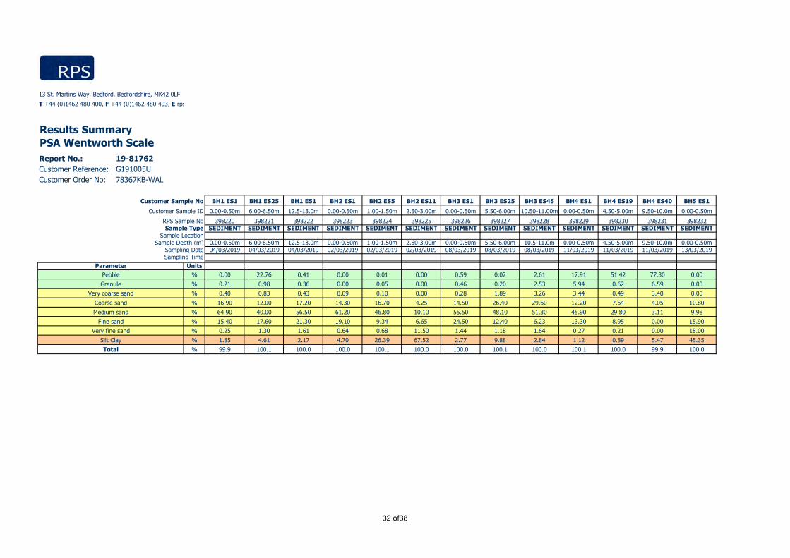
Report No.: 19-81762
Customer Reference: G191005U
Customer Order No: 78367KB-WAL
BH1 ES1 BH1 ES25 BH1 E51 BH2 ES1 BH2 ES5 BH2 ES11 BH3 ES1 BH3 ES25 BH3 ES45 BH4 ES1 BH4 ES19 BH4 ES40 BH5 ES1
0.00-0.50m 6.00-6.50m 12.5-13.0m 0.00-0.50m 1.00-1.50m 2.50-3.00m 0.00-0.50m 5.50-6.00m 10.50-11.00m 0.00-0.50m 4.50-5.00m 9.50-10.0m 0.00-0.50m
398220 398221 398222 398223 398224 398225 398226 398227 398228 398229 398230 398231 398232SEDIMENT SEDIMENT SEDIMENT SEDIMENT SEDIMENT SEDIMENT SEDIMENT SEDIMENT SEDIMENT SEDIMENT SEDIMENT SEDIMENT SEDIMENT
0.00-0.50m 6.00-6.50m 12.5-13.0m 0.00-0.50m 1.00-1.50m 2.50-3.00m 0.00-0.50m 5.50-6.00m 10.5-11.0m 0.00-0.50m 4.50-5.00m 9.50-10.0m 0.00-0.50m04/03/2019 04/03/2019 04/03/2019 02/03/2019 02/03/2019 02/03/2019 08/03/2019 08/03/2019 08/03/2019 11/03/2019 11/03/2019 11/03/2019 13/03/2019
Units
% 0.00 22.76 0.41 0.00 0.01 0.00 0.59 0.02 2.61 17.91 51.42 77.30 0.00
% 0.21 0.98 0.36 0.00 0.05 0.00 0.46 0.20 2.53 5.94 0.62 6.59 0.00
% 0.40 0.83 0.43 0.09 0.10 0.00 0.28 1.89 3.26 3.44 0.49 3.40 0.00
% 16.90 12.00 17.20 14.30 16.70 4.25 14.50 26.40 29.60 12.20 7.64 4.05 10.80
% 64.90 40.00 56.50 61.20 46.80 10.10 55.50 48.10 51.30 45.90 29.80 3.11 9.98
% 15.40 17.60 21.30 19.10 9.34 6.65 24.50 12.40 6.23 13.30 8.95 0.00 15.90
% 0.25 1.30 1.61 0.64 0.68 11.50 1.44 1.18 1.64 0.27 0.21 0.00 18.00
% 1.85 4.61 2.17 4.70 26.39 67.52 2.77 9.88 2.84 1.12 0.89 5.47 45.35
% 99.9 100.1 100.0 100.0 100.1 100.0 100.0 100.1 100.0 100.1 100.0 99.9 100.0
Very coarse sand
Silt Clay
Total
Coarse sand
Medium sand
Fine sand
Very fine sand
Granule
Sample Depth (m)Sampling DateSampling Time
Parameter
Pebble
13 St. Martins Way, Bedford, Bedfordshire, MK42 0LF
T +44 (0)1462 480 400, F +44 (0)1462 480 403, E [email protected],
RPS Sample NoSample Type
Sample Location
Results Summary
PSA Wentworth Scale
Customer Sample No
Customer Sample ID
32 of38

Report No.: 19-81762
Customer Reference: G191005U
Customer Order No: 78367KB-WAL
Units
%
%
%
%
%
%
%
%
%
Very coarse sand
Silt Clay
Total
Coarse sand
Medium sand
Fine sand
Very fine sand
Granule
Sample Depth (m)Sampling DateSampling Time
Parameter
Pebble
13 St. Martins Way, Bedford, Bedfordshire, MK42 0LF
T +44 (0)1462 480 400, F +44 (0)1462 480 403, E [email protected],
RPS Sample NoSample Type
Sample Location
Results Summary
PSA Wentworth Scale
Customer Sample No
Customer Sample ID
BH5 ES12 BH5 ES22 BH6 ES1 BH6 ES5 BH6 ES9 BH7 ES1 BH7 ES14 BH7 ES27 BH8 ES1 BH8 ES11 BH8 ES21
2.50-3.00m 5.00-5.50m 0.00-0.50m 1.00-1.50m 2.00-2.50m 0.00-0.50m 3.00-3.50m 6.00-6.50m 0.00-0.50m 2.50-3.00m 5.00-5.50m
398233 398234 398235 398236 398237 398238 398239 398240 398241 398242 398243SEDIMENT SEDIMENT SEDIMENT SEDIMENT SEDIMENT SEDIMENT SEDIMENT SEDIMENT SEDIMENT SEDIMENT SEDIMENT
2.50-3.00m 5.00-5.50m 0.00-0.50m 1.00-1.50m 2.00-2.50m 0.00-0.50m 3.00-3.50m 6.00-6.50m 0.00-0.50m 2.50-3.00m 5.00-5.50m13/03/2019 13/03/2019 16/03/0320 16/03/2019 16/03/2019 07/03/2019 07/03/2019 07/03/2019 05/03/2019 05/03/2019 05/03/2019
1.16 72.15 0.00 0.00 0.00 0.32 0.00 0.48 23.36 0.00 0.00
0.22 3.12 0.00 0.03 0.00 0.15 0.00 2.18 0.71 0.00 0.00
0.21 1.74 0.00 0.05 0.00 0.06 0.00 2.12 0.65 0.00 0.00
16.20 4.65 1.90 8.97 6.26 9.65 5.19 12.40 9.74 9.23 8.98
51.30 12.50 8.44 38.60 20.50 43.00 19.80 55.70 49.30 61.50 44.40
17.00 4.08 26.40 37.10 21.70 31.20 24.40 20.10 14.50 26.50 31.90
1.10 0.22 18.10 5.21 8.88 4.43 12.40 1.02 0.25 0.52 4.88
12.79 1.48 45.17 10.12 42.68 11.11 38.16 6.05 1.46 2.26 9.87
100.0 99.9 100.0 100.1 100.0 99.9 100.0 100.1 100.0 100.0 100.0
33 of38

13 St. Martins Way, Bedford, Bedfordshire, MK42 0LF
T +44 (0)1462 480 400, F +44 (0)1462 480 403, E [email protected], W rpsgroup.com
Report No.: 19-81762
Customer Reference: G191005U
Customer Order No: 78367KB-WAL
RPS Sample Number Customer Number Sample Comments
398220 BH1 ES1 Visual Inspection:
Colour: Light brown
Texture: Sandy
Odour: Sea
Biota: none
Anthropogenic Inputs: none
398221 BH1 ES25 Visual Inspection:
Colour: Light brown
Texture: Sandy
Odour: none
Biota: none
Anthropogenic Inputs: none
398222 BH1 E51 Visual Inspection:
Colour: Light brown
Texture: Sandy
Odour: Sea
Biota: Rocks
Anthropogenic Inputs: none
398223 BH2 ES1 Visual Inspection:
Colour: Dark brown/black
Texture: Sandy
Odour: Sea
Biota: none
Anthropogenic Inputs: none
398224 BH2 ES5 Visual Inspection:
Colour: Black
Texture: Sandy
Odour: none
Biota: none
Anthropogenic Inputs: none
398225 BH2 ES11 Visual Inspection:
Colour: Black
Texture: Clay
Odour: Sulphur
Biota: none
Anthropogenic Inputs: none
398226 BH3 ES1 Visual Inspection:
Colour: Grey
Texture: Sand
Odour: Sea Sweet
Biota: none
Anthropogenic Inputs: none
398227 BH3 ES25 Visual Inspection:
Colour: Brown
Texture: Sand
Odour: none
Biota: none
Anthropogenic Inputs: none
398228 BH3 ES45 Visual Inspection:
Colour: Light brown
Texture: Sand
Odour: Sweet
Biota: none
Anthropogenic Inputs: none
398229 BH4 ES1 Visual Inspection:
Colour: Brown
Texture: Sandy/Rocky
Odour: Sea
Biota: Rocks
Anthropogenic Inputs: none
Comments
Page 34 of 38

13 St. Martins Way, Bedford, Bedfordshire, MK42 0LF
T +44 (0)1462 480 400, F +44 (0)1462 480 403, E [email protected], W rpsgroup.com
Report No.: 19-81762
Customer Reference: G191005U
Customer Order No: 78367KB-WAL
RPS Sample Number Customer Number Sample Comments
Comments
398230 BH4 ES19 Visual Inspection:
Colour: Brown
Texture: Clay/Rocky
Odour: none
Biota: Rocks
Anthropogenic Inputs: none
398231 BH4 ES40 Visual Inspection:
Colour: Black
Texture: Sandy/Rocky
Odour: none
Biota: Rocks
Anthropogenic Inputs: none
398232 BH5 ES1 Visual Inspection:
Colour: Black
Texture: Sludge
Odour: Fish
Biota: none
Anthropogenic Inputs: none
398233 BH5 ES12 Visual Inspection:
Colour: Black
Texture: Sand
Odour: none
Biota: none
Anthropogenic Inputs: none
398234 BH5 ES22 Visual Inspection:
Colour: Brown
Texture: Sandy rock
Odour: none
Biota: Rock
Anthropogenic Inputs: none
398235 BH6 ES1 Visual Inspection:
Colour: Black
Texture: Sludge/Sandy
Odour: Light Sulphur
Biota: none
Anthropogenic Inputs: none
398236 BH6 ES5 Visual Inspection:
Colour: Black
Texture: Sandy
Odour: none
Biota: none
Anthropogenic Inputs: none
398237 BH6 ES9 Visual Inspection:
Colour: Brown/Black
Texture: Sludge/Sandy
Odour: Sulphur
Biota: none
Anthropogenic Inputs: none
398238 BH7 ES1 Visual Inspection:
Colour: Brown/grey
Texture: Sandy
Odour: Sweet
Biota: none
Anthropogenic Inputs: none
398239 BH7 ES14 Visual Inspection:
Colour: Brown
Texture: Clay/Sandy
Odour: Sulphur
Biota: none
Anthropogenic Inputs: none
Page 35 of 38

13 St. Martins Way, Bedford, Bedfordshire, MK42 0LF
T +44 (0)1462 480 400, F +44 (0)1462 480 403, E [email protected], W rpsgroup.com
Report No.: 19-81762
Customer Reference: G191005U
Customer Order No: 78367KB-WAL
RPS Sample Number Customer Number Sample Comments
Comments
398240 BH7 ES27 Visual Inspection:
Colour: Brown
Texture: Sandy
Odour: none
Biota: Shell
Anthropogenic Inputs: none
398241 BH8 ES1 Visual Inspection:
Colour: Brown
Texture: Sandy
Odour: Sea
Biota: Shell/Rock
Anthropogenic Inputs: none
398242 BH8 ES11 Visual Inspection:
Colour: Brown
Texture: Sandy
Odour: none
Biota: none
Anthropogenic Inputs: none
398243 BH8 ES21 Visual Inspection:
Colour: Dark brown
Texture: Clay/Sandy
Odour: Sulphur
Biota: none
Anthropogenic Inputs: none
Page 36 of 38

13 St. Martins Way, Bedford, Bedfordshire, MK42 0LF
T +44 (0)1462 480 400, F +44 (0)1462 480 403, E [email protected], W rpsgroup.com
Deviating SamplesReport No.: 19-81762
Customer Reference: G191005U
Customer Order No: 78367KB-WAL
RPS No. Customer No. Customer ID Date Sampled Containers Received Deviating Sample Reason for Sample Deviation
398220 BH1 ES1 04/03/2019 plastic & metal containers No
398221 BH1 ES25 04/03/2019 plastic & metal containers No
398222 BH1 E51 04/03/2019 plastic & metal containers No
398223 BH2 ES1 02/03/2019 plastic & metal containers No
398224 BH2 ES5 02/03/2019 plastic & metal containers No
398225 BH2 ES11 02/03/2019 plastic & metal containers No
398226 BH3 ES1 08/03/2019 plastic & metal containers No
398227 BH3 ES25 08/03/2019 plastic & metal containers No
398228 BH3 ES45 08/03/2019 plastic & metal containers No
398229 BH4 ES1 11/03/2019 plastic & metal containers No
398230 BH4 ES19 11/03/2019 plastic & metal containers No
398231 BH4 ES40 11/03/2019 plastic & metal containers No
398232 BH5 ES1 13/03/2019 plastic & metal containers No
398233 BH5 ES12 13/03/2019 plastic & metal containers No
398234 BH5 ES22 13/03/2019 plastic & metal containers No
398235 BH6 ES1 16/03/320 plastic & metal containers No
398236 BH6 ES5 16/03/2019 plastic & metal containers No
398237 BH6 ES9 16/03/2019 plastic & metal containers No
398238 BH7 ES1 07/03/2019 plastic & metal containers No
398239 BH7 ES14 07/03/2019 plastic & metal containers No
398240 BH7 ES27 07/03/2019 plastic & metal containers No
398241 BH8 ES1 05/03/2019 plastic & metal containers No
398242 BH8 ES11 05/03/2019 plastic & metal containers No
398243 BH8 ES21 05/03/2019 plastic & metal containers No
Our policy on Deviating Samples and reference list of Holding Times applied can be supplied on request. These have been implemented in accordance with UKAS Policy on Deviating Samples (TPS63).
RPS is not responsible for the integrity of samples as received, unless RPS personnel performed the sampling, and it is possible that samples submitted may be declared to be deviating.
Where applicable the analysis method remains UKAS accredited, however results reported for a deviating sample may be invalid. The reason for a sample being declared to be deviating is indicated below.
Where no sampling date was supplied, samples have been declared to be deviating. However, if a date of sampling can be supplied, the results may be reissued with the deviating sample status removed.
Where the sample container used was unsuitable, the appropriate Holding Time was exceeded, or the sample is flagged as deviating for some other reason, re-sampling/re-submisson may be required.
Page 37 of 38

2 Shaftesbury Industrial Centre, Icknield Way, Letchworth Garden City, Hertfordshire, SG6 1HE
T +44 (0)1462 480 400, F +44 (0)1462 480 403, E [email protected], W rpsgroup.com
Key to Report Codes
U UKAS Accredited
F UKAS Flexible Scope
M MCERTS Accredited
N Not Accredited
O Marine Management Organisation (MMO) Validated
S Subcontracted to approved laboratory
US Subcontracted to approved laboratory UKAS Accredited for the test
MS Subcontracted to approved laboratory MCERTS/UKAS Accredited for the test
SI Subcontracted to internal RPS Group Laboratory
USI Subcontracted to internal RPS Group Laboratory UKAS Accredited for the test
MSI Subcontracted to internal RPS Group Laboratory MCERTS/UKAS Accredited for the test
I/S (in results) Insufficient Sample
U/S (in results) Unsuitable Sample
S/C (in results) See Comments
ND (in results) Not Detected
DW (in units) Results are expressed on a dry weight basis
Sample Retention and Disposal
Samples will generally* be retained for the following times prior to disposal:
Perishables, e.g. foodstuffs 1 month (if frozen) from the issue date of this report
Waters 2 weeks from the issue date of this report
Other Liquids 1 months from the issue date of this report
Solids (including Soils) 1 months from the issue date of this report
*Sample retention may be subject to agreement with the customer for particular projects
Analytical Methods
PAH's and PCB's GCMS analysis following extraction of the wet sediment with DCM:acetone by ASE 350
extraction. Extract cleaned-up with silica and activated copper.
MetalsICP-MS analysis following microwave assisted digestion in hydrofluoric acid of the dried
(<30°C) and ground sediment.
TOC Combustion and infrared analysis following carbonate removal with hydrochloric acid.
PSA Wet and dry sieving follewed by laser diffraction analysis.
DensityDetermination of density from the dry sediment by gravimetric analysis of a known
volume of sediment.
Dry solids at 105°C A portion of the wet sediment is dried at 105°C to constant weight.
TBT and DBTGCMS analysis following the extraction of the wet sediment and subsequent
derivatisation.
Please note: All testing carried out using the <2mm fraction
Laboratories
RPS Letchworth UKAS Accreditation Laboratory No. 1663RPS Manchester (Metals only) UKAS Accreditation Laboratory No. 0605Ocean Ecology PSA only NMBAQC
RPS Letchworth and Manchester Laboratories participate in the QUASIMEME Proficiency Testing Scheme
Report Information
38 of38

GLOBAL ENERGY NIGG LIMITED
EAST QUAY DEVELOPMENT - MARINE GROUND INVESTIGATION
Contract No. G191005U Appendix G Survey Page 1 of 1
G. SURVEY
Mean Position Reports 18 Pages

04/03/2019 00:08:18 (UTC+00:00) Mean Position Report
STARFIX
MEAN POSITION REPORT
Project ID C1982
Project Name 192186 Nigg East Quay Development
Fugro OPCOFGBNM (Fugro Great Britain North
Marine)Location Nigg
Client Fugro Geoservices Ltd Vessel Skate 3A
Comment DTM = 5.50m, DTW = 3.40m Deck Height Above CD = 6.35m
Session Name: C1982 BH01 Records Used: 294 of 301
Start Time: 04 Mar 2019, 00:03:01+00:00 End Time: 04 Mar 2019, 00:08:02+00:00 Session Length: 00:05:01
Mean Position for Skate 3A CommonReferencePoint
OSGB 1936 / British National Grid
[OSGB-UK Gbr02 NT]ETRS89(2D)
Latitude 57°41’40.35536”N 57°41’39.30291”N
Longitude 004°01’25.47428”W 004°01’30.48544”W
Height 57.109m Ell. 57.109m Ell.
Easting 279,383.704m E(SD: ±0.01m)
Northing 868,963.576m N(SD: ±0.01m)
Height 4.295m Ort. (SD: ±0.02m Ort.)
Sensors Sensor Averages SD
Heading 50.00°T 51.71°G ±0.0°
Pitch
Roll
Depth (Sounder) 0.0m ±0.00m
Depth (Manual) 0.0m N/ADTM = 5.50m, DTW = 3.40m Deck Height
Above CD = 6.35m
Mean Position to Waypoint
Waypoint BH12
Easting 279,384.000m E
Northing 868,964.000m N
Range 0.52m Geodetic
Bearing TO 33.18°True
Bearing FROM 213.18°True
Jimmy WilsonParty Chief
FGSL (Fugro GeoServices Ltd UK)
Theo CleaveParty Chief
Fugro Geoservices Ltd
Page 1 of 2

To
cc
cc
cc
cc
cccc
NEARSHORE DAILY PROGRESS REPORT
Nigg Energy Park - Marine Ground Investigation
No./email
No./email
No./email
No./email
No./email
No./emailNo./email
0141 227 3060
Health Safety & the Environment
FGSL Rep: Theo Cleave
Signed:
Client Rep:
Signed:
15:4017:2519:1520:0023:30
23:30 3.50 Cable Percussion Commence CP drilling from 0.00m to 3.00m BML
00:00 0.50 Moving & Jacking Jack up another 1.50m as wind continues to increase >30kts and swell >1.00m.
00:00 SW
00:00From
05:4506:3007:2008:0011:35
Jack down and move NE into deeper water / Forth Constructor arrival on site.
08:00 0.67 Moving & Jacking BM Transfers to Tug with RHIB and discuss operations / Tug alongside and towing bridle connected and secured
11:35 3.58 Moving & Jacking Pull legs and commence tow to Berth 3 / Complete fire drill onboard / Arrival at Nigg Energy Park / Lower legs and disconnect tow.
12:10 0.58 Moving & Jacking
N/A smooth good
N/A smooth good
good
5
10
8
20
31
BH no. 1 2 3
00:00 SSW N/A smooth good
See Below06:00 SW N/A
18:00 S N/A smooth
smooth good
4
12:00 S
[email protected] Attn. Nicholas Armstrong - Reporting [email protected] Attn. Glen Crisp - Project Manager
Attn.
[email protected] Attn. Mathew Chappell ‐ Nearshore Manager
Observed WeatherSwell (Hs) Sea State Visibility Weather Forecast
Time 00:00 Dir
Wind
Speed Knts
Daily Report No.
01
Job No C1982 Vessel Skate 3A Date Saturday 02-Mar-19
ANeillings@arch‐henderson.co.uk Attn. Andy Neillings
mshuttleworth@arch‐henderson.co.uk Attn. Michael Shuttleworth
[email protected] Attn. Stuart Innes
05:45 5.75 Single Shift Standby Jacked in Moray Firth / Awaiting towage to Nigg Energy Park at high water slack.
06:30 0.75 Crew Change / TBT Dayshift Trasfer to JUB from Inverness Marina / TBT on Towing Operations
07:20 0.83 Moving & Jacking
Weather forecast
BH02 3.3 1.9 2.6 1.3
Leg Penetration (m)Operational Status
Jacked in Moray Firth awaiting tide/weather for towage to Nigg Energy Park
To Hrs (No.) Code Description
Summary of Operations / Borehole Drilling - last 24hrs:
Move JUB alongside Berth 3 / Preload and jack up to safe working height.
15:40 3.50 Mobilisation Offload CPT equipment, samples etc. / Load additional drill pipe, IBCs, consumables / General R&M on deck.
17:25 1.75 Moving & Jacking
12:10Jack down and move to BH02 / Preload and jack up to safe working height.
19:15 1.83 Cable Percussion Lift casing into position and prepare drill deck / Lower 8'' casing, DML=14.10m / High winds observed, continue to monitor
20:00 0.75 Crew Change / TBT Dayshift transfer to shore / Handover at CTV Quay / Nightshift transfer to JUB / TBT on Rig Abandonment Drill
Redacted

NEARSHORE DAILY PROGRESS REPORT
Nigg Energy Park - Marine Ground Investigation
Daily Report No.
01
0 0 0.00 0.0
Fugro GeoServices Representative Comments
0.0
0 0 0.00 0.0
#VALUE!Advance BH through hard stratum or obstruction B9 R/O 0 0 0.00 #VALUE!
0 0 0.00
59.00
As B4 but between 30m and 40m B7 R/O
0 0 0.00 0.0
Core box to be retained by client C49 21.00 0 0 0.00 0.0
As C41 but between 10m and 20m C42 20.50 0 0 0.00 0.0As C41 but between 20m and 30m C43 9.50 0 0 0.00 0.0
Move rotary plant to site of each exploratory hole C15 6.00 0 0 0.00 0.0RC drilling between groundlevel and 10m depth C41 R/O 0 0 0.00 #VALUE!
As B4 but between 20m and 30m B6 R/O 0 0 0.00 #VALUE!
Rotary Drilling C 0.0
0 0 0.00
3.00 3 0 0.00 3.8As B4 but between 10m and 20m B5 36.50 0 0 0.00 0.0
0 0 0.00 #VALUE!Break out surface obstructions where present B3 R/O 0 0 0.00 #VALUE!
Percussion Boring B 0.0
1 0 1 0.00 12.5
FGSL Rep: Theo Cleave
Signed:
Client Rep:
Signed:
B11 C19 R/O
Hours Worked 120 120
Client Representative Comments
Hoc Cards 2 5Safety Drills 2 4
Tool Box Talks
Environmental 0
1 3
HSE Meetings 1 1
Incidents/Near Miss 0
Health & Safety Summary Today Actual To Date Lost & Damaged
0 0 0.00
0.00 0 0.00
0.00
0 0.0
0 0.00
0 0 0.00
0 0 0.00 0.0
Large Bulk disturbed sample E3 R/O
0.0Insitu Testing H
Move boring plant to site of each exploratory hole
Bulk Disturbed Sample
Small Disturbed Sample
B1 8.00
Extra over B1 for setting up on a gradient >20% B2 R/O
Advance BH between groundlevel and 10m depth B4 80.00
Sampling, Monitoring during investigation E 0.0
0.00 0 0.00
59.00E1
E2
0.00 0 0.00
0 0 0.00Standing Time for plant, equipment and crew
Establish all plant, equipment, crew on site A2 1.0 1.0 0
0
1 0.00 100.0
General Items, Provisional Services A
Total 0.00 0.00 No. Personnel 10
%
0.00 0.00
No. Hours m. No. Hours ChartActivity BoQ Item m. No. Hours m.Project Program / Progress Programmed Today Actual To Date
0.00 0.00
0.00 0.000.00 0.00
Crew Change / TBT 0.00 0.00
Other Operations 0.00 0.00 Theo Cleave
0.00 0.000.00 0.00
Standby (Other) 0.00 0.00
Standby (Fugro) 0.00 0.00 Stuart Nye
Single Shift Standby 0.00 0.00
Standby weather 0.00 0.00 Richard Luker
Mobilisation 0.00 0.00
Moving & Jacking 0.00 0.00 Jimmy Wilson
Cable Percussion 0.00 0.00 Callum Allardyce
Rotary Drilling (Coring) 0.00 0.00 James Lawson
Activity Time Summary Today
0.0
Additional Items 0.0
Standard Penetration Test in Borehole H1
Standard Penetration Test in Rotary Drill Hole H2 R/O
0 0 0.00
Geoenvironmental Laboratory Testing L
0 0
0.0
Marine Scotland Sample L2 121 0 0 0.00
0
0 0.0
0.00 0.0
0 0.00
0.0
0 0 0.00 0.0
0
0.0
0.0
#VALUE!
40
#VALUE!
0 0 0.00
Bart Kot
Joshua Sandy
Adam Cook
Ashley Lowthian
Day Shift Night Shift
Onboard JUB (mobilisation)
To Date
#VALUE!
Total Man Hours
Worked120
% Completed Budget
PositionCompany
Bargemaster
Driller
Assistant Driller
Assistant Driller
Geotechnical Engineer
Project Engineer
Fugro GeoServices
Fugro GeoServices
Fugro GeoServices
Fugro GeoServices
Fugro
Fugro GeoServices
% Program Completed
0
100.0
0.0
0.0
0.0
0.0
12.5
0.0
0.0
3.8
0.0
0.0
0.0
0.0
0.0
0.0
0.0
0.0
0.0
0.0
0.0
0.0
0.0
0.0
0.0
0.0
0.0
0.0
0.0
0.0
0.0
0.0
0.0
0.0
0.0
0.0
0.0
0.0
0.0
0.0
% Program Completed

To
cc
cc
cc
cc
cc
cc
No./email
No./email
No./email
Weather forecast
Health Safety & the Environment
Winds in excess of operational and emergency limits. Crew continue to monitor weather with anomometer and updated forecasts for safe transfer window.
FGSL Rep: Theo Cleave
Signed:
Client Rep:
Signed:
23:45 00:00 0.25 Cable Percussion Run in casing to mudline and prepare deck for CP ops / DTM=5.50m
22:00 23:45 1.75 Moving & Jacking Move from BH02 to BH01 / Preload and jack up to safe working height
20:00 22:00 2.00 Standby (Tide) Waiting on tide to move to BH01 / Prepare JUB for move / Jack down and pull legs
19:15 20:00 0.75 Crew Change / TBT Dayshift transfer to shore / Handover on CTV Quay / Nightshift transfer to JUB / TBT on Lifting Operations
18:30 19:15 0.75 Other Operations Clear and wash down deck for E.O.S / Fuel all plant & RHIB / Begin pulling all casing to deck.
14:30 18:30 4.00 Cable Percussion Continue CP from 6.00m to 9.40m BML / E.O.H @ -18.50mCD / Rockhead encountered.
14:00 14:30 0.50 Other Operations Dayshift transfer to JUB / Prepare drill deck to continue CP drilling operations.
08:00 14:00 6.00 Standby weather Continue to monitor weather with forecasts and anomemeter / Wind dropping after 1200 / Transit to CTV Quay
07:30 08:00 0.50 Crew Change / TBT E.O.S / Nightshift handover at accomodation / TBT on Operational Limitations and Emergency Drills
05:00 07:30 2.50 Standby weather Conditions still in excess of operational limits / RHIB checked at low water / wind >30kts, swell >1m
03:00 05:00 2.00 Standby weather Conditions still in excess of operational limits / Crew periodically confirm conditions from shore.
02:15 03:00 0.75 Other Operations Nightshift return to shore as wind/swell continues to increase / Secure RHIB and measure wind speed / >35kts
00:00 02:15 2.25 Cable Percussion Continue CP from 3.00m to 6.00m BML / Secure deck against gale force winds /
Summary of Operations / Borehole Drilling - last 24hrs:
From To Hrs (No.) Code Description
3.1
BH02 3.3 1.9 2.6 1.3Jacked up on BH02.
Cable percussion drilling underway.BH01 1.0 1.0 2.2
Leg Penetration (m)Operational Status
BH no. 1 2 3 4
00:00 10 SW N/A Smooth good
18:00 21 SSW N/A Slight moderate
12:00 35 SW N/A Slight/Moderate Very Poor
N/A Slight PoorSee Below06:00 34 SW N/A Slight/Moderate Very Poor
No./email
NEARSHORE DAILY PROGRESS REPORT
Nigg Energy Park - Marine Ground Investigation
Daily Report No.
Time 00:00 Speed Knts Dir
00:00 28 S
[email protected] Attn. Glen Crisp - Project Manager
Observed Weather WindSwell (Hs) Sea State Visibility Weather Forecast
[email protected] Attn. Mathew Chappell ‐ Nearshore Manager
[email protected] Attn. Nicholas Armstrong - Reporting Mana
No./email
No./email
No./email
0141 227 3060
02Job No C1982 Vessel Skate 3A Date
[email protected] Attn. Stuart Innes
Attn.
Sunday 03-Mar-19
ANeillings@arch‐henderson.co.uk Attn. Andy Neillings
mshuttleworth@arch‐henderson.co.uk Attn. Michael Shuttleworth RedactedRedactedRedactedRedacted

NEARSHORE DAILY PROGRESS REPORT
Nigg Energy Park - Marine Ground Investigation
Daily Report No.
02
Fugro GeoServices Representative Comments Client Representative Comments
FGSL Rep: Theo Cleave
Signed:
Client Rep:
Signed:
Environmental 0 0
Hours Worked 120 240
HSE Meetings 0 1
Incidents/Near Miss 0 0
Hoc Cards 1 6Safety Drills 0 4
Tool Box Talks 1 4
Health & Safety Summary Today Actual To Date Lost & Damaged
0 0.00 0.0
0.0
0
0 0 0.00
0.00 0 0.00
0.00 0 0.00
0 0.00 0.0
0.0
0
0.0
Additional Items
0 0 0.00
6.68 0 8 0.00Marine Scotland Sample L2 121
0.0
0.0
Geoenvironmental Laboratory Testing L
0 0 0.00
#VALUE!0 0 0.00
0.0
Standard Penetration Test in Rotary Drill Hole H2 R/O
0 0 0.00
0.0
Standard Penetration Test in Borehole H1 40
0 0 0.00 0.0Insitu Testing H
#VALUE!0 0 0.00
0 0 0.00 0.0Large Bulk disturbed sample E3 R/O
32.2Bulk Disturbed Sample E2 59.00
19 0 19 0.00
0.0Small Disturbed Sample E1 59.00
0.0Sampling, Monitoring during investigation E
0 0 0.00
0 0 0.00 0.0
0.0Core box to be retained by client C49 21.00
0 0 0.00
0 0 0.00 0.0As C41 but between 20m and 30m C43 9.50
#VALUE!As C41 but between 10m and 20m C42 20.50
0 0 0.00
0 1 0.00 16.7RC drilling between groundlevel and 10m depth C41 R/O
0.0Move rotary plant to site of each exploratory hole C15 6.00 1
0 0 0.00 0.0
Rotary Drilling C
#VALUE!0 0 0.00
0 0 0.00 #VALUE!Advance BH through hard stratum or obstruction B9 R/O
#VALUE!As B4 but between 30m and 40m B7 R/O
0 0 0.00
0 0 0.00 0.0As B4 but between 20m and 30m B6 R/O
11.8As B4 but between 10m and 20m B5 36.50
6.40 9 0 0.00
0 0 0.00 #VALUE!Advance BH between groundlevel and 10m depth B4 80.00
#VALUE!Break out surface obstructions where present B3 R/O
0 0 0.00
0 2 0.00 25.0Extra over B1 for setting up on a gradient >20% B2 R/O
0.0Move boring plant to site of each exploratory hole B1 8.00 1
2.00 0 0 2.00 #VALUE!
Percussion Boring B
0 10.50 #VALUE!
Standing Time for plant, crew, etc - TIDE B11 C19 R/O
0.0
Standing Time for plant, crew, etc - WEATHER B11 C19 R/O 10.50 0
0 0 0.00
0 1 0.00 100.0
0
Establish all plant, equipment, crew on site A2 1.0
General Items, Provisional Services A
No. Hours Chart %Activity BoQ Item m. No. Hours m. No. Hours m.
Project Program / Progress Programmed Today Actual To Date % Completed Budget
Total 24.00 24.00 No. Personnel 10
Total Man Hours
Worked120
0.00 0.00
0.00 0.00
0.00 0.00
0.00 0.00
0.00 0.00
0.00 0.00
Crew Change / TBT 1.25 2.75
Other Operations 2.00 2.00 Theo Cleave Fugro GeoServices Project Engineer
Single Shift Standby 0.00 5.75
Standby weather 10.50 10.50 Richard Luker Bart Kot Fugro Geotechnical Engineer
Standby (Tide) 2.00 2.00
Fugro GeoServices Assistant Driller
Standby (Fugro) 0.00 0.00 Stuart Nye Fugro GeoServices Assistant Driller
Cable Percussion 6.50 11.83 Callum Allardyce Ashley Lowthian
Fugro GeoServices Bargemaster
Rotary Drilling (Coring) 0.00 0.00 James Lawson Adam Cook Fugro GeoServices Driller
Moving & Jacking 1.75 9.67 Jimmy Wilson Joshua Sandy
Position
Mobilisation 0.00 3.50 Onboard JUB (mobilisation)
Activity Time Summary Today To Date Day Shift Night Shift Company
0 0 0.00 0.0
% Program Completed
0
100.0
0.0
0.0
0.0
0.0
0.0
25.0
0.0
0.0
11.8
0.0
0.0
0.0
0.0
0.0
0.0
16.7
0.0
0.0
0.0
0.0
0.0
0.0
32.2
0.0
0.0
0.0
0.0
0.0
0.0
0.0
0.0
6.6
0.0
0.0
0.0
0.0
0.0
0.0
0.0
% Program Completed

To
cc
cc
cc
cc
cc
cc
Monday 04-Mar-19
ANeillings@arch‐henderson.co.uk Attn. Andy Neillings No./email 0141 227 3060
NEARSHORE DAILY PROGRESS REPORT
Nigg Energy Park - Marine Ground Investigation
Daily Report No.
03Job No C1982 Vessel Skate 3A Date
Attn. No./email
[email protected] Attn. Mathew Chappell ‐ Nearshore Manager No./email
mshuttleworth@arch‐henderson.co.uk Attn. Michael Shuttleworth No./email
[email protected] Attn. Stuart Innes No./email
Observed Weather WindSwell (Hs) Sea State Visibility Weather Forecast
Time 00:00 Speed Knts Dir
[email protected] Attn. Nicholas Armstrong - Reporting ManaNo./email
[email protected] Attn. Glen Crisp - Project Manager No./email
N/A smooth good
18:00 20 W N/A smooth good
See Below06:00 11 W N/A smooth good
12:00 18 W
00:00 10 SW N/A smooth good
BH01 1.0 1.0 2.2 3.1Jacked up on BH01
Ready to commence CP from mudline
Leg Penetration (m)Operational Status
BH no. 1 2 3 4
00:00 17 SW N/A smooth good
00:00 07:15 7.25 Cable Percussion Commence CP drilling from 0.00m to 10.00m BML
Summary of Operations / Borehole Drilling - last 24hrs:
From To Hrs (No.) Code Description
17:20 18:50 1.50 Rotary Drilling (Coring) Run in Geobor to depth / Flush hole
08:00 17:20 9.33 Cable Percussion Continue CP from 10.00m to 17.35m BML
07:15 08:00 0.75 Crew Change / TBT Nightshift transfer to shore / Handover on CTV Quay / Dayshift transfer to JUB / TBT on Site Rules
20:00 00:00 4.00 Rotary Drilling (Coring) Commence RC drilling from 17.35m to 23.35m BML / E.O.H at -22.50mCD / CD 0.85m below mudline
19:15 20:00 0.75 Crew Change / TBT Dayshift transfer to shore / Handover on CTV Quay / Nightshift transfer to JUB / TBT on Site Rules
18:50 19:15 0.42 Other Operations Fuel all plant / Wash down and clear deck for E.O.S
Weather forecast
Health Safety & the Environment
FGSL Rep: Theo Cleave
Signed:
Client Rep:
Signed:
RedactedRedactedRedactedRedacted

NEARSHORE DAILY PROGRESS REPORT
Nigg Energy Park - Marine Ground Investigation
Daily Report No.
03Position
Mobilisation 0.00 3.50 Onboard JUB (mobilisation)
Activity Time Summary Today To Date Day Shift Night Shift Company
Fugro GeoServices Assistant Driller
Standby (Fugro) 0.00 0.00 Stuart Nye Fugro GeoServices Assistant Driller
Cable Percussion 16.58 28.42 Callum Allardyce Ashley Lowthian
Fugro GeoServices Bargemaster
Rotary Drilling (Coring) 5.50 5.50 James Lawson Adam Cook Fugro GeoServices Driller
Moving & Jacking 0.00 9.67 Jimmy Wilson Joshua Sandy
Other Operations 0.42 2.42 Theo Cleave Fugro GeoServices Project Engineer
Single Shift Standby 0.00 5.75
Standby weather 0.00 10.50 Richard Luker Bart Kot Fugro Geotechnical Engineer
Standby (Tide) 0.00 2.00
0.00 0.00
0.00 0.00
0.00 0.00
Crew Change / TBT 1.50 4.25
Total 24.00 24.00 No. Personnel 10
Total Man Hours
Worked120
0.00 0.00
0.00 0.00
0.00 0.00
No. Hours Chart %Activity BoQ Item m. No. Hours m. No. Hours m.
Project Program / Progress Programmed Today Actual To Date % Completed Budget
0
Establish all plant, equipment, crew on site A2 1.0
General Items, Provisional Services A
0.00.0 0 0.00
0.0 1 0.00 100.0
0.0Move boring plant to site of each exploratory hole B1 8.00
0.0 0 2.00 0.0
Percussion Boring B
#VALUE!Break out surface obstructions where present B3 R/O
0.0 0 0.00
0.0 2 0.00 25.0Extra over B1 for setting up on a gradient >20% B2 R/O
33.4As B4 but between 10m and 20m B5 36.50
17.35 26.8 0 0.00
0.0 0 0.00 #VALUE!Advance BH between groundlevel and 10m depth B4 80.00
#VALUE!As B4 but between 30m and 40m B7 R/O
0.0 0 0.00
0.0 0 0.00 0.0As B4 but between 20m and 30m B6 R/O
#VALUE!0.0 0 0.00
0.0 0 0.00 #VALUE!Advance BH through hard stratum or obstruction B9 R/O
0.0Move rotary plant to site of each exploratory hole C15 6.00
0.0 0 0.00 0.0
Rotary Drilling C
#VALUE!As C41 but between 10m and 20m C42 20.50 2.65
0.0 0 0.00
0.0 1 0.00 16.7RC drilling between groundlevel and 10m depth C41 R/O
35.3Core box to be retained by client C49 21.00
3.35 3.4 0 0.00
2.7 0 0.00 12.9As C41 but between 20m and 30m C43 9.50
0.0Sampling, Monitoring during investigation E
0.0 0 0.00
0.0 0 0.00 0.0
91.5Bulk Disturbed Sample E2 59.00
35 0.0 54 0.00
0.0Small Disturbed Sample E1 59.00
#VALUE!0.0 0 0.00
0.0 0 0.00 0.0Large Bulk disturbed sample E3 R/O
0.0
Standard Penetration Test in Borehole H1 40
0.0 0 0.00 0.0Insitu Testing H
#VALUE!0.0 0 0.00
0.0
Standard Penetration Test in Rotary Drill Hole H2 R/O
0.0 0 0.00
Marine Scotland Sample L2 121
0.0
0.0
Geoenvironmental Laboratory Testing L
0.0 0 0.00
0.0
Additional Items
0.0 0 0.00
28.126 0.0 34 0.00
0 0.00 0.0
0.0
0.0
0.00.0 0 0.00
0.0
0.0
0.0 0 0.00
0.00.0 0 0.00
Hoc Cards 1 7Safety Drills 0 4
Tool Box Talks 1 5
Health & Safety Summary Today Actual To Date Lost & Damaged
0 0.00 0.0
Fugro GeoServices Representative Comments Client Representative Comments
FGSL Rep: Theo Cleave
Signed:
Client Rep:
Signed:
Environmental 0 0
Hours Worked 120 360
HSE Meetings 0 1
Incidents/Near Miss 0 0
Standing Time for plant, crew, etc - WEATHER B11 C19 R/O 10.50 0.0 0 10.50 #VALUE!
Standing Time for plant, crew, etc - TIDE B11 C19 R/O 2.00 0.0 0 2.00 #VALUE!
% Program Completed
0
100.0
0.0
0.0
0.0
0.0
0.0
25.0
0.0
0.0
33.4
0.0
0.0
0.0
0.0
0.0
0.0
16.7
0.0
12.9
35.3
0.0
0.0
0.0
91.5
0.0
0.0
0.0
0.0
0.0
0.0
0.0
0.0
28.1
0.0
0.0
0.0
0.0
0.0
0.0
0.0
% Program Completed

To
cc
cc
cc
cc
cc
cc
Weather forecast
Health Safety & the Environment
FGSL Rep: Theo Cleave
Signed:
Client Rep:
Signed:
20:00 00:00 4.00 Cable Percussion Continue CP drilling from 7.00m to 13.00m BML
19:15 20:00 0.75 Crew Change / TBT Dayshift transfer to shore / Handover on CTV Quay / Nightshift transfer to JUB / TBT on Rotary Drilling Operations
18:45 19:15 0.50 Other Operations Wash and clear down deck for E.O.S / Fuel all plant
11:50 18:45 6.92 Cable Percussion Run in casing to mudline / Commence CP drilling from 0.00m to 7.00m BML
10:30 11:50 1.33 Moving & Jacking Complete move from BH01 to BH08 / Preload and jack up to safe working height.
08:00 10:30 2.50 Standby (Tide) Unable to move JUB until high water / Prepare, secure deck for move / Jack down and pull legs
07:00 08:00 1.00 Crew Change / TBT Nightshift transfer to shore / Handover on CTV Quay / Dayshift transfer to JUB / TBT on Rotary Drilling Operations
02:30 07:00 4.50 Standby (Tide) Unable to move JUB until high water / Prepare, secure deck for move / General R&M
00:20 02:30 2.17 Other Operations Pull all Geobor to deck / Pull all casing to deck / Wash down and clear deck
00:00 00:20 0.33 Rotary Drilling (Coring) Commence RC drilling from 17.35m to 23.35m BML / E.O.H at -22.50mCD / CD 0.85m below mudline
Summary of Operations / Borehole Drilling - last 24hrs:
From To Hrs (No.) Code Description
1.3
BH01 1.0 1.0 2.2 3.1Rotary drilling underway on BH01
Prepare to move to BH08 at high waterBH08 0.3 0.9 1.4
Leg Penetration (m)Operational Status
BH no. 1 2 3 4
00:00 9 NE N/A smooth good
No./email
N/A smooth good
18:00 8 NE N/A smooth good
See Below06:00 4 SSW N/A smooth good
12:00 5 SW
00:00 6 SSW N/A smooth good
[email protected] Attn. Mathew Chappell ‐ Nearshore Manager No./email
mshuttleworth@arch‐henderson.co.uk Attn. Michael Shuttleworth No./email
[email protected] Attn. Stuart Innes No./email
Observed Weather WindSwell (Hs) Sea State Visibility Weather Forecast
Time 00:00 Speed Knts Dir
[email protected] Attn. Nicholas Armstrong - Reporting ManaNo./email
[email protected] Attn. Glen Crisp - Project Manager
Tuesday 05-Mar-19
ANeillings@arch‐henderson.co.uk Attn. Andy Neillings No./email 0141 227 3060
NEARSHORE DAILY PROGRESS REPORT
Nigg Energy Park - Marine Ground Investigation
Daily Report No.
04Job No C1982 Vessel Skate 3A Date
Attn. No./email
RedactedRedactedRedactedRedacted

NEARSHORE DAILY PROGRESS REPORT
Nigg Energy Park - Marine Ground Investigation
Daily Report No.
04
0.0 0 10.50 #VALUE!Standing Time for plant, crew, etc - WEATHER B11 C19 R/O
Fugro GeoServices Representative Comments Client Representative Comments
FGSL Rep: Theo Cleave
Signed:
Client Rep:
Signed:
Environmental 0 0
Hours Worked 120 480
HSE Meetings 0 1
Incidents/Near Miss 0 0
Hoc Cards 1 8Safety Drills 0 4
Tool Box Talks 1 6
Health & Safety Summary Today Actual To Date Lost & Damaged
0 0.00 0.0
0.0
0.0
0.0 0 0.00
0.00.0 0 0.00
0.00.0 0 0.00
0 0.00 0.0
0.0
0.0
0.0
Additional Items
0.0 0 0.00
28.10.0 34 0.00Marine Scotland Sample L2 121
0.0
0.0
Geoenvironmental Laboratory Testing L
0.0 0 0.00
#VALUE!0.0 0 0.00
0.0
Standard Penetration Test in Rotary Drill Hole H2 R/O
0.0 0 0.00
0.0
Standard Penetration Test in Borehole H1 40
0.0 0 0.00 0.0Insitu Testing H
#VALUE!0.0 0 0.00
0.0 0 0.00 0.0Large Bulk disturbed sample E3 R/O
91.5Bulk Disturbed Sample E2 59.00
0.0 54 0.00
0.0Small Disturbed Sample E1 59.00
0.0Sampling, Monitoring during investigation E
0.0 0 0.00
0.0 0 0.00 0.0
35.3Core box to be retained by client C49 21.00
3.4 0 0.00
2.7 0 0.00 12.9As C41 but between 20m and 30m C43 9.50
#VALUE!As C41 but between 10m and 20m C42 20.50
0.0 0 0.00
0.0 1 0.00 16.7RC drilling between groundlevel and 10m depth C41 R/O
0.0Move rotary plant to site of each exploratory hole C15 6.00
0.0 0 0.00 0.0
Rotary Drilling C
#VALUE!0.0 0 0.00
0.0 0 0.00 #VALUE!Advance BH through hard stratum or obstruction B9 R/O
#VALUE!As B4 but between 30m and 40m B7 R/O
0.0 0 0.00
10.4 0 0.00 28.4As B4 but between 20m and 30m B6 R/O
36.8As B4 but between 10m and 20m B5 36.50 3.00
10.00 29.4 0 0.00
0.0 0 0.00 #VALUE!Advance BH between groundlevel and 10m depth B4 80.00
#VALUE!Break out surface obstructions where present B3 R/O
0.0 0 0.00
0.0 3 0.00 37.5Extra over B1 for setting up on a gradient >20% B2 R/O
0.0Move boring plant to site of each exploratory hole B1 8.00 1
0.0 0 0.00 0.0
Percussion Boring B
0.00.0 0 0.00
0.0 1 0.00 100.0
7.00 0.0 0 9.00 #VALUE!Standing Time for plant, crew, etc - TIDE B11 C19 R/O
0
Establish all plant, equipment, crew on site A2 1.0
General Items, Provisional Services A
No. Hours Chart %Activity BoQ Item m. No. Hours m. No. Hours m.
Project Program / Progress Programmed Today Actual To Date % Completed Budget
Total 24.00 24.00 No. Personnel 10
Total Man Hours
Worked120
0.00 0.00
0.00 0.00
0.00 0.00
0.00 0.00
0.00 0.00
0.00 0.00
Crew Change / TBT 1.75 6.00
Other Operations 2.67 5.08 Theo Cleave Fugro GeoServices Project Engineer
Single Shift Standby 0.00 5.75
Standby weather 0.00 10.50 Richard Luker Bart Kot Fugro Geotechnical Engineer
Standby (Tide) 7.00 9.00
Fugro GeoServices Assistant Driller
Standby (Fugro) 0.00 0.00 Stuart Nye Fugro GeoServices Assistant Driller
Cable Percussion 10.92 39.33 Callum Allardyce Ashley Lowthian
Fugro GeoServices Bargemaster
Rotary Drilling (Coring) 0.33 5.83 James Lawson Adam Cook Fugro GeoServices Driller
Moving & Jacking 1.33 11.00 Jimmy Wilson Joshua Sandy
Position
Mobilisation 0.00 3.50 Onboard JUB (mobilisation)
Activity Time Summary Today To Date Day Shift Night Shift Company
% Program Completed
0
100.0
0.0
0.0
0.0
0.0
0.0
37.5
0.0
0.0
36.8
28.4
0.0
0.0
0.0
0.0
0.0
16.7
0.0
12.9
35.3
0.0
0.0
0.0
91.5
0.0
0.0
0.0
0.0
0.0
0.0
0.0
0.0
28.1
0.0
0.0
0.0
0.0
0.0
0.0
0.0
% Program Completed

To
cc
cc
cc
cc
cc
cc
Wednesday 06-Mar-19
ANeillings@arch‐henderson.co.uk Attn. Andy Neillings No./email 0141 227 3060
NEARSHORE DAILY PROGRESS REPORT
Nigg Energy Park - Marine Ground Investigation
Daily Report No.
05Job No C1982 Vessel Skate 3A Date
Attn. No./email
[email protected] Attn. Mathew Chappell ‐ Nearshore Manager No./email
mshuttleworth@arch‐henderson.co.uk Attn. Michael Shuttleworth No./email
[email protected] Attn. Stuart Innes No./email
Observed Weather WindSwell (Hs) Sea State Visibility Weather Forecast
Time 00:00 Speed Knts Dir
[email protected] Attn. Nicholas Armstrong - Reporting ManaNo./email
[email protected] Attn. Glen Crisp - Project Manager No./email
N/A smooth good
18:00 25 ENE N/A smooth good
See Below06:00 15 ENE N/A smooth good
12:00 27 ENE
00:00 7 ENE N/A smooth good
BH08 0.3 0.9 1.4 1.3
CP drilling underway on BH08
Leg Penetration (m)Operational Status
BH no. 1 2 3 4
00:00 21 NE N/A smooth good
00:00 02:45 2.75 Cable Percussion Continue CP from 13.00m to 15.82m BML / -15mCD
Summary of Operations / Borehole Drilling - last 24hrs:
From To Hrs (No.) Code Description
07:00 08:00 1.00 Crew Change / TBT Nightshift transfer to shore / Handover on CTV Quay / Dayshift transfer to JUB / TBT on
04:30 07:00 2.50 Standby (Tide) Waiting on high water to move to BH07 / Wash down and clear deck / Secure deck for move
02:45 04:30 1.75 Cable Percussion BH08 continued from 15.82 to 19.00m BML / -18.18mCD / Rockhead confirmed
12:15 14:00 1.75 Standby (weather) JUB jacked up ~30m from BH07 / Client Rep tranfers to JUB after witnessing attempted move from shore.
10:45 12:15 1.50 Moving & Jacking JUB ~30m from BH07 / wind, swell and steep contours preventing move / Preload and jack up to await safe weather window.
08:00 10:45 2.75 Moving & Jacking Pull legs and start move to BH07 / Wind speed and swell increasing / Move aborted
20:00 00:00 4.00 Standby (weather) Wind recorded at 24kt average, swell <1m / Continue to monitor weather and await window to complete move.
19:00 20:00 1.00 Crew Change / TBT Dayshift transfer to shore / Handover on CTV Quay / Nightshift transfer to JUB / TBT on
14:00 19:00 5.00 Standby (weather) JUB jacked up ~30m from BH07 / await weather window to complete move / Client Rep transits to shore after inspection
Weather forecast
Health Safety & the Environment
FGSL Rep: Theo Cleave
Signed:
Client Rep:
Signed:
RedactedRedactedRedactedRedacted

NEARSHORE DAILY PROGRESS REPORT
Nigg Energy Park - Marine Ground Investigation
Daily Report No.
05Position
Mobilisation 0.00 3.50 Onboard JUB (mobilisation)
Activity Time Summary Today To Date Day Shift Night Shift Company
Fugro GeoServices Assistant Driller
Standby (Fugro) 0.00 0.00 Stuart Nye Fugro GeoServices Assistant Driller
Cable Percussion 4.50 43.83 Callum Allardyce Ashley Lowthian
Fugro GeoServices Bargemaster
Rotary Drilling (Coring) 0.00 5.83 James Lawson Adam Cook Fugro GeoServices Driller
Moving & Jacking 4.25 15.25 Jimmy Wilson Joshua Sandy
Other Operations 0.00 5.08 Theo Cleave Fugro GeoServices Project Engineer
Single Shift Standby 0.00 5.75
Standby (weather) 10.75 21.25 Richard Luker Bart Kot Fugro Geotechnical Engineer
Standby (Tide) 2.50 11.50
0.00 0.00
0.00 0.00
0.00 0.00
Crew Change / TBT 2.00 8.00
Total 24.00 24.00 No. Personnel 10
Total Man Hours
Worked120
0.00 0.00
0.00 0.00
0.00 0.00
No. Hours Chart %Activity BoQ Item m. No. Hours m. No. Hours m.
Project Program / Progress Programmed Today Actual To Date % Completed Budget
0.0 1 0.00 100.0
0
Establish all plant, equipment, crew on site A2 1.0
General Items, Provisional Services A
0.0
Standing Time for plant, crew, etc - WEATHER B11 C19 R/O 10.75 0.0
0.0 0 0.00
2.50 0.0 0 11.50 #VALUE!
0 21.25 #VALUE!
Standing Time for plant, crew, etc - TIDE B11 C19 R/O
0.0Move boring plant to site of each exploratory hole B1 8.00
0.0
Percussion Boring B
0.0 0 0.00
0 0.00 #VALUE!Break out surface obstructions where present B3 R/O
37.5Extra over B1 for setting up on a gradient >20% B2 R/O 0.0
0.0 3 0.00
0 0.00 36.8As B4 but between 10m and 20m B5 36.50 6.00
#VALUE!Advance BH between groundlevel and 10m depth B4 80.00 29.4
0.0 0 0.00
0 0.00 #VALUE!As B4 but between 30m and 40m B7 R/O
44.8As B4 but between 20m and 30m B6 R/O 0.0
16.4 0 0.00
0 0.00 #VALUE!
#VALUE!Advance BH through hard stratum or obstruction B9 R/O 0.0
0.0 0 0.00
0.0Move rotary plant to site of each exploratory hole C15 6.00
0.0
Rotary Drilling C0.0 0 0.00
0 0.00 #VALUE!As C41 but between 10m and 20m C42 20.50
16.7RC drilling between groundlevel and 10m depth C41 R/O 0.0
0.0 1 0.00
0 0.00 35.3Core box to be retained by client C49 21.00
12.9As C41 but between 20m and 30m C43 9.50 3.4
2.7 0 0.00
0 0.00 0.0Sampling, Monitoring during investigation E
0.0
0.0
0.0 0 0.00
73 0.00 123.7Bulk Disturbed Sample E2 59.00
0.0Small Disturbed Sample E1 59.00 19 0.0
0 0.00 #VALUE!
32.2Large Bulk disturbed sample E3 R/O 0.0
19 0.0 19 0.00
Standard Penetration Test in Borehole H1 40
0.0
0.0Insitu Testing H
0.0 0 0.00
#VALUE!0.0 0 0.00
0.0
Standard Penetration Test in Rotary Drill Hole H2 R/O
0.0 0 0.00
Marine Scotland Sample L2 121
0.0
0.0
Geoenvironmental Laboratory Testing L
0.0 0 0.00
0.0
Additional Items
0.0 0 0.00
37.211 0.0 45 0.00
0 0.00 0.0
0.0
0.0
0.00.0 0 0.00
0.0
0.0
0.0 0 0.00
0.00.0 0 0.00
Hoc Cards 1 9Safety Drills 0 4
Tool Box Talks 1 7
Health & Safety Summary Today Actual To Date Lost & Damaged
0 0.00 0.0
Fugro GeoServices Representative Comments Client Representative Comments
BH08 was continued below scheduled depth of -15mCD to confirm rockhead.JUB was waiting on tide during this additional drilling time.
Additional data down to rockhead available,Alternatively, this period may be charged at standing rate if information is not required.
FGSL Rep: Theo Cleave
Signed:
Client Rep:
Signed:
Environmental 0 0
Hours Worked 120 600
HSE Meetings 0 1
Incidents/Near Miss 0 0
% Program Completed
0
100.0
0.0
0.0
0.0
0.0
0.0
37.5
0.0
0.0
36.8
44.8
0.0
0.0
0.0
0.0
0.0
16.7
0.0
12.9
35.3
0.0
0.0
0.0
32.2
0.0
0.0
0.0
0.0
0.0
0.0
0.0
37.2
0.0
0.0
0.0
0.0
0.0
0.0
0.0
% Program Completed

To
cc
cc
cc
cc
cc
cc
Weather forecast
Health Safety & the Environment
FGSL Rep: Theo Cleave
Signed:
Client Rep:
Signed:
20:15 00:00 3.75 Cable Percussion Run in casing to mudline / Commence CP drilling from 0.00m to 8.00m BML / Seabed below CD = 4.01m
19:45 20:15 0.50 Crew Change / TBT Nightshift transfer to JUB / Handover onboard as BM finishes preloading / Dayshift transfer to shore / TBT as above
17:30 19:45 2.25 Moving & Jacking Wind measured 19kts avg. / Jack down and pull legs / Complete move to BH07 / Preload and jack up to safe working height
16:30 17:30 1.00 Standby (weather) Conditions settling as winds move from NE towards SW forecast / Crew prepare JUB for move
08:00 16:30 8.50 Standby (weather) JUB jacked up ~30m from BH07 / Wind and swell in excess of operational limits / Dayshift continue to monitor conditions
07:00 08:00 1.00 Crew Change / TBT Nightshift transfer to shore / Handover at accomodation / Dayshift transfer to JUB / TBT on Moving & Jacking Ops
00:00 07:00 7.00 Standby (weather) JUB jacked up ~30m from BH07 / await weather window to complete move
Summary of Operations / Borehole Drilling - last 24hrs:
From To Hrs (No.) Code Description
BH07 3.2 4.4 4.4 3.4Jacked up ~30m from BH07 after aborted move
Awaiting suitable weather window to complete move.
Leg Penetration (m)Operational Status
BH no. 1 2 3 4
00:00 16 NW N/A smooth good
No./email
N/A slight good
18:00 19 NNW N/A smooth good
See Below06:00 24 E N/A slight good
12:00 28 NE
00:00 21 NE N/A smooth/slight good
[email protected] Attn. Mathew Chappell ‐ Nearshore Manager No./email
mshuttleworth@arch‐henderson.co.uk Attn. Michael Shuttleworth No./email
[email protected] Attn. Stuart Innes No./email
Observed Weather WindSwell (Hs) Sea State Visibility Weather Forecast
Time 00:00 Speed Knts Dir
[email protected] Attn. Nicholas Armstrong - Reporting ManaNo./email
[email protected] Attn. Glen Crisp - Project Manager
Thursday 07-Mar-19
ANeillings@arch‐henderson.co.uk Attn. Andy Neillings No./email 0141 227 3060
NEARSHORE DAILY PROGRESS REPORT
Nigg Energy Park - Marine Ground Investigation
Daily Report No.
06Job No C1982 Vessel Skate 3A Date
Attn. No./email
RedactedRedactedRedactedRedacted

NEARSHORE DAILY PROGRESS REPORT
Nigg Energy Park - Marine Ground Investigation
Daily Report No.
06
Fugro GeoServices Representative Comments Client Representative Comments
FGSL Rep: Theo Cleave
Signed:
Client Rep:
Signed:
Environmental 0 0
Hours Worked 120 720
HSE Meetings 0 1
Incidents/Near Miss 0 0
Hoc Cards 1 10Safety Drills 0 4
Tool Box Talks 1 8
Health & Safety Summary Today Actual To Date Lost & Damaged
0 0.00 0.0
0.0
0.0
0.0 0 0.00
0.00.0 0 0.00
0.00.0 0 0.00
0 0.00 0.0
0.0
0.0
0.0
Additional Items
0.0 0 0.00
37.20.0 45 0.00Marine Scotland Sample L2 121
0.0
0.0
Geoenvironmental Laboratory Testing L
0.0 0 0.00
#VALUE!0.0 0 0.00
0.0
Standard Penetration Test in Rotary Drill Hole H2 R/O
0.0 0 0.00Standard Penetration Test in Borehole H1 40
0.0
0.0Insitu Testing H
0.0 0 0.00
0 0.00 #VALUE!
32.2Large Bulk disturbed sample E3 R/O 0.0
0.0 19 0.00
73 0.00 123.7Bulk Disturbed Sample E2 59.00
0.0Small Disturbed Sample E1 59.00 0.0
0 0.00 0.0Sampling, Monitoring during investigation E
0.0
0.0
0.0 0 0.00
0 0.00 35.3Core box to be retained by client C49 21.00
12.9As C41 but between 20m and 30m C43 9.50 3.4
2.7 0 0.00
0 0.00 #VALUE!As C41 but between 10m and 20m C42 20.50
33.3RC drilling between groundlevel and 10m depth C41 R/O 0.0
1 0.0 2 0.00
0.0Move rotary plant to site of each exploratory hole C15 6.00
0.0
Rotary Drilling C0.0 0 0.00
0 0.00 #VALUE!
#VALUE!Advance BH through hard stratum or obstruction B9 R/O 0.0
0.0 0 0.00
0 0.00 #VALUE!As B4 but between 30m and 40m B7 R/O
44.8As B4 but between 20m and 30m B6 R/O 0.0
16.4 0 0.00
0 0.00 46.8As B4 but between 10m and 20m B5 36.50
#VALUE!Advance BH between groundlevel and 10m depth B4 80.00 8.00 37.4
0.0 0 0.00
0 0.00 #VALUE!Break out surface obstructions where present B3 R/O
50.0Extra over B1 for setting up on a gradient >20% B2 R/O 0.0
1 0.0 4 0.00
0.0Move boring plant to site of each exploratory hole B1 8.00
0.0
Percussion Boring B
0.0 0 0.00
0.0 0 11.50 #VALUE!
0 37.75 #VALUE!
Standing Time for plant, crew, etc - TIDE B11 C19 R/O
0.0
Standing Time for plant, crew, etc - WEATHER B11 C19 R/O 16.50 0.0
0.0 0 0.00
0.0 1 0.00 100.0
0
Establish all plant, equipment, crew on site A2 1.0
General Items, Provisional Services A
No. Hours Chart %Activity BoQ Item m. No. Hours m. No. Hours m.
Project Program / Progress Programmed Today Actual To Date % Completed Budget
Total 24.00 24.00 No. Personnel 10
Total Man Hours
Worked120
0.00 0.00
0.00 0.00
0.00 0.00
0.00 0.00
0.00 0.00
0.00 0.00
Crew Change / TBT 1.50 9.50
Other Operations 0.00 5.08 Theo Cleave Fugro GeoServices Project Engineer
Single Shift Standby 0.00 5.75
Standby (weather) 16.50 37.75 Richard Luker Bart Kot Fugro Geotechnical Engineer
Standby (Tide) 0.00 11.50
Fugro GeoServices Assistant Driller
Standby (Fugro) 0.00 0.00 Stuart Nye Fugro GeoServices Assistant Driller
Cable Percussion 3.75 47.58 Callum Allardyce Ashley Lowthian
Fugro GeoServices Bargemaster
Rotary Drilling (Coring) 0.00 5.83 James Lawson Adam Cook Fugro GeoServices Driller
Moving & Jacking 2.25 17.50 Jimmy Wilson Joshua Sandy
Position
Mobilisation 0.00 3.50 Onboard JUB (mobilisation)
Activity Time Summary Today To Date Day Shift Night Shift Company
% Program Completed
0
100.0
0.0
0.0
0.0
0.0
0.0
50.0
0.0
0.0
46.8
44.8
0.0
0.0
0.0
0.0
0.0
33.3
0.0
12.9
35.3
0.0
0.0
0.0
32.2
0.0
0.0
0.0
0.0
0.0
0.0
0.0
37.2
0.0
0.0
0.0
0.0
0.0
0.0
0.0
% Program Completed

To
cc
cc
cc
cc
cc
cc
Weather forecast
Health Safety & the Environment
FGSL Rep: Theo Cleave
Signed:
Client Rep:
Signed:
20:00 00:00 4.00 Cable Percussion Continue CP drilling from 8.00m to 13.00 BML
19:30 20:00 0.50 Crew Change / TBT Dayshift transfer to shore / Handover on CTV Quay / Nightshift transfer to JUB / TBT on Working at Height
19:00 19:30 0.50 Other Operations Wash down and clear deck for E.O.S / Fuel all plant nad RHIB
12:45 19:00 6.25 Cable Percussion Run in casing to mudline / Commence CP drilling from 0.00m to 8.00m BML / Seabed = -0.75mCD
10:10 12:45 2.58 Moving & Jacking Jack down and pull legs / Complete move to BH03 / Preload and jack up to safe working height
09:30 10:10 0.67 Other Operations Pull all casing / Wash down and clear deck / Prepare JUB for move
08:00 09:30 1.50 Cable Percussion Continue CP drilling from 18.45m to 19.50 BML / E.O.H confirmed by client at -23.51mCD / SPT tested to -23.62mCD
07:15 08:00 0.75 Crew Change / TBT Nightshift transfer to shore / Handover at CTV Quay / Dayshift transfer to JUB / TBT on Working at Height
00:00 07:15 7.25 Cable Percussion Continue CP drilling from 8.00m to 18.45m BML
Summary of Operations / Borehole Drilling - last 24hrs:
From To Hrs (No.) Code Description
2.7
BH07 3.2 4.4 4.4 3.4Jacked up on BH07
CP underway at approx. -12.00mCDBH03 2.3 0.8 1.9
Leg Penetration (m)Operational Status
BH no. 1 2 3 4
00:00 20 SSW N/A smooth good
No./email
N/A smooth good
18:00 25 SSW N/A smooth good
See Below06:00 8 SW N/A smooth good
12:00 21 SSW
00:00 16 NW N/A smooth good
[email protected] Attn. Mathew Chappell ‐ Nearshore Manager No./email
mshuttleworth@arch‐henderson.co.uk Attn. Michael Shuttleworth No./email
[email protected] Attn. Stuart Innes No./email
Observed Weather WindSwell (Hs) Sea State Visibility Weather Forecast
Time 00:00 Speed Knts Dir
[email protected] Attn. Nicholas Armstrong - Reporting ManaNo./email
[email protected] Attn. Glen Crisp - Project Manager
Friday 08-Mar-19
ANeillings@arch‐henderson.co.uk Attn. Andy Neillings No./email 0141 227 3060
NEARSHORE DAILY PROGRESS REPORT
Nigg Energy Park - Marine Ground Investigation
Daily Report No.
07Job No C1982 Vessel Skate 3A Date
Attn. No./email
RedactedRedactedRedactedRedacted

NEARSHORE DAILY PROGRESS REPORT
Nigg Energy Park - Marine Ground Investigation
Daily Report No.
07
Fugro GeoServices Representative Comments Client Representative Comments
Client rep contacted at shift change to update on forecasted high winds and current stage of BH07.Agreement to continue BH07 to -24mCD and then pull casing to allow a move before conditions
deteriorate.
''As per our discussion, please continue the BH to a level of -24mCD. This should allow you to complete and move before 10AM.''
FGSL Rep: Theo Cleave
Signed:
Client Rep:
Signed:
Environmental 0 0
Hours Worked 120 840
HSE Meetings 0 1
Incidents/Near Miss 0 0
Hoc Cards 1 11Safety Drills 0 4
Tool Box Talks 1 9
Health & Safety Summary Today Actual To Date Lost & Damaged
0 0.00 0.0
0.0
0.0
0.0 0 0.00
0.00.0 0 0.00
0.00.0 0 0.00
0 0.00 0.0
0.0
0.0
0.0
Additional Items
0.0 0 0.00
50.416 0.0 61 0.00Marine Scotland Sample L2 121
0.0
0.0
Geoenvironmental Laboratory Testing L
0.0 0 0.00
#VALUE!0.0 0 0.00
27.5
Standard Penetration Test in Rotary Drill Hole H2 R/O
11 0.0 11 0.00Standard Penetration Test in Borehole H1 40
0.0
0.0Insitu Testing H
0.0 0 0.00
0 0.00 #VALUE!
64.4Large Bulk disturbed sample E3 R/O 0.0
19 0.0 38 0.00
94 0.00 159.3Bulk Disturbed Sample E2 59.00
0.0Small Disturbed Sample E1 59.00 21 0.0
0 0.00 0.0Sampling, Monitoring during investigation E
0.0
0.0
0.0 0 0.00
0 0.00 35.3Core box to be retained by client C49 21.00
12.9As C41 but between 20m and 30m C43 9.50 3.4
2.7 0 0.00
0 0.00 #VALUE!As C41 but between 10m and 20m C42 20.50
50.0RC drilling between groundlevel and 10m depth C41 R/O 0.0
1 0.0 3 0.00
0.0Move rotary plant to site of each exploratory hole C15 6.00
0.0
Rotary Drilling C0.0 0 0.00
0 3.00 #VALUE!
#VALUE!Advance BH through hard stratum or obstruction B9 R/O 3.00 0.0
0.0 0 0.00
0 0.00 #VALUE!As B4 but between 30m and 40m B7 R/O
79.0As B4 but between 20m and 30m B6 R/O 0.0
28.9 0 0.00
0 0.00 61.8As B4 but between 10m and 20m B5 36.50 12.50
#VALUE!Advance BH between groundlevel and 10m depth B4 80.00 12.00 49.4
0.0 0 0.00
0 0.00 #VALUE!Break out surface obstructions where present B3 R/O
62.5Extra over B1 for setting up on a gradient >20% B2 R/O 0.0
1 0.0 5 0.00
0.0Move boring plant to site of each exploratory hole B1 8.00
0.0
Percussion Boring B
0.0 0 0.00
0.0 0 11.50 #VALUE!
0 37.75 #VALUE!
Standing Time for plant, crew, etc - TIDE B11 C19 R/O
0.0
Standing Time for plant, crew, etc - WEATHER B11 C19 R/O 0.0
0.0 0 0.00
0.0 1 0.00 100.0
0
Establish all plant, equipment, crew on site A2 1.0
General Items, Provisional Services A
No. Hours Chart %Activity BoQ Item m. No. Hours m. No. Hours m.
Project Program / Progress Programmed Today Actual To Date % Completed Budget
Total 24.00 24.00 No. Personnel 10
Total Man Hours
Worked120
0.00 0.00
0.00 0.00
0.00 0.00
0.00 0.00
0.00 0.00
0.00 0.00
Crew Change / TBT 1.25 10.75
Other Operations 1.17 6.25 Theo Cleave Fugro GeoServices Project Engineer
Single Shift Standby 0.00 5.75
Standby (weather) 0.00 37.75 Richard Luker Bart Kot Fugro Geotechnical Engineer
Standby (Tide) 0.00 11.50
Fugro GeoServices Assistant Driller
Standby (Fugro) 0.00 0.00 Stuart Nye Fugro GeoServices Assistant Driller
Cable Percussion 19.00 66.58 Callum Allardyce Ashley Lowthian
Fugro GeoServices Bargemaster
Rotary Drilling (Coring) 0.00 5.83 James Lawson Adam Cook Fugro GeoServices Driller
Moving & Jacking 2.58 20.08 Jimmy Wilson Joshua Sandy
Position
Mobilisation 0.00 3.50 Onboard JUB (mobilisation)
Activity Time Summary Today To Date Day Shift Night Shift Company
% Program Completed
0
100.0
0.0
0.0
0.0
0.0
0.0
62.5
0.0
0.0
61.8
79.0
0.0
0.0
0.0
0.0
0.0
50.0
0.0
12.9
35.3
0.0
0.0
0.0
64.4
0.0
0.0
0.0
27.5
0.0
0.0
0.0
50.4
0.0
0.0
0.0
0.0
0.0
0.0
0.0
% Program Completed
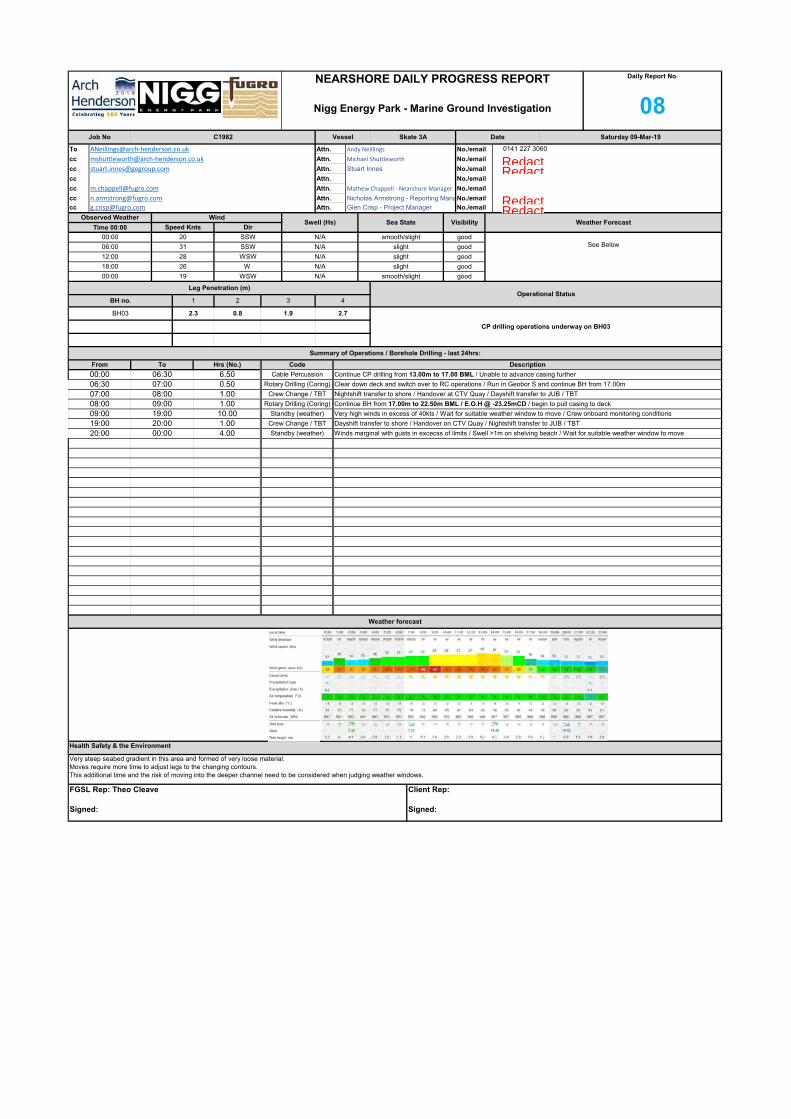
To
cc
cc
cc
cc
cc
cc
Saturday 09-Mar-19
ANeillings@arch‐henderson.co.uk Attn. Andy Neillings No./email 0141 227 3060
NEARSHORE DAILY PROGRESS REPORT
Nigg Energy Park - Marine Ground Investigation
Daily Report No.
08Job No C1982 Vessel Skate 3A Date
Attn. No./email
[email protected] Attn. Mathew Chappell ‐ Nearshore Manager No./email
mshuttleworth@arch‐henderson.co.uk Attn. Michael Shuttleworth No./email
[email protected] Attn. Stuart Innes No./email
Observed Weather WindSwell (Hs) Sea State Visibility Weather Forecast
Time 00:00 Speed Knts Dir
[email protected] Attn. Nicholas Armstrong - Reporting ManaNo./email
[email protected] Attn. Glen Crisp - Project Manager No./email
N/A slight good
18:00 26 W N/A slight good
See Below06:00 31 SSW N/A slight good
12:00 28 WSW
00:00 20 SSW N/A smooth/slight good
BH03 2.3 0.8 1.9 2.7
CP drilling operations underway on BH03
Leg Penetration (m)Operational Status
BH no. 1 2 3 4
00:00 19 WSW N/A smooth/slight good
00:00 06:30 6.50 Cable Percussion Continue CP drilling from 13.00m to 17.00 BML / Unable to advance casing further
Summary of Operations / Borehole Drilling - last 24hrs:
From To Hrs (No.) Code Description
08:00 09:00 1.00 Rotary Drilling (Coring) Continue BH from 17.00m to 22.50m BML / E.O.H @ -23.25mCD / begin to pull casing to deck
07:00 08:00 1.00 Crew Change / TBT Nightshift transfer to shore / Handover at CTV Quay / Dayshift transfer to JUB / TBT
06:30 07:00 0.50 Rotary Drilling (Coring) Clear down deck and switch over to RC operations / Run in Geobor S and continue BH from 17.00m
20:00 00:00 4.00 Standby (weather) Winds marginal with gusts in excecss of limits / Swell >1m on shelving beach / Wait for suitable weather window to move
19:00 20:00 1.00 Crew Change / TBT Dayshift transfer to shore / Handover on CTV Quay / Nightshift transfer to JUB / TBT
09:00 19:00 10.00 Standby (weather) Very high winds in excess of 40kts / Wait for suitable weather window to move / Crew onboard monitoring conditions
Weather forecast
Health Safety & the Environment
Very steep seabed gradient in this area and formed of very loose material.Moves require more time to adjust legs to the changing contours.This additional time and the risk of moving into the deeper channel need to be considered when judging weather windows.
FGSL Rep: Theo Cleave
Signed:
Client Rep:
Signed:
RedactedRedactedRedactedRedacted

NEARSHORE DAILY PROGRESS REPORT
Nigg Energy Park - Marine Ground Investigation
Daily Report No.
08Position
Mobilisation 0.00 3.50 Onboard JUB (mobilisation)
Activity Time Summary Today To Date Day Shift Night Shift Company
Fugro GeoServices Assistant Driller
Standby (Fugro) 0.00 0.00 Stuart Nye Fugro GeoServices Assistant Driller
Cable Percussion 6.50 73.08 Callum Allardyce Ashley Lowthian
Fugro GeoServices Bargemaster
Rotary Drilling (Coring) 1.50 7.33 James Lawson Adam Cook Fugro GeoServices Driller
Moving & Jacking 0.00 20.08 Jimmy Wilson Joshua Sandy
Other Operations 0.00 6.25 Theo Cleave Fugro GeoServices Project Engineer
Single Shift Standby 0.00 5.75
Standby (weather) 14.00 51.75 Richard Luker Bart Kot Fugro Geotechnical Engineer
Standby (Tide) 0.00 11.50
0.00 0.00
0.00 0.00
0.00 0.00
Crew Change / TBT 2.00 12.75
Total 24.00 24.00 No. Personnel 10
Total Man Hours
Worked120
0.00 0.00
0.00 0.00
0.00 0.00
No. Hours Chart %Activity BoQ Item m. No. Hours m. No. Hours m.
Project Program / Progress Programmed Today Actual To Date % Completed Budget
0.0 1 0.00 100.0
0
Establish all plant, equipment, crew on site A2 1.0
General Items, Provisional Services A
0.0
Standing Time for plant, crew, etc - WEATHER B11 C19 R/O 14.00 0.0
0.0 0 0.00
0.0 0 11.50 #VALUE!
0 51.75 #VALUE!
Standing Time for plant, crew, etc - TIDE B11 C19 R/O
0.0Move boring plant to site of each exploratory hole B1 8.00
0.0
Percussion Boring B
0.0 0 0.00
0 0.00 #VALUE!Break out surface obstructions where present B3 R/O
62.5Extra over B1 for setting up on a gradient >20% B2 R/O 0.0
0.0 5 0.00
0 0.00 61.8As B4 but between 10m and 20m B5 36.50 4.00
#VALUE!Advance BH between groundlevel and 10m depth B4 80.00 49.4
0.0 0 0.00
0 0.00 #VALUE!As B4 but between 30m and 40m B7 R/O
90.0As B4 but between 20m and 30m B6 R/O 0.0
32.9 0 0.00
0 3.00 #VALUE!
#VALUE!Advance BH through hard stratum or obstruction B9 R/O 0.0
0.0 0 0.00
0.0Move rotary plant to site of each exploratory hole C15 6.00
0.0
Rotary Drilling C0.0 0 0.00
0 0.00 #VALUE!As C41 but between 10m and 20m C42 20.50 3.00
50.0RC drilling between groundlevel and 10m depth C41 R/O 0.0
0.0 3 0.00
0 0.00 61.6Core box to be retained by client C49 21.00
27.6As C41 but between 20m and 30m C43 9.50 2.50 5.9
5.7 0 0.00
0 0.00 0.0Sampling, Monitoring during investigation E
0.0
0.0
0.0 0 0.00
116 0.00 196.6Bulk Disturbed Sample E2 59.00
0.0Small Disturbed Sample E1 59.00 22 0.0
0 0.00 #VALUE!
91.5Large Bulk disturbed sample E3 R/O 0.0
16 0.0 54 0.00
Standard Penetration Test in Borehole H1 40
0.0
0.0Insitu Testing H
0.0 0 0.00
#VALUE!0.0 0 0.00
52.5
Standard Penetration Test in Rotary Drill Hole H2 R/O
10 0.0 21 0.00
Marine Scotland Sample L2 121
0.0
0.0
Geoenvironmental Laboratory Testing L
0.0 0 0.00
0.0
Additional Items
0.0 0 0.00
68.622 0.0 83 0.00
0 0.00 0.0
0.0
0.0
0.00.0 0 0.00
0.0
0.0
0.0 0 0.00
0.00.0 0 0.00
Hoc Cards 1 12Safety Drills 0 4
Tool Box Talks 1 10
Health & Safety Summary Today Actual To Date Lost & Damaged
0 0.00 0.0
Fugro GeoServices Representative Comments Client Representative Comments
Wind speed recorded and monitored using forecasting systems (Met Office, WindFinder etc.) and anonometers; handheld and station mounted.
FGSL Rep: Theo Cleave
Signed:
Client Rep:
Signed:
Environmental 0 0
Hours Worked 120 960
HSE Meetings 0 1
Incidents/Near Miss 0 0
% Program Completed
0
100.0
0.0
0.0
0.0
0.0
0.0
62.5
0.0
0.0
61.8
90.0
0.0
0.0
0.0
0.0
0.0
50.0
0.0
27.6
61.6
0.0
0.0
0.0
91.5
0.0
0.0
0.0
52.5
0.0
0.0
0.0
68.6
0.0
0.0
0.0
0.0
0.0
0.0
0.0
% Program Completed

To
cc
cc
cc
cc
cc
cc
Weather forecast
Health Safety & the Environment
Met Office - "High for unsettled conditions for much of the period but Medium becoming Low on Monday for details due to complexity in movement and development of the synoptic pattern."Continue to monitor multiple complex lows over the next few days, forecasts up to and exceeding 50kts.
FGSL Rep: Theo Cleave
Signed:
Client Rep:
Signed:
19:45 00:00 4.25 Standby (weather) Continue to monitor storm from shore / Avg. 25-30kt winds, gusting >30kts
19:00 19:45 0.75 Crew Change / TBT Handover with nightshift at accomodation / Nightshift transfer CTV Quay
12:00 19:00 7.00 Standby (weather) Continue to monitor storm from shore / Avg. 35-40kt winds, gusting >40kts
11:45 12:00 0.25 Crew Change / TBT Transfer Dayshift to shore as a precaution / Forecast far in excess of deck operations and evacuation limits.
11:00 11:45 0.75 Other Operations Prepare deck for forecast storm / jack up beyond forecast Hmax and secure all deck items
08:00 11:00 3.00 Cable Percussion Continue CP drilling from 1.00m to 4.00m BML
07:30 08:00 0.50 Crew Change / TBT Dayshift transfer to JUB / Handover onboard for drilling continuation / TBT with all crew - Crew Transfers
06:00 07:30 1.50 Cable Percussion Run in casing to depth / Commence CP drilling from 0.00m to 1.00m BML
03:30 06:00 2.50 Moving & Jacking Conditions marginal / BM jacks down and pulls legs / Spin JUB to BH04 / Preload and jack to sage working height
03:00 03:30 0.50 Standby (weather) Wait for suitable weather window to move / Nightshift continue to monitor conditions / General R&M
00:00 03:00 3.00 Standby (weather) Winds marginal with gusts in excecss of limits / Swell ~1m on shelving beach / Wait for suitable weather window to move
Summary of Operations / Borehole Drilling - last 24hrs:
From To Hrs (No.) Code Description
2.9
BH03 2.3 0.8 1.9 2.7BH03 completed.
Awaiting suitable weather window for move to BH04.BH04 2.4 0.7 1.6
Leg Penetration (m)Operational Status
BH no. 1 2 3 4
00:00 28 W N/A smooth/slight poor
No./email
N/A slight poor
18:00 39 W N/A slight poor
See Below06:00 20 W N/A smooth/slight good
12:00 25 W
00:00 19 WSW N/A smooth good
[email protected] Attn. Mathew Chappell ‐ Nearshore Manager No./email
mshuttleworth@arch‐henderson.co.uk Attn. Michael Shuttleworth No./email
[email protected] Attn. Stuart Innes No./email
Observed Weather WindSwell (Hs) Sea State Visibility Weather Forecast
Time 00:00 Speed Knts Dir
[email protected] Attn. Nicholas Armstrong - Reporting ManaNo./email
[email protected] Attn. Glen Crisp - Project Manager
Sunday 10-Mar-19
ANeillings@arch‐henderson.co.uk Attn. Andy Neillings No./email 0141 227 3060
NEARSHORE DAILY PROGRESS REPORT
Nigg Energy Park - Marine Ground Investigation
Daily Report No.
09Job No C1982 Vessel Skate 3A Date
Attn. No./email
RedactedRedactedRedactedRedacted

NEARSHORE DAILY PROGRESS REPORT
Nigg Energy Park - Marine Ground Investigation
Daily Report No.
09
Fugro GeoServices Representative Comments Client Representative Comments
First complex low passes over this 24hr period.Second low currently tracking East towards North Sea, forecast to arrive on site in 48hrs.
FGSL Rep: Theo Cleave
Signed:
Client Rep:
Signed:
Environmental 0 0
Hours Worked 120 1080
HSE Meetings 0 1
Incidents/Near Miss 0 0
Hoc Cards 1 13Safety Drills 0 4
Tool Box Talks 1 11
Health & Safety Summary Today Actual To Date Lost & Damaged
0 0.00 0.0
0.0
0.0
0.0 0 0.00
0.00.0 0 0.00
0.00.0 0 0.00
0 0.00 0.0
0.0
0.0
0.0
Additional Items
0.0 0 0.00
68.60.0 83 0.00Marine Scotland Sample L2 121
0.0
0.0
Geoenvironmental Laboratory Testing L
0.0 0 0.00
#VALUE!0.0 0 0.00
52.5
Standard Penetration Test in Rotary Drill Hole H2 R/O
0.0 21 0.00Standard Penetration Test in Borehole H1 40
0.0
0.0Insitu Testing H
0.0 0 0.00
0 0.00 #VALUE!
91.5Large Bulk disturbed sample E3 R/O 0.0
0.0 54 0.00
116 0.00 196.6Bulk Disturbed Sample E2 59.00
0.0Small Disturbed Sample E1 59.00 0.0
0 0.00 0.0Sampling, Monitoring during investigation E
0.0
0.0
0.0 0 0.00
0 0.00 61.6Core box to be retained by client C49 21.00
27.6As C41 but between 20m and 30m C43 9.50 5.9
5.7 0 0.00
0 0.00 #VALUE!As C41 but between 10m and 20m C42 20.50
66.7RC drilling between groundlevel and 10m depth C41 R/O 0.0
1 0.0 4 0.00
0.0Move rotary plant to site of each exploratory hole C15 6.00
0.0
Rotary Drilling C0.0 0 0.00
0 3.00 #VALUE!
#VALUE!Advance BH through hard stratum or obstruction B9 R/O 0.0
0.0 0 0.00
0 0.00 #VALUE!As B4 but between 30m and 40m B7 R/O
90.0As B4 but between 20m and 30m B6 R/O 0.0
32.9 0 0.00
0 0.00 66.8As B4 but between 10m and 20m B5 36.50
#VALUE!Advance BH between groundlevel and 10m depth B4 80.00 4.00 53.4
0.0 0 0.00
0 0.00 #VALUE!Break out surface obstructions where present B3 R/O
75.0Extra over B1 for setting up on a gradient >20% B2 R/O 0.0
1 0.0 6 0.00
0.0Move boring plant to site of each exploratory hole B1 8.00
0.0
Percussion Boring B
0.0 0 0.00
0.0 0 11.50 #VALUE!
0 66.50 #VALUE!
Standing Time for plant, crew, etc - TIDE B11 C19 R/O
0.0
Standing Time for plant, crew, etc - WEATHER B11 C19 R/O 14.75 0.0
0.0 0 0.00
0.0 1 0.00 100.0
0
Establish all plant, equipment, crew on site A2 1.0
General Items, Provisional Services A
No. Hours Chart %Activity BoQ Item m. No. Hours m. No. Hours m.
Project Program / Progress Programmed Today Actual To Date % Completed Budget
Total 24.00 24.00 No. Personnel 10
Total Man Hours
Worked120
0.00 0.00
0.00 0.00
0.00 0.00
0.00 0.00
0.00 0.00
0.00 0.00
Crew Change / TBT 1.50 14.25
Other Operations 0.75 7.00 Theo Cleave Fugro GeoServices Project Engineer
Single Shift Standby 0.00 5.75
Standby (weather) 14.75 66.50 Richard Luker Bart Kot Fugro Geotechnical Engineer
Standby (Tide) 0.00 11.50
Fugro GeoServices Assistant Driller
Standby (Fugro) 0.00 0.00 Stuart Nye Fugro GeoServices Assistant Driller
Cable Percussion 4.50 77.58 Callum Allardyce Ashley Lowthian
Fugro GeoServices Bargemaster
Rotary Drilling (Coring) 0.00 7.33 James Lawson Adam Cook Fugro GeoServices Driller
Moving & Jacking 2.50 22.58 Jimmy Wilson Joshua Sandy
Position
Mobilisation 0.00 3.50 Onboard JUB (mobilisation)
Activity Time Summary Today To Date Day Shift Night Shift Company
% Program Completed
0
100.0
0.0
0.0
0.0
0.0
0.0
75.0
0.0
0.0
66.8
90.0
0.0
0.0
0.0
0.0
0.0
66.7
0.0
27.6
61.6
0.0
0.0
0.0
91.5
0.0
0.0
0.0
52.5
0.0
0.0
0.0
68.6
0.0
0.0
0.0
0.0
0.0
0.0
0.0
% Program Completed

To
cc
cc
cc
cc
cc
cc
Monday 11-Mar-19
ANeillings@arch‐henderson.co.uk Attn. Andy Neillings No./email 0141 227 3060
NEARSHORE DAILY PROGRESS REPORT
Nigg Energy Park - Marine Ground Investigation
Daily Report No.
10Job No C1982 Vessel Skate 3A Date
Attn. No./email
[email protected] Attn. Mathew Chappell ‐ Nearshore Manager No./email
mshuttleworth@arch‐henderson.co.uk Attn. Michael Shuttleworth No./email
[email protected] Attn. Stuart Innes No./email
Observed Weather WindSwell (Hs) Sea State Visibility Weather Forecast
Time 00:00 Speed Knts Dir
[email protected] Attn. Nicholas Armstrong - Reporting ManaNo./email
[email protected] Attn. Glen Crisp - Project Manager No./email
N/A smooth good
18:00 8 SW N/A smooth good
See Below06:00 19 SW N/A smooth good
12:00 20 WSW
00:00 28 W N/A smooth/slight good
BH04 2.4 0.7 1.6 2.9CP drilling underway on BH04
Rockhead expected at approx. -19mCD
Leg Penetration (m)Operational Status
BH no. 1 2 3 4
00:00 29 SSW N/A slight good
00:00 02:15 2.25 Standby (weather) Winds marginal with gusts in excecss of limits / Swell ~1m on shelving beach / Wait for suitable weather window to move
Summary of Operations / Borehole Drilling - last 24hrs:
From To Hrs (No.) Code Description
07:00 07:15 0.25 Other Operations Fuel all plant / Wash down and clear deck for E.O.S
02:45 07:00 4.25 Cable Percussion Prepare deck for drilling operations / remove all extra scraps etc. / Continue CP from 4.00m to 7.50m BML
02:15 02:45 0.50 Crew Change / TBT Nightshift transfer to JUB from CTV Quay
15:40 19:20 3.67 Cable Percussion Run in 7'' casing and continue CP drilling from 12.50m to 18m BML
08:00 15:40 7.67 Cable Percussion Continue CP drilling from 7.50m to 12.50m BML / Chiselling through very course gravels
07:15 08:00 0.75 Crew Change / TBT Nightshift transfer to shore / Handover at CTV Quay / Dayshift transfer to JUB / TBT & Fire Drill
22:35 00:00 1.42 Other Operations Pull all casing to deck / Wash down and clear deck for E.O.H / Fuel all plant / General R&M
20:00 22:35 2.58 Cable Percussion Continue CP drilling from 18.00m to 22.10m BML / E.O.H @ -24.10mCD / Seabed below Chart Datum = 2.00m
19:20 20:00 0.67 Crew Change / TBT Dayshift transfer to shore / Handover on CTV Quay / Nightshift transfer to JUB / TBT & Fire Drill
Weather forecast
Health Safety & the Environment
Met Office - "Complex low near Faeroes and into the northern North Sea tracks east or SE trough Mon while transient ridge builds over UK and drifts into the central and southern North Sea."Continue to monitor multiple complex lows over the next few days, forecasts up to and exceeding 40kts.
FGSL Rep: Theo Cleave
Signed:
Client Rep:
Signed:
RedactedRedactedRedactedRedacted

NEARSHORE DAILY PROGRESS REPORT
Nigg Energy Park - Marine Ground Investigation
Daily Report No.
10Position
Mobilisation 0.00 3.50 Onboard JUB (mobilisation)
Activity Time Summary Today To Date Day Shift Night Shift Company
Fugro GeoServices Assistant Driller
Standby (Fugro) 0.00 0.00 Stuart Nye Fugro GeoServices Assistant Driller
Cable Percussion 18.17 95.75 Callum Allardyce Ashley Lowthian
Fugro GeoServices Bargemaster
Rotary Drilling (Coring) 0.00 7.33 James Lawson Adam Cook Fugro GeoServices Driller
Moving & Jacking 0.00 22.58 Jimmy Wilson Joshua Sandy
Other Operations 1.67 8.67 Theo Cleave Fugro GeoServices Project Engineer
Single Shift Standby 0.00 5.75
Standby (weather) 2.25 68.75 Richard Luker Bart Kot Fugro Geotechnical Engineer
Standby (Tide) 0.00 11.50
0.00 0.00
0.00 0.00
0.00 0.00
Crew Change / TBT 1.92 16.17
Total 24.00 24.00 No. Personnel 10
Total Man Hours
Worked120
0.00 0.00
0.00 0.00
0.00 0.00
No. Hours Chart %Activity BoQ Item m. No. Hours m. No. Hours m.
Project Program / Progress Programmed Today Actual To Date % Completed Budget
0.0 1 0.00 100.0
0
Establish all plant, equipment, crew on site A2 1.0
General Items, Provisional Services A
0.0
Standing Time for plant, crew, etc - WEATHER B11 C19 R/O 0.0
0.0 0 0.00
0.0 0 11.50 #VALUE!
0 66.50 #VALUE!
Standing Time for plant, crew, etc - TIDE B11 C19 R/O
0.0Move boring plant to site of each exploratory hole B1 8.00
0.0
Percussion Boring B
0.0 0 0.00
0 0.00 #VALUE!Break out surface obstructions where present B3 R/O
75.0Extra over B1 for setting up on a gradient >20% B2 R/O 0.0
0.0 6 0.00
0 0.00 74.3As B4 but between 10m and 20m B5 36.50 10.00
#VALUE!Advance BH between groundlevel and 10m depth B4 80.00 6.00 59.4
0.0 0 0.00
0 0.00 #VALUE!As B4 but between 30m and 40m B7 R/O
117.4As B4 but between 20m and 30m B6 R/O 2.10 2.1
42.9 0 0.00
0 9.08 #VALUE!
#VALUE!Advance BH through hard stratum or obstruction B9 R/O 6.08 0.0
0.0 0 0.00
0.0Move rotary plant to site of each exploratory hole C15 6.00
0.0
Rotary Drilling C0.0 0 0.00
0 0.00 #VALUE!As C41 but between 10m and 20m C42 20.50
66.7RC drilling between groundlevel and 10m depth C41 R/O 0.0
0.0 4 0.00
0 0.00 61.6Core box to be retained by client C49 21.00
27.6As C41 but between 20m and 30m C43 9.50 5.9
5.7 0 0.00
0 0.00 0.0Sampling, Monitoring during investigation E
0.0
0.0
0.0 0 0.00
141 0.00 239.0Bulk Disturbed Sample E2 59.00
0.0Small Disturbed Sample E1 59.00 25 0.0
0 0.00 #VALUE!
127.1Large Bulk disturbed sample E3 R/O 0.0
21 0.0 75 0.00
Standard Penetration Test in Borehole H1 40
0.0
0.0Insitu Testing H
0.0 0 0.00
#VALUE!0.0 0 0.00
82.5
Standard Penetration Test in Rotary Drill Hole H2 R/O
12 0.0 33 0.00
Marine Scotland Sample L2 121
0.0
0.0
Geoenvironmental Laboratory Testing L
0.0 0 0.00
0.0
Additional Items
0.0 0 0.00
86.021 0.0 104 0.00
0 0.00 0.0
0.0
0.0
0.00.0 0 0.00
0.0
0.0
0.0 0 0.00
0.00.0 0 0.00
Hoc Cards 1 14Safety Drills 1 5
Tool Box Talks 1 12
Health & Safety Summary Today Actual To Date Lost & Damaged
0 0.00 0.0
Fugro GeoServices Representative Comments Client Representative Comments
FGSL Rep: Theo Cleave
Signed:
Client Rep:
Signed:
Environmental 0 0
Hours Worked 120 1200
HSE Meetings 0 1
Incidents/Near Miss 0 0
% Program Completed
0
100.0
0.0
0.0
0.0
0.0
0.0
75.0
0.0
0.0
74.3
0.0
0.0
0.0
0.0
0.0
66.7
0.0
27.6
61.6
0.0
0.0
0.0
0.0
0.0
0.0
82.5
0.0
0.0
0.0
86.0
0.0
0.0
0.0
0.0
0.0
0.0
0.0
% Program Completed

To
cc
cc
cc
cc
cc
cc
Tuesday 12-Mar-19
ANeillings@arch‐henderson.co.uk Attn. Andy Neillings No./email 0141 227 3060
NEARSHORE DAILY PROGRESS REPORT
Nigg Energy Park - Marine Ground Investigation
Daily Report No.
11Job No C1982 Vessel Skate 3A Date
Attn. No./email
[email protected] Attn. Mathew Chappell ‐ Nearshore Manager No./email
mshuttleworth@arch‐henderson.co.uk Attn. Michael Shuttleworth No./email
[email protected] Attn. Stuart Innes No./email
Observed Weather WindSwell (Hs) Sea State Visibility Weather Forecast
Time 00:00 Speed Knts Dir
[email protected] Attn. Nicholas Armstrong - Reporting ManaNo./email
[email protected] Attn. Glen Crisp - Project Manager No./email
N/A slight good
18:00 36 SSW N/A slight good
See Below06:00 20 SW N/A smooth/slight good
12:00 31 SW
00:00 28 W N/A slight good
BH04 2.4 0.7 1.6 2.9Pulling casing on BH04Complete to -24.10mCD
Monitor weather for suitable window to move.
Leg Penetration (m)Operational Status
BH no. 1 2 3 4
00:00 23 W N/A slight good
00:00 00:45 0.75 Other Operations Pull all casing to deck / Wash down and clear deck for E.O.H / Fuel all plant / General R&M
Summary of Operations / Borehole Drilling - last 24hrs:
From To Hrs (No.) Code Description
08:00 19:00 11.00 Standby (weather) Large weather system moving over site / Winds avg. ~30kts, gusts >50kts / Crew not onboard through v.high winds
07:00 08:00 1.00 Crew Change / TBT Handover with dayshift / TBT with all crew / Dayshift transfer to quayside to monitor weather
00:45 07:00 6.25 Standby (weather) Large weather system moving over site / Winds avg. ~25kts
20:00 00:00 4.00 Standby (weather) Large weather system moving over site / Winds avg. ~22kts, gusts >30kts /
19:00 20:00 1.00 Crew Change / TBT Transit toCTV Quay / Handover with nightshift
Weather forecast
Health Safety & the Environment
Met Office - "Large and deep Atlantic low to the NW of Scotland moves ESE across the far north of Scotland through Tuesday and into southern Scandinavia on Wednesday."Continue to monitor multiple complex lows over the next few days, forecasts up to and exceeding 50kts.
FGSL Rep: Theo Cleave
Signed:
Client Rep:
Signed:
RedactedRedactedRedactedRedacted

NEARSHORE DAILY PROGRESS REPORT
Nigg Energy Park - Marine Ground Investigation
Daily Report No.
11Position
Mobilisation 0.00 3.50 Onboard JUB (mobilisation)
Activity Time Summary Today To Date Day Shift Night Shift Company
Fugro GeoServices Assistant Driller
Standby (Fugro) 0.00 0.00 Stuart Nye Fugro GeoServices Assistant Driller
Cable Percussion 0.00 95.75 Callum Allardyce Ashley Lowthian
Fugro GeoServices Bargemaster
Rotary Drilling (Coring) 0.00 7.33 James Lawson Adam Cook Fugro GeoServices Driller
Moving & Jacking 0.00 22.58 Jimmy Wilson Joshua Sandy
Other Operations 0.75 9.42 Theo Cleave Fugro GeoServices Project Engineer
Single Shift Standby 0.00 5.75
Standby (weather) 21.25 90.00 Richard Luker Bart Kot Fugro Geotechnical Engineer
Standby (Tide) 0.00 11.50
0.00 0.00
0.00 0.00
0.00 0.00
Crew Change / TBT 2.00 18.17
Total 24.00 24.00 No. Personnel 10
Total Man Hours
Worked120
0.00 0.00
0.00 0.00
0.00 0.00
No. Hours Chart %Activity BoQ Item m. No. Hours m. No. Hours m.
Project Program / Progress Programmed Today Actual To Date % Completed Budget
0.0 1 0.00 100.0
0
Establish all plant, equipment, crew on site A2 1.0
General Items, Provisional Services A
0.0
Standing Time for plant, crew, etc - WEATHER B11 C19 R/O 21.25 0.0
0.0 0 0.00
0.0 0 11.50 #VALUE!
0 87.75 #VALUE!
Standing Time for plant, crew, etc - TIDE B11 C19 R/O
0.0Move boring plant to site of each exploratory hole B1 8.00
0.0
Percussion Boring B
0.0 0 0.00
0 0.00 #VALUE!Break out surface obstructions where present B3 R/O
75.0Extra over B1 for setting up on a gradient >20% B2 R/O 0.0
0.0 6 0.00
0 0.00 74.3As B4 but between 10m and 20m B5 36.50
#VALUE!Advance BH between groundlevel and 10m depth B4 80.00 59.4
0.0 0 0.00
0 0.00 #VALUE!As B4 but between 30m and 40m B7 R/O
117.4As B4 but between 20m and 30m B6 R/O 2.1
42.9 0 0.00
0 9.08 #VALUE!
#VALUE!Advance BH through hard stratum or obstruction B9 R/O 0.0
0.0 0 0.00
0.0Move rotary plant to site of each exploratory hole C15 6.00
0.0
Rotary Drilling C0.0 0 0.00
0 0.00 #VALUE!As C41 but between 10m and 20m C42 20.50
66.7RC drilling between groundlevel and 10m depth C41 R/O 0.0
0.0 4 0.00
0 0.00 61.6Core box to be retained by client C49 21.00
27.6As C41 but between 20m and 30m C43 9.50 5.9
5.7 0 0.00
0 0.00 0.0Sampling, Monitoring during investigation E
0.0
0.0
0.0 0 0.00
141 0.00 239.0Bulk Disturbed Sample E2 59.00
0.0Small Disturbed Sample E1 59.00 0.0
0 0.00 #VALUE!
127.1Large Bulk disturbed sample E3 R/O 0.0
0.0 75 0.00
Standard Penetration Test in Borehole H1 40
0.0
0.0Insitu Testing H
0.0 0 0.00
#VALUE!0.0 0 0.00
82.5
Standard Penetration Test in Rotary Drill Hole H2 R/O
0.0 33 0.00
Marine Scotland Sample L2 121
0.0
0.0
Geoenvironmental Laboratory Testing L
0.0 0 0.00
0.0
Additional Items
0.0 0 0.00
86.00.0 104 0.00
0 0.00 0.0
0.0
0.0
0.00.0 0 0.00
0.0
0.0
0.0 0 0.00
0.00.0 0 0.00
Hoc Cards 1 15Safety Drills 0 5
Tool Box Talks 1 13
Health & Safety Summary Today Actual To Date Lost & Damaged
0 0.00 0.0
Fugro GeoServices Representative Comments Client Representative Comments
Gap between weather systems developing over the next 24 hrs. Monitor development for possible move window.
FGSL Rep: Theo Cleave
Signed:
Client Rep:
Signed:
Environmental 0 0
Hours Worked 120 1320
HSE Meetings 0 1
Incidents/Near Miss 0 0
% Program Completed
0
100.0
0.0
0.0
0.0
0.0
0.0
75.0
0.0
0.0
74.3
0.0
0.0
0.0
0.0
0.0
66.7
0.0
27.6
61.6
0.0
0.0
0.0
0.0
0.0
0.0
82.5
0.0
0.0
0.0
86.0
0.0
0.0
0.0
0.0
0.0
0.0
0.0
% Program Completed

To
cc
cc
cc
cc
cc
cc
Wednesday 13-Mar-19
ANeillings@arch‐henderson.co.uk Attn. Andy Neillings No./email 0141 227 3060
NEARSHORE DAILY PROGRESS REPORT
Nigg Energy Park - Marine Ground Investigation
Daily Report No.
12Job No C1982 Vessel Skate 3A Date
Attn. No./email
[email protected] Attn. Mathew Chappell ‐ Nearshore Manager No./email
mshuttleworth@arch‐henderson.co.uk Attn. Michael Shuttleworth No./email
[email protected] Attn. Stuart Innes No./email
Observed Weather WindSwell (Hs) Sea State Visibility Weather Forecast
Time 00:00 Speed Knts Dir
[email protected] Attn. Nicholas Armstrong - Reporting ManaNo./email
[email protected] Attn. Glen Crisp - Project Manager No./email
N/A smooth good
18:00 34 WSW N/A slight good
See Below06:00 37 WNW N/A smooth good
12:00 21 W
00:00 28 W N/A slight good
BH04 2.4 0.7 1.6 2.9BH04 complete
Awaiting weather window to move to BH05
Leg Penetration (m)Operational Status
BH no. 1 2 3 4
00:00 23 SSW N/A smooth/slight good
00:00 00:45 0.75 Standby (weather) Await weather window for move to BH05 / Nightshift continue to monitor
Summary of Operations / Borehole Drilling - last 24hrs:
From To Hrs (No.) Code Description
08:00 13:00 5.00 Standby (weather) Await weather window for move to BH05 / Wind dropping to within operational limits / Monitor closely
07:00 08:00 1.00 Crew Change / TBT Nightshift transfer to shore / Handover at CTV Quay / Dayshift transfer to JUB / TBT & Abandonment Drill
00:45 07:00 6.25 Standby (weather) Await weather window for move to BH05 / Wind average <30kts
16:45 19:00 2.25 Cable Percussion Run in 8'' casing to mudline / Commence CP drilling from 0.00m to 2.00m BML
15:15 16:45 1.50 Standby (weather) Jack up and await window / Client contacted / Client Instruction to commence drilling 17m from BH05
13:00 15:15 2.25 Moving & Jacking Jack down and pull legs / Move ~53m directly S from BH04 / Cannot pull JUB West against wind / Abort move
20:00 00:00 4.00 Cable Percussion Continue CP drilling from 2.00m to 7.00m BML
19:20 20:00 0.67 Crew Change / TBT Dayshift transfer to shore / Handover on CTV Quay / Nightshift transfer to JUB / TBT & Abandonment Drill
19:00 19:20 0.33 Other Operations Fuel all plant and RHIB / Wash down for E.O.S
Weather forecast
Health Safety & the Environment
Met Office - "Deep low in central North Sea moves east to reach northern Denmark by this evening then to Sweden by Thur. Another low moves from near Iceland on a similar track on Thur with ridge briefly moving east over central and southern North Sea overnight into Fri."Continue to monitor onditions closely, forecasts up to and exceeding 40kts.
FGSL Rep: Theo Cleave
Signed:
Client Rep:
Signed:
RedactedRedactedRedactedRedacted

NEARSHORE DAILY PROGRESS REPORT
Nigg Energy Park - Marine Ground Investigation
Daily Report No.
12Position
Mobilisation 0.00 3.50 Onboard JUB (mobilisation)
Activity Time Summary Today To Date Day Shift Night Shift Company
Fugro GeoServices Assistant Driller
Standby (Fugro) 0.00 0.00 Fugro GeoServices Assistant Driller
Cable Percussion 6.25 102.00 Stuart Nye Ashley Lowthian
Fugro GeoServices Bargemaster
Rotary Drilling (Coring) 0.00 7.33 Callum Allardyce Adam Cook Fugro GeoServices Driller
Moving & Jacking 2.25 24.83 Jimmy Wilson Mark Bray
Other Operations 0.33 9.75 Theo Cleave Fugro GeoServices Project Engineer
Single Shift Standby 0.00 5.75
Standby (weather) 13.50 103.50 Richard Luker Bart Kot Fugro Geotechnical Engineer
Standby (Tide) 0.00 11.50
0.00 0.00
0.00 0.00
0.00 0.00
Crew Change / TBT 1.67 19.83
Total 24.00 24.00 No. Personnel 9
Total Man Hours
Worked108
0.00 0.00
0.00 0.00
0.00 0.00
No. Hours Chart %Activity BoQ Item m. No. Hours m. No. Hours m.
Project Program / Progress Programmed Today Actual To Date % Completed Budget
0.0 1 0.00 100.0
0
Establish all plant, equipment, crew on site A2 1.0
General Items, Provisional Services A
0.0
Standing Time for plant, crew, etc - WEATHER B11 C19 R/O 0.0
0.0 0 0.00
0.0 0 11.50 #VALUE!
0 87.75 #VALUE!
Standing Time for plant, crew, etc - TIDE B11 C19 R/O
0.0Move boring plant to site of each exploratory hole B1 8.00
0.0
Percussion Boring B
0.0 0 0.00
0 0.00 #VALUE!Break out surface obstructions where present B3 R/O
87.5Extra over B1 for setting up on a gradient >20% B2 R/O 0.0
1 0.0 7 0.00
0 0.00 83.0As B4 but between 10m and 20m B5 36.50
#VALUE!Advance BH between groundlevel and 10m depth B4 80.00 7.00 66.4
0.0 0 0.00
0 0.00 #VALUE!As B4 but between 30m and 40m B7 R/O
117.4As B4 but between 20m and 30m B6 R/O 2.1
42.9 0 0.00
0 9.08 #VALUE!
#VALUE!Advance BH through hard stratum or obstruction B9 R/O 0.0
0.0 0 0.00
0.0Move rotary plant to site of each exploratory hole C15 6.00
0.0
Rotary Drilling C0.0 0 0.00
0 0.00 #VALUE!As C41 but between 10m and 20m C42 20.50
83.3RC drilling between groundlevel and 10m depth C41 R/O 0.0
1 0.0 5 0.00
0 0.00 61.6Core box to be retained by client C49 21.00
27.6As C41 but between 20m and 30m C43 9.50 5.9
5.7 0 0.00
0 0.00 0.0Sampling, Monitoring during investigation E
0.0
0.0
0.0 0 0.00
142 0.00 240.7Bulk Disturbed Sample E2 59.00
0.0Small Disturbed Sample E1 59.00 0.0
0 0.00 #VALUE!
127.1Large Bulk disturbed sample E3 R/O 0.0
0.0 75 0.00
Standard Penetration Test in Borehole H1 40
0.0
0.0Insitu Testing H
0.0 0 0.00
#VALUE!0.0 0 0.00
82.5
Standard Penetration Test in Rotary Drill Hole H2 R/O
0.0 33 0.00
Marine Scotland Sample L2 121
0.0
0.0
Geoenvironmental Laboratory Testing L
0.0 0 0.00
0.0
Additional Items
0.0 0 0.00
86.00.0 104 0.00
0 0.00 0.0
0.0
0.0
0.00.0 0 0.00
0.0
0.0
0.0 0 0.00
0.00.0 0 0.00
Hoc Cards 1 16Safety Drills 1 6
Tool Box Talks 1 14
Health & Safety Summary Today Actual To Date Lost & Damaged
0 0.00 0.0
Fugro GeoServices Representative Comments Client Representative Comments
FGSL Rep: Theo Cleave
Signed:
Client Rep:
Signed:
Environmental 0 0
Hours Worked 108 1428
HSE Meetings 0 1
Incidents/Near Miss 0 0
% Program Completed
0
100.0
0.0
0.0
0.0
0.0
0.0
87.5
0.0
0.0
83.0
0.0
0.0
0.0
0.0
0.0
83.3
0.0
27.6
61.6
0.0
0.0
0.0
0.0
0.0
0.0
82.5
0.0
0.0
0.0
86.0
0.0
0.0
0.0
0.0
0.0
0.0
0.0
% Program Completed

To
cc
cc
cc
cc
cc
cc
Weather forecast
Health Safety & the Environment
Met Office: "A low moves east near Shetland on Friday morning then fills near Norway on Saturday morning. Another low is expected over Ireland deepening as it pushes northeast through the UK. This low continues to deepen as as it moves into the central North Sea early on Sunday."
FGSL Rep: Theo Cleave
Signed:
Client Rep:
Signed:
20:15 00:00 3.75 Standby (weather) Await weather window for move to BH05 / Nightshift continue to monitor
19:30 20:15 0.75 Crew Change / TBT Dayshift transfer to shore / Handover on CTV Quay / Nightshift transfer to JUB / TBT & Man Overboard Drill
16:00 19:30 3.50 Standby (weather) Await weather window for move to BH05 / Wind over operational limits for moving & jacking
12:15 16:00 3.75 Rotary Drilling (Coring) Run in Geobor S / Continue from 14.50m to 17.50m BML / E.O.H @ -24.25mCD / Pull all casing to deck
08:00 12:15 4.25 Cable Percussion Continue CP drilling from 12.00m to 14.50m BML / Chisel between 12.20 - 12.50m, large gravels
07:15 08:00 0.75 Crew Change / TBT Nightshift transfer to shore / Handover at CTV Quay / Dayshift transfer to JUB / TBT & Man Overboard Drill
07:00 07:15 0.25 Other Operations Wash down clear down for E.O.S / Fuel all plant
00:00 07:00 7.00 Cable Percussion Continue CP drilling from 7.00m to 12.00m BML / Break down and swap over bailer
Summary of Operations / Borehole Drilling - last 24hrs:
From To Hrs (No.) Code Description
BH05 1.8 1.7 2.5 2.6
CP drilling underway on BH05
Leg Penetration (m)Operational Status
BH no. 1 2 3 4
00:00 22 WSW N/A smooth good
No./email
N/A smooth good
18:00 22 SW N/A smooth good
See Below06:00 25 WSW N/A smooth good
12:00 22 WSW
00:00 23 SSW N/A smooth good
[email protected] Attn. Mathew Chappell ‐ Nearshore Manager No./email
mshuttleworth@arch‐henderson.co.uk Attn. Michael Shuttleworth No./email
[email protected] Attn. Stuart Innes No./email
Observed Weather WindSwell (Hs) Sea State Visibility Weather Forecast
Time 00:00 Speed Knts Dir
[email protected] Attn. Nicholas Armstrong - Reporting ManaNo./email
[email protected] Attn. Glen Crisp - Project Manager
Thursday 14-Mar-19
ANeillings@arch‐henderson.co.uk Attn. Andy Neillings No./email 0141 227 3060
NEARSHORE DAILY PROGRESS REPORT
Nigg Energy Park - Marine Ground Investigation
Daily Report No.
13Job No C1982 Vessel Skate 3A Date
Attn. No./email
RedactedRedactedRedactedRedacted

NEARSHORE DAILY PROGRESS REPORT
Nigg Energy Park - Marine Ground Investigation
Daily Report No.
13
Fugro GeoServices Representative Comments Client Representative Comments
FGSL Rep: Theo Cleave
Signed:
Client Rep:
Signed:
Environmental 0 0
Hours Worked 108 1536
HSE Meetings 0 1
Incidents/Near Miss 0 0
Hoc Cards 1 17Safety Drills 1 7
Tool Box Talks 1 15
Health & Safety Summary Today Actual To Date Lost & Damaged
0 0.00 0.0
0.0
0.0
0.0 0 0.00
0.00.0 0 0.00
0.00.0 0 0.00
0 0.00 0.0
0.0
0.0
0.0
Additional Items
0.0 0 0.00
94.210 0.0 114 0.00Marine Scotland Sample L2 121
0.0
0.0
Geoenvironmental Laboratory Testing L
0.0 0 0.00
#VALUE!0.0 0 0.00
102.5
Standard Penetration Test in Rotary Drill Hole H2 R/O
8 0.0 41 0.00Standard Penetration Test in Borehole H1 40
0.0
0.0Insitu Testing H
0.0 0 0.00
0 0.00 #VALUE!
150.8Large Bulk disturbed sample E3 R/O 0.0
14 0.0 89 0.00
158 0.00 267.8Bulk Disturbed Sample E2 59.00
0.0Small Disturbed Sample E1 59.00 16 0.0
0 0.00 0.0Sampling, Monitoring during investigation E
0.0
0.0
0.0 0 0.00
0 0.00 61.6Core box to be retained by client C49 21.00
42.2As C41 but between 20m and 30m C43 9.50 5.9
8.7 0 0.00
0 0.00 #VALUE!As C41 but between 10m and 20m C42 20.50 3.00
83.3RC drilling between groundlevel and 10m depth C41 R/O 0.0
0.0 5 0.00
0.0Move rotary plant to site of each exploratory hole C15 6.00
0.0
Rotary Drilling C0.0 0 0.00
0 9.08 #VALUE!
#VALUE!Advance BH through hard stratum or obstruction B9 R/O 0.0
0.0 0 0.00
0 0.00 #VALUE!As B4 but between 30m and 40m B7 R/O
129.7As B4 but between 20m and 30m B6 R/O 2.1
47.4 0 0.00
0 0.00 86.8As B4 but between 10m and 20m B5 36.50 4.50
#VALUE!Advance BH between groundlevel and 10m depth B4 80.00 3.00 69.4
0.0 0 0.00
0 0.00 #VALUE!Break out surface obstructions where present B3 R/O
87.5Extra over B1 for setting up on a gradient >20% B2 R/O 0.0
0.0 7 0.00
0.0Move boring plant to site of each exploratory hole B1 8.00
0.0
Percussion Boring B
0.0 0 0.00
0.0 0 11.50 #VALUE!
0 87.75 #VALUE!
Standing Time for plant, crew, etc - TIDE B11 C19 R/O
0.0
Standing Time for plant, crew, etc - WEATHER B11 C19 R/O 0.0
0.0 0 0.00
0.0 1 0.00 100.0
0
Establish all plant, equipment, crew on site A2 1.0
General Items, Provisional Services A
No. Hours Chart %Activity BoQ Item m. No. Hours m. No. Hours m.
Project Program / Progress Programmed Today Actual To Date % Completed Budget
Total 24.00 24.00 No. Personnel 9
Total Man Hours
Worked108
0.00 0.00
0.00 0.00
0.00 0.00
0.00 0.00
0.00 0.00
0.00 0.00
Crew Change / TBT 1.50 21.33
Other Operations 0.25 10.00 Theo Cleave Fugro GeoServices Project Engineer
Single Shift Standby 0.00 5.75
Standby (weather) 7.25 110.75 Richard Luker Bart Kot Fugro Geotechnical Engineer
Standby (Tide) 0.00 11.50
Fugro GeoServices Assistant Driller
Standby (Fugro) 0.00 0.00 Fugro GeoServices Assistant Driller
Cable Percussion 11.25 113.25 Justin Smith Ashley Lowthian
Fugro GeoServices Bargemaster
Rotary Drilling (Coring) 3.75 11.08 Callum Allardyce Adam Cook Fugro GeoServices Driller
Moving & Jacking 0.00 24.83 Jimmy Wilson Mark Bray
Position
Mobilisation 0.00 3.50 Onboard JUB (mobilisation)
Activity Time Summary Today To Date Day Shift Night Shift Company
% Program Completed
0
100.0
0.0
0.0
0.0
0.0
0.0
87.5
0.0
0.0
86.8
0.0
0.0
0.0
0.0
0.0
83.3
0.0
42.2
61.6
0.0
0.0
0.0
0.0
0.0
0.0
0.0
0.0
0.0
94.2
0.0
0.0
0.0
0.0
0.0
0.0
0.0
% Program Completed

To
cc
cc
cc
cc
cc
cc
Weather forecast
Health Safety & the Environment
Met Office: "A low moves east near Shetland on Friday morning then fills near Norway on Saturday morning. Another low is expected over Ireland deepening as it pushes northeast through the UK. This low continues to deepen as as it moves into the central North Sea early on Sunday."
FGSL Rep: Theo Cleave
Signed:
Client Rep:
Signed:
20:00 00:00 4.00 Standby (weather) Nightshift continue to monitor weather for opportunity to move to BH06
19:00 20:00 1.00 Crew Change / TBT Dayshift transfer to shore / Handover at accomodation / Nightshift transfer to Quay to continue monitoring conditions
14:00 19:00 5.00 Standby (weather) Dayshift continue to monitor weather for opportunity to move to BH06
11:00 14:00 3.00 Standby (weather) Dayshift transfer to shore ahead of forecast gales / Shoreside storage area prepared for demobilisation
08:00 11:00 3.00 Standby (weather) Dayshift onboard to monitor weather and perform general R&M to JUB plant.
07:00 08:00 1.00 Crew Change / TBT Nightshift transfer to shore / Handover at CTV Quay / Dayshift transfer to JUB to continue to monitor weather
00:00 07:00 7.00 Standby (weather) Await weather window for move to BH05 / Nightshift continue to monitor
Summary of Operations / Borehole Drilling - last 24hrs:
From To Hrs (No.) Code Description
BH05 1.8 1.7 2.5 2.6
Awaiting weather window to move to BH06
Leg Penetration (m)Operational Status
BH no. 1 2 3 4
00:00 23 SW N/A smooth good
No./email
N/A slight good
18:00 29 W N/A slight good
See Below06:00 25 W N/A smooth/slight good
12:00 38 W
00:00 22 WSW N/A smooth good
[email protected] Attn. Mathew Chappell ‐ Nearshore Manager No./email
mshuttleworth@arch‐henderson.co.uk Attn. Michael Shuttleworth No./email
[email protected] Attn. Stuart Innes No./email
Observed Weather WindSwell (Hs) Sea State Visibility Weather Forecast
Time 00:00 Speed Knts Dir
[email protected] Attn. Nicholas Armstrong ‐ Reporting ManagerNo./email
[email protected] Attn. Glen Crisp ‐ Project Manager
Friday 15-Mar-19
ANeillings@arch‐henderson.co.uk Attn. Andy Neillings No./email 0141 227 3060
NEARSHORE DAILY PROGRESS REPORT
Nigg Energy Park - Marine Ground Investigation
Daily Report No.
14Job No C1982 Vessel Skate 3A Date
Attn. No./email
RedactedRedactedRedactedRedacted

NEARSHORE DAILY PROGRESS REPORT
Nigg Energy Park - Marine Ground Investigation
Daily Report No.
14
Fugro GeoServices Representative Comments Client Representative Comments
FGSL Rep: Theo Cleave
Signed:
Client Rep:
Signed:
Environmental 0 0
Hours Worked 108 1644
HSE Meetings 0 1
Incidents/Near Miss 0 0
Hoc Cards 1 18Safety Drills 0 7
Tool Box Talks 1 16
Health & Safety Summary Today Actual To Date Lost & Damaged
0 0.00 0.0
0.0
0.0
0.0 0 0.00
0.00.0 0 0.00
0.00.0 0 0.00
0 0.00 0.0
0.0
0.0
0.0
Additional Items
0.0 0 0.00
94.20.0 114 0.00Marine Scotland Sample L2 121
0.0
0.0
Geoenvironmental Laboratory Testing L
0.0 0 0.00
#VALUE!0.0 0 0.00
102.5
Standard Penetration Test in Rotary Drill Hole H2 R/O
0.0 41 0.00Standard Penetration Test in Borehole H1 40
0.0
0.0Insitu Testing H
0.0 0 0.00
0 0.00 #VALUE!
150.8Large Bulk disturbed sample E3 R/O 0.0
0.0 89 0.00
158 0.00 267.8Bulk Disturbed Sample E2 59.00
0.0Small Disturbed Sample E1 59.00 0.0
0 0.00 0.0Sampling, Monitoring during investigation E
0.0
0.0
0.0 0 0.00
0 0.00 61.6Core box to be retained by client C49 21.00
42.2As C41 but between 20m and 30m C43 9.50 5.9
8.7 0 0.00
0 0.00 #VALUE!As C41 but between 10m and 20m C42 20.50
83.3RC drilling between groundlevel and 10m depth C41 R/O 0.0
0.0 5 0.00
0.0Move rotary plant to site of each exploratory hole C15 6.00
0.0
Rotary Drilling C0.0 0 0.00
0 9.08 #VALUE!
#VALUE!Advance BH through hard stratum or obstruction B9 R/O 0.0
0.0 0 0.00
0 0.00 #VALUE!As B4 but between 30m and 40m B7 R/O
129.7As B4 but between 20m and 30m B6 R/O 2.1
47.4 0 0.00
0 0.00 86.8As B4 but between 10m and 20m B5 36.50
#VALUE!Advance BH between groundlevel and 10m depth B4 80.00 69.4
0.0 0 0.00
0 0.00 #VALUE!Break out surface obstructions where present B3 R/O
87.5Extra over B1 for setting up on a gradient >20% B2 R/O 0.0
0.0 7 0.00
0.0Move boring plant to site of each exploratory hole B1 8.00
0.0
Percussion Boring B
0.0 0 0.00
0.0 0 11.50 #VALUE!
0 132.75 #VALUE!
Standing Time for plant, crew, etc - TIDE B11 C19 R/O
0.0
Standing Time for plant, crew, etc - WEATHER B11 C19 R/O 22.00 0.0
0.0 0 0.00
0.0 1 0.00 100.0
0
Establish all plant, equipment, crew on site A2 1.0
General Items, Provisional Services A
No. Hours Chart %Activity BoQ Item m. No. Hours m. No. Hours m.
Project Program / Progress Programmed Today Actual To Date % Completed Budget
Total 24.00 24.00 No. Personnel 9
Total Man Hours
Worked108
0.00 0.00
0.00 0.00
0.00 0.00
0.00 0.00
0.00 0.00
0.00 0.00
Crew Change / TBT 2.00 23.33
Other Operations 0.00 10.00 Theo Cleave Fugro GeoServices Project Engineer
Single Shift Standby 0.00 5.75
Standby (weather) 22.00 132.75 Richard Luker Bart Kot Fugro Geotechnical Engineer
Standby (Tide) 0.00 11.50
Fugro GeoServices Assistant Driller
Standby (Fugro) 0.00 0.00 Fugro GeoServices Assistant Driller
Cable Percussion 0.00 113.25 Justin Smith Ashley Lowthian
Fugro GeoServices Bargemaster
Rotary Drilling (Coring) 0.00 11.08 Callum Allardyce Adam Cook Fugro GeoServices Driller
Moving & Jacking 0.00 24.83 Jimmy Wilson Mark Bray
Position
Mobilisation 0.00 3.50 Onboard JUB (mobilisation)
Activity Time Summary Today To Date Day Shift Night Shift Company
% Program Completed
0
100.0
0.0
0.0
0.0
0.0
0.0
87.5
0.0
0.0
86.8
0.0
0.0
0.0
0.0
0.0
83.3
0.0
42.2
61.6
0.0
0.0
0.0
0.0
0.0
0.0
0.0
0.0
0.0
94.2
0.0
0.0
0.0
0.0
0.0
0.0
0.0
% Program Completed

To
cc
cc
cc
cc
cc
cc
Saturday 16-Mar-19
ANeillings@arch‐henderson.co.uk Attn. Andy Neillings No./email 0141 227 3060
NEARSHORE DAILY PROGRESS REPORT
Nigg Energy Park - Marine Ground Investigation
Daily Report No.
15Job No C1982 Vessel Skate 3A Date
Attn. No./email
[email protected] Attn. Mathew Chappell ‐ Nearshore Manager No./email
mshuttleworth@arch‐henderson.co.uk Attn. Michael Shuttleworth No./email
[email protected] Attn. Stuart Innes No./email
Observed Weather WindSwell (Hs) Sea State Visibility Weather Forecast
Time 00:00 Speed Knts Dir
[email protected] Attn. Nicholas Armstrong ‐ Reporting ManagerNo./email
[email protected] Attn. Glen Crisp ‐ Project Manager No./email
N/A smooth good
18:00 8 NNW N/A smooth good
See Below06:00 11 SW N/A smooth good
12:00 3 NE
00:00 23 SW N/A smooth good
BH05 1.8 1.7 2.5 2.6
Awaiting weather window to move to BH06BH06 3.2 5.2 3.4
Leg Penetration (m)Operational Status
BH no. 1 2 3 4
00:00 22 NW N/A smooth good
00:00 04:30 4.50 Standby (weather) Nightshift continue to monitor weather for opportunity to move to BH06
Summary of Operations / Borehole Drilling - last 24hrs:
From To Hrs (No.) Code Description
2.9
07:15 07:45 0.50 Crew Change / TBT Nightshift transfer to shore / Handover at CTV Quay / Dayshift transfer to JUB / TBT on CP Operations
06:25 07:15 0.83 Other Operations Prepare drill deck for operations / remove all weather lashings etc. / Fuel all plant
04:20 06:25 2.08 Moving & Jacking Wind below operational limits / Jack down and pull legs / Move to BH06 / Preload and jack up to safe working height
19:15 20:00 0.75 Crew Change / TBT Dayshift transfer to shore / Handover on CTV Quay / Nightshift transfer to JUB / TBT on CP Operations
18:45 19:15 0.50 Other Operations Clear and wash down deck for E.O.S / Fuel all plant
07:45 18:45 11.00 Cable Percussion Run in casing to -9.60mCD/ Commence CP drilling from 0.00m to 10.50m BML
20:00 00:00 4.00 Cable Percussion Continue CP drilling from 10.50m to 15.00m BML / E.O.H @ -24.6mCD
Weather forecast
Health Safety & the Environment
Met Office: "A deepening low moves NE across Ireland the central UK and into the North Sea today and then into southern Scandinavia on Sunday. A ridge of high pressure then topples across the UK and surrounding waters from the west on Monday"
FGSL Rep: Theo Cleave
Signed:
Client Rep:
Signed:
RedactedRedactedRedactedRedacted

NEARSHORE DAILY PROGRESS REPORT
Nigg Energy Park - Marine Ground Investigation
Daily Report No.
15Position
Mobilisation 0.00 3.50 Onboard JUB (mobilisation)
Activity Time Summary Today To Date Day Shift Night Shift Company
Fugro GeoServices Assistant Driller
Standby (Fugro) 0.00 0.00 Fugro GeoServices Assistant Driller
Cable Percussion 15.00 128.25 Justin Smith Ashley Lowthian
Fugro GeoServices Bargemaster
Rotary Drilling (Coring) 0.00 11.08 Callum Allardyce Adam Cook Fugro GeoServices Driller
Moving & Jacking 1.92 26.75 Jimmy Wilson Mark Bray
Other Operations 1.33 11.33 Theo Cleave Fugro GeoServices Project Engineer
Single Shift Standby 0.00 5.75
Standby (weather) 4.50 137.25 Richard Luker Bart Kot Fugro Geotechnical Engineer
Standby (Tide) 0.00 11.50
0.00 0.00
0.00 0.00
0.00 0.00
Crew Change / TBT 1.25 24.58
Total 24.00 24.00 No. Personnel 9
Total Man Hours
Worked108
0.00 0.00
0.00 0.00
0.00 0.00
No. Hours Chart %Activity BoQ Item m. No. Hours m. No. Hours m.
Project Program / Progress Programmed Today Actual To Date % Completed Budget
0.0 1 0.00 100.0
0
Establish all plant, equipment, crew on site A2 1.0
General Items, Provisional Services A
0.0
Standing Time for plant, crew, etc - WEATHER B11 C19 R/O 4.50 0.0
0.0 0 0.00
0.0 0 11.50 #VALUE!
0 137.25 #VALUE!
Standing Time for plant, crew, etc - TIDE B11 C19 R/O
0.0Move boring plant to site of each exploratory hole B1 8.00
0.0
Percussion Boring B
0.0 0 0.00
0 0.00 #VALUE!Break out surface obstructions where present B3 R/O
100.0Extra over B1 for setting up on a gradient >20% B2 R/O 0.0
1 0.0 8 0.00
0 0.00 99.3As B4 but between 10m and 20m B5 36.50 5.00
#VALUE!Advance BH between groundlevel and 10m depth B4 80.00 10.00 79.4
0.0 0 0.00
0 0.00 #VALUE!As B4 but between 30m and 40m B7 R/O
143.4As B4 but between 20m and 30m B6 R/O 2.1
52.4 0 0.00
0 10.58 #VALUE!
#VALUE!Advance BH through hard stratum or obstruction B9 R/O 1.50 0.0
0.0 0 0.00
0.0Move rotary plant to site of each exploratory hole C15 6.00
0.0
Rotary Drilling C0.0 0 0.00
0 0.00 #VALUE!As C41 but between 10m and 20m C42 20.50
100.0RC drilling between groundlevel and 10m depth C41 R/O 0.0
1 0.0 6 0.00
0 0.00 61.6Core box to be retained by client C49 21.00
42.2As C41 but between 20m and 30m C43 9.50 5.9
8.7 0 0.00
0 0.00 0.0Sampling, Monitoring during investigation E
0.0
0.0
0.0 0 0.00
173 0.00 293.2Bulk Disturbed Sample E2 59.00
0.0Small Disturbed Sample E1 59.00 15 0.0
0 0.00 #VALUE!
176.3Large Bulk disturbed sample E3 R/O 0.0
15 0.0 104 0.00
Standard Penetration Test in Borehole H1 40
0.0
0.0Insitu Testing H
0.0 0 0.00
#VALUE!0.0 0 0.00
122.5
Standard Penetration Test in Rotary Drill Hole H2 R/O
8 0.0 49 0.00
Marine Scotland Sample L2 121
0.0
0.0
Geoenvironmental Laboratory Testing L
0.0 0 0.00
0.0
Additional Items
0.0 0 0.00
98.35 0.0 119 0.00
0 0.00 0.0
0.0
0.0
0.00.0 0 0.00
0.0
0.0
0.0 0 0.00
0.00.0 0 0.00
Hoc Cards 1 19Safety Drills 0 7
Tool Box Talks 1 17
Health & Safety Summary Today Actual To Date Lost & Damaged
0 0.00 0.0
Fugro GeoServices Representative Comments Client Representative Comments
FGSL Rep: Theo Cleave
Signed:
Client Rep:
Signed:
Environmental 0 0
Hours Worked 108 1752
HSE Meetings 0 1
Incidents/Near Miss 0 0
% Program Completed
0
100.0
0.0
0.0
0.0
0.0
0.0
100.0
0.0
0.0
99.3
0.0
0.0
0.0
0.0
0.0
100.0
0.0
42.2
61.6
0.0
0.0
0.0
0.0
0.0
0.0
0.0
0.0
0.0
98.3
0.0
0.0
0.0
0.0
0.0
0.0
0.0
% Program Completed

To
cc
cc
cc
cc
cc
cc
Sunday 17-Mar-19
ANeillings@arch‐henderson.co.uk Attn. Andy Neillings No./email 0141 227 3060
NEARSHORE DAILY PROGRESS REPORT
Nigg Energy Park - Marine Ground Investigation
Daily Report No.
16Job No C1982 Vessel Skate 3A Date
Attn. No./email
[email protected] Attn. Mathew Chappell ‐ Nearshore Manager No./email
mshuttleworth@arch‐henderson.co.uk Attn. Michael Shuttleworth No./email
Observed Weather WindSwell (Hs) Sea State Visibility Weather Forecast
Time 00:00 Speed Knts Dir
[email protected] Attn. Nicholas Armstrong - Reporting ManaNo./email
[email protected] Attn. Glen Crisp - Project Manager No./email
N/A smooth/slight good
18:00 27 NW N/A smooth/slight good
See Below06:00 21 NW N/A smooth good
12:00 26 NNW
00:00 25 NW N/A smooth good
BH06 3.2 5.2 3.4 2.9Finishing BH06 and pulling casing.
Awaiting weather window to move to park up location
Leg Penetration (m)Operational Status
BH no. 1 2 3 4
00:00 16 WSW N/A smooth good
00:00 03:00 3.00 Other Operations Pull all casing to deck / Break casing down onto stillages / Clear down and fuel all plant
Summary of Operations / Borehole Drilling - last 24hrs:
From To Hrs (No.) Code Description
08:00 19:00 11.00 Standby (weather) Await weather window for move to park up location / Dayshift continue to monitor
07:30 08:00 0.50 Crew Change / TBT Nightshift transfer to shore / Handover at CTV Quay / Dayshift transfer to JUB / TBT
03:00 07:30 4.50 Standby (weather) Await weather window for move to park up location / Nightshift continue to monitor
19:30 00:00 4.50 Single Shift Standby No Nightshift as crew prepares for demobilisation / Nightshift resting to change shift pattern
19:00 19:30 0.50 Crew Change / TBT Dayshift transfer to shore for end of shift
Weather forecast
Health Safety & the Environment
No nightshift as crew adjust to shift change.Single Shift Standby from 19:30 to 07:30 to allow move to coincide with benine forecast on Monday.
FGSL Rep: Theo Cleave
Signed:
Client Rep:
Signed:
RedactedRedacted
RedactedRedact
edRedacted

NEARSHORE DAILY PROGRESS REPORT
Nigg Energy Park - Marine Ground Investigation
Daily Report No.
16Position
Mobilisation 0.00 3.50 Onboard JUB (mobilisation)
Activity Time Summary Today To Date Day Shift Night Shift Company
Fugro GeoServices Assistant Driller
Standby (Fugro) 0.00 0.00 Fugro GeoServices Assistant Driller
Cable Percussion 0.00 128.25 Justin Smith Ashley Lowthian
Fugro GeoServices Bargemaster
Rotary Drilling (Coring) 0.00 11.08 Callum Allardyce Adam Cook Fugro GeoServices Driller
Moving & Jacking 0.00 26.75 Jimmy Wilson Mark Bray
Other Operations 3.00 14.33 Theo Cleave Fugro GeoServices Project Engineer
Single Shift Standby 4.50 10.25
Standby (weather) 15.50 152.75 Richard Luker Bart Kot Fugro Geotechnical Engineer
Standby (Tide) 0.00 11.50
0.00 0.00
0.00 0.00
0.00 0.00
Crew Change / TBT 1.00 25.58
Total 24.00 24.00 No. Personnel 9
Total Man Hours
Worked108
0.00 0.00
0.00 0.00
0.00 0.00
No. Hours Chart %Activity BoQ Item m. No. Hours m. No. Hours m.
Project Program / Progress Programmed Today Actual To Date % Completed Budget
0.0 1 0.00 100.0
0
Establish all plant, equipment, crew on site A2 1.0
General Items, Provisional Services A
0.0
Standing Time for plant, crew, etc - WEATHER B11 C19 R/O 15.50 0.0
0.0 0 0.00
0.0 0 11.50 #VALUE!
0 152.75 #VALUE!
Standing Time for plant, crew, etc - TIDE B11 C19 R/O
0.0Move boring plant to site of each exploratory hole B1 8.00
0.0
Percussion Boring B
0.0 0 0.00
0 0.00 #VALUE!Break out surface obstructions where present B3 R/O
100.0Extra over B1 for setting up on a gradient >20% B2 R/O 0.0
0.0 8 0.00
0 0.00 99.3As B4 but between 10m and 20m B5 36.50
#VALUE!Advance BH between groundlevel and 10m depth B4 80.00 79.4
0.0 0 0.00
0 0.00 #VALUE!As B4 but between 30m and 40m B7 R/O
143.4As B4 but between 20m and 30m B6 R/O 2.1
52.4 0 0.00
0 10.58 #VALUE!
#VALUE!Advance BH through hard stratum or obstruction B9 R/O 0.0
0.0 0 0.00
0.0Move rotary plant to site of each exploratory hole C15 6.00
0.0
Rotary Drilling C0.0 0 0.00
0 0.00 #VALUE!As C41 but between 10m and 20m C42 20.50
100.0RC drilling between groundlevel and 10m depth C41 R/O 0.0
0.0 6 0.00
0 0.00 61.6Core box to be retained by client C49 21.00
42.2As C41 but between 20m and 30m C43 9.50 5.9
8.7 0 0.00
0 0.00 0.0Sampling, Monitoring during investigation E
0.0
0.0
0.0 0 0.00
173 0.00 293.2Bulk Disturbed Sample E2 59.00
0.0Small Disturbed Sample E1 59.00 0.0
0 0.00 #VALUE!
176.3Large Bulk disturbed sample E3 R/O 0.0
0.0 104 0.00
Standard Penetration Test in Borehole H1 40
0.0
0.0Insitu Testing H
0.0 0 0.00
#VALUE!0.0 0 0.00
122.5
Standard Penetration Test in Rotary Drill Hole H2 R/O
0.0 49 0.00
Marine Scotland Sample L2 121
0.0
0.0
Geoenvironmental Laboratory Testing L
0.0 0 0.00
0.0
Additional Items
0.0 0 0.00
98.30.0 119 0.00
0 0.00 0.0
0.0
0.0
0.00.0 0 0.00
0.0
0.0
0.0 0 0.00
0.00.0 0 0.00
Hoc Cards 1 20Safety Drills 0 7
Tool Box Talks 1 18
Health & Safety Summary Today Actual To Date Lost & Damaged
0 0.00 0.0
Fugro GeoServices Representative Comments Client Representative Comments
FGSL Rep: Theo Cleave
Signed:
Client Rep:
Signed:
Environmental 0 0
Hours Worked 108 1860
HSE Meetings 0 1
Incidents/Near Miss 0 0
% Program Completed
0
100.0
0.0
0.0
0.0
0.0
0.0
100.0
0.0
0.0
99.3
0.0
0.0
0.0
0.0
0.0
100.0
0.0
42.2
61.6
0.0
0.0
0.0
0.0
0.0
0.0
0.0
0.0
0.0
98.3
0.0
0.0
0.0
0.0
0.0
0.0
0.0
% Program Completed

04/03/2019 00:08:18 (UTC+00:00) Mean Position Report
STARFIX
MEAN POSITION REPORTGeodetic Parameters
Name : OSGB 1936 / British National Grid [OSGB-UK Gbr02 NT]
EPSG Code EPSG::27700
Local Geodetic Datum Parameters
Datum OSGB 1936 EPSG::6277
Ellipsoid Airy 1830
Semi major axis a = 6,377,563.396 m
Inverse flattening 1/f = 299.3249646
Datum Transformation Parameters from ETRS89 to OSGB 1936
OSGB 1936 to ETRS89 (1) NTv2 EPSG::5338
Latitude and longitude difference file OSTN02_NTv2.gsb
Local Projection Parameters
Map Projection Transverse Mercator
Grid System British National Grid EPSG::19916
Latitude Origin 49°00’00.000”N
Central Meridian 002°00’00.000”W
Scale Factor on Central Meridian 0.999601272
False Easting 400,000 m
False Northing -100,000 m
Page 2 of 2

03/03/2019 16:12:27 (UTC+00:00) Mean Position Report
STARFIX
MEAN POSITION REPORT
Project ID C1982
Project Name 192186 Nigg East Quay Development
Fugro OPCOFGBNM (Fugro Great Britain North
Marine)Location Nigg
Client Fugro Geoservices Ltd Vessel Skate 3A
Comment DML=14.6m DWL=4.2m Height above CD=5.5m
Session Name: 20190303-160430 Records Used: 301 of 301
Start Time: 03 Mar 2019, 16:05:44+00:00 End Time: 03 Mar 2019, 16:10:45+00:00 Session Length: 00:05:01
Mean Position for Skate 3A CommonReferencePoint
OSGB 1936 / British National Grid
[OSGB-UK Gbr02 NT]ETRS89(2D)
Latitude 57°41’39.38423”N 57°41’38.33184”N
Longitude 004°01’27.88485”W 004°01’32.89565”W
Height 56.111m Ell. 56.111m Ell.
Easting 279,342.906m E(SD: ±0.01m)
Northing 868,934.747m N(SD: ±0.02m)
Height 3.295m Ort. (SD: ±0.03m Ort.)
Sensors Sensor Averages SD
Heading 5.61°T 7.32°G ±0.1°
Pitch
Roll
Depth (Sounder) 0.0m ±0.00m
Depth (Manual) 0.0m N/A
Mean Position to Waypoint
Waypoint BH2
Easting 279,344.000m E
Northing 868,935.000m N
Range 1.12m Geodetic
Bearing TO 75.28°True
Bearing FROM 255.28°True
Jimmy WilsonBarge/Rig Superintendent
FGSL (Fugro GeoServices Ltd UK)
Theo CleaveSite Manager/Supervisor
Fugro Geoservices Ltd
Page 1 of 4

03/03/2019 16:12:27 (UTC+00:00) Mean Position Report
STARFIX
MEAN POSITION REPORTGeodetic Parameters
Name : OSGB 1936 / British National Grid [OSGB-UK Gbr02 NT]
EPSG Code EPSG::27700
Local Geodetic Datum Parameters
Datum OSGB 1936 EPSG::6277
Ellipsoid Airy 1830
Semi major axis a = 6,377,563.396 m
Inverse flattening 1/f = 299.3249646
Datum Transformation Parameters from ETRS89 to OSGB 1936
OSGB 1936 to ETRS89 (1) NTv2 EPSG::5338
Latitude and longitude difference file OSTN02_NTv2.gsb
Local Projection Parameters
Map Projection Transverse Mercator
Grid System British National Grid EPSG::19916
Latitude Origin 49°00’00.000”N
Central Meridian 002°00’00.000”W
Scale Factor on Central Meridian 0.999601272
False Easting 400,000 m
False Northing -100,000 m
Page 2 of 4

03/03/2019 16:12:27 (UTC+00:00) Mean Position Report
STARFIX
MEAN POSITION REPORT
Scatter Plot
Mean PositionEasting Northing
Skate 3A 279,342.906m E 868,934.747m N
Nor
thin
g (m
)
868933.8
868934.0
868934.2
868934.4
868934.6
868934.8
868935.0
868935.2
868935.4
868935.6
Easting (m)279342.0 279342.2 279342.4 279342.6 279342.8 279343.0 279343.2 279343.4 279343.6 279343.8
1xDRMS: 0.02m
Page 3 of 4

03/03/2019 16:12:27 (UTC+00:00) Mean Position Report
STARFIX
MEAN POSITION REPORT
Time Series Plots for Skate 3A
Eas
ting
(m)
279342.0
279342.5
279343.0
279343.5
279344.0
Time (UTC+00:00)16:06:00 16:06:30 16:07:00 16:07:30 16:08:00 16:08:30 16:09:00 16:09:30 16:10:00 16:10:30
Nor
thin
g (m
)
868934.0
868934.5
868935.0
868935.5
Time (UTC+00:00)16:06:00 16:06:30 16:07:00 16:07:30 16:08:00 16:08:30 16:09:00 16:09:30 16:10:00 16:10:30
Hei
ght (
m)
55.0
55.5
56.0
56.5
57.0
Time (UTC+00:00)16:06:00 16:06:30 16:07:00 16:07:30 16:08:00 16:08:30 16:09:00 16:09:30 16:10:00 16:10:30
Cor
rect
ed H
eadi
ng (
°)
5.4
5.5
5.6
5.7
Time (UTC+00:00)16:06:00 16:06:30 16:07:00 16:07:30 16:08:00 16:08:30 16:09:00 16:09:30 16:10:00 16:10:30
Hor
izon
tal D
OP
0
1
2
3
4
Time (UTC+00:00)16:06:00 16:06:30 16:07:00 16:07:30 16:08:00 16:08:30 16:09:00 16:09:30 16:10:00 16:10:30
Num
ber
of s
atel
lites
0
5
10
15
20
Time (UTC+00:00)16:06:00 16:06:30 16:07:00 16:07:30 16:08:00 16:08:30 16:09:00 16:09:30 16:10:00 16:10:30
Cor
rect
ion
Age
(s)
0
10
20
30
Time (UTC+00:00)16:06:00 16:06:30 16:07:00 16:07:30 16:08:00 16:08:30 16:09:00 16:09:30 16:10:00 16:10:30
Page 4 of 4

08/03/2019 13:21:16 (UTC+00:00) Mean Position Report
STARFIX
MEAN POSITION REPORT
Project ID C1982
Project Name 192186 Nigg East Quay Development
Fugro OPCOFGBNM (Fugro Great Britain North
Marine)Location Nigg
Client Fugro Geoservices Ltd Vessel Skate 3A
Comment DTM = 6.90m, DTW = 2.40m Deck Height Above CD = 6.15m
Session Name: MorganMap 20190308-131604 Records Used: 291 of 301
Start Time: 08 Mar 2019, 13:16:04+00:00 End Time: 08 Mar 2019, 13:21:05+00:00 Session Length: 00:05:01
Mean Position for Skate 3A CommonReferencePoint
OSGB 1936 / British National Grid
[OSGB-UK Gbr02 NT]ETRS89(2D)
Latitude 57°41’38.95397”N 57°41’37.90167”N
Longitude 004°01’25.58768”W 004°01’30.59877”W
Height 56.815m Ell. 56.815m Ell.
Easting 279,380.533m E(SD: ±0.01m)
Northing 868,920.311m N(SD: ±0.02m)
Height 4.001m Ort. (SD: ±0.02m Ort.)
Sensors Sensor Averages SD
Heading 44.11°T 45.83°G ±0.0°
Pitch
Roll
Depth (Sounder) 0.0m ±0.00m
Depth (Manual) 0.0m N/A
Mean Position to Waypoint
Waypoint BH3
Easting 279,382.000m E
Northing 868,920.000m N
Range 1.50m Geodetic
Bearing TO 100.25°True
Bearing FROM 280.25°True
Jimmy WilsonParty Chief
FGSL (Fugro GeoServices Ltd UK)
Theo CleaveParty Chief
Fugro Geoservices Ltd
Page 1 of 2

08/03/2019 13:21:16 (UTC+00:00) Mean Position Report
STARFIX
MEAN POSITION REPORTGeodetic Parameters
Name : OSGB 1936 / British National Grid [OSGB-UK Gbr02 NT]
EPSG Code EPSG::27700
Local Geodetic Datum Parameters
Datum OSGB 1936 EPSG::6277
Ellipsoid Airy 1830
Semi major axis a = 6,377,563.396 m
Inverse flattening 1/f = 299.3249646
Datum Transformation Parameters from ETRS89 to OSGB 1936
OSGB 1936 to ETRS89 (1) NTv2 EPSG::5338
Latitude and longitude difference file OSTN02_NTv2.gsb
Local Projection Parameters
Map Projection Transverse Mercator
Grid System British National Grid EPSG::19916
Latitude Origin 49°00’00.000”N
Central Meridian 002°00’00.000”W
Scale Factor on Central Meridian 0.999601272
False Easting 400,000 m
False Northing -100,000 m
Page 2 of 2

11/03/2019 02:48:19 (UTC+00:00) Mean Position Report
STARFIX
MEAN POSITION REPORT
Project ID C1982
Project Name 192186 Nigg East Quay Development
Fugro OPCOFGBNM (Fugro Great Britain North
Marine)Location Nigg
Client Fugro Geoservices Ltd Vessel Skate 3A
Comment DTM = 10.00m, DTW = 4.60m Deck Height Above CD = 7.98m
Session Name: MorganMap 20190311-023904 Records Used: 301 of 301
Start Time: 11 Mar 2019, 02:39:04+00:00 End Time: 11 Mar 2019, 02:44:05+00:00 Session Length: 00:05:01
Mean Position for Skate 3A CommonReferencePoint
OSGB 1936 / British National Grid
[OSGB-UK Gbr02 NT]ETRS89(2D)
Latitude 57°41’37.36438”N 57°41’36.31226”N
Longitude 004°01’25.48464”W 004°01’30.49567”W
Height 58.729m Ell. 58.729m Ell.
Easting 279,380.771m E(SD: ±0.01m)
Northing 868,871.120m N(SD: ±0.02m)
Height 5.915m Ort. (SD: ±0.02m Ort.)
Sensors Sensor Averages SD
Heading 27.61°T 29.32°G ±0.1°
Pitch
Roll
Depth (Sounder) 0.0m ±0.00m
Depth (Manual) 0.0m N/A
Mean Position to Waypoint
Waypoint BH4
Easting 279,382.000m E
Northing 868,872.000m N
Range 1.51m Geodetic
Bearing TO 52.68°True
Bearing FROM 232.68°True
Jimmy WilsonParty Chief
FGSL (Fugro GeoServices Ltd UK)
Theo CleaveParty Chief
Fugro Geoservices Ltd
Page 1 of 2

11/03/2019 02:48:19 (UTC+00:00) Mean Position Report
STARFIX
MEAN POSITION REPORTGeodetic Parameters
Name : OSGB 1936 / British National Grid [OSGB-UK Gbr02 NT]
EPSG Code EPSG::27700
Local Geodetic Datum Parameters
Datum OSGB 1936 EPSG::6277
Ellipsoid Airy 1830
Semi major axis a = 6,377,563.396 m
Inverse flattening 1/f = 299.3249646
Datum Transformation Parameters from ETRS89 to OSGB 1936
OSGB 1936 to ETRS89 (1) NTv2 EPSG::5338
Latitude and longitude difference file OSTN02_NTv2.gsb
Local Projection Parameters
Map Projection Transverse Mercator
Grid System British National Grid EPSG::19916
Latitude Origin 49°00’00.000”N
Central Meridian 002°00’00.000”W
Scale Factor on Central Meridian 0.999601272
False Easting 400,000 m
False Northing -100,000 m
Page 2 of 2

13/03/2019 17:58:44 (UTC+00:00) Mean Position Report
STARFIX
MEAN POSITION REPORT
Project ID C1982
Project Name 192186 Nigg East Quay Development
Fugro OPCOFGBNM (Fugro Great Britain North
Marine)Location Nigg
Client Fugro Geoservices Ltd Vessel Skate 3A
Comment DTM = 12.50m, DTW = 3.20m Deck Height Above CD = 5.75m
Session Name: MorganMap 20190313-174839 Records Used: 296 of 301
Start Time: 13 Mar 2019, 17:48:39+00:00 End Time: 13 Mar 2019, 17:53:39+00:00 Session Length: 00:05:00
Mean Position for Skate 3A CommonReferencePoint
OSGB 1936 / British National Grid
[OSGB-UK Gbr02 NT]ETRS89(2D)
Latitude 57°41’35.68569”N 57°41’34.63376”N
Longitude 004°01’25.45040”W 004°01’30.46137”W
Height 56.419m Ell. 56.419m Ell.
Easting 279,379.788m E(SD: ±0.01m)
Northing 868,819.209m N(SD: ±0.02m)
Height 3.605m Ort. (SD: ±0.04m Ort.)
Sensors Sensor Averages SD
Heading 55.42°T 57.13°G ±0.0°
Pitch
Roll
Depth (Sounder) 0.0m ±0.00m
Depth (Manual) 0.0m N/A
Mean Position to Waypoint
Waypoint BH5
Easting 279,367.000m E
Northing 868,808.000m N
Range 17.01m Geodetic
Bearing TO 227.05°True
Bearing FROM 47.05°True
Jimmy WilsonParty Chief
FGSL (Fugro GeoServices Ltd UK)
Theo CleaveParty Chief
Fugro Geoservices Ltd
Page 1 of 2

13/03/2019 17:58:44 (UTC+00:00) Mean Position Report
STARFIX
MEAN POSITION REPORTGeodetic Parameters
Name : OSGB 1936 / British National Grid [OSGB-UK Gbr02 NT]
EPSG Code EPSG::27700
Local Geodetic Datum Parameters
Datum OSGB 1936 EPSG::6277
Ellipsoid Airy 1830
Semi major axis a = 6,377,563.396 m
Inverse flattening 1/f = 299.3249646
Datum Transformation Parameters from ETRS89 to OSGB 1936
OSGB 1936 to ETRS89 (1) NTv2 EPSG::5338
Latitude and longitude difference file OSTN02_NTv2.gsb
Local Projection Parameters
Map Projection Transverse Mercator
Grid System British National Grid EPSG::19916
Latitude Origin 49°00’00.000”N
Central Meridian 002°00’00.000”W
Scale Factor on Central Meridian 0.999601272
False Easting 400,000 m
False Northing -100,000 m
Page 2 of 2

16/03/2019 10:15:24 (UTC+00:00) Mean Position Report
STARFIX
MEAN POSITION REPORT
Project ID C1982
Project Name 192186 Nigg East Quay Development
Fugro OPCOFGBNM (Fugro Great Britain North
Marine)Location Nigg
Client Fugro Geoservices Ltd Vessel Skate 3A
Comment DTM = 13.80m, DTW = 2.30m Deck Height Above CD = 4.20m
Session Name: MorganMap 20190316-100855 Records Used: 301 of 301
Start Time: 16 Mar 2019, 10:08:56+00:00 End Time: 16 Mar 2019, 10:13:56+00:00 Session Length: 00:05:00
Mean Position for Skate 3A CommonReferencePoint
OSGB 1936 / British National Grid
[OSGB-UK Gbr02 NT]ETRS89(2D)
Latitude 57°41’33.34574”N 57°41’32.29407”N
Longitude 004°01’25.20824”W 004°01’30.21914”W
Height 54.946m Ell. 54.946m Ell.
Easting 279,381.637m E(SD: ±0.01m)
Northing 868,746.754m N(SD: ±0.01m)
Height 2.133m Ort. (SD: ±0.03m Ort.)
Sensors Sensor Averages SD
Heading 88.51°T 90.22°G ±0.0°
Pitch
Roll
Depth (Sounder) 0.0m ±0.00m
Depth (Manual) 0.0m N/A
Mean Position to Waypoint
Waypoint BH6
Easting 279,382.000m E
Northing 868,746.000m N
Range 0.84m Geodetic
Bearing TO 152.56°True
Bearing FROM 332.56°True
Jimmy WilsonParty Chief
FGSL (Fugro GeoServices Ltd UK)
Theo CleaveParty Chief
Fugro Geoservices Ltd
Page 1 of 2

16/03/2019 10:15:24 (UTC+00:00) Mean Position Report
STARFIX
MEAN POSITION REPORTGeodetic Parameters
Name : OSGB 1936 / British National Grid [OSGB-UK Gbr02 NT]
EPSG Code EPSG::27700
Local Geodetic Datum Parameters
Datum OSGB 1936 EPSG::6277
Ellipsoid Airy 1830
Semi major axis a = 6,377,563.396 m
Inverse flattening 1/f = 299.3249646
Datum Transformation Parameters from ETRS89 to OSGB 1936
OSGB 1936 to ETRS89 (1) NTv2 EPSG::5338
Latitude and longitude difference file OSTN02_NTv2.gsb
Local Projection Parameters
Map Projection Transverse Mercator
Grid System British National Grid EPSG::19916
Latitude Origin 49°00’00.000”N
Central Meridian 002°00’00.000”W
Scale Factor on Central Meridian 0.999601272
False Easting 400,000 m
False Northing -100,000 m
Page 2 of 2

07/03/2019 20:35:17 (UTC+00:00) Mean Position Report
STARFIX
MEAN POSITION REPORT
Project ID C1982
Project Name 192186 Nigg East Quay Development
Fugro OPCOFGBNM (Fugro Great Britain North
Marine)Location Nigg
Client Fugro Geoservices Ltd Vessel Skate 3A
Comment DTM = 11.20m, DTW = 6.40m Deck Height Above CD = 7.19m
Session Name: MorganMap 20190307-201214 Records Used: 299 of 301
Start Time: 07 Mar 2019, 20:12:14+00:00 End Time: 07 Mar 2019, 20:17:14+00:00 Session Length: 00:05:00
Mean Position for Skate 3A CommonReferencePoint
OSGB 1936 / British National Grid
[OSGB-UK Gbr02 NT]ETRS89(2D)
Latitude 57°41’33.41635”N 57°41’32.36476”N
Longitude 004°01’21.01763”W 004°01’26.02909”W
Height 57.844m Ell. 57.844m Ell.
Easting 279,451.072m E(SD: ±0.01m)
Northing 868,746.866m N(SD: ±0.01m)
Height 5.035m Ort. (SD: ±0.02m Ort.)
Sensors Sensor Averages SD
Heading 83.63°T 85.34°G ±0.0°
Pitch
Roll
Depth (Sounder) 0.0m ±0.00m
Depth (Manual) 0.0m N/A
Mean Position to Waypoint
Waypoint BH7
Easting 279,450.000m E
Northing 868,746.000m N
Range 1.38m Geodetic
Bearing TO 229.36°True
Bearing FROM 49.36°True
Jimmy WilsonParty Chief
FGSL (Fugro GeoServices Ltd UK)
Theo CleaveParty Chief
Fugro Geoservices Ltd
Page 1 of 2

07/03/2019 20:35:17 (UTC+00:00) Mean Position Report
STARFIX
MEAN POSITION REPORTGeodetic Parameters
Name : OSGB 1936 / British National Grid [OSGB-UK Gbr02 NT]
EPSG Code EPSG::27700
Local Geodetic Datum Parameters
Datum OSGB 1936 EPSG::6277
Ellipsoid Airy 1830
Semi major axis a = 6,377,563.396 m
Inverse flattening 1/f = 299.3249646
Datum Transformation Parameters from ETRS89 to OSGB 1936
OSGB 1936 to ETRS89 (1) NTv2 EPSG::5338
Latitude and longitude difference file OSTN02_NTv2.gsb
Local Projection Parameters
Map Projection Transverse Mercator
Grid System British National Grid EPSG::19916
Latitude Origin 49°00’00.000”N
Central Meridian 002°00’00.000”W
Scale Factor on Central Meridian 0.999601272
False Easting 400,000 m
False Northing -100,000 m
Page 2 of 2

05/03/2019 12:13:51 (UTC+00:00) Mean Position Report
STARFIX
MEAN POSITION REPORT
Project ID C1982
Project Name 192186 Nigg East Quay Development
Fugro OPCOFGBNM (Fugro Great Britain North
Marine)Location Nigg
Client Fugro Geoservices Ltd Vessel Skate 3A
Comment DTM = 6.00m, DTW = 1.60m Dech Height Above CD = 5.18m
Session Name: MorganMap 20190305-114536 Records Used: 300 of 301
Start Time: 05 Mar 2019, 11:45:36+00:00 End Time: 05 Mar 2019, 11:50:36+00:00 Session Length: 00:05:00
Mean Position for Skate 3A CommonReferencePoint
OSGB 1936 / British National Grid
[OSGB-UK Gbr02 NT]ETRS89(2D)
Latitude 57°41’35.22782”N 57°41’34.17603”N
Longitude 004°01’21.30072”W 004°01’26.31222”W
Height 55.914m Ell. 55.914m Ell.
Easting 279,448.057m E(SD: ±0.01m)
Northing 868,803.004m N(SD: ±0.01m)
Height 3.104m Ort. (SD: ±0.02m Ort.)
Sensors Sensor Averages SD
Heading 46.50°T 48.21°G ±0.0°
Pitch
Roll
Depth (Sounder) 0.0m ±0.00m
Depth (Manual) 0.0m N/A
Mean Position to Waypoint
Waypoint BH8
Easting 279,448.000m E
Northing 868,803.000m N
Range 0.06m Geodetic
Bearing TO 264.09°True
Bearing FROM 84.09°True
Jimmy WilsonParty Chief
FGSL (Fugro GeoServices Ltd UK)
Theo CleaveParty Chief
Fugro Geoservices Ltd
Page 1 of 2

05/03/2019 12:13:51 (UTC+00:00) Mean Position Report
STARFIX
MEAN POSITION REPORTGeodetic Parameters
Name : OSGB 1936 / British National Grid [OSGB-UK Gbr02 NT]
EPSG Code EPSG::27700
Local Geodetic Datum Parameters
Datum OSGB 1936 EPSG::6277
Ellipsoid Airy 1830
Semi major axis a = 6,377,563.396 m
Inverse flattening 1/f = 299.3249646
Datum Transformation Parameters from ETRS89 to OSGB 1936
OSGB 1936 to ETRS89 (1) NTv2 EPSG::5338
Latitude and longitude difference file OSTN02_NTv2.gsb
Local Projection Parameters
Map Projection Transverse Mercator
Grid System British National Grid EPSG::19916
Latitude Origin 49°00’00.000”N
Central Meridian 002°00’00.000”W
Scale Factor on Central Meridian 0.999601272
False Easting 400,000 m
False Northing -100,000 m
Page 2 of 2

GLOBAL ENERGY NIGG LIMITED
EAST QUAY DEVELOPMENT - MARINE GROUND INVESTIGATION
Contract No. G191005U Appendix H Marine Activities Page 1 of 1
H. MARINE ACTIVITIES
Daily Progress Reports 32 Pages

GLOBAL ENERGY NIGG LIMITED
EAST QUAY DEVELOPMENT - MARINE GROUND INVESTIGATION
Contract No. G191005U Appendix I Data Sheets Page 1 of 1
I. VESSEL AND PLANT DATA SHEETS
Skate 3A
Comacchio MC1200
Terracore S-Geobor

All Fugro jack-ups are equipped with VHF
radios, life saving and first aid equipment,
and high speed outboard driven personnel
launches.
Operated and maintained exclusively by
Fugro’s trained and experienced marine
engineers, the Skate 3 jack-up is a versatile,
stable, self-elevating platform for overwater
work.
FUGROSKATE 3The Skate 3 range consists of medium sized, high payload, container transportable jack-up platforms. These platforms have low international transport cost coupled with high performance capabilities.
Skate 3’s modular design means that
jack-ups can be provided in a variety of
sizes, with deck areas ranging from 178 m2
to 238.1 m2 and the capability of operating
in water depths between 1-30 m. Each
craft in the Skate range has a rapid deck
elevating system and is equipped with four
legs mounted externally to provide
maximum stability.
All pontoon components and equipment
are designed around the container freight
concept. In transit, the pontoons double as
containers in which the jack-up legs, power
units and all other ancillary equipment are
housed. This allows cost-effective
international transportation by road, rail or
container ship. Assembly and
EQUIPMENT FLYER
commissioning of the jack-up is achieved in
under two shifts.
The jack-ups can be fitted with one of the
range of Fugro hydraulic thrusters to
provide self-propulsion. In compact
configurations, these fast elevating, self
propelled jack-up craft are ideal for confined
intertidal areas, where swift, accurate
moving and positioning is required. In their
larger configuration, Skate 3 jack-ups are
capable of working safely in exposed open
seas.
For maximum safety, they are equipped
with rigid steel bulwarks and 110 V
fluorescent lights providing full inboard and
outboard illumination for 24 hour working.
WWW.FUGRO.COM 1
Skate 3 on site in Uruguay.

12 189 mm
19 535 mm
36 000 mm
EQUIPMENT FLYER
SPECIFICATIONSSkate 3 Jack-up Barge
WWW.FUGRO.COM 2
Max. separation: 32 mWorking draft: 0.985 mNo. of containers: 7Deck area: 238.1 m2
Leg size: 762 mm diameterElevating system: Hydraulic ram & duo pin rackAccommodation: Workshop/canteen container
© FU
GR
O 09/2016/S
KTE
3
WWW.FUGRO.COM

FUGROCOMACCHIO MC1200The MC1200 is a hydraulic skid mounted drilling rig capable of operating all rotary and/or rotary percussive drilling systems.
During the design stage, Fugro worked
closely with Comacchio to ensure the
development of a fully integrated drilling unit
capable of withstanding both the complex
and rigorous nature of marine works. For
example, the MC1200 has a unique triple
holding clamp and breakout arrangement
for handling the various casings required.
These are complimented by a set of
hydraulically adjusted drill string centralisers.
The main mast is equipped with a crane
boom and a drill string manipulator arm that
enables drill rods and casings to be
manoeuvred to and from the working deck
with minimal manual intervention.
EQUIPMENT FLYER
The main power supply is fully silenced and
the hydraulics operate a closed system with
biodegradable oil.
The control console is deployed on a
multipositional arm, providing the driller with
an uninterrupted view of all drilling activities.
All rotating parts are guarded within a fully
interlocked cage.
The MC1200 is suitable for all aspects of
rotary soil investigations, core drilling as well
as specialised civil engineering works such
as micropiles, anchors and ground
consolidation works.
WWW.FUGRO.COM 1
MC1200 deck layout on Excalibur jack-up.

EQUIPMENT FLYER
SPECIFICATIONS
WWW.FUGRO.COM 2
Power Pack
Diesel engine: New generation 132 kW DEUTZ diesel engine series 2012Engine power: 132 kW (180 HP)/2300 rpmMain pump: 2 x 190 It/min./2 x 50, 2 gal/min.Oil tank: 400 lt / 105.6 galFuel tank: 350 It / 92.5 gal
Mast
Feed stroke: 4750/7200/10 200 mm Total length: 7100/9550/12 550 mm/ 23,3/31,3/41,2 ftFeed force: 7000 daN/ 15 736 lbsRetract force: 7000 daN/ 15 736 lbs
Clamps
Min. handling: 45 mm / 1,8”Max. handling: 360 mm /14.1”Clamping force: 280 kN / 62 946 lbs
Breaking torque: 3500 daNm / 25 814 lb ft
Rotary Head
Gears: 6Max torque: 1230 daNm/ 9072 lb ftMax speed: 340 (550) rpmHead passage: 93 mm/3,6”Swivel passage: 2”
Winch
Max line pull: 2000 daN/4496 lbsDrum capacity: 50 mt/164 ftRope speed: 30 mt/min./98 ft/minRope diameter: 10 mm/0.39”
1490 mm
9076 mm
© FU
GR
O 12 2016/FG
SL-FA
L/MC
1200
WWW.FUGRO.COM
MC1200 Marine Drill
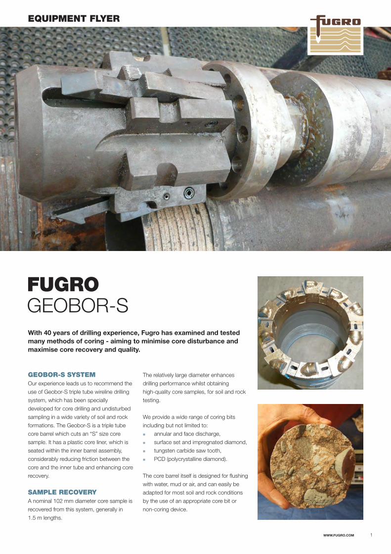
FUGRO GEOBOR-S With 40 years of drilling experience, Fugro has examined and tested many methods of coring - aiming to minimise core disturbance and maximise core recovery and quality.
GEOBOR-S SYSTEMOur experience leads us to recommend the
use of Geobor-S triple tube wireline drilling
system, which has been specially
developed for core drilling and undisturbed
sampling in a wide variety of soil and rock
formations. The Geobor-S is a triple tube
core barrel which cuts an “S” size core
sample. It has a plastic core liner, which is
seated within the inner barrel assembly,
considerably reducing friction between the
core and the inner tube and enhancing core
recovery.
SAMPLE RECOVERYA nominal 102 mm diameter core sample is
recovered from this system, generally in
1.5 m lengths.
EQUIPMENT FLYER
The relatively large diameter enhances
drilling performance whilst obtaining
high-quality core samples, for soil and rock
testing.
We provide a wide range of coring bits
including but not limited to:
�� annular and face discharge,
�� surface set and impregnated diamond,
�� tungsten carbide saw tooth,
�� PCD (polycrystalline diamond).
The core barrel itself is designed for flushing
with water, mud or air, and can easily be
adapted for most soil and rock conditions
by the use of an appropriate core bit or
non-coring device.
WWW.FUGRO.COM 1

EQUIPMENT FLYER
CORE LINERThe core liner is a rigid, transparent PVC
tube with a wall thickness of approximately
1 mm that fits snugly inside the Geobor-S
core barrel inner tube, trimmed to 1.5 m
lengths. This is provided for all coring
works.
The core samples are recovered within the
core liner tube and removed from the inner
barrel between each consecutive run. The
sample can be retained within the core liner
tube sealed at both ends and placed into
the core box. This minimises handling
induced core disturbance, both on the drill
deck and during subsequent transport of
the core sample to the onshore core store
and testing laboratories.
From our experience, the combination of
the Geobor-S system used with core liners:
�� reduces coring and transport induced
disturbance,
�� maintains sample quality,
�� significantly enhances recovery
especially in mixed formations.
Furthermore, we monitor the effectiveness
of the various bit types throughout drilling,
selecting bits appropriate to varying ground
conditions as each borehole progresses.
This allows us to maximise core quality and
recovery in an appropriate and cost
effective manner.
Four methods can be used to suit varying
ground conditions:
1. In medium to hard formations, many
types of core bits can be used
depending on the formation.
2. For coring in soft soil formations,
TC-set bits are used and the bit
consists of two parts (pilot and
reamer).
3. For coring in very soft or loose
formations, TC-set bits are used. The
bit is in two parts as in method two but
one core lifter is extended to run 25
mm in front of the bit.
4. For coring in very soft, loose
formations with varying layers. The
spring-loaded inner tube assembly is
extended to run in front of the bit, but
is retractable for optimised adaptation
to the consistency and density of the
ground.
Geobor-S Core Liner.
WWW.FUGRO.COM 2
Technical Specifications Metric Imperial
Hole diameter, method 1 & 4: 146.0 mm 5.75 inHole diameter, method 2 & 3: 150.0 mm 5.90 inDrill bit outer diameter: 145.6 / 149.6 mm 5.73 / 5.90 inDrill rod outer diameter: 139.7 mm 5.58 inBit kerf, method 1: 21.8 mm 0.86 inBit kerf, method 2 & 3: 23.8 mm 0.94 inCore diameter: 102.0 mm 4.05 inHole area (od 146/150): 167.3 / 176.7 cm² 26.0 / 27.4 in²Core area: 81.7 cm² 12.7 in²Cutting area in % of hole area: 51.7 % 51.7 %
OTHER ADVANTAGESThe advantages of wireline coring over
conventional coring (using drill rods and
core barrels) include:
�� Separate temporary lining casing for
borehole stabilisation may not be
required.
�� The drill string is more rigid.
�� The core barrel may be recovered
without removing the outer drill rod,
thus reducing disturbance to the
borehole wall.
�� The small annulus between the drill
pipe and borehole wall requires
significantly lower volumes of flush fluid
compared to conventional drilling to
achieve adequate uphole velocity for
removal of cuttings from the hole. As a
consequence, erosion of the formation
(particulary at the bit face) is reduced.
© FU
GR
O 12 2016/FG
SL-FA
L/GE
OB
R
WWW.FUGRO.COM
Related Documents


