NHDPlus: NHDPlus: A Big PLUS for User A Big PLUS for User Applications Applications ESRI User Conference - ESRI User Conference - July 24, 2005 July 24, 2005 The NHDPlus Team The NHDPlus Team Horizon Horizon Systems Systems Corporatio Corporatio n Sponsored Sponsored by by US EPA US EPA

NHDPlus: A Big PLUS for User Applications ESRI User Conference - July 24, 2005 The NHDPlus Team HorizonSystemsCorporation…
Jan 20, 2018
Our Agenda What is NHDPlus? Data to Support Analysis & Modeling Data to Support Analysis & Modeling Data Availability Data Availability Applications – Just a Start Wrapup Questions
Welcome message from author
This document is posted to help you gain knowledge. Please leave a comment to let me know what you think about it! Share it to your friends and learn new things together.
Transcript
NHDPlus: NHDPlus: A Big PLUS for User A Big PLUS for User
ApplicationsApplicationsESRI User Conference - ESRI User Conference - July 24, 2005July 24, 2005
The NHDPlus TeamThe NHDPlus Team
Horizon Horizon Systems Systems
CorporationCorporation
Sponsored Sponsored byby
US EPAUS EPA

The NHDPlus TeamThe NHDPlus TeamEPA Project LeadTommy Dewald
Horizon Systems
Cindy McKay
Jen Hill
Bob Deffenbaugh
USGS WRD
Rich Moore
Craig Johnston
Al Rea
RTI International.
Tim Bondelid

NHD Plus – What is it?NHD Plus – What is it? Greatly Improved 1:100K NHDGreatly Improved 1:100K NHD A Set of Value Added AttributesA Set of Value Added Attributes Elevation-based Catchment for Each Elevation-based Catchment for Each
Segment in the Stream NetworkSegment in the Stream Network Catchment CharacteristicsCatchment Characteristics Flow Direction and Flow Accumulation GridsFlow Direction and Flow Accumulation Grids NHD Network Node ElevationsNHD Network Node Elevations Stream Gages Linked to Stream NetworkStream Gages Linked to Stream Network Flow Volume & Velocity Estimates for Each Flow Volume & Velocity Estimates for Each
Segment in the Stream NetworkSegment in the Stream Network

1:100K NHD Improvements1:100K NHD Improvements
Stream and waterbody name corrections Stream and waterbody name corrections and additionsand additions
Correction to stream network coordinate Correction to stream network coordinate order (pointing downstream)order (pointing downstream)
Correction of gaps, overlaps, overshoots, Correction of gaps, overlaps, overshoots, etc. in network geometryetc. in network geometry
Independent QAQC of flow table.Independent QAQC of flow table. Flow table and geometry agree.Flow table and geometry agree.
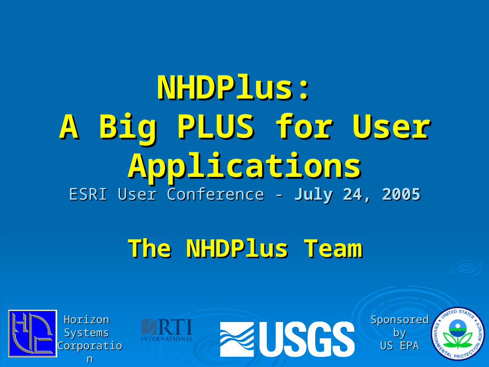
The Value-Added Attributes:The Value-Added Attributes:
A set of two dozen network characteristicsA set of two dozen network characteristics Based solely on native NHD contentBased solely on native NHD content Created with softwareCreated with software Built using the national NHDBuilt using the national NHD Provides alternatives to navigating with the Provides alternatives to navigating with the
geometrygeometry

Display•Generalization Attribute
•Stream Order•Waterbody Identifier
•Waterbody Type•Upstream Miles•Distance to Sink
NavigationAnalysis
Value Added Attributes
•Stream Order•Waterbody Identifier
•Waterbody Type•Upstream Miles•Distance to Sink
•Drain Stream Level •Link-Node Traversal•Hydrologic Sequence•Terminal Identifiers•Level Path Identifiers•Independent Flow Table
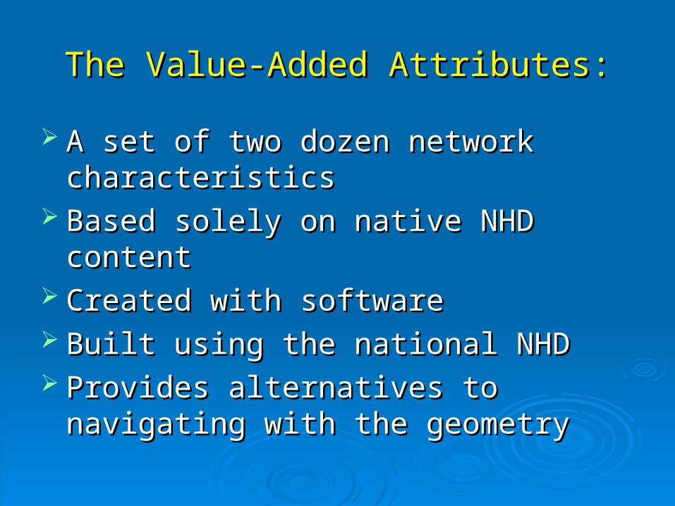
Simple Query Network NavigationSimple Query Network Navigation
A Series of Attributes Computed From the Flow Table and the Geometry
Once Computed, Independent of Geometry and GIS
Navigate with SQL Query

VAAs Help with NHD DisplaysVAAs Help with NHD Displays
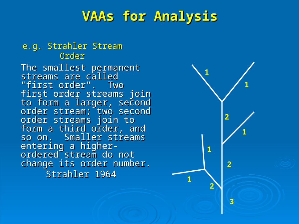
e.g. Strahler Stream Ordere.g. Strahler Stream Order
The smallest permanent The smallest permanent streams are called "first streams are called "first order". Two first order order". Two first order streams join to form a larger, streams join to form a larger, second order stream; two second order stream; two second order streams join to second order streams join to form a third order, and so on. form a third order, and so on. Smaller streams entering a Smaller streams entering a higher-ordered stream do not higher-ordered stream do not change its order number.change its order number.
Strahler 1964Strahler 1964
11
2
1
2
1
1
2
3
VAAs for AnalysisVAAs for Analysis

CatchmentsCatchments
The portion of the land surface that The portion of the land surface that drains to a network segmentdrains to a network segment
Catchments built using 30m National Catchments built using 30m National Elevation Dataset (NED)Elevation Dataset (NED)
Generated using the “New England Generated using the “New England Method” (with AGREE.AML)Method” (with AGREE.AML)
Outputs include catchments in grid Outputs include catchments in grid format and as polygonsformat and as polygons
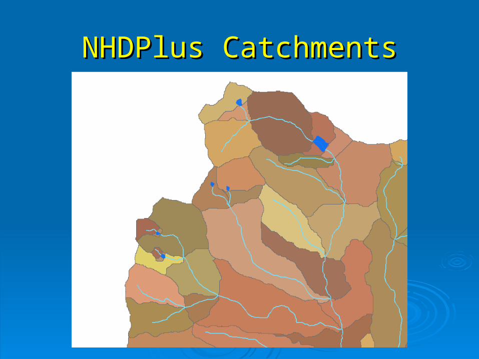
NHDPlus CatchmentsNHDPlus Catchments

NHDPlus CatchmentsNHDPlus Catchments Production status 7/8/05 – 2,161,911 catchments and counting

International Catchment AreasInternational Catchment Areas
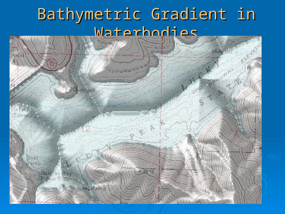
Bathymetric Gradient in WaterbodiesBathymetric Gradient in Waterbodies
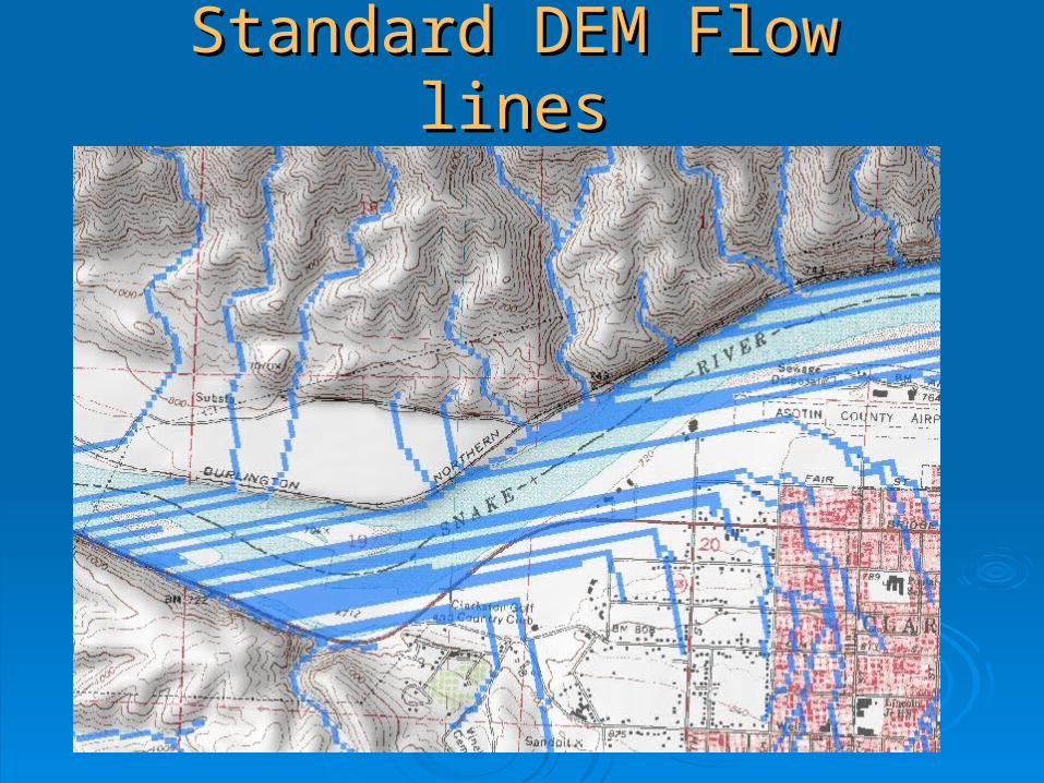
Standard DEM Flow linesStandard DEM Flow lines
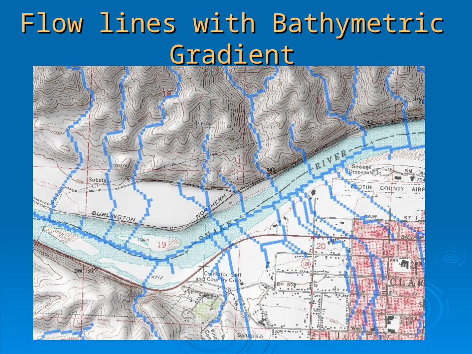
Flow lines with Bathymetric GradientFlow lines with Bathymetric Gradient
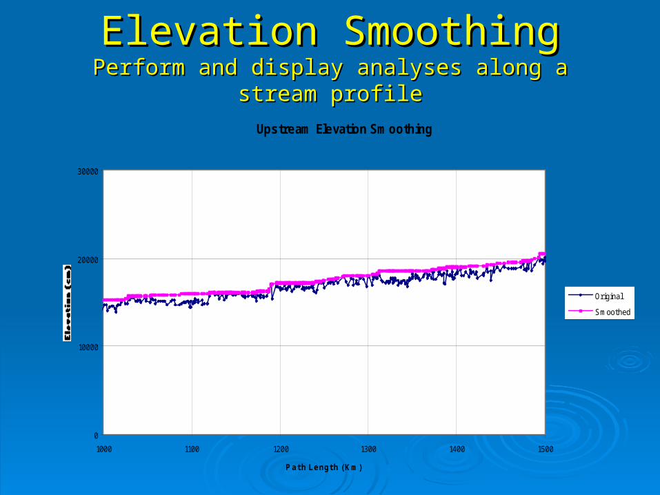
Elevation SmoothingElevation SmoothingPerform and display analyses along a stream profilePerform and display analyses along a stream profile
Upstream Elevation Smoothing
0
10000
20000
30000
1000 1100 1200 1300 1400 1500
Path Length (Km)
OriginalSmoothed

Flow EstimatesFlow EstimatesUnit Runoff MethodUnit Runoff Method
Estimate average annual unit runoff by 8-Estimate average annual unit runoff by 8-digit HUC (sub-basin)digit HUC (sub-basin)
Estimate Drainage Area (DA) for Each NHD Estimate Drainage Area (DA) for Each NHD segmentsegment
Route and accumulate incremental flows to Route and accumulate incremental flows to estimate mean annual flow by segmentestimate mean annual flow by segment

Flow estimates developed using mean Flow estimates developed using mean annual flows at HCDN gagesannual flows at HCDN gages
Multiple regression technique with Multiple regression technique with coefficients by hydrologic regioncoefficients by hydrologic region
NHD Plus implementation uses catchment-NHD Plus implementation uses catchment-based DA’s, PRISM data overlaid on based DA’s, PRISM data overlaid on catchmentscatchments
Flow EstimatesFlow EstimatesVogel, et al MethodVogel, et al Method

Cumulative Drainage AreaCumulative Drainage AreaReg 17 DA QA
0
100000
200000
300000
400000
500000
600000
700000
0 100000 200000 300000 400000 500000 600000 700000
Gage DA (sq km)
NH
D D
A (s
q km
)
Snake River

Flow Estimates Vs Gage Flow
0
5000
10000
15000
20000
25000
30000
35000
40000
45000
50000
0 5000 10000 15000 20000 25000 30000 35000 40000 45000 50000
Gage Flow (cfs)
NH
D F
low
(cfs
)
quromqvogel
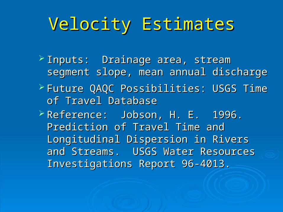
Velocity EstimatesVelocity Estimates
Inputs: Drainage area, stream segment Inputs: Drainage area, stream segment slope, mean annual dischargeslope, mean annual discharge
Future QAQC Possibilities: USGS Time of Future QAQC Possibilities: USGS Time of Travel DatabaseTravel Database
Reference: Jobson, H. E. 1996. Prediction Reference: Jobson, H. E. 1996. Prediction of Travel Time and Longitudinal Dispersion of Travel Time and Longitudinal Dispersion in Rivers and Streams. USGS Water in Rivers and Streams. USGS Water Resources Investigations Report 96-4013.Resources Investigations Report 96-4013.

NHDPlus Applications - Some NHDPlus Applications - Some ExamplesExamples
Some of these are “Right out of the box”Some of these are “Right out of the box” Some are simple ArcView OperationsSome are simple ArcView Operations Some require programmingSome require programming
Within a database environmentWithin a database environment The programming is not complex or lengthyThe programming is not complex or lengthy
Analyses can go back and forth between catchments Analyses can go back and forth between catchments and the flow networkand the flow network
For many applications, building the front end user For many applications, building the front end user interface is probably more work than the actual interface is probably more work than the actual application buildingapplication building

Quad Density Artifacts in NHDQuad Density Artifacts in NHD
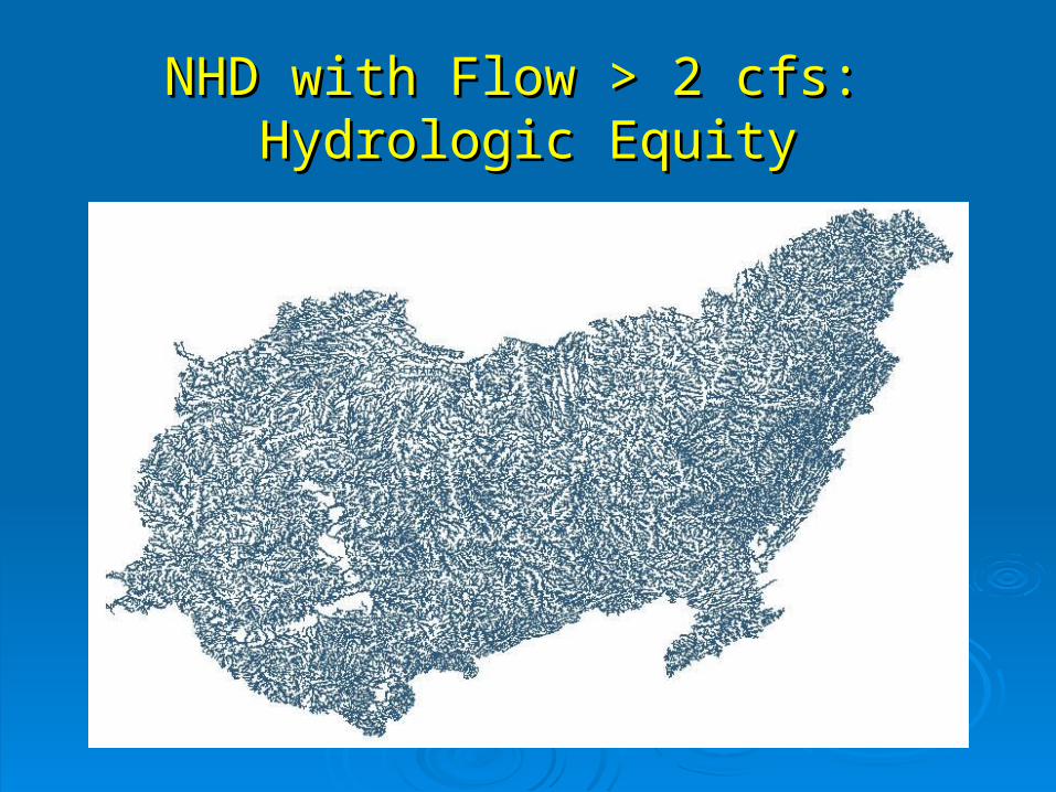
NHD with Flow > 2 cfs: NHD with Flow > 2 cfs: Hydrologic EquityHydrologic Equity

Cincinnati “Area of Influence”: The Cincinnati “Area of Influence”: The Watershed that is 3 Days Time of Watershed that is 3 Days Time of
Travel UpstreamTravel Upstream

Simple Dilution and Decay ModelSimple Dilution and Decay ModelConcentration Profile
0
50
100
150
200
250
300
207520802085209020952100
Pathlength
Con
c (m
g/l)
C_nodecayC_decay

SPARROW Model Results:
Predicted Total Nitrogen Catchment Yield
Contributions to Total Nitrogenfrom each source
Atmospheric Developed
Agriculture Point Source
=+
+ +
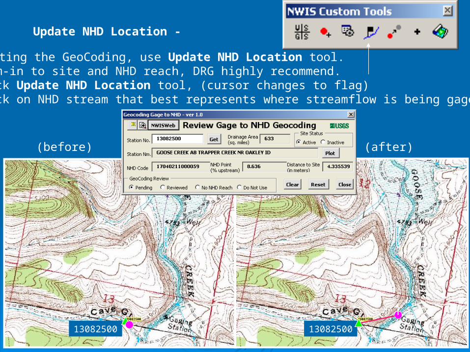
Correcting the GeoCoding, use Update NHD Location tool.1) Zoom-in to site and NHD reach, DRG highly recommend.2) Click Update NHD Location tool, (cursor changes to flag)3) Click on NHD stream that best represents where streamflow is being gaged
(before) (after)
13082500 13082500
Update NHD Location -
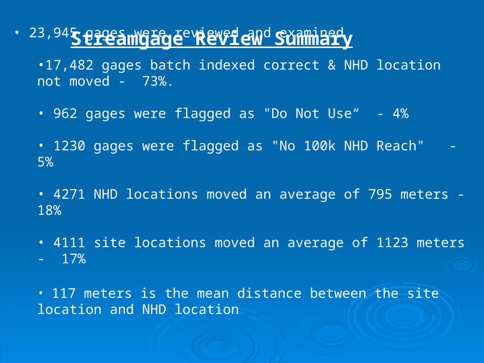
• 23,945 gages were reviewed and examined
•17,482 gages batch indexed correct & NHD location not moved - 73%. • 962 gages were flagged as "Do Not Use“ - 4%
• 1230 gages were flagged as "No 100k NHD Reach" - 5%
• 4271 NHD locations moved an average of 795 meters - 18%
• 4111 site locations moved an average of 1123 meters - 17%
• 117 meters is the mean distance between the site location and NHD location
Streamgage Review Summary

Wrapup - Importance of the VAAsWrapup - Importance of the VAAs Easier answers to network questionsEasier answers to network questions Fast, simple, reliable network navigationFast, simple, reliable network navigation
Fast, sequential routingFast, sequential routing Simple SQL queriesSimple SQL queries Link Node routingLink Node routing
Provide some commonly used attributesProvide some commonly used attributes Stream OrderStream Order Hydrologic SequenceHydrologic Sequence Stream Path IdentifierStream Path Identifier
Establish the integrity of the networkEstablish the integrity of the network

For More Information:For More Information:
NHD Sessions I and II Tuesday AMNHD Sessions I and II Tuesday AMRoom 25-C (SDCC)Room 25-C (SDCC)
NHD User Group Meeting Wed 12:15—NHD User Group Meeting Wed 12:15—1:15 Room 30-B (SDCC)1:15 Room 30-B (SDCC)
Contacts:Contacts:
Tommy Dewald Tommy Dewald [email protected]
Cindy McKay [email protected]
Tim Bondelid [email protected] Rich Moore [email protected] Craig Johnston [email protected] Al Rea [email protected]

20
NHDPlus Production UnitsNHDPlus Production Units
(Targeted Completion Dec, 2005)(Targeted Completion Dec, 2005)
Related Documents