NEWSC STORMWATER REFERENCE GUIDE FOR THE: POST-CONSTRUCTION STORMWATER MANAGEMENT ORDINANCE PREPARED BY: NEWSC STORMWATER & EROSION CONTROL COMMITTEE PREPARED FOR: NEWSC MEMBERSHIP DATE: August 15, 2007

Welcome message from author
This document is posted to help you gain knowledge. Please leave a comment to let me know what you think about it! Share it to your friends and learn new things together.
Transcript

NEWSC STORMWATER REFERENCE GUIDE
FOR THE:
POST-CONSTRUCTION STORMWATER MANAGEMENT ORDINANCE
PREPARED BY: NEWSC STORMWATER & EROSION CONTROL COMMITTEE
PREPARED FOR:
NEWSC MEMBERSHIP
DATE: August 15, 2007

TABLE OF CONTENTS EXECUTIVE SUMMARY.................................................................................................................................................... 3
S.01 AUTHORITY ............................................................................................................................................................... 4
S.02 FINDINGS OF FACT ................................................................................................................................................. 4
S.03 PURPOSE AND INTENT .......................................................................................................................................... 4
(1) PURPOSE............................................................................................................................................................ 4 (2) INTENT ................................................................................................................................................................. 4
S.04 APPLICABILITY AND JURISDICTION .................................................................................................................. 4
(1) APPLICABILITY .................................................................................................................................................. 4 (2) JURISDICTION ................................................................................................................................................... 4 (3) EXCLUSIONS ..................................................................................................................................................... 4
S.05 DEFINITIONS ............................................................................................................................................................. 4
S.06 TECHNICAL STANDARDS ..................................................................................................................................... 4
S.07 PERFORMANCE STANDARDS ........................................................................................................................... 11
(1) RESPONSIBLE PARTY ................................................................................................................................... 11 (2) PLAN................................................................................................................................................................... 11 (3) REQUIREMENTS ............................................................................................................................................. 11 (4) CONSIDERATIONS FOR ONSITE / OFFSITE STORMWATER MANAGEMENT MEASURES ........... 28 (5) LOCATION AND REGIONAL TREATMENT OPTION ................................................................................. 29 (6) ALTERNATE REQUIREMENTS ..................................................................................................................... 30
S.08 PERMITTING REQUIREMENTS, PROCEDURES AND FEES ........................................................................ 30
(1) PERMIT REQUIRED ........................................................................................................................................ 30 (2) PERMIT APPLICATION AND FEES .............................................................................................................. 30 (3) REVIEW AND APPROVAL OF PERMIT APPLICATION ............................................................................. 30 (4) PERMIT REQUIREMENTS ............................................................................................................................. 30 (5) PERMIT CONDITIONS .................................................................................................................................... 30 (6) PERMIT DURATION ........................................................................................................................................ 30 (7) ALTERNATE REQUIREMENTS ..................................................................................................................... 30
S.09 STORMWATER MANAGEMENT PLAN .............................................................................................................. 32
(1) PLAN REQUIREMENTS .................................................................................................................................. 32 (2) ALTERNATE REQUIREMENTS ..................................................................................................................... 33
S.10 MAINTENANCE AGREEMENT ............................................................................................................................. 34
(1) MAINTENANCE AGREEMENT REQUIRED ................................................................................................ 34 (2) AGREEMENT PROVISIONS .......................................................................................................................... 34 (3) ALTERNATE REQUIREMENTS ..................................................................................................................... 34
S.11 FINANCIAL GUARANTEE ..................................................................................................................................... 34
(1) ESTABLISHMENT OF GUARANTEE ............................................................................................................ 34 (2) CONDITIONS FOR RELEASE ........................................................................................................................ 34 (3) ALTERNATE REQUIREMENTS ..................................................................................................................... 34
S.12 FEE SCHEDULE ...................................................................................................................................................... 34
S.13 ENFORCEMENT ...................................................................................................................................................... 34
S.14 APPEALS .................................................................................................................................................................. 34
(1) BOARD OF APPEALS OR ADJUSTMENT ................................................................................................... 34 (2) WHO MAY APPEAL ......................................................................................................................................... 34
S.15 SEVERABILITY ....................................................................................................................................................... 34
S.16 EFFECTIVE DATE ................................................................................................................................................... 35

EXECUTIVE SUMMARY The NEWSC Stormwater Reference Guide (Reference Guide) has been created to act as a companion to the NEWSC Model Post-Construction Stormwater Management Ordinance (Ordinance). The Ordinance cites the Reference Guide as the resource for details that were omitted from the model Ordinance due to the potential for variations in each municipality’s permitting process and level of expertise in regard to the Ordinance. Items in the Reference Guide can be changed without the public hearing process as the changes are typically administrative and/or technical and do not affect the Ordinance’s intent and requirements. The Reference Guide is organized similar to the Post-Construction Stormwater Management Ordinance for ease of relating the comments in the Reference Guide to the appropriate sections in the ordinance.
Post-Construction Stormwater Management Ordinance
Site
Requirements a
Sediment (TSS)
Peak Discharge
Infiltration Protective Area
Fueling & Vehicle
Maintenance Areas Residential Non-
Residential < 20,000 ft2
Impervious Surface b No Numeric
Standard No Numeric
Standard No Numeric
Standard No Numeric
Standard Width Varies
No Visible Petroleum
Sheen
> 20
,000
ft2
Impe
rvio
us S
urfa
ce
New Development 80% 2/10/100
90% of pre-development
infiltration volume
60% of pre-development
infiltration volume
Width Varies
No Visible Petroleum
Sheen
Redevelopment 40% 2/10/100 Exempt Exempt Potentially Exempt
No Visible Petroleum
Sheen Routine
Maintenance Area
None, unless discharging into a BMP
None, unless discharging into a BMP
Exempt Exempt Potentially Exempt
No Visible Petroleum
Sheen
Transportation Facilities c
-Carry runoff through a grass swale a minimum of 200 feet long. -Velocity in grass swale < 1.5 ft/s for the 2-yr, 24- hour storm peak discharge.
a Summary of Section S.07 Performance Standards of the Post-Construction Stormwater Management Zoning Ordinance. See Ordinance and this Reference Guide for specific requirements, exemptions and prohibitions.
b The impervious surface areas created after the adoption date of the Ordinance are cumulative. For example, if a site first adds 18,000 ft2 of parking and then adds a 2,001 ft2 building the following year, the site is held to the >20,000 ft2 requirements at that time.
c Provides alternative criteria for transportation facilities with grass swale drainage systems. The alternative criteria may be used by the applicant to satisfy Section S.07 Performance Standards. The alternative criteria may not be used for transportation facilities that are part of a larger common plan of development.
NEWSC POST-CONSTRUCTION August 15, 2007 STORMWATER MANAGEMENT ORDINANCE REFERENCE GUIDE
Page 4 of 35
S.01 AUTHORITY S.02 FINDINGS OF FACT S.03 PURPOSE AND INTENT
(1) PURPOSE
(2) INTENT
S.04 APPLICABILITY AND JURISDICTION
(1) APPLICABILITY
(2) JURISDICTION
(3) EXCLUSIONS
The Wisconsin Department of Transportation (WisDOT) has entered into a memorandum of understanding with the Wisconsin Department of Natural Resources that satisfies s. 281.33 (2), Wis. Stats., such that activities directed and supervised by WisDOT are exempt from this Ordinance. Activities directed and supervised by the local municipality are covered by this Ordinance.
S.05 DEFINITIONS
“Biofiltration system” means a bioretention system which does not qualify for any infiltration credit pursuant to S.07(3)(c) of the Post-Construction Stormwater Management Ordinance. “Structural height” means the difference in elevation in feet between the point of lowest elevation of the top of the embankment before overtopping and the lowest elevation of the downstream toe of embankment.
S.06 TECHNICAL STANDARDS
Below is a list of Technical Standards and Guidance Documents that shall be used to satisfy Performance Standards contained in the ordinance. Technical Standards specify the minimum criteria for a best management practice (BMP). Guidance Documents contain recommendations and additional “how to” guidance. Performance Standards take precedence over Technical Standards and Technical Standards take precedence over Guidance Documents.
(a) Technical Standards: The following are applicable Wisconsin Department of Natural
Resources (DNR) Conservation Practice Standards or Technical Standards:
1001 Wet Detention Basin 1002 Site Evaluation for Stormwater Infiltration 1003 Infiltration Basin 1004 Bioretention For Infiltration 1005 Vegetated Infiltration Swale 1006 Method for Predicting the Efficiency of Proprietary Storm Water
Sedimentation Devices 1100 Interim Turf Nutrient Management
These standards may be found on the DNR website at http://dnr.wi.gov/org/water/wm/nps/stormwater/techstds.htm

NEWSC POST-CONSTRUCTION August 15, 2007 STORMWATER MANAGEMENT ORDINANCE REFERENCE GUIDE
Page 5 of 35
(b) Local Modifications to Technical Standards: The following are local requirements which
are intended to supplement, clarify, or supersede DNR Technical Standards.
1001 - Wet Detention Basin
Dry Detention Basin-
• Dry detention ponds shall be designed to meet requirements in Technical Standard 1001, except criteria contained in Sections V.A.2, V.B., and V.C.
• Dry detention ponds shall be designed to meet the local modifications provided below for Technical Standard 1001, except permanent pool and extended detention volume criteria.
• Dry detention ponds shall not receive any water quality or TSS credit, unless written approval is obtained from the DNR. The approval letter must specifically indicate the amount of TSS credit provided by the dry pond.
• Dry detention pond shall have a minimum bottom slope to the principal outlet of 1%. The applicant may request a waiver if site characteristics create a hardship.
• As part of the Operation & Maintenance Plan, sediment accumulation in the dry pond shall be monitored. Accumulated sediment shall be removed when 5% to 10% of the storage volume is lost for the 2-year, 24-hour design storm.
Pond Watershed-
• Wet ponds are not recommended for small watersheds (< 15 acres in clay soil). A wet pond located in a small watershed may develop stagnation problems and become a public nuisance. Public acceptance of stormwater BMPs is important to the success of a local stormwater program. Dry ponds, biofiltration, proprietary devices, and other BMPs are recommended for small watersheds.
100-Year Floodplain-
• Wet and dry detention ponds shall not be located in a 100-year floodway or 100-year flood storage area unless a hydrologic and hydraulic study is conducted in accordance with NR 116. Easements will be required if the flood study indicates the 100-year floodway or flood storage area is impacted by the pond or its embankment. Ponds shall not impede 100-year flood conveyance along navigable streams and non-navigable channels.
Permanent Pool-
• Pool Shape- A minimum length to width ratio of 3:1 is required between the principal inlet and principal outlet. The applicant may request a waiver if site characteristics create a hardship. Redevelopment and pond retrofit projects may be eligible for a waiver. Typically, new development is not eligible for a waiver.
• Liner- If soils are more permeable than a saturated hydraulic conductivity of 1x10⁻⁵ cm/sec, a liner is needed to maintain permanent pool levels. If soils are tighter than a saturated hydraulic conductivity of 1x10⁻⁷ cm/sec, no liner is needed (e.g. sandy clay loam, clay loam, silty clay loam, sandy clay, silty clay, or clay). A risk analysis shall be conducted if soils are between a saturated hydraulic conductivity of 1x10⁻⁵ cm/sec and 1x10⁻⁷ cm/sec. The risk analysis shall include proximity to public wells (400 ft) and private wells (100 ft), depth to groundwater and bedrock, and source pollutants (Tier 1 & Tier 2 Industries, fueling & maintenance areas). Liner materials can be soil, bentonite or synthetic.

NEWSC POST-CONSTRUCTION August 15, 2007 STORMWATER MANAGEMENT ORDINANCE REFERENCE GUIDE
Page 6 of 35
• Aerators- Generally, aerators are not allowed unless written approval is obtained from the Wisconsin DNR. The approval letter must specifically state the proposed aerators are acceptable.
Extended Detention Volume-
• Disregard Section V.A.2.b(2) of Technical Standard 1001. If the wet pond’s pollutant removal is not determined with SLAMM or P8, the 1-year, 24-hour design storm shall be released from the wet pond using the following formula:
Qoutflow = Vs * SA
Qoutflow = maximum allowable 1-year discharge rate (cfs) Vs = 5.12 x 10⁻⁵ ft/sec settling velocity SA = surface area of permanent pool (square feet)
Peak Flow Control-
• Do not use Table 2 in Technical Standard 1001. Use the maximum pre-development runoff curve numbers contained in the Post-Construction Stormwater Management Ordinance.
• It is recommended that the developer and designer contact the local municipality to discuss peak discharge requirements for the site early in the design process. The local municipality may have adopted alternative peak discharge requirements for the site which are different than the Post-Construction Stormwater Management Ordinance. At a minimum, the peak discharge requirements contained in NR 151 shall be met.
Inflows-
• Pipe inlets shall be protected from soil washouts due to seepage along the pipe’s granular bedding and backfill. Rip-rap or other protection shall be placed around the entire pipe perimeter.
• Other inflow points shall be protected from scour and erosion.
Principal Outlet-
• All flows shall pass through the principal outlet during the 2-year and 10-year, 24-hour design storms. The principal outlet shall consist of one or more flow control structures and discharge pipes.
• Pipes- Generally concrete, PVC, or CMP are the preferred pipe materials. Corrugated PE will tend to jack-up due to frost heave and flotation. The minimum recommended pipe diameter is 12-inches.
• Orifices- Orifices smaller than 4 inches are not recommended due to the potential for clogging. Consider using a 6-inch perforated drain pipe and restrictor plate (refer to Section V.B.8 of Technical Standard 1004 for guidance). The total opening area of all perforation holes combined shall be sufficient to allow the drain pipe to discharge at full capacity, as would occur if there were no orifice restriction. Backfilling the drain pipe with 1-inched washed stone provides protection from clogging.
• Trash racks or other equivalent litter control devices are required for all outlet openings that control the 2-year, 24-hour design storm. The maximum bar spacing shall be less than 2-inches and less than ½ the smallest opening dimension, whichever is more restrictive. The minimum surface area for the trash rack shall be 5 to 10 times the outlet’s cross sectional area to prevent

NEWSC POST-CONSTRUCTION August 15, 2007 STORMWATER MANAGEMENT ORDINANCE REFERENCE GUIDE
Page 7 of 35
clogging. Trash racks keep litter and debris in the pond and prevent it from discharging into streams, rivers, and lakes.
• Trash racks are also required for other outlet openings that have a width, height, or diameter less than 12-inches. The maximum bar spacing shall be less than ½ the smallest opening dimension. The minimum surface area for the trash rack shall be at 5 to 10 times the outlet’s cross sectional area to prevent clogging.
• Reverse-sloped pipes and other underwater outlets may impact a wet pond’s TSS removal efficiency. Outlets that draw water from below the permanent pool’s surface elevation reduce the effective surface area and depth of the permanent pool. If reverse-sloped pipes and other underwater outlets are used, special consideration is required for SLAMM & P8 modeling to ensure accurate water quality results. Also, underwater outlets may freeze during winter.
Flap Gates-
• Flap gates are required if the 2-year or 10-year, 24-hour design storm flows backward through the principal outlet. Backwater from a down slope conveyance system may impact a pond’s water quality and/or flood control performance.
• Flap gates are not required if the permanent pool’s water surface elevation is higher than the 10-year water elevation at the pond outlet (i.e. tailwater).
• Flap gates may be required if the permanent pool’s water surface elevation is lower than the 10-year water elevation at the pond outlet (i.e. tailwater). If hydrographs are available for the tailwater condition, an evaluation can be performed to determine if flap gates are required due to backwater. If hydrographs are not available, flap gates are required.
• Flap gates shall not impede flow in down slope channels or streams.
• Ice accumulation within the down slope conveyance system shall be considered during flap gate and principal outlet design.
Tailwater-
• Tailwater conditions shall be evaluated at the pond outlet.
• Tailwater conditions along lakes, rivers, and streams may be obtained from available 100-year floodplain studies.
• Tailwater conditions may require that 2, 10, and/or 100-year, 24-hour runoff volumes be held in the pond, without release, until the down slope hydrograph allows the pond and flap gate to discharge flow.
• It is recommended that the designer contact the local municipality to discuss tailwater conditions early in the design process. The local municipality may have information available to assist with the tailwater evaluation.
Emergency Spillway-
• The routed 2-year and 10-year, 24-hour design storm may not pass through the emergency spillway. The routed 100-year, 24-hour design storm may not pass through the emergency spillway if the pond is designed to have a:
Structural height > 6 feet and flood storage capacity > 50 acre-feet, or Structural height > 25 feet and flood storage capacity > 15 acre-feet.
• Backwater from a down slope conveyance system may not pass through the emergency spillway during the 2-year or 10-year, 24-hour design storm. Also, backwater may not pass through the emergency spillway during the 100-year,

NEWSC POST-CONSTRUCTION August 15, 2007 STORMWATER MANAGEMENT ORDINANCE REFERENCE GUIDE
Page 8 of 35
24-hour design storm, unless a hydrologic and hydraulic evaluation indicates the site’s peak discharge requirements are still satisfied, despite the backwater.
• When feasible, the emergency spillway should not be constructed on an embankment or over fill material. Spillways constructed on an embankment or over fill material are more prone to failure.
• The emergency spillway shall be constructed of permanent materials (i.e. poured concrete, grouted riprap, articulated concrete block, etc.) if the spillway is constructed on an embankment. The permanent material shall extend from the top of embankment to the down slope toe of embankment. The permanent material shall be shaped to contain flows and reduce potential for erosion and embankment failure.
Topsoil & Seeding-
• Topsoil is required in the safety shelf to encourage wetland plant growth (12-inch minimum thickness).
• When feasible, install a wetland seed mix or mature plants in the safety shelf to improve pond safety, reduce wave erosion along the shoreline, improve pollutant removal, and discourage geese residence. Use non-invasive species.
• When feasible, maintain a high grass buffer around the permanent pool’s perimeter. The high grass buffer will further improve pond safety and geese control. Also, the perimeter of the permanent pool is typically the most difficult area to mow due to saturated soil conditions.
Record Drawings-
• Surveyed record drawings certified by a Professional Engineer shall be submitted upon completion of construction of all wet and dry ponds. As part of the record drawings, the Professional Engineer may need to verify BMP performance using computer modeling. Refer to record drawing checklist for requirements.
1002 - Site Evaluation for Stormwater Infiltration
• A site layout should not be developed until Step B is complete. Information obtained from Step B is used to:
Identify soil textures within the site. Identify infiltration exclusions and exemptions. Develop a site layout and identify potential infiltration device locations.
• For Step B, the minimum number of initial test pits or soil borings required for a new development area are as follows:
Two for the initial 10 acres, plus one per 10 acres thereafter. One per soil unit. Soil units are depicted on NRCS Soil Survey Maps. Example calculations:
o 4 acres with 1 soil unit = min. of 2 test pits or soil borings o 20 acres with 2 soil units = min. of 3 test pits or soil borings. o 20 acres with 5 soil units = min. of 5 test pits or soil borings. o 34 acres with 3 soil units = min. of 4 test pits or soil borings.
• Upon completion of Step B, it is recommended that the developer and designer meet with the municipality to discuss infiltration requirements for the development to avoid redesign during permit submittal.
• Information obtained from Step C is used to design each infiltration device. As part of Step C, a second set of test pits or soil borings are required. Refer to Table 1, Technical Standard 1002 for test pit or soil boring requirements.

NEWSC POST-CONSTRUCTION August 15, 2007 STORMWATER MANAGEMENT ORDINANCE REFERENCE GUIDE
Page 9 of 35
1003 - Infiltration Basin
• Record Drawings- Surveyed record drawings certified by a Professional Engineer shall be submitted upon completion of construction of all infiltration basins. As part of the record drawings, the Professional Engineer may need to verify BMP performance using computer modeling. Refer to record drawing checklist for requirements.
1004 - Bioretention For Infiltration
• Biofiltration systems shall be designed to meet requirements in Technical Standard 1004, except for the storage layer and sand/native soil interface layer. Also, the engineered soil planting bed may be reduced to a 30 inch thickness.
• Rain Gardens shall be designed to meet requirements in Technical Standard 1004, except for the engineered soil planting bed, storage layer, underdrain, and sand/native soil interface layer. Rain Gardens are typically used in residential areas. Rain Gardens are primarily intended for roof runoff, but may also be used for lawn, sidewalk and driveway runoff.
• SLAMM, P8 or an equivalent methodology shall be used to evaluate the TSS reduction associated with a bioretention, biofiltration, or rain garden BMP.
• Record Drawings- Surveyed record drawings certified by a Professional Engineer shall be submitted upon completion of construction of all bioretention and biofiltration facilities. As part of the record drawings, the Professional Engineer may need to verify BMP performance using computer modeling. Also, as part of the record drawings, the contractor shall certify the bioretention or biofiltration device was constructed in accordance with the approved construction plans and that the installed engineered soil complies with the material specifications. Refer to record drawing checklist for requirements.
1005 – Vegetated Infiltration Swale
• Grass swales shall meet the following design criteria if the applicant plans to take credit for TSS reductions calculated by SLAMM or P8.
Bottom Width Trapezoid or parabolic shape with max. 6 ft width Side Slopes 4:1 or flatter for triangular shaped swales (waiver
is needed if steeper) 3:1 or flatter for trapezoidal channels (waiver is needed if steeper)
Longitudinal Slope 4% maximum (waiver is needed if steeper) Flow Velocity 1.5 fps or less for 2-year storm. The vegetation
type, mowing height, depth of flow, and O&M Plan must be consistent with the selected Manning’s ‘n’ value.
The grass swale infiltration rate used in SLAMM or P8 shall be obtained
from Table 2, Technical Standard 1002. The design infiltration rate shall be based on the most confining soil layer within 5 feet of the grass swale’s bottom elevation.
Minimum longitudinal slope for a grass swale is 1%. The applicant may request a waiver if site characteristics create a hardship.
Grass swales shall be designed for a 2-inch lawn height. If an alternative height is desired, it is recommended that the developer and designer contact the local municipality early in the design process to obtain
NEWSC POST-CONSTRUCTION August 15, 2007 STORMWATER MANAGEMENT ORDINANCE REFERENCE GUIDE
Page 10 of 35
approval. The local municipality may have ordinances or other design criteria which dictate the allowable mowing height.
Driveway culverts shall be considered when the swale length (density) is determined for purposes of SLAMM or P8 modeling. The maximum allowable culvert length for each lot shall be specified on the plans.
Minimize or mitigate soil compaction during grading activities.
Grassed swales shall be designed for the proper drainage area. Generally, it will be best to have one or two sizes to be used wherever needed throughout the development. The design shall be based on the largest drainage area served.
Grassed swales shall be designed according to the planned vegetation type and maintenance that will be provided. Generally, grassed channels will be designed to have stable velocities when the vegetation is shortest and adequate capacity when the vegetation is longest.
1006 - Method for Predicting the Efficiency of Proprietary Storm Water Sedimentation Devices
• The DNR is currently developing Technical Standard 1006 for proprietary devices. Until this Technical Standard is complete, proprietary devices shall comply with DNR guidance developed as part of the “Meeting New State Regulations: Post-Construction Stormwater Management Workshops”.
(c) Guidance Documents: The following are the applicable Guidance Documents:
• S100 Compost • Guidance for the Establishment of Protective Areas for Wetlands • “Construction Site” Definition – “Common Plan of Development” • Technical Note for Sizing Infiltration Basins and Bioretention Devices • Rain Gardens: A How-To Manual for Homeowners (see above local modifications to
Technical Standard 1004). http://clean-water.uwex.edu/pubs/home.htm#rain • Meeting New State Regulations: Post-Construction Stormwater Management Workshops
http://www.dnr.state.wi.us/org/water/wm/nps/stormwater/post-constr/index.htm • Estimating Residue Using the Line Transect Method (UW-Extension A3533). • The Wisconsin Stormwater Manual • Wisconsin Department of Transportation (DOT) - Facilities Development Manual • Wisconsin DOT Standard Specifications for Highway and Structure Construction • Other National Publications
(d) Local Easement Requirements:
• Easements are typically required for BMPs and conveyance systems that serve more
than one property owner or lot. Conveyance systems include storm sewers, grass swales, channels, streams, and overland relief paths. Easement widths will vary.
• An ingress / egress easement or direct access to a public street is typically required for BMPs that serve more than one property owner or lot.
• It is recommended that the developer and designer contact the local municipality early in the design process to discuss easements and width requirements.

NEWSC POST-CONSTRUCTION August 15, 2007 STORMWATER MANAGEMENT ORDINANCE REFERENCE GUIDE
Page 11 of 35
S.07 PERFORMANCE STANDARDS
(1) RESPONSIBLE PARTY (2) PLAN (3) REQUIREMENTS
(a) TOTAL SUSPENDED SOLIDS Post-construction sites with 20,000 sq.ft. or more of impervious surface disturbance and post-construction sites with 1 acre or more of land disturbance are required to meet the ordinance’s numeric performance standards. All other post-construction sites are not required to meet these numeric performance standards. BMP design guidance is provided below in Section (h) for sites with less than 20,000 sq.ft. of impervious surface disturbance. Computer Models: Pollutant loading models such as SLAMM, DETPOND, P8 or an approved equivalent methodology may be used to evaluate the efficiency of the design in reducing total suspended solids. Information on how to access SLAMM and P8 is available at http://dnr.wi.gov/org/water/wm/nps/models/SLAMM.htm or contact the stormwater coordinator in the runoff management section of the bureau of watershed management at (608) 267-7694. Use the most recent version of SLAMM, DETPOND and P8. The applicant may request a waiver of this requirement.
Design Clarifications: No Controls- “No Controls” is the baseline condition for each site. No TSS credit is provided for meeting the baseline condition. The baseline condition is defined as follows:
• Assume site is stabilized (no erosion). • Assume proposed impervious surfaces are in place. Impervious surface
reductions (e.g. reduced street width) can not be used to claim TSS credit; however, impervious surface reductions will lower runoff volumes which will reduce the required size for stormwater management BMPs.
• Assume no stormwater management BMPs. • Assume curb and gutter / storm sewer drainage system in fair condition. • If the applicant intends to claim TSS credit for disconnecting an
impervious surface, the “No Controls” condition shall be based on the “typical” percent connected impervious values established by the DNR:
LAND USE % CONNECTED
Open space / undeveloped 5 Suburban Residential 7 Park 10 Cemetery 12 Low Density Residential 14 Medium Density Residential – With Alley 25 Medium Density Residential – No Alley 28 Schools - Institutional 39 High Density Residential – With Alley 42 High Density Residential – No Alley 42 Mobile Home Residential 47 Freeway 51 Multi-Family Residential 51
NEWSC POST-CONSTRUCTION August 15, 2007 STORMWATER MANAGEMENT ORDINANCE REFERENCE GUIDE
Page 12 of 35
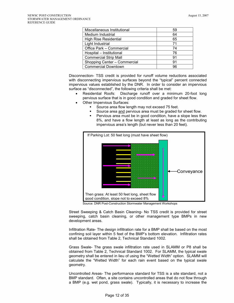
Miscellaneous Institutional 59 Medium Industrial 64 High Rise Residential 65 Light Industrial 71 Office Park – Commercial 74 Hospital – Institutional 76 Commercial Strip Mall 91 Shopping Center – Commercial 91 Commercial Downtown 96
Disconnection- TSS credit is provided for runoff volume reductions associated with disconnecting impervious surfaces beyond the “typical” percent connected impervious values established by the DNR. In order to consider an impervious surface as “disconnected”, the following criteria shall be met:
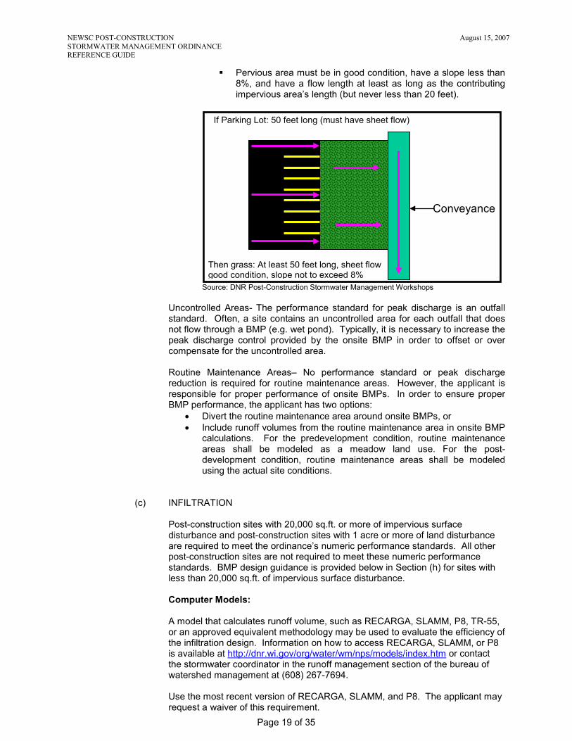
• Residential Roofs: Discharge runoff over a minimum 20-foot long pervious surface that is in good condition and graded for sheet flow.
• Other Impervious Surfaces: Source area flow length may not exceed 75 feet. Source area and pervious area must be graded for sheet flow. Pervious area must be in good condition, have a slope less than
8%, and have a flow length at least as long as the contributing impervious area’s length (but never less than 20 feet).
Source: DNR Post-Construction Stormwater Management Workshops Street Sweeping & Catch Basin Cleaning- No TSS credit is provided for street sweeping, catch basin cleaning, or other management type BMPs in new development areas. Infiltration Rate- The design infiltration rate for a BMP shall be based on the most confining soil layer within 5 feet of the BMP’s bottom elevation. Infiltration rates shall be obtained from Table 2, Technical Standard 1002. Grass Swale- The grass swale infiltration rate used in SLAMM or P8 shall be obtained from Table 2, Technical Standard 1002. For SLAMM, the typical swale geometry shall be entered in lieu of using the “Wetted Width” option. SLAMM will calculate the “Wetted Width” for each rain event based on the typical swale geometry. Uncontrolled Areas- The performance standard for TSS is a site standard, not a BMP standard. Often, a site contains uncontrolled areas that do not flow through a BMP (e.g. wet pond, grass swale). Typically, it is necessary to increase the
If Parking Lot: 50 feet long (must have sheet flow)
Conveyance
Then grass: At least 50 feet long, sheet flow good condition, slope not to exceed 8%

NEWSC POST-CONSTRUCTION August 15, 2007 STORMWATER MANAGEMENT ORDINANCE REFERENCE GUIDE
Page 13 of 35
TSS reduction provided by other onsite BMPs in order to offset or over compensate for these uncontrolled areas. Routine Maintenance Areas– No performance standard or TSS reduction is required for routine maintenance areas. However, the applicant is responsible for proper performance of onsite BMPs. In order to ensure proper BMP performance, the applicant has two options:
• Divert the routine maintenance area around onsite BMPs, or • Include runoff volumes from the routine maintenance area in onsite BMP
calculations. However, no TSS credit is provided for the routine maintenance area unless it is reclassified as redevelopment.
Offsite Drainage Areas– The applicant is not responsible for satisfying TSS performance standards for offsite areas that drain into the project site. However, the applicant is responsible for proper performance of onsite BMPs. In order to ensure proper onsite BMP performance, the applicant has two options:
• Divert offsite runoff around onsite BMPs, or • Include offsite runoff volumes in onsite BMP calculations. The amount of
onsite TSS credit is determined by multiplying the BMP’s percent TSS reduction by the base TSS load for the onsite area.
Example Calculations: The development site currently contains 30 acres of institutional land uses and 70 acres of agricultural land uses. The entire 100 acre site will be disturbed as part of the proposed project. Within the 100 acre site, the developer plans to:
• Redevelop 20 acres (existing institutional) into a new commercial area. • Conduct routine maintenance on 10 acres of existing asphalt parking lot
(existing institutional). Parking lot will be part of new commercial area. • Develop 70 acres (existing agriculture) into a new residential area.
The “No Controls” or base TSS load is computed as follows:
• Commercial area = 20 acres x 600 lbs/acre = 12,000 lbs • Residential area = 70 acres x 400 lbs/acre = 28,000 lbs • “No Controls” TSS Load = 40,000 lbs
The “TSS Reduction Required” is computed as follows:
• Commercial area = 12,000 lbs x 40% (redevelopment) = 4,800 lbs • Residential area = 28,000 lbs x 80% (new development) = 22,400 lbs • “TSS Reduction Required” = (4,800 + 22,400) / 40,000
= 0.68 or 68% A wet pond is proposed for the site. The pond achieves an 80% TSS reduction for its 130 acre watershed. The 130 acre watershed includes 20 acres of commercial area, 10 acres of commercial parking lot, 60 acres of residential area, and 40 acres of offsite residential area.
• Commercial area = 12,000 lbs x 80% (wet pond) = 9,600 lbs • Commercial parking lot = 8,000 lbs x 80% (wet pond) = 6,400 lbs • Residential area (60 acres) = 24,000 lbs x 80% (wet pond) = 19,200 lbs • Offsite residential area = 16,000 lbs x 80% (wet pond) = 12,800 lbs • Pond TSS Reduction = (9,600 + 6,400 + 19,200 + 12,800) / 60,000 = 0.80 or 80%
The “TSS Reduction Provided” is computed as follows:
• Commercial area = 12,000 lbs x 80% (wet pond) = 9,600 lbs • Residential area (60 acres) = 24,000 lbs x 80% (wet pond) = 19,200 lbs • Residential area (10 acres) = 4,000 lbs x 0% (uncontrolled) = 0 lbs • “TSS Reduction Provided” = (9,600 + 19,200 + 0) / 40,000
= 0.72 or 72%

NEWSC POST-CONSTRUCTION August 15, 2007 STORMWATER MANAGEMENT ORDINANCE REFERENCE GUIDE
Page 14 of 35
72% > 68%, therefore the TSS requirement is satisfied.
In the example, the 10 acre commercial parking lot could have been included in the “TSS Reduction Required” and “TSS Reduction Provided” calculations if it was reclassified as redevelopment, as opposed to routine maintenance. The reclassification would have allowed the applicant to plan for future reconstruction of the 10 acre commercial parking lot. In the example, the 40 acre offsite residential area could have been included in the “TSS Reduction Required” and “TSS Reduction Provided” calculations if it was a regional pond, as opposed to an onsite pond. A regional pond would have allowed the owner of the 40 acre offsite residential area to take credit for the TSS reduction provided by the wet pond.
(b) PEAK DISCHARGE
Post-construction sites with 20,000 sq.ft. or more of impervious surface disturbance and post-construction sites with 1 acre or more of land disturbance are required to meet the ordinance’s numeric performance standards. All other post-construction sites are not required to meet these numeric performance standards. BMP design guidance is provided below in Section (h) for sites with less than 20,000 sq.ft. of impervious surface disturbance. Computer Models:
Peak discharge rates shall be evaluated using TR-55 methodology and a computer model. NRCS recently released a new Windows version of TR-55 referred to as WinTR-55. Unfortunately, WinTR-55 has some unacceptable restrictions in computing Tc and the computations for outlet structures are too approximate to be useable. Therefore, WinTR-55 is not acceptable software. Other software packages are acceptable if they match the results and methodology of TR-55 (DOS version). There are multiple hydrology/pond routing computer programs available. They must be approved by the administering authority. Examples of common computer programs are HEC-HMS, XPSWMM, HydroCAD, HydraFlow, PondPack, etc. Each pre-development watershed shall be evaluated for peak discharge. It is not accurate or necessary to “link” all of the pre-development watersheds to determine the ultimate allowable discharge for the site. The allowable discharge for each outfall shall be determined based on the individual pre-development watershed as discussed more in depth below in “TR-55 Methodology Clarifications”.
TR-55 Methodology Clarifications: Time of Concentration (Tc)-
Pre-Development Requirements • The Tc route shall be the route that takes the longest time to reach
the outfall and not necessarily the furthest point in the watershed. • The Tc route shall be shown to scale on the pre-development
contours with each flow segment labeled. • The pre-development Tc should typically be at least 30 minutes in NE
Wisconsin. This may not apply to small sites. • A Manning’s “n” value of 0.24 shall be used for sheet flow “meadow”
conditions. For redevelopment areas, assume impervious surfaces do not exist.
NEWSC POST-CONSTRUCTION August 15, 2007 STORMWATER MANAGEMENT ORDINANCE REFERENCE GUIDE
Page 15 of 35
• The sheet flow length before development in NE Wisconsin is usually 250’ to 300’. This may not apply to small sites.
• For shallow concentrated flow, “unpaved” or “paved” shall be used to represent vegetated swales and paved swales, respectively.
Post-Development Requirements • The Tc route shall incorporate and represent the development. If the
development is large, consider dividing the development into multiple watersheds.
• Tc will almost always be shorter after development. • The Tc route shall be shown to scale on the post-development
drainage plan with each flow segment labeled. • The sheet flow length after development will seldom be greater than
50’ to 100’ due to the grading around homes and buildings. A sheet flow length of greater than 100 feet requires approval from the reviewing authority (except for large paved parking areas).
• A Manning’s “n” value of 0.24 is appropriate for sheet flow “lawn” conditions.
• The minimum sheet flow slope shall be 2% for residential lawns. • For shallow concentrated flow, “unpaved” or “paved” shall be used to
represent vegetated swales and paved swales, respectively. • The Tc flow path stops when it reaches the inflow of a wet or dry
detention basin. • The post-development Tc is important for determining the correct
storage volume required. See the Storage Volume for Detention Basins section below.
Runoff Curve Numbers (CN)-
Pre-Development Requirements • The following Curve Numbers shall be used for “meadow” conditions:
Maximum Pre-Development Runoff Curve Numbers (meadow) Hydrologic Soil Group A B C D Curve Number 30 58 71 78
• Existing concentrated wooded areas shall be modeled as “Woods,
Good Hydrologic Condition” with curve numbers of 30, 55, 70, and 77 for hydrologic soil groups A, B, C, and D, respectively.
• Soil units can be found in the applicable County Soil Survey (or, if provided, on the [Municipality’s] website.)
• The appropriate hydrologic soil groups are located at the following website: http://soildatamart.nrcs.usda.gov/County.aspx?State=WI
To get an online soils report, do the following: 1. Select the appropriate County. 2. Select the “Generate Reports” button. 3. Select the appropriate soils for the site (hold the ctrl key for
multiple). 4. Select the report type (RUSLE2 Related Attributes or Water
Features) below to get the Hydrologic Group(s) for the site. 5. Select the “Generate Report” button.
**Notice that a number of soils have different hydrologic soil groups than those shown in the original County USDA Soils book. The Internet groups are the ones to use.
Post-Development Requirements

NEWSC POST-CONSTRUCTION August 15, 2007 STORMWATER MANAGEMENT ORDINANCE REFERENCE GUIDE
Page 16 of 35
• The Runoff Curve Number for lawns shall be used for developed areas that will be vegetated. Woods, wetland, or prairie areas preserved with a recorded document may be modeled as such.
Pre/Post-Development Curve Number Determination for Permeable Soils • Refer to the Site Evaluation for Infiltration Report to verify that soils
mapped in hydrologic groups A or B are well drained. If not well drained use the County USDA Soils Books hydrologic group explanation to determine the appropriate hydrologic group.
• If the existing site consists of multiple hydrologic groups, especially a combination of highly permeable and non-permeable, consideration shall be given to the proposed site balance cut/fill. See Appendix A of TR-55 for discussion on disturbed soil profiles as a result of urbanization.
Example: The site consists of 30% Hydrologic Group A soils and 70% Hydrologic Group C soils. The following scenarios shall be handled as noted:
1. If the site earthwork does not balance within the respective Hydrologic Group and it is anticipated that the “C” soils will be filled on the “A” soils, the “C” soil RCN shall be used.
2. If the site earthwork balances within each respective Hydrologic Group and it is anticipated that offsite fill will be required to achieve the desired dwelling elevations, the “C” soil RCN shall be used.
3. If the site balances within each respective Hydrologic Group and no or minimal fill is anticipated on the “A” soils, compaction mitigation shall be provided.
Drainage Area-
Pre-Development Requirements • Determine the total contributing drainage area to the development,
including offsite properties. • If the pre-developed site consists of multiple drainage basins, each
outfall shall be evaluated for peak discharge.
Example: The pre-development site shown below is 40 acres and consists of 2 drainage basins, each 20 acres. Each outfall has a peak discharge of 4, 8, and 12 cfs for the 2, 10, and 100-year design storms, respectively.

NEWSC POST-CONSTRUCTION August 15, 2007 STORMWATER MANAGEMENT ORDINANCE REFERENCE GUIDE
Page 17 of 35
The post-development site shown below is the same 40 acres; however, Outfall 1 now has 30 acres draining to it and Outfall 2, 10 acres. The post-development discharges for Outfall 2 are 3, 6, and 9 cfs for the 2-, 10-, and 100-year design storms, respectively. Outfall 2 meets the peak discharge requirements of the Ordinance because the post-development peak discharges are below the pre-development discharges for Outfall 2. The post-development discharges for Outfall 1 are 12, 24, and 36 cfs for the 2-, 10-, and 100-year design storms, respectively. Outfall 1 does not meet the peak discharge requirements of the Ordinance. Stormwater facilities have to be installed to lower the post-development peak discharges to the pre-development discharges of 4, 8, and 12 cfs for the 2-, 10-, and 100-year design storms, respectively. Below is an example of appropriate Stormwater Management Plan summary tables as required:
Pre-Development Peak Discharges Design Storm 2-year 10-year 100-year Outfall 1 4 cfs 8 cfs 12 cfs Outfall 2 4 cfs 8 cfs 12 cfs
Post-Development Peak Discharges Design Storm 2-year 10-year 100-year Outfall 1 (undetained)
3.6 cfs (12 cfs)
7.5 cfs (24 cfs)
10.9 cfs (36 cfs)
Outfall 2 3 cfs 6 cfs 9 cfs Post-Development Requirements • The design of stormwater runoff control facilities shall be based on
the total contributing drainage area, not just the area being developed. Any off-site drainage area must be included in the plan facilities or safely diverted around the planned facilities.
• Off-site contributing areas that are not diverted must use the meadow condition runoff curve number for pre-development flow computations whether the off-site area is presently developed or not.

NEWSC POST-CONSTRUCTION August 15, 2007 STORMWATER MANAGEMENT ORDINANCE REFERENCE GUIDE
Page 18 of 35
• Offsite contributing areas that are diverted shall use the highest anticipated runoff curve number for the offsite area for a safe design. Also, the diversion shall provide 0.3’ of freeboard and assume 10% settlement for the 100-year flow. The conveyance shall be contained within an easement. The discharge location for the diversion shall be at the pre-developed outfall or at a stable location.
• If more than 30% of the drainage area will be impervious, it will often be necessary to divide the drainage area into a pervious sub-area and impervious sub-area for correct computation of peak flow.
Peak Discharge Method-
• For Wisconsin, use the Type II, 24-hour rainfall distribution for design storms.
• Natural depressions shall be evaluated or considered when determining peak discharge rates for the predevelopment condition.
Storage Volume for Detention Basins (TR-55)-
• The approximate storage-routing curves should not be used if the adjustment for ponding (discussed above in the peak discharge section) is used.
• This manual method is good for determining quick estimates of the effects of temporary detention on peak discharges. Computer programs that utilize TR-20 provide more accurate methods of analysis and routing.
• The procedure should not be used to perform final design if an error in storage of 25 percent cannot be tolerated. Figure 6-1 may significantly overestimate the required storage capacity.
• When the peak outflow discharge is too close to post-development peak inflow discharge, parameters that affect the rate of rise of a hydrograph become especially significant.
Design Clarifications:
It is recommended that the developer and designer contact the local municipality to discuss peak discharge requirements for the site early in the design process. The local municipality may have adopted alternative peak discharge requirements for the site which are different than the Post-Construction Stormwater Management Ordinance. At a minimum, the peak discharge requirements contained in NR 151 shall be met. Outfalls- Performance standards for peak discharge shall be satisfied at each outfall associated with the site. Written approval is required from down slope property owners if post-development peak discharge rates are not less than or equal to pre-development peak discharge rates at each outfall. Disconnection- Disconnecting impervious surfaces can help achieve the peak discharge requirement. Disconnecting impervious surfaces not only reduces runoff volumes, but also increases time of concentrations. In order to consider an impervious surface as “disconnected”, the following criteria shall be met:
• Residential Roofs: Discharge runoff over a minimum 20 foot long pervious surface that is in good condition and graded for sheet flow.
• Other Impervious Surfaces: Source area flow length may not exceed 75 feet. Source area and pervious area must be graded for sheet flow.
NEWSC POST-CONSTRUCTION August 15, 2007 STORMWATER MANAGEMENT ORDINANCE REFERENCE GUIDE
Page 19 of 35
Pervious area must be in good condition, have a slope less than 8%, and have a flow length at least as long as the contributing impervious area’s length (but never less than 20 feet).
Source: DNR Post-Construction Stormwater Management Workshops
Uncontrolled Areas- The performance standard for peak discharge is an outfall standard. Often, a site contains an uncontrolled area for each outfall that does not flow through a BMP (e.g. wet pond). Typically, it is necessary to increase the peak discharge control provided by the onsite BMP in order to offset or over compensate for the uncontrolled area. Routine Maintenance Areas– No performance standard or peak discharge reduction is required for routine maintenance areas. However, the applicant is responsible for proper performance of onsite BMPs. In order to ensure proper BMP performance, the applicant has two options:
• Divert the routine maintenance area around onsite BMPs, or • Include runoff volumes from the routine maintenance area in onsite BMP
calculations. For the predevelopment condition, routine maintenance areas shall be modeled as a meadow land use. For the post-development condition, routine maintenance areas shall be modeled using the actual site conditions.
(c) INFILTRATION
Post-construction sites with 20,000 sq.ft. or more of impervious surface disturbance and post-construction sites with 1 acre or more of land disturbance are required to meet the ordinance’s numeric performance standards. All other post-construction sites are not required to meet these numeric performance standards. BMP design guidance is provided below in Section (h) for sites with less than 20,000 sq.ft. of impervious surface disturbance. Computer Models: A model that calculates runoff volume, such as RECARGA, SLAMM, P8, TR-55, or an approved equivalent methodology may be used to evaluate the efficiency of the infiltration design. Information on how to access RECARGA, SLAMM, or P8 is available at http://dnr.wi.gov/org/water/wm/nps/models/index.htm or contact the stormwater coordinator in the runoff management section of the bureau of watershed management at (608) 267-7694. Use the most recent version of RECARGA, SLAMM, and P8. The applicant may request a waiver of this requirement.
If Parking Lot: 50 feet long (must have sheet flow)
Conveyance
Then grass: At least 50 feet long, sheet flow good condition, slope not to exceed 8%
NEWSC POST-CONSTRUCTION August 15, 2007 STORMWATER MANAGEMENT ORDINANCE REFERENCE GUIDE
Page 20 of 35
Depending on the type of infiltration device, groundwater mounding may need to be evaluated. Refer to Table 1, Technical Standard 1002 for groundwater mounding requirements. A model that calculates groundwater mounding is available at http://dnr.wi.gov/org/water/wm/nps/models/guidance/index.htm or contact the stormwater coordinator in the runoff management section of the bureau of watershed management at (608) 267-7694. Design Clarifications: Maximum required Effective Infiltration Area (EIA) is calculated as follows:
• For residential land uses, the EIA cap is 1% of the project site. For residential, the project site is defined as the area of land disturbance.
• For non-residential land uses, the EIA cap is 2% of the project site. For non-residential, the project site is defined as the portion of land disturbance dedicated to rooftops and parking lots.
• Excluded and exempted areas are included in the EIA cap calculation. • The maximum required EIA cap may be voluntarily exceeded.
Exclusions- Infiltration from source areas or at locations identified in section S.07(3)(c)8 of the ordinance is not prohibited. Rather, credit will not be given toward achieving the infiltration requirement. Runoff from excluded areas does not have to be included in calculating the infiltration goal. However, if runoff from an excluded area flows through an infiltration BMP, the following is required:
• Use caution. These source areas and locations are excluded from the ordinance’s infiltration requirement due to groundwater contamination concerns. The municipality is not responsible for the applicant’s decision to infiltrate this runoff. The applicant is solely responsible for NR 140 compliance and groundwater protection.
• The BMP design must take runoff from excluded areas into account to assure the device can safely handle the additional flow and volume.
Exemptions- Infiltration from source areas or at locations identified in section S.07(3)(c)9 of the ordinance is not required. Despite the ordinance, the applicant may choose to infiltrate exempted runoff. If exempted runoff is infiltrated, credit will be given toward achieving the infiltration requirement. Runoff from exempted areas does not have to be included in calculating the infiltration goal. However, if runoff from an exempted area flows through an infiltration BMP, the BMP design must take it into account to assure the device can safely handle the additional flow and volume. Groundwater Protection- It is the applicant’s sole responsibility to protect groundwater. Compliance with Preventative Action Limits (PAL) contained in NR 140 must be maintained. Also, infiltration system discharges must remain below Enforcement Standards (ES) contain in NR 140. DNR Technical Standards should meet these groundwater protection requirements. Maximum Extent Practicable (MEP):
• Definition takes into consideration best available technology, cost-effectiveness, natural resource protection, historic preservation, human safety & welfare, and site conditions (see ordinance).
• Topography- To achieve the infiltration requirement, maximum extent practicable should not be interpreted to require significant topography changes that create an excessive financial burden. Two feet or less of elevation change is considered reasonable and to the MEP.
• Pumping- To achieve the infiltration requirement, maximum extent practicable should not be interpreted to require stormwater pumping.

NEWSC POST-CONSTRUCTION August 15, 2007 STORMWATER MANAGEMENT ORDINANCE REFERENCE GUIDE
Page 21 of 35
Roof Runoff- To minimize potential groundwater impacts, it is desirable to infiltrate the cleanest runoff. To achieve this, a design may propose greater infiltration of runoff from low pollutant sources such as roofs, and less from higher pollutant source areas such as parking lots. Disconnection- Disconnection of impervious surfaces can be used to help achieve the infiltration requirement. However, disconnection is not considered to be part of an infiltration system. Therefore, disconnected areas do not count toward the maximum effective infiltration area calculation. In order to consider an impervious surface as “disconnected”, the following criteria shall be met:
• Residential Roofs: Discharge runoff over a minimum 20 foot long pervious surface that is in good condition and graded for sheet flow.
• Other Impervious Surfaces: Source area flow length may not exceed 75 feet. Source area and pervious area must be graded for sheet flow. Pervious area must be in good condition, have a slope less than
8%, and have a flow length at least as long as the contributing impervious area’s length (but never less than 20 feet).
Source: DNR Post-Construction Stormwater Management Workshops Routine Maintenance Areas– No performance standard or infiltration requirement is provided for routine maintenance areas. However, the applicant is responsible for proper performance of onsite BMPs. In order to ensure proper BMP performance, the applicant has two options:
• Divert the routine maintenance area around onsite BMPs, or • Include runoff volumes from the routine maintenance area in onsite BMP
calculations. The applicant will receive credit for infiltrating runoff from the routine maintenance area provided it is not an excluded area.
Offsite Drainage Areas– The applicant is not responsible for satisfying infiltration performance standards for offsite areas that drain into the project site. However, the applicant is responsible for proper performance of onsite BMPs. In order to ensure proper onsite BMP performance, the applicant has two options:
• Divert offsite runoff around onsite BMPs, or • Include offsite runoff volumes in the onsite BMP calculations. The
amount of onsite credit is determined by prorating the infiltration volume. The applicant will not receive credit for infiltrating offsite runoff, unless the BMP is a regional facility.
Alternative Uses- The volume of runoff used for alternative uses will be credited towards the infiltration requirement. Alternative uses may include toilet flushing, laundry, and irrigation (e.g. cisterns, rain barrels, green roofs). In addition to the
If Parking Lot: 50 feet long (must have sheet flow)
Conveyance
Then grass: At least 50 feet long, sheet flow good condition, slope not to exceed 8%

NEWSC POST-CONSTRUCTION August 15, 2007 STORMWATER MANAGEMENT ORDINANCE REFERENCE GUIDE
Page 22 of 35
stormwater benefits, these alternative uses may also reduce municipal invoices for drinking water. Example Calculations: The site is currently 100 acres of cropland. Following development, the site will be 30 acres medium residential, 20 acres commercial, and 50 acres cropland. Native soils in the area to be developed are sandy loams, silt loams and silty clay loams. Hydrologic soil groups are B and C with an average pre-development curve number of 75. A site investigation using Step B of the DNR Technical Standard 1002, Site Evaluation for Stormwater Infiltration, determined that 10 of the acres to be developed into medium residential have an infiltration rate of 0.10 in/hr and are therefore exempt from the infiltration requirements. The site investigation also determined that 10 acres to be developed into commercial are excluded from the infiltration requirements. The post-development curve number for the pervious portions of the residential and commercial components will be 80, based on TR-55. The residential component will be 40% impervious. The commercial component will be 80% impervious. The residential and commercial components will meet the infiltration requirements using two infiltration basins. Upon completion of a preliminary site layout, two locations were chosen for investigation using Step C of Technical Standard 1002. The first location investigated was in the residential area that is not exempt from the infiltration requirements. The soil texture at the residential infiltration basin site is a sandy loam with a design infiltration rate of 0.5 in/hr. The second location investigated was in the commercial area that is not excluded from the infiltration requirements. The soil texture at the commercial infiltration basin site is a loamy sand with a design infiltration rate of 1.63 in/hr. Step 1: Determine Infiltration Basin Size - Residential Component Step 1A: Determine Target Stay-on Depth – Residential
Using Chart 1, the target stay-on depth is 24 inches/year.
0
5
10
15
20
25
30
40 50 60 70 80 90 100Pre-Development Curve Number
Stay
-on
(Ann
ual I
nfilt
ratio
n) R
equi
rem
ent (
inch
es/y
r)
NR 151 Residential Req. NR 151 Commercial Req. 100% Predevelopment
CHART 1 - TARGET STAY-ON (ANNUAL INFILTRATION) REQUIREMENTBased on the annual 1981 Rainfall for Madison, WI
Note: 100% Predevelopment represents infiltration under predevelopment conditions
Step 1B: Determine Preliminary Effective Infiltration Area – Residential Using Chart 4, the preliminary effective infiltration area needed for the infiltration basin is 12,197 square feet (43,560 * 20 acres * 1.4%).

NEWSC POST-CONSTRUCTION August 15, 2007 STORMWATER MANAGEMENT ORDINANCE REFERENCE GUIDE
Page 23 of 35
Chart 4: Infiltration Basin Design Curve
Sandy Loam Soil: Kd=0.50 in/hr and 12-inch Ponding Depth
40%
60%
0%
20%
80%
0%20%
40%
60%
80%
0
5
10
15
20
25
30
0 2 4 6 8 10 12 14 16 18 20Infiltration Basin Area (% of Drainage Basin)
Cum
ulat
ive
Stay
-on
Dep
th (i
nche
s)
CNp = 60% ImperviousCNp = 80% Impervious100% ImperviousRainfall
##%
##%
Rainfall File: Madison, WI 1981
Step 1C: Maximum Required Effective Infiltration Area – Residential
• Residential Land Disturbance (30 acres total) Building roof 5 acres Driveway & sidewalk 2 acres Street 5 acres Lawn / landscaping 18 acres
• Maximum Required EIA = 13,068 sq.ft. (43,560 * 30 acres * 1%) Step 1D: Determine Final Effective Infiltration Area – Residential Using Technical Standard 1003, the preliminary effective infiltration area of 12,197 sq.ft. needs to be adjusted (depth, slope, cell configuration) to determine the final effective infiltration area. Groundwater mounding also needs to be checked. The maximum EIA cap does not appear to impact the infiltration basin’s size (12,197 sq.ft. < 13,068 sq.ft.).
Step 2: Determine Infiltration Basin Size – Commercial Component
Step 2A: Determine Target Stay-on Depth – Commercial Using Chart 1, the target stay-on depth is 16 inches/year.
0
5
10
15
20
25
30
40 50 60 70 80 90 100Pre-Development Curve Number
Stay
-on
(Ann
ual I
nfilt
ratio
n) R
equi
rem
ent (
inch
es/y
r)
NR 151 Residential Req. NR 151 Commercial Req. 100% Predevelopment
CHART 1 - TARGET STAY-ON (ANNUAL INFILTRATION) REQUIREMENTBased on the annual 1981 Rainfall for Madison, WI
Note: 100% Predevelopment represents infiltration under predevelopment conditions
Step 2B: Determine Preliminary Effective Infiltration Area – Commercial Using Chart 6, the preliminary effective infiltration area needed for the infiltration basin is 2,614 square feet (43,560 * 10 acres * 0.6%).

NEWSC POST-CONSTRUCTION August 15, 2007 STORMWATER MANAGEMENT ORDINANCE REFERENCE GUIDE
Page 24 of 35
Chart 6: Infiltration Basin Design Curve
Loamy Sand Soil: Kd=1.63 in/hr and 12-inch Ponding Depth
0%
20%
40%
60%
80%
0%
20%
40%
60%
80%
5
10
15
20
25
30
0 2 4 6 8 10 12 14 16 18Infiltration Basin Area (% of Drainage Basin)
Cum
ulat
ive
Stay
-on
Dep
th (i
nche
s)
CNp = 60% ImperviousCNp = 80% Impervious100% ImperviousRainfall
##%
##%
Rainfall File: Madison, WI 1981
Step 2C: Maximum Required Effective Infiltration Area – Commercial
• Non-Residential Land Disturbance (20 acres total) Building roof 6 acres Parking lot 7 acres Street 3 acres Lawn / landscaping 4 acre
• Maximum Required EIA = 11,326 sq.ft. (43,560 * 13 acres * 2%)
Step 2D: Determine Final Effective Infiltration Area – Commercial Using Technical Standard 1003, the preliminary effective infiltration area of 2,614 sq.ft. needs to be adjusted (depth, slope, cell configuration) to determine the final effective infiltration area. Groundwater mounding also needs to be checked. The maximum EIA cap does not appear to impact the infiltration basin’s size (2,614 sq.ft. < 11,326 sq.ft.).
(d) PROTECTIVE AREAS
All post-construction sites are required to meet the ordinance’s protective area performance standards. Design Clarifications: Adjacent Property Owners- If a stream or channel is placed or relocated along a property line, an easement or letter of permission is required from any property owners impacted by the protective area’s new location. Also, if a stormwater facility or structure is proposed within an onsite stream or channel, 100-year flood elevations shall be evaluated to determine if offsite property owners are impacted by backwater or a flood elevation increase. An easement or letter of permission is required from any property owners impacted by backwater. Wetland Delineations- Wetland delineations shall be performed by a professional soil scientist, professional hydrologist, or other qualified individual approved by the administering authority. The individual performing the delineation shall classify the wetland as a less susceptible wetland, highly susceptible wetland, exceptional resource water, or outstanding resource water. Disturbances- Protective areas may be disturbed as part of a project, if necessary. Disturbed areas must be stabilized from erosion and restored with a self-sustaining vegetation. Type of Vegetation- It is recommended that seeding of non-invasive vegetative cover be used in the protective areas. Vegetation that is flood and drought

NEWSC POST-CONSTRUCTION August 15, 2007 STORMWATER MANAGEMENT ORDINANCE REFERENCE GUIDE
Page 25 of 35
tolerant and can provide long-term bank stability because of an extensive root system is preferable. Vegetative cover can be measured using the line transect method described in the University of Wisconsin Extension publication number A3533, titled “Estimating Residue Using the Line Transect Method”. Best Management Practices-
• BMPs may be located in protective areas (ponds, swales, etc.) • Other state and local regulations may apply to BMPs located in
protective areas and waters of the state, including the following: Navigation, Dams, & Bridges (Chapter 30 and 31, Stats.) Wetland Water Quality Standards (NR 103) Wetlands (US Army Corps of Engineers Section 404 regulations) Shoreland Management (NR 115, NR 117, & local regulations) Floodplain Management (NR 116 & local regulations).
• For purposes of section S.07(3)(d)6.d of the ordinance, a vegetated protective area to filter runoff pollutants from post-construction sites is not necessary since runoff is not entering the surface water at that location. Other practices, necessary to meet the requirements of this section, such as a swale or basin, will need to be designed and implemented to reduce runoff pollutants before the runoff enters a surface water of the state.
(e) FUELING AND VEHICLE MAINTENANCE AREAS:
All post-construction sites are required to meet the ordinance’s no visible petroleum sheen performance standard. Design Clarifications: The following BMPs are recommended to meet the performance standards contained within section S.07(3)(e) of the ordinance:
• Enclose vehicle maintenance areas in a building or under a roof. • Install a roof or canopy over fueling areas. • Divert runoff away from fueling and vehicle maintenance areas. • Keep adsorbent spill cleanup materials onsite at all times. • Install an oil / water separator and/or biofiltration device. • Post the spill response phone numbers in conspicuous onsite locations.
The municipality’s Illicit Discharge Ordinance requires reporting of hazardous spills. The local municipality’s spill response phone number is 911 and the DNR’s 24-hour spill response phone number is 1-800-943-0003.
(f) SWALE TREATMENT FOR TRANSPORTATION FACILITIES
Post-construction sites with 20,000 sq.ft. or more of impervious surface disturbance and post-construction sites with 1 acre or more of land disturbance are required to meet the ordinance’s numeric performance standards. All other post-construction sites are not required to meet these numeric performance standards. BMP design guidance is provided below in Section (h) for sites with less than 20,000 sq.ft. of impervious surface disturbance. Design Clarifications: For purposes of section S.07(3)(f)1.a of the ordinance, it is preferred that tall and dense vegetation be maintained within the swale due to its greater effectiveness at enhancing runoff pollutant removal. However, the local municipality may have ordinances or other design criteria which dictate the allowable mowing height for grass swales.
NEWSC POST-CONSTRUCTION August 15, 2007 STORMWATER MANAGEMENT ORDINANCE REFERENCE GUIDE
Page 26 of 35
For purposes of section S.07(3)(f)1.b of the ordinance, check dams may be included in the swale design to slow runoff flows and improve pollutant removal. Transportation facilities with continuous features such as curb and gutter, sidewalks or parking lanes do not comply with the design requirements of section S.07(3)(f)1.b of the ordinance. However, a limited amount of structural measures such as curb and gutter may be allowed as necessary to account for other concerns such as human safety or resource protection. For purposes of section S.07(3)(f)2 of the ordinance, the Department of Natural Resource’s regional stormwater staff can determine if additional BMPs, beyond a water quality swale, are needed.
(g) EXEMPTIONS FOR S.07(3) PERFORMANCE STANDARDS Projects that consist of only the construction of bicycle paths or pedestrian trails generally meet the exception found under section S.07(3)(g)3.d of the ordinance, as these facilities have minimal connected imperviousness.
(h) SITES WITH LESS THAN 20,000 SQ.FT. OF IMPERVIOUS SURFACE DISTURBANCE Pursuant to S.07(6) of the ordinance, the municipality may establish stormwater management requirements more stringent than those set forth in this section if the municipality determines than an added level of protection is needed. Design Clarifications: For a post-construction site with less than 20,000 sq.ft. of impervious surface disturbance, the applicant shall comply with the protective area requirements in section S.07(3)(d) of the ordinance, petroleum sheen requirements in section S.07(3)(e) of the ordinance, and one of the two requirements provided below. It is recommended that the developer and designer contact the local municipality early in the design process to discuss which requirement must be complied with:
1. Disconnect impervious surfaces. 90% or more of disturbed impervious surfaces must be disconnected. In order to consider an impervious surface as “disconnected”, the following criteria shall be met: • Roofs: Discharge runoff over a minimum 20 foot long pervious surface
that is in good condition and graded for sheet flow. • Other Impervious Surfaces:
Source area flow length may not exceed 75 feet. Source area and pervious area must be graded for sheet flow. Pervious area must be in good condition, have a slope less than
8%, and have a flow length at least as long as the contributing impervious area’s length (but never less than 20 feet).

NEWSC POST-CONSTRUCTION August 15, 2007 STORMWATER MANAGEMENT ORDINANCE REFERENCE GUIDE
Page 27 of 35
Source: DNR Post-Construction Stormwater Management Workshops
2. Use the following best management practices and good housekeeping
practices to reduce peak flow rates, improve water quality, and encourage infiltration:
• Vehicle and equipment maintenance shall be performed inside buildings when feasible. Used fluids / batteries shall be stored and disposed of properly. Repair any vehicle leaks as soon as possible.
• Outdoor trash bins are required for fast food restaurants, convenience stores, and gas stations. Litter shall be cleaned up daily and disposed of properly.
• Fertilizers shall be used sparingly for lawn areas. Fertilizers shall be immediately swept off streets, parking lots, driveways, and sidewalks. Soil testing and compliance with Technical Standard 1100 (Turf Nutrient Management) is also encouraged.
• Stream, shoreline, swale, and other erosion problems shall be repaired as part of the development project when feasible.
• Roof downspouts, parking lots, driveways, and sidewalks shall discharge stormwater runoff to lawn or other pervious areas when feasible. Rain barrels are also encouraged at roof downspouts to store water for irrigation and watering landscaped areas (reduces municipal water invoice).
• Create depressions in lawn areas and other landscape areas to temporarily store and treat stormwater runoff from roofs, parking lots, driveways and sidewalks when feasible. Grass swales, biofiltration devices, bioretention devices, and rain gardens are also encouraged when feasible.
• Filter baskets shall be installed in parking lot catch basins when feasible.
• Preserve wooded areas, trees, shrubs, and other native vegetation that are in good condition when feasible.
(i) OTHER DESIGN REQUIREMENTS
• Topographic surveys and plans shall be on 1929 NGVD vertical datum.
• Grass swales shall be designed with a minimum longitudinal slope of 1%.
• Storm sewers shall be designed for a 10-year design storm. A copy of storm sewer design calculations, time of concentration paths, tailwater conditions, and watershed maps shall be submitted.
If Parking Lot: 50 feet long (must have sheet flow)
Conveyance
Then grass: At least 50 feet long, sheet flow good condition, slope not to exceed 8%
NEWSC POST-CONSTRUCTION August 15, 2007 STORMWATER MANAGEMENT ORDINANCE REFERENCE GUIDE
Page 28 of 35
• Culverts shall be designed for a 25, 50 or 100-year design storm, depending on location. Contact the municipality for more specific design guidance. A copy of culvert design calculations, time of concentration paths, tailwater conditions, and watershed maps shall be submitted.
• Overland flow paths shall be designed for a 100-year design storm. Flow paths shall be provided for street low points and other depressions. The location of overland flow paths shall be shown on the plans. The maximum depth of ponding in street low points shall be 9-inches. The 9-inch depth is measured at the street centerline.
• Minimum finished ground elevations shall be provided for buildings if deemed necessary to provide reasonable flood protection. The minimum finished ground elevation shall be > 1 foot above the 100-year flood elevation and extend at least 15 feet beyond the building. Minimum elevations may need to be specified for lakes, rivers, streams, ponds, and overland flow paths.
• A letter of permission may be required from down slope property owners if a post-development “point discharge” was “sheet flow” during the pre-development condition.
• The applicant may request a waiver or lesser design standard if site characteristics create a hardship.
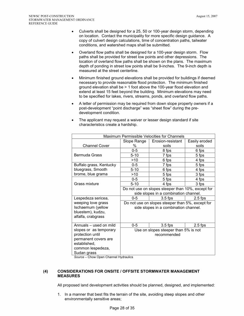
Maximum Permissible Velocities for Channels
Channel Cover
Slope Range %
Erosion-resistant soils
Easily eroded soils
Bermuda Grass
0-5 8 fps 6 fps 5-10 7 fps 5 fps >10 6 fps 4 fps
Buffalo grass, Kentucky bluegrass, Smooth brome, blue grama
0-5 7 fps 5 fps 5-10 6 fps 4 fps >10 5 fps 3 fps
Grass mixture
0-5 5 fps 4 fps 5-10 4 fps 3 fps
Do not use on slopes steeper than 10%, except for side slopes in a combination channel.
Lespedeza sericea, weeping love grass Ischaemum (yellow bluestem), kudzu, alfalfa, crabgrass
0-5 3.5 fps 2.5 fps Do not use on slopes steeper than 5%, except for
side slopes in a combination channel.
Annuals – used on mild slopes or as temporary protection until permanent covers are established, common lespedeza, Sudan grass
0-5 3.5 fps 2.5 fps Use on slopes steeper than 5% is not
recommended
Source – Chow Open Channel Hydraulics
(4) CONSIDERATIONS FOR ONSITE / OFFSITE STORMWATER MANAGEMENT MEASURES
All proposed land development activities should be planned, designed, and implemented: 1. In a manner that best fits the terrain of the site, avoiding steep slopes and other
environmentally sensitive areas;
NEWSC POST-CONSTRUCTION August 15, 2007 STORMWATER MANAGEMENT ORDINANCE REFERENCE GUIDE
Page 29 of 35
2. According to the unique resource conditions at, around, and downstream from a
given site; 3. According to the principles of Low Impact Development. Use source controls rather
than end-of-pipe treatment. Reduce, prevent and mitigate the adverse impacts of development by maintaining infiltration, reducing frequency and volume of discharges, reducing peak flows, and maintaining groundwater recharge. These goals can be accomplished by using: • Reduced impervious surfaces • Functional grading to slow runoff and thereby lengthen the time of concentration • Vegetated channels rather than paving or pipes • Disconnection of impervious surfaces; drain to vegetated areas • Bioretention (rain gardens) and filtration (buffer) landscape areas • Any other techniques that reduce the runoff curve number (RCN) or increase the
time of concentration (Tc) • Use wet detention basins after all source area practices and techniques have
been employed Overall, the goal is to design the site as an integral, living part of the environment with careful use of principles and practices that are both low impact on runoff and simple for people to maintain and live with.
4. To maintain groundwater recharge areas and the infiltration capacity of native soils
by avoiding the unnecessary filling of large natural depressions or compaction of upper soil horizons by construction equipment;
5. To maintain soil infiltration by keeping all topsoil on site; 6. To provide the protective area, shoreland, wetland, and environmentally sensitive
area setback along all water courses; and 7. According to the sequence in the “Treatment Train”:
a. First do source controls: • Reduce impervious areas to the maximum extent possible • Maintain undisturbed soil • Maintain existing trees, shrubs and vegetation
b. Next do lot controls • Grade lots to create long areas of overland flow rather than channels • Minimize directly connected impervious areas by such practices as directing
roof water to vegetated areas and draining driveways to grass rather than the street
• Include “rain gardens” (undrained areas that will pond water) c. Then do site controls
• Use grassed waterways and diversions rather than paved channels • Maintain wetlands • Use vegetated road ditches rather than curb and gutter • Use wet detention basins. They can have pools 5 or more feet deep or may
be designed as wetlands, but existing wetlands cannot be incorporated into stormwater facilities.
• Use off line detention basins d. Finally, do Regional controls such as regional detention basins.
(5) LOCATION AND REGIONAL TREATMENT OPTION
When using the regional treatment option, a letter is required from the owner of the regional facility. At a minimum, the letter shall state the following:
• Regional facility complies with ordinance requirements, • Site can use regional facility for ordinance compliance, and

NEWSC POST-CONSTRUCTION August 15, 2007 STORMWATER MANAGEMENT ORDINANCE REFERENCE GUIDE
Page 30 of 35
• Maintenance agreement for regional facility has been recorded at the County Register of Deeds.
(6) ALTERNATE REQUIREMENTS
S.08 PERMITTING REQUIREMENTS, PROCEDURES AND FEES
(1) PERMIT REQUIRED (2) PERMIT APPLICATION AND FEES (3) REVIEW AND APPROVAL OF PERMIT APPLICATION (4) PERMIT REQUIREMENTS
The permit applicant is required to post the permit in a conspicuous place at the construction site. Record Drawings-
• Post-construction sites with 20,000 sq.ft. or more of impervious surface disturbance and post-construction sites with 1 acre or more of land disturbance are required to have record drawings. Record drawings shall be signed by a licensed Professional Engineer. Agricultural land uses, unless they are exceptionally large or special in some other way, are not required to have record drawings. Typically, agricultural land uses will not need anything more than review and acceptance by the administering authority.
• Post-construction sites with less than 20,000 sq.ft. of impervious surface disturbance are not typically required to have record drawings. Typically, sites with less than 20,000 sq.ft. of impervious surface disturbance will not need anything more than review and acceptance by the administering authority.
(5) PERMIT CONDITIONS (6) PERMIT DURATION (7) ALTERNATE REQUIREMENTS
(a) Agricultural Production Areas
By protecting the resources through the use of BMPs, you are limiting liability to the farmer on existing infrastructure, both municipal and adjacent land owner (for example: culverts, flooding roadways, unstable outlet across a neighbor’s field, drainage way erosion, road ditches, “secondary containment” for stored chemicals, manure, local and regional flooding). Side benefits: water quality improvement, groundwater recharge, peak flow reduction, wildlife habitat and protection, reduced liability (offsite financial, onsite secondary containment), onsite reduced flooding/better planned drainage Thresholds (impervious):
• < 20,000 sq. ft = drainage plan, assessment of offsite impacts, explanation of mitigation • > 20,000 sq. ft to 1 acre = all of the above + waiver specs (if waiver specs not met, calculation is
needed) • > 1 acre = bullet 1 and engineered plan
o See S.07 (b) PEAK DISCHARGE
Source Areas: • Feedpads • Roofs • Driveways

NEWSC POST-CONSTRUCTION August 15, 2007 STORMWATER MANAGEMENT ORDINANCE REFERENCE GUIDE
Page 31 of 35
• Barnyards • Existing impervious surfaces • Calf housing/feeding areas • Contributing area to waste storage area (calf housing, sand storage, etc.)
*Crushed gravel, lime screening, paved surfaces, and compacted soil are considered impervious.
BMPs for Source Areas: • Feedpad
o Collection system (waste storage) o VTA o Pond o Manure storage offset
• Roof o Pond o Swale o Infiltration trench o Ground gutter o Manure storage offset
• Driveway o Pond o Swale o Infiltration trench o Ground gutter o Manure storage offset
• Barnyards o Collection system (waste storage) o VTA o Pond o Manure storage offset
• Existing impervious surfaces o Collection system (waste storage) o VTA o Pond o Manure storage offset o Swale o Infiltration trench o Ground gutter o Permeable pavement
*Swales, infiltration trench, pond not permitted as BMPs from some surfaces (barnyards/feedpads) due to potential pollutant loading/significant discharge, also see 151 for source area exemptions.
Prescriptive Scenarios: 1. Impervious areas < 1 acre
a. Runoff flows onto a buffer, cropland, or woodland i. 100 ft. overland flow or
ii. 1,000 ft. channelized flow or iii. Prorated combination
b. A farm owns at least 35 acres contiguous in the same watershed c. Impervious surface is at least 300 ft. from navigable stream or wetland
NEWSC POST-CONSTRUCTION August 15, 2007 STORMWATER MANAGEMENT ORDINANCE REFERENCE GUIDE
Page 32 of 35
d. Impervious surface is at least 1,000 ft. from a lake or pond or karst feature e. Protective area requirements are met—see S.07 (d)
2. Waste storage offset credit (TO DO: determine ratio of impervious footprint to waste storage size. Based on soil type, location, and existing problems from runoff.)
3. Barnyard a. Barnyard all goes to pit b. Barnyard all goes to VTA
4. Feedpad a. Feedpad all goes to pit b. Feedpad all goes to VTA c. Other
5. Ground gutter 6. Existing space between barns 7. New impervious swapping with existing (topographic challenges) 8. Regional
i. S.09 STORMWATER MANAGEMENT PLAN
(1) PLAN REQUIREMENTS
The stormwater management plan for post-construction sites with 20,000 sq.ft. or more of impervious surface disturbance and post-construction sites with 1 acre or more of land disturbance shall contain, at a minimum, the following information. (a) Name, address, and telephone number for the following or their designees:
landowner; developer; project engineer for practice design and certification; person(s) responsible for installation of stormwater management practices; and person(s) responsible for maintenance of stormwater management practices prior to the transfer, if any, of maintenance responsibility to another party.
(b) A proper legal description of the property proposed to be developed, referenced to the U.S. Public Land Survey system or to block and lot numbers within a recorded land subdivision plat.
(c) Pre-development site conditions, including: 1. One or more site maps at a scale of not less than 1 inch equals [100]
feet. The site maps shall show the following: site location and legal property description; predominant soil types and hydrologic soil groups; existing cover type and condition; one or two foot topographic contours of the site; topography and drainage network including enough of the contiguous properties to show runoff patterns onto, through, and from the site; watercourses that may affect or be affected by runoff from the site; flow path and direction for all stormwater conveyance sections; watershed boundaries used in hydrology determinations to show compliance with performance standards; lakes, streams, wetlands, channels, ditches, and other watercourses on and immediately adjacent to the site; limits of the 100 year floodplain; location of wells and wellhead protection areas covering the project area and delineated pursuant to s. NR 811.16, Wis. Adm. Code.
2. Hydrology and pollutant loading computations as needed to show compliance with performance standards. All major assumptions used in developing input parameters shall be clearly stated. The geographic areas used in making the calculations shall be clearly cross-referenced to the required map(s).
(d) Post-development site conditions, including:

NEWSC POST-CONSTRUCTION August 15, 2007 STORMWATER MANAGEMENT ORDINANCE REFERENCE GUIDE
Page 33 of 35
1. Explanation of the provisions to preserve and use natural topography and land cover features to minimize changes in peak flow runoff rates and volumes to surface waters and wetlands.
2. Explanation of any restrictions on stormwater management measures in the development area imposed by wellhead protection plans and ordinances. a. Stormwater infiltration systems and ponds shall be located at
least 400 feet from a well serving a community water system unless the Wisconsin Department of Natural Resources and municipality concur that a lesser separation distance would provide adequate protection of a well from contamination.
b. Stormwater management practices shall be located with a minimum separation distance from any well serving a non-community or private water system as listed within s. NR 812.08.
3. One or more site maps at a scale of not less than 1 inch equals [100] feet showing the following: post-construction pervious areas including vegetative cover type and condition; impervious surfaces including all buildings, structures, and pavement; post-construction one or two foot topographic contours of the site; post-construction drainage network including enough of the contiguous properties to show runoff patterns onto, through, and from the site; locations and dimensions of drainage easements; locations of maintenance easements specified in the maintenance agreement; flow path and direction for all stormwater conveyance sections; location and type of all stormwater management conveyance and treatment practices, including the onsite and offsite tributary drainage area; location and type of conveyance system that will carry runoff from the drainage and treatment practices to the nearest adequate outlet such as a curbed street, storm drain, or natural drainage way; watershed boundaries used in hydrology and pollutant loading calculations and any changes to lakes, streams, wetlands, channels, ditches, and other watercourses on and immediately adjacent to the site.
4. Hydrology and pollutant loading computations as needed to show compliance with performance standards. The computations shall be made for each discharge point in the development, and the geographic areas used in making the calculations shall be clearly cross-referenced to the required map(s).
5. Results of investigations of soils and groundwater required for the placement and design of stormwater management measures. When permanent infiltration systems are used, appropriate onsite testing shall be conducted to determine if seasonal groundwater elevation or top of bedrock is within 5 feet of the proposed infiltration system. Detailed drawings including cross-sections and profiles of all permanent stormwater conveyance and treatment practices.
(e) A description and installation schedule for the stormwater management practices needed to meet the performance standards in S.07.
(f) A maintenance plan developed for the life of each stormwater management practice including the required maintenance activities and maintenance activity schedule.
(g) Cost estimates for the construction, operation, and maintenance of each stormwater management practice.
(h) Other information requested in writing by the [administering authority] to determine compliance of the proposed stormwater management measures with the provisions of this ordinance.
(i) All site investigations, plans, designs, computations, and drawings shall be certified by a [licensed professional engineer] to be prepared in accordance with accepted engineering practice and requirements of this ordinance.
(2) ALTERNATE REQUIREMENTS

NEWSC POST-CONSTRUCTION August 15, 2007 STORMWATER MANAGEMENT ORDINANCE REFERENCE GUIDE
Page 34 of 35
S.10 MAINTENANCE AGREEMENT
(1) MAINTENANCE AGREEMENT REQUIRED
Post-construction sites with 20,000 sq.ft. or more of impervious surface disturbance and post-construction sites with 1 acre or more of land disturbance are required to have a maintenance agreement. The applicant shall use the municipality’s standard forms for the maintenance agreement. The local municipality is responsible for recording the signed maintenance agreement at the County Register of Deeds. Post-construction sites with less than 20,000 sq.ft. of impervious surface disturbance are not typically required to have a maintenance agreement. Sites utilizing the regional treatment option are not typically required to have a maintenance agreement. However, a maintenance agreement is required for the regional facility.
(2) AGREEMENT PROVISIONS
(3) ALTERNATE REQUIREMENTS
S.11 FINANCIAL GUARANTEE
(1) ESTABLISHMENT OF GUARANTEE
Post-construction sites with 20,000 sq.ft. or more of impervious surface disturbance and post-construction sites with 1 acre or more of land disturbance are required to have a financial guarantee. The financial guarantee includes the cost associated with stormwater BMPs, record drawings, project administration, and contingencies. Post-construction sites with less than 20,000 sq.ft. of impervious surface disturbance are not typically required to have a financial guarantee. Sites utilizing the regional treatment option are not typically required to have a financial guarantee.
(2) CONDITIONS FOR RELEASE
The financial guarantee shall not be released until the applicant conducts a final inspection with a municipal representative, submits “record drawings” certified by a licensed Professional Engineer, completes punch list items, and pays fees.
(3) ALTERNATE REQUIREMENTS
S.12 FEE SCHEDULE S.13 ENFORCEMENT S.14 APPEALS
(1) BOARD OF APPEALS OR ADJUSTMENT
(2) WHO MAY APPEAL S.15 SEVERABILITY

NEWSC POST-CONSTRUCTION August 15, 2007 STORMWATER MANAGEMENT ORDINANCE REFERENCE GUIDE
Page 35 of 35
S.16 EFFECTIVE DATE W:\DRAFTING\Nav\NEWSC\Erosion Control Committee\5 - NEWSC Post Construction Stormwater Reference Guide Final 08152007.doc
Related Documents