New York City Bicycle Lane and Trail Inventory New York City Department of City Planning Member of New York Metropolitan Transportation Council

Welcome message from author
This document is posted to help you gain knowledge. Please leave a comment to let me know what you think about it! Share it to your friends and learn new things together.
Transcript
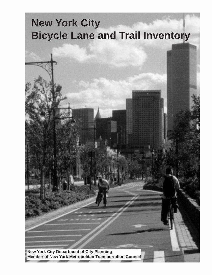
New York CityBicycle Lane and Trail Inventory
New York City Department of City PlanningMember of New York Metropolitan Transportation Council

New York City Bicycle Lane and Trail Inventory
Rudolph W. Giuliani, MayorCity of New York
Joseph B. Rose, DirectorDepartment of City Planning
April 2000
The preparation of this report has been financed in part through funds from the US Depart-ment of Transportation, Federal Highway Administration. This document is disseminated under the sponsorship of the Department of Transportation in the interest of information exchange. The contents of this report reflect the view of the author, who is responsible for the facts and accuracy of the data presented herein. The contents do not necessarily reflect the official views or policies of the Federal Highway Administration or the New York Metropolitan Transportation Council. This report does not constitute a standard, specifica-tion, or regulation.
This project was funded by a matching grant from the Federal Highway Administration, PIN# PT2117911.01, Program Year 1999-2000
ContentsIntroduction ................................................................................................................................ 1
Methodology................................................................................................................................ 2 Bicycle Lanes................................................................................................................... 2 Bicycle Trails .................................................................................................................. 6
Data ............................................................................................................................................. 11
Bronx ............................................................................................................................. 14 Brooklyn ......................................................................................................................... 22 Manhattan ....................................................................................................................... 52 Queens............................................................................................................................. 92 Staten Island ................................................................................................................... 112
Analysis .................................................................................................................................... 120
Bronx .............................................................................................................................. 120 Brooklyn ........................................................................................................................ 121 Manhattan ...................................................................................................................... 122 Queens ........................................................................................................................... 123 Staten Island .................................................................................................................. 124
Appendix A: Bicycle Lane Inventory Database..................................................................125
i. Pavement Condition ..............................................................................................126 ii. Lane Striping Condition..........................................................................................147 iii. Sign Condition .......................................................................................................166 iv. Diamond Symbol Condition ..................................................................................184 v. Cyclist Symbol Condition .........................................................................201
Appendix B: Bicycle Trail Inventory Database ...................................................................220
i. Pavement Condition ..............................................................................................221 ii. Lane Striping Condition .........................................................................................227 iii. Sign Condition .......................................................................................................230 iv. Symbol Condition ...................................................................................................237
Credits ...........................................................................................................................................247
NYC Bicycle Lane and Trail Inventory
�
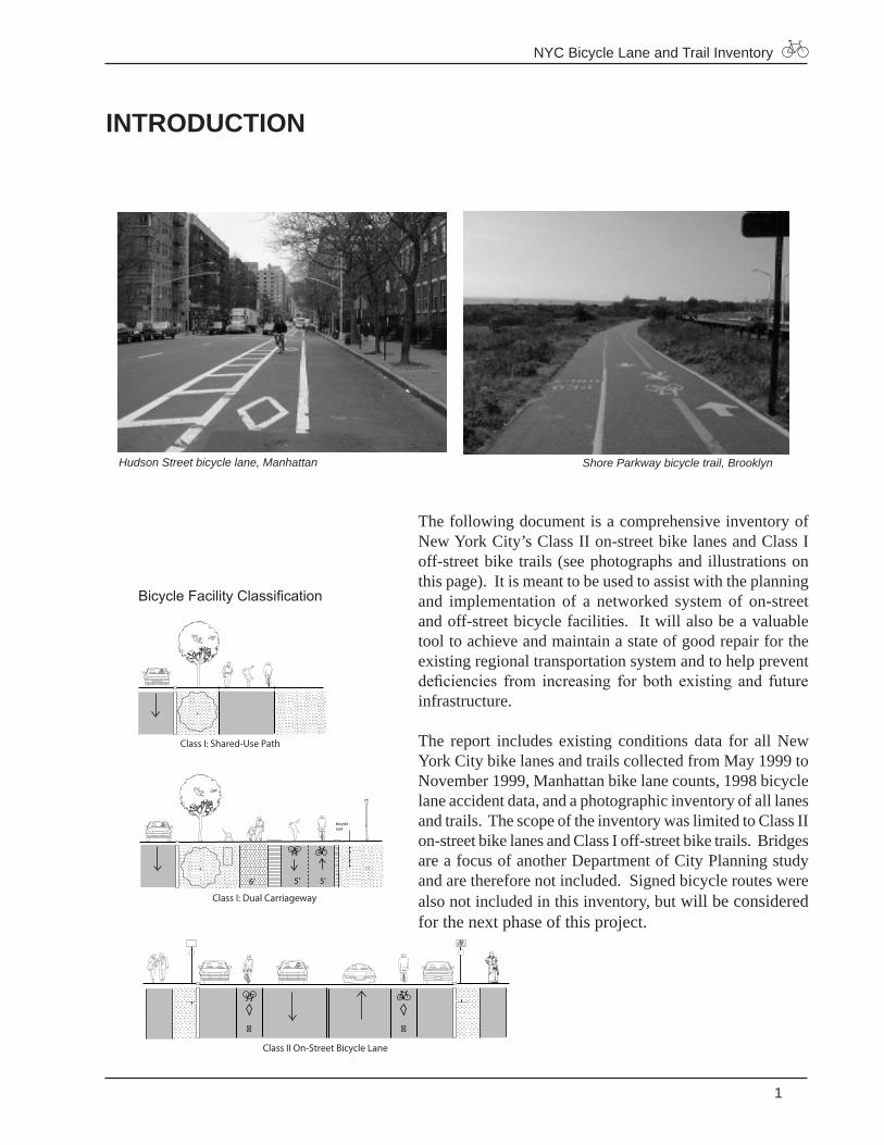
Hudson Street bicycle lane, Manhattan Shore Parkway bicycle trail, Brooklyn
INTRODUCTION
The following document is a comprehensive inventory of New York City’s Class II on-street bike lanes and Class I off-street bike trails (see photographs and illustrations on this page). It is meant to be used to assist with the planning and implementation of a networked system of on-street and off-street bicycle facilities. It will also be a valuable tool to achieve and maintain a state of good repair for the existing regional transportation system and to help prevent deficiencies from increasing for both existing and future infrastructure.
The report includes existing conditions data for all New York City bike lanes and trails collected from May 1999 to November 1999, Manhattan bike lane counts, 1998 bicycle lane accident data, and a photographic inventory of all lanes and trails. The scope of the inventory was limited to Class II on-street bike lanes and Class I off-street bike trails. Bridges are a focus of another Department of City Planning study and are therefore not included. Signed bicycle routes were also not included in this inventory, but will be considered for the next phase of this project.
Class I: Shared-Use Path
Class I: Dual Carriageway
5'6' 5'
bicyclerack
Class II On-Street Bicycle Lane
� �
Bicycle Facility Classification
NYC Bicycle Lane and Trail Inventory
�
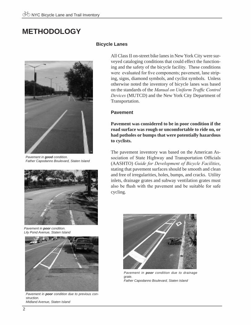
METHODOLOGYBicycle Lanes
All Class II on-street bike lanes in New York City were sur-veyed cataloging conditions that could effect the function-ing and the safety of the bicycle facility. These conditions were evaluated for five components; pavement, lane strip-ing, signs, diamond symbols, and cyclist symbols. Unless otherwise noted the inventory of bicycle lanes was based on the standards of the Manual on Uniform Traffic Control Devices (MUTCD) and the New York City Department of Transportation.
Pavement
Pavement was considered to be in poor condition if the road surface was rough or uncomfortable to ride on, or had potholes or bumps that were potentially hazardous to cyclists.
The pavement inventory was based on the American As-sociation of State Highway and Transportation Officials (AASHTO) Guide for Development of Bicycle Facilities, stating that pavement surfaces should be smooth and clean and free of irregularities, holes, bumps, and cracks. Utility inlets, drainage grates and subway ventilation grates must also be flush with the pavement and be suitable for safe cycling.
Pavement in poor condition.Lily Pond Avenue, Staten Island
Pavement in poor condition due to previous con-struction.Midland Avenue, Staten Island
Pavement in good condition.Father Capodanno Boulevard, Staten Island
Pavement in poor condition due to drainage grate.Father Capodanno Boulevard, Staten Island
NYC Bicycle Lane and Trail Inventory
�
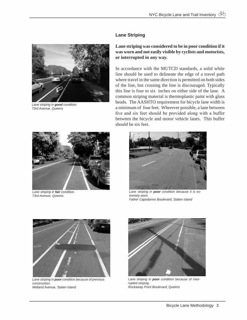
Lane Striping
Lane striping was considered to be in poor condition if it was worn and not easily visible by cyclists and motorists, or interrupted in any way.
In accordance with the MUTCD standards, a solid white line should be used to delineate the edge of a travel path where travel in the same direction is permitted on both sides of the line, but crossing the line is discouraged. Typically this line is four to six inches on either side of the lane. A common striping material is thermoplastic paint with glass beads. The AASHTO requirement for bicycle lane width is a minimum of four feet. Wherever possible, a lane between five and six feet should be provided along with a buffer between the bicycle and motor vehicle lanes. This buffer should be six feet.
Lane striping in good condition.73rd Avenue, Queens
Lane striping in fair condition.73rd Avenue, Queens
Lane striping in poor condition because of previous construction. Midland Avenue, Staten Island
Lane striping in poor condition because of inter-rupted striping.Rockaway Point Boulevard, Queens
Lane striping in poor condition because it is ex-tremely worn. Father Capodanno Boulevard, Staten Island
Bicycle Lane Methodology
NYC Bicycle Lane and Trail Inventory
�
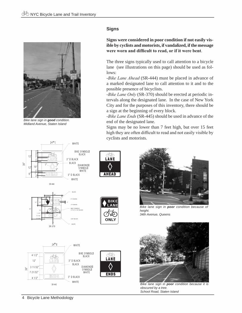
Signs
Signs were considered in poor condition if not easily vis-ible by cyclists and motorists, if vandalized, if the message were worn and difficult to read, or if it were bent.
The three signs typically used to call attention to a bicycle lane (see illustrations on this page) should be used as fol-lows:-Bike Lane Ahead (SR-444) must be placed in advance of a marked designated lane to call attention to it and to the possible presence of bicyclists. -Bike Lane Only (SR-370) should be erected at periodic in-tervals along the designated lane. In the case of New York City and for the purposes of this inventory, there should be a sign at the beginning of every block. -Bike Lane Ends (SR-445) should be used in advance of the end of the designated lane. Signs may be no lower than 7 feet high, but over 15 feet high they are often difficult to read and not easily visible by cyclists and motorists.
Bicycle Lane Methodology
SR-370
24"
2"
7 1/16"
2 7/16" 3/8 F BLACK
�
3" F WHITE
3" F WHITE
WHITE
2"
1 1/2"
1 1/2"
5"
10"13"
10"36"
17 1/2"
BLACK
BIKE SYMBOL�(171/2" X 10") BLACK
Bike lane sign in good condition.Midland Avenue, Staten Island
Bike lane sign in poor condition because of height.34th Avenue, Queens
Bike lane sign in poor condition because it is obscured by a tree.School Road, Staten Island
SR-445
2 4 © �
4 1 / 2 "
4 1 / 2 "
3 1 1 / 3 2 "
7 2 1 / 3 2 "
1 2 "
30"
3 " D B L AC K
3 " D B L AC K
B I K E S Y M B O L �B L AC K
D I A M O N D �S Y M B O L �
W H I T E
W H I T E
W H I T E
B L AC K
“
SR-444
2 4 © �
5 "
5 "
1 "
1 "1 "
1 "1 "1 "
1 0 "
5 "2 "
2 "
1 2 "
1 2 "
6 "
30"
3 " D B L AC K
3 " D B L AC K
B I K E S Y M B O L �B L AC K
D I A M O N D �S Y M B O L �
W H I T E
W H I T E
W H I T E
B L AC K
“
NYC Bicycle Lane and Trail Inventory
�
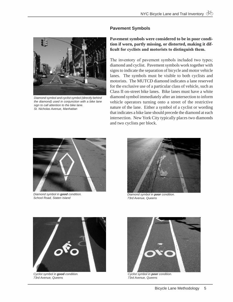
Pavement Symbols
Pavement symbols were considered to be in poor condi-tion if worn, partly missing, or distorted, making it dif-ficult for cyclists and motorists to distinguish them.
The inventory of pavement symbols included two types; diamond and cyclist. Pavement symbols work together with signs to indicate the separation of bicycle and motor vehicle lanes. The symbols must be visible to both cyclists and motorists. The MUTCD diamond indicates a lane reserved for the exclusive use of a particular class of vehicle, such as Class II on-street bike lanes. Bike lanes must have a white diamond symbol immediately after an intersection to inform vehicle operators turning onto a street of the restrictive nature of the lane. Either a symbol of a cyclist or wording that indicates a bike lane should precede the diamond at each intersection. New York City typically places two diamonds and two cyclists per block.
Diamond symbol and cyclist symbol (directly behind the diamond) used in conjunction with a bike lane sign to call attention to the bike lane. St. Nicholas Avenue, Manhattan
Diamond symbol in poor condition. 73rd Avenue, Queens
Diamond symbol in good condition. School Road, Staten Island
Cyclist symbol in poor condition.73rd Avenue, Queens
Cyclist symbol in good condition. 73rd Avenue, Queens
Bicycle Lane Methodology
NYC Bicycle Lane and Trail Inventory
�
Bicycle Trails
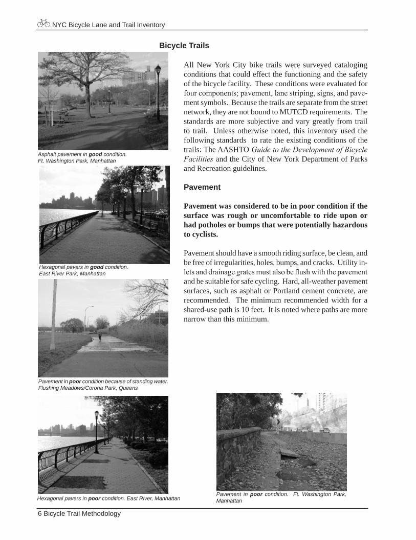
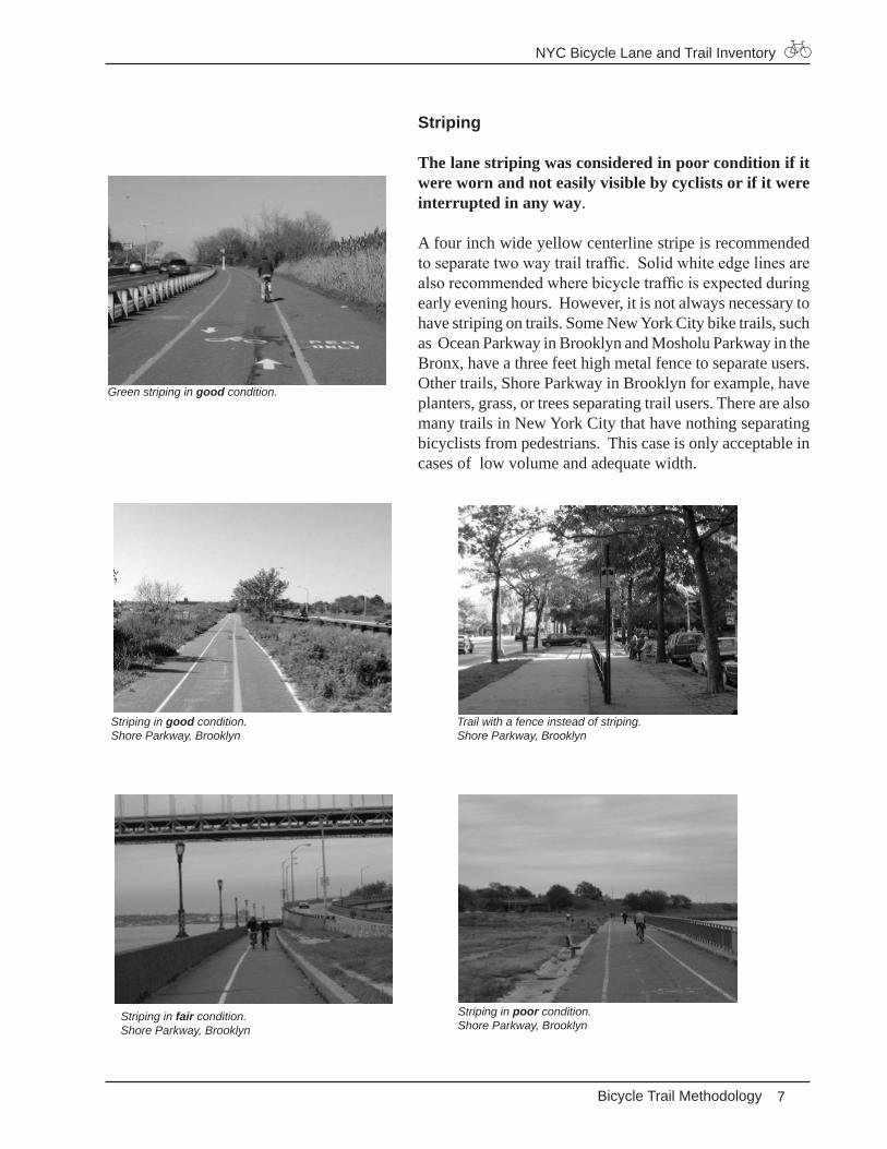
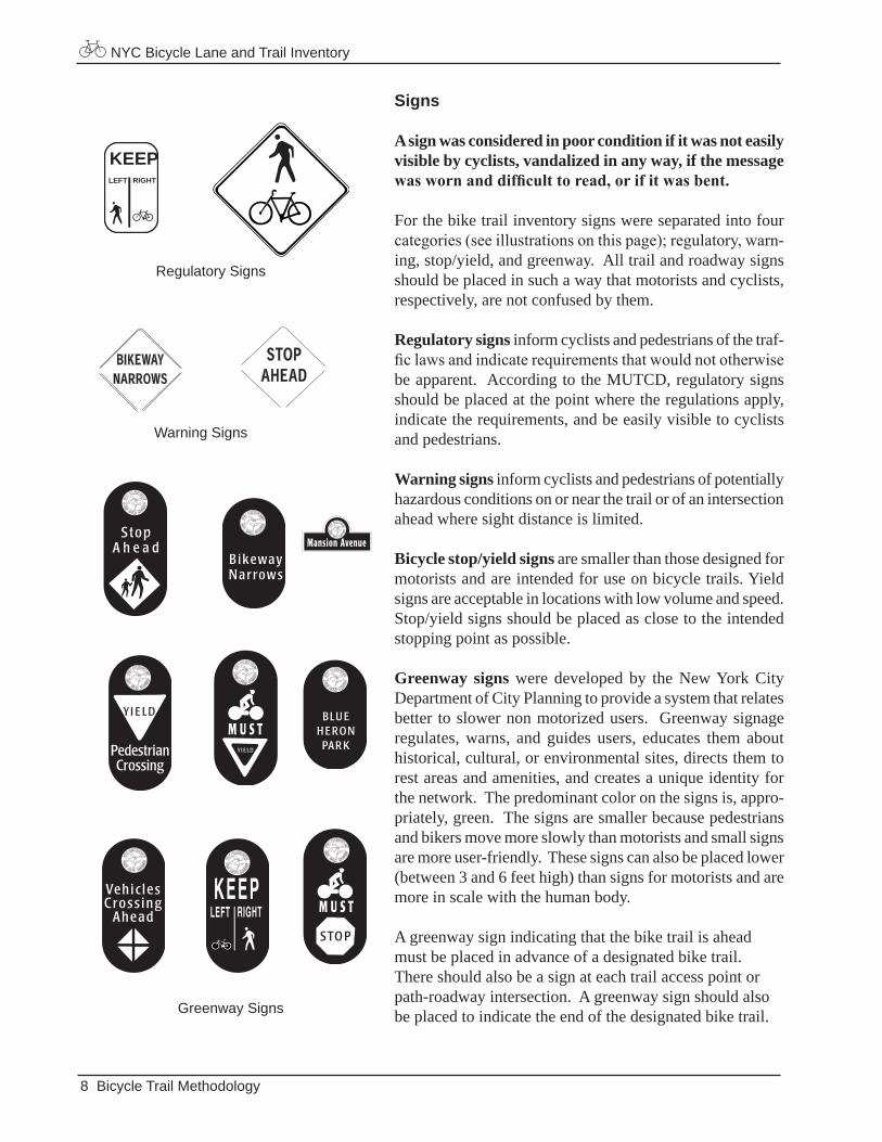
All New York City bike trails were surveyed cataloging conditions that could effect the functioning and the safety of the bicycle facility. These conditions were evaluated for four components; pavement, lane striping, signs, and pave-ment symbols. Because the trails are separate from the street network, they are not bound to MUTCD requirements. The standards are more subjective and vary greatly from trail to trail. Unless otherwise noted, this inventory used the following standards to rate the existing conditions of the trails: The AASHTO Guide to the Development of Bicycle Facilities and the City of New York Department of Parks and Recreation guidelines.
Pavement
Pavement was considered to be in poor condition if the surface was rough or uncomfortable to ride upon or had potholes or bumps that were potentially hazardous to cyclists.
Pavement should have a smooth riding surface, be clean, and be free of irregularities, holes, bumps, and cracks. Utility in-lets and drainage grates must also be flush with the pavement and be suitable for safe cycling. Hard, all-weather pavement surfaces, such as asphalt or Portland cement concrete, are recommended. The minimum recommended width for a shared-use path is 10 feet. It is noted where paths are more narrow than this minimum.
Pavement in poor condition. Ft. Washington Park, ManhattanHexagonal pavers in poor condition. East River, Manhattan
Hexagonal pavers in good condition.East River Park, Manhattan
Pavement in poor condition because of standing water. Flushing Meadows/Corona Park, Queens
Asphalt pavement in good condition.Ft. Washington Park, Manhattan
Bicycle Trail Methodology
NYC Bicycle Lane and Trail Inventory
�
Striping
The lane striping was considered in poor condition if it were worn and not easily visible by cyclists or if it were interrupted in any way.
A four inch wide yellow centerline stripe is recommended to separate two way trail traffic. Solid white edge lines are also recommended where bicycle traffic is expected during early evening hours. However, it is not always necessary to have striping on trails. Some New York City bike trails, such as Ocean Parkway in Brooklyn and Mosholu Parkway in the Bronx, have a three feet high metal fence to separate users. Other trails, Shore Parkway in Brooklyn for example, have planters, grass, or trees separating trail users. There are also many trails in New York City that have nothing separating bicyclists from pedestrians. This case is only acceptable in cases of low volume and adequate width.
Striping in poor condition.Shore Parkway, Brooklyn
Striping in fair condition.Shore Parkway, Brooklyn
Trail with a fence instead of striping.Shore Parkway, Brooklyn
Striping in good condition.Shore Parkway, Brooklyn
Green striping in good condition.
Bicycle Trail Methodology
NYC Bicycle Lane and Trail Inventory
�
Signs
A sign was considered in poor condition if it was not easily visible by cyclists, vandalized in any way, if the message was worn and difficult to read, or if it was bent.
For the bike trail inventory signs were separated into four categories (see illustrations on this page); regulatory, warn-ing, stop/yield, and greenway. All trail and roadway signs should be placed in such a way that motorists and cyclists, respectively, are not confused by them.
Regulatory signs inform cyclists and pedestrians of the traf-fic laws and indicate requirements that would not otherwise be apparent. According to the MUTCD, regulatory signs should be placed at the point where the regulations apply, indicate the requirements, and be easily visible to cyclists and pedestrians.
Warning signs inform cyclists and pedestrians of potentially hazardous conditions on or near the trail or of an intersection ahead where sight distance is limited.
Bicycle stop/yield signs are smaller than those designed for motorists and are intended for use on bicycle trails. Yield signs are acceptable in locations with low volume and speed. Stop/yield signs should be placed as close to the intended stopping point as possible.
Greenway signs were developed by the New York City Department of City Planning to provide a system that relates better to slower non motorized users. Greenway signage regulates, warns, and guides users, educates them about historical, cultural, or environmental sites, directs them to rest areas and amenities, and creates a unique identity for the network. The predominant color on the signs is, appro-priately, green. The signs are smaller because pedestrians and bikers move more slowly than motorists and small signs are more user-friendly. These signs can also be placed lower (between 3 and 6 feet high) than signs for motorists and are more in scale with the human body.
A greenway sign indicating that the bike trail is ahead must be placed in advance of a designated bike trail. There should also be a sign at each trail access point or path-roadway intersection. A greenway sign should also be placed to indicate the end of the designated bike trail.
Bicycle Trail Methodology
KEEPLEFT RIGHT
Regulatory Signs
Warning Signs
S G - 1 1 2
S G - 1 0 1
Greenway Signs

NYC Bicycle Lane and Trail Inventory
�
Greenway information sign in good condition.Joe Michael’s Mile, Queens
Regulatory sign in poor condition because it had been vandalized. Ocean Parkway, Brooklyn
Warning sign in poor condition because it had been vandalized. Shore Parkway, Brooklyn
Greenway information sign in good condition.Shore Parkway, Brooklyn
Bicycle stop sign in fair condition along with a regulatory sign in poor condition.Pelham Parkway, the Bronx
Regulatory sign in good condition.Ocean Parkway, Brooklyn
Bicycle Trail Methodology
NYC Bicycle Lane and Trail Inventory
�0
Pavement Markings
Pavement markings were considered to be in poor condition if the symbols were worn, partly missing, or distorted, making it difficult for cyclists to read them.
Pavement markings have been separated into five catego-ries; diamond, cyclist, arrow, roller-blader, and other sym-bols. Markings should be located at every crossing and path entrance to channel users to clearly defined crossings and to notify motorists of their presence. For mid path, pavement markings should be used when needed or about every 400 feet. On a shared-use path, cyclist symbols should be placed to indicate where cyclists should ride. Although symbols are recommended, there are many bicycle trails in New York City without any.
Trail symbols in poor condition.Shore Parkway, Brooklyn
Trail symbols (arrows, cyclists, and “ped only”) in good condition.Joe Michael’s Mile, Queens
Bicycle symbol in poor condition.Eastern Parkway, Brooklyn
Bicycle and pedestrian symbols in fair condition.Eastern Parkway, Brooklyn
Trail symbols (arrows, cyclists, and pedestrians) in good condition.Shore Parkway, Brooklyn
Bicycle Trail Methodology
NYC Bicycle Lane and Trail Inventory
��
DATAThe data is separated by borough and presented by individual bike lane or bike trail. It is meant to be used in a GIS format, but for publication purposes, the static map, in combination with the corresponding database entries, will take its place. The data in MapInfo format will be available via Zip disk and, eventually, on the Department of City Planning web site.
Bicycle LanesInventory data was collected for each block using a “good,” “fair,” “poor,” and “missing” rating system. In-formation was collected in the following five categories:
General data included name of the bike lane, cross streets framing the block, lane width, and any buffer width. A mid block address was noted for mapping purposes and potential street tree locations were collected for the Department of Parks and Recreation.
Sign data included condition, message, the type of mount or structure that is supporting the sign, and its height.
Pavement data included condition and description. There were several keywords chosen to represent common pave-ment conditions; rough surface, bumps in pavement, previous construction, pot hole, utility inlet, and uneven pavement.
Striping data included condition and description. There were several keywords chosen to represent common strip-ing conditions; interrupted striping, previous construction, and worn.
Symbol data included condition and number of diamonds and cyclists and whether the cyclist symbol included a helmet.
Manhattan Bicycle Count The survey was completed on October 27, 1999. All cor-ridors in Manhattan with Class II on-street bicycle lanes were monitored for a 12 hour period, from 7AM to 7PM. Throughout the 12 hour survey period, temperature and weather conditions ranged from approximately 40 to 65 degrees and from breezy and cloudy to sunny and warm.
Bicycle AccidentsThe source of the accident data used in this report was the New York State Department of Motor Vehicles 1998 State Highway Accident Data. It includes all bicycle accidents reported to the Department of Motor Vehicles.
NYC Bicycle Lane and Trail Inventory
��
Bicycle Trails
Inventory data for the New York City bike trails was col-lected in half mile segments using a “good,” “fair,” “poor,” and “missing” rating system. For each half mile segment the following information was collected: General data included name of bike trail, distance from start, list of access points, total width, and, if applicable, wheeled width and buffer width between bicyclists and pedestrians.
Pavement data included type of surface (asphalt, hexagonal pavers, etc.), condition, description, and edge treatment. Similar to the bike lane data, there were several keywords chosen to represent common trail pavement conditions; rough surface, bumps in pavement, previous construction, pot hole, utility inlet, root, and overgrowth.
Striping data included condition, description, color of strip-ing, and existence of a centerline and whether it is dashed. There were several keywords chosen to represent common striping conditions; interrupted striping, previous construc-tion, and worn.
Symbol data included condition and number of diamonds, cyclists, roller-bladers, arrows, pedestrians, and other sym-bols.
Amenities data included number of bike racks, water fountains, and police call boxes.
Sign data included overall rating and condition, message, and description of regulatory, warning, stop/yield, green-way, and other signs.
Data
NYC Bicycle Lane and Trail Inventory
��
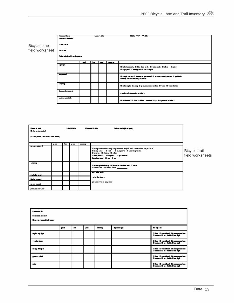
Data
Bicycle lane field worksheet
Bicycle trail field worksheets
NYC Bicycle Lane and Trail Inventory
Bronx Data
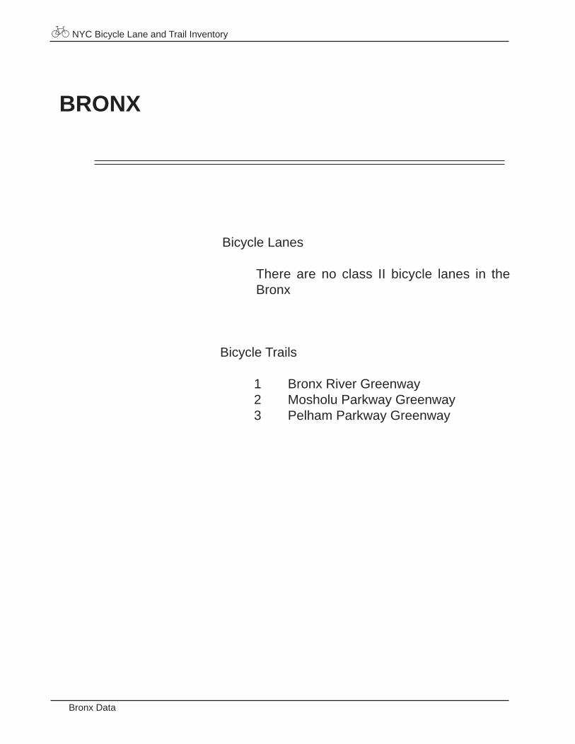
BRONX
Bicycle Trails
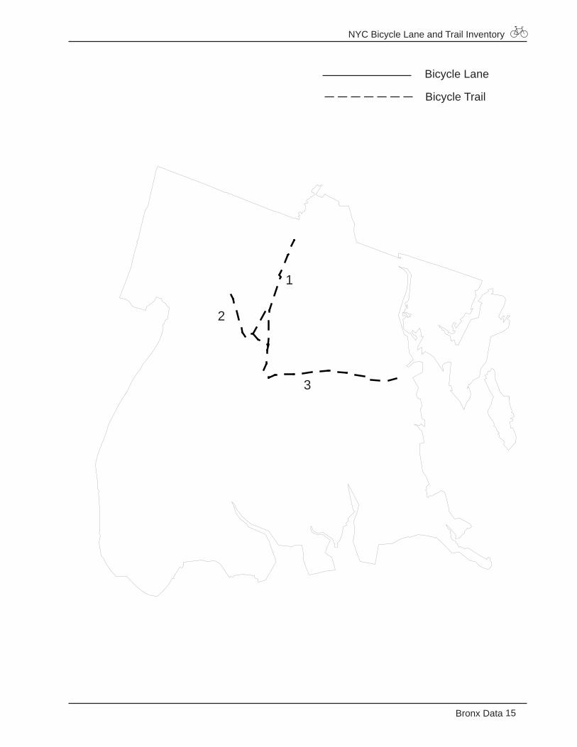
1 Bronx River Greenway2 Mosholu Parkway Greenway3 Pelham Parkway Greenway
Bicycle Lanes
There are no class II bicycle lanes in the Bronx
NYC Bicycle Lane and Trail Inventory
15Bronx Data
Bicycle Lane
Bicycle Trail
1
2
3
NYC Bicycle Lane and Trail Inventory
Bronx Data
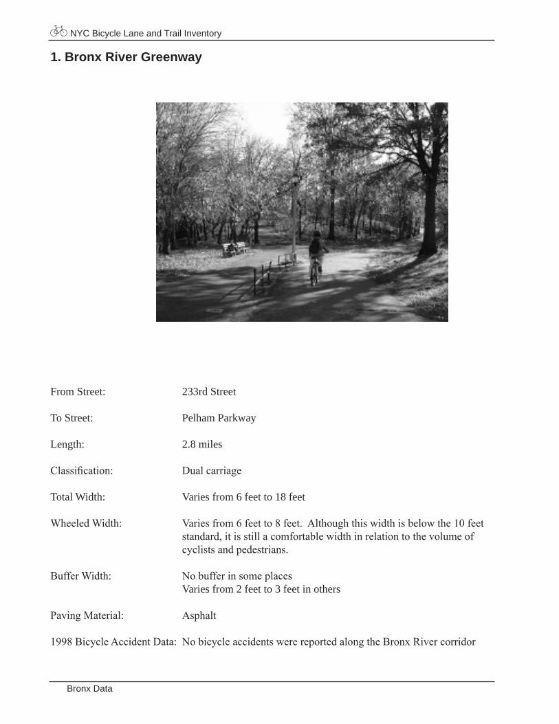
1. Bronx River Greenway
From Street: 233rd Street
To Street: Pelham Parkway
Length: 2.8 miles
Classification: Dualcarriage
Total Width: Varies from 6 feet to 18 feet
WheeledWidth: Variesfrom6feetto8feet.Althoughthiswidthisbelowthe10feet standard,itisstillacomfortablewidthinrelationtothevolumeof cyclistsandpedestrians.
BufferWidth: Nobufferinsomeplaces Varies from 2 feet to 3 feet in others
PavingMaterial: Asphalt
1998BicycleAccidentData: NobicycleaccidentswerereportedalongtheBronxRivercorridor
NYC Bicycle Lane and Trail Inventory
17Bronx Data
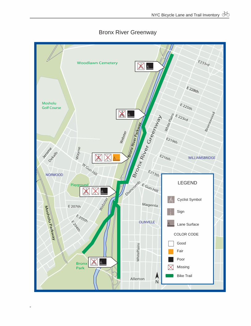
Bronx River Greenway
William
sbr
W Gun Hill
Whi
te P
lain
s
Whi
tePl
ains
Bro
nx
Riv
er P
arkw
ay
Mo
sho
lu P
arkw
ay
Web
ster
E233rd
WILLIAMSBRIDGE
OLINVILLE
NORWOOD
Woodlawn Cemetery
BronxPark
Playground
MosholuGolf Course
E Gun HillDuncom
b
E 223rd
E 225th
Bro
nx
Riv
er
Gre
en
wa
y
Bron
xwoo
d
E219th
E213th
E216th
Arnow
Lurt
ing
Ho
ne
Co
lden
Paul
ding
Magenta
Adee
Mat
thew
s
Radc
liff
Bro
nxw
oo
d
E 205thE 204th
E 207th
Dekal
b
Way
ne
Allerton
Jero
me
E 228th
Burke
Laco
nia
Allerton
Web
ster
LEGEND
Good
Fair
Poor
Missing
Bike Trail
Cyclist Symbol
Lane Surface
Sign
COLOR CODE
N
NYC Bicycle Lane and Trail Inventory
Bronx Data
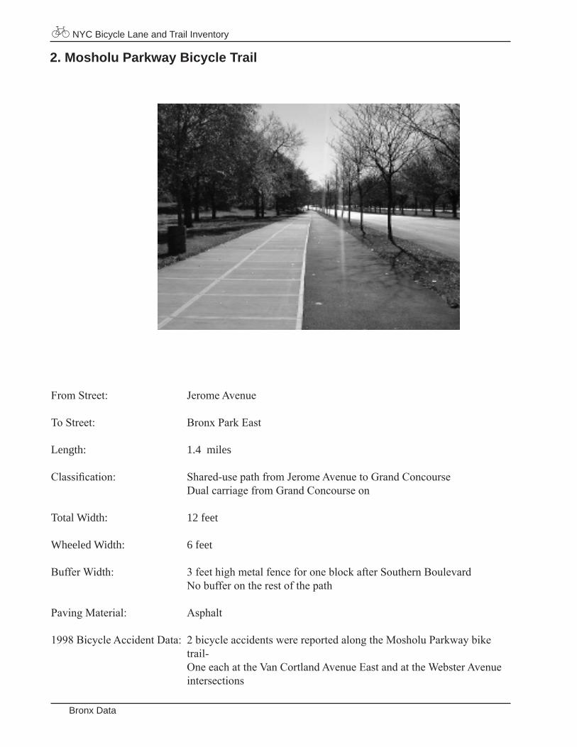
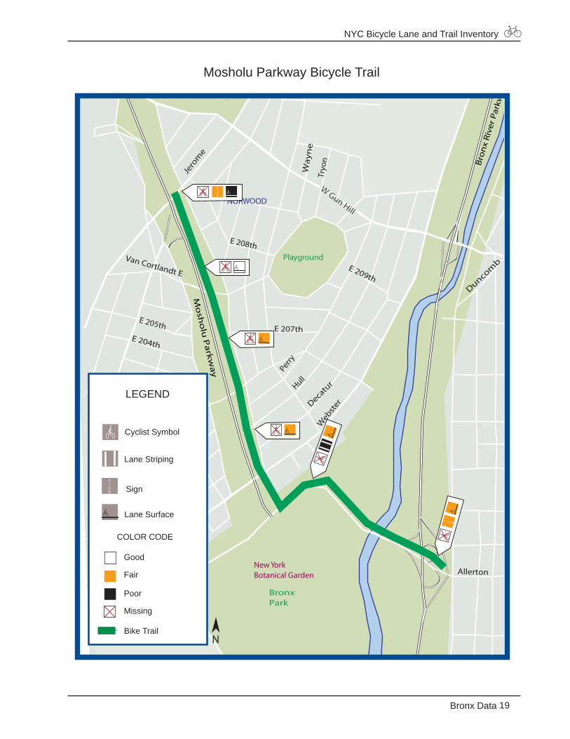
2. Mosholu Parkway Bicycle Trail
FromStreet: JeromeAvenue
ToStreet: BronxParkEast
Length: 1.4 miles
Classification: Shared-usepathfromJeromeAvenuetoGrandConcourse DualcarriagefromGrandConcourseon
Total Width: 12 feet
Wheeled Width: 6 feet
BufferWidth: 3feethighmetalfenceforoneblockafterSouthernBoulevard Nobufferontherestofthepath
PavingMaterial: Asphalt
1998BicycleAccidentData: 2bicycleaccidentswerereportedalongtheMosholuParkwaybike trail- OneeachattheVanCortlandAvenueEastandattheWebsterAvenue intersections
NYC Bicycle Lane and Trail Inventory
19Bronx Data
Mosholu Parkway Bicycle Trail
W Gun Hill
Bro
nx
Riv
er P
arkw
ay
Mo
sho
lu P
arkw
ay
E Fordham Rd
Webst
er
PELHAM P
BEDFORD PARK
NORWOOD
BronxPark
Playground
New YorkBotanical Garden
Duncomb
Cru
ger
Hull
Perry
Decatu
r
E 209th
E 207th
Way
ne
Tryo
nE 205th
E 204th
E 208th
Jero
me
Allerton
E189th Bron
x Pa
rk E
ast
Van Cortlandt E
LEGEND
Good
Fair
Poor
Missing
Bike Trail
Cyclist Symbol
Lane Surface
Sign
COLOR CODE
Lane Striping
N
NYC Bicycle Lane and Trail Inventory
Bronx Data
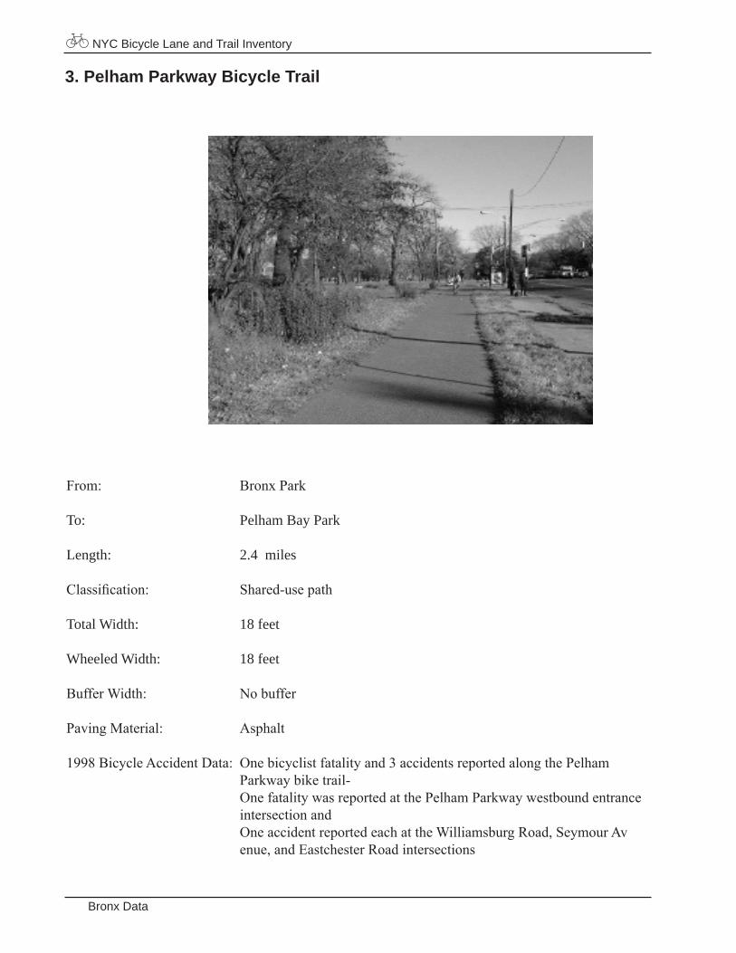
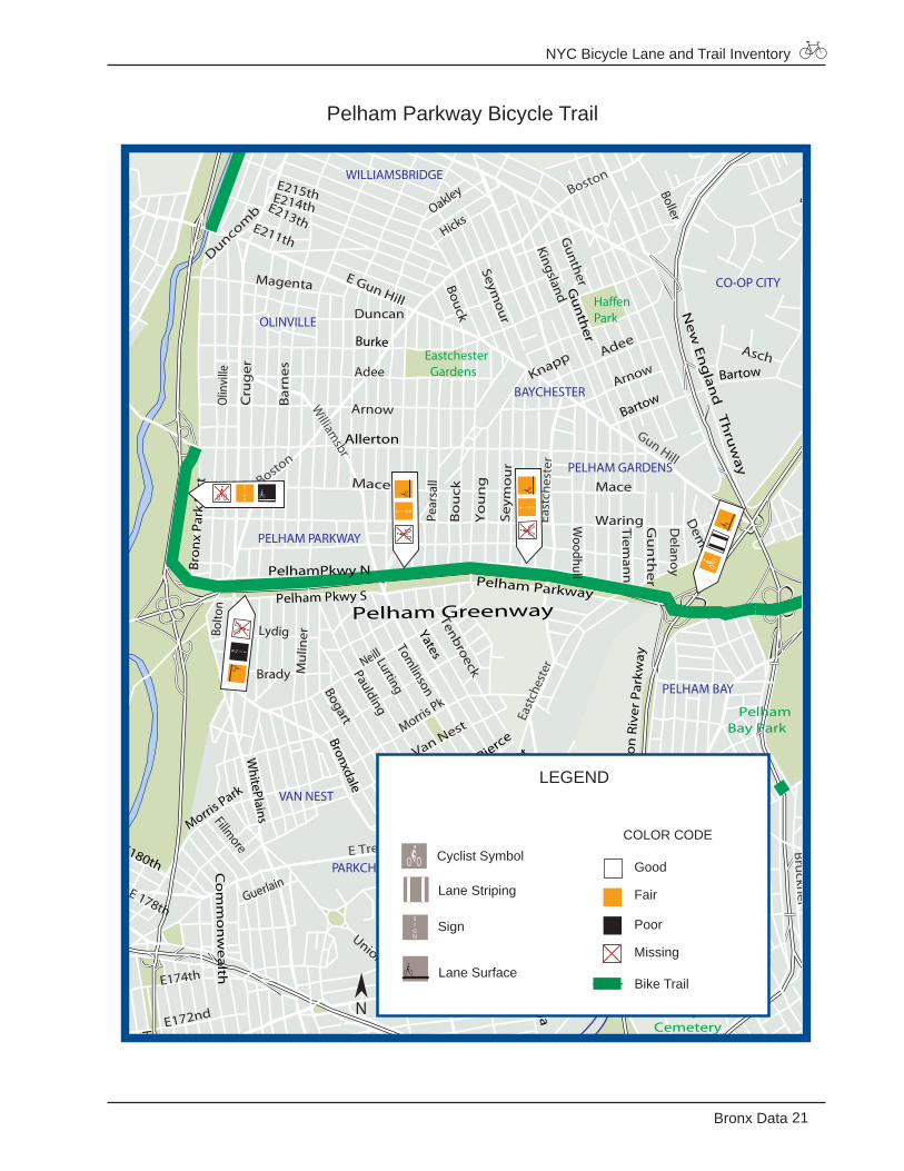
3. Pelham Parkway Bicycle Trail
From: BronxPark
To: Pelham Bay Park
Length: 2.4 miles
Classification: Shared-usepath
Total Width: 18 feet
Wheeled Width: 18 feet
BufferWidth: Nobuffer
PavingMaterial: Asphalt
1998BicycleAccidentData: Onebicyclistfatalityand3accidentsreportedalongthePelham Parkwaybiketrail- OnefatalitywasreportedatthePelhamParkwaywestboundentrance intersectionand OneaccidentreportedeachattheWilliamsburgRoad,SeymourAv enue,andEastchesterRoadintersections
NYC Bicycle Lane and Trail Inventory
21Bronx Data
Pelham Parkway Bicycle TrailE Trem
ont
East
ches
ter
Gun Hill
East
ches
ter
William
sbr
E Tremont
Whi
te P
lain
s
Westchester
Hu
tch
inso
n R
iver
Par
kway
Pelham Parkway
Throgs Neck Exp
wy
Ne
w E
ng
land
Th
ruw
ay
Pelham Greenway
Boston
Bruckn
er
Boston
EDENWALD
WILLIAMSBRIDGE
OLINVILLE
PELHAM PARKWAY
BAYCHESTER
PELHAM GARDENS
PELHAM BAY
MORRIS PARK
PARKCHESTER
VAN NEST
WESTCHESTERSQUARE
SCHUYLERVILLE
CO-OP CITY
BronxPark
St. Raymond'sCemetery
PelhamBay Park
Eastchester Gardens
HaffenPark
Adee
ArnowKnapp
Mace
Waring
Seymour
E Gun Hill
Duncomb
Bolto
n
Harrod
E 178th
E 223rd
E 224th
Bron
xwoo
dPa
uldi
ngE 222nd E221stE220th
E213th
E215thE214th
E211th
Peartree
Boller
Palmer
Boller
Gunther
Kingsland
E 229th
E 229th N
E 226th E 225th
Schieffe
lin
Bouck
Oakley
Hicks
Earhart
Delanoy
Gu
nth
er
Dem
eyer
Tieman
n
Woodhull
Yo
un
g
Seym
ou
r
Bo
uck
Pear
sall
Wilcox
Vincent
Barkley
Oh
m Res
earc
h
Layton
EdisonHollyw
ood
LoganRevere
Powell
Lyvere
Morris Pk
Van Nest
HavilandWatsonBlackrock
Pugsley
Olm
stead
Virginia
Thieriot
Co
mm
on
wealth
StLawrence
Beach
TaylorLeland
Underhill
Guerlain
Fillmore
FteleyC
roes
No
ble
Gleason
E174th
E172nd
Metcalf
Tenbroeck
Mace
Arnow
LurtingTom
linson
Neill
Paulding
Bogart
Magenta
Duncan
Adee
Brady Mul
inerLydig
Olin
ville
Cru
ger
Bar
nes
E 204th
Ro
cham
be
auW
ayn
eTr
yon
Starling
St RaymondUnionport
Asch
Co
mm
on
we
alth
E180thBost
on
Morris Park
Lafayette
Blondell
Yates
Bronxdale
WhitePlains
Burke
Bain
brid
ge
Bartow
Bartow
Allerton
Bron
x Pa
rk E
ast
Stad
ium
Stadium
Baychester
Gu
nth
er
Hu
tch
inso
n G
ree
nw
ay
William
sbridge
Griswold
Watt
HollersConner
Pear
tree
PelhamPkwy N
Pelham Pkwy S
Zereg
a
Web
ster
Pierce
Sackett
LEGEND
Good
Fair
Poor
Missing
Bike Trail
Cyclist Symbol
Lane Striping
Lane Surface
Sign
COLOR CODE
N
NYC Bicycle Lane and Trail Inventory
Brooklyn Data
BROOKLYN
Bicycle Lanes
1 Bedford Avenue2 Clinton Street3 Henry Street4 Prospect Park Drive5 Second Street6 Third Street7 Third Avenue8 Union Street9 Tompkins Avenue
Bicycle Trails
10 Eastern Parkway11 Ocean Parkway12 Shore Parkway
NYC Bicycle Lane and Trail Inventory
23Brooklyn Data
Bicycle Lane
Bicycle Trail
3
4
9
10
1
2
56
78
1112 12
NYC Bicycle Lane and Trail Inventory
Brooklyn Data
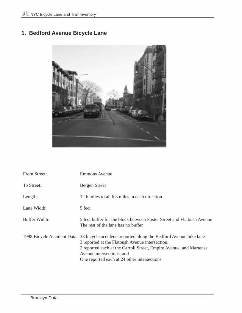
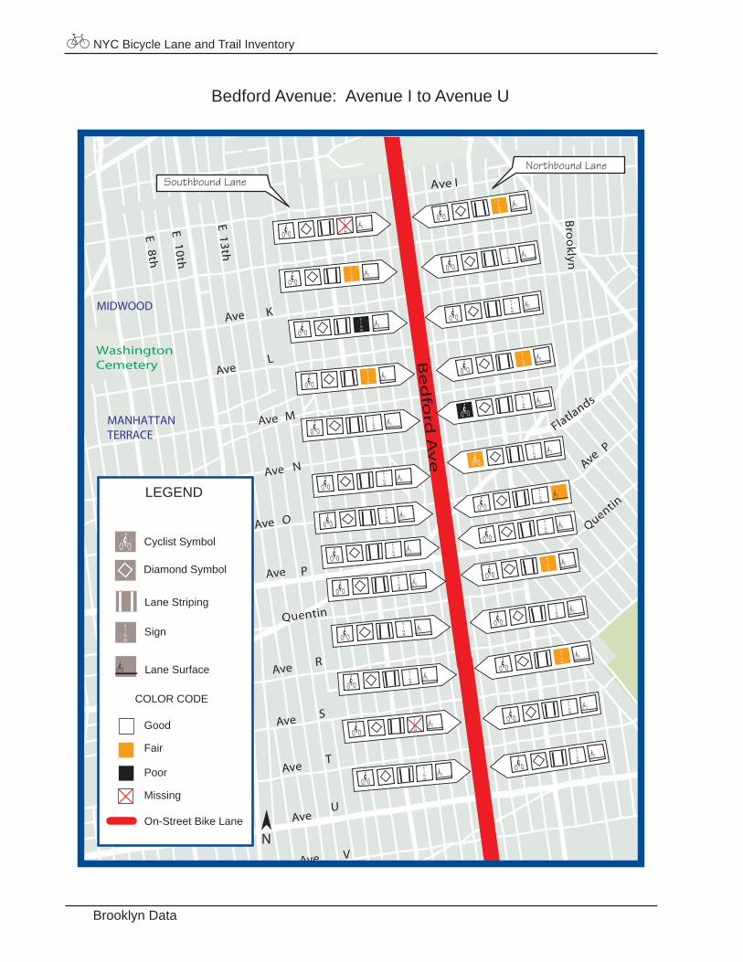
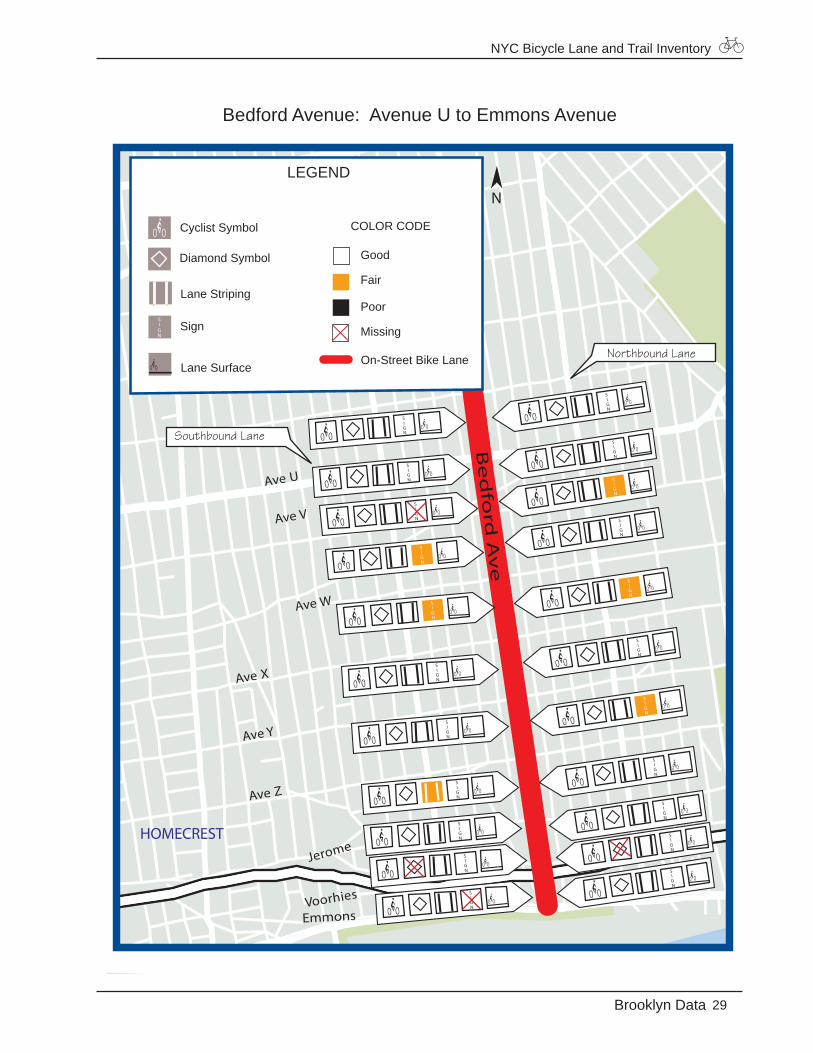
1. Bedford Avenue Bicycle Lane
From Street: Emmons Avenue
To Street: Bergen Street
Length: 12.6 miles total, 6.3 miles in each direction
Lane Width: 5 feet
Buffer Width: 5 feet buffer for the block between Foster Street and Flatbush Avenue The rest of the lane has no buffer
1998 Bicycle Accident Data: 33 bicycle accidents reported along the Bedford Avenue bike lane- 3 reported at the Flatbush Avenue intersection, 2 reported each at the Carroll Street, Empire Avenue, and Martense Avenue intersections, and One reported each at 24 other intersections

NYC Bicycle Lane and Trail Inventory
25Brooklyn Data
Bedford Avenue: Bergen Street to Empire BoulevardPacific
Lincoln
St Johns
Park
Broo
klyn
Union
President
Carroll
Crown
No
stra
nd
Eastern
Prospect
Sterling
Montgomery
Sullivan
Empire
Bergen
Be
dfo
rd A
ve
CROWN HEIGHTS
PROSPECTLEFFERTSGARDENS
LEGEND
Good
Fair
Poor
Missing
On-Street Bike Lane
Diamond Symbol
Cyclist Symbol
Lane Striping
Lane Surface
Sign
COLOR CODE
N
Northbound Lane
Southbound Lane
NYC Bicycle Lane and Trail Inventory
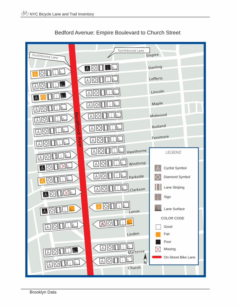
Brooklyn Data
Bedford Avenue: Empire Boulevard to Church Street
Sterling
Lefferts
Lincoln
Maple
Midwood
Rutland
Fenimore
Hawthorne
Clarkson
Lenox
Martense
Church
Empire
Hawthorne
Winthrop
Parkside
Clarkson
Lenox
Linden
Martense
Linden
WinthropB
ed
ford
Av
eLEGEND
Good
Fair
Poor
Missing
On-Street Bike Lane
Diamond Symbol
Cyclist Symbol
Lane Striping
Lane Surface
Sign
COLOR CODE
N
Northbound Lane Southbound Lane
NYC Bicycle Lane and Trail Inventory
27Brooklyn Data
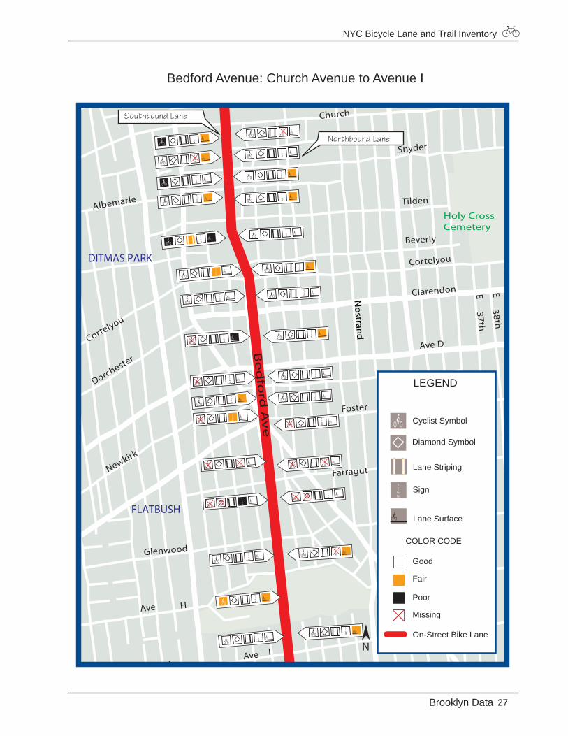
Bedford Avenue: Church Avenue to Avenue I
Newkirk
Cortelyou
Dorchester
Albemarle
37th38th
Cortelyou
Beverly
Snyder
Tilden
E
21st14th
Ave H
E
Glenwood
Farragut
Foster
EE
E
EE
Church
Clarendon
Ave D
Foster
Farragut
Glenwood
Ave I
No
strand
Holy CrossCemetery
Be
dfo
rd A
ve
Ave I
FLATBUSH
DITMAS PARK
LEGEND
Good
Fair
Poor
Missing
On-Street Bike Lane
Diamond Symbol
Cyclist Symbol
Lane Striping
Lane Surface
Sign
COLOR CODE
N
Northbound Lane
Southbound Lane
NYC Bicycle Lane and Trail Inventory
Brooklyn Data
Bedford Avenue: Avenue I to Avenue U
Ave O
V
Ave S
Estate
Ave N
Ave M
AveL
Ave K
8th
10th
13th8th
RQuentin
Flatlands
Ave H
Alb
any
Broo
klyn
AveP
E E E
Ave
Ave P
Ave S
TAve
Ave
Ave
Quentin
Ave R
U
V
WashingtonCemetery B
ed
ford
Av
e
Ave T
Ave I
FLATBUSH
MIDWOOD
MANHATTANTERRACE
OCEANPARKWAY
LEGEND
Good
Fair
Poor
Missing
On-Street Bike Lane
Diamond Symbol
Cyclist Symbol
Lane Striping
Lane Surface
Sign
COLOR CODE
N
Northbound Lane Southbound Lane
NYC Bicycle Lane and Trail Inventory
29Brooklyn Data
Bedford Avenue: Avenue U to Emmons Avenue
Jerome
Voorhies
Moore
W
X
Ave Z
Ave Y
Ave X
Ave W
Ave V
Ave U
Be
dfo
rd A
ve
Oce
an P
kwy
Emmons
Ave Y
HOMECREST
LEGEND
Good
Fair
Poor
Missing
On-Street Bike Lane
Diamond Symbol
Cyclist Symbol
Lane Striping
Lane Surface
Sign
COLOR CODE
N
Northbound Lane
Southbound Lane
NYC Bicycle Lane and Trail Inventory
Brooklyn Data
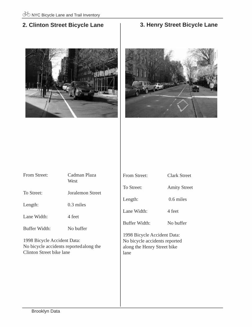
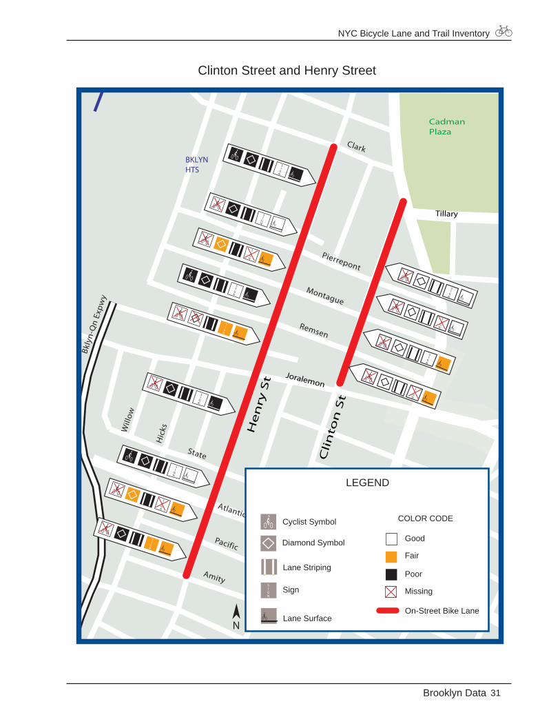
2. Clinton Street Bicycle Lane 3. Henry Street Bicycle Lane
From Street: Cadman Plaza West
To Street: Joralemon Street
Length: 0.3 miles
Lane Width: 4 feet
Buffer Width: No buffer
1998 Bicycle Accident Data:No bicycle accidents reported along the Clinton Street bike lane
From Street: Clark Street
To Street: Amity Street
Length: 0.6 miles
Lane Width: 4 feet
Buffer Width: No buffer
1998 Bicycle Accident Data: No bicycle accidents reported along the Henry Street bike lane
NYC Bicycle Lane and Trail Inventory
31Brooklyn Data
Clinton Street and Henry Street
Pear
l
Will
ow
Hic
ks
Remsen
Pierrepont
Montague
Congress
Grace
Bkly
n-Q
n Ex
pwy
State
Atlantic
Pacific
Amity
Clark
Atlantic
State
Pacific
CadmanPlaza
Ad
ams
He
nry
St
Cli
nto
n S
t
Joralemon
Tillary
BKLYNHTS
LEGEND
Good
Fair
Poor
Missing
On-Street Bike Lane
Diamond Symbol
Cyclist Symbol
Lane Striping
Lane Surface
Sign
COLOR CODE
N
NYC Bicycle Lane and Trail Inventory
Brooklyn Data
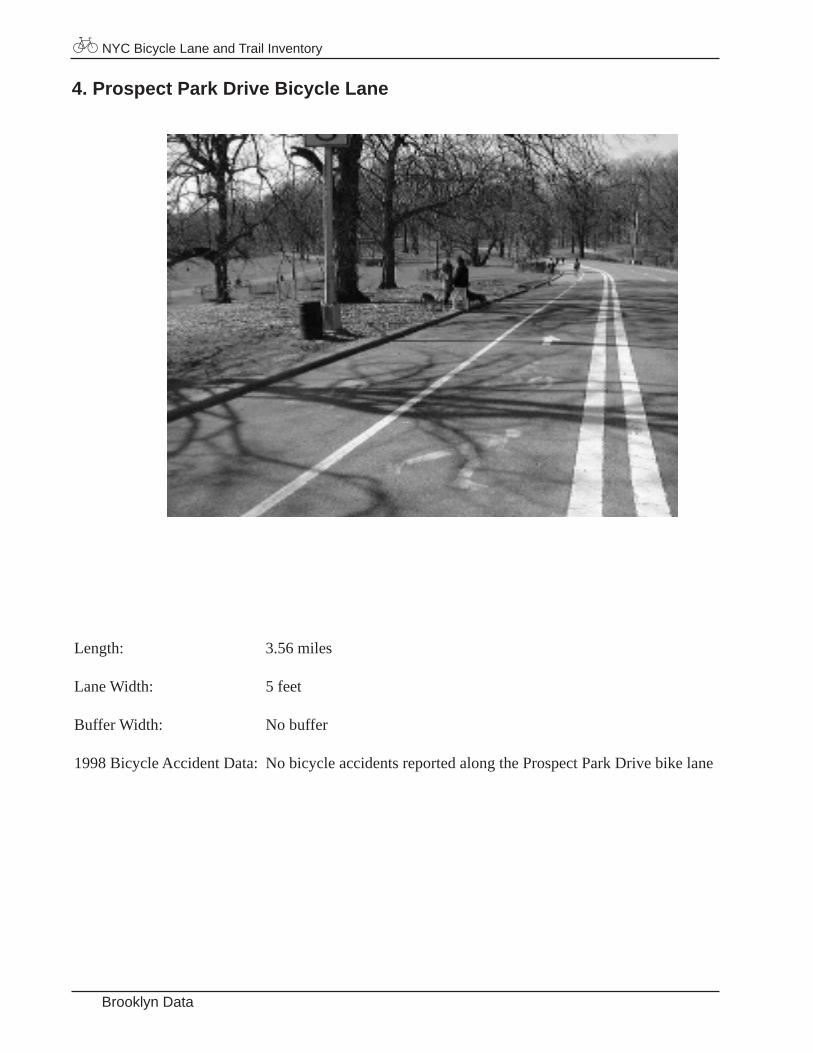
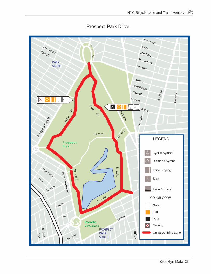
4. Prospect Park Drive Bicycle Lane
Length: 3.56 miles
Lane Width: 5 feet
Buffer Width: No buffer
1998 Bicycle Accident Data: No bicycle accidents reported along the Prospect Park Drive bike lane
NYC Bicycle Lane and Trail Inventory
33Brooklyn Data
Prospect Park Drive
ELake
Caton
S Lake
Ocean
PzSt
EFlatbush
EastD
r
Wes
tD
r
Central
Kermit
WLake
Prospect
Fran
klin
Sterling
Lincoln
St Johns
ParkCarroll
President
Reeve
Terrace
E2n
dE
3rd
E
Sherman17th
UnionPresident
Carroll
Montgomery
Crown Rog
ers
Flatbush
ProspectPark
ParadeGrounds
Bedf
ord
8th
Pros
pect
Par
k W
Park Southwest
Caton
Winthrop
PROSPECTLEFFERTSGARDENS
PARKSLOPE
PROSPECTPARKSOUTH
LEGEND
Good
Fair
Poor
Missing
On-Street Bike Lane
Diamond Symbol
Cyclist Symbol
Lane Striping
Lane Surface
Sign
COLOR CODE
N

NYC Bicycle Lane and Trail Inventory
Brooklyn Data
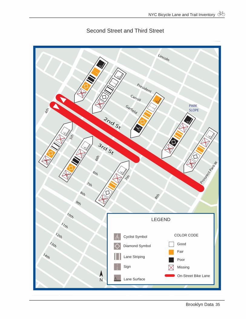
5. Second Street Bicycle Lane 6. Third Street Bicycle Lane
From Street: Fourth Avenue
To Street: Prospect Park West
Length: 0.75 miles
Lane Width: 4 feet
Buffer Width: No buffer
1998 Bicycle Accident Data: One bicycle accident reported at the intersec-tion of Fifth Avenue and Second Street
From Street: Third Avenue
To Street: Smith Street
Length: 0.5 miles
Lane Width: 4 feet
Buffer Width: No buffer
1998 Bicycle Accident Data: One bicycle accident reported at the intersection of Seventh Avenue and Third Street
NYC Bicycle Lane and Trail Inventory
35Brooklyn Data
Second Street and Third Street
Wes
t
Dr
Carroll
Garfield
7th
President
7th
8th
11th
10th
6th
14th
13th
12th
8th
Prosp
ect P
ark W
.
Lincoln
2nd St
8th
Pros
pect
Par
k W
5th
3rd St
9th
4th
6th
PARKSLOPE
LEGEND
Good
Fair
Poor
Missing
On-Street Bike Lane
Diamond Symbol
Cyclist Symbol
Lane Striping
Lane Surface
Sign
COLOR CODE
N
NYC Bicycle Lane and Trail Inventory
Brooklyn Data
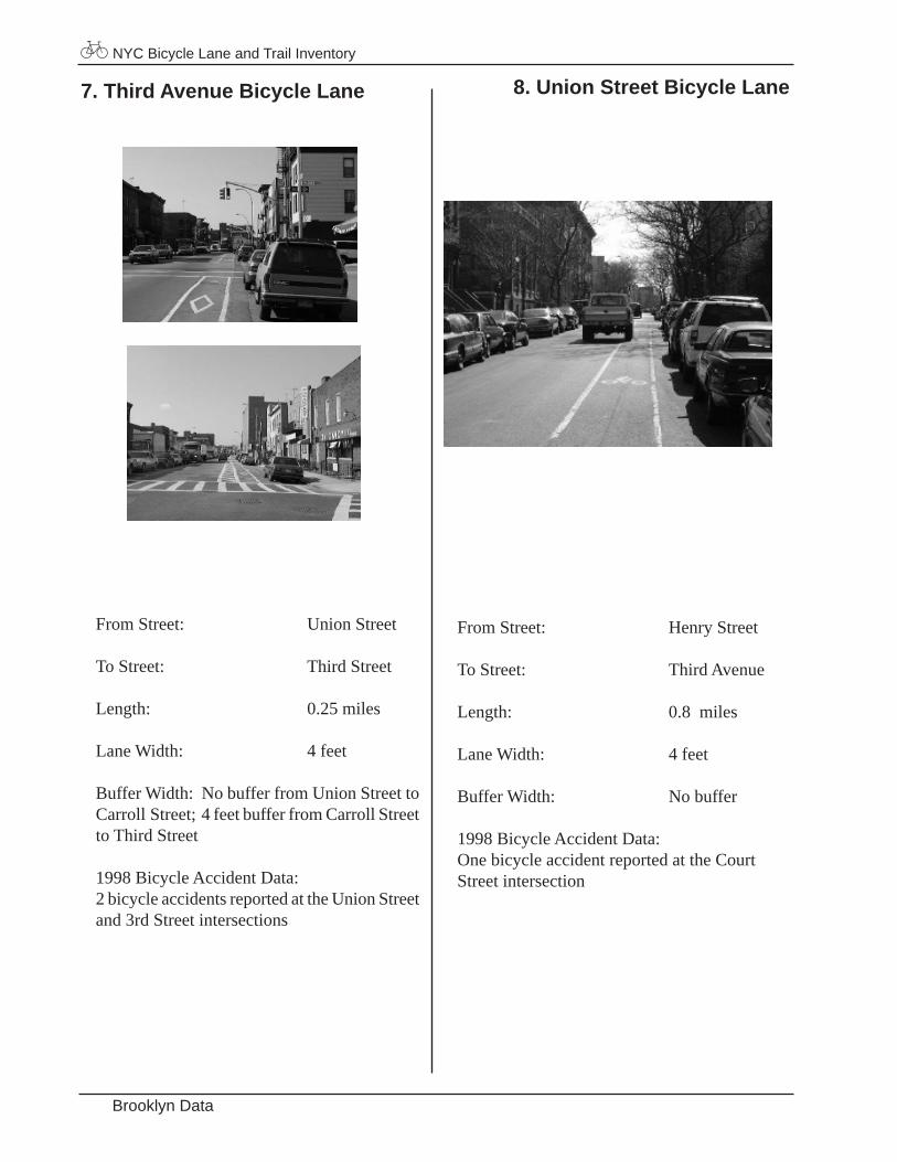
7. Third Avenue Bicycle Lane 8. Union Street Bicycle Lane
From Street: Union Street
To Street: Third Street
Length: 0.25 miles
Lane Width: 4 feet
Buffer Width: No buffer from Union Street to Carroll Street; 4 feet buffer from Carroll Street to Third Street
1998 Bicycle Accident Data: 2 bicycle accidents reported at the Union Street and 3rd Street intersections
From Street: Henry Street
To Street: Third Avenue
Length: 0.8 miles
Lane Width: 4 feet
Buffer Width: No buffer
1998 Bicycle Accident Data: One bicycle accident reported at the Court Street intersection

NYC Bicycle Lane and Trail Inventory
37Brooklyn Data
Third Avenue and Union Street
Warren
Wyckoff
Baltic
Nev
ins
Bond
Hoy
t2nd
4th
1st
Carroll
1st
LuquerNelson
Huntington
8th
2nd
Gow
anus Expwy
Hen
ryH
enry
Tom
pkin
s
Cour
t
Smith
Bergen
Union St
3rd St
3rd
Ave
3rd
9th
CARROLLGARDENS
GOWANUS
LEGEND
Good
Fair
Poor
Missing
On-Street Bike Lane
Diamond Symbol
Cyclist Symbol
Lane Striping
Lane Surface
Sign
COLOR CODE
N
NYC Bicycle Lane and Trail Inventory
Brooklyn Data
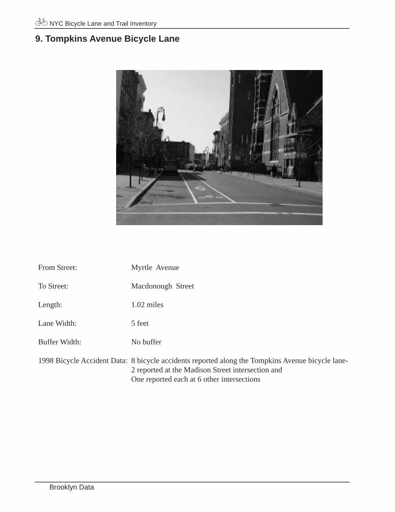
9. Tompkins Avenue Bicycle Lane
From Street: Myrtle Avenue
To Street: Macdonough Street
Length: 1.02 miles
Lane Width: 5 feet
Buffer Width: No buffer
1998 Bicycle Accident Data: 8 bicycle accidents reported along the Tompkins Avenue bicycle lane- 2 reported at the Madison Street intersection and One reported each at 6 other intersections
NYC Bicycle Lane and Trail Inventory
39Brooklyn Data
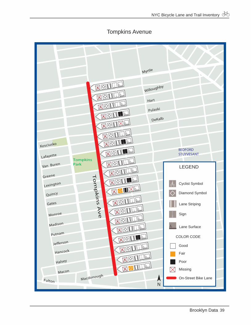
Tompkins Avenue
Hancock
Marcus
Garvey
Madison
Putnam
Jefferson
Halsey
Macon
Quincy
Van Buren
Greene
Lexington
Pulaski
Hart
Monroe
Lewis
Lafayette
Kosciusko
MacdonoughFulton
TompkinsPark
Willoughby
DeKalb
To
mp
kin
s Av
e
Gates
Myrtle
BEDFORDSTUYVESANT
LEGEND
Good
Fair
Poor
Missing
On-Street Bike Lane
Diamond Symbol
Cyclist Symbol
Lane Striping
Lane Surface
Sign
COLOR CODE
N
NYC Bicycle Lane and Trail Inventory
Brooklyn Data
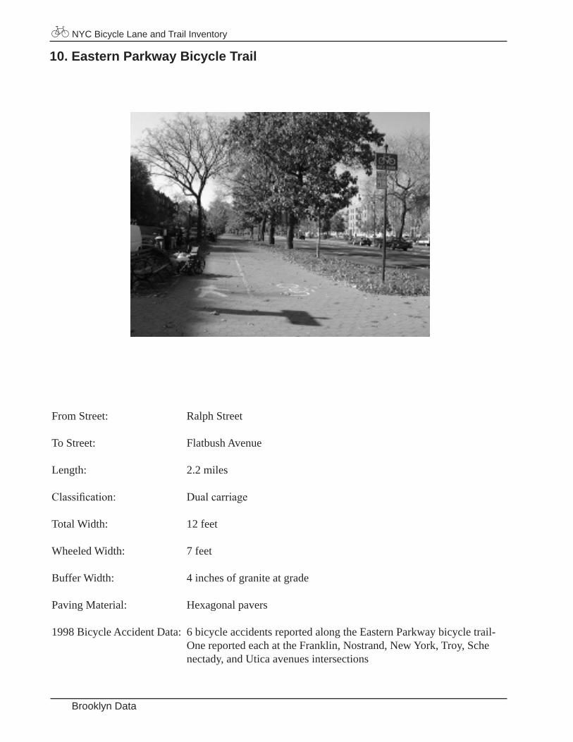
10. Eastern Parkway Bicycle Trail
From Street: Ralph Street
To Street: Flatbush Avenue
Length: 2.2 miles
Classification: Dualcarriage
Total Width: 12 feet
Wheeled Width: 7 feet
Buffer Width: 4 inches of granite at grade
Paving Material: Hexagonal pavers
1998 Bicycle Accident Data: 6 bicycle accidents reported along the Eastern Parkway bicycle trail- One reported each at the Franklin, Nostrand, New York, Troy, Sche nectady, and Utica avenues intersections

NYC Bicycle Lane and Trail Inventory
41Brooklyn Data
Eastern Parkway
Patchen
ELake
Caton
Ocean
Flatbush
Hancock
Madison
Putnam
Jefferson
Macon
Irving
Gran
dD
owning
Spen
cer
St Cam
br
Cla
sson
Pacific
Fran
klin
Woodruff
Crooke
Uti
ca
Sch
enec
tad
y
Alb
any
Bro
okl
yn
Kin
gst
on
Troy
Rog
ers
Lefferts
Maple
Rutland
Hawthorne
Rog
ers
ECortelyouBeverly
Church
Snyder
Tilden
EE
Winth
rop
Stuyvesant
Lewis
Ralph
No
stra
nd
EEE
Malcolm
X Blvd
Was
hin
gto
n
New
Yo
rk
Flatbush
Holy CrossCemetery
Lincoln Terr. ParkBe
dfor
d
Parkside
Eastern Pkwy
Dean
Buff
alo
Roch
este
r
BEDFORDSTUYVESANT
CROWN HEIGHTS
WINGATE
PROSPECTLEFFERTSGARDENS
RUGBY
PROSPECTHEIGHTS
DITMAS PARK
PROSPECTPARKSOUTH
LEGEND
Good
Fair
Poor
Missing
Bike Trail
Pedestrian Symbol
Cyclist Symbol
Lane Striping
Lane Surface
Sign
COLOR CODE
N
NYC Bicycle Lane and Trail Inventory
Brooklyn Data
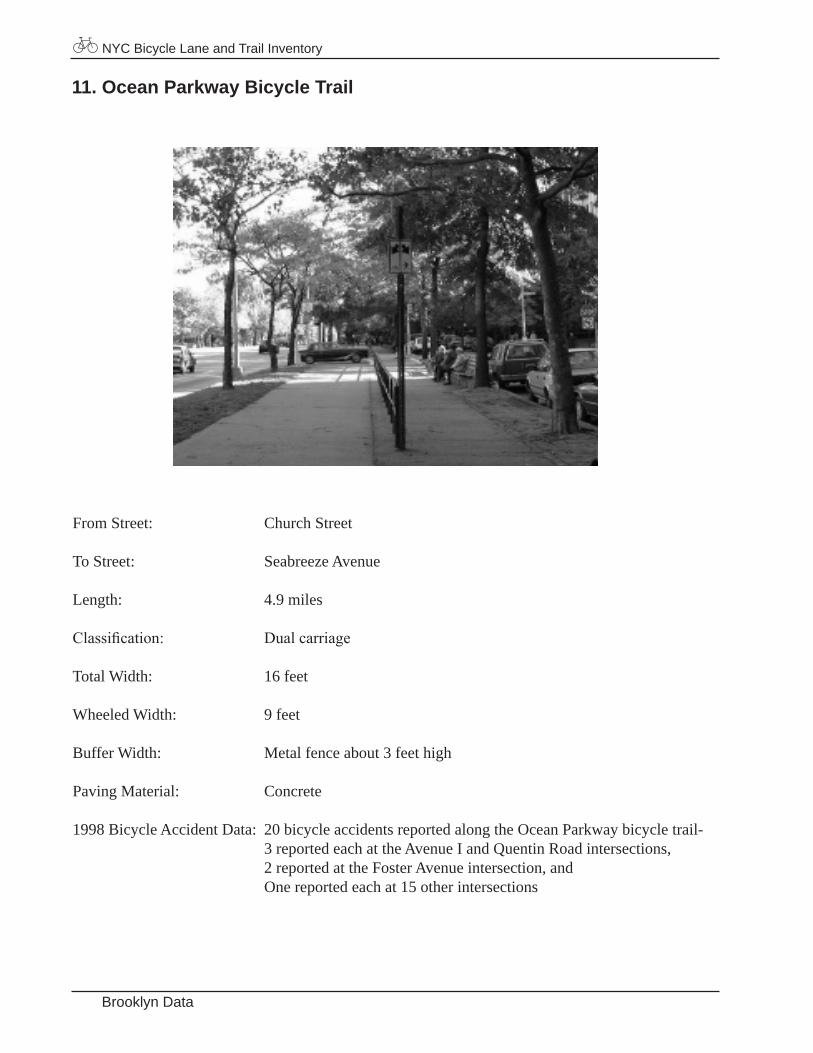
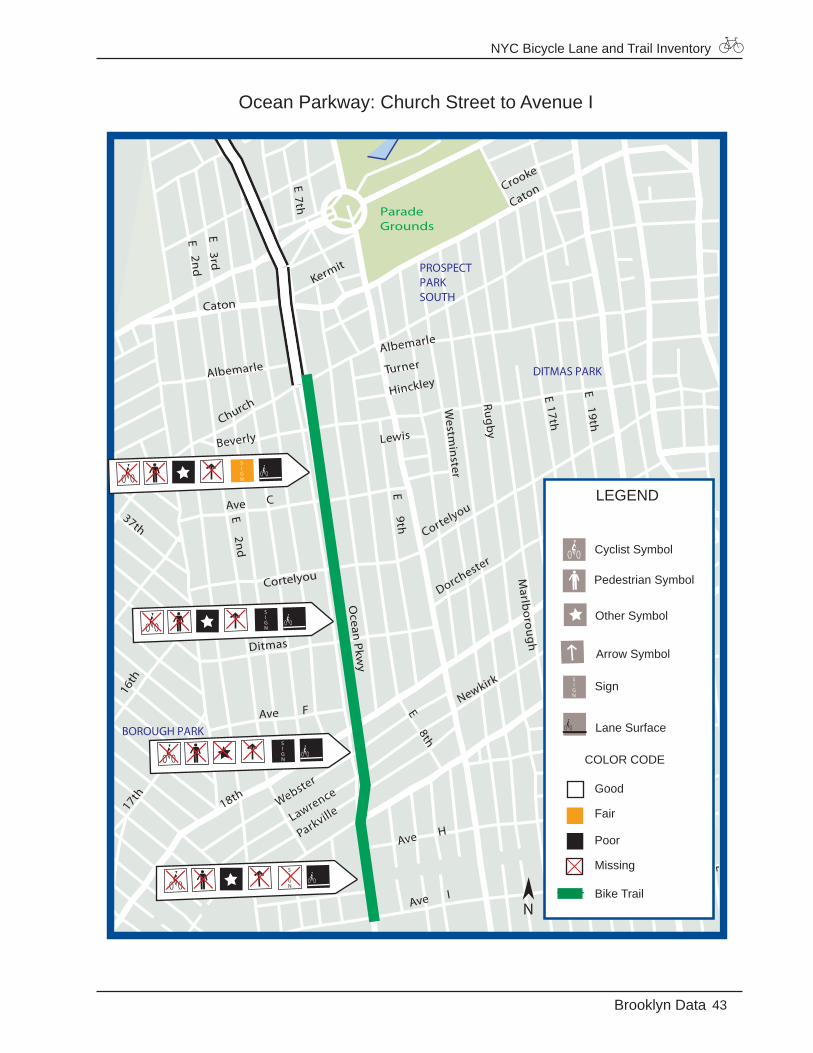
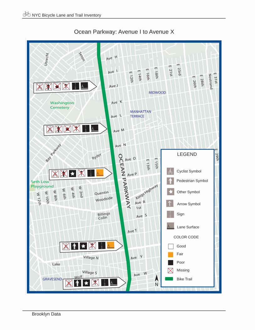
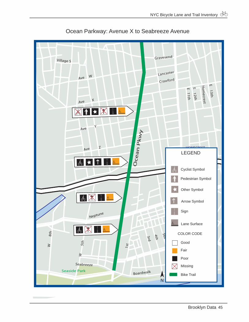
11. Ocean Parkway Bicycle Trail
From Street: Church Street
To Street: Seabreeze Avenue
Length: 4.9 miles
Classification: Dualcarriage
Total Width: 16 feet
Wheeled Width: 9 feet
Buffer Width: Metal fence about 3 feet high
Paving Material: Concrete
1998 Bicycle Accident Data: 20 bicycle accidents reported along the Ocean Parkway bicycle trail- 3 reported each at the Avenue I and Quentin Road intersections, 2 reported at the Foster Avenue intersection, and One reported each at 15 other intersections
NYC Bicycle Lane and Trail Inventory
43Brooklyn Data
Ocean Parkway: Church Street to Avenue I
Caton
Kermit
37th
17th
Old
New
Ave H
Newkirk
Cortelyou
Dorchester
E8th
Albemarle
Turner
Hinckley
Lewis
E9th
Lawrence
ParkvilleWebster
Ave F
Ditmas
E2n
d
Ave C
Beverly
Albemarle
Crooke
E2n
dE
3rd
E7th
E17th
E19th
Marlb
orough
Rugby
Westm
inster
5th
7th
E E E E E E
E
E
Ave I
18th
ParadeGrounds
Church
Caton
Ocean
Pkwy
Cortelyou
16th
FLATBUSHBOROUGH PARK
DITMAS PARK
PROSPECTPARKSOUTH
LEGEND
Good
Fair
Poor
Missing
Bike Trail
Pedestrian Symbol
Cyclist Symbol
Other Symbol
Lane Surface
Sign
COLOR CODE
Arrow Symbol
N
NYC Bicycle Lane and Trail Inventory
Brooklyn Data
Ocean Parkway: Avenue I to Avenue X
Ave O
Utr
ech
t
E29th
27th
E19th
21st
23rd
E13th
E15th
E17th
W
Ave V
1stR
Ave S
Quentin
Woodside
BillingsColin
Wolf
Lake
W4th
W6th
W2n
d
W10th
W12th
W8th
Ave N
Ave M
Ave L
Ryder
Ave K
Ave H
Seton
E31st
E28th
E26th
23rd16th
21st
18th
14th
12th
Village S
Village N
Ave
Ave
E E
E
E E E E E E
Nostran
d
Ave I
Bay P
arkw
ay
WashingtonCemetery
Seth LowPlayground
Bedford
Ave T
Ave P
Ave J
Kings Highway
MIDWOOD
MANHATTANTERRACE
OC
EA
N P
AR
KW
AY
GRAVESEND
LEGEND
Good
Fair
Poor
Missing
Bike Trail
Pedestrian Symbol
Cyclist Symbol
Other Symbol
Lane Surface
Sign
COLOR CODE
Arrow Symbol
N
NYC Bicycle Lane and Trail Inventory
45Brooklyn Data
Ocean Parkway: Avenue X to Seabreeze Avenue
11th
12th
5th
6th
7th
Boardwalk
3rd
4th
W12th W
8th
W5t
h
E13th
E12th
E11th
Hom
ecrest
West
Ave Z
Ave Y
W Lancaster
Crawford
Ave X
Gravesend
1st
Village S
Village N
Ave
Seabreeze
Seaside Park
Neptune
Oc
ea
n P
kw
y
BRIGHTONBEACH
HOMECREST
LEGEND
Good
Fair
Poor
Missing
Bike Trail
Pedestrian Symbol
Cyclist Symbol
Other Symbol
Lane Surface
Sign
COLOR CODE
Arrow Symbol
N
NYC Bicycle Lane and Trail Inventory
Brooklyn Data
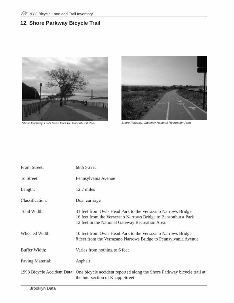
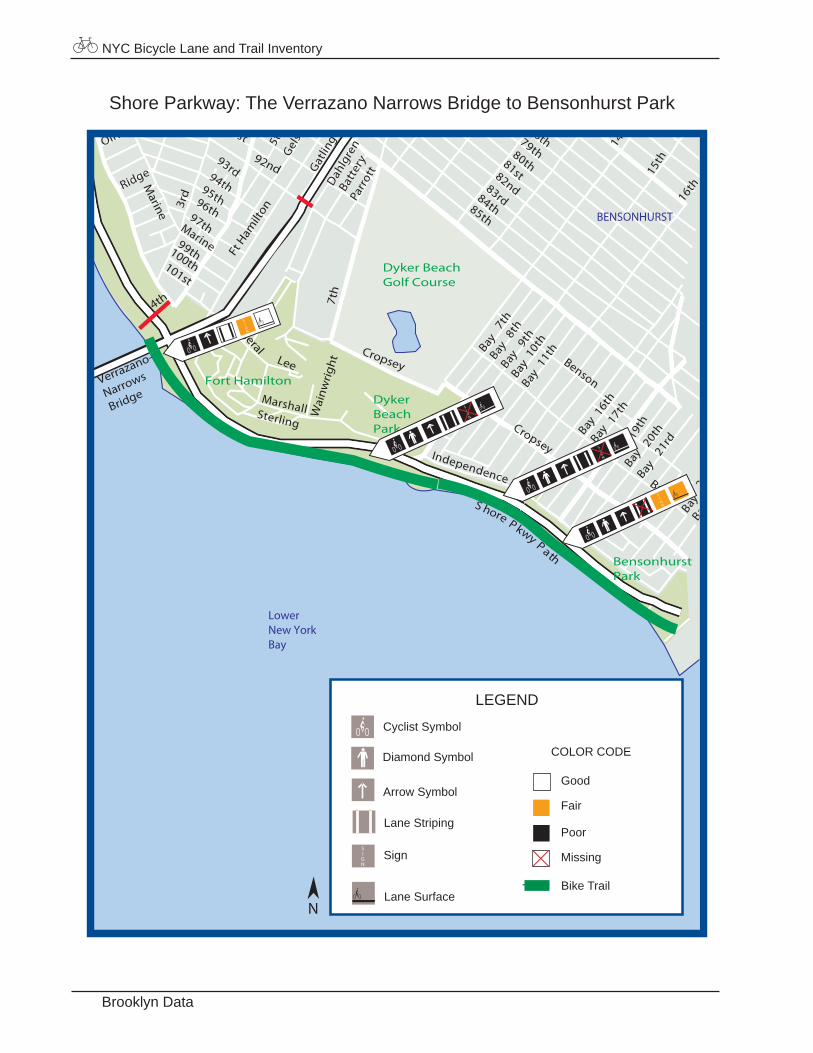
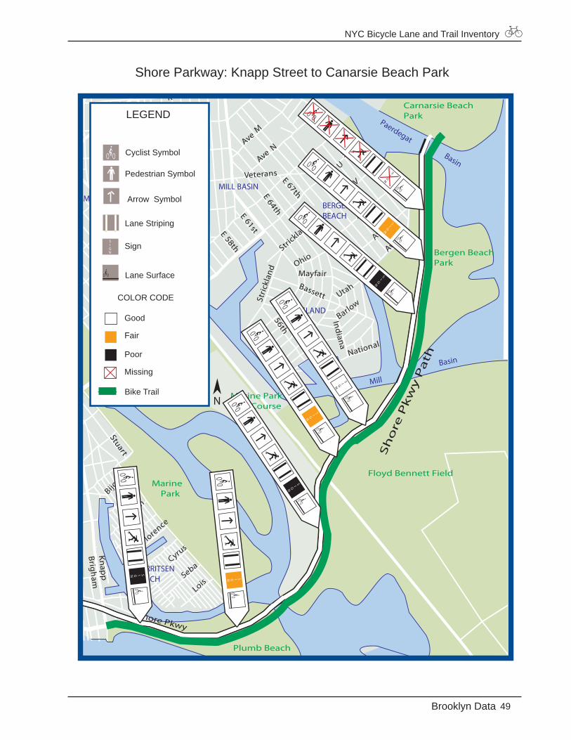
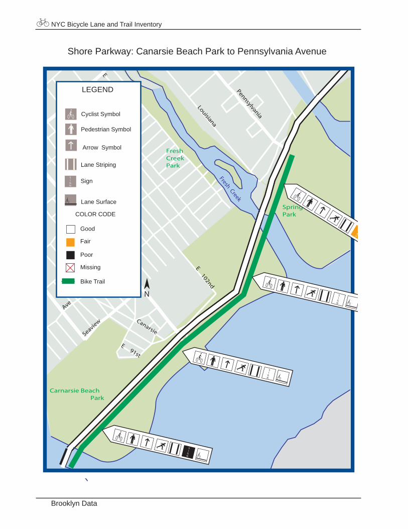
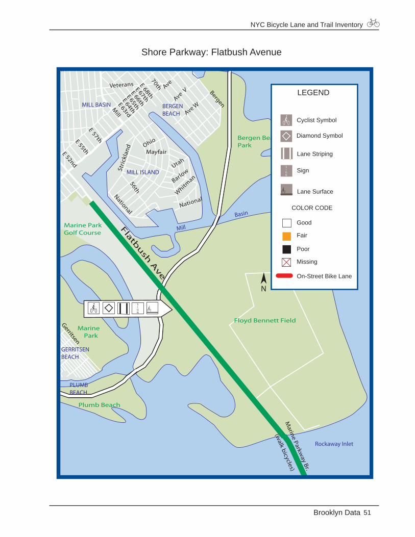
12. Shore Parkway Bicycle Trail
From Street: 68th Street
To Street: Pennsylvania Avenue
Length: 12.7 miles
Classification: Dualcarriage
Total Width: 31 feet from Owls Head Park to the Verrazano Narrows Bridge 16 feet from the Verrazano Narrows Bridge to Bensonhurst Park 12 feet in the National Gateway Recreation Area.
Wheeled Width: 10 feet from Owls Head Park to the Verrazano Narrows Bridge 8 feet from the Verrazano Narrows Bridge to Pennsylvania Avenue
Buffer Width: Varies from nothing to 6 feet
Paving Material: Asphalt
1998 Bicycle Accident Data: One bicycle accident reported along the Shore Parkway bicycle trail at the intersection of Knapp Street
Shore Parkway, Owls Head Park to Bensonhurst Park Shore Parkway, Gateway National Recreation Area
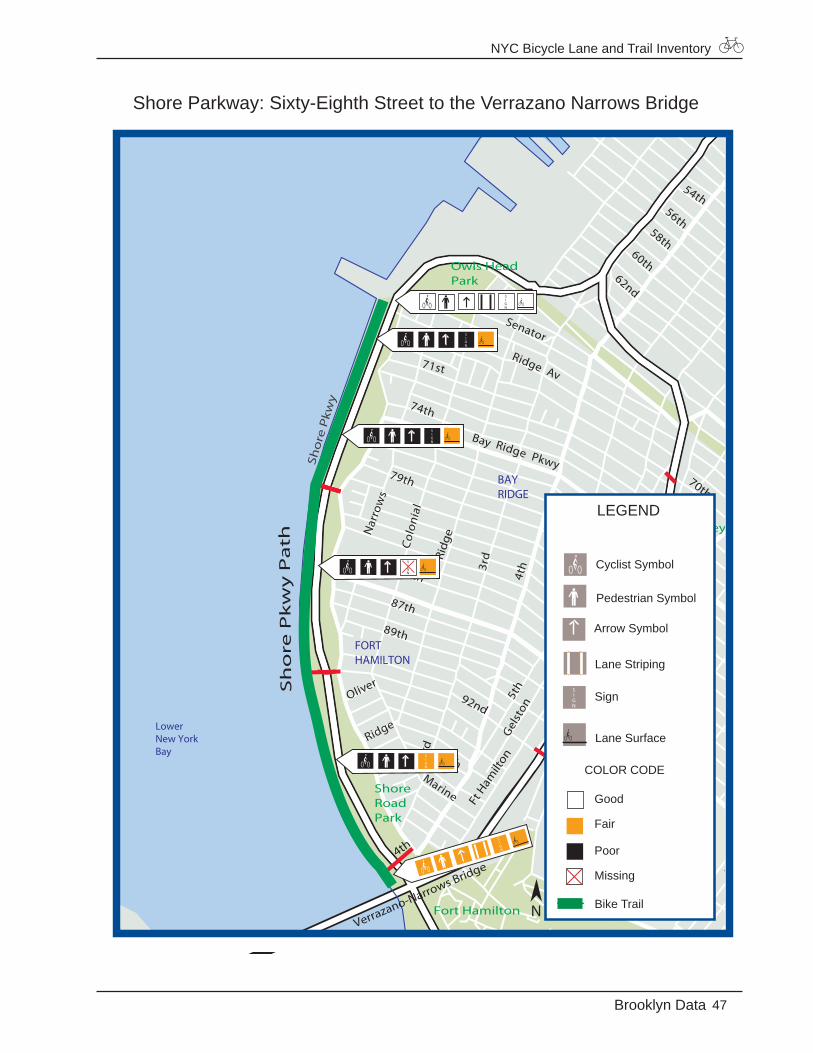
NYC Bicycle Lane and Trail Inventory
47Brooklyn Data
Shore Parkway: Sixty-Eighth Street to the Verrazano Narrows Bridge
LowerNew YorkBay
54th56th
58th60th
62nd
6th
3rd
5th
70thRidge Av
67th
Senator
Bay Ridge Pkwy
71st
74th
79th
87th
89th
85th
Nar
row
s
Col
onia
l
Marine
96th
Oliver
Ridge7th
8thBay
5th
Gel
ston
Batt
ery
Parr
ott
Marshall
81st82nd11
th
Bay9th
4th
Go
wan
us
Exp
wy
Sho
re P
kwy
Owls HeadPark
Fort Hamilton
ShoreRoadPark
DykerBeachPark
McKinleyPark
Sh
ore
Pk
wy
Pa
th
Verrazano-Narrows Bridge
70th
92nd
3rd
4th
Ridg
e
7th
Ft H
amilt
on
DYKERHEIGHTS
BAYRIDGE
FORTHAMILTON
LEGEND
Good
Fair
Poor
Missing
Bike Trail
Arrow Symbol
Cyclist Symbol
Lane Striping
Lane Surface
Sign
COLOR CODE
Pedestrian Symbol
N
NYC Bicycle Lane and Trail Inventory
Brooklyn Data
Shore Parkway: The Verrazano Narrows Bridge to Bensonhurst Park
LowerNew YorkBay
99th
Marine
96th97th
93rd94th95th
91stOliver
Ridge
Bay16th
Bay17th
Bay7th
Bay8th
Bay10th
Bay11th
5th
Gel
ston
Gat
ling
Dah
lgre
nBa
tter
yPa
rrot
t
Bay25th
Bay
Bay21rd
Bay19
thBay
20thCropsey
Benson
Independence
MarshallSterling
16th
15th81st
77th79th
78th80th
82nd83rd84th85th
Bay9th
Verrazano-
Narrows
BridgeFort Hamilton
BensonhurstPark
ShoreRoadPark
Dyker BeachGolf Course
DykerBeachParkVerrazano-Narrows Bridge
Bay
8th
92nd3r
d
14th
Cropsey
Bath
4th
Marine
7th
General
Lee
100th101st
Wai
nwrig
ht
Ft H
amilt
on
S hore P kwy Path
BENSONHURST
LEGEND
Good
Fair
Poor
Missing
Bike Trail
Diamond Symbol
Cyclist Symbol
Lane Striping
Lane Surface
Sign
COLOR CODE
Arrow Symbol
N
NYC Bicycle Lane and Trail Inventory
49Brooklyn Data
Shore Parkway: Knapp Street to Canarsie Beach Park
Basin
Basin
Mill
Basin
Paerdegat
FloydBennett
Field
Brigh
am
Cyrus
LoisSeba
Florence
Bijou
Devon
Stuart
Kimball
AveS
National
Indiana
Utah
Barlow
Bassett
Strickland
Ohio
Mayfair
56th
National
AveYAve
XAve W
AveV
Ave U
E
74th
BergenAve
NAve
M
E 67th
E 70th
E 61stE
64th
E 58thE
E53rd
Ave S
Fillmore
Ave M
Ave O
Ave N
Ave L
K
Veterans
Stri
ckla
nd
Flatbush
Shore Pkwy
Bergen BeachPark
Carnarsie BeachPark
Floyd Bennett Field
Marine Park Golf Course
Marine Park
Plumb Beach
Ave T
Sh
ore
Pk
wy
Pa
th
Knap
p
BERGENBEACH
MILL BASIN
MILL ISLAND
MARINE PARK
GERRITSENBEACH
LEGEND
Good
Fair
Poor
Missing
Bike Trail
Pedestrian Symbol
Cyclist Symbol
Lane Striping
Lane Surface
Sign
COLOR CODE
Arrow Symbol
N
NYC Bicycle Lane and Trail Inventory
Brooklyn Data
Shore Parkway: Canarsie Beach Park to Pennsylvania Avenue
Fresh Creek
E102nd
Ave
N
M
E91st
Canarsie
E
E103rd
104th105th
EE
SeaviewE
Carnarsie BeachPark
Spring CreekPark
FreshCreekPark
Rockaway
Louisiana
Pennsylvania
STARRETTCITY
LEGEND
Good
Fair
Poor
Missing
Bike Trail
COLOR CODE
Pedestrian Symbol
Cyclist Symbol
Lane Striping
Lane Surface
Sign
Arrow Symbol
N
NYC Bicycle Lane and Trail Inventory
51Brooklyn Data
Shore Parkway: Flatbush Avenue
Rockaway Inlet
Basin
Mill
Mill
National
Utah
Whitm
anBarlow
Ohio
Mayfair
56th
National
Ave WAve
VAve
EE
Bergen
N
E 67th
70thE68thE 66th
E 65th
E64th
E63rd
E57th
E 52ndE 55th
Ave M
Veterans
Mill
Stri
ckla
nd
Flatbu
sh A
ve
Bergen BeachPark
Floyd Bennett Field
Marine Park Golf Course
Marine Park
Plumb Beach
Marine Parkw
ay Br.
(walk bicycles)
Gerritsen
GEORGETOWN
BERGENBEACH
MILL BASIN
MILL ISLAND
GERRITSENBEACH
PLUMBBEACH
LEGEND
Good
Fair
Poor
Missing
On-Street Bike Lane
Diamond Symbol
Cyclist Symbol
Lane Striping
Lane Surface
Sign
COLOR CODE
N
NYC Bicycle Lane and Trail Inventory
52 Manhattan Data
MANHATTAN
Bicycle Lanes
1 Adam Clayton Powell Jr. Boulevard2 Broadway3 Central Park Drives 4 Fifth Avenue5 First Avenue6 Hudson Street/Eighth Avenue7 Lafayette Street/Fourth Avenue8 Second Avenue9 Sixth Avenue10 Street Nicholas Avenue
Bicycle Trails
11 East River, 126th Street to 63rd Street 12 East River, 20th Street to Montgomery Street13 East River, Rutgers Slip to Dover Street14 Battery Park City Bicycle Trail15 Hudson River Greenway16 Riverside Park Bicycle Trail17 Ft. Washington Park Bicycle Trail
NYC Bicycle Lane and Trail Inventory
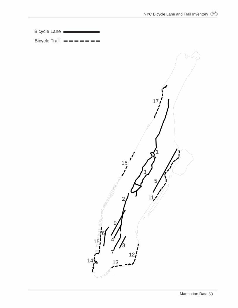
53Manhattan Data
Bicycle Lane
Bicycle Trail
1
2
3
4
5
6
78
9
11
121314
15
16
17
NYC Bicycle Lane and Trail Inventory
54 Manhattan Data
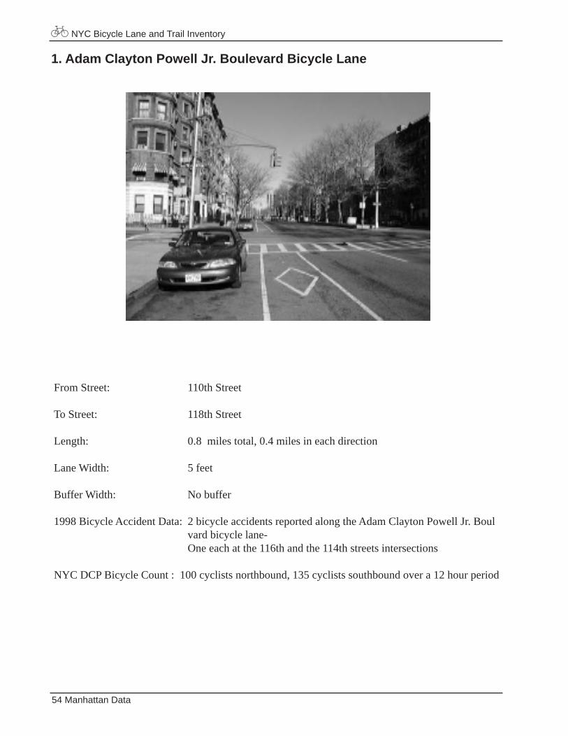
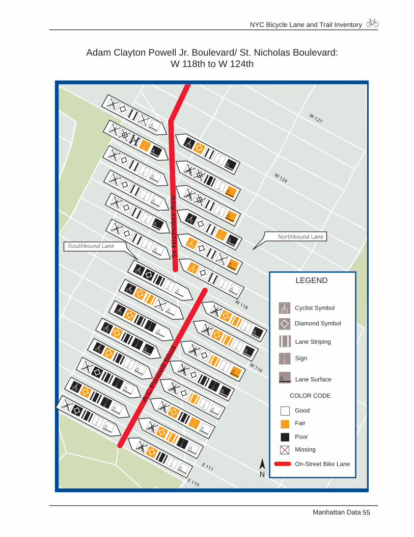
1. Adam Clayton Powell Jr. Boulevard Bicycle Lane
From Street: 110th Street
To Street: 118th Street
Length: 0.8 miles total, 0.4 miles in each direction
Lane Width: 5 feet
Buffer Width: No buffer
1998 Bicycle Accident Data: 2 bicycle accidents reported along the Adam Clayton Powell Jr. Boul vard bicycle lane- One each at the 116th and the 114th streets intersections
NYC DCP Bicycle Count : 100 cyclists northbound, 135 cyclists southbound over a 12 hour period
NYC Bicycle Lane and Trail Inventory
55Manhattan Data
Adam Clayton Powell Jr. Boulevard/ St. Nicholas Boulevard: W 118th to W 124th
E 110
E 111
W 127
A.C
Po
we
ll B
lvd
W 116
W 118
St
Nic
ho
las
Av
eW 124
LEGEND
Good
Fair
Poor
Missing
On-Street Bike Lane
Diamond Symbol
Cyclist Symbol
Lane Striping
Lane Surface
Sign
COLOR CODE
N
Northbound Lane Southbound Lane
NYC Bicycle Lane and Trail Inventory
56 Manhattan Data
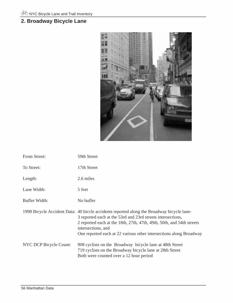
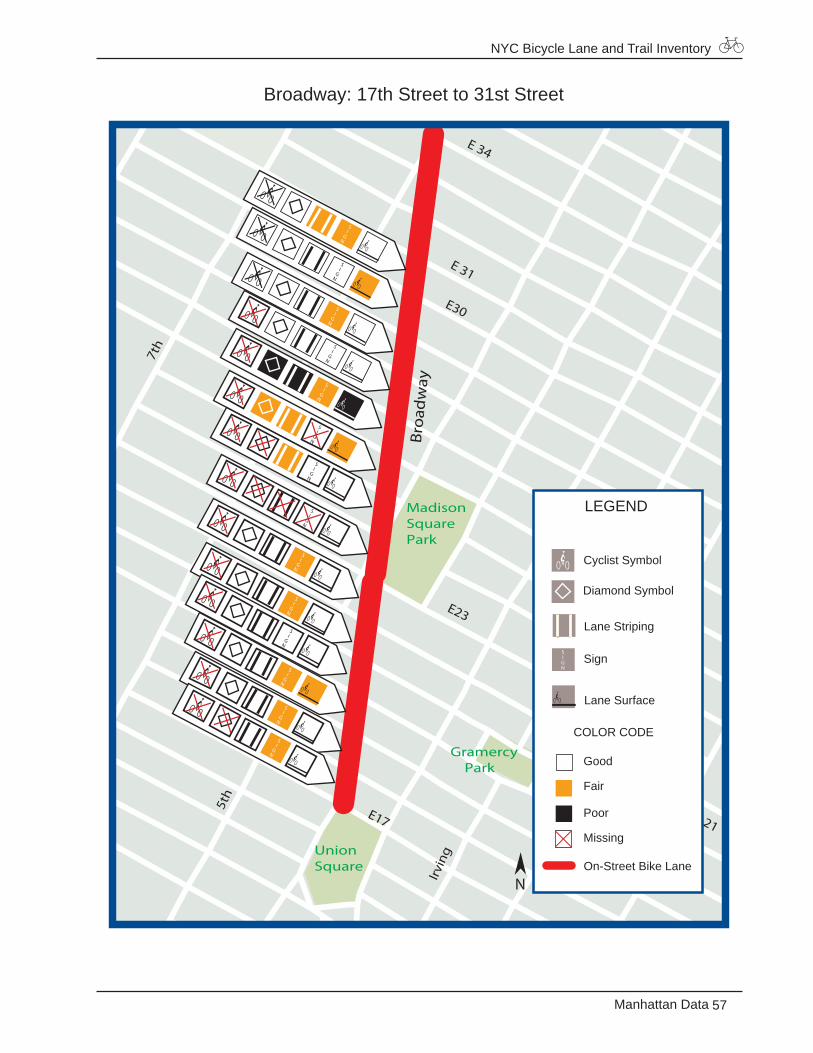
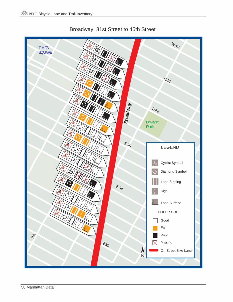
2. Broadway Bicycle Lane
From Street: 59th Street
To Street: 17th Street
Length: 2.6 miles
Lane Width: 5 feet
Buffer Width: No buffer
1998 Bicycle Accident Data: 40 biccle accidents reported along the Broadway bicycle lane- 3 reported each at the 53rd and 23rd streets intersections, 2 reported each at the 18th, 27th, 47th, 49th, 50th, and 54th streets intersections, and One reported each at 22 various other intersections along Broadway
NYC DCP Bicycle Count: 908 cyclists on the Broadway bicycle lane at 48th Street 719 cyclists on the Broadway bicycle lane at 28th Street Both were counted over a 12 hour period
NYC Bicycle Lane and Trail Inventory
57Manhattan Data
Broadway: 17th Street to 31st Street
E23
3rd
E 347t
h
E17
Broa
dw
ay
MadisonSquarePark
Gramercy Park
UnionSquare
E30
E 31
E 21
5th
Irvin
g
LEGEND
Good
Fair
Poor
Missing
On-Street Bike Lane
Diamond Symbol
Cyclist Symbol
Lane Striping
Lane Surface
Sign
COLOR CODE
N
NYC Bicycle Lane and Trail Inventory
58 Manhattan Data
Broadway: 31st Street to 45th Street
E 42
E 34
7th
E 45
Broa
dway
BryantPark
W 48
E 39
E30 E 31
TIMESSQUARE
LEGEND
Good
Fair
Poor
Missing
On-Street Bike Lane
Diamond Symbol
Cyclist Symbol
Lane Striping
Lane Surface
Sign
COLOR CODE
N
SIGN
SI
GN
SI
GN
SI
GN
SI
GN
SI
GN
SI
GN
SI
GN
SI
GN
SI
GN
SI
GN
SI
GN
SI
GN
SI
GN
SI
GN
SI
GN
SI
GN
NYC Bicycle Lane and Trail Inventory
59Manhattan Data
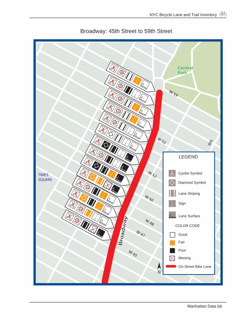
Broadway: 45th Street to 59th Street
CentralPark
6th
W 51
W 48
Bro
ad
wa
y
W 59
W 47
W 45
TIMESSQUARE
LEGEND
Good
Fair
Poor
Missing
On-Street Bike Lane
Diamond Symbol
Cyclist Symbol
Lane Striping
Lane Surface
Sign
COLOR CODE
N
W 50
W 52
W 55
NYC Bicycle Lane and Trail Inventory
60 Manhattan Data
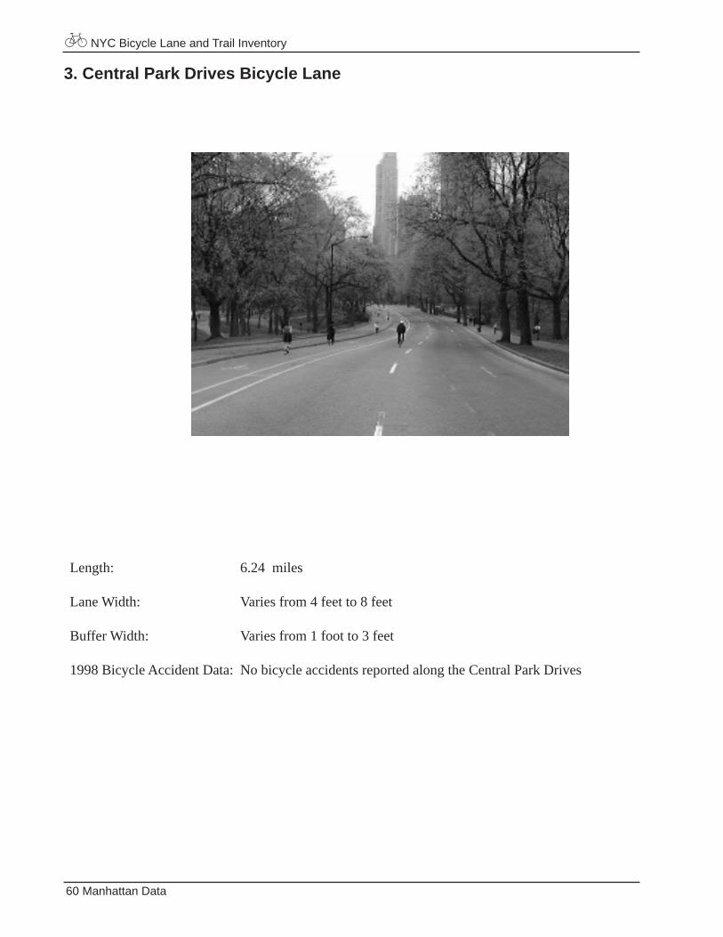
3. Central Park Drives Bicycle Lane
Length: 6.24 miles
Lane Width: Varies from 4 feet to 8 feet
Buffer Width: Varies from 1 foot to 3 feet
1998 Bicycle Accident Data: No bicycle accidents reported along the Central Park Drives
NYC Bicycle Lane and Trail Inventory
61Manhattan Data
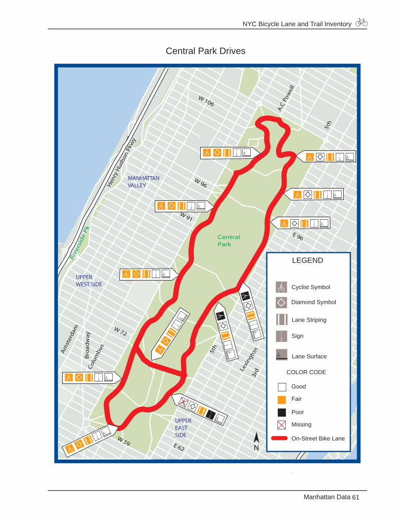
Central Park Drives
W 72
Colu
mbu
s
Lexi
ngto
n
York
E 96
3rd
W 96
Bro
adw
ay
Amst
erda
m
E 81
Hen
ry H
udso
n Pk
wy
CentralPark
Riv
ersi
de
Pk
5th
W 106
W 91
E 91 1s
t
2nd
5th
E 62
W 59
A.C
Pow
ell
78th
79th
CARNEGIEHILL
LENOXHILL
MANHATTANVALLEY
UPPERWEST SIDE
UPPEREASTSIDE
LEGEND
Good
Fair
Poor
Missing
On-Street Bike Lane
Diamond Symbol
Cyclist Symbol
Lane Striping
Lane Surface
Sign
COLOR CODE
N
NYC Bicycle Lane and Trail Inventory
62 Manhattan Data
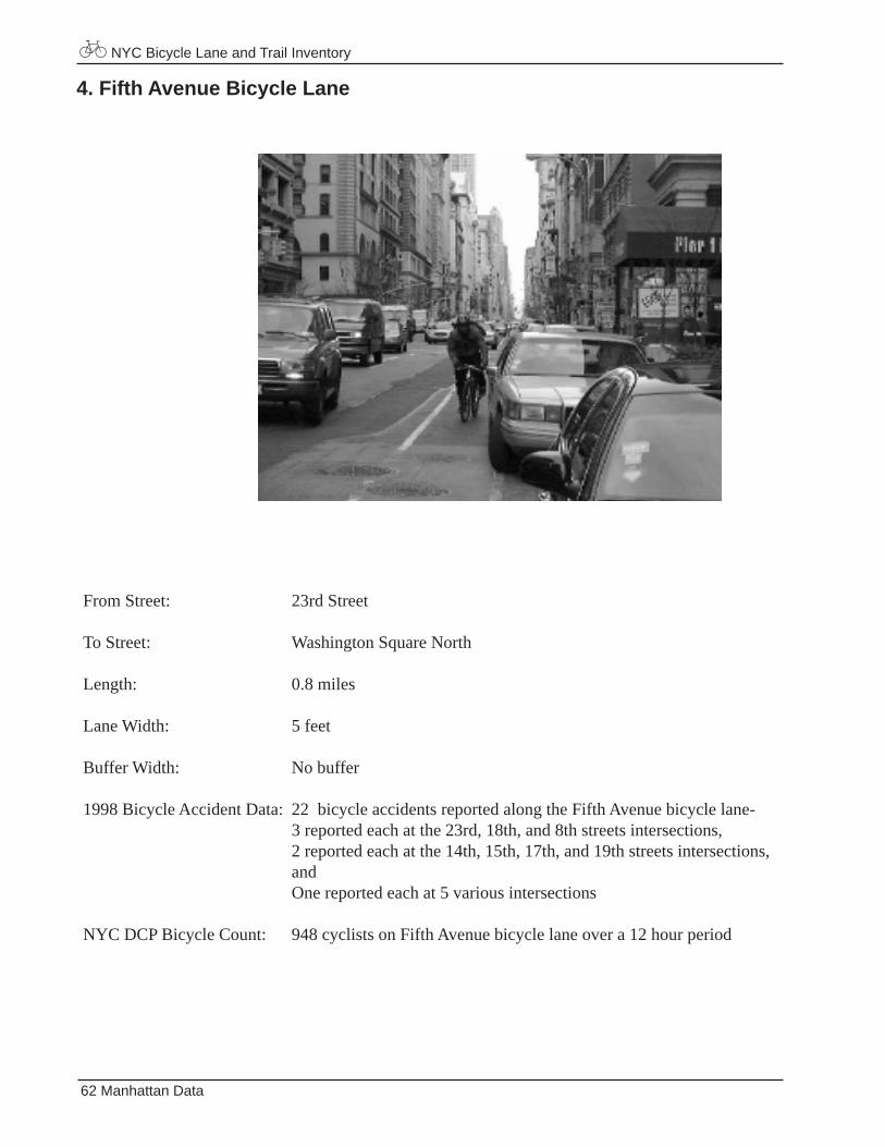
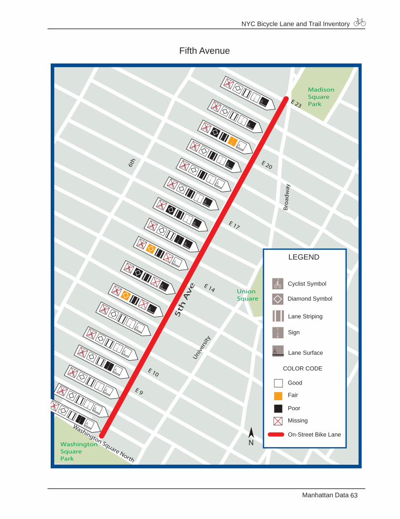
4. Fifth Avenue Bicycle Lane
From Street: 23rd Street
To Street: Washington Square North
Length: 0.8 miles
Lane Width: 5 feet
Buffer Width: No buffer
1998 Bicycle Accident Data: 22 bicycle accidents reported along the Fifth Avenue bicycle lane- 3 reported each at the 23rd, 18th, and 8th streets intersections, 2 reported each at the 14th, 15th, 17th, and 19th streets intersections, and One reported each at 5 various intersections
NYC DCP Bicycle Count: 948 cyclists on Fifth Avenue bicycle lane over a 12 hour period
NYC Bicycle Lane and Trail Inventory
63Manhattan Data
Fifth Avenue
MadisonSquarePark
UnionSquare
WashingtonSquarePark
Bro
adw
ay4t
h
5th
Av
e
6th
E 10
E 9
Washington Square North
Irvin
g
Unive
rsity
E 14
E 17
E 20
E 23
LEGEND
Good
Fair
Poor
Missing
On-Street Bike Lane
Diamond Symbol
Cyclist Symbol
Lane Striping
Lane Surface
Sign
COLOR CODE
N
NYC Bicycle Lane and Trail Inventory
64 Manhattan Data
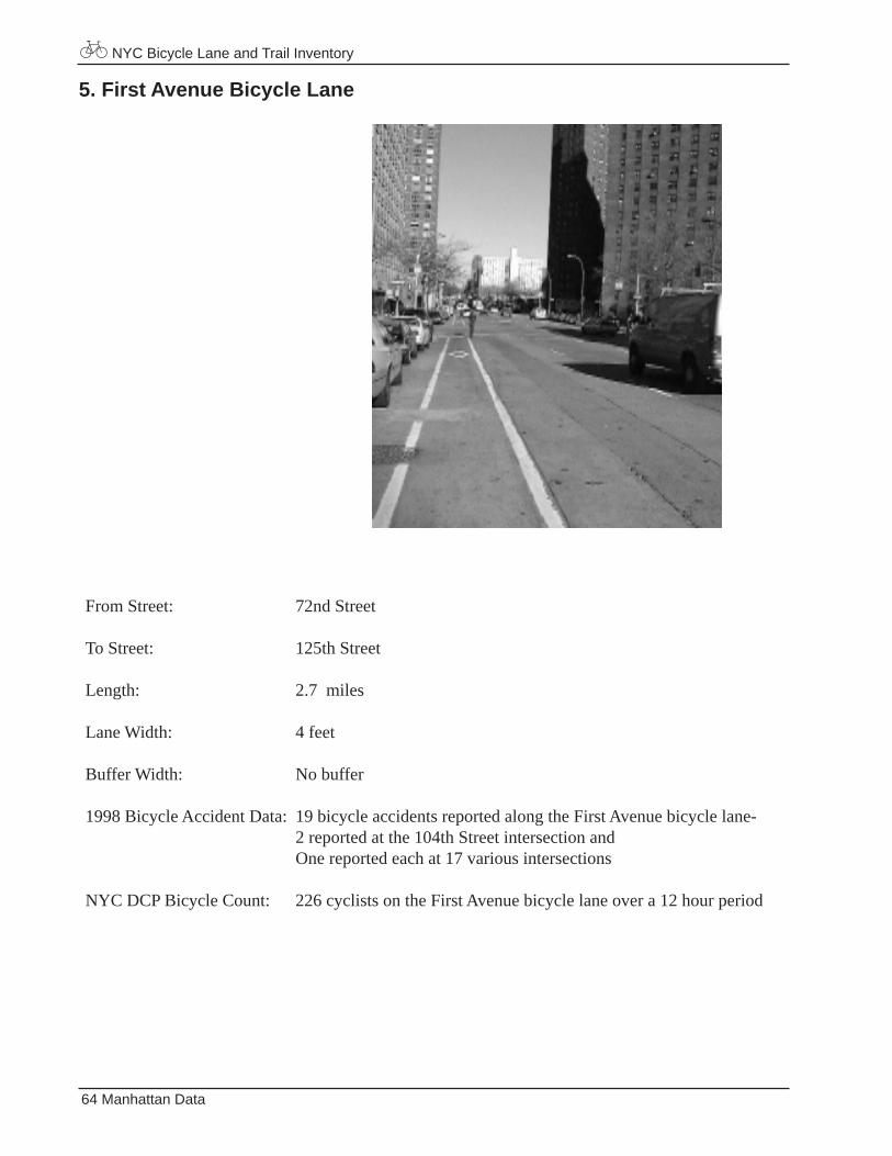
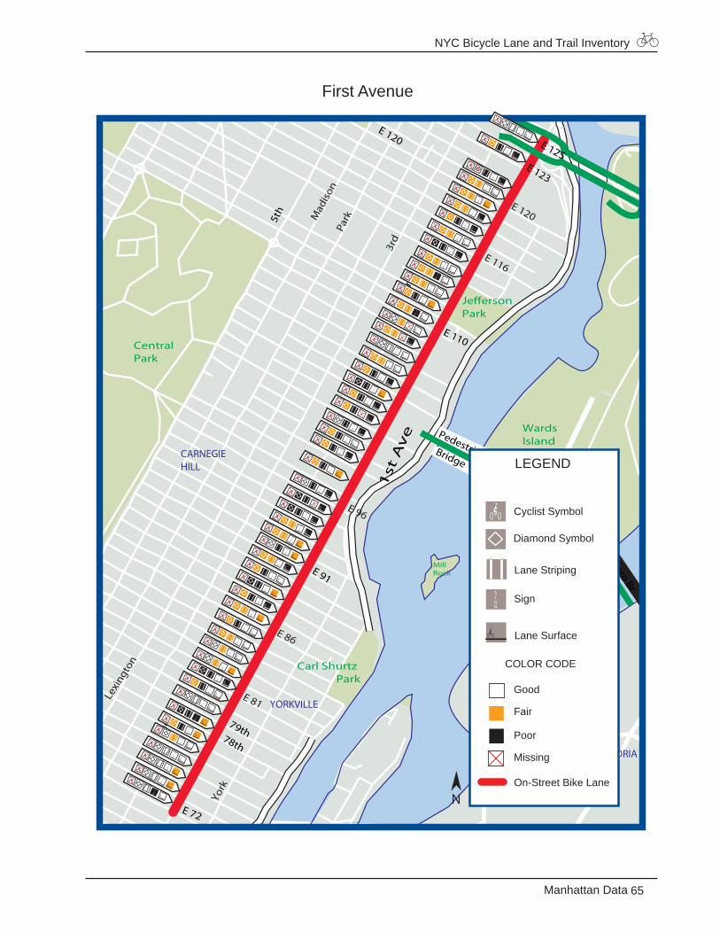
5. First Avenue Bicycle Lane
From Street: 72nd Street
To Street: 125th Street
Length: 2.7 miles
Lane Width: 4 feet
Buffer Width: No buffer
1998 Bicycle Accident Data: 19 bicycle accidents reported along the First Avenue bicycle lane- 2 reported at the 104th Street intersection and One reported each at 17 various intersections
NYC DCP Bicycle Count: 226 cyclists on the First Avenue bicycle lane over a 12 hour period
NYC Bicycle Lane and Trail Inventory
65Manhattan Data
First Avenue
E 116
E 86
Mad
ison
Lexi
ngto
n
York
E 96
3rd
Park
E 81
E 120
JeffersonPark
CentralPark
WardsIslandPark
MillRock
Carl Shurtz Park
E 123
E 120
5th
2nd
E 110
E 91
1st
Av
e
2nd
E 72
Pedestrian Bridge
Tri-Boro Br
E 125
78th
79th
CARNEGIEHILL
YORKVILLE
ASTORIA
LEGEND
Good
Fair
Poor
Missing
On-Street Bike Lane
Diamond Symbol
Cyclist Symbol
Lane Striping
Lane Surface
Sign
COLOR CODE
N
NYC Bicycle Lane and Trail Inventory
66 Manhattan Data
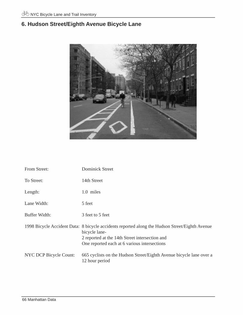
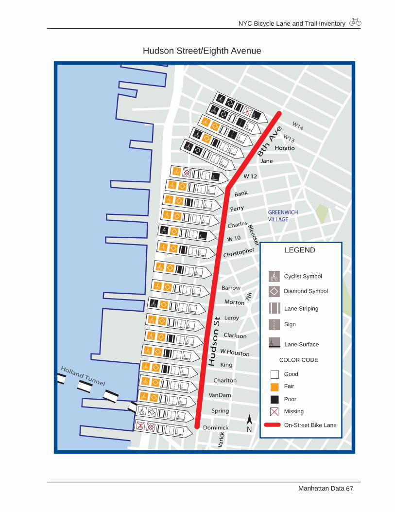
From Street: Dominick Street
To Street: 14th Street
Length: 1.0 miles
Lane Width: 5 feet
Buffer Width: 3 feet to 5 feet
1998 Bicycle Accident Data: 8 bicycle accidents reported along the Hudson Street/Eighth Avenue bicycle lane- 2 reported at the 14th Street intersection and One reported each at 6 various intersections
NYC DCP Bicycle Count: 665 cyclists on the Hudson Street/Eighth Avenue bicycle lane over a 12 hour period
6. Hudson Street/Eighth Avenue Bicycle Lane
NYC Bicycle Lane and Trail Inventory
67Manhattan Data
Hudson Street/Eighth Avenue
W14W13
Holland Tunnel
W Houston
Christopher
Clarkson
W 10
8th
Ave
Vari
ck
7th
Bleecker
Spring
Morton
Perry
W 12
Horatio
Hu
dso
n S
t
Dominick
VanDam
Charlton
King
Leroy
Barrow
Charles
Bank
Jane
GREENWICHVILLAGE
LEGEND
Good
Fair
Poor
Missing
On-Street Bike Lane
Diamond Symbol
Cyclist Symbol
Lane Striping
Lane Surface
Sign
COLOR CODE
N
NYC Bicycle Lane and Trail Inventory
68 Manhattan Data
From Street: Spring Street
To Street: 14th Street
Length: 1.0 miles
Lane Width: 5 feet
Buffer Width: 3 feet
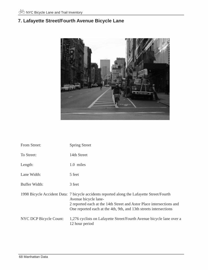
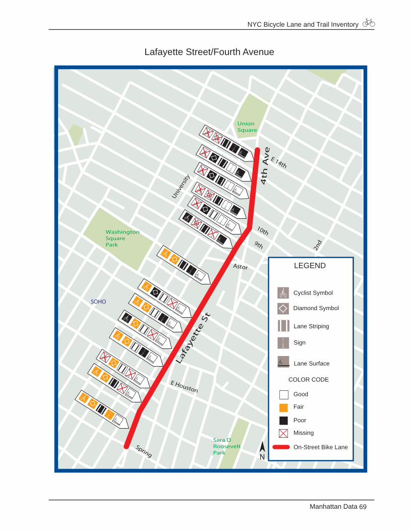
1998 Bicycle Accident Data: 7 bicycle accidents reported along the Lafayette Street/Fourth Avenue bicycle lane- 2 reported each at the 14th Street and Astor Place intersections and One reported each at the 4th, 9th, and 13th streets intersections
NYC DCP Bicycle Count: 1,276 cyclists on Lafayette Street/Fourth Avenue bicycle lane over a 12 hour period
7. Lafayette Street/Fourth Avenue Bicycle Lane
NYC Bicycle Lane and Trail Inventory
69Manhattan Data
Lafayette Street/Fourth Avenue
Spring
UnionSquare
TompkinsSquarePark
Sara DRooseveltPark
WashingtonSquarePark
1st A
v
2nd
4th
Av
e
Lafa
yett
e S
t
E Houston
10th
9th
E 14thUni
vers
ity
Astor
SOHO
LEGEND
Good
Fair
Poor
Missing
On-Street Bike Lane
Diamond Symbol
Cyclist Symbol
Lane Striping
Lane Surface
Sign
COLOR CODE
N
NYC Bicycle Lane and Trail Inventory
70 Manhattan Data
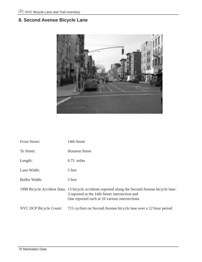
From Street: 14th Street
To Street: Houston Street
Length: 0.75 miles
Lane Width: 5 feet
Buffer Width: 3 feet
1998 Bicycle Accident Data: 13 bicycle accidents reported along the Second Avenue bicycle lane- 3 reported at the 14th Street intersection and One reported each at 10 various intersections
NYC DCP Bicycle Count: 715 cyclists on Second Avenue bicycle lane over a 12 hour period
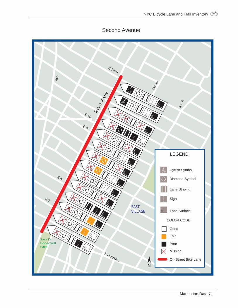
8. Second Avenue Bicycle Lane
NYC Bicycle Lane and Trail Inventory
71Manhattan Data
Second Avenue
Av
A
TompkinsSquarePark
Sara DRooseveltPark
1st A
v
2n
d A
ve
4th
E Houston
E 10
E 9
E 14th
E 4
E 2
EASTVILLAGE
LEGEND
Good
Fair
Poor
Missing
On-Street Bike Lane
Diamond Symbol
Cyclist Symbol
Lane Striping
Lane Surface
Sign
COLOR CODE
N
NYC Bicycle Lane and Trail Inventory
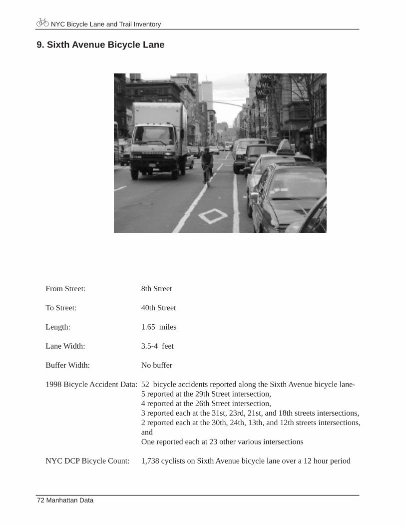
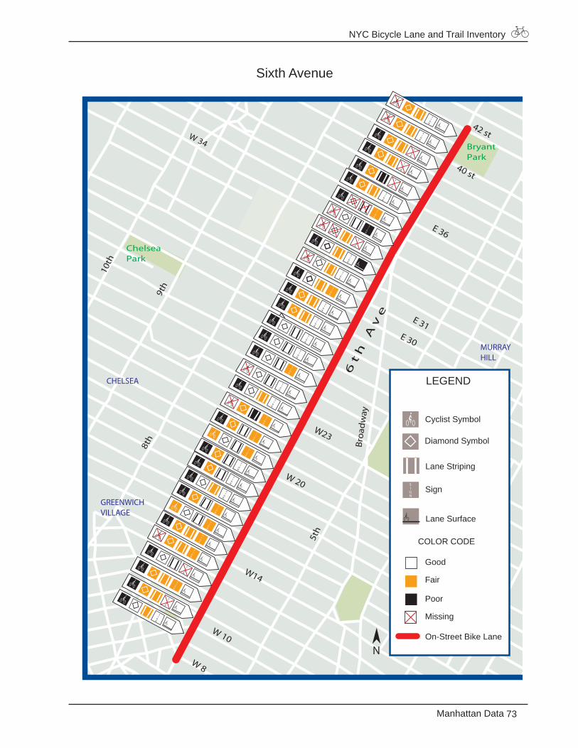
72 Manhattan Data
From Street: 8th Street
To Street: 40th Street
Length: 1.65 miles
Lane Width: 3.5-4 feet
Buffer Width: No buffer
1998 Bicycle Accident Data: 52 bicycle accidents reported along the Sixth Avenue bicycle lane- 5 reported at the 29th Street intersection, 4 reported at the 26th Street intersection, 3 reported each at the 31st, 23rd, 21st, and 18th streets intersections, 2 reported each at the 30th, 24th, 13th, and 12th streets intersections, and One reported each at 23 other various intersections
NYC DCP Bicycle Count: 1,738 cyclists on Sixth Avenue bicycle lane over a 12 hour period
9. Sixth Avenue Bicycle Lane
NYC Bicycle Lane and Trail Inventory
73Manhattan Data
Sixth Avenue
W23
W 34
7th
10th
5th
9th
W14
BryantPark
ChelseaPark
Broa
dw
ay
E 31E 30
W 20
5th
6t
h A
ve
8th
W 10
W 8
42 st
E 36
40 st
MURRAYHILL
CHELSEA
GREENWICHVILLAGE
LEGEND
Good
Fair
Poor
Missing
On-Street Bike Lane
Diamond Symbol
Cyclist Symbol
Lane Striping
Lane Surface
Sign
COLOR CODE
N
NYC Bicycle Lane and Trail Inventory
74 Manhattan Data
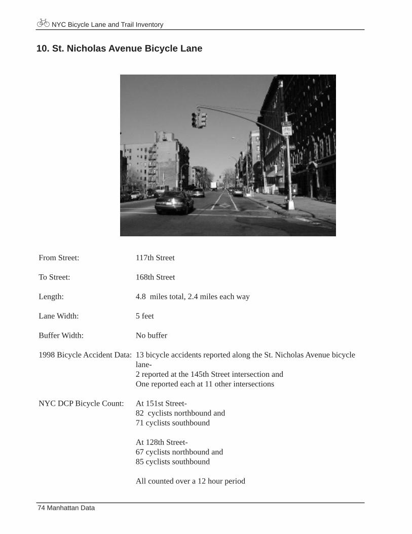
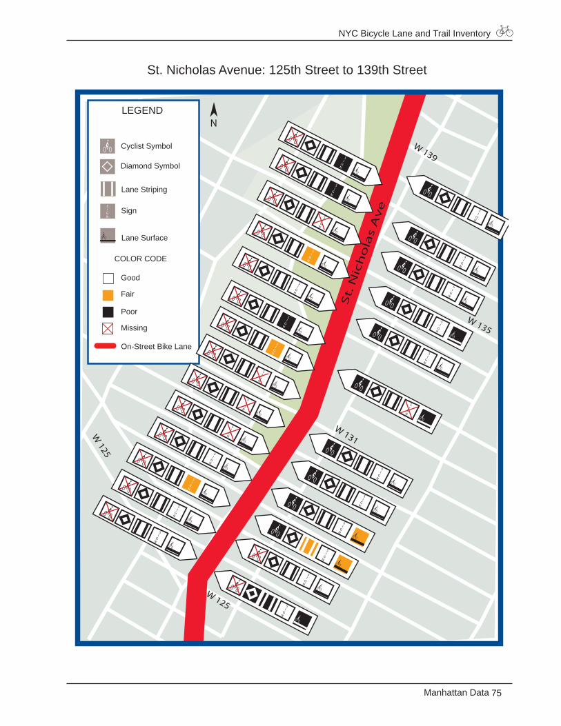
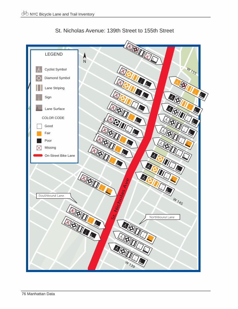
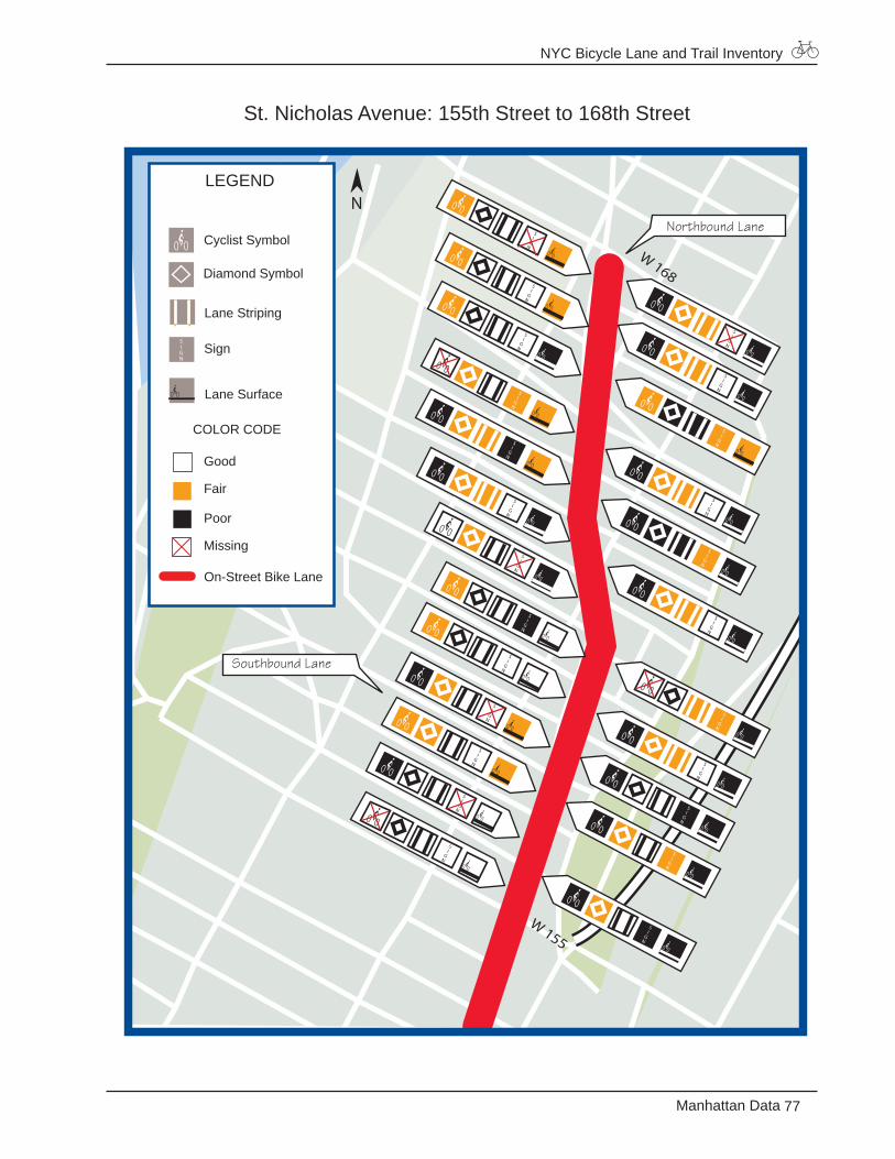
From Street: 117th Street
To Street: 168th Street
Length: 4.8 miles total, 2.4 miles each way
Lane Width: 5 feet
Buffer Width: No buffer
1998 Bicycle Accident Data: 13 bicycle accidents reported along the St. Nicholas Avenue bicycle lane- 2 reported at the 145th Street intersection and One reported each at 11 other intersections
NYC DCP Bicycle Count: At 151st Street- 82 cyclists northbound and 71 cyclists southbound At 128th Street- 67 cyclists northbound and 85 cyclists southbound
All counted over a 12 hour period
10. St. Nicholas Avenue Bicycle Lane
NYC Bicycle Lane and Trail Inventory
75Manhattan Data
St. Nicholas Avenue: 125th Street to 139th Street
W 135
W 125
St.
Nic
ho
las
Av
e
W 125
W 131
W 139
LEGEND
Good
Fair
Poor
Missing
On-Street Bike Lane
Diamond Symbol
Cyclist Symbol
Lane Striping
Lane Surface
Sign
COLOR CODE
N
NYC Bicycle Lane and Trail Inventory
76 Manhattan Data
St. Nicholas Avenue: 139th Street to 155th Street
Broa
dway
Amst
erda
m
Riv
ersi
de
Par
k
HAMILTONHEIGHTS
St.
Nic
ho
las
Av
e
W 145
W 139
W 155
LEGEND
Good
Fair
Poor
Missing
On-Street Bike Lane
Diamond Symbol
Cyclist Symbol
Lane Striping
Lane Surface
Sign
COLOR CODE
N
Northbound Lane
Southbound Lane
NYC Bicycle Lane and Trail Inventory
77Manhattan Data
St. Nicholas Avenue: 155th Street to 168th Street
W 168
W 155
LEGEND
Good
Fair
Poor
Missing
On-Street Bike Lane
Diamond Symbol
Cyclist Symbol
Lane Striping
Lane Surface
Sign
COLOR CODE
NNorthbound Lane
Southbound Lane
NYC Bicycle Lane and Trail Inventory
78 Manhattan Data
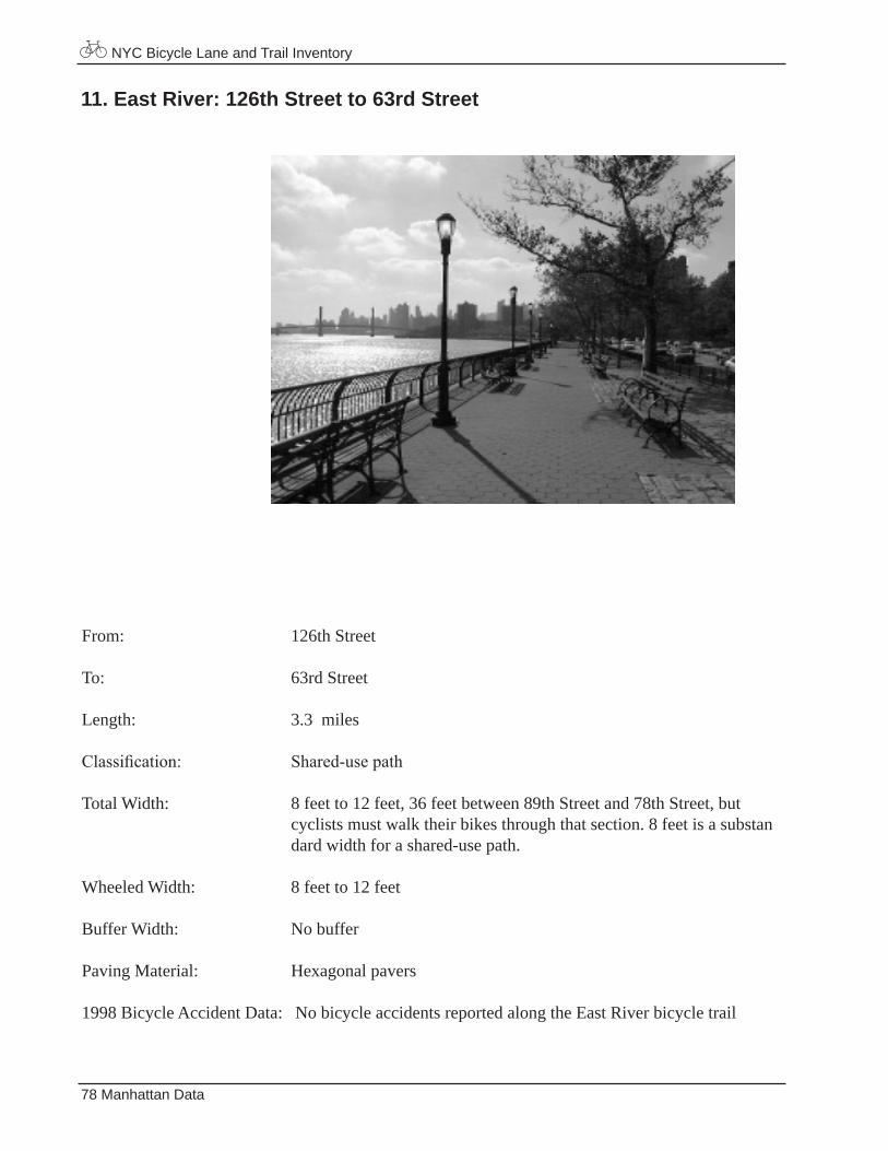
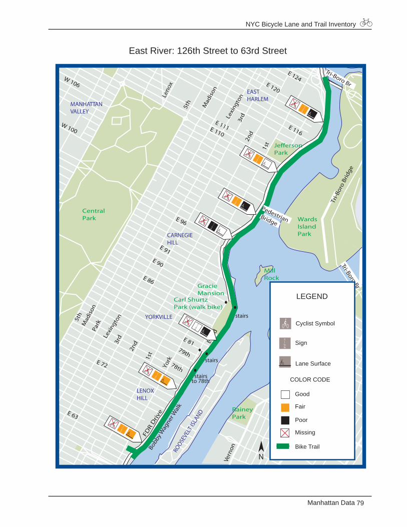
11. East River: 126th Street to 63rd Street
From: 126th Street
To: 63rd Street
Length: 3.3 miles
Classification: Shared-usepath
Total Width: 8 feet to 12 feet, 36 feet between 89th Street and 78th Street, but cyclists must walk their bikes through that section. 8 feet is a substan dard width for a shared-use path.
Wheeled Width: 8 feet to 12 feet
Buffer Width: No buffer
Paving Material: Hexagonal pavers
1998 Bicycle Accident Data: No bicycle accidents reported along the East River bicycle trail
NYC Bicycle Lane and Trail Inventory
79Manhattan Data
East River: 126th Street to 63rd Street
E 116
E 86
Lexi
ngto
n
Mad
ison
Mad
ison
Lexi
ngto
n
York
E 96
3rd
3rd
Park
Leno
x
E 81
FDR
Driv
e
MorningsidePark
JeffersonPark
CentralPark Wards
IslandPark
MillRock
Carl Shurtz Park (walk bike)
RaineyPark
GracieMansion
Vern
on
27 Ave12
St
14 S
t
E 124 E 120
5th
2nd
1st
W 110
E 110
W 106
W 100
E 91 E 90
1st2n
d
5th
E 72
Tri-B
oro
Brid
ge
Pedestrian Bridge
E 111
Tri-Boro Br
Tri-Boro BrE 125
Bobb
yWag
nerW
alk
stairs
stairs
to 78th
stairs
78th
79th
E En
d
E 63
EASTHARLEM
CARNEGIEHILL
LENOXHILL
YORKVILLE
MANHATTANVALLEY
ROOSE
VELT
ISLA
ND
LEGEND
Good
Fair
Poor
Missing
Bike Trail
Cyclist Symbol
Lane Surface
Sign
COLOR CODE
N
NYC Bicycle Lane and Trail Inventory
80 Manhattan Data
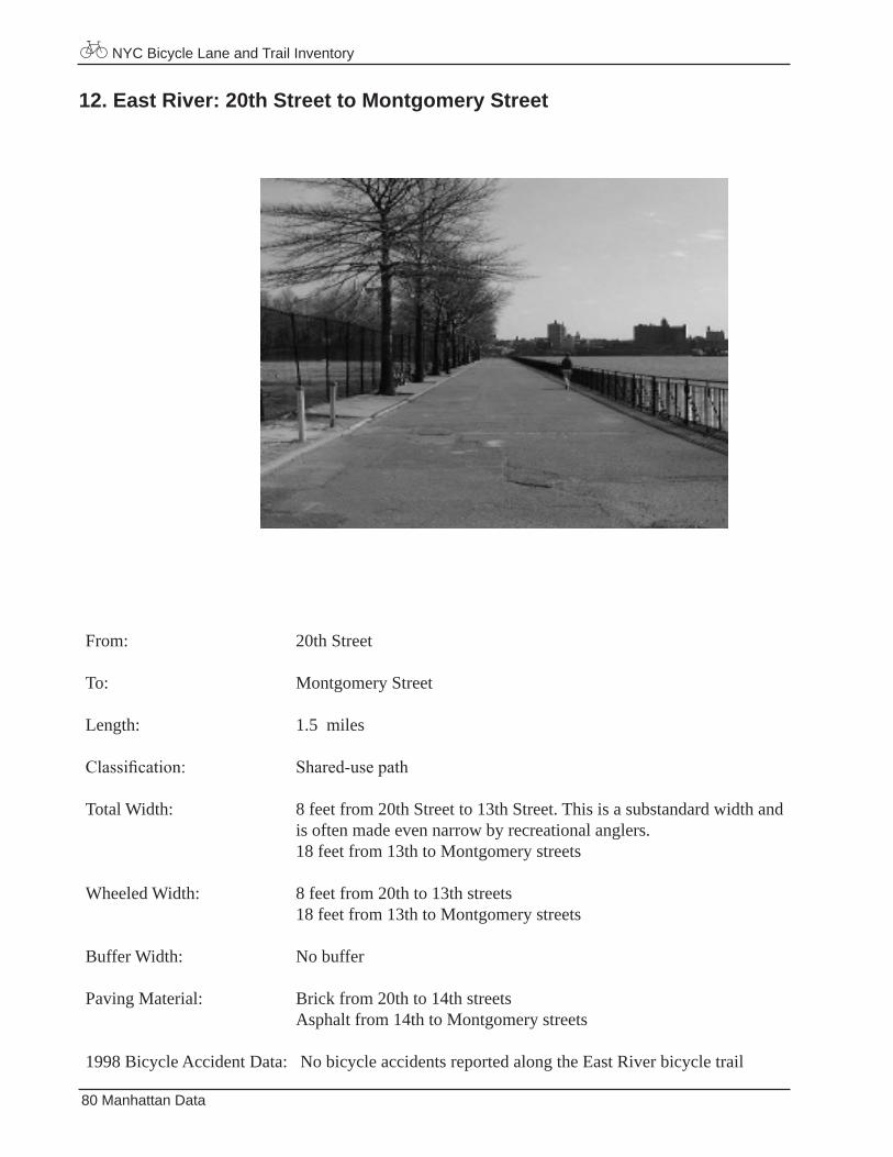
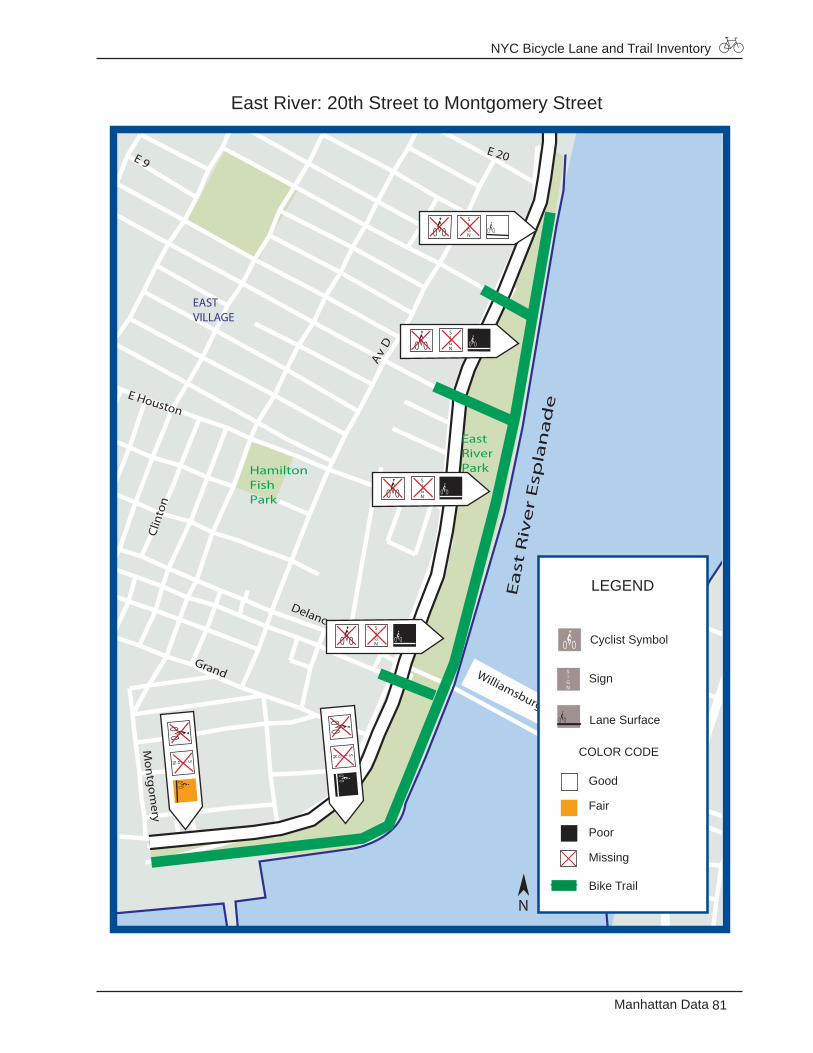
12. East River: 20th Street to Montgomery Street
From: 20th Street
To: Montgomery Street
Length: 1.5 miles
Classification: Shared-usepath
Total Width: 8 feet from 20th Street to 13th Street. This is a substandard width and is often made even narrow by recreational anglers. 18 feet from 13th to Montgomery streets
Wheeled Width: 8 feet from 20th to 13th streets 18 feet from 13th to Montgomery streets
Buffer Width: No buffer
Paving Material: Brick from 20th to 14th streets Asphalt from 14th to Montgomery streets
1998 Bicycle Accident Data: No bicycle accidents reported along the East River bicycle trail
NYC Bicycle Lane and Trail Inventory
81Manhattan Data
East River: 20th Street to Montgomery Street
Av
D
HamiltonFishPark
EastRiverPark
E Houston
E 9
Ea
st R
ive
r E
spla
na
de
Grand
Clin
ton
Mon
tgom
eryWilliamsburg Br
Delancey
E 20
EASTVILLAGE
LEGEND
Good
Fair
Poor
Missing
Bike Trail
Cyclist Symbol
Lane Surface
Sign
COLOR CODE
N
NYC Bicycle Lane and Trail Inventory
82 Manhattan Data
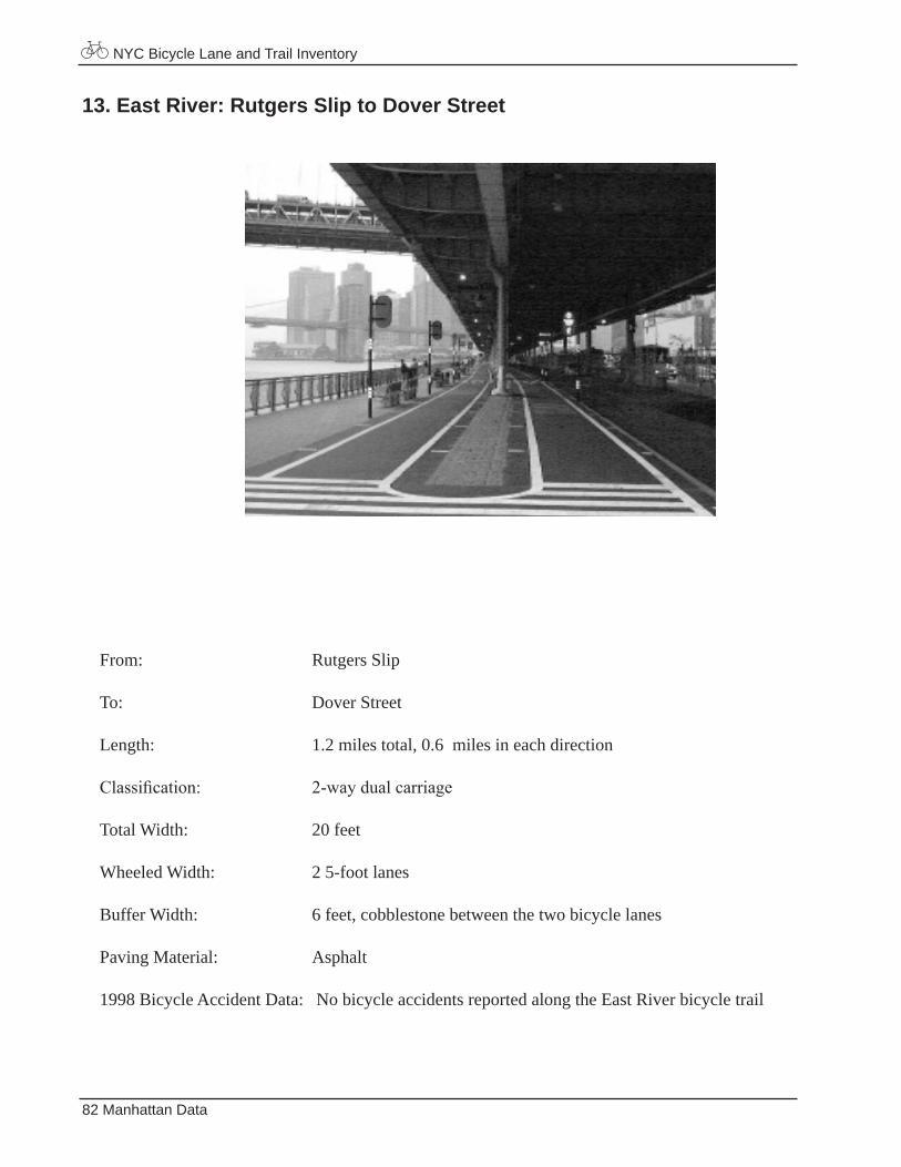
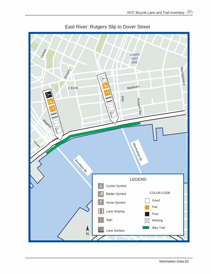
13. East River: Rutgers Slip to Dover Street
From: Rutgers Slip
To: Dover Street
Length: 1.2 miles total, 0.6 miles in each direction
Classification: 2-waydualcarriage
Total Width: 20 feet
Wheeled Width: 2 5-foot lanes
Buffer Width: 6 feet, cobblestone between the two bicycle lanes
Paving Material: Asphalt
1998 Bicycle Accident Data: No bicycle accidents reported along the East River bicycle trail
NYC Bicycle Lane and Trail Inventory
83Manhattan Data
East River: Rutgers Slip to Dover Street
Cent
re
Lafa
yett
e
PikeMadison
E Bway
Bow
ery
Wagner
Dover
Mon
tgom
ery
Manhattan BrBrooklyn Br
Rutg
ers Slip
LOWER EAST SIDE
LEGEND
Good
Fair
Poor
Missing
Bike Trail
Blader Symbol
Cyclist Symbol
Lane Striping
Lane Surface
Sign
COLOR CODE
Arrow Symbol
N
NYC Bicycle Lane and Trail Inventory
84 Manhattan Data
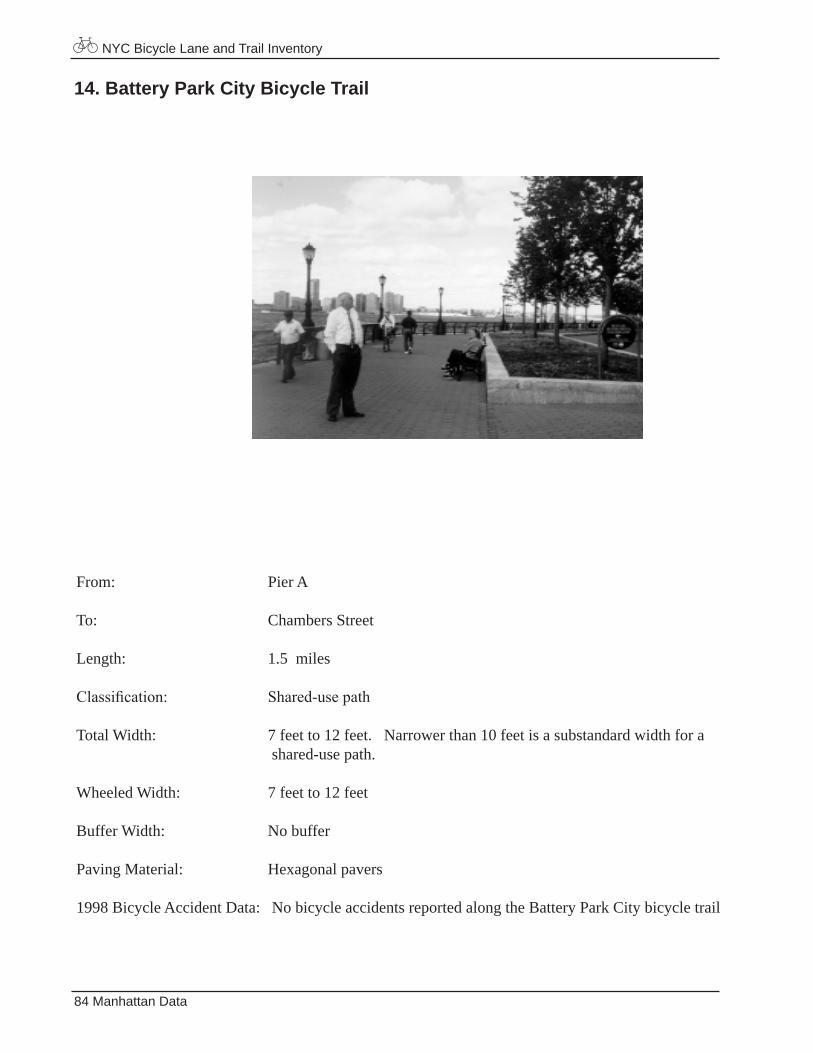
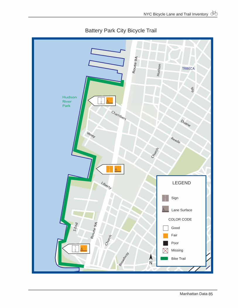
14. Battery Park City Bicycle Trail
From: Pier A
To: Chambers Street
Length: 1.5 miles
Classification: Shared-usepath
Total Width: 7 feet to 12 feet. Narrower than 10 feet is a substandard width for a shared-use path.
Wheeled Width: 7 feet to 12 feet
Buffer Width: No buffer
Paving Material: Hexagonal pavers
1998 Bicycle Accident Data: No bicycle accidents reported along the Battery Park City bicycle trail
NYC Bicycle Lane and Trail Inventory
85Manhattan Data
Battery Park City Bicycle Trail
Chur
ch
Ro
ute
9A
Ro
ute
9A
HudsonRiverPark
Hu
dso
n
Liberty
Broa
dway
Chur
ch
Vesey
Chambers
Reade
Duane
Spruce
S En
d
6th
Maiden
Lane
TRIBECA
FINANCIALDISTRICT
LEGEND
Good
Fair
Poor
Missing
Bike Trail
Lane Surface
Sign
COLOR CODE
N

NYC Bicycle Lane and Trail Inventory
86 Manhattan Data
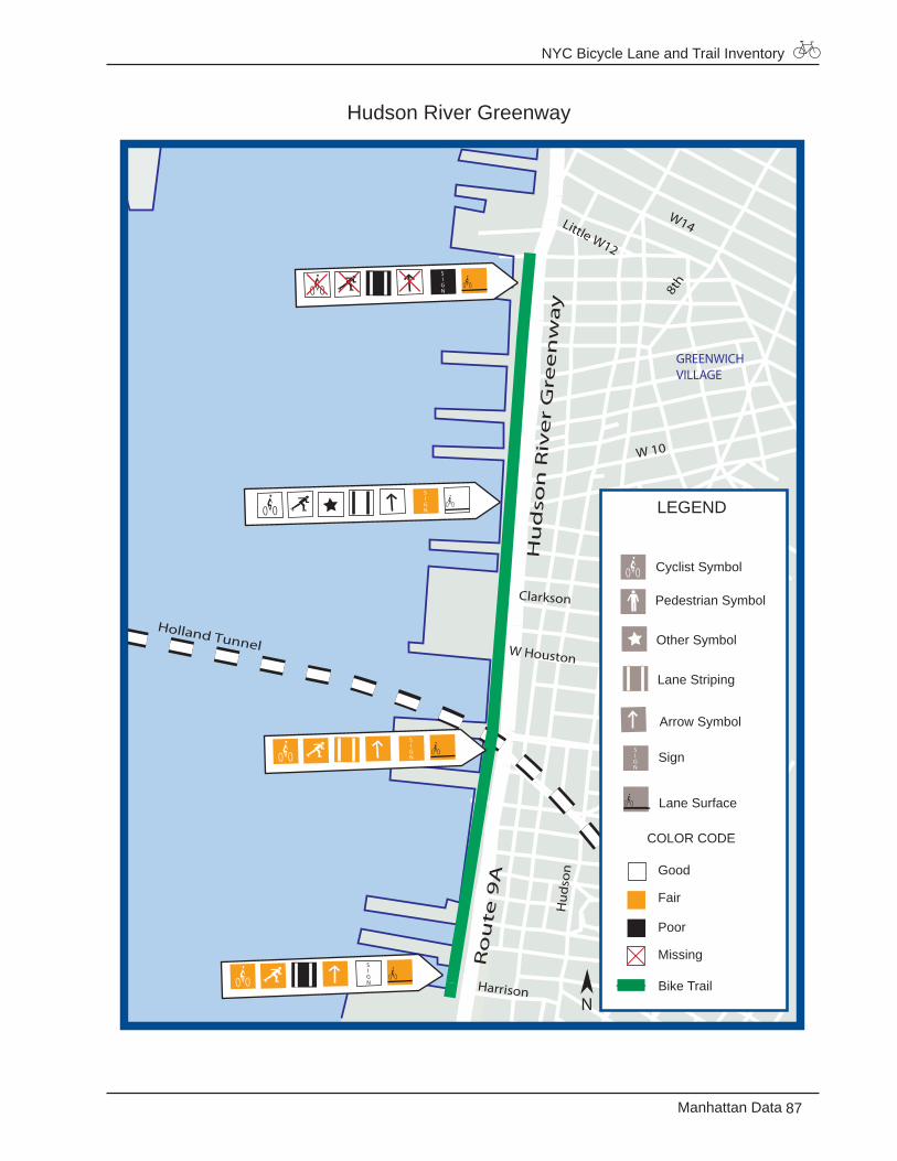
15. Hudson River Greenway
From: Chambers Street
To: Little W. 12th Street
Length: 1.4 miles
Classification: 2-waydualcarriage
Wheeled Width: 20 feet total , 9 feet each direction from Chambers Street to Jane Street 15 feet total, 7.5 feet each lane from Jane Street to Little W. 12th Street
Buffer Width: 2 feet green paint buffer between the bike path and pedestrian path from Chambers Street to Little W. 12th Street
NYC Bicycle Lane and Trail Inventory
87Manhattan Data
Hudson River Greenway
W14
Canal
Little W12
Holland Tunnel
Ro
ute
9A
Hu
dso
n
W Houston
Christopher
Hu
dso
n R
ive
r G
ree
nw
ay
Clarkson
W 10
8th
Vari
ck7t
h
Bleecker
Harrison
GREENWICHVILLAGE
Good
Fair
Poor
Missing
Bike Trail
Lane Striping
LEGEND
Pedestrian Symbol
Cyclist Symbol
Other Symbol
Lane Surface
Sign
COLOR CODE
Arrow Symbol
N
NYC Bicycle Lane and Trail Inventory
88 Manhattan Data
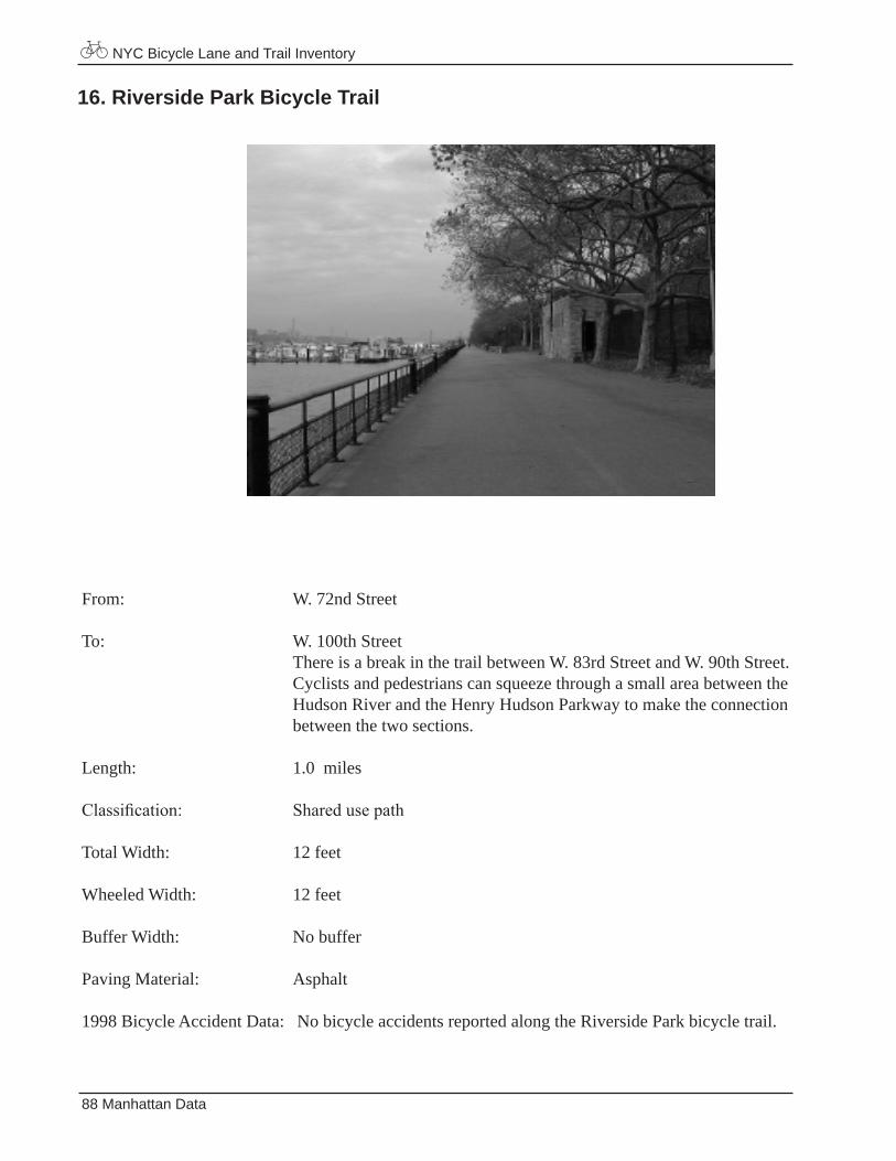
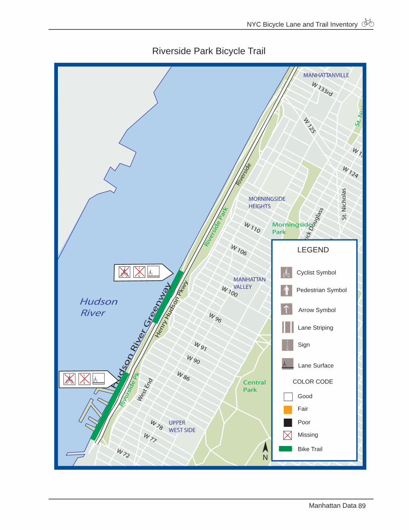
16. Riverside Park Bicycle Trail
From: W. 72nd Street
To: W. 100th Street There is a break in the trail between W. 83rd Street and W. 90th Street. Cyclists and pedestrians can squeeze through a small area between the Hudson River and the Henry Hudson Parkway to make the connection between the two sections.
Length: 1.0 miles
Classification: Sharedusepath
Total Width: 12 feet
Wheeled Width: 12 feet
Buffer Width: No buffer
Paving Material: Asphalt
1998 Bicycle Accident Data: No bicycle accidents reported along the Riverside Park bicycle trail.
NYC Bicycle Lane and Trail Inventory
89Manhattan Data
Riverside Park Bicycle Trail
Hudson River
W 86
W 72
W 133rd
W 96
Leno
x
Hen
ry H
ud
son
Pkw
y
MorningsidePark
CentralPark
Riv
ersi
de
Pk
Rive
rsid
e Pa
rk
St. N
ich
ola
s P
ark
W 125
Fred
eric
k D
ougl
ass
5th
W 110
W 106
W 100
W 91 W 90
Rive
rsid
e
Wes
t End
W 77
W 78 E 91
E 90
W 124
W 127
A.C
Pow
ell
St. N
ich
ola
s
Hu
dso
n R
ive
r G
ree
nw
ay
MANHATTANVILLE
MORNINGSIDEHEIGHTS
MANHATTANVALLEY
UPPERWEST SIDE
Good
Fair
Poor
Missing
Bike Trail
Lane Striping
LEGEND
Pedestrian Symbol
Cyclist Symbol
Lane Surface
Sign
COLOR CODE
Arrow Symbol
N
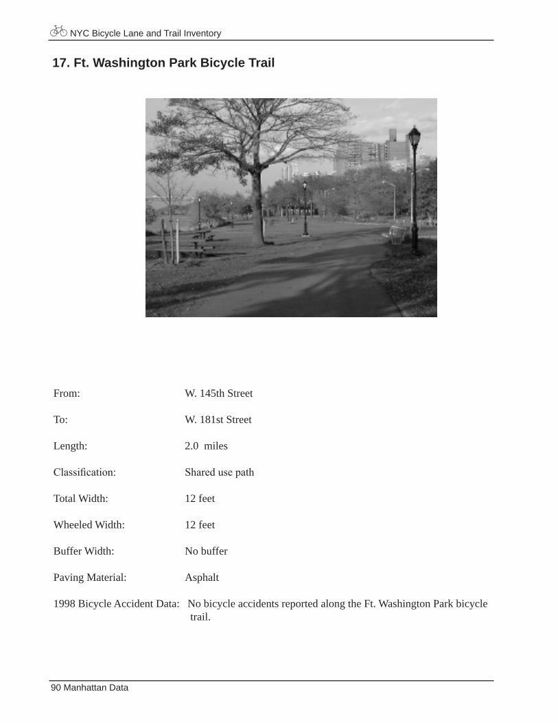
NYC Bicycle Lane and Trail Inventory
90 Manhattan Data
17. Ft. Washington Park Bicycle Trail
From: W. 145th Street
To: W. 181st Street
Length: 2.0 miles
Classification: Sharedusepath
Total Width: 12 feet
Wheeled Width: 12 feet
Buffer Width: No buffer
Paving Material: Asphalt
1998 Bicycle Accident Data: No bicycle accidents reported along the Ft. Washington Park bicycle trail.
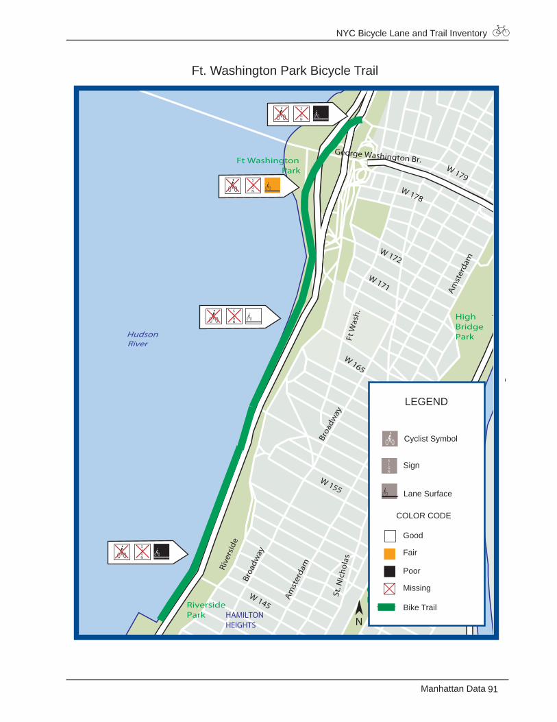
NYC Bicycle Lane and Trail Inventory
91Manhattan Data
Ft. Washington Park Bicycle Trail
Hudson River
Uni
vers
ity
Fred
rick
Dou
glas
s
Broa
dway
Broa
dway
Amst
erda
m
Harle
m R
iver
Driv
e
Ft WashingtonPark
HighBridgePark
ColonialPark
RiversidePark
Broa
dwayCa
brin
i
W 155
Amst
erda
m
Rive
rsid
e
St. N
icho
las
Ft W
ash.
W 179 W 178
W 171
W 172
George Washington Br.
Washington Br
High Br
W 145
Conv
ent
FtW
ashi
ngto
n
W 165
HAMILTONHEIGHTS
WASHINGTONHEIGHTS
LEGEND
Good
Fair
Poor
Missing
Bike Trail
Cyclist Symbol
Lane Surface
Sign
COLOR CODE
N
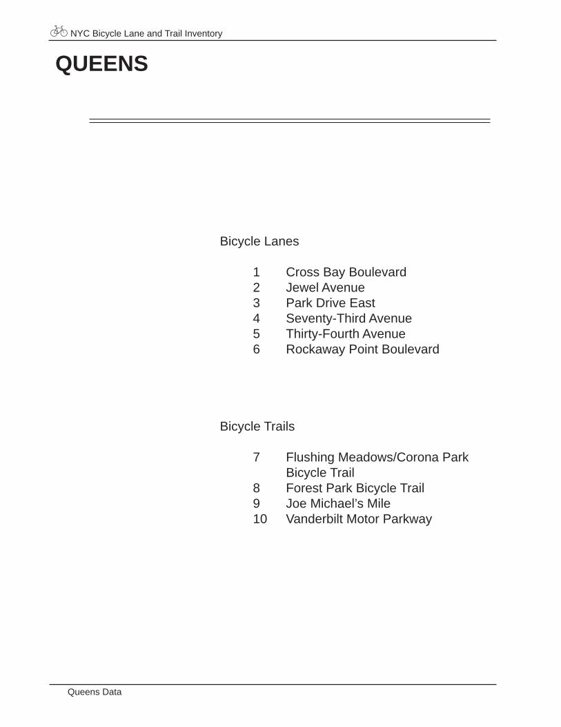
NYC Bicycle Lane and Trail Inventory
Queens Data
QUEENS
Bicycle Lanes
1 Cross Bay Boulevard2 Jewel Avenue3 Park Drive East4 Seventy-Third Avenue 5 Thirty-Fourth Avenue6 Rockaway Point Boulevard
Bicycle Trails
7 Flushing Meadows/Corona Park Bicycle Trail8 Forest Park Bicycle Trail9 Joe Michael’s Mile10 Vanderbilt Motor Parkway
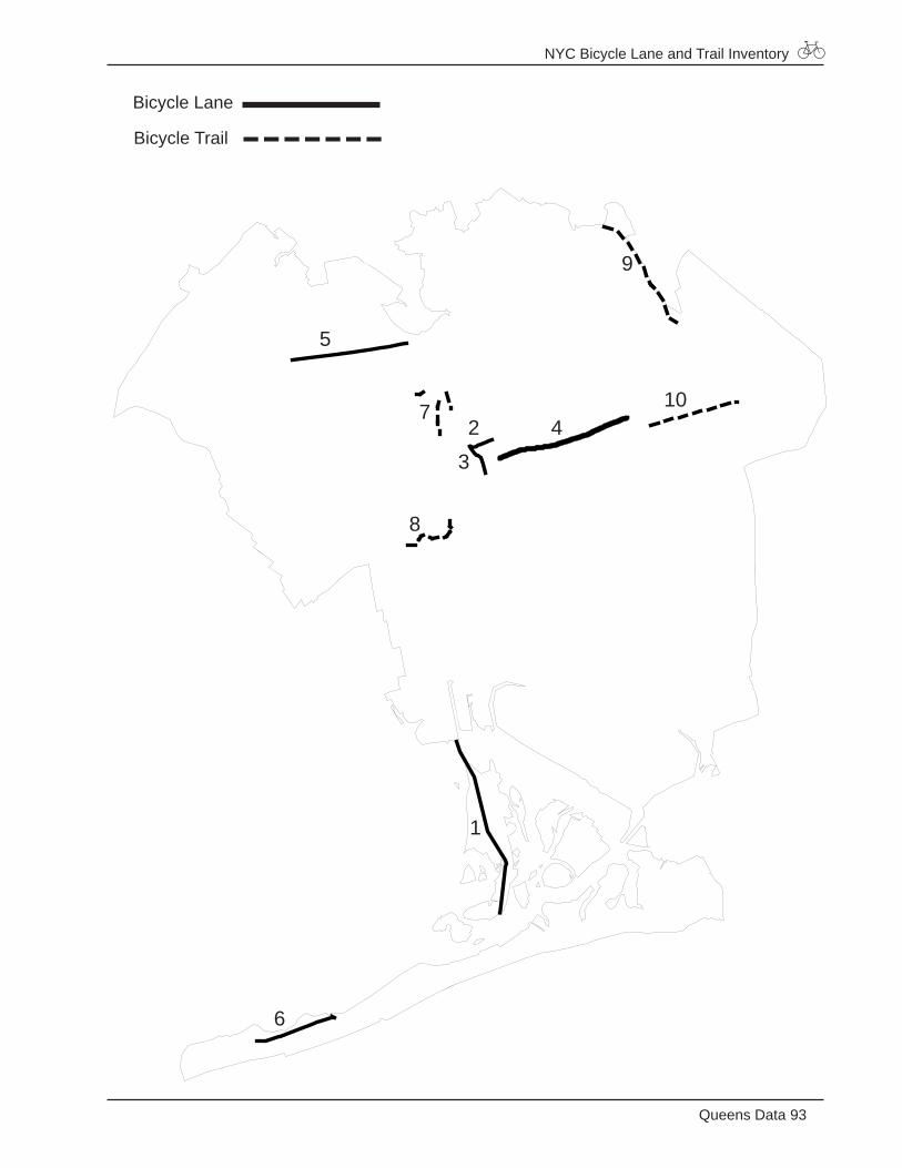
NYC Bicycle Lane and Trail Inventory
93Queens Data
Bicycle Lane
Bicycle Trail
1
23
4
5
6
7
8
9
10
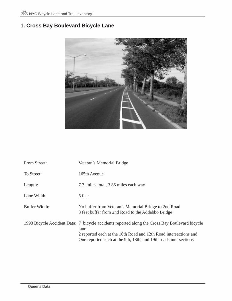
NYC Bicycle Lane and Trail Inventory
Queens Data
From Street: Veteran’s Memorial Bridge
To Street: 165th Avenue
Length: 7.7 miles total, 3.85 miles each way
Lane Width: 5 feet
Buffer Width: No buffer from Veteran’s Memorial Bridge to 2nd Road 3 feet buffer from 2nd Road to the Addabbo Bridge
1998 Bicycle Accident Data: 7 bicycle accidents reported along the Cross Bay Boulevard bicycle lane- 2 reported each at the 16th Road and 12th Road intersections and One reported each at the 9th, 18th, and 19th roads intersections
1. Cross Bay Boulevard Bicycle Lane
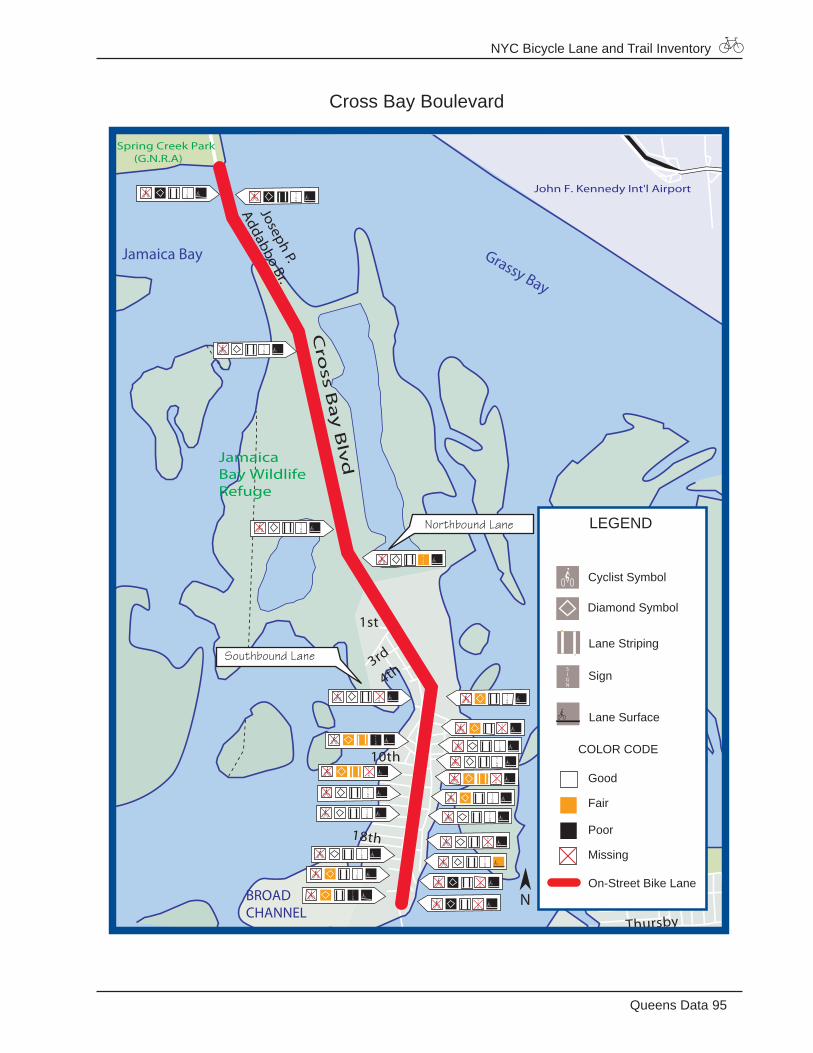
NYC Bicycle Lane and Trail Inventory
95Queens Data
Cross Bay Boulevard
Grassy Bay
Jamaica Bay
Thursby
Bayfield
18th
10th
1st
3rd
4th
John F. Kennedy Int'l Airport
JamaicaBay WildlifeRefuge
Spring Creek Park (G.N.R.A)
Cro
ss Ba
y B
lvd
Joseph P.
Addabbo Br.
BROADCHANNEL
LEGEND
Good
Fair
Poor
Missing
On-Street Bike Lane
Diamond Symbol
Cyclist Symbol
Lane Striping
Lane Surface
Sign
COLOR CODE
N
Northbound Lane
Southbound Lane
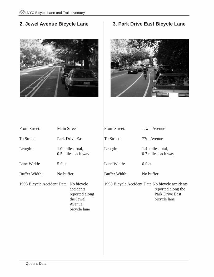
NYC Bicycle Lane and Trail Inventory
Queens Data
From Street: Main Street
To Street: Park Drive East
Length: 1.0 miles total, 0.5 miles each way
Lane Width: 5 feet
Buffer Width: No buffer
1998 Bicycle Accident Data: No bicycle accidents reported along the Jewel Avenue bicycle lane
2. Jewel Avenue Bicycle Lane
From Street: Jewel Avenue
To Street: 77th Avenue
Length: 1.4 miles total, 0.7 miles each way
Lane Width: 6 feet
Buffer Width: No buffer
1998 Bicycle Accident Data:No bicycle accidents reported along the Park Drive East bicycle lane
3. Park Drive East Bicycle Lane
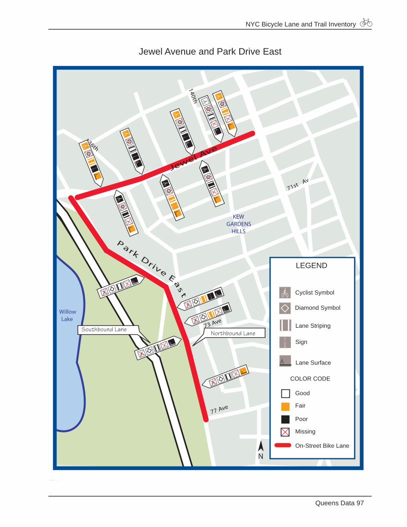
NYC Bicycle Lane and Trail Inventory
97Queens Data
Jewel Avenue and Park Drive East
71st Av
140th
136th
Jewel Ave
WillowLake
77 Ave
73 Ave
ParkDrive
Eas
t KEWGARDENS HILLS
LEGEND
Good
Fair
Poor
Missing
On-Street Bike Lane
Diamond Symbol
Cyclist Symbol
Lane Striping
Lane Surface
Sign
COLOR CODE
N
Northbound Lane Southbound Lane
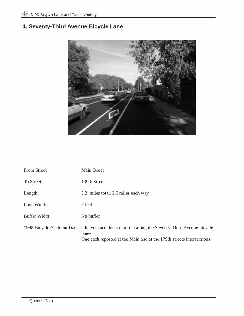
NYC Bicycle Lane and Trail Inventory
Queens Data
From Street: Main Street To Street: 199th Street
Length: 5.2 miles total, 2.6 miles each way
Lane Width: 5 feet
Buffer Width: No buffer
1998 Bicycle Accident Data: 2 bicycle accidents reported along the Seventy-Third Avenue bicycle lane- One each reported at the Main and at the 179th streets intersections
4. Seventy-Third Avenue Bicycle Lane
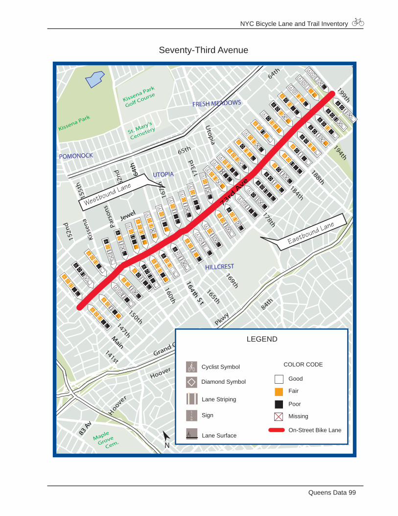
NYC Bicycle Lane and Trail Inventory
99Queens Data
Seventy-Third Avenue199th
184th
147th
150th
152n
d
84th
168th
169th
165th
160th
162nd
194th
64th
173r
d
178th
65th
167t
h162n
d
148th 87th
Kiss
ena
Hoover
155t
h
144th
141st
161st St
164th St
Utopia
188th
Pars
ons
Grand Central
Pkwy
Kissena Park
St. Mary's
Cemetery
Kissena Park
Golf Course
Maple
Grove
Cem.
83 Av
Main
164t
h
73rd A
veParsons
153 St
164 thS t
Hoover
Jewel
JAMAICA ESTATES
JAMAICA
CTR
HILLCREST
UTOPIA
POMONOCK
FRESH MEADOWS
LEGEND
Good
Fair
Poor
Missing
On-Street Bike Lane
Diamond Symbol
Cyclist Symbol
Lane Striping
Lane Surface
Sign
COLOR CODE
N
Eastbound Lane
Westbound Lane
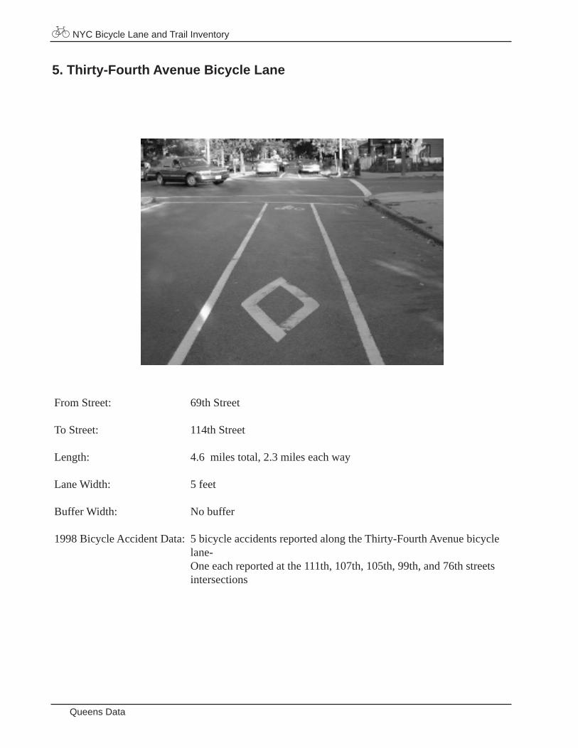
NYC Bicycle Lane and Trail Inventory
Queens Data
From Street: 69th Street
To Street: 114th Street
Length: 4.6 miles total, 2.3 miles each way
Lane Width: 5 feet
Buffer Width: No buffer
1998 Bicycle Accident Data: 5 bicycle accidents reported along the Thirty-Fourth Avenue bicycle lane- One each reported at the 111th, 107th, 105th, 99th, and 76th streets intersections
5. Thirty-Fourth Avenue Bicycle Lane
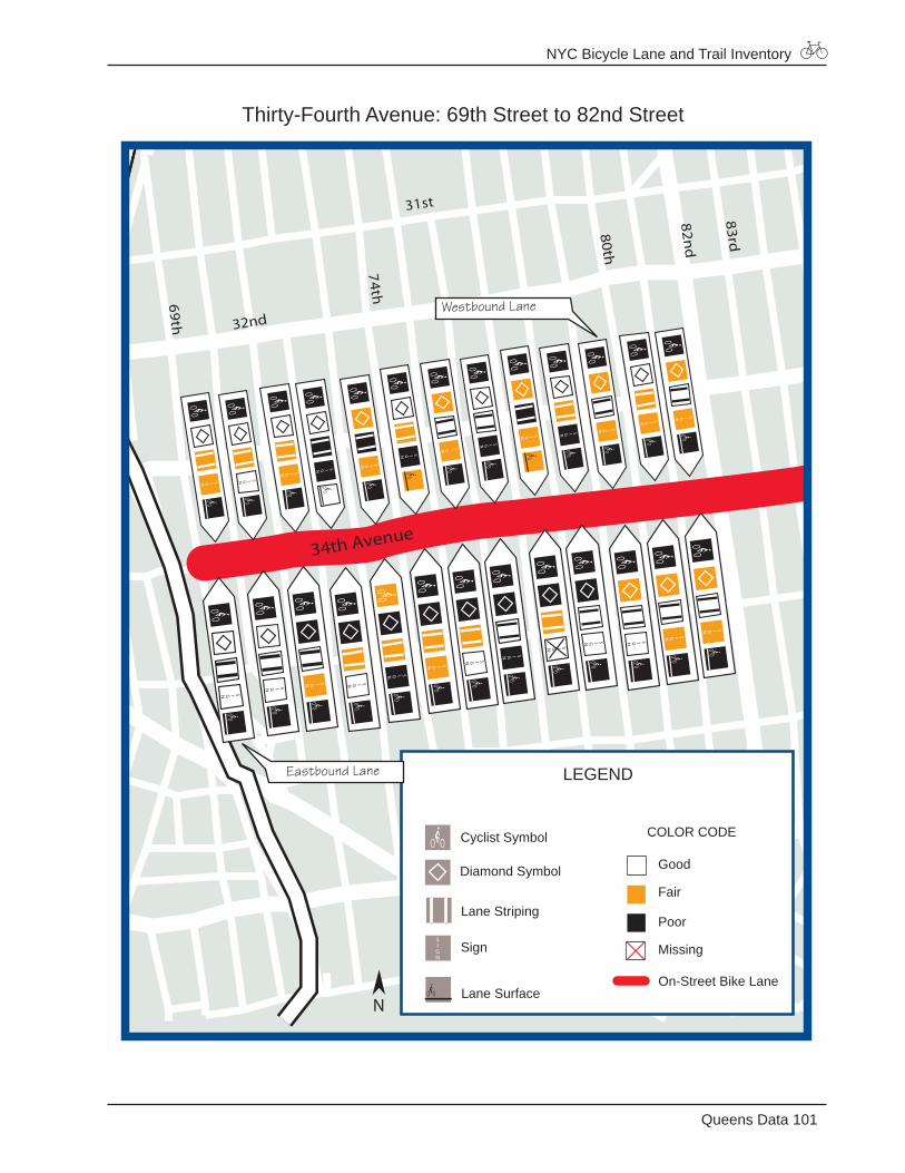
NYC Bicycle Lane and Trail Inventory
101Queens Data
Thirty-Fourth Avenue: 69th Street to 82nd Street
31st
74th69th
82nd
32nd
83rd
34th Avenue
80th
LEGEND
Good
Fair
Poor
Missing
On-Street Bike Lane
Diamond Symbol
Cyclist Symbol
Lane Striping
Lane Surface
Sign
COLOR CODE
N
Eastbound Lane
Westbound Lane

NYC Bicycle Lane and Trail Inventory
Queens Data
Thirty-Fourth Avenue: 82nd Street to 97th Street
Elbertson
98th
31st
93rd89th85th
37th
97th
Roosevelt
82nd
83rd
34th Ave
Ithaca
LEGEND
Good
Fair
Poor
Missing
On-Street Bike Lane
Diamond Symbol
Cyclist Symbol
Lane Striping
Lane Surface
Sign
COLOR CODE
N
Eastbound Lane
Westbound Lane
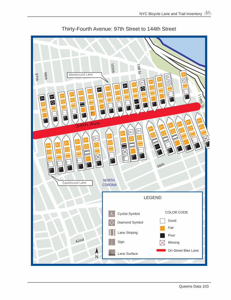
NYC Bicycle Lane and Trail Inventory
103Queens Data
Thirty-Fourth Avenue: 97th Street to 144th Street
105th98th
38th
48th
42nd
97th
34th Ave
108 St
114th St
NORTHCORONA
LEGEND
Good
Fair
Poor
Missing
On-Street Bike Lane
Diamond Symbol
Cyclist Symbol
Lane Striping
Lane Surface
Sign
COLOR CODE
N
Eastbound Lane
Westbound Lane
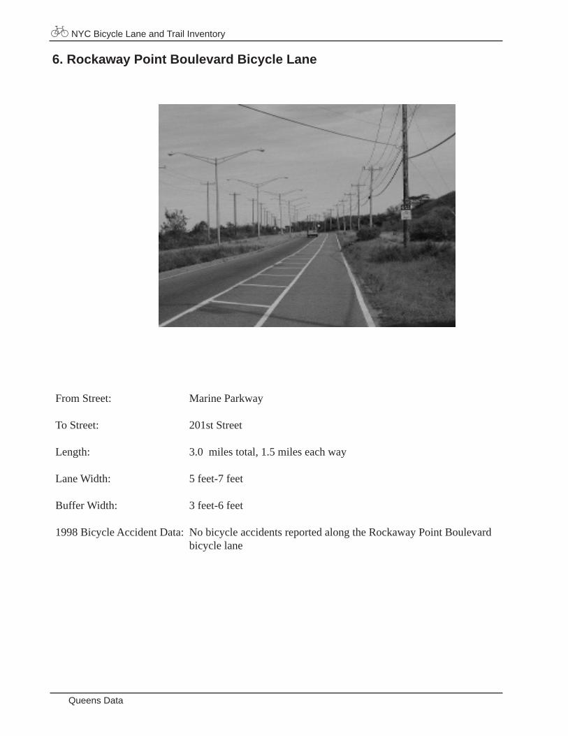
NYC Bicycle Lane and Trail Inventory
Queens Data
From Street: Marine Parkway
To Street: 201st Street
Length: 3.0 miles total, 1.5 miles each way
Lane Width: 5 feet-7 feet
Buffer Width: 3 feet-6 feet
1998 Bicycle Accident Data: No bicycle accidents reported along the Rockaway Point Boulevard bicycle lane
6. Rockaway Point Boulevard Bicycle Lane
NYC Bicycle Lane and Trail Inventory
105Queens Data
Rockaway Point Boulevard
Shore
193rd
201st
Gateway National Recreation Area
(National Park Service)
Rockaway Point Blvd
Marine Pkw
y Br
(walk bicycle)
169th
FORT TILDEN
LEGEND
Good
Fair
Poor
Missing
On-Street Bike Lane
Diamond Symbol
Cyclist Symbol
Lane Striping
Lane Surface
Sign
COLOR CODE
N
Eastbound Lane
Westbound Lane
NYC Bicycle Lane and Trail Inventory
Queens Data
7. Flushing Meadows/Corona Park Bicycle Trail
Length: 1.2 miles of official bicycle trail, but there are trails throughout the park that are often used by cyclists
Classification: Shared-use path
Total Width: 21 feet
Wheeled Width: 21 feet Buffer Width: No buffer
Paving Material: Asphalt
1998 Bicycle Accident Data:No bicycle accidents reported along the Flushing Meadows/ Corona Park bicycle trail
8. Forest Park Bicycle Trail
From: Metropolitan Avenue
To: Woodhaven Boulevard
Length: 1.4 miles
Classification: Closed off roadway
Total Width: 24 feet
Wheeled Width: 24 feet
Buffer Width: No buffer
Paving Material: Asphalt
1998 Bicycle Accident Data: No bicycle accidents report ed along the For est Park bicycle trail
NYC Bicycle Lane and Trail Inventory
107Queens Data
Flushing Meadows/Corona Park and Forest Park
Reeves
147th
152n
d
Doren
67thSaunders
Thornton
Xenia
Justice
91st
88th Av
66th
Doran
75th
78th
85thRd
75th
Rd
Asc
an
70th
Av
Walnut
Yello
wst
one
Av
134th
Babbage
Woodhaven
48th
52nd
42nd63
rd A
v
82nd
86th
67th
Rd
64th
84thPl
Jewel69th Av
98th99th
69th
IngramKessel
81st
103rd
97th95th
91st Av
94th Av
92nd Av
98thSt
86th
126th
124th
84th Av
78th
Audley
97th
94thSt
85th Rd
96th St
Rose
150t
h
146t
h
138t
h
155t
h
72nd Av
68th
71st Av
140th136th
138th
79th Pl
Melbour
136t
h
Rd
St
K ew
G ard
66th Rd
Metropolitan
Jamaica
LeffertsMyrtle
Corona
Junction
St. John'sCemetery
Forest ParkGolf Course
ForestPark
Mount HebronCemetery
Flushing MeadowCorona Park
WillowLake
MeadowLake
Park Lane S
Cooper
80th St
62nd Dr
LIE Service Rd 63rd Rd
Metropolitan
71 A
v
70 Rd
71 Av
112th St
110th St
111th St
80 Rd
Coolidge
Main
77 Rd77 Ave
73 Ave
Booth 56th Rd
Freedom
AtlanticJamaica
Corona
Alderton
Fo
rest
Jewel
ParkDv
ELEFRAK CITY
REGO PARK
FOREST HILLS
WOODHAVEN
RICHMOND HILL
KEWGARDENS HILLS
QUEENSBORO HILL
FORESTHILLS GARDENS
LEGEND
Good
Fair
Poor
Missing
Bike Trail
Cyclist Symbol
Lane Surface
Sign
COLOR CODE
Lane Striping
N
NYC Bicycle Lane and Trail Inventory
Queens Data
9. Joe Michael’s Mile
From: Northern Boulevard
To: Totten Avenue
Length: 2.4 miles
Classification: Dual carriage
Total Width: 19 feet
Wheeled Width: 7 feet
Buffer Width: No buffer
Paving Material: Asphalt
1998 Bicycle Accident Data: No bicycle accidents reported along Joe Michael’s Mile
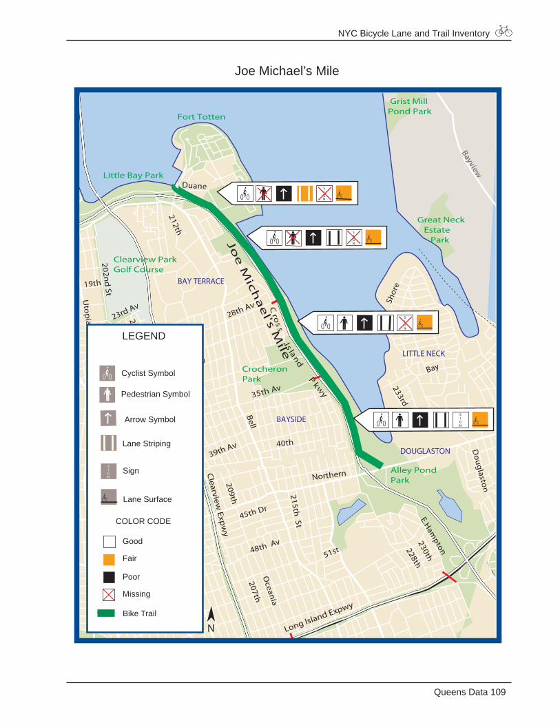
NYC Bicycle Lane and Trail Inventory
109Queens Data
Joe Michael’s Mile
Little Neck Bay
Douglaston
Bay
233rdSt
Joe
Mic
ha
el's M
ile
Duane
28th Av
29th Av
Av
19th
196th St
189th St 46th Av
45th Av
51st
40th
207thO
ceania
48th Av
45th Dr
209th
203rd St
48th Av
194th35th Av
32ndAv
212th
200th St
E.Ham
pton
230th
228th
Shor
e
215th St
Bayview
Clearview
Expw
y
Cro
s sIs land
Pkw
y
Long Island Expwy
Alley PondPark
CrocheronPark
Clearview ParkGolf Course
Little Bay Park
Fort Totten
Great Neck Estate Park
Grist MillPond Park
Utop
ia
202nd
St
26th Av
28th Av
206th St
39th Av
Bell
39th Av
23rd Av
Northern
DOUGLASTON
LITTLE NECK
BAYSIDE
AUBURNDALE
BAY TERRACE
Good
Fair
Poor
Missing
Bike Trail
Lane Striping
LEGEND
Pedestrian Symbol
Cyclist Symbol
Lane Surface
Sign
COLOR CODE
Arrow Symbol
N
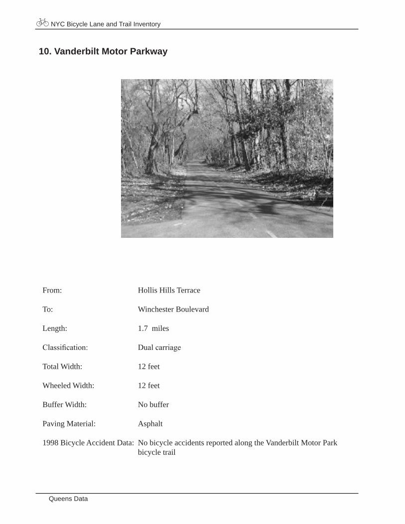
NYC Bicycle Lane and Trail Inventory
Queens Data
10. Vanderbilt Motor Parkway
From: Hollis Hills Terrace
To: Winchester Boulevard
Length: 1.7 miles
Classification: Dual carriage
Total Width: 12 feet
Wheeled Width: 12 feet
Buffer Width: No buffer
Paving Material: Asphalt
1998 Bicycle Accident Data: No bicycle accidents reported along the Vanderbilt Motor Park bicycle trail
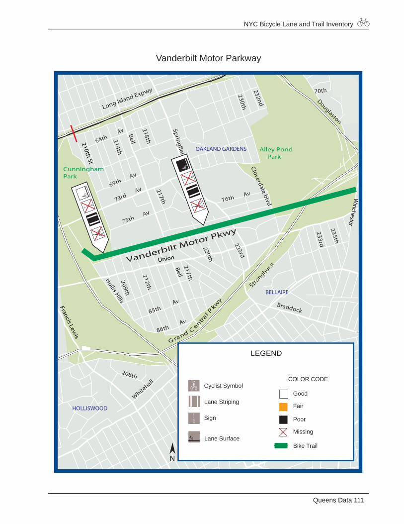
NYC Bicycle Lane and Trail Inventory
111Queens Data
Vanderbilt Motor Parkway
70thDouglaston
76th Av
217th
Braddock
Bell217th209th
212th
208th
White
hall
223rd230th
232nd
220th
86thAv
85thAv
218th
Bell
75thAv
73rdAv
214th
69thAv
64thAv
214th
Lym
an
235th
233rd
Stronghurst
Win
chester
65th
67th
92nd Av
93rd Av
213th
100th
210thPl
210th
Hollis H
ills
230th228th
Vanderbilt Motor PkwySpringfield
Hollis Hills
Cloverdale blvd
Long Island Expwy
G rand Centra
l Pkw
y
CunninghamPark
Alley Pond Park
210th St
90th Av
Winchester
Union
W.A
lleyR
d
Francis Lewis
HOLLISWOOD
QUEENSVILLAGE
BELLAIRE
OAKLAND GARDENS
LEGEND
Good
Fair
Poor
Missing
Bike Trail
Cyclist Symbol
Lane Striping
Lane Surface
Sign
COLOR CODE
N
NYC Bicycle Lane and Trail Inventory
Staten Island Data
STATEN ISLAND
Bicycle Lanes
1 Father Capodanno Boulevard2 Lily Pond Avenue3 Midland Avenue4 School Road
Bicycle Trails There are no class I bicycle trails in Staten Island
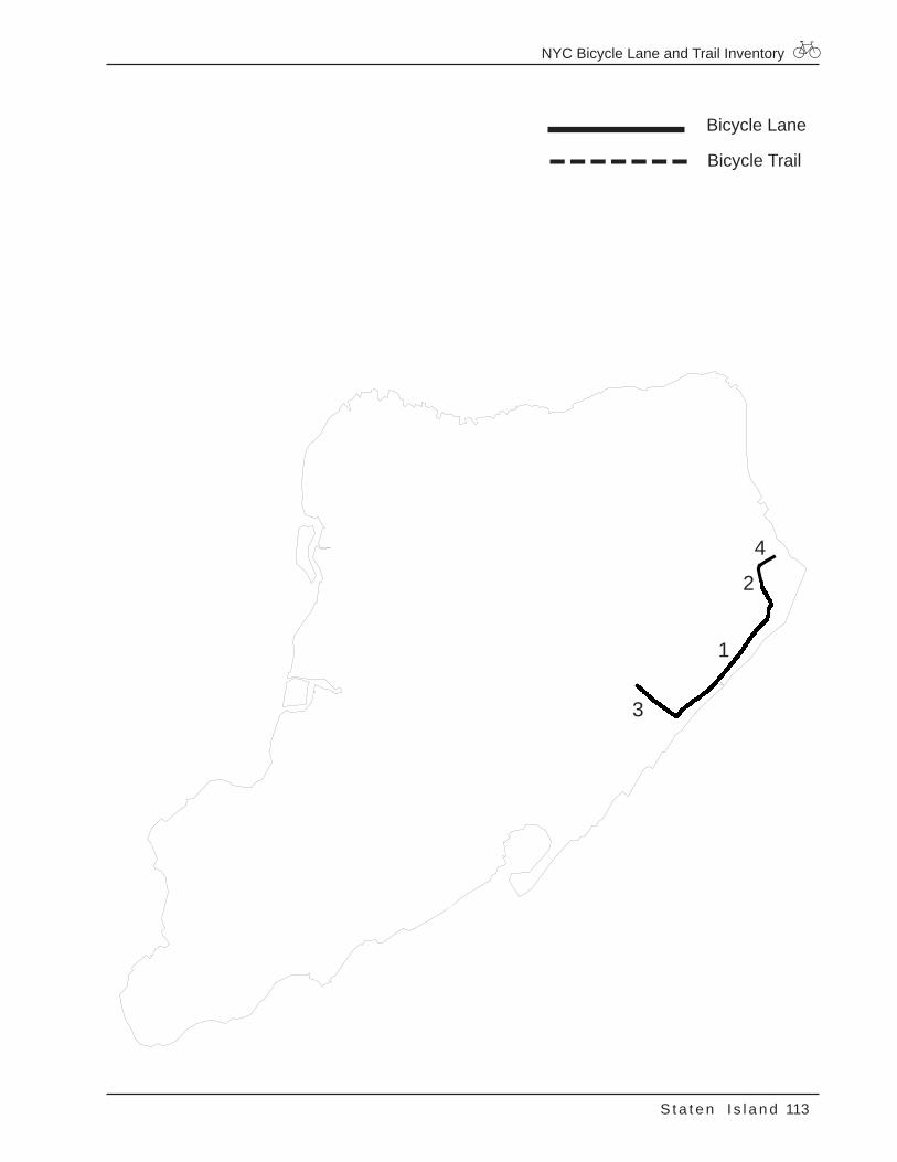
NYC Bicycle Lane and Trail Inventory
113S t a t e n I s l a n d
Bicycle Lane
Bicycle Trail
1
2
3
4
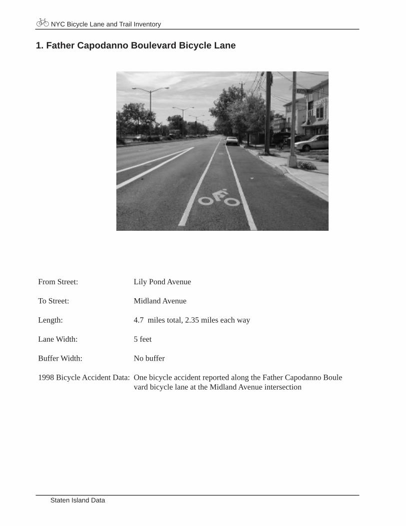
NYC Bicycle Lane and Trail Inventory
Staten Island Data
From Street: Lily Pond Avenue
To Street: Midland Avenue
Length: 4.7 miles total, 2.35 miles each way
Lane Width: 5 feet
Buffer Width: No buffer
1998 Bicycle Accident Data: One bicycle accident reported along the Father Capodanno Boule vard bicycle lane at the Midland Avenue intersection
1. Father Capodanno Boulevard Bicycle Lane
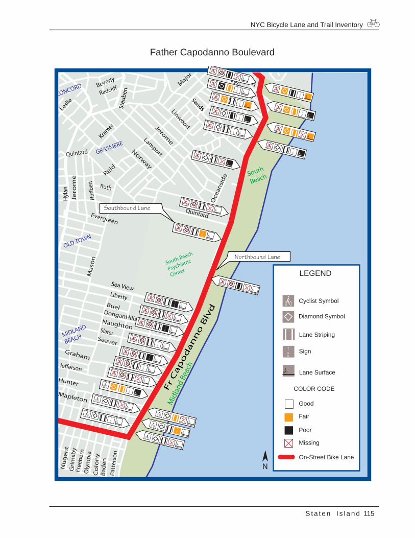
NYC Bicycle Lane and Trail Inventory
115S t a t e n I s l a n d
Father Capodanno Boulevard
Seaver
Hunter
Jefferson
Graham
Slater
Naughton
DonganHills
Oly
mpi
aC
olo
ny
Mapleton
Bad
enPa
tter
son
Free
born
Gri
msb
y
Nu
gen
t
Buel
Liberty
Reid
Jero
me
Ruth
Hurlb
ert
Quintard
Mas
on
Evergreen
Windom
OceanMajo
r
Oce
ansi
de
LinwoodJeromeLam
port
Beverly
Radcliff
Norway
Leslie
Quintard
GRASMERE
OLD TOWN
CONCORD
MIDLAND
BEACH
Hyl
an
Mid
land
Bea
ch
South
Beach
South Beach
Psychiatric
Center
Steu
ben
SandsKramer
Sea View
Fr
Cap
od
an
no
Blv
d
LEGEND
Good
Fair
Poor
Missing
On-Street Bike Lane
Diamond Symbol
Cyclist Symbol
Lane Striping
Lane Surface
Sign
COLOR CODE
N
Northbound Lane
Southbound Lane
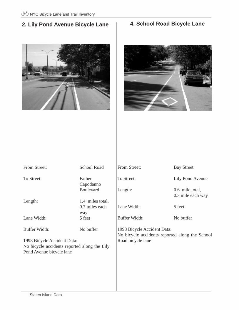
NYC Bicycle Lane and Trail Inventory
Staten Island Data
From Street: School Road
To Street: Father Capodanno Boulevard
Length: 1.4 miles total, 0.7 miles each way Lane Width: 5 feet
Buffer Width: No buffer
1998 Bicycle Accident Data: No bicycle accidents reported along the Lily Pond Avenue bicycle lane
2. Lily Pond Avenue Bicycle Lane 4. School Road Bicycle Lane
From Street: Bay Street
To Street: Lily Pond Avenue
Length: 0.6 mile total, 0.3 mile each way
Lane Width: 5 feet
Buffer Width: No buffer
1998 Bicycle Accident Data: No bicycle accidents reported along the School Road bicycle lane
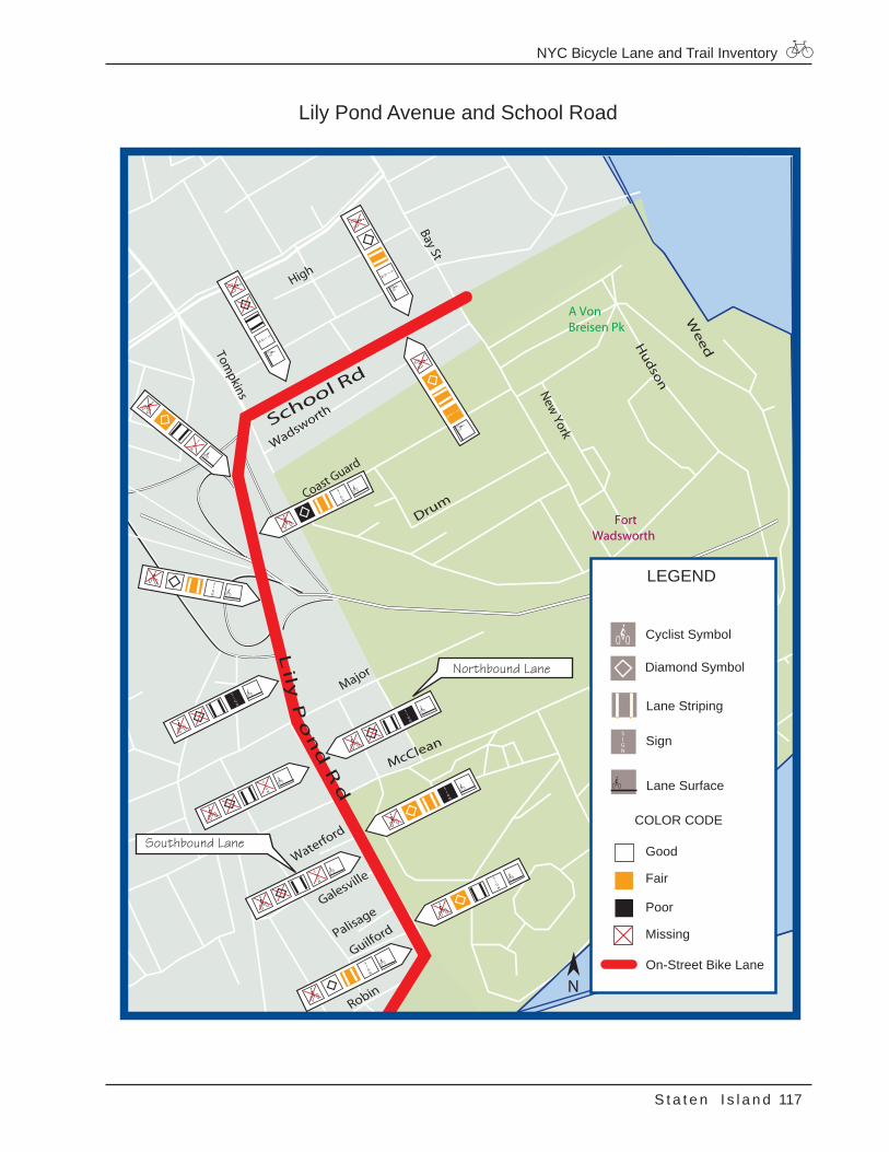
NYC Bicycle Lane and Trail Inventory
117S t a t e n I s l a n d
Lily Pond Avenue and School Road
McClean
WeedH
udson
Major
Drum
Wadsworth
Coast Guard
High
Waterford
Galesville
Palisage
Guilford
Robin
A Von Breisen Pk
FortWadsworth
School Rd
New York
Lily
Po
nd
Rd
Bay St
Tompkins
LEGEND
Good
Fair
Poor
Missing
On-Street Bike Lane
Diamond Symbol
Cyclist Symbol
Lane Striping
Lane Surface
Sign
COLOR CODE
N
Northbound Lane
Southbound Lane
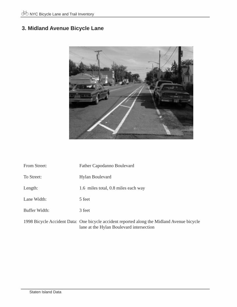
NYC Bicycle Lane and Trail Inventory
Staten Island Data
From Street: Father Capodanno Boulevard
To Street: Hylan Boulevard
Length: 1.6 miles total, 0.8 miles each way
Lane Width: 5 feet
Buffer Width: 3 feet
1998 Bicycle Accident Data: One bicycle accident reported along the Midland Avenue bicycle lane at the Hylan Boulevard intersection
3. Midland Avenue Bicycle Lane
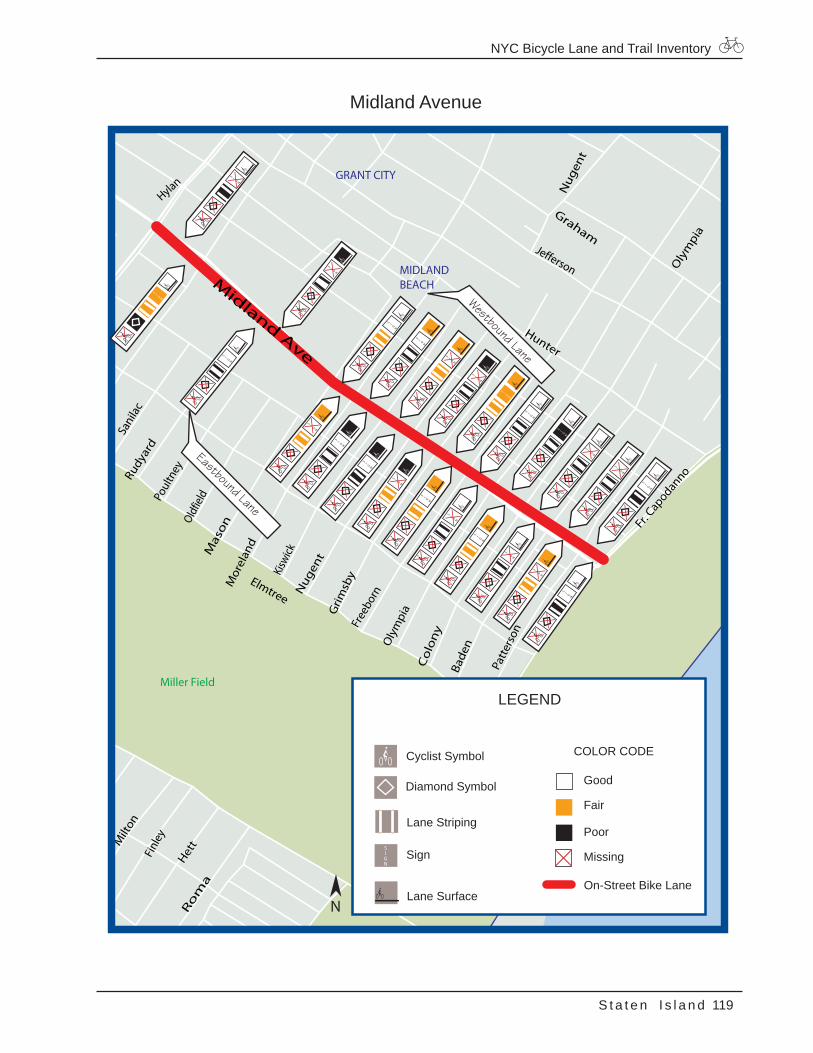
NYC Bicycle Lane and Trail Inventory
119S t a t e n I s l a n d
Midland Avenue
HettM
ilton
Finl
ey
Ro
ma
Hunter
Jefferson
Graham
Slater
Oly
mpi
aC
olo
ny
Bade
n
Patt
erso
n
Elmtree
Free
born
Grim
sby
Mor
elan
d
Kisw
ickN
ugen
t
Poul
tney
Sani
lac
Rudy
ard
Oldfie
ldM
aso
n
Oly
mpi
a
Nug
ent
Fr. Cap
odanno
GRANT CITY
MIDLANDBEACH
Hylan
Miller Field
Midland Ave
LEGEND
Good
Fair
Poor
Missing
On-Street Bike Lane
Diamond Symbol
Cyclist Symbol
Lane Striping
Lane Surface
Sign
COLOR CODE
N
Westbound Lane
Eastbound Lane
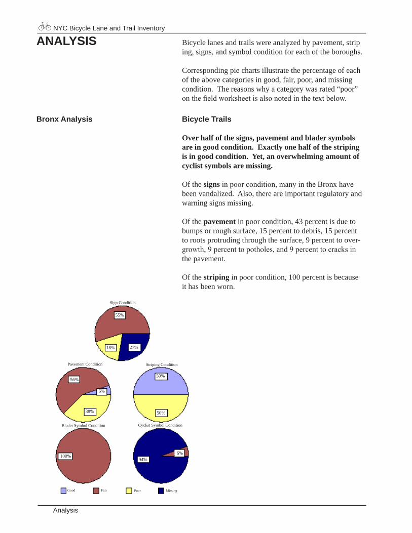
ANALYSIS Bicyclelanesandtrailswereanalyzedbypavement,strip ing,signs,andsymbolconditionforeachoftheboroughs.
Correspondingpiechartsillustratethepercentageofeachoftheabovecategoriesingood,fair,poor,andmissingcondition.Thereasonswhyacategorywasrated“poor”on the field worksheet is also noted in the text below.
Bronx Analysis Bicycle Trails
Over half of the signs, pavement and blader symbols are in good condition. Exactly one half of the striping is in good condition. Yet, an overwhelming amount of cyclist symbols are missing.
Ofthesigns in poor condition, many in the Bronx have beenvandalized.Also,thereareimportantregulatoryandwarningsignsmissing.
Ofthepavement inpoorcondition,43percentisduetobumpsorroughsurface,15percenttodebris,15percenttorootsprotrudingthroughthesurface,9percenttoover-growth, 9 percent to potholes, and 9 percent to cracks in thepavement.
Ofthestriping inpoorcondition,100percentisbecauseithasbeenworn.
NYC Bicycle Lane and Trail Inventory
Analysis
55%
18% 27%
56%
6%
38%
50%
50%
100% 6%94%
PavementCondition
SignCondition
StripingCondition
BladerSymbolCondition CyclistSymbolCondition
Good Fair Poor Missing
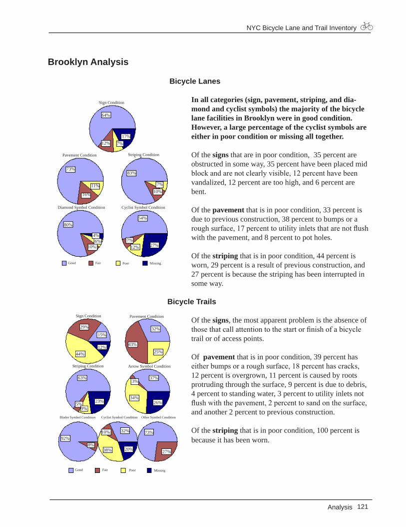
Brooklyn Analysis
Bicycle Lanes
In all categories (sign, pavement, striping, and dia-mond and cyclist symbols) the majority of the bicycle lane facilities in Brooklyn were in good condition. However, a large percentage of the cyclist symbols are either in poor condition or missing all together.
Ofthesigns thatareinpoorcondition,35percentareobstructedinsomeway,35percenthavebeenplacedmidblock and are not clearly visible, 12 percent have been vandalized,12percentaretoohigh,and6percentarebent.
Ofthepavement thatisinpoorcondition,33percentisduetopreviousconstruction,38percenttobumpsorarough surface, 17 percent to utility inlets that are not flush withthepavement,and8percenttopotholes.
Ofthestriping thatisinpoorcondition,44percentisworn,29percentisaresultofpreviousconstruction,and27percentisbecausethestripinghasbeeninterruptedinsomeway.
Bicycle Trails
Ofthesigns,themostapparentproblemistheabsenceofthose that call attention to the start or finish of a bicycle trailorofaccesspoints.
Ofpavement thatisinpoorcondition,39percenthaseither bumps or a rough surface, 18 percent has cracks, 12percentisovergrown,11percentiscausedbyrootsprotrudingthroughthesurface,9percentisduetodebris,4percenttostandingwater,3percenttoutilityinletsnotflush with the pavement, 2 percent to sand on the surface, andanother2percenttopreviousconstruction.
Ofthestriping thatisinpoorcondition,100percentisbecauseithasbeenworn.
NYC Bicycle Lane and Trail Inventory
121Analysis
PavementCondition
SignCondition
StripingCondition
DiamondSymbolCondition CyclistSymbolCondition
64%
12%17%
7%
73%
11%
16%
83%
10%7%
80%
4%6%
10%
54%
27%12%7%
Good Fair Poor Missing
Good Fair Poor Missing
PavementConditionSignCondition
StripingCondition
BladerSymbolCondition CyclistSymbolCondition
ArrowSymbolCondition
OtherSymbolCondition
29% 32%
44%12%
15%
25%43%
23%5%
63%
9%
3%
26%34%
37%
32%10%
8%92%
20%38% 27%
73%
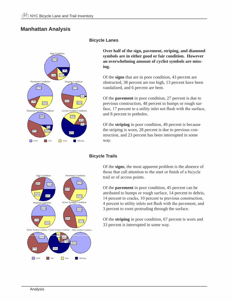
Manhattan Analysis
Bicycle Lanes
Over half of the sign, pavement, striping, and diamond symbols are in either good or fair condition. However an overwhelming amount of cyclist symbols are miss-ing.
Ofthesigns thatareinpoorcondition,43percentareobstructed,38percentaretoohigh,13percenthavebeenvandalized,and6percentarebent.
Ofthepavement inpoorcondition,27percentisduetopreviousconstruction,48percenttobumpsorroughsur-face, 17 percent to a utility inlet not flush with the surface, and8percenttopotholes.
Ofthestriping inpoorcondition,49percentisbecausethestripingisworn,28percentisduetopreviouscon-struction,and23percenthasbeeninterruptedinsomeway.
Bicycle Trails
Ofthesigns,themostapparentproblemistheabsenceofthose that call attention to the start or finish of a bicycle trailorofaccesspoints.
Ofthepavement inpoorcondition,45percentcanbeattributedtobumpsorroughsurface,14percenttodebris,14 percent to cracks, 10 percent to previous construction, 4 percent to utility inlets not flush with the pavement, and 3percenttorootsprotrudingthroughthesurface.
Ofthestriping inpoorcondition,67percentiswornand33percentisinterruptedinsomeway.
NYC Bicycle Lane and Trail Inventory
Analysis
SignCondition
Good
61%
CyclistSymbolConditionDiamondSymbolCondition
StripingConditionPavementCondition
MissingPoorFair
13%
11%15%
32%13%
55% 47%
1%
26%26%
8%10%38%
44%14%
2%
60%
24%
SignCondition
BladerSymbolCondition
StripingCondition
PavementCondition
ArrowSymbolCondition
CyclistSymbolCondition OtherSymbolCondition
Good MissingPoorFair
22%
18%30%
30% 32%
36%
32%
50%
17%33%
33%
45%22%
33%
67%
7%16%
70%
7% 100%
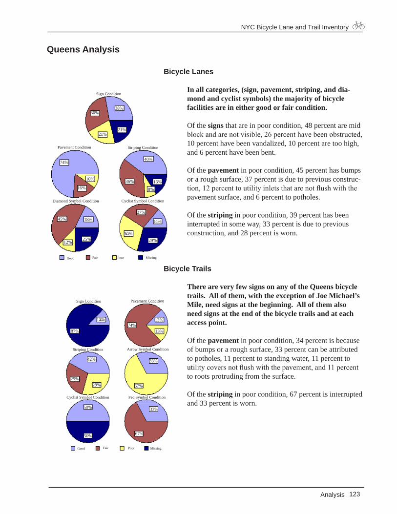
Queens Analysis
Bicycle Lanes
In all categories, (sign, pavement, striping, and dia-mond and cyclist symbols) the majority of bicycle facilities are in either good or fair condition.
Ofthesigns thatareinpoorcondition,48percentaremidblock and are not visible, 26 percent have been obstructed, 10percenthavebeenvandalized,10percentaretoohigh,and6percenthavebeenbent.
Ofthepavement inpoorcondition,45percenthasbumpsoraroughsurface,37percentisduetopreviousconstruc-tion, 12 percent to utility inlets that are not flush with the pavementsurface,and6percenttopotholes.
Ofthestriping inpoorcondition,39percenthasbeeninterruptedinsomeway,33percentisduetopreviousconstruction,and28percentisworn.
Bicycle Trails
There are very few signs on any of the Queens bicycle trails. All of them, with the exception of Joe Michael’s Mile, need signs at the beginning. All of them also need signs at the end of the bicycle trails and at each access point.
Ofthepavement inpoorcondition,34percentisbecauseofbumpsoraroughsurface,33percentcanbeattributedtopotholes,11percenttostandingwater,11percenttoutility covers not flush with the pavement, and 11 percent torootsprotrudingfromthesurface.
Ofthestripinginpoorcondition,67percentisinterruptedand33percentisworn.
NYC Bicycle Lane and Trail Inventory
123Analysis
SignCondition
CyclistSymbolConditionDiamondSymbolCondition
StripingConditionPavementCondition
Good MissingPoorFair
21%21%
30%28%
10%
74%
16%36%
40%
8%
16%
12%
45%
25%
18%
30%
27%
29%
14%
SignCondition
CyclistSymbolCondition PedSymbolCondition
StripingCondition
PavementCondition
ArrowSymbolCondition
Good MissingPoorFair
87%
13% 13%74%
29%
13%
29%
42%
67%
33%
50%
50%
33%
67%
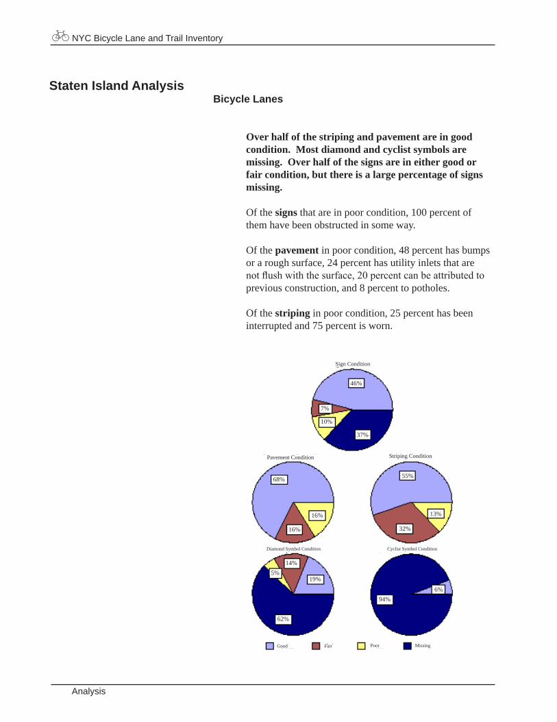
Staten Island AnalysisBicycle Lanes
Over half of the striping and pavement are in good condition. Most diamond and cyclist symbols are missing. Over half of the signs are in either good or fair condition, but there is a large percentage of signs missing.
Ofthesigns thatareinpoorcondition,100percentofthemhavebeenobstructedinsomeway.
Ofthepavement inpoorcondition,48percenthasbumpsoraroughsurface,24percenthasutilityinletsthatarenot flush with the surface, 20 percent can be attributed to previousconstruction,and8percenttopotholes.
Ofthestriping inpoorcondition,25percenthasbeeninterruptedand75percentisworn.
NYC Bicycle Lane and Trail Inventory
Analysis
SignCondition
DiamondSymbolCondition
StripingConditionPavementCondition
CyclistSymbolCondition
Good MissingPoorFair
46%
7%
37%
10%
68%
16%
55%
16%
13%
32%
5%14%
19%
62%
6%94%
Related Documents