New opportunities for oil exploration in New opportunities for oil exploration in Western Newfoundland offshore: Western Newfoundland offshore: Call For Bids NL13 Call For Bids NL13 - - 03 Parcels 1 to 4, 03 Parcels 1 to 4, Magdalen Magdalen and Anticosti Basins and Anticosti Basins Michael E. Enachescu, P Geo, P Geoph Euxinic Exploration Euxinic Exploration

Welcome message from author
This document is posted to help you gain knowledge. Please leave a comment to let me know what you think about it! Share it to your friends and learn new things together.
Transcript

New opportunities for oil exploration in New opportunities for oil exploration in Western Newfoundland offshore:Western Newfoundland offshore:
Call For Bids NL13Call For Bids NL13--03 Parcels 1 to 4, 03 Parcels 1 to 4, MagdalenMagdalen and Anticosti Basinsand Anticosti Basins
Michael E. Enachescu, P Geo, P GeophEuxinic Exploration
Euxinic
Exploration
• 2013 Call for Bids• Western NL Offshore Land Situation• Geology Reminder• Seismic Overview• NL13-03 Exploration Opportunities• Discussion• Conclusions
Presentation ContentPresentation Content
Enachescu, 201322

• 2013 Call for Bids in three areas:
– Flemish Pass Basin– Carson Basin– Western Newfoundland
• Call for Bids NL13-03 Western NL consists of four parcels comprising 1,004,482 hectares (2,482,075 acres) located in the shallow waters of the Gulf of St. Lawrence
2013 CFB2013 CFB
Enachescu, 201333
Modified After C‐NLOPB
Husky
Corridor
Black Spruce
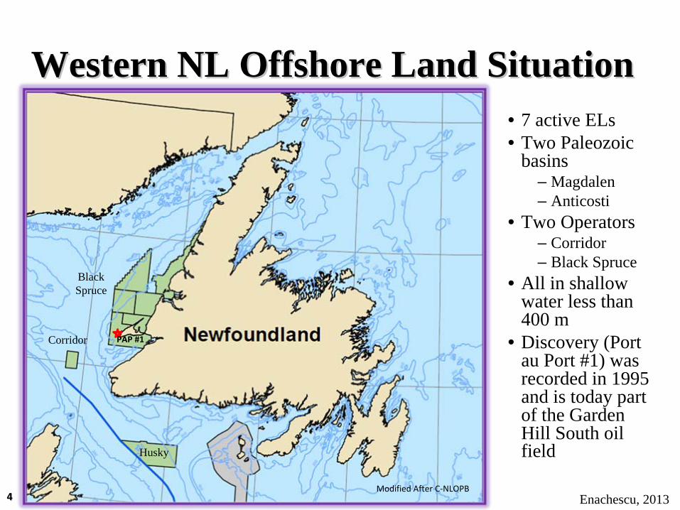
Western NL Offshore Land SituationWestern NL Offshore Land Situation• 7 active ELs• Two Paleozoic
basins– Magdalen– Anticosti
• Two Operators– Corridor– Black Spruce
• All in shallow water less than 400 m
• Discovery (Port au Port #1) was recorded in 1995 and is today part of the Garden Hill South oil field
Enachescu, 2013
PAP #1
44

Historic Bid Amounts and EL ParticularsHistoric Bid Amounts and EL Particulars
Enachescu, 201355
EXPIRED
EXPIRED
There are seven active Exploration Licences in Offshore Western Newfoundland that were previously issued under jurisdiction of the C-NLOPB totalling 10,638 km2
(2,628,798 acres). Several are approaching end of 1st Exploration Term

Enachescu, 201266
Geology ReminderGeology Reminder
Enachescu, 2013
Expanded geological and procedural information can be found athttp://www.nr.gov.nl.ca/nr/invest/CNLOPB13‐03.pdfhttp://www.nr.gov.nl.ca/nr/invest/enachescuNL11‐01anticosti.pdfhttp://www.nr.gov.nl.ca/nr/invest/callforbidsnl09‐03_1.pdf
http://www.nr.gov.nl.ca/nr/invest/callforbidsnl09‐03.pdf
http://www.nr.gov.nl.ca/nr/invest/cfb_nl06_03_anticosti.pdf
66
Western Newfoundland Western Newfoundland Basins and SubbasinsBasins and Subbasins
Enachescu, 2012
Cambro-Ordovician to Carboniferous basin fill
77
Maritime Basin
Parsons Pond
Sydney Basin
Courtesy of DNR
Enachescu, 2013
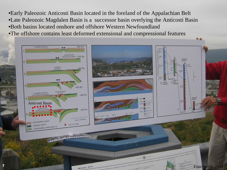
•Early Paleozoic Anticosti Basin located in the foreland of the Appalachian Belt•Late Paleozoic Magdalen Basin is a successor basin overlying the Anticosti Basin•Both basins located onshore and offshore Western Newfoundland•The offshore contains least deformed extensional and compressional features
Anticosti Basin
77
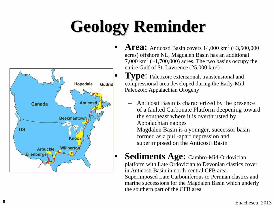
Geology ReminderGeology Reminder• Area: Anticosti Basin covers 14,000 km2 (~3,500,000
acres) offshore NL; Magdalen Basin has an additional 7,000 km2 (~1,700,000) acres. The two basins occupy the entire Gulf of St. Lawrence (25,000 km2)
• Type: Paleozoic extensional, transtensional and compressional area developed during the Early-Mid Paleozoic Appalachian Orogeny
– Anticosti Basin is characterized by the presence of a faulted Carbonate Platform deepening toward the southeast where it is overthrusted by Appalachian nappes
– Magdalen Basin is a younger, successor basin formed as a pull-apart depression and superimposed on the Anticosti Basin
• Sediments Age: Cambro-Mid-Ordovician platform with Late Ordovician to Devonian clastics cover in Anticosti Basin in north-central CFB area. Superimposed Late Carboniferous to Permian clastics and marine successions for the Magdalen Basin which underly the southern part of the CFB area
Enachescu, 201388

Yellow = Deep wells; Purple = Shallow well; Orange = Location only; Blue = Side track
Location of main offshore and onshore to offshore exploration wells, concentrated
around the Port au Port Peninsula.
West Newfoundland Offshore WellsWest Newfoundland Offshore Wells
Enachescu, 201399
Courtesy of DNR

West Newfoundland Offshore WellsWest Newfoundland Offshore Wells
Yellow =4 deep wells; Purple =1 Shallow well; Orange = 2 Location only; Blue = 3 Side track; N/A = Not applicableOnly 4 Wells are deep and significant for correlating the offshore geology; Only St. George A-36 was a true offshore well
Enachescu, 20131010

PAPPAP = Port au Port #1 Oil Discovery= Port au Port #1 Oil Discovery
SP = Shoal Point oil detected in Green Point shales
FB = Flat Bay wells that intersected tight oil zone
WA = West Adventure #1 limited gas flow
PAC = Port au Choix exhumed oil field
PP = Nalcor’s Parsons Pond wells with gas shows Magdalen
Basin
Atlantic O
cean
SP
FB
WA
NL
Quebec
NL
Modified after GSC
PAP
PAC
Anticosti B
asin
Newfoundland Geology Map and Newfoundland Geology Map and Significant Petroleum ShowsSignificant Petroleum Shows
PP
Enachescu, 2013
NS
1111
More than 20 years of effortMore than 20 years of effort

Seismic CoverageSeismic Coverage
Enachescu, 20131212

Pre and PostPre and Post--1991 Seismic Coverage1991 Seismic Coverage
Except for the BHP program collected in 1990, data was recorded with short
streamers, is poor imaging and unmigrated
Recorded with longer streamer, better imaging and migrated
No recent coverage for parcels 1, 3 and 4Enachescu, 2013
PostPost--19911991PrePre--19911991
1313

Offshore Western Newfoundland Offshore Western Newfoundland Seismic CoverageSeismic Coverage
Sydney Basin
Antico
sti B
asin
Magdalen Basin
Wes
tern
Newf
ound
land
Atlantic Ocean
Gulf of St. Lawrence
Post-1990 coverageHunt Oil -1990Mobil Canada -1991
Underexplored region with 14,906 line kms of 2D seismic data and one small (500 sq km) exploration 3D survey
Enachescu, 2013
Mobil CanadaBHP, Corridor,Husky
1414

NL13-03 Exploration OpportunitiesNL13NL13--03 Exploration Opportunities03 Exploration Opportunities
Enachescu, 2013
Four Large Four Large ParcelsParcels
1515
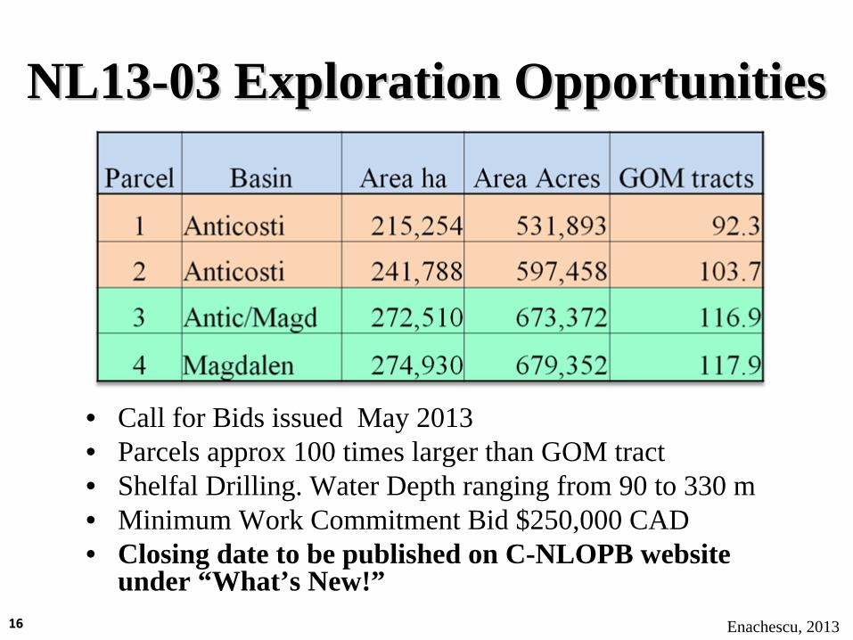
NL13NL13--03 Exploration Opportunities03 Exploration Opportunities
• Call for Bids issued May 2013• Parcels approx 100 times larger than GOM tract• Shelfal Drilling. Water Depth ranging from 90 to 330 m• Minimum Work Commitment Bid $250,000 CAD• Closing date to be published on C-NLOPB website
under “What’s New!”Enachescu, 20131616
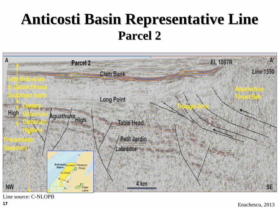
Anticosti Basin Representative LineAnticosti Basin Representative Line Parcel 2Parcel 2
Enachescu, 2013Line source: C-NLOPB1717
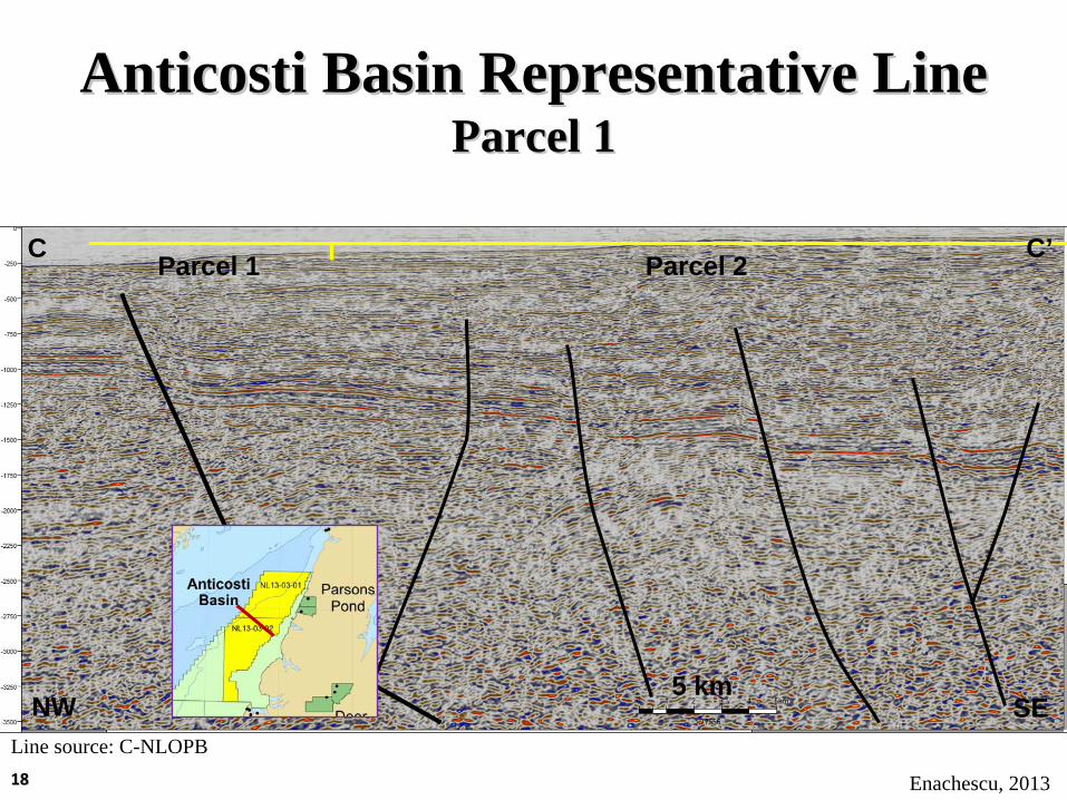
Anticosti Basin Representative LineAnticosti Basin Representative Line Parcel 1Parcel 1
Enachescu, 2013
Line source: C-NLOPB
Parcel 2Parcel 1
5 km
C C’
NW SE
1818
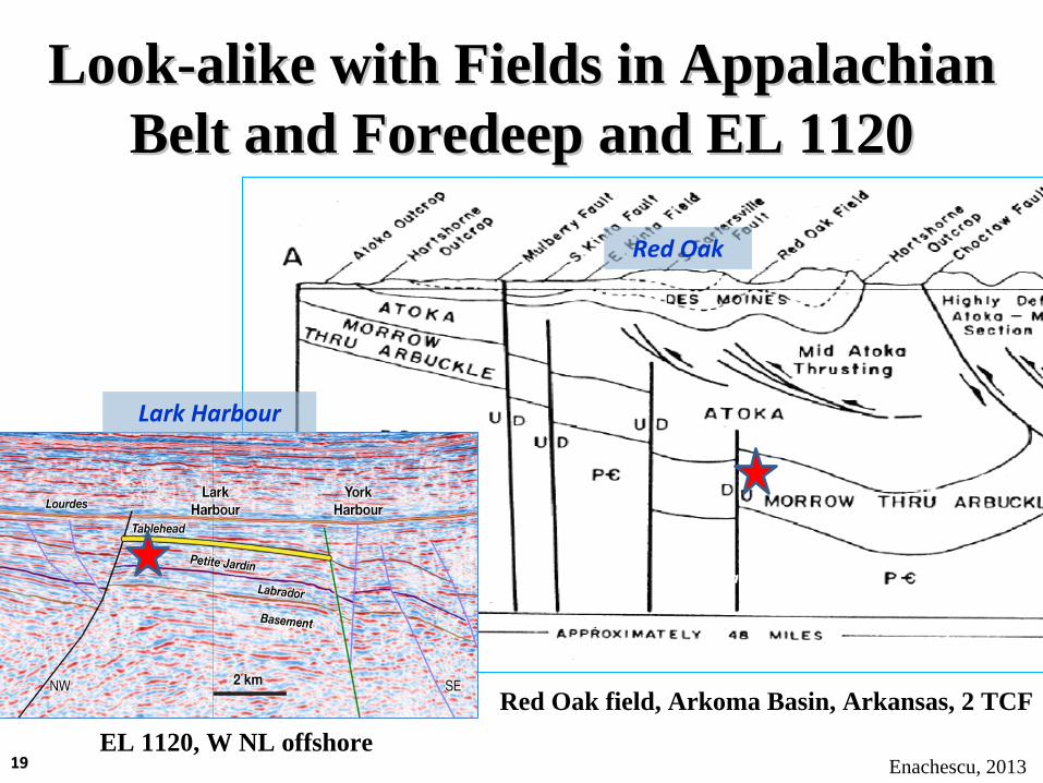
LookLook--alike with Fields in Appalachian alike with Fields in Appalachian Belt and Foredeep and EL 1120Belt and Foredeep and EL 1120
Lark Harbour
Ordovician Dolomite
Red Oak
EL 1120, W NL offshoreEnachescu, 2013
Red Oak field, Arkoma Basin, Arkansas, 2 TCF
1919

Geological CrossGeological Cross--Section Anticosti Basin Section Anticosti Basin • Offshore play is structurally simple in all parcels• Carbonate platform and sandstone reservoirs in rotated blocks• Also possible stratigraphic traps (karst, HDT lenses)
Triangle Zone Allochthon Play
Horst Block PlayRotated Block Play
Location of Parcels 1, 2 and 3
Modified after Atkinson and Wright, 2006
Enachescu, 2013
Carbonate reservoir-outcrop2020

• Cambro-Ordovician Carbonate Platform horsts and rotated fault blocks containing hydrothermal dolomite and karsted limestone reservoirs of the St. George Group are the main play types in Anticosti Basin
• Limestones of Port au Port and sandstone of Labrador Group trapped in rotated fault blocks forms a secondary play type
• Hydrocarbon traps are multi-fault bounded, 25 to over 100 km2 (~ 6,200 to 25,000 acres) in size
Anticosti Basin Play TypesAnticosti Basin Play Types
Enachescu, 20132121

Magdalen Basin Representative LineMagdalen Basin Representative Line Parcels 3 and 4Parcels 3 and 4
Enachescu, 2013Line source: C-NLOPB2222

• Main play types are thrust fault anticlines and salt anticlines containing Carboniferous sandstone trapped against and above salt diapirs
• Deeper play involves Carbonate Platform reservoirs in inverted or extensional structures
• Superimposed reservoirs are possible• Large compressional and salt anticline, and
deeper extensional traps are 25 to over 100 km2
in size
Magdalen Basin Play TypesMagdalen Basin Play Types
Enachescu, 20132323

Strike Line Along the W NL Strike Line Along the W NL OffshoreOffshore
Enachescu, 2013
SW NE6 km
Line source: Ptarmigan
Numerous tilted blocks, horsts , roll-over and slightly inverted structures are interpreted in the Carbonate Platform sequence on a strike line along the Western NL Anticosti Basin
2424

Enachescu, 2013
••Last significant well drilled in 1999Last significant well drilled in 1999••Last 2D Regional seismic program in 1991Last 2D Regional seismic program in 1991••Active petroleum systems proven in both Anticosti Active petroleum systems proven in both Anticosti and Magdalen basins, but still underexplored and Magdalen basins, but still underexplored frontier areasfrontier areas••Area needs a revival of activities and infusion of new Area needs a revival of activities and infusion of new operators with financial capability to carry a operators with financial capability to carry a complete exploration program to fruitioncomplete exploration program to fruition••The CThe C--NLOPB 2013 Western Newfoundland Call NLOPB 2013 Western Newfoundland Call for Bids provides an occasion for sizeable operators for Bids provides an occasion for sizeable operators to obtain large frontier acreage near oil marketsto obtain large frontier acreage near oil markets
DiscussionDiscussion
2525

ConclusionsConclusions• Four large parcels in Paleozoic Anticosti and Magdalen basins
offered at NL13-03 CFB• Proven petroleum systems with both oil and gas source rocks• Large structural traps as big as 100 km2
• Structures capable of holding hundreds of mmbbls or 2-3 Tcf• Excellent opportunity for new entrants in NL O&G exploration
Parcel 1
Clam Bank
Table Head
Petit Jardin
Labrador
Long Point
High
High
Aguathuna
AAAA
Line source: C-NLOPBEnachescu, 20132626

AcknowledgementsAcknowledgementsNL DNRC-NLOPBW NL Symposium organizersWes FooteIan AtkinsonPhonse FaganPtarmigan Energy
Pictures FromPictures FromM. Enachescu’s Western NL field trips
Thank You for Attention!
2727
Related Documents


