New insights into Arctic paleogeography and tectonics from U-Pb detrital zircon geochronology Elizabeth L. Miller, 1 Jaime Toro, 2 George Gehrels, 3 Jeffrey M. Amato, 4 Andrei Prokopiev, 5 Marianna I. Tuchkova, 6 Vyacheslav V. Akinin, 7 Trevor A. Dumitru, 1 Thomas E. Moore, 8 and Michael P. Cecile 9 Received 11 April 2005; revised 21 December 2005; accepted 6 March 2006; published 6 June 2006. [1] To test existing models for the formation of the Amerasian Basin, detrital zircon suites from 12 samples of Triassic sandstone from the circum-Arctic region were dated by laser ablation-inductively coupled plasma-mass spectrometry (ICP-MS). The northern Verkhoyansk (NE Russia) has Permo- Carboniferous (265–320 Ma) and Cambro-Silurian (410–505 Ma) zircon populations derived via river systems from the active Baikal Mountain region along the southern Siberian craton. Chukotka, Wrangel Island (Russia), and the Lisburne Hills (western Alaska) also have Permo-Carboniferous (280 – 330 Ma) and late Precambrian-Silurian (420–580 Ma) zircons in addition to Permo-Triassic (235–265 Ma), Devonian (340–390 Ma), and late Precambrian (1000–1300 Ma) zircons. These ages suggest at least partial derivation from the Taimyr, Siberian Trap, and/ or east Urals regions of Arctic Russia. The northerly derived Ivishak Formation (Sadlerochit Mountains, Alaska) and Pat Bay Formation (Sverdrup Basin, Canada) are dominated by Cambrian–latest Precambrian (500–600 Ma) and 445–490 Ma zircons. Permo-Carboniferous and Permo-Triassic zircons are absent. The Bjorne Formation (Sverdrup Basin), derived from the south, differs from other samples studied with mostly 1130–1240 Ma and older Precambrian zircons in addition to 430–470 Ma zircons. The most popular plate tectonic model for the origin of the Amerasian Basin involves counterclockwise rotation of the Arctic Alaska– Chukotka microplate away from the Canadian Arctic margin. The detrital zircon data suggest that the Chukotka part of the microplate originated closer to the Taimyr and Verkhoyansk, east of the Polar Urals of Russia, and not from the Canadian Arctic. Citation: Miller, E. L., J. Toro, G. Gehrels, J. M. Amato, A. Prokopiev, M. I. Tuchkova, V. V. Akinin, T. A. Dumitru, T. E. Moore, and M. P. Cecile (2006), New insights into Arctic paleogeography and tectonics from U-Pb detrital zircon geochronology, Tectonics , 25 , TC3013, doi:10.1029/ 2005TC001830. 1. Introduction [2] Despite an increased interest in the exploration of the Arctic Ocean for both its resources and its role in control- ling the Tertiary to recent climate history of Earth, we know remarkably little about the actual formation of this ocean basin and its changing paleogeography through time. Sea- floor spreading anomalies constrain most of the rift history of the Eurasian Basin (the northern continuation of the Mid- Atlantic Ridge system) back to 56 Ma (anomaly 24) [e.g., Rowley and Lottes, 1988], but the earlier rift history of the adjacent Amerasian Basin (Figure 1) remains an unsolved plate tectonic puzzle. Lawver and Scotese [1990] chronicled the wide variety of solutions proposed for this puzzle over the years, and classified the solutions into three end-member rifting models where the Canadian Arctic margin and the Lomonosov Ridge are alternatively used as rift or transform boundaries for the displacement of Arctic Alaska, Chukotka and their continental shelves to their present position (Figure 1). Geophysical data sets and seismic reflection- based stratigraphic correlations have lent support to one of these rifting models, the ‘‘rotational opening model’’, often referred to as the ‘‘windshield wiper’’ model (Figures 1 and 2). This model proposes that Early Cretaceous rifting rotated a continental mass, now known as the Arctic Alaska-Chukotka microplate, southward from the Arctic margin of Canada. The plate pivoted about a pole located in the McKenzie Delta region [e.g., Grantz et al., 1990b] (Figure 2), opening the Amerasian Basin by rifting. The Amerasian margin of the Lomonosov Ridge serves as a transform boundary in this model (Figures 1 and 2). Data in support of the ‘‘rotational model’’ include correlation of the upper Paleozoic-Mesozoic stratigraphy of the North Slope of Alaska to the Sverdrup Basin of Arctic Canada [Grantz et TECTONICS, VOL. 25, TC3013, doi:10.1029/2005TC001830, 2006 1 Department of Geological and Environmental Sciences, Stanford University, Stanford, California, USA. 2 Department of Geology and Geography, West Virginia University, Morgantown, West Virginia, USA. 3 Department of Geosciences, University of Arizona, Tucson, Arizona, USA. 4 Department of Geological Sciences, New Mexico State University, Las Cruces, New Mexico, USA. 5 Diamond and Precious Metal Geology Institute, Siberian Branch, Russian Academy of Sciences, Yakutsk, Russia. 6 Geological Institute, Russian Academy of Sciences, Moscow, Russia. 7 Northeast Interdisciplinary Scientific Research Institute, Russian Academy of Sciences, Magadan, Russia. 8 U.S. Geological Survey, Menlo Park, California, USA. 9 Geological Survey of Canada, Calgary, Alberta, Canada. Copyright 2006 by the American Geophysical Union. 0278-7407/06/2005TC001830$12.00 TC3013 1 of 19

Welcome message from author
This document is posted to help you gain knowledge. Please leave a comment to let me know what you think about it! Share it to your friends and learn new things together.
Transcript
New insights into Arctic paleogeography and tectonics
from U-Pb detrital zircon geochronology
Elizabeth L. Miller,1 Jaime Toro,2 George Gehrels,3 Jeffrey M. Amato,4
Andrei Prokopiev,5 Marianna I. Tuchkova,6 Vyacheslav V. Akinin,7
Trevor A. Dumitru,1 Thomas E. Moore,8 and Michael P. Cecile9
Received 11 April 2005; revised 21 December 2005; accepted 6 March 2006; published 6 June 2006.
[1] To test existing models for the formation of theAmerasian Basin, detrital zircon suites from 12samples of Triassic sandstone from the circum-Arcticregion were dated by laser ablation-inductivelycoupled plasma-mass spectrometry (ICP-MS). Thenorthern Verkhoyansk (NE Russia) has Permo-Carboniferous (265–320 Ma) and Cambro-Silurian(410–505 Ma) zircon populations derived via riversystems from the active Baikal Mountain region alongthe southern Siberian craton. Chukotka, WrangelIsland (Russia), and the Lisburne Hills (westernAlaska) also have Permo-Carboniferous (280–330Ma)and late Precambrian-Silurian (420–580 Ma) zirconsin addition to Permo-Triassic (235–265 Ma),Devonian (340–390 Ma), and late Precambrian(1000–1300 Ma) zircons. These ages suggest at leastpartial derivation from the Taimyr, Siberian Trap, and/or east Urals regions of Arctic Russia. The northerlyderived Ivishak Formation (Sadlerochit Mountains,Alaska) and Pat Bay Formation (Sverdrup Basin,Canada) are dominated by Cambrian – latestPrecambrian (500–600 Ma) and 445–490 Mazircons. Permo-Carboniferous and Permo-Triassiczircons are absent. The Bjorne Formation (SverdrupBasin), derived from the south, differs from othersamples studied with mostly 1130–1240 Ma and olderPrecambrian zircons in addition to 430–470 Mazircons. The most popular plate tectonic model forthe origin of the Amerasian Basin involves
counterclockwise rotation of the Arctic Alaska–Chukotka microplate away from the Canadian Arcticmargin. The detrital zircon data suggest that theChukotka part of the microplate originated closerto the Taimyr and Verkhoyansk, east of the PolarUrals of Russia, and not from the Canadian Arctic.Citation: Miller, E. L., J. Toro, G. Gehrels, J. M. Amato,
A. Prokopiev, M. I. Tuchkova, V. V. Akinin, T. A. Dumitru,
T. E. Moore, and M. P. Cecile (2006), New insights into
Arctic paleogeography and tectonics from U-Pb detrital zircon
geochronology, Tectonics, 25, TC3013, doi:10.1029/
2005TC001830.
1. Introduction
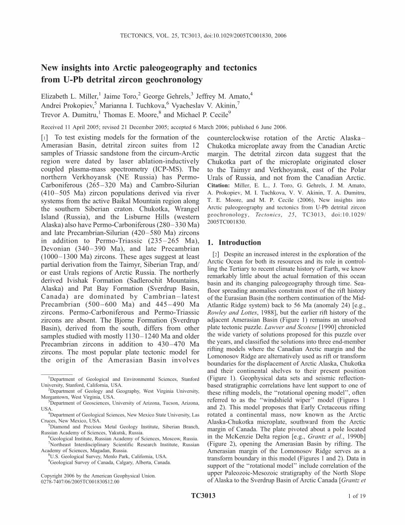
[2] Despite an increased interest in the exploration of theArctic Ocean for both its resources and its role in control-ling the Tertiary to recent climate history of Earth, we knowremarkably little about the actual formation of this oceanbasin and its changing paleogeography through time. Sea-floor spreading anomalies constrain most of the rift historyof the Eurasian Basin (the northern continuation of the Mid-Atlantic Ridge system) back to 56 Ma (anomaly 24) [e.g.,Rowley and Lottes, 1988], but the earlier rift history of theadjacent Amerasian Basin (Figure 1) remains an unsolvedplate tectonic puzzle. Lawver and Scotese [1990] chronicledthe wide variety of solutions proposed for this puzzle overthe years, and classified the solutions into three end-memberrifting models where the Canadian Arctic margin and theLomonosov Ridge are alternatively used as rift or transformboundaries for the displacement of Arctic Alaska, Chukotkaand their continental shelves to their present position(Figure 1). Geophysical data sets and seismic reflection-based stratigraphic correlations have lent support to one ofthese rifting models, the ‘‘rotational opening model’’, oftenreferred to as the ‘‘windshield wiper’’ model (Figures 1and 2). This model proposes that Early Cretaceous riftingrotated a continental mass, now known as the ArcticAlaska-Chukotka microplate, southward from the Arcticmargin of Canada. The plate pivoted about a pole locatedin the McKenzie Delta region [e.g., Grantz et al., 1990b](Figure 2), opening the Amerasian Basin by rifting. TheAmerasian margin of the Lomonosov Ridge serves as atransform boundary in this model (Figures 1 and 2). Data insupport of the ‘‘rotational model’’ include correlation of theupper Paleozoic-Mesozoic stratigraphy of the North Slopeof Alaska to the Sverdrup Basin of Arctic Canada [Grantz et
TECTONICS, VOL. 25, TC3013, doi:10.1029/2005TC001830, 2006
1Department of Geological and Environmental Sciences, StanfordUniversity, Stanford, California, USA.
2Department of Geology and Geography, West Virginia University,Morgantown, West Virginia, USA.
3Department of Geosciences, University of Arizona, Tucson, Arizona,USA.
4Department of Geological Sciences, New Mexico State University, LasCruces, New Mexico, USA.
5Diamond and Precious Metal Geology Institute, Siberian Branch,Russian Academy of Sciences, Yakutsk, Russia.
6Geological Institute, Russian Academy of Sciences, Moscow, Russia.7Northeast Interdisciplinary Scientific Research Institute, Russian
Academy of Sciences, Magadan, Russia.8U.S. Geological Survey, Menlo Park, California, USA.9Geological Survey of Canada, Calgary, Alberta, Canada.
Copyright 2006 by the American Geophysical Union.0278-7407/06/2005TC001830$12.00
TC3013 1 of 19
al., 1990b; Embry and Dixon, 1990; Toro et al., 2004], andmagnetic and gravity anomalies that identify a paleospread-ing center in part of the Amerasian Basin [Laxon andMcAdoo, 1994; Brozena et al., 2002]. Although the ‘‘rota-tional model’’ seems to best satisfy geological and geophys-ical data from the Canadian and Alaskan portion of thecircum-Arctic, reconstructing the Russian portion of theArctic Alaska-Chukotka plate by this model creates severalproblems. Geological and geophysical constraints suggestthat the Arctic Alaska-Chukotka microplate extends as farwest as the New Siberian Islands and includes most of theimmense and poorly known east Siberian continental shelf(Figure 1) [Kuzmichev and Soloviev, 2004]. Restoring themicroplate against the Canadian Arctic and Barents margins
with the ‘‘rotational opening model’’ thus produces signif-icant overlap of continental crust as discussed by Rowleyand Lottes [1988], Drachev [2004], and Natal’in [2004](Figure 2). Also, although the ‘‘rotational model’’ impliesthat the present-day southern margin of Arctic Alaska-Chukotka should have undergone shortening as the micro-plate rotated away from Arctic Canada, shortening in theBrooks Range appears to have started as early as mid-Jurassic [Moore et al., 1994]. Therefore, if the BrooksRange belt of deformation extends into Chukotka, as iswidely believed, the ‘‘rotational model’’ would juxtaposethe trends of a mid-Jurassic–Early Cretaceous orogenagainst a platformal region with no such history (Figure 2),further calling this model into question.[3] Understanding how the Amerasian Basin formed is
necessary in order to understand the origin and evolution ofthe vast Russian continental shelves and basins as well asthe origin of the major bathymetric features in the ArcticOcean such as the continental Lomonosov Ridge, the moreobscure Alpha-Mendeleev Ridge, and the Chukchi Border-land (Figure 1). At present, land-based geologic effortsprovide the only straightforward and cost-effective meansof addressing this problem. In particular, data from NERussia has the most potential for making a significantcontribution to our understanding. For instance, the recon-struction shown in Figure 2 suggests that Chukotka, Russia,should have depositional ties with Arctic Canada and notSiberia but this possibility has not been explored by land-based stratigraphic studies.[4] Recent advances in laser ablation-mass spectrometry
and ion microprobe technology have made the dating oflarge populations of detrital zircon feasible and now thesemethods are highly effective tools for provenance studies[e.g., Dickinson and Gehrels, 2003; DeGraaf-Surpless etal., 2002]. The power of such studies for plate tectonicreconstructions is clear. Here we present U-Pb single-grainages from detrital zircon populations of Triassic sandstonesof the circum-Arctic, carried out in order to better constrainthe position of the different parts of the Arctic Alaska-Chukotka microplate prior to the opening of the AmerasianBasin.
2. Arctic Alaska-Chukotka Microplate
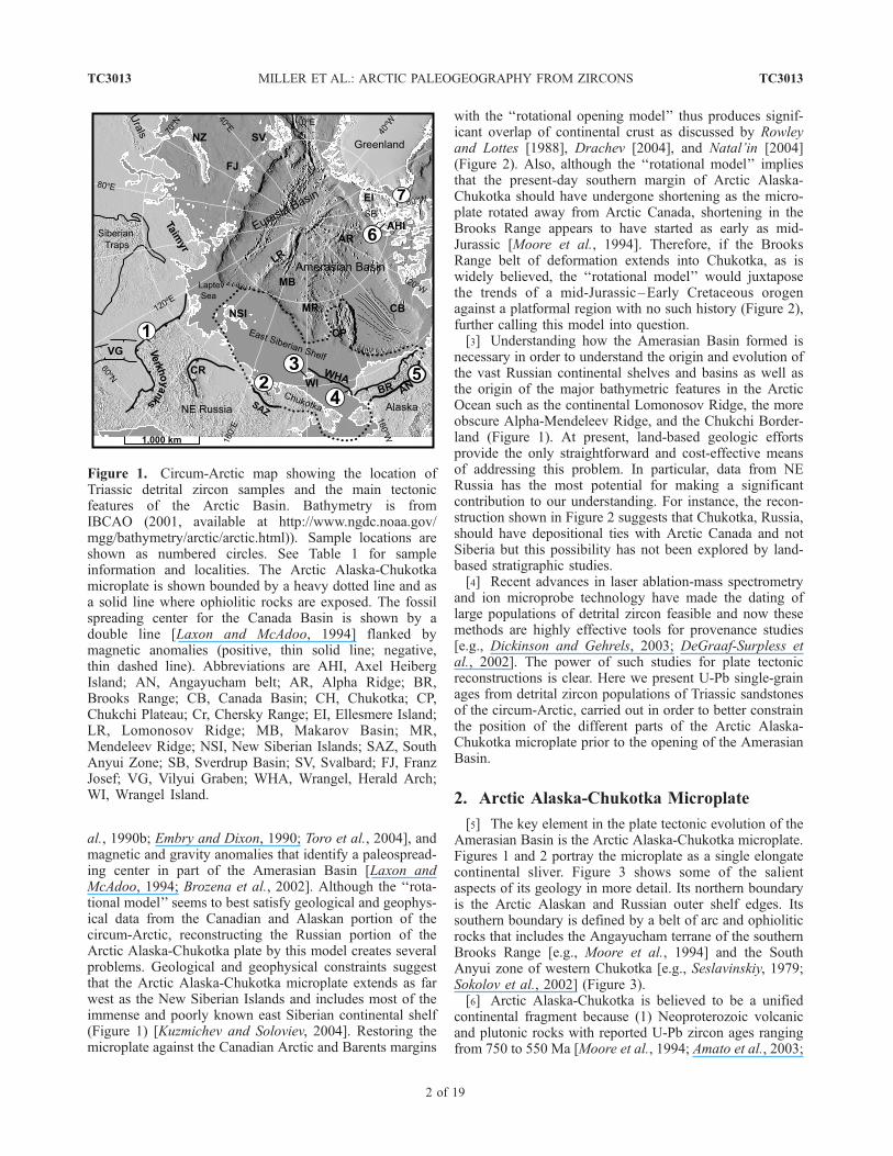
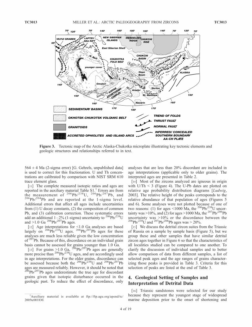
[5] The key element in the plate tectonic evolution of theAmerasian Basin is the Arctic Alaska-Chukotka microplate.Figures 1 and 2 portray the microplate as a single elongatecontinental sliver. Figure 3 shows some of the salientaspects of its geology in more detail. Its northern boundaryis the Arctic Alaskan and Russian outer shelf edges. Itssouthern boundary is defined by a belt of arc and ophioliticrocks that includes the Angayucham terrane of the southernBrooks Range [e.g., Moore et al., 1994] and the SouthAnyui zone of western Chukotka [e.g., Seslavinskiy, 1979;Sokolov et al., 2002] (Figure 3).[6] Arctic Alaska-Chukotka is believed to be a unified
continental fragment because (1) Neoproterozoic volcanicand plutonic rocks with reported U-Pb zircon ages rangingfrom 750 to 550 Ma [Moore et al., 1994; Amato et al., 2003;
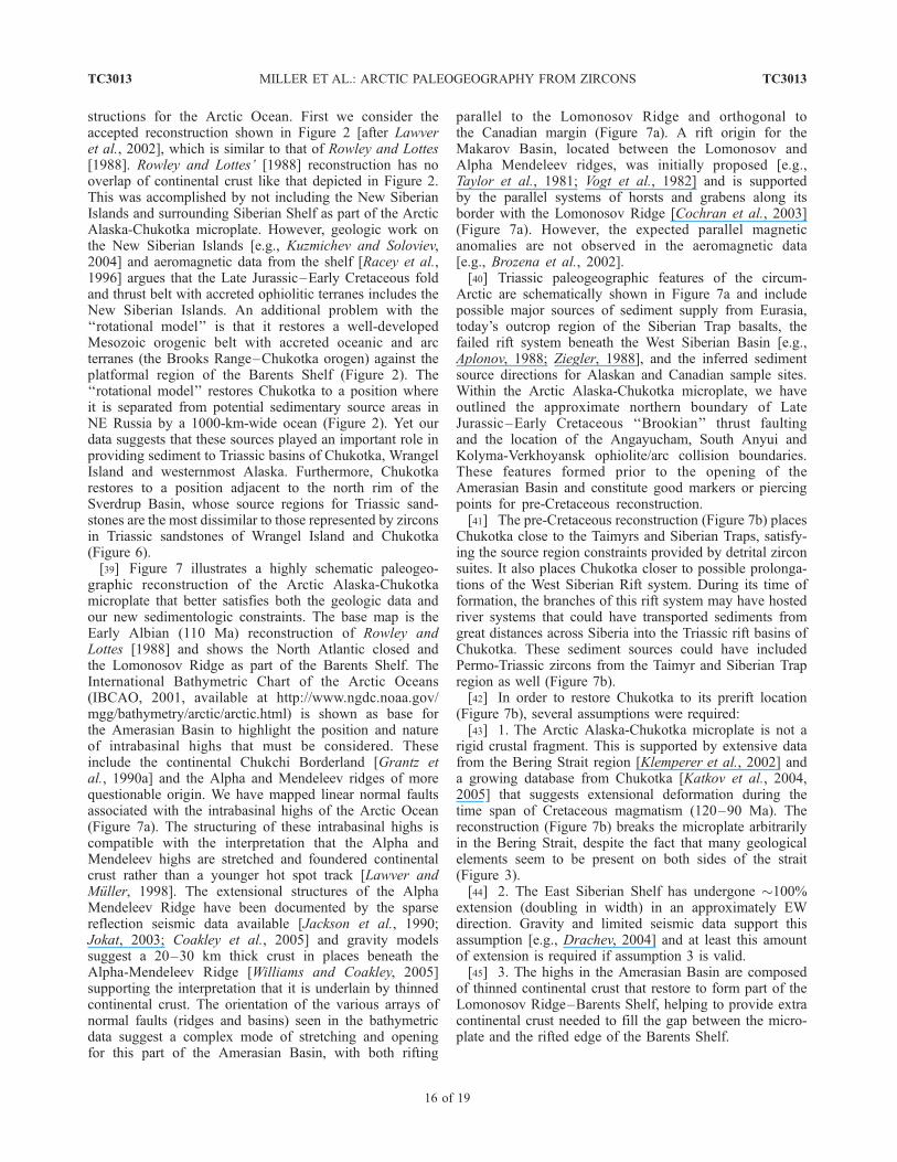
Figure 1. Circum-Arctic map showing the location ofTriassic detrital zircon samples and the main tectonicfeatures of the Arctic Basin. Bathymetry is fromIBCAO (2001, available at http://www.ngdc.noaa.gov/mgg/bathymetry/arctic/arctic.html)). Sample locations areshown as numbered circles. See Table 1 for sampleinformation and localities. The Arctic Alaska-Chukotkamicroplate is shown bounded by a heavy dotted line and asa solid line where ophiolitic rocks are exposed. The fossilspreading center for the Canada Basin is shown by adouble line [Laxon and McAdoo, 1994] flanked bymagnetic anomalies (positive, thin solid line; negative,thin dashed line). Abbreviations are AHI, Axel HeibergIsland; AN, Angayucham belt; AR, Alpha Ridge; BR,Brooks Range; CB, Canada Basin; CH, Chukotka; CP,Chukchi Plateau; Cr, Chersky Range; EI, Ellesmere Island;LR, Lomonosov Ridge; MB, Makarov Basin; MR,Mendeleev Ridge; NSI, New Siberian Islands; SAZ, SouthAnyui Zone; SB, Sverdrup Basin; SV, Svalbard; FJ, FranzJosef; VG, Vilyui Graben; WHA, Wrangel, Herald Arch;WI, Wrangel Island.
TC3013 MILLER ET AL.: ARCTIC PALEOGEOGRAPHY FROM ZIRCONS
2 of 19
TC3013
Amato, 2004, Kos’ko et al., 1993] form its depositionalbasement; (2) Early Paleozoic carbonate successions withSiberian faunal affinities unconformably overlie this base-ment across its known extent [Dumoulin et al., 2002;Natal’in et al., 1999; Kos’ko et al., 1993]; (3) the occur-rence of a common suite of Devonian plutons (found in theYukon, the Brooks Range, Seward Peninsula and Chukotka,with reported U-Pb ages ranging from 390 to 340 Ma [e.g.,Moore et al., 1994; Toro et al., 2002; Kos’ko et al., 1993];and (4) the similar nature and age of structural trendsacross the microplate. These include ophiolite belts (theAngayucham and South Anyui) developed by collision-related deformation along the southern side of the plateand initiated in the mid-Jurassic, folds and thrust faults thatinvolve continental margin sedimentary sequences from theBrooks Range and Lisburne Hills, where structures are welldated as latest Jurassic and Early Cretaceous, offshore alongthe Herald Arch to Wrangel Island, and into the Chukotkafold belt where shortening-related deformation is indirectlydated by syntectonic sedimentary sequences as latest Juras-sic and Early Cretaceous [e.g., Miller et al., 2004]. Struc-tures are cut by Cretaceous plutons dated by the U-Pbmethod that are as old as 117 ± 1.9 Ma [Katkov et al., 2004,
2005] (Figure 3). Volcanic sequences of the youngerOkhotsk-Chukotsk belt in turn unconformably overlie olderdeformational structures and plutons [Katkov et al., 2004,2005] (Figure 3).[7] One of the important along-strike differences in the
stratigraphy of the microplate is the varying nature ofTriassic sedimentary successions. Northern Alaska is char-acterized by a relatively thin, clastic passive margin suc-cession, which includes chert and other pelagic deposits inthe south and more proximal thin platform sandstones in thenorth. The Triassic succession of Alaska pinches out againsta north-south trending basement high in the Chukchiplatform east of Wrangel Island [Sherwood et al., 2002](Figure 3). In Chukotka, the Triassic consists of thickturbidite sequences intruded by gabbroic dikes and sills attheir base [Gelman, 1963; Ivanov and Milov, 1975]. Sand-stone petrography suggests recycled orogen sources[Tuchkova et al., 2004]. Thus, in contrast to Alaska,Chukotka experienced a Triassic rifting event that formeddeep basins across earlier platformal deposits and waspaleogeographically linked tomajor immature clastic sources[Tuchkova et al., 2004]. Deformation and metamorphism ofthe Triassic of Chukotka has hindered detailed studies ofsedimentary facies and paleocurrents in these rocks and hasobscured the initial geometry of these rift basins.
3. Analytical Methods
[8] Zircons were separated from 12 samples of Triassicsandstones (Table 1), mounted in epoxy and polished toexpose the interior of the grains. Isotopic analyses wereperformed with a Micromass Isoprobe multicollectorICP-MS with a laser ablation system. Laser beam diameterwas �30 mm and yielded ablation pits �20 mm deep. Grainswere selected randomly from all sizes and morphologiespresent, except for avoidance of grains with fractures orinclusion. The ablated material is carried in argon gas intothe plasma source of a Micromass Isoprobe, which isequipped with a flight tube of sufficient width that U, Th,and Pb isotopes are measured simultaneously. All measure-ments are made in static mode, using Faraday detectors for238U, 232Th, 208-206Pb, and an ion-counting channel for204Pb. Ion yields are � 0.5 mv per ppm. Each analysisconsists of one 20-s integration on peaks with the laser off(for backgrounds), twenty 1-s integrations with the laserfiring, and a 30-s delay to purge the previous sample andprepare for the next analysis.[9] Common Pb correction is made by using the mea-
sured 204Pb and assuming an initial Pb composition fromStacey and Kramers [1975] (with uncertainties of 1.0 for206Pb/204Pb and 0.3 for 207Pb/204Pb). Our measurement of204Pb is unaffected by the presence of 204Hg because back-grounds are measured on peaks (thereby subtracting anybackground 204Hg and 204Pb), and because very little Hg ispresent in the argon gas.[10] Interelement fractionation of Pb/U is generally
�15%, whereas fractionation of Pb isotopes is generally�3%. In-run analysis of fragments of a large zircon crystal(generally every fourth measurement) with a known age of
Figure 2. Early Cretaceous plate reconstruction of thecircum-Arctic region prior to opening of the AmerasianBasin by simple rotation of Arctic Alaska-Chukotka (AAC)modified from Lawver et al. [2002]. The area of overlap ofcontinental crust that results if AAC is rotated as a rigidplate is shown in black. The exposed area of the SouthAnyui Zone (SAZ) is highlighted by a ruled pattern.Numbered circles are detrital zircon sample locations.Abbreviations are AN, Angayucham belt; CR, Cherskyrange; KO, Kolyma-Omolon superterrane; KY, Koyukukarc; MD, Makenzie Delta.
TC3013 MILLER ET AL.: ARCTIC PALEOGEOGRAPHY FROM ZIRCONS
3 of 19
TC3013
564 ± 4 Ma (2-sigma error) [G. Gehrels, unpublished data]is used to correct for this fractionation. U and Th concen-trations are calibrated by comparison with NIST SRM 610trace element glass.[11] The complete measured isotopic ratios and ages are
reported in the auxiliary material Table S1.1 Errors are fromthe measurement of 206Pb/238U, 206Pb/207Pb, and206Pb/204Pb and are reported at the 1-sigma level.Additional errors that affect all ages include uncertaintiesfrom (1) U decay constants, (2) the composition of commonPb, and (3) calibration correction. These systematic errorsadd an additional 1–2% (1-sigma) uncertainty to 206Pb/238Uand >1.0 Ga 206Pb/207Pb ages.[12] Age interpretations for <1.0 Ga analyses are based
largely on 206Pb/238U ages. 206Pb/207Pb ages for theseanalyses are much less reliable given the low concentrationof 207Pb. Because of this, discordance on an individual grainbasis cannot be assessed for grains younger than 1.0 Ga.[13] For grains >1.0 Ga, 206Pb/207Pb ages are generally
more precise than 206Pb/238U ages, and are accordingly usedin age interpretations. For the older grains, discordance canbe assessed because both the 206Pb/238U and 206Pb/207Pbages are measured reliably. However, it should be noted that206Pb/207Pb ages underestimate the true age for discordantgrains given that isotopic disturbance occurred in thegeologic past. To reduce the effect of discordance, only
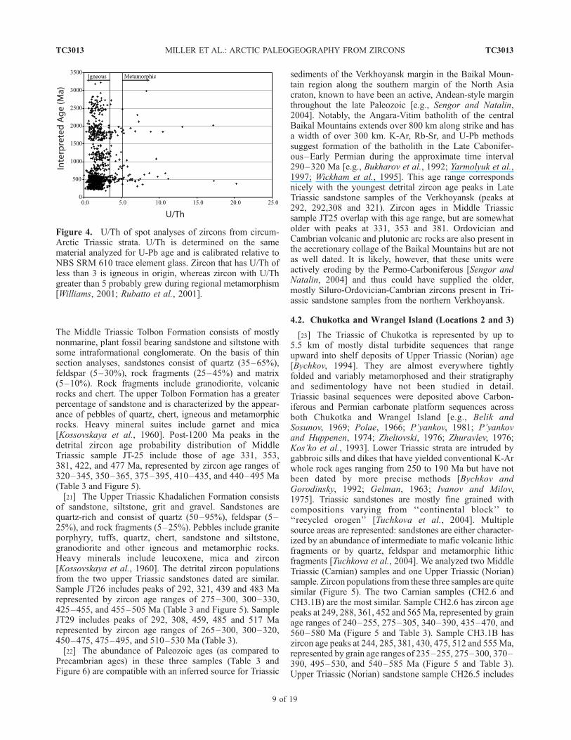
analyses that are less than 20% discordant are included inage interpretations (applicable only to older grains). Theinterpreted ages are presented in Table 2.[14] Most of the zircons analyzed are igneous in origin
with U/Th < 3 (Figure 4). The U-Pb dates are plotted onrelative age probability distribution diagrams [Ludwig,2003]. The relative height of the peaks corresponds to therelative abundance of that population of ages (Figures 5and 6). Some analyses were not plotted because of one oftwo reasons: (1) for ages <1000 Ma, the 206Pb/238U uncer-tainty was >10%, and (2) for ages >1000Ma, the 207Pb/206Pbuncertainty was >10% or the discordance between the206Pb/238U and 207Pb/206Pb ages was > 20%.[15] We discuss the detrital zircon suites from the Triassic
of Russia on a sample by sample basis (Figure 5), but wegroup these and other samples that have similar detritalzircon ages together in Figure 6 so that the characteristics ofall localities studied can be compared to one another. Toclarify the discussion of individual samples and to betterallow comparison of data from different samples, a list ofselected peak ages and the age ranges of grains character-izing those peaks is provided in Table 3. Criteria for thisselection of peaks are listed at the end of Table 3.
4. Geological Setting of Samples and
Interpretation of Detrital Data
[16] Triassic sandstones were selected for our studybecause they represent the youngest stage of widespreadmarine deposition prior to the onset of shortening and
Figure 3. Tectonic map of the Arctic Alaska-Chukotka microplate illustrating key tectonic elements andgeologic structures and relationships referred to in text.
1Auxiliary material is available at ftp://ftp.agu.org/apend/tc/2005tc001830.
TC3013 MILLER ET AL.: ARCTIC PALEOGEOGRAPHY FROM ZIRCONS
4 of 19
TC3013
subsequent rifting that led to the deformation and dispersalof terranes by formation of the Amerasian Basin. Crustalshortening affected parts of Arctic Alaska starting as earlyas the Middle Jurassic when arc-related ophiolitic sequenceswere emplaced northward in a deep water setting, south ofthe present-day Brooks Range [e.g., Moore et al., 1994].There is a striking similarity in the timing of ophiolite andarc emplacement in Alaska and the Kolyma region east ofthe Verkhoyansk (Figure 3), which also began to deform inthe Middle Jurassic. [Oxman et al., 1995] (see discussion byMiller et al. [2002]). The main period of folding andthrusting in the Brooks Range is dated by synorogenicdeposits of the Okpikruak Formation of Late Jurassic toEarly Cretaceous age, similar in age to synorogenic depositsof Chukotka [Miller et al., 2004; Katkov et al., 2005].Localized rifting began in the Late Jurassic along thenorthern Alaskan margin (the Dinkum graben [Grantz etal., 1990a]), but the major episode of seafloor spreading thatformed the Amerasian Basin is believed to have taken placein the Early Cretaceous (Grantz et al. [1990b], but seeDrachev [2004]). Widespread plutons across the ArcticAlaska-Chukotka plate (Figure 3) are everywhere believedto postdate collision-related deformation and the Angayu-cham and South Anyui belts. They are as old as 118 Ma andas young as 95 Ma and many are associated with verticalflattening and/or horizontal extensional fabrics [Klempereret al., 2002, Miller et al., 2002, 2004; Katkov et al., 2004,2005], arguing for perhaps significant internal deformationof the Arctic Alaska-Chukotka plate during this time span.[17] Detrital ages were measured in seven samples of
Triassic sedimentary rocks collected along the length of theArctic Alaska-Chukotka microplate to test both the struc-tural integrity and stratigraphic continuity of this crustalfragment as well as to constrain paleogeographic linksbetween Triassic sediments and their source areas. ThreeTriassic samples from the northern Verkhoyansk fold-and-thrust belt were analyzed to characterize the source regionsfor the NE Russian margin clastic wedge (which spans theCarboniferous to Early Jurassic) and two additional samples
were dated from the Sverdrup Basin, Arctic Canada, tocharacterize the source for Triassic sandstones that presum-ably lay adjacent to Chukotka prior to rifting and rotation ofthe Arctic Alaska-Chukotka microplate away from theCanadian Arctic (Figures 1 and 2).[18] Our data set (Figures 5 and 6) shows that nearly all
of the Triassic sandstones analyzed were derived primarilyfrom the erosion of Paleozoic and early Mesozoic sourceterranes. Precambrian zircons are present in all samples butin limited amounts, with the exception of one sample fromthe southern Sverdrup Basin (Figure 6). Our discussionbelow focuses on the interpretation of the Phanerozoic agesin the zircon populations because these are the most easilylinked to possible source areas and thus are most useful forpaleogeographic reconstructions. The three samples fromthe Russian Verkhoyansk margin and the three samplesfrom Chukotka (Russia) are discussed first and in greaterdetail (Figure 5).
4.1. Northern Verkhoyansk (Locality 1)
[19] The shallow marine to nonmarine Triassic succes-sion of the Verkhoyansk (Figure 3) is part of an immensepassive margin siliciclastic wedge that ranges in age fromCarboniferous to Early Jurassic [e.g., Khudoley and Guriev,1994]. A major fluvial system (or systems) is thought tohave connected the tectonically active Baikal Mountainregion to the Verkhoyansk margin via the Vilyui grabensystem (Figures 1 and 3) and other similar distributarysystems [e.g., Khudoley and Guriev, 1994].[20] Earliest Triassic strata of the northern Verkhoyansk
(the Nedshel and Tagand Formations) contain basalt flowsand tuffs that are believed to be coeval with Permo-Triassicboundary Siberian Trap magmatism (for location, seeFigure 1 and 3) [Andrianova and Andrianov, 1970] butwere not analyzed as part of this study. Middle and UpperTriassic sandstones have petrographic characteristics of‘‘recycled orogen’’ sources, compatible with their inferredprovenance from the actively uplifting Baikal Mountains.They do not contain any Permo-Triassic zircons (Figure 5).
Table 1. Sample Data for Sandstones Analyzed for Detrital Zircons
Field Number on Figures Area Latitude Longitude Age Unit
00JT25 1 Verkhoyansk 65.450207 126.897921 Middle Triassic Tolbon Formation00JT26 1 Verkhoyansk 65.438062 126.875138 Middle Triassic Tolbon Formation00JT29 1 Verkhoyansk 65.336460 126.343293 Upper Triassic Khedalichen
FormationCH3.1B 2 Chukotka 67.868222 166.290222 Upper Triassic Carnian T3kCH2.6 2 Chukotka 68.061778 166.412000 Upper Triassic Carnian T3kCH26.5 2 Chukotka 69.156528 165.038222 Upper Triassic Norian T3nC145741 3 Wrangel Island 71.031667 179.216667 Triassic Triassic Unit94CL10 4 Lisburne Hills 68.868667 166.059667 Upper Triassic Otuk Formation94CL53 4 Lisburne Hills 68.861167 166.014667 Upper Triassic Otuk Formation96DH102 5 Sadlerochit
Mountains69.684330 144.849000 Lower Triassic Ledge Member,
Ivishak FormationAE1 7 Sverdrup Basin 79.566667 83.333333 Lower Triassic
(Smithian)Bjorne Formation
AE2 6 Sverdrup Basin 80.583333 95.950000 Upper Triassic(Carnian)
Pat Bay Formation
TC3013 MILLER ET AL.: ARCTIC PALEOGEOGRAPHY FROM ZIRCONS
5 of 19
TC3013
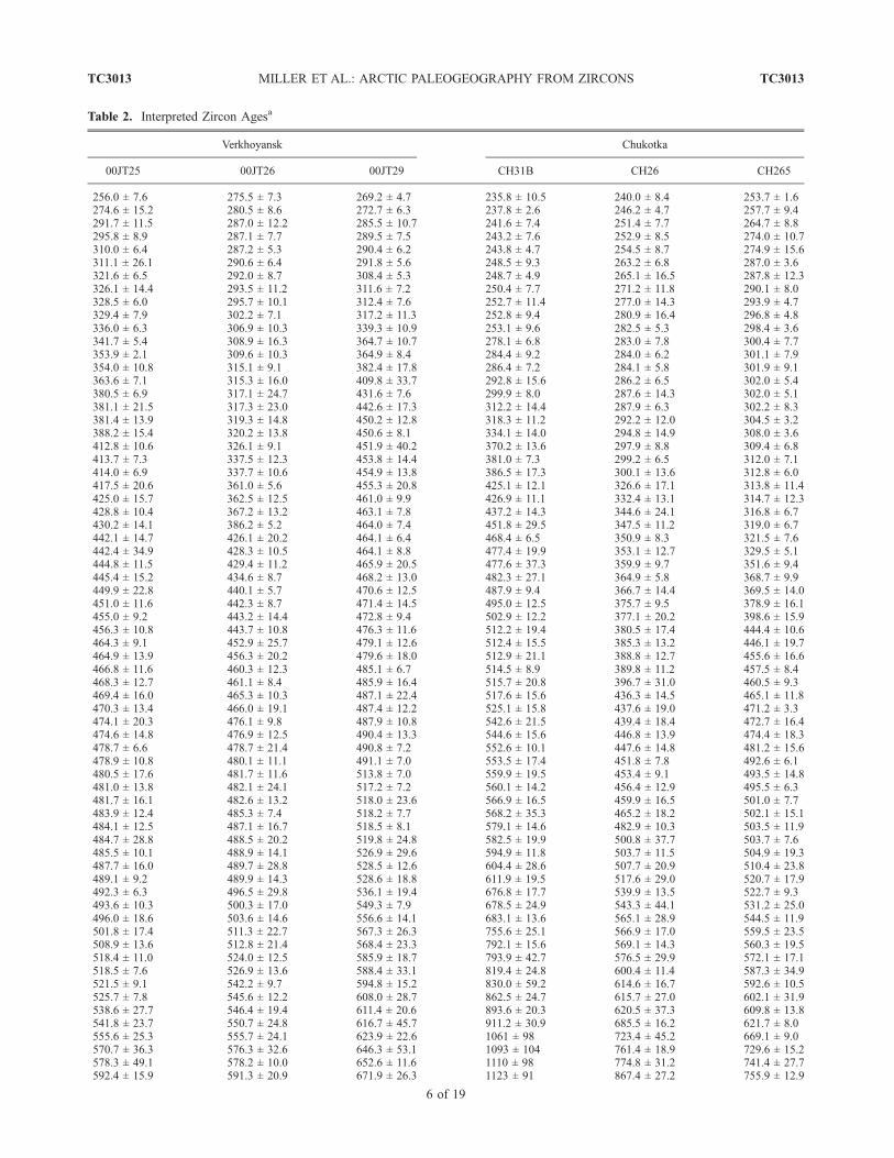
Table 2. Interpreted Zircon Agesa
Verkhoyansk Chukotka
00JT25 00JT26 00JT29 CH31B CH26 CH265
256.0 ± 7.6 275.5 ± 7.3 269.2 ± 4.7 235.8 ± 10.5 240.0 ± 8.4 253.7 ± 1.6274.6 ± 15.2 280.5 ± 8.6 272.7 ± 6.3 237.8 ± 2.6 246.2 ± 4.7 257.7 ± 9.4291.7 ± 11.5 287.0 ± 12.2 285.5 ± 10.7 241.6 ± 7.4 251.4 ± 7.7 264.7 ± 8.8295.8 ± 8.9 287.1 ± 7.7 289.5 ± 7.5 243.2 ± 7.6 252.9 ± 8.5 274.0 ± 10.7310.0 ± 6.4 287.2 ± 5.3 290.4 ± 6.2 243.8 ± 4.7 254.5 ± 8.7 274.9 ± 15.6311.1 ± 26.1 290.6 ± 6.4 291.8 ± 5.6 248.5 ± 9.3 263.2 ± 6.8 287.0 ± 3.6321.6 ± 6.5 292.0 ± 8.7 308.4 ± 5.3 248.7 ± 4.9 265.1 ± 16.5 287.8 ± 12.3326.1 ± 14.4 293.5 ± 11.2 311.6 ± 7.2 250.4 ± 7.7 271.2 ± 11.8 290.1 ± 8.0328.5 ± 6.0 295.7 ± 10.1 312.4 ± 7.6 252.7 ± 11.4 277.0 ± 14.3 293.9 ± 4.7329.4 ± 7.9 302.2 ± 7.1 317.2 ± 11.3 252.8 ± 9.4 280.9 ± 16.4 296.8 ± 4.8336.0 ± 6.3 306.9 ± 10.3 339.3 ± 10.9 253.1 ± 9.6 282.5 ± 5.3 298.4 ± 3.6341.7 ± 5.4 308.9 ± 16.3 364.7 ± 10.7 278.1 ± 6.8 283.0 ± 7.8 300.4 ± 7.7353.9 ± 2.1 309.6 ± 10.3 364.9 ± 8.4 284.4 ± 9.2 284.0 ± 6.2 301.1 ± 7.9354.0 ± 10.8 315.1 ± 9.1 382.4 ± 17.8 286.4 ± 7.2 284.1 ± 5.8 301.9 ± 9.1363.6 ± 7.1 315.3 ± 16.0 409.8 ± 33.7 292.8 ± 15.6 286.2 ± 6.5 302.0 ± 5.4380.5 ± 6.9 317.1 ± 24.7 431.6 ± 7.6 299.9 ± 8.0 287.6 ± 14.3 302.0 ± 5.1381.1 ± 21.5 317.3 ± 23.0 442.6 ± 17.3 312.2 ± 14.4 287.9 ± 6.3 302.2 ± 8.3381.4 ± 13.9 319.3 ± 14.8 450.2 ± 12.8 318.3 ± 11.2 292.2 ± 12.0 304.5 ± 3.2388.2 ± 15.4 320.2 ± 13.8 450.6 ± 8.1 334.1 ± 14.0 294.8 ± 14.9 308.0 ± 3.6412.8 ± 10.6 326.1 ± 9.1 451.9 ± 40.2 370.2 ± 13.6 297.9 ± 8.8 309.4 ± 6.8413.7 ± 7.3 337.5 ± 12.3 453.8 ± 14.4 381.0 ± 7.3 299.2 ± 6.5 312.0 ± 7.1414.0 ± 6.9 337.7 ± 10.6 454.9 ± 13.8 386.5 ± 17.3 300.1 ± 13.6 312.8 ± 6.0417.5 ± 20.6 361.0 ± 5.6 455.3 ± 20.8 425.1 ± 12.1 326.6 ± 17.1 313.8 ± 11.4425.0 ± 15.7 362.5 ± 12.5 461.0 ± 9.9 426.9 ± 11.1 332.4 ± 13.1 314.7 ± 12.3428.8 ± 10.4 367.2 ± 13.2 463.1 ± 7.8 437.2 ± 14.3 344.6 ± 24.1 316.8 ± 6.7430.2 ± 14.1 386.2 ± 5.2 464.0 ± 7.4 451.8 ± 29.5 347.5 ± 11.2 319.0 ± 6.7442.1 ± 14.7 426.1 ± 20.2 464.1 ± 6.4 468.4 ± 6.5 350.9 ± 8.3 321.5 ± 7.6442.4 ± 34.9 428.3 ± 10.5 464.1 ± 8.8 477.4 ± 19.9 353.1 ± 12.7 329.5 ± 5.1444.8 ± 11.5 429.4 ± 11.2 465.9 ± 20.5 477.6 ± 37.3 359.9 ± 9.7 351.6 ± 9.4445.4 ± 15.2 434.6 ± 8.7 468.2 ± 13.0 482.3 ± 27.1 364.9 ± 5.8 368.7 ± 9.9449.9 ± 22.8 440.1 ± 5.7 470.6 ± 12.5 487.9 ± 9.4 366.7 ± 14.4 369.5 ± 14.0451.0 ± 11.6 442.3 ± 8.7 471.4 ± 14.5 495.0 ± 12.5 375.7 ± 9.5 378.9 ± 16.1455.0 ± 9.2 443.2 ± 14.4 472.8 ± 9.4 502.9 ± 12.2 377.1 ± 20.2 398.6 ± 15.9456.3 ± 10.8 443.7 ± 10.8 476.3 ± 11.6 512.2 ± 19.4 380.5 ± 17.4 444.4 ± 10.6464.3 ± 9.1 452.9 ± 25.7 479.1 ± 12.6 512.4 ± 15.5 385.3 ± 13.2 446.1 ± 19.7464.9 ± 13.9 456.3 ± 20.2 479.6 ± 18.0 512.9 ± 21.1 388.8 ± 12.7 455.6 ± 16.6466.8 ± 11.6 460.3 ± 12.3 485.1 ± 6.7 514.5 ± 8.9 389.8 ± 11.2 457.5 ± 8.4468.3 ± 12.7 461.1 ± 8.4 485.9 ± 16.4 515.7 ± 20.8 396.7 ± 31.0 460.5 ± 9.3469.4 ± 16.0 465.3 ± 10.3 487.1 ± 22.4 517.6 ± 15.6 436.3 ± 14.5 465.1 ± 11.8470.3 ± 13.4 466.0 ± 19.1 487.4 ± 12.2 525.1 ± 15.8 437.6 ± 19.0 471.2 ± 3.3474.1 ± 20.3 476.1 ± 9.8 487.9 ± 10.8 542.6 ± 21.5 439.4 ± 18.4 472.7 ± 16.4474.6 ± 14.8 476.9 ± 12.5 490.4 ± 13.3 544.6 ± 15.6 446.8 ± 13.9 474.4 ± 18.3478.7 ± 6.6 478.7 ± 21.4 490.8 ± 7.2 552.6 ± 10.1 447.6 ± 14.8 481.2 ± 15.6478.9 ± 10.8 480.1 ± 11.1 491.1 ± 7.0 553.5 ± 17.4 451.8 ± 7.8 492.6 ± 6.1480.5 ± 17.6 481.7 ± 11.6 513.8 ± 7.0 559.9 ± 19.5 453.4 ± 9.1 493.5 ± 14.8481.0 ± 13.8 482.1 ± 24.1 517.2 ± 7.2 560.1 ± 14.2 456.4 ± 12.9 495.5 ± 6.3481.7 ± 16.1 482.6 ± 13.2 518.0 ± 23.6 566.9 ± 16.5 459.9 ± 16.5 501.0 ± 7.7483.9 ± 12.4 485.3 ± 7.4 518.2 ± 7.7 568.2 ± 35.3 465.2 ± 18.2 502.1 ± 15.1484.1 ± 12.5 487.1 ± 16.7 518.5 ± 8.1 579.1 ± 14.6 482.9 ± 10.3 503.5 ± 11.9484.7 ± 28.8 488.5 ± 20.2 519.8 ± 24.8 582.5 ± 19.9 500.8 ± 37.7 503.7 ± 7.6485.5 ± 10.1 488.9 ± 14.1 526.9 ± 29.6 594.9 ± 11.8 503.7 ± 11.5 504.9 ± 19.3487.7 ± 16.0 489.7 ± 28.8 528.5 ± 12.6 604.4 ± 28.6 507.7 ± 20.9 510.4 ± 23.8489.1 ± 9.2 489.9 ± 14.3 528.6 ± 18.8 611.9 ± 19.5 517.6 ± 29.0 520.7 ± 17.9492.3 ± 6.3 496.5 ± 29.8 536.1 ± 19.4 676.8 ± 17.7 539.9 ± 13.5 522.7 ± 9.3493.6 ± 10.3 500.3 ± 17.0 549.3 ± 7.9 678.5 ± 24.9 543.3 ± 44.1 531.2 ± 25.0496.0 ± 18.6 503.6 ± 14.6 556.6 ± 14.1 683.1 ± 13.6 565.1 ± 28.9 544.5 ± 11.9501.8 ± 17.4 511.3 ± 22.7 567.3 ± 26.3 755.6 ± 25.1 566.9 ± 17.0 559.5 ± 23.5508.9 ± 13.6 512.8 ± 21.4 568.4 ± 23.3 792.1 ± 15.6 569.1 ± 14.3 560.3 ± 19.5518.4 ± 11.0 524.0 ± 12.5 585.9 ± 18.7 793.9 ± 42.7 576.5 ± 29.9 572.1 ± 17.1518.5 ± 7.6 526.9 ± 13.6 588.4 ± 33.1 819.4 ± 24.8 600.4 ± 11.4 587.3 ± 34.9521.5 ± 9.1 542.2 ± 9.7 594.8 ± 15.2 830.0 ± 59.2 614.6 ± 16.7 592.6 ± 10.5525.7 ± 7.8 545.6 ± 12.2 608.0 ± 28.7 862.5 ± 24.7 615.7 ± 27.0 602.1 ± 31.9538.6 ± 27.7 546.4 ± 19.4 611.4 ± 20.6 893.6 ± 20.3 620.5 ± 37.3 609.8 ± 13.8541.8 ± 23.7 550.7 ± 24.8 616.7 ± 45.7 911.2 ± 30.9 685.5 ± 16.2 621.7 ± 8.0555.6 ± 25.3 555.7 ± 24.1 623.9 ± 22.6 1061 ± 98 723.4 ± 45.2 669.1 ± 9.0570.7 ± 36.3 576.3 ± 32.6 646.3 ± 53.1 1093 ± 104 761.4 ± 18.9 729.6 ± 15.2578.3 ± 49.1 578.2 ± 10.0 652.6 ± 11.6 1110 ± 98 774.8 ± 31.2 741.4 ± 27.7592.4 ± 15.9 591.3 ± 20.9 671.9 ± 26.3 1123 ± 91 867.4 ± 27.2 755.9 ± 12.9
TC3013 MILLER ET AL.: ARCTIC PALEOGEOGRAPHY FROM ZIRCONS
6 of 19
TC3013
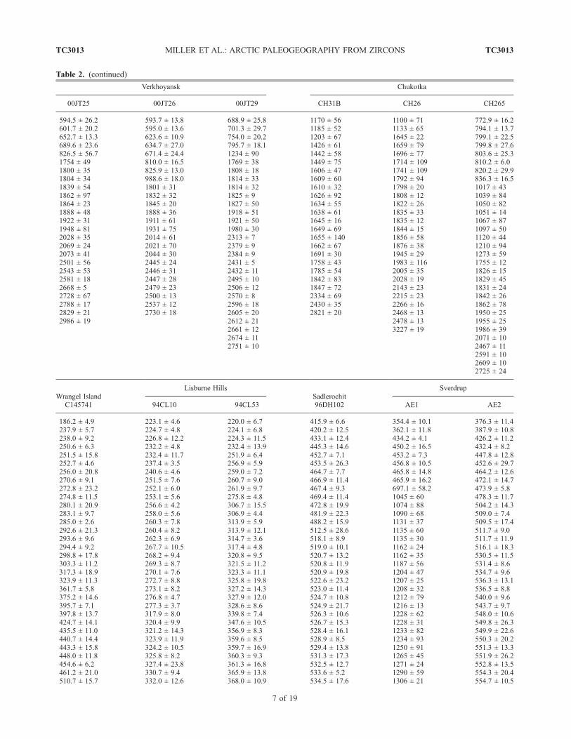
Table 2. (continued)
Verkhoyansk Chukotka
00JT25 00JT26 00JT29 CH31B CH26 CH265
594.5 ± 26.2 593.7 ± 13.8 688.9 ± 25.8 1170 ± 56 1100 ± 71 772.9 ± 16.2601.7 ± 20.2 595.0 ± 13.6 701.3 ± 29.7 1185 ± 52 1133 ± 65 794.1 ± 13.7652.7 ± 13.3 623.6 ± 10.9 754.0 ± 20.2 1203 ± 67 1645 ± 22 799.1 ± 22.5689.6 ± 23.6 634.7 ± 27.0 795.7 ± 18.1 1426 ± 61 1659 ± 79 799.8 ± 27.6826.5 ± 56.7 671.4 ± 24.4 1234 ± 90 1442 ± 58 1696 ± 77 803.6 ± 25.31754 ± 49 810.0 ± 16.5 1769 ± 38 1449 ± 75 1714 ± 109 810.2 ± 6.01800 ± 35 825.9 ± 13.0 1808 ± 18 1606 ± 47 1741 ± 109 820.2 ± 29.91804 ± 34 988.6 ± 18.0 1814 ± 33 1609 ± 60 1792 ± 94 836.3 ± 16.51839 ± 54 1801 ± 31 1814 ± 32 1610 ± 32 1798 ± 20 1017 ± 431862 ± 97 1832 ± 32 1825 ± 9 1626 ± 92 1808 ± 12 1039 ± 841864 ± 23 1845 ± 20 1827 ± 50 1634 ± 55 1822 ± 26 1050 ± 821888 ± 48 1888 ± 36 1918 ± 51 1638 ± 61 1835 ± 33 1051 ± 141922 ± 31 1911 ± 61 1921 ± 50 1645 ± 16 1835 ± 12 1067 ± 871948 ± 81 1931 ± 75 1980 ± 30 1649 ± 69 1844 ± 15 1097 ± 502028 ± 35 2014 ± 61 2313 ± 7 1655 ± 140 1856 ± 58 1120 ± 442069 ± 24 2021 ± 70 2379 ± 9 1662 ± 67 1876 ± 38 1210 ± 942073 ± 41 2044 ± 30 2384 ± 9 1691 ± 30 1945 ± 29 1273 ± 592501 ± 56 2445 ± 24 2431 ± 5 1758 ± 43 1983 ± 116 1755 ± 122543 ± 53 2446 ± 31 2432 ± 11 1785 ± 54 2005 ± 35 1826 ± 152581 ± 18 2447 ± 28 2495 ± 10 1842 ± 83 2028 ± 19 1829 ± 452668 ± 5 2479 ± 23 2506 ± 12 1847 ± 72 2143 ± 23 1831 ± 242728 ± 67 2500 ± 13 2570 ± 8 2334 ± 69 2215 ± 23 1842 ± 262788 ± 17 2537 ± 12 2596 ± 18 2430 ± 35 2266 ± 16 1862 ± 782829 ± 21 2730 ± 18 2605 ± 20 2821 ± 20 2468 ± 13 1950 ± 252986 ± 19 2612 ± 21 2478 ± 13 1955 ± 25
2661 ± 12 3227 ± 19 1986 ± 392674 ± 11 2071 ± 102751 ± 10 2467 ± 11
2591 ± 102609 ± 102725 ± 24
Wrangel IslandC145741
Lisburne HillsSadlerochit96DH102
Sverdrup
94CL10 94CL53 AE1 AE2
186.2 ± 4.9 223.1 ± 4.6 220.0 ± 6.7 415.9 ± 6.6 354.4 ± 10.1 376.3 ± 11.4237.9 ± 5.7 224.7 ± 4.8 224.1 ± 6.8 420.2 ± 12.5 362.1 ± 11.8 387.9 ± 10.8238.0 ± 9.2 226.8 ± 12.2 224.3 ± 11.5 433.1 ± 12.4 434.2 ± 4.1 426.2 ± 11.2250.6 ± 6.3 232.2 ± 4.8 232.4 ± 13.9 445.3 ± 14.6 450.2 ± 16.5 432.4 ± 8.2251.5 ± 15.8 232.4 ± 11.7 251.9 ± 6.4 452.7 ± 7.1 453.2 ± 7.3 447.8 ± 12.8252.7 ± 4.6 237.4 ± 3.5 256.9 ± 5.9 453.5 ± 26.3 456.8 ± 10.5 452.6 ± 29.7256.0 ± 20.8 240.6 ± 4.6 259.0 ± 7.2 464.7 ± 7.7 465.8 ± 14.8 464.2 ± 12.6270.6 ± 9.1 251.5 ± 7.6 260.7 ± 9.0 466.9 ± 11.4 465.9 ± 16.2 472.1 ± 14.7272.8 ± 23.2 252.1 ± 6.0 261.9 ± 9.7 467.4 ± 9.3 697.1 ± 58.2 473.9 ± 5.8274.8 ± 11.5 253.1 ± 5.6 275.8 ± 4.8 469.4 ± 11.4 1045 ± 60 478.3 ± 11.7280.1 ± 20.9 256.6 ± 4.2 306.7 ± 15.5 472.8 ± 19.9 1074 ± 88 504.2 ± 14.3283.1 ± 9.7 258.0 ± 5.6 306.9 ± 4.4 481.9 ± 22.3 1090 ± 68 509.0 ± 7.4285.0 ± 2.6 260.3 ± 7.8 313.9 ± 5.9 488.2 ± 15.9 1131 ± 37 509.5 ± 17.4292.6 ± 21.3 260.4 ± 8.2 313.9 ± 12.1 512.5 ± 28.6 1135 ± 60 511.7 ± 9.0293.6 ± 9.6 262.3 ± 6.9 314.7 ± 3.6 518.1 ± 8.9 1135 ± 30 511.7 ± 11.9294.4 ± 9.2 267.7 ± 10.5 317.4 ± 4.8 519.0 ± 10.1 1162 ± 24 516.1 ± 18.3298.8 ± 17.8 268.2 ± 9.4 320.8 ± 9.5 520.7 ± 13.2 1162 ± 35 530.5 ± 11.5303.3 ± 11.2 269.3 ± 8.7 321.5 ± 11.2 520.8 ± 11.9 1187 ± 56 531.4 ± 8.6317.3 ± 18.9 270.1 ± 7.6 323.3 ± 11.1 520.9 ± 19.8 1204 ± 47 534.7 ± 9.6323.9 ± 11.3 272.7 ± 8.8 325.8 ± 19.8 522.6 ± 23.2 1207 ± 25 536.3 ± 13.1361.7 ± 5.8 273.1 ± 8.2 327.2 ± 14.3 523.0 ± 11.4 1208 ± 32 536.5 ± 8.8375.2 ± 14.6 276.8 ± 4.7 327.9 ± 12.0 524.7 ± 10.8 1212 ± 79 540.0 ± 9.6395.7 ± 7.1 277.3 ± 3.7 328.6 ± 8.6 524.9 ± 21.7 1216 ± 13 543.7 ± 9.7397.8 ± 13.7 317.9 ± 8.0 339.8 ± 7.4 526.3 ± 10.6 1228 ± 62 548.0 ± 10.6424.7 ± 14.1 320.4 ± 9.9 347.6 ± 10.5 526.7 ± 15.3 1228 ± 31 549.8 ± 26.3435.5 ± 11.0 321.2 ± 14.3 356.9 ± 8.3 528.4 ± 16.1 1233 ± 82 549.9 ± 22.6440.7 ± 14.4 323.9 ± 11.9 359.6 ± 8.5 528.9 ± 8.5 1234 ± 93 550.3 ± 20.2443.3 ± 15.8 324.2 ± 10.5 359.7 ± 16.9 529.4 ± 13.8 1250 ± 91 551.3 ± 13.3448.0 ± 11.8 325.8 ± 8.2 360.3 ± 9.3 531.3 ± 17.3 1265 ± 45 551.9 ± 26.2454.6 ± 6.2 327.4 ± 23.8 361.3 ± 16.8 532.5 ± 12.7 1271 ± 24 552.8 ± 13.5461.2 ± 21.0 330.7 ± 9.4 365.9 ± 13.8 533.6 ± 5.2 1290 ± 59 554.3 ± 20.4510.7 ± 15.7 332.0 ± 12.6 368.0 ± 10.9 534.5 ± 17.6 1306 ± 21 554.7 ± 10.5
TC3013 MILLER ET AL.: ARCTIC PALEOGEOGRAPHY FROM ZIRCONS
7 of 19
TC3013
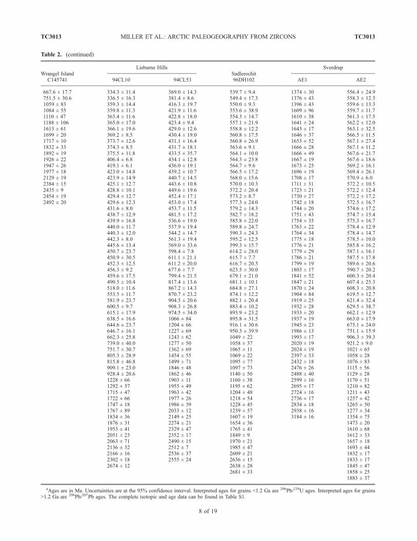
Table 2. (continued)
Wrangel IslandC145741
Lisburne HillsSadlerochit96DH102
Sverdrup
94CL10 94CL53 AE1 AE2
667.6 ± 17.7 334.3 ± 11.4 369.0 ± 14.3 539.7 ± 9.4 1374 ± 30 556.4 ± 24.9751.5 ± 30.6 336.5 ± 16.3 381.4 ± 8.6 549.4 ± 17.3 1376 ± 43 558.3 ± 12.31059 ± 83 359.3 ± 14.4 416.3 ± 19.7 550.0 ± 9.3 1396 ± 43 559.6 ± 13.31084 ± 55 359.8 ± 11.3 421.9 ± 11.6 553.6 ± 38.9 1609 ± 96 559.7 ± 11.71110 ± 47 363.4 ± 11.6 422.8 ± 18.0 554.3 ± 14.7 1610 ± 38 561.3 ± 17.51188 ± 106 365.0 ± 17.0 423.4 ± 9.4 557.1 ± 21.9 1641 ± 24 562.2 ± 12.01613 ± 61 366.1 ± 19.6 429.0 ± 12.6 558.8 ± 12.2 1643 ± 17 563.1 ± 32.51699 ± 20 369.2 ± 8.5 430.4 ± 19.0 560.8 ± 17.5 1646 ± 37 566.5 ± 11.51717 ± 10 373.7 ± 12.6 431.1 ± 16.4 560.8 ± 26.9 1653 ± 52 567.1 ± 27.41832 ± 33 374.3 ± 8.5 431.7 ± 18.1 563.6 ± 9.1 1666 ± 28 567.1 ± 11.21892 ± 19 375.5 ± 11.8 433.5 ± 35.7 564.1 ± 10.0 1666 ± 49 567.6 ± 21.71926 ± 22 406.4 ± 6.8 434.1 ± 12.8 564.3 ± 23.8 1667 ± 19 567.6 ± 18.61947 ± 26 419.1 ± 6.1 436.0 ± 19.1 564.7 ± 9.6 1673 ± 25 569.2 ± 16.11977 ± 18 423.0 ± 14.8 439.2 ± 10.7 566.5 ± 17.2 1696 ± 19 569.4 ± 26.12129 ± 19 423.9 ± 14.9 440.7 ± 14.5 568.0 ± 15.6 1708 ± 17 570.9 ± 6.02384 ± 15 425.1 ± 12.7 443.6 ± 10.8 570.0 ± 10.3 1711 ± 31 572.2 ± 10.52435 ± 9 428.8 ± 10.1 449.6 ± 19.6 572.2 ± 20.4 1723 ± 21 572.2 ± 12.42454 ± 19 429.4 ± 12.7 452.4 ± 17.1 573.2 ± 8.7 1730 ± 27 572.2 ± 17.22492 ± 20 429.6 ± 12.3 453.0 ± 17.4 577.3 ± 24.0 1742 ± 18 572.5 ± 16.7
431.6 ± 8.0 453.7 ± 11.5 579.2 ± 14.3 1744 ± 20 574.6 ± 17.2438.7 ± 12.9 481.5 ± 17.2 582.7 ± 18.2 1751 ± 43 574.7 ± 15.4439.9 ± 16.8 536.6 ± 19.0 585.8 ± 22.0 1754 ± 35 575.3 ± 16.7440.0 ± 11.7 537.9 ± 19.4 589.8 ± 24.7 1763 ± 22 578.4 ± 12.9440.3 ± 12.0 544.2 ± 14.7 590.3 ± 24.3 1764 ± 34 578.4 ± 14.7442.3 ± 8.0 561.3 ± 19.4 595.2 ± 12.5 1775 ± 18 578.5 ± 10.0445.6 ± 13.4 569.0 ± 33.6 599.3 ± 15.7 1776 ± 21 585.8 ± 16.2450.7 ± 23.7 598.4 ± 7.8 614.2 ± 28.0 1779 ± 29 587.1 ± 16.1450.9 ± 30.5 611.1 ± 21.1 615.7 ± 7.7 1786 ± 21 587.5 ± 17.8452.3 ± 12.5 611.2 ± 20.0 616.7 ± 20.5 1799 ± 19 589.6 ± 20.6456.3 ± 9.2 677.6 ± 7.7 623.5 ± 30.0 1803 ± 17 590.7 ± 20.2459.6 ± 17.5 799.4 ± 21.5 679.1 ± 21.0 1841 ± 52 600.3 ± 20.4490.5 ± 10.4 817.4 ± 13.6 681.1 ± 10.1 1847 ± 21 607.4 ± 25.3518.0 ± 11.6 867.2 ± 14.3 684.8 ± 27.1 1870 ± 24 608.3 ± 20.8553.5 ± 11.7 870.7 ± 23.2 874.1 ± 12.2 1904 ± 84 619.5 ± 12.7581.9 ± 23.7 904.5 ± 20.6 882.1 ± 20.4 1919 ± 25 621.4 ± 32.4600.5 ± 9.7 908.3 ± 26.8 883.4 ± 10.2 1932 ± 28 629.5 ± 38.7615.1 ± 17.9 974.5 ± 34.0 893.9 ± 23.2 1933 ± 20 662.1 ± 12.9638.5 ± 16.6 1066 ± 84 895.8 ± 31.5 1937 ± 19 663.0 ± 17.9644.6 ± 23.7 1204 ± 66 916.1 ± 30.6 1945 ± 23 675.1 ± 24.0646.7 ± 16.1 1227 ± 69 950.3 ± 39.9 1986 ± 13 751.1 ± 15.9662.3 ± 25.8 1243 ± 62 1049 ± 22 1993 ± 17 906.3 ± 39.3739.0 ± 40.0 1277 ± 50 1058 ± 37 2020 ± 19 921.2 ± 9.0751.7 ± 30.7 1362 ± 69 1065 ± 11 2024 ± 19 1021 ± 65805.3 ± 28.9 1454 ± 55 1069 ± 22 2397 ± 33 1058 ± 28815.8 ± 46.8 1499 ± 71 1095 ± 77 2432 ± 18 1076 ± 83909.1 ± 23.0 1846 ± 48 1097 ± 73 2476 ± 26 1115 ± 56928.4 ± 20.6 1862 ± 46 1140 ± 50 2488 ± 40 1129 ± 281228 ± 66 1903 ± 11 1160 ± 38 2599 ± 16 1170 ± 511292 ± 57 1955 ± 49 1195 ± 62 2695 ± 17 1210 ± 821715 ± 47 1963 ± 42 1204 ± 48 2724 ± 16 1211 ± 431722 ± 66 1977 ± 26 1218 ± 54 2736 ± 17 1257 ± 421747 ± 18 1986 ± 39 1228 ± 45 2834 ± 18 1265 ± 501767 ± 89 2033 ± 12 1239 ± 57 2938 ± 16 1277 ± 341834 ± 36 2149 ± 25 1607 ± 19 3184 ± 16 1354 ± 751876 ± 31 2274 ± 21 1654 ± 36 1473 ± 201953 ± 41 2329 ± 47 1765 ± 41 1610 ± 682051 ± 23 2352 ± 17 1849 ± 9 1612 ± 332063 ± 71 2490 ± 15 1970 ± 21 1657 ± 182136 ± 32 2512 ± 7 1985 ± 47 1693 ± 442166 ± 16 2536 ± 37 2609 ± 21 1832 ± 172302 ± 18 2555 ± 24 2636 ± 15 1833 ± 172674 ± 12 2638 ± 28 1845 ± 47
2681 ± 33 1858 ± 251883 ± 37
aAges are in Ma. Uncertainties are at the 95% confidence interval. Interpreted ages for grains <1.2 Ga are 206Pb/238U ages. Interpreted ages for grains>1.2 Ga are 206Pb/207Pb ages. The complete isotopic and age data can be found in Table S1.
TC3013 MILLER ET AL.: ARCTIC PALEOGEOGRAPHY FROM ZIRCONS
8 of 19
TC3013
The Middle Triassic Tolbon Formation consists of mostlynonmarine, plant fossil bearing sandstone and siltstone withsome intraformational conglomerate. On the basis of thinsection analyses, sandstones consist of quartz (35–65%),feldspar (5–30%), rock fragments (25–45%) and matrix(5–10%). Rock fragments include granodiorite, volcanicrocks and chert. The upper Tolbon Formation has a greaterpercentage of sandstone and is characterized by the appear-ance of pebbles of quartz, chert, igneous and metamorphicrocks. Heavy mineral suites include garnet and mica[Kossovskaya et al., 1960]. Post-1200 Ma peaks in thedetrital zircon age probability distribution of MiddleTriassic sample JT-25 include those of age 331, 353,381, 422, and 477 Ma, represented by zircon age ranges of320–345, 350–365, 375–395, 410–435, and 440–495 Ma(Table 3 and Figure 5).[21] The Upper Triassic Khadalichen Formation consists
of sandstone, siltstone, grit and gravel. Sandstones arequartz-rich and consist of quartz (50–95%), feldspar (5–25%), and rock fragments (5–25%). Pebbles include graniteporphyry, tuffs, quartz, chert, sandstone and siltstone,granodiorite and other igneous and metamorphic rocks.Heavy minerals include leucoxene, mica and zircon[Kossovskaya et al., 1960]. The detrital zircon populationsfrom the two upper Triassic sandstones dated are similar.Sample JT26 includes peaks of 292, 321, 439 and 483 Marepresented by zircon age ranges of 275–300, 300–330,425–455, and 455–505 Ma (Table 3 and Figure 5). SampleJT29 includes peaks of 292, 308, 459, 485 and 517 Marepresented by zircon age ranges of 265–300, 300–320,450–475, 475–495, and 510–530 Ma (Table 3).[22] The abundance of Paleozoic ages (as compared to
Precambrian ages) in these three samples (Table 3 andFigure 6) are compatible with an inferred source for Triassic
sediments of the Verkhoyansk margin in the Baikal Moun-tain region along the southern margin of the North Asiacraton, known to have been an active, Andean-style marginthroughout the late Paleozoic [e.g., Sengor and Natalin,2004]. Notably, the Angara-Vitim batholith of the centralBaikal Mountains extends over 800 km along strike and hasa width of over 300 km. K-Ar, Rb-Sr, and U-Pb methodssuggest formation of the batholith in the Late Cabonifer-ous–Early Permian during the approximate time interval290–320 Ma [e.g., Bukharov et al., 1992; Yarmolyuk et al.,1997; Wickham et al., 1995]. This age range correspondsnicely with the youngest detrital zircon age peaks in LateTriassic sandstone samples of the Verkhoyansk (peaks at292, 292,308 and 321). Zircon ages in Middle Triassicsample JT25 overlap with this age range, but are somewhatolder with peaks at 331, 353 and 381. Ordovician andCambrian volcanic and plutonic arc rocks are also present inthe accretionary collage of the Baikal Mountains but are notas well dated. It is likely, however, that these units wereactively eroding by the Permo-Carboniferous [Sengor andNatalin, 2004] and thus could have supplied the older,mostly Siluro-Ordovician-Cambrian zircons present in Tri-assic sandstone samples from the northern Verkhoyansk.
4.2. Chukotka and Wrangel Island (Locations 2 and 3)
[23] The Triassic of Chukotka is represented by up to5.5 km of mostly distal turbidite sequences that rangeupward into shelf deposits of Upper Triassic (Norian) age[Bychkov, 1994]. They are almost everywhere tightlyfolded and variably metamorphosed and their stratigraphyand sedimentology have not been studied in detail.Triassic basinal sequences were deposited above Carbon-iferous and Permian carbonate platform sequences acrossboth Chukotka and Wrangel Island [e.g., Belik andSosunov, 1969; Polae, 1966; P’yankov, 1981; P’yankovand Huppenen, 1974; Zheltovski, 1976; Zhuravlev, 1976;Kos’ko et al., 1993]. Lower Triassic strata are intruded bygabbroic sills and dikes that have yielded conventional K-Arwhole rock ages ranging from 250 to 190 Ma but have notbeen dated by more precise methods [Bychkov andGorodinsky, 1992; Gelman, 1963; Ivanov and Milov,1975]. Triassic sandstones are mostly fine grained withcompositions varying from ‘‘continental block’’ to‘‘recycled orogen’’ [Tuchkova et al., 2004]. Multiplesource areas are represented: sandstones are either character-ized by an abundance of intermediate to mafic volcanic lithicfragments or by quartz, feldspar and metamorphic lithicfragments [Tuchkova et al., 2004]. We analyzed two MiddleTriassic (Carnian) samples and one Upper Triassic (Norian)sample. Zircon populations from these three samples are quitesimilar (Figure 5). The two Carnian samples (CH2.6 andCH3.1B) are the most similar. Sample CH2.6 has zircon agepeaks at 249, 288, 361, 452 and 565Ma, represented by grainage ranges of 240–255, 275–305, 340–390, 435–470, and560–580 Ma (Figure 5 and Table 3). Sample CH3.1B haszircon age peaks at 244, 285, 381, 430, 475, 512 and 555Ma,represented by grain age ranges of 235–255, 275–300, 370–390, 495–530, and 540–585 Ma (Figure 5 and Table 3).Upper Triassic (Norian) sandstone sample CH26.5 includes
Figure 4. U/Th of spot analyses of zircons from circum-Arctic Triassic strata. U/Th is determined on the samematerial analyzed for U-Pb age and is calibrated relative toNBS SRM 610 trace element glass. Zircon that has U/Th ofless than 3 is igneous in origin, whereas zircon with U/Thgreater than 5 probably grew during regional metamorphism[Williams, 2001; Rubatto et al., 2001].
TC3013 MILLER ET AL.: ARCTIC PALEOGEOGRAPHY FROM ZIRCONS
9 of 19
TC3013
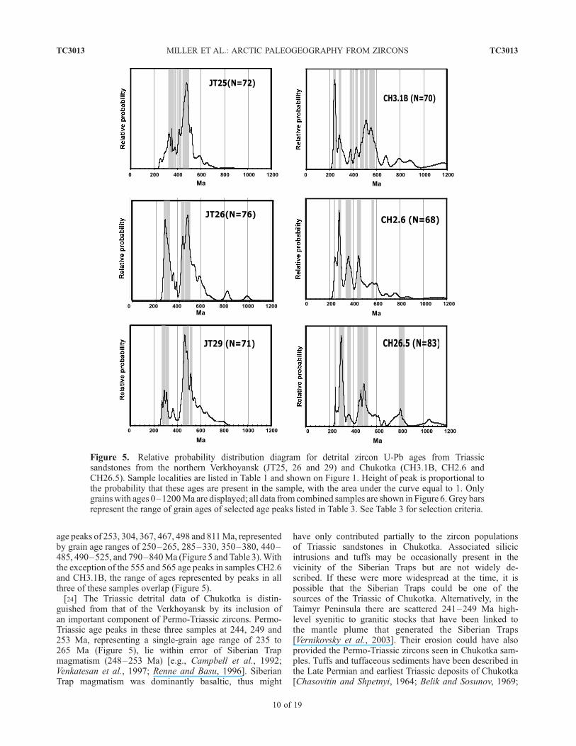
age peaks of 253, 304, 367, 467, 498 and 811Ma, representedby grain age ranges of 250–265, 285–330, 350–380, 440–485, 490–525, and 790–840Ma (Figure 5 and Table 3).Withthe exception of the 555 and 565 age peaks in samples CH2.6and CH3.1B, the range of ages represented by peaks in allthree of these samples overlap (Figure 5).[24] The Triassic detrital data of Chukotka is distin-
guished from that of the Verkhoyansk by its inclusion ofan important component of Permo-Triassic zircons. Permo-Triassic age peaks in these three samples at 244, 249 and253 Ma, representing a single-grain age range of 235 to265 Ma (Figure 5), lie within error of Siberian Trapmagmatism (248–253 Ma) [e.g., Campbell et al., 1992;Venkatesan et al., 1997; Renne and Basu, 1996]. SiberianTrap magmatism was dominantly basaltic, thus might
have only contributed partially to the zircon populationsof Triassic sandstones in Chukotka. Associated silicicintrusions and tuffs may be occasionally present in thevicinity of the Siberian Traps but are not widely de-scribed. If these were more widespread at the time, it ispossible that the Siberian Traps could be one of thesources of the Triassic of Chukotka. Alternatively, in theTaimyr Peninsula there are scattered 241–249 Ma high-level syenitic to granitic stocks that have been linked tothe mantle plume that generated the Siberian Traps[Vernikovsky et al., 2003]. Their erosion could have alsoprovided the Permo-Triassic zircons seen in Chukotka sam-ples. Tuffs and tuffaceous sediments have been described inthe Late Permian and earliest Triassic deposits of Chukotka[Chasovitin and Shpetnyi, 1964; Belik and Sosunov, 1969;
Figure 5. Relative probability distribution diagram for detrital zircon U-Pb ages from Triassicsandstones from the northern Verkhoyansk (JT25, 26 and 29) and Chukotka (CH3.1B, CH2.6 andCH26.5). Sample localities are listed in Table 1 and shown on Figure 1. Height of peak is proportional tothe probability that these ages are present in the sample, with the area under the curve equal to 1. Onlygrainswith ages 0–1200Ma are displayed; all data from combined samples are shown in Figure 6. Grey barsrepresent the range of grain ages of selected age peaks listed in Table 3. See Table 3 for selection criteria.
TC3013 MILLER ET AL.: ARCTIC PALEOGEOGRAPHY FROM ZIRCONS
10 of 19
TC3013
Sosunov and Til’man, 1960] but have never been datedradiometrically. These could represent an even more localorigin for zircons in overlying Triassic deposits. If the Triassicof Chukotka was derived from the Taimyr region or more
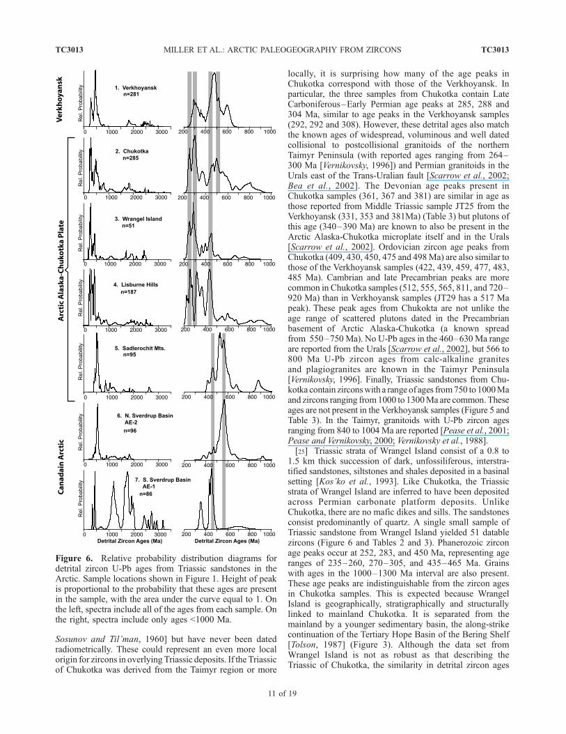
locally, it is surprising how many of the age peaks inChukotka correspond with those of the Verkhoyansk. Inparticular, the three samples from Chukotka contain LateCarboniferous–Early Permian age peaks at 285, 288 and304 Ma, similar to age peaks in the Verkhoyansk samples(292, 292 and 308). However, these detrital ages also matchthe known ages of widespread, voluminous and well datedcollisional to postcollisional granitoids of the northernTaimyr Peninsula (with reported ages ranging from 264–300 Ma [Vernikovsky, 1996]) and Permian granitoids in theUrals east of the Trans-Uralian fault [Scarrow et al., 2002;Bea et al., 2002]. The Devonian age peaks present inChukotka samples (361, 367 and 381) are similar in age asthose reported from Middle Triassic sample JT25 from theVerkhoyansk (331, 353 and 381Ma) (Table 3) but plutons ofthis age (340–390 Ma) are known to also be present in theArctic Alaska-Chukotka microplate itself and in the Urals[Scarrow et al., 2002]. Ordovician zircon age peaks fromChukotka (409, 430, 450, 475 and 498Ma) are also similar tothose of the Verkhoyansk samples (422, 439, 459, 477, 483,485 Ma). Cambrian and late Precambrian peaks are morecommon in Chukotka samples (512, 555, 565, 811, and 720–920 Ma) than in Verkhoyansk samples (JT29 has a 517 Mapeak). These peak ages from Chukokta are not unlike theage range of scattered plutons dated in the Precambrianbasement of Arctic Alaska-Chukotka (a known spreadfrom 550–750 Ma). No U-Pb ages in the 460–630 Ma rangeare reported from the Urals [Scarrow et al., 2002], but 566 to800 Ma U-Pb zircon ages from calc-alkaline granitesand plagiogranites are known in the Taimyr Peninsula[Vernikovsky, 1996]. Finally, Triassic sandstones from Chu-kotka contain zirconswith a range of ages from750 to1000Maand zircons ranging from1000 to 1300Ma are common. Theseages are not present in the Verkhoyansk samples (Figure 5 andTable 3). In the Taimyr, granitoids with U-Pb zircon agesranging from 840 to 1004 Ma are reported [Pease et al., 2001;Pease and Vernikovsky, 2000; Vernikovsky et al., 1988].[25] Triassic strata of Wrangel Island consist of a 0.8 to
1.5 km thick succession of dark, unfossiliferous, interstra-tified sandstones, siltstones and shales deposited in a basinalsetting [Kos’ko et al., 1993]. Like Chukotka, the Triassicstrata of Wrangel Island are inferred to have been depositedacross Permian carbonate platform deposits. UnlikeChukotka, there are no mafic dikes and sills. The sandstonesconsist predominantly of quartz. A single small sample ofTriassic sandstone from Wrangel Island yielded 51 datablezircons (Figure 6 and Tables 2 and 3). Phanerozoic zirconage peaks occur at 252, 283, and 450 Ma, representing ageranges of 235–260, 270–305, and 435–465 Ma. Grainswith ages in the 1000–1300 Ma interval are also present.These age peaks are indistinguishable from the zircon agesin Chukotka samples. This is expected because WrangelIsland is geographically, stratigraphically and structurallylinked to mainland Chukotka. It is separated from themainland by a younger sedimentary basin, the along-strikecontinuation of the Tertiary Hope Basin of the Bering Shelf[Tolson, 1987] (Figure 3). Although the data set fromWrangel Island is not as robust as that describing theTriassic of Chukotka, the similarity in detrital zircon ages
Figure 6. Relative probability distribution diagrams fordetrital zircon U-Pb ages from Triassic sandstones in theArctic. Sample locations shown in Figure 1. Height of peakis proportional to the probability that these ages are presentin the sample, with the area under the curve equal to 1. Onthe left, spectra include all of the ages from each sample. Onthe right, spectra include only ages <1000 Ma.
TC3013 MILLER ET AL.: ARCTIC PALEOGEOGRAPHY FROM ZIRCONS
11 of 19
TC3013
would argue that sequences of both regions formed partof a once continuous depositional system or basin in theTriassic.
4.3. Lisburne Hills (Locality 4)
[26] The Lisburne Hills fold-and-thrust belt in western-most Alaska (Figure 3) consists of lower Paleozoic toMesozoic sedimentary rocks involved in Brookian thrusting[Moore et al., 2002]. Two samples were collected from anunusual sandstone member of the Triassic Otuk Formation.The sandstone lies stratigraphically between the shale andchert members of the Otuk as described by Blome et al.
Table 3. Interpreted Peak Ages and Age Ranges
Peak Age,a Ma Number of Grainsb Age Range,c Ma
JT25 (N = 93)331 6 320–345353 3 350–365381 4 375–395422 9 410–435477 28 440–495
9 1740–19603 2020–20808 2500–3000
JT26 (N = 92)292 9 275–300321 11 300–330439c 9 425–455483c 21 455–505
6 1800–19403 2000–20606 2440–2540
JT29 (N = 96)292 6 265–300308 4 300–320459c 15 450–475485c 11 475–495517 9 510–530
6 1760–184014 2300–2760
94CL10 (N = 94)232c 7 220–245265c 17 250–280326 11 315–340369 9 355–380436 19 415–460
6 600–66510 1700–2180
94CL53 (N = 93)223 4 220–265256 5 250–265321 13 305–330360 7 355–370436 18 415–455
8 530–6207 1840–20404 2480–25604 1200–1280
96DH102 (N = 95)467 10 445–490530 20 510–540565 22 545–590
7 860–96013 1040–12404 2600–2700
AE1 (N = 86)454 6 430–4701216 15 1130–12401662 8 1640–16751769 13 1730–18051933 5 1920–19501988 4 1985–2025
10 2380–2940
AE2 (N = 96)474 4 460–480511c 6 500–520566c 45 530–590
Table 3. (continued)
Peak Age,a Ma Number of Grainsb Age Range,c Ma
11 1020–12804 1600–17005 1820–1900
CH13B (N = 92)244 11 235–255285 5 275–300381 3 370–390430 3 425–440475 5 465–490512 9 495–530555 10 540–585
8 725–9207 1060–122015 1600–1860
CH26 (N = 94)249 5 240–255288 14 275–305361 13 340–390452 10 435–470565 4 560–580
14 1640–1880
CH26.5 (N = 99)253 3 250–265304 23 285–330367 4 350–380467 10 440–485498 11 490–525811 7 790–840
8 1000–128010 1740–2080
C145741 (N = 51)252 6 235–260283 11 270–305450 6 435–465
4 1040–12008 1600–19804 2380–2500
aMost peak ages listed above are prominent peaks on relative age-probability diagrams (Figures 5 and 6). Peak ages are reported only for ageranges that define a single obvious peak. The listed peaks include at least threeoverlapping analyses (within about a million years of each other andwith lowreported errors). Peak age determined by deconvolution of adjacent peaksusing the Sambridge-Compston algorithm in Isoplot 3.0 [Ludwig, 2003].
bNumber of grains is the number of grains included in an age range.cAge range is the range of ages that make up a cluster on a relative age-
probability diagram (Figures 5 and 6).
TC3013 MILLER ET AL.: ARCTIC PALEOGEOGRAPHY FROM ZIRCONS
12 of 19
TC3013
[1988] and is very fine to fine-grained,massive, and about 5mthick. Monotis fossils found in the sandstone suggest a LateTriassic age. The sandstone is lithic, consisting of about 40%monocrystalline quartz, 20% altered feldspar, and 40% lithicfragments (argillite, chert, siltstone, granitic fragments andcarbonate). The Otuk in general is thought to representcondensed sedimentation in an outer shelf environment[Moore et al., 1994]. Although a predominantly sedimentaryprovenance is inferred for this sandstone, the granitic frag-ments suggest that it was shed from a source region that lay tothe NW (present coordinates) in the offshore Chukchi plat-form region (K.W. Sherwood, written communication, 2000,as cited by Moore et al. [1994]). The two samples from theLisburne Hills, 94CL10 and 94CL53, have very similarzircon age populations. Individual peaks and the age rangesrepresented are listed in Table 3; age probability plots arecombined in Figure 6. The samples includeTriassic peaks thatare younger than any peaks present in previously discussedsamples. Age peaks of 232 and 223 Ma, characterized bygrain age ranges of 220–245 and 220–265 Ma overlap thegrain age ranges that define Permo-Triassic age peaks insamples from Chukotka and Wrangel Island, but includesome younger single-grain ages (Tables 2 and 3). Peak agesof 256Ma, in both samples dated, correspond to age ranges of250–280 and 250–265 Ma and also overlap the single-grainage ranges represented by Permo-Triassic age peaks ofChukotka and Wrangel Island samples, but include someolder single-grain ages. When the data from the twoLisburne Hills samples are grouped (Figure 6), with atotal of 187 single-grain ages represented, two distinct agepeaks are further resolved, one at 222 Ma and the otherat 255Ma. Thus it appears that the Lisburne samples contain aPermo-Triassic zircon population as does Chukotka, butmight also contain a distinctly younger population of zirconsthat are about 222 Ma old (Late Triassic). Carboniferous agepeaks at 321 and 326 Ma, represented by single-grain ageranges of 305–330 and 315–340 Ma are similar, but slightlyolder than age peaks in samples from Chukotka (288 and304 Ma represented by age ranges of 275–305 and 285–330 Ma). Age peaks of 360 and 369 Ma in the Lisburnesamples, represented by age ranges of 355–370 and 355–380 Ma, are similar to those in Chukotka samples (361, 367and 381 Ma, represented by age ranges of 340–390, 350–380, and 370–390Ma) and again, are known to correspond tothe range of U-Pb ages obtained from Devonian plutons innorthern Alaska and Chukotka (340–390 Ma). Well-definedage peaks in each of the Lisburne samples at 436 Ma,representing an age span of 415–460 Ma (at least 37 single-grain ages represented) are identical to important age peaksseen in Chukotka and Verkhoyansk samples. Finally, bothsamples from the Lisburne Hills have zircons that span530–665 Ma. These ages are present in samples fromChukotka, but are not present in all Verkhoyansk samples(Late Triassic sample JT29 has a 517 Ma peak repre-sented by grains 510–530 Ma). In summary, Triassicsandstone of western Alaska, although deposited in avery different setting than sandstones of Chukotka andWrangel Island (shelf facies sandstone versus basinalturbidites) shared similar source regions for their detrital
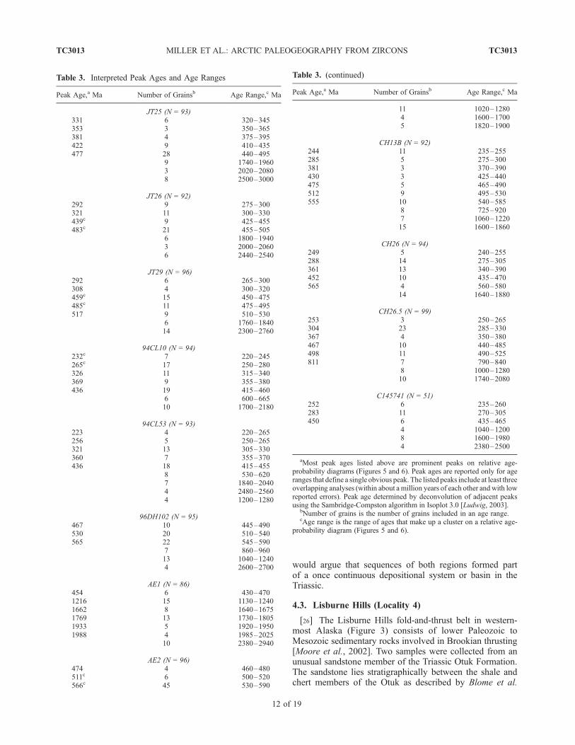
Figure 7. Speculative reconstruction of the AmerasianBasin that accounts for U-Pb single-grain detrital ages inTriassic sediments. Base map is from Rowley and Lottes[1988] and shows the plate reconstruction for the Arcticprior to the opening of the North Atlantic. The LomonosovRidge has been restored against the Barents Shelf, and theAmerasian Basin is assumed to be as it now exists. Thereconstruction represents the end of the Jurassic andbeginning of the Cretaceous, prior to opening of theAmerasian Basin, but does not restore shortening-relateddeformation that took place at this time. Grey arrows showinferred sediment source directions in the Triassic. Thepolar Urals may have acted as a divide in the Triassic withrespect to river systems and sediment transport. For furtherdiscussion, see text.
TC3013 MILLER ET AL.: ARCTIC PALEOGEOGRAPHY FROM ZIRCONS
13 of 19
TC3013
zircons populations. Samples from westernmost Alaskadiffer in their inclusion of a younger Triassic zirconpopulation of about 222 Ma. The closeness in age ofthis peak to the depositional age of the sandstone mightsuggest derivation from a contemporaneous magmaticsource.
4.4. Sadlerochit Mountains, Eastern Alaska (Locality 5)
[27] Detrital zircons from a single sample from the EarlyTriassic Ledge Member of the Ivishak Formation of theSadlerochit Mountains in northeastern Alaska were dated(Figures 1 and 3). Sedimentary structures and burrowsindicate a shallow marine deltaic origin for the LedgeMember, which, based on sedimentary facies and paleocur-rent directions, is known to have been derived from thenorth (present-day coordinates) [Mariani, 1987]. This unitis also notable because it is the main oil reservoir of thePrudhoe Bay field. The detrital zircon ages from the LedgeMember of the Ivishak Sandstone are strikingly differentfrom those of the Triassic of the Lisburne Hills, discussedabove. The sample from the Sadlerochit Mountains exhibitsage peaks at 467, 530 and 565 Ma, represented by ageranges 445–490, 510–540, and 545–590. Permo-Triassic,Permo-Carbonifereous, and Devonian age peaks are con-spicuously absent (Table 3 and Figure 6). The youngest agepeak, 467 Ma, falls within the range of the prominentOrdovician peaks seen in all of the samples discussed sofar. Cambrian to Late Precambrian zircons form an impor-tant component of the detrital population of this sample,with peaks at 530 and 565 Ma representing age spans of510–540 Ma (20 grains) and 545–590 Ma (22 grains).These ages correspond to the youngest age limit of latePrecambrian plutons that have been dated in basement rocksof northern Alaska and Wrangel Island [Moore et al., 1994;Amato et al., 2003; Amato, 2004; Kos’ko et al., 1993]. Itseems that rocks of this age, or sediments derived fromthem must have been quite prevalent in the northern sourcearea for these sandstones.
4.5. Sverdrup Basin, Arctic Canada (Locations 6 and 7)
[28] Sample AE-2 is representative of the Late Triassic(upper Carnian) sandstone-dominated Pat Bay Formation, afine-grained, shallow marine shelf-facies sandstone. The PatBay Formation exhibits facies changes (shallower water tothe north) that argue that the main region of sediment supplyfor the northern Sverdrup Basin in the Late Triassic lay tothe present north of the basin [Embry, 1991, 1992]. Notmuch is known about this northern landmass because riftingassociated with formation of the Amerasian Basin hasremoved the northern margin of the Sverdrup Basin, whichnow lies foundered beneath the continental shelf and slopeof the Canadian Arctic margin [Embry, 1992]. This paleo-source region was termed ‘‘Crockerland’’ by Embry [1992]and it provided sediments to the Sverdrup Basin intermit-tently from the Carboniferous to the Jurassic [Embry, 1992].The detrital zircon population from the Pat Bay Formationhelps characterize ‘‘Crockerland’’. The younger age peaksin this sample are virtually identical to those of the LedgeSandstone Member of the Ivashak Formation of easternmost
Alaska. Peaks are evident at 474, 511 and 566 Ma, repre-sented by grain age ranges of 460–480, 500–520, and 530–590 Ma. As in the Sadlerochit Mountains, the 566 Ma agepeak, represented by 45 grains out of a total of 96 grains isconspicuous. In addition, significant numbers of single-grainages fall in the intervals 1020–1280, 1600–1700, and 1820–1900. The similarities between the zircon populations fromthe Triassic of the Sadlerochit Mountains and Triassic sedi-ments derived from the northern borderland of the SverdrupBasin suggest that the now missing ‘‘Crockerland’’ mightwell have sourced both these regions.[29] Sample AE-1 (location 7, Figure 1) is representative
of the Early Triassic (Smithian) braided stream facies of theBjorne Formation from central Ellesmere Island. On thebasis of facies changes from fluvial-deltaic sands to the SE,to nearshore, offshore shelf, and basinal shales and silt-stones to the NW, the Bjorne Formation is believed to havebeen sourced from the east and south of the region sampled[Embry, 1991]. The deltaic sediments were fed by majorriver systems flowing from the Greenland and CanadianShield regions [Embry, 1991]. A 454 Ma Ordovician agepeak is evident in the zircon population of the BjorneFormation (Table 3 and Figure 6), represented by six grainswith ages ranging from 430 to 470 Ma. The rest of thezircons from the Bjorne Formation yield Precambrian ages.Age peaks are evident at 1216, 1662, 1769, 1933, and 1988Ma. In addition, ten grains have ages between 2380 and2940. The Ordovician and 1216 Ma age peaks in the BjorneFormation are similar to those in the Ledge SandstoneMember of the Ivashak Formation in the Sadlerochit Moun-tains, but otherwise this sample is very different in that ithas an absence of Cambrian and Late Precambrian ages andfar more older Precambrian zircons (Figure 6). Given theinferred SE source for the Bjorne Formation (including theCanadian Shield), the older ages are easily explained.However, this sample stands out in our data set becauseits source areas are so different from the other circum-Arcticsandstones discussed so far. Sample AE-1 does have sim-ilarities to the pattern of detrital zircon ages reported for twosamples of Carboniferous sandstones from the Outer MorayFirth in the northern part of the North Sea [Morton et al.,2001] emphasizing the distinction between Siberian andLaurasian-European detrital sources.
5. Conclusions
[30] The reconnaissance nature of this study and theimmense size of the region sampled make it difficult tomake unequivocal conclusions based on the few datadiscussed in this paper; rather, the inferences from thesedata as listed below represent testable hypotheses. Moredata from key stratigraphic sections is the next step neededto build on these initial inferences. The fact that many of thepotential source areas for the sediments we have studied arenot themselves geochronologically well characterizedpresents additional problems in interpreting the data. De-spite this, the new data provide a powerful means ofcomparing source regions for Triassic sediments and must
TC3013 MILLER ET AL.: ARCTIC PALEOGEOGRAPHY FROM ZIRCONS
14 of 19
TC3013
be used for testing any existing or proposed plate tectonicmodels for the Arctic.[31] When all the data are considered together (Figure 6),
the following general conclusions can be made:[32] 1. The three samples of Triassic sandstone deposited
along the northern Verkhoyanskmargin (locality 1, Figures 1,2, and 3) have distinctive detrital populations representedmainly by Permo-Caboniferous and Cambro-Ordovician-Silurian age zircons (Figure 5). Late Precambrian (1000 to1315 Ma) zircons, which are present in all other samplesstudied, are conspicuously absent. Cambrian-latest Precam-brian zircons (500 to 750 Ma), although present, are of lesserimportance. The stratigraphy, sedimentology and petrologyof the Triassic of the Verkhoyansk are quite well known, as isthe concept that they were derived from actively upliftingmountain systems in the Baikal region via a system of largerivers that delivered siliciclastic debris to the Verkhoyanskmargin from Carboniferous to Jurassic time. The detritalzircon populations support this inference; specifically, thereis a good match in the detrital zircon ages with theknown age of the extensive Angara-Vitim batholith ofPermo-Carboniferous age (290–320 Ma) in the Baikalmountainous region.[33] 2. The three samples from Chukotka and one from
Wrangel Island (localities 2 and 3, Figure 1) are from stratathat are the least studied stratigraphically and sedimento-logically. Their zircon populations are very similar. They aredistinct from those of the Verkhoyansk because they containPermo-Triassic and 1000–1315 Ma zircons. Permo-Carboniferous and Ordovician age peaks are similar tothose in the Verkhoyansk. Chukotka and Wrangel detritalzircon suites are more like the Verkhoyansk and are dis-similar from Canadian and eastern Alaska samples. Like theVerkhoyansk, the Triassic sediments of Chukotka are de-rived from orogenic source regions. The source region forPermo-Triassic zircons in Chukotka was most likely theTaimyr region and/or zircon-bearing magmas related to theSiberian Traps. If so, it is likely that Permo-Carboniferoussources in the Taimyr region dated at 264–300 Ma mayhave provided zircons to these sediments as well. Theseages preclude Laurentian sources because the Greenlandand Canada Caledonides do not have magmatic belts thatare this young (post-350 Ma) [e.g., Currie, 1995; Torsvikand Cocks, 2004]. Since Ordovician age peaks are presentin all samples dated, it is perhaps coincidental that Ver-khoyansk and Chukotka samples have similar Permo-Car-boniferous and Ordovician peaks, but without further work,a Baikal Mountains source (or recycled source) cannot beruled out for the Triassic of Chukotka, provided the Taimyrand Siberian Trap region of Russia are also included as partsof that source region. Similar orogenic histories to those ofthe Baikals occur within the Ural Mountains of Russia[Khain and Nikishin, 1997] and thus river systems thatdrained the northern Urals, provided they included theTaymir region/Siberian Traps, would also represent a feasi-ble source region. In addition, Chukotka’s history of riftingin the Triassic is unique to this part of the Arctic Alaska-Chukotka microplate and must be taken into account in anypaleogeographic reconstruction.
[34] 3. Triassic sandstones from the Lisburne Hills ofwestern Alaska (locality 4, Figures 1 and 3) have similarzircon populations to those of Chukotka and WrangelIsland, suggesting no significant paleogeographic barriersbetween the Russian and westernmost Alaskan parts of theArctic Alaska-Chukotka microplate in the Triassic, despitesignificant differences in facies and thicknesses. Specifi-cally, Triassic sandstones from both these regions sharePermo-Triassic and Permo-Carboniferous age detrital zir-cons. In addition to having Ordovician, Cambrian-LatePrecambrian and some 1000 to 1300 Ma age zircons incommon, the Chukotka and western Alaska samples alsoshare Devonian age peaks. Devonian granitoids have beendated in multiple localities in Alaska and Chukotka, wherethey intrude rocks that are basement to Mississippian andyounger sediments.[35] 4. The greatest difference in detrital zircon popula-
tions noted within the Arctic Alaska-Chukotka microplate isfound by comparing Triassic sandstones from westernversus eastern Alaska, or across a region that has been wellstudied and is known for its structural and stratigraphiccontinuity. Permo-Triassic and Permo-Carboniferous sour-ces are not represented in samples from the Triassic ofthe Sadlerochit Mountains in eastern Alaska (locality 5,Figure 1). Instead, Ordovician (445–490 Ma) and Cambri-an-latest Precambrian (500–600Ma) zircons predominate. Inaddition, 900–1000 and 1000–1300 Ma age zircons are alsopresent. Thus there is good evidence for along-strike changesin provenance for Triassic sandstones of the Arctic Alaska-Chukotka microplate across Alaska.[36] 5. The Upper Triassic Pat Bay Formation of the
Sverdrup Basin, Arctic Canada (locality 6, Figure 1), wasderived from a northern source region that is no longerpresent because it was rifted away during opening of theAmerasian Basin. Our one sample from the Pat BayFormation yielded a detrital zircon population that is nearlyidentical to that of the sample from the Sadlerochit Moun-tains. The now missing ‘‘Crockerland’’ of Embry [1992]appears to have sourced both these region in the LateTriassic and must have been characterized by igneous orsedimentary rocks containing mostly 500–600 Ma zircons,with less important Ordovician and late Precambrian sourcesrepresented.[37] 6. The Lower Triassic Bjorne Formation of the
Sverdrup Basin (locality 7, Figure 1) is known to havebeen derived from the south margin of the Sverdrup Basin,and its detrital zircon population is quite different from thatof the Pat Bay Formation. It reflects a 430–470 Ma source,but has no zircons in the 500–600 Ma range. Instead it isdominated by 1130–1240 Ma and older Precambrian zir-cons. This data is compatible with the inference that riversthat fed sediment to the Bjorne Formation from the southcontained detritus eroded from the Canadian Shield as wellas from the Caledonides [Embry, 1992].
6. Discussion
[38] The above conclusions and inferences from data areused to evaluate paleogeographic and plate tectonic recon-
TC3013 MILLER ET AL.: ARCTIC PALEOGEOGRAPHY FROM ZIRCONS
15 of 19
TC3013
structions for the Arctic Ocean. First we consider theaccepted reconstruction shown in Figure 2 [after Lawveret al., 2002], which is similar to that of Rowley and Lottes[1988]. Rowley and Lottes’ [1988] reconstruction has nooverlap of continental crust like that depicted in Figure 2.This was accomplished by not including the New SiberianIslands and surrounding Siberian Shelf as part of the ArcticAlaska-Chukotka microplate. However, geologic work onthe New Siberian Islands [e.g., Kuzmichev and Soloviev,2004] and aeromagnetic data from the shelf [Racey et al.,1996] argues that the Late Jurassic–Early Cretaceous foldand thrust belt with accreted ophiolitic terranes includes theNew Siberian Islands. An additional problem with the‘‘rotational model’’ is that it restores a well-developedMesozoic orogenic belt with accreted oceanic and arcterranes (the Brooks Range–Chukotka orogen) against theplatformal region of the Barents Shelf (Figure 2). The‘‘rotational model’’ restores Chukotka to a position whereit is separated from potential sedimentary source areas inNE Russia by a 1000-km-wide ocean (Figure 2). Yet ourdata suggests that these sources played an important role inproviding sediment to Triassic basins of Chukotka, WrangelIsland and westernmost Alaska. Furthermore, Chukotkarestores to a position adjacent to the north rim of theSverdrup Basin, whose source regions for Triassic sand-stones are the most dissimilar to those represented by zirconsin Triassic sandstones of Wrangel Island and Chukotka(Figure 6).[39] Figure 7 illustrates a highly schematic paleogeo-
graphic reconstruction of the Arctic Alaska-Chukotkamicroplate that better satisfies both the geologic data andour new sedimentologic constraints. The base map is theEarly Albian (110 Ma) reconstruction of Rowley andLottes [1988] and shows the North Atlantic closed andthe Lomonosov Ridge as part of the Barents Shelf. TheInternational Bathymetric Chart of the Arctic Oceans(IBCAO, 2001, available at http://www.ngdc.noaa.gov/mgg/bathymetry/arctic/arctic.html) is shown as base forthe Amerasian Basin to highlight the position and natureof intrabasinal highs that must be considered. Theseinclude the continental Chukchi Borderland [Grantz etal., 1990a] and the Alpha and Mendeleev ridges of morequestionable origin. We have mapped linear normal faultsassociated with the intrabasinal highs of the Arctic Ocean(Figure 7a). The structuring of these intrabasinal highs iscompatible with the interpretation that the Alpha andMendeleev highs are stretched and foundered continentalcrust rather than a younger hot spot track [Lawver andMuller, 1998]. The extensional structures of the AlphaMendeleev Ridge have been documented by the sparsereflection seismic data available [Jackson et al., 1990;Jokat, 2003; Coakley et al., 2005] and gravity modelssuggest a 20–30 km thick crust in places beneath theAlpha-Mendeleev Ridge [Williams and Coakley, 2005]supporting the interpretation that it is underlain by thinnedcontinental crust. The orientation of the various arrays ofnormal faults (ridges and basins) seen in the bathymetricdata suggest a complex mode of stretching and openingfor this part of the Amerasian Basin, with both rifting
parallel to the Lomonosov Ridge and orthogonal tothe Canadian margin (Figure 7a). A rift origin for theMakarov Basin, located between the Lomonosov andAlpha Mendeleev ridges, was initially proposed [e.g.,Taylor et al., 1981; Vogt et al., 1982] and is supportedby the parallel systems of horsts and grabens along itsborder with the Lomonosov Ridge [Cochran et al., 2003](Figure 7a). However, the expected parallel magneticanomalies are not observed in the aeromagnetic data[e.g., Brozena et al., 2002].[40] Triassic paleogeographic features of the circum-
Arctic are schematically shown in Figure 7a and includepossible major sources of sediment supply from Eurasia,today’s outcrop region of the Siberian Trap basalts, thefailed rift system beneath the West Siberian Basin [e.g.,Aplonov, 1988; Ziegler, 1988], and the inferred sedimentsource directions for Alaskan and Canadian sample sites.Within the Arctic Alaska-Chukotka microplate, we haveoutlined the approximate northern boundary of LateJurassic–Early Cretaceous ‘‘Brookian’’ thrust faultingand the location of the Angayucham, South Anyui andKolyma-Verkhoyansk ophiolite/arc collision boundaries.These features formed prior to the opening of theAmerasian Basin and constitute good markers or piercingpoints for pre-Cretaceous reconstruction.[41] The pre-Cretaceous reconstruction (Figure 7b) places
Chukotka close to the Taimyrs and Siberian Traps, satisfy-ing the source region constraints provided by detrital zirconsuites. It also places Chukotka closer to possible prolonga-tions of the West Siberian Rift system. During its time offormation, the branches of this rift system may have hostedriver systems that could have transported sediments fromgreat distances across Siberia into the Triassic rift basins ofChukotka. These sediment sources could have includedPermo-Triassic zircons from the Taimyr and Siberian Trapregion as well (Figure 7b).[42] In order to restore Chukotka to its prerift location
(Figure 7b), several assumptions were required:[43] 1. The Arctic Alaska-Chukotka microplate is not a
rigid crustal fragment. This is supported by extensive datafrom the Bering Strait region [Klemperer et al., 2002] anda growing database from Chukotka [Katkov et al., 2004,2005] that suggests extensional deformation during thetime span of Cretaceous magmatism (120–90 Ma). Thereconstruction (Figure 7b) breaks the microplate arbitrarilyin the Bering Strait, despite the fact that many geologicalelements seem to be present on both sides of the strait(Figure 3).[44] 2. The East Siberian Shelf has undergone �100%
extension (doubling in width) in an approximately EWdirection. Gravity and limited seismic data support thisassumption [e.g., Drachev, 2004] and at least this amountof extension is required if assumption 3 is valid.[45] 3. The highs in the Amerasian Basin are composed
of thinned continental crust that restore to form part of theLomonosov Ridge–Barents Shelf, helping to provide extracontinental crust needed to fill the gap between the micro-plate and the rifted edge of the Barents Shelf.
TC3013 MILLER ET AL.: ARCTIC PALEOGEOGRAPHY FROM ZIRCONS
16 of 19
TC3013
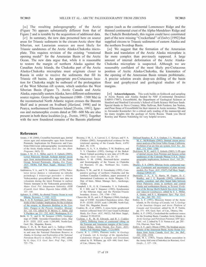
[46] The resulting paleogeography of the Arctic(Figure 7b) appears substantially different from that ofFigure 2 and is testable by the acquisition of additional data.[47] In summary, the new data presented here on source
areas for Triassic sediments in the circum-Arctic show thatSiberian, not Laurasian sources are most likely forTriassic sandstones of the Arctic Alaska-Chukotka micro-plate. This requires revision of the existing ‘‘rotationalopening model’’ for the Amerasian Basin of the ArcticOcean. The new data argue that, while it is reasonableto restore the margin of northern Alaska against theCanadian Arctic Islands, the Chukotka part of the ArcticAlaska-Chukotka microplate must originate closer toRussia in order to receive the sediments that fill itsTriassic rift basins. An appropriate pre-Cretaceous loca-tion for Chukotka might be outboard of the prolongationof the West Siberian rift system, which underlies the WestSiberian Basin (Figure 7). Arctic Canada and ArcticAlaska, especially eastern Alaska, have different sedimentarysource regions. Grenville age basement (1000–1300 Ma) inthe reconstructed North Atlantic region crosses the BarentsShelf and is present on Svalbard [Harland, 1998] and inPearya, northernmost Ellesmere Island [Trettin, 1991]. Igne-ous and metamorphic events dated at 500–600 Ma are alsopresent in both these localities [e.g., Trettin, 1991]. Togetherwith the now foundered remains of the Barents platformal
region (such as the continental Lomonosov Ridge and thethinned continental crust of the Alpha-Mendeleev Ridge andthe Chukchi Borderland), this region could have constitutedpart of the now missing ‘‘Crockerland’’ of Embry [1992] thatsupplied zircons to Triassic sediments of eastern Alaska andthe northern Sverdrup Basin.[48] We suggest that the formation of the Amerasian
Basin and translation of the Arctic Alaska microplate isfar more complex than previously supposed. A largeamount of internal deformation of the Arctic Alaska-Chukotka microplate is suspected. Although we arereasonably confident of the most likely pre-Cretaceousposition of Arctic Alaska-Chukotka, the kinematics ofthe opening of the Amerasian Basin remain problematic.A precise solution awaits deep-sea drilling of the basinfloor and geophysical and geological studies of itsmargins.
[49] Acknowledgments. This work builds on fieldwork and samplingin Arctic Russia and Alaska funded by NSF (Continental DynamicsEAR93-17087), ExxonMobil, the Department of Geological Sciences atStanford and Stanford University’s School of Earth Science McGuee funds.Special thanks to Steve Creaney, Mike Sullivan, Bob Ferderer, Ian Norton,and Pinar Ilmaz of ExxonMobil for their interest in Arctic tectonics. Thanksto Alexander Kusmichev for a critical early reading of the manuscript andhis many insights into the geology of Arctic Russia. Thank you DavidRowley and Warren Nokleberg for very helpful reviews.
TC3013 MILLER ET AL.: ARCTIC PALEOGEOGRAPHY FROM ZIRCONS
17 of 19
TC3013
ReferencesAmato, J. M. (2004), Crystalline basement ages, detrital
zircon ages and metamorphic ages from SewardPeninsula: Implications for Proterozoic and Cam-brian-Ordovician paleogeographic reconstructionsof the Arctic Alaska terrane, Geol. Soc. Am. Abstr.Programs, 36(5), 22.
Amato, J. M., E. L. Miller, and G. E. Gehrels (2003),Lower Paleozoic through Archean detrital zirconages from metasedimentary rocks of the NomeGroup, Seward Peninsula, Alaska, Eos Trans.AGU, 84(46), Fall Meet. Suppl., Abstract T31F-0891.
Andrianova, V. A., and V. N. Andrianov (1970), Neko-torye novye dannye o vulcanisme na rubezhepermskogo I triasovogo periodov v oblastiVerkoyanskoy geosynklinali (Some new data onvolcanism during the latest Permian to earliestTriassic timespan in the Verkoyansk geosyncline),Mater. Geol. Pol. Iskopaemym Yakutskoy ASSR(Contrib. Geol. Miner. Deposits Yakut ASSR), XVI,137–145.
Aplonov, S. (1988), An aborted Triassic Ocean in westSiberia, Tectonics, 7, 1103–1122.
Bea, F., G. B. Fershtater, and P. Montero (2002), Gran-itoids of the Uralides: Implications for the evolutionof the orogen, in Mountain Building in the Ura-lides: Pangea to the Present, Geophys. Monogr.Ser., vol. 132, edited by D. Brown, C. Juhlin, andV. Puchkov, pp. 211–232, AGU, Washington, D. C.
Belik, G. Y., and G. M. Sosunov (1969), Geologicmap of USSR: Anyuisko-Chaunskaya series, MapR-58 –XXIX, XXX, scale 1:200,000, North-East.Geol. Dir., Magadan, Russia.
Blome, C. D., K. M. Reed, and I. L. Tailleur (1988),Radiolarian biostratigraphy of the Otuk Formationin and near the National Petroleum Reserve inAlaska, in Geology and Exploration of the NationalPetroleum Reserve in Alaska, 1974 to 1982, editedby G. Gryc, U.S. Geol. Surv. Prof. Pap., 1399,725–776.
Brozena, J. M., L. A. Lawver, L. C. Kovacs, and V. A.Childers (2002), Aerogeophysical evidence for therotational opening of the Canada Basin, AAPGBull., 86, 1138.
Bukharov, A. A., V. A. Khalilov, T. M. Strakhova, andV. V. Chernikov (1992), Geology of the Baikal-Patom Upland according to new data of U-Pb dat-ing, Russ. Geol. Geophys., 33, 24–33.
Bychkov, Y. M. (1994), Structural-facies zonationand biostratigraphy of the Triassic in Chukotka(in Russian), 53 pp., Northeast Sci. Centre,Magadan.
Bychkov, Y. M., and M. E. Gorodinsky (1992), Com-parative geology of northern Chukotka and thenorthern Canadian Cordillera, paper presented atInternational Conference on Arctic Margins, U.S.Dep. of Inter., Miner. Manage. Serv., Anchorage,Alaska.
Campbell, I. H., G. K. Czamanske, V. A. Fedorenko,R. I. Hill, and V. Stepanov (1992), Synchronismof the Siberian traps and the Permian-Triassicboundary, Science, 258, 1760–1763.
Chasovitin, M. D., and A. P. Shpetnyi (1964), Geologicmap of USSR: Anyuisko-Chaunskaya series, MapR-58–XXXIII, XXXIV, scale 1:200,000, North-East.Geol. Dir., Magadan, Russia.
Coakley, B., et al. (2005), A cross-Arctic geophysicaltransect collected from US Coast Guard IcebreakerHealy, Eos Trans. AGU, 86(52), Fall Meet. Suppl.,Abstract T13D-0510.
Cochran, J. R., M. H. Edwards, and B. J. Coakley(2003), Differing forms of continental rifting onthe Eurasian and Amerasian margins of the Lomo-nosov Ridge, Arctic Ocean, Eos Trans. AGU,84(46), Fall Meeting Suppl., T12A-0450.
Currie, K. L. (1995), Plutonic rocks, in Geologyof Canada, vol. 6, Geology of the Appalachian-Caledonian Orogen in Canada and Greenland,edited by H. Williams, pp. 629–680, Geol. Surv.of Can., Ottawa, Ont.
DeGraaf-Surpless, K., S. A. Graham, J. L. Wooden, andM. C. McWilliams (2002), Detrital zircon prove-nance analysis of the Great Valley Group, California:Evolution of an arc-fore arc system, Geol. Soc. Am.Bull., 114, 1564–1580.
Dickinson, W. R., and G. E. Gehrels (2003), U-Pb agesof detrital zircons from Permian and Jurassic eoliansandstones of the Colorado Plateau U.S.A.: Paleo-geographic implications, Sediment. Geol., 163, 29–66.
Drachev, S. S. (2004), Siberian Arctic continental mar-gin: Constraints and uncertainties of plate tectonicmodels, Eos Trans. AGU, 85(47), Fall Meet. Suppl.,Abstract GP43C-07.
Dumoulin, J. A., A. G. Harris, M. Gagiev, D. C.Bradley, and J. E. Repetski (2002), Lithostrati-graphic, conodont, and other faunal links betweenlower Paleozoic strata in northern and centralAlaska and northeastern Russia, in Tectonic Evolu-tion of the Bering Shelf-Chukchi Sea-Arctic Marginand Adjacent Landmasses, edited by E. L. Miller,A. Grantz, and S. L. Klemperer. Spec. Pap. Geol.Soc. Am., 360, 291–312.
Embry, A. F. (1991), Mesozoic history of the ArcticIslands, in The Geology of Canada, vol. 3, Geologyof the Innuitian Orogen and Arctic Platform ofCanada and Greenland, edited by H. P. Trettin,pp. 371–434, Geol. Surv. of Can., Ottawa, Ont.
Embry, A. F. (1992), Crockerland-the northwest sourcefor the Sverdrup Basin, Canadian Arctic Islands, inArctic Geology and Petroleum Potential, NPF Spec.Publ., vol. 2, edited by T. O. Vorren et al., pp. 205–216, Elsevier, New York.
Embry, A. F., and J. Dixon (1990), The breakup uncon-formity of the Amerasian Basin, Arctic Ocean: Evi-dence from Arctic Canada, Geol. Soc. Am. Bull.,102, 1526–1534.
Gelman, M. L. (1963), Triassic diabase association inthe Aniuy fold zone (Chukotka) (in Russian), Geol.Geofiz., 2, 127–134.
TC3013 MILLER ET AL.: ARCTIC PALEOGEOGRAPHY FROM ZIRCONS
18 of 19
TC3013
Grantz, A., S. D. May, and P. E. Hart (1990a), Geologyof Arctic continental margin of Alaska, in TheGeology of North America, vol. L, The ArcticOcean Region, edited by A. Grantz, L. Johnson,and J. F. Sweeney, pp. 257 – 288, Geol. Soc. ofAm., Boulder, Colo.
Grantz, A., S. D. May, P. T. Taylor, and L. A. Lawver(1990b), Canada Basin, in The Geology of NorthAmerica, vol. L, The Arctic Ocean Region, editedby A. Grantz, L. Johnson, and J. F. Sweeney,pp. 379–402, Geol. Soc. of Am., Boulder, Colo.
Harland, W. B. (1998), Geology of Svalbard, Mem.Geol. Soc. London, 17, 529 pp.
Ivanov, O. N., and A. P. Milov (1975), The diabaseassociation in the Chukchi fold system and its rela-tion to the basic magmatism in the northern portionof the Pacific Mobile Belt (in Russian), in Magma-tism of North East Asia, part 2, edited by E. T.Shatalov, pp. 155–159, Magadan Publ. House, Ma-gadan, Russia.
Jackson, H. R., D. A. Forsyth, J. K. Hall, and A. Overton(1990), Seismic reflection and refraction, in TheGeology of North America, vol. L, The Arctic OceanRegion, edited by A. Grantz, L. Johnson, and J. F.Sweeney, pp. 153–170, Geol. Soc. of Am., Boulder,Colo.
Jokat, W. (2003), Seismic investigations along the wes-tern sector of Alpha Ridge, central Arctic Ocean,Geophys. J. Int., 152, 185–201.
Katkov, S. M., E. L. Miller, I. I. Podgorny, and J. Toro(2004), Deformation history of central Chukotka(Alarmaut Uplift) northeastern Arctic Russia, EosTrans. AGU, 85(47), Fall Meet. Suppl., AbstractGP41A-0813.
Katkov, S. M., A. Strickland, E. L. Miller, I. I. Podgorny,and J. Toro (2005), Dating deformation in the Anyui-Chukotka fold belt, northeastern Arctic Russia, EosTrans. AGU, 85(47), Fall Meet. Suppl. AbstractT11B-0378.
Khain, V. E., and A. Nikishin (1997), Russia, inEncyclopedia of European andAsian RegionalGeol-ogy, edited by E. M. Moores and R. W. Fairbridge,pp. 631–653, CRC Press, Boca Raton, Fla.
Khudoley, A. K., and G. A. Guriev (1994), The forma-tion and development of a late Paleozoic sedimentarybasin on the passivemargin of the Siberian paleocon-tinent, in Pangea: Global Environments and Re-sources, edited by A. F. Embry, B. Beauchamp,and D. J. Glass, Mem. Can. Soc. Pet. Geol., 17,131–143.
Klemperer, S. L., E. L. Miller, A. Grantz, D. W. Scholl,and The Bering-Chukchi Working Group (2002),Crustal structure of the Bering and Chukchishelves: Deep seismic reflection profiles acrossthe North American continent between Alaska andRussia, in Tectonic Evolution of the BeringShelf –Chukchi Sea–Arctic Margin and Adjacent
Landmasses, edited by E. L. Miller, A. Grantz,and S. L. Klemperer, Spec. Pap. Geol. Soc. Am.,360, 1 – 24.
Kos’ko, M. K., M. P. Cecile, J. C. Harrison, V. G.Ganelin, N. V. Khandoshko, and B. G. Lopatin(1993), Geology of Wrangel Island, between Chuk-chi and East Siberian seas, northeastern Russia,Geol. Surv. Can. Bull., 461, 101 pp.
Kossovskaya, A. G., V. D. Shutov, and V. I. Muravyev(1960), Mesozoic and upper Paleozoic deposits ofthe West Verkhoyansk Region and the Vilyui Basin,Moscow (in Russian), Trans. Geol. Inst. Acad. Sci.USSR, 34, 276 pp.
Kuzmichev, A. B., and A. V. Soloviev (2004), Meso-zoic flysch of the Big Lyakhov Island (New Siber-ian Islands): Age, provenance and tectonic setting,in Arctic Geology, Energy Resources and Envir-
onmental Challenges, edited by M. Smelror andT. Bugge, pp. 80 – 82, Norsk Geol. Forening,Trondheim, Norway.
Lawver, L. A., and R. D. Muller (1998), Iceland hotspottrack, Geology, 22, 311–314.
Lawver, L. A., and C. R. Scotese (1990), A review oftectonic models for the evolution of the CanadaBasin, in The Geology of North America, vol. L.,
The Arctic Ocean Region, edited by A. Grantz,L. Johnson, and J. F. Sweeney, pp. 593–618,Geol. Soc. of Am., Boulder, Colo.
Lawver, L. A., A. Grantz, and L. M. Gahagan (2002),Plate Kinematic evolution of the present Arcticregion since the Ordovician, in Tectonic Evolutionof the Bering Shelf-Chukchi Sea-Arctic Margin
and Adjacent Landmasses, edited by E. L. Miller,A. Grantz, and S. L. Klemperer, Spec. Pap. Geol.Soc. Am., 360, 333–358.
Laxon, S., and D. McAdoo (1994), Arctic Ocean grav-ity field derived from ERS-1 satellite altimetry,Science, 265, 621–624.
Ludwig, K. R. (2003), User’s manual for Isoplot 3.0: Ageochronological toolkit for Microsoft Excel, Spec.Pub. 4, 71 pp., Berkeley Geochronol. Center, Ber-keley, Calif.
Mariani, R. K. (1987), Petrography and diagenesis ofthe Ledge Sandstone member of the TriassicIvishak Formation, in Petroleum Geology of theNorthern Part of the Arctic National Wildlife Re-
fuge, Northeastern Alaska, edited by K. J. Bird andL. B. Magoon, U.S. Geol. Surv. Bull., 1778, 101 –115.
Miller, E. L., M. Gelman, L. Parfenov, and J. Hourigan(2002), Tectonic setting of Mesozoic magmatism: Acomparison between northeastern Russia and theNorth American Cordillera, in Tectonic Evolution
of the Bering Shelf-Chukchi Sea-Arctic Marginand Adjacent Landmasses, edited by E. L. Miller,A. Grantz, and S. L. Klemperer, Spec. Pap. Geol.Soc. Am., 360, 333 –358.
Miller, E. L., J. Toro, G. Gehrels, M. Tuchkova, andS. Katkov (2004), Detrital zircon ages from LateJurassic – Early Cretaceous Myrgovaam Basinsandstones (Rauchua Trough), western Chukotka,NE Russia, Eos Trans. AGU, 85(47), Fall Meet.Suppl., Abstract GP44A-04.
Moore, T. E., W. K.Wallace, K. J. Bird, S. M. Karl, C. G.Mull, and J. T. Dillon (1994), Geology of northernAlaska, in The Geology of North America, vol. G-1,The Geology of Alaska, edited by G. Plafker andH. C. Berg, pp. 49 – 140, Geol. Soc. of Am.,Boulder, Colo.
Moore, T. E., T. A. Dumitru, K. E. Adams, S. N.Witebsky, and A. G. Harris (2002), Origin of theLisburne Hills-Herald Arch structural belt: Strati-graphic, structural and fission track evidence fromthe Cape Lisburne area, northwestern Alaska, inTectonic Evolution of the Bering Shelf-ChukchiSea-Arctic Margin and Adjacent Landmasses, edi-ted by E. L. Miller, A. Grantz, and S. L. Klemperer,Spec. Pap. Geol. Soc. Am., 360, 77– 109.
Morton, A. C., J. C. Claoue-Long, and C. R. Hallsworth(2001), Zircon age and heavy mineral constraints onprovenance of North Sea Carboniferous sandstones,Mar. Pet. Geol., 18, 319–337.
Natal’in, B. A. (2004), Phanerozoic tectonic evolutionof the Chukotka-Arctic Alaska Block: Problems ofthe rotational model, Eos Trans. AGU, 85(47), FallMeet. Suppl., Abstract GP43C-04.
Natal’in, B. A., J. M. Amato, J. Toro, and J. E. Wright(1999), Paleozoic rocks of northern ChukotkaPeninsula, Russian Far East: Implications for thetectonics of the Arctic region, Tectonics, 18, 977 –1003.
Oxman, V. S., L. M. Parfenov, A. V. Prokopiev, V. F.Timofeev, F. F. Tretyakov, Y. D. Nedosekin, P. W.Layer, and K. Fujita (1995), The Chersky Rangeophiolite belt, northeast Russia, J. Geol., 103,539–557.
Pease, V., and V. Vernikovsky (2000), The tectonomag-matic evolution of the Taimyr Peninsula: Furtherconstraints from new ion-microprobe data, Polar-forschung, 68, 1 –3.
Pease, V., D. G. Gee, V. Vernikovsky, A. Vernikovskaya,and S. Kireev (2001), Geochronology and magmaticand metamorphic events in central Taimyr, northernSiberia, Terra Nova, 13, 270–280.
Polae, V. P. (1966), Gosudarstvennaya geologicheskayakarta SSSR (National Geological map of USSR),1:200,000 scale, Chukotsk series, Sheet R-60 –
XXIX, XXX, XXIII, XXIV, MinGeo Russ.,Moscow.
P’yankov, A. Y. (1981), Gosudarstvennaya geologi-cheskaya karta SSSR (National Geological map ofUSSR), 1:200,000 scale, Anyui-Chaun series, SheetR-60–XXI, XXII, MinGeo Russ., Magadan.
P’yankov, A. Y., and T. P. Huppenen (1974), Gosu-darstvennaya geologicheskaya karta SSSR (Na-tional Geological map of USSR), 1:200,000 scale,Anyui-Chaun series, Sheet R-60 – XIX, XX,MinGeo Russ., Moscow.
Racey, S. D., S. J. McLean, W. M. Davis, R. W.Buhmann, and A. M. Hittelman (1996), Magneticanomaly data of the former Soviet Union, version1.0 [CD-ROM], NOAA, Natl. Geophys. DataCenter, Boulder, Colo.
Renne, P. R., and A. R. Basu (1996), Rapid eruptionof the Siberian traps flood basalts at the Permo-Triassic boundary, Science, 253, 176–179.
Rowley, D. B., and A. L. Lottes (1988), Plate kinematicreconstructions of the North Atlantic and Arctic:Late Jurassic to Present, Tectonophysics, 155, 73–120.
Rubatto, D., I. S. Williams, and I. S. Buck (2001),Zircon and monazite response to prograde meta-morphism in the Reynolds Range, central Australia,Cont. Mineral. Petrol., 140, 458–468.
Scarrow, J. H., R. Hetzel, V. M. Gorozhanin, M. Dinn,J. Glodny, A. Gerdes, C. Ayala, and P. Montero(2002), Four decades of geochronological work inthe southern and middle Urals; a review, inMountain Building in the Uralides: Pangea to
the Present, Geophys. Monogr. Ser., vol. 132,edited by D. Brown, C. Juhlin, and V. Puchkov,pp. 233–255, AGU, Washington, D. C.
Sengor, A. M. C., and B. A. Natalin (2004), Tectonicsof the Altaids: An example of a Turkic-type orogen,in Earth Structure, edited by B. A. Van der Pluijmand S. Marshak, pp. 535–546, Norton, New York.
Seslavinskiy, K. B. (1979), The south Anyui suture(western Chukotka) (in Russian), Dokl. Akad. NaukSSSR, 249, 1181 –1185.
Sherwood, K. W., P. P. Johnson, J. D. Craig, S. A.Zerwick, R. T. Lothamer, D. K. Thurston, andS. B. Hurlbert (2002), Structure and stratigraphyof the Hanna Trough, U.S. Chukchi Shelf, Alaska, inTectonic Evolution of the Bering Shelf – ChukchiSea –Arctic Margin and Adjacent Landmasses, edi-ted by E. L. Miller, A. Grantz, and S. L. Klemperer,Spec. Pap. Geol. Soc. Am., 360, 39– 66.
Sokolov, S. D., G. Y. Bondarenko, O. L. Morozov, V. A.Shekhovtsov, S. P. Glotov, A. V. Ganelin,B. Kravchenko, and I. R. Berezhnoy (2002), SouthAnyui suture, Northeast Arctic Russia; facts and pro-blems, in Tectonic Evolution of the Bering Shelf –Chukchi Sea –Arctic Margin and Adjacent Land-masses, edited by E. L. Miller, A. Grantz, and S. L.Klemperer, Spec. Pap. Geol. Soc. Am., 360, 209 –224.
Sosunov, G. M., and S. M. Til’man (1960), Geologicmap of USSR, Anyuisko-Chaunskaya series, MapR-58–XXXV, XXXVI, scale 1:200,000, North-East.Geol. Dir., Magadan, Russia.
Stacey, J., and J. Kramers (1975), Approximation ofterrestrial lead isotope evolution by a two-stagemodel, Earth Planet. Sci. Lett., 26, 207–221.
Taylor, P. T., L. C. Kovacs, P. R. Vogt, and G. L. Johnson(1981), Detailed aeromagnetic investigation of theArctic Basin, J. Geophys. Res., 86, 6323–6333.
Tolson, R. B. (1987), Structure and stratigraphy of theHope Basin, southern Chukchi Seas, Alaska, inGeology and Resource Potential of the Continen-tal Margin of Western North America and Adja-cent Ocean Basins—Beaufort Sea to Baja
California, Earth Sci. Ser., v. 6, edited by D. W.Scholl, A. Grantz, and J. G. Vedde, pp. 59–71,Circum-Pac. Counc. for Energy and Miner. Re-sour., Houston, Tex.
Toro, J., P. B. Gans, W. B. McClelland, and T. Dumitru(2002), Deformation and exhumation of nappes inthe Mt. Igikpak region, central Brooks Range,Alaska, in Tectonic Evolution of the Bering
TC3013 MILLER ET AL.: ARCTIC PALEOGEOGRAPHY FROM ZIRCONS
19 of 19
TC3013
Shelf –Chukchi Sea–Arctic Margin and AdjacentLandmasses, edited by E. L. Miller, A. Grantz,and S. L. Klemperer, Spec. Pap. Geol. Soc. Am.,360, 111–132.
Toro, J., F. Toro, K. J. Bird, and C. Harrison (2004),The Arctic Alaska-Canada connection revisited,Geol. Soc. Am. Abstr. Programs, 36, 22.
Torsvik, T. H., and L. M. R. Cocks (2004), Earth geo-graphy from 400 to 250 million years: A palaeo-magnetic, faunal and facies review, J. Geol. Soc.London, 161, 555–572.
Trettin, H. P. (1991), The Proterozoic to Late Silurianrecord of Pearya, in The Geology of Canada, vol. 3,Geology of the Innuitian Orogen and Arctic Plat-
form of Canada and Greenland, edited by H. P.Trettin, pp. 241 –259, Geol. Surv. of Can., Ottawa,Ont.
Tuchkova, M. I., G. Y. Bondarenko, E. L. Miller, andS. M. Katkov (2004), Triassic terrigeneous depos-its of western Chukotka: Sedimentation, mineralcomposition, deformations (NE Russia), Eos
Trans. AGU, 85(47), Fall Meet. Suppl., AbstractGP41A-0816.
Venkatesan, T. R., A. Kumar, K. Gopolan, and A. I.Al’mukhamedov (1997), 40Ar/39Ar age of Siber-ian basaltic volcanism, Chem. Geol., 138, 303–310.
Vernikovsky, V. A. (1996), Geodymamic evolution ofthe Taimyr folded area (in Russian), 202 pp., UnitedInst. of Geol., Geophys., and Mineral., Siberian Br.,Russ. Acad. of Sci., Novosibirsk, Russia.
Vernikovsky, V. A., E. B. Salanikova, A. B. Kotov, V. P.Kovach, and S. Z. Yakovleva (1988), Precambriangranites of the Faddey terrane (northern Taimyr):New geochemical and geochronological (U-Pb,Sm-Nd) data (in Russian), Dokl. Russ. Akad. Nauk,363, 653–657.
Vernikovsky, V. A., V. L. Pease, A. E. Vernikovskaya,A. P. Romanov, D. G. Gee, and A. V. Travin (2003),First report of early Triassic A-type granite andsyenite intrusions from Taimyr: Product of thenorthern Eurasian superplume?, Lithos, 66, 23–36.
Vogt, P. R., P. T. Taylor, L. C. Kovacs, and G. L.Johnson (1982), The Canada Basin: Aeromagneticconstraints on structure and evolution, Tectono-physics, 89, 295–336.
Wickham, S. M., B. A. Litvinovsky, A. N. Zanvilevich,and I. N. Bindeman (1995), Geochemical evolutionof Phanerozoic magmatism in Transbaikalia, EastAsia; a key constraint on the origin of K-rich silicicmagmas and the process of cratonization, J. Geo-phys. Res., 100, 15,641–15,654.
Williams, C. C., and B. Coakley (2005), Spectral ana-lysis and isostasy of the Alpha-Mendeleev Ridge,Arctic Ocean, Eos Trans. AGU, 85(47), Fall Meet.Suppl., Abstract T13D-0496.
Williams, I. S. (2001), Response of detrital zircon andmonazite, and their U-Pb isotopic systems, to regio-nal metamorphism and host-rock partial melting,Cooma complex, southeastern Australia, J. EarthSci., 48, 557–580.
Yarmolyuk, V. V., V. I. Kovalenko, A. B. Kotov, andE. B. Sal’nikova (1997), The Angara-Vitim bath-olith: On the problem of batholith geodynamics inthe central Asia foldbelt, Geotectonics, 31, 359 –373.
Zheltovski, V. G. (1976), Gosudarstvennaya geologi-cheskaya karta SSSR (National Geological map ofUSSR), 1:200,000 scale, Anyui-Chaun series, SheetR-60– XXVII, XXVIII, MinGeo Russ., Magadan.
Zhuravlev, G. F. (1976), Gosudarstvennaya geologi-cheskaya karta SSSR (National Geological map ofUSSR), 1:200,000 scale, Anyui-Chaun series, SheetR-60–XXV, XXVI, MinGeo, Russ., Magadan.
Ziegler, P. A. (1988), Evolution of the Arctic –NorthAtlantic and the western Tethys, AAPG Mem., 43,198 pp.
���������V. V. Akinin, NEISRI, Russian Academy of
Sciences, Portovaya 16, Magadan 685000, Russia.([email protected])
J. M. Amato, Department of Geological Sciences,MSC 3AB P.O. Box 30001, New Mexico StateUniversity, Las Cruces, NM 88003, USA. ([email protected])
M. P. Cecile, Geological Survey of Canada, 330333rd Street NW Calgary, AB, Canada T2L 2A7.([email protected])
T. A. Dumitru and E. L. Miller, Department ofGeological and Environmental Sciences, Stanford Uni-versity, Blvd. 320, Stanford, CA 94305, USA. ([email protected]; [email protected])
G. Gehrels, Department of Geosciences, Universityof Arizona, Tucson, AZ 85721, USA. ([email protected])
T. E. Moore, U.S. Geological Survey, MS 901, 345Middlefield Road, Menlo Park, CA 94025, USA.([email protected])
A. Prokopiev, Diamond and Precious Metal Geol-ogy Institute, Siberian Branch, Russian Academy ofSciences, 39 Lenin Av., Yakutsk, 677980, Russia.([email protected])
J. Toro, Department of Geology and Geography,425 White Hall, P.O. Box 6300, West VirginiaUniversity, Morgantown, WV 26506, USA. ([email protected])
M. I. Tuchkova, Geological Institute, RussianAcademy of Sciences, Pyzhevsky 7, Moscow 119017,Russia. ([email protected])
Related Documents


![U-Pb Detrital Zircon Geochronology of Late Triassic to Early … · 2019-06-25 · China and Tarim cratons [1] (Figure 1A). As the eastern margin of the Kazakhstan orocline, the western](https://static.cupdf.com/doc/110x72/5f8561a246c6af41b70c5125/u-pb-detrital-zircon-geochronology-of-late-triassic-to-early-2019-06-25-china.jpg)