ASX ANNOUNCEMENT 9 th November 2016 NEW HIGH PRIORITY GOLD TARGETS CONFIRMED AT MT YORK Maiden drill program progressing well with first assays due by the end of this week Highlights High-priority strike extensive gold targets in previously unexplored areas at the Mt York Gold-Lithium Project refined by in-fill soil sampling – with strong sample grades of up to 13g/t Au returned. 10 diamond holes for 2,450m completed to date at the Old Faithful gold deposit as part of the current drilling program. A total of ~4,500m of Diamond and RC drilling on schedule for completion in 2016. Drilling to test new high priority targets to commence immediately Extensional targets at Iron Stirrup and Main Hill – Breccia Hill to follow. Figure 1. Project Locations Kairos Minerals Ltd (ASX: KAI) is pleased to advise that it has confirmed a series of strike extensive high priority gold targets located well outside of the known resource areas at its 100%-owned Mt York Lithium- Gold Project in the Pilbara region of Western Australia, where its maiden drilling program is progressing well. The Company recently completed detailed in-fill soil sampling programs on a 50m by 25m spacing over the previously reported MTY012/014 & MTY020 gold in soil anomalies identified during the initial regional campaign, with the results confirming and refining the location of the new targets. MTY012 & MTY014 are centred approximately 3 kilometres south of the Iron Stirrup gold deposit and define continuous gold in soil anomalism with strongly elevated supporting pathfinder multi-element geochemistry over strike lengths in excess of 2 kilometres and 0.5 kilometres at >30ppb gold respectively. Both trends are spatially associated with the locally important “Lynas Shear Zone” and both remain open along strike. Neither area has been subjected to any previous drill testing. MTY020 within the Gloucester Prospect is centred 1 kilometre to the east of the Breccia Hill gold deposit and defines a continuous zone of gold in soil anomalism at >30ppb gold with strongly elevated supporting For personal use only

Welcome message from author
This document is posted to help you gain knowledge. Please leave a comment to let me know what you think about it! Share it to your friends and learn new things together.
Transcript

ASX ANNOUNCEMENT 9th November 2016
NEW HIGH PRIORITY GOLD TARGETS CONFIRMED AT MT YORK
Maiden drill program progressing well with first assays due by the end of this week
Highlights
High-priority strike extensive gold targets in previously unexplored areas at the Mt York Gold-Lithium Project refined by in-fill soil sampling – with strong sample grades of up to 13g/t Au returned.
10 diamond holes for 2,450m completed to date at the Old Faithful gold deposit as part of the current drilling program.
A total of ~4,500m of Diamond and RC drilling on schedule for completion in 2016.
Drilling to test new high priority targets to commence immediately
Extensional targets at Iron Stirrup and Main Hill – Breccia Hill to follow.
Figure 1. Project Locations
Kairos Minerals Ltd (ASX: KAI) is pleased to advise that it has confirmed a series of strike extensive high priority gold targets located well outside of the known resource areas at its 100%-owned Mt York Lithium-Gold Project in the Pilbara region of Western Australia, where its maiden drilling program is progressing well. The Company recently completed detailed in-fill soil sampling programs on a 50m by 25m spacing over the previously reported MTY012/014 & MTY020 gold in soil anomalies identified during the initial regional campaign, with the results confirming and refining the location of the new targets. MTY012 & MTY014 are centred approximately 3 kilometres south of the Iron Stirrup gold deposit and define continuous gold in soil anomalism with strongly elevated supporting pathfinder multi-element geochemistry over strike lengths in excess of 2 kilometres and 0.5 kilometres at >30ppb gold respectively. Both trends are spatially associated with the locally important “Lynas Shear Zone” and both remain open along strike. Neither area has been subjected to any previous drill testing. MTY020 within the Gloucester Prospect is centred 1 kilometre to the east of the Breccia Hill gold deposit and defines a continuous zone of gold in soil anomalism at >30ppb gold with strongly elevated supporting
For
per
sona
l use
onl
y

multi-element pathfinder geochemistry extending over 1.5 kilometres. Several wide spaced historical drill holes indicate depth extensions to the surface anomalism however the area remains under-explored. (Refer to Figures 2 and 3)
Figure 2. Gold and Lithium Targets – Mt York
For
per
sona
l use
onl
y

The Company’s maiden drilling program commenced at Mt York at the end of September (see ASX Announcement – 29 September 2016). Kairos recently reported an upgraded JORC 2012 Indicated and Inferred Mineral Resource estimate of the Mt York Project of 5.692Mt at 1.42g/t Au for 258,000 contained ounces (see ASX Announcement – 5 October 2016). The current phase of exploration at the Project has been designed to test for extensions to the known deposits and to provide first pass evaluation of “virgin” anomalies in order to rapidly expand the Company’s gold resources. Phase 1 Drilling – Mt York Phase 1 of the current program was designed to evaluate extensions to the Old Faithful (2.069Mt at 1.37g/t Au for 90,000oz) and Iron Stirrup (714,000t at 1.99g/t Au for 45,000oz) gold deposits, both at depth and along strike. Drilling has progressed well with 10 diamond holes totaling 2,450 m completed to date at the Old Faithful Gold Deposit. This commitment by Kairos represents the first diamond drilling ever completed at Old Faithful and will provide critical insights into the geological and structural controls on mineralization within the area. All of the drilling has been undertaken by DDH1 Drilling utilizing a state of the art UDR 1200 multi-purpose drill rig operating on a continuous 2 x 12 hour shift basis. Visual inspection of the core indicates that all 10 holes encountered multiple zones of strong sulphide-bearing and quartz veined alteration. The last four holes targeted a previously unrecognised zone of strong alteration extending over a minimum strike length of 500m along the eastern flank of the known gold deposit close to the contact between a regionally extensive sheared and talc-carbonate altered ultramafic and a prominent, highly altered banded chert. The auriferous nature of each of these zones won’t be known until laboratory analyses are received. Assay results on the first two holes, KMYD001 and KMYD002, are due at the end of this week with results from additional holes due for receipt in sequence as the detailed geological logging and sampling programs are executed. It is important to note that processing of diamond drill core is considerably more laborious and time consuming that that for RC drilling. Given the outstanding nature of the recently identified gold in soil anomalies with grades of up to 13g/t (NB: potential nugget effect), the rig will now move to commence an initial assessment of those targets. This will be followed by the planned three RC/Diamond drill holes at the Iron Stirrup Deposit designed to test northern and depth extensions of the known mineralization. Phase 2 Drilling – Mt York Phase 2 will begin with ~1200m of RC drilling at the newly identified high-grade gold targets, MTY012 and MTY014 south of Iron Stirrup and MTY020 at the Gloucester prospect.
This will be followed by four diamond drill holes targeting extensions to the Main Hill and Breccia Hill Gold Deposits and the high priority “Hinge Zone” which separates them and which to date remains untested. In-fill soil sampling of previously identified lithium-tantalum targets is in progress. The results from these new surveys will be used to finalise drill-hole locations.
For
per
sona
l use
onl
y
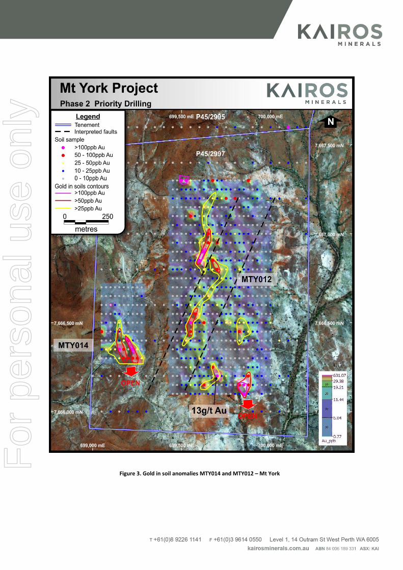
Figure 3. Gold in soil anomalies MTY014 and MTY012 – Mt York
For
per
sona
l use
onl
y

ENDS
For further information, please contact: Investors: Media: Mr Joshua Wellisch Nicholas Read/Paul Armstrong Managing Director Read Corporate Kairos Minerals Limited Ph: 08 9388 1474 COMPETENT PERSON STATEMENT: Competent Person: The information in this report that relates to Exploration Results or Mineral Resources is based on information compiled and reviewed by Mr Steve Vallance, who is the Technical Manager for Kairos Minerals Ltd and who is a Member of The Australian Institute of Geoscientists. Mr Vallance has sufficient experience which is relevant to the style of mineralisation and type of deposits under consideration and to the activity which he is undertaking to qualify as a Competent Person as defined in the 2012 Edition of the ‘Australasian Code for Reporting of Exploration Results, Mineral Resources and Ore Reserves.’ (the JORC Code 2012). Mr Vallance has consented to the inclusion in the report of the matters based on his information in the form and context in which it appears. The Australian Securities Exchange has not reviewed and does not accept responsibility for the accuracy or adequacy of this release. Contributing Technical Team: Dr Nigel Brand Mr Neil Hutchison Mr Ian Finch
Reference ASX Announcement 1 Pilbara Minerals Limited (ASX: PLS) March Quarterly Report 2016 2 Altura Mining Limited (ASX: AJM) March Quarterly Report 2016
For
per
sona
l use
onl
y
Section 1 Sampling Techniques and Data (Criteria in this section apply to all succeeding sections.)
Criteria JORC Code explanation Commentary
Sampling techniques
• Nature and quality of sampling (eg cut channels, random chips, or specific specialised industry standard measurement tools appropriate to the minerals under investigation, such as down hole gamma sondes, or handheld XRF instruments, etc). These examples should not be taken as limiting the broad meaning of sampling.
• Include reference to measures taken to ensure sample representivity and the appropriate calibration of any measurement tools or systems used.
• Aspects of the determination of mineralisation that are Material to the Public Report.
• In cases where ‘industry standard’ work has been done this would be relatively simple (eg ‘reverse circulation drilling was used to obtain 1 m samples from which 3 kg was pulverised to produce a 30 g charge for fire assay’). In other cases more explanation may be required, such as where there is coarse gold that has inherent sampling problems. Unusual commodities or mineralisation types (eg submarine nodules) may warrant disclosure of detailed information.
• All drilling results presented by Kairos Minerals
Limited (the “Company”) for the Iron Stirrup and
Old Faithful deposit are summarised from
historical work completed by Lynas Gold NL
during exploration and mining activities for the
period 1987 to 1998.
• The results were achieved via a combination of
RC and diamond drilling. Holes were generally
angled towards grid east to provide optimum
intersections through the targeted sequence.
• Industry standard sampling procedures have been
adhered to.
• RC samples were collected typically as 1m
intervals using riffle splitters.
• Diamond drill core was geologically logged to
identify intervals for sampling. Sample intervals
are generally 1m and reflect geological/lithological
contacts.
• Samples were submitted to a contract laboratory for crushing, pulverizing to produce a 50g charge for fire assay
• Gridded Soil geochemistry sampling.
• Certified Reference Material were inserted at
regular intervals to provide assay quality checks.
The standards reported within acceptable limits.
• Soil geochemistry: a 100g sample of -0.25mm
fraction taken from a depth of between 5 and
20cm below surface.
• •
Drilling techniques
• Drill type (eg core, reverse circulation, open-hole hammer, rotary air blast, auger, Bangka, sonic, etc) and details (eg core diameter, triple or standard tube, depth of diamond tails, face-sampling bit or other type, whether core is oriented and if so, by what method, etc).
• Diamond drilling was mostly carried out with NQ2
sized equipment, using standard tube.
• For RC holes, a 5 1/4“ face sampling bit was used. For deeper holes, RC holes were followed with diamond tails.
• No drilling involved.
Drill sample recovery
• Method of recording and assessing core and chip sample recoveries and results assessed.
• Measures taken to maximise sample recovery and ensure representative nature of the samples.
• Whether a relationship exists between sample recovery and grade and whether sample bias may have occurred due to preferential loss/gain of fine/coarse material.
• Recoveries from historical sampling techniques
are unknown, only Reverse Circulation (RC) and
Diamond Drilling (DD) drill holes are used in the
resource estimate.
Logging • Whether core and chip samples have been geologically and geotechnically logged to a level of detail to support appropriate Mineral Resource estimation, mining studies and metallurgical studies.
• Whether logging is qualitative or quantitative in nature. Core (or costean, channel, etc) photography.
• The total length and percentage of the relevant intersections logged.
• RC and diamond drilling was logged for various
geological attributes.
• All drill holes were logged in full.
• Soil sampling: basic ‘nature of soil and site’ log
• All sample sites were described.
Sub-sampling techniques and sample preparation
• If core, whether cut or sawn and whether quarter, half or all core taken.
• If non-core, whether riffled, tube sampled, rotary split, etc and whether sampled wet or dry.
• For all sample types, the nature, quality and appropriateness of the sample preparation technique.
• Quality control procedures adopted for all sub-sampling stages to maximise representivity of samples.
• Core was cut in half to 1m samples or geological /
lithological contacts.
• RC samples were riffle split at the rig and samples
as single metre intervals. Samples were generally
dry.
• Field duplicates were taken in the RC drilling.
• Sample preparation was conducted by a contract
• Soil sampling: The sample is sieved to the desired
fraction in the field.
For
per
sona
l use
onl
y
Criteria JORC Code explanation Commentary
• Measures taken to ensure that the sampling is representative of the in situ material collected, including for instance results for field duplicate/second-half sampling.
• Whether sample sizes are appropriate to the grain size of the material being sampled.
• Soil sampling: The sample is sieved to the desired
fraction in the field.
• Soil Geochemistry: Standard Reference Material is
included at a rate of 1 per 33 samples, and
duplicate samples taken 3 per hundred
• Soil Geochemistry: Field samples in the order of
100g are considered fit for purpose
• laboratory.
• Sample sizes are considered appropriate to
correctly represent the gold mineralisation based
on; the style of mineralisation, the thickness and
consistency of the intersections, the sampling
methodology and assay value ranges for Au.
Quality of assay data and laboratory tests
• The nature, quality and appropriateness of the assaying and laboratory procedures used and whether the technique is considered partial or total.
• For geophysical tools, spectrometers, handheld XRF instruments, etc, the parameters used in determining the analysis including instrument make and model, reading times, calibrations factors applied and their derivation, etc.
• Nature of quality control procedures adopted (eg standards, blanks, duplicates, external laboratory checks) and whether acceptable levels of accuracy (ie lack of bias) and precision have been established.
• For the Lynas Gold NL drilling, the analytical
technique used was a 50g fire assay. Samples
were analysed by the Australian Assay
Laboratories Group in Perth, Western Australia.
• Laboratory QA/QC includes the use of internal
standards using certified reference material,
blanks, splits and replicates.
• Laboratory splits and replicates were analysed and show good accuracy and no sign of bias.
• The sample preparation and assay method used is considered to be fit for purpose, with initial assays
for all elements by 4 acid digest, ICP-MS finish. • For high grade lithium values from rock chips, a second peroxide fusion technique with ICP-MS finish was used to determine Al, Li, Cs, Rb.
• All samples were analysed by a commercial laboratory.
• Standards and laboratory checks have been assessed. Most of the standards show results within acceptable limits of accuracy, with good precision in most cases. Internal laboratory checks indicate very high levels of precision.
Verification of sampling and assaying
• The verification of significant intersections by either independent or alternative company personnel.
• The use of twinned holes. • Documentation of primary data, data entry
procedures, data verification, data storage (physical and electronic) protocols.
• Discuss any adjustment to assay data.
• Not at this stage of the project development. • Soil
Geochemistry: Duplicate samples taken 3 per
hundred
• The Company has a digital SQL drilling database
where information is stored. • The Company uses
a range of consultants to load and validate data,
and appraise quality control samples.
• The Company has not adjusted any assay data,
• Significant intersections were visually verified by
company geologists at Lynas Gold NL.
• All assay reports were reported in electronic and
paper format.
• It is assumed verification procedures were robust due to the operation of an effective mine.
Location of data points
• Accuracy and quality of surveys used to locate drill holes (collar and down-hole surveys), trenches, mine workings and other locations used in Mineral Resource estimation.
• Specification of the grid system used. • Quality and adequacy of topographic control.
• The majority of the holes drilled by Lynas Gold NL
in 1987 and 1988 were surveyed by Zuideveld &
Bennett (ZB) using a control point with an
assumed RL of 500m. Holes from 1993 onwards
were surveyed by Lynas Gold NL mine site staff
surveyors. All drill hole coordinates were provided
in local grid as well as in AMG. A simple
translation has converted the drill hole coordinates
to MGA Zone 50 and height to the AHD.
• Down hole surveys were carried out using
Eastman Single Shot cameras.
• Mine working cross checks support the locations
of historic drilling.
• Topographic surface has been prepared from
detailed ground and mine surveys.
• The existing pit outline shown in the sectional
interpretations presented in this announcement
For
per
sona
l use
onl
y

Criteria JORC Code explanation Commentary
relating to Iron Stirrup reflect the planned pit
design. Mining ceased prior to reaching final pit
design depths.
• Final pit survey for Iron Stirrup is yet to be
confirmed.
• GDA94 Zone 50.
Data spacing and distribution
• Data spacing for reporting of Exploration Results. • Whether the data spacing and distribution is
sufficient to establish the degree of geological and grade continuity appropriate for the Mineral Resource and Ore Reserve estimation procedure(s) and classifications applied.
• Whether sample compositing has been applied.
• Soil samples: Gridded at 200x50m
• Nominal hole spacing of the Lynas Gold NL drilling
is approximately 25 by 30m.
• The mineralised domains have sufficient grade
continuity in both geology and grade to be
considered appropriate for the Mineral Resource
and Ore Reserve estimation procedures and
classification applied under the 2012 JORC Code.
Orientation of data in relation to geological structure
• Whether the orientation of sampling achieves unbiased sampling of possible structures and the extent to which this is known, considering the deposit type.
• If the relationship between the drilling orientation and the orientation of key mineralised structures is considered to have introduced a sampling bias, this should be assessed and reported if material.
• Soil geochemistry: Possibly gives an indication of
the strike direction of individual anomalies.
• Majority of the drill holes are angled to the east so
that intersections are orthogonal to the expected
trend of mineralisation.
• No orientation based sampling has been identified in the data.
Sample security • The measures taken to ensure sample security. • The Company uses standard industry practices when collecting, transporting and storing samples for analysis.
• Soil samples are disposed of after analysis.
• Unknown for historical samples.
Audits or reviews • The results of any audits or reviews of sampling techniques and data.
• Sampling techniques for soil geochemistry have been developed by Pioneer’s retained geochemist, Dr NW Brand, of Geochemical Services, Perth. The system has not been specifically audited but is similar to common practice methods in the Australian exploration industry.
• Review of the historical sampling techniques and data by Christopher Speedy of Auralia found that all procedures and practices conform to industry standards.
For
per
sona
l use
onl
y
Section 2 Reporting of Exploration Results (Criteria listed in the preceding section also apply to this section.)
Criteria JORC Code explanation Commentary
Mineral tenement and land tenure status
• Type, reference name/number, location and ownership including agreements or material issues with third parties such as joint ventures, partnerships, overriding royalties, native title interests, historical sites, wilderness or national park and environmental settings.
• The security of the tenure held at the time of reporting along with any known impediments to obtaining a licence to operate in the area.
• The Iron Stirrup Deposit is located within
granted Prospecting Licence P45/2992,
which is wholly owned by Kairos Minerals
Pty Ltd.
• The Old Faithful deposit is located within
granted Prospecting Licence P45/2993
• The tenements P45/2998, P45/2988, P45/2993, P45/2992, P45/2995, P45/2997 granted are in good standing with no known encumbrances.
• The tenements P45/2991,P45/2987,P45/2990,P45/2989,P45,2994 and P45/2996 are under application and with no known encumbrances.
Exploration done by other parties
• Acknowledgment and appraisal of exploration by other parties.
• The Mt. York Lithium – Gold Project was
discovered by Lynas Gold NL in the early
1990’s and mined a number of deposits as a
successful open pit operation by that
company between 1994 – 1998. Other
companies to have explored the area
include Austamax, Carpenteria, MIM and
Trafford Resources.
Geology • Deposit type, geological setting and style of mineralisation.
Regional Geology The Mt. York Lithium – Gold Project lies
within the Pilgangoora Greenstone Belt of
the Archaean Pilbara Craton. The Pilbara
Craton is composed of greenstone and
sediment units which have been deformed
by tight isoclinal folds during the intrusion of
diapiric granites. The Pilgangoora
Greenstone Belt covers an area of about
600 square kilometres and forms the
western part of the large central greenstone
belt of the east Pilbara The Carlindi Batholith
bounds the greenstone belt to the north-east
and north-west; the Yule Batholith lies to the
south-west and the internal Strelley granitoid
lies to the east.
The Pilgangoora Greenstone Belt is
dominated by the Pilgangoora Syncline,
which contains a sequence of steep dipping,
inward younging volcano-sedimentary rocks
belonging to the two lower groups of the
Pilbara Supergroup, the Warrawoona, and
Gorge Creek Groups. The Warrawoona
Group dominates the lithology of the
synclinal limbs, whilst the Gorge Creek
Group conformably overlies the Warrawoona
Group and dominates the lithology within the
synclinal core
Local geology The western edge of the Pilgangoora
Syncline is stoped out by regional granite,
partly along north-striking faults. A gently
dipping, anticlinally domed dolerite exhibiting
high deformation structures lies on the
western side of the syncline. Gently dipping
pegmatite sills associated with the waning
phase of granite intrusion intrude the
dolerite. These pegmatites are the source of
For
per
sona
l use
onl
y

Criteria JORC Code explanation Commentary
tantalum – lithium mineralisation in the area.
A serpentinised peridotite forms a semi-
continuous member along the eastern edge
of the dolerite. Just north of the Zakanaka
gold deposit, the peridotite is structurally
thickened and swings around the doleritic
anticlinal core to strike north north-west. A
mixed suite of talc-carbonate-chlorite
schists, peridotite and dolerite, lie to the east
of the serpentinised peridotite. This hybrid
suite is extensively developed to the west of
Old Faithful and contains a thin chert marker
horizon and heavily brecciated, coarsely
amphibolitised lenses. This suite is missing
at Iron Stirrup, and the serpentinised
peridotite is in direct contact with the Iron
Stirrup ultramafic.
The Iron Stirrup ultramafic is the main host
rock for gold mineralisation at the Old
Faithful, Iron Stirrup, and Darius prospects.
The unit is dominantly talc-carbonate schist
with some talc-carbonate-chlorite and talc-
chlorite assemblages. The suite is highly
deformed and is thought to have a volcanic
and komatiitic affinity, possibly in association
with Archaean sea-floor spreading or rifting.
The schist diverges southward from the
northern parts of the Old Faithful deposit.
Drilling and mapping of this area have
shown that the schist is in fact part of the
Iron Stirrup ultramafic.
Mineralisation Gold mineralisation at Iron Stirrup and Old
Faithful is contained within a well foliated
Talc-carbonate-magnetite-serpentite rock
with associated pyrite and pyrrhotite.
The mineralisation at the Iron Stirrup
prospect extends to a vertically drilled depth
of at least 125m, in part of the zone and
remains open at depth throughout most of
the strike length (Strike 010), and dips
westerly at around 70-80°.
The main structural control at Old Fiathful is
a strongly asymmetric synform with a
steeply east-dipping east limb and a west
limb which, in the central area, dipping flatly
east but in the northern and southern area,
dips more steeply. To the south the
mineralisation shows a gradual plunge to the
north of 10 degrees. In the middle of the
deposit the primary mineralisation is thrust
downwards (fault zone) 20-30m before
continuing its gradual plunge of 10 degrees
to the north.
Secondary mineralisation occurs below the primary mineralisation as a number of flanking gently to steeply dipping moderate grade lenses of gold mineralisation. Another secondary zone of mineralisation occurs in the north-east of the prospect where en-echelon shears occur within the talc-carbonate-chlorite-schist, and dip to the east.
Drill hole Information
• A summary of all information material to the understanding of the exploration results including a
• Drill hole collar summary and mineralisation
width is included in Appendix B for Iron
For
per
sona
l use
onl
y

Criteria JORC Code explanation Commentary
tabulation of the following information for all Material drill holes: o easting and northing of the drill hole collar o elevation or RL (Reduced Level – elevation above
sea level in metres) of the drill hole collar o dip and azimuth of the hole o down hole length and interception depth o hole length.
• If the exclusion of this information is justified on the basis that the information is not Material and this exclusion does not detract from the understanding of the report, the Competent Person should clearly explain why this is the case.
Stirrup
• A list of Drill holes used in the resource is
provided as a collar summary is included in
Appendix B for Old Faithful
• Comments relating to drill hole information relevant to the Mineral Resource estimate can be found in Section 1.
Data aggregation methods
• In reporting Exploration Results, weighting averaging techniques, maximum and/or minimum grade truncations (eg cutting of high grades) and cut-off grades are usually Material and should be stated.
• Where aggregate intercepts incorporate short lengths of high grade results and longer lengths of low grade results, the procedure used for such aggregation should be stated and some typical examples of such aggregations should be shown in detail.
• The assumptions used for any reporting of metal equivalent values should be clearly stated.
• Exploration results are not being reported.
• Not applicable as a Mineral Resource is
being reported.
• Metal equivalent values have not been used.
Relationship between mineralisation widths and intercept lengths
• These relationships are particularly important in the reporting of Exploration Results.
• If the geometry of the mineralisation with respect to the drill hole angle is known, its nature should be reported.
• If it is not known and only the down hole lengths are reported, there should be a clear statement to this effect (eg ‘down hole length, true width not known’).
• All historical drilling has been oriented to
intersect the targeted sequence at an
optimum angle, ie orthogonal to strike and
dip.
• The intercept summaries presented reflect
down hole intersection lengths
• True widths have not been presented but are estimated to be approximately 80% of the intersection length for most holes.
Diagrams • Appropriate maps and sections (with scales) and tabulations of intercepts should be included for any significant discovery being reported These should include, but not be limited to a plan view of drill hole collar locations and appropriate sectional views.
• Relevant diagrams have been included within the ASX release.
Balanced reporting
• Where comprehensive reporting of all Exploration Results is not practicable, representative reporting of both low and high grades and/or widths should be practiced to avoid misleading reporting of Exploration Results.
• Exploration results are not being reported. To avoid any misleading reporting of Exploration Results, a listing of drill holes and the mineralisation width and grade is included in Appendix B
Other substantive exploration data
• Other exploration data, if meaningful and material, should be reported including (but not limited to): geological observations; geophysical survey results; geochemical survey results; bulk samples – size and method of treatment; metallurgical test results; bulk density, groundwater, geotechnical and rock characteristics; potential deleterious or contaminating substances.
• All interpretations for the Iron Stirrup mineralisation are consistent with observations made and information gained during previous mining at the Iron Stirrup mine.
• All interpretations for the Old Faithful mineralisation are consistent with observations made in previous resource estimates.
• Exploration including mapping, geochemical sampling has been completed elsewhere within the project area but is not relevant to the Mineral Resource Estimate.
Further work • The nature and scale of planned further work (eg tests for lateral extensions or depth extensions or large-scale step-out drilling).
• Diagrams clearly highlighting the areas of possible extensions, including the main geological interpretations and future drilling areas, provided this information is not commercially sensitive.
• At Iron Stirrup and Old Faithful exploration RC and diamond drilling is planned to test for extensions and repetitions of the ore body both at depth and along strike to the north and south of the existing open pit (Iron Stirrup). F
or p
erso
nal u
se o
nly
Section 3 Estimation and Reporting of Mineral Resources (Criteria listed in section 1, and where relevant in section 2, also apply to this section.)
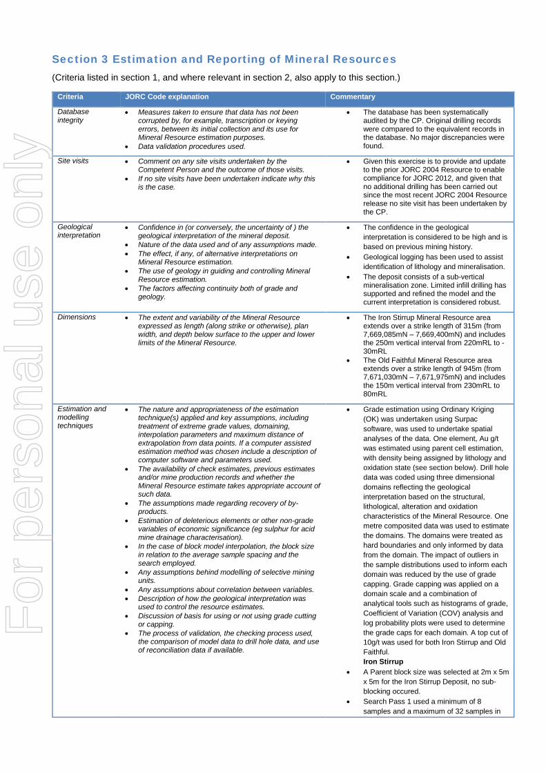
Criteria JORC Code explanation Commentary
Database integrity
• Measures taken to ensure that data has not been corrupted by, for example, transcription or keying errors, between its initial collection and its use for Mineral Resource estimation purposes.
• Data validation procedures used.
• The database has been systematically audited by the CP. Original drilling records were compared to the equivalent records in the database. No major discrepancies were found.
Site visits • Comment on any site visits undertaken by the Competent Person and the outcome of those visits.
• If no site visits have been undertaken indicate why this is the case.
• Given this exercise is to provide and update to the prior JORC 2004 Resource to enable compliance for JORC 2012, and given that no additional drilling has been carried out since the most recent JORC 2004 Resource release no site visit has been undertaken by the CP.
Geological interpretation
• Confidence in (or conversely, the uncertainty of ) the geological interpretation of the mineral deposit.
• Nature of the data used and of any assumptions made. • The effect, if any, of alternative interpretations on
Mineral Resource estimation. • The use of geology in guiding and controlling Mineral
Resource estimation. • The factors affecting continuity both of grade and
geology.
• The confidence in the geological
interpretation is considered to be high and is
based on previous mining history.
• Geological logging has been used to assist
identification of lithology and mineralisation.
• The deposit consists of a sub-vertical mineralisation zone. Limited infill drilling has supported and refined the model and the current interpretation is considered robust.
Dimensions • The extent and variability of the Mineral Resource expressed as length (along strike or otherwise), plan width, and depth below surface to the upper and lower limits of the Mineral Resource.
• The Iron Stirrup Mineral Resource area extends over a strike length of 315m (from 7,669,085mN – 7,669,400mN) and includes the 250m vertical interval from 220mRL to -30mRL
• The Old Faithful Mineral Resource area extends over a strike length of 945m (from 7,671,030mN – 7,671,975mN) and includes the 150m vertical interval from 230mRL to 80mRL
Estimation and modelling techniques
• The nature and appropriateness of the estimation technique(s) applied and key assumptions, including treatment of extreme grade values, domaining, interpolation parameters and maximum distance of extrapolation from data points. If a computer assisted estimation method was chosen include a description of computer software and parameters used.
• The availability of check estimates, previous estimates and/or mine production records and whether the Mineral Resource estimate takes appropriate account of such data.
• The assumptions made regarding recovery of by-products.
• Estimation of deleterious elements or other non-grade variables of economic significance (eg sulphur for acid mine drainage characterisation).
• In the case of block model interpolation, the block size in relation to the average sample spacing and the search employed.
• Any assumptions behind modelling of selective mining units.
• Any assumptions about correlation between variables. • Description of how the geological interpretation was
used to control the resource estimates. • Discussion of basis for using or not using grade cutting
or capping. • The process of validation, the checking process used,
the comparison of model data to drill hole data, and use of reconciliation data if available.
• Grade estimation using Ordinary Kriging
(OK) was undertaken using Surpac
software, was used to undertake spatial
analyses of the data. One element, Au g/t
was estimated using parent cell estimation,
with density being assigned by lithology and
oxidation state (see section below). Drill hole
data was coded using three dimensional
domains reflecting the geological
interpretation based on the structural,
lithological, alteration and oxidation
characteristics of the Mineral Resource. One
metre composited data was used to estimate
the domains. The domains were treated as
hard boundaries and only informed by data
from the domain. The impact of outliers in
the sample distributions used to inform each
domain was reduced by the use of grade
capping. Grade capping was applied on a
domain scale and a combination of
analytical tools such as histograms of grade,
Coefficient of Variation (COV) analysis and
log probability plots were used to determine
the grade caps for each domain. A top cut of
10g/t was used for both Iron Stirrup and Old
Faithful.
Iron Stirrup • A Parent block size was selected at 2m x 5m
x 5m for the Iron Stirrup Deposit, no sub-
blocking occured.
• Search Pass 1 used a minimum of 8
samples and a maximum of 32 samples in
For
per
sona
l use
onl
y

Criteria JORC Code explanation Commentary
the first pass, minimum of 4 samples and a
maximum of 32 samples in the second pass
and in the third pass a minimum of 2 and a
maximum of 32 samples.
• A dynamic search strategy was used with
the search ellipse oriented to the semi-
variogram model. The first pass was at the
variogram range, with subsequent passes
expanding the ellipse by factors of 1.5 and
2, then a final factor of 3 was used to inform
any remaining unfilled blocks. The majority
of the Mineral Resource was informed by the
first two passes, domains that were informed
by the third and fourth pass were flagged
with a lower resource classification or
remain unclassified.
Old Faithful • A Parent block size was selected at 5m x 4m
x 4m for the Iron Stirrup Deposit, with sub-
blocking down to 1.25m x 1m x 1m.
• Search Pass 1 used a minimum of 8
samples and a maximum of 32 samples in
the first pass, minimum of 4 samples and a
maximum of 32 samples in the second pass
and in the third pass a minimum of 2 and a
maximum of 32 samples.
• A dynamic search strategy was used with
the search ellipse oriented to the semi-
variogram model. The first pass was at the
variogram range, with subsequent passes
expanding the ellipse by factors of 1.5 and
2, then a final factor of 3 was used to inform
any remaining unfilled blocks. The majority
of the Mineral Resource was informed by the
first two passes, domains that were informed
by the third and fourth pass were flagged
with a lower resource classification or
remain unclassified.
• No assumption of mining selectivity has
been incorporated into the estimate.
• Only Au was estimated in the Mineral
Resource.
• The deposit mineralisation was constrained
by wireframes constructed using a 0.5g/t Au
cut-off grade.
• Validation of Mineral Resource comprised
comparing block grades against the data
used to inform the estimate on a domain by
domain basis, visual comparison of the
informing data against the estimate and the
use of swath plots showing grade trends by
easting northing and elevation of the input
data against the estimate.
Moisture • Whether the tonnages are estimated on a dry basis or with natural moisture, and the method of determination of the moisture content.
• Mineral Resource tonnage estimates are on a dry basis.
Cut-off parameters
• The basis of the adopted cut-off grade(s) or quality parameters applied.
• Mineral Resources are reported using a cut-
off grade of 0.5 g/t Au for the Iron Stirrup
Resource and Mineral Resources are
reported using a cut-off grade of 0.9 g/t for
the Old Faithful Resource.
Mining factors or assumptions
• Assumptions made regarding possible mining methods, minimum mining dimensions and internal (or, if applicable, external) mining dilution. It is always necessary as part of the process of determining reasonable prospects for eventual economic extraction
• The CP has assumed that the deposit could potentially be mined using open pit mining techniques. Economic open pit mining has previously occurred at the Iron Stirrup deposit during a period of decreased
For
per
sona
l use
onl
y

Criteria JORC Code explanation Commentary
to consider potential mining methods, but the assumptions made regarding mining methods and parameters when estimating Mineral Resources may not always be rigorous. Where this is the case, this should be reported with an explanation of the basis of the mining assumptions made.
economic sale factors, including a much reduced gold price. No assumptions have been made for mining dilution or mining widths, however mineralisation is generally broad. Mining dilution and ore loss will be incorporated into any Mineral Reserve works estimated from this Mineral Resource.
Metallurgical factors or assumptions
• The basis for assumptions or predictions regarding metallurgical amenability. It is always necessary as part of the process of determining reasonable prospects for eventual economic extraction to consider potential metallurgical methods, but the assumptions regarding metallurgical treatment processes and parameters made when reporting Mineral Resources may not always be rigorous. Where this is the case, this should be reported with an explanation of the basis of the metallurgical assumptions made.
• It is assumed that extraction of gold will be achieved by gravity and cyanide leaching methods for the mineralised lode, with recoveries greater than 90%.
Environmen-tal factors or assumptions
• Assumptions made regarding possible waste and process residue disposal options. It is always necessary as part of the process of determining reasonable prospects for eventual economic extraction to consider the potential environmental impacts of the mining and processing operation. While at this stage the determination of potential environmental impacts, particularly for a greenfields project, may not always be well advanced, the status of early consideration of these potential environmental impacts should be reported. Where these aspects have not been considered this should be reported with an explanation of the environmental assumptions made.
• No assumptions have been made regarding environmental factors. Historical open-cut mining has occurred at the Iron Stirrup deposit. The Company will work to mitigate environmental impact as a result of any future mining or mineral processing.
Bulk density • Whether assumed or determined. If assumed, the basis for the assumptions. If determined, the method used, whether wet or dry, the frequency of the measurements, the nature, size and representativeness of the samples.
• The bulk density for bulk material must have been measured by methods that adequately account for void spaces (vugs, porosity, etc), moisture and differences between rock and alteration zones within the deposit.
• Discuss assumptions for bulk density estimates used in the evaluation process of the different materials.
• Bulk density assumptions used in the
resource estimate were from testing in the
exploration programs and subsequent
mining by Lynas Gold NL.
• Specific gravity was determined by water displacement with wax coating.
Classification • The basis for the classification of the Mineral Resources into varying confidence categories.
• Whether appropriate account has been taken of all relevant factors (ie relative confidence in tonnage/grade estimations, reliability of input data, confidence in continuity of geology and metal values, quality, quantity and distribution of the data).
• Whether the result appropriately reflects the Competent Person’s view of the deposit.
• The Mineral Resource estimate is reported
here in compliance with the 2012 Edition of
the ‘Australasian Code for Reporting of
Exploration Results, Mineral Resources and
Ore Reserves’ by the Joint Ore Reserves
Committee (JORC). The Mineral Resource
at Iron Stirrup was classified as Indicated
and Inferred Mineral Resource based on
data quality, sample spacing and lode
continuity. The Indicated Mineral Resource
was defined within areas of close spaced
diamond and RC drilling and by a
combination of estimation passes 1 and 2
and a minimum of informing samples of 8.
Inferred resources were defined by a
combination of estimation passes (1-3) and
any material in any of the first two passes
being below RL 60m and minimum informing
samples of 4.
• The Mineral Resource at Old Faithful was
classified as Indicated and Inferred Mineral
Resource based on data quality, sample
spacing and lode continuity. The Indicated
Mineral Resource was defined within areas
of close spaced diamond and RC drilling
and by a combination of estimation passes 1
and 2 and a minimum number of informing
samples of 8. Inferred resources were
defined by a combination of estimation
passes (2-3) and a minimum number of
informing samples of 4.
For
per
sona
l use
onl
y

Criteria JORC Code explanation Commentary
• The input data is comprehensive in its
coverage of the mineralisation and does not
favour or misrepresent in-situ mineralisation.
The definition of mineralised zones is based
on high level geological understanding
producing a robust model of mineralised
domains. Validation of the block model
shows good correlation of the input data to
the estimated grades.
• The Mineral Resource estimate appropriately reflects the view of the CP.
Audits or reviews • The results of any audits or reviews of Mineral Resource estimates.
• No audits or review of the Mineral Resource estimate has been conducted.
Discussion of relative accuracy/ confidence
• Where appropriate a statement of the relative accuracy and confidence level in the Mineral Resource estimate using an approach or procedure deemed appropriate by the Competent Person. For example, the application of statistical or geostatistical procedures to quantify the relative accuracy of the resource within stated confidence limits, or, if such an approach is not deemed appropriate, a qualitative discussion of the factors that could affect the relative accuracy and confidence of the estimate.
• The statement should specify whether it relates to global or local estimates, and, if local, state the relevant tonnages, which should be relevant to technical and economic evaluation. Documentation should include assumptions made and the procedures used.
• These statements of relative accuracy and confidence of the estimate should be compared with production data, where available.
• The lode geometry and continuity has been
adequately interpreted to reflect the level of
Indicated and Inferred Mineral Resource. A
recognized laboratory has been used for all
analyses.
• The Mineral Resource statement relates to
global estimates of tonnes and grade.
For
per
sona
l use
onl
y

Appendix B – Drill holes used in the Iron Stirrup model with mineralisation intercept width and grade (Note: not true thickness).
Collar Orientation Assays
Hole Easting Northing RL Total Depth Dip Azimuth From
(m) To (m)
Length (m)
Au (ppm)
DIS1 699,225 7,669,147 225 119 - 60 92 80 105 25 2.29 DIS2 699,268 7,669,149 225 75 - 60 88 38 54 16 1.30 DIS3 699,291 7,669,266 216 153 - 60 90 30 50 20 1.84 DIS4 699,259 7,669,271 207 105 - 60 90 67 88 21 3.00 DIS5 699,231 7,669,273 203 155 - 60 94 104 127 23 3.80 DIS6 699,302 7,669,220 211 93 - 70 92 11 44 33 1.84 ISE10 699,197 7,669,203 205 150 - 60 93 123 131 8 1.40 ISE11 699,194 7,669,257 199 180 - 60 93 148 172 24 3.31 ISE12 699,206 7,669,273 198 160 - 60 93 144 160 16 3.52 ISE13 699,222 7,669,302 196 180 - 60 93 126 139 13 2.48 ISE14 699,228 7,669,314 195 150 - 60 93 126 130 4 0.92 ISE6 699,236 7,669,101 205 115 - 75 93 79 90 11 2.05 ISE7 699,225 7,669,126 205 143 - 67 93 79 94 15 2.82 ISE9 699,200 7,669,178 205 160 - 66 93 126 129 3 1.04
ISP099 699,164 7,669,255 197 250 - 60 90 169 187 18 1.83 ISP100 699,134 7,669,156 209 250 - 60 90 182 191 9 1.26 ISP11 699,337 7,669,292 202 58 - 40 269 4 37 33 2.78
ISP111 699,291 7,669,150 216 51 - 60 90 16 32 16 2.76 ISP112 699,297 7,669,149 216 42 - 60 90 11 21 10 1.86 ISP113 699,302 7,669,147 215 30 - 60 90 2 16 14 0.18 ISP114 699,308 7,669,146 214 25 - 60 90 2 8 6 1.30 ISP115 699,311 7,669,145 213 20 - 60 90 1 3 2 0.51 ISP117 699,286 7,669,144 218 20 - 60 90 19 20 1 0.53 ISP119 699,295 7,669,143 217 15 - 60 90 8 15 7 1.74 ISP12 699,320 7,669,293 204 50 - 42 273 0 1 1 0.74
ISP120 699,300 7,669,142 216 15 - 60 90 2 14 12 3.33 ISP121 699,306 7,669,142 215 10 - 60 90 0 10 10 1.45 ISP122 699,310 7,669,141 214 10 - 60 90 1 3 2 0.78 ISP123 699,285 7,669,129 223 20 - 60 90 6 20 14 2.01 ISP124 699,290 7,669,129 221 20 - 60 90 1 20 19 2.17 ISP125 699,296 7,669,128 219 15 - 60 90 1 14 13 1.30 ISP126 699,300 7,669,128 219 15 - 60 90 0 8 8 1.26 ISP127 699,306 7,669,127 217 10 - 60 90 0 1 1 2.01 ISP130 699,290 7,669,119 223 20 - 60 90 0 19 19 1.70 ISP131 699,295 7,669,118 222 20 - 60 90 4 14 10 1.43 ISP132 699,299 7,669,118 220 15 - 60 90 0 9 9 0.64 ISP133 699,304 7,669,118 219 15 - 60 90 2 4 2 7.69 ISP136 699,293 7,669,109 223 20 - 60 90 1 11 10 0.73 ISP137 699,299 7,669,108 221 15 - 60 90 0 7 7 1.33 ISP138 699,303 7,669,107 220 15 - 60 90 0 1 1 0.88 ISP139 699,294 7,669,099 225 20 - 60 90 4 7 3 1.36 ISP24 699,308 7,669,283 206 35 - 90 90 30 35 5 0.77 ISP29 699,334 7,669,340 200 30 - 57 89 2 11 9 2.27 ISP30 699,324 7,669,340 200 30 - 57 89 5 21 16 3.90 ISP31 699,264 7,669,292 203 100 - 57 90 62 86 24 2.37 ISP32 699,279 7,669,245 207 75 - 57 92 39 54 15 3.69 ISP33 699,237 7,669,199 204 125 - 57 90 67 85 18 2.09 ISP34 699,232 7,669,198 204 148 - 79 90 99 108 9 1.25 ISP35 699,276 7,669,198 208 88 - 56 90 26 54 28 2.18 ISP36 699,274 7,669,147 220 100 - 56 90 31 45 14 1.23 ISP37 699,236 7,669,148 220 133 - 56 90 71 96 25 1.42 ISP38 699,195 7,669,149 220 146 - 56 90 108 132 24 1.60 ISP39 699,240 7,669,247 200 167 - 56 91 74 98 24 2.78 ISP40 699,239 7,669,293 198 144 - 58 93 92 115 23 4.62 ISP41 699,237 7,669,293 197 154 - 78 91 118 145 27 3.06 ISP42 699,218 7,669,099 249 149 - 68 90 106 115 9 1.78
For
per
sona
l use
onl
y

Collar Orientation Assays
Hole Easting Northing RL Total Depth Dip Azimuth From
(m) To (m)
Length (m)
Au (ppm)
ISP43 699,252 7,669,096 249 101 - 56 90 52 58 6 1.33 ISP46 699,334 7,669,365 204 20 - 57 92 1 20 19 1.55 ISP47 699,323 7,669,365 204 33 - 56 90 19 33 14 1.32 ISP49 699,278 7,669,340 200 80 - 56 88 67 76 9 1.10 ISP50 699,245 7,669,340 197 105 - 56 91 104 105 1 3.48 ISP53 699,336 7,669,392 201 75 - 58 89 26 42 16 2.52 ISP54 699,336 7,669,378 202 40 - 58 91 5 11 6 1.36 ISP55 699,323 7,669,379 202 60 - 58 89 18 26 8 1.36 ISP57 699,304 7,669,340 201 100 - 57 89 34 48 14 2.69 ISP58 699,268 7,669,319 200 115 - 58 89 66 80 14 2.53 ISP59 699,261 7,669,270 202 125 - 57 90 61 85 24 2.34 ISP60 699,303 7,669,317 202 70 - 57 89 26 45 19 4.66 ISP61 699,293 7,669,267 210 70 - 57 88 27 48 21 2.35 ISP62 699,229 7,669,272 199 158 - 57 92 100 120 20 3.79 ISP63 699,213 7,669,124 231 131 - 57 87 87 116 29 4.13 ISP64 699,247 7,669,122 231 90 - 58 89 42 71 29 1.69 ISP65 699,265 7,669,122 231 55 - 57 90 30 51 21 1.71 ISP66 699,257 7,669,148 220 90 - 58 89 47 77 30 1.85 ISP67 699,274 7,669,172 212 80 - 58 89 27 66 39 2.10 ISP68 699,258 7,669,173 212 90 - 58 90 46 77 31 2.25 ISP69 699,236 7,669,171 212 105 - 58 89 71 100 29 1.93 ISP70 699,187 7,669,177 215 160 - 58 92 121 139 18 1.55 ISP71 699,278 7,669,221 209 75 - 58 91 34 68 34 3.26 ISP72 699,236 7,669,223 207 115 - 58 86 83 95 12 2.84 ISP73 699,199 7,669,225 213 170 - 59 87 122 139 17 1.80 ISP76 699,302 7,669,394 201 100 - 60 88 69 71 2 0.85 ISP78 699,330 7,669,365 204 50 - 60 91 9 24 15 2.19 ISP79 699,296 7,669,366 203 100 - 60 90 69 72 3 0.79 ISP80 699,233 7,669,320 196 165 - 60 90 116 132 16 1.67 ISP81 699,226 7,669,247 200 160 - 69 90 109 139 30 2.96 ISP82 699,245 7,669,341 197 150 - 60 88 114 131 17 2.37 ISP89 699,241 7,669,306 197 129 - 60 90 107 123 16 3.19 ISP90 699,302 7,669,219 210 40 - 60 90 8 40 32 0.54 ISP91 699,305 7,669,249 206 40 - 60 88 2 28 26 2.72 ISP92 699,305 7,669,249 207 40 - 70 92 3 33 30 2.69 ISP93 699,313 7,669,272 206 30 - 60 91 1 25 24 1.41 ISP94 699,318 7,669,324 200 38 - 60 91 10 29 19 2.55 ISP95 699,276 7,669,099 231 40 - 60 90 24 30 6 1.46 ISP97 699,291 7,669,150 216 33 - 60 94 14 31 17 2.88 ISP98 699,307 7,669,172 210 31 - 80 91 0 25 25 1.43
ISRC15 699,192 7,669,310 181 184 - 60 93 145 154 9 0.23 ISRC16 699,188 7,669,208 180 190 - 60 93 110 116 6 1.61 ISRC19 699,250 7,669,165 120 80 - 68 180 23 31 8 1.44 ISRC20 699,250 7,669,175 120 90 - 87 72 32 40 8 2.13
For
per
sona
l use
onl
y
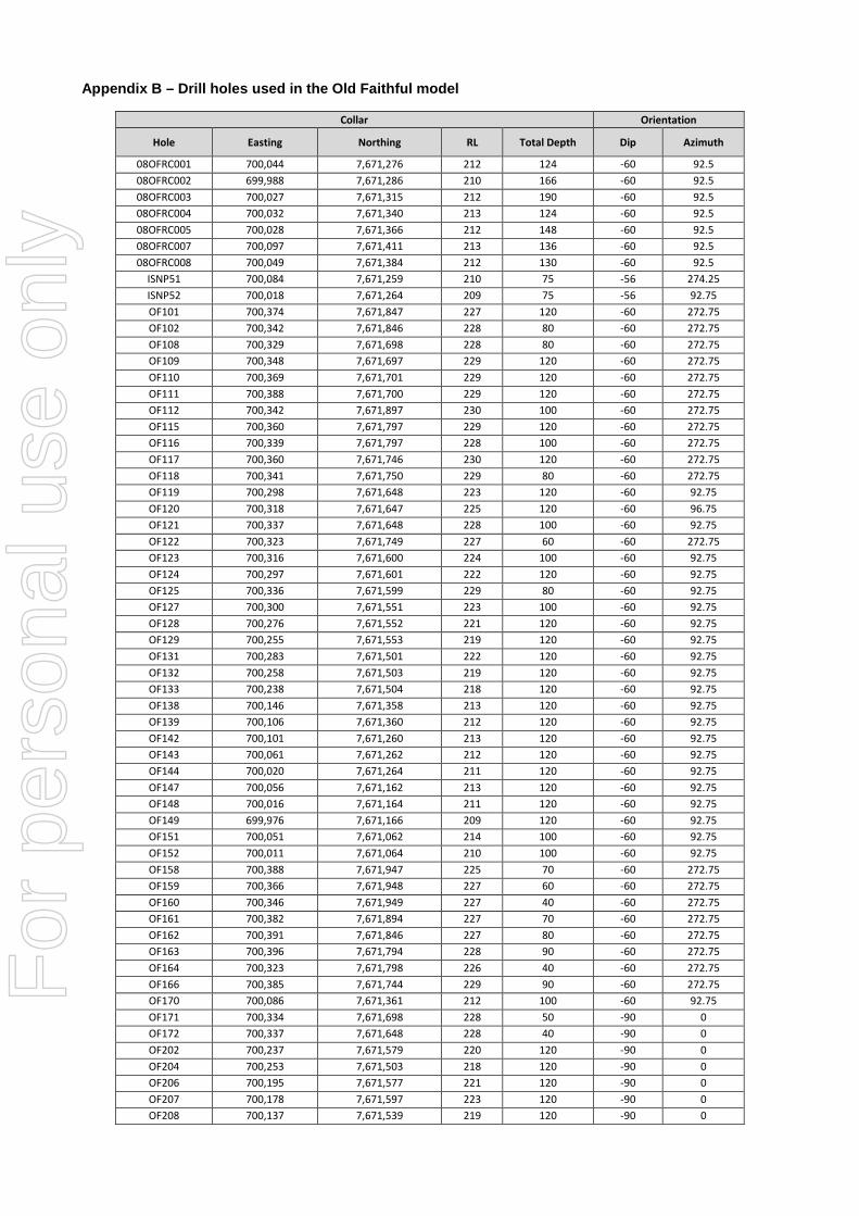
Appendix B – Drill holes used in the Old Faithful model
Collar Orientation
Hole Easting Northing RL Total Depth Dip Azimuth
08OFRC001 700,044 7,671,276 212 124 -60 92.5 08OFRC002 699,988 7,671,286 210 166 -60 92.5 08OFRC003 700,027 7,671,315 212 190 -60 92.5 08OFRC004 700,032 7,671,340 213 124 -60 92.5 08OFRC005 700,028 7,671,366 212 148 -60 92.5 08OFRC007 700,097 7,671,411 213 136 -60 92.5 08OFRC008 700,049 7,671,384 212 130 -60 92.5
ISNP51 700,084 7,671,259 210 75 -56 274.25 ISNP52 700,018 7,671,264 209 75 -56 92.75 OF101 700,374 7,671,847 227 120 -60 272.75 OF102 700,342 7,671,846 228 80 -60 272.75 OF108 700,329 7,671,698 228 80 -60 272.75 OF109 700,348 7,671,697 229 120 -60 272.75 OF110 700,369 7,671,701 229 120 -60 272.75 OF111 700,388 7,671,700 229 120 -60 272.75 OF112 700,342 7,671,897 230 100 -60 272.75 OF115 700,360 7,671,797 229 120 -60 272.75 OF116 700,339 7,671,797 228 100 -60 272.75 OF117 700,360 7,671,746 230 120 -60 272.75 OF118 700,341 7,671,750 229 80 -60 272.75 OF119 700,298 7,671,648 223 120 -60 92.75 OF120 700,318 7,671,647 225 120 -60 96.75 OF121 700,337 7,671,648 228 100 -60 92.75 OF122 700,323 7,671,749 227 60 -60 272.75 OF123 700,316 7,671,600 224 100 -60 92.75 OF124 700,297 7,671,601 222 120 -60 92.75 OF125 700,336 7,671,599 229 80 -60 92.75 OF127 700,300 7,671,551 223 100 -60 92.75 OF128 700,276 7,671,552 221 120 -60 92.75 OF129 700,255 7,671,553 219 120 -60 92.75 OF131 700,283 7,671,501 222 120 -60 92.75 OF132 700,258 7,671,503 219 120 -60 92.75 OF133 700,238 7,671,504 218 120 -60 92.75 OF138 700,146 7,671,358 213 120 -60 92.75 OF139 700,106 7,671,360 212 120 -60 92.75 OF142 700,101 7,671,260 213 120 -60 92.75 OF143 700,061 7,671,262 212 120 -60 92.75 OF144 700,020 7,671,264 211 120 -60 92.75 OF147 700,056 7,671,162 213 120 -60 92.75 OF148 700,016 7,671,164 211 120 -60 92.75 OF149 699,976 7,671,166 209 120 -60 92.75 OF151 700,051 7,671,062 214 100 -60 92.75 OF152 700,011 7,671,064 210 100 -60 92.75 OF158 700,388 7,671,947 225 70 -60 272.75 OF159 700,366 7,671,948 227 60 -60 272.75 OF160 700,346 7,671,949 227 40 -60 272.75 OF161 700,382 7,671,894 227 70 -60 272.75 OF162 700,391 7,671,846 227 80 -60 272.75 OF163 700,396 7,671,794 228 90 -60 272.75 OF164 700,323 7,671,798 226 40 -60 272.75 OF166 700,385 7,671,744 229 90 -60 272.75 OF170 700,086 7,671,361 212 100 -60 92.75 OF171 700,334 7,671,698 228 50 -90 0 OF172 700,337 7,671,648 228 40 -90 0 OF202 700,237 7,671,579 220 120 -90 0 OF204 700,253 7,671,503 218 120 -90 0 OF206 700,195 7,671,577 221 120 -90 0 OF207 700,178 7,671,597 223 120 -90 0 OF208 700,137 7,671,539 219 120 -90 0
For
per
sona
l use
onl
y
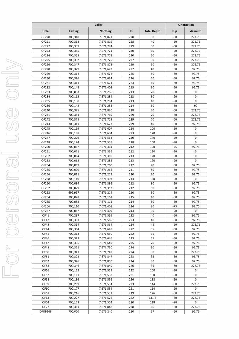
Collar Orientation
Hole Easting Northing RL Total Depth Dip Azimuth
OF220 700,340 7,671,821 228 30 -60 272.75 OF221 700,362 7,671,819 228 40 -60 272.75 OF222 700,339 7,671,774 229 30 -60 272.75 OF223 700,355 7,671,721 230 60 -60 272.75 OF224 700,358 7,671,773 230 60 -60 272.75 OF225 700,332 7,671,725 227 30 -60 272.75 OF226 700,347 7,671,873 229 30 -60 276.75 OF228 700,329 7,671,673 227 40 -60 92.75 OF229 700,314 7,671,674 225 60 -60 92.75 OF230 700,326 7,671,624 226 50 -60 92.75 OF231 700,311 7,671,624 223 65 -60 92.75 OF232 700,148 7,671,408 215 60 -60 92.75 OF233 700,093 7,671,286 213 70 -90 0 OF234 700,115 7,671,284 213 50 -90 0 OF235 700,130 7,671,284 213 40 -90 0 OF236 700,142 7,671,283 214 60 -60 92 OF240 700,375 7,671,820 228 70 -60 272.75 OF241 700,381 7,671,769 229 70 -60 272.75 OF242 700,375 7,671,719 229 70 -60 272.75 OF243 700,341 7,671,672 229 40 -60 92.75 OF245 700,159 7,671,607 224 100 -90 0 OF246 700,198 7,671,604 223 120 -90 0 OF247 700,209 7,671,553 220 140 -90 0 OF248 700,124 7,671,535 218 100 -90 0 OF250 700,087 7,671,361 212 100 -75 92.75 OF251 700,071 7,671,336 212 120 -90 0 OF252 700,064 7,671,310 213 120 -90 0 OF253 700,063 7,671,285 213 120 -90 0 OF254 700,069 7,671,260 212 70 -60 92.75 OF255 700,000 7,671,265 211 80 -60 92.75 OF256 700,011 7,671,213 210 90 -60 92.75 OF258 700,110 7,671,407 214 120 -90 0 OF260 700,084 7,671,386 212 80 -60 92.75 OF262 700,029 7,671,312 212 50 -60 92.75 OF263 699,997 7,671,214 210 60 -60 92.75 OF264 700,078 7,671,161 215 40 -60 92.75 OF265 700,053 7,671,111 214 50 -60 92.75 OF266 700,110 7,671,408 214 80 -73 92.75 OF267 700,087 7,671,409 213 90 -90 0 OF41 700,287 7,671,565 222 40 -60 92.75 OF42 700,303 7,671,565 223 40 -60 92.75 OF43 700,314 7,671,564 224 45 -60 272.75 OF44 700,304 7,671,648 222 35 -60 92.75 OF45 700,313 7,671,650 222 35 -60 92.75 OF46 700,323 7,671,646 223 35 -60 92.75 OF47 700,336 7,671,649 225 20 -60 92.75 OF48 700,321 7,671,750 224 30 -60 92.75 OF50 700,341 7,671,749 224 30 -60 272.75 OF51 700,323 7,671,847 223 35 -60 96.75 OF52 700,326 7,671,850 224 30 -60 92.75 OF53 700,346 7,671,849 226 35 -60 272.75 OF56 700,162 7,671,559 222 100 -90 0 OF57 700,161 7,671,538 221 100 -90 0 OF58 700,186 7,671,556 226 138 -90 0 OF59 700,209 7,671,554 223 144 -60 272.75 OF60 700,177 7,671,534 221 114 -90 0 OF61 700,216 7,671,531 219 126 -60 272.75 OF63 700,227 7,671,576 222 131.8 -60 272.75 OF64 700,163 7,671,514 220 118 -90 0 OF72 700,361 7,671,848 228 66 -60 272.75
OFRB268 700,000 7,671,240 210 67 -60 92.75
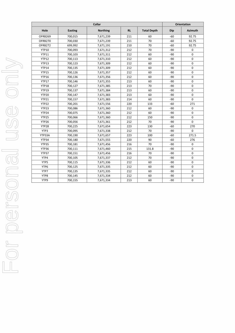
For
per
sona
l use
onl
y
Collar Orientation
Hole Easting Northing RL Total Depth Dip Azimuth
OFRB269 700,015 7,671,239 211 60 -60 92.75 OFRB270 700,030 7,671,239 211 70 -60 92.75 OFRB272 699,992 7,671,191 210 70 -60 92.75
YTP10 700,093 7,671,312 212 70 -90 0 YTP11 700,103 7,671,311 212 60 -90 0 YTP12 700,113 7,671,310 212 60 -90 0 YTP13 700,123 7,671,309 212 60 -90 0 YTP14 700,135 7,671,309 212 60 -90 0 YTP15 700,126 7,671,357 212 60 -90 0 YTP16 700,136 7,671,356 212 60 -90 0 YTP17 700,146 7,671,355 213 60 -90 0 YTP18 700,127 7,671,385 213 70 -90 0 YTP19 700,137 7,671,384 213 60 -90 0 YTP20 700,147 7,671,383 213 60 -90 0 YTP21 700,157 7,671,383 214 60 -90 0 YTP22 700,201 7,671,556 220 133 -60 271 YTP23 700,086 7,671,360 212 60 -90 0 YTP24 700,075 7,671,360 212 60 -90 0 YTP25 700,066 7,671,360 212 150 -90 0 YTP26 700,056 7,671,361 212 70 -90 0 YTP28 700,225 7,671,654 223 130 -60 270 YTP3 700,095 7,671,338 212 70 -90 0
YTP33A 700,190 7,671,657 223 100 -60 271.5 YTP34 700,180 7,671,555 220 90 -60 276 YTP35 700,181 7,671,456 216 70 -90 0 YTP36 700,111 7,671,460 215 131.8 -90 0 YTP37 700,151 7,671,456 216 70 -90 0 YTP4 700,105 7,671,337 212 70 -90 0 YTP5 700,115 7,671,336 212 60 -90 0 YTP6 700,125 7,671,335 212 60 -90 0 YTP7 700,135 7,671,335 212 60 -90 0 YTP8 700,145 7,671,334 212 60 -90 0 YTP9 700,155 7,671,334 213 60 -90 0
For
per
sona
l use
onl
y
Related Documents