New Education and Decision Support Model for Active Behaviour in Sustainable Development Based on Innovative Web Services and Qualitative Reasoning Alexander ALMER 1 , Peter BARZ 2 , Tim NUTTLE 3 , Bert BREDEWEG 4 , Karel CHARVAT 5 , Octavian IERCAN 5 , Markus JOCHUM 6 , Barbara KOCH 5 , Paulo SALLES 7 , Harald STELZL 1 1 Joanneum Research, Institute of Digitale Image Processing, Graz, Austria 2 Environmental Network Limited, UK and Germany 3 University of Jena, Germany. 4 University of Amsterdam, The Netherlands. 5 Czech Centre for Science and Society, Praha, Czech Republic 6 Albert-Ludwigs-University of Freiburg, Dep. of Remote Sensing and Landscape Information Systems, Freiburg, Germany 7 University of Brasilia, Brazil. Abstract NaturNet-Redime is a project co-funded by the European Commission within the Sixth Framework Programme (2002-2006). The general objective of NaturNet-Redime project is the provision of a web portal for the improvement of knowledge and the provision of education concerning all aspects of Sustainable Development. The project will further develop and demonstrate prototype technology and educational programmes towards implementing the European Union's Strategy for Sustainable Development. Extensive stakeholder understanding of the various factors and tools that affect sustainable development is one of the main goals of the NaturNet-Redime project. Two approaches are being taken in the project. The first is an interoperable internet architecture that supports innovative presentation and visualisation of data and tools for learning about sustainability. The second supports developing a deep understanding about cause and effect processes related to sustainability by learner interaction with qualitative reasoning models of sustainable development situations. Introduction The main concept of Sustainable Development (SD) is development that meets the needs of the present without compromising the ability of future generations to meet their own needs (United Nations, 1987). SD thus aims to balance the effects of the interacting environmental, social and economic systems. The European Strategy for SD tries to distribute and inculcate the concept of SD and supports particularly electronic media such as the Internet that offer new ways of learning to promote better understanding of those dependencies among citizens. Existing SD information resources on the Internet focus from the local to the national, supra- national and global levels and are characterized by their sheer quantity – a search for the terms “sustainability” and “sustainable development” alone generates several million resources on the Internet. With sub-topics such as SD in agriculture, forestry, environmental science, politics, economics, urban development etc., as well as items in other languages and media, these numbers increase exponentially. These resources call for organisation, and focussed presentation, as the complexity and comprehensiveness of the subject require the

Welcome message from author
This document is posted to help you gain knowledge. Please leave a comment to let me know what you think about it! Share it to your friends and learn new things together.
Transcript

New Education and Decision Support Model for Active Behaviour
in Sustainable Development Based on Innovative Web Services
and Qualitative Reasoning
Alexander ALMER1, Peter BARZ2, Tim NUTTLE3, Bert BREDEWEG4, Karel CHARVAT5, Octavian IERCAN5, Markus JOCHUM6, Barbara KOCH5,
Paulo SALLES7, Harald STELZL1
1Joanneum Research, Institute of Digitale Image Processing, Graz, Austria 2Environmental Network Limited, UK and Germany
3University of Jena, Germany. 4University of Amsterdam, The Netherlands.
5Czech Centre for Science and Society, Praha, Czech Republic 6Albert-Ludwigs-University of Freiburg, Dep. of Remote Sensing and Landscape Information
Systems, Freiburg, Germany 7University of Brasilia, Brazil.
Abstract NaturNet-Redime is a project co-funded by the European Commission within the Sixth Framework Programme (2002-2006). The general objective of NaturNet-Redime project is the provision of a web portal for the improvement of knowledge and the provision of education concerning all aspects of Sustainable Development. The project will further develop and demonstrate prototype technology and educational programmes towards implementing the European Union's Strategy for Sustainable Development. Extensive stakeholder understanding of the various factors and tools that affect sustainable development is one of the main goals of the NaturNet-Redime project. Two approaches are being taken in the project. The first is an interoperable internet architecture that supports innovative presentation and visualisation of data and tools for learning about sustainability. The second supports developing a deep understanding about cause and effect processes related to sustainability by learner interaction with qualitative reasoning models of sustainable development situations.
Introduction The main concept of Sustainable Development (SD) is development that meets the needs of the present without compromising the ability of future generations to meet their own needs (United Nations, 1987). SD thus aims to balance the effects of the interacting environmental, social and economic systems. The European Strategy for SD tries to distribute and inculcate the concept of SD and supports particularly electronic media such as the Internet that offer new ways of learning to promote better understanding of those dependencies among citizens. Existing SD information resources on the Internet focus from the local to the national, supra-national and global levels and are characterized by their sheer quantity – a search for the terms “sustainability” and “sustainable development” alone generates several million resources on the Internet. With sub-topics such as SD in agriculture, forestry, environmental science, politics, economics, urban development etc., as well as items in other languages and media, these numbers increase exponentially. These resources call for organisation, and focussed presentation, as the complexity and comprehensiveness of the subject require the
new user to show some determination to actually get to them and spend some time learning how best to utilise them.
The general objective of NaturNet-Redime (NNR) is to support the European Strategy for SD by improving knowledge about all aspects of sustainability and provide education mainly about the social, economic, and environmental tools for the implementation of the EU Strategy on SD at both EU and international levels. There are two main approaches of the NNR project, which originate from the two proposals that have merged to create the combined project. The first an interoperable Internet architecture, which focuses on innovative presentation of different tools and data sources for learning about sustainability. The second is learning through modelling, where learners develop a deep understanding of causes and effects by developing and exploring models of SD situations using Qualitative Reasoning. Both approaches will be accessible to the public via the NNR portal (www.naturnet.org).
Sustainable development and e-learning
Sustainable development SD is adaptive, continuous and has no fixed endpoint. SD tends to focus on situations where joint action among stakeholders is needed to ensure the common good for present and future generations. In addition, since interventions involve the creation, identification and, above all, societal sharing of risks that scientific and other expertise cannot reliably predict or prevent, there is a strong impetus towards wider public participation in decisions on SD. The result of such factors is that SD has a strong collective element in it, and the capacity of societies for such collective action is an important factor in successful SD. Given this situation, societies, organisations or individuals cannot autonomously define what constitutes a sustainable future or a sure path toward it. They have to jointly learn their way continuously towards such a future. The capacity of a society for such joint learning, often termed “co-learning” or “social learning” is a key element of successful SD, tackling the fundamental question of “What are we going to do next?” The required paradigm shift to SD thus requires changes in awareness, values, purposes, and identity. SD internet resource sites cover sites aimed at varied target audiences from school children to those professionally involved in the field. The least catered-for audience appears to be general adult users with lower-level academic skills. The content design of the NNR portal clearly will need to be adapted to the requirements of these target user groups.
E-learning standard and platform NNR adopted a bottom-up strategy of developing the e-learning environment for the SD content. At the outset we searched for a technological standard for e-learning and quickly realised that this part of the research would be far more complicated than anticipated as the current status of e-learning standardization is rather confusing. In the last few years, e-learning software has become structualy complicated due to integration of a large number of functionalities. The most widespread standards for e-learning platforms are IEEE LOM Metadata, IMS Packaging, AICC RTE and SCORM. SCORM was conceived as a reference model for other standards. In fact, SCORM offers interoperability by using its own reference model to integrate different standards conceived by different vendors and developers. More and more vendors seem to be using SCORM, judging by the disproportionate number of SCORM-compliant e-learning platforms. Therefore, we developed an algorithm for the selection of the intended e-learning platform. Within the selection criteria are included:
standardisation, licence type, development language, database type in use, etc. Based on this algorithm, the NNR consortium decided that the best platform is ILIAS. ILIASt is compliant with the SCORM standard and a powerful open source Learning Management System (LMS). ILIAS reached the LMS-RTE 3 level and so provides independent reutilisation of content.
Learning about sustainability online NNR aims to promote the concept of SD through the Internet by providing innovative tools and web services. The concept of SD will be demonstrated through example use case scenarios in test regions associated with the NNR project as well as at the European scale. The scenarios are embedded in an e-learning environment that guides the user through structured use case modules.
The main focus of this part of the NNR project is visualisation and use of geographical data since the environmental component of SD has a strong geographical relationship. Geographical information is presented in 2D by the open source Minnesota Map Server that will be implemented into the e-learning platform ILIAS. In addition to that, this data will also be accessible by a 3D viewer that provides additional information about the terrain. These courses will be established for each test region thereby presenting the specific challenges for SD. For all test regions, a variety of geographical data is available and already implemented on the web server. Economic development, e.g. in terms of industrial growth or just the increase of urban areas, can have negative effects on the environment and society if this process is not managed. Planners require appropriate tools for the sustainable management of geographic areas that provide information about the potential effects on the environment in advance. For this reason a NNR-specific Sustainability Impact Assessment, based on the principles of the Environmental Impact Assessment, will be provided as a learning module with the aim to sensitize the user to the potential impacts of physical development projects with regard to their environmental, social and economic parameters. The module will contain interactive matrices that enable the user to rate the impact for each parameter. In this context, the geodata with environmental, social and economic relation provide the information required for such an assessment. In addition to the application in the web portal, mobile devices will be applied in an outdoor environment in order to verify and/or add actual data to the database of the system.
Access to distributed information resources The NNR portal objective is to provide a structure for describing data related to SD. This system will:
• Provide data producers with appropriate information to characterize their data properly.
• Facilitate the organization and management of metadata for sustainable development data.
• Enable users to apply sustainable development data in the most efficient way by knowing its basic characteristics.
• Facilitate data discovery, retrieval and reuse. Users will be better able to locate, access, evaluate, purchase and utilize sustainable development data.
• Enable users to determine whether sustainable development data, in a holding, will be of use to them.
There exist metadata for general purposes and heterogeneous information. NNR uses the schema required for describing geographic and non-geographic information and services. It
provides information about the identification, the extent, the quality, the spatial and temporal schema, spatial reference, and distribution of digital geographic data.1
Information searching (catalogue and metadata) A revival in awareness of the importance of geography and how things relate spatially, combined with advancements in electronic technology, has caused a worldwide expansion in use of digital geographic information and geographic information systems (GIS). People from a wide range of disciplines outside geographic sciences and information technologies are increasingly capable of producing, enhancing, and modifying digital geographic information.
The objective of our International Standard ISO 19115 is to provide a structure for describing digital geographic data. This International Standard is intended to be used by information system analysts, program planners, and GIS developers, as well as others in order to understand the basic principles and the overall requirements for standardization of geographic information.
A Catalogue is simply a collection of 'entries' that is organized to assist in the discovery, access, and retrieval of geospatial resources that are of interest to the user, especially when the existence or whereabouts of the resource are not known to the user. Being a collection of catalogue entries, a catalogue should be able to enumerate each of its entries, and should allow entries to be added or removed. It should also support queries that will enable the user to obtain entries of interest based on specified criteria.
The Dublin Core (DC) metadata element set is a standard for cross-domain information resource description. Here an information resource is defined to be "anything that has identity". This is the definition used in Internet RFC 2396, "Uniform Resource Identifiers (URI): Generic Syntax", by Tim Berners-Lee. There are no fundamental restrictions to the types of resources to which DC metadata can be assigned. Three formally endorsed versions exist of the DC Metadata Element Set:
• ISO Standard 15836-2003 (February 2003)
• NISO Standard Z39.85-2001 (September 2001)
• CEN Workshop Agreement CWA 13874 (March 2000, no longer available)
The important task of NNR portal is to support combined search for spatial and non-spatial information. So the decision was to implement two systems, which combine ISO19115 standards for spatial data and DC for non spatial data. The solution is based on MIcKA metadata system developed by HSRS (member of OGC). For the search of textual, multimedia and educational content, projects and tools, the Dublin Core metadata methodology that is implemented in the MIcKA catalogue system will be used. The specific profiles of DC metadata will be prepared for information searches. The integration of a Thesaurus (GEMET, AgroVoc) and Gazetteers based on NUTS 5
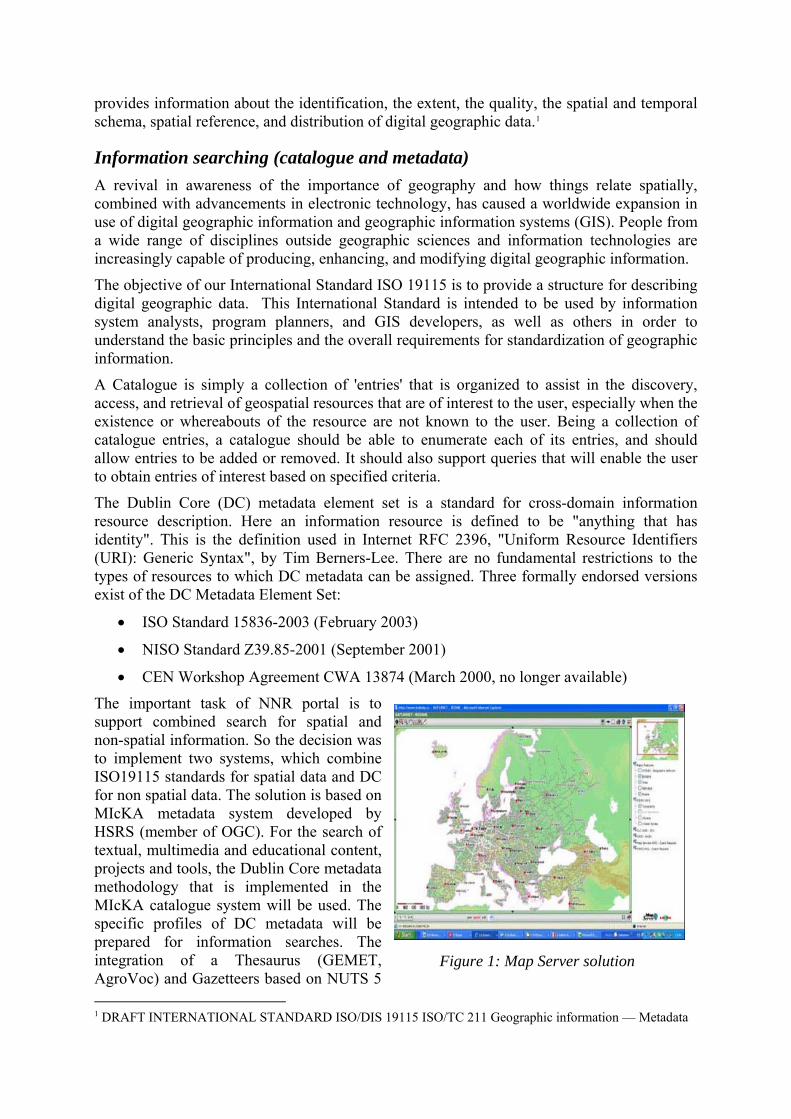
Figure 1: Map Server solution
1 DRAFT INTERNATIONAL STANDARD ISO/DIS 19115 ISO/TC 211 Geographic information — Metadata
European level supporting localisation of information is recommended. For the search for Geospatial information, the ISO19115 metadata model (respective implementation scheme 19139) that is implemented in MIcKA will be used.
The following parts of the catalogue will be MapDesigner supported:
• Search for spatial data
• Definition of the composition of spatial data;
• Storing of this composition as an application of MapServer
Information visualisation For the visualisation of spatial data the open source software MapServer, developed by University of Minnesota (USA) within the frame of a NASA grant, is used. The MapServer output is a raster map in GIF, PNG, JPG (for Internet browsers of personal or pocket computers) or WBMP formats (for mobile phones supporting WAP), and optionally PDF or GML vector format. Our applications use the wide range of possibilities provided by MapServer (see figure 1). Two clients are implemented. For professional work it will be Java Script clients. For the work of non-specialists and for integration with e-learning application, a DHTML client will be used.
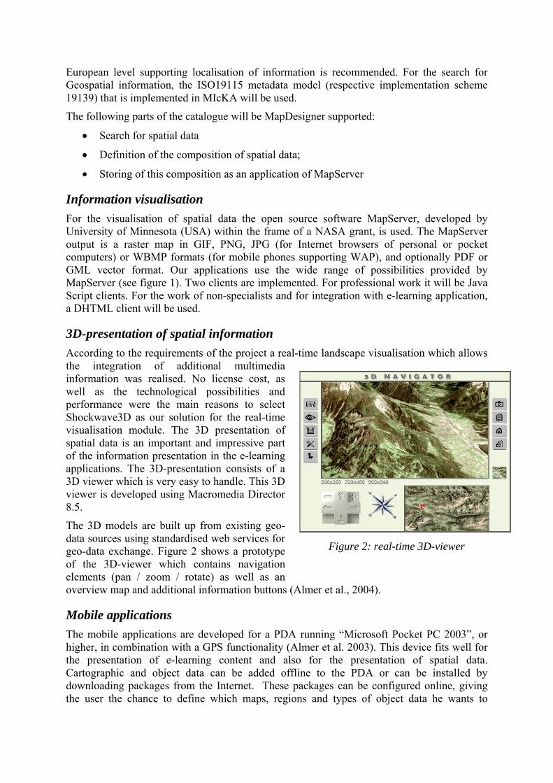
3D-presentation of spatial information According to the requirements of the project a real-time landscape visualisation which allows the integration of additional multimedia information was realised. No license cost, as well as the technological possibilities and performance were the main reasons to select Shockwave3D as our solution for the real-time visualisation module. The 3D presentation of spatial data is an important and impressive part of the information presentation in the e-learning applications. The 3D-presentation consists of a 3D viewer which is very easy to handle. This 3D viewer is developed using Macromedia Director 8.5.
The 3D models are built up from existing geo-data sources using standardised web services for geo-data exchange. Figure 2 shows a prototype of the 3D-viewer which contains navigation elements (pan / zoom / rotate) as well as an overview map and additional information buttons (Almer et al., 2004).
Figure 2: real-time 3D-viewer
Mobile applications The mobile applications are developed for a PDA running “Microsoft Pocket PC 2003”, or higher, in combination with a GPS functionality (Almer et al. 2003). This device fits well for the presentation of e-learning content and also for the presentation of spatial data. Cartographic and object data can be added offline to the PDA or can be installed by downloading packages from the Internet. These packages can be configured online, giving the user the chance to define which maps, regions and types of object data he wants to

download, depending on his needs, bandwidth and available storage space on his PDA. The functionalities of the mobile applications can be divided into the presentation and the data acquisition part.
The presentation on this device (see figure 3) includes the following information levels and functionalities:
• General information about e-learning scenarios (multimedia data)
Figure 3: Mobile application
• Display of different types of maps
• Visualisation of objects on the map and their details including multimedia content, such as pictures, movies and sounds
• Display lists of objects with filter-capabilities
• Visualisation of the current GPS-position if available and display objects within a user-defined distance
Data acquisition is realised by the following functionalities:
• Store tracks and points via GPS while in the field and linking of photos or voice notes recorded with the PDA to those objects
• Keeping a digital, location aware, personal diary of your trip
Qualitative reasoning: learning through modelling The goal of this part of the NNR project is to facilitate development of deeper understanding about how environmental, social, and economic processes affect SD. Machado (1995) viewed understanding as the process of capturing meaning. To capture meaning about something (an object, situation, concept, etc.) is to see it involved in relations with other things. Meaning is thus constructed from a set of relations. Relations are themselves articulated webs or networks, built up by someone either via their own experience or in social interaction; these webs are continuously being updated. Hence, developing understanding can be seen as the learner becoming involved in this web of relations between objects, situations, and concepts.
Despite an enormous amount of data on various environmental, social, and environmental factors, how these factors interact to affect SD in any particular situation remains generally poorly understood. The difficulty arises because, although the causal processes involved in a system might be well understood, the relative magnitudes of the impacts of these processes is not. The incomplete, fuzzy, often inherently uncertain nature of data relevant for SD decision making impedes use of traditional quantitative methods for understanding these systems and supporting the decision making process. In such situations, qualitative reasoning (QR) can help organise the available information into a computer-processable form that can be used create models and simulations to make a finite set of predictions about the behaviour of the system. The models can be used to assess how alternative scenarios might affect sustainability of a system, and therefore support education about a system as well as support decision making.
Qualitative reasoning (QR) is characterised by a principled formalisation of conceptual knowledge about the behaviour of systems in various domains (Bredeweg and Struss, 2003). QR provides a rich vocabulary for representing entities, structural relationships, attributes,

quantities, causal relationships and mathematical dependencies. These are combined into scenarios, which describe initial situations, and model fragments, which describe generic knowledge applicable in certain situations (e.g., processes). Using this knowledge, a simulation engine can produce predictions in the form of a qualitative simulation, without the need for numerical data. A qualitative simulation consists of a graph of all possible behavioural states of the system being modelled, where each state describes the complete state of the system. Because the conceptual knowledge is articulated explicitly, building qualitative models and inspecting simulation results often leads to an increased understanding of the behaviour of complex systems. Therefore, qualitative simulations are considered especially useful for educational purposes. Moreover, research on cognitive sciences has shown that when learners have a causal model of system behaviour, they are better able to apply their knowledge to new situations (e.g., Schumacher and Gentner, 1988; Bredeweg & Winkels, 1998). QR models are a way to develop such causal models, because they capture the fundamental aspects of a system or mechanism, while suppressing much of the irrelevant detail.
Garp3 – Workbench for capturing conceptual knowledge Within the NNR project we have developed Garp3, a user-friendly workbench that allows modellers to build, simulate, and inspect qualitative models (Figure 4). The software mainly uses a diagrammatic approach for representing model content, and graphical buttons to communicate the available user options and manipulations. Graphical representations help reduce working memory load, allowing students to work through more complex problems (Bredeweg and Forbus, 2003). Such external representations also help them present their ideas to others for discussion and collaboration. The reasoning engine works on the basis of three main constructs: scenarios, model fragments and transition rules. Scenarios specify initial situations for the simulator to start behaviour prediction. Model fragments capture knowledge about behaviour of system parts, and are used to assemble states of behaviour. Transition rules determine valid transitions between states of behaviour. After selecting a scenario the engine proceeds with the prediction task by recursively consulting the library for applicable model fragments. This search is exhaustive and each consistent subset of model fragments represents a behaviour interpretation that matches the selected scenario. The output of such a reasoning process is a state-graph that represents the possible behaviours of the system being simulated. (see Figure 6).
Figure 4: Main screen of the Garp3 workbench
Figure 5 illustrates a simple example of how knowledge can be represented in a Garp3 model. It reads as follows: there is an entity population (which applies to ‘any population’) that has
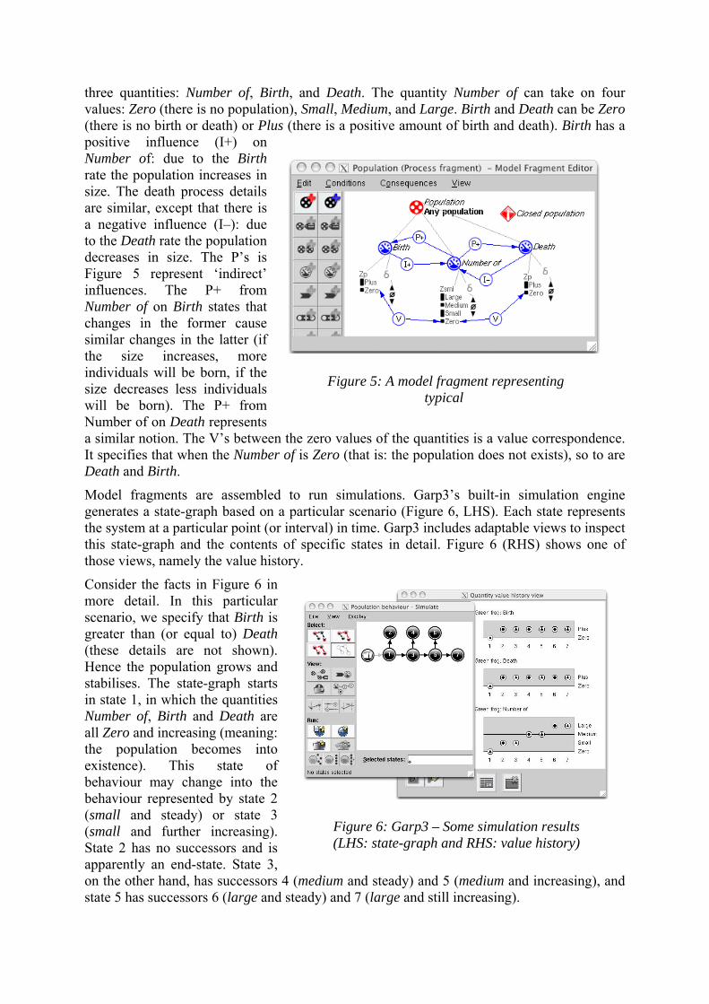
three quantities: Number of, Birth, and Death. The quantity Number of can take on four values: Zero (there is no population), Small, Medium, and Large. Birth and Death can be Zero (there is no birth or death) or Plus (there is a positive amount of birth and death). Birth has a positive influence (I+) on Number of: due to the Birth rate the population increases in size. The death process details are similar, except that there is a negative influence (I–): due to the Death rate the population decreases in size. The P’s is Figure 5 represent ‘indirect’ influences. The P+ from Number of on Birth states that changes in the former cause similar changes in the latter (if the size increases, more individuals will be born, if the size decreases less individuals will be born). The P+ from Number of on Death represents a similar notion. The V’s between the zero values of the quantities is a value correspondence. It specifies that when the Number of is Zero (that is: the population does not exists), so to are Death and Birth.
Figure 5: A model fragment representing typical
Model fragments are assembled to run simulations. Garp3’s built-in simulation engine generates a state-graph based on a particular scenario (Figure 6, LHS). Each state represents the system at a particular point (or interval) in time. Garp3 includes adaptable views to inspect this state-graph and the contents of specific states in detail. Figure 6 (RHS) shows one of those views, namely the value history.
Consider the facts in Figure 6 in more detail. In this particular scenario, we specify that Birth is greater than (or equal to) Death (these details are not shown). Hence the population grows and stabilises. The state-graph starts in state 1, in which the quantities Number of, Birth and Death are all Z o and increasing (meaning: the population becomes into existence). This state of behaviour may change into the behaviour represented by state 2 (small and steady) or state 3 (small and further increasing). State 2 has no successors and is apparently an end-state. State 3, on the other hand, has successors 4 (medium and steady) and 5 (medium and increasing), and state 5 has successors 6 (large and steady) and 7 (large and still increasing).
Figure 6: Garp3 – Some simulation results (LHS: state-graph and RHS: value history)
er

State 4, 6, and 7 are all end-states. Summarising, under the conditions specified in the scenario (including: Birth ≥ Death) this population starts at Zero and may grow to its largest possible size, or it may stabilise at certain intermediate sizes. This result reflects a typical feature of a qualitative simulation, namely showing all possible behaviours of a system.
The development of Garp3 is part of a bigger effort to support users in actually using Qualitative Reasoning technology to develop and organise their understanding of system behaviour, including the development of a Curriculum for learning about QR (Bredeweg et al., 2006) and a Structured approach to modelling (Bredeweg et al., 2005). Domain experts within the NNR project are currently using the workbench to capture knowledge about issues relevant to SD (see below). The software can be downloaded from http://hcs.science.uva.nl/QRM/.
Towards qualitative models and a curriculum for learning about SD We are developing QR models to explore the following key concepts of SD (based on definition by Cunningham and Cunningham, 2005):
• increase in well-being and standard of life for the average person (what is meant by ‘development’);
• cause and effect processes of environmental degradation and how this affects ecosystem services (processes in nature that contribute to human well being; Millennium Ecosystem Assessment Board 2005);
• the balance between development and long-term maintenance of ecosystem services.
We address these concepts mainly in the context of five case studies that each provide a good example of a real-world SD scenario. In their collective, they provide a well-rounded sampling of the various types of issues that any SD scenario is likely to involve, including environmental, social, and economic factors. These case studies each centre on rivers and catchment areas because this facilitates our goal of developing different models that can be integrated. Some of the case studies are concerned with fundamental processes involving chemical, physical, and simple biological processes in streams. Other case studies are more integrative, including these basic processes, but also addressing sociological, management, and ecosystem-level processes. In addition to the case studies, we are also developing QR models about specific SD issues related to the Millennium Ecosystem Assessment and Millennium Development Goals. Rather than focusing on SD in a specific geographic area or ecosystem, these models address targeted SD issues in a broader perspective.
Three case studies have already started implementation: the River Mesta (RM), Bulgaria, is a montain river that has been polluted by industrial plants and is now mostly restored to good ecological status; the Danube Delta Biosphere Reserve (DDBR), Romania, is impacted by pollution from agricultural runoff and industry in the Danube River’s vast catchment area; the Riacho Fundo (RF), Brazil, is a small river influenced by land-use changes, where natural and rural areas are being transformed into urban settlements. RM and DDBR focus on the aquatic ecosystem. Qualitative models under construction about the RM focus on dissolved oxygen as the central indicator of water quality and changes in the river. Models about the DDBR describe the effects pollution with heavy metals, pesticides and fertilizers have on biodiversity and human health. Models about the RF play the role of bridging the gap between land use and the aquatic environment, explaining how land use and urbanisation affect biotic and abiotic conditions.
The last two case studies are just now beginning. Models involving a restoration plan for River Kemp, Austria, aim at illustrating the problems found by managers who whish to

change the structure created for the human system in order to reduce negative impacts to the aquatic ecosystem. A comparison between different ways of addressing river problems is the theme of the models involving River Trent and River Ouse, England.
Although having very different water basins as starting points, the issues addressed in the NNR project can be used in curricula that deal with the integration between terrestrial (human) and aquatic ecosystems. These case studies involve society, governmental and non-governmental organisations, public policies, and planned actions of management. Besides providing support for discussions about impacts caused by human activities, the models may be used to develop arguments for or against specific conservation practices or alternative and sustainable economic activities such as tourism and exploitation of natural resources.
Content from the different models will be integrated into a 'library of re-usable QR model fragments' that will make future development of content more efficient. Using the case-study models as a base, we are comparing and contrasting different representations of similar processes, and organising these into a structure where users can easily select the appropriate elements they need in a model.
The main product of this modelling effort, from the perspective of most end users, will be the learning materials that they interact with in their pursuit of knowledge and understanding about SD. The concepts captured in our different QR models create a web of interrelated SD concepts, issues, and processes. The learning materials in our curriculum must support the process of individual involvement in this web, to support development of understanding as described by Machado (1995). We view the content in our QR models as a ‘landscape of SD concepts’ and our goal is to create a map of this landscape that facilitates exploration and learning about SD. The online map of SD concepts will be linked to QR models and simulations (as well as to expository materials like text and graphics) online the NNR portal. Relations between concepts in the map will be represented in learning routes through the landscape. The idea is that learners will follow the relations in the map to navigate from concept to concept in the landscape. In so doing, learners will internalise the knowledge contained in our external representations of expert knowledge about SD, and therefore gain a deeper understanding of processes and concepts of SD in contexts that meet their learning needs.
Conclusions This paper described the general objectives of the NNR project. These are the provision of a web portal for the improvement of knowledge and the provision of education concerning all aspects of Sustainable Development. The project will further develop and demonstrate prototype technology and educational programmes towards implementing the European Union's Strategy for Sustainable Development.
This paper has also presented Garp3, a workbench for building, running, and inspecting qualitative models. The workbench offers an easy access to high-end qualitative simulation software, providing non-AI/QR experts with the possibility to use QR technology without having to understand low-level implementation details of such automated reasoners. Future work will focus on supporting collaborative modelling and model reuse, and will include a repository for uploading, indexing and downloading models and model parts, as well as means for modellers to copy/paste model ingredients between models. Automatically preserving model consistency and supporting model debugging are essential for this, and need further development. The QR workbench is being used to create QR models about SD case studies and SD issues. These will be integrated and complemented with assignments and other didactic materials to build an online curriculum to learn about factors affecting SD, focusing

on learner interaction with QR models. Prospects for future work include augmenting geographic-based data presentation techniques with QR-based content to develop a more fully integrated web portal for learning about SD.
Bibliography [1] Almer A., Schnabel T., Schardt M., Stelzl H. (2004): Real-Time Visualization of Geo-
Information Focusing on Tourism Applications. ISPRS WG V/6 - Visualization and Animation. 18-20 November 2004, Pitsanulok, Thailand.
[2] Almer A., Luley P., Nischelwitzer A. (2003): Location Based Tourism Information Systems on Mobile Multimedia Devices. GNSS2003 Global Navigation Satellite System – Graz, 22-25.04.2003.
[3] Bredeweg, B., Liem, J., Bouwer, A., and Salles, P. (2006). Curriculum for learning about QR modelling, Naturnet-Redime, Project no. 004074, Project Deliverable Report D6.9.1.
[4] Bredeweg, B., Salles, P., Bouwer, A., and Liem, J. (2005) Framework for conceptual QR description of case studies, Naturnet-Redime, Project no. 004074, Project Deliverable Report D6.1.
[5] Bredeweg, B. and K. Forbus, K. (2003) Qualitative Modeling in Education. AI Magazine, Volume 24, Number 4, pages 35-46.
[6] Bredeweg, B., and P. Struss, P. (eds). (2003) Current Topics in Qualitative Reasoning. AI Magazine (special issue), 24(4):13-130.
[7] Cunningham, W. P., and M. A. Cunningham. (2005) Principles of Environmental Science. In. McGraw-Hill online.
[8] Jiggins J., Roling N. and Watson R. D. (1992): Environmental Challenges and the Management of Change. Macromarketing Conference 1992, the Netherlands Business School, Nijenrode.
[9] Machado, N. J. (1995) Epistemologia e didática: as concepções de conhecimento e inteligência e a prática docente. Cortez Editora, São Paulo, Brazil.
[10] Millennium Ecosystem Assessment Board. 2005. Living Beyond Our Means: Natural Assets and Human Well-being.
[11] Novak, J.D. and Gowin, D.B. (1984) Learning how to learn. Cambridge University Press, New York, New York.J.D.
[12] Schumacher, R. M., and Gentner, D. (1988) Transfer of training as analogical mapping. IEEE Transactions of Systems, Man, and Cybernetics, 18:592-600.
[13] United Nations (1987): Development and International Economic Co-operation: Environment – Report of the World Commission on Environment and Development “Our common future” http://www.are.admin.ch/imperia/md/content/are/nachhaltigeentwicklung/brundtland_bericht.pdf
[14] Winkels, R., and Bredeweg, B. (eds). (1998) Qualitative Models in Interactive Learning Environments. Interactive Learning Environment (special issue), 5(1-2):1-134.
[15] http://europa.eu.int/comm/sustainable/welcome/index_en.htm
Related Documents