Welcome message from author
This document is posted to help you gain knowledge. Please leave a comment to let me know what you think about it! Share it to your friends and learn new things together.
Transcript


Two People, Two Feet Apart
What is the truth? It seems so simple. But when wetry to put it into words, it turns out to be much morecomplex.
Our dictionary says that truth is: “Conformity toknowledge, fact, actuality, or logic.” That seems to helpuntil we try to say what “knowledge” is. Or “facts.”
“Truth is most commonly used to mean correspon-dence with facts or with what actually occurred,” ourdictionary goes on. But when the police officer asks“What happened?” at the scene of even the simplestfender-bender, the officer seldom hears just one story.If facts were straightforward, we wouldn’t need juriesto determine them.
The truth can seem awfully slippery at times.At other times, good sense rebels against such an
idea.Of course the truth exists! “We did have lunch lastThursday.” It is a simple fact.
But is it?We did have lunch last Thursday.
Of course we sat in different chairs and they weresort of angled to the table. Because of this one of uslooked at the other against a background of geraniumsin coffee cans and birds at a feeder in the dogwoodtree; the other against a background of the house nextdoor and thunderhead clouds in the summer sky aboveit.What at first appears to be one thing—the two of ushaving lunch—dissolves into two different scenes.Even at a single moment in the meal different thingsare going on. Sometimes they are so different we cansee that the other person’s eyes have drifted from thetable.Ward has moved his eyes to something going onin the tree behind Denis, or Denis has moved his eyesto something happening in the driveway behind Ward.We have to reorient ourselves to the reality of theother by turning our chairs to face each other moresquarely.
Sometimes one of us sees something the other miss-es completely: a bird at the feeder (gone by the timethe other turns), or a kid maneuvering on a skateboard(and the other turns, but he is too late). Then one
O N E The Multiple Truths of the Mappable World

person’s experience of lunch includes that event.Theother’s doesn’t.
These differences in the experience of lunch resultfrom a space less than than a foot or two between ourchairs and a difference in orientation of maybe 90 .̊Wecan add to this our different backgrounds, differentprofessions, different styles of thinking, and all the rest.Then, despite everything we share, it becomes hard tosay—even of this simple meal—precisely and unani-mously what was what. This is true even in themoment, much less in the mind, or in the memory aday, a week, a month later or even longer.
But, we did have lunch together!Sure, okay, if that’s all you want to say: we had
lunch.There may be something we can call the truth if we
keep it so simple it doesn’t really matter.
Two Peoples, a World Apart
Two people, two feet apart. What if they had beentwo peoples a world apart? What if they had beeninhabitants of the U.S.A and Iraq contemplating theU.S. bombing of Baghdad?
If all we can say of the truth is that bombs fell on acity we might as well say nothing. Because it is notabout that.That’s past. It is about now and tomorrow.It is about who (if anyone) will pay for what happened.It is about what was really going on, and if this was asign, what was it a sign of, and is it reasonable to havebombs? It is about what life means if it can end thisway. It is about stuff like that.
“It’s hot out here,” one says.“It sure is,” says the other.
“It’s from global warming,” says the first,“too manycars.”
“Hogwash!” says the second.It was easy to agree about it being hot, but attribut-
ing the heat to the cars implies a course of correctiveaction.That raises the stakes. Suddenly it is a matter ofperception. Is it really hotter than it used to be? Or isthis a perspective effect? If it is hotter, is this usual orunusual? If unusual, did people cause it? If we did,what can we do about it now?
Going back to our first example, you might ask,“Well, what about someone across the street watchingthe two of you having lunch? Wouldn’t they have anobjective view? What about the UN perspective on thebombing? What does science have to say about globalwarming?”
And, yes, each has its truth too, but there are threetruths now instead of two.Three truths . . .or more.TheUN scarcely speaks in a single voice, and in the case ofscience speaking about global warming we’re talkingabout dozens and dozens of truths.
How many can we stand?How do we act if we don’t know what’s true? Isn’t
life hard enough already without adding to it theuncertainty of there being many truths?
Frankly, life is hard enough already without pretending it is so simple there is only a single truth.
Maps Are Descriptions Too
What does this have to do with maps?Maps are descriptions of the way things are. They
are a lot like the answers people give police at the
The Multiple Truths of the Mappable World
2

scene of an accident. Questions of truth are never faraway.
We can ask the same things about maps that we askabout any description. How true? How complete? Howaccurate? How precise?
The answers depend on our purposes, or what weneed the description for.
Figure 1 is the map a guard made to show us how toget from Duke University, in Durham, North Carolina, toan auto repair shop on Angier Avenue. It brings institu-tions (Duke, Durham Tech), roads (NC 147, BriggsAvenue), and landmarks (a bridge, the railroad tracks)
together to form a sequence of in-structions: “Get off 147 at the BriggsAvenue exit just past Durham Tech,”is what the map says, “and whereBriggs dead ends, turn right . . . ”
Is it true? As a matter of fact, itgot us exactly where we wanted togo, so it was true enough. It neednot have been true.The guard couldhave been irritated by our presenceand drawn a map intended to mis-lead us. (People have been known todo such things.) Or the guard couldsimply have been mistaken aboutwhich street went where.
Is his map complete? It is com-plete enough. It is not a completemap of Durham. It is not even a com-plete map of Durham streets. But itincluded everything we needed toknow to get from Duke to Angier Ave.
How accurate is it? Again, it isaccurate enough for the purpose. As a matter of fact,Angier Avenue doesn’t “T” into Ellis Road. It crosses it.But this didn’t matter if we were following the map.
Is it precise? Not very. On one part of the map aninch equals a couple of hundred yards. On another itequals a couple of miles. But again, it was preciseenough for us!
The guard’s map perfectly fulfilled its purpose. Theguard managed this by selecting from everything heknew about Durham only what was necessary to hispurpose: to guide us where we wanted to go.
The Multiple Truths of the Mappable World
3
Figure 1. We were lost. A security guard at Duke University in Durham, NorthCarolina, drew this map of the best way to get from Duke to Angier Avenue. (1993).
4
All Maps Are Selective
Every map is a purposeful selection from every-thing that is known, bent to the mapmaker’s ends.Every map serves a purpose. Every map advances aninterest.
This is easy to see in a map like the one we havebeen looking at, which was drawn with the specialpurpose of helping us visualize instructions:“It’s kindof complicated,” the guard had said as he put pen topaper. It is not so easy to see the purpose in an ordi-nary map of the world like our next example.
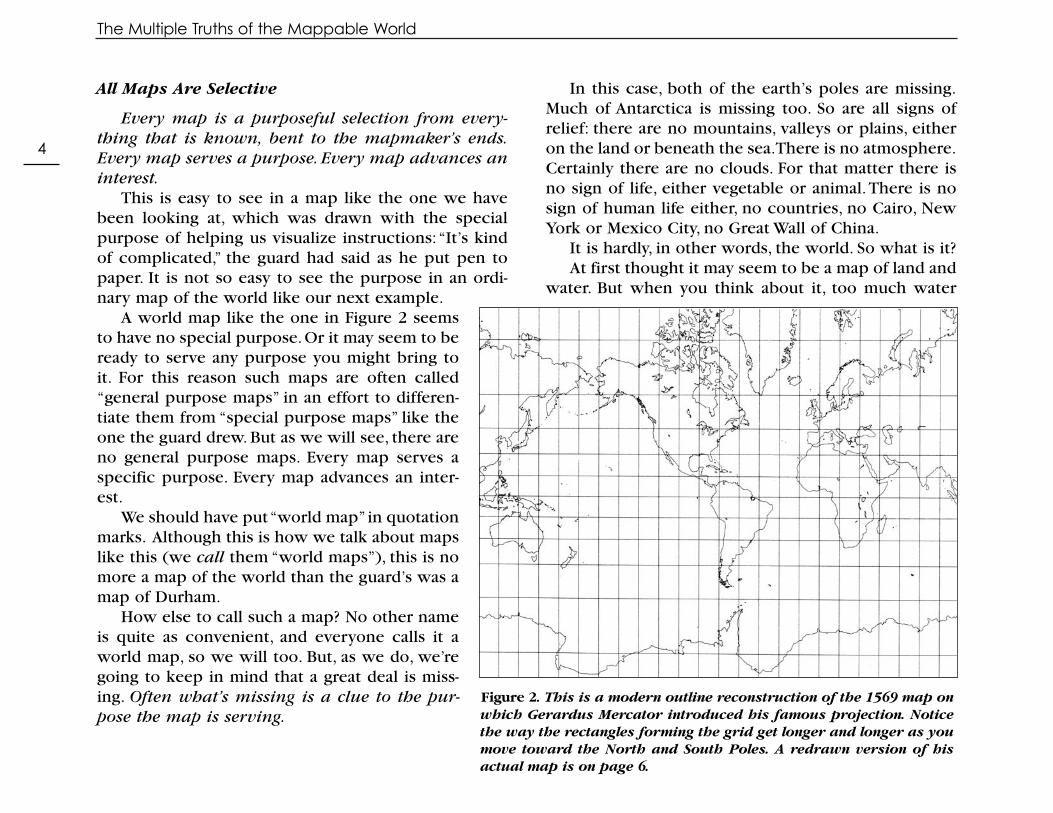
A world map like the one in Figure 2 seemsto have no special purpose. Or it may seem to beready to serve any purpose you might bring toit. For this reason such maps are often called“general purpose maps” in an effort to differen-tiate them from “special purpose maps” like theone the guard drew. But as we will see, there areno general purpose maps. Every map serves aspecific purpose. Every map advances an inter-est.
We should have put “world map” in quotationmarks. Although this is how we talk about mapslike this (we call them “world maps”), this is nomore a map of the world than the guard’s was amap of Durham.
How else to call such a map? No other nameis quite as convenient, and everyone calls it aworld map, so we will too. But, as we do, we’regoing to keep in mind that a great deal is miss-ing. Often what’s missing is a clue to the pur-pose the map is serving.
In this case, both of the earth’s poles are missing.Much of Antarctica is missing too. So are all signs ofrelief: there are no mountains, valleys or plains, eitheron the land or beneath the sea.There is no atmosphere.Certainly there are no clouds. For that matter there isno sign of life, either vegetable or animal.There is nosign of human life either, no countries, no Cairo, NewYork or Mexico City, no Great Wall of China.
It is hardly, in other words, the world. So what is it?At first thought it may seem to be a map of land and
water. But when you think about it, too much water
The Multiple Truths of the Mappable World
Figure 2 . This is a modern outline reconstruction of the 1569 map onwhich Gerardus Mercator introduced his famous projection. Noticethe way the rectangles forming the grid get longer and longer as youmove toward the North and South Poles. A redrawn version of hisactual map is on page 6.

lies on the land in the form of ice for this to be a mapof water.There are literally thousands of tons of waterin the ice that lies over Antarctica and Greenland.Tonsof water exist in the atmosphere too. So it is not a mapof land and water. The map has to be about somethingelse.
As with the truth, the subject of the map seems sim-ple. But when you try to put it into words, it turns outto be complex. In fact, the map is not at all what itseems. Even in its updated form (see page 4) the mapis actually still a piece of history. It reminds us thatwhen it was made, people crossed oceans in sailingships. A good description of this map’s subject wouldbe, “Places where ships will float and places wherethey won’t.”This still isn’t quite right. Even modern ice-breakers get stuck in the solid ice of the Arctic Ocean.Sailing ships never got into that ice at all.
All Maps Have a Purpose
The sailable world is what this map is paying atten-tion to. It is a map for a world of sailors. It should notsurprise us, then, that the way the map shows theworld reflects the interests of sailors too. Figure 3shows a modern redrawing of the map GerardusMercator made in 1569. He called his map “A New andEnlarged Description of the Earth With Corrections forUse in Navigation.” His title was very precise about themap’s purpose, and right over North America heengraved a long description of how he made it.
We will have much more to say about this map fur-ther on. What’s important here—where we are con-cerned with the purposes maps serve—is whatMercator’s map was for. The map made it possible for
sailors to draw a straight line to their destination andsail along it. Any straight line drawn on Mercator’s mapis a line of constant compass bearing. You’d draw a lineto your destination, set your compass to the bearing ofthe line, follow it and, making allowances for windsand tides, get where you wanted to go.
Mercator’s work was not appreciated immediately.For one thing, the map was too different at a timewhen sailors put a great deal of faith in tradition. Foranother, the map was too small to be of much practicaluse. It wasn’t until the ideas behind Mercator’s mapbecame understood and accepted, and until the mapwas redrawn as a series ofregional sea charts, that hiswork became popular.
In the 18th centurywhen world travel becamemore common, so did theuse of Mercator’s map. Inthat increasingly scientificage the map’s technicalpracticality gave it greatauthority. It was in the 18th century that Mercator’s map began to be seen asthe world map, essentially because it was the map ofthe seaman, the map of the navigator, the map of the professional world traveler. As Western nations madethemselves into colonial powers, Mercator’s map ofthe world came to be seen as an important icon ofWestern superiority (more on this is found in Chapter3, page 32).
5
The Multiple Truths of the Mappable World
CHART: A chart is amap designed fornavigation. Thereare coastal charts,harbor charts, nauti-cal charts for use atsea, and aeronauti-cal charts for flying.

The Multiple Truths of the Mappable World
6
Figure 3 . This is a redrawing of the map Gerardus Mercator published in 1569 to present his new projection. The original is too hard to reproduce. The title reads, in English, ‘A New and Enlarged Description of the Earth
With Corrections for Use in Navigation.’ Its intended use could not be more clearly spelled out.
© N
GS.
U
sed
with
pe
rmis
sio
n

A Map’s Quality Is Related To Its Purpose
The Mercator as an icon of Western superiority issomething else we will have much to say about furtheron. Here, our point is that this famous, popular, andapparently “general purpose” map of the world turnsout to have been created to serve a very special pur-pose, one almost as special as the purpose served bythe security guard’s map. In fact, both maps have simi-lar purposes. Both are about helping you get whereyou want to go.
How “true” is the Mercator? Manypeople think it is not very true. To seewhat they are talking about,do this: holdthe modern version of the Mercator upto a globe. It is obvious there thatMexico is larger than Alaska, but on theMercator it looks as though Alaska isthree times the size of Mexico. On theglobe you can see that Africa is signifi-cantly larger than North America, but onthe Mercator it is the other way around.On the globe South America can be seento be almost twice as large as Europe,but on the Mercator Europe seems to belarger than South America.
The proportions of places on theglobe are not the proportions shown onthe Mercator. On the Mercator, placescloser to the north and south poles areproportionally larger—often much larg-er—than places closer to the equator.
How should we think about this? Ourdictionary says that to distort something
is “to twist out of a proper or natural relation of parts,”and in this simple, straightforward sense Mercator’smap distorts the sizes of places on the globe. But thedictionary goes on to say that to distort is “to cast falselight on, alter misleadingly, misrepresent.” In this sec-ond sense, the “twisting out of a proper relation” isintended to mislead. The problem is that these twosenses of “distort” are often confused.
Does the Mercator mislead? It so happens that it isimpossible to make compass bearings straight lines on
The Multiple Truths of the Mappable World
7
Figure 4. The Mercator projection makes Europe look larger than SouthAmerica. In fact, Europe has only 3.8 million square miles and there are 6.9million square miles in South America. Of course, the projection was neverdesigned to facilitate the comparison of areas.
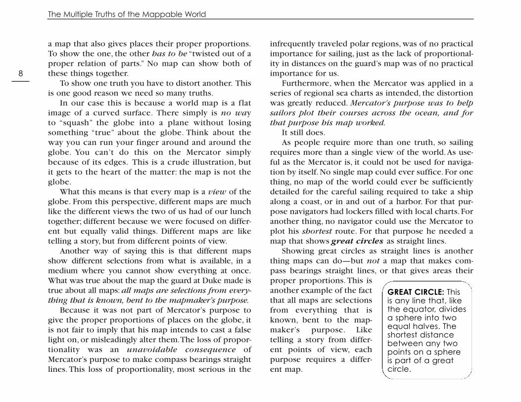
a map that also gives places their proper proportions.To show the one, the other has to be “twisted out of aproper relation of parts.” No map can show both ofthese things together.
To show one truth you have to distort another. Thisis one good reason we need so many truths.
In our case this is because a world map is a flatimage of a curved surface. There simply is no way to “squash” the globe into a plane without losingsomething “true” about the globe. Think about theway you can run your finger around and around theglobe. You can’t do this on the Mercator simplybecause of its edges. This is a crude illustration, butit gets to the heart of the matter: the map is not theglobe.
What this means is that every map is a view of theglobe. From this perspective, different maps are muchlike the different views the two of us had of our lunchtogether; different because we were focused on differ-ent but equally valid things. Different maps are liketelling a story, but from different points of view.
Another way of saying this is that different mapsshow different selections from what is available, in amedium where you cannot show everything at once.What was true about the map the guard at Duke made istrue about all maps: all maps are selections from every-thing that is known, bent to the mapmaker’s purpose.
Because it was not part of Mercator’s purpose togive the proper proportions of places on the globe, itis not fair to imply that his map intends to cast a falselight on, or misleadingly alter them.The loss of propor-tionality was an unavoidable consequence ofMercator’s purpose to make compass bearings straightlines. This loss of proportionality, most serious in the
infrequently traveled polar regions, was of no practicalimportance for sailing, just as the lack of proportional-ity in distances on the guard’s map was of no practicalimportance for us.
Furthermore, when the Mercator was applied in aseries of regional sea charts as intended, the distortionwas greatly reduced. Mercator’s purpose was to helpsailors plot their courses across the ocean, and forthat purpose his map worked.
It still does.As people require more than one truth, so sailing
requires more than a single view of the world.As use-ful as the Mercator is, it could not be used for naviga-tion by itself. No single map could ever suffice. For onething, no map of the world could ever be sufficientlydetailed for the careful sailing required to take a shipalong a coast, or in and out of a harbor. For that pur-pose navigators had lockers filled with local charts. Foranother thing, no navigator could use the Mercator toplot his shortest route. For that purpose he needed amap that shows great circles as straight lines.
Showing great circles as straight lines is anotherthing maps can do—but not a map that makes com-pass bearings straight lines, or that gives areas theirproper proportions. This isanother example of the factthat all maps are selectionsfrom everything that isknown, bent to the map-maker’s purpose. Liketelling a story from differ-ent points of view, eachpurpose requires a differ-ent map.
The Multiple Truths of the Mappable World
8
GREAT CIRCLE: This is any line that, likethe equator, dividesa sphere into twoequal halves. Theshortest distancebetween any twopoints on a sphere is part of a great circle.

What is a great circle? It is any line that divides asphere into two equal halves.The equator is a great cir-cle. It divides the globe into northern and southernhemispheres.While the shortest distance between twopoints on a plane is a straight line, the shortest distancebetween two points on a sphere is part of a great cir-cle. This is just another of those differences betweenplanes and spheres that complicates the world of maps.
You may already know about great circle routes.Take another look at a globe. If you were to fly fromNew York to Beijing would you head east over the
Atlantic, Europe and all of Asia? Or west across the U.S.and the Pacific? Or would you fly north, more or lessover the pole?
As you can see (and, if you want to make sure, youcan use a piece of thread or string to measure it), theshortest route (by far!) goes close to the North pole.This is a great circle route, a segment of a circle which,if it were continued, would circle the globe and, likethe equator, divide it in two.
As you can also see, flying along the great circleroute from New York to Beijing would require con-stantly changing your bearing. First you would be flyingapproximately north, then west, then south.
The way navigators work is to plot their route on amap that shows great circle routes as straight lines.They can do this on a kind of map called gnomonic.Such maps do not have a lot of other useful character-istics, so they are not used much. Since great circles arealmost straight on Lambert conformal conic maps,these are increasinglyused for this purpose,especially for aeronauticalcharts.
Having laid out theirroute on such a map, thepilots transfer it to a Mer-cator. Here they approxi-mate the route with achain of straight line seg-ments.They then fly alongthese segments which,since they are straightlines on a Mercator, arelines of constant compass
The Multiple Truths of the Mappable World
9
Figure 5. Mercator’s projection showing the line of constantcompass bearing (straight) and the great circle route(curved) between Kansas City and Moscow. Although itshows up as longer on this projection, the great circle routeis shorter on the globe. A composite line composed of littleshort lines of constant compass bearing would then be fittedto the great circle route. These are what a pilot would follow.
GNOMONIC: A kind of map that showsgreat circles asstraight lines.
LAMBERT CONFORMALCONIC: A kind of mapon which great circlesare close enough to straight lines tomake it useful foraeronautical charts.

bearing. This is similar to how ships navigate,too. Of course today this is all done by comput-ers.
To Repeat: A Map’s Quality Is a Function of ItsPurpose
Would it be fair to say Mercator’s world maplied because it lacked detail about the coastsand harbors?
Not really. If you want to show the world’s197 million square miles on a chart that’s twelvefeet square, some details are going to be left out.It is like telling a story. If someone wants it toldin 60 seconds, the details that would make it lastan hour have to go.You just hit the main points.This isn’t lying. (It is not incompleteness, either.)When mapmakers just hit the main points, ignor-ing, say, all the tiny twists and turns of a coast-line, they call it generalization .
Similarly, Mercator’sfailure to give placestheir proper proportionsdoesn’t amount to lying, nor isit fair to think about it as inac-curate.The changes in propor-tionality are smooth, continu-ous and predictable. They arenecessary consequences ofthe manipulations Mercatorhad to carry out in order tomake compass bearingsstraight lines.
To make all this clearer, take a look at the mapabove.What a different world!
This is called the Peters map, named for ArnoPeters who introduced it in 1974. Unlike Mercator,whose purpose was to help sailors, Peters’ purposewas to help the rest of us. Peters believed that wide-spread use of Mercator maps for purposes that hadnothing to do with navigation built up in our minds aseriously distorted image of the world.
It is fair to say Peters was especially concernedabout our image of Africa and the countries close tothe equator that were given short-shrift as a conse-
The Multiple Truths of the Mappable World
10
GENERALIZATION:When mapmak-ers smooth outcoastlines or takethe kinks out ofrivers to give thegeneral idea, aswhen they areshowing thewhole Mississippior the whole EastCoast of NorthAmerica.
Figure 6. What a different world this seems to be. This is a pro-jection of the world that gives areas their true relative size. Youcan easily see how much larger South America is than Europe. Onthe other hand, compass bearings are not straight on this map.Maps really are like points of view.

quence of the Mercator projection. On a Mercator theformer Soviet Union is much larger than Africa. Sincesize can often imply importance, wouldn’t peoplelooking at such a map imagine that the Soviet Unionwas much more important than Africa?
Africa is actually about the same size as the formerSoviet Union and the United States combined.Africa issubstantially larger than the United States and thecurrent Russia. If size were what mattered, Africawould rank second in importance only to Asia. Europewould compete with Australia for last place.There is noquestion that the Peters makes this much more evidentthan the Mercator.
Which map is right?They’re both right.They’re just “right” about differ-
ent things. But again, they’re both “wrong,” too.Try this exercise! Focus on the shapes of the conti-
nents. First hold the Peters up next to a globe. Is Africareally so tall and skinny? Is Alaska so stringy? Theshapes on the Peters are precisely as distorted as sizeson the Mercator. Good shape, what mapmakers call
conformality, is one of the things Peters had to sacri-fice to keep the areas of places in proper proportion.
On the other hand,the Mercator is said toshow true shapes. Thisis something we willhave more to say aboutlater on, but if you com-pare shapes on theMercator with those onthe globe you will seethat if shapes are true,they are true in a verypeculiar way.
In fact, shapes are only locally true on the Mercator.That is, shapes are true in this little spot here and inthat little spot there. Because sizes change so drastical-ly, when you look at something as large as a continentyou have one small true shape toward the equator (sayMexico), and another small true shape near the Northpole (say Alaska), but the latter is so many times larger
The Multiple Truths of the Mappable World
11
Figure 7. A head drawn on one projection (Robinson’s) has been transferred to the Mercator (center left) and a sinusoidal(center right) and finally to a Mollweide (far right). The ‘natural’ profile could have been drawn on any of these and
then plotted on the others. This is just a way of getting a sense of what different projections do.
CONFORMALITY: This is the ability of a mapto preserve angularrelationships as theyexist on the globe.What this means is thatthe map can showshapes the way theyare. A conformal mapcannot show areas attheir true size.

than the former, that when you put them together, theshape of North America as a whole is not right.
It’s as if you were to draw a picture of someone’sface, and you got the shape of the chin right, and yougot the shape of the forehead right, but you made theforehead ten times larger than the chin. Then eventhough every part was right, the shape of the wholeface would seem to be wrong.
Shapes get truer and truer the more you zoom in onthe Mercator. This is why the Mercator is so widelyused today for mapping small areas in great detail.
Each Map Has Its Own Point of View
So which map should you use?You should use the map that best serves your pur-
pose. Only when you are given a map’s purpose canthe map’s rightness—its truth—be assessed.
If you’re flying across the ocean, the Mercator isgoing to be useful, but if you’re trying to compare therelative size of places you will want to use the Peters.If you’re trying to find your way from Duke to AngierAvenue, neither will be the slightest help.
We need a local point of view to get across town.We need a comparative perspective to get sizes right.We need the point of view of a compass to fly acrossthe ocean.
Every map takes a point of view. No map can showeverything at once, any more than the two of us couldsee the same things at the same time at our lunchtogether. At the very least, if we were to see eachother, we couldn’t see ourselves! Besides, sometimesone of us was in the kitchen getting the coffee, or vis-iting the bathroom.Then our experiences of the meal
were sharply divided. One of us might ask,“Rememberthat bird a while ago that—”and the other will say,“No,I was in the kitchen getting the coffee, but you told meabout it.” Yet we did have lunch together.
The map that is, as it were, getting the coffee (mak-ing compass bearings straight) can’t be sitting on theporch taking in the scene (showing places in theirproper proportions). Yet there is only one planet.
It takes many different eyes to see it all, and manydifferent maps to show it. That this is a strength, not aweakness, is what the rest of this book is about.
The Multiple Truths of the Mappable World
12
To figure out what's left off a map:
One important clue is to look at what is atthe center. Sometimes what is not important to the mapmaker is put off to the edges, or left out altogether. Ask questions like:
• What would a sociologist, anthropologistor psychologist include on this map?
• To what extent does the map reflectcommercial interests (like showingrestaurants and gas stations) or highlightrecreational and aesthetic information(like hiking trails and vistas)?
• What can I discern about the self-interest of the mapmaker and/or thosewho commissioned the work? How doyou suppose that self-interest or agendamay have influenced choices of whatto include or omit?

Related Documents