Document of the World Bank Report No: ACS5812 . Nepal Kathmandu Valley Urban Policy Dialogue Advisory Notes on Metropolitan Planning and Management and Urban Regeneration .U June 2013 SASDU SOUTH ASIA . Public Disclosure Authorized Public Disclosure Authorized Public Disclosure Authorized Public Disclosure Authorized Public Disclosure Authorized Public Disclosure Authorized Public Disclosure Authorized Public Disclosure Authorized

Welcome message from author
This document is posted to help you gain knowledge. Please leave a comment to let me know what you think about it! Share it to your friends and learn new things together.
Transcript
Document of the World Bank
Report No: ACS5812
.
Nepal Kathmandu Valley Urban Policy Dialogue
Advisory Notes on Metropolitan Planning and Management and Urban Regeneration
.U June 2013
SASDU
SOUTH ASIA
.
Pub
lic D
iscl
osur
e A
utho
rized
Pub
lic D
iscl
osur
e A
utho
rized
Pub
lic D
iscl
osur
e A
utho
rized
Pub
lic D
iscl
osur
e A
utho
rized
Pub
lic D
iscl
osur
e A
utho
rized
Pub
lic D
iscl
osur
e A
utho
rized
Pub
lic D
iscl
osur
e A
utho
rized
Pub
lic D
iscl
osur
e A
utho
rized
.
Standard Disclaimer:
.
This volume is a product of the staff of the International Bank for Reconstruction and Development/ The World Bank. The findings, interpretations, and conclusions expressed in this paper do not necessarily reflect the views of the Executive Directors of The World Bank or the governments they represent. The World Bank does not guarantee the accuracy of the data included in this work. The boundaries, colors, denominations, and other information shown on any map in this work do not imply any judgment on the part of The World Bank concerning the legal status of any territory or the endorsement or acceptance of such boundaries.
.
Copyright Statement:
.
The material in this publication is copyrighted. Copying and/or transmitting portions or all of this work without permission may be a
violation of applicable law. The International Bank for Reconstruction and Development/ The World Bank encourages dissemination
of its work and will normally grant permission to reproduce portions of the work promptly.
For permission to photocopy or reprint any part of this work, please send a request with complete information to the Copyright
Clearance Center, Inc., 222 Rosewood Drive, Danvers, MA 01923, USA, telephone 978-750-8400, fax 978-750-4470,
http://www.copyright.com/.
All other queries on rights and licenses, including subsidiary rights, should be addressed to the Office of the Publisher, The World
Bank, 1818 H Street NW, Washington, DC 20433, USA, fax 202-522-2422, e-mail [email protected].
Nepal Kathmandu Valley Urban Policy Dialogue
Metropolitan Planning & Management in the Kathmandu Valley
Advisory Note & Action Plan
Urban Regeneration of the Historic City Cores of the Kathmandu Valley
Advisory Note & Action Plan
Summary of Focus Group Discussions in Prayag Pokhari and Jhyapato
Initial Documentation & Description of Two Heritage Routes in Lalitput
June 2013

KATHMANDU VALLEY URBAN POLICY DIALOGUE
TECHNICAL ASSISTANCE
METROPOLTIAN PLANNING AND MANAGEMENT
IN THE KATHAMANDU VALLEY
ADVISORY NOTE AND ACTION PLAN
June 2013
South Asia Urban Unit
1
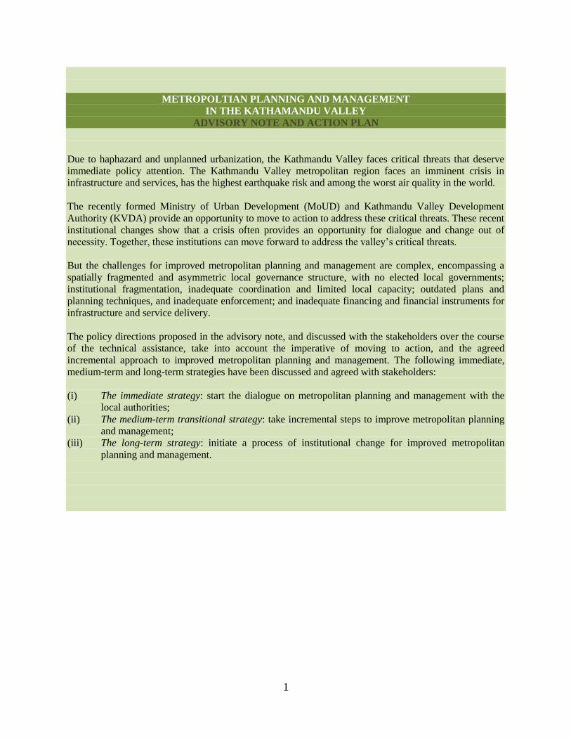
METROPOLTIAN PLANNING AND MANAGEMENT
IN THE KATHAMANDU VALLEY
ADVISORY NOTE AND ACTION PLAN
Due to haphazard and unplanned urbanization, the Kathmandu Valley faces critical threats that deserve
immediate policy attention. The Kathmandu Valley metropolitan region faces an imminent crisis in
infrastructure and services, has the highest earthquake risk and among the worst air quality in the world.
The recently formed Ministry of Urban Development (MoUD) and Kathmandu Valley Development
Authority (KVDA) provide an opportunity to move to action to address these critical threats. These recent
institutional changes show that a crisis often provides an opportunity for dialogue and change out of
necessity. Together, these institutions can move forward to address the valley’s critical threats.
But the challenges for improved metropolitan planning and management are complex, encompassing a
spatially fragmented and asymmetric local governance structure, with no elected local governments;
institutional fragmentation, inadequate coordination and limited local capacity; outdated plans and
planning techniques, and inadequate enforcement; and inadequate financing and financial instruments for
infrastructure and service delivery.
The policy directions proposed in the advisory note, and discussed with the stakeholders over the course
of the technical assistance, take into account the imperative of moving to action, and the agreed
incremental approach to improved metropolitan planning and management. The following immediate,
medium-term and long-term strategies have been discussed and agreed with stakeholders:
(i) The immediate strategy: start the dialogue on metropolitan planning and management with the
local authorities;
(ii) The medium-term transitional strategy: take incremental steps to improve metropolitan planning
and management;
(iii) The long-term strategy: initiate a process of institutional change for improved metropolitan
planning and management.
2
ACKNOWLEDGEMENTS
This note has been prepared by a team comprising Elisa Muzzini, Senior Economist in the South
Asia Urban and Water Unit of the World Bank/Task Team Leader), Silva Shrestha (Water &
Sanitation Specialist), Pawan Lohani (Consultant/Municipal finance), Anil Pokhrel (Disaster
Risk Management Specialist), Sonam Velani (Disaster Risk Management Analyst), Tara
Lonnberg (Consultant/Institutions) and a team of experts including David Dowall (International
Development Advisor and Professor Emeritus of Planning, University of Berkeley), Edward
Leman (Consultant/urban planning), and Rajivan Krishnaswamy (Consultant/municipal finance).
The advisory note benefited from the Global Lab Knowledge exchange on metropolitan planning
organized by the World Bank Institute (WBI) and the World Bank Urban Anchor in
collaboration with the South Asia Urban & Water Unit. The Technical Assistance benefited from
support from the World Bank – AusAID Infrastructure for Growth Trust Fund.
The advisory note builds on consultations with a broad range of central agencies and local
governments, service delivery agencies, NGOs, private sector, the academia and professionals
conducted in January and April, 2013; a sector study on the competitiveness of the Kathmandu
Valley Metropolitan Region conducted by the World Bank in 2012; and the World Bank’s
‘Urban Growth and Spatial Transition in Nepal’ study completed in 2012. The team would like
to extend special thanks to the Ministry of Urban Development (MoUD), the Ministry of Federal
Affairs and Local Development (MoFALD), the Ministry of Physical Infrastructure and
Transport, the Ministry of Home Affairs, the Kathmandu Valley Development Authority
(KVDA), the Kathmandu Valley Water and Sewerage Board (KVWSB), and the High-Powered
Commission for the Bagmati Civilization for their collaborative efforts to support the note.

3
TABLE OF CONTENTS
EXECUTIVE SUMMARY ................................................................................................................................. 4
I. INTRODUCTION ..................................................................................................................................... 9
II. THE CRITICAL THREATS POSED BY RAPID, HAPAZHARD URBAN GROWTH IN
THE KATHMANDU VALLEY ..................................................................................................................... 10
III. OPPORTUNITIES AND CHALLENGES FOR METROPOLITAN PLANNING AND
MANAGEMENT ................................................................................................................................................. 12
III.I The Opportunities ................................................................................................................................... 12
III.II The Challenges ........................................................................................................................................ 14
IV. POLICY DIRECTIONS ........................................................................................................................... 23
A. The Immediate Strategy – Start the Dialogue on Metropolitan Management and Planning
with the Local Authorities ................................................................................................................................. 24
B. The Medium-term Transitional Strategy – Take Incremental Steps to Improve
Metropolitan Planning and Management ...................................................................................................... 28
C. The Long-term Strategy – Initiate a Process of Institutional Change for Improved
Metropolitan Planning and Management ...................................................................................................... 32
V. IMPLEMENTATION ROADMAP FOR IMPROVED METROPOLITAN PLANNING
AND MANAGEMENT ..................................................................................................................................... 34
Annexes
Annex 1: Models of Metropolitan Management – The International Experience ............................ 37
Tables
Table 1: Summary of Examples, Criteria and Models .............................................................................. 42
Boxes
Box 1: The Functions and Governance Structure of the KVDA............................................................ 13
Box 2: The 2020 Kathmandu Valley Long-term Development Plan ................................................... 20
Box 3: Metropolitan Partnerships – The International Experience ....................................................... 28
Box 4: Geospatial Data and Open Source Tools for Planning: An International Perspective....... 30
Box 5: Metropolitan Initiative for the Regeneration of the Kathmandu Valley ................................ 31
Maps
Map 1: Kathmandu Valley, Population Growth 1991-2001 ................................................................... 16
Map 2: Kathmandu Valley, Population Growth 2001-2011 ................................................................... 17

4
EXECUTIVE SUMMARY
The Kathmandu Valley has not been able to seize the benefits of agglomeration forces due to
haphazard and unplanned urbanization.
The rapid growth of the valley, if well managed, provides an opportunity for agglomeration
economies to arise at the metropolitan scale. The Kathmandu Valley is one of the fastest-
growing metropolitan regions in Asia. With a population of 2.5 million, it is the first region in
Nepal to face urbanization at a metropolitan scale. And it is one of the fastest growing
metropolitan regions in South Asia, with annual population growth of 4 percent in the core urban
area, and 5-6 percent in peri-urban areas, based on 2001 and 2011 population census data.
A number of threats have, however, been borne of this rapid and unmanaged urbanization. The
largely unplanned and unmanaged development has left the Kathmandu Valley with major
shortages in infrastructure and services, high vulnerability to earthquakes and one of the worst
air qualities of any urban agglomeration in the world.
Urbanization has led to the decay of historic neighborhoods in the city cores and haphazard
urban expansion at the fringe. The loss of unique cultural assets in the city cores has negatively
affected tourism revenues – a key economic driver in the valley – with a decline in tourists’
visitation time and daily tourist expenditure (from US$ 65 in 2009 to US$ 40 in 2011).
The valley now faces an imminent crisis in infrastructure and services. Piped water supply meets
less than half of the total demand. Solid waste is often disposed on riverbanks and in open
dumps, and the Sisdol landfill site is currently at capacity. The Kathmandu Valley does not have
a public transportation system. Citizens rely on private and largely unregulated small bus
companies. Load shedding is routine in the valley.
Un-managed urbanization has increased vulnerability to seismic risk. The Kathmandu Valley is
the urban area facing the highest earthquake risk in the world. An earthquake occurs every 50-70
years on average; the valley is overdue for a large seismic event. It is expected that 1 in 20
people would be killed, 1 in 7 would be hospitalized, and 1 out of every 2 people would be
homeless as 60 percent of all buildings are projected to be heavily damaged. These estimates are
widely viewed as underestimating the actual risk.
And air quality in the Kathmandu Valley is among the worst in the world. The main sources of
pollution are vehicle emissions, emissions of re-suspended dust from poorly maintained and un-
cleaned roads and the brick sector. About 1,600 premature deaths per year in the valley are
expected to occur due to the exposure of the population to PM10; about 1-8 people in 100,000
are expected to suffer from leukemia due to benzene exposure; and about 16-32 people in
100,000 are expected to suffer from lung cancer due to PAH exposure.
5
Opportunities have opened up for improving metropolitan planning and management in the
Kathmandu Valley.
Recent institutional and legislative trends and actions signal a renewed policy attention by the
Government of Nepal to the Kathmandu Valley metropolitan area. A dedicated Ministry for
Urban Development (MoUD) and a metropolitan agency for the Kathmandu Valley, the
Kathmandu Valley Development Authority (KVDA), were established in 2012. The recent
institutional changes respond to the need for strengthening central oversight and metropolitan-
level planning and management in the Kathmandu Valley.
The formal adoption of the KVDA Regulations in March 2012 has empowered the KVDA to
assume its mandate and responsibilities. As per the KVDA Act of 1988, the agency is granted
authority for planning, development, enforcement of regulations and coordination over the five
urban local bodies and 99 small rural local bodies (Village Development Committees [VDCs])
comprising the metropolitan area.1 The enactment of the Regulations of 2012 empowered the
KVDA to take on its functions. The regulations, however, do not reaffirm the KVDA’s broader
authority for metropolitan management and coordination, as stipulated in the KVDA Act.
An important initiative led by the newly established Ministry is the preparation of the first
national urban strategy. Building on the Nepal Urban Policy of 2007, the national urban strategy
is the signature initiative of the new ministry. It would provide timely policy directions to
respond to the challenges of rapid urbanization in Nepal, fostering the resilient and sustainable
growth of urban regions and enhancing the competitiveness of the Kathmandu Valley.
The Kathmandu Valley faces complex challenges for improved metropolitan planning and
management, encompassing local governance, urban management, planning, and sustainable
financing of infrastructure and service delivery.
The Kathmandu Valley metropolitan region has a spatially fragmented and asymmetric local
governance structure, with no elected local governments. The Kathmandu Valley has one-tier
fragmented governance structure comprising five urban local bodies and 99 rural local bodies
(VDCs), of which nearly half are classified as urbanizing, in suburban and outer areas.2 An
equally important challenge is the very limited spatial territory of individual local government
units, in particular the VDCs. The highly asymmetric local governance structure, dominated by
the Kathmandu Metropolitan City, has created an imbalance in financial and human resources,
and technical capacity across the local bodies. The lack of elected local representatives is a
challenge for local governance, but recent political events herald a return to local elected
governance in Nepal by April 2014.
Overlapping mandates and duplication of functions among levels of government, and limited
local capacity, are a challenge for metropolitan management. Coordination among central
agencies remains a challenge given the institutional fragmentation, but the recent creation of a
1 There are 16 VDCs in Bhaktapur District, 57 in Kathmandu District and 26 in Lalitpur District.
2 The five urban local bodies are the Kathmandu Metropolitan City (population of 1,007,000), Kirtipur Municipality
(67,000), Lalitpur Sub-metropolitan City (223,000), Bhaktapur Municipality (84,000) and Madhyapur Thimi
Municipality (84,000)
6
dedicated line ministry presents an opportunity for strengthening central oversight in the
Kathmandu Valley. The division of functional responsibilities between the KVDA and local
governments needs however clarification, as the KVDA’s broad mandate can potentially overlap
with those of local bodies in several areas. Urban management capacities of local governments
are limited, and their mandates are under-funded.
Plans and planning techniques are outdated, and enforcement inadequate. There is no updated
metropolitan strategy and plan to guide urban development in the valley. The 2020 Kathmandu
Valley Long Term Development Plan of 2002 lacks necessary implementation and financing
plans. Data and technological tools to support the planning process at the metropolitan scale are
inadequate. Plans and regulations at the local levels are outdated and largely ad hoc. Local plans
are not framed within an overall strategic context. Building bye-laws are similarly not being
enforced.
Financing and financing instruments for infrastructure and service delivery are inadequate. The
spatial distribution of capital expenditure for municipal infrastructure is biased against
Kathmandu Metropolitan City, where the needs are the highest. Sustainable financing for
metropolitan infrastructure is a challenge given the over-reliance on central funds, and the
limited scope for cost sharing by the local governments and users. Land pooling, the dominant
instrument used to self-finance infrastructure in the valley, is a lengthy and complex process
yielding limited resources relative to the time invested.
Immediate, medium-term, and long-term strategies have been identified for strengthening
metropolitan planning and management, taking into account the imperative of moving to
action, and the agreed incremental approach.
A. The immediate strategy START THE DIALOGUE ON METROPOLITAN MANAGEMENT AND PLANNING WITH
THE LOCAL AUTHORITIES
A.1 Clarify the hierarchy of roles and responsibilities for metropolitan planning and
management. There is the need to start a dialogue on metropolitan management and planning
needs to clarify roles and responsibilities at central, metropolitan and local levels within the
existing governance structure. The MoUD is expected to have central oversight, high-level
policy-making and technical support functions; the KVDA will take on responsibilities as the
metropolitan planning agency, regulatory agency, apex body for metropolitan coordination, and
promoter of strategic land development and infrastructure projects; and local authorities will
retain responsibility for local planning, service delivery and urban management functions.
A.2 Agree on metropolitan initiatives that the KVDA can champion to show tangible and
quick results. The following three strategic entry points were agreed during the consultations:
(a) prepare a Kathmandu Valley development strategy and structure plan, and establish an open
repository of metropolitan geospatial data and information; (b) launch a metropolitan initiative to
regenerate the historic city cores of the Kathmandu Valley; and (c) launch a metropolitan
7
initiative to increase resilience to natural disasters. 3
The consultations also identified interest
from stakeholders for discussing as part of the initial phase of stakeholder dialogue the
development of important metropolitan initiatives on solid waste management, air quality and
transportation. These three areas require enhanced coordination at the metropolitan level.
B. The medium-term transitional strategy TAKE INCREMENTAL STEPS TO IMPROVE METROPOLITAN PLANNING AND
MANAGEMENT
B.1 Update the 2020 Kathmandu Valley Long Term Development Plan, and establish an
open repository of metropolitan geospatial data and information. It is recommended that the
plan be developed as a strategic and structural plan, rather than a master plan. Particular attention
would need to be paid to plan for urban expansion at the fringe, while protecting high-
productivity agricultural land and open spaces and steering development away from hazard prone
areas.
B.2 Develop a road map and implement a metropolitan initiative for the regeneration of
the historic cores of the Kathmandu Valley. Urban regeneration goes beyond physical
upgrading to include economic revitalization, disaster risk management, livable housing,
protection of cultural heritage and community strengthening. Consensus was reached as part of
the consultations on the following key conditions for the success of the urban regeneration
strategy: (i) an integrated approach to upgrading the urban fabric; (ii) a partnership between the
government and the private sector; (iii) involvement of local communities; and (iv) strong
institutional coordination mechanisms among stakeholders at metropolitan level.4
B.3 Develop and implement a metropolitan initiative to improve resilience to natural
disasters. The KVDA has an important role to play to mainstream disaster risk considerations
into the metropolitan planning process and infrastructure investments; coordinate disaster risk
management initiatives implemented by local authorities and central agencies; and manage
technical assistance and capacity building for the local authorities on topics related to disaster
risk reduction.
B.4 Develop and implement a metropolitan-level technical assistance program for local
authorities for local infrastructure planning, financing and service delivery. Given the
challenges of providing technical assistance in a highly fragmented governance structure, it is
recommended that technical assistance be targeted where the needs are highest, such as urban
local bodies and rapidly urbanizing rural local bodies (VDCs), in the initial phase.
B.5 Design appropriate incentive-based financing mechanisms to enhance metropolitan
planning and management. Options include setting incentives to promote local planning efforts
that are consistent with the metropolitan structure plan, and earmarked funds for the
implementation of specific metropolitan initiatives.
3 Entry points were identified as part of the consultative process based on the following criteria: (a) urgency of
interventions, and socio-economic benefits; (b) consensus among local authorities about priority activities, which
can deliver quick and visible results on the ground; and (c) rationale for metropolitan-level interventions 4 A separate advisory note has been prepared to outline the policy directions and action plan for implementing the
metropolitan urban regeneration initiative.
8
C. The long-term strategy INITIATE A PROCESS OF INSTITUTIONAL CHANGE FOR IMPROVED METROPOLITAN
PLANNING AND MANAGEMENT
C.1 Develop a process to guide institutional change for metropolitan planning and
management. The process that will be used to structure metropolitan governance and
management models is the critical success factor for institutional change. Ideally, this process
should be undertaken after the local elections planned for 2014.
C.2 Evaluate models of metropolitan management and their strengths and weaknesses
and applicability to the valley in the longer-term. Stakeholders need to be informed about
alternative models and their applicability to Kathmandu. It is likely that a two-tiered
consolidated governance structure would emerge as the preferred choice for the management of
the Kathmandu Valley in the long-term, with an enhanced role for the central government in
some strategic areas.
9
I. INTRODUCTION
This advisory note, prepared as part of the Kathmandu Valley Technical Assistance, summarizes
the technical support provided to the recently established Ministry of Urban Development
(MoUD) and the Kathmandu Valley Development Authority (KVDA) for improving
metropolitan planning and management in the valley. The advisory note discusses the critical
threats facing the Kathmandu Valley metropolitan region (KVMR), presents opportunities and
challenges for improved metropolitan planning and management, and provides policy directions
and an action plan to guide policy implementation by the central government, the MoUD, the
KVDA, municipalities and Village Development Committees (VDCs) over the next two years.
Methodology. The advisory note builds on consultations with a broad range of central agencies
and local governments, service delivery agencies, NGOs, private sector, the academia and
professionals conducted in January and April, 2013; background studies on the KVMR’s
competitiveness conducted by the World Bank in 2012; and the World Bank’s ‘Urban Growth
and Spatial Transition in Nepal’ study completed in 2012.5 The advisory note also presents
relevant, internationally based policy research on how other metropolitan areas have tackled
problems similar to the Kathmandu Valley by reducing the negative effects of fragmentation and
inefficient management. These examples will assist policy makers in assessing the suitability and
applicability of the proposed policy directions in the Kathmandu Valley.
Outline. The advisory note is structured as follows:
Section II discusses the critical threats posed by rapid, haphazard urban growth in the
Kathmandu Valley.
Section III presents the main opportunities and challenges for improved metropolitan
panning and management.
Section IV outlines a set of immediate, medium-term and long-term policy directions for
identifying priorities, implementation arrangement and financing mechanisms for
improving the valley’s metropolitan planning and management.
Section V presents a road map for policy implementation.
The Annex presents relevant international experiences with metropolitan governance and
management structures.
5 Muzzini and Aparicio. 2013. Urban Growth and Spatial Transition in Nepal. An Initial Assessment. Directions in
Development. Washington, DC: World Bank.
10
II. THE CRITICAL THREATS POSED BY RAPID, HAPAZHARD URBAN
GROWTH IN THE KATHMANDU VALLEY
The Kathmandu Valley has not been able to fully seize the benefits of agglomeration forces
associated with rapid urbanization. It faces critical threats that deserve immediate policy
attention. Rapid and haphazard urbanization has led to the decay of historic neighborhoods in
the city cores and unplanned urban expansion at the fringe. The Kathmandu Valley faces an
imminent crisis in infrastructure and services, the highest earthquake risk and one of the worst
air qualities of any urban agglomeration in the world.
The rapid growth of the valley, if well managed, provides an opportunity for agglomeration
economies to arise at the metropolitan scale, with the associated benefits of higher private
investments, and more and higher productivity jobs. With a population of 2.5 million, the
Kathmandu Valley is the first region in Nepal to face the opportunities and challenges of
urbanization at a metropolitan scale. The Kathmandu Valley is one of the fastest growing
metropolitan regions in South Asia – with population growth to the order of 4 percent in the core,
and 5 percent in the outskirts. The small and relatively compact metropolis of 1.6 million people
in 2000 has mushroomed into a metropolitan region of 2.6 million residents based on 2011
population census data. However, the Kathmandu Valley has not been able to fully reap the
benefits of urbanization, and the costs of unmanaged urbanization are high and growing.6
Rapid and haphazard urbanization has led to the decay of historic neighborhoods in the city
cores and unplanned urban expansion at the fringe. Rapid and haphazard urbanization of the
Kathmandu Valley over the last 15 years has led to the unprecedented consumption of suburban
land, fragmentation and loss of agricultural land, degeneration of historic city cores and their
environments, and inadequate infrastructure and services to accommodate rapidly growing
urbanization. The loss of unique cultural assets in the city cores has negatively affected tourism
revenues – a key economic driver in the valley. In spite of the increasing influx of tourists to
Nepal since the end of the insurgency, tourists’ visitation time as well as their daily expenditure
(from $65 in 2009 to $40 in 2011) is declining.7
The rapidly expanding Kathmandu Valley faces an imminent crisis in infrastructure and
services – water and sanitation, solid waste management, and transportation. Inadequate
provision and quality of urban services has severely compromised the quality of life for urban
residents, and affected productivity. The water sector faces an imminent crisis. The piped water
supply meets less than half of the total demand, solid waste is often disposed on riverbanks and
in open dumps, and the Sisdol landfill site is currently at capacity. The Kathmandu Valley does
not have a public transportation system, with citizens relying on taxis or private and largely
unregulated small bus companies. Load shedding is routine in the valley. Power outages average
6 Based on 2011 population census data.
7 ETG (Economic Transformations Group). 2012. “Kathmandu Valley Tourism Cluster Competitiveness
Assessment and Action Plan.” Background paper for Muzzini and Aparicio. 2013. Urban Growth and Spatial
Transition in Nepal. An Initial Assessment. Directions in Development. Washington, DC: World Bank.

11
68 hours per week (starting from February 27, 2012), in which there are 9 hours of power
outages for three days, 10 hours for the next three days, and 11 hours for the seventh day. 8
Rapid and un-managed urbanization has increased vulnerability to seismic risk. The
Kathmandu Valley is the urban area facing the highest earthquake risk in the world9, while Nepal
is the 11th
most at-risk country to earthquakes and the 30th
most at-risk to floods and landslides.10
A loss estimation study was conducted as part of the Kathmandu Valley Earthquake Risk
Management Project from 1997-1999. This study examined the potential damage scenario if the
1934 earthquake were to reoccur in the valley. The National Society for Earthquake Technology
(NSET) revised the estimates in 2010, accounting for the area’s demographic changes. The new
estimates suggest that 1 in 20 people will be killed and 1 in 7 will require hospitalization. One
out of every 2 people is projected to be left homeless as 60 percent of all buildings are projected
to be heavily damaged. In terms of damage to basic infrastructure, 50 percent of all bridges will
be impassable, 95 percent of water pipes and 50 percent of water system components such as
pumping stations and treatment plants will be severely damaged, and 40 percent of electricity
lines and substations will not function. These estimates are widely viewed as underestimating the
actual risk.
Air quality in the Kathmandu Valley is among the worst in the world. The Environment
Performance Index (EPI) ranking 2012—by the Yale Centre for Environmental Law and Policy,
Yale University and Centre for International Earth Science Information Network and Columbia
University—has listed Nepal in the third to last position (the 130th
) among 132 countries, in
terms of air pollution impact on human health, only before India and Bangladesh.11 The main
sources of pollution are vehicle emissions, emissions of re-suspended dust from poorly
maintained and un-cleaned roads and the brick sector. About 1,600 premature deaths per year are
expected to occur due to exposure of the Kathmandu Valley population to PM10; about 1-8
people in 100,000 are expected to suffer from leukemia due to benzene exposure; and about 16-
32 people in 100,000 from lung cancer due to PAH exposure. 12
These threats call for immediate policy attention and actions to improve metropolitan planning
and management. The following section discusses a number of positive steps that have been
taken to improve metropolitan planning and management in the KVMR as a response to the
critical threats that have been borne out of this rapid and unmanaged urbanization.
8 Muzzini and Aparicio. 2013. Urban Growth and Spatial Transition in Nepal. An Initial Assessment. Directions in
Development. Washington, DC: World Bank. 9 GeoHazards International & United Nations Center for Regional Development. 2001. Global Earthquake Safety
Initiative Pilot Project Final Report. 10
UNDP/BCPR. 2004. Reducing Disaster Risk: A Challenge for Development A Global Report. New York: United
Nations Development Programme/Bureau for Crisis Prevention and Recovery. 11
http://epi.yale.edu/epi2012/countryprofiles 12
A recent study by the Swedish Environment Institute in 2009 found that: “Fine particulate matter (PM2.5),
polycyclic aromatic hydrocarbons (PAH) and benzene are air pollutants of concern in Kathmandu Valley;
concentrations of PM10 and PM2.5 exceed WHO guideline values by a factor
of 2-10 indicating a serious risk for cardiovascular-respiratory diseases; the fraction of fine particles PM2.5 and
PM1.0 (0.8-0.9) is large in PM10 indicating a high threat of PM-induced ailments.
12
III. OPPORTUNITIES AND CHALLENGES FOR METROPOLITAN PLANNING
AND MANAGEMENT
The recent institutional and legislative developments, with the establishment of the MoUD and
the KVDA, are positive steps to improve metropolitan planning and management in the valley.
But the challenges ahead are complex, encompassing local governance, urban management,
planning, infrastructure and service delivery and land development.
Opportunities have opened up for improving planning and management of the metropolitan
region. There have been efforts to create an enabling environment to support urban development
in the metropolitan area through institutional and policy changes. However, complex challenges
remain related to the local governance structure and institutional settings. And efforts to advance
metropolitan planning and management in the valley are additionally up against constrained local
capacity, poor enforcement of planning and regulation, and inadequate infrastructure financing
instruments.
III.I The Opportunities
The urban agenda in Nepal has received renewed policy attention recently. A crisis often
provides an opportunity for dialogue and change out of necessity, as the recent institutional
developments in the Nepal urban sector demonstrate. A dedicated ministry for urban
development and a metropolitan agency for the Kathmandu Valley, the KVDA, were established
in 2012. The KVDA Act of December, 1988 entrusts the KVDA with broad authority for
metropolitan planning and regulation, management and coordination, as well as land
development in the metropolitan area. The establishment of the new ministry and the
metropolitan agency has generated momentum for action, in spite of the continuous political
instability. Together these institutions can move the agenda forward to address the critical threats
facing the valley.
The recent institutional changes respond to the need for strengthening central oversight and
metropolitan-level planning and management in the Kathmandu Valley. These high level
actions also provide an opportunity for rethinking the role of central, metropolitan and local
institutions to enhance the quality of life, competitiveness and effectiveness of service delivery in
the Kathmandu Valley as the country moves toward a decentralized local governance structure.
The establishment of the two dedicated urban institutions at the central and metropolitan levels
also reflects the growing recognition among government officials of the economic importance of
investing in urban areas.
The formal adoption of the KVDA Regulations in March 2012 has empowered the KVDA to
assume its mandate and responsibilities. The KVDA is established as a multi-purpose
metropolitan agency based on the KVDA Act of 1988, and the KVDA Regulations of 2012 (see
Box 1 for a review of the functions and governance structure of the KVDA). The agency is
granted authority for planning, development, enforcement of regulations and coordination over
the five urban local bodies and 99 VDCs comprising the metropolitan area13
The enactment of
the Regulations of 2012 empowered the KVDA to take on its functions, and coincides with the
13
There are 16 VDCs in Bhaktapur District, 57 in Kathmandu District and 26 in Lalitpur District.
13
dissolution of the Kathmandu Valley Town Development Committee, which prepared the 2020
Kathmandu Valley Long-term Development Concept of 2002. The fact that the 1988 KVDA Act
has not been officially ratified and gazetted, however, raises a number of legal ambiguities.
The regulations do not reaffirm the KVDA’s broader authority for metropolitan management
and coordination, as stipulated in the KVDA Act. The KVDA Regulations of 2012 refer to
Articles 29 and 29.1 of the 1988 Act allowing for the adoption of regulations to activate the
powers of the KVDA. However, the Regulations are limited in its promulgation of KVDA
activities to physical planning, enforcement of regulations and development and do not reaffirm
broader authority for metropolitan coordination as stipulated in the 1988 KVDA Act. As
discussed later in the advisory note, the Regulations also do not clarify the functions of the local
bodies vis-à-vis the KVDA. Ambiguities and overlapping mandates may arise in the absence of
regulations clarifying divisions of responsibilities across tiers of government to ensure that
central, metropolitan and local planning complement each other. This calls for either the formal
adoption of the 1988 KVDA Act or efforts to harmonize the 1988 KVDA Act with the 2012
KVDA Regulations.
The preparation of the national urban strategy provides an opportunity to develop timely
policy directions to respond to the challenges of rapid urbanization in Nepal. An important
initiative led by the newly established Ministry is the preparation of the first national urban
strategy, building on the Nepal Urban Policy of 2007. As the signature initiative of the new
ministry, the strategy is expected to advance the urban agenda in the country by setting the vision
and directions for urban development based on concrete, time-bound and measurable urban
development targets, and developing an investment and financing plan to support its
operationalization. The strategy is also expected to provide the much needed framework for
prioritizing the “where, what and how” of infrastructure investments in rapidly growing urban
areas that are highly exposed to natural hazards. It would also clarify the roles and
responsibilities of central and local governments in urban development, paying particular
attention to the special challenges of metropolitan management in the Kathmandu Valley. The
strategy also has the potential to influence the spatial dimension of the future federal structure of
Nepal and the overall decentralization debate.
Box 1: The Functions and Governance Structure of the KVDA
The KVDA is established as an autonomous multi-purpose metropolitan agency, reporting to the MoUD,
and entrusted with responsibilities for: (i) metropolitan planning; (ii) metropolitan coordination; (iii) land
development; and (iv) enforcement of regulations in the valley. As per the 1988 KVDA Act, the KVDA is
responsible for: (i) preparing and implementing a physical development plan for the Kathmandu Valley
(section 5); (ii) regulating, controlling, banning development in the valley in line with the plan (section 8);
(iii) demolishing constructions that are in violation of regulation (section 9); (iv) carrying out projects for
the conservation and maintenance of cultural heritage (section 6.1.3); (v) regulating activities for the
protection of the natural environment (section 8.1.4); (vi) formulating and implementing land
development projects, including land pooling schemes, in line with the physical plan (section 10); and
(vii) coordinating development in the valley (section 6.2). The KVDA has authority to mobilize funds to
carry out its functions, including receiving grants from the central government and international
organizations, as well as borrowing and generating income from the management of its own land and
properties. The KVDA takes over the functions of the Kathmandu Valley Town Development Committee,
which was dissolved with the passing of the KVDA Regulations of 2012.
14
Through its governance structure, the KVDA is empowered to coordinate and manage development in the
valley. The KVDA is headed by a Development Commissioner appointed by the Government as the
Executive Chief of the KVDA for a fixed term of 5 years, with possibility of extension for a second term.
The Development Commissioner chairs the Board of Director, which is responsible for directing,
managing and monitoring the operations of the KVDA under the supervision of the Kathmandu Valley
Physical Development Board.
The Board of Director is headed by the Development Commissioner, and includes representatives from
offices with responsibilities for implementing programs in the valley, such as the Department of Urban
Development and Building Construction (DUDBC), the representatives/chairpersons from Kathmandu
Metropolitan City, Lalitpur Sub-metropolitan City, and Bhaktapur Municipality, and three VDCs in the
valley. The Board of Director meets at least every two months. The quorum of the meeting is 50 percent
of the members, and decisions are taken by majority.
The Kathmandu Valley Physical Development Board is the policy-making and oversight body with
responsibilities for: (i) approving the annual budget and the bye-laws of the authority; (ii) formulating
policies for the preparation of the physical development plan; (iii) approving the plan; and (iv) monitoring
implementation progress. The KVPDB comprises the Development Commissioner, Secretaries from
relevant ministers, representatives/chairpersons from Kathmandu Metropolitan City, Lalitpur Sub-
metropolitan City, and Bhaktapur Municipality, and the Commissioners of the three Districts in the valley
(Kathmandu, Lalitpur and Bhaktapur).
III.II The Challenges
The challenges associated with local governance, urban management, planning, and
sustainable financing for infrastructure and service delivery in the valley are complex. The
section provides an overview of the following critical challenges facing the valley:
A. A spatially fragmented and asymmetric local governance structure, with no elected local
government officials.
B. Overlapping mandates and duplication of functions among levels of government, and
limited local capacity.
C. Out-dated plans and planning techniques, and inadequate enforcement of plans.
D. Inadequate financing and financing instruments for infrastructure and service delivery.
A. A spatially fragmented and asymmetric local governance structure, with no elected
local government officials
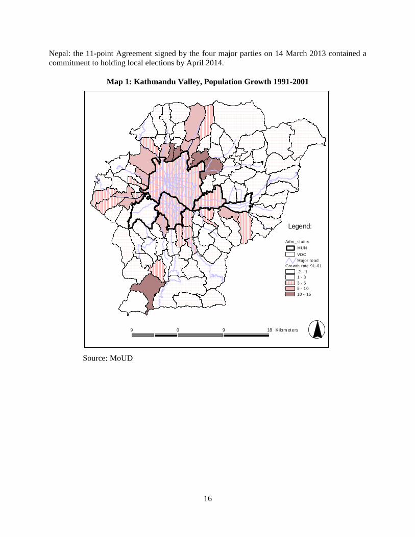
As in most metropolitan regions elsewhere in the world, the KVMR crosses multiple municipal
boundaries. The KVMR, as defined in the 1988 KVDA Act, has a one-tier fragmented
governance structure, comprising five urban local bodies and 99 rural local bodies (VDCs), of
which nearly half are classified as urbanizing (see maps 1 and 2). The five urban local bodies are
the Kathmandu Metropolitan City (population of 1,007,000), Kirtipur Municipality (67,000),
Lalitpur Sub-metropolitan City (223,000), Bhaktapur Municipality (84,000) and Madhyapur
15
Thimi Municipality (84,000).14
The KVDA, as a multi-purpose metropolitan agency, has
jurisdiction over the entire KVMR territory.
Fragmentation of the nearly 100 VDCs in suburban and outer areas of the valley is a
challenge for effective metropolitan management. An equally important challenge is the very
limited spatial territory of individual local government units, in particular the VDCs, which
further compound the difficulties of planning metropolitan infrastructure and service delivery.
The average area of the 104 local government units in the Valley is 69 km2. Compared with
many other metropolitan regions, the KVMR, relative to its population, has an extremely high
number of local government units. For example, Metro Manila, the largest metropolitan area in
the Philippines, has a population of about 12 million persons, subdivided in 11 local government
units. The large number of geographically small local government units has created a highly
fragmented system of local governance in the KVMR.
Aside from spatial fragmentation, the Kathmandu Valley’s local governance structure is
highly asymmetric in terms of population. Kathmandu Metropolitan City contains 40 percent of
the valley’s population, compared to 18.6 percent for the four other municipalities combined.
This asymmetry is found in other metropolitan regions around the world—New York City’s
population accounts for about 44 percent of the New York metropolitan area’s population.15
The
asymmetry in the governance structure presents challenges for metropolitan management, given
the associated imbalance in financial and human resources, and technical capacity across the
local bodies.
The KVDA Act provides mechanisms for coordinating among local authorities in the valley,
but their effectiveness is yet to be tested. A spatially fragmented local governance structure
poses a major challenge for the effective regional coordination of development planning and
service delivery. The KVDA Act of 1988, however, provides the metropolitan agency with the
tools for coordination and management in a highly fragmented local governance structure. The
1988 KVDA Act calls for the KVDA’s Board of Directors to coordinate with the VDCs in the
valley through three government-designated VDC Chairmen, as well as three appointed District
Commissioners, which are part of the Kathmandu Valley Physical Development Board (see Box
1). The coordination mechanisms however, have not yet been tested, since the KVDA has not yet
fully taken on its functions.
The lack of elected local representatives is a challenge for local governance, but recent
political events herald a return to local elected governance. The last elections for local
government were held in 1997. Since 2002, when the central government postponed local
elections, District Commissioners, Municipal Chief Executives, and VDC Secretaries have all
been civil servants appointed by the central government. Although many of them proactively
engage with local communities, they lack the formal accountability of elected Councils and
Development Committees. Recent political events herald a return to local elected governance in
14
Population based on 2011 census data. 15
United States Census Bureau, "Population Estimates: Metropolitan and Micropolitan Statistical Areas"
and "Table GCT-PL2 - Population and Housing Occupancy Status: 2010 - United States -- Metropolitan Statistical
Area; and for Puerto Rico".
16
Nepal: the 11-point Agreement signed by the four major parties on 14 March 2013 contained a
commitment to holding local elections by April 2014.
Map 1: Kathmandu Valley, Population Growth 1991-2001
Source: MoUD
9 0 9 18 Kilom eters
Gro wth rate 91 -01
-2 - 1
1 - 3
3 - 5
5 - 1 0
10 - 15
Major ro ad
Ad m_ statu s
MUN
VDC
Legend:

17
Map 2: Kathmandu Valley, Population Growth 2001-2011
Source: World Bank.
B. Overlapping mandates and duplication of functions among levels of governments,
and limited local capacity
Overlapping mandates and duplication of functions pose significant challenges for
metropolitan management. Existing institutional arrangements split functional responsibilities
for metropolitan management between the central government, metropolitan agencies and local
governments, with insufficient coordination and oversight. To cite one example, the issuance of
building permits is the responsibility of local bodies, with the exception of building permits for
apartment complexes, which are issued by the Department of Urban Development and Building
Construction (DUDBC). The issuing of building permits in often not done in compliance with
the national building code. This further increases the vulnerability of the built environment in the
Kathmandu Valley, and a seismic event would result in devastation across the area. The
establishment of the KVDA created the institutional framework for strengthening oversight in a
fragmented institutional environment, but the enforcement powers of the KVDA are weakened
by the lack of clarity in the division of responsibilities among central, metropolitan and local
levels, often resulting in overlapping mandates and duplication of functions.
Coordination among central agencies remains a challenge, but the creation of a dedicated line
ministry presents an opportunity for strengthening central oversight in the Kathmandu Valley. At the central level, several departments within various ministries (the MoUD, the Ministry of
Federal Affairs and Local Development [MoFALD], the Ministry of Physical Infrastructure and
18
Transport and the Ministry of Home Affairs) are involved not only in regulation and monitoring
but also in the delivery of some metropolitan services, raising coordination challenges. The
recent creation of a dedicated line ministry for urban development (MoUD) presents an
opportunity for strengthening the central government’s engagement in metropolitan management
in the Kathmandu Valley.
One metropolitan agency and two single-purpose agencies have metropolitan-level
responsibilities in the valley, but with jurisdictions over different geographical areas. At the
metropolitan level, there are three agencies engaged in the development of the valley, with
different areas of jurisdiction: (a) the KVDA created in 2012 as a multi-purpose metropolitan
agency with planning, enforcement, coordinating and land development authority; and two
single-purpose agencies, (b) the Kathmandu Valley Water and Sewerage Board (KVWSB) as a
metropolitan water supply and sanitation sector agency, and the (c) High-Powered Commission
for the Bagmati Civilization as an environmental agency with a mandate to improve quality of
water in the Bagmati river system and restore the fragile eco-system. The three agencies have
jurisdiction over different geographic areas. The boundaries of the KVDA broadly coincide with
the Kathmandu Valley watershed area (comprising the five urban local governments and 99
VDCs). However the Kathmandu Valley building construction bye-laws for which the KVDA
has enforcement authority do not apply to the entire valley, but only to the five urban local
governments and the 45 urbanizing VDCs. Other VDCs not currently classified as urban are
developing as rapidly and would benefit from enhanced building inspection. The boundaries of
the KVWSB only include the five urban local governments and several adjacent VDCs.
The division of functional responsibilities between the KVDA and local governments needs
clarification. The local governments exercise their functions as per the Local Self-Governance
Act (LSGA) of 1999. Local bodies are required to plan their areas, including green zones, parks,
and recreational areas, and ensure the delivery of local services. They also have extensive
mandates on environmental protection and on cultural heritage. There are ambiguities in the
functional responsibilities of the KVDA and local governments, particularly in urban planning
and land development as prescribed in the KVDA Act of 1998 and the LSGA of 1999.16
The
KVDA’s broad mandate can potentially overlap with those of local bodies in several areas, if the
division of responsibilities between metropolitan and local levels is not clarified.
Urban management capacities of local governments are limited, and their mandates are
underfunded. For example, solid waste management is problematic in all municipalities.
Enforcement of development controls is uneven, leading to widespread sub-standard
construction. The quality and currency of information on urban development and infrastructure is
inadequate and are not consistent across local bodies. To cite one example, the KVDA has a total
of 45-50 staff, but only 5 (6 if we count the director) have professional qualifications. While the
KVDA has submitted an organization plan and staffing request to the Ministry of Finance, the
plan has yet to be approved.
16
The KVDA Act was drafted in 1988 and the KDVA Regulations Act was enacted in 2012. The Local Governance
Act was enacted in 1999.
19
C. Out-dated plans and planning techniques, and inadequate enforcement of plans
There is no updated metropolitan strategy and plan to guide urban development in the valley. The 2020 Long Term Development Plan for the Kathmandu Valley prepared in 2002 failed in
implementation, since it lacked necessary implementation and financing plans. It was not
formally adopted by the Cabinet and published in the Nepali official register. Lack of
enforcement and monitoring power at the central and metropolitan levels, political instability and
the lack of democratically elected officials were among the factors that impeded implementation
of the plan. Furthermore, there is no centralized data and information system in the Kathmandu
Valley to support planning and investment decisions at the metropolitan scale. The lack of up-to-
date information and open data sharing arrangements is particularly worrisome for disaster risk
management, where reliance on updated information is critical for understanding and mitigating
risk.
Plans and regulations at the local level are outdated and largely ad hoc. At the local level,
statutory master plans have only been prepared for the Kathmandu Metropolitan City and
Bhaktapur municipality; the Kathmandu Metropolitan City Plan has not been updated since
1985. Building bye-laws are similarly not being enforced, resulting in increased development in
high-risk areas such as flood plains and surfaces prone to liquefaction, poor building construction
practices, and encroachment around high value cultural heritage assets. Despite the lack of up-to-
date plans and regulations, periodic investment plans and annual project plans are regularly being
prepared by the local bodies. However, these investment and project plans are largely ad hoc as
they are not based on a metropolitan or even local development strategy.
Local plans are not framed within an overall strategic context – e.g., considering how the plan
will promote sustainable development, reduce traffic congestion, enhance resilience to natural
hazards, improve air quality or promote economic prosperity. Even if plans were regularly
updated and enforced, the current approach to urban planning within the valley would need to be
enhanced to reflect best-practice approaches—including strategy assessments of strengths,
weaknesses, opportunities and threats, visioning, formulation of development initiatives to
leverage strengths and opportunities, and actions to overcome weaknesses and threats. The local
authorities were not equipped with the tools to implement the 2020 Kathmandu Valley Long
Term Development Plan. As the KVDA and local governments start the process of updating the
2020 plan, they have the opportunity to move toward more modern and effective planning
paradigms, based on strategic and structure plans, to guide the development and regeneration of
the valley.
Robust data and technological tools are underutilized in the planning process. The central,
metropolitan, and local levels of government lack adequate access to data driven decision-
making tools for managing urban planning and disaster risk at the metropolitan scale. There is a
severe shortage of high-quality and robust information. In addition, common geo-spatial
databases for managing and publishing layers of infrastructure data, including transportation,
water, sanitation systems, and electricity infrastructure, are non-existent. There is a lack of data
sharing policies and agreements that foster cooperation across the various line ministries.
Information is also rarely made public, resulting in high transaction costs as available
information is either replicated and/or under-utilized.
20
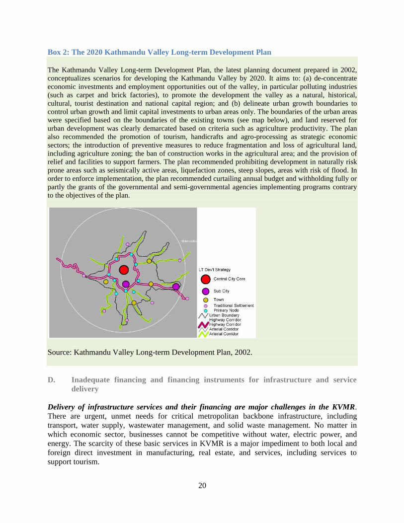
Box 2: The 2020 Kathmandu Valley Long-term Development Plan
The Kathmandu Valley Long-term Development Plan, the latest planning document prepared in 2002,
conceptualizes scenarios for developing the Kathmandu Valley by 2020. It aims to: (a) de-concentrate
economic investments and employment opportunities out of the valley, in particular polluting industries
(such as carpet and brick factories), to promote the development the valley as a natural, historical,
cultural, tourist destination and national capital region; and (b) delineate urban growth boundaries to
control urban growth and limit capital investments to urban areas only. The boundaries of the urban areas
were specified based on the boundaries of the existing towns (see map below), and land reserved for
urban development was clearly demarcated based on criteria such as agriculture productivity. The plan
also recommended the promotion of tourism, handicrafts and agro-processing as strategic economic
sectors; the introduction of preventive measures to reduce fragmentation and loss of agricultural land,
including agriculture zoning; the ban of construction works in the agricultural area; and the provision of
relief and facilities to support farmers. The plan recommended prohibiting development in naturally risk
prone areas such as seismically active areas, liquefaction zones, steep slopes, areas with risk of flood. In
order to enforce implementation, the plan recommended curtailing annual budget and withholding fully or
partly the grants of the governmental and semi-governmental agencies implementing programs contrary
to the objectives of the plan.
Source: Kathmandu Valley Long-term Development Plan, 2002.
D. Inadequate financing and financing instruments for infrastructure and service
delivery
Delivery of infrastructure services and their financing are major challenges in the KVMR.
There are urgent, unmet needs for critical metropolitan backbone infrastructure, including
transport, water supply, wastewater management, and solid waste management. No matter in
which economic sector, businesses cannot be competitive without water, electric power, and
energy. The scarcity of these basic services in KVMR is a major impediment to both local and
foreign direct investment in manufacturing, real estate, and services, including services to
support tourism.

21
The spatial distribution of capital expenditure for municipal infrastructure is biased against
Kathmandu Metropolitan City, where the needs are the highest. Public capital expenditure for
municipal infrastructure, averaging US$9 per capita countrywide, is inadequate to meet the
growing needs of urban areas in Nepal. Furthermore, the spatial distribution of capital
expenditure for municipal infrastructure is biased against Kathmandu Metropolitan City—the
city with the greatest infrastructure needs. On a per capita basis, municipalities benefit from a
higher level of capital expenditure for municipal infrastructure than Kathmandu Metropolitan
City and the sub-metropolitan cities. In fiscal year 2009-10, infrastructure capital expenditure
averaged US$14.00 per capita in the 53 municipalities, compared with US$ 9.20 in Lalitpur Sub-
metropolitan City and US$6 per capita in Kathmandu Metropolitan City. Block grants represent
the main source of finance for infrastructure in Kathmandu Metropolitan City, and the bulk of
project-funded infrastructure schemes are implemented directly by central or metropolitan
agencies. 17
Sustainable financing for metropolitan infrastructure is a challenge given the over-reliance
on central funds, and the limited scope for cost sharing by the local governments and users.
The bulk of investment funds from infrastructure investments in the water supply, wastewater
management, solid waste management and transportation come from central agencies through
transfers and donor funding. Metropolitan sectoral plans to guide the infrastructure development,
however, either do not exist or are outdated. In addition, over-reliance on central funding raises
issues of sustainability, given the need for recurrent financing of operations and maintenance of
the completed infrastructure. Cost sharing by the local governments for metropolitan
infrastructure through own-source revenues (e.g. property taxation) is limited due to their
inadequate revenue bases. While the Kathmandu Valley has a long tradition in community
contributions to local infrastructure, such as constructing and maintaining wells, there is no
established culture of ‘user pay’ for urban services mostly due to the lack of citizens’ trust
toward service providers.
Land pooling, the dominant instrument used to self-finance infrastructure in the valley, is a
lengthy and complex process.18
The 2012 KVDA Regulations devote considerable attention to
land pooling and guided land development. Discussions with KVDA staff reveal, however, that
land pooling is very lengthy and yields have been minimal. It can take up to 10 years to complete
a land pooling project, and in some cases, if the government is reluctant to use its powers of
eminent domain, land development projects can be permanently stopped since participation is
voluntary – land owners do not have to agree to participate in land consolidation, and discussions
to persuade owners is very time consuming. The KVDA Regulations (Section 9) illustrate the
difficulty of executing land pooling projects.19
The Regulations also reveal the government’s
17
Muzzini and Aparicio. 2013. Urban Growth and Spatial Transition in Nepal. An Initial Assessment. Directions in
Development. Washington, DC: World Bank. 18
UNCHS (2010) reports that land pooling and guided land development have accounted for only 10 percent of
developed land over the last decade. 19
a) In case of KVDA planning to execute the land pooling project in project area or in case when people in the area
provide written application to KVDA for land pooling project with consent of at least fifty one percent of the
population living in the project area, KVDA can execute land pooling project, provided that it serves at least fifty
families in the project area.
22
reluctance to compensate landowners in guided land development projects. As stipulated in
section 8c, the Act states: “to execute guided land development projects, in case there is
requirement of acquisition of land, the compensation cost will be borne by the beneficiaries of
the project area (emphasis added).” For strategic infrastructure right of way access, the use of
eminent domain with adequate and fair compensation would be far more efficient. While the
KVDA Regulations stipulate that the KVDA can access funds from the Government of Nepal or
indirectly from international donors, it is unclear whether the political environment supports
compulsory acquisition.
Despite a number of positive steps, several complex challenges thus remain for improving
metropolitan planning and management in the Kathmandu Valley. The following section
presents a set of policy directions on how to address these challenges.
b) For land pooling project execution, as per sub-rule a, KVDA can form the user group committee of landowners
and tenants for coordination and monitoring of the project, and KVDA will execute land pooling with coordination
with that user group committee.
c) While executing the land pooling project, KVDA can restrict the fragmentation or physical change of the land
within the project area for maximum of two years relying on the clause 7 of the Act.
23
IV. POLICY DIRECTIONS
Consultations with a variety of stakeholders conveyed the urgent need for action to address the
critical threats facing the Kathmandu Valley. The common understanding that these critical
threats require immediate action, should be the starting point for a structured dialogue among
stakeholders. An incremental approach is thus proposed to address immediate challenges, while
laying the foundation for strengthening the governance structure of the Kathmandu Valley in the
longer-term.
There is significant scope for improving metropolitan planning and management within the
existing governance structure of the valley, based on an incremental approach. The
Kathmandu Valley has a one-tier fragmented local governance structure, with a multi-sector
metropolitan agency (the KVDA) and two single-sector metropolitan bodies (the KVWSB and
the Bagmati Commission) having jurisdiction over different geographical areas in the valley.
Given the existing governance structure, an incremental approach to improved metropolitan
planning and management would necessarily rely on voluntary cooperation, i.e. “metropolitan
contracts” among local authorities, around concrete solutions to the challenges facing the valley,
to be implemented under the coordination of KVDA and the oversight of MoUD.
The policy directions take into account the imperative of moving to action, and the agreed
incremental approach to improved metropolitan planning and management. A phasing of the
interventions is proposed to address immediate issues of strategic importance for the valley,
while laying the foundation for strengthening the governance of the Kathmandu Valley in the
longer-term. Immediate, medium-term and long-term policy directions were discussed with
stakeholders and agreed with counterparts as follows:
A. The immediate strategy – Start the dialogue on metropolitan planning and management
with local authorities.
(A.1) Clarify and codify the hierarchy of roles and responsibilities for metropolitan
planning and management.
(A.2) Agree on metropolitan initiatives that KVDA can champion to show tangible and
quick results.
B. The medium-term transitional strategy – Take incremental steps to improve metropolitan
planning and management.
(B.1) Update the 2020 Kathmandu Valley Long-term Development Plan and establish
an open repository of metropolitan geospatial data and information.
(B.2) Develop a road map and implement a metropolitan initiative for the regeneration
of the Kathmandu Valley.
(B.3) Develop and implement a metropolitan initiative to improve resilience to natural
disasters.
(B.4) Develop and implement a technical assistance program to local authorities for
local infrastructure planning and financing and service delivery

24
(B.5) Design appropriate incentive-based financing mechanisms to enhance
metropolitan planning and management.
C. The long-term strategy – Initiate a process of institutional change for improved
metropolitan planning and management in the Kathmandu Valley.
(C.1) Develop a process to guide institutional change for metropolitan planning and
management.
(C.2) Evaluate models of metropolitan management and their strengths, weaknesses and
applicability to the valley in the longer-term.
A. The Immediate Strategy – Start the Dialogue on Metropolitan Management and
Planning with the Local Authorities
The recommended immediate step is to start a process of structured dialogue among stakeholders
to: (A.1) clarify and codify the hierarchy of roles and responsibilities for metropolitan planning
and management at the central, metropolitan and local levels, in line with the current governance
structure of the valley; and (A.2) identify strategic entry points to move to implementation and
show visible and quick results.
The dialogue with stakeholders and local authorities would be led by the KVDA, based on a
collaborative approach. The existing institutional setting for metropolitan management provides
the KVDA with the tools for leading a structured dialogue with the local authorities, even within
the current fragmented local governance. As codified in the KVDA Act of 1988 and Regulations
of 2012, the Kathmandu Valley Physical Development Board is expected to act as the principal
liaison between the VDCs and the KVDA through the District Commissioners. In addition, the
Board of Directors, which is expected to meet at least every two months, includes direct
representation of 3 VDCs.
A.1 Clarify the hierarchy of roles and responsibilities for metropolitan planning and
management
The roles and responsibilities for metropolitan planning and management of the central
government, metropolitan agencies (KVDA, KVWSB and the Bagmati Commission) and local
governments need to be clarified and aligned with the existing governance structure and legal
framework (KVDA Act of 1988, LSGA of 1999 and KVDA Regulations of 2012) for the
Kathmandu Valley.
Based on the stakeholder consultations over the course of the technical assistance, consensus was
reached on the following: (a) KVDA needs to gradually take on its responsibilities in line with its
mandate as well as the priorities emerging from the structured dialogue with the stakeholders; (b)
given the high costs of the current lack of effective coordination in the valley, the KVDA needs
to strengthen its role as a coordinating agency, providing clear directions to the local bodies; (c)
in the short-to-medium term, the role of the central government will be critical to oversee the
transitional arrangements, and provide technical support to the KVDA and the local bodies.

25
Proposed divisions of responsibilities among levels of governments in line with the existing
institutional and legal framework would be as follows:
MoUD: oversight, high-level policy-making and technical support agency. The central
government, through its dedicated ministry for urban development, MoUD, is expected to retain
strong oversight powers over urban development in the Kathmandu Valley, given the strategic
national importance of the metropolitan region and the current limited capacity of the KVDA.
The central government would empower the MoUD to coordinate implementation of the national
urban strategy under preparation and set broad policy directions and standards regarding urban
development in the Kathmandu Valley. At the central level, MoUD would be the core oversight
ministry for KVDA and local governments. The ministry would also serve as the focal point for
technical assistance to the KVDA. In the short-to-medium term, it would also coordinate
technical assistance and capacity building for the local bodies in the valley, until the KVDA has
built the capacity to take over the function.
The KVDA: metropolitan planning agency. From a functional perspective, the KVDA would
be the top-tier planning and management organization that sets out the broad spatial structure for
the development of the Kathmandu Valley (as a structure plan, not a master plan). The objective
would be to guide the municipalities and VDCs to plan for urban expansion, regenerate the
historic city cores, support risk resilient construction and development in public and private
investments, and promote more compact development in the urbanizing areas of the metropolitan
region. This would include leading the process for the preparation of the structural plan for the
valley. In conjunction with the planning function, KVDA should consider taking on the critical
functions of geospatial data management in the valley, by creating a central repository and
platform for data sharing among government agencies and local authorities for metropolitan
planning and management, and promoting open data access policies for public engagement and
transparent decision-making.
The KVDA: metropolitan regulatory body. There is unanimous consensus that the KVDA would
need to strengthen its functions as a regulatory agency, with a focus on developing, updating and
enforcing regulations for development in the valley. The local authorities do not have adequate
capacity to enforce building codes and national bye-laws. While KVDA has the legal powers to
regulate and enforce, it can only effectively exercise its functions if local authorities, government
agencies and citizens validate the mandate and role of the KVDA as a regulatory body.
Furthermore, command and control regulation is rarely effective if it is not accompanied by a
system of rewards and penalties to incentivize implementation and enforcement by the local
authorities, such as incentive-based financing mechanisms earmarked for specific metropolitan
initiatives. As an immediate action, the Kathmandu Valley building bye-laws for which the
KVDA has enforcement authority (currently limited to the five urban local governments and the
45 urbanizing VDCs) need to be updated and extended to the entire valley.
The KVDA: promoter of strategic land development and infrastructure projects. One of the
functions of the KVDA is to carry out guided land development projects, including land pooling,
and provide serviced land for development. Since its establishment, land pooling projects have
absorbed much of the scarce technical and financial resources of the metropolitan agency. If the
trend continues, there is the risk that the KVDA, established as a metropolitan agency, would
26
become a land development agency, losing sight of the strategic valley-wide functions a
metropolitan agency should perform. A more effective use of KVDA’s limited resources would
be to focus on catalyzing and leveraging private sector investments for land and infrastructure
development projects of strategic importance for the Kathmandu Valley, and delegating powers
for implementation of small land pooling projects to the competent local authorities, based on
transparent criteria. It is also recommended that the functions of the KVDA as a land developer
be clearly spelled out to avoid possible conflicts of interest between KVDA’s planning and
development functions, that KVDA technical and financial resources be allocated in line with
agreed priorities, and that it is ensured that land development by public agencies leverage, rather
than stifle, private sector development in the longer-term. Experience in other South Asian
countries (e.g. Sri Lanka and Bangladesh) indicate that urban development agencies tend to
crowd out, rather than leverage, private sector investments if the role of the public and private
sectors are not clearly defined.
The KVDA: apex body for metropolitan coordination. KVDA’s role should extend beyond
planning, development and regulation as stipulated in the 2012 KVDA Regulations. The KVDA
is expected to evolve to become the apex body for coordination in the Kathmandu Valley and
also provide local governments with the latitude to carry out initiatives and projects that
contribute to the sustainable development of the valley. There are several critical areas that
warrant stronger coordination at the metropolitan level based on the principle of subsidiarity
because of externalities, economies of scales and cost savings, including, but not necessarily
limited to the following:
– The regeneration of the historic city cores, and the planning for sustainable and resilient
expansion in peri-urban areas;
– Air quality management, public transit and transportation systems management;
– The upgrading of housing in regularized areas;
– The implementation of risk assessments and the prioritization of investments and
interventions to reduce disaster risks at the metropolitan level;
– Long-term planning to secure adequate supply of potable water and develop sewage
collection and treatment facilities in coordination with the KVWSB and the Bagmati
Commission;
– Enhancement of solid waste management collection, transportation, processing and safe
disposal.
The local authorities: local planning, service delivery and urban management functions. Any
approach to metropolitan management needs to balance the need for central coordination with
local autonomy to be effective and sustainable. The establishment of the KVDA is expected to
enable local authorities to carry out their functions. Local authorities would continue performing
local planning, service delivery and urban management functions in their jurisdictions as per the
LSGA of 1999. Core responsibilities will include preparing and implementing local plans,
issuing building permits and collecting revenues such as property taxes.
27
A.2 Agree on metropolitan initiatives that KVDA can champion to show tangible and
quick results
The consultations highlighted the urgency of identifying entry points for metropolitan planning
and management based on a collaborative process. This calls for finding pragmatic and
negotiated solutions around concrete issues, which can form the basis for voluntary metropolitan
partnerships or initiatives between the KVDA and local authorities. In many countries, voluntary
cooperation arrangements based on negotiated “metropolitan contracts” are becoming more
prevalent as a tool to improve metropolitan planning and management (see Box 3).
Working group discussions were held to identify metropolitan initiatives that could be
championed by the KVDA, in line with its mandate and functions, based on the following
criteria: (a) urgency of interventions, and socio-economic benefits; (b) consensus among local
authorities about priority activities, which can deliver quick and visible results on the ground; (c)
rationale for metropolitan-level interventions. Based on the consultations carried out as part of
the technical assistance, the following three main entry points were proposed, and agreed:
Prepare a Kathmandu Valley development strategy and structure plan, and establish an
open repository of metropolitan geospatial data and information – given the rapid pace
of urban growth, and the high costs of the current haphazard development pattern in the
valley, the preparation and implementation of a metropolitan strategy and action plan is
urgently required to manage resilient expansion in the peri-urban areas and support the
regeneration of the historic city cores. To facilitate the development of the strategy and
plan, a geospatial repository of information from various line ministries operating in the
Kathmandu Valley will serve as the foundation for collecting and managing metropolitan
data. It will also be the basis on which urban planning tools are created to enhance the
capacity of the KVDA going forward.
Launch a metropolitan initiative to regenerate the historic city cores of the valley – the
regeneration of the Kathmandu Valley is an agenda of national priority given the strategic
importance of the valley and its unique assets for job creation and economic
development. In addition, there is strong rational for metropolitan-level coordination, as
urban regeneration is a new agenda for the valley, and must be addressed at both
metropolitan and local levels and in partnership with the private sector to succeed.
Launch a metropolitan initiative to improve resilience to natural disasters – strong
metropolitan coordination is required to ensure that seismic risk considerations are
mainstreamed in metropolitan planning and all investments initiatives in the valley. The
consultations highlighted the urgency of the initiative given the Kathmandu Valley’s long
history of seismic activity and extremely high seismic risk, and the high costs of
deferring action based on available damage scenario analysis.
In addition to the three strategic entry points agreed upon during the consultative process, the
consultations identified the opening for developing other important metropolitan initiatives as
part of the initial phase of stakeholder dialogue to address metropolitan-level issues related to
solid waste management, air quality and transportation. These three areas require enhanced
28
coordination at the metropolitan level. In particular, a metropolitan initiative for air quality
management would require a partnership between the MoUD and the Ministry of Environment.
While the Ministry of Environment is the lead agency for air quality management, the urban
form and traffic management, as well as current building construction practices (under the
control of the MoUD) play a critical role in generating pollution in the valley.
Box 3: Metropolitan Partnerships – The International Experience
In many countries, inter-governmental negotiation and collaboration have progressively replaced the
interventionist approach to metropolitan management that first prevailed and recommended the creation
of new institutions and consolidation of local governments (e.g. Shanghai, Toronto and Singapore), while
still allowing policy makers to increase policy coherence across an economic functional area. New tools
for voluntary collaboration, such as a metropolitan contracts and partnerships, which tend to emphasize
pragmatic solutions based on voluntary and collaborative arrangements are becoming more prevalent. It is
increasingly agreed that such partnerships need to be part of a long-term vision for the metropolitan
region in order to be successful. Examples include Barcelona, New York, and Sydney. While
metropolitan partnerships present distinct advantages, they also have limitations. This is particularly the
case when applied in rapidly growing metropolitan agencies of low-income and emerging countries,
where urban expansion is rapid, and civil society and private sector’s level of engagement is still limited.
In this context, metropolitan partnerships initiatives need to be complemented and supported by strong
central oversight and directions, as well as targeted interventions.
Source: RPA (2011). Inter-jurisdictional Coordination – Metropolitan Management and Regional
Integration. Background paper for Colombia Urbanization Review.
B. The Medium-term Transitional Strategy – Take Incremental Steps to Improve
Metropolitan Planning and Management
The urgent need to take incremental steps to address the critical threats facing the valley was
conveyed by stakeholders during the consultations. Agreed priority actions include: (B.1)
updating the 2020 Kathmandu Valley Long Term Development Plan and establishing an open
repository of metropolitan geospatial data and information; (B.2) developing the road map and
implementing the metropolitan initiative for the regeneration of the valley; (B.3) developing and
implementing a metropolitan initiative for improving resilience to natural disasters, with a focus
on seismic risk; (B.4) developing and implementing technical assistance programs for the local
authorities; and (B.5) designing appropriate incentive-based financing mechanisms to enhance
metropolitan planning and management.
B.1 Update the 2020 Kathmandu Valley Long-term Development Plan and establish an
open repository of metropolitan geospatial data and information
The KVDA is best placed to lead the consultative process for updating the 2020 Kathmandu
Valley Long-term Development Plan, and monitor and enforce its implementation. It is
recommended that the plan be developed as a strategic and structure plan, rather than a master
plan.20
The preparation of the metropolitan strategy would need to start with a visioning exercise,
20
There are a number of problems inherent with traditional ‘land use master planning’. They are succinctly
summarized by Dowall and Clark (1996): master plans are static in nature, take long to prepare; master plans
seldom offer guidance on phasing or techniques of implementation; master plans seldom evaluate the costs of
29
based on a highly inclusive participatory process, with civil society and the private sector.
Emphasis would need to be placed on the economic dimension of the urban transition –
competitiveness, job creation and poverty alleviation – based on a critical assessment of the
comparative advantages of the Kathmandu Valley. It is also recommended that competitiveness
strategies be prepared for the main growth drivers as an input to the preparation of the
metropolitan strategy.
Particular attention would need to be paid to plan for sustainable and resilient urban expansion at
the fringe, based on realistic projections of urban land needs, while protecting high-productivity
agricultural land and open spaces and encouraging development away from hazard prone areas.
The preparation of a transport strategy would be an integral part of the plan. As a basic
framework for planning the metropolitan region, rights of ways would need to be secured for an
arterial road and infrastructure grid to accommodate urban expansion. International experience
indicates that urban containment policies that restrict rather than “make room” for urban
expansion are difficult to implement in rapidly urbanizing countries; and even when effective,
they are not without economic costs (see Box 3).
This strategy and structural plan would guide development activities in the urban local bodies
and VDCs, and would provide the KVDA and the MoUD with a roadmap for metropolitan-level
interventions and infrastructure investments. The local bodies would be responsible for preparing
local plans in line with the metropolitan strategic and structure plan. Due to the limited capacity
of most of the VDCs, the KVDA would work closely with the VDCs to prepare local plans that
are consistent with the metropolitan structure plan. At all levels, the structure plans and local
plans would include detailed capital investment plans for carrying out much needed public
infrastructure works.
The development and management of an open repository of metropolitan geospatial data and
information (e.g. open street maps and web-based databases) under the coordination of the
KVDA would be integral part of the planning process. Several countries around the world have
embraced the open data approach successfully (see Box 4). The goal would be to empower
decision-makers with better information, data, knowledge and the tools to improve the planning
process at the metropolitan scale. The KVDA would facilitate the creation of an open source
data-sharing platform that can enable open access to information, building on the ongoing Open
Cities Project.21
Such a database would include maps on building data, road networks, water and
sewage systems, electricity grids, and other urban infrastructure. The KVDA would promote
development they propose or how they would be financed; they are seldom based on realistic appraisals of the city’s
economic potential or likely population growth; they seldom provide a compelling rationale for detailed land use
controls; community leaders and implementation agency executives are seldom meaningfully involved in the master
planning process; master plans are infrequently updated. See David Dowall and Giles Clark (1996). A Framework
for Reforming Land Policies in Developing Countries. Policy Paper # 7. Urban Management Program.
21 The Open Cities Project relies on OpenStreetMap (OSM), a global online database and user community of over
one million members that allows volunteers to collaborate towards creating a free and open map of the world. Often
called the “Wikipedia” of maps, it fosters collaboration at the community level and encourages participation from a
broad range of stakeholders. Through the Open Cities Project, the OSM Nepal map has added over 340,000 nodes
since October 2012, and over 95% of the road network and 40% of the building footprints of Kathmandu Valley
have already been mapped by university students, professors, and young tech entrepreneurs

30
institutional coordination and partnership with key stakeholders including development partners
to facilitate the sharing of data and information and foster innovation.
Box 4: Geospatial Data and Open Source Tools for Planning: An International Perspective
In Haiti, following the January 12, 2010 earthquake, large amounts of geospatial information, data and
knowledge created by projects funded by development partners have been disseminated to the public to
effectively support the country’s rehabilitation recovery and development processes for longer-term
sustainability. The HaitiData.org portal includes the country’s best geospatial data to date and continues
to grow as new information is added from various governmental and civil society stakeholders.
The Pacific Risk Information Systems (PaRIS), serving 15 Pacific Countries, including Vanuatu, Fiji,
Samoa, Papua New Guinea, Marshall Islands and 10 others, is one of the largest collections of geospatial
information in Asia providing detailed risk information to a broad spectrum of key decision-makers,
including disaster risk management, planning, and public finance agencies.
The Sahel is an area in the horn of Africa where food insecurity and malnutrition are chronic, and is
predicted to grow as over 15 million people try to cope with continuing drought conditions. To ensure
early warnings, the Sahel Response tool is a collaborative effort that pulls together leading data sources
and knowledge streams and shares these across the region between stakeholders and development
partners, resulting in actionable responses on behalf of at-risk populations.
B.2 Develop a road map and implement a metropolitan initiative for the regeneration of
the Kathmandu Valley
The consultations identified urban regeneration as a strategic entry point for metropolitan
management in the valley. Urban regeneration goes beyond physical upgrading to include
economic revitalization, disaster risk management, livable housing, protection of cultural
heritage and community strengthening. A two-pronged regeneration strategy is needed to reverse
the current decline of the historic city core of Kathmandu and prevent the deterioration of
historic city cores in peripheral cities and towns in the valley.
Consensus was reached as part of the consultations on the key conditions for success of urban
regeneration strategy: (a) an integrated approach to upgrading the urban fabric; (b) a partnership
between the government and the private sector, (c) involvement of local communities; and (d)
strong institutional coordination mechanisms among stakeholders at the metropolitan level.
As a first step, it was agreed that the KVDA would take the lead in preparing a road map for
implementing the metropolitan initiative for the urban regeneration of the Kathmandu Valley
with support from the MoUD. A separate advisory note has been prepared to outline the policy
directions and action plan for implementing the metropolitan urban regeneration initiative. The
road map discussed with stakeholders is summarized below in Box 5.
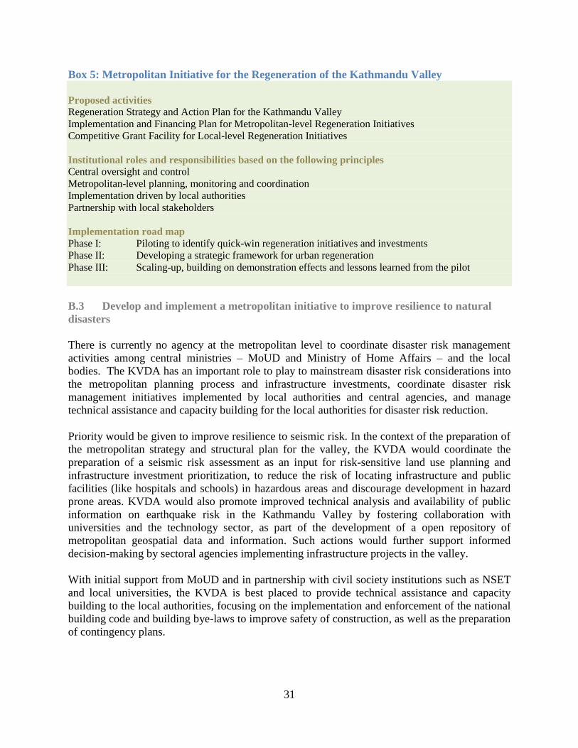
31
Box 5: Metropolitan Initiative for the Regeneration of the Kathmandu Valley
Proposed activities
Regeneration Strategy and Action Plan for the Kathmandu Valley
Implementation and Financing Plan for Metropolitan-level Regeneration Initiatives
Competitive Grant Facility for Local-level Regeneration Initiatives
Institutional roles and responsibilities based on the following principles
Central oversight and control
Metropolitan-level planning, monitoring and coordination
Implementation driven by local authorities
Partnership with local stakeholders
Implementation road map
Phase I: Piloting to identify quick-win regeneration initiatives and investments
Phase II: Developing a strategic framework for urban regeneration
Phase III: Scaling-up, building on demonstration effects and lessons learned from the pilot
B.3 Develop and implement a metropolitan initiative to improve resilience to natural
disasters
There is currently no agency at the metropolitan level to coordinate disaster risk management
activities among central ministries – MoUD and Ministry of Home Affairs – and the local
bodies. The KVDA has an important role to play to mainstream disaster risk considerations into
the metropolitan planning process and infrastructure investments, coordinate disaster risk
management initiatives implemented by local authorities and central agencies, and manage
technical assistance and capacity building for the local authorities for disaster risk reduction.
Priority would be given to improve resilience to seismic risk. In the context of the preparation of
the metropolitan strategy and structural plan for the valley, the KVDA would coordinate the
preparation of a seismic risk assessment as an input for risk-sensitive land use planning and
infrastructure investment prioritization, to reduce the risk of locating infrastructure and public
facilities (like hospitals and schools) in hazardous areas and discourage development in hazard
prone areas. KVDA would also promote improved technical analysis and availability of public
information on earthquake risk in the Kathmandu Valley by fostering collaboration with
universities and the technology sector, as part of the development of a open repository of
metropolitan geospatial data and information. Such actions would further support informed
decision-making by sectoral agencies implementing infrastructure projects in the valley.
With initial support from MoUD and in partnership with civil society institutions such as NSET
and local universities, the KVDA is best placed to provide technical assistance and capacity
building to the local authorities, focusing on the implementation and enforcement of the national
building code and building bye-laws to improve safety of construction, as well as the preparation
of contingency plans.

32
B.4 Develop and implement a metropolitan-level technical assistance program to local
authorities for local infrastructure planning and financing and service delivery
A program of technical support to local authorities for planning and financing sustainable local
infrastructure investments and service delivery is required to support implementation of the
metropolitan initiatives. The fragmented governance structure of the valley, as well as the
significant difference in the level of human resources and technical capacity across local bodies,
provide a challenge for scaling up the technical assistance to all local bodies in the valley. In the
initial phase, it would be appropriate to target technical support to localities where the needs are
the highest, in particular the rapidly urbanizing VDCs. Key areas of the capacity building
program would include technical support for the development of local physical plans and land
use maps, and preparation of revenue enhancement plans and O&M funds to ensure the
sustainability of the local investments. The central government, through the MoUD, would need
to play a strong role in the development and management of the capacity building program, in
coordination with the KVDA. As the Authority builds its capacity, it would gradually take over
the technical assistance function.
B.5 Design appropriate incentive-based financing mechanisms to enhance metropolitan
planning and management
Competencies such as planning cannot be separated from the metropolitan and local financing
structure. The incentives set by the central government and the KVDA will be critical to
mobilize adequate financial resources for enhanced metropolitan planning and management. The
KVDA may consider setting incentives (such as grants, financial subsidies, more competencies)
to promote local planning efforts that are consistent with the metropolitan structure plan. The
KVDA can also consider the establishment of earmarked funds for the implementation of the
identified metropolitan initiatives. Funds would be allocated based on a demand-driven and
competitive process to incentivize local authorities’ participation, and build a relationship of trust
and collaboration between the local authorities and the KVDA. See, for example, the competitive
grant facility for local-level regeneration initiatives described in the advisory note on urban
regeneration.
C. The Long-term Strategy – Initiate a Process of Institutional Change for Improved
Metropolitan Planning and Management
An incremental approach to metropolitan planning and management, based on a collaborative
approach with the local authorities and in line with the current metropolitan governance structure
of the valley, is recommended in the short-to-medium term. In the long-term, the government has
the opportunity to review and strengthen the governance structure of the Kathmandu Valley as
part of the necessary institutional change toward a federal structure. The implementation of the
metropolitan initiatives would provide an opportunity to learn from experience, so that lessons
learned can be taken into account when the political environment is ready for institutional
change.
C.1 Develop a process to guide institutional change for metropolitan planning and
management
33
International experience shows that the process used to structure metropolitan governance and
management models is the critical success factor for institutional change. Therefore, the MoUD
and the Government of Nepal would need to give consideration to the process as a first step.
Ideally, this process should be undertaken after local elections, planned for 2014, and it should
not be a top down central government led process. The MoUD should be viewed as a convener
and facilitator, and any institutional reform would need to be based on consensus.
C.2 Evaluate models of metropolitan management and their strengths, weaknesses and
applicability to the valley in the longer-term
Stakeholders need to be informed about alternative models and their applicability to the
Kathmandu Valley. While this process will take time, it is likely that a two-tiered consolidated
governance structure would emerge as the preferred choice for the management of the
Kathmandu Valley in the long-term, with modifications to adjust the models to local conditions,
which may include an enhanced role for the central government in some strategic areas. The
assessment should include an evaluation of the economic benefits and costs of consolidation of
the local governance structure through amalgamation or annexation. As the Kathmandu Valley
further urbanizes, the economic benefits of consolidation in terms of economies of scale are
expected to increase significantly. International models for metropolitan management are
presented in the annex.
A number of policy directions have thus been identified to address the identified roadblocks for
improving metropolitan management and planning in the Kathmandu Valley. The following
section develops an implementation road map for programmatically translating these policy
directions into action.
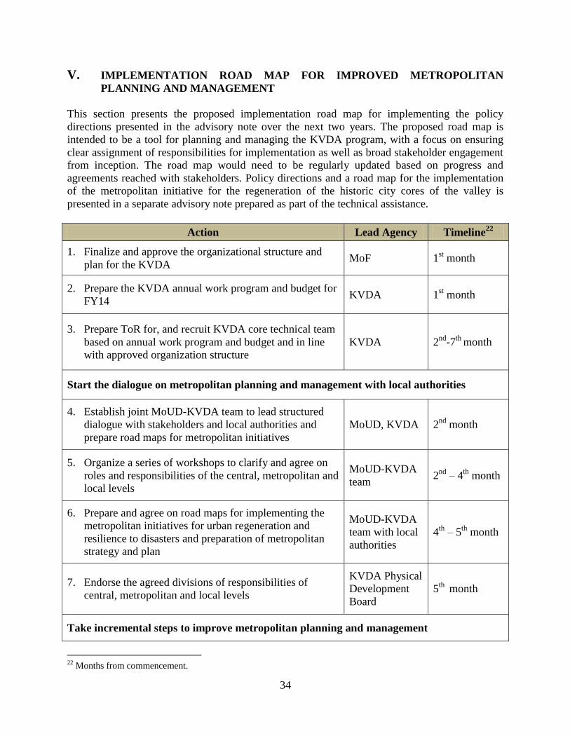
34
V. IMPLEMENTATION ROAD MAP FOR IMPROVED METROPOLITAN
PLANNING AND MANAGEMENT
This section presents the proposed implementation road map for implementing the policy
directions presented in the advisory note over the next two years. The proposed road map is
intended to be a tool for planning and managing the KVDA program, with a focus on ensuring
clear assignment of responsibilities for implementation as well as broad stakeholder engagement
from inception. The road map would need to be regularly updated based on progress and
agreements reached with stakeholders. Policy directions and a road map for the implementation
of the metropolitan initiative for the regeneration of the historic city cores of the valley is
presented in a separate advisory note prepared as part of the technical assistance.
Action Lead Agency Timeline22
1. Finalize and approve the organizational structure and
plan for the KVDA MoF 1
st month
2. Prepare the KVDA annual work program and budget for
FY14 KVDA 1
st month
3. Prepare ToR for, and recruit KVDA core technical team
based on annual work program and budget and in line
with approved organization structure
KVDA 2nd
-7th
month
Start the dialogue on metropolitan planning and management with local authorities
4. Establish joint MoUD-KVDA team to lead structured
dialogue with stakeholders and local authorities and
prepare road maps for metropolitan initiatives
MoUD, KVDA 2nd
month
5. Organize a series of workshops to clarify and agree on
roles and responsibilities of the central, metropolitan and
local levels
MoUD-KVDA
team 2
nd – 4
th month
6. Prepare and agree on road maps for implementing the
metropolitan initiatives for urban regeneration and
resilience to disasters and preparation of metropolitan
strategy and plan
MoUD-KVDA
team with local
authorities
4th
– 5th
month
7. Endorse the agreed divisions of responsibilities of
central, metropolitan and local levels
KVDA Physical
Development
Board
5th
month
Take incremental steps to improve metropolitan planning and management
22
Months from commencement.
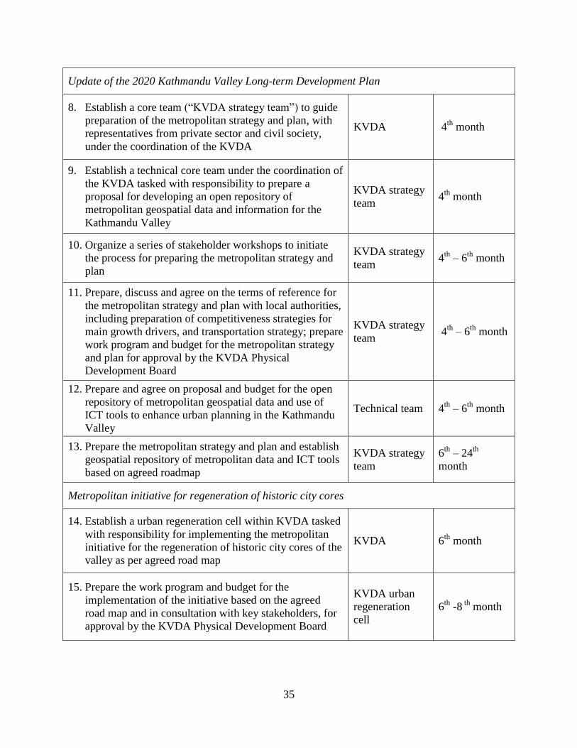
35
Update of the 2020 Kathmandu Valley Long-term Development Plan
8. Establish a core team (“KVDA strategy team”) to guide
preparation of the metropolitan strategy and plan, with
representatives from private sector and civil society,
under the coordination of the KVDA
KVDA 4th
month
9. Establish a technical core team under the coordination of
the KVDA tasked with responsibility to prepare a
proposal for developing an open repository of
metropolitan geospatial data and information for the
Kathmandu Valley
KVDA strategy
team 4
th month
10. Organize a series of stakeholder workshops to initiate
the process for preparing the metropolitan strategy and
plan
KVDA strategy
team 4
th – 6
th month
11. Prepare, discuss and agree on the terms of reference for
the metropolitan strategy and plan with local authorities,
including preparation of competitiveness strategies for
main growth drivers, and transportation strategy; prepare
work program and budget for the metropolitan strategy
and plan for approval by the KVDA Physical
Development Board
KVDA strategy
team 4
th – 6
th month
12. Prepare and agree on proposal and budget for the open
repository of metropolitan geospatial data and use of
ICT tools to enhance urban planning in the Kathmandu
Valley
Technical team 4th
– 6th
month
13. Prepare the metropolitan strategy and plan and establish
geospatial repository of metropolitan data and ICT tools
based on agreed roadmap
KVDA strategy
team
6th
– 24th
month
Metropolitan initiative for regeneration of historic city cores
14. Establish a urban regeneration cell within KVDA tasked
with responsibility for implementing the metropolitan
initiative for the regeneration of historic city cores of the
valley as per agreed road map
KVDA 6th
month
15. Prepare the work program and budget for the
implementation of the initiative based on the agreed
road map and in consultation with key stakeholders, for
approval by the KVDA Physical Development Board
KVDA urban
regeneration
cell
6th
-8 th
month
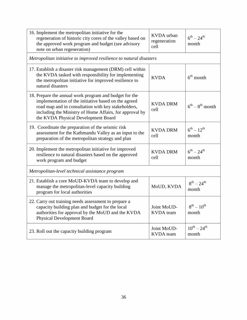
36
16. Implement the metropolitan initiative for the
regeneration of historic city cores of the valley based on
the approved work program and budget (see advisory
note on urban regeneration)
KVDA urban
regeneration
cell
6th
– 24th
month
Metropolitan initiative to improved resilience to natural disasters
17. Establish a disaster risk management (DRM) cell within
the KVDA tasked with responsibility for implementing
the metropolitan initiative for improved resilience to
natural disasters
KVDA 6th
month
18. Prepare the annual work program and budget for the
implementation of the initiative based on the agreed
road map and in consultation with key stakeholders,
including the Ministry of Home Affairs, for approval by
the KVDA Physical Development Board
KVDA DRM
cell 6
th – 8
th month
19. Coordinate the preparation of the seismic risk
assessment for the Kathmandu Valley as an input to the
preparation of the metropolitan strategy and plan
KVDA DRM
cell
6th
– 12th
month
20. Implement the metropolitan initiative for improved
resilience to natural disasters based on the approved
work program and budget
KVDA DRM
cell
6th
– 24th
month
Metropolitan-level technical assistance program
21. Establish a core MoUD-KVDA team to develop and
manage the metropolitan-level capacity building
program for local authorities
MoUD, KVDA 8
th – 24
th
month
22. Carry out training needs assessment to prepare a
capacity building plan and budget for the local
authorities for approval by the MoUD and the KVDA
Physical Development Board
Joint MoUD-
KVDA team
8th
– 10th
month
23. Roll out the capacity building program Joint MoUD-
KVDA team
10th
– 24th
month
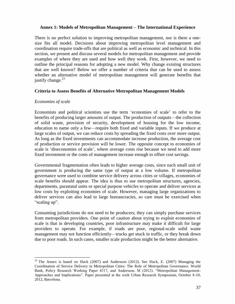
37
Annex 1: Models of Metropolitan Management – The International Experience
There is no perfect solution to improving metropolitan management, nor is there a one-
size fits all model. Decisions about improving metropolitan level management and
coordination require trade-offs that are political as well as economic and technical. In this
section, we present and discuss several models for metropolitan management and provide
examples of where they are used and how well they work. First, however, we need to
outline the principal reasons for adopting a new model. Why change existing structures
that are well known? Below we offer a number of criteria that can be used to assess
whether an alternative model of metropolitan management will generate benefits that
justify change.23
Criteria to Assess Benefits of Alternative Metropolitan Management Models
Economies of scale
Economists and political scientists use the term ‘economies of scale’ to refer to the
benefits of producing larger amounts of output. The production of outputs—the collection
of solid waste, provision of security, development of housing for the low income,
education to name only a few—require both fixed and variable inputs. If we produce at
large scales of output, we can reduce costs by spreading the fixed costs over more output.
As long as the fixed investments can accommodate increase production, the average cost
of production or service provision will be lower. The opposite concept to economies of
scale is ‘diseconomies of scale’, where average costs rise because we need to add more
fixed investment or the costs of management increase enough to offset cost savings.
Governmental fragmentation often leads to higher average costs, since each small unit of
government is producing the same type of output at a low volume. If metropolitan
governance were used to combine service delivery across cities or villages, economies of
scale benefits should appear. The idea is thus to use metropolitan structures, agencies,
departments, parastatal units or special purpose vehicles to operate and deliver services at
low costs by exploiting economies of scale. However, managing large organizations to
deliver services can also lead to large bureaucracies, so care must be exercised when
“scaling up”.
Consuming jurisdictions do not need to be producers; they can simply purchase services
from metropolitan providers. One point of caution about trying to exploit economies of
scale is that in developing countries, poor infrastructure may make it difficult for large
providers to operate. For example, if roads are poor, regional-scale solid waste
management may not function efficiently—trucks get stuck in traffic, or they break down
due to poor roads. In such cases, smaller scale production might be the better alternative.
23
The Annex is based on Slack (2007) and Andersson (2012). See Slack, E. (2007) Managing the
Coordination of Service Delivery in Metropolitan Cities: The Role of Metropolitan Governance. World
Bank, Policy Research Working Paper 4317, and Andersson, M (2012). “Metropolitan Management-
Approaches and Implications”. Paper presented at the sixth Urban Research Symposium, October 8-10,
2012, Barcelona.
38
Externalities
Externalities are side effects associated with economic activities. If a farmer builds
housing on his farm, he may increase storm water runoff and flood his neighbors. If a city
decides to build some new roads for its residents, drivers from outside the jurisdiction
may come in and use the roads because they are faster. When externalities generate
positive spillovers, it is frequently the case that jurisdictions produce less services or
outputs than optimal. In the case of negative externalities (air pollution or flooding for
example), too much is produced. Metropolitan structures can effectively mediate these
problems by internalizing the externality. For example a major source of pollution in the
Kathmandu Valley is brick production—it produces a lot of soot and particulates. An
individual city may benefit from the brick company—jobs are created, tax revenues are
generated and so forth, but the metropolitan area is worse off. It would therefore be worth
considering forming a metropolitan air quality management district that covers the entire
air-shed. The size of the metropolitan agency might not be the same size as the agency
used to promote economies of scale. The air quality district might be larger than the
metropolitan school district. The point here is that all districts do not need to be the same
size or cover the same area. Externalities can also be remedied by imposing transfers. The
towns making bricks might be taxed to compensate other towns for the pollution they
cause. The town that builds new roads might make non-residents pay tolls for using their
roads.
Equity
Another common metropolitan-level problem is income inequality across smaller
jurisdictions. When thinking about equity, metropolitan management experts think about
how to balance costs and benefits. Wealthy communities may have a low demand and
willingness to pay for security since they live in gated communities. But the metropolitan
area would be far safer if all areas, rich and poor had good quality community policing.
Jurisdictional fragmentation often fosters income inequality. Metropolitan educational
systems can help to foster integration and increase educational attainment for the poor. In
other cases, wealthier jurisdictions could cross-subsidize poorer communities through
having metropolitan level property taxes or sales taxes.
Accessibility and accountability
Another consideration that should be used when designing metropolitan management and
governance systems pertains to how accessible the metropolitan government is to its
citizens. Here smaller is usually better, since local governments are closer to their
constituents. More fragmentation may lower corruption as well since citizens are more
likely to know about local projects and services if they are provided locally. As far as
accountability, scale may be less important. What is important is to link expenditure
decisions with revenue decisions—how are tax monies being used?
Local responsiveness
The final criterion is in regards to local responsiveness. Here local is by definition better
in most cases. However, large metropolitan governments have worked to be more locally

39
responsive by setting up local service centers, hold local stakeholder meetings and so
forth. The European Council has a law called the “subsidiarity principle,” which refers to
a policy that public services should be provided by the government or entity closest to the
user, given considerations regarding economies of scale, externalities, equity,
accessibility, accountability and local responsiveness.
These are the five criteria that should be used to evaluate alternative models of
metropolitan governance and management. As illustrated, these criteria call for either
large scale or small scale governance structures. So the challenge is finding the right
balance.
Models of Metropolitan Governance and Management
There are six basic models that have been used around the world to address the
challenges of managing large metropolitan regions. These models change over time,
where some cities shift from one model to another. Some models are not geographically
robust if their boundaries are not broad enough to capture externalities or generate
economies of scale. In some cases, metropolitan areas fuse together to create even larger
governance issues. With these caveats in mind, the six models are reviewed below.
One tier fragmented structure
This model is essentially the status quo. It could be a Houston with nearly 800 local
governments and no coherent metropolitan strategy. It could be Chicago with nearly 500
local governments and no regional coordination. Mumbai would also fit here, with the
provison that it has a regional planning authority with limited power—the MMRDA. In
one-tier systems, it is difficult to build consensus. But when there is a crisis, these cities
often cooperate out of necessity.
One tier consolidated government
A single metropolitan government provides a full range of services to its region. These
one tier systems are usually formed through amalgamation or annexation. Shanghai –
essentially a city-state with direct reporting to Beijing – is one example. With the Delhi
Development Authority, Delhi is another developing country example. Examples in the
developed world include Bremen, Hamburg and Berlin in Germany as well as Louisville
and Indianapolis in the US.
These cities have a common, shared tax base and have a business-friendly climate. They
maximize economies of scale, work to reduce negative externalities and increase positive
ones. They also work to improve equity across districts with their metropolitan
boundaries. These cities typically set up local service centers to improve access.
Interestingly, they are expensive to run since they have large bureaucracies. There is also
less competition among service providers as monopolies are common. They have lower
competitiveness and their boundaries rarely change, even as urbanization expands beyond
their limits.

40
Two tier government
In two tier governments, metropolitan agencies go through a process of deciding how to
allocate service delivery – should the metro do it, or should the local governments do it?
The critical challenge is to use the five criteria presented above to decide on the
allocation of services. There are many examples of two tier metropolitan areas, including
Madrid, Toronto, London, Cape Town and Abidjan. Two tier systems may, however, be
confusing to taxpayers, who have to interface with two levels of government, and there is
the potential for waste through the duplication of services.
Voluntary cooperation
Voluntary cooperation models are the easiest to form from a political perspective, and are
becoming a more prevalent model for metropolitan management in urbanized countries.
They are common in the US, France and Italy. Essentially, jurisdictions create informal
agreements to cooperate on service provision. Cities can opt out or join as they wish.
Noteworthy examples are Bologna, Marseilles, and most other cities in France. Los
Angeles is a well-known example in the US. An advantage of voluntary cooperation is
the ability of cities to maintain their autonomy while at the same time reaping the benefits
of scaling up. In Los Angeles, Los Angeles County offers services to smaller cities in the
county. Common services include police and fire fighting, emergency services and
purchasing in bulk to lower costs.
Special purpose districts (metropolitan authorities and public service agencies)
Options include a metropolitan council of government, a metropolitan planning agency
(with broad or narrow focus, and which may or may not have authority to enforce plans),
and a metropolitan public service (single-purpose) agency, such as a utility cooperation
or cooperative. Examples of public service agency include school districts, transportation,
water supply, sewerage treatment and solid waste management agencies.
The key advantage is that cooperation or integration can be tailored to the needs of the
metropolitan agency, and that local governments do not lose autonomy as they would
under some of the other models. Problems with special purpose districts are
accountability, poor access and inability to coordinate across services that are not
provided at the regional or metropolitan level. Examples are common in the US, and
include San Francisco, Atlanta and Denver. San Francisco’s Bay Area Air Quality
Management District is an example of a special purpose vehicle or agency that seeks to
reduce air pollution.
Central, state or provincial provision
A final model is to simply have the central government or province step in and provide
the service. This is common in Australia and India (Mumbai).
41
Summary of Models
One lesson of international experience is that models change over time—Toronto,
London, Cape Town and Abidjan have all experienced significant change. In Cape Town,
one expert refers to “reorganization fatigue.” The second lesson is that the voluntary
model is the easiest in terms of politics, having proven to work well in Los Angeles and
Sao Paulo, but is may have imitations when applied in rapidly growing metropolitan
agencies of low-income and emerging countries, where urban expansion is rapid, and
civil society and private sector’s level of engagement is still limited (see also Box 3
above). A third lesson is that boundaries do not move with urbanization, and outward
development can undermine the benefits of metropolitan governance. While one can
achieve economies of scale, metropolitan governments are expensive and do not always
lower costs. The local and national context is extremely important in shaping which
models are successful. The process that is used to create a dialogue about metropolitan
governance is extremely important. The process should be bottom up and participatory.
Top down models have a poor track record. Finally, metropolitan governance and
management structures require a financing plan to support implementation. Table 1
provides a summary of this section.

42
Table 1: Summary of Examples, Criteria and Models Models
One tier
fragmented
structure
One tier
consolidated
government
Two tier
government
Voluntary
cooperation
Special purpose
districts
Central, state or
provincial
provision
Examples Houston, Chicago,
Mumbai and
Kathmandu
Shanghai, Delhi,
Bremen,
Hamburg, Berlin
and Louisville
Madrid, Toronto,
London, Cape
Town and Abidjan
Bologna,
Marseilles and
Los Angeles
San Francisco,
Atlanta and
Denver
Melbourne and
Mumbai
Economies of scale Poor results Strong positive
results
Effective results if
allocation is well
made
Positive results Positive results for
specific services
Variable results, can
be positive
Externalities Poor results Strong positive
results
Effective results if
allocation is well
made
Mixed results,
usually not
effective
Mixed results,
usually not
effective
Variable results, can
be positive
depending on
service
Equity Poor results Excellent results
if equity is a
priority
Effective results if
allocation is well
made
Model offers
flexibility to be
positive
Positive results
only if SPVs aim
toward equity
Variable results, can
be positive
depending on type of
service
Accessibility and
accountability
Variable, poor to
excellent results
Depends on
decentralization
efforts and
outreach
Model offers
flexibility to be
positive
Model offers
flexibility to be
positive
Poor results Variable results, can
be positive
depending on
service
Local Responsiveness Variable, poor to
excellent results
Depends on
decentralization
efforts and
outreach
Poor results Variable results,
depending on quality
of central or
state/provincial
government
Source: E. Slack, 2007. Managing the Coordination of Service Delivery in Metropolitan Cities: The Role of Metropolitan Governance. World Bank,
Policy Research Working Paper 4317.
KATHMANDU VALLEY URBAN POLICY DIALOGUE
TECHNICAL ASSISTANCE
URBAN REGENERATION OF THE HISTORIC CITY CORES
OF THE KATHMANDU VALLEY
ADVISORY NOTE AND ACTION PLAN
June 2013
South Asia Urban Unit

1
URBAN REGENERATION OF THE HISTORIC CITY CORES OF THE KATHMANDU
VALLEY
ADVISORY NOTE AND ACTION PLAN
Enhancing the competitiveness of the Kathmandu Valley is a national priority given the strategic
importance of the valley for economic growth and job creation for the country. The valley has many
assets to develop for continued prosperity and growth, with a comparative advantage in cultural
industries. However, rapid urbanization – combined with inadequate development control – is
undermining these advantages.
The Kathmandu Valley’s rapid urbanization calls for a metropolitan-level sustainable regeneration
strategy driven by local economic development. An urban regeneration approach that goes beyond
physical renewal is required to bring about a lasting improvement in the economic, physical, social and
environmental conditions of the Kathmandu Valley. To succeed, the regeneration of the valley needs to
be embedded in a growth strategy that combines orderly and higher density land and housing
development in the fast-growing peri-urban areas with the regeneration of the historic city cores.
The urban regeneration strategy must be tailored to the environment of the Kathmandu Valley. The valley
presents several strengths for achieving successful and sustainable urban regeneration, including strong
communities, world class cultural assets as a primary resource, and vibrant private sector leaders who
have shown a strong interest in participating in urban regeneration efforts. Yet a number of constraints
also remain, including inadequate planning and development controls; insufficient investment in
infrastructure and services; institutional fragmentation of government responsibility and overlapping
authority across agencies; the weakening of social networks and informal safety nets in the deteriorating
urban cores, and lack of organized support for cultural industries.
The proposed policy directions for implementing the urban regeneration agenda build on the strengths of
the valley, by focusing on promoting community mobilization and leveraging private sector activities,
while addressing issues of institutional coordination. The following policy directions were discussed and
agreed with counterparts:
A. Identify priority urban regeneration initiatives that can catalyze change and economic growth.
B. Develop a collaborative planning process and transparent, demand-driven and competitive
funding instruments that promote partnerships with the private sector.
C. Develop an institutional framework and coordination mechanisms for urban regeneration at
metropolitan and local levels.
D. Identify quick-win regeneration interventions and investments to create demonstration effects.

2
ACKNOWLEDGEMENTS
This note has been prepared by a team comprising Elisa Muzzini (Senior Economist/Task Team
Leader in the South Asia Urban and Water Unit of the World Bank), Silva Shrestha (Water &
Sanitation Specialist), Pawan Lohani (Consultant/Municipal finance), Anil Pokhrel (Disaster
Risk Management Specialist), Sonam Velani (Disaster Risk Management Analyst), Pragya
Pradhan (Consultant/Community planning), Tara Lonnberg (Consultant/Institutions) and a team
of experts including Katrinka Ebbe (Consultant/Cultural Heritage) and Dr. Sudarshan Tiwari
(Consultant, Professor of Planning and Architecture at Tribhuvan University, Nepal). The Global
Lab Knowledge exchange was organized by WBI and Urban Anchor in collaboration with the
South Asia Urban & Water Unit. The activities benefited from support from the World Bank –
AusAID Infrastructure for Growth Trust Fund.
Extensive consultations on urban regeneration in the Kathmandu Valley have taken place with
the Ministry of Urban Development (MoUD) and the Kathmandu Valley Development Authority
(KVDA) as part of the technical assistance. The advisory note also builds on consultations with
a broad range of stakeholders including central agencies, local governments, the private sector
and the academia. Working group discussions on urban regeneration were conducted in May,
2012 and January and May, 2013 with representatives from national ministries and municipal
executive officers and agencies, business leaders and associations, heritage conservation groups
and historic site managers, professional urban and regional planners, individual artisans and their
associations, NGOs and Community-based Organizations (CBOs), development partners, and
other interested parties, such as conservation architects and academics. In-depth interviews were
carried out with key local actors in each of the five municipalities in the valley, including
municipal leaders, heritage site managers, crafts producers and tour operators. The consultations
included extended visits to neighborhoods and specific historic sites to familiarize team members
with existing urban conditions. Focus group discussions were conducted with residents of two
neighborhoods in Lalitpur by a team supervised by Dr. Sudarshan Raj Tiwari and comprising
Ms. Pragya Pradhan, Ms. Shreedhara Bajracharya, Ms. Niluja Singh and Mr. Subik Shrestha.
The advisory note also draws on a background study on the heritage conservation and local
economic development in the Kathmandu Valley conducted by the World Bank in 2012; and the
World Bank’s ‘Urban Growth and Spatial Transition in Nepal’ study completed in 2012. The
team would like to extend special thanks to the MoUD and the KVDA for their collaborative
efforts.
3
TABLE OF CONTENTS
EXECUTIVE SUMMARY ............................................................................................................ 5
I. INTRODUCTION ............................................................................................................. 11
II. THE STRATEGIC IMPORTANCE OF THE REGENERATION OF THE
KATHMANDU VALLEY ........................................................................................................... 13
III. THE URBAN REGENERATION OF HISTORIC CITY CORES IN THE
KATHMANDU VALLEY: APPROACH AND CONDITIONS FOR SUCCESS ...................... 15
IV. STRENGHTS AND CONSTRAINTS FOR URBAN REGENERATION IN THE
KATHMANDU VALLEY ........................................................................................................... 19
IV.I Strengths for urban regeneration in the valley ................................................................. 19
IV.II Constraints for urban regeneration in the valley ............................................................. 21
V. POLICY DIRECTIONS .................................................................................................... 26
A. Identify priority urban regeneration initiatives that can catalyze change and economic
growth........................................................................................................................................ 26
B. Develop a collaborative planning process and transparent, demand-driven and competitive
funding instruments that promote partnerships with the private sector .................................... 31
C. Develop an institutional framework and coordination mechanisms for urban regeneration
at metropolitan- and local-levels ............................................................................................... 33
D. Identify quick-win regeneration interventions and investments to create demonstration
effects ........................................................................................................................................ 37
VI. IMPLEMENTATION ROAD MAP FOR THE REGENERATION OF THE
KATHMANDU VALLEY .......................................................................................................... 40
Annexes
Annex 1: Potential Metropolitan- and Local-level Initiatives for the Urban Regeneration of the
Historic City Cores of the Kathmandu Valley .............................................................................. 44
Annex 2: Developing a Cultural Heritage Walking Tour: The Experience of Lalitpur ............... 46
Annex 3: International Urban Regeneration Case Studies and Lessons Learned ......................... 53
Annex 4: Maps of Comparison Neighborhoods: Jhyatapo and Prayag Pokhari ........................... 74
Tables
Table 1: An Integrated Approach to Urban Regeneration ............................................................ 17 Table 2: Implementation Arrangements in Practice ..................................................................... 36
4
Boxes
Box 1: International Experience with Urban Regeneration in Delhi, India .................................. 18 Box 2: The Causes of Decline in the Jhyatapo Neighborhood ..................................................... 23 Box 3: A Housing Rehabilitation Program Based on Resident Incomes in Fez, Morocco .......... 27 Box 4: Neighborhood Cooperation to Conserve Heritage in Kirtipur .......................................... 27 Box 5: Conserving Traditional Buildings and Addressing Seismic Risks in Lalitpur ................. 28 Box 6: Steps for Developing a Cultural Heritage Route – The Example of Lalitpur ................... 30 Box 7: The Competitive Grant Facility – Examples of Grant Windows ...................................... 33
Maps
Map 1: Study Area 1 – Jhyatapo ................................................................................................... 74 Map 2: Study Area 2 – Prayag Pokhari ........................................................................................ 75

5
EXECUTIVE SUMMARY
Enhancing the competitiveness of the Kathmandu Valley is a national priority given the
strategic importance of the valley for economic growth and job creation for the country.
The Kathmandu Valley has many assets to develop for continued growth and prosperity, with a
comparative advantage in cultural industries. Tourism and handicrafts are an important source
of income diversification and poverty reduction in the valley through their economic, social,
environmental and cultural benefits. The valley’s unique heritage includes the famous UNESCO
World Heritage site and intangible heritage such as music, dance, art, handicrafts, festivals and
folklore. As the hub for organized outdoor activities such as trekking and mountaineering, the
Kathmandu Valley is also the main gateway for tourists to Nepal.
Rapid urbanization – combined with inadequate development control – is undermining these
advantages, and poses challenges that require immediate policy attention. Pressures for new
construction and development are contributing to the disappearance of unique buildings and
streetscapes. Rapid urbanization is leading to increasingly high levels of congestion, noise and
air pollution and straining the government’s capacity to provide infrastructure and basic services
(e.g., water, power and sewerage). This is in turn contributing to diminishing the value of the
World Heritage site, reducing earnings from tourism, and weakening social cohesion and
community engagement with their tangible and intangible heritage.
The Kathmandu Valley’s rapid urbanization calls for a metropolitan-level sustainable
regeneration strategy driven by local economic development.
The Kathmandu Valley needs an urban regeneration approach that goes beyond physical
renewal. A sustainable urban regeneration approach based on three areas of interventions –
people, businesses and places – is required to bring about a lasting improvement in the
economic, physical, social and environmental conditions of the Kathmandu Valley. A sustainable
urban regeneration approach encompasses economic revitalization, disaster risk management,
livable housing, protection of cultural heritage and community strengthening. Key conditions for
the success of urban regeneration initiatives are an integrated approach to upgrading the urban
fabric, a partnership with the private sector and involvement of local communities.
The regeneration of the Kathmandu Valley is a metropolitan agenda. Urban regeneration
initiatives require strong coordination at the metropolitan level between central agencies, local
authorities and the private sector. To succeed, the regeneration of the valley needs to be embedded
in a growth strategy that combines orderly and higher density land and housing development in
the fast-growing peri-urban areas with the regeneration of the historic city cores. A two-pronged
strategy would be required to reverse the decline of the historic core of Kathmandu Metropolitan
City (hereafter referred to as Kathmandu) on one hand, and prevent the future deterioration of
historic cores in peripheral cities and towns in the valley on the other hand (e.g., Lalitpur Sub-
metropolitan City [hereafter referred to as Lalitpur], Kirtipur and Madhyapur-Thimi
municipalities).

6
The urban regeneration strategy must be tailored to the environment of the Kathmandu
Valley. The valley presents several strengths as well as challenges for achieving successful and
sustainable urban regeneration.
Several strengths exist for urban regeneration in the Kathmandu Valley. First, the valley has
strong communities and an established way of mobilizing them through user-group contributions
for small, government-initiated infrastructure projects. Second, the valley has world class
cultural assets – including the seven monument zones comprising the UNESCO World Heritage
site – that offer great potential for income-generating activities around tourism and provide a
strong sense of local identity, community pride and social cohesion. And third, the valley has
vibrant private sector leaders who have shown strong interest in participating in urban
regeneration efforts. With support from the government, entrepreneurship and business
development can play an important role in the planning and decision making for local economic
development.
A number of constraints also exist, however, for urban regeneration in the valley. Constraints
include the inadequate planning and development controls contributing to urban decline;
insufficient investment in infrastructure and services decreasing urban livability; institutional
fragmentation of government responsibility and overlapping authority across agencies leading to
inaction; the weakening of social networks and informal safety nets in the deteriorating urban
cores where the poorest and most vulnerable reside, and lack of organized support for cultural
industries resulting in loss of competitiveness and income.
The proposed policy directions for implementing the urban regeneration agenda build on the
strengths of the valley, by focusing on promoting community mobilization and leveraging
private sector activities, while addressing issues of institutional coordination.
The advisory note proposes policy directions and a road map to implement a metropolitan
initiative for the regeneration of the Kathmandu Valley. The following primary policy directions
were agreed with stakeholders to support urban regeneration efforts in the valley:
A. IDENTIFY PRIORITY URBAN REGENERATION INITIATIVES THAT CAN
CATALYZE CHANGE AND ECONOMIC GROWTH
Through the consultative process, a clear consensus emerged on the highest priority initiatives
that are needed to catalyze change in the historic city cores of the Kathmandu Valley. The
following initiatives related to housing, disaster risk management, cultural heritage protection,
infrastructure and service delivery improvements, and local economic development have been
identified.
A.1 Promote traditional housing rehabilitation incentive programs to support the
conservation of traditional buildings. Local incentive programs could be developed and/or
expanded to shield private homeowners from the extra costs of restoring original buildings or
constructing new ones with traditional materials, giving priorities to façade improvements along
designated heritage routes.

7
A.2 Initiate coordinated interventions at both the metropolitan and the local level to
better protect the valley’s cultural heritage. The success of cultural heritage protection
programs hinges on attention and action at both the metropolitan and local levels. A role best
undertaken at the metropolitan level is the establishment of criteria to assess the potential
negative impact of development projects on heritage and the creation of a mechanism for regular
review among relevant ministries to reduce these impacts. A priority activity at the local level
involves raising community awareness of the value of heritage. This could be done through
media campaigns, school programs and by creating inventories that document local historic sites
and intangible heritage (e.g., shrines, temples, celebrations and cuisine).
A.3 Upgrade the deteriorated historic urban fabric to maintain and improve the
livability and tourism potential of the valley’s historic city cores. Metropolitan planning
should be improved by developing new information tools and criteria for prioritizing physical
investments that recognize the importance and needs of historic areas. Local-level agencies could
be instrumental by developing public-private partnerships to demonstrate the advantages of
adapting heritage buildings for income-generating activities and by prioritizing local
infrastructure and service improvements (e.g., drainage and paving) in their Protected Monument
Zones and buffer zones.
A.4 Coordinate disaster risk reduction and management efforts among agencies at the
metropolitan and local levels as well as the local population. There is a critical need to
develop awareness raising campaigns and engage a large majority of the population in planning
and preparing for natural disasters, in particular seismic risk. An initiative that is especially
important is a review of regulations and enforcement of construction safety codes and by-laws to
improve the protection and safety of traditional buildings.
A.5 Undertake initiatives to increase the economic benefits of cultural tourism for
communities in the valley. Appropriate activities at the metropolitan level include: (1)
improving tourism data collection (e.g., tourist characteristics, demand and satisfaction); (2)
updating tourism branding and marketing campaigns; and (3) improving the quality of vocational
tourism training programs, based on private sector input. Local authorities could be more
proactive in promoting cultural events and could support individual businesses in developing
new niche-market tourism products that attract high-value cultural tourists and extend their stay
in the area.
A.6 Promote handicraft development initiatives to generate further income from
cultural tourism in the area. At the metropolitan level, efforts should be made to make
improvements to the handicraft export sector. Improved handicraft training centers, design
updating and development of new products strongly linked to export tourist markets is another
initiative that is best supported at the metropolitan level. Local authorities could increase artisan
earnings by marketing local products, improving local training programs, expanding handicraft
demonstration areas and direct sales points and creating specialized crafts tours.
A.7 Develop cultural heritage walking tours as a catalyst for local regeneration. The
development of heritage routes, if strategically identified, can generate partnerships and joint
investments by the public and private sectors as well as local communities. Such partnerships
8
may lead to infrastructure upgrading on the part of local authorities (paving and signage),
heritage conservation by communities (housing rehabilitation and façade restorations), and
promotion of small businesses (artisan workshops and restaurants). The conceptual development
of two cultural heritage routes was undertaken as part of the technical assistance to illustrate how
cultural heritage walking tours can be an entry point for urban regeneration in the valley.
B. DEVELOP A COLLABORATIVE PLANNING PROCESS AND TRANSPARENT,
DEMAND-DRIVEN AND COMPETITIVE FUNDING INSTRUMENTS THAT
PROMOTE PARTNERSHIPS WITH THE PRIVATE SECTOR.
The planning and financing instruments for urban regeneration need to be tailored to local
conditions, including the level of private sector development and institutional capacity, and aim
to promote community mobilization and leverage private sector activities, while addressing
issues of institutional coordination.
B.1 Develop a Regeneration Strategy and Action Plan for the Kathmandu Valley. The
preparation of the strategy and action plan needs to be highly consultative and linked to the
update of the Kathmandu Valley Long-Term Development Concept of 2002 that is currently
being prepared. The urban regeneration strategy needs to be informed by competitiveness
strategies for the valley’s main growth drivers, such as cultural tourism and handicrafts. . The
competitiveness strategies would be cluster specific and based on a collaborative, inclusive,
private sector-led process focused on action and results.
B.2 Prepare an Implementation and Financing Plan for Metropolitan-level
Regeneration Initiatives. The urban regeneration strategy would need to be complemented by
an implementation and financing plan for metropolitan-level regeneration initiatives. The
implementation plan would include a list of priority action initiatives to be undertaken by the
private and public agencies to improve competitiveness in the main clusters. For each action
initiative, an initiative champion and team would be identified, together with a timeline for
implementation, tasks and funding requirements. Public and private funding would be assembled
by the participating entities for implementation.
B.3 Establish a Competitive Grant Facility for Local-level Regeneration Initiatives. This
funding facility would be based on four overarching principles for implementation: (1) being
demand driven, with a requirement of matching funds; (2) competitive; (3) transparent; and (4)
based on government partnerships with the private sector. Open to all municipalities and small
towns in the valley, the grant facility would be an instrument to improve the urban fabric and
living conditions in historic city cores, enhance awareness of the importance of cultural heritage
conservation, and develop income-generating activities linked to the primary drivers of growth in
the valley.
C. DEVELOP AN INSTITUTIONAL FRAMEWORK AND COORDINATION
MECHANISMS FOR URBAN REGENERATION AT METROPOLITAN AND LOCAL
LEVELS.
The following four principles for assigning responsibilities for urban regeneration were
discussed and agreed as part of the consultations, namely (i) central oversight and support; (ii)
metropolitan-level planning, monitoring and coordination; (iii) implementation driven by local

9
bodies; and (iv) partnership with local stakeholders. In line with these principles, the following
objectives, roles and responsibilities are proposed for central, metropolitan and local agencies,
the private sector and local communities.
C.1 Establish a nodal agency within the Ministry of Urban Development (MoUD) for
strategic oversight and technical assistance. MoUD would provide overall strategic oversight
for the planning, management, monitoring and coordination of the urban regeneration activities
through the establishment of a nodal agency reporting to the Secretary’s office. In addition,
MoUD would provide technical support to the KVDA and local authorities through the
Department of Urban Development and Building Construction (DUDBC).
C.2 Establish a Steering Committee for the regeneration of the Kathmandu Valley. The
Steering Committee would ensure coordination of the urban regeneration agenda among public
agencies and stakeholders and provide direction to the KVDA. The Steering Committee would
comprise a small group of high-level stakeholders from the public and private sector,
representatives from service delivery agencies and local authorities in the Kathmandu Valley.
C.3 Strengthen the KVDA to become the “go-to” agency for urban regeneration. The
KVDA would be responsible for the overall planning, management, and monitoring of urban
regeneration activities. Main responsibilities would include leading the participatory process for
the preparation of the Urban Regeneration Strategy for the Kathmandu Valley and its annual
updates, preparing the implementation and financing plan for the metropolitan-level initiatives,
as well as managing the competitive grant facility for the local-level urban regeneration
activities.
C.4 Enable local authorities to move to action and deliver results to their constituencies.
The local authorities (municipalities and VDCs) would be responsible for proposing and
implementing local urban regeneration activities funded through the competitive grant facility
under the municipal window, in line with the priorities established as part of the Urban
Regeneration Strategy.
C.5 Empower small businesses and community groups to actively contribute to the
urban regeneration agenda. Businesses and community groups would be responsible for
implementing private sector-led and community-based regeneration activities. These would be
funded based on a demand-driven and competitive selection process as part of the competitive
grant facility for local-level urban regeneration initiatives.
D. IDENTIFY QUICK-WIN REGENERATION INTERVENTIONS AND INVESTMENTS
TO CREATE DEMONSTRATION EFFECTS.
Because the urban regeneration approach is new to the valley, a great deal of learning is still
needed in the local context. In the first phase, it would be critical to prioritize interventions that
can provide the best opportunities for learning and demonstration effects.
D.1 Implement a pilot in Lalitpur to allow for learning that can be applied to other
urban areas in the Kathmandu Valley. A two-pronged approach is recommended – piloting in
Lalitpur while starting preparatory work for Kathmandu and the valley’s other urban and rural

10
areas. The piloting approach would serve to create a demonstration effect and raise awareness
among decision-makers throughout the Kathmandu Valley. Lalitpur offers the best conditions for
implementing the pilot in the Kathmandu Valley. Lalitpur has been able to retain vibrant
indigenous artisan communities. Although in distress, the historic core of Lalitpur has significant
potential for renewal and the challenges in terms of infrastructure, services and housing are not
as severe as those affecting the historic core of Kathmandu.
D.2 Develop a set of criteria for choosing target neighborhoods for piloting urban
regeneration initiatives to increase focus and the potential for demonstration effects. A set
of criteria need to be developed to identify neighborhoods that present urban challenges
sufficient to create learning while also offering the opportunity for success. Local-level
initiatives will be heavily based on participatory planning and cooperation. Therefore, it is
important to identify areas that residents perceive as neighborhoods – areas where people have
common interests and believe that cooperative action can create positive change. To address
neighborhoods’ deficits in urban infrastructure and basic services, it would also be important to
consider government service delivery boundaries. Neighborhoods would also be defined and
chosen based on levels of need.
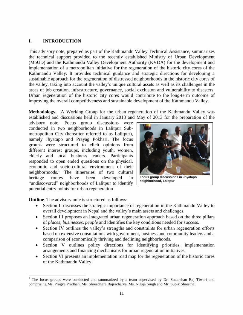
11
I. INTRODUCTION
This advisory note, prepared as part of the Kathmandu Valley Technical Assistance, summarizes
the technical support provided to the recently established Ministry of Urban Development
(MoUD) and the Kathmandu Valley Development Authority (KVDA) for the development and
implementation of a metropolitan initiative for the regeneration of the historic city cores of the
Kathmandu Valley. It provides technical guidance and strategic directions for developing a
sustainable approach for the regeneration of distressed neighborhoods in the historic city cores of
the valley, taking into account the valley’s unique cultural assets as well as its challenges in the
areas of job creation, infrastructure, governance, social exclusion and vulnerability to disasters.
Urban regeneration of the historic city cores would contribute to the long-term outcome of
improving the overall competitiveness and sustainable development of the Kathmandu Valley.
Methodology. A Working Group for the urban regeneration of the Kathmandu Valley was
established and discussions held in January 2013 and May of 2013 for the preparation of the
advisory note. Focus group discussions were
conducted in two neighborhoods in Lalitpur Sub-
metropolitan City (hereafter referred to as Lalitpur),
namely Jhyatapo and Prayag Pokhari. The focus
groups were structured to elicit opinions from
different interest groups, including youth, women,
elderly and local business leaders. Participants
responded to open ended questions on the physical,
economic and socio-cultural environment of their
neighborhoods.1 The itineraries of two cultural
heritage routes have been developed in
“undiscovered” neighborhoods of Lalitpur to identify
potential entry points for urban regeneration.
Outline. The advisory note is structured as follows:
Section II discusses the strategic importance of regeneration in the Kathmandu Valley to
overall development in Nepal and the valley’s main assets and challenges.
Section III proposes an integrated urban regeneration approach based on the three pillars
of places, businesses, people and identifies the key conditions needed for success.
Section IV outlines the valley’s strengths and constraints for urban regeneration efforts
based on extensive consultations with government, business and community leaders and a
comparison of economically thriving and declining neighborhoods.
Section V outlines policy directions for identifying priorities, implementation
arrangements and financing mechanisms for urban regeneration initiatives.
Section VI presents an implementation road map for the regeneration of the historic cores
of the Kathmandu Valley.
1 The focus groups were conducted and summarized by a team supervised by Dr. Sudarshan Raj Tiwari and
comprising Ms. Pragya Pradhan, Ms. Shreedhara Bajracharya, Ms. Niluja Singh and Mr. Subik Shrestha.
Focus group discussions in Jhyatapo
neighborhood, Lalitpur

12
Annexes to the note provide: (1) examples of the priority activities that could be initiated as part
of the urban regeneration initiative; (2) description of the process for designing a cultural
heritage walking tour, and presentation of a part of one of the two routes; (3) case studies
presenting international experience in urban regeneration; (4) description of the consultative
process undertaken as part of the technical assistance; and (5) maps of the Jhyatapo and Prayag
Pokhari neighborhoods, where focus group discussions were carried out. Supporting
documentation is provided in two separate attachments, namely: (1) an in-depth record of the
focus group discussions; and (2) an extended description of the two cultural heritage walking
tours.
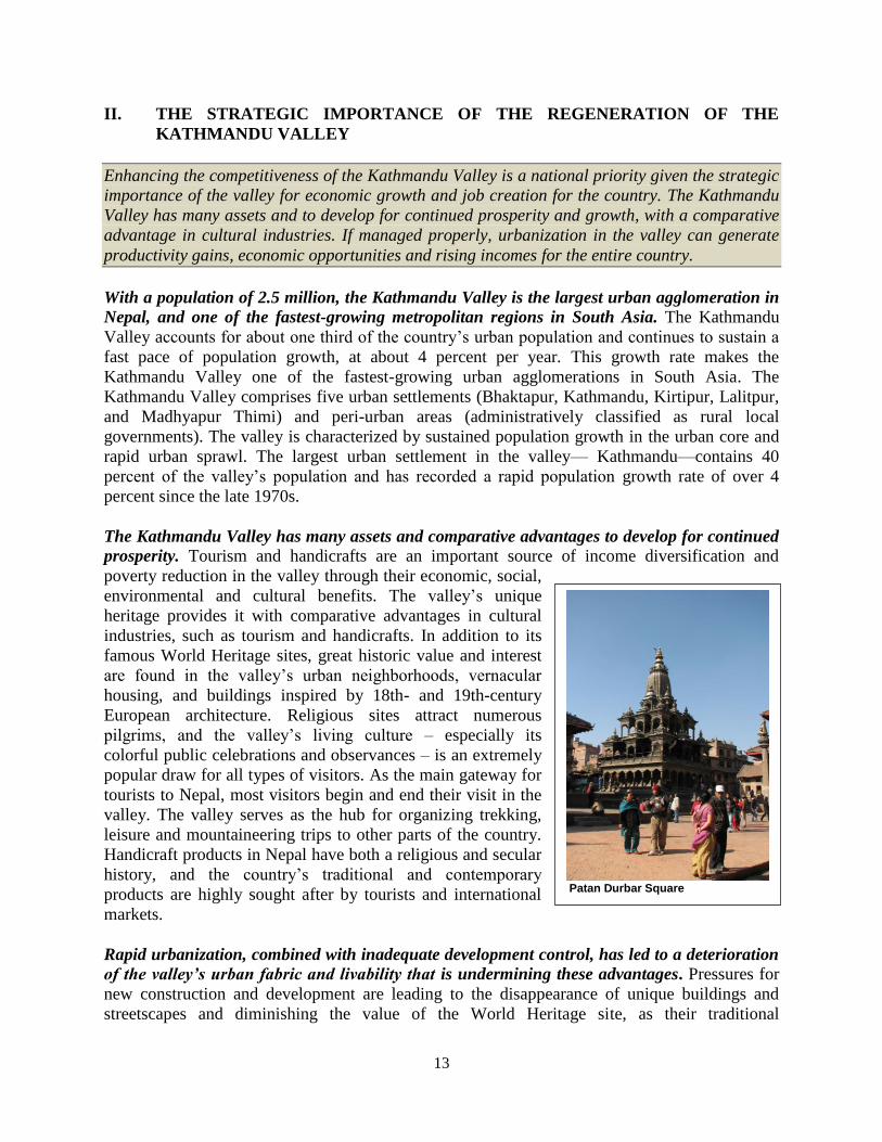
13
II. THE STRATEGIC IMPORTANCE OF THE REGENERATION OF THE
KATHMANDU VALLEY
Enhancing the competitiveness of the Kathmandu Valley is a national priority given the strategic
importance of the valley for economic growth and job creation for the country. The Kathmandu
Valley has many assets and to develop for continued prosperity and growth, with a comparative
advantage in cultural industries. If managed properly, urbanization in the valley can generate
productivity gains, economic opportunities and rising incomes for the entire country.
With a population of 2.5 million, the Kathmandu Valley is the largest urban agglomeration in
Nepal, and one of the fastest-growing metropolitan regions in South Asia. The Kathmandu
Valley accounts for about one third of the country’s urban population and continues to sustain a
fast pace of population growth, at about 4 percent per year. This growth rate makes the
Kathmandu Valley one of the fastest-growing urban agglomerations in South Asia. The
Kathmandu Valley comprises five urban settlements (Bhaktapur, Kathmandu, Kirtipur, Lalitpur,
and Madhyapur Thimi) and peri-urban areas (administratively classified as rural local
governments). The valley is characterized by sustained population growth in the urban core and
rapid urban sprawl. The largest urban settlement in the valley— Kathmandu—contains 40
percent of the valley’s population and has recorded a rapid population growth rate of over 4
percent since the late 1970s.
The Kathmandu Valley has many assets and comparative advantages to develop for continued
prosperity. Tourism and handicrafts are an important source of income diversification and
poverty reduction in the valley through their economic, social,
environmental and cultural benefits. The valley’s unique
heritage provides it with comparative advantages in cultural
industries, such as tourism and handicrafts. In addition to its
famous World Heritage sites, great historic value and interest
are found in the valley’s urban neighborhoods, vernacular
housing, and buildings inspired by 18th- and 19th-century
European architecture. Religious sites attract numerous
pilgrims, and the valley’s living culture – especially its
colorful public celebrations and observances – is an extremely
popular draw for all types of visitors. As the main gateway for
tourists to Nepal, most visitors begin and end their visit in the
valley. The valley serves as the hub for organizing trekking,
leisure and mountaineering trips to other parts of the country.
Handicraft products in Nepal have both a religious and secular
history, and the country’s traditional and contemporary
products are highly sought after by tourists and international
markets.
Rapid urbanization, combined with inadequate development control, has led to a deterioration
of the valley’s urban fabric and livability that is undermining these advantages. Pressures for
new construction and development are leading to the disappearance of unique buildings and
streetscapes and diminishing the value of the World Heritage site, as their traditional
Patan Durbar Square
14
surroundings and context are lost. The escalating pace of urban life means that residents have
less time and ability to participate in the traditional customs and practices that make up their
intangible heritage. Rapid urbanization is also overwhelming government’s ability to deliver
basic services (e.g., water, power and sewerage), which decreases livability and hampers tourism
operations. Even though tourist numbers are rising, congestion, noise and air pollution
throughout the valley are compromising the tourism experience and reducing earnings.2 Artisans
face escalating challenges as the sector fails to modernize and incomes decline. Overall, local
communities are experiencing diminished engagement with their tangible and intangible heritage
and this is weakening the “sense of place” and social cohesion in the valley’s cities.
The valley has strong potential to reverse decline based on its comparative advantages. The
experience of Bhaktapur municipality provides a positive model of successful regeneration in the
Kathmandu Valley. Local entrepreneurs are creating attractive new tourism products and
specialized tourism experiences, and the handicraft sector can rebound by building on the
availability of highly skilled artisans and the expected growth in sales related to tourism.
To leverage the comparative advantage of the valley, a sustainable regeneration strategy driven
by local economic development is needed. This approach to urban regeneration and key
conditions for success are presented in the next section.
2 See Muzzini and Aparicio. 2013. Urban Growth and Spatial Transition in Nepal. An Initial Assessment. Directions
in Development.
15
III. THE URBAN REGENERATION OF HISTORIC CITY CORES IN THE
KATHMANDU VALLEY: APPROACH AND CONDITIONS FOR SUCCESS
The Kathmandu Valley’s rapid urbanization calls for a metropolitan-level sustainable
regeneration strategy driven by local economic development. A sustainable urban regeneration
approach is based on three pillars (or areas of interventions) – people, businesses and places. In
the context of the Kathmandu Valley, urban regeneration initiatives require strong coordination
at the metropolitan level between central agencies, local authorities and the private sector. And
they need to be embedded in a metropolitan growth strategy that combines orderly and higher
density land and housing development in the fast-growing peri-urban areas with the
regeneration of the historic city cores.
The Kathmandu Valley needs an urban regeneration approach that beyond physical renewal. Urban regeneration needs to be driven by local economic development to bring about a lasting
improvement in the economic, physical, social and environmental conditions of an area that has
experienced negative change.3 Turok (2004) identifies three characteristics of contemporary
urban regeneration: a) the intention to change the nature of a place by involving the whole
community and other stakeholders with a stake in its future; b) the multiple social, economic,
environmental and governance objectives and activities which can cut across the responsibilities
of central and local governments; and c) the partnership among different stakeholders. 4
Urban
regeneration focuses on protecting the existing urban fabric, with its historic, cultural and
architectural elements and local social networks, while aiming to improve the livability and
quality of life for residents. The approach for urban regeneration discussed in this advisory note
hence goes beyond the proposed “house pooling” concept, a term coined for urban regeneration
in Nepal.5
Contemporary urban regeneration seeks a balance between ‘people’, ‘businesses’ and
‘places’. A sustainable urban regeneration approach is based on three pillars (or areas of
intervention) – places, businesses and people. For people, regeneration provides participation in
the renewal process and benefits by enhancing their capacities and opportunities. For businesses,
regeneration increases their economic competitiveness by enhancing skills and improving the
business environment. For historic places, regeneration includes protecting and reinforcing the
unique characteristics that give them their special sense of identity, appeal and branding
potential. Table 1 below presents the approach. It also describes institutional activities that could
be initiated under each pillar in the context of the Kathmandu Valley. Detailed examples are
3 Gibson, Micheal and Kocabaş, Arzu “London: Sustainable Regeneration - Challenge and Response”. Paper
presented to the International Urban Design Meeting, Mimar Sinan University, Istanbul, Turkey. May 2001. 4 Turok (2004). “Urban regeneration: what can be done and what should be avoided”. Paper presented at
International Urban Regeneration Implementation Symposium. 5 House pooling refers to a process whereby old houses in selected neighborhoods that are highly vulnerable to
natural hazards would be dismantled and redeveloped and then returned back to the owners. In exchange for
dilapidated houses, new houses compliant with risk-resilient building codes would be built based on traditional
design norms, and distributed to the original owners with provision of open spaces, access roads and economic
activities possible on certain floors of these buildings. A more rigorous assessment is required to assess viability of
the approach for the regeneration of the valley. The initiative, at feasibility stage, has been criticized because
resettlement costs would be prohibitively high, the difficulty of obtaining stakeholder consensus would significantly
lengthen implementation, the approach would be difficult to scale up given resource constraints, and the initiative
undermines the holistic approach to regeneration.
16
listed in Annex 1.
An integrated approach to upgrading the urban fabric, a partnership with the private sector
and community involvement are key conditions for the success of urban regeneration
initiatives. An integrated approach to upgrading the urban fabric encompasses improvements in
infrastructure, the protection of historic environments and disaster risk mitigation to reverse
decline in the historic cores. A partnership between the government and the private sector is
critical, as regeneration efforts are unlikely to succeed if they are a one-sided “push” from the
government side. And mobilization of local communities is critical for the sustainability of urban
regeneration initiatives.
The regeneration of the Kathmandu Valley is a metropolitan agenda. Sustainable urban
regeneration needs an overarching institutional and financing framework to deal with the
complexity of multi-sector interventions. In the specific context of the valley, urban regeneration
requires strong coordination at the metropolitan level between central agencies, local authorities
and the private sector. And urban regeneration initiatives need to be embedded in a metropolitan
growth strategy that combines orderly and higher density land and housing development in the
fast-growing peri-urban areas with the regeneration of the historic city cores. A two-pronged
strategy would be required to reverse the decline of the historic core of Kathmandu Metropolitan
City (hereafter referred to as Kathmandu) on one hand, and prevent the future deterioration of
historic cores in peripheral cities and towns in the valley on the other hand (e.g., Lalitpur,
Kirtipur and Madhyapur-Thimi).
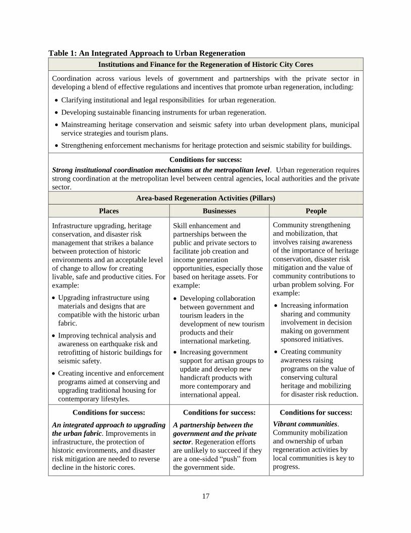
17
Table 1: An Integrated Approach to Urban Regeneration
Institutions and Finance for the Regeneration of Historic City Cores
Coordination across various levels of government and partnerships with the private sector in
developing a blend of effective regulations and incentives that promote urban regeneration, including:
Clarifying institutional and legal responsibilities for urban regeneration.
Developing sustainable financing instruments for urban regeneration.
Mainstreaming heritage conservation and seismic safety into urban development plans, municipal
service strategies and tourism plans.
Strengthening enforcement mechanisms for heritage protection and seismic stability for buildings.
Conditions for success:
Strong institutional coordination mechanisms at the metropolitan level. Urban regeneration requires
strong coordination at the metropolitan level between central agencies, local authorities and the private
sector.
Area-based Regeneration Activities (Pillars)
Places Businesses People
Infrastructure upgrading, heritage
conservation, and disaster risk
management that strikes a balance
between protection of historic
environments and an acceptable level
of change to allow for creating
livable, safe and productive cities. For
example:
Upgrading infrastructure using
materials and designs that are
compatible with the historic urban
fabric.
Improving technical analysis and
awareness on earthquake risk and
retrofitting of historic buildings for
seismic safety.
Creating incentive and enforcement
programs aimed at conserving and
upgrading traditional housing for
contemporary lifestyles.
Skill enhancement and
partnerships between the
public and private sectors to
facilitate job creation and
income generation
opportunities, especially those
based on heritage assets. For
example:
Developing collaboration
between government and
tourism leaders in the
development of new tourism
products and their
international marketing.
Increasing government
support for artisan groups to
update and develop new
handicraft products with
more contemporary and
international appeal.
Community strengthening
and mobilization, that
involves raising awareness
of the importance of heritage
conservation, disaster risk
mitigation and the value of
community contributions to
urban problem solving. For
example:
Increasing information
sharing and community
involvement in decision
making on government
sponsored initiatives.
Creating community
awareness raising
programs on the value of
conserving cultural
heritage and mobilizing
for disaster risk reduction.
Conditions for success:
An integrated approach to upgrading
the urban fabric. Improvements in
infrastructure, the protection of
historic environments, and disaster
risk mitigation are needed to reverse
decline in the historic cores.
Conditions for success:
A partnership between the
government and the private
sector. Regeneration efforts
are unlikely to succeed if they
are a one-sided “push” from
the government side.
Conditions for success:
Vibrant communities.
Community mobilization
and ownership of urban
regeneration activities by
local communities is key to
progress.
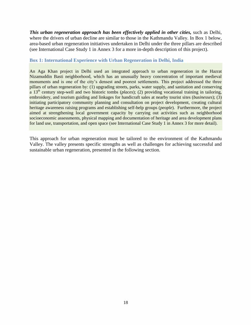
18
This urban regeneration approach has been effectively applied in other cities, such as Delhi,
where the drivers of urban decline are similar to those in the Kathmandu Valley. In Box 1 below,
area-based urban regeneration initiatives undertaken in Delhi under the three pillars are described
(see International Case Study 1 in Annex 3 for a more in-depth description of this project).
Box 1: International Experience with Urban Regeneration in Delhi, India An Aga Khan project in Delhi used an integrated approach to urban regeneration in the Hazrat
Nizamuddin Basti neighborhood, which has an unusually heavy concentration of important medieval
monuments and is one of the city’s densest and poorest settlements. This project addressed the three
pillars of urban regeneration by: (1) upgrading streets, parks, water supply, and sanitation and conserving
a 13th century step-well and two historic tombs (places); (2) providing vocational training in tailoring,
embroidery, and tourism guiding and linkages for handicraft sales at nearby tourist sites (businesses); (3)
initiating participatory community planning and consultation on project development, creating cultural
heritage awareness raising programs and establishing self-help groups (people). Furthermore, the project
aimed at strengthening local government capacity by carrying out activities such as neighborhood
socioeconomic assessments, physical mapping and documentation of heritage and area development plans
for land use, transportation, and open space (see International Case Study 1 in Annex 3 for more detail).
This approach for urban regeneration must be tailored to the environment of the Kathmandu
Valley. The valley presents specific strengths as well as challenges for achieving successful and
sustainable urban regeneration, presented in the following section.
19
IV. STRENGHTS AND CONSTRAINTS FOR URBAN REGENERATION IN THE
KATHMANDU VALLEY
Several strengths exist for urban regeneration in the valley. These include strong communities,
the presence of world class cultural assets with significant potential for income-generating
activities around cultural industries, and the vibrant private sector leaders who show a strong
interest in participating in regeneration efforts. A number of constraints also exist, however.
These include the inadequate planning and development controls contributing to urban decline;
insufficient investment in infrastructure and services decreasing urban livability; institutional
fragmentation of government responsibility and overlapping authority across agencies leading to
inaction; the weakening of social networks and informal safety nets in the deteriorating urban
cores where the poorest and most vulnerable reside, and lack of organized support for cultural
industries resulting in loss of competitiveness and income.
Consultations were held with a broad range of stakeholders to identify the strengths and
constraints for urban regeneration in the valley. Focus group discussions were carried out in the
neighborhoods of Jhyatapo and Prayag Pokhari (PP) to further explore the causes of
neighborhood decline and prosperity in the Kathmandu Valley. They were selected because they
occupy different points on the development spectrum. While Jhyatapo is declining and PP is
prospering, there are many interesting points of similarity and contrast between the two
neighborhoods.
IV.I Strengths for urban regeneration in the valley
There was broad consensus among all those consulted on the strengths that the Kathmandu
Valley has to draw on. The strengths for urban regeneration in the valley include the following,
as illustrated by examples from Jhyatapo and PP.
Strong communities, their mobilization and ownership of urban regeneration activities, are
seen as key to progress. The existence of strong communities and an established way of
mobilizing them through user-group contributions (usually about 20%) for small, government-
initiated infrastructure projects will be a strong starting point for urban regeneration efforts.
Focus group discussions
In terms of generating community action to address common problems, the two neighborhoods
differ substantially. In Jhyatapo, the local community-based development committee (Tole
Sudhar Samiti, or TSS) takes responsibility for resolving conflicts, maintaining infrastructure and
conserving heritage. TSS members say that the level of volunteerism is low and that maintaining
traditions and heritage buildings was much easier when the guthi was responsible, as it could
compel members to cooperate and contribute.6 PP does not have a TSS or any other community
groups. The neighborhood’s issues are solved by a handful of people, who have good rapport
with the municipality. Members of the predominant caste in PP maintain their commitment and
6 A guthi is an association formed by groups of people on the basis of caste, patrilineal grouping, or territorial
aspects. Guthis were originally set up in Nepal to establish and maintain religious and charitable institutions, and are
one of the indigenous systems that traditionally played an important role in the conservation and perpetuation of
cultural heritage.
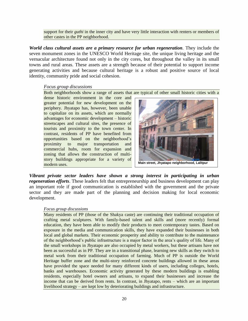
20
support for their guthi in the inner city and have very little interaction with renters or members of
other castes in the PP neighborhood.
World class cultural assets are a primary resource for urban regeneration. They include the
seven monument zones in the UNESCO World Heritage site, the unique living heritage and the
vernacular architecture found not only in the city cores, but throughout the valley in its small
towns and rural areas. These assets are a strength because of their potential to support income
generating activities and because cultural heritage is a robust and positive source of local
identity, community pride and social cohesion.
Focus group discussions
Both neighborhoods show a range of assets that are typical of other small historic cities with a
dense historic environment in the core and
greater potential for new development on the
periphery. Jhyatapo has, however, been unable
to capitalize on its assets, which are normally
advantages for economic development – historic
streetscapes and cultural sites, the presence of
tourists and proximity to the town center. In
contrast, residents of PP have benefited from
opportunities based on the neighborhood’s
proximity to major transportation and
commercial hubs, room for expansion and
zoning that allows the construction of multi-
story buildings appropriate for a variety of
modern uses.
Vibrant private sector leaders have shown a strong interest in participating in urban
regeneration efforts. These leaders felt that entrepreneurship and business development can play
an important role if good communication is established with the government and the private
sector and they are made part of the planning and decision making for local economic
development.
Focus group discussions
Many residents of PP (those of the Shakya caste) are continuing their traditional occupation of
crafting metal sculptures. With family-based talent and skills and (more recently) formal
education, they have been able to modify their products to meet contemporary tastes. Based on
exposure in the media and communication skills, they have expanded their businesses in both
local and global markets. Their economic prosperity and ability to contribute to the maintenance
of the neighborhood’s public infrastructure is a major factor in the area’s quality of life. Many of
the small workshops in Jhyatapo are also occupied by metal workers, but these artisans have not
been as successful as in PP. They are in a transitional phase, learning new skills as they switch to
metal work from their traditional occupation of farming. Much of PP is outside the World
Heritage buffer zone and the multi-story reinforced concrete buildings allowed in these areas
have provided the space needed for many different kinds of users, including colleges, hotels,
banks and warehouses. Economic activity generated by these modern buildings is enabling
residents, especially hotel owners and artisans, to expand their businesses and increase the
income that can be derived from rents. In contrast, in Jhyatapo, rents – which are an important
livelihood strategy – are kept low by deteriorating buildings and infrastructure.
Main street, Jhyatapo neighborhood, Lalitpur
21
IV.II Constraints for urban regeneration in the valley
Over the course of the workshops and interviews undertaken, strong agreement emerged on the
major constraints faced by residents of the valley, including the following.
Inadequate planning and development controls are a leading cause of urban decline. Poor
enforcement of building codes and conservation laws is allowing new construction and building
rehabilitation that is unsympathetic to historic areas and undermines both their cultural and
historic value. Lack of attention to building codes and land use planning is also increasing
seismic risk by allowing unsafe construction, irregular, dense and inaccessible housing patterns
and the loss of open space. Inadequately enforced urban plans and zoning regulations are
creating haphazard sprawl on urban peripheries and allowing slum settlements in ecologically
sensitive and marginal areas.
Focus group discussions
Jhyatapo’s streetscape and building morphology was fully developed before the city’s rapid
population growth began. The neighborhood has a traditional town plan consisting of dense
housing blocks and narrow lanes. With limited room for expansion, the neighborhood is
experiencing physical decay as the increase in population and contemporary lifestyles put stress
on the buildings and infrastructure. Before heritage conservation regulations were put in place,
some historic facades were modified and modern buildings erected, somewhat diminishing the
tourism appeal of the area. This is in contrast to PP, where politicians and professionals who lived
in PP saw the potential for economic growth in their area (in part thanks to the open space
available for development) and promoted the widening of a pedestrian way into a major road and
installation of a good drainage system. This road is now a busy thoroughfare connecting
Lalitpur’s urbanizing core to its periphery, as well as connecting the neighborhood to nearby
transportation and commercial hubs. Physical and economic development in PP began increasing
only after this expanded access was created.
Insufficient investment in infrastructure and services is leading to a severe decrease in urban
livability. The valley is dealing with water shortages, heavily congested roads, flooding and
power outages. As investments by central and municipal governments lag demand, urban
residents and businesses must seek individual solutions, which are often inefficient and
inconvenient. For example, long lines of residents form to access public water sources and
building structures are compromised by the weight of roof-top water storage tanks that hold
water pumped from individual household wells.
Focus group discussions
Residents of both neighborhoods report that buildings in their area (traditional and reinforced
concrete structures) are at extreme risk of collapse from earthquakes, due to poorly enforced
building codes and lack of maintenance. Both neighborhoods also suffer from inadequate
drinking water, noise and air pollution, traffic jams and loss of public space.
Institutional fragmentation of responsibility and overlapping authority across agencies at the
central and local levels often result in little or no action being taken. This lack of clarity is
exacerbated by the absence of effective and well-established mechanisms for planning and
coordination at the valley’s metropolitan level. In addition, a lack of information sharing and
22
trust between municipalities and their communities is leading to inaction and low “up-take” of
government initiatives.
Focus group discussions
There is a lack of inclusion and participatory decision making in both neighborhoods. In
Jhyatapo, the community-based development organization (TSS) consists mostly of young men
from one caste, and its decision-making process excludes women, homeowners from other castes,
migrants and businessmen. The predominant caste group in PP attends to infrastructure and other
needs on an ad hoc basis and has little interaction with the more recently arrived residents or
businessmen. Unfortunately, the lack of information sharing and participatory planning that is
prevalent in government institutions is being recreated in the neighborhoods. Increasing the use of
inclusive planning and communication from the central level to the metropolitan, municipal, ward
and neighborhood levels would be a positive change in the valley. It could build citizen
awareness of the valley’s complicated challenges and mobilize them to more fully contribute to
resolving these problems. Residents and businesses in both neighborhoods are additionally
hampered by a lack of coordination and action on the part of government institutions. More
economic growth and dynamism could be established through integrated planning, enforcement
of development controls, upgraded public infrastructure, improved housing and disaster risk
reduction.
The poorest and most vulnerable reside in the deteriorating urban cores, where there is a
general loss of social capital. Poverty in the valley is multidimensional and includes social
segregation, discrimination, lack of voice, vulnerability to shocks and poor access to basic
infrastructure and services. These dimensions of poverty reinforce disempowerment and
exclusion from the benefits that the valley’s urban areas have to offer. Existing social networks
and informal safety nets are being weakened as neighborhoods are composed of growing
numbers of transient migrants and the effects of rapid urbanization undermine communal
customs and practices.
Focus group discussions
The composition of original residents (who are usually from the same caste) and migrants renting
space is significantly different in the two neighborhoods. Renters account for approximately 50
percent of the population in Jhyatapo, while they constitute only about 30 percent of residents in
PP. However, the rate of in-migration in PP is increasing due to employment opportunities in the
area and growth of the nearby commercial and transit hub. The “sense of community” in both
neighborhoods has decreased due to changes in lifestyle, lack of a predominant cultural group and
low levels of interaction between owners and renters.
Lack of organized support for cultural industries is resulting in a loss of competitiveness and
income. International handicraft sales are declining due the inability of the export industry to
improve branding and marketing strategies and provide timely trademark protection. Individual
artisans receive little help in updating their designs and products for modern lifestyles and
preferences. The valley has a growing reputation as a low-cost and crowded tourism destination
because mass tourism, rather than high-yield niche tourism, is becoming dominant. Deteriorating
infrastructure and lack of development controls are not only undermining the heritage assets on
which cultural tourism is based, but also limiting tourism growth. In general, entrepreneurs face
serious constraints in creating development and jobs.

23
Focus group discussions
The built assets of Jhyatapo include traditional buildings with impressive architectural detail and
local cultural sites. The neighborhood’s main street is a heavily used route between two of
Lalitpur’s most important tourist sites – the Golden Temple and Kumbheshwar. This combination
of assets should lead to income from tourism development, but residents have been unable to
capture the interest and spending of the tourists who pass through the neighborhood. The main
streets in both PP and Jhyatapo are lined with shops selling items for local residents’ daily needs
as well as various handicraft products for tourists. Shop owners in both neighborhoods complain
that the pollution, congestion and lack of pedestrian safety of the main streets limit foot traffic
and the frequency by which people stop to shop. Both neighborhoods have older and younger
generations with opposing views on the importance of conserving heritage. Older residents are
confident that the guthi system should and can maintain traditions by exerting social and financial
pressure on young people to participate in activities. The younger generation, with modern values
and lifestyles, is very vocal about discontinuing traditional practices unless there is justification
for their importance, or adapting them to fit residents’ changing needs.
The insights and experiences described by residents in the Jhyatapo neighborhood illustrate the
impact of the constraints that are affecting them and many other neighborhoods across the valley
(see Box 2).
Box 2: The Causes of Decline in the Jhyatapo Neighborhood
Focus group discussions in the Jhyatapo neighborhood of Lalitpur were conducted with four different
groups representing youth, women, the elderly and local business leaders. Participants responded to open
ended questions on the physical, economic and socio-cultural environment of their neighborhood. The
participants flagged a number of primary causes of neighborhood decline, including inadequate planning
and development controls, insufficient investment in infrastructure and services, institutional
fragmentation of responsibility and overlapping authority, the poorest and most vulnerable are located in
the deteriorating urban cores and there is a general loss of social capital in these neighborhoods, and lack
of organized support for cultural industries.
The lack of planning and development controls in Jhyatapo has an especially negative impact on heritage
conservation and disaster risk reduction. The section of Jhyatapo’s main street between Mahapal and
Konti is within the core area of the Patan Durbar Square Monument Zone. Before the heritage
conservation regulations were put in place, many traditional building facades were modernized and major
buildings at either end of the historic street were reconstructed using concrete and contemporary
architectural styles. These changes have diminished the cultural value and tourist appeal of the street.
Some Jhyatapo residents said that the regulations on traditional buildings (especially height limits) restrict
their ability to expand for growing families. Others felt that maintenance of historic buildings is hampered
by a lack of information and the cost of traditional materials and building techniques.
All four focus groups believed many of the neighborhood structures to be at high risk of collapse during
an earthquake due to poor maintenance, despite traditional building technology being well suited to
survive earthquakes. The new reinforced concrete buildings are also unsafe, either because they were
built before the earthquake stability regulations were put in place or because the regulations were not
followed. The focus groups also identified the loss of open space as a problem since it has reduced refuge
areas from falling buildings. Members of the women’s focus group participated in earthquake
preparedness training, and said that “Preparing for an earthquake is hard to implement. The main reasons
24
are that there are economic constraints. It has never happened in people’s lifetime so it is hard to convince
them. Awareness is there, but it is not taken seriously.”
The focus groups reported improved infrastructure as their most pressing need in Jhyatapo. Participants
unanimously flagged sanitation and drainage as the major problems facing Jhyatapo. “When it rains
heavily, the roads are like open stinking sewers.” Drinking water is limited – with households only
having a piped supply for a short time a few days a week – and this water was said to often be polluted.
The water table is additionally getting so low that household wells are also going dry, and most of the
public waterspouts have similarly dried up. Focus groups participants also mentioned interruptions in
electrical service, high levels of air and noise pollution, and a shortage of parking, which is causing
conflict over the use of open space.
Residents also say that poor road conditions hamper economic development. The main street in Jhyatapo
links two of the most highly visited cultural heritage sites in Lalitpur, namely the Golden Temple and
Kumbheshwar Temple. Many houses along this street have shops on the ground floor selling tourist-
oriented handicrafts. While commercial activity has grown over the past 15-20 years due to an overall
expansion in tourism, the increasingly poor road condition is now leading to a decline in the area’s
economic vitality and flow of visitors. In addition to its flooding and drainage problems, heavy traffic on
the street and encroachment on the sidewalks make use of the road unsafe for tourists and other
pedestrians. Since business has not been able to flourish in the area, property values and rental rates are
comparatively low. The business leaders’ focus group recommended that, “To improve business, the road
should be maintained, traffic should be banned and tourist-centric services should be provided.”
Businessmen express frustration with the fact that they are not included in the TSS community
discussions and decision making that can affect their businesses.
Ineffective governance in Jhyatapo not only results in poor urban infrastructure and the related health
and safety risks, but also has led to conflict between neighborhoods. The serious drainage and flooding
problems in Jhyatapo could be corrected by laying larger drainage pipes across several neighborhoods.
However, people living in nearby Kumbheshwar will not allow these improvements to be made in their
area as buildings have been constructed over the pipe system. Since the municipality failed to stop such
illegal construction in Kumbheswar, the Jhyatapo community thinks that it should be responsible for
resolving this conflict and solving the issue. Residents of Kumbheshwar additionally blame their
neighborhood’s water shortage on the Jhyatapo residents’ water wells. Several years ago, a group from
Kumbheshwar forcefully took a boring machine and buried wells in the Jhyatapo area. Focus group
members say that the needs of Kumbheswar dominate those of Jhyatapo and that one reason for this is the
decreasing number of long-term/original residents (Tandukar) in Jhyatapo demanding their rights.7
Jhyatapo has a mix of low- and middle-income residents, with many facing disempowerment and lack of
voice in the neighborhood. The focus groups reported that poor migrant renters constitute around 50
percent of the population, and that there has been a decrease in the “sense of community” in the
neighborhood. The structured community-development organization TSS – made up of local residents –
works closely with the municipality on infrastructure development and takes responsibility for conserving
some historic buildings. But TSS members expressed dissatisfaction with the current level of
volunteerism in the community. “Since the guthis are replaced by committees, people think it is the sole
responsibility of the TSS to take care of problems. Now people don’t want to volunteer or work for ‘free’
as there is a great opportunity cost associated with it.” Focus group members mentioned there being an
overwhelming concentration of one specific caste in the TSS, and that those who own homes in Jhyatapo
but do not belong to that caste are not included in the TSS decision making process. Also, there are no
7 Kumbheswar is downhill from Jhyatapo, which accounts for the two neighborhoods impact on each other’s
drainage and water scarcity.

25
women in the group and only the Newari language is used during meetings. The Jhyatapo focus group
participants expressed greatest concerned over tourism and commercial development, citing a lack of
organized support for cultural industries. Discussion with artisans would likely confirm many of the
concerns and wishes presented elsewhere in this note.
Building on the strengths while addressing the constraints related to urban regeneration in the
valley requires collaboration and action at both metropolitan and local levels. A set of policy
directions and institutional arrangements for regeneration efforts in the valley were borne out of
stakeholder consultations. These are presented in the following section.
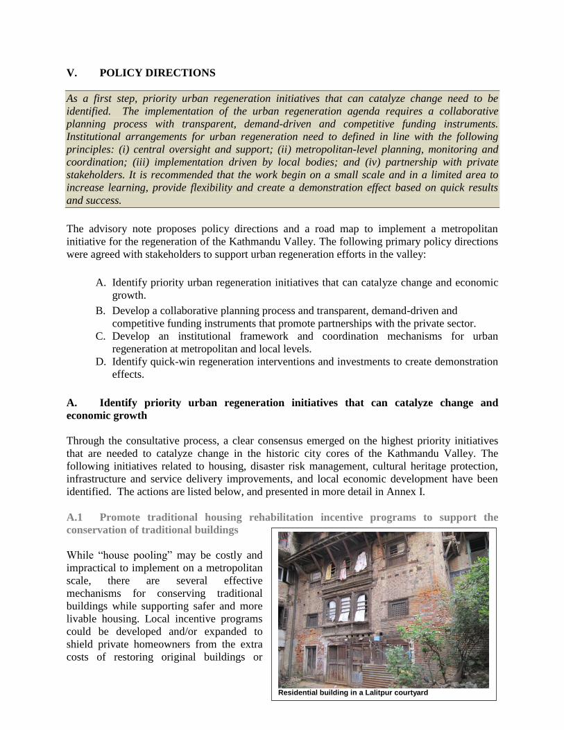
26
V. POLICY DIRECTIONS
As a first step, priority urban regeneration initiatives that can catalyze change need to be
identified. The implementation of the urban regeneration agenda requires a collaborative
planning process with transparent, demand-driven and competitive funding instruments.
Institutional arrangements for urban regeneration need to defined in line with the following
principles: (i) central oversight and support; (ii) metropolitan-level planning, monitoring and
coordination; (iii) implementation driven by local bodies; and (iv) partnership with private
stakeholders. It is recommended that the work begin on a small scale and in a limited area to
increase learning, provide flexibility and create a demonstration effect based on quick results
and success.
The advisory note proposes policy directions and a road map to implement a metropolitan
initiative for the regeneration of the Kathmandu Valley. The following primary policy directions
were agreed with stakeholders to support urban regeneration efforts in the valley:
A. Identify priority urban regeneration initiatives that can catalyze change and economic
growth.
B. Develop a collaborative planning process and transparent, demand-driven and
competitive funding instruments that promote partnerships with the private sector.
C. Develop an institutional framework and coordination mechanisms for urban
regeneration at metropolitan and local levels.
D. Identify quick-win regeneration interventions and investments to create demonstration
effects.
A. Identify priority urban regeneration initiatives that can catalyze change and
economic growth
Through the consultative process, a clear consensus emerged on the highest priority initiatives
that are needed to catalyze change in the historic city cores of the Kathmandu Valley. The
following initiatives related to housing, disaster risk management, cultural heritage protection,
infrastructure and service delivery improvements, and local economic development have been
identified. The actions are listed below, and presented in more detail in Annex I.
A.1 Promote traditional housing rehabilitation incentive programs to support the
conservation of traditional buildings
While “house pooling” may be costly and
impractical to implement on a metropolitan
scale, there are several effective
mechanisms for conserving traditional
buildings while supporting safer and more
livable housing. Local incentive programs
could be developed and/or expanded to
shield private homeowners from the extra
costs of restoring original buildings or
Residential building in a Lalitpur courtyard
27
constructing new ones with traditional materials, giving priorities to façade improvements along
designated heritage routes (see Box 3 and International Case Study 2 in Annex 3 for examples of
housing rehabilitation incentive programs in Morocco).
Box 3: A Housing Rehabilitation Program Based on Resident Incomes in Fez, Morocco A World Bank project in Fez provides an example of housing-focused urban regeneration work . The Fez
medina, a World Heritage site in the city core, is a vibrantly active area that has experienced decades of
physical decay resulting in a serious deterioration of its infrastructure and housing. Two different housing
rehabilitation programs based on income were developed for the medina.
A matching grant program was designed for individual house owners who were able to pre-finance and
carry out restoration work using their own or borrowed funds. After completion of the work, owners were
reimbursed for 30 percent of the restoration costs. At project closing, 132 grants at an average of
US$1,000 per grant were disbursed.
For low-income residents, the housing program solely targeted the common areas of residential buildings
that were critical for their survival, such as roofs and water drainage systems, rather than restoring
individual spaces. No financial contribution was required of the low-income residents given their level of
poverty. Upon all parties signing a simple form, the project agency provided skilled laborers, technical
supervision, building materials, and transport of materials and rubble. The low-income residents provided
unskilled labor (one person per family living in the building being rehabilitated). Under this mechanism,
107 projects were completed (see International Case Study 2 in Annex 3 for more detail on this project).
A.2 Initiate coordinated interventions at both the metropolitan and the local level to
better protect the valley’s cultural heritage
The success of cultural heritage protection programs hinges on attention and action at both the
metropolitan and local levels. A role best undertaken at the metropolitan level, is the
establishment of criteria to assess the potential negative impact of development projects on
heritage and the creation of a mechanism for regular review among relevant ministries to reduce
these impacts. A priority activity at the local level involves raising community awareness of the
value of heritage. This could be done through media campaigns, school programs and by creating
inventories that document local historic sites and intangible heritage (e.g., shrines, temples,
celebrations and cuisine). Municipalities and small towns in the valley could also undertake the
conservation of key local assets, such as traditional water spouts (hitis) that are both historic and
important public assets, especially for the poor. An example of a community-level initiative is
the open-air museum and traditional restaurant established by a neighborhood group in Kirtipur
(see Box 4).
Box 4: Neighborhood Cooperation to Conserve Heritage in Kirtipur A neighborhood in Kiritpur has worked to develop a successful co-op restaurant, serving traditional
cuisine in an effort to conserve their heritage and create jobs for local youth. The Newa Lahana restaurant
was established using a contribution of NR 5,000 from 65 households. Today, those who work in the
restaurant draw salaries and the contributing households receive an annual dividend. The community has
also begun establishing an open-air museum along the street leading to the restaurant by hanging
traditional agricultural tools and photographs of life-stage ceremonies on the house walls. In an open area
28
near the restaurant, neighborhood women produce the local whisky, aila, for visitors to watch and for the
restaurant to use. Community trust and cooperation around these activities is strengthened by the fact that
the organizing vehicle is the local guthi.
A.3 Upgrade the deteriorated historic urban fabric to maintain and improve the
livability and tourism potential of the valley’s historic city cores
At the metropolitan level, overall planning should be improved by developing new information
tools and criteria for prioritizing physical investments that recognize the importance and needs of
historic areas. Central- and metropolitan-level infrastructure agencies that impact the historic
environment (e.g., those working on electricity and telecommunications) should develop
guidelines that allow for installation and connection harmonized with the surrounding traditional
structures. Local-level agencies could be instrumental in improving historic areas by prioritizing
local infrastructure and service improvements (e.g., drainage and paving) in their Protected
Monument Zones and buffer zones and by developing public-private partnerships to demonstrate
the advantages of adapting heritage buildings for income-generating activities (see International
Case Study 4 in Annex 3 on upgrading the historic urban fabric in Quito, Ecuador).
A.4 Coordinate disaster risk reduction and management efforts among agencies at the
metropolitan and local levels as well as the local population
There is a critical need to develop awareness raising campaigns and engage a large majority of
the population in planning and preparing for natural disasters, in particular seismic risk. An
initiative that is especially important for the urban regeneration of the Kathmandu Valley is a
review of regulations, enforcement and inspection systems to improve the protection and safety
of traditional buildings. It is critical that agencies at the metropolitan level take the lead in
improving the technical analysis and availability of public information on earthquake risk (e.g.,
open street maps and web-based databases); establishing norms for analyzing the resilience of
traditional buildings and techniques for strengthening them; and adapting land-use planning
norms to reduce risk from earthquakes and floods. Local-level agencies need to improve the
enforcement of construction safety codes and by-laws and designate and prepare post-disaster
areas for relief. They could also form a public-private partnership to retrofit traditional buildings
for seismic safety on a pilot basis and use it as a demonstration project to promote norms and
guidelines for stability (see Box 5).
Box 5: Conserving Traditional Buildings and Addressing Seismic Risks in Lalitpur
Between 2009 and 2011, UNESCO, Tribhuvan University and Ritsumeikan University in Kyoto, Japan
undertook a study assessing seismic risks in the Jhyatapo area in Lalitpur. The study was initiated because
the historic streets, courtyards and buildings in the area are integral to tourism and residents’ livelihoods
in the Kathmandu Valley. The research identified a number of issues regarding earthquake risk reduction
in historic neighborhoods related to safeguarding and strengthening of heritage buildings as well as
reducing disaster risks to the communities living in historic areas. Various structural weaknesses and
effective reinforcement measures were identified, evacuation risks and countermeasures analyzed, and
emergency response capacities and limits (e.g., firefighting and rescue) estimated. It was also found that
the heritage sites themselves, their open spaces, traditional water sources and communal areas, could be
effectively conserved, maintained and prepared to provide emergency shelter, water and first-aid stations.

29
Study Reference: The Research Center for Disaster Mitigation of Urban Cultural Heritage at Ritsumeikan
University, Kyoto Japan and the Institute of Engineering at the Pulchowk Campus, Tribhuvan University,
Kathmandu. 2012. Disaster Risk Management for the Historic City of Patan, Nepal.
A.5 Undertake initiatives to increase the economic benefits of cultural tourism for
communities in the valley
Appropriate activities at the metropolitan level include: (1) improving tourism data collection
(e.g., tourist characteristics, demand and satisfaction); (2) updating tourism branding and
marketing campaigns; and (3) improving the quality of vocational tourism training programs,
based on private sector input. Local authorities could be more proactive in promoting cultural
events and developing more accessible and coherent scripts on their city’s unique history. For
example, Madhapur Thimi is located between Kathmandu and Bhaktapur. With some investment
in upgrading the city’s five historic areas and marketing these sites, authorities could develop
attractions sufficient to draw visits from tourists en route between the two towns. Local
authorities could also support individual businesses in developing new niche-market tourism
products that attract high-value cultural tourists and extend their stay in the area. Community
groups could develop their own local heritage assets and link them to income-generation
activities, especially experiential tourism activities, such as handicraft and cooking lessons.
A.6 Promote handicraft development
initiatives to generate further income from
cultural tourism in the area
Handicrafts are an important and centuries-old
element of the valley’s intangible heritage, but
expertise is being lost as younger generations
refuse to enter these trades, mostly because
incomes are low. At the metropolitan level,
efforts should be made to make improvements to
the handicraft export sector (e.g., research on
future demand, marketing, branding and
institutional processes). Improved handicraft
training centers, design updating and development of new products strongly linked to export
tourist markets is another initiative that is best supported at the metropolitan level. In addition,
artisans’ business profitability could be enhanced through business training and mentoring
programs supported on a metropolitan-wide basis. Local authorities could increase artisan
earnings by branding and marketing local products, improving local training programs,
expanding handicraft demonstration areas and direct sales points and creating specialized crafts
tours (see International Case Studies 5 and 6 for examples of support for handicrafts).
Woodcarving workshop and training center
30
A.7 Develop cultural heritage walking tours as a catalyst for local regeneration
The development of heritage routes, if strategically identified, can generate partnerships and joint
investments by the public and private sectors as well as local communities. Such partnerships
may lead to infrastructure upgrading on the part of local authorities (paving and signage),
heritage conservation by communities (housing rehabilitation and façade restorations), and
promotion of small businesses (artisan workshops and restaurants). Cultural heritage routes can
also be instrumental in: (1) easing the pressure on heavily visited sites; (2) providing more
channels for marketing local attractions; and (3) disseminating the benefits of local economic
development across a wider area (beyond the Protected Monument Zone of the UNESCO World
Heritage Site). If well developed, these cultural heritage routes have the potential of drawing
together all of the priority activities for urban regeneration identified through the consultative
process and described above (see International Case Study 3 in Annex 3 for an example of how
development of a tourism route promoted urban regeneration activity in Lahore, Pakistan). The
concepts of two neighborhood walking tours have been developed in Lalitpur as part of the
technical assistance to illustrate how cultural heritage walking tours can be an effective strategy
for urban regeneration. Box 6 and Annex 2 describe the process to be followed to develop a
cultural heritage route in order to maximize socio-economic impact, drawing on the experience
of Lalitpur.
Box 6: Steps for Developing a Cultural Heritage Route – The Example of Lalitpur
The development of successful cultural heritage walking tour routes requires a number of steps. First, the
route needs to be identified, based on well-established planning criteria to maximize socio-economic
impact (such as proximity to other tourist focal points, concentration of heritage assets, accessibility,
availability or potential for provision of basic services, diversity and mixed income routes and potential
for developing storylines). Second, the development of the route requires preparation of a site
management plan, based on a participatory planning, and the identification of catalytic public investments
(streetscape upgrading and beautification, heritage conservation, tourism services and way finding) to
leverage contributions from the private sector. Third, interpretation, marketing are required to attract
visitors to the area. Fourth, follow-up support and monitoring for focal points and entrepreneurs along the
heritage route is necessary to solve problems and/or keep improving the experience.
As part of the technical assistance, the concept for two neighborhood walking tours has been developed –
- “Hindu and Buddhist Heritage of East Patan” and “Artisans and Architecture of East Patan”. The goal of
these tours is to draw tourists visiting the city’s most famous heritage destinations into less well-known
areas that contain historic sites as well as vibrant living heritage. These routes are designed to link a series
of remarkable sites, people and experiences to communicate the unique history, architecture and culture
of “undiscovered” neighborhoods in Lalitpur. The tourism potential that these routes represent can
catalyze investment and development on the part of government, communities and businesses. Annex 2
describes in detail the process of developing a cultural heritage walking tour, drawing on the experience
of Lalitpur. It additionally presents an excerpt from one of the two neighborhood tours – ‘The Artisans
and Architecture of East Patan’.
31
B. Develop a collaborative planning process and transparent, demand-driven and
competitive funding instruments that promote partnerships with the private sector
The planning and financing instruments for urban regeneration need to be tailored to local
conditions, including the level of private sector development and institutional capacity, and aim
to leverage the specific strengths while addressing the constraints for urban regeneration
identified in Section IV. Hence, the implementation of urban regeneration initiatives in the valley
would require a combination of planning and financing instruments to mobilize communities and
leverage private sector activities, while addressing issues of institutional coordination. The
outcomes of the planning process will include the following:
B.1 Develop a Regeneration Strategy and Action Plan for the Kathmandu Valley
The Kathmandu Valley needs a metropolitan-level regeneration strategy and action plan given
the strategic importance of the agenda. The preparation of this strategy needs to be highly
consultative and linked to the update of the Kathmandu Valley Long-Term Development
Concept of 2002 that is currently being prepared. As urban regeneration is driven by economic
development, the urban regeneration strategy needs to be informed by competitiveness strategies
for the valley’s main growth drivers, such as cultural tourism and handicrafts. The
competitiveness strategies would be cluster specific and based on a collaborative, inclusive,
private sector-led process focused on action and results. A cluster can be defined as a public-
private partnership initiative based on a group of interdependent companies, organizations and
institutions in a geographic region with common or complementary interests.8 A tourism cluster,
for example, could consist of officials from relevant government ministries and agencies,
municipal governments, and 40-70 business leaders, including the valley’s hotel and restaurant
owners, tour operators, travel agencies, airlines and transport companies, tourist guides,
chambers of commerce, guthi leaders and other important community leaders. Researchers at the
universities, marketing experts, trainers, labor unions and regulators would also be important
cluster participants.
B.2 Prepare an Implementation and Financing Plan for Metropolitan-level
Regeneration Initiatives
The urban regeneration strategy would need to be complemented by an implementation and
financing plan for metropolitan-level regeneration initiatives. The implementation plan would
include a list of action initiatives identified as priorities to improve sector competitiveness by the
private and public agencies in the clusters. For each action initiative, an initiative champion and
team would be identified, together with a timeline for implementation, tasks and funding
requirements. Public and private funding would be assembled by the participating entities for
implementation. Indicators of success would need to be developed and monitored to assess
8 Public institutions in a cluster would include government agencies for regulating and supporting these businesses
as well as apex organizations that serve their sector, such as hotel owners’ associations. Businesses in an “industry
cluster” are typically in the same or related field, located near one another, and are linked by service or supplier
relationships, common customers and supporting institutions or other relationships. They share reliance on regional
knowledge and on the regional labor market. They compete with one another but also complement one another.
They draw productive advantage from their mutual proximity and connections.
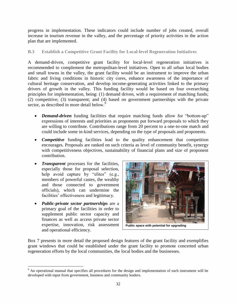
32
progress in implementation. These indicators could include number of jobs created, overall
increase in tourism revenue in the valley, and the percentage of priority activities in the action
plan that are implemented.
B.3 Establish a Competitive Grant Facility for Local-level Regeneration Initiatives
A demand-driven, competitive grant facility for local-level regeneration initiatives is
recommended to complement the metropolitan-level initiatives. Open to all urban local bodies
and small towns in the valley, the grant facility would be an instrument to improve the urban
fabric and living conditions in historic city cores, enhance awareness of the importance of
cultural heritage conservation, and develop income-generating activities linked to the primary
drivers of growth in the valley. This funding facility would be based on four overarching
principles for implementation, being: (1) demand driven, with a requirement of matching funds;
(2) competitive; (3) transparent; and (4) based on government partnerships with the private
sector, as described in more detail below.9
Demand-driven funding facilities that require matching funds allow for “bottom-up”
expressions of interests and priorities as proponents put forward proposals to which they
are willing to contribute. Contributions range from 20 percent to a one-to-one match and
could include some in-kind services, depending on the type of proposals and proponents.
Competitive funding facilities lead to the quality enhancement that competition
encourages. Proposals are ranked on such criteria as level of community benefit, synergy
with competitiveness objectives, sustainability of financial plans and size of proponent
contribution.
Transparent processes for the facilities,
especially those for proposal selection,
help avoid capture by “elites” (e.g.,
members of powerful castes, the wealthy
and those connected to government
officials), which can undermine the
facilities’ effectiveness and legitimacy.
Public-private sector partnerships are a
primary goal of the facilities in order to
supplement public sector capacity and
finances as well as access private sector
expertise, innovation, risk assessment
and operational efficiency.
Box 7 presents in more detail the proposed design features of the grant facility and exemplifies
grant windows that could be established under the grant facility to promote concerted urban
regeneration efforts by the local communities, the local bodies and the businesses.
9 An operational manual that specifies all procedures for the design and implementation of each instrument will be
developed with input from government, business and community leaders.
Public space with potential for upgrading
33
Box 7: The Competitive Grant Facility – Examples of Grant Windows
The competitive grant facility would promote community-based, bottom-up planning that identifies the
priorities that local authorities, their communities and businesses value, contribute to and benefit from.
This competitive grant facility would be open to all municipalities and local authorities, small businesses
and community groups in the valley, and have three windows with three complementary areas of focus.
The Local Investments and Initiatives Grant Window would support small works implemented by local
bodies – such as improvements in local infrastructure and services as well as heritage conservation – to
enhance residents’ living conditions. Such initiatives may include upgrading of public spaces and
improved solid waste collection. The local authorities would be required to provide matching
contributions on the order of 10 percent. All civil works financed under this window would be
constructed with seismic resilience and criteria for site selection will take into consideration flood risk.
The Community-based Initiatives Grant Window would support community-driven initiatives for heritage
conservation and the enhancement of cultural identity, social cohesion and acceptance of cultural
diversity. Such initiatives may include revitalization of disappearing celebrations and signage for local
historic sites. Community groups would contribute up to 20 percent of project costs in cash or in kind.
Given the high disaster risk in the built environment, a seismic risk awareness campaign would need to be
incorporated into the community driven initiatives.
The Small Business Development Grant Window would support initiatives by eligible small businesses,
NGOs, cooperatives and CBOs aimed at creating small businesses and jobs in clusters corresponding to
those in the metropolitan-level competiveness strategy, namely handicrafts and tourism. Such initiatives
may include training for artisans or development of new fee-based cultural tourism activities. Grantees
would be required to provide sustainable business plans and make matching contributions on the order of
20 percent.
To access the funds, localities would need to engage in a participatory planning process, based on a
comprehensive assessment of local needs and conditions. This process would include: (i) a social needs
assessment to identify the socioeconomic needs and livelihood strategies of local residents; (ii) a market
assessment to examine local handicraft and tourism activities, identify needs for improvement and
develop a strategy for development; (iii) a site management framework to create an inventory of physical
and intangible heritage, examine existing municipal and heritage management plans and clarify the roles
and responsibilities of all stakeholders; (iv) a participatory action plan to “give voice” to local community
priorities, build local coalitions of stakeholders and help them organize a set of proposals that are
coordinated and mutually reinforcing with the regeneration strategy and plan for the Kathmandu Valley.
C. Develop an institutional framework and coordination mechanisms for urban
regeneration at metropolitan- and local-levels
The recent establishment of the MoUD and KVDA represents an important opportunity to define
the roles and responsibilities of each level of government and stakeholder group for the
implementation of the regeneration initiative. The implementation arrangements need to be
consistent with the national strategic importance of the agenda, the integrated nature of the
regeneration activities, and the local conditions for success identified through the consultative
process – in particular, the partnership with the private sector and the local communities.
Implementation arrangements would also need to address the main bottlenecks for action; first
and foremost these include the fragmentation of institutional responsibilities and the lack of
34
“trust” between local authorities and communities. Four principles for assigning responsibilities
were discussed and agreed as part of the consultations carried out during preparation of this
advisory note, namely (i) central oversight and support; (ii) metropolitan-level planning,
monitoring and coordination; (iii) implementation driven by local bodies; and (iv) partnership
with local stakeholders. In line with these principles, the following objectives, roles and
responsibilities are proposed for central, metropolitan and local agencies, the private sector and
local communities.
C.1 Establish a nodal agency within MoUD for strategic oversight and technical
assistance
MoUD would provide overall strategic oversight for the planning, management, monitoring and
coordination of the urban regeneration activities through the establishment of a nodal agency
reporting to the Secretary’s office. In addition, MoUD would provide technical support to the
KVDA and local authorities through the Department of Urban Development and Building
Construction (DUDBC).10
C.2 Form a Steering Committee for the regeneration of the Kathmandu Valley
The Steering Committee would ensure coordination of the urban regeneration agenda among
public agencies and stakeholders and provide direction to the KVDA. The Steering Committee
would meet regularly to review progress reports prepared by the KVDA and ensure that the
activities undertaken complement one another and do not overlap or conflict with other
government initiatives. The Steering Committee would be responsible for formally endorsing the
Urban Regeneration Strategy prepared by the KVDA and the annual updates. The committee
would comprise a small group of high-level stakeholders from the public and private sector,
including the MoUD, the Ministry of Federal Affairs and Local Development, the Federation of
Nepal Chambers of Commerce and Industry (FNCCI), NGOs (such as the National Society for
Earthquake Technology-Nepal [NSET]), and representatives from service delivery agencies
(e.g., Water Supply and Sewerage Board and Department of Roads and Transport) and local
authorities in the Kathmandu Valley.
C.3 Strengthen the KVDA to become the “go-to” agency for urban regeneration
The KVDA would aim to become the “go-to” agency for the urban regeneration agenda,
responsible for the overall planning, management, and monitoring of urban regeneration
activities. Main responsibilities would include leading the participatory process for the
preparation of the Urban Regeneration Strategy for the Kathmandu Valley and its annual
updates, preparing the implementation and financing plan for the metropolitan-level initiatives,
as well as managing the competitive grant facility for the local-level urban regeneration
activities. The KVDA would monitor overall implementation progress of the urban regeneration
activities, and regularly report progress to the Steering Committee. An urban regeneration cell
would be established within the KVDA to undertake these tasks.
10
Such as the Special Physical and Infrastructure Area Development Project (SPIADP) within the DUDBC.
35
C.4 Enable local authorities to move to action and deliver results to their constituencies
The local authorities (urban local bodies and VDCs) would be responsible for proposing and
implementing local urban regeneration activities funded through the competitive grant facility
under the Local Investments and Initiatives Grant Window (see Box 7), in line with the priorities
established as part of the Urban Regeneration Strategy and the local plans. Local Authorities
would be required to provide matching contributions to access funds under the grant facility.
They will have primary responsibilities for mobilizing communities for local regeneration
activities, monitoring local implementation and reporting on progress to the KVDA.
C.5 Empower small businesses and community groups to actively contribute to the
urban regeneration agenda
Businesses and community groups would be responsible for implementing private sector-led and
community-based regeneration activities. These would be funded based on a demand-driven and
competitive selection process as part of the competitive grant facility for local-level urban
regeneration initiatives. Eligible grant recipients may consist of cooperatives, small businesses
and community groups. Grant recipients would be required to mobilize matching contributions
(in the form of cash, labor or other in-kind contributions) commensurate with their financial
capacity.
An example of the possible attribution of responsibilities for the main urban regeneration
activities, in line with the proposed principles and division of responsibilities, is presented in
Table 2.
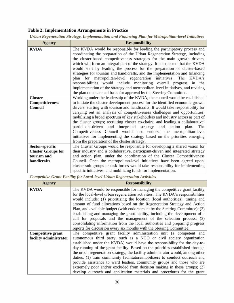
36
Table 2: Implementation Arrangements in Practice
Urban Regeneration Strategy, Implementation and Financing Plan for Metropolitan-level Initiatives
Agency Responsibility
KVDA The KVDA would be responsible for leading the participatory process and
coordinating the preparation of the Urban Regeneration Strategy, including
the cluster-based competitiveness strategies for the main growth drivers,
which will form an integral part of the strategy. It is expected that the KVDA
would start by leading the process for the preparation of cluster-based
strategies for tourism and handicrafts, and the implementation and financing
plan for metropolitan-level regeneration initiatives. The KVDA’s
responsibilities would include monitoring overall progress in the
implementation of the strategy and metropolitan-level initiatives, and revising
the plan on an annual basis for approval by the Steering Committee.
Cluster
Competitiveness
Council
Working under the leadership of the KVDA, the council would be established
to initiate the cluster development process for the identified economic growth
drivers, starting with tourism and handicrafts. It would take responsibility for
carrying out an analysis of competitiveness challenges and opportunities;
mobilizing a broad spectrum of key stakeholders and industry actors as part of
the cluster groups; recruiting cluster co-chairs; and leading a collaborative,
participant-driven and integrated strategy and action plan. The
Competitiveness Council would also endorse the metropolitan-level
initiatives for implementing the strategy based on the priorities emerging
from the preparation of the cluster strategy.
Sector-specific
Cluster Groups for
tourism and
handicrafts
The Cluster Groups would be responsible for developing a shared vision for
their industry and a collaborative, participant-driven and integrated strategy
and action plan, under the coordination of the Cluster Competitiveness
Council. Once the metropolitan-level initiatives have been agreed upon,
cluster sub-groups or task forces would take responsibility for implementing
specific initiatives, and mobilizing funds for implementation.
Competitive Grant Facility for Local-level Urban Regeneration Activities
Agency Responsibility
KVDA The KVDA would be responsible for managing the competitive grant facility
for the local-level urban regeneration activities. The KVDA’s responsibilities
would include: (1) prioritizing the location (local authorities), timing and
amount of fund allocations based on the Regeneration Strategy and Action
Plan, and available budget (with endorsement by the Steering Committee); (2)
establishing and managing the grant facility, including the development of a
call for proposals and the management of the selection process; (3)
consolidating information from the local authorities and preparing progress
reports for discussion every six months with the Steering Committee.
Competitive grant
facility administrator
The competitive grant facility administration unit (a competent and
autonomous third party, such as a NGO or civil society organization
established under the KVDA) would have the responsibility for the day-to-
day running of the grant facility. Based on the priorities established through
the urban regeneration strategy, the facility administrator would, among other
duties: (1) train community facilitators/mobilizers to conduct outreach and
provide assistance to ward leaders, community groups and those who are
extremely poor and/or excluded from decision making in these groups; (2)
develop outreach and application materials and procedures for the grant

37
facility; (3) disseminate the material to local authorities, communities and
small businesses; (4) provide technical support to grant proponents for the
preparation and submission of the grant proposals, including the preparation
of environmental and social screening; (5) carry out technical reviews of the
proposals, consolidate and submit them in batches to the Approval Committee
for approval; (6) manage grant disbursements; (7) mobilize specialized
expertise to provide technical support to the grantees when needed to support
implementation; (8) receive, synthesize and submit progress reports to the
KVDA; and (9) respond to complaints and enforce sanctions for misuse of
funds.
Independent
approval committee
The approval committee would provide overall oversight of the facility and
approve the proposals. It would comprise representatives of the KVDA,
municipalities, local NGOs, renowned local experts and leaders,
representatives from central agencies (e.g., the MoUD, the MoFALD, the
Ministry of Culture, Tourism and Civil Aviation) and other stakeholders, such
as the FNCCI.
Local Authorities The local authorities would be responsible for: (1) identifying and prioritizing
the geographic areas of focus and preparing proposals for funding under the
Municipal Initiatives and Investments Grant Window; (2) guiding the
competitive grant facility preparation work (social and market assessments,
the site management frameworks and the participatory action plan); (3)
sharing outreach information with eligible grant proponents, complementing
the outreach effort of the competitive grant facility administration unit; (4)
supporting and providing technical assistance for proponents as they develop
proposals, in coordination with the Facility Administration Unit; (5)
monitoring implementation of private sector-led initiatives and community-
based initiatives within their jurisdiction, and alerting KVDA and the facility
administrator to any problems, such as mismanagement of funds; and (6)
directly implementing the grant activities funded under the Municipal
Initiatives and Investments Grant Window. The implementing local
authorities within their community would establish a small cross-sectoral
urban regeneration working unit to undertake various tasks.
D. Identify quick-win regeneration interventions and investments to create
demonstration effects
Because the urban regeneration approach is new to the valley, a great deal of learning is still
needed in the local context. In the first phase, it would be critical to prioritize interventions that
can provide the best opportunities for learning and demonstration effects. It would also be
important to work in areas that offer the conditions for quick results and visibility in order to
start implementing priority local-level initiatives identified as part of the consultation process,
and to generate interest in the urban regeneration process.
D.1 Develop a pilot in Lalitpur City to allow for learning that can be applied to other
urban areas in the valley
Urban settlements in the Kathmandu Valley are experiencing different levels of urban stress. As
the largest settlement in the valley and the focal point of political and commercial activities,
Kathmandu offers a complex problem for urban regeneration efforts. Consequently, more
38
preparation and an approach that has been tested and fine-tuned in the country context are
recommended before seeking to reverse the trends of deterioration in Kathmandu. Kirtipur,
Madhyapur-Thimi and Bhakatpur municipalities have yet to experience the levels of stress or
deterioration that would provide an effective learning environment for urban regeneration
initiatives. On the other hand, Lalitpur City offers the best conditions for implementing the pilot
in the Kathmandu Valley. Lalitpur City has been able to retain vibrant indigenous artisan
communities whose participation would be central to the successful implementation of the
proposed activities. Although in distress, the historic core of Lalitpur city has significant
potential for renewal and the challenges in terms of infrastructure, services and housing are not
as severe as those affecting the historic core of Kathmandu City. Lalitpur city’s administration
has demonstrated a strong commitment to poverty alleviation and to the preservation of the city’s
built and living heritage. And Lalitpur’s smaller scale offers the opportunity to achieve some
relatively fast and visible successes that can, in turn, create more energy for regeneration. Hence,
a two-pronged approach is recommended – piloting in Lalitpur while starting preparatory work
for Kathmandu and the valley’s other urban and rural areas. The piloting would have the
following advantages.
A piloting approach would facilitate a better understanding of the key aspects of the
initiative that will be necessary for achieving results, such as capacity building,
participatory planning, priority setting and implementation arrangements. It would also
help identify issues of overlapping institutional authority and responsibility and suggest
new modes of inter-agency collaboration before the initiative is scaled up. Finally, the
smaller size and focus of pilot activities would provide more opportunities to explore
innovative initiatives.
A piloting effort would allow more flexibility in implementation. To maximize the
synergies between urban renewal and poverty alleviation in the historic city cores it
would be important to have the ability to respond to on-the-ground experiences and
lessons learned during implementation. A model that emphasizes feedback and
modification as necessary would be used. This process would not only lead to better
outcomes, but also to more meaningful lessons that can be used in replicating and scaling
up activities.
Finally, the piloting approach would serve to create a demonstration effect and raise
awareness among decision-makers throughout the Kathmandu Valley. The pilot can be
used to expose government officials, managers and planners to the concepts and
principles of an integrated urban regeneration approach. Through workshops and other
forms of outreach, lessons learned and successes could be disseminated to raise visibility
and generate interest in participating in the scaling up of the initiative.
D.2 Develop a set of criteria for choosing target neighborhoods for piloting urban
regeneration initiatives to increase focus and the potential for demonstration effects
Based on an understanding of the drivers of urban decline and the pre-conditions for successful
regeneration, a set of criteria need to be developed to identify neighborhoods that present urban
challenges sufficient to create learning while also offering the opportunity for success. Local-
39
level initiatives will be heavily based on participatory planning and cooperation. Therefore, first
and foremost, it is important to identify areas that residents perceive as neighborhoods – areas
where people have common interests and believe that cooperative action can create positive
change. To address neighborhoods’ deficits in urban infrastructure and basic services, it would
also be important to consider government service delivery boundaries. Neighborhoods would
also be defined and chosen based on levels of need. This could be done by evaluating the
following criteria:
Social dynamics, such as the degree of social capital and engagement, as indicated by
level of communal activities and community based organizations.
Economic conditions, such as the number of income poor, low caste and indigenous
communities, ethnic minorities, youth, the disabled, and women, especially those who are
single heads of households.
Significance of tangible and intangible cultural heritage, such as the presence of national,
municipal- and ward-level historic sites; number of artisans and other practitioners of
traditional occupations, and focal points/locations of religious ceremonies and
celebrations.
Level of vulnerability to natural disasters, as indicated by GIS mapping, building
inspection and permit records.
Level of infrastructure and urban services deficit, such as the condition of streets,
pedestrian routes and drainage, availability of water and electricity, as well as solid waste
services.
The policy directions and implementation arrangements discussed above would initially be
piloted in a limited area, and then scaled up across the metropolitan area based on the
demonstration effect and lessons learned. A two-year, and three-phase road map to implement
the policy directions and guide the planned regeneration efforts in the Kathmandu Valley is
proposed in the following section.
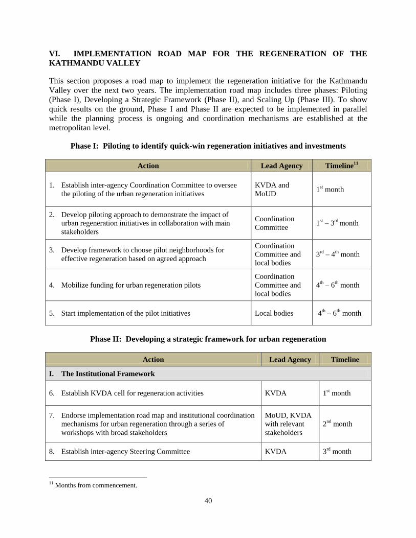
40
VI. IMPLEMENTATION ROAD MAP FOR THE REGENERATION OF THE
KATHMANDU VALLEY
This section proposes a road map to implement the regeneration initiative for the Kathmandu
Valley over the next two years. The implementation road map includes three phases: Piloting
(Phase I), Developing a Strategic Framework (Phase II), and Scaling Up (Phase III). To show
quick results on the ground, Phase I and Phase II are expected to be implemented in parallel
while the planning process is ongoing and coordination mechanisms are established at the
metropolitan level.
Phase I: Piloting to identify quick-win regeneration initiatives and investments
Action Lead Agency Timeline11
1. Establish inter-agency Coordination Committee to oversee
the piloting of the urban regeneration initiatives
KVDA and
MoUD 1
st month
2. Develop piloting approach to demonstrate the impact of
urban regeneration initiatives in collaboration with main
stakeholders
Coordination
Committee 1
st – 3
rd month
3. Develop framework to choose pilot neighborhoods for
effective regeneration based on agreed approach
Coordination
Committee and
local bodies
3rd
– 4th month
4. Mobilize funding for urban regeneration pilots
Coordination
Committee and
local bodies
4th – 6
th month
5. Start implementation of the pilot initiatives Local bodies 4th – 6
th month
Phase II: Developing a strategic framework for urban regeneration
Action Lead Agency Timeline
I. The Institutional Framework
6. Establish KVDA cell for regeneration activities KVDA 1st month
7. Endorse implementation road map and institutional coordination
mechanisms for urban regeneration through a series of
workshops with broad stakeholders
MoUD, KVDA
with relevant
stakeholders
2nd
month
8. Establish inter-agency Steering Committee KVDA 3rd
month
11
Months from commencement.
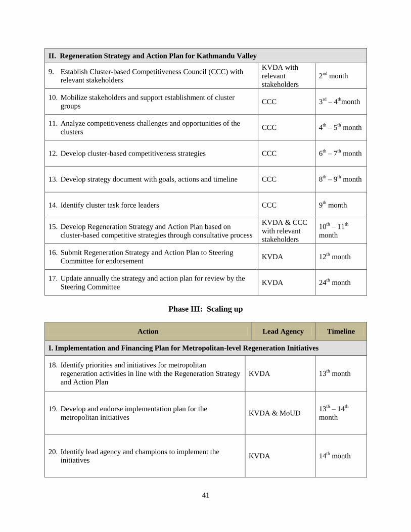
41
II. Regeneration Strategy and Action Plan for Kathmandu Valley
9. Establish Cluster-based Competitiveness Council (CCC) with
relevant stakeholders
KVDA with
relevant
stakeholders
2nd
month
10. Mobilize stakeholders and support establishment of cluster
groups CCC 3
rd – 4
thmonth
11. Analyze competitiveness challenges and opportunities of the
clusters CCC 4
th – 5
th month
12. Develop cluster-based competitiveness strategies CCC 6th – 7
th month
13. Develop strategy document with goals, actions and timeline CCC 8th – 9
th month
14. Identify cluster task force leaders CCC 9th month
15. Develop Regeneration Strategy and Action Plan based on
cluster-based competitive strategies through consultative process
KVDA & CCC
with relevant
stakeholders
10th – 11
th
month
16. Submit Regeneration Strategy and Action Plan to Steering
Committee for endorsement KVDA 12
th month
17. Update annually the strategy and action plan for review by the
Steering Committee KVDA 24
th month
Phase III: Scaling up
Action Lead Agency Timeline
I. Implementation and Financing Plan for Metropolitan-level Regeneration Initiatives
18. Identify priorities and initiatives for metropolitan
regeneration activities in line with the Regeneration Strategy
and Action Plan
KVDA 13th month
19. Develop and endorse implementation plan for the
metropolitan initiatives KVDA & MoUD
13th – 14
th
month
20. Identify lead agency and champions to implement the
initiatives KVDA 14
th month
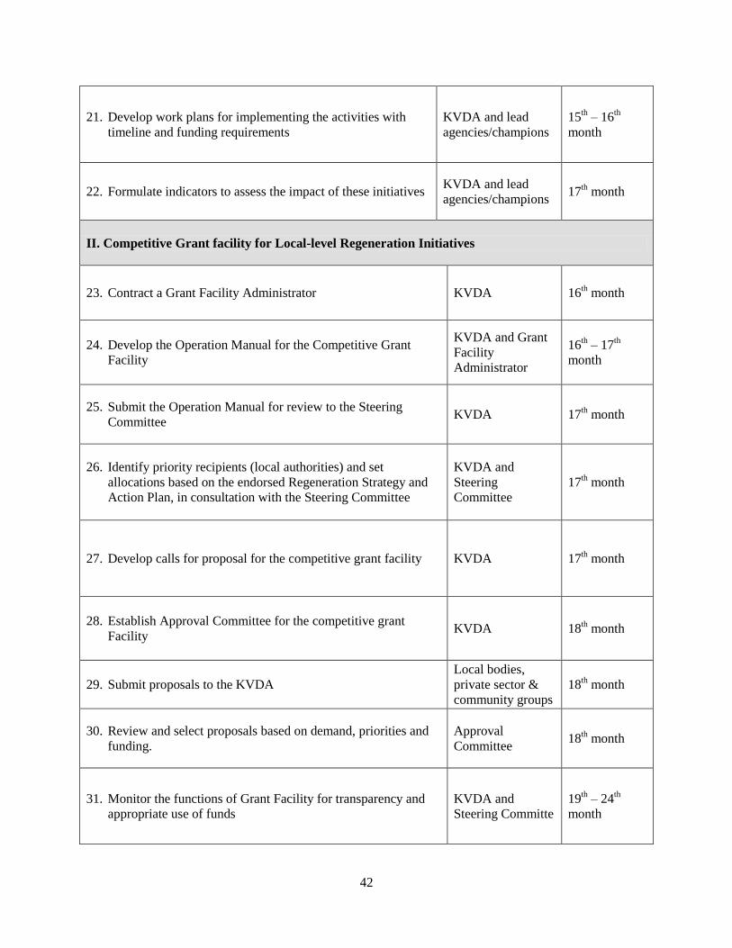
42
21. Develop work plans for implementing the activities with
timeline and funding requirements
KVDA and lead
agencies/champions
15th – 16
th
month
22. Formulate indicators to assess the impact of these initiatives KVDA and lead
agencies/champions 17
th month
II. Competitive Grant facility for Local-level Regeneration Initiatives
23. Contract a Grant Facility Administrator KVDA 16th month
24. Develop the Operation Manual for the Competitive Grant
Facility
KVDA and Grant
Facility
Administrator
16th – 17
th
month
25. Submit the Operation Manual for review to the Steering
Committee KVDA 17
th month
26. Identify priority recipients (local authorities) and set
allocations based on the endorsed Regeneration Strategy and
Action Plan, in consultation with the Steering Committee
KVDA and
Steering
Committee
17th month
27. Develop calls for proposal for the competitive grant facility KVDA 17th month
28. Establish Approval Committee for the competitive grant
Facility KVDA 18
th month
29. Submit proposals to the KVDA
Local bodies,
private sector &
community groups
18th month
30. Review and select proposals based on demand, priorities and
funding.
Approval
Committee 18
th month
31. Monitor the functions of Grant Facility for transparency and
appropriate use of funds
KVDA and
Steering Committe
19th – 24
th
month

43
32. Submit progress reports to Steering Committee KVDA &
Grantees
Every six
months
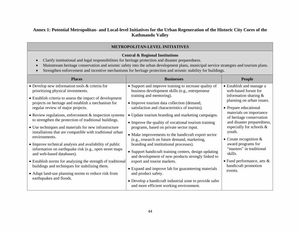
44
Annex 1: Potential Metropolitan- and Local-level Initiatives for the Urban Regeneration of the Historic City Cores of the
Kathmandu Valley
METROPOLITAN-LEVEL INITIATIVES
Central & Regional Institutions
Clarify institutional and legal responsibilities for heritage protection and disaster preparedness.
Mainstream heritage conservation and seismic safety into the urban development plans, municipal service strategies and tourism plans.
Strengthen enforcement and incentive mechanisms for heritage protection and seismic stability for buildings.
Places Businesses People
Develop new information tools & criteria for
prioritizing physical investments.
Establish criteria to assess the impact of development
projects on heritage and establish a mechanism for
regular review of major projects.
Review regulations, enforcement & inspection systems
to strengthen the protection of traditional buildings.
Use techniques and materials for new infrastructure
installations that are compatible with traditional urban
environments.
Improve technical analysis and availability of public
information on earthquake risk (e.g., open street maps
and web-based databases).
Establish norms for analyzing the strength of traditional
buildings and techniques for stabilizing them.
Adapt land-use planning norms to reduce risk from
earthquakes and floods.
Support and improve training to increase quality of
business development skills (e.g., entrepreneur
training and mentoring).
Improve tourism data collection (demand,
satisfaction and characteristics of tourists).
Update tourism branding and marketing campaigns.
Improve the quality of vocational tourism training
programs, based on private sector input.
Make improvements to the handicraft export sector
(e.g., research on future demand, marketing,
branding and institutional processes).
Support handicraft training centers, design updating
and development of new products strongly linked to
export and tourist markets.
Expand and improve lab for guaranteeing materials
and product safety.
Develop a handicraft industrial zone to provide safer
and more efficient working environment.
Establish and manage a
web-based forum for
information sharing &
planning on urban issues.
Prepare educational
materials on importance
of heritage conservation
and disaster preparedness,
especially for schools &
youth.
Create recognition &
award programs for
“masters” in traditional
skills.
Fund performance, arts &
handicraft promotion
events.
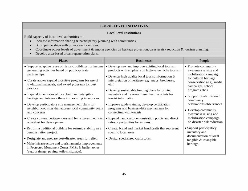
45
LOCAL-LEVEL INITIATIVES
Local-level Institutions
Build capacity of local-level authorities to:
Increase information sharing & participatory planning with communities.
Build partnerships with private sector entities.
Coordinate across levels of government & among agencies on heritage protection, disaster risk reduction & tourism planning.
Develop area-based urban regeneration plans.
Places Businesses People
Support adaptive reuse of historic buildings for income
generating activities based on public-private
partnerships.
Create and/or expand incentive programs for use of
traditional materials, and award programs for best
practice.
Expand inventories of local built and intangible
heritage and integrate them into existing inventories.
Develop participatory site management plans for
neighborhood sites that address local community goals
and concerns.
Create cultural heritage tours and focus investments as
a catalyst for development.
Retrofit a traditional building for seismic stability as a
demonstration project.
Designate and prepare post-disaster areas for relief.
Make infrastructure and tourist amenity improvements
in Protected Monument Zones PMZs & buffer zones
(e.g., drainage, paving, toilets, signage).
Develop new and improve existing local tourism
products with emphasis on high-value niche tourism.
Develop high quality local tourist information &
interpretation of heritage (e.g., maps, brochures,
etc.).
Develop sustainable funding plans for printed
materials and increase dissemination points for
tourist information.
Improve guide training, develop certification
programs and business-like mechanisms for
connecting with tourists.
Expand handicraft demonstration points and direct
sales opportunities for artisans.
Create, brand and market handicrafts that represent
specific local areas.
Design specialized crafts tours.
Promote community
awareness raising and
mobilization campaign
for cultural heritage
conservation (e.g., media
campaigns, school
programs etc.).
Support revitalization of
community
celebrations/observances.
Develop community
awareness raising and
mobilization campaign
on disaster risk reduction.
Support participatory
inventory and
documentation of local
tangible & intangible
heritage.
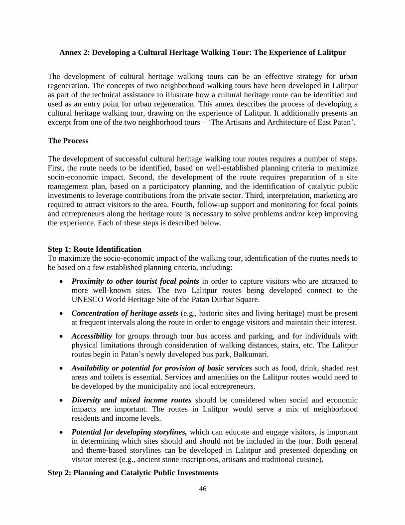
46
Annex 2: Developing a Cultural Heritage Walking Tour: The Experience of Lalitpur
The development of cultural heritage walking tours can be an effective strategy for urban
regeneration. The concepts of two neighborhood walking tours have been developed in Lalitpur
as part of the technical assistance to illustrate how a cultural heritage route can be identified and
used as an entry point for urban regeneration. This annex describes the process of developing a
cultural heritage walking tour, drawing on the experience of Lalitpur. It additionally presents an
excerpt from one of the two neighborhood tours – ‘The Artisans and Architecture of East Patan’.
The Process
The development of successful cultural heritage walking tour routes requires a number of steps.
First, the route needs to be identified, based on well-established planning criteria to maximize
socio-economic impact. Second, the development of the route requires preparation of a site
management plan, based on a participatory planning, and the identification of catalytic public
investments to leverage contributions from the private sector. Third, interpretation, marketing are
required to attract visitors to the area. Fourth, follow-up support and monitoring for focal points
and entrepreneurs along the heritage route is necessary to solve problems and/or keep improving
the experience. Each of these steps is described below.
Step 1: Route Identification
To maximize the socio-economic impact of the walking tour, identification of the routes needs to
be based on a few established planning criteria, including:
Proximity to other tourist focal points in order to capture visitors who are attracted to
more well-known sites. The two Lalitpur routes being developed connect to the
UNESCO World Heritage Site of the Patan Durbar Square.
Concentration of heritage assets (e.g., historic sites and living heritage) must be present
at frequent intervals along the route in order to engage visitors and maintain their interest.
Accessibility for groups through tour bus access and parking, and for individuals with
physical limitations through consideration of walking distances, stairs, etc. The Lalitpur
routes begin in Patan’s newly developed bus park, Balkumari.
Availability or potential for provision of basic services such as food, drink, shaded rest
areas and toilets is essential. Services and amenities on the Lalitpur routes would need to
be developed by the municipality and local entrepreneurs.
Diversity and mixed income routes should be considered when social and economic
impacts are important. The routes in Lalitpur would serve a mix of neighborhood
residents and income levels.
Potential for developing storylines, which can educate and engage visitors, is important
in determining which sites should and should not be included in the tour. Both general
and theme-based storylines can be developed in Lalitpur and presented depending on
visitor interest (e.g., ancient stone inscriptions, artisans and traditional cuisine).
Step 2: Planning and Catalytic Public Investments
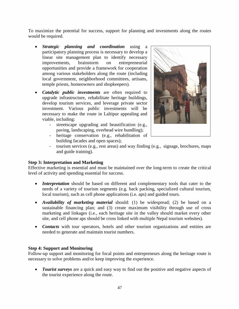
47
To maximize the potential for success, support for planning and investments along the routes
would be required.
Strategic planning and coordination using a
participatory planning process is necessary to develop a
linear site management plan to identify necessary
improvements, brainstorm on entrepreneurial
opportunities and provide a framework for cooperation
among various stakeholders along the route (including
local government, neighborhood committees, artisans,
temple priests, homeowners and shopkeepers).
Catalytic public investments are often required to
upgrade infrastructure, rehabilitate heritage buildings,
develop tourism services, and leverage private sector
investment. Various public investments will be
necessary to make the route in Laltipur appealing and
viable, including:
- streetscape upgrading and beautification (e.g.,
paving, landscaping, overhead wire bundling);
- heritage conservation (e.g., rehabilitation of
building facades and open spaces);
- tourism services (e.g., rest areas) and way finding (e.g., signage, brochures, maps
and guide training).
Step 3: Interpretation and Marketing
Effective marketing is essential and must be maintained over the long-term to create the critical
level of activity and spending essential for success.
Interpretation should be based on different and complementary tools that cater to the
needs of a variety of tourism segments (e.g. back packing, specialized cultural tourism,
local tourism), such as cell phone applications (i.e. aps) and guided tours.
Availability of marketing material should: (1) be widespread; (2) be based on a
sustainable financing plan; and (3) create maximum visibility through use of cross
marketing and linkages (i.e., each heritage site in the valley should market every other
site, and cell phone aps should be cross linked with multiple Nepal tourism websites).
Contacts with tour operators, hotels and other tourism organizations and entities are
needed to generate and maintain tourist numbers.
Step 4: Support and Monitoring
Follow-up support and monitoring for focal points and entrepreneurs along the heritage route is
necessary to solve problems and/or keep improving the experience.
Tourist surveys are a quick and easy way to find out the positive and negative aspects of
the tourist experience along the route.
ional character at Patan’s historic

48
Training in areas such as business planning, English, guiding and tourism services will
be an important part of creating economic benefits from the route.
The rest of the Annex includes a short excerpt from the proposed Lalitpur tour ‘Artisans and
Architecture of East Patan’. The full description of the tours is included as supporting
documentation to the advisory note.

49
Excerpt of the Proposed Walking Tour
ARTISANS AND ARCHITECTURE OF EAST PATAN
According to legend, the beautiful Lalitaranya Van forest was cut to make space for human
settlement. The city of Lalitpur or Patan – named after this forest and meaning beautiful city – is
known for its rich cultural heritage, particularly its tradition of arts and crafts. The city is divided
into spatial units or neighborhoods called toles, and is characterized by particular communities
inhabiting certain sectors of the city. Among the many interesting areas of Patan, this route has
been developed to highlight the traditional lifestyles, practicing artisans and important heritage in
East Patan, which was one of the earliest settled areas in the city (see map for indication of tour
route).
BHINCHHEN BAHAL12
(Site B7)
Bhinchhen Bahal, also known as Vishnuk Chhen
Bihar and Mayur Barna Bihar, is a large complex
with a sanctuary built in 1939 AD. According to
legend, this monastery from the Malla era is built
where an image of the god Vishnu was buried,
discovered when a peacock rested on that spot.
The clans of Varjracharya and Shakya reside in this
monastery. Their guthi,13
or social organization,
annually observes three main festivals here, with their associated rituals and feasts, namely the
full moon of Baisakh in April, the full moon of Poush in December, and the twelfth day of the
bright half of Magh in January.14
The Stone Sculptors of Bhinchhen Bahal
Nepal’s most ancient craft, stone sculpting, is still actively practiced in Bhinchhen Bahal.
Although stonework had already developed in Kathmandu Valley, residents of Bhinchhen Bahal
claim that the making of stone sculptures in Patan began at this monastery. There are at least 10
families here still working in this art form, creating stupas, pillars, water-spouts, inscriptions,
protective lions, griffins and gods. The stone used in Bhinchhen Bahal is primarily granite
sourced from quarries in Dakshinkali, Hattiban, Farping and Kharpa, located on the periphery of
Lalitpur District. And the metal tools used for the stone craft are mostly in Patan, with the
exception of a special tool imported from Jaipur, India that is used for diamond cuts. Some of the
artisans work and sell from their homes while others have shops in the Magalbazar, Saugal and
Sundhara areas.
Inside the monastery’s large gate and to the left you will see Shakya Stone Craft, where Manoj
Shakya continues the stone sculpting tradition of his ancestors. Though Mr. Shakya does not
have a shop, he sells his work through local stores in Kathmandu and abroad. He was one of the
12
A bahal is a monastery complex of two-story buildings, one of which contains a sanctuary, surrounding a
courtyard on all four sides. 13
Guthi is a social organization of people belonging to a neighborhood and caste. 14
John K. Locke, 1985.
Sanctuary of Bhinchhen Bahal
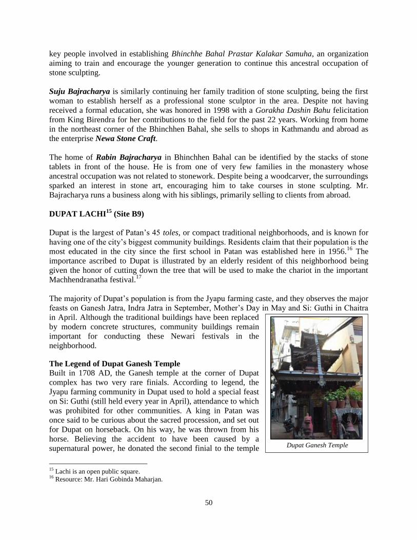
50
key people involved in establishing Bhinchhe Bahal Prastar Kalakar Samuha, an organization
aiming to train and encourage the younger generation to continue this ancestral occupation of
stone sculpting.
Suju Bajracharya is similarly continuing her family tradition of stone sculpting, being the first
woman to establish herself as a professional stone sculptor in the area. Despite not having
received a formal education, she was honored in 1998 with a Gorakha Dashin Bahu felicitation
from King Birendra for her contributions to the field for the past 22 years. Working from home
in the northeast corner of the Bhinchhen Bahal, she sells to shops in Kathmandu and abroad as
the enterprise Newa Stone Craft.
The home of Rabin Bajracharya in Bhinchhen Bahal can be identified by the stacks of stone
tablets in front of the house. He is from one of very few families in the monastery whose
ancestral occupation was not related to stonework. Despite being a woodcarver, the surroundings
sparked an interest in stone art, encouraging him to take courses in stone sculpting. Mr.
Bajracharya runs a business along with his siblings, primarily selling to clients from abroad.
DUPAT LACHI15
(Site B9)
Dupat is the largest of Patan’s 45 toles, or compact traditional neighborhoods, and is known for
having one of the city’s biggest community buildings. Residents claim that their population is the
most educated in the city since the first school in Patan was established here in 1956.16
The
importance ascribed to Dupat is illustrated by an elderly resident of this neighborhood being
given the honor of cutting down the tree that will be used to make the chariot in the important
Machhendranatha festival.17
The majority of Dupat’s population is from the Jyapu farming caste, and they observes the major
feasts on Ganesh Jatra, Indra Jatra in September, Mother’s Day in May and Si: Guthi in Chaitra
in April. Although the traditional buildings have been replaced
by modern concrete structures, community buildings remain
important for conducting these Newari festivals in the
neighborhood.
The Legend of Dupat Ganesh Temple
Built in 1708 AD, the Ganesh temple at the corner of Dupat
complex has two very rare finials. According to legend, the
Jyapu farming community in Dupat used to hold a special feast
on Si: Guthi (still held every year in April), attendance to which
was prohibited for other communities. A king in Patan was
once said to be curious about the sacred procession, and set out
for Dupat on horseback. On his way, he was thrown from his
horse. Believing the accident to have been caused by a
supernatural power, he donated the second finial to the temple
15
Lachi is an open public square. 16
Resource: Mr. Hari Gobinda Maharjan.
Dupat Ganesh Temple
51
as a plea for forgiveness.
STREETSCAPE FROM YANGU BAHAL TO KUTI SAUGAL
In historic times, Kuti Saugal was a place where people beat paddy grain to extract rice.18
‘Kuti’
refers to the wooden tool used in this process. The kutis have now been replaced by the modern
mill in this area that continues the rice production.
The Chariot Maker (Site B11)
Located at the right corner of Yangu Bahal Street leading to Kuti Saugal is the house of Dil
Kumar Barahi. The Barahi caste comprises carpenters responsible for making the chariot for the
Machhendranatha Jatra festival. This house belongs to the naaya, or leader of the group, who
leads the team in constructing these chariots. Mr. Dil Kumar Barahi continues to practice
carpentry in his home, where he has a small workshop.
The Lokhta Painter (Site B12) Along this street, you will notice images of nagh, or snakes, as well as other auspicious signs
painted on Nepali lokhta paper and pasted around the main entrances of the houses during Nagh
Panchami. Similarly, images of Laxmi, the Goddess of Wealth, can be seen pasted in a sacred
place inside houses during Laxmi Puja. As “Chitra” means picture Newari, Chitrakar is the
Newari caste that paints. The main materials used in traditional painting are lokhta paper,
paintbrushes, watercolor in powder form (available to purchase in a shop in Mangal Bazar),
wooden blocks for printing and frames for holding the paper while painting.
Following his ancestral occupation, Gyanu Ratna Chitrakar paints these lokhta paper images for
use in different rituals by the Newar community. Mr. Chitrakar also paints images of the Pancha
Buddha or Five Buddhas (mostly used for welcoming new brides), astha mangal (a decoration
for weddings and pujas), mari kashi (a highly decorated traditional pot used for engagement),
and clay pots and vessels for rituals. Mr. Chitrakar is also responsible for painting the image of
Aakash Bhairav, which is worshiped as the main deity’s image in Aakash Bhairav Temple at
Kapinchhe. As the Aakash Bhairav image inside the temple is made of paper, it is changed twice
a year during the full moon day of January (Magh Purnima) as well as during Dashain, the
national festival in October. People come in a procession to take the painted image of the god
from Mr. Chitrakar’s house to the temple. Despite playing this important cultural role, Mr.
Chitrakar thinks that his traditional family occupation is likely to end with him as no one seems
interested in learning these skills.
18
Kuti is name of the wooden tool used for beating rice grains.
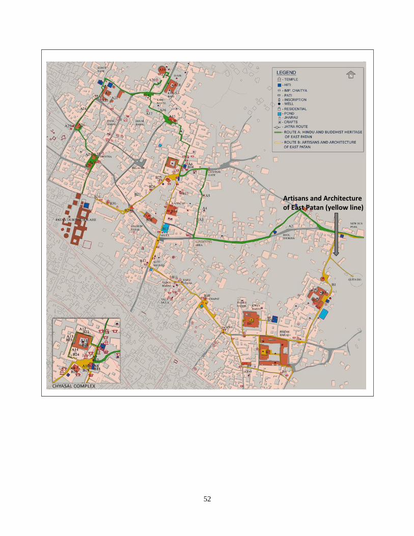
52
Artisans and Architecture of East Patan (yellow line)
53
Annex 3: International Urban Regeneration Case Studies and Lessons Learned
International Case Study 1. Heritage Conservation Linked to Urban Regeneration in Delhi
International Case Study 2. Historic Housing Rehabilitation as Part of Urban Regeneration in
Fez
International Case Study 3. Heritage Trail Project Adopts an Urban Regeneration Approach in
Lahore
International Case Study 4. A Joint Venture for Historic City Regeneration in Quito
International Case Study 5. A Comprehensive Approach to Supporting Crafts Producers in India
International Case Study 6. Aid to Artisans: Crafts Production and Export Growth around the
World
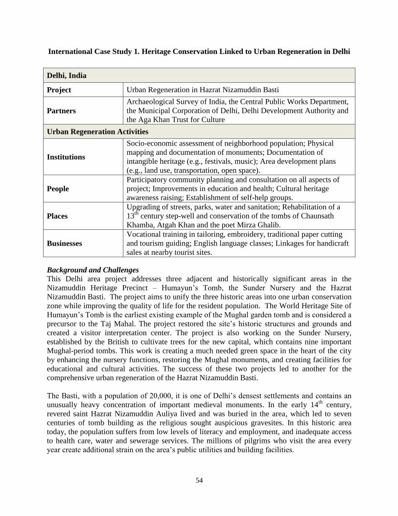
54
International Case Study 1. Heritage Conservation Linked to Urban Regeneration in Delhi
Delhi, India
Project Urban Regeneration in Hazrat Nizamuddin Basti
Partners
Archaeological Survey of India, the Central Public Works Department,
the Municipal Corporation of Delhi, Delhi Development Authority and
the Aga Khan Trust for Culture
Urban Regeneration Activities
Institutions
Socio-economic assessment of neighborhood population; Physical
mapping and documentation of monuments; Documentation of
intangible heritage (e.g., festivals, music); Area development plans
(e.g., land use, transportation, open space).
People
Participatory community planning and consultation on all aspects of
project; Improvements in education and health; Cultural heritage
awareness raising; Establishment of self-help groups.
Places
Upgrading of streets, parks, water and sanitation; Rehabilitation of a
13th
century step-well and conservation of the tombs of Chaunsath
Khamba, Atgah Khan and the poet Mirza Ghalib.
Businesses
Vocational training in tailoring, embroidery, traditional paper cutting
and tourism guiding; English language classes; Linkages for handicraft
sales at nearby tourist sites.
Background and Challenges
This Delhi area project addresses three adjacent and historically significant areas in the
Nizamuddin Heritage Precinct – Humayun’s Tomb, the Sunder Nursery and the Hazrat
Nizamuddin Basti. The project aims to unify the three historic areas into one urban conservation
zone while improving the quality of life for the resident population. The World Heritage Site of
Humayun’s Tomb is the earliest existing example of the Mughal garden tomb and is considered a
precursor to the Taj Mahal. The project restored the site’s historic structures and grounds and
created a visitor interpretation center. The project is also working on the Sunder Nursery,
established by the British to cultivate trees for the new capital, which contains nine important
Mughal-period tombs. This work is creating a much needed green space in the heart of the city
by enhancing the nursery functions, restoring the Mughal monuments, and creating facilities for
educational and cultural activities. The success of these two projects led to another for the
comprehensive urban regeneration of the Hazrat Nizamuddin Basti.
The Basti, with a population of 20,000, it is one of Delhi’s densest settlements and contains an
unusually heavy concentration of important medieval monuments. In the early 14th
century,
revered saint Hazrat Nizamuddin Auliya lived and was buried in the area, which led to seven
centuries of tomb building as the religious sought auspicious gravesites. In this historic area
today, the population suffers from low levels of literacy and employment, and inadequate access
to health care, water and sewerage services. The millions of pilgrims who visit the area every
year create additional strain on the area’s public utilities and building facilities.
55
An Integrated Approach
In consultation with its partners, the Aga Khan designed a community-centered approach to
improve the quality of life for the Basti’s residents by integrating historic conservation, socio-
economic development, urban and environmental improvements and a regular series of cultural
activities and performances. Work began with a socio-economic analysis of the population and a
spatial analysis to understand area issues in land use, transportation, open space and historic
sites. However, the community was highly resistant to the monument mapping and land use
planning, so other aspects of the project were emphasized from the beginning.
Socio-economic Development is a First Priority in the Basti
Socio-economic programs focused on the community’s needs in education, health and vocational
training. Project efforts upgraded the local primary school and teaching approaches and offered
tutoring in math and English for 14 to16 year olds. Health issues were addressed by upgrading a
local clinic, increasing public health outreach and building a pathology lab. A survey to identify
demand for vocational skills resulted in a career development center and English language
classes.
As neighborhood confidence in the project grew, urban upgrading activities were undertaken,
including the building of community managed public toilets, improvements to streets, sewerage
lines, solid waste removal systems and landscaping in open spaces. Project work on socio-
economic development continued with skill enhancement in women’s tailoring and embroidery
classes, training in traditional paper cutting and the creation of booths for handicraft sales at local
historic sites.
In an effort to enhance the cultural life and creativity of the area and create a connection between
residents and the surrounding heritage, several activities to raise awareness were supported.
These included development of heritage walks and competitions for area children,
documentation of artistic traditions and support for festivals and performances, especially of the
famous poetry and music that originated in the Basti.19
Area youths were trained to undertake
cultural mapping of historic buildings and give tours of the Basti and Humayun’s Tomb. Today,
conservation activity is underway at some 40 heritage buildings, including an important
community asset – a 13th
century step-well (baoli), which is the last in Delhi that is fed by
underground springs.
Lessons and Observations
Unless social development and poverty alleviation efforts support the urban poor by
means of economic growth and targeted interventions, it is impossible to fully reverse the
physical decay of historic cities.
Urban regeneration initiatives require broad public support. Low-income and
disadvantaged communities are often mistrustful of government and need to see
improvements relevant to their lives before they are willing to support broader project
objectives.
19
The Qawwali music of 14th
century poet-composer Amir Khusrau Dehlvi originated in the area.

56
Project investments often need to include support for raising community awareness of the
importance of heritage conservation and its potential to enrich their lives and provide
income earning opportunities.
Involving residents in decision making on project activities leads to realistic and widely
supported initiatives (e.g., vocational programs that address resident interests and skills).
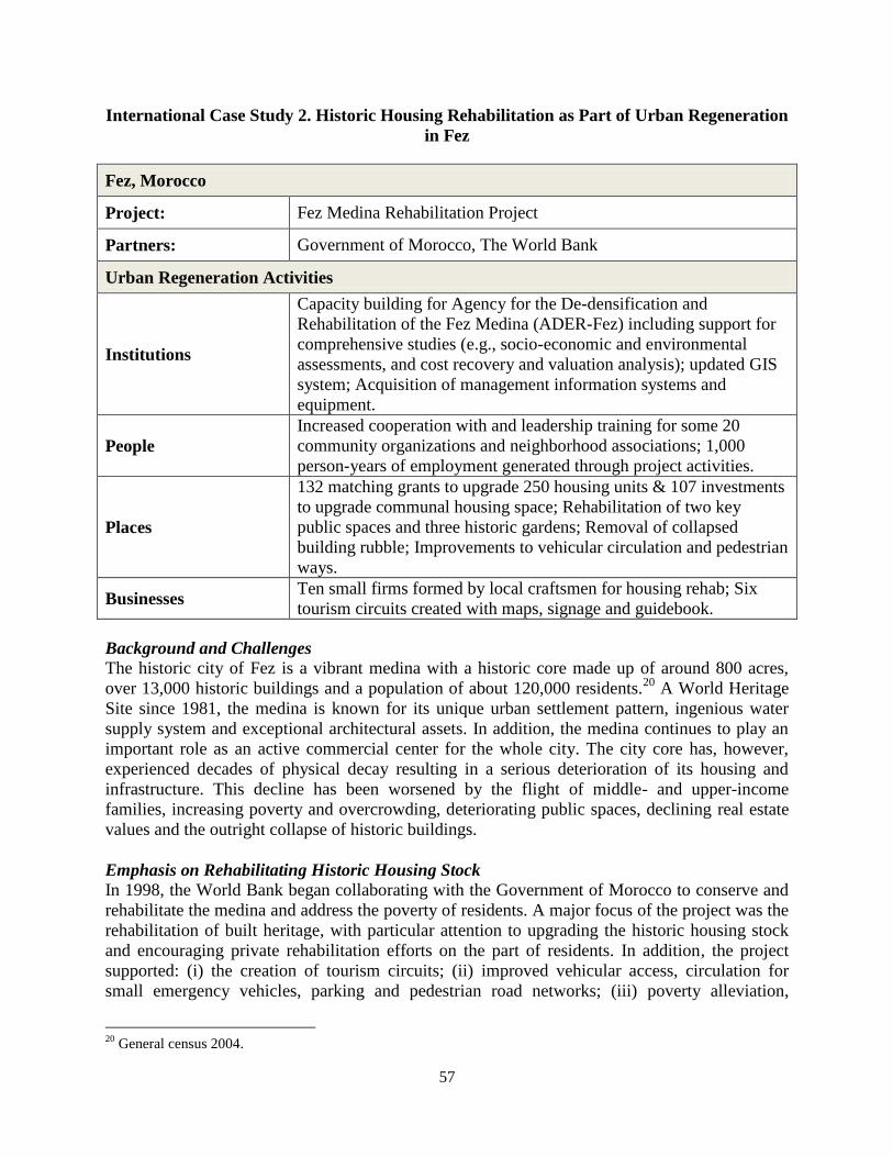
57
International Case Study 2. Historic Housing Rehabilitation as Part of Urban Regeneration
in Fez
Fez, Morocco
Project: Fez Medina Rehabilitation Project
Partners: Government of Morocco, The World Bank
Urban Regeneration Activities
Institutions
Capacity building for Agency for the De-densification and
Rehabilitation of the Fez Medina (ADER-Fez) including support for
comprehensive studies (e.g., socio-economic and environmental
assessments, and cost recovery and valuation analysis); updated GIS
system; Acquisition of management information systems and
equipment.
People
Increased cooperation with and leadership training for some 20
community organizations and neighborhood associations; 1,000
person-years of employment generated through project activities.
Places
132 matching grants to upgrade 250 housing units & 107 investments
to upgrade communal housing space; Rehabilitation of two key
public spaces and three historic gardens; Removal of collapsed
building rubble; Improvements to vehicular circulation and pedestrian
ways.
Businesses Ten small firms formed by local craftsmen for housing rehab; Six
tourism circuits created with maps, signage and guidebook.
Background and Challenges
The historic city of Fez is a vibrant medina with a historic core made up of around 800 acres,
over 13,000 historic buildings and a population of about 120,000 residents.20
A World Heritage
Site since 1981, the medina is known for its unique urban settlement pattern, ingenious water
supply system and exceptional architectural assets. In addition, the medina continues to play an
important role as an active commercial center for the whole city. The city core has, however,
experienced decades of physical decay resulting in a serious deterioration of its housing and
infrastructure. This decline has been worsened by the flight of middle- and upper-income
families, increasing poverty and overcrowding, deteriorating public spaces, declining real estate
values and the outright collapse of historic buildings.
Emphasis on Rehabilitating Historic Housing Stock
In 1998, the World Bank began collaborating with the Government of Morocco to conserve and
rehabilitate the medina and address the poverty of residents. A major focus of the project was the
rehabilitation of built heritage, with particular attention to upgrading the historic housing stock
and encouraging private rehabilitation efforts on the part of residents. In addition, the project
supported: (i) the creation of tourism circuits; (ii) improved vehicular access, circulation for
small emergency vehicles, parking and pedestrian road networks; (iii) poverty alleviation,
20
General census 2004.
58
through the labor-intensive implementation of project works; and (iv) institutional strengthening
for the Fez Municipality and the implementing agency ADER-Fez.
A Matching Grant Program for Housing Rehabilitation
A matching grant program was designed for individual house owners who were able to obtain a
building permit, pre-finance and carry out restoration work for up to US$12,000 using their own
or borrowed funds. In return, ADER-Fez, would reimburse the owners for 30 percent of the
restoration costs. Over a two-year period, this matching grant scheme generated disappointing
results – only one grant out of the 40 applications submitted to ADER-Fez was disbursed. The
main reasons were local residents’ mistrust of government and a complicated ownership and
occupancy situation (a significant proportion of the buildings that could benefit from the
matching grant were owned by multiple private owners and were occupied by a range of users).
A Necessary Shift in the Approach
As a result of this slow progress, project managers developed a second housing rehabilitation
program based on four main ideas:
Emphasis on common areas of the buildings that are critical for their survival, such as
terrace roofs and water drainage systems, rather than restoring individual spaces.
No financial contribution required given the level of poverty of the local residents.
No building permits required given the multiplicity of occupancy statuses of residents.
Upon all parties signing a simple form, the project agency would provide skilled laborers,
technical supervision, building materials, and transport of materials and rubble.
Residents required to provide unskilled labor (one person per family living in the
building being rehabilitated), who could be family members, neighbors or paid
manpower.
To carry out this innovative housing rehabilitation activity, a community development unit was
established to create a relationship with the existing neighborhood associations. A key role was
given to these associations to mediate between the project agency and local residents, to
encourage their participation in the rehabilitation and to identify priority buildings. Government
cooperation with neighborhood associations created a sense of ownership and joint responsibility
at the local level. As part of the agreement between the neighborhood associations and ADER-
Fez, training programs were provided to their members in administrative and financial
management, project design and resource mobilization.
Improved Results
Under the second mechanism, the average rehabilitation cost per building was US$4,500, while
an intervention carried out by a “conventional” contractor would ordinarily have been five times
more expensive. Some of the main reasons for the project’s lower costs are:
Good control of technical aspects throughout the intervention process
Better coordination between the companies working on the same rehabilitation site
The use of unskilled labor provided by residents
Involvement of existing local master craftsmen in the rehabilitation
At project closing, 132 grants under the original matching grant program had been disbursed at
an average of US$1,000 per grant. In addition, 107 participatory rehabilitation activities under
59
the second program were completed in the communal parts of buildings. Cooperation with the
neighborhood associations also enabled the rehabilitation of 26 pedestrian streets serving around
550 buildings. Another project success was that the encouragement of local craftsmen to form
small companies providing skilled laborers or building materials resulted in the creation of 10
small firms.
These community-centered approaches have yielded highly successful and cost-effective results
for the conservation of the historic housing stock. However, few individual housing
rehabilitation interventions appear to have otherwise taken place in the Medina. In other words,
project expectations of a major increase of individually financed rehabilitation efforts did not
materialize.
Lessons and Observations
Community participation is essential for the successful rehabilitation of historic housing
stock. Reconciling the objectives of urban conservation and regeneration with the
housing needs of low-income residents is feasible, through a process of consultation and
participation in the design and implementation of housing rehabilitation initiatives.
Community based organizations and neighborhood associations that are often external to
the process of urban regeneration can be essential social actors, organizers and mediators
between the implementing agencies and the resident households.
The tenure of land and buildings is a critical difficulty in the rehabilitation of historic
cities. Transactions involving historical properties are often stymied by the lack of proper
property records, the subdivisions of property due to inheritance, the scattering of
absentee owners, the often conflicting property rights over land and buildings.
Regardless of how small they may be, tangible local economic benefits increase
community “ownership” of sites and thus contribute to the sustainability of conservation
efforts. Projects most often create benefits when they rely on local labor and strengthen
local capacity to: (i) restore and preserve cultural assets; and/or (ii) participate in tourism
activities that generate income.

60
International Case Study 3. Heritage Trail Project Adopts an Urban Regeneration
Approach in Lahore
Lahore, Pakistan
Project Punjab Municipal Services Improvement Project
Partners Punjab Provincial Government, The World Bank and Aga Khan Trust
for Culture and Aga Khan Cultural Services, Pakistan
Urban Regeneration Activities
Institutions
Capacity building for municipalities and new national-level urban
sector unit; Rationalization of institutional mandates & regulatory
frameworks for heritage protection; GIS data base; Strategic plan for
city upgrading and conservation.
People Formation of community based organizations.
Places
Incentives for home owner improvements through technical support
and grants; Public spaces and rights of way reclaimed; Street façade
and street surface improvements; Infrastructure upgrading;
Conservation of historic buildings.
Businesses Development of a heritage tourism trail; Training of local youth in
spatial mapping and traditional building trades.
Background and Challenges
The Walled City of Lahore (WCL) hosts a vibrant living culture and an urban fabric with a
remarkable concentration of monuments, landmark buildings and historic sites. These buildings
represent cultural influences of at least three major eras: the Mughul Empire, British colonial
presence, and the modern nation‐state of Pakistan. Two royal complexes are recognized as a
World Heritage site in the WCL – the Lahore Fort and the Shalimar Gardens.
Within the mega city of 10 million people, the WCL has a population of approximately 150,000
in a 2.5 sq. km area, making it one of the most densely populated sections of Lahore (300 to
1,700 persons per ha.) The WCL is becoming increasingly marginalized as the city expands
southwards with low density suburbs and municipal negligence creates slum‐like conditions in
the historic core. Paradoxically, the WCL is a beehive of economic activity filled with small-
scale commerce and larger-scale warehousing and distribution systems for mass produced goods
(shoes and textiles).
A Three-way Partnership
In 2007-2008, a partnership was formed between the Punjab Government, Aga Khan Trust for
Culture (AKTC) and the World Bank to address challenges in the WCL. The combined work of
these three groups included: recommendations to rationalize institutions and update regulatory
frameworks for heritage protection; development of a GIS data base and strategic plan for city
upgrading and conservation; and a pilot project to demonstrate methods and processes for the
creation of a heritage trail (the Royal Route of Mughal nobility) leading from the Delhi Gate to
the palace at the Lahore Fort.
61
The heritage trail is a “linear bazaar” comprising some of the major commercial centers serving
the metropolis and the region. Work on this street consisted mostly of identifying illegal
encroachments, proposing building alterations back to historic scale and form, and removing
those illegally on public land and rights of way, with compensation paid in cash or in kind.
Special attention was given to buildings with the most historically authentic façades and
businesses that still functioned at the scale of the traditional bazaar economy.
An Urban Regeneration Approach for Neighborhood Rehabilitation
Work on the original goal of developing a heritage trail quickly demonstrated the need for an
area-based urban regeneration approach. Several concerns broadened the work to include the
residential neighborhoods historically associated with the bazaars including: (i) logistical issues
(drainage catchments); (ii) visual considerations (sight lines into the abutting residential
neighborhoods); and (iii) equity (the need to ameliorate the economic status of residents).
To facilitate the work, community-based organizations were created in small units related to the
streets and lanes. These CBOs enhanced direct communication with residents and were
extremely helpful in resolving any local conflicts and disseminating the heritage conservation
values and urban regeneration goals of the program.
The neighborhood rehabilitation work consisted of: street façade and street surface
improvements; infrastructure upgrading; the conservation of historic building stock; training of
local youth in spatial planning and traditional building trades, and incentives for home owner
improvements through technical support and grants. Pilot work was undertaken in Gali Surjan
Singh lane (GSS) and was implemented directly by AKTC with its own funding. A second
demonstration project in Mohammadi Mohalla lane began sometime after the completion of GSS
and is being implemented with World Bank funding.
In 2009-2010, infrastructure upgrading (water and sewerage pipes and aerial bundling of
electrical wires)21
was carried out in GSS for a total cost of US$100,000, and thirteen historic
houses were conserved for a combined cost of US$233,000. Many owners were able to
participate with payments made in installments spread over the period of construction, usually
averaging about four months for each house. Payments were usually on time with a zero default
rate. Owner equity participation ranged between 8% and 15% of the total cost of conservation. It
is interesting to note that the second housing rehabilitation activity in Mohammadi Mohalla is
finding that the demonstration effect of the GSS project results is convincing residents to offer
higher contributions for the home improvement works.
Lessons and Observations
A great deal of social mobilization and advocacy is often needed to generate
neighborhood trust and interest in a housing rehabilitation program. This can be greatly
facilitated by setting up community-based organizations formed around specific
neighborhoods or streets.
21
Upgrading of the tangled electrical and telecommunications systems with aerial bundling cable necessitated the
structural consolidation of building facades. Thus facade improvement was considered part of the public realm and
eligible for public funding.
62
Project experience shows that homeowners are willing to undertake home repair and
maintenance work in accordance with their income levels. However, lack of technical
knowledge and skills creates serious limitations for this work.
On-the-job training in various traditional building trade skills targeting local youth in the
project area or providing opportunities for home owners to contribute labor instead of
funds facilitates housing rehabilitation programs.
The demonstration effect of pilot housing rehabilitation projects is an important tool in
encouraging participation in urban regeneration activities. Once improvements and
success can be seen on the ground, community members are more likely to make
commitments to follow-on housing initiatives.
63
International Case Study 4. A Joint Venture for Historic City Regeneration in Quito
Quito, Ecuador
Project Quito Historic Center Enterprise Project
Partners Quito Municipality, Inter-American Development Bank (IDB)
Urban Regeneration Activities
Institutions Creation of the Quito Historic Center Enterprise (ECH) a public-
private joint venture entity
People Community mobilization & awareness raising program focused on
social groups, educational institutions and businesses.
Places
Rehab of 269 apartments in buildings with historic or architectural
value and subsidies for medium- and low-income residents;
Improvement of 53,500 sq. meters of sidewalk; Upgraded street signs
and street lights; Installation of 100 benches, 300 trash cans, 50
portable toilets and underground telephone cables; Construction
and/or rehab of 1,370 parking places; Renovation of 2 museums, a
public library and 2 historic sites.
Businesses
Rehabilitation of 25,000 sq. meters of commercial space in buildings
with historic or architectural value; Negotiation and market
development to relocate street vendors outside the historic core.
Background and Challenges Quito, the capital of Ecuador, was founded in 1534 and is noted as the least changed of all
colonial city centers in Latin America. It was declared a UNESCO World Heritage Site in 1979
based on its fine examples of civil and religious colonial architecture from the 16th
, 17th
and 18th
centuries.
While the center of Quito accommodated all the administrative, commercial and social activities
of the city for over 400 years, in the 1950s it began to decline. Rapid urban growth and
densification prompted wealthy residents to move to the more comfortable outlying areas, And
high-end businesses as well as prestigious institutions soon followed suit. By the late 1970s, the
center was severely degraded and characterized by deteriorated buildings, congestion, pollution
and social problems, such as crime. Poorly designed rent controls and preservation policies
created negative incentives for property owners who reacted by subdividing buildings to house
multiple tenants, converting them to commercial uses or abandoning property all together.
Early Approaches to Conservation
As early as the 1930s, the public sector began work to conserve Quito’s monuments and historic
buildings, including preparing master plans, creating inventories and issuing protective
regulations. However, these activities failed to create strong results because they lacked stable
financial support, were not integrated with wider regeneration efforts and did not draw on the
participation of the private sector or the third sector.
64
A more proactive phase began in 1987 with the creation of the Fund for Saving the Cultural
Heritage (FONSAL). Administered by the municipality, FONSAL is funded by a 3 percent tax
on sales of tickets to public performances in Quito and a 6 percent share of the rent taxes
collected by the city.22
The main obligation of FONSAL is to finance and manage the
restoration, conservation, and protection of the city’s religious, artistic and cultural assets. While
it achieved some success, FONSAL’s funding was not sufficient to meet the huge challenges of
regenerating the historic core, leading to the development of an additional mechanism.
Joint Venture: Historic Center Enterprise
In 1994, with technical and financial assistance from the IDB, the municipality created the
Historic Center Enterprise (ECH), a joint venture that includes the public, private and third
sectors. The enterprise is legally a public-private partnership (PPP), with 90 percent funded from
public sources and 10 percent from private sources. Since more than two-thirds of the funding is
from the public sector, Ecuador’s Law on Public Contracting allows the municipality to avoid
complicated procurement procedures and be more flexible in contracting with ECH and investing
with the private sector.
The ECH has two stockholders – the municipality and the Capiscara Foundation, which is
dedicated to conserving the city’s historic buildings and monuments. These two stockholders
make up the governing council, which appoints a board of directors. Members of the board
represent the three sectors, namely: (i) the public sector – Quito’s mayor (board chairman) and
two members of the city council; (ii) the private sector – three prominent members of the
business community; and (iii) the third sector, in some measure, represented through the Catholic
Church. Appointment to the board remains largely in the hands of the municipality because there
is no formal process by which the private and third sectors nominate their representatives.
However, there is a plan to strengthen participation by formalizing a process for the private and
third sectors to elect representatives.
ECH Activities
ECH focuses on projects that demonstrate the viability of rehabilitating buildings with important
architectural heritage while also diversifying economic and residential activities and showing a
positive rate of return. Ideally, ECH uses its funds in a revolving manner to rehabilitate
structures, sell them to the private sector and reinvest in new projects.
Due to market conditions in the city center, ECH takes on a variety of roles depending on
circumstances. First, ECH can function as a real estate developer, making all the investment and
taking on all the risk. In principle, this is inconsistent with the objective of a semi-public
corporation; however, ECH undertakes some projects in order to demonstrate the feasibility of
investments in which the private sector has shown no interest, such as affordable housing.
Second, ECH can enter into partnership with private investors, provide capital and take on only
part of the risk. The private sector partner may contribute capital, buildings or knowledge of the
market. In these cases, ECH divests itself of the investment as soon as possible in order to
recover capital and reinvest in other projects. In a third alternative, ECH retains ownership of
properties that are operated by private partners. This can be because there are no investors
22
FONSAL is now known as the Metropolitan Institute of Patrimony (IMPQ).
65
willing to purchase the properties or because the city thinks it is important to maintain control of
the building’s use and maintenance.
An estimate in 1994 showed that about 18 percent of all investments in the historic core were
from the private sector.
Lessons and Observations
To plan a program that is both realistic and large enough in scope to produce significant
and sustainable change requires the participation of various actors because it is rare that a
lone investor can affect such change.
The sustainability of urban regeneration depends on creating a positive environment for
private investors and businesses because it is private initiative that sustains development
over time.
Reversing the urban decay of historic cities depends on the ability of the responsible
agencies to secure a long-term commitment and concentrated efforts by all economic
actors involved, well beyond the lifetime of a single project. Committed leadership and
institutionalization of regeneration partnerships can maintain efforts through changes of
government.
66
International Case Study 5. A Comprehensive Approach to Supporting Crafts Producers
in India
Andhra Pradesh, Bihar, Jharkhand, Orissa, Rajasthan and Tamil Nadu, India
Project JIYO Handicrafts Project
Partners Japan Social Development Fund at The World Bank, Asian Heritage
Foundation
Urban Regeneration Activities
Institutions Artisan Cluster-level Institutions – artisan self-help groups
established or existing ones strengthened.
People Training for cluster leaders in organization building, project
management and partnership development.
Places NA
Businesses
Business training for artisans in: (i) business planning, market
research and trend forecasting; and (ii) web portal development for
artisan support and marketing. Support for brand development and
management, e-commerce and links to exhibitions and buyers.
Training for artisans in new skills and product development;
Development of tailored financial products for crafts producers and
other credit and insurance products as needed.
Overview
JIYO, which means “Live It” in Hindi, is a program funded by the Japanese Social Development
Fund at the World Bank. Undertaken in 2008, the US$1.8 M program focuses on support for
poor artisan communities in India to set up their own self-managed grassroots-level institutions
to develop craft-based livelihoods on a long-term basis. The program works toward
strengthening the entire craft value chain and helping the poorest and most vulnerable
communities to develop and strengthen their own institutions for ensuring sustainable economic
linkages with mainstream markets.
Artisan Self-Help Groups
As a first step, the program provides the necessary capacity building, equipment, facilities and
focused mentoring to poor artisan communities to set up and/or strengthen existing organizations
that are fully responsive to their needs. These organizations serve as the focal point for all project
activities, such as capacity building and product redesign. Focused training and technical support
is provided to help artisan groups develop a long-term vision and action plan for their selected
craft activity and implement that plan. Selected community members and women’s groups
receive additional training in leadership, project management, negotiations, conflict resolution,
accounting and procurement. In addition, help is provided in building the cluster-level
institutions’ ability to foster partnerships with other artisan groups, local level authorities, NGOs
and the private sector.
New Product Development
The program provides design and product development for the creation of new and highly
marketable products. Experts who have substantial experience with artisan communities work
67
with master crafts producers to study their skills and traditional designs and then develop
products with broad appeal and marketability. The master crafts producers receive training in
making the new products and then train other artisans in the cluster through a training-of-trainers
mechanism. If demand for new products warrants, the program can train additional artisans, and
provide additional equipment, storage and transportation to manage the new business. The
experts will use market research and trend forecasting to develop new products and these skills
are explained to certain cluster members so that they can continue to have an understanding of
market demands, constraints and possibilities over time.
Community Artisan Investment Fund
An innovative mechanism is being piloted by the program whereby experts work with artisan
communities to: (i) identify the key financial constraints and services that are critical for
ensuring viability and sustainability of craft production activities; (ii) design a set of tailored
financial products for the craft-based livelihoods; and (iii) help negotiate and leverage a credit
line from commercial banks and other private sector organizations for scaling up and ensuring
sustainable operations. Possible credit and insurance products include: (i) loan products with the
amount, repayment schedules and duration based on the craft activity business cycle; and (ii)
trade financing and insurance for artisan clusters, such as export and logistics credit guarantees.
Web Portal and Marketing Development
The program builds capacity for artisans to use the latest information and communications
technology in promoting their craft-based activity. This involves training for cluster members
and developing a web-based craft portal that can be managed by the artisan organizations to: (i)
access virtual training materials and libraries that act as a resource base; (ii) disseminate new
design trends and concepts to cluster members; and (iii) facilitate linkages with mainstream
buyers (including through e-commerce).
Efforts are also made to provide the critical marketing and trade support to connect the artisan
clusters with mainstream markets and private sector linkages. This includes developing a craft
product brand, marketing materials, and a brand management and launching strategy, including
identifying specific state, national and international exhibitions and events, developing
catalogues and product profiles and organizing focused buyer-seller meets.
Lessons and Observations
The creation of artisan self-help groups allows for well targeted training and technical
support for artisans, and allows artisans greater voice and visibility in communicating
their needs. These organizations additionally connect designers, producers, and artisans
as well as foster partnerships with government agencies, civil society organizations and
the private sector to smooth production and marketing processes.
In addition to supporting the existing work of artisans, experts can study the skills and
traditional of artisan communities and master crafts producers to assist in developing
products with broader appeal and marketability. This can then inform training for local
designers and artisans as well as training-of-trainers programs that will allow for
continual updating of product lines to meet changing demand and industry trends.
68
Support to artisan communities should expand beyond technical assistance to include
examination of the financial barriers and opportunities for craft-based livelihoods,
allowing for the development of financial products and services aligned with the
particular needs of the businesses and industry.
Building artisan capacity to access and use the latest information and communications
technology is critical for the successful development and promotion of craft-based
activities as well as the longer-term sustainability of artisans’ businesses.
Marketing and trade support as well as private sector linkages can play a critical role in
connecting artisans to broader markets by identifying national and international
exhibitions and events, developing catalogues and arranging buyer-seller meetings. Such
support also help convey the importance product branding, management, and launching
strategies.

69
International Case Study 6. Aid to Artisans: Crafts Production and Export Growth
around the World
Ghana, Hungary and Peru
Project Three separate Aid to Artisans programs
Partners Aid to Artisans (ATA) and US Agency for International
Development (USAID)
Urban Regeneration Activities
Institutions Advocacy for university-level design programs.
People
Capacity building and mentoring for artisan cooperatives, micro-
entrepreneurs, independent exporters, small businesses, NGOs, and
crafts production companies
Places N/A
Businesses
Business training including costing and pricing, production planning
and management, quality control, packing and shipping, billing and
collecting, customer service and export documentation and
international buying cycles and trends. Advice and mentoring on
positive exporter/producer partnerships for better results;
Participation at international gift fairs and trade shows for exposure to
competitors and direct sales; Direct links to foreign importers through
in-country, buyer-led product development. Intensive design input
and training for artisans in new product development and updating of
existing products based on existing skills and materials; Training and
mentoring of local designers and
Overview
Aid to Artisans (ATA) is an international nonprofit organization focused on creating
opportunities for low-income artisans around the world to build profitable businesses inspired by
handmade traditions. Since its founding in 1976, ATA has worked in over 110 countries with
artisans, development experts, retailers, design industry leaders and business trainers. The basic
building blocks of ATA’s work consist of product development, business training, sales and
marketing. ATA partners with businesses and organizations to implement their services and
relies on the support of a range of public and private sector partners and individuals for funding.
Product Development
In most projects, ATA starts with product development. Experienced product design consultants
work directly with artisan entrepreneurs. These consultants help artisans revive traditional crafts,
adapt the products they are already producing or develop new lines that will appeal to the U.S.
and European markets. This process always begins by building on local traditions and materials
to create functional and aesthetically desirable products. Consultants also assist artisans in
developing pricing structures which balance the need for a fair, productive wage and positioning
within the marketplace that reflects the perceived value of the product.
For example, as one activity under a project in Peru ATA worked through the Peruvian
Exporter’s Association (ADEX) with the community of Chulucanas to update designs for their
70
traditional pottery.23
In addition to new designs, technical assistance was provided to meet
growing demand. Producers were trained to utilize new pigments and colors, modern clay
processing machinery eliminated the slow, laborious step of preparing clay and new wheel
throwing techniques were introduced, which in some cases made production ten times faster.
These changes resulted in at least US$1 million of new sales annually. An important lesson from
work in Peru is the fact that new designs often have technical issues that must be worked out. For
example, custom rugs ordered by Sundance Catalogue were too large and heavy for women
using back strap looms to produce and painted photograph frames cracked under hot store
display lights.To address such problems, technical specialists began working closely with
designers to ensure that products were realistic and dependable.
Business Training Nearly every ATA project involves some type of formal business training or informal mentoring.
Artisans normally participate in general business training including modules on costing and
pricing, production planning and management, distribution, quality control, packing and
shipping, billing and collecting, customer service, export documentation and international buying
cycles and trends.
ATA’s original approach of mentoring young businesses with “just-in-time” information has
shifted and matured to accommodate the participation of larger businesses and better educated
artisans and is now also relevant to the needs exporters, craft business owners and NGO leaders.
For example based on the demands of project participants for formal training in Hungary, ATA
developed more formal training tools including a book entitled, Export Manual: A Guide to
Exporting Crafts from Hungary, and a Buyer’s Guide to Hungarian Crafts.24
In Hungary, ATA
also developed its concept of buyer-led product development, which is now standard practice –
ATA sponsored visits where buyers spent up to two weeks in Hungary developing proprietary
products with artisans.
Sales and Marketing ATA links artisans to the marketplace, connecting them to local customers, importers or
businesses with whom they can develop lasting professional relationships. As part of the Market
Readiness Program, ATA explains sales and marketing concepts and systems, such as price
points, quality control, display principles, and “green” products. ATA consultants also analyze
artisan products for export potential and provide feedback. A central platform of ATA’s
marketing activity is participation in trade shows, such as the New York International Gift Fair,
the California Gift Show in Los Angeles, SARCDA in South Africa, and Ambiente and
Tendence in Frankfurt, Germany.
During a project in Ghana, ATA brought producers and products to the New York International
Gift Fair, where they participated in the Market Readiness Program.25
Participants were exposed
to the size and scope of their competition in the global market and provided with insights on the
need for quality, consistency, precise finishing and careful packaging. ATA also brought buyers
23
Peru Microenterprise and Small Producers Support Project (1994 to 2002). 24
Hungary Export Enhancement Program (1991-1995) 25
Ghana Increasing Non-traditional Exports Program
71
to Ghana where Pier 1 Imports, Cost Plus and MarMaxx (T.J. Maxx and Marshall’s) bought
ATA-supported designs. When ATA started work in Ghana, there was one large producer-
exporter. By 2003, several of the producers had the capacity to fill orders of US$100,000 and
more.
Lessons and Observations
Collaboration between designers, technical production specialists and artisans is
necessary for new products to avoid failures such as those due to inappropriate raw
materials, lack of sophisticated machinery or unrealistic buyer expectations.
In addition to supporting artisans, successful programs must include training and
mentoring for local designers who will be the resource for continued updating and
creation of product lines. Advocacy for the enhancement of design education programs at
the university level is also important.
Program sustainability depends on producers and exporters developing the ability to
continue accessing information on trends, marketing and sales opportunities by
overcoming language barriers and distance from markets.
Successful producers and exporters realize the importance of designing to meet market
demand. Even the local market and tourists can absorb only so much purely ethnic
product. Moving to international design and image is vital in both local and export
markets.
Direct exposure to European and North American markets, at international gift fairs,
greatly informs local perspective on the importance of quality, consistency, precise
finishing and careful packaging.
ATA Program Summaries
Peru: Microenterprise and Small Producers Support Project (1994 to 2002)
Funding: USAID US$1.2 M; (additional US$1.2 M to Peruvian Exporter’s Association)
Activities: Exhibition at 18 international trade shows and buyer recruitment
850 days of product design and production assistance
Results: 1994 exports = US$16 M; 2003 exports = US$30 M
15,000 jobs created
Cumulative sales (US$23 million) surpass total project budget during project life.
Program clients earned an average of 134% of national per capita income,
whereas artisans who did not participate in the project averaged 90%.
Hungary: Export Enhancement Program (1991-1995)
Funding: USAID US$729,000
Activities: Exhibition at 8 trade shows
Development of Export Manual and Buyer’s Guide to Hungarian Crafts
163 days of product design
Training of 30 small businesses; mentoring and practicum opportunities
72
Results: Cumulative sales surpass total project budget during project life
US$1.1 million in sales at end of project.
233 jobs created and maintained for a decade
Ghana: Increasing Non-traditional Exports (1993-1997)
Funding: Self-funding and grants US$22,000; USAID US$1.3 M
Activities: Direct market links; 8 trade shows; buyer visits
424 days of product design
Market Readiness Program for 30 entrepreneurs in New York City
Results: Cumulative sales of US$859,000 at project end; sales surpass total project budget
within two years of project end.
1989 exports = US$160,000; 2002 exports = US$11 million (60% attributed to
ATA and its local partner Aid to Artisans Ghana.
Artisan reported wages 155% of the national per capita income, but average three
months without work.
About 12 small- and medium-sized artisan exporters created.
73
CASE STUDY SOURCES:
Heritage Conservation Linked to Urban Regeneration in Delhi
Jodidio, Philip editor. The Aga Khan Historic Cities Programme: Strategies for Urban
Regeneration. Prestel. 2011.
Aga Khan Progress Report. The Aga Khan. 2008.
Historic Housing Rehabilitation as Part of Urban Regeneration in Fez
Raftani, Kamal “Housing Rehabilitation and Community Development in the Medina of Fez,
Morocco” in Harnessing the Hidden Potential of Cities, NIKU and the World Bank 2012.
Bigio, Anthony and Guido Licciardi. The Urban Rehabilitation of Medinas: The World Bank
Experience in the Middle East and North Africa, The World Bank. 2010.
Fes Medina Rehabilitation Implementation Completion Report. The World Bank. 2006.
Heritage Trail Project Adopts an Urban Regeneration Approach in Lahore
Khan, Massod. “The Public Private Partnership Experience in the Walled City of Lahore,
Pakistan”. In Harnessing the Hidden Potential of Cities. NIKU and the World Bank. 2012.
Jodidio, Philip editor. The Aga Khan Historic Cities Programme: Strategies for Urban
Regeneration. Prestel. 2011.
A Joint Venture for Historic City Regeneration in Quito
Rojas, Eduardo and Francesco Lanzafame, editors. City Development: Experiences in the
Preservation of Ten World Heritage Sites. Washington, DC: Inter-American Development
Bank. 2011.
Fox, Catherine, Jos Brakarz, and Alejandro Cruz Fano. Tripartite Partnerships: Recognizing
the Third Sector: Five Case Studies of Urban Revitalization in Latin America. Washington,
DC: Inter-American Development Bank. 2005.
Rojas, Eduardo. Old Cities, New Assets: Preserving Latin America’s Urban Heritage.
Washington, DC: the Inter-American Development Bank. 1999.
A Comprehensive Approach to Supporting Crafts Producers in India
Japan Social Development Fund Grant Proposal. 2008.
Aid to Artisans: Crafts Production and Export Growth around the World
Aid to Artisans. A Revolution in Design-driven Export: A Case Study of Aid to Artisans in
Peru, 1994-2002. 2005.
Aid to Artisans. Bridging an Economic Gap: A Case Study of Aid to Artisans in Hungary,
1991-1995. 2005.
Aid to Artisans. A Rich and Deeply Cultural Tradition: A Case Study of Aid to Artisans in
Ghana, 1993-1997. 2005.
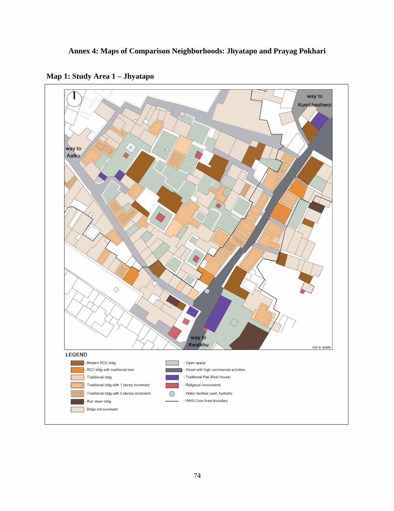
74
Annex 4: Maps of Comparison Neighborhoods: Jhyatapo and Prayag Pokhari
Map 1: Study Area 1 – Jhyatapo
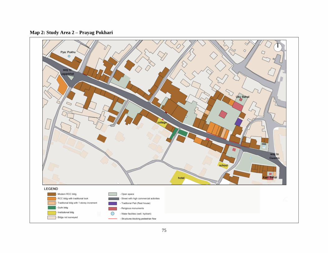
75
Map 2: Study Area 2 – Prayag Pokhari
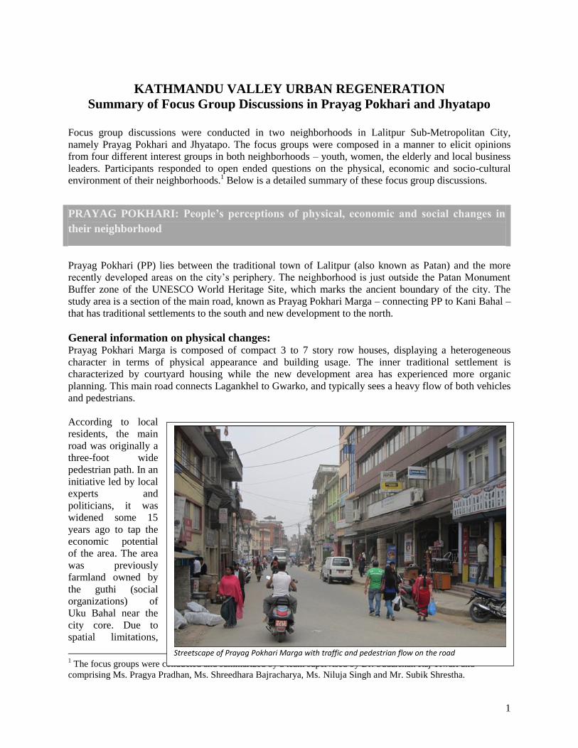
1
KATHMANDU VALLEY URBAN REGENERATION
Summary of Focus Group Discussions in Prayag Pokhari and Jhyatapo
Focus group discussions were conducted in two neighborhoods in Lalitpur Sub-Metropolitan City,
namely Prayag Pokhari and Jhyatapo. The focus groups were composed in a manner to elicit opinions
from four different interest groups in both neighborhoods – youth, women, the elderly and local business
leaders. Participants responded to open ended questions on the physical, economic and socio-cultural
environment of their neighborhoods.1 Below is a detailed summary of these focus group discussions.
PRAYAG POKHARI: People’s perceptions of physical, economic and social changes in
their neighborhood
Prayag Pokhari (PP) lies between the traditional town of Lalitpur (also known as Patan) and the more
recently developed areas on the city’s periphery. The neighborhood is just outside the Patan Monument
Buffer zone of the UNESCO World Heritage Site, which marks the ancient boundary of the city. The
study area is a section of the main road, known as Prayag Pokhari Marga – connecting PP to Kani Bahal –
that has traditional settlements to the south and new development to the north.
General information on physical changes: Prayag Pokhari Marga is composed of compact 3 to 7 story row houses, displaying a heterogeneous
character in terms of physical appearance and building usage. The inner traditional settlement is
characterized by courtyard housing while the new development area has experienced more organic
planning. This main road connects Lagankhel to Gwarko, and typically sees a heavy flow of both vehicles
and pedestrians.
According to local
residents, the main
road was originally a
three-foot wide
pedestrian path. In an
initiative led by local
experts and
politicians, it was
widened some 15
years ago to tap the
economic potential
of the area. The area
was previously
farmland owned by
the guthi (social
organizations) of
Uku Bahal near the
city core. Due to
spatial limitations,
1 The focus groups were conducted and summarized by a team supervised by Dr. Sudarshan Raj Tiwari and
comprising Ms. Pragya Pradhan, Ms. Shreedhara Bajracharya, Ms. Niluja Singh and Mr. Subik Shrestha.
Streetscape of Prayag Pokhari Marga with traffic and pedestrian flow on the road

2
however, traditional residences were unable to accommodate the increasing household population and
traditional property division between sons. Residents thus had to either continue living in the ancestral
home or move to another area. As a result, members of Uku Bahal guthi bought available guthi land along
this main street to build their homes and additionally contributed some of the land for road expansion.
What is seen today is a major physical transformation following the road expansion, aiming to capitalize
on proximity to Lagankhel, the economic and transportation hub of Patan. The local people who have
relocated from the inner part of PP and the Uku Bahal area own the most houses on this street. Yet most
of these buildings are rented out as residential units as well as for commercial purposes.
PLACES
Based on general observation, the majority of buildings along the main street are used for both residential
and commercial purposes. Major economic activities include shops on the ground floor and rental-
housing units above, as well as service-based activities like schools, colleges and offices. According to
focus group participants, 70 percent of the people living in the area are local Shakyas (a caste) with small-
scale metal craft workshops in their houses. The majority of the buildings were built about 20 to 25 years
ago with reinforced cement concrete (RCC) technology and modern materials. A few owners have
attempted to create traditional brick façades by using decorative bricks, but these buildings also have
aluminum windows, which has demeaned the facade value. In general, not much interest has been given
to developing a traditional look or extending the heritage value of the inner neighborhoods off the main
road.
Disaster risk and structural integrity of the buildings: The focus groups unanimously agreed that the new structures in PP are highly vulnerable to seismic
hazards as none comply with the building codes for earthquake safety. The majority of buildings were
constructed before the codes were implemented and more recent construction bypassed the regulations
due to a lack of enforcement by the Municipality. The youth and women’s focus groups consider
traditional technology safer than RCC as it is based on centuries-old building developed for earthquakes.
However, preference for modern concrete houses is high, as they are easy, cheap and fast to construct and
have greater economic return. In contrast, traditional technology is very expensive in terms of material
and labor. Participants correlated a decrease in open space to increased risk, with tall and vulnerable
buildings surrounding remaining ones, thus decreasing their functional value.
Enforcement of building by-laws and regulations: The women’s focus group perceived building by-laws for earthquake safety as a positive step. However,
these regulations were introduced after most of the buildings were built. If the by-laws were to be
enforced strictly, the women thought that they could be implemented in the new buildings built hereon.
However, the youth group presented a different perspective, believing implementation of these new laws
will be a challenge as people are accustomed to the old norms, and reluctant to follow new rules that are
expensive and limit their needs. As a result, the youth focus group felt that enforcement of these
regulations would need to be accompanied by incentives and mechanisms to help people accept and
follow them. This would require the Municipality to mobilize its experts and bring local people to the
table to include them in discussions on the issue and make them realize the importance of such laws.
Developing, or at least enforcing regulations through public participation can thus be more effective and
ease implementation. Focus groups also felt that the Municipality should focus on providing proper public
orientation on the regulations as well as surveillance of enforcement.
Provision of infrastructure and public services: The main road joining Lagankhel to Gwarko as well as the drainage system appear to be well maintained.
However, extended front steps of houses encroach on the sidewalk, obstructing pedestrian flow. And
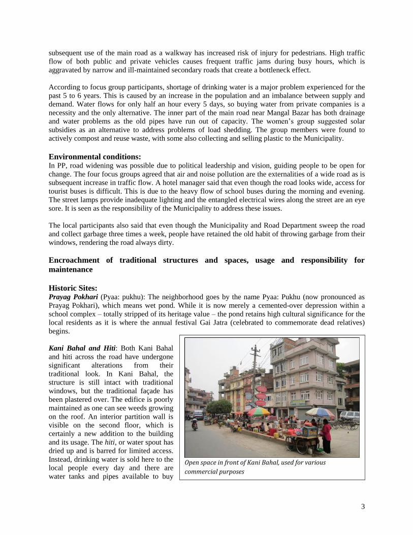
3
subsequent use of the main road as a walkway has increased risk of injury for pedestrians. High traffic
flow of both public and private vehicles causes frequent traffic jams during busy hours, which is
aggravated by narrow and ill-maintained secondary roads that create a bottleneck effect.
According to focus group participants, shortage of drinking water is a major problem experienced for the
past 5 to 6 years. This is caused by an increase in the population and an imbalance between supply and
demand. Water flows for only half an hour every 5 days, so buying water from private companies is a
necessity and the only alternative. The inner part of the main road near Mangal Bazar has both drainage
and water problems as the old pipes have run out of capacity. The women’s group suggested solar
subsidies as an alternative to address problems of load shedding. The group members were found to
actively compost and reuse waste, with some also collecting and selling plastic to the Municipality.
Environmental conditions: In PP, road widening was possible due to political leadership and vision, guiding people to be open for
change. The four focus groups agreed that air and noise pollution are the externalities of a wide road as is
subsequent increase in traffic flow. A hotel manager said that even though the road looks wide, access for
tourist buses is difficult. This is due to the heavy flow of school buses during the morning and evening.
The street lamps provide inadequate lighting and the entangled electrical wires along the street are an eye
sore. It is seen as the responsibility of the Municipality to address these issues.
The local participants also said that even though the Municipality and Road Department sweep the road
and collect garbage three times a week, people have retained the old habit of throwing garbage from their
windows, rendering the road always dirty.
Encroachment of traditional structures and spaces, usage and responsibility for
maintenance
Historic Sites: Prayag Pokhari (Pyaa: pukhu): The neighborhood goes by the name Pyaa: Pukhu (now pronounced as
Prayag Pokhari), which means wet pond. While it is now merely a cemented-over depression within a
school complex – totally stripped of its heritage value – the pond retains high cultural significance for the
local residents as it is where the annual festival Gai Jatra (celebrated to commemorate dead relatives)
begins.
Kani Bahal and Hiti: Both Kani Bahal
and hiti across the road have undergone
significant alterations from their
traditional look. In Kani Bahal, the
structure is still intact with traditional
windows, but the traditional façade has
been plastered over. The edifice is poorly
maintained as one can see weeds growing
on the roof. An interior partition wall is
visible on the second floor, which is
certainly a new addition to the building
and its usage. The hiti, or water spout has
dried up and is barred for limited access.
Instead, drinking water is sold here to the
local people every day and there are
water tanks and pipes available to buy
Open space in front of Kani Bahal, used for various
commercial purposes
4
and store.
According to the youth and women’s groups, both people and institutions have encroached on traditional
structures to gain economic benefit from these public properties. One example of this is the Dabali, or
raised public platform in the inner part of the neighborhood, which was renovated for public use and now
used by surrounding houses and shops as a walk way and sitting area. The Municipality was identified as
the responsible agency to take strong action to stop such acts.
Both the Thaina Youth Club and Thaina Women’s Group have rehabilitated a pati, or traditional rest
house as their office. Yet the structure has been modified to look like a modern building, having lost any
trace of its original character.
Open Space: Because PP lies on the fringe of the traditional city, there are not many traditional courtyard spaces.
However, enclosed behind bars is a small green traffic island at the cross section of PP. In addition, a
traditional brick paved open space in front of Kani Bahal is used for bike parking and as a display area for
shops and vendors, accentuating the contemporary economic value of this traditional open space.
BUSINESSES
The economic vitality of PP is comparatively lower than the nearest economic hubs of Mangal Bazaar and
Lagankhel. Though heavy vehicular movement is witnessed, engagement of pedestrians in commercial
activities is inadequate because the road is not pedestrian friendly. Most of the shops are consumer based,
to supply the daily needs of the local population. There are also charcoal shops catering to the needs of
the metal craftsmen living in the area. The types of consumer and service oriented activities here include:
stationery shops, grocery stores, pharmacies, salons, printing presses, storage warehouses, small tea shops,
banks, co-operatives, schools, colleges and hotels.
Level of economic vitality and types of commercial activities: The local people (Shakyas) say this area is “the tole (neighborhood) of craftsmen” as the majority of them
still continue their traditional occupations of crafting metal sculptures. With inherited skill and formal
education (one of them is a mechanical engineer), they are able to redefine their products to meet
contemporary tastes. Media exposure and various communication mediums have helped expand
businesses in the local and global markets. While European countries were the main importer beforehand,
it is now China. Flourishing small-scale workshops within houses are leading to economic prosperity and
are the main reason people are capable of investing in maintenance of the neighborhood’s public
infrastructure. According to the youth group, economic vitality increased after the road was widened, and
consumer and service based shops and facilities also increased. However, other business groups
(especially renters) said that people use the road almost exclusively as a connector, hardly ever stopping
to shop. Consequently, the visible economic vitality and the increased number of shops do not necessarily
mean that business is satisfactory. Also, the flow of tourists decreased after Mahaboudha was removed
from the Patan Monument Zone of UNESCO’s World Heritage Site (WHS) core area. Focus group
members thus suggested that relevant agencies work on regaining this designation.
Employment opportunities for the local people: According to the local craftsmen, they do not focus on providing employment to the local people, rather
preferring those with particular skill and interest. Since the new generation is increasingly abandoning
craftsmanship, many migrant workers are hired to cater to the needs of the growing metal sculpture
business. This is one of the main reasons for the increased migrant population in the area. According to
the hotel manager, only 5 out of the hotel’s 35 employees are from the neighborhood, with local
hesitation towards such work due to the negative societal perceptions of the hotel business.

5
Income level and rental value: According to the women’s and youth focus groups, income levels have definitely increased as people
have expanded their traditional businesses. However, Nepal’s stringent export laws have stifled the
potential increase in exports. Harassment by political groups for donations has also reportedly created an
insecure environment for businessmen.
PEOPLE
Change in dominant ethnic population: Focus group participants agree that about 75 percent of the houses in Prayag Pokhari Marga are owned by
the local people of Uku Bahal, who bought guthi land to build houses in order to accommodate increasing
family size. It is also believed that the other houses are mostly rented, with an estimated rental population
of 30 percent. The rate of in-migration is increasing due to employment opportunities in the area and
growth of the nearby Lagankhel as the main commercial and transit hub.
Preservation of heritage and continuance of socio-cultural practices: Shakya communities in PP, who are associated with the Uku Bahal guthi in the old city core, are very
active in reviving and preserving their culture, language and art. According to the locals, the strong guthi
system takes responsibility for maintaining both tangible and intangible heritage. This is partially done
through force, as speaking the Newari language is required. According to the youth group, the younger
generations – who have modern values and life styles – are less concerned about the importance of their
socio-cultural practices, feeling that they should not be forced to follow culture blindly without proper
justification for continuing these rituals. Lack of research on the importance of these traditions and failure
to adapt them to the changing needs of people and context has failed to convince the younger generation
to uphold and promote their socio-cultural practices. Academic courses are also increasingly influenced
by imported knowledge and modern culture, with people now preferring to celebrate January 1st rather
than Baisakh 1st
as New Year’s Day. Participants expressed a need for research-based revision of school
curriculums to encourage the younger generation to preserve culture and heritage. They identified
conservation of heritage as the key to developing tourism in the area.
Level of acquaintance and helping each other: According to the women’s group, there is a strong sense of community around Thaina and Thapa hiti
neighborhood near Mangal Bazaar. The value put on culture has increased recently due to realization on
the part of youth of the significance of their own roots. However, these communities in PP are fragmented
from the inner part. The youth group noted lower levels of acquaintance in PP due to people adopting
different, more individual rather than community-oriented lifestyles, less interaction with renters and loss
of dominance of a specific cultural group as people relocated from their neighborhoods to new areas. The
business group, comprising of individuals renting in the area, expressed absence of unity at the social
level in PP as the Shakyas from Uku Bahal are associates to guthi of Uku Bahal (inner area near to city
core) and less engaged with people in the area.
Level of safety: Farmland around PP used to be unsafe, dark and infested with drug addicts. With increasing numbers of
houses and the widening of the road, however, the security condition has improved. Still, people agree
that the security level is now again declining due to an increase in new or migrant populations in the area.
Disturbances from rental units are a common occurrence. One of the buildings has 55 rooms rented, with
fights commonly leading residents to call the police. According to one participant, bells have been placed
in the inner part of the city around the Uku Bahal area to alert people of emergency situations like theft or
to issue a call for a mass gathering.
6
Types, activities and capacity of social capital: Everyone expressed concern over the absence of social organizations in the PP Marga area, as most of the
local residents are associated with committees and the Uku Bahal guthi near the city core. Public
participation in social issues and interaction with renters is minimal. As it is difficult to gather people
together, only a handful work on solving problems in PP while most others simply comply.
According to the youth focus group, the migrant population in PP is struggling to improve their
circumstances, but have a hard time in this due to a lack of social connections. So while physical
development is a prominent result of urbanization in modern areas like PP, social development lags
behind.
Participants felt that the focus should be on developing social capital, engaging people to address issues at
the community level and guiding development for the betterment of all stakeholders. Residents also
stressed the importance of providing personal development opportunities for local people, so that they can
grow. It was generally believed that this can be accomplished by developing communication skills,
establishing social connections, and creating exposure to, and interaction with various committees and
agencies. The women’s group also expressed the need to bring a Teacher’s Learning Center (TLC) to
municipality, which are now limited to villages only. They want to establish a TLC in the area for
supporting education, which is deemed vital for women’s empowerment.
PLACES:
Possibilities of new development with modern facilities:
- Earlier a farmland on fringe area of the traditional city, land was abundant for new development.
- Construction of wide road connecting Lagankhel with Gwarko, now a major connector.
- Provision of better drainage services to support a growing population in the area.
- Absence of Monument zone by-laws, so development of RCC structures was easier, faster,
economical, and had high economic return in terms of space.
Close proximity to Lagankhel and Mangal Bazaar, economic and transportation hubs of Patan:
- Increase in economic activities to capture spill-over effect of the economic hubs.
PEOPLE:
- Presence of political leaders with vision and the will to develop PP. As an initial step, they
assisted in road widening by convincing people to contribute their land.
- Majority of population is Shakya (higher/richer caste) who can afford to contribute land for
development.
BUSINESS: - Traditional craftsmen building upon their ancestral occupation of metal sculpture crafting and
ability to adapt and expand it to meet the contemporary taste.
- Growth of both consumer-based and services-oriented economic activities with increase in flow
of people.
- Establishment of tourist centric services like hotels to attract visitors are doing good business and
providing employment to the local population.
Causes of urban development in Prayag Pokhari
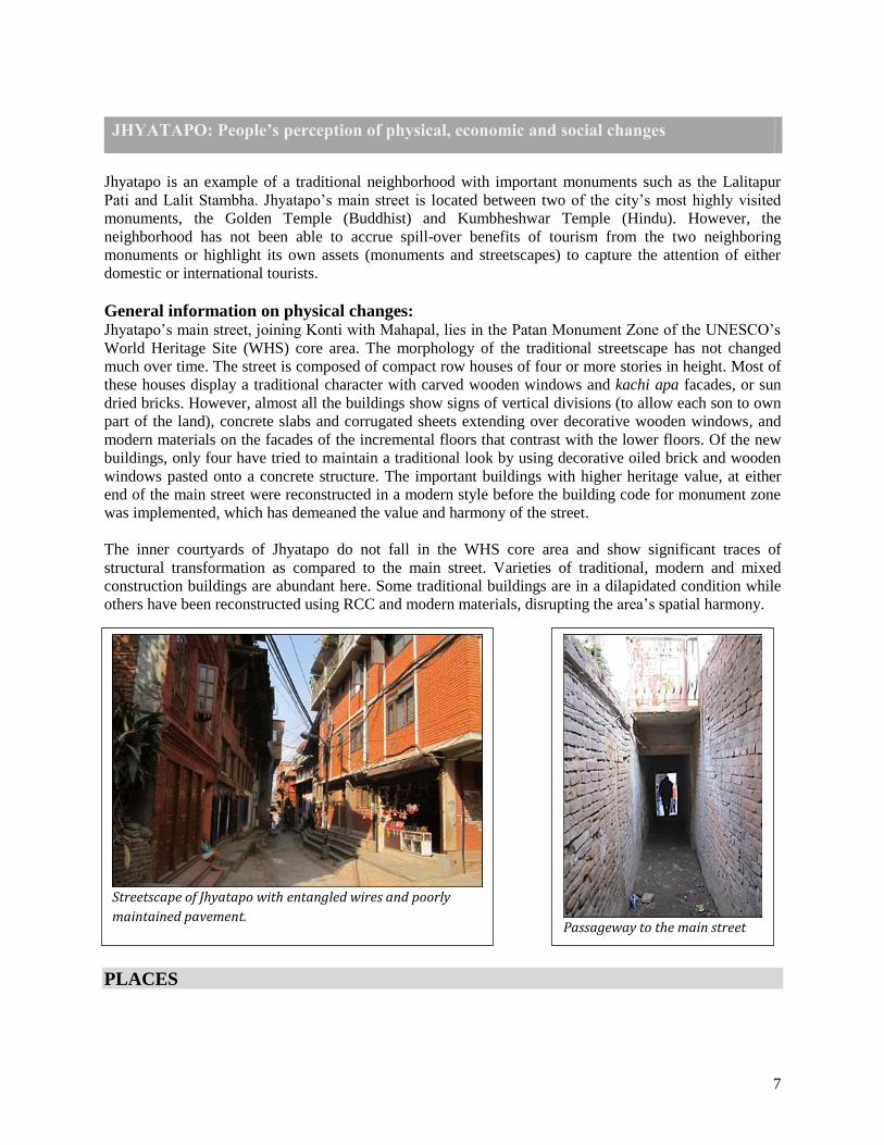
7
Jhyatapo is an example of a traditional neighborhood with important monuments such as the Lalitapur
Pati and Lalit Stambha. Jhyatapo’s main street is located between two of the city’s most highly visited
monuments, the Golden Temple (Buddhist) and Kumbheshwar Temple (Hindu). However, the
neighborhood has not been able to accrue spill-over benefits of tourism from the two neighboring
monuments or highlight its own assets (monuments and streetscapes) to capture the attention of either
domestic or international tourists.
General information on physical changes: Jhyatapo’s main street, joining Konti with Mahapal, lies in the Patan Monument Zone of the UNESCO’s
World Heritage Site (WHS) core area. The morphology of the traditional streetscape has not changed
much over time. The street is composed of compact row houses of four or more stories in height. Most of
these houses display a traditional character with carved wooden windows and kachi apa facades, or sun
dried bricks. However, almost all the buildings show signs of vertical divisions (to allow each son to own
part of the land), concrete slabs and corrugated sheets extending over decorative wooden windows, and
modern materials on the facades of the incremental floors that contrast with the lower floors. Of the new
buildings, only four have tried to maintain a traditional look by using decorative oiled brick and wooden
windows pasted onto a concrete structure. The important buildings with higher heritage value, at either
end of the main street were reconstructed in a modern style before the building code for monument zone
was implemented, which has demeaned the value and harmony of the street.
The inner courtyards of Jhyatapo do not fall in the WHS core area and show significant traces of
structural transformation as compared to the main street. Varieties of traditional, modern and mixed
construction buildings are abundant here. Some traditional buildings are in a dilapidated condition while
others have been reconstructed using RCC and modern materials, disrupting the area’s spatial harmony.
PLACES
JHYATAPO: People’s perception of physical, economic and social changes
Streetscape of Jhyatapo with entangled wires and poorly
maintained pavement.
Passageway to the main street
8
Buildings in the neighborhood were once the homes of the farming community, but are now rental units
to meet the increasing demand for housing from migrant workers. Focus group participants believed
about half of the total population living in Jhyatapo to be renters. The majority of houses along the main
street have provision for tourism-based handicraft shops on the ground floor. Some have workshops for
small-scale metal sculpture, one of the major occupations that has substituted for farming in the
neighborhood. According to the Tole Sudhar Samiti (TSS) community development organization, the
economic drive to maximize benefits from houses has destroyed the homogeneity of the physical
surroundings. While the street once consisted of traditional houses with similar façades, tall buildings
have come to replace many of them.
Disaster risk and structural integrity of the buildings: Based on observation, some houses made of kachi apa brick show signs of vertical cracks. Earthquake
risk has increased as a result of: (1) traditional buildings having been retrofitted with improperly braced
concrete overhangs and incremental floors using modern materials; and (2) RCC houses adjacent to old
homes in the inner courtyards having inappropriate overhangs. The major concern during earthquakes is
the lack of good escape routes – passageways connecting inner courtyards to the main street are narrow
and go underneath other buildings, running the risk of trapping people during evacuation.
The focus groups unanimously agreed that structures in Jhyatapo are at high risk from earthquakes. Both
TSS and the women’s group considered traditional technology to be safer than RCC as it is based on
centuries-old technology developed for earthquakes. However, traditional technology and materials are
expensive, leading most to choose RCC structures, which have a life span of 100 years but will increase
risk in the long run. The elderly and business focus groups identified old houses that survived the 1934
earthquake, but which are now high risk due to lack of maintenance. All groups expressed concern over
the lack of open space due to an increase in building and population density and unsafe escape routes,
citing them as major elements of growing earthquake risks. TSS was aware that the increase in paved
surfaces has resulted in a decrease in water recharge and water level in wells, which can be a major life
saving resource after an earthquake. People stressed that many buildings were constructed before the
introduction of building regulations for earthquake safety, and explained that the Municipality has not
been able to enforce the regulations in new structures.
Enforcement of building by-laws and regulations: There is a blanket building regulation for earthquake safety in Patan, but groups say that the Municipality
cannot enforce it, which has increased vulnerability in the area. Since the main street of Jhyatapo falls
under the WHS Core Area, buildings are required to maintain a traditional architectural style and height.
However, modern concrete buildings at either end of the street and incremental floors with modern
material on the old ones have disrupted the harmony of the streetscape. The four groups expressed
different opinions on this law. TSS thought that height limitations could not satisfy the spatial needs of
growing family size. According to the elderly group, the law was implemented too late because modern
RCC buildings were built 30 years ago. The women’s group suggested that the Municipality provide
information on material, labor and subsidies to incentivize people to start following the by-laws. And the
business groups identified the law itself as the major cause for the physical decay in Jhyatapo, explaining
that the high costs of traditional construction technology and materials and subsequent low economic
returns from the buildings prevent people from following the regulation.
Provision of infrastructure and public services: Based on general observation, Jhyatapo needs to address the issue of drainage and maintenance of the
main street between Kumbheshwar and the Golden Temple. The street is currently bumpy with uneven
paving, and the two and four wheel traffic poses a risk to pedestrians.
9
All four groups identified sanitation and drainage as their major problem. The old open-drainage system
(without latrine connections) was replaced with hume pipes and sewerage connections. However, the
Municipality also connected drainage from Ga Bahal, Pulchowk and Shanta Bawan to this line, which
exceeded its carrying capacity. So every year during rainy season, the main street floods like an open
drain. People have attempted to replace old pipes with new ones, but the problem is not a local one
constrained to Jhyatapo. People living in Kumbheshwar area have opposed the laying of new drainpipes
since this would require taking down houses and schools that have been built over them. With Konti lying
on low land, people were scared that a high force of water would damage their structures. Since the issue
extends beyond the territory of Jhyatapo, people want the Municipality to resolve this conflict and take
forceful actions if needed.
The women and business focus groups emphasized the dilapidated condition of the street as a major factor
limiting the potential of Jhyatapo to be a tourist attraction point. Despite the tole, or neighborhood
conducting maintenance, it is washed away by floods every year leaving the roads bumpy and uneven.
Unwanted traffic also creates a nuisance by increasing pollution and risk to pedestrians. Both the TSS and
business focus groups suggested making the street to pedestrian friendly, allow locals and tourists to walk
safely and comfortably. The business group additionally suggested that the Municipality provide tourist
centric services in the area to cater to the needs of tourists.
Water scarcity is another problem, which was aggravated after the Konti hiti, or water spout dried up.
People have sought deep boring and wells as alternatives. According to one respondent, the people from
Kumbheshwar blamed the construction of wells and boring in Jhyatapo for the drying up of their hiti.
This resulted in the forceful removal of a boring machine and buried wells. People in Jhyatapo could not
stand up to such a forceful act due to the low number of local residents present to stand up for their rights.
This special Newar cast (regarded as harsh), concentrated in the Kumbheshwar area, is also dominating
and suppressing people in Jhyatapo. Focus group participants expressed strong need for the Municipality
to understand these differences and the conflicts between two neighborhoods, and plan accordingly.
As for electricity, people suggested subsidies for solar energy as an alternative to addressing the
increasing frequency of transformer explosions.
Environmental conditions: People have experienced an increase in air and noise pollution as an externality of increasing vehicular
flow in the area. High traffic-flow days are Thursday and Saturday, as devotees flock to worship at
Kumbheshwar. The numbers of two-wheelers owned by the residents have increased, with vehicular
movement in this narrow bumpy street causing traffic jams and increasing risks to pedestrians. Tangled
electrical wires along the street have also degraded the beauty of streetscape, and there are very few street
lamps.
Encroachment of traditional structures and spaces, usage and responsibility for
maintenance:
Historic Sites
Lalitapur Pati: Lalitapur Pati, or traditional rest house, is a significant monument in Jhyatapo. It
shows signs of physical deterioration with vertical cracks, bulging walls and settled floors that have
increased its structural vulnerability. Structural alterations like the replacement of the terracotta roof
tiles with corrugated sheets and addition of metal grills to prevent misuse have disfigured the
structure and demeaned its heritage value and purpose. However, the concept of conservation has
gradually changed with time, rendering the younger generation more aware of ethics and knowledge

10
on preservation. Since this rest house serves various social and cultural functions such as meetings,
parties, elderly classes, trainings, etc., its renovation is currently the main agenda of the TSS.
Lalit Jyapu’s Monolith and Pati: Lalit Jyapu’s Monolith, or a legendary figure and the rest house
next to it are structurally intact with visual signs of modifications, such as the use of modern materials
(cement floor and new concrete pillars in the pati). The rest house has metal grills to store first-aid
boxes provided by the Red Cross. Passersby rarely notice these important monuments as they are not
highlighted.
Open Spaces: The inner courtyards along the main street are not well maintained except for one with a Nasa dyo, or
shrine and another leading to Ikhachen. Some are used for storage purposes and are overgrown with
vegetation. One reason for this deterioration may be the dominance of the rental population living in these
areas, which lacks significant concern for courtyard conditions. All four focus groups are confident that
traditional structures have not been significantly encroached upon; however, the women’s and business
focus groups identified private parking in open public spaces as a problem. Parking is not well managed,
leading to conflicts when people
want to park in these areas. The
women’s group thus suggested
instituting a parking fee to
collect money for maintaining
the space.
A courtyard near Tapa hiti is an
outstanding south-facing open
space with many traditional
elements like pati, chaitya and a
well. Only local residents around
the courtyard use this space to
carry out daily household chores
and social gatherings. But one
can see modification of
traditional houses as a
consequence of property division
between brothers. One of the
patis has been reconstructed as a
modern shelter, having lost its
traditional look.
BUSINESSES
Based on general observation, most of the houses along the main street have provision for shops on the
ground floor (most are tourist oriented), whereas the upper floors are used for residential purposes. The
flow of tourists along the road is adequate, but tourists rarely stop to shop or take an interest in looking
around the buildings. One reason may be the poor street paving and number of vehicles. This means that
people must pay close attention in order to walk safely. Also, the shops are not selling anything
significantly different from any other shop in Patan, making it difficult to attract tourists’ attention. The
types of shops on the street include handicrafts shops ( selling masks, thanka paintings, wood, accessories,
garments, statues, etc.), a grocery store, a butcher shop and a CD shop. The inner courtyards are
dominated by rental residences.
Lalitpur pati with corrugated roof and metal grills demeaning its
heritage value
11
Level of economic vitality and types of commercial activities: The four focus groups stressed that the numbers of shops on the main street have increased while the level
of economic vitality and flow of people has decreased. Road conditions were identified as the major
reason for this decline as the roads are not pedestrian friendly and as there are alternative and better roads
that lead to Kumbheshwar.
Farming used to be the main occupation of the Tandukars. With decreasing farmland due to houses being
built or the land being sold as well as the lack of irrigation in the new town planning area, people can no
longer depend on farming for their livelihood. Renting rooms and houses is thus regarded as an economic
activity. Some people have also switched professions to metal work, opening small metal sculpture
workshops in their houses.
Employment opportunities for the local people: Not much attention has been given to providing employment to local people. Local craftsmen stressed
their preference for skilled and/or interested people rather than those in their locality and caste. However,
20 men in Jhyatapo have formed a group to start community businesses. They have thus far started a car
service store in Shankhamul – although their technicians are not from this locality – and are planning on
opening a restaurant.
Income level and rental value: Though the income level has increased, the level of residents’ income remains unsatisfactory as the value
of money has decreased and things are expensive. Any increase in income has been counter balanced by
increases in the price of goods. The economic status of people has thus not changed – they still need two
jobs and multiple sources of income for their livelihood. Since business has not been able to flourish, the
rents are low compared to other neighborhoods.
There are small-scale economic activities in Jhyatapo. For instance one person supplies diyo (traditional
light using ghee), which is sold to the devotees in Kumbheshwar. Mr. Gyan Raja Shakya has a small
mask shop along the street, which has been his ancestral business for the past 60 years. These small-scale
activities are livelihoods, which usually go unnoticed, but could potentially attract both tourists and
investment.
PEOPLE
Change in ethnic dominant population: The focus groups agree that more than half of the total population are renters, and the population of the
dominant ethnic group (Tandukar) has significantly changed. The driving factor for local people’s
relocation is lack of space catering to the spatial needs of increasing family size. These people have
moved out by constructing new houses on their farmland near Chakupat and Jwagal. At one time, demand
for rental units was high in the area due to availability of water (Kumbheshwar hiti) and jobs. At that
point, renting out houses was an easy source of income for the locals.
Preservation of heritage and continuance of socio-cultural practices: According to TSS members, the organization takes responsibility for addressing community issues
including preservation of heritage. They expressed dissatisfaction with the limited participation of others
in the area, who see an opportunity cost in giving their time to social activities. Before, when there was a
guthi system, gathering people together was easy as they had to obey orders of the seniors. Since
committees have replaced the guthi, people generally see it as the responsibility of TSS to handle local
issues. Bringing people together has thus become a challenge. The women’s group explained that there is

12
a strong sense of ownership among women and the younger generation, while both the women’s and
elderly focus groups identified the TSS as responsible for preserving heritage.
TSS members – who are mostly young men – view cultural practices that do not contribute to
contemporary life as irrelevant. They were vocal about discontinuing such activities, because the younger
generation is busy managing their lives. For instance, bhajan mandala, the group singing devotional
songs – which does not fall under the guthi system – has ceased as elderly people who were engaged in
this have either died or moved out, and there was no support for its continuance from the younger
generation. The elderly focus group participants, however, expressed confidence that their guthi system is
capable of exerting social pressure on the younger generation to participate in social activities. And they
suggested that people failing to participate could be fined. One of the major events in the neighborhood is
a feast during Bhimsen Jatra, which has the main objective of building and maintaining social connections.
Level of acquaintance and helping each other: The TSS, women’s and elderly focus groups agreed that there has been a decrease in the level of
acquaintance in the community due to: (1) relocation of the local people, (2) an increase in the renter
population, and (3) changes in lifestyle as people have limited time for social activities. However, the
members of the business focus group – who do not belong to the community committee – said that there
is a lack of social bonding due to them being excluded from community activities. They reported little
exchange of information or suggestions with the TSS. Renters and businessmen who work in the area are
not included in social activities or decision-making processes to address communal issues. However, all
focus group participants agreed that people come together to help each other when needed.
Level of safety: While all four groups considered Jhyatapo to be a safe place, they felt that safety had deteriorated due to
the expansion of the rental population and an increase in unknown faces. Cases of theft, for instance, were
noted to have increased. Members of the women’s group believed it to be the responsibility of each
household to take care of their own safety.
Types, activities and capacity of social capital: TSS is the major committee active in resolving conflicts and maintaining the neighborhood’s physical
structures and facilities, including maintenance of the road, drainage, rest house, and street lights.
According to TSS members, they seek advice from seniors so as to avoid conflict, but other committees
and local people are free to oppose their decisions.
The women’s group reported being focused on the social development of women in the community by
establishing a co-operative for banking and lending money. They also reported conducting training on
income generating skills.
Participants in the business focus group said that there is a concentration of one specific caste in the TSS.
Even those with a home in the area but who do not belong to this caste were said to be excluded in the
decision-making process. The use of the Newari language during TSS meetings is required and a barrier
to communication for many residents. Lacking interaction with the TSS and being excluded from various
activities, the business group expressed the need for a business committee to raise their visibility in the
neighborhood and give them a collective voice for addressing their issues in the community.
On earthquake preparation, both the TSS and women’s focus group said that it is a challenge to
implement preparation measures. One TSS member who is a Red Cross volunteer expressed difficulties in
gathering people and convincing them to volunteer for training. The women’s group expressed challenges
in implementing and continuing preparedness practices due to economic constraints. They also
13
highlighted that people do not take seriously the risk of an event that they have never experienced in their
lifetime. The business group has not participated in any training, and was not informed about the presence
of a Red Cross box in the Pati.
PLACES:
Traditional morphology and system trying to fulfill contemporary demand of growing population
- Vehicular movement in a traditionally pedestrian street resulted in an increase of air and noise
pollution, damage to paving materials, road blockage, and risk to pedestrians.
- Vertical division of traditional structures increased risk from earthquakes and decreased heritage
value of the structures. Example: Lack of bracing on overhangs, use of modern materials.
- Drainage problem caused by diversion from other areas, outrunning the capacity of old pipes.
- Frequent explosion of electricity transformers resulting in disruption of power supply, even in the
absence of load shedding. Entangled electrical wires increasing risk and disturbing view.
- Scarcity of drinking water caused by drying of communal Kumbheshwar water source, with an
increase in population alongside a decrease in water supply from the authority (which also
smells).
Increase in earthquake vulnerability
- Inability of the Municipality to strictly enforce building codes, lack of orientation to properly use
traditional technology and materials.
- Presence of old houses that are not maintained properly.
- Apathy of people to implement lessons learned from disaster preparedness trainings.
- Decrease in open spaces and unsafe escape routes not marked that go underneath old houses.
- Increase in population.
- Decreasing water level in wells.
PEOPLE:
Socio-cultural changes, resulting in increasing social disconnection.
- Migration of the original residents, increase in rental population.
- Exclusion of renters and business owners from community activities.
- Change in lifestyle and less value placed on socio-cultural rituals by younger generation.
- Change in community system, guthi replaced by different committees (TSS, women’s group).
Conflict between neighborhoods: Prevalence of traditional caste system and dominance of specific
group causing obstruction in reconstruction of drainage system, which results in floods during rainy
season and damages street paving every year.
Lack of a political mobilizer in the community to build relationship with the municipality and use the
right channels to access funds for maintenance of infrastructure and restoration of important
monuments in the neighborhood.
BUSINESSES:
Decreasing economic vitality and inability to capture economic benefits from tourism
- Lack of proper infrastructure (road, drainage, vehicular movements).
- Lack of tourist centric services.
- Inability to build upon assets like Lalitapur Pati, Lalit Jyapu’s Monolith.
- Exclusion of businessmen from community activities, not being able to encourage and facilitate
their contributions.
Unable to increase income level and economic stability
- Change in traditional occupation from farming, which is still in transitional phase.
Causes of urban decline in Jhyatapo:
14
- Dependence on rents as a source of income; rents are kept low and cannot contribute to economic
betterment.
- Limited opportunities for employment at the local level.
The PP area was planned for new development and caters to the expansion of the traditional town. It went
through major physical alterations (widening the road and installing an adequate drainage system) in
order to connect this peripheral area to the growing city hub. Because construction in the area was not
restricted by being inside the World Heritage core, the building code allowed construction of new RCC
buildings that could accommodate a variety of businesses. The area shows visible signs of growth, but
also faces various issues such as a shortage of drinking water, pollution and encroachment of public space.
In Jhyatapo, the streetscape and building morphology is still based on the traditional town system. It has
visible signs of physical decay as an increasing population, changes in lifestyle, and contemporary needs
stress the physical structures and infrastructure. Residents of both areas felt that their neighborhoods are
at high risk of earthquake disaster, as most of the buildings were constructed before the introduction of
the building by-law for earthquake safety.
Since PP does not have a TSS or any other community groups, local issues are solved by a handful of
people who have a good rapport with the Municipality. Although the area remains inhabited by a majority
of the original residents, they are associated with Uku Bahal Guthi in the inner city neighborhood, and
have very little interaction with the renters in PP. Focus group participants in PP expressed feeling a lack
of social bonding and a lag in social development.
In Jhyatapo, there is a well-established TSS that addresses social and physical issues and there is a strong
women’s group as well. Some focus group participants in Jhyatapo felt that the neighborhood has a close-
knit and strong community. These participants are probably members of the predominant caste in the
neighborhood, however. There was some dissatisfaction among other stakeholders – such as the
businessmen and renters – who expressed feeling excluded from community activities.
Some businessmen in PP reported decreasing economic vitality on the main road due to its primary use as
a connector, it not being pedestrian friendly, and it lacking the variety of shops that can engage people
along the road. However, tourism industries like traditional metal crafts and hotels are satisfied with their
growth and are planning to further expand their businesses. In the case of Jhyatapo – which is mainly
focused on tourism-based businesses – participants reported a loss in economic vitality along with
minimal economic benefit from their businesses. While the flow of tourists was deemed adequate, the
community has not been able to accrue significant economic benefit from this, with the shift away from
the traditional occupation of farming still in a transitional phase.
Comparison between two neighborhoods: Jhyatapo and Prayag Pokhari
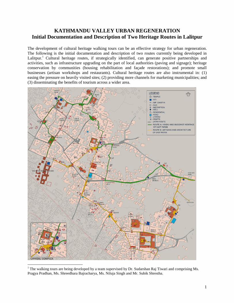
1
KATHMANDU VALLEY URBAN REGENERATION
Initial Documentation and Description of Two Heritage Routes in Lalitpur
The development of cultural heritage walking tours can be an effective strategy for urban regeneration.
The following is the initial documentation and description of two routes currently being developed in
Lalitpur.1 Cultural heritage routes, if strategically identified, can generate positive partnerships and
activities, such as infrastructure upgrading on the part of local authorities (paving and signage); heritage
conservation by communities (housing rehabilitation and façade restorations); and promote small
businesses (artisan workshops and restaurants). Cultural heritage routes are also instrumental in: (1)
easing the pressure on heavily visited sites; (2) providing more channels for marketing municipalities; and
(3) disseminating the benefits of tourism across a wider area.
1 The walking tours are being developed by a team supervised by Dr. Sudarshan Raj Tiwari and comprising Ms.
Pragya Pradhan, Ms. Shreedhara Bajracharya, Ms. Niluja Singh and Mr. Subik Shrestha.
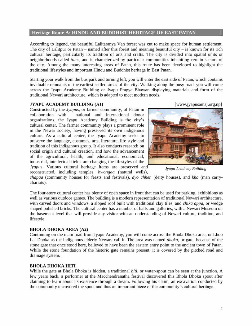
2
Heritage Route A: HINDU AND BUDDHIST HERITAGE OF EAST PATAN
According to legend, the beautiful Lalitaranya Van forest was cut to make space for human settlement.
The city of Lalitpur or Patan – named after this forest and meaning beautiful city – is known for its rich
cultural heritage, particularly its tradition of arts and crafts. The city is divided into spatial units or
neighborhoods called toles, and is characterized by particular communities inhabiting certain sectors of
the city. Among the many interesting areas of Patan, this route has been developed to highlight the
traditional lifestyles and important Hindu and Buddhist heritage in East Patan.
Starting your walk from the bus park and turning left, you will enter the east side of Patan, which contains
invaluable remnants of the earliest settled areas of the city. Walking along the busy road, you will come
across the Jyapu Academy Building or Jyapu Pragya Bhawan displaying materials and form of the
traditional Newari architecture, which is adapted to meet modern needs.
JYAPU ACADEMY BUILDING (A1) [www.jyapusamaj.org.np]
Constructed by the Jyapus, or farmer community, of Patan in
collaboration with national and international donor
organizations, the Jyapu Academy Building is the city’s
cultural center. The farmer community plays a prominent role
in the Newar society, having preserved its own indigenous
culture. As a cultural center, the Jyapu Academy seeks to
preserve the language, costumes, arts, literature, life style and
tradition of this indigenous group. It also conducts research on
social origin and cultural creation, and how the advancement
of the agricultural, health, and educational, economical,
industrial, intellectual fields are changing the lifestyles of the
Jyapus. Various cultural heritage items are preserved and
reconstructed, including temples, bwongaa (natural wells),
chapaa (community houses for feasts and festivals), dyo chhen (deity houses), and kha (man carry-
chariots).
The four-story cultural center has plenty of open space in front that can be used for parking, exhibitions as
well as various outdoor games. The building is a modern representation of traditional Newari architecture,
with carved doors and windows, a sloped roof built with traditional clay tiles, and chika appa, or wedge
shaped polished bricks. The cultural center has a number of halls and galleries, with a Newari Museum on
the basement level that will provide any visitor with an understanding of Newari culture, tradition, and
lifestyle.
BHOLA DHOKA AREA (A2)
Continuing on the main road from Jyapu Academy, you will come across the Bhola Dhoka area, or Lhoo
Lai Dhoka as the indigenous elderly Newars call it. The area was named dhoka, or gate, because of the
stone gate that once stood here, believed to have been the eastern entry point to the ancient town of Patan.
While the stone foundation of the historic gate remains present, it is covered by the pitched road and
drainage system.
BHOLA DHOKA HITI While the gate at Bhola Dhoka is hidden, a traditional hiti, or water-spout can be seen at the junction. A
few years back, a performer at the Macchendranatha festival discovered this Bhola Dhoka spout after
claiming to learn about its existence through a dream. Following his claim, an excavation conducted by
the community uncovered the spout and thus an important piece of the community’s cultural heritage.
Jyapu Academy Building
3
As you continue ahead, you will see a wider brick paved area on the right side of the road. Not to be
confused with footpaths, these areas are the farmers’ dedicated spots for drying their grains after harvest.
SLAUGHTER AREA (A3)
The slaughter area characterized by its burnt brick pavements is located in front of the house of Mr. Sunil
Khadgi. Continuing the traditional family occupation, Mr. Khadgi is a butcher. He slaughters 2 to 3
buffalos brought from Kalanki, Kathmandu every day. He usually finishes before 8 in the morning, after
which he sells the meat to local shops.
The walkway where the slaughtering takes place is fairly clean and offers an interesting look into
traditional town planning that was based on caste. Social hierarchy was a major determinant in planning
of old settlements. Dwellings of members that belonged to upper castes were located near the center of
town while lower castes were found more at the periphery near river banks or the city fringe. In lower
caste areas such as this one, you will not see bahal, or Buddhist monasteries built during the Malla
Period, important temples, or structures that exist in other parts of the city. The lower caste acted as a
guarding army for the higher caste, using khadga (or swords) as weapons, thus coming to be called
Khadgi. Over the course of time, many of these people became butchers instead.
CHAITYA AT CHYAGMA (A4)
The motifs seen on this 17th century terracotta chaitya, or shrine, at Chyagma resemble those of the
famous Mahabouddha Temple, also known as “the temple of a thousand buddha”. According to
Gutschow, the components of this shrine are the most exuberant and delicate of their kind. A pair of
makara (crocodile) rests on pilasters, with the kalasha (vase) and amala (fruit of immorality) motif below
and above to support the cusped arch and the peculiar stepped fame. Foliage that rises in steps, towards
the surmounting element of the Wheel of the Law, triangle, lotus throne and vajra.2
While the whole structure is made of bricks, the dome and base have been cemented over. It is believed
that the structure was erected to cover the mud mounds from which the terracotta components of the
Mahabouddha temple were formed.3 A member of the Patan potter community, Mr. Krishan Awale
claims that his ancestors who made bricks for the Mahabouddha Temple also brought in some extra to
build this shrine. The extended Awale family living around the courtyard remains the main clan
associated with the shrine. They celebrate the yearly Busa da: puja (a day to worship the shrine) on the
day of the October full moon, Kartik Purnima, and observe the Mataya, the festival of lights, to
commemorate dead relatives. At the Mataya festival celebrated in August, people walk in a line to
worship all shrines in the city.
You will notice two typical types of plants around the courtyard. On the west side of the Chyagma shrine
there is a Sina Swaa tree used for worshipping gods and goddesses. There are also spiny branches over
the boundary walls. Commonly seen on the boundary walls of residences, these thorny plants have
traditionally been used as a natural security mechanism to prevent intrusion.
CRAFTSMAN’S HOUSE (A5)
Made from sun-dried bricks, mud mortar and constructed in a traditional structural system, the 45-year
old Craftsman’s House is one of the few remaining traditional Newari houses in this fringe area. With
storage on the ground floor, a narrow wooden staircase leads to a bedroom on the first floor, metal
workshop on second floor and a kitchen on the top floor. The house belongs to a metal sculpting family of
the Khadgi community, who shifted away from their ancestral occupation of animal herding and
slaughtering 17 years ago.
2 Neils Gutschow, 1997.
3 Neils Gutschow, 1997.

4
While it had for long laid in dire condition, an NGO has helped in paving and maintaining this street for
the past 12 years. Outside of the main areas in the city core, streets have not been paved, remaining
largely neglected as fringe settlements not prioritized in the city’s development and beautification efforts.
CHYASAL COMPLEX (A6)
Exiting the neighborhood of Khadgi, the route opens up to the important public space in Patan, Chyasal
Complex. Chyasa, meaning eight hundred in Newari, is believed to commemorate the eight hundred
Kiratas that fell here.4
Below are some of the important components of Chyasal Complex:
Chyasal Dabu (A7)
According to historians, a battle took place in Chyasal in 250 A.D. between the invading Lichchhavi army
and Kiratas, the ruling dynasty of the Kathmandu Valley.5 800 Kirat soldiers are thought to have been
beheaded on the battlefield by the Lichchhavis during the last period of Kirat rule. And the soldiers’ heads
were believed to be buried under this dabu, a raised platform besides the Ganesh temple. A local legend
ascribed a different story to Chyasal Dabu centered around the locals’ fear of the Kirat rulers. According
to this legend, the Priest of the Golden Temple (Hiranya Varna Mahavihara) sent his son to perform his
daily rituals, and the child who was gifted by God with enchanted milk that turned into bees had the bees
attack the Kirat soldiers. Attempting to escape to the Bagmati River, the 800 soldiers were beheaded by
the local people and buried at Chyasa Dabu. The Chyasal Dabu is also referred to as Ghar Ghur Dabu
because of its believed mysterious powers.
This Chyasal Dabu is a raised 5 by 5 foot platform with a Shiva
Linga mounted above it. Shiva Linga is usually built in memory
of the dead, so this cultural tradition may have similarly been
followed by the Lichchhavi rulers at that time. Another theory of
the use of a Shiva Linga here centers around Emperor Ashok,
who built numerous Ashok shrine and megaliths after coming to
regret his past killings of such large numbers of people.
Every year in the month of October, a small group of people gathers at Chyasal Dabu at midnight to
perform religious ritual and have a feast.
Gaja Laxmi Statue in Nayo hiti (A8)
A steel cage protects an ancient statue of Gaja Laxmi, or the “Goddess of wealth”, elegantly standing at
ground level to the right of the hiti, or water-spout with a lotus flower in hand. The stone carving is worn,
with two barely visible elephants (gaja in Sanskrit) almost floating above Laxmi’s shoulders pouring
water for her. Some believe the statue to be from 250-280 BC and locals claim it to be the first stone
sculpture of Nepal, which was followed by development of prominent stone craftsmanship in the country.
According to eminent Nepali artist and art historian Bangdel (1982), the image of Gaja Laxmi is to be of
first century BC. The Nayo water-spout dried up about 7 or 8 years ago, with one local attributing this to
the construction of nearly 80 wells around the Chyasal area that may have blocked the veins of the water
supply system.
4 Ancient Settlement Of Kathmandu Valley [pg. 14].
5 Lichchhavi period is from 1
st to 9
th century.
Chyasal Dabu near Ganesh Temple

5
Bhairav Sattal/Awah Guthi Chapaa6 (A9)
Bhairav Sattal7 is one of the biggest structures in the court,
believed to have been made from a single tree. Distinct features
include the huge terracotta roof and row of lattice windows, as
well as the open plan on both floors that caters to mass
gatherings. This community building displays Malla era
architecture, and has icons of gods Bhairav, Nasa dyo and
Ganesh.
According to local custom, people of lower castes as well as
menstruating women are prohibited from entering the building.
And during gatherings, the first scoop of food should be offered
to the god before anyone tastes it. It is believed that if this is not done, people will face fatal
consequences.
The Awales, who comprise the local pottery making community, use this building for community
gatherings of up to 1,500 people. Such gatherings are mobilized around guthi,8 or social organization,
functions for people belonging to a particular neighborhood and caste, during the annual dewali puja or
community festival, and to celebrate the commencement of the community’s Thakali (eldest person) and
Naaya (leader).
While Bhairav Sattal can be renovated, floors cannot be added. The building adhering to the community
building is used for storing ancient clay utensils made by the Awales. One masterpiece held here is a 355-
year old jharon, or water reservoir made of clay, as opposed to the usual material of stone.
Jhyalcha Kenigu (Shadow Drama) (A9)
Since the period of King Yog Narendra Malla of Patan, the Awale potter community has been performing
Jhyalcha Kenigu – a shadow drama – from the first floor window of the Awah Guthi Chapa the day
before the September Indra Jatra festival. As the King was passing by Chyasal, he was said to have seen a
Byanjankar woman bathing near a well. He noticed bumblebees on her clothes, which were believed to be
auspicious. Regarded as a woman of good fortune, she became King Narendra’s second queen. Due to
jealousy, however, the first wife bribed the Awales of Chyasal to organize a shadow play to humiliate the
Byanjankar queen.
This play is called “jhyalcha kenigu” in Newari, meaning
“showing from a window”, and is performed on the rhythm of
the traditional instrument khi and devotional song bhajan. It
continues to be performed every year in the same manner as it
was originally performed.
There are statues of a king and his two queens on a tall stone
pillar in Patan Durbar Square, one of which is this Byanjankar
queen.
Takha (long) Pati adhering to Nayo hiti (A10)
Patis are traditional public rest houses for pedestrians. With an image of Narayan, the Takha Pati – built
in 1731 AD – is also known as Narayan Pati. It is used mainly for citing devotional songs as background
6 Chapa is a farmers’ community building.
7 Sattal is a two-story communal building.
8 Guthi is a social organization of people belonging to a neighborhood and caste.
Bhairav Sattal and lachi in front
Backside window for displaying drama
6
music for the shadow drama held annually at the Awah Guthi Chapa. Two rest houses were built here
joined longitudinally but at different floor levels. They were then reconstructed as a single structure at the
same level during a renovation in 2000.
CHIKA: BAHI9 (SAPTAPUR MAHAVIHARA) (A11)
A stone staircase on the west end of the Chyasal Complex leads you to Chika: Bahi, a monastery for
celibate monks, which was constructed for the Raj Vaidyas, or doctors of the royal palace. The earliest
date recorded at the site is 1415 AD, when the image of Ganesh was consecrated. The courtyard contains
an ancient shrine with an intricately detailed lotus base dated 1434 AD.
Vaidya – the families of which are traditionally in the medical profession – is the main clan associated
with the courtyard, continuing socio-cultural practices such as the rituals of Samyak worshipping of the
main image of Dipankar Buddha, Chudakarma when young boys become members of their clan, the
annual community gathering and festival of a communal feast, and Pancha dana when annual offerings
are made.
This monastery of Vaidyas is also known as Saptapur (sapta meaning seven) as it is believed that the
court’s main wing that housed the image of god was seven
storied. This was destroyed during a fire and later constructed
into the 2-story shrine we see today. Later, as the family grew,
family members started to settle around the main monastery,
thus leading to construction of many kachha bahas, or
branches of Chika: Bahi. All branches of the Chika: Bahi
monastery were said to be inhabited by the Shakya, the
community traditionally linked to the carpentry profession, and
the Vaidya medical community.
The branches are (Kachha Bahas):
Chika: Bahi Budhima- Manikuta Vihara (A12)
Exiting Chika: Bahi and turning anti-clockwise, Manikuta Vihara is located north of the main monastery.
A narrow passageway underneath a building will lead you to this small, enclosed courtyard surrounded by
3-story traditional buildings. A unique feature of the Manikuta Vihara is its wall painting, rarely seen in
ancient monasteries. Along with an image of the seven-tiered shrine of Chika: Bahi, the worn painting
depicts the process of Panchadana and Samyak, where rich people are giving donations, or dana.
Chika: Bahi- Triratna Vir Vihar/ Chibaha Chuka (A13) This monastery branch is located on the west side of Chika: Bahi. The main shrine contains an idol of
Saraswoti (aka. Sasuma in Newari), and is thus called the “sasuma yagu falcha”.10
As the goddess of
knowledge, Saraswoti puja (worshipping) is celebrated throughout the nation on the auspicious day of
Shri Panchami in April, which attracts local Hindu devotees to her nearby temples. The walls of the
Saraswoti temples are full of letters, with Shri Panchami associated with the centuries old tradition of
writing out the first Devanagari alphabets (Om Na Mo Ba Gi Swa Ra Ya) on the temple walls to obtain a
special blessing from the goddess. Toddlers are often taught and encouraged to write their first alphabets
on this lucky day. Around this monastery is the residence of Mr. Suresh Vaidya. While the ancestral
occupation of the Vaidyas is in medicine, Mr. Vaidya is a sculpture artist with a metal crafts studio in this
house.
9 Bahi is a two-story monastery complex for celibate monks, usually situated near the fringe of traditional town.
10 Falcha is another name for pati or traditional rest house.
Chika: Bahi complex
7
Bhaisajya Raj Baha (A14)
Bhaisajya Raj baha is located on the south-west side of Chika: Bahi. The deity’s house is a single story
building thought to have been constructed nine generations ago during the time of Prime Minister Jung
Bahadur Rana, when one of the family members was working as a Vaidya, producing and prescribing
medicines for the ruling government. It houses a shrine for idol Bhaishyajya Tathagat, worshiped by the
Vaidya family and medical profession. The previous image was stolen over twenty years ago, after which
a new idol was replaced by following the rituals of “Jivanyasha” and Buddha puja. These rituals included
three coats of paintings that can be observed on the outer wall of the shrine. Bhaisajya Raj baha contains
the residence of Mrs. Dev Kumara Vaidya, who has upheld the traditional family occupation in the
medical and pharmacy field.
WHITE GANESH AT OM BAHAL (A15)
Leaving Chika: Bahi behind, a 17th century miniature Buddhist shrine, can be seen in the middle of the
court half way down to Om Bahal. Om Bahal is a Shrestha (a caste) community neighborhood space
dating back to 1697 AD and the Malla era. As a Shrestha neighborhood, Om Bahal only has one guthi
social organization . The land where the guthi community building stands now is believed to have been
exchanged with the land at Mangalbazar, where the popular Krishna Mandir now stands.
The three-tiered temple in Om Bahal – with highly decorated torana, or gateway, and struts with Bhairav
and Matrika carvings that support the roof – is known as the temple of tuyu or white Ganesh. On special
occasions, the icon of white Ganesh is decorated with silver ornaments. A picture of Tuyu Ganesh icon
decorated with such ornaments is displayed in the community building to the left of the temple. Sadly, the
original Lichcchavi era Ganesh statue believed to be about 1400 years old11
was stolen and replaced with
a new one, which is now on display in the temple. The Gane Dya Boyu festival takes place four times a
year when the deity is kept in a chariot and taken on a festival tour route.
A metal crafts workshop can be visited opposite to the Ganesh temple where wax casting of bronze
images is a special craft of Newar Shakya.
RICE MILL (A16)
Heading from Om Bahal to Tadha Chuka, an almost 50-year old operational rice mill on the right offers
an interesting opportunity to see how rice is produced from paddy grains.
TADHA CHUKA (A17)
The statue of Lokeswora in the middle of this huge open space is believed to be of Machhendranatha.
According to legend, a Karunamaya image of Machhendranatha that was kept at Karuna Chuka in Yampi
Mahavihara was relocated to this open space due to security reasons. It was later moved again to Ta
Bahal12
, where the main icon remains to date.
It is mainly the Shrestha caste and Jyapu farmer communities that currently live at this court, where the
community holds feasts on the full moon day of Kartik Purnima in October and observes Mataya, the
festival of lights in August. While the traditional profession here used to be farming, most of the residents
now hold office jobs.
SUNAYA SRI MISHRA VIHARA/ YAMPI MAHAVIHARA13
(A18)
Located on the northern fringe of the ancient Lichchhavi town, this monastery is commonly known as
Yampi Mahavihar, meaning monastery in the north in Newari. Locals believe this set of three courtyards
11
According to local, Samrajya Shrestha. 12
A bahal or bihar is a complex of two-story buildings, one of which contains a sanctuary, surrounding a courtyard. 13
Resource: Pragya Shakya, Ratna man Shakya, Hiranya Shakya.

8
to be about 2,300 years old, close to the early-Buddhism period. There are many legends associated with
this monastery.
Legends credit Brahmin Sunyasri Misra from Kapilavastu – a great devotee of Buddhism – to have built
seven monasteries here. On his mission to spread the religion, he decided to live in Shankhamul, Patan as
it was of auspicious Shankha, or shell shape and had seven
main thirtha, or holy places. Misra went to Tibet to educate
people about Buddhism and collect money, earning Cha
Koti (6 Karod or 60 million). Returning to Shankhamul, he
wanted to construct seven monasteries to educate the local
population about Buddhism; due to his older age, he built
all seven monasteries in one place. The northern most court,
Yampi Yanta Mahavihara, has three structures housing
three deities. The middle court, Yampi Mahavihara, has
three alcoves. The southern court, Sujak Prabha
Mahavihara is also known as Karunamaya Chuka,
named after the image of Lord Machhendranath.
According to legend, the Kathmandu valley once faced serious draught causing famine. King Narendra
Dev of Bhaktapur, Vandhudatta Achaju from Kathmandu and Lalita Jyapu from Patan together went to
Kamarukamachya in Assam, India to bring the god of rain Machhendranatha to the valley. It was finally
decided that the deity was placed in Sujak Prabha Mahavihara in Patan where there was prominent human
settlement and safety. With Machhendranatha placed in the monastery, it was named Karunamaya
Chuka after the god. However, given the proximity of this monastery to the neighboring kingdom and
acknowledging the possibility of attacks from the neighboring kingdom on the monastery – which was on
the boundary of the old Kingdom – Karunamaya was placed in Thadha Chuka and later moved to Ta
Bahal where it has stayed till date. This shifting is reenacted annually in the month-long and highly
acclaimed Machhendranatha Jatra festival. In the festival, a tall wooden chariot with wheels is built and
pulled around the city with the deity placed in the alcove.
Another local story tells us that great Tibetan Buddhist exponent and religious figure Padmasambhav of
the Mahayan period lived in Karunamaya Chuka during his time in Nepal. Many Tibetans still travel to
this monastery to worship the place where their revered god had stayed, and there are many stories in
Tibet related to this area.
The clan belonging to this monastery is the Brahmacharya Bhichhu, who claim to be the descendants of
Sunaya Sri Mishra. Breaking down their caste, Bramha means they are the only Buddhist clan whose
chudakarma (ritual to make young boys member of the monastery) is done by a Bhramin. Charya denotes
the traditional occupation of priesthood, and Bhichu refers to boys having to spend four days of their life
as bhichu, or monks in this monastery. This group still conducts daily rituals in the monastery, especially
on the day of the Sri Panchami in April, the Fagu Purnima full moon in March and in October during Si:
Guthi feast.
The importance of Yampi Mahavihara can be witnessed during the Samyak festival conducted every 5
years when Dipankar Buddhas from around the city are brought to Nagh Bahal for a feast. Shakya Muni
of the Golden temple (Hiranya Barna Mahavihara) welcomes everyone at Kwalkhu, where the rest of the
Dipankars bow to him. But when the message of the Dipankar arrival from Yampi Mahavihara is relayed,
the Shakya Muni himself welcomes and bows to the Dipankar. Only the five eldest priests from Yampi
Vihara are respected during the procession ceremony by the washing of their feet.
Yampi Mahavihar Courtyard

9
The image of Sunyasri Misra in Yampi Bahi receives a lot of visitors. Believed to have the power of
conception, many childless couples come to worship the statue as well as gynecologists and other doctors.
Every 12 years, major woodwork is done by the Barahi caste – who are carpenters of the farmer’s
community – in this monastery to make the wheels of the chariot of Machhendranath. Mr. Dil Kumar
Barahi, currently the head carpenter and leader of this Barahi team, resides in Yangu Bahal, where a
Lichchhavi inscription issued by King Narendradeva and dated to the 7th century suggests contribution of
workmanship by the people living in Yangu Bahal. The trees that supply wood for making of the chariot
are required to be auspiciously cut by another farmer from Dupat, a majority farmers’ area.
ASHOKAN STUPA14
(A19)
In the northern end of Patan just across Yampi Bahi, a white gate leads you to one of the four Ashokan
stupas, or mound-like structures containing Buddhist relics, built at the ‘four cardinal directions’ of the
city of Patan. While the precise history of the mounds must await archaeological investigation, taken
together with the city’s association with the Kirata, these primitive looking structures suggest that Patan
was the site of ancient settlements. Although it is unlikely that Ashoka was personally associated with the
mounds, they closely compare to Mauryan Stupas in size and shape, and could be coeval.15
The mounds
are all named according to the general cardinal direction in which they are located: for north they use the
term Yampi.
Except for the thoroughly renovated North Stupa, all are simple, grass-grown brick mounds to which the
shrines of the directional Buddhas were later attached. The new look of the North Stupa is the result of a
Shakya16
businessman who financed a renovation in this century, turning the previously grassy dome into
one of bricks and mud. A sensitive restoration of the stupa and its ancillary elements back to its original
historical form and fabric can reveal its pristine beauty.
The priest of the Ashoka Stupa – also known as Yampi Stupa – is from Yampi Bahi, which lies to its east.
The stupa is the main site of the major religious festival beginning with the full moon day of Bhadra in
August, when Buddhists in Patan engage in three
consecutive days of celebration overlapping with Janai-
purnima and Gai-jatra. The first day is devoted to worship
of the Patan East Stupa and the second day is Saparu,
commemorating the dead through worship of the four
Ashokan stupas. Beginning at the North Stupa at dawn, a
procession of boys and men rushes barefoot through the
hushed and sometimes rain-washed streets to circle the
four mounds. Creating a rhythmic sound from wearing
traditional leg bells (ghungru), pairs of men drag between
them a rolling object symbolizing the Buddhist Wheel of
the Law, eternally revolving to destroy sin17
. The third day
of celebration is Mataya, the festival of lights.
It is primarily Shakya, Bajracharya and Maharjan people who live in the Ashoka Stupa area. While the
occupation of people in this neighborhood is traditionally centered around Tibet business and farming, it
has now adopted a focus on the sculpture business.
14
Mary Slusser, 1982. 15
Mary Slusser, 1982. 16
Shakya families are traditionally linked to the carpentry profession. 17
Mary Slusser, 1982.
Ashokan or Yampi Stupa
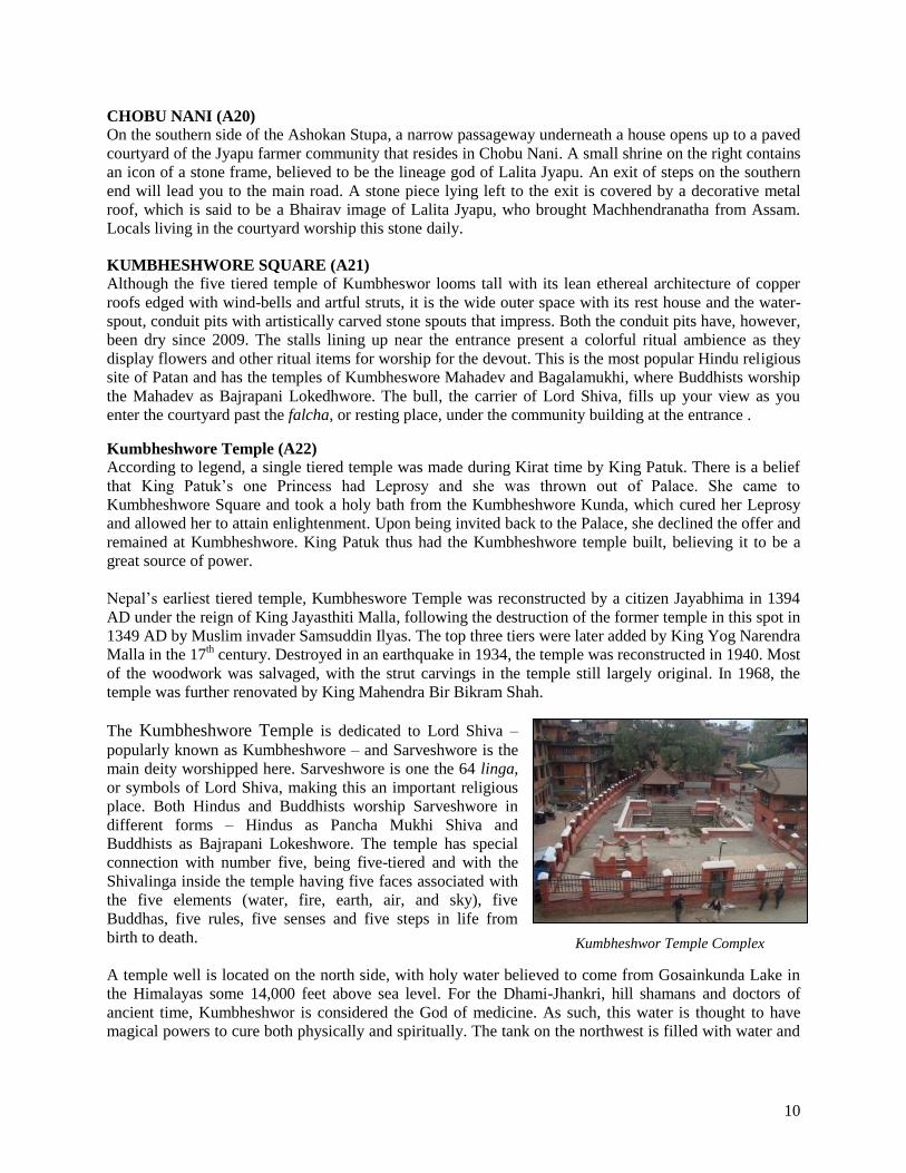
10
CHOBU NANI (A20)
On the southern side of the Ashokan Stupa, a narrow passageway underneath a house opens up to a paved
courtyard of the Jyapu farmer community that resides in Chobu Nani. A small shrine on the right contains
an icon of a stone frame, believed to be the lineage god of Lalita Jyapu. An exit of steps on the southern
end will lead you to the main road. A stone piece lying left to the exit is covered by a decorative metal
roof, which is said to be a Bhairav image of Lalita Jyapu, who brought Machhendranatha from Assam.
Locals living in the courtyard worship this stone daily.
KUMBHESHWORE SQUARE (A21)
Although the five tiered temple of Kumbheswor looms tall with its lean ethereal architecture of copper
roofs edged with wind-bells and artful struts, it is the wide outer space with its rest house and the water-
spout, conduit pits with artistically carved stone spouts that impress. Both the conduit pits have, however,
been dry since 2009. The stalls lining up near the entrance present a colorful ritual ambience as they
display flowers and other ritual items for worship for the devout. This is the most popular Hindu religious
site of Patan and has the temples of Kumbheswore Mahadev and Bagalamukhi, where Buddhists worship
the Mahadev as Bajrapani Lokedhwore. The bull, the carrier of Lord Shiva, fills up your view as you
enter the courtyard past the falcha, or resting place, under the community building at the entrance .
Kumbheshwore Temple (A22)
According to legend, a single tiered temple was made during Kirat time by King Patuk. There is a belief
that King Patuk’s one Princess had Leprosy and she was thrown out of Palace. She came to
Kumbheshwore Square and took a holy bath from the Kumbheshwore Kunda, which cured her Leprosy
and allowed her to attain enlightenment. Upon being invited back to the Palace, she declined the offer and
remained at Kumbheshwore. King Patuk thus had the Kumbheshwore temple built, believing it to be a
great source of power.
Nepal’s earliest tiered temple, Kumbheswore Temple was reconstructed by a citizen Jayabhima in 1394
AD under the reign of King Jayasthiti Malla, following the destruction of the former temple in this spot in
1349 AD by Muslim invader Samsuddin Ilyas. The top three tiers were later added by King Yog Narendra
Malla in the 17th century. Destroyed in an earthquake in 1934, the temple was reconstructed in 1940. Most
of the woodwork was salvaged, with the strut carvings in the temple still largely original. In 1968, the
temple was further renovated by King Mahendra Bir Bikram Shah.
The Kumbheshwore Temple is dedicated to Lord Shiva –
popularly known as Kumbheshwore – and Sarveshwore is the
main deity worshipped here. Sarveshwore is one the 64 linga,
or symbols of Lord Shiva, making this an important religious
place. Both Hindus and Buddhists worship Sarveshwore in
different forms – Hindus as Pancha Mukhi Shiva and
Buddhists as Bajrapani Lokeshwore. The temple has special
connection with number five, being five-tiered and with the
Shivalinga inside the temple having five faces associated with
the five elements (water, fire, earth, air, and sky), five
Buddhas, five rules, five senses and five steps in life from
birth to death.
A temple well is located on the north side, with holy water believed to come from Gosainkunda Lake in
the Himalayas some 14,000 feet above sea level. For the Dhami-Jhankri, hill shamans and doctors of
ancient time, Kumbheshwor is considered the God of medicine. As such, this water is thought to have
magical powers to cure both physically and spiritually. The tank on the northwest is filled with water and
Kumbheshwor Temple Complex
11
the Siva Kumbheswor, a wooden representation of Lord Shiva, is kept afloat during Janai Pumina
celebrations in August.
You may try to meet Mr. Madhav Shyam Sharma, the chief priest of Kumbheshwor temple to hear some
of the stories behind this majestic temple and about his experience of being the chief priest for over a
decade.
Banglamukhi Temple (A23)
Savor the art and craft of the woodworks under the first roof as you proceed around to the temple of
Baglamukhi on the south. One of the main structures to be viewed in Banglamukhi Temple is the
beautiful silver shrine dedicated to goddess Banglamukhi. Banglamukhi is one of the ten Maha Vidyas, or
aspects of the Divine Mother, and is a Shakti Pith, an icon with supernatural power. The shrine attracts
thousands of devotees, as many believe that the powerful goddess grants all of her devotees’ wishes.
JHYATAPO (A24)
The name Jhyatapo was derived from Newari language meaning wetland. There remains a platform at
Jhyatapo Lalitpur with four upright monolithic stone obelisks (A25), one of which is popularly thought to
be the nole, or horizontal post of the carrying basket of Lalit Jyapu. According to the local history of
Patan, Lalit Jyapu (Rathachakra) – from which 'Lalitpur' is derived – was the right and perfect one who
carried Machhendranatha from Kamaru Kamacchhya to Kathmandu Valley. There is also an idol face of
Lalit Jyapu carved into the stone wall with material items representing his supporting stick, as well as a
preserved shrine.
Lalit-pati (A26)
The Lalit pati was built in the early-18th century as a rest house for pilgrims to stay overnight free of cost.
This two-story brick building with beautifully carved five-fold wooden windows (ga jhya) stretching
across the length of the structure is managed and used by members of the Tandukar guthi social
organization, who gather and conduct all their ritual norms here. It is also the site where the neighborhood
Ganesh is worshipped. Lalit Pati overlooks an alley leading to the Kumbheshwore Temple.
For the Tandukar community and thus for Jhyatapo, the Yamari Purni full moon day in December is very
special. Farmers’ communities go around the neighborhoods of Jhyatapo, singing and playing their
traditional folk songs and tunes during the Yamari Purni festival marking the end of the rice harvest. A
special type of rice bread known as "Yohmari" is prepared and offered to locals. The Mataya festival of
light is also observed in this area.
SWOTHA (A27)
Swotha is a public square characterized by its set of courtyards known as “Yauta Griha”. The courtyards
and Swotha-chowk building are thought to have been built by Kirtisimha Malla, the first son of King
Siddhi Narasimha Malla of Patan in 1661 when Srinivas Malla ousted Kirtisimha from Sundarichowk and
became King.
Kirtisimha also built the three temples in the square. The three-tiered Radha-Krishna Temple (A28) is
the largest structure dominating the entire square, with its post-1934 domical roof that was earlier in
‘Sikhara’ style awaiting restoration. This early-18th century temple with the most intricately carved
wooden structures was restored a decade ago with the financial support from the Kathmandu Valley
Preservation Trust (KVPT) and Lalitpur Sub-Metropolitan City. The chariot festival of Kumari visit the
Krishna temple, possibly indicating that Siddhi Narasimha himself may have lived here as a rajarshi, or
King and royal sage of Patan.
12
The pointed top of the shikhara-style Krishna Mandir Temple collapsed during the earthquake of 1934,
and underwent a less than complete renovation. The temple was given an onion-shaped plaster top,
looking strange and out of proportion with the bottom’s stone finish.18
Across the road, the two-tiered Manikeshav Narayan Temple is dedicated to the Hindu god of
preservation Narayan. The exquisitely carved temple struts are all inscribed, telling the story of Lord
Vishnu’s reincarnations and associated events. Next to the Manikeshav Narayan Temple is a two-story
prayer house with an impressive stone image of Garuda (the carrier of Vishnu), where devotional hymns
and songs are sung every year at the Ekadashi festival marking Vishnu’s awakening.
Corner Window of Swotha (A29) Part of the three interconnected courtyards, there is a well-known and special type of intricately carved
corner window on the third floor of an old Brahmin house at Swotha neighborhood. Dating back to the
late 17th century, the corner window is one of only three representations in the entire city of medieval
Patan’s distinguished woodcraft. With the launch of efforts to revive the Swotha courts to their earlier
glory, the corner window was consolidated in 1997 with assistance from the UNDP Partnership for
Quality Tourism Project. As of late, there has also been restoration and
adaptation of the court wings for tourism, restaurants, and hotel rooms
(B&B). Ideas have been presented from private entrepreneurs to transform
the whole Swotha complex into a high-class specialty accommodation cum
service center.
Shrestha, Rajbanshi, Sharma, Amatya and Newar Brahmins mostly live in
Swotha, with the main guthi social organizaiton comprised of a group of
300 members.
Moving ahead past Swotha, handicraft and curio shops on the street will
give way to a large public open space with temples, water conduits, rest
houses, traditional buildings, restaurants, and vendor shops. This will lead
you to the next site, Patan Durbar Square.
18
www.patantours.com.
Corner window at Swotha
13
Heritage Route B: ARTISANS AND ARCHITECTURE OF EAST PATAN
According to legend, the beautiful Lalitaranya Van forest was cut to make space for human settlement.
The city of Lalitpur or Patan – named after this forest and meaning beautiful city – is known for its rich
cultural heritage, particularly its tradition of arts and crafts. The city is divided into spatial units or
neighborhoods called toles, and is characterized by particular communities inhabiting certain sectors of
the city. Among the many interesting areas of Patan, this route has been developed to highlight the
traditional lifestyles, practicing artisans and important heritage in East Patan.
Starting your walk from the bus park and turning left, you will enter the east side of Patan, which is one
of the earliest settled areas in the city. The first stop on this heritage route is Guita, a beautiful paved court
composed of stupas, ponds, temples and bihars, or Buddhist monasteries.
GUITA (B1)
The Guita court welcomes you with its two stupas characterized by very flat domes and almost vertical
sides sharply flared to join the medhi, or base. While quite different than most stupas, these stupas reflect
a style popular in the transitional and early Malla Periods (12th-18
th century).
19
The name Guita-tol is likely rooted in a legendary nine-storied temple in the neighborhood. In local
Newari, gu means nine and tala land. In addition to its nine stories, Guita-tol has many additional
connections to the number nine, including its nine wells, nine chaityas or shrines, nine hitis or water-
spouts, a pati or traditional rest house for pedestrians with nine days between the columns, and a tradition
of reciting Nava Grantha, or the nine scriptures.
It is believed that Guita was established by the great King
Sarvananda. According to legend, King Sarvananda had
invited Dipankara Buddha to receive Pindapatra Dana, or
an offering. The Buddha, however, chose to receive
offering from an old and poor woman before going to the
King’s palace. Out of curiosity, the king asked why the
Buddha preferred her offering over his lavish
arrangement. The Buddha replied, “Dana is best when
offered with a pure motivation, which is earned by doing
own physical labor, no matter what the quantity.” Inspired
to earn through his own physical labor, the king searched
for the hardest job, finally settling as a blacksmith. After earning enough, he invited back the Buddha for
offering. The day of this offering is marked as an auspicious one and believed to have started the tradition
of Yala Panchadana, an offering observed on the eighth day after the August new moon. The old lady
who inspired the king to offer with pure motivation is venerated, with her image proudly displayed at the
Guita bahi,20
or monastery.
Today, the Guita monastery draws throngs of devotees through its annual observation of two major
festivals. Thousands of people come to see the sacred water-spout called “dhanlyahiti” during Gunla, or
the full moon of August as well as the ancient Pauwa Chitra painting depicting the full story of King
Sarvananda during the Indra Jatra festival every September.21
19
Mary Slusser, 1982. 20
Bahi is a two-story monastery complex for celibate monks, usually situated near the fringe of traditional town. 21
Mary Slusser, 1982.
Stupa at Guita-tol
14
Locals claim that the Guita monastery is one of the oldest in East Patan. A number of inscriptions around
the area refer to these foundations. The oldest one is dated 1024 AD and attached to the large stupa
outside the monastery complex. This monastery is an ancient Buddhist site with three monasteries
clustered together, with traces of foundation suggesting that there may originally have been more than just
the remaining three.
Prathama Sri Mahabihar (B2) The best preserved of the three remaining monasteries for celibate monks at Guita, Prathama Sri
Mahabihar has the most recent foundation. While an entirely closed courtyard, the only thing remaining
of the original monastery structure is the shrine of the main deity, kwapa dyo. Chakrasamvara is the
lineage deity of the sangha (clan belonging to the monastery) and worshipped at the monastery. The clan
observes the annual festival on the full moon day of the month of Baisakh (April).
Basucchashil Mahabihar (B3) The second monastery at Guita, Basucchashil Mahabihar is situated in a courtyard directly to the north of
the Prathama Sri Mahabihar. Only the western arm of the courtyard, which houses the shrine of the kwapa
dyo, remains in its original form. The members groups of this monastery call themselves “brahmacharya
vikschu”.
Gustala Mahabihar (B4) The third Guita monastery is Gustala Mahabihar, which was once a magnificent temple of nine roofs. The
plinth, or base of the super structure serves as tangible evidence of a unique character dissimilar to any of
the other monasteries here.
As you make your way through Pinche bahal, on your right you will see a hexagon shaped water-spout –
which is itself special – and the two rest houses that add further value to the place.
Su Baha Hiti and Chaitya (B5)
Believed to be nearly 5,334 years old, the Su baha stone water-spout is highly valued by local Hindus and
Buddhists through its association with many annual rituals and festivals. The main source of water, which
has nearly stopped, is believed to be the holy Hindu place Silu. Devotees continue to flock to the water-
spout on the day of Navaratri, worshipping and then bathing at the spout.22
An image of mother goddess
Vaisnavi from the third or fourth century may be seen in the fountain of Subahal.23
The two Lichchhavi24
chaityas, or shrines on the water-spout
premises are not to be missed. According to an inscription, the
shrine on the raised platform is one of its earliest kind, dating
back to 749 AD. There is an image of a lotus as the base or throne
for the upper portion of the shrine (that contains a dome, drum
and finial), believed to be the first of its kind. This is thought to
have been repeated only on the shrine at Bhinchhe bahal and the
one at Guita Bahi.25
22
Resource: Krishna Lal Maharjan. 23
Lain Singh Bangdel, 1982. 24
Lichchhavi period is from 1st-9
th century.
25 Neils Gutschow, 1997.
Su Baha water-spout and shrines
15
Shakya – families traditionally linked to the carpentry profession – were the major clan that used to live
around the water-spout, but they have all migrated. The water-spout remains preserved by the locals and
the shrines are worshipped during the Mataya festival of light in August, Desi puja, and Indra Jatra
festival in September.
SU BAHA (B6)
There are two Lichchhavi inscriptions near Su baha dated 1062 and 1067 AD, but the earliest reference to
the shrine is from 1142. Also known as “Sarvaka” and “Salake”, Su baha is famous for the scary and
strange rituals practiced on its premises. The monastery was originally built on a cremation ground, and
you can still today see traces of a rectangular cremation area in front of the sanctuary.
While bali, or human offerings were made in the court in the past, nowadays human flesh is offered
instead on the ninth day of Dashain in October. Many people from
the monastery as well as outside take part in this event, believing
that physical problems stemming from the upper part of the body
may be cured with an offering of one’s flesh on Dashain. One of
the many gods that you will see in Su baha, the Gyanpu dya, or
scary god is one of the more prominent ones because of the scary
stories behind this place.26
Even today, outsiders are not allowed
to enter the courtyard at night due to these ancient legends, and
three or four locals are responsible for guarding this courtyard.
The Purna Sundar Baha is situated directly behind the main
shrine of Su baha. Over the shrine’s doorway is a small wooden torana, or gateway, dated 1942 depicting
Akobhya Buddha. The annual festival on the third day of the bright half of the month of Kartik (October)
is celebrated at this monastery.
Thakun Baha/ Ratnajaya Vihar, with an inscription claiming that it was found in 1767, is located in the
northwest part of the Su baha complex. The annual festival on the twelfth day of the dark half of the
month of Baisakh (April) is celebrated at this monastery.
Shakya families who work as carpenters as well as Jyapu farmer families who have their farmland in
Imadol, Sanogaun and Harisiddhi reside in Su baha.
BHINCHHEN BAHAL27
(B7)
Bhinchhen Bahal, also known as Vishnuk Chhen Bihar and Mayur
Barna Bihar, is a large complex with a sanctuary built in 1939 AD.
According to legend, this monastery from the Malla era is built
where an image of the god Vishnu was buried, discovered when a
peacock rested on that spot.
The clans of Varjracharya and Shakya reside in this monastery.
Their guthi,28
or social organization, annually observes three main
festivals here, with their associated rituals and feasts, namely the full moon of Baisakh in April, the full
moon of Poush in December, and the twelfth day of the bright half of Magh in January.29
26
Resource: Yagra Raj Shakya & Singh Raj Shakya. 27
A bahal or bihar is a complex of two-story buildings, one of which contains a sanctuary, surrounding a courtyard. 28
Guthi is a social organization of people belonging to a neighborhood and caste. 29
John K. Locke, 1985.
Sanctuary of Su Baha
Sanctuary of Bhinchhen Bahal
16
The Stone Sculptors of Bhinchhen Bahal
Nepal’s most ancient craft, stone sculpting, is still actively practiced in Bhinchhen Bahal. Although
stonework had already developed in Kathmandu Valley, residents of Bhinchhen Bahal claim that the
making of stone sculptures in Patan began at this monastery. There are at least 10 families here still
working in this art form, creating stupas, pillars, water-spouts, inscriptions, protective lions, griffins and
gods. The stone used in Bhinchhen Bahal is primarily granite sourced from quarries in Dakshinkali,
Hattiban, Farping and Kharpa, located on the periphery of Lalitpur District. And the metal tools used for
the stone craft are mostly in Patan, with the exception of a special tool imported from Jaipur, India that is
used for diamond cuts. Some of the artisans work and sell from their homes while others have shops in
the Magalbazar, Saugal and Sundhara areas.
Inside the monastery’s large gate and to the left you will see Shakya Stone Craft, where Manoj Shakya
continues the stone sculpting tradition of his ancestors. Though Mr. Shakya does not have a shop, he sells
his work through local stores in Kathmandu and abroad. He was one of the key people involved in
establishing Bhinchhe Bahal Prastar Kalakar Samuha, an organization aiming to train and encourage the
younger generation to continue this ancestral occupation of stone sculpting.
Suju Bajracharya is similarly continuing her family tradition of stone sculpting, being the first woman to
establish herself as a professional stone sculptor in the area. Despite not having received a formal
education, she was honored in 1998 with a Gorakha Dashin Bahu felicitation from King Birendra for her
contributions to the field for the past 22 years. Working from home in the northeast corner of the
Bhinchhen Bahal, she sells to shops in Kathmandu and abroad as the enterprise Newa Stone Craft.
The home of Rabin Bajracharya in Bhinchhen Bahal can be identified by the stacks of stone tablets in
front of the house. He is from one of very few families in the monastery whose ancestral occupation was
not related to stonework. Despite being a woodcarver, the surroundings sparked an interest in stone art,
encouraging him to take courses in stone sculpting. Mr. Bajracharya runs a business along with his
siblings, primarily selling to clients from abroad.
Pilachhen- Kachha Baha of Bhinchhen Baha (B8) Kachha baha or the branch of Bhinchhen Bahal is the residence of the Maharjan families who have their
farmland around Sanogaon, Imadol. With people decreasingly involved in the ancestral occupation of
farming, the local clubs have recently re-constructed the guthi social organization building, and about 25
to 30 people are currently involved in the guthi.
The traditional dance “Khya Pyakha” is a board dance of the Kankal and Rakchyas, the ghostly figures,
and has become the main attraction of Kachha baha in Bhinchhen Bahal. This dance continues to be
performed along the route where the Khyaks, or ghosts were believed to travel.
DUPAT LACHI30 (B9)
Dupat is the largest of Patan’s 45 toles, or compact traditional neighborhoods, and is known for having
one of the city’s biggest community buildings. Residents claim that their population is the most educated
in the city since the first school in Patan was established here in 1956.31
The importance ascribed to Dupat
is illustrated by an elderly resident of this neighborhood being given the honor of cutting down the tree
that will be used to make the chariot in the important Machhendranatha festival.32
30
Lachi is an open public square. 31
Resource: Mr. Hari Gobinda Maharjan.

17
The majority of Dupat’s population is from the Jyapu farming caste, and they observes the major feasts on
Ganesh Jatra, Indra Jatra in September, Mother’s Day in May and Si: Guthi in Chaitra in April. Although
the traditional buildings have been replaced by modern concrete structures,
community buildings remain important for conducting these Newari festivals
in the neighborhood.
The Legend of Dupat Ganesh Temple
Built in 1708 AD, the Ganesh temple at the corner of Dupat complex has
two very rare finials. According to legend, the Jyapu farming community in
Dupat used to hold a special feast on Si: Guthi (still held every year in
April), attendance to which was prohibited for other communities. A king in
Patan was once said to be curious about the sacred procession, and set out
for Dupat on horseback. On his way, he was thrown from his horse.
Believing the accident to have been caused by a supernatural power, he
donated the second finial to the temple as a plea for forgiveness.
CHAPAT GANESH (B10)
The three-tiered Chapat Ganesh temple, built in 1745 AD, depicts Malla architecture33
with its terracotta
roof supported by highly decorative struts intricately carved with imagery of Bhairav and Matrika. The
image of Ganesh is placed in the centre of the sanctum that
has entrances from three directions. Residents of the Chapat
area primarily comprise members of the Jyapu farming
community, with the guthi social organization conducting a
feast at Chapat lachi in the month of Baisakh (April-May).
Chapat Ganesh is actively worshipped by both locals and
outsiders, especially visited upon losing things inside one’s
house. Ganesh is called upon in these situations, with some
rice and money offered at this temple when the items are
found.
CRAFTMAN AT BAKU BAHA
Making your way from Chapat Ganesh to Yangu Bahal, you will see a small shop on your left displaying
woodcarvings. Traditionally belonging to a farmer family, Sanu Kaji Maharjan trained in woodcarving
for four years before opening this shop at his house. You can watch him transforming small blocks of
wood into pieces of art, which are sold to local shops.
STREETSCAPE FROM YANGU BAHAL TO KUTI SAUGAL
Before reaching the open court of Yangu Bahal, there will be a stone slab on the right next to a small
temple. The inscription is dated from 679 AD and reads, “Narendra Deva who resides in
Bhadradiwasbhawan (probably at Guita) declared that people of Yangu Bahal served him well during the
construction of a water conduit thus, they are free from labor works. This place was declared as a
Fortified Place.”
In historic times, Kuti Saugal was a place where people beat paddy grain to extract rice.34
‘Kuti’ refers to
the wooden tool used in this process. The kutis have now been replaced by the modern mill in this area
that continues the rice production.
33
Malla Era is from 12th
to 18th
century. 34
Kuti is name of the wooden tool used for beating rice grains.
Dupat Ganesh Temple
Chapat Ganesh Temple and lachi in front
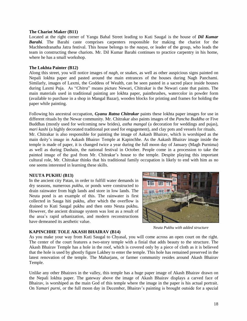
18
The Chariot Maker (B11)
Located at the right corner of Yangu Bahal Street leading to Kuti Saugal is the house of Dil Kumar
Barahi. The Barahi caste comprises carpenters responsible for making the chariot for the
Machhendranatha Jatra festival. This house belongs to the naaya, or leader of the group, who leads the
team in constructing these chariots. Mr. Dil Kumar Barahi continues to practice carpentry in his home,
where he has a small workshop.
The Lokhta Painter (B12) Along this street, you will notice images of nagh, or snakes, as well as other auspicious signs painted on
Nepali lokhta paper and pasted around the main entrances of the houses during Nagh Panchami.
Similarly, images of Laxmi, the Goddess of Wealth, can be seen pasted in a sacred place inside houses
during Laxmi Puja. As “Chitra” means picture Newari, Chitrakar is the Newari caste that paints. The
main materials used in traditional painting are lokhta paper, paintbrushes, watercolor in powder form
(available to purchase in a shop in Mangal Bazar), wooden blocks for printing and frames for holding the
paper while painting.
Following his ancestral occupation, Gyanu Ratna Chitrakar paints these lokhta paper images for use in
different rituals by the Newar community. Mr. Chitrakar also paints images of the Pancha Buddha or Five
Buddhas (mostly used for welcoming new brides), astha mangal (a decoration for weddings and pujas),
mari kashi (a highly decorated traditional pot used for engagement), and clay pots and vessels for rituals.
Mr. Chitrakar is also responsible for painting the image of Aakash Bhairav, which is worshiped as the
main deity’s image in Aakash Bhairav Temple at Kapinchhe. As the Aakash Bhairav image inside the
temple is made of paper, it is changed twice a year during the full moon day of January (Magh Purnima)
as well as during Dashain, the national festival in October. People come in a procession to take the
painted image of the god from Mr. Chitrakar’s house to the temple. Despite playing this important
cultural role, Mr. Chitrakar thinks that his traditional family occupation is likely to end with him as no
one seems interested in learning these skills.
NEUTA PUKHU (B13)
In the ancient city Patan, in order to fulfill water demands in
dry seasons, numerous pukhu, or ponds were constructed to
drain rainwater from high lands and store in low lands. The
Neuta pond is an example of this. The rainwater is first
collected in Sauga hiti pukhu, after which the overflow is
drained to Kuti Saugal pukhu and then onto Neuta pukhu.
However, the ancient drainage system was lost as a result of
the area’s rapid urbanization, and modern reconstructions
have demeaned its aesthetic value.
KAPINCHHE TOLE AKASH BHAIRAV (B14)
As you make your way from Kuti Saugal to Chyasal, you will come across an open court on the right.
The center of the court features a two-story temple with a finial that adds beauty to the structure. The
Akash Bhairav Temple has a hole in the roof, which is covered only by a piece of cloth as it is believed
that the hole is used by ghostly figure Lakhey to enter the temple. This hole has remained preserved in the
latest renovation of the temple. The Maharjans, or farmer community resides around Akash Bhairav
Temple.
Unlike any other Bhairavs in the valley, this temple has a huge paper image of Akash Bhairav drawn on
the Nepali lokhta paper. The gateway above the image of Akash Bhairav displays a carved face of
Bhairav, is worshiped as the main God of this temple where the image in the paper is his actual portrait.
On Yamari purni, or the full moon day in December, Bhairav’s painting is brought outside for a special
Neuta Pukhu with added structure
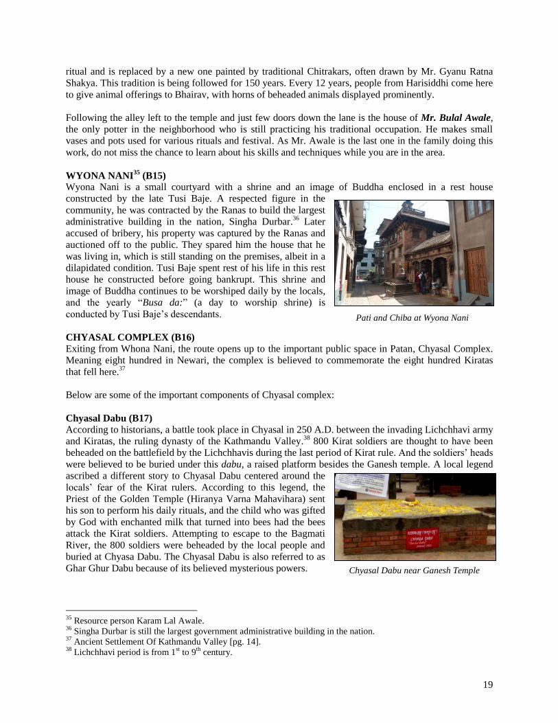
19
ritual and is replaced by a new one painted by traditional Chitrakars, often drawn by Mr. Gyanu Ratna
Shakya. This tradition is being followed for 150 years. Every 12 years, people from Harisiddhi come here
to give animal offerings to Bhairav, with horns of beheaded animals displayed prominently.
Following the alley left to the temple and just few doors down the lane is the house of Mr. Bulal Awale,
the only potter in the neighborhood who is still practicing his traditional occupation. He makes small
vases and pots used for various rituals and festival. As Mr. Awale is the last one in the family doing this
work, do not miss the chance to learn about his skills and techniques while you are in the area.
WYONA NANI35
(B15)
Wyona Nani is a small courtyard with a shrine and an image of Buddha enclosed in a rest house
constructed by the late Tusi Baje. A respected figure in the
community, he was contracted by the Ranas to build the largest
administrative building in the nation, Singha Durbar.36
Later
accused of bribery, his property was captured by the Ranas and
auctioned off to the public. They spared him the house that he
was living in, which is still standing on the premises, albeit in a
dilapidated condition. Tusi Baje spent rest of his life in this rest
house he constructed before going bankrupt. This shrine and
image of Buddha continues to be worshiped daily by the locals,
and the yearly “Busa da:” (a day to worship shrine) is
conducted by Tusi Baje’s descendants.
CHYASAL COMPLEX (B16)
Exiting from Whona Nani, the route opens up to the important public space in Patan, Chyasal Complex.
Meaning eight hundred in Newari, the complex is believed to commemorate the eight hundred Kiratas
that fell here.37
Below are some of the important components of Chyasal complex:
Chyasal Dabu (B17)
According to historians, a battle took place in Chyasal in 250 A.D. between the invading Lichchhavi army
and Kiratas, the ruling dynasty of the Kathmandu Valley.38
800 Kirat soldiers are thought to have been
beheaded on the battlefield by the Lichchhavis during the last period of Kirat rule. And the soldiers’ heads
were believed to be buried under this dabu, a raised platform besides the Ganesh temple. A local legend
ascribed a different story to Chyasal Dabu centered around the
locals’ fear of the Kirat rulers. According to this legend, the
Priest of the Golden Temple (Hiranya Varna Mahavihara) sent
his son to perform his daily rituals, and the child who was gifted
by God with enchanted milk that turned into bees had the bees
attack the Kirat soldiers. Attempting to escape to the Bagmati
River, the 800 soldiers were beheaded by the local people and
buried at Chyasa Dabu. The Chyasal Dabu is also referred to as
Ghar Ghur Dabu because of its believed mysterious powers.
35
Resource person Karam Lal Awale. 36
Singha Durbar is still the largest government administrative building in the nation. 37
Ancient Settlement Of Kathmandu Valley [pg. 14]. 38
Lichchhavi period is from 1st to 9
th century.
Pati and Chiba at Wyona Nani
Chyasal Dabu near Ganesh Temple

20
This Chyasal Dabu is a raised 5 by 5 foot platform with a Shiva Linga mounted above it. Shiva Linga is
usually built in memory of the dead, so this cultural tradition may have similarly been followed by the
Lichchhavi rulers at that time. Another theory of the use of a Shiva Linga here centers around Emperor
Ashok, who built numerous Ashok shrine and megaliths after coming to regret his past killings of such
large numbers of people.
Every year in the month of October, a small group of people gathers at Chyasal Dabu at midnight to
perform religious ritual and have a feast.
Gaja Laxmi Statue in Nayo hiti (B18)
A steel cage protects an ancient statue of Gaja Laxmi, or the “Goddess of wealth”, elegantly standing at
ground level to the right of the hiti, or water-spout with a lotus flower in hand. The stone carving is worn,
with two barely visible elephants (gaja in Sanskrit) almost floating above Laxmi’s shoulders pouring
water for her. Some believe the statue to be from 250-280 BC and locals claim it to be the first stone
sculpture of Nepal, which was followed by development of prominent stone craftsmanship in the country.
According to eminent Nepali artist and art historian Bangdel (1982), the image of Gaja Laxmi is to be of
first century BC. The Nayo water-spout dried up about 7 or 8 years ago, with one local attributing this to
the construction of nearly 80 wells around the Chyasal area that may have blocked the veins of the water
supply system.
Takha (long) Pati adhering to Nayo hiti (B19)
Patis are traditional public rest houses for pedestrians. With an image of Narayan, the Takha Pati – built
in 1731 AD – is also known as Narayan Pati. It is used mainly for citing bhajan, or devotional songs, as
background music for the shadow drama held annually at the Awah Guthi Chappa. Two rest houses were
built here joined longitudinally but at different floor levels. They were then reconstructed as a single
structure at the same level during a renovation in 2000.
Bhairav Sattal/ Awah Guthi Chapa (B20)
Bhairav Sattal is one of the biggest structures in the court, believed to have been made from a single tree.
Distinct features of this community building include the huge terracotta roof and row of lattice windows,
as well as the open plan on both floors that caters to mass gatherings. Bhairav Sattal displays Malla
architecture with icons of gods: Bhairav, Nasa dyo and Ganesh.
According to local custom, people of lower castes as well as menstruating women are prohibited from
entering the building. And during gatherings, the first scoop of food should be offered to the god before
anyone tastes it. It is believed that if this is not done, people will face fatal consequences.
The Awales, or pottery making community, use this building for
community gatherings of up to 1,500 people. Such gatherings
are mobilized around social guthi39
functions for people
belonging to a particular neighborhood and caste, during the
annual dewali puja or community festival, and to celebrate the
commencement of the community’s Thakali (eldest person) and
Naaya (leader).
While Bhairav Sattal can be renovated, floors cannot be added.
The building adhering to the community building is used for
storing ancient clay utensils made by the Awales. One
masterpiece held here is a 355-year old jharon, or water
39
Guthi is a social organization of people belonging to a neighborhood and caste.
Bhairav Sattal and lachi in front
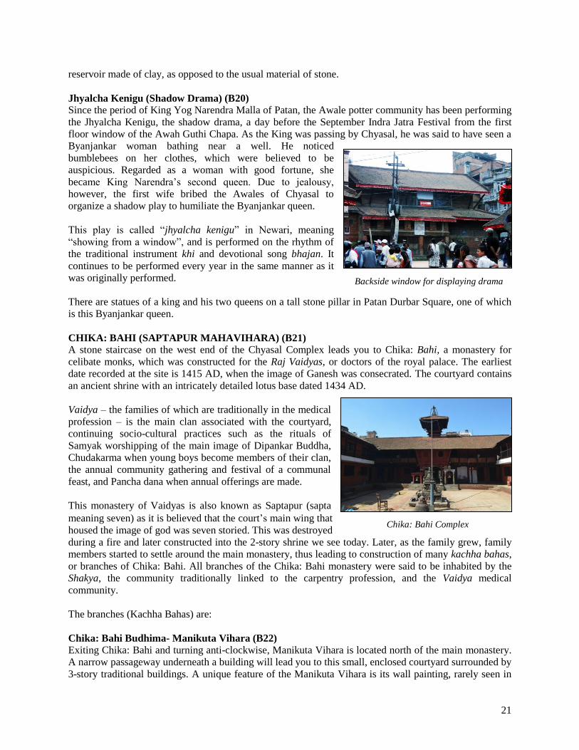
21
reservoir made of clay, as opposed to the usual material of stone.
Jhyalcha Kenigu (Shadow Drama) (B20)
Since the period of King Yog Narendra Malla of Patan, the Awale potter community has been performing
the Jhyalcha Kenigu, the shadow drama, a day before the September Indra Jatra Festival from the first
floor window of the Awah Guthi Chapa. As the King was passing by Chyasal, he was said to have seen a
Byanjankar woman bathing near a well. He noticed
bumblebees on her clothes, which were believed to be
auspicious. Regarded as a woman with good fortune, she
became King Narendra’s second queen. Due to jealousy,
however, the first wife bribed the Awales of Chyasal to
organize a shadow play to humiliate the Byanjankar queen.
This play is called “jhyalcha kenigu” in Newari, meaning
“showing from a window”, and is performed on the rhythm of
the traditional instrument khi and devotional song bhajan. It
continues to be performed every year in the same manner as it
was originally performed.
There are statues of a king and his two queens on a tall stone pillar in Patan Durbar Square, one of which
is this Byanjankar queen.
CHIKA: BAHI (SAPTAPUR MAHAVIHARA) (B21)
A stone staircase on the west end of the Chyasal Complex leads you to Chika: Bahi, a monastery for
celibate monks, which was constructed for the Raj Vaidyas, or doctors of the royal palace. The earliest
date recorded at the site is 1415 AD, when the image of Ganesh was consecrated. The courtyard contains
an ancient shrine with an intricately detailed lotus base dated 1434 AD.
Vaidya – the families of which are traditionally in the medical
profession – is the main clan associated with the courtyard,
continuing socio-cultural practices such as the rituals of
Samyak worshipping of the main image of Dipankar Buddha,
Chudakarma when young boys become members of their clan,
the annual community gathering and festival of a communal
feast, and Pancha dana when annual offerings are made.
This monastery of Vaidyas is also known as Saptapur (sapta
meaning seven) as it is believed that the court’s main wing that
housed the image of god was seven storied. This was destroyed
during a fire and later constructed into the 2-story shrine we see today. Later, as the family grew, family
members started to settle around the main monastery, thus leading to construction of many kachha bahas,
or branches of Chika: Bahi. All branches of the Chika: Bahi monastery were said to be inhabited by the
Shakya, the community traditionally linked to the carpentry profession, and the Vaidya medical
community.
The branches (Kachha Bahas) are:
Chika: Bahi Budhima- Manikuta Vihara (B22)
Exiting Chika: Bahi and turning anti-clockwise, Manikuta Vihara is located north of the main monastery.
A narrow passageway underneath a building will lead you to this small, enclosed courtyard surrounded by
3-story traditional buildings. A unique feature of the Manikuta Vihara is its wall painting, rarely seen in
Chika: Bahi Complex
Backside window for displaying drama
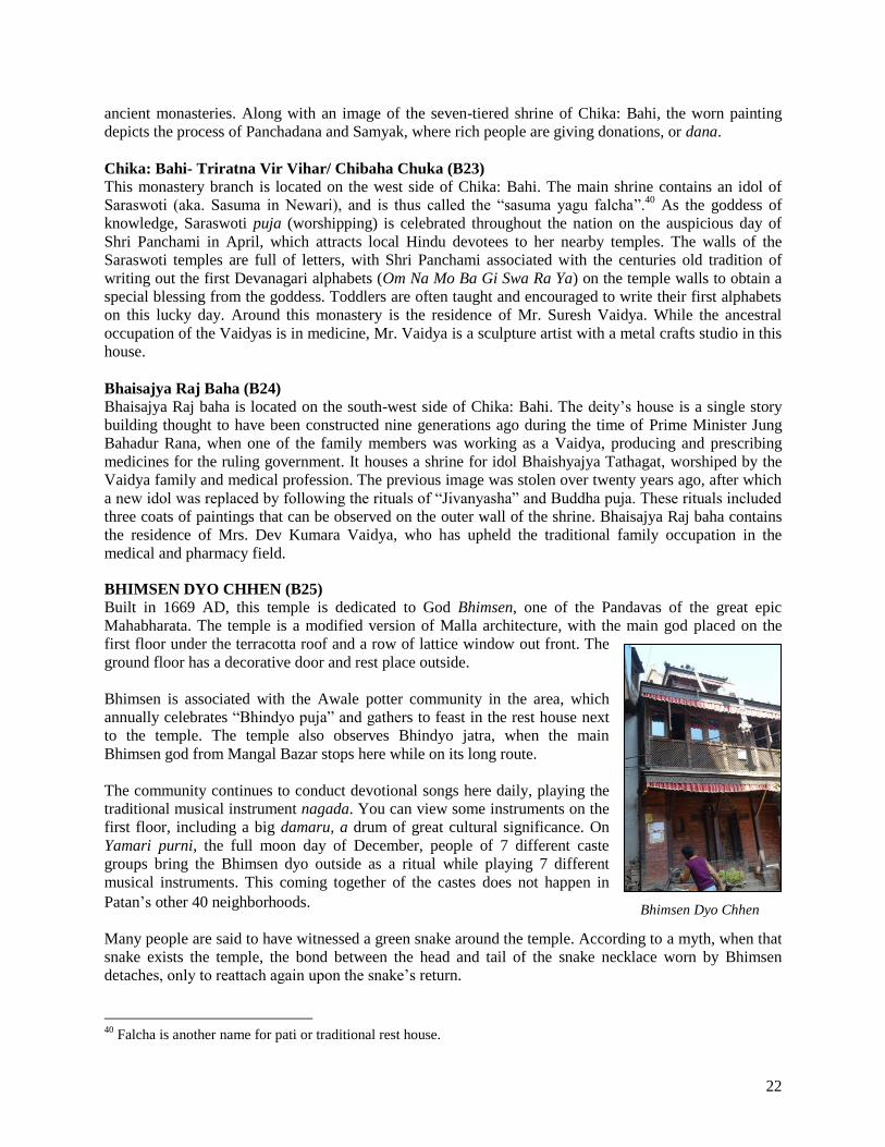
22
ancient monasteries. Along with an image of the seven-tiered shrine of Chika: Bahi, the worn painting
depicts the process of Panchadana and Samyak, where rich people are giving donations, or dana.
Chika: Bahi- Triratna Vir Vihar/ Chibaha Chuka (B23)
This monastery branch is located on the west side of Chika: Bahi. The main shrine contains an idol of
Saraswoti (aka. Sasuma in Newari), and is thus called the “sasuma yagu falcha”.40
As the goddess of
knowledge, Saraswoti puja (worshipping) is celebrated throughout the nation on the auspicious day of
Shri Panchami in April, which attracts local Hindu devotees to her nearby temples. The walls of the
Saraswoti temples are full of letters, with Shri Panchami associated with the centuries old tradition of
writing out the first Devanagari alphabets (Om Na Mo Ba Gi Swa Ra Ya) on the temple walls to obtain a
special blessing from the goddess. Toddlers are often taught and encouraged to write their first alphabets
on this lucky day. Around this monastery is the residence of Mr. Suresh Vaidya. While the ancestral
occupation of the Vaidyas is in medicine, Mr. Vaidya is a sculpture artist with a metal crafts studio in this
house.
Bhaisajya Raj Baha (B24)
Bhaisajya Raj baha is located on the south-west side of Chika: Bahi. The deity’s house is a single story
building thought to have been constructed nine generations ago during the time of Prime Minister Jung
Bahadur Rana, when one of the family members was working as a Vaidya, producing and prescribing
medicines for the ruling government. It houses a shrine for idol Bhaishyajya Tathagat, worshiped by the
Vaidya family and medical profession. The previous image was stolen over twenty years ago, after which
a new idol was replaced by following the rituals of “Jivanyasha” and Buddha puja. These rituals included
three coats of paintings that can be observed on the outer wall of the shrine. Bhaisajya Raj baha contains
the residence of Mrs. Dev Kumara Vaidya, who has upheld the traditional family occupation in the
medical and pharmacy field.
BHIMSEN DYO CHHEN (B25)
Built in 1669 AD, this temple is dedicated to God Bhimsen, one of the Pandavas of the great epic
Mahabharata. The temple is a modified version of Malla architecture, with the main god placed on the
first floor under the terracotta roof and a row of lattice window out front. The
ground floor has a decorative door and rest place outside.
Bhimsen is associated with the Awale potter community in the area, which
annually celebrates “Bhindyo puja” and gathers to feast in the rest house next
to the temple. The temple also observes Bhindyo jatra, when the main
Bhimsen god from Mangal Bazar stops here while on its long route.
The community continues to conduct devotional songs here daily, playing the
traditional musical instrument nagada. You can view some instruments on the
first floor, including a big damaru, a drum of great cultural significance. On
Yamari purni, the full moon day of December, people of 7 different caste
groups bring the Bhimsen dyo outside as a ritual while playing 7 different
musical instruments. This coming together of the castes does not happen in
Patan’s other 40 neighborhoods.
Many people are said to have witnessed a green snake around the temple. According to a myth, when that
snake exists the temple, the bond between the head and tail of the snake necklace worn by Bhimsen
detaches, only to reattach again upon the snake’s return.
40
Falcha is another name for pati or traditional rest house.
Bhimsen Dyo Chhen

23
JABAR AJA AND AJI PATI (B26)
Aja and Aji mean grandfather and grandmother respectively in Newari, and Jabar is a name. This rest
house on the left of the alley was constructed by an old Awale couple for pedestrians to rest. An icon in a
niche of the rest house shows the couple after whom the site is named joining hands. The rest house has a
terracotta roof and wood and brick as the main construction materials. Despite being a small structure, it
has a guthi social organization for its property maintenance. The Jabar Aja and Aji Pati is used today to
conduct traditional Samaybaji, Newari food offerings during the Indra Jatra and Machhendranatha Jatra
festival.
TULASI FO NANI (B27)
This courtyard is named after Tulsi, the holy basil, which is planted in a cemented block. The plant is
worshipped daily by the people living both in as well as outside of the courtyard.
According to Mr. Bagacha Awale, those living in this neighborhood are largely Awale, or traditional
pottery makers. While only Awales were allowed to make bricks during the Rana period, few practice this
occupation today.
As you follow this route, a narrow alley on your left will lead you to Wam Bahal, which houses one of the
masterpieces of Patan’s stone craft tradition.
WAM BAHAL (B28)
Though the foundation date of this monastery is uncertain, a palm leaf manuscript dated 1441 AD
mentions a Vajracharya from this monastery. The main building is on the south side of the complex with
a finely carved doorway surmounted by a gateway depicting Buddha and metal flags on both sides.41
The
first story has five fold windows and two small windows on both sides, above which is a threefold lattice
window and wooden struts supporting the roof. On top is a tiered tower with tile roof and a finial. The
idol of main god (kwapa dyo) is a north facing image of Aksobhya.
The courtyard contains a 17th century Lichchhavi shrine,
considered one of the best shrines in Patan. The shrine has a
two-story base, featuring Buddha on the lower niches and
Vairochana on the upper niches. The niche frame is decorated
with floral design by a crowning Kirtimukha in the center. A
special feature of this shrine is the rare 11-tiered finial, with
only one similar known to exist in Mahabouddha, Patan.42
It is important to note that a shrine is considered a living being
in Newari culture, necessitating three rituals when conducting
renovations. First, the spirit of the shrine must be removed and placed in a flask before initiating the
renovation. Once the shrine is considered “dead,” the craftsmen start dismantling the structure. The
foundation is then worshipped through an offer of jewels. Lastly, upon completing the construction, a
ceremony is held to reinstall the spirit. 43
The Wam Bahal courtyard belongs to the Shakya44
and Vajracharya clans living around the courtyard.
From birth to death, clan members take turns every 15 days to conduct daily rituals in this courtyard. The
most important of these rituals is Chudakarma, which formally makes young boys members of the
41
John K. Locke, 1985. 42
Neils Gutschow, 1997. 43
Neils Gutschow, 1997. 44
Shakya are families traditionally linked to the carpentry profession.
Wam Bahal Complex
24
community. As an example of the patriarchal family structure, women from the community are not
allowed to enter the sanctuary. However, the local women’s group has started to celebrate Buddha puja on
the first day of Nepali month in the courtyard. Other annual rituals practiced at Wam Bahal include Guthi
puja during the second week of Poush in December, the Mataya festival of lights in August, Baha puja
and Dipankar puja.
While Shakyas and Varjracharyas were traditionally priests and tailors, their professions have diversified.
Today you will hear the sounds of metal work in the courtyard, with those engaged mostly specialized in
silver bowls and metal statues. One of the families that used to sew dresses for the royal family is now
engaged in the profession of teaching, with the son (Mr. Rajiv Vajracharya) currently a lecturer of
mathematics.
MUSA GANESH TEMPLE (WALKHU GANESH)45
(B29)
Musa Ganesh Temple is one of the many Ganesh temples to be found in Patan’s intersections. According
to the inscription, the temple was constructed by Keshav Raj Joshi during the Malla era in 1685 AD. As
such, typical Malla architecture can be viewed with a 3-tiered roof made of brick and wood. Outside the
temple there is a statue of a big mouse, which is regarded as the carrier of Ganesh. As the temple is
named after this mouse, people come to worship this Ganesh when they have problem with mice
damaging their property. 46
Inside the temple, there are icons of five different gods and goddesses lined
up, the second of which is Ganesh.
This temple is dedicated to the main god of the Joshi community (a Newari caste traditionally working as
astrologers) in the Walkhu area. Apart from the daily worshipping at the temple by people living in the
area, the Joshi community conducts pujas on Magh Shukla Purnima, or the full moon day in January as
well as on Shrawan Shukla Pratipada in August-September.
Just a few blocks down the road heading southeast, you will come across is Bakhum Bahal, where
respected scholar and a living legend of Nepalese culture Mr. Satya Mohan Joshi lives.
DATATRAYA TEMPLE AND THE PURI COMMUNITY (B30)
As you take right from Musa Ganesh, try to find a two-tiered temple behind bars and metal sheets. The
holy Datatraya Temple of Patan lies somewhat hidden inside one of the rest houses on the left, which is
currently being used as a cafe. The main access to his holy courtyard is from the private Puri residence
near the Musa Ganesh temple.
Datatraya is the only temple in Patan built during the Malla era along with one in Bhaktapur. The god
represents the three great Hindu gods Bhramha, Bishnu and Maheshwora. Disfigured lions in front of the
temple stairs were damaged during the 1934 earthquake. As the temple is private property of the Puri
community, there has reportedly been less interest by the government in terms of its maintenance as a
cultural heritage property. In addition to these annual rituals, Rajopadhya from Patan is assigned as the
pujari to conduct daily rituals in the Math and temple.
By caste, Puri are yogi, or saints and Hindu by religion. Originally a saint community from Karnataka,
India, they started coming to Nepal during the reign of King Pratap Malla to observe Maha Shivaratri.
Patan’s Puri community settled on the left side of the Palace during the time of King Siddhi Narshimha
Malla, who organized feeding ceremonies for the saints in the country in 1631 AD. The Puris then
constructed Datatraya Temple, in honor of main god of the Puri community, as well as a Shringeni Math.
45 Resource: Daibagya Jyodev Prasad Joshi.
46 Resource: Satya Mohan Joshi.
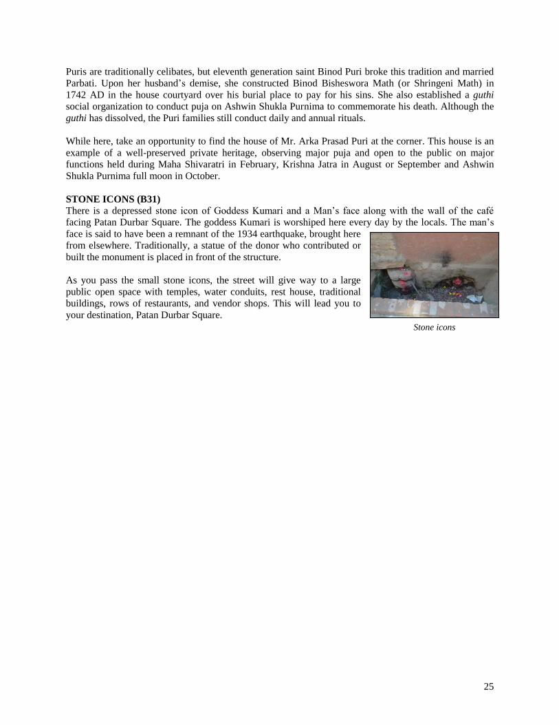
25
Puris are traditionally celibates, but eleventh generation saint Binod Puri broke this tradition and married
Parbati. Upon her husband’s demise, she constructed Binod Bisheswora Math (or Shringeni Math) in
1742 AD in the house courtyard over his burial place to pay for his sins. She also established a guthi
social organization to conduct puja on Ashwin Shukla Purnima to commemorate his death. Although the
guthi has dissolved, the Puri families still conduct daily and annual rituals.
While here, take an opportunity to find the house of Mr. Arka Prasad Puri at the corner. This house is an
example of a well-preserved private heritage, observing major puja and open to the public on major
functions held during Maha Shivaratri in February, Krishna Jatra in August or September and Ashwin
Shukla Purnima full moon in October.
STONE ICONS (B31)
There is a depressed stone icon of Goddess Kumari and a Man’s face along with the wall of the café
facing Patan Durbar Square. The goddess Kumari is worshiped here every day by the locals. The man’s
face is said to have been a remnant of the 1934 earthquake, brought here
from elsewhere. Traditionally, a statue of the donor who contributed or
built the monument is placed in front of the structure.
As you pass the small stone icons, the street will give way to a large
public open space with temples, water conduits, rest house, traditional
buildings, rows of restaurants, and vendor shops. This will lead you to
your destination, Patan Durbar Square.
Stone icons
Related Documents