1 Forest Carbon Partnership Facility (FCPF) Carbon Fund Emission Reductions Program Document (ER-PD) ER Program Name and Country: People and Forests - A Sustainable Forest Management-Based Emission Reduction Program in the Terai Arc Landscape, Nepal Date of Revision: 23 May 2018 WORLD BANK DISCLAIMER The World Bank does not guarantee the accuracy of the data included in the Emissions Reductions Program Document (ER-PD) submitted by REDD+ Country Participant and accepts no responsibility for any consequences of their use. The boundaries, colors, denominations, and other information shown on any map in ER-PD does not imply on the part of the World Bank any legal judgment on the legal status of the territory or the endorsement or acceptance of such boundaries. The Facility Management Team and the REDD Country Participant shall make this document publicly available, in accordance with the World Bank Access to Information Policy and the FCPF Disclosure Guidance (FMT Note CF-2013-2 Rev, dated November 2013).

Welcome message from author
This document is posted to help you gain knowledge. Please leave a comment to let me know what you think about it! Share it to your friends and learn new things together.
Transcript
1
Forest Carbon Partnership Facility (FCPF)
Carbon Fund
Emission Reductions Program Document (ER-PD)
ER Program Name and Country:
People and Forests - A Sustainable Forest Management-Based Emission Reduction
Program in the Terai Arc Landscape, Nepal
Date of Revision: 23 May 2018
WORLD BANK DISCLAIMER
The World Bank does not guarantee the accuracy of the data included in the Emissions
Reductions Program Document (ER-PD) submitted by REDD+ Country Participant and accepts no responsibility for any consequences of their use. The boundaries, colors, denominations, and other information shown on any map in ER-PD does not imply on the part of the World
Bank any legal judgment on the legal status of the territory or the endorsement or acceptance of such boundaries.
The Facility Management Team and the REDD Country Participant shall make this document
publicly available, in accordance with the World Bank Access to Information Policy and the FCPF Disclosure Guidance (FMT Note CF-2013-2 Rev, dated November 2013).
2
EXECUTIVE SUMMARY
Nepal’s National REDD+ Strategy and political commitment In 2018, Nepal is at an inflection point in its political and economic development trajectories. After almost ten years, restructuring of the government from a constitutional monarchy to a federal republic is coming to completion. The newly formed Ministry of Forests and Environment brings together responsibilities from previously distinct ministries and links them to Nepal’s representation as a Party to the UNFCCC. Additionally, after several years of stepwise progress in REDD+ readiness, the newly formed government has endorsed the National REDD+ Strategy and the proposed Emission Reduction (ER) Program in a show of commitment that supports and intersects several national policies – most notably the Climate Change Policy (2011), the draft National Low Carbon Development Strategy, the Forestry Sector Strategy (2016 – 2025) and Nepal’s Nationally-Determined Contribution (NDC). These policies collectively prioritize:
1) addressing key drivers and expanding sustainable management of forests, 2) ensuring fair and equitable benefit sharing of carbon and non-carbon benefits and 3) increasing livelihood opportunities for poor and forest-dependent communities
Program area description and rationale The priorities laid out by the National REDD+ Strategy align most powerfully with opportunities in the land sector in Nepal’s lowlands also known as Terai. The Terai supports the most productive forests, richest biodiversity and most significant protected areas in the country, but also is the region of highest population growth, urbanization, and economic development opportunity. As a result, the natural resource base is facing significant threats that the proposed ER program aims to address. The well-being of many communities in the Terai is also closely tied to forests. Forestry, agroforestry, fuelwood and fodder collection and non-timber forest products (NTFPs) directly support livelihoods and customary practices of countless people, and forests provide ecosystems services like watershed protection and flood mitigation that are critical for climate resilience. While the high reliance on forests translates to significant deforestation and degradation, it also presents an opportunity to broadly engage local communities in better management of these forests. In particular, the proposed ER Program plans to consolidate and build on a legacy of community-based forest management to localize forest governance, improve forest management regimes for greater productivity and livelihood opportunities and concurrently generate benefits for climate mitigation and adaptation. The Terai was selected also because the ER Program can build on the foundation that the Terai Arc Landscape (TAL) program has laid, leverage additional finance and scale activities that have a proven track record. Partnerships with organizations like World Wildlife Fund (WWF), Federation of Community Forestry Users, Nepal (FECOFUN) and Nepal Federation of Indigenous Nationalities (NEFIN) have been essential to early successes and will ensure reach to diverse constituencies in implementation of the program. The ER Program Area is delineated jurisdictionally by 12 contiguous districts of the TAL, an area covering approximately 2.4 million hectares of Nepal’s lowlands and some of the adjoining Chure Hills. Uniquely rich in culture and natural resources, the TAL represents approximately 15% of Nepal’s total land area, 20% of Nepal’s forests, 25% of Nepal’s total population, and is the country’s most productive agricultural region. As a significant subnational effort aligned with the National REDD+ Strategy, the ER Program will be a model for implementation performance-based activities to address drivers of deforestation and degradation nationally in Nepal. Drivers of deforestation and degradation Deforestation accounts for approximately two-thirds of land-based emissions in the Terai, and is driven by immigration and unplanned settlement, encroachment of government-managed forests, illegal and unsustainable logging (mostly in government managed forests) and expanding infrastructure development.
3
Degradation accounts for approximately one-third of land-based emissions and is driven by an overall supply-demand gap for forest products, in particular for fuelwood and fodder, and illegal and unsustainable logging in government-managed forests. Unmanaged grazing, particularly outside community forests, exacerbates these drivers and likely plays a role in inhibiting forest regeneration and enhancement in many areas. High fire frequency also plays a significant role in Terai. Fire is part of a natural disturbance regime in many of Nepal’s forests and grasslands; however, most fires are started intentionally, either as part of a prescribed burning regimen in protected areas (e.g., to enhance wildlife habitat) or to enhance grazing conditions in unmanaged areas. Preliminary analysis suggests that fires, though frequent, are not a significant source of emissions; however, further work is in progress to better understand its impacts and if necessary, to incorporate these emissions in the ER Program’s carbon accounting. Regeneration also appears significant in the proposed Program Area, as indicated by roughly 60,000 ha of regrowth (non-forest to forest) during the reference period and may represent benefits already generated by community-based forest management in the region. Additional work is planned in the near-term to establish a better understanding the causes and extent of regeneration and enhancement and to further refine planned activities for maximum carbon and non-carbon benefits. Proposed program activities The central theme of ER Program is to expand community-based forest management regimes (community forestry and collaborative forestry), reducing the land area in less-managed government forests and enhancing the benefits of localized forest management with increased knowledge and application of Sustainable Forest Management (SFM) principles. These activities will be implemented under Ministry of Forests and Environment (MoFE) by supporting the actual “handover” process, i.e., by transferring the management rights of the forests to local user groups, and by working with user groups to upgrade management plans to reflect SFM guidelines. The ER Program will also create additional opportunities for private sector forestry in two important ways. First, the private sector plays an important role in developing forest management plans and implementing forest prescriptions for community and collaborative forests. These opportunities will be expanded with increased areas under community management and training to provide more employment opportunities in this field. Second, the Program will create incentives to attract more private land holders to productive forest management, including through access to long-term, low-cost capital to incentivize plantation production and maintenance of forests on their private lands. Complementing these activities, the ER Program will expand the pro-poor Leasehold Forestry program that has been successful in other parts of the country at providing livelihood opportunities for poor and historically-marginalized groups in forest management, agroforestry, and NTFPs cultivation. Beyond the forest management interventions, the ER Program will also support efforts to reduce demand on forests with a significant expansion of existing improved cookstove and biogas programs, and to improve baselines of protected areas management and landuse planning. Protected areas are anchors of region’s biodiversity, and tourism opportunities and their management can be better integrated with Terai-wide landscape vision of the TAL strategy. Landuse planning will focus at municipal levels and take initial steps to apply national planning policies with municipal-level planning and implementation.
4
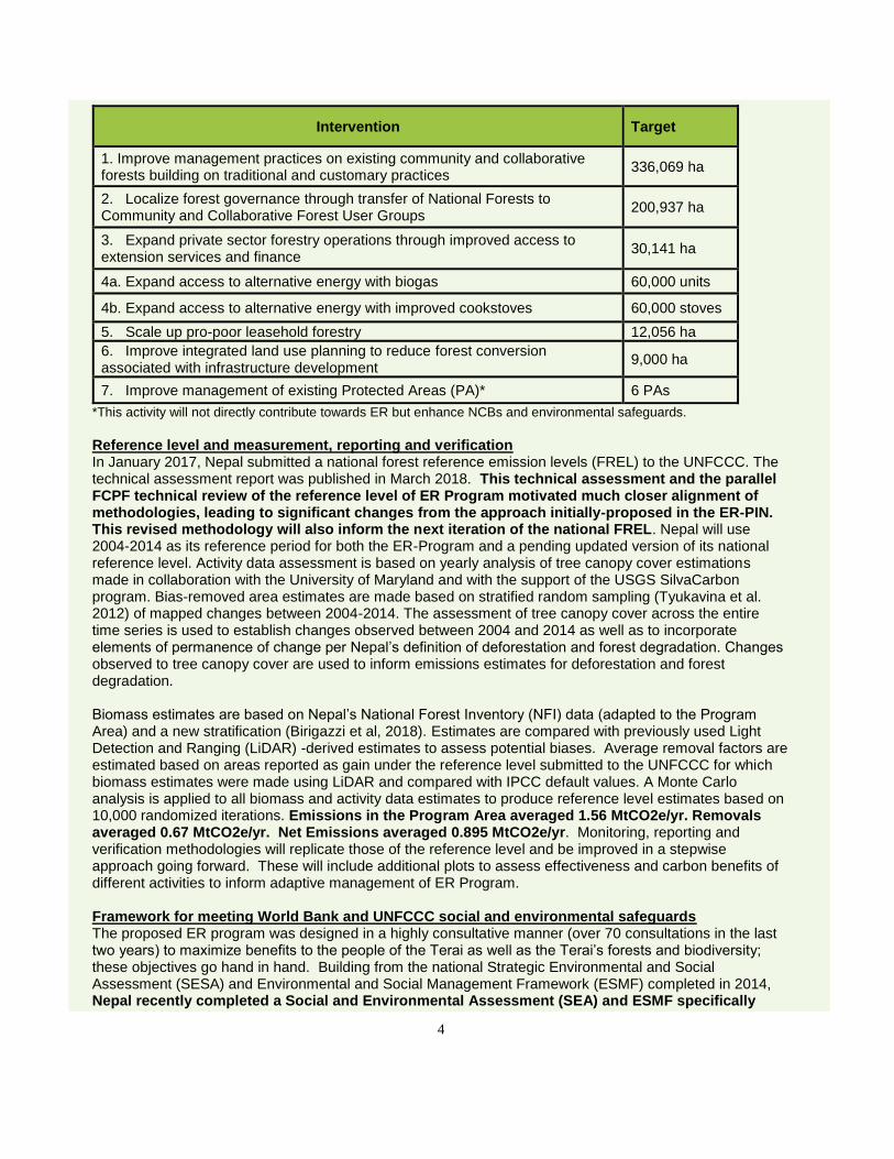
Intervention Target
1. Improve management practices on existing community and collaborative forests building on traditional and customary practices
336,069 ha
2. Localize forest governance through transfer of National Forests to Community and Collaborative Forest User Groups
200,937 ha
3. Expand private sector forestry operations through improved access to extension services and finance
30,141 ha
4a. Expand access to alternative energy with biogas 60,000 units
4b. Expand access to alternative energy with improved cookstoves 60,000 stoves
5. Scale up pro-poor leasehold forestry 12,056 ha
6. Improve integrated land use planning to reduce forest conversion associated with infrastructure development
9,000 ha
7. Improve management of existing Protected Areas (PA)* 6 PAs
*This activity will not directly contribute towards ER but enhance NCBs and environmental safeguards. Reference level and measurement, reporting and verification In January 2017, Nepal submitted a national forest reference emission levels (FREL) to the UNFCCC. The technical assessment report was published in March 2018. This technical assessment and the parallel FCPF technical review of the reference level of ER Program motivated much closer alignment of methodologies, leading to significant changes from the approach initially-proposed in the ER-PIN. This revised methodology will also inform the next iteration of the national FREL. Nepal will use 2004-2014 as its reference period for both the ER-Program and a pending updated version of its national reference level. Activity data assessment is based on yearly analysis of tree canopy cover estimations made in collaboration with the University of Maryland and with the support of the USGS SilvaCarbon program. Bias-removed area estimates are made based on stratified random sampling (Tyukavina et al. 2012) of mapped changes between 2004-2014. The assessment of tree canopy cover across the entire time series is used to establish changes observed between 2004 and 2014 as well as to incorporate elements of permanence of change per Nepal’s definition of deforestation and forest degradation. Changes observed to tree canopy cover are used to inform emissions estimates for deforestation and forest degradation. Biomass estimates are based on Nepal’s National Forest Inventory (NFI) data (adapted to the Program Area) and a new stratification (Birigazzi et al, 2018). Estimates are compared with previously used Light Detection and Ranging (LiDAR) -derived estimates to assess potential biases. Average removal factors are estimated based on areas reported as gain under the reference level submitted to the UNFCCC for which biomass estimates were made using LiDAR and compared with IPCC default values. A Monte Carlo analysis is applied to all biomass and activity data estimates to produce reference level estimates based on 10,000 randomized iterations. Emissions in the Program Area averaged 1.56 MtCO2e/yr. Removals averaged 0.67 MtCO2e/yr. Net Emissions averaged 0.895 MtCO2e/yr. Monitoring, reporting and verification methodologies will replicate those of the reference level and be improved in a stepwise approach going forward. These will include additional plots to assess effectiveness and carbon benefits of different activities to inform adaptive management of ER Program. Framework for meeting World Bank and UNFCCC social and environmental safeguards The proposed ER program was designed in a highly consultative manner (over 70 consultations in the last two years) to maximize benefits to the people of the Terai as well as the Terai’s forests and biodiversity; these objectives go hand in hand. Building from the national Strategic Environmental and Social Assessment (SESA) and Environmental and Social Management Framework (ESMF) completed in 2014, Nepal recently completed a Social and Environmental Assessment (SEA) and ESMF specifically
5
targeting the ER Program. The ESMF identifies relevant World Bank and UNFCCC safeguards and analyzes them against policies in place in the Program Area to identify consistencies as well as gaps. It then provides the basis for addressing these gaps through a process of screening and preparing site-specific environmental and social management plans as needed during program implementation. The ESMF ensures that risks and impacts are properly mitigated and managed and that periodic monitoring, reporting and evaluation is taking place. The Feedback and Grievance Redress Mechanisms (FGRM) for the ER Program is already largely operational, not as a singular “mechanism” but rather as a web of existing, practical informal and formal grievance mechanisms that are preferred by local communities. For example, the largest “footprint” of the ER program will be in existing and new community forests, for which guidelines and quasi-judicial processes are already in place to resolve disputes. Nonetheless, the ER Program clarifies these pathways and options for elevation of grievances when necessary. Not all institutions for safeguards monitoring and implementation are fully in place; however, a safeguards roadmap details a schedule of steps that will be taken to achieve full institutional readiness for program implementation. Benefit sharing arrangements for monetary and non-monetary benefits The ER Program is not designed to function primarily as a monetary distribution mechanism. Rather, carbon finance will be directed in large part to support government implementation of programs that directly benefit the people and forests of the Terai. These real, tangible benefits will be experienced by communities who, as a result of ER Program activities, are managing their own forests, receiving technical support and extension services from MoFE and are being trained in sustainable forest management techniques to generate higher productivity and revenues from their forests. Importantly, there are existing modalities for benefit sharing within CBFM whereby the forest user groups benefit from 50-100% of the revenues from their forests. Similarly, Nepal’s Alternative Energy Promotion Center (AEPC) has a proven track record installing biogas plants and cookstoves and will administer these program activities, and households will derive the benefits of improved technologies and creating time for other economic pursuits. Though most of the program activities will operate under existing modalities and associated benefit sharing arrangements, there will be some exceptions in which direct monetary or non-monetary benefits will be accessed through participation in program activities, and in cases where implementation partners are engaged to accelerate the program’s implementation. An advanced draft Benefit Sharing Plan will be prepared in 2018 and be available prior to contract negotiations for an ERPA. Delivery of non-carbon benefits The ER Program has significant, cross-cutting non-carbon benefit components because its core interventions promote healthy and productive forests in the Terai, and these forests are a mainstay for improved livelihoods, elevated governance (with increased participation from women and marginalized groups) and a wide range of ecosystem services. Non-carbon benefits will include improved incomes from increased forest productivity; strengthened forest governance (e.g., through the establishment of community and collaborative forests); improved health outcomes and time availability for women (from expanded uptake of biogas and cookstoves); sustainable livelihood opportunities in forest management, NTFPs, and agroforestry; and maintained and enhanced biodiversity inside and outside of Protected Areas. Climate change resilience will be mainstreamed across all interventions to sustain and improve the adaptation benefits that forests already deliver to the region. Estimated ER Program volume and transfer of title Before appropriate set aside for uncertainty buffer and reversal management mechanism, the ER Program aims to achieve 34.2 MtCO2e carbon benefits (reduced emissions and increased removals combined) over the ten-year life of the program, or 13.2 MtCO2e over six years proposed under the Carbon Fund. Nepal’s constitution and federal law provide clear authority for the National REDD+ Center, on behalf of MoFE, to transfer title for emission reductions generated on public lands. This legal basis applies to the majority of activities proposed in the ER Program as they are focused on community and
6
collaborative forests on government lands. Proposed activities on private lands will be linked to an “opt-in” contractual arrangement with private land holders in which they effectively “trade” title to carbon rights associated with their lands for articulated benefits of participation in the ER Program. During initial stages of the ER Program, Nepal will rely on the registry system of the World Bank for tracking ERs generated under the Program. Upon successful establishment of the national registry, transactions will also be captured and tracked in the national registry system. There are six existing forest carbon projects in the proposed Program Area, all supporting installation of biogas plants or improved cook stove technology in households. These projects report to the Gold Standard and CDM registries, which will cross-walk with the centralized registry system established by the WB to avoid double counting or reporting. MoFE/NRC will also inform AEPC through a letter of understanding that carbon benefits achieved under ER Program activities cannot be separately accounted for with AEPC programs. ER Program Financing The estimated cost of Nepal’s ER Program over 10 years is USD$ 184 million, or USD$ 123M for the prospective 6 years under the Carbon Fund. The ER Program will allocate 23% of generated emissions reductions to a buffer that will be managed by the Carbon Fund, based on estimated uncertainty of ERs (12% conservativeness factor) and risk of reversal of 11%. The consequent offer to the Carbon Funds is for transfer of 4.9 MtCO2e and 5.3 MtCO2e in years 4 and 6, respectively. The Government of Nepal is fully invested in the success of this program, as indicated by an approximated USD$ 45M contribution through MoFE line budgets and the President Chure Terai Madhesh Conservation Development Program. The program will leverage significant co-financing, including through the Terai Arc Landscape Program ($13M), the Forest Investment Program (USD$ 7.5M), and co-financing from community and collaborative forest user groups (USD$ 13 million) and household rural energy users (USD$ 10 million), through existing cost sharing arrangements. Nepal is also exploring opportunities to harmonize Carbon Fund finance with next IDA replenishment. The ER Program is expected to achieve a budget surplus over 10 years, but is projected to experience a cash flow deficit until approximately the seventh year. Nepal is exploring options to close this gap and is potentially interested to negotiate an advanced payment in the ERPA. Nepal’s commitment to conservation Despite significant political changes over recent decades culminating in the establishment of a federal republic, Nepal and its people have demonstrated an enduring commitment to the country’s forests and natural heritage. The significant extent of designated protected areas in the Terai and a record of transitioning forests to community-based management are two important examples. Drawing on Nepal’s experience in wildlife conservation, the country has recently celebrated achieving zero poaching of its rhino population for five out of the last seven years and is on track to double its tiger population as part of its commitment to the Global Tiger Recovery Plan. These exciting achievements demonstrate what is obtainable with a parallel commitment to implementing REDD+ in Terai at this important time in Nepal’s development pathway.
7
Table of Contents
1. ENTITIES RESPONSIBLE FOR THE MANAGEMENT AND IMPLEMENTATION OF THE PROPOSED
ER PROGRAM ........................................................................................................................................ 19
1.1 ER Program Entity that is expected to sign the Emission Reduction Payment Agreement (ERPA) with the FCPF Carbon Fund ...........................................................19
1.2 Organization(s) responsible for managing the proposed ER Program ............................19
1.3 Partner agencies and organizations involved in the ER Program ...................................21
2. STRATEGIC CONTEXT AND RATIONALE FOR THE ER PROGRAM ................................................ 24
2.1 Current status of the Readiness Package and summary of additional achievements of readiness activities in the country ...................................................................................24
2.2 Ambition and strategic rationale for the ER Program ......................................................29
2.3 Political commitment ......................................................................................................31
3. ER PROGRAM LOCATION .................................................................................................................... 32
3.1 Accounting Area of the ER Program ..............................................................................32
3.2 Environmental and social conditions in the Accounting Area of the ER Program ............38
3.2.1 Existing vegetation types in the accounting area .......................................................38
3.2.2 Climatic conditions and the occurrence of catastrophic events ..................................38
3.2.3 Soil characteristics ....................................................................................................40
3.2.4 Presence of rare and endangered species and their habitat ......................................40
3.2.5 Overview of stakeholders and rights-holders, including linguistic and socio-cultural diversity .....................................................................................................................41
3.2.6 Population demographics and growth ........................................................................41
3.2.7 Modes of Livelihoods AND Dependency on Forest Resources ..................................42
4. DESCRIPTION OF ACTIONS AND INTERVENTIONS TO BE IMPLEMENTED UNDER THE
PROPOSED ER PROGRAM. .................................................................................................................. 44
4.1 Analysis of drivers and underlying causes of deforestation and forest degradation, and existing activities that can lead to conservation or enhancement of forest carbon stocks ............................................................................................................................44
4.1.1 Unsustainable and illegal harvest of timber and fuelwood .........................................46
4.1.2 Overgrazing ...............................................................................................................48
4.1.3 Forest fires ................................................................................................................50
4.1.4 Conversion of forests to other land uses due to encroachment, resettlement, and infrastructure .............................................................................................................52
4.1.5 Regeneration .............................................................................................................53
4.2 Assessment of the major barriers to REDD+ ..................................................................54
8
4.3 Description and justification of the planned actions and interventions under the ER Program that will lead to emission reductions and/or removals ......................................56
4.3.1 Improve management practices in existing community and collaborative forests building on traditional and customary practices .........................................................60
4.3.2 Localize forest governance through transfer of National Forests to Community and Collaborative Forest User Groups .............................................................................64
4.3.3 Expand private-sector forestry through improved access to extension services and finance ......................................................................................................................67
4.3.4 Expand access to alternative energy with biogas and improved cookstoves .............69
4.3.5 Scale up pro-poor Leasehold Forestry .......................................................................71
4.3.6 Improve integrated land use planning to reduce forest conversion associated with advancing infrastructure development .......................................................................73
4.3.7 Improve the management of Protected Areas............................................................75
4.3.8 Approximate timeline of planned ER Program measures ...........................................77
4.4 Assessment of land and resource tenure in the Accounting Area ...................................81
4.4.1 Constitutional provisions for securing land and resource tenure ................................84
4.4.2 Potential impacts of the ER Program on existing land and resource tenure ...............85
4.5 Analysis of laws, statutes and other regulatory frameworks ...........................................88
4.6 Expected lifetime of the proposed ER Program ..............................................................91
5. STAKEHOLDER CONSULTATION AND PARTICIPATION .................................................................. 92
5.1 Description of stakeholder consultation process .............................................................92
5.1.1 Organization of Consultation Workshops and Meetings .............................................93
5.1.2 District-Level Consultations ........................................................................................94
5.1.3 Regional-Level Consultations ....................................................................................97
5.1.4 National-Level Consultations .....................................................................................98
5.1.5 Ongoing consultations during implementation of ER Program ...................................99
5.2 Summary of the comments received and how these views have been taken into account in the design and implementation of the ER Program .......................................99
6 OPERATIONAL AND FINANCIAL PLANNING ................................................................................... 103
6.1 Institutional and implementation arrangements ............................................................ 103
6.2 ER Program budget ..................................................................................................... 113
7 CARBON POOLS, SOURCES AND SINKS ......................................................................................... 115
7.1 Description of Sources and Sinks selected .................................................................. 115
7.2 Description of Carbon Pools and greenhouse gases selected ...................................... 115
8 REFERENCE LEVEL ............................................................................................................................ 120
9
8.1 Reference Period ......................................................................................................... 120
8.2 Forest definition used in the construction of the Reference Level ................................. 120
8.3 Average annual historical emissions over the Reference Period .................................. 121
8.3.1 Activity data ............................................................................................................. 122
8.3.2 Emission and removal factors .................................................................................. 128
8.3.3 Calculation of the average annual historical emissions over the Reference Period .. 134
8.4 Upward or downward adjustments to the average annual historical emissions over the Reference Period (if applicable) ................................................................................... 134
8.5 Estimated Reference Level .......................................................................................... 135
8.6 Relation between the Reference Level, the development of a FREL/FRL for the UNFCCC, and the country’s existing or emerging greenhouse gas inventory .............. 137
9 APPROACH FOR MEASUREMENT, MONITORING, AND REPORTING .......................................... 138
9.1 Measurement, monitoring, and reporting approach for estimating emissions occurring under the ER Program within the Accounting Area ...................................................... 138
9.2 Organizational structure for measurement, monitoring, and reporting .......................... 142
9.3 Relation and consistency with the National Forest Monitoring System ...................... 144
10 DISPLACEMENT ................................................................................................................................... 145
10.1 Identification of risk of Displacement ............................................................................ 145
10.2 ER Program design features to prevent and minimize potential Displacement ............. 146
11 REVERSALS ......................................................................................................................................... 147
11.1 Identification of risk of Reversals .................................................................................. 147
11.2 ER Program design features to prevent and mitigate Reversals................................... 151
11.3 Reversal management mechanism .............................................................................. 152
11.4 Monitoring and reporting of major emissions that could lead to Reversals of ERs ........ 152
12 UNCERTAINTIES OF THE CALCULATION OF EMISSION REDUCTIONS ....................................... 153
12.1 Identification and assessment of sources of uncertainty ............................................... 153
12.2 Quantification of uncertainty in Reference Level setting ............................................... 154
13 CALCULATION OF EMISSION REDUCTIONS ................................................................................... 158
13.1 Ex-ante estimation of the Emission Reductions ............................................................ 158
14 SAFEGUARDS ...................................................................................................................................... 161
14.1 Description of how the ER Program meets the World Bank social and environmental safeguards and promotes and supports the safeguards included in UNFCCC guidance related to REDD+ ......................................................................................... 161
14.1.1 Strategic Environmental and Social Assessment (SESA)/Environmental and Social Management Framework (SESA/ESMF) ................................................................. 161
10
14.1.2 Key themes emerging from SESA consultations and socioeconomic baseline assessment ............................................................................................................. 162
14.1.3 Potential ER Program environmental impacts and mitigation ................................. 164
14.1.4 Potential ER Program Social Risks and Mitigation ................................................. 167
14.1.5 Environmental and Social Safeguards Triggered by the ER-P ............................... 172
14.1.6 Legislative Regulatory and Policy Regime for addressing safeguards ................... 173
14.1.7 Implementation of ESMF........................................................................................ 175
14.2 Description of Arrangements to Provide Information on Safeguards During ER Program Implementation .............................................................................................. 176
14.2.1 Implementation arrangements and national safeguards information ...................... 176
14.3 Description of the Feedback and Grievance Redress Mechanism (FGRM) in place and possible actions to improve it ................................................................................ 177
15 BENEFIT-SHARING ARRANGEMENTS .............................................................................................. 182
15.1 Description of benefit-sharing arrangements ................................................................ 182
15.2 Summary of the process of designing the benefit-sharing arrangements ..................... 184
15.3 Description of the legal context of the benefit-sharing arrangements ........................... 185
16 NON-CARBON BENEFITS ................................................................................................................... 187
16.1 Outline of potential Non-Carbon Benefits and identification of Priority Non-Carbon Benefits ........................................................................................................................ 187
16.2 Approach for providing information on Priority Non-Carbon Benefits ............................ 189
17 TITLE TO EMISSION REDUCTIONS ................................................................................................... 194
17.1 Authorization of the ER Program .............................................................................. 194
17.2 Transfer of Title to ERs ................................................................................................ 194
18 DATA MANAGEMENT AND REGISTRY SYSTEMS ........................................................................... 199
18.1 Participation under other GHG initiatives ...................................................................... 199
18.2 Data management and Registry systems to avoid multiple claims to ERs .................... 199
ANNEXES .................................................................................................................................................... 202
Annex 1: Summary of financial plan .................................................................................... 202
Annex 2: Agencies and organizations participating in the ER Program ............................... 205
Annex 3: Socioeconomic conditions in the Terai Arc Landscape ......................................... 209
Annex 4: Multilateral Environmental Agreements to which Nepal is a Party ........................ 214
Annex 5: Stakeholder Consultations and Workshops .......................................................... 215
Annex 6: Results of consultations on drivers of deforestation.............................................. 221
Annex 7: List of laws, statutes, and other regulatory frameworks ........................................ 228
Annex 8: Social and Environmental Risks of the ER Program ............................................. 231
11
Annex 9: Detailed list of planned interventions by district .................................................... 235
Annex 10: nepal government endorsement of erpd ............................................................. 236
Annex 11: Position Statements of 10 National Networks Representing Indigenous Peoples and Local Communities on Nepal’s ERPD ................................................................... 238
Annex 12: Monte Carlo analysis for the reference level....................................................... 242
Annex 13: umd-dfrs Sample interpretation protocol ............................................................. 243
Annex 14: Safeguards Roadmap ........................................................................................ 244
Annex 16: Voluntary and Compliance Market Projects in ER Program Area ....................... 246
Annex 15: National assessment of tree cover extent and change ....................................... 247
LIST OF FIGURES
Figure 1: Program Area with physiographic regions ...................................................................................... 32 Figure 2: Map of Nepal showing ER Program Area with jurisdictional boundaries of districts and states ..... 34 Figure 3: Trend of mean annual rainfall of 35 years at Rampur Station ........................................................ 39 Figure 4: Trend of mean maximum temperature of 35 years at Rampur Station .......................................... 39 Figure 5: Fire incidents in the TAL (2000–2014) ............................................................................................ 51 Figure 6: Fire frequency in the TAL. Figure depicts the number of years between 2004 and 2014 during
which each pixel was highlighted at least once over that calendar year by the MODIS Burnt Area Product. The data show how most of the fires occurred within protected areas boundaries. ............... 51
Figure 7: Theory of change of the ER Program ............................................................................................. 58 Figure 8: Forest area in the Program Area by tenure type ............................................................................ 82 Figure 9: Planning of consultations for ER-PD ............................................................................................... 94 Figure 10: Tiered institutional and implementation arrangements ............................................................... 106 Figure 11: Proposed financial flow ............................................................................................................... 114 Figure 12: MODIS-derived fires frequency data with protected areas in the TAL; occurrence density 2012–
2018. The data show how most of the fires occur within protected areas boundaries. ...................... 119 Figure 13: Example of MSPA analysis outputs for 2010 forest cover data. Left: Binary Forest Map. Center:
Guidos MSPA tool output run with basic parameters and 5x5 (150x150m) assessment window. Right: Simplified output: Inner Edge, Outer Edge and Patch MSPA classes grouped together under Edge Class and core named as Intact. This classification was used to derive estimates of biomass from NFI plot data for No Forest, Intact and Edge areas. .................................................................................. 122
Figure 14: Stratification results for activity data estimation: a. Results from Landsat Based change mapping following Hansen et al. 2012; Tyukavina et al. 2012,2013). b. MSPA results for the 2004 period after reclassifying into Intact (MSPA Core) and Edge (MSPA Inner and Outer Edge plus Patch). c. Final forest classification combined with change data for emission factors and AD combination ............... 127
Figure 15: a. General location of NFI plots in Nepal. A total of 426 NFI plots are inside the ER program area. b. Location of LiDAR sampling blocks. ....................................................................................... 129
Figure 16: Above-ground biomass estimates derived from NFI plot data subset for the TAL (left) and LiDAR data (right) for the forest types proposed based on MSPA analysis applied to 2010 FREL forest cover data. ..................................................................................................................................................... 130
Figure 17: Proposed position of MRV-related institutions ............................................................................ 143 Figure 18: Illustration of Monte Carlo method .............................................................................................. 155 Figure 19: Proposed Data Management and Carbon Registry System for Nepal ....................................... 201 Figure 20: Example of Information Available for Sample Interpretation....................................................... 248 Figure 21: Detail of sample in Google Earth ................................................................................................ 250
12
LIST OF TABLES
Table 1: Readiness progress comparison between the Mid-Term Review (MTR) and the R-Package assessment ............................................................................................................................................ 25
Table 2: Criteria assessed during the Readiness Package as requiring further development and Nepal’s progress in these areas ......................................................................................................................... 26
Table 3: Priority national policies and initiatives advanced by ER Program activities ................................... 29 Table 4: Overview of the 12 districts in the ER Program Area (Nepal Human Development Report 2014) .. 35 Table 5: Forest cover for different forest management regimes in the ER Program Area ............................. 36 Table 6: Forest cover for different physiographic zones in the ER Program Area ......................................... 37 Table 7: Summary of drivers of deforestation and forest degradation identified in studies in ER Program
Area ....................................................................................................................................................... 44 Table 8: Projections for timber demand and supply (million m3) by ecological region in Nepal .................... 46 Table 9: Projected fuelwood demand (million tons/year) by ecological region in Nepal ............................... 47 Table 10: Livestock numbers in ER Program Area (by district) ..................................................................... 49 Table 11: Relationship between the ER Program interventions and the drivers of deforestation and forest
degradation ............................................................................................................................................ 59 Table 12: Summary of intervention actions for improved forest management in community forests ............ 61 Table 13: Summary of intervention actions for improved forest management in collaborative forests ......... 62 Table 14: Potential risks and impacts of community forest management interventions for Indigenous
Peoples and remedies ........................................................................................................................... 63 Table 15: Distribution of carbon stock (Mg ha-1) across forest management regimes ................................. 65 Table 16: Summary of Intervention Area for transfer of government-managed forests to community forests
............................................................................................................................................................... 65 Table 17: Summary of intervention actions on transfer of government-managed forests to collaborative
forests .................................................................................................................................................... 66 Table 18: Potential risks and impacts of private-sector forestry activities on Indigenous Peoples and
remedies ................................................................................................................................................ 68 Table 19: Expand access to alternative energy with biogas and improved cookstoves ................................ 70 Table 20: Potential risks and impacts of this intervention on Indigenous Peoples and remedies ................. 70 Table 21: Summary of intervention area for scale up of pro-poor leasehold forestry .................................... 72 Table 22: Potential risks and impacts of this intervention on Indigenous Peoples and remedies ................. 72 Table 23: Improve integrated land-use planning to reduce forest conversion associated with advancing
infrastructure development .................................................................................................................... 74 Table 24: Perceived risks of this intervention to Indigenous Peoples and remedies ..................................... 75 Table 25: Strengthen the management of protected areas ........................................................................... 76 Table 26: Approximate timeline of planned ER Program measures .............................................................. 77 Table 27 Major legal instruments on land and resource tenure rights in Nepal ............................................. 81 Table 28 Categories of forest tenure in Nepal and their associated rights. Adapted from Jhaveri and
Adhikari (2015), FAO (2015), and NRC (2015) ..................................................................................... 82 Table 29 Status of customary rights associated with forestland tenure according to recent studies ............ 84 Table 30 Potential impacts of the ER Program on existing land and resource tenure .................................. 86 Table 31: Implementation status of major MEAs that are relevant to REDD+ in Nepal ................................ 90 Table 32: Tentative timeline for ER Program ................................................................................................. 91 Table 33 Key stakeholders consulted during ER Program design ................................................................. 95 Table 34 Summary of the key concerns and comments raised during stakeholder consultations and how
these comments have been responded to or reflected in the ER Program design process ............... 100 Table 35 Overarching functions of leading agencies and institutions in ER Program ................................. 107 Table 36: Engagement of agencies and institutions in ER Program activities ............................................. 108 Table 37: Transition management for institutional arrangements of the seven intervention areas in Nepal’s
federal restructuring process ............................................................................................................... 111 Table 38: Description of sources and sinks selected ................................................................................... 115 Table 39: Description of Carbon Pools and greenhouse gases selected .................................................... 115 Table 40: Characterization of natural forests in Nepal used in national land cover mapping ...................... 121
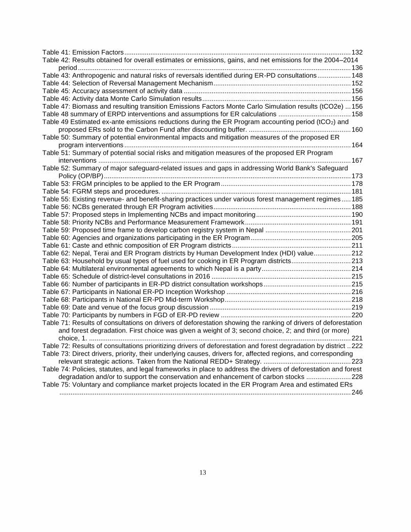
13
Table 41: Emission Factors .......................................................................................................................... 132 Table 42: Results obtained for overall estimates or emissions, gains, and net emissions for the 2004–2014
period ................................................................................................................................................... 136 Table 43: Anthropogenic and natural risks of reversals identified during ER-PD consultations .................. 148 Table 44: Selection of Reversal Management Mechanism .......................................................................... 152 Table 45: Accuracy assessment of activity data .......................................................................................... 156 Table 46: Activity data Monte Carlo Simulation results ................................................................................ 156 Table 47: Biomass and resulting transition Emissions Factors Monte Carlo Simulation results (tCO2e) ... 156 Table 48 summary of ERPD interventions and assumptions for ER calculations ....................................... 158 Table 49 Estimated ex-ante emissions reductions during the ER Program accounting period (tCO2) and
proposed ERs sold to the Carbon Fund after discounting buffer. ....................................................... 160 Table 50: Summary of potential environmental impacts and mitigation measures of the proposed ER
program interventions .......................................................................................................................... 164 Table 51: Summary of potential social risks and mitigation measures of the proposed ER Program
interventions ........................................................................................................................................ 167 Table 52: Summary of major safeguard-related issues and gaps in addressing World Bank's Safeguard
Policy (OP/BP) ..................................................................................................................................... 173 Table 53: FRGM principles to be applied to the ER Program ...................................................................... 178 Table 54: FGRM steps and procedures. ...................................................................................................... 181 Table 55: Existing revenue- and benefit-sharing practices under various forest management regimes ..... 185 Table 56: NCBs generated through ER Program activities .......................................................................... 188 Table 57: Proposed steps in Implementing NCBs and impact monitoring ................................................... 190 Table 58: Priority NCBs and Performance Measurement Framework ......................................................... 191 Table 59: Proposed time frame to develop carbon registry system in Nepal .............................................. 201 Table 60: Agencies and organizations participating in the ER Program ...................................................... 205 Table 61: Caste and ethnic composition of ER Program districts ................................................................ 211 Table 62: Nepal, Terai and ER Program districts by Human Development Index (HDI) value.................... 212 Table 63: Household by usual types of fuel used for cooking in ER Program districts ................................ 213 Table 64: Multilateral environmental agreements to which Nepal is a party ................................................ 214 Table 65: Schedule of district-level consultations in 2016 ........................................................................... 215 Table 66: Number of participants in ER-PD district consultation workshops ............................................... 215 Table 67: Participants in National ER-PD Inception Workshop ................................................................... 216 Table 68: Participants in National ER-PD Mid-term Workshop .................................................................... 218 Table 69: Date and venue of the focus group discussion ............................................................................ 219 Table 70: Participants by numbers in FGD of ER-PD review ...................................................................... 220 Table 71: Results of consultations on drivers of deforestation showing the ranking of drivers of deforestation
and forest degradation. First choice was given a weight of 3; second choice, 2; and third (or more) choice, 1. ............................................................................................................................................. 221
Table 72: Results of consultations prioritizing drivers of deforestation and forest degradation by district .. 222 Table 73: Direct drivers, priority, their underlying causes, drivers for, affected regions, and corresponding
relevant strategic actions. Taken from the National REDD+ Strategy. ............................................... 223 Table 74: Policies, statutes, and legal frameworks in place to address the drivers of deforestation and forest
degradation and/or to support the conservation and enhancement of carbon stocks ........................ 228 Table 75: Voluntary and compliance market projects located in the ER Program Area and estimated ERs
............................................................................................................................................................. 246
14
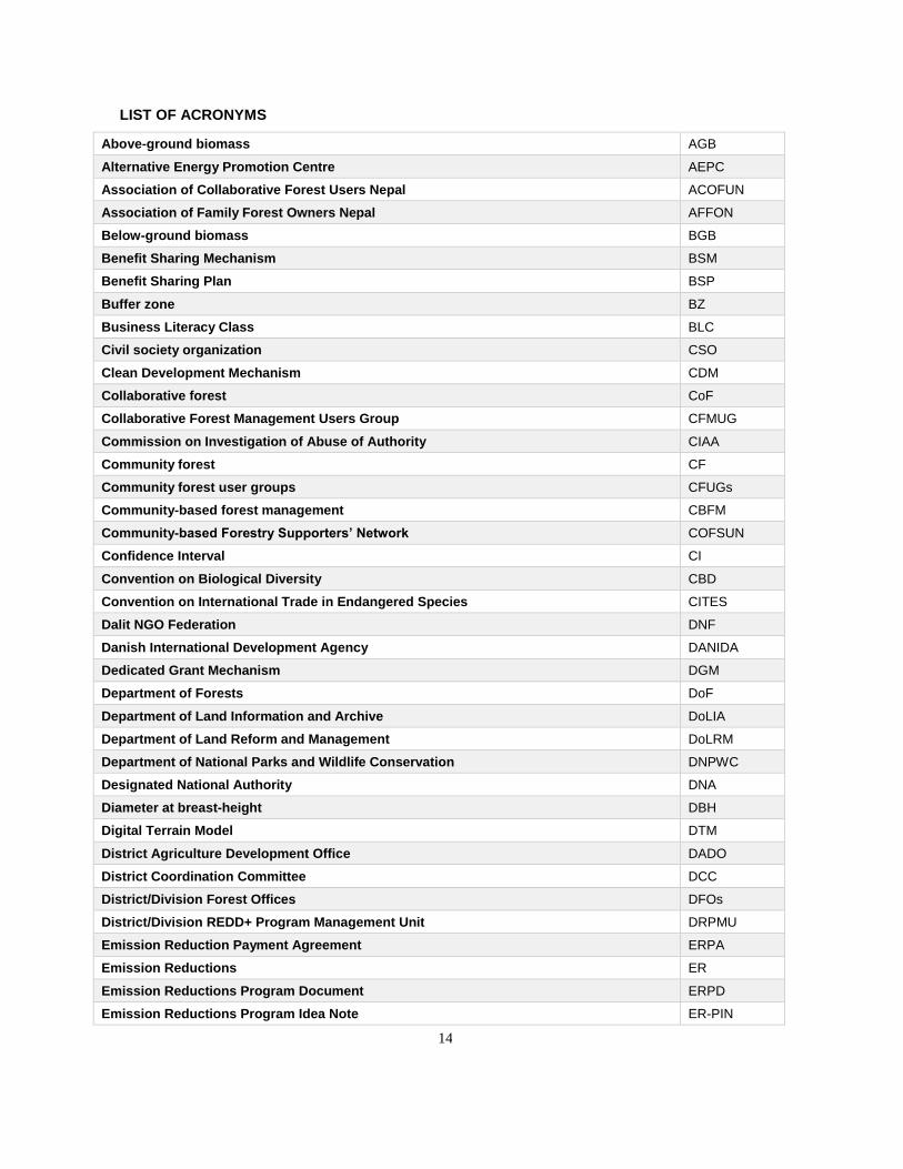
LIST OF ACRONYMS
Above-ground biomass AGB
Alternative Energy Promotion Centre AEPC
Association of Collaborative Forest Users Nepal ACOFUN
Association of Family Forest Owners Nepal AFFON
Below-ground biomass BGB
Benefit Sharing Mechanism BSM
Benefit Sharing Plan BSP
Buffer zone BZ
Business Literacy Class BLC
Civil society organization CSO
Clean Development Mechanism CDM
Collaborative forest CoF
Collaborative Forest Management Users Group CFMUG
Commission on Investigation of Abuse of Authority CIAA
Community forest CF
Community forest user groups CFUGs
Community-based forest management CBFM
Community-based Forestry Supporters’ Network COFSUN
Confidence Interval CI
Convention on Biological Diversity CBD
Convention on International Trade in Endangered Species CITES
Dalit NGO Federation DNF
Danish International Development Agency DANIDA
Dedicated Grant Mechanism DGM
Department of Forests DoF
Department of Land Information and Archive DoLIA
Department of Land Reform and Management DoLRM
Department of National Parks and Wildlife Conservation DNPWC
Designated National Authority DNA
Diameter at breast-height DBH
Digital Terrain Model DTM
District Agriculture Development Office DADO
District Coordination Committee DCC
District/Division Forest Offices DFOs
District/Division REDD+ Program Management Unit DRPMU
Emission Reduction Payment Agreement ERPA
Emission Reductions ER
Emission Reductions Program Document ERPD
Emission Reductions Program Idea Note ER-PIN
15
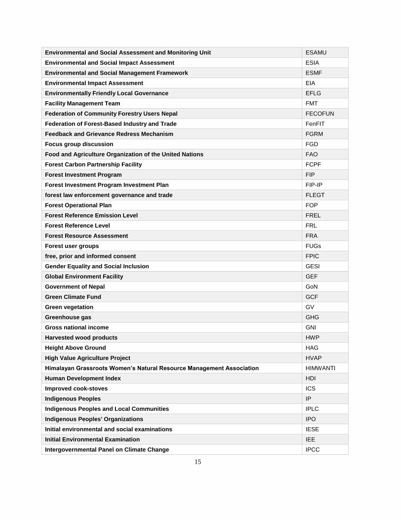
Environmental and Social Assessment and Monitoring Unit ESAMU
Environmental and Social Impact Assessment ESIA
Environmental and Social Management Framework ESMF
Environmental Impact Assessment EIA
Environmentally Friendly Local Governance EFLG
Facility Management Team FMT
Federation of Community Forestry Users Nepal FECOFUN
Federation of Forest-Based Industry and Trade FenFIT
Feedback and Grievance Redress Mechanism FGRM
Focus group discussion FGD
Food and Agriculture Organization of the United Nations FAO
Forest Carbon Partnership Facility FCPF
Forest Investment Program FIP
Forest Investment Program Investment Plan FIP-IP
forest law enforcement governance and trade FLEGT
Forest Operational Plan FOP
Forest Reference Emission Level FREL
Forest Reference Level FRL
Forest Resource Assessment FRA
Forest user groups FUGs
free, prior and informed consent FPIC
Gender Equality and Social Inclusion GESI
Global Environment Facility GEF
Government of Nepal GoN
Green Climate Fund GCF
Green vegetation GV
Greenhouse gas GHG
Gross national income GNI
Harvested wood products HWP
Height Above Ground HAG
High Value Agriculture Project HVAP
Himalayan Grassroots Women’s Natural Resource Management Association HIMWANTI
Human Development Index HDI
Improved cook-stoves ICS
Indigenous Peoples IP
Indigenous Peoples and Local Communities IPLC
Indigenous Peoples' Organizations IPO
Initial environmental and social examinations IESE
Initial Environmental Examination IEE
Intergovernmental Panel on Climate Change IPCC
16
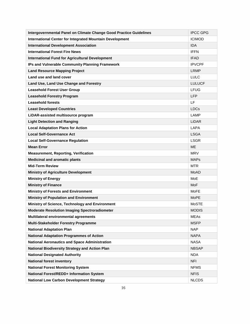
Intergovernmental Panel on Climate Change Good Practice Guidelines IPCC GPG
International Center for Integrated Mountain Development ICIMOD
International Development Association IDA
International Forest Fire News IFFN
International Fund for Agricultural Development IFAD
IPs and Vulnerable Community Planning Framework IPVCPF
Land Resource Mapping Project LRMP
Land use and land cover LULC
Land Use, Land Use Change and Forestry LULUCF
Leasehold Forest User Group LFUG
Leasehold Forestry Program LFP
Leasehold forests LF
Least Developed Countries LDCs
LiDAR-assisted multisource program LAMP
Light Detection and Ranging LiDAR
Local Adaptation Plans for Action LAPA
Local Self-Governance Act LSGA
Local Self-Governance Regulation LSGR
Mean Error ME
Measurement, Reporting, Verification MRV
Medicinal and aromatic plants MAPs
Mid-Term Review MTR
Ministry of Agriculture Development MoAD
Ministry of Energy MoE
Ministry of Finance MoF
Ministry of Forests and Environment MoFE
Ministry of Population and Environment MoPE
Ministry of Science, Technology and Environment MoSTE
Moderate Resolution Imaging Spectroradiometer MODIS
Multilateral environmental agreements MEAs
Multi-Stakeholder Forestry Programme MSFP
National Adaptation Plan NAP
National Adaptation Programmes of Action NAPA
National Aeronautics and Space Administration NASA
National Biodiversity Strategy and Action Plan NBSAP
National Designated Authority NDA
National forest inventory NFI
National Forest Monitoring System NFMS
National Forest/REDD+ Information System NFIS
National Low Carbon Development Strategy NLCDS
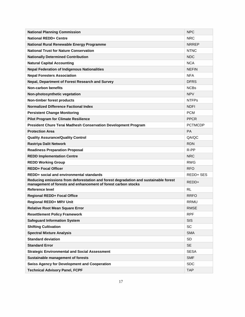
17
National Planning Commission NPC
National REDD+ Centre NRC
National Rural Renewable Energy Programme NRREP
National Trust for Nature Conservation NTNC
Nationally Determined Contribution NDC
Natural Capital Accounting NCA
Nepal Federation of Indigenous Nationalities NEFIN
Nepal Foresters Association NFA
Nepal, Department of Forest Research and Survey DFRS
Non-carbon benefits NCBs
Non-photosynthetic vegetation NPV
Non-timber forest products NTFPs
Normalized Difference Factional Index NDFI
Persistent Change Monitoring PCM
Pilot Program for Climate Resilience PPCR
President Chure Terai Madhesh Conservation Development Program PCTMCDP
Protection Area PA
Quality Assurance/Quality Control QA/QC
Rastriya Dalit Network RDN
Readiness Preparation Proposal R-PP
REDD Implementation Centre NRC
REDD Working Group RWG
REDD+ Focal Officer RFO
REDD+ social and environmental standards REDD+ SES
Reducing emissions from deforestation and forest degradation and sustainable forest management of forests and enhancement of forest carbon stocks
REDD+
Reference level RL
Regional REDD+ Focal Office RRFO
Regional REDD+ MRV Unit RRMU
Relative Root Mean Square Error RMSE
Resettlement Policy Framework RPF
Safeguard Information System SIS
Shifting Cultivation SC
Spectral Mixture Analysis SMA
Standard deviation SD
Standard Error SE
Strategic Environmental and Social Assessment SESA
Sustainable management of forests SMF
Swiss Agency for Development and Cooperation SDC
Technical Advisory Panel, FCPF TAP
18
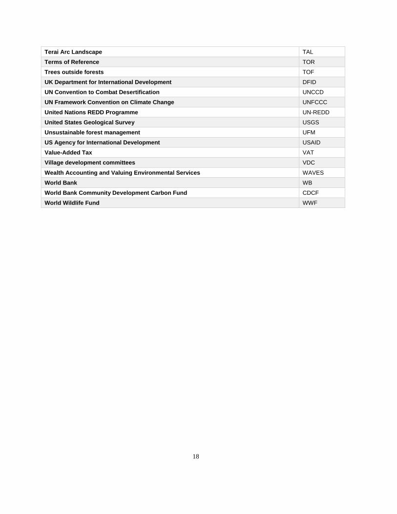
Terai Arc Landscape TAL
Terms of Reference TOR
Trees outside forests TOF
UK Department for International Development DFID
UN Convention to Combat Desertification UNCCD
UN Framework Convention on Climate Change UNFCCC
United Nations REDD Programme UN-REDD
United States Geological Survey USGS
Unsustainable forest management UFM
US Agency for International Development USAID
Value-Added Tax VAT
Village development committees VDC
Wealth Accounting and Valuing Environmental Services WAVES
World Bank WB
World Bank Community Development Carbon Fund CDCF
World Wildlife Fund WWF
19
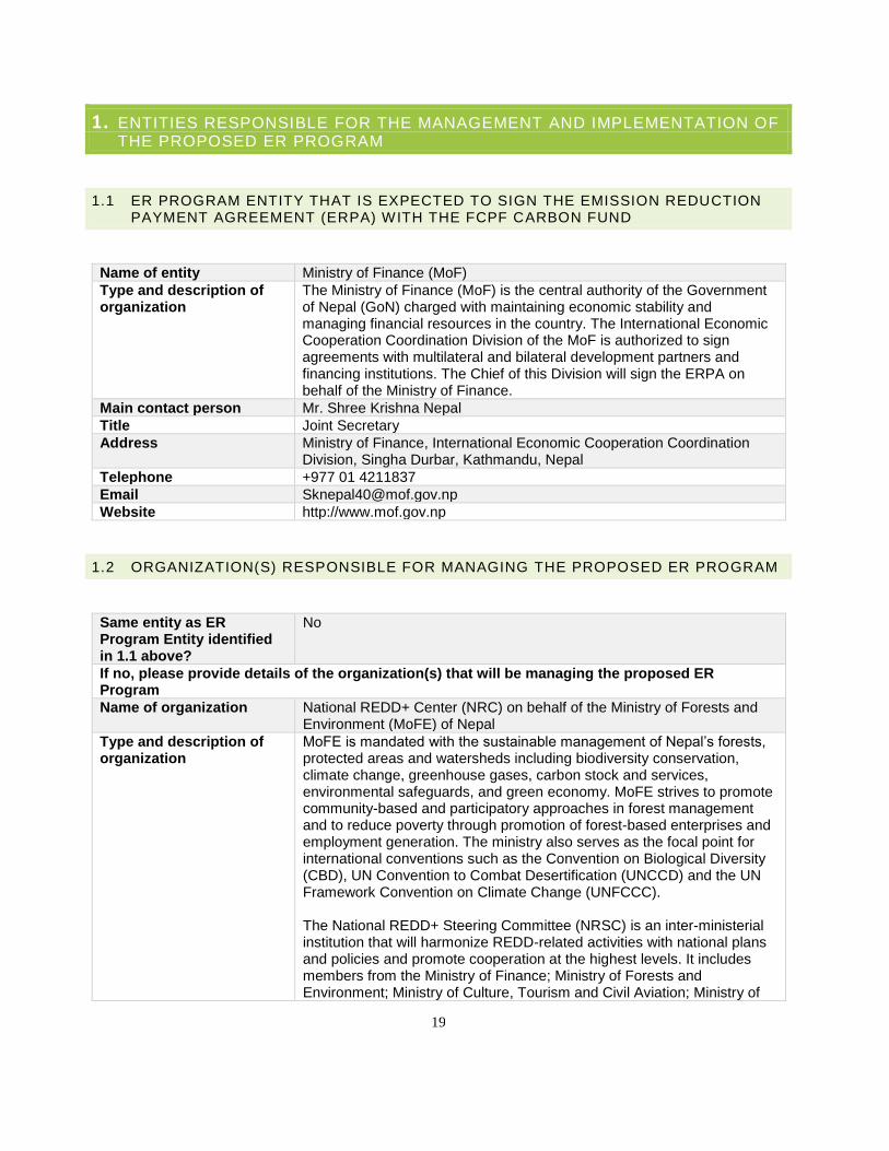
1. ENTITIES RESPONSIBLE FOR THE MANAGEMENT AND IMPLEMENTATION OF THE PROPOSED ER PROGRAM
1.1 ER PROGRAM ENTITY THAT IS EXPECTED TO SIGN THE EMISSION REDUCTION PAYMENT AGREEMENT (ERPA) WITH THE FCPF CARBON FUND
Name of entity Ministry of Finance (MoF)
Type and description of organization
The Ministry of Finance (MoF) is the central authority of the Government of Nepal (GoN) charged with maintaining economic stability and managing financial resources in the country. The International Economic Cooperation Coordination Division of the MoF is authorized to sign agreements with multilateral and bilateral development partners and financing institutions. The Chief of this Division will sign the ERPA on behalf of the Ministry of Finance.
Main contact person Mr. Shree Krishna Nepal
Title Joint Secretary
Address Ministry of Finance, International Economic Cooperation Coordination Division, Singha Durbar, Kathmandu, Nepal
Telephone +977 01 4211837
Email [email protected]
Website http://www.mof.gov.np
1.2 ORGANIZATION(S) RESPONSIBLE FOR MANAGING THE PROPOSED ER PROGRAM
Same entity as ER Program Entity identified in 1.1 above?
No
If no, please provide details of the organization(s) that will be managing the proposed ER Program
Name of organization National REDD+ Center (NRC) on behalf of the Ministry of Forests and Environment (MoFE) of Nepal
Type and description of organization
MoFE is mandated with the sustainable management of Nepal’s forests, protected areas and watersheds including biodiversity conservation, climate change, greenhouse gases, carbon stock and services, environmental safeguards, and green economy. MoFE strives to promote community-based and participatory approaches in forest management and to reduce poverty through promotion of forest-based enterprises and employment generation. The ministry also serves as the focal point for international conventions such as the Convention on Biological Diversity (CBD), UN Convention to Combat Desertification (UNCCD) and the UN Framework Convention on Climate Change (UNFCCC). The National REDD+ Steering Committee (NRSC) is an inter-ministerial institution that will harmonize REDD-related activities with national plans and policies and promote cooperation at the highest levels. It includes members from the Ministry of Finance; Ministry of Forests and Environment; Ministry of Culture, Tourism and Civil Aviation; Ministry of
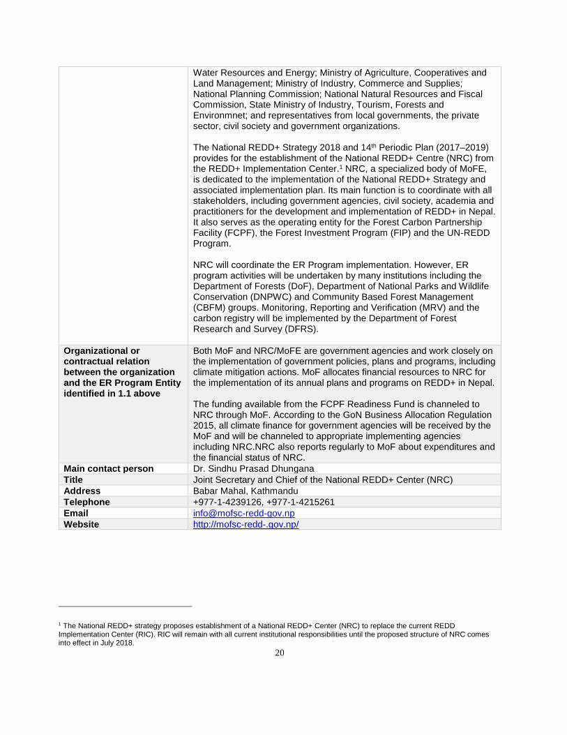
20
Water Resources and Energy; Ministry of Agriculture, Cooperatives and Land Management; Ministry of Industry, Commerce and Supplies; National Planning Commission; National Natural Resources and Fiscal Commission, State Ministry of Industry, Tourism, Forests and Environmnet; and representatives from local governments, the private sector, civil society and government organizations. The National REDD+ Strategy 2018 and 14th Periodic Plan (2017–2019) provides for the establishment of the National REDD+ Centre (NRC) from the REDD+ Implementation Center.1 NRC, a specialized body of MoFE, is dedicated to the implementation of the National REDD+ Strategy and associated implementation plan. Its main function is to coordinate with all stakeholders, including government agencies, civil society, academia and practitioners for the development and implementation of REDD+ in Nepal. It also serves as the operating entity for the Forest Carbon Partnership Facility (FCPF), the Forest Investment Program (FIP) and the UN-REDD Program. NRC will coordinate the ER Program implementation. However, ER program activities will be undertaken by many institutions including the Department of Forests (DoF), Department of National Parks and Wildlife Conservation (DNPWC) and Community Based Forest Management (CBFM) groups. Monitoring, Reporting and Verification (MRV) and the carbon registry will be implemented by the Department of Forest Research and Survey (DFRS).
Organizational or contractual relation between the organization and the ER Program Entity identified in 1.1 above
Both MoF and NRC/MoFE are government agencies and work closely on the implementation of government policies, plans and programs, including climate mitigation actions. MoF allocates financial resources to NRC for the implementation of its annual plans and programs on REDD+ in Nepal. The funding available from the FCPF Readiness Fund is channeled to NRC through MoF. According to the GoN Business Allocation Regulation 2015, all climate finance for government agencies will be received by the MoF and will be channeled to appropriate implementing agencies including NRC.NRC also reports regularly to MoF about expenditures and the financial status of NRC.
Main contact person Dr. Sindhu Prasad Dhungana
Title Joint Secretary and Chief of the National REDD+ Center (NRC)
Address Babar Mahal, Kathmandu
Telephone +977-1-4239126, +977-1-4215261
Email [email protected]
Website http://mofsc-redd-.gov.np/
1 The National REDD+ strategy proposes establishment of a National REDD+ Center (NRC) to replace the current REDD Implementation Center (RIC). RIC will remain with all current institutional responsibilities until the proposed structure of NRC comes into effect in July 2018.
21
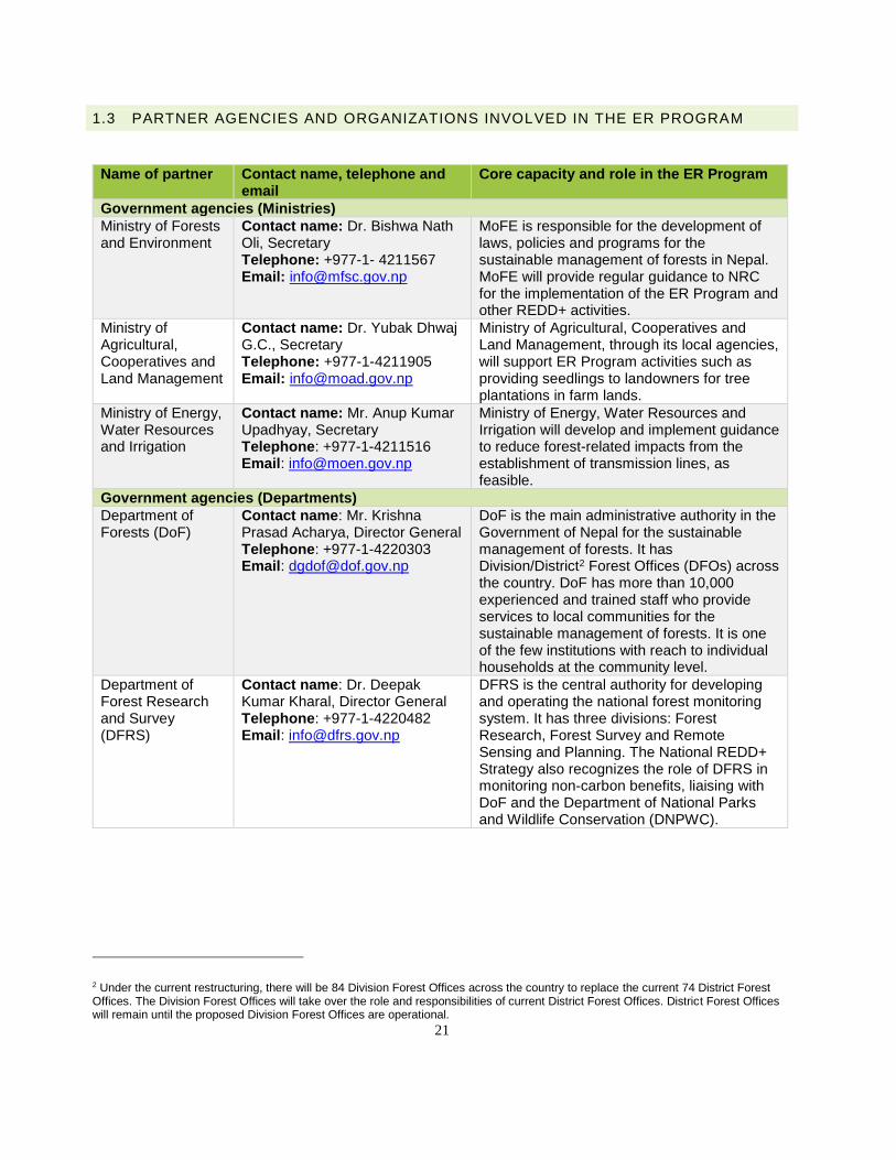
1.3 PARTNER AGENCIES AND ORGANIZATIONS INVOLVED IN THE ER PROGRAM
Name of partner Contact name, telephone and email
Core capacity and role in the ER Program
Government agencies (Ministries)
Ministry of Forests and Environment
Contact name: Dr. Bishwa Nath Oli, Secretary Telephone: +977-1- 4211567 Email: [email protected]
MoFE is responsible for the development of laws, policies and programs for the sustainable management of forests in Nepal. MoFE will provide regular guidance to NRC for the implementation of the ER Program and other REDD+ activities.
Ministry of Agricultural, Cooperatives and Land Management
Contact name: Dr. Yubak Dhwaj G.C., Secretary Telephone: +977-1-4211905 Email: [email protected]
Ministry of Agricultural, Cooperatives and Land Management, through its local agencies, will support ER Program activities such as providing seedlings to landowners for tree plantations in farm lands.
Ministry of Energy, Water Resources and Irrigation
Contact name: Mr. Anup Kumar Upadhyay, Secretary Telephone: +977-1-4211516 Email: [email protected]
Ministry of Energy, Water Resources and Irrigation will develop and implement guidance to reduce forest-related impacts from the establishment of transmission lines, as feasible.
Government agencies (Departments)
Department of Forests (DoF)
Contact name: Mr. Krishna Prasad Acharya, Director General Telephone: +977-1-4220303 Email: [email protected]
DoF is the main administrative authority in the Government of Nepal for the sustainable management of forests. It has Division/District2 Forest Offices (DFOs) across the country. DoF has more than 10,000 experienced and trained staff who provide services to local communities for the sustainable management of forests. It is one of the few institutions with reach to individual households at the community level.
Department of Forest Research and Survey (DFRS)
Contact name: Dr. Deepak Kumar Kharal, Director General Telephone: +977-1-4220482 Email: [email protected]
DFRS is the central authority for developing and operating the national forest monitoring system. It has three divisions: Forest Research, Forest Survey and Remote Sensing and Planning. The National REDD+ Strategy also recognizes the role of DFRS in monitoring non-carbon benefits, liaising with DoF and the Department of National Parks and Wildlife Conservation (DNPWC).
2 Under the current restructuring, there will be 84 Division Forest Offices across the country to replace the current 74 District Forest Offices. The Division Forest Offices will take over the role and responsibilities of current District Forest Offices. District Forest Offices will remain until the proposed Division Forest Offices are operational.
22
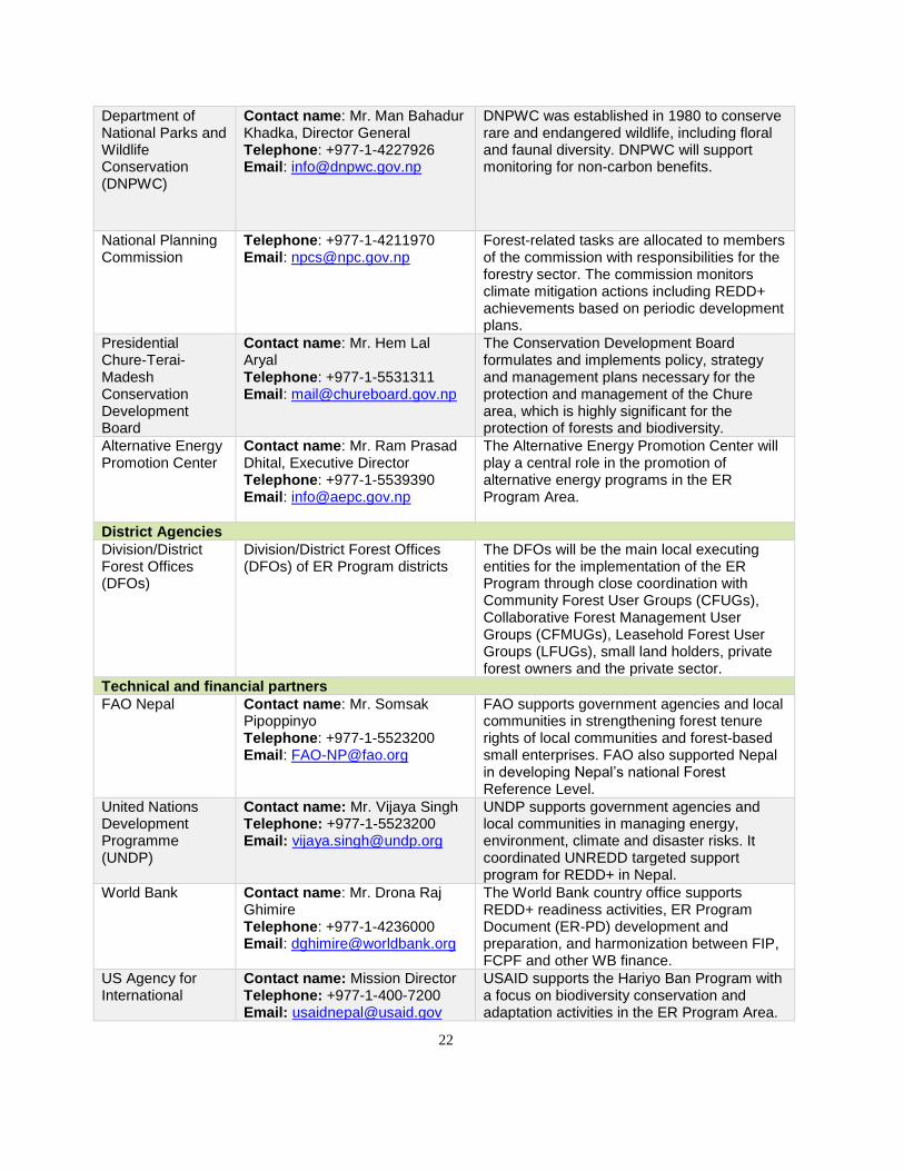
Department of National Parks and Wildlife Conservation (DNPWC)
Contact name: Mr. Man Bahadur Khadka, Director General Telephone: +977-1-4227926 Email: [email protected]
DNPWC was established in 1980 to conserve rare and endangered wildlife, including floral and faunal diversity. DNPWC will support monitoring for non-carbon benefits.
National Planning Commission
Telephone: +977-1-4211970 Email: [email protected]
Forest-related tasks are allocated to members of the commission with responsibilities for the forestry sector. The commission monitors climate mitigation actions including REDD+ achievements based on periodic development plans.
Presidential Chure-Terai-Madesh Conservation Development Board
Contact name: Mr. Hem Lal Aryal Telephone: +977-1-5531311 Email: [email protected]
The Conservation Development Board formulates and implements policy, strategy and management plans necessary for the protection and management of the Chure area, which is highly significant for the protection of forests and biodiversity.
Alternative Energy Promotion Center
Contact name: Mr. Ram Prasad Dhital, Executive Director Telephone: +977-1-5539390 Email: [email protected]
The Alternative Energy Promotion Center will play a central role in the promotion of alternative energy programs in the ER Program Area.
District Agencies
Division/District Forest Offices (DFOs)
Division/District Forest Offices (DFOs) of ER Program districts
The DFOs will be the main local executing entities for the implementation of the ER Program through close coordination with Community Forest User Groups (CFUGs), Collaborative Forest Management User Groups (CFMUGs), Leasehold Forest User Groups (LFUGs), small land holders, private forest owners and the private sector.
Technical and financial partners
FAO Nepal Contact name: Mr. Somsak Pipoppinyo Telephone: +977-1-5523200 Email: [email protected]
FAO supports government agencies and local communities in strengthening forest tenure rights of local communities and forest-based small enterprises. FAO also supported Nepal in developing Nepal’s national Forest Reference Level.
United Nations Development Programme (UNDP)
Contact name: Mr. Vijaya Singh Telephone: +977-1-5523200 Email: [email protected]
UNDP supports government agencies and local communities in managing energy, environment, climate and disaster risks. It coordinated UNREDD targeted support program for REDD+ in Nepal.
World Bank Contact name: Mr. Drona Raj Ghimire Telephone: +977-1-4236000 Email: [email protected]
The World Bank country office supports REDD+ readiness activities, ER Program Document (ER-PD) development and preparation, and harmonization between FIP, FCPF and other WB finance.
US Agency for International
Contact name: Mission Director Telephone: +977-1-400-7200 Email: [email protected]
USAID supports the Hariyo Ban Program with a focus on biodiversity conservation and adaptation activities in the ER Program Area.
23
Development (USAID)
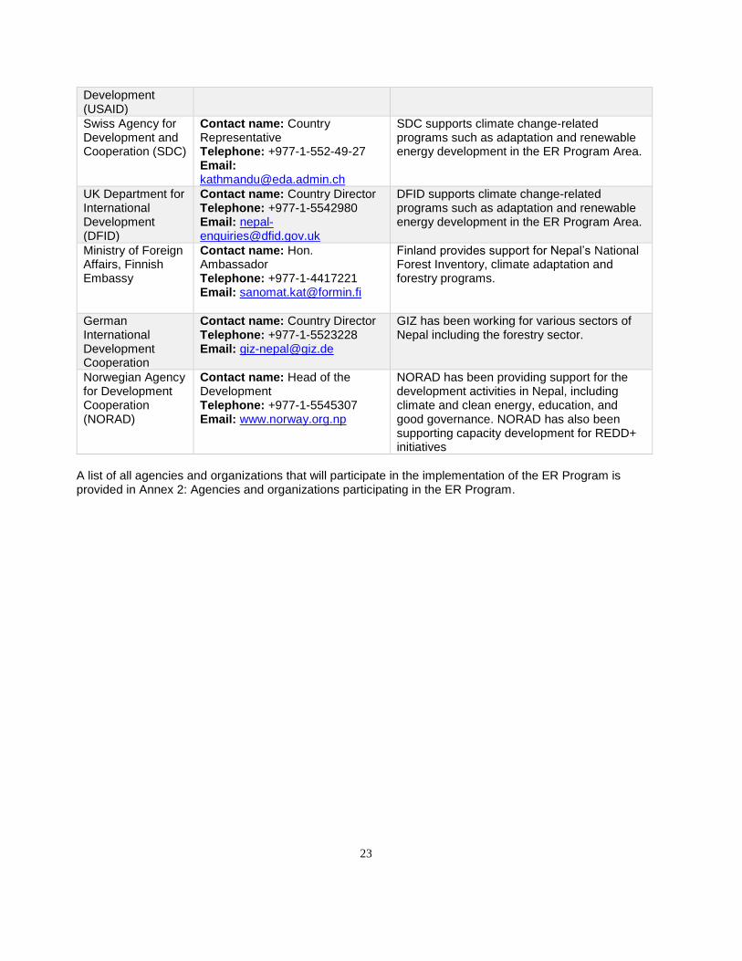
Swiss Agency for Development and Cooperation (SDC)
Contact name: Country Representative Telephone: +977-1-552-49-27 Email: [email protected]
SDC supports climate change-related programs such as adaptation and renewable energy development in the ER Program Area.
UK Department for International Development (DFID)
Contact name: Country Director Telephone: +977-1-5542980 Email: [email protected]
DFID supports climate change-related programs such as adaptation and renewable energy development in the ER Program Area.
Ministry of Foreign Affairs, Finnish Embassy
Contact name: Hon. Ambassador Telephone: +977-1-4417221 Email: [email protected]
Finland provides support for Nepal’s National Forest Inventory, climate adaptation and forestry programs.
German International Development Cooperation
Contact name: Country Director Telephone: +977-1-5523228 Email: [email protected]
GIZ has been working for various sectors of Nepal including the forestry sector.
Norwegian Agency for Development Cooperation (NORAD)
Contact name: Head of the Development Telephone: +977-1-5545307 Email: www.norway.org.np
NORAD has been providing support for the development activities in Nepal, including climate and clean energy, education, and good governance. NORAD has also been supporting capacity development for REDD+ initiatives
A list of all agencies and organizations that will participate in the implementation of the ER Program is provided in Annex 2: Agencies and organizations participating in the ER Program.
24
2. STRATEGIC CONTEXT AND RATIONALE FOR THE ER PROGRAM
2.1 CURRENT STATUS OF THE READINESS PACKAGE AND SUMMARY OF ADDITIONAL ACHIEVEMENTS OF READINESS ACTIVITIES IN THE COUNTRY
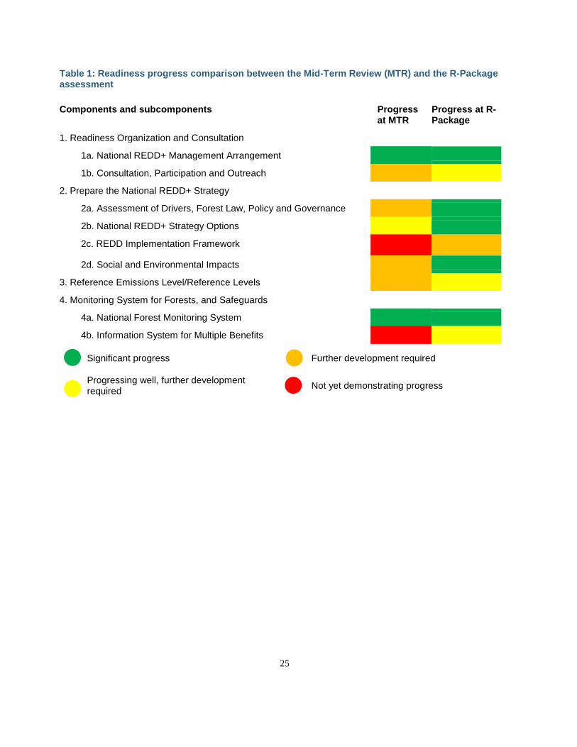
Nepal initiated REDD+ Readiness activities in 2011. In December 2013, Nepal became the third REDD country to present a Mid-Term Report (MTR) to the FCPF Participants Committee. In March 2014, the Government of Nepal submitted an Emission Reductions Program Idea Note (ER-PIN) to the ninth FCPF Carbon Fund meeting for 12 contiguous districts in the Terai Arc Landscape (TAL). At the meeting, Carbon Fund Participants accepted Nepal’s ER-PIN into the Carbon Fund pipeline and allocated up to US$ 650,000 to support the development of Nepal’s ER Program Document (ER-PD). Nepal successfully completed its first phase of REDD+ readiness in August 2015 and then requested mid-term readiness funds in September 2015. This request was approved by the 20th meeting of the Participant Committee of the FCPF in November 2015 (Resolution PC/20/2015/3). Nepal submitted its R-Package to the PC in July 2016, and it was endorsed by the 22nd meeting of the PC in September 2016 (Resolution PC/22/2016/1). The Findings of the R-Package assessment as compared to the Mid-Term Report are summarized in Table 1 and demonstrate forward progress in all components. In January 2017, Nepal secured mid-term readiness funding for US$ 5.2 million. The use of these funds is focused largely on the issues prioritized in the self-assessment to ensure a robust foundation of REDD+ readiness behind the ER Program in the Terai as well as to scale this readiness nationally. The R-Package self-assessment concluded that Nepal achieved significant progress for 16 criteria, good progress for 12 criteria, and required further development for 12 criteria (six of these overlapping with the good progress category). No elements were assessed as not yet demonstrating progress. The TAP review of the R-Package3 found the participatory self-assessment process in Nepal was in general well conducted and provided an accurate picture of REDD+ readiness progress in Nepal. The review suggested that under sub-component 2c, the R-package did not sufficiently reflect the progress that had been made on proposed legal reforms for REDD+ implementation, including detailed recommendations with regard to carbon rights. In sub-components 2a and 2b, on the other hand, the reviewers felt that yellow scores might have been more appropriate, given that the R-package report signaled potential challenges in these areas. Those criteria assessed in the orange (further development required) and related follow-up actions and achievements are summarized in Table 2 below.
3 https://www.forestcarbonpartnership.org/sites/fcp/files/2016/Sep/Nepal%20R-Package-TAP%20Review-September%202016.pdf
25
Table 1: Readiness progress comparison between the Mid-Term Review (MTR) and the R-Package assessment
Components and subcomponents Progress at MTR
Progress at R-Package
1. Readiness Organization and Consultation
1a. National REDD+ Management Arrangement
1b. Consultation, Participation and Outreach
2. Prepare the National REDD+ Strategy
2a. Assessment of Drivers, Forest Law, Policy and Governance
2b. National REDD+ Strategy Options
2c. REDD Implementation Framework
2d. Social and Environmental Impacts
3. Reference Emissions Level/Reference Levels
4. Monitoring System for Forests, and Safeguards
4a. National Forest Monitoring System
4b. Information System for Multiple Benefits
Significant progress Further development required
Progressing well, further development required
Not yet demonstrating progress
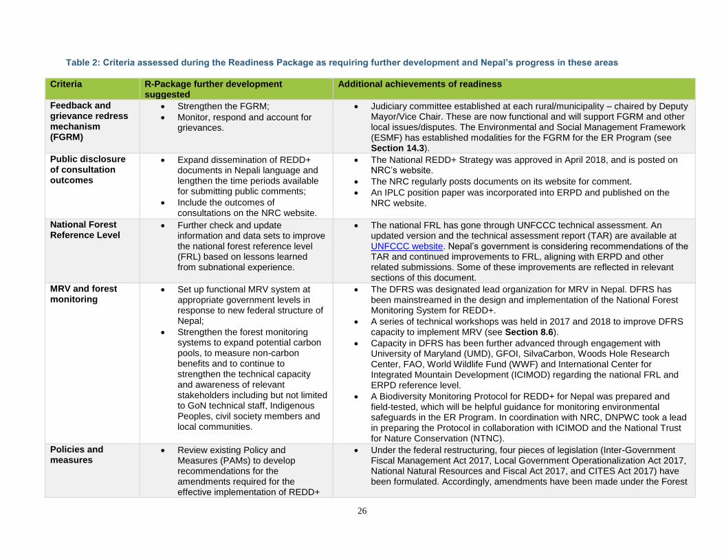
26
Table 2: Criteria assessed during the Readiness Package as requiring further development and Nepal’s progress in these areas
Criteria R-Package further development suggested
Additional achievements of readiness
Feedback and grievance redress mechanism (FGRM)
• Strengthen the FGRM;
• Monitor, respond and account for grievances.
• Judiciary committee established at each rural/municipality – chaired by Deputy Mayor/Vice Chair. These are now functional and will support FGRM and other local issues/disputes. The Environmental and Social Management Framework (ESMF) has established modalities for the FGRM for the ER Program (see Section 14.3).
Public disclosure of consultation outcomes
• Expand dissemination of REDD+ documents in Nepali language and lengthen the time periods available for submitting public comments;
• Include the outcomes of consultations on the NRC website.
• The National REDD+ Strategy was approved in April 2018, and is posted on NRC’s website.
• The NRC regularly posts documents on its website for comment.
• An IPLC position paper was incorporated into ERPD and published on the NRC website.
National Forest Reference Level
• Further check and update information and data sets to improve the national forest reference level (FRL) based on lessons learned from subnational experience.
• The national FRL has gone through UNFCCC technical assessment. An updated version and the technical assessment report (TAR) are available at UNFCCC website. Nepal’s government is considering recommendations of the TAR and continued improvements to FRL, aligning with ERPD and other related submissions. Some of these improvements are reflected in relevant sections of this document.
MRV and forest monitoring
• Set up functional MRV system at appropriate government levels in response to new federal structure of Nepal;
• Strengthen the forest monitoring systems to expand potential carbon pools, to measure non-carbon benefits and to continue to strengthen the technical capacity and awareness of relevant stakeholders including but not limited to GoN technical staff, Indigenous Peoples, civil society members and local communities.
• The DFRS was designated lead organization for MRV in Nepal. DFRS has been mainstreamed in the design and implementation of the National Forest Monitoring System for REDD+.
• A series of technical workshops was held in 2017 and 2018 to improve DFRS capacity to implement MRV (see Section 8.6).
• Capacity in DFRS has been further advanced through engagement with University of Maryland (UMD), GFOI, SilvaCarbon, Woods Hole Research Center, FAO, World Wildlife Fund (WWF) and International Center for Integrated Mountain Development (ICIMOD) regarding the national FRL and ERPD reference level.
• A Biodiversity Monitoring Protocol for REDD+ for Nepal was prepared and field-tested, which will be helpful guidance for monitoring environmental safeguards in the ER Program. In coordination with NRC, DNPWC took a lead in preparing the Protocol in collaboration with ICIMOD and the National Trust for Nature Conservation (NTNC).
Policies and measures
• Review existing Policy and Measures (PAMs) to develop recommendations for the amendments required for the effective implementation of REDD+
• Under the federal restructuring, four pieces of legislation (Inter-Government Fiscal Management Act 2017, Local Government Operationalization Act 2017, National Natural Resources and Fiscal Act 2017, and CITES Act 2017) have been formulated. Accordingly, amendments have been made under the Forest
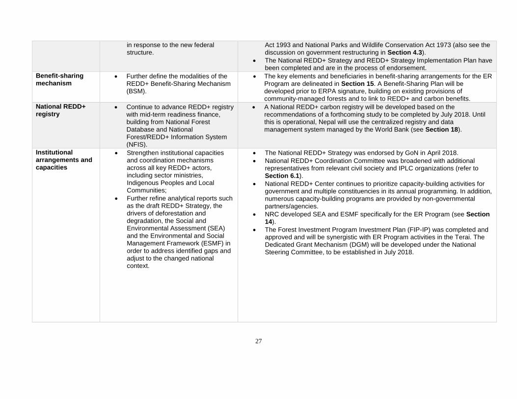
27
in response to the new federal structure.
Act 1993 and National Parks and Wildlife Conservation Act 1973 (also see the discussion on government restructuring in Section 4.3).
• The National REDD+ Strategy and REDD+ Strategy Implementation Plan have been completed and are in the process of endorsement.
Benefit-sharing mechanism
• Further define the modalities of the REDD+ Benefit-Sharing Mechanism (BSM).
• The key elements and beneficiaries in benefit-sharing arrangements for the ER Program are delineated in Section 15. A Benefit-Sharing Plan will be developed prior to ERPA signature, building on existing provisions of community-managed forests and to link to REDD+ and carbon benefits.
National REDD+ registry
• Continue to advance REDD+ registry with mid-term readiness finance, building from National Forest Database and National Forest/REDD+ Information System (NFIS).
• A National REDD+ carbon registry will be developed based on the recommendations of a forthcoming study to be completed by July 2018. Until this is operational, Nepal will use the centralized registry and data management system managed by the World Bank (see Section 18).
Institutional arrangements and capacities
• Strengthen institutional capacities and coordination mechanisms across all key REDD+ actors, including sector ministries, Indigenous Peoples and Local Communities;
• Further refine analytical reports such as the draft REDD+ Strategy, the drivers of deforestation and degradation, the Social and Environmental Assessment (SEA) and the Environmental and Social Management Framework (ESMF) in order to address identified gaps and adjust to the changed national context.
• The National REDD+ Strategy was endorsed by GoN in April 2018.
• National REDD+ Coordination Committee was broadened with additional representatives from relevant civil society and IPLC organizations (refer to Section 6.1).
• National REDD+ Center continues to prioritize capacity-building activities for government and multiple constituencies in its annual programming. In addition, numerous capacity-building programs are provided by non-governmental partners/agencies.
• NRC developed SEA and ESMF specifically for the ER Program (see Section 14).
• The Forest Investment Program Investment Plan (FIP-IP) was completed and approved and will be synergistic with ER Program activities in the Terai. The Dedicated Grant Mechanism (DGM) will be developed under the National Steering Committee, to be established in July 2018.
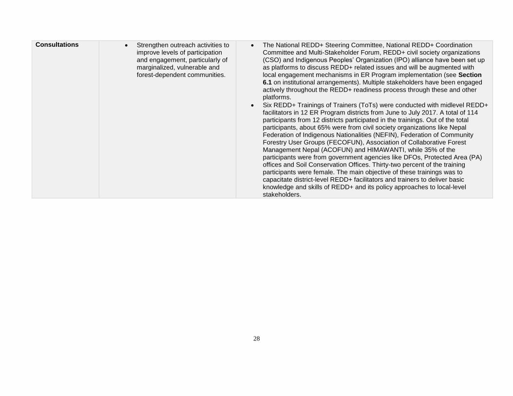
28
Consultations • Strengthen outreach activities to improve levels of participation and engagement, particularly of marginalized, vulnerable and forest-dependent communities.
• The National REDD+ Steering Committee, National REDD+ Coordination Committee and Multi-Stakeholder Forum, REDD+ civil society organizations (CSO) and Indigenous Peoples’ Organization (IPO) alliance have been set up as platforms to discuss REDD+ related issues and will be augmented with local engagement mechanisms in ER Program implementation (see Section 6.1 on institutional arrangements). Multiple stakeholders have been engaged actively throughout the REDD+ readiness process through these and other platforms.
• Six REDD+ Trainings of Trainers (ToTs) were conducted with midlevel REDD+ facilitators in 12 ER Program districts from June to July 2017. A total of 114 participants from 12 districts participated in the trainings. Out of the total participants, about 65% were from civil society organizations like Nepal Federation of Indigenous Nationalities (NEFIN), Federation of Community Forestry User Groups (FECOFUN), Association of Collaborative Forest Management Nepal (ACOFUN) and HIMAWANTI, while 35% of the participants were from government agencies like DFOs, Protected Area (PA) offices and Soil Conservation Offices. Thirty-two percent of the training participants were female. The main objective of these trainings was to capacitate district-level REDD+ facilitators and trainers to deliver basic knowledge and skills of REDD+ and its policy approaches to local-level stakeholders.
29
2.2 AMBITION AND STRATEGIC RATIONALE FOR THE ER PROGRAM
Nepal’s national greenhouse gas (GHG) emissions, excluding the Land Use, Land Use Change and Forestry (LULUCF) sector, were estimated at 24.5 million tons carbon dioxide equivalent (MtCO2e) for the base year of 2000. Nearly 70% of this total comes from the agricultural sector.4 Emissions and removals in the LULUCF sector for the same base year were estimated nationally to be a net sink of 12.8 MtCO2e. Nepal’s national forest reference emission level (FREL) submitted in 2017 to the UNFCCC for the reference period 2000–2010 estimated annual emissions from deforestation and degradation at 1.34 MtCO2e and only partially estimates GHG removals from sinks (0.15 MtCO2e).5 The reference level for the ER Program Area from 2004 to 2014 estimates average annual emissions from deforestation and degradation at 1.73 million MtCO2e, and gain from forest regeneration at 0.84 MtCO2e (Section 8). Though ex-ante estimates of program volumes are not directly comparable to these ex-poste estimations, the Terai ER Program sets an ambitious but achievable agenda to achieve 34.2 MtCO2e in carbon benefits (combined emissions reductions and removals) over a 10-year period (Section 13). With a central focus on localizing forest governance in community and collaborative forests and broadening the application of sustainable forest management practices, the strategic rationale for the ER Program is rooted firmly in the National REDD+ Strategy and Implementation Framework (2018), and is consistent with several other key national policies and strategies summarized in Table 3. The National REDD+ Strategy drives at five overall objectives: 1) addressing key drivers and expanding sustainable management of forests, 2) ensuring fair and equitable benefit sharing of carbon and non-carbon benefits, 3) increasing livelihood opportunities for poor and forest-dependent communities, 4) improving governance in forest agencies and by harmonizing relevant policy and legal frameworks, and 5) establishing and maintaining a robust forest monitoring system. The proposed ER Program outlines measures in support of all five of these objectives and against four key targets identified in the Implementation Framework, including land area under CBFM, area in Private Forest (PF), area under Sustainable Forest Management (SFM) and establishment of biogas plants (under the alternative energy program). Table 3: Priority national policies and initiatives advanced by ER Program activities
National policy/initiative Key objectives and links to ER Program activities
National Low Carbon Development Strategy (NLCDS)
The NLCDS integrates REDD+ activities and includes forestry as one of six leading sectors for promoting low carbon growth in Nepal. The strategy stresses improving forest management practices, community-based forest management and livelihoods through sustainable forest management. The strategy further highlights the need to include women, Indigenous Peoples, Dalits and marginalized communities in all processes. Some key activities currently underway and relevant to the ER Program include the following: preparation of allometric equations for 10 forest tree species, establishment of a national carbon registry, improvements and updated database management at the DFRS, and an improved and updated national forest information system and national forest database.
Strategy and Action Plan 2015–2025, Terai Arc Landscape
The ER Program builds upon a strong national commitment to forest conservation and landscape planning led by the MoFE and delineated in the TAL Strategy and Action Plan 2015–2025. This strategy will be a key policy priority for development and conservation in the TAL over the next 10 years.
4 Nepal 2nd National Communication to UNFCCC 2014. Source: http://unfccc.int/resource/docs/natc/nplnc2.pdf. 5 National Forest Reference Level of Nepal 2016. Source: redd.unfccc.int/files/nepal_frl_jan_8__2017.pdf.
30
Forestry Sector Strategy (2016–2025)
The Forestry Sector Strategy (2016–2025) of Nepal aims to enhance national carbon stocks by 5% from the current forest carbon stock estimate of 177.6 tC/Ha and decrease deforestation rates by 0.05%—from current figures of about 0.44% and 0.18% in the Terai and Chure, respectively—through activities including community-based forest management (CBFM), sustainable management of forests (SMF), leasehold forests (LF) and forest enterprise development. All of these activities are represented in the proposed ER Program.
Forest Policy 2015 The ER Program is consistent with the Government of Nepal’s Forest Policy (2015), which identifies community, collaborative, leasehold, protection, buffer zone, religious and private forests as key tools for the provision of social, economic and ecosystems services. The Forest Policy identifies forests as critical to climate change adaptation and provision of forest ecosystem services. The Forest Policy recognizes forests as a renewable natural resource that contributes to subsistence livelihoods and recognizes subsistence forest use as a stepping stone to increased application of good forest management practices.
National Biodiversity Strategy and Action Plan 2014–2020
The ER Program will support Nepal’s National Biodiversity Strategy and Action Plan (NBSAP) 2014–2020, which prioritizes the meaningful participation of local communities in the management of natural resources, implementation of landscape approaches to address multiple drivers of biodiversity loss, and cooperation among relevant agencies to achieve success in biodiversity conservation. The ER Program will support the implementation of priority actions linked to the NBSAP to meet the Aichi Targets. This includes contributions to Aichi Target 5, concerning loss of natural habitat, including forests, and Aichi Target 7, concerning sustainable management of agriculture and forests to ensure conservation of biodiversity.
Nationally Determined Contribution
The Nationally Determined Contribution (NDC), submitted by Nepal to the UNFCCC in November 2016, outlines both mitigation and adaptation strategies to address climate change. The NDC goals prioritize resource conservation and management in forest areas; reducing dependency on biomass through the use of alternative energy; and maintaining forest cover and enhancing carbon sequestration through sustainable management of forests, improved forest governance to control drivers of deforestation and forest degradation, and institutional strengthening.
The proposed Program Area was selected both for its strategic role in advancing REDD+ implementation priorities in Nepal and for its potential to generate near-term carbon and non-carbon benefits under a Carbon Fund program. Set mostly in the Terai and Chure physiographic regions, the Program Area represents approximately 15% of Nepal’s total land area, 20% of national forest area, 25% of the national population and much of the country’s rich biodiversity. It is also the region of highest agricultural productivity in the country, with associated economic growth, urbanization and infrastructure placing pressures on forests and other natural resources. It is therefore central to Nepal’s development strategy as well as its national strategy for climate change mitigation and adaptation. The ER Program will be the leading subnational effort for REDD+ demonstration and performance-based activities and will serve as a model to replicate priority REDD+ activities in other parts of the country. The ER Program will build from the foundational successes of the first phase of the TAL Program, initiated in 2001 in partnership with WWF to scale up community conservation as a platform for both economic development and sustainable natural resources management. This landscape-level program has been critical in protecting forests, species and ecosystems across the TAL while also expanding sustainable livelihood opportunities for the region’s people. Over the past 15 years, nearly 62,000 ha of
31
degraded forests have been restored; wildlife populations have increased, with tiger populations increasing by 63% and rhinos increasing by 23%; more than 50,000 households increased incomes through nature-based enterprises and improved access to alternative energy; and community-based conservation organizations have strengthened their capacities to manage natural resources. However, these achievements are threatened by persistent drivers in the region including unsustainable harvesting, overgrazing, and forest fires, particularly in government forests with limited management, indicating the importance of scaling up successful community-based forest conservation approaches in the ER Program Area. The ER Program will be a critical part of the story of forest and landscape conservation in Nepal by leveraging performance-based payments to deliver forest conservation achievements at scale.
2.3 POLITICAL COMMITMENT
The Government of Nepal considers REDD+ as one of its highest-priority programs, and its progress is monitored up to the level of Minister in several sectors beyond MoFE as well by the National Planning Commission (NPC), the Office of Prime Minister and the Council of Ministers. In April 2018, GoN endorsed the National REDD+ Strategy, for which the ER Program is a central component, and the proposed ER Program. By linking carbon finance with specific programs and initiatives that deliver concrete results, the GoN expects that development and implementation of the ER Program will continue to build on this political support for REDD+ and advance Nepal’s national readiness efforts, laying the foundation for additional results-based programs. The Government of Nepal has demonstrated consistent commitment to conserving and managing Nepal’s natural heritage and, more recently, to the opportunities presented by REDD+, by imbedding relevant practices and strategies in several national planning frameworks, described in Section 2.2. In addition, the 13th Periodic Plan of the National Planning Commission (NPC) emphasizes that the conservation and sustainable management of forestry resources including forests, plants, wildlife and biodiversity should be optimized through participatory and decentralized systems, as are proposed for the ER Program, and the 14th Periodic Plan (2017–2019) aims to promote diversified forest management practices and improved livelihood and employment opportunities through SFM. Furthermore, in 2014 the government established the President Chure-Terai Madhesh Conservation Development Board to protect the important ecological, social and economic value of the Chure hills. The region has one of the highest rates of deforestation in the country, and is fragile and vulnerable to landslides, soil erosion and flash floods. The fragile ecosystem is further threatened by anthropogenic activities, such as agricultural expansion, illegal logging, uncontrolled grazing and excavation of sand and gravel. The Chure region is critical in maintaining biodiversity, regulating water flows and providing ecosystem services to local and downstream communities. The Conservation Development Board developed a master plan, treating the Chure as a single landscape, and is coordinating efforts with other government and donor programs to implement the master plan. The Government of Nepal provides earmarked funding for protection of the Chure on an annual basis, which, along with the Conservation Development Board, indicates a high level of commitment to protecting the forests, wildlife, ecosystem services and livelihoods of local communities in the region. Forty percent of the Chure falls under the ER Program Area, which provides a unique opportunity to leverage the commitment from the Government of Nepal with the activities of the ER Program. Nepal’s commitment to REDD+ was initially demonstrated through establishment of a three-tiered institutional structure to manage and coordinate REDD+ activities (Section 6). The GoN also participates actively in international negotiations and trainings, including at the UNFCCC, where Nepal has played an important coordinating role for all 49 Least Developed Countries (LDCs) on climate change issues. Nepal is also an active participant at the FCPF, including as a technical resource to its neighboring countries Bhutan and Pakistan.
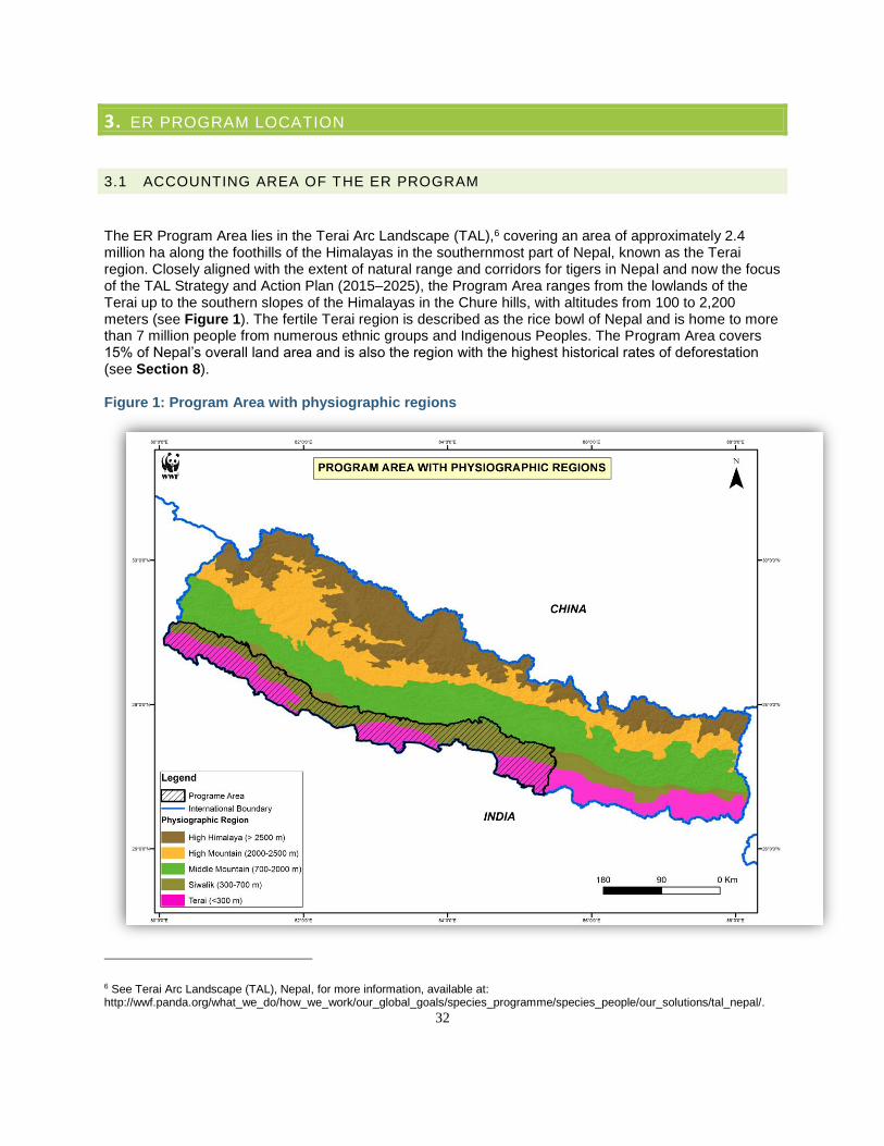
32
3. ER PROGRAM LOCATION
3.1 ACCOUNTING AREA OF THE ER PROGRAM
The ER Program Area lies in the Terai Arc Landscape (TAL),6 covering an area of approximately 2.4 million ha along the foothills of the Himalayas in the southernmost part of Nepal, known as the Terai region. Closely aligned with the extent of natural range and corridors for tigers in Nepal and now the focus of the TAL Strategy and Action Plan (2015–2025), the Program Area ranges from the lowlands of the Terai up to the southern slopes of the Himalayas in the Chure hills, with altitudes from 100 to 2,200 meters (see Figure 1). The fertile Terai region is described as the rice bowl of Nepal and is home to more than 7 million people from numerous ethnic groups and Indigenous Peoples. The Program Area covers 15% of Nepal’s overall land area and is also the region with the highest historical rates of deforestation (see Section 8). Figure 1: Program Area with physiographic regions
6 See Terai Arc Landscape (TAL), Nepal, for more information, available at: http://wwf.panda.org/what_we_do/how_we_work/our_global_goals/species_programme/species_people/our_solutions/tal_nepal/.
33
The Program Area is also jurisdictional, aligned with the 12 western districts of the region, which are Rautahat, Bara, Parsa, Chitwan, Nawalparasi, Rupandehi, Kapilbastu, Dang, Banke, Bardia, Kailali and Kanchanpur (Figure 2 and Table 4). Based on political boundaries established under the new constitution (Section 4.2), the district boundaries are now divided among seven recently delineated states, and the ER Program partially overlaps with five of these. Under the constitutional changes, municipalities will play a greater role in local planning; however, district-level functions will remain, including in the MoFE (see Section 6.1 on institutional arrangements). The NRC will be in place at the federal level and will continue to oversee REDD+ related roles and responsibilities in the forest sector institutions during the remaining restructuring. The implementation of the ER Program will mainly take place at local and community levels, at which roles are already relatively established. According to the Constitution, local governments need to follow federal forest laws during the implementation of forest-related activities. About half of the TAL (1.17 million ha) is forested. According to Forest Act 1993, forests in Nepal are classified into two broad management regimes: National Forest and Private Forest. National Forest is further classified into seven sub-categories: Government-Managed Forest, Forests within the Protected Areas, Collaborative Forest, Protected Forest, Community Forest, Leasehold Forest, and Religious Forest (further described in Table 28 in Section 4.4 below). Of forested areas in the TAL, 29% (0.33 million ha) is within protected areas, and 27% (0.32 million ha) is under community forest (CF). An additional 5% (0.58 million ha) is collaborative forest, and the remaining 39% (0.45 million ha) is government-managed forest (see Table 5).7 These different management regimes and their respective benefits for people, forests, and climate are fundamental to the proposed activities in the ER Program.
7 REDD, Forestry and Climate Change Cell, Ministry of Forest and Soil Conservation, Government of Nepal. Emission Reductions Project Idea Note. Kathmandu, Nepal, 2014.
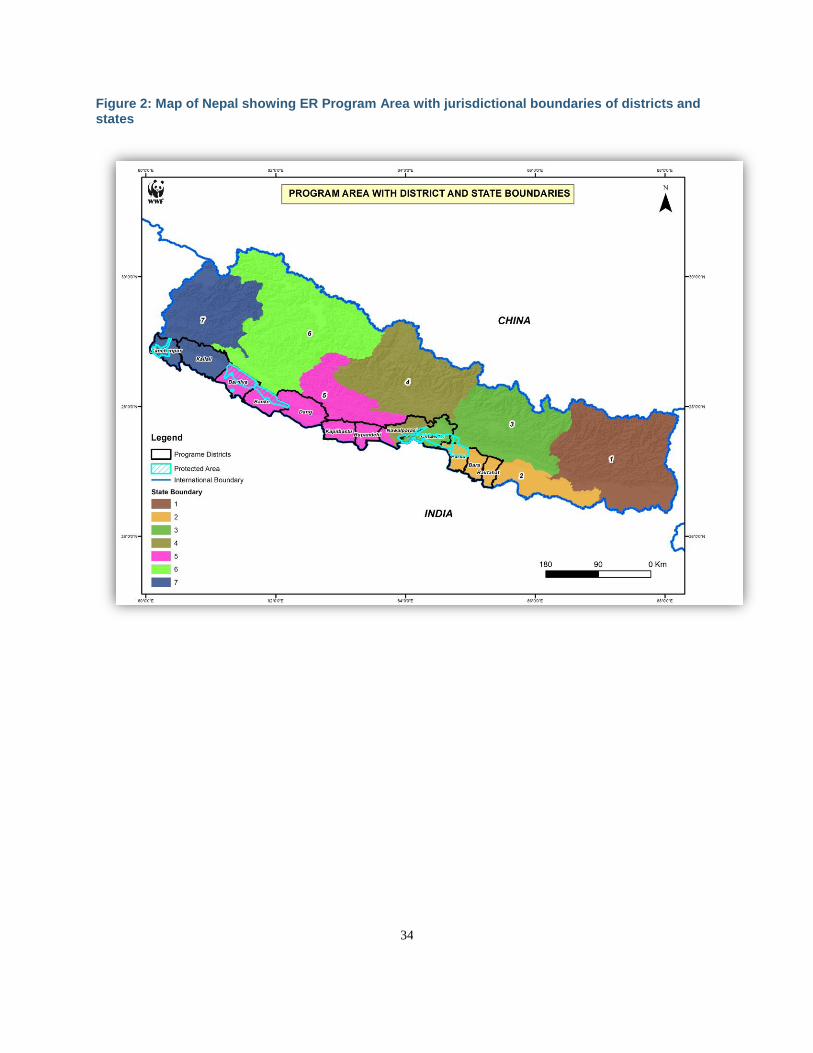
34
Figure 2: Map of Nepal showing ER Program Area with jurisdictional boundaries of districts and states
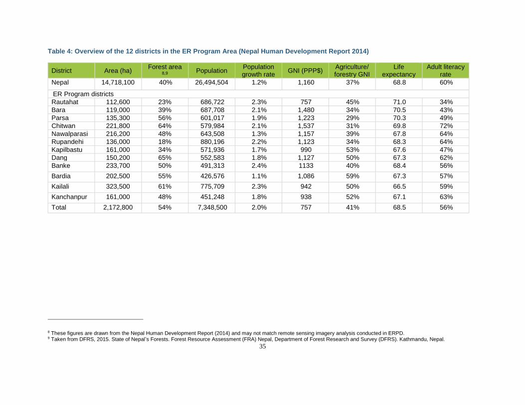
35
Table 4: Overview of the 12 districts in the ER Program Area (Nepal Human Development Report 2014)
District Area (ha) Forest area
8,9 Population
Population growth rate
GNI (PPP$) Agriculture/ forestry GNI
Life expectancy
Adult literacy rate
Nepal 14,718,100 40% 26,494,504 1.2% 1,160 37% 68.8 60%
ER Program districts
Rautahat 112,600 23% 686,722 2.3% 757 45% 71.0 34%
Bara 119,000 39% 687,708 2.1% 1,480 34% 70.5 43%
Parsa 135,300 56% 601,017 1.9% 1,223 29% 70.3 49%
Chitwan 221,800 64% 579,984 2.1% 1,537 31% 69.8 72%
Nawalparasi 216,200 48% 643,508 1.3% 1,157 39% 67.8 64%
Rupandehi 136,000 18% 880,196 2.2% 1,123 34% 68.3 64%
Kapilbastu 161,000 34% 571,936 1.7% 990 53% 67.6 47%
Dang 150,200 65% 552,583 1.8% 1,127 50% 67.3 62%
Banke 233,700 50% 491,313 2.4% 1133 40% 68.4 56%
Bardia 202,500 55% 426,576 1.1% 1,086 59% 67.3 57%
Kailali 323,500 61% 775,709 2.3% 942 50% 66.5 59%
Kanchanpur 161,000 48% 451,248 1.8% 938 52% 67.1 63%
Total 2,172,800 54% 7,348,500 2.0% 757 41% 68.5 56%
8 These figures are drawn from the Nepal Human Development Report (2014) and may not match remote sensing imagery analysis conducted in ERPD. 9 Taken from DFRS, 2015. State of Nepal’s Forests. Forest Resource Assessment (FRA) Nepal, Department of Forest Research and Survey (DFRS). Kathmandu, Nepal.
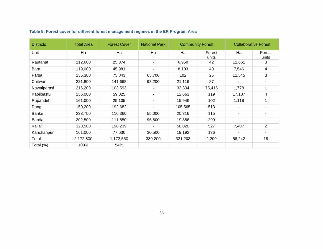
36
Table 5: Forest cover for different forest management regimes in the ER Program Area
Districts Total Area Forest Cover National Park Community Forest Collaborative Forest
Unit Ha Ha Ha Ha Forest units
Ha Forest units
Rautahat 112,600 25,874 - 6,950 42 11,661 3
Bara 119,000 45,981 - 8,103 40 7,546 4
Parsa 135,300 75,843 63,700 102 25 11,545 3
Chitwan 221,800 141,668 93,200 21,116 87 - -
Nawalparasi 216,200 103,593 - 33,334 75,416 1,778 1
Kapilbastu 136,000 59,025 - 12,663 119 17,187 4
Rupandehi 161,000 25,105 - 15,946 102 1,118 1
Dang 150,200 192,682 - 105,565 513 - -
Banke 233,700 116,360 55,000 20,316 115 - -
Bardia 202,500 111,550 96,800 19,886 290 - -
Kailali 323,500 198,239 - 58,020 527 7,407 2
Kanchanpur 161,000 77,630 30,500 19,192 136 - -
Total 2,172,800 1,173,550 339,200 321,203 2,209 58,242 18
Total (%) 100% 54%
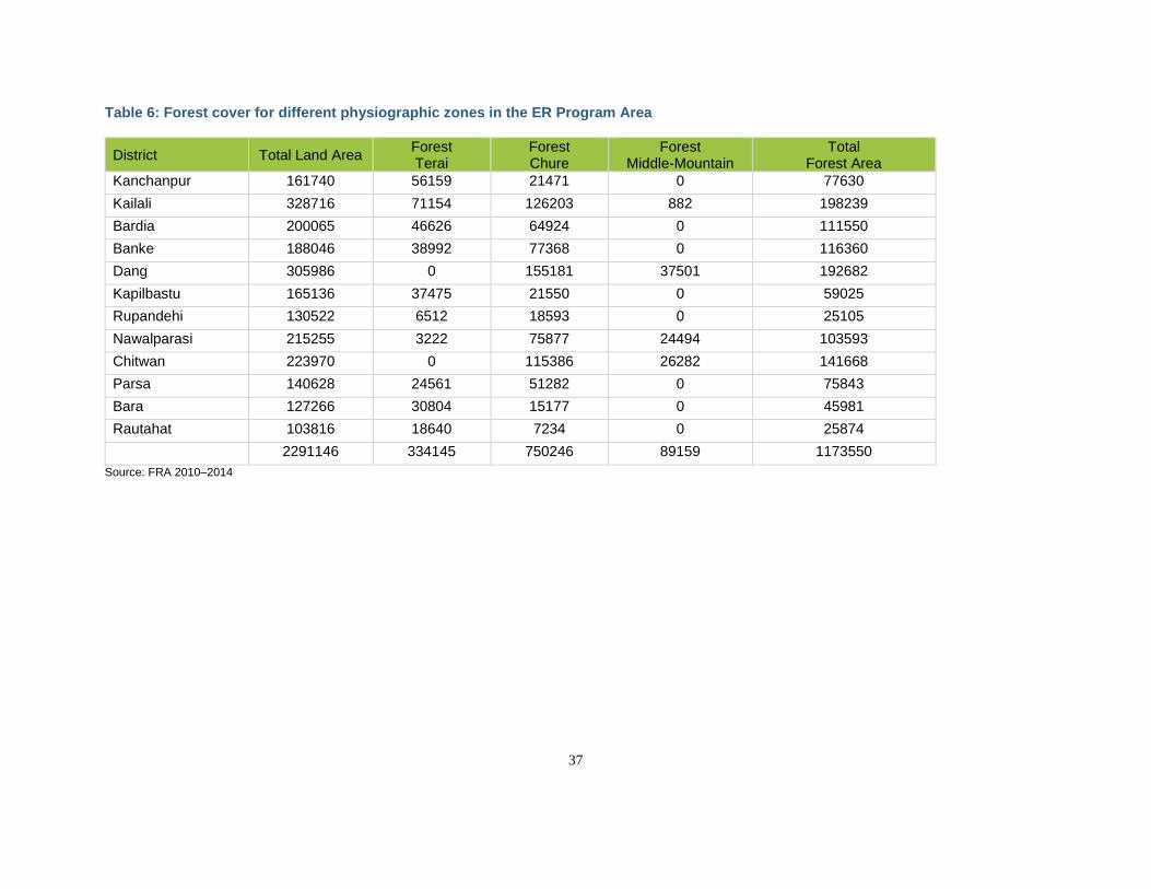
37
Table 6: Forest cover for different physiographic zones in the ER Program Area
District Total Land Area Forest Terai
Forest Chure
Forest Middle-Mountain
Total Forest Area
Kanchanpur 161740 56159 21471 0 77630
Kailali 328716 71154 126203 882 198239
Bardia 200065 46626 64924 0 111550
Banke 188046 38992 77368 0 116360
Dang 305986 0 155181 37501 192682
Kapilbastu 165136 37475 21550 0 59025
Rupandehi 130522 6512 18593 0 25105
Nawalparasi 215255 3222 75877 24494 103593
Chitwan 223970 0 115386 26282 141668
Parsa 140628 24561 51282 0 75843
Bara 127266 30804 15177 0 45981
Rautahat 103816 18640 7234 0 25874
2291146 334145 750246 89159 1173550
Source: FRA 2010–2014
38
3.2 ENVIRONMENTAL AND SOCIAL CONDITIONS IN THE ACCOUNTING AREA OF THE ER PROGRAM
3.2.1 EXISTING VEGETATION TYPES IN THE ACCOUNTING AREA The ecosystems in the Program Area range from early successional tall grasslands established in the alluvial floodplain to old-growth Sal forests at lower elevations, and to broad-leaved forest in the Chure. Major forest ecosystems include Sal forest, riverine forest, and mixed forest and grasslands.10 Sal forest is dominated by Shorea robusta associated with Terminalia spp., Dillenia pentagyna, Careya arborea, Lagerstroemia parviflora and Buchanania latifolia. Riverine forests grow along water bodies and are dominated by Mallotus phillipinensis, Trewia nudiflora and Bombax ceiba. Wooded grasslands have sparsely distributed trees, including Mallotus phillipinensis, Bauhinia spp., Lagerstromia parviflora and Adina cordifolia. Tall grasslands are dominated by Saccharum spp., emeda spp., Arundo donax, Phragmites karka and Narenga porphyrocoma. The TAL also harbors dozens of trees and other plant species that yield non-timber forest products (NTFPs), as well as medicinal and aromatic plants (MAPs). Most of the natural grasslands in Terai have been converted to either settlements or agricultural lands. Major crops in the Terai include rice, wheat, pulses, sugarcane, jute, tobacco, and maize, most of which source primarily to local and domestic markets. The Chure range rises steeply from the Terai plains along their northern border. It extends as a contiguous landscape feature from east to west in 33 districts, including the 12 districts of the ER Program Area. It also makes up about 13% of the country. The Chure has 26% of the natural forest of Nepal; 3% are conifers (all Chirpine), 83% are hardwoods (comprising Sal and tropical mixed forest), and 14% are mixed Chirpine and hardwoods. Because of the Chure’s social and ecological significance, GoN has prioritized conservation in the Chure since the 1970s and declared the entire region a priority environmental conservation area in 2014.
3.2.2 CLIMATIC CONDITIONS AND THE OCCURRENCE OF CATASTROPHIC EVENTS The Program Area is influenced by both tropical and subtropical climates. From April to June, the maximum daily temperature is around 35°C. The rainy season lasts from June to September and is characterized by heavy downpours that often cause severe flooding. In winter, the daily maximum temperature is around 25°C. At night, the temperature may fall below 10°C.11 Climate change is expected to increase monsoon precipitation 15%–20% in the TAL, but with greater variability and less predictability. The Terai region seems to be experiencing more extreme weather events, including more frequent, devastating floods. Figure 3 and Figure 4 show temperature and rainfall change over time from the Rampur Station in the Chitwan district. More intense rainfall, coupled with denuded and deforested watersheds and rugged topography in the Chure and Siwaliks, results in soil erosion and landslides. In addition, poorly managed extraction of sand, gravel, and boulders from streams and rivers in the Chure is changing river profiles and flow regimes. All of these factors result in increased sedimentation in the flatlands of the Terai, with subsequent shifts in river channels and flooding. Downstream communities, ecosystems, and infrastructure are now more vulnerable to floods and other natural disasters.
10 MoFSC 2015. Strategy and Action Plan 2015–2025, Terai Arc Landscape, Nepal. MoFSC, Singha Durbar, Kathmandu, Nepal. 11 WWF Nepal 2016. Terai Arc Landscape (TAL). Source: http://www.wwfnepal.org/about_wwf/where_we_work/tal/.
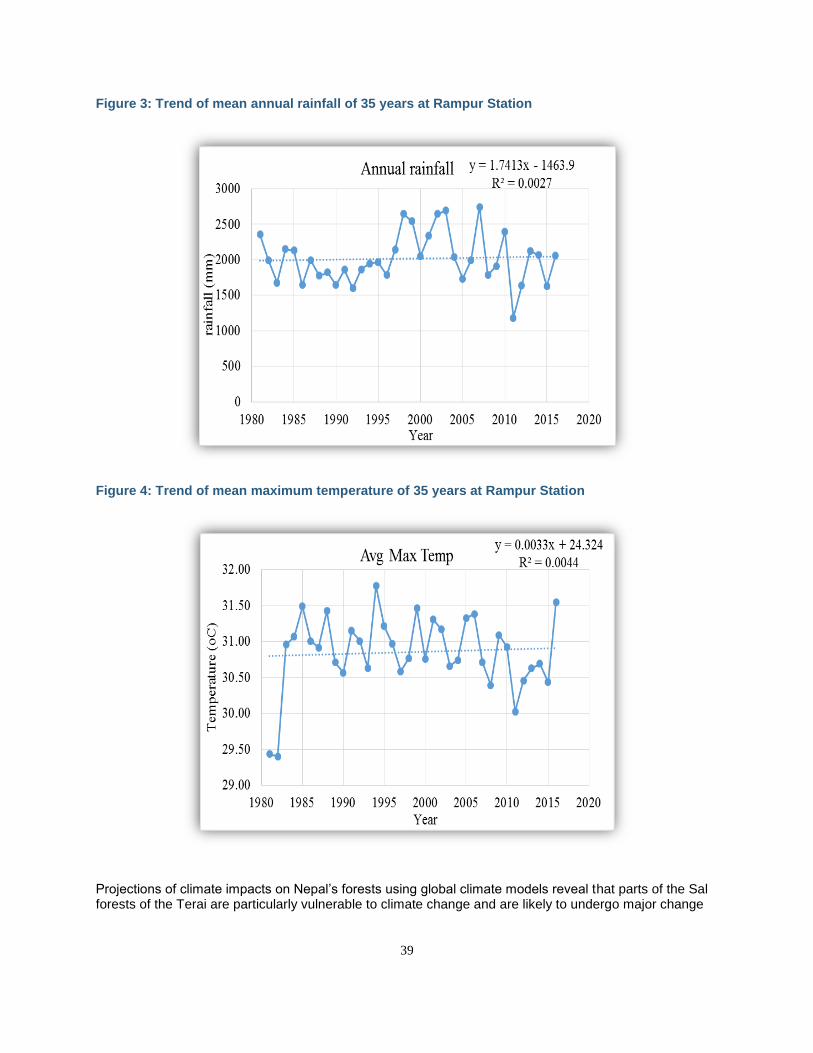
39
Figure 3: Trend of mean annual rainfall of 35 years at Rampur Station
Figure 4: Trend of mean maximum temperature of 35 years at Rampur Station
Projections of climate impacts on Nepal’s forests using global climate models reveal that parts of the Sal forests of the Terai are particularly vulnerable to climate change and are likely to undergo major change
40
in species composition by 2080.12 Recent research indicates an overall trend for tree species in the lower elevations to shift northward or up slopes within their current ranges. Shorea robusta (Sal) showed a northward shift following the river valleys and up the surrounding slopes. Climate impacts may also include a loss of agricultural productivity, which could increase pressure on forests as existing lands become less able to support domestic food needs. For example, increased or more severe droughts could decrease the productivity and yields of current agricultural areas, leading to further pressures to deforest. In addition, as areas become overgrazed and water holes dry up, livestock may go further into forested areas for food and water. Prolonged droughts and degraded forests are also likely to lead to more frequent or intense fires, which could also affect the availability of firewood and timber (see Section 4.3). Although the ER Program Area is not in Nepal’s primary earthquake impact zone, resettlement of communities impacted by the earthquakes has likely increased immigration into the Terai, leading to increased pressures on forest resources. There was some expectation that the demand for timber for post-earthquake reconstruction would also increase demands on the forests of the ER Program Area prized for construction-grade timber; however, this has not clearly materialized. Some possible explanations are the following: 1) post-earthquake reconstruction has taken a longer time due to late release of government support funds; 2) limited availability of technical manpower in earthquake-impacted districts has also slowed reconstruction; and 3) people are using locally available timbers due to proximity and availability.
3.2.3 SOIL CHARACTERISTICS The soils of Nepal are highly variable and are derived mainly from young parent material and classified on the basis of soil texture, mode of deposition, and color. The soils are broadly divided into alluvial, sandy and alluvial, gravelly, residual, and glacial soil. The Terai valleys lie between the Siwaliks and Mahabharat hills, which widen out in places to form flat, fertile Dun valleys with alluvial soils. New alluvial soils—with more sand and silt than clay—are being deposited in the floodplain areas along the river courses. Alluvial soils are also found in the slightly higher areas above the floodplains covering a greater part of the Terai. The nutrient content of new alluvial soils is fair to medium, depending on how long they have been cultivated. On the other hand, the nutrient content of old alluvial soils is very low.13
3.2.4 PRESENCE OF RARE AND ENDANGERED SPECIES AND THEIR HABITAT The TAL is a globally significant area for biodiversity conservation and has been established as a model of landscape conservation by the Government of Nepal, with the support of WWF Nepal and other partners. Highly productive alluvial grasslands and subtropical forests support some of the highest densities in the world of the Royal Bengal Tiger (Panthera tigris), the second-largest population of the Greater One-Horned Rhinoceros (Rhinoceros unicornis) and the largest herd of Swamp Deer (Cervus duvaucelli). The ER Program Area is also home to endangered and protected species like the Asian Elephant (Elephas maximus), Gangetic Dolphin (Platanista gangetica), Gharial Crocodile (Gavialis gangeticus) and Sarus Crane (Grus antigone). Bardia National Park has been designated a Learning Site for the Protected Area Learning Network (PALnet) by IUCN. The ER Program Area also includes three Ramsar sites, a Bird Diversity Hotspot and two World Heritage sites—Chitwan National Park and Lumbini, the birthplace of Lord Buddha.
12 Thapa et al. 2015. Climate-change Impacts on the Biodiversity of the Terai Arc Landscape and the Chitwan-Annapurna Landscape. 13 Food and Agriculture Organization, 1998. Country Pasture/Forage Resource Profiles – Nepal. Source: http://www.fao.org/ag/agp/agpc/doc/counprof/nepal.htm.
41
3.2.5 OVERVIEW OF STAKEHOLDERS AND RIGHTS-HOLDERS, INCLUDING LINGUISTIC AND SOCIO-CULTURAL DIVERSITY The TAL is known for its rich cultural heritage. Indigenous Peoples (Tharu community) have been living in the TAL for generations, and their cultural and traditional values associated with natural resources and forests contribute to the conservation and protection of the Terai’s forests. Numerous other ethnic communities also live in the area, which continues to draw migrants from the Mid Hills and Himalaya regions. The ER Program Area represents a cultural mosaic that is currently inhabited by the following broad groups of people:
● Groups comprised of Hindus and Adhibasi/Janajatis (IPs) of Hill origin who migrated to and settled in the area, particularly after 1950.
● People who have been living in the region for centuries and prefer to be recognized as Adhibasi/Janajatis of the Nepal Terai. These include the Tharus, Dhimals, Tajpuriya, Rajbanshis, Gangai, Majhis, Kumal, Darai and Danuwar.
● People of the Terai Hindu (also known as Madhesi) with a social structure including the Brahmins (Maithili) and untouchables (Dom, Halkhor).
● Muslims. ● Others (e.g., the merchant groups of Indian origin such as Marwaris, Bengalis and Sikhs).
Overall, IPs (in both the Hills and the Terai) represent the largest segment of the population (31%), followed by High Caste Hill Groups (24%) and Madhesis (23%). Dalits (12%) and Muslims (9%) are minority groups that form the remainder of the Terai population. See Annex 3: Socioeconomic conditions in the Terai Arc Landscape for a more detailed assessment of socioeconomic conditions in the TAL represented in the Program Area.
3.2.6 POPULATION DEMOGRAPHICS AND GROWTH Until the 1950s, the ER Program Area was covered by forests occupied by only a few ethnic groups. After the establishment of a democratic government in 1951 and improved access to malaria treatment and land resettlement programs that reached many diverse groups, the Terai became a new agricultural frontier. This brought about a significant change in the population of the Terai; in 1950, the Terai accounted for only 35% of the total population of Nepal, but today it accounts for more than half of the total population of the country.14
According to the 2011 census, the total population of the ER Program Area includes 1,345,706 households, with a total population of 7,348,500. The average annual population growth rate in the TAL is 2.1%, almost double the national annual growth rate of 1.2%. In general, the population growth rate is low in the Hill districts and high in the Terai districts, due to migration and resettlement. The area continues to face immigration from the north and emigration of working-age males to urban centers in Nepal, India and the Middle East. The increased flux due to emigration has dampened future projections of population growth in the Terai.
14 Government of Nepal National Planning Commission Secretariat Central Bureau of Statistics National Population and Housing Census 2011. Accessed at http://unstats.un.org/unsd/demographic/sources/census/wphc/Nepal/Nepal-Census-2011-Vol1.pdf.
42
3.2.7 MODES OF LIVELIHOODS AND DEPENDENCY ON FOREST RESOURCES The main source of income and means of livelihoods for the people in the TAL are agriculture, animal husbandry, employment and remittance. Agriculture is the main occupation in the Program Area, and most people (57%) own or manage livestock.15 However, livelihoods and forests are inextricably linked in the TAL, where over 50% of the land area is forested. Forests are used by some households for timber production and by others for subsistence livelihoods like gathering fuelwood, fodder and non-timber forest products (NTFPs). Local timber is essential for housing, farm buildings, fences, irrigation canals, and agricultural tools, as well as for trade. For these reasons, sustainable forest management and forest conservation are critical to improve livelihoods and reduce poverty. Forests in the ER Program Area include high-value timber species that generate substantial revenue for the government and for communities. Community forest management and collaborative forest management have played central roles in the Terai’s forests in the past 25 years; over 360,000 ha of forests are managed under these regimes, with over 2,000 forest units and associated user groups (see Box 1), delivering significant forest-related revenues back to user groups and their members and supporting associated livelihood opportunities. Forest user groups also play a significant role in local governance and decision-making, particularly as they relate to forests and natural resources. Several other forest management regimes (e.g., Leasehold Forests, Private Forests) are also important sources of livelihoods in the Program Area and are described in Table 55. The forests in the watersheds in the Chure hills north of the Terai also play an important role in regulating groundwater recharge and surface water supply to Terai inhabitants, as well as in mitigating flood risks. In addition, they support numerous indirect benefits including soil and water conservation, carbon sequestration, biodiversity conservation and nutrient cycling for downstream farmlands. The protected area system in the ER Program Area attracts approximately 200,000 tourists each year, generating US$ 26.31 million in revenue for the area.16 Approximately two-thirds of households in the ER Program Area use firewood for cooking purposes (see Annex 3: Socioeconomic conditions in the Terai Arc Landscape). The remaining third cook primarily with dung (13%) and liquid petroleum gas (LPG)(16%). Biogas now is used by 4% of households in the Terai as a result of the national biogas program and Gold Standard biogas project.
15 Livelihoods Outcomes: Study and Analysis of Changes in the Livelihoods of Bottleneck-level Community Forest Users, WWF Nepal 2008. 16 Annual Progress Report (2016), Department of National Parks and Wildlife Conservation (DNPWC), Babarmahal, Kathmandu, www.dnpwc.gov.np.
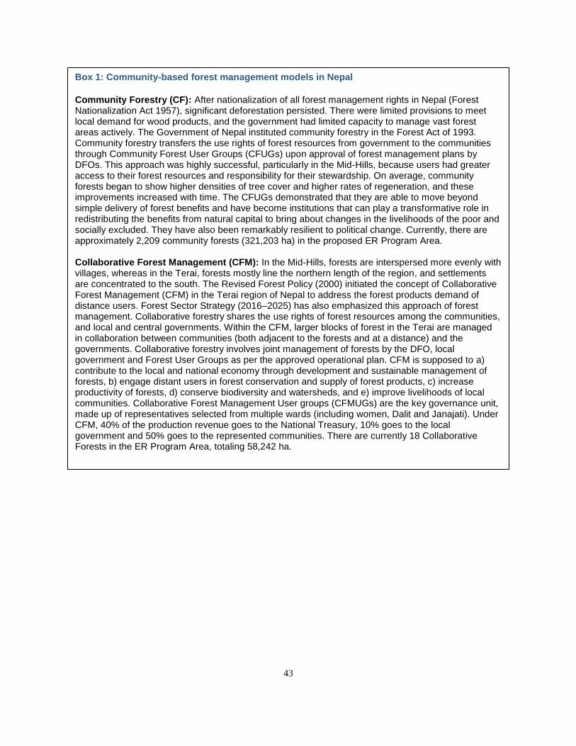
43
Box 1: Community-based forest management models in Nepal
Community Forestry (CF): After nationalization of all forest management rights in Nepal (Forest Nationalization Act 1957), significant deforestation persisted. There were limited provisions to meet local demand for wood products, and the government had limited capacity to manage vast forest areas actively. The Government of Nepal instituted community forestry in the Forest Act of 1993. Community forestry transfers the use rights of forest resources from government to the communities through Community Forest User Groups (CFUGs) upon approval of forest management plans by DFOs. This approach was highly successful, particularly in the Mid-Hills, because users had greater access to their forest resources and responsibility for their stewardship. On average, community forests began to show higher densities of tree cover and higher rates of regeneration, and these improvements increased with time. The CFUGs demonstrated that they are able to move beyond simple delivery of forest benefits and have become institutions that can play a transformative role in redistributing the benefits from natural capital to bring about changes in the livelihoods of the poor and socially excluded. They have also been remarkably resilient to political change. Currently, there are approximately 2,209 community forests (321,203 ha) in the proposed ER Program Area. Collaborative Forest Management (CFM): In the Mid-Hills, forests are interspersed more evenly with villages, whereas in the Terai, forests mostly line the northern length of the region, and settlements are concentrated to the south. The Revised Forest Policy (2000) initiated the concept of Collaborative Forest Management (CFM) in the Terai region of Nepal to address the forest products demand of distance users. Forest Sector Strategy (2016–2025) has also emphasized this approach of forest management. Collaborative forestry shares the use rights of forest resources among the communities, and local and central governments. Within the CFM, larger blocks of forest in the Terai are managed in collaboration between communities (both adjacent to the forests and at a distance) and the governments. Collaborative forestry involves joint management of forests by the DFO, local government and Forest User Groups as per the approved operational plan. CFM is supposed to a) contribute to the local and national economy through development and sustainable management of forests, b) engage distant users in forest conservation and supply of forest products, c) increase productivity of forests, d) conserve biodiversity and watersheds, and e) improve livelihoods of local communities. Collaborative Forest Management User groups (CFMUGs) are the key governance unit, made up of representatives selected from multiple wards (including women, Dalit and Janajati). Under CFM, 40% of the production revenue goes to the National Treasury, 10% goes to the local government and 50% goes to the represented communities. There are currently 18 Collaborative Forests in the ER Program Area, totaling 58,242 ha.
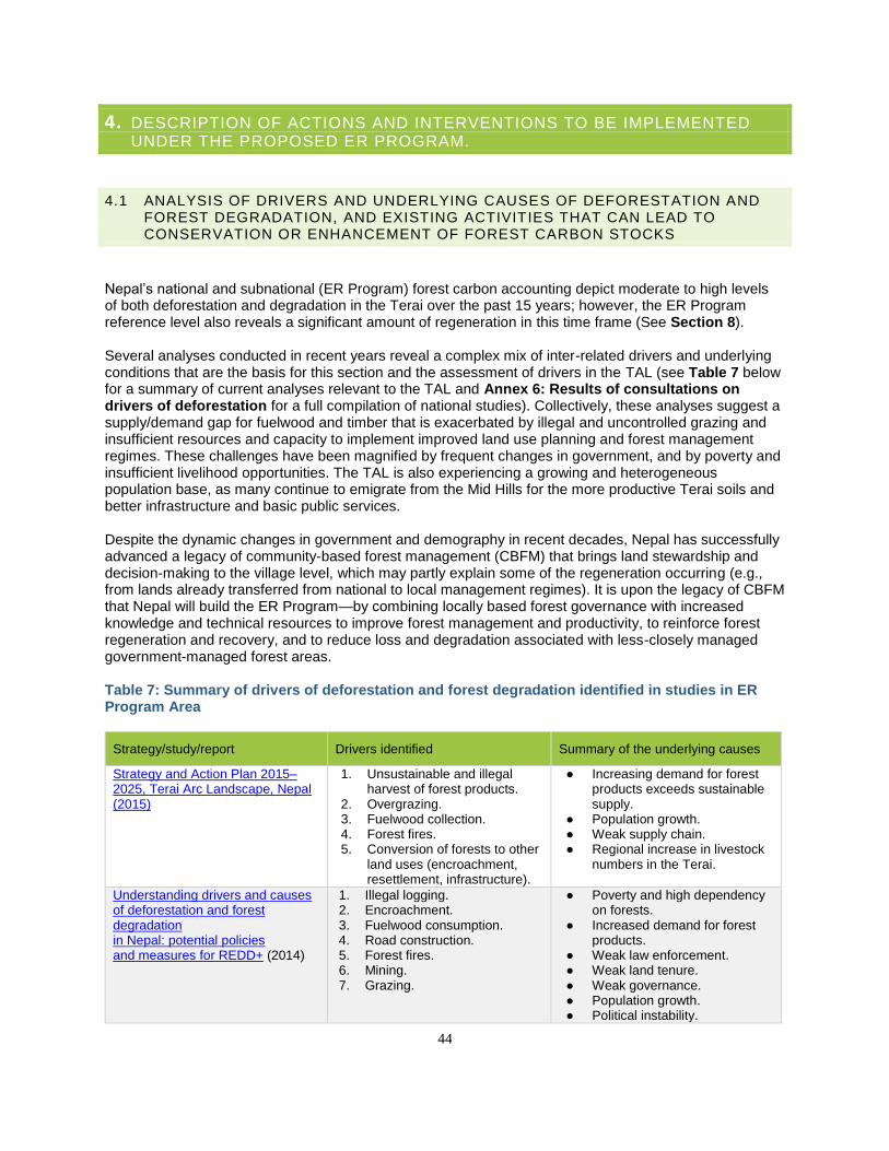
44
4. DESCRIPTION OF ACTIONS AND INTERVENTIONS TO BE IMPLEMENTED UNDER THE PROPOSED ER PROGRAM.
4.1 ANALYSIS OF DRIVERS AND UNDERLYING CAUSES OF DEFORESTATION AND FOREST DEGRADATION, AND EXISTING ACTIVITIES THAT CAN LEAD TO CONSERVATION OR ENHANCEMENT OF FOREST CARBON STOCKS
Nepal’s national and subnational (ER Program) forest carbon accounting depict moderate to high levels of both deforestation and degradation in the Terai over the past 15 years; however, the ER Program reference level also reveals a significant amount of regeneration in this time frame (See Section 8). Several analyses conducted in recent years reveal a complex mix of inter-related drivers and underlying conditions that are the basis for this section and the assessment of drivers in the TAL (see Table 7 below for a summary of current analyses relevant to the TAL and Annex 6: Results of consultations on drivers of deforestation for a full compilation of national studies). Collectively, these analyses suggest a supply/demand gap for fuelwood and timber that is exacerbated by illegal and uncontrolled grazing and insufficient resources and capacity to implement improved land use planning and forest management regimes. These challenges have been magnified by frequent changes in government, and by poverty and insufficient livelihood opportunities. The TAL is also experiencing a growing and heterogeneous population base, as many continue to emigrate from the Mid Hills for the more productive Terai soils and better infrastructure and basic public services. Despite the dynamic changes in government and demography in recent decades, Nepal has successfully advanced a legacy of community-based forest management (CBFM) that brings land stewardship and decision-making to the village level, which may partly explain some of the regeneration occurring (e.g., from lands already transferred from national to local management regimes). It is upon the legacy of CBFM that Nepal will build the ER Program—by combining locally based forest governance with increased knowledge and technical resources to improve forest management and productivity, to reinforce forest regeneration and recovery, and to reduce loss and degradation associated with less-closely managed government-managed forest areas. Table 7: Summary of drivers of deforestation and forest degradation identified in studies in ER Program Area
Strategy/study/report Drivers identified Summary of the underlying causes
Strategy and Action Plan 2015–2025, Terai Arc Landscape, Nepal (2015)
1. Unsustainable and illegal harvest of forest products.
2. Overgrazing. 3. Fuelwood collection. 4. Forest fires. 5. Conversion of forests to other
land uses (encroachment, resettlement, infrastructure).
● Increasing demand for forest products exceeds sustainable supply.
● Population growth. ● Weak supply chain. ● Regional increase in livestock
numbers in the Terai.
Understanding drivers and causes of deforestation and forest degradation in Nepal: potential policies and measures for REDD+ (2014)
1. Illegal logging. 2. Encroachment. 3. Fuelwood consumption. 4. Road construction. 5. Forest fires. 6. Mining. 7. Grazing.
● Poverty and high dependency on forests.
● Increased demand for forest products.
● Weak law enforcement. ● Weak land tenure. ● Weak governance. ● Population growth. ● Political instability.
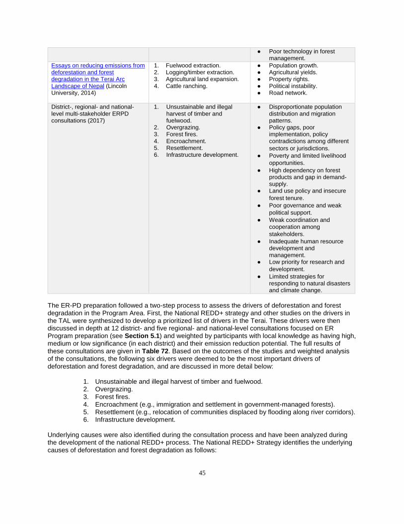
45
● Poor technology in forest management.
Essays on reducing emissions from deforestation and forest degradation in the Terai Arc Landscape of Nepal (Lincoln University, 2014)
1. Fuelwood extraction. 2. Logging/timber extraction. 3. Agricultural land expansion. 4. Cattle ranching.
● Population growth. ● Agricultural yields. ● Property rights. ● Political instability. ● Road network.
District-, regional- and national-level multi-stakeholder ERPD consultations (2017)
1. Unsustainable and illegal harvest of timber and fuelwood.
2. Overgrazing. 3. Forest fires. 4. Encroachment. 5. Resettlement. 6. Infrastructure development.
● Disproportionate population distribution and migration patterns.
● Policy gaps, poor implementation, policy contradictions among different
sectors or jurisdictions. ● Poverty and limited livelihood
opportunities. ● High dependency on forest
products and gap in demand-supply.
● Land use policy and insecure
forest tenure. ● Poor governance and weak
political support. ● Weak coordination and
cooperation among
stakeholders. ● Inadequate human resource
development and management.
● Low priority for research and
development. ● Limited strategies for
responding to natural disasters and climate change.
The ER-PD preparation followed a two-step process to assess the drivers of deforestation and forest degradation in the Program Area. First, the National REDD+ strategy and other studies on the drivers in the TAL were synthesized to develop a prioritized list of drivers in the Terai. These drivers were then discussed in depth at 12 district- and five regional- and national-level consultations focused on ER Program preparation (see Section 5.1) and weighted by participants with local knowledge as having high, medium or low significance (in each district) and their emission reduction potential. The full results of these consultations are given in Table 72. Based on the outcomes of the studies and weighted analysis of the consultations, the following six drivers were deemed to be the most important drivers of deforestation and forest degradation, and are discussed in more detail below:
1. Unsustainable and illegal harvest of timber and fuelwood. 2. Overgrazing. 3. Forest fires. 4. Encroachment (e.g., immigration and settlement in government-managed forests). 5. Resettlement (e.g., relocation of communities displaced by flooding along river corridors). 6. Infrastructure development.
Underlying causes were also identified during the consultation process and have been analyzed during the development of the national REDD+ process. The National REDD+ Strategy identifies the underlying causes of deforestation and forest degradation as follows:
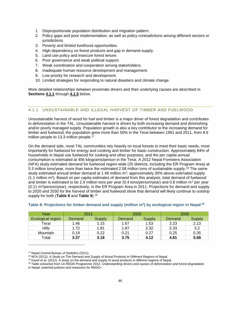
46
1. Disproportionate population distribution and migration pattern. 2. Policy gaps and poor implementation, as well as policy contradictions among different sectors or
jurisdictions.
3. Poverty and limited livelihood opportunities.
4. High dependency on forest products and gap in demand-supply. 5. Land use policy and insecure forest tenure.
6. Poor governance and weak political support.
7. Weak coordination and cooperation among stakeholders.
8. Inadequate human resource development and management.
9. Low priority for research and development. 10. Limited strategies for responding to natural disasters and climate change.
More detailed relationships between proximate drivers and their underlying causes are described in Sections 4.1.1 through 4.1.5 below.
4.1.1 UNSUSTAINABLE AND ILLEGAL HARVEST OF TIMBER AND FUELWOOD Unsustainable harvest of wood for fuel and timber is a major driver of forest degradation and contributes to deforestation in the TAL. Unsustainable harvest is driven by both increasing demand and diminishing and/or poorly managed supply. Population growth is also a key contributor to the increasing demand for timber and fuelwood; the population grew more than 50% in the Terai between 1991 and 2011, from 8.6 million people to 13.3 million people.17 On the demand side, most TAL communities rely heavily on local forests to meet their basic needs, most importantly for fuelwood for energy and cooking and timber for basic construction. Approximately 84% of households in Nepal use fuelwood for cooking and other purposes, and the per capita annual consumption is estimated at 456 kilograms/person in the Terai. A 2012 Nepal Foresters Association (NFA) study estimated demand for fuelwood region-wide (20 districts, including the ER Program Area) at 5.3 million tons/year, more than twice the estimated 2.58 million tons of sustainable supply.18 The same study estimated annual timber demand at 1.46 million m3, approximately 30% above estimated supply (1.1 million m3). Based on per capita estimates of demand from this analysis, total demand of fuelwood and timber is estimated to be 2.9 million tons per year (0.4 tons/person/year) and 0.8 million m3 per year (0.11 m3/person/year), respectively, in the ER Program Area in 2011. Projections for demand and supply to 2020 and 2030 for the harvest of timber and fuelwood show that demand will likely continue to outstrip supply for both (Table 8 and Table 9).19 Table 8: Projections for timber demand and supply (million m3) by ecological region in Nepal 20
Year 2011 2020 2030
Ecological region Demand Supply Demand Supply Demand Supply
Terai 1.46 1.15 1.67 1.53 2.23 2.13
Hills 1.72 1.81 1.87 2.32 2.33 3.2
Mountain 0.19 0.22 0.21 0.27 0.25 0.35
Total 3.37 3.18 3.75 4.12 4.81 5.68
17 Nepal Central Bureau of Statistics (2011). 18 NFA (2012). A Study on The Demand and Supply of Wood Products in Different Regions of Nepal. 19 Kanel et al. (2012). A study on the demand and supply of wood products in different regions of Nepal. 20 Table extracted from Un-REDD Programme 2014. Understanding drivers and causes of deforestation and forest degradation in Nepal: potential policies and measures for REDD+.
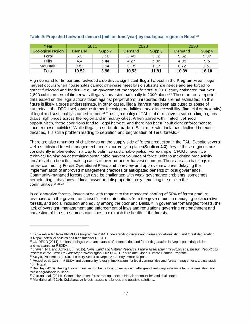
47
Table 9: Projected fuelwood demand (million tons/year) by ecological region in Nepal 21
Year 2011 2020 2030
Ecological region Demand Supply Demand Supply Demand Supply
Terai 5.3 2.58 5.48 3.72 5.62 5.07
Hills 4.4 5.44 4.27 6.96 4.05 9.6
Mountain 0.82 0.94 0.78 1.13 0.72 1.51
Total 10.52 8.96 10.53 11.81 10.39 16.18
High demand for timber and fuelwood also drives significant illegal harvest in the Program Area. Illegal harvest occurs when households cannot otherwise meet basic subsistence needs and are forced to gather fuelwood and fodder—e.g., on government-managed forests. A 2010 study estimated that over 2,800 cubic meters of timber was illegally harvested nationally in 2009 alone.22 These are only reported data based on the legal actions taken against perpetrators; unreported data are not estimated, so this figure is likely a gross underestimate. In other cases, illegal harvest has been attributed to abuse of authority at the DFO level, opaque timber licensing modalities and/or inaccessibility (financial or proximity) of legal and sustainably sourced timber.23 The high quality of TAL timber relative to surrounding regions draws high prices across the region and in nearby cities. When paired with limited livelihood opportunities, these conditions lead to illegal harvest, and there has been insufficient enforcement to counter these activities. While illegal cross-border trade in Sal timber with India has declined in recent decades, it is still a problem leading to depletion and degradation of Terai forests.24 There are also a number of challenges on the supply side of forest production in the TAL. Despite several well-established forest management models currently in place (Section 4.3), few of these regimes are consistently implemented in a way to optimize sustainable yields. For example, CFUGs have little technical training on determining sustainable harvest volumes of forest units to maximize productivity and/or carbon benefits, making cases of over- or under-harvest common. There are also backlogs to renew community Forest Operational Plans and to review and approve new ones, delaying the implementation of improved management practices or anticipated benefits of local governance. Community-managed forests can also be challenged with weak governance problems, sometimes perpetuating imbalances of local power and disproportionately benefiting the elite in the communities.25,26,27 In collaborative forests, issues arise with respect to the mandated sharing of 50% of forest product revenues with the government, insufficient contributions from the government in managing collaborative forests, and social inclusion and equity among the poor and Dalits.28 In government-managed forests, the lack of oversight, management and enforcement of laws and regulations governing encroachment and harvesting of forest resources continues to diminish the health of the forests.
21 Table extracted from UN-REDD Programme 2014. Understanding drivers and causes of deforestation and forest degradation in Nepal: potential policies and measures for REDD+. 22 UN-REDD (2014). Understanding drivers and causes of deforestation and forest degradation in Nepal: potential policies and measures for REDD+. 23 Jhaveri, N.J. and Adhikari, J. (2015). Nepal Land and Natural Resource Tenure Assessment for Proposed Emission Reductions Program in the Terai Arc Landscape. Washington, DC: USAID Tenure and Global Climate Change Program. 24 Satyal, Poshendra (2004). “Forestry Sector in Nepal: A Country Profile Report.” 25 Poudel et al. (2014). REDD+ and community forestry: implications for local communities and forest management: a case study from Nepal. 26 Bushley (2010). Seeing the communities for the carbon: governance challenges of reducing emissions from deforestation and forest degradation in Nepal. 27 Gurung et al. (2011). Community-based forest management in Nepal: opportunities and challenges. 28 Mandal et al. (2014). Collaborative forest: issues, challenges and possible solutions.
48
Several other issues contribute to the supply problem, including limited information management systems on production and consumption of forest products, unregulated (or unenforced) access to forests, and inefficient supply and delivery mechanisms to get sustainably harvested products to consumers. Most of these challenges stem from inadequate resources for forest management, training, knowledge sharing, enforcement, and accountability and can be addressed if incentives and/or forest-related revenues are channeled back to improving management practices.
4.1.2 OVERGRAZING Overgrazing (e.g., overstocking of cattle) and unmanaged grazing in the ER Program Area contributes significantly to forest degradation, destroying understory seedlings and saplings and causing soil erosion. Millions of livestock, including cattle, buffalo, goats, and sheep, graze in national forests across the Terai. 29 This negatively impacts the forest understory and prevents forest regeneration.30 The most recent national forest inventory (NFI) estimates grazing as the most frequent biotic disturbance reported across forests.31 The more recently developed national forest reference level estimates grazing to be the largest source of emissions in Nepal, contributing to an estimated 1.8 MtCO2e of emissions annually.32 There is a significant deficit in terms of biomass needed (-1,915,546t DM) and supplied in the Terai for cattle. The most recent Forest Resource Assessment (2010–2014) found that nearly two-thirds of the total forest area in Nepal was affected by grazing.33 Table 10 presents official data on livestock numbers published by the Government of Nepal, summarizing recent increases in livestock numbers, year on year, in the 12 ER Program districts. Cattle, buffalo, sheep, and goats are included, as they are the most numerous livestock grazing in forests and have the highest impacts on forest health and greenhouse gas emissions. The data show increases in every district but Chitwan during this period. Overall, there was an approximately 12% increase in these four types of livestock across the ER Program districts from 2011 to 2016.34,35 The underlying causes of unmanaged grazing include weak grazing management systems and practices, limited understanding of the ecological impacts, and lack of enforcement of grazing policies (e.g., allowing unmanaged grazing in government forests). In addition, the high rates of landlessness both within the TAL and in the Chure Hills leads people to graze their cattle in government-managed forests instead of in dedicated grazing areas. Cultural and religious sensitivities, which prohibit the culling of cows and oxen, can also mean that even when some cattle become unproductive, they are left to stray and graze in both managed and unmanaged forest areas.
29 MoAD (2017). Statistical Information on Nepalese Agriculture 2015/2016. 30 MoFSC (2015). Strategy and Action Plan 2015–2025, Terai Arc Landscape, Nepal. 31 DFRS, 2015. State of Nepal’s Forests. Forest Resource Assessment (FRA) Nepal, Department of Forest Research and Survey (DFRS). Kathmandu, Nepal. Available at: http://www.dfrs.gov.np/downloadfile/State%20of%20Nepals%20Forests%20(DFRS)_1457599484.pdf. 32 MoFSC (2016). National Forest Reference Level of Nepal (2000–2010). Available at: http://redd.unfccc.int/files/nepal_frl_jan_8__2017.pdf. 33 DFRS (2015). State of Nepal’s Forests. 34 MoAD (2012). Statistical Information on Nepalese Agriculture 2011/2012. 35 MoAD (2017). Statistical Information on Nepalese Agriculture 2015/2016.
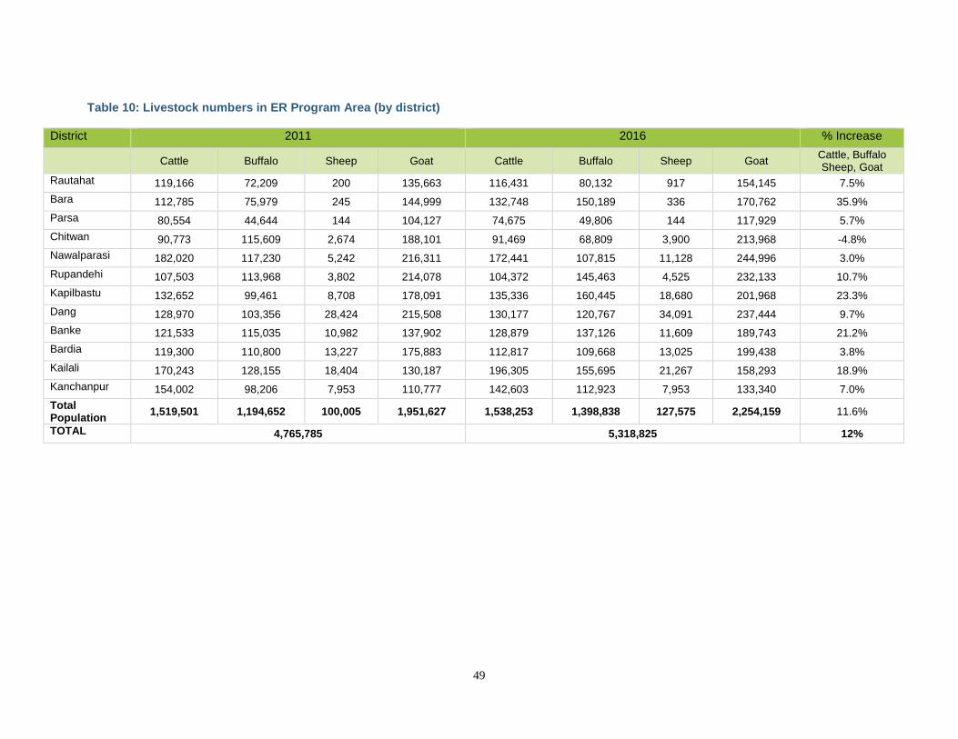
49
Table 10: Livestock numbers in ER Program Area (by district)
District 2011 2016 % Increase
Cattle Buffalo Sheep Goat Cattle Buffalo Sheep Goat Cattle, Buffalo Sheep, Goat
Rautahat 119,166 72,209 200 135,663 116,431 80,132 917 154,145 7.5%
Bara 112,785 75,979 245 144,999 132,748 150,189 336 170,762 35.9%
Parsa 80,554 44,644 144 104,127 74,675 49,806 144 117,929 5.7%
Chitwan 90,773 115,609 2,674 188,101 91,469 68,809 3,900 213,968 -4.8%
Nawalparasi 182,020 117,230 5,242 216,311 172,441 107,815 11,128 244,996 3.0%
Rupandehi 107,503 113,968 3,802 214,078 104,372 145,463 4,525 232,133 10.7%
Kapilbastu 132,652 99,461 8,708 178,091 135,336 160,445 18,680 201,968 23.3%
Dang 128,970 103,356 28,424 215,508 130,177 120,767 34,091 237,444 9.7%
Banke 121,533 115,035 10,982 137,902 128,879 137,126 11,609 189,743 21.2%
Bardia 119,300 110,800 13,227 175,883 112,817 109,668 13,025 199,438 3.8%
Kailali 170,243 128,155 18,404 130,187 196,305 155,695 21,267 158,293 18.9%
Kanchanpur 154,002 98,206 7,953 110,777 142,603 112,923 7,953 133,340 7.0%
Total Population
1,519,501 1,194,652 100,005 1,951,627 1,538,253 1,398,838 127,575 2,254,159 11.6%
TOTAL 4,765,785 5,318,825 12%
50
4.1.3 FOREST FIRES While fire is part of the natural disturbance regime for several forest types in Nepal (fires start naturally via lightning strikes, particularly during drought periods), fires in the Terai are often also set intentionally to enhance wildlife habitat (i.e., in protected areas), to clear for agriculture, to create grazing areas for livestock, or with the intention of reducing human-wildlife conflicts. The fire season in the Terai is quite concentrated, with most forest fires occurring between March and May. Currently, there is insufficient information to rigorously assess the impact of fires in the Terai on forests or emissions, but there are some recent studies and forest fire data that are informative. For example, a 2015 analysis indicates a highly concentrated fire season in Nepal, peaking in April, and high interannual variability in burnt area, but no overall trend in area burned annually over the 13 years assessed.36 A second study explored spatial and temporal patterns in historical forest fire incidence data in Nepal. The study identified three factors driving the ignition and spread of forest fires, including fuel availability, temperature and ignition potential. A fire risk index was developed using these factors, resulting in risk rankings for districts. Eighteen of Nepal’s 75 districts were found to have high risk of forest fires, eight of which were located in the ER Program Area.37 The Global Fire Emissions Database (GFED) provides monthly dry matter emissions derived also using MODIS burned area maps. Data from this product were used by Winrock International for IUCN to estimate fire degradation emissions between 2000 and 2010 globally at subnational and national levels in the Global Emissions Database,38 . The subnational estimates for the ER Program Area, clipped using GIS to fit the Program Area boundaries corresponded to 217,542 tCO2 from 2000 to 2010. It is important to clarify that the MODIS forest fire data represent thermal anomalies (above 300 degrees farenheit) occurring inside 500x500m (25ha) pixels and do not specifically represent area burned or impact.39 Basically a flagged pixel does not imply the entire area has been burnt. It simply indicates a fire has been detected within that area. This means that area estimates such as those made by Winrock as well as the specific ones presented in this document in Section 7 can be considered to be very large overestimations of actual emissions from fire. This is particularly the case for the Terai as further analyses (see Section 7 on pools and gases) revealed that most of these fires occurred within protected areas, did not result in canopy damage and reflect controlled, prescribed burning applied to manage and improve wildlife habitat. There is some evidence that these fires have limited structural effects on forests; for example, a preliminary analysis against NFI plots actually showed higher biomass in burned areas. Many fires are also followed by quick rebound of green growth (Krishna Bahadur Bhujel, personal communication), in which cases some of the carbon flux is likely short-term. Section 7 provides a detailed analysis from the best available data on the potential significance of fire-related emissions in the Program Area in addition to plans for additional work to assess fire impacts.
36 Parajuli et al. (2015). Spatial and temporal distribution of forest fires in Nepal. 37 Matin et al. (2017). Understanding forest fire patterns and risk in Nepal using remote sensing, geographic information systems and historical fire data. 38 Bernal, B., Sidman, G., Murray, L. and Pearson, T.R.H. (2017). Global Forest GHG Emissions and FLR CO2 Removals Databases. Report to IUCN. 39 ICIMOD Regional Database System (2018). Active fire incidents in Nepal. http://rds.icimod.org/Home/DataDetail?metadataId=8899.
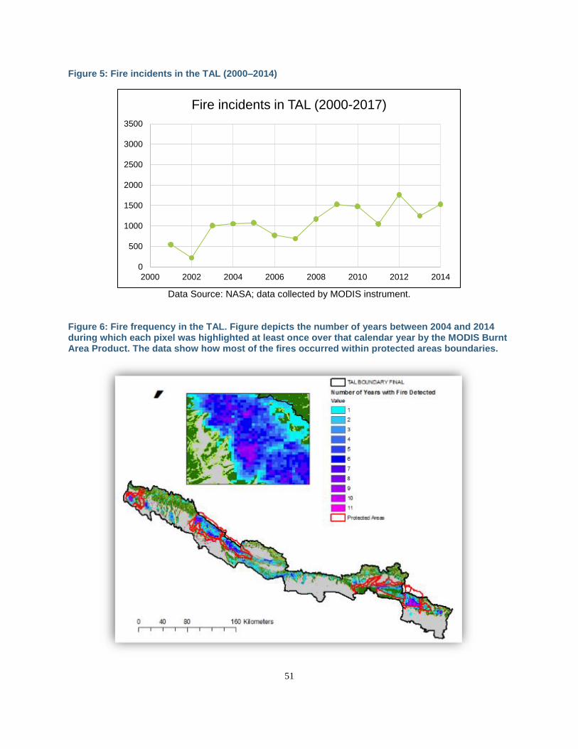
51
Figure 5: Fire incidents in the TAL (2000–2014)
Data Source: NASA; data collected by MODIS instrument.
Figure 6: Fire frequency in the TAL. Figure depicts the number of years between 2004 and 2014 during which each pixel was highlighted at least once over that calendar year by the MODIS Burnt Area Product. The data show how most of the fires occurred within protected areas boundaries.
0
500
1000
1500
2000
2500
3000
3500
2000 2002 2004 2006 2008 2010 2012 2014
Fire incidents in TAL (2000-2017)
52
A fire management strategy was developed by the MoFE in 2010 emphasizing fire prevention, awareness and education, capacity development of DFOs, community-based fire management, and strengthened coordination and collaboration among multiple stakeholders during fire seasons. DFOs in the Terai have increased their capacity over recent years to handle forest fires. For example, the WWF-funded TAL Program and the USAID-funded Hariyo Ban Program trained DFOs and CFUGs in fire management including establishing fire lines in community forests and firefighting techniques. At the national level, ICIMOD and MoFE have been implementing a near-real-time forest fire detection system to track forest fires across Nepal. The fire information system uses data collected by MODIS 2 to send automated information on forest fires to local forestry stakeholders, including the DoF, DFOs and district officials of FECOFUN. ICIMOD is also piloting a community-based fire detection system to complement this initiative. Clearly, fire plays an important role in the Program Area and requires additional analysis, now in planning stages, to better assess its implications for forests and forest-related emissions.
4.1.4 CONVERSION OF FORESTS TO OTHER LAND USES DUE TO ENCROACHMENT, RESETTLEMENT, AND INFRASTRUCTURE Encroachment on and then illegal conversion of forests to agricultural land and legal, but poorly planned, conversion related to resettlement and infrastructure are additional drivers of deforestation in Nepal. The underlying issues driving conversion of forests to agricultural land are multilayered. For example, immigration to the Terai region from the Mid-Hills continues, motivated by more productive land and improved economic opportunities. In addition, the high number of landless people in the Terai and lack of off-farm employment opportunities and alternative livelihood options often drive the conversion of “common property” (i.e., government-managed forests) to agricultural land. Major river channels through the Program Area are also highly dynamic and proximate to many settled areas. Consequently, families often lose their land due to flooding, riverbank erosion and changes in river courses, deposition of boulders and sediment by rivers, and landslides. This in turn leads to planned resettlement, often in forest areas. Policy initiatives for resettlement and/or compensation are limited to agricultural-based livelihoods, putting more pressure on forests. In some cases, these initiatives have been ineffective due to weak management, insufficient allocation of resources, and/or abuse of authority. Infrastructure development, particularly road construction, continues to be a driver of deforestation in the Terai, particularly in the far western region. Infrastructure was identified by MoFE as a major obstacle to sustainable forest management. Annually, about US$ 40 million is spent on road construction. As a result, the road network more than doubled between 1998 and 2010 (from 4,740 km in 1998 to 10,835 km in 2010), and this growth continued in recent years.40 Several national roads are planned, and many local roads are being opened up without adequate planning, leading to serious impacts on forests, particularly in the fragile Chure hills. An east-west railway is planned, many transmission line corridors and irrigation canals are in various stages of development, and a new airport is planned. WWF recently estimated that anticipated/planned infrastructures will lead to direct conversion of approximately 10,000 ha of forests within the ER Program Area. Many of these developments require extraction of building materials (sand, gravel, rock), which is an additional threat in the Chure. Moreover, there is a high likelihood of rapid urbanization along the newly built highways and railways, which will have multifold negative impacts on forests. Impacts on forests are both direct and indirect (e.g., increased access for illegal activities, forest fragmentation). Insufficient coordination among different government agencies is a major contributing factor to these environmental outcomes. Major infrastructure development projects, like the expansion of road networks and transmission lines, are implemented without considering the economic or ecological value of forests. The situation is exacerbated by weak enforcement of environmental impact assessments (EIAs) for these projects. In addition, Strategic Environmental Assessment legislation that would cover complex, large-
40 UN-REDD (2014). Understanding drivers and causes of deforestation and forest degradation in Nepal: potential policies and measures for REDD+.
53
scale and multi-sectoral developments has not yet been passed. The Department of Forest (DoF) estimates that about 14,000 ha of forest have been officially permitted for development through ministerial-level decisions in the past 25 years. These recorded cases provide a conservative estimate of actual conversion. Additional underlying factors include lack of transparency in forest sector governance and weak land tenure. Weak governance in the forestry sector may also undermine regulation and enforcement, e.g., of development plans, harvest and transport of forest products. As a result, diverse types of non-transparent and illegal financial transactions in the forestry sector lead to deforestation and degradation. Weak law enforcement primarily results from a lack of capacity. The DoF and its local offices do not have adequate staffing, transport equipment, and access to information to monitor, detect and stop overharvesting, illegal logging, or poaching. With respect to weak land tenure, the government continues to hold management responsibility of over two-thirds of forest lands. As the central government has full control over the management and benefits of most forests, local governments have not had a specific role to play. The tenure issues are sometimes unclear, even for community forests and other forest regimes. There are ongoing conflicts between the authorities and community leadership, specifically over the roles and regulations exercised by the government officials and local organizations. Climate change and Terai forests Several of these drivers may be exacerbated in the future by climate change. For example, increased frequency of droughts, floods and other extreme weather events can increase the displacement of people and need for resettlement, impacting forested areas. Fire frequency and intensity are also subject to increase in association with increased temperatures and/or drought periods. And climate change itself may become a direct driver of deforestation, degradation, and/or forest change. One recent analysis suggested that changing environmental gradients in the Terai within 20 to 30 years may have significant impacts on the range of dominant tree species, with obvious implications for forest management planning. As discussed in more detail in Section 4.3, ER Program activities are planned to anticipate these types of changes and increase climate change resilience where possible, including by building climate-smart principles into new or updated forest management plans. Existing activities and policies relevant to conservation and enhancement of carbon stocks Please refer to Section 2.2 for a description of relevant policies and frameworks linked to the proposed activities and to Sections 4.4, 4.5 and Annex 7: List of laws, statutes, and other regulatory frameworks for a full mapping of relevant laws and statutes.
4.1.5 REGENERATION The reference level developed for the ER Program from 2004 to 2014 shows regeneration occurring in the range of 60,000+ ha and offsetting approximately half of the combined emissions of deforestation and degradation (see Section 8). Importantly, these estimates are limited to land area detected as changing from a non-forest to forest condition. Current data are insufficient to fully explain this positive change, and whether it represents a trend or temporary effect. A broad-based economic model designed to predict patterns of deforestation and degradation in Nepal predicts increasing rates of deforestation and degradation in the Terai and Chure without REDD+ interventions.41 On the other hand, this regeneration occurs concurrently with a period when increasing areas of government forest have been transferred to community and collaborative forest management models, and it may reflect benefits already derived from these initiatives. If true, this would be a significant validation of planned program activities. There are other possible explanations, including some loss of labor capacity as working-age men, in particular, leave the region for more lucrative employment opportunities, which could fuel some abandonment of agricultural lands. The NRC is commissioning a study to begin in 2018 to explore these trends and in
41MOFCS, 2015. Economic model to forecast future rates of deforestation and degradation in Nepal.
54
particular to look at regeneration and enhancement as it relates to community versus non-community forest regimes, which will position Nepal to better understand and focus the appropriate activities in the ER Program to maximize associated carbon and non-carbon benefits. This work will also inform the stepwise improvements to the ER Program and national MRV methodologies to better reflect changes related to regeneration and enhancement of carbon stocks.
4.2 ASSESSMENT OF THE MAJOR BARRIERS TO REDD+
Based on multiple consultations and prior assessments conducted in Nepal, the major barriers to addressing the key drivers of deforestation and forest degradation in the Program Area include the following: 1) limited financial resources and technologies to successfully implement programs; 2) limited information and awareness on best management practices; 3) Nepal’s constitutional transition and governance; 4) insufficient alternative livelihood and poverty alleviation opportunities; and 5) conflicting views on sustainable management of forests. These are each briefly described below. Limited financial resources and technologies to successfully implement programs Nepal has been a major recipient of donor support for many decades. External aid increased from US$ 0.13 million per year in 1956 to over US$ 1 billion in 2013.42 Notwithstanding this, most finance in Nepal today is not directed to forests. Forest-related support from both bilateral and multilateral donors has declined significantly in recent years, with the closing of the Multi-Stakeholder Forestry Programme (MSFP) and the Forest Resource Assessment (FRA). Current forest sector investments are focused in the Chure and Mid-Hills, with fewer investments concentrated in the Terai. Past investments in the forestry sector have built capacity in best management practices; however, approaches for the sustainable management of forests (SMF) have evolved in recent years, so it will be important to inform, sensitize and build capacity of communities and local institutions to adopt new approaches, technologies, and management models of SFM. Small-scale, localized awareness-raising events and management trainings have been performed on a project-by-project basis throughout the REDD+ readiness process, but without a comprehensive push across government and civil society to widely disseminate best practices across entire districts for forest management at the landscape level. Limited information and awareness on best management practices The lack of institutional and technical capacities of district-level government offices and community-based organizations is a barrier to disseminating information effectively and providing training in best management practices. For example, there is often community interest and political will to transfer government-managed forests to CBFM models. However, communities and DFOs lack the resources to develop management plans and to implement new harvest and use regimes. In addition, CFUGs are generally open to and interested in new management techniques, but they have not had access to training to understand the medium-term and long-term benefits of alternative management. Many five-year community Forest Operational Plans are due for renewal, but the DoF lacks the resources to renew these, which limits progress at the central level and creates a backlog of applications. In addition, the low level of capacity to actively manage forests for future scenarios under climate change is a barrier to addressing deforestation and forest degradation. This includes planning for more variable and unpredictable weather, shifting monsoon seasons, natural disturbances such as flooding and landslides, and species range shifts. The slow uptake of incorporating climate change implications into forest management, particularly in Forest Operational Plan development, is a barrier to addressing the drivers of deforestation and forest degradation.
42 MoFSC, 2015. Project Bank in the Forestry Sector of Nepal.
55
Nepal’s constitutional transition and governance Nepal has undergone a major political transition from a unitary system of governance to a federal democratic republic. The restructuring of state jurisdictions and establishment of state and local bodies necessary to institutionalize the new political system is nearing completion after three levels of elections of the federal bodies. The Constitution of Nepal (2015) devolves significant powers and rights of forest management to the states, while some remain under combined authority (e.g., with the federal government providing overarching national policies and the subnational jurisdictions completing implementing regulations). This devolution to the local level is expected to significantly improve the management of forests in the future based on the overall policy framework designed by the federal and state government. However, there are still some ambiguities on the legal and institutional transition from the current centralized management structure to a devolved local management structure. In near term, although newly elected local bodies have the mandate to manage the forests’ resources, they will likely face capacity-related challenges. It will also take time to resolve outstanding ambiguities on management of forest resources and to establish necessary entities at the local level. During this transition period, there are potential risks associated with lack of clear lines of authority, which could create room for increased illegal activities like timber harvesting and forest area encroachment, though this is most likely to occur in government-managed forests. The ER Program districts fall under five states in the new structure. This will add an additional layer of coordination and will require better communication mechanisms and capacity building for successful implementation of the ER Program. A State Department of Forests will be created in each of the states and will be responsible for the overall management of the forests within the state. In addition, a Division Forest Office (DFO) will be created (at least one in every current district) that will be responsible for activities like forest management plan preparation and transfers of forests to local communities for management. The Division Forest Office will take over the roles and responsibilities of current District Forest Offices. At local (municipal) levels, there will be forestry units that will be responsible for protection, restoration and management of the forests. There is a plan to absorb the current forestry workforce to the new proposed entities at state and local levels based on their technical capacities and interests. Each state will have its own forest policy and implementation plan under the framework of federal policy and Nepal’s Forestry Sector Strategy (2016–2025). At the federal level, the former Ministry of Forests and Soil Conservation and Ministry of Environment are now combined as one ministry, the Ministry of Forests and Environment (MoFE). Importantly, the REDD Implementation Center will become the National REDD+ Center (NRC) and will have multi-agency representation in the future. Similarly, the Department of Forests (DoF), the Department of Forest Research and Survey (DFRS), and the Department of National Parks and Wildlife Conservation (DNPWC) will remain in the new structure with MoFE. Notwithstanding these challenges, the new constitution is historic step for Nepal and will provide new opportunities for the successful implementation of the ER Program. Insufficient alternative livelihood and poverty alleviation opportunities Previous programs have targeted forest-dependent communities focused on selected priority areas of different donors. The ER-PD focuses on expanding and scaling this work across a larger geography than these past investments, and in so doing, working with many more communities in the EPRD Program Area. The work and interventions pursued under the ER-PD will be done in coordination with other projects in the ER Program Area that have strong livelihood components. Conflicting views on sustainable management of forests There are conflicting views and ongoing debates about the practices of sustainable management of forests and scientific forest management. There is lack of consensus on the benefits with respect to biodiversity and carbon sequestration of rotation, thinning, and pruning regimes. This makes it difficult to proceed with a unified, coherent approach to forest management that has nationwide political support. CFUGs are reluctant to support scientific forest management because of transparency issues with DFOs, specifically with how and to whom the timber harvest is allocated. The DFOs control many of the parameters of harvest, and communities are not allowed to harvest timber under Forest Operational
56
Plans. The justification by DFOs that decisions are made based on sound science remains a point of contention with communities, as there is a lack of shared understanding of the basis of that science. This leads to mistrust, as well as illegal harvesting, because the legal and regulatory frameworks, specifically the Forest Operational Plans, do not allow for optimum harvest. After the National Silviculture Workshop held in February 2017, the Department of Forests has formulated a national Silviculture Working Group (SWG) representing experts from government and non-governmental sectors and civil society representatives. The SWG has been working to identify policy gaps and procedural hurdles to implementing sustainable forest management in Nepal. The recommendations of the SWG should be helpful in resolving some of the misunderstandings and/or conflicting views on this important issue. There also continues to be a perceived competition between CF and CFM user groups. The CFs and CFMs are interested in increasing the share of forest area under their management regimes, with all CF benefits concentrated locally, and CFMs benefiting distant users through a revenue-sharing mechanism between the government and communities. The competition arises from perceived government preference for CFMs, given the revenue-sharing structure. The interventions proposed in the next section will address these barriers as directly as possible. Most importantly, the program seeks to expand models of local control, empowerment, and accountability in land management regimes, and combine this with improved knowledge sharing. Nepal’s precedent for significant community involvement presents a framework from which to implement management changes broadly to improve the supply/demand deficit for forest products and the sustainability of ecosystem services that forests provide. The past few years have marked considerable progress in the national governance situation in Nepal with adoption of a new constitution, and this is well-timed with the ambitious interventions proposed.
4.3 DESCRIPTION AND JUSTIFICATION OF THE PLANNED ACTIONS AND INTERVENTIONS UNDER THE ER PROGRAM THAT WILL LEAD TO EMISSION REDUCTIONS AND/OR REMOVALS
As Section 4.1 discusses, the major drivers in the TAL and the results of multiple recent stakeholder consultations depict a culturally and ecologically diverse landscape that is facing a tipping point. The TAL’s rich soils support substantial agricultural output and forest growth, and the forests and grasslands continue to support globally important wildlife like the Royal Bengal Tiger. However, the demands on the land exceed its production capacity and its ability to support the needs of local communities, with a population growth rate nearly twice the national average. The result is continued poverty, a net decline in forest cover, and loss of ecosystem services, with associated increases in emissions from deforestation and degradation (Section 8). On the other hand, there is much experience to build from in the region, including a legacy of conservation efforts from NGOs and critical multilateral and bilateral support from countries including the UK, US, Finland, Norway, Germany, and Switzerland. There are strong traditions and values from the local to national level that place a high priority on sustaining Nepal’s natural resources, reflected in the protected area designation of almost one-third of the forest area in the Program Area. Most importantly, there is an existing forest governance infrastructure in the Terai built on a legacy of community forest management that has enhanced forests in the Terai. With the active participation of thousands of households organized as villages, wards and districts, existing and new community forests can be a foundation for reinforcing these gains and advancing sustainable land management practices (see Box 1: Nepal’s community-based forest management models).
57
The Government of Nepal and its partners will take the opportunity and visibility of the ER Program to leverage this unique community-driven infrastructure, bring improved planning, accountability, coordination and sustainable production to the Terai, and achieve a green growth trajectory that can be a model for other parts of Nepal as well as other forest countries. Based on several district, regional and national consultations (see Section 5.1 for details), the ER Program prioritizes seven key interventions to address the drivers of deforestation and forest degradation in the Terai Arc Landscape (see Figure 7 for the ER Program’s theory of change). In addition, the ER Program will ensure that these interventions are climate-smart and improve the overall resilience of communities and ecosystems in the TAL. All of these activities will build on ongoing conservation and forestry activities in the region, notably those highlighted in Section 4.1, and have been designed not only to address the drivers of deforestation and forest degradation, but also to advance the existing policies, strategies and plans of the forestry and environmental sectors summarized in Section 2.2. Most notably, as described in Section 2.2, all of the interventions are directly aligned with leading objectives of the National REDD+ Strategy (2018), with a particular focus on expanding community forest management, increasing the uptake of Sustainable Forest Management practices, and ensuring equitable distribution of carbon and non-carbon benefits from forests to local communities. In line with the findings of several analyses on land and resources tenure, these interventions will also provide important opportunities to improve the recognition of customary rights and practices through the development and/or updating of forest management plans under different management regimes (See Section 4.4). The seven interventions of the Nepal ER Program are as follows:
1. Improve management practices in existing community and collaborative forests, including by building on traditional and customary practices.
2. Localize forest governance through transfer of government forests to Community and Collaborative Forest User Groups.
3. Expand private-sector forestry through improved access to extension services and finance.
4. Expand access to alternative energy with biogas and improved cookstoves.
5. Scale up pro-poor Leasehold Forestry.
6. Implement integrated land use planning measures to reduce forest conversion associated with infrastructure development.
7. Improve the management of existing Protected Areas.
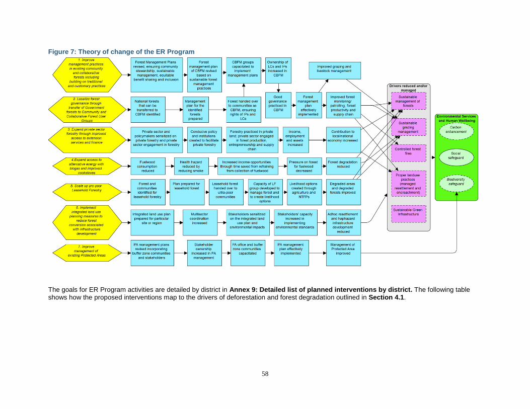
58
Figure 7: Theory of change of the ER Program
The goals for ER Program activities are detailed by district in Annex 9: Detailed list of planned interventions by district. The following table shows how the proposed interventions map to the drivers of deforestation and forest degradation outlined in Section 4.1.
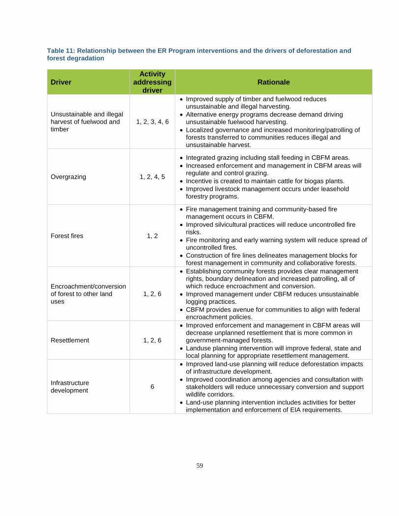
59
Table 11: Relationship between the ER Program interventions and the drivers of deforestation and forest degradation
Driver Activity
addressing driver
Rationale
Unsustainable and illegal harvest of fuelwood and timber
1, 2, 3, 4, 6
• Improved supply of timber and fuelwood reduces unsustainable and illegal harvesting.
• Alternative energy programs decrease demand driving unsustainable fuelwood harvesting.
• Localized governance and increased monitoring/patrolling of forests transferred to communities reduces illegal and unsustainable harvest.
Overgrazing 1, 2, 4, 5
• Integrated grazing including stall feeding in CBFM areas.
• Increased enforcement and management in CBFM areas will regulate and control grazing.
• Incentive is created to maintain cattle for biogas plants.
• Improved livestock management occurs under leasehold forestry programs.
Forest fires 1, 2
• Fire management training and community-based fire management occurs in CBFM.
• Improved silvicultural practices will reduce uncontrolled fire risks.
• Fire monitoring and early warning system will reduce spread of uncontrolled fires.
• Construction of fire lines delineates management blocks for forest management in community and collaborative forests.
Encroachment/conversion of forest to other land uses
1, 2, 6
• Establishing community forests provides clear management rights, boundary delineation and increased patrolling, all of which reduce encroachment and conversion.
• Improved management under CBFM reduces unsustainable logging practices.
• CBFM provides avenue for communities to align with federal encroachment policies.
Resettlement 1, 2, 6
• Improved enforcement and management in CBFM areas will decrease unplanned resettlement that is more common in government-managed forests.
• Landuse planning intervention will improve federal, state and local planning for appropriate resettlement management.
Infrastructure development
6
• Improved land-use planning will reduce deforestation impacts of infrastructure development.
• Improved coordination among agencies and consultation with stakeholders will reduce unnecessary conversion and support wildlife corridors.
• Land-use planning intervention includes activities for better implementation and enforcement of EIA requirements.
60
4.3.1 IMPROVE MANAGEMENT PRACTICES IN EXISTING COMMUNITY AND COLLABORATIVE FORESTS BUILDING ON TRADITIONAL AND CUSTOMARY PRACTICES The ER Program will broadly build on and expand Nepal’s successful CBFM practices and address key gaps in resources to improve the sustainable management of forests (SMF). CBFM is well documented for contributing to the improvement of forest cover in Nepal,43 and many once-degraded forests have been restored to mixed tree species or monoculture plantations. Notwithstanding this, stocking densities in the Program Area are far below optimum productive forest levels, and CBFs could be managed to provide multiple benefits including improved carbon storage potential. The carbon stock in forests of the Program Area, calculated through field plots and the LAMP methodology, is between 80 and 110 tC/ha compared to average carbon stocks in protected areas of 291.55 tC/ha.44 Each community and collaborative forest has a forest operation/management plan consistent with national guidelines. Under this first intervention area, the forest operation/management plans for existing community forests and collaborative forests in the ER Program Area will be reviewed and updated to include SFM practices that improve carbon stocks, sustain ecosystem services, and increase the supply of forest products to Community and Collaborative Forest User Groups. Management practices will include implementation of improved silvicultural systems for yield regulation, selective thinning and natural regeneration promotion for forest gain.45 Policy gaps and procedural hurdles to sustainable forest management identified by the National Silvicultural Working Group will also be addressed to make implementation of forest management plans more effective. Special attention will be paid to developing capacity of CBFM groups, forest officials and local resource persons on SFM practices and on helping user groups implement updated plans. In addition, CBFM group members may not have sufficient technical skills and equipment to implement silvicultural operations such as harvesting, thinning, pruning, post-harvest operations, etc., as prescribed by forest management plans. CBFM groups can outsource some of these tasks to private-sector operations, as needed. The NRC will coordinate with the DoF and DFOs to develop clear guidelines for SFM in CFMUGS and CFUGS. DFOs will then work with the CBFM groups to improve and update their forest management plans, which are updated on a five-to-10-year basis. Thus, over the period of the ER Program, all forest management plans will be revised at least once in line with new SFM guidelines. Forest management plans will be developed with the full and effective participation and engagement of local communities and IPs, as well as of the private sector and local government agencies. Implementation of management plans in the community and collaborative forests not only helps to regulate yields but also helps to control fire and grazing. For example, management blocks are made by creating fire lines to prevent the spread of fire, and planned rotational grazing is practiced. The community forests also allocate income from the forests to promote integrated livestock management with stall feeding and improved breeds and to access fodder from plantations on private agricultural lands, helping to reduce grazing pressure on the forests. Established regional training centers will improve understanding of the benefits of best practices among representatives from the different forest user groups. Trainings will also include important gender and social inclusion components and emphasize the importance of biodiversity conservation in SFM. Training models will help to familiarize vulnerable populations, including women and marginalized communities, with their rights and empower them to improve their participation and access to benefits under improved management regimes.
43 For a review of the impacts of sustainable forest management in Nepal, see, e.g., Nepal Swiss Community Forestry Project (2011): Two Decades of Community Forestry in Nepal: What Have We Learned? 44 Gurung, Mohan B., et al. “Estimation of carbon stock under different management regimes of tropical forest in the Terai Arc Landscape, Nepal.” Forest Ecology and Management 356 (2015): 144-152. 45 This will improve the supply of timber domestically and ultimately contribute to the long-term harvested wood pool.
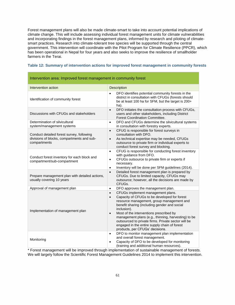
61
Forest management plans will also be made climate-smart to take into account potential implications of climate change. This will include assessing individual forest management units for climate vulnerabilities and incorporating findings in the forest management plans, informed by research and piloting of climate-smart practices. Research into climate-tolerant tree species will be supported through the central government. This intervention will coordinate with the Pilot Program for Climate Resilience (PPCR), which has been operational in Nepal for four years and also seeks to improve the resilience of smallholder farmers in the Terai. Table 12: Summary of intervention actions for improved forest management in community forests
Intervention area: Improved forest management in community forest
Intervention action Description
Identification of community forest
• DFO identifies potential community forests in the district in consultation with CFUGs (forests should be at least 100 ha for SFM, but the target is 200+ ha).
Discussions with CFUGs and stakeholders • DFO initiates the consultation process with CFUGs,
users and other stakeholders, including District Forest Coordination Committee.
Determination of silvicultural system/management systems
• DFO and CFUGs determine the silvicultural systems in consultation with forestry experts.
Conduct detailed forest survey, following divisions of blocks, compartments and sub-compartments
• CFUG is responsible for forest surveys in consultation with DFO.
• As technical expertise may be needed, CFUGs outsource to private firm or individual experts to conduct forest survey and blocking.
Conduct forest inventory for each block and compartment/sub-compartment
• CFUG is responsible for conducting forest inventory with guidance from DFO.
• CFUGs outsource to private firm or experts if necessary.
• Inventory will be done per SFM guidelines (2014).
Prepare management plan with detailed actions, usually covering 10 years
• Detailed forest management plan is prepared by CFUGs. Due to limited capacity, CFUGs may outsource; however, all the decisions are made by CFUGs.
Approval of management plan • DFO approves the management plan.
Implementation of management plan
• CFUGs implement management plans.
• Capacity of CFUGs to be developed for forest resource management, group management and benefit sharing (including gender and social inclusion).
• Most of the interventions prescribed by management plans (e.g., thinning, harvesting) to be outsourced to private firms. Private sector will be engaged in the entire supply chain of forest products, per CFUGs’ decisions.
Monitoring
• DFO to monitor management plan implementation and overall forest management.
• Capacity of DFO to be developed for monitoring (training and additional human resources).
* Forest management will be improved through implementation of sustainable management of forests. We will largely follow the Scientific Forest Management Guidelines 2014 to implement this intervention.
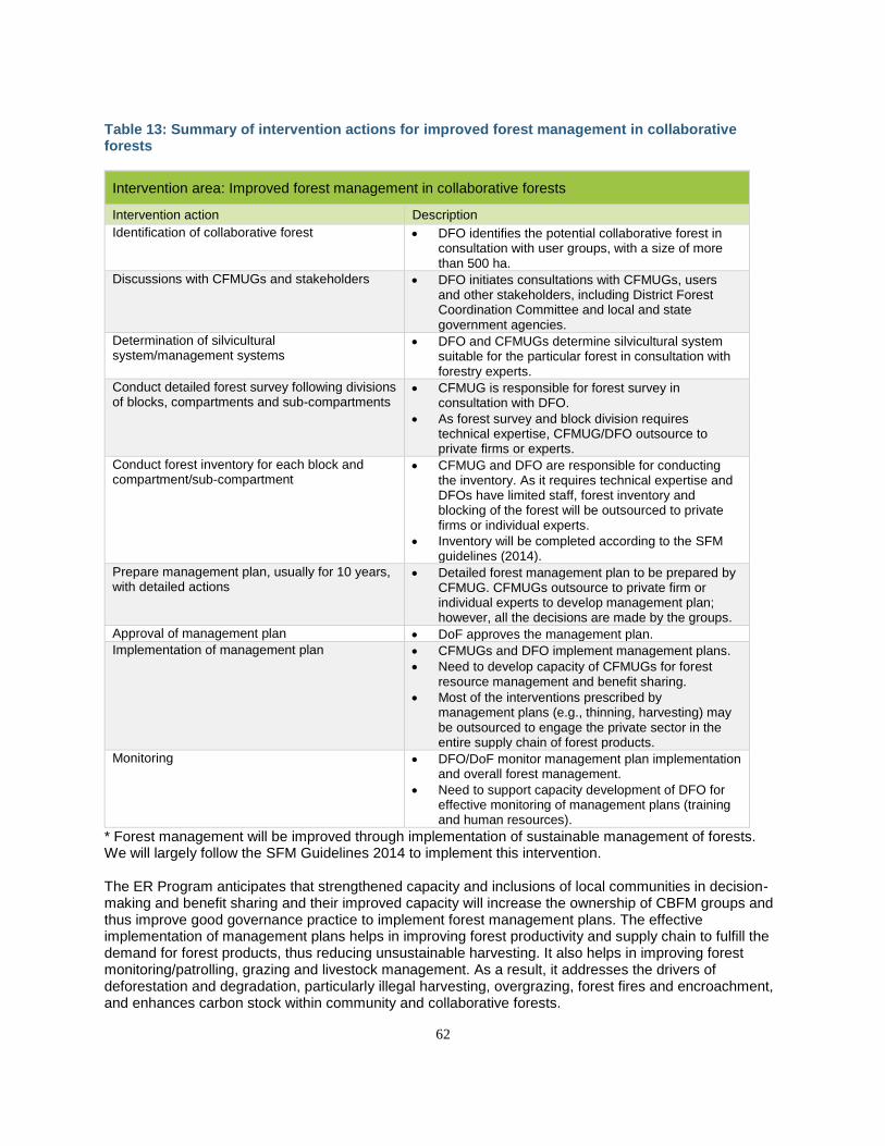
62
Table 13: Summary of intervention actions for improved forest management in collaborative forests
Intervention area: Improved forest management in collaborative forests
Intervention action Description
Identification of collaborative forest • DFO identifies the potential collaborative forest in consultation with user groups, with a size of more than 500 ha.
Discussions with CFMUGs and stakeholders • DFO initiates consultations with CFMUGs, users and other stakeholders, including District Forest Coordination Committee and local and state government agencies.
Determination of silvicultural system/management systems
• DFO and CFMUGs determine silvicultural system suitable for the particular forest in consultation with forestry experts.
Conduct detailed forest survey following divisions of blocks, compartments and sub-compartments
• CFMUG is responsible for forest survey in consultation with DFO.
• As forest survey and block division requires technical expertise, CFMUG/DFO outsource to private firms or experts.
Conduct forest inventory for each block and compartment/sub-compartment
• CFMUG and DFO are responsible for conducting the inventory. As it requires technical expertise and DFOs have limited staff, forest inventory and blocking of the forest will be outsourced to private firms or individual experts.
• Inventory will be completed according to the SFM guidelines (2014).
Prepare management plan, usually for 10 years, with detailed actions
• Detailed forest management plan to be prepared by CFMUG. CFMUGs outsource to private firm or individual experts to develop management plan; however, all the decisions are made by the groups.
Approval of management plan • DoF approves the management plan.
Implementation of management plan • CFMUGs and DFO implement management plans.
• Need to develop capacity of CFMUGs for forest resource management and benefit sharing.
• Most of the interventions prescribed by management plans (e.g., thinning, harvesting) may be outsourced to engage the private sector in the entire supply chain of forest products.
Monitoring • DFO/DoF monitor management plan implementation and overall forest management.
• Need to support capacity development of DFO for effective monitoring of management plans (training and human resources).
* Forest management will be improved through implementation of sustainable management of forests. We will largely follow the SFM Guidelines 2014 to implement this intervention. The ER Program anticipates that strengthened capacity and inclusions of local communities in decision-making and benefit sharing and their improved capacity will increase the ownership of CBFM groups and thus improve good governance practice to implement forest management plans. The effective implementation of management plans helps in improving forest productivity and supply chain to fulfill the demand for forest products, thus reducing unsustainable harvesting. It also helps in improving forest monitoring/patrolling, grazing and livestock management. As a result, it addresses the drivers of deforestation and degradation, particularly illegal harvesting, overgrazing, forest fires and encroachment, and enhances carbon stock within community and collaborative forests.
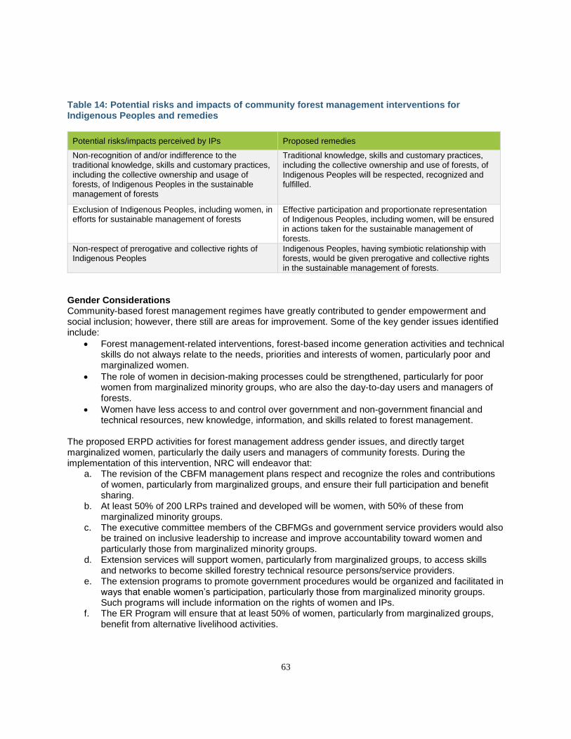
63
Table 14: Potential risks and impacts of community forest management interventions for Indigenous Peoples and remedies
Potential risks/impacts perceived by IPs Proposed remedies
Non-recognition of and/or indifference to the traditional knowledge, skills and customary practices, including the collective ownership and usage of forests, of Indigenous Peoples in the sustainable management of forests
Traditional knowledge, skills and customary practices, including the collective ownership and use of forests, of Indigenous Peoples will be respected, recognized and fulfilled.
Exclusion of Indigenous Peoples, including women, in efforts for sustainable management of forests
Effective participation and proportionate representation of Indigenous Peoples, including women, will be ensured in actions taken for the sustainable management of forests.
Non-respect of prerogative and collective rights of Indigenous Peoples
Indigenous Peoples, having symbiotic relationship with forests, would be given prerogative and collective rights in the sustainable management of forests.
Gender Considerations Community-based forest management regimes have greatly contributed to gender empowerment and social inclusion; however, there still are areas for improvement. Some of the key gender issues identified include:
• Forest management-related interventions, forest-based income generation activities and technical skills do not always relate to the needs, priorities and interests of women, particularly poor and marginalized women.
• The role of women in decision-making processes could be strengthened, particularly for poor women from marginalized minority groups, who are also the day-to-day users and managers of forests.
• Women have less access to and control over government and non-government financial and technical resources, new knowledge, information, and skills related to forest management.
The proposed ERPD activities for forest management address gender issues, and directly target marginalized women, particularly the daily users and managers of community forests. During the implementation of this intervention, NRC will endeavor that:
a. The revision of the CBFM management plans respect and recognize the roles and contributions of women, particularly from marginalized groups, and ensure their full participation and benefit sharing.
b. At least 50% of 200 LRPs trained and developed will be women, with 50% of these from marginalized minority groups.
c. The executive committee members of the CBFMGs and government service providers would also be trained on inclusive leadership to increase and improve accountability toward women and particularly those from marginalized minority groups.
d. Extension services will support women, particularly from marginalized groups, to access skills and networks to become skilled forestry technical resource persons/service providers.
e. The extension programs to promote government procedures would be organized and facilitated in ways that enable women’s participation, particularly those from marginalized minority groups. Such programs will include information on the rights of women and IPs.
f. The ER Program will ensure that at least 50% of women, particularly from marginalized groups, benefit from alternative livelihood activities.
64
The ER Program will conduct participatory assessments to ensure that proposed forest-based income-generating activities and indigenous arts and skills are based on the needs, priorities and interests of women, particularly from marginalized minority groups, and promote income-generating activities and micro-enterprise value chains that are tested and successful in the ER Program Area.
4.3.2 LOCALIZE FOREST GOVERNANCE THROUGH TRANSFER OF NATIONAL FORESTS TO COMMUNITY AND COLLABORATIVE FOREST USER GROUPS One of the most effective interventions that can be advanced by the ER Program is the actual handover of national forests to community and collaborative forest management regimes. Localizing forest management in this way has numerous benefits for local communities and for forests. On one hand, it decentralizes and delegates forest and forest product use rights to local communities who live in and near the forests and have the greatest interests in sustainable management. This results not only in improved rights for forest user groups but also in improved productivity, as forest management plans and related extension services provide opportunities to improve management practices. On the other hand, local management also counters drivers of deforestation and degradation. For example, community members conduct regular monitoring and patrolling within their forests (as compared to very limited monitoring in national forests), which reduces illegal and unsustainable harvesting, forest fire and encroachment. Grazing management is also incorporated into forest management plans, as described in the previous section. These multiple benefits are reflected in several independent studies in Nepal. For example, a landscape-level analysis by Lamsal et al (2014) indicated that threats to forests (including encroachment, poaching, forest fire, mining, infrastructure development and fuelwood collection) were better and significantly mitigated in community-managed forests as compared to government-managed forests.46 Shrub and sapling density and basal area were found to be higher in community forests as compared to government-managed forests, suggesting that community management helps to improve tree regeneration and overall forest health.47 Carbon stocks were also found to be higher in community forests as compared to government-managed forests, although their highest levels were in protected areas (Table 15).48 Currently 1.7 million ha of forests in Nepal are managed as community forest and 60,000 ha as collaborative forests. The National Forest Strategy (2016-25) targets the establishment of 2.3 million ha of community forests and 265,000 ha of collaborative forests through handover of national forests by 2025. The National REDD+ Strategy also prioritizes the expansion of community-based forest management given its effectiveness in controlling illegal activities, reducing deforestation and improving forest conditions. In the last 15 years, 379,445 ha of national forests have been handed over to communities in the proposed ER Program Area (approximately 25,000 ha per year in an average year, or about 2,100 ha per district per year). The ER Program will include handover of an additional 200,000 ha of national forests (equivalent to 40% of the remaining government forests in the Terai) to the communities as community and collaborative forests over 10 years. These CBFMs (CFMs and CFs) will be implemented with improved management plans as outlined in Section 4.3.1 above. To establish which areas will be handed over, the NRC will work closely with the DoF and DFRS to identify national forests that can be transitioned to CBFM in the ER Program Area. There is already a pipeline of applications to begin this process. The DoF will then work through DFOs to initiate the handover process as per the laws, rules and regulations of the Government of Nepal (see 4.4 and 4.5
46 Lamsal et al (2014). Threat reduction assessment approach to evaluate impacts of landscape level conservation in Nepal 47 Paudel et al (2015). Effects of different management practices on stand composition and species diversity in subtropical forests in Nepal: implications of community participation in biodiversity conservation 48 Gurung et al (2015). Estimation of carbon stock under different management regimes of tropical forest in the Terai Arc
Landscape, Nepal
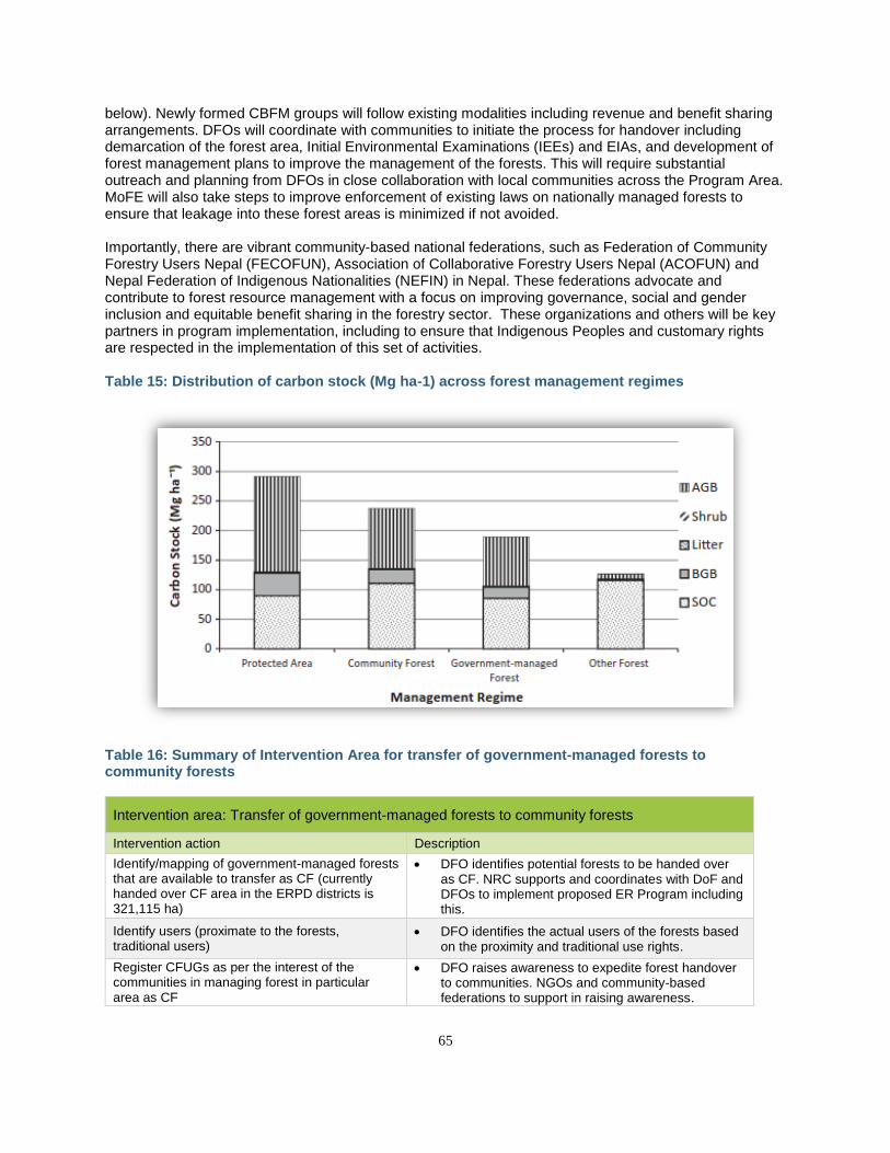
65
below). Newly formed CBFM groups will follow existing modalities including revenue and benefit sharing arrangements. DFOs will coordinate with communities to initiate the process for handover including demarcation of the forest area, Initial Environmental Examinations (IEEs) and EIAs, and development of forest management plans to improve the management of the forests. This will require substantial outreach and planning from DFOs in close collaboration with local communities across the Program Area. MoFE will also take steps to improve enforcement of existing laws on nationally managed forests to ensure that leakage into these forest areas is minimized if not avoided. Importantly, there are vibrant community-based national federations, such as Federation of Community Forestry Users Nepal (FECOFUN), Association of Collaborative Forestry Users Nepal (ACOFUN) and Nepal Federation of Indigenous Nationalities (NEFIN) in Nepal. These federations advocate and contribute to forest resource management with a focus on improving governance, social and gender inclusion and equitable benefit sharing in the forestry sector. These organizations and others will be key partners in program implementation, including to ensure that Indigenous Peoples and customary rights are respected in the implementation of this set of activities. Table 15: Distribution of carbon stock (Mg ha-1) across forest management regimes
Table 16: Summary of Intervention Area for transfer of government-managed forests to community forests
Intervention area: Transfer of government-managed forests to community forests
Intervention action Description
Identify/mapping of government-managed forests that are available to transfer as CF (currently handed over CF area in the ERPD districts is 321,115 ha)
• DFO identifies potential forests to be handed over as CF. NRC supports and coordinates with DoF and DFOs to implement proposed ER Program including this.
Identify users (proximate to the forests, traditional users)
• DFO identifies the actual users of the forests based on the proximity and traditional use rights.
Register CFUGs as per the interest of the communities in managing forest in particular area as CF
• DFO raises awareness to expedite forest handover to communities. NGOs and community-based federations to support in raising awareness.
66
• DFO facilitates the registration process and technical support.
• CFUG prepares users’ constitution ensuring gender and social inclusion, and benefit sharing among the users.
Conduct forest inventory and prepare Forest Management Plan with explicit management prescriptions (based on appropriate silvicultural systems and principles of SFM whereas customary practices are also valued)
• CFUG is responsible to conduct forest inventory of their forests. As it requires technical expertise, CFUGs outsource to forestry technicians to perform forest inventory.
• Forest management plans are drafted following the standards and guidelines.
Forest management plan finalization and submission for approval
• Draft forest management plan is discussed in detail by General Assembly of each CF and is endorsed.
• After endorsement, CFUGs submit the forest management plan to DFO for approval.
Forest management plan approval • DFO approves the forest management plan.
• Capacity building of DFO officials is required to accomplish the work.
Forest management plan implementation
• CFUGs implement forest management plan, ensuring its provision of increasing forest productivity, sustainable supply and equitable benefit sharing (including gender and social inclusion).
• Implementation of some of the interventions prescribed by forest management plans (e.g., thinning, harvesting) to be outsourced to private firm or individual experts. Private sector to be engaged in the entire supply chain of forest products.
• All the decisions should be made by CFUGs, but actions can be outsourced.
Monitoring
• DFO monitors the implementation of forest management plan and overall forest management.
• Capacity of DFO for monitoring to be developed/increased.
Table 17: Summary of intervention actions on transfer of government-managed forests to collaborative forests
Intervention area: Transfer of government-managed forests to collaborative forests
Intervention Action Description
Identification of mapping of government-managed forest that is available to transfer as CFM (currently handed over CFM area in the ERPD districts: 58,242 ha)
• DFO to identify potential forests to be handed over as collaborative forest. NRC to support and coordinate with DoF and DFOs to implement proposed ER programs including this.
Identify users, both proximate and distant users • DFO to identify the users.
• DFO to be strengthened with human resources.
Conduct forest inventory and prepare forest management plan with explicit management prescriptions, based on appropriate silvicultural systems and principles of SFM that value customary practices
• CFMUG is responsible to conduct forest inventory. As it requires technical expertise, CFMUGs outsource to forestry technicians to perform forest inventory.
• CFMUGs prepare forest management plans. They can be outsourced to private firms or experts.
• Forest management plans to be prepared following the standards and guidelines, including adequate consultation with communities and local government.
67
Forest management plan finalization and submission for approval
• DFO finalizes the forest management plan in due consultation with CFMUG. DFO submits the forest management plan to DoF.
• Capacity development of DFO is important at this stage.
Forest management plan approval • DoF approves the forest management plan.
Forest management plan implementation
• DFO and CFMUG implement the forest management plans of collaborative forests.
• Need to develop capacity of DFO and CFMUG to implement the plan.
• Interventions prescribed by forest management plans (e.g., thinning, harvesting) can be outsourced, and would engage the private sector in the entire supply chain of forest products.
• DFO to ensure benefit sharing, including 40% for government treasury, 10% for local government and 50% for community forest user groups.
Monitoring • DFO/DoF to monitor forest management plan
implementation and overall forest management.
Gender Considerations Gender considerations on this intervention will be the same as in the first intervention. While implementing various activities under this intervention, special emphasis will be given to women, particularly of the poor and marginalized groups. Extension activities will inform women and IPs of their rights in relation to land use and benefits, as per the government policies.
4.3.3 EXPAND PRIVATE-SECTOR FORESTRY THROUGH IMPROVED ACCESS TO EXTENSION SERVICES AND FINANCE Despite the rich soils in the TAL, privately run forestry operations have never been extensive, in part because private landowners lack the means to wait for a financial return from long rotation–cycle timber products. In contrast, other agricultural commodities can be grown seasonally and quickly brought to market. Private foresters play an important role, however, in many aspects of community forest management, including being contracted by CFUGs to draft or consult on forest management plans and to implement thinning and harvest regimes. Currently, there are only 639 registered private forests (PFs) in the Program Area covering 550 ha of forests,49 though in reality, most private forests have not been properly accounted for and the actual area and number of private forests are probably larger. Some efforts have been made to increase private-sector engagement in forest management, as reflected in the Forestry Sector Strategy 2016 that includes measures to incentivize commercial forestry nationally and to scale up private forestry to 200,000 ha by 2025. Increasing private-sector capacity and private forestry is also one of the four priority targets identified in the National REDD+ Strategy Implementation Plan. There are about one million hectares of private lands under agricultural practice in the ER Program Area, and the ER Program targets seek to incentivize private forestry and agroforestry in 30,000 ha over 10 years in support of the Forest Sector Strategy goal. Long-term, low-cost capital will be provided to small-scale landholders to incentivize plantation production and maintenance of forests on their private lands. These landholder groups will be provided with training and seedlings to develop culturally and ecologically appropriate timber products, with specific attention to native and climate-resilient species. As outlined in 4.3.1 and 4.3.2, research and extension services will be provided to support these climate-
49 DoF 2012. Hamro Ban. Department of Forests, Ministry of Forests and Soil conservation, Government of Nepal.
68
smart forestry practices. Existing small-scale nursery operations of DFOs will also be scaled to meet increasing demands for seedlings. Per Section 201 of the 2nd amendment of Forest Act 1993, block forests greater than 500 ha can be managed under partnerships between government and the private sector, and MoFE is exploring avenues to lump proximate private lands into block forests to achieve efficiencies of scale. The ER Program’s first two interventions to scale community and collaborative forests and update management plans to reflect sustainable forest management guidelines will also create more business for the private sector, which will be needed to support updated management plans for both existing and new CBFM. This intervention area will also include the training of local resource persons (LRPs) and local-level forestry staffs on various aspects of private forestry including nursery management, silviculture practices, disease and pest management, soil fertility and nutrient management, and harvesting and post-harvest handling through site visits and demonstration sites.50 Increased private and commercial forestry are expected to improve multiple ecosystem services through reduced erosion and landslides, protection of downstream water supplies, and reduced risk of flooding and sedimentation and by increasing soil carbon and above-ground biomass in the intervention areas. This ER Program will promote private forestry through developing a conducive environment and providing technical support and incentives to the private forest owners. Private forestry not only helps in improving supply of forest products but also creates employment and assets through forest-based enterprises, contributing to local and national economies and reducing pressure on forests. Table 18: Potential risks and impacts of private-sector forestry activities on Indigenous Peoples and remedies
Potential risks/impacts perceived by IPs Proposed remedies
Imposition of fees and administrative hurdles for forest owners
Fees for private forest owners would be made reasonable, and administrative procedures would be simplified as much as possible.
Loss of owner control over their own private forests (use and sale of forest products, felling trees, etc.)
Rights and freedom to a reasonable extent would be bestowed on forest owners in terms of use, sale and ownership of forest products.
Room for irregularities in private forests Good governance would be practiced in forestry sector.
Invasion of profit-oriented companies and other actors in forestry sector
Cultural biodiversity and the environmental integrity would be maintained.
Negative impacts on culture and/or biodiversity For-profit activities in the forestry sector should respect, promote and fulfill the rights of Indigenous Peoples and other communities.
Gender considerations Women across all social and economic groups have little control over private forest resources. The proposed ER Program activities have the potential to spur innovation to engage more women in private forest management through many of the targeted activities, including, for example, the following measures:
• Support women, particularly from marginalized groups, to access capital, skills, networks and subsidized quality seeds to become successful entrepreneurs and skilled forestry technical resource persons/service providers.
50 Multi Stakeholder Forestry Programme (MSFP) 2014 Potential of Forestry Sector in Economic Growth and Development Short Concepts on Five Themes.
69
• Provide Business Literacy Classes (BLC) for women entrepreneurs, learning from the successful classes conducted by USAID and IFAD.
• Provide soft loans to women, particularly those from marginalized groups.
• Make efforts to improve land tenure rights for women of marginalized groups.
• Develop or incentivize establishment of cooperative business models, including, for example, using invasive species and other biomass for bioenergy supply chain.
4.3.4 EXPAND ACCESS TO ALTERNATIVE ENERGY W ITH BIOGAS AND IMPROVED COOKSTOVES As discussed in Section 4.1, the demand for fuelwood in the TAL has outpaced the capacity of the forests to provide supply. Improved forest management practices and the scaling up of private forestry will increase supply considerably over the long term but must be coupled with efforts to address the demand side. In this regard, the GoN has extensive experience in the TAL which can be leveraged in the ER Program with the broadening of efforts to install biogas units and improved cookstoves (ICS) across the region. Biogas units decrease the need for fuelwood by producing methane cooking gas from the breakdown of animal, agricultural and human wastes. Similarly, ICS demonstrate significant efficiency improvements relative to open cooking fires, are readily installed and can benefit households who do not keep livestock. The success of both technologies has already been proven in Nepal under a voluntary Gold Standard project and multiple Programs of Activity (PoA) developed by the Alternative Energy Promotion Centre (AEPC; and see Table 75).51 Both technologies also have the advantage of directly and sustainably addressing the underlying driver and deliver significant additional social and environmental benefits. Some of the social benefits include time and labor savings for women, significant reduction of respiratory and eye infections, and increased school enrollment rates for children due to the extra income earned by parents. In addition, with stall-fed livestock used to produce slurry, children have milk to drink, improving nutritional baselines. Environmental benefits include improved water quality (i.e., decreased run off of natural by-products into local waterways) and increased soil quality through the use of organic fertilizers derived from cow waste slurry. The necessary institutional and policy frameworks are already in place to make this intervention feasible. In 1996, the GoN established the AEPC to promote access to renewable energy technologies. AEPC subsequently developed Rural Renewable Energy Subsidy Policies to improve access to renewable energy technologies for people living in rural areas, reduce pressure on forests, and generate multiple other benefits.52 Under these programs, over 200,000 biogas units have been installed in the ER Program Area. However, a national analysis suggests that only 15% of demand for biogas has been met, due in part to the up-front costs of installations. Under the proposed ER Program, the GoN will expand existing initiatives and install an additional 6,000 biogas plants per year in the ER Program Area. A revolving financing mechanism will expand and accelerate these installations with up-front funds. To supplement the biogas plants, which only benefit households with livestock, the GoN will expand its Clean Cookstove Initiative to install on average 6,000 ICS per year in the ER Program Area,53 or a total of 60,000 ICS/year over the life of the program. Both of these initiatives will be implemented in coordination with the existing AEPC program, which will receive additional finance from the ER Program to support further rollout in the TAL.
51 See https://products.markit.com/br-reg/services/processDocument/.../103000000002030 and https://cdm.unfccc.int/ProgrammeOfActivities/poa_db/7BSCYZMH2U05TWXFJKELND18PRQ96O/view 52 The Nepal Electricity Authority (NEA) serves only 15% of the country’s total population, and an even smaller percentage of the Terai. In addition, electricity provides less than 0.05% of Terai cooking needs and is therefore not considered under this intervention. 53 2,000 is an average across all districts, and demand may be different in each district.
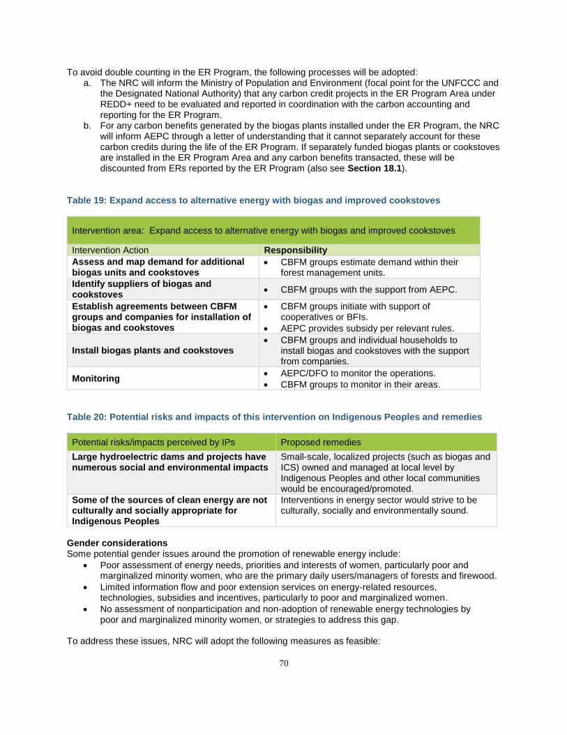
70
To avoid double counting in the ER Program, the following processes will be adopted: a. The NRC will inform the Ministry of Population and Environment (focal point for the UNFCCC and
the Designated National Authority) that any carbon credit projects in the ER Program Area under REDD+ need to be evaluated and reported in coordination with the carbon accounting and reporting for the ER Program.
b. For any carbon benefits generated by the biogas plants installed under the ER Program, the NRC will inform AEPC through a letter of understanding that it cannot separately account for these carbon credits during the life of the ER Program. If separately funded biogas plants or cookstoves are installed in the ER Program Area and any carbon benefits transacted, these will be discounted from ERs reported by the ER Program (also see Section 18.1).
Table 19: Expand access to alternative energy with biogas and improved cookstoves
Intervention area: Expand access to alternative energy with biogas and improved cookstoves
Intervention Action Responsibility
Assess and map demand for additional biogas units and cookstoves
• CBFM groups estimate demand within their forest management units.
Identify suppliers of biogas and cookstoves
• CBFM groups with the support from AEPC.
Establish agreements between CBFM groups and companies for installation of biogas and cookstoves
• CBFM groups initiate with support of cooperatives or BFIs.
• AEPC provides subsidy per relevant rules.
Install biogas plants and cookstoves • CBFM groups and individual households to
install biogas and cookstoves with the support from companies.
Monitoring • AEPC/DFO to monitor the operations.
• CBFM groups to monitor in their areas.
Table 20: Potential risks and impacts of this intervention on Indigenous Peoples and remedies
Potential risks/impacts perceived by IPs Proposed remedies
Large hydroelectric dams and projects have numerous social and environmental impacts
Small-scale, localized projects (such as biogas and ICS) owned and managed at local level by Indigenous Peoples and other local communities would be encouraged/promoted.
Some of the sources of clean energy are not culturally and socially appropriate for Indigenous Peoples
Interventions in energy sector would strive to be culturally, socially and environmentally sound.
Gender considerations Some potential gender issues around the promotion of renewable energy include:
• Poor assessment of energy needs, priorities and interests of women, particularly poor and marginalized minority women, who are the primary daily users/managers of forests and firewood.
• Limited information flow and poor extension services on energy-related resources, technologies, subsidies and incentives, particularly to poor and marginalized women.
• No assessment of nonparticipation and non-adoption of renewable energy technologies by poor and marginalized minority women, or strategies to address this gap.
To address these issues, NRC will adopt the following measures as feasible:
71
• Empower women, particularly from marginalized groups, e.g., with training to serve as Renewable Energy Service Providers and entrepreneurs, providing information about the benefits of biogas and ICS, subsidies and micro-credits.
• Engage women, particularly of marginalized groups, in developing bioenergy supply chain using invasive species and available biomass.
• Assess demand from women and link with micro-credit providers in the respective districts; introduce innovative strategies to encourage the use of bio-gas and ICS such as awarding renewable energy technician champions (both among beneficiaries and SPs) and increasing the incentive amounts to offset up-front costs of biogas installation for the poorest and most marginalized women.
• Use “Window of Opportunity” funds and resources to promote new technologies to reduce household workloads
4.3.5 SCALE UP PRO-POOR LEASEHOLD FORESTRY While several activities described above are essential to reduce the conversion of forests to other land uses, they are not sufficient if local communities do not have access to forest resources and opportunities for alternative livelihoods. Under this intervention area, the GoN, in coordination with ongoing poverty reduction initiatives such as the Poverty Alleviation Fund, Feed the Future, and Rastrapati (President) Chure Terai Madhesh Conservation and Development Program, will seek to expand pro-poor leasehold forestry to create livelihood opportunities in forest management. The main beneficiaries of this intervention are expected to be socially and economically disadvantaged rural households in the Program Area, namely women, Dalit and Janajatis (Indigenous Peoples), and other communities who depend on forests for their livelihoods. This intervention will expand the Leasehold Forestry Program (LFP), which has been successful in providing employment opportunities to economically disadvantaged communities in other parts of Nepal. In 2014, there were more than 7,000 LFUGs in Nepal managing over 40,000 ha of LFs and involving over 62,000 families. The program has helped to support these families through the production of forage, fodder, agroforestry products, medicinal and aromatic plants, and other NTFPs.54 The pro-poor LFP will also help to reduce forest degradation from unmanaged forest exploitation. To date, the LFP has only been implemented in the Chitwan district of the TAL; however, this intervention will scale the program to other districts in the ER Program Area. DFOs will identify areas suitable for leasehold forestry and maintain a roster of these lands for potential applicants. National NGOs and IPOs will facilitate “matchmaking” to connect potential beneficiaries to DFOs through community outreach programs and awareness-raising campaigns. The costs of scaling up the pro-poor LFP are relatively small; success will instead depend on establishing better linkages between relevant stakeholders and DFOs. Support will initially be provided to DFOs to provide skill-based training in SFM techniques to leasehold forest user groups (LHFUGs) as well as access to seedlings, and other inputs, to ensure that new forest users are able to quickly scale up planting and silvicultural practices.
54 Laduari and Kaini (2014) Nepal’s Pro-poor Leasehold Forestry Program: Processes, Policies, Problems and Ways Forward. http://www.nepjol.info/index.php/INIT/article/viewFile/10258/8337
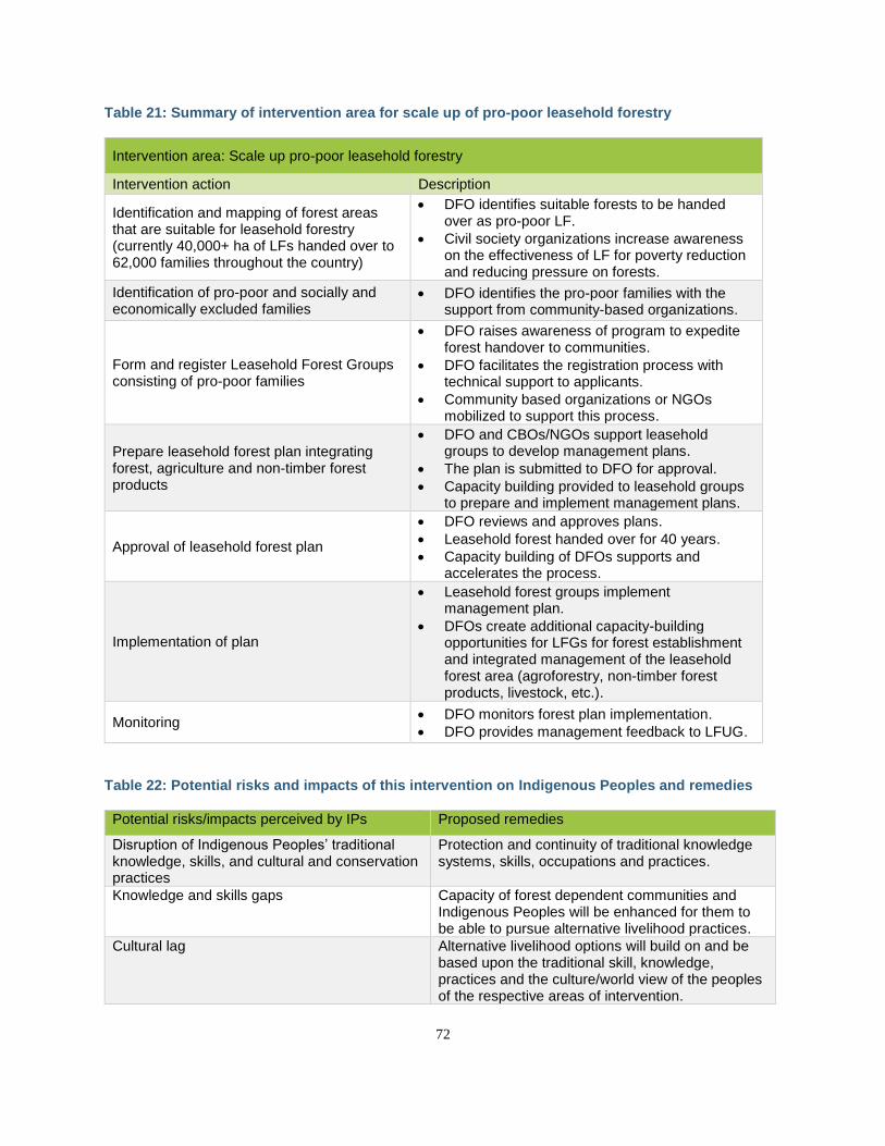
72
Table 21: Summary of intervention area for scale up of pro-poor leasehold forestry
Intervention area: Scale up pro-poor leasehold forestry
Intervention action Description
Identification and mapping of forest areas that are suitable for leasehold forestry (currently 40,000+ ha of LFs handed over to 62,000 families throughout the country)
• DFO identifies suitable forests to be handed over as pro-poor LF.
• Civil society organizations increase awareness on the effectiveness of LF for poverty reduction and reducing pressure on forests.
Identification of pro-poor and socially and economically excluded families
• DFO identifies the pro-poor families with the support from community-based organizations.
Form and register Leasehold Forest Groups consisting of pro-poor families
• DFO raises awareness of program to expedite forest handover to communities.
• DFO facilitates the registration process with technical support to applicants.
• Community based organizations or NGOs mobilized to support this process.
Prepare leasehold forest plan integrating forest, agriculture and non-timber forest products
• DFO and CBOs/NGOs support leasehold groups to develop management plans.
• The plan is submitted to DFO for approval.
• Capacity building provided to leasehold groups to prepare and implement management plans.
Approval of leasehold forest plan
• DFO reviews and approves plans.
• Leasehold forest handed over for 40 years.
• Capacity building of DFOs supports and accelerates the process.
Implementation of plan
• Leasehold forest groups implement management plan.
• DFOs create additional capacity-building opportunities for LFGs for forest establishment and integrated management of the leasehold forest area (agroforestry, non-timber forest products, livestock, etc.).
Monitoring • DFO monitors forest plan implementation.
• DFO provides management feedback to LFUG.
Table 22: Potential risks and impacts of this intervention on Indigenous Peoples and remedies
Potential risks/impacts perceived by IPs Proposed remedies
Disruption of Indigenous Peoples’ traditional knowledge, skills, and cultural and conservation practices
Protection and continuity of traditional knowledge systems, skills, occupations and practices.
Knowledge and skills gaps Capacity of forest dependent communities and Indigenous Peoples will be enhanced for them to be able to pursue alternative livelihood practices.
Cultural lag Alternative livelihood options will build on and be based upon the traditional skill, knowledge, practices and the culture/world view of the peoples of the respective areas of intervention.
73
Gender Considerations One of the major challenges within leasehold forests is identification of poor and marginalized women and provision for their access and control over forest-based resources for the development of appropriate livelihoods and enterprise-related activities. Women are more likely than men to be without land rights, so it is critical that Leasehold Forest User Groups have strong participation of women and ensure their rights to long-term leases. To address these issues, NRC will adopt the following measures:
• Support successfully tested and implemented value chains for marginalized women in two districts (in-road corridors).
• Apply lessons learned from IFAD/HVAP and Heifer Nepal to develop/establish pro-poor value chains with well-developed human resources, structures and markets.
• Implement BLC, learning from the successful classes conducted by USAID and IFAD. The BLC packages will be modified in the context of leasehold forests to include technical components such as on REDD+, sustainable forest management, good governance, leadership and fairness in benefit sharing, access to information and resources, basic bookkeeping, and finance.
4.3.6 IMPROVE INTEGRATED LAND USE PLANNING TO REDUCE FOREST CONVERSION ASSOCIATED WITH ADVANCING INFRASTRUCTURE DEVELOPMENT In 2012, the Government of Nepal developed the National Land-use Policy, which aims to support district-level planning and land management including natural resource management. However, to date this policy has had little support, and additional resources and capacity building of relevant government staff are required to translate the policy into land-use plans and follow-through at the local level. Similarly, the Ministry of Forests and Environment is mandated to regulate Environmental Impact Assessments (EIAs) for infrastructure projects, but a key challenge lies in monitoring and evaluating the implementation of approved EIAs once the projects are operational. The reasons for this are primarily capacity and financial gaps. The ER Program provides an opportunity for the GoN to implement these guidelines and reduce deforestation and biodiversity impacts from unmitigated infrastructure development projects. This intervention includes several components to improve and integrate land-use planning to reduce forest conversion. First, the ER Program—through the National REDD+ Steering Committee—will strengthen cross-sectoral coordination in implementation of local land-use plans. A coordination mechanism between the forestry sector and other sectors at the national, state and local levels will be implemented to ensure that goals across sectors are better harmonized (e.g., better siting of infrastructure projects). To support this coordination, the NRC—with support from DoF and DFRS and coordination with the Ministry of Agriculture, Land Management and Cooperatives—will develop a detailed map, zoning all CBFM areas and potential resettlement areas. The map will also delimit potential sites for afforestation and reforestation, including for new plantations for private commercial forestry operations. At the municipality levels, DFOs will support infrastructure zoning by developing land-use plans for the concerned rural and urban municipalities integrating development and traditional land-use practices. Additional coordination efforts will be made with the local governments to employ land-use planning and reduce unnecessary conversion of forests. Complementary initiatives are underway to reduce disaster risks and help guide resettlement needed following flooding or landslide events; these will be strengthened through the ER Program. Policies are also being formulated to integrate disaster risk management into local land-use plans. As an indicative example, the Rashtrapati Chure Terai Madhesh Conservation and Development (RCTMCD) Programme was established in 2013 with NRs 250 million (USD$2.4 million) from the national budget to improve and maintain the ecological integrity of the Chure hills. The program has been categorized as a program of national pride. The ER Program through the local line agencies of the MoFE will work in coordination with the RCTMCD Program to build capacities in improved forest management and support integrated land-
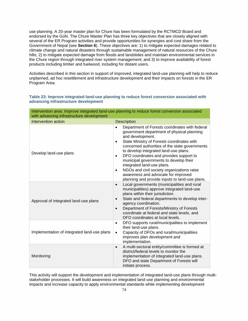
74
use planning. A 20-year master plan for Chure has been formulated by the RCTMCD Board and endorsed by the GoN. The Chure Master Plan has three key objectives that are closely aligned with several of the ER Program activities and provide opportunities for synergies and cost share from the Government of Nepal (see Section 6). These objectives are: 1) to mitigate expected damages related to climate change and natural disasters through sustainable management of natural resources of the Chure hills; 2) to mitigate expected damage from floods and landslides and maintain environmental services in the Chure region through integrated river system management; and 3) to improve availability of forest products including timber and fuelwood, including for distant users. Activities described in this section in support of improved, integrated land-use planning will help to reduce unplanned, ad hoc resettlement and infrastructure development and their impacts on forests in the ER Program Area. Table 23: Improve integrated land-use planning to reduce forest conversion associated with advancing infrastructure development
Intervention area: Improve integrated land-use planning to reduce forest conversion associated with advancing infrastructure development
Intervention action Description
Develop land-use plans
• Department of Forests coordinates with federal government department of physical planning and development.
• State Ministry of Forests coordinates with concerned authorities of the state governments to develop integrated land-use plans.
• DFO coordinates and provides support to municipal governments to develop their integrated land-use plans.
• NGOs and civil society organizations raise awareness and advocate for improved planning and provide inputs to land-use plans.
Approval of integrated land-use plans
• Local governments (municipalities and rural municipalities) approve integrated land-use plans within their jurisdiction.
• State and federal departments to develop inter-agency coordination.
• Department of Forests/Ministry of Forests coordinate at federal and state levels, and DFO coordinates at local levels.
Implementation of integrated land-use plans
• DFO supports rural/municipalities to implement their land-use plans.
• Capacity of DFOs and rural/municipalities improves plan development and implementation.
Monitoring
• A multi-sectoral entity/committee is formed at district/federal levels to monitor the implementation of integrated land-use plans. DFO and state Department of Forests will initiate process.
This activity will support the development and implementation of integrated land-use plans through multi-stakeholder processes. It will build awareness on integrated land-use planning and environmental impacts and increase capacity to apply environmental standards while implementing development
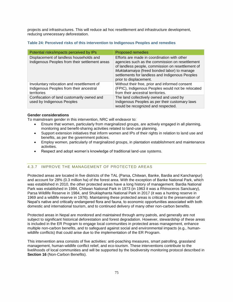
75
projects and infrastructures. This will reduce ad hoc resettlement and infrastructure development, reducing unnecessary deforestation. Table 24: Perceived risks of this intervention to Indigenous Peoples and remedies
Potential risks/impacts perceived by IPs Proposed remedies
Displacement of landless households and Indigenous Peoples from their settlement areas
Efforts are made in coordination with other agencies such as the commission on resettlement of landless people, commission on resettlement of Muktakamaiya (freed bonded labor) to manage settlements for landless and Indigenous Peoples prior to displacement.
Involuntary relocation and resettlement of Indigenous Peoples from their ancestral territories
Without their free, prior and informed consent (FPIC), Indigenous Peoples would not be relocated from their ancestral territories.
Confiscation of land customarily owned and used by Indigenous Peoples
The land collectively owned and used by Indigenous Peoples as per their customary laws would be recognized and respected.
Gender considerations To mainstream gender in this intervention, NRC will endeavor to:
• Ensure that women, particularly from marginalized groups, are actively engaged in all planning, monitoring and benefit-sharing activities related to land-use planning.
• Support extension initiatives that inform women and IPs of their rights in relation to land use and benefits, as per the government policies.
• Employ women, particularly of marginalized groups, in plantation establishment and maintenance activities.
• Respect and adopt women’s knowledge of traditional land-use systems.
4.3.7 IMPROVE THE MANAGEMENT OF PROTECTED AREAS Protected areas are located in five districts of the TAL (Parsa, Chitwan, Banke, Bardia and Kanchanpur) and account for 28% (0.3 million ha) of the forest area. With the exception of Banke National Park, which was established in 2010, the other protected areas have a long history of management. Bardia National Park was established in 1984, Chitwan National Park in 1973 (in 1963 it was a Rhinoceros Sanctuary), Parsa Wildlife Reserve in 1984, and Shuklaphanta National Park in 2017 (it was a hunting reserve in 1969 and a wildlife reserve in 1976). Maintaining these protected areas is critical to the preservation of Nepal’s native and critically endangered flora and fauna, to economic opportunities associated with both domestic and international tourism, and to continued delivery of many other non-carbon benefits. Protected areas in Nepal are monitored and maintained through army patrols, and generally are not subject to significant historical deforestation and forest degradation. However, stewardship of these areas is included in the ER Program to engage local communities in protected areas management, enhance multiple non-carbon benefits, and to safeguard against social and environmental impacts (e.g., human-wildlife conflicts) that could arise due to the implementation of the ER Program. This intervention area consists of five activities: anti-poaching measures, smart patrolling, grassland management, human-wildlife conflict relief, and eco-tourism. These interventions contribute to the livelihoods of local communities and will be supported by the biodiversity monitoring protocol described in Section 16 (Non-Carbon Benefits).
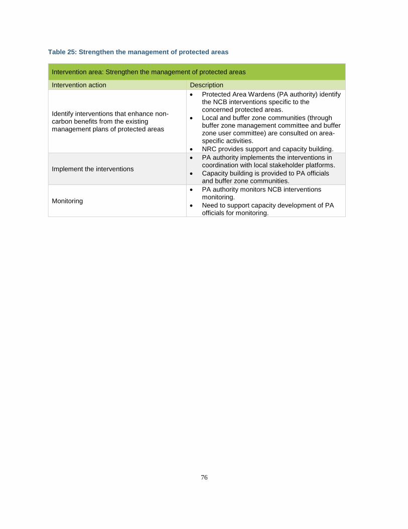
76
Table 25: Strengthen the management of protected areas
Intervention area: Strengthen the management of protected areas
Intervention action Description
Identify interventions that enhance non-carbon benefits from the existing management plans of protected areas
• Protected Area Wardens (PA authority) identify the NCB interventions specific to the concerned protected areas.
• Local and buffer zone communities (through buffer zone management committee and buffer zone user committee) are consulted on area-specific activities.
• NRC provides support and capacity building.
Implement the interventions
• PA authority implements the interventions in coordination with local stakeholder platforms.
• Capacity building is provided to PA officials and buffer zone communities.
Monitoring
• PA authority monitors NCB interventions monitoring.
• Need to support capacity development of PA officials for monitoring.
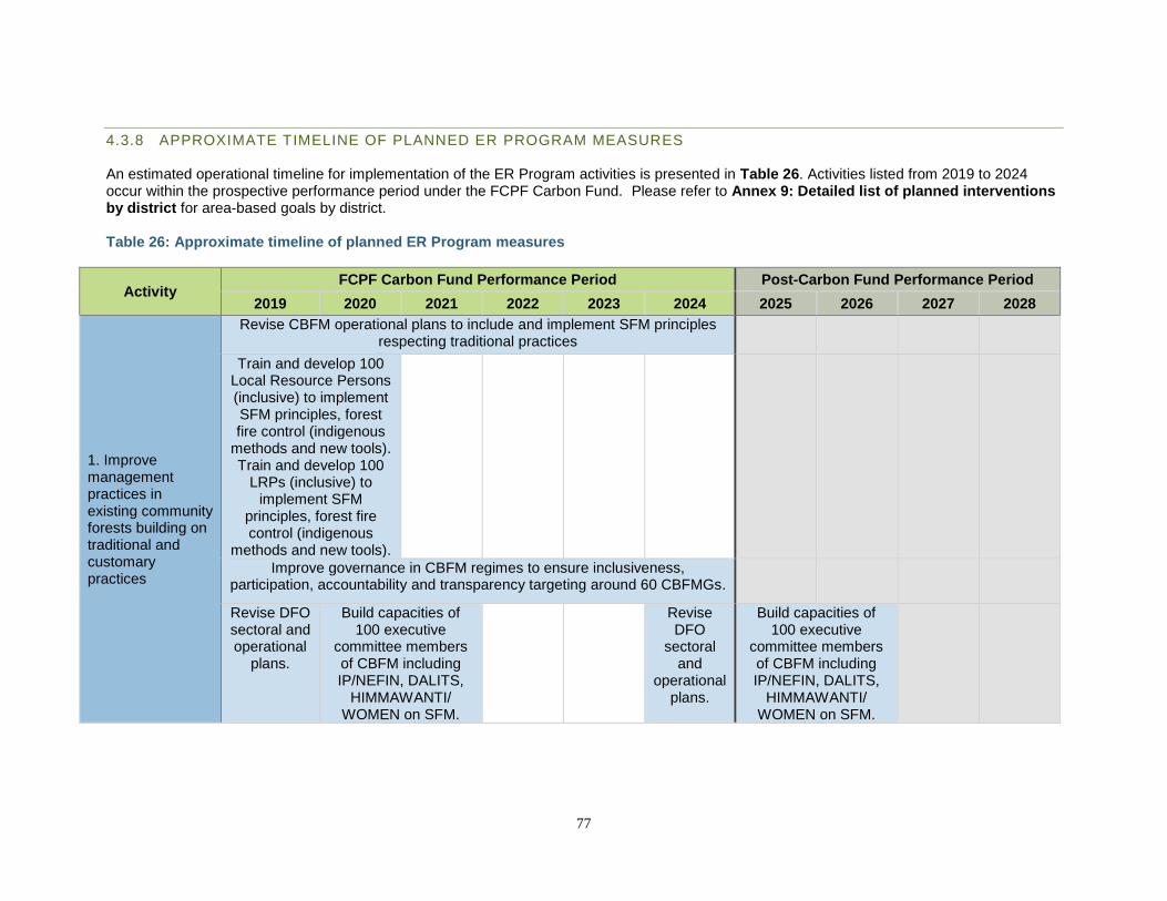
77
4.3.8 APPROXIMATE TIMELINE OF PLANNED ER PROGRAM MEASURES An estimated operational timeline for implementation of the ER Program activities is presented in Table 26. Activities listed from 2019 to 2024 occur within the prospective performance period under the FCPF Carbon Fund. Please refer to Annex 9: Detailed list of planned interventions by district for area-based goals by district. Table 26: Approximate timeline of planned ER Program measures
Activity FCPF Carbon Fund Performance Period Post-Carbon Fund Performance Period
2019 2020 2021 2022 2023 2024 2025 2026 2027 2028
1. Improve management practices in existing community forests building on traditional and customary practices
Revise CBFM operational plans to include and implement SFM principles respecting traditional practices
Train and develop 100 Local Resource Persons (inclusive) to implement SFM principles, forest fire control (indigenous
methods and new tools). Train and develop 100
LRPs (inclusive) to implement SFM
principles, forest fire control (indigenous
methods and new tools).
Improve governance in CBFM regimes to ensure inclusiveness, participation, accountability and transparency targeting around 60 CBFMGs.
Revise DFO sectoral and operational
plans.
Build capacities of 100 executive
committee members of CBFM including IP/NEFIN, DALITS,
HIMMAWANTI/ WOMEN on SFM.
Revise DFO
sectoral and
operational plans.
Build capacities of 100 executive
committee members of CBFM including IP/NEFIN, DALITS,
HIMMAWANTI/ WOMEN on SFM.
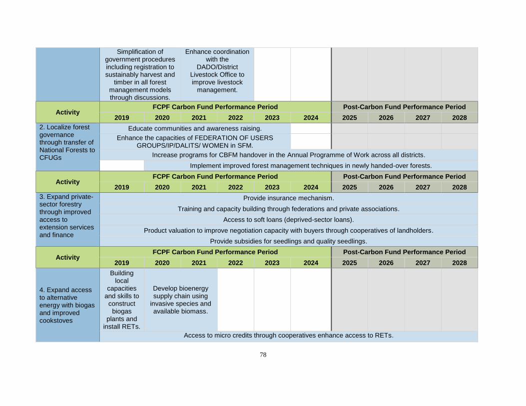
78
Simplification of government procedures including registration to sustainably harvest and
timber in all forest management models through discussions.
Enhance coordination with the
DADO/District Livestock Office to improve livestock
management.
Activity FCPF Carbon Fund Performance Period Post-Carbon Fund Performance Period
2019 2020 2021 2022 2023 2024 2025 2026 2027 2028
2. Localize forest governance through transfer of National Forests to CFUGs
Educate communities and awareness raising.
Enhance the capacities of FEDERATION OF USERS GROUPS/IP/DALITS/ WOMEN in SFM.
Increase programs for CBFM handover in the Annual Programme of Work across all districts.
Implement improved forest management techniques in newly handed-over forests.
Activity FCPF Carbon Fund Performance Period Post-Carbon Fund Performance Period
2019 2020 2021 2022 2023 2024 2025 2026 2027 2028
3. Expand private- sector forestry through improved access to extension services and finance
Provide insurance mechanism.
Training and capacity building through federations and private associations.
Access to soft loans (deprived-sector loans).
Product valuation to improve negotiation capacity with buyers through cooperatives of landholders.
Provide subsidies for seedlings and quality seedlings.
Activity FCPF Carbon Fund Performance Period Post-Carbon Fund Performance Period
2019 2020 2021 2022 2023 2024 2025 2026 2027 2028
4. Expand access to alternative energy with biogas and improved cookstoves
Building local
capacities and skills to
construct biogas
plants and install RETs.
Develop bioenergy supply chain using
invasive species and available biomass.
Access to micro credits through cooperatives enhance access to RETs.
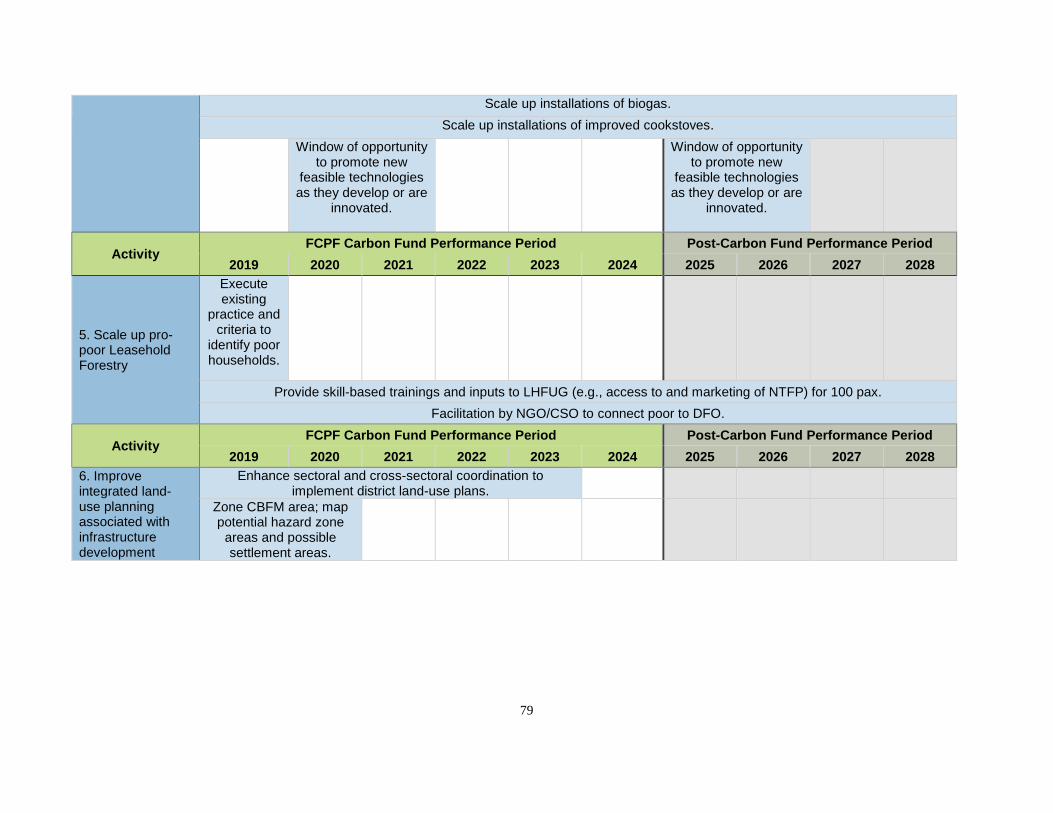
79
Scale up installations of biogas.
Scale up installations of improved cookstoves.
Window of opportunity to promote new
feasible technologies as they develop or are
innovated.
Window of opportunity
to promote new feasible technologies as they develop or are
innovated.
Activity FCPF Carbon Fund Performance Period Post-Carbon Fund Performance Period
2019 2020 2021 2022 2023 2024 2025 2026 2027 2028
5. Scale up pro-poor Leasehold Forestry
Execute existing
practice and criteria to
identify poor households.
Provide skill-based trainings and inputs to LHFUG (e.g., access to and marketing of NTFP) for 100 pax.
Facilitation by NGO/CSO to connect poor to DFO.
Activity FCPF Carbon Fund Performance Period Post-Carbon Fund Performance Period
2019 2020 2021 2022 2023 2024 2025 2026 2027 2028
6. Improve integrated land-use planning associated with infrastructure development
Enhance sectoral and cross-sectoral coordination to implement district land-use plans.
Zone CBFM area; map potential hazard zone
areas and possible settlement areas.
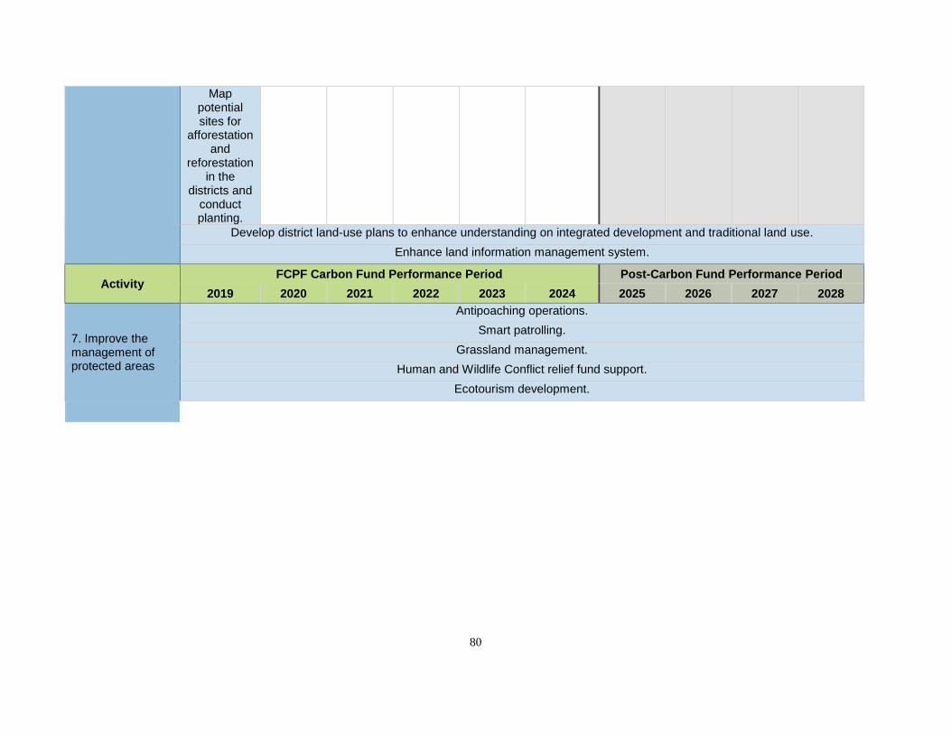
80
Map potential sites for
afforestation and
reforestation in the
districts and conduct planting.
Develop district land-use plans to enhance understanding on integrated development and traditional land use.
Enhance land information management system.
Activity FCPF Carbon Fund Performance Period Post-Carbon Fund Performance Period
2019 2020 2021 2022 2023 2024 2025 2026 2027 2028
7. Improve the management of protected areas
Antipoaching operations.
Smart patrolling.
Grassland management.
Human and Wildlife Conflict relief fund support.
Ecotourism development.
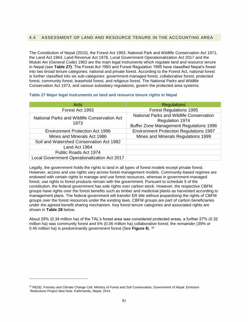
81
4.4 ASSESSMENT OF LAND AND RESOURCE TENURE IN THE ACCOUNTING AREA
The Constitution of Nepal (2015), the Forest Act 1993, National Park and Wildlife Conservation Act 1971, the Land Act 1964, Land Revenue Act 1978, Local Government Operationalization Act 2017 and the Muluki Ain (General Code) 1963 are the main legal instruments which regulate land and resource tenure in Nepal (see Table 27). The Forest Act 1993 and Forest Regulation 1995 have classified Nepal’s forest into two broad tenure categories: national and private forest. According to the Forest Act, national forest is further classified into six sub-categories: government-managed forest, collaborative forest, protected forest, community forest, leasehold forest, and religious forest. The National Parks and Wildlife Conservation Act 1973, and various subsidiary regulations, govern the protected area systems. Table 27 Major legal instruments on land and resource tenure rights in Nepal
Acts Regulations
Forest Act 1993 Forest Regulations 1995
National Parks and Wildlife Conservation Act 1973
National Parks and Wildlife Conservation Regulation 1974
Buffer Zone Management Regulations 1996
Environment Protection Act 1996 Environment Protection Regulations 1997
Mines and Minerals Act 1986 Mines and Minerals Regulations 1999
Soil and Watershed Conservation Act 1982
Land Act 1964
Public Roads Act 1974
Local Government Operationalization Act 2017 Legally, the government holds the rights to land in all types of forest models except private forest. However, access and use rights vary across forest management models. Community-based regimes are endowed with certain rights to manage and use forest resources, whereas in government-managed forest, use rights to forest products remain with the government. Pursuant to schedule 5 of the constitution, the federal government has sole rights over carbon stock. However, the respective CBFM groups have rights over the forest benefits such as timber and medicinal plants as harvested according to management plans. The federal government will transfer ER title without jeopardizing the rights of CBFM groups over the forest resources under the existing laws. CBFM groups are part of carbon beneficiaries under the agreed-benefit sharing mechanism. Key forest tenure categories and associated rights are shown in Table 28 below. About 29% (0.34 million ha) of the TAL’s forest area was considered protected areas, a further 27% (0.32 million ha) was community forest and 5% (0.06 million ha) collaborative forest; the remainder (39% or 0.45 million ha) is predominantly government forest (See Figure 8). 55
55 REDD, Forestry and Climate Change Cell, Ministry of Forest and Soil Conservation, Government of Nepal. Emission Reductions Project Idea Note. Kathmandu, Nepal, 2014.
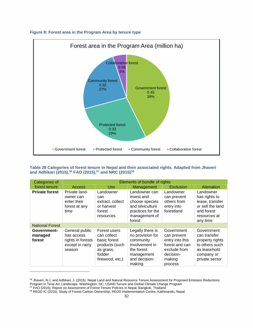
82
Figure 8: Forest area in the Program Area by tenure type
Table 28 Categories of forest tenure in Nepal and their associated rights. Adapted from Jhaveri and Adhikari (2015),56 FAO (2015),57 and NRC (2015)58
Categories of forest tenure
Elements of bundle of rights
Access Use Management Exclusion Alienation
Private forest Private land- owner can enter their forest at any time
Landowner can extract, collect or harvest forest resources
Landowner can invest and choose species and silviculture practices for the management of forest
Landowner can prevent others from entry into forestland
Landowner has rights to lease, transfer or sell the land and forest resources at any time
National Forest
Government- managed forest
General public has access rights in forests except in rainy season
Forest users can collect basic forest products (such as grass, fodder firewood, etc.)
Legally there is no provision for community involvement in the forest management and decision-making
Government can prevent entry into this forest and can exclude from decision-making process
Government can transfer property rights to others such as leasehold company or private sector
56 Jhaveri, N.J. and Adhikari, J. (2015). Nepal Land and Natural Resource Tenure Assessment for Proposed Emission Reductions Program in Terai Arc Landscape. Washington, DC: USAID Tenure and Global Climate Change Program 57 FAO (2016), Report on Assessment of Forest Tenure Policies in Nepal, Bangkok, Thailand 58 REDD IC (2015). Study of Forest Carbon Ownership, REDD Implementation Centre, Kathmandu, Nepal
Government forest 0.4539%
Protected forest0.3329%
Community forest0.3227%
Collaborative forest 0.585%
Forest area in the Program Area (million ha)
Government forest Protected forest Community forest Collaborative forest
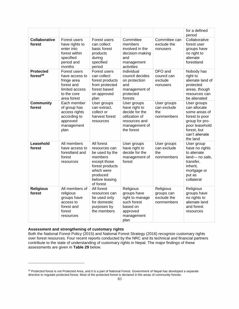
83
for a defined period
Collaborative forest
Forest users have rights to enter into forest within specified period and months
Forest users can collect basic forest products during specified period
Committee members involved in the decision-making and management activities
Committee can exclude the nonusers
Collaborative forest user groups have no right to alienate forestland
Protected forest59
Forest users have access to fringe area forest and limited access to the core area forest
Forest users can collect forest products from protected forest based on approved plan
Individual council decides on protection and management of protected forests
DFO and council can exclude nonusers
Nobody has right to alienate land of protected areas, though resources can be alienated
Community forest
Each member of group has access rights according to approved management plan
User groups can extract, collect or harvest forest resources
User groups have right to decide for the utilization of resources and management of the forest
User groups can exclude the nonmembers
User groups can allocate some areas of forest to poor group for pro-poor leasehold forest, but can’t alienate the land
Leasehold forest
All members have access to forestland and forest resources
All forest resources can be used by the members except those forest products which were produced before leasing of forest
User groups have right to decide for the management of forest
User groups can exclude the nonmembers
User group have no rights to alienate land— no sale, transfer, inherit, mortgage or put as collateral
Religious forest
All members of religious groups have access to forest and forest resources
All forest resources can be used only for domestic purposes by the members
Religious groups have right to manage such forest based on approved management plan
Religious groups can exclude the nonmembers
Religious groups have no rights to alienate land and forest resources
Assessment and strengthening of customary rights Both the National Forest Policy (2015) and National Forest Strategy (2016) recognize customary rights over forest resources. Four recent reports conducted by the NRC and its technical and financial partners contribute to the state of understanding of customary rights in Nepal. The major findings of these assessments are given in Table 29 below.
59 Protected forest is not Protected Area, and it is a part of National Forest. Government of Nepal has developed a separate directive to regulate protected forest. Most of the protected forest is declared in the areas of community forests.
84
Table 29 Status of customary rights associated with forestland tenure according to recent studies
Assessment reports Major findings and recommendations on customary
rights to make the ER Program a success
Report on Forest Carbon Ownership (2015) http://mofsc-redd.gov.np/wp-content/uploads/2013/11/Final-Report-FCO_Revised_29_10_2015_ERI_Final_01-11-2015.pdf
• Several customary practices for forest management are in place, though they are less recognized in the formal management plans of all types of forests. CFUGs should be required to incorporate customary rights in the regular revision process of forest management plans.
Report on Assessment of Forest Tenure Policies in Nepal (2016) (http://www.fao.org/3/a-i6247e.pdf)
• The customary rights are recognized in the policy instruments and guidance documents, though less recognized in the forest management plans, which should be recognized during the revision of all types of forest management plans.
Documentation and assessing customary practices of managing forest resources at local level in Nepal (2015) http://mofsc-redd.gov.np/page_id=14
• In the ER Program Area, there are various customary practices of Tharu communities and other forest-dependent IPs related to the collection of forest products for cultural as well as religious practices. These should be protected and promoted as customary rights during the implementation of the ER Program.
Nepal Land and Natural Resource Tenure Assessment for Proposed Emission Reductions Program in Terai Arc Landscape (2015) (https://www.land-links.org/)
• The forest management plans of all types of regimes have recognized very limited customary rights of IPs; therefore, during the revision of such plans, there is a requirement to ensure the customary rights in all types of forest management plans including management plans of Buffer Zones.
These and other assessment reports on forest tenure conclude that forest management plans are weak in terms of recognition of customary rights and that there should be recognition and inclusion of customary rights during the regular revision of forest management plans of all types of forests in the future, which is one of the major activities of this ER Program. Considering the above-mentioned findings and recommendations on customary rights, the National REDD+ Strategy has also proposed a separate strategy to recognize and integrate traditional and customary rights, knowledge, and practices in forest management plans, particularly in CBFM regimes. All relevant issues identified in these reports in relation to customary tenure and IP rights will be taken into consideration in the forthcoming Indigenous Peoples Plan(s), for which social assessments will be conducted. For further discussion on the promotion of safeguards in the design of the ER Program, refer to Table 34 in Section 5.2 and general consideration under Section 14.1 on safeguards.
4.4.1 CONSTITUTIONAL PROVISIONS FOR SECURING LAND AND RESOURCE TENURE The recently enacted Constitution of Nepal (2015) provides several additional provisions related to land and resource tenure. Article 25 of the Constitution of Nepal has recognized the rights to secure property rights and land/resource tenure of individuals. The rights of private landholders are protected according to these fundamental rights ensured by the constitution. The government has authority to develop and
85
implement plans and programs for environmental protection, and planned housing and urban development, by following due process of law. The Constitution has not incorporated any specific fundamental rights for securing rights of Indigenous Peoples, though under the state policies of the constitution, the state has expressed a strong policy commitment for the promotion of traditional rights of IPs. For this purpose, the Article 51(j)(8) has expressed that the state will make an appropriate arrangement for the indigenous nationalities to participate in decisions concerning that community by making special provisions for opportunities and benefits in order to ensure the right of these indigenous nationalities to live with dignity, along with their identity, and protect and promote traditional knowledge, skill, culture, social tradition and experience of the indigenous nationalities. The ER Program has proposed activities to promote the traditional and customary rights of IPs considering the legal provisions of the country and additional comments received during the consultation process. These are outlined in Sections 4.3, 14.1 and 16.1 and include activities that safeguard against the loss of IP rights and practices (see ER Program Area Specific SESA and ESMF) as well as those that actively promote them (e.g., programs to preserve IP traditional knowledge, skills and customary practices will be introduced). Article 40(5) of the constitution ensures that the state shall provide land to the landless Dalit in accordance with law, and article 40(6) has stated that the state shall, in accordance with law, arrange settlement for the Dalit who do not have housing. Close coordination will be needed across ministries to ensure that when fulfilling this law, forestland is not converted, considering the legal provisions on land-use planning as envisioned in the Section 51g of Land Act 1964 and Section 67a of the Forest Act 1993. Under the rights to social justice, article 40(4) of the Constitution has ensured that every farmer shall have the right to have access to lands, and to select and protect local seeds and species which have been used and pursued traditionally, in accordance with law. However, considering the section 67a of the Forest Act 1993, forestlands will not be converted into agricultural land during the exercise of this fundamental right and the land redistribution law and policy will be applied to execute this fundamental right considering the recommendations made by High Level Land Reform Commission and Environmental Committee of the Parliament in 2015. The Constitution of Nepal (article 32) has guaranteed the cultural rights, and based on these fundamental rights, the IP/LCs can exercise their bio-cultural rights through their own community protocols or approved forest management plans. Some of the customary rights to collect or harvest forest resources are incorporated in the forest management plans, and remaining gaps will be addressed as feasible during the implementation of the ER Program through revision of forest management plans. In addition, Feedback and Grievance Redress Mechanisms (FGRM) under the program will provide formal and informal avenues to resolve potential conflicts (Section 14.3). The Constitution of Nepal has made a provision to establish a separate Constitutional Commission on Indigenous Peoples, and that commission will be responsible to develop various guidance on customary sustainable use rights of IPs in the future.
4.4.2 POTENTIAL IMPACTS OF THE ER PROGRAM ON EXISTING LAND AND RESOURCE TENURE The potential impacts of the ER Program on resource tenure rights were discussed during district and national consultation and are highlighted in Section 5. These are summarized in Table 30 below.
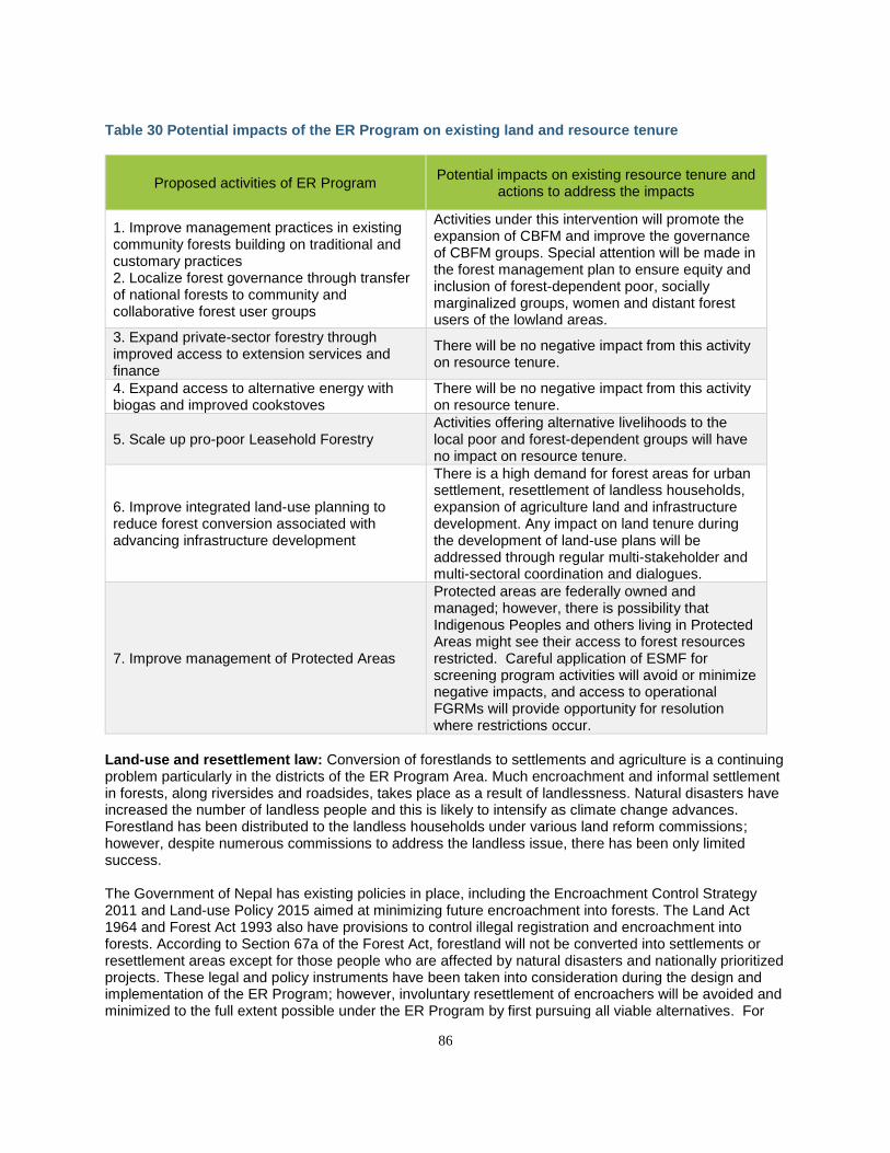
86
Table 30 Potential impacts of the ER Program on existing land and resource tenure
Proposed activities of ER Program Potential impacts on existing resource tenure and
actions to address the impacts
1. Improve management practices in existing community forests building on traditional and customary practices 2. Localize forest governance through transfer of national forests to community and collaborative forest user groups
Activities under this intervention will promote the expansion of CBFM and improve the governance of CBFM groups. Special attention will be made in the forest management plan to ensure equity and inclusion of forest-dependent poor, socially marginalized groups, women and distant forest users of the lowland areas.
3. Expand private-sector forestry through improved access to extension services and finance
There will be no negative impact from this activity on resource tenure.
4. Expand access to alternative energy with biogas and improved cookstoves
There will be no negative impact from this activity on resource tenure.
5. Scale up pro-poor Leasehold Forestry Activities offering alternative livelihoods to the local poor and forest-dependent groups will have no impact on resource tenure.
6. Improve integrated land-use planning to reduce forest conversion associated with advancing infrastructure development
There is a high demand for forest areas for urban settlement, resettlement of landless households, expansion of agriculture land and infrastructure development. Any impact on land tenure during the development of land-use plans will be addressed through regular multi-stakeholder and multi-sectoral coordination and dialogues.
7. Improve management of Protected Areas
Protected areas are federally owned and managed; however, there is possibility that Indigenous Peoples and others living in Protected Areas might see their access to forest resources restricted. Careful application of ESMF for screening program activities will avoid or minimize negative impacts, and access to operational FGRMs will provide opportunity for resolution where restrictions occur.
Land-use and resettlement law: Conversion of forestlands to settlements and agriculture is a continuing problem particularly in the districts of the ER Program Area. Much encroachment and informal settlement in forests, along riversides and roadsides, takes place as a result of landlessness. Natural disasters have increased the number of landless people and this is likely to intensify as climate change advances. Forestland has been distributed to the landless households under various land reform commissions; however, despite numerous commissions to address the landless issue, there has been only limited success. The Government of Nepal has existing policies in place, including the Encroachment Control Strategy 2011 and Land-use Policy 2015 aimed at minimizing future encroachment into forests. The Land Act 1964 and Forest Act 1993 also have provisions to control illegal registration and encroachment into forests. According to Section 67a of the Forest Act, forestland will not be converted into settlements or resettlement areas except for those people who are affected by natural disasters and nationally prioritized projects. These legal and policy instruments have been taken into consideration during the design and implementation of the ER Program; however, involuntary resettlement of encroachers will be avoided and minimized to the full extent possible under the ER Program by first pursuing all viable alternatives. For
87
example, the Managed Settlement Commission under the Chair of the Minister of Agriculture, Land Management and Cooperatives has chapters in each district working to identify legitimately landless families and to arrange voluntary resettlement options for them outside forested areas. Similarly, the Freed Bonded Labour Resettlement Issues Resolution Commission provides compensation for purchasing lands outside of forests along with timber for house construction. More broadly speaking, the core pillars of the ER Program are largely aligned with the recommendations of a detailed land and resources tenure assessment (Jhaveri and Adhikari 2016), in that handing over forests to local communities as community and collaborative forests both provides the opportunity to improve resource tenure as well as to limit future encroachment or unplanned settlement, and leasehold forests specifically target poor and marginalized people in this regard. When these forests are handed over, or when the management/governance of these handed over forests are reformed, efforts will be made to include Indigenous Peoples, women and other marginalized communities in the groups and seek their consent in the planning process of forests at community, district and landscape levels. In those rare cases where the involuntary resettlement of encroachers cannot be avoided, it will be carried out in accordance with the Resettlement Policy Framework for the Program, as per OP/BP 4.12, which reflects international good practice pertaining to resettlement. Competing rights and conflict resolution mechanisms: The legal provisions of Nepal have established various mechanisms for the resolution of forest tenure disputes. The forestry sector and other cross-sectoral legal systems have given authority to CFUGs, DFOs, local governments, constitutional bodies, quasi-judicial bodies and judicial organs for resolution of forest tenure disputes. Forest law has provided limited access to CFUGs to participate in judicial proceedings, though they can use other general legal measures to do so. The Community Forestry Development Guideline has established steps to prevent forest tenure disputes at the community level. The government authority at the district level is also responsible to prevent any conflicts related to forests. The DFO is the key agency responsible for settling the boundary conflicts between different community-based forest user groups in the districts (rule 27). The DFO has authority to investigate and decide about illegal registration of any part of the community-based forest by any individual in the name of private land registration. The DFO should cancel an illegal registration of forestland from an individual (Section 16). The DFOs have rights to investigate and provide suggestions to CFUGs and other community-based forest user groups about the distribution of forest products, utilization of funds and implementation of approved forest management plans. The Commission on Investigation of Abuse of Authority (CIAA) is a constitutional body in Nepal responsible for investigating the cases related to abuse of authority and irregularities in all public spheres including forestry. The Civil Code of Nepal 1963 and the Constitution of Nepal 2015 both have provided a legal opportunity to the citizen or groups of citizens to go to the ordinary courts individually or collectively for a legal remedy in any cases related to public interest including protection of environment and forest tenure rights. All these measures will be applicable to the dispute resolution during the implementation of the ER Program. The main conflicting issue in the ER Program Area is to address the landlessness through providing appropriate areas to them for housing or settlement. The Government of Nepal enacted the Bonded Labor (Prohibition) Act 2002 to address the landlessness-related problems of freed bonded labor, and based on this act, the district-level committee on bonded labor has been working to resolve the problems of landlessness. This mechanism will be functional in the future as well. These issues are discussed further and addressed in Section 14.3 on the Feedback and Grievance Redress Mechanism.
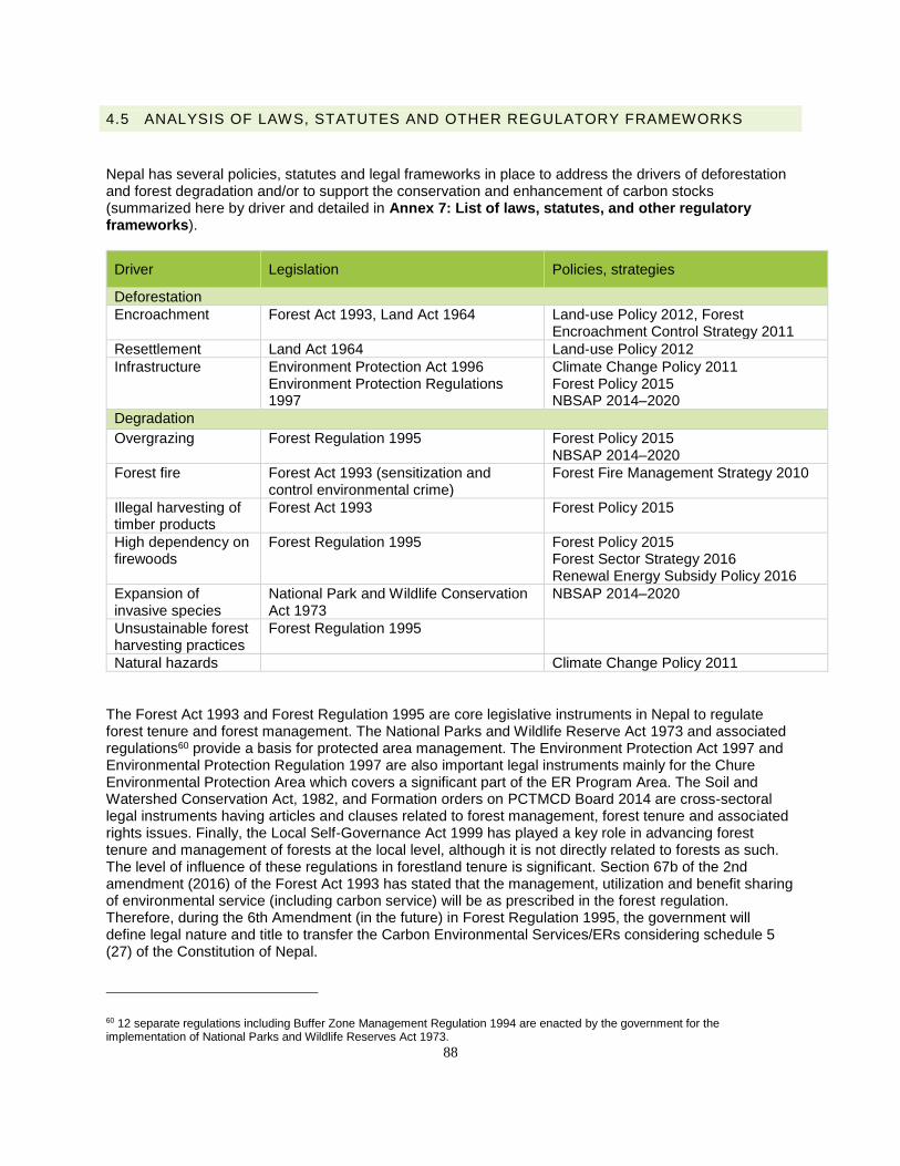
88
4.5 ANALYSIS OF LAWS, STATUTES AND OTHER REGULATORY FRAMEWORKS
Nepal has several policies, statutes and legal frameworks in place to address the drivers of deforestation and forest degradation and/or to support the conservation and enhancement of carbon stocks (summarized here by driver and detailed in Annex 7: List of laws, statutes, and other regulatory frameworks).
Driver Legislation Policies, strategies
Deforestation
Encroachment Forest Act 1993, Land Act 1964 Land-use Policy 2012, Forest Encroachment Control Strategy 2011
Resettlement Land Act 1964 Land-use Policy 2012
Infrastructure Environment Protection Act 1996 Environment Protection Regulations 1997
Climate Change Policy 2011 Forest Policy 2015 NBSAP 2014–2020
Degradation
Overgrazing Forest Regulation 1995 Forest Policy 2015 NBSAP 2014–2020
Forest fire Forest Act 1993 (sensitization and control environmental crime)
Forest Fire Management Strategy 2010
Illegal harvesting of timber products
Forest Act 1993 Forest Policy 2015
High dependency on firewoods
Forest Regulation 1995 Forest Policy 2015 Forest Sector Strategy 2016 Renewal Energy Subsidy Policy 2016
Expansion of invasive species
National Park and Wildlife Conservation Act 1973
NBSAP 2014–2020
Unsustainable forest harvesting practices
Forest Regulation 1995
Natural hazards Climate Change Policy 2011
The Forest Act 1993 and Forest Regulation 1995 are core legislative instruments in Nepal to regulate forest tenure and forest management. The National Parks and Wildlife Reserve Act 1973 and associated regulations60 provide a basis for protected area management. The Environment Protection Act 1997 and Environmental Protection Regulation 1997 are also important legal instruments mainly for the Chure Environmental Protection Area which covers a significant part of the ER Program Area. The Soil and Watershed Conservation Act, 1982, and Formation orders on PCTMCD Board 2014 are cross-sectoral legal instruments having articles and clauses related to forest management, forest tenure and associated rights issues. Finally, the Local Self-Governance Act 1999 has played a key role in advancing forest tenure and management of forests at the local level, although it is not directly related to forests as such. The level of influence of these regulations in forestland tenure is significant. Section 67b of the 2nd amendment (2016) of the Forest Act 1993 has stated that the management, utilization and benefit sharing of environmental service (including carbon service) will be as prescribed in the forest regulation. Therefore, during the 6th Amendment (in the future) in Forest Regulation 1995, the government will define legal nature and title to transfer the Carbon Environmental Services/ERs considering schedule 5 (27) of the Constitution of Nepal.
60 12 separate regulations including Buffer Zone Management Regulation 1994 are enacted by the government for the implementation of National Parks and Wildlife Reserves Act 1973.
89
The following subsections highlight those domestic policies and frameworks that are most relevant to the specific program activities outlined above in Section 4.3. Policy and legal instruments addressing unsustainable and illegal harvest of timber and fuelwood: One of the main objectives of Forest Act 1993 and Forest Regulation 1995 is to manage forests sustainably and to control unsustainable and illegal harvest of forest products. According to Forest Act 1995 (sections 20 and 25), the DFO and the Forest Users Groups are required to include measures in forest management plans to control unsustainable and illegal harvesting of timber and other forest products. The Government also developed separate Timber Harvesting, Sales and Distribution Directives61 for both government-managed and community forests which have helped to control unsustainable harvesting of timber through provisions for measurement and monitoring of timber harvesting activities in forest areas. Section 49 of Forest Act 1993 includes a list of prohibited activities in all types of forests in order to control illegal harvest of timber, for example, by authorizing fines and/or imprisonment for persons found to be involved in illegal harvesting of forest products including timber and fuelwood. Similarly, Section 29 of the Forest Act 1993 gives authority to community forest user groups to control illegal harvest of timber in community forests. Related to the objectives and strategy of Forest Policy 2015 and the National Forest Strategy 2016, the government and local communities have also developed a system for the equitable distribution of timber and firewood from government-managed and community forests and particularly to forest-dependent poor households, socially marginalized groups and families affected by natural disaster. Policies to manage overgrazing: According to Rule 19 of Forest Regulation 1995, a license must be obtained from the DFO for grazing in some forest management areas. According to the Forest Regulation, management of grazing should be an integral part of forest management plans of all types of forests including community forests. According to the Community Forestry Development Program Guideline (revised 2015) and Community Forestry Inventory Guideline, each CFUG should allocate a designated area in the community forest for grazing, and in the last few years, many CFUGs have been establishing zero grazing areas in the community forests to control open- and overgrazing. The CFUGs, DFOs and Livestock offices are also implementing fodder production programs for livestock at local levels to reduce over/open grazing in forest areas. Policies to control forest fires: In response to many major forest fire events, the Government formulated the Forest Fire Management Strategy 2010. This strategy has four components (law enforcement, capacity building, community-based fire management and coordination/monitoring) for forest fire management. The objective of this strategy is to strengthen capacities to control forest fires with the broad involvement of stakeholders, adopting a community-based approach to control forest fires. Each FUG develops a program and activities to control forest fires through local level mobilization. The Forest Act 1993 (section 50) also includes provisions for punishment for setting of illegal fires. Legal mechanism to control encroachment and manage resettlement: The Constitution of Nepal 2015 (art. 51) commits to maintain national forest area goals and also incorporates state policies to control forest encroachment, a critical issue in the ER Program Area. Nepal formulated a Forest Encroachment Control Strategy in 2011 that prohibits conversion of forests into other land use except forest utilization for nationally prioritized projects. The strategy also proposes activities to control forest encroachment. The second amendment of Forest Act 1993 in 2016 also includes provisions to control forest encroachment. According to section 16 of this act, no one has rights to ownership over forest areas, and if anybody has registered the forest area in the name of an individual, such illegal registration
61 Directives on Forest Products (Timbers, firewood and other forest products) harvesting, sales and distribution from Community Forestry 2015; Directives on Forest Products (Timbers, firewood and other forest products) harvesting, sales and distribution from Community Forestry 2017
90
can be ipso facto cancelled by the DFO at any time. Section 49 of the Forest Act prohibits conversion of forestland for other use such as agriculture and settlement. Similarly, section 67a of this act strictly prohibits settlement or resettlement programs in forest areas; however, if there are no other options for the settlement, based on the Environmental Impact Assessment reports, the government can allocate some parts of forestlands for the settlement of natural disaster-affected households and households displaced due to the implementation of nationally prioritized projects. As discussed in the previous section, though a number of legal mechanisms are available to minimize or control encroachment, all alternatives will be exhausted before any involuntary resettlement measure is considered. In unavoidable cases, if any, such resettlement will be carried out in accordance with the Resettlement Policy Framework for the Program, as per OP/BP 4.12, which reflects international good practice pertaining to resettlement. Environmental standards on infrastructure development: Section 68 of Forest Act 1993 describes that in cases where there is no alternative except to use forest areas for the national priority plans, and if there will be no significant adverse effects on the environment, government may allow for the use of forestlands for the implementation of such plan. The government recently developed procedures to prevent abuse of this government authority. This procedure (2017) to utilize the forestland for nationally prioritized infrastructure projects includes mandatory provisions to conduct Environmental Impact Assessments before deciding to allocate any forest for infrastructure development. According to this procedure, the infrastructure project developer should develop an environmental management plan for the rehabilitation of forest lost during the infrastructure development, including through mitigation measures such as planting and other measures. Implementation of Multilateral Environmental Agreements Nepal is a party to several multilateral environmental agreements (MEAs) concerning climate change, biodiversity conservation and sustainable natural resource management. To some extent Nepal has been able to fulfill the commitments to these agreements effectively. The implementation status of some of the MEAs that are relevant to REDD+ are briefly presented in Table 31 below, see Annex 4: Multilateral Environmental Agreements to which Nepal is a Party, for further details Table 31: Implementation status of major MEAs that are relevant to REDD+ in Nepal
Policy and legal arrangement Institutional arrangement Remarks
United Nations Framework Convention on Climate Change, 1992
CC Policy 2011 NAPA 2010 LAPA framework 2012 NAP (under preparation) National REDD+ Strategy NDC
MoFE – focal ministry. CC Council – chaired by prime minister. CC Division – under MoFE. Line ministries – forests and environment; agriculture, land management and cooperatives; federal affairs and general administration; energy, water resources and irrigation; – working as a program coordinating agencies. NGOs – working for technical support and capacity building. local communities – implementing programs at local level for adaptation/mitigation.
Ratified by Nepal on June 2, 1994
United Nations Convention on Biological Diversity, 1992
National Park & Wildlife Conservation Act, 1973, and 10 regulations including Buffer Zone Regulation under this act
MoFE – a focal ministry for this convention. Biodiversity and Environment Division of MoFE is working as a coordinating body for the implementing of convention.
Ratified by Nepal November 23, 1993
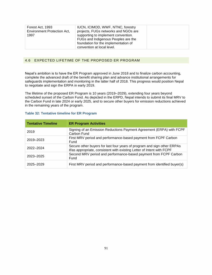
91
Forest Act, 1993 Environment Protection Act, 1997
IUCN, ICIMOD, WWF, NTNC, forestry projects, FUGs networks and NGOs are supporting to implement convention. FUGs and Indigenous Peoples are the foundation for the implementation of convention at local level.
4.6 EXPECTED LIFETIME OF THE PROPOSED ER PROGRAM
Nepal’s ambition is to have the ER Program approved in June 2018 and to finalize carbon accounting, complete the advanced draft of the benefit sharing plan and advance institutional arrangements for safeguards implementation and monitoring in the latter half of 2018. This progress would position Nepal to negotiate and sign the ERPA in early 2019. The lifetime of the proposed ER Program is 10 years (2019–2029), extending four years beyond scheduled sunset of the Carbon Fund. As depicted in the ERPD, Nepal intends to submit its final MRV to the Carbon Fund in late 2024 or early 2025, and to secure other buyers for emission reductions achieved in the remaining years of the program. Table 32: Tentative timeline for ER Program
Tentative Timeline ER Program Activities
2019 Signing of an Emission Reductions Payment Agreement (ERPA) with FCPF Carbon Fund
2019–2023 First MRV period and performance-based payment from FCPF Carbon Fund
2022–2024 Secure other buyers for last four years of program and sign other ERPAs if/as appropriate, consistent with existing Letter of Intent with FCPF
2023–2025 Second MRV period and performance-based payment from FCPF Carbon Fund
2025–2029 First MRV period and performance-based payment from identified buyer(s)
92
5. STAKEHOLDER CONSULTATION AND PARTICIPATION
5.1 DESCRIPTION OF STAKEHOLDER CONSULTATION PROCESS
Stakeholder consultations are central to the design and implementation of Nepal’s ER Program. The Government of Nepal—supported by the ER-PD development team—followed an extensive, bottom-up consultation approach that generated district- and community-level activities that could be feasibly implemented during the project’s lifetime, and that have the ownership and inclusion of local stakeholders. All consultations were carried out following the “Guidelines on Stakeholder Engagement in REDD+ Readiness” on agendas ranging from institutional arrangements, benefit sharing, and roles of stakeholders, carbon and non-carbon benefits, safeguards and strategies for implementation of ER Programs and activities. Consultations were principally organized by the NRC, Regional Directorate of Forest, Department of Forests, and District Forest Offices, as well as district chapters of different stakeholders like Indigenous Peoples, Community Forest User Groups and Dalit NGO Networks (e.g., the Dalit NGO Federation or DNF). The consultations engaged marginalized groups, women’s groups and Madhesi and Muslim communities to ensure these important stakeholders have full and adequate representation in the consultation process. A wide range of stakeholders62 and right-holders63 were also consulted in designing and planning the ER Program and activities. This involved representation of government and nongovernment institutions, traditional and customary organizations, private sector, and representatives of local forest-dependent communities, women, Dalits, IPs, Madhesis and Muslims. These consultations had the dual purpose of disseminating information on the proposed ER Program and activities, and seeking feedback from the participants and stakeholders involved. They also aimed to enhance the capacity and build knowledge and expertise on REDD+ among the participants. See Annex 5: Stakeholder Consultations and Workshops for a breakdown of the representation of different communities in the consultations. In addition to the consultations described here to inform the design of the proposed ER Program, an additional set of consultations was conducted in early 2018 to inform the Social and Environmental Assessment (SEA) and Environmental and Social Management Framework (ESMF) for the proposed ER Program (please refer to Section 14.1.1). Consultation from and with Indigenous Peoples and local communities NEFIN is an autonomous and politically nonpartisan, national level organization of IPs. NEFIN organized a regional-level consultation workshop to explore the issues, agenda and concerns of IPs in the design and implementation of the ER Program. Based on the consultation workshop, NEFIN has developed a 28-point common position, which has been formally submitted to NRC from 12 District Coordination Council of NEFIN through its national secretariat. This position paper strongly recommended ensuring the resource rights of IPs over forestland during the design and implementation of the ER Program. These recommendations have been taken into account during the design of the ER Program, and NEFIN’s concerns will be addressed and respected during the implementation of the ER Program as well. Among these positions, points 15 and 16 in particular will be addressed through the revision of CBFM plans to recognize the rights of IPs. The position paper concerning IPs can be found in Annex 11: Position
62 Stakeholders for the ER Program are those whose interests are potentially affected by the program or who can affect and influence the program. 63 Right-holders are those individuals, groups and organizations (including both government and nongovernment) whose existing rights, whether formally recognized or granted based on customary law might be potentially affected by the ER Program.
93
Statements of 10 National Networks Representing Indigenous Peoples and Local Communities on Nepal’s ERPD. FECOFUN is a representative organization of CFUGs in Nepal; it organized two regional-level consultations on the design and implementation of the ER Program. Based on these regional consultations, FECOFUN developed a seven-point position paper, which was submitted to NRC. This position paper recommended including a program to hand over national forest to local communities as a CBFM regime. The district consultations were organized and conducted through the Association of Collaborative Forest Users Nepal (ACOFUN) and the Community-based Forestry Supporters’ Network (COFSUN), which organized six district consultations each.
5.1.1 ORGANIZATION OF CONSULTATION WORKSHOPS AND MEETINGS
In line with guidance from the REDD Implementation Centre and suggestions received during the inception workshop, the Government of Nepal, in collaboration with the ER-PD development team, conducted three national, four regional and 36 district-level consultations. These consultations were conducted in collaboration with the Nepal Federation of Indigenous Nationalities (NEFIN), the Federation of Community Forestry Users Nepal (FECOFUN), Dalit NGO networks and field partners. Participants present in the national workshops also attended district and regional workshops, and the NRC aimed for continuity of participants between workshops. An initial national inception workshop helped to inform and guide the ER-PD development team as well as ensure the political buy in of all relevant stakeholders in Nepal. Following this, three half-day consultations were carried out in each ER Program district to ensure that lessons and recommendations can be aggregated back up to the national level. Following these district-level consultations, four regional cluster consultations were organized, specifically targeting marginalized groups that may otherwise be inadequately consulted during district-level consultations. Finally, the NRC conducted a midterm and final consultation with national-level stakeholders to share the results of district- and regional-level consultations. In parallel to the bottom-up consultations, a number of focused group discussions with marginalized groups, academics, and experts were conducted on specific elements of the ER Program design (see Figure 9 below). For a full list of participants see Annex 5: Stakeholder Consultations and Workshops.
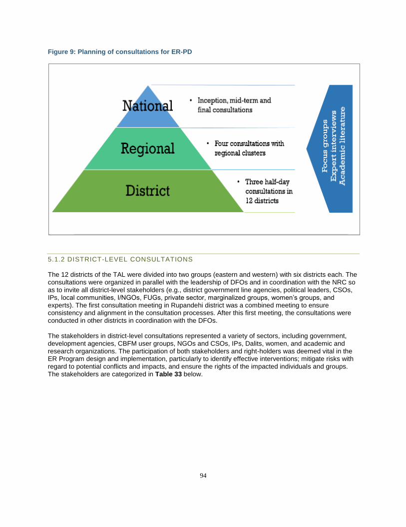
94
Figure 9: Planning of consultations for ER-PD
5.1.2 DISTRICT-LEVEL CONSULTATIONS
The 12 districts of the TAL were divided into two groups (eastern and western) with six districts each. The consultations were organized in parallel with the leadership of DFOs and in coordination with the NRC so as to invite all district-level stakeholders (e.g., district government line agencies, political leaders, CSOs, IPs, local communities, I/NGOs, FUGs, private sector, marginalized groups, women’s groups, and experts). The first consultation meeting in Rupandehi district was a combined meeting to ensure consistency and alignment in the consultation processes. After this first meeting, the consultations were conducted in other districts in coordination with the DFOs. The stakeholders in district-level consultations represented a variety of sectors, including government, development agencies, CBFM user groups, NGOs and CSOs, IPs, Dalits, women, and academic and research organizations. The participation of both stakeholders and right-holders was deemed vital in the ER Program design and implementation, particularly to identify effective interventions; mitigate risks with regard to potential conflicts and impacts, and ensure the rights of the impacted individuals and groups. The stakeholders are categorized in Table 33 below.
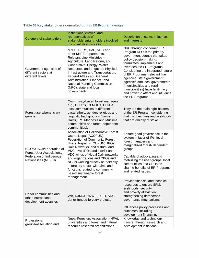
95
Table 33 Key stakeholders consulted during ER Program design
Category of stakeholders
Institutions, entities, and representatives of stakeholders/right-holders involved in consultation process
Description of stake, influence, and interests
Government agencies of different sectors at different levels
MoFE: DFRS, DoF, NRC and other MoFE departments. Relevant Line Ministries – Agriculture, Land Reform, and Cooperative, Energy, Water Resources and Irrigation; Physical Infrastructure and Transportation, Federal Affairs and General Administration; Finance; and National Planning Commission (NPC), state and local governments.
NRC through concerned ER Program DFO is the primary government agency that takes policy decision-making, formulates, implements and oversees the ER Programs. Considering the integrated nature of ER Programs, relevant line agencies, state government agencies and local governments (municipalities and rural municipalities) have legitimacy and power to affect and influence the ER Programs.
Forest users/beneficiary groups
Community-based forest managers, e.g., CFUGs, CFMUGs, LFUGs, local communities of different caste/ethnic, gender, religious and linguistic backgrounds (women, Dalits, IPs, Madhesis and Muslims communities and forest-dependent communities).
They are the main right-holders of the ER Program considering that it is their lives and livelihoods that are directly at stake.
NGOs/CSOs/Federation of Forest User Associations/ Federation of Indigenous Nationalities (NEFIN)
Association of Collaborative Forest Users, Nepal (ACOFUN); Federation of Community Forest Users, Nepal (FECOFUN); IPOs, Dalit Networks, and district- and VDC-level IPOs and district and VDC wings of Nepal Dalit networks and organizations and CBOs and NGOs working directly or indirectly in forestry sector with aims and functions related to community- based sustainable forest management.
Ensure good governance in the system in favor of IPs, local forest managers and marginalized forest- dependent groups. Capable of advocating and mobilizing the user groups, local communities and CBOs on sharing benefits of ER Programs and related issues.
Donor communities and other international development agencies
WB, ICIMOD, WWF, DFID, SDC, donor-funded forestry projects
Provide financial and technical resources to ensure SFM, livelihoods, security and poverty alleviation; strengthening democratic governance mechanisms. Influences policy processes and outcomes, including development financing.
Professional groups/association and
Nepal Foresters Association (NFA), universities and forest and natural resource research organizations
Knowledge and technology transfer through research and development initiations.
96
academia/research institutions
such as Tribhuvan University, Institute of Forestry and Information Center of Government of Nepal.
Remain at the center of science and technological development.
Owner/managers of private forestry, forest-based entrepreneurs and workers
Individuals and organized entities involved in farming private forests; operating industries based on forest resources. It also includes the labor force involved in the entrepreneurship.
Play key role to develop and invest in public/private venture in ER Programs.
Consultations were conducted using locally appropriate procedures, including use of Nepali languages or hiring LCs or IPs as facilitators. A letter was sent from the NRC to all DFOs in the TAL to invite stakeholders to the consultations, including a tentative list of stakeholders. The concerned DFO then issued invitation letters to all possible stakeholders in his/her district. The invitation letter issued by the DFO to invite stakeholders described briefly the objectives, process and procedures of the consultation process, with program details including venue and date of the consultation. Consultations were organized in a standardized format across all 12 districts. The three half-day consultations were broken down as follows: Identification of Drivers of Deforestation and Forest Degradation: Participants were divided into three groups to identify key drivers of deforestation, forest degradation, and enhancement. Each group was given an hour and a half to two hours to brainstorm, prioritize, and fill in information pertaining to their theme and district. Upon completion of the task, group leaders - assigned by their teammates - presented the group’s analyses. This was followed by an approximate half hour discussion where all participants were encouraged to comment, critique and add information that may otherwise have been missing. Identification of Policies and Measures to Address Drivers: After identification of key drivers of deforestation and forest degradation as well as opportunities to enhance forest carbon stocks for each district, the participants of these groups were requested to propose specific policies and measures for each identified area. After discussing key hotspots and areas, each group proposed activities to address the drivers of deforestation and forest degradation or enhance forest carbon stocks, identifying responsible authorities and entities. They also identified key legal, technical, and social challenges and barriers. Identification and Ranking of Non-Carbon Benefits: Participants were informed about non-carbon benefits (NCB), including their meaning and categories and how NCBs can be incentivized alongside the generation of emission reductions during the implementation of the ER Program. The participants were then requested to list possible NCBs that could be generated while implementing different activities (based on the previous session’s group work) in each district. The participants were also requested to express the existing practices of monitoring community forests in general and NCBs in particular, and measures (if any) to strengthen the monitoring system. Social and Environmental Safeguards: The participants were requested to identify the likely social and environmental impacts and corresponding mitigation measures if the proposed interventions were to be implemented in each district. Participants were encouraged to assess the likely adverse impact in terms of: risk of restriction of access to resources; risk of relocation/displacement of forest-dependent communities/HHs; risk of biodiversity degradation; risk of leakage (in terms of deforestation, degradation, and over-exploitation of forest resources); risk of loss of livelihoods and incomes; and impacts on IPs and vulnerable communities. Legal Basis and Institutional Arrangement: The participants were informed about the current legal and constitutional provisions related to forests and climate change as well as the institutional framework proposed in the National REDD+ Strategy for implementing REDD+ activities including projects related to ERs. Focus group discussions were then held with the participants, who were requested to hold
97
participatory discussions and to provide their feedback on the presentation as well as their possible roles and responsibilities in the implementation of the ER Program. Benefit-sharing Arrangements: Preliminary discussions related to benefit sharing were informed by several stages of consultations prior to the development of the ER-PD. This included consultations at the local, district and national levels, including the development of benefit- and revenue-sharing arrangements under the various CBFM regimes, and was part of the National REDD+ Strategy development process.
5.1.3 REGIONAL-LEVEL CONSULTATIONS In addition to the district consultations, four regional-level consultations were organized. These targeted IP groups and CFUGs at the grassroots level to ensure that marginalized groups, women’s groups, and other important stakeholders have full and adequate representation in the consultation process. Consultation with IPs: A regional-level consultation with IPs was organized on October 26-27, 2016, in Chitwan, Nepal, to collect and document Nepal’s Indigenous Peoples’ concerns, stances and demands regarding Nepal’s ER Program. The consultation workshop was facilitated by Climate Change Partnership Program of Nepal Federation of Indigenous Nationalities (NEFIN). The two-day consultation workshop was divided into two parts. The participants were first introduced to the key elements of the ER Program and were provided quick updates on the REDD+ process. Facilitators used presentations and meta-cards, and held question and answer sessions to explain the points and issues. Following this, facilitators conducted intensive plenary discussions among the participants for one and a half days to gather views and recommendations from IP participants. The details of the concerns and issues raised by the participants, along with their recommendations, are presented in Section 5.2 below. More than 75 participants, including representatives from NEFIN’s District Coordination Council and its affiliated organizations (i.e., federation of indigenous journalists, students, women), NEFIN CCPP staff members attended and contributed to the program. Consultation Workshops with Forest User Groups: Regional consultations with forest user groups were held on September 27-28, 2016, in Butwal and September 29-30, 2016, in Dhanghadi with the purpose of collecting and documenting concerns, stances and demands of forest user groups (FUGs) and forest-dependent communities regarding the ongoing process of preparing Nepal’s ER Program. These consultations were organized by FECOFUN, and participants were mainly members of the CFUGs and FECOFUN district chapters. Consultations emphasized land-use planning to avoid the use of forests for other purposes, such as resettlement, infrastructure development and community infrastructure. Consultation Workshop with the Private Sector: NRC, supported by WWF Nepal in collaboration with the Association of Family Forest Owners Nepal (AFFON), organized a half-day focus group discussion with the private sector. The discussion started with an introduction of the AFFON and their role in the districts. WWF briefed the team on the ER-PD and the process. The NRC briefed the group about the scope of work of the NRC and the ER-PIN. The key issues highlighted by the private sector included the following:
a. Tree tenure along with the land tenure in which the trees were planted. b. Simplify process for the private sector to harvest the planted trees. c. Provision of quality seedlings for planting. d. AFFON members are required to plant at least 10 trees a year, and need technical advice on tree
species choice. They prefer fast-growing (exotic) species, but this could conflict with the environmental safeguards.
e. Insurance mechanism for plantations. f. Capacity building of the private sector on REDD+. g. Investment opportunities in green enterprises. h. Market development.
98
5.1.4 NATIONAL-LEVEL CONSULTATIONS In addition to the district and regional consultations, the NRC in collaboration with the ER-PD development team conducted three national workshops and bilateral conversations with key ministries. Inception Workshop: The one-day inception workshop was hosted by the REDD-IC on August 14, 2016. The objective of the inception workshop was threefold: 1) officially launch the ER-PD development process; 2) provide key stakeholders with an overview of the ER-PIN, the ER-PD development process, and the role of World Bank and Carbon Fund in the ER-PD; and 3) receive feedback on the existing ER-PIN, along with the proposed ER-PD development process and the project’s five core intervention activities. The inception workshop was divided into two sessions and comprised a total of six informative presentations. Each session of the program included a plenary question and answer session. The morning session began with an overview of the ER-PD development process, followed by remarks from key government ministers. The afternoon session focused on the five interventions proposed in the ER-PIN and the cross-cutting elements of the ER-PD including the legal, social and technical considerations. Midterm Workshop: A midterm review workshop was organized on December 7, 2016, after completion of district- and regional-level consultations. The one-day workshop was hosted by the REDD-IC, and a total of 46 participants representing right-holders, stakeholders of the ER Program, and relevant institutions attended the workshop. A full list of participants is available in Annex 5: Stakeholder Consultations and Workshops. The overall goal of the midterm workshop was: 1) to review the objectives of the proposed ER Program; 2) review the proposed ER Program design and feedback from national stakeholders; and 3) provide an overview of the process including project timelines, consultation and review, and key deliverables. The workshop was divided into three main sessions—opening, technical and closing—and comprised opening remarks by representatives of key stakeholders and chief guests, four technical presentations on ER-PD preparation and ER Program design, and closing remarks by the chair summarizing the whole program. Each session of the program included a plenary floor discussion and question and answer session. Inter-ministerial discussions: Discussions were held with the various ministries and departments at the federal level and intergovernmental and nongovernmental organization (NGOs) present in Kathmandu. This included discussions with the Ministry of Finance (MoF), Department of Forests (DoF), Department of Forest Research and Survey (DFRS), Department of National Parks and Wildlife Conservation (DNPWC), UNREDD program, Alternative Energy Promotion Centre (AEPC), International Centre for Integrated Mountain Development (ICIMOD), Nepal Federation of Indigenous Nationalities (NEFIN), Association of Collaborative Forest Users Nepal (ACOFUN), and Federation of Community Forestry Users Nepal (FECOFUN). Comments from these groups were taken into account during the design of the ER-PD, and they will continue to be consulted and will participate in the implementation of the ER-PD. Focus Group Discussion: Four focus group discussions (FGDs) were conducted separately with women, Dalit, CFUGs, and IPs. The final draft ER-PD was shared with participants, and their feedback was collected to further improve the ER-PD. The date and venue of the FGDs and the details of participants is included in Annex 5: Stakeholder Consultations and Workshops. Final Workshop: A final workshop was held on April 27, 2017, to present the ER-PD to national stakeholders. This workshop was conducted after a review period of the ER-PD by national stakeholders, including an ER-PD draft working group established during the inception workshop. The goal of the final workshop was to launch the ER Program nationally and collect final issues and concerns from relevant stakeholders identified during the ER-PD development process. Following the national workshop, the ER-PD was made available online, including a translated summary version in Nepali.
99
5.1.5 ONGOING CONSULTATIONS DURING IMPLEMENTATION OF ER PROGRAM The Government of Nepal has maintained a transparent and consultative process since the outset of its REDD+ program in Nepal. A Consultation and Participation Plan was developed as a part of the implementation of the Readiness Preparation Proposal (R-PP) and the preparation of the R-PP also included consultation and participation of stakeholders from the public and private sectors, NGOs, indigenous communities, and civil society organizations. The Government of Nepal and the NRC are committed to continuing a robust consultation process, building on earlier consultations during the implementation of the ER Program through transparent stakeholder information-sharing and consultation mechanisms that ensure broad support and effective participation of relevant stakeholders, particularly local forest-dependent communities, women, IPs, Dalits, Madhesis, and Muslims. To engage stakeholders in the REDD+ process in Nepal, a REDD+ stakeholder forum (REDD+CSO Alliance) has been established that comprises representatives of government, CSOs, IPOs and donors. The REDD+ stakeholder forum will be strengthened during ER Program implementation to use their existing networks and decentralized structures to enhance participation, communication and outreach. Field-based activities will be developed and implemented using participatory approaches and a range of formal and informal consultation methods will be adopted including: focus group discussions (FGDs), public meetings, community discussions, in-depth and key informant interviews, and censuses and socioeconomic surveys. The NRC, working through relevant district-level line agencies, will ensure that all the right-holders and stakeholders of the ER Program are informed and consulted on ER Program activities to be implemented. Similarly, the NRC will ensure that views of ER Program beneficiaries, particularly IPs, Dalits, Madhesis, distant users, women and forest-dependent communities, are incorporated and addressed while conducting screening, social and environmental assessment and preparing safeguard planning documents. Language, technical and attitudinal barriers will be minimized through translation of ER Program-related documents into Nepali, and explained to stakeholders in dedicated sessions. Summaries of the final ER-PD, safeguard plans, National REDD+ Strategy and other documents related to ER Program implementation will also be translated into Nepali and made publicly available both online and in public places such as offices of respective wards of rural municipalities and municipalities of the ER Program location. As per Clauses 3, 7 and 8 of the Right to Information Act, 2064 (2007), copies of these documents will be provided to any requester by charging the photocopy cost. The information to be disclosed will include, at a minimum, a short summary written in Nepali about the key elements of the proposed ER Program, its likely impacts and benefits, measures proposed for minimizing adverse impacts and maximizing beneficial impacts, grievance redress mechanism and contact information. The implementation of the ER Program will also make use of a Feedback and Grievance Redress Mechanism (FGRM) to address REDD+ related grievances (see Section 14.3).
5.2 SUMMARY OF THE COMMENTS RECEIVED AND HOW THESE VIEWS HAVE BEEN TAKEN INTO ACCOUNT IN THE DESIGN AND IMPLEMENTATION OF THE ER PROGRAM
The district- and regional-level consultation meetings received many important comments, suggestions and recommendations from stakeholders and IPs, which together have been a key guideline in the process of designing the ER Program. Table 34 provides a summary of the key concerns and comments raised by the stakeholders and participants of district and regional workshops with IPs, as well as how these comments have been responded to or reflected in the ER Program design process. Further details can be found in Annex 5: Stakeholder Consultations and Workshops.
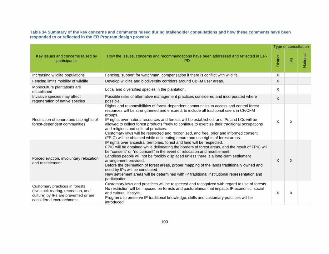
100
Table 34 Summary of the key concerns and comments raised during stakeholder consultations and how these comments have been responded to or reflected in the ER Program design process
Key issues and concerns raised by participants
How the issues, concerns and recommendations have been addressed and reflected in ER-PD
Type of consultation
Dis
tric
t
IPs
National
Increasing wildlife populations Fencing, support for watchman, compensation if there is conflict with wildlife. X
Fencing limits mobility of wildlife Develop wildlife and biodiversity corridors around CBFM user areas. X
Monoculture plantations are established
Local and diversified species in the plantation. X
Invasive species may affect regeneration of native species
Possible risks of alternative management practices considered and incorporated where possible.
X
Restriction of tenure and use rights of forest-dependent communities
Rights and responsibilities of forest-dependent communities to access and control forest resources will be strengthened and ensured, to include all traditional users in CF/CFM groups. IP rights over natural resources and forests will be established, and IPs and LCs will be allowed to collect forest products freely to continue to exercise their traditional occupations and religious and cultural practices. Customary laws will be respected and recognized, and free, prior and informed consent (FPIC) will be obtained while delineating tenure and use rights of forest areas.
X X
Forced eviction, involuntary relocation and resettlement
IP rights over ancestral territories, forest and land will be respected. FPIC will be obtained while delineating the borders of forest areas, and the result of FPIC will be “consent” or “no consent” in the event of relocation and resettlement. Landless people will not be forcibly displaced unless there is a long-term settlement arrangement provided. Before the delineation of forest areas, proper mapping of the lands traditionally owned and used by IPs will be conducted. New settlement areas will be determined with IP traditional institutional representation and participation.
X X
Customary practices in forests (livestock rearing, recreation, and culture) by IPs are prevented or are considered encroachment
Customary laws and practices will be respected and recognized with regard to use of forests. No restriction will be imposed on forests and pasturelands that impacts IP economic, social and cultural lifestyle. Programs to preserve IP traditional knowledge, skills and customary practices will be introduced.
X X
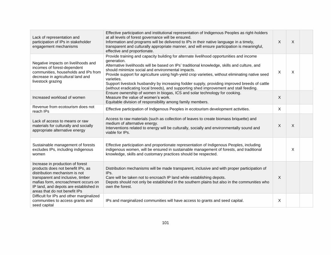
101
Lack of representation and participation of IPs in stakeholder engagement mechanisms
Effective participation and institutional representation of Indigenous Peoples as right-holders at all levels of forest governance will be ensured. Information and programs will be delivered to IPs in their native language in a timely, transparent and culturally appropriate manner, and will ensure participation is meaningful, effective and proportionate.
X X
Negative impacts on livelihoods and incomes of forest-dependent communities, households and IPs from decrease in agricultural land and livestock grazing
Provide training and capacity building for alternate livelihood opportunities and income generation. Alternative livelihoods will be based on IPs’ traditional knowledge, skills and culture, and should minimize social and environmental impacts. Provide support for agriculture using high-yield crop varieties, without eliminating native seed varieties. Support livestock husbandry by increasing fodder supply, providing improved breeds of cattle (without eradicating local breeds), and supporting shed improvement and stall feeding.
X X
Increased workload of women Ensure ownership of women in biogas, ICS and solar technology for cooking. Measure the value of women’s work. Equitable division of responsibility among family members.
X
Revenue from ecotourism does not reach IPs
Effective participation of Indigenous Peoples in ecotourism development activities. X
Lack of access to means or raw materials for culturally and socially appropriate alternative energy
Access to raw materials (such as collection of leaves to create biomass briquette) and medium of alternative energy. Interventions related to energy will be culturally, socially and environmentally sound and viable for IPs.
X X
Sustainable management of forests excludes IPs, including indigenous women
Effective participation and proportionate representation of Indigenous Peoples, including indigenous women, will be ensured in sustainable management of forests, and traditional knowledge, skills and customary practices should be respected.
X
Increase in production of forest products does not benefit IPs, as distribution mechanism is not transparent and inclusive, timber mafias form, encroachment occurs on IP land, and depots are established in areas that do not benefit IPs
Distribution mechanisms will be made transparent, inclusive and with proper participation of IPs. Care will be taken not to encroach IP land while establishing depots. Depots should not only be established in the southern plains but also in the communities who own the forest.
X
Difficult for IPs and other marginalized communities to access grants and seed capital
IPs and marginalized communities will have access to grants and seed capital. X
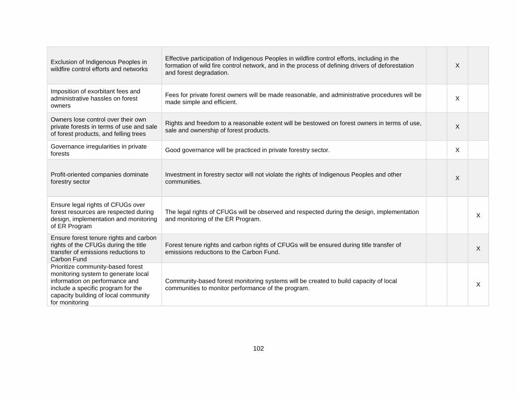
102
Exclusion of Indigenous Peoples in wildfire control efforts and networks
Effective participation of Indigenous Peoples in wildfire control efforts, including in the formation of wild fire control network, and in the process of defining drivers of deforestation and forest degradation.
X
Imposition of exorbitant fees and administrative hassles on forest owners
Fees for private forest owners will be made reasonable, and administrative procedures will be made simple and efficient.
X
Owners lose control over their own private forests in terms of use and sale of forest products, and felling trees
Rights and freedom to a reasonable extent will be bestowed on forest owners in terms of use, sale and ownership of forest products.
X
Governance irregularities in private forests
Good governance will be practiced in private forestry sector. X
Profit-oriented companies dominate forestry sector
Investment in forestry sector will not violate the rights of Indigenous Peoples and other communities.
X
Ensure legal rights of CFUGs over forest resources are respected during design, implementation and monitoring of ER Program
The legal rights of CFUGs will be observed and respected during the design, implementation and monitoring of the ER Program.
X
Ensure forest tenure rights and carbon rights of the CFUGs during the title transfer of emissions reductions to Carbon Fund
Forest tenure rights and carbon rights of CFUGs will be ensured during title transfer of emissions reductions to the Carbon Fund.
X
Prioritize community-based forest monitoring system to generate local information on performance and include a specific program for the capacity building of local community for monitoring
Community-based forest monitoring systems will be created to build capacity of local communities to monitor performance of the program.
X
103
6 OPERATIONAL AND FINANCIAL PLANNING
6.1 INSTITUTIONAL AND IMPLEMENTATION ARRANGEMENTS
National Level At the national level, the REDD+ process is operationalized through a three-tier structure comprising National REDD+ Steering Committee (NRSC), National REDD+ Coordination Committee at the coordination and decision-making level, and the National REDD+ Center (NRC) as the REDD+ program management entity. These three governing structures are supplemented by two informal structures, the REDD+ Multi-Stakeholder Forum and REDD+ CSO and IPO Alliance. The roles of these committees and their relationship are described further below and depicted visually in Figure 10 below.
● National REDD+ Steering Commmittee (NRSC): The NRSC is an inter-ministerial high-level policy, steering and coordination body to harmonize REDD+ and related policies and program with national plans and policies. The NRSC will be chaired by the Minister of Forests and Environment and represented by Ministry of Finance; Ministry of Forests and Environment; Ministry of Energy, Water Resources and Irrigation; Ministry of Agriculture, Land Management and Cooperatives; Ministry of Industry, Commerce and Supplies;National Planning Commission, National Natural Resources and Fiscal Commission; State Ministry of Industry, Tourism, Forests and Environment; and representatives from the local governments, private sector, civil society and government organizations. The chief of the NRSC will act as member secretary of the NRCC The NRSC will be linked with the Climate Change Council chaired by the Right Honorable Prime Minister to bring synergy and integration of climate change related aspects in the policies, plans, and programs.
● National REDD+ Coordination Committee (NRCC): The NRCC is a board that meets three
times per year and provides strategic leadership in designing, planning and implementation of REDD+ program in the country. The NRCC is chaired by the Secretary of the Ministry of Forests and Environment and represented by government agencies including Climate Change Management Division; Environment and Biodiversity Division; Planning, Policy and Monitoring Division, Participatory Forest Management Division; Forests and Watershed Division; Administrative Division; Department of Forests, Department of National Parks and Wildlife Conservation, Department of Forest Research and Survey; Department of Plant Resources; Department of Environment; Forest and Environment Training Center; non-governmental organizations having expertise in the REDD+; and development partners. The Chief of the NRC will act as member secretary of the NRCC and the National REDD+ Center (NRC) serves it’s secretariat function (the NRCC does not have separate staffing). The NRCC is a key decision-making entity on the overall REDD+ process and management. The NRCC is also expected to provide innovative ideas, monitor programs and help to integrate program priorities under the National REDD+ Strategy.
● National REDD+ Center (NRC): The NRC is the executing entity for carrying out day-to-day
activities and implementing regular programs under REDD+ as well as implementing decisions made by NRSC and NRCC. It is a permanent government organization with regular budget and 18 permanent staff members dedicated to REDD+. It serves the secretariat function for both NRSC and NRCC. The chief of NRC works as the member secretary to both NRSC and NRCC. It functions as the primary operational body to provide national program leadership, coordinate ER Program planning, and bridge state and district-level planning and priorities under the National REDD+ Strategy. The NRC works closely with the NRCC on overall strategic planning and priorities; with the Planning, Monitoring and Coordination Division of MoFE to ensure close coordination of the program across the departments and districts; and to ensure harmonization of the ER Program with other finance streams. Under the ER Program there will be staff members of the NRC who are dedicated to national-level support and coordination of the program. Nepal's
104
National REDD+ Strategy proposes to elevate the existing REDD Implementation Centre to National REDD+ Centre as a semi-autonomous entity. The Terms of Reference for the proposed National REDD+ Centre will include the following:
- Explore and access national and international funds including result-based payments.
- Coordination among sectors and actors for REDD+ related policy decisions. - Coordinate regulation of greenhouse gas emissions from forests. - Coordinate REDD+-related benefit-sharing. - Coordinate safeguards implementation and monitoring. - Establish and operate national Safeguards Information System. - Coordinate implementation of ER Program and National REDD+ Strategy. - Carry out and publish research and studies. - Coordinate with DFRS for implementation of MMRV, the National Forest
Information System and Carbon Registry. - Establish contractual arrangements for private forestry owners interested to opt-in
in ER Program private forestry incentives.
● REDD+ Multi-stakeholder Forum: The REDD+ Multi-Stakeholder Forum functions as the principal consultation, outreach and communication platform. The forum includes representatives from the private sector, civil society, media, government organizations, community-based organizations, Indigenous Peoples Organizations (IPOs), national and international NGOs, donors, academic and research institutions, Gender and Social Inclusion related organizations and other stakeholders interested in REDD+. The forum will meet at least twice a year.
● REDD+ CSO and IPO Alliance: The Alliance functions as a platform to discuss and develop a
common understanding of REDD+ on behalf of wide spectrum of women, Dalits, Civil Society Organizations (CSO) and IPs Organizations. The alliance will meet at least once a year. It also advocates to ensure social and environmental safeguards while implementing REDD+ programs.
● Department REDD+ Focal Point: A REDD+ Focal Point will be established at the federal level
both at the Department of Forests and the Department of National Parks and Wildlife Conservation. The Focal Point will be a staff member nominated by the respective Department and will liaise with the NRC and the state-level REDD+ Focal Points. While the Directors General will participate in the NRCC meeting for strategic decisions, the REDD+ Focal Point will work as the permanent, day-to-day contact point between the NRC and the respective Department for program implementation.
State Level
• REDD+ Focal Desk: A REDD+ Focal Desk will be established at the state Ministry of Industry, Tourism, Forests and Environment/ state forest department to coordinate ER Program implementation. A position of REDD+ Focal Officer (RFO) will be created for each REDD+ Focal Desk. The main function of the desk and the RFO will be:
o Ensure coordination among districts/divisions on ER Program implementation. o Provide advice and guidance to districts/divisions and to REDD+ Program Management
Units. o Liaise with NRC and REDD+ Focal Officer at federal level as needed for technical
guidance and advice. o Monitor ER Program implementation at district/division level. o Report to NRC and DoF/DNPWC on ER Program implementation in the state.
District/Division Level
• District/Division REDD+ Coordination Committee (DRCC): The DRCC provides leadership in developing and implementation of REDD+ program in the districts/divisions. The DRCC will be chaired by the District/Division Forest Officer and represented by relevant government agencies,
105
local level non-governmental organizations having expertise in the REDD+; forestry related community-based organizations, women, IPOs, Dalits; and private sector. The DRCC will assist in the implementation of the REDD+ program in the district, monitor program activities, and advocate and lobby to support for the emission reduction programs.
• District/Division REDD+ Multi-stakeholder Forum: A REDD+ Multi-Stakeholder's Forum complements the DRCC by providing a less formal venue forconsultation, outreach and communication in the district/division. The forum includes representatives from district chapters of the national REDD+ Multi-Stakeholder Forum involving the private sector, civil society, media, government organizations, community-based organizations, Indigenous Peoples, NGOs, research organizations, and all stakeholders interested in climate change and REDD+. The forum will increase access to information among stakeholders and enhance their role in the decision-making process. The involvement of different stakeholders ensures transparency and accountability during ER Program implementation. The forum will also provide input and feedback to the ER Program Management Unit.
• District/Division REDD+ CSOs and IPO Alliance: There will be REDD+ CSOs and IPO Alliance in each district/division. This will serve as a platform for CSO and IPOs interested in REDD+ to pursue the following:
o Discuss and develop a common understanding of REDD+ on behalf of CSOs and IPOs in the districts/divisions.
o Empower and build capacity of CSOs and IPOs on contemporary issues of REDD+. o Provide support and advice to District/Division REDD+ Management Unit (DRPMU) on
ER Program management. o Provide suggestions and feedback on REDD+ policy processes through DRPMU and
REDD+ CSO and IPO alliance.
• District/Division REDD+ Program Management Unit: A District/Division REDD+ Program Management Unit (DRPMU) will be established at District/Division forest office. The DRPMU will coordinate and provide secretariat services related to ER Program activities in each district/division. This unit is responsible for the implementation and monitoring of REDD+ programs in the district/division and supports implementation of REDD+ activities at various Forest Management Units such as community forests, collaborative forests, leasehold forests, private forests, etc. The DRPMU is composed of permanent staff members of the DFO dedicated to carrying out REDD+/ERPD related activities, comparable to the role that NRC plays at national level.
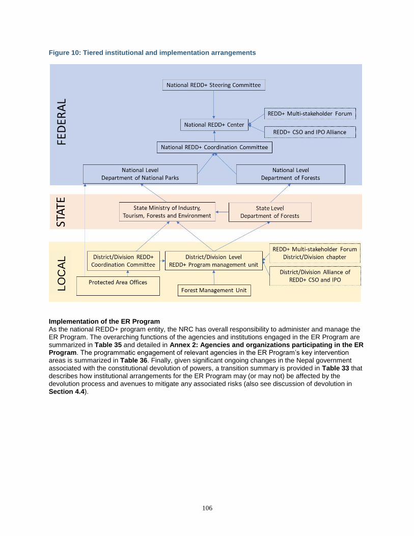
106
Figure 10: Tiered institutional and implementation arrangements
Implementation of the ER Program As the national REDD+ program entity, the NRC has overall responsibility to administer and manage the ER Program. The overarching functions of the agencies and institutions engaged in the ER Program are summarized in Table 35 and detailed in Annex 2: Agencies and organizations participating in the ER Program. The programmatic engagement of relevant agencies in the ER Program’s key intervention areas is summarized in Table 36. Finally, given significant ongoing changes in the Nepal government associated with the constitutional devolution of powers, a transition summary is provided in Table 33 that describes how institutional arrangements for the ER Program may (or may not) be affected by the devolution process and avenues to mitigate any associated risks (also see discussion of devolution in Section 4.4).
LO
CA
L
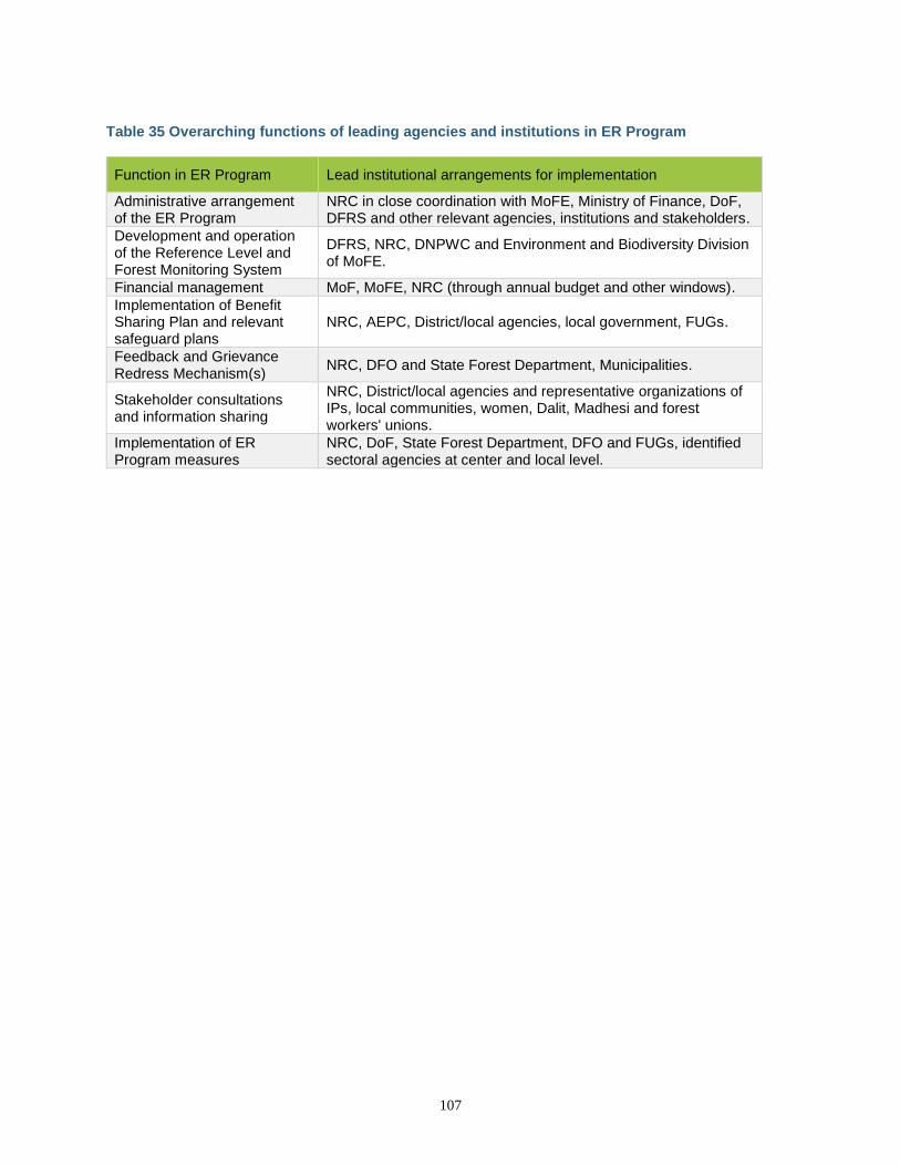
107
Table 35 Overarching functions of leading agencies and institutions in ER Program
Function in ER Program Lead institutional arrangements for implementation
Administrative arrangement of the ER Program
NRC in close coordination with MoFE, Ministry of Finance, DoF, DFRS and other relevant agencies, institutions and stakeholders.
Development and operation of the Reference Level and Forest Monitoring System
DFRS, NRC, DNPWC and Environment and Biodiversity Division of MoFE.
Financial management MoF, MoFE, NRC (through annual budget and other windows).
Implementation of Benefit Sharing Plan and relevant safeguard plans
NRC, AEPC, District/local agencies, local government, FUGs.
Feedback and Grievance Redress Mechanism(s)
NRC, DFO and State Forest Department, Municipalities.
Stakeholder consultations and information sharing
NRC, District/local agencies and representative organizations of IPs, local communities, women, Dalit, Madhesi and forest workers' unions.
Implementation of ER Program measures
NRC, DoF, State Forest Department, DFO and FUGs, identified sectoral agencies at center and local level.
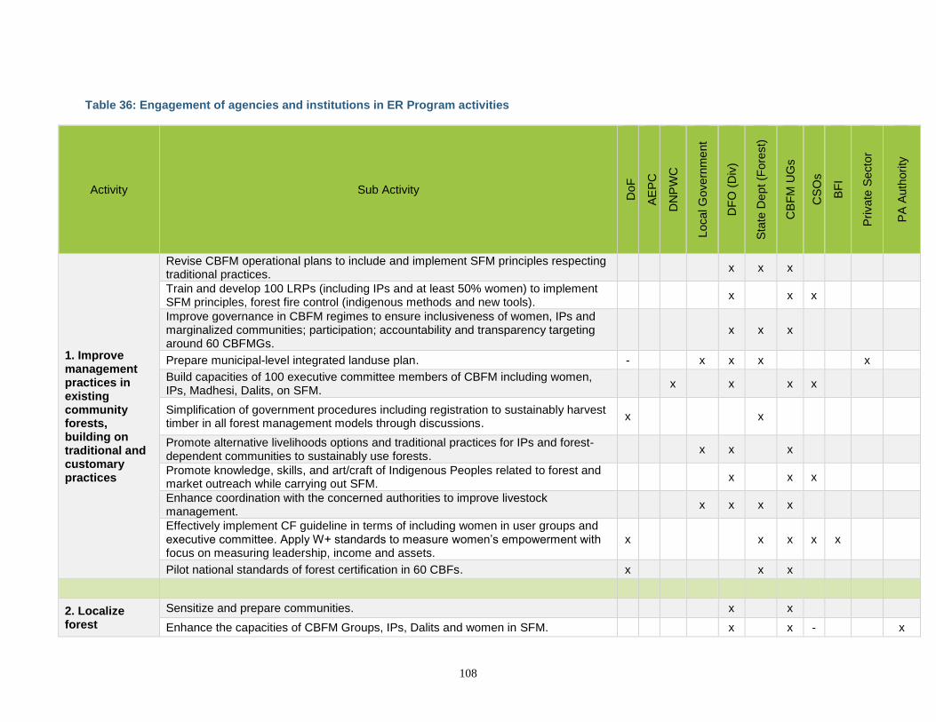
108
Table 36: Engagement of agencies and institutions in ER Program activities
Activity Sub Activity
DoF
AE
PC
DN
PW
C
Local G
overn
me
nt
DF
O (
Div
)
Sta
te D
ept (F
ore
st)
CB
FM
UG
s
CS
Os
BF
I
Private
Secto
r
PA
Auth
ori
ty
1. Improve management practices in existing community forests, building on traditional and customary practices
Revise CBFM operational plans to include and implement SFM principles respecting traditional practices.
x x x
Train and develop 100 LRPs (including IPs and at least 50% women) to implement SFM principles, forest fire control (indigenous methods and new tools).
x x x
Improve governance in CBFM regimes to ensure inclusiveness of women, IPs and marginalized communities; participation; accountability and transparency targeting around 60 CBFMGs.
x x x
Prepare municipal-level integrated landuse plan. - x x x x
Build capacities of 100 executive committee members of CBFM including women, IPs, Madhesi, Dalits, on SFM.
x x x x
Simplification of government procedures including registration to sustainably harvest timber in all forest management models through discussions.
x x
Promote alternative livelihoods options and traditional practices for IPs and forest-dependent communities to sustainably use forests.
x x x
Promote knowledge, skills, and art/craft of Indigenous Peoples related to forest and market outreach while carrying out SFM.
x x x
Enhance coordination with the concerned authorities to improve livestock management.
x x x x
Effectively implement CF guideline in terms of including women in user groups and executive committee. Apply W+ standards to measure women’s empowerment with focus on measuring leadership, income and assets.
x x x x x
Pilot national standards of forest certification in 60 CBFs. x x x
2. Localize forest
Sensitize and prepare communities. x x
Enhance the capacities of CBFM Groups, IPs, Dalits and women in SFM. x x - x
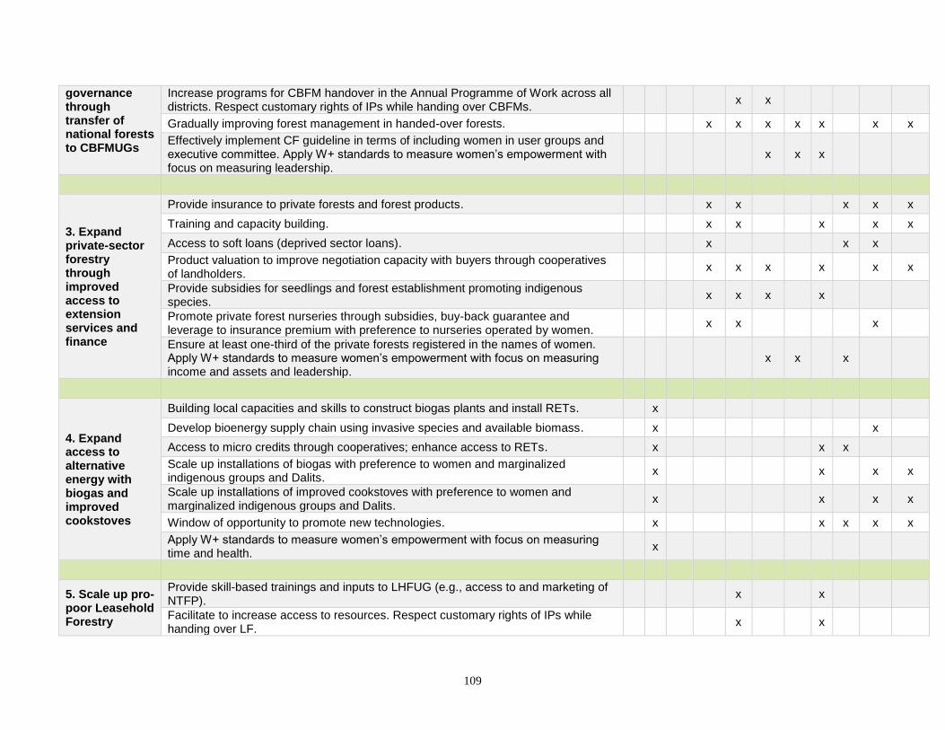
109
governance through transfer of national forests to CBFMUGs
Increase programs for CBFM handover in the Annual Programme of Work across all districts. Respect customary rights of IPs while handing over CBFMs.
x x
Gradually improving forest management in handed-over forests. x x x x x x x
Effectively implement CF guideline in terms of including women in user groups and executive committee. Apply W+ standards to measure women’s empowerment with focus on measuring leadership.
x x x
3. Expand private-sector forestry through improved access to extension services and finance
Provide insurance to private forests and forest products. x x x x x
Training and capacity building. x x x x x
Access to soft loans (deprived sector loans). x x x
Product valuation to improve negotiation capacity with buyers through cooperatives of landholders.
x x x x x x
Provide subsidies for seedlings and forest establishment promoting indigenous species.
x x x x
Promote private forest nurseries through subsidies, buy-back guarantee and leverage to insurance premium with preference to nurseries operated by women.
x x x
Ensure at least one-third of the private forests registered in the names of women. Apply W+ standards to measure women’s empowerment with focus on measuring income and assets and leadership.
x x x
4. Expand access to alternative energy with biogas and improved cookstoves
Building local capacities and skills to construct biogas plants and install RETs. x
Develop bioenergy supply chain using invasive species and available biomass. x x
Access to micro credits through cooperatives; enhance access to RETs. x x x
Scale up installations of biogas with preference to women and marginalized indigenous groups and Dalits.
x x x x
Scale up installations of improved cookstoves with preference to women and marginalized indigenous groups and Dalits.
x x x x
Window of opportunity to promote new technologies. x x x x x
Apply W+ standards to measure women’s empowerment with focus on measuring time and health.
x
5. Scale up pro-poor Leasehold Forestry
Provide skill-based trainings and inputs to LHFUG (e.g., access to and marketing of NTFP).
x x
Facilitate to increase access to resources. Respect customary rights of IPs while handing over LF.
x x
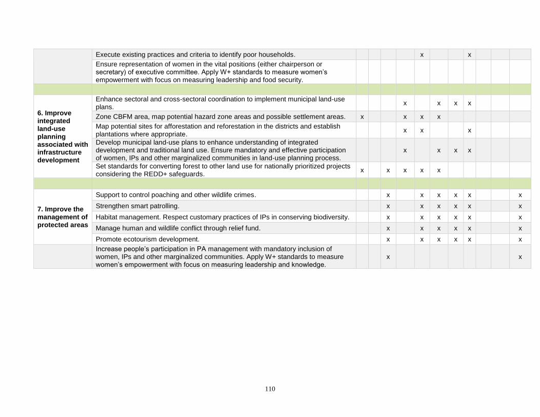
110
Execute existing practices and criteria to identify poor households. x x
Ensure representation of women in the vital positions (either chairperson or secretary) of executive committee. Apply W+ standards to measure women’s empowerment with focus on measuring leadership and food security.
6. Improve integrated land-use planning associated with infrastructure development
Enhance sectoral and cross-sectoral coordination to implement municipal land-use plans.
x x x x
Zone CBFM area, map potential hazard zone areas and possible settlement areas. x x x x
Map potential sites for afforestation and reforestation in the districts and establish plantations where appropriate.
x x x
Develop municipal land-use plans to enhance understanding of integrated development and traditional land use. Ensure mandatory and effective participation of women, IPs and other marginalized communities in land-use planning process.
x x x x
Set standards for converting forest to other land use for nationally prioritized projects considering the REDD+ safeguards.
x x x x x
7. Improve the management of protected areas
Support to control poaching and other wildlife crimes. x x x x x x
Strengthen smart patrolling. x x x x x x
Habitat management. Respect customary practices of IPs in conserving biodiversity. x x x x x x
Manage human and wildlife conflict through relief fund. x x x x x x
Promote ecotourism development. x x x x x x
Increase people’s participation in PA management with mandatory inclusion of women, IPs and other marginalized communities. Apply W+ standards to measure women’s empowerment with focus on measuring leadership and knowledge.
x x
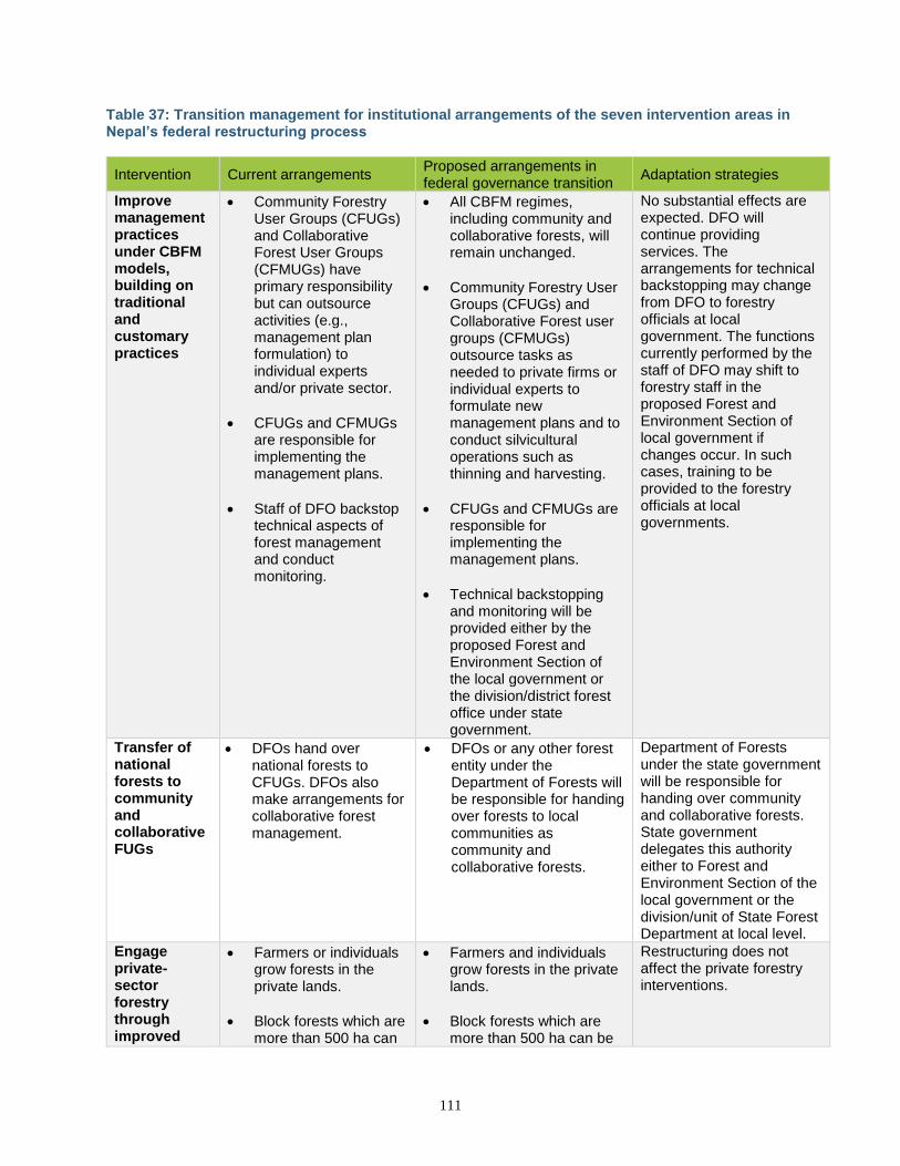
111
Table 37: Transition management for institutional arrangements of the seven intervention areas in Nepal’s federal restructuring process
Intervention Current arrangements Proposed arrangements in federal governance transition
Adaptation strategies
Improve management practices under CBFM models, building on traditional and customary practices
• Community Forestry User Groups (CFUGs) and Collaborative Forest User Groups (CFMUGs) have primary responsibility but can outsource activities (e.g., management plan formulation) to individual experts and/or private sector.
• CFUGs and CFMUGs are responsible for implementing the management plans.
• Staff of DFO backstop technical aspects of forest management and conduct monitoring.
• All CBFM regimes, including community and collaborative forests, will remain unchanged.
• Community Forestry User Groups (CFUGs) and Collaborative Forest user groups (CFMUGs) outsource tasks as needed to private firms or individual experts to formulate new management plans and to conduct silvicultural operations such as thinning and harvesting.
• CFUGs and CFMUGs are responsible for implementing the management plans.
• Technical backstopping and monitoring will be provided either by the proposed Forest and Environment Section of the local government or the division/district forest office under state government.
No substantial effects are expected. DFO will continue providing services. The arrangements for technical backstopping may change from DFO to forestry officials at local government. The functions currently performed by the staff of DFO may shift to forestry staff in the proposed Forest and Environment Section of local government if changes occur. In such cases, training to be provided to the forestry officials at local governments.
Transfer of national forests to community and collaborative FUGs
• DFOs hand over national forests to CFUGs. DFOs also make arrangements for collaborative forest management.
• DFOs or any other forest entity under the Department of Forests will be responsible for handing over forests to local communities as community and collaborative forests.
Department of Forests under the state government will be responsible for handing over community and collaborative forests. State government delegates this authority either to Forest and Environment Section of the local government or the division/unit of State Forest Department at local level.
Engage private-sector forestry through improved
• Farmers or individuals grow forests in the private lands.
• Block forests which are more than 500 ha can
• Farmers and individuals grow forests in the private lands.
• Block forests which are more than 500 ha can be
Restructuring does not affect the private forestry interventions.
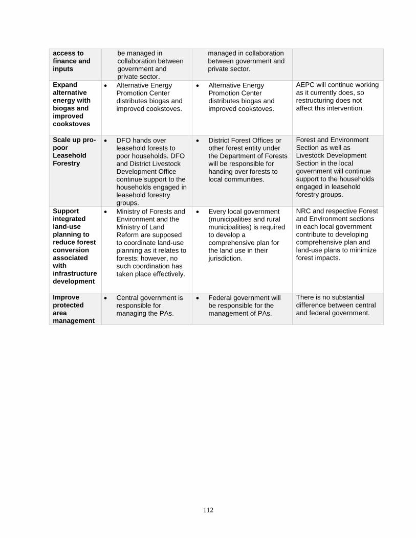
112
access to finance and inputs
be managed in collaboration between government and private sector.
managed in collaboration between government and private sector.
Expand alternative energy with biogas and improved cookstoves
• Alternative Energy Promotion Center distributes biogas and improved cookstoves.
• Alternative Energy Promotion Center distributes biogas and improved cookstoves.
AEPC will continue working as it currently does, so restructuring does not affect this intervention.
Scale up pro-poor Leasehold Forestry
• DFO hands over leasehold forests to poor households. DFO and District Livestock Development Office continue support to the households engaged in leasehold forestry groups.
• District Forest Offices or other forest entity under the Department of Forests will be responsible for handing over forests to local communities.
Forest and Environment Section as well as Livestock Development Section in the local government will continue support to the households engaged in leasehold forestry groups.
Support integrated land-use planning to reduce forest conversion associated with infrastructure development
• Ministry of Forests and Environment and the Ministry of Land Reform are supposed to coordinate land-use planning as it relates to forests; however, no such coordination has taken place effectively.
• Every local government (municipalities and rural municipalities) is required to develop a comprehensive plan for the land use in their jurisdiction.
NRC and respective Forest and Environment sections in each local government contribute to developing comprehensive plan and land-use plans to minimize forest impacts.
Improve protected area management
• Central government is responsible for managing the PAs.
• Federal government will be responsible for the management of PAs.
There is no substantial difference between central and federal government.

113
6.2 ER PROGRAM BUDGET
The table in Annex 1: Summary of financial plan provides an overview of the financial plan for implementation of the proposed ER Program. The cost of implementing the major interventions identified to address the drivers of deforestation and forest degradation and to enhance removals—based on consultations, current costs and past experiences—is estimated to be US$ 184 million over 10 years. Financial planning is described here for the entire 10-year period; however, Carbon Fund revenues are only expected for six years, or through 2024, in anticipation of the Carbon Fund’s possible sunset. Total anticipated implementation costs for this period under the Carbon Fund are US$ 123 million. It is estimated that approximately US$21 million over 10 years will be contributed to the implementation of the ER Program by the government through DoF.64 In addition, about 40% of the President Chure Terai Madhesh Conservation Development Program (PCTMCDP), a project of national pride, partly lies in the ER Program Area, and it is estimated that approximately US$ 24 million will support implementation of ER Program activities. More specifically, the PCTMCDP will support improved management practices in existing community and collaborative forests (intervention 1), transfer of national forests to community and collaborative forests (intervention 2), expanding private forestry (intervention 3), scaling up pro-poor leasehold forestry (intervention 5) and improving management of protected areas (intervention 7). As the PCTMCDP does not claim carbon emissions, activities under PCTMCDP are complementary to the interventions proposed in the ER Program. Approximately US$ 7.5 million anticipated from the Forest Investment Program (FIP) will also support interventions in the ER Program Area synergistically with Nepal’s Forest Investment Plan. Specifically, FIP Project 1 (Sustainable Management of CBFM) and Project 2 (Forest management for economy) will complement to the cost of interventions 1, 2 and 5 in the ER Program, while Project 3 (Private forestry) will provide leverage to the cost of intervention 3 in the ER Program.The WWF-funded Terai Arc Landscape Program, a long-term program with a 50-year vision, will contribute approximately US$ 13 million over 10 years. Lastly, an additional US$23 million will be invested by local communities through their co-financing of biogas plants and cookstove projects (US$10 million), and reinvestments of revenues from sales of timber from community and collaborative forest user groups (US$13 million). In the case of biogas plants and cookstove projects, these estimates are based on total numbers of units that will be installed and the cost-share of the recipients. In community and collaborative forests, this contribution is estimated from average forest revenues by management type and the provision that CBFM and CF groups are required to spend at least 25% of their income from forests in forest management. The Letter of Intent (LOI) between FCPF Carbon Fund and Ministry of Finance allows for results-based payments of up to US$ 70M for 14 MtCO2e from the ER Program. The Government of Nepal anticipates the sale of 10.2 MtCO2e at US$5/tCO2 corresponding to US$ 51 million in revenue from the Carbon Fund over ten years. From these funds, US$ 24.4 and US$ 26.4 million are projected to be paid after year 4 (2022), and year 6 (2024) of the ER Program, respectively, assuming a start date of 2019, and following successful field verification of ERs. Given that the ER Program will generate in total 26.3 MtCO2e (after buffer deduction) over ten years, the estimated volume under the proposed Carbon Fund program represents less than a half of total ERs generated (see Table 49). After the deduction of the buffer and ERs sold to the Carbon Fund, the ER Program aims to generate an additional 16.2 MtCO2e over the 10-year period. The Government of Nepal may either seek external carbon finance to purchase these ERs to catalyze further activities in the Program Area or use these ERs toward domestic mitigation targets. Anticipated financial flow is shown in Figure 11 (See also Section 15 on benefit sharing). Regarding financial flows (see Figure 11 and also Section 15 on benefit sharing), the Ministry of Finance will distribute results-based payments directly to the Ministry of Forests and Environment at the federal
64 The contribution from the government and other partners only reflects the budget related to the implementation of activities identified in the ER Program, and does not include expenses related to other activities, personnel costs, and management costs.
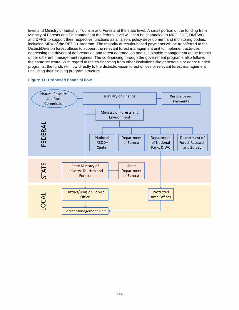
114
level and Ministry of Industry, Tourism and Forests at the state level. A small portion of the funding from Ministry of Forests and Environment at the federal level will then be channeled to NRC, DoF, DNPWC and DFRS to support their respective functions as a liaison, policy development and monitoring bodies, including MRV of the REDD+ program. The majority of results-based payments will be transferred to the District/Division forest offices to support the relevant forest management unit to implement activities addressing the drivers of deforestation and forest degradation and sustainable management of the forests under different management regimes. The co-financing through the government programs also follows the same structure. With regard to the co-financing from other institutions like parastatals or donor funded programs, the funds will flow directly to the district/division forest offices or relevant forest management unit using their existing program structure. Figure 11: Proposed financial flow
LOC
AL
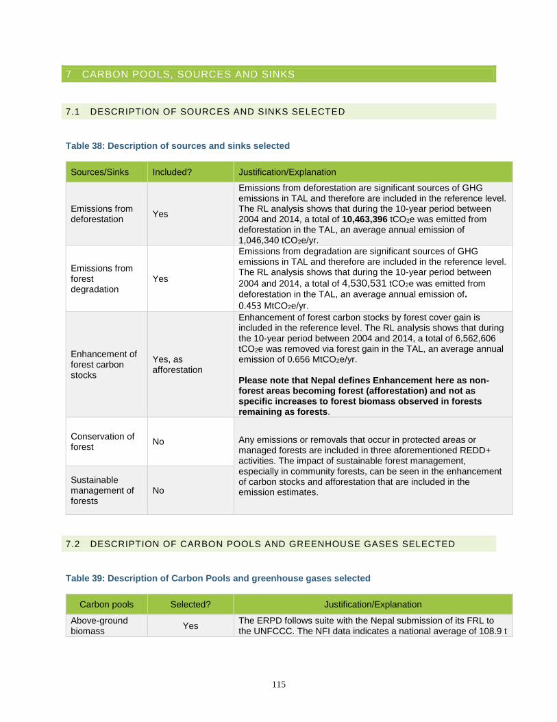
115
7 CARBON POOLS, SOURCES AND SINKS
7.1 DESCRIPTION OF SOURCES AND SINKS SELECTED
Table 38: Description of sources and sinks selected
Sources/Sinks Included? Justification/Explanation
Emissions from deforestation
Yes
Emissions from deforestation are significant sources of GHG emissions in TAL and therefore are included in the reference level. The RL analysis shows that during the 10-year period between 2004 and 2014, a total of 10,463,396 tCO2e was emitted from deforestation in the TAL, an average annual emission of 1,046,340 tCO2e/yr.
Emissions from forest degradation
Yes
Emissions from degradation are significant sources of GHG emissions in TAL and therefore are included in the reference level. The RL analysis shows that during the 10-year period between
2004 and 2014, a total of 4,530,531 tCO2e was emitted from
deforestation in the TAL, an average annual emission of.
0.453 MtCO2e/yr.
Enhancement of forest carbon stocks
Yes, as afforestation
Enhancement of forest carbon stocks by forest cover gain is included in the reference level. The RL analysis shows that during the 10-year period between 2004 and 2014, a total of 6,562,606 tCO2e was removed via forest gain in the TAL, an average annual emission of 0.656 MtCO2e/yr. Please note that Nepal defines Enhancement here as non-forest areas becoming forest (afforestation) and not as specific increases to forest biomass observed in forests remaining as forests.
Conservation of forest
No Any emissions or removals that occur in protected areas or managed forests are included in three aforementioned REDD+ activities. The impact of sustainable forest management, especially in community forests, can be seen in the enhancement of carbon stocks and afforestation that are included in the emission estimates.
Sustainable management of forests
No
7.2 DESCRIPTION OF CARBON POOLS AND GREENHOUSE GASES SELECTED
Table 39: Description of Carbon Pools and greenhouse gases selected
Carbon pools Selected? Justification/Explanation
Above-ground biomass
Yes The ERPD follows suite with the Nepal submission of its FRL to the UNFCCC. The NFI data indicates a national average of 108.9 t
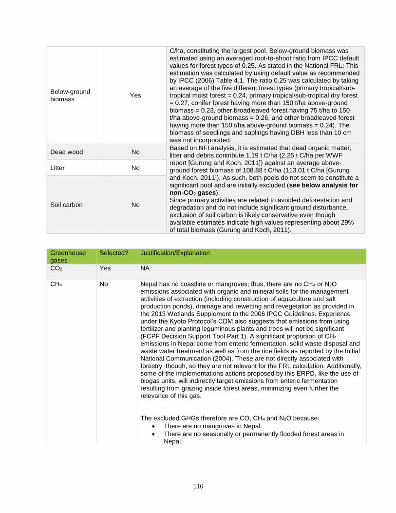
116
Below-ground biomass
Yes
C/ha, constituting the largest pool. Below-ground biomass was estimated using an averaged root-to-shoot ratio from IPCC default values for forest types of 0.25. As stated in the National FRL: This estimation was calculated by using default value as recommended by IPCC (2006) Table 4.1. The ratio 0.25 was calculated by taking an average of the five different forest types (primary tropical/sub-tropical moist forest = 0.24, primary tropical/sub-tropical dry forest = 0.27, conifer forest having more than 150 t/ha above-ground biomass = 0.23, other broadleaved forest having 75 t/ha to 150 t/ha above-ground biomass = 0.26, and other broadleaved forest having more than 150 t/ha above-ground biomass = 0.24). The biomass of seedlings and saplings having DBH less than 10 cm was not incorporated.
Dead wood No Based on NFI analysis, it is estimated that dead organic matter, litter and debris contribute 1.19 t C/ha (2.25 t C/ha per WWF report [Gurung and Koch, 2011]) against an average above-ground forest biomass of 108.88 t C/ha (113.01 t C/ha [Gurung and Koch, 2011]). As such, both pools do not seem to constitute a significant pool and are initially excluded (see below analysis for non-CO2 gases). Since primary activities are related to avoided deforestation and degradation and do not include significant ground disturbance, exclusion of soil carbon is likely conservative even though available estimates indicate high values representing about 29% of total biomass (Gurung and Koch, 2011).
Litter No
Soil carbon No
Greenhouse gases
Selected? Justification/Explanation
CO2 Yes NA
CH4 No Nepal has no coastline or mangroves; thus, there are no CH4 or N2O emissions associated with organic and mineral soils for the management activities of extraction (including construction of aquaculture and salt production ponds), drainage and rewetting and revegetation as provided in the 2013 Wetlands Supplement to the 2006 IPCC Guidelines. Experience under the Kyoto Protocol’s CDM also suggests that emissions from using fertilizer and planting leguminous plants and trees will not be significant (FCPF Decision Support Tool Part 1). A significant proportion of CH4 emissions in Nepal come from enteric fermentation, solid waste disposal and waste water treatment as well as from the rice fields as reported by the Initial National Communication (2004). These are not directly associated with forestry, though, so they are not relevant for the FRL calculation. Additionally, some of the implementations actions proposed by this ERPD, like the use of biogas units, will indirectly target emissions from enteric fermentation resulting from grazing inside forest areas, minimizing even further the relevance of this gas. The excluded GHGs therefore are CO, CH4 and N2O because:
• There are no mangroves in Nepal.
• There are no seasonally or permanently flooded forest areas in Nepal.
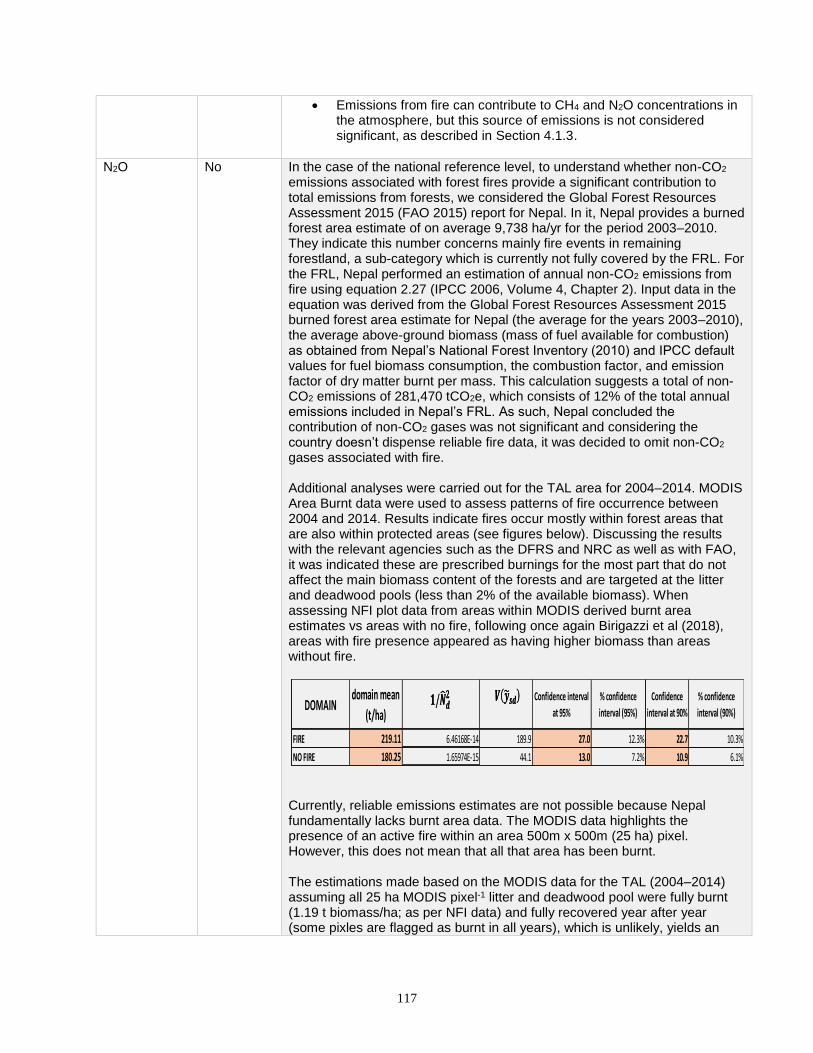
117
• Emissions from fire can contribute to CH4 and N2O concentrations in the atmosphere, but this source of emissions is not considered significant, as described in Section 4.1.3.
N2O No In the case of the national reference level, to understand whether non-CO2 emissions associated with forest fires provide a significant contribution to total emissions from forests, we considered the Global Forest Resources Assessment 2015 (FAO 2015) report for Nepal. In it, Nepal provides a burned forest area estimate of on average 9,738 ha/yr for the period 2003–2010. They indicate this number concerns mainly fire events in remaining forestland, a sub-category which is currently not fully covered by the FRL. For the FRL, Nepal performed an estimation of annual non-CO2 emissions from fire using equation 2.27 (IPCC 2006, Volume 4, Chapter 2). Input data in the equation was derived from the Global Forest Resources Assessment 2015 burned forest area estimate for Nepal (the average for the years 2003–2010), the average above-ground biomass (mass of fuel available for combustion) as obtained from Nepal’s National Forest Inventory (2010) and IPCC default values for fuel biomass consumption, the combustion factor, and emission factor of dry matter burnt per mass. This calculation suggests a total of non-CO2 emissions of 281,470 tCO2e, which consists of 12% of the total annual emissions included in Nepal’s FRL. As such, Nepal concluded the contribution of non-CO2 gases was not significant and considering the country doesn’t dispense reliable fire data, it was decided to omit non-CO2 gases associated with fire. Additional analyses were carried out for the TAL area for 2004–2014. MODIS Area Burnt data were used to assess patterns of fire occurrence between 2004 and 2014. Results indicate fires occur mostly within forest areas that are also within protected areas (see figures below). Discussing the results with the relevant agencies such as the DFRS and NRC as well as with FAO, it was indicated these are prescribed burnings for the most part that do not affect the main biomass content of the forests and are targeted at the litter and deadwood pools (less than 2% of the available biomass). When assessing NFI plot data from areas within MODIS derived burnt area estimates vs areas with no fire, following once again Birigazzi et al (2018), areas with fire presence appeared as having higher biomass than areas without fire.
Currently, reliable emissions estimates are not possible because Nepal fundamentally lacks burnt area data. The MODIS data highlights the presence of an active fire within an area 500m x 500m (25 ha) pixel. However, this does not mean that all that area has been burnt. The estimations made based on the MODIS data for the TAL (2004–2014) assuming all 25 ha MODIS pixel-1 litter and deadwood pool were fully burnt (1.19 t biomass/ha; as per NFI data) and fully recovered year after year (some pixles are flagged as burnt in all years), which is unlikely, yields an
DOMAINdomain mean
(t/ha)
Confidence interval
at 95%
% confidence
interval (95%)
Confidence
interval at 90%
% confidence
interval (90%)
FIRE 219.11 6.46168E-14 189.9 27.0 12.3% 22.7 10.3%
NO FIRE 180.25 1.65974E-15 44.1 13.0 7.2% 10.9 6.1%
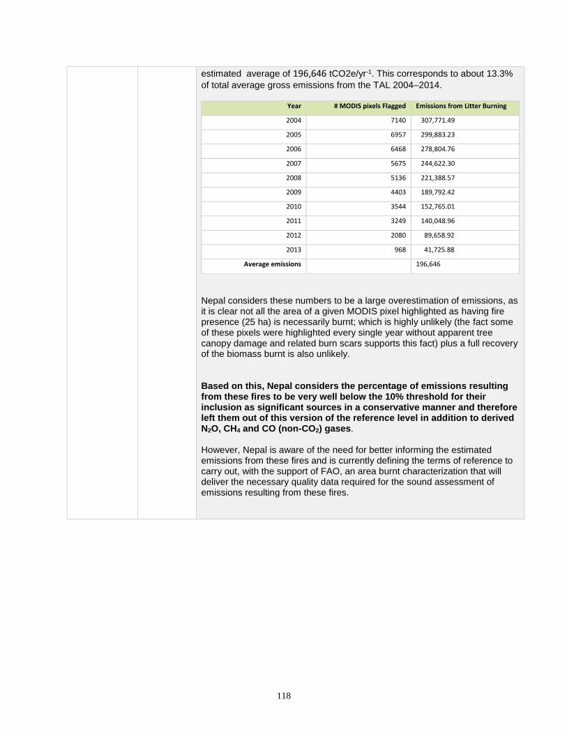
118
estimated average of 196,646 tCO2e/yr-1. This corresponds to about 13.3%
of total average gross emissions from the TAL 2004–2014.
Year # MODIS pixels Flagged Emissions from Litter Burning
2004 7140 307,771.49
2005 6957 299,883.23
2006 6468 278,804.76
2007 5675 244,622.30
2008 5136 221,388.57
2009 4403 189,792.42
2010 3544 152,765.01
2011 3249 140,048.96
2012 2080 89,658.92
2013 968 41,725.88
Average emissions 196,646
Nepal considers these numbers to be a large overestimation of emissions, as it is clear not all the area of a given MODIS pixel highlighted as having fire presence (25 ha) is necessarily burnt; which is highly unlikely (the fact some of these pixels were highlighted every single year without apparent tree canopy damage and related burn scars supports this fact) plus a full recovery of the biomass burnt is also unlikely. Based on this, Nepal considers the percentage of emissions resulting from these fires to be very well below the 10% threshold for their inclusion as significant sources in a conservative manner and therefore left them out of this version of the reference level in addition to derived N2O, CH4 and CO (non-CO2) gases. However, Nepal is aware of the need for better informing the estimated emissions from these fires and is currently defining the terms of reference to carry out, with the support of FAO, an area burnt characterization that will deliver the necessary quality data required for the sound assessment of emissions resulting from these fires.
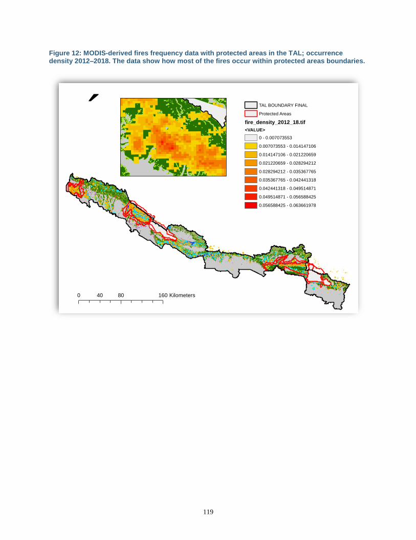
119
Figure 12: MODIS-derived fires frequency data with protected areas in the TAL; occurrence density 2012–2018. The data show how most of the fires occur within protected areas boundaries.
´
0 80 16040 Kilometers
TAL BOUNDARY FINAL
Protected Areas
fire_density_2012_18.tif
<VALUE>
0 - 0.007073553
0.007073553 - 0.014147106
0.014147106 - 0.021220659
0.021220659 - 0.028294212
0.028294212 - 0.035367765
0.035367765 - 0.042441318
0.042441318 - 0.049514871
0.049514871 - 0.056588425
0.056588425 - 0.063661978
120
8 REFERENCE LEVEL
8.1 REFERENCE PERIOD
The start date for the reference period is 2004 and end date is 2014. These dates are consistent with the available data used to inform the stratification used for unbiased estimation of activity data and elements of permanence in Nepal‘s definition of deforestation and forest degradation—particularly those involved with their permanence. We used 2002–2004 forest conditions to define a benchmark or forest stratum area and used changes observed as of 2014 and that remained as such as of 2015 and 2016 as a means to assess permanence of relevant accounting strata: stable forest, stable non-forest (all non-forest classes), forest gain, and forest loss.
8.2 FOREST DEFINITION USED IN THE CONSTRUCTION OF THE REFERENCE LEVEL
The definition of forest used in Nepal is “forest as an area of land of at least 0.5 ha and a minimum width/length of 20 m with a tree crown cover of more than 10% and tree heights of 5 m at maturity.” Forest definition operationalization: The ER-PD uses Landsat data (30m resolution) for mapping of tree canopy cover estimated data following Hansen et al (2012) from 2002 to 2016, to derive corresponding activity data. Given the fact Nepal’s area component of its forest definition refers to 0.5 ha and 10% tree cover, Nepal considers that 30m resolution TCC estimates inform its forest definition, as any given pixel represents an area of 0.09 ha or 18% of 0.5 ha. Use of TCC data for unbiased estimation of AD via stratified random sampling following Tyukavina et al 2013,65 2015,66 Global Forest Observation Initiative’s Methods and Guidance (MGD) update in process as well as pixel level sample assessment of tree canopy cover permanence, loss and gain complies with the operationalization of the forest definition as well as of its definition of deforestation (permanent forest loss: TCC below 10% threshold) and forest degradation (partial loss while still above 10%).
NOTE: The Government of Nepal, including the DFRS as well as REDD-IC agreed to apply this approach. Following ongoing capacity building under the GFOI and USGS Silva Carbon Program with the University of Maryland (UMD), FAO, and WWF, it was determined and agreed that this spatial dataset will be employed for both: ERPD updated submission as well as UNFCCC FREL submission following the results from the FREL UNFCCC technical assessment report (TAR). It was agreed these methods as well as those depicted below for degradation and emissions factors would be the same for both processes. Hence solving pending concerns about lack of alignment between ERPD and national carbon accounting frameworks.
65 Tyukavina et al, 2013. National-scale estimation of gross forest above-ground carbon loss: a case study of the Democratic Republic of the Congo. http://iopscience.iop.org/article/10.1088/1748-9326/8/4/044039 66 Tyukavina et al, 2015. Above-ground carbon loss in natural and managed tropical forests from 2000 to 2012. http://iopscience.iop.org/article/10.1088/1748-9326/10/7/074002
121
8.3 AVERAGE ANNUAL HISTORICAL EMISSIONS OVER THE REFERENCE PERIOD
Preparation of the RL follows the principles of the Intergovernmental Panel on Climate Change (IPCC) for reporting of national emissions and removals of GHGs, which include: (1) transparency, (2) completeness, (3) consistency, (4) comparability, and (5) accuracy. The RL has attempted to minimize errors through conservative estimates, verification of results through multiple data sources, field verification studies, and statistical analysis of error and uncertainty. The RL is reported in tCO2e following the guidance of the IPCC Good Practice Guidelines (GPG) for National Greenhouse Gas Accounting. It incorporates various tiers from the IPCC guidance but primarily Tier 2 and Tier 3. This effort is viewed as providing credible preliminary estimates of emissions in the TAL in support of the ER Program and as laying the foundation for development of a Tier 3 RL over the next five years. The change in carbon stock covers the pools Above-Ground Biomass and Below-Ground Biomass from Equation 2.3, and justification for excluding other pools is provided in Section 7. For these pools, emissions are calculated as as the difference between forest conditions (for degradation) and no forest estimates multiplied by corresponding Emission Factors, as depicted in Equation 2.2. Estimation of Biomass Table 40: Characterization of natural forests in Nepal used in national land cover mapping
No Landcover type Description
Forests
1 Intact forest Natural forest as per Nepal’s country definition that are located in the inner part or larger forest areas: continuous tree cover not showing any tree cover loss during the historic period. This type of area corresponds to the MSPA assessment core class. These areas show the higher biomass as disturbance level (both natural and human) are lower. This is supported by forest landscape ecology.
2 Edge forest Areas that are located at the margin of the forest areas as per Nepal’s forest definition. It also includes areas around observed tree canopy cover loss inside large continuous core areas. These corresponded to Inner Edge, Outer Edge and Patch areas as per MSPA analysis grouping. These areas show the lower biomass as disturbance level (both natural and human) are higher This is supported by forest landscape ecology and edge ecology.
3 Degraded forest These are the result of a dynamic process (being on the edge does not directly mean a given forest area is degraded as per, e.g., transition edges). Degraded forest refers to those that transition from Intact to Edge MSPA class because of tree cover changes detected during the assessment period. Note this means degradation is not linearly correlated with deforestation as it depends on the resulting landscape structure changes from deforestation.
4 No forest areas All areas not considered as forest are per Nepal’s forest definition as per its national forest inventory.

122
8.3.1 ACTIVITY DATA Additionally, in order to accommodate remaining aspects of forest degradation not readily picked by the assessment of tree canopy cover as per Hansen et al (2012) (see, e.g., Thompson et al. [2013]67, e.g., understory fuelwood, grazing, etc.), Nepal decided to classify its forests based on approaches developed by Voght et al (200768,2009) 69 and Shapiro et al. (2014).70 The method: Morphological Spatial Pattern Analysis Tool (MSPA), classifies each forest pixel based on the landscape structure surrounding it (Voght et al, 2007,2009). The classes here simplified into Intact/Core and Edge have been shown to be related with aspects considered under degradation of forests (see Thompson et al. (2013) that result from tree cover change, and relate with forest edge ecology, carbon dynamics (Chaplin Cramer et al 201571; Shapiro et al, 2014). This classification based on the morphology of the remaining forest area or Stable Forest Class as per the change mapping allows for detection of areas that transition from the Intact to the Edge class between assessing periods, depicting in this way the process of degradation that would result from the impact of such transition as well as its implications from ecological and biomass perspectives. Figure 13: Example of MSPA analysis outputs for 2010 forest cover data. Left: Binary Forest Map. Center: Guidos MSPA tool output run with basic parameters and 5x5 (150x150m) assessment window. Right: Simplified output: Inner Edge, Outer Edge and Patch MSPA classes grouped together under Edge Class and core named as Intact. This classification was used to derive estimates of biomass from NFI plot data for No Forest, Intact and Edge areas.
67 Thompson et al. 2013. An Operational Framework for Defining and Monitoring Forest Degradation. https://www.ecologyandsociety.org/vol18/iss2/art20/. 68 Vogt et al. 2007. Mapping Spatial Patterns with Morphological Image Processing. https://www.researchgate.net/publication/226038149_Mapping_Spatial_Patterns_with_Morphological_Image_Processing 69 Vogt K. Morphological segmentation of binary patterns. Pattern Recognit Lett. 2009;30:456–9. 70 Shapiro et al. Carbon Balance and Management (2016) 11:11. DOI 10.1186/s13021-016-0054-9. 71 Rebecca Chaplin-Kramer, Ivan Ramler, Richard Sharp, Nick M. Haddad, James S. Gerber, Paul C. West, Lisa Mandle, Peder Engstrom, Alessandro Baccini, Sarah Sim, Carina Mueller, and Henry King. 2015. Degradation in carbon stocks near tropical forest edges. Nature Communications volume 6, Article number: 10158 (2015), doi:10.1038/ncomms10158 (https://www.nature.com/articles/ncomms10158).
´
0 2 41 Kilometers
No Forest
Forest
´
0 2 41 Kilometers
No Forest
Core
Inner Edge
Outer Edge
Patch
´
0 2 41 Kilometers
No Forest
Intact
Edge
123
NOTE on Morphological Spatial Pattern Analysis (MSPA) Tool: Details of how the MSPA Tool works can be found here: http://ies-ows.jrc.ec.europa.eu/gtb/publications/1-Vogt_SPmorph_LE.pdf In this case, Nepal uses an 8-neighborhood assessment window with depth of ‘edge’ effects for the edge depth defined by a 5x5 (150m side) assessment widow. The 150m size choice was made based on preliminary results as well as on literature review on edge effects, and degradation. Dantas da Paula et al. (2016)72, for example, establish that average ‘depth of edge’ maximizes its effects at that distance. Basically, the premise here is that most of degradation occurs within the first 150m from the edge of any given forest area. This combined with the morphological pattern of forest edges and how these change because of tree cover loss (that in some cases result from a progressive degradation) allow for depiction of degradation patterns. The MSPA tool was run with basic parameters for 2004 and 2014 so only 4 output classes resulted from it. Then those output classes were reclassified so all non-core areas (Patch, Perforated or Inner Edge, Edge, or Outer Edge) were unified as the Edge class and the core area remained as core area. Then the transitions between classes were mapped as follows: 1. Core → Core = Stable Intact 2. Edge → Edge = Stable Edge 3. Core → Edge = Degradation 4. Core → No Forest = Core Deforestation (to be combined with difference between biomass estimates of Core and No Forest from NFI Plots) 5. Edge → No Forest = Edge Deforestation (to be combined with difference between biomass estimates of Edge and No Forest form NFI Plots) 6. No Forest → Edge/Core = Gain (to be combined with difference between biomass estimates of No Forest from NFI Plots and LiDAR-derived Biomass estimates from Kauranne et al 2017 for national FREL reported at least 2.25 ha Gain areas); no difference is made between Core or Edge condition of gain, as the time interval (<= 10 years) is considered too short.
NOTE: The MSPA approach allows also to map Edge→Core transitions the result from Gain of tree cover around pre-existing Edge areas. These would be areas where Enhancement of Carbon Stocks as seen in forests remaining forests could be expected to occur in the long term. However, Nepal lacks the data to inform the changes resulting from such transition at this point and therefore this activity is not included in the ERPD. Currently Nepal is considering updating the NFI to inform the related biomass changes
72 Dantas Da Paula et al. 2016. The extent of edge effects in fragmented landscapes: Insights from satellite measurements of tree cover https://www.sciencedirect.com/science/article/pii/S1470160X16301923
124
Description of the parameter including the time period covered (e.g., forest-cover change between 2000–2005 or transitions between forest categories X and Y between 2003–2006):
Landsat satellite best pixel mosaic derived Tree Canopy Cover (TCC) data were used to analyze tree-cover change and based on that as per Oloffsson et al. 2014 and updated MGD, define strata for unbiased stratified random sampling for AD estimation. Data were produced following Hansen et al. (2012) on a yearly basis between 2002–2016 produced by DFRS with the support of the University of Maryland and the US Forest Service Silva Carbon Program. Forest cover loss, gain, and no changes categories were assessed as informed by the TCC change data. Preliminary analyses with DFRS showed TCC estimates >=30% matched best Nepal’s forests, pending further calibration of estimators for Nepalese forests (this process is ongoing). Following the MF as well as in order to meet the permanence aspects of Nepal’s country Deforestation and Degradation definition, changes were assessed between mean TCC values 2002–2004 and average TCC Values 2014–2016 to depict a 2004–2014 historic period. The premise here is that a 3-year window enabled compliance with the permanence and only consolidated (or permanent) change or permanence would be detected. Change data produced the following classes (as per Tyukavina et al. 2012,2013) (Figure 14a): 1. Stable Tree Cover 2. Stable Non-Tree Cover 3. Tree Cover Loss 4. Tree Cover Gain 5. Change Buffer (2-pixel width) Six hundred (100 per class with Stable Tree Cover with 200) samples were randomly generated for DFRS staff to produce bias-corrected AD estimates. Standard operations followed a UMD-DFRS protocol for sample assessment (see Annex 13: umd-dfrs Sample interpretation protocol). Raw AD estimates and then linked with MSPA outputs to generate the final AD estimates with respective confidence intervals for the following classes: 1. Stable No Forest 2. Stable Edge 3. Stable Intact 4. Gain 5. Edge Loss 6. Intact Loss 7. Degradation = Intact-Edge Transition due to Loss. The MSPA Tool was run to assess landscape structure for the tree cover class for 2004 and 2014 areas with 02-04 and 14-16 mean TCC>=30%; see Figure 14b for 02-04. This allowed for the classification of forest types in both periods as well as to map their changes and link those with their respective emissions factors. Of particular interest is
125
the transition from Intact to Edge as it is proposed as a means to account for degradation not readily detectable via remote sensing The results of the final stratification, once changes were incorporated, can be seen in Figure 14c.
Explanation for which sources or sinks the parameter is used (e.g., deforestation or forest degradation):
Source Classes include: 1. Intact loss, 2. Edge Loss, 3. Degradation (Transition from Intact to Edge class based on MSPA). Sink Classes Include: Gain. NOTE: that the UMD-DFRS protocol for sample assessment includes the characterization of Gain type for samples classified as Gain. This will enable future improved statistics and removal factors: e.g., Natural Gain and age vs. Plantations.
Data unit (e.g., ha/yr): Hectares per year (ha.yr-1)
Value for the parameter:
Original Activity data Estiamtes results (without considering forest types nor consdition of stability (for degradation) are as follows:
Change Class Bias Removed Estimated Area
Estimated Area SE
Estimated Area CI 95%
Estimated Area CI %Est
GAIN 51,847 15,831 31,029 60
Total Loss 51,012 16,239 31,828 62
Stable forest 1,166,886 25,577 50,131 4
Stable No Forest 1,015,489 31,642 62,019 6 Once forest types are included the estimates are:
GAIN CORE DEF
EDGE DEF
DEG Stable Edge
Stable Core
Stable No Forest
TOTAL
Average 51,864.71
13,595.33
37,242.84
32,080.60
175,345.83
839,223.97 1,136,218.92
2,165,166.91
STDEV 15,677.05
5,455.18
15,174.47
11,177.90
22,882.30
24,656.98 41,777.09
52,400.81
90th Perc 77,392.63
22,626.17
62,873.13
50,440.20
212,609.91
880,240.41 1,204,590.43
2,251,156.06
10th Perc 25,869.77
4,507.79
12,263.24
13,939.64
137,362.54
799,876.23 1,067,571.91
2,077,913.44
HWCI 25,761.43
9,059.19
25,304.94
18,250.28
37,623.69
40,182.09 68,509.26
86,621.31
Relative Gain 49.7% 66.6% 67.9% 56.9% 21.5% 4.8% 6.0% 4.0%
Source of data (e.g., official statistics) or description of the method
Landsat 5, 7 and 8 satellite images and remote sensing tools were used to generate activity data strata. Then samples were assessed using the following general guidance from the UMD-DFRS sample protocol:
126
for developing the data, including (pre-processing methods for data derived from remote sensing images (including the type of sensors and the details of the images used):
1. Assess 2002–2016 yearly cloud-free RGB composites 2. Assess NDVI (greenness), SWIR (brightness) and NDWI (wetness) time series data for phenology time series interpretation. 3. Evaluate samples in Google Earth’s available high-resolution imagery (keeping in mind the seasonality of the spectral response). 4. Incorporate additional details of change class that enable driver assignment: e.g., Natural vs. Planted Gain or Natural (river-caused) vs. Non-natural loss. NOTE: This last step is being tested in countries like Peru and Colombia, and a proof of concept has been developed by UMD to generate statistics that go beyond REDD+ activities and into IPCC Land Use class changes. This is also one of the reasons Nepal decided to follow suit with this approach toward AD production.
Spatial level (local, regional, national, or international):
Sub-national level comprising 12 administrative districts of Nepal.
Discussion of key uncertainties for this parameter:
A full discussion of uncertainty is given in Section 12 below.
Estimation of accuracy, precision, and/or confidence level, as applicable and an explanation of assumptions/methodology in the estimation:
Accuracy, precision, and confidence intervals are provided in Section 12 below.
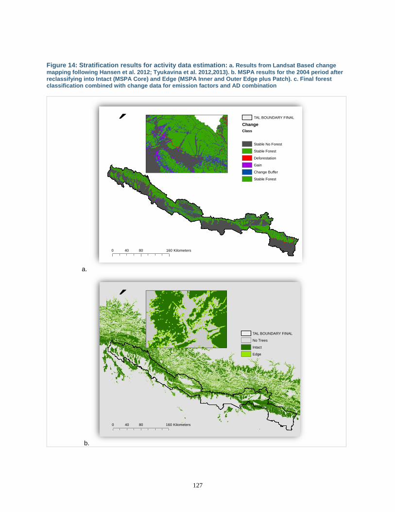
127
Figure 14: Stratification results for activity data estimation: a. Results from Landsat Based change
mapping following Hansen et al. 2012; Tyukavina et al. 2012,2013). b. MSPA results for the 2004 period after reclassifying into Intact (MSPA Core) and Edge (MSPA Inner and Outer Edge plus Patch). c. Final forest classification combined with change data for emission factors and AD combination
a.
b.
´
0 80 16040 Kilometers
TAL BOUNDARY FINAL
Change
Class
Stable No Forest
Stable Forest
Deforestation
Gain
Change Buffer
Stable Forest
´
0 80 16040 Kilometers
TAL BOUNDARY FINAL
No Trees
Intact
Edge
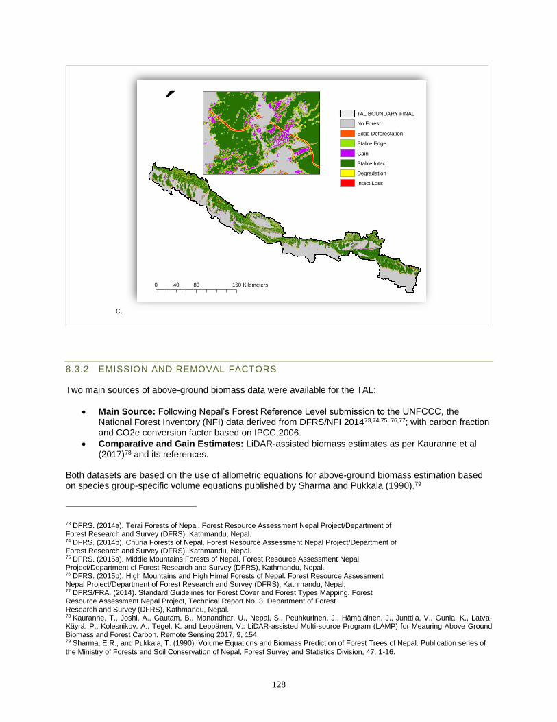
128
c.
8.3.2 EMISSION AND REMOVAL FACTORS Two main sources of above-ground biomass data were available for the TAL:
• Main Source: Following Nepal’s Forest Reference Level submission to the UNFCCC, the National Forest Inventory (NFI) data derived from DFRS/NFI 201473,74,75, 76,77; with carbon fraction and CO2e conversion factor based on IPCC,2006.
• Comparative and Gain Estimates: LiDAR-assisted biomass estimates as per Kauranne et al (2017)78 and its references.
Both datasets are based on the use of allometric equations for above-ground biomass estimation based on species group-specific volume equations published by Sharma and Pukkala (1990).79
73 DFRS. (2014a). Terai Forests of Nepal. Forest Resource Assessment Nepal Project/Department of Forest Research and Survey (DFRS), Kathmandu, Nepal. 74 DFRS. (2014b). Churia Forests of Nepal. Forest Resource Assessment Nepal Project/Department of Forest Research and Survey (DFRS), Kathmandu, Nepal. 75 DFRS. (2015a). Middle Mountains Forests of Nepal. Forest Resource Assessment Nepal Project/Department of Forest Research and Survey (DFRS), Kathmandu, Nepal. 76 DFRS. (2015b). High Mountains and High Himal Forests of Nepal. Forest Resource Assessment Nepal Project/Department of Forest Research and Survey (DFRS), Kathmandu, Nepal. 77 DFRS/FRA. (2014). Standard Guidelines for Forest Cover and Forest Types Mapping. Forest Resource Assessment Nepal Project, Technical Report No. 3. Department of Forest Research and Survey (DFRS), Kathmandu, Nepal. 78 Kauranne, T., Joshi, A., Gautam, B., Manandhar, U., Nepal, S., Peuhkurinen, J., Hämäläinen, J., Junttila, V., Gunia, K., Latva-Käyrä, P., Kolesnikov, A., Tegel, K. and Leppänen, V.: LiDAR-assisted Multi-source Program (LAMP) for Meauring Above Ground Biomass and Forest Carbon. Remote Sensing 2017, 9, 154. 79 Sharma, E.R., and Pukkala, T. (1990). Volume Equations and Biomass Prediction of Forest Trees of Nepal. Publication series of
the Ministry of Forests and Soil Conservation of Nepal, Forest Survey and Statistics Division, 47, 1-16.
´
0 80 16040 Kilometers
TAL BOUNDARY FINAL
No Forest
Edge Deforestation
Stable Edge
Gain
Stable Intact
Degradation
Intact Loss
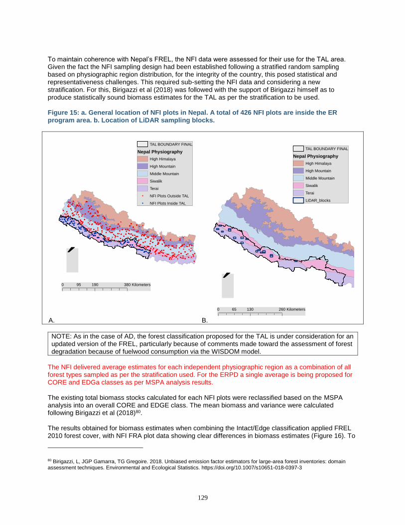
129
To maintain coherence with Nepal’s FREL, the NFI data were assessed for their use for the TAL area. Given the fact the NFI sampling design had been established following a stratified random sampling based on physiographic region distribution, for the integrity of the country, this posed statistical and representativeness challenges. This required sub-setting the NFI data and considering a new stratification. For this, Birigazzi et al (2018) was followed with the support of Birigazzi himself as to produce statistically sound biomass estimates for the TAL as per the stratification to be used. Figure 15: a. General location of NFI plots in Nepal. A total of 426 NFI plots are inside the ER program area. b. Location of LiDAR sampling blocks.
A. B.
NOTE: As in the case of AD, the forest classification proposed for the TAL is under consideration for an updated version of the FREL, particularly because of comments made toward the assessment of forest degradation because of fuelwood consumption via the WISDOM model.
The NFI delivered average estimates for each independent physiographic region as a combination of all forest types sampled as per the stratification used. For the ERPD a single average is being proposed for CORE and EDGa classes as per MSPA analysis results. The existing total biomass stocks calculated for each NFI plots were reclassified based on the MSPA analysis into an overall CORE and EDGE class. The mean biomass and variance were calculated following Birigazzi et al (2018)80. The results obtained for biomass estimates when combining the Intact/Edge classification applied FREL 2010 forest cover, with NFI FRA plot data showing clear differences in biomass estimates (Figure 16). To
80 Birigazzi, L, JGP Gamarra, TG Gregoire. 2018. Unbiased emission factor estimators for large-area forest inventories: domain assessment techniques. Environmental and Ecological Statistics. https://doi.org/10.1007/s10651-018-0397-3
´0 190 38095 Kilometers
TAL BOUNDARY FINAL
Nepal Physiography
High Himalaya
High Mountain
Middle Mountain
Siwalik
Terai
NFI Plots Outside TAL
NFI Plots Inside TAL
´0 130 26065 Kilometers
TAL BOUNDARY FINAL
Nepal Physiography
High Himalaya
High Mountain
Middle Mountain
Siwalik
Terai
LiDAR_blocks
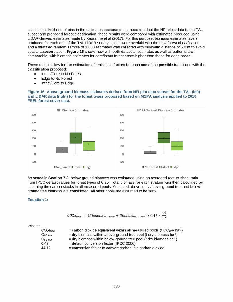
130
assess the likelihood of bias in the estimates because of the need to adapt the NFI plots data to the TAL subset and proposed forest classification, these results were compared with estimates produced using LiDAR-derived estimates made by Kauranne et al (2017): For this purpose, biomass estimates layers produced for each one of the TAL LiDAR survey blocks were overlaid with the new forest classification, and a stratified random sample of 1,000 estimates was collected with minimum distance of 500m to avoid spatial autocorrelation. Figure 16 shows how with both datasets, estimates as well as patterns are comparable, with biomass estimates for core/intact forest areas higher than those for edge areas. These results allow for the estimation of emissions factors for each one of the possible transitions with the classification proposed:
• Intact/Core to No Forest
• Edge to No Forest
• Intact/Core to Edge Figure 16: Above-ground biomass estimates derived from NFI plot data subset for the TAL (left) and LiDAR data (right) for the forest types proposed based on MSPA analysis applied to 2010 FREL forest cover data.
As stated in Section 7.2, below-ground biomass was estimated using an averaged root-to-shoot ratio from IPCC default values for forest types of 0.25. Total biomass for each stratum was then calculated by summing the carbon stocks in all measured pools. As stated above, only above-ground tree and below-ground tree biomass are considered. All other pools are assumed to be zero. Equation 1:
𝐶𝑂2𝑒𝑡𝑜𝑡𝑎𝑙 = (𝐵𝑖𝑜𝑚𝑎𝑠𝑠𝐴𝐺−𝑡𝑟𝑒𝑒 + 𝐵𝑖𝑜𝑚𝑎𝑠𝑠𝐵𝐺−𝑡𝑟𝑒𝑒) ∗ 0.47 ∗ 44
12
Where: CO2etotal = carbon dioxide equivalent within all measured pools (t CO2-e ha-1) CAG-tree = dry biomass within above-ground tree pool (t dry biomass ha-1) CBG-tree = dry biomass within below-ground tree pool (t dry biomass ha-1) 0.47 = default conversion factor (IPCC 2006) 44/12 = conversion factor to convert carbon into carbon dioxide

131
The average and standard deviation results obtained for biomass estimates were used as descriptors of frequency distributions that were resampled 10,000 times following a MonteCarlo approach. Emissions factors were generated for each sample. The final average emissions factors were the ones used for the reference level as well as for their uncertainty estimations. The resulting values are presented in the table below. The detailed estimation is available in the additional documentation available on-line in compliance with Criterion 6 of the Methodological Framework.
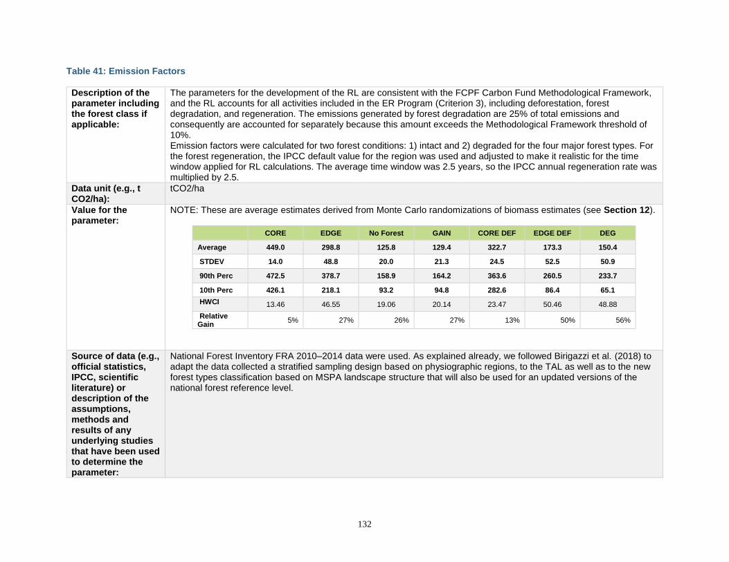
132
Table 41: Emission Factors
Description of the parameter including the forest class if applicable:
The parameters for the development of the RL are consistent with the FCPF Carbon Fund Methodological Framework, and the RL accounts for all activities included in the ER Program (Criterion 3), including deforestation, forest degradation, and regeneration. The emissions generated by forest degradation are 25% of total emissions and consequently are accounted for separately because this amount exceeds the Methodological Framework threshold of 10%. Emission factors were calculated for two forest conditions: 1) intact and 2) degraded for the four major forest types. For the forest regeneration, the IPCC default value for the region was used and adjusted to make it realistic for the time window applied for RL calculations. The average time window was 2.5 years, so the IPCC annual regeneration rate was multiplied by 2.5.
Data unit (e.g., t CO2/ha):
tCO2/ha
Value for the parameter:
NOTE: These are average estimates derived from Monte Carlo randomizations of biomass estimates (see Section 12).
CORE EDGE No Forest GAIN CORE DEF EDGE DEF DEG
Average 449.0 298.8 125.8 129.4 322.7 173.3 150.4
STDEV 14.0 48.8 20.0 21.3 24.5 52.5 50.9
90th Perc 472.5 378.7 158.9 164.2 363.6 260.5 233.7
10th Perc 426.1 218.1 93.2 94.8 282.6 86.4 65.1
HWCI 13.46 46.55 19.06 20.14 23.47 50.46 48.88
Relative Gain
5% 27% 26% 27% 13% 50% 56%
Source of data (e.g., official statistics, IPCC, scientific literature) or description of the assumptions, methods and results of any underlying studies that have been used to determine the parameter:
National Forest Inventory FRA 2010–2014 data were used. As explained already, we followed Birigazzi et al. (2018) to adapt the data collected a stratified sampling design based on physiographic regions, to the TAL as well as to the new forest types classification based on MSPA landscape structure that will also be used for an updated versions of the national forest reference level.
133
Spatial level (local, regional, national, or international):
Subnational level comprising 12 administrative districts of Nepal.
Discussion of key uncertainties for this parameter:
A full discussion of uncertainty is given in Section 12 below.
Estimation of accuracy, precision, and/or confidence level, as applicable and an explanation of assumptions/methodology in the estimation:
Accuracy, precision, and confidence intervals are provided in Section 12 below.
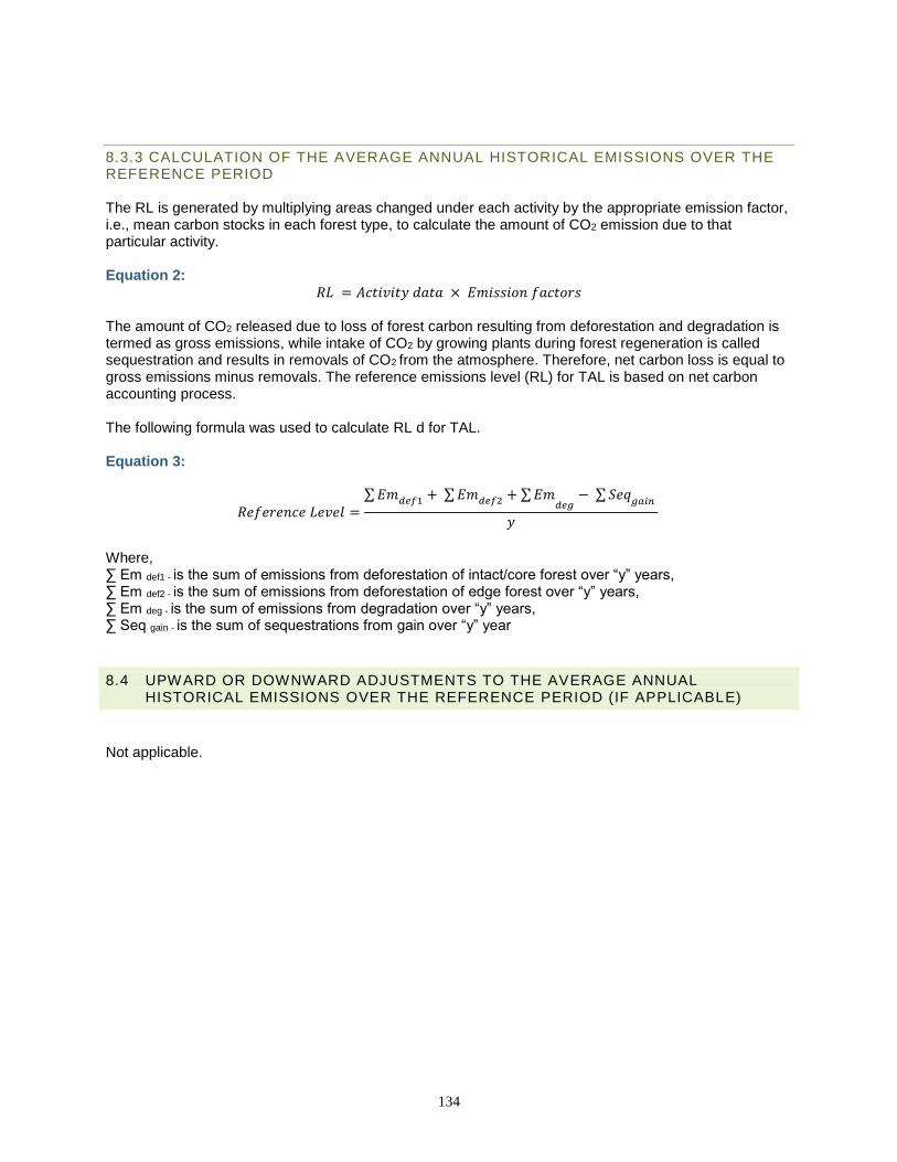
134
8.3.3 CALCULATION OF THE AVERAGE ANNUAL HISTORICAL EMISSIONS OVER THE REFERENCE PERIOD The RL is generated by multiplying areas changed under each activity by the appropriate emission factor, i.e., mean carbon stocks in each forest type, to calculate the amount of CO2 emission due to that particular activity. Equation 2:
𝑅𝐿 = 𝐴𝑐𝑡𝑖𝑣𝑖𝑡𝑦 𝑑𝑎𝑡𝑎 × 𝐸𝑚𝑖𝑠𝑠𝑖𝑜𝑛 𝑓𝑎𝑐𝑡𝑜𝑟𝑠 The amount of CO2 released due to loss of forest carbon resulting from deforestation and degradation is termed as gross emissions, while intake of CO2 by growing plants during forest regeneration is called sequestration and results in removals of CO2 from the atmosphere. Therefore, net carbon loss is equal to gross emissions minus removals. The reference emissions level (RL) for TAL is based on net carbon accounting process. The following formula was used to calculate RL d for TAL. Equation 3:
𝑅𝑒𝑓𝑒𝑟𝑒𝑛𝑐𝑒 𝐿𝑒𝑣𝑒𝑙 =∑𝐸𝑚𝑑𝑒𝑓1 + ∑𝐸𝑚𝑑𝑒𝑓2 + ∑𝐸𝑚
𝑑𝑒𝑔− ∑ 𝑆𝑒𝑞
𝑔𝑎𝑖𝑛
𝑦
Where, ∑ Em def1 - is the sum of emissions from deforestation of intact/core forest over “y” years, ∑ Em def2 - is the sum of emissions from deforestation of edge forest over “y” years, ∑ Em deg - is the sum of emissions from degradation over “y” years, ∑ Seq gain - is the sum of sequestrations from gain over “y” year
8.4 UPWARD OR DOWNWARD ADJUSTMENTS TO THE AVERAGE ANNUAL HISTORICAL EMISSIONS OVER THE REFERENCE PERIOD (IF APPLICABLE)
Not applicable.
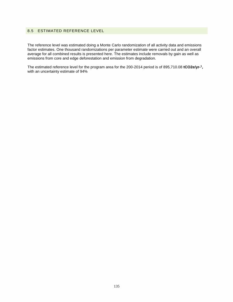
135
8.5 ESTIMATED REFERENCE LEVEL
The reference level was estimated doing a Monte Carlo randomization of all activity data and emissions factor estimates. One thousand randomizations per parameter estimate were carried out and an overall average for all combined results is presented here. The estimates include removals by gain as well as emissions from core and edge deforestation and emission from degradation. The estimated reference level for the program area for the 200-2014 period is of 895,710.08 tCO2e/yr-1, with an uncertainty estimate of 94%
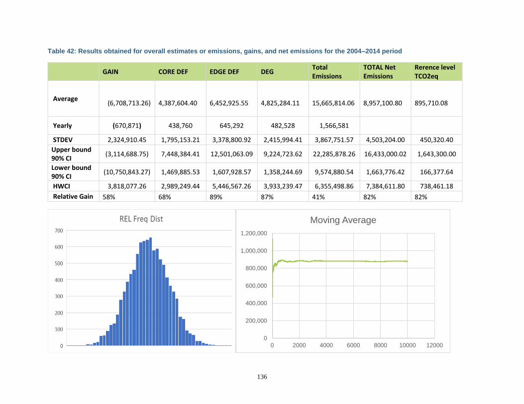
136
Table 42: Results obtained for overall estimates or emissions, gains, and net emissions for the 2004–2014 period
GAIN CORE DEF EDGE DEF DEG Total Emissions
TOTAL Net Emissions
Rerence level TCO2eq
Average (6,708,713.26)
4,387,604.40
6,452,925.55
4,825,284.11
15,665,814.06
8,957,100.80
895,710.08
Yearly (670,871) 438,760 645,292 482,528 1,566,581
STDEV 2,324,910.45 1,795,153.21 3,378,800.92 2,415,994.41 3,867,751.57 4,503,204.00 450,320.40
Upper bound 90% CI
(3,114,688.75) 7,448,384.41 12,501,063.09 9,224,723.62 22,285,878.26 16,433,000.02 1,643,300.00
Lower bound 90% CI
(10,750,843.27) 1,469,885.53 1,607,928.57 1,358,244.69 9,574,880.54 1,663,776.42 166,377.64
HWCI 3,818,077.26 2,989,249.44 5,446,567.26 3,933,239.47 6,355,498.86 7,384,611.80 738,461.18
Relative Gain 58% 68% 89% 87% 41% 82% 82%
0
200,000
400,000
600,000
800,000
1,000,000
1,200,000
0 2000 4000 6000 8000 10000 12000
Moving Average
137
8.6 RELATION BETWEEN THE REFERENCE LEVEL, THE DEVELOPMENT OF A FREL/FRL FOR THE UNFCCC, AND THE COUNTRY’S EXISTING OR EMERGING GREENHOUSE GAS INVENTORY
In January 2017, the Government of Nepal submitted its draft national RL to the UNFCCC. The Technical Assessment Report (TAR)81,82 was delivered to the UNFCCC and Nepal submitted an updated version to the UNFCCC. However, Nepal understands there is room for improvement in their FRL based on the comments received on its FRL as well as the corrective actions required by the ERPD reference level. Based on this, Nepal has decided to switch gears on carbon accounting for both the FRL and the ERPD and to fully align its carbon accounting for both UNFCCC and FCPF processes as well as base it completely on capacities Nepal already has or is in the process of consolidating. This will result in better coordination as well as better assimilation on the part of the DFRS, which will be the agency in charge of both ERPA MRV and UNFCCC BUR. The process for decision-making had the participation of relevant Nepalese agencies (DFRS and REDD-IC) as well as all the agencies that have been collaborating with Nepal’s carbon accounting. These included WWF, FAO, USFS Silva Carbon, UMD, the FCPF FMT, and others. It was agreed to capitalize on ongoing capacity-building processes aimed at building strengths in Nepal rather that count on external consultancies.
NOTE: At this point the TAR for the FRL as submitted by Nepal has not been made public. Nepal has decided to update its FRL based on the methods used for the ERPD reference level. The ERPD RL is being used as a pilot for the national FRL. This complies with the principles of the FCPF as stated on page 1 of the FCPF Methodological Framework.
The details of the new direction that was agreed include:
1. Activity data will be based on stratified random sampling with strata produced following ongoing capacity-building support DFRS has been acquiring from UMD with the support of the Silva Carbon Program from the US Forest Service.
2. Sample interpretation will follow standardized protocols based on protocols elaborated with UMD but adapted to country circumstances.
3. Data processing capacities will be complemented with south-south exchanges with countries like Colombia and Peru that have already capitalized on support from UMD and moved forward with their own approaches in a sustainable and independent manner.
4. Biomass estimates and emissions factors will be based on the national forest inventory currently led by DRFS and methods of which are familiar to them and are undergoing a second round of measurements. This will generate relevant data for, among others, validating degradation emissions factors as well as develop adequate removal factors for gain areas.
5. As required, additional plots will be set up for the MRV of the program. As a way forward, it was agreed Nepal would work on the concept for the updated version of the ERPD, and then work on an updated national FRL. This should happen after the ERPD has been presented to the CFPs.
81 MoFSC (2016) National Forest Reference Level of Nepal (2000 – 2010) http://redd.unfccc.int/files/nepal_frl_jan_8__2017.pdf. 82 http://unfccc.int/resource/docs/2017/tar/npl.pdf.
138
9 APPROACH FOR MEASUREMENT, MONITORING, AND REPORTING
9.1 MEASUREMENT, MONITORING, AND REPORTING APPROACH FOR ESTIMATING EMISSIONS OCCURRING UNDER THE ER PROGRAM WITHIN THE ACCOUNTING AREA
Based on the decisions taken for the update of the FRL as well as the ERPD reference level, the MMR for the program will follow suit and be fully aligned for both the FREL and the ER Program in the TAL. The TAL monitoring system will be fully aligned with the national forest monitoring system of Nepal and will be designed in coordination with the Ministry of Population and Environment (MoPE), MoFE, NRC, and DFRS. In line with Decision 11/CP.19, the monitoring system will provide data and information that are transparent, consistent over time, suitable for measuring, reporting and verifying anthropogenic forest-related emissions by sources, and removals by sinks, forest carbon stocks, and forest-area changes. The same methods used for the elaboration of this ERPD reference level will be used for program MRV. The rationale for this is that the MMR needs to assess the impact of the program as a whole and not as the sum of its components. It is also based on the assumption that all implementation actions will deliver a combined impact on drivers so that significant results are attained and detected. The system will also incorporate monitoring activities including but not limited to participatory monitoring in community forests aimed at supporting programmatic Monitoring and Evaluation (M&E), decision-making related to National REDD+ Strategy options and adaptive management, and will provide ancillary information to governmental organizations, NGOs, research institutions, other relevant institutions, and the general public. These activities will not constitute the MMR but will deliver relevant management insights. These will also include monitoring of drivers to assess their contribution and any changes in their relative importance over time as an important input toward adaptive management. The information produced by the MMR system for the TAL ER Program will be integrated into the National Forest Database (NFD) and National Forest Information System (NFIS) of the Government of Nepal and will be shared with relevant stakeholders. These systems will have web-based interfaces. Monitoring activities will include (please also see “Areas for Improvement”):
1. Yearly estimation of tree canopy cover as during the reference period based on UMD approach. It is expected the analyses will be calibrated for Nepal.
2. Tree cover change will inform directly both deforestation and degradation, as well as indirectly via MSPA analysis or remaining forest area and detected transitions.
3. DRFS will continue with the NFI re-measurement cycle with emphasis on the TAL. 4. Additionally, plots will be established to cover some of the information gaps observed during the
elaboration of the reference level:
a. Assessment of biomass accumulation in areas mapped as Forest Area Gain to better inform the sequestration rates and assign adequate estimates on a yearly basis; b. Mapping Community Forests and Collaborative Forests, both historical and new ones, to assess the overall impact of their designation on Deforestation and Forest degradation as well as in favoring Forest cover gain. c. Assessment of biomass change or lack thereof in areas of influence of mitigation actions like community forests, biogas/cook-stoves units, sustainable forest management (This will more for programmatic management than for actual reporting as these data will be difficult to link with the land based accounting to be used for MRV).
139
5. Burned areas mapping will be conducted on a periodic basis if needed based on the methods
used for the improvement of the reference level between ERPD and ERPA (if emissions result to be significant and incorporated into the ERPA FREL).
As part of the implementation of some of the mitigation actions, local communities will be involved in the measuring and monitoring activities, in collecting forest-level information, and socio-environmental baseline data for the Safeguard Information System (SIS). Forest-level data collection is already a central component of DFO and CFUG activities, and local communities and IPs will work closely with the monitoring of forests during the ER Program through community-based forest monitoring. This will strengthen and enhance the engagement of local communities and IPs in the monitoring of forest carbon stocks on the ground. In addition, the ER Program will incorporate non-carbon indicators developed in national stakeholder processes and apply them in the ER Program Area where possible, to assess the improvement of other benefits in the ER Program. Additionally, the agencies involved in the monitoring of mitigation activities that will be complemented/enhanced by the ER Program will continue to perform their duties and their protocols/accounting frameworks will be maintained as to not generate discrepancies.
NOTE: It is important to underline the fact that specific action accounting will not directly inform overall accounting reporting. The reported numbers will come as in the case of the reference level, from the land-based accounting. Partial intervention numbers will be used as an administrative tool to inform benefit sharing and strategic management of the program. However, in cases where accounting is linked to benefits that could result in double accounting, such performances will be discounted from the overall performance reporting as to avoid duplication.
Activity Data and Emission Factors The FRL uses spatially explicit activity data (IPCC Approach 3) and forest strata level emission factors (Tier 3) within the TAL. As explained above, activity data will be produced following the same methods as for the reference level. The main parameters to be measured for activity data are tree cover loss/gain. Forest land will be further subdivided as per the RL methodology based on the MSPA analysis into Core/Intact and Edge. The classes to be mapped will be the same as in the reference level, and randomized samples will be generated for unbiased area estimates to be produced with accompanying confidence intervals.
Parameter: Deforestation, Degradation, and Gain, Stable Forest, Stable Non-forest
Description:
Data unit: Hectares
Source of data or measurement/calculation methods and procedures to be applied (e.g., field measurements, remote sensing data, national data, official statistics, IPCC Guidelines, commercial and scientific literature), including the spatial level of the data (local, regional, national, international) and if and how the data or methods will be approved during the term of the ERPA:
Landsat satellite data following Hansen et al. (2012)
Frequency of monitoring/recording: 2 years
Monitoring equipment: Relevant software with Internet access, using adequate computers. The details may change as
140
Nepal consolidates its capacities in exchanges with other countries like Colombia and Peru.
Quality Assurance/Quality Control procedures to be applied:
QA/QC for field measurements: Rigorous and detailed standard operating procedures will be further developed for all steps to ensure consistency and comparability. Once standard operating procedures have been developed, DFRS personnel will be fully trained in all aspects of data collection, including ensuring the accuracy of data. A program for auditing data interpretation, measurement, and sampling will be established. It will include three types of checks: hot, cold-blind, and blind: Hot checks are where auditors observe members of the team while collecting data on samples or plots. This type of check is primarily for training purposes and allows for the correction of errors in techniques. Cold-blind checks, in contrast, are those which are conducted when several team members are assigned the same samples. Blind checks include the complete re-assessment of a sample/plot to establish measurement variance. Blind checks should be conducted on about 10% of samples/plots and the resultant data compared with the original data. Any errors detected should be corrected, and measurement error should be estimated by expressing the number of errors as a percentage of the total number of plots rechecked. QA/QC for data entry: For activity data, sample assessment will be the aspect for which more attention will be assigned. This is because we now know that even though a good map helps in lowering uncertainty, most of the errors can come from the way sample interpretation occurs. As standard practice, a subset (10%) will be run by an odd number of interpreters. The implications of the number of interpreters and how this is related with bias has been modeled (e.g., McRoberts et al in process) but no methodological guidance exists still about best practices for sample interpretation protocols and QA/QC. This is why Nepal is committed with keeping up to date with the progress of know-how on this matter as per, e.g., the GFOI methodological guidance as well as related fora. Regular communication among all personnel involved in measuring and analyzing data (including other countries) will be maintained as critical to help
141
resolve anomalies before the final analysis is completed. QA/QC for data archiving: Because of the relatively long-term nature of MMR activities, data archiving and storage is important. The following three steps should be adhered to:
● The original laboratory data and field measurements, whether data sheets or electronic files, should be maintained in their original form and stored in a secure location.
● Copies of all data analyses, models, final estimates, GIS products, and measuring and monitoring reports should all be stored in a secure, preferably offsite location.
● All relevant metadata will be collected and stored.
● Taking into consideration how fast data are produced and when reporting periods fall, software and hardware for storing material should be periodically updated in a format that can be accessed by whatever new or updated software or hardware is currently in use.
Identification of sources of uncertainty for this parameter:
See Section 12.1 below.
Process for managing and reducing uncertainty associated with this parameter:
See Section 12.1 below.
Any comment:
Areas for improvement: Nepal understands that at present there is considerable room for improvement of both its ER Program reference level and the MMR system and process. As such, Nepal is already considering working in the upcoming months to years on the following areas of improvement:
1. Allometric equations assessment: Nepal understands that the equations used in both the FREL and this ERPD may be over-estimating biomass because of their development being made based on air-dried as opposed to oven-dried biomass. A comparison of estimates with other alternative equations like those of Chave et al, 2015 will be carried out.
2. Biomass estimates: Given the fact an alternative stratification has been proposed for the ERPD, the NFI plot samples will likely need to be complemented. This is particularly the case for the Stable Edge, but also could be relevant to the Stable Core and areas mapped as changing from Edge to Core because of area gain and if enhancement in these areas are to be estimated. . Therefore, an additional number of plots will likely be measured.
3. Gain removal factors: At present biomass removal factors are estimated based on LiDAR data. Nepal will collect data from an adequate number of plots to estimate, via pseudo-time series, the rate of biomass sequestration from forest gain areas as a function of age. This will help Nepal better estimate removal rates from gain areas.
4. Enhancements in forests remaining forests: The MSPA analysis enables identification of areas that may change from an Edge to a Core/Intact classification due to their new location, given new areas of gain. As such, it is expected those areas will see an enhancement of their biomass. Nepal will consider sampling these areas to estimate such rates of enhancement and to be able to incorporate such activity, if significant, in the future. Assessment of the biomass in these areas, on
142
a pseudo time series basis based on age of gain (based on the tree canopy cover data time series generated with UMD support) will be considered as to possibly inform better the enhacement of carbon stocks in these areas during the reference period as well as during MRV.
5. Fires: Nepal will be collecting data to estimate area burned to better inform the estimates of emissions from fire and better determine if those are significant or not.
6. Sample size for activity data estimates: Based on the results obtained so far, Nepal will re-assess the number of samples per stratum to be used and evaluate the additional samples.
7. Activity data sample assessment: Based on the experience obtained assessing their samples, Nepal will further elaborate its sample assessment protocols to standardize the process and remove bias.
8. Activity data stratification: Nepal will work with UMD to calibrate the Tree Canopy Cover estimates to the Nepalese reality, based on the samples assessed for both the ERPD and their ongoing collaboration and re-estimate the strata for the activity data sampling design.
9.2 ORGANIZATIONAL STRUCTURE FOR MEASUREMENT, MONITORING, AND REPORTING
A four-tiered institutional structure of national, state, sub-state, and local/community levels is proposed for Nepal’s MRV system. At the national level, there will be two structures responsible for the monitoring and MRV function (see Figure 17):
1) Forest Survey and Carbon Measurement Division (FSCMD) in the Department of Forest Research and Survey (DFRS), and
2) Carbon Accounting, Monitoring and Reporting Coordination Section (CAMRCS) in the National REDD+ Centre (NRC).
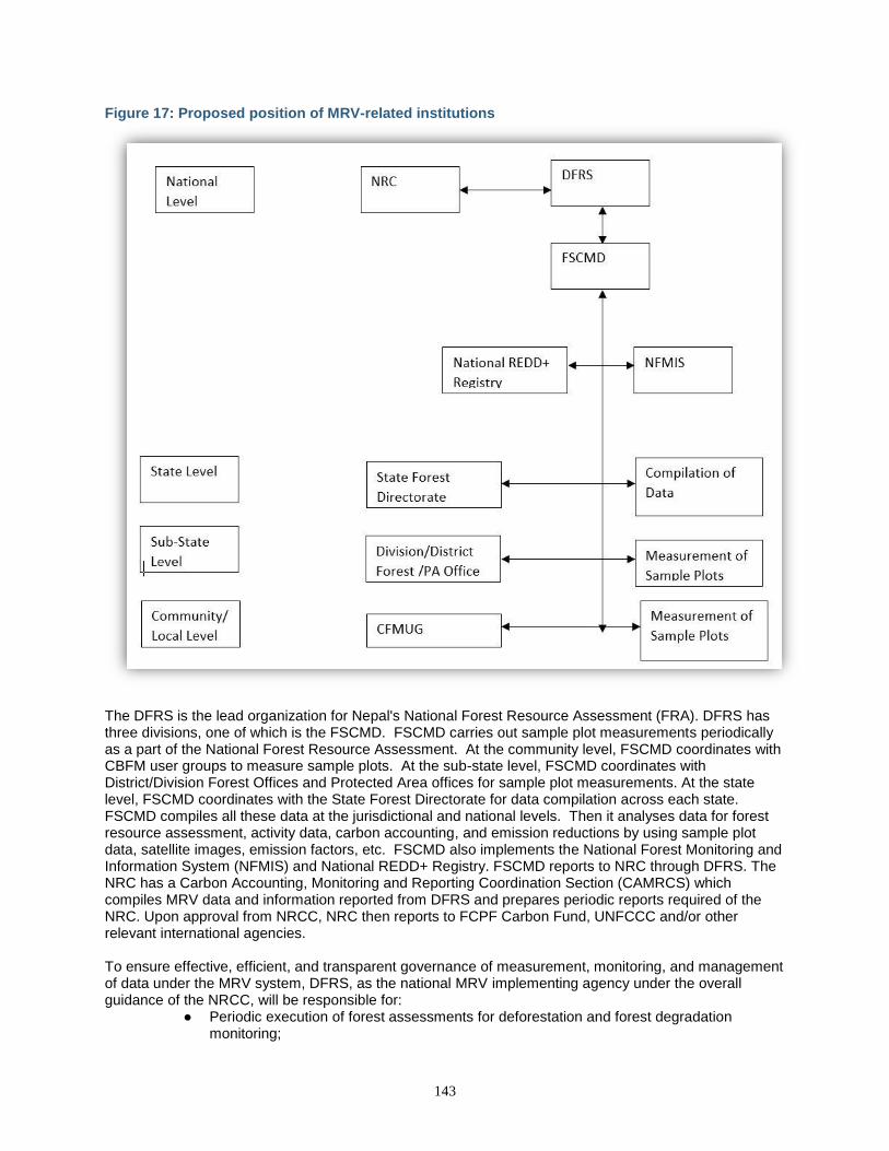
143
Figure 17: Proposed position of MRV-related institutions
The DFRS is the lead organization for Nepal's National Forest Resource Assessment (FRA). DFRS has three divisions, one of which is the FSCMD. FSCMD carries out sample plot measurements periodically as a part of the National Forest Resource Assessment. At the community level, FSCMD coordinates with CBFM user groups to measure sample plots. At the sub-state level, FSCMD coordinates with District/Division Forest Offices and Protected Area offices for sample plot measurements. At the state level, FSCMD coordinates with the State Forest Directorate for data compilation across each state. FSCMD compiles all these data at the jurisdictional and national levels. Then it analyses data for forest resource assessment, activity data, carbon accounting, and emission reductions by using sample plot data, satellite images, emission factors, etc. FSCMD also implements the National Forest Monitoring and Information System (NFMIS) and National REDD+ Registry. FSCMD reports to NRC through DFRS. The NRC has a Carbon Accounting, Monitoring and Reporting Coordination Section (CAMRCS) which compiles MRV data and information reported from DFRS and prepares periodic reports required of the NRC. Upon approval from NRCC, NRC then reports to FCPF Carbon Fund, UNFCCC and/or other relevant international agencies. To ensure effective, efficient, and transparent governance of measurement, monitoring, and management of data under the MRV system, DFRS, as the national MRV implementing agency under the overall guidance of the NRCC, will be responsible for:
● Periodic execution of forest assessments for deforestation and forest degradation monitoring;
144
● Designing, maintaining, and operating the National Forest Monitoring System (NFMS); ● Coordinating the collection of subnational-level information, including to avoid double
counting of emissions by allocating each district to a single subnational-level area only; ● Disseminating NFMS deliverables through a national web portal; ● Providing technical guidance and institutional/capacity support to the parallel institutional
setups at subnational/district/local community levels; ● Operating the National REDD+ registry, once established.
DFRS hosts many capable forest professionals to manage the national forest monitoring system. It recently successfully completed the national FRA between 2011 and 2015, including the associated campaign that captured LiDAR data for TAL. DFRS also already started a step-wise periodic forest inventory in the Terai and Siwalik physiographic zones. Some development and training in satellite data interpretation and REDD+ information systems will build additional capacities for staff who will conduct the relevant MRV tasks.
9.3 RELATION AND CONSISTENCY WITH THE NATIONAL FOREST MONITORING SYSTEM
The MMR system for the TAL ER Program will be the same as for the FRL BURs. Basically, reported numbers for the ER Program will constitute a subset of national reporting by the National Forest Database (NFD) and National Forest Information System (NFIS) of the Government of Nepal and will be shared with relevant stakeholders. The design of the monitoring system of carbon is built on the activities conducted under the FRA project, and the work already carried out for Terai Arc Landscape (TAL) and Nepal’s NFD and NFIS. The design of a monitoring system is closely linked with the technical approach for assessing emissions and removals, since the system will be designed to monitor carbon stock changes over time. It is based on an integrated method using remote sensing data and periodic ground measurements throughout all major forest types in Nepal.
145
10 DISPLACEMENT
10.1 IDENTIFICATION OF RISK OF DISPLACEMENT
This section discusses the risk of displacement/leakage, i.e., the increase of emissions outside the Program Area due to program activities. The table below provides an analysis of the main drivers of deforestation and forest degradation identified in Section 4.1 and the risk of displacement along with a corresponding justification for the assessment.
Driver of
deforestation or
degradation
Risk of
displacement
(Categorize as
high, medium
or low)
Explanation / justification of risk assessment
DEFORESTATION
Encroachment Low Migration within Nepal has historically occurred from north to south, with communities from the hills moving to the Terai in search of livelihoods from agriculture and lucrative timber opportunities. This has resulted in a steady encroachment on forestland and a conversion of forests to settlements and agricultural land. The reverse has not been the case in Nepal, and in fact, today, out-migration is more common with Nepali men seeking labor opportunities in the Middle East in construction and infrastructure development. There is therefore a very low risk of displacement due to reductions in encroachment to other areas of Nepal. In addition, the trend in encroachment has been in steady decline and is expected to continue declining in coming years.
Infrastructure
development
Low Infrastructure planning is typically designed to serve a given area, e.g., a road, airport, or school, and is therefore not at risk of displacement outside the ER Program Area. Where changes to designs do occur (e.g., moving the railway outside the Chitwan National Park), they are still within the same district boundary and within the ER Program accounting area. There is therefore minimal risk of displacement due to infrastructure development displacement.
Resettlement Low Resettlement differs from encroachment insofar as it is planned. When resettlement plans are being formulated, for example, due to infrastructure development, national services (e.g., army, police), or the declaration of conservation areas/national parks, the resettlements are made in areas that are in the same locality or around the same area so that people do not lose their culture, traditional customs, and identity. Resettlements are therefore confined within districts and in general do not occur across districts. Resettlement plans that extend far and wide across the country are rare except for cases when the institutional setups are moved, hence the risk of displacement due to resettlement is low.
FOREST DEGRADATION
146
Timber Extraction
(Unsustainable/
Illegal)
Medium The demand for timber in Nepal and the Terai far exceeds the current sustainable supply of timber. Timber trade in Nepal includes both inter-district and cross-border flows, with much of Nepal’s domestic demand being met through international sources or from domestic, illegal supply. Post-earthquake recovery is expected to sustain the high demand for construction timber through the lifetime of the ER Program. Curbing illegal timber extraction in the TAL could therefore cause additional pressure on forests outside the project area or promote illegal timber extraction within the project boundary. Counterbalancing this is the often-local nature of timber extraction in the Terai to serve the needs of local districts and communities. We have therefore ranked the risk of displacement of timber extraction as medium.
Fuelwood
extraction
Low Fuelwood in the Terai is almost exclusively extracted from within the vicinity of wood fuel users and therefore minimizes the risk of displacement. Some displacements could occur, particularly in district border areas, but is expected to be minimal and is therefore ranked as low.
Overgrazing Low Grazing also typically occurs within the vicinity of villages. However, cattle from the lowlands will not go as far as the highlands to graze thus rendering the fact that the displacement from overgrazing can be ranked as low. Nevertheless, some displacements could occur partially in border areas but will be very few.
Forest fire Low The chances of displacement due to forest fire cannot occur, as forest fires in Nepal, unlike in many parts of the world, are generally started by people. Therefore, the displacement from forest fires is estimated to be very low.
10.2 ER PROGRAM DESIGN FEATURES TO PREVENT AND MINIMIZE POTENTIAL DISPLACEMENT
The primary risk of displacement identified above is the risk of displacement due to unsustainable and illegal extraction of timber outside the ER Program Area. To minimize this risk, the ER Program primarily proposes to increase the supply of timber from the ER Program Area. Over time, this is expected to narrow the supply/demand deficit and minimize the risk of illegal supply outside the ER Program Area. In addition, the handover of government-managed forests to CBFM engages indigenous, local, and marginalized communities to build their respective capacities to sustainably manage forests, thereby minimizing the risk of leakage within the project boundary. Similarly, the program also proposes to enhance access to renewable energy technologies such as biogas and ICS to minimize the dependency on fuelwood and increase the production of timber from forests. Regarding cross-border and international leakage, since Nepal and India have an open border, cross-border issues such as illegal timber trade, wildlife trade, poaching, and cross-border grazing are an issue. To address these issues, there has been a mechanism in place to hold annual bilateral meetings on transboundary biodiversity conservation between Nepal and India since 2010. Similarly, Nepal and China have signed a Memorandum of Understanding (MoU) for transboundary biodiversity conservation. Nepal also has a regional project financed by the World Bank to improve the effectiveness of wildlife and habitat conservation across Bangladesh, Bhutan, India, and Nepal. As part of ER implementation, the MoFE will collaborate with the Government of India to develop a mutual understanding addressing potential cross-
147
border issues. Through improved forest law enforcement governance and trade (FLEGT) and trans-boundary coordination, international leakage will be mitigated.
11 REVERSALS
11.1 IDENTIFICATION OF RISK OF REVERSALS
During the ER-PD development phase, the NRC and ER-PD development team identified the following anthropogenic and natural risks of reversals. These risks are analyzed in Table 43 below. Overall the risk due to reversals is estimated to be 11%.
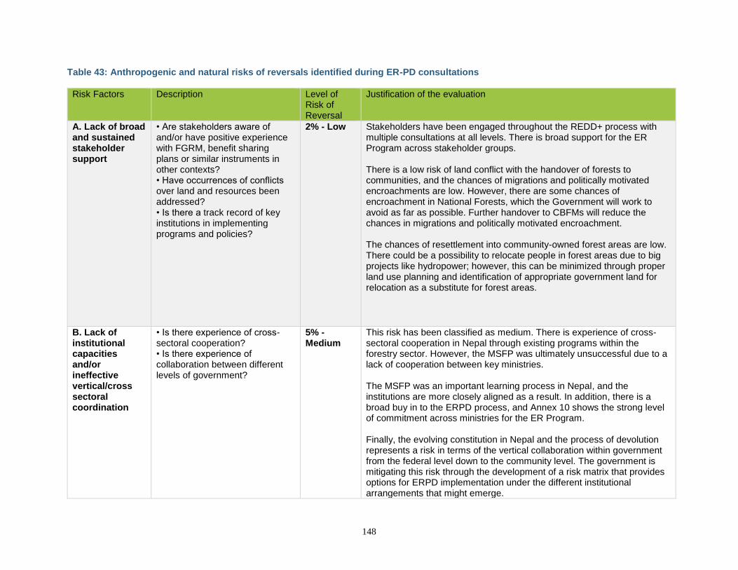
148
Table 43: Anthropogenic and natural risks of reversals identified during ER-PD consultations
Risk Factors Description Level of Risk of Reversal
Justification of the evaluation
A. Lack of broad and sustained stakeholder support
• Are stakeholders aware of and/or have positive experience with FGRM, benefit sharing plans or similar instruments in other contexts? • Have occurrences of conflicts over land and resources been addressed? • Is there a track record of key institutions in implementing programs and policies?
2% - Low Stakeholders have been engaged throughout the REDD+ process with multiple consultations at all levels. There is broad support for the ER Program across stakeholder groups. There is a low risk of land conflict with the handover of forests to communities, and the chances of migrations and politically motivated encroachments are low. However, there are some chances of encroachment in National Forests, which the Government will work to avoid as far as possible. Further handover to CBFMs will reduce the chances in migrations and politically motivated encroachment. The chances of resettlement into community-owned forest areas are low. There could be a possibility to relocate people in forest areas due to big projects like hydropower; however, this can be minimized through proper land use planning and identification of appropriate government land for relocation as a substitute for forest areas.
B. Lack of institutional capacities and/or ineffective vertical/cross sectoral coordination
• Is there experience of cross-sectoral cooperation? • Is there experience of collaboration between different levels of government?
5% - Medium
This risk has been classified as medium. There is experience of cross-sectoral cooperation in Nepal through existing programs within the forestry sector. However, the MSFP was ultimately unsuccessful due to a lack of cooperation between key ministries. The MSFP was an important learning process in Nepal, and the institutions are more closely aligned as a result. In addition, there is a broad buy in to the ERPD process, and Annex 10 shows the strong level of commitment across ministries for the ER Program. Finally, the evolving constitution in Nepal and the process of devolution represents a risk in terms of the vertical collaboration within government from the federal level down to the community level. The government is mitigating this risk through the development of a risk matrix that provides options for ERPD implementation under the different institutional arrangements that might emerge.
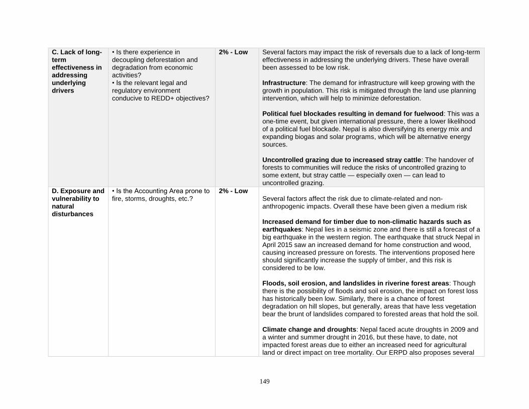
149
C. Lack of long-term effectiveness in addressing underlying drivers
• Is there experience in decoupling deforestation and degradation from economic activities? • Is the relevant legal and regulatory environment conducive to REDD+ objectives?
2% - Low Several factors may impact the risk of reversals due to a lack of long-term effectiveness in addressing the underlying drivers. These have overall been assessed to be low risk. Infrastructure: The demand for infrastructure will keep growing with the growth in population. This risk is mitigated through the land use planning intervention, which will help to minimize deforestation. Political fuel blockades resulting in demand for fuelwood: This was a one-time event, but given international pressure, there a lower likelihood of a political fuel blockade. Nepal is also diversifying its energy mix and expanding biogas and solar programs, which will be alternative energy sources. Uncontrolled grazing due to increased stray cattle: The handover of forests to communities will reduce the risks of uncontrolled grazing to some extent, but stray cattle — especially oxen — can lead to uncontrolled grazing.
D. Exposure and vulnerability to natural disturbances
• Is the Accounting Area prone to fire, storms, droughts, etc.?
2% - Low Several factors affect the risk due to climate-related and non-anthropogenic impacts. Overall these have been given a medium risk Increased demand for timber due to non-climatic hazards such as earthquakes: Nepal lies in a seismic zone and there is still a forecast of a big earthquake in the western region. The earthquake that struck Nepal in April 2015 saw an increased demand for home construction and wood, causing increased pressure on forests. The interventions proposed here should significantly increase the supply of timber, and this risk is considered to be low. Floods, soil erosion, and landslides in riverine forest areas: Though there is the possibility of floods and soil erosion, the impact on forest loss has historically been low. Similarly, there is a chance of forest degradation on hill slopes, but generally, areas that have less vegetation bear the brunt of landslides compared to forested areas that hold the soil. Climate change and droughts: Nepal faced acute droughts in 2009 and a winter and summer drought in 2016, but these have, to date, not impacted forest areas due to either an increased need for agricultural land or direct impact on tree mortality. Our ERPD also proposes several
150
interventions to increase understanding of climate vulnerability and to address climate change impacts through improved tree species selection.

151
11.2 ER PROGRAM DESIGN FEATURES TO PREVENT AND MITIGATE REVERSALS
The ER program in the TAL is viewed as a long-term commitment with a foundation in CBFM and equitable sharing of benefits. With this strong local ownership of forest management, the risks of anthropogenic reversals within Nepal are significantly mitigated. The history of CBFM in Nepal has demonstrated that the benefits are long-lasting once these local models are in place. The following proposed actions are aimed at limiting the risk of reversals in the ER Program Area. Improved land use planning and cross sectoral dialogue: To prevent and mitigate the risk of reversal through resettlement and infrastructure development the ER Program includes a cross-cutting component of land use planning in all the districts that will map, zone, and develop appropriate land use plans across the TAL. The land use plans will also identify appropriate sites that could be a result of mitigation measures as identified for infrastructure projects. The land use plans will also map and zone potential areas for resettlement and or new institutional setups in the districts as appropriate so as to have minimum impact on the forest areas, thus reducing the risk of reversal due to ad-hoc resettlement plans and new institutional setups in the districts. Cross sectoral dialogue with local government agencies and political leaders on a regular basis to implement the land use plans will help minimize the risk of reversal of in-migrations and politically motivated encroachment. Addressing the supply/demand deficit: The supply/demand deficit in the timber market within Nepal has resulted in most timber being consumed within Nepal with no significant export market other than illegal sales to India. The silvicultural interventions in the ER Program Area will result in increases in both carbon stocks and timber supply, reducing pressures on the forest. Similarly, enhancing access to renewable energy technologies for cooking while substantially reducing dependence on fossil fuels and fuelwood for cooking and heating will reduce the risk of reversal due to political fuel blockades, resulting in reduced forest degradation. Improved forest stewardship and awareness raising: A central component of the TAL ER Program is the training in improved sustainable forest management techniques, including training on forest fire fighting techniques, awareness-raising programs, and planting of more climate-resilient tree species. This is expected to minimize the risk of reversals due to forest fires, or increased tree mortality in a changing climate. Improved sustainable management of forest techniques and handover of national forest to community-based forest management regimes will also minimize stray cattle in forest areas. In addition to this the enhanced coordination with the District Livestock Offices for improved varieties of cattle and improving cattle management will reduce the risk of forest degradation due to excess uncontrolled grazing. Non-anthropogenic reversals are harder to mitigate. The Government of Nepal is very conscious of some of these issues, however, and is taking measures to prevent further impact due to natural hazards. For example, the design of houses, schools, and buildings in the central, regional, and local areas has taken into account future risks of earthquake (and potential impact on the timber market for reconstruction of houses). In addition, the District Development Committee’s funds for disaster risk reduction and, plantation programs will minimize the risk of floods, soil erosion, and landslides. The TAL contains the most productive forests in Nepal so managing this area will result in the stewardship of the most significant forest resources in the country without significant risk of displacing deforestation and forest degradation to other areas of Nepal.
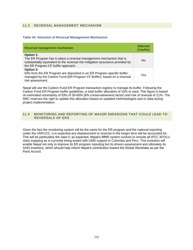
152
11.3 REVERSAL MANAGEMENT MECHANISM
Table 44: Selection of Reversal Management Mechanism
Reversal management mechanism Selected (Yes/No)
Option 1: The ER Program has in place a reversal management mechanism that is substantially equivalent to the reversal risk mitigation assurance provided by the ER Program CF buffer approach.
No
Option 2: ERs from the ER Program are deposited in an ER Program-specific buffer, managed by the Carbon Fund (ER Program CF Buffer), based on a reversal risk assessment.
Yes
Nepal will use the Carbon Fund ER Program transaction registry to manage its buffer. Following the Carbon Fund ER Program buffer guidelines, a total buffer allocation of 19% is used. This figure is based on estimated uncertainty of ERs of 30-60% (8% conservativeness factor) and risk of reversal of 11%. The NRC reserves the right to update this allocation based on updated methodologies and or data during project implementation.
11.4 MONITORING AND REPORTING OF MAJOR EMISSIONS THAT COULD LEAD TO REVERSALS OF ERS
Given the fact the monitoring system will be the same for the ER program and the national reporting under the UNFCCC, it is expected any displacement or reversal in the longer term will be accounted for. This will be particularly the case if, as expected, Nepal’s MMR system evolves to include all IPCC AFOLU class mapping as is currently being tested with UMD support in Colombia and Peru. This evolution will enable Nepal not only to improve its ER program reporting but its drivers assessment and ultimately its GHG inventory, which should help inform Nepal’s contribution toward the Global Stocktake as per the Paris Accord.
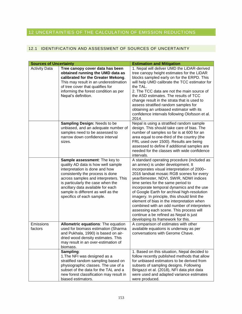
153
12 UNCERTAINTIES OF THE CALCULATION OF EMISSION REDUCTIONS
12.1 IDENTIFICATION AND ASSESSMENT OF SOURCES OF UNCERTAINTY
Sources of Uncertainty Estimation and Mitigation
Activity Data Tree canopy cover data has been obtained running the UMD data as calibrated for the Greater Mekong. This may result in an underestimation of tree cover that qualifies for informing the forest condition as per Nepal’s definition.
1. Nepal will deliver UMD the LiDAR-derived tree canopy height estimates for the LiDAR blocks sampled early on for the ERPD. This will help UMD calibrate the TCC estimator for the TAL. 2. The TCC data are not the main source of the ASD estimates. The results of TCC change result in the strata that is used to assess stratified random samples for obtaining an unbiased estimator with its confidence intervals following Olofsson et al. 2014.
Sampling Design: Needs to be unbiased, and an adequate number of samples need to be assessed to narrow down confidence interval sizes.
Nepal is using a stratified random sample design. This should take care of bias. The number of samples so far is at 600 for an area equal to one-third of the country (the FRL used over 1500). Results are being assessed to define if additional samples are needed for the classes with wide confidence intervals.
Sample assessment: The key to quality AD data is how well sample interpretation is done and how consistently the process is done across samples and interpreters. This is particularly the case when the ancillary data available for each sample is different as well as the specifics of each sample.
A standard operating procedure (included as an annex) is under development. It incorporates visual interpretation of 2000–2016 landsat mosaic RGB scenes for every year/bimester, NDVI, SWIR, NDWI indices time series for the same period to incorporate temporal dynamics and the use of Google Earth for archival high-resolution imagery. In principle, this should limit the element of bias in the interpretation when combined with an odd number of interpreters assessing each scene. This process will continue a be refined as Nepal is just developing its framework for this.
Emissions factors
Allometric equations: The equation used for biomass estimation (Sharma and Pukhala, 1990) is based on air-dried wood density estimates. This may result in an over-estimation of biomass.
A comparison of estimates with other available equations is underway as per conversations with Gerome Chave.
Sampling: 1.The NFI was designed as a stratified random sampling based on physiographic classes. The use of a subset of the data for the TAL and a new forest classification may result in biased estimators.
1. Based on this situation, Nepal decided to follow recently published methods that allow for unbiased estimators to be derived from subsets of sampling designs. Following Birigazzi et al. (2018), NFI data plot data were used and adapted variance estimates were produced.
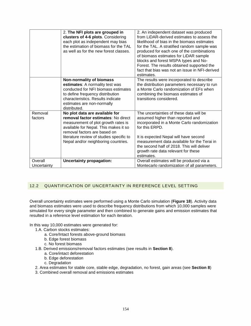
154
2. The NFI plots are grouped in clusters of 4-6 plots. Considering each plot as independent may bias the estimation of biomass for the TAL as well as for the new forest classes.
2. An independent dataset was produced from LiDAR-derived estimates to assess the likelihood of bias in the biomass estimates for the TAL. A stratified random sample was produced for each one of the combinations of biomass estimates for LiDAR sample blocks and forest MSPA types and No-Forest. The results obtained supported the fact that bias was not an issue in NFI-derived estimates.
Non-normality of biomass estimates: A normality test was conducted for NFI biomass estimates to define frequency distribution characteristics. Results indicate estimates are non-normally distributed.
The results were incorporated to describe the distribution parameters necessary to run a Monte Carlo randomization of EFs when combining the biomass estimates of transitions considered.
Removal factors
No plot data are available for removal factor estimates: No direct measurement of plot growth rates is available for Nepal. This makes it so removal factors are based on literature review of studies specific to Nepal and/or neighboring countries.
The uncertainties of these data will be assumed higher than reported and incorporated in a Monte Carlo randomization for this ERPD. It is expected Nepal will have second measurement data available for the Terai in the second half of 2018. This will deliver growth rate data relevant for these estimates.
Overall Uncertainty
Uncertainty propagation: Overall estimates will be produced via a Montecarlo randomization of all parameters.
12.2 QUANTIFICATION OF UNCERTAINTY IN REFERENCE LEVEL SETTING
Overall uncertainty estimates were performed using a Monte Carlo simulation (Figure 18). Activity data and biomass estimates were used to describe frequency distributions from which 10,000 samples were simulated for every single parameter and then combined to generate gains and emission estimates that resulted in a reference level estimation for each iteration. In this way 10,000 estimates were generated for:
1.A. Carbon stocks estimates: a. Core/Intact forests above-ground biomass b. Edge forest biomass c. No forest biomass
1.B. Derived emissions/removal factors estimates (see results in Section 8). a. Core/intact deforestation b. Edge deforestation c. Degradation
2. Area estimates for stable core, stable edge, degradation, no forest, gain areas (see Section 8) 3. Combined overall removal and emissions estimates
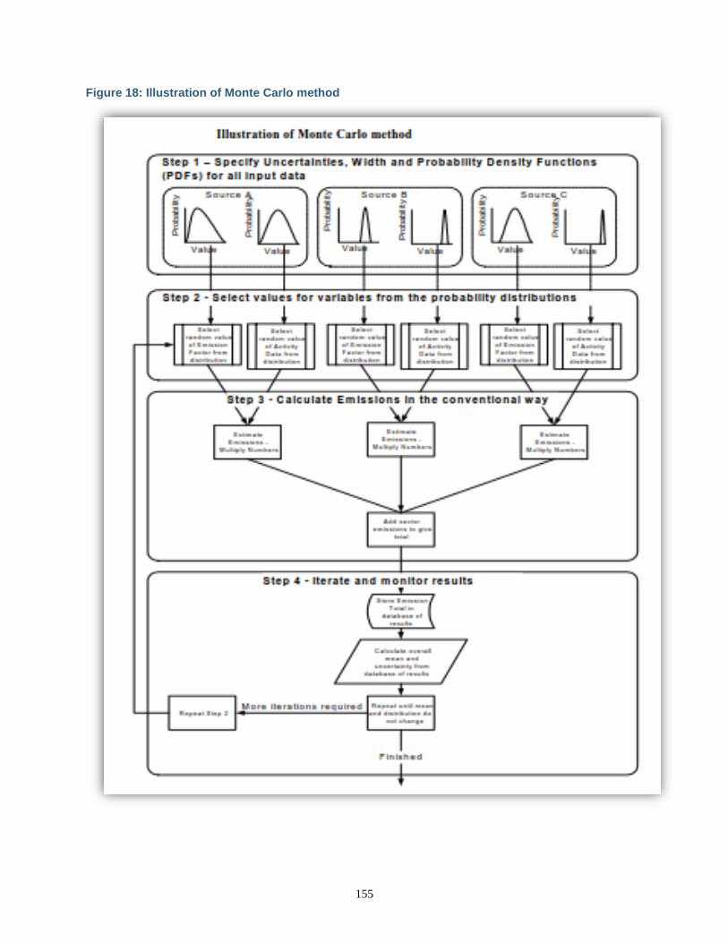
155
Figure 18: Illustration of Monte Carlo method
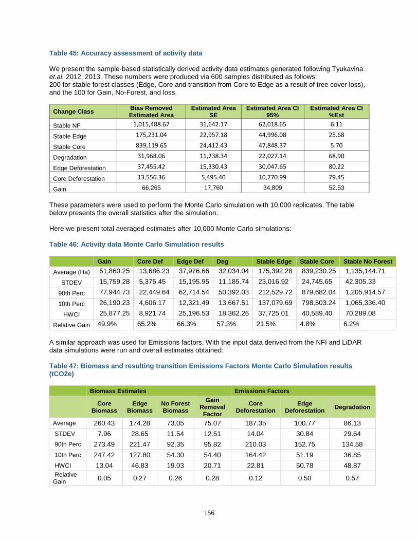
156
Table 45: Accuracy assessment of activity data We present the sample-based statistically derived activity data estimates generated following Tyukavina et.al. 2012, 2013. These numbers were produced via 600 samples distributed as follows: 200 for stable forest classes (Edge, Core and transition from Core to Edge as a result of tree cover loss), and the 100 for Gain, No-Forest, and loss.
Change Class Bias Removed Estimated Area
Estimated Area SE
Estimated Area CI 95%
Estimated Area CI %Est
Stable NF 1,015,488.67 31,642.17 62,018.65 6.11
Stable Edge 175,231.04 22,957.18 44,996.08 25.68
Stable Core 839,119.65 24,412.43 47,848.37 5.70
Degradation 31,968.06 11,238.34 22,027.14 68.90
Edge Deforestation 37,455.42 15,330.43 30,047.65 80.22
Core Deforestation 13,556.36 5,495.40 10,770.99 79.45
Gain 66,265 17,760 34,809 52.53
These parameters were used to perform the Monte Carlo simulation with 10,000 replicates. The table below presents the overall statistics after the simulation. Here we present total averaged estimates after 10,000 Monte Carlo simulations: Table 46: Activity data Monte Carlo Simulation results
Gain Core Def Edge Def Deg Stable Edge Stable Core Stable No Forest
Average (Ha) 51,860.25 13,686.23 37,976.66 32,034.04 175,392.28 839,230.25 1,135,144.71
STDEV 15,759.28 5,375.45 15,195.95 11,185.74 23,016.92 24,745.65 42,305.33
90th Perc 77,944.73 22,449.64 62,714.54 50,392.03 212,529.72 879,682.04 1,205,914.57
10th Perc 26,190.23 4,606.17 12,321.49 13,667.51 137,079.69 798,503.24 1,065,336.40
HWCI 25,877.25 8,921.74 25,196.53 18,362.26 37,725.01 40,589.40 70,289.08
Relative Gain 49.9% 65.2% 66.3% 57.3% 21.5% 4.8% 6.2%
A similar approach was used for Emissions factors. With the input data derived from the NFI and LiDAR data simulations were run and overall estimates obtained: Table 47: Biomass and resulting transition Emissions Factors Monte Carlo Simulation results (tCO2e)
Biomass Estimates Emissions Factors
Core Biomass
Edge Biomass
No Forest Biomass
Gain Removal
Factor
Core Deforestation
Edge Deforestation
Degradation
Average 260.43 174.28 73.05 75.07 187.35 100.77 86.13
STDEV 7.96 28.65 11.54 12.51 14.04 30.84 29.64
90th Perc 273.49 221.47 92.35 95.82 210.03 152.75 134.58
10th Perc 247.42 127.80 54.30 54.40 164.42 51.19 36.85
HWCI 13.04 46.83 19.03 20.71 22.81 50.78 48.87
Relative Gain
0.05 0.27 0.26 0.28 0.12 0.50 0.57

157
Overall resulting emissions with related uncertainty estimates are presented in Section 8.3.3.
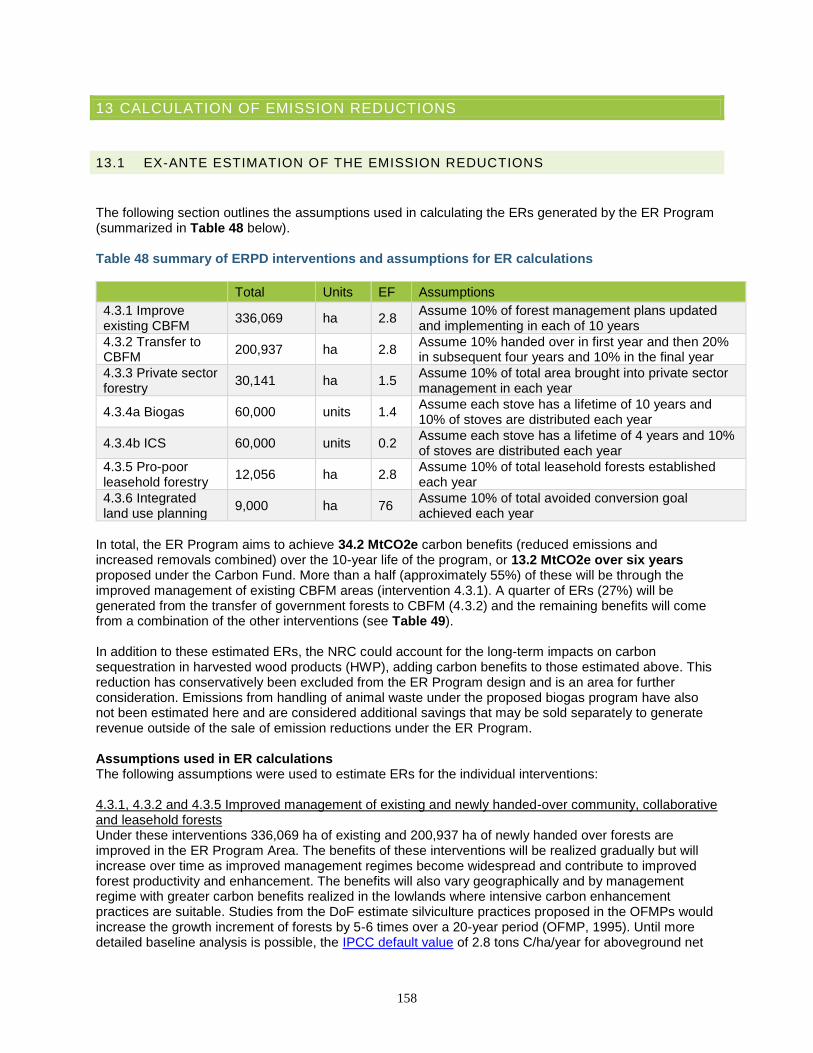
158
13 CALCULATION OF EMISSION REDUCTIONS
13.1 EX-ANTE ESTIMATION OF THE EMISSION REDUCTIONS
The following section outlines the assumptions used in calculating the ERs generated by the ER Program (summarized in Table 48 below). Table 48 summary of ERPD interventions and assumptions for ER calculations
Total Units EF Assumptions
4.3.1 Improve existing CBFM
336,069 ha 2.8 Assume 10% of forest management plans updated and implementing in each of 10 years
4.3.2 Transfer to CBFM
200,937 ha 2.8 Assume 10% handed over in first year and then 20% in subsequent four years and 10% in the final year
4.3.3 Private sector forestry
30,141 ha 1.5 Assume 10% of total area brought into private sector management in each year
4.3.4a Biogas 60,000 units 1.4 Assume each stove has a lifetime of 10 years and 10% of stoves are distributed each year
4.3.4b ICS 60,000 units 0.2 Assume each stove has a lifetime of 4 years and 10% of stoves are distributed each year
4.3.5 Pro-poor leasehold forestry
12,056 ha 2.8 Assume 10% of total leasehold forests established each year
4.3.6 Integrated land use planning
9,000 ha 76 Assume 10% of total avoided conversion goal achieved each year
In total, the ER Program aims to achieve 34.2 MtCO2e carbon benefits (reduced emissions and increased removals combined) over the 10-year life of the program, or 13.2 MtCO2e over six years proposed under the Carbon Fund. More than a half (approximately 55%) of these will be through the improved management of existing CBFM areas (intervention 4.3.1). A quarter of ERs (27%) will be generated from the transfer of government forests to CBFM (4.3.2) and the remaining benefits will come from a combination of the other interventions (see Table 49). In addition to these estimated ERs, the NRC could account for the long-term impacts on carbon sequestration in harvested wood products (HWP), adding carbon benefits to those estimated above. This reduction has conservatively been excluded from the ER Program design and is an area for further consideration. Emissions from handling of animal waste under the proposed biogas program have also not been estimated here and are considered additional savings that may be sold separately to generate revenue outside of the sale of emission reductions under the ER Program. Assumptions used in ER calculations The following assumptions were used to estimate ERs for the individual interventions: 4.3.1, 4.3.2 and 4.3.5 Improved management of existing and newly handed-over community, collaborative and leasehold forests Under these interventions 336,069 ha of existing and 200,937 ha of newly handed over forests are improved in the ER Program Area. The benefits of these interventions will be realized gradually but will increase over time as improved management regimes become widespread and contribute to improved forest productivity and enhancement. The benefits will also vary geographically and by management regime with greater carbon benefits realized in the lowlands where intensive carbon enhancement practices are suitable. Studies from the DoF estimate silviculture practices proposed in the OFMPs would increase the growth increment of forests by 5-6 times over a 20-year period (OFMP, 1995). Until more detailed baseline analysis is possible, the IPCC default value of 2.8 tons C/ha/year for aboveground net
159
biomass growth in natural forests (subtropical dry forests in continental Asia, under 20 years of age) has been used for lowland areas where the most intensive SFM will be conducted.83 4.3.3 Private sector forestry Efforts to promote private forestry initiatives under the ER program will help establish 30,141 ha of new commercial private forests in the area (approximately 1,000 ha in each district) in five years. This intervention assumes an emission factor of 1.5 tons/ha, the average from the IPCC default value (0.55tC/ha/year) and the estimated EF of annual increment from initial RL analysis (2.4tC/ha/year). 4.3.4 Biogas and ICS Each biogas plant replaces the need for approximately 4.5 tons of fuelwood/year, or roughly 1.4 tC/year. Improved cookstoves (ICS) are estimated to increase fuel efficiency compared to an open hearth by approximately 30%. Given an estimated annual demand of 0.4 tons of fuelwood/person (Kanel et al 2012) converted to 1.94 tons of fuelwood/household gives an estimated saving of approximately 0.22tC/year from ICS. 4.3.6 Integrated land use planning Land use planning interventions are expected to prevent at least 9,000 ha of forest from being deforested due to resettlement and infrastructure development in ten years of the ER program implementation period. Tier 2 RL estimates are used for conversion of forests to non-forests in the reference period. 4.3.7 Protected area management Emissions reductions are not estimated for protected areas since these are only included for non-carbon benefits.
83 Section 4.4.1, IPCC Special Report on Land-use, Land-use Change and Forestry, 2000
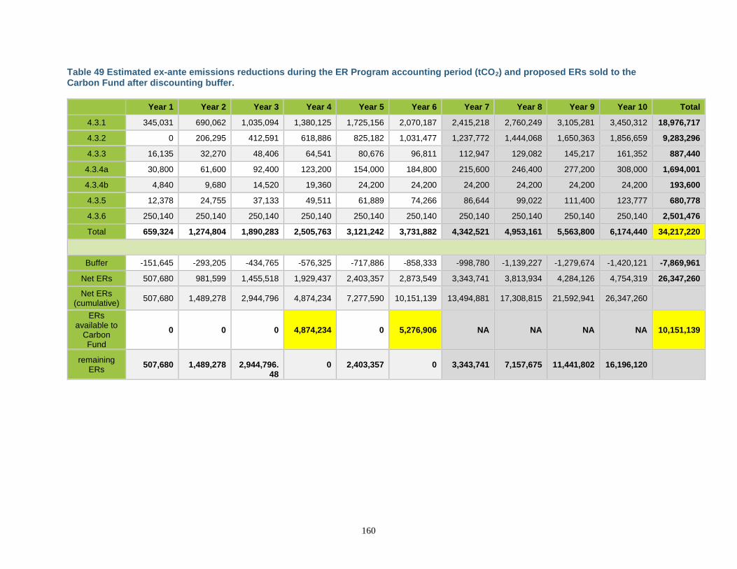
160
Table 49 Estimated ex-ante emissions reductions during the ER Program accounting period (tCO2) and proposed ERs sold to the Carbon Fund after discounting buffer.
Year 1 Year 2 Year 3 Year 4 Year 5 Year 6 Year 7 Year 8 Year 9 Year 10 Total
4.3.1 345,031 690,062 1,035,094 1,380,125 1,725,156 2,070,187 2,415,218 2,760,249 3,105,281 3,450,312 18,976,717
4.3.2 0 206,295 412,591 618,886 825,182 1,031,477 1,237,772 1,444,068 1,650,363 1,856,659 9,283,296
4.3.3 16,135 32,270 48,406 64,541 80,676 96,811 112,947 129,082 145,217 161,352 887,440
4.3.4a 30,800 61,600 92,400 123,200 154,000 184,800 215,600 246,400 277,200 308,000 1,694,001
4.3.4b 4,840 9,680 14,520 19,360 24,200 24,200 24,200 24,200 24,200 24,200 193,600
4.3.5 12,378 24,755 37,133 49,511 61,889 74,266 86,644 99,022 111,400 123,777 680,778
4.3.6 250,140 250,140 250,140 250,140 250,140 250,140 250,140 250,140 250,140 250,140 2,501,476
Total 659,324 1,274,804 1,890,283 2,505,763 3,121,242 3,731,882 4,342,521 4,953,161 5,563,800 6,174,440 34,217,220
Buffer -151,645 -293,205 -434,765 -576,325 -717,886 -858,333 -998,780 -1,139,227 -1,279,674 -1,420,121 -7,869,961
Net ERs 507,680 981,599 1,455,518 1,929,437 2,403,357 2,873,549 3,343,741 3,813,934 4,284,126 4,754,319 26,347,260
Net ERs (cumulative)
507,680 1,489,278 2,944,796 4,874,234 7,277,590 10,151,139 13,494,881 17,308,815 21,592,941 26,347,260
ERs available to
Carbon Fund
0 0 0 4,874,234 0 5,276,906 NA NA NA NA 10,151,139
remaining ERs
507,680 1,489,278
2,944,796.48
0 2,403,357 0 3,343,741 7,157,675 11,441,802 16,196,120
161
14 SAFEGUARDS
14.1 DESCRIPTION OF HOW THE ER PROGRAM MEETS THE WORLD BANK SOCIAL AND ENVIRONMENTAL SAFEGUARDS AND PROMOTES AND SUPPORTS THE SAFEGUARDS INCLUDED IN UNFCCC GUIDANCE RELATED TO REDD+
The recently completed ESMF and its component safeguard instruments will be the primary vehicles to ensure that all triggered WB safeguards are met and that UNFCCC safeguards are promoted and supported. The ESMF draws both on existing national policy measures in Nepal and on supplementary measures delineated to address any remaining gaps needed to meet WB and UNFCCC safeguards. This section describes 1) the national context for REDD+ social and environmental safeguards and the process and consultations informing the Social and Environmental Assessment (SEA) for the ER Program Area, 2) an overview of key themes emerging from the SEA, 3) a more detailed review of identified environmental and social risks and mitigation measures, 4) an analysis of WB safeguards triggered by the ER Program, 5) a review of national and subnational policies that will address many of the triggered safeguards and outstanding gaps, and 6) some elaboration of the process by which the ESMF will be implemented and address gaps and issues that arise during program implementation. Outstanding measures needed to fully operationalize ESMF for ER Program implementation are outlined in the Safeguards Roadmap included as Annex 14: Safeguards Roadmap.
14.1.1 STRATEGIC ENVIRONMENTAL AND SOCIAL ASSESSMENT (SESA)/ENVIRONMENTAL AND SOCIAL MANAGEMENT FRAMEWORK (SESA/ESMF) The Government of Nepal completed a national SESA in 2014 that broadly assessed environmental and social baselines in the forestry sector as well as the potential social, environmental, and institutional impacts of REDD+ activities in Nepal. This was accompanied by an indicative national ESMF for REDD+ activities in Nepal, including proposed institutional arrangements and recommendations for screening, conducting impact assessments, and monitoring REDD+ activities for consistency with relevant national and international policies and safeguards frameworks. Both the national SESA and ESMF were completed before finalization of the National REDD+ Strategy; therefore, in 2018, the NRC augmented these frameworks with completion of a SEA and ESMF specifically focused on the proposed ER Program in the Terai and its activities. The ER Program SEA and ESMF were informed by several recent analyses and associated consultations linked with Nepal’s REDD+ readiness activities, including the National REDD+ Strategy (2018), an ESMF working paper for the ER program (2016), an assessment report and gender action plan for the ER program (2017), the Feedback and Grievance Redress Mechanism assessment (2015), and a land and natural resources tenure assessment for the proposed ER Program in the TAL (2016). The scope of the SEA and ESMF for the ER program included:
a) examining potential environmental and social impacts of the proposed seven interventions to be implemented in the ER Program Area;
b) identifying policy, measures, and governance-related gaps in mitigating potential social and environmental impacts;
c) linking identified impacts with environmental and social standards of the World Bank and the UNFCCC safeguard principles; and
d) delineating a framework for mitigating and managing identified potential environmental and social impacts of the proposed ER Program, including a process for screening specific activities, triggering development of specific safeguard documents in accordance with WB safeguards policies, and associated monitoring and reporting.
162
The Government of Nepal aims to complete its National Safeguards Information System (SIS) in 2019, in accordance with UNFCCC guidance, and the SIS will be informed in part by the ESMF for the ER Program and its monitoring arrangements. Consultations in the ER Program Area In line with the country approach to REDD+ in Nepal, consultations with relevant stakeholders from local communities up to the national level were central to the initial design of the ER Program, to understanding possible social and environment impacts and opportunities presented by the program’s activities, and to informing modifications to the program to both minimize and mitigate risks and to maximize both carbon and non-carbon benefits across stakeholder groups. A total of 70 consultation meetings and workshops were held across the 12 districts of the Program Area between 2016 and 2018, including during ERPD preparation (40), during preparation of the gender integration plan (24), and during the final ESMF preparation process (6). Related government authorities (e.g., District Forest Officers); civil society and IP organizations like FECOFUN, ACOFUN, NEFIN; Dalit communities; Madhasi communities; and women groups took part in the consultations. Representatives of many of these stakeholder groups were also consulted separately to make sure that they understood potential impacts of the proposed activities and could suggest appropriate mitigation plans. Five national-level consultations involving government officials from relevant ministries, related civil society organizations, and national experts complemented the local consultations. Details of all consultation meetings and participants are presented in Section 5 of the ERPD.
14.1.2 KEY THEMES EMERGING FROM SESA CONSULTATIONS AND SOCIOECONOMIC BASELINE ASSESSMENT There are a number of themes that emerged out of the SEA process and related studies that warrant elaboration in the context of the ER Program’s safeguards process. Gender Issues, Women, and Forest Management In 2017, a gender assessment was conducted at the district and community levels in the proposed ER Program Area to provide baseline information on the various social, economic, and political conditions that women face in the forestry sector, and to identify opportunities and benefits that could be facilitated through REDD+ interventions. The assessment was complemented by a Gender Action Plan that delineates activities to make the ER Program and its activities more gender responsive. The assessment’s review of Nepal’s policies and practices for gender integration in forestry showed that despite policy mandates in Nepal’s Gender Equality and Social Inclusion (GESI) strategy and concerted efforts by different agencies, the forest sector has not achieved effective gender integration in programming, budgeting, monitoring, and evaluation. For example, there is a high level of engagement of rural women in labor-intensive forest-related activities on a daily basis, but a lower level of engagement in decision-making processes that remain dominated by men. Women’s workloads within and outside the household are heavy, and “time poverty” is a critical issue. Their traditional roles as family care givers and food producers are unpaid and under-valued and take up most of women’s time and energy. Firewood remains a major source of energy for cooking and is mostly collected by women. Despite some of these challenges, best practices in forest management, developed as part of Nepal’s decentralization process, such as the provision for women to represent 50% of executive positions in CFUGs, provides a solid basis for developing a GESI-responsive ER Program. Learnings from the gender assessment and many elements of the gender action plan have been directly incorporated into the program design and are reflected in the descriptions of specific activities and interventions in Section 4.3. Indicators from the gender action plan will also be integrated into the safeguards and non-carbon benefits monitoring plans.
163
Concerns regarding involuntary resettlement This concern emerged in the consultations particularly in Chitwan, Bara, Dang, Banke, and Kailali districts where squatter settlements have been considered a challenge for tackling deforestation and forest degradation. For example, local participants participating in the consultation meeting held in Chitwan were curious to know how an approach might be taken with regard to the Bharandhabhar squatter settlement, where thousands of people have been living in an encroached forest for several years. The squatter settlement problem is not limited to the ER Program Area; however, it is more significant in the Terai area than in other regions. Since this issue is underpinned by sociopolitical and economic conditions in the country, resolving it fully is beyond the scope of the ER Program. However, the, Government of Nepal has formed a "Systematic Settlement Commission" (Gazette notification on March 21, 2017) to implement Article 51(h)(11) of the constitution, and more specifically to minimize further encroachment of public land with a view to redressing the problems of unsystematic settlement. For example, the commission has been working to find a long-term solution that minimizes or avoids the need for involuntary resettlement, consistent with “do no harm” principles reflected in UNFCCC and World Bank safeguards policies. The ER program will avoid any involuntary resettlement to the extent possible. Households residing in the area before the ER Program will be treated fairly and equally regardless of their settlement status. However, further expansion of illegal settlement will be addressed with both participatory and law enforcement approaches, in manners that are respectful of people’s basic needs and legal and customary rights. Further details of how safeguards will be applied in relation to avoid involuntary resettlement are discussed in the Resettlement Policy Framework of the ESMF. Provisions for sustainable, alternative livelihoods The lack of sufficient livelihood opportunities was a recurring theme in ER Program consultations and was listed by many as a significant underlying cause of deforestation and degradation in the Terai. On one hand, agriculture is one of the most common livelihoods in the region, and agricultural expansion could be constrained under the ER Program. On the other hand, many livelihoods including subsistence and customary practices depend on accessible, healthy forests that support local timber, fuelwood, fodder and NTFPs. The ER Program activities were selected specifically with these considerations in mind, and nearly all activities incorporate elements to improve livelihood opportunities for women, for Indigenous Peoples, and for poor and traditionally marginalized groups. For example, community forests increase participation, local empowerment, and productivity in forest management, and sustainable forest management will support improved productivity and generation of forest-related products and the market opportunities they present. Improved cooking technologies provide more time to women to pursue leadership or job training opportunities. Management and conservation of protected areas supports a tourism industry attracted to the Terai’s biodiversity and creates tourism-related job opportunities. And the pro-poor Leasehold Forestry Program is designed specifically to provide opportunities for historically disadvantaged groups in forestry, agroforestry, and NTFPs based on demonstrated success in other parts of the country. Nonetheless, forest management can also be perceived as a risk to traditional livelihoods, grazing, and customary practices, and there are several measures in place in the ER Program and the ESMF to minimize and mitigate these risks. In particular, forest user groups need to imbed these multiple uses into forest management plans directly, and in a way that is consultative, sustainable, and sensitive to traditional practices and needs, and also rely on existing formal and informal FGRMs that are fair and equitable to resolve possible conflicts that may arise. NCB and safeguards monitoring through program implementation will facilitate tracking of program benefits and/or impacts on livelihoods and provide opportunities for adaptive management.
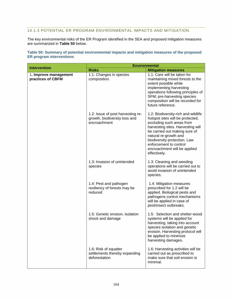
164
14.1.3 POTENTIAL ER PROGRAM ENVIRONMENTAL IMPACTS AND MITIGATION The key environmental risks of the ER Program identified in the SEA and proposed mitigation measures are summarized in Table 50 below. Table 50: Summary of potential environmental impacts and mitigation measures of the proposed ER program interventions
Intervention Environmental
Risks Mitigation measures
1. Improve management practices of CBFM
1.1: Changes in species composition. 1.2: Issue of post harvesting re-growth, biodiversity loss and encroachment 1.3: Invasion of unintended species 1.4: Pest and pathogen resiliency of forests may be reduced 1.5: Genetic erosion, isolation shock and damage 1.6: Risk of squatter settlements thereby expanding deforestation
1.1: Care will be taken for maintaining mixed forests to the extent possible while implementing harvesting operations following principles of SFM; pre-harvesting species composition will be recorded for future reference. 1.2: Biodiversity-rich and wildlife hotspot sites will be protected, excluding such areas from harvesting sites. Harvesting will be carried out making sure of natural re-growth and biodiversity protection. Law enforcement to control encroachment will be applied effectively. 1.3: Cleaning and weeding operations will be carried out to avoid invasion of unintended species. 1.4: Mitigation measures prescribed for 1.2 will be applied. Biological pests and pathogens control mechanisms will be applied in case of pest/insect outbreaks. 1.5: Selection and shelter-wood systems will be applied for harvesting, taking into account species isolation and genetic erosion. Harvesting protocol will be applied to minimize harvesting damages. 1.6: Harvesting activities will be carried out as prescribed to make sure that soil erosion is minimal.
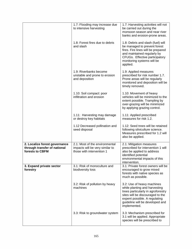
165
1.7: Flooding may increase due to intensive harvesting 1.8: Forest fires due to debris and slash 1.9: Riverbanks become unstable and prone to erosion and deposition 1.10: Soil compact: poor infiltration and erosion 1.11: Harvesting may damage or destroy key habitats 1.12 Decreased pollination and seed disposal
1.7: Harvesting activities will not be carried out during the monsoon season and near river banks and erosion-prone areas. 1.8: Debris and slash (fuel) will be managed to prevent forest fires. Fire lines will be prepared and maintained regularly by CFUGs. Effective participatory monitoring systems will be applied. 1.9: Applied measures prescribed for risk number 1.7. Prone areas will be regularly monitored and deposition will be timely removed. 1.10: Movement of heavy vehicles will be minimized to the extent possible. Trampling by over-grazing will be minimized by applying grazing control. 1.11: Applied prescribed measures for risk 1.2. 1.12: Seed trees will be retained following silviculture science. Measures prescribed for 1.2 will also be applied.
2. Localize forest governance through transfer of national forests to CBFM
2.1: Most of the environmental impacts will be very similar to those with intervention 1
2.1: Mitigation measures prescribed for intervention 1 will also be applied to address identified potential environmental impacts of this intervention.
3. Expand private sector forestry
3.1: Risk of monoculture and biodiversity loss 3.2: Risk of pollution by heavy machines 3.3: Risk to groundwater system
3.1: Private forest owners will be encouraged to grow mixed forests with native species as much as possible. 3.2: Use of heavy machines while planting and harvesting trees particularly in agroforestry sites will be discouraged to the expent possible. A regulating guideline will be developed and implemented. 3.3: Mechanism prescribed for 3.1 will be applied. Appropriate species will be prescribed to
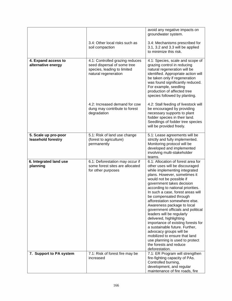
166
3.4: Other local risks such as soil compaction
avoid any negative impacts on groundwater system. 3.4: Mechanisms prescribed for 3.1, 3.2 and 3.3 will be applied to minimize this risk.
4. Expand access to alternative energy
4.1: Controlled grazing reduces seed dispersal of some tree species, leading to limited natural regeneration 4.2: Increased demand for cow dung may contribute to forest degradation
4.1: Species, scale and scope of grazing control in reducing natural regeneration will be identified. Appropriate action will be taken only if regeneration was found significantly reduced. For example, seedling production of affected tree species followed by planting. 4.2: Stall feeding of livestock will be encouraged by providing necessary supports to plant fodder species in their land. Seedlings of fodder tree species will be provided freely.
5. Scale up pro-poor leasehold forestry
5.1: Risk of land use change (forest to agriculture) permanently
5.1: Lease agreements will be strictly and fully implemented. Monitoring protocol will be developed and implemented involving multi-stakeholder teams.
6. Integrated land use planning
6.1: Deforestation may occur if some forest sites are allocated for other purposes
6.1: Allocation of forest area for other uses will be discouraged while implementing integrated plans. However, sometimes it would not be possible if government takes decision according to national priorities. In such a case, forest areas will be compensated through afforestation somewhere else. Awareness package to local government officials and political leaders will be regularly delivered, highlighting importance of existing forests for a sustainable future. Further, advocacy groups will be mobilized to ensure that land use planning is used to protect the forests and reduce deforestation.
7. Support to PA system 7.1: Risk of forest fire may be increased
7.1: ER Program will strengthen fire-fighting capacity of PAs. Controlled burning, development, and regular maintenance of fire roads, fire
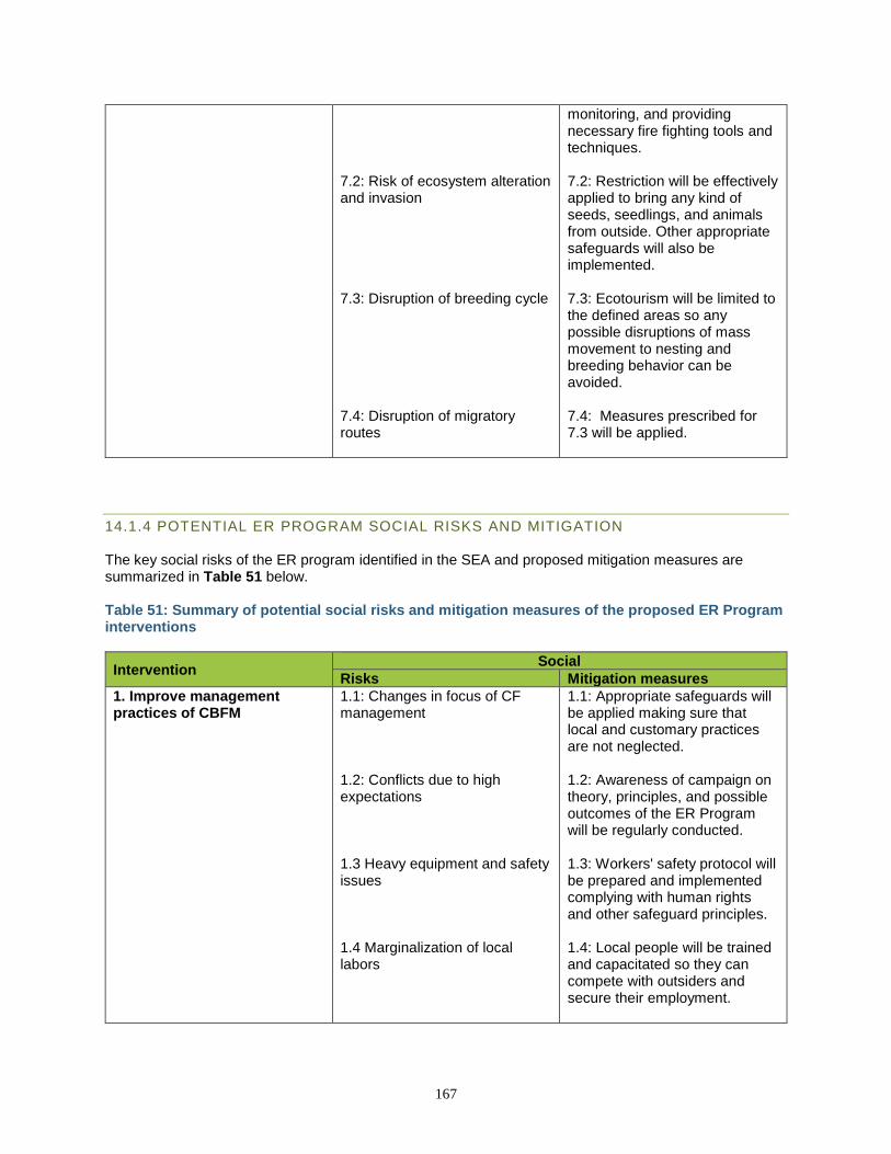
167
7.2: Risk of ecosystem alteration and invasion 7.3: Disruption of breeding cycle 7.4: Disruption of migratory routes
monitoring, and providing necessary fire fighting tools and techniques. 7.2: Restriction will be effectively applied to bring any kind of seeds, seedlings, and animals from outside. Other appropriate safeguards will also be implemented. 7.3: Ecotourism will be limited to the defined areas so any possible disruptions of mass movement to nesting and breeding behavior can be avoided. 7.4: Measures prescribed for 7.3 will be applied.
14.1.4 POTENTIAL ER PROGRAM SOCIAL RISKS AND MITIGATION The key social risks of the ER program identified in the SEA and proposed mitigation measures are summarized in Table 51 below. Table 51: Summary of potential social risks and mitigation measures of the proposed ER Program interventions
Intervention Social
Risks Mitigation measures
1. Improve management practices of CBFM
1.1: Changes in focus of CF management 1.2: Conflicts due to high expectations 1.3 Heavy equipment and safety issues 1.4 Marginalization of local labors
1.1: Appropriate safeguards will be applied making sure that local and customary practices are not neglected. 1.2: Awareness of campaign on theory, principles, and possible outcomes of the ER Program will be regularly conducted. 1.3: Workers' safety protocol will be prepared and implemented complying with human rights and other safeguard principles. 1.4: Local people will be trained and capacitated so they can compete with outsiders and secure their employment.
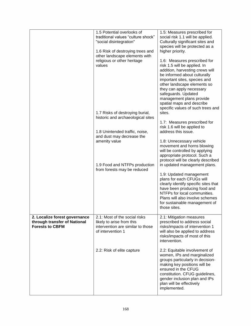
168
1.5 Potential overlooks of traditional values “culture shock” "social disintegration" 1.6 Risk of destroying trees and other landscape elements with religious or other heritage values 1.7 Risks of destroying burial, historic and archaeological sites 1.8 Unintended traffic, noise, and dust may decrease the amenity value 1.9 Food and NTFPs production from forests may be reduced
1.5: Measures prescribed for social risk 1.1 will be applied. Culturally significant sites and species will be protected as a higher priority. 1.6: Measures prescribed for risk 1.5 will be applied. In addition, harvesting crews will be informed about culturally important sites, species and other landscape elements so they can apply necessary safeguards. Updated management plans provide spatial maps and describe specific values of such trees and sites. 1.7: Measures prescribed for risk 1.6 will be applied to address this issue. 1.8: Unnecessary vehicle movement and horns blowing will be controlled by applying appropriate protocol. Such a protocol will be clearly described in updated management plans. 1.9: Updated management plans for each CFUGs will clearly identify specific sites that have been producing food and NTFPs for local communities. Plans will also involve schemes for sustainable management of those sites.
2. Localize forest governance through transfer of National Forests to CBFM
2.1: Most of the social risks likely to arise from this intervention are similar to those of intervention 1 2.2: Risk of elite capture
2.1: Mitigation measures prescribed to address social risks/impacts of intervention 1 will also be applied to address risks/impacts of most of this intervention. 2.2: Equitable involvement of women, IPs and marginalized groups particularly in decision-making key positions will be ensured in the CFUG constitution. CFUG guidelines, gender inclusion plan and IPs plan will be effectively implemented.
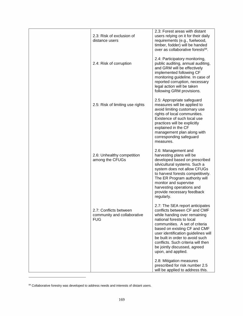
169
2.3: Risk of exclusion of distance users 2.4: Risk of corruption 2.5: Risk of limiting use rights 2.6: Unhealthy competition among the CFUGs 2.7: Conflicts between community and collaborative FUG
2.3: Forest areas with distant users relying on it for their daily requirements (e.g., fuelwood, timber, fodder) will be handed over as collaborative forests84. 2.4: Participatory monitoring, public auditing, annual auditing, and GRM will be effectively implemented following CF monitoring guideline. In case of reported corruption, necessary legal action will be taken following GRM provisions. 2.5: Appropriate safeguard measures will be applied to avoid limiting customary use rights of local communities. Existence of such local use practices will be explicitly explained in the CF management plan along with corresponding safeguard measures. 2.6: Management and harvesting plans will be developed based on prescribed silvicultural systems. Such a system does not allow CFUGs to harvest forests competitively. The ER Program authority will monitor and supervise harvesting operations and provide necessary feedback regularly. 2.7: The SEA report anticipates conflicts between CF and CMF while handing over remaining national forests to local communities. A set of criteria based on existing CF and CMF user identification guidelines will be built in order to avoid such conflicts. Such criteria will then be jointly discussed, agreed upon, and applied. 2.8: Mitigation measures prescribed for risk number 2.5 will be applied to address this.
84 Collaborative forestry was developed to address needs and interests of distant users.
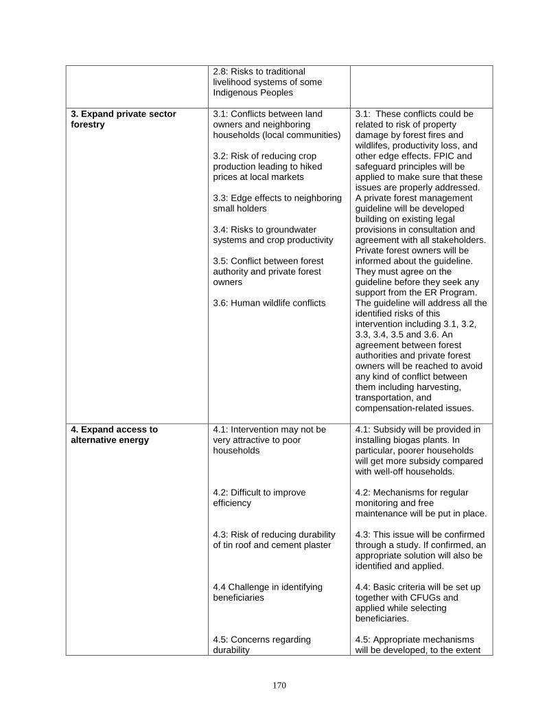
170
2.8: Risks to traditional livelihood systems of some Indigenous Peoples
3. Expand private sector forestry
3.1: Conflicts between land owners and neighboring households (local communities) 3.2: Risk of reducing crop production leading to hiked prices at local markets 3.3: Edge effects to neighboring small holders 3.4: Risks to groundwater systems and crop productivity 3.5: Conflict between forest authority and private forest owners 3.6: Human wildlife conflicts
3.1: These conflicts could be related to risk of property damage by forest fires and wildlifes, productivity loss, and other edge effects. FPIC and safeguard principles will be applied to make sure that these issues are properly addressed. A private forest management guideline will be developed building on existing legal provisions in consultation and agreement with all stakeholders. Private forest owners will be informed about the guideline. They must agree on the guideline before they seek any support from the ER Program. The guideline will address all the identified risks of this intervention including 3.1, 3.2, 3.3, 3.4, 3.5 and 3.6. An agreement between forest authorities and private forest owners will be reached to avoid any kind of conflict between them including harvesting, transportation, and compensation-related issues.
4. Expand access to alternative energy
4.1: Intervention may not be very attractive to poor households 4.2: Difficult to improve efficiency 4.3: Risk of reducing durability of tin roof and cement plaster 4.4 Challenge in identifying beneficiaries 4.5: Concerns regarding durability
4.1: Subsidy will be provided in installing biogas plants. In particular, poorer households will get more subsidy compared with well-off households. 4.2: Mechanisms for regular monitoring and free maintenance will be put in place. 4.3: This issue will be confirmed through a study. If confirmed, an appropriate solution will also be identified and applied. 4.4: Basic criteria will be set up together with CFUGs and applied while selecting beneficiaries. 4.5: Appropriate mechanisms will be developed, to the extent
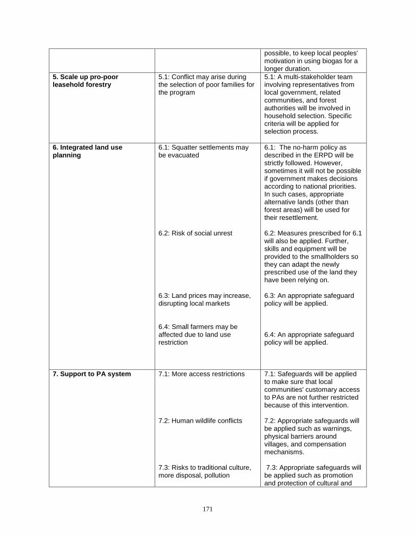
171
possible, to keep local peoples' motivation in using biogas for a longer duration.
5. Scale up pro-poor leasehold forestry
5.1: Conflict may arise during the selection of poor families for the program
5.1: A multi-stakeholder team involving representatives from local government, related communities, and forest authorities will be involved in household selection. Specific criteria will be applied for selection process.
6. Integrated land use planning
6.1: Squatter settlements may be evacuated 6.2: Risk of social unrest 6.3: Land prices may increase, disrupting local markets 6.4: Small farmers may be affected due to land use restriction
6.1: The no-harm policy as described in the ERPD will be strictly followed. However, sometimes it will not be possible if government makes decisions according to national priorities. In such cases, appropriate alternative lands (other than forest areas) will be used for their resettlement. 6.2: Measures prescribed for 6.1 will also be applied. Further, skills and equipment will be provided to the smallholders so they can adapt the newly prescribed use of the land they have been relying on. 6.3: An appropriate safeguard policy will be applied. 6.4: An appropriate safeguard policy will be applied.
7. Support to PA system 7.1: More access restrictions 7.2: Human wildlife conflicts 7.3: Risks to traditional culture, more disposal, pollution
7.1: Safeguards will be applied to make sure that local communities' customary access to PAs are not further restricted because of this intervention. 7.2: Appropriate safeguards will be applied such as warnings, physical barriers around villages, and compensation mechanisms. 7.3: Appropriate safeguards will be applied such as promotion and protection of cultural and
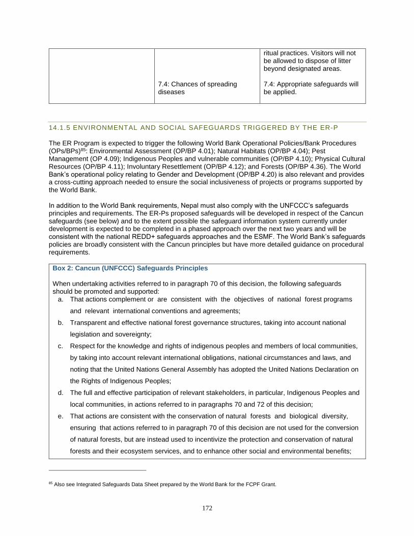
172
7.4: Chances of spreading diseases
ritual practices. Visitors will not be allowed to dispose of litter beyond designated areas. 7.4: Appropriate safeguards will be applied.
14.1.5 ENVIRONMENTAL AND SOCIAL SAFEGUARDS TRIGGERED BY THE ER-P The ER Program is expected to trigger the following World Bank Operational Policies/Bank Procedures (OPs/BPs)85: Environmental Assessment (OP/BP 4.01); Natural Habitats (OP/BP 4.04); Pest Management (OP 4.09); Indigenous Peoples and vulnerable communities (OP/BP 4.10); Physical Cultural Resources (OP/BP 4.11); Involuntary Resettlement (OP/BP 4.12); and Forests (OP/BP 4.36). The World Bank’s operational policy relating to Gender and Development (OP/BP 4.20) is also relevant and provides a cross-cutting approach needed to ensure the social inclusiveness of projects or programs supported by the World Bank. In addition to the World Bank requirements, Nepal must also comply with the UNFCCC’s safeguards principles and requirements. The ER-Ps proposed safeguards will be developed in respect of the Cancun safeguards (see below) and to the extent possible the safeguard information system currently under development is expected to be completed in a phased approach over the next two years and will be consistent with the national REDD+ safeguards approaches and the ESMF. The World Bank’s safeguards policies are broadly consistent with the Cancun principles but have more detailed guidance on procedural requirements.
Box 2: Cancun (UNFCCC) Safeguards Principles When undertaking activities referred to in paragraph 70 of this decision, the following safeguards should be promoted and supported:
a. That actions complement or are consistent with the objectives of national forest programs
and relevant international conventions and agreements;
b. Transparent and effective national forest governance structures, taking into account national
legislation and sovereignty;
c. Respect for the knowledge and rights of indigenous peoples and members of local communities,
by taking into account relevant international obligations, national circumstances and laws, and
noting that the United Nations General Assembly has adopted the United Nations Declaration on
the Rights of Indigenous Peoples;
d. The full and effective participation of relevant stakeholders, in particular, Indigenous Peoples and
local communities, in actions referred to in paragraphs 70 and 72 of this decision;
e. That actions are consistent with the conservation of natural forests and biological diversity,
ensuring that actions referred to in paragraph 70 of this decision are not used for the conversion
of natural forests, but are instead used to incentivize the protection and conservation of natural
forests and their ecosystem services, and to enhance other social and environmental benefits;
85 Also see Integrated Safeguards Data Sheet prepared by the World Bank for the FCPF Grant.
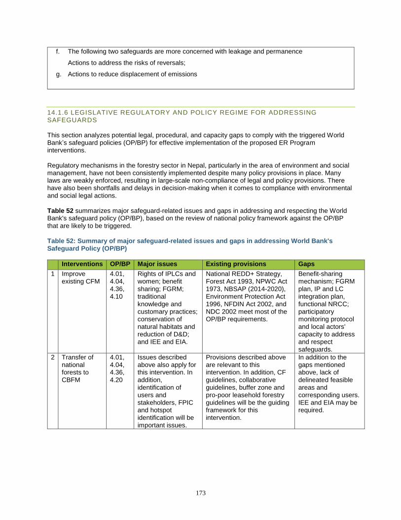
173
f. The following two safeguards are more concerned with leakage and permanence
Actions to address the risks of reversals;
g. Actions to reduce displacement of emissions
14.1.6 LEGISLATIVE REGULATORY AND POLICY REGIME FOR ADDRESSING SAFEGUARDS This section analyzes potential legal, procedural, and capacity gaps to comply with the triggered World Bank’s safeguard policies (OP/BP) for effective implementation of the proposed ER Program interventions. Regulatory mechanisms in the forestry sector in Nepal, particularly in the area of environment and social management, have not been consistently implemented despite many policy provisions in place. Many laws are weakly enforced, resulting in large-scale non-compliance of legal and policy provisions. There have also been shortfalls and delays in decision-making when it comes to compliance with environmental and social legal actions. Table 52 summarizes major safeguard-related issues and gaps in addressing and respecting the World Bank's safeguard policy (OP/BP), based on the review of national policy framework against the OP/BP that are likely to be triggered. Table 52: Summary of major safeguard-related issues and gaps in addressing World Bank's Safeguard Policy (OP/BP)
Interventions OP/BP Major issues Existing provisions Gaps
1 Improve existing CFM
4.01, 4.04, 4.36, 4.10
Rights of IPLCs and women; benefit sharing; FGRM; traditional knowledge and customary practices; conservation of natural habitats and reduction of D&D; and IEE and EIA.
National REDD+ Strategy, Forest Act 1993, NPWC Act 1973, NBSAP (2014-2020), Environment Protection Act 1996, NFDIN Act 2002, and NDC 2002 meet most of the OP/BP requirements.
Benefit-sharing mechanism; FGRM plan, IP and LC integration plan, functional NRCC; participatory monitoring protocol and local actors' capacity to address and respect safeguards.
2 Transfer of national forests to CBFM
4.01, 4.04, 4.36, 4.20
Issues described above also apply for this intervention. In addition, identification of users and stakeholders, FPIC and hotspot identification will be important issues.
Provisions described above are relevant to this intervention. In addition, CF guidelines, collaborative guidelines, buffer zone and pro-poor leasehold forestry guidelines will be the guiding framework for this intervention.
In addition to the gaps mentioned above, lack of delineated feasible areas and corresponding users. IEE and EIA may be required.
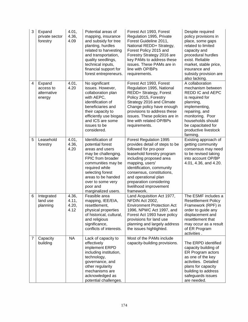
174
3 Expand private sector forestry
4.01, 4.36, 4.09
Potential areas of mapping, insurance and subsidy for tree planting, hurdles related to harvesting and transportation, quality seedlings, technical inputs, financial support for forest entrepreneurs.
Forest Act 1993, Forest Regulation 1995, Private Forest Guideline 2011, National REDD+ Strategy, Forest Policy 2015 and Forestry Strategy 2016 are key PAMs to address these issues. These PAMs are in line with OP/BPs requirements.
Despite required policy provisions in place, some gaps related to limited capacity and procedural hurdles exist. Reliable market, stable price, insurance and subsidy provision are also lacking.
4 Expand access to alternative energy
4.01, 4.20
No significant issues. However, collaboration plan with AEPC, identification of beneficiaries and their capacity to efficiently use biogas and ICS are some issues to be considered.
Forest Act 1993, Forest Regulation 1995, National REDD+ Strategy, Forest Policy 2015, Forestry Strategy 2016 and Climate Change policy have enough provisions to address these issues. These policies are in line with related OP/BPs requirements.
A collaboration mechanism between REDD IC and AEPC is required for planning, implementing, repairing, and monitoring. Poor households should be capacitated for productive livestock farming.
5 Leasehold forestry
4.01, 4.36, 4.20
Identification of potential forest areas and users may be challenging. FPIC from broader communities may be required while selecting forest areas to be handed over to some very poor and marginalized users.
Forest Regulation 1995 provides detail of steps to be followed for pro-poor leasehold forestry program including proposed area mapping, users' identification, community consensus, constitutions, and operational plan preparation considering livelihood improvement framework.
Existing approach of getting community consensus may need to be revised taking into account OP/BP 4.01, 4.36, and 4.20.
6 Integrated land use planning
4.36, 4.11, 4.20, 4.12
Feasible area mapping, IEE/EIA, resettlement, physical properties of historical, cultural, and religious significance, conflicts of interests.
Land Acquisition Act 1977, NFDIN Act 2002, Environment Protection Act 1996, NPWC Act 1997, and Forest Act 1993 have policy provisions for land use planning and largely address the issues highlighted.
The ESMF includes a Resettlement Policy Framework (RPF) in order to guide any displacement and resettlement that may occur as a result of ER Program activities .
7 Capacity building
NA Lack of capacity to effectively implement ERPD including institution, technology, governance, and other regularity mechanisms are acknowledged as potential challenges.
Most of the PAMs include capacity-building provisions.
The ERPD identified capacity building of ER Program actors as one of the key activities. Detailed plans for capacity building to address safeguards issues are needed.
175
14.1.7 IMPLEMENTATION OF ESMF The Environmental and Social Monitoring Framework (ESMF) will serve as the main instrument for ensuring the integration of different environmental and social considerations into the implementation of ER Program activities. This will include addressing the potential risks and impacts associated with the WB safeguard policies triggered by the ER Program as well at the Cancun Safeguards under UNFCCC. Accordingly, it will provide the basis for the preparation of site-specific environmental and social management plans (ESMPs), which will be prepared and implemented in the course of program implementation to ensure that risks and impacts are properly mitigated and managed, and that periodic monitoring, reporting, and evaluation are taking place. The ESMPs will be prepared in line with the safeguard requirements of the Government of Nepal, the WBG, and the UNFCCC Cancun safeguards. How the ESMPs will be implemented Nepal's National REDD+ Strategy outlines institutional arrangements for implementing safeguards that will be implemented for the ER Program, with slight modifications related to the government’s decentralization process. The implementation of the various safeguard instruments—such as ESMF, IPVCPF, RPF, and REDD+ specific ESMPs—are an essential component of the overall ER Program implementation arrangements. The safeguard implementation arrangements consist of institutional structures and responsibilities to minimize and mitigate social and environmental risks related to ER Program implementation following a tiered, three-level structure described here. Though all of these institutions are not fully established at the time of ERPD submission due to the government’s decentralization process, they will be functional for the program implementation period (See Annex 14: Safeguards Roadmap).
• At the national level, an Environmental and Social Assessment and Monitoring Unit (ESAMU) will be established within the NRC, which will serve as the coordinating and implementing agency for REDD+ safeguards. The ESAMU will be responsible for the overall coordination, planning, implementation, and monitoring of REDD+ safeguards activities, particularly the activities proposed under activity-specific ESMPs. These responsibilities will include:
• Screening of activity proposals at the national level;
• Liaising with other relevant ministries and institutions for implementation of ESMP;
• Monitoring and evaluating the implementation of safeguard measures as per the ESMP;
• Acting as a Member Secretary to a Grievance Redressal Mechanism for national/regional REDD+ activities and facilitating the tabling of grievances by affected parties;
• Collecting and storing (database preparation) of safeguard-related information;
• Disclosure and dissemination of safeguard-related information through appropriate means of communication; and
• Preparation of status reports on safeguard implementation and monitoring periodically and submit to MoFE and donors through the REDD IC.
• At the state level, the REDD+ Focal Office (RFO) at the state forest office will have oversight and monitoring responsibilities over the respective District Forest Offices, PA Offices or Protection Area (PA) offices, and line agencies that will be implementing the REDD+ safeguard activities.
• At the district/division level, an Environment and Social Section (ESS) will be established in each REDD+ Program Management Unit (RPMU) to handle environmental and social concerns. The RPMU will execute all the safeguard-related activities through its provincial forest office. Other key responsibilities of ESS are:
o Screening of sub-projects at district and local levels; o Facilitating to implement all the safeguard-related activities; o Building capacity of local stakeholders; o Monitoring and evaluating ESMP implementation; o Acting as member secretary to a Grievance Redressal Mechanism for district and local
REDD+ projects/activities, and facilitating the tabling of grievances by affected parties;
176
o Preparing status reports on safeguard implementation and monitoring periodically and reporting to ESAMU; and
o Liaising with District REDD+ Coordination Committees (DRCC). In addition to this mechanism, a number of agencies such as local governments, district court/judicial organizations, and Chief District Officers will have roles in leveraging funds for livelihoods and infrastructure related activities and conflict resolutions in formal and informal GRM process. Similarly, executive committees and federations of CBFMs, Dalits networks, indigenous peoples networks, and local NGOs will have critical roles in facilitating planning and implementation processes that address the safeguard issues and facilitate the first stage of a GRM process.
14.2 DESCRIPTION OF ARRANGEMENTS TO PROVIDE INFORMATION ON SAFEGUARDS DURING ER PROGRAM IMPLEMENTATION
14.2.1 IMPLEMENTATION ARRANGEMENTS AND NATIONAL SAFEGUARDS INFORMATION The ESMF sets out a mechanism for monitoring the environmental and social outcomes of the ER Program Area and arrangements for the participation of relevant stakeholders in this process, including appropriate roles and responsibilities. The ESMF also provides an outline of the necessary reporting procedures for managing and monitoring environmental and social safeguards related to project implementation.86 The monitoring of environmental and social safeguards through a Safeguard Information System (SIS) will be linked and integrated with the national forest information management system. The SIS will collect and make available information on how safeguards are being addressed and respected throughout the implementation of REDD+ at the national level, including activities under the ER Program. The SIS is currently being developed by REDD IC and has been included in the annual plan (FY 2018/19). A draft REDD+ SIS framework has been prepared considering potential activities, stakeholders and their specific concerns, anticipated outcomes and implications. The framework proposes two basic levels: 1) activity level; and 2) program (national/sub-national) level of REDD SIS. The activity-level SIS establishes a linkage between REDD+ activities being implemented and the safeguard principles triggered. Furthermore, it illustrates scope (activities, budgets, and targeted groups) and scale (spatial locations, area coverage, stakeholder coverage, and beneficiaries) of the activities, anticipated social and environmental effects, and it safeguards compliance indicators. The framework provides sources of information to verify safeguard compliance. Sources of information are separated into basic and complementary. Information directly related to the activity like progress/evaluation report, output/outcomes, feedback, project documents, and stakeholder engagement come under the basic source of information. Policy and measures related to the activities, institutions, and GRM reports are considered as complementary activities. The program-level SIS framework explains how UNFCCC and other safeguard principles are associated with the REDD+ program interventions. In addition to the correlation between program and the safeguard principles, this framework provides a list of information sources verifying that each of the associated safeguards is addressed and respected. Basic sources of information are directly related with the program implementation approaches, institutions and activities. Complementary sources inform how the REDD+ program and its safeguard concerns are likely to be addressed and respected by related policies, measures and institutional mechanisms.
86 See Chapter 5 of the ESMF at http://mofsc-redd.gov.np/wp-content/uploads/2013/11/Nepal-REDD-ESMF-Final-revision-6-August-2014.pdf
177
Nepal can also utilize the REDD+ Social and Environmental Standards (SES) for the SIS. The REDD+ SES consist of seven principles, 28 criteria and a number of indicators which define issues of concern and conditions to be met to achieve high social and environmental performance, and a process for assessment (REDD+ SES, 2012). The principles provide the key objectives that define high social and environmental performance of REDD+ programs. The criteria define the conditions to be met related to processes, impacts and policies to deliver the principles. The indicators define quantitative or qualitative information needed to show progress achieving a criterion. Monitoring of safeguards will be carried out at the national level by the ESAMU and at district level by DRPMU. In order to keep track of the environmental and social performance of REDD+ activities of the ER Program, the ESAMU will:
● Regularly monitor national and regional projects/activities in coordination with the Regional REDD+ Focal Desk and project developers/implementing agencies.
● Coordinate regularly with DRPMUs, which monitor district- and local-level projects/activities. ● Report the findings of monitoring to the National REDD+ Coordination Committee on behalf
of the REDD IC. ● Recommend necessary actions to improve and/or enhance environmental and social
performance of the REDD+ activities and the ER Program. For those projects subjected to an Environmental and Social Impact Assessment (ESIA) procedure, monitoring will need to be carried out in accordance with the Environmental Protection Rules 1997. Rule 12 requires the project developer to comply with the matters mentioned in the approved EIA (in this case, ESIA) report, while the Concerned Agency is responsible for monitoring the impact on the environment resulting from the implementation of the project (Rule 13). Thus, the ESAMU will have to coordinate with the MoPE to carry out the monitoring. For projects for which ESIAs are undertaken and approved by MoPE, the formal responsibility for approving the ESIA report and monitoring compliance with ESIA recommendations lies with MoPE’s Environmental Evaluation Section in the Environment Division. However, auditing is the responsibility of MOSTE’s Department of Environment.
14.3 DESCRIPTION OF THE FEEDBACK AND GRIEVANCE REDRESS MECHANISM (FGRM) IN PLACE AND POSSIBLE ACTIONS TO IMPROVE IT
In 2015, the NRC published a report to assess the existing Feedback and Grievance Redress Mechanisms (FGRMs) in Nepal, including in the ER Program Area, and to guide development of an appropriate national FGRM with the support of FCPF; this report is posted on NRC’s website.87 The detailed report highlighted the following characteristics of the existing FGRMs in the forestry sector in Nepal:
• FGRMs related to forest resources vary according to forest type, type of users and type of forest management regimes.
• In the mountain region, grievances are mainly related to conflict between forest officials and cattle herders. In the hill region grievances emphasize boundaries and user rights. In the Terai region, with its valuable timber, the most frequent grievances are related to boundaries and user rights related to users coming from distant areas.
• Forest users widely prefer to settle grievances locally and informally as a first option. If local, informal processes do not resolve an issue, the next preference is for a formal, quasi-judicial local mechanism (usually already established), e.g., through the local municipality or district forest office. Formal legal action is an important option but is generally viewed as a last resort.
87 http://mofsc-redd.gov.np/wp-content/uploads/2013/11/Final_GRM-Report-FINAL_01-11-2015.pdf
178
In addition to summarizing informal and formal FGRM mechanisms in Nepal and the most likely grievances to arise under REDD+, the assessment report proposed principles and a potential structure for a national REDD+ FGRM, recognizing that many of the modalities are already in place in current policies and procedures. The report also suggested clarifying and institutionalizing a REDD+ FGRM in the Terai as a first step prior to establishing a national FGRM for REDD+. Informal and Customary FGRM About 85% of grievances or conflicting cases are resolved by the local communities themselves, under the leadership of the community heads or their traditional leaders. The main reasons that communities choose informal mechanisms to resolve grievances are: 1) solutions are locally available, 2) procedures are easier than in formal systems, 3) these processes are familiar to the majority of people, 4) local processes are simple and 5) these processes can handle oral complaints and deliver immediate and effective justice at the local level. As an example, the Tharu community in the ER Program Area have their own customary practices to manage conflicts through community meetings called “Bhalvansa.” The National REDD+ Strategy and the ER Program recognize this customary FGRM, and the Constitution of Nepal (Article 51) promotes such cultural or customary practices. The FUGs also have a responsibility to promote customary practices for conflict management and grievance redress considering such customary practices. If there are any grievances related to utilization of forest products, particularly between and within Tharu communities, these formal institutions must consider the opinions or recommendations of the Tharu leader “Bhalvansa” before decisions are taken or forest management plans are approved. FGRM Principles as Reflected in Current Policy Provisions in Nepal As described above, there are also numerous provisions in existing policies that guide feedback and grievance redress in Nepal, reflecting responsibilities of government agencies, local government, quasi-judicial and judicial agencies, and local communities. For this reason, an FGRM for the ER Program does not require an entirely new formulation, but rather a clarification, consolidation and strengthening of existing mechanisms and any remaining gaps, as well as clear communication of these avenues to all potentially affected stakeholders. Table 53 summarizes the most relevant policies as they relate to essential principles that will be represented in the FGRM for the ER Program. Table 53: FRGM principles to be applied to the ER Program
Principles of FGRM
Existing provisions and their application to ER Program
Legitimacy
● The Forest Act 1993 and Forest Regulation 1995 have given authority to the DFO to receive feedback and grievances related to the forest sector, and generally the Forest Users Groups and other stakeholders trust decisions made by the DFO.
● Good Governance (Management and Operation) Act 2008 gives responsibility to the ministry, departments and district/local agencies to receive feedback and grievances through various tools and to take necessary steps and actions for redressing such feedback and grievances within a given time frame. The general public, affected people and stakeholders trust the steps taken by the administrative agencies based on this legislation.
● Local Government Operationalization Act 2017 incorporated a special provision to establish a Mediation Council for grievance redress at the local government level. The interested people or groups of people can register their grievances in these councils for remedial action. The councils are also trusted by the public for providing redress in a cost-effective way.
Accessibility
● Good Governance (Management and Operation) Act 2008 requires each government agency to post a Citizen Charter in a prescribed form and keep it in a visible place of the office. All agencies are required to appoint a spokesperson and FGR officer, and their responsibility is to provide adequate information to the stakeholders about the FGRM of concerned offices.
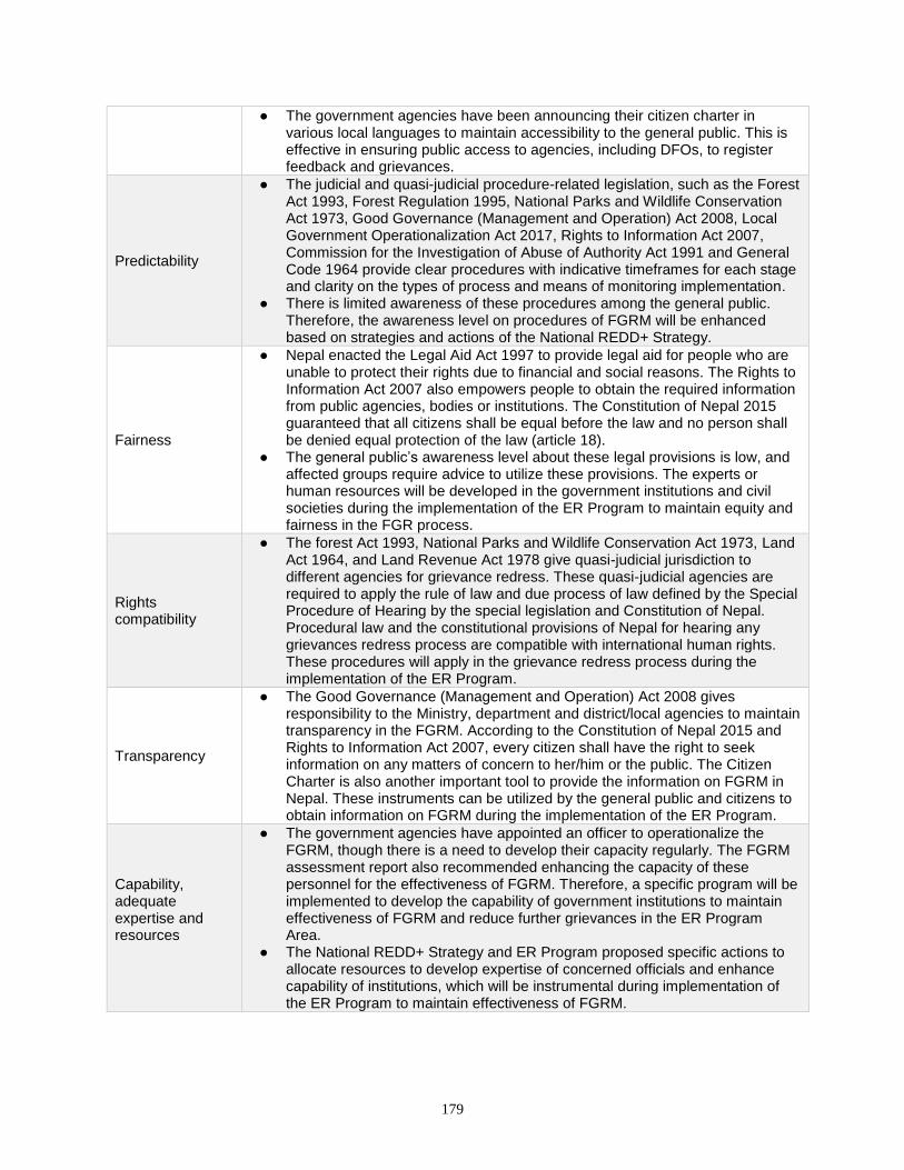
179
● The government agencies have been announcing their citizen charter in various local languages to maintain accessibility to the general public. This is effective in ensuring public access to agencies, including DFOs, to register feedback and grievances.
Predictability
● The judicial and quasi-judicial procedure-related legislation, such as the Forest Act 1993, Forest Regulation 1995, National Parks and Wildlife Conservation Act 1973, Good Governance (Management and Operation) Act 2008, Local Government Operationalization Act 2017, Rights to Information Act 2007, Commission for the Investigation of Abuse of Authority Act 1991 and General Code 1964 provide clear procedures with indicative timeframes for each stage and clarity on the types of process and means of monitoring implementation.
● There is limited awareness of these procedures among the general public. Therefore, the awareness level on procedures of FGRM will be enhanced based on strategies and actions of the National REDD+ Strategy.
Fairness
● Nepal enacted the Legal Aid Act 1997 to provide legal aid for people who are unable to protect their rights due to financial and social reasons. The Rights to Information Act 2007 also empowers people to obtain the required information from public agencies, bodies or institutions. The Constitution of Nepal 2015 guaranteed that all citizens shall be equal before the law and no person shall be denied equal protection of the law (article 18).
● The general public’s awareness level about these legal provisions is low, and affected groups require advice to utilize these provisions. The experts or human resources will be developed in the government institutions and civil societies during the implementation of the ER Program to maintain equity and fairness in the FGR process.
Rights compatibility
● The forest Act 1993, National Parks and Wildlife Conservation Act 1973, Land Act 1964, and Land Revenue Act 1978 give quasi-judicial jurisdiction to different agencies for grievance redress. These quasi-judicial agencies are required to apply the rule of law and due process of law defined by the Special Procedure of Hearing by the special legislation and Constitution of Nepal. Procedural law and the constitutional provisions of Nepal for hearing any grievances redress process are compatible with international human rights. These procedures will apply in the grievance redress process during the implementation of the ER Program.
Transparency
● The Good Governance (Management and Operation) Act 2008 gives responsibility to the Ministry, department and district/local agencies to maintain transparency in the FGRM. According to the Constitution of Nepal 2015 and Rights to Information Act 2007, every citizen shall have the right to seek information on any matters of concern to her/him or the public. The Citizen Charter is also another important tool to provide the information on FGRM in Nepal. These instruments can be utilized by the general public and citizens to obtain information on FGRM during the implementation of the ER Program.
Capability, adequate expertise and resources
● The government agencies have appointed an officer to operationalize the FGRM, though there is a need to develop their capacity regularly. The FGRM assessment report also recommended enhancing the capacity of these personnel for the effectiveness of FGRM. Therefore, a specific program will be implemented to develop the capability of government institutions to maintain effectiveness of FGRM and reduce further grievances in the ER Program Area.
● The National REDD+ Strategy and ER Program proposed specific actions to allocate resources to develop expertise of concerned officials and enhance capability of institutions, which will be instrumental during implementation of the ER Program to maintain effectiveness of FGRM.
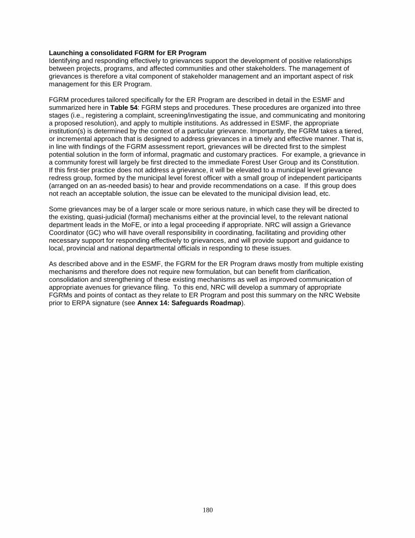
180
Launching a consolidated FGRM for ER Program Identifying and responding effectively to grievances support the development of positive relationships between projects, programs, and affected communities and other stakeholders. The management of grievances is therefore a vital component of stakeholder management and an important aspect of risk management for this ER Program. FGRM procedures tailored specifically for the ER Program are described in detail in the ESMF and summarized here in Table 54: FGRM steps and procedures. These procedures are organized into three stages (i.e., registering a complaint, screening/investigating the issue, and communicating and monitoring a proposed resolution), and apply to multiple institutions. As addressed in ESMF, the appropriate institution(s) is determined by the context of a particular grievance. Importantly, the FGRM takes a tiered, or incremental approach that is designed to address grievances in a timely and effective manner. That is, in line with findings of the FGRM assessment report, grievances will be directed first to the simplest potential solution in the form of informal, pragmatic and customary practices. For example, a grievance in a community forest will largely be first directed to the immediate Forest User Group and its Constitution. If this first-tier practice does not address a grievance, it will be elevated to a municipal level grievance redress group, formed by the municipal level forest officer with a small group of independent participants (arranged on an as-needed basis) to hear and provide recommendations on a case. If this group does not reach an acceptable solution, the issue can be elevated to the municipal division lead, etc. Some grievances may be of a larger scale or more serious nature, in which case they will be directed to the existing, quasi-judicial (formal) mechanisms either at the provincial level, to the relevant national department leads in the MoFE, or into a legal proceeding if appropriate. NRC will assign a Grievance Coordinator (GC) who will have overall responsibility in coordinating, facilitating and providing other necessary support for responding effectively to grievances, and will provide support and guidance to local, provincial and national departmental officials in responding to these issues. As described above and in the ESMF, the FGRM for the ER Program draws mostly from multiple existing mechanisms and therefore does not require new formulation, but can benefit from clarification, consolidation and strengthening of these existing mechanisms as well as improved communication of appropriate avenues for grievance filing. To this end, NRC will develop a summary of appropriate FGRMs and points of contact as they relate to ER Program and post this summary on the NRC Website prior to ERPA signature (see Annex 14: Safeguards Roadmap).
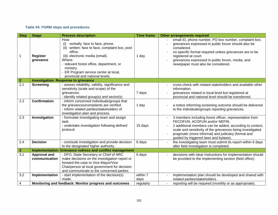
181
Table 54: FGRM steps and procedures.
Step Stage Process description Time frame Other arrangements required
1
Register grievance
How: (i) verbally: face to face, phone. (ii) written: face to face, complaint box, post
office. (iii) electronic media (email).
Where: - relevant forest office, department, or
ministry. - ER Program service center at local,
provincial and national levels.
1 day
- email ID, phone number, PO box number, complaint box. - grievances expressed in public forum should also be
considered. - no specific format required unless grievances are to be
registered at court. - grievances expressed in public forum, media, and
newspaper must also be considered.
2 Investigation: Response to grievance
2.1 Screening - assess reliability, validity, significance and sensitivity (scale and scope) of the grievances. - identify related group(s) and sector(s)
7 days
- cross-check with related stakeholders and available other information.
- grievances related to local level but registered at provincial and national level should be transferred.
2.2 Confirmation - inform concerned individuals/groups that the grievances/complaints are verified. - inform related parties/stakeholders of investigation plan and process.
1 day
- a notice informing screening outcome should be delivered
to the individuals/groups reporting grievances.
2.3 Investigation - formulate investigating team and assign task. - undertake investigation following defined protocol.
15 days
- 3 members including forest officer, representative from FECOFUN, ACOFUN and/or NEFIN.
- 2 additional members can be added, according to context, scale and sensitivity of the grievances being investigated.
- pragmatic (more informal) and judiciary (formal and guided by triggered laws and bylaws).
2.4 Decision - conclude investigation and provide decision to the designated higher authority.
6 days - the investigating team must submit its report within 6 days after field investigation is completed.
3 Implementation: Grievance redress and conflict management
3.1 Approval and communication
- DFO, State Secretary or Chief of NRC make decisions on the investigation report or forward the case to Vice Mayor/Vice Chairperson at local government for decision and communicate to the concerned parties.
6 days
- decisions with clear instructions for implementation should be provided to the implementing section (field office).
3.2 Implementation - start implementation of the decision(s) made.
within 7 days
- implementation plan should be developed and shared with related parties/stakeholders.
4 Monitoring and feedback: Monitor progress and outcomes regularly - reporting will be required (monthly or as appropriate).
182
15 BENEFIT-SHARING ARRANGEMENTS
15.1 DESCRIPTION OF BENEFIT-SHARING ARRANGEMENTS
The benefit-sharing component of any REDD+ program is central to its viability, as it guides how REDD+ finance translates into tangible benefits for all relevant and affected stakeholders. These benefits may themselves be a core objective of the program, but they are also essential to the long-term support and buy-in from diverse constituencies, which in turn are critical for participation and success of the program activities. Benefit-sharing arrangements are also fundamental to achieving fairness, inclusivity and transparency in program implementation, which are equally important in achieving sustainable results. The proposed ER Program will generate many types of carbon and non-carbon benefits as well as monetary and nonmonetary benefits. This section addresses benefit-sharing arrangements for monetary and nonmonetary benefits, i.e., those benefits directly related to payments for the program or funded with these payments. Three other sections of the ER-PD are also relevant in the context of costs and benefit sharing for Nepal’s ER Program. Section 16 is dedicated to non-carbon benefits and their monitoring arrangements. Section 4 of the ER-PD describes the prioritization and timelines of the planned ER Program Measures and therefore their subsequent benefits. Activities are prioritized based on alignment with the National REDD+ Strategy, the magnitude of threats from relevant drivers, and their potential to deliver other non-carbon benefits. Section 6 of the ER-PD includes cost estimates for the activities/measures and components of the ER Program along with revenue the ER Program Measures may generate. A benefit-sharing plan is under preparation. The NRC will delineate the Benefit Sharing Plan for the ER Program to at least the advanced draft stage in 2018. This section provides background and guiding principles for this work, including the types of monetary and nonmonetary benefits that are anticipated for various beneficiaries. The overall logic of the benefit-sharing arrangements is straightforward. Importantly, direct, monetary distribution to stakeholders in the Terai is not a significant feature of the proposed program. Rather, the majority of finances for this program will build capacity in public agencies to implement and scale key programs and activities that themselves deliver significant beneficial outcomes for communities. For example, the line agencies and DFOs under MoFE have geographic reach and experience and are well-positioned to work on the ground with communities, delineate new community forests, support the development and implementation of forest management plans through extension services, etc., but will utilize funds under the ER Program to significantly strengthen and scale these programs. On the other hand, the direct benefits to communities derived from these program activities are both tangible and significant, and their distribution is guided by existing institutional arrangements. In the case of establishing new CBFM groups or leasehold forests, for example, communities will immediately benefit, among other things, from a) formalizing their management rights over local forests with the associated security of clear user rights, b) extension services that guide development of forest management plans, c) improved production for forest products and/or NTFPs from these lands, and d) increased revenues associated with improved outputs from these forests. In turn, CBFM, CFM and leasehold forest management guidelines described below clearly define rules for distribution and/or reinvestment of these revenues. There will be some cases under the ER Program of even more direct provision of benefits. For example, in the case of the alternative energy activities, ER Program finance will help to reduce the costs and improve the accessibility of cookstove and biogas technologies to households, which will directly acquire the new technology and its multiple associated benefits. In the case of the private forestry interventions, there will be mechanisms to facilitate access to credit as well as other direct benefits/incentives including
183
seedlings from nurseries and extension support and training. In both of these activities, DFOs will prioritize outreach to the areas of greatest demand and/or interest in these activities. Though details of these arrangements are still being formulated, NRC will be guided by several principles in the design of benefit-sharing arrangements for REDD+ in Nepal, including equity (e.g., fair benefit sharing with and within the poorest communities), inclusivity (e.g., making sure women and historically marginalized groups are able to participate in and benefit from community forest management), and conditionality (e.g., linking payments to performance as much as possible). The National REDD+ Strategy also emphasizes the recognition of customary use rights and management practices of Indigenous Peoples in benefit-sharing arrangements, including through regulatory provisions and forest management plans. Categories of potential beneficiaries and types of benefits Following the Institutional and Cost-Benefit Sharing study in the ER Program Area, REDD+ beneficiaries can be divided into four groups:
1) Indigenous Peoples and local communities including women and forest-dependent poor may receive benefits under the ER Program either directly or indirectly. These benefits could arise from a wide range of activities including participation in community-based forest management regimes, participation in bio-energy programs (e.g., biogas, cookstoves), protection of religious and cultural practices related to forest resources, leadership development, participation in income generation activities, etc.
2) Government entities at national, state, district/division and local levels will receive budgetary funding for the implementation of the ER Program activities, as guided by costs, potential for impact and delivery of results. Similarly, government employees will receive opportunities for training, capacity building and exposure to technical knowledge and skills.
3) Private forest owners engaged in managing forests on private property can opt in to participate in the ER Program and are eligible to receive benefits to improve private forest management. The benefits could include technical assistance (e.g., in forest management planning or prescriptions) and/or through improved access to inputs (e.g., seedling nurseries, market access). Private forest management will also be incentivized through access to concessional credits and subsidies in crop insurance.
4) NGOs including CSOs and IPLC federations are major stakeholders in the design and implementation of the ER Program and will be important partners in delivery of ER Program activities. These partners could receive funds to support capacity building or to provide technical services, or to act as direct implementers of ER Program activities at the community level.
Criteria, process and timelines for the distribution of monetary and nonmonetary benefits Some broader frameworks for benefit sharing in natural resource management and climate change related programs are already in place. For example, the Climate Change Policy of 2011 recommends that at least 80 per cent of any climate related funds received by the country be directly allocated for the benefit of communities which are vulnerable to climate change and only up to 20 per cent can be used for management cost. In line with this policy, the ER Program will allocate at least 80% of available funds under the ERPA to implementing community-level ER activities, as described in Section 4.3. The allocation of these funds is outlined in Section 6 based on the agreed activities under the ER Program. Up to 20% of the funds will be used to support policies and measures across national and regional government institutions that guide or facilitate the implementation of field-level activities. These include monitoring, legal, institutional and other transaction costs. Another framework for distribution of benefits between federal, state and local governments is included in the National Natural Resources and Fiscal Commission Act of 2017. This Act developed criteria for the distribution of revenues and grants related to natural resources management. These legal and policy frameworks will be taken into account in development of final benefit sharing plan in addition to the existing practices under different forest management regimes.
184
Further criteria and context for delivering benefits are defined within the individual ER Program measures (see Sections 4 and 6). The Government of Nepal already has systems in place for identifying new and additional areas that will be handed over to CBFM groups, and a process for identifying households for bio-energy programs. Similarly, there are existing criteria for the distribution of benefits within CBFM groups which will be adhered to under this ER Program. In line with the principle of country-driven implementation, the Government of Nepal will apply existing modalities for the delivery of benefits through the ER Program; some of these are listed in Table 55 below. Monitoring provisions of the benefit-sharing arrangements The monitoring of costs and benefits under the ER Program will align with the proposed monitoring systems for carbon and non-carbon benefits. Costs and benefits incurred by IPs, local communities including women and forest-dependent poor, and other private-sector actors will be reported alongside the reporting of other carbon and non-carbon benefits as outlined in Sections 9 and 16. Both monetary and nonmonetary benefits will be monitored through district/division and/or local forest offices and relevant local government entities. The successful implementation of ER Program activities will be monitored by the relevant program entities (see below) to allow for adaptive management during the lifetime of the ER Program.
15.2 SUMMARY OF THE PROCESS OF DESIGNING THE BENEFIT-SHARING ARRANGEMENTS
As outlined in Section 5, the ER Program was developed using an extensive bottom-up approach that generated district- and community-relevant activities that can be feasibly implemented and that have the ownership and inclusion of local stakeholders. All consultations were carried out following the “Guidelines on Stakeholder Engagement in REDD+ Readiness” including consultations on benefit sharing, the role of stakeholders, and carbon and non-carbon benefits activities. Preliminary discussions related to benefit sharing were informed by several stages of consultations prior to the development of the ER-PD, including consultations at the local, district and national levels, including the development of benefit- and revenue-sharing arrangements under the various CBFM regimes, as part of the National REDD+ Strategy development process. These consultations included national and district government, CSOs, IPs, local communities, I/NGOs, forest user groups, women’s groups, Dalits, private sector, marginalized groups, and other experts. The ER Program benefit-sharing arrangements have already been guided by several stages of consultations prior to the development of the ER-PD, including consultations at the local, district and national levels. These include:
● National policy development: Prior to the establishment of the national REDD+ process, policies were developed which include benefit-sharing modalities that either explicitly or indirectly inform the BSM in the forestry sector. These include the development of benefit- and revenue-sharing arrangements under the various CBFM regimes outlined in Table 55, the development of the biogas program through AEPC and local government, and others.
● National REDD+ Strategy development: As part of the National REDD+ Strategy development process, consultations were held with national, regional and district-level stakeholders on the design of the REDD+ BSM. The REDD+ Strategy was also informed by the ER-PIN development process, which involved consulting across the 12 districts of the ER Program Area and reviewing existing national benefit-sharing arrangements.
● SESA development: The SESA provides an assessment of institutional mechanisms to ensure equitable benefit sharing and transfer of forest carbon payments to local communities, and an analysis of impacts of different interventions on improved benefit sharing for local communities.
● TAL cost-benefit-sharing analysis: During the REDD+ readiness process, the Government of Nepal commissioned a study on cost benefit-sharing and institutional arrangements in the TAL.
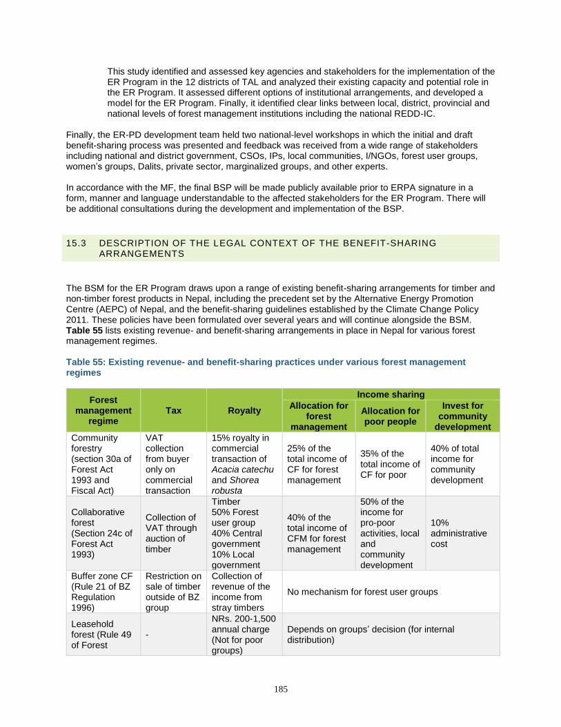
185
This study identified and assessed key agencies and stakeholders for the implementation of the ER Program in the 12 districts of TAL and analyzed their existing capacity and potential role in the ER Program. It assessed different options of institutional arrangements, and developed a model for the ER Program. Finally, it identified clear links between local, district, provincial and national levels of forest management institutions including the national REDD-IC.
Finally, the ER-PD development team held two national-level workshops in which the initial and draft benefit-sharing process was presented and feedback was received from a wide range of stakeholders including national and district government, CSOs, IPs, local communities, I/NGOs, forest user groups, women’s groups, Dalits, private sector, marginalized groups, and other experts. In accordance with the MF, the final BSP will be made publicly available prior to ERPA signature in a form, manner and language understandable to the affected stakeholders for the ER Program. There will be additional consultations during the development and implementation of the BSP.
15.3 DESCRIPTION OF THE LEGAL CONTEXT OF THE BENEFIT-SHARING ARRANGEMENTS
The BSM for the ER Program draws upon a range of existing benefit-sharing arrangements for timber and non-timber forest products in Nepal, including the precedent set by the Alternative Energy Promotion Centre (AEPC) of Nepal, and the benefit-sharing guidelines established by the Climate Change Policy 2011. These policies have been formulated over several years and will continue alongside the BSM. Table 55 lists existing revenue- and benefit-sharing arrangements in place in Nepal for various forest management regimes. Table 55: Existing revenue- and benefit-sharing practices under various forest management regimes
Forest management
regime Tax Royalty
Income sharing
Allocation for forest
management
Allocation for poor people
Invest for community
development
Community forestry (section 30a of Forest Act 1993 and Fiscal Act)
VAT collection from buyer only on commercial transaction
15% royalty in commercial transaction of Acacia catechu and Shorea robusta
25% of the total income of CF for forest management
35% of the total income of CF for poor
40% of total income for community development
Collaborative forest (Section 24c of Forest Act 1993)
Collection of VAT through auction of timber
Timber 50% Forest user group 40% Central government 10% Local government
40% of the total income of CFM for forest management
50% of the income for pro-poor activities, local and community development
10% administrative cost
Buffer zone CF (Rule 21 of BZ Regulation 1996)
Restriction on sale of timber outside of BZ group
Collection of revenue of the income from stray timbers
No mechanism for forest user groups
Leasehold forest (Rule 49 of Forest
-
NRs. 200-1,500 annual charge (Not for poor groups)
Depends on groups’ decision (for internal distribution)

186
Regulation 1995)
Protected areas (Section 25a of NPWC Act 1973)
- - 30-50% of income should be allocated for the community development of Buffer Zone areas
Constitutional provision for benefits sharing of natural resources: According to Article 59(4) of the constitution the federation, state and local levels shall provide for the equitable distribution of benefits derived from the use of natural resources or development. Certain portions of such benefits shall be distributed, pursuant to law, in forms of royalty, services or goods to the project-affected regions and local communities. The new constitutional provisions have given legal authority to all levels of states to collect and share the royalties from natural resources including forest, though the detailed legal framework will be developed after election of states and local institutions and establishment of such states at the beginning of 2018. The ER Program activities will serve to strengthen and enhance existing benefit-sharing arrangements by supporting various community-based forest management regimes, and the existing bio-energy (biogas, ICS and briquette) program and fire management programs in the ER Program Area. In this regard, it will deliver significant benefits to local communities and strengthen existing institutions. The BSM builds on the guidelines established by the Climate Change Policy (2011), constitutional provisions as envisioned in the article 59(4), and the precedent set by the Alternative Energy Promotion Centre (AEPC). In principle, 80% of benefits received under the ER Program will be shared with local communities, Indigenous Peoples and private forest owners. This principle has already been applied under the AEPC biogas program, which receives funds from a variety of sources including the World Bank, UNDP, Government of Nepal, DANIDA, and NORAD. Under an ERPA signed with the World Bank Community Development Carbon Fund (CDCF) AEPC has also adopted an 80/20 ratio of benefit distribution to local communities to support biogas implementation and to deliver emissions reductions under the ER Program. In addition, to the above principle, the BSM will also support the established modalities for revenue sharing under the CBFM regimes established under the Forest Act (1993), and Forest Regulation (1995) (see Table 55). Through this, the existing benefits being generated by CBFM areas will be promoted under the ER Program. The benefit sharing plan will be developed based on these legal and policy frameworks, existing practices under different forest management regimes and further consultations with rights holders according to the time table shown in Annex 14: Safeguards Roadmap.
187
16 NON-CARBON BENEFITS
16.1 OUTLINE OF POTENTIAL NON-CARBON BENEFITS AND IDENTIFICATION OF PRIORITY NON-CARBON BENEFITS
The proposed ER Program is expected to contribute to bettering forest and socioeconomic conditions by improving livelihood opportunities, governance reform, community empowerment and social change. The ER Program will result in visible positive changes in forest conditions, increasing production and the availability of forest products and concurrently reducing the time spent collecting forest products (e.g., biogas units and cookstoves will reduce time spent collecting fuelwood). Enhancing the production and marketing of forest products will generate financial capital, and ultimately support livelihoods of the communities. ER Program activities are intended to generate social capital through collective actions, trust building, and conflict resolution, ensuring improved participation in decision-making and enhancing the access of poor, women, and powerless and disadvantaged groups to the multiple benefits of productive forests. Human capital will be developed by conducting capacity-building activities described in Section 4.3, and financial capital will be developed by improving access to financial resources. The proposed ER Program activities comply with the UNFCCC and the World Bank safeguard principles and will maintain and improve multiple ecosystem services provided by forests, including carbon sequestration, biodiversity conservation, and maintenance of water flow and quality. Categories and key elements of NCBs A recent study on non-carbon benefits (NCBs) commissioned by the NRC provided the following working definition of NCBs.88
“Non-Carbon Benefits (NCBs –also understood as co-benefits, multiple benefits or other benefits) has been defined as a wide range of positive outcomes beyond those associated with avoided CO2 emissions and/or carbon sequestration, resulting from the implementation of safeguards responsive REDD+ activities. Such benefits are both realized and/or appreciated by concerned stakeholders.”
This study further proposed the following five major categories of NCB values, including key elements under each of these categories for periodic monitoring at local and landscape/watershed levels. The categories included:
1. Livelihood values 2. Social values 3. Biodiversity values 4. Ecosystem values 5. Governance, Policy and Institutional values
In addition, Nepal’s 2013 submission to the UNFCCC89 emphasized the importance of more resilient ecosystems for climate change adaptation, which is an important non-carbon benefit that can arise from ecosystem-based mitigation activities. The aim is for the outcomes of the ER Program activities and interventions to go beyond the minimum requirements of safeguards (which ensure that the program does no harm to livelihoods and biodiversity), to generate significant positive impacts through enhancement of livelihoods, social norms and rights; conservation of natural forests and their ecosystem services; and promotion of effective forest governance mechanisms. In addition, the ER Program will improve the
88 Government of Nepal REDD Implementation Centre. Study of Forest Carbon Ownership in Nepal. http://mofsc-redd.gov.np/wp-content/uploads/2013/11/Final-Report-FCO_Revised_29_10_2015_ERI_Final_01-11-2015.pdf. August 2015. 89 Methodological guidance for non-market-based approaches and methodological issues related to noncarbon benefits resulting from the implementation of REbD-plus:http://redd.unfccc.int/uploads/2_78_redd_20140326_nepal_nmbas_ncb.pdf
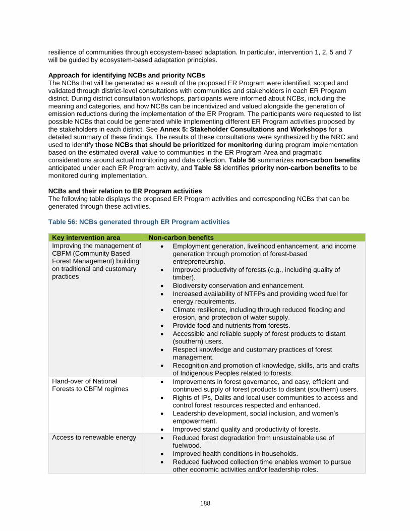
188
resilience of communities through ecosystem-based adaptation. In particular, intervention 1, 2, 5 and 7 will be guided by ecosystem-based adaptation principles. Approach for identifying NCBs and priority NCBs The NCBs that will be generated as a result of the proposed ER Program were identified, scoped and validated through district-level consultations with communities and stakeholders in each ER Program district. During district consultation workshops, participants were informed about NCBs, including the meaning and categories, and how NCBs can be incentivized and valued alongside the generation of emission reductions during the implementation of the ER Program. The participants were requested to list possible NCBs that could be generated while implementing different ER Program activities proposed by the stakeholders in each district. See Annex 5: Stakeholder Consultations and Workshops for a detailed summary of these findings. The results of these consultations were synthesized by the NRC and used to identify those NCBs that should be prioritized for monitoring during program implementation based on the estimated overall value to communities in the ER Program Area and pragmatic considerations around actual monitoring and data collection. Table 56 summarizes non-carbon benefits anticipated under each ER Program activity, and Table 58 identifies priority non-carbon benefits to be monitored during implementation. NCBs and their relation to ER Program activities The following table displays the proposed ER Program activities and corresponding NCBs that can be generated through these activities. Table 56: NCBs generated through ER Program activities
Key intervention area Non-carbon benefits
Improving the management of CBFM (Community Based Forest Management) building on traditional and customary practices
• Employment generation, livelihood enhancement, and income generation through promotion of forest-based entrepreneurship.
• Improved productivity of forests (e.g., including quality of timber).
• Biodiversity conservation and enhancement.
• Increased availability of NTFPs and providing wood fuel for energy requirements.
• Climate resilience, including through reduced flooding and erosion, and protection of water supply.
• Provide food and nutrients from forests.
• Accessible and reliable supply of forest products to distant (southern) users.
• Respect knowledge and customary practices of forest management.
• Recognition and promotion of knowledge, skills, arts and crafts of Indigenous Peoples related to forests.
Hand-over of National Forests to CBFM regimes
• Improvements in forest governance, and easy, efficient and continued supply of forest products to distant (southern) users.
• Rights of IPs, Dalits and local user communities to access and control forest resources respected and enhanced.
• Leadership development, social inclusion, and women’s empowerment.
• Improved stand quality and productivity of forests.
Access to renewable energy
• Reduced forest degradation from unsustainable use of fuelwood.
• Improved health conditions in households.
• Reduced fuelwood collection time enables women to pursue other economic activities and/or leadership roles.
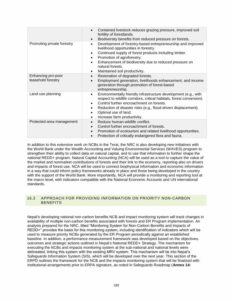
189
• Contained livestock reduces grazing pressure, improved soil fertility of forestlands.
• Biodiversity benefits from reduced pressure on forests.
Promoting private forestry
• Development of forestry-based entrepreneurship and improved livelihood opportunities in forestry.
• Continued supply of forest products including timber.
• Promotion of agroforestry.
• Enhancement of biodiversity due to reduced pressure on natural forests.
• Maintained soil productivity.
Enhancing pro-poor leasehold forestry
• Restoration of degraded forests.
• Employment generation, livelihoods enhancement, and income generation through promotion of forest-based entrepreneurship.
Land-use planning
• Environmentally friendly infrastructure development (e.g., with respect to wildlife corridors, critical habitats, forest conversion).
• Control further encroachment on forests.
• Reduction of disaster risks (e.g., flood-driven displacement).
• Optimal use of land.
• Increase farm productivity.
Protected area management • Reduce human-wildlife conflict.
• Control further encroachment of forests.
• Promotion of ecotourism and related livelihood opportunities.
• Protection of critically endangered flora and fauna.
In addition to this extensive work on NCBs in the Terai, the NRC is also developing new initiatives with the World Bank under the Wealth Accounting and Valuing Environmental Services (WAVES) program to strengthen their ability to collect data on natural capital, and to use that information to further shape the national REDD+ program. Natural Capital Accounting (NCA) will be used as a tool to capture the value of the market and nonmarket contributions of forests and their link to the economy, reporting also on drivers and impacts of forest use. NCA will be used to connect biophysical information and economic information in a way that could inform policy frameworks already in place and those being developed in the country with the support of the World Bank. More importantly, NCA will provide a monitoring and reporting tool at the macro level, with indicators compatible with the National Economic Accounts and UN international standards.
16.2 APPROACH FOR PROVIDING INFORMATION ON PRIORITY NON-CARBON BENEFITS
Nepal’s developing national non-carbon benefits NCB and impact monitoring system will track changes in availability of multiple non-carbon benefits associated with forests and ER Program implementation. An analysis prepared for the NRC, titled “Monitoring System for Non-Carbon Benefits and Impacts of REDD+” provides the basis for this monitoring system, including identification of indicators which will be used to measure priority NCBs generated by the ER Program periodically against an established baseline. In addition, a performance measurement framework was developed based on the objectives, outcomes and strategic actions outlined in Nepal’s National REDD+ Strategy. The mechanism for executing the NCBs and impacts monitoring system at the sub-national and national levels were delineated, linking this system with the existing MRV system. This mechanism will tie into Nepal’s Safeguards Information System (SIS), which will be developed over the next year. This section of the ERPD outlines the framework for the NCB and the impacts monitoring system that will be finalized with institutional arrangements prior to ERPA signature, as noted in Safeguards Roadmap (Annex 14:
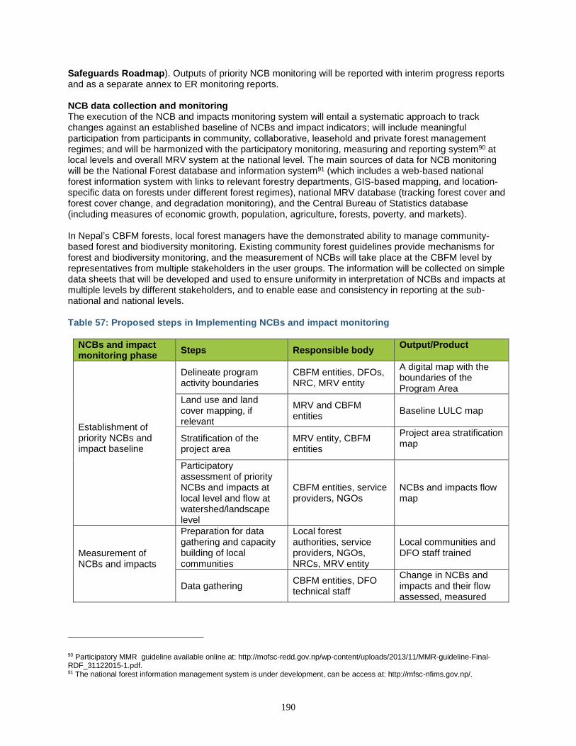
190
Safeguards Roadmap). Outputs of priority NCB monitoring will be reported with interim progress reports and as a separate annex to ER monitoring reports. NCB data collection and monitoring The execution of the NCB and impacts monitoring system will entail a systematic approach to track changes against an established baseline of NCBs and impact indicators; will include meaningful participation from participants in community, collaborative, leasehold and private forest management regimes; and will be harmonized with the participatory monitoring, measuring and reporting system90 at local levels and overall MRV system at the national level. The main sources of data for NCB monitoring will be the National Forest database and information system91 (which includes a web-based national forest information system with links to relevant forestry departments, GIS-based mapping, and location-specific data on forests under different forest regimes), national MRV database (tracking forest cover and forest cover change, and degradation monitoring), and the Central Bureau of Statistics database (including measures of economic growth, population, agriculture, forests, poverty, and markets). In Nepal’s CBFM forests, local forest managers have the demonstrated ability to manage community-based forest and biodiversity monitoring. Existing community forest guidelines provide mechanisms for forest and biodiversity monitoring, and the measurement of NCBs will take place at the CBFM level by representatives from multiple stakeholders in the user groups. The information will be collected on simple data sheets that will be developed and used to ensure uniformity in interpretation of NCBs and impacts at multiple levels by different stakeholders, and to enable ease and consistency in reporting at the sub-national and national levels. Table 57: Proposed steps in Implementing NCBs and impact monitoring
NCBs and impact monitoring phase
Steps Responsible body Output/Product
Establishment of priority NCBs and impact baseline
Delineate program activity boundaries
CBFM entities, DFOs, NRC, MRV entity
A digital map with the boundaries of the Program Area
Land use and land cover mapping, if relevant
MRV and CBFM entities
Baseline LULC map
Stratification of the project area
MRV entity, CBFM entities
Project area stratification map
Participatory assessment of priority NCBs and impacts at local level and flow at watershed/landscape level
CBFM entities, service providers, NGOs
NCBs and impacts flow map
Measurement of NCBs and impacts
Preparation for data gathering and capacity building of local communities
Local forest authorities, service providers, NGOs, NRCs, MRV entity
Local communities and DFO staff trained
Data gathering CBFM entities, DFO technical staff
Change in NCBs and impacts and their flow assessed, measured
90 Participatory MMR guideline available online at: http://mofsc-redd.gov.np/wp-content/uploads/2013/11/MMR-guideline-Final-RDF_31122015-1.pdf. 91 The national forest information management system is under development, can be access at: http://mfsc-nfims.gov.np/.
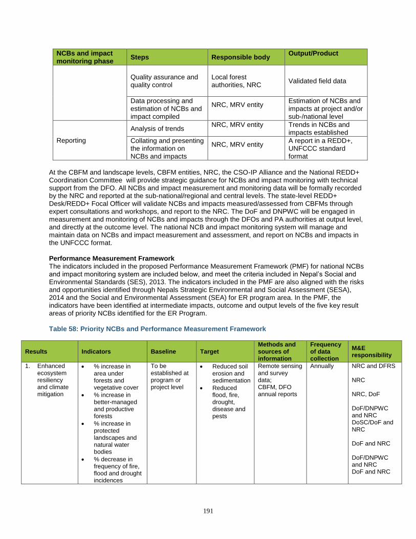
191
NCBs and impact monitoring phase
Steps Responsible body Output/Product
Quality assurance and quality control
Local forest authorities, NRC
Validated field data
Data processing and estimation of NCBs and impact compiled
NRC, MRV entity
Estimation of NCBs and impacts at project and/or sub-/national level
Reporting
Analysis of trends NRC, MRV entity
Trends in NCBs and impacts established
Collating and presenting the information on NCBs and impacts
NRC, MRV entity
A report in a REDD+, UNFCCC standard format
At the CBFM and landscape levels, CBFM entities, NRC, the CSO-IP Alliance and the National REDD+ Coordination Committee will provide strategic guidance for NCBs and impact monitoring with technical support from the DFO. All NCBs and impact measurement and monitoring data will be formally recorded by the NRC and reported at the sub-national/regional and central levels. The state-level REDD+ Desk/REDD+ Focal Officer will validate NCBs and impacts measured/assessed from CBFMs through expert consultations and workshops, and report to the NRC. The DoF and DNPWC will be engaged in measurement and monitoring of NCBs and impacts through the DFOs and PA authorities at output level, and directly at the outcome level. The national NCB and impact monitoring system will manage and maintain data on NCBs and impact measurement and assessment, and report on NCBs and impacts in the UNFCCC format. Performance Measurement Framework The indicators included in the proposed Performance Measurement Framework (PMF) for national NCBs and impact monitoring system are included below, and meet the criteria included in Nepal’s Social and Environmental Standards (SES), 2013. The indicators included in the PMF are also aligned with the risks and opportunities identified through Nepals Strategic Environmental and Social Assessment (SESA), 2014 and the Social and Environmental Assessment (SEA) for ER program area. In the PMF, the indicators have been identified at intermediate impacts, outcome and output levels of the five key result areas of priority NCBs identified for the ER Program. Table 58: Priority NCBs and Performance Measurement Framework
Results Indicators Baseline Target Methods and sources of information
Frequency of data collection
M&E responsibility
1. Enhanced ecosystem resiliency and climate mitigation
• % increase in area under forests and vegetative cover
• % increase in better-managed and productive forests
• % increase in protected landscapes and natural water bodies
• % decrease in frequency of fire, flood and drought incidences
To be established at program or project level
• Reduced soil erosion and sedimentation
• Reduced flood, fire, drought, disease and pests
Remote sensing and survey data; CBFM, DFO annual reports
Annually
NRC and DFRS NRC NRC, DoF DoF/DNPWC and NRC DoSC/DoF and NRC DoF and NRC DoF/DNPWC and NRC DoF and NRC
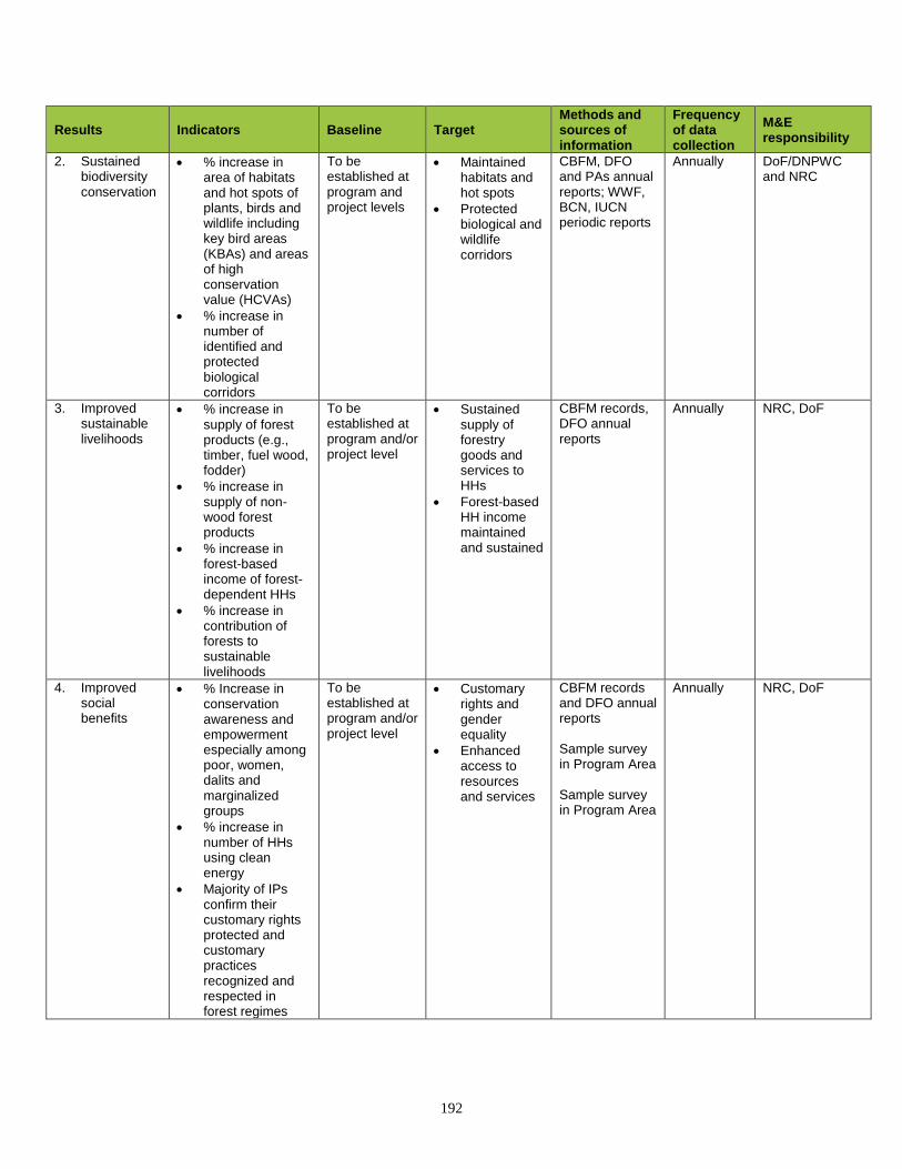
192
Results Indicators Baseline Target Methods and sources of information
Frequency of data collection
M&E responsibility
2. Sustained biodiversity conservation
• % increase in area of habitats and hot spots of plants, birds and wildlife including key bird areas (KBAs) and areas of high conservation value (HCVAs)
• % increase in number of identified and protected biological corridors
To be established at program and project levels
• Maintained habitats and hot spots
• Protected biological and wildlife corridors
CBFM, DFO and PAs annual reports; WWF, BCN, IUCN periodic reports
Annually
DoF/DNPWC and NRC
3. Improved sustainable livelihoods
• % increase in supply of forest products (e.g., timber, fuel wood, fodder)
• % increase in supply of non-wood forest products
• % increase in forest-based income of forest-dependent HHs
• % increase in contribution of forests to sustainable livelihoods
To be established at program and/or project level
• Sustained supply of forestry goods and services to HHs
• Forest-based HH income maintained and sustained
CBFM records, DFO annual reports
Annually
NRC, DoF
4. Improved social benefits
• % Increase in conservation awareness and empowerment especially among poor, women, dalits and marginalized groups
• % increase in number of HHs using clean energy
• Majority of IPs confirm their customary rights protected and customary practices recognized and respected in forest regimes
To be established at program and/or project level
• Customary rights and gender equality
• Enhanced access to resources and services
CBFM records and DFO annual reports Sample survey in Program Area Sample survey in Program Area
Annually NRC, DoF
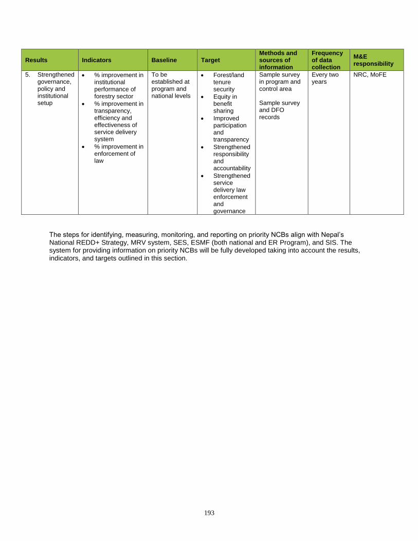
193
Results Indicators Baseline Target Methods and sources of information
Frequency of data collection
M&E responsibility
5. Strengthened governance, policy and institutional setup
• % improvement in institutional performance of forestry sector
• % improvement in transparency, efficiency and effectiveness of service delivery system
• % improvement in enforcement of law
To be established at program and national levels
• Forest/land tenure security
• Equity in benefit sharing
• Improved participation and transparency
• Strengthened responsibility and accountability
• Strengthened service delivery law enforcement and governance
Sample survey in program and control area Sample survey and DFO records
Every two years
NRC, MoFE
The steps for identifying, measuring, monitoring, and reporting on priority NCBs align with Nepal’s National REDD+ Strategy, MRV system, SES, ESMF (both national and ER Program), and SIS. The system for providing information on priority NCBs will be fully developed taking into account the results, indicators, and targets outlined in this section.
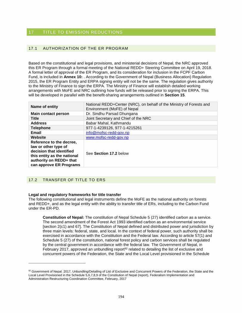
194
17 TITLE TO EMISSION REDUCTIONS
17.1 AUTHORIZATION OF THE ER PROGRAM
Based on the constitutional and legal provisions, and ministerial decisions of Nepal, the NRC approved this ER Program through a formal meeting of the National REDD+ Steering Committee on April 19, 2018. A formal letter of approval of the ER Program, and its consideration for inclusion in the FCPF Carbon Fund, is included in Annex 10: . According to the Government of Nepal (Business Allocation) Regulation 2015, the ER Program Entity and ERPA signing entity will not be the same. The regulation gives authority to the Ministry of Finance to sign the ERPA. The Ministry of Finance will establish detailed working arrangements with MoFE and NRC outlining how funds will be released prior to signing the ERPA. This will be developed in parallel with the benefit-sharing arrangements outlined in Section 15.
Name of entity National REDD+Center (NRC), on behalf of the Ministry of Forests and Environment (MoFE) of Nepal
Main contact person Dr. Sindhu Parsad Dhungana
Title Joint Secretary and Chief of the NRC
Address Babar Mahal, Kathmandu
Telephone 977-1-4239126, 977-1-4215261
Email [email protected]
Website www.mofsc-redd-gov.np
Reference to the decree, law or other type of decision that identified this entity as the national authority on REDD+ that can approve ER Programs
See Section 17.2 below
17.2 TRANSFER OF TITLE TO ERS
Legal and regulatory frameworks for title transfer The following constitutional and legal instruments define the MoFE as the national authority on forests and REDD+, and as the legal entity with the ability to transfer title of ERs, including to the Carbon Fund under the ER-PD.
Constitution of Nepal: The constitution of Nepal Schedule 5 (27) identified carbon as a service. The second amendment of the Forest Act 1993 identified carbon as an environmental service [section 2(c1) and 67]. The Constitution of Nepal defined and distributed power and jurisdiction by three main levels: federal, state, and local. In the context of federal power, such authority shall be exercised in accordance with the Constitution and the Federal law. According to article 57(1) and Schedule 5 (27) of the constitution, national forest policy and carbon services shall be regulated by the central government in accordance with the federal law. The Government of Nepal, in February 2017, approved an unbundling report92 related to detailing the list of exclusive and concurrent powers of the Federation, the State and the Local Level provisioned in the Schedule
92 Government of Nepal. 2017, Unbundling/Detailing of List of Exclusive and Concurrent Powers of the Federation, the State and the Local Level Provisioned in the Schedule 5,6,7,8,9 of the Constitution of Nepal (report), Federalism Implementation and Administration Restructuring Coordination Committee, February, 2017
195
5,6,7,8,9 of the Constitution of Nepal. This report elaborated on carbon service related authority of federation and clearly states that the enhancement of carbon stocks, as well as fiscal management of the carbon service authority will be under the jurisdiction of federation.
Based on this constitutional provision (Schedule 5: List of Federal Powers/Jurisdiction), MoFE can develop and approve policies, plans and programs on national forest and associated carbon services such as carbon trade and regulation and is not required to get consent from state and local governments. Accordingly, the NRC can approve the ER Program and transfer title to ERs to the Carbon Fund through a formal meeting of the National REDD+ Coordination Committee (NRCC). The National REDD+ Strategy has also given this authority to the NRCC.
According to article 59(4) of the constitution, the central government is required to make an appropriate arrangement to share the benefits generated from natural resources with the project affected local communities as prescribed by the law. Therefore, as an ER Program entity, the NRC will develop a Benefit Sharing Plan and Safeguards Plan considering this constitutional provision in the future before signing in the ERPA, or before receiving any upfront payment from the Carbon Fund for the implementation of the ER Program.
Government of Nepal (Business Allocation) Regulation 2015: This Regulation allocated the rights and responsibilities of each ministry of Nepal and based on these rules, the concerned ministry has the authority to approve any plan and program that is relevant to Schedule 2 of the Government of Nepal (Business Allocation) Regulation 2015. Schedule-2 (18.16) of this regulation gives authority to MoFE to develop and approve plans and programs related to forest-based climate change mitigation. As a decision-making body on the REDD+ at the national level, the NRCC, chaired by the Secretary of MoFE, first approves the ER Program and decides to forward it to the National REDD+ Steering Committee (NRSC), chaired by the Minister of MoFE for final endorsement. The NRSC will endorse the ER Program and decide to transfer title to ERs to the Carbon Fund. As a Secretariat of the National REDD+ Coordination Committee and National REDD+ Steering Committee, the NRC will prepare a formal request and forward it through MoFE to the Ministry of Finance to sign the ERPA with the FCPF Carbon Fund as per the Section 2(11)(13) of the Government of Nepal (Business Allocation) Regulation 2015.
Forest Act 1993: According to the Forest Act 1993, carbon stocks are not included under forest products and not counted as forest products/goods, but included under or counted as an environmental service, which will be managed and utilized based on forest regulation or contractual laws. The second amendment in Forest Act 1993 (2016) made a provision to manage environmental services generated through the sustainable management of forests. Section 2c1 of the Forest Act defined environmental services and according to this definition, forest carbon stocks are also counted as an environmental service generated from forests. According to section 67b of the Forest Act, the MoFE has authority to make an appropriate arrangement for the management, utilization and benefit sharing of environmental services, including regulation of forest carbon stocks. Due to different environmental services, the carbon service will be regulated by NRC on behalf of MoFE.
Sub-arrangements: The forestry sector legislation of Nepal recognized FUGs as legal entities. In addition, the National Parks and Wildlife Reserves (NPWR) Act 1973 and associated regulations also recognized forest tenure rights of communities and individuals in the Buffer Zones and Conservation Areas in Nepal. FUGs prepare forest management plans and, according to the Community Forest Development Guideline 2015 (revised), FUGs may include provisions for the conservation and utilization of environmental services, including carbon stocks, in their forest management plans. Section 25 of the Forest Act 1993 authorizes DFOs to approve forest management plans, but only for the utilization of forest products and not for environmental services. As such, the Forest Act defines forest carbon as both an intangible asset and an environmental service, and gives resource rights to communities on the products or goods produced in the forest but not to the land, intangible property, nor environmental services (e.g., carbon stocks).
196
Assessment of carbon rights The National REDD+ Strategy states that “under the existing land and forest tenure regimes, substantive measures will be taken to secure carbon rights of the right holders. For this, forest legislation will clearly define carbon rights and its right holder.” Considering this, the second amendment in the Forest Act (2016) included carbon sequestration/stock as an environmental service, which will be regulated according to the constitutional provision and procedures defined in the Forest Regulation 1995. Under the existing regulatory framework, carbon rights are therefore considered as a national right, not an individual right. According to the Constitution of Nepal, the federal government has the explicit authority to manage the fiscal responsibilities of carbon services, granting it the authority and ability to transfer ER Titles to the Carbon Fund. While forest carbon stocks are an intangible asset classified under the jurisdiction of the federal government, it is a key priority of Nepal’s National REDD+ Strategy to ensure that communities that have been managing the forests are entitled to benefit from the sale of carbon stored in the forests under clarified usufruct rights. Clarifying lend tenure for communities in Nepal is a key issue for effective REDD+ implementation. Carbon rights and emission reduction title The Constitution of Nepal (2016) Schedule 5, No 27, puts the following matter under the sole jurisdiction of federal power. In other words, the following matter is dealt with by the Federal Government, as opposed to State Government or Local Government: “National and international environment management, national parks, wildlife reserves and wetlands, national forest policies, carbon services.” REDD+ comes under both national and international environment management. On the one hand, the activities and interventions for implementing Emission Reduction Programs, or any other programs in the National REDD+ Strategy, are guided by national laws, policies and the annual budget/program of the government. On the other hand, REDD+ is also guided by UNFCCC and any contract made by the Government of Nepal with any international entities such as the World Bank’s Carbon Fund and UN-REDD. Carbon rights and Emission Reduction Title directly belong to national and international environment management and carbon services. They are also a matter of national forest policies. It is clear that the Federal Government has the right to transfer title of emission reduction to international entities based on its right over national and international environment management and carbon services, as well as the right to issue national forest policies. However, this right should not be viewed in isolation. The Federal Government has other obligations and commitments toward its citizens and natural resources including forests and biodiversity. Under the Policies of the State, Article 51 (g) relates to the protection, promotion and use of natural resources, which state:
• “(1) to protect, promote, and make environmental friendly and sustainable use of, natural resources available in the country, in consonance with national interest and adopting the concept of inter-generational equity, and make equitable distribution of fruits, according to priority and preferential right to the local communities,
• (6) to maintain the forest area in necessary lands for ecological balance,
• (7) to adopt appropriate measures to abolish or mitigate existing or possible adverse environmental impacts on the nature, environment or biological diversity,
• (8) to pursue the principles of environmentally sustainable development such as the principles of polluter pays, of precaution in environmental protection and of prior informed consent”
The State Policies imply that the benefits of natural resources, including the benefits from carbon services, are equitably distributed. Local communities have preferential right over management and sustainable use of natural resources, including forests. Principles of prior informed (currently free prior informed) consent are applicable in REDD+ processes and results, including benefit sharing. Since emissions are reduced from the contribution of the activities carried out by people, biological persons (private tree grower individuals) or legal persons (government entities and groups of forest users, such as community forest user groups, collaborative forest user groups, leasehold forest user groups), the title of the emission as property rests with the person (private or legal), and hence is also pursuant to
197
the Fundamental right relating to property in the Constitution. The Constitution defines property as “any form of property including movable and immovable property, and includes an intellectual property right” (Article 25). The same Article 25 (Right relating to Property) states:
• “(2) The State shall not, except for public interest, requisition, acquire, or otherwise create any encumbrance on, property of a person. Provided that this clause shall not apply to any property acquired by any person illicitly
• (3) The basis of compensation to be provided and procedures to be followed in the requisition by the State of property of any person for public interest in accordance with clause (2) shall be as provided for in the Act”
The title of carbon emission rests with the person (biological and legal) who contributes to reducing emissions. However, the individual person cannot transfer the emission title like other private property or tangible forest products, such as timber and medicinal herbs, because the Federal Government has power over carbon services as well as the land ownership of national forests. In other words, since the land under national forests, including community forests, is owned by the Federal Government (Forest Act, Article 67) and authority over carbon services is vested in the Federal government (Constitution Schedule 5 (27)), no person (biological or legal) can transfer title of emission reductions apart from the Federal Government. The Federal Government pursuant to other legislation (Article 25) and equitable benefit-sharing plans (Article 51) can transfer title of carbon emission to any entity. One set of interventions described in Section 4.3 involves offering different incentives and extension services to private landowners to transition non-forestlands into productive forest management. In contrast to government-owned lands, private landholders have encompassing rights described in Section 4.4, including to access, management, alienation, etc., and the established authority of the federal government over carbon rights does not clearly apply. For this reason, and to minimize the risk of conflict over carbon rights as they relate to ER Program activities associated with private lands, the NRC will establish a well-publicized, contractual “opt-in” mechanism that is a prerequisite for participation of private landholders. Similar to the “Transfer of Green House Gas” contract used by AEPC in biogas projects, this contract will allow private landholders to register for ER Program forestry incentives in exchange for transfer of carbon rights associated with their land. The contractual mechanism will specify the obligations for private landholders to develop and implement a sustainable forest management plan that will be mutually agreeable between NRC and the private landowner based on key conditions of REDD+, including but not limited to measures to ensure permanence and minimize displacement risks. Their incentive and benefit will be reflected in the extension services that they access under the ER Program and the economic benefits that they help to catalyze. Nonregistered private landholders will not be participants in the ER Program activities and therefore will have little basis for legal claim to emission reductions produced under the ER Program. This contractual opt-in arrangement has already been included by the Ministry of Forests and Environment in the draft amendment to the Forest Regulation of 1995, which is pending endorsement by the Council of Ministers. This contractual opt-in arrangement will be elaborated on and included as part of the Benefit Sharing Plan. The Federal Government has started making provisions for carbon services in legislation. The second amendment of the Forest Act (1993) in 2016 has such a provision. Article 2 (C1) states that “Ecosystem Services” mean the following services and benefits derived from ecosystems:
1. Carbon stock 2. Biodiversity conservation 3. Hydrological system 4. Ecotourism 5. Any other benefit as defined
The provision related to the management of ecosystem services in Article 67(b) states: ”The management, utilization and benefit sharing of ecosystem services from forests shall be arranged as per the regulation.” Forest regulation is yet to be amended to incorporate the Second Amendment of the Forest Act, including the elaboration of the management, utilization and benefit sharing of ecosystem services including
198
emission reduction (carbon services). There is ample opportunity to incorporate the provision of carbon emission title, emission title transfer and benefit-sharing mechanism that is consistent with the Constitution of Nepal, Forest Act and Nepal’s international obligations such as UNFCCC and Nationally Determined Contributions. There is a strong commitment on the part of the Ministry of Law, Justice and Parliamentary Affairs to amend legislation or make new legislation to incorporate carbon title, which will be recommended by the Ministry of Forests and Environment. The Government of Nepal (Allocation of Business) Rules (2012) allocates the responsibilities of all the Ministries in the Government of Nepal. Under the Schedule 2(2), the businesses of the Ministry of Finance include:
• International relation and coordination for social and economic development.
• International relation and co-ordination relating to economic, banking and currency sector.
• Foreign loan, grant and other bilateral and multilateral aid. On behalf of the Federal Government, the Ministry of Finance is the authority to sign an Emission Reduction Payment Agreement (ERPA) with an international entity, including FCPF's Carbon Fund. A detailed study on land and forest tenure, as well as the title transfer of emission reductions, has been undertaken by Jhaveri and Adhikari (2015) for the purpose of implementing the Emission Reduction Program in the Terai Arc Landscape. The document is submitted as an associated document to the ERPD. The study recommends setting up a central-level entity under the Ministry of Forests and Environment with a mandate to transfer emission title as well as to manage benefitsharing by amending Government of Nepal (Allocation of Business) Rules (2012).
199
18 DATA MANAGEMENT AND REGISTRY SYSTEMS
18.1 PARTICIPATION UNDER OTHER GHG INITIATIVES
As stated in Section 6.2, the ER Program is not currently planning to participate in any other GHG initiatives; however, the GoN may sell additional ERs generated under the ER Program through external carbon market transactions to catalyze further activities in the Terai. Since several biogas and cookstove projects operate at the national level and in the Terai, any ERs generated and sold through other initiatives that result in reductions in fuelwood use in the ER Program Area will be tracked through relevant registries (that will cross-walk with centralized registry provided by FCPF) and deducted from ERs generated by the ER Program (See Annex 16: ).
18.2 DATA MANAGEMENT AND REGISTRY SYSTEMS TO AVOID MULTIPLE CLAIMS TO ERS
The National REDD+ Strategy indicates that a central-level, independent carbon registry, which will work as a repository for REDD+-related information (e.g., information on the location, ownership, carbon accounting, financial flows for sub-national and national REDD+ programs and projects) will be established and maintained within the NRC. The registry will enforce standards and engage in carbon transactions by maintaining broad-based participation of stakeholders in the management of the registry. Projects at the national and sub-national level will register their performance at the registry. The central registry will aggregate and track multiple levels of REDD+ activities (national, subnational and project-based) and provide governments, donors and stakeholders with transparent and meaningful data from which to make results-based payments. The registry system will be consistent with existing national policies, and local stakeholders (e.g., REDD-IC, departments, ministry, local communities, CSOs) will be involved to the extent possible. The system will be linked with the NFD and NFIS and national MRV section. The registry will enforce standards and engage in carbon transactions by maintaining broad-based participation of stakeholders in the management of the registry. Establishing an independent carbon registry system would enable Nepal to maintain its position as national registry’s authority. A national carbon registry system will have two main components. The REDD+ program/project database will support the registering of and reporting on REDD+ projects/programs on the following parameters (FCPF 2013):
i) Managing official approvals and compiling/distributing information on location of project/program proponents;
ii) Collecting/distributing geo-referenced information on the location of REDD+ projects/programs;
iii) Collecting/distributing information on reference levels (RL/REL) at different scales; iv) Collecting and distributing on MRV data to specific REDD+ projects/programs; v) Collecting/distributing information on how safeguards are addressed and respected in
specific REDD+ projects/programs; vi) Collecting/distributing information on CF payments and benefit sharing for specific REDD+
projects/programs.
The ER transaction registry will organize the process of creating (issuing) offsets units with unique serial numbers and supporting the transfer of ERs between account holders with the registry and to other
200
linked trading registries. The use of the ER transaction registry refers to the system that supports (FCPF 2013):
i) The serialization of ERs that have been issued under a recognized standard or framework; ii) Account holders’ systems to manage positions and settlements for ER transaction; iii) Accounting for non-permanence risk management (buffer reserves); iv) Reporting; v) The linking to other ER transaction registries, e.g., i) a trading platform and ii) a GHG
reporting tool will be implemented. To meet the aforementioned criteria and to avoid double counting, the registry system’s structure will:
● Maintain environmental integrity as well as track domestic leakage and double counting; ● Promote transparency of reference scenarios; ● Ensure efficiency through establishing a financially and operationally efficient management
system; ● Be able to handle both carbon and non-carbon requirements of REDD+; ● Well defined linkages with NFIS
The carbon registry system will have the following qualities:
● A simple web-based, user-friendly and affordable registry system that is automated and can be updated as Nepal progresses with the REDD+ implementation;
● Clearly defined methodology with simple and easy process; ● Capable of effectively tracking double counting and leakage; ● Maintaining access to different stakeholder as per the policy of the Government of Nepal; ● Be able to track and respect safeguards compliance and co-benefits;
During the initial period of implementation of the ER Program, while Nepal’s national registry is being established, the NRC will rely on the centralized ER transaction registry provided by the World Bank, which will also cross-walk with Gold Standard and CDM registries relevant to other projects in the ER Program Area. Upon successful establishment of the national registry, transactions will be duplicated in the national registry and transactions will subsequently be implemented through the national registry system.
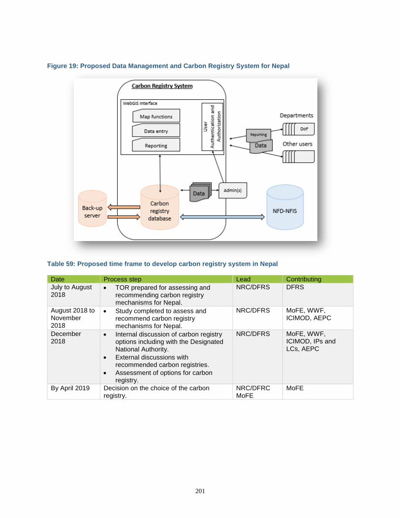
201
Figure 19: Proposed Data Management and Carbon Registry System for Nepal
Table 59: Proposed time frame to develop carbon registry system in Nepal
Date Process step Lead Contributing
July to August 2018
• TOR prepared for assessing and recommending carbon registry mechanisms for Nepal.
NRC/DFRS DFRS
August 2018 to November 2018
• Study completed to assess and recommend carbon registry mechanisms for Nepal.
NRC/DFRS MoFE, WWF, ICIMOD, AEPC
December 2018
• Internal discussion of carbon registry options including with the Designated National Authority.
• External discussions with recommended carbon registries.
• Assessment of options for carbon registry.
NRC/DFRS MoFE, WWF, ICIMOD, IPs and LCs, AEPC
By April 2019 Decision on the choice of the carbon registry.
NRC/DFRC MoFE
MoFE
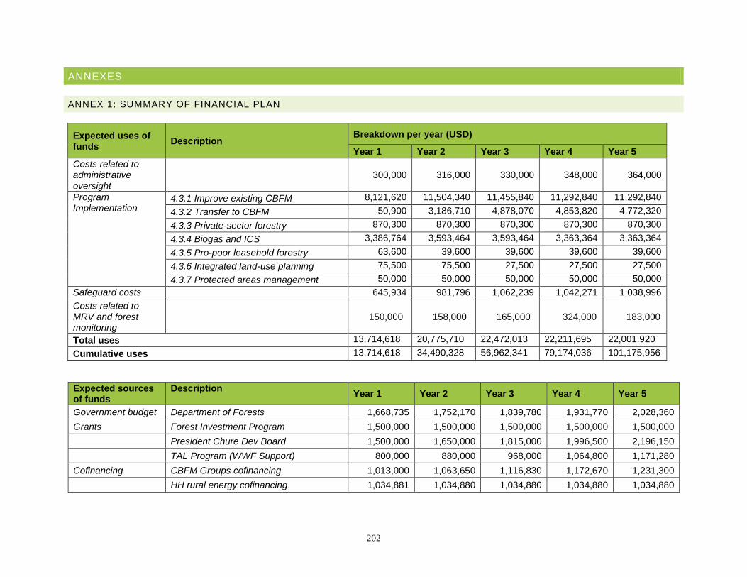
202
ANNEXES
ANNEX 1: SUMMARY OF FINANCIAL PLAN
Expected uses of funds
Description Breakdown per year (USD)
Year 1 Year 2 Year 3 Year 4 Year 5
Costs related to administrative oversight
300,000
316,000
330,000
348,000
364,000
Program Implementation
4.3.1 Improve existing CBFM 8,121,620 11,504,340 11,455,840 11,292,840 11,292,840
4.3.2 Transfer to CBFM 50,900 3,186,710 4,878,070 4,853,820 4,772,320
4.3.3 Private-sector forestry 870,300 870,300 870,300 870,300 870,300
4.3.4 Biogas and ICS 3,386,764 3,593,464 3,593,464 3,363,364 3,363,364
4.3.5 Pro-poor leasehold forestry 63,600 39,600 39,600 39,600 39,600
4.3.6 Integrated land-use planning 75,500 75,500 27,500 27,500 27,500
4.3.7 Protected areas management 50,000 50,000 50,000 50,000 50,000
Safeguard costs 645,934 981,796 1,062,239 1,042,271 1,038,996
Costs related to MRV and forest monitoring
150,000 158,000 165,000 324,000 183,000
Total uses 13,714,618 20,775,710 22,472,013 22,211,695 22,001,920
Cumulative uses 13,714,618 34,490,328 56,962,341 79,174,036 101,175,956
Expected sources of funds
Description Year 1 Year 2 Year 3 Year 4 Year 5
Government budget Department of Forests 1,668,735 1,752,170 1,839,780 1,931,770 2,028,360
Grants Forest Investment Program 1,500,000 1,500,000 1,500,000 1,500,000 1,500,000
President Chure Dev Board 1,500,000 1,650,000 1,815,000 1,996,500 2,196,150
TAL Program (WWF Support) 800,000 880,000 968,000 1,064,800 1,171,280
Cofinancing CBFM Groups cofinancing 1,013,000 1,063,650 1,116,830 1,172,670 1,231,300
HH rural energy cofinancing 1,034,881 1,034,880 1,034,880 1,034,880 1,034,880
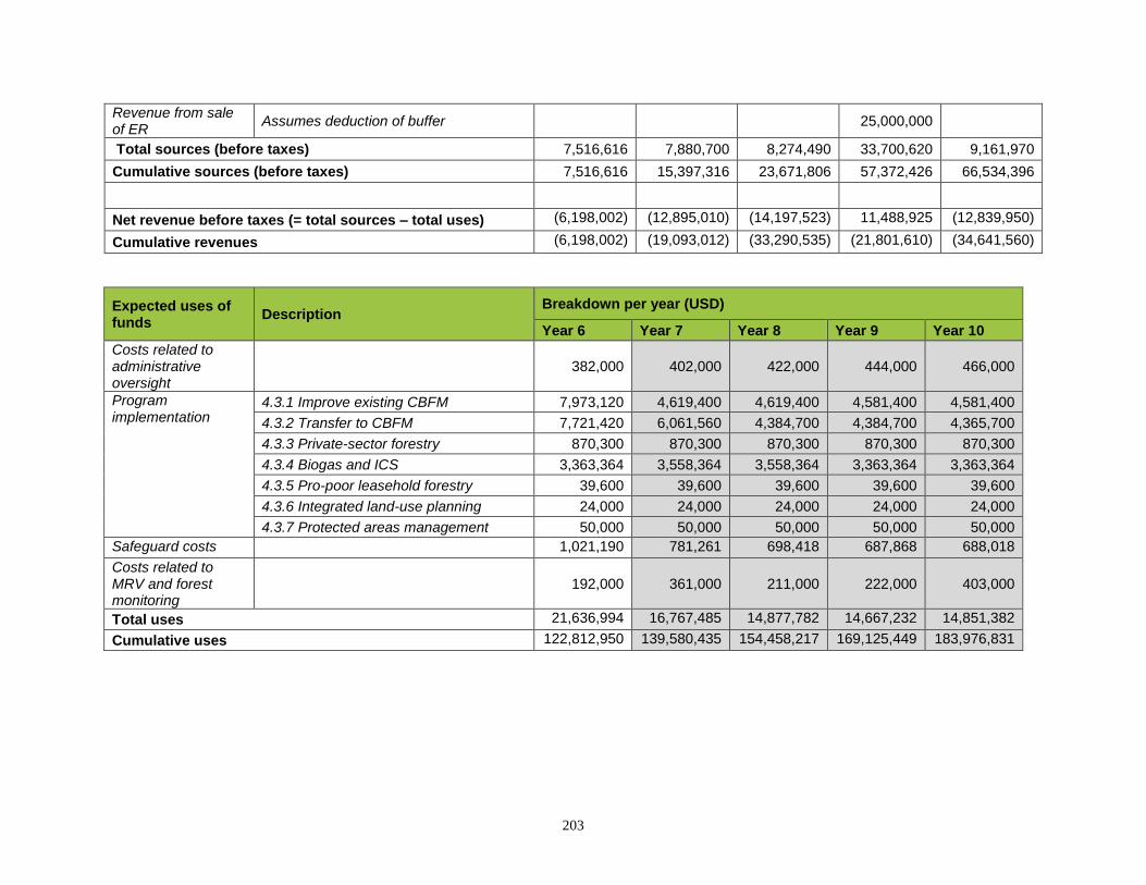
203
Revenue from sale of ER
Assumes deduction of buffer 25,000,000
Total sources (before taxes) 7,516,616 7,880,700 8,274,490 33,700,620 9,161,970
Cumulative sources (before taxes) 7,516,616 15,397,316 23,671,806 57,372,426 66,534,396
Net revenue before taxes (= total sources – total uses) (6,198,002) (12,895,010) (14,197,523) 11,488,925 (12,839,950)
Cumulative revenues (6,198,002) (19,093,012) (33,290,535) (21,801,610) (34,641,560)
Expected uses of funds
Description Breakdown per year (USD)
Year 6 Year 7 Year 8 Year 9 Year 10
Costs related to administrative oversight
382,000 402,000 422,000 444,000 466,000
Program implementation
4.3.1 Improve existing CBFM 7,973,120 4,619,400 4,619,400 4,581,400 4,581,400
4.3.2 Transfer to CBFM 7,721,420 6,061,560 4,384,700 4,384,700 4,365,700
4.3.3 Private-sector forestry 870,300 870,300 870,300 870,300 870,300
4.3.4 Biogas and ICS 3,363,364 3,558,364 3,558,364 3,363,364 3,363,364
4.3.5 Pro-poor leasehold forestry 39,600 39,600 39,600 39,600 39,600
4.3.6 Integrated land-use planning 24,000 24,000 24,000 24,000 24,000
4.3.7 Protected areas management 50,000 50,000 50,000 50,000 50,000
Safeguard costs 1,021,190 781,261 698,418 687,868 688,018
Costs related to MRV and forest monitoring
192,000 361,000 211,000 222,000 403,000
Total uses 21,636,994 16,767,485 14,877,782 14,667,232 14,851,382
Cumulative uses 122,812,950 139,580,435 154,458,217 169,125,449 183,976,831
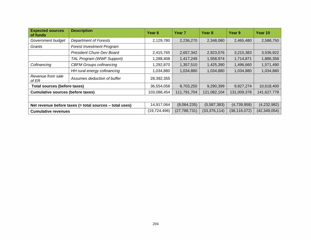
204
Expected sources of funds
Description Year 6 Year 7 Year 8 Year 9 Year 10
Government budget Department of Forests 2,129,780 2,236,270 2,348,080 2,465,480 2,588,750
Grants Forest Investment Program
President Chure Dev Board 2,415,765 2,657,342 2,923,076 3,215,383 3,536,922
TAL Program (WWF Support) 1,288,408 1,417,249 1,558,974 1,714,871 1,886,358
Cofinancing CBFM Groups cofinancing 1,292,870 1,357,510 1,425,390 1,496,660 1,571,490
HH rural energy cofinancing 1,034,880 1,034,880 1,034,880 1,034,880 1,034,880
Revenue from sale of ER
Assumes deduction of buffer 28,392,355
Total sources (before taxes) 36,554,058 8,703,250 9,290,399 9,927,274 10,618,400
Cumulative sources (before taxes) 103,088,454 111,791,704 121,082,104 131,009,378 141,627,778
Net revenue before taxes (= total sources – total uses) 14,917,064 (8,064,235) (5,587,383) (4,739,958) (4,232,982)
Cumulative revenues (19,724,496) (27,788,731) (33,376,114) (38,116,072) (42,349,054)
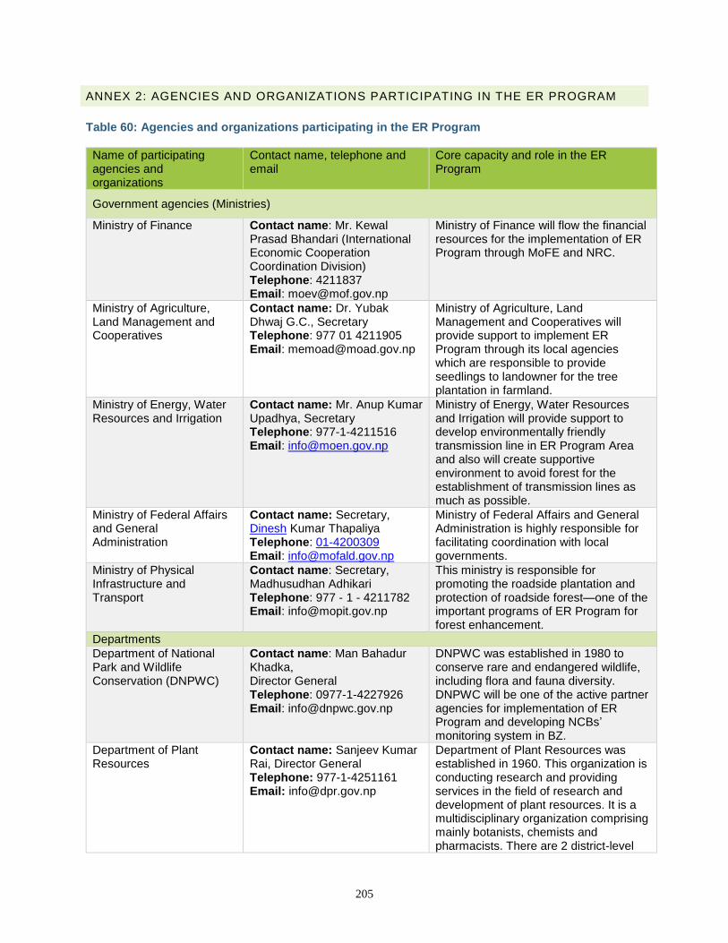
205
ANNEX 2: AGENCIES AND ORGANIZATIONS PARTICIPATING IN THE ER PROGRAM
Table 60: Agencies and organizations participating in the ER Program
Name of participating agencies and organizations
Contact name, telephone and email
Core capacity and role in the ER Program
Government agencies (Ministries)
Ministry of Finance Contact name: Mr. Kewal Prasad Bhandari (International Economic Cooperation Coordination Division) Telephone: 4211837 Email: [email protected]
Ministry of Finance will flow the financial resources for the implementation of ER Program through MoFE and NRC.
Ministry of Agriculture, Land Management and Cooperatives
Contact name: Dr. Yubak Dhwaj G.C., Secretary Telephone: 977 01 4211905 Email: [email protected]
Ministry of Agriculture, Land Management and Cooperatives will provide support to implement ER Program through its local agencies which are responsible to provide seedlings to landowner for the tree plantation in farmland.
Ministry of Energy, Water Resources and Irrigation
Contact name: Mr. Anup Kumar Upadhya, Secretary Telephone: 977-1-4211516 Email: [email protected]
Ministry of Energy, Water Resources and Irrigation will provide support to develop environmentally friendly transmission line in ER Program Area and also will create supportive environment to avoid forest for the establishment of transmission lines as much as possible.
Ministry of Federal Affairs and General Administration
Contact name: Secretary, Dinesh Kumar Thapaliya Telephone: 01-4200309 Email: [email protected]
Ministry of Federal Affairs and General Administration is highly responsible for facilitating coordination with local governments.
Ministry of Physical Infrastructure and Transport
Contact name: Secretary, Madhusudhan Adhikari Telephone: 977 - 1 - 4211782 Email: [email protected]
This ministry is responsible for promoting the roadside plantation and protection of roadside forest—one of the important programs of ER Program for forest enhancement.
Departments
Department of National Park and Wildlife Conservation (DNPWC)
Contact name: Man Bahadur Khadka, Director General Telephone: 0977-1-4227926 Email: [email protected]
DNPWC was established in 1980 to conserve rare and endangered wildlife, including flora and fauna diversity. DNPWC will be one of the active partner agencies for implementation of ER Program and developing NCBs’ monitoring system in BZ.
Department of Plant Resources
Contact name: Sanjeev Kumar Rai, Director General Telephone: 977-1-4251161 Email: [email protected]
Department of Plant Resources was established in 1960. This organization is conducting research and providing services in the field of research and development of plant resources. It is a multidisciplinary organization comprising mainly botanists, chemists and pharmacists. There are 2 district-level
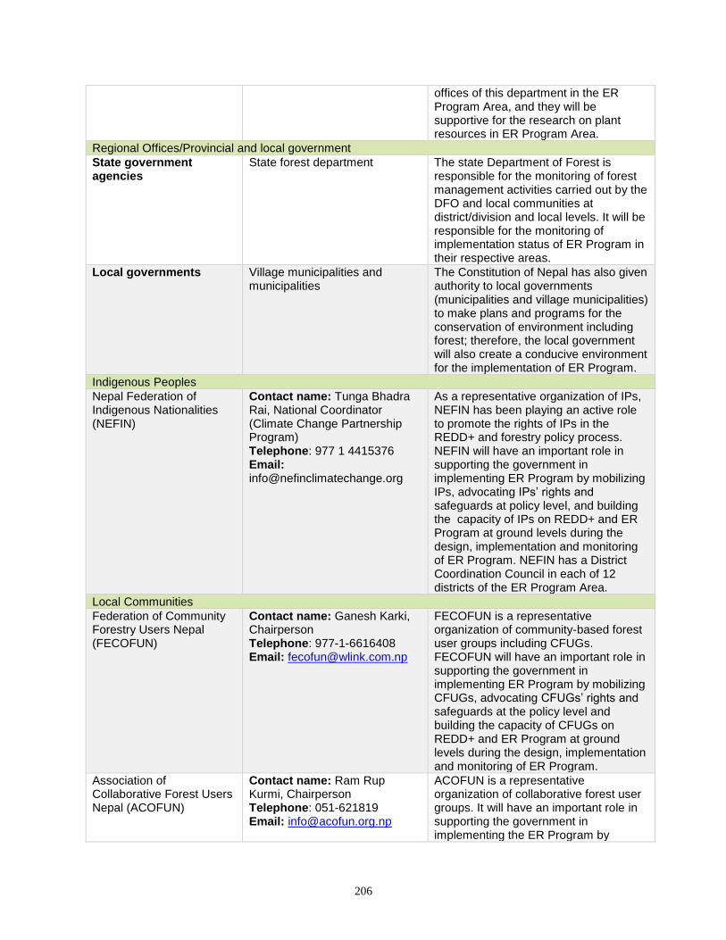
206
offices of this department in the ER Program Area, and they will be supportive for the research on plant resources in ER Program Area.
Regional Offices/Provincial and local government
State government agencies
State forest department The state Department of Forest is responsible for the monitoring of forest management activities carried out by the DFO and local communities at district/division and local levels. It will be responsible for the monitoring of implementation status of ER Program in their respective areas.
Local governments Village municipalities and municipalities
The Constitution of Nepal has also given authority to local governments (municipalities and village municipalities) to make plans and programs for the conservation of environment including forest; therefore, the local government will also create a conducive environment for the implementation of ER Program.
Indigenous Peoples
Nepal Federation of Indigenous Nationalities (NEFIN)
Contact name: Tunga Bhadra Rai, National Coordinator (Climate Change Partnership Program) Telephone: 977 1 4415376 Email: [email protected]
As a representative organization of IPs, NEFIN has been playing an active role to promote the rights of IPs in the REDD+ and forestry policy process. NEFIN will have an important role in supporting the government in implementing ER Program by mobilizing IPs, advocating IPs’ rights and safeguards at policy level, and building the capacity of IPs on REDD+ and ER Program at ground levels during the design, implementation and monitoring of ER Program. NEFIN has a District Coordination Council in each of 12 districts of the ER Program Area.
Local Communities
Federation of Community Forestry Users Nepal (FECOFUN)
Contact name: Ganesh Karki, Chairperson Telephone: 977-1-6616408 Email: [email protected]
FECOFUN is a representative organization of community-based forest user groups including CFUGs. FECOFUN will have an important role in supporting the government in implementing ER Program by mobilizing CFUGs, advocating CFUGs’ rights and safeguards at the policy level and building the capacity of CFUGs on REDD+ and ER Program at ground levels during the design, implementation and monitoring of ER Program.
Association of Collaborative Forest Users Nepal (ACOFUN)
Contact name: Ram Rup Kurmi, Chairperson Telephone: 051-621819 Email: [email protected]
ACOFUN is a representative organization of collaborative forest user groups. It will have an important role in supporting the government in implementing the ER Program by
207
mobilizing collaborative forest ysers group, advocating for their rights and safeguards at policy levels, and building the capacity of their members on REDD+ and ER Program at ground levels during the design, implementation and monitoring of ER Program.
Dalit Communities
Dalit93 NGO Federation (DNF)
Contact name: Ram Lakhan Harijan, Chairperson Telephone: 977-1-5527559 Email: [email protected]
As a representative organization of Dalit Communities and NGOs of Dalits, DNF will have an important role in supporting the government in implementing the ER Program by mobilizing Dalits, advocating for Dalits’ rights and safeguards at policy levels, and building capacity of Dalits on REDD+ and ER Program at ground levels. DNF has district chapters in each district of ER Program Area.
Women’s Groups
Himalayan Grassroots Women’s Natural Resource Management Association (HIMAWANTI)
Contact name: Ms. Rama Ale Magar, Chairperson Telephone: 977-1-5536245 Email: [email protected]
HIMWANTI is dedicated to strengthening the capacity of rural women for sustainable natural resource management. It will have an important role supporting the government in implementing the ER Program by mobilizing rural women, advocating for their rights and safeguards at policy levels, and building capacity of rural women on REDD+ and ER Program at ground levels. HIMWANTI has a district chapter in each district of ER Program Area.
Non-Governmental Organizations
NGO Federation Nepal Contact name: Chairperson Telephone: 977 1 4782908 Email: [email protected]
NGO Federation has its own district chapter in each district of ER Program Areas, which will play an active role strengthening governance of local communities during the implementation of ER Program.
WWF Nepal Contact name: Santosh Mani Nepal, Senior Director, Policy and Governance Telephone: +977 1 4434820 Email: [email protected]
WWF Nepal will have a role providing technical and financial support to the government in developing and implementing the ER Program.
ICIMOD Contact name: Bhaskar Singh Karky, Resource Economist Telephone: 977 1 5003222 Email: [email protected]
Support for the exchange of knowledge on REDD+ at national and trans-boundary levels.
Private Sector
93 Dalit are defined as those communities who, by virtue of atrocities of caste-based discrimination and untouchability, are most backward in social, economic, educational, political and religious fields, and are deprived of human dignity and social justice (National Dalit Commission - NDC).
208
Federation of Forest Based Industry and Trade, Nepal (FenFIT)
Contact name: Shyam Sundar Dhakal, Chairperson Telephone: 977-01-5147152 Email: [email protected]
FENFIT is an umbrella organization of timber and non-timber forests products industries and traders in Nepal. It is a platform for forest traders and timber industries and works to find solutions to improve forest management practices as well. FENFIT works to ensure the permanent existence of forest areas through responsible forest utilization and marketing of forest products. It has district chapters in each district of ER Program Area.
Private Forest Stakeholders Federation
Contact name: Chairperson Telephone: +9841511250 Email: [email protected]
Association of Family Forest Owners, Nepal (AFFON)
Contact name: Chairperson Telephone: 977 01 4786734 Email: [email protected]
Professional Organization
Nepal Forester Association (NFA)
Contact name: Kumud Shrestha, Chairperson Telephone: 977-1-4220401 Email: [email protected]
Provide technical support to implement ER Program at local level and support to develop capacity of forest user groups.
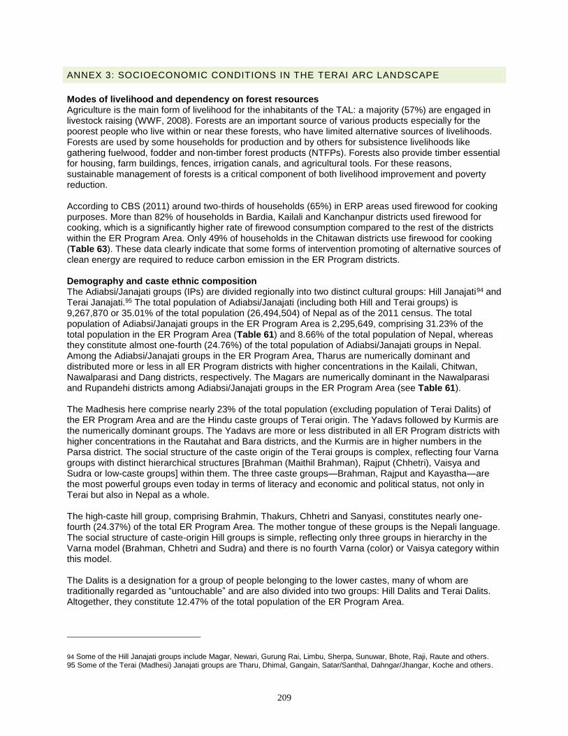
209
ANNEX 3: SOCIOECONOMIC CONDITIONS IN THE TERAI ARC LANDSCAPE
Modes of livelihood and dependency on forest resources Agriculture is the main form of livelihood for the inhabitants of the TAL: a majority (57%) are engaged in livestock raising (WWF, 2008). Forests are an important source of various products especially for the poorest people who live within or near these forests, who have limited alternative sources of livelihoods. Forests are used by some households for production and by others for subsistence livelihoods like gathering fuelwood, fodder and non-timber forest products (NTFPs). Forests also provide timber essential for housing, farm buildings, fences, irrigation canals, and agricultural tools. For these reasons, sustainable management of forests is a critical component of both livelihood improvement and poverty reduction. According to CBS (2011) around two-thirds of households (65%) in ERP areas used firewood for cooking purposes. More than 82% of households in Bardia, Kailali and Kanchanpur districts used firewood for cooking, which is a significantly higher rate of firewood consumption compared to the rest of the districts within the ER Program Area. Only 49% of households in the Chitawan districts use firewood for cooking (Table 63). These data clearly indicate that some forms of intervention promoting of alternative sources of clean energy are required to reduce carbon emission in the ER Program districts. Demography and caste ethnic composition The Adiabsi/Janajati groups (IPs) are divided regionally into two distinct cultural groups: Hill Janajati94 and Terai Janajati.95 The total population of Adiabsi/Janajati (including both Hill and Terai groups) is 9,267,870 or 35.01% of the total population (26,494,504) of Nepal as of the 2011 census. The total population of Adiabsi/Janajati groups in the ER Program Area is 2,295,649, comprising 31.23% of the total population in the ER Program Area (Table 61) and 8.66% of the total population of Nepal, whereas they constitute almost one-fourth (24.76%) of the total population of Adiabsi/Janajati groups in Nepal. Among the Adiabsi/Janajati groups in the ER Program Area, Tharus are numerically dominant and distributed more or less in all ER Program districts with higher concentrations in the Kailali, Chitwan, Nawalparasi and Dang districts, respectively. The Magars are numerically dominant in the Nawalparasi and Rupandehi districts among Adiabsi/Janajati groups in the ER Program Area (see Table 61). The Madhesis here comprise nearly 23% of the total population (excluding population of Terai Dalits) of the ER Program Area and are the Hindu caste groups of Terai origin. The Yadavs followed by Kurmis are the numerically dominant groups. The Yadavs are more or less distributed in all ER Program districts with higher concentrations in the Rautahat and Bara districts, and the Kurmis are in higher numbers in the Parsa district. The social structure of the caste origin of the Terai groups is complex, reflecting four Varna groups with distinct hierarchical structures [Brahman (Maithil Brahman), Rajput (Chhetri), Vaisya and Sudra or low-caste groups] within them. The three caste groups—Brahman, Rajput and Kayastha—are the most powerful groups even today in terms of literacy and economic and political status, not only in Terai but also in Nepal as a whole. The high-caste hill group, comprising Brahmin, Thakurs, Chhetri and Sanyasi, constitutes nearly one-fourth (24.37%) of the total ER Program Area. The mother tongue of these groups is the Nepali language. The social structure of caste-origin Hill groups is simple, reflecting only three groups in hierarchy in the Varna model (Brahman, Chhetri and Sudra) and there is no fourth Varna (color) or Vaisya category within this model. The Dalits is a designation for a group of people belonging to the lower castes, many of whom are traditionally regarded as “untouchable” and are also divided into two groups: Hill Dalits and Terai Dalits. Altogether, they constitute 12.47% of the total population of the ER Program Area.
94 Some of the Hill Janajati groups include Magar, Newari, Gurung Rai, Limbu, Sherpa, Sunuwar, Bhote, Raji, Raute and others. 95 Some of the Terai (Madhesi) Janajati groups are Tharu, Dhimal, Gangain, Satar/Santhal, Dahngar/Jhangar, Koche and others.
210
Muslims account for 4.4% of the total population of Nepal and numerically occupy the eighth-highest position in the 2011 census. They account for 8.63% of the total population of the ER Program Area with higher concentrations in the Rautahat, Kapilbastu, Bara and Parsa districts respectively (see Table 61). Indicators of human development The Human Development Index (HDI) can be used to assess the social and economic development levels of particular countries, regions or districts. Usually a composite statistic of life expectancy, education, and per capita income indicators is used to rank particular countries or regions and districts. The HDI values for Nepal, the Terai region and ER Program districts based on the geometric mean are presented in Table 62. The HDI value for the Program Area as a whole is 0.470, which is less than the HDI value for Nepal (0.490), and it is slightly on the higher side compared to the HDI value of 0.468 for the Terai region. Among 12 ER Program districts, Chitwan district has the highest HDI score at 0.551 and Rautahat district has the lowest HDI value at 0.386 (Table 62). The lowest HDI score for Rautahat is primarily due to its lowest per capita income and adult literacy rate among ER Program districts. On the other hand, Chitwan district has the highest scores in all indicators of human development.
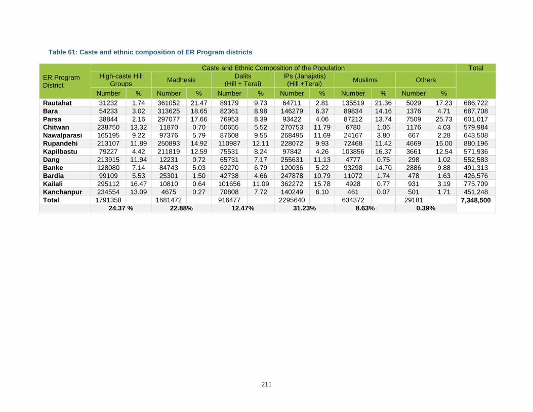
211
Table 61: Caste and ethnic composition of ER Program districts
ER Program District
Caste and Ethnic Composition of the Population Total
High-caste Hill Groups
Madhesis Dalits
(Hill + Terai) IPs (Janajatis)
(Hill +Terai) Muslims Others
Number % Number % Number % Number % Number % Number %
Rautahat 31232 1.74 361052 21.47 89179 9.73 64711 2.81 135519 21.36 5029 17.23 686,722
Bara 54233 3.02 313625 18.65 82361 8.98 146279 6.37 89834 14.16 1376 4.71 687,708
Parsa 38844 2.16 297077 17.66 76953 8.39 93422 4.06 87212 13.74 7509 25.73 601,017
Chitwan 238750 13.32 11870 0.70 50655 5.52 270753 11.79 6780 1.06 1176 4.03 579,984
Nawalparasi 165195 9.22 97376 5.79 87608 9.55 268495 11.69 24167 3.80 667 2.28 643,508
Rupandehi 213107 11.89 250893 14.92 110987 12.11 228072 9.93 72468 11.42 4669 16.00 880,196
Kapilbastu 79227 4.42 211819 12.59 75531 8.24 97842 4.26 103856 16.37 3661 12.54 571,936
Dang 213915 11.94 12231 0.72 65731 7.17 255631 11.13 4777 0.75 298 1.02 552,583
Banke 128080 7.14 84743 5.03 62270 6.79 120036 5.22 93298 14.70 2886 9.88 491,313
Bardia 99109 5.53 25301 1.50 42738 4.66 247878 10.79 11072 1.74 478 1.63 426,576
Kailali 295112 16.47 10810 0.64 101656 11.09 362272 15.78 4928 0.77 931 3.19 775,709
Kanchanpur 234554 13.09 4675 0.27 70808 7.72 140249 6.10 461 0.07 501 1.71 451,248
Total 1791358 1681472 916477 2295640 634372 29181 7,348,500 24.37 % 22.88% 12.47% 31.23% 8.63% 0.39%
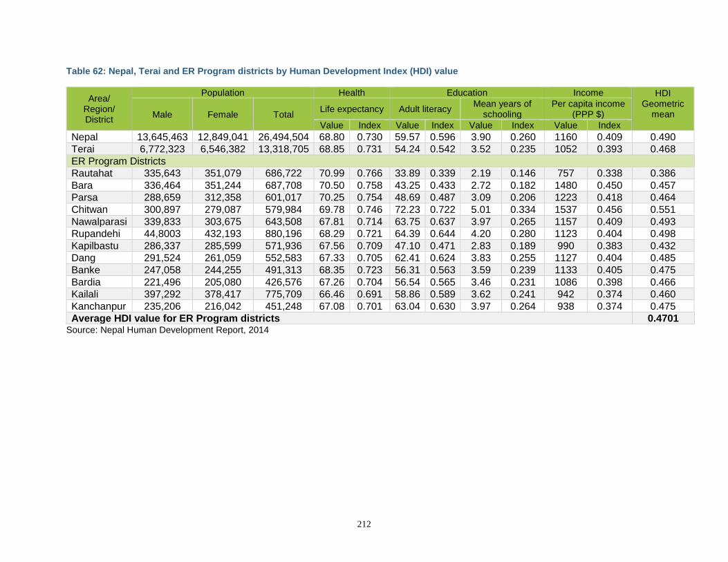
212
Table 62: Nepal, Terai and ER Program districts by Human Development Index (HDI) value
Area/ Region/ District
Population Health Education Income HDI Geometric
mean
Male Female Total Life expectancy Adult literacy
Mean years of schooling
Per capita income (PPP $)
Value Index Value Index Value Index Value Index
Nepal 13,645,463 12,849,041 26,494,504 68.80 0.730 59.57 0.596 3.90 0.260 1160 0.409 0.490
Terai 6,772,323 6,546,382 13,318,705 68.85 0.731 54.24 0.542 3.52 0.235 1052 0.393 0.468
ER Program Districts
Rautahat 335,643 351,079 686,722 70.99 0.766 33.89 0.339 2.19 0.146 757 0.338 0.386
Bara 336,464 351,244 687,708 70.50 0.758 43.25 0.433 2.72 0.182 1480 0.450 0.457
Parsa 288,659 312,358 601,017 70.25 0.754 48.69 0.487 3.09 0.206 1223 0.418 0.464
Chitwan 300,897 279,087 579,984 69.78 0.746 72.23 0.722 5.01 0.334 1537 0.456 0.551
Nawalparasi 339,833 303,675 643,508 67.81 0.714 63.75 0.637 3.97 0.265 1157 0.409 0.493
Rupandehi 44,8003 432,193 880,196 68.29 0.721 64.39 0.644 4.20 0.280 1123 0.404 0.498
Kapilbastu 286,337 285,599 571,936 67.56 0.709 47.10 0.471 2.83 0.189 990 0.383 0.432
Dang 291,524 261,059 552,583 67.33 0.705 62.41 0.624 3.83 0.255 1127 0.404 0.485
Banke 247,058 244,255 491,313 68.35 0.723 56.31 0.563 3.59 0.239 1133 0.405 0.475
Bardia 221,496 205,080 426,576 67.26 0.704 56.54 0.565 3.46 0.231 1086 0.398 0.466
Kailali 397,292 378,417 775,709 66.46 0.691 58.86 0.589 3.62 0.241 942 0.374 0.460
Kanchanpur 235,206 216,042 451,248 67.08 0.701 63.04 0.630 3.97 0.264 938 0.374 0.475
Average HDI value for ER Program districts 0.4701 Source: Nepal Human Development Report, 2014
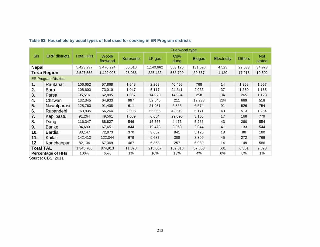
213
Table 63: Household by usual types of fuel used for cooking in ER Program districts
SN ERP districts Total HHs
Fuelwood type
Wood/ firewood
Kerosene LP gas Cow dung
Biogas Electricity Others Not
stated
Nepal 5,423,297 3,470,224 55,610 1,140,662 563,126 131,596 4,523 22,583 34,973
Terai Region 2,527,558 1,429,005 26,066 385,433 558,799 89,657 1,180 17,916 19,502
ER Program Districts
1. Rautahat 106,652 57,868 1,648 2,263 40,456 768 14 1,968 1,667
2. Bara 108,600 73,010 1,047 5,117 24,841 2,033 37 1,350 1,165
3. Parsa 95,516 62,805 1,067 14,970 14,994 258 34 265 1,123
4. Chitwan 132,345 64,933 997 52,545 211 12,238 234 669 518
5. Nawalparasi 128,760 91,408 611 21,931 6,865 6,574 91 526 754
6. Rupandehi 163,835 56,264 2,005 56,066 42,519 5,171 43 513 1,254
7. Kapilbastu 91,264 49,561 1,089 6,654 29,890 3,106 17 168 779
8. Dang 116,347 88,827 546 16,356 4,473 5,288 43 260 554
9. Banke 94,693 67,651 844 19,473 3,963 2,044 41 133 544
10. Bardia 83,147 72,873 370 3,652 841 5,125 18 88 180
11. Kailali 142,413 122,344 679 9,687 308 8,309 45 272 769
12. Kanchanpur 82,134 67,369 467 6,353 257 6,939 14 149 586
Total TAL 1,345,706 874,913 11,370 215,067 169,618 57,853 631 6,361 9,893
Percentage of HHs 100% 65% 1% 16% 13% 4% 0% 0% 1%
Source: CBS, 2011
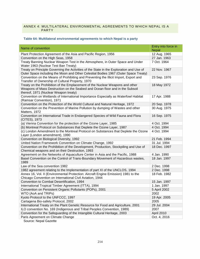
214
ANNEX 4: MULTILATERAL ENVIRONMENTAL AGREEMENTS TO WHICH NEPAL IS A PARTY
Table 64: Multilateral environmental agreements to which Nepal is a party
Name of convention Entry into force in Nepal
Plant Protection Agreement of the Asia and Pacific Region, 1956 12 Aug. 1965
Convention on the High Seas, 1958 27 Jan. 1963
Treaty Banning Nuclear Weapon Test in the Atmosphere, in Outer Space and Under Water 1963 (Nuclear Test Ban Treaty)
7 Oct. 1964
Treaty on Principle Governing the Activities of the State in the Exploration and Use of Outer Space including the Moon and Other Celestial Bodies 1967 (Outer Space Treaty)
22 Nov. 1967
Convention on the Means of Prohibiting and Preventing the Illicit Import, Export and Transfer of Ownership of Cultural Property, 1970
23 Sep. 1976
Treaty on the Prohibition of the Emplacement of the Nuclear Weapons and other Weapons of Mass Destruction on the Seabed and Ocean floor and in the Subsoil thereof, 1971 (Nuclear Weapon treaty)
18 May 1972
Convention on Wetlands of International Importance Especially as Waterfowl Habitat (Ramsar Convention), 1971
17 Apr. 1988
Convention on the Protection of the World Cultural and Natural Heritage, 1972 20 Sep. 1978
Convention on the Prevention of Marine Pollution by dumping of Wastes and other Matters, 1972
30 Aug. 1975
Convention on International Trade in Endangered Species of Wild Fauna and Flora (CITES), 1973
16 Sep. 1975
(a) Vienna Convention for the protection of the Ozone Layer, 1985 4 Oct. 1994
(b) Montreal Protocol on Substances that Deplete the Ozone Layer, 1987 4 Oct. 1994
(c) London Amendment to the Montreal Protocol on Substances that Deplete the Ozone Layer (London amendment), 1990
4 Oct. 1994
Convention on Biological Diversity, 1992 21 Feb. 1994
United Nation Framework Convention on Climate Change, 1992 31 Jul. 1994
Convention on the Prohibition of the Development, Production, Stockpiling and Use of Chemical weapons and on their Destruction, 1993
18 Dec. 1997
Agreement on the Networks of Aquaculture Center in Asia and the Pacific, 1988 4 Jan. 1990
Basel Convention on the Control of Trans-Boundary Movement of Hazardous wastes, 1989
18 Jan. 1997
Law of the Sea convention 1982 2 Dec. 1998
1982 agreement relating to the Implementation of part XI of the UNCLOS, 1994 2 Dec. 1998
Annex 16, Vol. II (Environmental Protection: Aircraft Engine Emission) 1981 to the Chicago Convention on International Civil Aviation, 1944
18 Feb. 1982
Convention to Combat Desertification, 1994 15 Jan. 1997
International Tropical Timber Agreement (ITTA), 1994 1 Jan. 1997
Convention on Persistent Organic Pollutants (POPs), 2001 5 April 2002
WTO (AoA and TRIPs) 2002
Kyoto Protocol to the UNFCCC, 1997 19 Apr. 2005
Cartagena Bio-safety Protocol, 2002 2005
International Treaty on the Plant Genetic Resource for Food and Agriculture, 2001 29 Jul. 2004
ILO convention No. 169 (Indigenous and Tribal Peoples Convention, 1989) 2007
Convention for the Safeguarding of the Intangible Cultural Heritage, 2003 April 2010
Paris Agreement on Climate Change Oct. 4, 2016
Source: Nepal Gazette
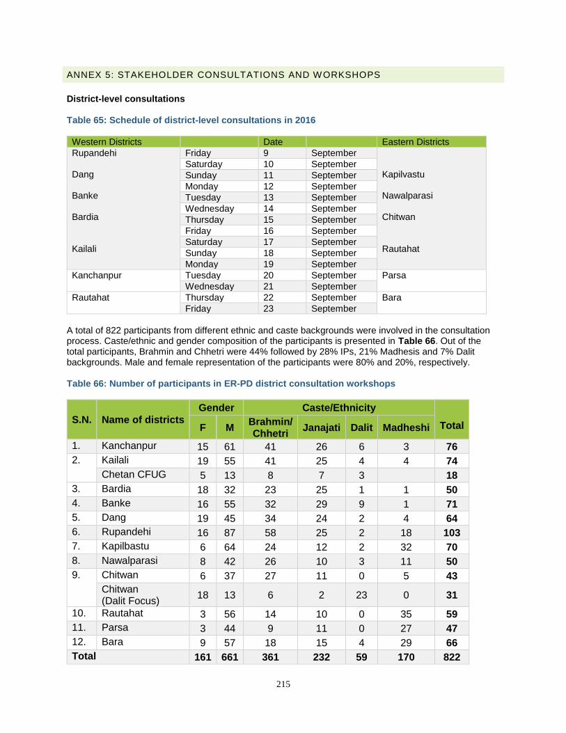
215
ANNEX 5: STAKEHOLDER CONSULTATIONS AND WORKSHOPS
District-level consultations Table 65: Schedule of district-level consultations in 2016
Western Districts Date Eastern Districts
Rupandehi Dang Banke Bardia Kailali
Friday 9 September Kapilvastu Nawalparasi Chitwan Rautahat
Saturday 10 September
Sunday 11 September
Monday 12 September
Tuesday 13 September
Wednesday 14 September
Thursday 15 September
Friday 16 September
Saturday 17 September
Sunday 18 September
Monday 19 September
Kanchanpur Tuesday 20 September Parsa
Wednesday 21 September
Rautahat Thursday 22 September Bara
Friday 23 September
A total of 822 participants from different ethnic and caste backgrounds were involved in the consultation process. Caste/ethnic and gender composition of the participants is presented in Table 66. Out of the total participants, Brahmin and Chhetri were 44% followed by 28% IPs, 21% Madhesis and 7% Dalit backgrounds. Male and female representation of the participants were 80% and 20%, respectively. Table 66: Number of participants in ER-PD district consultation workshops
S.N. Name of districts
Gender Caste/Ethnicity
Total F M Brahmin/ Chhetri
Janajati Dalit Madheshi
1. Kanchanpur 15 61 41 26 6 3 76
2. Kailali 19 55 41 25 4 4 74
Chetan CFUG 5 13 8 7 3 18
3. Bardia 18 32 23 25 1 1 50
4. Banke 16 55 32 29 9 1 71
5. Dang 19 45 34 24 2 4 64
6. Rupandehi 16 87 58 25 2 18 103
7. Kapilbastu 6 64 24 12 2 32 70
8. Nawalparasi 8 42 26 10 3 11 50
9. Chitwan 6 37 27 11 0 5 43
Chitwan (Dalit Focus)
18 13 6 2 23 0 31
10. Rautahat 3 56 14 10 0 35 59
11. Parsa 3 44 9 11 0 27 47
12. Bara 9 57 18 15 4 29 66
Total 161 661 361 232 59 170 822
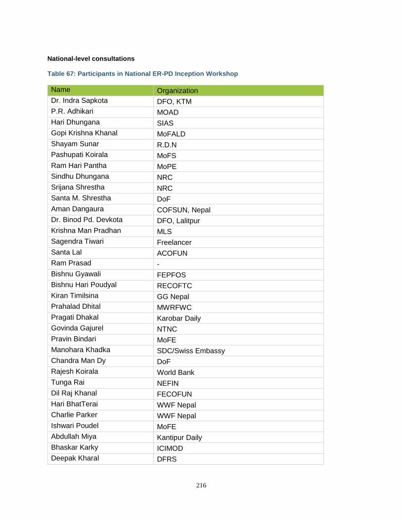
216
National-level consultations Table 67: Participants in National ER-PD Inception Workshop
Name Organization
Dr. Indra Sapkota DFO, KTM
P.R. Adhikari MOAD
Hari Dhungana SIAS
Gopi Krishna Khanal MoFALD
Shayam Sunar R.D.N
Pashupati Koirala MoFS
Ram Hari Pantha MoPE
Sindhu Dhungana NRC
Srijana Shrestha NRC
Santa M. Shrestha DoF
Aman Dangaura COFSUN, Nepal
Dr. Binod Pd. Devkota DFO, Lalitpur
Krishna Man Pradhan MLS
Sagendra Tiwari Freelancer
Santa Lal ACOFUN
Ram Prasad -
Bishnu Gyawali FEPFOS
Bishnu Hari Poudyal RECOFTC
Kiran Timilsina GG Nepal
Prahalad Dhital MWRFWC
Pragati Dhakal Karobar Daily
Govinda Gajurel NTNC
Pravin Bindari MoFE
Manohara Khadka SDC/Swiss Embassy
Chandra Man Dy DoF
Rajesh Koirala World Bank
Tunga Rai NEFIN
Dil Raj Khanal FECOFUN
Hari BhatTerai WWF Nepal
Charlie Parker WWF Nepal
Ishwari Poudel MoFE
Abdullah Miya Kantipur Daily
Bhaskar Karky ICIMOD
Deepak Kharal DFRS
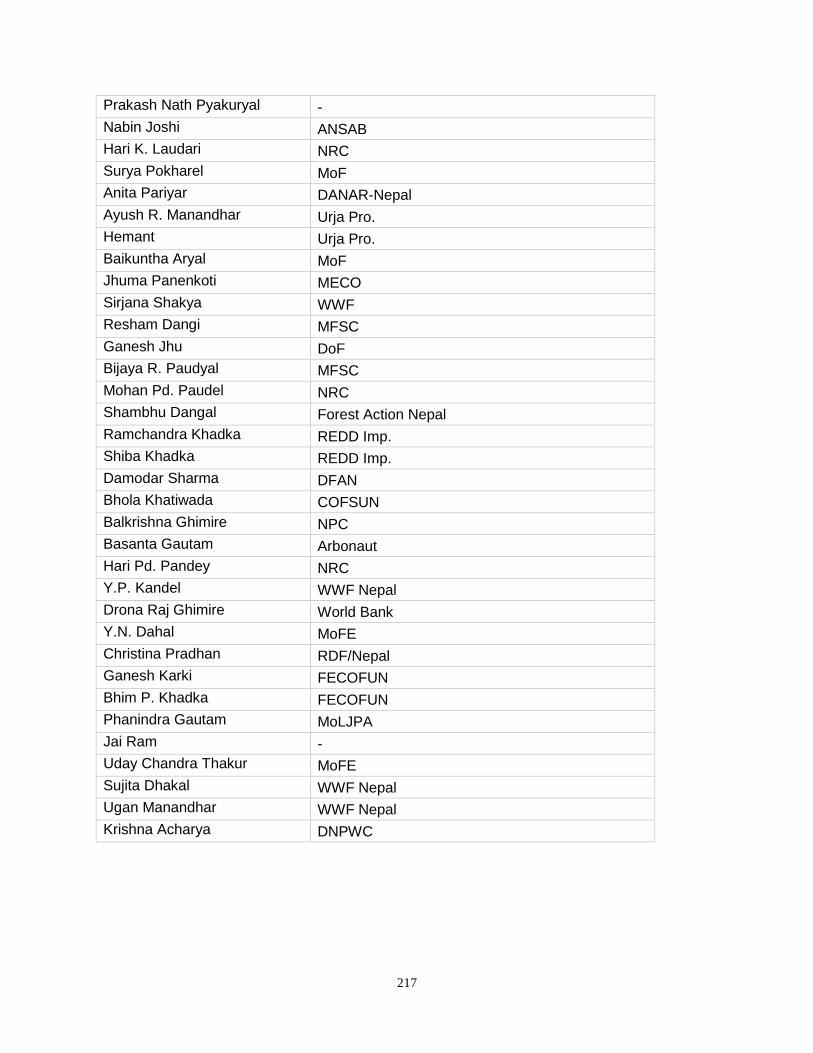
217
Prakash Nath Pyakuryal -
Nabin Joshi ANSAB
Hari K. Laudari NRC
Surya Pokharel MoF
Anita Pariyar DANAR-Nepal
Ayush R. Manandhar Urja Pro.
Hemant Urja Pro.
Baikuntha Aryal MoF
Jhuma Panenkoti MECO
Sirjana Shakya WWF
Resham Dangi MFSC
Ganesh Jhu DoF
Bijaya R. Paudyal MFSC
Mohan Pd. Paudel NRC
Shambhu Dangal Forest Action Nepal
Ramchandra Khadka REDD Imp.
Shiba Khadka REDD Imp.
Damodar Sharma DFAN
Bhola Khatiwada COFSUN
Balkrishna Ghimire NPC
Basanta Gautam Arbonaut
Hari Pd. Pandey NRC
Y.P. Kandel WWF Nepal
Drona Raj Ghimire World Bank
Y.N. Dahal MoFE
Christina Pradhan RDF/Nepal
Ganesh Karki FECOFUN
Bhim P. Khadka FECOFUN
Phanindra Gautam MoLJPA
Jai Ram -
Uday Chandra Thakur MoFE
Sujita Dhakal WWF Nepal
Ugan Manandhar WWF Nepal
Krishna Acharya DNPWC
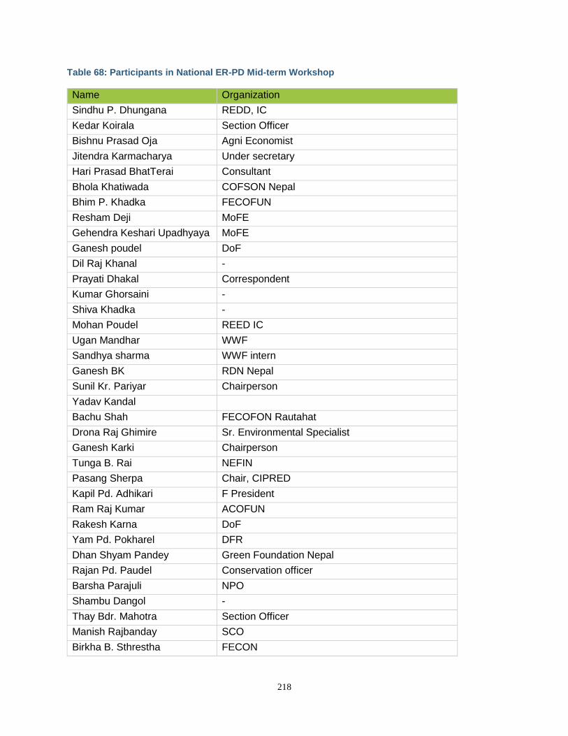
218
Table 68: Participants in National ER-PD Mid-term Workshop
Name Organization
Sindhu P. Dhungana REDD, IC
Kedar Koirala Section Officer
Bishnu Prasad Oja Agni Economist
Jitendra Karmacharya Under secretary
Hari Prasad BhatTerai Consultant
Bhola Khatiwada COFSON Nepal
Bhim P. Khadka FECOFUN
Resham Deji MoFE
Gehendra Keshari Upadhyaya MoFE
Ganesh poudel DoF
Dil Raj Khanal -
Prayati Dhakal Correspondent
Kumar Ghorsaini -
Shiva Khadka -
Mohan Poudel REED IC
Ugan Mandhar WWF
Sandhya sharma WWF intern
Ganesh BK RDN Nepal
Sunil Kr. Pariyar Chairperson
Yadav Kandal
Bachu Shah FECOFON Rautahat
Drona Raj Ghimire Sr. Environmental Specialist
Ganesh Karki Chairperson
Tunga B. Rai NEFIN
Pasang Sherpa Chair, CIPRED
Kapil Pd. Adhikari F President
Ram Raj Kumar ACOFUN
Rakesh Karna DoF
Yam Pd. Pokharel DFR
Dhan Shyam Pandey Green Foundation Nepal
Rajan Pd. Paudel Conservation officer
Barsha Parajuli NPO
Shambu Dangol -
Thay Bdr. Mahotra Section Officer
Manish Rajbanday SCO
Birkha B. Sthrestha FECON
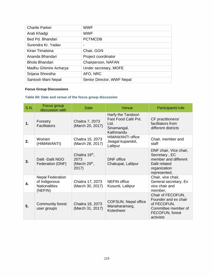
219
Charlie Parker WWF
Arati Khadgi WWF
Bed Pd. Bhandari PCTMCDB
Surendra Kr. Yadav -
Kiran Timalsina Chair, GGN
Ananda Bhandari Project coordinator
Bhola Bhandari Chairperson, NAFAN
Madhu Ghimire Acharya Under secretary, MOFE
Srijana Shrestha AFO, NRC
Santosh Mani Nepal Senior Director, WWF Nepal
Focus Group Discussions Table 69: Date and venue of the focus group discussion
S.N. Focus group
discussion with Date Venue Participants’role
1. Forestry Facilitators
Chaitra 7, 2073 (March 20, 2017)
Harfy the Tandoori Fast Food Café Pvt. Ltd. Sinamangal, Kathmandu
CF practitioners/ facilitators from different districts
2. Women (HIMAWANTI)
Chaitra 15, 2073 (March 28, 2017)
HIMAWANTI office Jwagal kupandol, Lalitpur
Chair, member and staff
3. Dalit -Dalit NGO Federation (DNF)
Chaitra 16th, 2073 (March 29th, 2017)
DNF office Chakupat, Lalitpur
DNF chair, Vice chair, Secretary , EC member and different Dalit related organization represented,
4.
Nepal Federation of Indigenous Nationalities (NEFIN)
Chaitra 17, 2073 (March 30, 2017)
NEFIN office Kusunti, Lalitpur
Chair, vice chair, General secretary, Ex vice chair and member,
5. Community forest user groups
Chaitra 18, 2073 (March 31, 2017)
COFSUN, Nepal office Manaharamarg, Koteshwor
Chair of FECOFUN, Founder and ex chair of FECOFUN, Committee member of FECOFUN, forest activists
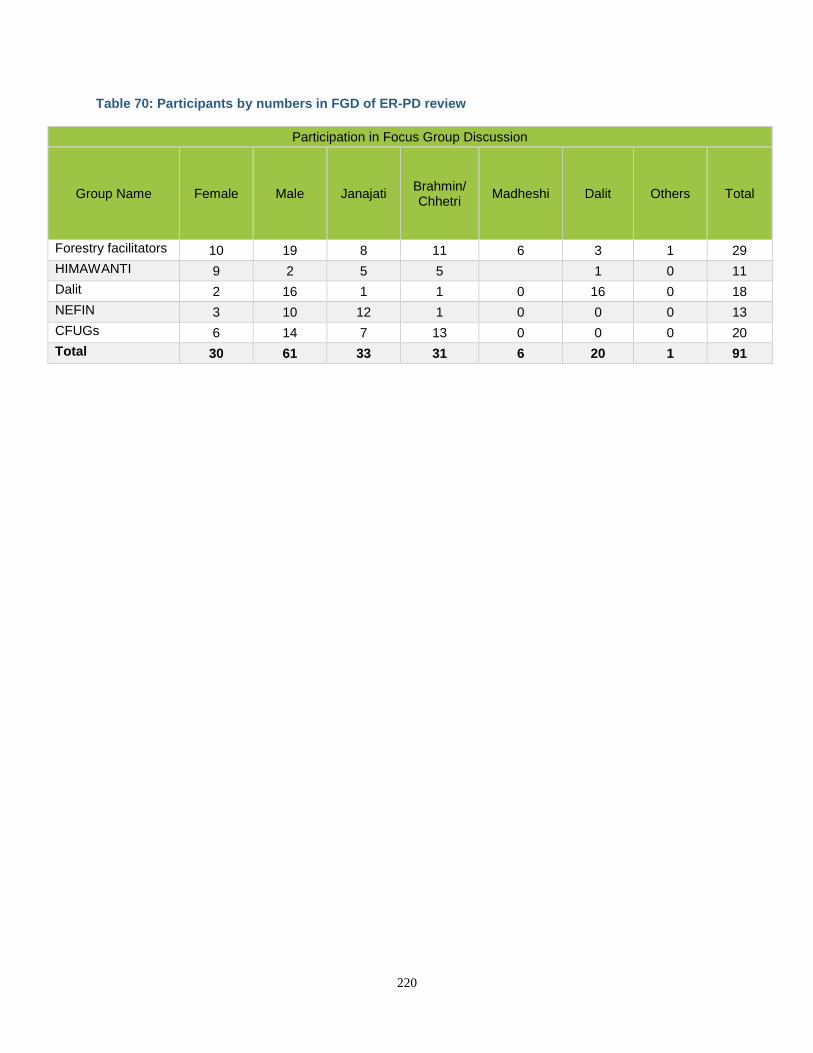
220
Table 70: Participants by numbers in FGD of ER-PD review
Participation in Focus Group Discussion
Group Name Female Male Janajati Brahmin/ Chhetri
Madheshi Dalit Others Total
Forestry facilitators 10 19 8 11 6 3 1 29
HIMAWANTI 9 2 5 5 1 0 11
Dalit 2 16 1 1 0 16 0 18
NEFIN 3 10 12 1 0 0 0 13
CFUGs 6 14 7 13 0 0 0 20
Total 30 61 33 31 6 20 1 91
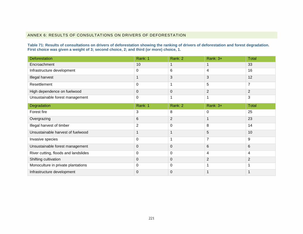
221
ANNEX 6: RESULTS OF CONSULTATIONS ON DRIVERS OF DEFORESTATION
Table 71: Results of consultations on drivers of deforestation showing the ranking of drivers of deforestation and forest degradation. First choice was given a weight of 3; second choice, 2; and third (or more) choice, 1.
Deforestation Rank: 1 Rank: 2 Rank: 3+ Total
Encroachment 10 1 1 33
Infrastructure development 0 6 4 16
Illegal harvest 1 3 3 12
Resettlement 0 1 5 7
High dependence on fuelwood 0 0 2 2
Unsustainable forest management 0 1 1 3
Degradation Rank: 1 Rank: 2 Rank: 3+ Total
Forest fire 3 8 0 25
Overgrazing 6 2 1 23
Illegal harvest of timber 2 0 8 14
Unsustainable harvest of fuelwood 1 1 5 10
Invasive species 0 1 7 9
Unsustainable forest management 0 0 6 6
River cutting, floods and landslides 0 0 4 4
Shifting cultivation 0 0 2 2
Monoculture in private plantations 0 0 1 1
Infrastructure development 0 0 1 1
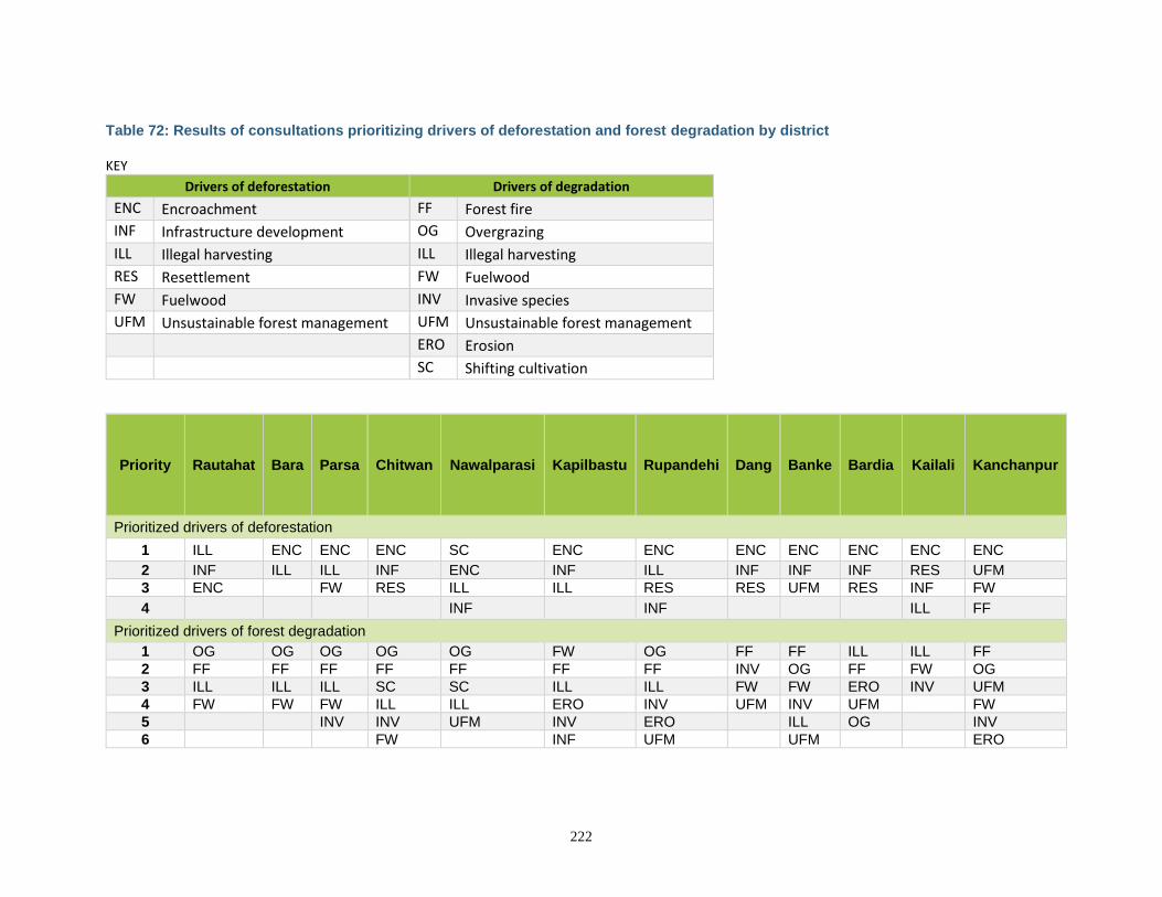
222
Table 72: Results of consultations prioritizing drivers of deforestation and forest degradation by district KEY
Drivers of deforestation Drivers of degradation
ENC Encroachment FF Forest fire
INF Infrastructure development OG Overgrazing
ILL Illegal harvesting ILL Illegal harvesting
RES Resettlement FW Fuelwood
FW Fuelwood INV Invasive species
UFM Unsustainable forest management UFM Unsustainable forest management
ERO Erosion
SC Shifting cultivation
Priority Rautahat Bara Parsa Chitwan Nawalparasi Kapilbastu Rupandehi Dang Banke Bardia Kailali Kanchanpur
Prioritized drivers of deforestation
1 ILL ENC ENC ENC SC ENC ENC ENC ENC ENC ENC ENC
2 INF ILL ILL INF ENC INF ILL INF INF INF RES UFM
3 ENC FW RES ILL ILL RES RES UFM RES INF FW
4 INF INF ILL FF
Prioritized drivers of forest degradation
1 OG OG OG OG OG FW OG FF FF ILL ILL FF
2 FF FF FF FF FF FF FF INV OG FF FW OG
3 ILL ILL ILL SC SC ILL ILL FW FW ERO INV UFM
4 FW FW FW ILL ILL ERO INV UFM INV UFM FW
5 INV INV UFM INV ERO ILL OG INV
6 FW INF UFM UFM ERO
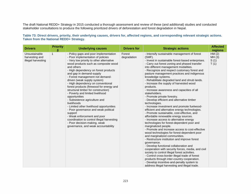
223
The draft National REDD+ Strategy in 2015 conducted a thorough assessment and review of these (and additional) studies and conducted stakeholder consultations to produce the following prioritized drivers of deforestation and forest degradation in Nepal. Table 73: Direct drivers, priority, their underlying causes, drivers for, affected regions, and corresponding relevant strategic actions. Taken from the National REDD+ Strategy.
Drivers Priority
§ Underlying causes Drivers for Strategic actions
Affected regions
Unsustainable harvesting and illegal harvesting
1 - Policy gaps and poor implementation - Poor implementation of policies - Very low priority to other alternative wood products such as composite wood and others - High dependency on forest products and gap in demand-supply - Forest management not demand-driven (weak supply system) - High dependency on conventional forest products (firewood for energy and structural timber for construction) - Poverty and limited livelihood opportunities - Subsistence agriculture and livelihoods - Limited other livelihood opportunities - Poor governance and weak political support - Weak enforcement and poor coordination to control illegal harvesting - Poor decision-making, weak governance, and weak accountability
Forest degradation
- Intensify sustainable management of forest (SMF). - Invest in sustainable forest-based enterprises. - Carry out forest zoning and phased transfer into different management modalities. - Recognize and respect customary forest and pasture management practices and indigenous knowledge systems. - Rehabilitate degraded land and shrub lands. - Increase the supply of harvested wood products. - Increase awareness and capacities of all stakeholders. - Promote private forestry. - Develop efficient and alternative timber technologies. - Increase investment and promote fuelwood-efficient and alternative energy technologies. - Promote sustainable, cost-effective, and affordable renewable energy sources. - Increase access to alternative energy technologies for forest-dependent poor and marginalized people. - Promote and increase access to cost-effective wood technologies for forest-dependent poor and marginalized communities. - Restructure institution and improve forest governance. - Develop functional collaboration and cooperation with security forces, media, and civil society to control illegal forest activities. - Control cross-border illegal trade of forest products through inter-country cooperation. - Develop incentive-and-penalty system to address illegal harvesting and illegal trade.
HM (2) MH (3) S (1) T (1)
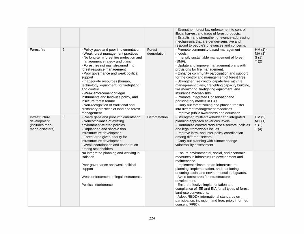
224
- Strengthen forest law enforcement to control illegal harvest and trade of forest products. - Establish and strengthen grievance-addressing mechanisms that are gender-sensitive and respond to people’s grievances and concerns.
Forest fire 2 - Policy gaps and poor implementation - Weak forest management practices - No long-term forest fire protection and management strategy and plans - Forest fire not mainstreamed into forest resource management - Poor governance and weak political support - Inadequate resources (human, technology, equipment) for firefighting and control - Weak enforcement of legal instruments and land-use policy, and insecure forest tenure - Non-recognition of traditional and customary practices of land and forest management
Forest degradation
- Promote community-based management models. - Intensify sustainable management of forest (SMF). - Update and improve management plans with provisions for fire management. - Enhance community participation and support for the control and management of forest fires. - Strengthen fire control capabilities with fire management plans, firefighting capacity building, fire monitoring, firefighting equipment, and insurance mechanisms. - Promote Integrated Conservationand participatory models in PAs. - Carry out forest zoning and phased transfer into different management modalities. - Improve public awareness and education.
HM (1)* MH (3) S (1) T (2)
Infrastructure development (includes man-made disasters)
3 - Policy gaps and poor implementation - Noncompliance of existing environment-related policies - Unplanned and short-vision infrastructure development - Forest area given priority for infrastructure development - Weak coordination and cooperation among stakeholders
Deforestation - Strengthen multi-stakeholder and integrated planning approach at various levels. - Harmonize contradictory cross-sectoral policies and legal frameworks issues. - Improve intra- and inter-policy coordination among different sectors. - Carry out planning with climate change vulnerability assessment.
HM (2) MH (1) S (2) T (4)
No integrated planning and working in isolation Poor governance and weak political support Weak enforcement of legal instruments Political interference
- Ensure environmental, social, and economic measures in infrastructure development and maintenance. - Implement climate-smart infrastructure planning, implementation, and monitoring, ensuring social and environmental safeguards. - Avoid forest area for infrastructure development. - Ensure effective implementation and compliance of IEE and EIA for all types of forest land-use conversions. - Adopt REDD+ international standards on participation, inclusion, and free, prior, informed consent (FPIC).
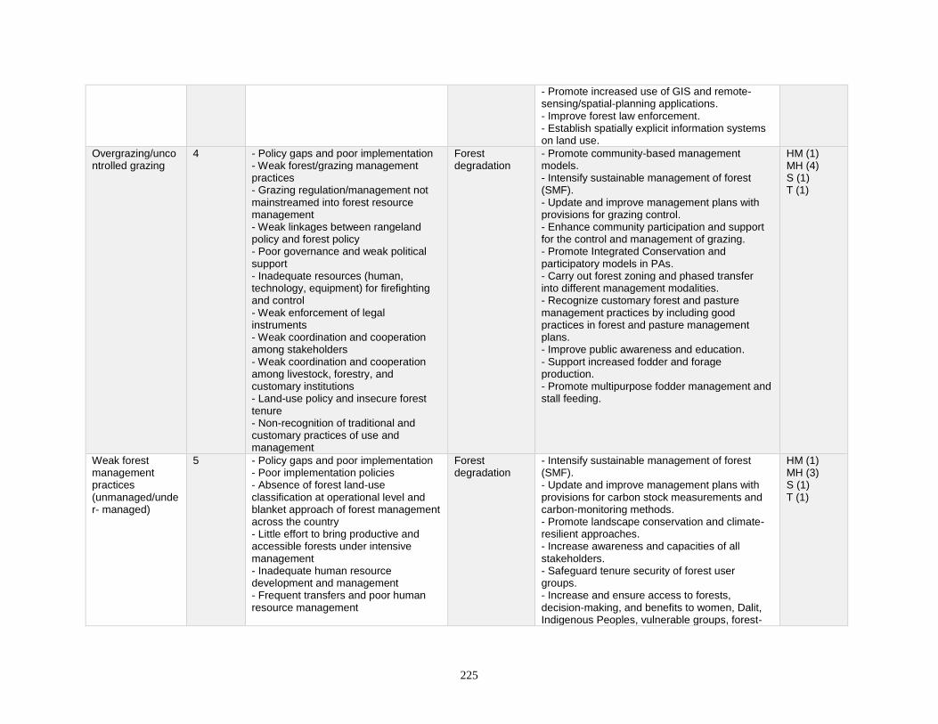
225
- Promote increased use of GIS and remote- sensing/spatial-planning applications. - Improve forest law enforcement. - Establish spatially explicit information systems on land use.
Overgrazing/uncontrolled grazing
4 - Policy gaps and poor implementation - Weak forest/grazing management practices - Grazing regulation/management not mainstreamed into forest resource management - Weak linkages between rangeland policy and forest policy - Poor governance and weak political support - Inadequate resources (human, technology, equipment) for firefighting and control - Weak enforcement of legal instruments - Weak coordination and cooperation among stakeholders - Weak coordination and cooperation among livestock, forestry, and customary institutions - Land-use policy and insecure forest tenure - Non-recognition of traditional and customary practices of use and management
Forest degradation
- Promote community-based management models. - Intensify sustainable management of forest (SMF). - Update and improve management plans with provisions for grazing control. - Enhance community participation and support for the control and management of grazing. - Promote Integrated Conservation and participatory models in PAs. - Carry out forest zoning and phased transfer into different management modalities. - Recognize customary forest and pasture management practices by including good practices in forest and pasture management plans. - Improve public awareness and education. - Support increased fodder and forage production. - Promote multipurpose fodder management and stall feeding.
HM (1) MH (4) S (1) T (1)
Weak forest management practices (unmanaged/under- managed)
5 - Policy gaps and poor implementation - Poor implementation policies - Absence of forest land-use classification at operational level and blanket approach of forest management across the country - Little effort to bring productive and accessible forests under intensive management - Inadequate human resource development and management - Frequent transfers and poor human resource management
Forest degradation
- Intensify sustainable management of forest (SMF). - Update and improve management plans with provisions for carbon stock measurements and carbon-monitoring methods. - Promote landscape conservation and climate-resilient approaches. - Increase awareness and capacities of all stakeholders. - Safeguard tenure security of forest user groups. - Increase and ensure access to forests, decision-making, and benefits to women, Dalit, Indigenous Peoples, vulnerable groups, forest-
HM (1) MH (3) S (1) T (1)
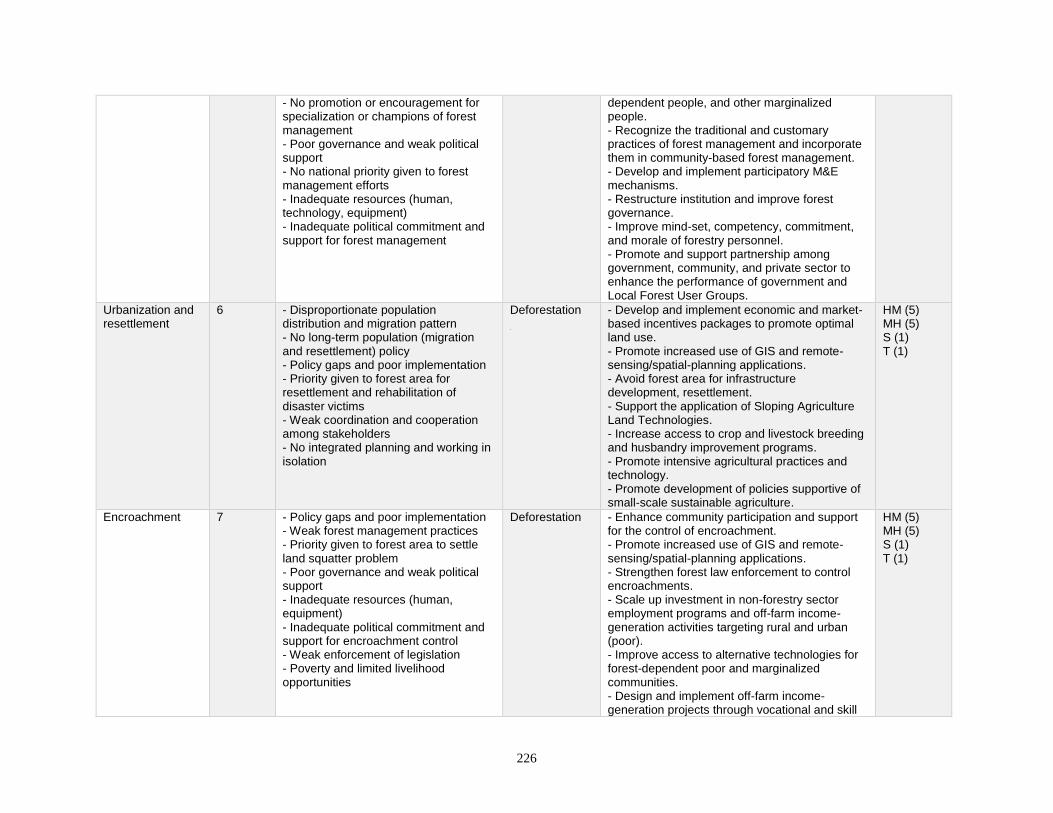
226
- No promotion or encouragement for specialization or champions of forest management - Poor governance and weak political support - No national priority given to forest management efforts - Inadequate resources (human, technology, equipment) - Inadequate political commitment and support for forest management
dependent people, and other marginalized people. - Recognize the traditional and customary practices of forest management and incorporate them in community-based forest management. - Develop and implement participatory M&E mechanisms. - Restructure institution and improve forest governance. - Improve mind-set, competency, commitment, and morale of forestry personnel. - Promote and support partnership among government, community, and private sector to enhance the performance of government and Local Forest User Groups.
Urbanization and resettlement
6 - Disproportionate population distribution and migration pattern - No long-term population (migration and resettlement) policy - Policy gaps and poor implementation - Priority given to forest area for resettlement and rehabilitation of disaster victims - Weak coordination and cooperation among stakeholders - No integrated planning and working in isolation
Deforestation
- Develop and implement economic and market-based incentives packages to promote optimal land use. - Promote increased use of GIS and remote- sensing/spatial-planning applications. - Avoid forest area for infrastructure development, resettlement. - Support the application of Sloping Agriculture Land Technologies. - Increase access to crop and livestock breeding and husbandry improvement programs. - Promote intensive agricultural practices and technology. - Promote development of policies supportive of small-scale sustainable agriculture.
HM (5) MH (5) S (1) T (1)
Encroachment 7 - Policy gaps and poor implementation - Weak forest management practices - Priority given to forest area to settle land squatter problem - Poor governance and weak political support - Inadequate resources (human, equipment) - Inadequate political commitment and support for encroachment control - Weak enforcement of legislation - Poverty and limited livelihood opportunities
Deforestation - Enhance community participation and support for the control of encroachment. - Promote increased use of GIS and remote- sensing/spatial-planning applications. - Strengthen forest law enforcement to control encroachments. - Scale up investment in non-forestry sector employment programs and off-farm income-generation activities targeting rural and urban (poor). - Improve access to alternative technologies for forest-dependent poor and marginalized communities. - Design and implement off-farm income-generation projects through vocational and skill
HM (5) MH (5) S (1) T (1)
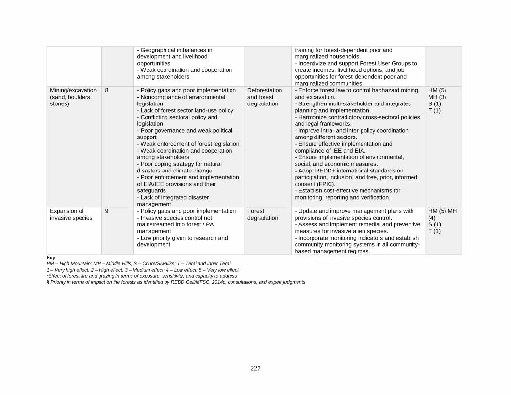
227
- Geographical imbalances in development and livelihood opportunities - Weak coordination and cooperation among stakeholders
training for forest-dependent poor and marginalized households. - Incentivize and support Forest User Groups to create incomes, livelihood options, and job opportunities for forest-dependent poor and marginalized communities.
Mining/excavation (sand, boulders, stones)
8 - Policy gaps and poor implementation - Noncompliance of environmental legislation - Lack of forest sector land-use policy - Conflicting sectoral policy and legislation - Poor governance and weak political support - Weak enforcement of forest legislation - Weak coordination and cooperation among stakeholders - Poor coping strategy for natural disasters and climate change - Poor enforcement and implementation of EIA/IEE provisions and their safeguards - Lack of integrated disaster management
Deforestation and forest degradation
- Enforce forest law to control haphazard mining and excavation. - Strengthen multi-stakeholder and integrated planning and implementation. - Harmonize contradictory cross-sectoral policies and legal frameworks. - Improve intra- and inter-policy coordination among different sectors. - Ensure effective implementation and compliance of IEE and EIA. - Ensure implementation of environmental, social, and economic measures. - Adopt REDD+ international standards on participation, inclusion, and free, prior, informed consent (FPIC). - Establish cost-effective mechanisms for monitoring, reporting and verification.
HM (5) MH (3) S (1) T (1)
Expansion of invasive species
9 - Policy gaps and poor implementation - Invasive species control not mainstreamed into forest / PA management - Low priority given to research and development
Forest degradation
- Update and improve management plans with provisions of invasive species control. - Assess and implement remedial and preventive measures for invasive alien species. - Incorporate monitoring indicators and establish community monitoring systems in all community-based management regimes.
HM (5) MH (4) S (1) T (1)
Key
HM – High Mountain; MH – Middle Hills; S – Chure/Siwaliks; T – Terai and inner Terai 1 – Very high effect; 2 – High effect; 3 – Medium effect; 4 – Low effect; 5 – Very low effect *Effect of forest fire and grazing in terms of exposure, sensitivity, and capacity to address § Priority in terms of impact on the forests as identified by REDD Cell/MFSC, 2014c, consultations, and expert judgments
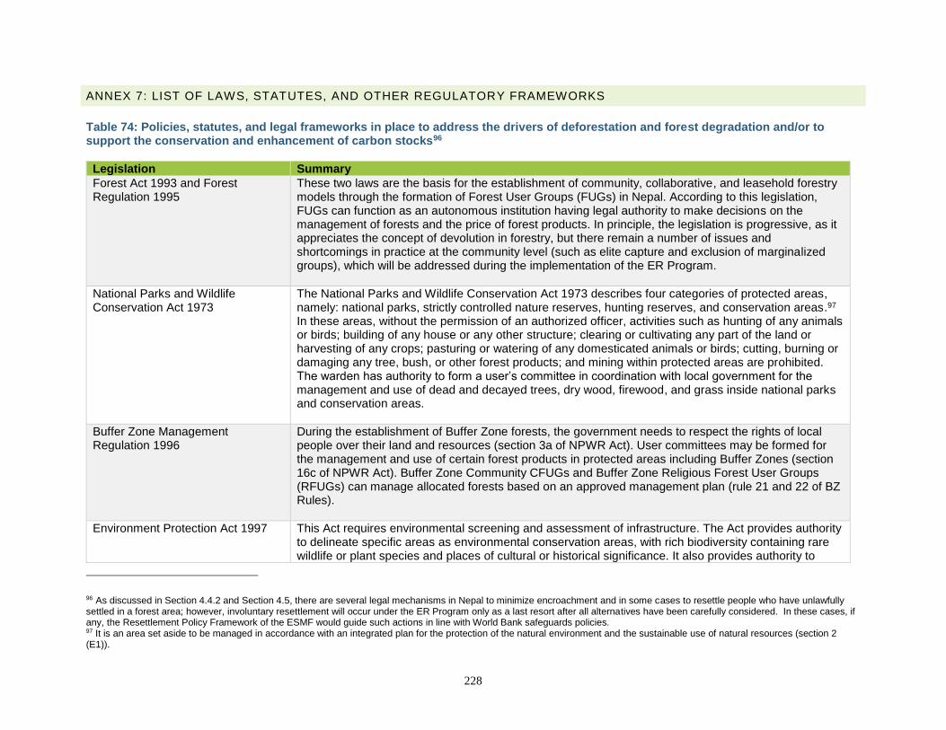
228
ANNEX 7: LIST OF LAWS, STATUTES, AND OTHER REGULATORY FRAMEWORKS
Table 74: Policies, statutes, and legal frameworks in place to address the drivers of deforestation and forest degradation and/or to support the conservation and enhancement of carbon stocks96
Legislation Summary
Forest Act 1993 and Forest Regulation 1995
These two laws are the basis for the establishment of community, collaborative, and leasehold forestry models through the formation of Forest User Groups (FUGs) in Nepal. According to this legislation, FUGs can function as an autonomous institution having legal authority to make decisions on the management of forests and the price of forest products. In principle, the legislation is progressive, as it appreciates the concept of devolution in forestry, but there remain a number of issues and shortcomings in practice at the community level (such as elite capture and exclusion of marginalized groups), which will be addressed during the implementation of the ER Program.
National Parks and Wildlife Conservation Act 1973
The National Parks and Wildlife Conservation Act 1973 describes four categories of protected areas, namely: national parks, strictly controlled nature reserves, hunting reserves, and conservation areas.97 In these areas, without the permission of an authorized officer, activities such as hunting of any animals or birds; building of any house or any other structure; clearing or cultivating any part of the land or harvesting of any crops; pasturing or watering of any domesticated animals or birds; cutting, burning or damaging any tree, bush, or other forest products; and mining within protected areas are prohibited. The warden has authority to form a user’s committee in coordination with local government for the management and use of dead and decayed trees, dry wood, firewood, and grass inside national parks and conservation areas.
Buffer Zone Management Regulation 1996
During the establishment of Buffer Zone forests, the government needs to respect the rights of local people over their land and resources (section 3a of NPWR Act). User committees may be formed for the management and use of certain forest products in protected areas including Buffer Zones (section 16c of NPWR Act). Buffer Zone Community CFUGs and Buffer Zone Religious Forest User Groups (RFUGs) can manage allocated forests based on an approved management plan (rule 21 and 22 of BZ Rules).
Environment Protection Act 1997 This Act requires environmental screening and assessment of infrastructure. The Act provides authority to delineate specific areas as environmental conservation areas, with rich biodiversity containing rare wildlife or plant species and places of cultural or historical significance. It also provides authority to
96 As discussed in Section 4.4.2 and Section 4.5, there are several legal mechanisms in Nepal to minimize encroachment and in some cases to resettle people who have unlawfully settled in a forest area; however, involuntary resettlement will occur under the ER Program only as a last resort after all alternatives have been carefully considered. In these cases, if any, the Resettlement Policy Framework of the ESMF would guide such actions in line with World Bank safeguards policies. 97 It is an area set aside to be managed in accordance with an integrated plan for the protection of the natural environment and the sustainable use of natural resources (section 2 (E1)).
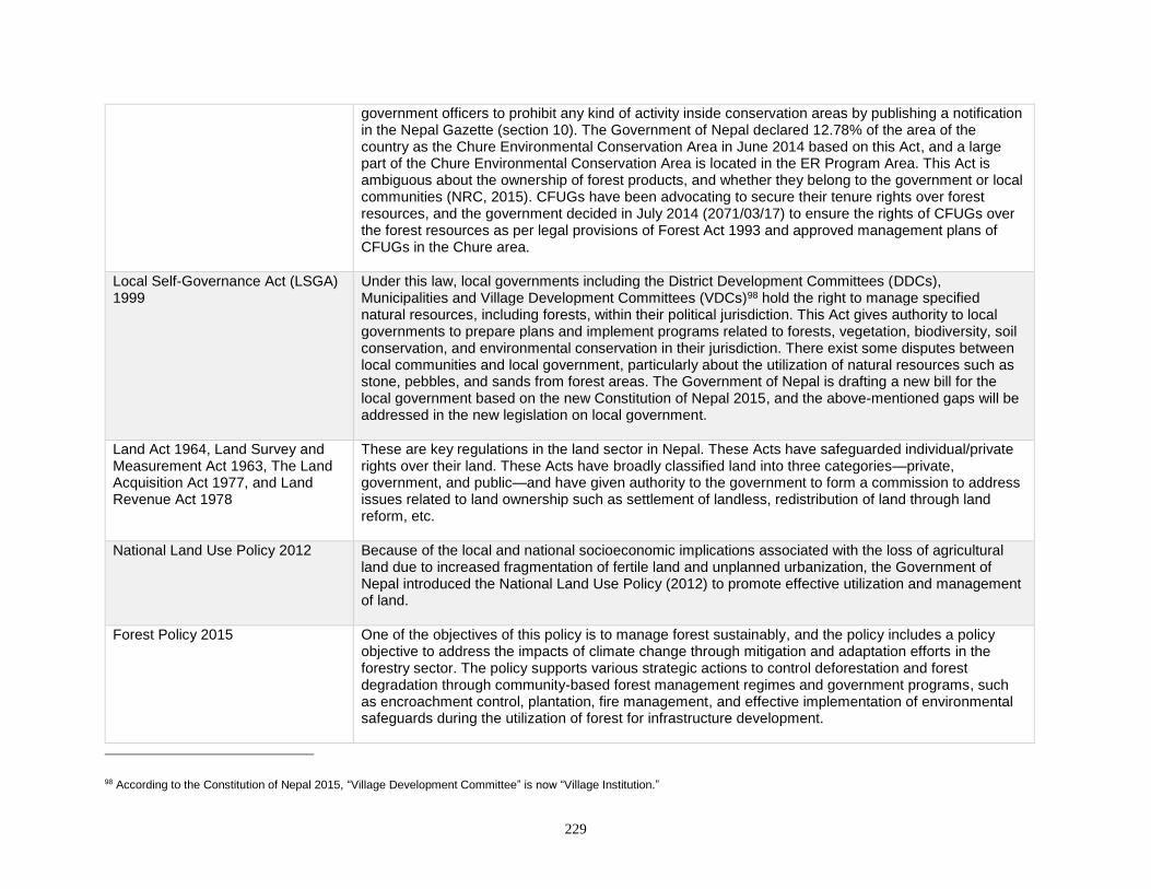
229
government officers to prohibit any kind of activity inside conservation areas by publishing a notification in the Nepal Gazette (section 10). The Government of Nepal declared 12.78% of the area of the country as the Chure Environmental Conservation Area in June 2014 based on this Act, and a large part of the Chure Environmental Conservation Area is located in the ER Program Area. This Act is ambiguous about the ownership of forest products, and whether they belong to the government or local communities (NRC, 2015). CFUGs have been advocating to secure their tenure rights over forest resources, and the government decided in July 2014 (2071/03/17) to ensure the rights of CFUGs over the forest resources as per legal provisions of Forest Act 1993 and approved management plans of CFUGs in the Chure area.
Local Self-Governance Act (LSGA) 1999
Under this law, local governments including the District Development Committees (DDCs), Municipalities and Village Development Committees (VDCs)98 hold the right to manage specified natural resources, including forests, within their political jurisdiction. This Act gives authority to local governments to prepare plans and implement programs related to forests, vegetation, biodiversity, soil conservation, and environmental conservation in their jurisdiction. There exist some disputes between local communities and local government, particularly about the utilization of natural resources such as stone, pebbles, and sands from forest areas. The Government of Nepal is drafting a new bill for the local government based on the new Constitution of Nepal 2015, and the above-mentioned gaps will be addressed in the new legislation on local government.
Land Act 1964, Land Survey and Measurement Act 1963, The Land Acquisition Act 1977, and Land Revenue Act 1978
These are key regulations in the land sector in Nepal. These Acts have safeguarded individual/private rights over their land. These Acts have broadly classified land into three categories—private, government, and public—and have given authority to the government to form a commission to address issues related to land ownership such as settlement of landless, redistribution of land through land reform, etc.
National Land Use Policy 2012 Because of the local and national socioeconomic implications associated with the loss of agricultural land due to increased fragmentation of fertile land and unplanned urbanization, the Government of Nepal introduced the National Land Use Policy (2012) to promote effective utilization and management of land.
Forest Policy 2015 One of the objectives of this policy is to manage forest sustainably, and the policy includes a policy objective to address the impacts of climate change through mitigation and adaptation efforts in the forestry sector. The policy supports various strategic actions to control deforestation and forest degradation through community-based forest management regimes and government programs, such as encroachment control, plantation, fire management, and effective implementation of environmental safeguards during the utilization of forest for infrastructure development.
98 According to the Constitution of Nepal 2015, “Village Development Committee” is now “Village Institution.”
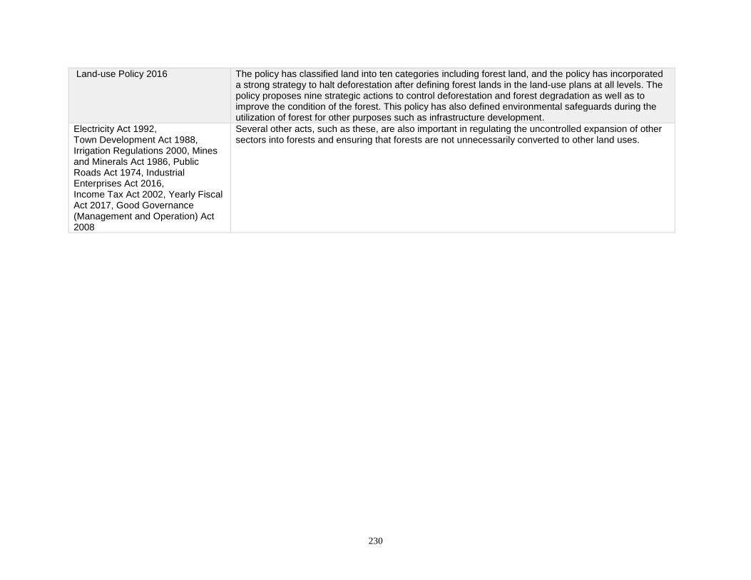
230
Land-use Policy 2016 The policy has classified land into ten categories including forest land, and the policy has incorporated a strong strategy to halt deforestation after defining forest lands in the land-use plans at all levels. The policy proposes nine strategic actions to control deforestation and forest degradation as well as to improve the condition of the forest. This policy has also defined environmental safeguards during the utilization of forest for other purposes such as infrastructure development.
Electricity Act 1992, Town Development Act 1988, Irrigation Regulations 2000, Mines and Minerals Act 1986, Public Roads Act 1974, Industrial Enterprises Act 2016, Income Tax Act 2002, Yearly Fiscal Act 2017, Good Governance (Management and Operation) Act 2008
Several other acts, such as these, are also important in regulating the uncontrolled expansion of other sectors into forests and ensuring that forests are not unnecessarily converted to other land uses.

231
ANNEX 8: SOCIAL AND ENVIRONMENTAL RISKS OF THE ER PROGRAM
ERPD Districts
Likely E&S negative impacts identified Mitigation measures suggested
Rautahat
Increased wild animals Fencing, provision of watchman, compensation if harm by the animals
Less access of schoolchildren to playground; playground will be converted into forest due to plantation in school areas so that kids cannot play
Set aside playground and build well-managed playground and carry out plantation only on the remaining land of educational institutions.
Limited access to firewood Provide alternative energy to villagers.
Bara
Adverse effect on livelihood after evacuation of encroached areas
Secure alternative livelihood for people so that they will not become involved in conflict. Government should manage.
May affect development interventions Need clear development plan so that conservation and development go together
Limited access to cattle grazing
After fencing the plantation site, people near that particular site will not graze cattle. Need to provide support for fodder production, help to stall feeding.
Monoculture plantation
There should be local and diversified species in the plantation.
Parsa
Adverse effect on livelihood after evacuation of encroached areas
Need to provide alternative livelihood, skill-based training so people can survive; facilitate the people before displace them and provide alternative and right place for their settlement.
Limited access to cattle grazing After fencing the plantation site, people near that particular site will not graze cattle. Need to provide support for fodder production, help to stall feeding.
Restrictions on and exclusion from traditional use rights
Need to include all traditional users in CF/CFM groups
Chitwan
Encroachment control: After controlling the encroachment, there will be conflict between government and encroacher.
Government should manage alternative settlements and secure alternative livelihood for people so that they will not be involved in conflict.
Risk of loss of livelihood and access to traditional practices of grazing while implementing activities related to grazing control
Support alternative energy program in the targeted communities, stall feeding.
Displacement Provide settlement in the proper place, and provide alternative livelihoods.
Nawalparasi
Plantation, grazing control: This will impact the poor who are using those open lands for grazing their cattle.
Establish alternative land for grazing, or provide alternative support for their livelihoods.
Sustainable Management of Forests (SMF): Due to opening of canopy, there will be a risk
Provide in-depth study on possible risks of SFM before full-fledged implementation of the management practice.
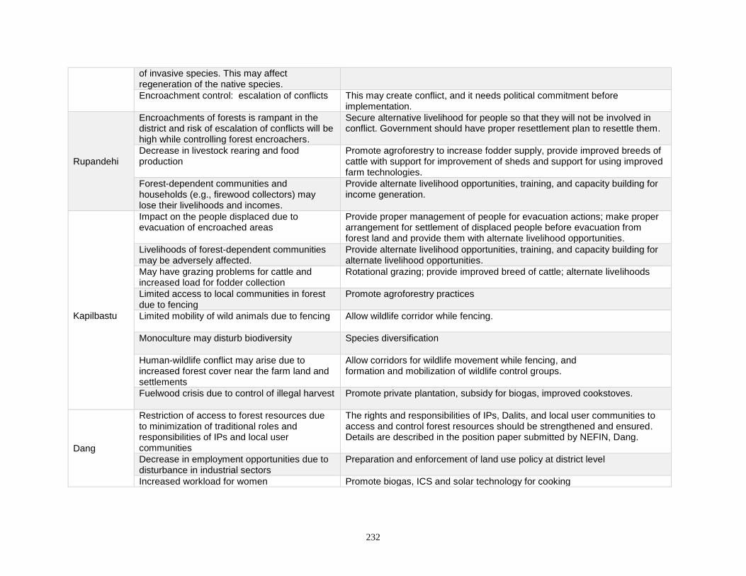
232
of invasive species. This may affect regeneration of the native species.
Encroachment control: escalation of conflicts This may create conflict, and it needs political commitment before implementation.
Rupandehi
Encroachments of forests is rampant in the district and risk of escalation of conflicts will be high while controlling forest encroachers.
Secure alternative livelihood for people so that they will not be involved in conflict. Government should have proper resettlement plan to resettle them.
Decrease in livestock rearing and food production
Promote agroforestry to increase fodder supply, provide improved breeds of cattle with support for improvement of sheds and support for using improved farm technologies.
Forest-dependent communities and households (e.g., firewood collectors) may lose their livelihoods and incomes.
Provide alternate livelihood opportunities, training, and capacity building for income generation.
Kapilbastu
Impact on the people displaced due to evacuation of encroached areas
Provide proper management of people for evacuation actions; make proper arrangement for settlement of displaced people before evacuation from forest land and provide them with alternate livelihood opportunities.
Livelihoods of forest-dependent communities may be adversely affected.
Provide alternate livelihood opportunities, training, and capacity building for alternate livelihood opportunities.
May have grazing problems for cattle and increased load for fodder collection
Rotational grazing; provide improved breed of cattle; alternate livelihoods
Limited access to local communities in forest due to fencing
Promote agroforestry practices
Limited mobility of wild animals due to fencing Allow wildlife corridor while fencing.
Monoculture may disturb biodiversity Species diversification
Human-wildlife conflict may arise due to increased forest cover near the farm land and settlements
Allow corridors for wildlife movement while fencing, and formation and mobilization of wildlife control groups.
Fuelwood crisis due to control of illegal harvest
Promote private plantation, subsidy for biogas, improved cookstoves.
Dang
Restriction of access to forest resources due to minimization of traditional roles and responsibilities of IPs and local user communities
The rights and responsibilities of IPs, Dalits, and local user communities to access and control forest resources should be strengthened and ensured. Details are described in the position paper submitted by NEFIN, Dang.
Decrease in employment opportunities due to disturbance in industrial sectors
Preparation and enforcement of land use policy at district level
Increased workload for women Promote biogas, ICS and solar technology for cooking
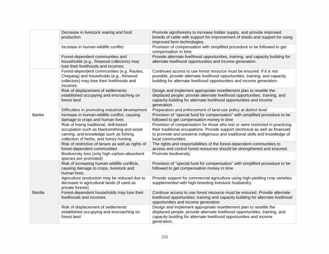
233
Decrease in livestock rearing and food production
Promote agroforestry to increase fodder supply, and provide improved breeds of cattle with support for improvement of sheds and support for using improved farm technologies.
Increase in human-wildlife conflict Provision of compensation with simplified procedure to be followed to get compensation in time
Forest-dependent communities and households (e.g., firewood collectors) may lose their livelihoods and incomes.
Provide alternate livelihood opportunities, training, and capacity building for alternate livelihood opportunities and income generation.
Banke
Forest-dependent communities (e.g. Rautes, Chepang) and households (e.g., firewood collectors) may lose their livelihoods and incomes.
Continued access to use forest resource must be ensured. If it is not possible, provide alternate livelihood opportunities, training, and capacity building for alternate livelihood opportunities and income generation.
Risk of displacement of settlements established occupying and encroaching on forest land
Design and implement appropriate resettlement plan to resettle the displaced people; provide alternate livelihood opportunities, training, and capacity building for alternate livelihood opportunities and income generation.
Difficulties in promoting industrial development Preparation and enforcement of land-use policy at district level
Increase in human-wildlife conflict, causing damage to crops and human lives
Provision of “special fund for compensation” with simplified procedure to be followed to get compensation money in time
Risk of losing traditional, skill-based occupation such as blacksmithing and wood carving, and knowledge such as fishing, collection of herbs, and honey hunting
Provision of compensation for those who lost or were restricted in practicing their traditional occupations. Provide support (technical as well as financial) to promote and preserve indigenous and traditional skills and knowledge of local communities.
Risk of restriction of tenure as well as rights of forest-dependent communities
The rights and responsibilities of the forest-dependent communities to access and control forest resources should be strengthened and ensured.
Biodiversity loss (only high-carbon-absorbent species are promoted)
Promote biodiversity.
Bardia
Risk of increasing human-wildlife conflicts, causing damage to crops, livestock and human lives
Provision of “special fund for compensation” with simplified procedure to be followed to get compensation money in time
Agriculture production may be reduced due to decrease in agricultural lands (if used as private forests)
Provide support for commercial agriculture using high-yielding crop varieties supplemented with high-breeding livestock husbandry.
Forest-dependent households may lose their livelihoods and incomes.
Continue access to use forest resource must be ensured. Provide alternate livelihood opportunities; training and capacity building for alternate livelihood opportunities and income generation
Risk of displacement of settlements established occupying and encroaching on forest land
Design and implement appropriate resettlement plan to resettle the displaced people; provide alternate livelihood opportunities, training, and capacity building for alternate livelihood opportunities and income generation.
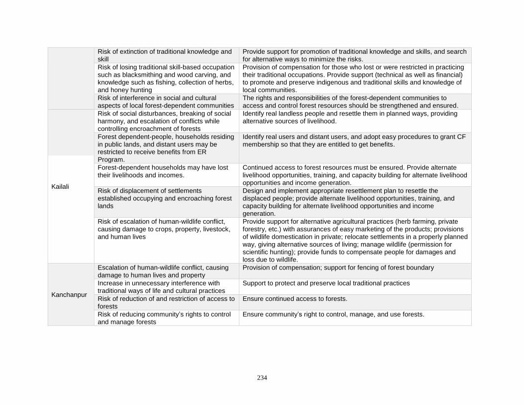
234
Risk of extinction of traditional knowledge and skill
Provide support for promotion of traditional knowledge and skills, and search for alternative ways to minimize the risks.
Risk of losing traditional skill-based occupation such as blacksmithing and wood carving, and knowledge such as fishing, collection of herbs, and honey hunting
Provision of compensation for those who lost or were restricted in practicing their traditional occupations. Provide support (technical as well as financial) to promote and preserve indigenous and traditional skills and knowledge of local communities.
Risk of interference in social and cultural aspects of local forest-dependent communities
The rights and responsibilities of the forest-dependent communities to access and control forest resources should be strengthened and ensured.
Kailali
Risk of social disturbances, breaking of social harmony, and escalation of conflicts while controlling encroachment of forests
Identify real landless people and resettle them in planned ways, providing alternative sources of livelihood.
Forest dependent-people, households residing in public lands, and distant users may be restricted to receive benefits from ER Program.
Identify real users and distant users, and adopt easy procedures to grant CF membership so that they are entitled to get benefits.
Forest-dependent households may have lost their livelihoods and incomes.
Continued access to forest resources must be ensured. Provide alternate livelihood opportunities, training, and capacity building for alternate livelihood opportunities and income generation.
Risk of displacement of settlements established occupying and encroaching forest lands
Design and implement appropriate resettlement plan to resettle the displaced people; provide alternate livelihood opportunities, training, and capacity building for alternate livelihood opportunities and income generation.
Risk of escalation of human-wildlife conflict, causing damage to crops, property, livestock, and human lives
Provide support for alternative agricultural practices (herb farming, private forestry, etc.) with assurances of easy marketing of the products; provisions of wildlife domestication in private; relocate settlements in a properly planned way, giving alternative sources of living; manage wildlife (permission for scientific hunting); provide funds to compensate people for damages and loss due to wildlife.
Kanchanpur
Escalation of human-wildlife conflict, causing damage to human lives and property
Provision of compensation; support for fencing of forest boundary
Increase in unnecessary interference with traditional ways of life and cultural practices
Support to protect and preserve local traditional practices
Risk of reduction of and restriction of access to forests
Ensure continued access to forests.
Risk of reducing community’s rights to control and manage forests
Ensure community’s right to control, manage, and use forests.
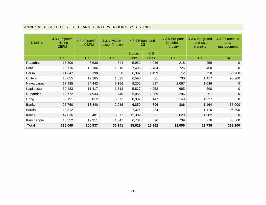
235
ANNEX 9: DETAILED LIST OF PLANNED INTERVENTIONS BY DISTRICT
Districts
4.3.1 Improve existing CBFM
4.3.2 Transfer to CBFM
4.3.3 Private-sector forestry
4.3.4 Biogas and ICS
4.3.5 Pro-poor leasehold forestry
4.3.6 Integrated land-use planning
4.3.7 Protected area
management
Biogas ICS Ha Ha Ha Units Units Ha Ha Ha
Rautahat 16,800 3,630 544 5,952 4,046 218 259 0
Bara 15,716 12,106 1,816 7,406 2,484 726 460 0
Parsa 11,647 198 30 6,387 1,499 12 758 63,700
Chitwan 18,055 12,165 1,825 6,593 21 730 1,417 93,200
Nawalparasi 17,485 34,443 5,166 9,202 687 2,067 1,036 0
Kapilbastu 30,483 11,417 1,713 5,827 4,252 685 590 0
Rupandehi 12,772 4,933 740 5,065 2,989 296 251 0
Dang 103,151 35,812 5,372 8,937 447 2,149 1,927 0
Banke 27,760 13,440 2,016 6,850 396 806 1,164 55,000
Bardia 18,812 - - 7,324 84 - 1,116 96,800
Kailali 47,036 60,481 9,072 12,302 31 3,629 1,982 0
Kanchanpur 16,352 12,311 1,847 6,784 26 739 776 30,500
Total 336,069 200,937 30,141 88,629 16,962 12,056 11,736 339,200
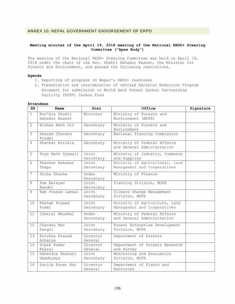
236
ANNEX 10: NEPAL GOVERNMENT ENDORSEMENT OF ERPD
Meeting minutes of the April 19, 2018 meeting of the National REDD+ Steering
Committee (“Apex Body”)
The meeting of the National REDD+ Steering Committee was held on April 19,
2018 under the chair of the Hon. Shakti Bahadur Basnet, the Minister for
Forests and Environment, and passed the following resolutions.
Agenda
1. Reporting of progress on Nepal's REDD+ readiness
2. Presentation and consideration of revised Emission Reduction Program
Document for submission to World Bank Forest Carbon Partnership
Facility (FCPF) Carbon Fund
Attendees
SN Name Post Office Signature
1 Hon'ble Shakti
Bahadur Basnet
Minister Ministry of Forests and
Environment (MOFE)
2 Bishwa Nath Oli Secretary Ministry of Forests and
Environment
3 Sharad Chandra
Poudel
Secretary National Planning Commission
4 Shankar Koirala Secretary Ministry of Federal Affairs
and General Administration
5 Toya Nath Gyawali Joint
Secretary
Ministry of Industry, Commerce
and Supplies
6 Shankar Bahadur
Thapa
Joint
Secretary
Ministry of Agricultural, Land
Management and Cooperatives
7 Shiba Sharma Under
Secretary
Ministry of Finance
8 Pem Narayan
Kandel
Joint
Secretary
Planning Division, MOFE
9 Ram Prasad Lamsal Joint
Secretary
Climate Change Management
Division, MOFE
10 Keshab Prasad
Premi
Joint
Secretary
Ministry of Agriculture, Land
Management and Cooperatives
11 Jibalal Bhushal Under
Secretary
Ministry of Federal Affairs
and General Administration
12 Chandra Man
Dangol
Joint
Secretary
Forest Enterprise Development
Division, MOFE
13 Krishna Prasad
Acharya
Director
General
Department of Forests
14 Dipak Kumar
Kharal
Director
General
Department of Forests Research
and Survey
15 Gehendra Keshari
Upadhyaya
Joint
Secretary
Monitoring and Evaluation
Division, MOFE
16 Sanjib Kunar Rai Director
General
Department of Plants and
Resources
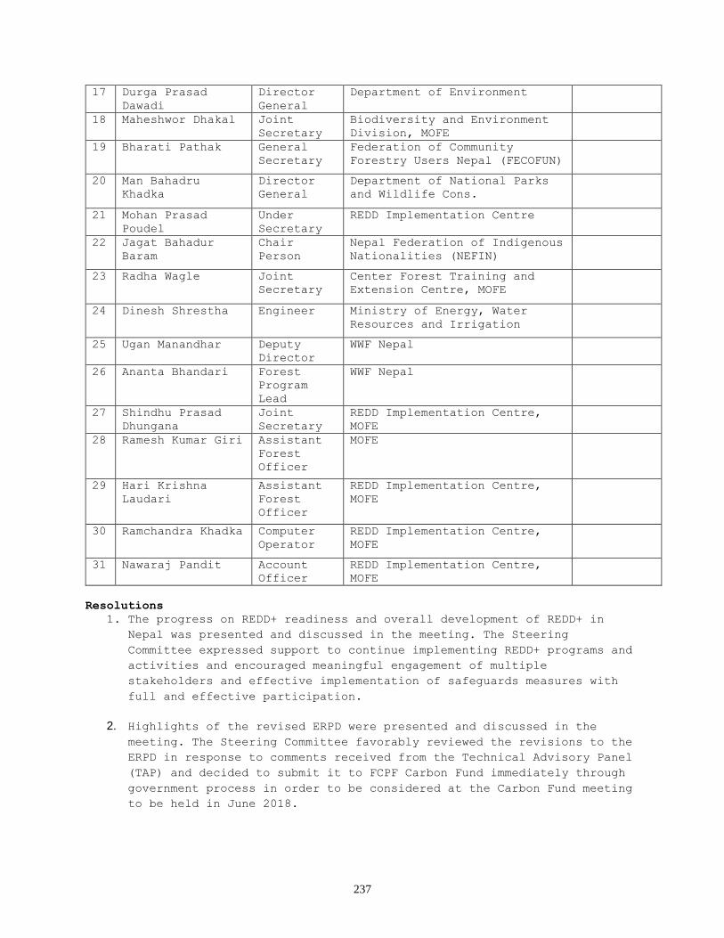
237
17 Durga Prasad
Dawadi
Director
General
Department of Environment
18 Maheshwor Dhakal Joint
Secretary
Biodiversity and Environment
Division, MOFE
19 Bharati Pathak General
Secretary
Federation of Community
Forestry Users Nepal (FECOFUN)
20 Man Bahadru
Khadka
Director
General
Department of National Parks
and Wildlife Cons.
21 Mohan Prasad
Poudel
Under
Secretary
REDD Implementation Centre
22 Jagat Bahadur
Baram
Chair
Person
Nepal Federation of Indigenous
Nationalities (NEFIN)
23 Radha Wagle Joint
Secretary
Center Forest Training and
Extension Centre, MOFE
24 Dinesh Shrestha Engineer Ministry of Energy, Water
Resources and Irrigation
25 Ugan Manandhar Deputy
Director
WWF Nepal
26 Ananta Bhandari Forest
Program
Lead
WWF Nepal
27 Shindhu Prasad
Dhungana
Joint
Secretary
REDD Implementation Centre,
MOFE
28 Ramesh Kumar Giri Assistant
Forest
Officer
MOFE
29 Hari Krishna
Laudari
Assistant
Forest
Officer
REDD Implementation Centre,
MOFE
30 Ramchandra Khadka Computer
Operator
REDD Implementation Centre,
MOFE
31 Nawaraj Pandit Account
Officer
REDD Implementation Centre,
MOFE
Resolutions
1. The progress on REDD+ readiness and overall development of REDD+ in
Nepal was presented and discussed in the meeting. The Steering
Committee expressed support to continue implementing REDD+ programs and
activities and encouraged meaningful engagement of multiple
stakeholders and effective implementation of safeguards measures with
full and effective participation.
2. Highlights of the revised ERPD were presented and discussed in the
meeting. The Steering Committee favorably reviewed the revisions to the
ERPD in response to comments received from the Technical Advisory Panel
(TAP) and decided to submit it to FCPF Carbon Fund immediately through
government process in order to be considered at the Carbon Fund meeting
to be held in June 2018.
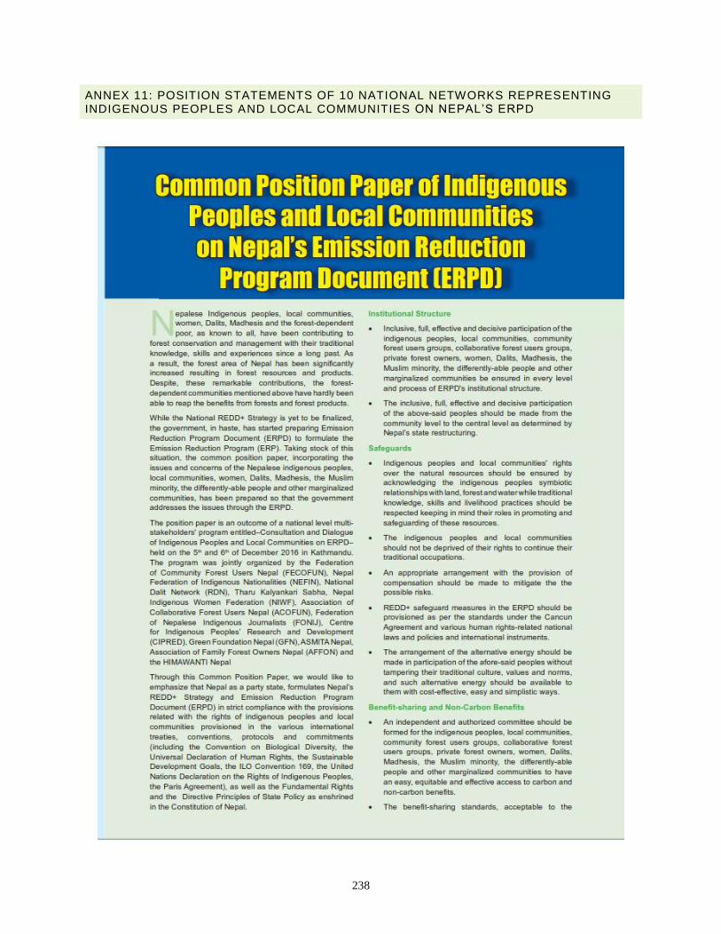
238
ANNEX 11: POSITION STATEMENTS OF 10 NATIONAL NETWORKS REPRESENTING INDIGENOUS PEOPLES AND LOCAL COMMUNITIES ON NEPAL’S ERPD
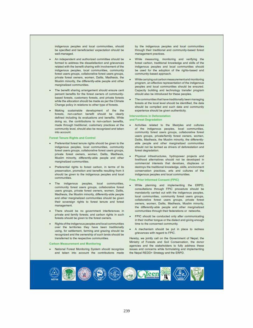
239
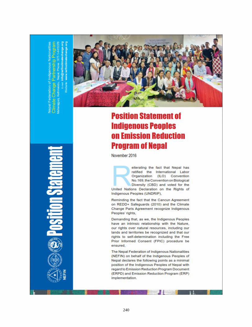
240
241
242
ANNEX 12: MONTE CARLO ANALYSIS FOR THE REFERENCE LEVEL
A Monte Carlo analysis was used to produce a distribution of estimations for above-ground biomass, derived emissions factors, and their combination with unbiased activity data area estimates. A Monte Carlo randomization was performed for each factor in the calculation of the reference level:
1. Random biomass estimates were drawn for Core Forest, Edge Forest, and No Forest. 2. Random combined emissions factors were derived for all transitions reported in the reference
level: Core deforestation, Edge deforestation, Degradation, Gain. 3. Each one of the transition’s randomized estimated emissions factors was combined with the area
estimates for each one. 4. Overall averages were calculated as well as confidence intervals and were used for reporting the
final estimated reference level.
243
ANNEX 13: UMD-DFRS SAMPLE INTERPRETATION PROTOCOL
Reference documentation
Sample-based national tree canopy cover and change assessment
Peter Potapov and Alexandra Tyukavina
Global Land Analysis and Discovery Lab University of Maryland Department of Geographical Sciences 4321 Hartwick Rd, Suite 400 College Park, MD 20740 United States
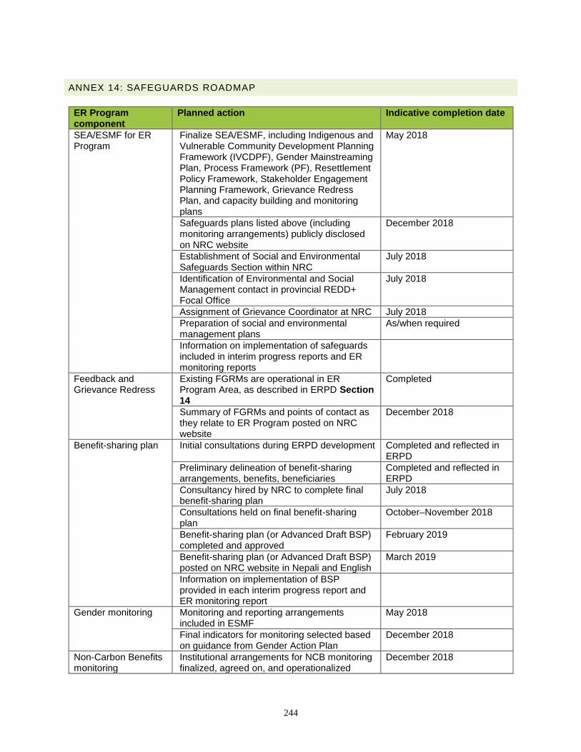
244
ANNEX 14: SAFEGUARDS ROADMAP
ER Program component
Planned action Indicative completion date
SEA/ESMF for ER Program
Finalize SEA/ESMF, including Indigenous and Vulnerable Community Development Planning Framework (IVCDPF), Gender Mainstreaming Plan, Process Framework (PF), Resettlement Policy Framework, Stakeholder Engagement Planning Framework, Grievance Redress Plan, and capacity building and monitoring plans
May 2018
Safeguards plans listed above (including monitoring arrangements) publicly disclosed on NRC website
December 2018
Establishment of Social and Environmental Safeguards Section within NRC
July 2018
Identification of Environmental and Social Management contact in provincial REDD+ Focal Office
July 2018
Assignment of Grievance Coordinator at NRC July 2018
Preparation of social and environmental management plans
As/when required
Information on implementation of safeguards included in interim progress reports and ER monitoring reports
Feedback and Grievance Redress
Existing FGRMs are operational in ER Program Area, as described in ERPD Section 14
Completed
Summary of FGRMs and points of contact as they relate to ER Program posted on NRC website
December 2018
Benefit-sharing plan Initial consultations during ERPD development Completed and reflected in ERPD
Preliminary delineation of benefit-sharing arrangements, benefits, beneficiaries
Completed and reflected in ERPD
Consultancy hired by NRC to complete final benefit-sharing plan
July 2018
Consultations held on final benefit-sharing plan
October–November 2018
Benefit-sharing plan (or Advanced Draft BSP) completed and approved
February 2019
Benefit-sharing plan (or Advanced Draft BSP) posted on NRC website in Nepali and English
March 2019
Information on implementation of BSP provided in each interim progress report and ER monitoring report
Gender monitoring Monitoring and reporting arrangements included in ESMF
May 2018
Final indicators for monitoring selected based on guidance from Gender Action Plan
December 2018
Non-Carbon Benefits monitoring
Institutional arrangements for NCB monitoring finalized, agreed on, and operationalized
December 2018
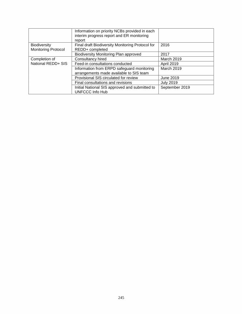
245
Information on priority NCBs provided in each interim progress report and ER monitoring report
Biodiversity Monitoring Protocol
Final draft Biodiversity Monitoring Protocol for REDD+ completed
2016
Biodiversity Monitoring Plan approved 2017
Completion of National REDD+ SIS
Consultancy hired March 2019
Feed-in consultations conducted April 2019
Information from ERPD safeguard monitoring arrangements made available to SIS team
March 2019
Provisional SIS circulated for review June 2019
Final consultations and revisions July 2019
Initial National SIS approved and submitted to UNFCCC Info Hub
September 2019
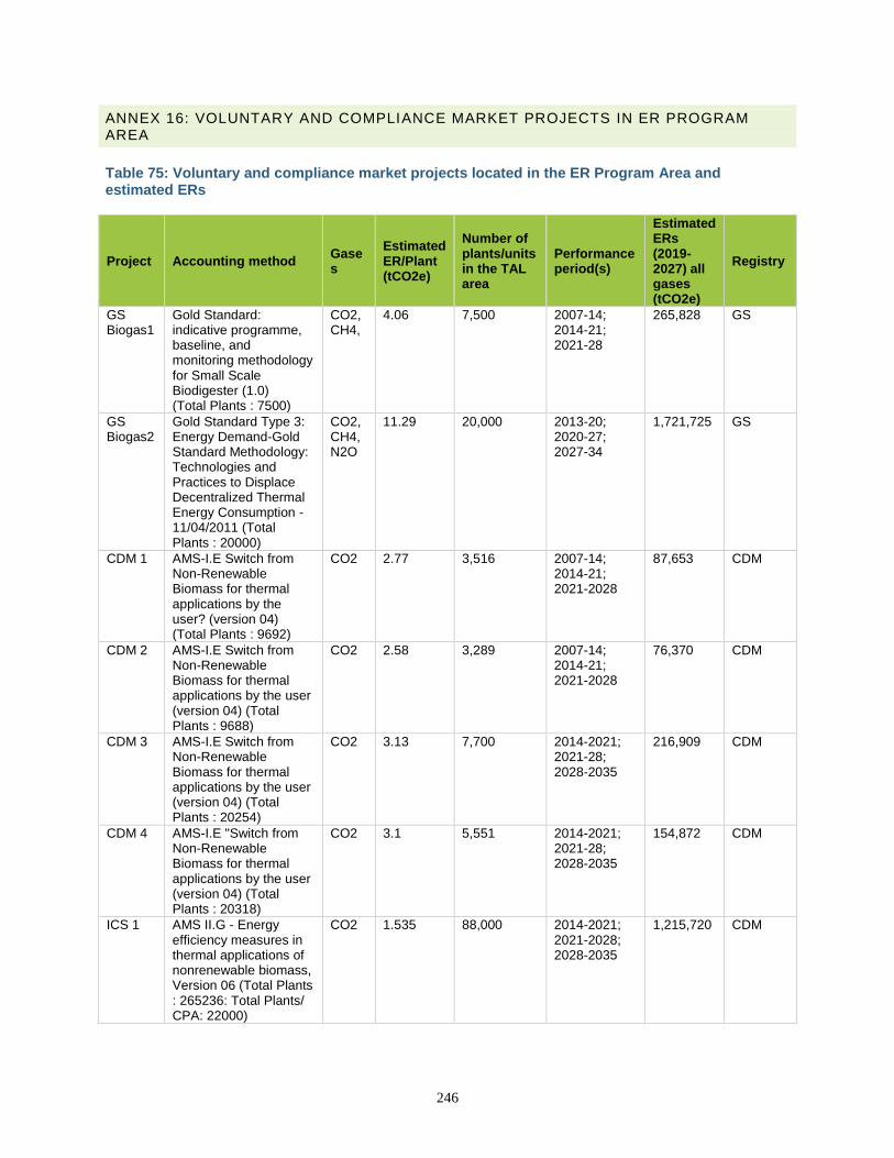
246
ANNEX 16: VOLUNTARY AND COMPLIANCE MARKET PROJECTS IN ER PROGRAM AREA
Table 75: Voluntary and compliance market projects located in the ER Program Area and estimated ERs
Project Accounting method Gases
Estimated ER/Plant (tCO2e)
Number of plants/units in the TAL area
Performance period(s)
Estimated ERs (2019-2027) all gases (tCO2e)
Registry
GS Biogas1
Gold Standard: indicative programme, baseline, and monitoring methodology for Small Scale Biodigester (1.0) (Total Plants : 7500)
CO2, CH4,
4.06 7,500 2007-14; 2014-21; 2021-28
265,828 GS
GS Biogas2
Gold Standard Type 3: Energy Demand-Gold Standard Methodology: Technologies and Practices to Displace Decentralized Thermal Energy Consumption - 11/04/2011 (Total Plants : 20000)
CO2, CH4, N2O
11.29 20,000 2013-20; 2020-27; 2027-34
1,721,725 GS
CDM 1 AMS-I.E Switch from Non-Renewable Biomass for thermal applications by the user? (version 04) (Total Plants : 9692)
CO2 2.77 3,516 2007-14; 2014-21; 2021-2028
87,653 CDM
CDM 2 AMS-I.E Switch from Non-Renewable Biomass for thermal applications by the user (version 04) (Total Plants : 9688)
CO2 2.58 3,289 2007-14; 2014-21; 2021-2028
76,370 CDM
CDM 3 AMS-I.E Switch from Non-Renewable Biomass for thermal applications by the user (version 04) (Total Plants : 20254)
CO2 3.13 7,700 2014-2021; 2021-28; 2028-2035
216,909 CDM
CDM 4 AMS-I.E "Switch from Non-Renewable Biomass for thermal applications by the user (version 04) (Total Plants : 20318)
CO2 3.1 5,551 2014-2021; 2021-28; 2028-2035
154,872 CDM
ICS 1 AMS II.G - Energy efficiency measures in thermal applications of nonrenewable biomass, Version 06 (Total Plants : 265236: Total Plants/ CPA: 22000)
CO2 1.535 88,000 2014-2021; 2021-2028; 2028-2035
1,215,720 CDM
247
ANNEX 15: NATIONAL ASSESSMENT OF TREE COVER EXTENT AND CHANGE
Overview of GLAD national forest monitoring system National information on tree cover extent and change is required for effective land-use planning and management, Forest Resources Assessment reporting to the Food and Agriculture Organization of United Nations, national reporting on greenhouse gas emissions according to the Intergovernmental Panel on Climate Change guidelines and in context of REDD+ agreements, and nature conservation strategy development. Satellite imagery, especially freely available medium spatial resolution data such as that delivered by the Landsat program, provides practical means for national tree canopy cover monitoring. High spatial resolution data available from Google Earth is sufficient to interpret land-cover type and tree canopy cover proportion. The overarching goal of GLAD training is to support ongoing national efforts for forest mapping and monitoring. The system developed by the UMD Global Land Analysis and Discovery (GLAD) Lab is used by a number of countries for annual tree cover change monitoring. The system includes two components (stages). The first stage consists of wall-to-wall Landsat-based tree cover extent and change mapping. Wall-to-wall mapping may be performed at the national as well as the regional or global scale. The tree cover extent and change maps are further used to stratify the country in the implementation of a stratified random sampling protocol. The second stage of the analysis consists of tree cover and change area estimation based on a sample interpretation using multi-resolution time-series data. The tree cover and change area uncertainty is also measured, as well as the accuracy of the wall-to-wall maps. Objectives of the sample interpretation In this example, we show the generic way to assess sample-based tree cover area and change between 2000 and 2016. The same approach may be implemented for any other time interval. The national samples are selected using the stratified random sampling protocol using wall-to-wall national tree cover extent and change maps developed during the first stage of GLAD system implementation. Using reference data collected for the samples, the following parameters (and their uncertainty) at the national scale can be estimated:
• Tree cover in the year 2016;
• Tree cover net change area 2001–2016;
• Gross tree cover loss and gain area;
• Tree cover loss area by forest type/category in the year 2000;
• Change categories and proximate causes of tree cover loss (area proportion for each cause); and
• Land-cover outcomes of tree cover conversion (area proportion for each outcome). Every parameter (area and proportion) is estimated at the national level with known uncertainty (95% confidence interval). Stratified sampling design The sampling unit is a single Landsat pixel (~30 x 30 meters) selected using stratified random sampling design. Stratification is based on the GLAD forest or tree canopy cover, annual tree cover loss, and tree cover gain maps for 2000–2016. Typical strata represent the following classes:
• “Stable tree cover”: pixels with tree canopy cover of at least 10% for any year.
• “Dynamic tree cover”: pixels where tree cover loss or gain, or both, was detected. This stratum is generated using the available forest dynamic map.
• “Buffer around dynamic tree cover”: pixels adjacent (1- or 2-pixel radius) to the change areas. This stratum is selected to target the area of high probability of change omission.
• “No tree cover”: pixels where tree canopy cover was always lower than 10%. The number of strata may be different for different applications.
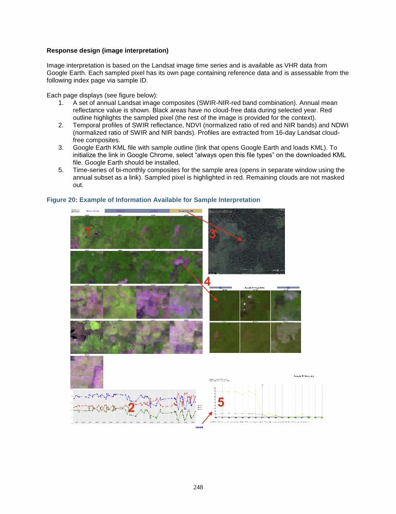
248
Response design (image interpretation) Image interpretation is based on the Landsat image time series and is available as VHR data from Google Earth. Each sampled pixel has its own page containing reference data and is assessable from the following index page via sample ID. Each page displays (see figure below):
1. A set of annual Landsat image composites (SWIR-NIR-red band combination). Annual mean reflectance value is shown. Black areas have no cloud-free data during selected year. Red outline highlights the sampled pixel (the rest of the image is provided for the context).
2. Temporal profiles of SWIR reflectance, NDVI (normalized ratio of red and NIR bands) and NDWI (normalized ratio of SWIR and NIR bands). Profiles are extracted from 16-day Landsat cloud-free composites.
3. Google Earth KML file with sample outline (link that opens Google Earth and loads KML). To initialize the link in Google Chrome, select “always open this file types” on the downloaded KML file. Google Earth should be installed.
5. Time-series of bi-monthly composites for the sample area (opens in separate window using the annual subset as a link). Sampled pixel is highlighted in red. Remaining clouds are not masked out.
Figure 20: Example of Information Available for Sample Interpretation
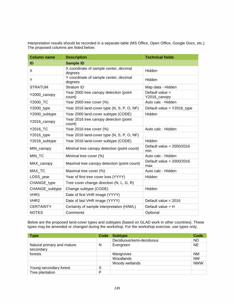
249
Interpretation results should be recorded in a separate table (MS Office, Open Office, Google Docs, etc.). The proposed columns are listed below:
Column name Description Technical fields
ID Sample ID
X X coordinate of sample center, decimal degrees
Hidden
Y Y coordinate of sample center, decimal degrees
Hidden
STRATUM Stratum ID Map data - Hidden
Y2000_canopy Year 2000 tree canopy detection (point count)
Default value = Y2016_canopy
Y2000_TC Year 2000 tree cover (%) Auto calc - Hidden
Y2000_type Year 2016 land-cover type (N, S, P, O, NF) Default value = Y2016_type
Y2000_subtype Year 2000 land-cover subtype (CODE) Hidden
Y2016_canopy Year 2016 tree canopy detection (point count)
Y2016_TC Year 2016 tree cover (%) Auto calc - Hidden
Y2016_type Year 2016 land-cover type (N, S, P, O, NF)
Y2016_subtype Year 2016 land-cover subtype (CODE) Hidden
MIN_canopy Minimal tree canopy detection (point count) Default value = 2000/2016 min
MIN_TC Minimal tree cover (%) Auto calc - Hidden
MAX_canopy Maximal tree canopy detection (point count) Default value = 2000/2016 max
MAX_TC Maximal tree cover (%) Auto calc - Hidden
LOSS_year Year of first tree cover loss (YYYY) Hidden
CHANGE_type Tree cover change direction (N, L, G, R)
CHANGE_subtype Change subtype (CODE) Hidden
VHR1 Date of first VHR image (YYYY)
VHR2 Date of last VHR image (YYYY) Default value = 2016
CERTAINTY Certainty of sample interpretation (H/M/L) Default value = H
NOTES Comments Optional
Below are the proposed land-cover types and subtypes (based on GLAD work in other countries). These types may be amended or changed during the workshop. For the workshop exercise, use types only.
Type Code Subtype Code
Deciduous/semi-deciduous ND
Natural primary and mature secondary
N Evergreen NE
forests Mangroves NM
Woodlands NW
Woody wetlands NWW
Young secondary forest S
Tree plantation P
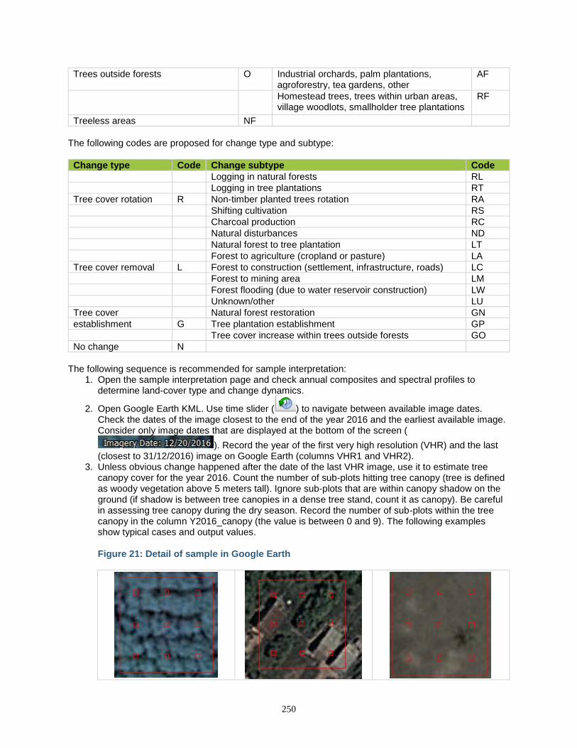
250
Trees outside forests O Industrial orchards, palm plantations, agroforestry, tea gardens, other
AF
Homestead trees, trees within urban areas, village woodlots, smallholder tree plantations
RF
Treeless areas NF
The following codes are proposed for change type and subtype:
Change type Code Change subtype Code
Logging in natural forests RL
Logging in tree plantations RT
Tree cover rotation R Non-timber planted trees rotation RA
Shifting cultivation RS
Charcoal production RC
Natural disturbances ND
Natural forest to tree plantation LT
Forest to agriculture (cropland or pasture) LA
Tree cover removal L Forest to construction (settlement, infrastructure, roads) LC
Forest to mining area LM
Forest flooding (due to water reservoir construction) LW
Unknown/other LU
Tree cover Natural forest restoration GN
establishment G Tree plantation establishment GP
Tree cover increase within trees outside forests GO
No change N
The following sequence is recommended for sample interpretation:
1. Open the sample interpretation page and check annual composites and spectral profiles to determine land-cover type and change dynamics.
2. Open Google Earth KML. Use time slider ( ) to navigate between available image dates. Check the dates of the image closest to the end of the year 2016 and the earliest available image. Consider only image dates that are displayed at the bottom of the screen (
). Record the year of the first very high resolution (VHR) and the last (closest to 31/12/2016) image on Google Earth (columns VHR1 and VHR2).
3. Unless obvious change happened after the date of the last VHR image, use it to estimate tree canopy cover for the year 2016. Count the number of sub-plots hitting tree canopy (tree is defined as woody vegetation above 5 meters tall). Ignore sub-plots that are within canopy shadow on the ground (if shadow is between tree canopies in a dense tree stand, count it as canopy). Be careful in assessing tree canopy during the dry season. Record the number of sub-plots within the tree canopy in the column Y2016_canopy (the value is between 0 and 9). The following examples show typical cases and output values. Figure 21: Detail of sample in Google Earth
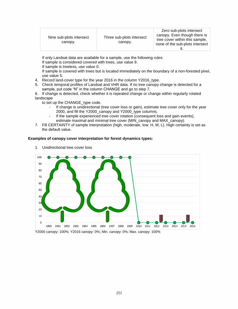
251
Nine sub-plots intersect canopy.
Three sub-plots intersect canopy.
Zero sub-plots intersect canopy. Even though there is tree cover within this sample, none of the sub-plots intersect
it.
If only Landsat data are available for a sample, use the following rules: If sample is considered covered with trees, use value 9. If sample is treeless, use value 0. If sample is covered with trees but is located immediately on the boundary of a non-forested pixel, use value 5.
4. Record land-cover type for the year 2016 in the column Y2016_type. 5. Check temporal profiles of Landsat and VHR data. If no tree canopy change is detected for a
sample, put code “N” in the column CHANGE and go to step 7. 6. If change is detected, check whether it is repeated change or change within regularly rotated landscape
to set up the CHANGE_type code. - If change is unidirectional (tree cover loss or gain), estimate tree cover only for the year
2000, and fill the Y2000_canopy and Y2000_type columns. - If the sample experienced tree cover rotation (consequent loss and gain events),
estimate maximal and minimal tree cover (MIN_canopy and MAX_canopy). 7. Fill CERTAINTY of sample interpretation (high, moderate, low: H, M, L). High certainty is set as
the default value.
Examples of canopy cover interpretation for forest dynamics types:
1. Unidirectional tree cover loss
Y2000 canopy: 100%; Y2016 canopy: 0%; Min. canopy: 0%; Max. canopy: 100%
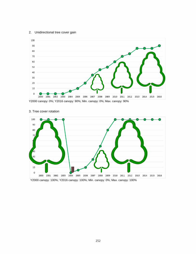
252
2. Unidirectional tree cover gain
Y2000 canopy: 0%; Y2016 canopy: 90%; Min. canopy: 0%; Max. canopy: 90%
3. Tree cover rotation
Y2000 canopy: 100%; Y2016 canopy: 100%; Min. canopy: 0%; Max. canopy: 100%
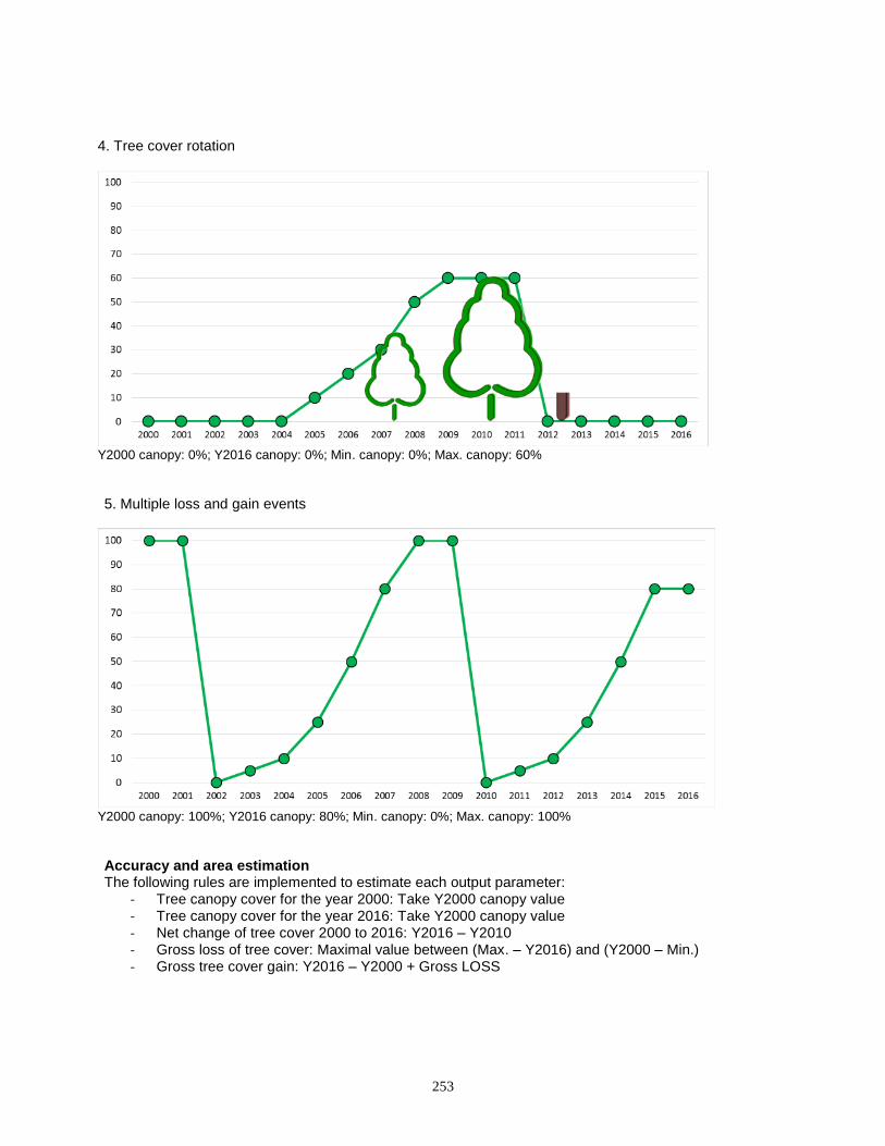
253
4. Tree cover rotation
Y2000 canopy: 0%; Y2016 canopy: 0%; Min. canopy: 0%; Max. canopy: 60%
5. Multiple loss and gain events
Y2000 canopy: 100%; Y2016 canopy: 80%; Min. canopy: 0%; Max. canopy: 100% Accuracy and area estimation The following rules are implemented to estimate each output parameter:
- Tree canopy cover for the year 2000: Take Y2000 canopy value - Tree canopy cover for the year 2016: Take Y2000 canopy value - Net change of tree cover 2000 to 2016: Y2016 – Y2010 - Gross loss of tree cover: Maximal value between (Max. – Y2016) and (Y2000 – Min.) - Gross tree cover gain: Y2016 – Y2000 + Gross LOSS
Related Documents


