Neotectonics in the foothills of the southernmost central Andes (37° –38° S): Evidence of strike-slip displacement along the Antin ˜ ir-Copahue fault zone Andre ´s Folguera and Vı ´ctor A. Ramos Laboratorio de Tecto ´nica Andina, Universidad de Buenos Aires, Buenos Aires, Argentina Reginald L. Hermanns 1 GeoForschungsZentrum, Potsdam, Germany Jose ´ Naranjo Servicio Nacional de Geologı ´a y Minerı ´a de Chile, Santiago, Chile Received 2 April 2003; revised 2 May 2004; accepted 8 July 2004; published 5 October 2004. [1] The Antin ˜ir-Copahue fault zone (ACFZ) is the eastern orogenic front of the Andes between 38° and 37°S. It is formed by an east vergent fan of high-angle dextral transpressive and transtensive faults, which invert a Paleogene intra-arc rift system in an out of sequence order with respect to the Cretaceous to Miocene fold and thrust belt. 3.1–1.7 Ma volcanic rocks are folded and fractured through this belt, and recent indicators of fault activity in unconsolidated deposits suggest an ongoing deformation. In spite of the absence of substantial shallow seismicity associated with the orogenic front, neotectonic studies show the existence of active faults in the present mountain front. The low shallow seismicity could be linked to the high volumes of retroarc- derived volcanic rocks erupted through this fault system during Pliocene and Quaternary times. This thermally weakened basement accommodates the strain of the Antin ˜ir-Copahue fault zone, absorbing the present convergence between the South America and Nazca plates. INDEX TERMS: 8102 Tectonophysics: Continental contractional orogenic belts; 8107 Tectonophysics: Continental neotectonics; 8110 Tectonophysics: Continental tectonics—general (0905); 8150 Tectonophysics: Plate boundary—general (3040); 8124 Tectonophysics: Earth’s interior—composition and state (1212); KEYWORDS: Andean neotectonics, southern central Andes, retroarc, orogenic front, northern Liquin ˜e-Ofqui fault zone. Citation: Folguera, A., V. A. Ramos, R. L. Hermanns, and J. Naranjo (2004), Neotectonics in the foothills of the southernmost central Andes (37° –38°S): Evidence of strike-slip displacement along the Antin ˜ir-Copahue fault zone, Tectonics, 23, TC5008, doi:10.1029/2003TC001533. 1. Introduction [2] The Andes between 26° and 44°S are extremely variable in altitude and amplitude as a consequence of gradients in orogenic shortening (Figure 1) [Kley , 1998; Ramos, 1999]. This fact is revealed by the variable crustal thickness which changes with the topography along the chain [Introcaso et al., 1992]. The Andes between 37° and 38°S have a crustal thickness of less than 42 km [Bohm et al., 2002], in contrast to the region to the north with thickness of 70 to 50 km between 26° and 33°S respectively [Allmendinger et al. , 1997]. The eastern thrust front, corresponding to the Agrio fold and thrust belt (Figure 2), became fossilized during late Miocene times [Ramos and Barbieri, 1989; Zapata et al. 1999, 2002]. The present orogenic front at these latitudes, vaguely revealed by seismicity (Figure 2), has shifted like the volcanic arc and inner retroarc toward the trench [Mun ˜oz and Stern, 1988; Folguera and Ramos, 2002]. [3] The structural style and timing of development of the deformation front is not well known to the east of the Andean drainage divide in Argentina (Figure 1). New detailed microstructural studies [Lavenu and Cembrano, 1999; Melnick et al., 2002], as well as limited fission track analyses [Thomson, 2002; Gra ¨fe et al., 2002] show that the present orogenic front is located at the inner retroarc area. This is in accordance with the distribution of the few earthquakes that have been recorded in the last two decades in both sides of the Andes at these latitudes [Barrientos and Acevedo, 1992]. The deformation is related to a dextral transpressive offset which was established in the late Miocene (Figures 1a and 2) [Lavenu and Cembrano, 1999; Gra ¨fe et al., 2002; Melnick et al., 2002; Thomson, 2002]. This fault system has been called the Liquin ˜e-Ofqui fault system [Herve ´ , 1976], and runs through the western slope of the northern Patagonian Andes along the intra-arc zone (Figures 1 and 2). [4] There are few data for a detailed understanding of the fault kinematics at 38° –40°S, mainly due to a homogeneous suite of Jurassic to Neogene granitoids which crop out along the fault system, and hence there is an absence of good TECTONICS, VOL. 23, TC5008, doi:10.1029/2003TC001533, 2004 1 Now at Geological Survey of Canada, Vancouver, British Columbia, Canada. Copyright 2004 by the American Geophysical Union. 0278-7407/04/2003TC001533$12.00 TC5008 1 of 23

Welcome message from author
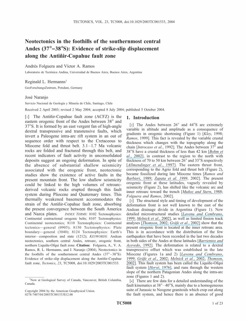
This document is posted to help you gain knowledge. Please leave a comment to let me know what you think about it! Share it to your friends and learn new things together.
Transcript
Neotectonics in the foothills of the southernmost central
Andes (37�––38�S): Evidence of strike-slip displacement
along the Antinir-Copahue fault zone
Andres Folguera and Vıctor A. Ramos
Laboratorio de Tectonica Andina, Universidad de Buenos Aires, Buenos Aires, Argentina
Reginald L. Hermanns1
GeoForschungsZentrum, Potsdam, Germany
Jose Naranjo
Servicio Nacional de Geologıa y Minerıa de Chile, Santiago, Chile
Received 2 April 2003; revised 2 May 2004; accepted 8 July 2004; published 5 October 2004.
[1] The Antinir-Copahue fault zone (ACFZ) is theeastern orogenic front of the Andes between 38� and37�S. It is formed by an east vergent fan of high-angledextral transpressive and transtensive faults, whichinvert a Paleogene intra-arc rift system in an out ofsequence order with respect to the Cretaceous toMiocene fold and thrust belt. 3.1–1.7 Ma volcanicrocks are folded and fractured through this belt, andrecent indicators of fault activity in unconsolidateddeposits suggest an ongoing deformation. In spite ofthe absence of substantial shallow seismicityassociated with the orogenic front, neotectonicstudies show the existence of active faults in thepresent mountain front. The low shallow seismicitycould be linked to the high volumes of retroarc-derived volcanic rocks erupted through this faultsystem during Pliocene and Quaternary times. Thisthermally weakened basement accommodates thestrain of the Antinir-Copahue fault zone, absorbingthe present convergence between the South Americaand Nazca plates. INDEX TERMS: 8102 Tectonophysics:
Continental contractional orogenic belts; 8107 Tectonophysics:
Continental neotectonics; 8110 Tectonophysics: Continental
tectonics—general (0905); 8150 Tectonophysics: Plate
boundary—general (3040); 8124 Tectonophysics: Earth’s
interior—composition and state (1212); KEYWORDS: Andean
neotectonics, southern central Andes, retroarc, orogenic front,
northern Liquine-Ofqui fault zone. Citation: Folguera, A., V. A.
Ramos, R. L. Hermanns, and J. Naranjo (2004), Neotectonics in
the foothills of the southernmost central Andes (37�–38�S):
Evidence of strike-slip displacement along the Antinir-Copahue
fault zone, Tectonics, 23, TC5008, doi:10.1029/2003TC001533.
1. Introduction
[2] The Andes between 26� and 44�S are extremelyvariable in altitude and amplitude as a consequence ofgradients in orogenic shortening (Figure 1) [Kley, 1998;Ramos, 1999]. This fact is revealed by the variable crustalthickness which changes with the topography along thechain [Introcaso et al., 1992]. The Andes between 37� and38�S have a crustal thickness of less than 42 km [Bohm etal., 2002], in contrast to the region to the north withthickness of 70 to 50 km between 26� and 33�S respectively[Allmendinger et al., 1997]. The eastern thrust front,corresponding to the Agrio fold and thrust belt (Figure 2),became fossilized during late Miocene times [Ramos andBarbieri, 1989; Zapata et al. 1999, 2002]. The presentorogenic front at these latitudes, vaguely revealed byseismicity (Figure 2), has shifted like the volcanic arc andinner retroarc toward the trench [Munoz and Stern, 1988;Folguera and Ramos, 2002].[3] The structural style and timing of development of the
deformation front is not well known to the east of theAndean drainage divide in Argentina (Figure 1). Newdetailed microstructural studies [Lavenu and Cembrano,1999; Melnick et al., 2002], as well as limited fission trackanalyses [Thomson, 2002; Grafe et al., 2002] show that thepresent orogenic front is located at the inner retroarc area.This is in accordance with the distribution of the fewearthquakes that have been recorded in the last two decadesin both sides of the Andes at these latitudes [Barrientos andAcevedo, 1992]. The deformation is related to a dextraltranspressive offset which was established in the lateMiocene (Figures 1a and 2) [Lavenu and Cembrano,1999; Grafe et al., 2002; Melnick et al., 2002; Thomson,2002]. This fault system has been called the Liquine-Ofquifault system [Herve, 1976], and runs through the westernslope of the northern Patagonian Andes along the intra-arczone (Figures 1 and 2).[4] There are few data for a detailed understanding of the
fault kinematics at 38�–40�S, mainly due to a homogeneoussuite of Jurassic to Neogene granitoids which crop out alongthe fault system, and hence there is an absence of good
TECTONICS, VOL. 23, TC5008, doi:10.1029/2003TC001533, 2004
1Now at Geological Survey of Canada, Vancouver, British Columbia,Canada.
Copyright 2004 by the American Geophysical Union.0278-7407/04/2003TC001533$12.00
TC5008 1 of 23
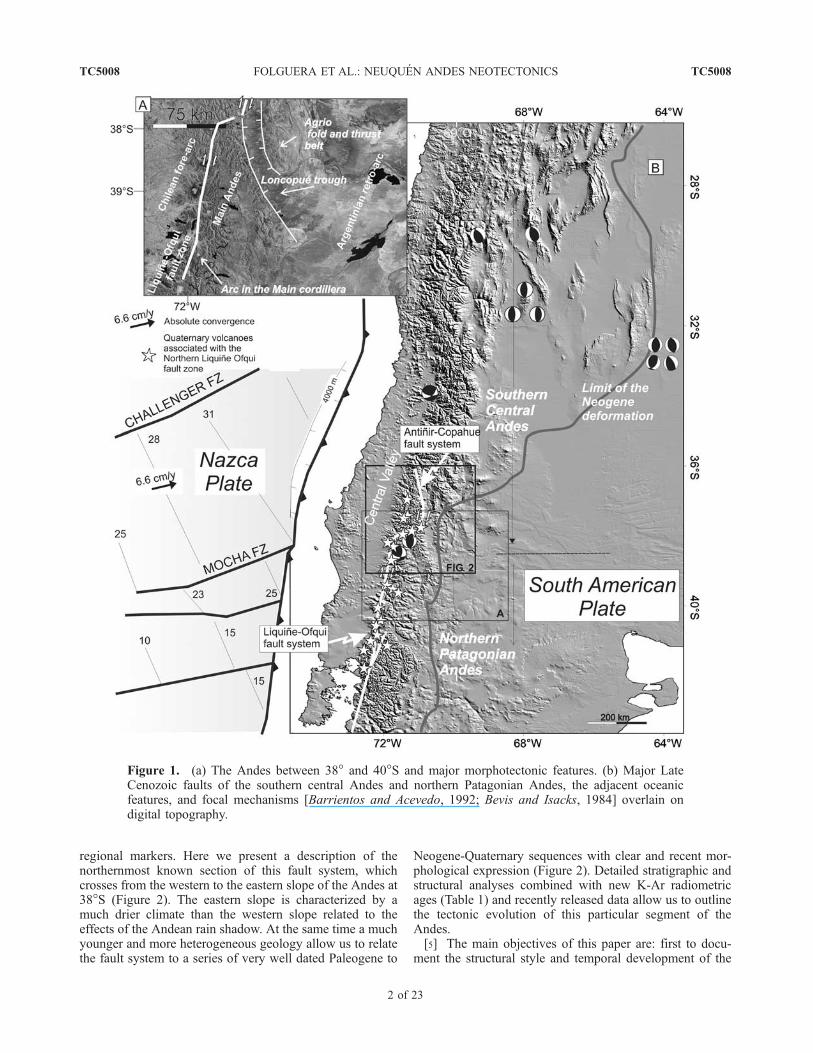
regional markers. Here we present a description of thenorthernmost known section of this fault system, whichcrosses from the western to the eastern slope of the Andes at38�S (Figure 2). The eastern slope is characterized by amuch drier climate than the western slope related to theeffects of the Andean rain shadow. At the same time a muchyounger and more heterogeneous geology allow us to relatethe fault system to a series of very well dated Paleogene to
Neogene-Quaternary sequences with clear and recent mor-phological expression (Figure 2). Detailed stratigraphic andstructural analyses combined with new K-Ar radiometricages (Table 1) and recently released data allow us to outlinethe tectonic evolution of this particular segment of theAndes.[5] The main objectives of this paper are: first to docu-
ment the structural style and temporal development of the
Figure 1. (a) The Andes between 38� and 40�S and major morphotectonic features. (b) Major LateCenozoic faults of the southern central Andes and northern Patagonian Andes, the adjacent oceanicfeatures, and focal mechanisms [Barrientos and Acevedo, 1992; Bevis and Isacks, 1984] overlain ondigital topography.
TC5008 FOLGUERA ET AL.: NEUQUEN ANDES NEOTECTONICS
2 of 23
TC5008
Figure 2. Transitional area (38�S) between the northern Patagonian Andes and the southern centralAndes, that coincides with boundary between the intra-arc Liquine-Ofqui fault system (LOFZ) and theAntinir-Copahue fault zone (ACFZ) located to the north in the retroarc. Note the present orogenic frontlocated inboard from the Agrio fold and thrust belt formed between the Middle Cretaceous and lateMiocene.
TC5008 FOLGUERA ET AL.: NEUQUEN ANDES NEOTECTONICS
3 of 23
TC5008
section corresponding to the transition between the southerncentral Andes and northern Patagonia Andes, and second todocument the intimate association between the orogenicfront, deformation and volcanism from the Pliocene to thepresent.[6] The study area is located between 37� and 38�S in the
eastern foothills of the Andes (Figure 2). This area corre-sponds to the transition between the southern central Andes(27�–38�S) and the northern Patagonian Andes (38�–45�S)in the south (Figure 1). The southern central Andes arecharacterized by a recent history of uplift related to the
stacking of crustal sheets, during the entire Neogene period,which has partially obscured evidence of older deformations[Ramos, 1999]. In contrast, the northern Patagonian Andesare the result of a combination of foreland progression ofeast vergent thrusts, which has occurred periodically sincethe Late Cretaceous to the early Neogene [Zapata et al.,1999], and a lack of significant upper Neogene exhumationin the frontal parts of the external Agrio fold and thrust belt(Figure 2) [Ramos and Barbieri, 1989].
2. Cenozoic Stratigraphy
2.1. Andean Units
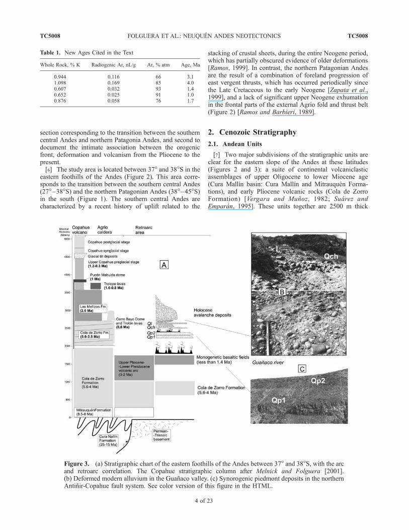
[7] Two major subdivisions of the stratigraphic units areclear for the eastern slope of the Andes at these latitudes(Figures 2 and 3): a suite of continental volcaniclasticassemblages of upper Oligocene to lower Miocene age(Cura Mallın basin: Cura Mallın and Mitrauquen Forma-tions), and early Pliocene volcanic rocks (Cola de ZorroFormation) [Vergara and Munoz, 1982; Suarez andEmparan, 1995]. These units together are 2500 m thick
Figure 3. (a) Stratigraphic chart of the eastern foothills of the Andes between 37� and 38�S, with the arcand retroarc correlation. The Copahue stratigraphic column after Melnick and Folguera [2001].(b) Deformed modern alluvium in the Guanaco valley. (c) Synorogenic piedmont deposits in the northernAntinir-Copahue fault system. See color version of this figure in the HTML.
Table 1. New Ages Cited in the Text
Whole Rock, % K Radiogenic Ar, nL/g Ar, % atm Age, Ma
0.944 0.116 66 3.11.098 0.169 85 4.00.607 0.032 93 1.40.652 0.025 91 1.00.876 0.058 76 1.7
TC5008 FOLGUERA ET AL.: NEUQUEN ANDES NEOTECTONICS
4 of 23
TC5008

and are separated by an angular unconformity visible inseveral localities along the chain, indicating a major periodof late Miocene deformation in the Andes at these latitudes[Niemeyer and Munoz, 1983].2.1.1. Paleogene Rocks[8] The entire Cura Mallın basin is located between 36�
and 40�S and comprises a belt bounded by the Patagonianbatholith to the west and by the western Neuquen embay-ment and Cordillera del Viento to the east (Figure 2). Itswestern basement is formed by Jurassic to Neogene gran-itoids corresponding to the northern Patagonian Batholith,and the eastern one by Carboniferous to Permian volcanicand sedimentary rocks, Lower Jurassic sequences, andvolcaniclastic and intrusive rocks of 57 to 50 Ma [Ramosand Nullo, 1993; Rovere Adaniya et al., 1993]. The basinwas extensional, as indicated by seismic lines in combina-tion with stratigraphic analyses [Vergara et al., 1997a,1997b; Zapata et al., 1999; Jordan et al., 2001] and bythe study of the superficial structure [Radic et al., 2002].Vergara et al. [1997a, 1997b] identified the main axis of therift system corresponding to NW trending faults.[9] The Cura Mallın basin comprises the Cura Mallın and
the Mitrauquen Formations [Suarez and Emparan, 1997].The Cura Mallın Formation accumulated during the lateOligocene to early Miocene north of the 37�300S [Jordan etal., 2001; Radic et al., 2002], and during the middleMiocene in the Lonquimay area, south of 38�S [Suarezand Emparan, 1995]. The Cura Mallın Formation[Niemeyer and Munoz, 1983] is a volcanic and sedimentaryunit, deposited in lacustrine and fluvial environments, datedbetween 20 and 11 Ma [Suarez and Emparan, 1995; Jordanet al., 2001; Radic et al., 2002]. Locally, the sequence iscapped by the Mitrauquen Formation (Figure 3).[10] The Mitrauquen Formation consists of ignimbrites,
conglomerates, and andesitic lava flows, dated between 9and 8 Ma [Suarez and Emparan, 1997]. This unit isvolumetrically less important than the rest of the basin fill,however it has important tectonic implications. First, in thearea corresponding to the southern depocenter, specificallythe Pino Solo area in Chile, these ignimbrites were thrust byLower Jurassic turbidites, indicating a last period of basininversion after 8 Ma [Suarez and Emparan, 1997]. Second,there are localities in which the Mitrauquen Formation isconformably overlaid by the lower Pliocene Cola de ZorroFormation (5.5–3.5 Ma), both together fossilizing a com-pressive structure predating 9 Ma [Suarez and Emparan,1997]. This indicates that the inversion of the Cura Mallınbasin developed diachronically throughout the zone, insome areas between 8 and 5 Ma, and in some others before12–9 Ma. The older constraint comes from stratigraphicrelationships and synorogenic units in the inner Agrio foldand thrust belt to the east (Figure 2) [Zapata et al., 1999,2002].[11] This Paleogene basin corresponds with several Mio-
cene depocenters in the southern central Andes and in thenorthern Patagonian Andes, in the north and south respec-tively. To the north equivalent units to the Cura Mallın andMitrauquen Formations were associated with the CoyaMachalı Formation [Charrier et al., 1996; Godoy et al.,
1999; Rivera and Cembrano, 2000], which extends north to33�S. To the south, the Cura Mallın basin is associated withother basins in the forearc: the Temuco basin (37�–39�S),Osorno Llanquihue basin (39�–41�S) [McDonough et al.,1997; Munoz and Araneda, 2000], and in the retroarc:Collon Cura basin (39�–41�S) [Gonzalez Dıaz and Nullo,1980], Nırihuao basin (41�–42�S) [Cazau et al., 1987;Spalletti and Dalla Salda, 1996] and also the Traiguenbasin in the intra-arc (45�–46�S) [Herve et al., 1995] asindicated by stratigraphic evidence.2.1.2. Late Neogene Rocks[12] The Cola de Zorro Formation is up to 1200 m thick
and is composed of volcanic breccias, lavas, and relatedintrusives, as well as clastic sequences [Niemeyer andMunoz, 1983]. In Laguna de la Laja area, the Cola de ZorroFormation has a thickness of 1900 m, to the west of thestudy area. The age of these sequences is limited between5.5 and 3.5 Ma, and their distribution outlines a latitudinalbelt from 36� to 39�S [Munoz and Stern, 1988; Suarez andEmparan, 1997; Linares et al., 1999]. In the eastern slope ofthe Andes between 37� and 38�S, two members can beclearly distinguished, one consisting of ignimbrites andvolcanic breccias, coincident with the maximum topographichighs of the Andes at this latitude, and a series of calderasand volcanic edifices [Munoz and Stern, 1988]. A secondunit to the east is composed of lava flows, which form aneast dipping plateau at the eastern foothills of the cordillera.[13] In older geologic maps, volcanic rocks and units
younger than 2.5 Ma were mapped as Cola de ZorroFormation [Vergara and Munoz, 1982], although locallyangular unconformities are developed, such as in the Lon-copue graben, where these discontinuities mark separatedifferent volcanic pulses of intra-arc activity.2.1.3. Early Late Neogene to Quaternary Volcanics[14] Upper Pliocene and Pleistocene to Holocene volca-
noes are scattered all over the region. Munoz and Stern[1988] have distinguished two volcanic belts between 37�and 38�S. An eastern one defined by lower Pleistocenepolygenetic edifices and a western one consisting of theactive upper Pleistocene to Holocene volcanic front. Thestudy area includes the active Upper Quaternary Copahuevolcano and a belt formed by a series of strato-volcanoescalled the Mandolegue Cordillera (Figure 2), which isoriented transversely to the active volcanic front, andoccupies an important area. The volcanic lineament Call-aqui-Copahue-Mandolegue Cordillera [Folguera andRamos, 2000] is the longest volcanic complex in theCordillera Patagonica (80 km). It extends transversally fromthe present volcanic arc front to the inner retroarc along thesouthern part of the study area at 37�450S (Figure 2). Thisfeature is defined by a series of coalescent polygenetic andmonogenetic volcanic centers: the Callaqui and Copahuevolcanoes of 1–0 Ma, a monogenetic lava field of 1.6 Ma to0.8 Ma located at the Trolope trough, the Bayo and Trolopedome complexes of 0.6 Ma and the Trolon eroded strato-volcano of 0.6 Ma [Pesce, 1989; Linares et al., 1999] andan extensive monogenetic basaltic field which is part of thenorthern extent of the extensional Loncopue trough [Ramosand Folguera, 1999], from west to east respectively.
TC5008 FOLGUERA ET AL.: NEUQUEN ANDES NEOTECTONICS
5 of 23
TC5008

[15] The age and stratigraphy of these complexes con-strain the main pulses of deformation in the region (Figure 3).2.1.3.1. Caldera del Agrio Area[16] The Caldera del Agrio is a 15 � 20 km depression
with quadrangular morphology located between 37�450 and38�S interpreted to be a caldera complex (Figure 2). Thetime of formation of this caldera was poorly known due tothe absence of substantial volumes of pyroclastic deposits[Pesce, 1989; Delpino and Bermudez, 1993]. Since therecognition of its structural origin [Folguera and Ramos,2000] the collapse of this 15 � 20 km depocenter wasconstrained by its oldest accumulations. These corre-sponded to the Coladas de Fondo de Valle Basalt [Pesce,1989] 1.6 Ma in age [Linares et al., 1999]. Although scarce,the Riscos Bayos pyroclastic flows [Pesce, 1989] have anage of 2 Ma and are from the caldera external eastern slope,next to the Loncopue trough [Linares et al., 1999]. An olderunit of 2.5 Ma or younger [Linares et al., 1999] wasrecently considered as the first intracaldera volcanic depositand therefore the age of caldera collapse could be redefined[Melnick and Folguera, 2001]. Awelded ignimbrite, locatedat the Chancho-Co hill, overlies 2.5 Ma volcanic succes-sions. On the basis of this age, caldera formation isbracketed between 2.5 and 1.6 Ma.[17] Late volcanic activity in this basin is indicated by
dome complexes of 0.62 ± 0,02 Ma [Linares et al., 1999],preferentially along its northern edge and polygenetic andmonogenetic activity concentrated in the SW corner, such asthe Copahue volcano since 1.2 Ma (Figure 3).2.1.3.2. Copahue Volcano Stratigraphy[18] The Copahue volcano is situated at the SW edge of
the quadrangular Agrio Caldera and represents about half ofthe postcaldera resurgent filling (Figures 2 and 3). Thestratigraphic sequence of this volcano (Figure 3) starts withbasal lavas between 1.2 and 0.4 Ma old [Munoz and Stern,1988; Linares et al., 1999], which are mainly exposedthrough the western face of the edifice due to deep glacialerosion. These older lavas are intruded by a hypabyssaldome dated around 1 Ma (Pucon Mahuida dome, on the SEface of the volcano). A 300 m thick sequence of andesiticlavas rests on a glacial eroded surface formed over theseintrusive bodies. Over these rocks, voluminous synglacialdomes and pillow lavas of andesitic composition wereemplaced. A major body has grown to the east of the mostrecent craters of the Copahue volcano, forming a newvolcanic center. A series of minor domes, correspondingto an even younger generation of synglacial eruptions areconfined to the deepest glacial valleys.[19] Glacial detritus and rock avalanche deposits associ-
ated with a semicircular scar were deposited on the northernslope of the volcano. These deposits partially fill the reliefand were produced since the synglacial dome activity. Inturn they are covered by postglacial lavas associated withfissural centers at the base of the volcano.
2.2. Piedmont Units and Inner Retroarc Volcanics
[20] The Quaternary deposits in the eastern Andesbetween 37� and 38�S can be subdivided in two sequences:
(1) a series of piedmont cover gravels over a volcanicbasement and (2) younger generations of retroarc volcanics,glacial deposits, alluvial fan to channeled gravels, landslide,and related lacustrine deposits of younger generations(Figure 3).2.2.1. Basal Plateau Lavas (UN-LQl, Lower Neogene toLower Quaternary Lavas)[21] This unit is dominated by lavas with andesitic
composition and is intercalated between lower Pliocenevolcanic rocks and Quaternary gravels associated with theAndean piedmont and young volcanic cones. Its age wouldtherefore be younger than late Pliocene-early Pleistocene.K/Ar age obtained in the Guanaco valley for the top of thesequence have yielded 1.7 ± 0.2 Ma. In some otherlocalities, they are possible lateral equivalents to lowerPliocene volcanics related to the Cola de Zorro Formation.This unit forms a series of three to six flat plateaus, formedby a series of superimposed lava flows, occasionally lavadomes, and even more rarely pyroclastic flows. This dis-tinctive sequence constitutes an excellent marker to charac-terize the deformation in the area. The centers of eruptionare only occasionally distinguishable. The thickness, al-though extremely variable is between 20 and 200 m.2.2.2. Piedmont Cover Gravels (Qp1 and Qp2)[22] Two extensive units cover the plateau lavas in the
northern area associated with the present Andean front ofdeformation (Figures 3a, 3c, and 4). The lower unit covers thewhole piedmont area between approximately 37�120 and37�180W. The second unit is located downstream to the eastmore than 5 kmwith respect to the area ofmaximum thicknessof the first unit (Figure 4). These sequences are erosionalremnants of formerlymore extensive surfaces, now incised bythe rivers that are part of the Nahueve basin (Figure 4).[23] Both units are dominated by gravels, with minor
intercalations of sandstones and siltstones (Figure 3c). Eachis clearly distinguishable based on color and the extent ofvegetation developed on top of them. The lower unit ischaracterized by a brown colored sequence (Qp1), whereasthe upper one is green (Qp2). Their ages are younger than1.7 Ma.2.2.3. Younger Generations of Basaltic-Andesitic Cones,Domes, and Calderas (YQv)[24] A series of monogenetic cones and related lava flows
are distributed across the piedmont area. These are eitherisolated andesitic to basaltic lava flows or are basalticcalderas, such as the eastern extreme of the Mandoleguechain and the Guanaco volcanic center (Figures 2 and 4).These flows lie on top of the piedmont gravels, lowerPliocene volcanic units, and occasionally reach the valleyfloors.[25] Their number and eruptive mechanism vary from
north to south. In the northern area, they are mainlyrestricted to isolated polygenetic edifices, whereas thenumber of independent centers increases in the south. Mostof the polygenetic volcanic centers are located to the northof the trace of the main axis of the Trocoman fault(Figure 2). This lineament coincides with the largest retroarccenters in the area, which are characterized by multiplecaldera collapses. Five centers have amalgamated forming a
TC5008 FOLGUERA ET AL.: NEUQUEN ANDES NEOTECTONICS
6 of 23
TC5008
line of large depressions: the two extremes are the ViluMallın caldera in the north and the Trolon center in thesouth.2.2.4. Glacial Deposits, Channeled and Terraced FluvialDeposits (Qch), Landslide Deposits, and RelatedLacustrine Deposits (Ql)[26] Glacial deposits are limited at these latitudes to the
highest parts of the Andes, being relatively more extensivein the southern portion of the study area (Figure 3)[Groeber, 1925, 1927; Dixon et al., 1999; E. GonzalezDıaz, Mapa geomorfologico a escala 1:90,000 de la regionde Copahue-Caviahue, Direccion de Geologıa y Ambientaly Aplicada, unpublished data, SEGEMAR, Buenos Aires,Argentina, 2001].[27] The west to east draining valleys of Trocoman,
Lileo, Guanaco, Renileuvu, Nireco, Picunleo, Las Damas,and Trolope-Agrio river (Figure 2) have similar Quaternarystratigraphic units, characterized by landslide and relatedlake deposits, pebbly deltas, and fluvial terraces (Figure 3).[28] Massive rock slope failures with a volume of more
than 1 million m3 have been recognized. A large number ofsmaller landslide deposits also exists, however they are toonumerous to map and did not form sequences with strati-graphic importance.[29] Landslides of the rock avalanche type were identi-
fied. Internal structure of the deposit displayed inversegrading, jigsaw breccia, and megaclasts with a diameter ofseveral meters to tens of meters, features characteristic ofwell-known rock avalanche deposits [McSaveney, 1978;Hewitt, 1988; Yarnold, 1993]. Block-glide rockslides are
inferred by their strongly fractured and folded layers in theproximal portions of deposits, and distal flow deposits[Braddock, 1978; Fauque and Tchilinguirian, 2002]. Mostlandslides are postglacial. This young age is consistent withthe observation that they are interbedded with riverbedsdeposits and are well preserved. Deformation affecting theselandslide and related deposits represent the most recentdeformation in this region.
3. Structure Along the Antinir-Copahue Fault
Zone (ACFZ)
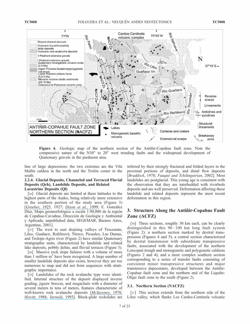
[30] Three sections, roughly 30 km each, can be clearlydistinguished in this 90–100 km long fault system(Figure 2): a northern section marked by dextral trans-pression (Figures 4 and 5); a central section characterizedby dextral transtension with subordinate transpressivefaults, associated with the development of the northernLoncopue trough and monogenetic and polygenetic calderas(Figures 2 and 4); and a more complex southern sectioncorresponding to a series of transfer faults consisting ofcoexistent minor transpressive structures and majortranstensive depocenters, developed between the Antinir-Copahue fault zone and the northern end of the Liquine-Ofqui fault zone to the south (Figure 2).
3.1. Northern Section (NACFZ)
[31] This section extends from the northern side of theLileo valley, which flanks Los Cardos-Centinela volcanic
Figure 4. Geologic map of the northern section of the Antinir-Copahue fault zone. Note thecompressive nature of the N30� to 20� west trending faults and the widespread development ofQuaternary gravels in the piedmont area.
TC5008 FOLGUERA ET AL.: NEUQUEN ANDES NEOTECTONICS
7 of 23
TC5008
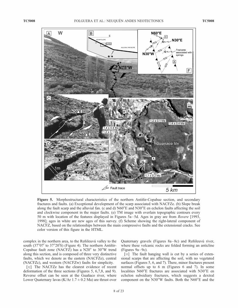
complex in the northern area, to the Renileuvu valley to thesouth (37�070 to 37�200S) (Figure 4). The northern Antinir-Copahue fault zone (NACFZ) has a N20� to 30�W trendalong this section, and is composed of three very distinctivefaults, which we denote as the eastern (NACFZe), central(NACFZc), and western (NACFZw) faults for simplicity.[32] The NACFZe has the clearest evidence of recent
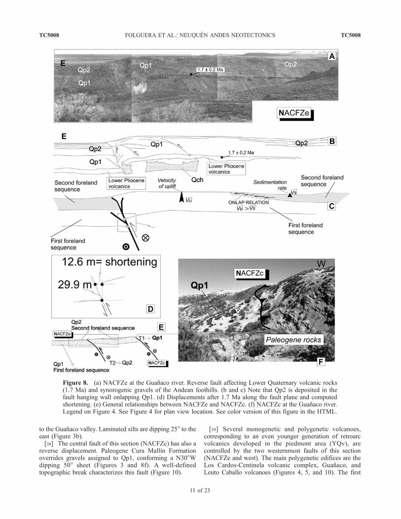
deformation of the three sections (Figures 5, 6,7,8, and 9).Reverse offset can be seen at the Guanaco river, whereLower Quaternary lavas (K/Ar 1.7 ± 0.2 Ma) are thrust over
Quaternary gravels (Figures 8a–8c) and Renileuvu river,where these volcanic rocks are folded forming an anticline(Figures 9a–9c).[33] The fault hanging wall is cut by a series of exten-
sional scarps that are affecting the soil, with no vegetatedsurfaces (Figures 5, 6, and 7). There, minor fractures presentnormal offsets up to 6 m (Figures 6 and 7). In somelocalities N60�E fractures are associated with N30�E enechelon subsidiary fractures, which suggests a dextralcomponent on the N30�W faults. Both the N60�E and the
Figure 5. Morphostructural characteristics of the northern Antinir-Copahue section, and secondaryfractures and faults. (a) Exceptional development of the scarp associated with NACFZe. (b) Slope breakalong the fault scarp and the alluvial fan. (c and d) N60�E and N30�E en echelon faults affecting the soiland clockwise component in the major faults. (e) TM image with overlain topographic contours every50 m with location of the features displayed in Figures 5a–5d. Ages in gray are from Rovere [1993,1998]; ages in white are new ages of this survey. (f) Scheme showing the right-lateral component ofNACFZ, based on the relationships between the main compressive faults and the extensional cracks. Seecolor version of this figure in the HTML.
TC5008 FOLGUERA ET AL.: NEUQUEN ANDES NEOTECTONICS
8 of 23
TC5008

N30�E fractures are associated with springs aligned with themain scarp of the NACFZe (Figures 5c and 5d). SomeN30�–20�W fractures are also developed in the faulthanging wall, with an anastomosed design, holding enechelon NS fractures with normal offsets and defining aseries of 4 to 5 blocks, 30 to 40 m each, and thereforesuggesting a dextral component in these lineaments(Figure 7). Numerous flowing east small channels havelateral offsets in the order of 10 to 20 m on the NACFZehanging wall.[34] The steepest related fault scarp is found between the
Lileo and Guanaco valleys, reaching 30� (Figure 5a),whereas to the south, between Guanaco and Renileuvuvalleys the angle of the scarp diminishes to around 15�.
[35] In the Guanaco valley, basal plateau lavas (1.7 Ma)and the overlying piedmont gravels (Qp1 and Qp2) arefolded and faulted, producing an offset of near 30 m(Figures 8a–8d). Qp2 has been accumulated at the faulthanging wall in an onlap relation which indicates a structuregrowth faster than the coeval synorogenic sedimentationrates (Figure 8).[36] The fault has a N20�–30�W to N-S strike and a dip
which varies between 65� to 80� to the W-SW (Figure 9).The basal plateau lavas at the footwall trend N50�E, and dipbetween 45�W next to the fault trace to 5�W immediately tothe east, as well as the upper piedmont gravels (Qp1 andQp2) (Figures 8a and 8b). In a band 100 m wide, theserocks are intensively deformed in the fault footwall. A
Figure 6. Northern section of the Antinir-Copahue fault zone. Soil affected by normal and strike-slipfaults is shown. (a–c) A cuspidal graben is formed in the axial zone of an anticline (see Figure 4).Figures 6a and 6b show a series of extensional scarps with a vertical throw of more than 3 m each. Thesefaults are associated to the south with fissural basaltic flows covering the scarp, corresponding to theNACFZe, as outlined in the scheme (Figure 6e). Figure 6c shows an extensional scarp developed at thefootwall of the thrust front. (d) Aerial photograph and (e) structural scheme where the previous featuresare located. See color version of this figure in the HTML.
TC5008 FOLGUERA ET AL.: NEUQUEN ANDES NEOTECTONICS
9 of 23
TC5008
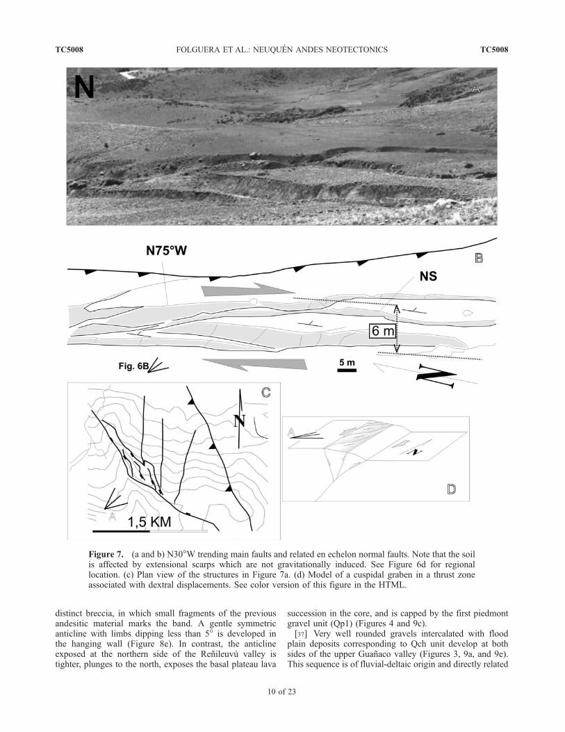
distinct breccia, in which small fragments of the previousandesitic material marks the band. A gentle symmetricanticline with limbs dipping less than 5� is developed inthe hanging wall (Figure 8e). In contrast, the anticlineexposed at the northern side of the Renileuvu valley istighter, plunges to the north, exposes the basal plateau lava
succession in the core, and is capped by the first piedmontgravel unit (Qp1) (Figures 4 and 9c).[37] Very well rounded gravels intercalated with flood
plain deposits corresponding to Qch unit develop at bothsides of the upper Guanaco valley (Figures 3, 9a, and 9e).This sequence is of fluvial-deltaic origin and directly related
Figure 7. (a and b) N30�W trending main faults and related en echelon normal faults. Note that the soilis affected by extensional scarps which are not gravitationally induced. See Figure 6d for regionallocation. (c) Plan view of the structures in Figure 7a. (d) Model of a cuspidal graben in a thrust zoneassociated with dextral displacements. See color version of this figure in the HTML.
TC5008 FOLGUERA ET AL.: NEUQUEN ANDES NEOTECTONICS
10 of 23
TC5008
to the Guanaco valley. Laminated silts are dipping 25� to theeast (Figure 3b).[38] The central fault of this section (NACFZc) has also a
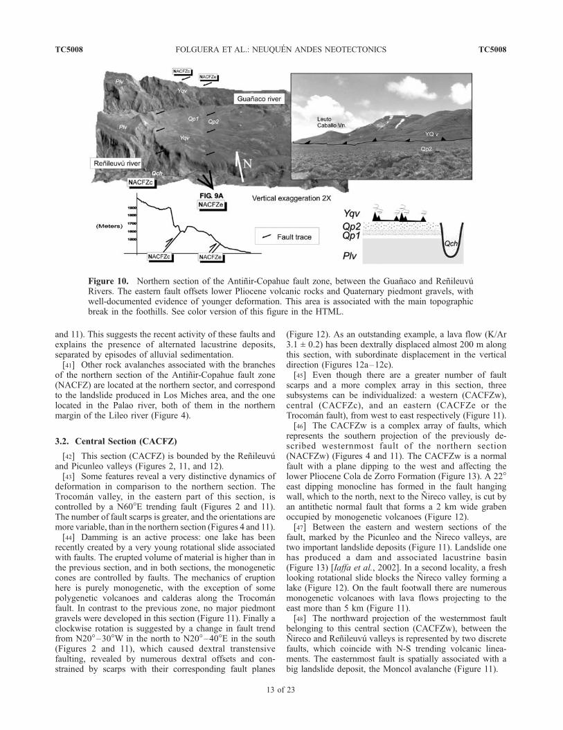
reverse displacement. Paleogene Cura Mallın Formationoverrides gravels assigned to Qp1, conforming a N30�Wdipping 50� sheet (Figures 3 and 8f). A well-definedtopographic break characterizes this fault (Figure 10).
[39] Several monogenetic and polygenetic volcanoes,corresponding to an even younger generation of retroarcvolcanics developed in the piedmont area (YQv), arecontrolled by the two westernmost faults of this section(NACFZe and west). The main polygenetic edifices are theLos Cardos-Centinela volcanic complex, Guanaco, andLeuto Caballo volcanoes (Figures 4, 5, and 10). The first
Figure 8. (a) NACFZe at the Guanaco river. Reverse fault affecting Lower Quaternary volcanic rocks(1.7 Ma) and synorogenic gravels of the Andean foothills. (b and c) Note that Qp2 is deposited in thefault hanging wall onlapping Qp1. (d) Displacements after 1.7 Ma along the fault plane and computedshortening. (e) General relationships between NACFZe and NACFZc. (f) NACFZc at the Guanaco river.Legend on Figure 4. See Figure 4 for plan view location. See color version of this figure in the HTML.
TC5008 FOLGUERA ET AL.: NEUQUEN ANDES NEOTECTONICS
11 of 23
TC5008
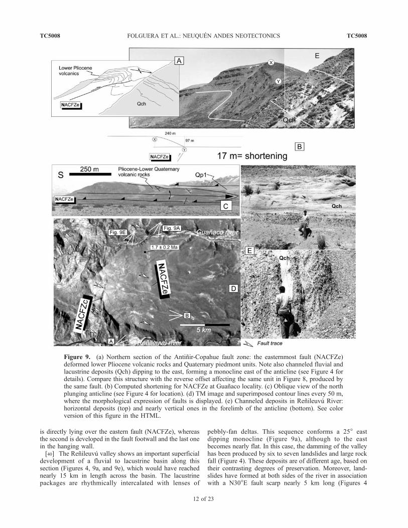
is directly lying over the eastern fault (NACFZe), whereasthe second is developed in the fault footwall and the last onein the hanging wall.[40] The Renileuvu valley shows an important superficial
development of a fluvial to lacustrine basin along thissection (Figures 4, 9a, and 9e), which would have reachednearly 15 km in length across the basin. The lacustrinepackages are rhythmically intercalated with lenses of
pebbly-fan deltas. This sequence conforms a 25� eastdipping monocline (Figure 9a), although to the eastbecomes nearly flat. In this case, the damming of the valleyhas been produced by six to seven landslides and large rockfall (Figure 4). These deposits are of different age, based ontheir contrasting degrees of preservation. Moreover, land-slides have formed at both sides of the river in associationwith a N30�E fault scarp nearly 5 km long (Figures 4
Figure 9. (a) Northern section of the Antinir-Copahue fault zone: the easternmost fault (NACFZe)deformed lower Pliocene volcanic rocks and Quaternary piedmont units. Note also channeled fluvial andlacustrine deposits (Qch) dipping to the east, forming a monocline east of the anticline (see Figure 4 fordetails). Compare this structure with the reverse offset affecting the same unit in Figure 8, produced bythe same fault. (b) Computed shortening for NACFZe at Guanaco locality. (c) Oblique view of the northplunging anticline (see Figure 4 for location). (d) TM image and superimposed contour lines every 50 m,where the morphological expression of faults is displayed. (e) Channeled deposits in Renileuvu River:horizontal deposits (top) and nearly vertical ones in the forelimb of the anticline (bottom). See colorversion of this figure in the HTML.
TC5008 FOLGUERA ET AL.: NEUQUEN ANDES NEOTECTONICS
12 of 23
TC5008
and 11). This suggests the recent activity of these faults andexplains the presence of alternated lacustrine deposits,separated by episodes of alluvial sedimentation.[41] Other rock avalanches associated with the branches
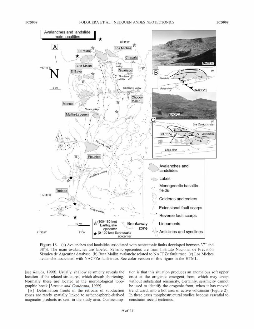
of the northern section of the Antinir-Copahue fault zone(NACFZ) are located at the northern sector, and correspondto the landslide produced in Los Miches area, and the onelocated in the Palao river, both of them in the northernmargin of the Lileo river (Figure 4).
3.2. Central Section (CACFZ)
[42] This section (CACFZ) is bounded by the Renileuvuand Picunleo valleys (Figures 2, 11, and 12).[43] Some features reveal a very distinctive dynamics of
deformation in comparison to the northern section. TheTrocoman valley, in the eastern part of this section, iscontrolled by a N60�E trending fault (Figures 2 and 11).The number of fault scarps is greater, and the orientations aremore variable, than in the northern section (Figures 4 and 11).[44] Damming is an active process: one lake has been
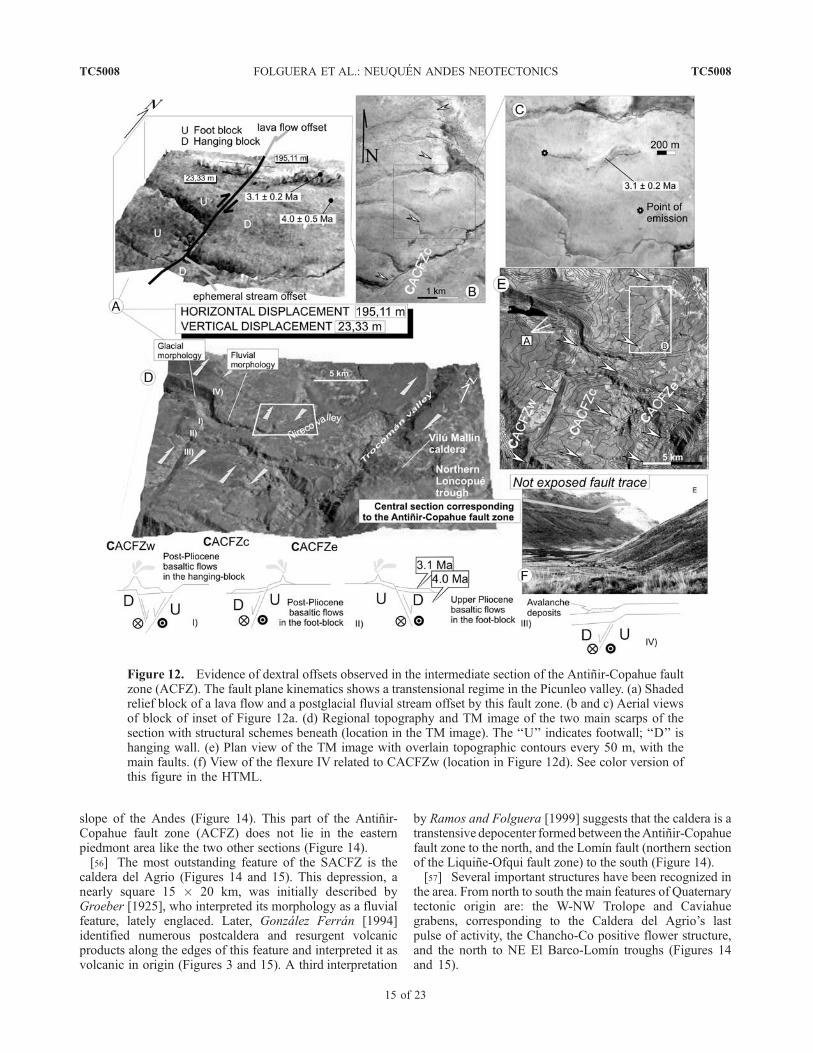
recently created by a very young rotational slide associatedwith faults. The erupted volume of material is higher than inthe previous section, and in both sections, the monogeneticcones are controlled by faults. The mechanics of eruptionhere is purely monogenetic, with the exception of somepolygenetic volcanoes and calderas along the Trocomanfault. In contrast to the previous zone, no major piedmontgravels were developed in this section (Figure 11). Finally aclockwise rotation is suggested by a change in fault trendfrom N20�–30�W in the north to N20�–40�E in the south(Figures 2 and 11), which caused dextral transtensivefaulting, revealed by numerous dextral offsets and con-strained by scarps with their corresponding fault planes
(Figure 12). As an outstanding example, a lava flow (K/Ar3.1 ± 0.2) has been dextrally displaced almost 200 m alongthis section, with subordinate displacement in the verticaldirection (Figures 12a–12c).[45] Even though there are a greater number of fault
scarps and a more complex array in this section, threesubsystems can be individualized: a western (CACFZw),central (CACFZc), and an eastern (CACFZe or theTrocoman fault), from west to east respectively (Figure 11).[46] The CACFZw is a complex array of faults, which
represents the southern projection of the previously de-scribed westernmost fault of the northern section(NACFZw) (Figures 4 and 11). The CACFZw is a normalfault with a plane dipping to the west and affecting thelower Pliocene Cola de Zorro Formation (Figure 13). A 22�east dipping monocline has formed in the fault hangingwall, which to the north, next to the Nireco valley, is cut byan antithetic normal fault that forms a 2 km wide grabenoccupied by monogenetic volcanoes (Figure 12).[47] Between the eastern and western sections of the
fault, marked by the Picunleo and the Nireco valleys, aretwo important landslide deposits (Figure 11). Landslide onehas produced a dam and associated lacustrine basin(Figure 13) [Iaffa et al., 2002]. In a second locality, a freshlooking rotational slide blocks the Nireco valley forming alake (Figure 12). On the fault footwall there are numerousmonogenetic volcanoes with lava flows projecting to theeast more than 5 km (Figure 11).[48] The northward projection of the westernmost fault
belonging to this central section (CACFZw), between theNireco and Renileuvu valleys is represented by two discretefaults, which coincide with N-S trending volcanic linea-ments. The easternmost fault is spatially associated with abig landslide deposit, the Moncol avalanche (Figure 11).
Figure 10. Northern section of the Antinir-Copahue fault zone, between the Guanaco and RenileuvuRivers. The eastern fault offsets lower Pliocene volcanic rocks and Quaternary piedmont gravels, withwell-documented evidence of younger deformation. This area is associated with the main topographicbreak in the foothills. See color version of this figure in the HTML.
TC5008 FOLGUERA ET AL.: NEUQUEN ANDES NEOTECTONICS
13 of 23
TC5008

[49] Along both the western fault (CACFZw) as well asthe central fault (CACFZc), individual fault sections haveevidence of dextral offset, including volcanic morphologies,fluvial channels and glacial valleys (Figures 12a–12e).[50] Two more western faults with reverse components
associated with N-S lineaments, which define the southernsection, cut lacustrine successions found along the Picunleovalley (Figures 13a–13c).[51] The CACFZc subsystem is formed by a complex
array of faults, each of which is 2 to 4 km long. Two sets canbe distinguished: one of N-S to N20�E trend and anotherlonger with a N50�–60�E trend, characterized by rightstepping N-S lineaments (Figure 11). Multiple monogeneticvolcanoes developed in this area occupy transtensionaldepressions, suggested by their location in rhomboedrictopographic lows. Right-lateral extensional faults tend todip to the east parallel to piedmont plateau (Figures 11and 12).[52] The easternmost fault or Trocoman fault (CACFZe)
is the longest lineament in the area, however the sense ofdisplacement is not obvious (Figures 2 and 11).
[53] N50�–60�E fault scarps are represented by a series ofsteps falling to the east, which cut Miocene to Pliocenevolcanic sequences (Figure 11). Three calderas are alignedalong this subsection in less than 20 km (Figure 11). Thesefaults apparently control volcanism, frommonogenetic to bigpolygenetic volcanoes, which have experimented collapsecaldera episodes followed by profuse resurgent volcanism.[54] Additional evidence of right-lateral displacements in
the area is given by paleomagnetic studies performed inNeogene volcanic successions in El Moncol area (IACFZwzone) (Figure 11) (S. Geuna, Estudio Paleomagnetico pre-liminar de unidades volcanicas neogenas, unpublishedreport from Conicet, Buenos Aires, Argentina, 2000), wherelate Miocene intrusives [Rovere, 1998] have revealed a20� clockwise rotation.
3.3. Southern Section (SACFZ)
[55] This section extends from the Damas valley, locatedin the inner retroarc, in the eastern Andes, to the Lomınvalley in the Quaternary volcanic arc platform on the western
Figure 11. Geologic map of the intermediate section of the Antinir-Copahue fault zone.
TC5008 FOLGUERA ET AL.: NEUQUEN ANDES NEOTECTONICS
14 of 23
TC5008
slope of the Andes (Figure 14). This part of the Antinir-Copahue fault zone (ACFZ) does not lie in the easternpiedmont area like the two other sections (Figure 14).[56] The most outstanding feature of the SACFZ is the
caldera del Agrio (Figures 14 and 15). This depression, anearly square 15 � 20 km, was initially described byGroeber [1925], who interpreted its morphology as a fluvialfeature, lately englaced. Later, Gonzalez Ferran [1994]identified numerous postcaldera and resurgent volcanicproducts along the edges of this feature and interpreted it asvolcanic in origin (Figures 3 and 15). A third interpretation
by Ramos and Folguera [1999] suggests that the caldera is atranstensive depocenter formed between theAntinir-Copahuefault zone to the north, and the Lomın fault (northern sectionof the Liquine-Ofqui fault zone) to the south (Figure 14).[57] Several important structures have been recognized in
the area. From north to south the main features of Quaternarytectonic origin are: the W-NW Trolope and Caviahuegrabens, corresponding to the Caldera del Agrio’s lastpulse of activity, the Chancho-Co positive flower structure,and the north to NE El Barco-Lomın troughs (Figures 14and 15).
Figure 12. Evidence of dextral offsets observed in the intermediate section of the Antinir-Copahue faultzone (ACFZ). The fault plane kinematics shows a transtensional regime in the Picunleo valley. (a) Shadedrelief block of a lava flow and a postglacial fluvial stream offset by this fault zone. (b and c) Aerial viewsof block of inset of Figure 12a. (d) Regional topography and TM image of the two main scarps of thesection with structural schemes beneath (location in the TM image). The ‘‘U’’ indicates footwall; ‘‘D’’ ishanging wall. (e) Plan view of the TM image with overlain topographic contours every 50 m, with themain faults. (f) View of the flexure IV related to CACFZw (location in Figure 12d). See color version ofthis figure in the HTML.
TC5008 FOLGUERA ET AL.: NEUQUEN ANDES NEOTECTONICS
15 of 23
TC5008
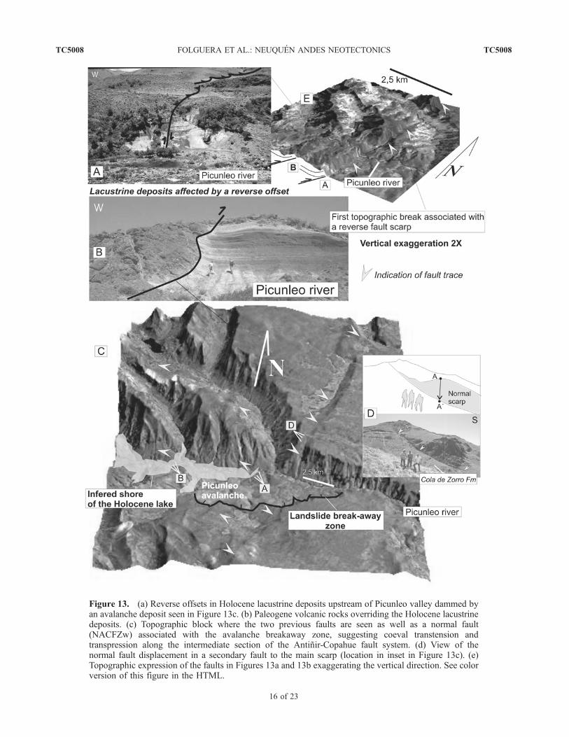
Figure 13. (a) Reverse offsets in Holocene lacustrine deposits upstream of Picunleo valley dammed byan avalanche deposit seen in Figure 13c. (b) Paleogene volcanic rocks overriding the Holocene lacustrinedeposits. (c) Topographic block where the two previous faults are seen as well as a normal fault(NACFZw) associated with the avalanche breakaway zone, suggesting coeval transtension andtranspression along the intermediate section of the Antinir-Copahue fault system. (d) View of thenormal fault displacement in a secondary fault to the main scarp (location in inset in Figure 13c). (e)Topographic expression of the faults in Figures 13a and 13b exaggerating the vertical direction. See colorversion of this figure in the HTML.
TC5008 FOLGUERA ET AL.: NEUQUEN ANDES NEOTECTONICS
16 of 23
TC5008

[58] The Trolope and Caviahue grabens are rather sym-metric troughs in a traverse transect, which have a preriftsequence formed by ignimbrites and lavas older than 2.5 Ma(Figures 3 and 14) [Linares et al., 1999]. The last stage ofgraben formation can be addressed for the last case, wherethe basal products of the 1.2–0 Ma Copahue volcano werecontrolled by normal faults (Figure 14).[59] Considerable amounts of synglacial volcanics were
emplaced along the northern edge of the Caviahue graben,which reveal a differential amount of extension from theCopahue volcano to the east, as a function of their eruptivevolume. Therefore the Caviahue graben formed between 2.5and 1.2 Ma. Lately a volcanic reactivation took placebetween 600 ka and 30 ka years ago. The Trolope grabenhistory is obscured by the most recent volcanic products of0.8 Ma flooring this extensional depocenter.[60] The northern extreme of the Liquine-Ofqui fault
system corresponds to the El Barco transtensional system(Figure 14). This depression was completely generatedduring postglacial times [Melnick and Folguera, 2001].Quaternary fluvial sediments dip 40�E in the hanging wall
of the main extensional fault and have been offset nearly300 m compared to their position in the footwall. This seriesof extensional scarps forms a domino structure which ismainly dipping to the east. The Lomın graben is a N60�Eextensional basin formed by eastern branch of the El Barcoextensional system. This structure has an eastern footwallcomprising lower Pliocene continental volcanics and awestern hanging wall filled by the 1.2 Ma and younger lavaflows from Copahue volcano.[61] Another extensional reactivation into the Caldera del
Agrio occurred between 1.6 and 0.8 Ma when an extensivevolcanic unit occupied the northern half of this depression,and then the last pulses of the Caviahue and Trolopegrabens were the Quaternary expression of the extensionalactivity of the basin.[62] The Agrio caldera embraces a positive structural
feature: the Chancho-Co hill (Figures 14 and 15). This isa positive flower structure with a N60�E direction flankedby nearly vertical faults with a reversal offset (Figures 15aand 15b). This block is cored by the initial syncaldera unitof 2.5 Ma. Initial growth of the flower structure before
Figure 14. Geologic map corresponding to the southern section of the ACFZ. Here the transitionbetween the intra-arc Liquine-Ofqui fault system and the retroarc Antinir-Copahue fault system isachieved.
TC5008 FOLGUERA ET AL.: NEUQUEN ANDES NEOTECTONICS
17 of 23
TC5008
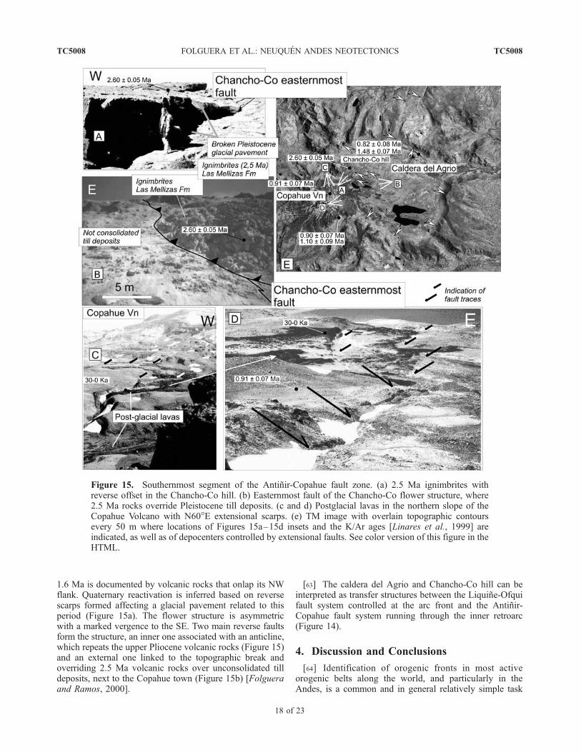
1.6 Ma is documented by volcanic rocks that onlap its NWflank. Quaternary reactivation is inferred based on reversescarps formed affecting a glacial pavement related to thisperiod (Figure 15a). The flower structure is asymmetricwith a marked vergence to the SE. Two main reverse faultsform the structure, an inner one associated with an anticline,which repeats the upper Pliocene volcanic rocks (Figure 15)and an external one linked to the topographic break andoverriding 2.5 Ma volcanic rocks over unconsolidated tilldeposits, next to the Copahue town (Figure 15b) [Folgueraand Ramos, 2000].
[63] The caldera del Agrio and Chancho-Co hill can beinterpreted as transfer structures between the Liquine-Ofquifault system controlled at the arc front and the Antinir-Copahue fault system running through the inner retroarc(Figure 14).
4. Discussion and Conclusions
[64] Identification of orogenic fronts in most activeorogenic belts along the world, and particularly in theAndes, is a common and in general relatively simple task
Figure 15. Southernmost segment of the Antinir-Copahue fault zone. (a) 2.5 Ma ignimbrites withreverse offset in the Chancho-Co hill. (b) Easternmost fault of the Chancho-Co flower structure, where2.5 Ma rocks override Pleistocene till deposits. (c and d) Postglacial lavas in the northern slope of theCopahue Volcano with N60�E extensional scarps. (e) TM image with overlain topographic contoursevery 50 m where locations of Figures 15a–15d insets and the K/Ar ages [Linares et al., 1999] areindicated, as well as of depocenters controlled by extensional faults. See color version of this figure in theHTML.
TC5008 FOLGUERA ET AL.: NEUQUEN ANDES NEOTECTONICS
18 of 23
TC5008
[see Ramos, 1999]. Usually, shallow seismicity reveals thelocation of the related structures, which absorb shortening.Normally these are located at the morphological topo-graphic break [Lavenu and Cembrano, 1999].[65] Deformation fronts in the retroarc of subduction
zones are rarely spatially linked to asthenospheric-derivedmagmatic products as seen in the study area. Our assump-
tion is that this situation produces an anomalous soft uppercrust at the orogenic emergent front, which may creepwithout substantial seismicity. Certainly, seismicity cannotbe used to identify the orogenic front, when it has movedtrenchward, into a hot area of active volcanism (Figure 2).In these cases morphostructural studies become essential toconstraint recent tectonics.
Figure 16. (a) Avalanches and landslides associated with neotectonic faults developed between 37� and38�S. The main avalanches are labeled. Seismic epicenters are from Instituto Nacional de PrevisionSısmica de Argentina database. (b) Buta Mallın avalanche related to NACFZc fault trace. (c) Los Michesavalanche associated with NACFZe fault trace. See color version of this figure in the HTML.
TC5008 FOLGUERA ET AL.: NEUQUEN ANDES NEOTECTONICS
19 of 23
TC5008

Figure 17. Structural sections along the Renileuvu (A-A0), Picunleo (B-B0) and Las Damas valleys.Note that transpressive deformation is interpreted as controlled by inversion of normal faults associatedwith Paleogene and Neogene extension.
TC5008 FOLGUERA ET AL.: NEUQUEN ANDES NEOTECTONICS
20 of 23
TC5008
[66] Three sections corresponding to the Antinir-Copahuefault system have been identified with important differencesalong a length of 100 km, as follows: (1) a relative-hightopography related to N20�–30�W dextral transpression tothe north; (2) widespread N60�E dextral transtension in themiddle part, and (3) transfer mechanisms to the south, in thevicinity of the northernmost part of the intra-arc Liquine-Ofqui fault system. The differences among sections reflectdistinctive structural mechanics, eruptive mechanisms, andmorphology.[67] These variations are related to the variable orienta-
tion of the fault sets controlled by previous structures withrespect to the relative convergence between the SouthAmerica and Nazca plates (Figure 1).[68] Systematic coincidence exists between the docu-
mented neotectonics, mass wasting phenomena (Figure 16)and the edges of Oligocene to Miocene extensionaldepocenters determined in previous studies [Jordan et al.,2001]. Breaks in orientation of the eastern edge of this basincould be controlling variable orientations of Quaternaryfault sets.[69] The northernmost section is dextral transpressive,
and shows the more recent signals of ongoing deformationalong this Andean front. Transpression is straightly afunction of the orientation of these faults respect to theregional convergence between Nazca and South Americanplates (Figures 1 and 2). The orientation is a function of thereactivation of inherited Paleogene basement structures
(Figure 17), as widely recognized in neighbor sections andrelated to NW segmentation of the basement [Vergara et al.,1997a, 1997b; Jordan et al., 2001; Radic et al., 2002].[70] The intermediate section is associated with profuse
volcanic activity in a mainly transtensive environment,which developed the NE Loncopue trough.[71] The southern section solves the transition between
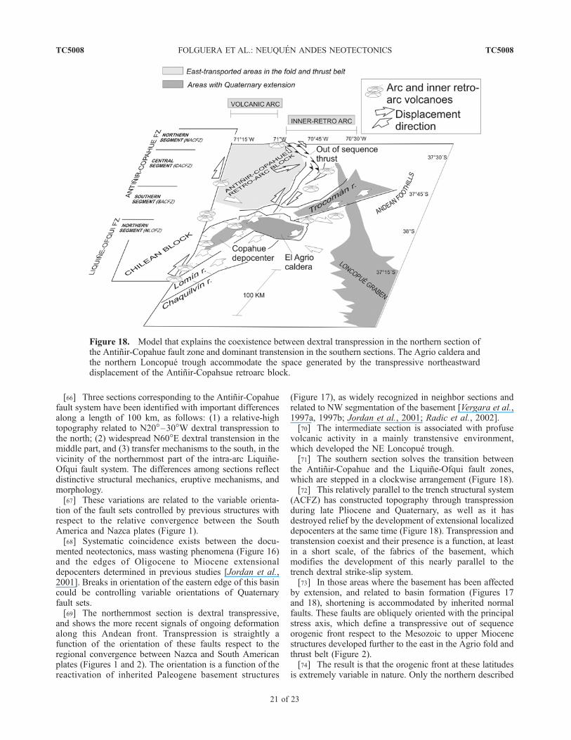
the Antinir-Copahue and the Liquine-Ofqui fault zones,which are stepped in a clockwise arrangement (Figure 18).[72] This relatively parallel to the trench structural system
(ACFZ) has constructed topography through transpressionduring late Pliocene and Quaternary, as well as it hasdestroyed relief by the development of extensional localizeddepocenters at the same time (Figure 18). Transpression andtranstension coexist and their presence is a function, at leastin a short scale, of the fabrics of the basement, whichmodifies the development of this nearly parallel to thetrench dextral strike-slip system.[73] In those areas where the basement has been affected
by extension, and related to basin formation (Figures 17and 18), shortening is accommodated by inherited normalfaults. These faults are obliquely oriented with the principalstress axis, which define a transpressive out of sequenceorogenic front respect to the Mesozoic to upper Miocenestructures developed further to the east in the Agrio fold andthrust belt (Figure 2).[74] The result is that the orogenic front at these latitudes
is extremely variable in nature. Only the northern described
Figure 18. Model that explains the coexistence between dextral transpression in the northern section ofthe Antinir-Copahue fault zone and dominant transtension in the southern sections. The Agrio caldera andthe northern Loncopue trough accommodate the space generated by the transpressive northeastwarddisplacement of the Antinir-Copahsue retroarc block.
TC5008 FOLGUERA ET AL.: NEUQUEN ANDES NEOTECTONICS
21 of 23
TC5008
section (37�–37�30’S) could be considered as a typicalorogenic front, related to synorogenic sediments and asso-ciated with topography constructed by stacking of crustalsheets. This mechanism best explains the rapid increase oftopography from 37� to 38�S (Figure 1b).
[75] Acknowledgments. Special thanks are due to reviewers AndrewMeigs, Carlos Costa, and Doug Walker for constructive remarks which
greatly contributed to improving the original manuscript. This study hasbeen made with funding from PICT 06729/99 of Agencia Nacional dePromocion Cientıfica y Tecnologica to V. A. Ramos. We also acknowledgethe careful revisions to the first manuscript made by Beatriz Aguirre Urretaand Pablo Leal (Universidad de Buenos Aires). Thanks to Jose M. Cortes(Universidad de Buenos Aires) and Daniel Melnick (GFZ Potsdam) forfruitful discussion. Thanks to Ezequiel Garcıa Morabito for field assistance.Fieldwork by R. Hermanns was financed by the GeoForsChungsZentrumPotsdam and supported by the Collaborative Research Centre 276 ‘‘Defor-mation Processes in the Andes.’’ Carlos Perez de Arce is acknowledged forradiometric dating at Sernageomin.
References
Allmendinger, R., T. Jordan, S. Kay, and B. Isacks(1997), The evolution of the Altiplano-Puna plateauof the central Andes, Annu. Rev. Earth Planet Sci.,25, 139–174.
Barrientos, S., and P. Acevedo (1992), Seismologicalaspects of the 1988 – 1989 Lonquimay volcaniceruption (Chile), J. Volcanol. Geotherm. Res., 53,73– 87.
Bevis, M., and B. Isacksv (1984), Hypocentral trendsurface analysis: Probing the geometry of Nenioffzones, J. Geophys. Res., 89, 6153–6170.
Bohm, M., S. Luth, H. Echtler, G. Asch, K. Bataille,C. Bruhn, A. Rietbrock, and P. Wigger (2002), Thesouthern Andes between 36� and 40�S latitude:Seismicity and average seismic velocities, Tectono-physics, 356, 275 –289.
Braddock, W. (1978), Dakota Group rockslides, north-ern Front Range, Colorado, U.S.A., in Rockslidesand Avalanches, edited by B. Voight, pp. 439–479,Elsevier Sci., New York.
Cazau, L., C. Mancini, J. Cangini, and L. Spalletti(1987), Cuenca de Nirihuao, in Cuencas Sedimen-tarias de Argentina, Ser. Correlacion Geol., vol. 6,edited by G. Chebli and L. Spalletti, pp. 299–318,Inst. Sup. de Correlacion Geol., Univ. Nac. deTucuman, Buenos Aires, Argentina.
Charrier, R., A. Wyss, J. Flynn, C. Swisher III,M. Norell, F. Zapatta,M.McKenna, andM.Novacek(1996), New evidence for late Mesozoic-EarlyCenozoic evolution of theChileanAndes in the upperTinguieririca Valley (35�S), central Chile, J. S. Am.Earth Sci., 9, 393–422.
Delpino, D. and A. Bermudez, (1993), La actividad delvolcan Copahue durante 1992: Erupcion con emi-sion de azufre piroclastico: Provincia de Neuquen,paper presented at the XII Congreso Geologico Ar-gentino, Mendoza, Argentina.
Dixon, H., M.Murphy, S. Sparks, R. Chavez, J. Naranjo,P. Dinkley, S. Young, J. Gilbert, and M. Pringle(1999), The geology of Nevados de Chillan volcano,Chile, Rev. Geol. Chile, 26(2), 227–253.
Fauque, L. and P. Tchilinguirian (2002), Villavilrockslides, Catamarca Province, Argentina, inCatastrophic Landslides: Effects, Occurrence, andMechanism, Rev. Eng. Geol., vol. 15, edited byS. G. Evans and J. V. DeGraff, pp. 303–324, Geol.Soc. of Am., Boulder, Colo.
Folguera, A., and V. A. Ramos (2000), Control estruc-tural del volcan Copahue (38�S–71�O): Implican-cias tectonicas para el arco volcanico cuaternario(36�S – 39�S), Rev. Asoc. Geol. Argent., 55(3),229–244.
Folguera, A., and V. A. Ramos (2002), Particion de ladeformacion durante el Neogeno en los AndesPatagonicos Septentrionales (37�–46�S), Rev. Soc.Geol. Esp., 15(1 –2), 81–93.
Godoy, E., G. Yanez, and E. Vera (1999), Inversion ofan Oligocene volcano tectonic basin and upliftingof its superimposed Miocene magmatic arc in theChilean central Andes: First seismic and gravityevidences, Tectonophysics, 306, 217–236.
Gonzalez Dıaz, E. and F. Nullo (1980), Cordillera Neu-quina, in Segudno Simposio de Geologıa Regional
Argentina, vol. 2, edited by J. C. M. Turner,
pp. 1099–1147, Acad. Nac. de Ciencias, Cordoba,Argentina.
Gonzalez Ferran, O. (1994), Volcanes de Chile, Inst.Geogr. Militar, 640 pp., Santiago, Chile.
Grafe, K., J. Glodny, W. Seifert, M. Rosenau, andH. Echtler (2002), Apatite fission track thermochro-nology of granitoids at the South Chilean activecontinental margin (37�S. 42�S): Implications fordenudation, tectonics and mass transfer since theCretaceous, paper presented at Fifth InternationalSymposium on Andean Geodynamics, Inst. deRech. pour le Dev., Univ. Paul Sabatier, Toulousse,France.
Groeber, P. (1925), LA region de Copahue y su glacia-cion diluvial, GAEA Rev. Soc. Argent. Estud. Geogr.Buenos Aires, 1(1), 92– 110.
Groeber, P. (1927), Origen de los valles transversales dela Cordillera Patagonica, GAEA Rev. Soc. Argent.Estud. Geogr. Buenos Aires, 2(3), 438 –450.
Herve, M. (1976), Estudio geologico de la fallaLiquine-Reloncavı an la area de Liquine: Antece-dentes de un movimiento transcurrente (Provinciade Vadivia), paper presented at I Congreso Geolo-gico Chileno, Santiago de Chile, Chile.
Herve, F., R. Pankhurst, R. Drake, and M. Beck (1995),Pillow basalts in a mid-Tertiary extensional basinadjacent to the Liquine Ofqui fault zone: The IslaMagdalena area, Aysen, Chile, J. S. Am. Earth Sci.,8(1), 33– 46.
Hewitt, K. (1988), Catastrophic landslide deposits inthe Karakoram Himalaya, Science, 242, 64– 67.
Iaffa, D., E. Gonzalez Dıaz, and A. Folguera (2002),Tectonica postglaciaria en la Cordillera Neuquina:Rıo Picunleo (37�30 0S), paper presented atXV Congreso Geologico Argentino, El Calafate,Argentina.
Introcaso, A., M. Pacino, and H. Fraga (1992), Gravity,isostasy and Andean crustal shortening betweenlatitudes 30� and 35�S, Tectonophysics, 205, 31 –48.
Jordan, T., W. Burns, R. Veiga, F. Pangaro, P. Copeland,S. Kelley, and C. Mpodozis (2001), Extension andbasin formation in the southern Andes caused byincreased convergence rate: A mid-Cenozoic triggerfor the Andes, Tectonics, 20(3), 308–324.
Kley, J. (1998), Variable foreland shortening along thesouthern central Andes (15�– 42�S): Correlationwith crustal thickness, lithospheric structure andthe geometry of the Nazca plate, paper presentedat X Congreso Latinoamericano de Geologıa and VICongreso Nacional de Geologıa Economica, Bue-nos Aires, Argentina.
Lavenu, A., and J. Cembrano (1999), Compressionaland tranpressional stress pattern for Pliocene andQuaternary brittle deformation in fore arc and intraarc zones (Andes of central and southern Chile),J. Struct. Geol., 21, 1669–1691.
Linares, E., H. Ostera, and L. Mas (1999), CronologıaPotasio-Argon del complejo efusivo Copahue-Caviahue, Provincia del Neuquen, Rev. Asoc. Geol.Argent., 54(3), 240–247.
McDonough, M., P. Duhart, and P. Crignola (1997),Naturaleza del alzamiento del basamento costero yla apertura de la cuenca de Osorno-Llanquihue, X
Region: Nuevos antecedentes sısmicos y observa-ciones de terreno, paper presented at VIII CongresoGeologico Chileno, Santiago, Chile.
McSaveney, M. (1978), Sherman Glacier rock ava-lanche, Alaska, U.S.A., in Rockslides and Ava-lanches, edited by B. Voight, pp. 197 – 257,Elsevier Sci., New York.
Melnick, D., and A. Folguera (2001), Geologia delcomplejo volcanico Copahue-Caldera Del Agrio,un sistema transtensional activo desde el Pliocenoen la transicion de los Andes Patagonicos a losAndes centrales (38�S–71�O), paper presented atIX Congreso Geologico Latinoamericano sympo-sium ‘‘Evolucion Tectonica de los Andes,’’Monte-video, Uruguay.
Melnick, D., A. Folguera, M. Rosenau, H. Echtler, andS. Potent (2002), Tectonics from the northern seg-ment of the Liquine-Ofqui fault system (37�–39�s),Patagonian Andes, paper presented at Fifth Interna-tional Symposium on Andean Geodynamics, Inst.de Rech. pour le Dev., Univ. Paul Sabatier, Tou-louse, France.
Munoz, J. and M. Araneda (2000), Extension corticalen el Oligoceno-Mioceno entre los 39� y los 42�Sregion de los lagos Chile: Antecedentes geologicosy geofısicos, paper presented at IX Congreso Geo-logico Chileno, Puerto Varas, Chile.
Munoz, J., and C. Stern (1988), The Quaternary volca-nic belt of the southern continental margin of SouthAmerica: Transverse structural and petrochemicalvariations across the segment between 38� and39�S, J. S. Am. Earth Sci., 1(2), 147–161.
Niemeyer, H. and J. Munoz (1983), Geologıa de la hoja57 Laguna de La Laja, Region de Bıo Bıo,1:250,000, Serv. Nac. de Geol. y Min., Santiagode Chile, Chile.
Pesce, A. (1989), Evolucion volcano-tectonica del com-plejo efusivo Copahue-Caviahue y su modelo geo-termico preliminar, Rev. Asoc. Geol. Argent., 44(1 –4), 307–327.
Radic, J., L. Rojas, A. Carpinelli, and E. Zurita (2002),Evolucion tectonica de la Cuenca Terciaria de CuraMallın, region cordillerana Chileno-Argentina(36�300–39�S), paper presented at XV CongresoGeologico Argentino, El Calafate, Argentina.
Ramos, V. A. (1999), Plate tectonic setting of the An-dean Cordillera, Episodes, 22(3), 183–190.
Ramos, V. A., and M. Barbieri (1989), El volcanismocenozoico de Huantraico: Edad y relaciones isoto-picas iniciales, provincia de Neuquen, Rev. Asoc.Geol. Argent., 43(2), 210–223.
Ramos, V. A. and A. Folguera (1999), The Andes ofNeuquen (36�–38�S): Evidence of Cenozoic trans-tension along the arc, paper presented at FourthInternational Symposium on Andean Geodynamics,Inst. de Rech. pour le Dev., Gottingen, Germany.
Ramos, V. A., and F. Nullo (1993), El volcanismo dearco cenozoico, Geol. Recurs. Nat. Mendoza Relat.,I, (12), 149–160.
Rivera, O. and J. Cembrano (2000), Modelo de forma-cion de cuencas volcano-tectonicas en zonas detransferencia oblicuas a la cadena andina: El casode las cuencas oligo-miocenas de Chile central y surelacion con estructuras NWW-NW (33�–34�300),
TC5008 FOLGUERA ET AL.: NEUQUEN ANDES NEOTECTONICS
22 of 23
TC5008

paper presented at IX Congreso Geologico Chileno,Puerto Varas, Chile.
Rovere, E. (1998), Volcanismo Jurasico, Paleogeno yNeogeno en el noroeste del Neuquen, Argentina,paper presented at X Congreso Latinoamericanode Geologıa and VI Congreso Nacional de Geolo-gıa Economica, Buenos Aires, Argentina.
Rovere Adaniya, E., I. Kaneoka, and K. Nagao (1993),K/Ar ages in the south Andes, 37�– 37� 150S –71�W, Argentina, paper presented at IAVCEI Gen-eral Assembly ‘‘Ancient Volcanism and ModernAnalogues,’’Int. Assoc. of Volcanol. and Chem. ofthe Earth’s Inter., Canberra, ACT, Australia.
Spalletti, L., and L. Dalla Salda (1996), A pull apartvolcanic related Tertiary basin, an example from thePatagonian Andes, J. S. Am. Earth Sci., 9(3 – 4),197–206.
Suarez, M., and C. Emparan (1995), The stratigraphy,geochronology and paleophysiography of a Mio-cene fresh-water interarc basin, southern Chile,J. S. Am. Earth Sci., 8(1), 17– 31.
Suarez, M. and C. Emparan (1997), Hoja Curacautın:Regiones de la Araucanıa y del Bıo Bıo, 1:250,000,Carta Geol. Chile, 71, p. 105, Serv. Nac. de Geol. yMin., Santiago, Chile.
Thomson, S. (2002), Late Cenozoic geomorphic andtectonic evolution of the Patagonian Andes betweenlatitudes 42�S and 46�S: An appraisal based onfission-track results from the transpressional intra-arc Liquine-Ofqui fault zone, Geol. Soc. Am. Bull.,114(9), 1159–1173.
Vergara, M., and J. Munoz (1982), La Formacion Colade Zorro en la Alta cordillera Andina Chilena(36�–39�S), sus caracterısticas petrograficas y pet-rologicas: Una revision, Rev. Geol. Chile, 17, 31 –46.
Vergara, M., J. Moraga, and M. Zentilli (1997a), Evo-lucion termotectonica de la cuenca terciaria entreParral y Chillan: Analisis por trazas de fision enapatitas, paper presented at VIII Congreso Geologi-co Chileno, Antofagasta, Chile.
Vergara, M., E. Puga, D. Morata, I. Beccar, A. Dıaz deFederico, and E. Fonseca (1997b), Mineral Chem-istry of the Oligocene-Miocene volcanism from Li-nares to Parral, Andean Precordillera, paperpresented at VIII Congreso Geologico Chileno, An-tofagasta, Chile.
Yarnold, J. (1993), Rock-avalanche characteristics indry climates and the effect of flow into lakes:Insights from mid-Tertiary sedimentary breccias
near Artillery Peak, Arizona, Geol. Soc. Am. Bull.,105, 345–360.
Zapata, T., I. Brisson, and F. Dzelalija (1999), The roleof basement in the Andean fold and thrust belt ofthe Neuquen Basin, in Thrust Tectonics, edited byK. McClay, pp. 122–124, Chapman and Hall, NewYork.
Zapata, T., S. Corsico, F. Dzelajica, and G. Zamora(2002), La faja plegada y corrida del Agrio: Anali-sis estructural y su relacion con los estratos terciar-ios de la Cuenca Neuquina Argentina, paperpresented at V Congreso de Exploracion y Desar-rollo de Hidrocarburos, Mar del Plata, Argentina.
���������A. Folguera and V. A. Ramos, Laboratorio de
Tectonica Andina, Universidad de Buenos Aires, BuenosAires, Argentina. ([email protected]; [email protected])
R. L. Hermanns, Geological Survey of Canada,101-605 Robson Street, Vancouver, British Columbia,Canada V6B 5J3. ([email protected])
J. Naranjo, Servicio Nacional de Geologıa y Minerıade Chile, Santiago, Chile. ([email protected])
TC5008 FOLGUERA ET AL.: NEUQUEN ANDES NEOTECTONICS
23 of 23
TC5008
Related Documents