This article was downloaded by: [University of Delhi] On: 22 November 2013, At: 18:21 Publisher: Taylor & Francis Informa Ltd Registered in England and Wales Registered Number: 1072954 Registered office: Mortimer House, 37-41 Mortimer Street, London W1T 3JH, UK Geocarto International Publication details, including instructions for authors and subscription information: http://www.tandfonline.com/loi/tgei20 Neotectonic activity and the origin of Tso Morari Lake using remote sensing and digital elevation model (DEM) derivative techniques Dericks Praise Shukla a , Chandra Shekhar Dubey a & Neelratan Singh a a Department of Geology , Center for Advanced Studies, University of Delhi , Delhi , 110007 , India Accepted author version posted online: 22 Nov 2011.Published online: 04 Jan 2012. To cite this article: Dericks Praise Shukla , Chandra Shekhar Dubey & Neelratan Singh (2012) Neotectonic activity and the origin of Tso Morari Lake using remote sensing and digital elevation model (DEM) derivative techniques, Geocarto International, 27:3, 249-262, DOI: 10.1080/10106049.2011.642412 To link to this article: http://dx.doi.org/10.1080/10106049.2011.642412 PLEASE SCROLL DOWN FOR ARTICLE Taylor & Francis makes every effort to ensure the accuracy of all the information (the “Content”) contained in the publications on our platform. However, Taylor & Francis, our agents, and our licensors make no representations or warranties whatsoever as to the accuracy, completeness, or suitability for any purpose of the Content. Any opinions and views expressed in this publication are the opinions and views of the authors, and are not the views of or endorsed by Taylor & Francis. The accuracy of the Content should not be relied upon and should be independently verified with primary sources of information. Taylor and Francis shall not be liable for any losses, actions, claims, proceedings, demands, costs, expenses, damages, and other liabilities whatsoever or howsoever caused arising directly or indirectly in connection with, in relation to or arising out of the use of the Content. This article may be used for research, teaching, and private study purposes. Any substantial or systematic reproduction, redistribution, reselling, loan, sub-licensing, systematic supply, or distribution in any form to anyone is expressly forbidden. Terms &

Welcome message from author
This document is posted to help you gain knowledge. Please leave a comment to let me know what you think about it! Share it to your friends and learn new things together.
Transcript
This article was downloaded by: [University of Delhi]On: 22 November 2013, At: 18:21Publisher: Taylor & FrancisInforma Ltd Registered in England and Wales Registered Number: 1072954 Registeredoffice: Mortimer House, 37-41 Mortimer Street, London W1T 3JH, UK
Geocarto InternationalPublication details, including instructions for authors andsubscription information:http://www.tandfonline.com/loi/tgei20
Neotectonic activity and the origin ofTso Morari Lake using remote sensingand digital elevation model (DEM)derivative techniquesDericks Praise Shukla a , Chandra Shekhar Dubey a & NeelratanSingh aa Department of Geology , Center for Advanced Studies,University of Delhi , Delhi , 110007 , IndiaAccepted author version posted online: 22 Nov 2011.Publishedonline: 04 Jan 2012.
To cite this article: Dericks Praise Shukla , Chandra Shekhar Dubey & Neelratan Singh (2012)Neotectonic activity and the origin of Tso Morari Lake using remote sensing and digitalelevation model (DEM) derivative techniques, Geocarto International, 27:3, 249-262, DOI:10.1080/10106049.2011.642412
To link to this article: http://dx.doi.org/10.1080/10106049.2011.642412
PLEASE SCROLL DOWN FOR ARTICLE
Taylor & Francis makes every effort to ensure the accuracy of all the information (the“Content”) contained in the publications on our platform. However, Taylor & Francis,our agents, and our licensors make no representations or warranties whatsoever as tothe accuracy, completeness, or suitability for any purpose of the Content. Any opinionsand views expressed in this publication are the opinions and views of the authors,and are not the views of or endorsed by Taylor & Francis. The accuracy of the Contentshould not be relied upon and should be independently verified with primary sourcesof information. Taylor and Francis shall not be liable for any losses, actions, claims,proceedings, demands, costs, expenses, damages, and other liabilities whatsoever orhowsoever caused arising directly or indirectly in connection with, in relation to or arisingout of the use of the Content.
This article may be used for research, teaching, and private study purposes. Anysubstantial or systematic reproduction, redistribution, reselling, loan, sub-licensing,systematic supply, or distribution in any form to anyone is expressly forbidden. Terms &

Conditions of access and use can be found at http://www.tandfonline.com/page/terms-and-conditions
Dow
nloa
ded
by [
Uni
vers
ity o
f D
elhi
] at
18:
21 2
2 N
ovem
ber
2013
Neotectonic activity and the origin of Tso Morari Lake using
remote sensing and digital elevation model (DEM)derivative techniques
Dericks Praise Shukla*, Chandra Shekhar Dubey andNeelratan Singh
Department of Geology, Center for Advanced Studies, University of Delhi,Delhi 110007, India
(Received 3 June 2011; final version received 16 November 2011)
Neotectonics play an important role in the formation of lakes, especially nearactive suture zones. The best suited areas where such changes are observed are thetectonically active mountainous regions of Himalaya. However, in an inaccessibleterrain like Higher-Himalaya, active tectonic studies related to development ofnewer and reactivated faults are less conceived. In this article, an attempt has beenmade to identify active faults and Neotectonic activity in the Tso Morari area inLadakh, North-West Himalaya, with the help of remote sensing and digitalelevation model (DEM) techniques. The results suggest that Tso Morari Lake isdeveloped due to Neotectonic uplift in the region which created a fault scarp inE–W direction. The horizon blocking technique with the aid of elevation, slopeand aspect map is used to demarcate the E–W trending younger fault. Moreover,the earthquakes foci also lie along this E–W direction which has restricted theseismic activity to its southern part.
Keywords: neo-tectonics; fault identification; remote sensing and DEM; horizonblocking; Tso Morari; India
1. Introduction
The collision of Indian plate with Asian plate in the Early Cenozoic has causedhorizontal compression of the lithosphere and topographic uplift causing relief in theHimalayas. It has shown block faulting and enhanced uplift on faults in its northernand central parts. Since the middle Miocene, regional deformation changed fromcompression to translation extension described by a complex and pervasive networkof strike slip and normal faults (Molnar and Tapponnier 1978, Ni and Barazangi1985, Coleman and Hodges 1995, Blisniuk et al. 2001, Taylor et al. 2003, Murphyand Copeland 2005, Thiede et al. 2006, Yin 2006). Regional structure, tectonicallyinfluenced landforms, and seismicity demonstrate that this style of deformationcontinues even today with the development of new faults or reactivation of earlierfaults (e.g. Ni and Barazangi 1984, Molnar and Lyon-Caen 1989). The developmentof many newer and younger faults along with the reactivation of the older thrusts
*Corresponding author. Email: [email protected]
Geocarto International
Vol. 27, No. 3, June 2012, 249–262
ISSN 1010-6049 print/ISSN 1752-0762 online
� 2012 Taylor & Francis
http://dx.doi.org/10.1080/10106049.2011.642412
http://www.tandfonline.com
Dow
nloa
ded
by [
Uni
vers
ity o
f D
elhi
] at
18:
21 2
2 N
ovem
ber
2013
during Eopleistocene started the beginning of the morphostructural dissection of theuplifted mountains.
As a result of the convergence of the Indian and Asian plates, a number of lakeshave also formed on either side of the Indus Tsangpo Suture Zone (ITSZ). Theselakes are either brackish or freshwater. Sternberg (1950) first suggested therelationship between lake patterns and neotectonics in the Amazonian lowlandconcluding the tectonic reactivations during the Holocene. Dumont (1991, 1993)found that lake patterns in the Ucamara depression are developed along extensionalfaults within Andean foredeep regime. He established the relation of active subsidingareas to basement structures, neotectonic and seismotectonic data. However, in theinaccessible Himalayan terrain, active tectonic studies related to development ofnewer as well as reactivated faults are less conceived because conventional methodsof morphology and fault analysis have not yielded appreciable results. Using remotesensing technique, Philip and Mazari (2000) were able to study the shrinkinglake basin of Tso Kar and Stratsapuk Tso, situated close to the ITSZ. Bhargava(1990) concluded that tectonic and climatic factors were responsible forrapid exhumation and development of many sets of faults and thrusts in the areasto the south of ITSZ in the Himalaya. Some of these faults are still active orreactivated due to tectonic development in the area. Hence, an attempt has beenmade in this study to identify the recent active faults, which has caused tilting of fandeposits and hence the neotectonic origin of Tso Morari Lake. This study is carriedout with the help of remote sensing and geographical information system (GIS)techniques which are best suited for inaccessible terrains like Higher and TransHimalayas.
2. Study area
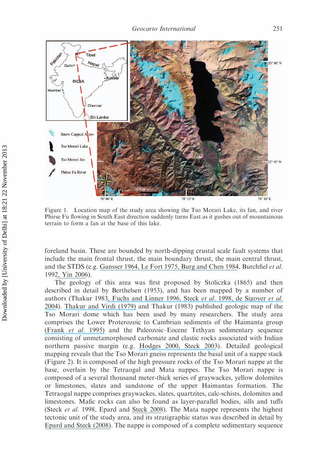
The Tso Morari Lake is probably a leftover from the ice age, formed by melting ofice masses and is stunning cobalt blue in colour. It is located between latitude 328400–338 050 N and longitude 788 150–788 250 E, which is about 220 km southeast ofLeh in the north-western Himalaya at an altitude of 4900 m and close to the ITSZ. Itis one of the largest lakes in Ladakh region and is almost like an inland sea(Figure 1). It has a length of about 25 km and a varying width of 6 to 8 km with adepth of more than 50 m at the deepest point. The waters from the surroundingareas drained into the lake. The huge amounts of water present at the outsetevaporated very fast in the desert-like atmosphere and consequently fresh waterbecame brackish and finally salty making it unfit for human consumption.
The area has a rugged topography dominated by barren mountains. Most of theregion lie above the tree line with little vegetation. The region remains covered withsnow for nearly six months. Voluminous amount of talus, scree cones, huge alluvialfans and sediments on both sides of the river valleys, deep gorges and waterfalls arecommon features in the region (Phartiyal et al. 2005). The study area lies between theITSZ to the north and the South Tibetan detachment system (STDS) to the south inthe Tethyan Himalaya.
2.1 Geology and tectonics
The Himalayan orogen has four major tectonostratigraphic units: the TethyanHimalaya, the High Himalayan Crystalline, the Lesser Himalaya and the Himalayan
250 D.P. Shukla et al.
Dow
nloa
ded
by [
Uni
vers
ity o
f D
elhi
] at
18:
21 2
2 N
ovem
ber
2013
foreland basin. These are bounded by north-dipping crustal scale fault systems thatinclude the main frontal thrust, the main boundary thrust, the main central thrust,and the STDS (e.g. Gansser 1964, Le Fort 1975, Burg and Chen 1984, Burchfiel et al.1992, Yin 2006).
The geology of this area was first proposed by Stoliczka (1865) and thendescribed in detail by Berthelsen (1953), and has been mapped by a number ofauthors (Thakur 1983, Fuchs and Linner 1996, Steck et al. 1998, de Sigoyer et al.2004). Thakur and Virdi (1979) and Thakur (1983) published geologic map of theTso Morari dome which has been used by many researchers. The study areacomprises the Lower Proterozoic to Cambrian sediments of the Haimanta group(Frank et al. 1995) and the Paleozoic–Eocene Tethyan sedimentary sequenceconsisting of unmetamorphosed carbonate and clastic rocks associated with Indiannorthern passive margin (e.g. Hodges 2000, Steck 2003). Detailed geologicalmapping reveals that the Tso Morari gneiss represents the basal unit of a nappe stack(Figure 2). It is composed of the high pressure rocks of the Tso Morari nappe at thebase, overlain by the Tetraogal and Mata nappes. The Tso Morari nappe iscomposed of a several thousand meter-thick series of graywackes, yellow dolomitesor limestones, slates and sandstone of the upper Haimantas formation. TheTetraogal nappe comprises graywackes, slates, quartzites, calc-schists, dolomites andlimestones. Mafic rocks can also be found as layer-parallel bodies, sills and tuffs(Steck et al. 1998, Epard and Steck 2008). The Mata nappe represents the highesttectonic unit of the study area, and its stratigraphic status was described in detail byEpard and Steck (2008). The nappe is composed of a complete sedimentary sequence
Figure 1. Location map of the study area showing the Tso Morari Lake, its fan, and riverPhirse Fu flowing in South East direction suddenly turns East as it gushes out of mountainousterrain to form a fan at the base of this lake.
Geocarto International 251
Dow
nloa
ded
by [
Uni
vers
ity o
f D
elhi
] at
18:
21 2
2 N
ovem
ber
2013
in the Tso Morari transect. It contains the Paleoproterozoic to Cambrian Haimantasgraywackes, the Karsha graywackes and dolomites at the base. These units wereintruded by Tso Morari granite. This nappe is bound by rocks ITSZ to north andto the south and west by sedimentary rocks of the Tibetan Zone (Garzanti et al.1987).
The ITSZ is composed of six units (de Sigoyer et al. 2004), out of which, theIndus Sedimentary Sequence and the Nidar Ophiolite are present in the study area.The Indus sedimentary sequence of ITSZ in the north of study area was deposited inan episutural basin that evolved from a marine to a continental environment andrecorded the closure of marine domain between the two converging continents. Theyare composed of red deltaic sediments and nummulitic limestone accumulated on theAsian margin (Garzanti et al. 1987) and is popularly known as Indus Molasse. Theyare overlain by the Choksti conglomerate with stretched granodioritic and andesiticpebbles (Mascle et al. 1986). Southward, red continental pelites alternating withpaleosoils and green conglomeratic sandstones lie in channels (de Sigoyer et al.2004). The Nidar ophiolite (Thakur and Virdi 1979, Thakur and Misra 1984),
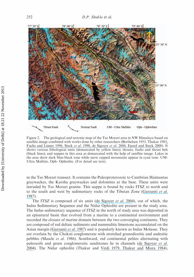
Figure 2. The geological and tectonic map of the Tso Morari area in NWHimalaya based onsatellite image combined with works done by other researchers (Berthelsen 1953, Thakur 1983,Fuchs and Linner 1996, Steck et al. 1998, de Sigoyer et al. 2004, Epard and Steck 2008). Itshows various lithological units (demarcated by yellow lines); thrusts, faults and thrust belt(black lines); and nappes in this area as demarcated with the help of satellite image. Lakes inthe area show dark blue-black tone while snow capped mountains appear in cyan tone. UM-Ultra Mafitite, Oph- Ophiolite. (For detail see text).
252 D.P. Shukla et al.
Dow
nloa
ded
by [
Uni
vers
ity o
f D
elhi
] at
18:
21 2
2 N
ovem
ber
2013
composed of serpentinites, peridotites, gabbros, pillow basalts of N-MORBcomposition, is interpreted as an intra-oceanic arc. The Asian margin north of theITSZ is made up of the Cordillera-type, calc-alkaline Ladakh intrusive batholith asan integral part of Trans-Himalayan batholiths e.g. Honegger et al. 1982 andScharer et al. 1984. The calc-alkaline Ladakh batholith corresponds to a volcanicarc, formed along the Asian margin during the northward subduction of the Neo-Tethys Ocean from Lower Cretaceous to early Eocene (Murphy et al. 1999,Weinberg and Dunlap 2000, Schlup et al. 2003).
There are three major faults in this part of Himalayas namely the Karakoramfault, the ITSZ and STDS (Figure 2). The earlier two are active faults which trend ina NW–SE direction, while the STDS was reactivated during early to mid-Miocenealong the south-western termination of the Tethyan Sedimentary Sequence as amajor shear zone with normal displacement, facilitating rapid exhumation of theHigher Himalayan Crystalline to the south (Burg and Chen 1984, Burchfiel et al.1992). Hence, from the mid-Eocene to the present, exhumation continued at a steadyand slow rate except for the root zone of the Tso Morari nappe, which cooled fasterthan the rest of the nappe stack (Schlup et al. 2003). Thus, the rapid exhumation andthe tectonic activity developed many sets of faults and thrusts. Some of these faultsare parallel to the main active faults while others are in transverse direction as shownin Figure 2. This made the area tectonically quite active and the lakes were isolatedby a few sets of faults.
3. Material and method
The remote sensing and GIS techniques have proved to be powerful tools especiallyfor identification of various geological, geomorphological, seismological andtectonic attributes. Remote sensing provides synoptic coverage for large areas,most updated data for change detection studies, with quantitative analysis of narrowdefined spectral bands. Thus, a number of information regarding geology, lithology,structure and tectonic studies can be extracted from it. So far known to us very littlestudies have been carried out using such approach to understand the seismo-tectonics and active tectonics of the study area.
3.1 Data used
3.1.1 Satellite data
Visible, near infrared (NIR), and mid infrared (MIR) bands of the LandsatEnhanced Thematic Mapper Plus (ETMþ) images, having a spatial resolution of30 m for the summer of 2006, were used for this study.
3.1.2 Digital elevation model (DEM)
Digital elevation model (DEM) data consists of two aspects: one is demonstrativeinformation that includes corner coordinates, size of a grid, number of rows, etc.,and the other is elevation information that includes the elevation value of each grid.Latest DEM from Aster GDEM datasets were used which are at 30 m spatialresolution with an accuracy of nearly 10 m.
Geocarto International 253
Dow
nloa
ded
by [
Uni
vers
ity o
f D
elhi
] at
18:
21 2
2 N
ovem
ber
2013
3.2 Data analysis
3.2.1 Satellite image processing
The false colour composite (FCC) image of the study area was created by stacking 7,4 and 2 bands of Landsat ETMþ satellite data as RGB, using ERDAS Imagine 9.1software. This combination provides a ‘natural-like’ rendition, while also penetratingatmospheric particles and smoke. It is useful for geological mapping in areas wherevegetation is sparse. The image was created to study the regional geology andstructural anomalies present in the field area. The satellite data was then rectified andresampled to get the georeferenced image of the area. Digital image processing wasperformed using various enhancement techniques, such as linear contrast stretching,histogram equalization, breakpoint adjustments, Intensity Hue Saturation (IHS)transformation, etc. and finally colour compositing. The breakpoint adjustmentsgave the best results as it gives user the ability to enhance the individual bandaccording to the reflectance and contrast of the image. A good contrast for variousfeatures was obtained while processing which enhanced the tonal variations whichwere helpful for geological mapping using satellite image.
3.2.2 DEM processing
The DEM gives the elevation data of any area and when it is enhanced withtoposheet height data, the accuracy increases. Nonetheless, with the addedadvantage of elevation data, it is possible to carry out many tasks which wereearlier not envisaged. The analysis of DEM is done using Arc GIS 9.3,MICRODEM software. Various maps like horizon blocking, slope, aspect, etc.were derived from this DEM for this study. The DEM has the capability to locatethe areas which falls in the visible range of the observer depending on the height ofthe area. The concept behind this is that an observer point is selected, and its heightis defined. After that, the whole area is scanned in radial direction and the areaswhich are visible or the point till which the horizon is blocked is selected. This givesan area which is visible from this observer point or the area where horizon isblocked. Especially, this type of concept is very helpful in mountainous terrain whereone wants to study the areas which lie in line of sight. The general term used for thisis inter-visibility or horizon blocking that means to distinguish the visible areas fromthe non-visible areas. This analysis can be easily done using Arc GIS 9.3 as well asMicroDEM software with the help of DEM of an area. Various observer points werechosen so that the area of the fan of Tso Morari Lake is fully covered. Out of theseobserver points, four points were chosen which depict the best results. The height ofobserver was kept at 1 m which is the minimum elevation that can be provided, andthe whole DEM was scanned to get the area that is visible or where the horizon isblocked. The slope and aspect map were also derived from the DEM data using thesesoftware. These maps were very useful for delineating the faults showing neo-tectonic activity.
4. Results and discussion
Morphological analysis of topographic features is one of the most usedparameters for tectonic and structural inferences since long. It includes studiesof aerial photographs, satellite images and DEM’s. Philip and Mazari 2000, Guth
254 D.P. Shukla et al.
Dow
nloa
ded
by [
Uni
vers
ity o
f D
elhi
] at
18:
21 2
2 N
ovem
ber
2013
2003, Jordan 2003, Jordan et al. 2005, Philip and Mathew 2005, Arrowsmith2006, Khan and Mahmood 2008, etc. have shown the capabilities of satelliteimages, DEM’s, shaded relief images and terrain derivative maps (slope, aspectand curvatures) for demarcation of lithological unit contacts, lineaments andfaults.
4.1 Satellite image interpretation
The band combination of 7,4,2 is the best suited for geological studies as discussedearlier due to the good reflectance of various lithounits in Short Wave Infra-Red(SWIR) range. Healthy vegetation will appear bright green, grasslands or shrubswill appear green, pink areas represent barren soil, oranges represent open areas withvery less to dry vegetation and water will be seen as blue to black. Sands, soils andminerals are shown in a variety of colours and tonal variations. Based on the studiescarried out by other workers earlier in this area and depending on the tonalvariations, various units were demarcated on image as shown in Figure 2 andmodified from the previously published maps. Nearly, the whole area is barred ofvegetation giving shades of pink and orange, except little greenish tinge near the fanwhich are shrubs. The snow capped mountains are visible as turquoise colour whileTso Morari Lake in the centre of the image gives black tone. Just to the south of thislake a fan is present. The Tso Morari nappe is clearly visible in the centre of the maphaving light tone and smooth texture. This nappe can be very easily distinguishedfrom the surrounding hilly terrain. On the north-eastern side, ITSZ is clearly visiblealong NW–SE direction. In this suture zone, ophiolites which are commonly namedhere as Nidar ophiolites are visible as reddish brown tinge while some greenish tingepinching shows the presence of Ultra mafic rocks termed elsewhere as Ultra Mafitites(Epard and Steck 2008). Beyond this suture zone highly dissected uniform terrain isclearly demarcated as calc-alkaline Ladakh batholith. On the basis of tonal, texturaland pattern differentiation Rupshu granite, and Mata units are demarcated fromTetraogal nappe and Tso Morari nappe in the south-western region as shown inFigure 2. Beyond this region, the rocks belong to Tethyan series which is highlydissected and well formed mountains. Between this Tethyan Series and Mata unitthere is a region which is not highly dissected, is less developed and has nearly flattopography which falls in the category of unmetamorphosed zone as described byEpard and Steck (2008). In this zone, the ridges and valleys are not so prominentlyformed.
The prominent NW–SE trending faults and thrusts were clearly demarcatedbased on the sudden change in topography as well as termination and contacts ofvarious lithounits. They include Karakoram thrust system, ITS, Nyamling thrust etc.Some transverse faults are also marked in Ladakh batholith and Tso Morari nappebased on earlier works (de Sigoyer et al. 2004, Epard and Steck 2008). There is aprominent nearly N–S trending fault on the western margin of Tso Morari Lakewhich becomes NNE–SSW after the emergence of Phirse Fu river in the fan. A breakin the continuation of this fault is visible at this location where this river comes outof mountainous terrain. This river Phirse Fu flowing from NW to SE direction alongthe normal shear zone (Figures 1 and 2) suddenly bends in Eastern direction justbefore coming out of hilly terrain and thus forming the fan. As Tso Morari Lake issituated along the N–S to NNW–SSE trending fault passing through it up to Kaurik,Leo and Sangla valley (Thiede et al. 2006, Singh and Jain 2007) and hence the river
Geocarto International 255
Dow
nloa
ded
by [
Uni
vers
ity o
f D
elhi
] at
18:
21 2
2 N
ovem
ber
2013
after coming out of the terrain should flow along this fault. But in this satelliteimage, river flows upward in NE direction and thus feeding the lake. Anotherprominent feature that is visualized is that the fan at the mouth of Tso Morari Lakeis formed in such a way that the northern part takes a concave shape while thesouthern part takes a convex shape as shown in these figures. These two peculiaritiesindicate some anomalous tectonic and/or geomorphic activity in this area causingthe change of flow and the shape of the fan.
4.2 DEM interpretation
The digital elevation data is broadly used to map features resulted from tectonicactivity, especially the faults. There are many specific landforms associated withfaults which allow the fault type recognition (Keller and Pinter 1996, Burbank andAnderson 2001). Fault scarps are the most clear fault features as they have steepslopes with the same aspect and they run parallel to the fault trace. Such faults canbe morphologically expressed and easily demarcated with the help of DEMparameters (Oguchi et al. 2003, Szynkaruk et al. 2004, Grohmann et al. 2007).The widely used is hill shaded map but terrain derivative maps (slope,aspect, topographic grain, etc.) are also very helpful for recognition of suchfeatures. For example, fault scarps block the view of horizon from a specificlocation; they show abrupt changes in slope gradient also (Ganas et al. 2005,Jordan et al. 2005).
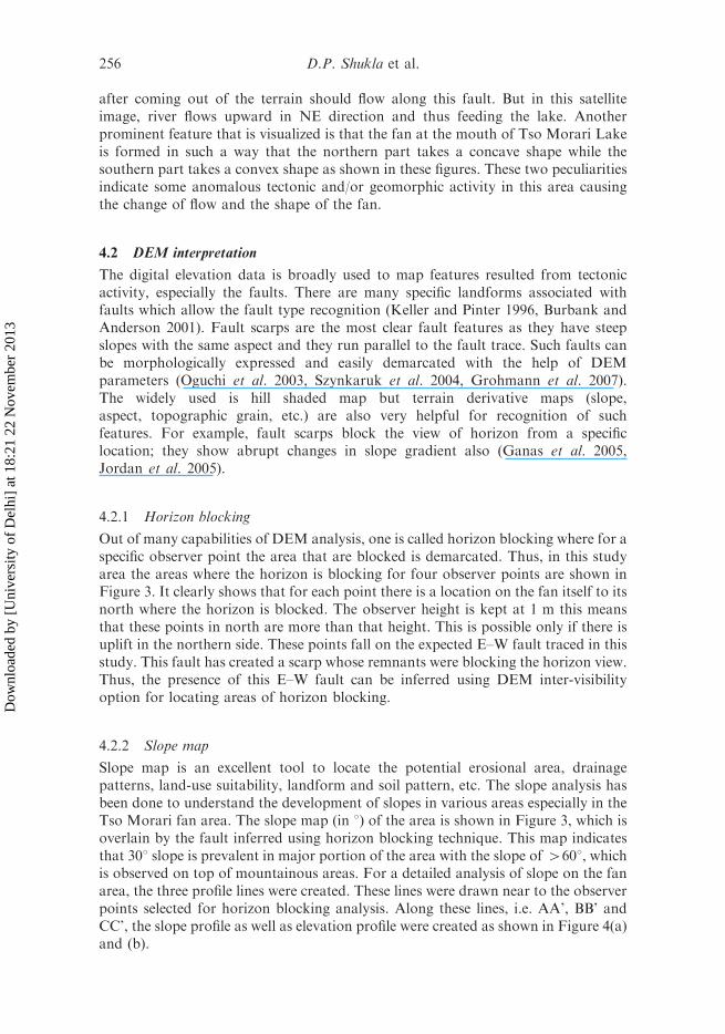
4.2.1 Horizon blocking
Out of many capabilities of DEM analysis, one is called horizon blocking where for aspecific observer point the area that are blocked is demarcated. Thus, in this studyarea the areas where the horizon is blocking for four observer points are shown inFigure 3. It clearly shows that for each point there is a location on the fan itself to itsnorth where the horizon is blocked. The observer height is kept at 1 m this meansthat these points in north are more than that height. This is possible only if there isuplift in the northern side. These points fall on the expected E–W fault traced in thisstudy. This fault has created a scarp whose remnants were blocking the horizon view.Thus, the presence of this E–W fault can be inferred using DEM inter-visibilityoption for locating areas of horizon blocking.
4.2.2 Slope map
Slope map is an excellent tool to locate the potential erosional area, drainagepatterns, land-use suitability, landform and soil pattern, etc. The slope analysis hasbeen done to understand the development of slopes in various areas especially in theTso Morari fan area. The slope map (in 8) of the area is shown in Figure 3, which isoverlain by the fault inferred using horizon blocking technique. This map indicatesthat 308 slope is prevalent in major portion of the area with the slope of 4608, whichis observed on top of mountainous areas. For a detailed analysis of slope on the fanarea, the three profile lines were created. These lines were drawn near to the observerpoints selected for horizon blocking analysis. Along these lines, i.e. AA’, BB’ andCC’, the slope profile as well as elevation profile were created as shown in Figure 4(a)and (b).
256 D.P. Shukla et al.
Dow
nloa
ded
by [
Uni
vers
ity o
f D
elhi
] at
18:
21 2
2 N
ovem
ber
2013
Figure 3. HorizonBlockingMapderived fromDEM, showing thehorizonblockedareas for thefour observer points situated on the fan of TsoMorari Lake fan. The observer height was kept at1 m. For each point there is a blockade in north probably due to fault scarp. Inset shows the slopemap of fan area and the three profile lines AA’, BB’ and CC’. (Detail description in text).
Geocarto International 257
Dow
nloa
ded
by [
Uni
vers
ity o
f D
elhi
] at
18:
21 2
2 N
ovem
ber
2013
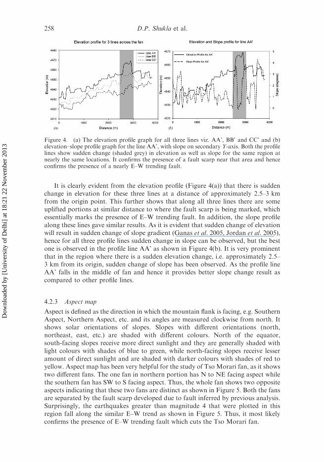
It is clearly evident from the elevation profile (Figure 4(a)) that there is suddenchange in elevation for these three lines at a distance of approximately 2.5–3 kmfrom the origin point. This further shows that along all three lines there are someuplifted portions at similar distance to where the fault scarp is being marked, whichessentially marks the presence of E–W trending fault. In addition, the slope profilealong these lines gave similar results. As it is evident that sudden change of elevationwill result in sudden change of slope gradient (Ganas et al. 2005, Jordan et al. 2005),hence for all three profile lines sudden change in slope can be observed, but the bestone is observed in the profile line AA’ as shown in Figure 4(b). It is very prominentthat in the region where there is a sudden elevation change, i.e. approximately 2.5–3 km from its origin, sudden change of slope has been observed. As the profile lineAA’ falls in the middle of fan and hence it provides better slope change result ascompared to other profile lines.
4.2.3 Aspect map
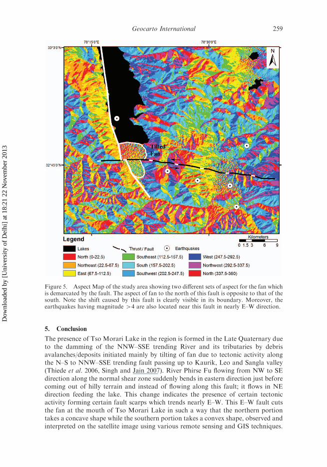
Aspect is defined as the direction in which the mountain flank is facing, e.g. SouthernAspect, Northern Aspect, etc. and its angles are measured clockwise from north. Itshows solar orientations of slopes. Slopes with different orientations (north,northeast, east, etc.) are shaded with different colours. North of the equator,south-facing slopes receive more direct sunlight and they are generally shaded withlight colours with shades of blue to green, while north-facing slopes receive lesseramount of direct sunlight and are shaded with darker colours with shades of red toyellow. Aspect map has been very helpful for the study of Tso Morari fan, as it showstwo different fans. The one fan in northern portion has N to NE facing aspect whilethe southern fan has SW to S facing aspect. Thus, the whole fan shows two oppositeaspects indicating that these two fans are distinct as shown in Figure 5. Both the fansare separated by the fault scarp developed due to fault inferred by previous analysis.Surprisingly, the earthquakes greater than magnitude 4 that were plotted in thisregion fall along the similar E–W trend as shown in Figure 5. Thus, it most likelyconfirms the presence of E–W trending fault which cuts the Tso Morari fan.
Figure 4. (a) The elevation profile graph for all three lines viz. AA’, BB’ and CC’ and (b)elevation–slope profile graph for the line AA’, with slope on secondary Y-axis. Both the profilelines show sudden change (shaded grey) in elevation as well as slope for the same region atnearly the same locations. It confirms the presence of a fault scarp near that area and henceconfirms the presence of a nearly E–W trending fault.
258 D.P. Shukla et al.
Dow
nloa
ded
by [
Uni
vers
ity o
f D
elhi
] at
18:
21 2
2 N
ovem
ber
2013
5. Conclusion
The presence of Tso Morari Lake in the region is formed in the Late Quaternary dueto the damming of the NNW–SSE trending River and its tributaries by debrisavalanches/deposits initiated mainly by tilting of fan due to tectonic activity alongthe N–S to NNW–SSE trending fault passing up to Kaurik, Leo and Sangla valley(Thiede et al. 2006, Singh and Jain 2007). River Phirse Fu flowing from NW to SEdirection along the normal shear zone suddenly bends in eastern direction just beforecoming out of hilly terrain and instead of flowing along this fault; it flows in NEdirection feeding the lake. This change indicates the presence of certain tectonicactivity forming certain fault scarps which trends nearly E–W. This E–W fault cutsthe fan at the mouth of Tso Morari Lake in such a way that the northern portiontakes a concave shape while the southern portion takes a convex shape, observed andinterpreted on the satellite image using various remote sensing and GIS techniques.
Figure 5. Aspect Map of the study area showing two different sets of aspect for the fan whichis demarcated by the fault. The aspect of fan to the north of this fault is opposite to that of thesouth. Note the shift caused by this fault is clearly visible in its boundary. Moreover, theearthquakes having magnitude 44 are also located near this fault in nearly E–W direction.
Geocarto International 259
Dow
nloa
ded
by [
Uni
vers
ity o
f D
elhi
] at
18:
21 2
2 N
ovem
ber
2013
The horizon blocking, slope and aspect map clearly indicate the presence of afault in nearly E–W direction. This fan seems to be divided into two parts, both ofwhose aspect is different as seen in the aspect map. This difference in the aspect ofboth these parts signifies the presence of a fault scarp at the intersection of these twoparts. The elevation profiles as well as the slope profile along three sections on thefan of the lake ascertain the presence of certain scarp where there is a sudden changeof elevation as well as degrees of slope. This E–W fault seems to be younger andactive and hence has caused the shift from N–S fault to NNW–SSE. The mapsderived from DEM depict the sinitral movement of the fault as shown in thesefigures. The moderate intensity (medium-sized) of earthquake activity havingmagnitude 44 (source USGS database) also lies nearly along the fault. It isimportant to note that most of the recent seismic activity is limited to south of thelake. The inferred fault seems to be younger and active and hence has displaced theN–S trending Tso Morari fault. The neotectonic activity in this region had developedthis E–W trending fault which has changed the course of the Phirse Fu river. It isenvisaged that this river earlier used to flow in SE direction but due to developmentof this fault it has changed its course and started flowing NE, thus providing water tothe lake. The deposition at the fan thus has two opposite aspects. Even in the satelliteimage, the northern part appears to have concave shape while the southern part hasconvex shape. This concave shape depicts that the flow process is continuouslyfluvial fed while convex shape depicts that the portion of fan is barred from suchfeeds. Hence, two fans having opposite aspect are formed due to development ofE–W fault caused by tectonic activity. Eventually, the water from the Phirse Fu riverflowing in NE direction starts accumulating and this magnificent Tso Morari Lake isformed. In future, the TL dating of the old tilted fan deposit and the younger newdeposit may reveal the age and stage wise development process of Tso Morari Lake.
Acknowledgements
The help and insight provided by teachers and colleagues of the department is duly recognisedand justified with this publication. The authors are grateful to Prof. Saumitra Mukherjee andProf. Santosh Kumar and anonymous journal reviewers for providing critical comments andsuggestions that improved the manuscript.
References
Arrowsmith, J.R., 2006. Active tectonics, tectonic geomorphology, and fault system dynamics:How geoinformatics can help. In: A.K Sinha, ed. Geoinformatics: data to knowledge:Geological society of America special paper, 397, 131–139, doi: 10.1130/2006.2397(09).
Berthelsen, A., 1953. On the geology of the Rupshu district, N.W. Himalaya: contribution tothe problem of the central gneisses. Bulletin of the Geological Society of Denmark(Meddelelser fra Dansk Geologisk Forening), 12, 350–414.
Bhargava, O.N., 1990. Holocene tectonics south of the Indus Suture, Lahul-LadakhHimalaya: a consequence of Indian plate motion. Tectonophysics, 174, 315–320.
Blisniuk, P.M., et al., 2001. Normal faulting in central Tibet since at least 13.5 Myr ago.Nature, 412, 628–632, doi: 10.1038/35088045.
Burbank, D.W. and Anderson, R.S., 2001. Tectonic geomorphology. Malden, MA: BlackwellSciences, 274.
Burchfiel, B.D., et al., 1992. The South Tibetan detachment system, Himalayan orogen:extension contemporaneous with and parallel to shortening in a collisional mountain belt.Geological Society of America Special Paper, 269, 1–41.
Burg, J.P. and Chen, G.M., 1984. Tectonics and structural zonation of southern Tibet. Nature,311, 219–223, doi: 10.1038/311219a0.
260 D.P. Shukla et al.
Dow
nloa
ded
by [
Uni
vers
ity o
f D
elhi
] at
18:
21 2
2 N
ovem
ber
2013
Coleman, M. and Hodges, K., 1995. Evidence for Tibetan Plateau uplift before 14-Myr Agofrom a new minimum age for east–west extension. Nature, 374, 49–52, doi: 10.1038/374049a0.
de Sigoyer, J., Guillot, S., and Dick, P., 2004. Exhumation of the ultrahigh-pressure TsoMorari unit in eastern Ladakh (NW Himalaya): a case study. Tectonics, 23, TC3003,doi:10.1029/2002TC001492.
Dumont, J.F., 1991. Fluvial shifting in the Ucamara Depression as related to the neotectonicsof the Andean foreland Brazilian Craton Border (Peru). Geodynamique, 6 (1), 9–20.
Dumont, J.F., 1993. Lake patterns as related to neotectonics in subsiding basins: the exampleof the Ucamara Depression, Peru. Tectonophysics, 222, 69–78.
Epard, J.L. and Steck, A., 2008. Structural development of the Tso Morari ultra-high pressurenappe of the Ladakh Himalaya. Tectonophysics, 451, 242–264.
Frank, W., et al., 1995. Geological map of the Kishtwar-Chamba-Kulu region (NWHimalayas, India). Vienna/A, Jahrbuch der Geologischen Bundesanstalt, 138, 299–308.
Fuchs, G. and Linner, M., 1996. On the geology of the suture zone and Tso Morari Dome inEastern Ladakh (Himalaya). Jahrbuch der Geologischen Bundesanstalt, Wien, 139, 191–207.
Ganas, A., Pavlides, S., and Karastathis, V., 2005. DEM-based morphometry of range-frontescarpments in Attica, central Greece, and its relation to fault slip rates. Geomorphology,65 (3–4), 301–319.
Gansser, A., 1964. Geology of the Himalayas. London: John Wiley, pp. 1–289.Garzanti, E., Baud, E., and Mascle, G., 1987. Sedimentary record of the northward flight of
India and its collision with Eurasia (Ladakh Himalaya, India). Geodynamica Acta, 1,297–312.
Grohmann, C.H., Riccomini, C., and Alves, F.M., 2007. SRTM-based morphotectonicanalysis of the Poc-os de Caldas Alkaline Massif, southeastern Brazil. Computers &Geosciences, 33, 10–19, doi:10.1016/j.cageo.2006.05.002.
Guth, P.L., 2003. Terrain organisation calculated from digital elevation models. In: I.S. Evanset al., eds. Concepts and modelling in geomorphology: international perspectives. Tokyo:Terrapub Publishers, 199–220. Available from: http://www.terrapub.co.jp/e-library/ohmori/pdf/199.pdf [Accessed 28 November 2011].
Hodges, K.V., 2000. Tectonics of the Himalaya and southern Tibet from two perspectives.Geological Society of America Bulletin, 112, 324–350.
Honegger, K.H., et al., 1982. Magmatism and metamorphism in the Ladakh Himalayas(Indus- Tsangpo suture zone). Earth and Planetary Science Letters, 60, 253–292.
Jordan, G., 2003. Morphometric analysis and tectonic interpretation of digital terrain data: acase study. Earth Surface Processes and Landforms, 28 (8), 807–822.
Jordan, G., et al., 2005. Extraction of morphotectonic features from DEMs: development andapplications for study areas in Hungary and NW Greece. International Journal of AppliedEarth Observation and Geoinformation, 7, 163–182.
Keller, E.A. and Pinter, N., 1996. Active tectonics: earthquakes, uplift and landforms. NewJersey: Prentice Hall.
Khan, S.D. and Mahmood, K., 2008. The application of remote sensing techniques to thestudy of ophiolites. Earth Science Reviews, 89, 135–143, doi:10.1016/j.earscirev.2008.04.004.
Le Fort, P., 1975. Himalayas–collided range – Present knowledge of continental arc. AmericanJournal of Science, A275, 1.
Mascle, G.H., et al., 1986. Structure et evolution des bassins d’episuture et de perisuture lies ala chaıne Himalayenne. BCREDP, 10, 181–203.
Molnar, P. and Lyon-Caen, H., 1989. Fault plane solutions of earthquakes and activetectonics of the Tibetan Plateau and its margins. Geophysical Journal International, 99,123–153.
Molnar, P. and Tapponnier, P., 1978. Active tectonics of Tibet. Journal of GeophysicalResearch, 83, 5361–5375.
Murphy, M.A. and Copeland, P., 2005. Transtensional deformation in the central Himalayaand its role in accommodating growth of the Himalayan orogen. Tectonics, 24 (4), TC4012.
Murphy, M.A., et al., 1999. Southward propagation of the Karakoram fault system intosouthwest Tibet: timing and magnitude of slip. Geology, 27, 719–722.
Geocarto International 261
Dow
nloa
ded
by [
Uni
vers
ity o
f D
elhi
] at
18:
21 2
2 N
ovem
ber
2013
Ni, J. and Barazangi, M., 1984. Seismotectonics of the Himalayan collision zone – geometry ofthe underthrusting Indian plate beneath the Himalaya. Journal of Geophysical Research,89, 1147–1163.
Ni, J. and Barazangi, M., 1985. Active tectonics of the western Tethyan Himalaya above theunderthrusting Indian plate – the Upper Sutlej River Basin as a pull-apart structure.Tectonophysics, 112, 277–295, doi: 10.1016/0040–1951(85)90183–0.
Oguchi, T., Aoki, T., and Matsuta, N., 2003. Identification of an active fault in the JapaneseAlps from DEM-based hill shading. Computers & Geosciences, 29 (7), 885–891.
Phartiyal, B., et al., 2005. Quaternary geology, tectonics and distribution of palaeo- andpresent fluvio/glacio lacustrine deposits in Ladakh, NW Indian Himalaya – a study basedon field observations. Geomorphology, 65 (3–4), 241–256.
Philip, G. and Mathew, J., 2005. Climato-tectonic impression on Trans Himalayan lakes: acase study of Kyon Tso basin of the Indus Suture Zone in NW Himalaya using remotesensing techniques. Current Science, 89 (11), 1941–1947.
Philip, G. and Mazari, R.K., 2000. Shrinking lake basins in the proximity of the Indus SutureZone of northwestern Himalaya: a case study of Tso Kar and Startsapuk Tso, using 1RS–1C data. International Journal of Remote Sensing, 21 (16), 2973–2984.
Scharer, U., Hamet, J.U., and Allegre, C.J., 1984. The Transhimalaya (gangdese) plutonism inthe Ladakh region: a U–Pb and Rb–Sr study. Earth and Planetary Science Letters, 67,327–339.
Schlup, M., et al., 2003. Exhumation history of eastern Ladakh revealed by Ar- 40/Ar–39 andfission-track ages: The Indus River–Tso Morari transect, NW Himalaya. GeologicalSociety [London] Journal, 160, 385–399.
Singh, S. and Jain, A.K., 2007. Liquefaction and fluidization of lacustrine deposits fromLahaul-Spiti and Ladakh Himalaya: geological evidences of paleoseismicity along activefault zone, Sedimentary Geology, 196, 47–57.
Steck, A., 2003. Geology of the NW Indian Himalaya. Eclogae Geologicae Helvetiae, 96 (2),147–196.
Steck, A., et al., 1998. Geological transect across the Tso Morari and Spiti areas: the nappestructures of the Tethys Himalaya. Eclogae Geologicae Helvetiae, 91, 103–121.
Sternberg, H.O.R., 1950. Vales tectonicas na planicie amazonicas? Revista Brasileira deGeografia, 4, 511–534.
Stoliczka, F., 1865. Geological sections across the Himalayan Mountains. Memoirs of theGeological Survey of India (Calcutta), 5, 1–154.
Szynkaruk, E., Graduno-Monroy, V.H., and Bocco, G., 2004. Active fault systems andtectono-topographic configuration of the central Trans-Mexican Volcanic Belt. Geomor-phology, 61 (1–2), 111–126.
Taylor, M., et al., 2003. Conjugate strike-slip faulting along the Bangong- Nujiang suture zoneaccommodates coeval east–west extension and north–south shortening in the interior ofthe Tibetan Plateau. Tectonics, 22, 1044.
Thakur, V.C., 1983. Deformation and metamorphism of the Tso Morari crystalline complex.In: V.C. Thakur and K.K. Sharma, eds. Geology of Indus suture zone of Ladakh. DehraDun: Wadia Institute of Himalayan Geology, 1–18.
Thakur, V.C. and Misra, D.K., 1984. Tectonic framework of the Indus and Shyok suturezones in Eastern Ladakh, Northwest Himalaya. Tectonophysics, 101, 207–220.
Thakur, V.C. and Virdi, N.S., 1979. Lithostratigraphy, structural framework, deformationand metamorphism of the southeastern region of Ladakh, Kashmir Himalaya, India.Himalayan Geology, 9, 63–78.
Thiede, R.C., et al., 2006. Dome formation and extension in the Tethyan Himalaya, LeoPargil, northwest India. Geological Society of America, 118, 635–650.
Weinberg, R.F. and Dunlap, W.J., 2000. Growth and deformation of the Ladakh batholith,northwest Himalayas: implications for timing of continental collision and origin of calc-alkaline batholiths. Journal of Geology, 108, 303–320.
Yin, A., 2006. Cenozoic tectonic evolution of the Himalayan orogen as constrained by along-strike variation of structural geometry, exhumation history, and foreland sedimentation.Earth Science Reviews, 76, 1–131.
262 D.P. Shukla et al.
Dow
nloa
ded
by [
Uni
vers
ity o
f D
elhi
] at
18:
21 2
2 N
ovem
ber
2013
Related Documents