TS 44 – Financing Affordable Housing Hani Rezayan, Farid Karimipour, Jalal Amini and Amir Mohammed Toosi TS44.3 Neighborhoods Development in Real Estate Appraisal Process From Pharaohs to Geoinformatics FIG Working Week 2005 and GSDI-8 Cairo, Egypt April 16-21, 2005 1/11 Neighborhoods Development in Real Estate Appraisal Process Hani REZAYAN, Farid KARIMIPOUR, Jalal AMINI and Amir Mohammad TOOSI, Iran Key words: Mass Appraisal, Kohonen self organizing feature map neural network SUMMARY The main approach in real estate appraisal process is finding comparable properties for value estimation known as sales comparison or market approach. It is done defining a search area through segmentation of market into some neighborhoods and then the mentioned comparable properties are selected in. Accomplishing this, further processes are carried out with some adjustment which could be done by any people more or less. Estimating the value for a dwelling by this approach (fee appraisal), could be extended, using the modern computer technology, for many dwellings at once which is known as mass appraisal. As the mass appraisal requires some level of automation, automated valuation models, which mainly tried to provide a fully automatic approach, were developed. Deficiencies of these approaches resulted in definition and utilization of partial solutions. This paper experienced such a solution using the Kohonen self organizing feature map neural networks automating the most crucial step of mass appraisal known as neighborhoods development, which will be resulted in generation of a value map for part of Tehran, the capital of Iran. This map could bring some level of coordination and corporation in Tehran real estate market as it can be used by different parties to carry out fee appraisal more effectively.

Welcome message from author
This document is posted to help you gain knowledge. Please leave a comment to let me know what you think about it! Share it to your friends and learn new things together.
Transcript
TS 44 – Financing Affordable Housing Hani Rezayan, Farid Karimipour, Jalal Amini and Amir Mohammed Toosi TS44.3 Neighborhoods Development in Real Estate Appraisal Process From Pharaohs to Geoinformatics FIG Working Week 2005 and GSDI-8 Cairo, Egypt April 16-21, 2005
1/11
Neighborhoods Development in Real Estate Appraisal Process
Hani REZAYAN, Farid KARIMIPOUR, Jalal AMINI and Amir Mohammad TOOSI, Iran
Key words: Mass Appraisal, Kohonen self organizing feature map neural network SUMMARY
The main approach in real estate appraisal process is finding comparable properties for value estimation known as sales comparison or market approach. It is done defining a search area through segmentation of market into some neighborhoods and then the mentioned comparable properties are selected in. Accomplishing this, further processes are carried out with some adjustment which could be done by any people more or less. Estimating the value for a dwelling by this approach (fee appraisal), could be extended, using the modern computer technology, for many dwellings at once which is known as mass appraisal. As the mass appraisal requires some level of automation, automated valuation models, which mainly tried to provide a fully automatic approach, were developed. Deficiencies of these approaches resulted in definition and utilization of partial solutions. This paper experienced such a solution using the Kohonen self organizing feature map neural networks automating the most crucial step of mass appraisal known as neighborhoods development, which will be resulted in generation of a value map for part of Tehran, the capital of Iran. This map could bring some level of coordination and corporation in Tehran real estate market as it can be used by different parties to carry out fee appraisal more effectively.
TS 44 – Financing Affordable Housing Hani Rezayan, Farid Karimipour, Jalal Amini and Amir Mohammed Toosi TS44.3 Neighborhoods Development in Real Estate Appraisal Process From Pharaohs to Geoinformatics FIG Working Week 2005 and GSDI-8 Cairo, Egypt April 16-21, 2005
2/11
Neighborhoods Development in Real Estate Appraisal Process
Hani REZAYAN, Farid KARIMIPOUR, Jalal AMINI and Amir Mohammad TOOSI, Iran
1. INTRODUCTION
Real estate appraisal is the action of judging the market value of land and its improvements, which is usually done by expert appraisers. The market value plays an important rule in land management. It almost participates in any land-human interactions like formulation of land policy, land development and land use plans preparation, land market management, land taxation and urban management. Then the market value would be comprehensive and reliable enough to serve all these multidisciplinary activities effectively. Appraisers deal with the estimation of market value by gathering related data as much as possible, integrating them on the basis of land, as the common factor, and finally carrying out the analysis using methods and experiences.
Besides the above mentioned importance of the value market and assessment of this value, the appraisal is a high frequency activity which has to be done within a short period of time. Then a continuing pressure has been exerted to speed up this process. Automated valuation models/machines (AVM's), are significant products of this trend. While a manual appraisal takes days to derive a market value, AVMs can deal with it in a few seconds.
Basically, AVM is a database that tries to match up similar properties producing the range of recorded sales prices. Similar to manual appraisal, AVM is more or less a subjective measure. Then each AVM, its estimated values, and confidence scores would be unique and different from other AVMs. The subjectivity of AVMs is intensified as they mainly use artificial neural networks (ANNs) approaches, despite the considerable level of automation and specificity they provided for AVMs. Due to this subjectivity, high level of dissatisfactions are created against AVMs which threat their further evolution and applicability, especially in developing societies (e.g. Tehran, the capital of Iran) that suffer from lack of successful experiences in real estate appraisal.
This paper investigates the objectiveness could be provided in AVMs using ANNs and GIS capabilities. It is a part of a research which is still in progress by dept. of surveying and geomatics eng. of Tehran University on development of a conceptual framework for real estate market of Tehran. In sections 2 and 3 a brief review of real estate mass appraisal and the automations created through development of AVMs is presented. Section 4 provides the proposed methodology as usage of KSOFM and GIS for deriving a valuation map. Section 5 illustrates the related issues about applying the methodology for part of Tehran and analyzing the results. Finally the general conclusions are presented in section 6.
2. REAL ESTATE APPRAISAL
Real estate appraisal process is usually categorized into two approaches based on the domain of properties entered in as fee appraisal and mass appraisal. In the former just one property is undertaken and an ad hoc appraisal process is carried out by an appraiser. However, the latter deals with a group of properties and try to estimate their values together by using a systematic

TS 44 – Financing Affordable Housing Hani Rezayan, Farid Karimipour, Jalal Amini and Amir Mohammed Toosi TS44.3 Neighborhoods Development in Real Estate Appraisal Process From Pharaohs to Geoinformatics FIG Working Week 2005 and GSDI-8 Cairo, Egypt April 16-21, 2005
3/11
process (Error! Reference source not found.). While AVMs are implemented on the basis of the second, it will be considered in continue here. Figure 1 shows the steps of a general mass appraisal process.
Figure 1. General trend of mass appraisal (Extracted from Error! Reference source not found.)
Figure 1 demonstrates the mass appraisal process as a collection of data access, exploration (mining), documentation, selection, modeling, adjustment, and prediction under full administration of an expert appraiser.
In step 3, the required basis for execution of sales comparison approach is prepared by analyzing the effect of each data elements on value and classifying the space (market) known as segmentation.
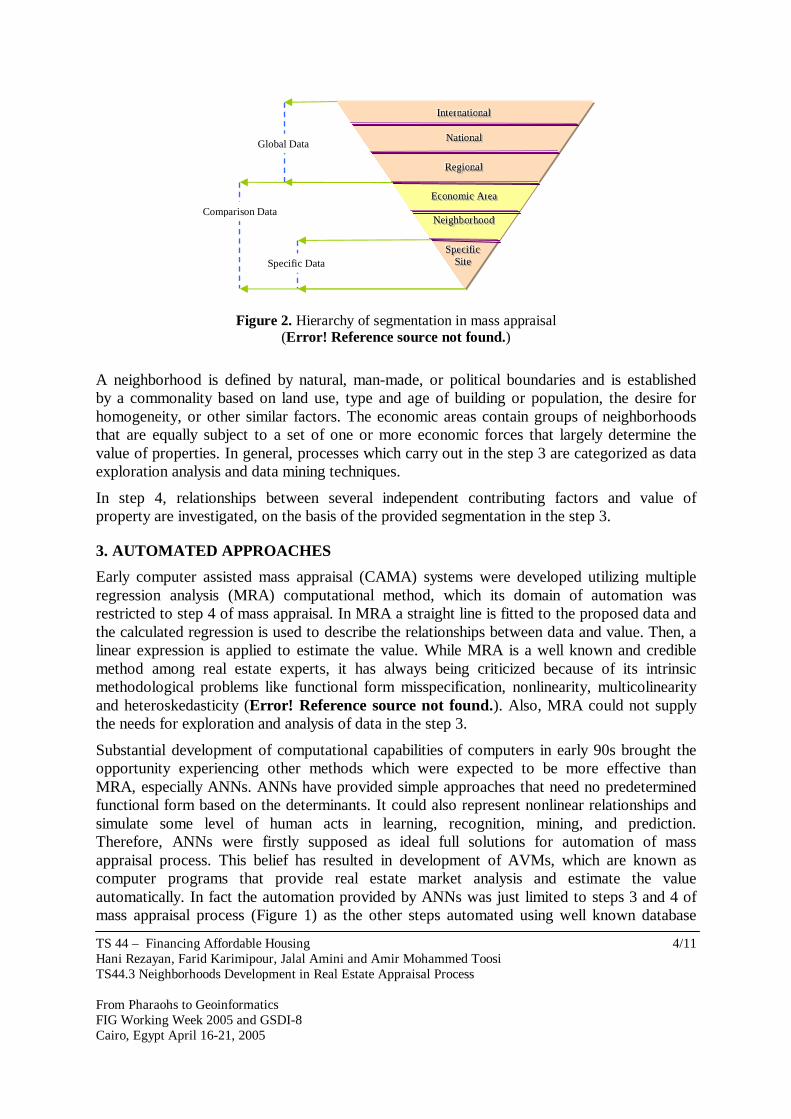
The segmentation is usually resulted in stratification of space into specific sites, neighborhoods, economic areas, regional, national, and global levels as depicted in Figure 2. Each level of this hierarchy consists of one or more of its lower levels’ components. Among these, neighborhood and economic area levels are the most important levels as they have direct effect on value.
1. Problem Definition
Start
2. Preliminary Survey and Planning
3. Data Collection and Analysis
4. Application of the approach to value
5. Estimated value reconciliation
6. Finalize Estimation
• Land Site Identification
• Property rights involved
• Property usage determination
• Value estimation approach definition
• Segmentation (esp. Neighborhoods definition)
• Comparable properties determination
• Adjustment
• Value estimation/prediction
• Documentation
• Consultation with stakeholders
TS 44 – Financing Affordable Housing Hani Rezayan, Farid Karimipour, Jalal Amini and Amir Mohammed Toosi TS44.3 Neighborhoods Development in Real Estate Appraisal Process From Pharaohs to Geoinformatics FIG Working Week 2005 and GSDI-8 Cairo, Egypt April 16-21, 2005
4/11
Figure 2. Hierarchy of segmentation in mass appraisal (Error! Reference source not found.)
A neighborhood is defined by natural, man-made, or political boundaries and is established by a commonality based on land use, type and age of building or population, the desire for homogeneity, or other similar factors. The economic areas contain groups of neighborhoods that are equally subject to a set of one or more economic forces that largely determine the value of properties. In general, processes which carry out in the step 3 are categorized as data exploration analysis and data mining techniques.
In step 4, relationships between several independent contributing factors and value of property are investigated, on the basis of the provided segmentation in the step 3.
3. AUTOMATED APPROACHES
Early computer assisted mass appraisal (CAMA) systems were developed utilizing multiple regression analysis (MRA) computational method, which its domain of automation was restricted to step 4 of mass appraisal. In MRA a straight line is fitted to the proposed data and the calculated regression is used to describe the relationships between data and value. Then, a linear expression is applied to estimate the value. While MRA is a well known and credible method among real estate experts, it has always being criticized because of its intrinsic methodological problems like functional form misspecification, nonlinearity, multicolinearity and heteroskedasticity (Error! Reference source not found.). Also, MRA could not supply the needs for exploration and analysis of data in the step 3.
Substantial development of computational capabilities of computers in early 90s brought the opportunity experiencing other methods which were expected to be more effective than MRA, especially ANNs. ANNs have provided simple approaches that need no predetermined functional form based on the determinants. It could also represent nonlinear relationships and simulate some level of human acts in learning, recognition, mining, and prediction. Therefore, ANNs were firstly supposed as ideal full solutions for automation of mass appraisal process. This belief has resulted in development of AVMs, which are known as computer programs that provide real estate market analysis and estimate the value automatically. In fact the automation provided by ANNs was just limited to steps 3 and 4 of mass appraisal process (Figure 1) as the other steps automated using well known database
SSSppp eee ccciii fff iii ccc SSSiii ttt eee
NNN eeeiii ggghhh bbb ooorrr hhhooo ooo ddd
EEEccc ooonnn ooo mmmiii ccc AAA rrreeeaaa
RRReee gggiii ooonnnaaa lll
NNN aaa ttt iiiooo nnnaaa lll
IIInnnttt eeerrr nnnaaa ttt iii ooonnnaaa lll
Global Data
Comparison Data
Specific Data
TS 44 – Financing Affordable Housing Hani Rezayan, Farid Karimipour, Jalal Amini and Amir Mohammed Toosi TS44.3 Neighborhoods Development in Real Estate Appraisal Process From Pharaohs to Geoinformatics FIG Working Week 2005 and GSDI-8 Cairo, Egypt April 16-21, 2005
5/11
manipulation methods. At first, the ANNs capabilities in weighting the factors and predicting the value (the step 4) was applied more than their capabilities in exploration and segmentation (the step 3). Therefore, the feed-forward back-propagation networks were usually adopted in AVMs.
Various researches were carried out within the 1990s comparing ANNs and MRA. Some of these were focused on justifying ANNs superiority through determination of nonlinear relationships between factors used in appraisal and value, as Do and Grudinitski (1992) investigated nonlinear relationship between age and value of a land. Along these, some other papers like Worzala et al. (1995) introduced ANNs as an unstable, not easy to use method. Therefore, while there is a great deal of literature about use of ANNs for mass appraisal, there is relatively little work on how it can be applied in real estate forecasting (Error! Reference source not found.). Also various studies offered improvements to MRA data models through utilization of nonlinear functional forms like semi-log and log-log which their relevant references are mentioned in Nguyen and Cripps (2001). They went further to explain why previous researches have obtained varied result comparing MRA and ANNs in 108 scenario in which training size of input data and ANN types were different. They concluded that ANNs perform better than MRA just when standard back propagation neural networks and sufficient and qualified training size are used.
Considering these and the more reliability and comprehensibility of MRA than ANNs, MRA is still the dominant method in the step 4. Investigating the capabilities of ANNs in providing the requirements of the step 3, we faced with issues of market segmentation which requires effective handling of location factor. Toosi et al. (2005) presented a detailed review of the recent researches on market segmentation. They introduced Kauko (2002) and Carlson (2002) in utilization of Kohonen self organizing feature map (KSOFM) neural networks that both confirm the suitability of these KSOFM for effective utilization of spatial factors in market segmentation.
Leaving spatial factors definition and utilization to local knowledge and experiences of appraisers results in unstable real estate market. Therefore geographic information systems (GISs) are highlighted as the systems which could provide the required objectiveness by development of a common basis for convergence of appraisers' valuation (Error! Reference source not found.; Error! Reference source not found.; Error! Reference source not found.; Error! Reference source not found.; Error! Reference source not found.). Knowing that dealing with location requires considerations about handling topology, the importance of GIS would be specified more.
Rodriguez et al. (1994) experienced GIS in derivation of accessibility factors as distance variables, using shortest path algorithm, and modeled values by a logarithmic MRA. They introduced the significance of realistic spatial factors derived by GIS comparing their results to traditional approaches, which were based on calculation for accessibility factors as straight-line distance.
Debbis et al. (2000) presented an approach for augmentation of spatial factors in regression utilizing GIS capabilities. They used some interpolation options (inverse distance weighting and kriging) as regressors to develop neighborhoods and visualized their results on a triangulated irregular network (TIN). They discussed GIS capabilities in clustering (market
TS 44 – Financing Affordable Housing Hani Rezayan, Farid Karimipour, Jalal Amini and Amir Mohammed Toosi TS44.3 Neighborhoods Development in Real Estate Appraisal Process From Pharaohs to Geoinformatics FIG Working Week 2005 and GSDI-8 Cairo, Egypt April 16-21, 2005
6/11
segmentation) and pointed that GIS could be integrated into CAMAs and create an environment that could interact with real applications (e.g. urban planning) better.
In recent papers, utilization of GIS in provision of more objective spatial factors, models, and outputs is continuing. Yomralioglu and Nisanci (2004) presented a nominal approach which deals with value definition by deriving out some qualitative and quantitative characteristics of properties using GIS. So property values are assigned by the numerical parameters rather than market values. They produced map that enables anyone to estimate values by knowing the market value of one relevant property.
Despite the mentioned benefits of GIS, it has to be pointed out that GIS does not appear to be used in the corporate real estate community as extensively as one may expect (Error! Reference source not found.). While corporations used GIS have gained considerable successes, this situation could be interpreted as non applicability of many researches as mentioned before, lack of GIS education in this community (especially in small organizations) and some level of restraining forces exit against changes in real estate appraisers community (Error! Reference source not found.).
4. METHODOLOGY
Considering the real estate appraisal situation in developing societies, which most of them suffer from lack of organized structure, qualified experts, and datasets, the recommended approach would be dealing with provision of some level of improvements and automation avoiding substantial changes in traditional methods and models used (esp. usage of MRA).
The lack of basic statistical and socio-economical data and reliable market values could be overcame by effective utilization of spatial factors have to be extracted from existing spatial datasets like topographic and cadastral databases. Besides, KSOFMs are proposed handling these factors due to accomplishment of the step 3 of mass appraisal process (Figure 3).
KSOFMs could learn to recognize groups of similar input vectors in such a way that neurons physically near each other respond similarly as their neighborhoods. KSOFMs are classified as competitive networks which learn by Kohonen learning rule towards updating the closest weight vector and its neighbors to an input. This learning process will result in adjustment of weights to clusters of inputs and delineation of the required similarity. Dealing with these networks considerations definition have to be proposed about effective training epochs by controlling the gradual reduction of learning rate and neighborhood radius.
The results provided by Kauko (2002) are followed in this paper for definition of the desired KSOFM. Then a two dimensional KSOFM with hexagonal cells is proposed. The number of neurons will be determined by calculation of an overall estimation about the number of clusters in data defined using K-Mean approach, a trade-off between the required resolution, generalization, and existing related segmentations (e.g. Census districts). Then the dimensions of network (rows and columns) will be defined asymmetrically based on the extent of our case study.
The proposed spatial factors for this research are supplied basic services; access to street; street frontage; currently usable area; distance to educational centers; distance to health services; religious places; play gardens; recreational areas; access to highway; available
TS 44 – Financing Affordable Housing Hani Rezayan, Farid Karimipour, Jalal Amini and Amir Mohammed Toosi TS44.3 Neighborhoods Development in Real Estate Appraisal Process From Pharaohs to Geoinformatics FIG Working Week 2005 and GSDI-8 Cairo, Egypt April 16-21, 2005
7/11
utilities and topography. These data were generated through GIS based approaches using the GIS’s embedded algorithms like point in polygon, polygon in polygon and network analysis. In regards with extraction of network related factors two scenarios were adopted for close and far targets modeling walking and driving agents respectively.
The output of feeding data into the designed KSOFM will be a map which presents comparable dwellings, considering the mentioned issues about the required contiguity and homogeneity for neighborhoods resulted from segmentation. This could be exploited by different sectors defining their relevant dwellings values, knowing market value of at least one of the similar dwellings mapped. Also, the visual presentation of this map and the KSOFM of delineated submarkets could be interpreted due to some a priori knowledge about features like urban administrative districts and census districts.
5. CASE STUDY
The proposed methodology is applied for Tehran, the capital of Iran, as one of the developing societies which challenges with serious defects because of its poor real estate appraisal. It is a metropolitan with about 7 million populations being sprawled unevenly. The lack of effective planning highly affected the development of this city. Adopting a formal collaboration could easily become a real trouble in this city. In regards with real estate appraisal these problems could be outlined clearly as no formal widely accepted real estate appraisal board, no reliable dataset, and not enough successful experiences. In fact no specific land market is distinguished here too.
The methodology is applied for part of Tehran which contains about 6000 dwellings spread into about 20 census districts. These data were extracted from 1:2,000 planimetric maps, produced by Iranian national cartographic center (NCC). Then required spatial factors were calculated within a GIS environment.
Besides, 40 neurons were proposed for the network considering the result of using K-Mean approach and the mentioned existing segmentation developed by Statistical Center of Iran (SCI) as census districts. Then an asymmetric 8×5 network constructed for analysis. This hexagonal network was trained by data extracted from the 6,000 dwelling.
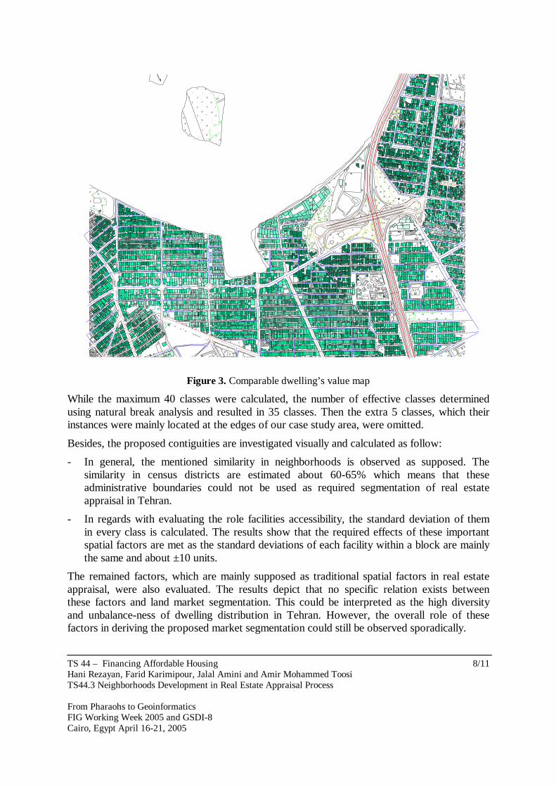
The training executed in two phase as ordering and tuning phase. Training began by 0.9 learning rate within first 1000 epochs (ordering phase) and continued the remaining epochs with 0.02 learning rate and 1 neighborhood distance for 6500 epochs (tuning phase) which is defined as the sum of row and width of network multiplied by 500 (13*500). The trained network is fed and simulated by the mentioned dwelling and their relevant winner neurons are defined. The resulted network was classified and transformed to a map shown in figure 3.
TS 44 – Financing Affordable Housing Hani Rezayan, Farid Karimipour, Jalal Amini and Amir Mohammed Toosi TS44.3 Neighborhoods Development in Real Estate Appraisal Process From Pharaohs to Geoinformatics FIG Working Week 2005 and GSDI-8 Cairo, Egypt April 16-21, 2005
8/11
#
#
#
#
Figure 3. Comparable dwelling’s value map
While the maximum 40 classes were calculated, the number of effective classes determined using natural break analysis and resulted in 35 classes. Then the extra 5 classes, which their instances were mainly located at the edges of our case study area, were omitted.
Besides, the proposed contiguities are investigated visually and calculated as follow:
- In general, the mentioned similarity in neighborhoods is observed as supposed. The similarity in census districts are estimated about 60-65% which means that these administrative boundaries could not be used as required segmentation of real estate appraisal in Tehran.
- In regards with evaluating the role facilities accessibility, the standard deviation of them in every class is calculated. The results show that the required effects of these important spatial factors are met as the standard deviations of each facility within a block are mainly the same and about ±10 units.
The remained factors, which are mainly supposed as traditional spatial factors in real estate appraisal, were also evaluated. The results depict that no specific relation exists between these factors and land market segmentation. This could be interpreted as the high diversity and unbalance-ness of dwelling distribution in Tehran. However, the overall role of these factors in deriving the proposed market segmentation could still be observed sporadically.
TS 44 – Financing Affordable Housing Hani Rezayan, Farid Karimipour, Jalal Amini and Amir Mohammed Toosi TS44.3 Neighborhoods Development in Real Estate Appraisal Process From Pharaohs to Geoinformatics FIG Working Week 2005 and GSDI-8 Cairo, Egypt April 16-21, 2005
9/11
6. CONCLUSION This research is conducted as a pilot study dealing with overcoming deficiencies caused by a poor land market in Tehran, the capital of Iran. A straight approach is introduced as development of a value map using ANNs as a partial solution for market segmentation. The results would be justifiable and applicable within Iranian real estate appraisers’ community as the least changes are exerted in their current activities. We believe that existence of such a value map and its general utilization would create an opportunity, through generation of a level of common sense, to establish an organized real estate valuation board in Tehran.
Our AVMs have to be modified towards utilization of more objective factors in different steps of mass appraisal process too. Then more effective and comprehensive contribution of GISs has to be followed by different stakeholders in real estate markets.
However, still further tests in different old and new parts of Tehran have to be carried out to derive more precise evaluation of the provided model sensitivity and generalize it. REFERENCES Carlson, E., 2002, Kohonen Map, GIS and the Analysis of Real Estate Sales, FIG XXII
International Congress, Washington, D.C. USA, April 19-26, 2002. Debbis, W.G., Lamont, I.G. and McCluskey, W.J., 2000, the Application of spatially derived
location factors within a GIS environment, Proceedings of: Integrating GIS and CAMA Conference, Miami, pp 132-141, 2000.
Division of Property Taxation of Colorado, 2004, Land Valuation Manual, Division of Property Taxation of Colorado, published in January 1989 and revised in January 2004.
Do, A.Q. and Grudinitski, G., 1993, A Neural Network Analysis of the Effect of Age on Housing Values, Journal of Real Estate Research, Volume 8, No. 2, 1993, pp. 253-264.
Fryrear, R., Prill E. and Worzala, M., 2001, The Use of Geographic Information Systems by Corporate Real Estate, Journal of Real Estate Research, Volume 22, No. 2, 2001, pp. 153-164.
González M.A.S. and Formoso C.T., 2003, Mass Appraisal with Genetic Fuzzy Rule-Based Systems, 10th European Real Estate Society Conference, Helsinki, Finland, 10-13 June 2003.
Kauko, T., 2002, Modeling the Locational Determinants of House Prices: Neural Network and Value Tree Approaches, Ph.D. thesis, Utrecht University, Netherland, 2002.
Nguyen, N. and A. Cripps, 2001, Predicting Housing Value: A Comprason of Multiple Regression Analysis and Artificial Neural Netwrks, Journal of Real Estate Research, Volume 22, No. 3, 2001, pp. 313-336.
Rodriguez, M., Sirmans, C.F. and Marks, A.P., 1995, Using Geographic Information System to Improve Real Estate Analysis, Journal of Real Estate Research, Volume 10, No. 2, 1995, pp. 163-173.
Rossini, P., 2000, Using Expert Systems and Artificial Intelligence for Real Estate Forcastin, Sixth Annual Pacific-Rim Real Estate Society Conference, Sydney, Australia, 24-27 January, 2000.

TS 44 – Financing Affordable Housing Hani Rezayan, Farid Karimipour, Jalal Amini and Amir Mohammed Toosi TS44.3 Neighborhoods Development in Real Estate Appraisal Process From Pharaohs to Geoinformatics FIG Working Week 2005 and GSDI-8 Cairo, Egypt April 16-21, 2005
10/11
Toosi, A., M.R. Delavar, and H. Rezayan, 2005, Upgrading urban plan production process using GIS: Case study- production of land value data layer, FIG Conference, Cairo, Egypt April 16-21, 2005.
Worzala, E., Lenk M. and Silva A., 1995, An Exploration of Neural Networks and Its Application to Real Estate Valuation, Journal of Real Estate Research, Volume 10, No. 2, 1995, pp. 185-202.
Yomralioglu, T. and Nisanci, R., 2004, Nominal Asset Land Valuation Technique by GIS, FIG Working Week, Athens, Greece, May 22-27, 2004.
BIOGRAPHICAL NOTES Hani Rezayan is now PhD student at Dept. of Surveying and Geomatics Eng., University of Tehran, He has obtained his M.Sc. in GIS and B.Sc. in Surveying from University of Tehran. His research interest is SDI and Urban GIS.
Farid Karimipour is now M.Sc. student at Dept. of Surveying and Geomatics Eng., University of Tehran, He has obtained his B.Sc. in Surveying from University of Tehran. His research interest is Urban GIS.
Jalal Amini has obtained his PhD in photogrametry from University of Tehran in 2001. He is now Assistant Professor in the Dept. of Surveying and Geomatics Eng., University of Tehran. His research interests are in artificial intelligence, digital terrain modeling, and computer graphic.
Amir Mohammad Toosi is now M.Sc. student at Dept. of Surveying and Geomatics Eng., University of Tehran, He has obtained his B.Sc. in Surveying from University of K.N. Toosi. His research interest is Urban GIS.
CONTACTS Hani Rezayan Dept. of Dept. of Surveying and Geomatics Eng., Eng. Faculty, University of Tehran Amir-Abad Ave. Tehran Tehran IRAN Tel. +98 912 223 6486 Fax +98 21 800 88 37 Email [email protected] Farid Karimipour Dept. of Surveying and Geomatics Eng., Eng. Faculty, University of Tehran Amir-Abad Ave. Tehran Tehran IRAN Tel. +98 912 122 7967 Fax +98 21 889 43 56 Email [email protected]

TS 44 – Financing Affordable Housing Hani Rezayan, Farid Karimipour, Jalal Amini and Amir Mohammed Toosi TS44.3 Neighborhoods Development in Real Estate Appraisal Process From Pharaohs to Geoinformatics FIG Working Week 2005 and GSDI-8 Cairo, Egypt April 16-21, 2005
11/11
Jalal Amini Dept. of Surveying and Geomatics Eng., Eng. Faculty, University of Tehran Amir-Abad Ave. Tehran Tehran IRAN Tel. +98 912 340 61 04 Fax +98 21 800 88 37 Email [email protected] Amir Mohammad Toosi Dept. of Surveying and Geomatics Eng., Eng. Faculty, University of Tehran. Amir-Abad Ave. Tehran Tehran IRAN Tel. +98 912 122 7967 Fax +98 21 889 43 56 Email [email protected]
Related Documents