NEARSHORE SEDIMENT DISTRIBUTION, SOUTH TARAWA, KIRIBATI Bruce M Richmond October 1990 * CCOP/SOPAC Technical Report 91 *Editor's note: field work for this report was carried out in late 1985 and interpretation carried out over the next three years. Finalising the report for publication was delayed after the author left Techsec in 1989. There are no original photographs available. Prepared for: South Pacific Applied Geoscience Commission (SOPAC) Coastal and Nearshore Programme, Kiribati Project: KI.6

Welcome message from author
This document is posted to help you gain knowledge. Please leave a comment to let me know what you think about it! Share it to your friends and learn new things together.
Transcript
NEARSHORE SEDIMENT DISTRIBUTION, SOUTH TARAWA, KIRIBATI
Bruce M Richmond
October 1990 * CCOP/SOPAC Technical Report 91
*Editor's note: field work for this report was carried out in late 1985 and interpretation carried out over the next three years. Finalising the report for publication was delayed after the author left Techsec in 1989. There are no original photographs available.
Prepared for: South Pacific Applied Geoscience Commission (SOPAC) Coastal and Nearshore Programme, Kiribati Project: KI.6
[3]
TABLE OF CONTENTS
Page SUMMARY ............................................................................................................ 5
INTRODUCTION
Previous Studies ......................................................................................... 6
METHODS
Participating Personnel .......................................................................... 7 Equipment and Facilities .............................................................................. 7
Data Compilation ...................................................................................... 7
RESULTS
Summary of Textural Studies ....................................................................... 10 Sand ................................................................................................. 10 Mud .................................................................................................. 13
Gravel 13
Vertical Distribution of Sediments ................................................................... 16 ..................................................................................................
DISCUSSION Depositional Environments and Construction Materials .............................. 18
Ocean Reef Front ....................................................................... 18 Ocean Reef Flats ............................................................................ 18 Islets ................................................................................................... 21 Lagoon Reef Flats ........................................................................ 21 Patch Reefs ............................................................................. 21 Lagoon Bed .................................................................................... 24 Leeward (Western) Reef Rim ......................................................... 24
RECOMMENDATIONS AND CONCLUSIONS ................................................. 26
REFERENCES CITED ........................................................................................... 27
APPENDIX Surface sediment - sample descriptions ...................................................... 29
[TR91 - Richmond]

[4]
LIST OF FIGURES AND TABLE
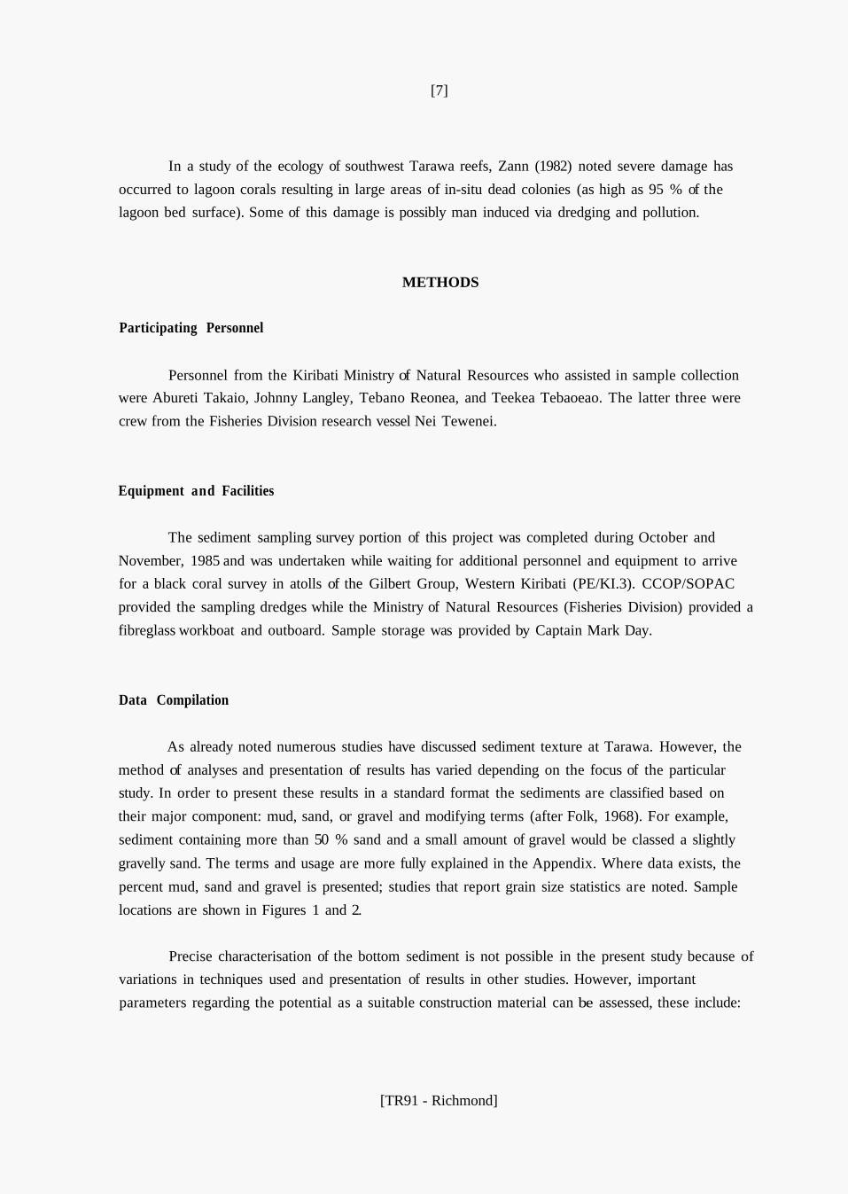
Figure Page 1 Surface sediment samples, Tarawa Lagoon ............................................ 8 2 Sediment samples, Betio-Bairiki ......................................................... 9 3 Surface sediment distribution, Tarawa Lagoon ...................................... 11
4 Surface sediment distribution, South Tarawa ............................................ 12
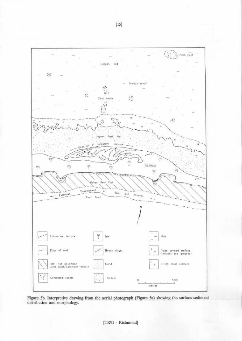
5b Interpretation of sediment distribution and morphology ........................ 15
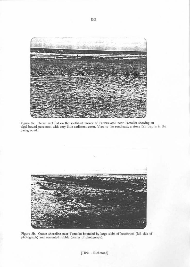
7 Schematic distribution, atoll facies and morphology ..................................... 19 8a Ocean reef flat, southeast Tarawa atoll ...................................................... 20
Windblown sand overlying sand and gravel near Temaiku ................. 9b Sandy shoreline of lagoon spits near Ambo ...................................... 22
10a Lagoon and borrow pit, Betio-Bairiki causeway construction ................ 23
5a Aerial photograph near Abarao, South Tarawa .......................................... 14
6 Hypothetical stratigraphic sections, South Tarawa ...................................... 17
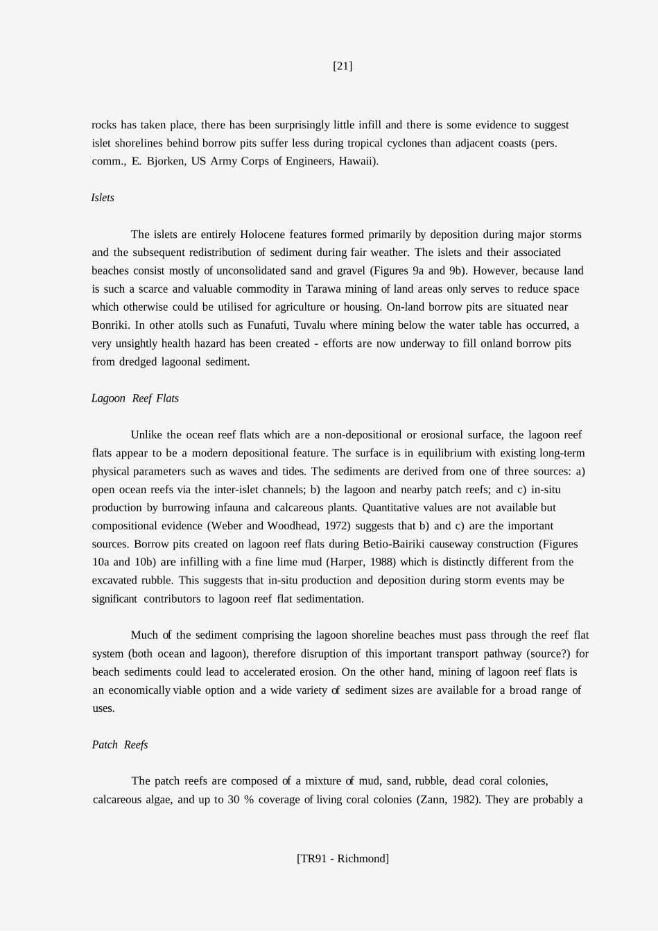
8b Beachrock slabs near Temaiku ............................................................... 20
9a 22
10b Sand and gravel excavated from lagoon ............................................... 23
Table 1 Depositional environments, construction materials, and
extraction techniques ......................................................................... 25
[TR91 - Richmond]
[5]
SUMMARY
Triangular-shaped Tarawa Atoll in western Kiribati is characterised by: well-developed islets on
the windward eastern and southern rims; a leeward western rim with reef passages and containing no islets; and, a moderately-deep lagoon (25 m) dotted by numerous patch reefs and coral pinnacles. Overall, sand-size material dominates the unconsolidated sediments of the atoll. Gravel is important on the islets, reef flats and upper levels of the patch reefs. Muds are widely distributed on the lagoon bed occurring in significant amounts in water depths as shallow as 5 m. Sediments of the atoll are
composed almost exclusively of biogenically derived calcium carbonate (minor amounts of silica are contributed by organisms such as diatoms and sponges).
Construction materials for the atoll are mined from the lagoon reef flat in the Betio-Bairiki Vicinity, on-land pits near Bonriki, and various small-scale sites throughout the atoll rim. The sediment is typically a slightly muddy gravelly-sand and is used in a wide variety of construction applications such as roading and fill.
In general the lagoon reef flats are a depositional surface with sediment thickness (a mixture of consolidated and unconsolidated material) in excess of 3 m. Conversely the ocean reef flats consist of an algal covered pavement of a non-depositional or erosional nature where sediment typically occurs as thin veneers. The pavement and associated cemented rocks are the best source of dense
rock for revetments and other uses. The reef flats are both a potential sediment source and important transport pathway for material being deposited on the islet beaches. Further studies are required to assess the impact of reef flat mining on coastal stability.
The patch reefs are a potential, essentially unlimited, source for construction materials that is
presently not utilised. They are separated from the islet littoral processes by deeper water, therefore mining on patch reefs should not affect coastal stability. However, higher extraction costs and a potential negative impact on fisheries and water clarity may limit their usefulness.
[TR91 - Richmond]
[6]
INTRODUCTION
This study was undertaken as part of SOPAC Work Programme KI.6: Investigation of nearshore and coastal areas for landfill and construction materials.
Rapid population growth and development in South Tarawa has increased the demand for landfill and construction materials of which there are limited on-land deposits. With continuing pressure on existing land for urban and agricultural development the need exists to identify alternative sand and gravel resources. A traditional source of sand are the beaches of Tarawa's coastline - a
practice that undoubtedly contributes to coastal erosion if sand is removed at a faster rate than it is replenished. Beaches act as a natural buffer between the land and sea - expanding and retreating in response to variations in the wave climate. As such, beaches are an important asset that should be
protected from over-exploitation. It is therefore important to understand the dynamic coastal system including the source of beach sediment, sediment transport pathways, and ultimate sediment sinks.
The purpose of the present study is threefold
a) b) c)
compile results of previous studies to help elucidate sediment distribution on Tarawa;
collect and analyse additional samples as required to supplement existing data; identify potential alternative source areas for sand and gravel resources.
Previous Studies
There have been numerous studies in Tarawa concerned with sediment types (Weber and Woodhead, 1972), beach composition and changes (Burne, 1983; Carter, 1983; Howorth, 1982 a & b; Harper, 1987, 1988) and engineering properties of the coastal zone (Gauss, 1982; Kiribati Government,
1969 and 1981).
Weber and Woodhead (1972) examined textural properties, mineralogical composition, and
biological diversity among lagoon and reef flat sediment (69 samples). Some of their findings were: a)
a westward coarsening of lagoon sediment; b) aragonite is the most abundant mineral component; and c) weathering of grains increases to the east making identification more difficult but the general trends for four different biological components are percent coral increasing to the west and percent Halimeda, mollusc, and echinoderm increasing towards the east. Halimeda fragments are the overall dominant component of the lagoon sediment.
[TR91 - Richmond]
[7]
In a study of the ecology of southwest Tarawa reefs, Zann (1982) noted severe damage has occurred to lagoon corals resulting in large areas of in-situ dead colonies (as high as 95 % of the lagoon bed surface). Some of this damage is possibly man induced via dredging and pollution.
METHODS
Participating Personnel
Personnel from the Kiribati Ministry of Natural Resources who assisted in sample collection were Abureti Takaio, Johnny Langley, Tebano Reonea, and Teekea Tebaoeao. The latter three were crew from the Fisheries Division research vessel Nei Tewenei.
Equipment and Facilities
The sediment sampling survey portion of this project was completed during October and November, 1985 and was undertaken while waiting for additional personnel and equipment to arrive for a black coral survey in atolls of the Gilbert Group, Western Kiribati (PE/KI.3). CCOP/SOPAC provided the sampling dredges while the Ministry of Natural Resources (Fisheries Division) provided a fibreglass workboat and outboard. Sample storage was provided by Captain Mark Day.
Data Compilation
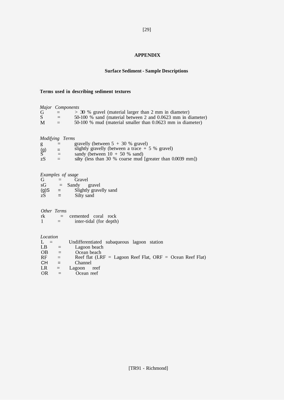
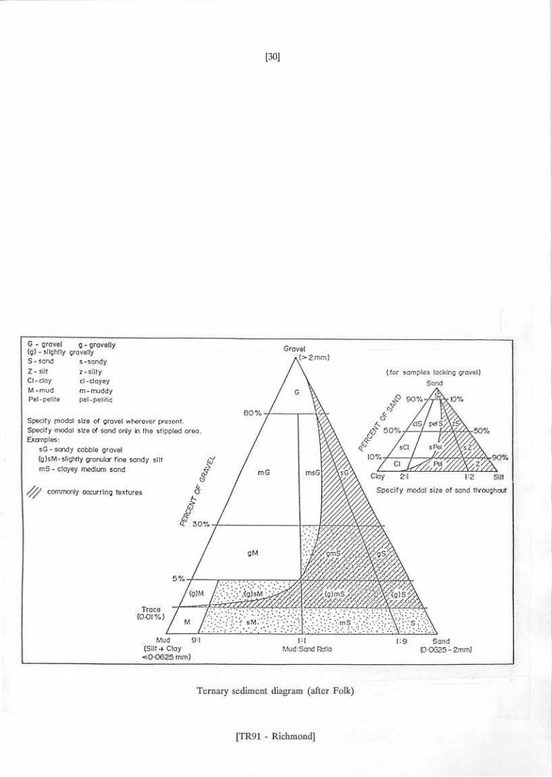
As already noted numerous studies have discussed sediment texture at Tarawa. However, the method of analyses and presentation of results has varied depending on the focus of the particular study. In order to present these results in a standard format the sediments are classified based on their major component: mud, sand, or gravel and modifying terms (after Folk, 1968). For example, sediment containing more than 50 % sand and a small amount of gravel would be classed a slightly
gravelly sand. The terms and usage are more fully explained in the Appendix. Where data exists, the percent mud, sand and gravel is presented; studies that report grain size statistics are noted. Sample locations are shown in Figures 1 and 2.
Precise characterisation of the bottom sediment is not possible in the present study because of
variations in techniques used and presentation of results in other studies. However, important parameters regarding the potential as a suitable construction material can be assessed, these include:
[TR91 - Richmond]

[10]
a) mud content - too much mud is undesirable in many construction applications and may cause excess water turbidity at the extraction site.
sand - the main constituent in most construction/fill applications. Sand beaches are therefore an attractive source, and offer easy extraction.
gravel - can be desirable as a fill component but potentially hazardous in offshore mining operations (for example gravel blockage in suction dredge machines). Coral gravel when crushed is a suitable base material for many roading applications.
b)
c)
RESULTS
Summary of Textural Studies
The generalised surficial sediment distribution for Tarawa is summarised in Figure 3; South Tarawa sediment distribution is shown in Figure 4. Four sediment facies are recognised: 1) Sand which has varying amounts of gravel and occurs mostly in subaerial and exposed intertidal and shallow subtidal locales; 2) A slightly gravelly silty-sand occurring mostly in open lagoon situations ; 3) A silty sand to sandy mud of protected lagoon bottoms; and 4) Pavement with sediment veneers on the ocean reef flats.
Sand and gravel compose most of the atoll rim sediment. Mud and sand dominate the lagoon bed although locally gravel content may be significant. Within the lagoon median grain size increases towards the west presumably because of greater exposure and more prolific coral growth. The southeast corner of the lagoon (Temaiku Bight) is an area of significant accumulation of fie-grained material.
Superimposed upon this generalised distribution are local variations due to such things as proximity to patch reefs and microclimatic effects. For example, lagoonal patch reefs and pinnacles support prolific benthic communities which provide a variety of sediment types to the immediate area.
In the southeastern lagoon the patch reefs are characterised as zones of coarse sediment accumulation in an area of predominantly mud deposition. Microclimatic effects may include topographic shielding of the lagoon bottom by reefs presumably resulting in coarser material on updrift margins and finer
material along the downdrift sides.
Sand
Sand is the dominant component of the unconsolidated sediment of the islets, reef flats, patch
reefs, and shallow lagoon floor. The sand is derived from the breakdown of skeletal components of
[TR91 - Richmond]


[13]
marine organisms and consists mostly of aragonite with lesser amounts of calcite (high-magnesium calcite much greater than low-magnesium calcite; Weber and Woodhead, 1972)). The sand-rich sediment tends to be moderately- to well-sorted on the beaches. Sorting gets poorer away from the beaches because of the increase in mud and gravel content. Beach sand is typically well-rounded and abraded.
Intertidal to supratidal sand bars occur on reef flats west of Betio, between Betio and Bairiki (now highly modified by causeway construction), and at numerous locations along the eastern atoll rim. Bikeman Island is a sand cay developed on a patch reef.
Mud
Significant amounts of lime mud, as much as 98 % are accumulating in deeper (>~10m)
lagoonal areas and in shallower (~5 m) areas of the protected southeast portion of the lagoon. In general mud content increases from west to east because of the sheltering effect of the atoll rim - the Temaiku Bight is protected from easterlie winds and appears to be a major depocenter of the lagoon. The mud appears to be of detrital origin (Weber and Woodhead, 1972) produced as the final breakdown product of skeletal material. The water throughout much of the lagoon is a turbid milky-white caused by the high suspended mud content. The upper sediment surface of the lagoon
muds typically has a soupy consistency.
Gravel
Because of difficulties obtaining accurate representative samples of gravel its abundance may be somewhat underestimated. Gravel-size material is composed mostly of the skeletal remains of coral colonies occuring both in-situ and as transported clasts. The other main gravel contributor are molluscs. Detrital gravel material is deposited on the reef flats, patch reefs, and off-reef slopes. In-situ production takes place wherever the organisms are living. The most significant gravel deposits form along oceanside reef flats as a result of major storms. Gravel ramparts several metres high and hundreds of metres long may be produced during a single event. The gravel, derived mainly from the reef front, is transported lagoonward during peak storm surge. Subsequent cementation has formed
conglomerate platforms (cemented rubble) on the oceanside reef flats. For construction purposes, these conglomerates represent the hardest rock of the atoll and can be broken into large blocks for revetments or similar uses.
Figure 5 illustrates surface sediment distribution and morphological features of a portion of the South Tarawa coastline near Abarao.
[TR91 - Richmond]


[16]
Vertical Distribution of Sediment
The vertical distribution of sediments at Tarawa is poorly known. However, some generalisations can be made using scattered core and borehole data, seismic profiles, and a
comparison with other, better studied atolls. The recent stratigraphy is conceptually summarised in Figure 6.
The oceanside reef flat is typically a pavement surface covered by a patchy veneer of sediments. This "reef plate" is probably only 1 m to 2 m thick and overlies a mixture of unconsolidated sediment interbedded with cemented reef rock and in-situ corals and coralline algae.
Underneath the islets a typical stratigraphy consists of the following sequence (after Marshall and Jacobson, 1985):
- unconsolidated sand and gravel - cemented reef top sediment
corals, primarily in growth position - limestone (pre-Holocene basement) -
The thickness of individual units is quite variable; depth to the limestone varies from about 10 m to 17 m. The thickness and hardness of near-surface cemented rock underneath the islets increases in an easterly direction (pers. comm., R. Howorth, CCOP/SOPAC; based on discussions with engineers involved with the South Tarawa sewerage scheme).
The lagoonside reef flats differ markedly from those of the oceanside. Sediments consisting of sand, gravel, traces of mud, interbedded with weakly consolidated layers occur to depths of 3 m or more (Kiribati Government, 1981). Borrow pits created on the lagoon reef flat for construction of the Betio-Bairiki causeway confirm the presence of 3 m or more of a mixture of relatively unconsolidated sediment and lightly cemented material (Harper, 1988).
Lagoonal boreholes (Kiribati Government, 1969, 1981) and high-resolution geophysical surveys
(Gauss, 1982) in the vicinity of the Betio-Bairiki causeway indicate the unconsolidated sediment thickness varies between about 1 m and at least 7.5 m. The sediment consists of a mixture of mud
(primarily silt), sand, and gravel (mostly coral heads). Constituent proportions vary dramatically over short distances and appear to be related to the proximity of patch reefs and pinnacles. Coarser material is produced at the reefs and finer material is accumulating away from the reefs.
Patch reefs and other reef structures (e.g. pinnacles and coral knolls) within the lagoon are
in-situ carbonate build-ups. Many of the larger structures are presumably underlain by Pleistocene limestone highs. Thickness of the Holocene cap on the patch reefs is unknown; seismic evidence
[TR91 - Richmond]
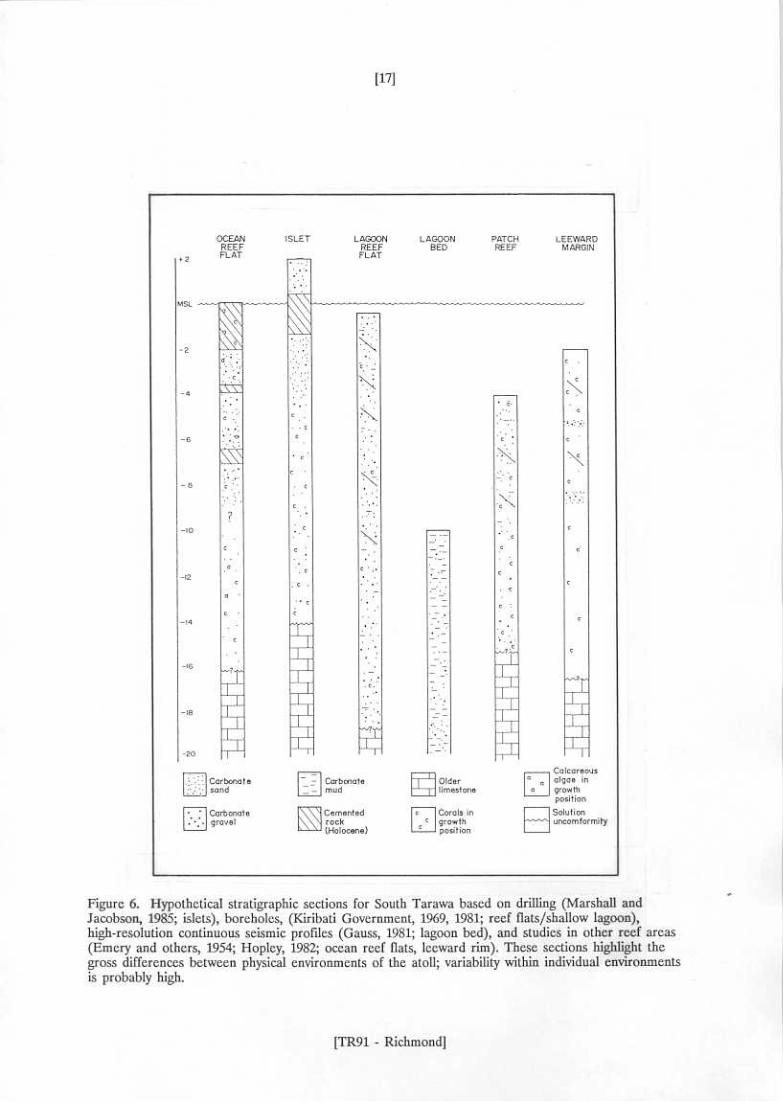
[18]
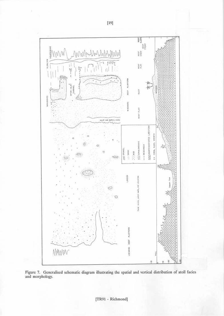
(Gauss, 1982) suggests a MINIMUM thickness of 5 m of undifferentiated coral rubble, sand, and scattered coral heads. The limestone basement morphology is in part probably derived from pre-Holocene karst processes. The western rim of the atoll is mostly living reef whose vertical growth is approaching mean sea level. It is presumably composed of in-situ coral colonies and associated organisms and sediment. Figure 7 is a generalised schematic diagram illustrating sediment distribution, both vertically and spatially, and morphology.
DISCUSSION
Depositional Environments and Construction Materials
Ocean Reef Front
Information concerning the Tarawa reef front is sparse (Zann, 1982). However, some generalisations can be made by comparison with other atoll reef fronts. Construction materials are limited to either: a) coral-gravel veneers of marine terraces (10 m to 20 m water depths); these are
the source materials for the storm-derived rubble ramparts; and b) sand and gravel channel-fill deposits. The channels act as conduits, receiving much of their material from the spur-and-groove zone by downslope movement and delivering sediments to upper-slope scree deposits. Occasionally the channels coalesce to form small fans on the marine terraces. Overall, construction material deposits
are probably not large and because of the open-ocean exposure mining along the reef front would require specialised equipment and anchoring systems. The reef front is not a viable site for construction materials at present.
Ocean Reef Flats
Characterised by a thin, patchy distribution of poorly-sorted sand and gravel overlying a cemented reef pavement the ocean reef flats appear to be a non-depositional or erosional surface at present (Figure 8a). Unconsolidated deposits are of limited extent and are the probable immediate
source for beach deposits along the ocean-facing shorelines; their removal could accelerate an already serious erosion problem (Howorth, 1982a, 1982b, 1983, 1984).
The ocean reef flats and shoreline headlands however are the best source of hard, dense, cemented rock (Figure 8b) for use in such applications as shoreline revetments. Others sources of cemented rock exist (for example lagoon reef flats and reefs) but the oceanside material is typically the hardest material of the atoll. Excavation of the reef pavement creates borrow pits which become potential sediment sinks. In atolls of the Marshall Islands, where mining of ocean reef flat cemented
[TR91 - Richmond]
[21]
rocks has taken place, there has been surprisingly little infill and there is some evidence to suggest islet shorelines behind borrow pits suffer less during tropical cyclones than adjacent coasts (pers. comm., E. Bjorken, US Army Corps of Engineers, Hawaii).
Islets
The islets are entirely Holocene features formed primarily by deposition during major storms and the subsequent redistribution of sediment during fair weather. The islets and their associated beaches consist mostly of unconsolidated sand and gravel (Figures 9a and 9b). However, because land is such a scarce and valuable commodity in Tarawa mining of land areas only serves to reduce space which otherwise could be utilised for agriculture or housing. On-land borrow pits are situated near Bonriki. In other atolls such as Funafuti, Tuvalu where mining below the water table has occurred, a very unsightly health hazard has been created - efforts are now underway to fill onland borrow pits from dredged lagoonal sediment.
Lagoon Reef Flats
Unlike the ocean reef flats which are a non-depositional or erosional surface, the lagoon reef flats appear to be a modern depositional feature. The surface is in equilibrium with existing long-term physical parameters such as waves and tides. The sediments are derived from one of three sources: a) open ocean reefs via the inter-islet channels; b) the lagoon and nearby patch reefs; and c) in-situ production by burrowing infauna and calcareous plants. Quantitative values are not available but compositional evidence (Weber and Woodhead, 1972) suggests that b) and c) are the important sources. Borrow pits created on lagoon reef flats during Betio-Bairiki causeway construction (Figures 10a and 10b) are infilling with a fine lime mud (Harper, 1988) which is distinctly different from the excavated rubble. This suggests that in-situ production and deposition during storm events may be
significant contributors to lagoon reef flat sedimentation.
Much of the sediment comprising the lagoon shoreline beaches must pass through the reef flat
system (both ocean and lagoon), therefore disruption of this important transport pathway (source?) for beach sediments could lead to accelerated erosion. On the other hand, mining of lagoon reef flats is an economically viable option and a wide variety of sediment sizes are available for a broad range of uses.
Patch Reefs
The patch reefs are composed of a mixture of mud, sand, rubble, dead coral colonies,
calcareous algae, and up to 30 % coverage of living coral colonies (Zann, 1982). They are probably a
[TR91 - Richmond]


[24]
significant source of sediment within the lagoon. There is a general downslope decrease in grain size and they are typically surrounded by an apron of off-reef sediments. The patch reefs are usually separated from the islet shorelines and lagoon reef flats by deeper water and are therefore probably detached from littoral processes affecting sedimentation of the islet coastlines. In other words the patch reefs and atoll rim features are parts of related but physically separated nearshore sedimentation cells. Therefore construction material excavation on patch reefs would probably have a minimal
physical impact on islet shoreline stability. However, potential for increased lagoonal turbidity and other biological consequences need further investigation.
Lagoon Bed
As noted by Weber and Woodhead (1972) the lagoon bed of Tarawa is mud-rich when compared to other atoll lagoons. Muddy sediments (up to 98 % mud) occur in relatively shallow water (~5 m in eastern reaches). In general there is an increase in median grain size and reduction in mud
content towards the west. The high mud content reduces the desirability of lagoon bed sediments for construction purposes as well as posing serious environmental concerns such as water turbidity at the dredge site.
Leeward (Western) Reef Rim
The submerged western rim is devoid of subaerial land masses and is dissected by reef passages. Zann (1982) described the surficial coverage of the southwestern rim which included up to 60 % live coral growth (average ~15 % - 30 %); channels filled with sand and rubble associated with the spur-and-grooves; dead standing coral (-10 % - 40 %); and up to 30 % calcareous algae (Halimeda) coverage. No extensive sediment bodies were described by Zann, however sand-filled channels are widespread west of Betio as interpreted from aerial photographs. Channel-till sands in this area are a potential construction material source but their relationship to reef flat sand bars and the Betio shoreline requires further examination. The possibility exists that during westerly conditions the western reefs supply sediment to the Betio littoral system.
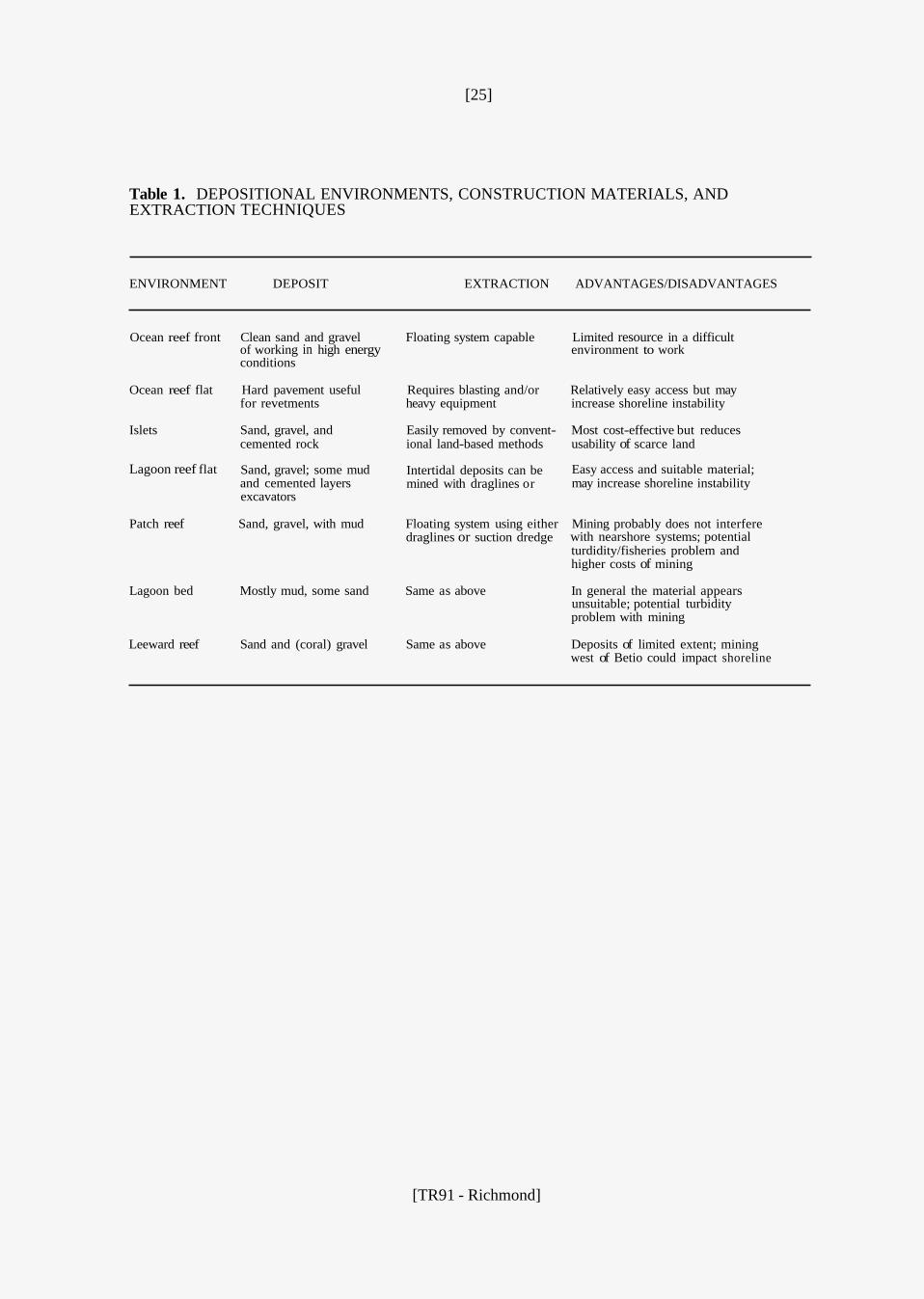
Depositional environments, their potential deposits, possible extraction techniques, and the advantages/disadvantages of mining in each environment are summarised in Table 1.
[TR91 - Richmond]
[25]
Table 1. DEPOSITIONAL ENVIRONMENTS, CONSTRUCTION MATERIALS, AND EXTRACTION TECHNIQUES
ENVIRONMENT DEPOSIT EXTRACTION ADVANTAGES/DISADVANTAGES
Ocean reef front Clean sand and gravel Floating system capable Limited resource in a difficult of working in high energy conditions
environment to work
Ocean reef flat Hard pavement useful Requires blasting and/or Relatively easy access but may for revetments heavy equipment increase shoreline instability
Islets Sand, gravel, and Easily removed by convent- Most cost-effective but reduces cemented rock ional land-based methods usability of scarce land
Sand, gravel; some mud and cemented layers excavators
Lagoon reef flat Intertidal deposits can be mined with draglines or
Easy access and suitable material; may increase shoreline instability
Patch reef Sand, gravel, with mud Floating system using either Mining probably does not interfere draglines or suction dredge with nearshore systems; potential
turdidity/fisheries problem and higher costs of mining
Lagoon bed Mostly mud, some sand Same as above In general the material appears unsuitable; potential turbidity problem with mining
Leeward reef Sand and (coral) gravel Same as above Deposits of limited extent; mining west of Betio could impact shoreline
[TR91 - Richmond]
[26]
RECOMMENDATIONS AND CONCLUSIONS
A. Construction materials on Tarawa are currently derived from one of three sources:
1) 2) 3)
reef flat borrow pits in the Betio - Bairiki area on-land borrow pits (near Bonriki) limited small-scale beach and land mining
B. Atolls are essentially accumulations of carbonate materials produced by reefs. Locating
potential construction material deposits is not difficult. The problem lies in finding deposits which are economically viable and whose extraction would cause the minimum amount of negative environmental impact.
C. valuable asset to the tourist industry and should be protected from over-exploitation. It is recommended that no beach mining be allowed.
Beaches act as a natural buffer, protecting the shoreline during storms. They are also a
D. viable option. The excavated material provides a variety of grain sizes for many construction applications. However, potential problems with reef flat mining include: a) the lagoon reef flats are
both an important source and pathway for sediment of the lagoon beaches; b) the rate of sediment production is unknown - it is important that the rate of extraction does not exceed the production rate; c) food items are gathered from the reef flats and these resources should be safeguarded.
With the equipment currently available in Tarawa, mining of the lagoon reef flat is the most
E. recommended further studies regarding resource potential be conducted in this area.
The Temaiku Bight area in southeast Tarawa appears to be an active sediment sink and it is
F. Higher costs could be offset by a reduction in negative environmental impact to coastal stability.
Consideration should be given to utilising patch reefs as a source for construction materials.
[TR91 - Richmond]
[27]
REFERENCES CITED
BURNE, R.V. 1983 Origin and transportation of Beach sand, Betio-Bairiki, Tarawa, Kiribati - July, 1983. CCOP/SOPAC Cruise Report 81. DRAFT
CARTER, R. 1983 Coastal erosion in Kiribati, 10-13 January, 1983. CCOP/SOPAC Cruise Report 76 25 pages, 34 figures, 5 tables.
EMERY, K.O.; TRACEY, J.I.; and LADD, H.S. 1954 Bikini and nearby atolls, Marshall Islands. US Geological Survey Professional Paper 260A: 265 pages.
FOLK, R.L. 1968: Petrology of Sedimentary Rocks. Hemphill's, Austin, Texas. 170 pages.
GAUSS, G.A. 1982 Nearshore surveys, Tarawa, Kiribati, 5 November - 23 December 1981. CCOP/SOPAC Cruise Report 6 3 8 pages, 2 appendices.
HARPER, J.R. 1987 Initial survey of the Betio/Bairiki causeway, Tarawa, Republic of Kiribati. CCOP/SOPAC Technical Report 82 34 pages, 13 figures, 3 tables, 2 appendices.
HARPER, J.R. 1989 Follow-upsurvey of the Betio-Bairiki causeway, Tarawa, republic of Kiribati. CCOP/SOPAC Technical Report 86 58 pages.
HOPLEY, D. 1982 The geomorphology of the Great Barrier Reef: Quaternary development of coral reefs. Wiley-Interscience, New York. 453 pages.
HOWORTH, R. 1982 Coastal erosion in Kiribati: visit to South Tarawa, 22 January - 10 February 1982. CCOP/SOPAC Technical Report 22: 13 pages, figures, 3 appendices.
HOWORTH, R. 1983 Coastal erosion in Kiribati: second visit to South Tarawa, 10-16 June 1982. CCOP/SOPAC Technical Report 25: 5 pages, 1 appendix
HOWORTH, R. 1984: Coastal erosion in Kiribati - visit to South Tarawa, September 1983. CCOP/SOPAC Technical Report 31: 22 pages, 3 appendices.
HYDRAULICS RESEARCH STATION, 1976 Gilbert Islands, Land reclamation, causeway construction, and sea defences. Hydraulics Research Station, Wallingford, England. Report EX727: 44 pages.
KIRIBATI GOVERNMENT, 1969; 1981: Reports on survey and site investigation for a causeway between Betio and Bairiki. Consulting Engineers (Complete references not available).
MARSHALL, J.F. and JACOBSON, G., 1985: Holocene growth of a mid-Pacific atoll: Tarawa Kiribati. Coral Reefs, 4: 11-17.
WEBER J.N. and WOODHEAD, P.M.J. 1972 Carbonate lagoon and beach sediments of Tarawa atoll, Gilbert Islands. Atoll Research Bulletin 157: 9 pages, 9 figures, 2 tables.
ZANN, L. 1982: Marine ecology on Betio Island, Tarawa Atoll, Republic of Kiribati, 5-18 November 1981. CCOP/SOPAC Technical Report 23: 2.5 pages, 9 figures, 4 appendices.
[TR91 - Richmond]
[29]
APPENDIX
Surface Sediment - Sample Descriptions
Terms used in describing sediment textures
Major Components G = S = M =
> 30 % gravel (material larger than 2 mm in diameter) 50-100 % sand (material between 2 and 0.0623 mm in diameter) 50-100 % mud (material smaller than 0.0623 mm in diameter)
Modifying Terms g = gravelly (between 5 + 30 % gravel) (g) = S = sandy (between 10 + 50 % sand) zS =
slightly gravelly (between a trace + 5 % gravel)
silty (less than 30 % coarse mud [greater than 0.0039 mm])
Examples of usage G = Gravel sG = Sandy gravel (g)S = Slightly gravelly sand zS = Silty sand
Other Terms rk = cemented coral rock 1 = inter-tidal (for depth)
Location L = Undifferentiated subaqueous lagoon station LB = Lagoon beach OB = Ocean beach RF = CH = Channel LR = Lagoon reef OR = Ocean reef
Reef flat (LRF = Lagoon Reef Flat, ORF = Ocean Reef Flat)
[TR91 - Richmond]
[31]
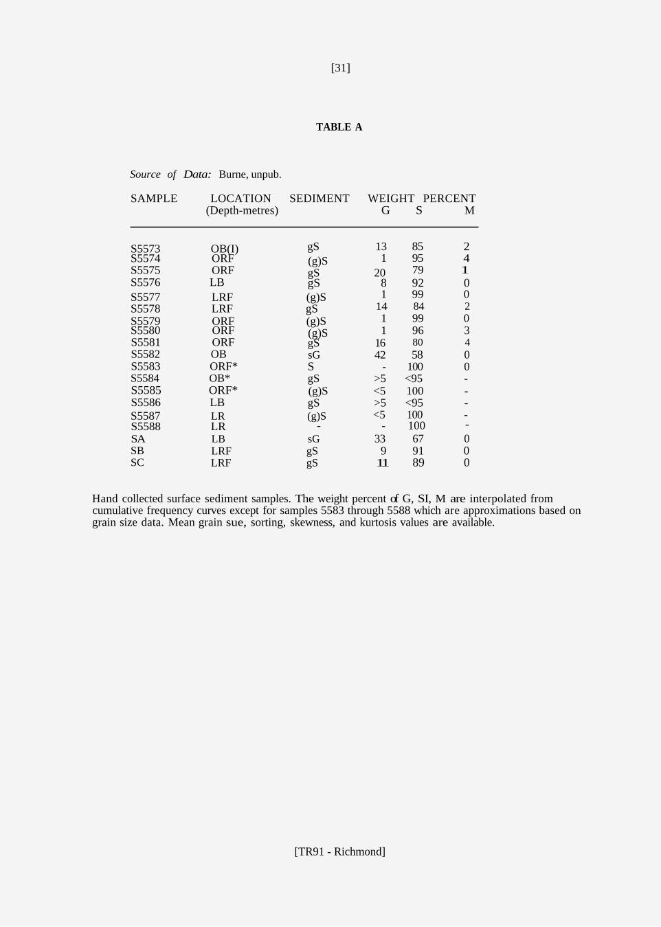
TABLE A
Source of Data: Burne, unpub.
SAMPLE LOCATION SEDIMENT WEIGHT PERCENT (Depth-metres) G S M
gS 13 85 2 1 95 4
S5573 OB(I)
79 1 S5574 ORF (g)S S5575 ORF gS 20 S5576 LB gS 8 92 0
1 99 0 14 84 2
S5577 LRF (g)S S5578 LRF gS
1 99 0 1 96 3
S5579 ORF (g)S
80 4 S5580 ORF (g)S S5581 ORF gS 16 S5582 OB sG 42 58 0 S5583 ORF* S - 100 0 S5584 OB* gS >5 <95 - S5585 ORF* (g)S <5 100 - S5586 LB gS >5 <95 - S5587 LR (g)S
SB LRF gS SC LRF gS
<5 100 - - - 100 S5588 LR -
SA LB sG 33 67 0 9 91 0
11 89 0
Hand collected surface sediment samples. The weight percent of G, SI, M are interpolated from cumulative frequency curves except for samples 5583 through 5588 which are approximations based on grain size data. Mean grain sue, sorting, skewness, and kurtosis values are available.
[TR91 - Richmond]

[32]
TABLE B
Source of Data: Carter, 1983
SAMPLE LOCATION SEDIMENT WEIGHT PERCENT (Depth-metres) G S M
3 96 1 6 94 0
1 LB (g)S 2 OB gS 3 OB sG 56 44 0
2 98 0 7 93 0
4 OB (g)S 5 LB gS
3 % 1 8 92 0
6 LB (g)S 7 LB gS 8 LB gS 6 94 0 9 LB gS 10 90 0
10 LB (g)S 4 96 0 11 OB (g)S 12 OB gS 13 OB gS 19 81 0 14 OB gS 7 93 0 15 OB gS 9 91 0 16 OB gS 12 88 0 17 OB gS 19 81 0 18 LB gS 25 75 0 19 LB gS 25 75 0
1 99 0 44 56 0
20 Ch(1.5) (g)S 21 Ch sGkl 22 - - - - -
1 99 0 15 85 0
23 OB (g)S 24 OB gS 25 OB gS 9 81 0 26 OB gS 9 81 0 27 OB gS 6 94 0 28 OB gS 27 73 0 29 OB gS 14 86 0 30 LB gS 22 78 0 31 LB gS 7 93 0 32 LB sG 31 69 0 33 LB gS 12 88 0 34 LB gS 4 96 0 35 LB gS 4 96 0 36 OB sG 45 55 0 37 OR S 0 100 0 38 OR S 0 99 0 39 RF gS 5 95 0
3 97 0 1 91 0
40 RF (g)S
0 100 0 41 L(7.0) (g)ZS
43 RF gS 6 94 0
3 97 0 16 84 0
42 RF S
Surface sediment samples of the beaches were composites of equal portions gathered at five equally spaced intervals from the toe of the beach to the berm crest. The weight percent of G, S & M were interpolated from the cumulative frequency diagrams. The samples were sieved at 1 phi intervals. Mean grain size, sorting and skewness parameters are available.
[TR91 - Richmond]
[33]
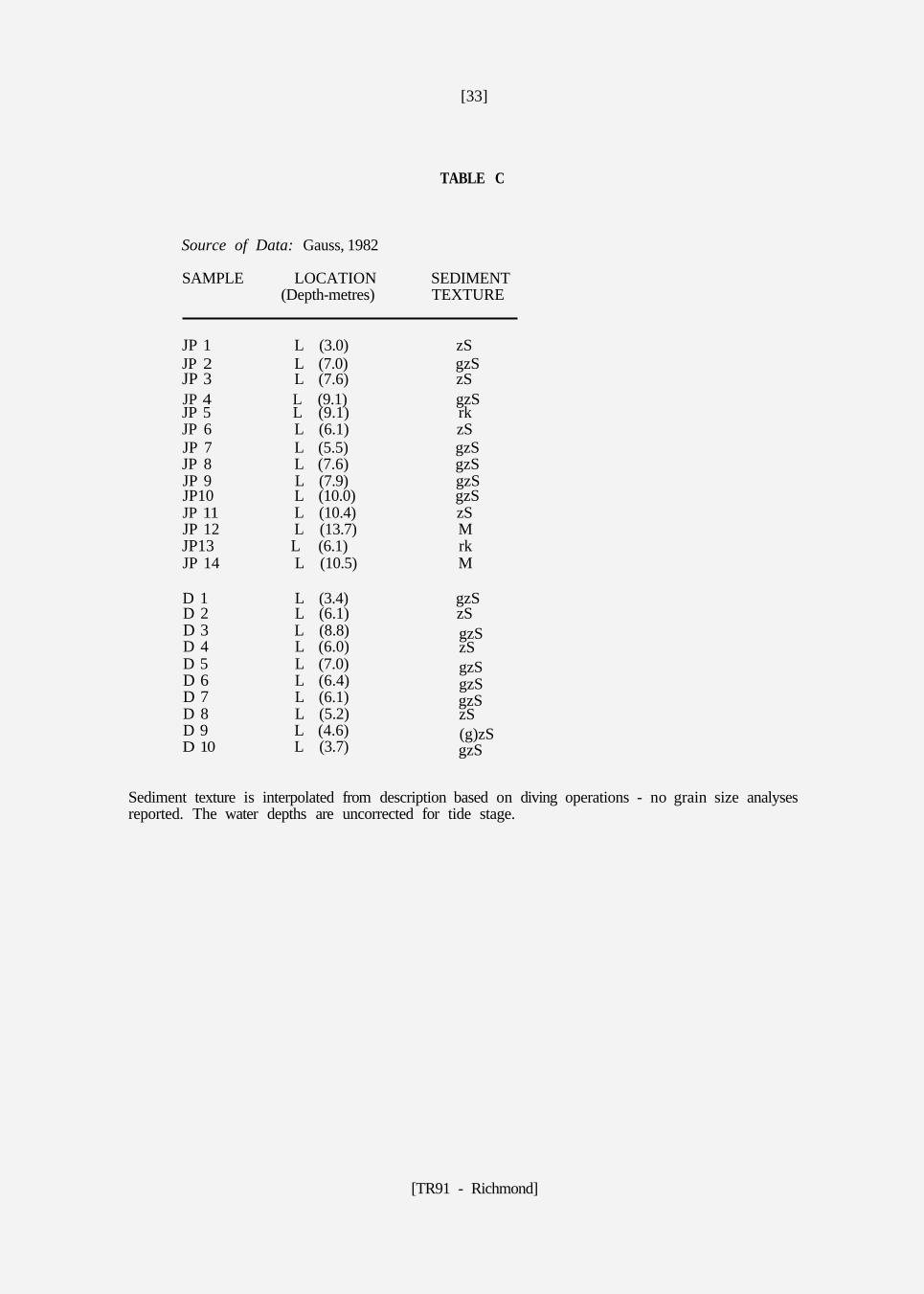
TABLE C
Source of Data: Gauss, 1982
SAMPLE LOCATION SEDIMENT (Depth-metres) TEXTURE
JP 1 L (3.0) zS JP 2 L (7.0) gzS JP 3 L (7.6) zS JP 4 L (9.1) gzS
JP 6 L (6.1) zS JP 7 L (5.5) gzS JP 8 L (7.6) gzS JP 9 L (7.9) gzS JP10 L (10.0) gzS JP 11 L (10.4) zS JP 12 L (13.7) M
JP 14 L (10.5) M
D 1 L (3.4) gzS D 2 L (6.1) zS D 3 L (8.8) gzS D 4 L (6.0) zS D 5 L (7.0) gzS D 6 L (6.4) gzS D 7 L (6.1) gzS D 8 L (5.2) zS D 9 L (4.6) (g)zS D 10 L (3.7) gzS
JP 5 L (9.1) rk
JP13 L (6.1) rk
Sediment texture is interpolated from description based on diving operations - no grain size analyses reported. The water depths are uncorrected for tide stage.
[TR91 - Richmond]
[34]
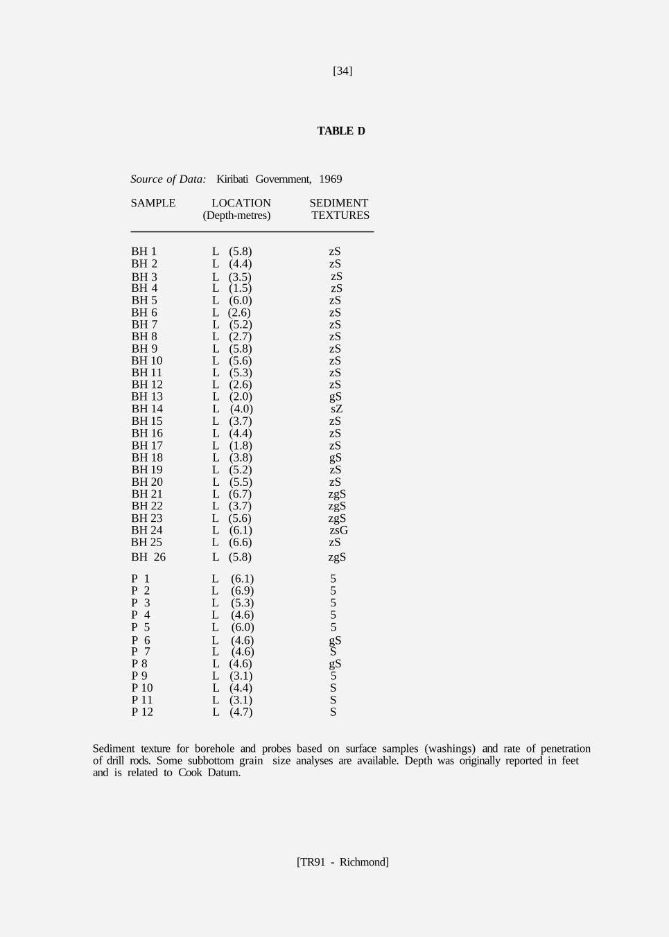
TABLE D
Source of Data: Kiribati Government, 1969
SAMPLE LOCATION SEDIMENT (Depth-metres) TEXTURES
BH 1 L (5.8) zS BH 2 L (4.4) zS BH 3 L (3.5) BH 4 L (1.5) BH 5 L (6.0) zS BH 6 L (2.6) zS BH 7 L (5.2) zS BH 8 L (2.7) zS BH 9 L (5.8) zS BH 10 L (5.6) zS BH 11 L (5.3) zS BH 12 L (2.6) zS BH 13 L (2.0) gS BH 14 L (4.0) sZ BH 15 L (3.7) zS BH 16 L (4.4) zS BH 17 L (1.8) zS BH 18 L (3.8) gS BH 19 L (5.2) zS BH 20 L (5.5) zS BH 21 L (6.7) zgS BH 22 L (3.7) zgS BH 23 L (5.6) zgS BH 24 L (6.1) zsG BH 25 L (6.6) zS BH 26 L (5.8) zgS
P 1 L (6.1) 5 P 2 L (6.9) 5 P 3 L (5.3) 5 P 4 L (4.6) 5 P 5 L (6.0) 5 P 6 L (4.6) gS P 7 L (4.6) S P 8 L (4.6) gS P 9 L (3.1) 5 P 10 L (4.4) S P 11 L (3.1) S P 12 L (4.7) S
zS zS
Sediment texture for borehole and probes based on surface samples (washings) and rate of penetration of drill rods. Some subbottom grain size analyses are available. Depth was originally reported in feet and is related to Cook Datum.
[TR91 - Richmond]
[35]
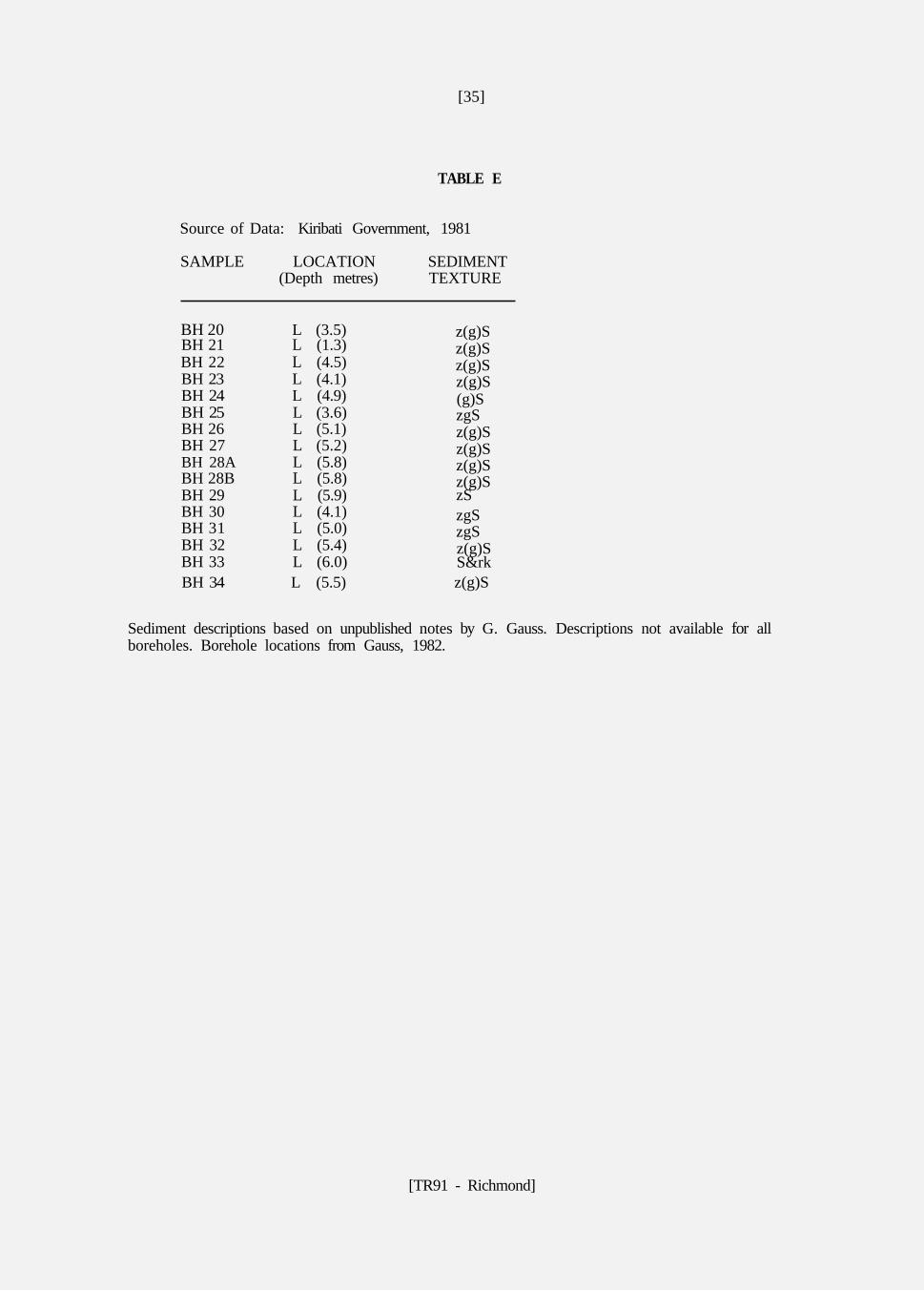
TABLE E
Source of Data: Kiribati Government, 1981
SAMPLE LOCATION SEDIMENT (Depth metres) TEXTURE
BH 20 L (3.5) z(g)S BH 21 L (1.3) z(g)S BH 22 L (4.5) z(g)S BH 23 L (4.1) z(g)S BH 24 L (4.9) (g)S BH 25 L (3.6) zgS BH 26 L (5.1) z(g)S BH 27 L (5.2) z(g)S BH 28A L (5.8) z(g)S BH 28B L (5.8) z(g)S BH 29 L (5.9) zS BH 30 L (4.1) zgS BH 31 L (5.0) zgS BH 32 L (5.4) z(g)S BH 33 L (6.0) S&rk BH 34 L (5.5) z(g)S
Sediment descriptions based on unpublished notes by G. Gauss. Descriptions not available for all boreholes. Borehole locations from Gauss, 1982.
[TR91 - Richmond]
[36]
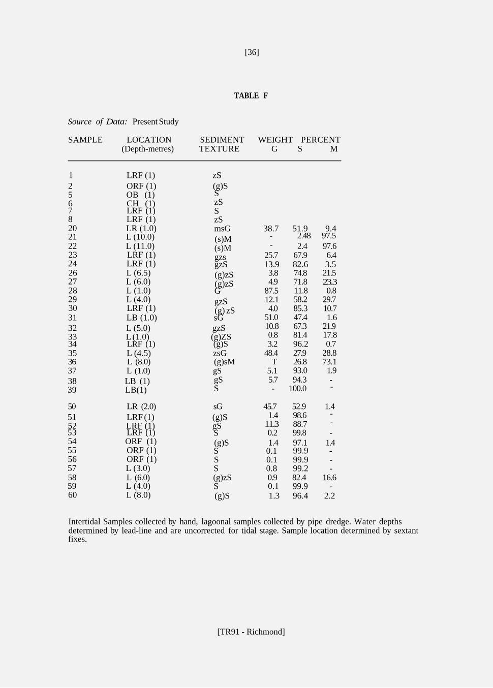
TABLE F
Source of Data: Present Study
SAMPLE LOCATION SEDIMENT WEIGHT PERCENT (Depth-metres) TEXTURE G S M
1 LRF (1) zS 2 ORF (1) (g)S 5 OB (1) 6 CH (1)
8 LRF (1) zS 20 LR (1.0) msG 38.7 51.9 9.4 21 L (10.0) (s)M 22 L (11.0) (s)M 23 LRF (1) gzs 24 LRF (1) gzS 13.9 82.6 3.5 26 L (6.5) (g)zS 27 L (6.0) (g)zS 28 L (1.0) G 29 L (4.0) gzS 30 LRF (1) (g) zS 31 LB (1.0) sG 32 L (5.0) gzS 33 L (1.0) (g)ZS
35 L (4.5) zsG
38 LB (1) 39 LB(1)
51 LRF (1) (g)S 52 LRF (1) gS
55 ORF (1) S 0.1 99.9 - 56 ORF (1) S 0.1 99.9 - 57 L (3.0) S 0.8 99.2 -
59 L (4.0) S 0.1 99.9 - 60 L (8.0) (g)S 1.3 96.4 2.2
S zS S 7 LRF (1)
- 2.48 97.5 2.4 97.6
25.7 67.9 6.4
3.8 74.8 21.5 4.9 71.8 23.3
87.5 11.8 0.8 12.1 58.2 29.7 4.0 85.3 10.7
51.0 47.4 1.6 10.8 67.3 21.9 0.8 81.4 17.8
34 LRF (1) (g)S 3.2 96.2 0.7 48.4 27.9 28.8
36 L (8.0) (g)sM T 26.8 73.1 37 L (1.0) gS 5.1 93.0 1.9
-
gS 5.7 94.3 -
50 LR (2.0) sG 45.7 52.9 1.4
S - 100.0 -
1.4 98.6 11.3 88.7
- -
53 LRF (1) S 0.2 99.8 - 54 ORF (1) (g)S 1.4 97.1 1.4
58 L (6.0) (g)zS 0.9 82.4 16.6
Intertidal Samples collected by hand, lagoonal samples collected by pipe dredge. Water depths determined by lead-line and are uncorrected for tidal stage. Sample location determined by sextant fixes.
[TR91 - Richmond]
[37]
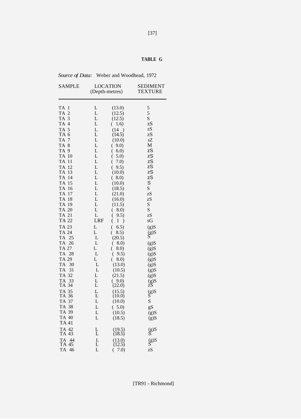
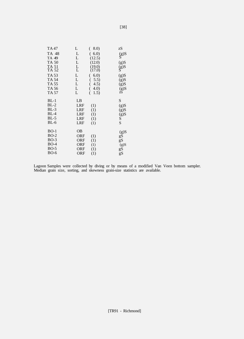
TABLE G
Source of Data: Weber and Woodhead, 1972
SAMPLE LOCATION SEDIMENT (Depth-metres) TEXTURE
TA 1 L (13.0) 5 TA 2 L (12.5) 5 TA 3 L (12.5) S TA 4 L ( 1.6) TA 5 L (14 )
TA 7 L (10.0) sZ TA 8 L ( 9.0) TA 9 L ( 6.0) TA 10 L ( 5.0) TA 11 L ( 7.0) TA 12 L ( 9.5) TA 13 L (10.0) TA 14 L ( 8.0) TA 15 L (10.0) TA 16 L (18.5) S TA 17 L (21.0) zS TA 18 L (16.0) zS TA 19 L (11.5) S TA 20 L ( 8.0) S TA 21 L ( 9.5) zS
TA 23 L ( 6.5) (g)S (g)S TA 24 L ( 8.5)
TA 25 L (20.5) TA 26 L ( 8.0) (g)S TA 27 L ( 8.0) (g)S TA 28 L ( 9.5) (g)S TA 29 L ( 8.0) (g)S TA 30 L (13.0) (g)S TA 31 L (10.5) (g)S TA 32 L (21.5) (g)S
(g)S TA 33 L ( 9.0) TA 34 L (22.0) TA 35 L (15.5) (g)S TA 36 L (10.0) S TA 37 L (10.0) S TA 38 L ( 5.0) gS TA 39 L (10.5) (g)S TA 40 L (18.5) (g)S
(g)S TA 42 L (19.5)
(g)S TA 44 L (13.0)
TA 46 L ( 7.0) zS
zS zS zS
M zS zS zS zS zS zS S
TA 6 L (14.5)
TA 22 LRF ( 1 ) sG
S
zS
TA 41
TA 43 L (18.5)
TA 45 L (12.5)
S
S
[TR91 - Richmond]
[38]
TA 47 L ( 8.0) zS (g)S TA 48 L ( 6.0)
TA 49 L (12.5) TA 50 L (12.0) (g)S TA 51 L (19.0) (g)S TA 52 L (17.0) S TA 53 L ( 6.0) (g)S TA 54 L ( 5.5) (g)S TA 55 L ( 4.5) (g)S
(g)S TA 56 L ( 4.0) TA 57 L ( 1.5)
BL-2 LRF (1) (g)S BL-3 LRF (1) (g)S BL-4 LRF (1) (g)S BL-5 LRF (1) S BL-6 LRF (1) S
BO-1 OB (g)S BO-2 ORF (1) gS BO-3 ORF (1) gS BO-4 ORF (1) (g)S BO-5 ORF (1) gS BO-6 ORF (1) gS
S
zs
BL-1 LB S
Lagoon Samples were collected by diving or by means of a modified Van Veen bottom sampler. Median grain size, sorting, and skewness grain-size statistics are available.
[TR91 - Richmond]
Related Documents