NCERT Solutions for 9th Class Geography : Chapter 2-Physical Features of India Class 9: Geography Chapter 2 solutions. Complete Class 9 Geography Chapter 2 Notes. NCERT Solutions for 9th Class Geography : Chapter 2-Physical Features of India NCERT 9th Geography Chapter 2, class 9 Geography chapter 2 solutions Page No: 11 1. The names of the glaciers and passes that lie in Great Himalayas https://www.indcareer.com/schools/ncert-solutions-for-9th-class-geography-chapter-2-physical-f eatures-of-india/

Welcome message from author
This document is posted to help you gain knowledge. Please leave a comment to let me know what you think about it! Share it to your friends and learn new things together.
Transcript
NCERT Solutions for 9th ClassGeography : Chapter 2-PhysicalFeatures of IndiaClass 9: Geography Chapter 2 solutions. Complete Class 9 Geography Chapter 2Notes.
NCERT Solutions for 9th Class Geography : Chapter2-Physical Features of India
NCERT 9th Geography Chapter 2, class 9 Geography chapter 2 solutions
Page No: 11
1. The names of the glaciers and passes that lie in Great Himalayas
https://www.indcareer.com/schools/ncert-solutions-for-9th-class-geography-chapter-2-physical-features-of-india/

Answer
Glaciers in the Great Himalayas — Gangotri, Chaturangi, Bhagirathi, Kharak,Satopanth, Kamet, Milam and Pindari.
Passes in the Great Himalayas — Karakoram pass, Shipkila pass, Nathula, Bomdilapass.
2. The name of the states where highest peaks are located.
Answer
Mountain peaks - States
Kanchenjunga - Sikkim
Nanga Parbat - Jammu and Kashmir
Nanda Devi - Uttarakhand
Kamet - Uttarakhand
Namcha Barwa - Assam
Page No: 15
Excercise
1. Choose the right answer from the four alternatives given below :
(i) A landmass bounded by sea on three sides is referred to as
(a) Coast
(b) Island
(c) Peninsula
(d) None of the above.
https://www.indcareer.com/schools/ncert-solutions-for-9th-class-geography-chapter-2-physical-features-of-india/
► (c) Peninsula
(ii) Mountain ranges in the eastern part of India forming its boundaries withMyanmar
are collectively called :
(a) Himachal
(b) Uttaranchal
(c) Purvachal
(d) None of the above
► (c) Purvachal
(iii) The western coastal strip south of Goa is referred to as
(a) Coromandel
(b) Konkan
(c) Kannad
(d) Northern Circar
(iv) The highest peak in the Eastern Ghats is
(a) Anai Mudi
(b) Kanchenjunga
(c) Mahendragiri
(d) Khasi
► (c) Mahendragiri
2. Answer the following questions briefly:
https://www.indcareer.com/schools/ncert-solutions-for-9th-class-geography-chapter-2-physical-features-of-india/

(i) What are tectonic plates?
(ii) Which continents of today were parts of the Gondwana land?
(iii) What is bhabar?
(iv) Name the three major divisions of the Himalayas from north to south.
(v) Which plateau lies between the Aravali and the Vindhyan ranges?
(vi) Name the island group of India having coral origin.
Answer
(i) Large fragments of the Earth’s crust and upper mantle separated due to theconvectional currents are called tectonic plates.
(ii) South America, South Africa, part of Asia (India, Arabia, Malaya), Australia andAntarctica continents were parts of the Gondwana land.
(iii) The Bhabar is that narrow belt of the plain which is covered with pebbles and liesalong the foothills of the Shiwaliks from the Indus to the Tista.
(iv) The Great or the Inner Himalayas or the Himadri, the Middle Himalayas or theHimachal, and the Outer Himalayas or the Shivaliks.
(v) The Malwa plateau lies between the Aravali and the Vindhya Ranges.
(vi) Lakshadweep Islands is the island group of India having coral origin.
Page No: 16
3. Distinguish between
(i) Converging and Diverging Tectonic Plates.
(ii) Bhangar and Khadar
(iii) Western Ghats and Eastern Ghats
Answer
https://www.indcareer.com/schools/ncert-solutions-for-9th-class-geography-chapter-2-physical-features-of-india/
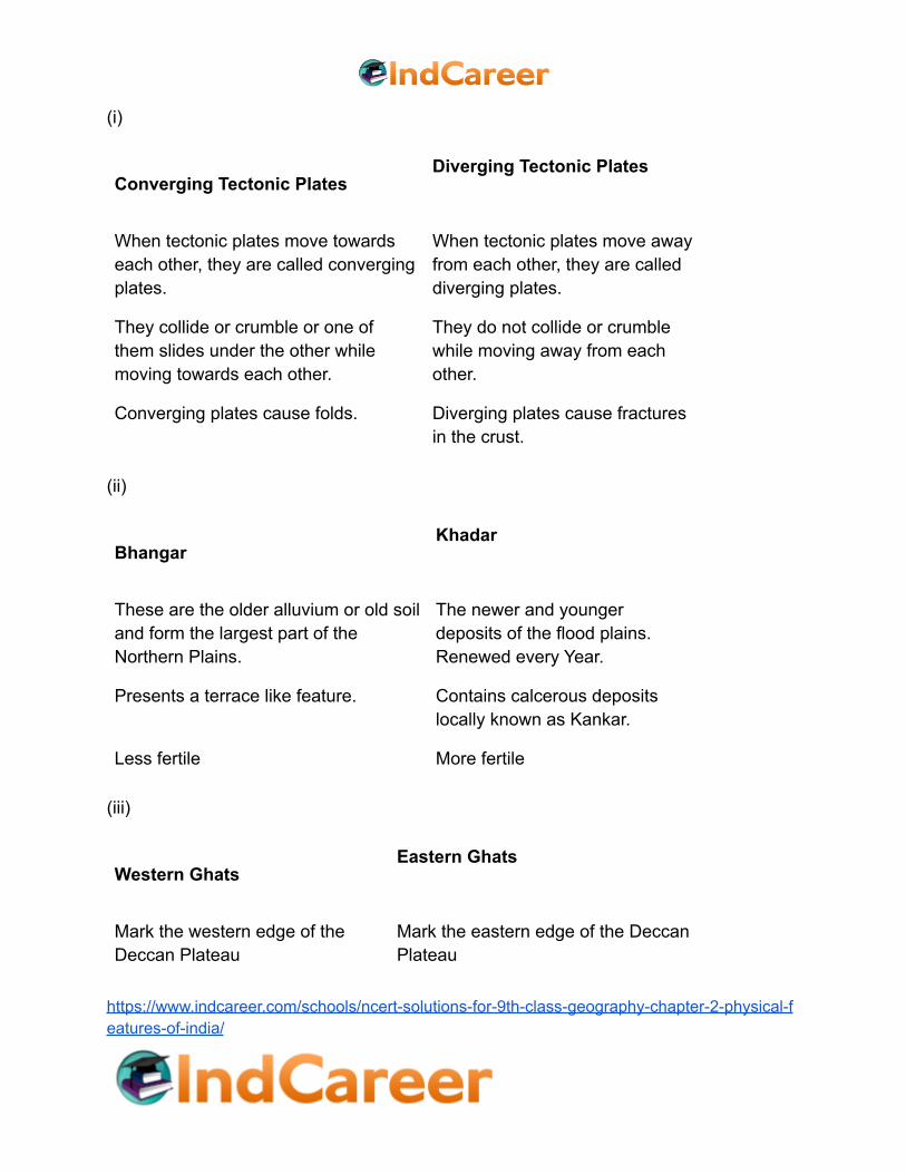
(i)
Converging Tectonic PlatesDiverging Tectonic Plates
When tectonic plates move towardseach other, they are called convergingplates.
When tectonic plates move awayfrom each other, they are calleddiverging plates.
They collide or crumble or one ofthem slides under the other whilemoving towards each other.
They do not collide or crumblewhile moving away from eachother.
Converging plates cause folds. Diverging plates cause fracturesin the crust.
(ii)
BhangarKhadar
These are the older alluvium or old soiland form the largest part of theNorthern Plains.
The newer and youngerdeposits of the flood plains.Renewed every Year.
Presents a terrace like feature. Contains calcerous depositslocally known as Kankar.
Less fertile More fertile
(iii)
Western GhatsEastern Ghats
Mark the western edge of theDeccan Plateau
Mark the eastern edge of the DeccanPlateau
https://www.indcareer.com/schools/ncert-solutions-for-9th-class-geography-chapter-2-physical-features-of-india/

Continuous, can be crossedthrough the passes only.
Discontinuous, irregular anddissected by rivers draining into theBay of Bengal.
Higher; average elevation is900−1600 meters
Lower; average elevation is 600meters
It experiences orographic rainmostly in summer due to thesummer monsoons. The climateis hot and moist.
It receives rain mostly in winterthrough North-eastern monsoon.However, here the rain is lesser thanthe western strip.
Soil is highly fertile. Rice, spices,rubber and fruits like coconuts,cashew nuts etc. are grown
Soil is not as fertile as western ghats.Rice, ground nuts, cotton, tobacco,coconuts etc. are grown
4. Describe how the Himalayas were formed.
Answer
According to the Theory of Plate Tectonics, the Earth's crust was initially a single, giantsuper-continent called Pangea. Gradually, Pangea began to split into a number ofpieces due to convectional currents and formed Angaraland and Gondwanaland.Angaraland is the Eurasian land mass and Gondwanaland included India, Australia, S.Africa and S. America as one single land mass. The Indo-Australian plate separatedfrom the Gondwana land due to convectional currents and drifted towards north. Due tothis collision, the sedimentary rocks which were accumulated in the geosyncline knownas the Tethys were folded to form the mountain system of western Asia and Himalaya.
NCERT 9th Geography Chapter 2, class 9 Geography chapter 2 solutions
5. Which are the major physiographic divisions of India? Contrast the relief of theHimalayan region with that of the Peninsular Plateau.
Answer
The major physiography divisions of India are :
(i) The Himalayan Mountains
https://www.indcareer.com/schools/ncert-solutions-for-9th-class-geography-chapter-2-physical-features-of-india/

(ii) The Northern Plains
(iii) The Peninsular Plateau
(iv) The Indian Desert
(v) The Coastal Plains
(vi) The Islands
The Himalayan RegionThe Peninsular Plateau
Young fold mountains made from the upliftof the strata formed by the sedimentaryrocks.
Ancient landmass createdafter splitting ofGondwanaland.
Consists of the loftiest mountains and deepvalleys
Consists of broad andshallow valleys, androunded hills
Composed of sedimentary rocks. Composed of igneous andmetamorphic rocks.
It is the origin of perennial rivers. It has rainfed, seasonalrivers.
From the point of view of geology, thisregion forms an unstable zone
This region forms a stablezone
6. Give an account of the Northern Plains of India.
Answer
The northern plain has been formed by the interplay of the three major river systems,namely the Indus, the Ganga and the Brahmaputra along with their tributaries. Thisplain is formed of alluvial soil which is suitable for agriculture. It spreads over an area of7 lakh sq. km. The plain is a densely populated physiographic division. The NorthernPlain is broadly divided into three sections, Punjab Plains, Ganga Plains andBrahpmputra plains. According to the variations in relief features, the Northern plainshttps://www.indcareer.com/schools/ncert-solutions-for-9th-class-geography-chapter-2-physical-features-of-india/
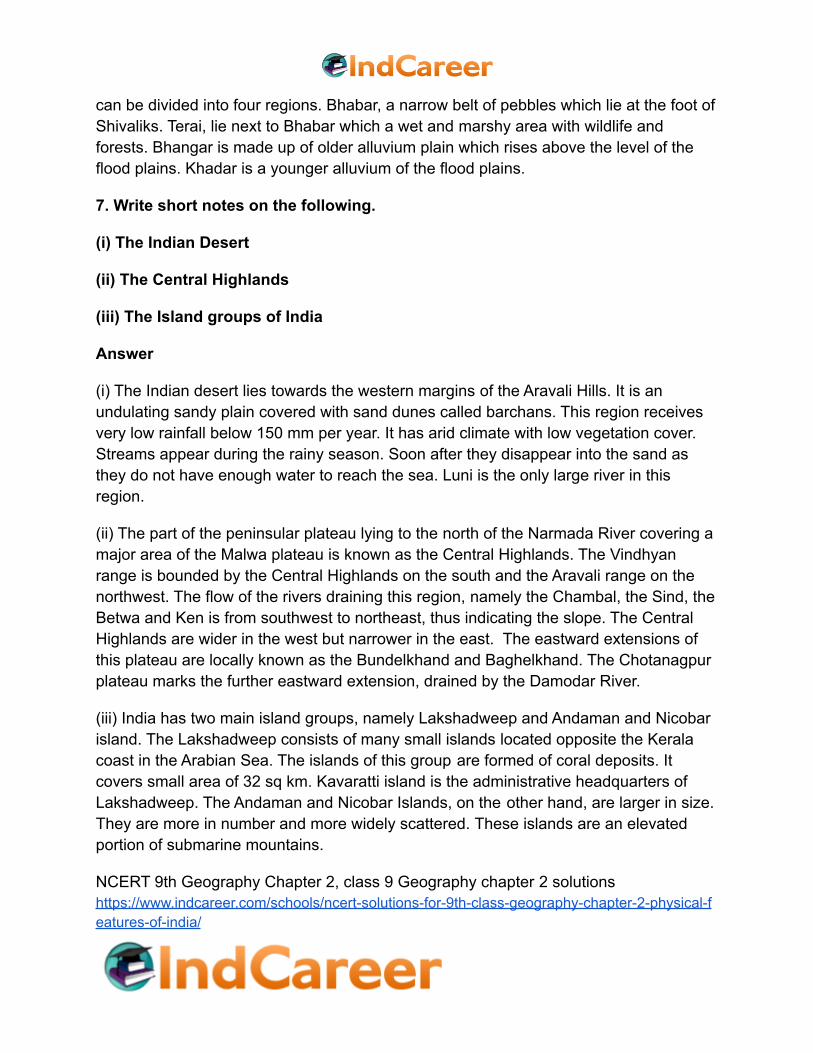
can be divided into four regions. Bhabar, a narrow belt of pebbles which lie at the foot ofShivaliks. Terai, lie next to Bhabar which a wet and marshy area with wildlife andforests. Bhangar is made up of older alluvium plain which rises above the level of theflood plains. Khadar is a younger alluvium of the flood plains.
7. Write short notes on the following.
(i) The Indian Desert
(ii) The Central Highlands
(iii) The Island groups of India
Answer
(i) The Indian desert lies towards the western margins of the Aravali Hills. It is anundulating sandy plain covered with sand dunes called barchans. This region receivesvery low rainfall below 150 mm per year. It has arid climate with low vegetation cover.Streams appear during the rainy season. Soon after they disappear into the sand asthey do not have enough water to reach the sea. Luni is the only large river in thisregion.
(ii) The part of the peninsular plateau lying to the north of the Narmada River covering amajor area of the Malwa plateau is known as the Central Highlands. The Vindhyanrange is bounded by the Central Highlands on the south and the Aravali range on thenorthwest. The flow of the rivers draining this region, namely the Chambal, the Sind, theBetwa and Ken is from southwest to northeast, thus indicating the slope. The CentralHighlands are wider in the west but narrower in the east. The eastward extensions ofthis plateau are locally known as the Bundelkhand and Baghelkhand. The Chotanagpurplateau marks the further eastward extension, drained by the Damodar River.
(iii) India has two main island groups, namely Lakshadweep and Andaman and Nicobarisland. The Lakshadweep consists of many small islands located opposite the Keralacoast in the Arabian Sea. The islands of this group are formed of coral deposits. Itcovers small area of 32 sq km. Kavaratti island is the administrative headquarters ofLakshadweep. The Andaman and Nicobar Islands, on the other hand, are larger in size.They are more in number and more widely scattered. These islands are an elevatedportion of submarine mountains.
NCERT 9th Geography Chapter 2, class 9 Geography chapter 2 solutionshttps://www.indcareer.com/schools/ncert-solutions-for-9th-class-geography-chapter-2-physical-features-of-india/

Map Skills
On an outline map of India show the following.
(i)Mountain and hill ranges – the Karakoram, the Zaskar, the Patkai Bum, theJaintia, the Vindhya range, the Aravali, and the Cardamom hills.
(ii) Peaks – K2, Kanchenjunga, Nanga Parbat and the Anai Mudi.
(iii) Plateaus, Chotanagpur and Malwa
(iv) The Indian Desert, Western Ghats, Lakshadweep Islands
Answer
https://www.indcareer.com/schools/ncert-solutions-for-9th-class-geography-chapter-2-physical-features-of-india/

Project/Activity
Locate the peaks, passes, ranges, plateaus, hills, and duns hidden in thepuzzle.Try to find where these features are located. You may start your searchhorizontally, vertically or diagonally.
https://www.indcareer.com/schools/ncert-solutions-for-9th-class-geography-chapter-2-physical-features-of-india/
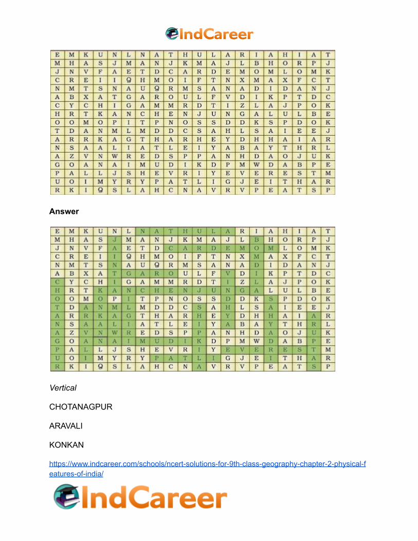
Answer
Vertical
CHOTANAGPUR
ARAVALI
KONKAN
https://www.indcareer.com/schools/ncert-solutions-for-9th-class-geography-chapter-2-physical-features-of-india/

JAINTIA
MALWA
NILGIRI
SHIPKILA
VINDHYA
BOMDILA
SAHYADRI
SATPURA
Horizontal
NATHULA
CARDEMOM
GARO
KANCHENJUNGA
ANAIMUDI
EVEREST
PATLI
NCERT 9th Geography Chapter 2, class 9 Geography chapter 2 solutions
https://www.indcareer.com/schools/ncert-solutions-for-9th-class-geography-chapter-2-physical-features-of-india/
Chapterwise NCERT Solutions forClass 9 Geography :
● Chapter 1 India–Size and Location
● Chapter 2 Physical Features of India
● Chapter 3 Drainage
● Chapter 4 Climate
● Chapter 5 Natural Vegetation and Wildlife
● Chapter 6 Population
https://www.indcareer.com/schools/ncert-solutions-for-9th-class-geography-chapter-2-physical-features-of-india/

About NCERT
The National Council of Educational Research and Training is an autonomous
organization of the Government of India which was established in 1961 as a literary,
scientific, and charitable Society under the Societies Registration Act. The major
objectives of NCERT and its constituent units are to: undertake, promote and
coordinate research in areas related to school education; prepare and publish model
textbooks, supplementary material, newsletters, journals and develop educational kits,
multimedia digital materials, etc.Organise pre-service and in-service training of
teachers; develop and disseminate innovative educational techniques and
practices;collaborate and network with state educational departments, universities,
NGOs and other educational institutions; act as a clearing house for ideas and
information in matters related to school education; and act as a nodal agency for
achieving the goals of Universalisation of Elementary Education.In addition to research,
development, training, extension, publication and dissemination activities, NCERT is an
implementation agency for bilateral cultural exchange programmes with other countries
in the field of school education.Its headquarters are located at Sri Aurobindo Marg in
New Delhi. Visit the Official NCERT website to learn more.
https://www.indcareer.com/schools/ncert-solutions-for-9th-class-geography-chapter-2-physical-features-of-india/
Related Documents