Welcome message from author
This document is posted to help you gain knowledge. Please leave a comment to let me know what you think about it! Share it to your friends and learn new things together.
Transcript


R
KENTUCKY RIVER
SHEET A
DANGER AREA
RESTRICTED AREA
GENERAL NOTES AND LEGEND
N A V I G AT I O N C H A R T S
LEGEND
Waters edge at pool stage
Bar with less than project depth (6.0’)at pool stage
(a)
(b)
Rock
Sand
Aerial Crossing
Power
Telephone
Submarine Crossing
Intake
Discharge
Terminal or Commercial Dock
Pleasure Craft Facility(Marina, Restaurant, Dock etc.)
Launching Ramp
Danger Buoys
Do not Navigate in theRestricted area
NOTES ABOUT THE USE OF THESE CHARTS AND THE INFORMATION PRESENTED:These charts were originally developed in 1966 by the U. S. Army Corps of Engineers as freehand drawings based on U. S. Geological Survey maps current at that time. Since the charts are no longer available through the Corps of Engineers, the Kentucky River Authority contracted he U. S. Geological Survey in 2001to reproduce these charts in a form which could be edited. Most of the features of the charts show the same information as the last update by the Corps of Engineers in 1988. The Kentucky River Authority has updated features important to boaters such as: locations of ramps, docks and other points of recreational interest. The edits were not based on detailed field survey and the Authority welcomes any corrections or additions of information on these charts. The width of the river is distorted to approximately twice its scale size in order to show the detail of features. The depth of the channel along the sail line is estimated to be no less than 6 feet, however water conditions continually change the bottom contours of the river. Therefore the Kentucky River Authority therefore does not warrant the actual depth of the channel at any location and warns boaters to be alert to shallow areas and other navigational hazards. Historically known hazards such as shoals and bars are shown based on best available information. These hazards change shape and location over time but generally exist near any stream confluence and boaters should be on alert when approaching these areas. Mile points are numbered consecutively traveling upstream from the mouth of the Kentucky River near Carrollton. Some inaccuracies exist in mile-points to agree with historic locations of well known features on the river. Features are denoted as being on the left or right hand bank when facing downstream.
Boaters should use extreme caution while boating near the Locks and Dams. Restricted areas and Danger areas are marked on these navigation charts and these areas are marked with “Keep Out” and “Danger Dam” buoys. The buoys are subject to shifting during high water, so boaters should observe the restricted area limits when buoys are not present.
The dams on the Kentucky River are classified as “low-head dams” which inherently present a greater danger to boaters. Upstream of these dams, it is difficult to determine the dam’s existence, since it blends with the horizon. Because there is constant overflow, the velocity of flow increases as you approach the dam, and can pull a boat over the dam quickly.
Downstream of the dams, the overflow creates a powerful circular hydraulic which can continuously pull a boat underwater and trap it.
Boaters are also asked to stay out of the approach area to the locks unless intending to lock through. During operation of the locks a rush of water could capsize a small craft.
To report a spill of hazardous material or other pollution concern please call the Kentucky Division of Water hot line at 800-928-2380 or 502-564-2380.
To report an accident, drowning, missing person or fish & wildlife violation, please call the Fish and Wildlife Hot Line at 800-252-5378.
To report a navigational hazard, please call the U.S. Coast Guard at 502-582-6439 or the Corps of Engineers at 502-315-6692.
For any of the above situations call the Kentucky River Authority at 502-564-2866 during weekday hours.
The Kentucky River Authority wishes everyone safe and enjoyable recreational use of the Kentucky River.
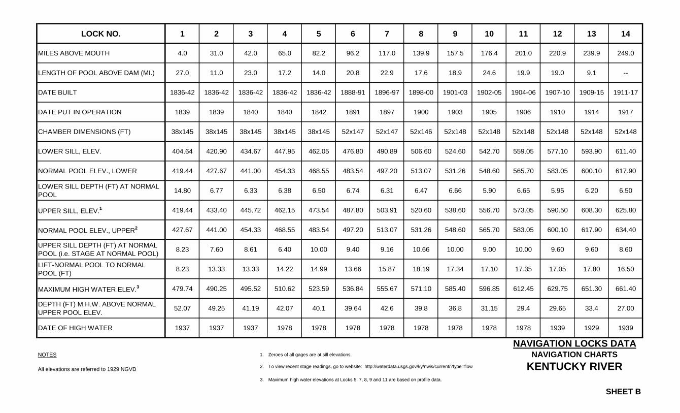
LOCK NO. 1 2 3 4 5 6 7 8 9 10 11 12 13 14
MILES ABOVE MOUTH 4.0 31.0 42.0 65.0 82.2 96.2 117.0 139.9 157.5 176.4 201.0 220.9 239.9 249.0
LENGTH OF POOL ABOVE DAM (MI.) 27.0 11.0 23.0 17.2 14.0 20.8 22.9 17.6 18.9 24.6 19.9 19.0 9.1 --
DATE BUILT 1836-42 1836-42 1836-42 1836-42 1836-42 1888-91 1896-97 1898-00 1901-03 1902-05 1904-06 1907-10 1909-15 1911-17
DATE PUT IN OPERATION 1839 1839 1840 1840 1842 1891 1897 1900 1903 1905 1906 1910 1914 1917
CHAMBER DIMENSIONS (FT) 38x145 38x145 38x145 38x145 38x145 52x147 52x147 52x146 52x148 52x148 52x148 52x148 52x148 52x148
LOWER SILL, ELEV. 404.64 420.90 434.67 447.95 462.05 476.80 490.89 506.60 524.60 542.70 559.05 577.10 593.90 611.40
NORMAL POOL ELEV., LOWER 419.44 427.67 441.00 454.33 468.55 483.54 497.20 513.07 531.26 548.60 565.70 583.05 600.10 617.90
LOWER SILL DEPTH (FT) AT NORMAL
POOL14.80 6.77 6.33 6.38 6.50 6.74 6.31 6.47 6.66 5.90 6.65 5.95 6.20 6.50
UPPER SILL, ELEV.1 419.44 433.40 445.72 462.15 473.54 487.80 503.91 520.60 538.60 556.70 573.05 590.50 608.30 625.80
NORMAL POOL ELEV., UPPER2 427.67 441.00 454.33 468.55 483.54 497.20 513.07 531.26 548.60 565.70 583.05 600.10 617.90 634.40
UPPER SILL DEPTH (FT) AT NORMAL
POOL (i.e. STAGE AT NORMAL POOL)8.23 7.60 8.61 6.40 10.00 9.40 9.16 10.66 10.00 9.00 10.00 9.60 9.60 8.60
LIFT-NORMAL POOL TO NORMAL
POOL (FT)8.23 13.33 13.33 14.22 14.99 13.66 15.87 18.19 17.34 17.10 17.35 17.05 17.80 16.50
MAXIMUM HIGH WATER ELEV.3 479.74 490.25 495.52 510.62 523.59 536.84 555.67 571.10 585.40 596.85 612.45 629.75 651.30 661.40
DEPTH (FT) M.H.W. ABOVE NORMAL
UPPER POOL ELEV.52.07 49.25 41.19 42.07 40.1 39.64 42.6 39.8 36.8 31.15 29.4 29.65 33.4 27.00
DATE OF HIGH WATER 1937 1937 1937 1978 1978 1978 1978 1978 1978 1978 1978 1939 1929 1939
NOTES 1. Zeroes of all gages are at sill elevations.
All elevations are referred to 1929 NGVD2. To view recent stage readings, go to website: http://waterdata.usgs.gov/ky/nwis/current/?type=flow
3. Maximum high water elevations at Locks 5, 7, 8, 9 and 11 are based on profile data.
SHEET B
NAVIGATION LOCKS DATANAVIGATION CHARTS
KENTUCKY RIVER
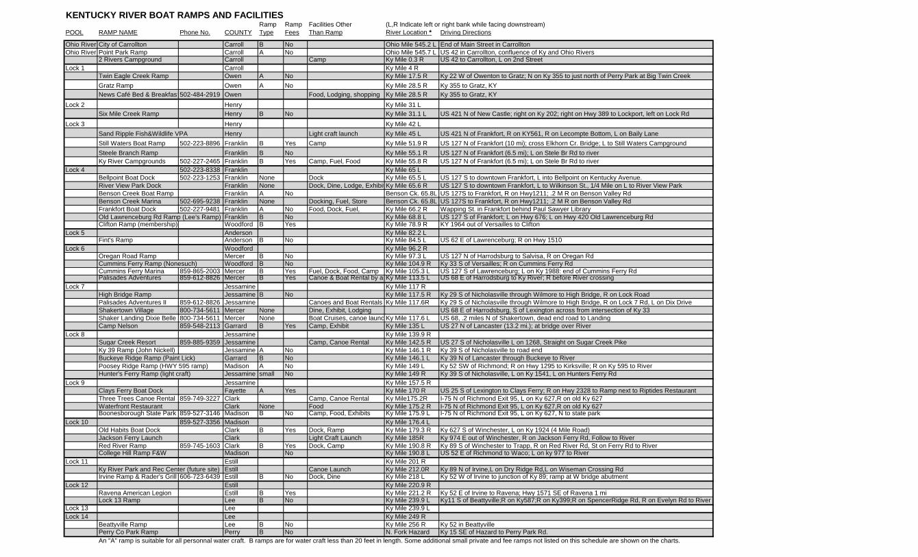
KENTUCKY RIVER BOAT RAMPS AND FACILITIES Ramp Ramp Facilities Other (L,R Indicate left or right bank while facing downstream)
POOL RAMP NAME Phone No. COUNTY Type Fees Than Ramp River Location * Driving Directions
Ohio River City of Carrollton Carroll B No Ohio Mile 545.2 L End of Main Street in Carrollton
Ohio River Point Park Ramp Carroll A No Ohio Mile 545.7 L US 42 in Carrollton, confluence of Ky and Ohio Rivers2 Rivers Campground Carroll Camp Ky Mile 0.3 R US 42 to Carrollton, L on 2nd Street
Lock 1 Carroll Ky Mile 4 R
Twin Eagle Creek Ramp Owen A No Ky Mile 17.5 R Ky 22 W of Owenton to Gratz; N on Ky 355 to just north of Perry Park at Big Twin Creek
Gratz Ramp Owen A No Ky Mile 28.5 R Ky 355 to Gratz, KY
News Café Bed & Breakfast 502-484-2919 Owen Food, Lodging, shopping Ky Mile 28.5 R Ky 355 to Gratz, KY
Lock 2 Henry Ky Mile 31 L
Six Mile Creek Ramp Henry B No Ky Mile 31.1 L US 421 N of New Castle; right on Ky 202; right on Hwy 389 to Lockport, left on Lock Rd
Lock 3 Henry Ky Mile 42 L
Sand Ripple Fish&Wildlife VPA Henry Light craft launch Ky Mile 45 L US 421 N of Frankfort, R on KY561, R on Lecompte Bottom, L on Baily Lane
Still Waters Boat Ramp 502-223-8896 Franklin B Yes Camp Ky Mile 51.9 R US 127 N of Frankfort (10 mi); cross Elkhorn Cr. Bridge; L to Still Waters Campground
Steele Branch Ramp Franklin B No Ky Mile 55.1 R US 127 N of Frankfort (6.5 mi); L on Stele Br Rd to river
Ky River Campgrounds 502-227-2465 Franklin B Yes Camp, Fuel, Food Ky Mile 55.8 R US 127 N of Frankfort (6.5 mi); L on Stele Br Rd to river
Lock 4 502-223-8338 Franklin Ky Mile 65 L
Bellpoint Boat Dock 502-223-1253 Franklin None Dock Ky Mile 65.5 L US 127 S to downtown Frankfort, L into Bellpoint on Kentucky Avenue.
River View Park Dock Franklin None Dock, Dine, Lodge, Exhibit Ky Mile 65.6 R US 127 S to downtown Frankfort, L to Wilkinson St., 1/4 Mile on L to River View Park
Benson Creek Boat Ramp Franklin A No Benson Ck. 65.8L US 127S to Frankfort, R on Hwy1211; .2 M R on Benson Valley Rd
Benson Creek Marina 502-695-9238 Franklin None Docking, Fuel, Store Benson Ck. 65.8L US 127S to Frankfort, R on Hwy1211; .2 M R on Benson Valley Rd
Frankfort Boat Dock 502-227-9481 Franklin A No Food, Dock, Fuel, Ky Mile 66.2 R Wapping St. in Frankfort behind Paul Sawyer Library
Old Lawrenceburg Rd Ramp (Lee's Ramp) Franklin B No Ky Mile 68.8 L US 127 S of Frankfort; L on Hwy 676; L on Hwy 420 Old Lawrenceburg RdClifton Ramp (membership) Woodford B Yes Ky Mile 78.9 R KY 1964 out of Versailles to Clifton
Lock 5 Anderson Ky Mile 82.2 L Fint's Ramp Anderson B No Ky Mile 84.5 L US 62 E of Lawrenceburg; R on Hwy 1510
Lock 6 Woodford Ky Mile 96.2 R Oregan Road Ramp Mercer B No Ky Mile 97.3 L US 127 N of Harrodsburg to Salvisa, R on Oregan Rd
Cummins Ferry Ramp (Nonesuch) Woodford B No Ky Mile 104.9 R Ky 33 S of Versailles; R on Cummins Ferry RdCummins Ferry Marina 859-865-2003 Mercer B Yes Fuel, Dock, Food, Camp Ky Mile 105.3 L US 127 S of Lawrenceburg; L on Ky 1988: end of Cummins Ferry RdPalisades Adventures 859-612-8826 Mercer B Yes Canoe & Boat Rental by appt.Ky Mile 113.5 L US 68 E of Harrodsburg to Ky River; R before River crossing
Lock 7 Jessamine Ky Mile 117 R
High Bridge Ramp Jessamine B No Ky Mile 117.5 R Ky 29 S of Nicholasville through Wilmore to High Bridge, R on Lock Road
Palisades Adventures II 859-612-8826 Jessamine Canoes and Boat Rentals Ky Mile 117.6R Ky 29 S of Nicholasville through Wilmore to High Bridge, R on Lock 7 Rd, L on Dix Drive
Shakertown Village 800-734-5611 Mercer None Dine, Exhibit, Lodging US 68 E of Harrodsburg, S of Lexington across from intersection of Ky 33
Shaker Landing Dixie Belle 800-734-5611 Mercer None Boat Cruises, canoe launchKy Mile 117.6 L US 68, .2 miles N of Shakertown, dead end road to Landing
Camp Nelson 859-548-2113 Garrard B Yes Camp, Exhibit Ky Mile 135 L US 27 N of Lancaster (13.2 mi.); at bridge over River
Lock 8 Jessamine Ky Mile 139.9 R
Sugar Creek Resort 859-885-9359 Jessamine Camp, Canoe Rental Ky Mile 142.5 R US 27 S of Nicholasville L on 1268, Straight on Sugar Creek Pike
Ky 39 Ramp (John Nickell) Jessamine A No Ky Mile 146.1 R Ky 39 S of Nicholasville to road end
Buckeye Ridge Ramp (Paint Lick) Garrard B No Ky Mile 146.1 L Ky 39 N of Lancaster through Buckeye to River
Poosey Ridge Ramp (HWY 595 ramp) Madison A No Ky Mile 149 L Ky 52 SW of Richmond; R on Hwy 1295 to Kirksville; R on Ky 595 to River
Hunter's Ferry Ramp (light craft) Jessamine small No Ky Mile 149 R Ky 39 S of Nicholasville, L on Ky 1541, L on Hunters Ferry Rd
Lock 9 Jessamine Ky Mile 157.5 R
Clays Ferry Boat Dock Fayette A Yes Ky Mile 170 R US 25 S of Lexington to Clays Ferry; R on Hwy 2328 to Ramp next to Riptides Restaurant
Three Trees Canoe Rental 859-749-3227 Clark Camp, Canoe Rental Ky Mile175.2R I-75 N of Richmond Exit 95, L on Ky 627,R on old Ky 627
Waterfront Restaurant Clark None Food Ky Mile 175.2 R I-75 N of Richmond Exit 95, L on Ky 627,R on old Ky 627Boonesborough State Park 859-527-3146 Madison B No Camp, Food, Exhibits Ky Mile 175.9 L I-75 N of Richmond Exit 95, L on Ky 627, N to state park
Lock 10 859-527-3356 Madison Ky Mile 176.4 L
Old Habits Boat Dock Clark B Yes Dock, Ramp Ky Mile 179.3 R Ky 627 S of Winchester, L on Ky 1924 (4 Mile Road)
Jackson Ferry Launch Clark Light Craft Launch Ky Mile 185R Ky 974 E out of Winchester, R on Jackson Ferry Rd, Follow to River
Red River Ramp 859-745-1603 Clark B Yes Dock, Camp Ky Mile 190.8 R Ky 89 S of Winchester to Trapp, R on Red River Rd, St on Ferry Rd to RiverCollege Hill Ramp F&W Madison No Ky Mile 190.8 L US 52 E of Richmond to Waco; L on ky 977 to River
Lock 11 Estill Ky Mile 201 R
Ky River Park and Rec Center (future site) Estill Canoe Launch Ky Mile 212.0R Ky 89 N of Irvine,L on Dry Ridge Rd,L on Wiseman Crossing Rd Irvine Ramp & Rader's Grill 606-723-6439 Estill B No Dock, Dine Ky Mile 218 L Ky 52 W of Irvine to junction of Ky 89; ramp at W bridge abutment
Lock 12 Estill Ky Mile 220.9 R
Ravena American Legion Estill B Yes Ky Mile 221.2 R Ky 52 E of Irvine to Ravena; Hwy 1571 SE of Ravena 1 miLock 13 Ramp Lee B No Ky Mile 239.9 L Ky11 S of Beattyville;R on Ky587;R on Ky399;R on SpencerRidge Rd, R on Evelyn Rd to River
Lock 13 Lee Ky Mile 239.9 L
Lock 14 Lee Ky Mile 249 R
Beattyville Ramp Lee B No Ky Mile 256 R Ky 52 in BeattyvillePerry Co Park Ramp Perry B No N. Fork Hazard Ky 15 SE of Hazard to Perry Park Rd.
An "A" ramp is suitable for all personnal water craft. B ramps are for water craft less than 20 feet in length. Some additional small private and fee ramps not listed on this schedule are shown on the charts.

Middle
Fork
North
ForkO
HIO
RIV
ER
Station Camp Cr.
Drennon C
r.
Eag
leC
r.
Big
Twin
Cr.
SixMile
Cr.
hok rnl E Cr.
Benson
Cr.
KENTUCKY
RIVER
Jessamine
Cr.
Dix River
KENTUCKY RIVER
SHEET D
MAP INDEXN A V I G AT I O N C H A R T S
SCALE IN MILES
5 0 5 10 15
CarrolltonDAM 1
Silver Cr.
Hickm
anC
r.
Camp Nelson
Muddy
Cr.
reviR deR
Irvine
SturgeonCr.
South Fork
Heidelburg
Beattyville
1
23
4 5
6
M 20 DAM 2
78
9
10
11
DAM 3
Lockport
FrankfortDAM 4
M 4
0
M 6
0
M 8
012
1314
DAM 5
DAM 6 15
M 1
00
16
17
18
19
DAM 7
M 120
M 140DAM 8
20
21
22
23
24
DAM 9
M 160
25DAM 10
M180
26
27
28
29
30
M 2
00
DAM 11
31
32
33
M 220
DAM 12
34
35
36
37
37A
37B
DAM 14
37C
DAM 13
M 2
40

KENTUCKY RIVERLOCK NO. 1
MID-CHANNEL SCALE: 1” = 2000’LATERAL SCALE: DISTORTED
CHART NO. 1
0 1 2 3 4000’
The New Orleans, first steam-boat on the western rivers, wasbuilt at Pittsburgh for NicholasRoosevelt and passed down theOhio River in 1811
8
9
INDIA
NA
See
Ohi
o R
iver
Nav
igat
ion
Cha
rts
(Cai
ro, I
ll. to
Fos
ter,
Ken
tuck
y)
U. S
. Arm
y Eng
inee
r Dis
trict
Loui
sville,
Ken
tuck
y
+54
6
KENTUCKY
OHIO
NORM
AL PO
OL M
CALPINE D
AM E
L. 420
.0
Little Kentucky River
7
RIV
ER
+54
5
A
R
Kentucky River Light& Daymark 545.7
R
1
C
Old Bridge Piers
OldBridgePiers
Prestonville
1929NG VD DatumElev. 419.44
Ohio River DatumElev. 420.0
2
1
23456
9 8 7
D
D
B
A
C
U.S. ROUTE 42 HWY. BRIDGE
AERIAL POWER CROSSING
SUBMARINE CROSSINGS
CITY OF CARROLLTON RAMP
POINT PARK RAMP
2 RIVERS CAMPGROUND
CARROLLTON SEWAGE TREATMENT PLANT DISCHARGE
42
Carrollton
3
+1
B
4
5
Sailing Line2+
CARROLL COUNTY
General Butler
State Park
Note:
Elevations are referred to 1929NGVD Datum
DAM NO. 1MILE 4.0
Mud
+3
6
dneB shtae
H
Majors Run
MAT
CH
CH
AR
T N
O. 2
NO
RM
AL P
OO
L D
AM NO 7. 1 6427. EL. +5
RESTRICTED AREA
DANGER AREA
1754 - Date and initials of JamesMcBride carved on a tree nearthe mouth of Kentucky River.
1794 - Port William Incorpo-rated. Later renamed Carrollton.
U.P. El. 427.67
U. Sill El. 419.40
L.P. El. 419.44
L. Sill 404.64
38’ 0”
SECTIONLOCK NO. 1
SCALE: 1” =30’
14
.80
'8
.23
’
EL. 437.09

KENTUCKY RIVER
MID-CHANNEL SCALE: 1” = 2000’LATERAL SCALE: DISTORTED
CHART NO. 2
0 1 2 3 4000’
MA
TC
H C
HA
RT
NO
. 1
MA
TC
H C
HA
RT
NO
. 3
1
B2
3
A
5
4
Worthville
Sailing Line
Summer CottagesNORMAL POOL DAM NO. 1 EL. 427.67
CARROLL COUNTYMill
Cr.
Deans Bend
GooseCr.
Whites
Run B
end
Whi
tes
Run
English
B
A
13
2
4
5
AERIAL POWER CROSSING
U.S. ROUTE I-71 HWY. BRIDGES-2
L&N R.R. CO. BRIDGE
AERIAL TELEPHONE CROSSING
L&N R.R. CO. INTAKE
GEOGHEGAN & MATHIS, INC. (INACTIVE)
+6
+7
+8+9
+10
6
SUBMARINE CROSSING6
Trees

KENTUCKY RIVER
MID-CHANNEL SCALE: 1” = 2000’LATERAL SCALE: DISTORTED
CHART NO. 3
0 1 2 3 4000’
Worthville
MA
TC
H C
HA
RT
NO
. 2
MA
TC
H C
HA
RT
NO
. 4
CARRO
LL C
OU
NTY
Gul
lion
Run
Gullions Bar
+11
A
2Eagle Cr.
2 In 1802 an official state inspec-tion station was established atmouth of Eagle Creek fortobacco, hemp, flour, and goodsshipped by flatboat from itsupper reaches.
OWEN COUNTY
+12
NO
RM
AL P
OO
L D
AM
NO
. 1 EL. 4
27 .67
3
1
HENRY COUNTY
+13
Sailing Line
raB senayL
CanesRun
1
1
+14
Where one of the major buffalotrails, from Drennon's Lick toBig Bone Lick, crossedKentucky River. Used by George Rogers Clark in his campaignagainst Ohio Indians and calledClark's War Road.
+15
Sow
ers
Bend
Locust GroveSummer Cottages
4
2 1
34
A
SUBMARINE CROSSING
AERIAL POWER CROSSINGS
EAGLE CREEK RESORT
+16
2
Trees
R (PRIVATE)

KENTUCKY RIVER
MID-CHANNEL SCALE: 1” = 2000’LATERAL SCALE: DISTORTED
CHART NO. 4
0 1 2 3 4000’
LittleTwin Cr.
Moxley Landing
MATCH CHART NO
. 3
Turner Bar
Big
Twin C
r.
MillCr.
Perry Park PO
+17
+18 Sailing Line
OWEN COUNTY
A
B
Spring Port
NORMAL POOL DAM NO. 1 EL. 427.67
Location of one of Kentucky'smajor early resort areas, famousfor its medicinal mineral waters.The hotel burned following thecholera epidemic, ca. 1880.
HENRY COUNTY
A
12 AERIAL POWER CROSSING
TWIN EAGLE RAMP F & W
AMERICAN PYRAMID CO. DAM & SPILLWAY
+19
+20
1
2
+21
22 +
D rr aen Bn n o
Drennon Springs
Dre
nnon
Cr.
23 +
Marshall Bottom
MATCH CHART NO. 5
B
R
!SHALLOWCAUTION
!SHALLOWCAUTION

KENTUCKY RIVER
MID-CHANNEL SCALE: 1” = 2000’LATERAL SCALE: DISTORTED
CHART NO. 5
0 1 2 3 4000’
+24
+25
+26
+27
+28
+29
MATCH CHART NO. 4
MA
TC
H C
HA
RT
NO
. 6
raB la
ohS les suM
Sailing Line
OWEN COUNTY
Lead Mine
NO
RM
AL
PO
OL
DA
M N
O. 1
EL.
427
.67
Rock Bar Landing
Rocky Point
Cr.
Leitc
hs
Cr.
Gratz Bar
Rock
Ledg
e
Claylick Cr.
Gratz
Leitch's Landing
HENRY COUNTY
12
1
2
KENTUCKY STATE ROUTE 22 HWY. BRIDGE
AERIAL TELEPHONE CROSSING
Limestone ledges known as thePalisades begin near Gratz andextend thru pool 9.Known as Kentucky RiverMarble or Birdseye Marble, thisstone was used as a building materialfor many central Kentucky homes.
! SHALL
OW
CAU
TION
R
B
A
B
GRATZ RAMP F & W
NEWS CAFÉ AND GOLD STAR BED & BREAKFAST
A

KENTUCKY RIVERLOCK NO. 2
MID-CHANNEL SCALE: 1” = 2000’LATERAL SCALE: DISTORTED
CHART NO. 6
0 1 2 3 4000’
30+
+32
+33
+34
+35
+36
37+
38+
39+
R
DAM NO. 2MILE 31.0
Lockport
Sixm
ile
Cr.
RESTRICTED AREA
DANGER AREA
Thomas Bea
ch
OWEN COUNTY
raB sttekca
H
LO
OP LA
MRON
76.7
24 .L
E 1 .ON
MAD
MATCH CHART NO. 5
Sailing Line
BrownsBottom Bar
Pot
Rip
ple
C
r.
Fallis
NO
RM
AL
PO
OL
DA
M N
O. 2 E
L. 441.0
HENRY COUNTY
raB .rC nreveS
Severn Cr.
ClemmonsLanding
Slid
ing
Ban
k
OWEN COUNTY
Pond Cr.
MA
TC
H C
HA
RT
NO
. 7
B
A GEOGHEGAN AND MATHIS, INC., TERMINAL (INACTIVE)
SIX-MILE BOAT RAMP F & W
B
A
SECTIONLOCK NO. 2
SCALE: 1" = 40'
38' -0"
U.P. El. 441.00
U. Sill El. 433.40
El. 450.00
L.P. El. 427.67
L. Sill El. 420.90
7.6
'6.
77’
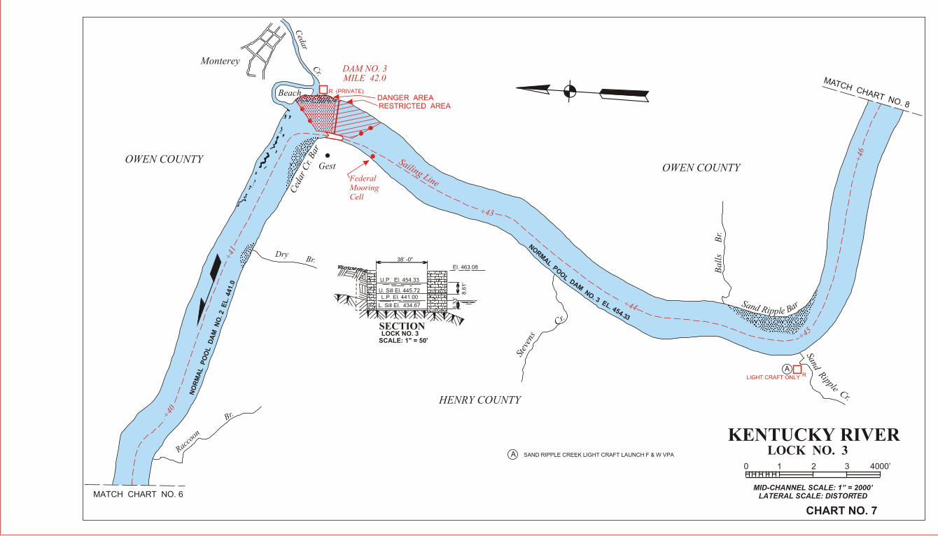
KENTUCKY RIVERLOCK NO. 3
MID-CHANNEL SCALE: 1” = 2000’LATERAL SCALE: DISTORTED
CHART NO. 7
0 1 2 3 4000’
+40
+41
+43
+44
+45
+46
MATCH CHART NO. 6
MATCH CHART NO. 8
Racco
on
Br.
NO
RM
AL
P
OO
L D
AM
N
O. 2 E
L. 441.0
NORM
AL POO
L DAM NO. 3 EL. 454.33
OWEN COUNTY
Monterey
Cedar
Cr.
Beach
DAM NO. 3MILE 42.0
DANGER AREARESTRICTED AREA
Ced
ar C
r. B
ar
Gest
FederalMooringCell
Sailing Line
DryBr.
HENRY COUNTY
OWEN COUNTY
Stev
ens
Cr.
Bal
ls
B
r.
S rand a R Bip lp e
Sand Ripple Cr.
SECTIONLOCK NO. 3
SCALE: 1" = 50'
El. 463.08
38' -0"
U.P. El. 454.33
U. Sill El. 445.72L.P. El. 441.00
L. Sill El. 434.67 6.3
3’
8.6
1'
R (PRIVATE)
RLIGHT CRAFT ONLY
A
SAND RIPPLE CREEK LIGHT CRAFT LAUNCH F & W VPAA

KENTUCKY RIVER
MID-CHANNEL SCALE: 1” = 2000’LATERAL SCALE: DISTORTED
CHART NO. 8
0 1 2 3 4000’
+47
+48
+49
+50
+51
+52
+53
Saili
ng L
ine
NORMAL POOL DAM NO. 3 EL. 454.33
MATCH CHART NO. 7
MATCH CHART NO. 9OWEN COUNTY
HENRY COUNTY
FRANKLIN COUNTY
FRANKLIN COUNTY
Webbs Bend
Payton Bend
Fla
tC
r.
Polsgrove
Elkhorn Cr.
Lower Elkhorn Bend
Roc
kB
luff
ElkhornBend
A
A
STILL WATERS RAMP & CAMPGROUNDS
SUBMARINE CROSSING
1
1
R
B KENTUCKY AMERICAN WATER COMPANY
B
KENTUCKY RIVER
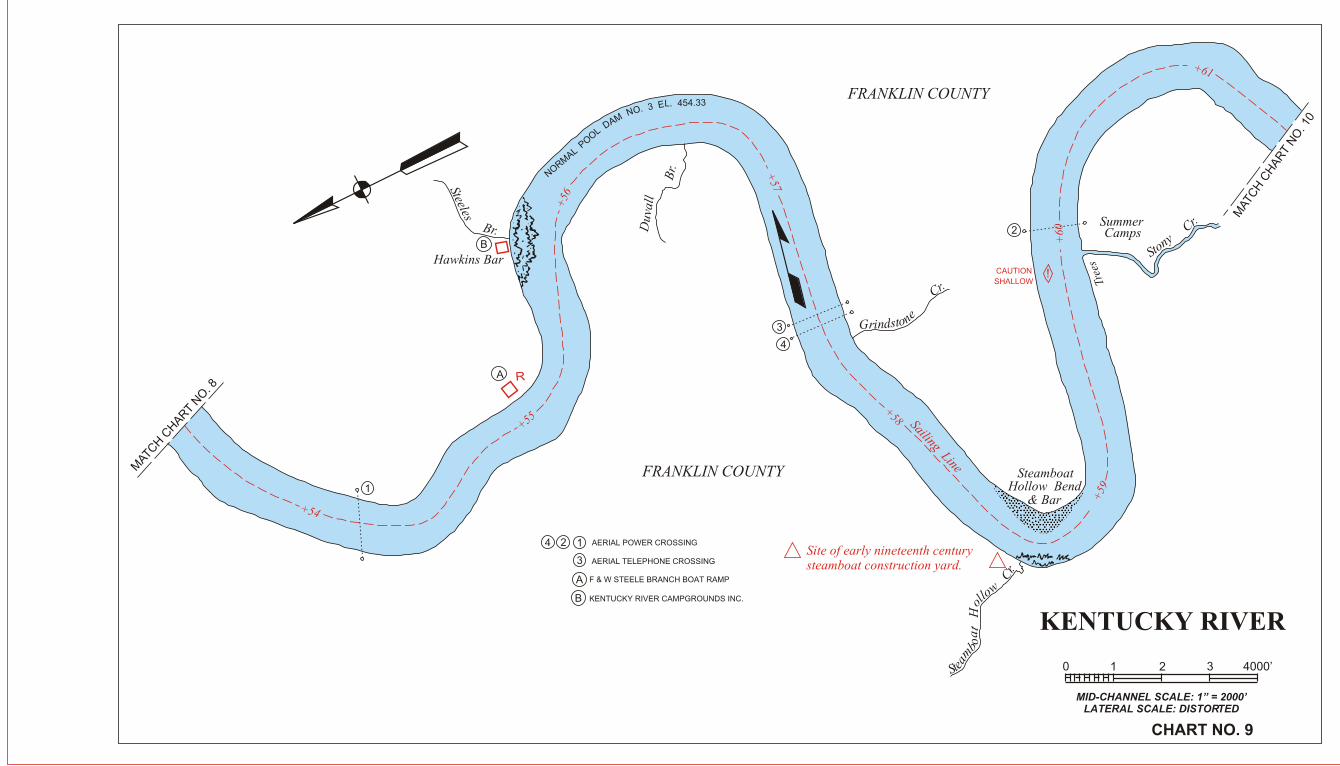
MID-CHANNEL SCALE: 1” = 2000’LATERAL SCALE: DISTORTED
CHART NO. 9
0 1 2 3 4000’
+54
+55
+56
+57
+58
+59
+60
+61
Sailing LineMAT
CH C
HAR
T NO
. 8
R
Hawkins Bar
Steeles
Br.
54.33L. 4E 3 .ON MAD LO
OP LAMR
ON
Duv
all
Br.
enotsrindG
Cr.
SteamboatHollow Bend
& Bar
.r
C wolloH ta o
b
maetS
Site of early nineteenth centurysteamboat construction yard.
SummerCamps
Stony
Cr.
FRANKLIN COUNTY
FRANKLIN COUNTY
124
3
A
AERIAL POWER CROSSING
AERIAL TELEPHONE CROSSING
KENTUCKY RIVER CAMPGROUNDS INC.
1
2
3
4
MAT
CH
CH
AR
T N
O. 1
0
B
A
B
F & W STEELE BRANCH BOAT RAMP
Tree
s
!CAUTION
SHALLOW

15
KENTUCKY RIVERLOCK NO. 4
MID-CHANNEL SCALE: 1” = 2000’LATERAL SCALE: DISTORTED
CHART NO. 10
0 1 2 3 4000’
MATCH CHART NO. 9
1
2
2
1
Site of the first pioneer settle-ment in Frankfort area, settledby Hancock Lee, ca. 1776
Area known as "corner incelebrities" contains a numberof historic houses and buildings.+
62
+63
+64
+66
+67
+68
Macy Bar
Macy
Br.
Jones Ripple Br.
Pettys
Ripple
Br.Ben
son
Cr.
PettysRipple Bar
33.454 .LE 3 .ON
MAD LOOP LAMRON
Jolly Roger Bar
Leestown Bar
R
DAM NO. 4MILE 65.0
PHONE: (502) 223-8338
Bellepoint
Leestown Terrace
DANGER AREA
RESTRICTED AREA
KentuckyRiver Authority
Office
Frankfort
Rock Bluff
Sailing Line
New State Capitol
SouthFrankfort
Daniel BooneGrave & Monument
D AML NO OOP . 4L EA LM . R 4O 6N 8.55
MATC
H C
HA
RT N
O. 1
1
1
2
3
4
5
8
11
7
6
12
910
13
1
2
3
4
5
6
7
8
9
10
11 12
13
CITY & COUNTY HWY. BRIDGE
CSX R.R. CO. BRIDGE
AERIAL TELEPHONE CROSSING
AERIAL POWER CROSSING
SINGING BRIDGE
CAPITAL AVE. BRIDGE
SUBMARINE CROSSING
C
B
A
DD
E
F
G
H
A
B
C
LAUNCHING RAMP-PRIVATE
FRANKFORT SEWER TREATMENT PLANT DISCHARGEAND PRIVATE RAMP
BUFFALO TRACE DISTILLERY INTAKE
BELLEPOINT BOAT DOCK
FRANKFORT BOAT CLUB, INC.AND CITY LAUNCHING RAMP
STATE AIR CONDITION SYSTEM INTAKE
FRANKFORT ELECTRIC & WATER CO.
14
FRANKLIN COUNTY
RIVERVIEW PARK BOAT DOCK
CENTRAL KENTUCKY SAND BARGE FACILITY (INACTIVE)
15 EAST-WEST CONNECTOR BRIDGES
14
127
127
K
L
BENSON CREEK BOAT RAMP F & W
BENSON CREEK MARINA
JH
SECTIONLOCK NO. 4
SCALE: 1” = 40’
EL. 478.2638' -0"
U.P. El. 468.55
U. Sill El. 462.15
L. P. El. 454.33
L. Sill El. 447.95
6.4
0'
6.3
8'
J
R
14
RTrees
R(PRIVATE)
(PRIVATE)
BUFFALO TRACE DISTILLERY
M
N
FRANKFORT AMPHITHEATER
P CAPITAL VIEW PARK
D
E
F
G
K L
P
M
N

KENTUCKY RIVER
MID-CHANNEL SCALE: 1” = 2000’LATERAL SCALE: DISTORTED
CHART NO. 11
0 1 2 3 4000’
+69
+70
+71
+72
+73
MA
TC
H C
HA
RT
NO
. 10
State
Bar
RCedar Run Bar
CedarRun
Big Eddy BendBig Eddy
Vaug
han
Br.
FRANKLIN COUNTY
Glenns Bar
Glenns C
r.
NORMAL POOL DAM NO. 4 EL. 468.55
R (PRIVATE)Sailing Line
Mulholand Bend
MA
TC
H C
HA
RT
NO
. 12
Bea
r B
r.
WOODFORD COUNTY
1
2
4
5
8
67
3
1
2
3
4
5
6
7
8
C
D
B
A
A
B
CD
AERIAL POWER CROSSING
AERIAL TELEPHONE CROSSING
U. S. ROUTE I-64 HWY. BRIDGES-2
SUBMARINE CROSSING
EAST - WEST CONNECTOR BRIDGE (KY ROUTE 676)
OLD LAWRENCEBURG ROAD BOAT RAMP
JIM BEAM DISTILLERY INAKE
SHORE-ACRES DOCK & LAUNCHING RAMP-PRIVATE
FRANKFORT ELECTRIC & WATER CO. INTAKE
Tree
s
KENTUCKY RIVER
MID-CHANNEL SCALE: 1” = 2000’LATERAL SCALE: DISTORTED
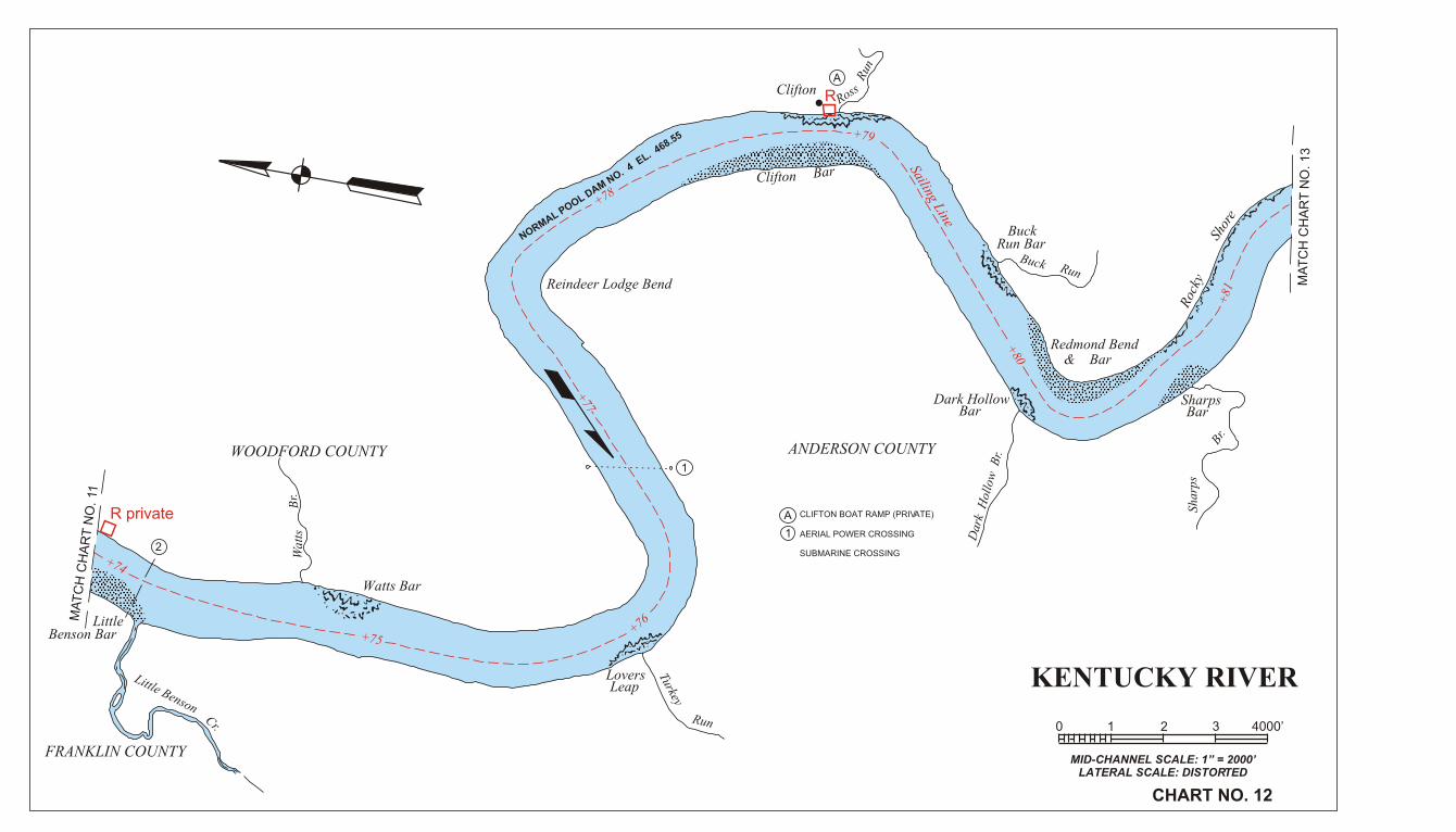
CHART NO. 12
0 1 2 3 4000’
+74
+75+76
+77
+78
+79
+80
Sailing Line
+81
MA
TC
H C
HA
RT
NO
. 11
LittleBenson Bar
Little BensonCr.
FRANKLIN COUNTY
WOODFORD COUNTY
Wat
tsB
r.
Watts Bar
LoversLeap
Turkey
Run
Reindeer Lodge Bend
NORMAL POOL D
AM NO. 4
EL. 4
68.55
Clifton Bar
CliftonRoss
Run
BuckRun Bar
Buck Run
Redmond Bend& Bar
Dark HollowBar
ANDERSON COUNTY
Dar
k H
ollo
w B
r.
Shar
ps
Br.
SharpsBar
Roc
kySh
ore
MA
TC
H C
HA
RT
NO
. 1
3
A
1
A
CLIFTON BOAT RAMP (PRIVATE)
AERIAL POWER CROSSING
SUBMARINE CROSSING
R
R private
1
2

KENTUCKY RIVERLOCK NO. 5
MID-CHANNEL SCALE: 1” = 2000’LATERAL SCALE: DISTORTED
CHART NO. 13
0 1 2 3 4000’
MA
TC
H C
HA
RT
NO
. 12
DANGER AREA
DAM NO. 5MILE 82.2
RESTRICTED AREA
Creek
Tyrone Steam
Generating Plant
keerC
+83
82+
+84
+85
+86
Sailing Line
+87
Site of Shryock's Ferry, used totransport troops of ConfederateGeneral John Hunt Morgan onraids in central Kentucky
BlackburnMemorial Bridge
NO
RM
AL
PO
OL
DA
M N
O.
5 E
L. 4
83.5
4
Bailey Run
R
WOODFORD COUNTY
Tyrone
Wildcat B
r.
ANDERSON COUNTY
Griers
Cr.
Bear
Br.
MA
TC
H C
HA
RT
NO
. 14
13456
2
7
8
A
B
C
D
E
F
1
2
3
4
5
67
8
A
B
CD
E
F
AERIAL POWER CROSSING
SUBMARINE CROSSING
U.S. ROUTE 62 HWY. BRIDGE
SOUTHERN RR. CO. BRIDGE
KY. UTILITY CO. DISCHARGE
KY. UTILITY CO. INDUSTRIAL INTAKE
CITY OF LAWRENCEBURG MUNICIPAL INTAKE
WILD TURKEY DISTILLERY INTAKE
KY. STONE CO., INC., INDUSTRIAL INTAKE
FINT’S RAMP KY F & W
CITY OF VERSAILLES MUNICIPAL INTAKE
SECTIONLOCK NO. 5
SCALE: 1” = 40’
El. 493.2438' -0"
U.P. El. 483.54
U. Sill El. 473.54
L.P. El. 468.55
L. Sill El. 462.05
10
.0'
6.5
’
G
G

KENTUCKY RIVER
MID-CHANNEL SCALE: 1” = 2000’LATERAL SCALE: DISTORTED
CHART NO. 14
0 1 2 3 4000’
+88
+89
+90
+91
+92
+93
+94
Sailing Line
MA
TC
H C
HA
RT
NO
. 13
MATC
H C
HAR
T NO
. 15
NO
RM
AL P
OO
L DA
M N
O. 5 E
L. 483.54
Craig
Cr. Summer Cottages
Gilb
ert
Cr.
Clay
Lick
Cr.
WOODFORD COUNTY
Dowling Camp
ME
RC
ER
CO
UN
TY
AN
DE
RSO
N C
OU
NT
Y
Lilla
rds
Bar
Lillards Bend
Y.W.C.A.Camp Otonka
1
23
1
2 3
KY BLUEGRASS PARKWAY BRIDGES-2
(VERT. CLEAR. 135.2')
AERIAL POWER CROSSING

R
R
MA
TC
H C
HA
RT
NO
. 14
KENTUCKY RIVERLOCK NO. 6
MID-CHANNEL SCALE: 1” = 2000’LATERAL SCALE: DISTORTED
CHART NO. 15
0 1 2 3 4000’
1
2
A
B
AERIAL POWER CROSSING
SUBMARINE CROSSING
F&W OREGAN ROAD BOAT RAMP
F & W CUMMINS FERRY RAMP (WOODFORD CO.)
2
1
A
B
WOODFORD COUNTY
Carr Cabin
Capt. Preston’s Landing
MERCER COUNTY
Where James Harrod’s partylanded their canoes in 1774 enroute to establish settlement atHarrodsburg.
Oregon
Lan nd uing R
Sercy Br.
Ready Bar
BeachDANGER AREA
DAM NO.6 MILE 96.2
RESTRICTED AREA
Clear Cr.
r Ca re .lC
ekiD enotS
nampahC
dneB
.rB nosli
W
.rC sni
mmuC
Cummins Falls
Cummins Bar
Cliff
Roc
k
High Cliff
Stumpy Bar
)nuR hsurB( . r
B snamor
F
Cum dnm eins B
dneB snae
D
Sailing line
NO
RM
AL POOL DAM NO.6 EL. 497.2
95+
+96
+97
+98
+99
+100
102+
+101
+104
103+
+10
5
+106
MA
TC
H C
HA
RT
NO
. 1
6
SECTIONLOCK NO.6
SCALE: 1”=40’
El. 507.3052’ -0”
U.P. El. 497.2
U. Sill El. 487.8L. P. El. 483.54
L. Sill El. 476.86.7
4’
9.4
’
Bar
C
C CUMMINS FALLS CAMPGROUND/MARINA (MERCER CO)
R

.
.
.
.
KENTUCKY RIVER
MID-CHANNEL SCALE: 1” = 2000’LATERAL SCALE: DISTORTED
CHART NO. 16
0 1 2 3 4000’
JESSAMINE COUNTY
Brooklyn
Brooklyn Bridge
.rC sreltta
B
WOODFORD COUNTY
MERCER COUNTY
Weeping Willow Stone HouseSailin
g Line
Site of early ferry. Later, ashipping point for fluorspar andcalcite from nearby mines.
.297 EL. 4. 6ON MAD LOOP LAMRON
Chinn’s HomesteadMundysLanding
Flourspar Mine
ShawneeBar
Shawnee Run
Calcite Mine(Abandoned)
RockCliff
RockyRun
Fluorspar Mine
Lower Fluorspar Mine
Twin Chimney’s Rock
+107
108+
+109
+110
+11
1
+112 +113
MA
TC
H C
HA
RT
NO
. 1
7
MATCH CHART NO. 15
123 AERIAL POWER CROSSING
3
2
1
4BRIDGE (VERT. CLEAR 54.2’)
U.S. ROUTE 68 HWY. BROOKLYN
4
A
A
PALISADES ADVENTURES CANOE RENTAL AND BOAT RAMP
R
R private

R
+ 1
18
+115
+11
4
+116
117+
119+
120 +
Shak
er
Ben
d
KENTUCKY RIVERLOCK NO. 7
MID-CHANNEL SCALE: 1” = 2000’LATERAL SCALE: DISTORTED
CHART NO. 17
0 1 2 3 4000’
44
3
4
1
12
2
3
GARRARD COUNTY
MERCER COUNTY
Early nineteenth centurypoint of shipment by flatboat of agricultural commodities pro-duced in upper reaches of DixRiver.
Cave
Dix River DamKy. Util. Hydro Elec. Plant
Herrington Lake
REVIR XID
Once the world’s highestrailroad bridge over a navigablestream; built 1876.
CedarBr.
Pleasant Hill, restored Shakercommunity.
Shakertown( Restoration )
Shaker Landing
Mother Anne Lee HydroElec. Plant
AREA RESTRICTED
1 2
3
4
5
8
987
B
A
AERIAL POWER CROSSING
A
1
9
7
3
2
5
B
4C
From this point the Shakersshipped produce and manufac-tures to points south.
DANGER AREA
Beach
DAM NO. 7MILE 117.0
High Bridge
MERCER COUNTY
Hig
hC
liff
MATCH CHART NO. 16
MATCH CHART NO. 18
Bowm
ans
Bend
JESSAMINE COUNTY
Sailing Line
NO
RM
AL P
OO
L D
AM
NO
6 EL. 4
97 .2
NORMAL POOL DAM NO. 7 EL. 513.07
AERIAL TELEPHONE CROSSING
SOUTHERN RR. CO. HIGH
BRIDGE (VERT. CLEAR 160.7’)
WILMORE WATER INTAKE
HARRODSBURG WATER INTAKE
HIGH BRIDGE BOAT RAMP F & W VPA ACCESS SITE
SECTIONLOCK NO. 7
SCALE: 1” = 40’
El. 521.91 52’ -0”
U.P. El. 513.07
U. Sill El. 503.91
L.P. El. 497.20
L. Sill El. 490.89
9.1
6’
6.3
1’
D
D
C
SHAKERTOWN LANDING
Dixie Belle Cruise Boat PH 800 734-5611
AA

KENTUCKY RIVER
MID-CHANNEL SCALE: 1” = 2000’LATERAL SCALE: DISTORTED
CHART NO. 18
0 1 2 3 4000’
MATCH CHART NO. 17
2 AERIAL POWER CROSSING
MATCH CHART NO. 19
1
2
1
JESSAMINE COUNTY
High Cliff
Ox Bow Bend
Saili
ng L
ine
Jess
amin
e
Cr.
Handys Bend
(7 Mile Bottom)
High Cliff
Boat Hollow
GARRARD COUNTYTw
inB
r.dneB sna
mwo
B
MAD LOOP LAMRON
NO. 7 EL. 5
13.07
+121+122
+123
+12
4
125+
126+
127+
RR
KENTUCKY RIVER
MID-CHANNEL SCALE: 1” = 2000’LATERAL SCALE: DISTORTED
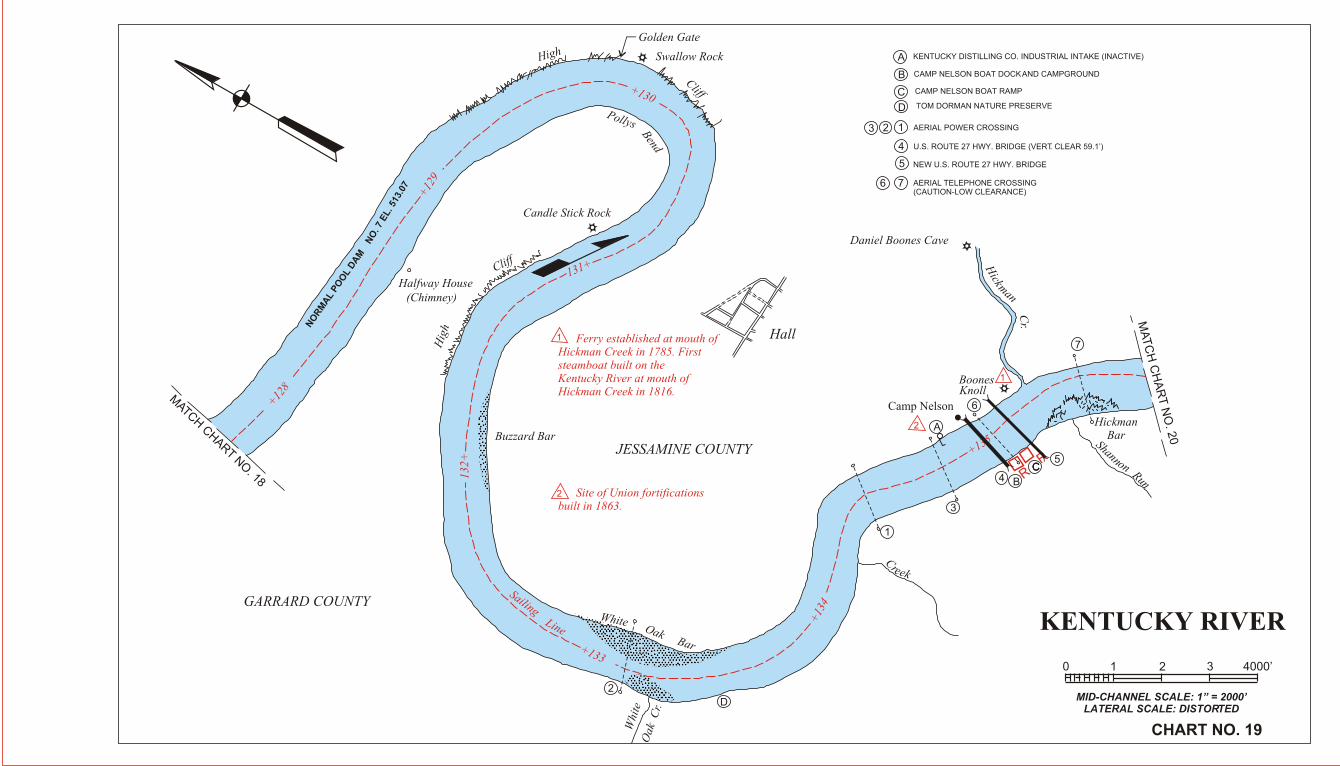
CHART NO. 19
0 1 2 3 4000’
MATCH CHART NO
. 18
MA
TC
H C
HA
RT
NO
. 20
2
1
1
3
B
D
4C
5
6
A
2
2
1
23
4
5
A
B
C
D
7
AERIAL POWER CROSSING
AERIAL TELEPHONE CROSSING(CAUTION-LOW CLEARANCE)
1
KENTUCKY DISTILLING CO. INDUSTRIAL INTAKE (INACTIVE)
CAMP NELSON BOAT DOCK AND CAMPGROUND
CAMP NELSON BOAT RAMP
TOM DORMAN NATURE PRESERVE
U.S. ROUTE 27 HWY. BRIDGE (VERT. CLEAR 59.1’)
NEW U.S. ROUTE 27 HWY. BRIDGE
Golden Gate
Swallow RockHigh
Cliff
Pollys
Bend
Candle Stick Rock
Halfway House(Chimney)
Buzzard BarH
igh
Cliff
Ferry established at mouth ofHickman Creek in 1785. Firststeamboat built on the Kentucky River at mouth ofHickman Creek in 1816.
Hall
Site of Union fortificationsbuilt in 1863.
JESSAMINE COUNTY
GARRARD COUNTY
Daniel Boones Cave
Camp Nelson
HickmanBar
BoonesKnoll
Hickman C
r.
Shannon Run
White Oak Bar
Whi
teO
ak C
r.
Creek
+12
8
+12
9
+130
131+
132+
+133
+13
4
+135
SailingLine
NO
RM
AL
PO
OL
DA
MN
O. 7
EL. 5
13.0
7
CC
7
6
MATCH CHART NO. 21
MATC
H C
HA
RT N
O. 1
9
KENTUCKY RIVERLOCK NO. 8
MID-CHANNEL SCALE: 1” = 2000’LATERAL SCALE: DISTORTED
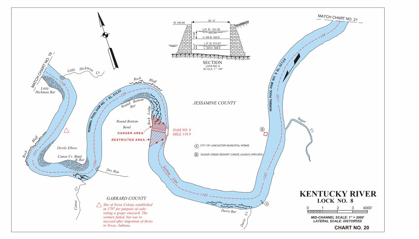
CHART NO. 20
0 1 2 3 4000’
GARRARD COUNTY
Site of Swiss Colony establishedin 1797 for purpose of culti-vating a grape vineyard. The venture failed, but was to succeed after migration of Swissto Vevay, Indiana.
Devils Elbow
Roc
k
Bluff
Canoe Cr. Bend& Bar
Can
oeC
r.
Dry Run
Littlemk aciH n
LittleHickman Bar
Cr.
Rock Bluff
mottoB dnuoR Bar
Round Bottom
Bend
DANGER AREA
RESTRICTED AREA
egdeL kco
R
Davis Bar
Dav
isC
r.
JESSAMINE COUNTY
CITY OF LANCASTER MUNICIPAL INTAKE
DAM NO. 8MILE 139.9
A
A
Sugar
Cr.
Sailing Line
62.1
35 .L
E 8 .
ON
MA
D L
OO
P L
AM
RO
N
70.315 .LE 7 .ON
MA
D L
OO
P L
AM
RO
N
+136
137+
+13
8+139
140+
+141
+14
2
+14
3
+144
52’ -0”
U.P. El. 531.26
U. Sill El. 520.6
L.P. El. 513.07
L. Sill El. 506.66.4
7’
10
.66
’
El. 540.60
SECTIONLOCK NO. 8
SCALE: 1” =40’
B
SUGAR CREEK RESORT CANOE LAUNCH (PRIVATE)B

R R
R
+145
KENTUCKY RIVER
MID-CHANNEL SCALE: 1” = 2000’LATERAL SCALE: DISTORTED
CHART NO. 21
0 1 2 3 4000’
MATC
H C
HA
RT N
O. 2
0
MATC
H C
HA
RT N
O. 22
5
4
2
8
6
3
PaintLickBarsreteeT
holenruT Bend
Teeters
Br.
Paint
LickC
r.
esrohdli
W
Br.
Yate
sB
r.
Rock
Cliff
Dry
Run
GARRARD COUNTY
JESSAMINE COUNTY
MADISON COUNTY
Sailing Line
LowerHunters
Bar
llim
waS
Run
NO. 8 EL. 531.26
2
3
4
6
8
AERIAL TELEPHONE CROSSING
BUCKEYE RIDGE RAMP- HUNTER’S FERRY CROSSING
HWY 39 F& W RAMP (AKA JOHN NICKELL RAMP)
SUBMARINE CROSSING
POOSEY RIDGE F & W RAMP
AERIAL POWER CROSSING5
+146
+147
+148
+149
NORMAL POOL DAM
7
7
R private
R
9 HUNTER’S FERRY RAMP
9
SMALL CRAFT
KENTUCKY RIVER
MID-CHANNEL SCALE: 1” = 2000’LATERAL SCALE: DISTORTED
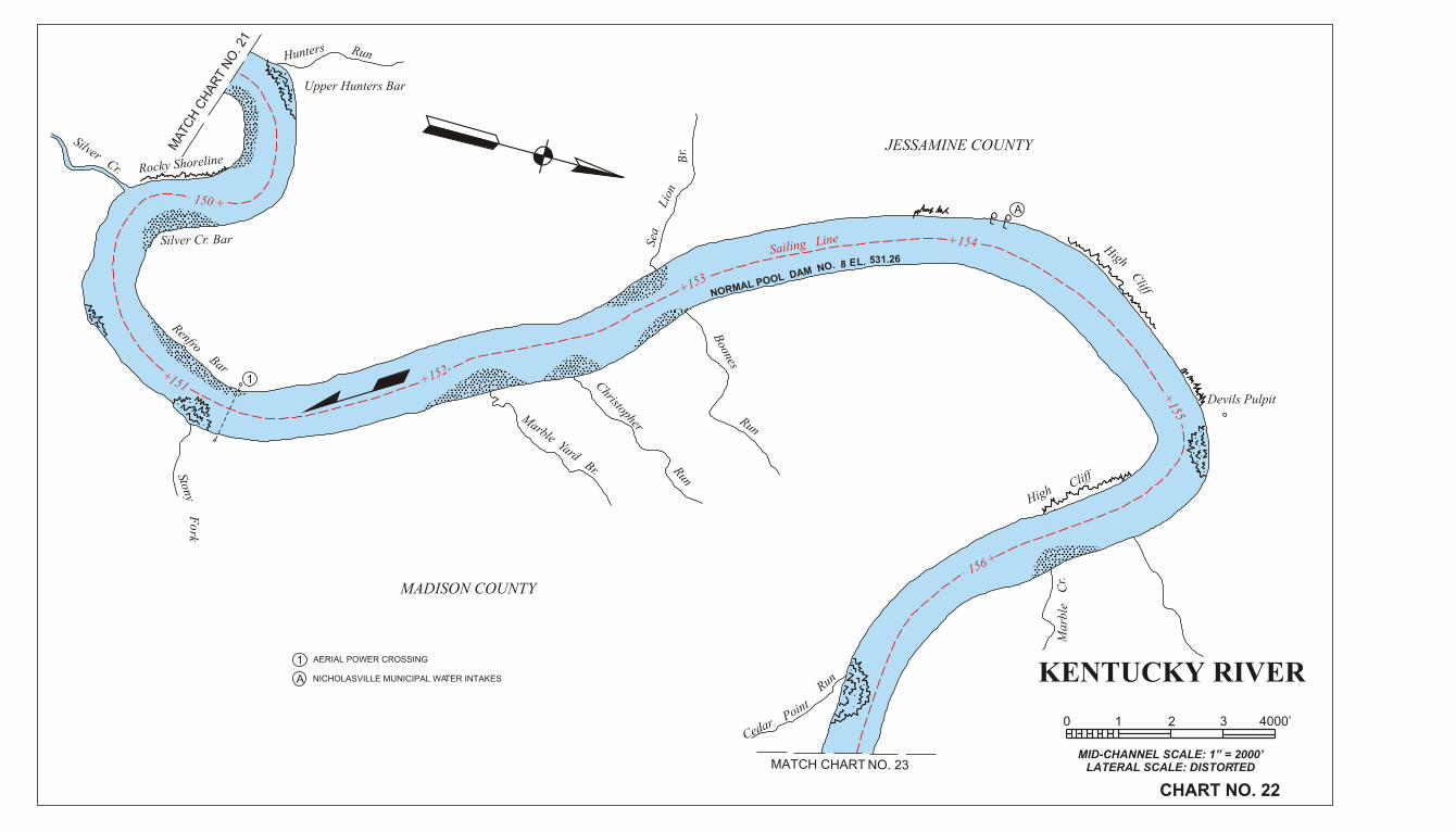
CHART NO. 22
0 1 2 3 4000’
MATCH CHART NO. 23
A NICHOLASVILLE MUNICIPAL WATER INTAKES
MAT
CH
CH
AR
T N
O. 2
1
Upper Hunters Bar
Silver Cr. Bar
Silver Cr. Rocky Shoreline
Hunters Run
RenfroBar
StonyF
ork
Marble Yard Br.
Christopher
Run
Boones
Run
Sailing LineSea
Lion
Br.
MADISON COUNTY
JESSAMINE COUNTY
High
Cliff
Devils Pulpit
HighCliff
Mar
ble
Cr.
CedarPoint
Run
NORMAL POOL DAM NO. 531.26L.E8
1 AERIAL POWER CROSSING
A
1
150 +
+151 +152
+153
+154
+155
156 +

MA
TC
H C
HA
RT
NO
. 24
MA
TC
H C
HA
RT
NO
. 22
3
KENTUCKY RIVERLOCK NO. 9
MID-CHANNEL SCALE: 1” = 2000’LATERAL SCALE: DISTORTED
CHART NO. 23
0 1 2 3 4000’
2 1
3
4
1
42
Valley View
Tates
Cr.
FERRY
Spea
rsB
r.
JESSAMINE COUNTY
Walden
Run
Sand
RockClif
f
Bridge Piers
RESTRICTED AREA
DANGER AREA
DAM NO. 9MILE 157.5
MADISON COUNTY
Valley View Ferry is the oldestcontinuously operating in busi-ness in Kentucky, established in1785, and now the only remain-ing ferry on the Kentucky River.
VALLEY VIEW FERRY CABLES
AERIAL POWER CROSSING
VALLEY VIEW PICNIC AREA
Lovers Leap
Hig
h C
liff
Sa
ilin
g L
ine
FAYETTE COUNTY
Dry
Br.
NO
RM
AL P
OO
L D
AM
NO
.9
EL. 548.6
+157
+15
8
+
15
9
+160
+161
+162
+16
3
El. 558.6052’ -0”
U.P. El 548.6
U. Sill El. 538.6
L.P. El 531.26
L. Sill El. 524.6
10
.0’
6.6
6’
LOCK NO. 9SECTIONSCALE: 1” =40’
R private
R
KENTUCKY RIVER
MID-CHANNEL SCALE: 1” = 2000’LATERAL SCALE: DISTORTED
CHART NO. 24
0 1 2 3 4000’
7
2
3
4
5
A
B
6
SUBMARINE CROSSING
U.S. ROUTE 25 HWY BRIDGE (VERT. CLEAR 48.4’)
1 AERIAL POWER CROSSING
AERIAL TELEPHONE CROSSING
U.S. ROUTE I-75 HWY. BRIDGE-2 (VERT. CLEAR 173.1’)
KY AMERICAN WATER CO INTAKES
CLAY’S FERRY BOAT RAMP
7
3
45
A
B
6
1
2
MATC
H C
HA
RT N
O. 2
5
MATCH CHART NO. 23
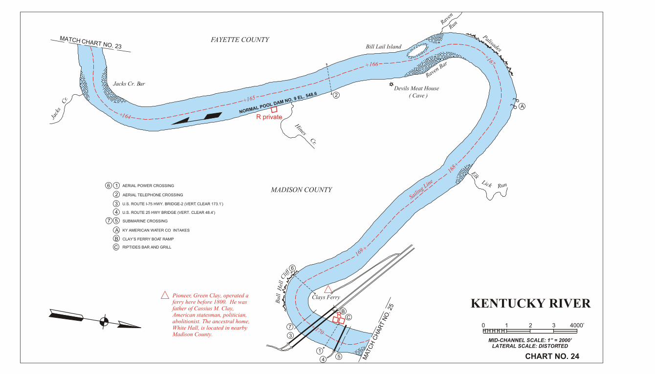
Pioneer, Green Clay, operated a ferry here before 1800. He wasfather of Cassius M. Clay, American statesman, politician,abolitionist. The ancestral home,White Hall, is located in nearbyMadison County.
MADISON COUNTY
FAYETTE COUNTY
Jacks Cr. Bar
Jack
s
Cr.
Hines
Cr.
Bill Lail Island
Devils Meat House( Cave )
Raven Bar
Raven
Run
Palisades
NORMAL POOL DAM NO. 9 EL. 548.6
ElkLick Run
Sailing Line
lleH llu
BC
liff
Clays Ferry
+164
+165
+166
+167
168+
169 +
+
170
R private
C
C RIPTIDES BAR AND GRILL

R
x x xx xx x x
B
2
3
4
A
WINCHESTER MUNICIPAL INTAKE
SUBMARINE CROSSING
BOONESBOROUGH STATE PARK BOAT RAMP
1
THREE TREES CAMPGROUND AND CANOE RENTAL
AERIAL POWER CROSSING
KY.627 HWY. MEMORIAL BRIDGE (VERT. CLEAR 101.3’)
1
MATCH CHART NO. 26
MATCH CHART NO. 24
KENTUCKY RIVERLOCK NO. 10
MID-CHANNEL SCALE: 1” = 2000’LATERAL SCALE: DISTORTED
CHART NO. 25
0 1 2 3 4000’
B
2 3
4C
A
C
MADISON COUNTY
CLARK COUNTY
Bea
ch
Calloway Br.
CliffCliff
Clays Ferry Bar
BooneC
r.
NORMAL POOL DAMNO. 9 EL. 5
48.6
Sailing Line
Dewitt Bar
Cliff
Dry Run
(Jou
ett
Cr.
)
Dew
itt
Cr.
Allen Co.Quarry
The first ferry chartered tooperate on the Kentucky Riverwas established at Boones-borough in 1779.
Fort BoonesboroughOriginal FortRebuilt 1974
BoonesboroughState Park
DAM NO. 10MILE 176.4
PHONE: A/C 859527-3356
RESTRICTEDAREA
DANGER AREA
388
Low
erH
owar
dC
r.
Lisletown
Fort
+171
+172
+173
+174
175
+
+176
El. 576.7052’ -0”
U.P. El 565.7
U. Sill El. 556.7
L.P. El. 548.6
L. Sill El. 542.7
9.0
’5
.9’
LOCK NO. 10SECTIONSCALE: 1” =40’
5
5 SUNKEN PADDLEWHEELER
D
D HALL’S ON THE RIVER RESTAURANT
R private
E
E WATERFRONT RESTAURANT

KENTUCKY RIVER
MID-CHANNEL SCALE: 1” = 2000’LATERAL SCALE: DISTORTED
CHART NO. 26
0 1 2 3 4000’
MATCH CHART NO
. 27
MATCH CHART NO. 25
2
3
4
5
A
B
C
6 SUBMARINE CROSSING-2 EACH
OLD HABITS BOAT DOCK, RAMP AND BAR
L&N R.R. CO. BRIDGE (VERT. CLEAR 49.8’)
1 AERIAL TELEPHONE CROSSING
AERIAL POWER CROSSING
L&N R.R. CO. BRIDGE (VERT. CLEAR 47.0’)
R.E.A. PLANT COAL TERMINAL (INACTIVE)
R.E.A. STEAM GEN. PLANT INTAKE
710
8
9
2
3
45
A
B
C
6
1
7
10
8
9
MADISON COUTNY
CLARK COUNTY
Fourmile Cr.
Sailing line
BarRun
Probable Site of Orig-inal Stockade of Boonesborough
Otter
Cr.
Ford SteamGenerating Plant
Ford
Twom
ile
Cr.
.7565 .LE 01 .ON MAD LOOP LAMRON
+17917
7+
+178
+180
+181
+182
R
KENTUCKY RIVER
MID-CHANNEL SCALE: 1” = 2000’LATERAL SCALE: DISTORTED
CHART NO. 27
0 1 2 3 4000’
MATCH CHART NO
. 26
MATCH C
HART NO. 2
8
A
3
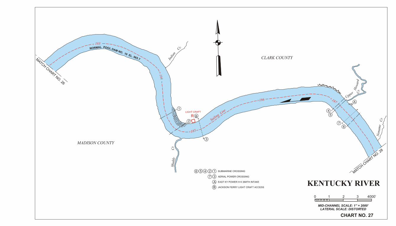
EAST KY POWER H K SMITH INTAKE
SUBMARINE CROSSING
AERIAL POWER CROSSING
MADISON COUNTY
Indi
an
Cr.
CLARK COUNTY
drawo
H
Upper Cr.
Non
ame
Cr.
Mud
dyC
r.12456
A
3
1
2
4
5
6
+ 183
+184
+185
+186+187
Sailing L
ine
L PA OMR OO LN DAM NO. 10 EL. 565.7
7
7
RLIGHT CRAFT
B
B JACKSON FERRY LIGHT CRAFT ACCESS

1O. 0 N FM L. A 565D .7 LOOP LAMRON
KENTUCKY RIVER
MID-CHANNEL SCALE: 1” = 2000’LATERAL SCALE: DISTORTED
CHART NO. 28
0 1 2 3 4000’
MATCH CHART NO. 27
MATCH CHART NO. 29
2
A
1
RED RIVER BOAT DOCK & RAMP (AKA MERRITT BOAT RAMP)
SUBMARINE CROSSING
2
A
1
ESTILL COUNTY
Rocky Face
Sailing Line
RockyFace
T dne Bh gr ur b no
Bend
Devils Backbone Rocky Ledges
Iron products from the RedRiver Iron District in Estill,Powell, and Lee Counties were hauled overland by wagon, thendown Red River to the Kentucky River for barge trans-portation. Several iron furnaces still exist.
MADISON COUNTY
Cow
Run
Roc
kyL
edge
s
Maup
inBend
Bull
Run
EDR RIVER
CLARK COUNTY
+18
8
189+
+
190
+191 +192
+ 193
+194
+ 195
196+
197+
Strawberry
R
RB
B COLLEGE HILL RAMP F&W

+
198
+199
+200
+
+20
2
+
203
+ 204
205
+
2
345
A
AERIAL POWER CROSSING
AERIAL TELEPHONE CROSSING1
RICHMOND MUNICIPAL INTAKE
SUBMARINE CROSSING
MATCH CHART NO. 30
KENTUCKY RIVERLOCK NO. 11
MID-CHANNEL SCALE: 1” = 2000’LATERAL SCALE: DISTORTED
CHART NO. 29
0 1 2 3 4000’
MATCH CHART NO. 28
2
34
5
A
1
Little
Polecat
Cr.
Falling
Rock
Br.
ESTILL COUNTYFlat Rocky Point
Lick
Run
Sailing Line
Flat RockyShoreline
Raven
Br. N
olan
dC
r.
Noland Cr. Bar
MADISON COUNTY
Roc
kO
verh
ang
NORMAL POOL DAM NO. 10 EL. 5 65.7
50.
38
5 .L
E 11 .
ON
MA
D L
OO
P L
AM
RO
N
Flint Cr.L
edge
Rocky
Face
D A N G E R A R E A
R E S T R I C T E D A R E A
DAM NO.11MILE 201.0
El . 593.0552’ -0”
U.P. El 583.05
U. Sill El. 573.05
L.P. El. 565.70
L. Sill El. 559.05
10
.0’
6.6
5’
LOCK NO. 11SECTION
SCALE: 1” =40’
KENTUCKY RIVER
MID-CHANNEL SCALE: 1” = 2000’LATERAL SCALE: DISTORTED
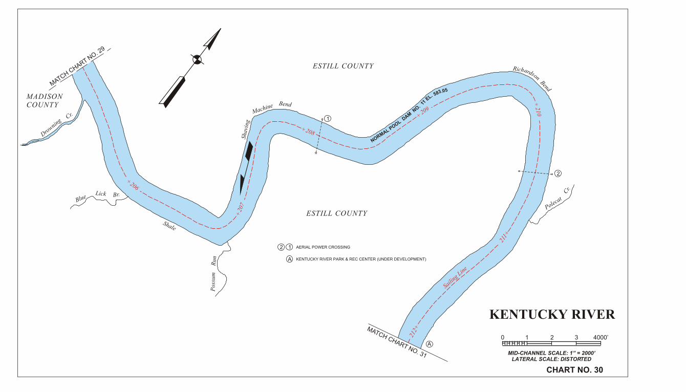
CHART NO. 30
0 1 2 3 4000’
MATCH CHART NO. 31
MATCH CHART N
O. 29
2 AERIAL POWER CROSSING1
2
1
ESTILL COUNTY
ESTILL COUNTY
MADISONCOUNTY
Drowning
Cr.
BlueLick Br.
Shale
Pos
sum
Run
Shav
ing
Machine Bend
50.385 .LE 11 .ON MAD LOOP LAMRON
Richardson Bend
Polecat
Cr.
Saili
ng L
ine
+
206
+20
7
+208
+209
+210
211+
212+
A
A KENTUCKY RIVER PARK & REC CENTER (UNDER DEVELOPMENT)

R
KENTUCKY RIVER
MID-CHANNEL SCALE: 1” = 2000’LATERAL SCALE: DISTORTED
CHART NO. 31
0 1 2 3 4000’
D
2
3
45
A
B
C
6
AERIAL POWER CROSSING
KY. ROUTES 52-89 HWY. BRIDGE (VERT. CLEAR 64.3’)
IRVINE SEWAGE TREATMENT PLANT DISCHARGE
1
RIVER CITY MARINA
RADER’S RIVER GRILL & BOAT RAMP
SOUTH EAST COAL CO. INTAKES
SUBMARINE CROSSING
MA
TC
H C
HA
RT
NO
. 3
1
MATC
H C
HA
RT N
O. 3
0
AERIAL TELEPHONE CROSSING
D
2
3
4 5
A B
C
6
1
Cal
low
ayC
r.
Calloway Crossing
CubbardRock
Sa
iling L
ine
Whi
teO
ak
Cr.
Irvine
Bridge Piers Mi. 217.6
West Irvine
ESTILL COUNTY
NORMAL POOL DAM NO. 11 EL. 583.05
+21
3 +214
+215 +216
+ 217
+218
7
7
8
8
9
9

KENTUCKY RIVERLOCK NO. 12
MID-CHANNEL SCALE: 1” = 2000’LATERAL SCALE: DISTORTED
CHART NO. 32
0 1 2 3 4000’
2
3
B
A
AERIAL POWER CROSSING
AERIAL POWER AND TELEPHONE CROSSING
1 SUBMARINE CROSSING
AMERICAN LEGION RAMP
IRVINE-RAVENNA MUNICIPAL INTAKE
MA
TC
H C
HA
RT
NO
. 3
3
MA
TC
H C
HA
RT
NO
. 31
23
A
BB
1
The Indians’ north-south“Warriors’ Path” crossed the Kentucky River near the mouthof Station Camp Creek.Dr. Thomas Walker, who dis-covered and named CumberlandGap, camped at Station CampCreek in 1750.
Irvine
Ravenna
ESTILL COUNTY
Soap & Tallow Bend
Cow
Cr.
Sailing Line
Wagers Bend
ffilC elahS
Coppers LickBend
Coppers Lick
Br.
NORMAL PO
OL DAM NO. 12 EL. 600.10
Stat
ion
Cam
p
Cr.
QuickShoalsBar
South Irvine
QuickShoals
Cha
mbe
rlai
nC
r.
. 11 EL. 5O N 8MAD 3.LOO PL 0AMR 5ON
Dog Rock Bend
Dog
Br.
Dog Rock
Doe Cr.Bar
Ravenna Beach
DANGER AREA
BigDoe
Cr.
Doe
Cr.
Little
RESTRICTED
A R E A
DogRock
Bar
DAM NO.12MILE 220.9+
219
+220
+22
1
+ 222
+223
+ 224
El. 606.10
52’ -0”
U.P. El. 600.10
U. Sill El. 590.50
L.P. El. 583.05
L. Sill El. 577.10
9.6
’5
.95
’
LOCK NO. 12SECTIONSCALE: 1” =40’
R
Shallow

KENTUCKY RIVER
MID-CHANNEL SCALE: 1” = 2000’LATERAL SCALE: DISTORTED
CHART NO. 33
0 1 2 3 4000’
+22
5 +226
+227
+228
+229
MA
TC
H C
HA
RT
NO
. 34
MA
TC
H C
HA
RT
NO
. 32
Millers Creek
Miller C
r.
.rB kci
L eulB
Pryse
Texola
Buck
Cr.
ESTILL COUNTY
NORMAL POOL DAM NO. 12 EL. 600.1
1
3
2
1
2
3
SUBMARINE CROSSING
AERIAL POWER CROSSING
Sailing Line

KENTUCKY RIVER
MID-CHANNEL SCALE: 1” = 2000’LATERAL SCALE: DISTORTED
CHART NO. 34
0 1 2 3 4000’
238+
.1006. L ENORM 12AL PO .OL DA OM N
237+
236+
+235+234 +233
+232
231+
230+
LEE COUNTY
Ross Cr.
Evelyn
Bridge Piers
ESTILL COUNTY
Sailing Line
MATCH CHART NO
. 35
Pinnacle Rock
Old Landing
LEE COUNTYM
ATCH CHART N
O. 33
1234578
6
A
12
3
4
5
7
8
6
AERIAL POWER CROSSING
AERIAL TELEPHONE CROSSING
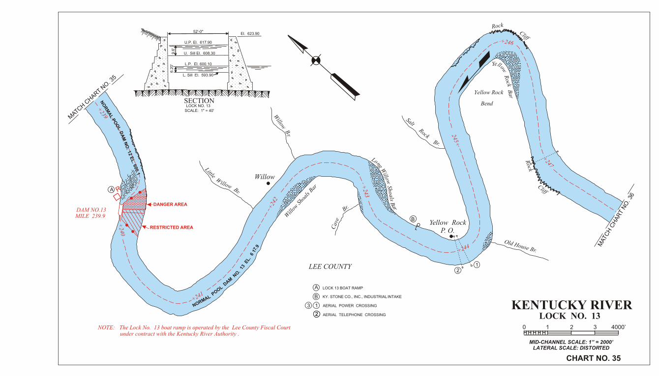
KENTUCKY RIVERLOCK NO. 13
MID-CHANNEL SCALE: 1” = 2000’LATERAL SCALE: DISTORTED
CHART NO. 35
0 1 2 3 4000’
+239
+240
+241
+24
2
+243
+244
245+
+246
+247
MATCH C
HART NO
. 35
NO
RM
AL P
OO
LD
AM
NO
. 12 E
L. 6
00.1
DAM NO.13MILE 239.9
DANGER AREA
RESTRICTED AREA
NOTE: The Lock No. 13 boat ramp is operated by the Lee County Fiscal Courtunder contract with the Kentucky River Authority .
9.716 .
LE 31 .
ON MAD LOOP LAMRON
Little Willow Br.
Willow
Willow
Br.
Will
ow S
hoal
s Bar
Cav
e
Br.
Yellow RockP. O.
Old House Br.
Long Willow
Shoals B
ar
SaltRock
Br.
Yellow Rock
Bend
Yellow R
ock Bar
RockCliff
Rock
Cliff
MATC
H C
HA
RT N
O. 3
6
LEE COUNTY
1
2
12
KY. STONE CO., INC., INDUSTRIAL INTAKE
LOCK 13 BOAT RAMP
AERIAL POWER CROSSING
AERIAL TELEPHONE CROSSING
SECTIONLOCK NO. 13
SCALE: 1" = 40'
52'-0"El. 623.90
U.P. El. 617.90
U. Sill El. 608.30
L.P. El. 600.10
L. Sill El. 593.90
6.2
0'
9.6
'
3
R
2
B
B
A
A
.

KENTUCKY RIVERLOCK NO. 14
MID-CHANNEL SCALE: 1” = 2000’LATERAL SCALE: DISTORTED
CHART NO. 36
0 1 2 3 4000’
SECTIONLOCK NO. 14
SCALE: 1" = 40'
52'-0"El. 641.40
U.P. El. 634.40
U. Sill El. 625.80
L.P. El. 617.90
L. Sill El. 611.4
6.5
0'
8.6
'
MATCH CHART NO. 35
Sawmill B
r.
Old Gal Bar
Heidelberg
BridgePiers
Turnhole Br.
Sturgeon Bar
Sturgeon Cr.
RESTRICTED AREA
DAM NO. 14MILE 249.0
DANGER AREA
+248
+25
0
+251
+252
+25
3
+254
Saili
ng L
ine
Con
trar
y C
r.
Belle Point
LEE COUNTY
Dirk
sen
Br.
NO
RM
A
L POOL DAM NO. 14 EL. 634.4
Baker Bar
Mik
es B
r.
Mar
rey
Cr.
MATC
H C
HA
RT N
O. 3
7
A
1
2
3
4
A
4
1
23
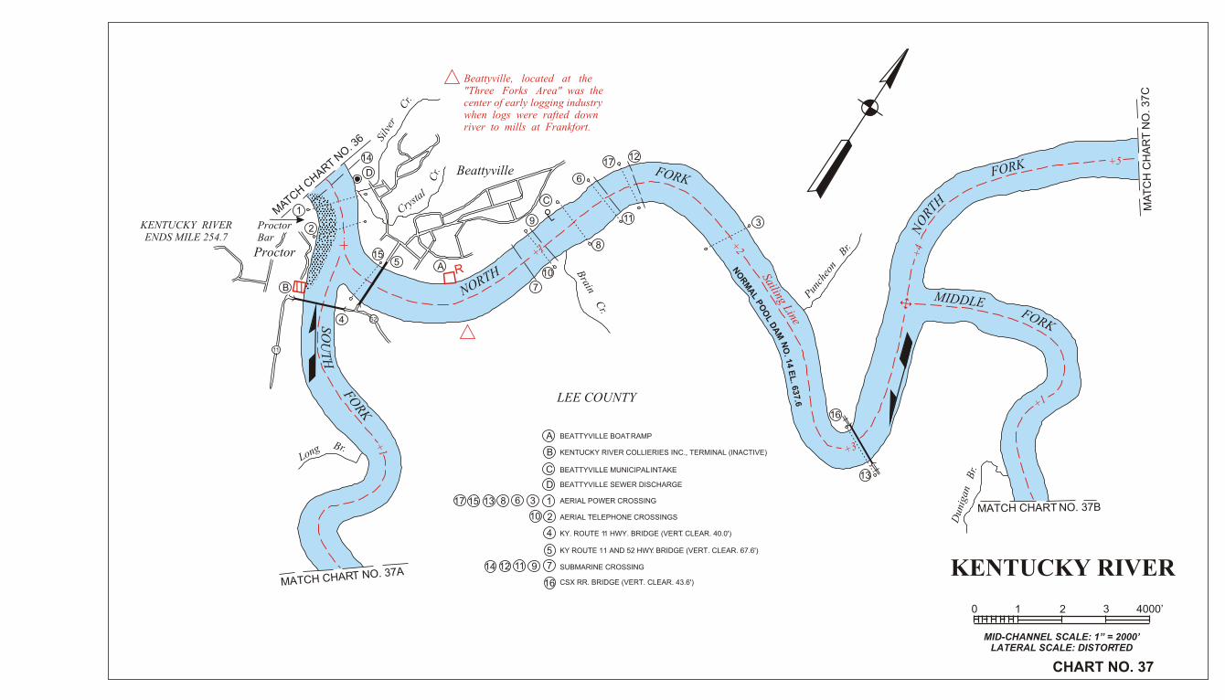
BEATTYVILLE SEWAGE TREATMENT PLANT DISCHARGE
AERIAL POWER CROSSING
LEE COUNTY ROUTE 399 HWY. BRIDGE (VERT. CLEAR. 51.2)
AERIAL TELEPHONE CROSSING
5
5 SUBMARINE CROSSING
KENTUCKY RIVER
MID-CHANNEL SCALE: 1” = 2000’LATERAL SCALE: DISTORTED
CHART NO. 37
0 1 2 3 4000’
+1
+1
+2
+3
+4
+5
+1
MATCH C
HART NO
. 36
MATCH CHART NO. 37A
MATCH CHART NO. 37B
MA
TC
H C
HA
RT
NO
. 3
7C
KENTUCKY RIVERENDS MILE 254.7
ProctorBar
Proctor
Long Br.
SOU
TH
FORK
Silv
er
Crystal
Cr.
Cr.
Beattyville
NORTHR
LEE COUNTY
Brain C
r.
FORK
Sailing Line
Punch
eon
Br.
NO
RM
AL P
OO
L DA
M N
O. 1
4 E
L. 6
37.6
HTRO
N
FORK
FORK
MIDDLE
Dun
igan
B
r.
A
B
C
1
2
4
5
7
16
9111214
10
368131517
A
B
C
17
15
13
8
6
31
10
2
4
5
7
9 11
1214
16
52
11
Beattyville, located at the"Three Forks Area" was thecenter of early logging industrywhen logs were rafted downriver to mills at Frankfort.
BEATTYVILLE BOAT RAMP
KENTUCKY RIVER COLLIERIES INC., TERMINAL (INACTIVE)
BEATTYVILLE MUNICIPAL INTAKE
AERIAL POWER CROSSING
AERIAL TELEPHONE CROSSINGS
KY. ROUTE 11 HWY. BRIDGE (VERT. CLEAR. 40.0')
KY ROUTE 11 AND 52 HWY. BRIDGE (VERT. CLEAR. 67.6')
SUBMARINE CROSSING
CSX RR. BRIDGE (VERT. CLEAR. 43.6')
D BEATTYVILLE SEWER DISCHARGE
D
KENTUCKY RIVER
KENTUCKY RIVER
MID-CHANNEL SCALE: 1” = 2000’LATERAL SCALE: DISTORTED
CHART NO. 37A
0 1 2 3 4000’
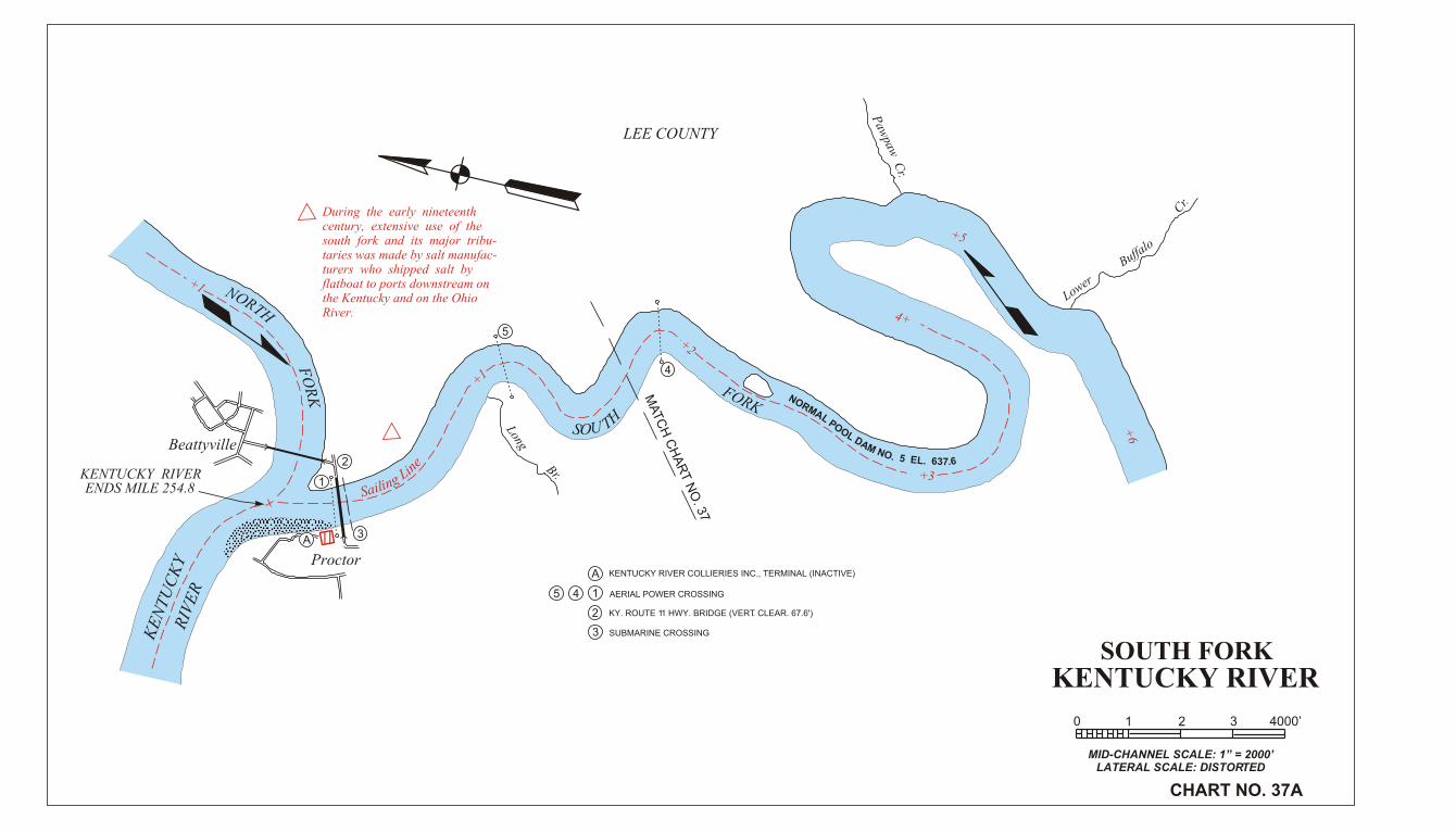
SOUTH FORK
1
2
3
45
A
A
1
2
3
4
5
+1
+1
+2
+3
4+
+5
+6
During the early nineteenthcentury, extensive use of thesouth fork and its major tribu-taries was made by salt manufac-turers who shipped salt byflatboat to ports downstream onthe Kentucky and on the OhioRiver.
ENDS MILE 254.8
eniL gniliaS
Beattyville
NORTH
FO
RK
Proctor
Long
Br.
HTS UO
MATC
H C
HA
RT N
O. 3
7
FORKNORMAL POOL DAM NO. 5 EL. 637.6
Paw
paw C
r.
LEE COUNTY
Lower
Buffalo
Cr.
KE
NT
UC
KY
RIV
ER
KENTUCKY RIVER COLLIERIES INC., TERMINAL (INACTIVE)
AERIAL POWER CROSSING
KY. ROUTE 11 HWY. BRIDGE (VERT. CLEAR. 67.6')
SUBMARINE CROSSING

KENTUCKY RIVER
MID-CHANNEL SCALE: 1” = 2000’LATERAL SCALE: DISTORTED
CHART NO. 37B
0 1 2 3 4000’
FO
RK
HT
RO
N 1
4
3
2
MIDDLE
FORK
Dunigan B
r.
MATC
H C
HA
RT N
O. 37
Dou
ble
Cab
in C
r.
N 37.6O 6.R LEM A 5 L . OP NO O ML A D
Long
Shoal
Br.
Sailing Line
Horse Shoe
Ben
d
LEE COUNTY
An extensive commercial trafficin loose floating saw logs and lografts descended the Middle Forkto downstream mills from mid-19th century to as late as 1912.
13
2
4
AERIAL POWER CROSSING
KY. ROUTE 52 HWY. BRIDGE (VERT. CLEAR. 43.8')
CSX R.R. BRIDGE (VERT. CLEAR. 43.6')
+3
+4
1+
+2 +3
+4
+5
+6
MIDDLE FORK

1
1
NORTH FORKKENTUCKY RIVER
MID-CHANNEL SCALE: 1” = 2000’LATERAL SCALE: DISTORTED
CHART NO. 37C
0 1 2 3 4000’
Sailing Line
+3
+4
+5
+6
+7
+8
+1
Laurel Br.
Log Shoal Br.
Airedale
Fincastle Road
NORMAL POOL DAM NO. 14 EL. 637.6
OldBridgePier W
alke
r C
r.Hel
l C
r.
FORKNORTH
MA
TC
H C
HA
RT
NO
. 37
MIDDLEFORK
Punc
heon
Br.
Dun
igan
Br.
LEE COUNTY HWY. BRIDGE
LEE COUNTY
In the early 19th century flat-boat shipments of salt and coal,as well as loose and rafted logswere made from the upperreaches of the North Fork.

Related Documents