Navigation and Ancillary Information Facility N IF WebGeocalc A Tutorial http://wgc.jpl.nasa.gov:8080/web geocalc April 2015 SPICE components and services are not restricted under ITAR and EAR regulations

Navigation and Ancillary Information Facility NIF WebGeocalc A Tutorial April 2015 SPICE components and services.
Jan 03, 2016
Welcome message from author
This document is posted to help you gain knowledge. Please leave a comment to let me know what you think about it! Share it to your friends and learn new things together.
Transcript
Navigation and Ancillary Information Facility
N IF
WebGeocalc
A Tutorial
http://wgc.jpl.nasa.gov:8080/webgeocalc
April 2015
SPICE components and services are not restricted under ITAR and EAR regulations
Navigation and Ancillary Information Facility
N IF
WebGeocalc 2
Overview
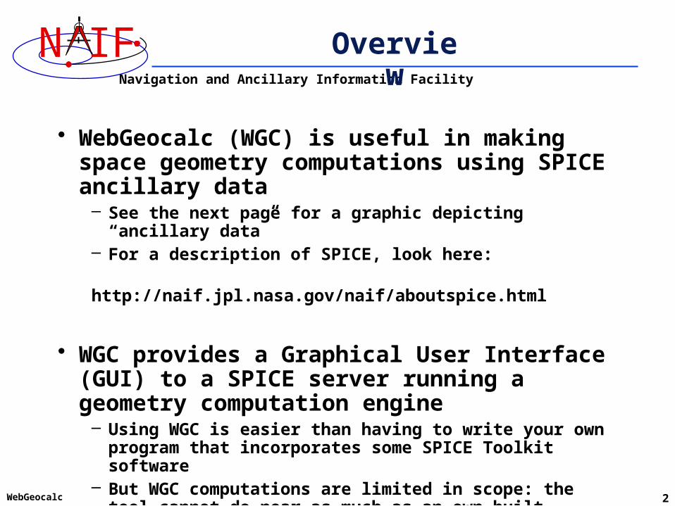
• WebGeocalc (WGC) is useful in making space geometry computations using SPICE ancillary data
– See the next page for a graphic depicting “ancillary data”– For a description of SPICE, look here: http://naif.jpl.nasa.gov/naif/aboutspice.html
• WGC provides a Graphical User Interface (GUI) to a SPICE server running a geometry computation engine
– Using WGC is easier than having to write your own program that incorporates some SPICE Toolkit software
– But WGC computations are limited in scope: the tool cannot do near as much as an own-built program that uses SPICE Toolkit APIs

Navigation and Ancillary Information Facility
N IF
WebGeocalc 3
What are Ancillary Data?
3
Spacecraft
Planet
Earth
Sun
• Solar System Barycenter
Time ConversionCalculations
Time Conversions
Instrumentreference frame
Antennareferenceframe
J2000 reference frame(EME 2000)
Reference frames
and size/shapeof planet
and size/shapeof Earth
Sizes/shapesRelative positionsof spacecraft and
solar system bodies
Positions
Orientations
Pointing ofInstrumentfield-of-view
Instrument Pointing
Navigation and Ancillary Information Facility
N IF
WebGeocalc 4
Architecture
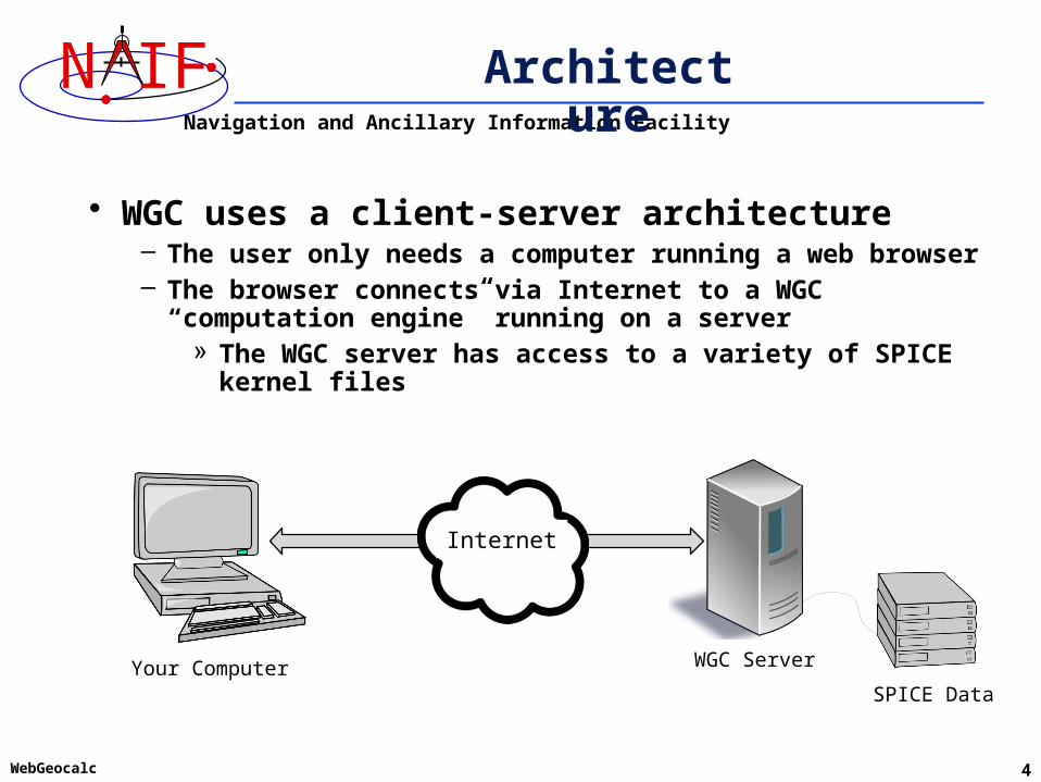
• WGC uses a client-server architecture– The user only needs a computer running a web browser– The browser connects via Internet to a WGC “computation
engine” running on a server» The WGC server has access to a variety of SPICE kernel files
SPICE Data
WGC ServerYour Computer
Internet

Navigation and Ancillary Information Facility
N IF
WebGeocalc 5
Using WebGeocalc
• WGC makes it “easy” to do many kinds of SPICE computations
– You need not write a program using SPICE Toolkit software– Instead, open a web browser and use standard GUI widgets to:
» read a variety of HELP statements (if just learning to use WGC)» select the computation desired » select the data to be used in your computation» specify the computation details» press the “CALCULATE” button
– Your results, possibly including some plots, appear in your browser window
• There are a number of conditions under which WGC will not be able to fulfill your request
– See the Limitations and Errors pages at the end of this tutorial for some examples
Navigation and Ancillary Information Facility
N IF
WebGeocalc 6
Purpose
• WGC can support planetary science in several ways– Help a user check his/her own SPICE-based program under
development– Help a user check the validity of a SPICE data file (a “kernel”)– Help a user quickly solve a one-time space geometry problem– Allow those unable to write a SPICE-based program to
nevertheless make some kinds of space geometry computations– Help a science data peer reviewer do spot checks of geometry
parameters contained in an archive about to be submitted to an archive center

Navigation and Ancillary Information Facility
N IF
WebGeocalc 7
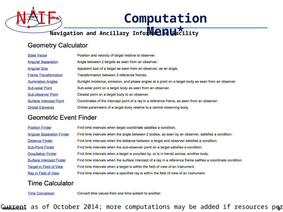
Computations
• Three categories of SPICE computations are possible
1. Geometry Calculator» Compute a parameter value at a given time, or over a time range
• Example: Compute the angular size of Phobos as seen from the SPIRIT Mars rover from 2009 March 10 12:00:00 to 2009 March 10 14:00:00
2. Geometric Event Finder» Within a specified time bounds (the confinement window)…
• Find time intervals when a particular geometric condition exists– Example: Find time intervals when Phobos is occulted by Mars as seen from Mars
Odyssey within the period 2010 June 01 to 2010 June 02• Find time intervals when a parameter is within a given range
– Example: Find time intervals when the spacecraft altitude is between 300 and 400 km• Find time intervals when a parameter has reached a local or global maximum or minimum
– Example: Find time intervals when the angular separation of a satellite from a planet, as seen from a spacecraft, has reached its minimum value
3. Time conversion calculator» Convert between various time systems and time formats
• See the WGC “menu” on the next page for some details
Navigation and Ancillary Information Facility
N IF
WebGeocalc 8
Computation Menu*
* Current as of October 2014; more computations may be added if resources permit
Navigation and Ancillary Information Facility
N IF
WebGeocalc 9
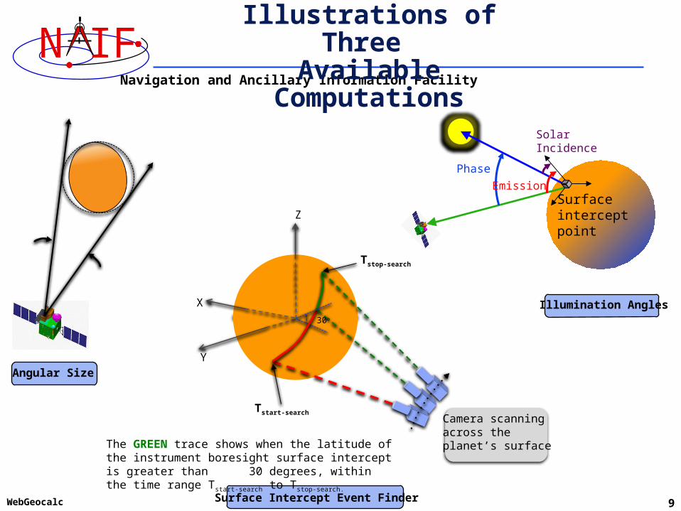
Illustrations of Three Available Computations
Phase
Solar Incidence
EmissionSurfaceinterceptpoint
Angular Size
•
Tstart-search
Tstop-search
The GREEN trace shows when the latitude of the instrument boresight surface intercept is greater than 30 degrees, within the time range Tstart-search to Tstop-search.
X
Y
Z
Camera scanningacross the planet’s surface
30o
Illumination Angles
Surface Intercept Event Finder
Navigation and Ancillary Information Facility
N IF
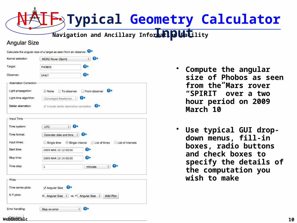
WebGeocalc 10
Typical Geometry Calculator Input
• Compute the angular size of Phobos as seen from the Mars rover “SPIRIT” over a two hour period on 2009 March 10
• Use typical GUI drop-down menus, fill-in boxes, radio buttons and check boxes to specify the details of the computation you wish to make
Navigation and Ancillary Information Facility
N IF
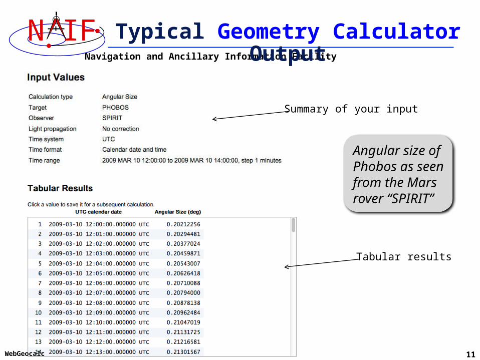
WebGeocalc 11
Typical Geometry Calculator Output
Angular size of Phobos as seen from the Mars rover “SPIRIT”
Summary of your input
Tabular results

Navigation and Ancillary Information Facility
N IF
WebGeocalc 12
Typical Geometry Calculator Plot
• Some Geometry Calculator computations offer optional plots
Angular size of Phobos as seen from the Mars rover “SPIRIT”

Navigation and Ancillary Information Facility
N IF
WebGeocalc 13
Another Geometry Calculator Plot
• Some Geometry Calculator computations offer plots using other than time on the X axis
Mars Global Surveyor sub-point on Mars from 2008 JAN 1 00:10:00 to 2008 JAN 1 02:00:00
Navigation and Ancillary Information Facility
N IF
WebGeocalc 14
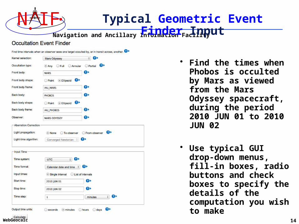
Typical Geometric Event Finder Input
• Find the times when Phobos is occulted by Mars as viewed from the Mars Odyssey spacecraft, during the period 2010 JUN 01 to 2010 JUN 02
• Use typical GUI drop-down menus, fill-in boxes, radio buttons and check boxes to specify the details of the computation you wish to make
Navigation and Ancillary Information Facility
N IF
WebGeocalc 15
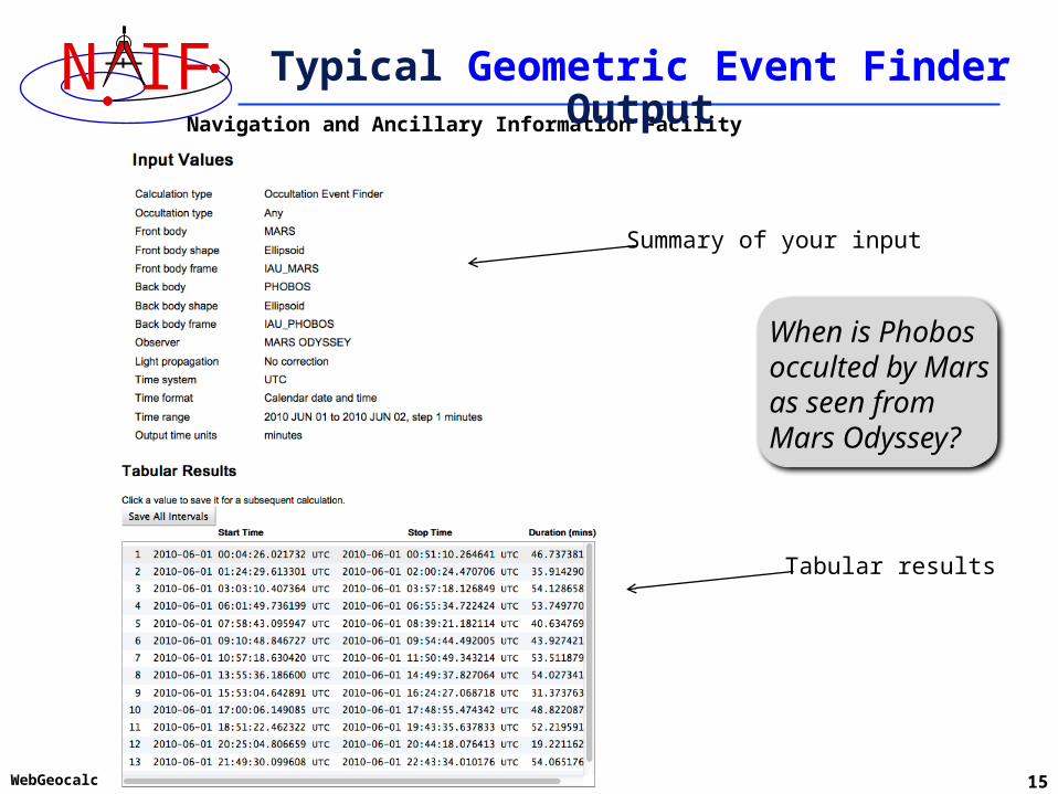
Typical Geometric Event Finder Output
When is Phobos occulted by Mars as seen from Mars Odyssey?
Summary of your input
Tabular results

Navigation and Ancillary Information Facility
N IF
WebGeocalc 16
Typical Geometric Event Finder Plot
• Geometric Event Finder computations all produce “plots” of the time intervals that satisfy your search computations
Between June 1, 2010 and June 2, 2010, find times when Phobos is occulted by Mars, as viewed from the Mars Odyssey spacecraft
Navigation and Ancillary Information Facility
N IF
WebGeocalc 17
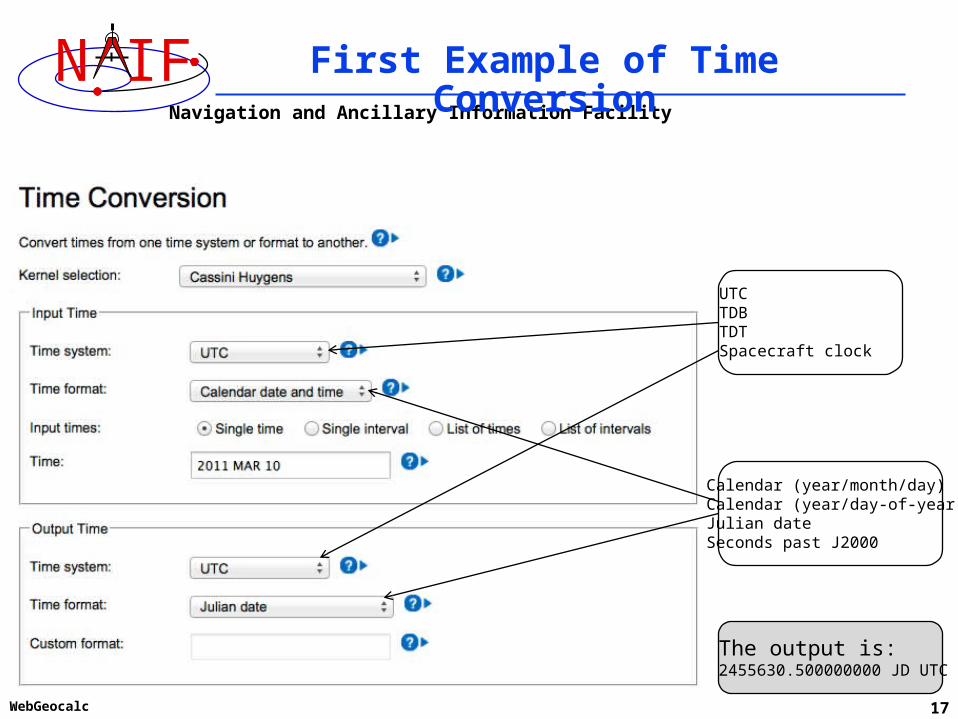
First Example of Time Conversion
UTCTDBTDTSpacecraft clock
Calendar (year/month/day)Calendar (year/day-of-year)Julian dateSeconds past J2000
The output is:2455630.500000000 JD UTC
Navigation and Ancillary Information Facility
N IF
WebGeocalc 18
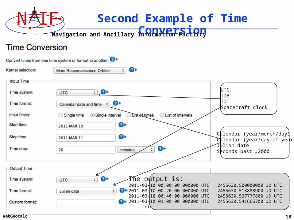
Second Example of Time Conversion
UTCTDBTDTSpacecraft clock
Calendar (year/month/day)Calendar (year/day-of-year)Julian dateSeconds past J2000
The output is:2011-03-10 00:00:00.000000 UTC 2455630.500000000 JD UTC2011-03-10 00:20:00.000000 UTC 2455630.513888900 JD UTC2011-03-10 00:40:00.000000 UTC 2455630.527777800 JD UTC2011-03-10 01:00:00.000000 UTC 2455630.541666700 JD UTC etc. etc.
Navigation and Ancillary Information Facility
N IF
WebGeocalc 19
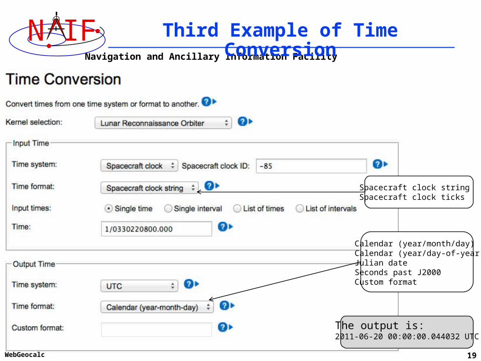
Third Example of Time Conversion
Calendar (year/month/day)Calendar (year/day-of-year)Julian dateSeconds past J2000Custom format
Spacecraft clock stringSpacecraft clock ticks
The output is:2011-06-20 00:00:00.044032 UTC
Navigation and Ancillary Information Facility
N IF
WebGeocalc 20
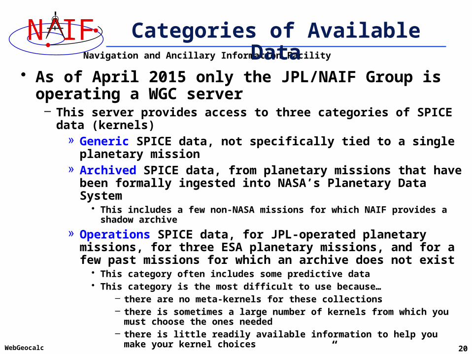
Categories of Available Data
• As of April 2015 only the JPL/NAIF Group is operating a WGC server
– This server provides access to three categories of SPICE data (kernels)» Generic SPICE data, not specifically tied to a single planetary
mission» Archived SPICE data, from planetary missions that have been
formally ingested into NASA’s Planetary Data System• This includes a few non-NASA missions for which NAIF provides a shadow archive
» Operations SPICE data, for JPL-operated planetary missions, for three ESA planetary missions, and for a few past missions for which an archive does not exist
• This category often includes some predictive data• This category is the most difficult to use because…
– there are no meta-kernels for these collections– there is sometimes a large number of kernels from which you must choose
the ones needed– there is little readily available information to help you make your kernel
choices
– VERY IMPORTANT: Read the “About the data” text provided within the tool for details

Navigation and Ancillary Information Facility
N IF
WebGeocalc 21
Kernel Selection
Solar System KernelsLatest Leapseconds KernelLatest Planetary Constants KernelGround Stations KernelsCassini HuygensClementineDawnDeep Impact (Primary mission)Deep Impact (EPOXI mission)Deep Space 1GRAILHayabusaLunar Reconnaissance OrbiterMER1 Rover (Opportunity)MER2 Rover (Spirit)MESSENGERMars ExpressMars Global SurveyorMars Odyssey . .Manual
A scrollable drop-down menu is used to select the kernel set(s) to be used in your calculation.
Use the menu to select: - generic kernel sets - archived mission kernel sets (includes relevant generic kernels) - manual selection of individual kernels from operations collections
Navigation and Ancillary Information Facility
N IF
WebGeocalc 22
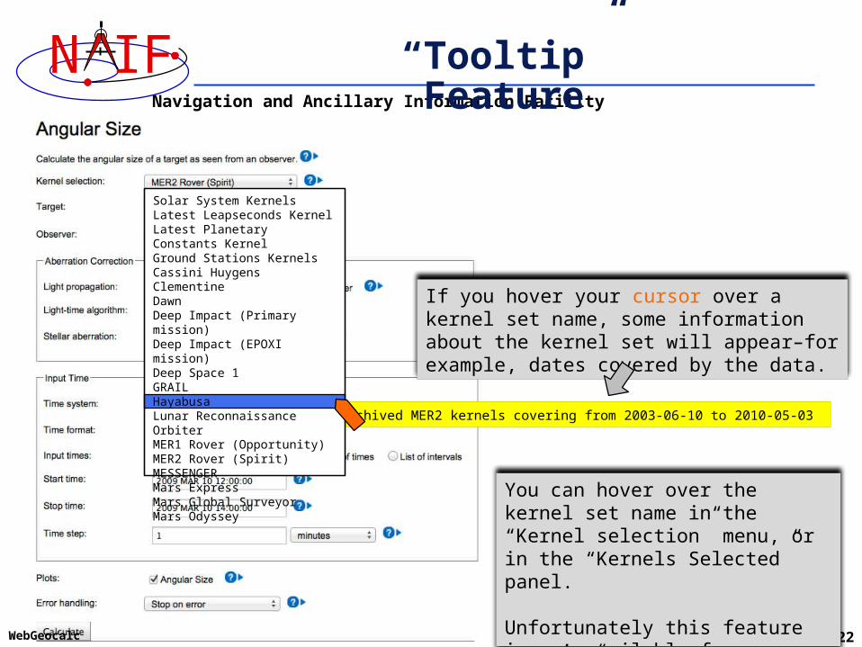
“Tooltip” Feature
If you hover your cursor over a kernel set name, some information about the kernel set will appear–for example, dates covered by the data.
Archived MER2 kernels covering from 2003-06-10 to 2010-05-03
You can hover over the kernel set name in the “Kernel selection” menu, or in the “Kernels Selected” panel.
Unfortunately this feature is not available for “Manual” kernel selection.
Solar System KernelsLatest Leapseconds KernelLatest Planetary Constants KernelGround Stations KernelsCassini HuygensClementineDawnDeep Impact (Primary mission)Deep Impact (EPOXI mission)Deep Space 1GRAILHayabusaLunar Reconnaissance OrbiterMER1 Rover (Opportunity)MER2 Rover (Spirit)MESSENGERMars ExpressMars Global SurveyorMars Odyssey
Navigation and Ancillary Information Facility
N IF
WebGeocalc 23
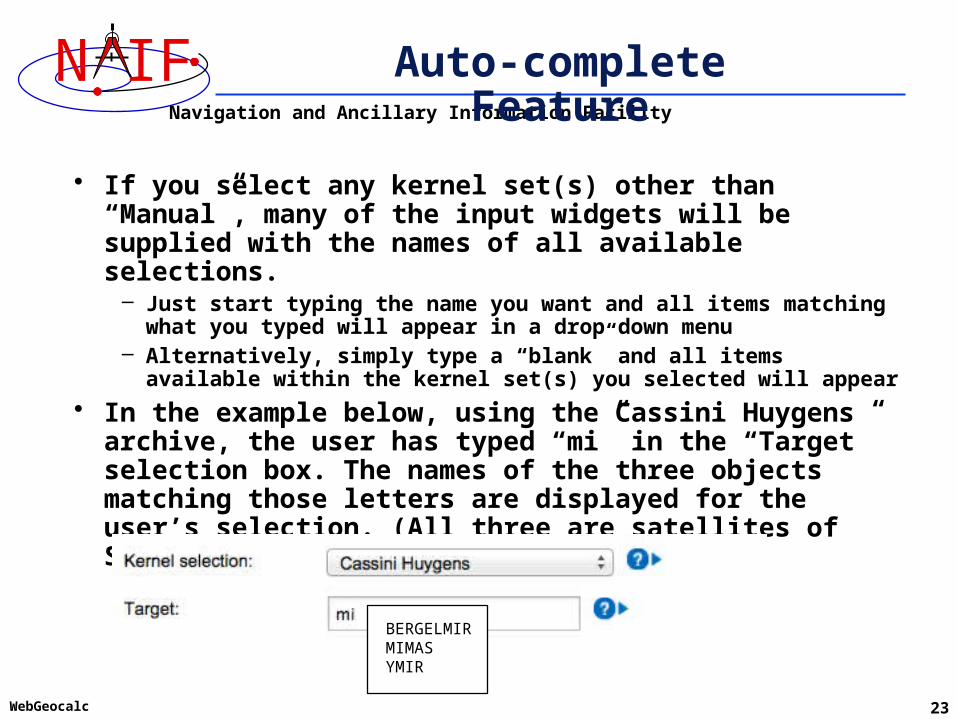
Auto-complete Feature
• If you select any kernel set(s) other than “Manual”, many of the input widgets will be supplied with the names of all available selections.
– Just start typing the name you want and all items matching what you typed will appear in a drop down menu
– Alternatively, simply type a “blank” and all items available within the kernel set(s) you selected will appear
• In the example below, using the Cassini Huygens archive, the user has typed “mi” in the “Target” selection box. The names of the three objects matching those letters are displayed for the user’s selection. (All three are satellites of Saturn.)
BERGELMIRMIMASYMIR
Navigation and Ancillary Information Facility
N IF
WebGeocalc 24
Downloading Results
• You can download tabular results to your computer by clicking the “Download Results” button, then selecting the format desired:
– Excel – Comma separated values– Plain text
• You can download any plots by clicking on the “Download Plot” button
– Plots are saved in PNG format with a transparent background» Easily pasted into a document or presentation
Navigation and Ancillary Information Facility
N IF
WebGeocalc 25
Saving Results for Use as New Inputs
• You can save a numeric output, or an event finder interval start or stop time, by clicking on the value
– The saved value will appear in a “Saved Values” panel on the right side of your browser window
– This value can then be dragged to an input widget in a subsequent calculation
• You can save a complete set of event finder output interval start and stop times by clicking the “Save All Intervals” button
– These can then be used as part of the input for a subsequent geometric event finder computation if you select “List of intervals” for the “Input times” selection
Navigation and Ancillary Information Facility
N IF
WebGeocalc 26
Getting Help
• WGC users must read the “About the Data” web page to understand the kinds of SPICE kernels (data) available to the WGC tool
• Most GUI controls have associated HELP text, available by clicking the ? icon
• Most computation descriptions have an associated graphic depicting one or more examples of what may be computed
• Some GUI controls have a second-level, more extensive help description, available by clicking the “Read more…” text displayed in the first level help
• The NAIF Team has limited ability and authorization to provide individual help
– Make good use of the HELP panels and other documentation included in WGC
– Look at the SPICE tutorials and documentation available on the NAIF website
» http://naif.jpl.nasa.gov

Navigation and Ancillary Information Facility
N IF
WebGeocalc 27
Usage Rules
• The WGC program has a link entitled “Rules of Use”– WGC users must read and abide by these rules
• Using WGC requires some knowledge of space geometry and of NASA’s SPICE system
– The NAIF website provides much SPICE information: » http://naif.jpl.nasa.gov
– Casual surfers, educators and public outreach entities may find more useable space geometry information and tools elsewhere on the web
Navigation and Ancillary Information Facility
N IF
WebGeocalc 28
Limited Capability
• WGC does not provide all of the space geometry computational capability offered by the SPICE Toolkits
– But WGC nevertheless provides substantial capability–likely more than is obvious at first glance
• More capability might be added if the user community finds this tool useful
Navigation and Ancillary Information Facility
N IF
WebGeocalc 29
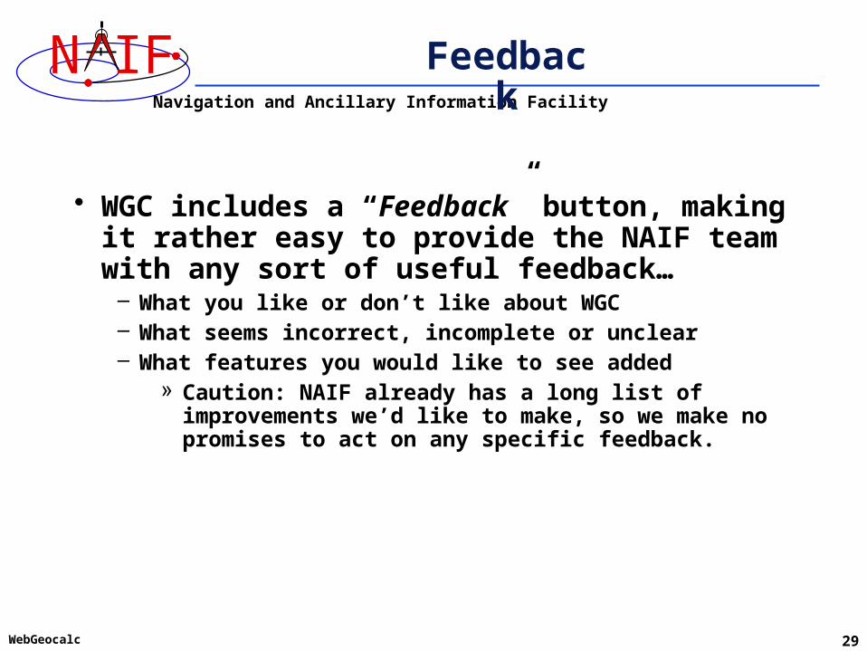
Feedback
• WGC includes a “Feedback” button, making it rather easy to provide the NAIF team with any sort of useful feedback…
– What you like or don’t like about WGC– What seems incorrect, incomplete or unclear– What features you would like to see added
» Caution: NAIF already has a long list of improvements we’d like to make, so we make no promises to act on any specific feedback.

Navigation and Ancillary Information Facility
N IF
WebGeocalc 30
Problems Using WGC
• There are several limitations and errors you might encounter in using WebGeocalc
– See the next several pages for examples– Some of these conditions could be unique to the WGC
installation at NAIF
• One browser does not interact well with WGC– Internet Explorer 8.0.7601.17514 on a Windows 7 PC
» May not properly handle “Manual” kernel loading– Many popular browsers/versions have been checked, but it’s
possible that problems exist with some others

Navigation and Ancillary Information Facility
N IF
WebGeocalc 31
Missing Input
• WGC will alert you to missing inputs
Navigation and Ancillary Information Facility
N IF
WebGeocalc 32
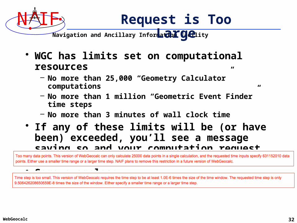
Request is Too Large
• WGC has limits set on computational resources– No more than 25,000 “Geometry Calculator” computations– No more than 1 million “Geometric Event Finder” time steps– No more than 3 minutes of wall clock time
• If any of these limits will be (or have been) exceeded, you’ll see a message saying so and your computation request will be terminated
• Some examples:

Navigation and Ancillary Information Facility
N IF
WebGeocalc 33
SPICE Error Messages
• WGC will display a SPICE Toolkit error message when an underlying SPICE API is able to detect a problem
• These SPICE error messages all begin with:“CSPICE_N00xx:” followed by some text
• See the remaining pages for some examples

Navigation and Ancillary Information Facility
N IF
WebGeocalc 34
Unusable Time Tag(s) - 1
• Time tag processing within WGC makes use of SPICE Toolkit modules.
• These Toolkit modules offer a great deal of capability. But not every conceivable style of time tag, and not every time system, are acceptable.
• What to do?– Use the help icons ? next to any Time system or Time format
input.– See Appendix 2 of the Chronos User’s Guide for some details
and many examples. » http://naif.jpl.nasa.gov/misc/chronos_ug.html
– See the Time Required Reading document for a full explanation of time treatment within SPICE.
» http://naif.jpl.nasa.gov/pub/naif/toolkit_docs/FORTRAN/req/time.html

Navigation and Ancillary Information Facility
N IF
WebGeocalc 35
Unusable Time Tag(s) - 2
• A few examples of bad time tags and resultant error messages
– Using UTC and Calendar format, and inputting: 2010:10:03 05:44:12
» Would have worked using: 2010-10-03 05:44:12 or 2010/10/03 05:44:12– Using UTC and Calendar format, and inputting: 2455160.098304
» Needed to specify “Julian date” format– Using UTC and Calendar format, and inputting: 2010:10:03T05:44:12
» Instead, use an ISO-defined format such as: 2010-10-03T05:44:12• (Dashes before the “T” and colons after the “T”)

Navigation and Ancillary Information Facility
N IF
WebGeocalc 36
Unusable Time Tag(s) - 3
• A few more examples of bad time tags and resultant error messages
– Using UTC and Calendar format, and inputting: 2010-10-03 05:44:12 JD
» 2010-10-03 05:44:12 is not a Julian date format: remove the trailing JD– Using TDB and Julian date format, and inputting: 2.4404005000000000 D+06
» “E” and “D” notation are not allowed– Using Spacecraft clock and Spacecraft clock string format, and inputting:
81138762:563
» The Spacecraft clock ID value is 0, which is not a valid clock ID. Either you did not load an archival kernel set (containing the mission SCLK kernel) or you did not manually load a SCLK kernel.

Navigation and Ancillary Information Facility
N IF
WebGeocalc 37
Time out of Bounds - 1
• WGC will display a SPICE error message when SPICE is able to detect a problem.
• In this example the user requested the position of Mercury relative to the MESSENGER spacecraft at a time before MESSENGER was launched.
Navigation and Ancillary Information Facility
N IF
WebGeocalc 38
Time out of Bounds - 2
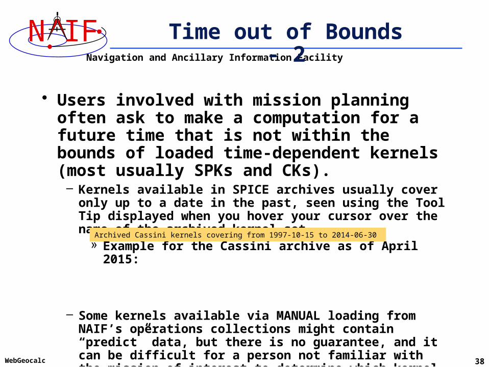
• Users involved with mission planning often ask to make a computation for a future time that is not within the bounds of loaded time-dependent kernels (most usually SPKs and CKs).
– Kernels available in SPICE archives usually cover only up to a date in the past, seen using the Tool Tip displayed when you hover your cursor over the name of the archived kernel set.
» Example for the Cassini archive as of April 2015:
– Some kernels available via MANUAL loading from NAIF’s operations collections might contain “predict” data, but there is no guarantee, and it can be difficult for a person not familiar with the mission of interest to determine which kernel to load.
Archived Cassini kernels covering from 1997-10-15 to 2014-06-30

Navigation and Ancillary Information Facility
N IF
WebGeocalc
Missing Data - 1
• If you try to make a series of calculations (e.g. over a time interval, or at each of a set of times) it could be that some of the calculations can be made while others can not due to data gaps or otherwise missing data.
– A gap in a CK is the most likely culprit. This is usually caused by sparse or missing downlinked spacecraft attitude telemetry.
– The graphic below represents a CK file.» The orange bars are called “interpolation intervals” during which
orientation can be determined.» The white spaces between the orange bars are gaps during
which orientation cannot be determined.
» See the next page for some options to deal with this.39
CK END TimeCK START Time
CK file:

Navigation and Ancillary Information Facility
N IF
WebGeocalc 40
Missing Data - 2
• When making “Geometry Calculator” computations you can control the action taken by WGC using the “Error handling” control found at the bottom of each “Geometry Calculator” web page
– The options are:» Stop on error (the default setting)» Report errors and continue (a more friendly but still safe option)» Silently omit errors
• However, when making “Geometric Event Finder” calculations you haven’t any options: WGC will issue an error message and discontinue the computation, showing no interval results at all

Navigation and Ancillary Information Facility
N IF
WebGeocalc 41
Incomplete Data
• Computations involving ephemerides (trajectories) or orientations often require the chaining (the combining together) of multiple “chunks” of data to obtain needed data.
• Kernels containing ALL the needed “chunks” of data to complete the chain must be loaded into WGC.
– This is rarely a problem when using a mission’s archive since much care is taken to make the archive complete.
– But incomplete data is often a problem when MANUALY loading individual kernels from a mission operations collection. The user may not understand what are the needed components of an ephemeris chain (SPK, FK) or an orientation chain (some of CK, FK, PCK).
Navigation and Ancillary Information Facility
N IF
WebGeocalc 42
Mixed Up Target and Observer
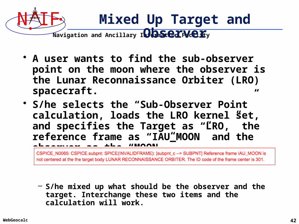
• A user wants to find the sub-observer point on the moon where the observer is the Lunar Reconnaissance Orbiter (LRO) spacecraft.
• S/he selects the “Sub-Observer Point” calculation, loads the LRO kernel set, and specifies the Target as “LRO,” the reference frame as “IAU_MOON” and the observer as the “MOON.”
– S/he mixed up what should be the observer and the target. Interchange these two items and the calculation will work.
Navigation and Ancillary Information Facility
N IF
WebGeocalc 43
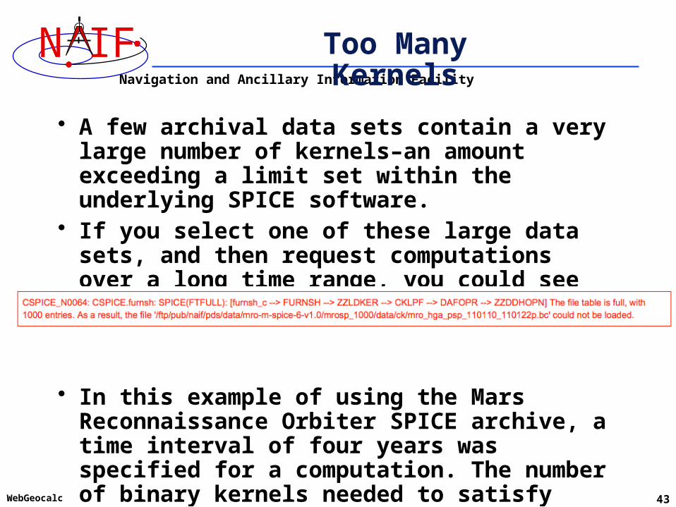
Too Many Kernels
• A few archival data sets contain a very large number of kernels–an amount exceeding a limit set within the underlying SPICE software.
• If you select one of these large data sets, and then request computations over a long time range, you could see an error message like this:
• In this example of using the Mars Reconnaissance Orbiter SPICE archive, a time interval of four years was specified for a computation. The number of binary kernels needed to satisfy this request exceeded the limit of 5000 binary kernels allowed to be loaded at one time.
Navigation and Ancillary Information Facility
N IF
WebGeocalc 44
Limitation – One at a Time
• WebGeocalc executes only one computation at a time – Any computation requests received while one
computation is in progress will be queued in the order received
» A “queued” message will be displayed in your browser’s window
» Each request will automatically execute once having reached the top of the queue
Navigation and Ancillary Information Facility
N IF
WebGeocalc 45
The WGC URL
http://wgc.jpl.nasa.gov:8080/webgeocalc
Try it!
Related Documents