t t t t t t t t t t t t t t t t t t t t t t t t t t t t t t t t t t t t t t t t t t t t t t t t t t t t t t t t t t t t t t t t t t t t t t t t t t t t t t t t t t t t t t t t t t t t t t t t t t t t t t t t t t t t ! 4 ! n ! n ! n ! n ! n ! n ! n ! n ! n ! n ! n ! n ! n ! n ! n ! n ! n ! n ! n ! n ! n ! n ! n ! n ! n ! n ! n ! n ! n ! n ! n ! n ! ! n ! n ! n ! n ! n ! n ! n ! n ! n ! n ! H ! Ã ! Ã ! Ã ! Ã 6000-00 6900-00 5305-00 6920-00 6024-00 6023-00 5303-00 5307-00 6918-00 6919-00 6025-00 6919-03 5307-04 6021-00 6000-77 6900-28 6900-40 5000-50 6920-05 6024-01 6000-64 5305-02 5304-00 6022-00 6000-62 6918-02 6900-27 6900-32 6800-06 6919-01 5307-01 6920-03 6025-03 6000-75 6022-03 5306-01 5307-03 6000-78 6023-07 5306-00 6000-71 6900-33 6000-73 5307-02 6900-37 6000-79 6919-02 6023-10 6900-31 6920-06 6000-63 6900-29 5307-05 6920-08 6920-04 6021-01 6900-30 6000-60 6900-41 6024-04 6024-06 6000-68 6000-59 6024-02 6900-38 5305-04 6919-04 6025-01 5303-01 6000-61 6900-36 6025-08 6024-05 6000-66 6900-42 6025-02 6025-04 6025-05 6000-58 6023-08 6900-39 6021-02 6918-03 6022-06 6920-07 6000-67 6023-09 6023-06 6000-65 6000-72 5305-01 6920-01 6000-70 6025-07 6000-74 6022-05 6800-08 6023-05 6900-34 6025-06 6918-04 6900-35 6000-76 6000-69 6920-02 6000-57 5305-03 6024-03 5307-06 6917-01 7104-03 6917-00 7105-06 5301-01 6025-10 6900-26 7105-07 Sunnyside Westville Stevenson Riverside Southford Huntington Pine Bridge East Village Quaker Farms Straitsville OXFORD SHELTON BETHANY SEYMOUR MONROE ORANGE DERBY SOUTHBURY ANSONIA NEWTOWN NAUGATUCK NEW HAVEN PROSPECT Long Hill Barn Hill Peck Hill Good Hill Coram Hill Deroy Hill Great Hill Round Hill Round Hill Beacon Cap Jacks Hill Grassy Hill Osborn Hill Rimmon Hill Rock Rimmon Beacon Hill Mount Pisgah Wildcat Gorge Prospect Hill Fivemile Hill Chestnut Hill Towantic Hill Rockhouse Hill Twomile Island Carrington Hill Huntington Hill Hunters Mountain Buttermilk Hollow Lower White Hills O' Sullivan Island Shaw Dam Res No 4 Res No 3 Res No 2 Res No 1 Cap Pond Mud Brook Mud Brook Ivy Brook Ivy Brook Webb Pond Swan Lake Russ Pond Peck Pond Park Pond Lily Pond Leys Pond Lake Zoar Lake Zoar Glen Lake Bass Pond West River West River West River Race Brook Race Brook Race Brook Pine Brook Hopp Brook Upper Pond Keiser Dam Swans Pond State Pond Shaws Pond Ryans Pond Misty Pond Amity Pond Pines Brook Pines Brook Parks Brook Means Brook Marks Brook Jacks Brook Egypt Brook Boehm Brook Black Brook Kleeman Dam Disbrow Dam Emerson Dam Turner Pond Spring Lake Silver Lake Raylis Pond Newton Pond Newton Pond Maylew Pond Lemays Pond Lander Pond Lake Dawson Hunter Pond Colony Pond Clarks Pond Chanko Pond Beaver Lake Spruce Brook Spruce Brook Silver Brook Sharps Brook Rimmon Brook Priton Brook Nelson Brook Little River Jeremy Brook Indian River Beaver Brook Wooster Pond Stoddard Dam Strongs Pond Simpson Lake Sawmill Pond Pin Oak Pond Parkers Pond Nursery Pond Nichols Pond Lake Watrous Lake Bethany Konolds Pond Hickory Pond Chordas Pond Boswick Pond Bishops Pond Jackson Cove Wooster Brook Twomile Brook Twomile Brook Sixmile Brook Simmons Brook Sargent River Sargent River Sanford Brook Halfway River Farmill River Curtiss Brook Bladens River Weingrad Pond Saw Mill Pond McGeever Pond Lindleys Pond Fairwood Pond Cargyles Pond Bristols Pond Whitlock Brook Wepawaug River Wepawaug River Towantic Brook Fourmile Brook Fivemile Brook Pine Brook Dam Pricketts Pond Papermill Pond Eastside Pond Community Pond Bear Hill Pond Barn Hill Pond Arsenault Pond Witkowski Brook Sevenmile Brook Naugatuck River Naugatuck River Naugatuck River Moulthrap Brook Hull Hill Brook Good Hill Brook Eightmile Brook Beardsley Brook West River Pond Means Brook Dam Round Hill Pond Ray Bishop Pond Paper Mill Pond Old Clarks Pond Lake Housatonic Lake Housatonic Lake Housatonic Kettletown Pond Keenes Ice Pond Carrington Pond Amity High Pond Pink House Cove Round Hill Brook Kinneytown Brook Kettletown Brook Kettletown Brook Housatonic River Housatonic River Hemp Swamp Brook Globe Mill Brook Silver Brook Dam Beaver Brook Dam Beaver Brook Dam Lambert Road Dam Nelson Brook Dam Norvein Hier Dam Von Wettberg Dam Middle Reservoir Maltby Lake No 3 Maltby Lake No 2 Maltby Lake No 1 Main Street Pond Horseshoe Lagoon Dillon Road Pond Church Hill Pond Burnt Swamp Pond Bungay Reservoir Black Brook Pond Wintergreen Brook Walnut Hill Brook Nickel Mine Brook Indian Hole Brook Harvey Pete Brook Colony Pond Brook Christinson Brook Beacon Hill Brook Straitsville Brook School House Brook Riggs Street Brook Boys Halfway River Wepawaug Reservoir Walnut Avenue Pond Twomile Brook Pond Northrop Road Pond Upper Hackanum Pond Twitchell Reservoir Racebrook Road Pond Quillinan Reservoir Lower Hackanum Pond Long Hill Reservoir Great Hill Reservoir Bethany Village Pond Booth Hill Road Brook Cristenson Brook Pond Bronsons Factory Pond Walnut Tree Hill Brook Butternut Hollow Brook Upper Candee Reservoir Straitsville Reservoir Shelton Reservoir No 2 Upper White Hills Brook Fountain Lake Reservoir New Haven Lions Club Dam Far Mill River Reservoir Lower Derby Hill Reservoir White Hills Community Brook Seymour Saw Mill Pond Brook North Georges Hill Road Pond South Branch Bullet Hill Brook Upper Community House Road Pond Lower Kerite Cable Company Pond Hidelum Rock Bar Twomile Island Bar Griffin Hospital Mead School Forest School Irving School Bungay School Mohegan School Bradley School Great Oak School Lafayette School Sunnyside School Race Brook School Booth Hill School Bethany Community Masuk High School Derby High School Turkey Hill School Laurel Ledge School Quaker Farms School Davis Street Magnet Cross Street School Beecher Road School Derby Middle School Shelton High School Seymour High School Ansonia High School Oxford Center School Paul Chatfield School Seymour Middle School Ansonia Middle School Edgewood Magnet School Amity Regional High School Shelton Intermediate School Amity Middle School Bethany Sheridan Acad For Excellence May V Carrigan Middle School Metropolitan Business Academy Wintergreen Interdistrict Magnet Emmett O'Brien Technical High School Seymour Station Ansonia Station Beacon Falls Station Derby-Shelton Station 300 100 400 600 500 200 700 800 300 400 300 200 600 600 600 500 600 600 400 700 200 600 500 700 500 500 700 700 300 600 500 700 700 500 300 500 600 700 300 500 600 700 200 500 500 600 400 200 500 200 500 100 400 600 500 500 200 600 300 500 600 600 600 600 300 700 200 600 100 200 600 600 200 600 600 700 700 400 700 600 100 400 700 600 500 500 300 500 400 300 400 300 400 400 200 500 400 200 700 600 200 600 500 500 500 700 100 500 400 300 100 100 300 500 500 500 200 400 300 500 500 200 500 400 400 100 500 700 600 500 700 600 300 300 200 800 500 700 100 100 400 700 500 600 300 700 300 600 500 700 300 300 400 400 600 500 600 200 400 300 500 600 400 500 200 600 700 700 700 600 400 300 200 400 400 800 500 700 600 400 700 500 700 600 500 700 500 600 400 300 800 500 700 600 400 100 600 400 700 200 600 400 600 200 400 100 600 600 700 300 200 500 600 700 500 500 600 600 700 700 400 700 500 200 300 500 600 600 700 400 600 200 700 500 200 600 400 600 600 600 500 400 600 600 700 200 700 200 400 500 100 600 200 600 600 600 300 500 600 400 700 500 500 600 300 500 500 700 600 400 600 800 400 400 400 200 100 400 600 600 300 700 400 700 700 600 700 400 500 500 500 200 600 400 500 600 600 400 300 200 700 600 600 300 400 400 500 600 600 700 500 600 500 500 500 200 700 600 200 400 500 600 200 700 State Hwy 8 Amity Rd State Hwy 67 State Hwy 63 State Hwy 69 State Hwy 34 Litchfield Tpke Oxford Rd Roosevelt Dr State Hwy 110 State Hwy 15 State Hwy 188 State Hwy 313 State Hwy 243 Derby Tpke Monroe Tpke Wilbur Cross Hwy Sperry Rd State Hwy 115 Quaker Farms Rd Riggs St Racebrook Rd State Hwy 111 Village Rd Baldwin Dr Howe Ave Route 67 Maple St Seymour Southbury Rd Skokorat Rd Mt Rd Seymour Rd Shelton Ave Kettletown Rd Forest Rd Southford Rd Park Rd Chestnut Tree Hill Rd Downs Rd State Hwy 334 Bethmour Rd Ansonia Rd New Haven Rd Peck Hill Rd Walnut Tree Hill Rd Leavenworth Rd Carrington Rd River Rd Miller Rd Ansonia Derby Expy Christian St Bungay Rd Center Rd Jacob Rd Rimmon Rd Christian Rd Meadow St Mountain Rd Newton Rd State Hwy 122 Beacon Rd Main St Mohegan Rd Bridgeport Ave Waverly Rd State Hwy 42 Old Zoar Rd Ford St Skokorat St Soundview Ave Pease Rd Beaver St Beardsley Rd Old Mill Rd Coram Rd Moose Hill Rd Colony St Punkup Rd Botsford Rd Fairwood Rd Burton Rd Grassy Hill Rd Long Hill Ave Northrop Rd Hulls Hill Rd Governors Hill Rd Baldwin Rd Holbrook Rd Peter Rd Valley St Falls Rd Cheshire Rd Beecher Rd Wheeler Rd Indian Well Rd State Hwy 114 Dillon Rd Burr Rd Fountain St State Hwy 121 Garden Rd Pulaski Hwy Far Mill St Bear Hill Rd Birdseye Rd Hawley Rd US Hwy 1 Berkshire Rd Prindle Ave Webb Cir Maple Ave Davis Rd Lopus Rd Good Hill Rd Derby Milford Rd Ripton Rd Orange Ave Pole Hill Rd Rock House Hill Rd North St Central Ave Oneil Rd Wakelee Ave Wooding Hill Rd Booth Hill Rd Cottage St Ford Rd Silvermine Rd Shelton Rd West St Pines Bridge Rd Rimmon Hill Rd Orange Center Rd Colony Rd Georges Hill Rd Cook Ln Jacks Hill Rd Constitution Blvd Cedar St Grove St Park Ln Valley Rd Prospect St Russell Rd Edmonds Rd Rees Dr Nells Rock Rd Tram Dr Buddington Rd Village Dr Silano Dr Squantuck Rd I 84 Loughlin Rd Laughlin Rd Freeman Rd Saw Mill City Rd Alden Ave Hillside Ln Hilldale Rd Great Hill Rd Black Forest Rd Newgate Rd Bowers Hill Rd Tomlinson Rd Dogburn Rd Wintergreen Ave Nichols Ave Maple Tree Hill Rd Coram Ave Poplar Dr State Hwy 152 Derby Ave Dogwood Rd Hatfield Hill Rd Knorr Rd Pisgah Rd Marshall Ln Lambert Rd Cali Dr Fox Dr Prokop Rd Lasky Rd Gray St Moss Ave Old Ansonia Rd Fairfax St Hunters Mountain Rd Dorman Rd Mapledale Rd Schaffer Rd Bagburn Rd Lane St Bethany Rd Maplevale Dr Pope Rd Kneen St Benz St Haddad Rd Rock Ave Bagley Rd Huntington St Pearl St Olivia St Walnut St River St Cross Hill Rd Coppermine Rd Cross St Division St Acorn Hill Rd Hurd Rd Greenway Rd Russell Ave Cogwheel Ln Schaeffer Rd Atwater Rd Lee St Hull Rd Candee Rd Cortland Pl Silva Ter Pershing Dr Philip Dr Wesley Dr Howard Ave Towner Ln Hemlock Trl Chapel St Myrtle St Cliff St State St Strongtown Rd Silver Hill Rd Reality Rd Barry Rd Peck Rd Thoreau Dr Swendsen Dr Lower Bungay Rd Osborn Ln West Rd Thorson Rd State Hwy 108 Hull St Greenbrier Dr Park Ave Burrits Rd Luke Hill Rd Old Fish House Rd Cold Springs Rd Platt St Hill St Thompson St Sentinel Hill Rd Munn Rd Great Oak Rd Caroline St Apple Dr Larkey Rd Seth Den Rd Grannis Rd Myrtle Ave Eagle Dr Mark Dr Hilltop Rd Hoadley Rd Rocky Rest Rd Jewett St Pine St Morris Rd Osborn Rd Hurd Ave Hawthorne Ave Church St Elm St Forest Pkwy Holly Pl Bradley Ln 4th St McKinley Ave Beacon Valley Rd Lebanon Rd Emmett Ave Pearmain Rd Seeley Rd Indian Trl Cranbury Dr Maler Ave Shelton St Platt Rd Ancient Hwy Jeremy Rd Birchbank Rd Smith Rd Wheeler St Benham Rd Forest Glen Dr Oakwood Dr E St Canfield Rd Laurel Ave Old Church Rd Sunset Dr Bradley Rd Plaskon Dr Longmeadow Rd Kathy Dr Pent Rd Water St Shari Dr Lacey Rd Emma St Willard Rd David St Hurley Rd Highridge Dr Rugby Rd Grand St Kissawaug Rd Perry Ln Lazy Brook Rd Milan Rd Burma Rd Railroad Ave Cemetery Rd Ida Ave Oak Hill Ln Kohary Dr Nelson Rd Hurd St Clark Rd Yale Ave Grist Mill Rd Whitney Ave Sodom Ln Highland Ave Williamsburg Dr William St Chamberlain Dr Cherry St Alston Ave Westfield Ave Sanford Rd West Rock Ave Bethway Rd Wyant Rd Wepawaug Rd Francis Dr Oak Ave Adams Dr Oak Dr Bunting Rd Mesa Dr General Samuel Jaskilka Hwy Highland Rd Knorr Ave Rimmon St Greenwood Ln Dauria Dr Humiston Dr Ann Dr Grant Rd Short St Perry Hill Rd School St Camelot Dr Dogwood Dr Brookfield Rd Maple Ln Hickory Rd Lake Rd DIX St Pine Rdg Long Hill Cross Rd Still Rd Munson Rd Ray Rd Perkins Rd Keron Dr Charles St Howellton Rd Navajo Loop Old Dairy Ln Clinton Rd Richards Dr Todd Rd Wabuda Pl Suren Ln Independence Dr Terrace Ave Martin Ter Old Castle Dr Hickory Ln Bucks Hill Rd Hinman Rd Daytona St Finney St Moosup Trl Nettleton Dr Rice Rd Robin Rd Breault Rd Clay Rd Mulberry Rd Old Silo Rd Lake Dr Martinka Dr Dimon Rd Sachem Rd Bank St Curtis Dr View Rd Sharon Ct Hyland Ter Clinton Dr Windsor Rd Brooks Rd Feldspar Ave Spoke Dr Craig Dr Osprey Dr Ridge Rd Vista Ter Rolling Hills Dr Anthony Ct Shepherd Ln Deer Run Dr Amos White Rd Chauncey Dr Elk Dr The Maples Chester St Arbor Ter Jupiter Dr Prospect Ave Briar Rd Fountain Lake Rd Beech Tree Hill Rd Fiddlehead Rd Burnt Swamp Rd Overhill Rd Lucille Dr Condon Rd Old Country Rd Ardale St Deep Run Dr Nancy Dr Sachem Dr Oak Hill Dr Westenhook Ter Hunting Hill Rd Cobbler Ln High St Hillside Dr Noe Pl Country Club Dr Federal Rd McGuire Rd Rayo Dr Bissell Pl Laurel Ln Grouse Ln Jacqueline Dr Homeside Ave Vista Dr New St Ells St Sunbrook Rd East St Lantern Dr Chucta Rd Lyrical Ln Lisa Dr Painter Rd Earl St Westward Rd Hemlock St Nickel Pl Deer Run Rd Glen Dr Webster Dr Ross Dr Inwood Rd Scott Dr Tuttle Rd Tuttle Ct Robert Treat Dr Elaine Dr Silva Dr Timberlane Dr Lark Ln Ranch Rd Grandview Blvd Oakcrest Rd Miami St Chatfield Dr Wheelers Farm Rd Bond Rd Wilson Dr Crestview Dr Morse Rd Astor Dr Midland Dr Little Fox Run Matilda Ln Britiani Rd Stag Ln Northwood Dr Nicholdale Rd Old Litchfield Tpke Echo Valley Rd Farm View Rd Ivy Ter Sylvan Dr Grace Trl Scott Rd Franklin St High Rd French St Sycamore Ln Progress Ave Victory Dr Barbara Dr Davis St Frontage Rd Partridge Dr Andrew Ln Bridge St Ten Coat Ln Jackson Cove Rd Chestnut Dr Autumn Ridge Rd Woodfield Dr Sentry Hill Rd Laborde Rd Fawn Dr Buttonball Rd Tumblebrook Rd Summit Dr Sunrise Dr Hubbell Ln Dales Dr Brookwood Dr Ruden St Farrell Dr Woodin St Industry Dr Washington Ave Sunwood Dr Brook Rd Grove Hill Rd Lily Ln Cleveland Rd Stevenson Rd Putting Green Ln Wisteria Dr Brookwood Ln Lucy St Manville Rd Brook Pine Dr Hart Ct English Ln Fowler St Button Rd Willow St Apple Tree Ln 1st St Stonewall Ln Big Horn Rd Crestwood Rd Westwood Rd Spring St Isinglass Rd Manners Ave Country Ln Christine Dr Oak Ridge Dr Carriage Dr Rodia Ridge Rd Brierwood Dr Ramsdell St Glen View Ter Canal St Bayberry Ln Atwater Ave Johnson Rd Renee Dr Monroe Rd Ralph Rd Whalley Ave Blue Hills Rd Maiden Ln Tuckahoe Dr Earley Ct Woodcrest Rd Belmont Ave Fraser Dr Porter Hill Rd Avon Dr Lorraine Dr Chauncey St Holbrook St Wilson Ln Willenbrock Rd Robert St Brook St Birchwood Dr Dennis Dr Old Tannery Rd Cedar Grv Misty Ln Cedar Rd Palmer Rd Spruce St Prospect Ct Bedford St Lorelei Ct Deerwood Rd Beacon Manor Rd Marvel Rd Heritage Dr Okenuck Way Somers Ln Landin St Lois Dr Fresh Meadow Rd Redwood Dr Upson Dr 6th St Woodsend Ave Wolf Ave Grove Ave White Oak Rd Sabrina Dr Sycamore Dr Patrick Dr Summerfield Gdns Garden St Sagamore Dr Kluge Rd Jordan Hill Rd North Ave Belinsky Cir Orne St Pond Lily Ave Birch Rd Peach Dr Falmouth Dr Wedgewood Dr Clark St Serenity Ln Briarwood Dr Cedarwood Ln Andrasko Rd Millbrook Ter Squire Rd Luciani Rd Bonna St Waterview Dr Sagamore Rd Rock Hill Rd Kindle Ln Menna Rd Fox Den Way Park St Anna St Courtland Dr Sand Bar Rd Harold St Chestnut Ridge Rd Tilquist Rd Seneca Rd Oliver Ter Franklin Ave Cedar Hill Rd New Haven Ave Kathleen Rd Brentley Dr Lakeview Ter Coventry Ln Hackett St Spruce Brook Rd Harper Ave Stable Ridge Rd Hallsey Ln Vine St Toro Ln Hemlock Hollow Rd Diana Dr Coachlight Cir Sharon St Driftwood Ln Doyle Dr Deerfield Ln Lunar Dr Jem Woods Rd Lakeview Ave Chestnut Ln Enoch Dr Maryanne Dr Kozey Ln John St Glendevon Dr Hawley Dr Selden St Division Ave College St Dogwood Cir Cassway Rd Spector Rd Malcolm Rd Shepard Rd Orchard St L'Hermitage Dr Lilac Dr Elmwood Dr Kennedy Dr Timber Ln Bartholomew Ave Cayer Cir Surrey Ln Argonne Ter Knollwood Rd Osullivan Rd Dutton Rd Hopbrook Rd Spruce Rd Bethridge Rd Ridge Ln Elliott Dr Legion Rd Warren Ave Rome Dr Gilyard St Princess Wenonah Dr Jenny Ln Mohawk Ave Reiner Dr Woonsocket Ave Ansmour St Westview Rd Newport Ave Chelsea Cir Silver Beach Rd Wycliffe Ter Glenwood Ct Pleasant Hill Rd Pryde Dr Eleanor Rd 9th St Hunters Trl Crestwood Dr Marion Ln Jordan Ave Winthrop Dr Crest Rd Merritt Ave Mary St Butternut Ln Rice Lane Ext Sargent Dr Kaleas Way South St Fort Hill Ave Montar Dr Aspen Ln Brownson Dr Tall Pines Dr Juniper Dr Dunn Dr Laurel Rd Ellen Dr Wayfarer St Old State Road 2 Cedric Ave Mulberry Ln Applewood Dr Oak Rd Hoinski Way Level St Glen Cir Cedar Ln Bowman Dr Mitchell Ln Stoneybrook Dr Almar Dr Astoria Ln Palmer Ln Village Ln Royal Ct Wooster St Wychwood Ln Championship Dr Norwell St Old Still Rd Stone Bridge Trl Elizabeth St Wood Rd Byron Pl Orchard Rd Swan Ave Waverly Ter Middlefield Rd Maltby Ave Perry Ave Bassett St Weekepegme Trl Cynthia Ln Woodcutters Dr Slope Dr Snyder Dr Falcon Dr Haverhill Dr Country Ct Olin Ct Coachman Ln Dolan Rd Eaton Ct Riverview Ave Rufus St Broad St Wildrose Rd Hershey Dr Theodore Rd Omar St Grandison Pl Ivy Ln Pondview Cir Ledgewood Rd Bishop Dr Commodore Hull Dr Burtville Ave Wildwood Dr Elliot Dr Cascio Dr Plainfield Ave Sharon Dr Belleview Dr Rock Creek Rd Jeremy Gdn Brookfield Dr Revere Rd Hillview St Park Pl Vernon Ct Weid Dr 7th St Hilltop Dr Harborview Rd Ashford St Ox Bow Ln Lydia St Diana Ln Granite Ter Krakow St Oakwood Rd Woods Rd Ormond St Todd Dr Ariel Rd Deer Run Ln Marc St Winter St Michael Cir Red Fern Rdg Carriage Hill Rd Fairlea Dr Acton St Evergreen Dr Tracy Ter Kimberly Ln Catlin Pl Foxhunt Rd Molsick Rd Poe Pl Castle Ln Pumpkin Patch Rd Winfield Dr Rose Dr Murray St Lolly Ln Dodge Dr Soundview Dr Kilborn St Adam St Tahmore Pl High Meadow Rd Condon Dr Old Hickory Rd Simon Pl Chaden Rd Stonegate Dr Bradley Dr Canterbury Ln Plum Tree Ln Cots St Hampton Dr Ann Ave Lagana Ln Liberty Dr Shady Ln Fall St Milne Ave Zake Hill Dr Knollwood Dr New England Ln Gerardo Dr Mumford Dr Chamberlain Rd Pleasant Dr Hawkins Rd Homestead Ave Doolittle Dr Fairview St Heather Ln Green Cir Jenyfer Ct Alling St Research Dr Philip St Greisers Rd Fieldstone Dr Falcon Ln Sheffield Rd Belleview Ter Great Oak Rdg Roberts St Benanto Dr Edward Ln Kiely Ln Heavenly Ln Block Farm Rd Country Hill Rd Field St Steep Hill Rd Eagle St Suburban Dr Ajellos Farm Rd Loveland Dr Hotchkiss Ter Haven Ln Split Rail Ct Deer Run Krum Elbow Spruce Hill Dr Jay Ln Twinbrook Dr Rockwell Pl Brookside Dr Walnut Hill Rd Rollin Rd Sunrise Ter Bob White Ter Arbutus Ln Hazel Ct Homewood Rd Audubon Ln Rogers Rd Hampton Close Vose St Lakeview Dr Tallwood Rd Wood St Split Rock Rd Cleft Rock Ln Whittier Ln Cassella Dr 5th St Crescent St Hunters Rdg Jonathan Ln Riggs Rd Chestnut Knoll Dr Sunset Cir Olson Dr Prospect Rd North Cir Jennifer Ln Pin Oak Ln Florence St Christina Dr Regent Dr Centerview Rd Hearthstone Rd Ross Ct Chimney Pl Savelle Rd Brinton Rd Dahlia Ln Sunset Ter Israel Hill Rd Adanti Ave Rose St 3rd St Arrowhead Ln Andras Rd Highview Dr Hillside Ter Cedar Ter Mansfield St Nichols St Robinson Ln Fatima Dr Avenue D Meadowcrest Cir Woodland Park Golden Rod Dr Depot St Joseph Ct Avon Ct Harvard Ave Stoddard Pl Underhill Rd Deer Hollow Rd Pineledge Rd Wolf Run Eagles Lndg Yale Farms Ln Sweet Briar Ln Bachelor Oak Rd Osage Rd Raymond Ln Beech St Beechlawn Ter Concord Ct Founders Way Columbine Ln Woodside Ter Tulip Ln Tee Shot Dr Ivy Grove Ct Henry Dr Cedar Acres Rd Blue Spruce Ln Laurel Pl Powerline Rd Pulver Pl Bice Dr Dumschott Rd Guardiano Ter Shasta Ter Thomas St Owl Hill Rd Timber Ln Carrington Rd Newton Rd Elizabeth St Brookside Dr Shelton Rd Perkins Rd Barry Rd Main St Valley Rd Munson Rd 3rd St Benham Rd Ramsdell St Pease Rd Cliff St Wheeler Rd Davis Rd Derby Ave Pearmain Rd Cherry St Franklin St Carriage Dr Maltby Ave Derby Ave Elm St Orchard Rd Moose Hill Rd West St Grove St Spring St Sunset Dr Pine St Ansonia Derby Expy High St New Haven Rd Great Hill Rd Sanford Rd Benz St Ford Rd Hickory Ln North St Mountain Rd Meadow St West St Main St Old Mill Rd Berkshire Rd Thompson St Hinman Rd Hilltop Rd Elaine Dr Main St Great Oak Rd I 84 Church St Davis Rd New St Bethany Rd State Hwy 15 Falls Rd Great Hill Rd Still Rd Francis Dr Sagamore Rd Silva Dr New Haven Rd Derby Ave Misty Ln Wilbur Cross Hwy River St State Hwy 8 Bank St Ridge Rd Chapel St Elm St Larkey Rd Cliff St Willard Rd Heritage Dr Booth Hill Rd Maple Ave Larkey Rd Cedar Rd Seymour Rd Great Hill Rd Mulberry Ln Exit 16 Exit 15 Exit 59 Exit 17 Exit 58 Exit 56 S V 188 S V 69 S V 8 S V 34 S V 15 S V 42 S V 110 S V 67 S V 334 S V 313 S V 63 S V 115 S V 122 S V 111 S V 114 S V 243 S V 188 Notre D Anna L Lopresti School Elizabeth Shelton School Amity Middle School Orange Campus Univer 6 4 3 5 7 1 2 2 8 8 EXPLANATION This map shows the location and identification number of major, regional, subregional, and local drainage basins. It is intended to serve as a municipal guide for drainage basin delineation and identification. Local basins make up larger subregional, regional, and major drainage basin areas and are differentiated by their drainage basin boundary type and identification numbers. Arrows on the map represent general direction of surface water flow within local drainage basins. Local outlet direction is shown in purple. Main stem direction is shown in red. Coastal direction is shown in blue. A 7-digit drainage basin number such as 4302-02 uniquely identifies local drainage basin areas shown on this map. Drainage basin areas are numbered sequentially beginning upstream and proceeding downstream. The identification numbers are hierarchical. The first digit (column 1) identifies the major basin, the first two digits (columns 1-2) identify the regional basin, the first 4 digits (columns 1-4) identify the subregional basin, and the first seven digits (columns 1-7) identify the local basin. For example, 4, 43, and 4302 are the major, regional and subregional basin numbers for local basin number 4302-02. As illustrated in the diagram below, this signifies that local basin number 4302-02 is part of subregional basin 4302, which is part of regional basin 43, which is part of major basin 4. Drainage basin boundaries shown on this map were manually delineated by interpreting the 10 foot contour lines and hydrography features shown on USGS 1:24,000-scale topographic quadrangle maps. Only limited field checking was conducted to verify the location of these basin boundaries. Basin boundaries may not be accurate in areas that have been diked for flood control, upland wetland and reservoirs having outlets into two basins, areas where topographic mapping is not up to date, is inaccurate, or is not detailed enough to adequately define local drainage. Residential and commercial development, highway construction, and other changes to the landscape may have resulted in local modifications to the natural drainage pattern since the time these basin boundaries were delineated. The elevation contour lines shown on this map are more accurate than those used to originally delineate the drainage basin boundaries so, in certain areas, the basin boundaries may not exactly reflect the shape of the land surface depicted by the contour lines shown on this map. These contour lines are based on information from a statewide collection of ground elevation LiDAR data for the year 2000. This information is only suitable for general planning and informational purposes. It is not intended for exact determinations of elevation where a survey is normally required, or for detailed engineering, building, or design purposes. With this information, a general sense of the lay of the land can be ascertained. Gentle slopes are characterized by widely spaced contour lines, while steep slopes are represented by closely spaced contour lines. Contour lines that cross streams flowing through valleys of noticeable relief will form a V- shaped deflection with the apex of the V pointing upstream. However, river and stream features and watershed delineations that are based on USGS topographic quadrangle maps at 1:24,000 scale may not align exactly with the terrain of stream valleys and elevation of hills and ridges depicted by these contour lines. Note : The major, regional and subregional drainage basin boundaries shown on this map are the same as those published on the 1:125,000- scale state map entitled Natural Drainage Basins in Connecticut, McElroy, 1981. The basin boundaries shown on this town map were digitized from the 1:24,000-scale compilation sheets used to publish the state map of Natural Drainage Basins in Connecticut, 1981. DATA SOURCES LOCAL DRAINAGE BASIN DATA – The drainage basin information shown on this map is based on the following digital spatial datasets: Connecticut Local Basin Line and Local Basin Poly. These two datasets were developed by CT DEP and depict major, regional, subregional, and local basin drainage areas and boundaries at 1:24,000-scale. These data depict drainage areas for Connecticut rivers, streams, brooks, lakes, reservoirs and ponds published on 1:24,000-scale 7.5 minute topographic quadrangle maps prepared by the USGS between 1969 and 1984. ELEVATION CONTOUR DATA – The elevation contour line information shown on this map was derived from a statewide 10-foot Digital Elevation Model (DEM) surface. The DEM was based on the Connecticut LiDAR dataset for 2000, which captured ground elevation every 20 feet at a horizontal accuracy of approximately 3 feet on the ground. For unknown reasons, data was collected unevenly in some areas, which resulted in data gaps. The University of Connecticut, Center for Land Use Education and Research (CLEAR) created the DEM and edited it to fill in data gaps with information from contour lines on USGS 1:24,000-scale topographic maps. However, some inaccuracies remain and the data should be used within the known limitations of the source data. BASE MAP DATA - Based on data originally from 1:24,000-scale USGS 7.5 minute topographic quadrangle maps published between 1969 and 1992. It includes political boundaries, railroads, airports, hydrography, geographic names and geographic places. Streets and street names are from Tele Atlas ® copyrighted data. Base map information is neither current nor complete. RELATED INFORMATION This map is intended to be printed at its original dimensions in order to maintain the 1:24,000 scale (1 inch = 2000 feet). To identify either all upstream basins draining to or all downstream basins flowing from a particular location, refer to the Gazetteer of Drainage Basin Areas of Connecticut, Nosal, 1977, CT DEP Water Resources Bulletin 15, for the hydrologic sequence, headwater to outfall, of drainage basins. MAPS AND DIGITAL DATA - Visit the CT ECO website for this map and a variety of others in PDF format. Visit the CT DEP website to download the digital spatial data shown on this map. LEGEND Basin Boundary Major Basin Regional Basin Subregional Basin Local Basin Local Drainage Basin Direction t Outlet Direction t Main Stem Direction t Coastal Direction Elevation 100 ft Contour Line 20 ft Contour Line Figure 1. Example showing a typical local drainage basin and the subregional, regional, and major drainage basin it is part of. MAP LOCATION State Plane Coordinate System of 1983, Zone 3526 Lambert Conformal Conic Projection North American Datum of 1983 MAJOR BASINS 1 Pawcatuck 2 Southeast Coast 3 Thames 4 Connecticut 5 South Central Coast 6 Housatonic 7 Southwest Coast 8 Hudson £ NATURAL DRAINAGE BASINS MAJOR, REGIONAL, SUBREGIONAL AND LOCAL SEYMOUR, CONNECTICUT SCALE 1:24,000 (1 inch = 2000 feet) when map is printed at original size (48 x 36 in) STATE OF CONNECTICUT DEPARTMENT OF ENVIRONMENTAL PROTECTION 79 Elm Street Hartford, CT 06106-5127 Map created by CT DEP May 2011 This map replaces a similar natural drainage basins map dated January 2010 0 2,500 5,000 7,500 10,000 1,250 Feet 0 0.4 0.8 1.2 1.6 2 0.2 Miles 0 0.3 0.6 0.9 1.2 1.5 0.15 Kilometers

Welcome message from author
This document is posted to help you gain knowledge. Please leave a comment to let me know what you think about it! Share it to your friends and learn new things together.
Transcript
t
t
tt
t
t
t
t
t
t
t
t
t
t
t
t t
t
t
t
t
t
tt
t
t
t
t
t
t
t
t
t
t
t
t
tt
t
t
t
tt
t
t
t
t
t
t
t
t
t
t
t
t
t
t
t
t
t
t
t
t
t
t
t
t
t
t
t
t
t
t
t
t
t
t
t
t
t
t
t
t
t
t
t
t
t
t
t
t
t
t
t
t
t
t
t
t
t
t
t
t
t
t
t
t
t
!4
!n
!n
!n
!n
!n
!n
!n
!n
!n
!n
!n
!n
!n
!n
!n
!n
!n
!n
!n
!n
!n
!n
!n
!n
!n
!n
!n
!n
!n
!n
!n
!n
!n
!n
!n
!n
!n
!n
!n
!n
!n
!n
!n
!n
!H
!Ã
!Ã
!Ã
!o
!Ã
6000-00
6900-00
5305-00
6920-00
6024-00
6023-00
5303-00
5307-00
6918-00
6919-00
6025-00
6919-03
5307-04
6021-00
6000-77
6900-28
6900-40
5000-50
6920-05
6024-01
6000-64
5305-02
5304-00
6022-00
6000-62
6918-02
6900-27
6900-32
6800-06
6919-01
5307-01
6920-03
6025-03
6000-75
6022-03
5306-01
5307-03
6000-78
6023-07
5306-00
6000-71
6900-33
6000-73
5307-02
6900-37
6000-79
6919-02
6023-10
6900-31
6920-06
6000-63
6900-29
5307-05
6920-08
6920-04
6021-01
6900-30
6000-60
6900-41
6024-04
6024-06
6000-68
6000-59
6024-02
6900-38
5305-04
6919-04
6025-01
5303-01
6000-61
6900-36
6025-08
6024-05
6000-66
6900-42
6025-02
6025-04
6025-05
6000-58
6023-08
6900-39
6021-02
6918-03
6022-06
6920-07
6000-67
6023-09
6023-06
6000-65
6000-72
5305-01
6920-01
6000-70
6025-07
6000-74
6022-05
6800-08
6023-05
6900-34
6025-06
6918-04
6900-35
6000-76
6000-69
6920-02
6000-57
5305-03
6024-03
5307-06
6917-01
7104-03
6917-00
7105-06
5301-01
6025-10
6900-26
7105-07
Sunnyside
Westville
Stevenson
Riverside
Southford
Huntington
Pine Bridge
East Village
Quaker Farms
Straitsville
O X F O R D
S H E L T O N
B E T H A N Y
S E Y M O U R
M O N R O E
O R A N G E
D E R B Y
S O U T H B U R Y
A N S O N I A
N E W T O W N
N A U G A T U C K
N E W H A V E N
P R O S P E C T
Long Hill
Barn Hill
Peck Hill
Good Hill
Coram Hill
Deroy Hill
Great Hill
Round Hill
Round Hill
Beacon Cap
Jacks Hill
Grassy Hill
Osborn Hill
Rimmon Hill
Rock Rimmon
Beacon Hill
Mount Pisgah
Wildcat Gorge
Prospect Hill
Fivemile Hill
Chestnut Hill
Towantic Hill
Rockhouse Hill
Twomile Island
Carrington Hill
Huntington Hill
Hunters Mountain
Buttermilk Hollow
Lower White Hills
O' Sullivan Island
Shaw Dam
Res No 4
Res No 3
Res No 2
Res No 1
Cap Pond
Mud Brook
Mud Brook
Ivy Brook
Ivy Brook
Webb Pond
Swan Lake
Russ Pond
Peck Pond
Park Pond
Lily Pond
Leys Pond
Lake Zoar
Lake Zoar
Glen Lake
Bass Pond
West River
West River
West River
Race Brook
Race Brook
Race Brook
Pine Brook
Hopp Brook
Upper Pond
Keiser Dam
Swans Pond
State Pond
Shaws Pond
Ryans Pond
Misty Pond
Amity Pond
Pines Brook
Pines Brook
Parks Brook
Means Brook
Marks Brook
Jacks Brook
Egypt Brook
Boehm Brook
Black Brook
Kleeman Dam
Disbrow Dam
Emerson Dam
Turner Pond
Spring Lake
Silver Lake
Raylis Pond
Newton Pond
Newton Pond
Maylew Pond
Lemays Pond
Lander Pond
Lake Dawson
Hunter Pond
Colony Pond
Clarks Pond
Chanko Pond
Beaver Lake
Spruce Brook
Spruce Brook
Silver Brook
Sharps Brook
Rimmon Brook
Priton Brook
Nelson Brook
Little River
Jeremy Brook
Indian River
Beaver Brook
Wooster Pond
Stoddard Dam
Strongs Pond
Simpson Lake
Sawmill Pond
Pin Oak Pond
Parkers Pond
Nursery Pond
Nichols Pond
Lake Watrous
Lake Bethany
Konolds Pond
Hickory Pond
Chordas Pond
Boswick Pond
Bishops Pond
Jackson Cove
Wooster Brook
Twomile Brook
Twomile Brook
Sixmile Brook
Simmons Brook
Sargent River
Sargent River
Sanford Brook
Halfway River
Farmill River
Curtiss Brook
Bladens River
Weingrad Pond
Saw Mill Pond
McGeever Pond
Lindleys Pond
Fairwood Pond
Cargyles Pond
Bristols Pond
Whitlock Brook
Wepawaug River
Wepawaug River
Towantic Brook
Fourmile Brook
Fivemile BrookPine Brook Dam
Pricketts Pond
Papermill Pond
Eastside Pond
Community Pond
Bear Hill Pond
Barn Hill Pond
Arsenault Pond
Witkowski Brook
Sevenmile Brook
Naugatuck River
Naugatuck River
Naugatuck River
Moulthrap Brook
Hull Hill Brook
Good Hill Brook
Eightmile Brook
Beardsley Brook
West River Pond
Means Brook Dam
Round Hill Pond
Ray Bishop Pond
Paper Mill Pond
Old Clarks Pond
Lake Housatonic
Lake Housatonic
Lake Housatonic
Kettletown Pond
Keenes Ice Pond
Carrington Pond
Amity High Pond
Pink House Cove
Round Hill Brook
Kinneytown Brook
Kettletown Brook
Kettletown Brook
Housatonic River
Housatonic River
Hemp Swamp Brook
Globe Mill Brook
Silver Brook Dam
Beaver Brook Dam
Beaver Brook Dam
Lambert Road Dam
Nelson Brook Dam
Norvein Hier Dam
Von Wettberg Dam
Middle Reservoir
Maltby Lake No 3
Maltby Lake No 2
Maltby Lake No 1
Main Street Pond
Horseshoe Lagoon
Dillon Road Pond
Church Hill Pond
Burnt Swamp Pond
Bungay Reservoir
Black Brook Pond
Wintergreen Brook
Walnut Hill Brook
Nickel Mine Brook
Indian Hole Brook
Harvey Pete Brook
Colony Pond Brook
Christinson Brook
Beacon Hill Brook
Straitsville Brook
School House Brook
Riggs Street Brook
Boys Halfway River
Wepawaug ReservoirWalnut Avenue Pond
Twomile Brook Pond
Northrop Road PondUpper Hackanum Pond
Twitchell Reservoir
Racebrook Road Pond
Quillinan Reservoir
Lower Hackanum Pond
Long Hill Reservoir
Great Hill Reservoir
Bethany Village Pond
Booth Hill Road Brook
Cristenson Brook Pond
Bronsons Factory Pond
Walnut Tree Hill Brook
Butternut Hollow Brook
Upper Candee Reservoir Straitsville Reservoir
Shelton Reservoir No 2
Upper White Hills Brook
Fountain Lake Reservoir
New Haven Lions Club Dam
Far Mill River Reservoir
Lower Derby Hill Reservoir
White Hills Community Brook
Seymour Saw Mill Pond Brook
North Georges Hill Road Pond
South Branch Bullet Hill Brook
Upper Community House Road Pond
Lower Kerite Cable Company Pond
Hidelum Rock Bar
Twomile Island Bar
Griffin Hospital
Mead School
Forest School
Irving School
Bungay School
Mohegan School
Bradley School
Great Oak School
Lafayette School
Sunnyside School Race Brook School
Booth Hill School
Bethany Community
Masuk High School
Derby High School
Turkey Hill School
Laurel Ledge School
Quaker Farms School
Davis Street Magnet
Cross Street School
Beecher Road School
Derby Middle School
Shelton High School
Seymour High School
Ansonia High School
Oxford Center School
Paul Chatfield School
Seymour Middle School
Ansonia Middle School
Edgewood Magnet School
Amity Regional High School
Shelton Intermediate School
Amity Middle School Bethany
Sheridan Acad For Excellence
May V Carrigan Middle School
Metropolitan Business Academy
Wintergreen Interdistrict Magnet
Emmett O'Brien Technical High School
Seymour Station
Ansonia Station
Beacon Falls Station
Derby-Shelton Station
300
100
400
600
500
200
700
800
300
400
300
200
600
600
600
500
600
600
400
700
200
600
500
700
500
500
700
700
300
600
500
700
700
500
300 500
600
700
300
500
600
700
200
500
500
600
400
200
500
200
500
100
400
600
500
500 200
600
300
500
600
600
600
600
300
700
200
600
100
200
600
600
200
600
600
700
700
400
700
600
100
400
700
600
500
500
300
500
400
300
400
300
400
400
200
500
400
200
700
600
200
600
500
500
500
700
100
500
400
300
100
100
300
500
500
500
200
400
300
500
500
200
500
400
400
100
500
700
60050
0
700
600
300
300
200
800
500
700
100
100
400
700500
600
300
700
300
600
500
700
300
300
400
400
600
500
600
200
400
300
500
600
400
500
200
600
700
700
700
600
400
300
200
400
400
800
500
700
600
400
700
500
700
600
500
700
500
600
400
300
800
500
700
600
400
100
600
400
700
200
600
400
600
200
400
100
600
600
700
300
200
500
600
700
500
500
600
600
700
700
400
700
500
200
300
500
600
600
700
400
600
200
700
500
200
600
400
600
600
600
500
400
600
600
700
200
700
200
400
500
100
600
200
600
600
600
300
500
600
400
700
500
500
600
300
500
500
700
600
400
600
800
400
400
400
200
100
400
600
600
300
700
400
700
700
600
700
400
500
50050
0
200
600
400
500
600
600
400
300
200700
600
600
300
400
400
500
600
600
700
500
600
500
500
500
200
700
600
200
400
500
600
200
700
State
Hwy 8
Amity
Rd
State Hwy 67
State
Hwy 6
3
State
Hwy 6
9
State Hwy 34
Litch
field
Tpke
Oxford Rd
Roosevelt DrState Hwy 110
State Hwy 1
5
State Hwy 188
State Hwy 313
State Hwy 243
Derby Tpke
Monro
e Tpk
e
Wilbur Cross Hwy
Sperr
y Rd
State Hwy 115
Quaker Farms Rd
Riggs
St
Racebrook Rd
State
Hwy 1
11
Village Rd
Baldwin Dr
Howe Ave
Route 67
Maple St
Seymour Southbury Rd
Skok
orat R
d
Mt R
d
Seymour Rd
Shelton AveKettletown Rd
Forest Rd
Southford Rd
Park Rd
Chestnut Tree Hill Rd
Down
s Rd
State Hwy 334
Bethm
our R
d
Ansonia Rd
New Haven Rd
Peck
Hill
Rd
Walnut Tree Hill Rd
Leavenworth Rd
Carrington Rd
River
Rd
Mille
r Rd
Ansonia Derby Expy
Christian St
Bung
ay Rd
Center Rd
Jacob Rd
Rimmon Rd
Chris
tian R
d
Meadow St
Moun
tain R
d
Newt
on R
d
State
Hwy 1
22
Beacon Rd
Main St
Mohegan Rd
Bridg
eport
Ave
Waverly Rd
State Hwy 42
Old Z
oar R
d
Ford St
Skok
orat S
t
Soun
dview
Ave
Peas
e Rd
Beave
r St
Beardsley Rd
Old M
ill Rd
Coram Rd
Moose Hill Rd
Colon
y St
Punk
up R
d
Botsford
Rd
Fairw
ood R
d
Burton Rd
Grassy Hill Rd
Long H
ill Ave
North
rop R
d
Hulls Hill R
d
Governors Hill Rd
Baldw
in Rd
Holbr
ook R
d
Peter Rd
Valley St
Falls Rd
Cheshire Rd
Beec
her R
d
Wheeler Rd
Indian Well Rd
State Hwy 114
Dillon Rd
Burr Rd
Fountain St
State Hwy 121
Garde
n Rd
Pulaski Hwy
Far Mill St
Bear
Hill R
d
Birdseye Rd
Hawley Rd
US Hwy 1
Berkshire Rd
Prindle A
ve
Webb
Cir
Maple Ave
Davis Rd
Lopu
s Rd
Good Hill Rd
Derby Milford Rd
Ripton Rd
Orange Ave
Pole
Hill R
d
Rock House Hill Rd
North St
Centr
al Av
e
Oneil Rd
Wake
lee Av
e
Wood
ing H
ill Rd
Booth Hill Rd
Cottage St
Ford Rd
Silve
rmine
Rd
Shelto
n Rd
West St
Pines B
ridge R
d
Rimmo
n Hill
Rd
Oran
ge C
enter
Rd
Colon
y Rd
Georges Hill Rd
Cook Ln
Jacks Hill Rd
Constitution Blvd
Ceda
r St
Grove St
Park
Ln
Valley Rd
Prosp
ect S
t
Russell Rd
Edmonds Rd
Rees Dr
Nells
Rock
Rd
Tram Dr
Buddington Rd
Village Dr
Silano Dr
Squantu
ck Rd
I 84
Loug
hlin Rd
Laughlin Rd
Freeman
Rd
Saw Mill City Rd Alden
Ave
Hillsid
e Ln
Hilldale Rd
Great Hill Rd
Black Forest Rd
Newgate Rd
Bowers Hill Rd
Tomlinson Rd
Dogb
urn R
d
Winte
rgree
n Ave
Nicho
ls Ave
Maple Tree Hill Rd
Coram Ave
Poplar Dr
State Hwy 152
Derby
Ave
Dogwood Rd
Hatfield Hill Rd
Knorr Rd
Pisgah Rd
Marsh
all Ln
Lambert RdCali D
r
Fox Dr
Prokop Rd
Lasky Rd
Gray St
Moss Ave
Old An
sonia
Rd
Fairfax St
Hunters Mountain Rd
Dorman Rd
Maple
dale
Rd
Scha
ffer R
d
Bagburn Rd
Lane St
Bethany Rd
Maplevale Dr
Pope
Rd
Knee
n St
Benz St
Haddad
Rd
Rock
Ave
Bagley Rd
Huntington St
Pearl St
Olivia St
Walnut St
River St
Cross Hill Rd
Copperm
ine Rd
Cross St
Division St
Acorn
Hill R
d
Hurd Rd
Greenway Rd
Russell Ave
Cogw
heel
Ln
Scha
effer
Rd
Atwater Rd
Lee St
Hull Rd
Cande
e Rd
Cortland Pl
Silva Ter
Persh
ing Dr
Philip
Dr
Wesley Dr
Howa
rd Av
e
Towner Ln
Heml
ock T
rl
Chapel St
Myrtle St
Cliff St
State
St
Strongto
wn Rd
Silver Hill Rd
Reality Rd
Barry Rd
Peck Rd
Thore
au Dr
Swendsen Dr
Lowe
r Bun
gay R
d
Osborn Ln
West Rd
Thorson Rd
State H
wy 10
8
Hull S
t
Gree
nbrie
r Dr
Park Ave
Burrits Rd
Luke
Hill R
d
Old Fish
House Rd
Cold
Sprin
gs R
d
Platt St
Hill St
Thompson St
Sentinel Hill Rd
Munn Rd
Great Oak Rd
Caroline St
Apple
Dr
Larkey Rd
Seth
Den R
d
Grannis Rd
Myrtle Ave
Eagle Dr
Mark Dr
Hilltop Rd
Hoadley Rd
Rocky Rest Rd
Jewe
tt St
Pine St
Morris Rd
Osbo
rn Rd
Hurd
Ave
Hawthorne Ave
Church St
Elm St
Forest P
kwy
Holly Pl
Bradley Ln
4th St
McKin
ley Av
e
Beacon Valley Rd
Lebanon Rd
Emme
tt Ave
Pearmain
Rd
Seele
y Rd
Indian Trl
Cranbury Dr
Maler
Ave
Shelton St
Platt Rd
Ancient Hwy
Jeremy Rd
Birchbank Rd
Smith Rd
Wheeler St
Benham RdForest Glen Dr
Oakw
ood D
r
E St
Canfield Rd
Laurel Ave
Old Church Rd
Suns
et Dr
Bradley Rd
Plaskon Dr
Longmeadow Rd
Kathy Dr
Pent Rd
Water St
Shari Dr
Lace
y Rd
Emma St
Willar
d Rd
David St
Hurley Rd
Highridge Dr
Rugby R
d
Grand St
Kissawaug
Rd
Perry
Ln
Lazy
Broo
k Rd
Milan Rd
Burma Rd
Railroad
Ave
Cemetery Rd
Ida Av
e
Oak Hill Ln
Koha
ry Dr
Nelson Rd
Hurd
St
Clark Rd
Yale
Ave
Grist Mill Rd
Whitney Ave
Sodom Ln
Highla
nd Av
eWilliamsburg Dr
William St
Chamberlain Dr
Cherr
y St
Alston
Ave
Westf
ield A
ve
Sanford Rd
West
Rock
Ave
Bethway Rd
Wyant Rd
Wepa
waug
Rd
Franc
is Dr
Oak Ave
Adams Dr
Oak Dr
Bunting Rd
Mesa Dr
Gene
ral Sa
muel
Jaski
lka Hw
y
Highland Rd
Knorr AveRimmon St
Greenw
ood Ln
Dauria Dr
Humisto
n Dr
Ann Dr
Grant Rd
Short St
Perry Hill Rd
School St
Camelot Dr
Dogw
ood D
r
Brookfield Rd
Maple Ln
Hickory Rd
Lake R
d
DIX St
Pine R
dg
Long Hill Cross R
d
Still Rd
Muns
on Rd
Ray Rd
Perkins Rd
Keron Dr
Charl
es St
Howe
llton R
d
Navaj
o Loo
p
Old Dairy Ln
Clinto
n Rd
Richards Dr
Todd
Rd
Wabu
da Pl
Suren Ln
Independence
Dr
Terrace Ave
Martin Ter
Old Castle Dr
Hickory Ln
Bucks Hill Rd
Hinman
Rd
Daytona St
Finney St
Moosup Trl
Nettle
ton D
r
Rice R
d
Robin Rd
Brea
ult R
d
Clay Rd
Mulberry Rd
Old Silo Rd
Lake Dr
Martinka
Dr
Dimon Rd
Sachem Rd
Bank St
Curtis Dr
View
Rd
Sharo
n Ct
Hyland Ter
Clinto
n Dr
Windsor Rd
Brook
s Rd
Feldspar Ave
Spoke Dr
Craig
Dr
Osprey Dr
Ridge
Rd
Vista
Ter
Rolling Hills
Dr Antho
ny C
t
Shepherd Ln
Deer Run Dr
Amos White Rd
Chau
ncey
Dr
Elk D
r
The Maples
Chester StArbor Ter
Jupiter
Dr
Prospect Ave
Briar Rd
Fountain Lake Rd
Beech Tree Hill Rd
Fiddlehead Rd
Burnt Swamp Rd
Overhill Rd
Lucil
le Dr
Condon Rd
Old Country Rd
Ardale St
Deep Run Dr
Nancy
Dr
Sachem Dr
Oak Hill Dr
Westenhook Ter
Hunting Hill Rd
Cobbler Ln
High S
t
Hillside Dr
Noe Pl
Country Club Dr
Federal Rd
McGuire
Rd
Rayo Dr
Bissell Pl
Laurel Ln
Grouse Ln
Jacqueline Dr
Homeside Ave
Vista Dr
New St
Ells S
t
Sunbrook Rd
East
St
Lantern
Dr
Chucta Rd
Lyric
al Ln
Lisa D
r
Painter Rd
Earl St
Westward Rd
Hemlock St
Nickel Pl
Deer Run Rd
Glen Dr
Webster Dr
Ross Dr
Inwood Rd
Scott
Dr
Tuttle Rd
Tuttle Ct
Robert Treat Dr
Elaine DrSilva Dr
Timberlane Dr
Lark
Ln
Ranc
h Rd
Grandview Blvd
Oakcrest Rd
Miami St
Chatfield Dr
Wheelers Farm
Rd
Bond Rd
Wilson Dr
Cres
tview
Dr
Morse R
d
Astor Dr
Midland Dr
Little Fox Run
Matild
a Ln
Britiani Rd
Stag Ln
Northwood Dr
Nicholdale Rd
Old Litchfield Tpke
Echo
Valley
Rd
Farm View Rd
Ivy Te
r
Sylvan Dr
Grace
Trl
Scott Rd
Franklin St
High Rd
French St
Syca
more
Ln
Progre
ss Av
e
Victory Dr
Barba
ra Dr
Davis
St
Fronta
ge Rd
Partridge Dr
Andrew Ln
Bridge S
t
Ten Co
at Ln
Jackson Cove Rd
Chestnut Dr
Autumn Ridge Rd
Woodfield Dr
Sentr
y Hill
Rd
Laborde Rd
Fawn Dr
Buttonball Rd
Tumblebrook Rd
Summit D
r
Sunri
se Dr
Hubbell Ln
Dales Dr
Broo
kwoo
d Dr
Ruden St
Farre
ll Dr
Woodin St
Industry Dr
Wash
ington
Ave
Sunw
ood D
r
Brook Rd
Grove Hill Rd
Lily Ln
Cleveland RdSteve
nson
Rd
Putting Green Ln
Wisteria Dr
Brookwood Ln
Lucy St
Manville Rd
Brook Pine Dr
Hart C
t
Engli
sh Ln
Fowler St
Butto
n Rd
Willo
w St
Apple Tree Ln
1st St
Stonewall Ln
Big H
orn R
d
Crestwood Rd
Westwood Rd
Spring St
Isinglass Rd
Manners
Ave
Country
Ln
Christine Dr
Oak R
idge D
r
Carriage Dr
Rodia Ridge Rd
Brierwood Dr
Ramsde
ll St
Glen View
Ter
Canal St
Bayberry Ln
Atwate
r Ave
Johnson Rd
Renee Dr
Monroe Rd
Ralph
Rd
Whall
ey Av
e
Blue Hills Rd
Maide
n Ln
Tuckahoe Dr
Earle
y Ct
Woodcrest Rd
Belmont Ave
Fraser Dr
Porter Hill Rd
Avon Dr
Lorraine Dr
Chauncey St
Holbrook St
Wilson Ln
Willenbrock Rd
Robert St
Brook St
Birchwood Dr
Dennis Dr
Old Tannery Rd
Ceda
r Grv
Misty Ln
Ceda
r Rd
Palmer Rd
Spruce St
Prospect Ct
Bedford S
t
Lorelei Ct
Deerw
ood R
d
Beacon Manor Rd
Marve
l Rd
Herita
ge Dr
Okenuck Way
Somers Ln
Landin St
Lois
Dr
Fresh
Mea
dow
Rd
Redw
ood D
r
Upson Dr
6th St
Woodsen
d Ave
Wolf Ave
Grove Ave
White Oak R
d
Sabrina Dr
Sycamore Dr
Patrick Dr
Summerfield Gdns
Garde
n St
Sagamore Dr
Kluge Rd
Jordan Hill Rd
North Ave
Belinsky Cir
Orne St
Pond Lily Ave
Birch Rd
Peach Dr
Falm
outh
Dr
Wedgewood Dr
Clark
St
Serenity Ln
Briarwood Dr
Cedarwood Ln
Andrasko Rd
Millbrook Ter
Squire Rd Luciani Rd
Bonn
a St
Water
view
Dr
Sagamore Rd
Rock Hill R
d
Kindle
Ln
Menna Rd
Fox Den Way
Park S
t
Anna St
Courtland Dr
Sand
Bar R
d
Harold St
Ches
tnut R
idge R
d
Tilquist Rd
Sene
ca Rd
Olive
r Ter
Franklin Ave
Ceda
r Hill
Rd
New Haven Ave
Kathleen Rd
Brentley Dr
Lake
view T
er
Coventry Ln
Hackett St
Spruce
Brook R
d
Harper Ave
Stable
Ridg
e Rd
Hallse
y Ln
Vine St
Toro
Ln
Heml
ock H
ollow
Rd
Diana Dr
Coachlight Cir
Sharon St
Driftwood
Ln
Doyle Dr
Deerf
ield Ln
Lunar Dr
Jem W
oods
Rd
Lakeview Ave
Chestnut Ln
Enoch Dr
Maryanne Dr
Kozey Ln
John S
t
Glendevon Dr
Hawley Dr
Selden St
Division Ave
College St
Dogwood Cir
Cassway Rd
Spec
tor R
d
Malco
lm R
d
Shepard Rd
Orch
ard St
L'Herm
itage
Dr
Lilac
Dr
Elmwood Dr
Kennedy Dr
Timber Ln
Bartholomew Ave
Cayer Cir
Surrey Ln
Argonne Ter
Knollwood Rd
Osulli
van Rd
Dutton
Rd
Hopbrook Rd
Spruce Rd
Bethr
idge R
d
Ridge
LnElliott Dr
Legion Rd
Warren Ave
Rome D
r
Gilyard St
Princ
ess W
enon
ah Dr
Jenn
y Ln
Mohawk Ave
Reiner Dr
Woonsocket Ave
Ansm
our St
Westview Rd
Newport Ave
Chels
ea Ci
r
Silver Beach Rd
Wycliffe Ter
Glenwood Ct
Pleasant Hill Rd
Pryde Dr
Eleanor Rd
9th St
Hunters Trl
Cres
twoo
d Dr
Marion Ln
Jordan Ave
Winthrop Dr
Crest Rd
Merritt AveMary St
Butte
rnut L
n
Rice Lane Ext
Sarge
nt Dr
Kaleas Way
South St
Fort Hill Ave
Monta
r Dr
Aspen Ln
Brownson Dr
Tall Pines Dr
Juniper Dr
Dunn
Dr
Laure
l Rd
Ellen Dr
Wayfarer St
Old State Road 2
Cedri
c Ave
Mulberry Ln
Applewood Dr
Oak Rd
Hoinski Way
Leve
l St
Glen Cir
Cedar Ln
Bowman Dr
Mitchell Ln
Stoneybrook Dr
Almar Dr
Astoria Ln
Palmer Ln
Village Ln
Royal CtWooster St
Wychwood Ln
Cham
pions
hip D
r
Norwell St
Old Still Rd
Stone
Bridg
e Trl
Elizabeth StWood Rd
Byron Pl
Orchard Rd
Swan Ave
Wave
rly Te
r
Middlefield Rd
Maltby
Ave
Perry Ave
Basse
tt St
Weekepegme Trl
Cynthia Ln
Wood
cutte
rs Dr
Slope
Dr
Snyd
er Dr
Falcon Dr
Haverhill Dr
Coun
try C
t
Olin
Ct
Coachman Ln
Dolan
Rd
Eaton Ct
Riverview Ave
Rufus St
Broad St
Wildrose Rd
Hershey Dr
Theodore Rd
Omar St
Grandison Pl
Ivy Ln
Pondvi
ew Cir
Ledgewood Rd
Bishop
Dr
Comm
odore
Hull
Dr
Burtville Ave
Wildwood Dr
Elliot
Dr
Cascio Dr
Plainfield Ave
Sharo
n Dr
Belleview Dr
Rock Creek Rd
Jerem
y Gdn
Brookfield Dr
Revere R
d
Hillvie
w St
Park Pl
Vernon Ct
Weid Dr
7th St
Hilltop D
r
Harborview Rd
Ashford St
Ox Bow Ln
Lydia St
Diana Ln
Granite Ter
Krakow St
Oakw
ood R
d
Wood
s Rd
Ormond St
Todd Dr
Ariel Rd
Deer Run Ln
Marc St
Winter St
Michael Cir
Red Fern Rdg
Carriage Hill Rd
Fairlea Dr
Acton St
Everg
reen D
r
Tracy Ter
Kimbe
rly Ln
Catlin
Pl
Foxhunt Rd
Molsick Rd
Poe Pl
Castle Ln
Pumpkin Patch Rd
Winfield Dr
Rose Dr
Murray St
Lolly Ln
Dodge Dr
Soundview Dr
Kilborn St
Adam St
Tahmore Pl
High Meadow Rd
Cond
on D
r
Old Hickory Rd
Simon Pl
Chaden Rd
Stonegate Dr
Bradley Dr
Canterbury Ln
Plum Tre
e Ln
Cots St
Hampton Dr
Ann A
ve
Lagana Ln
Liberty Dr
Shady Ln
Fall St
Milne Ave
Zake Hill Dr
Knollw
ood D
r
New England Ln
Gerardo Dr
Mumf
ord D
r
Chamberlain Rd
Pleas
ant D
r
Hawkins Rd
Homestead Ave
Doolittle Dr
Fairview St
Heather Ln
Gree
n CirJenyfer Ct
Alling St
Research Dr
Philip St
Greisers Rd
Fields
tone D
r
Falcon Ln
Sheffield Rd
Bellevie
w Ter
Great Oak Rdg
Roberts St
Benan
to Dr
Edward Ln
Kiely L
n
Heavenly Ln
Block
Farm
Rd
Country Hill Rd
Field St
Steep Hill Rd
Eagle
St
Suburban Dr
Ajellos Farm Rd
Loveland Dr
Hotchkiss Ter
Haven Ln
Split Rail Ct
Deer Run
Krum
Elbo
w
Spruce Hill Dr
Jay Ln
Twinbrook Dr
Rockwell Pl
Brookside Dr
Walnu
t Hill R
d
Rollin
Rd
Sunrise Ter
Bob W
hite Te
r
Arbutus Ln
Hazel Ct
Home
wood
Rd
Audubon Ln
Rogers Rd
Hampton Close
Vose St
Lakeview Dr
Tallwood Rd
Wood
St
Split Rock Rd
Cleft R
ock L
n
Whittier Ln
Casse
lla Dr
5th St
Crescent St
Hunters Rdg
Jona
than L
n
Riggs Rd
Chestnut Knoll Dr
Suns
et Cir
Olson Dr
Prospect Rd
North
Cir
Jennifer Ln
Pin O
ak Ln
Florence St
Christina Dr
Rege
nt Dr
Cente
rview R
d
Heart
hston
e Rd
Ross Ct
Chimney Pl
Savelle Rd
Brint
on R
d
Dahlia Ln
Sunset TerIsrael Hill Rd
Adanti Ave
Rose St
3rd St
Arrow
head
Ln
Andras Rd
Highview Dr
Hillside Ter
Cedar Ter
Mansfiel
d St
Nichols St
Robinson Ln
Fatim
a Dr
Avenue D
Mead
owcre
st Cir
Wood
land P
ark
Golden Rod Dr
Depot St
Joseph Ct
Avon Ct
Harva
rd Av
eSto
ddard
Pl
Underhill Rd
Deer Hollow Rd
Pineledge Rd
Wolf Run
Eagles
Lndg
Yale Farms Ln
Swee
t Bria
r Ln
Bachelor Oak Rd
Osag
e Rd
Raym
ond L
n
Beech St
Beechlawn Ter
Concord Ct
Foun
ders
Way
Colum
bine L
n
Wood
side T
er
Tulip Ln
Tee Sh
ot Dr
Ivy Grove Ct
Henry Dr
Ceda
r Acre
s Rd
Blue Spruce Ln
Laurel Pl
Powerline Rd
Pulver Pl
Bice Dr
Dums
chott
Rd
Guard
iano T
er
Shasta Ter
Thomas St
Owl H
ill Rd
Timbe
r Ln
Carrin
gton R
d
Newt
on R
d
Elizabeth St
Broo
kside
Dr
Shelton Rd
Perkins Rd
Barry Rd
Main
St
Valley Rd
Munson Rd
3rd St
Benham Rd
Ramsdell St
Peas
e Rd
Cliff St
Wheeler Rd
Davis Rd
Derby
Ave
Pearmain
Rd
Cherr
y St
Franklin St
Carriage Dr
Maltb
y Ave
Derby
Ave
Elm St
Orchard Rd
Moose Hill Rd
West St
Grove St
Sprin
g St
Sunset Dr
Pine S
t
Anso
nia D
erby E
xpy
High S
t
New Haven Rd
Great
Hill R
d
Sanford Rd
Benz St
Ford
Rd
Hickory Ln
North St
Mountain Rd
Meadow St
West St
Main
St
Old Mill Rd
Berks
hire R
d
Thompson St
Hinman Rd
Hilltop Rd
Elaine
Dr
Main St
Grea
t Oak
Rd
I 84
Churc
h St
Davis
Rd
New St
Bethany Rd
State Hwy 15
Falls Rd
Great Hill Rd
Still Rd
Francis Dr
Sagamore Rd
Silva Dr
New Haven Rd
Derby Ave
Misty Ln
Wilbu
r Cros
s Hwy
River St
State
Hwy 8
Bank St
Ridge Rd
Chapel St
Elm St
Larkey Rd
Cliff St
Willar
d Rd
Heritage Dr
Booth
Hill R
d
Maple Ave
Larke
y Rd
Ceda
r Rd
Seymour Rd
Great Hill Rd
Mulberry
Ln
Exit 16
Exit 15
Exit 59
Exit 17
Exit 58
Exit 56
SV188
SV69
SV8
SV34
SV15
SV42
SV110
SV67
SV334
SV313
SV63
SV115
SV122
SV111
SV114
SV243
SV188
Notre Dame High School
Anna L Lopresti School
Elizabeth Shelton School
Amity Middle School Orange Campus
University of New Haven
64 3
5
7
122
8
8
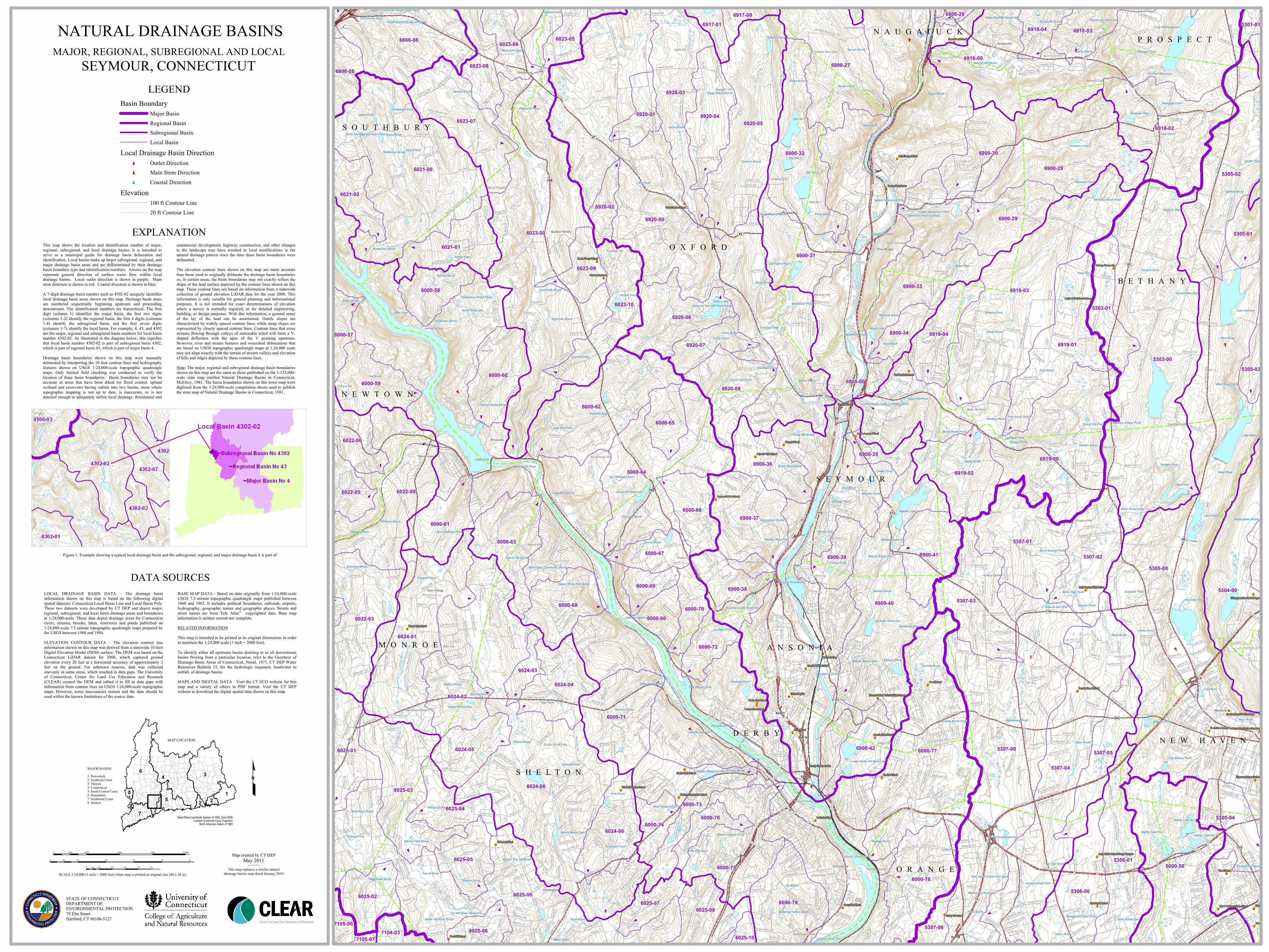
EXPLANATIONThis map shows the location and identification number of major,regional, subregional, and local drainage basins. It is intended toserve as a municipal guide for drainage basin delineation andidentification. Local basins make up larger subregional, regional, andmajor drainage basin areas and are differentiated by their drainagebasin boundary type and identification numbers. Arrows on the maprepresent general direction of surface water flow within localdrainage basins. Local outlet direction is shown in purple. Mainstem direction is shown in red. Coastal direction is shown in blue.A 7-digit drainage basin number such as 4302-02 uniquely identifieslocal drainage basin areas shown on this map. Drainage basin areasare numbered sequentially beginning upstream and proceedingdownstream. The identification numbers are hierarchical. The firstdigit (column 1) identifies the major basin, the first two digits(columns 1-2) identify the regional basin, the first 4 digits (columns1-4) identify the subregional basin, and the first seven digits(columns 1-7) identify the local basin. For example, 4, 43, and 4302are the major, regional and subregional basin numbers for local basinnumber 4302-02. As illustrated in the diagram below, this signifiesthat local basin number 4302-02 is part of subregional basin 4302,which is part of regional basin 43, which is part of major basin 4.
Drainage basin boundaries shown on this map were manuallydelineated by interpreting the 10 foot contour lines and hydrographyfeatures shown on USGS 1:24,000-scale topographic quadranglemaps. Only limited field checking was conducted to verify thelocation of these basin boundaries. Basin boundaries may not beaccurate in areas that have been diked for flood control, uplandwetland and reservoirs having outlets into two basins, areas wheretopographic mapping is not up to date, is inaccurate, or is notdetailed enough to adequately define local drainage. Residential and
commercial development, highway construction, and other changesto the landscape may have resulted in local modifications to thenatural drainage pattern since the time these basin boundaries weredelineated.The elevation contour lines shown on this map are more accuratethan those used to originally delineate the drainage basin boundariesso, in certain areas, the basin boundaries may not exactly reflect theshape of the land surface depicted by the contour lines shown on thismap. These contour lines are based on information from a statewidecollection of ground elevation LiDAR data for the year 2000. Thisinformation is only suitable for general planning and informationalpurposes. It is not intended for exact determinations of elevationwhere a survey is normally required, or for detailed engineering,building, or design purposes. With this information, a general senseof the lay of the land can be ascertained. Gentle slopes arecharacterized by widely spaced contour lines, while steep slopes arerepresented by closely spaced contour lines. Contour lines that crossstreams flowing through valleys of noticeable relief will form a V-shaped deflection with the apex of the V pointing upstream.However, river and stream features and watershed delineations thatare based on USGS topographic quadrangle maps at 1:24,000 scalemay not align exactly with the terrain of stream valleys and elevationof hills and ridges depicted by these contour lines.Note: The major, regional and subregional drainage basin boundariesshown on this map are the same as those published on the 1:125,000-scale state map entitled Natural Drainage Basins in Connecticut,McElroy, 1981. The basin boundaries shown on this town map weredigitized from the 1:24,000-scale compilation sheets used to publishthe state map of Natural Drainage Basins in Connecticut, 1981.
DATA SOURCESLOCAL DRAINAGE BASIN DATA – The drainage basininformation shown on this map is based on the following digitalspatial datasets: Connecticut Local Basin Line and Local Basin Poly.These two datasets were developed by CT DEP and depict major,regional, subregional, and local basin drainage areas and boundariesat 1:24,000-scale. These data depict drainage areas for Connecticutrivers, streams, brooks, lakes, reservoirs and ponds published on1:24,000-scale 7.5 minute topographic quadrangle maps prepared bythe USGS between 1969 and 1984.ELEVATION CONTOUR DATA – The elevation contour lineinformation shown on this map was derived from a statewide 10-footDigital Elevation Model (DEM) surface. The DEM was based on theConnecticut LiDAR dataset for 2000, which captured groundelevation every 20 feet at a horizontal accuracy of approximately 3feet on the ground. For unknown reasons, data was collectedunevenly in some areas, which resulted in data gaps. The Universityof Connecticut, Center for Land Use Education and Research(CLEAR) created the DEM and edited it to fill in data gaps withinformation from contour lines on USGS 1:24,000-scale topographicmaps. However, some inaccuracies remain and the data should beused within the known limitations of the source data.
BASE MAP DATA - Based on data originally from 1:24,000-scaleUSGS 7.5 minute topographic quadrangle maps published between1969 and 1992. It includes political boundaries, railroads, airports,hydrography, geographic names and geographic places. Streets andstreet names are from Tele Atlas® copyrighted data. Base mapinformation is neither current nor complete.RELATED INFORMATIONThis map is intended to be printed at its original dimensions in orderto maintain the 1:24,000 scale (1 inch = 2000 feet).
To identify either all upstream basins draining to or all downstreambasins flowing from a particular location, refer to the Gazetteer ofDrainage Basin Areas of Connecticut, Nosal, 1977, CT DEP WaterResources Bulletin 15, for the hydrologic sequence, headwater tooutfall, of drainage basins.MAPS AND DIGITAL DATA - Visit the CT ECO website for thismap and a variety of others in PDF format. Visit the CT DEPwebsite to download the digital spatial data shown on this map.
LEGENDBasin Boundary
Major BasinRegional BasinSubregional BasinLocal Basin
Local Drainage Basin Directiont Outlet Directiont Main Stem Directiont Coastal Direction
Elevation100 ft Contour Line20 ft Contour Line
Figure 1. Example showing a typical local drainage basin and the subregional, regional, and major drainage basin it is part of.
MAP LOCATION
State Plane Coordinate System of 1983, Zone 3526Lambert Conformal Conic Projection
North American Datum of 1983
MAJOR BASINS1 Pawcatuck2 Southeast Coast3 Thames4 Connecticut5 South Central Coast6 Housatonic7 Southwest Coast8 Hudson
£
NATURAL DRAINAGE BASINSMAJOR, REGIONAL, SUBREGIONAL AND LOCAL
SEYMOUR, CONNECTICUT
SCALE 1:24,000 (1 inch = 2000 feet) when map is printed at original size (48 x 36 in)
STATE OF CONNECTICUTDEPARTMENT OF ENVIRONMENTAL PROTECTION79 Elm StreetHartford, CT 06106-5127
Map created by CT DEPMay 2011
This map replaces a similar naturaldrainage basins map dated January 2010
0 2,500 5,000 7,500 10,0001,250Feet
0 0.4 0.8 1.2 1.6 20.2Miles
0 0.3 0.6 0.9 1.2 1.50.15Kilometers
Related Documents