Natural Conditions Assessment for Low DO, Skinquarter Creek Chesterfield County, Virginia Submitted by Virginia Department of Environmental Quality January, 2005

Welcome message from author
This document is posted to help you gain knowledge. Please leave a comment to let me know what you think about it! Share it to your friends and learn new things together.
Transcript
Natural Conditions Assessment for Low DO,
Skinquarter Creek Chesterfield County, Virginia
Submitted by
Virginia Department of Environmental Quality
January, 2005

Skinquarter Creek low DO TMDL
i
TABLE OF CONTENTS Executive Summary ............................................................................................................................1 1. Introduction....................................................................................................................................3 2. Physical Setting .............................................................................................................................3
2.1. Listed Water Bodies ..................................................................................................................3 2.2. Watershed ...............................................................................................................................5
2.2.1. General Description ...........................................................................................................5 2.2.2. Geology, Climate, Land Use...............................................................................................5
3. Description of Water Quality Problem/Impairment...........................................................................10 3.1. Associated Mainstem and Tributary Site DO…………………………………………………………….10 4. Water Quality Standard ................................................................................................................11
4.1. Designated Uses....................................................................................................................11 4.2. Applicable Water Quality Criteria .............................................................................................11
5. Assessment of Natural Conditions affecting low DO .......................................................................12 5.1. Preliminary Data Screen for Low Flow 7Q10............................................................................16 5.2. Low Slope, Swamps, or Wetlands ...........................................................................................17 5.3. Instream Nutrients..................................................................................................................18
5.4 Natural Seasonal DO Fluctuation.............................................................................................19 5.5. Impact from Point Source Dischargers .....................................................................................19 6. Conclusion ..................................................................................................................................20 7. Public Participation.......................................................................................................................20 8. References ..................................................................................................................................20 Appendix A...................................................................................................................................... A1

Skinquarter Creek low DO TMDL
ii
LIST OF TABLES Table 1. Impaired segment description (Skinquarter Creek) .......................................................3 Table 2. Climate summary for Amelia, Virginia (440187) .............................................................7 Table 3. Land use in the Skinquarter Creek watershed ...............................................................8 Table 4. DO data collected by DEQ on Skinquarter Creek at Rt. 603, 2-SQT001.54 ...................10 Table 5. Applicable water quality standards..............................................................................11 Table 6. Instream Nutrients of Skinquarter Creek at Rt. 603, 2-SQT001.54................................19
LIST OF FIGURES Figure E1. Time series of DO Concentrations at Skinquarter Creek at Rt. 603, 2-SQT001.54..……...1 Figure 1. Map of the Skinquarter Creek study area.......................................................................4 Figure 2. Soil Characteristics of the Skinquarter Creek Watershed ..............................................6 Figure 3. Land Use in the Skinquarter Creek Watershed...............................................................9 Figure 4. Time series of DO Concentrations at Skinquarter Creek at Rt. 603, 2-SQT001.54 ........10 Figure 5. Time series of DO Concentrations at Skinquarter Creek at Rt. 622, 2-SQT003.12 ........11 Figure 6. Skinquarter Creek at Rt. 603.........................................................................................17 Figure 7. Skinquarter Creek at Rt. 622.........................................................................................18 Figure 8. Seasonal Variations in DO at Skinquarter Creek at Rt. 603, 2-SQT001.54 ....................19

Skinquarter Creek low DO TMDL
1
Executive Summary This report presents the assessment of whether low dissolved oxygen (DO) in the Skinquarter Creek watershed is due to natural conditions or whether a Total Maximum Daily Load (TMDL) must be performed because of anthropogenic impacts. Skinquarter Creek is located in Chesterfield County in the Appomattox River Basin (USGS Hydrologic Unit Code 02080207). The waterbody identification code (WBID, Virginia Hydrologic Unit) for Skinquarter Creek is VAP-J07R-01. There are 25.0 total stream miles in the Skinquarter watershed (National Hydrography Dataset (NHD). The drainage area of the Skinquarter Creek watershed is approximately 15.0 square miles. The average annual rainfall is 44.27 inches. The watershed is approximately 9,595.9 acre in size, and is predominately forested (84.5 percent). Agriculture encompasses 10.9 percent of the watershed, with 2.0 percent cropland and 8.9 pasture/hayland. Residential and high use industrial areas compose approximately 0.08 percent of the land base. The remaining 4.5 percent of the watershed is comprised of 4.1 percent of transitional areas and grasses, and 0.4 percent wetlands and open water. The impaired segment is 7.0 stream miles from the headwaters near Moseley, VA to its confluence with the Appomattox River. An assessment of low pH due to natural conditions has been performed on the Skinquarter Creek watershed in a separate document. Skinquarter Creek was listed as impaired on Virginia’s 1998 303(d) Total Maximum Daily Load Priority List and Report and the 2004 305(b) / 303(d) Integrated Report (VADEQ, 1998 & 2004) due to violations of the State’s water quality standard for dissolved oxygen and pH (1998 and 2004). A total of 48 DO data points, with 18 water quality standard violations (37.5%), have been taken by DEQ at station 2-SQT001.54 (see Figure E1) from September 15, 1994 through December 3, 2003. Figure E1. Time series of DO concentrations (station 2-SQT001.54), Sept. 1994 to Dec. 2003. According to Virginia Water Quality Standards (9 VAC 25-260-10A), “all state waters are designated for the following uses: recreational uses (e.g., swimming and boating); the propagation and growth of a balanced indigenous population of aquatic life, including game fish, which might be reasonably expected to inhabit them; wildlife; and the production of edible and marketable natural resources (e.g., fish and shellfish).” As indicated above, Skinquarter Creek must support all designated uses and meet all applicable criteria. The Skinquarter Creek does not appear to support aquatic life use because of DO water quality standard violations. VADEQ proposes a methodology for determining whether low DO originates from natural or anthropogenic sources, adapted from “Methodology for Assessing Natural Dissolved Oxygen and pH Impairments: Application to the Appomattox River Watershed, Virginia.” (MapTech 2003)
DO at Skinquarter Creek at Rt. 603, 2-SQT001.54
0
24
68
1012
14
9/15/9
43/1
5/95
9/15/9
53/1
5/96
9/15/9
63/1
5/97
9/15/9
7
3/15/9
89/1
5/98
3/15/9
99/1
5/99
3/15/0
0
9/15/0
03/1
5/01
9/15/0
1
3/15/0
29/1
5/02
3/15/0
39/1
5/03
Sampling Date
DO
(m
g/L
)
37.5% Violations (18 of 48)

Skinquarter Creek low DO TMDL
2
The level of dissolved oxygen in a water body is determined by a balance between oxygen-depleting processes (e.g., decomposition and respiration) and oxygen restoring processes (e.g., aeration and photosynthesis). Certain natural conditions promote a situation where oxygen-restoring processes are not sufficient to overcome the oxygen- depleting processes. Conditions in a free-flowing stream that would typically be associated with naturally low DO include slow-moving, ripple-less waters where the bacterial decay of organic matter depletes DO at a faster rate than it can be replenished. Indicators of these conditions include low slope, the presence of wetlands, and often low pH due to organic acids (tannins, humic and fulvic substances) produced in the decay process. These situations can be compounded by anthropogenic activities that contribute excessive nutrients or readily available organic matter to these systems. The general approach to determine if DO and pH impairments in free-flowing streams are due to natural conditions is to assess a series of water quality and hydrologic criteria to determine the likelihood of an anthropogenic source. A logical 4-step process for identifying natural conditions that result in low DO and/or pH levels and for determining the likelihood of anthropogenic impacts that will exacerbate the natural condition is described below. DEQ staff is proposing to use this approach to implement State Water Control Law 9 VAC 25-260-55, Implementation Procedure for Dissolved Oxygen Criteria in Waters Naturally Low in Dissolved Oxygen. Before implementing this procedure for low DO, all DO data should be screened for flows less than the 7Q10. DO data collected on days when flow was < 7Q10 should be eliminated from the data set and the violation rate recalculated accordingly. Step 1. Determine slope and appearance (presence of wetlands). Step 2. Determine nutrient levels and compare with USGS background concentrations. Step 3. Determine degree of seasonal fluctuation (for DO only). Step 4. Determine anthropogenic impacts from permitted dischargers and land use. The 7Q10 for Skinquarter Creek at the original listing station is 0.10 cfs. No low DO violations occurred below 7Q10, therefore no DO violations were eliminated. Skinquarter Creek from rivermile 5.27 downstream to the confluence with the Appomattox River exhibits low slope (0.16%) and large areas of forested land with swamps and heavy tree canopy. Decomposition of the large inputs of decaying vegetation from areas of forested land with swamps and heavy tree canopy throughout the watershed increase oxygen demand and lower DO as they decay. These are not considered anthropogenic impacts. Skinquarter Creek exhibits low nutrient concentrations below national background levels in streams from undeveloped areas, which not indicative of human impact. Skinquarter Creek exhibits natural seasonal DO fluctuation due to the inverse relationship between water temperature and DO. There are no permitted dischargers in the Skinquarter Creek watershed. Residential / Commercial land use (0.08%) probably has no DO effect on streams in the watershed. Based on the above information, a change in the water quality standards classification to Class VII Swampwater due to natural conditions, rather than a TMDL, is indicated for mainstem Skinquarter Creek from rivermile 5.27 downstream to its confluence with the Appomattox River, totaling 5.27 stream miles. If there is a 305(b)/303(d) assessment prior to the reclassification, Skinquarter Creek will be assessed as Category 4C, Impaired due to natural condition, no TMDL needed. DEQ performed the assessment of the Skinquarter Creek low DO natural condition in lieu of a TMDL. Therefore neither a TMDL Technical Advisory Committee (TAC) meeting nor a public meeting was involved. Public participation will occur during the next water quality standards triennial review process.

Skinquarter Creek low DO TMDL
3
1. Introduction Skinquarter Creek and was listed as impaired on Virginia’s 1998 303(d) Total Maximum Daily Load Priority List and Report and the 2004 305(b) / 303(d) Integrated Report (VADEQ, 1998 & 2004) due to violations of the State’s water quality standard for dissolved oxygen (DO, 1998) and pH (1998 and 2004). This report evaluates the DO impairment by determining if natural conditions are the cause of the impairment, thus obviating the need for a TMDL. The pH impairment has been addressed separately from this document. A glossary of terms used throughout this report is presented as Appendix A. 2. Physical Setting 2.1 Listed Water Bodies Skinquarter Creek is located in Chesterfield County in the Appomattox River Basin (USGS Hydrologic Unit Code 02080207). The waterbody identification code (WBID, Virginia Hydrologic Unit) for non-tidal Skinquarter Creek is VAP-J07R-01. There are 25.0 total stream miles in the Skinquarter watershed (National Hydrography Dataset (NHD). The impaired segment is 7.0 stream miles of mainstem Skinquarter Creek. This report addresses only the DO impairments. The pH impairments are reported in a separate document. These segments are described in Table 1 and Figure 1. Table 1. Impaired segment descriptions (Skinquarter Creek)
Segment (segment ID)
Impairment (source of impairment)
Upstream Limit Description
Downstream Limit Description
Miles Affected
Skinquarter Creek VAP-J07R-01
pH Dissolved Oxygen
(Natural conditions)
Headwaters Appomattox River confluence
7.0
Figure 1. Map of the Skinquarter Creek study area .

Skinquarter Creek low DO TMDL
4
2.2. Watershed
2-SQT001.54
2-SQT003.12

Skinquarter Creek low DO TMDL
5
2.2.1. General Description Skinquarter Creek, located within Chesterfield County, Virginia, is a minor tributary to the Appomattox River. It is approximately 7 miles long and flows southwestward from its headwaters near Moseley, VA to its confluence with the Appomattox River. The watershed itself has an area of approximately 15.0 square miles. There is no continuous flow gaging station on Skinquarter Creek, however there is a gage on Deep Creek near Mannboro, VA, 02041000, located 10 miles south of Skinquarter Creek, with a drainage area of 158 mi2.
2.2.2. Geology, Climate, Land Use Geology and Soils Skinquarter Creek is in the Piedmont physiographic region. The Piedmont of Virginia extends eastward from the Blue Ridge to the Fall Line, where Paleozoic-age and older igneous and metamorphic rocks are covered by unconsolidated sediments of the Atlantic Coastal Plain. The Virginia Piedmont is part of the greater southeastern Piedmont, which extends from northeastern Alabama through Georgia, South Carolina, North Carolina, Virginia, Maryland, and southeastern Pennsylvania. The Piedmont is characterized by deeply weathered, poorly exposed bedrock and a high degree of geological complexity, making it one of the last frontiers of North American regional geology. The Piedmont contains a collage of rock associations or terranes that are bounded by northeast-trending regional faults. (http://www.geology.state.va.us/DOCS/Geol/pied.html). Soils for the Skinquarter Creek watershed were documented utilizing the VA State Soil Geographic Database (STATSGO). Two general soil types were identified using in this database. Descriptions of these soil series were derived from queries to the USDA Natural Resources Conservation Service (NRCS) Official Soil Series Description web site (http://ortho.ftw.nrcs.usda.gov/cgi-bin/osd/osdname.cgi). Figure 2 shows the location of these general soil types in the watershed. The Cecil-Madison-Enon-Wilkes-Chewacla series (VA019) are very deep to shallow soils which have been formed from residuum weathered from igneous and high-grade metamorphic rocks, or alluvium deposits of these same parent materials. Located in the Piedmont uplands, these soils are located on ridges and side slopes of the Piedmont uplands and floodplains. This series are moderately drained in the uplands and somewhat poorly drained in floodplains. Soils are moderate to slowly permeable. The Altavista-Congaree-Chewacla-Wehadkee-Wickham-Turbeville-Hiwassee series (VA032) are very deep to deep soils. Soils are located on stream terraces in the Piedmont and Upper Atlantic Coastal Plain. This series is formed from recent fluvial sediments. The drainage class are moderately well to very poorly drained, with moderate to poor permeability. The Creedmoor-Partlow-Mayodan-Pinkston soils (VA042) are very deep, well drained to poorly drained soils. Permeability for this series ranges from moderately rapid to slow. These soils have formed either from Triassic material or in local colluvial and alluvial materials.

Skinquarter Creek low DO TMDL
6
Figure 2. Soil Characteristics of the Skinquarter Creek Watershed.
Skinquarter Creek low DO TMDL
7
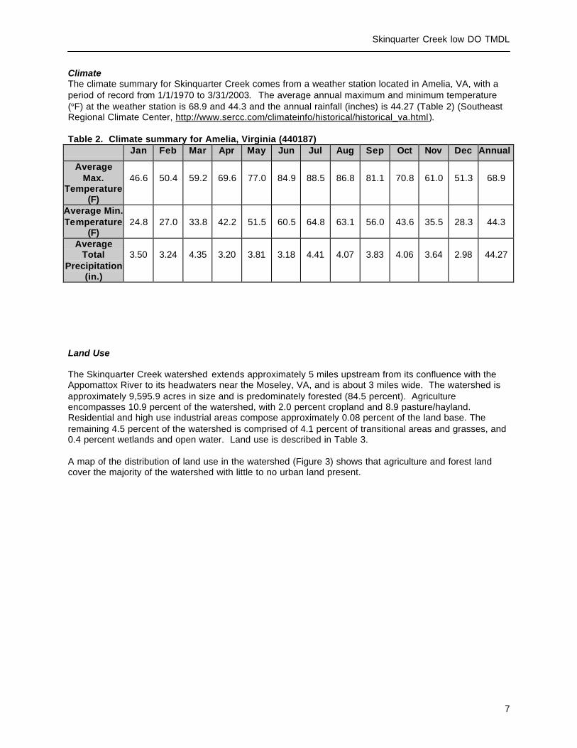
Climate The climate summary for Skinquarter Creek comes from a weather station located in Amelia, VA, with a period of record from 1/1/1970 to 3/31/2003. The average annual maximum and minimum temperature (°F) at the weather station is 68.9 and 44.3 and the annual rainfall (inches) is 44.27 (Table 2) (Southeast Regional Climate Center, http://www.sercc.com/climateinfo/historical/historical_va.html). Table 2. Climate summary for Amelia, Virginia (440187)
Jan Feb Mar Apr May Jun Jul Aug Sep Oct Nov Dec Annual
Average Max.
Temperature (F)
46.6
50.4
59.2
69.6
77.0
84.9
88.5
86.8
81.1
70.8
61.0
51.3
68.9
Average Min. Temperature
(F)
24.8
27.0
33.8
42.2
51.5
60.5
64.8
63.1
56.0
43.6
35.5
28.3
44.3
Average Total
Precipitation (in.)
3.50
3.24
4.35
3.20
3.81
3.18
4.41
4.07
3.83
4.06
3.64
2.98
44.27
Land Use The Skinquarter Creek watershed extends approximately 5 miles upstream from its confluence with the Appomattox River to its headwaters near the Moseley, VA, and is about 3 miles wide. The watershed is approximately 9,595.9 acres in size and is predominately forested (84.5 percent). Agriculture encompasses 10.9 percent of the watershed, with 2.0 percent cropland and 8.9 pasture/hayland. Residential and high use industrial areas compose approximately 0.08 percent of the land base. The remaining 4.5 percent of the watershed is comprised of 4.1 percent of transitional areas and grasses, and 0.4 percent wetlands and open water. Land use is described in Table 3. A map of the distribution of land use in the watershed (Figure 3) shows that agriculture and forest land cover the majority of the watershed with little to no urban land present.

Skinquarter Creek low DO TMDL
8
Table 3. Land Use in the Skinquarter Creek Watershed Landuse Acres Percent of Total
Open Water 28.9 0.30Low Intensity Residential 0.2 0.00High Intensity Residential 0.0 0.00High Intensity Commercial/Industrial/Transportation 7.3 0.08Bare Rock/Sand/Clay 0.0 0.00Quarries/Strip Mines/Gravel Pits 0.0 0.00Transitional 393.6 4.10Deciduous Forest 5499.6 57.31Evergreen Forest 765.5 7.98Mixed Forest 1842.8 19.20Pasture/Hay 856.0 8.92Row Crops 194.8 2.03Other Grasses (Urban/recreational; e.g. parks) 0.0 0.00Woody Wetlands 0.0 0.00Emergent Herbaceous Wetlands 7.1 0.07TOTAL: 9595.9 100.00
15.0 sq. miles

Skinquarter Creek low DO TMDL
9
Figure 3. Land Use in the Skinquarter Creek Watershed

Skinquarter Creek low DO TMDL
10
3. Description of Water Quality Problem/Impairment Skinquarter Creek was listed as impaired on Virginia’s 1998 303(d) Total Maximum Daily Load Priority List and Report and the 2004 305(b) / 303(d) Integrated Report (VADEQ, 1998 & 2004) due to violations of the State’s water quality standard for dissolved oxygen and pH (1998 and 2004). A total of 48 DO data points, with 18 water quality standard violations (37.5%), have been taken by DEQ at station 2-SQT001.54 (see Figure 1) from September 15, 1994 through December 3, 2003 (Table 4).
Table 4. DO data collected by DEQ on Skinquarter Creek at Rt. 603
mg/l
Station Date of First
Sample
Date of Last
Sample
Number of
Samples
Average Minimum Maximum Number of Violations
2-SQT001.54 09/15/1994 12/03/2003 48 5.43 0.43 11.53 18
A time series graph of all data collected at station 2-SQT001.54 shows the DO concentrations ranging from 0.43 mg/l to 11.53 mg/l (Figure 4). The horizontal line at the DO = 4.0 mg/l mark represents the minimum water quality standard. The data points below the DO = 4.0 mg/l line illustrate violations of the water quality standard. Figure 4. Time series of DO Concentrations at Skinquarter Creek at Rt. 603, 2-SQT001.54.
3.1 Associated Mainstem and Tributary site DO
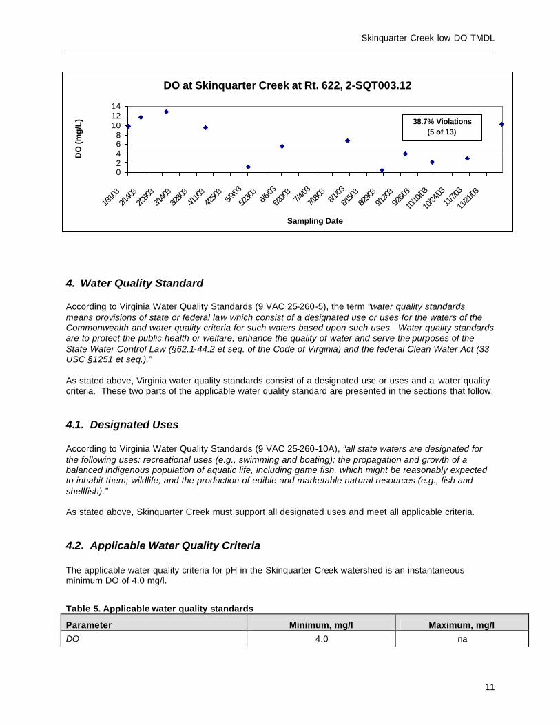
DEQ added an associated mainstem and tributary monitoring station during data collection for the low DO assessment of natural conditions or development of a TMDL. Associated station DO data are presented in Figure 5 below.
Figure 5. Time series of DO Concentrations at Skinquarter Creek at Rt. 622, 2-SQT003.12.
DO at Skinquarter Creek at Rt. 603, 2-SQT001.54
0
2
4
6
8
10
12
14
9/15/9
4
3/15/9
5
9/15/9
5
3/15/9
6
9/15/9
6
3/15/9
7
9/15/9
7
3/15/9
8
9/15/9
8
3/15/9
9
9/15/9
9
3/15/0
0
9/15/0
0
3/15/0
1
9/15/0
1
3/15/0
2
9/15/0
2
3/15/0
3
9/15/0
3
Sampling Date
DO
(m
g/L
)
37.5% Violations (18 of 48)
Skinquarter Creek low DO TMDL
11
4. Water Quality Standard According to Virginia Water Quality Standards (9 VAC 25-260-5), the term “water quality standards means provisions of state or federal law which consist of a designated use or uses for the waters of the Commonwealth and water quality criteria for such waters based upon such uses. Water quality standards are to protect the public health or welfare, enhance the quality of water and serve the purposes of the State Water Control Law (§62.1-44.2 et seq. of the Code of Virginia) and the federal Clean Water Act (33 USC §1251 et seq.).” As stated above, Virginia water quality standards consist of a designated use or uses and a water quality criteria. These two parts of the applicable water quality standard are presented in the sections that follow.
4.1. Designated Uses According to Virginia Water Quality Standards (9 VAC 25-260-10A), “all state waters are designated for the following uses: recreational uses (e.g., swimming and boating); the propagation and growth of a balanced indigenous population of aquatic life, including game fish, which might be reasonably expected to inhabit them; wildlife; and the production of edible and marketable natural resources (e.g., fish and shellfish).” As stated above, Skinquarter Creek must support all designated uses and meet all applicable criteria.
4.2. Applicable Water Quality Criteria The applicable water quality criteria for pH in the Skinquarter Creek watershed is an instantaneous minimum DO of 4.0 mg/l.
Table 5. Applicable water quality standards Parameter Minimum, mg/l Maximum, mg/l
DO 4.0 na
DO at Skinquarter Creek at Rt. 622, 2-SQT003.12
02468
101214
1/31/0
32/1
4/03
2/28/0
33/1
4/03
3/28/0
34/1
1/03
4/25/0
35/9
/03
5/23/0
36/6
/03
6/20/0
37/4
/03
7/18/0
38/1
/03
8/15/0
38/2
9/03
9/12/0
39/2
6/03
10/10
/03
10/24
/03
11/7/0
3
11/21
/03
Sampling Date
DO
(mg
/L) 38.7% Violations
(5 of 13)

Skinquarter Creek low DO TMDL
12
If the waterbody exceeds the criterion listed above in more than 10.5 percent of samples, the waterbody is classified as impaired and natural conditions must be determined or a TMDL must be developed and implemented to bring the waterbody into compliance with the water quality criterion.
5. Assessment of Natural Conditions Affecting low DO - Process for determining if DO and pH impairments in free-flowing streams are due to natural conditions.
The level of dissolved oxygen in a water body is determined by a balance between oxygen-depleting processes (e.g., decomposition and respiration) and oxygen-restoring processes (e.g., aeration and photosynthesis). Certain natural conditions promote a situation where oxygen-restoring processes are not sufficient to overcome the oxygen- depleting processes. The level of pH in a water body is determined by a balance between organic acids produced by decay of vegetative material, and buffering capacity. Conditions in a stream that would typically be associated with naturally low DO and pH include slow-moving, ripple- less waters or wetlands where the decay of organic matter produces organic acids. These situations can be compounded by anthropogenic activities that contribute excessive nutrients or readily available organic matter to these systems. The general approach to determine if DO and pH impairments in streams are due to natural conditions is to assess a series of water quality and hydrologic criteria to determine the likelihood of an anthropogenic source. A logical 4-step process for identifying natural conditions that result in low DO and/or pH levels and for determining the likelihood of anthropogenic impacts that will exacerbate the natural condition is described below. Step 1. Determine slope and appearance. Step 2. Determine nutrient levels. Step 3. Determine degree of seasonal fluctuation (for DO only). Step 4. Determine anthropogenic impacts.
The results from this methodology (or process or approach) will be used to determine if the stream should be re -classified as Class VII Swamp Waters. Each step is described in detail below.
Skinquarter Creek low DO TMDL
13
Procedure for Natural Condition Assessment of low pH and low DO in Virginia
Streams
Prepared by Virginia Department of Environmental Quality October 2004
I. INTRODUCTION Virginia’s list of impaired waters currently shows many waters as not supporting the aquatic life use due to exceedances of pH and/or DO criteria that are designed to protect aquatic life in Class III waters. However, there is reason to believe that most of these streams or stream segments have been mis-classified and should more appropriately be classified as Class VII, Swamp Waters. This document presents a procedure for assessing if natural conditions are the cause of the low pH and/or low DO levels in a given stream or stream segment. The level of dissolved oxygen (DO) in a water body is determined by a balance between oxygen-depleting processes (e.g., decomposition and respiration) and oxygen-restoring processes (e.g., aeration and photosynthesis). Certain natural conditions promote a situation where oxygen-restoring processes are not sufficient to overcome the oxygen- depleting processes. The level of acidity as registered by pH in a water body is determined by a balance between organic acids produced by decay of vegetative material, and buffering capacity. Conditions in a stream that would typically be associated with naturally low DO and/or naturally low pH include slow-moving, ripple-less waters. In such waters, the decay of organic matter depletes DO at a faster rate than it can be replenished and produces organic acids (tannins, humic and fulvic substances). These situations can be compounded by anthropogenic activities that contribute excessive nutrients or readily available organic matter to these systems. The general approach to determine if DO and pH impairments in streams are due to natural conditions is to assess a series of water quality and hydrologic criteria to determine the likelihood of an anthropogenic source. A logical 4-step process for identifying natural conditions that result in low DO and/or pH levels and for determining the likelihood of anthropogenic impacts that will exacerbate the natural condition is described below. DEQ staff is proposing to use this approach to implement State Water Control Law 9 VAC 25-260-55, Implementation Procedure for Dissolved Oxygen Criteria in Waters Naturally Low in Dissolved Oxygen. Waters that are shown to have naturally low DO and pH levels will be re-classified as Class VII, Swamp Waters, with the associated pH criterion of 4.3 to 9.0 SU. An associated DO criterion is currently being developed from swamp water data. A TMDL is
Skinquarter Creek low DO TMDL
14
is not needed for these waters. An assessment category of 4C will be assigned until the waterbody has been re-classified. II. NATURAL CONDITION ASSESSMENT Following a description of the watershed (including geology, soils, climate, and land use), a description of the DO and/or pH water quality problem (including a data summary, time series and monthly data distributions), and a description of the water quality criteria that were the basis for the impairment determination, the available information should be evaluated in four steps. Step 1. Determine appearance and flow/slope. Streams or stream segments that have naturally low DO (< 4 mg/L) and low pH (< 6 SU) are characterized by very low slopes and low velocity flows (flat water with low reaeration rates). Decaying vegetation in such swampy waters provides large inputs of plant material that consumes oxygen as it decays. The decaying vegetation in a swamp water also produces acids and decreases pH. Plant materials contain polyphenols such as tannin and lignin. Polyphenols and partially degraded polyphenols build up in the form of tannic acids, humic acids, and fulvic acids that are highly colored. The trees of swamps have higher polyphenolic content than the soft-stemmed vegetation of marshes. Swamp streams (blackwater) are therefore more highly colored and more acidic than marsh streams. Appearance and flow velocity (or slope if flow velocity is not available) must be identified for each stream or stream segment to be assessed for natural conditions and potential re-classification as a Class VII swamp water. This can be done through maps, photos, field measurements or other appropriate means. Step 2. Determine nutrient levels. Excessive nutrients can cause a decrease in DO in relatively slow moving systems, where aeration is low. High nutrient levels are an indication of anthropogenic inputs of nitrogen, phosphorus, and possibly organic matter. Nutrient input can stimulate plant growth, and the resulting die-off and decay of excessive plankton or macrophytes can decrease DO levels. USGS (1999) estimated national background nutrient concentrations in streams and groundwater from undeveloped areas. Average nitrate background concentrations are less than 0.6 mg/L for streams, average total nitrogen (TN) background concentrations are less than 1.0 mg/L, and average background concentrations of total phosphorus (TP) are less than 0.1 mg/L. Nutrient levels must be documented for each stream or stream segment to be assessed for natural conditions and potential re-classification as a Class VII swamp water. Streams with average concentrations of nutrients greater than the national background concentrations should be further evaluated for potential impacts from anthropogenic sources.

Skinquarter Creek low DO TMDL
15
Step 3. Determine degree of seasonal fluctuation (for DO only). Anthropogenic impacts on DO will likely disrupt the typical seasonal fluctuation seen in the DO concentrations of wetland streams. Seasonal analyses should be conducted for each potential Class VII stream or stream segment to verify that DO is depressed in the summer months and recovers during the winter, as would be expected in natural systems. A weak seasonal pattern could indicate that human inputs from point or nonpoint sources are impacting the seasonal cycle. Step 4. Determine anthropogenic impacts. Every effort should be made to identify human impacts that could exacerbate the naturally low DO and/or pH. For example, point sources should be identified and DMR data analyzed to determine if there is any impact on the stream DO or pH concentrations. Land use analysis can also be a valuable tool for identifying potential human impacts. Lastly, a discussion of acid rain impacts should be included for low pH waters. The format of this discussion can be based either on the process used for the recent Class VII classification of several streams in the Blackwater watershed of the Chowan Basin (letter from DEQ to EPA, 14 October 2003). An alternative is a prototype regional stream comparison developed for Fourmile Creek, White Oak Swamp, Matadequin Creek and Mechumps Creek (all east of the fall line). The example analysis under IV in this document, or the example report prepared for Fourmile Creek, illustrate this approach. For streams west of the fall line, a regional stream comparison for 2004 analyses encompasses Winticomack, Winterpock, and Skinquarter Creeks. 7Q10 Data Screen If the data warrant it, a data screen should be performed to ensure that the impairment was identified based on valid data. All DO or pH data that violate water quality standards should be screened for flows less than the 7Q10. Data collected on days when flow was < 7Q10 should be eliminated from the data set and the violation rate recalculated accordingly. Only those waters with violation rates determined days with flows > or = 7Q10 flows should be classified as impaired. In some cases, data were collected when flow was 0 cfs. If the 7Q10 is identified as 0 cfs as well, all data collected under 0 cfs flow would need to be considered in the water quality assessment. In those cases, the impairment should be classified as 4C, Impaired due to natural conditions, no TMDL needed. However, a reclassification to Class VII may not always be appropriate. III. NATURAL CONDITION CONCLUSION MATRIX The following decision process should be applied for determining whether low pH and/or low DO values are due to natural conditions and justify a reclassification of a stream or stream segment as Class VII, Swamp Water.
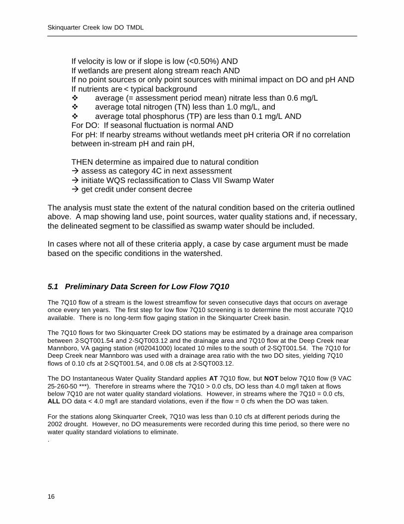
Skinquarter Creek low DO TMDL
16
If velocity is low or if slope is low (<0.50%) AND If wetlands are present along stream reach AND If no point sources or only point sources with minimal impact on DO and pH AND If nutrients are < typical background v average (= assessment period mean) nitrate less than 0.6 mg/L v average total nitrogen (TN) less than 1.0 mg/L, and v average total phosphorus (TP) are less than 0.1 mg/L AND For DO: If seasonal fluctuation is normal AND For pH: If nearby streams without wetlands meet pH criteria OR if no correlation between in-stream pH and rain pH,
THEN determine as impaired due to natural condition à assess as category 4C in next assessment à initiate WQS reclassification to Class VII Swamp Water à get credit under consent decree
The analysis must state the extent of the natural condition based on the criteria outlined above. A map showing land use, point sources, water quality stations and, if necessary, the delineated segment to be classified as swamp water should be included. In cases where not all of these criteria apply, a case by case argument must be made based on the specific conditions in the watershed. 5.1 Preliminary Data Screen for Low Flow 7Q10 The 7Q10 flow of a stream is the lowest streamflow for seven consecutive days that occurs on average once every ten years. The first step for low flow 7Q10 screening is to determine the most accurate 7Q10 available. There is no long-term flow gaging station in the Skinquarter Creek basin. The 7Q10 flows for two Skinquarter Creek DO stations may be estimated by a drainage area comparison between 2-SQT001.54 and 2-SQT003.12 and the drainage area and 7Q10 flow at the Deep Creek near Mannboro, VA gaging station (#02041000) located 10 miles to the south of 2-SQT001.54. The 7Q10 for Deep Creek near Mannboro was used with a drainage area ratio with the two DO sites, yielding 7Q10 flows of 0.10 cfs at 2-SQT001.54, and 0.08 cfs at 2-SQT003.12. The DO Instantaneous Water Quality Standard applies AT 7Q10 flow, but NOT below 7Q10 flow (9 VAC 25-260-50 ***). Therefore in streams where the 7Q10 > 0.0 cfs, DO less than 4.0 mg/l taken at flows below 7Q10 are not water quality standard violations. However, in streams where the 7Q10 = 0.0 cfs, ALL DO data < 4.0 mg/l are standard violations, even if the flow = 0 cfs when the DO was taken. For the stations along Skinquarter Creek, 7Q10 was less than 0.10 cfs at different periods during the 2002 drought. However, no DO measurements were recorded during this time period, so there were no water quality standard violations to eliminate. .

Skinquarter Creek low DO TMDL
17
5.2 Low slope, Swamps, Wetlands or Large Forested Areas There were no discharge measurements made at the Rt. 603 bridge, the original 303(d) listing station, or at Rt. 622. The hydrologic slope from the 230 ft. topographic contour at rivermile 5.27 located 2.2 mi above Rt. 622 downstream to the 190 ft. topographic contour at rivermile 0.81 located 0.7 mi below Rt. 603 is estimated at 0.16%, which is considered very low slope. These locations comprise the approximate upstream and downstream boundaries of this low slope segment on mainstem Skinquarter Creek. The low slope in this 4.46 mile segment contributes no human impact. However slope immediately upstream of this segment, from the headwaters of Skinquarter Creek at the 330 ft contour at rivermile 7.19, located 0.2 mi south of the intersection of Rts. 605 and 622, downstream to the 230 ft contour at rivermile 5.27, located 2.2 mi above Rt. 622, is estimated at 0.99%. This is more than six times the low slope in the downstream DO impaired segment, and above the Swampwater slope guideline of 0.50%. Skinquarter Creek from rivermile 5.27 downstream to the confluence with the Appomattox River exhibits low slope (0.16%) and large areas of forested land with swamps and heavy tree canopy. Decomposition of the large inputs of decaying vegetation from areas of forested land with swamps and heavy tree canopy throughout the watershed increase oxygen demand and lower DO as they decay. These are not considered anthropogenic impacts. Visual inspections from bridges at Rts. 603, and 622 revealed large swamp areas with heavy tree canopy. There are large inputs of decaying vegetation from areas of forested land with heavy tree canopy throughout the watershed, that produce acids and lower pH as they decay. (Figures 6-7). Figure 6. Skinquarter Creek at Rt. 603.

Skinquarter Creek low DO TMDL
18
Figure 7. Skinquarter Creek at Rt. 622.
5.3 Instream Nutrients The VADEQ collected nutrient data from station 3-SQT001.54 from September 1994 to December 2003 (Table 6). The average nutrient concentrations are below the USGS (1999) national background nutrient concentrations in streams from undeveloped areas levels of nitrate < 0.6 mg/l; TN (TKN + NO3 + NO2) < 1.0 mg/l; and TP < 0.1 mg/l. These low nutrient levels are not indicative of human impact.

Skinquarter Creek low DO TMDL
19
Table 6. Instream Nutrients of Skinquarter Creek at Rt. 603, 2-SQT001.54. Parameter Average Conc. Number Total Phosphorus 0.069 mg/l (n=39) Orthophosphorus 0.034 mg/l (n=38) Total Kjeldahl Nitrogen 0.709 mg/l (n=39) Ammonia as N 0.028 mg/l (n=39) Nitrate as N 0.031 mg/l (n=33) Nitrite as N 0.006 mg/l (n=33) TN (TKN + NO3 + NO2) 0.746 mg/l (n=39) These levels of nitrate, total nitrogen and total phosphorus (bolded in black) are below the USGS (1999) national background nutrient concentrations in streams from undeveloped areas levels of nitrate < 0.6 mg/l; TN (TKN + NO3 + NO2) < 1.0 mg/l; and TP < 0.1 mg/l. 5.4 Natural Seasonal DO Fluctuation Skinquarter Creek exhibits natural seasonal DO fluctuation due to the inverse relationship between water temperature and DO. DO is high in the winter months while water temperatures are low, and low in the summer months when water temperatures are high. This is depicted in Figure 8. Figure 8. Seasonal Variation in DO at Skinquarter Creek at Rt. 603, 1994 – 2003. 5.5 Impact from Point Source Dischargers and Land Use There are no permitted point source discharges in the Skinquarter Creek watershed. Residential and high use industrial areas (7.5 acres) compose approximately 0.08 percent of the land base, an insignificant portion of the watershed. The watershed is predominately forested (84.5 percent), with 0.4 percent wetlands and open water. This land use was considered not indicative of human impact.
DO at Skinquarter Creek at Rt. 603, 2-SQT001.54
0
2
4
6
8
10
12
14
9/15/9
43/1
5/95
9/15/9
53/1
5/96
9/15/9
6
3/15/9
7
9/15/9
7
3/15/9
8
9/15/9
8
3/15/9
9
9/15/9
9
3/15/0
0
9/15/0
03/1
5/01
9/15/0
1
3/15/0
2
9/15/0
2
3/15/0
3
9/15/0
3
Sampling Date
DO
(m
g/L)

Skinquarter Creek low DO TMDL
20
6.0 CONCLUSION The following decision process is proposed for determining whether low DO values are due to natural conditions: If slope is low (<0.50) AND If wetlands or large areas of forested land are present along stream reach AND If no point sources or point sources with minimal impact on DO AND If nutrients are < typical background v average (= assessment period mean) nitrate less than 0.6 mg/L v average total nitrogen (TN) less than 1.0 mg/L, and v average total phosphorus (TP) are less than 0.1 mg/L AND If nearby streams without wetlands meet DO criteria, THEN determine as impaired due to natural condition à assess as category 4C in next assessment à initiate WQS reclassification to Class VII Swamp Water à get credit under consent decree Skinquarter Creek from rivermile 5.27 downstream to the confluence with the Appomattox River exhibits low slope (0.16%) and large areas of forested land with swamps and heavy tree canopy. Decomposition of the large inputs of decaying vegetation from areas of forested land with swamps and heavy tree canopy throughout the watershed increase oxygen demand and lower DO as they decay. These are not considered anthropogenic impacts. Skinquarter Creek exhibits low nutrient concentrations below national background levels in streams from undeveloped areas, which not indicative of human impact. Skinquarter Creek exhibits natural seasonal DO fluctuation due to the inverse relationship between water temperature and DO. There are no permitted dischargers in the Skinquarter Creek watershed. Residential / Commercial land use (0.08%) probably has no DO effect on the mainstem or tributary swampy areas. Based on the above information, a change in the water quality standards classification to Class VII Swampwater due to natural conditions, rather than a TMDL, is indicated for mainstem Skinquarter Creek from rivermile 5.27 downstream to its confluence with the Appomattox River, totaling 5.27 stream miles. If there is a 305(b)/303(d) assessment prior to the reclassification, Skinquarter Creek will be assessed as Category 4C, Impaired due to natural condition, no TMDL needed. 7.0. Public Participation DEQ performed the assessment of the Skinquarter Creek low DO natural condition in lieu of a TMDL. Therefore neither a TMDL Technical Advisory Committee (TAC) meeting nor a public meeting was involved. Public participation will occur during the next water quality standards triennial review process.
8. References Maptech, Methodology for Assessing Natural Dissolved Oxygen and pH Impairments: Application to the Appomattox River Watershed, Virginia. 2003. SRCC (Southeast Regional Climate Center)
http://www.dnr.state.sc.us/climate/sercc/products/historical/historical_va.html (Accessed 12/18/02) USGS (United States Geological Survey), National Background Nutrient Concentrations in Streams from
Undeveloped Areas. 1999.

Skinquarter Creek low DO TMDL
21
VADEQ (Virginia Department of Environmental Quality), Virginia Water Quality Assessment 1998.
Virginia. 1998.
VADEQ (Virginia Department of Environmental Quality), Virginia Water Quality Assessment 2002. Virginia. 2002.


Skinquarter Creek low DO TMDL
E1
Appendix A
Glossary

Skinquarter Creek low DO TMDL
E2
GLOSSARY Note: All entries in italics are taken from USEPA (1998). All non-italicized entries are taken from MapTech (2002). 303(d). A section of the Clean Water Act of 1972 requiring states to identify and list water bodies that do not meet the states’ water quality standards. 7Q10. The lowest streamflow for seven consecutive days that occurs on average once every ten years. Ambient water quality. Natural concentration of water quality constituents prior to mixing of either point or nonpoint source load of contaminants. Reference ambient concentration is used to indicate the concentration of a chemical that will not cause adverse impact on human health. Anthropogenic. Pertains to the [environmental] influence of human activities. Background levels. Levels representing the chemical, physical, and Bacterial conditions that would result from natural geomorphological processes such as weathering or dissolution. Best management practices (BMPs). Methods, measures, or practices determined to be reasonable and cost-effective means for a landowner to meet certain, generally nonpoint source, pollution control needs. BMPs include structural and nonstructural controls and operation and maintenance procedures. Clean Water Act (CWA). The Clean Water Act (formerly referred to as the Federal Water Pollution Control Act or Federal Water Pollution Control Act Amendments of 1972), Public Law 92-500, as amended by Public Law 96-483 and Public Law 97-117, 33 U.S.C. 1251 et seq. The Clean Water Act (CWA) contains a number of provisions to restore and maintain the quality of the nation's water resources. One of these provisions is section 303(d), which establishes the TMDL program. Concentration. Amount of a substance or material in a given unit volume of solution; usually measured in milligrams per liter (mg/L) or parts per million (ppm). Confluence. The point at which a river and its tributary flow together. Contamination. The act of polluting or making impure; any indication of chemical, sediment, or Bacterial impurities. Designated uses. Those uses specified in water quality standards for each waterbody or segment whether or not they are being attained. Dilution. The addition of some quantity of less-concentrated liquid (water) that results in a decrease in the original concentration.

Skinquarter Creek low DO TMDL
E3
Direct runoff. Water that flows over the ground surface or through the ground directly into streams, rivers, and lakes. Discharge. Flow of surface water in a stream or canal, or the outflow of groundwater from a flowing artesian well, ditch, or spring. Can also apply to discharge of liquid effluent from a facility or to chemical emissions into the air through designated venting mechanisms. Discharge permits (under VPDES). A permit issued by the U.S. EPA or a state regulatory agency that sets specific limits on the type and amount of pollutants that a municipality or industry can discharge to a receiving water; it also includes a compliance schedule for achieving those limits. The permit process was established under the National Pollutant Discharge Elimination System, under provisions of the Federal Clean Water Act. Domestic wastewater. Also called sanitary wastewater, consists of wastewater discharged from residences and from commercial, institutional, and similar facilities. Drainage basin. A part of a land area enclosed by a topographic divide from which direct surface runoff from precipitation normally drains by gravity into a receiving water. Also referred to as a watershed, river basin, or hydrologic unit. Effluent. Municipal sewage or industrial liquid waste (untreated, partially treated, or completely treated) that flows out of a treatment plant, septic system, pipe, etc. Effluent limitation. Restrictions established by a state or EPA on quantities, rates, and concentrations in pollutant discharges. Existing use. Use actually attained in the waterbody on or after November 28, 1975, whether or not it is included in the water quality standards (40 CFR 131.3). GIS. Geographic Information System. A system of hardware, software, data, people, organizations and institutional arrangements for collecting, storing, analyzing and disseminating information about areas of the earth. (Dueker and Kjerne, 1989) Hydrologic cycle. The circuit of water movement from the atmosphere to the earth and its return to the atmosphere through various stages or processes, such as precipitation, interception, runoff, infiltration, storage, evaporation, and transpiration. Hydrology. The study of the distribution, properties, and effects of water on the earth's surface, in the soil and underlying rocks, and in the atmosphere. In situ. In place; in situ measurements consist of measurements of components or processes in a full-scale system or a field, rather than in a laboratory. Margin of safety (MOS). A required component of the TMDL that accounts for the uncertainty about the relationship between the pollutant loads and the quality of the
Skinquarter Creek low DO TMDL
E4
receiving waterbody (CWA section 303(d)(1)(C)). The MOS is normally incorporated into the conservative assumptions used to develop TMDLs (generally within the calculations or models) and approved by EPA either individually or in state/EPA agreements. If the MOS needs to be larger than that which is allowed through the conservative assumptions, additional MOS can be added as a separate component of the TMDL (in this case, quantitatively, a TMDL = LC = WLA + LA + MOS). Mean. The sum of the values in a data set divided by the number of values in the data set. MGD. Million gallons per day. A unit of water flow, whether discharge or withdraw. Monitoring. Periodic or continuous surveillance or testing to determine the level of compliance with statutory requirements and/or pollutant levels in various media or in humans, plants, and animals. Narrative criteria. Nonquantitative guidelines that describe the desired water quality goals. National Pollutant Discharge Elimination System (NPDES). The national program for issuing, modifying, revoking and re-issuing, terminating, monitoring, and enforcing permits, and imposing and enforcing pretreatment requirements, under sections 307, 402, 318, and 405 of the Clean Water Act. Natural waters. Flowing water within a physical system that has developed without human intervention, in which natural processes continue to take place. Non-point source. Pollution that originates from multiple sources over a relatively large area. Nonpoint sources can be divided into source activities related to either land or water use including failing septic tanks, improper animal-keeping practices, forest practices, and urban and rural runoff. Numeric targets. A measurable value determined for the pollutant of concern, which, if achieved, is expected to result in the attainment of water quality standards in the listed waterbody. Organic matter. The organic fraction that includes plant and animal residue at various stages of decomposition, cells and tissues of soil organisms, and substances synthesized by the soil population. Commonly determined as the amount of organic material contained in a soil or water sample. Peak runoff. The highest value of the stage or discharge attained by a flood or storm event; also referred to as flood peak or peak discharge. Permit. An authorization, license, or equivalent control document issued by EPA or an approved federal, state, or local agency to implement the requirements of an environmental regulation; e.g., a permit to operate a wastewater treatment plant or to operate a facility that may generate harmful emissions.

Skinquarter Creek low DO TMDL
E5
Point source. Pollutant loads discharged at a specific location from pipes, outfalls, and conveyance channels from either municipal wastewater treatment plants or industrial waste treatment facilities. Point sources can also include pollutant loads contributed by tributaries to the main receiving water stream or river. Pollutant. Dredged spoil, solid waste, incinerator residue, sewage, garbage, sewage sludge, munitions, chemical wastes, Bacterial materials, radioactive materials, heat, wrecked or discarded equipment, rock, sand, cellar dirt, and industrial, municipal, and agricultural waste discharged into water. (CWA section 502(6)). Pollution. Generally, the presence of matter or energy whose nature, location, or quantity produces undesired environmental effects. Under the Clean Water Act, for example, the term is defined as the man-made or man-induced alteration of the physical, Bacterial, chemical, and radiological integrity of water. Public comment period. The time allowed for the public to express its views and concerns regarding action by EPA or states (e.g., a Federal Register notice of a proposed rule-making, a public notice of a draft permit, or a Notice of Intent to Deny). Raw sewage. Untreated municipal sewage. Receiving waters. Creeks, streams, rivers, lakes, estuaries, ground-water formations, or other bodies of water into which surface water and/or treated or untreated waste are discharged, either naturally or in man-made systems. Restoration. Return of an ecosystem to a close approximation of its presumed condition prior to disturbance. Riparian areas. Areas bordering streams, lakes, rivers, and other watercourses. These areas have high water tables and support plants that require saturated soils during all or part of the year. Riparian areas include both wetland and upland zones. Riparian zone. The border or banks of a stream. Although this term is sometimes used interchangeably with floodplain, the riparian zone is generally regarded as relatively narrow compared to a floodplain. The duration of flooding is generally much shorter, and the timing less predictable, in a riparian zone than in a river floodplain. Runoff. That part of precipitation, snowmelt, or irrigation water that runs off the land into streams or other surface water. It can carry pollutants from the air and land into receiving waters. Slope. The degree of inclination to the horizontal. Usually expressed as a ratio, such as 1:25 or 1 on 25, indicating one unit vertical rise in 25 units of horizontal distance, or in a decimal fraction (0.04), degrees (2 degrees 18 minutes), or percent (4 percent). Stakeholder. Any person with a vested interest in assessment of natural condition or TMDL development.

Skinquarter Creek low DO TMDL
E6
Standard. In reference to water quality (e.g. pH 6 – 9 SU limit). Storm runoff. Storm water runoff, snowmelt runoff, and surface runoff and drainage; rainfall that does not evaporate or infiltrate the ground because of impervious land surfaces or a soil infiltration rate lower than rainfall intensity, but instead flows onto adjacent land or into waterbodies or is routed into a drain or sewer system. Streamflow. Discharge that occurs in a natural channel. Although the term "discharge" can be applied to the flow of a canal, the word "streamflow" uniquely describes the discharge in a surface stream course. The term "streamflow" is more general than "runoff" since streamflow may be applied to discharge whether or not it is affected by diversion or regulation. Stream restoration. Various techniques used to replicate the hydrological, morphological, and ecological features that have been lost in a stream because of urbanization, farming, or other disturbance. Surface area. The area of the surface of a waterbody; best measured by planimetry or the use of a geographic information system. Surface runoff. Precipitation, snowmelt, or irrigation water in excess of what can infiltrate the soil surface and be stored in small surface depressions; a major transporter of nonpoint source pollutants. Surface water. All water naturally open to the atmosphere (rivers, lakes, reservoirs, ponds, streams, impoundments, seas, estuaries, etc.) and all springs, wells, or other collectors directly influenced by surface water. Topography. The physical features of a geographic surface area including relative elevations and the positions of natural and man-made features. Total Maximum Daily Load (TMDL). The sum of the individual wasteload allocations (WLAs) for point sources, load allocations (LAs) for nonpoint sources and natural background, plus a margin of safety (MOS). TMDLs can be expressed in terms of mass per time, toxicity, or other appropriate measures that relate to a state's water quality standard. Tributary. A lower order-stream compared to a receiving waterbody. "Tributary to" indicates the largest stream into which the reported stream or tributary flows. Variance. A measure of the variability of a data set. The sum of the squared deviations (observation – mean) divided by (number of observations) – 1. DCR. Department of Conservation and Recreation. DEQ. Virginia Department of Environmental Quality. VDH. Virginia Department of Health.

Skinquarter Creek low DO TMDL
E7
Wastewater. Usually refers to effluent from a sewage treatment plant. See also Domestic wastewater. Wastewater treatment. Chemical, Bacterial, and mechanical procedures applied to an industrial or municipal discharge or to any other sources of contaminated water to remove, reduce, or neutralize contaminants. Water quality. The Bacterial, chemical, and physical conditions of a waterbody. It is a measure of a waterbody's ability to support beneficial uses. Water quality criteria. Levels of water quality expected to render a body of water suitable for its designated use, composed of numeric and narrative criteria. Numeric criteria are scientifically derived ambient concentrations developed by EPA or states for various pollutants of concern to protect human health and aquatic life. Narrative criteria are statements that describe the desired water quality goal. Criteria are based on specific levels of pollutants that would make the water harmful if used for drinking, swimming, farming, fish production, or industrial processes. Water quality standard. Law or regulation that consists of the beneficial designated use or uses of a waterbody, the numeric and narrative water quality criteria that are necessary to protect the use or uses of that particular waterbody, and an antidegradation statement. Watershed. A drainage area or basin in which all land and water areas drain or flow toward a central collector such as a stream, river, or lake at a lower elevation.
Related Documents