1 Matt Kushi Native American Studies The Pioneer Valley Native Americans The Sons and Daughters of the Connecticut River Valley and Their Understanding of the Land "We know our lands have now become more valuable. The white people think we do not know their value; but we know that the land is everlasting, and the few goods we receive for it are soon worn out and gone." 1 Throughout the course of history, many battles and arguments have been instigated by the land that we stand on and its uses. The quote above is from a member of one of the races that was involved in the primary, and most widespread, land dispute on continental North America – the Native Americans. The man who spoke this line was a man named Canassatego, leader of the Iroquois Nations in 1744. 2 This line was part of a speech that he was giving to a Native American-British Assembly in Philadelphia. Though the United States had yet to be founded and the start of the American “manifest destiny” 3 was nearly 60 years in the future with the expeditions of Lewis and Clark, Europeans had already started to displace and disrupt the lives of the Native Americans nearly as soon as they had landed on the new land more than 100 years before. What I would like to focus on is not so much the context in which Cannastego was speaking but, rather, what he said. One thought that sticks out in this statement is where Cannastego states. “The white people think we do not know their value…” This shows a common misconception in the Native American‟s understanding of the land on which they lived. 1 http://www.ilhawaii.net/~stony/quotes.html (accessed 12/16/09) 2 http://www.uh.edu/engines/epi709.htm (Accessed 12/16/09) 3 Lecture Notes (Professor Richardson, UMass; Westward American Expansion)

Welcome message from author
This document is posted to help you gain knowledge. Please leave a comment to let me know what you think about it! Share it to your friends and learn new things together.
Transcript
1
Matt Kushi
Native American Studies
The Pioneer Valley Native Americans
The Sons and Daughters of the Connecticut River Valley
and Their Understanding of the Land
"We know our lands have now become more valuable. The white people think we do not
know their value; but we know that the land is everlasting, and the few goods we receive for it
are soon worn out and gone."1 Throughout the course of history, many battles and arguments
have been instigated by the land that we stand on and its uses. The quote above is from a
member of one of the races that was involved in the primary, and most widespread, land dispute
on continental North America – the Native Americans.
The man who spoke this line was a man named Canassatego, leader of the Iroquois
Nations in 1744.2 This line was part of a speech that he was giving to a Native American-British
Assembly in Philadelphia. Though the United States had yet to be founded and the start of the
American “manifest destiny”3 was nearly 60 years in the future with the expeditions of Lewis
and Clark, Europeans had already started to displace and disrupt the lives of the Native
Americans nearly as soon as they had landed on the new land more than 100 years before.
What I would like to focus on is not so much the context in which Cannastego was
speaking but, rather, what he said. One thought that sticks out in this statement is where
Cannastego states. “The white people think we do not know their value…” This shows a
common misconception in the Native American‟s understanding of the land on which they lived.
1 http://www.ilhawaii.net/~stony/quotes.html (accessed 12/16/09)
2 http://www.uh.edu/engines/epi709.htm (Accessed 12/16/09)
3 Lecture Notes (Professor Richardson, UMass; Westward American Expansion)
2
There are often two generalizations made about Native Americans concerning the knowledge of
land. The first is that the Native Americans had no knowledge of the land; they merely lived on
it. The second is that the Native Americans only understood the physical nature of the land; as in
how to use it to best suit their needs. Both of these are false statements. First, all Native
American tribes had different cultures and therefore different levels of needs concerning the land
on which they lived. Second, there is proof that the Native Americans of the early colonial era
were, in fact, as knowledgeable about the land as the Europeans that invaded their lands. Another
generalization is that all Native Americans had the same concept of land value. This is a mindset
I also believe to be false as there are discrepancies in the theory of land sales between 17th
century northeastern Native Americans and the 19th
century Plains tribes. Overall, the point that I
will prove in this paper is that the Native Americans of the New England region had a full range
of knowledge concerning the value of land, both physically and financially. In order to do so, I
will be using the tribes of the northeastern United States and the Pioneer Valley in Massachusetts
as the main examples.
The first aspect of how the Native Americans understood land value will be from the
physical perspective. What I mean by the “physical” perspective is the functionality of the land.
If Native Americans are given credit for being knowledgeable about land value in any manner,
this is the aspect that they are often given credit for. Yes, it is true that Native Americans
understood the function of the land on which they lived. The understanding of the environment
that the Native Americans had has been quoted from history book to popular media throughout
the years. However, unlike the movies of the 1950‟s, there was no one set way of understanding
the function of the land. This differed from tribe to tribe. Therefore, when studying how the
Pioneer Valley Native Americans understood the function of the land on which they lived, one
3
cannot look at the Plains Native Americans and say that the Plains tribes had the same physical
land value that the New England tribes had. No, one must look at who the Native Americans of
the Pioneer Valley were. How did they fit into the New England landscape of other Native
American tribes?
To answer this question, let us look at the root of the problem. Who were the Native
Americans of the Pioneer Valley? In the Pioneer Valley, the tribes consisted of the Norwottuck
(Nonotuck) in the present day Hadley and Northampton region. There were the Woronoco and
the Agawam to the south in the present day Springfield and Agawam region. Then were the
Pocumtuck, the Valley‟s most powerful tribe, in Deerfield. They were surrounded by the
Mohican and Mohawk tribes of the Iroquois nation in present day New York and the Pennacook
and the Abenaki to the north in present day New Hampshire and Canada.4 The specific tribe that
I would like to focus on is that of the Norwottuck in Hadley and Northampton and, later, the
Pocumtuck of Deerfield.
Who were the Norwottuck? We know that they were one of the tribes that called the
shores of the Connecticut River home and that they were connected with the Pocumtuck tribe.
But who were they? One source that will help us find this out is a book by the late Mary Lou
Brockett Cutter of Hatfield, titled Life beside the Connecticut River: A Children‟s History of
Hadley, Massachusetts. While the book is slightly outdated and written for children, it provides
one interesting piece of information. This book states that the Norwottuck tribe was a member of
the larger tribe called the Nipmuc. The Nipmuc were a group of people that were under the
Algonquian family due to the language that they spoke.5
4 Pocumtuck: A Native Homeland, Historic Deerfield brochure
5 Brockett Cutter, Mary Lou Life Beside The Connecticut River: A Children’s History of Hadley, Massachusetts.,
4
So who were the Nipmuc? The Nipmuc tribes occupied regions in the interior part of
present day Massachusetts. The Nipmuc settled their villages and smaller tribes along streams
and rivers, leading the name that the Nipmuc call themselves – the Nipamaug. Nipamaug means
“Freshwater Fishing Place.”6 During the time of the 17
th century, the interior of portion of
Massachusetts was heavily wooded, much as it still remains today. Therefore, the Nipmuc were
not a war based tribe or roaming tribes like those of the plain. According to the book Scholastic
Encyclopedia of the North American Indian7 by James Ciment and Ronald LaFrance, the
Nipmuc were hunters, fishers and farmers. The Nipmuc defended their land when it was
necessary but were mainly an agriculturally based tribe.
So what happened to the Nipmuc tribes in the Pioneer Valley? What happened to the
Norwottuck and the Pocumtuck? Why did these tribes disappear in the 1670‟s? One can assume,
somewhat correctly, that this is when Europeans really started to settle the Pioneer Valley. As
will be discussed later on in this paper, the Native Americans encouraged Europeans to move
into the Pioneer Valley. What else could have happened? One has to only look in a history book
to find an event that happened in the 1670‟s – King Philip‟s War. What was King Philip‟s war
and how did it affect the Native American tribes of the Pioneer Valley?
To explain King Philip‟s War, I would like to quote two sources. One being a previous
observation that I typed and handed in to Professor Nash, my sponsor for this Independent study.
The other source being Scholastic Encyclopedia of the North American Indian by James Ciment
and Ronald LaFrance, which I referenced earlier. To explain the context of King Philip‟s war, I
pg. 23
6 Ciment, James and LaFrance, Ronald. Scholastic Encyclopedia of the North American Indian, pg.120
7 Ibid.
5
shall quote the above mentioned book. “In 1675, Wampanoag [powerful New England tribe
located in present day Eastern Massachusetts; known most for helping the Pilgrims in 1620 at
Plymouth] Chief Metacomet [named „King Philip‟ by Europeans] resisted Puritan land seizures
and taxes. His 500 warriors were joined by 20,000 men from neighboring tribes [including the]
Nipmuc.”8
To explain how King Philip‟s War eventually affected the Pioneer Valley and the series
of events that took place as a result of it, I will reference a speech that I attended on October 24,
2009 explaining Native American life in the Pioneer Valley. The man who gave this speech was
named Allan Zuchowski, a Hadley resident who studies history. This was part of Hadley‟s
history weekend as the Town of Hadley was celebrating its 350th
anniversary in 2009. I
described what Mr. Zuchowski had to say on the matter of King Philip‟s War in an observational
paper to Professor Nash.
The following is what I wrote in this paper concerning Mr. Zuchowski‟s speech. “This
[Metacomet‟s rebellion] worked its way westward to the Valley [as the Nipmuc were allies of
Metacomet and the Wampanoag]. English militia was dispatched to the Valley to make sure that
nothing went wrong. This is where it gets confusing. As Mr. Zuchowski pointed out, while the
Valley and New England tribes were generally agriculturally based and have been given the
image of “peaceful”, they were really no different than other Algonquin tribes. While they were
not always on the war path, they did fight fairly often. There was a complex alliance issue that
got more complicated with the addition of white settlers. The New England tribes hated the
Mohawks, who were known for their brutality. So, therefore, many raids were set up against the
Mohawks. However, at one point, the Mohicans were also an enemy so there was a temporary
8 Ciment, James and LaFrance, Ronald. Scholastic Encyclopedia of the North American Indian, pg.193
6
alliance with the Mohawks to down the Mohicans. On top of all of this, some of the Connecticut
tribes hated the Massachusetts tribes.
This made the King Phillip‟s War debacle even more complex [as there were many
political connections weaved throughout]. The English didn‟t know who to work with. The New
England tribes were rowdy, drunk with the idea of rebellion. The Connecticut tribes convinced
the English to disarm the Massachusetts tribes in the Valley. This went against the grain of the
Massachusetts tribes and they refused initially but relented. However, they got their weapons
back and said that they could not surrender their weapons again until their hunters returned [from
their hunting journey].
So the English waited but got impatient and shouted across the river, as the English were
in the Honey Pot [region] at Hadley and the Native Americans were at a fort located on an
embankment on the Northampton/Hatfield bank across from the [Hadley] river dike, and
demanded a surrender of arms. The Native Americans [would hear none of it]. Later that night
they fled to the north to meet up, presumably with the Pocumtuck. The English, led by Captains
Beer and Lathrop took off in pursuit. The tribe ambushed them at a swamp in Whately and a
series of battles followed as the chase went further north, and through Deerfield (Bloody Brook
Battle). This effectively ended Native American inhabitants in the Valley.”9
These resources above explain how the Norwottuck lived, who they were a part of, who
they worked with and how they left. Yet another aspect of their lives, which will be explored in
greater detail later, entails their interaction with Europeans and the reasons why they would sell
of their land to the Europeans. In order to understand the Norwottuck and Pocumtuck tribes
better, one has to be able to step outside the boundaries of their own mind and put themselves
9 Allan Zuchowski Speech, Native American Observation Report #3, Matt Kushi
7
into the Native American‟s shoes. One has to explore the environment that these people lived in
in order to understand how the physical knowledge that they had of the land.
Now that we have established the background and context of whom the Nipmuc were and
how they left the Pioneer Valley, it is time to explore the environment that they lived in during
the 17th
century. Since one cannot board a time machine and go back to this era, the best that one
can do is find the approximate landmarks of where historians believed certain events or villages
to have stood and explore the areas surrounding these landmarks. This was the course that I
chose to follow in order to better understand how the Nipmuc may have understood the land and
its function; its physical aspect. The following resources will concern the field research, as
explained above, that I conducted.
A resource that held many of the primary and secondary resources that I relied upon for
my research was held in the book Standing On History: Deerfield – Northampton – Hadley –
Hatfield – Northfield – Springfield & the Valley Indians by David Graci. One of the main
resources that I relied on to aid me in my field research was a fold-out map held in the front of
the book.10
This map provided a series of approximate locations of Native American villages and
fishing spots. Other text and maps guided me to the approximate locations of the battles in
Hatfield and Whately during the Native American‟s northerly retreat during King Philip‟s War.11
Yet another map, and section of text, gave me a detailed guide as to the approximate location of
Bloody Brook Battle in South Deerfield and a subsequent skirmish at the popular fishing spot at
10
Graci, David. Standing On History: Deerfield – Northampton – Hadley – Hatfield – Northfield – Springfield & the
Valley Indians, fold-out map.
11 Ibid, pps.92-106
8
Turners Falls.12
With these guides to the approximate locations of the locations and locations of
the battles of the Native American retreat during King Philip‟s War, I attempted to match them
up with current road maps to give myself a clear idea as to where to go to look over the land
where these landmarks would be. It must also be noted that these landmarks and events over the
land of the Pioneer Valley existed and took place some 330 years ago and more. The land likely
looked much different than it does now. The terrain was likely somewhat different in some areas
as well. Therefore, when I went to explore some of these locations, it was very likely altered
from that condition that it had been in 330 years ago. That being said, some of the general
environment such as locations of mountains, probably remained relatively the same.
The first piece of field research that I decided to conduct was to explore the Town of
Hadley. Being a Hadley resident, this was not too challenging. When I matched up the landmark
maps with road maps, I was familiar with much of the land that I would be exploring. The first
segment of land I explored was the alleged location of a small village within the Norwottuck
tribe led by one of the Norwottuck‟s sachem‟s named QuontQuont. Though he likely held
villages in various locations, one of his settlements was supposedly in present day North
Hadley.13
The reason we know this is from a land deed that was signed by QuontQuont
concerning a sale of land that describes this parcel of land. This land deed was reproduced in the
book Cultivating the Past: Essays on the History of Hadley, Massachusetts as edited by Marla R.
Miller. One of the articles within this book is written by Professor Nash, entitled QuontQuont’s
Mortgage of 1663. The fact that the Native Americans were involved in land transactions will be
12
Graci, David. Standing On History: Deerfield – Northampton – Hadley – Hatfield – Northfield – Springfield & the
Valley Indians, pps. 102-116
13 Ibid, fold-out map and pg. 70
9
visited later in the paper and documents like these will help prove my theses. In this land deed,
the land described as QuontQuont‟s is described as a “parcel of land…thus bonded lying against
the great river westerly lying against a hill that is Hadlies men somewhat like a half moon
easterly running into a river called by the Indians „Won nac eag comasuck northerly lying
against a piece of meadow southerly.”14
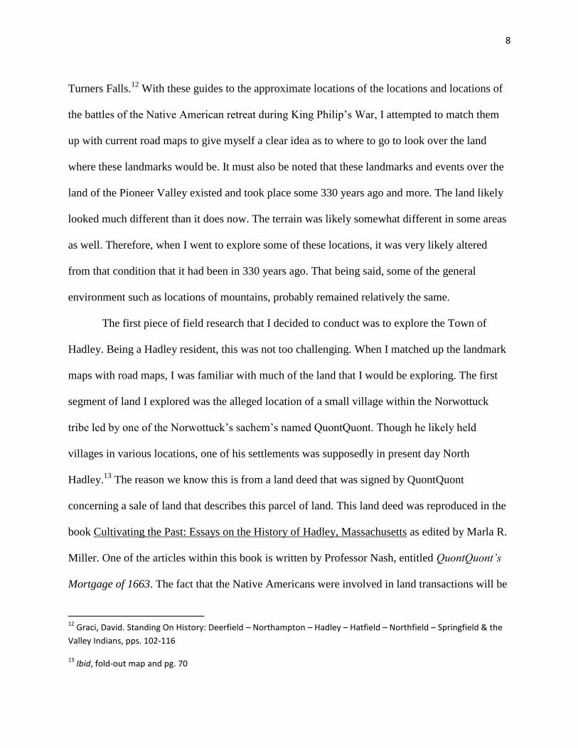
This parcel of land, when I thought about it, sounded familiar. After searching the
Standing on History map that I have previously referenced, I discovered that the approximate
location of QuontQuont‟s fort and the area described in the land deed, were indeed the location I
had thought. The area, in its present state, is
now known unofficially as the North Hadley
sandbar. It is where the Connecticut River
narrows slightly, forming a sandbar. These
are ideal points for fording and fishing. What
advantages did QuontQuont‟s people have
l
living here? As one can see by standing on the land
and looking at the maps, the land provides security. It
is in a place where the soil is fertile, the fish run by
this location, the river is shallow enough to walk into
it but deep enough for transportation, and sheltered
enough so that an enemy attack would be difficult.
14
QuontQuont Land Deed; Nash, Alice. QuontQuont’s Mortgage of 1663; Miller, Marla R., Cultivating the Past:
Essays On the History of Hadley, Massachusetts, pps. 26-28
10
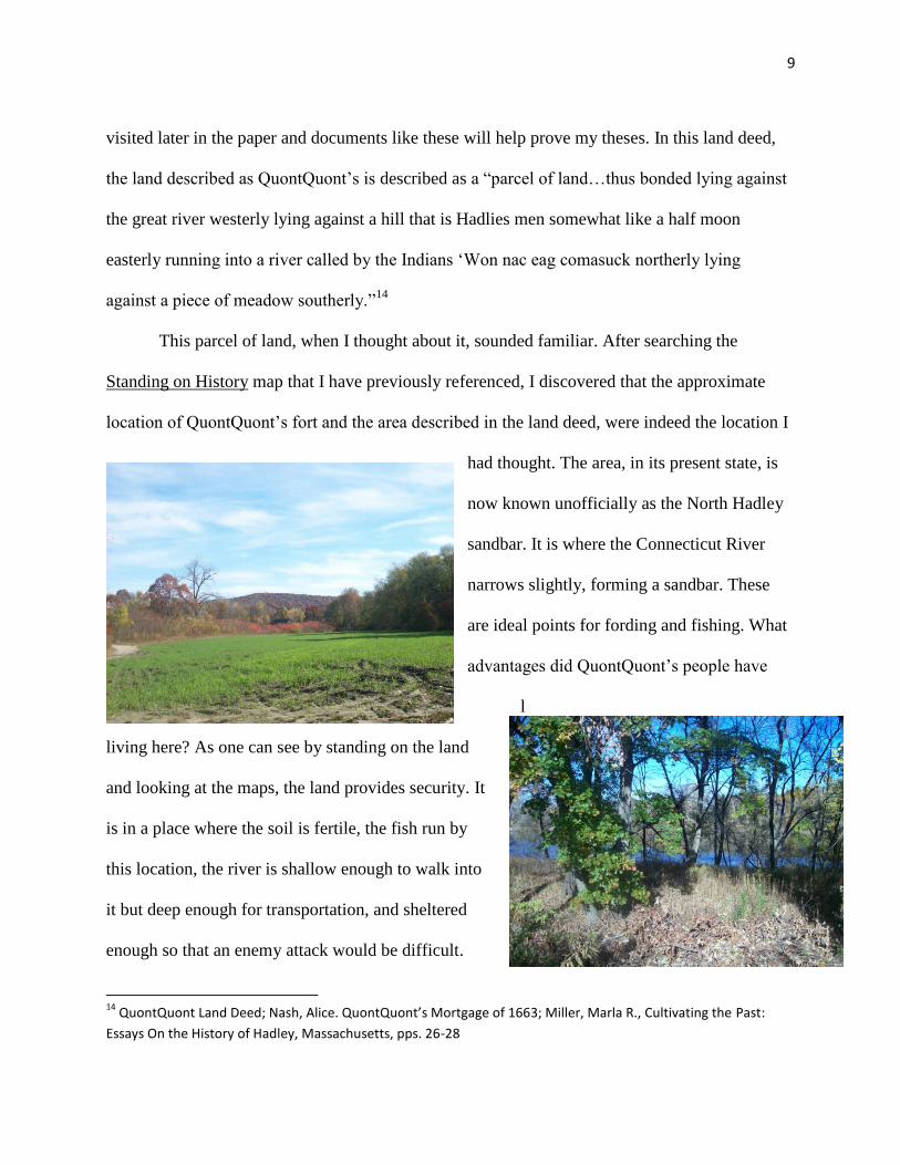
Since fortifications are usually located on a small hill, for better protection and visibility, one can
only speculate that perhaps this land that is now farmland was slightly more elevated 330 years
ago. This would have been the ideal location for a village as the “half moon shape” meant that
the river, as it does today, bends at this point in a half moon formation.
This would give a village protection on 3 of 4 sides. The fourth side, the back, would have been
protected by the hill that is now called Mount Warner. The pictures and map provided detail this
and they are similar to those found in the Standing on History book.
11
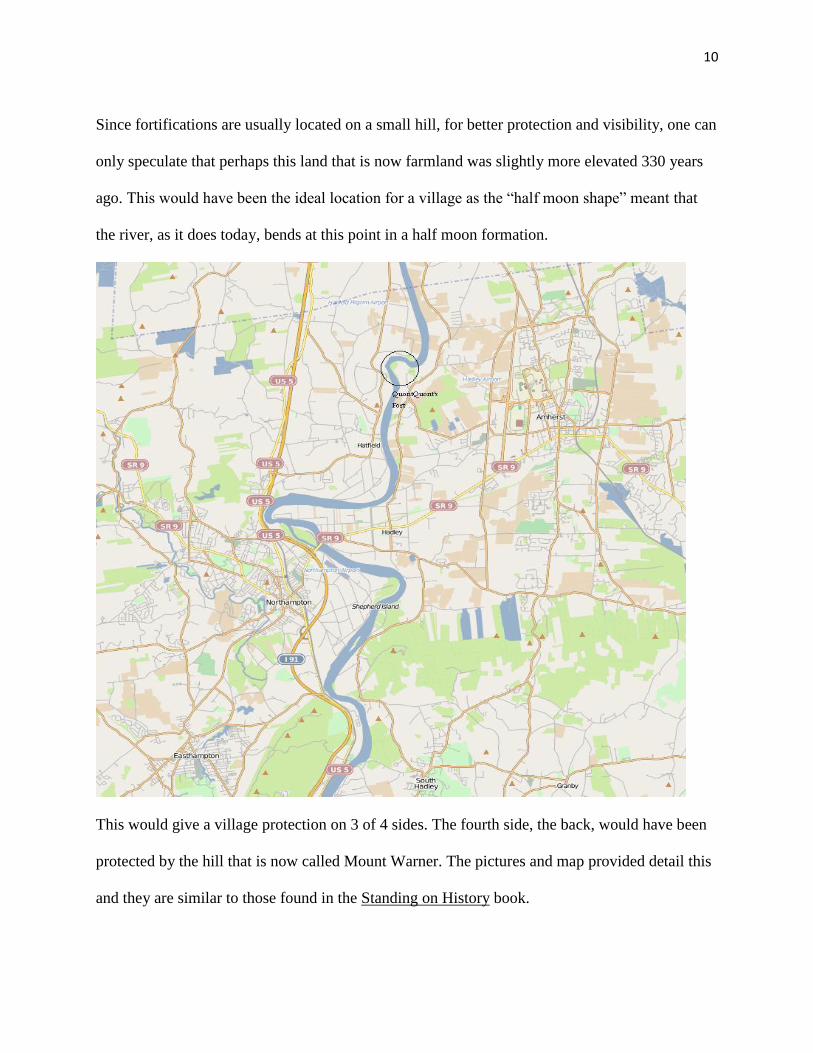
After concluding the exploration of the region of QuontQuont‟s fort, I moved to other
Hadley location. In the following map, the notable locations are circled and labeled.
There are a couple of notable locations on this map. The first, within the Town of Hadley,
would be the fishing spot located north of the Honey Pot. While this location may not seem
significant, it is in an underlying way. It is not so much important in the fact of where it is but,
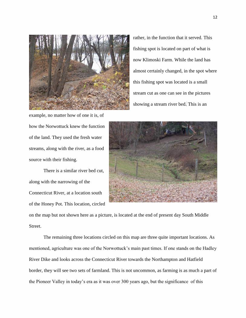
12
rather, in the function that it served. This
fishing spot is located on part of what is
now Klimoski Farm. While the land has
almost certainly changed, in the spot where
this fishing spot was located is a small
stream cut as one can see in the pictures
showing a stream river bed. This is an
example, no matter how of one it is, of
how the Norwottuck knew the function
of the land. They used the fresh water
streams, along with the river, as a food
source with their fishing.
There is a similar river bed cut,
along with the narrowing of the
Connecticut River, at a location south
of the Honey Pot. This location, circled
on the map but not shown here as a picture, is located at the end of present day South Middle
Street.
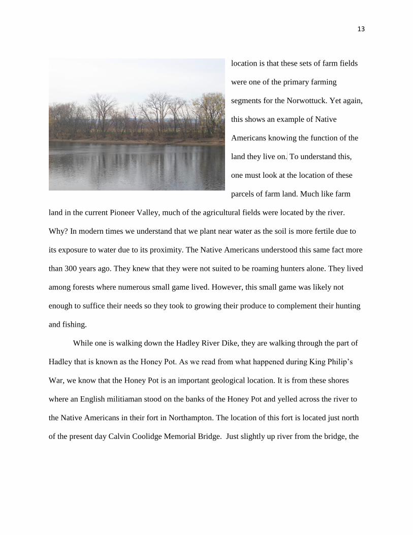
The remaining three locations circled on this map are three quite important locations. As
mentioned, agriculture was one of the Norwottuck‟s main past times. If one stands on the Hadley
River Dike and looks across the Connecticut River towards the Northampton and Hatfield
border, they will see two sets of farmland. This is not uncommon, as farming is as much a part of
the Pioneer Valley in today‟s era as it was over 300 years ago, but the significance of this
13
location is that these sets of farm fields
were one of the primary farming
segments for the Norwottuck. Yet again,
this shows an example of Native
Americans knowing the function of the
land they live on. To understand this,
one must look at the location of these
parcels of farm land. Much like farm
land in the current Pioneer Valley, much of the agricultural fields were located by the river.
Why? In modern times we understand that we plant near water as the soil is more fertile due to
its exposure to water due to its proximity. The Native Americans understood this same fact more
than 300 years ago. They knew that they were not suited to be roaming hunters alone. They lived
among forests where numerous small game lived. However, this small game was likely not
enough to suffice their needs so they took to growing their produce to complement their hunting
and fishing.
While one is walking down the Hadley River Dike, they are walking through the part of
Hadley that is known as the Honey Pot. As we read from what happened during King Philip‟s
War, we know that the Honey Pot is an important geological location. It is from these shores
where an English militiaman stood on the banks of the Honey Pot and yelled across the river to
the Native Americans in their fort in Northampton. The location of this fort is located just north
of the present day Calvin Coolidge Memorial Bridge. Just slightly up river from the bridge, the
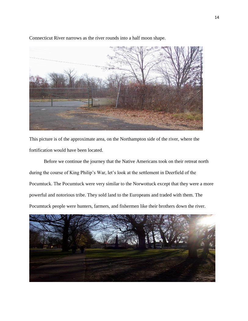
14
Connecticut River narrows as the river rounds into a half moon shape.
This picture is of the approximate area, on the Northampton side of the river, where the
fortification would have been located.
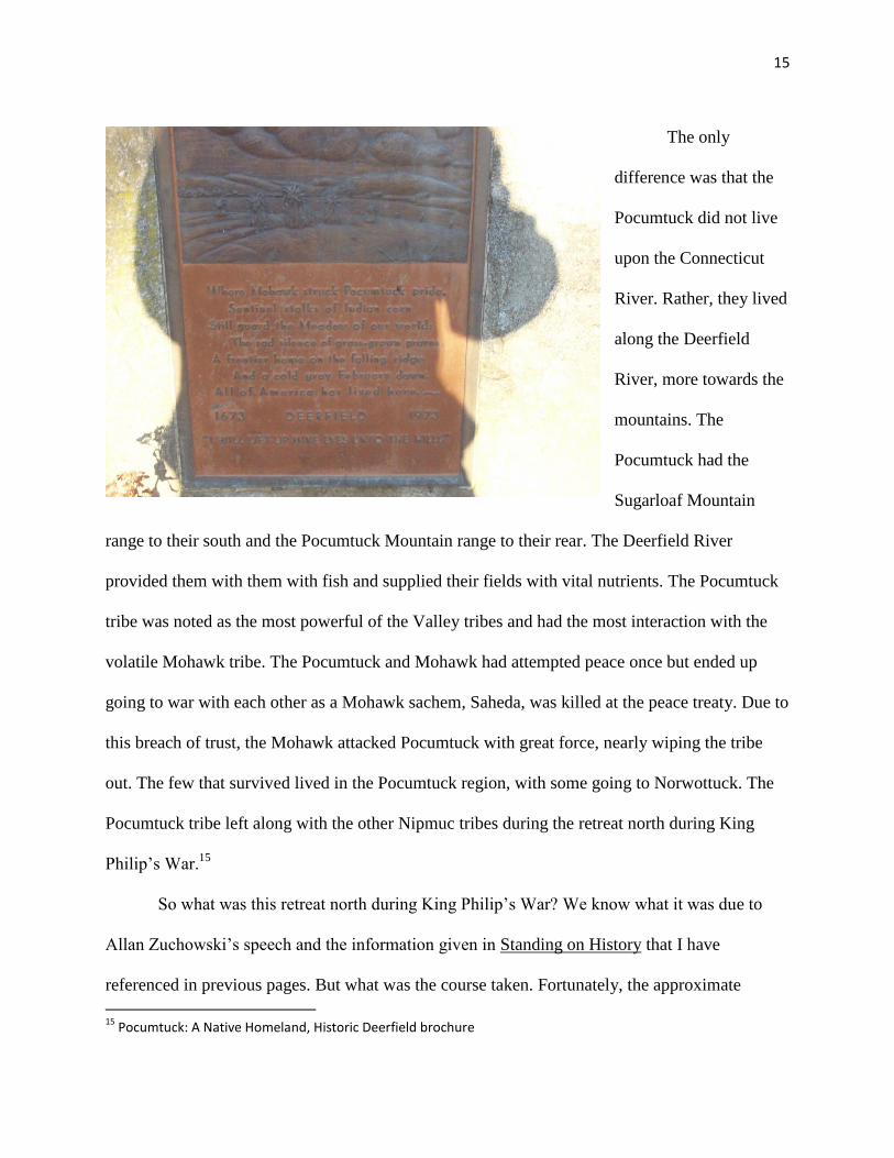
Before we continue the journey that the Native Americans took on their retreat north
during the course of King Philip‟s War, let‟s look at the settlement in Deerfield of the
Pocumtuck. The Pocumtuck were very similar to the Norwottuck except that they were a more
powerful and notorious tribe. They sold land to the Europeans and traded with them. The
Pocumtuck people were hunters, farmers, and fishermen like their brothers down the river.
15
The only
difference was that the
Pocumtuck did not live
upon the Connecticut
River. Rather, they lived
along the Deerfield
River, more towards the
mountains. The
Pocumtuck had the
Sugarloaf Mountain
range to their south and the Pocumtuck Mountain range to their rear. The Deerfield River
provided them with them with fish and supplied their fields with vital nutrients. The Pocumtuck
tribe was noted as the most powerful of the Valley tribes and had the most interaction with the
volatile Mohawk tribe. The Pocumtuck and Mohawk had attempted peace once but ended up
going to war with each other as a Mohawk sachem, Saheda, was killed at the peace treaty. Due to
this breach of trust, the Mohawk attacked Pocumtuck with great force, nearly wiping the tribe
out. The few that survived lived in the Pocumtuck region, with some going to Norwottuck. The
Pocumtuck tribe left along with the other Nipmuc tribes during the retreat north during King
Philip‟s War.15
So what was this retreat north during King Philip‟s War? We know what it was due to
Allan Zuchowski‟s speech and the information given in Standing on History that I have
referenced in previous pages. But what was the course taken. Fortunately, the approximate
15
Pocumtuck: A Native Homeland, Historic Deerfield brochure
16
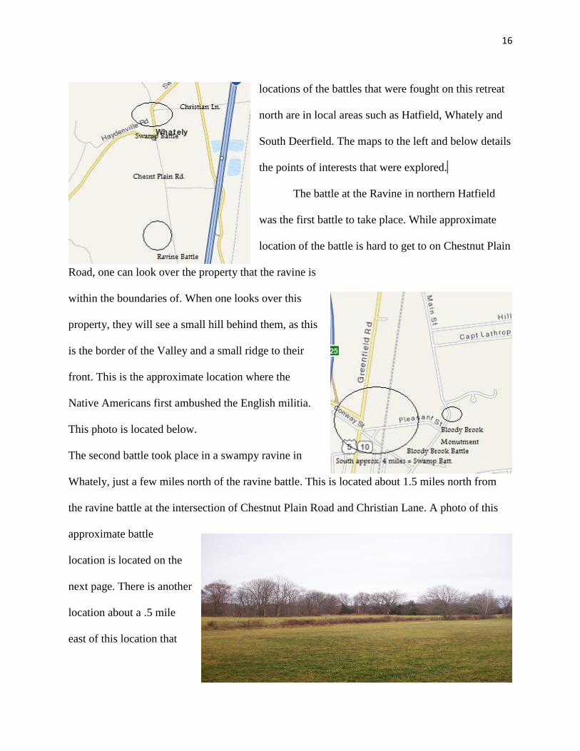
locations of the battles that were fought on this retreat
north are in local areas such as Hatfield, Whately and
South Deerfield. The maps to the left and below details
the points of interests that were explored. kj
The battle at the Ravine in northern Hatfield
was the first battle to take place. While approximate
location of the battle is hard to get to on Chestnut Plain
Road, one can look over the property that the ravine is
within the boundaries of. When one looks over this
property, they will see a small hill behind them, as this
is the border of the Valley and a small ridge to their
front. This is the approximate location where the
Native Americans first ambushed the English militia.
This photo is located below.
The second battle took place in a swampy ravine in
Whately, just a few miles north of the ravine battle. This is located about 1.5 miles north from
the ravine battle at the intersection of Chestnut Plain Road and Christian Lane. A photo of this
approximate battle
location is located on the
next page. There is another
location about a .5 mile
east of this location that
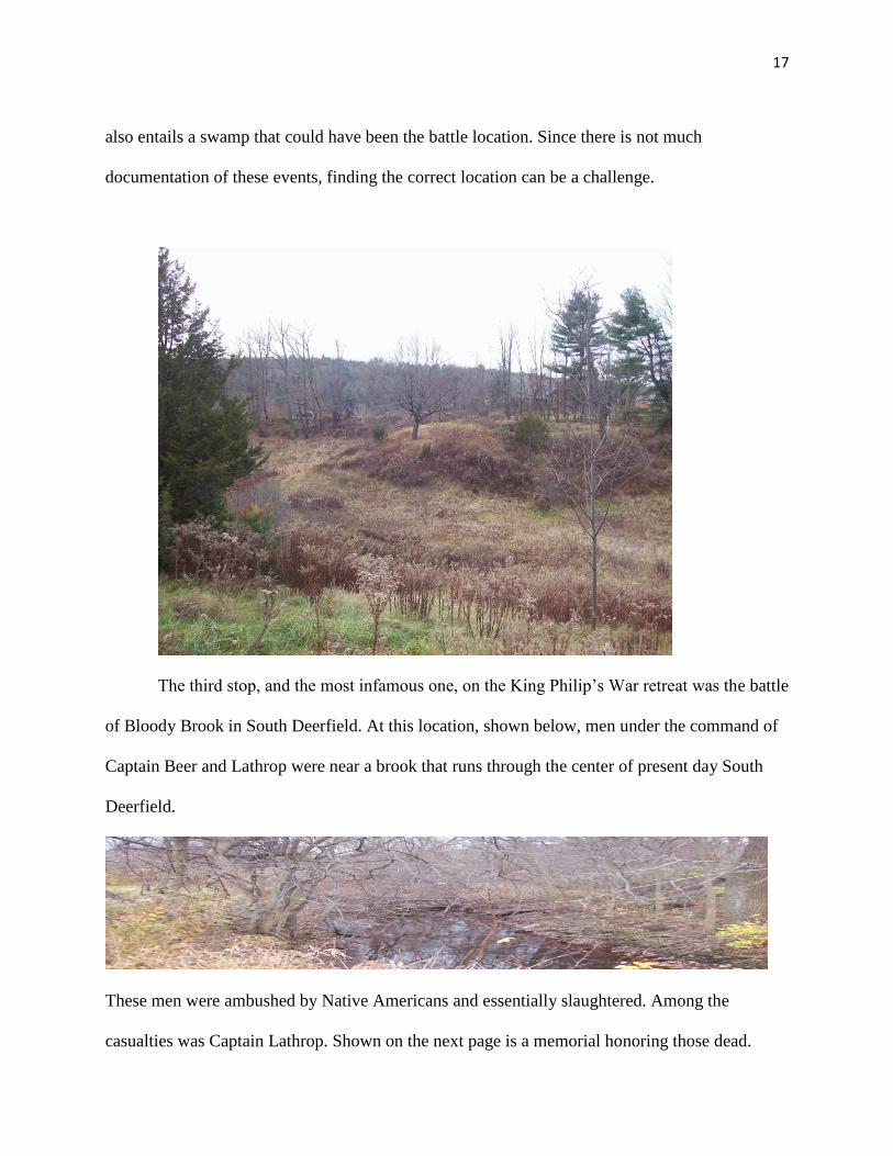
17
also entails a swamp that could have been the battle location. Since there is not much
documentation of these events, finding the correct location can be a challenge.
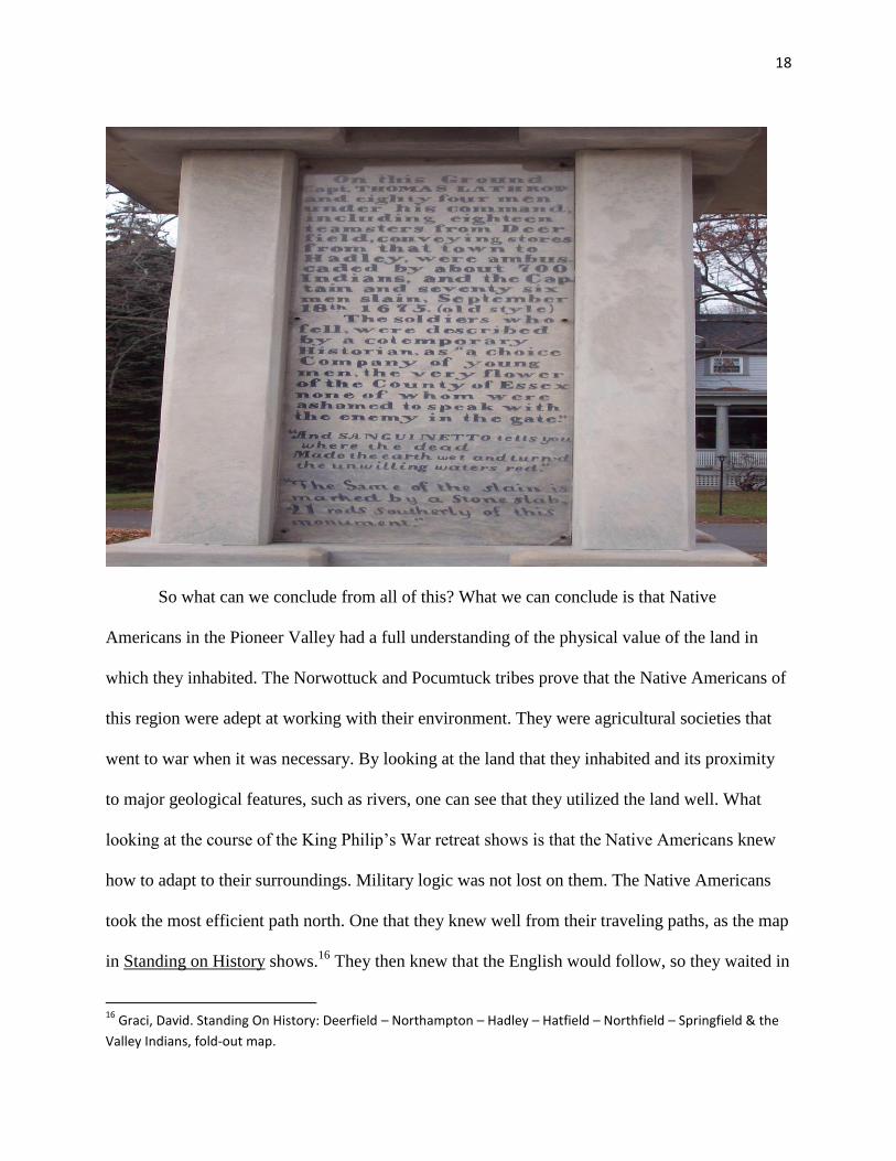
The third stop, and the most infamous one, on the King Philip‟s War retreat was the battle
of Bloody Brook in South Deerfield. At this location, shown below, men under the command of
Captain Beer and Lathrop were near a brook that runs through the center of present day South
Deerfield.
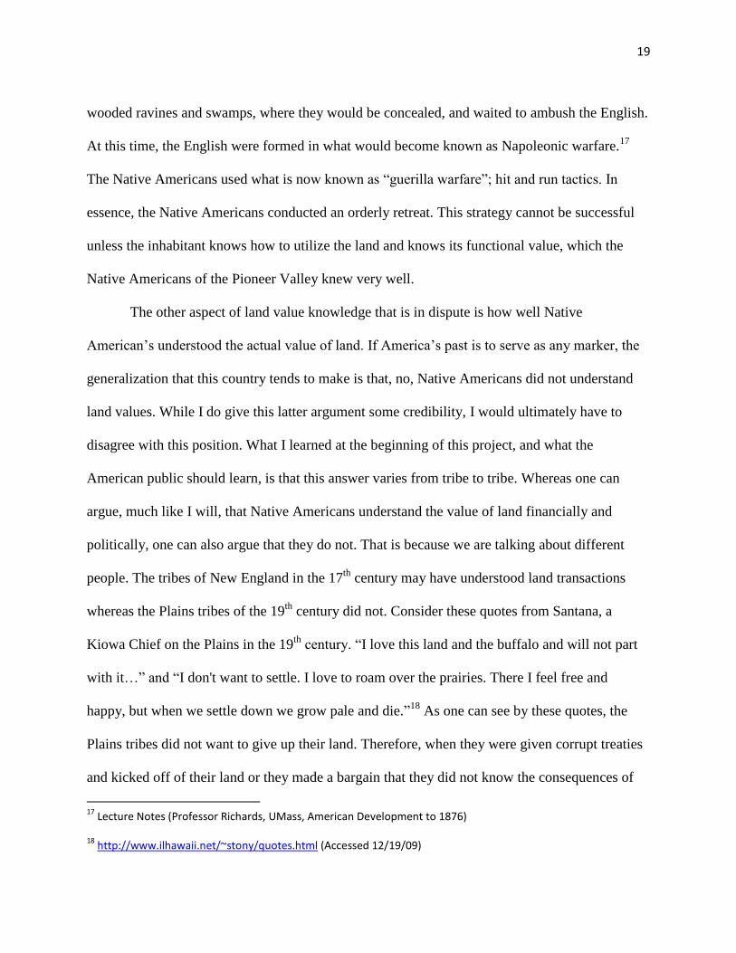
These men were ambushed by Native Americans and essentially slaughtered. Among the
casualties was Captain Lathrop. Shown on the next page is a memorial honoring those dead.
18
So what can we conclude from all of this? What we can conclude is that Native
Americans in the Pioneer Valley had a full understanding of the physical value of the land in
which they inhabited. The Norwottuck and Pocumtuck tribes prove that the Native Americans of
this region were adept at working with their environment. They were agricultural societies that
went to war when it was necessary. By looking at the land that they inhabited and its proximity
to major geological features, such as rivers, one can see that they utilized the land well. What
looking at the course of the King Philip‟s War retreat shows is that the Native Americans knew
how to adapt to their surroundings. Military logic was not lost on them. The Native Americans
took the most efficient path north. One that they knew well from their traveling paths, as the map
in Standing on History shows.16
They then knew that the English would follow, so they waited in
16
Graci, David. Standing On History: Deerfield – Northampton – Hadley – Hatfield – Northfield – Springfield & the
Valley Indians, fold-out map.
19
wooded ravines and swamps, where they would be concealed, and waited to ambush the English.
At this time, the English were formed in what would become known as Napoleonic warfare.17
The Native Americans used what is now known as “guerilla warfare”; hit and run tactics. In
essence, the Native Americans conducted an orderly retreat. This strategy cannot be successful
unless the inhabitant knows how to utilize the land and knows its functional value, which the
Native Americans of the Pioneer Valley knew very well.
The other aspect of land value knowledge that is in dispute is how well Native
American‟s understood the actual value of land. If America‟s past is to serve as any marker, the
generalization that this country tends to make is that, no, Native Americans did not understand
land values. While I do give this latter argument some credibility, I would ultimately have to
disagree with this position. What I learned at the beginning of this project, and what the
American public should learn, is that this answer varies from tribe to tribe. Whereas one can
argue, much like I will, that Native Americans understand the value of land financially and
politically, one can also argue that they do not. That is because we are talking about different
people. The tribes of New England in the 17th
century may have understood land transactions
whereas the Plains tribes of the 19th
century did not. Consider these quotes from Santana, a
Kiowa Chief on the Plains in the 19th
century. “I love this land and the buffalo and will not part
with it…” and “I don't want to settle. I love to roam over the prairies. There I feel free and
happy, but when we settle down we grow pale and die.”18
As one can see by these quotes, the
Plains tribes did not want to give up their land. Therefore, when they were given corrupt treaties
and kicked off of their land or they made a bargain that they did not know the consequences of
17
Lecture Notes (Professor Richards, UMass, American Development to 1876)
18 http://www.ilhawaii.net/~stony/quotes.html (Accessed 12/19/09)
20
because they had been tricked, they cried foul. The New England tribes of the 17th
century
willingly traded their land. There lies the great difference.
What I say here will show that the New England tribes knew the value of land in terms of
financial and political terms. Why did the Native Americans in this region willingly sell their
land to Europeans? For political and financial reasons. They sold their lands for the very reasons
that history tells us they did not understand. The tribes sold their land mainly for political
purposes with the financial aspect being the formality or for supplies.
There are a few examples I will give. First, we have QuontQuont‟s land deed. In
Professor Nash‟s article, it states that we do not know the true reasons behind the land deed.
However, we can speculate. It is stated that it was a common practice for Native Americans to
loan their land to the Europeans and the Europeans would take care of the finances. The Native
Americans would have parts of their land loaned back to them for a fee. Therefore, the Native
Americans had sold the land and its assets to the Europeans but had retained the rights to use the
land for a fee. In this case, due to an infraction or tax, QuontQuont was paying a debt to the
Europeans for the land. 19
One must also remember that, as stated earlier in this paper, that King
Philip‟s War started due to Metacomet not wanting to be taxed anymore. King Philip‟s War was
not only a war about oppression of a race, but it was a war over land transactions and land value
as well.
Yet another example is the very case of how Western Massachusetts was settled. John
Pynchon20
, the European man responsible for establishing a trading post in Agawam and
19
QuontQuont Land Deed; Nash, Alice. QuontQuont’s Mortgage of 1663; Miller, Marla R., Cultivating the Past:
Essays On the History of Hadley, Massachusetts
20 Graci, David. John Pynchon – Early Settlements in Massachusetts ,Standing On History: Deerfield – Northampton
– Hadley – Hatfield – Northfield – Springfield & the Valley Indians, pps. 8-11
21
purchasing land deeds all along the Connecticut River in the 17th
century, did not just purchase
this land. The Native Americans had to agree to sell it. Why did they agree to sell it? For
political reasons. As Standing on History and Allan Zuchowski‟s speech stated, the Native
Americans thought with a savvy political mind.21
They knew which tribes were their allies and
which were there enemies. They knew how to form alliances in order to defeat an enemy. These
tribes knew who their enemies allied with. These tribes also knew that they would add more
power to their side if they could get a powerful European nation to side with them. This put a
buffer between them and their enemies. It was kind of like buying a security plan. A tribe would
ensure that they would get the trade benefits of a European nation while making their numbers
stronger in the case that they were attacked. This was one of the main reasons why there were
Native American land deeds.22
This is shown particularly well in Emerson Baker‟s 1989 Ethno
History article titled A Scratch with a Bear‟s Paw. This article talks about the same exact
situation as above, except it outlines tribes in Maine around present day York, Maine.23
So what does this show? It shows that, at least in New England during the 17th
century,
that Native Americans understood the concept of land transactions. This disproves the
generalization that all Native Americans were naïve to the idea of land transactions. While
certainly some were later on in the course of history, the New England Native Americans were
not. They may not have understood the European intentions at first, but they understood the
concept of land transactions very well, whether it be trading goods for sharing the land as they
21
Graci, David. Standing On History: Deerfield – Northampton – Hadley – Hatfield – Northfield – Springfield & the
Valley Indians
22 Allan Zuchowski Speech, Native American Observation Report #3, Matt Kushi
23 Baker, Emerson. A Scratch With A Bear’s Paw ,Ethno History
22
had done amongst themselves and eventually with the Europeans or selling the land for political
purposes as they did with the Europeans. What these arguments shows, throughout this whole
paper, is that the Native Americans of New England understood the concept of land value both
physically and financially/politically. This shows that the generalization that all Native
Americans were naïve to the value of land is false.
In conclusion, it can be stated that Native Americans, at least the tribes in New England
and the Pioneer Valley, understood more than the physical value of land. The Native Americans
understood the value of land financially and politically as well. What these arguments show,
throughout this whole paper, is that the Native Americans of New England understood the
concept of land value both physically and financially/politically. This shows that the
generalization that all Native Americans were naïve to the value of land is false. It can also be
said that the concept of land value for the New England tribes deeply differed with the concept
of land value held by the Midwest tribes during the 19th
century. Overall, the Native Americans
of New England understood more than many people give them credit for.
23
References
Graci, David. Standing on History: Deerfield – Northampton- Hadley –Hatfield – Northfield –
Springfield & The Valley Indians, Class A Graphics, 380 Union St. 32C, West Sprringfield, MA
01080, 2006
Ciment, James and LaFrance, Ronald. Scholastic Encyclopedia of the North American Indian,
Scholastic, Inc., New York, NY, 1996
Cutter Brockett, Mary Lou. Life Beside The Connecticut River: A Children‟s History of Hadley,
Massachusetts, Hatfield, MA, 1980;1990
Pocumtuck: A Native Homeland ,Old Historic Deerfield Brochure, 2009
QuontQuont Land Deed; Nash, Alice. QuontQuont‟s Mortgage of 1663; Miller, Marla R.,
Cultivating the Past: Essays On the History of Hadley, Massachusetts
Thomas, Peter Allen. In The Maelstrom of Change. The Indian and Cultural Process in the
Middle Connecticut River Valley: 1635-1665, Doctoral Thesis Dissertion, University of
Massachusetts-Amherst, 1979
Baker, Emerson. A Scratch With A Bear‟s Paw ,Ethno History, 1989
Microforms (University of Massachusetts-Amherst Library): Hampshire County Probate – 17c
And Massachusetts Archives – Vol. 30
Allan Zuchowski Speech, Native American Observation Report #3, Matt Kushi
Lecture Notes (Professor Richardson, UMass; Westward American Expansion)
Lecture Notes (Professor Richards, UMass; American Development to 1876)
Google Maps
http://www.ilhawaii.net/~stony/quotes.html
http://www.uh.edu/engines/epi709.htm Photos taken by Matthew Kushi during field research
Related Documents