DOCKET NO. SA- 516 EXHIBIT NO. 13A NATIONAL TRANSPORTATION SAFETY BOARD WASHINGTON, D.C. AIRPLANE PERFORMANCE STUDY

Welcome message from author
This document is posted to help you gain knowledge. Please leave a comment to let me know what you think about it! Share it to your friends and learn new things together.
Transcript

DOCKET NO. SA- 516
EXHIBIT NO. 13A
NATIONAL TRANSPORTATION SAFETY BOARDWASHINGTON, D.C.
AIRPLANE PERFORMANCE STUDY

National Transportation Safety BoardOffice of Research and Engineering
Washington, D.C.
September 30, 1997
AIRPLANE PERFORMANCE STUDY
DCA-96-MA-070
I. ACCIDENT
Location: East Moriches, New YorkDate: July 17, 1996Time: 2031 Eastern Daylight Time (EDT)Aircraft: Boeing 747-131, N93119Carrier: Trans World Airlines (TWA), Flight 800
II. GROUP IDENTIFICATION
Chairman: Charles PereiraNTSB, RE-60
Member: Joe BrackenAirline Pilots Association
Member: Dave F. WarneTWA
Member: Mark SweepeBoeing Commercial Airplane Group
Member: Don WilsonFAA Seattle ACO
Member: Erik MogelgaardFBI
III. SUMMARY
On July 17, 1996, at 2031:12.5 Eastern Daylight Time (EDT1), a Boeing 747-131,N93119, crashed into the Atlantic Ocean about 8 miles south of East Moriches, New York,after taking off from John F. Kennedy International Airport (JFK). The airplane was operatingon an instrument flight rules (IFR) flight plan under the provisions of Title 14, Code of Federal
1 All times are given in EDT unless otherwise noted.

2
Regulations (CFR), Part 121, on a regularly scheduled flight to Charles De Gaulle InternationalAirport (CDG), Paris, France, as Trans World Airlines (TWA) Flight 800. The airplane wasdestroyed by explosion, fire, and impact forces with the ocean. All 230 people aboard werekilled
IV. DETAILS OF THE INVESTIGATION
Review of the accident airplane’s Flight Data Recorder (FDR) data2 and Cockpit VoiceRecorder (CVR) transcript3 indicate that performance was normal throughout the takeoff andflight, including the last second of FDR data. Predicted rate-of-climb values for 3 sample areaswere in excess of the actual TWA 800 rate-of-climb; however, Boeing has attributed thesedifferences to the unsteadiness of the climb (Air Traffic Control altitude/climb instructionsresulted in several rate-of-climb changes. The CVR indicates that the flying pilot, whoapparently was new to the 747, was having minor difficulty trimming the airplane properly inthe pitch axis on at least one occasion). For further details concerning the performance ofFlight 800, see Attachment I, Boeing’s TWA Flight 800 FDR Data Summary.
Radar data for the accident airplane and the surrounding area were obtained from theFederal Aviation Administration (FAA), Department of Defense (NAVY and NORAD), andSikorsky. These are all of the known sources of radar data for the area where TWA flight 800crashed, with a total of 9 radars located in 5 states (Pennsylvania, New Jersey, New York,Connecticut, Massachusetts).
The FAA radar data are from New York Approach Control (NYTRACON) and the NewYork and Boston Air Route Traffic Control Centers (ARTCCs, commonly referred to asCenters). NYTRACON has 5 radars, each with a range of approximately 60 nautical miles.The 5 NYTRACON radars are located at JFK airport, Newark, NJ airport (EWR), Islip, NYairport (ISP), White Plains, NY airport (HPN), and Stewart Field airport in Newburg, NY(SWF). The NYTRACON radar data were provided to the NTSB in range/magnetic azimuthformat relative to each radar site. Three Center radars, each with a range of approximately 250nautical miles, were within range of the accident area. The 3 Center radars are located atTrevose, PA, Riverhead, NY, and North Truro, MA. The Center radar data were provided tothe NTSB in latitude/longitude format.
The NAVY and NORAD radar data for the accident area also come from the FAACenter radars at Trevose, PA, North Truro, MA, and Riverhead, NY via modem. Because theNAVY and NORAD radar data for the accident area come from the same radars as the FAACenter radar data, the NAVY and NORAD radar data are essentially identical to the FAACenter radar data. However, data transmission, processing, and recording differences betweenNAVY, NORAD, and the FAA Centers resulted in some minor differences in the respectivedata sets (such as computer clock times, missing data points likely due to modem transmissionerrors, etc.). The NAVY and NORAD data were provided to the NTSB in range/true azimuthformat relative to each radar site.
2 See Flight Data Recorder Factual Report.3 See Cockpit Voice Recorder Factual Report.

3
The Sikorsky radar data were recorded at the Sikorsky aircraft plant in Stratford, CT.The radar data come from the FAA Center radar in Riverhead, NY and from Sikorsky’s ownradar in Shelton, CT (approximately 3 miles from their plant). The radar data from the FAA’sRiverhead, NY Center radar are sent to Sikorsky via modem by the NAVY immediately afterthe NAVY receives them from the FAA. Because Sikorsky, FAA, NAVY, and NORAD all getessentially identical radar data from the Riverhead, NY radar, the Riverhead, NY portion of theSikorsky, FAA, NAVY, and NORAD radar data are essentially identical. Note that theSikorsky radar in Shelton, CT is a secondary radar system4 only - no primary radar5 data areavailable from this radar. The Sikorsky radar data were provided to the NTSB in range/trueazimuth format relative to each radar site.
The radar data for TWA 800 (transponder code 2633) were converted from eitherrange/azimuth or latitude/longitude data (depending on data source) to x/y position data relativeto the FAA’s Islip, New York Airport Surveillance Radar (ASR) radar site. The coordinateconversion was accomplished using NTSB software and FAA/Sikorsky-provided facilityposition and magnetic variation data. All radar data sets were aligned in x/y position assumingthat the FAA Center radar data positions were the most accurate. Attachment II containstabular listings of the facility position and magnetic variation data. Tabular listings of eachradar data set will be presented in a separate addendum to this report.
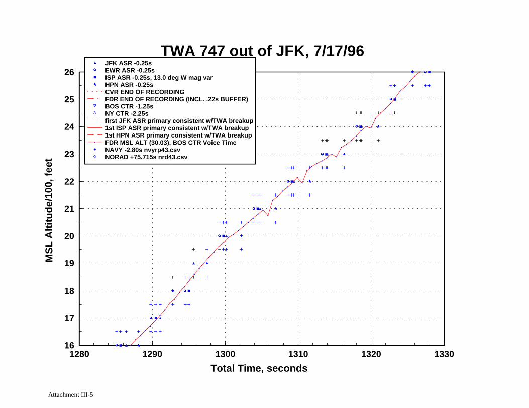
The CVR group established time correlation between the FAA’s Boston Center ATCvoice recording and the CVR by aligning microphone keying signatures in the audio data. TheFDR group then established time correlation between the FDR and the CVR by aligning CVRmicrophone keying signatures in the audio data with FDR microphone keying discrete data.This study establishes an additional time correlation between the FDR time base and all radardata sources. The time correlation was established by graphing and aligning TWA 800’s radaraltitude as a function of time with its FDR altitude as a function of time (see Attachment III).The following time correlation was established:
Data Source Time Offset Required to AlignData Source Time Base withBoston Center Voice Time Base
Boston Center Radar Data -1.25 secondsNew York Center Radar Data -2.25 secondsAll New York TRACON ASR Radar Data -0.25 secondsNAVY Radar Data -2.80 secondsNORAD Radar Data +75.715 secondsSikorsky Radar Data N/A (anomalous times)
4 Air traffic control secondary radar systems transmit coded electromagnetic signals (interrogation) that can be received bytransponder-equipped aircraft. The aircraft receives the signal, decodes it, and then transmits a coded electromagneticsignal in response to the interrogation. Secondary returns can provide information on the aircraft’s identity, altitude, andposition.5 Air traffic control primary radar systems transmit electromagnetic signals that can be reflected by an object such as anaircraft. The position of the object can be determined by timing of the transmission and return of the electromagneticsignals, and by measurement of the direction in which the radar antenna is pointed when the signals are transmitted andreturned.
4
The FDR pressure altitude data and Navy/NORAD/Sikorsky radar data altitudes are based on29.92 inches of mercury, and the New York TRACON radar data altitudes are based on 30.03inches of mercury. Therefore, in order to align the altitudes during the time correlation, 100feet was added to the FDR pressure altitude data and Navy/NORAD/Sikorsky radar altitudes.Also note that the times for the Sikorsky radar data were found to be anomalous; therefore, atime correlation was not established for the Sikorsky radar data.
The time correlation was further verified by graphing x/y position for all radar data setsand observing proper time/position sequencing of the radar returns (see Attachment IV). As anexample, a radar return from the White Plains, New York ASR shows up at the expectedapproximate time and position relative to the previous radar return from New York Center.
Selected CVR excerpts, which were also overlaid on the altitude versus time and x/ygraphs, support the time correlation as well due to agreement between pilot/ATC dialogue andthe flight path. As an example, the airplane levels off at approximately 13,000 feet altitudeafter the CVR transcript shows ATC instructing TWA 800 to amend its altitude clearance to13,000 feet. Further, the FDR and radar altitudes oscillate in the area where the CVR shows theflying pilot commenting about having difficulty trimming the airplane.
The time correlation indicates that the last secondary radar return from TWA 800(recorded by the FAA’s Trevose, PA radar site) occurred at approximately 20:31:12.0, the FDRrecording ended at 20:31:12.26, the CVR recording ended at 20:31:12.50, and the first ofseveral hundred primary radar returns consistent with TWA 800’s flight path and in-flightbreak-up was recorded at 20:31:14.39. This sequence of events is consistent with a normalclimb through 13,750 feet msl (altitude based on FDR, radar, and altimeter setting data)terminating in nearly simultaneous loss of electrical power to the accident airplane’s altitudeencoding transponder, FDR, and CVR.
The radar data were subsequently reviewed for evidence of airplanes or unidentifiedradar returns in the vicinity of TWA 800. Primary and secondary radar data returns throughoutthe accident area were reviewed, eventually focusing on a square area 20 nautical miles per sidecentered around the accident area (see graphs in Attachment IV and V). The radar data reviewshowed the following vehicle and/or object tracks within 10 nautical miles of TWA 800 justprior to the time of the accident (local time 20:30:30-20:31:13):
1. a Navy P-3 anti-submarine airplane less than 3 nautical miles south-southwest andapproximately 6,300 feet above TWA 800 (P-3 altitude data is based on P-3 flightcrew interview), moving southwest at over 250 knots groundspeed (labeled “1” ongraph in Attachment V)
2. USAIR flight 217 approximately 3 nautical miles south-southwest and
approximately 8,000 feet above TWA 800, moving north (labeled “2” on graph inAttachment V)

5
3. TWA flight 900 approximately 9 nautical miles west and approximately 5,300 feet
above TWA 800, moving east-northeast (labeled “3” on graph in Attachment V)
4. an unidentified track less than 3 nautical miles south-southeast moving south-southwest at just over 30 knots groundspeed, consistent with the speed of a boat(labeled “4” on graph in Attachment V)
5. an unidentified track approximately 5 nautical miles west moving east-southeast at
approximately 15 knots groundspeed, consistent with the speed of a boat (labeled“5” on graph in Attachment V)
6. an unidentified track approximately 5 nautical miles west-northwest moving south-
southwest at approximately 12 knots groundspeed, consistent with the speed of aboat (labeled “6” on graph in Attachment V)
7. an unidentified track approximately 6 nautical miles northwest moving southeast at
approximately 20 knots groundspeed, consistent with the speed of a boat (labeled“7” on graph in Attachment V)
The radar data in this area and time period also show several primary returns not associatedwith any track. The presence of such unassociated primary returns is common and can becaused by ground/sea clutter, temperature inversions (see text portion of Attachment VI), ships,birds, radar signals reflecting off structures around the radar, and other factors.
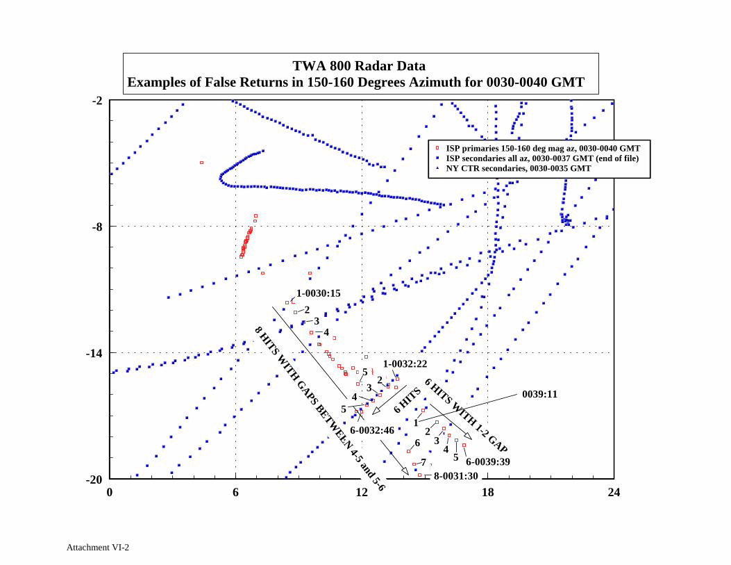
No sequence of radar returns intersected TWA 800’s position at any point in time, norwere there any radar returns consistent with a missile or other projectile traveling towardsTWA 800. There was one sequence of 8 primary radar returns6 from the NYTRACON ISPradar which were studied further (see Attachment VI). These 8 radar returns, which started at2030:15 and ended at 2031:30 (18 seconds after TWA 800’s last secondary return), appeared toshow a target moving at over 400 knots groundspeed on a southeasterly heading (156-157degrees magnetic) away from TWA 800’s position. This target track never came closer than 6nautical miles to TWA 800 and remained on a straight track away from TWA 800 withoutturning towards TWA 800.
ISP was the only primary radar system out of 8 to show these primary radar returns andno associated secondary radar returns were found in any of the 9 secondary radar data sets. TheISP radar data from time 20:30:00 to 20:40:00 in the azimuth range 150 to 160 degrees show 3examples of primary-only target tracks with groundspeeds over 300 knots (see graph inAttachment VI). In each case a primary radar track appears with no prior track leading to it andthen disappears after 4-8 returns, with occasional intermittent single returns at either end of thetrack or in the middle. For each of these primary target tracks, the signal strength variesrandomly between low and high values between the first and last return. Additionally, none of
6 Initially only 4 primary radar returns from this track were identified. Further review showed 4 more primary radar returnsafter the first 4, each consistent with the speed and heading of the first 4.
6
these ISP primary tracks are shown on the other 7 primary radar systems and none has anyassociated secondary target track. However, secondary target tracks with similar groundspeedswere found in other geographic areas.
These findings, as well as prior case history and consultation with air traffic control andradar specialists indicate that the 8 primary radar returns and other 300+ knot Islip ASR primarytarget tracks shown in Attachment VI are consistent with false primary targets resulting fromground or building reflections of actual aircraft primary returns from another geographic area.Several instances of this have reportedly occurred at FAA approach control radar sites becauseof their location at or near city airports where buildings and other reflective structure is near theradar.
Charles PereiraAerospace Engineer/DFDR
Attachments

Attachment I
Boeing’s TWA Flight 800 FDR Data Summary

TWA Flight 800 FDR Data Summary
T h e FDR data was processed and validated at the NTSB FDR lab on July 26and 27, 1996. Aircraft motion, control deflection, engine EPR, thrustreverser, and leading edge flap parameters are described.
1) Aircraft motion
● No unusual aircraft motion throughout the entire flight● Vertical and longitudinal accelerations are normal● Lateral acceleration is not recorded● Pitch, roll, and heading are all normal
2) Control input
● No unusual control inputs● Control wheel deflection is very noisey for both flight 1300 and
the previous flight. The noise appears to diminish when thecontrol wheel is deflected during roll commands.
● Upper and lower rudder deflections are normal. No change inrudder deflection was recorded during the last 3 minutes ofrecorded data (above 12500 ft pressure altitude) . A constantdeflection of .8 degrees T.E. right was recorded for this timeperiod. During the takeoff roll, varying rudder deflectionoccurred with a maximum recorded deflection of 9.5 degrees. Theaverage rudder deflection during the takeoff roll is T.E. leftwhich suggests a small crosswind from the right. Correctprocessing of the rudder deflection data were verified byconfirming that the yaw damper saturation which occurred duringtaxi was near the expected deflection of 4.2 degrees. A ruddercontrol sweep occurred prior to takeoff and was also confirmed tobe near the expected maximum rudder deflection of 26 degrees.
● Right and left elevator deflections were less than 1 degreeduring the last 3 minutes. Correct processing of the elevatordeflection data was verified by confirming that the deflectionwhich occurred during takeoff rotation was near the expecteddeflection of 7 degrees T.E. up. An elevator control sweep wasnot recorded by the FDR.
3) Engine EPR
● No unexplained Dower changes. The power is retarded to near idle(EPR approximately 1.00 to 1.12) for 2 minutes, ending 44 secondsbefore the end of the recording. Within this period of time, thepower is at idle (EPR of 1.00 to 1.01) for 37 seconds, ending 1minute and 44 seconds before the end of the recording. Thispower reduction is consistent with the ATC direction to hold at13,000 ft.
4) Flight path and control changes in last minute
Time from endof recording(min:sec)
2:45 EPRs
Event
reduce to 1.1 average (Split EPRs 1.08 to 1.12)

5)
6)
2:22
2:15
1:44
0:37
0:00
A roll to 16 degrees is initiated (roll maneuver lastsapproximately 30 seconds)Variation in pitch attitude of 3 degrees starts
EPRs reduce to 1.0
Return to wings level (Bank angle within +/- 3 degrees forremainder of flightAltitude of 13,000 ft achieved momentarilySlow descent begins and deceleration continues utill poweris advanced
EPRs begin to advance toward 1.05 to 1.12 EPR (Split EPRs)
EPRs advanced toward climb power (Split EPRs 1.25 to 1.31)EPR differences continue to diminish until end of recordingwhen all are 1.30
At end of recorded data:
Vertical accel = .90 (- .03 offset indicated by .97 duringtaxi )Longitudinal accel = .10 (No offset indicated)Pitch attitude = 3.6 degRoll attitude = 0.0 deg (No offset indicated)Heading = 82.4 degIndicated Airspeed = 298 ktPressure Altitude = 13600 ft
Last several seconds of recorded data
There are no sudden changes in any parameter in the last severalseconds of the recording.
Thrust reversers
For all four thrust reversers (T/R), “not-in-transit” and “not-deployed” are recorded for the entire flight. No rapid yaw or rollnor aircraft buffet is recorded that would be indicative of a suddenT/R deployment in flight. Prior to flight 800, the #3 T/R waslocked-out by maintence and was being treated as an MEL item.
During the landing at JFK, #3 T/R “in-transit” was recorded duringthe entire time that the T/R deployed condition was recorded. Thisis unlike #1, 2, and 4 which are “in-transit” for 3 to 4 seconds,then are “not-in-transit” until the 3 to 4 second period prior tothe T/R becoming “not-deployed” toward the end of the landing roll-Out .
The deployed signals for all four T/Rs occur simultaneously with the“in-transit” recording. This suggests that the deploy signals areactually “not-stowed” signals, since full T/R deployment occurs in 3to 4 seconds. The 3 to 4 second transit time is confirmed by theduration of the “in-transit” condition recorded for T/Rs 1, 2 and 4.The T/R discretes are recorded every second by the FDR.
The #3 T/R had been locked-out and was being treated as an MEL item.Consistent with a locked-out reverser, the #3 EPR did not increase
throughout the landing rollout at JFK. Severed #3 T/R controlcables were replaced in New York.
7) Leading edge flaps
The FDR recorded an “in-transit” condition for the #3 left leadingedge flap drive during the entire time that the flaps were retractedfor both flight” 800 and the previous flight. After flap extension,“not-in-transit” is recorded. For all other leading edge drives,“not-in-transit” is recorded after retraction and extension.
For all of the leading edge extend discretes, the extended conditionis recorded simultaneously with the first recording of “in-transit”.This also suggests, like the T/R discretes, that the extendeddiscretes are actually “not-retracted” discretes.
The maintenance log contains the entry: “July 15th, 3L LE flap AmberLt. Stays on with LE Flaps Up and Retracted electrically. FWD panellights ops check O.K. Because the in-transit condition occurredwith alternate flap operation, the “in-transit” flight deckindication and FDR recording are believed to be false signals,propably due to an out-of-rig condition of the sensor.
The left #3 leading edgeof the inboard engine.
7) Aircraft Performance
The aircraft performanceQuantitative comparisons
drive powers the two flap segments outboard
appears normal throughout flight 800.between estimated and FDR recorded
performance were-made for segments of flight 800 that were leastunsteady. However, varying differences in the rates-of-climb arecalculated and are believed to be due to unsteadiness of the flightprofile:
Rate-of-Climb (feet/minute)Time segment FDR Estimatedmin:sec
10:12 to 10:32 750 840
15:52 to 16:02 1500 2200
20:40 to End 1650 1900
Takeoff:
● Derated EPRs of approximately 1.34 were achieved● Stabilizer position of 6 units was set and resulted in the
aircraft nearly trimmed at the all engine climb speed● Liftoff occurs at approximately 10 degrees of pitch attitude● Normal initial climb pitch attitude of 17 degrees was achieved
206-965-5401

Attachment II
Tabular Listings of the FAA/Sikorsky-Provided Facility Data

Radar Sites
40 38 22.4 73 45 59.2 JFK ASR radar site, lat/lon coordinates-30.455 -9.14 x/y coordinates relative to ISP ASR
W 13.0 FAA-provided magnetic variation
40 41 25.1 74 9 46 EWR ASR radar site, lat/lon coordinates-48.53 -5.906 x/y coordinates relative to ISP ASR
W 13.0 FAA-provided magnetic variation
40 47 38.2 73 6 0.5 ISP ASR radar site, lat/lon coordinates0 0 x/y coordinates relative to ISP ASR
W 13.0 FAA-provided magnetic variation
41 3 40.35 73 42 50.87 HPN ASR radar site, lat/lon coordinates-27.875 16.136 x/y coordinates relative to ISP ASR
W 12.0 FAA-provided magnetic variation
41 29 26.14 74 6 20.52 SWF ASR radar site, lat/lon coordinates-45.339 42.059 x/y coordinates relative to ISP ASR
W 12.0 FAA-provided magnetic variation
40 8 3.4 74 59 11.91 Trevose PA radar site, lat/lon coordinates-86.911 -38.592 x/y coordinates relative to ISP ASR
40 52 42.66 72 41 15.95 Riverhead NY radar site, lat/lon coordinates18.775 5.12 x/y coordinates relative to ISP ASR
42 2 2.4 70 3 11.1 North Truro MA radar site, lat/lon coordinates136.148 76.879 x/y coordinates relative to ISP ASR
41 17 42 73 4 59 Sikorsky secondary radar site, lat/lon coordinates0.771 30.054 x/y coordinates relative to ISP ASR
W 14.0 Sikorsky-provided magnetic variation
Attachment II-1

Attachment III
Altitude, X, and Y versus Time Graphs

Attachment III-1
1650 1700 1750 1800 1850 1900
Total Time, seconds
120
125
130
135
140
MS
L A
ltitu
de/1
00, f
eet
JFK ASR -0.25sEWR ASR -0.25sISP ASR -0.25s, 13.0 deg W mag varHPN ASR -0.25sCVR END OF RECORDINGFDR END OF RECORDING (INCL. .22s BUFFER)BOS CTR -1.25sNY CTR -2.25sfirst JFK ASR primary consistent w/TWA breakup1st ISP ASR primary consistent w/TWA breakup1st HPN ASR primary consistent w/TWA breakupFDR MSL ALT (30.03), BOS CTR Voice TimeNAVY -2.80s nvyrp43.csvNORAD +75.715s nrd43.csv
TWA 747 out of JFK, 7/17/96
CV
R E
ND
FD
R E
ND
1st J
FK
prim
ary
1st I
SP
prim
ary
1sr
HP
N p
rimar
y
2028:13 BOS CTR TWA800 traffic 1 o'clock 7 miles southbound 1000 ft above you he's a Beech 1900
2029:15 CAM1 comment about #4 engine fuel flow indicator
2029:35 CAM1 comment about trim
2030:15 BOS CTR TWA800 climb and maintain 15,000 ft
2030:18 CAM1 climb thrust
2030:42 CAM (sound of clunk)
2031:03 CAM (unintelligible)

Attachment III-2
1140 1150 1160 1170 1180 1190
Total Time, seconds
-1
0
1
2
3
4
5
6
7
8
9
MS
L A
ltitu
de/1
00, f
eet
JFK ASR -0.25sEWR ASR -0.25sISP ASR -0.25s, 13.0 deg W mag varHPN ASR -0.25sCVR END OF RECORDINGFDR END OF RECORDING (INCL. .22s BUFFER)BOS CTR -1.25sNY CTR -2.25sfirst JFK ASR primary consistent w/TWA breakup1st ISP ASR primary consistent w/TWA breakup1st HPN ASR primary consistent w/TWA breakupFDR MSL ALT (30.03), BOS CTR Voice TimeNAVY -2.80s nvyrp43.csvNORAD +75.715s nrd43.csv
TWA 747 out of JFK, 7/17/96

Attachment III-3
1190 1200 1210 1220 1230 1240
Total Time, seconds
1
2
3
4
5
6
7
8
9
10
11
MS
L A
ltitu
de/1
00, f
eet
JFK ASR -0.25sEWR ASR -0.25sISP ASR -0.25s, 13.0 deg W mag varHPN ASR -0.25sCVR END OF RECORDINGFDR END OF RECORDING (INCL. .22s BUFFER)BOS CTR -1.25sNY CTR -2.25sfirst JFK ASR primary consistent w/TWA breakup1st ISP ASR primary consistent w/TWA breakup1st HPN ASR primary consistent w/TWA breakupFDR MSL ALT (30.03), BOS CTR Voice TimeNAVY -2.80s nvyrp43.csvNORAD +75.715s nrd43.csv
TWA 747 out of JFK, 7/17/96

Attachment III-4
1240 1250 1260 1270 1280 1290
Total Time, seconds
6
7
8
9
10
11
12
13
14
15
16
MS
L A
ltitu
de/1
00, f
eet
JFK ASR -0.25sEWR ASR -0.25sISP ASR -0.25s, 13.0 deg W mag varHPN ASR -0.25sCVR END OF RECORDINGFDR END OF RECORDING (INCL. .22s BUFFER)BOS CTR -1.25sNY CTR -2.25sfirst JFK ASR primary consistent w/TWA breakup1st ISP ASR primary consistent w/TWA breakup1st HPN ASR primary consistent w/TWA breakupFDR MSL ALT (30.03), BOS CTR Voice TimeNAVY -2.80s nvyrp43.csvNORAD +75.715s nrd43.csv
TWA 747 out of JFK, 7/17/96
Attachment III-5
1280 1290 1300 1310 1320 1330
Total Time, seconds
16
17
18
19
20
21
22
23
24
25
26
MS
L A
ltitu
de/1
00, f
eet
JFK ASR -0.25sEWR ASR -0.25sISP ASR -0.25s, 13.0 deg W mag varHPN ASR -0.25sCVR END OF RECORDINGFDR END OF RECORDING (INCL. .22s BUFFER)BOS CTR -1.25sNY CTR -2.25sfirst JFK ASR primary consistent w/TWA breakup1st ISP ASR primary consistent w/TWA breakup1st HPN ASR primary consistent w/TWA breakupFDR MSL ALT (30.03), BOS CTR Voice TimeNAVY -2.80s nvyrp43.csvNORAD +75.715s nrd43.csv
TWA 747 out of JFK, 7/17/96

Attachment III-6
1320 1330 1340 1350 1360 1370
Total Time, seconds
26
27
28
29
30
31
32
33
34
35
36M
SL
Alti
tude
/100
, fee
tJFK ASR -0.25sEWR ASR -0.25sISP ASR -0.25s, 13.0 deg W mag varHPN ASR -0.25sCVR END OF RECORDINGFDR END OF RECORDING (INCL. .22s BUFFER)BOS CTR -1.25sNY CTR -2.25sfirst JFK ASR primary consistent w/TWA breakup1st ISP ASR primary consistent w/TWA breakup1st HPN ASR primary consistent w/TWA breakupFDR MSL ALT (30.03), BOS CTR Voice TimeNAVY -2.80s nvyrp43.csvNORAD +75.715s nrd43.csv
TWA 747 out of JFK, 7/17/96

Attachment III-7
1340 1350 1360 1370 1380 1390
Total Time, seconds
36
37
38
39
40
41
42
43
44
45
46
MS
L A
ltitu
de/1
00, f
eet
JFK ASR -0.25sEWR ASR -0.25sISP ASR -0.25s, 13.0 deg W mag varHPN ASR -0.25sCVR END OF RECORDINGFDR END OF RECORDING (INCL. .22s BUFFER)BOS CTR -1.25sNY CTR -2.25sfirst JFK ASR primary consistent w/TWA breakup1st ISP ASR primary consistent w/TWA breakup1st HPN ASR primary consistent w/TWA breakupFDR MSL ALT (30.03), BOS CTR Voice TimeNAVY -2.80s nvyrp43.csvNORAD +75.715s nrd43.csv
TWA 747 out of JFK, 7/17/96

Attachment III-8
1360 1370 1380 1390 1400 1410
Total Time, seconds
46
47
48
49
50
51
52
53
54
55
56
MS
L A
ltitu
de/1
00, f
eet
JFK ASR -0.25sEWR ASR -0.25sISP ASR -0.25s, 13.0 deg W mag varHPN ASR -0.25sCVR END OF RECORDINGFDR END OF RECORDING (INCL. .22s BUFFER)BOS CTR -1.25sNY CTR -2.25sfirst JFK ASR primary consistent w/TWA breakup1st ISP ASR primary consistent w/TWA breakup1st HPN ASR primary consistent w/TWA breakupFDR MSL ALT (30.03), BOS CTR Voice TimeNAVY -2.80s nvyrp43.csvNORAD +75.715s nrd43.csv
TWA 747 out of JFK, 7/17/96

Attachment III-9
1410 1420 1430 1440 1450 1460
Total Time, seconds
55
56
57
58
59
60
61
62
63
64
65
MS
L A
ltitu
de/1
00, f
eet
JFK ASR -0.25sEWR ASR -0.25sISP ASR -0.25s, 13.0 deg W mag varHPN ASR -0.25sCVR END OF RECORDINGFDR END OF RECORDING (INCL. .22s BUFFER)BOS CTR -1.25sNY CTR -2.25sfirst JFK ASR primary consistent w/TWA breakup1st ISP ASR primary consistent w/TWA breakup1st HPN ASR primary consistent w/TWA breakupFDR MSL ALT (30.03), BOS CTR Voice TimeNAVY -2.80s nvyrp43.csvNORAD +75.715s nrd43.csv
TWA 747 out of JFK, 7/17/96

Attachment III-10
1420 1430 1440 1450 1460 1470
Total Time, seconds
65
66
67
68
69
70
71
72
73
74
75
MS
L A
ltitu
de/1
00, f
eet
JFK ASR -0.25sEWR ASR -0.25sISP ASR -0.25s, 13.0 deg W mag varHPN ASR -0.25sCVR END OF RECORDINGFDR END OF RECORDING (INCL. .22s BUFFER)BOS CTR -1.25sNY CTR -2.25sfirst JFK ASR primary consistent w/TWA breakup1st ISP ASR primary consistent w/TWA breakup1st HPN ASR primary consistent w/TWA breakupFDR MSL ALT (30.03), BOS CTR Voice TimeNAVY -2.80s nvyrp43.csvNORAD +75.715s nrd43.csv
TWA 747 out of JFK, 7/17/96

Attachment III-11
1450 1460 1470 1480 1490 1500
Total Time, seconds
75
76
77
78
79
80
81
82
83
84
85
MS
L A
ltitu
de/1
00, f
eet
JFK ASR -0.25sEWR ASR -0.25sISP ASR -0.25s, 13.0 deg W mag varHPN ASR -0.25sCVR END OF RECORDINGFDR END OF RECORDING (INCL. .22s BUFFER)BOS CTR -1.25sNY CTR -2.25sfirst JFK ASR primary consistent w/TWA breakup1st ISP ASR primary consistent w/TWA breakup1st HPN ASR primary consistent w/TWA breakupFDR MSL ALT (30.03), BOS CTR Voice TimeNAVY -2.80s nvyrp43.csvNORAD +75.715s nrd43.csv
TWA 747 out of JFK, 7/17/96

AttachmentIII-12
1490 1500 1510 1520 1530 1540
Total Time, seconds
85
86
87
88
89
90
91
92
93
94
95
MS
L A
ltitu
de/1
00, f
eet
JFK ASR -0.25sEWR ASR -0.25sISP ASR -0.25s, 13.0 deg W mag varHPN ASR -0.25sCVR END OF RECORDINGFDR END OF RECORDING (INCL. .22s BUFFER)BOS CTR -1.25sNY CTR -2.25sfirst JFK ASR primary consistent w/TWA breakup1st ISP ASR primary consistent w/TWA breakup1st HPN ASR primary consistent w/TWA breakupFDR MSL ALT (30.03), BOS CTR Voice TimeNAVY -2.80s nvyrp43.csvNORAD +75.715s nrd43.csv
TWA 747 out of JFK, 7/17/96

Attachment III-13
1530 1540 1550 1560 1570 1580
Total Time, seconds
95
96
97
98
99
100
101
102
103
104
105
MS
L A
ltitu
de/1
00, f
eet
JFK ASR -0.25sEWR ASR -0.25sISP ASR -0.25s, 13.0 deg W mag varHPN ASR -0.25sCVR END OF RECORDINGFDR END OF RECORDING (INCL. .22s BUFFER)BOS CTR -1.25sNY CTR -2.25sfirst JFK ASR primary consistent w/TWA breakup1st ISP ASR primary consistent w/TWA breakup1st HPN ASR primary consistent w/TWA breakupFDR MSL ALT (30.03), BOS CTR Voice TimeNAVY -2.80s nvyrp43.csvNORAD +75.715s nrd43.csv
TWA 747 out of JFK, 7/17/96

Attachment III-14
1550 1560 1570 1580 1590 1600
Total Time, seconds
105
106
107
108
109
110
111
112
113
114
115
MS
L A
ltitu
de/1
00, f
eet
JFK ASR -0.25sEWR ASR -0.25sISP ASR -0.25s, 13.0 deg W mag varHPN ASR -0.25sCVR END OF RECORDINGFDR END OF RECORDING (INCL. .22s BUFFER)BOS CTR -1.25sNY CTR -2.25sfirst JFK ASR primary consistent w/TWA breakup1st ISP ASR primary consistent w/TWA breakup1st HPN ASR primary consistent w/TWA breakupFDR MSL ALT (30.03), BOS CTR Voice TimeNAVY -2.80s nvyrp43.csvNORAD +75.715s nrd43.csv
TWA 747 out of JFK, 7/17/96

Attachment III-15
1600 1610 1620 1630 1640 1650
Total Time, seconds
115
116
117
118
119
120
121
122
123
124
125
MS
L A
ltitu
de/1
00, f
eet
JFK ASR -0.25sEWR ASR -0.25sISP ASR -0.25s, 13.0 deg W mag varHPN ASR -0.25sCVR END OF RECORDINGFDR END OF RECORDING (INCL. .22s BUFFER)BOS CTR -1.25sNY CTR -2.25sfirst JFK ASR primary consistent w/TWA breakup1st ISP ASR primary consistent w/TWA breakup1st HPN ASR primary consistent w/TWA breakupFDR MSL ALT (30.03), BOS CTR Voice TimeNAVY -2.80s nvyrp43.csvNORAD +75.715s nrd43.csv
TWA 747 out of JFK, 7/17/96

Attachment III-16
1650 1660 1670 1680 1690 1700
Total Time, seconds
120
121
122
123
124
125
126
127
128
129
130
MS
L A
ltitu
de/1
00, f
eet
JFK ASR -0.25sEWR ASR -0.25sISP ASR -0.25s, 13.0 deg W mag varHPN ASR -0.25sCVR END OF RECORDINGFDR END OF RECORDING (INCL. .22s BUFFER)BOS CTR -1.25sNY CTR -2.25sfirst JFK ASR primary consistent w/TWA breakup1st ISP ASR primary consistent w/TWA breakup1st HPN ASR primary consistent w/TWA breakupFDR MSL ALT (30.03), BOS CTR Voice TimeNAVY -2.80s nvyrp43.csvNORAD +75.715s nrd43.csv
TWA 747 out of JFK, 7/17/96
2028:13 BOS CTR TWA800 traffic 1 o'clock 7 miles southbound 1000 ft above you he's a Beech 1900

Attachment III-17
1700 1710 1720 1730 1740 1750
Total Time, seconds
125
126
127
128
129
130
131
132
133
134
135
MS
L A
ltitu
de/1
00, f
eet
JFK ASR -0.25sEWR ASR -0.25sISP ASR -0.25s, 13.0 deg W mag varHPN ASR -0.25sCVR END OF RECORDINGFDR END OF RECORDING (INCL. .22s BUFFER)BOS CTR -1.25sNY CTR -2.25sfirst JFK ASR primary consistent w/TWA breakup1st ISP ASR primary consistent w/TWA breakup1st HPN ASR primary consistent w/TWA breakupFDR MSL ALT (30.03), BOS CTR Voice TimeNAVY -2.80s nvyrp43.csvNORAD +75.715s nrd43.csv
TWA 747 out of JFK, 7/17/96

Attachment III-18
1750 1760 1770 1780 1790 1800
Total Time, seconds
125
126
127
128
129
130
131
132
133
134
135
MS
L A
ltitu
de/1
00, f
eet
JFK ASR -0.25sEWR ASR -0.25sISP ASR -0.25s, 13.0 deg W mag varHPN ASR -0.25sCVR END OF RECORDINGFDR END OF RECORDING (INCL. .22s BUFFER)BOS CTR -1.25sNY CTR -2.25sfirst JFK ASR primary consistent w/TWA breakup1st ISP ASR primary consistent w/TWA breakup1st HPN ASR primary consistent w/TWA breakupFDR MSL ALT (30.03), BOS CTR Voice TimeNAVY -2.80s nvyrp43.csvNORAD +75.715s nrd43.csv
TWA 747 out of JFK, 7/17/96
2029:15 CAM1 comment about #4 engine fuel flow indicator 2029:35 CAM1 comment about trim

Attachment III-19
1800 1810 1820 1830 1840 1850
Total Time, seconds
125
126
127
128
129
130
131
132
133
134
135
MS
L A
ltitu
de/1
00, f
eet
JFK ASR -0.25sEWR ASR -0.25sISP ASR -0.25s, 13.0 deg W mag varHPN ASR -0.25sCVR END OF RECORDINGFDR END OF RECORDING (INCL. .22s BUFFER)BOS CTR -1.25sNY CTR -2.25sfirst JFK ASR primary consistent w/TWA breakup1st ISP ASR primary consistent w/TWA breakup1st HPN ASR primary consistent w/TWA breakupFDR MSL ALT (30.03), BOS CTR Voice TimeNAVY -2.80s nvyrp43.csvNORAD +75.715s nrd43.csv
TWA 747 out of JFK, 7/17/96
2030:15 BOS CTR TWA800 climb and maintain 15,000 ft
2030:18 CAM1 climb thrust
2030:42 CAM (sound of clunk)

Attachment III-20
1850 1860 1870 1880 1890 1900
Total Time, seconds
130
131
132
133
134
135
136
137
138
139
140
MS
L A
ltitu
de/1
00, f
eet
JFK ASR -0.25sEWR ASR -0.25sISP ASR -0.25s, 13.0 deg W mag varHPN ASR -0.25sCVR END OF RECORDINGFDR END OF RECORDING (INCL. .22s BUFFER)BOS CTR -1.25sNY CTR -2.25sfirst JFK ASR primary consistent w/TWA breakup1st ISP ASR primary consistent w/TWA breakup1st HPN ASR primary consistent w/TWA breakupFDR MSL ALT (30.03), BOS CTR Voice TimeNAVY -2.80s nvyrp43.csvNORAD +75.715s nrd43.csv
TWA 747 out of JFK, 7/17/96
2031:03 CAM (unintelligible)F
DR
EN
D
CV
R E
ND
1sr
HP
N p
rimar
y
1st I
SP
prim
ary
1st J
FK
prim
ary

Attachment III-21
1100 1200 1300 1400 1500 1600 1700 1800 1900
Total Time, seconds
-35
-30
-25
-20
-15
-10
-5
0
5
10
15
20
25E
ast-
Wes
t Dis
tanc
e fr
om Is
lip A
SR
-8 R
adar
, nau
tical
mile
s
BOS CTR -1.25sNY CTR -2.25sJFK ASR -0.25s, 12.50 deg W mag varEWR ISP -0.25s, 12.3 deg W mag varISP ASR -0.25s, 13.0 deg W mag varHPN ASR -0.25s, 12.3 deg W mag varNORAD +75.715s nrd43.csv
TWA 747 out of JFK, 7/17/96

Attachment III-22
1100 1200 1300 1400 1500 1600 1700 1800 1900
Total Time, seconds
-25
-20
-15
-10
-5N
orth
-Sou
th D
ista
nce
from
Islip
AS
R-8
Rad
ar, n
autic
al m
iles
JFK ASR -0.25sEWR ASR -0.25sISP ASR -0.25s, 13.0 deg W mag varHPN ASR -0.25sBOS CTR -1.25sNY CTR -2.25sNORAD +75.715s nrd43.csv
TWA 747 out of JFK, 7/17/96

Attachment III-23
1840 1860 1880 1900 1920 1940 1960 1980 2000
Total Time, seconds
18
19
20
21
22
23
Eas
t- W
est D
ista
nce
Fro
m Is
lip, N
Y A
SR
-8 R
adar
(na
utic
al m
iles)
TWA 800 secondaries, JFK ASR -0.25s, 12.5 deg W mag varTWA 800 secondaries, EWR ASR -0.25s, 12.3 deg W mag varTWA 800 secondaries, ISP ASR -0.25s, 13.0 deg W mag varTWA 800 secondaries, HPN ASR -0.25s, 12.3 deg W mag varTWA 800 secondaries, BOS CTR -1.25s, NTAP/LATSN91TWA 800 secondaries, NY CTR -2.25s, NTAP/LATSN91JFK ASR primaries, -0.25s, 12.5 deg W mag varEWR ASR primaries, -0.25s, 12.3 deg W mag varISP ASR primaries, -0.25s, 13.0 deg W mag varHPN ASR primaries, -0.25s, 12.3 deg W mag varTWA 800 secondaries, NAVY/NORAD/SIKORSKY data from Trevose, PA radarTWA 800 secondaries, NAVY/NORAD/SIKORSKY data from Riverhead, NY radarTWA 800 secondaries, NAVY/NORAD/SIKORSKY data from North Truro, MA radarNAVY/NORAD/SIKORSKY primaries from Trevose, PA radarNAVY/NORAD/SIKORSKY primaries from Riverhead, NY radarNAVY/NORAD/SIKORSKY primaries from North Truro, MA radarBOS CTR primaries, -1.25s, NTAP/LATSN91NY CTR primaries, -2.25s, NTAP/LATSN91
TWA 747 Out of JFK, July 17, 1996FAA Radar Data From NYTRACON, NYCTR, and BOSCTR
Main Wreckage East-West Location
P-3
30 knottarget
1
2
3
4
56
7
89
10

Attachment III-24
1840 1860 1880 1900 1920 1940 1960 1980 2000
Total Time, seconds
-11
-10
-9
-8
-7
-6
Nor
th-S
outh
Dis
tanc
e F
rom
Islip
, NY
AS
R-8
Rad
ar (
naut
ical
mile
s)TWA 800 secondaries, JFK ASR -0.25s, 12.5 deg W mag varTWA 800 secondaries, EWR ASR -0.25s, 12.3 deg W mag varTWA 800 secondaries, ISP ASR -0.25s, 13.0 deg W mag varTWA 800 secondaries, HPN ASR -0.25s, 12.3 deg W mag varTWA 800 secondaries, BOS CTR -1.25s, NTAP/LATSN91TWA 800 secondaries, NY CTR -2.25s, NTAP/LATSN91JFK ASR primaries, -0.25s, 12.5 deg W mag varEWR ASR primaries, -0.25s, 12.3 deg W mag varISP ASR primaries, -0.25s, 13.0 deg W mag varHPN ASR primaries, -0.25s, 12.3 deg W mag varTWA 800 secondaries, NAVY/NORAD/SIKORSKY data from Trevose, PA radarTWA 800 secondaries, NAVY/NORAD/SIKORSKY data from Riverhead, NY radarTWA 800 secondaries, NAVY/NORAD/SIKORSKY data from North Truro, MA radarNAVY/NORAD/SIKORSKY primaries from Trevose, PA radarNAVY/NORAD/SIKORSKY primaries from Riverhead, NY radarNAVY/NORAD/SIKORSKY primaries from North Truro, MA radarBOS CTR primaries, -1.25s, NTAP/LATSN91NY CTR primaries, -2.25s, NTAP/LATSN91
TWA 747 Out of JFK, July 17, 1996FAA Radar Data From NYTRACON, NYCTR, and BOSCTR
Main Wreckage North-South Location
1
2
3
4
5
6
7 8
9
10
P-3

Attachment IV
X versus Y Graphs

Attachment IV-1
-40 -35 -30 -25 -20 -15 -10 -5 0 5 10 15 20 25 30 35 40
East-West Distance From Islip, NY ASR-8 Radar (nautical miles)
-40
-35
-30
-25
-20
-15
-10
-5
0
5
10
15
20
Nor
th-S
outh
Dis
tanc
e F
rom
Islip
, NY
Rad
ar (
naut
ical
mile
s)TWA 800 secondaries, BOS CTR -1.25s, NTAP/LATSN91TWA 800 secondaries, NY CTR -2.25s, NTAP/LATSN91TWA 800 secondaries, JFK ASR -0.25s, 12.5 deg W mag varTWA 800 secondaries, EWR ASR -0.25s, 12.3 deg W mag varTWA 800 secondaries, ISP ASR -0.25s, 13.0 deg W mag varTWA 800 secondaries, HPN ASR -0.25s, 12.3 deg W mag varJFK ASR primaries, -0.25s, 12.5 deg W mag varEWR ASR primaries, -0.25s, 12.3 deg W mag varISP ASR primaries, -0.25s, 13.0 deg W mag varHPN ASR primaries, -0.25s, 12.3 deg W mag varTWA 800 secondaries, NAVY/NORAD/SIKORSKY data from Trevose, PA radarTWA 800 secondaries, NAVY/NORAD/SIKORSKY data from Riverhead, NY radar1200 track, ISP ASR -0.25s, 13.0 deg W mag varUSAIR 217 secondaries, ISP ASR -0.25s, 13.0 deg W mag varTWA 900 secondaries, ISP ASR -0.25s, 13.0 deg W mag varJET EX 18 secondaries, ISP ASR -0.25s, 13.0 deg W mag varNY CTR primaries, -2.25s, NTAP/LATSN91BOS CTR primaries, -1.25s, NTAP/LATSN91TWA 800 secondaries, NAVY/NORAD/SIKORSKY data from North Truro, MA radarNAVY/NORAD/SIKORSKY primaries from Trevose, PA radarNAVY/NORAD/SIKORSKY primaries from Riverhead, NY radarNAVY/NORAD/SIKORSKY primaries from North Truro, MA radar
TWA 747 Out of JFK, July 17, 1996Radar Data Overhead View From Takeoff To Last Secondary
22R
22L
13L13R
JFK Airport Runways
JFK ASR
ISP ASR
HPN ASR
2024:48 BOS CTR TWA 800 Boston Center climb and maintain 13,000 ft
2025:41 BOS CTR climb and maintain 19,000 ft and expedite thru 15,000 ft
2025:59 CAM3 cross feed comment
2026:24 BOS CTR TWA800 amend altitude maintain 13,000 for now
2028:13 BOS CTR TWA800 traffic 1 o'clock 7 miles southbound 1000 ft above you he's a Beech 1900
2029:15 CAM1 comment about #4 engine fuel flow indicator
2029:35 CAM1 comment about trim
2030:15 BOS CTR TWA800 climb and maintain 15,000 ft
2030:18 CAM1 climb thrust
2030:42 CAM (sound of clunk)
2031:03 CAM (unintelligible)
PRIMARIES ANDNON-TWA 800 A/CSHOWN FOR TIME20:30:00-20:31:13and 8 < X < 28 nm-18 < Y < 2 nm
TWA800 climbingto 13,750 ft USAir 217 descending
through 21,700 ft
NAVY P-3 @ 20,000 ft
20 knot track
12-15 knot tracks and individual primariesTWA900@ 19,000 ft
1200 and JetEx 18 tracks
30 knot track

Attachment IV-2
0 5 10 15 20 25 30 35 40
East-West Distance From Islip, NY ASR-8 Radar (nautical miles)
-25
-20
-15
-10
-5
0
5
Nor
th-S
outh
Dis
tanc
e F
rom
Islip
, NY
Rad
ar (
naut
ical
mile
s)
TWA 800 secondaries, BOS CTR -1.25s, NTAP/LATSN91TWA 800 secondaries, NY CTR -2.25s, NTAP/LATSN91TWA 800 secondaries, JFK ASR -0.25s, 12.5 deg W mag varTWA 800 secondaries, EWR ASR -0.25s, 12.3 deg W mag varTWA 800 secondaries, ISP ASR -0.25s, 13.0 deg W mag varTWA 800 secondaries, HPN ASR -0.25s, 12.3 deg W mag varJFK ASR primaries, -0.25s, 12.5 deg W mag varEWR ASR primaries, -0.25s, 12.3 deg W mag varISP ASR primaries, -0.25s, 13.0 deg W mag varHPN ASR primaries, -0.25s, 12.3 deg W mag varTWA 800 secondaries, NAVY/NORAD/SIKORSKY data from Trevose, PA radarTWA 800 secondaries, NAVY/NORAD/SIKORSKY data from Riverhead, NY radar1200 track, ISP ASR -0.25s, 13.0 deg W mag varUSAIR 217 secondaries, ISP ASR -0.25s, 13.0 deg W mag varTWA 900 secondaries, ISP ASR -0.25s, 13.0 deg W mag varJET EX 18 secondaries, ISP ASR -0.25s, 13.0 deg W mag varNY CTR primaries, -2.25s, NTAP/LATSN91BOS CTR primaries, -1.25s, NTAP/LATSN91TWA 800 secondaries, NAVY/NORAD/SIKORSKY data from North Truro, MA radarNAVY/NORAD/SIKORSKY primaries from Trevose, PA radarNAVY/NORAD/SIKORSKY primaries from Riverhead, NY radarNAVY/NORAD/SIKORSKY primaries from North Truro, MA radar
TWA 747 Out of JFK, July 17, 1996Radar Data Overhead View Up To Last Secondary
PRIMARIES ANDNON-TWA 800 A/CSHOWN FOR TIME20:30:00-20:31:13and 8 < X < 28 nm-18 < Y < 2 nm
TWA800 climbingto 13,750 ft
USAir 217 descendingthrough 21,700 ft
NAVY P-3 @ 20,000 ft
TWA900@ 19,000 ft
1200 and JetEx 18 tracks
20 knot track
12-15 knot tracks and individual primaries
30 knot track

Attachment IV-3
12 13 14 15 16 17 18 19 20 21 22 23 24 25 26 27 28
East-West Distance From Islip, NY ASR-8 Radar (nautical miles)
-16
-15
-14
-13
-12
-11
-10
-9
-8
-7
-6
-5
-4
Nor
th-S
outh
Dis
tanc
e F
rom
Islip
, NY
Rad
ar (
naut
ical
mile
s)
TWA 800 secondaries, BOS CTR -1.25s, NTAP/LATSN91TWA 800 secondaries, NY CTR -2.25s, NTAP/LATSN91TWA 800 secondaries, JFK ASR -0.25s, 12.5 deg W mag varTWA 800 secondaries, EWR ASR -0.25s, 12.3 deg W mag varTWA 800 secondaries, ISP ASR -0.25s, 13.0 deg W mag varTWA 800 secondaries, HPN ASR -0.25s, 12.3 deg W mag varJFK ASR primaries, -0.25s, 12.5 deg W mag varEWR ASR primaries, -0.25s, 12.3 deg W mag varISP ASR primaries, -0.25s, 13.0 deg W mag varHPN ASR primaries, -0.25s, 12.3 deg W mag varTWA 800 secondaries, NAVY/NORAD/SIKORSKY data from Trevose, PA radarTWA 800 secondaries, NAVY/NORAD/SIKORSKY data from Riverhead, NY radar1200 track, ISP ASR -0.25s, 13.0 deg W mag varUSAIR 217 secondaries, ISP ASR -0.25s, 13.0 deg W mag varTWA 900 secondaries, ISP ASR -0.25s, 13.0 deg W mag varJET EX 18 secondaries, ISP ASR -0.25s, 13.0 deg W mag varNY CTR primaries, -2.25s, NTAP/LATSN91BOS CTR primaries, -1.25s, NTAP/LATSN91TWA 800 secondaries, NAVY/NORAD/SIKORSKY data from North Truro, MA radarNAVY/NORAD/SIKORSKY primaries from Trevose, PA radarNAVY/NORAD/SIKORSKY primaries from Riverhead, NY radarNAVY/NORAD/SIKORSKY primaries from North Truro, MA radar
TWA 747 Out of JFK, July 17, 1996Radar Data Overhead View Up To Last Secondary
PRIMARIES ANDNON-TWA 800 A/CSHOWN FOR TIME20:30:00-20:31:13and 8 < X < 28 nm-18 < Y < 2 nm
30 knot track
NAVY P-3 @ 20,000 ft
12-15 knot tracks and individual primaries
TWA800 climbingto 13,750 ft
USAir 217 descendingthrough 21,700 ft

Attachment IV-4
18 19 20 21 22 23 24 25 26
East-West Distance From Islip, NY ASR-8 Radar (nautical miles)
-12
-11
-10
-9
-8
-7
-6
Nor
th-S
outh
Dis
tanc
e F
rom
Islip
, NY
Rad
ar (
naut
ical
mile
s)
TWA 800 secondaries, BOS CTR -1.25s, NTAP/LATSN91TWA 800 secondaries, NY CTR -2.25s, NTAP/LATSN91TWA 800 secondaries, JFK ASR -0.25s, 12.5 deg W mag varTWA 800 secondaries, EWR ASR -0.25s, 12.3 deg W mag varTWA 800 secondaries, ISP ASR -0.25s, 13.0 deg W mag varTWA 800 secondaries, HPN ASR -0.25s, 12.3 deg W mag varJFK ASR primaries, -0.25s, 12.5 deg W mag varEWR ASR primaries, -0.25s, 12.3 deg W mag varISP ASR primaries, -0.25s, 13.0 deg W mag varHPN ASR primaries, -0.25s, 12.3 deg W mag varTWA 800 secondaries, NAVY/NORAD/SIKORSKY data from Trevose, PA radarTWA 800 secondaries, NAVY/NORAD/SIKORSKY data from Riverhead, NY radar1200 track, ISP ASR -0.25s, 13.0 deg W mag varUSAIR 217 secondaries, ISP ASR -0.25s, 13.0 deg W mag varTWA 900 secondaries, ISP ASR -0.25s, 13.0 deg W mag varJET EX 18 secondaries, ISP ASR -0.25s, 13.0 deg W mag varNY CTR primaries, -2.25s, NTAP/LATSN91BOS CTR primaries, -1.25s, NTAP/LATSN91TWA 800 secondaries, NAVY/NORAD/SIKORSKY data from North Truro, MA radarNAVY/NORAD/SIKORSKY primaries from Trevose, PA radarNAVY/NORAD/SIKORSKY primaries from Riverhead, NY radarNAVY/NORAD/SIKORSKY primaries from North Truro, MA radar
TWA 747 Out of JFK, July 17, 1996Radar Data Overhead View Up To Last Secondary
PRIMARIES SHOWN FOR TIME20:30:00-20:50:00and 8 < X < 28 nm-18 < Y < 2 nm
1
23
4
5
6
7 8
8
9
10
7

Attachment IV-5
12 13 14 15 16 17 18 19 20 21 22 23 24 25 26 27 28
East-West Distance From Islip, NY ASR-8 Radar (nautical miles)
-16
-15
-14
-13
-12
-11
-10
-9
-8
-7
-6
-5
-4
Nor
th-S
outh
Dis
tanc
e F
rom
Islip
, NY
Rad
ar (
naut
ical
mile
s)
TWA 800 secondaries, BOS CTR -1.25s, NTAP/LATSN91TWA 800 secondaries, NY CTR -2.25s, NTAP/LATSN91TWA 800 secondaries, JFK ASR -0.25s, 12.5 deg W mag varTWA 800 secondaries, EWR ASR -0.25s, 12.3 deg W mag varTWA 800 secondaries, ISP ASR -0.25s, 13.0 deg W mag varTWA 800 secondaries, HPN ASR -0.25s, 12.3 deg W mag varJFK ASR primaries, -0.25s, 12.5 deg W mag varEWR ASR primaries, -0.25s, 12.3 deg W mag varISP ASR primaries, -0.25s, 13.0 deg W mag varHPN ASR primaries, -0.25s, 12.3 deg W mag varTWA 800 secondaries, NAVY/NORAD/SIKORSKY data from Trevose, PA radarTWA 800 secondaries, NAVY/NORAD/SIKORSKY data from Riverhead, NY radar1200 track, ISP ASR -0.25s, 13.0 deg W mag varUSAIR 217 secondaries, ISP ASR -0.25s, 13.0 deg W mag varTWA 900 secondaries, ISP ASR -0.25s, 13.0 deg W mag varJET EX 18 secondaries, ISP ASR -0.25s, 13.0 deg W mag varNY CTR primaries, -2.25s, NTAP/LATSN91BOS CTR primaries, -1.25s, NTAP/LATSN91TWA 800 secondaries, NAVY/NORAD/SIKORSKY data from North Truro, MA radarNAVY/NORAD/SIKORSKY primaries from Trevose, PA radarNAVY/NORAD/SIKORSKY primaries from Riverhead, NY radarNAVY/NORAD/SIKORSKY primaries from North Truro, MA radar
TWA 747 Out of JFK, July 17, 1996Radar Data Overhead View From 20:30 - 20:50
PRIMARIES SHOWN FOR TIME20:30:00-20:50:00and 8 < X < 28 nm-18 < Y < 2 nm
primaries from TWA800 breakupnote wind drift to southeast
USAir 217 descendingthrough 21,700 ft
TWA800 climbingto 13,750 ft
30 knot track
TWA900@ 19,000 ft
NAVY P-3 @ 20,000 ft
14-17 knot tracknote gaps in coverage
13 knot track0043:53first hit
0047:34last hit
0029:14first hit
0030:48last hit
0043:15first hit
0047:29last hit
14 knots requiredto cross this areatherefore consistent

Attachment V
Vehicle/Object Identification Graphs

Attachment V-1
8 10 12 14 16 18 20 22 24 26 28
East-West Distance From Islip, NY ASR-8 Radar (nautical miles)
-15
-13
-11
-9
-7
-5
-3
-1
Nor
th-S
outh
Dis
tanc
e F
rom
Islip
, NY
AS
R-8
Rad
ar (
naut
ical
mile
s)
TWA 800, ISP ASR, 13.0 deg W mag varUSAIR 217, ISP ASR, 13.0 deg W mag varTWA 900, ISP ASR, 13.0 deg W mag varprimaries, ISP ASR, 13.0 deg W mag var
RADAR DATA PLAN VIEW, ISLIP RADAR, TIME 2030:30-2031:13 EDTTWA FLIGHT 800 OUT OF JFK, JULY 17, 1996
US
AIR
217
TWA 900
TWA 800
NAVY P-3
30 K
NO
T TA
RG
ET
12-15 KNOT TARGETS
LAST ISP TWA BEACON RETURN @ 2031:11.27
1
4
2
3
5
6
20 KNOT TARGET7

Attachment VI
Islip ASR False Primary Return Graphs

Attachment VI-1
8 10 12 14 16 18 20 22 24 26 28
East-West Distance From Islip, NY ASR-8 Radar (nautical miles)
-15
-13
-11
-9
-7
-5
-3
-1
Nor
th-S
outh
Dis
tanc
e F
rom
Islip
, NY
AS
R-8
Rad
ar (
naut
ical
mile
s)
TWA 800, ISP ASR, 13.0 deg W mag var1200, ISP ASR, 13.0 deg W mag varAMTRANS 493, ISP ASR, 13.0 deg W mag varUSAIR 217, ISP ASR, 13.0 deg W mag varTWA 900, ISP ASR, 13.0 deg W mag varJEX 18, ISP ASR, 13.0 deg W mag varprimaries, ISP ASR, 13.0 deg W mag var
RADAR DATA PLAN VIEW, ISLIP RADAR, TIME 2030-2032 EDTTWA FLIGHT 800 OUT OF JFK, JULY 17, 1996
US
AIR
217
TWA 900
AMTR
ANS
493
TWA 800 NAVY P-3
FALSE RETU
RN
S
INITIAL POST-ACCIDENTPRIMARY RETURNS FROMTWA 800 DEBRIS FALLING
30 K
NO
T TA
RG
ET
12-15 KNOT TARGETS
20 KNOT TARGET
Attachment VI-2
0 6 12 18 24-20
-14
-8
-2
ISP primaries 150-160 deg mag az, 0030-0040 GMTISP secondaries all az, 0030-0037 GMT (end of file)NY CTR secondaries, 0030-0035 GMT
TWA 800 Radar DataExamples of False Returns in 150-160 Degrees Azimuth for 0030-0040 GMT
6 HITS WITH 1-2 GAP
6 HIT
S
8 HITS WITH G
APS BETWEEN 4-5 and 5-6
1-0030:15
23
4
5
6
78-0031:30
12
34
5 6-0039:39
1-0032:22
23
45
6-0032:46
0039:11


Related Documents