NATIONAL SEARCH AND RESCUE MANUAL (NATIONAL SAR MANUAL) B–GA–209–001/FP–001 DFO 5449 EXHIBIT/P-00112

Welcome message from author
This document is posted to help you gain knowledge. Please leave a comment to let me know what you think about it! Share it to your friends and learn new things together.
Transcript

NATIONALSEARCH AND RESCUE
MANUAL
(NATIONAL SAR MANUAL)
B–GA–209–001/FP–001DFO 5449
EXHIBIT/P-00112

EXHIBIT/P-00112

B–GA–209–001/FP–001DFO 5449 NATIONAL SAR MANUAL
REVISED — MAY 2000 PAGE I
RECORD OF AMENDMENTS
AMENDMENT DATE DATE ENTERED ENTERED BYENGLISH VERSIONPG VIII JUNE 2,2000 JUNE 2, 2000 DIANNE TIMMINS
ENGLISH VERSIONPG XIX JUNE 2,2000 JUNE 2,2000 DIANNE TIMMINS
ENGLISH VERSIONPG XX JUNE 2,2000 JUNE 2,2000 DIANNE TIMMINS
ENGLISH VERSIONCHAPTER 1 - PGS 1, 8, 9, 17,18
JUNE 2,2000 JUNE 2,2000 DIANNE TIMMINS
ENGLISH VERSIONCHAPTER 3 - PGS 3, 9,13 JUNE 2,2000 JUNE 2,2000 DIANNE TIMMINS
ENGLISH VERSIONCH. 4-PGS 12, 13, 17, 22, 23 JUNE 2,2000 JUNE 2,2000 DIANNE TIMMINS
ENGLISH VERSIONCHAPTER 5 -PGS 32, 51, JUNE 2,2000 JUNE 2,2000 DIANNE TIMMINS
ENGLISH VERSIONCHAPTER 7-PGS 26, 27, 28,61,62
JUNE 2,2000 JUNE 2,2000 DIANNE TIMMINS
ENGLISH VERSIONCHAPTER 9 -PGS 13, 14, 15,17, 19, 21, 39, 47.
JUNE 2,2000 JUNE 2,2000 DIANNE TIMMINS
VERSION FRANÇAISEPG XI, XXI, XXII JUNE 2,2000 JUNE 2,2000 DIANNE TIMMINS
VERSION FRANÇAISECHAPTER 1 - PG 1, 9, 17, 18 JUNE 2,2000 JUNE 2,2000 DIANNE TIMMINS
VERSION FRANÇAISECHAPTER 3 - PG 3, 10, 15, JUNE 2,2000 JUNE 2,2000 DIANNE TIMMINS
VERSION FRANÇAISECHAPTER 4 - PG 14, 19, 24, 25 JUNE 2,2000 JUNE 2,2000 DIANNE TIMMINS
VERSION FRANÇAISECHAPTER 5 - PG 35, 55 JUNE 2,2000 JUNE 2,2000 DIANNE TIMMINS
VERSION FRANÇAISECHAPTER 7 - PG 29,30, 64 JUNE 2,2000 JUNE 2,2000 DIANNE TIMMINS
VERSION FRANÇAISECHAPTER 9 - PG 13, 15, 17, 19,21, 39, 47,
JUNE 2,2000 JUNE 2,2000 DIANNE TIMMINS
EXHIBIT/P-00112

B–GA–209–001/FP–001DFO 5449 NATIONAL SAR MANUAL
REVISED — MAY 2000 PAGE II
AMENDMENT DATE DATE ENTERED ENTERED BY
EXHIBIT/P-00112

B–GA–209–001/FP–001DFO 5449 NATIONAL SAR MANUAL
ORIGINAL — MAY 1998 PAGE III
NATIONAL SEARCH AND RESCUE MANUAL
FOREWORD
1. This National Search and Rescue Manual, B–GA–209–001/FP–001 – DFO 5449, is issuedunder the joint authority of the Deputy Minister of National Defence, the Chief of Defence Staff,and the Commissioner, Canadian Coast Guard. The purpose of the publication is to assistpersonnel of all federal departments and agencies involved in Search and Rescue (SAR) to meetthe SAR objectives of the Canadian Government.
2. This manual presents federal SAR policy and describes the federal SAR organization and theinterdepartmental structure established to provide effective SAR. It presents the commonprocedures, techniques, and terminology which have been developed to enhance the effectivenessof operations conducted by any combination of SAR forces.
3. Amendments of this publication shall be co-ordinated through the Department of NationalDefence/Canadian Coast Guard (DND/CCG) and will be issued under the joint authority of theDND/CCG. Suggested changes shall be forwarded to:
Chief of Air Staff/D Air FE 3National Defence HeadquartersMajor-General George R. Pearkes BuildingOttawa (Ontario) CanadaK1A 0K2Fax: (613) 995–5814
or to: Director, Search and RescueCanadian Coast GuardCentennial Towers200 Kent Street, 5th FloorOttawa (Ontario) Canada, K1A 0E6Fax: (613) 996–8902
4. This edition of the National SAR Manual is effective upon receipt and supersedes previousversions.
5. In order to conform to international phraseology, the terms “aeronautical, maritime andground SAR” have replaced the previous “marine, air and land SAR”. Also, many Frenchabbreviations have been replaced by their international equivalent, such as SAR, SRR, RCC andMRSC (see List of abbreviations).
EXHIBIT/P-00112

EXHIBIT/P-00112

B–GA–209–001/FP–001DFO 5449 NATIONAL SAR MANUAL
ORIGINAL — MAY 1998 PAGE V
TABLE OF CONTENTS
RECORD OF AMENDMENTS............................................................................................................................ i
NATIONAL SEARCH AND RESCUE MANUAL................................................................................................ iii
FOREWORD............................................................................................................................... iii
TABLE OF CONTENTS ..................................................................................................................................... v
ABBREVIATIONS ............................................................................................................................................ vii
GLOSSARY ..................................................................................................................................................... xvii
CHAPTER 1—INTRODUCTION.........................................................................................................................
CHAPTER 2—SAR AGREEMENTS ...................................................................................................................
CHAPTER 3—TERMS OF REFERENCE—CANADIAN SAR SYSTEM .........................................................
CHAPTER 4—POLICY AND OPERATIONAL DIRECTIVES .........................................................................
CHAPTER 5—SAR OPERATIONAL PROCEDURES—GENERAL ................................................................
CHAPTER 6—SAR OPERATIONAL PROCEDURES—AERONAUTICAL INCIDENTS ..............................
CHAPTER 7—SAR OPERATIONAL PROCEDURES—MARITIME INCIDENTS.........................................
CHAPTER 8—COMMUNICATIONS PROCEDURES.......................................................................................
CHAPTER 9—REPORTS AND RETURNS.........................................................................................................
EXHIBIT/P-00112

EXHIBIT/P-00112

B–GA–209–001/FP–001DFO 5449 NATIONAL SAR MANUAL
ORIGINAL — MAY 1998 PAGE VII
ABBREVIATIONS
NOTE: The abbreviations are listed alphabetically in the first column, with the French equivalentin brackets. Bold characters indicate that the abbreviation is the same in both languages.
1 CAD (1 DAC) 1 Canadian Air Division
A3 TSR(A3 Disp Op Tpt/SAR)
A3 Transport and SAR Readiness
ACC area control centre
AOC (COA) air operations centre
AGL above ground level
AMVER Automated Mutual Assistance Vessel Rescue System
ASCC Air Standardization Co-ordinating Committee
ATC air traffic control
BC bottom current
C coverage factor
CANSARP Canadian Search and Rescue Planning Program
CAS co-ordinator aeronautical search
CAS (CEMFA) Chief of Air Staff
CASARA (ACRSA) Civil Air Search and Rescue Association(also see SERABEC)
CASP Computer Assisted Search Planning system(United States Coast Guard)
CCG (GCC) Canadian Coast Guard
EXHIBIT/P-00112

B–GA–209–001/FP–001DFO 5449 NATIONAL SAR MANUAL
PAGE VIII REVISED — MAY 2000
CCGA (GCAC) Canadian Coast Guard Auxiliary
CF (FC) Canadian Forces
CFB (BFC) Canadian Forces Base
CFS (SFC) Canadian Forces Station
CFSRS (RRSFC) Canadian Forces Supplementary Radio System
CGFO (OFGC) Coast Guard Fleet Order
CMCC Canadian Mission Control Centre
OA (LO) Oceans Act
COSPAS “Kosmicheskaya Sistyema Poiska Avariyny Sudov”(Russian for: Space system search for distressedvessels.)
CPI (IPC) crash position indicator
CSA (LMMC) Canada Shipping Act
CSAD Canadian Search Area Definition
CSS co-ordinator surface search
CVTS (—) Co-operative Vessel Traffic Services
CW continuous wave
D total drift
da aerospace trajectory
D Air FE 3 (DEF Air 3) Directorate of Air ForceEmployment 3
de individual drift error
EXHIBIT/P-00112

B–GA–209–001/FP–001DFO 5449 NATIONAL SAR MANUAL
ORIGINAL — MAY 1998 PAGE IX
De total drift error
de minimax minimax drift error
DF direction finder
DFO (MPO) Department of Fisheries and Oceans
DG (DG) Director General
DMB datum marker buoy
DND (MDN) Department of National Defence
dp parachute drift
DR (—) dead reaconing
ds sinking drift
DSC (ASN) digital selective calling
E total probable error
ECAREG CANADA Eastern Canada Traffic Zone Regulations
EGC (AGA) enhanced group call
ELT emergency locator transmitter
EPIRB (RLS) emergency position-indicating radio beacon
ETA (HPA) estimated time of arrival
ETD (HPD) estimated time of departure
ff crew fatigue correction factor
FLIR forward-looking infra-red
EXHIBIT/P-00112

NATIONAL SAR MANUALB–GA–209–001/FP–001
DFO 5449
PAGE X ORIGINAL — MAY 1998
FM frequency modulated
fs optimal search factor
FSS flight service station
fv search aircraft speed correction factor
fw weather condition correction factor
GEOREF geographic reference system
GHz gigahertz
GMDSS (SMDSM) Global Maritime Distress and Safety System
GPS Global Positioning System
GRS (SRG) General Radio Service
GRT (TJB) gross register ton or tonnage
HF high frequencies (3 to 30 MHz)
HQ (QG) headquarters
ICAO (OACI) International Civil Aviation Organization
ICSAR (CIRES) Interdepartmental Committee on Search and Rescue
IMO (OMI) International Maritime Organization
Inmarsat International Mobile Satellite Organization
IRB (ESC) inshore rescue boat
JETS Joint Enroute Terminal System
kHz kilohertz
EXHIBIT/P-00112

B–GA–209–001/FP–001DFO 5449 NATIONAL SAR MANUAL
ORIGINAL — MAY 1998 PAGE XI
LC lake current
LKP last known position
LM SAR (—) Lead Minister for Search and Rescue
Loran LOng RAnge Navigation
LSC long shore current
LUT local user terminal (satellite tracking station)
LW leeway
M nautical mile
MAJAID (CATAIR) major aeronautical disaster
MANOT missing aircraft notice
MARB (—) maritime assistance request broadcast
MARLANT [FMAR (A)] Maritime Forces Atlantic
MARPAC [FMAR (P)] Maritime Forces Pacific
MCC mission control centre
MCTS (SCTM) Marine Communications and Traffic Services
MCTSO (OSCTM) Marine Communications and Traffic Services Officer
MCW modulated continuous wave
medevac medical evacuation
MF medium frequencies (300 to 3000 kHz)
MHz megahertz
EXHIBIT/P-00112
NATIONAL SAR MANUALB–GA–209–001/FP–001
DFO 5449
PAGE XII ORIGINAL — MAY 1998
MRSC maritime rescue sub-centre
MSI maritime safety information
MVFR Mountain Visual Flight Rules
N/A (s/o) not applicable
NATO (OTAN) North Atlantic Treaty Organization
NBDP (IDBE) narrow-band direct-printing telegraphy
NDHQ (QGDN) National Defence Headquarters
NDOC (CODN) National Defence Operations Centre
NIF (FNI) new search and rescue initiatives fund
NOCL notice of crash/casualty location
NOK (—) next-of-kin
NORAD North American Air Defence
NORDREG CANADA Arctic Canada Traffic System
NOTAM notice to airmen
NSM (MSN) National Search and Rescue Manual
NSP (PNRS) National Search and Rescue Program
NSS (SNRS) National Search and Rescue Secretariat
NVGs (—) night vision goggles
OBS (BSN) Office of Boating Safety
OIC (—) Officer in Charge
EXHIBIT/P-00112

B–GA–209–001/FP–001DFO 5449 NATIONAL SAR MANUAL
ORIGINAL — MAY 1998 PAGE XIII
OSC on-scene commander
PEP Provincial Emergency Program(volunteer organization in British Columbia)
PIW person in water
PLB personal locator beacon
POB persons on board
POC probability of containment
POD probability of detection
Radar RAdio Detection And Ranging
RC river current
RCAF (ARC) Royal Canadian Air Force
RCC rescue co-ordination centre
RCMP (GRC) Royal Canadian Mounted Police
RD (DR) Regional Director
RSER (SSIE) Rescue, Safety and Environmental Response
RSMS (RRSM) Regional Supervisor, Maritime Search and Rescue
S track spacing
SAR search and rescue
SAREX search and rescue exercise
SARSAT Search and Rescue Satellite-Aided Tracking
EXHIBIT/P-00112

NATIONAL SAR MANUALB–GA–209–001/FP–001
DFO 5449
PAGE XIV ORIGINAL — MAY 1998
SARSUM (—) search and rescue summary
SART search and rescue (radar) transponder
SAR Tech (SAR Tec) Search and Rescue Technician
SC sea current
SERABEC “Sauvetage et recherches aériens du Québec”(also see CASARA)
SICOFAA “Sistema de Cooperation Fuerzas Aereas Americanas”(Spanish for:System of co-operation among the American Air Forces.)
SITREP situation report
SKAD survival kit air droppable
SLDMB self-locating datum marker buoy
SM (—) searchmaster
SMC search and rescue mission co-ordinator
SOLAS International Convention of the Safety of Life at Sea, 1974
SOPs (IPO) standard operating procedures
SRR search and rescue region
SRU search and rescue unit
SURPIC surface picture
TC tidal current
EXHIBIT/P-00112
B–GA–209–001/FP–001DFO 5449 NATIONAL SAR MANUAL
ORIGINAL — MAY 1998 PAGE XV
TSB (BST) Transport Safety Board—working title for theCanadian Transportation Accident Investigation Safety Board(CTAISB)
TWC total water current
U wind speed in knots
UHF ultra high frequencies (300 to 3000 MHz)
UNSAR unnecessary search and rescue alert
US (—) United States
USAF United States Air Force
USCG United States Coast Guard
UTC Co-ordinated Universal Time
VFR visual flight rules
VHF very high frequencies (30 to 300 MHz)
VTS (STM) vessel traffic services
W sweep width
WC wind driven current
Wu uncorrected sweep width
X initial position error
Y search and rescue facility position error
EXHIBIT/P-00112

EXHIBIT/P-00112

B–GA–209–001/FP–001DFO 5449 NATIONAL SAR MANUAL
ORIGINAL — MAY 1998 PAGE XVII
GLOSSARY
NOTE: The terms are listed alphabetically in bold characters in the first column. The Frenchequivalent is indicated between quotation marks in italics, at the end of the definition.
Aeromedical evacuation A Canadian Forces (CF) term meaning the medical evacuation byCF aircraft of service personnel from one facility to another.“évacuation aéromédicale”
Aeronautical incident A search and rescue incident involving an aircraft.“incident aéronautique”
Casualty staging area An intermediate forward location where a large number ofsurvivors can be treated prior to evacuation to appropriate medicalfacilities.“aire de rassemblement des blessés”
Combat support squadron A Canadian Forces (CF) squadron established to provide searchand rescue service and other support to specified CF formations.“escadron de support au combat”
ConfirmedSARSAT position
a. a 121.5/243.0 MHz SARSAT position which has beenconfirmed either by
• at least two different satellite passes, or
• one satellite pass with another outside source such as anaircraft report, or
b. a 406 MHz SARSAT location for an operationally codeddistress beacon.
“position SARSAT confirmée”
Co-ordinated SAR system The combined facilities, equipment and procedures established ineach search and rescue region to provide the response to searchand rescue incidents.“système SAR coordonné”
EXHIBIT/P-00112

NATIONAL SAR MANUALB–GA–209–001/FP–001
DFO 5449
PAGE XVIII ORIGINAL — MAY 1998
Co-ordinatorsurface search(CSS)
A vessel, other than a search and rescue unit, designated to co-ordinate surface search and rescue operations within a specifiedsearch area.“coordonnateur des recherches en surface”
COSPAS–SARSAT International organization which operates one of the satellitedistress beacon alerting systems.“COSPAS–SARSAT”
DATUM The most probable position of a search object, corrected for drift,at any specific time.“point de repère ou DATUM”
Datum marker buoy(DMB)
Droppable floating beacon used to determine actual sea current, orto serve as location reference.“bouée-repère électronique”
Disabled A situation wherein a vessel or aircraft afloat and not in distress orpotential of distress, has lost all means of propulsion, steering orcontrol to such a degree as to be incapable of proceeding to safetywithout assistance.“désemparé”
Distress A search and rescue incident where there is a reasonable certaintythat one or more individuals are threatened by grave and imminentdanger and require immediate assistance.“détresse”
Distress beacon A generic term used to describe any emergency locator transmitter(ELT), emergency position-indicating radio beacon (EPIRB) orpersonal locator beacon (PLB).“balise de détresse”
Ditching The forced landing of an aircraft on water.“amerissage forcé”
EXHIBIT/P-00112

B–GA–209–001/FP–001NATIONAL SAR MANUAL DFO 5449
REVISED — MAY 2000 PAGE XIX
Duckbutt An airborne standby posture carried out by Canadian Forcesaircraft to provide navigation or other assistance to aircraftduringa specific operation.“duckbutt”
Forward operations base A base, located as close as possible to an incident site, which iscapable of handling large aircraft and has sufficient facilities(with augmentation, if necessary) to support a majoraeronautical disaster operation.“base avancée des opérations”
Ground search and rescue Any incident not otherwise classified as an aeronautical orincident maritime incident and involving missing persons or persons in
distress.“incident de recherche et sauvetage au sol”
Humanitarian Incident A Humanitarian Incident is a search and rescue (SAR) incident(not aeronautical or Maritime) that requires a response by theSAR System“incident humanitaire”
Major aeronautical An aircraft incident occurring in Canada which, because of thedisaster number of people involved, requires augmentation of
established(MAJAID) search and rescue resources.
“catastrophe aéronautique”
Major search and rescue • Aeronautical and maritime search and rescue incidents whereoperations primary maritime and/or primary aeronautical search and
rescue units are tasked on an incident for more than fourcalendar days;
• Incidents which the search and rescue region commanderassesses as being potentially sensitive; or
• Special cases, as directed by the National Defense Headquarters.
“opérations majeures de recherche et sauvetage”
EXHIBIT/P-00112

National SAR Manual B-GA-209-001/FP-001DFO 5449
PAGE XX REVISED – MAY 2000
Maritime incident A Maritime incident is a search and rescue (SAR) incident on thewater involving a vessel or person(s) from a vessel, including themedical evacuation (medevac) of persons(s) from a vessel.
MI Distress – A person or persons are threatened by grave andimminent danger and require immediate assistance.
M3 Situation resolved in the uncertainly phase-such as:• a disabled vessel in no immediate danger, or• a disoriented or lost vessel in no immediate danger, or• other related incident involving a vessel with no person onboard.“incident maritime”
Medical evacuation The critical evacuation of injured or stranded persons from(medevac) isolated areas or the recovery of sick or critically injured—critical persons from vessels at sea.
“évacuation médicale critique”
Medical evacuation The routine medical evacuation of patients or vital medical(medevac) resources from one medical facility to another (aeronautical—routine or maritime ambulance service).
“évacuation médicale de routine”
NAVTEX Telegraphy system for transmission of maritime safety information, navigation and meteorological warnings andurgent information to ships.“NAVTEX”
On-scene commander The commander of a search and rescue unit designated to(OSC) co-ordinate search and rescue operations within a specified
Search area.“commandant sur place”
Other search and rescue Resources other than primary or secondary which participate insearch and rescue activities when required. This includes civilianagencies, volunteers and partially Federal Government fundedresources such as the Canadian Coast Guard Auxiliary and theCivil Air Search and Rescue Association.“ressources de recherche et sauvetage—autres”
EXHIBIT/P-00112

B–GA–209–001/FP–001DFO 5449 NATIONAL SAR MANUAL
ORIGINAL — MAY 1998 PAGE XXI
Primary search and rescueresources
Federal search and rescue (SAR) aircraft and vessels, includingthose multi-tasked to SAR, established and equipped specificallyfor SAR with SAR trained crews aboard. Primary SAR resourcesare under the direct operational control of the Search and RescueRegion Commander for SAR taskings.“ressources primaires de recherche et sauvetage”
Ramp (or strip) alert An increased standby posture maintained by Canadian Forcessearch and rescue forces during periods of increased Air Defenceor other notable activity.“alerte « aire de trafic » ou « piste d’envol »”
Rescue co-ordination The function of integrating the efforts of search and rescue (SAR)facilities and resources to achieve concerted and harmonizedresolution of SAR incidents in an effective and efficient manner.“coordination des opérations de sauvetage”
Rescueco-ordination centre(RCC)
A unit responsible for promoting efficient organization of searchand rescue (SAR) services and for co-ordinating the conduct ofSAR operations within an associated Search and Rescue Region.“centre de coordination de sauvetage”
Rescue sub-centre(RSC)
A unit subordinate to a rescue co-ordination centre established tocomplement the latter within a specific area within a Search andRescue Region.“centre secondaire de sauvetage maritime”
Search and rescue(SAR)
Search and Rescue comprises the search for, and provision of aidto, persons, ships or other craft which are, or are feared to be, indistress or imminent danger.“recherche et sauvetage”
Search and rescueincident
A reported situation which requires a response from the searchand rescue system. The rescue co-ordination centre (RCC) willassign an incident number whenever, as judged by the RCC, aresponse is made to the reported incident.“incident de recherche et sauvetage”
EXHIBIT/P-00112

NATIONAL SAR MANUALB–GA–209–001/FP–001
DFO 5449
PAGE XXII ORIGINAL — MAY 1998
Search and rescuemission co-ordinator(SMC)
The official temporarily assigned to co-ordinate response to anactual or apparent distress situation.“coordonnateur de mission de recherche et sauvetage”
Search and rescue region(SRR)
An area of defined dimensions associated with a rescue co-ordination centre within which search and rescue services areprovided.“région de recherche et sauvetage”
Search and rescue regioncommander
The person designated by the Chief of Defence Staff andauthorized by the Canada Shipping Act as being responsible forsearch and rescue operations within a Search and Rescue Region.“commandant d’une région de recherche et sauvetage”
Search and rescueresource
A resource capable of responding to a search and rescue incident.“ressource de recherche et sauvetage”
Search and rescueresponse
An action required to resolve a situation, such as:
• the tasking of search and rescue units (singular or multiple);
• acting as search and rescue mission co-ordinator, the issuanceof any “All Stations” communications (e.g. distress, urgency ormarine assistance request broadcasts, etc.);
• extensive monitoring (when situation dictates) involving onehalf hour of working time; or
• investigations involving one half hour working time, todetermine if a search and rescue incident is occurring.
“intervention de recherche et sauvetage”
Search and rescue unit(SRU)
A unit composed of trained personnel and provided withequipment suitable for the expeditious conduct of search andrescue operations.“unité de recherche et sauvetage”
EXHIBIT/P-00112

B–GA–209–001/FP–001DFO 5449 NATIONAL SAR MANUAL
ORIGINAL — MAY 1998 PAGE XXIII
Searchmaster(SM)
An individual who has been appointed by a Search and RescueRegion Commander to co-ordinate and direct a specific search andrescue operation.“chef des opérations de recherche”
Secondarysearch and rescueresources
All resources of the Federal government that are not Primarysearch and rescue (SAR) but which may be tasked to aid in theresolution of a SAR incident.“ressources de recherche et sauvetage secondaires”
Self-locatingdatum marker buoy(SLDMB)
A datum marker buoy that determines its own position andincludes the position information in the transmission of the beaconsignal. These beacons usually transmit through satellite services.“bouée-repère électronique émettant sa propre position”
Unknown incident An incident which commences as a search and rescue incident ofunknown type and the source of which is untraced.“incident de source inconnue”
Unnecessarysearch and rescue alert(UNSAR) message
A message sent by a rescue co-ordination centre to the appropriateauthorities as a follow-up when the SAR system is unnecessarilyactivated by a false alert.“message d’alerte inutile de recherche et sauvetage”
Vessel Any displacement or non-displacement vehicle that uses water as ameans of navigation.“bateau”
EXHIBIT/P-00112

B–GA–209–001/FP–001DFO 5449 NATIONAL SAR MANUAL
REVISED — MAY 2000 CHAPTER 1 – PAGE 1
CHAPTER 1—INTRODUCTION
TABLE OF CONTENTS
CHAPTER 1—INTRODUCTION....................................................................................................................... 1
TABLE OF CONTENTS.............................................................................................................. 1
GENERAL ................................................................................................................................... 3
NATIONAL SAR OBJECTIVE.................................................................................................... 3
INTERNATIONAL SAR TREATIES, CONVENTIONS AND AGREEMENTS.......................... 4
NATIONAL SAR PROGRAM MANAGEMENT OVERVIEW.................................................... 4
AERONAUTICAL AND MARITIME SAR SERVICE................................................................. 5
NATIONAL DEFENCE SAR RESPONSIBILITIES..................................................................... 5
FISHERIES AND OCEANS SAR RESPONSIBILITIES .............................................................. 8
TRANSPORT CANADA SAR RESPONSIBILITIES ................................................................. 10
OTHER FEDERAL GOVERNMENT DEPARTMENT RESOURCES ....................................... 11
ANNEX 1A—EXCERPTS FROM THE CANADA SHIPPING ACT ............................................................... 13
ANSWERING DISTRESS SIGNAL ............................................................................................ 13
SHIPS REQUISITIONED ............................................................................................................ 13
RELEASE FROM OBLIGATION................................................................................................ 13
FURTHER RELEASE.................................................................................................................. 13
OFFENCE AND PENALTY........................................................................................................ 14
RIGHT TO SALVAGE ................................................................................................................ 14
MINISTER MAY DESIGNATE RESCUE CO-ORDINATORS................................................... 14
POWER OF RESCUE CO-ORDINATORS .................................................................................. 14
PENALTY ................................................................................................................................... 14
DEFENCE ................................................................................................................................... 15
AIRCRAFT TREATED AS IF SHIP OR VESSEL....................................................................... 15
ASSISTANCE ............................................................................................................................. 15
SALVAGE NOT AFFECTED...................................................................................................... 15
ANNEX 1B—EXCERPTS FROM THE OCEANS ACT .......................................................... 17
INTERPRETATION .................................................................................................................... 17
COAST GUARD SERVICES....................................................................................................... 17
AMENDMENTS TO THE CANADA SHIPPING ACT BY THE OCEANS ACT........................... 18
EXHIBIT/P-00112

EXHIBIT/P-00112

B–GA–209–001/FP–001DFO 5449 NATIONAL SAR MANUAL
ORIGINAL — MAY 1998 CHAPTER 1 – PAGE 3
INTRODUCTION
GENERAL
1.1 NSP—In 1986, the Government of Canada directed the establishment of a NationalSearch and Rescue Program (NSP). The NSP is a co-operative effort by federal, provincial andmunicipal governments along with other search and rescue (SAR) organizations. The objective ofthe NSP is to save lives by enhancing SAR prevention and provide effective and affordable SARservices in Canada’s SAR areas of responsibility.
1.2 Jurisdiction—Membership in the National Search and Rescue Program does not in anyway change existing jurisdictions, responsibilities or authorities, nor require the mandatoryexpenditure of resources. Membership does, however, provide a structure and process toproduce effective, efficient and economical use of resources.
1.3 NSP Components—The National Search and Rescue Program is characterized by thethree complementary components of aeronautical, maritime and ground SAR. Each component isbroken down into two sub-components: SAR operations and SAR prevention.
NATIONAL SAR OBJECTIVE
1.4 Objective—The national search and rescue (SAR) objective is to prevent loss of life andinjury through search and rescue alerting, responding and aiding activities using public and privateresources. Where possible and when directly related thereto, reasonable efforts will be made tominimize damage to or loss of property. Through prevention measures focused on owners andoperators most commonly involved in SAR incidents, the National Search and Rescue Programwill attempt to reduce the number and severity of SAR incidents.
1.5 Area of Responsibility—The Canadian federal area of responsibility is as defined underInternational Civil Aviation Organization agreements for aeronautical SAR and as defined underInternational Maritime Organisation agreements for maritime SAR. The Canadian waters of theGreat Lakes and the St. Lawrence River system are also part of the Canadian federal SAR area ofresponsibility.
EXHIBIT/P-00112

NATIONAL SAR MANUALB–GA–209–001/FP–001
MPO 5449
CHAPTER 1 – PAGE 4 ORIGINAL — MAY 1998
INTERNATIONAL SAR TREATIES, CONVENTIONS AND AGREEMENTS
1.6 Participation—Canada participates in a number of international organizations such as theInternational Civil Aviation Organization (ICAO) and the International Maritime Organization(IMO), and has agreed to adopt search and rescue (SAR) standards and practices in accordancewith the Convention on International Civil Aviation, the International Convention on MaritimeSearch and Rescue, and the International Convention for the Safety of Life at Sea (SOLAS).Standardization is also achieved by membership in international military organizations such as theNorth Atlantic Treaty Organization (NATO) and the Air Standardization Co-ordinatingCommittee. Similarly, the Canadian Coast Guard seeks standardization of maritime SARprocedures through IMO forums such as the Maritime Safety Committee and theRadiocommunications and Search and Rescue Sub-Committee. Finally, agreements betweenCanadian and American SAR agencies enhance co-ordination and mutual support operationsadjacent to the common border.
NATIONAL SAR PROGRAM MANAGEMENT OVERVIEW
1.7 General—Within the federal system, the focus on search and rescue (SAR) as a distinctintegrated activity is maintained through the Interdepartmental Committee on Search and Rescueand the National Search and Rescue Secretariat. Although numerous federal, provincial,municipal, commercial and volunteer groups contribute to the National Search and RescueProgram, this manual will focus on the federal responsibility for aeronautical and maritime SARactivity.
1.8 Lead Minister—To establish a single spokesperson for the government on overall searchand rescue (SAR) matters, the Prime Minister, in December 1976, identified the Minister ofNational Defence as the Lead Minister for SAR (LM–SAR) and spokesperson for the governmenton SAR. This was reconfirmed in 1982 and again in 1986 by Cabinet.
1.9 ICSAR— The Interdepartmental Committee on Search and Rescue (ICSAR) is made upof senior federal officials representing departments and central agencies involved in the NationalSearch and Rescue Program. This Committee is the primary forum for the development of advicefor the Lead Minister. ICSAR is responsible for identifying search and rescue (SAR)requirements and advising the government on how best to respond to these requirements. ICSARexists to provide interdepartmental co-ordination and advice to the Ministers in the areas of SARpolicy, planning, resources, and effectiveness.
1.10 ICSAR Composition—The Interdepartmental Committee on Search and Rescue(ICSAR) is chaired by the Executive Director of the National Search and Rescue Secretariat and
EXHIBIT/P-00112

B–GA–209–001/FP–001DFO 5449 NATIONAL SAR MANUAL
ORIGINAL — MAY 1998 CHAPTER 1 – PAGE 5
consists of members from the Department of National Defence; the Department of Fisheries andOceans (Canadian Coast Guard); Transport Canada (Aviation); Environment Canada(Atmospheric Environmental Services); the Royal Canadian Mounted Police; and HeritageCanada (Parks Canada). Additional ICSAR representatives include the Department of NaturalResources; Department of Indian Affairs and Northern Development; Emergency PreparednessCanada; Treasury Board; and the Privy Council Office.
1.11 NSS—The National Search and Rescue Secretariat (NSS) is an independent bodyoutside the line authorities of search and rescue (SAR) delivery departments and it plays a centralmanagerial support role of the overall SAR objectives of departments. The role of the NSS is toenhance the provision of effective, efficient and economical SAR services in Canada by facilitatingthe development of the National Search and Rescue Program (NSP). This includes facilitating theco-operation, communication and co-ordination among NSP members in the development ofpolicy, resource planning, research and development, analysis and review. The ExecutiveDirector of the NSS has been designated the Chair of the Interdepartmental Committee on Searchand Rescue (ICSAR). He is responsible to the Lead Minister for SAR. Operational departmentsdeliver SAR service and, via ICSAR and/or departmental lines of communication, advise the leadMinister in areas of SAR policy, planning, resources and effectiveness. This management processallows the Lead Minister to receive the advice of the departments and the independent advice ofthe NSS (if there is not consensus) with which to make program recommendations to Cabinet.The SAR delivery departments thus retain full control of SAR operations and execute theircomponents of the NSP.
AERONAUTICAL AND MARITIME SAR SERVICE
1.12 Joint CCG and DND Activity—The Department of National Defence and theCanadian Coast Guard support the National Search and Rescue Program through two areas ofactivity related to the aeronautical and maritime search and rescue (SAR) services:
.1 SAR operations, aimed at detection, response and rescue; and
.2 SAR prevention, aimed at reducing the number and severity of SAR incidents througheducation and the enforcement of relevant regulations.
NATIONAL DEFENCE SAR RESPONSIBILITIES
1.13 DND Responsibilities—General—The primary responsibility for the provision ofaeronautical search and rescue (SAR) services and effective operation of the co-ordinatedaeronautical and maritime SAR system is assigned to the Department of National Defence. The
EXHIBIT/P-00112

NATIONAL SAR MANUALB–GA–209–001/FP–001
MPO 5449
CHAPTER 1 – PAGE 6 ORIGINAL — MAY 1998
provision of assistance to aircraft in distress through a federal aeronautical SAR service arises outof Canada’s signatory status to the 1944 Convention on International Civil Aviation, Article 25.As well, on June 18, 1947, the Cabinet authorized the Royal Canadian Air Force (RCAF) toestablish facilities and equipment to meet this commitment. In 1951, the Cabinet furtherdelegated responsibility for maritime SAR co-ordination to the RCAF.
1.14 CAS Responsibilities—The Chief of Air Staff is responsible for:
.1 strategic Department of National Defence (DND) search and rescue (SAR) policy andunit allocation;
.2 liaison with the National Search and Rescue Secretariat;
.3 the provision of a DND Interdepartmental Committee on Search and Rescuerepresentative responsible for departmental SAR policy co-ordination; and
.4 liaison with other SAR operating departments and agencies, nationally andinternationally.
1.15 1 CAD Responsibilities—The 1 Canadian Air Division is responsible for:
.1 operational command of all aeronautical search and rescue assets;
.2 the establishment and manning of the rescue co-ordination centres and the SARSATCanadian Mission Control Centre;
.3 the provision of ground search parties in support of aeronautical and maritime incidents;and
.4 the interface between the Civil Air Search and Rescue Association and the Departmentof National Defence at the operational level.
1.16 Commander MARLANT Responsibilities—The Commander Maritime ForcesAtlantic, as Commander of the Halifax Search and Rescue Region (SRR), is accountable for theco-ordination, control and conduct of search and rescue operations in the Halifax SRR.
1.17 Commander 1 CAD Responsibilities—The Commander, 1 Canadian Air Division, asCommander of the Trenton Search and Rescue Region (SRR), is accountable for the co-ordination, control and conduct of search and rescue operations in the Trenton SRR.
EXHIBIT/P-00112

B–GA–209–001/FP–001DFO 5449 NATIONAL SAR MANUAL
ORIGINAL — MAY 1998 CHAPTER 1 – PAGE 7
1.18 Commander MARPAC Responsibilities—The Commander, Maritime Forces Pacific,as Commander of the Victoria Search and Rescue Region (SRR), is accountable for the co-ordination, control and conduct of search and rescue operations in the Victoria SRR.
1.19 DND SAR Activities − The search and rescue (SAR) activities of the Department ofNational Defence are:
.1 the efficient operation of the aeronautical and maritime components of the co-ordinatedSAR system;
.2 the provision and operation of the rescue co-ordination centres and other SAR facilitiesin conjunction with the Canadian Coast Guard (CCG);
.3 the co-ordination, control, and conduct of aeronautical SAR operations within theCanadian area of responsibility and between Canada and the United States in accordancewith existing agreements;
.4 the provision of SAR aircraft in response to SAR incidents within the Canadian area ofresponsibility;
.5 the setting of priorities pertaining to the allocation of search and rescue units (SRUs) toSAR operations;
.6 the provision of ground SAR and humanitarian assistance, as a complementary tasking;
.7 the formulation and promulgation of SAR policy (in collaboration with theInterdepartmental Committee on Search and Rescue);
.8 the establishment of operating standards and the provision of SAR training for the co-ordinated SAR system in collaboration (when appropriate) with CCG authorities;
.9 the evaluation of SAR equipment and procedures in collaboration (when appropriate)with CCG authorities;
.10 the review of SAR services, facilities and SRUs in collaboration (when appropriate) withCCG;
.11 co-ordination of the Civil Air Search and Rescue Association training and operationalactivity; and
.12 the efficient operation of the Canadian components of the SARSAT system.
EXHIBIT/P-00112

NATIONAL SAR MANUALB–GA–209–001/FP–001
MPO 5449
CHAPTER 1 – PAGE 8 REVISED — MAY 2000
1.20 DND Basic SAR Tasks—The Department of National Defence has the following basicsearch and rescue (SAR) tasks:
.1 to co-ordinate, control and conduct SAR operations in relation to aeronautical SARincidents within the Canadian area of responsibility;
.2 to provide search and rescue units (SRUs) in support of the prosecution of maritimeSAR operations and to exercise ultimate authority in the allocation of all SRUs during aSAR incident;
.3 to conduct ground searches in relation to aeronautical and maritime SAR incidents; and
.4 to provide the resources to operate the Canadian components of the SARSAT system.
1.21 DND Complementary SAR Tasks—The Department of National Defence has thefollowing complementary search and rescue (SAR) tasks:
.1 To provide search and rescue units when and where available, to assist in the prosecutionof ground SAR and humanitarian incidents which occur within provincial or municipalareas of responsibility; and
.2 to support Transport Canada (Aviation) and the Canadian Coast Guard in SARprevention through participation in related educational programs and by advising theappropriate agencies of areas of concern identified in SAR operations.
FISHERIES AND OCEANS SAR RESPONSIBILITIES
1.22 DFO Responsibilities—General—The responsibility for the provision of the maritimecomponent of the federal search and rescue program rests with the Department of Fisheries andOceans (DFO) and the Canadian Coast Guard. This responsibility is assigned to DFO through theOceans Act (Annex 1B).
1.23 DFO Responsibilities—History—In 1948, Canada signed the Convention for theSafety of Life at Sea (SOLAS), wherein, under Chapter 5, Regulation 15, each contracting state isrequired to undertake and ensure necessary arrangements for coast watching and for the rescue ofpersons in distress at sea. In 1958, Canada became a signatory to the Convention on the HighSeas, wherein, under Article 12 (2), every coastal state is required to maintain an adequate andeffective search and rescue service regarding safety on and over the sea. These responsibilities arefurther reflected and amplified in subsequent Cabinet decisions, and legislation such as the
EXHIBIT/P-00112

B–GA–209–001/FP–001DFO 5449 NATIONAL SAR MANUAL
REVISED— MAY 2000 CHAPTER 1 – PAGE 9
Canada Shipping Act (Annex 1A) and now the Oceans Act. The InternationalConvention on Maritime SAR, 1979, further defines these responsibilities.
1.24 CCG Responsibilities—The Canadian Coast Guard has primary responsibility for theprovision of the maritime component of the federal search and rescue program and for all mattersrelating to pleasure craft safety, including the regulation of the construction, inspection,equipment and operation of pleasure craft.
1.25 CCG SAR Activities—The search and rescue (SAR) activities of the Canadian CoastGuard (CCG) are:
.1 the provision of and participation in the maritime component of the rescue co-ordinationcentres (RCCs) as well as the provision, operation and equipping of the maritime rescuesub-centres (MRSCs) and other SAR facilities in co-operation with the Department ofNational Defence (DND);
.2 in collaboration with DND, the co-ordination, control and conduct of maritime SARoperations within the Canadian area of responsibility;
.3 the provision of maritime advice and assistance to DND in the co-ordination ofaeronautical SAR and other emergencies which may require the use of maritime units;
.4 the provision of maritime search and rescue units (SRUs) in response to SAR incidentswithin the Canadian area of responsibility, the activities of which SRUs are co-ordinatedby RCCs and MRSCs;
.5 the provision of humanitarian assistance (as a secondary task) when such is deemed bestprovided by CCG SRUs;
.6 formulation and promulgation of SAR policy (in collaboration with the InterdepartmentalCommittee on Search and Rescue);
.7 establishment of levels of service, performance and operating standards;
.8 the provision of maritime SAR training for the co-ordinated SAR system in collaboration(when appropriate) with DND;
.9 the organization, co-ordination and administration of Canadian Coast Guard Auxiliaryactivities;
.10 the evaluation of SAR services, equipment and procedures, in collaboration with DND;
EXHIBIT/P-00112

NATIONAL SAR MANUALB–GA–209–001/FP–001
MPO 5449
CHAPTER 1 – PAGE 10 ORIGINAL — MAY 1998
.11 the review of SAR services and and facilities and of SRUs, in collaboration with DND;and
.12 the provision of maritime emergency communications and alerting services.
1.26 CCG Basic SAR Tasks—The Canadian Coast Guard has the following basic searchand rescue (SAR) tasks:
.1 to detect maritime incidents and, in collaboration with the Department of NationalDefence, to co-ordinate, control and conduct SAR operations in maritime SAR incidentswithin the Canadian area of responsibility;
.2 to provide maritime units and communications in support of the prosecution ofaeronautical SAR operations where applicable; and
.3 to co-ordinate, control and conduct SAR Loss-Of-Life prevention programs to reducethe number and severity of maritime SAR incidents.
1.27 CCG Complementary SAR Task—The complementary search and rescue task of theCanadian Coast Guard is to provide search and rescue units, when and where available, to assistin the prosecution of humanitarian incidents.
TRANSPORT CANADA SAR RESPONSIBILITIES
1.28 Transport Canada (Aviation)—Transport Canada (Aviation) has primaryresponsibility for the provision of the aeronautical search and rescue (SAR) prevention program,under the authority of the Aeronautics Act. This responsibility is met through educationprograms, regulation and enforcement and is executed in close consultation with the Departmentof National Defence SAR authorities in an effort to optimize program priorities and effectiveness.Co-ordination is effected through the Interdepartmental Committee on Search and Rescue.
1.29 Transport Canada (Aviation) SAR Tasks—Transport Canada (Aviation) has thefollowing search and rescue (SAR) tasks:
.1 to provide means and methods in respect to civil aircraft in distress in the Canadian areaof responsibility to achieve efficiency in alerting the appropriate rescue co-ordinationcentre and in locating the distressed aircraft;
.2 to provide specialized departmental resources and expertise as a functional part of theSAR program; and
EXHIBIT/P-00112

B–GA–209–001/FP–001DFO 5449 NATIONAL SAR MANUAL
ORIGINAL — MAY 1998 CHAPTER 1 – PAGE 11
.3 to co-ordinate, control and conduct a SAR prevention program designed to reduce thenumber and severity of aeronautical SAR incidents.
OTHER FEDERAL GOVERNMENT DEPARTMENT RESOURCES
1.30 Aircraft and vessels of all departments of the federal government are consideredsecondary search and rescue units and will respond to calls for assistance whenever possible.
EXHIBIT/P-00112

EXHIBIT/P-00112

B–GA–209–001/FP–001DFO 5449 NATIONAL SAR MANUAL
ORIGINAL — MAY 1998 CHAPTER 1 – PAGE 13
ANNEX 1A—EXCERPTS FROM THE CANADA SHIPPING ACT
ANSWERING DISTRESS SIGNAL
384. (1) The master of a Canadian ship at sea, on receiving a signal from any source that a shipor aircraft or survival craft thereof is in distress, shall proceed with all speed to the assistance ofthe persons in distress informing them if possible that he is doing so, but if he is unable or, in thespecial circumstances of the case, considers it unreasonable or unnecessary to proceed to theirassistance, he shall enter in the official log-book the reason for failing to proceed to the assistanceof those persons.
SHIPS REQUISITIONED
(2) The master of any ship in distress may, after consultation, in so far as possible, with themasters of the ships that answer his distress signal, requisition one or more of those ships that heconsiders best able to render assistance, and it is the duty of the master of any Canadian ship thatis so requisitioned to comply with the requisition by continuing to proceed with all speed to theassistance of the ship in distress.
RELEASE FROM OBLIGATION
(3) The master of a ship shall be released from the obligation imposed by subsection (1)when he learns that one or more ships other than his own have been requisitioned and arecomplying with the requisition.
FURTHER RELEASE
(4) The master of a ship shall be released from the obligation imposed by subsection (1),and, if his ship has been requisitioned, from the obligation imposed by subsection (2), if he isinformed by the persons in the ship in distress or by the master of another ship that he has reachedthose persons that assistance is no longer necessary.
EXHIBIT/P-00112

NATIONAL SAR MANUALB–GA–209–001/FP–001
MPO 5449
CHAPTER 1 – PAGE 14 ORIGINAL — MAY 1998
OFFENCE AND PENALTY
(5) If the master of a Canadian ship contravenes this section he is guilty of an indictableoffence and liable to a fine not exceeding five hundred dollars or to imprisonment for a term notexceeding one year.
RIGHT TO SALVAGE
(6) Nothing in this section affects the provisions of section 451 and compliance by themaster of a ship with this section does not affect his right, or the right of any other person tosalvage.
MINISTER MAY DESIGNATE RESCUE CO-ORDINATORS
385. (1) The Minister may designate persons, to be known as rescue co-ordinators, to organizesearch and rescue operations in Canadian waters and on the high seas off the coasts of Canada.
POWER OF RESCUE CO-ORDINATORS
(2) On being informed that a vessel or aircraft or survival craft thereof is in distress or ismissing in Canadian waters or on the high seas off any of the coasts of Canada undercircumstances that indicate it may be in distress, a rescue co-ordinator may:
(a) order all vessels within an area specified by him to report their positions to him;
(b) order any vessel to take part in a search for that vessel, aircraft or survival craft orto otherwise render assistance; and
(c) give such other orders as he deems necessary to carry out search and rescueoperations for that vessel, aircraft or survival craft.
PENALTY
(3) Every master or person in charge of a vessel in Canadian waters or a Canadian vesselon the high seas off the coasts of Canada who fails to comply with an order given by a rescue co-ordinator or a person acting under his direction is guilty of an offence and liable on summaryconviction to a fine not exceeding five hundred dollars or to imprisonment for a term notexceeding six months or both.
EXHIBIT/P-00112

B–GA–209–001/FP–001DFO 5449 NATIONAL SAR MANUAL
ORIGINAL — MAY 1998 CHAPTER 1 – PAGE 15
DEFENCE
(4) No master or person in charge of a vessel shall be convicted of an offence undersubsection (3) if he establishes that compliance with an order of a rescue co-ordinator or personacting under the direction thereof would have exposed his vessel or tow or persons on board it toserious danger.
AIRCRAFT TREATED AS IF SHIP OR VESSEL
449. (1) The law, statutory and other, including the provisions of this Part, relating to wrecks, tothe salvage of life or property and to the duty or obligation to render assistance to ships or vesselsin distress applies to aircraft on or over the sea or tidal waters and on and over the Great Lakes,as it applies to ships or vessels.
(2) The owner of an aircraft is entitled to a reasonable reward for salvage services renderedby the aircraft to any property or persons in any case where the owner of the aircraft would be soentitled had it been a ship or vessel.
(3) The Governor in Council may make modifications of and exemptions from theprovisions of the law, statutory and other, in its application to aircraft, to such extent and in suchmanner as appears necessary or expedient.
ASSISTANCE
451. (1) The master or person in charge of a vessel shall, so far as he can do so without seriousdanger to his own vessel, its crew and passengers, if any, render assistance to every person, evenif that person is a subject of a foreign state at war with Her Majesty, who is found at sea and indanger of being lost, and if he fails to do so he is liable to a fine not exceeding one thousanddollars.
SALVAGE NOT AFFECTED
(2) Compliance with subsection (1) by the master or person in charge of a vessel does notaffect his right or the right of any other person to salvage.
Royal Ascent Granted March 26, 1987
EXHIBIT/P-00112

EXHIBIT/P-00112

B–GA–209–001/FP–001DFO 5449 NATIONAL SAR MANUAL
REVISED — MAY 2000 CHAPTER 1 – PAGE 17
ANNEX 1B—EXCERPTS FROM THE OCEANS ACT
INTERPRETATION
2. In this Act,
“Department” means the Department of Fisheries and Oceans;
“Minister” means the Minister of Fisheries and Oceans.
COAST GUARD SERVICES
41. (1) As the Minister responsible for coast guard services, the powers, duties and functionsof the Minister extend to and include all matters over which Parliament has jurisdiction, notassigned by law to any other department, board or agency of the Government of Canada, relatingto
(a) services for the safe, economical and efficient movement of ships in Canadianwaters through the provision of
(i) aids to navigation systems and services,
(ii) marine communications and traffic management services,
(iii) ice breaking and ice management services, and
(iv) channel maintenance;
(b) the marine component of the federal search and rescue program;
(c) pleasure craft safety, including the regulation of the construction, inspection,equipment and operation of pleasure craft;
(d) marine pollution prevention and response; and
(e) the support of departments, boards and agencies of the Government of Canadathrough the provision of ships, aircraft and other marine services.
EXHIBIT/P-00112

NATIONAL SAR MANUALB–GA–209–001/FP–001
MPO 5449
CHAPTER 1 – PAGE 18 REVISED — MAY 2000
AMENDMENTS TO THE CANADA SHIPPING ACTBY THE OCEANS ACT
95. The definitions “Department” and “Minister” in section 2 of the Canada Shipping Act arereplaced by the following:
“Department” means, in section 385, the Department of Fisheries and Oceans;
“Minister” means, in section 385, the Minister of Fisheries and Oceans.
Royal Assent granted 18th December, 1996.
EXHIBIT/P-00112

B–GA–209–001/FP–001DFO 5449 NATIONAL SAR MANUAL
ORIGINAL — MAY 1998 CHAPTER 2 – PAGE 1
CHAPTER 2—SAR AGREEMENTS
TABLE OF CONTENTS
CHAPTER 2—SAR AGREEMENTS ................................................................................................................. 1
TABLE OF CONTENTS.............................................................................................................. 1
GENERAL ................................................................................................................................... 3
VISITS BETWEEN CANADA AND THE UNITED STATES..................................................... 3
JOINT AREAS OF SAR RESPONSIBILITY—CANADA/UNITED STATES ............................. 3
CUSTOMS AND IMMIGRATION BILATERAL AGREEMENT—SAR AIRCRAFT ................. 4
INTERNATIONAL CONVENTION FOR THE SAFETY OF LIFE AT SEA, 1974 ........................... 5
INTERNATIONAL CONVENTION ON MARITIME SEARCH AND RESCUE, 1979 ..................... 6
ANNEX 2—SAR AGREEMENTS ...................................................................................................................... 7
INTERNATIONAL ........................................................................................................................... 7
CANADA/UNITED STATES ........................................................................................................... 7
DOMESTIC ...................................................................................................................................... 8
EXHIBIT/P-00112

EXHIBIT/P-00112

B–GA–209–001/FP–001DFO 5449 NATIONAL SAR MANUAL
ORIGINAL — MAY 1998 CHAPTER 2 – PAGE 3
SAR AGREEMENTS
GENERAL
2.1 Canadian search and rescue (SAR) procedures should be compatible with those used bynations participating in the International Maritime Organization, the International Civil AviationOrganization, the North Atlantic Treaty Organization, the Air Standardization and CoordinationCommittee, and the System of Co-operation Among the American Air Forces (SICOFAA). Thisrequires a high degree of liaison and the acceptance of mutual agreements, terminology andstandards. It is essential, therefore, that close co-operation be maintained between Canadian SARauthorities and those of other nations.
VISITS BETWEEN CANADA AND THE UNITED STATES
2.2 To ensure smooth co-ordination in cross-border search and rescue (SAR) operations,periodic liaison visits are required between SAR personnel from Canada and the United States.Visits by personnel of Canadian search and rescue units (SRUs) to adjacent United States CoastGuard and United States Air Force installations may be made on the approval of the commanderresponsible for the particular SRU concerned. For Department of National Defence personnel, anitinerary of the proposed trip shall be sent to the Canadian Defence Liaison Staff in Washington; avisit clearance from Canadian Defence Liaison Staff in Washington is not required (Telephoneconversation between the Staff Officer Search and Rescue 2, the Canadian Defence Liaison Staffin Washington and the Department of Movements, October 95). Canadian Coast Guardpersonnel shall travel in accordance with guidelines provided in the Treasury Board SecurityPolicy. Details including reports of such visits shall be passed to the appropriate headquarters.
JOINT AREAS OF SAR RESPONSIBILITY—CANADA/UNITED STATES
2.3 The following paragraphs outline the working arrangements for search and rescue (SAR)operations in Canadian territory where Canadian and United States (US) search and rescue units(SRUs) are operating together.
2.4 When a SAR incident occurs in Canadian territory, involving a US aircraft other thanmilitary, US SAR forces may be permitted to provide SRUs they consider necessary, but theappropriate Canadian rescue co-ordination centre (RCC) will be responsible for the search. UnitedStates Air Force (USAF) or US Coast Guard SAR forces will inform the Canadian RCC of action
EXHIBIT/P-00112

NATIONAL SAR MANUALB–GA–209–001/FP–001
DFO 5449
CHAPTER 2 – PAGE 4 ORIGINAL — MAY 1998
taken or proposed, but all decisions and activity shall be under the control of, and subject to,ratification by the Canadian RCC.
2.5 When an emergency incident occurs involving a US military aircraft in Canadian territory(for which search participation may become necessary), USAF forces may be permitted to takeany action that is necessary, consulting with the appropriate Canadian RCC as soon as possible.Under such conditions, a USAF Searchmaster (SM) will be designated as well as a CanadianAssistant SM to act as liaison between US and local Canadian authorities. The US SM will reportdetails to the appropriate Canadian RCC and the RCC will be kept informed of developments.However, the search and rescue region commander may assume control of any search that arisesin his area. This power normally will only be exercised when Canadian Forces (CF) searchaircraft are participating or when, in his opinion, the CF are better qualified to conduct the search.When a USAF SRU gains knowledge of an incident involving a US military aircraft in Canadianterritory, immediate notification will be given to the appropriate Canadian RCC giving:
.1 full information on flight plan;
.2 action taken or being taken;
.3 safety and environment risk assessment; and
.4 future plans.
2.6 Canadian and US SRUs will provide mutual assistance when such assistance is requestedand is available. A listing of Canadian/US SAR agreements is provided at Annex 2. Copies ofthese agreements are held at NDHQ/Directorate of Air Force Employment 3.
CUSTOMS AND IMMIGRATION BILATERAL AGREEMENT—SAR AIRCRAFT
2.7 Customs and Immigration authorities in Canada and the United States (US) haveapproved the following procedures to be employed between rescue co-ordination centres (RCCs)and Customs and Immigration officers in dealing with search and rescue (SAR) aircraft of eitherCanada or the US crossing the international boundary while engaged in SAR operations:
.1 when US aircraft are to be employed on a SAR operation in Canada, the RCC in chargeof the search shall obtain from US authorities the number of aircraft participating and theidentification markings of the aircraft. This information, along with the additionalinformation of the territory to be searched and the possible duration of the stay of the US
EXHIBIT/P-00112

B–GA–209–001/FP–001DFO 5449 NATIONAL SAR MANUAL
ORIGINAL — MAY 1998 CHAPTER 2 – PAGE 5
aircraft shall be relayed to the Collector of Customs and the appropriate immigrationofficial for the area involved;
.2 when Canadian aircraft are to be employed on a SAR operation in the US, the particularCanadian RCC that is dispatching the aircraft shall pass all pertinent details to the USRCC in charge of the search, and in addition, shall inform the appropriate CanadianCollector of Customs and the immigration official of the intended operations giving thefollowing details:
.1 the territory to be searched;
.2 the possible duration of the stay of the aircraft;
.3 the identification markings of each aircraft; and
.4 the number of persons comprising the crew of each aircraft;
.3 should an unscheduled landing be made by US aircraft while employed on a SAR missionin Canada, the RCC in charge of the operation shall notify the appropriate Collector ofCustoms and the immigration officials of:
.1 the name of the airport at which the aircraft landed;
.2 the identification of the aircraft; and
.3 the duration of the stay if known;
NOTE: Should any merchandise, carried in the aircraft in question from one country to theother in the course of SAR operations, remain in the latter country on conclusion of anoperation, it will be subject to customs treatment normally accorded to import merchandise.
.4 at Canadian locations where there is no immigration service available, the local customsofficial shall be notified and requested to inform the appropriate immigration official.
INTERNATIONAL CONVENTIONFOR THE SAFETY OF LIFE AT SEA, 1974
2.8 The 1974 International Convention on the Safety of Life at Sea (SOLAS) has theobjective of promoting safety of life at sea by the contracting governments, through adoption andpursuance of common laws and regulations and all other steps which may be necessary to ensure,from the point of view of safety of life, that a ship is fit for the service for which it is intended.Each contracting government also undertakes to ensure that necessary arrangements are made for
EXHIBIT/P-00112

NATIONAL SAR MANUALB–GA–209–001/FP–001
DFO 5449
CHAPTER 2 – PAGE 6 ORIGINAL — MAY 1998
coast watching and for the rescue of the persons in distress at sea and around its coasts. Canadais a signatory to the 1974 SOLAS Convention and has accepted the obligation to establish thefacilities required for coast watching and rescuing persons in distress at sea, along its coasts andoff-shore areas for which it has accepted the responsibility.
INTERNATIONAL CONVENTIONON MARITIME SEARCH AND RESCUE, 1979
2.9 The main purpose of the International Convention on Maritime Search and Rescue,1979, is to facilitate co-operation between governments and to facilitate co-operation betweenthose participating in search and rescue (SAR) operations at sea. In this regard the InternationalMaritime Organization (IMO) has established an International SAR Plan and published the IMOSearch and Rescue Manual (IMOSAR Manual) to assist governments. The InternationalConvention on Maritime Search and Rescue, 1979, has been in effect since June 22, 1985.
EXHIBIT/P-00112

B–GA–209–001/FP–001DFO 5449 NATIONAL SAR MANUAL
ORIGINAL — MAY 1998 CHAPTER 2 – PAGE 7
ANNEX 2—SAR AGREEMENTS
Canada is a signatory to, or member of, the following agreements or organizations:
INTERNATIONAL
• International Civil Aviation Organization (ICAO)
• North Atlantic Treaty Organization (NATO)
• Air Standardization Co-ordinating Committee (ASCC)
• International Maritime Organization (IMO)
• Convention on International Civil Aviation
• International Convention on Maritime Search and Rescue
• International Convention for the Safety of Life at Sea (SOLAS)
CANADA/UNITED STATES
DATE AUTHORITIES AGREEMENT
31.09.49 Canada/United States Search and rescue (SAR) operations alongthe common boundary outlining customsprocedures.
27.04.72 Maritime Forces Pacific (MARPAC)/17th District United States CoastGuard (USCG)
Provide for mutual assistance, delineatingresponsibility and control.
02.02.73 MARPAC/USCG Pacific Authority for agreements betweenMARPAC and 13th and 17th DistrictsUSCG.
EXHIBIT/P-00112

NATIONAL SAR MANUALB–GA–209–001/FP–001
DFO 5449
CHAPTER 2 – PAGE 8 ORIGINAL — MAY 1998
18.05.73 MARPAC/13th District USCG Provide for mutual assistance, delineatingresponsibility and control.
24.03.95 Department of National Defence,Canadian Coast Guard,USCG and United States Air Force
Memorandum of Understanding definingthe respective operational andadministrative responsibilities of therespective agencies in conducting SARactivities.
DOMESTIC
DATE AUTHORITIES AGREEMENT
27.04.87 Department of National Defence(DND)/Transport Canada
Search and rescue training.
30.04.94 DND/Transport Canada Joint sponsorship and cost-sharing of the CivilAir Search and Rescue Association (CASARA).
NOTE: Each search and rescue region will have regional agreements between localagencies and authorities as necessary to facilitate the co-ordination and conduct ofregional SAR operations. Each rescue co-ordination centre and maritime rescue sub-centre will maintain copies of their relevent agreements.
EXHIBIT/P-00112

B–GA–209–001/FP–001DFO 5449 NATIONAL SAR MANUAL
ORIGINAL — MAY 1998 CHAPTER 3 – PAGE 1
CHAPTER 3—TERMS OF REFERENCE—CANADIAN SAR SYSTEM
TABLE OF CONTENTS
CHAPTER 3—TERMS OF REFERENCE—CANADIAN SAR SYSTEM ....................................................... 1
TABLE OF CONTENTS.............................................................................................................. 1
TABLE OF FIGURES .................................................................................................................. 2
CO-ORDINATION OF SAR ........................................................................................................ 3
SEARCH AND RESCUE REGIONS............................................................................................ 3
TERMS OF REFERENCE—NATIONAL DEFENCE SAR STAFF ............................................. 3
TERMS OF REFERENCE—COAST GUARD SAR STAFF ........................................................ 5
TERMS OF REFERENCE—SEARCH AND RESCUE REGION................................................. 9
TERMS OF REFERENCE—RESCUE CO-ORDINATION CENTRE .......................................... 9
TERMS OF REFERENCE—MARITIME RESCUE SUB-CENTRE........................................... 15
TERMS OF REFERENCE—CANADIAN MISSION CONTROL CENTRE .............................. 18
TERMS OF REFERENCE—ALERTING POST......................................................................... 21
TERMS OF REFERENCE—SEARCHMASTER/SAR MISSION CO-ORDINATOR................................................. 21
TERMS OF REFERENCE—ON-SCENE COMMANDER/CO-ORDINATOR SURFACE SEARCH/CO-ORDINATOR AERONAUTICAL SEARCH ........................... 23
ANNEX 3A—SEARCH AND RESCUE REGION BOUNDARIES ................................................................. 25
VICTORIA SRR .......................................................................................................................... 26
TRENTON SRR........................................................................................................................... 26
HALIFAX SRR............................................................................................................................ 26
ANNEX 3B—MARITIME RESCUE SUB-CENTRE OPERATIONAL BOUNDARIES ............................... 27
ANNEX 3C—RCC/MRSC SAR STANDARD OPERATING PROCEDURES ............................................... 29
EXHIBIT/P-00112

NATIONAL SAR MANUALB–GA–209–001/FP–001
DFO 5449
CHAPTER 3 – PAGE 2 ORIGINAL — MAY 1997
TABLE OF FIGURES
FIGURE 3A–1 SEARCH AND RESCUE REGIONS ..........................................................................................25
FIGURE 3B–1 MRSC QUÉBEC OPERATIONAL BOUNDARIES....................................................................27
FIGURE 3B–2 MRSC ST. JOHN’S OPERATIONAL BOUNDARIES................................................................28
EXHIBIT/P-00112

B–GA–209–001/FP–001DFO 5449 NATIONAL SAR MANUAL
REVISED — MAY 2000 CHAPTER 3 – PAGE 3
TERMS OF REFERENCE—CANADIAN SAR SYSTEMCO-ORDINATION OF SAR
3.1 As summarized in Cabinet Directives, the Department of National Defense (DND) hasoverall responsibility for the efficient operation of the co-ordinated aeronautical and maritimesearch and rescue (SAR) system. The statutory authority for the co-ordination of maritime SARresponse is assigned to the Minister of Fisheries and Oceans by the Oceans Act. Under thisauthority the military search and rescue region (SRR) commanders have been designated asrescue co-ordinators. Within the rescue co-ordination centres (RCCs), the co-ordination andcontrol of aeronautical and maritime rescue operations are conducted by both DND and CoastGuard personnel respectively. RCC personnel function together as a team to ensure thatresponse to distress incidents is co-ordinated effectively. Maritime rescue sub-centres (MRSCs)are established for the purpose of co-ordinating, conducting and controlling response to maritimeSAR incidents within local areas of the SRR, maximizing the use of local knowledge andresources in providing an effective response. MRSCs keep parent RCCs fully informed of theiractivity and transfer control of an incident to the parent RCC in accordance with establishedcriteria.
SEARCH AND RESCUE REGIONS
3.2 In accordance with International Maritime Organization (IMO) and International CivilAviation Organization (ICAO) agreements to provide search and rescue (SAR) services inCanada and adjacent ocean areas, the country has been divided into three search and rescueregions (SRRs) for maritime and aeronautical SAR co-ordination. The international boundariesare in accordance with ICAO and IMO agreements (SRR boundaries are outlined in Annex 3A).
3.3 Rescue co-ordination centres at Victoria, Trenton and Halifax co-ordinate aeronauticaland maritime SAR operations. Maritime rescue sub-centres (MRSCs) are established at QuébecCity (Québec), and St. John’s (Newfoundland). MRSC areas of responsibility are outlined inAnnex 3B.
TERMS OF REFERENCE—NATIONAL DEFENCE SAR STAFF
3.4 Directorate Air Requirements—The Directorate Air Requirements staff is responsibleto the Chief of the Air Staff for the:
EXHIBIT/P-00112

NATIONAL SAR MANUALB–GA–209–001/FP–001
DFO 5449
CHAPTER 3 – PAGE 4 ORIGINAL — MAY 1997
.1 co-ordination of equipment procurement and other requirements of the Department ofNational Defence (DND) search and rescue (SAR) system;
.2 co-ordination of all DND inputs to the New SAR Initiatives Fund (NIF); and
.3 monitoring of research and development for potential improvements in DND SARequipment.
3.5 D Air FE 3—The Directorate of Air Force Employment 3 staff is responsible to the Chiefof the Air Staff for the:
.1 development and promulgation of Department of National Defence (DND) search andrescue (SAR) policy in accordance with ministerial direction;
.2 processing of ministerial or other inquiries regarding DND aspects of the Canadian SARprogram;
.3 liaison with the Canadian Coast Guard, the National Search and Rescue Secretariat andother agencies involved in the National SAR Program;
.4 provision of information to other National Defence Headquarters staffs on mattersconcerning SAR;
.5 provision of staff support to the DND Interdepartmental Committee on Search andRescue representative;
.6 co-ordination of DND participation in the COSPAS–SARSAT program;
.7 provision of Canadian representation for SAR policy matters at SICOFAA and theInternational Civil Aviation Organization; and
.8 monitoring of major SAR operations and submitting the recommendations for theirreduction.
3.6 A3 TSR—The A3 Transport and SAR Readiness staff is responsible to the Commander,1 Canadian Air Division, for the:
.1 preparation and publishing of the Department of National Defence (DND) search andrescue (SAR) operational procedures in accordance with current policy;
.2 administration, standardization and determination of readiness levels of DND SARformations;
EXHIBIT/P-00112

B–GA–209–001/FP–001DFO 5449 NATIONAL SAR MANUAL
ORIGINAL — MAY 1998 CHAPTER 3 – PAGE 5
.3 ensuring of operational readiness and the performing of regular evaluation of DND SARformations;
.4 Civil Air Search and Rescue Association (CASARA) liaison and co-ordination ofCASARA activities;
.5 provision of staff support to the Trenton Search and Rescue Region Commander;
.6 provision of operational support to the rescue co-ordination centres;
.7 processing of ministerial or other inquiries related to operational SAR matters;
.8 liaison with the North Atlantic Treaty Organization and the Air Standardization Co-ordinating Committee; and
.9 Office of Primary Interest duties regarding the Major Aeronautical Disaster OperationPlan.
TERMS OF REFERENCE—COAST GUARD SAR STAFF
3.7 Director SAR—The Director, Search and Rescue (SAR), through the Director General,Rescue, Safety and Environmental Response, is designated, on behalf of the Commissioner, as thesenior officer responsible for the exercise of functional authority and direction in relation tomaritime SAR program activities in the Canadian Coast Guard (CCG). The authority anddirection noted includes the following:
.1 CCG SAR policy, levels of service, resource allocation, operating and performancestandards;
.2 the provision of support to the Interdepartmental Committee on Search and Rescueconcerning maritime SAR policy, standards, procedures, planning, resources andprogram effectiveness;
.3 the interface with and co-ordination of the Canadian Coast Guard Auxiliary—commonlycalled the Auxiliary—and management of all aspects of the partnership; and
.4 the liaison with the National Search and Rescue Secretariat.
The Director SAR is the national spokesperson for the maritime SAR Program.
3.8 CCG HQ—The Canadian Coast Guard (CCG) Headquarters search and rescue (SAR)staff shall be responsible to the Director SAR for the:
EXHIBIT/P-00112

NATIONAL SAR MANUALB–GA–209–001/FP–001
DFO 5449
CHAPTER 3 – PAGE 6 ORIGINAL — MAY 1997
.1 development, approval by appropriate authority, and promulgation of CCG SAR policy,levels of service and performance and operating standards;
.2 processing of ministerial or other inquiries regarding CCG aspects of the National Searchand Rescue Program (NSP);
.3 co-ordination of equipment procurement and other requirements of the maritime SARsystem;
.4 provision of information to other CCG HQ staff on matters concerning maritime SAR;
.5 office of primary interest duties regarding primary maritime SAR craft types, under theLimited Fleet Type Structure;
.6 provision of staff assistance to the Interdepartmental Committee on Search and Rescueon maritime SAR interests;
.7 liaison with the Department of National Defence and other agencies involved in the NSP;
.8 conducting and monitoring of research and development for potential improvements inCCG SAR equipment and procedures;
.9 maintenance of international maritime SAR liaison through the International MaritimeOrganization and other international bodies;
.10 ensure the development and maintenance of training criteria and plans for personnelinvolved in maritime SAR;
.11 liaison with and administration of the Canadian Coast Guard Auxiliary and its activities;
.12 co-ordination of all CCG inputs to the New SAR Initiatives Fund; and
.13 provision of technical and maritime expertise.
3.9 Director OBS—The Director, Office of Boating Safety (OBS), through the DirectorGeneral, Rescue, Safety and Environmental Response, is designated on behalf of theCommissioner as the senior officer responsible for the exercise of functional authority anddirection in relation to recreational boating safety and search and rescue (SAR) Loss-Of-Lifeprevention activities. The authority and direction noted includes the following:
.1 OBS policy and resource allocation;
EXHIBIT/P-00112

B–GA–209–001/FP–001DFO 5449 NATIONAL SAR MANUAL
ORIGINAL — MAY 1998 CHAPTER 3 – PAGE 7
.2 regulatory authority for all recreational boating safety on all Canadian waters and safetyequipment specific to recreational boats, notably personal flotation devices; and
.3 SAR Loss-Of-Life
.1 courtesy examinations,
.2 demonstrations and lectures, and
.3 awareness campaigns.
3.10 Director MCTS—The Director, Marine Communications and Traffic Services, isresponsible to the Commissioner, Canadian Coast Guard for the provision of adequatetelecommunications and electronic facilities to support the detection of search and rescueincidents and co-ordination of distress communications in the Canadian area of responsibility.
3.11 RDs CCG—The Regional Directors (RDs), Canadian Coast Guard (CCG), aredesignated, on behalf of the Commissioner, as the senior officers responsible to effect, on aregional basis, in collaboration with the search and rescue region commander, implementation ofthose CCG policies, standards and objectives designed to provide an effective search and rescue(SAR) service to the maritime community. RDs CCG are functionally responsible to theCommissioner and line responsible to the regional directors general, Department of Fisheries andOceans to ensure, on a daily basis, the adequate provision and disposition of resources withintheir respective regions in support of SAR operations.
3.12 Superintendent RSER—The Superintendent, Rescue, Safety and EnvironmentalResponse (RSER), shall be responsible for planning, organizing, and directing the activities of theCanadian Coast Guard (CCG) Maritime Search and Rescue (SAR) Program, and managing andco-ordinating the activities of the Canadian Coast Guard Auxiliary for the assigned geographicalarea of responsibility. The Superintendent RSER shall be responsible to the:
.1 SRR commander through the Regional Director (RD) CCG for:
.1 providing expert maritime advice in matters of CCG policy and proceduresconcerning maritime SAR,
.2 ensuring that qualified maritime SAR controllers are selected and appointed incollaboration with the Regional Supervisor, Maritime SAR (RSMS), and the Officerin Charge (OIC) of the appropriate rescue co-ordination centre (RCC),
.3 selecting and appointing a qualified RSMS,
EXHIBIT/P-00112

NATIONAL SAR MANUALB–GA–209–001/FP–001
DFO 5449
CHAPTER 3 – PAGE 8 ORIGINAL — MAY 1997
.4 ensuring provision of the RCC/maritime rescue sub-centre (MRSC) equipment forwhich CCG is responsible,
.5 ensuring adequate deployment of CCG search and rescue units against current levelsof SAR activity and trends.
.2 RD CCG for:
.1 implementing CCG SAR policy and ensuring that CCG SAR procedures arefollowed,
.2 developing regional plans to ensure that CCG SAR levels of service, performanceand operating standards are met,
.3 planning and conducting the SAR program,
.4 planning and monitoring, in conjunction with Operations, the CG maritime SARcoverage,
.5 maintaining liaison with the appropriate branches of CCG to ensure the best possiblelevel of support to the SAR program,
.6 evaluating effectiveness of SAR programs through training exercises, anddetermining the resource requirements,
.7 developing and maintaining public information and relations programs,
.8 establishing and maintaining liaison with relevant departments of federal andprovincial governments and other groups, public or private, involved in maritimeSAR and safety,
.9 ensuring that operationally ready maritime SRUs are available for tasking by theRCC/MRSC,
.10 developing and maintaining liaison at an operational level with neighbouring foreignmaritime SAR related agencies engaged in maritime SAR co-ordination, and
.11 delivering the Regional component of the CCG SAR Loss-Of-Life PreventionProgram.
EXHIBIT/P-00112

B–GA–209–001/FP–001DFO 5449 NATIONAL SAR MANUAL
REVISED — MAY 2000 CHAPTER 3 – PAGE 9
TERMS OF REFERENCE—SEARCH AND RESCUE REGION
3.13 SRR Commander—Rescue Co-ordinator—The Search and Rescue Region (SRR)Commander shall be responsible to the Chief of the Defense Staff for:
.1 initiating and co-ordinating search and rescue (SAR) operations, and authorizing thereduction of minor SAR operations (those operations not classed as major SARoperations under Chapter 5);
.2 recommending the reduction of major SAR operations;
.3 carrying out the duties of rescue co-ordinator pursuant to section 385 (2) of the CanadaShipping Act;.4 formally appointing searchmasters as required;
.5 approving the use of search and rescue units for humanitarian incidents; and
.6 establishing channels of communication to allow the expeditious flow of informationbetween the SRR Commander and the Officer in Charge of the rescue co-ordinationcentre.
3.14 Senior Military Officer—The Senior Military Officer is a senior military officerassigned specific duties and responsibilities by the Search and Rescue Region Commander inrespect to the co-ordinated search and rescue system.
TERMS OF REFERENCE—RESCUE CO-ORDINATION CENTRE
3.15 General—A rescue co-ordination centre (RCC) is an agency established within eachsearch and rescue region for the purpose of co-ordinating, controlling, and conductingaeronautical and maritime search and rescue (SAR) operations. In addition, RCCs will co-ordinate search and rescue units response for humanitarian incidents in accordance with nationalpolicy and regional directives. For this it requires:
.1 trained staff, capable of controlling, co-ordinating and conducting operations;
.2 a detailed plan formulating the basis of SAR operations as outlined in Annex 3C;
.3 specific plans to meet the SAR demands of the region;
Note: Any exceptions to the controller qualification requirements statedin this chapter must be approved by 1CAD/A3 SAR and the appropriateSRR Commander. The Manager SAR/CCG must be consulted forexceptions to Maritime Controllers qualifications.
EXHIBIT/P-00112

NATIONAL SAR MANUALB–GA–209–001/FP–001
DFO 5449
CHAPTER 3 – PAGE 10 ORIGINAL — MAY 1997
.4 communications equipment which will ensure a timely alerting procedure and provide anefficient network for monitoring and working SAR traffic; and
.5 facilities and equipment for the efficient co-ordination and control of operations.
3.16 OIC RCC—The Officer in Charge (OIC) of a rescue co-ordination centre (RCC) shallbe a qualified aeronautical search and rescue (SAR) pilot or navigator. Qualifications shallinclude the successful completion of the Searchmaster course and applicable unit on-job-training.Qualifications should also include the successful completion of the RCC/Maritime Rescue Sub-Centre (MRSC) Controller course. The OIC RCC is responsible to the:
.1 Search and Rescue Region (SRR) Commander for:
.1 the co-ordination, control and conduct of SAR operations within the RCC’s area ofresponsibility,
.2 ensuring the effective operation of the co-ordinated SAR system,
.3 the operational status of RCC communications and other equipment and ensuringthat appropriate authorities are notified of any deficiencies,
.4 advising on the adequacy and deployment of search and rescue units (SRUs) to meetoperational requirements,
.5 recommending search reduction,
.6 certifying senior controllers in collaboration with the RCC Regional Supervisor,Maritime Search and Rescue (RSMS) and collaborating with RSMS (RCC/MRSC)on the certification of maritime controllers,
.7 liaison with the RSMS on the day-to-day operation and deployment of SRUs and onthe participation and performance of the staff in the operation of the RCC/MRSC,
.8 liaison with the Superintendent, Rescue, Safety and Environmental Response or hisdelegate on the operations interface between RCCs and MRSCs, and on thedeployment of Canadian Coast Guard (CCG) SRUs,
.9 establishing and maintaining liaison with relevant departments of federal andprovincial governments and other groups, public or private, concerning SARmatters,
.10 co-ordination of SAR training exercises which involve more than one agency (whenappropriate),
EXHIBIT/P-00112

B–GA–209–001/FP–001DFO 5449 NATIONAL SAR MANUAL
ORIGINAL — MAY 1998 CHAPTER 3 – PAGE 11
.11 co-ordinating the RCC input to SAR educational programs, displays and visitswithin the SRR,
.12 approving all public information releases on aeronautical SAR services and allRCC/MRSC co-ordinated SAR incidents (see Chapter 4, Press Releases),
.13 providing staff assistance in SAR matters,
.14 the collection of SAR incident statistical information.
NOTE: When deemed necessary, the OIC RCC may assume control of any incident.
.2 Commander 1 Canadian Air Division, through the A3 Transport and SAR Readiness for:
.1 supervising Department of National Defence (DND) RCC personnel and ensuringthey are adequately trained to standard and kept informed of current policy andprocedures,
.2 all DND administrative matters pertaining to the RCC,
NOTE: Administrative procedures which affect or concern both DND and CCG should bepublished under the joint authority of the OIC RCC and the RSMS.
.3 preparation of reports, returns and records,
.4 reporting the status of DND SRUs and SAR operations.
3.17 Deputy OIC RCC—The deputy Officer in Charge (OIC) of a rescue co-ordinationcentre (RCC) shall be a qualified search and rescue Air Operations officer. The duties of theDeputy OIC RCC shall include:
.1 act as OIC RCC in his/her absence; and
.2 fulfilment of duties as duty aeronautical controller, when so employed.
3.18 RSMS RCC (for RSMS MRSC, see 3.24)—The Regional Supervisor, Maritime Searchand Rescue (RSMS), is the senior Canadian Coast Guard (CCG) officer assigned to a rescue co-ordination centre (RCC) to ensure the continuing effectiveness of the maritime search and rescue(SAR) system within the SRR except for those areas assigned to maritime rescue sub-centres(MRSCs) (see 3.23). The RSMS RCC shall be responsible to the:
EXHIBIT/P-00112

NATIONAL SAR MANUALB–GA–209–001/FP–001
DFO 5449
CHAPTER 3 – PAGE 12 ORIGINAL — MAY 1997
.1 Search And Rescue Region (SRR) Commander through the Officer in Charge (OIC) ofthe RCC, for the following:
.1 the co-ordination, control and conduct of maritime SAR operations within theRSMS RCC’s area of responsibility,
.2 ensuring the effectiveness of SAR co-ordination and control duties performed by theCCG component of the RCC,
.3 providing expert advice on maritime SAR operations and their co-ordination forappropriate areas of the SRR,
.4 providing the maritime expertise necessary to evaluate the adequacy and deploymentof search and rescue units (SRUs) to meet maritime SAR requirements,
.5 the operational status of CCG communications and other equipment within the RCCand ensuring that appropriate CCG authorities are notified of any deficiencies orbreakdowns of CCG equipment and communications networks,
.6 making recommendations to the OIC RCC on the selection and appointment ofSenior Controllers,
.7 liaison with the OIC RCC on the day-to-day operation and deployment of SRUs andon the participation and performance of staff in the operations of the RCC,
.8 ensuring that all relevant information pertaining to CCG SAR co-ordination andcontrol activities in the RCC are duly recorded in the official log books and filesdesignated,
.9 in collaboration with the OIC RCC, ensuring that all relevant SAR statistical dataare recorded,
.10 prepare, in concert with the OIC RCC, the recommendation for search reduction ofmaritime SAR operations.
.2 Superintendent, Rescue, Safety and Environmental Response, for the following:
.1 supervising RCC CCG personnel and ensuring they are adequately trained tostandard and kept informed of current policy and procedures,
.2 monitoring the operations of maritime search and rescue units (SRUs) andprosecution of maritime SAR incidents within all areas of the SRR except those
EXHIBIT/P-00112

B–GA–209–001/FP–001DFO 5449 NATIONAL SAR MANUAL
REVISED — MAY 2000 CHAPTER 3 – PAGE 13
specifically assigned to the MRSC, making recommendations designed to achieveimproved effectiveness and efficiency,
.3 making recommendations on the optimum deployment of maritime SRUs for SARpurposes, taking into account the cyclical nature of certain maritime activities,
.4 the efficient management, administration, supervision, training and effective performanceof the CCG component of the RCC,
.5 all CCG administrative matters pertaining to the RCC including the collection ofmaritime SAR incident statistical information and program management information,
.6 co-ordinating the RCC maritime SAR input into SAR education programs, displays andvisits within the CCG Region, and
.7 reporting on the general effectiveness of CCG participation in RCC activities and onpurely CCG matters.
3.19 Senior Controller, RCC—The Senior Controller of a rescue co-ordination centre(RCC) is an experienced and qualified controller appointed by the Officer in Charge (OIC) of theRCC. Qualifications will include successful completion of RCC/Maritime Rescue Sub-Centre(MRSC) Controller course, Searchmaster course, Fundamental Maritime Search and Rescue(SAR) course (or applicable United States Coast Guard Maritime SAR course), and any unitupgrade on-job-training programmes which are applicable. Senior Controllers shall beresponsible to the OIC RCC/Regional Supervisor, Maritime Search and Rescue, (RSMS) for allincidents for the following;
.1 assigning of priorities pertaining to the allocation of search and rescue units in responseto search and rescue (SAR) incidents;
.2 when deemed necessary, transferring or assuming control of a particular SAR incident;
.3 ensuring that the MRSC is kept informed of the progress of incidents initially controlledby an MRSC;
NOTE: Administrative procedures which affect or concern both Department ofNational Defence (DND) and CCG should be published under the joint authority of theOIC RCC and the RSMS.
NOTE: Assuming or transferring control of an incident is to be considered aformal action and is to be completed in conjunction with formal communicationsprocedures (see Chapter 9; Reports on Searches).
EXHIBIT/P-00112

NATIONAL SAR MANUALB–GA–209–001/FP–001
DFO 5449
CHAPTER 3 – PAGE 14 ORIGINAL — MAY 1997
.4 advising the OIC and/or RSMS of significant incidents in accordance with localprocedure;
.5 approving requests from MRSC to charter civilian resources if the accounting base of theRCC will be held responsible for payment; and
.6 monitoring incidents handled by the MRSCs and advising the OIC of significantdevelopments.
3.20 Aeronautical Controller, RCC—The duty Aeronautical Controller of a rescue co-ordination centre (RCC) shall be a qualified Aeronautical search and rescue (SAR) pilot ornavigator. Qualifications shall include successful completion of RCC/Maritime Rescue Sub-Centre (MRSC) Controller course, Searchmaster course, and applicable unit on-job-training. TheAeronautical Controller is responsible to the Officer in Charge (OIC) of the RCC through theSenior Controller for the following:
.1 planning, co-ordinating, controlling and directing the response to aeronautical SARincidents;
.2 tasking primary aeronautical search and rescue units (SRUs) and initiating requests forsecondary aeronautical and other SRUs, as appropriate;
.3 appointing an on-scene commander and/or a co-ordinator aeronautical search whenappropriate and, where necessary, recommending the appointment of a searchmaster(SM);
.4 tasking and co-ordinating aircraft in support of maritime incidents;
.5 assisting the maritime controller or SM as necessary, particularly in relation to thetasking and employment of aeronautical SRUs in a maritime incident;
.6 ensuring that all releases to the press or other public agencies are approved by the OIC inaccordance with Chapter 4 (Press Releases) and standard operating procedures; and
.7 recommending search reduction; and
.8 performing other duties as may be assigned by the Senior Controller and by the OICRCC.
3.21 Maritime Controller, RCC—The duty maritime controller of a rescue co-ordinationcentre (RCC) shall be a qualified ships’ navigation officer. Qualifications shall include successfulcompletion of the RCC/Maritime Rescue Sub-Centre (MRSC) Controller course, Fundamental
EXHIBIT/P-00112

B–GA–209–001/FP–001DFO 5449 NATIONAL SAR MANUAL
ORIGINAL — MAY 1998 CHAPTER 3 – PAGE 15
Maritime Search and Rescue course and applicable unit on-job-training. The Maritime Controlleris responsible to the Office in charge (OIC) of the RCC through the Senior Controller and to theRegional Supervisor, Maritime Search and Rescue (RSMS) of the RCC when applicable for thefollowing;
.1 planning, co-ordinating, controlling and directing the response to maritime search andrescue incidents;
.2 tasking primary and secondary maritime search and rescue units (SRUs) and initiatingrequests for other units, as required;
.3 appointing an on-scene commander or co-ordinator surface search when appropriateand, where necessary, recommending the appointment of a searchmaster;
.4 tasking and co-ordinating maritime SRUs in support of aeronautical incidents;
.5 recommending search reduction;
.6 ensuring that all releases to the press or other public agencies are approved by the OIC inaccordance with Chapter 4 (Press Releases) and standard operating procedures; and
.7 performing other duties as may be assigned by the Senior Controller and by the RSMS.
3.22 Assistant Aeronautical Controller, RCC—The assistant Aeronautical Controller of arescue co-ordination centre (RCC) shall be responsible to the Officer in Charge of the RCCthrough the Aeronautical Controller for the following:
.1 assisting the duty controllers in search and rescue (SAR) operations;
.2 ensuring that the duty controllers are kept aware of any actions taken by him inconjunction with SAR operations;
.3 other duties as may be assigned; and
.4 ensuring the daily log is updated with pertinent data in a neat, timely, and accuratemanner.
TERMS OF REFERENCE—MARITIME RESCUE SUB-CENTRE
3.23 General—In Canada, maritime rescue sub-centres (MRSCs) are established to enhancemaritime search and rescue (SAR) co-ordination through improved communications and localknowledge. MRSCs thus expedite the initiation of appropriate action and allow a timely response
EXHIBIT/P-00112

NATIONAL SAR MANUALB–GA–209–001/FP–001
DFO 5449
CHAPTER 3 – PAGE 16 ORIGINAL — MAY 1997
to SAR incidents within their areas of responsibility. The responsibilities of an MRSC are similarto those of a rescue co-ordination centre (RCC), but on a smaller scale. MRSCs carry out SARco-ordination functions under the authority of the Search and Rescue Region Commandersthrough the RCC, including co-ordinating responses to humanitarian incidents in accordance withnational and regional policies. MRSCs must also keep informed their Regional Director, CanadianCoast Guard. MRSCs normally control maritime SAR incidents which occur within their area ofresponsibility.
NOTE: The tasking and co-ordination of Department of National Defence aircraft must beperformed by the RCC Aeronautical Controller.
3.24 RSMS MRSC—The Regional Supervisor, Maritime Search and Rescue (RSMS), of aMaritime Rescue Sub-Centre (MRSC) is the senior Canadian Coast Guard (CCG) officer assignedto an MRSC to ensure the continuing effectiveness of the maritime search and rescue (SAR)system within the area assigned to an MRSC. The RSMS shall be responsible to the:
.1 Search and Rescue Region (SRR) Commander through the Officer in Charge (OIC) ofthe parent rescue co-ordination centre (RCC) for the following:
.1 the co-ordination, control and conduct of maritime SAR operations within theRSMS MRSC’s area of responsibility,
.2 ensuring the effectiveness of SAR co-ordination and control duties performed byMRSC personnel,
.3 providing expert advice on maritime SAR operations and their co-ordination for theappropriate areas of the SRR,
.4 providing the maritime expertise necessary to evaluate the adequacy and deploymentof search and rescue units (SRUs) to meet maritime SAR requirements,
.5 the operational status of CCG communications and other equipment within theMRSC, and ensuring that appropriate CCG authorities are notified of anydeficiencies or breakdowns of CCG equipment and communications networks,
.6 liaison with the OIC of the parent RCC on the day-to-day operations interfacebetween the MRSC and RCC,
.7 liaison with the OIC of the parent RCC on the day-to-day operation and deploymentof Department of National Defence SRUs,
EXHIBIT/P-00112

B–GA–209–001/FP–001DFO 5449 NATIONAL SAR MANUAL
ORIGINAL — MAY 1998 CHAPTER 3 – PAGE 17
.8 ensuring that all relevant information pertaining to CCG SAR co-ordination andcontrol activities in the MRSC are duly recorded in official log books and filesdesignated,
.9 in collaboration with the OIC RCC, ensuring that all relevant SAR statistical dataare recorded,
.10 ensuring that all releases to the press or other public agencies are approved by theOIC RCC in accordance with Chapter 4 (press releases) and standard operatingprocedures, and
.11 during SAR operations, prepare in concert with the OIC RCC the recommendationfor search reduction.
.2 Superintendent, Rescue, Safety and Environmental Response for:
.1 supervising MRSC personnel and ensuring they are adequately trained to standardand kept informed of current policy and procedures,
.2 monitoring the operations of SRUs and prosecution of maritime SAR incidentswithin the MRSC’s area of responsibility and making recommendations designed toachieve improved effectiveness and efficiency,
.3 making recommendations on the optimum deployment of maritime SRUs for SARpurposes within the MRSC’s area of responsibility, taking into account the cyclicalnature of certain maritime activities,
.4 the efficient management, administration, supervision, training and effectiveperformance of the MRSC,
.5 all CCG administrative matters pertaining to the MRSC including programmanagement information,
.6 co-ordinating the MRSC maritime SAR input into SAR education programs,displays and visits within the CCG Region,
.7 reporting on the general effectiveness of MRSC activities and on purely CCGmatters,
.8 in collaboration with the parent RCC, ensuring that all relevant SAR statistical dataare recorded.
EXHIBIT/P-00112
NATIONAL SAR MANUALB–GA–209–001/FP–001
DFO 5449
CHAPTER 3 – PAGE 18 ORIGINAL — MAY 1997
3.25 Maritime Controller, MRSC—The maritime controller of a maritime rescue sub-centre (MRSC) shall be responsible to the Officer in Charge (OIC) of the rescue co-ordinationcentre (RCC) through the senior controller and through the Regional Supervisor, Maritime Searchand Rescue (RSMS) of the MRSC when applicable for the following:
.1 planning, co-ordinating, controlling and directing the response to maritime search andrescue (SAR) incidents;
.2 tasking primary and secondary search and rescue units (SRUs) maritime resources andinitiating requests for other units, as required;
.3 appointing an on-scene commander or co-ordinator surface search as necessary, andrecommending the appointment of a searchmaster (SM);
.4 tasking and co-ordinating maritime SRUs in support of aeronautical incidents;
.5 ensuring the RCC is kept fully informed of all MRSC SAR activities and recommendingthat the RCC assume control of particular incidents (see note);
NOTE: Assuming or transferring control of an incident is to be considered a formal actionand is to be completed in conjunction with formal communications procedures (seeChapter 8, Reports on Searches).
.6 providing local expertise and assistance to the parent RCC or the SM, when any of thesehave taken over control of the response to a particular SAR incident;
.7 recommending search reduction;
.8 ensuring that all releases to the press or other public agencies are approved by the OICRCC in accordance with Chapter 4 (Press releases) and standard operating procedures;and
.9 performing other duties as may be assigned by the Senior Controller and by the RSMS.
TERMS OF REFERENCE—CANADIAN MISSION CONTROL CENTRE
3.26 General—The Canadian Mission Control Centre (CMCC) is co-located with the rescueco-ordination centre (RCC) in Trenton and is the focal point for the receipt of distress beaconmessages from national and international sources in accordance with procedures prescribed innational agreements and the COSPAS–SARSAT documentation. This data is then redistributedusing procedures as required in accordance with the above documents. For this it requires:
EXHIBIT/P-00112
B–GA–209–001/FP–001DFO 5449 NATIONAL SAR MANUAL
ORIGINAL — MAY 1998 CHAPTER 3 – PAGE 19
.1 trained staff, capable of controlling, co-ordinating and conducting operations;
.2 detailed procedures and computer software for the collection and dissemination ofdistress data; and
.3 communications equipment which will ensure a timely alerting procedure to RCCs andforeign Mission Control Centres.
3.27 OIC CMCC—The Officer in Charge (OIC) of the Canadian Mission Control Centre(CMCC) is also the OIC of the rescue co-ordination centre (RCC) in Trenton and shall beresponsible to the Commander, 1 Canadian Air Division through A3 Transport and SARReadiness for:
.1 ensuring the effective operation of the Canadian SARSAT ground segment, includinglocal user terminals (LUTs), the CMCC and the related communications interfaces;
.2 advising on policy and operational matters which may affect the Canadian SARSATground segment;
.3 establishing and maintaining liaison with relevant departments of federal and provincialgovernments and other groups public or private concerning COSPAS–SARSAT matters;
.4 acting as the point of contact for Canada with regard to operational level matterspursuant to the COSPAS–SARSAT system;
.5 provision of trained staff and material supplies to support operations 24 hours a day, 7days a week;
.6 distributing operational search and rescue (SAR) data to Canadian RCCs, provincialpoints of contact for SAR and other Mission Control Centres in accordance withnational and international agreements;
.7 providing data analysis to support Canadian RCCs on specific cases;
.8 serving as a member of the Canadian delegation to COSPAS–SARSAT internationalmeetings;
.9 monitoring the performance of the LUTs and initiating corrective action as required; and
.10 identifying problems in the space segment and relaying the information to appropriatetechnical authorities.
EXHIBIT/P-00112

NATIONAL SAR MANUALB–GA–209–001/FP–001
DFO 5449
CHAPTER 3 – PAGE 20 ORIGINAL — MAY 1997
3.28 Operations Officer CMCC—The operations officer of the Canadian Mission ControlCentre (CMCC) is an experienced and highly qualified CMCC duty controller appointed by, andresponsible to the Officer in Charge of the rescue co-ordination centre (RCC)/CMCC for variousduties including:
.1 the general operations of the CMCC;
.2 documentation of operational procedures for the CMCC and associated systems;
.3 ensuring operational records are properly maintained; and
.4 ensuring the timely distribution of distress data to Canadian RCCs, provincial points ofcontact for search and rescue and other Mission Control Centres in accordance withestablished national and international procedures.
3.29 Duty Operator, CMCC—The duty operator of the Canadian Mission Control Centre(CMCC) shall be an Air Operations Officer appointed by the Officer in Charge (OIC) of therescue co-ordination centre (RCC)/CMCC in Trenton, after successful completion of the CMCCDuty Operator course and applicable unit on-job-training. The CMCC duty operator shall beresponsible to the OIC RCC/CMCC Trenton through the CMCC operations officer for theroutine operation of the CMCC and for other duties to include:
.1 monitoring the status of the local user terminals, CMCC communications and satellitetracking schedule and taking corrective actions as applicable; and
.2 ensuring operational distress beacon information is distributed to the RCCs, provincialpoints of contact for search and rescue and other Mission Control Centres in a timelymanner.
3.30 Systems Officer, CMCC—The systems officer of the Canadian Mission Control Centre(CMCC) is an experienced and qualified Air Force Communications and Electronics Engineerofficer and shall be responsible to the Officer in Charge of the rescue co-ordination centre/CMCCfor various duties including:
.1 ensuring all software/hardware systems within the Canadian SARSAT ground segmentare in operational order;
.2 recording and reporting any unscheduled downtime of the Canadian ground segment;
.3 managing a database to record any problems, deficiencies, or proposed changes to theCanadian ground segment; and
EXHIBIT/P-00112

B–GA–209–001/FP–001DFO 5449 NATIONAL SAR MANUAL
ORIGINAL — MAY 1998 CHAPTER 3 – PAGE 21
.4 co-ordinating research and development projects for upgrading the equipment in theCMCC.
TERMS OF REFERENCE—ALERTING POST
3.31 General—In Canada, St. John’s Maritime Rescue Sub-Centre (MRSC) has beendesignated as an alerting post for notification of maritime search and rescue (SAR) incidentsoriginating seaward of the MRSC’s area of responsibility adjacent to the Newfoundland andLabrador coasts.
3.32 As an alerting post, the responsibility of MRSC St. John’s is to receive initial SARincident reports and forward them verbatim with comments or additional information to the parentrescue co-ordination centre (RCC) for action. This procedure:
.1 eliminates the need of Canadian Coast Guard Maritime Communications and TrafficServices (MCTS) Centres determining the relative location of an incident in relation toarea of responsibility boundaries, which would otherwise be required to facilitatedetermining the address for SAR alerts, i.e. RCC or MRSC;
.2 allows the MRSC the opportunity of determining whether an incident is in its area ofresponsibility and if so, the opportunity to initiate response action immediately, prior toalerting RCC, or if the incident is outside the MRSC’s area of responsibility, initiatingappropriate action and passing the information to RCC Halifax, together with any inputfrom the MRSC relative local knowledge of maritime activity taking place adjacent tothe MRSC area;
.3 simplifies SAR reporting procedures for Newfoundland and Labrador MCTS Centres,which will normally report all initial SAR alerts to the MRSC only; and
.4 allows the St. John’s MRSC to be aware of SAR demands and activity in the Search andRescue Region waters adjacent to the MRSC’s area of responsibility boundaries.
TERMS OF REFERENCE—SEARCHMASTER/SAR MISSION CO-ORDINATOR
3.33 In the Canadian context, the responsibilities of a Searchmaster are the same as thoseestablished for a search and rescue mission co-ordinator under the International Civil AviationOrganization and the International Maritime Organization.
EXHIBIT/P-00112
NATIONAL SAR MANUALB–GA–209–001/FP–001
DFO 5449
CHAPTER 3 – PAGE 22 ORIGINAL — MAY 1997
3.34 SM/SMC—When considered necessary, a qualified searchmaster (SM)/search andrescue mission co-ordinator (SMC) shall be formally appointed by and be responsible to thesearch and rescue region commander through the Officer in Charge of the rescue co-ordinationcentre (RCC) for the efficient conduct of a specific search and rescue (SAR) operation (this mayinclude aeronautical or maritime controllers). Qualifications shall include successful completionof the Searchmaster course and satisfactory performance in the position of Assistant SM duringan actual search or a squadron SAR exercise. Upon being recommended by a SM and with theconcurrence of the unit Commanding Officer, an Assistant SM may be upgraded to SM status.The requirement to perform as an Assistant SM does not apply to maritime controllers appointedto act as SM within an RCC for a maritime case.
3.35 The SM/SMC is responsible for:
.1 the planning, co-ordination, control and conduct of SAR operations;
.2 when required, completing the necessary arrangements to establish search headquartersat a location other than the RCC;
.3 tasking primary aeronautical and/or maritime search and rescue units (SRUs) andrequesting secondary and/or other SRUs as necessary;
.4 liaise with meteorological services at the advanced base, as required to support thesearch;
.5 where appropriate ensuring that a properly equipped ground search party is available;
.6 ensuring that all releases to the press or other public agencies are approved by theOfficer in Charge (OIC) in accordance with Chapter 4 (press releases) and standardoperating procedures;
.7 advising appropriate authorities when the search object is found; and
.8 if the search object is not found, recommending search reduction through the OIC RCCto the Search and Rescue Region Commander.
3.36 Assistant SM—On operations requiring the appointment of a searchmaster (SM), oneor more qualified assistant SMs may also be appointed. They shall assist in the conduct of thesearch operation, as directed by the SM. Normally a Maritime Controller should be included asone of the assistant SMs during an aeronautical search where a portion of the aircraft’s routeoccurs over water and normally an Aeronautical Controller/qualified aircrew should be includedas one of the assistant SMs on any maritime search that involves aircraft.
EXHIBIT/P-00112

B–GA–209–001/FP–001DFO 5449 NATIONAL SAR MANUAL
ORIGINAL — MAY 1998 CHAPTER 3 – PAGE 23
3.37 Detachment Commander—The Detachment Commander is normally a senior militaryofficer assigned from the primary unit tasked. The Detachment Commander is responsible to theSearchmaster for all administrative and disciplinary matters.
TERMS OF REFERENCE—ON-SCENE COMMANDER/CO-ORDINATOR SURFACE SEARCH/CO-ORDINATOR AERONAUTICAL SEARCH
3.38 The resolution of a search and rescue (SAR) incident (aeronautical or maritime)commences with the receipt of the initial alert and continues with the effective co-ordination ofsearch and rescue unit (SRU) activity. The rescue co-ordination centre (RCC)/maritime rescuesub-centre (MRSC) may designate an on-scene commander (OSC) or a co-ordinator surfacesearch (CSS) to enhance co-ordination.
3.39 Whenever there is more than one SRU (primary or secondary) engaged in an operation,one SRU should be designated to co-ordinate the operation at the scene. The SRUs engaged maybe either aeronautical or maritime or a combination of both. Since the crews of SRUs will beexperienced and trained in SAR operations, one of these will normally be designated as OSC. Ifprimary SRUs, either vessels or aircraft, are not available and only secondary maritime SRUs areengaged, then one of these should assume the duty of CSS.
3.40 It will be the responsibility of the OSC or CSS to:
.1 carry out the plan for the conduct of the operation as directed by theRCC/MRSC/searchmaster (SM);
.2 recommend modifications to the search plan to the RCC/MRSC/SM as facilities and on-scene conditions dictate and if unable to communicate with the RCC/MRSC/SM, carryout those modifications notifying RCC as soon as able;
.3 monitor weather and sea conditions and report on these at regular intervals to theRCC/MRSC/SM;
.4 maintain communications with the RCC/MRSC/SM and the SRUs on scene;
.5 maintain a detailed record of the operation, including on-scene arrival and departuretimes of SRUs, areas searched, track spacing used, sightings and leads reported, actionstaken and results obtained;
EXHIBIT/P-00112

NATIONAL SAR MANUALB–GA–209–001/FP–001
DFO 5449
CHAPTER 3 – PAGE 24 ORIGINAL — MAY 1997
.6 issue regular situation reports to the RCC/MRSC/SM which should include, but not belimited to, weather and sea conditions, the results of search to date, any actions taken,and any future plans or recommendations; and
.7 advise the RCC/MRSC/SM to release units when their assistance is no longer required.
3.41 Co-ordinator Aeronautical Search—Whenever more than one aircraft is engaged in asearch where a vessel is on-scene commander (OSC)/co-ordinator surface search (CSS), then oneof these aircraft should be designated to co-ordinate the aeronautical portion of the search asdirected by the rescue co-ordination centre (RCC)/searchmaster (SM) and maintaincommunication/liaison as the primary point of contact between the OSC/CSS, RCC and theaircraft on scene. The designated aircraft should co-ordinate aircraft hourly check-ins, giveupdated search information as it is relayed from RCC or OSC/CSS, update RCC/SM on changingweather or search information, and provide updated navigational data to other aircraft as required.The designated aircraft will also be responsible for co-ordinating OSC/CSS and RCC requests foraircraft support within the search area.
EXHIBIT/P-00112

B–GA–209–001/FP–001DFO 5449 NATIONAL SAR MANUAL
ORIGINAL — MAY 1998 CHAPTER 3 – PAGE 25
ANNEX 3A—SEARCH AND RESCUE REGION BOUNDARIES
Halifax SRR
Trenton SRRVictoria SRR
FIGURE 3A–1 SEARCH AND RESCUE REGIONS
EXHIBIT/P-00112

NATIONAL SAR MANUALB–GA–209–001/FP–001
DFO 5449
CHAPTER 3 – PAGE 26 ORIGINAL — MAY 1997
VICTORIA SRR
54°42.5’N 130°36.5’W, along the Alaska – Canada border to the Beaufort Sea, east along theshoreline to the Yukon – North West Territory border, south along the Yukon – North WestTerritory border to 60°00’N, east along 60°00’N to the British Columbia – Alberta border, southalong the British Columbia – Alberta border to the Canada – United States border, west along theCanada – United States border to 48°30’N 124°45’W, 48°30’N 125°00’W,48°20’N 128°00’W, 48°20’N 145°00’W, 5440’N 140°00’W, 5440’N 136°00’W,54°00’N 136°00’W, 54°13’N 134°57’W, 54°39.45’N 132°41’W and 54°42.5’N 130°36.5’W.
TRENTON SRR
70°00’N 080°00’W, 64°00’N 080°00’W, 62°00’N 070°00’W, 46°42’N 070°00’W, westerlyalong the Canada – United States border to the Alberta – British Columbia border, north alongthe Alberta – British Columbia border to 60°00’N 120°00’W, westerly to 60°00’N 124°00’W,north along the Yukon – North West Territory border to the Beaufort Sea, westerly along thecoast to the Canada – Alaska border, north along 141°00’W to the North Pole, south to82°00’N 060°00’W, 78°00’N 075°00’W, 76°00’N 076°00’W, 74°00’N 068°18’W,73°00’N 067°00’W, 70°00’N 063°00’W and west to 70°00’N 080°00’W.
HALIFAX SRR
64°00’N 080°00’W, 70°00’N 080°00’W, 70°00’N 063°00’W, 65°30’N 058°39’W,58°30’N 050°00’W, 58°30’N 030°00’W, 45°00’N 030°00’W, 45°00’N 053°00’W,43°36’N 060°00’W, 41°52’N 067°00’W, 44°30’N 067°00’W, north to the Canada – UnitedStates border, westerly along the Canada – United States border to the 70th meridian, north alongthe 70th meridian to 62°00’N 070°00’W and north west to 64°00’N 080°00’W.
EXHIBIT/P-00112

B–GA–209–001/FP–001DFO 5449 NATIONAL SAR MANUAL
ORIGINAL — MAY 1998 CHAPTER 3 – PAGE 27
ANNEX 3B—MARITIME RESCUE SUB-CENTREOPERATIONAL BOUNDARIES
CornwallCornwallCornwallCornwallCornwallCornwallCornwallCornwallCornwall
OttawaOttawaOttawaOttawaOttawaOttawaOttawaOttawaOttawa
ÕÕÕÕÕÕÕÕÕ
RichelieuRichelieuRichelieuRichelieuRichelieuRichelieuRichelieuRichelieuRichelieu
QuébecQuébecQuébecQuébecQuébecQuébecQuébecQuébecQuébec
SaguenaySaguenaySaguenaySaguenaySaguenaySaguenaySaguenaySaguenaySaguenay
47°50.0'N47°50.0'N47°50.0'N47°50.0'N47°50.0'N47°50.0'N47°50.0'N47°50.0'N47°50.0'N65°25.0'W65°25.0'W65°25.0'W65°25.0'W65°25.0'W65°25.0'W65°25.0'W65°25.0'W65°25.0'W
48°05.0'N48°05.0'N48°05.0'N48°05.0'N48°05.0'N48°05.0'N48°05.0'N48°05.0'N48°05.0'N66°23.0'W66°23.0'W66°23.0'W66°23.0'W66°23.0'W66°23.0'W66°23.0'W66°23.0'W66°23.0'W
51°27.0'N51°27.0'N51°27.0'N51°27.0'N51°27.0'N51°27.0'N51°27.0'N51°27.0'N51°27.0'N56°52.0'W56°52.0'W56°52.0'W56°52.0'W56°52.0'W56°52.0'W56°52.0'W56°52.0'W56°52.0'W
49°30.0'N49°30.0'N49°30.0'N49°30.0'N49°30.0'N49°30.0'N49°30.0'N49°30.0'N49°30.0'N60°00.0'W60°00.0'W60°00.0'W60°00.0'W60°00.0'W60°00.0'W60°00.0'W60°00.0'W60°00.0'W
48°10.0'N48°10.0'N48°10.0'N48°10.0'N48°10.0'N48°10.0'N48°10.0'N48°10.0'N48°10.0'N64°30.0'W64°30.0'W64°30.0'W64°30.0'W64°30.0'W64°30.0'W64°30.0'W64°30.0'W64°30.0'W
FIGURE 3B–1 MRSC QUÉBEC OPERATIONAL BOUNDARIES
EXHIBIT/P-00112

NATIONAL SAR MANUALB–GA–209–001/FP–001
DFO 5449
CHAPTER 3 – PAGE 28 ORIGINAL — MAY 1997
47°50.0'N47°50.0'N47°50.0'N47°50.0'N47°50.0'N47°50.0'N47°50.0'N47°50.0'N47°50.0'N60°00.0'W60°00.0'W60°00.0'W60°00.0'W60°00.0'W60°00.0'W60°00.0'W60°00.0'W60°00.0'W
49°30.0'N49°30.0'N49°30.0'N49°30.0'N49°30.0'N49°30.0'N49°30.0'N49°30.0'N49°30.0'N60°00.0'W60°00.0'W60°00.0'W60°00.0'W60°00.0'W60°00.0'W60°00.0'W60°00.0'W60°00.0'W
60°00.0'N64°10.0'W
47°20.0'N47°20.0'N47°20.0'N47°20.0'N47°20.0'N47°20.0'N47°20.0'N47°20.0'N47°20.0'N59°25.0'W59°25.0'W59°25.0'W59°25.0'W59°25.0'W59°25.0'W59°25.0'W59°25.0'W59°25.0'W
52°00.0'N52°00.0'N52°00.0'N52°00.0'N52°00.0'N52°00.0'N52°00.0'N52°00.0'N52°00.0'N55°55.0'W55°55.0'W55°55.0'W55°55.0'W55°55.0'W55°55.0'W55°55.0'W55°55.0'W55°55.0'W
51°27.0'N51°27.0'N51°27.0'N51°27.0'N51°27.0'N51°27.0'N51°27.0'N51°27.0'N51°27.0'N56°52.0'W56°52.0'W56°52.0'W56°52.0'W56°52.0'W56°52.0'W56°52.0'W56°52.0'W56°52.0'W
47°34.0'N47°34.0'N47°34.0'N47°34.0'N47°34.0'N47°34.0'N47°34.0'N47°34.0'N47°34.0'N59°07.0'W59°07.0'W59°07.0'W59°07.0'W59°07.0'W59°07.0'W59°07.0'W59°07.0'W59°07.0'W
ÕÕÕÕ
60°00.0'N56°40.0'W
51°38.0'N51°38.0'N51°38.0'N51°38.0'N51°38.0'N51°38.0'N51°38.0'N51°38.0'N51°38.0'N55°26.0'W55°26.0'W55°26.0'W55°26.0'W55°26.0'W55°26.0'W55°26.0'W55°26.0'W55°26.0'W
56°31.0'N52°57.0'W
54°15.0'N50°20.0'W
52°30.0'N52°30.0'N52°30.0'N52°30.0'N52°30.0'N52°30.0'N52°30.0'N52°30.0'N52°30.0'N54°45.0'W54°45.0'W54°45.0'W54°45.0'W54°45.0'W54°45.0'W54°45.0'W54°45.0'W54°45.0'W
Cape Bonavista
46°39.0'N53°04.0'W
46°39.0'N46°39.0'N46°39.0'N46°39.0'N46°39.0'N46°39.0'N46°39.0'N46°39.0'N46°39.0'N53°04.0'W53°04.0'W53°04.0'W53°04.0'W53°04.0'W53°04.0'W53°04.0'W53°04.0'W53°04.0'W
52.38.0'N48°30.0'W
51°00.0'N48°15.0'W
46°44.0'N47°25.0'W
45°00.0'N47°25.0'W
FIGURE 3B–2 MRSC ST. JOHN’S OPERATIONAL BOUNDARIES
EXHIBIT/P-00112

B–GA–209–001/FP–001DFO 5449 NATIONAL SAR MANUAL
ORIGINAL — MAY 1998 CHAPTER 3 – PAGE 29
ANNEX 3C—RCC/MRSC SAR STANDARD OPERATINGPROCEDURES
1. Each rescue co-ordination centre (RCC) is responsible for preparing a comprehensivedocument detailing the standard operating procedures (SOPs) for the conduct of search andrescue in its search and rescue region. Local amplification of national policy and procedures mustbe included where necessary. Maritime rescue sub-centres must also have SOPs for the conductof operations in their area, approved by RCC(s).
2. The standard operating procedures must set out the details for the conduct of search andrescue at the operational levels. It should state precisely which agencies are responsible foractivating the facilities, and the methods of communicating with them. It should also indicate bywhom, and to what extent, any of these facilities can be requested to participate in an operation,so that no party will be in doubt as to its authority.
3. The standard operating procedures (SOPs) must be brought up to date whenever a change inconditions or experience in actual operations and exercises makes this necessary or advisable.The SOPs should be published regionally and the information therein should be made available toany interested parties.
4. The following are examples of what could be included in standard operating procedures .
a. General information—
(1) conduct of joint operations with adjacent rescue co-ordination centres(RCCs)/maritime rescue sub-centres (MRSCs), including:
• notification of emergencies between RCCs,
• joint use of facilities and resources, and
• co-ordination of search and rescue (SAR) operations,
(2) any special provisions for redeployment of equipment and resources to expediteaccess to the area of the operation or to avoid or overcome difficulties caused bymeteorological disturbances, communication failures, major disaster (bothaeronautical and maritime), etc.;
EXHIBIT/P-00112

NATIONAL SAR MANUALB–GA–209–001/FP–001
DFO 5449
CHAPTER 3 – PAGE 30 ORIGINAL — MAY 1997
(3) methods of alerting mobile units (e.g. vessels at sea, aircraft, ground searchparties), including broadcast information;
(4) methods of obtaining ship and aircraft position information from various sources;
(5) procedures for assisting aircraft which must ditch and to arrange rendez-vous withsuitable and available surface craft;
(6) procedures for underwater SAR relating to offshore exploration activities includingcontacts, phone numbers, etc., of agencies having suitable equipment;
(7) details of agreements of mutual assistance with various other organizations andagencies, such as:
• Police forces,
• local, provincial emergency planning departments,
• Marine Communications and Traffic Services,
• Civil Air Search and Rescue Association (CASARA), Canadian Coast GuardAuxiliary (CCGA), Provincial Emergency Program,
• crash/casualty investigations,
• private industry aircraft and vessel operations,
• organizations involved in operations peculiar to the search and rescue region(SRR) (e.g., oil and gas, sealing, herring roe, aquaculture),
• medical facilities,
• other federal government departments and agencies; and
(8) procedures for assisting disoriented vessels.
b. Personnel—The responsibilities, duties, authority and limitations of personnel assignedto SAR operations and involved in the SRR command structure (i.e. Department ofNational Defence and Canadian Coast Guard).
EXHIBIT/P-00112

B–GA–209–001/FP–001DFO 5449 NATIONAL SAR MANUAL
ORIGINAL — MAY 1998 CHAPTER 3 – PAGE 31
c. Resources—The description of the available resources, including but not limited to:
(1) MRSCs,
(2) alerting posts,
(3) primary search and rescue units (SRUs), including
• Inshore Rescue Boats,
(4) secondary SRUs,
(5) CCGA, and
(6) CASARA.
d. Communications—Contingency plans such as to address relocation in the event ofemergency evacuation, communications problems, etc..
e. Information—Methods of obtaining essential information and accessing data bases.
f. Training and Standards—
(1) establishment of unit training program;
(2) arrangements for SAR personnel liaison/familiarization visits to other SARauthorities and agencies; and
(3) records of the periodic reviews of case files to ensure that established proceduresare followed.
5. The above lists are by no means exclusive and any additional information, practices andprocedures that it is felt would improve the conduct of search and rescue operations within thesearch and rescue region should be included by the rescue co-ordination centre/maritime rescuesub-centre.
EXHIBIT/P-00112

B–GA–209–001/FP–001DFO 5449 NATIONAL SAR MANUAL
ORIGINAL — MAY 1998 CHAPTER 4 – PAGE 1
CHAPTER 4—POLICY AND OPERATIONAL DIRECTIVES
TABLE OF CONTENTS
CHAPTER 4—POLICY AND OPERATIONAL DIRECTIVES ....................................................................... 1
TABLE OF CONTENTS.............................................................................................................. 1
GENERAL ................................................................................................................................... 3
SEARCH AND RESCUE UNITS ................................................................................................. 3
SAR CO-ORDINATION .............................................................................................................. 4
STATE OF READINESS—AERONAUTICAL SEARCH AND RESCUE UNITS................................................................... 4
STATE OF READINESS—MARITIME SEARCH AND RESCUE UNITS............................................................................. 5
SECONDARY SEARCH AND RESCUE UNITS ......................................................................... 5
CANADIAN FORCES SAR TECHNICIANS............................................................................... 5
CANADIAN FORCES GROUND SEARCH PARTIES ................................................................ 6
USE OF CIVILIAN ASSOCIATIONS.......................................................................................... 7
USE OF CIVILIAN VOLUNTEERS ............................................................................................ 8
HIRING OF CIVILIAN PERSONNEL AND SERVICES ............................................................. 8
COSPAS–SARSAT ...................................................................................................................... 9
DISTRESS BEACONS................................................................................................................. 9
TASKING OF SEARCH AND RESCUE UNITS ON NON-SAR INCIDENTS ............................ 9
SALVAGE OF CIVILIAN PROPERTY ..................................................................................... 10
CLASSIFICATION OF SAR INCIDENTS................................................................................. 10
HUMANITARIAN INCIDENTS................................................................................................ 11
MISSING DIVERS/SWIMMERS............................................................................................... 11
NOTIFICATION OF NEXT-OF-KIN......................................................................................... 11
PRESS RELEASES.................................................................................................................... 12
ACCESS TO INFORMATION/PRIVACY ACT LEGISLATION ................................................... 12
SEARCH FOR SURVIVORS ..................................................................................................... 13
MAJOR AERONAUTICAL AND MARITIME DISASTERS..................................................... 13
MILITARY SUBMARINE/SUBMERSIBLE .............................................................................. 14
NUCLEAR EMERGENCY RESPONSE .................................................................................... 14
EXHIBIT/P-00112

NATIONAL SAR MANUALB–GA–209–001/FP–001
DFO 5449
CHAPTER 4 – PAGE 2 ORIGINAL — MAY 1998
UNLAWFUL INTERFERENCE OF VESSELS OR AIRCRAFT(HIJACKING/PIRACY) ...............................................................................................................15
HOAXES......................................................................................................................................15
METEOROLOGY ........................................................................................................................15
ROYAL FAMILY/GOVERNOR GENERAL/PRIME MINISTER FLIGHTS................................15
DUCKBUTT.................................................................................................................................16
LEGAL RESPONSIBILITIES ......................................................................................................16
ANNEX 4A—STATE OF READINESS FOR PRIMARY SAR AIRCRAFT...................................................17
ANNEX 4B—CANADIAN FORCES GROUND SEARCH PARTIES LOCATIONS .....................................19
ANNEX 4C—CLASSIFICATION OF SAR INCIDENTS.................................................................................21
AERONAUTICAL INCIDENTS ..................................................................................................21
MARITIME INCIDENTS.............................................................................................................22
HUMANITARIAN INCIDENTS ..................................................................................................23
UNKNOWN INCIDENTS ............................................................................................................24
ANNEX 4D—RELEASE OF INFORMATION TO THE PUBLIC..................................................................25
ANNEX 4E—GROUND SEARCH PARTIES ...................................................................................................27
EQUIPMENT AND PROCEDURES ............................................................................................27
SEARCH CONTROL AND INCIDENT PROXIMITY SIGNS .....................................................28
GROUND SEARCH BRIEFING...................................................................................................28
MANDATORY EQUIPMENT AND RESCUE OPERATION PROCEDURES.............................29
CO-OPERATION BETWEEN AIRCRAFT AND GROUND SEARCH PARTIES........................31
ANNEX 4F—CASARA EXPENSE CLAIM ......................................................................................................33
EXHIBIT/P-00112

B–GA–209–001/FP–001DFO 5449 NATIONAL SAR MANUAL
ORIGINAL — MAY 1998 CHAPTER 4 – PAGE 3
POLICY AND OPERATIONAL DIRECTIVES
GENERAL
4.1 The following policy directives amplify the broad policy set forth in Cabinet Directives.Other policy directives which amplify and pertain to the conduct of search and rescue operationsmay be found within departmental publications.
SEARCH AND RESCUE UNITS
4.2 As per chapter 1, the Department of National Defence (DND) and the Canadian CoastGuard (CCG) are required to provide primary search and rescue units (SRUs).
4.3 In addition to primary search and rescue units (SRUs), CCG provides CCG units multi-tasked to the search and rescue (SAR) program. When tasked to SAR, these units are subject tothe same standards of operation and procedures that apply to primary CCG SRUs including stateof readiness and pre-positioning deployment in anticipation of SAR related demand.
4.4 Search and rescue region (SRR) commanders may utilize all primary and secondary SRUsavailable in providing SAR services. In instances where a commander’s SRUs are considered tobe inadequate for a specific task, he may request assistance from any suitable source. These mayinclude:
.1 the primary SRUs of neighbouring SRRs which may be available and are requestedthrough the appropriate rescue co-ordination centre (RCC)/maritime rescue sub-centre(MRSC);
.2 DND secondary SRUs, which may be tasked through 1 Canadian Air Division/AirOperations Centre or National Defence Headquarters/National Defence OperationsCentre;
.3 CCG units not assigned to SAR; which may be tasked through the appropriate CCGresponsibility manager;
.4 other federal government departments units; and
.5 maritime or aeronautical units which may be tasked under the Canada Shipping Act bythe RCC controller, acting for the SRR commander.
EXHIBIT/P-00112

NATIONAL SAR MANUALB–GA–209–001/FP–001
DFO 5449
CHAPTER 4 – PAGE 4 ORIGINAL — MAY 1998
NOTE: RCCs/MRSCs may charter required units in accordance with 4.24 through 4.28.Any MRSC arranged charter which will be costed against the RCC’s accounting base must beapproved by the Senior Controller.
SAR CO-ORDINATION
4.5 The Department of National Defence (DND) provides rescue co-ordination centres(RCCs) staffed by both DND and Canadian Coast Guard (CCG) personnel on a 24 hours a day,7 days a week basis. In addition, CCG provides two maritime rescue sub-centres (MRSCs)manned by CCG personnel also on a 24 hours a day, 7 days a week basis. The RCCs and MRSCswill respond to all incidents until such time as the incident is resolved or until the incident can bepassed to the appropriate authority.
STATE OF READINESS—AERONAUTICAL SEARCH AND RESCUE UNITS
4.6 The state of readiness requirement for primary aeronautical search and rescue units(SRUs) is shown in Annex 4A.
4.7 When the standby search and rescue (SAR) aircraft is deployed on a SAR operation theminimum state of readiness for that type of aircraft as described in Annex 4A is waived for theapplicable squadron until the aircraft returns to home base. However, should another incidentoccur which requires the urgent deployment of additional SRUs, the commanding officer of thesquadron concerned shall make every effort to provide the necessary aircraft and crews.Approval from the search and rescue region (SRR) commander must be obtained for any otherplanned degradation of the minimum state of readiness.
4.8 Commanders of SRRs may realign SAR standby periods so that they coincide withperiods of greatest SAR activity, particularly during summer months. When this occurs, unitsmust continue to provide 30 minute SAR standby on each aircraft type for a minimum of 40 hoursper week. Standby posture beyond 40 hours per week will require 1 Canadian Air Divisionapproval.
EXHIBIT/P-00112

B–GA–209–001/FP–001DFO 5449 NATIONAL SAR MANUAL
ORIGINAL — MAY 1998 CHAPTER 4 – PAGE 5
STATE OF READINESS—MARITIME SEARCH AND RESCUE UNITS
4.9 The state of readiness requirement for maritime search and rescue units (SRUs) is asfollows:
.1 Primary SRUs and CCG Units Multi-Tasked to SAR—Canadian Coast Guard(CCG) primary SRUs and CCG units multi-tasked to the Search And Rescue (SAR)Program, when fully operational, shall be capable of responding to SAR taskingimmediately or shall otherwise maintain a 30 minute standby posture;
.2 Other SRUs—Chartered vessels shall be on similar standby unless specified otherwise intheir charter-party agreements; and
.3 the commanding officer of the SRU referred to in .1 and .2 above shall inform theappropriate rescue co-ordination centre/maritime rescue sub-centre of any change in theunit’s state of readiness as may be caused by a reduction in its efficiency or capability. Inorder to preserve the availability of SAR capability as much as possible, the affectedSRU may continue SAR activities upon initial approval by the Superintendent, Rescue,Safety and Environmental Response. However, if the unit is expected to remain affectedover a prolonged period, the retention of the unit on SAR duties shall be subject toapproval by the Director SAR, CCG.
SECONDARY SEARCH AND RESCUE UNITS
4.10 Secondary search and rescue units (SRUs) are all units of the Federal government thatare not specifically dedicated to search and rescue (SAR). While secondary SRUs do notmaintain a SAR standby posture, they may be tasked to aid in the resolution of a SAR incident.
CANADIAN FORCES SAR TECHNICIANS
4.11 The role of search and rescue technicians (SAR Techs) in search and rescue (SAR) andnon-SAR operations is to save lives and reduce human suffering. This is accomplished by:
.1 accessing the site to determine the situation;
.2 initiating and maintaining medical treatment;
.3 sustaining the survivors by the provision of food, water and shelter; and
EXHIBIT/P-00112

NATIONAL SAR MANUALB–GA–209–001/FP–001
DFO 5449
CHAPTER 4 – PAGE 6 ORIGINAL — MAY 1998
.4 evacuating survivors.
NOTE: SAR Techs shall not dive for salvage or body recovery operations.
4.12 The method of accessing the distress site rests with the aircraft commander and the SARTech team leader. It may be achieved by one of the following:
.1 parachute;
.2 hoist;
.3 Lock Rope Descent device;
.4 free entry;
.5 Compressed Air Breathing Apparatus;
.6 over land; or
.7 over water.
4.13 Operational deployment of the SAR Tech team for SAR or non-SAR incidents shallnormally be preceded by authorization from the searchmaster or the rescue co-ordination centreto ensure that it is the most effective method of resolving the situation.
4.14 With regard to safety, the SAR Tech team shall not be deployed without the completeconcurrence of the SAR Tech team leader and of the aircraft commander.
4.15 Procedures pertaining to operational deployment of SAR Techs are detailed inCFACM 60-2605.
CANADIAN FORCES GROUND SEARCH PARTIES
4.16 Ground search parties are primary search and rescue units. They can be used to searchsmall high probability areas which cannot be effectively covered by other means. They may alsobe used to aid in the rescue of survivors which have been located but cannot be evacuated byother means. The parties are made up of a minimum of ten volunteer service personnel who haveexperience in bush lore and outdoor activities. The locations of Canadian Forces (CF) groundsearch parties are shown in Annex 4B.
EXHIBIT/P-00112

B–GA–209–001/FP–001DFO 5449 NATIONAL SAR MANUAL
ORIGINAL — MAY 1998 CHAPTER 4 – PAGE 7
4.17 The organization of ground search parties is the responsibility of the Base, Wing orSquadron Commander. They are responsible to the regional rescue co-ordination centre (RCC)through the normal chain of command and during operational functions, are at the disposal of theRCC or of the searchmaster. Under normal circumstances ground search parties shall beequipped and ready to leave their unit within two hours of being alerted by the RCC. When CFground search parties are tasked by other agencies they shall obtain approval from the parentRCC.
4.18 Equipment requirements and operating procedures for ground search parties are detailedin Annex 4E.
NOTE: Civilian ground search teams may be available through the Royal Canadian MountedPolice, through provincial police forces or through provincial emergency responseorganizations.
USE OF CIVILIAN ASSOCIATIONS
4.19 When tasking a civilian association the rescue co-ordination centre/maritime rescue sub-centre must ensure that it is clearly understood by the civilians that the tasking is in fact a requestand that the civilians are not obligated to comply with this request.
4.20 CCGA—The Canadian Coast Guard Auxiliary (CCGA) associations have contractualagreements to provide members/vessels to augment existing Canadian Coast Guard (CCG) searchand rescue units in search and rescue (SAR) operations and to assist the CCG in SAR Loss-Of-Life prevention activities. Tasking of Auxiliary units is to be considered in the absence of moreappropriate SAR facilities or when it is perceived that by utilizing Auxiliary units the SARobjectives can be achieved more quickly.
4.21 CASARA—The Canadian Forces assists in the training of Civil Air Search and RescueAssociation (CASARA) volunteers and the operational evaluation of certified members on aregular basis. CASARA members may be tasked for distress beacon homing missions, as spotterson military flights, or to provide fully manned civilian search aircraft as considered appropriate bythe rescue co-ordination centre (RCC)/Searchmaster (SM). Under the CASARA agreement,Transport Canada remains responsible for training sessions relating to safe flying practices.
NOTE: CASARA invoices (Annex 4F) shall be certified and paid by the SM/SM staff atsearch headquarters prior to CASARA members leaving the search. Other invoices shall becertified by the RCC and submitted to the section of the base associated with the RCC for
EXHIBIT/P-00112

NATIONAL SAR MANUALB–GA–209–001/FP–001
DFO 5449
CHAPTER 4 – PAGE 8 ORIGINAL — MAY 1998
payment. Where possible, invoices shall be reimbursed with minimum delay owing to thepersonal expenses incurred by CASARA members.
USE OF CIVILIAN VOLUNTEERS
4.22 Other Volunteers—When civilian aircraft, vehicle, or maritime vessel operatorsvolunteer to assist in a search, but their assistance is considered not essential to the search, therescue co-ordination centre (RCC)/maritime rescue sub-centre (MRSC) or searchmaster maypermit them to participate under his direction on the understanding that no reimbursement ofexpenses will be made. When tasking a civilian volunteer, the RCC/MRSC or searchmaster mustensure that it is clearly understood by these civilians that the tasking is in fact a request and thatthese civilians are not obligated to comply with this request.
4.23 Spotters —Trained Civil Air Search and Rescue Association or Canadian Forcesspotters shall be used when required. When trained spotters are unavailable, other civilians maybe used if they are essential to the conduct of the search. Civilians volunteering their services inthis capacity shall be advised that there will be no remuneration for their services. However, thesearchmaster is authorized to provide in-flight lunches for volunteer civilian spotters and toreimburse them for out-of-pocket expenses incurred due to their volunteer services (i.e. lodgingand meals necessitated by an overnight stay as the result of an aircraft diversion). Invoices shallbe utilized.
HIRING OF CIVILIAN PERSONNEL AND SERVICES
4.24 When the the rescue co-ordination centre (RCC)/maritime rescue sub-centre (MRSC) orthe searchmaster considers that the assistance of civilian services is required, these services maybe employed, at pay/charter rates, on the authority of the search and rescue region commander orhis delegated representative. These services include the hiring of civilian aircraft, boats, vehiclesand personnel (guides, trackers, etc.) that are essential to the successful completion of a searchand rescue (SAR) distress operation.
4.25 Before recommending the hiring of civilian personnel services, the RCC/MRSCor thesearchmaster shall determine that the rates quoted are fair and reasonable and include charges forall services rendered.
4.26 Invoices charged to the Department of National Defence shall be certified by theRCC/MRSC or the searchmaster in accordance with 4.25, and submitted to the accountingsection of the base serving the RCC for certification and payment action.
EXHIBIT/P-00112

B–GA–209–001/FP–001DFO 5449 NATIONAL SAR MANUAL
ORIGINAL — MAY 1998 CHAPTER 4 – PAGE 9
4.27 When necessary, SAR personnel may be carried by chartered civilian units. Thiscarriage will normally be limited to the transport of personnel to and from the scene of theincident.
4.28 Once hired, the responsibility to adhere to normal safe operating procedures remainswith the operator.
COSPAS–SARSAT
4.29 Canada participates in the COSPAS–SARSAT system which employs satellites to detectand locate emergency radio signals on 121.5 Megahertz (MHz), 243 MHz and 406 MHz. Thesatellites receive the distress signals and relay the information to local user terminals located atEdmonton, Churchill and Goose Bay. The signal data is then automatically sent to the CanadianMission Control Centre, at 8 Wing Trenton, where computer analysis is used to determine theapproximate location of the emitted signal. The rescue co-ordination centre responsible receivesthe information and dispatches search and rescue units as required.
DISTRESS BEACONS
4.30 The response to Emergency Locator Transmitter (ELT) and Emergency PositionIndicating Radio Beacon (EPIRB) signals falls within the Department of NationalDefence/Canadian Coast Guard (CCG) mandate. The resolution of Personal Locator Beacons(PLB) does not fall within this mandate and the appropriate authority will be sought to resolve theincident. Normally, the Canadian Mission Control Centre will disseminate PLB data forresolution to a provincial/territorial point of contact for search and rescue. Since November1997, the National Search and Rescue Secretariat maintains the national beacon registry. Alltypes of distress beacons reside on this new database.
TASKING OF SEARCH AND RESCUE UNITS ON NON-SAR INCIDENTS
4.31 Search and rescue (SAR) controllers do not have the authority to task search and rescueunits (SRUs) for non-SAR incidents.
4.32 Requests made to the SAR controller for tasking of primary SRUs to other than SARfunctions shall be referred to the appropriate authority within the Department of National Defence(DND) or the Canadian Coast Guard (CCG) as appropriate. Normally, formal tasking approvalof DND SRUs for non-SAR incidents shall be in accordance with the procedures outlined in B-
EXHIBIT/P-00112

NATIONAL SAR MANUALB–GA–209–001/FP–001
DFO 5449
CHAPTER 4 – PAGE 10 ORIGINAL — MAY 1998
GS-055-000/AG001, Provision of Services to Non Defence Agencies. Tasking of CCG SRUs inthis instance shall be in accordance with Regional procedures.
SALVAGE OF CIVILIAN PROPERTY
4.33 Search and rescue units (SRUs) may be utilized to salvage civilian property providing nocommercial means are available and appropriate approval has been obtained by the requestingpersons or agencies.
4.34 Salvage operations will not be performed if they jeopardize operations, disrupt training,or unduly hazard search and rescue (SAR) personnel or equipment.
4.35 When a request is made to use Canadian Forces SAR aircraft for the salvage of civilianaircraft, full details of the commitment will be obtained and its feasibility assessed by the1 Canadian Air Division, in conjunction with the applicable rescue co-ordination centre (RCC).
4.36 SRUs shall comply with the Policy For Provision Of Towing Assistance By VesselsEngaged In Search And Rescue Operations (Annex 7A).
4.37 When a request is made to use Canadian Coast Guard SRUs for maritime salvage, fulldetails of the commitment shall be obtained. Based on this, the Superintendent, Rescue, Safetyand Environmental Response, in consultation with the RCC/maritime rescue sub-centre (MRSC),will decide whether to undertake the mission.
4.38 In non-life threatening situations, and if requested, the RCC/MRSC will aid in arrangingassistance from the private sector, as stated in Annex 7A.
CLASSIFICATION OF SAR INCIDENTS
4.39 For the purpose of reporting and statistical data, search and rescue (SAR) incidents areto be classified in accordance with Annex 4C. Classification of incidents is based on a post-incident dispassionate assessment of what actually occurred, not the perceived level of distressduring the incident.
4.40 Records of SAR incidents are kept and these are an important instrument in themanagement of the Canadian SAR System. For the SAR data to reflect accurate information, it isimportant that all rescue co-ordination centres/maritime rescue sub-centres use the sameguidelines for reporting.
EXHIBIT/P-00112

B–GA–209–001/FP–001DFO 5449 NATIONAL SAR MANUAL
ORIGINAL — MAY 1998 CHAPTER 4 – PAGE 11
HUMANITARIAN INCIDENTS
4.41 Department of National Defence and Canadian Coast Guard search and rescue units maybe tasked for humanitarian incidents when properly requested and approved by the Officer inCharge of the rescue co-ordination centre or the superintendent, Rescue, Safety andEnvironmental Response as appropriate, and when not employed in an aeronautical or maritimesearch and rescue incident. Procedures pertaining to such tasking are detailed in Chapter 5.
MISSING DIVERS/SWIMMERS
4.42 In incidents where the search object is a diver or swimmer, the vehicle or platform fromwhich the diver entered the water should be recorded but the vehicle or platform does notdetermine the incident classification. All such cases are to be classified as humanitarian incidents.Provincial and/or local authorities are to be advised by the rescue co-ordination centre(RCC)/maritime rescue sub-centre (MRSC) of a diving incident, and the RCC/MRSC will assistwhen requested. If for any reason the proper civil authorities cannot be advised, the RCC/MRSCcontroller is to take appropriate action as detailed in Chapter 5, Diving Accidents, until civilcontrol is assumed.
NOTIFICATION OF NEXT-OF-KIN
4.43 A rescue co-ordination centre (RCC)/maritime rescue sub-centre (MRSC) orSearchmaster (SM) must ensure that the immediate next-of-kin (NOK) of persons involved in asearch and rescue (SAR) incident have been notified prior to the release of names to the press.Notification of NOK shall be accomplished as follows:
.1 for Department of National Defence personnel, the RCC shall notify the CommandingOfficer of the casualties’ parent unit;
.2 for Canadian Coast Guard personnel, contact the Superintendent, Rescue, Safety andEnvironmental Response;
.3 for casualties resulting from a SAR incident involving a commercial aircraft or maritimecraft, the RCC/MRSC shall request that the operating company notify NOK;
.4 for casualties resulting from a SAR incident involving a privately owned aircraft ormaritime craft, the RCC/MRSC shall request the federal, provincial, or municipal police,as applicable, notify NOK;
EXHIBIT/P-00112

B–GA–209–001/FP–001NATIONAL SAR MANUAL DFO 5449
CHAPTER 4 – PAGE12 REVISED — MAY 2000
.5 In instances where the SM has established regular contact with the NOK to keepthem informed of search development, notification of the NOK concerning casualtiesmay be made by the SM if he considers it the most appropriate method of conveying thenews; and
.6 In instances where foreign nationals are involved, the RCC shall inform theNational Defense Operations Centre to advise the appropriate embassy if required.
PRESS RELEASES
4.44 Whenever possible all public information releases to the news media concerning searchand rescue (SAR) operations should be made through the Department of National Defense(DND) Public Affairs. Unless otherwise directed by the search and rescue region commander,releases will be authorized by the Officer in Charge (OIC) of the rescue co-ordination centre(RCC) or his representative.
4.45 Squadron Commanders, vessel/aircraft captains, or other Canadian Coast Guard/DNDpersonnel participating in or questioned regarding a SAR operation shall not make publicreleases or grant public interviews without first obtaining clearance to do so from the RCC,searchmaster (SM), or designated Public Affairs officer. If such clearance is obtained, Annex 4Dshould be consulted for guidance as to content of press/media releases.
4.46 The Regional Supervisor, Maritime Search and Rescue (RSMS) of an RCC may developpress releases for maritime incidents. However, approval of the OIC RCC must be obtained priorto actual release of the information.
4.47 The RSMS of a maritime rescue sub-centre (MRSC) may develop press releases forincidents which are solely controlled by the MRSC; however, approval of the OIC RCC must beobtained prior to actual release. Press releases on incidents for which the RCC has assumedcontrol from an MRSC shall originate through the OIC RCC, senior controller, or, if applicable,the SM. Prior to issuance of a press release in these cases, a copy of the contents shall beforwarded to the MRSC for near-simultaneous transmittal to news media. All releases fromRCCs shall be in accordance with current DND directives.
ACCESS TO INFORMATION/PRIVACY ACT LEGISLATION
4.48 All records, logs and report created during the resolution of an incident are accessible tothe public and are controlled by the Department of National Defense (DND). Informationrequested to DND will forwarded to the Maritime Forces Pacific, the Maritime Forces Atlanticor the 1 Canadian Air Division Privacy and Access to Information section, for onwardtransmission to the appropriate rescue co-ordination centre (RCC). If the information request is
EXHIBIT/P-00112

B – GA-209-001/FP-001DFO 5449 NATIONAL SAR MANUAL
REVISED – MAY 2000 CHAPTER 4 – PAGE 13
of a factual nature and does not impinge on the privacy of other individuals then the Officer inCharge (OIC) of the RCC may authorize the release of that information. If the documents to bereleased contain any information that is contrary to the tenants of the Access to Information Actof the Privacy Act, this information must be severed in accordance with the applicable section ofthe aforementioned Act. Consult the local Access to Information experts if in doubt as to whatportion should be severed.
4.49 To expedite investigations by Coroner Boards of Inquiry, Transportation Safety Board ofCanada (TSB) members or local police, the OIC RCC is authorized to release copies of pertinentdocuments and tape transcripts to these authorities.
SEARCH FOR SURVIVORS
4.50 The Canadian search and rescue (SAR) system is responsible to search for survivors ofSAR incidents and the fact that a survivor is not located at the scene when an aircraft or vessel isfound does not alter this obligation. A search will continue until the rescue co-ordinationcentre/maritime rescue sub-centre/searchmaster is convinced that there is no longer any hope offinding survivors in the search area, that every reasonable effort has been expended and that allleads have been exhausted. The search and rescue region commander concerned is to retain hisresponsibility to conduct search operations, but co-operation by Royal Canadian Mounted Police,provincial police, or other appropriate agencies should be sought if required.
4.51 Reduction/re-opening of searches is covered in chapter 5.
MAJOR AERONAUTICAL AND MARITIME DISASTERS
4.52 The Department of National Defense is responsible for preparing the response to a majoraeronautical disaster (MAJAID) within Canada’s area of responsibility. The specific details ofthe response are found in AOC 210. Once the scope of the distress is determined, the rescue co-ordination centre will contact the Air Operations Centre (AOC) and request that the MAJAIDplan be implemented. The decision to implement the MAJAID plan shall be made on theauthority
NOTE: Tapes or original documents are not to be released to other than DND,Canadian Coast Guard, or TSB personnel unless ordered by the National DefenseHeadquarters or a court of law.
EXHIBIT/P-00112

NATIONAL SAR MANUALB–GA–209–001/FP–001
DFO 5449
CHAPTER 4 – PAGE 14 ORIGINAL — MAY 1998
of the Commander, 1 Canadian Air Division (1 CAD). AOC will initiate the MAJAIDImplementation Order to alert all key Headquarters and Operations personnel. The Commander1 CAD then assumes responsibility as Mission Commander and a MAJAID command post isactivated.
4.53 8 Wing Trenton shall prepare a CC130 with a MAJAID kit for response to the incidentregardless of search and rescue region (SRR). Response to a MAJAID shall be limited tocontingency planning until a MAJAID has been declared.
4.54 The response to a major maritime disaster shall be in accordance with contingency planspublished by each SRR commander. These plans are to be developed in accordance withAnnex 7B, Major Maritime Disaster SAR Contingency Plan.
MILITARY SUBMARINE/SUBMERSIBLE
4.55 The overall responsibility for search and rescue (SAR) in the event of a lost Canadiansubmarine remains with the search and rescue region commander. The formulation of plans andthe control of SAR operations in a Submiss-Subsunk operation is the function of the Commander,Maritime Forces Atlantic (MARLANT)/Maritime Forces Pacific (MARPAC). In the event of alost United States Navy submarine, the responsibility for overall co-ordination of SAR activitiesrests with the United States Navy Submarine Operating Authority.
4.56 Detailed instructions covering submarine disaster SAR operations are contained in theNorth Atlantic Treaty Organization publication ATP-10(D) and operational orders issued by theCommander, MARLANT and the Commander, MARPAC.
NUCLEAR EMERGENCY RESPONSE
4.57 Rescue co-ordination centres will action nuclear emergency responses in accordancewith the instructions contained in B-GS-138-001/FP-001—CF Nuclear Emergency Responsedirectives.
4.58 A nuclear emergency response may range from incidents involving military nuclearweapons or civilian reactors to incidents involving civilian aircraft or vessels carrying industrial ormedical isotopes.
EXHIBIT/P-00112

B–GA–209–001/FP–001DFO 5449 NATIONAL SAR MANUAL
ORIGINAL — MAY 1998 CHAPTER 4 – PAGE 15
UNLAWFUL INTERFERENCE OF VESSELS OR AIRCRAFT(HIJACKING/PIRACY)
4.59 When a rescue co-ordination centre (RCC)/maritime rescue sub-centre (MRSC) isnotified by any source of an actual or suspected hijacking, they shall immediately notify the AirOperations Centre (AOC), the Air Traffic Control, the other RCCs and the Royal CanadianMounted Police (RCMP) as appropriate. The RCC within whose boundaries the incident existsshall declare an alert phase as detailed in Chapter 6. The RCC shall maintain communicationswith the alerting agency and AOC and provide the latter with expert advice and recommendationspertaining to the SAR response.
4.60 When a RCC/MRSC is notified by any source of an actual or suspected act of piracy,they shall immediately notify the Regional Supervisor, Maritime Search and Rescue, theSuperintendent, Rescue, Safety and Environmental Response, and the RCMP The RCC/MRSCwithin whose boundaries the incident exists shall declare an alert phase as detailed in Chapter 7.
HOAXES
4.61 Hoaxes and unnecessary search and rescue alerts (UNSARs) are a serious drain onsearch and rescue units and shall be reported to local authorities.
METEOROLOGY
4.62 The provision of meteorological support to search and rescue operations is theresponsibility of the Canadian Forces Weather Service.
ROYAL FAMILY/GOVERNOR GENERAL/PRIME MINISTER FLIGHTS
4.63 For Royal family, Governor General and Prime Minister flights, the appropriate searchand rescue (SAR) authorities shall be notified by the National Defence Operations Centre and thefollowing posture shall be maintained by SAR aircraft:
.1 Domestic and Oceanic—normal standby posture (30 minutes during working hours andother times 2 hours); and
.2 North of 60°N—Winnipeg CC130 to maintain 30 minutes standby while the VIP aircraftis airborne and north of 60 N.
EXHIBIT/P-00112

NATIONAL SAR MANUALB–GA–209–001/FP–001
DFO 5449
CHAPTER 4 – PAGE 16 ORIGINAL — MAY 1998
DUCKBUTT
4.64 The Canadian Forces have periodic requirements for search and rescue aircraft to orbitcertain positions or fly along specified routes in support of military operations. This airborneescort service is called “Duckbutt”.
LEGAL RESPONSIBILITIES
4.65 The Crown will indemnify, according to Treasury Board policy, rescue co-ordinationcentre/maritime rescue sub-centre personnel and the servants of the Crown if they were actingwithin the scope of their employment and not acting maliciously or dishonestly.
4.66 If legal action is commenced against an employee, member of the Department ofNational Defence or other servant of the Crown, they may apply through the chain of commandfor legal representation at public expense. Where the Department of Justice is notified that thereis a divergence of interest as between the employee and the Crown as employer, arrangements willbe made to provide for separate representation of the employee by an outside lawyer.
4.67 If an employee is summoned to give evidence at a Coroner’s Inquest, Board of Inquiryor other body engaged in the investigation of a search and rescue related misadventure, he shouldrequest legal advice through his immediate supervisor. Canadian Forces Members should complywith Queen’s Regulations & Orders 19.55.
4.68 Where Canadian Coast Guard personnel are subpoenaed to testify during formal searchand rescue (SAR) investigations, in recognition of the Department of National Defence (DND)overall responsibility in SAR co-ordination, a DND SAR expert will be tasked to provide advice.Depending on the nature of the inquiry there may also be a requirement for a DND legalrepresentative to be present.
4.69 In the case of investigations into incidents having maritime implications, the appropriateCanadian Coast Guard search and rescue expert shall also be in attendance to give advice.
EXHIBIT/P-00112

B–GA–209–001/FP–001DFO 5449 NATIONAL SAR MANUAL
REVISED — MAY 2000 CHAPTER 4 – PAGE 17
ANNEX 4A—STATE OF READINESS FOR PRIMARY SAR AIRCRAFT
1. The minimum state of readiness for each rescue squadron shall be one search and rescue(SAR) aircraft of each type, on 30 minutes standby during work hours and on 2 hours standbyduring quiet hours and statutory holidays as follows:
103 Search and Rescue Squadron,Gander, Newfoundland
LABRADOR Helicopter
413 Transport and Rescue Squadron,Greenwood, Nova Scotia
HERCULES AircraftLABRADOR Helicopter
424 Transport and Rescue Squadron,Trenton, Ontario
HERCULES AircraftLABRADOR Helicopter
435 Transport and Rescue Squadron,Winnipeg, Manitoba
HERCULES Aircraft
442 Transport and Rescue Squadron,Comox, British Columbia
BUFFALO AircraftLABRADOR Helicopter
2. The SRR commander has operational control of primary SAR standby aircraft and is theapproving authority for states of readiness. Canadian Forces aircraft not on standby aresubject to recall to meet SAR requirements.
3. Unless otherwise directed, the normal state of readiness for a ramp or strip alert will be onededicated SAR aircraft and crew capable of becoming airborne within 30 minutes.
NOTE: Work hours are as defined by the search and rescue region (SRR) commander, inaccordance with 4.8.
EXHIBIT/P-00112

EXHIBIT/P-00112

B–GA–209–001/FP–001DFO 5449 NATIONAL SAR MANUAL
ORIGINAL — MAY 1998 CHAPTER 4 – PAGE 19
ANNEX 4B—CANADIAN FORCES GROUND SEARCH PARTIESLOCATIONS
Location Personnel(Minimum/Maximum)
Canadian Forces Base (CFB) Bagotville,Québec
10/30
CFB Cold Lake, Alberta 10/30
CFB Gander, Newfoundland 10/20
CFB Goose Bay, Labrador 10/20
CFB Moosejaw, Saskatchewan 10/30
CFB Winnipeg, Manitoba 10/30
Canadian Forces Northern Area, Yellowknife 10/15
EXHIBIT/P-00112

EXHIBIT/P-00112

B–GA–209–001/FP–001DFO 5449 NATIONAL SAR MANUAL
ORIGINAL — MAY 1998 CHAPTER 4 – PAGE 21
ANNEX 4C—CLASSIFICATION OF SAR INCIDENTS
AERONAUTICAL INCIDENTS
An aeronautical incident is a search and rescue (SAR) incident involving an aircraft.
Category Definition
A1 Distress—A person or persons (in relation to an aircraft) arethreatened by grave and imminent danger and require immediateassistance.
A1P Previously unreported A1 incident—An aeronautical incident thathas been resolved but would have required a response had the SARsystem been alerted at the time of the incident.
A2 Potential Distress—The potential exists for an A1 incident if timelyaction is not taken; i.e., an immediate response is required to stabilize asituation in order to prevent distress.
A3 Situation Resolved In The Uncertainty Phase.
A4 Known Aeronautical Related False Alarm or Hoax—such as:
• a false or inadvertent emergency locator transmitter activation.
EXHIBIT/P-00112

NATIONAL SAR MANUAL B-GA-209-001/FP-001DFO 5449
CHAPTER 4 – PAGE 22 REVISED – MAY 2000
MARITIME INCIDENTSA maritime incident is a search and rescue (SAR) incident involving a vessel or a person,including the medical evacuation (medevac) of person(s) from a vessel.
Category Definition
M1 Distress—A vessel or a person is threatened by grave and imminent danger andrequires immediate assistance.
M1P Previously Unreported M1 Incident—A maritime incident that has beenresolved, but would have required a response had the SAR system been alerted atthe time of the incident.
M2 Potential Distress—The potential exists for an M1 incident if timely action is nottaken; i.e., immediate response is required to stabilize a situation in order toprevent distress.
M3 Situation Resolved In The Uncertainty Phase—such as:
• a disabled vessel in no immediate danger; or
• a disoriented or lost vessel in no immediate danger.
• other related incident involving a vessel with no person on board.
M4 Known Maritime Related False Alarm or Hoax—such as:
• a located overdue vessel that is in no difficulty but that had failed to advise of achange of plans or had failed to report;
• the investigation of a maritime related sighting that proved false (does notinclude unlocated flares); or
• an emergency position-indicating radio beacon false alarm (accidental orotherwise).
NOTE: Maritime medivacs should normally be classified in categories 1 or 2.
EXHIBIT/P-00112

B–GA–209–001/FP–001DFO 5449 NATIONAL SAR MANUAL
REVISED — MAY 2000 CHAPTER 4 – PAGE 23
HUMANITARIAN INCIDENTS
A humanitarian incident is a search and rescue (SAR) incident (not aeronautical or maritime)which requires a response by the SAR system.
Category Definition
H1 Distress—A person or persons are threatened by grave or imminentdanger (not maritime or aeronautical related) and require immediateassistance, such as:
• a critical medical evacuation on land;
• a suicide or suicide attempt;
• a missing diver from a vessel or from land;
• a swimmer in difficulty;
• a missing person; or
• the response to a natural disaster.
H2 Potential Distress—The potential exists for an H1 incident if timelyaction is not taken, i.e., a situation such as in an H1 incident but with alesser degree of urgency and where timely action must be taken toensure that the situation does not become critical.
H3 Situation where assistance is required, however no distressexists—such as:
• on scene evaluation indicates no distress or potential; or
• body recovery.
H4 False Alarm or Hoax.
NOTE 1: Normally, an incident number will only by assigned to a humanitarian incidentwhen federal SAR system units are used.
NOTE 2: Humanitarian incidents now encompass the incidents formally classified as civilassistance.
EXHIBIT/P-00112

NATIONAL SAR MANUALB–GA–209–001/FP–001
DFO 5449
CHAPTER 4 – PAGE 24 ORIGINAL — MAY 1998
UNKNOWN INCIDENTS
An unknown incident is an incident which commences as a search and rescue incident of anunknown type and the source of which is untraced.
Category Definition
U4 Unknown—such as :
• a false alarm for an unlocated emergency locator transmitter oremergency position-indicating radio beacon;
• a false alarm for a flare of unlocated origin; or
• a hoax.
EXHIBIT/P-00112

B–GA–209–001/FP–001DFO 5449 NATIONAL SAR MANUAL
ORIGINAL — MAY 1998 CHAPTER 4 – PAGE 25
ANNEX 4D—RELEASE OF INFORMATION TO THE PUBLIC
1. In conducting search and rescue operations, occasions arise when Canadian Coast Guardand Department of National Defence personnel are subjected to requests for information from themedia/public. This is especially true when a search and rescue unit [aircraft, vessel, or otherheadquarters (HQ)] is geographically distant from the rescue co-ordination centre (RCC),maritime rescue sub-centre (MRSC) or Searchmaster (SM) HQ. It is prudent to respond to theserequests rather than give the impression of being unaware or unresponsive. Once clearance isobtained from the RCC, SM, or designated Public Affairs Officer the facts given in an interviewshould be limited to the following:
a. number of units engaged in the search;
b. number of crew aboard the search unit;
c. number of hours the unit has been engaged in the search;
d. the area searched, and search results of the individual search unit;
e. weather conditions;
f. search unit’s capabilities; and
g. items of general interest, readiness to carry on with the search, etc.
2. Personal opinions on the conduct of a particular search and rescue operation or ondepartmental policy should not be offered. Questions regarding topics other than those inparagraph 1 above shall be referred to the rescue co-ordination centre, Searchmaster orDepartment of National Defence Public Affairs Officer.
EXHIBIT/P-00112

EXHIBIT/P-00112

B–GA–209–001/FP–001DFO 5449 NATIONAL SAR MANUAL
ORIGINAL — MAY 1998 CHAPTER 4 – PAGE 27
ANNEX 4E—GROUND SEARCH PARTIES
EQUIPMENT AND PROCEDURES
1. General—The equipment and procedures to be used by ground search parties are setforth in the following paragraphs.
2. Equipment—Equipment specified in CFS-2, Canadian Forces Scale of Issue, items B22-096, B13-040 and B41-002, and unit entitlements for vehicles, communications, and photographicequipment shall be issued and utilized to equip personnel of authorized ground search parties.This equipment shall be maintained and stored on a constant alert status. The base commander ofeach unit shall ensure that adequate space is made available for the storage of ground searchequipment. Each member of the party is responsible for the maintenance of his equipment. Otherequipment shall be held in the ground search section and shall be the responsibility of the searchand rescue officer or party leader.
3. Ground Search Procedures—Ground search parties are normally utilized either toconduct a search covering a small area of ground or to aid in the evacuation of personnel andequipment from crashes or during emergency incidents.
4. Ground Search Patterns—Normally search patterns will conform to either the parallelsweep or contour type of search. Variations and modifications of these basic patterns may berequired because of local terrain factors. The two most common patterns are:
a. Parallel Sweep—This is the most common type of ground search pattern. It is normallyaccomplished by forming up a number of people in a straight line evenly spaced apart.The distance between them will vary depending on the terrain and the object of the search.Everyone must be able to see everything between themselves and the persons on eachside. The persons on each end of the line are known as flankers and they are responsiblefor the guidance and control of the search line. In commencing to search an area, thenumber one flanker usually tries to follow a natural boundary of some type or apredetermined compass course. During the first leg of the search, the party moves on thenumber one flanker, advancing in the abreast formation. The number two flanker shouldblaze or mark a trail so that when the party comes to the end of the first leg they can pivotabout the number two flanker and proceed in the opposite direction on the second leg.The party will now move on the number two flanker who is searching along his blazedtrail. The number one flanker will now be blazing a trail to follow on the third leg. Thismethod is continued until the search area is completely covered; and
EXHIBIT/P-00112

NATIONAL SAR MANUALB–GA–209–001/FP–001
DFO 5449
CHAPTER 4 – PAGE 28 ORIGINAL — MAY 1998
b. Contour Search—This type of search is a modification of the parallel sweep and isconducted in hilly or mountainous terrain. The search party commences searching at thehighest point and a parallel sweep is carried out encircling the hill or terrain.
SEARCH CONTROL AND INCIDENT PROXIMITY SIGNS
5. The control of a search party is difficult to maintain. The most experienced personnelshould be assigned as flankers with other experienced personnel strategically placed along the lineof search to assist in party control. To keep control and ensure full coverage of an area, partiesshould not consist of more than ten people.
6. The party must proceed slowly and all members must maintain their correct spacing. Eachperson should maintain their distance from the person on their directing flank and also try toremain in line. Continuous contact is essential. It is a common fault for most to try to proceed toofast and as a result, the control of the search party is lost and full coverage is not ensured.
7. All members of the search party should be instructed to watch for the object of the searchand any sign which may indicate the proximity of the object of the search:
a. broken or disturbed trees or underbush;
b. presence of smoke;
c. pieces of clothing or wreckage;
d. drops of oil or fuel;
e. odour caused by decomposition;
f. presence of scavengers;
g. unusual sounds; and
h. unusually disturbed areas.
GROUND SEARCH BRIEFING
8. The following points shall be included during the briefing of a ground search party beforeit sets out on a search operation or rescue mission:
a. full details of the missing aircraft or persons;
EXHIBIT/P-00112

B–GA–209–001/FP–001DFO 5449 NATIONAL SAR MANUAL
ORIGINAL — MAY 1998 CHAPTER 4 – PAGE 29
b. the type of terrain the party will encounter if known;
c. map references of the area and routes to be followed to the search area of the crash site;
d. aerial support which will be provided;
e. special equipment that is to be carried;
f. equipment that will be supply dropped;
g. action to be taken on locating the missing object or on arrival at the crash site; and
h. communications procedures and use of ground-air signals.
MANDATORY EQUIPMENT AND RESCUE OPERATION PROCEDURES
9. The leader of the ground search party shall ensure that each member of the ground party isadequately equipped for the operation and that the following items are carried:
a. large scale maps of the area;
b. photographs of the surrounding terrain if available;
c. at least one transmitter and receiver with spare batteries capable of operating on5 717 kilohertz (kHz) or at least one of the on-scene working frequencies listed inChapter 8;
d. a copy of the ground/air visual code; and
e. a list giving the number, rank, and name of each member of the party.
10. Each member of the ground search party shall be completely equipped with properclothing and footgear. Each member shall carry a knife, a whistle, a package of matches, and acompass. They shall carry sleeping bags, rations, signalling panels, flashlight, and signal flares ifthe party is to remain out overnight.
11. Unless personnel are themselves familiar with the terrain in which an operation is beingconducted, search parties shall include, if available, at least one competent guide who is familiarwith the area. The searchmaster or rescue co-ordination centre shall arrange the rate ofremuneration with the guide prior to the departure of the party.
EXHIBIT/P-00112

NATIONAL SAR MANUALB–GA–209–001/FP–001
DFO 5449
CHAPTER 4 – PAGE 30 ORIGINAL — MAY 1998
12. Normally, single file is the best method of advancing through bush. If the party mustspread out in order to find a trail or crash site, continuous contact shall be maintained between allmembers of the party. One effective method is to number the members consecutively and then theleader can give command, "NUMBER", to verify all are present.
13. The greatest care shall be taken that the party remains together. Should it be necessary todivide the party, each section shall be in the charge of a competent leader. If a member of a partyis unable to continue, he shall not be sent back alone. If a party or any member of it becomes lost,the international distress signal of firing three shots should be used. The recognizedacknowledgement is one shot. If no firearms are carried, the distress signal should be given bywhistle or three loud sounds by any valuable means.
14. Search parties shall not travel at night unless the nature of the emergency warrants suchaction.
15. On locating a crash site, the ground search party shall determine the number of survivorsand deceased persons and inform the covering aircraft or search centre. If all persons who wereaboard the missing aircraft are not immediately accounted for, the search shall continue in theevent that someone has left the crash site or parachuted.
16. The leader of a ground search party shall ensure that no person, whether military orcivilian, removes or interferes with an aircraft or wreckage, or disturbs or removes corpses untilauthorized by the searchmaster or the rescue co-ordination centre.
17. Identification of deceased personnel is usually made from wallets, identification tags,watches, etc. When possible, two persons should be present when these are being gathered.Valuables and money shall be inventoried and turned over to the rescue co-ordination centre, thesearchmaster or the police, and a receipt obtained.
18. When stretcher cases are to be transported any distance overland, a minimum of sixpersons shall be provided for each stretcher case. When available, an additional six persons shallbe provided to spell off the original group and assist in clearing a trail.
19. Ground search personnel operating watercraft shall observe all water safety regulations.Suitable life preservers shall be worn by all personnel using any type of maritime craft or raft.
EXHIBIT/P-00112

B–GA–209–001/FP–001DFO 5449 NATIONAL SAR MANUAL
ORIGINAL — MAY 1998 CHAPTER 4 – PAGE 31
CO-OPERATION BETWEEN AIRCRAFT ANDGROUND SEARCH PARTIES
20. In many instances, aircraft can be of great assistance to ground search parties in locatingthe scene of a crash. Leaders of search parties and aircraft crews shall be briefed on the method ofcommunication and the operation plan to be used. This briefing shall include a plannedcommunication schedule and an alternative schedule in the event of poor weather or aircraftunserviceability.
21. Ground parties shall ensure that the following information is communicated to thesupporting aircraft:
a. the number of days’ food supplies on hand;
b. the progress made;
c. the estimated time of reaching the next objective; and
d. the requirement for food or other equipment.
22. A narrative report covering all aspects and phases of the ground search and rescueoperation, including comments on equipment and recommendations for the approval oftechniques, shall be submitted by the ground search party leader to the rescue co-ordinationcentre or searchmaster for inclusion in the search operation final report.
EXHIBIT/P-00112

EXHIBIT/P-00112

B–GA–209–001/FP–001DFO 5449 NATIONAL SAR MANUAL
ORIGINAL — MAY 1998 CHAPTER 4 – PAGE 33
ANNEX 4F—CASARA EXPENSE CLAIM
EXHIBIT/P-00112

B–GA–209–001/FP–001DFO 5449 NATIONAL SAR MANUAL
ORIGINAL — MAY 1998 CHAPTER 5 – PAGE 1
CHAPTER 5—SAR OPERATIONAL PROCEDURES—GENERAL
TABLE OF CONTENTS
CHAPTER 5—SAR OPERATIONAL PROCEDURES—GENERAL .............................................................. 1
TABLE OF CONTENTS.............................................................................................................. 1
TABLE OF FIGURES .................................................................................................................. 3
JURISDICTION OF RESCUE CO-ORDINATION CENTRES/MARITIME RESCUE SUB-CENTRES........................................................................................ 5
DESIGNATION OF THE RCC/MRSC RESPONSIBLE FOR SAR ACTION............................... 5
SEARCH PLANNING.................................................................................................................. 6
SEARCH PLANNING SEQUENCE............................................................................................. 6
SEARCH PLANNING METHODS .............................................................................................. 7
SAR INCIDENT LOCATION ...................................................................................................... 8
DATUM..................................................................................................................................... 10
DRIFT FORCES......................................................................................................................... 11
PLOTTING DRIFT FORCES..................................................................................................... 12
AREA COVERAGE................................................................................................................... 12
SEARCH PATTERNS................................................................................................................ 16
BASIC SEARCH PLAN............................................................................................................. 19
SAR BRIEFINGS/TASKINGS ................................................................................................... 22
AIR DEFENCE, AIR TRAFFIC CONTROL ANDMARINE COMMUNICATIONS AND TRAFFIC SERVICES SUPPORT.................................. 23
METEOROLOGICAL SUPPORT .............................................................................................. 24
SATELLITE, AERIAL AND INFRA-RED PHOTOGRAPHY.................................................... 24
DIVING AND UNDERWATER SEARCH OPERATIONS ........................................................ 25
LOCATION OF SEARCH OBJECT—SAR CREW PROCEDURES .......................................... 26
NOTICE OF CRASH/CASUALTY LOCATION........................................................................ 27
RESTRICTING ACCESS TO A RESCUE SITE ........................................................................ 27
PHOTOGRAPHY OF THE SEARCH OBJECT.......................................................................... 27
RELEASE OF PHOTOGRAPHS................................................................................................ 28
TRANSPORT OF BODIES/CORONER/TRANSPORT SAFETY BOARD REPRESENTATIVES ........................................................... 28
CRASH SITE ............................................................................................................................. 28
EXHIBIT/P-00112

NATIONAL SAR MANUAL B–GA–209–001/FP–001
DFO 5449
CHAPTER 5 – PAGE 2 ORIGINAL — MAY 1998
REDUCTION OF MAJOR SAR OPERATIONS...........................................................................29
REOPENING OF SEARCHES .....................................................................................................31
MARKING OF WRECKAGE.......................................................................................................31
HUMANITARIAN INCIDENTS—MEDICAL EVACUATIONS AND GROUND SAR .....................................................................32
DIVING ACCIDENTS .................................................................................................................33
ANNEX 5A—VISUAL SEARCH PATTERNS..................................................................................................35
ANNEX 5B—EMERGENCY LOCATOR TRANSMITTER REPORT— PROBABILITY AREAS.............41
UTILIZATION OF ELT RECEPTION REPORTS........................................................................41
VHF/UHF THEORETICAL RECEPTION RANGES....................................................................41
EXAMPLE A ...............................................................................................................................42
EXAMPLE B................................................................................................................................43
EXAMPLE C................................................................................................................................44
ANNEX 5C—SEARCH AREA PLANNING NOMOGRAPHS ........................................................................45
ANNEX 5D—NOTICE OF CRASH/CASUALTY LOCATION MESSAGE ...................................................49
ANNEX 5E—REQUEST FOR SEARCH REDUCTION..................................................................................51
EXHIBIT/P-00112

B–GA–209–001/FP–001DFO 5449 NATIONAL SAR MANUAL
ORIGINAL — MAY 1998 CHAPTER 5 – PAGE 3
TABLE OF FIGURES FIGURE 5–1 DATUM LINE.............................................................................................................................. 10
FIGURE 5–2 PROBABILITY OF DETECTION................................................................................................ 13
FIGURE 5–3 COVERAGE FACTOR VS PROBABILITY OF DETECTION..................................................... 14
FIGURE 5–4 COVERAGE FACTOR ................................................................................................................ 15
FIGURE 5–5 ELT DETECTION DISTANCE.................................................................................................... 18
FIGURE 5–6 ELT SEARCH PATTERNS.......................................................................................................... 19
FIGURE 5–7 SEARCH SEQUENCE ................................................................................................................. 21
FIGURE 5A–1 TRACK CRAWL PATTERN..................................................................................................... 35
FIGURE 5A–2 CREEPING LINE PATTERN.................................................................................................... 36
FIGURE 5A–3 SINGLE UNIT PARALLEL TRACK......................................................................................... 36
FIGURE 5A–4 EXPANDING SQUARE ............................................................................................................ 37
FIGURE 5A–5 SECTOR SEARCH.................................................................................................................... 38
FIGURE 5A–6 CONTOUR SEARCH ................................................................................................................ 39
FIGURE 5B–1 ELT SEARCHING EXAMPLE A .............................................................................................. 42
FIGURE 5B–2 ELT SEARCHING EXAMPLE B............................................................................................... 43
FIGURE 5B–3 ELT SEARCHING EXAMPLE C............................................................................................... 44
FIGURE 5C–1 SEARCH AREA PLANNING NOMOGRAPH........................................................................... 45
FIGURE 5C–2 SECTOR SEARCH AREA NOMOGRAPH................................................................................ 46
FIGURE 5C–3 SECTOR SEARCH TIME NOMOGRAPH................................................................................. 47
EXHIBIT/P-00112

EXHIBIT/P-00112

B–GA–209–001/FP–001DFO 5449 NATIONAL SAR MANUAL
ORIGINAL — MAY 1998 CHAPTER 5 – PAGE 5
SAR OPERATIONAL PROCEDURES—GENERAL
JURISDICTION OF RESCUE CO-ORDINATION CENTRES/MARITIME RESCUE SUB-CENTRES
5.1 Any rescue co-ordination centre (RCC)/maritime rescue sub-centre (MRSC) which isnotified of the existence of an emergency and is not aware of the involvement of any othercompetent authority shall initiate suitable action. If the emergency is not related to anaeronautical or maritime incident the appropriate authority shall be advised as soon as possible. Ifthe emergency has arisen as a result of an aeronautical or maritime incident then the RCC/MRSCresponsible for initiating action shall be designated as described in the following sections.
DESIGNATION OF THE RCC/MRSC RESPONSIBLE FOR SAR ACTION
5.2 Any rescue co-ordination centre (RCC)/maritime rescue sub-centre (MRSC) which isnotified of the existence of a search and rescue (SAR) emergency and is not aware of theinvolvement of another RCC/MRSC shall initiate suitable action. If the incident is outside theboundaries of that RCC/MRSC, the appropriate RCC shall be advised as soon as possible, whileappropriate action is continued. When more than one RCC/MRSC become involved in a case,action shall be taken to designate one of them responsible for the overall conduct of the search.
5.3 Unless otherwise decided by common agreement of those concerned, the followingapplies:
.1 The position of the aircraft or vessel is known—
.1 When the position of the aircraft or vessel in distress is known, the responsibility forinitiation of a SAR operation will be that of the RCC or MRSC in whose area theaircraft, ship or other craft is located.
.2 When the RCC or MRSC recognizes that the aircraft or vessel is continuing its flightor voyage and may leave the search and rescue region (SRR) for which it isresponsible, it should:
a. alert the RCCs associated with the planned or intended route of the aircraft, shipor other craft, and pass on all information;
EXHIBIT/P-00112

NATIONAL SAR MANUAL B–GA–209–001/FP–001
DFO 5449
CHAPTER 5 – PAGE 6 ORIGINAL — MAY 1998
b. continue co-ordination of the SAR operation until it has been notified by anadjacent RCC or MRSC that the aircraft, ship or other craft has entered its SRRand that it is assuming responsibility; and
c. remain ready to assist until informed that this is no longer required.
.2 The position of the aircraft or vessel not known—
.1 When the position of the aircraft or vessel in distress is unknown, the RCC orMRSC shall assume responsibility for the SAR operation and consult adjacent RCCsalong the route of the aircraft, ship or other craft as to which centre will assumeprimary responsibility.
.2 Unless otherwise decided by common agreement of the RCCs or MRSCsconcerned, the RCC or MRSC to assume responsibility should be the centreresponsible for the region:
a. in which the aircraft or vessel was, according to its last reported position;
b. to which the aircraft or vessel was proceeding if the last reported position was atthe boundary of two SRRs; and
c. to which the aircraft or vessel was destined if it was not equipped with suitabletwo-way radio communication or not under obligation to maintain radiocommunication.
SEARCH PLANNING
5.4 The information contained in this chapter is based on accepted International CivilAviation Organization/International Maritime Organization procedures. In addition, specificCanadian search procedures such as the Canadian Search Area Definition and Mountain VisualFlight Rules methods of search planning are included. As well, the Canadian Coast Guard hasdeveloped Canadian inshore search planning procedures and a computer assisted method ofcalculating drift, the Canadian Search and Rescue Planning Program CANSARP.
SEARCH PLANNING SEQUENCE
5.5 There are normally five sequential events in the development of a search plan. They are:
.1 estimating the datum—determining the position of the emergency and in maritimecases determining the effect of wind and current on the survivors;
EXHIBIT/P-00112

B–GA–209–001/FP–001DFO 5449 NATIONAL SAR MANUAL
ORIGINAL — MAY 1998 CHAPTER 5 – PAGE 7
.2 determining the size of the search area—allowing for errors in position estimates,navigation errors of search units and drift variables;
.3 selecting appropriate search patterns—considering size of area, type of terrain andcapabilities of search units;
.4 determining the desired area coverage—considering factors affecting the probabilityof detection, track spacing and number of sweeps; and
.5 developing an optimum and attainable search plan—considering the number ofsearch units available and other limiting factors and circumstances.
5.6 The search planning sequence may be carried out completely by the rescue co-ordinationcentre/maritime rescue sub-centre controller or may be initiated by the controller and continued bythe searchmaster (SM). Since more than one person may be involved in the planning process, arecord shall be kept of all assumptions and factors which affected the development of the plan.This record of assumptions and factors is especially critical on extended searches where newinformation may cause the controller or SM to re-evaluate the assumptions made during the initialplanning phase. The record is also critical for legal purposes where the conduct of a search maybe called into question. It is important that throughout the process all participating agencies areincluded in the communications net and kept advised of the search action plan. On-scenecommanders also have search planning responsibilities (Chapter 3).
SEARCH PLANNING METHODS
5.7 The degree of search planning can range from the simple tasking of a search and rescueunit on an electronic search to the complicated co-ordination of a week-long search using manyaeronautical and/or maritime units. The planning can be carried out manually or by one of theseveral computer programs available. The search planner may have to deal with more than onemethod regardless of whether the search is happening in the maritime or inland environment.
5.8 The manual methods include the Minimax computation for maritime search areas(Chapter 7), primarily from the United States National Search and Rescue Manual, and theCanadian developed Canadian Search Area Definition (CSAD) and Mountain Visual Flight Rules(MVFR) methods (Chapter 6) for aeronautical searches. Each method is thoroughly discussed atthe indicated section of this manual.
5.9 Each rescue co-ordination centre (RCC) and maritime rescue sub-centre has the CanadianSearch and Rescue Planning Program CANSARP for calculating drift plots and conducting search
EXHIBIT/P-00112

NATIONAL SAR MANUAL B–GA–209–001/FP–001
DFO 5449
CHAPTER 5 – PAGE 8 ORIGINAL — MAY 1998
planning and effort allocation. In all maritime searches CANSARP should be used as the primarymeans for search planning.
5.10 Another computerized search planning program, called Computer Assisted SearchPlanning (CASP), is also available through United States Coast Guard (USCG) RCCs in Norfolkand Seattle. The CASP uses simulation methods and is most efficient in cases where informationconcerning the incident position is vague. For Canadian users, access to CASP is achieved byhaving RCC contact a USCG RCC.
5.11 Maritime Search Planning Forms—Forms and worksheets for several of the searchplanning steps have been devised by various search and rescue co-ordinators to aid in the planningprocess when it must be done manually. Examples of these are provided in Annex 7C and theiruse may be considered to avoid overlooking pertinent data and to establish a logical sequence forthe planning computations.
SAR INCIDENT LOCATION
5.12 At the initiation of search planning, the planner may know a reported position, theproposed track or only the general area of the search object. This knowledge is used to determinethe object’s most probable position, which is then corrected for drift if necessary. When searchingfor an aircraft on land, the result is a datum which will remain stationary throughout the search.For an object in the water, the result is a moving datum from which continually moving searchareas may be derived. In both cases the object is to determine an area which has the greatestchance of including the most probable position of the search object.
5.13 In the computation of the search and rescue incident location the planner must collect,weigh and review information from all practical sources. These might include:
.1 airfields where an aircraft might have attempted to land;
.2 possible vessel docking areas;
.3 military or civil radar services, i.e. the Terminal Radar and Control System (TRACS) orthe Joint Enroute/Terminal System (JETS);
.4 aviation or maritime authorities along the route;
.5 Marine Communications and Traffic Services;
EXHIBIT/P-00112

B–GA–209–001/FP–001DFO 5449 NATIONAL SAR MANUAL
ORIGINAL — MAY 1998 CHAPTER 5 – PAGE 9
.6 Department of National Defence high frequency (HF) and Canadian Coast Guard veryhigh frequency (VHF) direction finder nets;
.7 owner/operator/next-of-kin to:
.1 obtain information on the crew and the aircraft/vessel operating characteristics,relating these to the enroute weather and terrain,
.2 assess the ability of the crew to survive and the type of assistance likely fromsurvivors,
.8 Atmospheric Environment Services offices for weather information which may haveinfluenced the intended voyage.
5.14 Possible Area—This area is the region bounded by the object’s limit of endurance in allpossible directions from the last known position (LKP) of the search object. It approximates acircle centred on the LKP with the radius being expressed in terms of distance. The basicmethodology may be applied to both aeronautical and maritime cases. Normally, it will beimpractical to search this wide area, but it should be determined so that the planner will be awareof all possibilities.
5.15 Probability Area (Aeronautical)—In the absence of information to the contrary, itmay be assumed that the most probable area within which a missing aircraft will be found is thatalong the intended track from the last known position to intended destination and within areasonable distance either side of track. The study of Canadian data which led to the CanadianSearch Area Definition and Mountain Visual Flight Rules methods confirmed this assumption foraircraft cases. It also determined that definitive area sizes could be established in relation toprobability of whereabouts values of an incident location for various track length groupings.
5.16 Probability Area (Maritime)—In maritime cases the probability area consists of anincreasing area about a periodically repositioned datum. The area is determined using theoffshore or inshore search area methods described in the following paragraphs.
5.17 Adjustment of the probability area may be necessary for a variety of reasons, including:
.1 the initial search of a determined probability area has proven unsuccessful;
.2 information becomes available which suggests a deviation from the intended route mayhave occurred. This might include:
.1 adverse weather differing from that expected by the crew,
EXHIBIT/P-00112

NATIONAL SAR MANUAL B–GA–209–001/FP–001
DFO 5449
CHAPTER 5 – PAGE 10 ORIGINAL — MAY 1998
.2 unserviceable or unreliable navigation aids en route,
.3 advice on preferred routes from qualified witnesses,
.4 reliable sighting reports,
.3 the effect of drift in the case of maritime incidents.
Methods for adjusting the probability area are discussed in the following paragraphs.
DATUM
5.18 The first step in either maritime or inland search planning is to determine a startingreference point or datum. In an aeronautical case this is simply establishing the last knownposition, that is, the last position for which there is indisputable evidence of the search object’slocation. For maritime cases the most probable position must then be corrected with computeddrift forces to obtain datum for a specific time.
5.19 If a datum point cannot be determined, it may be necessary to use a datum line, that is,an intended track, or even a datum area. Examples of the latter would be an aircraft whichintended to operate in a known training area or a fishing boat which may have gone to particularfishing grounds. In general, the planner should attempt to limit the size of datum lines and areasas much as possible by using communications checks and whatever other evidence may beavailable.
FIGURE 5–1 DATUM LINE
EXHIBIT/P-00112

B–GA–209–001/FP–001DFO 5449 NATIONAL SAR MANUAL
ORIGINAL — MAY 1998 CHAPTER 5 – PAGE 11
5.20 Datum Line—In some cases the intended track of a vessel may be known. In suchcases, dead reckoning (DR) positions should be established at the beginning and end of track, andalong track as required (usually one for each 24 hours along track). Each DR is used to develop adatum point for a common time, for example the mid-search time. These are analysed for possibleerrors and the resultant search radii are tangentially joined to construct a search area along theintended track (Figure 5–1).
5.21 Datum Area—If the last known position is actually a vicinity rather than a position, forexample a particular fishing grounds, it will be necessary to determine a datum area. Using thevessel endurance, normal cruising speed, and drift forces, an area of possibility is determined.This area will normally be much too large to search effectively, the search planner will thereforebe required to do extensive detective work to determine a reasonable search area.
DRIFT FORCES
5.22 In all searches where the search object is believed to be in the water it will be necessaryto re-compute datum periodically to account for drift or new information by determining thevarious forces that cause the search object to move in and with the water. The periods at whichdatum must be re-computed will vary according to this expected drift in specific cases. In someaeronautical cases it may also be necessary to compute drift to determine the impact point. Theforces that must be considered may include:
.1 aerospace trajectory (da) - aircraft only; (Annex 6)
.2 parachute drift (dp) - aircraft only; (Annex 6)
.3 sinking drift (ds);
.4 leeway (LW); (Chapter 7)
.5 wind driven current (WC); (Chapter 7)
.6 sea current (SC); (Chapter 7)
.7 tidal current (TC); (Chapter 7)
.8 lake current (LC); (Chapter 7)
.9 river current (RC); (Chapter 7)
.10 bottom current (BC); (Chapter 7) and
.11 long shore current (LSC) (Chapter 7).
EXHIBIT/P-00112

NATIONAL SAR MANUAL B–GA–209–001/FP–001
DFO 5449
CHAPTER 5 – PAGE 12 ORIGINAL — MAY 1998
The method required to plot each of the drift forces mentioned above is the subject of theirrespective chapters. While the list may seem overwhelming, some are rarely used. Typically onedrift force might be used for aircraft incidents over land, three for surface water incidents, andnone for ground incidents.
PLOTTING DRIFT FORCES
5.23 In each case where more than one drift force is present, the forces must be addedvectorially to determine the total drift (D). The methods of calculating each of the drift forceswhich can effect search objects, and how to compute a D estimate are explained in Chapters 6(aeronautical) and 7 (maritime).
AREA COVERAGE
5.24 Search area coverage involves the systematic search of defined areas to ensure theoptimum probability of detection of the search object. The many factors that influence detectioncapability during a search can be reduced to four mathematical expressions, these being:
.1 track Spacing (S);
.2 Probability of Detection (POD);
.3 sweep Width (W); and
.4 Coverage factor (C).
These expressions are measurements, S being a measure of search effort, POD being ameasure of search effect, whether desired or attained, W being a measure of detection capabilityand C being a measure of search quality.
5.25 Track Spacing—The distance between adjacent search tracks, whether these are bysimultaneous sweeps of several units or successive sweeps of a single unit, is known as trackspacing (S). It should be apparent that the smaller S is, the higher will be the likelihood ofdetecting any object which is within the area searched. It must be remembered, however, thatdecreasing S increases the time for any given search unit to cover the search area, or alternativelyrequires more units to complete the search in the same time. The object of the search planner willbe to achieve an optimum value for S, one that will permit expecting target detection to be withinthe constraints of time and unit availability.
EXHIBIT/P-00112

B–GA–209–001/FP–001DFO 5449 NATIONAL SAR MANUAL
ORIGINAL — MAY 1998 CHAPTER 5 – PAGE 13
FIGURE 5–2 PROBABILITY OF DETECTION
EXHIBIT/P-00112

NATIONAL SAR MANUAL B–GA–209–001/FP–001
DFO 5449
CHAPTER 5 – PAGE 14 ORIGINAL — MAY 1998
FIGURE 5–3 COVERAGE FACTOR VS PROBABILITY OF DETECTION
5.26 Probability of Detection—Usually expressed as a percentage, the probability ofdetection (POD) refers to the odds of detecting the target. An observer can be expected, undernormal conditions, to sight most of the targets in close range, fewer targets at greater range andno targets at all beyond the maximum detection range. A typical curve for search craft spotters isdepicted in Figure 5–2. It has been shown in field experiments that the curve is not a straight line,that is, there is not a constant rate of decrease as the range increases. To make optimum use ofthis concept, sweep widths have been developed to achieve particular PODs.
5.27 As track spacing (S) and sweep width (W) control the coverage factor (C), so Ccontrols the POD. The POD is determined using the graph shown in Figure 5–3. The curves onthis graph provide POD when C is given, for a single search of an area, and for up to fourrepeated searches in the same area. When repeated searches of the same area are completed, thePOD is determined by entering the Figure 5–3 with the average C for all those searches, using theappropriate curve. While this is not strictly accurate, it is sufficiently so for manual calculationsgiven the basic level of accuracy of the graphs. Due to the lack of Canadian W tables, Figure 5–3cannot be used for determining the POD of inland searches.
EXHIBIT/P-00112

B–GA–209–001/FP–001DFO 5449 NATIONAL SAR MANUAL
ORIGINAL — MAY 1998 CHAPTER 5 – PAGE 15
5.28 Sweep Width—Sweep width (W) is a mathematically expressed measure of detectioncapability based on target characteristics, weather and other variables. W is obtained by choosinga value less than the maximum detection range so that scattered targets that may be detectedbeyond W are equal in number to those which may be missed within W. This concept isexpressed graphically in Figure 5–2. Thus, W will always be less than the maximum detectionrange. The W concept is applicable for any type of search, including electronic or aural searches.Tables have been developed to provide W for various types of searches and are discussed inparagraphs 5.30 through 5.40.
5.29 The computation of sweep width depends on the search methods being used by searchunits. These can be divided into the following general headings, which are further discussed inChapters 6 and 7:
.1 visual search;
.2 electronic search; and
.3 miscellaneous search methods.
FIGURE 5–4 COVERAGE FACTOR
EXHIBIT/P-00112

NATIONAL SAR MANUAL B–GA–209–001/FP–001
DFO 5449
CHAPTER 5 – PAGE 16 ORIGINAL — MAY 1998
5.30 Coverage Factor—Coverage factor (C) is a measure of search effectiveness or quality.C depends on the relation between sweep width (W) and track spacing (S), and is expressed:
CWS
=
Figure 5−4 demonstrates the difference between a C of 1.0 and one of 0.5. In the case ofinland searches, the probability of detection varies according to the changing terrain andvegetation within a given search area. Canadian visual W tables have not been developed forinland searches and therefore C for these searches cannot be determined.
SEARCH PATTERNS
5.31 Visual Search Pattern Types—There are six main groups of visual search patterns:
.1 track crawl;
.2 parallel track;
.3 creeping line;
.4 expanding square;
.5 sector; and
.6 contour.
A description of these common search patterns is found in Annex 5A. United States searchand rescue authorities often further differentiate these search patterns by whether individual ormultiple units are used or whether there is co-ordination between aeronautical and surface units.
5.32 Electronic Search Patterns for Distress Beacons—Normally, search and rescue unitswill have a rough position of where a distress beacon is located as a consequence of theCOSPAS–SARSAT system. The following general procedures are used to precisely locate thedistress beacon. These patterns are used during the initial search phase and apply to emergencylocator transmitters (ELTs), ejectable crash position indicators (CPIs), personal locator beacons(PLBs) or emergency position indicating radio beacons (EPIRBs). The procedures for locating allof these beacons are the same. Of note, most military ELTs operate on 243.0 MHz, and civilELTs operate on 121.5 MHz. Some ELTs, however, operate simultaneously on both frequenciesand 406 MHz ELTs are also manufactured.
EXHIBIT/P-00112

B–GA–209–001/FP–001DFO 5449 NATIONAL SAR MANUAL
ORIGINAL — MAY 1998 CHAPTER 5 – PAGE 17
NOTE: Some PLBs and most EPIRBs transmit a 406 MHz signal which is received by theCOSPAS–SARSAT system which, in turn, relays a position to the Canadian Mission ControlCentre. EPIRBs which meet Canadian regulatory specifications emit a homing signal on121.5 MHz. EPIRBs and PLBs capable of transmitting only on 406 MHz can be located byusing 406 MHz capable homing equipment.
5.33 While in theory distress beacon signals should extend to line of sight range, they may beaffected by a number of factors such as terrain shielding, transmitter strength and receiversensitivity. Figure 5–5 shows the ranges that may be expected under various conditions.
5.34 Because of the limited operating life of most distress beacon batteries, it is essential thatsearch planning be premised on saturating the high probability areas as soon as possible. Anelectronic search should be conducted during the first 24 hours after a search object is missing.For the remainder of the search, a listening watch on the appropriate frequencies shall bemaintained.
5.35 The standard visual search patterns are applicable to electronic searches with thefollowing modifications:
.1 effective electronic search can be carried out under all weather conditions at normalcruise speed;
.2 track spacing (S) should be 60 nautical miles (M) at 20,000 feet and 30 M at 10,000 feetwith the spacing reduced by one half over mountainous terrain; and
.3 the beacon’s location and orientation on the ground can cause erroneous “on top”indications—caution should be used on all homing with a second procedure carried out ifdoubt exists.
Normally, a parallel track or creeping line should be employed for distress beacon searches.Maximum S should be used for the initial rapid sweep of the area, followed by a further sweep ofthe area at right angles to the first, followed by a further sweep stepped over one-half the S(Figure 5–6). In mountainous areas, the search should be arranged to cut the ridge lines at rightangles if at all possible.
5.36 Often distress beacon reports are received from pilots of other than search and rescueaircraft. In Canada, anyone hearing a distress beacon signal is required to advise the nearest AirTraffic Control Unit, Flight Service Station or rescue co-ordination centre, stating the positionwhere the signal was first and last heard and the strength of the signal. With this information thesearch planner can arrive at a rough estimate of the most appropriate search area. Severalmethods of working out the solution are described at Annex 5B.
EXHIBIT/P-00112

NATIONAL SAR MANUAL B–GA–209–001/FP–001
DFO 5449
CHAPTER 5 – PAGE 18 ORIGINAL — MAY 1998
FIGURE 5–5 ELT DETECTION DISTANCE
EXHIBIT/P-00112

B–GA–209–001/FP–001DFO 5449 NATIONAL SAR MANUAL
ORIGINAL — MAY 1998 CHAPTER 5 – PAGE 19
FIGURE 5–6 ELT SEARCH PATTERNS
5.37 Night Search Patterns—Patterns to be used for flare assisted night searches depend onthe sort of equipment being used, and are described in the particular search and rescue unit’sstandard operating procedures. For searches involving night vision goggles, refer to 7.69.
BASIC SEARCH PLAN
5.38 General—A search outline is required in almost every mission. While it may be veryabbreviated for a single search unit, or very complex for a large number of units, many lives maydepend on its careful development by the search planner. When a search unit is tasked, fourthings are of vital importance to its commander:
.1 an adequate briefing on the search object;
.2 description of search area;
.3 optimum search pattern; and
.4 optimum track spacing.
EXHIBIT/P-00112

NATIONAL SAR MANUAL B–GA–209–001/FP–001
DFO 5449
CHAPTER 5 – PAGE 20 ORIGINAL — MAY 1998
This information should be considered the minimum, but other information may be addedwhen applicable or available.
5.39 When developing a search plan the planner must carefully weigh the limitations of time,terrain, weather, search object detectability, available search units and their capabilities, size andlocation of search area, search unit staging locations, safety factors, and the particular probabilityof detection desired under the circumstances.
5.40 The search planner develops his optimum search plan on the assumption that anadequate number of suitable search units will be available to conduct the search. Once theserequirements are known, he should make every effort to obtain the required units. If all thedesired units are not available, then compromises or alternative units must be considered to enabledevelopment of an attainable plan.
5.41 Time is of paramount importance, since the survivors of an incident may be ill-equippedto deal with their new environment. While thorough search planning and good search conditionsare the optimum, the searchmaster should exercise his judgment in initiating a search with theinformation and search units immediately at hand, increasing the effort when more informationand units become available.
5.42 Search Concentration—The likelihood of survivors decreases with time, making itimperative that the search planner complete a maximum search effort at the outset of the search.Usually, a large area will be involved, compounding the problem. Adherence to the followingprinciples has proven successful in the past:
.1 define an area large enough to encompass the survivors;
.2 use a track spacing equal to the sweep width (coverage factor equal to 1.0);
.3 select a time frame to complete the search;
.4 determine the number of aircraft and/or vessel hours needed to complete the search inthe allotted time;
.5 dispatch sufficient search units to complete one search of the area within the allottedtime;
.6 if unsuccessful, expand and repeat the search; and
.7 avoid re-orienting the search or reassigning search units unnecessarily.
EXHIBIT/P-00112

B–GA–209–001/FP–001DFO 5449 NATIONAL SAR MANUAL
ORIGINAL — MAY 1998 CHAPTER 5 – PAGE 21
In any search, re-orientation of the search area once a particular search has commenced isboth difficult and wasteful. Thus, planning should be thorough and then adhered to. Thetemptation to reassign units for every new lead or sighting report should be resisted. Rather,additional units should be dispatched to check out such possibilities.
5.43 Search Sequence—There is no single sequence of search types or patterns which willbe suitable for all searches. Figure 5–7 shows a representative search sequence, in this case wherea large area is to be searched and search units are limited. Night searches should be consideredwhen terrain is suitable and when there is a likelihood that survivors might have night orelectronic signalling capability.
5.44 In all cases, search planners will be expected to use their judgment and the availableunits to establish a sensible and attainable search sequence, based on the type of target orsignalling device expected and the environmental conditions encountered.
FIGURE 5–7 SEARCH SEQUENCE
5.45 Search Area and Time—To aid in the computation of the area and time involved insequential coverage of various search areas, a series of nomographs and tables have beendeveloped and are attached in Annex 5C.
Search Type Period Target PreferredAircraft
Track/Speed
Spacing Altitude
1 andinitial
trackline day/night
communicationwreckage,
electronic beacons
jet 300/600 50 10 000–40,000
2 electronic day/night
electronic beacons jet 300/600 50 10 000–40 000
3 visual (aids) night fires, flares,torch, etc.
turbo-prop 150/300 20 1500–3000
4 visual (aids) day mirrors, dye prop 130/190 10 1500–2000
5 visual (rafts) day rafts prop, helo 100/180 3.1 300–1500
6 visual(wreckage)
day wreckage prop, helo 75/130 0.3 200–500
All aircraft to keep radar search.
NOTE: Initial, electronic and visual (aids) searches could take place simultaneously at night and visual(aids)/(rafts)/(wreckage) searches could take place during the ensuing daylight hours; six searches beingcompleted by the end of a 24 or 36 hour period.
EXHIBIT/P-00112

NATIONAL SAR MANUAL B–GA–209–001/FP–001
DFO 5449
CHAPTER 5 – PAGE 22 ORIGINAL — MAY 1998
SAR BRIEFINGS/TASKINGS
5.46 Aircrew—The initial briefing to the first crews participating in a search operation shallnormally be given by the rescue co-ordination centre (RCC) via telephone/fax. The briefing shallcover all the items detailed in either of the SAR Briefing/Tasking Form for Aircraft shown inAnnexes 9G to 9I, and any additional information items considered pertinent to the case. Whensearch headquarters have been set up and a searchmaster (SM) appointed, it is the responsibilityof the SM to ensure that all search crews are adequately briefed prior to each sortie. Theappropriate SAR Briefing/Tasking Form shall be filled out by the SM and made available to eachsearch unit commander prior to each mission.
5.47 When possible, the briefing shall commence with a comprehensive description of theweather situation and forecast given by a meteorologist or qualified meteorological technician. Ifsuch personnel are not available, then the rescue co-ordination centre (RCC)/maritime rescue sub-centre (MRSC) or the SM shall provide as detailed a weather picture as is possible.
5.48 The SRU commander shall only accept the proposed mission if, in the commander’sjudgement, the SRU’s equipment and crew capability will permit completion of the task withsafety. To ensure secondary aeronautical SRU commanders fully understand the scope of themission, search and rescue (SAR) controllers shall provide each commander with a detailedbriefing covering all the items of the SAR Briefing/Tasking Form for Aircraft—Secondary Searchand Rescue Units shown in Annex 9I.
5.49 SRUs are obligated to maintain regular communications with the RCC/MRSC/SM andthis should be emphasized to secondary SRUs. SRUs should also be instructed to contact theRCC/MRSC before departure and upon arrival. SAR controllers shall employ all means to verifythe status of the SRU if a communications check-in is missed. This could include the dispatch ofanother SRU if consecutive check-ins are missed. The SAR controller should also not hesitate totask a primary fixed wing SRU to provide top cover for a secondary helicopter SRU if thecontroller feels the secondary SRU may require assistance (i.e., communications).
5.50 Secondary SRUs will be tasked through normal tasking procedures; however, inemergency situations where this procedure would not be practicable, the request for assistancemay be made directly to the SRU commander. In these cases, the SRU commander or therequesting SAR official shall, as soon as possible, take steps to report through regular channelsthe action being taken and the circumstances which made a direct approach necessary.
EXHIBIT/P-00112

B–GA–209–001/FP–001DFO 5449 NATIONAL SAR MANUAL
ORIGINAL — MAY 1998 CHAPTER 5 – PAGE 23
5.51 Maritime Crew—Briefing for commanding officers of maritime SRUs should cover alldetails concerning the SAR object and other relevant information as described in the SARBriefing/Tasking Form for Vessels (Annex 9J)
5.52 Other Agencies—The RCC/MRSC is responsible to ensure that all other organizationsparticipating in the search operations have all of the necessary details for the briefing of theircrews.
5.53 Press/NOK—The RCC/MRSC or SM or his representative must ensure the press andnext-of-kin are kept informed of the situation. A good rapport with these groups is important.
AIR DEFENCE, AIR TRAFFIC CONTROL ANDMARINE COMMUNICATIONS AND TRAFFIC SERVICES SUPPORT
5.54 Numerous radar sites located across Canada are used to record the progress of aircraftand vessel movements. These modern radar systems have a capability to assist in locating aircraftor vessels in distress and search planners should make full use of this capability.
5.55 Military radar sites of the North American Aerospace Defence Command (NORAD)may provide valuable information which could help locate distressed aircraft which transit throughthe area coverage of the defence radar. Rescue co-ordination centres (RCCs)/searchmasters canbe provided specific recorded radar information from NORAD sites by contacting appropriatemilitary authorities. RCCs shall maintain a current list of contacts within NORAD to ensuretimely provision of such information when required.
5.56 Recorded radar or voice information from civilian and military Air Traffic Control(ATC) installations may also be used to assist in responding to an aeronautical distress incident.In addition, some air traffic control radar facilities have the capability to direct search and rescue(SAR) aircraft to the scene of a suspected aeronautical distress. When it is believed that ATCinformation can assist in SAR operations, the Wing’s Operations Officer of Canadian Forcesbases, or the Transport Canada regional manager of Air Traffic Services, should be contacted assoon as possible.
5.57 In addition, Air Traffic Control should be requested to issue notices to airmen(NOTAM) about the search areas in order to provide added safety for search crews.
EXHIBIT/P-00112

NATIONAL SAR MANUAL B–GA–209–001/FP–001
DFO 5449
CHAPTER 5 – PAGE 24 ORIGINAL — MAY 1998
5.58 Marine Communications and Traffic Services Centres within the search and rescueregion may also be able to provide RCCs/maritime rescue sub-centres with real-time radarinformation concerning incidents and/or traffic within the limits of a traffic zone.
METEOROLOGICAL SUPPORT
5.59 SAR Operations—The provision of meteorological support to search and rescue(SAR) operations is the responsibility of the Canadian Forces Weather Service. The rescue co-ordination centre (RCC)/searchmaster (SM) will co-ordinate with the Canadian Forces WeatherService to arrange for the meteorological services to be provided at a deployed search base.
5.60 In the initial planning of a search and rescue (SAR) operation, the RCC/marine rescuesub-centre(MRSC)/SM shall have available comprehensive information on the past, prevailing,and forecast meteorological conditions in the search area, and the prevailing and forecastconditions en route from and returning to the base from which the search is being conducted.Most of the Canadian Forces Weather Offices are equipped to receive satellite photos via fax.These pictures are available for the visual and infra-red frequencies and may be of assistance tosearch planners. In the case of maritime SAR, forecast and prevailing ice conditions should alsobe obtained. This information shall be obtained from the Canadian Forces WeatherOffice/Canadian Forces Forecast Centre/Canadian Forces Meteorological and OceanographicCentre designated by the Senior Staff Officer, Meteorology. For subsequent operations, therequired meteorological information shall be obtained in accordance with the arrangements madeby the Senior Staff Officer, Meteorology or his delegate. MRSCs and CANSARP will normallyobtain past, prevailing, and forecast meteorological information directly from their establishedpoints of contact with Atmospheric Environment Services.
SATELLITE, AERIAL AND INFRA-RED PHOTOGRAPHY
5.61 If the use of air or infra-red photography may aid the conduct of a search, a request forits use shall be forwarded by priority message to the National Defence Operations Centre(NDOC).
5.62 Space-based, multi-spectrum detection systems may be capable of assisting in detectingthe search object. A request for this service may be forwarded by priority message to the NorthAmerican Air Defence (NORAD), through NDOC.
EXHIBIT/P-00112

B–GA–209–001/FP–001DFO 5449 NATIONAL SAR MANUAL
ORIGINAL — MAY 1998 CHAPTER 5 – PAGE 25
DIVING AND UNDERWATER SEARCH OPERATIONS
5.63 SAR Technician diving procedures are contained in CFACM- 2605.
5.64 Suspension or continuation of a search may depend on underwater detection andrecovery measures to locate a missing aircraft or maritime craft to establish the fate of itsoccupants. However, if identification of floating wreckage or an accumulation of evidence whichclearly established the fate of the aircraft or vessel and its occupants is possible without recourseto underwater search, then there is no responsibility for the SAR system to co-ordinate orparticipate in underwater detection or recovery action.
5.65 Assistance may be rendered when requested by a competent provincial or federalauthority; however, nothing in this article should be construed as committing the SAR system toundertake or to continue underwater search when such action is considered by the search andrescue region (SRR) commander to be impractical.
5.66 When required, the rescue co-ordination centre (RCC) may co-ordinate divingoperations using units of the Department of National Defence (DND), the Department ofFisheries and Oceans/Canadian Coast Guard (CCG), the Royal Canadian Mounted Police, or anyprovincial or federal agency that is prepared to assist and can provide suitable equipment andqualified personnel. Commercial facilities may be engaged on authority of the SRR commander ifsuitable government facilities are not available, and underwater investigation is deemed necessaryto the expeditious conduct of the search. Should the use of DND units and capability be required,direct communications should be effected with the Maritime Forces Atlantic or the MaritimeForces Pacific Headquarters, as appropriate. In the case of CCG units being required, a requestshould be made in compliance with Coast Guard Fleet Order (CGFO) 203.00. The message ofrequest should state the situation, depth of water, tide or current, type of bottom, visibility ofwater, and other pertinent details.
5.67 The decision to continue an underwater search will be as a result of consultationbetween the RCC/maritime rescue sub-centre/searchmaster and the appropriate diving advisor.
5.68 Despite the above considerations, it is provincial authorities that have jurisdiction in thematter of drowned persons. Therefore, any participation in recovery must be with the cognizanceand consent of the provincial authorities concerned.
EXHIBIT/P-00112

NATIONAL SAR MANUAL B–GA–209–001/FP–001
DFO 5449
CHAPTER 5 – PAGE 26 ORIGINAL — MAY 1998
LOCATION OF SEARCH OBJECT—SAR CREW PROCEDURES
5.69 When a missing aircraft or vessel is located, it shall be inspected carefully to verify that itis the object sought and the rescue co-ordination centre (RCC)/maritime rescue sub-centre(MRSC) or the searchmaster (SM) shall be advised immediately. A report of the sighting shall bepassed to search headquarters without delay. If positive identification cannot be made, astatement to this effect shall be included in the report.
5.70 When a search and rescue unit (SRU) has located the search object, it should attempt toindicate to the search object, by any means, that it has been sighted. The position of the object ofsearch shall be carefully plotted and a notice of crash/casualty location (NOCL) message, shall bedispatched to the RCC/MRSC or the SM. If possible, the SRU should remain visible to thesearch object in order to contribute to the survivors’ mental well-being.
5.71 If unable to do the rescue, the search crew shall scrutinize the area carefully with a viewto assisting those who will be required to effect rescue or conduct investigations. If possible,several photographs of the scene and surrounding area shall be taken. Any open stretches of landon which aircraft could conceivably be landed or SAR Technicians dropped, or any lakes or riverson which an aircraft could land, should be examined, and any information which may assist inrescue operations shall be reported.
5.72 Crews locating survivors in a liferaft shall be particularly careful not to lose sight of theraft. In normal circumstances, search aircraft should remain in the vicinity of the raft untilrelieved, or until prudent limit of fuel endurance. If possible, the location shall be marked bysmoke floats, sea markers, or datum marker buoys.
5.73 Crews of search aircraft finding survivors in obvious need of food, water, or first aidequipment, shall, at the captain’s discretion, drop the necessary supplies and equipment carried onthe search aircraft for that purpose. If the aircraft locating the object of the search is not carryingthe special supply drop equipment designed for dropping to survivors of a distress incident, thenthe captain shall immediately notify the RCC/MRSC or SM of his position and request that a unitcarrying the necessary equipment be dispatched or diverted to the scene.
5.74 Kits containing narcotics shall not be provided to survivors of a distress incident unlessaccompanied by personnel trained in the administration of narcotics.
5.75 Search crews shall watch for signal messages from survivors. Any such signal notedshall be relayed immediately to the RCC/MRSC or SM.
EXHIBIT/P-00112

B–GA–209–001/FP–001DFO 5449 NATIONAL SAR MANUAL
ORIGINAL — MAY 1998 CHAPTER 5 – PAGE 27
5.76 Many newer generation aircraft include components which when damaged in an accidentmay release hazardous material into the environment (carbon fibres, hydrazine, etc.). It isimperative that responding units and personnel are adequately protected in these circumstancesand that the RCC contact the 1 Canadian Air Division Chief Health Services for directions inhandling dangerous materials at a crash site.
NOTICE OF CRASH/CASUALTY LOCATION
5.77 The purpose of the notice of crash/casualty location (NOCL) message is to advise therescue co-ordination centre/maritime rescue sub-centre or the searchmaster of the location of anaircraft crash or maritime casualty and to provide pertinent details to enable appropriate rescuedecisions. The format is designed to ensure an orderly and complete transfer of information andto provide some protection for sensitive information. The contents of the NOCL are listed inAnnex 5D.
RESTRICTING ACCESS TO A RESCUE SITE
5.78 In the event that press or private aircraft are interfering with rescue operations orjeopardizing flight safety, the rescue area can be immediately restricted to search and rescueoperations by advising the Transport Canada Air Operations Centre in Ottawa,at (613) 992-6853.
PHOTOGRAPHY OF THE SEARCH OBJECT
5.79 When the search object has been located, it shall be photographed if possible from theheight and distance at which it was first spotted and at the various heights and distances normallyused in search. The rescue co-ordination centre (RCC)/maritime rescue sub-centre(MRSC)/searchmaster shall be notified immediately that photographs have been taken. Eithernegatives or developed photos shall be forwarded to RCC/MRSC by the most expeditious meansfor a possible press release. Photographs so taken shall also form a photographic library at searchand rescue units and shall be used in training crews and spotters and briefing them during futuresearches. Copies of photographs considered useful for briefing and training purposes shall beforwarded to the National Defence Headquarters/J3 Operations and to the Director, Search andRescue, Canadian Coast Guard, as applicable.
5.80 When possible, photographs shall be taken at incident sites showing the crash/wreckagelocation, equipment in use, and any other pertinent details that would assist authorities inconducting an investigation of the incident. These photographs will normally be taken by search
EXHIBIT/P-00112
NATIONAL SAR MANUAL B–GA–209–001/FP–001
DFO 5449
CHAPTER 5 – PAGE 28 ORIGINAL — MAY 1998
and rescue personnel. Every bit of wreckage which would appear worthwhile to the investigatorsshould be photographed. The location and position at which the photographs were taken shouldbe marked on a grid or chart and this information retained. Bodies should not be photographed,but if it is necessary to take a picture of an area with a body in it, the body should be covered ifpossible.
RELEASE OF PHOTOGRAPHS
5.81 Photos for Casualty Investigation—Search and rescue incident photographs may beprovided to the Transport Safety Board, the Coroner and the Royal Canadian Mounted Police,who shall request these through the rescue co-ordination centre when it appears that aninvestigation will take place. Requests from media sources for the release of photographs shouldbe directed to Department of National Defence Public Affairs.
TRANSPORT OF BODIES/CORONER/TRANSPORT SAFETY BOARD REPRESENTATIVES
5.82 During a search operation, authority to transport the coroner, the coroner’srepresentatives or local authorities to a crash site is vested in the searchmaster or the rescue co-ordination centre Duty Aeronautical Controller. After the suspension of the search, only NationalDefence Headquarters (NDHQ)/J3 Operations (J3 Ops) holds that authority. Similarly, authorityto transport representatives of the Transport Safety Board (TSB) for any situation must beobtained from NDHQ/J3 Ops. Hoisting of coroner, the coroner’s representatives, localauthorities or representatives of the TSB is not authorized. Bodies can be removed onceapproved by the coroner.
CRASH SITE
5.83 When the subject of the aeronautical search has been found, the rescue co-ordinationcentre (RCC) shall inform the appropriate Transport Safety Board Regional Office and confirmthe requirements for guarding the wreckage pending the arrival of the accident investigation team.The RCC or searchmaster shall ensure that, when necessary, guards are mounted to prevent thedisturbance of wreckage or any marks made by the aircraft in landing and the guard is maintaineduntil relieved by the civil authorities. The aircraft wreckage should not be disturbed except toassist in the recovery of survivors.
EXHIBIT/P-00112

B–GA–209–001/FP–001DFO 5449 NATIONAL SAR MANUAL
ORIGINAL — MAY 1998 CHAPTER 5 – PAGE 29
REDUCTION OF MAJOR SAR OPERATIONS
5.84 While numerous search and rescue (SAR) incidents occur daily, many are of a minornature, and are resolved in a relatively short period of time. There are, however, some incidentswhich develop into major SAR operations and, as such, require the employment of considerablefederal units. Because of the potential for public reaction when a search object cannot be found,authority to withdraw units in unsuccessful major SAR operations has been vested in the NationalDefence Headquarters (NDHQ). Searchmasters (SMs) shall ensure that the situation reports(SITREPs) are completed in enough detail to enable NDHQ staff to process reduction requests.The format for SAR reduction requests is provided in Annex 5E.
NOTE: Minor searches are those which do not meet the following criteria. Minor searchesmay be reduced by the Officer in Charge (OIC) of the rescue co-ordination centre (RCC) onthe authority of the search and rescue region (SRR) commander.
5.85 Major SAR operations, for the purpose of this section, are those which meet thefollowing criteria:
.1 aeronautical and maritime SAR incidents where primary maritime and/or primaryaeronautical search and rescue units (SRUs) are tasked on an incident for more than fourcalendar days;
.2 incidents which the SRR commander assesses as being potentially sensitive; or
.3 special cases, as directed by NDHQ.
5.86 When the object of a major SAR operation has not been located after the search area hasbeen adequately covered, and the SM considers there is no likelihood that survivors will berecovered, a search reduction should be recommended. In the case of maritime incidents, suchrecommendation shall be made under the advice of the regional supervisor, maritime SAR(RSMS). Next-of-kin (NOK) should be made aware that search reduction is being sought. If theSRR commander agrees with the search reduction, NDHQ approval shall be obtained bysubmitting a priority message in the format of Annex 5E. The request for a maritime SARreduction at NDHQ shall be evaluated by NDHQ in consultation with Canadian Coast Guard(CCG) Headquarters (HQ) SAR staff. Immediately after the SRR Commander decides to requestreduction, the OIC RCC should advise NDHQ by telephone, and the RSMS shall similarly adviseCCG HQ in case of maritime incidents. To ensure adequate time to action the request, thereduction request message must reach NDHQ at least one working day prior to the proposedreduction date.
EXHIBIT/P-00112

NATIONAL SAR MANUAL B–GA–209–001/FP–001
DFO 5449
CHAPTER 5 – PAGE 30 ORIGINAL — MAY 1998
5.87 A delay in reduction after all reasonable steps have been taken would likely result in aneedless waste of SRUs. It is therefore important that NDHQ staff officers are armed with fulland accurate supporting data prior to presenting the request for approval. To this end, therequest message must summarize search activities, outline the reasons for recommendingreductions, and resolve any apparent anomalies. NDHQ must also be advised of any local factorswhich might provoke controversy. The reduction request should be based on the completion of aspecified search plan as detailed in the message.
5.88 An authorization for reduction shall not prevent the SM from prolonging the search,should a change in circumstances so demand. In this case, the National Defence OperationsCentre shall be advised as soon as it is practicable. For cases involving maritime units, theDirector SAR, shall also be advised at the CCG HQ.
5.89 When approval of a search reduction has been obtained, the NOK, if known, shall beadvised immediately and the circumstances explained fully. This shall include a frank explanationthat the RCC/maritime rescue sub-centre (MRSC)/SM is convinced that there is no longer anyhope of finding survivors in the search area, that every reasonable effort has been expended andthat all leads have been exhausted. The RCC/MRSC/SM shall state that aircraft/vessels in thearea will be asked to keep a lookout, but that, while it may be possible to hold a SAR exercise inthe search area at some future date, there will be no further formal search activity. The NOK shallbe informed that although the incident will remain open, further search activity is not plannedunless new evidence indicates a strong likelihood of locating survivors. In particular, NOK shallnot be left with any perception that search activity might resume because of climatologicalchanges such as melting snow, changes in foliage or changes in sea-ice conditions.
5.90 After notification of NOK, the following information may be passed to news media andas required, members of the public:
.1 the full scale search for the (type aircraft/vessel) missing in (area) since (date) has beenreduced;
.2 a total of (number) government and civilian aircraft/vessels have flown/steamed (number)hours and covered (number) square kilometres;
.3 the aircraft/vessel was owned by (name) and was (describe mission) at the time of itsloss. Aboard were (names and hometowns of persons on board);
.4 the aircraft/vessel was/was not equipped with an electronic locating device and survivalgear (if applicable); and
EXHIBIT/P-00112

B–GA–209–001/FP–001DFO 5449 NATIONAL SAR MANUAL
ORIGINAL — MAY 1998 CHAPTER 5 – PAGE 31
.5 further search activity is not planned unless new evidence indicates a strong likelihood oflocating survivors.
REOPENING OF SEARCHES
5.91 Searches may be reopened on the authority of the search and rescue region commanderwithout reference to the National Defence Headquarters when new evidence indicates a stronglikelihood of locating survivors. Changes in climatic conditions which might make wreckagemore visible at a later date would not constitute grounds for reopening a general search since, ifthere was any hope of discovering survivors, the search would not have been reduced.
5.92 Requests for reopening searches which do not meet the criteria of the previousparagraph are to be referred to the National Defence Operations Centre for the Deputy Chief ofthe Defence Staff decision.
5.93 When searches are reopened, normal daily situation reports (SITREPs) shallrecommence.
MARKING OF WRECKAGE
5.94 The CF will be responsible for the marking of the wreckage of military aircraft that havenot been removed from the crash site. Transport Canada will be responsible for marking thewreckage of civil aircraft that have not been removed.
5.95 Military wreckage will be marked by metal plaques manufactured locally by the searchand rescue squadrons. The plaques will bear the words:
THIS CRASH HAS BEEN REPORTED CET ÉCRASEMENT A ÉTÉ SIGNALÉ
They are to be screwed or bolted firmly to the wreckage or a nearby tree.
5.96 If the wreckage was not marked during either the search or investigation phases, theplaques may be placed during ground party or SAR Technicians jump training exercises. Priorityshould be given to marking wreckage likely to be encountered by hunters or prospectors.
EXHIBIT/P-00112

NATIONAL SAR MANUAL B–GA–209–001/FP–001DFO 5449
REVISED – MAY 2000 CHAPTER 5 – PAGE 32
HUMANITARIAN INCIDENTS—MEDICAL EVACUATIONS AND GROUND SAR
5.97 Medevacs—There are two types of humanitarian assistance that fall under the headingof medical evacuations (medevacs). These types are:
.1 medevac (critical)—the critical evacuation of injured or stranded persons from isolatedareas or the recovery of sick or critically injured persons from vessels at sea; and
.2 medevac (routine)—the routine medevac of patients or vital medical resources fromone medical facility to another (aeronautical or maritime ambulance service).
5.98 Ground SAR—Ground search and rescue (SAR) is an integral part of the NationalSearch and Rescue Program. Hence, Department of National Defence primary search and rescueunits may be tasked, when available, for ground SAR and humanitarian missions such as asearch for missing persons.
5.99 DND—On behalf of the search and rescue region commander, the Officer in Charge(OIC) of the rescue co-ordination centre (RCC) shall consider requests from non-defenceagencies and decide what units are best suited for the mission. The OIC RCC shall determine iftasking of Canadian Forces SAR resources falls within the guidelines of the National Search andRescue Program an inform the appropriate LFA when SAR resources are tasked. The OIC ofRCCs will be responsible for co-ordinating Canadian Forces (CF) aeronautical and civilianaeronautical resource participation in humanitarian and ground search and rescue missions. Costrecovery actions for CF aeronautical search resources are the responsibility of the Commander ofthe 1 Canadian Air Division, in accordance with the CF Provision of Services Manual.
5.100 DFO—Canadian Coast Guard search and rescue units (SRUs) and facilities may alsobe tasked for ground search and rescue (SAR) and humanitarian incidents. Controllers receivingrequests for such assistance from federal, provincial or territorial health or emergency planningauthorities in the approved format (as detailed in local procedures) shall, as soon as practicable,forward the request to the regional supervisor, maritime SAR (RSMS).
5.101 CCG SRUs are neither equipped nor intended for use in some types of ground SARand humanitarian incidents. Nonetheless, if satisfied that certain specific conditions have beenmet, the RSMS shall advise the appropriate CCG regional authority of the request. Theseconditions are :
.1 other appropriate units are not readily available;
EXHIBIT/P-00112

B–GA–209–001/FP–001DFO 5449 NATIONAL SAR MANUAL
ORIGINAL — MAY 1998 CHAPTER 5 – PAGE 33
.2 CCG units are suitable and available for the mission at hand; and
.3 the request is from and approved by a recognized federal or provincial authority.
5.102 Should the request be approved and CCG SRUs be selected as the appropriate vehiclefor reacting to the request, the approval and unit requirements shall be transmitted to the rescueco-ordination centre (RCC)/maritime rescue sub-centre (MRSC) originating the request. If theOfficer in Charge of the RCC or RSMS is of the opinion that the tasking of the required unitswould hamper the maritime response capability in the Region, the use of the CCG primary SRUsmay be denied or deferred. Any such denial or deferral shall be immediately forwarded to theappropriate regional authority/manager or his delegate in order that other arrangements may bemade.
NOTE: For purposes of the National SAR Manual (NSM), RCCs/MRSCs shall consider theSuperintendent, Rescue, Safety and Environmental Response to be the final authorityrespecting the utilization of primary CCG SRUs for ground SAR and humanitarian incidents.
5.103 The Director SAR, CCG, shall be kept informed of any ground SAR or humanitarianincident involving CCG primary SRUs. The RCC/MRSC shall be informed as soon as ispracticable by the RSMS if the request is not approved or if secondary SRUs are to be used. Inthe latter instance RCC/MRSC shall also be advised when the mission is complete or CCG SRUsare no longer involved.
DIVING ACCIDENTS
5.104 Diving accidents are normally the responsibility of local authorities (see Chapter 4,Missing divers/swimmers). It may be necessary, however, for a controller to ensure thatappropriate action is taken until the responsible authority can take charge of the incident.
5.105 In all serious diving accidents, and when in doubt, specialized medical assistance mustbe arranged without delay. Therapeutic recompression can best be conducted in a compressionchamber capable of holding two or more people and fitted with an inner and outer compartment.A one-man chamber can be used for emergency treatment of decompression sickness but, on suchoccasions, this chamber must be conveyed to the site of a multi- personnel chamber by thequickest means after therapeutic treatment has started.
5.106 Preferably, a diving casualty should be accompanied by a person adequately trained inthe medical aspects of diving accidents. In all cases, detailed written information concerningpatient and accident must travel with the casualty.
EXHIBIT/P-00112

NATIONAL SAR MANUAL B–GA–209–001/FP–001
DFO 5449
CHAPTER 5 – PAGE 34 ORIGINAL — MAY 1998
5.107 Diving accidents occurring in coastal waters and remote areas usually require medicalassistance on short notice. Therefore, rescue of the casualty by helicopter or transportation ofmedical assistance will be asked for in most cases. Assistance by a surface vessel equipped fortherapeutic recompression or with medical facilities is also possible. Where suitable helicopters orsurface vessels are not available, the requirement may be to get the casualty ashore by boat andtransport him to medical assistance or recompression facilities by road.
5.108 The choice between helicopter and surface vessel depends on various factors such as:
.1 helicopter capability;
.2 weather conditions and sea state;
.3 distance to be covered; and
.4 condition of the casualty.
5.109 A helicopter landing will only be attempted on a platform equipped for this purpose;therefore, in most cases a helicopter rescue hoist has to be used. A special stretcher will normallybe lowered by the helicopter for the evacuation of a diving casualty not being treated in arecompression chamber.
5.110 Evacuation by helicopter of a patient being treated in a recompression chamber shouldonly be attempted if the helicopter is capable of accommodating the recompression chamber.
5.111 During the flight, the recompression chamber is to be attended constantly and sufficientbreathing gas must be available for adequate ventilation of the chamber.
5.112 Helicopters evacuating a diving casualty not being treated in a recompression chamber,should preferably fly at altitudes not exceeding 300 feet above ground level.
EXHIBIT/P-00112

B–GA–209–001/FP–001DFO 5449 NATIONAL SAR MANUAL
ORIGINAL — MAY 1998 CHAPTER 5 – PAGE 35
ANNEX 5A—VISUAL SEARCH PATTERNS
1. Track Crawl Pattern—The track crawl pattern is usually employed as the initial searchaction, and is based on the assumption that the search object will be close to its intended track, orthat there will be survivors capable of signalling when they hear or see the search unit. Somecommon track crawl patterns are shown in Figure 5A–1. Track crawl patterns can be used onelectronic or visual searches.
FIGURE 5A–1 TRACK CRAWL PATTERN
2. Creeping Line and Parallel Track Patterns—There are two types of patterns which requiresuccessive search legs advancing across a search area. They are Creeping Line or Parallel Trackpatterns. Both are employed to provide uniform coverage over areas where only the approximateposition of the target can be estimated. Such patterns are called Creeping Line when the legs areparallel to the shortest side of the search area.
EXHIBIT/P-00112

NATIONAL SAR MANUAL B–GA–209–001/FP–001
DFO 5449
CHAPTER 5 – PAGE 36 ORIGINAL — MAY 1998
FIGURE 5A–2 CREEPING LINE PATTERN
Creeping Line patterns are suitable for rapid advancement along a given track or drift line.
3. A Parallel Track differs from a Creeping Line in that the legs are parallel to the longest side ofthe search area.
FIGURE 5A–3 SINGLE UNIT PARALLEL TRACK
EXHIBIT/P-00112

B–GA–209–001/FP–001DFO 5449 NATIONAL SAR MANUAL
ORIGINAL — MAY 1998 CHAPTER 5 – PAGE 37
Parallel track patterns are more suitable for large areas since there are fewer turns andnavigation is normally more accurate.
4. Expanding Square Pattern—An expanding square search pattern is used when the locationof the search object is known with reasonable accuracy, usually within an area of about100 square miles. It is a pattern which requires precise navigation to avoid gaps in coverage.Figure 5A–4 shows an example of a square search pattern.
FIGURE 5A–4 EXPANDING SQUARE
5. If second coverage of an area is desired, the tracks should be angled at 45 degrees to the firstcoverage. If the search object is believed to be moving, the square pattern may be adjusted to arectangular one, with the longer legs parallel to the suspected track line. This would normallyonly be considered for very slow moving objects.
6. Sector Pattern—This pattern is used when datum is established with a high degree ofconfidence, the search area is not extensive and the search object is difficult to detect. Anavigation aid such as a datum marker buoy or a smoke marker can be used at the centre of thepattern to achieve very accurate navigation. The chief advantage of a sector search is that trackspacing at the centre of the search is very small, resulting in a greater probability of detection inthe area of greatest probability of whereabouts.
EXHIBIT/P-00112

NATIONAL SAR MANUAL B–GA–209–001/FP–001
DFO 5449
CHAPTER 5 – PAGE 38 ORIGINAL — MAY 1998
7. Figure 5A–5 shows an example of a sector search, including the orientation of the secondsearch. Normally, sector search patterns should not have a radius greater than 10 nauticalmiles (M) for aircraft or 5 M for vessels; another type of pattern should be used for search areasany larger than 300 square miles. Usually a six sector pattern is used, simplifying the navigationin that each turn is 120 degrees to the right. If a second pattern is required, it is commenced30 degrees off the first.
FIGURE 5A–5 SECTOR SEARCH
8. Contour Search—In much of the terrain in Canada this is the only suitable search pattern. Itis also a hazardous search procedure, and can only be assigned when the following conditions aremet:
a. the aircraft used must be suitable, i.e.: highly manoeuvrable, low speed and small turningradius with adequate power reserve;
b. the crew must be experienced in mountainous terrain, well briefed and in possession ofsuitable maps; and
EXHIBIT/P-00112

B–GA–209–001/FP–001DFO 5449 NATIONAL SAR MANUAL
ORIGINAL — MAY 1998 CHAPTER 5 – PAGE 39
c. only one aircraft may be assigned to an area for contour search, multi-unit contoursearches being conducted only by ground search teams.
9. An example of a contour search pattern is shown in Figure 5A–6.
FIGURE 5A–6 CONTOUR SEARCH
EXHIBIT/P-00112

EXHIBIT/P-00112

B–GA–209–001/FP–001DFO 5449 NATIONAL SAR MANUAL
ORIGINAL — MAY 1998 CHAPTER 5 – PAGE 41
ANNEX 5B—EMERGENCY LOCATOR TRANSMITTER REPORT—PROBABILITY AREAS
UTILIZATION OF ELT RECEPTION REPORTS
With the information received from emergency locator transmitter reports, the theoreticalreception range for very high frequencies (VHF) and ultra high frequencies (UHF) signals can beused to arrive at a rough estimate of the search probability area.
VHF/UHF THEORETICAL RECEPTION RANGES
Altitude above ground level Range
1,000 feet 30 nautical miles
2,000 feet 45 nautical miles
3,000 feet 55 nautical miles
4,000 feet 67 nautical miles
5,000 feet 85 nautical miles
10,000 feet 100 nautical miles
15,000 feet 127 nautical miles
20,000 feet 150 nautical miles
30,000 feet 200 nautical miles
NOTE—The ranges in this table are for an electronic locator transmitter (ELT) operatingat full power. Actual reception range will depend on terrain, signal strength and otherfactors.
The following examples show how ELT tone information received from overflying aircraft can beused to locate the source of the signal.
EXHIBIT/P-00112

NATIONAL SAR MANUAL B–GA–209–001/FP–001
DFO 5449
CHAPTER 5 – PAGE 42 ORIGINAL — MAY 1998
EXAMPLE A
The pilot of a Beaver is flying from point A to point B. Over point X at 2000 feet above groundlevel, he receives a loud and clear steady electronic locator transmitter (ELT) signal. He notes thetime and his location but because of fuel considerations does not attempt an aural homing. Hecontinues his flight and keeps monitoring 121.5 MHz. Thirty minutes later at point Y, aftercovering approximately 60 miles, the signal fades out.
FIGURE 5B–1 ELT SEARCHING EXAMPLE A
SOLUTION
It is most likely, judging from the way that the signal was first received (loud and clear) that thedowned pilot did not turn the ELT on until he saw or heard the Beaver. At that time, the Beaverwas probably within 20 nautical miles (M) of his position. Since the Beaver pilot continued tohear the beacon until it faded at point y, we can use the VHF/UHF theoretical reception range for2000 feet of 45 M and draw an arc cutting the 20 M circle drawn around point X. The probabilityarea would then be the relatively small shaded area.
EXHIBIT/P-00112

B–GA–209–001/FP–001DFO 5449 NATIONAL SAR MANUAL
ORIGINAL — MAY 1998 CHAPTER 5 – PAGE 43
EXAMPLE B
Two different aircraft on two different routes, one flying at 10,000 feet above ground level (AGL)and the other at 30,000 feet AGL, each receiving electronic locator transmitter signals.
FIGURE 5B–2 ELT SEARCHING EXAMPLE B
SOLUTION
By using the theoretical reception range of 100 nautical miles (M) for aircraft at 10,000 feet and200 M for aircraft at 30,000 feet, we can draw two arcs and arrive at a relatively small probabilityarea.
EXHIBIT/P-00112
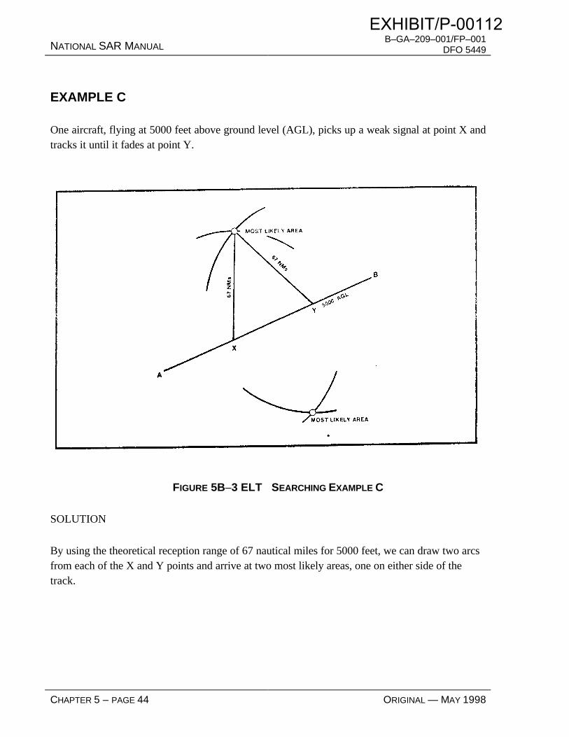
NATIONAL SAR MANUAL B–GA–209–001/FP–001
DFO 5449
CHAPTER 5 – PAGE 44 ORIGINAL — MAY 1998
EXAMPLE C
One aircraft, flying at 5000 feet above ground level (AGL), picks up a weak signal at point X andtracks it until it fades at point Y.
FIGURE 5B–3 ELT SEARCHING EXAMPLE C
SOLUTION
By using the theoretical reception range of 67 nautical miles for 5000 feet, we can draw two arcsfrom each of the X and Y points and arrive at two most likely areas, one on either side of thetrack.
EXHIBIT/P-00112

B–GA–209–001/FP–001DFO 5449 NATIONAL SAR MANUAL
ORIGINAL — MAY 1998 CHAPTER 5 – PAGE 45
ANNEX 5C—SEARCH AREA PLANNING NOMOGRAPHS
FIGURE 5C–1 SEARCH AREA PLANNING NOMOGRAPH
EXHIBIT/P-00112

NATIONAL SAR MANUAL B–GA–209–001/FP–001
DFO 5449
CHAPTER 5 – PAGE 46 ORIGINAL — MAY 1998
FIGURE 5C–2 SECTOR SEARCH AREA NOMOGRAPH
EXHIBIT/P-00112

B–GA–209–001/FP–001DFO 5449 NATIONAL SAR MANUAL
ORIGINAL — MAY 1998 CHAPTER 5 – PAGE 47
FIGURE 5C–3 SECTOR SEARCH TIME NOMOGRAPH
EXHIBIT/P-00112

EXHIBIT/P-00112

B–GA–209–001/FP–001DFO 5449 NATIONAL SAR MANUAL
ORIGINAL — MAY 1998 CHAPTER 5 – PAGE 49
ANNEX 5D—NOTICE OF CRASH/CASUALTY LOCATION MESSAGE
The originator should transmit only the words on the left; the meaning is shown on the right.
SEARCHMASTER THIS IS RESCUE 000 NOVEMBER OSCAR CHARLIE LIMA
ALPHA
• AFFIRMATIVE Positive identification that the object sighted is thesearch object.
• NEGATIVE Unable to positively determine that the object sightedis the search object.
BRAVO
• An eight or nine digit group denoting position without North or West being used.
CHARLIE
• NEGATIVE No survivors or casualties can be seen.
• Any number, followed by(and repeated as necessary)
Indicates number of victims actually seen.
• UNDETERMINED The status of the survivors or casualties cannot bedetermined.
• RED Immediate treatment and evacuation (Priority 1).
• YELLOW Early treatment and evacuation (Priority 2).
• GREEN Routine treatment and evacuation (Priority 3).
• BLUE Deferred treatment and evacuation (Priority 4).
• WHITE Uninjured.
• GREY Missing.
• BLACK Dead.
NOTE—This information on the medical conditions of victims should only be transmittedafter investigation by SAR Technicians or other medically trained personnel.
EXHIBIT/P-00112

NATIONAL SAR MANUAL B–GA–209–001/FP–001
DFO 5449
CHAPTER 5 – PAGE 50 ORIGINAL — MAY 1998
DELTA
• ONE Side of hill plus indicate north, south, east, or westslope.
• TWO In valley plus indicate north, south east, or west sideof floor.
• THREE In level country.
• FOUR Heavily wooded area (can be used in conjunction withONE, TWO or THREE).
• FIVE In water:
• ALPHA – Near shore.
• BRAVO – Well off shore.
ECHO
• ONE Request authorization to deploy theSAR Technicians team.
• TWO A helicopter will be required
• THREE A ground party could reach the location in good time.
• FOUR A rescue boat will be required.
• FIVE Coroner required.
FOXTROT
• REMARKS Briefly provide any detail which allows the rescue co-ordination centre/maritime rescue sub-centre toinitiate appropriate action, bearing in mind that thetransmission is not secure.
EXHIBIT/P-00112
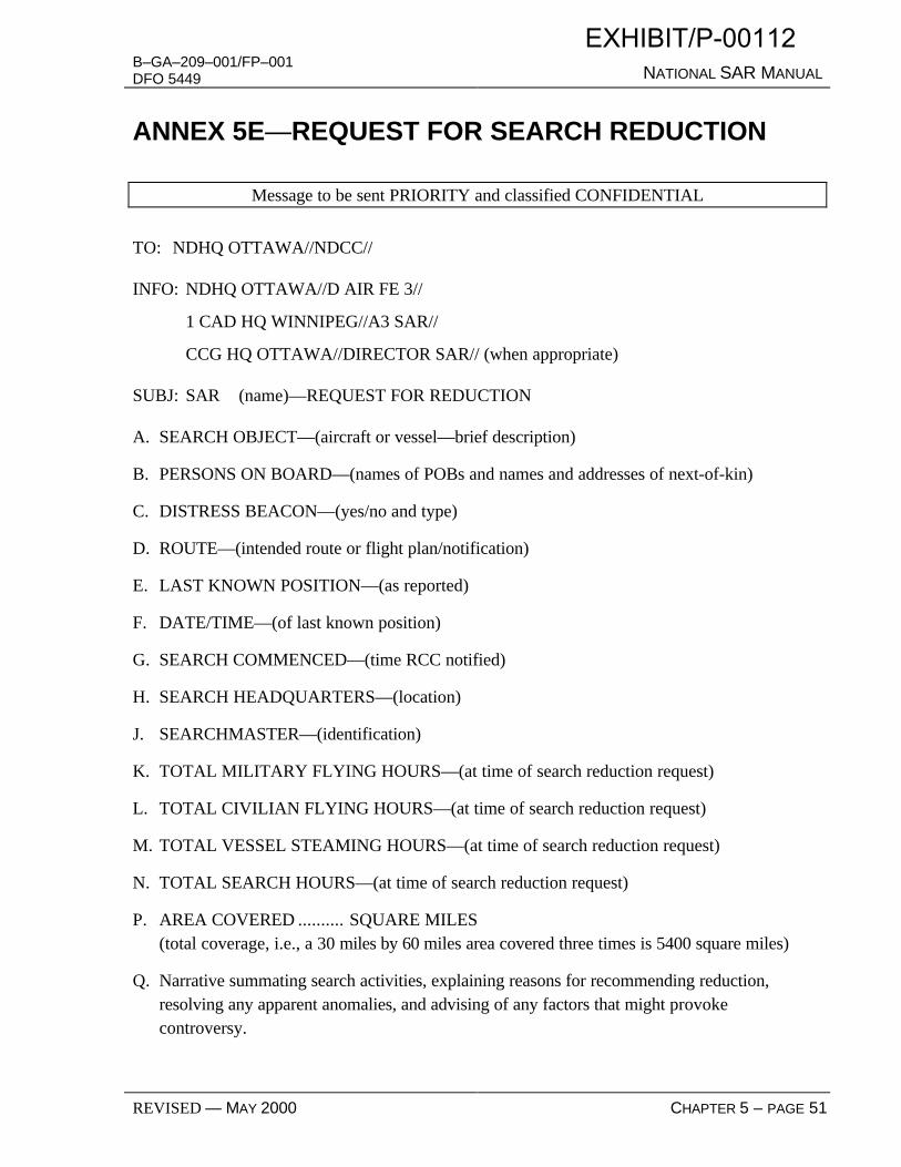
B–GA–209–001/FP–001DFO 5449 NATIONAL SAR MANUAL
REVISED — MAY 2000 CHAPTER 5 – PAGE 51
ANNEX 5E—REQUEST FOR SEARCH REDUCTION
Message to be sent PRIORITY and classified CONFIDENTIAL
TO: NDHQ OTTAWA//NDCC//
INFO: NDHQ OTTAWA//D AIR FE 3//
1 CAD HQ WINNIPEG//A3 SAR//
CCG HQ OTTAWA//DIRECTOR SAR// (when appropriate)
SUBJ: SAR (name)—REQUEST FOR REDUCTION
A. SEARCH OBJECT—(aircraft or vessel—brief description)
B. PERSONS ON BOARD—(names of POBs and names and addresses of next-of-kin)
C. DISTRESS BEACON—(yes/no and type)
D. ROUTE—(intended route or flight plan/notification)
E. LAST KNOWN POSITION—(as reported)
F. DATE/TIME—(of last known position)
G. SEARCH COMMENCED—(time RCC notified)
H. SEARCH HEADQUARTERS—(location)
J. SEARCHMASTER—(identification)
K. TOTAL MILITARY FLYING HOURS—(at time of search reduction request)
L. TOTAL CIVILIAN FLYING HOURS—(at time of search reduction request)
M. TOTAL VESSEL STEAMING HOURS—(at time of search reduction request)
N. TOTAL SEARCH HOURS—(at time of search reduction request)
P. AREA COVERED .......... SQUARE MILES(total coverage, i.e., a 30 miles by 60 miles area covered three times is 5400 square miles)
Q. Narrative summating search activities, explaining reasons for recommending reduction,resolving any apparent anomalies, and advising of any factors that might provokecontroversy.
EXHIBIT/P-00112

B–GA–209–001/FP–001DFO 5449 NATIONAL SAR MANUAL
ORIGINAL — MAY 1998 CHAPTER 6 – PAGE 1
CHAPTER 6—SAR OPERATIONAL PROCEDURES—AERONAUTICAL INCIDENTS
TABLE OF CONTENTS
CHAPTER 6—SAR OPERATIONAL PROCEDURES— AERONAUTICAL INCIDENTS ........................... 1
TABLE OF CONTENTS.............................................................................................................. 1
TABLE OF FIGURES .................................................................................................................. 2
EVALUATION OF DEGREE OF REQUIRED RESPONSE......................................................... 3
SAR INCIDENT PROGRESSION................................................................................................ 3
DEGREES OF AERONAUTICAL EMERGENCY....................................................................... 4
RCC ACTION DURING DEGREES OF AERONAUTICAL EMERGENCY ............................... 5
INTERCEPT AND ESCORT OF DISTRESSED AIRCRAFT....................................................... 8
SEARCH PLANNING.................................................................................................................. 9
DETERMINING THE LAST KNOWN POSITION...................................................................... 9
SEARCH AREAS....................................................................................................................... 10
CANADIAN SEARCH AREA DEFINITION METHOD............................................................ 10
CSAD SEARCH STRATEGY AND SEQUENCE...................................................................... 14
MOUNTAIN VISUAL FLIGHT RULES METHOD ................................................................... 14
MVFR SEARCH STRATEGY AND SEQUENCE ..................................................................... 17
SWEEP WIDTH COMPUTATION ............................................................................................ 18
SEARCH AREA COVERAGE................................................................................................... 20
SEARCH AREA EXPANSION .................................................................................................. 21
DESCRIBING SEARCH AREAS............................................................................................... 22
ANNEX 6—AERIAL DRIFT FORCES ............................................................................................................ 25
EXHIBIT/P-00112

NATIONAL SAR MANUAL B–GA–209–001/FP–001
DFO 5449
CHAPTER 6 – PAGE 2 ORIGINAL — MAY 1998
TABLE OF FIGURES FIGURE 6–1 CSAD AREAS ..............................................................................................................................11
FIGURE 6–2 CSAD TURNING POINT .............................................................................................................12
FIGURE 6–3 CSAD SQUARE MILEAGE GRAPH............................................................................................13
FIGURE 6–4 MFVR SEARCH AREA................................................................................................................15
FIGURE 6–5 COMPARISON OF CSAD & MVFR SEARCH AREAS ...............................................................16
FIGURE 6–6 HEIGHT OF EYE VS. HORIZON RANGE...................................................................................20
FIGURE 6–7 GEOREF GRID.............................................................................................................................23
FIGURE 6A–1 AIRCRAFT GLIDE AREA.........................................................................................................25
FIGURE 6A–2 PARACHUTE DRIFT DISTANCE.............................................................................................27
FIGURE 6A–3 AVERAGE WINDS ALOFT EXAMPLE ...................................................................................27
EXHIBIT/P-00112

B–GA–209–001/FP–001DFO 5449 NATIONAL SAR MANUAL
ORIGINAL — MAY 1998 CHAPTER 6 – PAGE 3
SAR OPERATIONAL PROCEDURES—AERONAUTICAL INCIDENTS
EVALUATION OF DEGREE OF REQUIRED RESPONSE
6.1 In the following sections an attempt has been made to provide guidelines to assist thecontroller in determining the degree of emergency in a search and rescue incident. In emergencysituations requiring immediate assistance action must be taken quickly and positively. The abilityto take appropriate action is a function of the information available to the controller, and of hisjudgment and experience. Initially, the controller should not hesitate to classify an incident at thehighest degree of emergency that the available information supports. Later, the degree ofemergency can be lowered if the situation warrants it.
6.2 Nothing in the following paragraphs is meant to prevent the controller from assigning thehighest degree of emergency.
SAR INCIDENT PROGRESSION
6.3 When search efforts indicate that danger no longer exists, e.g.: the communication searchwas successful and no problem exists or the object and/or the survivors have been located andrescued, and all search and rescue units are accounted for, the rescue co-ordinationcentre/maritime rescue sub-centre shall close the incident and immediately inform the operatingagency and any centre, service or facility that has been alerted or activated.
6.4 If apprehension as to the safety of the search object and its occupants continues to exist,or if new evidence implies the persons on board are in grave and imminent danger, the currentemergency phase should be increased to a higher degree of emergency phase, as appropriate,given the circumstances and information available. The decision to declare this change of phaseshould be taken without delay and based on past experience with similar situations.
6.5 When during search operations it has been determined that further search would be to noavail because the area has been adequately searched and all probability areas investigated, orbecause there is no longer any probability of survival of the persons on board, or for otherpertinent reasons, it should be recommended the search be reduced. The procedures for obtainingauthority to reduce a search are detailed in Chapter 5.
EXHIBIT/P-00112

NATIONAL SAR MANUAL B–GA–209–001/FP–001
DFO 5449
CHAPTER 6 – PAGE 4 ORIGINAL — MAY 1998
DEGREES OF AERONAUTICAL EMERGENCY
6.6 There are three degrees of emergency used in the conduct of aeronautical search andrescue incidents: UNCERTAINTY, ALERT and DISTRESS.
6.7 An UNCERTAINTY phase exists in any one of the following circumstances:
.1 no communication has been received from an aircraft within a period of 30 minutes afterthe time communications should have been received, or from the time an unsuccessfulattempt to establish communication with such aircraft was first made;
.2 a flight plan has been filed and no arrival report has been received by the Area ControlCentre (ACC) within 60 minutes of when the arrival time was last estimated by theaircraft or by an ACC, whichever is later;
.3 a flight itinerary has been filed and no arrival report has been received by the ACC within24 hours of the time that the pilot indicated on the flight itinerary;
.4 a situation exists wherein there is uncertainty as to the safety of an aircraft and itsoccupants, e.g. a responsible person has declared an aircraft overdue which was not on aflight plan but whose tardiness is of sufficient concern; and
.5 an emergency locator transmitter (ELT) signal has been reported by an aircraft, a groundstation or the SARSAT system (event) but there is no reason to suspect that an actualdistress situation exists.
6.8 An ALERT phase exists when:
.1 following the uncertainty phase, the communication search procedure has failed to revealany new information on the aircraft;
.2 an aircraft has been cleared to land and fails to land within five minutes of the estimatedtime of landing and communication has not been re-established with the aircraft;
.3 information has been received which indicates that the operating efficiency of the aircrafthas been impaired, but not to the extent that a forced landing is likely; or
.4 a SARSAT merge position or the ELT signal reported in 6.7.5 is still being reported andcannot be isolated or otherwise accounted for.
6.9 A DISTRESS phase exists when:
EXHIBIT/P-00112

B–GA–209–001/FP–001DFO 5449 NATIONAL SAR MANUAL
ORIGINAL — MAY 1998 CHAPTER 6 – PAGE 5
.1 the fuel on board is considered to be exhausted or to be insufficient to enable the aircraftto reach safety;
.2 information is received which indicates that the operating efficiency of the aircraft hasbeen impaired to the extent that a forced landing is likely;
.3 information is received that the aircraft is about to make or has made a forced landing orrequires immediate assistance;
.4 a downed aircraft is located; or
.5 the ELT transmission referred to in 6.7.5 and 6.8.4
.1 has been linked to an overdue aircraft;
.2 confirmed by the SARSAT system (case or combination of event and ELT report);or
.3 has continued for two hours and the source has not been located.
RCC ACTION DURING DEGREES OF AERONAUTICAL EMERGENCY
6.10 During the UNCERTAINTY phase of an aircraft emergency, the rescue co-ordinationcentre (RCC) shall, when applicable:
.1 obtain the data contained on the flight plan or notification;
.2 confirm that all airports or possible alighting areas along the route of flight and withinthe possible flight range of the aircraft concerned are checked;
.3 notify position fixing agencies (see Chapter 8, Direction finding assistance to SAR) toattempt establishment of the aircraft’s position, informing them of all known frequencies;
.4 notify Region Operational Control Centre at the North American Air Defence (NORAD)headquarters, North Bay, and request air surveillance;
.5 notify the Royal Canadian Mounted Police, the provincial police, and/or the Civil AirSearch and Rescue Association (CASARA) along the route of flight, as they may berequested to verify alighting areas, or obtain information on the aircraft and itsoccupants;
.6 if the flight is over water, request coast radio stations to alert the vessels in the area;
EXHIBIT/P-00112

NATIONAL SAR MANUAL B–GA–209–001/FP–001
DFO 5449
CHAPTER 6 – PAGE 6 ORIGINAL — MAY 1998
.7 if the flight originated in, or intended entering, a country other than Canada, notify theappropriate search and rescue (SAR) facility in that country;
.8 notify the appropriate Area Control Centres (ACCs) for air surveillance(radar/transponder) and request all ground stations in the area to monitor the primaryfrequency of the missing aircraft as well as distress frequencies;
.9 in the case of an emergency locator transmitter (ELT) signal, request all ground stations,including private strips, Flight Service Stations, towers, ACC, vessels, etc., to monitorthe appropriate frequency (121.5 or 243.0 MHz) in an attempt to verify and isolate theELT;
.10 advise the Canadian Mission Control Centre (CMCC) of the details of the possibleemergency and request a query of the SARSAT system; and
.11 select a name for the incident, normally the last name of the aircraft pilot with the prefix"SAR", for example "SAR Jones". If the name of the aircraft pilot is not known, then aname appropriate to and descriptive of the incident shall be selected.
NOTE: Normally, the communication search should not be pursued for more than one hourin the uncertainty phase without upgrading to the alert phase.
6.11 During the ALERT phase of an aircraft emergency, the RCC shall, when applicable:
.1 expand the communication search area as the case warrants;
.2 alert the rescue squadronto prepare aircraft equipment and personnel, especially incircumstances that may require more than the standard configuration;
.3 alert secondary and other facilities, including ships at sea, which may be required toassist, in order to establish availability;
.4 alert CASARA to prepare aircraft and personnel;
.5 ensure that the appropriate ACCs have alerted air traffic flying through the area involvedso that a watch will be maintained;
.6 obtain additional details on aircraft, equipment on board, the pilot and the passengers;
.7 obtain weather along the aircraft’s route and assess its effect on the tasking of search andrescue units (SRUs);
EXHIBIT/P-00112

B–GA–209–001/FP–001DFO 5449 NATIONAL SAR MANUAL
ORIGINAL — MAY 1998 CHAPTER 6 – PAGE 7
.8 plan initial briefing of search crews;
.9 action all incoming reports and consolidate them into the initial briefing plan;
.10 in the case of an ELT signal, task individuals, airport managers, Industry Canada orCASARA ground personnel to isolate the source of the signal, if its general location hasbeen determined and its general location indicates that a distress is unlikely; and
.11 advise CMCC of the details of the emergency and request a query of the SARSATsystem.
NOTE 1: Tasking of aeronautical SRUs from other search and rescue regions (SRRs)should be considered when:
a. significant improvement in on-scene time would be realized,
b. there would be no adverse effect on the responding SRR. NOTE 2: Normally, the communication search should not be pursued for more than one
hour in the Alert Phase without upgrading to the Distress Phase.
6.12 During the DISTRESS phase of an aircraft emergency, the RCC shall, when applicable:
.1 initiate action with the appropriate search and rescue (SAR) units and services: thisaction will normally be to task the standby crew to immediately take off on an initialsearch;
.2 notify appropriate ACC and other agencies concerned, such as the National DefenceOperations Centre (NDOC) when deemed appropriate; issue a Missing Aircraft Notice(MANOT) and a situation report (SITREP);
.3 develop a search plan by ascertaining the position of the aircraft, estimating the degree ofuncertainty of this position, and on the basis of this information, the circumstances andthe historical weather, determine the extent of the search area;
.4 task additional search units as deemed suitable to meet the requirements of the searchplan, and appoint an on-scene commander as required;
.5 in conjunction with the SAR squadron, arrange for the appointment of a searchmasterand assess and determine the most suitable location for the search headquarters;
EXHIBIT/P-00112

NATIONAL SAR MANUAL B–GA–209–001/FP–001
DFO 5449
CHAPTER 6 – PAGE 8 ORIGINAL — MAY 1998
.6 assess and co-ordinate the requirements for telecommunication facilities, weatherservices and equipment and ensure that appropriate telecommunication personnel areavailable and briefed;
.7 notify the operating agency and keep it informed on SAR developments;
.8 advise CMCC of the details of the emergency and request a query of the SARSATsystem;
.9 when an aircraft accident has been confirmed, notify the Transport Safety Board with thepertinent details;
.10 when the incident involves an aircraft of foreign registry, the RCC shall inform NDOC toadvise the appropriate embassy if required; and
.11 develop a rescue plan in the event casualties require assistance. The plan should haveprovisions for the notification of medical facilities and police/coroner, and shouldestablish the most expeditious means and method of rescue.
NOTE 1: The operating agency shall be requested to provide all known informationregarding the aircraft, its occupants, the experience of the captain, and any special equipmentcarried.
NOTE 2: The operating agency shall be afforded the opportunity to appoint liaison
personnel and participate in the search subject to Chapter 4, Hiring of Civilian Personnel andServices.
NOTE 3: The operating agency shall be requested to inform and update the next-of-kin
(NOK) of all occupants. Failing this option, RCC will deal directly with the NOK.
INTERCEPT AND ESCORT OF DISTRESSED AIRCRAFT
6.13 Intercept and escort services will be provided for aircraft in distress, as required, in areasof Canadian search and rescue (SAR) responsibility. If primary SAR aircraft are unable to providethis service owing to unavailability or limitations in operational capability—lack of necessaryrange or speed—the search and rescue region commander is empowered to direct any CanadianForces aircraft operating within his area to perform the task, providing it possesses the necessarycapability.
EXHIBIT/P-00112
B–GA–209–001/FP–001DFO 5449 NATIONAL SAR MANUAL
ORIGINAL — MAY 1998 CHAPTER 6 – PAGE 9
6.14 When an aircraft is required to provide intercept and escort service, the captain will beprovided with as much of the following information as possible:
.1 the distressed aircraft’s identification;
.2 its last known position (LKP) with amplification as to the type of navigation aids used,i.e. LORAN, Doppler, VOR, TACAN, Celestial, INERTIAL, or estimated;
.3 time of the LKP;
.4 its altitude and whether or not the aircraft is descending or climbing;
.5 true course;
.6 ground speed;
.7 true air speed; and
.8 a brief description of the emergency.
6.15 The operational procedures for airborne intercept are set out in CFACM 60–2605,Airlift Operations, Search and Rescue.
SEARCH PLANNING
6.16 The search planning task includes the determination of the last known position, datumand a search area, developing a plan that maximizes effort allocation, selecting search patterns andtrack spacing to achieve a suitable area coverage, planning on-scene co-ordination, transmittingthe search plan to the search units and periodically reviewing and updating the search plan.
DETERMINING THE LAST KNOWN POSITION
6.17 The last known position (LKP) can be based on the last reported position, on aconfirmed sighting report, on a radar image or on a SARSAT position, etc. Each one of thesedeterminations has its own inherent potential error which must be considered by the controller.
6.18 When calculating the LKP, consideration must also be given to the aerial drift associatedwith the search object just prior to the accident. This may involve drift associated with a glidingaircraft, parachute drift when an ejection is involved or the drift associated with the aircraft beingoff course. Annex 6A provides detailed calculations for aerospace trajectory and parachute drift.
EXHIBIT/P-00112

NATIONAL SAR MANUAL B–GA–209–001/FP–001
DFO 5449
CHAPTER 6 – PAGE 10 ORIGINAL — MAY 1998
SEARCH AREAS
6.19 Two predefined methods of determining and plotting inland search areas have beendeveloped for use in Canada. They are:
.1 the Canadian Search Area Definition (CSAD) method—based on empirical datacollected on Canadian inland search and rescue incidents from 1981 to 1986, excludingthe data used for the Mountain Visual Flight Rules study; and
.2 the Mountain Visual Flight Rules (MVFR) method—for utilization in mountainousregions in which visual flight routes are accepted, published, and flown. This method isbased on empirical data collected on Canadian inland incidents involving Visual FlightRules flights in mountainous regions.
6.20 These methods were developed for cases where there is little information to go onbesides a last known position and a destination. The MVFR method applies in cases where theintended route of the missing aircraft involves navigation by following such things as valley floors,rivers and roads (in mountainous terrain) as opposed to point-to-point navigation. The CSADmethod applies in point-to-point cases. If the Searchmaster (SM) has evidence to suggest thatthese methods are not applicable, then they should be modified, subject to the concurrence of thesearch and rescue region commander through the officer in charge of the rescue co-ordinationcentre. Details of the modification to the search area and SM reasoning for the modification areto be included in the situation report (SITREP).
CANADIAN SEARCH AREA DEFINITION METHOD
6.21 Based on historical data, two definitive probability areas have been established and arecategorized according to the priority with which they should be searched. The method takes intoaccount the variations in known crash positions along track and across track. Those variationsare combined, giving rectangular areas within which the crash position is likely to be found.
6.22 The use of the Canadian Search Area Definition (CSAD) requires the followinginformation:
.1 the last known position (LKP);
.2 the intended route; and
.3 the intended destination.
EXHIBIT/P-00112

B–GA–209–001/FP–001DFO 5449 NATIONAL SAR MANUAL
ORIGINAL — MAY 1998 CHAPTER 6 – PAGE 11
6.23 The CSAD method applies to all intended track lengths. The two areas are (seeFigure 6–1):
.1 Area One—A rectangle 10 miles each side of track beginning 10 miles before LKP andextending 10 miles beyond destination; and
.2 Area Two—A rectangle 15 miles each side of track beginning at the LKP and extending15 miles beyond destination. Area Two includes that portion of Area One whereoverlapping occurs.
FIGURE 6–1 CSAD AREAS
6.24 Where an enroute turning point includes a track direction change of greater than20 degrees the outside boundary of each area shall be an arc using the turning point as centre anda radius equal to 10 miles for Area One and 15 miles for Area Two, as per figure 6–2.
6.25 Normally there is no requirement to adjust the search areas in an inland search. Suchadjustment would have to be considered, however, if any of the three basic factors listed in 6.22should change during the search.
EXHIBIT/P-00112

NATIONAL SAR MANUAL B–GA–209–001/FP–001
DFO 5449
CHAPTER 6 – PAGE 12 ORIGINAL — MAY 1998
FIGURE 6–2 CSAD TURNING POINT
6.26 Probability of containment—The probability of containment (POC) or density of crashpositions based on the data varies in the along-track and off-track directions. Generally, casestend to cluster close to intended track with the density dropping off sharply as offset increases.There are concentrations of cases in the first tenth and last tenth of track but very few cases in theunderfly and overfly areas. There also tends to be more cases in the second half of track than inthe first half.
NOTE: A graph providing ready reference for determining the square mileage of searchareas is included in Figure 6–3.
EXHIBIT/P-00112

B–GA–209–001/FP–001DFO 5449 NATIONAL SAR MANUAL
ORIGINAL — MAY 1998 CHAPTER 6 – PAGE 13
AREA ONEFormula: (D + 20) x 20
AREA TWOFormula: (D + 15) x 30
0
50
100
150
200
250
0 100 200 300 400 500 600 700 800
Track Length (D)
Square Miles (hundreds)
FIGURE 6–3 CSAD SQUARE MILEAGE GRAPH
EXHIBIT/P-00112

NATIONAL SAR MANUAL B–GA–209–001/FP–001
DFO 5449
CHAPTER 6 – PAGE 14 ORIGINAL — MAY 1998
CSAD SEARCH STRATEGY AND SEQUENCE
6.27 There is no single sequence of search types or patterns which will be suitable for allsearches. For searches where the Canadian Search Area Definition (CSAD) method is used, thefollowing search sequence is suggested, unless circumstances dictate otherwise:
.1 Phase I—
.1 Carry out track crawls along the missing aircraft’s intended track and thoroughlycheck in the vicinity of the last known position (LKP) and destination.
.2 Carry out electronic searches.
.3 Carry out a co-operating target/survivor search over the high probability areas,covering 15 miles either side of the missing aircraft’s intended track.
.2 Phase II—search Area One in the following sequence, for all track lengths:
.1 the last quarter of track from the intended track outwards with equal priority alongtrack,
.2 the third quarter from the intended track outwards with equal priority along track,
.3 the first quarter from the intended track outwards commencing at LKP,
.4 the second quarter from the intended track outwards with equal priority along track,
.5 the overfly area followed by the underfly area commencing at the destination andLKP respectively,
.3 Phase III—expand the search to Area Two and use the same sequence as in Phase II.
MOUNTAIN VISUAL FLIGHT RULES METHOD
6.28 Canadian search and rescue data involving Visual Flight Rules flight plans has revealeddistinct differences in the probability of containment (POC) between the mountainous regions andother regions of the country. In particular:
.1 although there tend to be more crash sites between one-half and three-quarters of theway along the intended track, a substantial portion occur along the other areas of thetrack;
EXHIBIT/P-00112

B–GA–209–001/FP–001DFO 5449 NATIONAL SAR MANUAL
ORIGINAL — MAY 1998 CHAPTER 6 – PAGE 15
.2 very few crash sites are found before the last known position (LKP) or beyond theintended destination;
.3 crash sites tend to cluster close to the intended track with the POC decaying sharply asyou move away from the track; and
.4 the minimum search area for a given POC always stretches along the entire length of thetrack.
FIGURE 6–4 MFVR SEARCH AREA
6.29 Two probability areas are defined for cases involving Visual Flight Rules flight plans inmountainous regions (see Figure 6–4).
.1 Area A—This is an area which stretches along the entire track of the missing aircraft,from the LKP to the intended destination, and extends 5 miles either side of the intendedtrack. Based on previous data and assuming the intended track is known, this area
EXHIBIT/P-00112

NATIONAL SAR MANUAL B–GA–209–001/FP–001
DFO 5449
CHAPTER 6 – PAGE 16 ORIGINAL — MAY 1998
should include a large portion of crash sites. In order to include cases where the crashoccurs shortly after takeoff or on approach for landing, this area is extended 5 milesbefore the LKP and 5 miles beyond the destination. Note that if the missing aircraft’sintended route is not known with any certainty, all likely routes must be covered (seeFigure 6–5) or another search planning method used.
.2 Area B—This is an area which stretches along the entire intended track of the missingaircraft from the LKP to the destination and extends 10 miles either side of the track. Italso extends 10 miles before the LKP and 10 miles beyond the destination. Note thatArea B also includes all of Area A.
FIGURE 6–5 COMPARISON OF CSAD & MVFR SEARCH AREAS
EXHIBIT/P-00112

B–GA–209–001/FP–001DFO 5449 NATIONAL SAR MANUAL
ORIGINAL — MAY 1998 CHAPTER 6 – PAGE 17
MVFR SEARCH STRATEGY AND SEQUENCE
6.30 Given that an aircraft is missing on a Visual Flight Rules (VFR) flight in themountainous regions of Canada and all the preliminary checks have been completed withoutsuccess, the following procedure is recommended:
.1 Phase I—
.1 Carry out track crawls along the missing aircraft’s intended VFR route andthoroughly check last known position (LKP) and destination for near take-off/landing incidents.
.2 Carry out an electronic search to detect any distress beacon signals.
.3 Carry out a co-operative target/survivor search over the high probability area,covering 10 miles either side of the missing aircraft’s intended track. This shouldinclude all likely routes if the intended track is unknown.
.2 Phase II—Thoroughly search Area A in the following sequence, for all track lengths.Once again, if the missing aircraft’s intended track is not known with any certainty, alllikely routes must be covered:
.1 third quarter from the track outwards,
.2 fourth quarter from the track outwards,
.3 second quarter from the track outwards,
.4 first quarter from the track outwards,
.5 overfly and underfly areas expanding from the destination and the LKP.
.3 Phase III—Expand the search to Area B, and use the same sequence as given inPhase II. Any valleys, dead-end canyons, passes, etc., that may have been takenaccidentally by the missing aircraft should also be covered.
6.31 Figure 6–5 shows a comparison between the Canadian Search Area Definition (CSAD)and the Mountain Visual Flight Rules (MVFR) methods for a case involving a flight fromAbbotsford to Revelstoke, BC, where more than one common VFR route is possible. Thepracticality of the MVFR system is demonstrated by the fact that the CSAD method covers onlyabout one-third of the possible VFR routes.
EXHIBIT/P-00112

NATIONAL SAR MANUAL B–GA–209–001/FP–001
DFO 5449
CHAPTER 6 – PAGE 18 ORIGINAL — MAY 1998
SWEEP WIDTH COMPUTATION
6.32 Visual Search—For inland searches, sweep width (W) tables have not been computed,although research may someday provide better guidance for planners. In general two types ofinland search are conducted: initial coverage and intensive coverage. For initial coverage, trackspacing (S) is usually 2 miles or more, depending on terrain. For intensive coverage, S is less than2 miles with 1 mile being the norm (thereby giving the normal 1/2 mile spotting distance), againdepending on terrain.
6.33 Since inland searches will normally be in areas of varying terrain, the coverage factorwill be based on the subjective judgment of the search crew and the search planner. This valuecan then be used to assess the effectiveness of the initial coverage and the requirement of repeatedsearches of an area.
6.34 There are many factors which may modify visual Ws. While the effects of some of thesefactors may be variable or indefinite, the search planner must take them into consideration whendeveloping a search plan. Most of these factors tend to affect the probability of detection (POD)and are discussed below in their approximate order of influence.
.1 Search Object—Detectability is significantly related to its size, and its colour contrastrelative to its environment.
.2 Terrain Conditions—Effects due to the difficulty of sighting objects through densebrush or tall timber; the distractions of vegetation and other surface irregularities.
.3 Search Craft Speed—High speed can reduce effectiveness in aircraft, particularly atlow altitude, or in any type of search vehicle if turbulence is being encountered.
.4 Position of Sun—Effectiveness is reduced when looking into the sun, particularly inhazy conditions and when the sun is low on the horizon. In mountainous areas, valleyfloors may only be visible at certain times of the day. Track spacing or orientation mayhave to be adjusted.
.5 Spotter Effectiveness—Fatigue, type of training, physical and mental condition,suitability and comfort of spotter positions will all have a bearing on the effectiveness ofspotters.
All of these, and any other factors which come to the search planner’s attention, must beconsidered as objectively as possible when determining the POD using visual search methods.
EXHIBIT/P-00112

B–GA–209–001/FP–001DFO 5449 NATIONAL SAR MANUAL
ORIGINAL — MAY 1998 CHAPTER 6 – PAGE 19
6.35 Electronic Search—Electronic searching includes SARSAT queries, radio, radar,magnetic, radioactive and other electromagnetic band searches. The determination of anappropriate value for sweep widths in these searches is just as important as in visual searches.
6.36 Electronic sweep widths may be affected by:
.1 the search objects’ output;
.2 the search units’ capability;
.3 environmental attenuation level;
.4 environmental ambient noise;
.5 terrain attenuation; and
.6 COSPAS–SARSAT orbital mechanics.
The detection range of distress beacons varies and the search planner should attempt todetermine the specific range of the equipment in question. The same may be true of the searchunit capability. Dedicated search units will normally have published standard operatingprocedures regarding electronic track spacing and detection ranges to which the search plannermay refer. Examples of these are shown in Figure 5–5.
6.37 The detection range data available to the search planner may be reported as minimum,average or maximum detection ranges. The classification would be based on a series of ranges atwhich targets have been first detected, subdivided into the minimum, average and maximum ofsuch series. When such data is available, the following guidelines are recommended in order ofpreference:
.1 when minimum detection range is known, the sweep width (W) is equal to 1.7 timesminimum detection range;
.2 when average detection range is known, W = 1.5 times average detection range;
.3 when maximum detection range is known, W = maximum detection range; and
.4 when no detection range is known, W = 0.5 times horizon range.
A horizon range chart is provided at Figure 6–6. If the search is in a mountainous or heavilywooded area, W should be further reduced by half.
EXHIBIT/P-00112

NATIONAL SAR MANUAL B–GA–209–001/FP–001
DFO 5449
CHAPTER 6 – PAGE 20 ORIGINAL — MAY 1998
FIGURE 6–6 HEIGHT OF EYE VS. HORIZON RANGE
EXHIBIT/P-00112

B–GA–209–001/FP–001DFO 5449 NATIONAL SAR MANUAL
ORIGINAL — MAY 1998 CHAPTER 6 – PAGE 21
6.38 Miscellaneous Methods—Some methods of searches, i.e., forward-looking infra-red(FLIR), have sweep widths that are so variable, a subjective estimate of the probability ofdetection will be the only option. For searches involving night vision goggles, refer to 7.69.
SEARCH AREA COVERAGE
6.39 The number of times an area should be searched depends on the probability ofcontainment (POC) and on the probability of detection (POD). Both of these values aresubjective. However the following guidelines are suggested:
.1 lateral coverage from the airplane is improved to some extent with increasing altitudewithout degrading the POD appreciably. Therefore, a minimum search altitude ofapproximately 1000 feet should be considered where terrain and/or vegetation arefactors;
.2 since lateral coverage varies with terrain and vegetation, spotters must adjust theirsearching accordingly. For example, in densely forested areas, lateral coverage may onlybe a few hundred feet whereas in open ground, it may be one-half mile; and
.3 adequate coverage of a forested, high probability area may require multiple intensivesearches with the narrow track spacings. There are also advantages in varying the searchdirection, if possible.
6.40 Any pre-defined search areas like those of the Canadian Search Area Definition andMountain Visual Flight Rules methods are intended as guides when there is little else to go on.Any valid information on the missing aircraft, pilot, route flown, weather, etc., should be used tomodify or re-define search areas. This same route may involve a dead-end canyon that could havebeen taken accidentally by the pilot. This canyon should be searched even if it extends more than10 miles from the intended track. The key is common sense and flexibility.
SEARCH AREA EXPANSION
6.41 Inland Searches—Unlike maritime searches, inland searches do not normally require anexpansion of the search area. Rather, repeated coverage of the same areas will usually berequired until the conclusion of the search.
6.42 Currently available data does not allow for more than a subjective estimate of theeffectiveness of aerial search. Factors such as the type of terrain, the weather, the available light
EXHIBIT/P-00112
NATIONAL SAR MANUAL B–GA–209–001/FP–001
DFO 5449
CHAPTER 6 – PAGE 22 ORIGINAL — MAY 1998
and the capability of the searchers all affect the efficiency of the search units. It will be theresponsibility of the search planner to evaluate each coverage of the individual sections of thesearch area to reach a rational search conclusion in unsuccessful searches.
DESCRIBING SEARCH AREAS
6.43 When the search area has been determined it will be necessary to define it to search unitsand others who may require the information. The total area will need to be divided in sub-areasfor allocation to search units. The accurate definition of these areas is of the utmost importanceto the search planner, since the information will have to be recorded and may be referred to over aperiod of days or even weeks.
6.44 In Canada, the preferred method is the latitude and longitude system of squares. It isespecially suitable for large-scale searches where a wide area can be covered withoutcomplication. This system is used with the National Topographical Series, Aeronautical Edition,scale 1:500,000. These maps are printed with each GEOREF grid square (1 degree latitude by1 degree longitude) labelled with a two letter code. Thirty-minute grid lines are also provided,subdividing each 1 degree by 1 degree area into four sub-areas. These are identified numericallyfrom 1 to 4, with 1 being the Northwest corner, 2 the Northeast corner, 3 the Southwest cornerand 4 the Southeast corner. These 30 minute by 30 minute squares are referred to as "primarysquares" and can be further divided into "secondary squares". These secondary squares arelabelled alphabetically from A to D in the same fashion as the primary squares. An example of anassigned area might read as Map 42 NW, square CG4A (see Figure 6–7).
6.45 An added advantage of this system is that the GEOREF overlay is printed not only onthe 1:500,000 maps but on the 1:1,000,000 as well. Also, the legend on the 1:250,000 mapsindicates a GEOREF grid that can be easily extrapolated onto the map.
6.46 Other possible methods, described in the United States National Search and RescueManual, include the following:
.1 boundary method;
.2 corner method;
.3 centre point method;
.4 track line method; and
.5 grid method.
EXHIBIT/P-00112

B–GA–209–001/FP–001DFO 5449 NATIONAL SAR MANUAL
ORIGINAL — MAY 1998 CHAPTER 6 – PAGE 23
FIGURE 6–7 GEOREF GRID
EXHIBIT/P-00112

NATIONAL SAR MANUAL B–GA–209–001/FP–001
DFO 5449
CHAPTER 6 – PAGE 24 ORIGINAL — MAY 1998
The GEOREF latitude and longitude system of squares is the preferred method used oninland searches for missing aircraft in Canada, both for tasking and for reporting, and should beused during the intensive search phase. The use of other methods may be more practical duringthe initial co-operative target/survivor searches, when it is important to follow a priority sequencealong the track. It should always be remembered that the method used should be simple, effectiveand easy to work with, not only for the rescue co-ordination centre/searchmaster, but for theother agencies involved with the operation. Maritime search and rescue units will simply uselatitude and longitude.
EXHIBIT/P-00112

B–GA–209–001/FP–001DFO 5449 NATIONAL SAR MANUAL
ORIGINAL — MAY 1998 CHAPTER 6 – PAGE 25
ANNEX 6—AERIAL DRIFT FORCES
1. This Annex amplifies Chapter 5 and provides for the detailed calculation of aerial drift.
2. Aerospace Trajectory—This drift force is the result of the momentum due to aircraftmovement at the moment of bailout and acts on the airman in the direction of flight between themoment of ejection and the moment of parachute opening. If this direction is known, and thebailout location precise, the planner may apply an aerospace trajectory (da) of 0.5 miles for turbo-prop and medium performance jets or 0.8 miles for high performance jet aircraft. Information isseldom precise enough to make use of the da.
3. Aircraft gliding distance may also be considered part of aerospace trajectory when theposition and altitude of bailout are known. The maximum no-wind glide distance should berequested from the operator. Using the average winds aloft a displacement vector is computed,this point becoming the centre of a circle the radius of which is the maximum glide distance. Thisforce is seldom used since the parachute is the object of the immediate search.
FIGURE 6A–1 AIRCRAFT GLIDE AREA
EXHIBIT/P-00112

NATIONAL SAR MANUAL B–GA–209–001/FP–001
DFO 5449
CHAPTER 6 – PAGE 26 ORIGINAL — MAY 1998
4. In all cases of bailout, maximum use must be made of radar when available, since mostejection seats automatically dispense chaff during the ejection sequence which can be identified onradar.
5. Parachute Drift—If the position and altitude of bailout are known, it will be possible forthe planner to apply the parachute drift (dp). There are four factors to consider:
a. opening altitude;
b. parachute type;
c. average winds aloft; and
d. terrain height.
To determine the opening altitude and parachute type check with the operator, sincerequirements differ with aircraft type and geographical location. The exact altitude may beavailable from a witness such as a wingman.
6. The normal emergency parachute in use in Canada is a 28 foot diameter chute, designed todescend vertically in no wind conditions. If a different type of parachute has been used, theoperator should provide details on glide ratio and operating procedures. The table at Figure 6A–2 is based on a rate of descent of 16 feet per second, and should be adequate for all types ofemergency parachutes.
7. The average winds aloft for the bailout area should be requested from a Canadian ForcesWeather Office or Atmospheric Environment Services. The applicable winds, from bailoutaltitude to the local terrain height, are applied to achieve an average wind vector (see example atFigure 6A–3). Using the wind speed from this vector, enter Figure 6A–2 to determine theparachute drift distance. Interpolation may be required for the average windspeed and openingheight, and will be necessary if the terrain height is not at sea level.
EXHIBIT/P-00112

B–GA–209–001/FP–001DFO 5449 NATIONAL SAR MANUAL
ORIGINAL — MAY 1998 CHAPTER 6 – PAGE 27
FIGURE 6A–2 PARACHUTE DRIFT DISTANCE
FIGURE 6A–3 AVERAGE WINDS ALOFT EXAMPLE
EXHIBIT/P-00112

B–GA–209–001/FP–001DFO 5449 NATIONAL SAR MANUAL
ORIGINAL — MAY 1998 CHAPTER 7 – PAGE 1
CHAPTER 7—SAR OPERATIONAL PROCEDURES—MARITIME INCIDENTS
TABLE OF CONTENTS
CHAPTER 7—SAR OPERATIONAL PROCEDURES—MARITIME INCIDENTS....................................... 1
TABLE OF CONTENTS.............................................................................................................. 1
TABLE OF FIGURES .................................................................................................................. 3
EVALUATION OF DEGREE OF EMERGENCY........................................................................ 5
SAR INCIDENT PROGRESSION................................................................................................ 5
DEGREES OF MARITIME EMERGENCY................................................................................. 6
RCC/MRSC ACTION DURING DEGREES OF MARITIME EMERGENCY.............................. 7
ASSISTANCE TO DISORIENTED VESSELS............................................................................. 9
ASSISTANCE TO DISABLED/ABANDONED VESSELS........................................................ 10
ASSISTANCE TO OTHER CCG PROGRAMS.......................................................................... 10
CIVILIAN SUBMARINES/SUBMERSIBLES............................................................................ 10
SEARCH PLANNING................................................................................................................ 11
METHODS OF SEARCH PLANNING....................................................................................... 11
MANUAL SEARCH PLANNING .............................................................................................. 13
DATUM..................................................................................................................................... 13
MINIMAX ................................................................................................................................. 20
DATUM AND SEARCH UNIT ERRORS .................................................................................. 21
OFFSHORE SEARCH AREAS .................................................................................................. 24
INSHORE SEARCH AREAS ..................................................................................................... 25
SWEEP WIDTH COMPUTATION ............................................................................................ 25
MAJOR MARITIME DISASTERS............................................................................................. 28
EXHIBIT/P-00112

NATIONAL SAR MANUAL B–GA–209–001/FP–001
DFO 5449
CHAPTER 7 – PAGE 2 ORIGINAL — MAY 1998
ANNEX 7A—POLICY FOR THE PROVISION OF TOWING ASSISTANCEBY VESSELS ENGAGED IN SAR OPERATIONS....................................................................31
CCG HELP IN OBTAINING THIRD PARTY ASSISTANCE......................................................31
ANNEX 7B—MAJOR MARITIME DISASTER SAR CONTINGENCY PLAN.............................................33
FOREWORD................................................................................................................................33
SITUATION.................................................................................................................................33
MISSION .....................................................................................................................................34
EXECUTION ...............................................................................................................................34
SUPPORT.....................................................................................................................................36
COMMAND.................................................................................................................................38
ANNEX 7C—SIMPLIFIED MINIMAX SEARCH PLANNING WORKSHEETS..........................................39
ANNEX 7D—SWEEP WIDTH TABLES ..........................................................................................................51
EXHIBIT/P-00112

B–GA–209–001/FP–001DFO 5449 NATIONAL SAR MANUAL
ORIGINAL — MAY 1998 CHAPTER 7 – PAGE 3
TABLE OF FIGURES FIGURE 7–1 SEARCH PLANNING DECISION MATRIX ............................................................................... 16
FIGURE 7–2 LEEWAY RATES TABLE........................................................................................................... 17
FIGURE 7–3 MINIMAX PLOT ......................................................................................................................... 21
FIGURE 7–4 POSITION ERRORS .................................................................................................................... 23
FIGURE 7–5 SAFETY FACTOR AND SEARCH RADIUS............................................................................... 25
FIGURE 7–6 HEIGHT OF EYE VS. HORIZON RANGE .................................................................................. 29
FIGURE 7C–1 MINIMAX WORKSHEET 1—DATUM .................................................................................... 39
FIGURE 7C–2 MINIMAX WORKSHEET 2...................................................................................................... 40
FIGURE 7C–3 MINIMAX WORKSHEET 3—SEARCH AREA........................................................................ 41
FIGURE 7C–4 MINIMAX WORKSHEET 4...................................................................................................... 42
FIGURE 7C–5 MINIMAX WORKSHEET 5—EFFORT ALLOCATION........................................................... 43
FIGURE 7C–6 MINIMAX WORKSHEET 6...................................................................................................... 44
FIGURE 7C–7 MINIMAX WORKSHEET 7—DRIFT COMPENSATED SEARCH PATTERNS...................... 45
FIGURE 7C–8 MINIMAX WORKSHEET 8...................................................................................................... 46
FIGURE 7C–9 MINIMAX WORKSHEET 9—WIND CURRENT CALCULATION ......................................... 47
FIGURE 7C–10 MINIMAX WORKSHEET 10—WIND CURRENT COEFFICIENT TABLE........................... 48
FIGURE 7C–11 MINIMAX WORKSHEET 11—AVERAGE SURFACE WINDS AND LEEWAY................... 49
FIGURE 7C–12 MINIMAX WORKSHEET 12 .................................................................................................. 50
FIGURE 7D–1 UNCORRECTED VISUAL SWEEP WIDTH TABLE—FIXED-WING AIRCRAFT—ALTITUDES 300 AND 500 FEET ............................................. 51
FIGURE 7D–2 UNCORRECTED VISUAL SWEEP WIDTH TABLE—FIXED-WING AIRCRAFT—ALTITUDES 750 AND 1000 FEET ........................................... 52
FIGURE 7D–3 UNCORRECTED VISUAL SWEEP WIDTH TABLE—FIXED-WING AIRCRAFT—ALTITUDES 1500 AND 2000 FEET ......................................... 53
FIGURE 7D–4 UNCORRECTED VISUAL SWEEP WIDTH TABLE—FIXED-WING AIRCRAFT—ALTITUDES 2500 AND 3000 FEET ......................................... 54
FIGURE 7D–5 UNCORRECTED VISUAL SWEEP WIDTH TABLE—HELICOPTERS—ALTITUDES 300 AND 500 FEET .............................................................. 55
FIGURE 7D–6 UNCORRECTED VISUAL SWEEP WIDTH TABLE—HELICOPTERS—ALTITUDES 750 AND 1000 FEET ............................................................ 56
FIGURE 7D–7 UNCORRECTED VISUAL SWEEP WIDTH TABLE—HELICOPTERS—ALTITUDES 1500 AND 2000 FEET........................................................... 57
FIGURE 7D–8 UNCORRECTED VISUAL SWEEP WIDTH TABLE—HELICOPTERS—ALTITUDES 2500 AND 3000 FEET........................................................... 58
EXHIBIT/P-00112

NATIONAL SAR MANUAL B–GA–209–001/FP–001
DFO 5449
CHAPTER 7 – PAGE 4 ORIGINAL — MAY 1998
FIGURE 7D–9 UNCORRECTED VISUAL SWEEP WIDTH TABLE—VESSELS AND SMALL BOATS .............................................................................................59
FIGURE 7D–10 UNCORRECTED VISUAL SWEEP WIDTH TABLE— NIGHT VISION GOGGLES ....................................................................................................60
FIGURE 7D–11 WEATHER CONDITION FACTOR.........................................................................................60
FIGURE 7D–12 SEARCH AIRCRAFT SPEED CORRECTION TABLE............................................................61
FIGURE 7D–13 FATIGUE CORRECTION FACTOR........................................................................................61
EXHIBIT/P-00112

B–GA–209–001/FP–001DFO 5449 NATIONAL SAR MANUAL
ORIGINAL — MAY 1998 CHAPTER 7 – PAGE 5
SAR OPERATIONAL PROCEDURES—MARITIME INCIDENTS
EVALUATION OF DEGREE OF EMERGENCY
7.1 In the following sections an attempt has been made to provide guidelines to assist thecontroller in determining the degree of emergency in a search and rescue incident. In emergencysituations requiring immediate assistance positive action must be taken quickly. The ability totake appropriate action is a function of the information available to the controller, and of hisjudgment and experience. Initially, the controller should not hesitate to classify an incident at thehighest degree of emergency that the available information supports. Later, the degree ofemergency can be lowered if the situation warrants it.
7.2 Nothing in the following paragraphs is meant to prevent the controller from assigning thehighest degree of emergency.
SAR INCIDENT PROGRESSION
7.3 When search efforts indicate that danger no longer exists, e.g. the communication searchwas successful and no problem exists or the object and/or the survivors have been located andrescued, and all search and rescue units are accounted for; the rescue co-ordinationcentre/maritime rescue sub-centre shall close the incident and immediately inform the operatingagency and any centre, service or facility that has been alerted or activated.
7.4 If apprehension as to the safety of the search object and its occupants continues to exist,or if new evidence implies that the persons on board are in grave and imminent danger, the currentemergency phase should be advanced to a higher degree of emergency phase, as appropriate,given the circumstances and information available. The decision to declare this change of phaseshould be taken without undue delay and based on past experiences with similar situations.
7.5 When during search operations, it has been determined that further search would be to noavail because the area has been adequately searched and all probability areas investigated, orbecause there is no longer any probability of survival of the persons on board, or for otherpertinent reasons, it should be recommended that the search be reduced. The procedures forobtaining authority to reduce a search are detailed in Chapter 5.
EXHIBIT/P-00112

NATIONAL SAR MANUAL B–GA–209–001/FP–001
DFO 5449
CHAPTER 7 – PAGE 6 ORIGINAL — MAY 1998
DEGREES OF MARITIME EMERGENCY
7.6 There are three degrees of emergency used in the conduct of maritime SAR incidents:UNCERTAINTY, ALERT, and DISTRESS.
7.7 An UNCERTAINTY phase exists when:
.1 there is doubt regarding the safety of a vessel or the persons on board;
.2 a vessel has been reported overdue at destination; or
.3 a vessel has failed to make an expected position report.
7.8 An ALERT phase exists when:
.1 there is apprehension regarding the safety of a vessel or the persons on board;
.2 following the uncertainty phase, attempts to establish contact with the vessel have failedand inquiries addressed to other appropriate sources have been unsuccessful; or
.3 information has been received indicating that the operational efficiency of a vessel isimpaired but not to the extent that a distress situation is likely.
7.9 A DISTRESS phase exists when:
.1 positive information is received that a vessel or a person on board is in grave andimminent danger and in need of immediate assistance;
.2 following the alert phase, further unsuccessful attempts to establish contact with thevessel and more widespread unsuccessful inquiries point to the probability that the vesselis in distress; or
.3 information is received which indicates that the operating efficiency of the vessel hasbeen impaired to the extent that a distress situation is likely.
NOTE 1: In the absence of other information, a signal from a distress beacon, on its own, isto be considered as a sign of distress and shall be investigated immediately.
NOTE 2: Paragraph 7.9.3 confers the authority to declare distress on behalf of a vessel
whether or not the vessel has declared a distress. Whenever a distress is declared under thesecircumstances the rationale is to be recorded in the case file log.
EXHIBIT/P-00112
B–GA–209–001/FP–001DFO 5449 NATIONAL SAR MANUAL
ORIGINAL — MAY 1998 CHAPTER 7 – PAGE 7
RCC/MRSC ACTION DURING DEGREES OF MARITIME EMERGENCY
7.10 During the UNCERTAINTY phase of a maritime emergency, the rescue co-ordinationcentre (RCC)/maritime rescue sub-centre (MRSC) shall, when applicable:
.1 verify the information received and if it is suspected that the vessel is in danger, itsmaster should be asked the following question: “Are you in immediate danger?” If thereply is negative and the RCC/MRSC judges it appropriate, ensure that the MarineCommunication and Traffic Services (MCTS) centre issues an “All stations” broadcastand allow up to 15 minutes for vessels in the area to respond. If a response is received,refer to Annex 7A. (The controller should use the replies to prioritize the search andrescue (SAR) response.)
.2 attempt to obtain information on the route, points and times of departure and arrival ofthe vessel;
.3 start a plot of the situation based on the information obtained;
.4 conduct a communication search, utilizing appropriate resources;
.5 issue an “All stations” broadcast for information on the vessel’s whereabouts;
.6 if the voyage originated in, intended entering, or may have entered other than Canadianwaters, notify the appropriate RCC; and
.7 select a name for the operation, this will normally be the name of the vessel and will beused throughout the operation when reference to such is made.
7.11 During the ALERT phase of a maritime emergency, the RCC/MRSC shall, whenapplicable:
.1 issue an “All stations” broadcast under the urgency (PAN PAN) prefix for informationon the vessel or, if the vessel is disabled, to locate vessels able to render assistance;
.2 alert personnel and SAR facilities, and plan initial briefing of SAR crews;
.3 verify the information received;
.4 endeavour to obtain information concerning the vessel from sources not previouslycontacted;
.5 thoroughly evaluate information on the vessel’s intended route, weather, possiblecommunications delays, last known position (LKP) and last radio communication;
EXHIBIT/P-00112

NATIONAL SAR MANUAL B–GA–209–001/FP–001
DFO 5449
CHAPTER 7 – PAGE 8 ORIGINAL — MAY 1998
.6 consider the possibility of fuel exhaustion and the estimated performance of the vesselunder adverse conditions;
.7 maintain close liaison with associated MCTS centres so that information from ships atsea can be evaluated;
.8 plot relevant details obtained through the actions described above to determine theprobable position of the vessel and its maximum range of action from its LKP, anddetermine the extent of search area. Also plot the positions of any vessel known to beoperating in the vicinity;
.9 if so indicated by the situation appraisal, initiate appropriate search action and notify theassociated MCTS centres of any action taken; and
.10 whenever possible, communicate to the owner or agent all information received andaction taken.
NOTE: The use of search and rescue units (SRUs) from a neighbouring search and rescueregion (SRR) should be considered when:
a. significant improvement in on-scene time would be realized; and
b. there would be no adverse affect on the responding SRR.
7.12 During the DISTRESS phase of a maritime emergency, the RCC/MRSC shall, whenapplicable:
.1 initiate action in accordance with the detailed plans or instructions for conduct of SARoperations in its area;
.2 issue an “All stations” broadcast for vessels to render immediate assistance;
NOTE: this action may already have been taken by an MCTS centre in the form of aMAYDAY or a MAYDAY RELAY, as appropriate.
.3 develop a search plan;
.4 advise appropriate authorities;
.5 notify the owner or agent, if possible, and keep them informed of developments;
.6 notify adjacent RCCs or MRSCs which may be able to render assistance or which maybe involved in the operation;
EXHIBIT/P-00112

B–GA–209–001/FP–001DFO 5449 NATIONAL SAR MANUAL
ORIGINAL — MAY 1998 CHAPTER 7 – PAGE 9
.7 when applicable, inform the vessel in distress, if possible, of SAR actions taken;
.8 when the incident involves a vessel of foreign registry, notify the consular authoritiesconcerned;
NOTE: Formal requests for information received from a consulate are to be acknowledgedby the regional supervisor, maritime search and rescue, and forwarded through theSuperintendent, Rescue, Safety and Environmental Response, to the Director SAR, CanadianCoast Guard Headquarters, for action as soon as possible. Correspondence with anyconsular authority shall be through the Officer in Charge of the RCC. When a foreign ship isinvolved or if any report about the incident is produced, a copy (for information) should beforwarded to the Department of Foreign Affairs and International Trade, Legal AdvisoryDivision.
.9 assess and determine the most suitable SRU for assuming the duties of on-scenecommander/co-ordinator surface search, as appropriate;
.10 assess and determine the most suitable location for the search headquarters and arrangefor the appointment of a searchmaster; and
.11 develop a rescue plan in the event casualties require assistance—consider using theEmergency Measure Organization for their contacts with local hospitals, police, etc.
ASSISTANCE TO DISORIENTED VESSELS
7.13 When a disoriented vessel requests assistance from a rescue co-ordinationcentre/maritime rescue sub-centre, the duty maritime controller shall evaluate the degree ofemergency (paragraphs 7.1 and 7.2 refer) and take such action, as deemed appropriate under thecircumstances, i.e.:
.1 attempt to locate the disorientated vessel by using any available communication networkor information source, such as marine communications and traffic services (MCTS)centres; and
.2 task available search and rescue units to locate the disoriented vessel and either escortthe vessel to safety or provide guidance so that he can proceed safely.
NOTE: See Annex 8A for information regarding the assistance MCTS centres can provideto disoriented vessels.
EXHIBIT/P-00112

NATIONAL SAR MANUAL B–GA–209–001/FP–001
DFO 5449
CHAPTER 7 – PAGE 10 ORIGINAL — MAY 1998
ASSISTANCE TO DISABLED/ABANDONED VESSELS
7.14 Search and rescue units (SRUs) often provide assistance in operations not directlyrelated to a search and rescue (SAR) incident, which if not carried out might result in a definablepotential endangerment to life, and/or might result in undue hardship to the interests involved.Examples of the types of assistance provided typically include the provision of aid such as towing,dewatering, firefighting or escort assistance. Subject to SAR priorities and paragraph 7.15,rescue co-ordination centres/maritime rescue sub-centres should facilitate the participation ofSRUs in these types of operations, and assign an appropriate incident classification to the activity.
NOTE: Vessels or other craft abandoned during the course of a SAR incident may requireassistance from SRUs until the owner or other responsible agency assumes control.
7.15 SAR activity taken under the above paragraph shall be in accordance with the CanadianCoast Guard Towing Policy (Annex 7A), when applicable, and in any event shall not beperformed in competition with commercial salvage interests. However, it is recognized that manyareas of each search and rescue region are remote and isolated and that there are no commercialsalvage firms operating within these areas which can or will respond to the incidents.
ASSISTANCE TO OTHER CCG PROGRAMS
7.16 Subject to search and rescue priorities, regional supervisors, maritime search and rescueshall facilitate the use of CanadianCoast Guard (CCG) units to support other CCG programswithin their patrol areas.
CIVILIAN SUBMARINES/SUBMERSIBLES
7.17 A rescue operation where the vehicle in distress is a submersible will require specializedequipment and personnel who are familiar with the lay out and operation of submersibles andrescue equipment. The role of the search and rescue organization will be to assist the rescueefforts to save the lives of persons involved. The rescue co-ordination centre (RCC)/maritimerescue sub-centre (MRSC) shall co-ordinate such action.
7.18 Each RCC/MRSC shall maintain a contact list which will enable appropriate response tobe carried out immediately upon receiving information of a submersible in distress.
EXHIBIT/P-00112

B–GA–209–001/FP–001DFO 5449 NATIONAL SAR MANUAL
ORIGINAL — MAY 1998 CHAPTER 7 – PAGE 11
SEARCH PLANNING
7.19 Search planning is necessary when:
.1 the location of the distress is not known; or
.2 a significant period of time has passed since the search object’s position was last known.
7.20 The search planning task includes the determination of datum and a search area,developing an attainable plan of search and rescue units (SRU) effort allocation, selecting searchpatterns and track spacing to achieve a suitable area coverage, planning on-scene co-ordination,transmitting the search plan to the on-scene commander/SRUs, and periodically reviewing andupdating the search plan.
METHODS OF SEARCH PLANNING
7.21 The method used to determine the search plan will depend on the complexity of theincident and the resources available for its prosecution. Complex incidents, involving more thanone uncertainty or a number of search and rescue units, normally require the use of automatedplanning tools. Less complex incidents may be resolved by the application of manual planningmethods.
7.22 All maritime search planning methods use the same types of information. This chapterwill detail the manual method of search planning. The computations require a knowledge ofvectors and algebra. A scientific-function electronic calculator is helpful.
7.23 The search object in the maritime environment is rarely static; it drifts due to the effectof the various water currents and surface winds. The search planning methods are based on theassumed drift errors of these individual drift forces. As these drift errors increase proportionallywith the passage of time, it is recommended that search planning be commenced early in theincident, to minimize the search area, and therefore, the effort required to resolve the incident.
7.24 CANSARP—The Canadian Search and Rescue Planning System (CANSARP) is anautomated search planning tool that is available in the rescue co-ordination centre/maritime rescuesub-centre. It is recommended that CANSARP be used in search planning and it is most useful incases too complex for the manual method.
7.25 CANSARP advantages are that the program:
EXHIBIT/P-00112

NATIONAL SAR MANUAL B–GA–209–001/FP–001
DFO 5449
CHAPTER 7 – PAGE 12 ORIGINAL — MAY 1998
.1 accepts more available incident data than is possible in the manual solution. The searchplanner can evaluate many possible scenarios with a range of incident times, positions,targets, situations, and environmental factors. The manual method averages data toestimate target location;
.2 uses computer simulation to graphically depict the range of possible target locations, andareas most likely to contain the target. When more than one search is necessary,CANSARP can use previous search results in estimating the probable target location forthe next search;
.3 calculates the probability of detection (POD), a measure of search effectiveness, forindividual search and rescue unit (SRU). CANSARP maintains a record of the POD foreach SRU, allowing the search planner to more effectively evaluate the search effort,especially in large incidents when a number of searches or SRUs are required;
.4 CANSARP divides the divergence angle (see 7.31) of the assigned targets by a factor often, and drifts each individual set of vectors over the desired time interval. This resultsin eleven drift tracks per target, with resulting drift error. In a uniform wind and currentfield, this results in a series of overlapping probability circles, or “arc of probability”.The arc of probability defines the area where the search object is most likely to be found,and the search planner can concentrate the search effort in this area (see 5.42, SearchConcentration). In a less uniform current field, such as a tidal zone, the arc ofprobability may be less regular in shape. However, it still defines the best areas tosearch. The amount of calculations required to make similar predictions manually isprohibitive;
.5 CANSARP also calculates the minimax probability area derived by the manual method.If adequate search units are available to the search planner, this area may still be covered;and
.6 to monitor and improve CANSARP, the results of successful and unsuccessful SARincidents should be compared with CANSARP predictions. Copies of incident files andsituation reports, along with all other information relevant to the CANSARP predictionsshould be sent to:
Director, Search and RescueCanadian Coast Guard
Centennial Towers200 Kent Street, 5th Floor
Ottawa (Ontario)K1A 0E6
EXHIBIT/P-00112

B–GA–209–001/FP–001DFO 5449 NATIONAL SAR MANUAL
ORIGINAL — MAY 1998 CHAPTER 7 – PAGE 13
7.26 Other search planning models such as DRIFTCALC and CASP are available fordetermining the search area. However, as with all planning tools, the user should be aware oftheir limitations and proper application.
MANUAL SEARCH PLANNING
7.27 The search planner is usually confronted with a complex variety of uncertainties andpossible scenarios when he begins to develop his search plan. However, an organized, methodicalapproach to preparing the search plan has been developed using the following steps:
.1 determine a datum for an appropriate commence search time;
.2 calculate a search area surrounding the datum(s) considering the probable drift andnavigation errors;
.3 determine the coverage of the area, using appropriate search patterns and track spacingsin order to achieve an acceptable probability of detection of the search object; and
.4 allocate sub-areas to the search and rescue units in a manner that will maximize theireffort.
DATUM
7.28 Datum is defined as the most probable position of the search object, corrected for driftat any specific time. In the maritime environment, many forces act on the search object; wind, seaand tidal current, etc. Unless the search object is immobilized, such as a vessel aground, theactual position of the target of the search may be substantially different from the initial or lastknown position (LKP). Therefore, the search planner should include all the appropriate forces,considering the location, when calculating a particular datum. As the search object continues tobe acted upon by these forces during the search, datum should be periodically recalculated.Datums are usually labelled sequentially (e.g., Datum 1, Datum 2, Datum 3), with the calculationtime.
7.29 One of four possible datums usually exists, depending on the initial position informationreceived by the search planner; a single datum, multiple datums, a datum line or a datum area. Tocompute a datum, the search planner must first consider the time and location of the searchobject’s last reliable position, called the LKP. Four possible situations usually exist:
.1 Single Position Known—The incident reported by the distressed vessel itself, or iswitnessed by another vessel or on-shore observer, or the position is computed by the
EXHIBIT/P-00112

NATIONAL SAR MANUAL B–GA–209–001/FP–001
DFO 5449
CHAPTER 7 – PAGE 14 ORIGINAL — MAY 1998
planner from a previously reliable position. If the position is known, drift is applied tothe search object for the appropriate time interval, and a unique, or single datum iscomputed.
.2 Multiple Positions Known—A variation of the unique datum is the “positionuncertainty” situation. In this case, the reported position may be vague, or described insuch a manner that the planner must drift two or more possible locations (this should notbe confused with the trackline described below).
.3 Track Known—The vessel’s intended track is known, but its position along the track isunknown, or a single line of position, such as a direction finder bearing, is obtained. Ifthe intended track is known, a datum line (the track corrected for drift) can beestablished.
.1 The intended track is first plotted. A series of dead reckoning (DR) positions arethen computed for estimated progress along the track, including the DR position atthe end of the track and the turning points along the track. If the track legs arelong, intermediate positions should be computed.
.2 A DR position is recommended for every 5° of latitude or longitude for aircraft overwater, and at least every 24 hours on the track of vessels at sea.
.3 Each DR position is considered as a known position and drift is computed for eachposition up to a common single time. Thus, a series of datum points is developed.All datum points are then sequentially connected by straight lines to form a datumline.
.4 General Area Known—Neither the position nor the intended track is known, but thegeneral area the target was probably in, such as a lake, a military exercise area, or anoffshore fishing ground, is known. In this case, a datum area is developed. Datum areacalculations depend on many factors, such as fuel endurance, natural boundaries, andknown or suspected areas of occupancy. Datum area calculations may range fromreasonably exact to a best guess.
7.30 Search Planning Decision Matrix—The search planning decision matrix (Figure 7−−1)illustrates the four possible paths described above that a planner may use to determine a datum,and ultimately a search area. Other factors may occur that will warrant the planner determiningthe datum via some other method, and this matrix should be used as a guideline only. Thefollowing steps describe the use of the matrix:
EXHIBIT/P-00112

B–GA–209–001/FP–001DFO 5449 NATIONAL SAR MANUAL
ORIGINAL — MAY 1998 CHAPTER 7 – PAGE 15
.1 First Search/Subsequent Searches—If planning a first search, the planner mustconsider the location of the incident; for subsequent searches, determine the last knownposition (LKP) type;
.2 Determine Location—Establish whether the search object is in coastal waters or in theoceanic environment;
.3 Determine Total Drift Time—Estimate how long the search object has been adrift.This is normally the time interval between the actual occurrence of the incident and thetime chosen by the planner for datum calculation;
.4 Determine LKP Type—Establish the LKP type, considering one of the following:single position, multiple position, area or trackline;
.5 Compute Total Water Current—Consider all the water current acting on the searchobject (sea current, tidal current, wind driven current, etc.);
.6 Compute LW—Leeway (LW) is applied downwind in coastal waters, and in cases inthe oceanic environment where the LKP is determined to be an area or trackline, or if thetotal drift time is four hours or less (See 7.31, Leeway). LW uncertainly is applied insituations where the LKP is a single position or multiple position and the total drift timeis greater than four hours;
.7 Determine DATUM(s) or DATUMminimax—If the planner uses the downwind LW, thenhe will determine DATUM (one position per LKP). If he uses the LW uncertainty, hewill determine DATUMminimax;
.8 Determine the Search Radius—
.1 In coastal waters, if the drift period is equal to or less than six hours, use a 6 nauticalmile (M) radius (See 7.30.9). If the drift period is more than 6 hours, use oceanicmethodology.
.2 In oceanic evironment, if the drift period is less than four hours, compute the searchradius without considering the total drift error (De). If the drift period is more thanfour hours, compute the search radius using the total probable error (E).
.9 Search Area(s)—
.1 For coastal waters, a 6 M radius around DATUM(s) will normally create the desiredsearch area(s). If these radii are drawn about a series of positions, as a tracklineDATUMs, then the circles are grouped together in a simple geometric shape to formthe search area.
EXHIBIT/P-00112

NATIONAL SAR MANUAL B–GA–209–001/FP–001
DFO 5449
CHAPTER 7 – PAGE 16 ORIGINAL — MAY 1998
.2 For the oceanic environment, the search area is determined by the search radiuswhen using the minimax solution. In other cases, the search area will be determinedby drawing search radii about the DATUM positions as in the coastal solution.
FirstSearch
?
Location?
LKP Type?
Coastal Waters
No
Yes
Single PositionMultiple Positions
LineArea
NationalSAR Manual
Oceanic Environment
Yes
Information?Incident
LeewayUncertainty
DatumMiniMax
Radius = E
SearchArea
DownwindLeeway
Datum(s)
SearchArea
Radius = E
Drift> 6 hours ?
No
Datum(s)
Radius = 6 M
SearchArea
DownwindLeeway
LKP
Drift> 4 hours ?
No
Datum(s)
SearchArea
DownwindLeeway
Total WaterCurrent (TWC)
LKP
Radius = E
Yes
Task Resources
Total WaterCurrent (TWC)
Total WaterCurrent (TWC)
Total WaterCurrent (TWC)
FIGURE 7–1 SEARCH PLANNING DECISION MATRIX
EXHIBIT/P-00112

B–GA–209–001/FP–001DFO 5449 NATIONAL SAR MANUAL
ORIGINAL — MAY 1998 CHAPTER 7 – PAGE 17
Annex 7C contains search planning worksheets that may be used as guides for thesecalculations.
7.31 Leeway—Leeway (LW) is the movement of the search object through water, caused bythe action of the wind on the exposed surfaces of the object. The shape, size and orientation ofthe search object cause LW to vary to the point where it is extremely difficult to determine aprecise value for LW direction and magnitude for any given object. Also, experiments haveshown that objects tend to diverge either side of the downwind direction. The table at Figure 7–2provides values to calculate LW speed and divergence for various objects at windspeeds of 5 to40 knots. The table should be used with caution for winds of more than 40 knots, keeping inmind that high waves may reduce the wind speed effect on the search object; for windspeeds ofless than 5 knots, do not apply the correction factor.
NOTE: The experimental data used to produce the table at figure 7–2 used wind speedsmeasured at the 10 metre wave height (U10). Search planners should be aware that windsmeasured at a higher height may be significantly greater than the U10 winds.
NOTE: U=wind speed in knots.
With drogue orballast system
Without drogue Leeway
Object Coefficient Correction Coefficient Correction Divergence
Person in Water 0.000 U nil 0.000 U nil 00°
Surfboard 0.020 U nil 0.020 U nil ±60°
Raft (any size)– capsized or swamped
0.013 U –0.060 0.013 U –0.060 ±35°
Raft ≤ 10 persons 0.028 U –0.120 0.037 U –0.040 ±35°
Raft > 10 persons 0.031 U –0.120 0.037 U –0.040 ±35°
Powerboat < 25 feet 0.050 U –0.120 0.070 U +0.040 ±35°
Powerboat 25–65 feet 0.050 U nil 0.050 U nil ±45°
Powerboat 65–90 feet 0.040 U nil 0.040 U nil ±45°
Sailboat < 25 feet 0.050 U –0.120 0.070 U +0.040 ±35°
Sailboat 25–40 feet 0.040 U nil 0.040 U nil ±45°
Sailboat 50-90 feet 0.030 U nil 0.030 U nil ±45°
Ship > 90 feet 0.030 U nil 0.030 U nil ±45°
FIGURE 7–2 LEEWAY RATES TABLE
EXHIBIT/P-00112

NATIONAL SAR MANUAL B–GA–209–001/FP–001
DFO 5449
CHAPTER 7 – PAGE 18 ORIGINAL — MAY 1998
7.32 Wind Current—Also called wind driven current or wind drift current, the wind current(WC) is the result of wind acting on the surface of the water for a long period. For the purposesof computation the most accurate windspeed possible should be obtained for the 48 hour periodprior to the incident. WC are virtually ignored in coastal, lake, river and harbour areas due to themany variable effects of the water/land interface. A rule of thumb is to calculate WC when waterdepths are greater than 100 feet and at distances of 20 nautical miles or more from shore.
7.33 The wind record for WC calculation should be 48 hours long, and is divided into eightsix-hour periods. Period one represents the most recent period, period eight the earliest. Windsare usually available for the normal synoptic hours, 0000 UTC, 0600 UTC, 1200 UTC and1800 UTC, or from weather maps. Wind speed and direction for each period are considered to bethose which were valid at the end of the period. Period one should be selected so that it beginsand ends on the synoptic times bracketing the time for which the current is to be calculated.While a 48 hour wind record is preferred, a shorter period could be used with some loss ofaccuracy.
7.34 WC Computation—The United States Coast Guard Oceanographic Unit developed aprocedure to calculate the wind current by determining the wind effect for each six-hour timeperiod and vectorially adding these effects. Examples of the worksheets required to complete thecalculations are contained in Annex 7C.
7.35 Sea Current—Sea current (SC) is the permanent, large-scale flow of ocean waters, notcaused by local winds or tides. SC is normally only significant in oceanic areas, and is generallynot calculated in depths of less than 300 feet, unless local knowledge suggests differently. Whileseveral sources for obtaining SC information are available, the most recent and preferred sourcesare the appropriate Canadian Hydrographic Publications. The instructions for deriving SC fromthese and other publications are included in the publications. It must be remembered that SCpublications are based on recorded climatological data and should be verified whenever possiblewith more recent on-scene information.
7.36 Tidal Current—The effect of tide on current in any given area may be determined byconsulting tide tables or current charts which will include the effects of coastal geography.Whenever possible, local knowledge should be sought to verify tidal computations. While the ebband flow of tides may tend to nullify the cumulative effect, tide must be considered since:
.1 when tides reverse, the current effect in one direction may be greater than in the other;
.2 the tidal flow will cause changes in the probable position of the search object fordifferent search times; and
EXHIBIT/P-00112

B–GA–209–001/FP–001DFO 5449 NATIONAL SAR MANUAL
ORIGINAL — MAY 1998 CHAPTER 7 – PAGE 19
.3 the cumulative effect may be such as to thrust the search object into areas where seacurrent may take effect.
7.37 Lake Current—Any large lake will likely have a water current which can vary due tochanges in season, weather, etc. Information on current may be found in regional CanadianHydrographic publications. If charts do not exist, potential sources oflocal knowledge are boat ormarina operators who are familiar with the lake.
7.38 River Current—Some large rivers, such as the St. Lawrence, have data published ontheir current. It should be remembered that, where large rivers empty into the sea, their currentmay have an effect some distance from the river mouth. This should be considered whencomputing the off-shore or long-shore current, and the only reliable source of information willusually be local knowledge.
7.39 Bottom Current—Although Canadian search and rescue units are seldom involved inunderwater incidents, it may be necessary for the search and rescue planner to obtain informationon bottom current for military or commercial divers. This data can be obtained from the CanadianHydrographic regional facility.
7.40 Long-Shore Current—Caused by incoming swells striking the shoreline at an angle,the long-shore current is only considered within one mile of the shoreline and must be obtainedfrom direct observation or local knowledge.
7.41 In general, when planning any kind of inshore search, it will be advisable to seek localknowledge. Each rescue co-ordination centre/maritime rescue sub-centre will normally haveestablished reliable contacts who can provide such data. These might include:
.1 Coast Guard or Naval experts;
.2 Oceanographic Institutes;
.3 Professional fishermen or tug operators;
.4 Marina operators;
.5 Ferry operators; and
.6 Local area marine pilots.
7.42 Total Water Current—The vectorial sum of all applicable current in a particular driftplot may be referred to as the total water current.
EXHIBIT/P-00112

NATIONAL SAR MANUAL B–GA–209–001/FP–001
DFO 5449
CHAPTER 7 – PAGE 20 ORIGINAL — MAY 1998
7.43 On-Scene Observations—Since almost all information available for computing thevarious drifts is based on historical record, every effort should be made to verify or update it withrecent observeddata. Some of the methods which may be used are:
.1 information on winds or current from vessels operating in the area of the incident;
.2 datum marker buoys (DMBs), carried by search and rescue aircraft and vessels and bysome naval aircraft and vessels. A DMB should be employed at the earliest opportunityin a maritime search. The DMB vector can then be added to the leeway vector for amore reliable datum. It must be remembered, however, that the DMB will only provideinformation on the current existing at the time and place it is used;
.3 expendable surface current probes (ESCP), carried by some oceanographic researchvessels and should be deployed if available. The same constraints exist with ESCP aswith DMB;
.4 visual markers such as smoke floats or dye markers can be used but must be continuallyreplaced to ensure continuous marking; and
.5 if no other marker is available the planner might consider the use of a “drifter”, such as aboat, a raft or a large float. The search planner must realize that the object used mayhave a different draft and plane area from the search object, and may thus have adifferent leeway speed and direction.
MINIMAX
7.44 Often the information available about a maritime incident is so uncertain that the plannermust make several assumptions to determine a datum. This is accomplished by deciding on theleast and greatest practical values of all unknown or uncertain factors. These factors include theearliest and latest times the incident may have occurred, the various positions where the incidentmay have occurred and the many drift forces that may affect the object. Then, the least practicalvalues are added vectorially to provide the minimum distance an object should be from the lastknown position, just as the greatest practical values are added to provide the maximum distance.The datum point is established midway. This procedure is called minimax (minimum/maximum)plotting, and some examples are shown in Figure 7–3. The minimum distance is labelled dmin, themaximum distance dmax and datum point is labelled Datumminimax.
7.45 It will be apparent that when minimum and maximum values of all uncertainties such astime, position and drift are incorporated into one minimax computation the result will be anextremely complex computation, and so only one uncertainty is normally considered. Thus, if a
EXHIBIT/P-00112

B–GA–209–001/FP–001DFO 5449 NATIONAL SAR MANUAL
ORIGINAL — MAY 1998 CHAPTER 7 – PAGE 21
time uncertainty is imposed, a single position will be used and leeway (LW) will be considered asdownwind. If drift rate (and therefore, LW) uncertainty is imposed, time and position uncertaintywill not be included in the computation.
FIGURE 7–3 MINIMAX PLOT
DATUM AND SEARCH UNIT ERRORS
7.46 Once datum has been determined the planner must consider the effect of possible errorsin the computations and later planning. These errors include errors in drift estimation, errors inreporting the last known position, and the navigational inaccuracies of search units. The totalprobable error (E) can be estimated using a basic statistical method which holds that the sum ofthe squares of all possible errors will equal the square of the total error ( )E a b c etc2 2 2 2= + + + .This calculation is of great importance since the size of the search area which will be developeddepends directly on E.
7.47 Three basic errors which must be considered are:
.1 total drift error;
EXHIBIT/P-00112

NATIONAL SAR MANUAL B–GA–209–001/FP–001
DFO 5449
CHAPTER 7 – PAGE 22 ORIGINAL — MAY 1998
.2 initial position error; and
.3 search unit error.
7.48 Total drift error (De)—Total drift error is either the combination of all individual drifterrors (de) or the minimax drift error (de minimax).
7.49 The individual drift errors are the errors which develop during computation and arepossible when computing any kind of drift. These errors are due to the assumptions andgeneralizations which must be made to keep the computations practical and simple. For searchplanning, de is established as one-eighth (0.125) of the determined drift, or, if confidence is low, atthree-tenths (0.3) of the drift. It should be noted that, in the early hours (up to four) of a search,drift error can be disregarded. Again, for practicality, drift error is ignored if it is less than1 nautical mile and needs only to be considered when calculating surface drift.
7.50 The minimax drift error is determined using the formula:
dDistance d d
2e minimaxe min e max=
+ +
where Distance is the distance between dmin and dmax; de min is one-eighth dmin (or three-tenths,depending on confidence); and de max is one-eighth dmax (or three-tenths, depending on theconfidence).
7.51 The precise definition of total drift error is the arithmetic sum of all the individual drifterrors accumulated during the mission, from the time the search object was first exposed to driftto the time of the latest computed datum. De is used in determining the total probable error (E).In the calculation of the first datum on a mission, de will usually equal De but, as the missionprogresses and another datum is calculated, De will equal de1 + de2 ... and so on.
7.52 This method is appropriate for all cases except when minimax plotting is used to accountfor directional uncertainty. In such cases the addition of drift errors from a series of minimaxcalculations causes an unwarranted enlargement of the total drift error. When using minimaxplotting to account for directional uncertainty, De must be determined for the final datum positiononly.
7.53 Initial Position Error (X)—This error is based on the position fixing accuracy of thereporting agency, whether it was the search object, a passing vessel or aircraft, or an electronicdirection finding source such as radar or HF DF. The more sophisticated the reporting agency,the smaller the error that may be expected.
EXHIBIT/P-00112

B–GA–209–001/FP–001DFO 5449 NATIONAL SAR MANUAL
ORIGINAL — MAY 1998 CHAPTER 7 – PAGE 23
7.54 Figure 7−4 lists the position errors which may be assumed for various types of reportingagencies. The search planner should keep in mind that these are guidelines only, and should alterthem should he have information indicating that the accuracy is substantially different from thatsuggested.
7.55 When the initial position is reported as a fix, X is the same as the fix error. When theinitial position is reported as a dead reaconing (DR) position, X is the sum of the fix error and theDR error:
X = Fixe + DRe
Position Errors with Navigation Systems
Means of Navigation Fix Errors — Fixe
Global Positioning System (GPS) 0.25 nautical mile (M)
Inertial Navigation System (INS) 0.5 M per flight hour without position update
Radar 1 M
Loran C 1 M
Visual Fix (3 lines) 1 M
Celestial Fix (3 lines) 2 M
Marine Radio Beacon (3 beacon fix) 4 M
VOR (VHF Omni-directional Range) andTACAN (Tactical Air Navigation)
±3° arc and 3 % of distance, or 0.5 M radius,whichever is greater.
If the means of navigation is unknown:
Type of Aircraft or Vessel Fix Errors — Fixe
Ship, military submarine or aircraft with more than 2 engines 5 M
Twin-engine aircraft 10 M
Boat< 65 feet, submersible or single engine aircraft 15 M
Dead Reckoning Errors
Type of Aircraft or Vessel DR Errors — DRe
Ship, military submarine or aircraft with more than 2 engines 5 % of the DR distance
Twin-engine aircraft 10 % of the DR distance
Boat < 65 feet, submersible or single engine aircraft 15 % of the DR distance
FIGURE 7–4 POSITION ERRORS
EXHIBIT/P-00112

NATIONAL SAR MANUAL B–GA–209–001/FP–001
DFO 5449
CHAPTER 7 – PAGE 24 ORIGINAL — MAY 1998
7.56 Search Craft Error (Y)—Similar errors may be anticipated for search units, dependingon their individual capabilities to navigate. However, only fix errors need be considered forsearch units since they will normally do little or no dead reaconing:
Y = Fixe
The values shown in Figure 7–4 also apply to the search units.
7.57 The total probable error may therefore be found using the formula:
E D X Ye 2 2 2= + +
7.58 It will be necessary for the search planner to recompute the total probable error (E)periodically, for example to account for:
.1 drift changes, as datum is redefined;
.2 search unit changes; or
.3 initial position revision.
OFFSHORE SEARCH AREAS
7.59 One of the most important phases of the search planning process is the delineation of thearea to be searched. The objective of the search planner in all cases will be to define an areawhich will ensure a better than 50 per cent chance that the search object is in the area. Formaritime searches this can be described as a circle with the datum point as centre and having aradius equal to the product of the total probable error (E) multiplied by a safety factor, called theoptimal search factor (fs). (While it would obviously be desirable to increase the radius to achievethe highest possible probability, there are usually limitations, including the number of search unitsavailable, the time available and the track spacing required). Figure 7–5 shows the fs which mustbe applied to E to determine search radius.
7.60 Using the search radius, the planner describes a circle about the datum point usuallysquaring it off with tangential lines parallel to the direction of drift. As the datum point moves,the search area is redefined by the same process, using the new search radius to enlarge the searcharea. In this way, the search keeps recovering the water surface area within which the searchobject is most likely to be.
EXHIBIT/P-00112

B–GA–209–001/FP–001DFO 5449 NATIONAL SAR MANUAL
ORIGINAL — MAY 1998 CHAPTER 7 – PAGE 25
7.61 Search area expansion—The procedures described above result in repeated expansionof the search area as the search continues. While the table provided expands the search area to aradius 2.5 times the total probable area by the fifth search, the area will continue to grow largeron successive searches by virtue of the fact that the total probable error (E) will continue toincrease.
FIGURE 7–5 SAFETY FACTOR AND SEARCH RADIUS
INSHORE SEARCH AREAS
7.62 Inshore search planning differs from offshore planning in that sea current and windcurrent are not usually included in the total water current and that the initial search radius is set at6 nautical miles.
7.63 Search area expansion—After the first search in an inshore case, the search areas willbe increased using the method of computing the total probable error (E) and the safety factor (fs)as shown in Figure 7–5. The datums will be developed by using minimax plotting.
SWEEP WIDTH COMPUTATION
7.64 Visual Search—Tables of uncorrected sweep widths (Wu) for visual search have beendeveloped for various types of targets (see Annex 7D). The basic factors included in the tablesare: type of target, meteorological visibility and search altitude. Wu is expressed in nautical miles.Correction tables are included to account for the effect of weather (fw), crew fatigue (ff) andsearch aircraft speed (fv). The values from these tables are applied to Wu as follows:
W W f f fu w f v= × × ×
Search fs R
1st 1.1 1.1 E
2nd 1.6 1.6 E
3rd 2.0 2.0 E
4th 2.3 2.3 E
5th 2.5 2.5 E
EXHIBIT/P-00112

B–GA–209–001/FP–001NATIONAL SAR MANUAL DFO 5449
CHAPTER 7 – PAGE 26 REVISED — MAY 2000
It will be noted that in some cases f is less than 1 in calm winds. This is due to the detrimentaleffect glassy water conditions have on sighting small objects. These tables are for daylight useonly.
7.65 Tables in Annex 7D give sweep width value for a person in water. Some of these valuesare too small to be flown or sailed but provide the search planner with an indication of searcheffectiveness and a guide for deciding how long to continue the search effort.
7.66 There are many factors which may modify visual sweep widths. While the effects ofsome of these factors may be variable or indefinite, the search planner must take them intoconsideration when developing a search plan. Most of these factors tend to affect thecorresponding probability of detection (POD) and are discussed below in their approximate orderof influence.
.1 Search Object—Delectability is significantly related to its size and amount of freeboard,its colour contrast or fluorescence, and its motion relative to its environment.
.2 Sea Conditions—Effects due to the difficulty of sighting objects with the distractions ofwhitecaps, flotsam, and other surface irregularities; glassy water; and wind-blown spray. Theweather condition factors (fw) are included at Figure 7D-11.
.3 Search Craft Speed—High speed can reduce effectiveness in aircraft, particularly at lowaltitude, or in any type of search vehicle if turbulence is being encountered. A search aircraftspeed correction (fv) table is included at Figure 7D-12.
.4 Position of Sun—Effectiveness is reduced when looking into the sun, particularly inhazy conditions and when the sun is low on the horizon. Track spacing or orientation may haveto be adjusted.
.5 Spotter Effectiveness—Fatigue, type of training, physical and mental condition,suitability and comfort of spotter positions will all have a bearing on the effectiveness ofspotters. The crew fatigue factor (ff) is explained at Figure 7D-13.
.6 Fatigue—Fatigue has been recognized around the world as a major contributor to manytransportation incident and accidents. Previous misconceptions concerning fatigue have falselylimited the perceived importance of fatigue factor. Fatigue is commonly caused by circadian(daily) rhythms, lack a adequate sleep, and intense work activity. Fatigue affects motivation asmuch as individual and team task performance. There is no physical or chemical test, whichcan tell us that a person is impaired with fatigue. Although fatigue can be both physical andmental. Mental fatigue is most critical in SAR operations. Mental fatigue exhibits thefollowing symptoms:
w
EXHIBIT/P-00112

B–GA–209–001/FP–001NATIONAL SAR MANUAL DFO 5449
REVISED — MAY 2000 CHAPTER 7 – PAGE 27
− Increased drowsiness-difficulty staying awake;− Reduced alertness - less capable of responding to demands of the job;− Reduced ability to concentrate - more difficulty with decision-making and
reasoning; shorter attention span;− Impaired memory - failure to remember recently completed tasks− poorer task performance - reduced ability to complete a task as fast and accurately
as usual; and− Increased irritability.
All of these, and any other factors which come to the search planner’s attention must beconsidered as objectively as possible when determining the POD using visual search.
7.67 NVG search—Night vision goggles (NVG) search performance is significantlyinfluenced by the following factors:
.1 background lighting (i.e., shore lights);
.2 search and rescue unit (SRU) illumination (i.e., deck lights, instrument panels, etc.); and
.3 target illumination (canopy lights, moonlight, active illumination by the SRU, etc.).
Figure 7D–10 shows the available sweep width information for night vision goggles searches.These values should be viewed as rough estimates, the accuracy of which has to be assessed bythe search planner on a case by case basis.
7.68 Electronic Search—Electronic searching includes SARSAT queries, radio, radar,magnetic, radio-active and other electromagnetic band searches. The determination of anappropriate value for sweep widths in these searches is just as important as in visual searches.
7.69 Electronic sweep widths may be affected by:
.1 the search objects’ output;
.2 the search units’ capability;
.3 environmental attenuation level;
.4 environmental ambient noise;
.5 terrain attenuation; and
.6 COSPAS–SARSAT orbital mechanics. The detection range of distress beacons variesand the search planner should attempt to determine the specific range of the equipment inquestion. The same may be true of the search unit capability. Dedicated search units will
EXHIBIT/P-00112
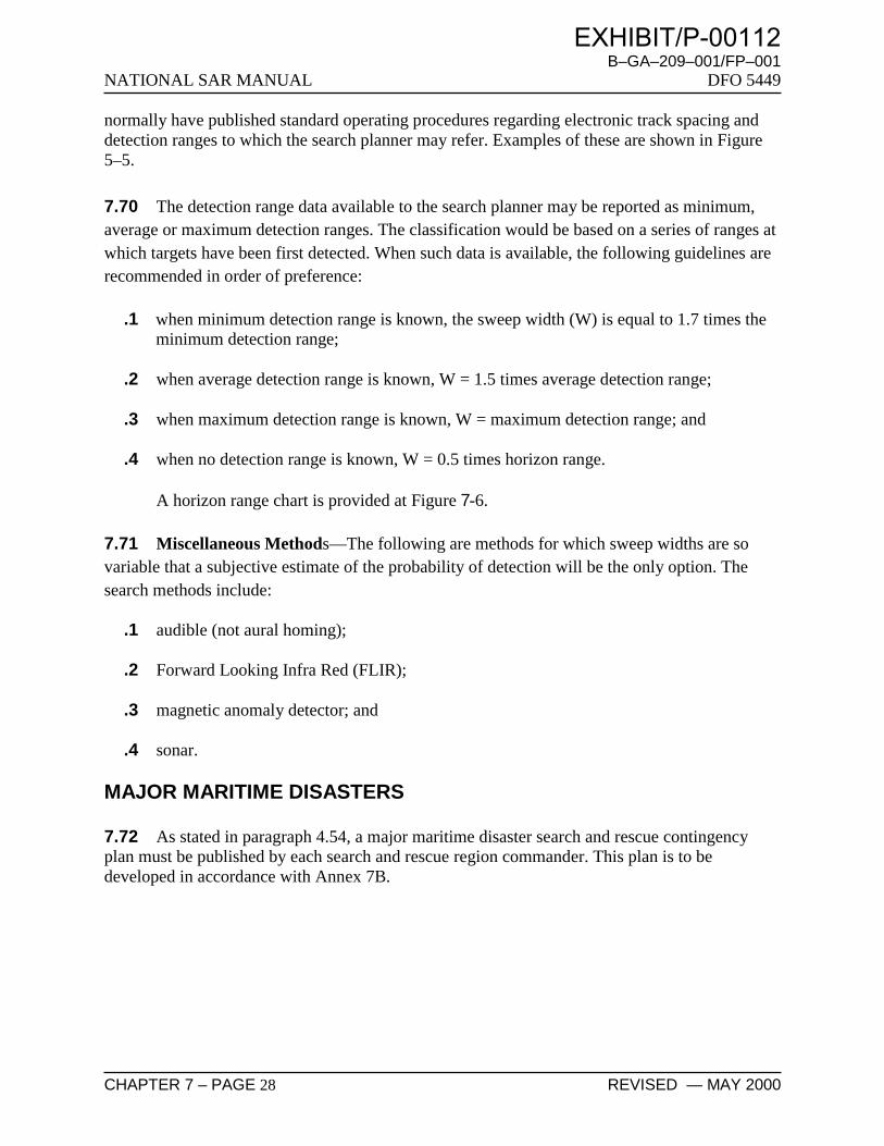
B–GA–209–001/FP–001NATIONAL SAR MANUAL DFO 5449
CHAPTER 7 – PAGE 28 REVISED — MAY 2000
normally have published standard operating procedures regarding electronic track spacing anddetection ranges to which the search planner may refer. Examples of these are shown in Figure5–5.
7.70 The detection range data available to the search planner may be reported as minimum,average or maximum detection ranges. The classification would be based on a series of ranges atwhich targets have been first detected. When such data is available, the following guidelines arerecommended in order of preference:
.1 when minimum detection range is known, the sweep width (W) is equal to 1.7 times theminimum detection range;
.2 when average detection range is known, W = 1.5 times average detection range;
.3 when maximum detection range is known, W = maximum detection range; and
.4 when no detection range is known, W = 0.5 times horizon range.
A horizon range chart is provided at Figure 7-6.
7.71 Miscellaneous Methods—The following are methods for which sweep widths are sovariable that a subjective estimate of the probability of detection will be the only option. Thesearch methods include:
.1 audible (not aural homing);
.2 Forward Looking Infra Red (FLIR);
.3 magnetic anomaly detector; and
.4 sonar.
MAJOR MARITIME DISASTERS
7.72 As stated in paragraph 4.54, a major maritime disaster search and rescue contingencyplan must be published by each search and rescue region commander. This plan is to bedeveloped in accordance with Annex 7B.
EXHIBIT/P-00112

B–GA–209–001/FP–001DFO 5449 NATIONAL SAR MANUAL
ORIGINAL — MAY 1998 CHAPTER 7 – PAGE 29
FIGURE 7–6 HEIGHT OF EYE VS. HORIZON RANGE
EXHIBIT/P-00112

NATIONAL SAR MANUAL B–GA–209–001/FP–001
DFO 5449
CHAPTER 7 – PAGE 30 ORIGINAL — MAY 1998
EXHIBIT/P-00112

B–GA–209–001/FP–001DFO 5449 NATIONAL SAR MANUAL
ORIGINAL — MAY 1998 CHAPTER 7 – PAGE 31
ANNEX 7A—POLICY FOR THE PROVISION OFTOWING ASSISTANCEBY VESSELS ENGAGED IN SAR OPERATIONS
1. Search and rescue units (SRUs) may provide towing assistance in accordance with theNational Search and Rescue Objective as stated in Chapter 1 and in accordance with theapplicable Coast Guard Fleet Order, provided it can be done without imperilling the assistingvessel or tow or persons on board.
2. If in the judgment of the rescue co-ordination centre/maritime rescue sub-centre/on-scenecommander or the commanding officer of the vessel on scene, the conditions for a distress orpotential distress are not present, and if suitable commercial assistance is readily available, thenthe provision of tow by an SRU unit will be denied.
CCG HELP IN OBTAINING THIRD PARTY ASSISTANCE
3. In certain situations, the Canadian Coast Guard (CCG) helps end users, such as a casualty, itsagent, or another party, in obtaining assistance from the private sector. It must be made clear toeach party at the outset who will pay for the assistance; therefore the following procedure is to beused:
a. If possible, the CCG will have the end user make a direct request to the supplier, ratherthan through the CCG.
b. If the CCG must relay the request:
(1) the CCG will, on receipt of the request from the end user, make clear that it is for hisaccount, and that a signed hard copy reflecting this understanding will be required assoon as possible;
(2) the CCG will, on contracting the supplier, make clear that the assistance is beingobtained for the end user’s account, and that a signed hard copy reflecting thisunderstanding will be required as soon as possible;
(3) and a hard copy of the understanding cannot be obtained, then all conversationsbetween the CCG, the end user and the supplier should be recorded and/or witnessed;and
EXHIBIT/P-00112

NATIONAL SAR MANUAL B–GA–209–001/FP–001
DFO 5449
CHAPTER 7 – PAGE 32 ORIGINAL — MAY 1998
(4) both the verbal and hard copy formats should include language that covers thefollowing four points:
(a) the supplier agrees to supply the following assistance (list) to the end user for theend user’s account,
(b) the end user confirms to the CCG that it will be responsible to pay the supplierfor the assistance supplied,
(c) the supplier and the end user accept that the CCG has no contractual or otherobligation in this arrangement, and
(d) the document must be signed and dated by the end user and/or supplier asappropriate.
EXHIBIT/P-00112

B–GA–209–001/FP–001DFO 5449 NATIONAL SAR MANUAL
ORIGINAL — MAY 1998 CHAPTER 7 – PAGE 33
ANNEX 7B—MAJOR MARITIME DISASTERSAR CONTINGENCY PLAN
FOREWORD
1. There is no fundamental distinction between a major maritime disaster and other maritimedistress incidents except in scale, and in the scope of the response that is required.
2. For the purposes of this plan, the term “major maritime disaster” means a maritime distressincident or other distress incident occurring on the waters of the search and rescue region forwhich the rescue co-ordination centre is responsible, and of such scale that the federal search andrescue (SAR) system alone can no longer co-ordinate, control and respond to all aspects of thesearch for and recovery of survivors, and/or the preservation of life. Normally in a majormaritime disaster the number of persons in distress is unusually large and vital support from otheragencies not normally party to, or used by, the SAR system is required.
3. The purpose of this contingency plan is to provide a framework for the expeditious andeffective resolution of a major maritime disaster by means of using all available resources to theirfull advantage.
SITUATION
4. a. As part of its responsibility for conducting search and rescue (SAR) services, the federalgovernment may be required to respond under extremely unfavourable weather and seaconditions to a maritime disaster of such magnitude that augmentation of the normal SARsystem may become necessary. Examples of such an event are the mass evacuation of anoil rig or the rescue of survivors of a large passenger vessel in difficulty.
b. The SAR system is capable of providing adequate response to most incidents, but at somepoint a maritime distress could escalate to such a degree that vital support from otheragencies is required.
c. Because of the necessity for fast reaction when a maritime incident occurs, as muchorganization as possible must be pre-planned and possible available resources identifiedbeforehand. To accomplish this, formal agreements must be established with outside
EXHIBIT/P-00112

NATIONAL SAR MANUAL B–GA–209–001/FP–001
DFO 5449
CHAPTER 7 – PAGE 34 ORIGINAL — MAY 1998
agencies which include matters such as single point of contact and on-scenecommunication frequencies.
d. Because of the very diverse nature of maritime activity in the various search and rescueregions (SRRs) of Canada, it is not possible to prepare a single, detailed national plan forresponse to major maritime disasters. This plan is therefore, general in nature; each SRRmust develop its own more specific regional contingency plans.
e. Contingency plans, particularly those involving outside agencies, must be regularlysubjected to formal exercises.
MISSION
5. To ensure the expeditious and effective use of all available resources in the event of amajor maritime disaster in the Canadian search and rescue area of responsibility.
EXECUTION
6. a. Concept of Operation—
(1) General—
(a) Factors to be considered include the number of persons involved and their needs,the environment, the location of the incident, the resources available and thesurvivor handling facilities.
(b) Speed and flexibility of response are essential. Primary search and rescue units(SRUs) and vessels of opportunity can be expected to provide the initialresponse, and may provide on scene co-ordination and control. Depending onthe nature and magnitude of the incident, augmentation of these unitss fromother sources may be required. Such response must be pre-planned and beincluded in the plan in the form of single points of contact, agreed upontasking/communications procedures, and capabilities.
(c) The main objective is to remove survivors from the distress situation toappropriate medical or other facilities in the shortest possible time. If evacuationto such facilities is not possible, all available steps must be taken to sustain lifeuntil evacuation can be accomplished.
EXHIBIT/P-00112

B–GA–209–001/FP–001DFO 5449 NATIONAL SAR MANUAL
ORIGINAL — MAY 1998 CHAPTER 7 – PAGE 35
(d) If the major maritime disaster involves a large number of survivors therequirement to establish one or more casualty staging areas may arise. From thispoint casualties will normally be turned over to the appropriate medicalauthorities; however, further SAR support, in the form of aeromedicalevacuation, may be required beyond the casualty staging areas.
(2) Response—
(a) The initial response to any maritime incident shall be consistent with internationalconventions and constitute an appropriate first level of response regardless of thesubsequent escalation of an incident into a major disaster.
(b) A major maritime disaster will likely require the assistance of agencies notnormally part of the search and rescue (SAR) system. The plan shall identifysuch agencies in the search and rescue region (SRR) and reflect the developmentof liaison and agreements with them through the proper authorities to ensure thatnecessary assistance will be available and effective when required.
(c) Should the augmentation of units be required, the recue co-ordination centre(RCC) shall use all available means to locate and task suitable vessels or aircraft.
(d) When it becomes apparent that a major maritime incident is in progress, on dutypersonnel must be authorized to call in additional personnel to meet therequirements of the search mission co-ordinator (SMC) organization until an SMis appointed. The SRR commander shall appoint a searchmaster (SM) who shallbe responsible for the co-ordination of the incident until its termination. The SMalong with an appropriate staff, may be detached from the RCC to a moresuitable location from which to co-ordinate the extraordinary response that maybe called for by the major maritime disaster. RCC standard operating proceduresare to establish appropriate procedures.
(3) Rescue—
(a) Depending upon the number of persons involved in a major maritime disaster itmay be necessary for the SM to formulate a detailed plan to allow theappropriate disposition of survivors, and to ensure that adequate medical andother post-rescue care will be available at the proper time and in the correctlocations. It will be important to maintain a high degree of flexibility in thisrespect, as there will be many variables such as the weather, the number andcondition of the casualties, the availability of evacuation units and the availabilityof suitable medical facilities.
EXHIBIT/P-00112

NATIONAL SAR MANUAL B–GA–209–001/FP–001
DFO 5449
CHAPTER 7 – PAGE 36 ORIGINAL — MAY 1998
(b) To this end, SRR commanders shall ensure the establishment and maintenance ofcommunication lines between RCC and the outside agencies specified in the plan.This includes the regular exercising of the plan.
(c) A successful response to a major maritime disaster will probably result in therecovery of a large number of survivors. These will require evacuation from thescene, possibly through an intermediate location which may not be particularlywell suited for handling survivors, to the casualty staging area. Furthertransportation may be required to deliver the casualties to suitable medicalfacilities. As soon as it is apparent that a large number of persons are involved,the SM shall canvass all appropriate authorities who may be able to makesuitable units available, so that these units may be tasked when necessary. Thelocation and availability of all such units shall be monitored and updatedthroughout the incident.
(d) Because of the number of agencies which may become involved in the rescue anddisposition of survivors in a major maritime disaster, and the possible difficulty inassigning responsibility for survivors at different stages of the events, SRRcommanders shall ensure that the advice of authorities such as medical andemergency measures will be readily available to the staff. Prior consultation inthis area ensures quick and effective response in situations where theidentification of the responsible agency might otherwise not be clear cut. Agreedprocedures, together with the names and locations of key personnel, should bereadily available to RCC controllers, and should be exercised regularly.
(4) Readiness—The Readiness status for primary SRUs applies to major maritimedisasters. SRR Commanders will of course make use of all primary or any other unitswhen and if they become needed and available.
SUPPORT
7. a. Concept of Support —
(1) General—The response to major maritime disasters will be supported initially bythe normal search and rescue (SAR) system. As requirements become known, thatsystem will be supported by all available and suitable agencies and resources.
(2) DND/CCG—As in other SAR incidents, commands or regions may be requested toprovide additional primary or secondary search and rescue units in the event of amajor maritime disaster.
EXHIBIT/P-00112

B–GA–209–001/FP–001DFO 5449 NATIONAL SAR MANUAL
ORIGINAL — MAY 1998 CHAPTER 7 – PAGE 37
(3) Other Departments—All federal departments, by government direction, arecommitted to respond to maritime SAR incidents when available and capable. Thesearch and rescue region (SRR) commander shall ensure that current lists of keypersonnel in the appropriate federal and provincial departments are available to therescue co-ordination centre (RCC) controllers.
(4) Civilian Resources—There are in Canada extensive resources available throughcivilian authorities or private companies and individuals for possible use inresponding to a major maritime disaster. SRR commanders shall ensure that theseare identified to the extent possible, and that adequate liaison is maintained tofacilitate their effective participation in an emergency. Lists of key (single point ofcontact) personnel shall be available in the plan.
(5) Foreign Support—Resources of other nations, in particular the United States CoastGuard, may be available to assist in a major maritime disaster. The use of theseresources shall be in accordance with current SAR agreements.
b. Communications—Communication procedures shall be in accordance with regionalcommunications plans. In general SAR communications procedures must remain flexibleand will depend on the capabilities of the resources involved, the nature and location ofthe incident and the response required. The plan must indicate all agreed upon on-scenefrequencies.
c. Public Information—The initial announcement of a potential or actual major maritimedisaster should be issued by the officer in charge of the RCC, if possible through theappropriate Department of National Defence Public Affairs Officer.
d. Reports and Returns —
(1) In the case of major maritime incidents, situation reports (SITREPs) shall be issuedat least daily throughout the rescue phase.
(2) In addition to the Final SITREP Operation Report, the RCC shall submit a MajorSAR Operation Report within 30 days after the conclusion of a major maritimedisaster. This report is to be forwarded to the National Defence Headquarters and tothe Director SAR, Canadian Coast Guard Headquarters, through the appropriatechannels.
EXHIBIT/P-00112

NATIONAL SAR MANUAL B–GA–209–001/FP–001
DFO 5449
CHAPTER 7 – PAGE 38 ORIGINAL — MAY 1998
COMMAND
8. a. The search and rescue region (SRR) commander shall command a major maritimedisaster search and rescue response: he will normally appoint a searchmaster (SM).
b. The SM shall normally report to the SRR commander through the officer in charge of the rescue co-ordination centre.
c. Because of the urgency associated with a major disaster, tasking is to be accomplished bythe most expeditious means available. Where tasking is directed by telephone or otherverbal means, it is to be confirmed by message or in other written form.
EXHIBIT/P-00112

B–GA–209–001/FP–001DFO 5449 NATIONAL SAR MANUAL
ORIGINAL — MAY 1998 CHAPTER 7 – PAGE 39
ANNEX 7C—SIMPLIFIED MINIMAXSEARCH PLANNING WORKSHEETS
FIGURE 7C–1 MINIMAX WORKSHEET 1—DATUM
EXHIBIT/P-00112

NATIONAL SAR MANUAL B–GA–209–001/FP–001
DFO 5449
CHAPTER 7 – PAGE 40 ORIGINAL — MAY 1998
FIGURE 7C–2 MINIMAX WORKSHEET 2
EXHIBIT/P-00112

B–GA–209–001/FP–001DFO 5449 NATIONAL SAR MANUAL
ORIGINAL — MAY 1998 CHAPTER 7 – PAGE 41
FIGURE 7C–3 MINIMAX WORKSHEET 3—SEARCH AREA
EXHIBIT/P-00112

NATIONAL SAR MANUAL B–GA–209–001/FP–001
DFO 5449
CHAPTER 7 – PAGE 42 ORIGINAL — MAY 1998
FIGURE 7C–4 MINIMAX WORKSHEET 4
EXHIBIT/P-00112

B–GA–209–001/FP–001DFO 5449 NATIONAL SAR MANUAL
ORIGINAL — MAY 1998 CHAPTER 7 – PAGE 43
FIGURE 7C–5 MINIMAX WORKSHEET 5—EFFORT ALLOCATION
EXHIBIT/P-00112

NATIONAL SAR MANUAL B–GA–209–001/FP–001
DFO 5449
CHAPTER 7 – PAGE 44 ORIGINAL — MAY 1998
FIGURE 7C–6 MINIMAX WORKSHEET 6
EXHIBIT/P-00112

B–GA–209–001/FP–001DFO 5449 NATIONAL SAR MANUAL
ORIGINAL — MAY 1998 CHAPTER 7 – PAGE 45
FIGURE 7C–7 MINIMAX WORKSHEET 7—DRIFT COMPENSATED SEARCH PATTERNS
EXHIBIT/P-00112

NATIONAL SAR MANUAL B–GA–209–001/FP–001
DFO 5449
CHAPTER 7 – PAGE 46 ORIGINAL — MAY 1998
FIGURE 7C–8 MINIMAX WORKSHEET 8
EXHIBIT/P-00112

B–GA–209–001/FP–001DFO 5449 NATIONAL SAR MANUAL
ORIGINAL — MAY 1998 CHAPTER 7 – PAGE 47
FIGURE 7C–9 MINIMAX WORKSHEET 9—WIND CURRENT CALCULATION
x =
x =
x =
EXHIBIT/P-00112

NATIONAL SAR MANUAL B–GA–209–001/FP–001
DFO 5449
CHAPTER 7 – PAGE 48 ORIGINAL — MAY 1998
FIGURE 7C–10 MINIMAX WORKSHEET 10—WIND CURRENT COEFFICIENT TABLE
EXHIBIT/P-00112

B–GA–209–001/FP–001DFO 5449 NATIONAL SAR MANUAL
ORIGINAL — MAY 1998 CHAPTER 7 – PAGE 49
FIGURE 7C–11 MINIMAX WORKSHEET 11—AVERAGE SURFACE WINDS AND LEEWAY
EXHIBIT/P-00112

NATIONAL SAR MANUAL B–GA–209–001/FP–001
DFO 5449
CHAPTER 7 – PAGE 50 ORIGINAL — MAY 1998
FIGURE 7C–12 MINIMAX WORKSHEET 12
EXHIBIT/P-00112

B–GA–209–001/FP–001DFO 5449 NATIONAL SAR MANUAL
ORIGINAL — MAY 1998 CHAPTER 7 – PAGE 51
ANNEX 7D—SWEEP WIDTH TABLES
Search object
Altitude 300 feet
Visibility (M)
Altitude 500 feet
Visibility (M)
1 3 5 10 15 20 30 1 3 5 10 15 20 30
Person in water * 0.1 0.1 0.1 0.1 0.1 0.1 0.1 0.0 0.1 0.1 0.1 0.1 0.1 0.1 Raft 1 person 0.3 0.7 0.9 1.2 1.3 1.3 1.3 0.3 0.7 0.9 1.2 1.4 1.4 1.4 Raft 4 persons 0.4 0.9 1.3 1.7 2.0 2.2 2.2 0.4 1.0 1.3 1.8 2.0 2.2 2.2 Raft 6 persons 0.4 1.1 1.5 2.1 2.5 2.7 2.7 0.4 1.1 1.5 2.2 2.5 2.8 2.8 Raft 8 persons 0.4 1.2 1.6 2.3 2.6 2.9 2.9 0.4 1.2 1.6 2.3 2.7 2.9 2.9 Raft 10 persons 0.4 1.2 1.7 2.4 2.9 3.2 3.2 0.4 1.2 1.7 2.5 2.9 3.2 3.2 Raft 15 persons 0.5 1.3 1.9 2.7 3.2 3.5 4.0 0.5 1.3 1.9 2.7 3.3 3.6 4.0 Raft 20 persons 0.5 1.4 2.1 3.1 3.7 4.2 4.8 0.5 1.5 2.1 3.2 3.8 4.2 4.8 Raft 25 persons 0.5 1.5 2.2 3.4 4.1 4.6 5.2 0.5 1.6 2.3 3.4 4.1 4.6 5.3
Power boat < 15 ft 0.4 0.8 1.1 1.4 1.6 1.7 1.7 0.4 0.9 1.2 1.5 1.7 1.8 1.8 Power boat 15–25 ft 0.5 1.6 2.4 3.5 4.3 4.8 4.8 0.5 1.7 2.4 3.6 4.3 4.8 4.8 Power boat 25–40 ft 0.6 2.1 3.3 5.3 6.6 7.6 9.1 0.6 2.1 3.3 5.3 6.7 7.7 9.1 Power boat 40–65 ft 0.6 2.6 4.5 8.1 10.9 13.1 16.4 0.6 2.7 4.5 8.1 10.9 13.1 16.5 Power boat 65–90 ft 0.6 2.8 5.0 9.7 13.5 16.6 21.6 0.6 2.8 5.0 9.8 13.5 16.7 21.7
Sailboat 15 feet 0.5 1.5 2.2 3.2 3.8 4.3 4.3 0.5 1.6 2.2 3.2 3.9 4.3 4.3 Sailboat 20 feet 0.6 1.8 2.6 4.0 4.9 5.6 5.6 0.6 1.8 2.7 4.1 5.0 5.6 5.6 Sailboat 25 feet 0.6 2.0 3.1 4.8 6.0 6.9 6.9 0.6 2.0 3.1 4.9 6.1 7.0 7.0 Sailboat 30 feet 0.6 2.3 3.6 5.9 7.5 8.8 10.6 0.6 2.3 3.6 5.9 7.6 8.8 10.6 Sailboat 40 feet 0.6 2.6 4.3 7.5 10.0 11.9 14.8 0.6 2.6 4.3 7.6 10.0 11.9 14.8 Sailboat 50 feet 0.6 2.7 4.6 8.4 11.3 13.6 17.3 0.6 2.7 4.6 8.4 11.3 13.7 17.3 Sailboat 65–75 feet 0.6 2.8 4.9 9.3 12.7 15.5 20.0 0.6 2.8 4.9 9.3 12.7 15.5 20.0 Sailboat 75–90 feet 0.6 2.8 5.1 9.9 13.7 16.9 22.1 0.6 2.8 5.1 9.9 13.7 17.0 22.1
Ship 90–150 feet 0.6 2.9 5.4 11.1 15.9 20.0 26.9 0.6 2.9 5.4 11.1 15.9 20.1 26.9 Ship 150–300 feet 0.6 3.0 5.7 12.5 18.8 24.7 34.8 0.6 3.0 5.7 12.5 18.9 24.7 34.8 Ship > 300 feet 0.7 3.0 5.8 13.2 20.6 27.9 41.4 0.7 3.0 5.8 13.2 20.6 27.9 41.4
* For search altitudes up to 500 feet only, the values given for sweep width for a person in watermay be increased by a factor of four if it is known that the person is wearing a personal flottationdevice.
FIGURE 7D–1 UNCORRECTED VISUAL SWEEP WIDTH TABLE—FIXED-WING AIRCRAFT—ALTITUDES 300 AND 500 FEET
EXHIBIT/P-00112

NATIONAL SAR MANUAL B–GA–209–001/FP–001
DFO 5449
CHAPTER 7 – PAGE 52 ORIGINAL — MAY 1998
Search object
Altitude 750 feet
Visibility (M)
Altitude 1000 feet
Visibility (M)
1 3 5 10 15 20 30 1 3 5 10 15 20 30
Person in water 0.0 0.1 0.1 0.1 0.1 0.1 0.1 0.0 0.1 0.1 0.1 0.1 0.1 0.1 Raft 1 person 0.3 0.7 0.9 1.2 1.4 1.4 1.4 0.3 0.7 0.9 1.2 1.4 1.4 1.4 Raft 4 persons 0.4 1.0 1.3 1.8 2.1 2.2 2.2 0.3 1.0 1.3 1.8 2.1 2.3 2.3 Raft 6 persons 0.4 1.1 1.6 2.2 2.6 2.8 2.8 0.4 1.1 1.6 2.2 2.6 2.8 2.8 Raft 8 persons 0.4 1.2 1.7 2.3 2.7 3.0 3.0 0.4 1.2 1.7 2.4 2.8 3.0 3.0 Raft 10 persons 0.4 1.3 1.8 2.5 3.0 3.3 3.3 0.4 1.3 1.8 2.6 3.0 3.3 3.3 Raft 15 persons 0.4 1.4 1.9 2.8 3.3 3.7 4.1 0.4 1.4 2.0 2.8 3.4 3.7 4.2 Raft 20 persons 0.5 1.5 2.2 3.2 3.8 4.3 4.9 0.4 1.5 2.2 3.2 3.9 4.3 4.9 Raft 25 persons 0.5 1.6 2.3 3.5 4.2 4.7 5.4 0.4 1.6 2.3 3.5 4.2 4.7 5.4
Power boat < 15 ft 0.4 0.9 1.2 1.6 1.8 1.9 1.9 0.4 1.0 1.3 1.7 1.8 2.0 2.0 Power boat 15–25 ft 0.5 1.7 2.4 3.6 4.4 4.9 4.9 0.5 1.7 2.5 3.7 4.4 5.0 5.0 Power boat 25–40 ft 0.6 2.1 3.3 5.3 6.7 7.7 9.2 0.5 2.2 3.4 5.4 6.8 7.8 9.3 Power boat 40–65 ft 0.6 2.7 4.5 8.2 10.9 13.1 16.5 0.6 2.7 4.5 8.2 10.9 13.1 16.6 Power boat 65–90 ft 0.6 2.8 5.0 9.8 13.5 16.7 21.7 0.6 2.8 5.1 9.8 13.6 16.7 21.7
Sailboat 15 feet 0.5 1.6 2.3 3.3 3.9 4.4 4.4 0.5 1.6 2.3 3.3 4.0 4.4 4.4 Sailboat 20 feet 0.5 1.8 2.7 4.1 5.0 5.7 5.7 0.5 1.8 2.7 4.2 5.1 5.7 5.7 Sailboat 25 feet 0.6 2.1 3.1 5.0 6.2 7.0 7.0 0.5 2.1 3.2 5.0 6.2 7.1 7.1 Sailboat 30 feet 0.6 2.3 3.6 6.0 7.6 8.9 10.7 0.6 2.3 3.6 6.0 7.6 8.9 10.7 Sailboat 40 feet 0.6 2.6 4.3 7.6 10.0 11.9 14.9 0.6 2.6 4.3 7.6 10.9 12.0 14.9 Sailboat 50 feet 0.6 2.7 4.6 8.5 11.4 13.7 17.4 0.6 2.7 4.6 8.5 11.4 13.7 17.4 Sailboat 65–75 feet 0.6 2.8 4.9 9.3 12.7 15.6 20.0 0.6 2.8 4.9 9.3 12.8 15.6 20.1 Sailboat 75–90 feet 0.6 2.8 5.1 9.9 13.8 17.0 22.2 0.6 2.8 5.1 9.9 13.8 17.0 22.2
Ship 90–150 feet 0.6 2.9 5.4 11.1 15.9 20.1 27.0 0.6 2.9 5.4 11.1 15.9 20.1 27.0 Ship 150–300 feet 0.6 3.0 5.7 12.5 18.9 24.7 34.9 0.6 3.0 5.7 12.5 18.9 24.7 34.9 Ship > 300 feet 0.7 3.0 5.8 13.2 20.6 27.9 41.4 0.6 3.0 5.8 13.2 20.6 27.9 41.4
FIGURE 7D–2 UNCORRECTED VISUAL SWEEP WIDTH TABLE—FIXED-WING AIRCRAFT—ALTITUDES 750 AND 1000 FEET
EXHIBIT/P-00112

B–GA–209–001/FP–001DFO 5449 NATIONAL SAR MANUAL
ORIGINAL — MAY 1998 CHAPTER 7 – PAGE 53
Search object
Altitude 1500 feet
Visibility (M)
Altitude 2000 feet
Visibility (M)
1 3 5 10 15 20 30 1 3 5 10 15 20 30
Person in water 0.0 0.0 0.0 0.0 0.0 0.1 0.1 0.0 0.0 0.0 0.0 0.0 0.0 0.1 Raft 1 person 0.2 0.7 0.9 1.3 1.4 1.4 1.4 0.1 0.6 0.9 1.2 1.4 1.4 1.4 Raft 4 persons 0.3 1.0 1.3 1.9 2.1 2.3 2.3 0.2 0.9 1.3 1.9 2.2 2.3 2.3 Raft 6 persons 0.3 1.1 1.6 2.3 2.6 2.9 2.9 0.2 1.1 1.6 2.3 2.7 2.9 2.9 Raft 8 persons 0.3 1.2 1.7 2.4 2.8 3.1 3.1 0.2 1.2 1.7 2.5 2.9 3.2 3.2 Raft 10 persons 0.3 1.3 1.8 2.6 3.1 3.4 3.4 0.2 12 1.8 2.7 3.1 3.5 3.5 Raft 15 persons 0.3 1.4 2.0 2.9 3.4 3.8 4.3 0.2 1.4 2.0 3.0 3.5 3.9 4.4 Raft 20 persons 0.4 1.5 2.2 3.3 4.0 4.4 5.1 0.3 1.5 2.2 3.4 4.0 4.5 5.1 Raft 25 persons 0.4 1.6 2.4 3.6 4.3 4.8 5.6 0.3 1.6 2.4 3.6 4.4 4.9 5.7
Power boat < 15 ft 0.3 1.0 1.3 1.7 2.0 2.1 2.1 0.2 1.0 1.3 1.8 2.0 2.2 2.2 Power boat 15–25 ft 0.4 1.7 2.5 3.7 4.5 5.1 5.1 0.3 1.7 2.5 3.8 4.6 5.1 5.1 Power boat 25–40 ft 0.5 2.2 3.4 5.5 6.8 7.9 9.4 0.3 2.2 3.4 5.5 6.9 8.0 9.5 Power boat 40–65 ft 0.5 2.6 4.5 8.2 11.0 13.2 16.6 0.4 2.6 4.5 8.3 11.0 13.3 16.7 Power boat 65–90 ft 0.5 2.8 5.1 9.8 13.6 16.7 21.8 0.4 2.8 5.0 9.8 13.6 16.8 21.8
Sailboat 15 feet 0.4 1.6 2.3 3.4 4.1 4.5 4.5 0.3 1.6 2.3 3.5 4.1 4.6 4.6 Sailboat 20 feet 0.4 1.8 2.8 4.2 5.2 5.8 5.8 0.3 1.8 2.8 4.3 5.2 5.9 5.9 Sailboat 25 feet 0.5 2.1 3.2 5.1 6.3 7.2 7.2 0.3 2.1 3.3 5.2 6.4 7.3 7.3 Sailboat 30 feet 0.5 2.3 3.7 6.1 7.7 9.0 10.8 0.3 2.3 3.7 6.1 7.8 9.1 10.9 Sailboat 40 feet 0.5 2.6 4.3 7.6 10.1 12.0 14.9 0.4 2.5 4.3 7.7 10.1 12.1 15.0 Sailboat 50 feet 0.5 2.7 4.6 8.5 11.4 13.8 17.5 0.4 2.7 4.6 8.6 11.5 13.9 17.5 Sailboat 65–75 feet 0.5 2.8 4.9 9.4 12.8 15.7 20.2 0.4 2.7 4.9 9.4 12.9 15.7 20.2 Sailboat 75–90 feet 0.5 2.8 5.1 10.0 13.8 17.1 22.3 0.4 2.8 5.1 10.0 13.9 17.1 22.3
Ship 90–150 feet 0.5 2.9 5.4 11.1 16.0 20.1 27.0 0.4 2.9 5.4 11.1 16.0 20.1 27.1 Ship 150–300 feet 0.5 3.0 5.7 12.5 18.9 24.7 34.9 0.4 2.9 5.7 12.5 18.9 24.7 34.9 Ship > 300 feet 0.6 3.0 5.8 13.2 20.7 27.9 41.4 0.5 3.0 5.8 13.2 20.7 27.9 41.5
FIGURE 7D–3 UNCORRECTED VISUAL SWEEP WIDTH TABLE—FIXED-WING AIRCRAFT—ALTITUDES 1500 AND 2000 FEET
EXHIBIT/P-00112

NATIONAL SAR MANUAL B–GA–209–001/FP–001
DFO 5449
CHAPTER 7 – PAGE 54 ORIGINAL — MAY 1998
Search object
Altitude 2500 feet
Visibility (M)
Altitude 3000 feet *
Visibility (M)
1 3 5 10 15 20 30 1 3 5 10 15 20 30
Person in water 0.0 0.0 0.0 0.0 0.0 0.0 0.0 0.0 0.0 0.0 0.0 0.0 0.0 0.0 Raft 1 person 0.1 0.5 0.8 1.2 1.4 1.4 1.4 0.1 0.5 0.8 1.1 1.3 1.3 1.3 Raft 4 persons 0.1 0.8 1.3 1.8 2.2 2.4 2.4 0.1 0.7 1.2 1.8 2.1 2.3 2.3 Raft 6 persons 0.1 1.0 1.5 2.3 2.7 2.9 2.9 0.1 0.9 1.5 2.2 2.7 2.9 2.9 Raft 8 persons 0.1 1.1 1.7 2.5 2.9 3.2 3.2 0.1 1.0 1.6 2.5 2.9 3.2 3.2 Raft 10 persons 0.2 1.2 1.8 2.7 3.2 3.5 3.5 0.1 1.1 1.8 2.7 3.2 3.5 3.5 Raft 15 persons 0.2 1.3 2.0 3.0 3.6 4.0 4.5 0.1 1.2 2.0 3.0 3.6 4.0 4.5 Raft 20 persons 0.2 1.4 2.2 3.4 4.1 4.6 5.2 0.1 1.4 2.2 3.4 4.1 4.6 5.3 Raft 25 persons 0.2 1.5 2.4 3.7 4.5 5.0 5.7 0.1 1.5 2.4 3.7 4.5 5.1 5.8
Power boat < 15 ft 0.1 0.9 1.3 1.8 2.1 2.2 2.2 0.1 0.8 1.3 1.8 2.1 2.3 2.3 Power boat 15–25 ft 0.2 1.6 2.5 3.8 4.6 5.2 5.2 0.1 1.6 2.5 3.9 4.7 5.3 5.3 Power boat 25–40 ft 0.2 2.1 3.4 5.6 7.0 8.1 9.6 0.2 2.1 3.4 5.6 7.1 8.1 9.7 Power boat 40–65 ft 0.3 2.6 4.5 8.3 11.3 13.3 16.7 0.2 2.5 4.5 8.3 11.1 13.4 16.8 Power boat 65–90 ft 0.3 2.7 5.0 9.8 13.6 16.8 21.9 0.2 2.7 5.0 9.9 13.7 16.8 21.9
Sailboat 15 feet 0.2 1.5 2.3 3.5 4.2 4.7 4.7 0.1 1.5 2.3 3.5 4.3 4.7 4.7 Sailboat 20 feet 0.2 1.8 2.8 4.3 5.3 6.0 6.0 0.1 1.7 2.8 4.4 5.3 6.0 6.0 Sailboat 25 feet 0.2 2.1 3.3 5.2 6.5 7.5 7.5 0.2 2.0 3.3 5.3 6.6 7.5 7.5 Sailboat 30 feet 0.2 2.2 3.7 6.1 7.8 9.1 11.0 0.2 2.2 3.7 6.2 7.9 9.2 11.1 Sailboat 40 feet 0.3 2.5 4.3 7.7 10.2 12.1 15.1 0.2 2.4 4.3 7.7 10.2 12.1 15.1 Sailboat 50 feet 0.3 2.6 4.6 8.6 11.5 13.9 17.6 0.2 2.6 4.6 8.6 11.6 14.0 17.7 Sailboat 65–75 feet 0.3 2.7 4.9 9.4 12.9 15.8 20.3 0.2 2.6 4.9 9.4 13.0 15.8 20.3 Sailboat 75–90 feet 0.3 2.8 5.1 10.0 13.9 17.2 22.4 0.2 2.7 5.1 10.0 14.0 17.2 22.5
Ship 90–150 feet 0.3 2.8 5.4 11.1 16.0 20.2 27.1 0.2 2.8 5.3 11.1 16.0 20.2 27.1 Ship 150–300 feet 0.3 2.9 5.6 12.5 18.9 24.8 35.0 0.2 2.8 5.6 12.5 18.9 24.8 35.0 Ship > 300 feet 0.3 2.9 5.7 13.2 20.7 27.9 41.5 0.2 2.9 5.7 13.2 20.7 27.9 41.5
* Visual searches are seldom conducted from altitudes above 3000 feet; however, for altitudes upto 5000 feet where visibility exceeds 3 M and target size exceeds 25 feet, the sweep widths givenfor 3000 feet remain applicable.
FIGURE 7D–4 UNCORRECTED VISUAL SWEEP WIDTH TABLE—
FIXED-WING AIRCRAFT—ALTITUDES 2500 AND 3000 FEET
EXHIBIT/P-00112

B–GA–209–001/FP–001DFO 5449 NATIONAL SAR MANUAL
ORIGINAL — MAY 1998 CHAPTER 7 – PAGE 55
Search object
Altitude 300 feet
Visibility (M)
Altitude 500 feet
Visibility (M)
1 3 5 10 15 20 30 1 3 5 10 15 20 30
Person in water * 0.1 0.1 0.1 0.1 0.1 0.1 0.1 0.0 0.1 0.1 0.1 0.1 0.1 0.1 Raft 1 person 0.4 0.9 1.2 1.5 1.7 1.7 1.7 0.4 0.9 1.2 1.6 1.8 1.8 1.8 Raft 4 persons 0.5 1.2 1.6 2.2 2.5 2.7 2.7 0.5 1.2 1.6 2.2 2.6 2.8 2.8 Raft 6 persons 0.5 1.4 1.9 2.7 3.1 3.4 3.4 0.5 1.4 1.9 2.7 3.2 3.5 3.5 Raft 8 persons 0.6 1.4 2.0 2.8 3.3 3.6 3.6 0.6 1.5 2.0 2.8 3.3 3.7 3.7 Raft 10 persons 0.6 1.5 2.1 3.0 3.6 3.9 3.9 0.6 1.6 2.2 3.1 3.6 4.0 4.0 Raft 15 persons 0.6 1.6 2.3 3.3 3.9 4.3 4.9 0.6 1.7 2.3 3.3 4.0 4.4 5.0 Raft 20 persons 0.6 1.8 2.6 3.8 4.5 5.1 5.8 0.6 1.8 2.6 3.8 4.6 5.1 5.9 Raft 25 persons 0.6 1.9 2.7 4.1 4.9 5.5 6.3 0.6 1.9 2.7 4.1 5.0 5.6 6.4
Power boat < 15 ft 0.5 1.1 1.4 1.9 2.1 2.2 2.2 0.5 1.2 1.5 1.9 2.2 2.3 2.3 Power boat 15–25 ft 0.7 2.0 2.9 4.3 5.2 5.8 5.8 0.7 2.0 2.9 4.3 5.2 5.8 5.8 Power boat 25–40 ft 0.8 2.5 3.8 6.1 7.7 8.9 10.6 0.8 2.5 3.9 6.2 7.8 9.0 10.7 Power boat 40–65 ft 0.8 3.1 5.1 9.2 12.2 14.7 18.5 0.8 3.1 5.1 9.2 12.3 14.7 18.5 Power boat 65–90 ft 0.8 3.3 5.7 10.8 15.0 18.4 23.9 0.8 3.3 5.7 10.8 15.0 18.4 23.9
Sailboat 15 feet 0.7 1.9 2.7 3.9 4.6 5.2 5.2 0.7 1.9 2.7 3.9 4.7 5.2 5.2 Sailboat 20 feet 0.7 2.2 3.2 4.8 5.9 6.6 6.6 0.7 2.2 3.2 4.8 5.9 6.7 6.7 Sailboat 25 feet 0.8 2.4 3.6 5.7 7.1 8.1 8.1 0.8 2.4 3.7 5.7 7.1 8.2 8.2 Sailboat 30 feet 0.8 2.7 4.2 6.8 8.7 10.1 12.2 0.8 2.7 4.2 6.9 8.7 10.2 12.3 Sailboat 40 feet 0.8 3.0 4.9 8.6 11.3 13.4 16.7 0.8 3.0 4.9 8.6 11.3 13.5 16.8 Sailboat 50 feet 0.8 3.1 5.2 9.5 12.7 15.3 19.3 0.8 3.1 5.2 9.5 12.7 15.3 19.4 Sailboat 65–75 feet 0.8 3.2 5.5 10.3 14.1 17.2 22.1 0.8 3.2 5.5 10.4 14.1 17.3 22.2 Sailboat 75–90 feet 0.8 3.3 5.7 11.0 15.2 18.7 24.3 0.8 3.3 5.7 11.0 15.2 18.7 24.4
Ship 90–150 feet 0.8 3.4 6.0 12.2 17.4 21.9 29.3 0.8 3.4 6.0 12.2 17.4 21.9 29.3 Ship 150–300 feet 0.8 3.4 6.3 13.6 20.4 26.6 37.3 0.8 3.4 6.3 13.6 20.4 26.6 37.3 Ship > 300 feet 0.8 3.5 6.4 14.3 22.1 29.8 43.8 0.8 3.5 6.4 14.3 22.1 29.8 43.8
* For search altitudes up to 500 feet only, the values given for sweep width for a person in watermay be increased by a factor of four if it is known that the person is wearing a personal flottationdevice.
FIGURE 7D–5 UNCORRECTED VISUAL SWEEP WIDTH TABLE—HELICOPTERS—ALTITUDES 300 AND 500 FEET
EXHIBIT/P-00112

NATIONAL SAR MANUAL B–GA–209–001/FP–001
DFO 5449
CHAPTER 7 – PAGE 56 ORIGINAL — MAY 1998
Search object
Altitude 750 feet
Visibility (M)
Altitude 1000 feet
Visibility (M)
1 3 5 10 15 20 30 1 3 5 10 15 20 30
Person in water 0.0 0.1 0.1 0.1 0.1 0.1 0.1 0.0 0.1 0.1 0.1 0.1 0.1 0.1 Raft 1 person 0.4 0.9 1.2 1.6 1.8 1.8 1.8 0.4 0.9 1.2 1.6 1.8 1.8 1.8 Raft 4 persons 0.5 1.2 1.7 2.3 2.6 2.8 2.8 0.5 1.2 1.7 2.3 2.6 2.9 2.9 Raft 6 persons 0.5 1.4 2.0 2.7 3.2 3.5 3.5 0.5 1.4 2.0 2.8 3.2 3.5 3.5 Raft 8 persons 0.5 1.5 2.1 2.9 3.4 3.7 3.7 0.5 1.5 2.1 2.9 3.4 3.8 3.8 Raft 10 persons 0.6 1.6 2.2 3.1 3.7 4.0 4.0 0.5 1.6 2.2 3.2 3.7 4.1 4.1 Raft 15 persons 0.6 1.7 2.4 3.4 4.0 4.5 5.0 0.6 1.7 2.4 3.5 4.1 4.5 5.1 Raft 20 persons 0.6 1.8 2.6 3.9 4.6 5.2 5.9 0.6 1.8 2.7 3.9 4.7 5.2 6.0 Raft 25 persons 0.6 1.9 2.8 4.2 5.0 5.6 6.5 0.6 1.9 2..8 4.2 5.1 5.7 6.5
Power boat < 15 ft 0.5 1.2 1.6 2.0 2.3 2.4 2.4 0.5 1.2 1.6 2.1 2.3 2.5 2.5 Power boat 15–25 ft 0.7 2.0 2.9 4.4 5.3 5.9 5.9 0.7 2.1 3.0 4.4 5.3 5.9 5.9 Power boat 25–40 ft 0.7 2.5 3.9 6.2 7.8 9.0 10.7 0.7 2.6 3.9 6.3 7.9 9.1 10.8 Power boat 40–65 ft 0.8 3.1 5.1 9.2 12.3 14.7 18.5 0.7 3.1 5.2 9.2 12.3 14.8 18.6 Power boat 65–90 ft 0.8 3.3 5.7 10.9 15.0 18.4 23.9 0.8 3.3 5.7 10.9 15.0 18.5 23.9
Sailboat 15 feet 0.7 1.9 2.7 4.0 4.8 5.3 5.3 0.6 1.9 2.8 4.0 4.8 5.4 5.4 Sailboat 20 feet 0.7 2.2 3.2 4.9 6.0 6.7 6.7 0.7 2.2 3.2 4.9 6.0 6.8 6.8 Sailboat 25 feet 0.7 2.5 3.7 5.8 7.2 8.3 8.3 0.7 2.5 3.7 5.8 7.3 8.3 8.3 Sailboat 30 feet 0.8 2.7 4.2 6.9 8.8 10.2 12.3 0.7 2.7 4.2 6.9 8.8 10.3 12.4 Sailboat 40 feet 0.8 3.0 4.9 8.6 11.3 13.5 16.8 0.7 3.0 4.9 8.6 11.4 13.5 16.8 Sailboat 50 feet 0.8 3.1 5.3 9.5 12.7 15.4 19.4 0.7 3.1 5.3 9.5 12.8 15.4 19.5 Sailboat 65–75 feet 0.8 3.2 5.5 10.4 14.2 17.3 22.2 0.8 3.2 5.6 10.4 14.2 17.3 22.2 Sailboat 75–90 feet 0.8 3.3 5.7 11.0 15.2 18.8 24.4 0.8 3.3 5.7 11.0 15.3 18.8 24.4
Ship 90–150 feet 0.8 3.4 6.0 12.2 17.4 21.9 29.3 0.8 3.4 6.0 12.2 17.4 21.9 29.3 Ship 150–300 feet 0.8 3.4 6.3 13.6 20.4 26.6 37.3 0.8 3.4 6.3 13.6 20.4 26.6 37.3 Ship > 300 feet 0.8 3.5 6.4 14.3 22.2 29.8 43.8 0.8 3.5 6.4 14.3 22.2 29.8 43.9
FIGURE 7D–6 UNCORRECTED VISUAL SWEEP WIDTH TABLE—HELICOPTERS—ALTITUDES 750 AND 1000 FEET
EXHIBIT/P-00112

B–GA–209–001/FP–001DFO 5449 NATIONAL SAR MANUAL
ORIGINAL — MAY 1998 CHAPTER 7 – PAGE 57
Search object
Altitude 1500 feet
Visibility (M)
Altitude 2000 feet
Visibility (M)
1 3 5 10 15 20 30 1 3 5 10 15 20 30
Person in water 0.0 0.0 0.0 0.1 0.1 0.1 0.1 0.0 0.0 0.0 0.0 0.0 0.1 0.1 Raft 1 person 0.3 0.9 1.2 1.6 1.8 1.8 1.8 0.2 0.8 1.2 1.6 1.8 1.8 0.8 Raft 4 persons 0.4 1.2 1.7 2.3 2.7 2.9 2.9 0.3 1.2 1.7 2.3 2.7 3.0 3.0 Raft 6 persons 0.4 1.4 2.0 2.8 3.3 3.6 3.6 0.3 1.4 2.0 2.8 3.3 3.6 3.6 Raft 8 persons 0.4 1.5 2.1 3.0 3.5 3.9 3.9 0.3 1.5 2.1 3.0 3.6 3.9 3.9 Raft 10 persons 0.4 1.6 2.2 3.2 3.8 4.2 4.2 0.3 1.6 2.3 3.3 3.9 4.2 4.2 Raft 15 persons 0.5 1.7 2.4 3.5 4.2 4.6 5.2 0.3 1.7 2.5 3.6 4.3 4.7 5.3 Raft 20 persons 0.5 1.9 2.7 4.0 4.8 5.3 6.1 0.4 1.8 2.7 4.0 4.9 5.4 6.2 Raft 25 persons 0.5 2.0 2.9 4.3 5.2 5.8 6.7 0.4 1.9 2.9 4.3 5.3 5.9 6.8
Power boat < 15 ft 0.4 1.3 1.7 2.2 2.5 2.6 2.6 0.3 1.3 1.7 2.3 2.6 2.7 2.7 Power boat 15–25 ft 0.6 2.1 3.0 4.5 5.4 6.1 6.1 0.4 2.1 3.0 4.5 5.5 6.1 6.1 Power boat 25–40 ft 0.6 2.6 4.0 6.3 7.9 9.2 10.9 0.5 2.6 4.0 6.4 8.0 9.3 11.0 Power boat 40–65 ft 0.7 3.1 5.2 9.3 12.4 14.8 18.6 0.5 3.0 5.2 9.3 12.4 14.9 18.7 Power boat 65–90 ft 0.7 3.2 5.7 10.9 15.1 18.5 24.0 0.5 3.2 5.7 10.9 15.1 18.5 24.0
Sailboat 15 feet 0.6 2.0 2.8 4.1 4.9 5.5 5.5 0.4 1.9 2.8 4.2 5.0 5.6 5.6 Sailboat 20 feet 0.6 2.2 3.3 5.0 6.1 6.9 6.9 0.5 2.2 3.3 5.1 6.2 7.0 7.0 Sailboat 25 feet 0.6 2.5 3.8 5.9 7.4 8.4 8.4 0.5 2.5 3.8 6.0 7.5 8.6 8.6 Sailboat 30 feet 0.6 2.7 4.2 7.0 8.9 10.3 12.5 0.5 2.7 4.3 7.0 9.0 10.4 12.6 Sailboat 40 feet 0.6 3.0 4.9 8.7 11.4 13.6 16.9 0.5 3.0 4.9 8.7 11.4 13.6 17.0 Sailboat 50 feet 0.7 3.1 5.3 9.6 12.8 15.5 19.5 0.5 3.1 5.3 9.6 12.9 15.5 19.6 Sailboat 65–75 feet 0.7 3.2 5.6 10.4 14.3 17.4 22.3 0.5 3.2 5.6 10.5 14.3 17.4 22.4 Sailboat 75–90 feet 0.7 3.3 5.7 11.1 15.3 18.8 24.5 0.5 3.2 5.7 11.1 15.4 18.9 24.6
Ship 90–150 feet 0.7 3.3 6.0 12.2 17.5 22.0 29.4 0.5 3.3 6.0 12.2 17.5 22.0 29.4 Ship 150–300 feet 0.7 3.4 6.3 13.6 20.4 26.6 37.3 0.5 3.4 6.3 13.6 20.4 26.6 37.4 Ship > 300 feet 0.7 3.4 6.4 14.3 22.2 29.8 43.9 0.6 3.4 6.4 14.3 22.2 29.8 43.9
FIGURE 7D–7 UNCORRECTED VISUAL SWEEP WIDTH TABLE—HELICOPTERS—ALTITUDES 1500 AND 2000 FEET
EXHIBIT/P-00112

NATIONAL SAR MANUAL B–GA–209–001/FP–001
DFO 5449
CHAPTER 7 – PAGE 58 ORIGINAL — MAY 1998
Search object
Altitude 2500 feet
Visibility (M)
Altitude 3000 feet *
Visibility (M)
1 3 5 10 15 20 30 1 3 5 10 15 20 30
Person in water 0.0 0.0 0.0 0.0 0.0 0.0 0.1 0.0 0.0 0.0 0.0 0.0 0.0 0.0 Raft 1 person 0.1 0.8 1.1 1.6 1.8 1.8 1.8 0.1 0.7 1.0 1.5 1.8 1.8 1.8 Raft 4 persons 0.2 1.1 1.6 2.3 2.7 3.0 3.0 0.1 1.0 1.6 2.3 2.7 3.0 3.0 Raft 6 persons 0.2 1.3 1.9 2.8 3.3 3.7 3.7 0.1 1.2 1.9 2.8 3.3 3.7 3.7 Raft 8 persons 0.2 1.4 2.1 3.1 3.6 4.0 4.0 0.1 1.3 2.1 3.1 3.6 4.0 4.0 Raft 10 persons 0.2 1.5 2.2 3.3 3.9 4.3 4.3 0.1 1.4 2.2 3.3 3.9 4.3 4.3 Raft 15 persons 0.2 1.7 2.5 3.6 4.3 4.8 5.4 0.2 1.6 2.4 3.7 4.4 4.9 5.5 Raft 20 persons 0.3 1.8 2.7 4.1 4.9 5.5 6.3 0.2 1.7 2.7 4.1 5.0 5.6 6.3 Raft 25 persons 0.3 1.9 2.9 4.4 5.3 6.0 6.9 0.2 1.9 2.9 4.4 5.4 6.0 6.9
Power boat < 15 ft 0.2 1.2 1.7 2.3 2.6 2.8 2.8 0.1 1.1 1.7 2.3 2.7 2.9 2.9 Power boat 15–25 ft 0.3 2.0 3.0 4.6 5.5 6.2 6.2 0.2 2.0 3.0 4.6 5.6 6.3 6.3 Power boat 25–40 ft 0.4 2.5 4.0 6.5 8.1 9.3 11.1 0.2 2.5 4.0 6.5 8.2 9.4 11.2 Power boat 40–65 ft 0.4 3.0 5.2 9.3 12.4 14.9 18.8 0.3 3.0 5.2 9.3 12.5 15.0 18.8 Power boat 65–90 ft 0.4 3.2 5.7 10.9 15.1 18.6 24.1 0.3 3.1 5.7 10.9 15.1 18.6 24.1
Sailboat 15 feet 0.3 1.9 2.8 4.2 5.1 5.6 5.6 0.2 1.9 2.8 4.3 5.1 5.7 5.7 Sailboat 20 feet 0.3 2.2 3.3 5.1 6.3 7.1 7.1 0.2 2.1 3.3 5.2 6.3 7.1 7.1 Sailboat 25 feet 0.4 2.5 3.8 6.1 7.6 8.7 8.7 0.2 2.4 3.9 6.1 7.7 8.8 8.8 Sailboat 30 feet 0.4 2.7 4.3 7.1 9.0 10.5 12.6 0.2 2.6 4.3 7.1 9.1 10.6 12.7 Sailboat 40 feet 0.4 2.9 4.9 8.7 11.5 13.7 17.0 0.3 2.9 4.9 8.7 11.5 13.7 17.1 Sailboat 50 feet 0.4 3.1 5.3 9.6 12.9 15.6 19.7 0.3 3.0 5.3 9.7 13.0 15.6 19.7 Sailboat 65–75 feet 0.4 3.1 5.6 10.5 14.3 17.5 22.4 0.3 3.1 5.6 10.5 14.4 17.5 22.5 Sailboat 75–90 feet 0.4 3.2 5.7 11.1 15.4 18.9 24.6 0.3 3.1 5.7 11.1 15.4 19.0 24.7
Ship 90–150 feet 0.4 3.3 6.0 12.2 17.5 22.0 29.4 0.3 3.2 6.0 12.2 17.5 22.0 29.5 Ship 150–300 feet 0.4 3.3 6.3 13.6 20.4 26.6 37.4 0.3 3.3 6.3 13.6 20.4 26.6 37.4 Ship > 300 feet 0.5 3.4 6.4 14.3 22.2 29.8 43.9 0.3 3.3 6.4 14.3 22.2 29.8 43.9
* Visual searches are seldom conducted from altitudes above 3000 feet; however, for altitudes upto 5000 feet where visibility exceeds 3 M and target size exceeds 25 feet, the sweep widths givenfor 3000 feet remain applicable.
FIGURE 7D–8 UNCORRECTED VISUAL SWEEP WIDTH TABLE—
HELICOPTERS—ALTITUDES 2500 AND 3000 FEET
EXHIBIT/P-00112

B–GA–209–001/FP–001DFO 5449 NATIONAL SAR MANUAL
ORIGINAL — MAY 1998 CHAPTER 7 – PAGE 59
Search object
Ships — ex. type 500
(90' All Weather Patrol Boat WPB)
Visibility (M)
Boats — ex. type 300
(41' Utility Boat UTB)
Visibility (M)
1 3 5 10 15 20 1 3 5 10 15 20
Person in water 0.3 0.4 0.5 0.5 0.5 0.5 0.2 0.2 0.3 0.3 0.3 0.3 Raft 1 person 0.9 1.8 2.3 3.1 3.4 3.7 0.7 1.3 1.7 2.3 2.6 2.7 Raft 4 persons 1.0 2.2 3.0 4.0 4.6 5.0 0.7 1.7 2.2 3.1 3.5 3.9 Raft 6 persons 1.1 2.5 3.4 4.7 5.5 6.0 0.8 1.9 2.6 3.6 4.3 4.7 Raft 8 persons 1.1 2.5 3.5 4.8 5.7 6.2 0.8 2.0 2.7 3.8 4.4 4.9 Raft 10 persons 1.1 2.6 3.6 5.1 6.1 6.7 0.8 2.0 2.8 4.0 4.8 5.3 Raft 15 persons 1.1 2.8 3.8 5.5 6.5 7.2 0.9 2.2 3.0 4.3 5.1 5.7 Raft 20 persons 1.2 3.0 4.1 6.1 7.3 8.1 0.9 2.3 3.3 4.9 5.8 6.5 Raft 25 persons 1.2 3.1 4.3 6.4 7.8 8.7 0.9 2.4 3.5 5.2 6.3 7.0
Power boat < 15 ft 0.5 1.1 1.4 1.9 2.1 2.3 0.4 0.8 1.1 1.5 1.6 1.8 Power boat 15–25 ft 1.0 2.0 2.9 4.3 5.2 5.8 0.8 1.5 2.2 3.3 4.0 4.5 Power boat 25–40 ft 1.1 2.5 3.8 6.1 7.7 8.8 0.8 1.9 2.9 4.7 5.9 6.8 Power boat 40–65 ft 1.2 3.1 5.1 9.1 12.1 14.4 0.9 2.4 3.9 7.0 9.3 11.1 Power boat 65–90 ft 1.2 3.2 5.6 10.7 14.7 18.1 0.9 2.5 4.3 8.3 11.4 14.0
Sailboat 15 feet 1.0 1.9 2.7 3.9 4.7 5.2 0.8 1.5 2.1 3.0 3.6 4.0 Sailboat 20 feet 1.0 2.2 3.2 4.8 5.9 8.6 0.8 1.7 2.5 3.7 4.6 5.1 Sailboat 25 feet 1.1 2.4 3.6 5.7 7.0 8.1 0.9 1.9 2.8 4.4 5.4 6.3 Sailboat 30 feet 1.1 2.7 4.1 6.8 8.6 10.0 0.9 2.1 3.2 5.3 6.6 7.7 Sailboat 40 feet 1.2 3.0 4.9 8.5 11.2 13.3 0.9 2.3 3.8 6.6 8.6 10.3 Sailboat 50 feet 1.2 3.1 5.2 9.4 12.5 15.0 0.9 2.4 4.0 7.3 9.7 11.6 Sailboat 65–75 feet 1.2 3.2 5.5 10.2 13.9 16.9 0.9 2.5 4.2 7.9 10.7 13.1 Sailboat 75–90 feet 1.2 3.3 5.7 10.8 15.0 18.4 0.9 2.5 4.4 8.3 11.6 14.2
Ship 90–150 feet 1.8 3.3 6.0 12.0 17.1 21.5 1.4 2.5 4.6 9.3 13.2 16.6 Ship 150–300 feet 1.8 3.4 6.3 13.4 20.1 26.1 1.4 2.6 4.9 10.3 15.5 20.2 Ship > 300 feet 1.8 3.4 6.4 14.1 21.8 29.2 1.4 2.6 4.9 10.9 16.8 22.5
FIGURE 7D–9 UNCORRECTED VISUAL SWEEP WIDTH TABLE—VESSELS AND SMALL BOATS
EXHIBIT/P-00112

NATIONAL SAR MANUAL B–GA–209–001/FP–001
DFO 5449
CHAPTER 7 – PAGE 60 ORIGINAL — MAY 1998
Liferaft Canopy Lights
Variables Below AverageConditions
AverageConditions
Above AverageConditions
Wind Speed 24 knots 18 knots 14 knots
Sweep Width 4.0 M 5.0 M 5.7 M
Unlighted Liferaft Canopy Targets
Significant Wave Height 3 to 5 feet 5.6 to 7.2 feet
Lateral Range 1.3 M 0.6 M
FIGURE 7D–10 UNCORRECTED VISUAL SWEEP WIDTH TABLE—NIGHT VISION GOGGLES
The following table gives the weather condition factor (fw). When two conditions are present, usethe values from the right hand column.
Target Type Winds > 15 knotsSeas 2–3 feet
Winds> 25 knotsSeas > 4 feet
Person in water 0.5 0.25
Boat < 30 feet 0.5 0.25
Other targets 0.9 0.9
FIGURE 7D–11 WEATHER CONDITION FACTOR
EXHIBIT/P-00112

B–GA–209–001/FP–001DFO 5449 NATIONAL SAR MANUAL
REVISED — MAY 2000 CHAPTER 7 – PAGE 61
Search objectFixed-wing aircraft
(speed in knots)Helicopter
(speed in knots)
< 150 180 210 60 90 120 140
Person in water 1,2 1,0 0,9 1,5 1,0 0,8 0,7Raft 1 to 4 persons 1,1 1,0 0,9 1,3 1,0 0,9 0,8Raft 6 to 25 persons 1,1 1,0 0,9 1,2 1,0 0,9 0,8
Power boat < 25 ft 1,1 1,0 0,9 1,2 1,0 0,9 0,8Power boat 25–40 ft 1,1 1,0 0,9 1,1 1,0 0,9 0,9Power boat 40–65 ft 1,1 1,0 1,0 1,1 1,0 0,9 0,9Power boat 65–90 ft 1,1 1,0 1,0 1,1 1,0 1,0 0,9Sailboat < 26 ft 1,1 1,0 0,9 1,2 1,0 0,9 0,9
Sailboat 30-52 ft 1,1 1,0 1,0 1,1 1,0 0,9 0,9Sailboat 65-90 ft 1,1 1,0 1,0 1,1 1,0 1,0 0,9Ship > 90 ft 1,0 1,0 1,0 1,1 1,0 1,0 0,9
Correcting for Search Aircraft Speed Correction (fv)—Enter the speed correction table withaircraft type and the speed flown. Read down the column to the search object. This value is thespeed correction. Interpolate as required. There is no speed correction for surface SRUs.
FIGURE 7D–12 SEARCH AIRCRAFT SPEED CORRECTION TABLE
If feedback from on-scene search and rescue units indicates search crews are excessively fatigued, reduce the sweep width values by 10 %:
ff = 0.8
FIGURE 7D–13 FATIGUE CORRECTION FACTOR
EXHIBIT/P-00112

B-GA-209-001/FP-001National SAR Manual DFO 5449
CHAPTER 7 – 62 REVISED – JUNE 2000
Use the fatigue correction factor when the crew on the SRU is likely fatigued. Crew willbe fatigued if they have been involved in a search for an extended period, and they mayexhibit signs of fatigue which include: missed communications; problems with memory;irritability; and increased time to complete tasks or make decisions.
EXHIBIT/P-00112

B-GA-209-001/FP-001 NATIONAL SAR MANUALDFO 5449
AMENDMENT – OCTOBER, 2000 CHAPTER 8 – PAGE 1
CHAPTER 8—COMMUNICATIONS PROCEDURES
TABLE OF CONTENTS ........................................................................1
Chapter 8 – COMMUNICATIONS PROCEDURESIntroduction ............................................................................................................. 3Minimum RCC/MRSC Communications Systems Requirements.......................... 3Recording of RCC/MRSC Communications .......................................................... 4Forwarding Aeronautical & Maritime Alerts to an RCC/MRSC ........................... 4Reception of Aeronautical & Maritime Alerts at an RCC/MRSC.......................... 5Vital Incident Data ................................................................................................. 5Distress Beacon Alerts-General .............................................................................. 6Cospas-Sarsat Beacon Alerts .................................................................................. 6Inmarsat-E EPIRB Alerts ........................................................................................ 8VHF-DSC EPIRB Alerts......................................................................................... 8Maritime Mobile & Maritime Mobile-Satellite Services – General ....................... 8Maritime Mobile Service-Radio Telephone Alerts................................................. 9Maritime Mobile Service-Digital Selective Calling (DSC) Alerts ......................... 9Maritime Mobile Service-SAR Transponder (SART) Alerts ............................... 11Maritime Mobile-Satellite Service-Inmarsat Alerts.............................................. 11Mobile Phone (Terrestrial & Satellite) Alerts ....................................................... 12Communications Searches .................................................................................... 13CCG VHF Direction Finding Assistance .............................................................. 14CF HF Direction Finding Assistance .................................................................... 14Broadcast-General ................................................................................................. 16Maritime Safety Information (MSI) Broadcast-General ....................................... 16MSI-DSC Broadcast.............................................................................................. 17MSI -RT Broadcast ............................................................................................... 17MSI -NAVTEX Broadcast .................................................................................... 17MSI -SafetyNet Enhanced Group Call (EGC) Broadcast ..................................... 17MSI-NOTSHIP & NAVAREA Warnings ............................................................ 18SARNET ............................................................................................................... 18Mission Co-ordination Communications .............................................................. 18AMVER ................................................................................................................ 19Vessel Traffic Services (VTS) & Reporting Systems........................................... 20SAR Vessels in VTS Zones .................................................................................. 20On-Scene Communications................................................................................... 20
Annex 8A – LIST OF SAR RELATED RADIO FREQUENCIES AND CHANNELS..... 21Distress, safety and calling.................................................................................... 21Mission Co-ordination .......................................................................................... 22On-scene ground search parties working frequencies........................................... 23Frequencies used by MCTS centres ...................................................................... 24
Annex 8B – MSI BROADCAST MESSAGE......................................................................... 25
EXHIBIT/P-00112

B-GA-209-001/FP-001 NATIONAL SAR MANUALDFO 5449
AMENDMENT – OCTOBER, 2000 CHAPTER 8 – PAGE 2
Annex 8C - MSI BROADCAST CANCELLATION MESSAGE.................................. 26Annex 8D - CF SUPPLEMENTARY RADIO SYSTEM HF DF SAR MESSAGE....... 27Annex 8E – AMVER .................................................................................................. 28
Vessels reporting ................................................................................................ 28Information......................................................................................................... 28SURPIC.............................................................................................................. 29Procedures .......................................................................................................... 29
EXHIBIT/P-00112

B-GA-209-001/FP-001 NATIONAL SAR MANUALDFO 5449
AMENDMENT – OCTOBER, 2000 CHAPTER 8 – PAGE 3
INTRODUCTION
8.1 Efficient operational communications systems, policies and procedures are vital to theoverall delivery of SAR services and to the success of every SAR mission. Communicationssupport; distress alerting, co-ordination, and locating functions by allowing:
.1 those in distress to alert the SAR system;
.2 the SAR system to respond and conduct its mission; and
.3 survivors to help SAR units respond and conduct a rescue.1
8.2 This chapter details communications system, policies and procedures to be used in theCanadian SRR in addition to procedures found in other publications such as the IAMSARManual.
MINIMUM RCC/MRSC COMMUNICATIONS SYSTEM REQUIREMENTS
8.3 RCC/ MRSC’s are the “hub” of Canada’s SAR System and shall effectively co-ordinatemulti-agency responses to aeronautical or maritime SAR incidents. To support co-ordination, thefollowing communications systems shall be provided in each RCC/MRSC:
.1 Telephone links (includes toll-free and regular emergency lines that are widelypublished, sufficient non-emergency lines and lines for the press);
.2 Fax links;
.3 Telex links (for A3 sea area and international communications);
.4 SARCOM links (dedicated CCG regional link between RCC/MRSC, MCTSCentres and ROCs);
.5 ADIS links (Automated Data Interchange System (ADIS) which is the CanadianATC communications network forming the international AFTN (AeronauticalFixed Telecommunications Network) - RCCs only);
.6 Military Messaging System links (RCCs only);
.7 Internet links;
.8 E-Mail links;
.9 Dedicated data links (as required);
.10 Dedicated voice links (as required);
1 IAMSAR Vol. 1 Chapter 4 paragraph 4.2.1
EXHIBIT/P-00112

B-GA-209-001/FP-001 NATIONAL SAR MANUALDFO 5449
AMENDMENT – OCTOBER, 2000 CHAPTER 8 – PAGE 4
.11 Inmarsat-C terminals (for A3 sea area SafetyNet monitoring);
.12 Wireless contingency back-up communications links (terrestrial and satellite);
.13 Contact list of facilities available to support SAR.
RECORDING OF RCC/MRSC COMMUNICATIONS
8.4 Operational communications links at RCC/MRSCs are to be equipped with recordingequipment. The policy applied to the custody and operations of the recording equipment is asfollows:
.1 all conversations on RCC/MRSC operational communication lines shall berecorded;
.2 tapes/disks shall be changed as required;
.3 recorded tapes/disks shall be numbered and dated;
.4 all recorded tapes/disks shall be kept for a minimum of 30 days;
.5 tapes/disks shall be impounded by the OIC RCC or RSMS MRSC whenever aninvestigation, judicial inquiry, etc., has been ordered or is anticipated and the OICRCC or RSMS MRSC shall be responsible for providing continuity of possessionensuring that tapes/disks are not recycled until released by higher authority;
.6 requests for recordings and transcripts should be directed to the OIC RCC or RSMSMRSC in writing;
.7 tapes/disks or transcripts are not to be released to other than DFO/Canadian CoastGuard, DND/Canadian Forces and TSB personnel unless ordered by the NationalDefence Headquarters or a court of law; and
.8 instantaneous playback of all operational telephone lines shall be provided.
FORWARDING AERONAUTICAL & MARITIME ALERTS TO AN RCC/MRSC
8.5 The need for the earliest possible alerting of the RCC/MRSC SAR Co-ordinator to actualor potential aeronautical and maritime incidents cannot be overemphasised. Any facility, eithermobile or fixed, that detects an alert of an actual or potential incident, as described below, shallforward, as soon as possible, all related information, including information on any actions taken,to an RCC/MRSC:
.1 all maritime or aeronautical SAR incidents;
EXHIBIT/P-00112

B-GA-209-001/FP-001 NATIONAL SAR MANUALDFO 5449
AMENDMENT – OCTOBER, 2000 CHAPTER 8 – PAGE 5
.2 any situation which may develop into a SAR incident; and
.3 any incident, which may involve or lead to danger to life, the environment or toproperty which may require action from the SAR services and/or other authorities.
RECEPTION OF AERONAUTICAL AND MARITIME ALERTS AT AN RCC/MRSC
8.6 The RCC/MRSC is alerted of aeronautical or maritime distress or other incidents, whichrequire a co-ordinated response from the SAR System, via numerous means. These meansinclude but are not limited to;
.1 Radiotelephone (monitored by ATC, MCTS or others),
.2 Radio digital selective calling (monitored by MCTS),
.3 Distress beacons (monitored by Cospas-Sarsat, Inmarsat or MCTS-for VHF-DSCbeacons),
.4 Inmarsat,
.5 SARTs,
.6 Reports of official visual or audible distress signals or other indications of distress,
.7 Reports of overdue or missing aircraft ,
.8 Reports of overdue or missing vessels and persons at sea,
.9 Reports of overdue or missing aircraft or vessels participating in an ATC, VTS oroffshore reporting system,
.10 Requests for assistance via mobile phone aboard an aircraft or vessel or on behalf ofan aircraft or vessel,
Regardless of the means and method, whether regulated by aeronautical or maritimeregulations or not, by which a RCC/MRSC SAR Co-ordinator has been alerted of an actual orpotential aeronautical or maritime incident, the SAR Co-ordinator shall take action to resolve theincident.
VITAL INCIDENT DATA
8.7 Regardless of the means by which an alert is transmitted to an RCC/MRSC, the SAR Co-ordinator shall, as a minimum, obtain data vital to co-ordinating the effective resolution of
EXHIBIT/P-00112

B-GA-209-001/FP-001 NATIONAL SAR MANUALDFO 5449
AMENDMENT – OCTOBER, 2000 CHAPTER 8 – PAGE 6
the incident. A list of this data is found in IAMSAR Vol 2 Appendix C. At no time shall the SARCo-ordinator delay the response to a life-threatening incident, if all vital data is not readilyavailable.
DISTRESS BEACON ALERTS - GENERAL
8.8 There are three types of distress beacons regulated for use:
.1 Cospas-Sarsat 121.5/243/406 MHz ELT/EPIRB/PLB
.2 Inmarsat-E EPIRB
.3 VHF-DSC EPIRB
8.9 The response to ELT and EPIRB alerts falls within the DND/CCG mandate. Theresolution of PLB alerts does not fall within this mandate and the appropriate authority will besought to resolve the incident. Normally, the Canadian Mission Control Centre (CMCC) willdisseminate Cospas-Sarsat PLB alerts for resolution to a provincial/territorial SAR point ofcontact (SPOC). In the absence of, or in corroboration with, other information, a distress beaconalert is to be considered as a sign of distress and shall be actioned immediately by the responsibleRCC/MRSC until resolved.
COSPAS-SARSAT BEACON ALERTS
8.10 Alerts from 121.5/243 MHz and 406 MHz distress beacons (ELT/EPIRB/PLB) arereceived by the Cospas-Sarsat constellation of geostationary (GOES) and low-earth orbiting(LEO) satellites and relayed to ground stations called local users terminals (LUTs). Alerts arethen forwarded to the associated mission control centre (MCC) for processing and determinationof position. The Canadian MCC (CMCC) at RCC Trenton shall forward all ELT and EPIRBalerts to the RCC responsible for the SRR in which the beacon is detected. The RCC or MRSCSAR Co-ordinator shall then action the alert to resolve the incident.
EXHIBIT/P-00112

B-GA-209-001/FP-001 NATIONAL SAR MANUALDFO 5449
AMENDMENT – OCTOBER, 2000 CHAPTER 8 – PAGE 7
8.11 121.5/243 MHz beacons – These are uncoded and thus have no associated registrationdatabase. In the absence of other corroborating information, an alert is normally considered to bereceived at the RCC when CMCC “merges” two unique “hits” to form a CMCC ‘case”.
8.12 406 MHz beacons – These are coded, and when properly registered, identify the aircraftor vessel and give contact information, which the SAR Co-ordinator shall use in resolvingincidents. Some also transmit a low-power 121.5 MHz homing signal. The Canadian 406 MHzbeacon registry is maintained by the National Search and Rescue Secretariat (NSS) (toll-free inCanada 1-800-727-9414 or 1-613-996-1504) and accessed by CMCC on a 24/7 basis. SAR Co-ordinators who encounter improperly registered beacons shall advise CMCC.
8.13 Coded Cospas-Sarsat beacons transmit a bit-code that contains vital information,including the 15-digit hexidecimal code, which is used to cross-reference against the distressbeacon registry for each country. Some beacons may have a GPS position fixing option, in whichcase, the position is transmitted within the bit-code. Also included is a “beacon ID” which iscoded using one of three protocols:
.1 Call sign;
.2 MMSI; or
.3 Serial number not related to any other registry.
EXHIBIT/P-00112

B-GA-209-001/FP-001 NATIONAL SAR MANUALDFO 5449
AMENDMENT – OCTOBER, 2000 CHAPTER 8 – PAGE 8
This ID may be useful to cross-reference against other registries.
8.14 406 MHz Cospas-Sarsat beacon alerts are instantaneously detected by the GOESsatellites which, however, cannot ascertain the beacon’s position because there is no Dopplershift. A position cannot be calculated until a LEO satellite detects the signal. An unlocated signalis initially passed to the MCC of the country that holds the database for that beacon, until aprobable position of the beacon can be ascertained. If it is a Canadian registered beacon, CMCCshall forward the alert to the RCC responsible for the SRR in which the aircraft or vesselnormally operates.
INMARSAT-E EPIRB ALERTS
8.15 Inmarsat-E is the system that supports the operation of L-band EPIRBs. These beaconsprovide ship-to-shore distress alerting for ships operating within the Inmarsat satellite coveragefootprint. These beacons do not have a homing signal due to the accuracy of the on-board GPSpositioning. A SART may be built into the beacon for homing but is not a requirement. Thesebeacons are registered in the Inmarsat registry, which contains vital information on the vesselcarrying the beacon.
8.16 When an Inmarsat Land Earth Station (LES) receives a beacon distress alert, it isforwarded, with the accompanying registry information, held at the LES, for action by the RCCassociated with that LES. If the position is outside that RCC’s SRR, the RCC shall pass the alertto the responsible RCC for resolution. Once received at the responsible Canadian RCC/MRSC,the SAR Co-ordinator shall then action the alert to resolve the incident. If the vessel data is notprovided with the alert, it can be obtained from an Inmarsat Operator.
VHF-DSC EPIRB ALERTS
8.17 Ships operating exclusively in an “A1 sea area” may, in lieu of satellite EPIRBs, useVHF-DSC EPIRBs transmitting on channel 70. These EPIRBs transmit an MMSI, GPS positionand other vital information. They are registered in the national MMSI database for each country.In Canada, distress alerts from these beacons are detected by CCG MCTS Centres. The MCTSOfficer shall then forward all alert information to the appropriate RCC/MRSC as soon aspossible. The RCC/MRSC SAR Co-ordinator shall then action the alert to resolve the incidentsimilarly to VHF-DSC distress alerts.
MARITIME MOBILE AND MARITIME MOBILE-SATELLITE SERVICES - GENERAL
8.18 The Maritime Mobile Service is defined by the ITU as, “A mobile (communications)service between coast stations and ship stations, or between ship stations, or between associatedon-board communications stations; survival craft stations and emergency position-indicatingradiobeacon stations may also participate in this service”. The Maritime Mobile-Satellite Serviceis defined by the ITU as, “A mobile-satellite (communications) service in which mobile earthstations are located on board ships: survival craft stations and emergency position-indicatingradiobeacon stations may also participate in this service”. These services interface with carriagerequirements and other shore-side services, required under SOLAS and the International
EXHIBIT/P-00112

B-GA-209-001/FP-001 NATIONAL SAR MANUALDFO 5449
AMENDMENT – OCTOBER, 2000 CHAPTER 8 – PAGE 9
Convention on Maritime SAR, to form the overall “GLOBAL MARITIME DISTRESS &SAFETY SYSTEM” (GMDSS).
8.19 In the Canadian SRR, CCG Marine Communications and Traffic Services (MCTS)Centres provide 24/7 “coast watching” services required for the detection of all distress alertsissued within the maritime mobile service. Further, these Centres provide the follow-onbroadcast and mobile communications services required during the resolution of a SAR incident.
MARITIME MOBILE SERVICE – RADIOTELEPHONE ALERTS
8.20 Upon receipt of a VHF/MF/HF RT transmitted alert at an MCTS Centre, the duty MCTSOfficer (MCTSO) will take action in accordance with (IAW) the MCTS National StandardsManual. The MCTS Officer will obtain relevant vital data from the source. Further, the MCTSOfficer shall broadcast, on behalf of the Master of the distressed vessel, a “Mayday Relay” if it isclear that there are persons in distress and more assistance is required. The MCTS Officer shallthen forward, as soon as possible, all information related to alerts and any actions taken to theRCC/MRSC SAR Co-ordinator via voice and follow-up with a hardcopy message. The RCC/MRSC SAR Co-ordinator shall then action the alert to resolve the incident (refer to Annex 1for frequencies).
MARITIME MOBILE SERVICE – DIGITAL SELECTIVE CALLING (DSC) ALERTS
8.21 DSC distress and other alerts are detected by: CCG MCTS Centres equipped with DSC;foreign coast radio stations; and vessels within propagation range of the alert broadcast (refer toAnnex 1 for DSC frequencies).
.1 DSC alert message composition:Format specifier:• Distress;• Urgency;• Safety.
.2 9-digit Maritime Mobile Service Identity (MMSI):• Ship station: MIDXXXXXX;• Coast station: 00MIDXXXX;
where MID is Maritime Identification Digits or country code and X is any figure from 0 to 9.Nature of the distress (default setting is “undesignated”);Distress co-ordinates. (default is “no position information” or 99999 99999);Time UTC: hhmm (default is “no time information” or 8888);Mode of subsequent communication (default is “radiotelephony”).
8.22 MCTS actions upon receipt of a VHF-DSC distress alert – If the distress co-ordinatesare within an MCTS Centre’s area of responsibility, the MCTS Officer will immediately transmita VHF-DSC distress alert acknowledgement. If no co-ordinates are transmitted or if the
EXHIBIT/P-00112

B-GA-209-001/FP-001 NATIONAL SAR MANUALDFO 5449
AMENDMENT – OCTOBER, 2000 CHAPTER 8 – PAGE 10
co-ordinates are outside VHF range and it is not being acknowledged, the MCTS Officer willacknowledge. After acknowledgement, RT communications will be established on VHF CH 16in order to obtain vital data. If required, a Mayday Relay may be broadcast. The MCTS Officerwill then advise the RCC/MRSC as soon as possible.
8.23 MCTS actions upon receipt of a MF/HF DSC distress alert - If the distress co-ordinates are within the Canadian SRR, the most appropriate MCTS Centre will immediatelytransmit a MF/HF DSC distress alert acknowledgement on the same frequency. Afteracknowledgement, communications will be established on RT or NBDP using the associatedfrequency in order to obtain vital information. If required, a Mayday Relay may be broadcast.The MCTS Officer will then advise the RCC/MRSC. If the distress co-ordinates are outside theCanadian SRR or no co-ordinates were included in the transmission a DSC distress alertacknowledgement will not be sent without consultation with the RCC/MRSC SAR Co-ordinator.
8.24 RCC/MRSC actions upon notification of a DSC distress alert - The SAR Co-ordinatorshall:
.1 Obtain distressed vessel’s MMSI, and other vital data;
.2 If not received directly by an MCTS Centre, obtain the receiving station’s name,MMSI, position, frequency alert received on, time of receipt, and any actions taken;
.3 If the position is within the RCC’s SRR or MRSC’s SRS, assume SAR Mission Co-ordinator (SMC) and continue to resolve the incident;
.4 If the position is outside the RCC’s SRR or MRSC’s SRS, attempt to passresponsibility to the appropriate RCC/MRSC. If this is not possible, or no position istransmitted, continue to action the incident IAW the policy of “First RCC” detailed inthe IAMSAR Manual Vol 2, chapter 3, section 3.6. Further, advise the Flag State forthat particular vessel.
8.25 If the MCTS Centre or other station that received the alert is unable to communicate withthe vessel that sent the alert, RCC/MRSC shall establish communications directly with the vesselor shore-side contact for the vessel by:
.1 Identifying the distressed vessel and obtaining registry information from a MMSIregistry and attempting to establish communications using all available means such asInmarsat; and/or
.2 Identifying other vessels in the area of the distressed vessel using MSI broadcasts andAMVER, and request they attempt to contact the distressed vessel; and/or
.3 Contacting other RCCs and requesting any further information they may have on thedistressed vessel; and/or
EXHIBIT/P-00112

B-GA-209-001/FP-001 NATIONAL SAR MANUALDFO 5449
AMENDMENT – OCTOBER, 2000 CHAPTER 8 – PAGE 11
.4 Contacting the 24/7 SAR data provider for the national MMSI or Distress Beaconregistries.
8.26 The Canadian MMSI Registry is maintained by Industry Canada and is available via theInternet. The ITU also maintains an international MMSI registry available via the Internet. RCCHalifax is designated the 24/7 emergency “SAR Data Provider” for the Canadian MMSI registry.
MARITIME MOBILE SERVICE – SAR TRANSPONDER (SART) ALERTS
8.27 Search and Rescue (radar) Transponders (SARTs) are used for locating survivors by SARunits and are also to be considered as a distress alert. The SART should normally be taken to thesurvival craft when abandoning the vessel. They transmit a signal in the X-band (3 cm) radiofrequency used by common aeronautical and maritime radar. They are detected at variousdistances depending on scanner height, tuning and band-width of the radar.
8.28 Any RCC/MRSC SAR Co-ordinator that is advised of the detection of a SART shallaction the alert to resolve the incident.
MARITIME MOBILE-SATELLITE SERVICE – INMARSAT ALERTS
8.29 Inmarsat A/B/C distress and urgency alerts transmitted from a vessel are first detected byan Inmarsat LES and forwarded directly to its associated RCC. RCC Halifax is associated withthe LES at Laurentides, Quebec, for Inmarsat B/C services. A vessel in distress in Canada’s SRRusing an LES other than Laurentides will have its automatic distress alert sent to the RCCassociated with the LES which that vessel has chosen. Vessels may also contact any RCC/MRSCdirectly by telephone, fax, or telex using Inmarsat A/B/C.
8.30 RCC/MRSC actions upon receipt or notification of an Inmarsat alert – The SAR Co-ordinator shall:
.1 If the distress position is within their SRR or SRS, acknowledge reception of the alertby establishing contact with the vessel via any means and resolve the incident;
.2 If the position is outside their SRR or SRS, acknowledge reception of the alert andattempt to pass responsibility to the appropriate RCC/MRSC. If this is not possible,the SAR Co-ordinator shall continue to action the incident IAW the policy of “FirstRCC” detailed in the IAMSAR Vol 2, chapter 3, section 3.6. SAR Co-ordinators shalluse the format for “RCC-RCC Distress Alert Information” provided in IAMSAR Vol2, Appendix B, for the forwarding of distress alerts between RCCs;
.3 Use the services of the Inmarsat LES or Network Operations Centre (NOC) operatorto help establish direct follow-on communications, if required.
EXHIBIT/P-00112

B-GA-209-001/FP-001 NATIONAL SAR MANUALDFO 5449
AMENDMENT – OCTOBER, 2000 CHAPTER 8 – PAGE 12
8.31 Inmarsat Terminal Return ID – The return ID is a “hidden” Inmarsat ID assigned to aship earth station used by the system for security purposes . Occasionally alerts are received fromterminals that have been installed on a ship but have not yet been commissioned on the Inmarsatsystem. In these cases there will be no terminal ID to identify the vessel. The return ID isprogrammed into the terminal at the manufacturing stage, as opposed to a terminal ID, which isassigned by Inmarsat when the SES is commissioned. It can be obtained from the Inmarsat NOCor the LES Operator that received the distress alert. Inmarsat equipment manufacturers haverecords to match return IDs with serial numbers and should be able to identify the dealer towhom the terminal was sold.
8.32 Follow-on Inmarsat communications – Each Inmarsat system provides differentservices and can be recognised by the first digit of the Inmarsat Mobile Number (IMN):
Type First Digit ServiceInmarsat-A 1 telephone, telex, fax, dataInmarsat-B 3 telephone, telex, fax, dataInmarsat-C 4 telex, send fax, dataInmarsat-M 6 telephone, fax, data
8.33 To call a vessel on Inmarsat, follow the instructions in the Inmarsat Users’ Manual or usethe assistance of the LES or NOC Operator.
8.34 Inmarsat-C shore-to-ship distress priority message (DMSG) – An RCC/MRSC mayinitiate an Inmarsat-C DMSG message for follow-on communications. This Internet-basedservice gives the shore-to-ship message the same priority for immediate delivery as a distressmessage originating from a ship. An Inmarsat-C DMSG can be sent from the RCC/MRSC or anMCTS Centre with access to the service. An acknowledgement request can be attached to themessage, which means the LES will send a positive delivery notification (PDN) to the originatorwhen the message is delivered to the vessel, thus ensuring that the message has been deliveredon-board the vessel.
8.35 Barred Inmarsat terminals – Inmarsat may bar a ship’s terminal from accessing thesystem due to non-payment of invoices or improper use. The ship will still be able to send adistress alert to an RCC via a LES even when normal access is barred. In the event thatRCC/MRSC receives a distress alert from a barred terminal, the SAR Co-ordinator can requestthat the Operator at the LES that received the alert, activate the terminal for distresscommunications. Since reception of MSI Broadcasts is a requirement in the GMDSS, all barredterminals will still receive all priorities of EGC broadcasts.
MOBILE PHONE (TERRESTRIAL AND SATELLITE) ALERTS
8.36 Mobile (Cellular) Telephones – Although a cellular phone is not an approved norsuitable substitute for radiotelephone distress communications, RCC/MRSC SAR Co-ordinatorsmust be capable of co-ordinating the response to incidents alerted via this method. In Canada,cellular users can call; *16 to be connected directly to an MCTS Centre, 911 to be connected
EXHIBIT/P-00112

B-GA-209-001/FP-001 NATIONAL SAR MANUALDFO 5449
AMENDMENT – OCTOBER, 2000 CHAPTER 8 – PAGE 13
directly with a Public Safety Answering Point (PSAP), or the RCC/MRSC directly. In addition tothe vital data, the following information should also be initially obtained:
.1 Caller’s complete cellular telephone number;
.2 Cellular service provider;
.3 Roam number if needed to recall caller;
.4 An alternative point of contact; and
.5 Remaining battery power.
8.37 The caller should be advised to keep the cellular phone on and ensure any call forwardingor messaging is disabled. If the cellular telephone has insufficient battery charge to be left on,then an appropriate communication schedule should be arranged. Further, if possible, the callershould attempt to make a distress alert on standard distress radiotelephone frequencies.
8.38 RCC/MRSCs should make arrangements with the cellular service providers’ regionalNetwork Operation Centres (NOCs) to provide SAR assistance such as:
.1 Directory assistance;
.2 When last and next call is made from a particular cellular number;
.3 Which cell site a particular call was received through; and
.4 Locating services, where available.
8.39 Satellite Communications Services – Although many mobile satellite communicationsservices are not regulated for the provision of aeronautical or maritime distress alerting, nor aresuitable substitutes for approved distress communications, RCC/MRSCs must be capable of co-ordinating the response to incidents alerted via this method. There are numerous internationalservices (systems) used aboard aircraft and vessels for the provision of: voice; fax; e-mail; anddata communications. Quite often these services automatically interface with publiccommunications networks.
8.40 Most satellite service providers maintain a Network Operations Centre (NOC) that isstaffed 24/7. RCC/MRSCs should maintain contact information for these NOCs to assist inestablishing follow-on communications and obtaining vital data in the event of an alert beingtransmitted via one of these services. If an alert is transmitted via one of these services, eitherdirectly to an RCC/MRSC or relayed to an RCC/MRSC via another source, the SAR Co-ordinator shall then action the alert to resolve the incident.
COMMUNICATIONS SEARCHES
8.41 In the uncertainty or alert phases of an incident, the SAR Co-ordinator shall, if required,initiate a communications search for overdue or missing aircraft and vessels, as per IAMSARVol 2, Appendix D.
EXHIBIT/P-00112

B-GA-209-001/FP-001 NATIONAL SAR MANUALDFO 5449
AMENDMENT – OCTOBER, 2000 CHAPTER 8 – PAGE 14
CCG VHF DIRECTION FINDING ASSISTANCE
8.42 Some MCTS Centres have the capability to DF on selected VHF aeronautical andmaritime frequencies. SAR Co-ordinators should familiarise themselves as to which MCTSCentres provide which type of DF services. These centres should be contacted if their assistanceis likely to contribute to the resolution of the SAR incident.
8.43 Under regulation, all primary SAR vessels have a VHF–FM DF capability which shouldbe used to the maximum extent.
CF HF DIRECTION FINDING ASSISTANCE
8.44 There are two HF DF nets in Canada, one operated by the Canadian ForcesSupplementary Radio System and the other by Industry Canada, that may be used by the SARSystem to pinpoint the source of an HF transmission from distressed vessels or aircraft.
8.45 One of the primary services of the nets is support to SAR; they should therefore becontacted if their assistance is likely to contribute to the success of the SAR effort.
8.46 The following information should be provided when the stations are contacted:
.1 emergency phase (distress, alert, uncertainty);
.2 SAR incident name;
.3 name or call sign of distressed craft;
.4 frequency distressed craft is using or expected to use;
.5 nature of emergency; and
.6 length of watch requested.
8.47 CFSRS—For assistance in locating an aircraft or vessel in distress which has the abilityto transmit in the 2 – 30 MHz range, rescue co-ordination centres (RCCs) are authorised tocontact the Canadian Forces Supplementary Radio System (CFSRS) by telephone. The CanadianForces Station (CFS) Leitrim has established formal procedures with RCCs in their immediatearea to ensure timely and workable interaction during periods of actual or potential distress. Thissupport should be maintained and procedures should be updated periodically. Any changes inprocedures between RCCs and the CFSRS are to be forwarded to the Senior Staff Officer ofOperations, at the CFSRS Headquarters. Contact telephone numbers for the CFSRS are:
EXHIBIT/P-00112

B-GA-209-001/FP-001 NATIONAL SAR MANUALDFO 5449
AMENDMENT – OCTOBER, 2000 CHAPTER 8 – PAGE 15
HF DF service requests1 888 CAL–HFDF
CFS Leitrim613-945-5380General Purpose Canadian Switched Network : 627-5380
8.48 MANOT—Additionally, the following procedures, aimed at enhancing the CanadianForces Supplementary Radio System (CFSRS) HF DF support to search and rescue (SAR)activity involving missing aircraft, are to be employed by the rescue co-ordination centres(RCCs) and CFSRS stations:
.1 on notification that a target with an ability to transmit in the 2 – 30 MHz range is indistress, the applicable RCC will include in its missing aircraft notice (MANOT) thefollowing action addressees: Canadian Forces Station (CFS) Alert and CFS Leitrim.The Senior Staff Officer of Operations (SSO Ops) at the CFSRS Headquarters (HQ)will be included as an information addressee;
.2 CFSRS stations shall respond to all MANOTs using dedicated HF DF facilities,treating requests for CF assistance to actual or potential distress cases as anemergency;
.3 negative reports shall be submitted every 8 hours or at shift turnover. Positive reportsshall be submitted as they occur, in accordance with the format described in Annex8D. All reports will be submitted as immediate precedence to the initiating RCC, infoCFSRS HQ/SSO OPS, with follow-up reports numbered in sequence. If the RCCwishes to extend the surveillance beyond the initial 48 hour period, it shall address itsrequest to the CFSRS addresses, specifying the period of extended cover requested,e.g. 24 hours, 48 hours. Unless requested to extend surveillance, contributing stationsshall submit their final report as “FOLLOW-UP NR __ AND FINAL”; and
.4 netted HF DF stations may initiate tip-offs to the appropriate net for SAR support asrequired. When available, netted results will be reported in section G of the SARsupport message (Annex 8D).
8.49 To facilitate maximum opportunity for HF DF net prosecution, the SAR authority shouldattempt to have the distressed unit transmit, at maximum power, an easily identified signal suchas one of the following:
.1 telegraphy—continuous keying for ten seconds followed by radio callsign, repeatedfrequently (note, this service has been phased out);
.2 HF voice—long count from zero to ten or longer and reverse followed by thedistressed unit’s identification, repeated frequently; and
EXHIBIT/P-00112

B-GA-209-001/FP-001 NATIONAL SAR MANUALDFO 5449
AMENDMENT – OCTOBER, 2000 CHAPTER 8 – PAGE 16
.3 steady carrier or alarm signal.
BROADCASTS - GENERAL
8.50 After an alert of an actual or potential aeronautical or maritime incident has beendetected, a broadcast of SAR related safety information, that requires and initiates a response byall fixed or mobile stations (aircraft and vessels) in the vicinity, may aid in resolving the incident.The broadcasts are issued via various systems.
8.51 In general, a broadcast of SAR related Aeronautical or Maritime Safety Information shallconsist of:
.1 Priority• Distress Priority transmitted as “Mayday Relay”,• Urgency Priority transmitted as “Pan Pan”,• Safety Priority transmitted as “Securite”• Or no specific priority (general broadcast)
.2 All stations (3X)
.3 This is (name of transmitting station)
.4 Details of situation
.5 Action required by all stations
.6 Contact instructions for follow-on communications.
8.52 Broadcasts of SAR related information, are normally initiated by the SAR Co-ordinatorat the RCC/MRSC that is SMC for the particular incident. A distress broadcast (Mayday Relay)may, however, be retransmitted or initiated by a station that learns that a mobile stations (aircraftor vessel) or person is in distress and it is apparent that further assistance is required.
MARITIME SAFETY INFORMATION (MSI) BROADCASTS - GENERAL
8.53 The RCC/MRSC SAR Co-ordinator shall initiate the broadcast appropriate to the type ofSAR incident and degree of emergency (unless already done so by an MCTS Officer), bytransmitting the completed “MSI Broadcast” form, provided in Annex 8B, to an MCTS Centre(s)for broadcast. This action may be done verbally and followed-up with a hard copy. SAR Co-ordinators and MCTS Officers should consult and reach a mutual agreement to ensure that thebroadcast is properly prioritised, sent via the most appropriate media and transmitted over themost effective area. This will help ensure the best resolution of the incident while not impactingmore stations than necessary. Should a conflict occur that cannot be immediately resolved, theSAR Co-ordinator will exercise ultimate authority and accept responsibility for actions taken toresolve the incident. Finally, the SAR Co-ordinator shall always cancel or downgrade the priorityof MSI broadcasts as soon as practicable, by transmitting the completing message, provided inAnnex 8C, to an MCTS Centre(s).
EXHIBIT/P-00112

B-GA-209-001/FP-001 NATIONAL SAR MANUALDFO 5449
AMENDMENT – OCTOBER, 2000 CHAPTER 8 – PAGE 17
MSI – DSC BROADCAST
8.54 Dependent upon the priority of an MSI RT broadcast and the availability of DSCequipment, the MCTS Officer will normally precede the RT broadcast with the appropriatedistress or urgency priority DSC broadcast, known as a “relay”. The radio autoalarm tone mayalso precede an RT broadcast. Because DSC relays can be addressed to ships within arectangular area and due to the negative impact that multiple DSC relays can cause within theMaritime Mobile Service, consultation should occur between the MCTS Officer and SAR Co-ordinator when relays are used.
8.55 VHF-DSC Distress Relay Alert Broadcasts – In accordance with the MCTS NationalStandards Manual , MCTS Officers will broadcast a VHF-DSC Distress Relay Alert for vesselsor persons in distress who require further assistance.
8.56 MF/HF-DSC Distress Relay Alert Broadcasts – In accordance with the MCTSNational Standards Manual MF/HF-DSC Distress Relay Alert Broadcast shall only be broadcastafter consultation between the MCTS Officer and the SAR Co-ordinator. This is required tocontrol the near global impact associated with these broadcasts.
MSI – RT BROADCAST
8.57 MSI Broadcast via VHF/MF/HF RT – In accordance with the MCTS NationalStandards, MCTS Officers shall make MSI Broadcasts of SAR information via RT inconsultation with the SAR Co-ordinator.
8.58 Continuous Marine Broadcast (CMB) – In accordance with the MCTS StandardsManual, once the priority of an incident has decreased or for other reasons, the MCTS Officermay, in consultation with the SAR Co-ordinator, place the SAR related MSI broadcast on thecentre’s CMB.
MSI – NAVTEX BROADCAST
8.59 In accordance with the MCTS Standards Manual, MCTS Officers shall make MSIBroadcasts of SAR information via NAVTEX in consultation with the SAR Co-ordinator.
MSI – SAFETYNET ENHANCED GROUP CALL (EGC) BROADCAST
8.60 SafetyNET is the satellite service for dissemination of Maritime Safety Information(MSI) using Inmarsat-C. Navigational warnings, Meteorological warnings and SAR messagesare broadcast over the Inmarsat-C system using the Enhanced Group Call (EGC) facility. TheCCG is licensed as a “SAR SafetyNet Provider” for the purpose of broadcasting SAR relatedEGCs using this service. One MCTS Centre per CCG Region, shall act as the sole-provider ofthe SafetyNet service.
EXHIBIT/P-00112

B-GA-209-001/FP-001 NATIONAL SAR MANUALDFO 5449
AMENDMENT – OCTOBER, 2000 CHAPTER 8 – PAGE 18
8.61 In accordance with the MCTS National Standards Manual, MCTS Officers shall makeMSI broadcasts of SAR information via SafetyNet in consultation with the SAR Co-ordinator inorder to ensure that the most effective broadcast parameters are used. Further, to ensureconsistency of information received aboard vessels, only one MCTS Centre shall issue SafetyNetbroadcasts for each SAR incident. SAR Co-ordinators shall monitor SafetyNet broadcasts, whichthey have initiated by using an Inmarsat-C terminal.
MSI – NOTSHIP & NAVAREA WARNINGS
8.62 In relation to SAR incidents, situations arise where a MSI notice should be transmitted tomariners (i.e. abandoned vessels). If the SAR Co-ordinator becomes aware of such situations,he/she shall advise the regional CCG NOTSHIP issuing authority and request a safety notice beissued. Further, if there is a requirement to issue a safety notice on the high seas, this can only bedone by the IMO approved NAVAREA 4&12 Co-ordinator at the National Imagery andMapping Agency in Washington, DC.
1-301-227-31471-301-227-3731 (fax)898334 (telex)62554950 (Easylink mailbox)
SARNET
8.63 SARNET is an Inmarsat-C EGC broadcast service maintained by the HMCG thatprovides international wide-area messaging to RCC/MRSCs. It is recommended thatRCC/MRSCs make use of this service, where appropriate, in the resolution of international SARincidents.
MISSION CO-ORDINATION COMMUNICATIONS
8.64 In the process of co-ordinating a SAR mission, the SAR Co-ordinator shall prepare andissue messages as required, such as:
.1 Briefings;
.2 Taskings;
.3 SAR Actions Plans; and
.4 Debriefings,
to mobile facilities (aircraft, vessels and others)
8.65 Mobile facilities, in return, will prepare and issue:
EXHIBIT/P-00112

B-GA-209-001/FP-001 NATIONAL SAR MANUALDFO 5449
AMENDMENT – OCTOBER, 2000 CHAPTER 8 – PAGE 19
.1 Sitreps;
.2 NOCLs; and
.3 Debriefings,
to the SAR Co-ordinator at the RCC/MRSC that is SMC or a deployed SMC for thatincident.
8.66 Normally, these verbal or hardcopy messages shall be transmitted via MCTS Centre,ATC Unit or CF Radio Station, radio telephone service providers so that all relevant parties areinformed and kept up-to-date as to the status of the mission (refer to Annex 8A for frequencies).If not necessary, secure communications should be avoided.
8.67 The SAR Co-ordinator or mobile facility may, however, choose to communicate directlyusing point-to-point mobile communications. This may be required to: ensure privacy; pass largemessages automatically; or because the facility is not within radio telephone range. If thesecommunications are used for co-ordination, the SAR Co-ordinator shall attempt to keepnecessary parties advised of the mission status.
AMVER
8.68 The Automated Mutual Assistance Vessel Rescue System (AMVER) operated by theUSCG shall be used, as required, in resolving a SAR incident. Details are found in Annex 8E.
VESSEL TRAFFIC SERVICES (VTS) AND REPORTING SYSTEMS8.69 MCTS Centres which provide Vessel Traffic Services (VTS) and/or Vessel TrafficReporting Systems are capable of providing, to varying degrees, information about participatingvessels (location, construction, cargo, etc.) that may be of use in resolving a SAR incident.
8.70 Selected MCTS centres are designated to administer the following Canadian offshoreVessel Traffic Reporting Systems:
.1 the Eastern Canada Traffic System (ECAREG),which covers all eastern Canadianwaters south of 60°N, including the Gulf of Saint Lawrence but excluding designatedVTS zones;
.2 the Arctic Canada Traffic System (NORDREG CANADA), which covers all watersnorth of 60°N, including all of Hudson Bay and Ungava Bay but excluding thoseportions of MacKenzie Bay and Kugmallit Bay that are south of 70°N and east of139°W; and
EXHIBIT/P-00112

B-GA-209-001/FP-001 NATIONAL SAR MANUALDFO 5449
AMENDMENT – OCTOBER, 2000 CHAPTER 8 – PAGE 20
.3 the Cooperative Vessel Traffic Services (CVTS OFFSHORE), which cover allwestern territorial waters of Canada excluding designated VTS zones.
8.71 St. Lawrence Seaway Traffic System—Operated by the St. Lawrence SeawayManagement Corporation in Canada and by the St. Lawrence Seaway Development Corporationin the United States, it covers the area from west of 073°30’W in Montréal Harbour to PortColborne, Lake Erie. The traffic centres in the Seaway Traffic System maintain VHF-FM contactand the reporting procedures are the same as described in Annex 8A.
8.72 Each RCC/MRSC should develop mutually agreed upon procedures with all MCTS, andSaint Lawrence Seaway Traffic System Centres within their area of responsibility. The localprocedures shall be included in the RCC/MRSC standard operating procedures.
SAR VESSELS IN VTS ZONES
8.73 When a CCG or other government vessel has been tasked to a SAR incident, itscommanding officer shall so advise the MCTS Centre as soon as practicable, if not alreadyadvised.
8.74 The MCTS Centre shall make any special provisions necessary to facilitate the arrival,departure or transit of a government vessel engaged on SAR operations.
8.75 CCG vessels, when not tasked to a SAR incident, must comply with the proceduresprescribed for other vessels.
8.76 When CCG or other government vessels are proceeding to the scene of a SAR incident,participating in a SAR mission within a VTS zone or when transporting sick or injured personsthestandard reporting and routing procedures may be waived by the MCTS Officer.
8.77 Commanding officers shall ensure that, to the greatest extent possible, all reportingprocedures to MCTS are maintained during any SAR operations.
ON-SCENE COMMUNICATIONS
8.78 The SMC, OSC or ACO shall designate on-scene aeronautical and maritime frequenciesas required. SAR facilities shall maintain a continuous watch on the frequencies allotted by thecontrolling authority during a SAR mission. Subject to the approval of the SMC, a scheduledwatch may be adopted (see Annex 8A for frequencies).
8.79 Plain language and non-secure communications shall be used whenever practicable toavoid confusion.
EXHIBIT/P-00112

B-GA-209-001/FP-001 NATIONAL SAR MANUALDFO 5449
AMENDMENT – OCTOBER, 2000 CHAPTER 8 – PAGE 21
ANNEX 8ASAR RADIO FREQUENCIES AND CHANNELS
DISTRESS, SAFETY AND CALLING
BAND FREQUENCY/CHANNEL
MODE SERVICE DESCRIPTION
VHF-FM
156.525 MHzch 70
DSC Maritime International-DSC distress &calling
VHF-FM
156.8 MHzch 16
RT Maritime International-voice distress &calling
VHF-FM
156.75 MHzch 15
RT Maritime Canadian-Frequency for oldelectronic position indicating buoys(EPIBs) which may still be inexistence but are not allowed underregulations
VHF-AM
121.5 MHz RT Aeronautical International-voice distress anddistress beacon frequency
UHF 243 MHz RT Aeronautical/Maritime
NATO-combined voiceaeronautical distress, internationallifeboat and liferaft frequency anddistress beacon frequency.
UHF 406-406.1MHz
Aeronautical/Maritime/Land
International-distress beaconfrequency
MF 500 kHz CW Maritime International-Morse Code distressand calling (discontinued)
MF 2187.5 kHz DSC Maritime International-DSC distress andcalling
MF 2182 kHz RT Maritime International-voice distressMF 2174.5 kHz NBDP Maritime International-NBDP distressHF 4207.5 kHz DSC Maritime International-DSC distress and
callingHF 4125 kHz RT Maritime International-voice distressHF 4177.5 kHz NBDP Maritime International-NBDP distressHF 6312 kHz DSC Maritime International-DSC distress and
calling
EXHIBIT/P-00112

B-GA-209-001/FP-001 NATIONAL SAR MANUALDFO 5449
AMENDMENT – OCTOBER, 2000 CHAPTER 8 – PAGE 22
HF 6215 kHz RT Maritime International-voice distressHF 6268 kHz NBDP Maritime International-NBDP distressHF 8414.5 kHz DSC Maritime International-DSC distress and
callingHF 8291 kHz RT Maritime International-voice distressHF 8376.5 kHz NBDP Maritime International-NBDP distressHF 12 577 kHz DSC Maritime International-DSC distress and
callingHF 12 290 kHz RT Maritime International-voice distressHF 12 520 kHz NBDP Maritime International-NBDP distressHF 16 804.5 kHz DSC Maritime International-DSC distress and
callingHF 16 420 kHz RT Maritime International-voice distressHF 16 695 kHz NBD0 Maritime International-NBDP distressHF 8364 kHz CW Maritime International-CW lifeboat and
liferaft frequency (discontinued)HF 27 066.5 kHz
CB-ch 09RT Land International-GRS frequency
(citizen’s band-CB) unoffical safetyand calling
MISSION CO-ORDINATION
BAND FREQUENCY/CHANNEL
MODE SERVICE DESCRIPTION
VHF-FM
156.3 MHzCh 06
RT Maritime International-voice SAR on-scene
VHF-FM
156.95 MHzCh 19A
RT Maritime Canadian-Coast Guard generaloperations (East Coast & GreatLakes)
VHF-FM
157.125 MHzCh 82A
RT Maritime Canadian-Coast Guard generaloperations (West Coast)
FHF-AM
123.1 MHz RT Aeronautical International-voice SAR on-scene& ELT training
EXHIBIT/P-00112

B-GA-209-001/FP-001 NATIONAL SAR MANUALDFO 5449
AMENDMENT – OCTOBER, 2000 CHAPTER 8 – PAGE 23
BAND FREQUENCY/CHANNEL
MODE SERVICE DESCRIPTION
UHF 246.2 MHz RT Aeronautical Canadian-voice SAR on-scene &DND PLB training
UHF 252.8 MHz RT Aeronautical/Maritime
NATO-voice combined SARtraining
UHF 282.8 MHz RT Aeronautical/Maritime
NATO-voice combined SAR on-scene
HF 5717 kHz RT Aeronautical Canadian-voice SAR air/ground/airHF 8992 kHz RT Aeronautical Canadian-voice SAR air/ground/airHF 11 187 kHz RT Aeronautical Canadian-voice SAR air/ground/airHF 4125 kHz RT Aeronautical/
MaritimeInternational-voice SAR on-scene(recommended betweencommercial aircraft & vessels)
HF 3023 kHz RT Aeronautical/Maritime
International-voice SAR on-scene(to be used between commercialaircraft & vessels ifcommunications not established on4125 kHz)
HF 5680 kHz RT Aeronautical/Maritime
International-voice SAR on-scene
OTHER
ON-SCENE GROUND SEARCH PARTIES WORKING FREQUENCIES
1. Ground search parties involved in crash guard team duties may use any of the followingfrequencies while so employed:
• 2216 kHz;
• 3280 kHz;
• 4480 kHz;
• 5832 kHz;
• 9292 kHz;
• 12 115 kHz;
• 15 733 kHz; and
• 18 204 kHz.
EXHIBIT/P-00112

B-GA-209-001/FP-001 NATIONAL SAR MANUALDFO 5449
AMENDMENT – OCTOBER, 2000 CHAPTER 8 – PAGE 24
2. Frequencies Used by MCTS Centres—Working frequencies and frequencies formaritime safety information broadcasts from Marine Communications and Traffic Servicescentres can be found in the current volume of Radio Aids to Marine Navigation, Pacific orAtlantic and Great Lakes edition The Admiralty List of Radio Signals—Volume 5 lists those forall international radio stations.
EXHIBIT/P-00112

B-GA-209-001/FP-001 NATIONAL SAR MANUALDFO 5449
AMENDMENT – OCTOBER, 2000 CHAPTER 8 – PAGE 25
ANNEX 8BMSI BROADCAST MESSAGE
To: MCTS MCTS
From: RCC/MRSC Date/time UTC
SUBJECT: SAR
Incident Number: Message Number
The following SAR message is to be issued upon receipt and repeated, in accordancewith MCTS standard procedures, until cancelled.
INSTRUCTIONS: (consult with MCTS Officer to ensure most effective broadcast)
Mode (s): (circle)VHF-DSC MF-DSC HF-DSC NAVTEXVHF-RT MF-RT HF-RT SafetyNetVHF-CMB
Priority & Prefix: (circle)Distress/Mayday Relay Urgency/PanPan Safety/Securite Routine/Nil
DSC Parameters (if required): (circle)No geographical area definedRectangle geographical area: NW corner point lat/long: ____________________Side length:____degrees Top length:_____degrees
SafetyNet Parameters (if required): (circle)The broadcast shall be sent via all Inmarsat satellites appropriate for the area.Circular geographical area Centre lat/long:______________ Radius:___nmRectangular geographical area SW corner point lat/long:_____________________Side length:____degrees Top length:_____degrees
TEXT: Contact the nearest Canadian Coast Guard Radio Station orRCC/MRSC Telephone Telefax Telex
EXHIBIT/P-00112

B-GA-209-001/FP-001 NATIONAL SAR MANUALDFO 5449
AMENDMENT – OCTOBER, 2000 CHAPTER 8 – PAGE 26
ANNEX 8CMSI BROADCAST CANCELLATION MESSAGE
To: MCTS ___________________MCTS ___________________
___________________From: RCC/MRSC _________________ Date/time _________________UTC
SUBJECT: SAR
Incident Number: ___________________ Message Number _______________
The MSI broadcast message issued at date/time ____________UTC is to be cancelled.
REASON FOR CANCELLATION:
EXHIBIT/P-00112

B-GA-209-001/FP-001 NATIONAL SAR MANUALDFO 5449
AMENDMENT – OCTOBER, 2000 CHAPTER 8 – PAGE 27
ANNEX 8DCF SUPPLEMENTARY RADIO SYSTEM HF DF SAR MESSAGE
Message to be sent IMMEDIATE/ROUTINE
FM: Applicable Canadian Forces Communication Station
TO: Appropriate RCC
INFO: CFSRS HQ OTTAWA//SSO OPS//
SUBJ: SAR HF DF SUPPORT
MANOT Identification
Time of bearing in UTC or negative results
True bearing in three digits with validity indicator
Latitude and longitude of reporting station
Signal type/frequency
Amplifying data
Netted fix report
EXAMPLEA. MANOT 58, SAR BALDWIN FOLLOW-UP NUMBER 10 AND FINAL
B. 1800 UTC
C. 320 TRUE PLUS OR MINUS 10 DEGREES
D. 485704N 0543133W
E. VOICE/5680
F. N/A
G. N/A
EXHIBIT/P-00112

B-GA-209-001/FP-001 NATIONAL SAR MANUALDFO 5449
AMENDMENT – OCTOBER, 2000 CHAPTER 8 – PAGE 28
ANNEX 8EAMVER
1. Operated by the United States Coast Guard (USCG), the Automated Mutual AssistanceVessel Rescue (AMVER) System provides information that could aid in the resolution and co-ordination of search and rescue (SAR) efforts in the ocean areas of the world, in particular, theAtlantic and Pacific areas.
2. Sailing and position reports are sent via selected coastal, inland and ocean station vesselradio stations to the USCG AMVER centre.
3. Information from these reports is processed by a computer which calculates andmaintains dead reckoning plots for the vessels within the plotting area. The characteristics of avessel that are considered valuable for determining SAR capability are also stored in thecomputer.
VESSELS REPORTING
4. Under Section 64 of the Ship Station Technical Regulations, all Canadian ships makingan offshore voyage of more than 24 hours which will proceed:
1) beyond the limits of VHF and MF coverage; and
2) outside of the ECAREG and NORDREG zones,
must make reports to AMVER in accordance with approved procedures, set out in Radio Aids toMarine Navigation.
5. This does not apply to fishing vessels or Her Majesty’s ships engaged in lawenforcement.
6. All other ships are encouraged to make voluntary reports when they are on offshorevoyages of more than 24 hours duration.
INFORMATION
7. Information concerning the predicted locations and characteristics of ships known to benear the scene of an emergency is made available to recognized search and rescue (SAR)agencies of any country, or to vessels and persons in distress for use during the emergency.
EXHIBIT/P-00112

B-GA-209-001/FP-001 NATIONAL SAR MANUALDFO 5449
AMENDMENT – OCTOBER, 2000 CHAPTER 8 – PAGE 29
8. Information provided by AMVER is considered privileged and will not be released forany purpose other than for reasons of maritime safety, unless specifically approved by theCommander Eastern Area, United States Coast Guard.
9. Information provided by AMVER is in the form of a SURPIC (surface picture). ASURPIC is a listing of vessels, their SAR capabilities and dead reckoning positions within aspecified geographical area at a specific time. There are three types of SURPIC:
(A) RADIUS SURPIC:1) The geographic area is defined by a datum (latitude and longitude) provided by
the requesting agency;
2) The radius is given by the requesting agency as a distance around the datum;
3) The listing of vessels is in the order of increasing distance from the datum.
(B) Hi/Lo SURPIC:1) Two limiting parallels of latitude and two limiting meridians of longitude are
provided by the requesting agency; and
2) The listing is in random order unless listing by latitude or longitude is specifiedby the requesting agency.
(C) TRACKLINE SURPIC:1) The listing is arranged along the track line (which may be obliquely oriented)
from the origin to the destination (the first and second positions provided by therequesting agency); and
2) The SURPIC can be obtained for a great circle track if requested.
3) Each SURPIC can be further modified according to specific needs, for exampleby making one of the following requests for listing:
4) all ships, or just those with doctors aboard;
5) all ships, or just those heading east or just those heading west; and
6) the doctor and direction specifications in combination.
PROCEDURES
10. Requests for AMVER information should be made to the AMVER Centre by the mostappropriate method. This would normally be through the rescue co-ordination centre of thesearch and rescue region in question.
EXHIBIT/P-00112

EXHIBIT/P-00112

B–GA–209–001/FP–001DFO 5449 NATIONAL SAR MANUAL
ORIGINAL — MAY 1998 CHAPTER 9 – PAGE 1
CHAPTER 9—REPORTS AND RETURNS
TABLE OF CONTENTS
CHAPTER 9—REPORTS AND RETURNS....................................................................................................... 1
TABLE OF CONTENTS.............................................................................................................. 1
GENERAL ................................................................................................................................... 3
SAR LOG AND CASE FILES...................................................................................................... 3
INITIAL SAR DATA REPORT.................................................................................................... 4
RCC DAILY SITUATION REPORTS.......................................................................................... 4
MISSING AIRCRAFT NOTICE................................................................................................... 5
SAR BRIEFING/TASKING FORM—AIRCRAFT ....................................................................... 5
SAR BRIEFING/TASKING FORM—VESSELS.......................................................................... 6
REPORTS ON SEARCHES ......................................................................................................... 6
SAR SIGHTING REPORT FORM................................................................................................ 7
SAR OPERATION REPORTS ..................................................................................................... 7
SAR MISSION REPORT—AIRCRAFT....................................................................................... 8
SAR MISSION REPORT—VESSELS.......................................................................................... 8
GROUND SEARCH PARTY TRAINING REPORT..................................................................... 8
UNNECESSARY SAR ALERT MESSAGE ................................................................................. 9
DAILY SAR SUMMARIES ......................................................................................................... 9
ANNEX 9A—INITIAL SAR DATA REPORT ................................................................................................. 11
ANNEX 9B—INITIAL RCC SAR SITREP ...................................................................................................... 13
ANNEX 9C—DAILY RCC SAR SITREP—(SITREP TWO, ETC.)................................................................ 15
ANNEX 9D—FINAL RCC SAR SITREP ......................................................................................................... 17
ANNEX 9E—INITIAL MANOT....................................................................................................................... 19
ANNEX 9F—FINAL MANOT .......................................................................................................................... 21
ANNEX 9G—SAR BRIEFING/TASKING FORM FOR AIRCRAFT—PRIMARY SEARCH AND RESCUE UNITS ........................................................................... 23
ANNEX 9H—ABBREVIATED SAR BRIEFING/TASKING FORM FOR AIRCRAFT................................ 25
ANNEX 9I—SAR BRIEFING/TASKING FORM FOR AIRCRAFT—SECONDARY SEARCH AND RESCUE UNITS ....................................................................... 27
EXHIBIT/P-00112

NATIONAL SAR MANUALB–GA–209–001/FP–001
MPO 5449
CHAPTER 9 – PAGE 2 ORIGINAL — MAY 1998
ANNEX 9J—SAR BRIEFING/TASKING FORM FOR VESSELS..................................................................31
ANNEX 9K—OPERATIONAL SITREP FROM A MARITIME SRU ............................................................33
ANNEX 9L—SAR SIGHTING REPORT..........................................................................................................35
ANNEX 9M—SAR OPERATION REPORT.....................................................................................................37
ANNEX 9N—SAR MISSION REPORT—AIRCRAFT ....................................................................................41
ANNEX 9O—SAR MISSION REPORT—VESSELS .......................................................................................43
ANNEX 9P—GROUND SEARCH TRAINING REPORT EXAMPLE............................................................45
ANNEX 9Q—UNSAR MESSAGE.....................................................................................................................47
ANNEX 9R—DAILY SAR SUMMARY............................................................................................................49
EXHIBIT/P-00112

B–GA–209–001/FP–001DFO 5449 NATIONAL SAR MANUAL
ORIGINAL — MAY 1998 CHAPTER 9 – PAGE 3
REPORTS AND RETURNS
GENERAL
9.1 Accurate reports and returns are essential for the effective control of search and rescueaircraft, vessels, and personnel. They are also needed for the compilation of data and statisticsrequired to indicate or support organizational changes and equipment requirements, and tofacilitate planning.
SAR LOG AND CASE FILES
9.2 A log or case file shall be kept in which all rescue co-ordination centre (RCC)/maritimerescue sub-centre (MRSC)/searchmaster (SM) actions are recorded, with times entered in Co-ordinated Universal Time (UTC). All RCC/MRSC controllers shall sign the log at the beginningand end of each shift. Logs shall be retained in the RCC/MRSC for three years and thenforwarded to the Regional Archives Centre. SMs shall submit logs to the RCC at the terminationof a search.
9.3 Case files shall be kept on individual search and rescue (SAR) incidents. The case file willbe the primary record of a case and shall include all pertinent information on the incident,including all message traffic, records of telephone conversations and, where applicable, suchinformation as coroner’s reports and press clippings. Searchmasters’ case files shall be submittedto the RCC at the termination of a search.
9.4 To meet the legal retention period for RCCs/MRSCs/Canadian Mission Control Centre(CMCC) data of seven years (JA Ont: 33385–1 6 NOV 95) and the requirement to store SARfiles at the National Archives for historical purposes, the following procedure will be followed:
.1 RCC/MRSC/CMCC case files shall be retained at the RCC/MRSC for a minimum of twoyears after the date of the last entry. Major SAR Operations, unresolved incidents orother cases of interest may be retained longer at the discretion of the centre. If files areretained at the centre, the SAR name, date and case number of the retained file(s) shallaccompany the applicable records box sent to the Archives;
.2 after the RCC/MRSC retention period, case files are to be sent to the respectiveRegional Archives Centre;
EXHIBIT/P-00112

NATIONAL SAR MANUALB–GA–209–001/FP–001
MPO 5449
CHAPTER 9 – PAGE 4 ORIGINAL — MAY 1998
.3 the Regional Centre will retain the case files for a period of time stated in the RecordsScheduling and Disposal Manual (for SAR files, this period is 5 years from the date ofreceipt). After this time has past, the Regional Centre will forward a letter to theappropriate RCC/MRSC requesting permission to dispose of the files. If the legal timeperiod has been met and the RCC/MRSC can see no reason to retain the files further,they shall advise the Centre to dispose of the files;
.4 the Regional Centre will then forward all files to the Government Archives Division inOttawa for permanent storage in accordance with the Records Scheduling and DisposalManual; and
.5 the procedure for storing audio tapes is described in Chapter 8, Tape Recording—RCCCommunications.
INITIAL SAR DATA REPORT
9.5 Annex 9A lists critical information that should be gathered by the rescue co-ordinationcentre/maritime rescue sub-centre upon notification that an emergency exists or is anticipated.
RCC DAILY SITUATION REPORTS
9.6 In prolonged distress cases and in all cases necessitating a search reduction, situationreports (SITREPs) shall be issued by the rescue co-ordination centre (RCC). SITREPs frommaritime rescue sub-centres shall be forwarded to the officer in charge of the parent RCC, forapproval and onward transmission. These shall be sent PRIORITY in the following sequence:
.1 SITREP ONE AND INITIAL;
.2 SITREP TWO, etc.; and
.3 SITREP (NUMBER) AND FINAL.
9.7 A SITREP shall contain all information and action taken using the format at Annex 9B.Wherever possible plain language shall be used in lieu of terse format phrases. Enoughinformation must be relayed to enable headquarters staff officers to process queries and requestsfor future reduction.
9.8 Subsequent daily SITREPs shall be finalized and transmitted by the RCC. The formatshall be as shown at Annex 9C and daily SITREPs shall be numbered consecutively from TWO.
EXHIBIT/P-00112

B–GA–209–001/FP–001DFO 5449 NATIONAL SAR MANUAL
ORIGINAL — MAY 1998 CHAPTER 9 – PAGE 5
9.9 When the search and rescue (SAR) operation is successfully completed or searchreduction has been authorized, the RCC shall send a final SITREP in the format at Annex 9D. Incases where only one situation report is required (SITREP ONE AND FINAL) a modifiedAnnex 9B format shall be used; paragraphs J and K will be replaced with the information fromparagraphs B to E of Annex 9D, and the paragraphs re-labelled appropriately. The final SITREPshall state whether a SAR Operation Report will be prepared on the case.
MISSING AIRCRAFT NOTICE
9.10 Once a distress phase has been declared by a rescue co-ordination centre (RCC) for anaeronautical incident, a missing aircraft notice (MANOT) is to be issued by the RCC and shallcontain information using the message format shown in Annex 9E.
9.11 On successful completion or reduction of a search, a final MANOT is to be issued usingthe message format shown in Annex 9F.
9.12 When a search has been reactivated a MANOT is to be issued, using the original numberand format, adding the word “REOPENED” after the number.
9.13 Each RCC will number the MANOTs consecutively, commencing each year with thenumber 1 with a suffix of the last two digits of the calendar year, i.e., 1/98 INITIAL, 1/98FINAL, and 1/98 REOPENED.
SAR BRIEFING/TASKING FORM—AIRCRAFT
9.14 The requirement for a search briefing/debriefing is discussed in Chapter 5, SARBriefings. The basic formats are given in Annexes 9G to 9J.
9.15 The briefing portion of the combined SAR briefing/tasking form—aircraft, should becompleted by the rescue co-ordination centre (RCC)/maritime rescue sub-centre (MRSC) or bythe searchmaster (SM), and should be passed to each search and rescue unit. The search unitcommander will pass the pertinent information to each crew member as required.
9.16 The debriefing portion of the SAR briefing/tasking form—aircraft should be completedby the search unit commander on the completion of each sortie. All information blanks should becompleted and, where possible, a designated crew member should be made responsible forupdating the form during the sortie to ensure accurate information is entered in a timely fashion.
EXHIBIT/P-00112

NATIONAL SAR MANUALB–GA–209–001/FP–001
MPO 5449
CHAPTER 9 – PAGE 6 ORIGINAL — MAY 1998
9.17 On completion of the sortie, the search unit commander shall pass the information to theappropriate controlling agency. If under control of a rescue co-ordination centre (RCC)/maritimerescue sub-centre (MRSC), pass the information on the debriefing form to the RCC/MRSC by thequickest available means. A hard copy of the form should be subsequently passed to theRCC/MRSC for record purposes, either by the aircraft captain or the searchmaster, as applicable.
9.18 In some cases it may be necessary to complete the briefing and debriefing by telephoneor radio. In this case the format should be used as a guide, with the completed briefing/debriefingpassed by message if required.
9.19 For lengthy searches, the abbreviated briefing/debriefing form shown in Annex 9H maybe used at the searchmaster’s discretion.
SAR BRIEFING/TASKING FORM—VESSELS
9.20 The SAR briefing/tasking form—vessels should be completed by the rescue co-ordination centre/maritime rescue sub-centre or by the searchmaster, and passed as soon aspossible to the commander of each maritime search and rescue unit (SRU) being tasked on asearch and rescue mission. The briefing/tasking form contains information pertinent to the taskingand will normally be updated as more details concerning the search become available. The formatto be used for the briefing/tasking of maritime SRUs is provided in Annex 9J.
REPORTS ON SEARCHES
9.21 All search and rescue units (SRUs) engaged on search and rescue (SAR) missions shallpass reports to the appropriate rescue co-ordination centre (RCC)/maritime rescue sub-centre(MRSC) or searchmaster (SM), or to the nearest station for onward transmission to theRCC/MRSC or SM. This will normally consist of an "OPERATIONS NORMAL" for SARaircraft and an operational situation report (Annex 9K) for SAR vessels.
9.22 The RCC/MRSC or SM shall specify, during briefings, the reporting times of individualsearch and rescue units. These reports should be made at least once per hour for aircraft and onceevery four hours or less for vessels.
9.23 When the control of a SAR incident is transferred, a message shall be passed by theRCC/MRSC or SM which had the original control to all SRUs involved, advising them of thechange. The message should inform them of the time of transfer of control and that all further
EXHIBIT/P-00112

B–GA–209–001/FP–001DFO 5449 NATIONAL SAR MANUAL
ORIGINAL — MAY 1998 CHAPTER 9 – PAGE 7
reports are to be passed to the new controlling authority with an information copy to the formercontrolling authority if necessary.
SAR SIGHTING REPORT FORM
9.24 A SAR sighting report form should be filled out when sighting reports are received atSearch headquarters. Copies of these forms may be distributed to local police forces andresponsible persons throughout each search and rescue region. The format for the form is shownin Annex 9L.
SAR OPERATION REPORTS
9.25 SAR operation reports are compiled for the purpose of recording the pertinent details ofan incident for the information of participating search and rescue (SAR) agencies, other agencies,the owners and/or operating agencies of the aircraft or vessel. Recommendations that aresupported by fact and offer insight into ways of avoiding similar accidents are useful to TransportSafety Board investigators.
9.26 This report is required for major SAR operations (see Chapter 5, Reduction of MajorSAR Operations) or when it is desired to make recommendations or comments on the command,control, and/or co-ordination aspects of the incident.
9.27 This report will be prepared and distributed by the rescue co-ordination centre(RCC)/maritime rescue sub-centre (MRSC) or searchmaster (SM) involved in accordance withAnnex 9M.
9.28 The RCC/MRSC or SM shall prepare the SAR operation report as soon as possible aftercompletion of the case (normally within 30 days). For maritime incidents, the Officer in Charge(OIC) of the RCC and the regional supervisor, maritime SAR shall co-sign the report. The searchand rescue region (SRR) commander, or a delegated senior officer shall:
.1 review the report; and
.2 indicate on the report those items which will be actioned by the SRR commander andthose on which other comment or action is desired.
9.29 It will be necessary to include in the SAR operation report sufficient information toallow others to infer the rationale for the more important decisions and actions taken during thesearch. The information should include weather and search and rescue unit considerations, the
EXHIBIT/P-00112

NATIONAL SAR MANUALB–GA–209–001/FP–001
MPO 5449
CHAPTER 9 – PAGE 8 ORIGINAL — MAY 1998
impact of sighting reports, the effectiveness of search vehicles and patterns, and any other factorsthat aided or interfered with the progress of the search.
9.30 SAR operation reports from MRSCs or SMs shall be forwarded to OIC of the parentRCC for approval and onward transmission.
SAR MISSION REPORT—AIRCRAFT
9.31 The aircraft commander and the SAR Technicians’ (SAR Tech) team leader of theoperation shall fill out a SAR mission report on completion of each search and rescue missionwhich involves the use of the SAR Tech equipment or to highlight any problems in procedures orequipment involved with the mission.
9.32 This report should include a comprehensive narrative report and photos in accordancewith Chapter 5, Photography of the Search Object. A description of the equipment or techniquesused and/or deficiency in equipment or techniques with corrective action should also be provided.
9.33 The format for this form is shown in Annex 9N.
SAR MISSION REPORT—VESSELS
9.34 Commanding officers and coxswains of vessels involved in a search and rescue (SAR)incident may provide SAR mission reports to rescue co-ordination centre/maritime rescue sub-centre as applicable. The use of this report by on-scene commanders is encouraged for everyincident involving more than one search and rescue unit. The reports should detail any problemsinvolved with the mission (communications, co-ordination, etc.) and/or any new or innovativepractices that aided in the mission plus any other comment that might aid the prosecution orprevention of similar incidents in the future.
9.35 The format is shown in Annex 9O.
GROUND SEARCH PARTY TRAINING REPORT
9.36 Squadrons with authorized ground search parties shall submit monthly Ground SearchTraining Reports to their regional rescue co-ordination centre, with copies to the 1 Canadian AirDivision Headquarters in accordance with Annex 9P.
EXHIBIT/P-00112

B–GA–209–001/FP–001DFO 5449 NATIONAL SAR MANUAL
ORIGINAL — MAY 1998 CHAPTER 9 – PAGE 9
9.37 When ground search parties have been employed on search and rescue (SAR)operations, the extent of their participation will be reported in the SISAR information system andSAR Operation Reports.
UNNECESSARY SAR ALERT MESSAGE
9.38 An unnecessary SAR alert (UNSAR) message is to be sent by the officer in charge ofthe rescue co-ordination centre when the SAR system is unnecessarily activated in a maritime oraeronautical case. Examples would be unauthorized diversions from or failing to file or closeflight/float plans, or the inadvertent or illegal use of distress beacons.
9.39 The format for an UNSAR message is shown in Annex 9Q.
DAILY SAR SUMMARIES
9.40 Daily SAR summaries (SARSUMs) are prepared by each rescue co-ordination centre(RCC) and are used extensively at each headquarters in briefings to senior officials and mustprovide a logical story of the events that occurred for each of the incidents mentioned. Thereporting format is shown at Annex 9R.
9.41 Maritime rescue sub-centres shall only provide the required daily data to their parentRCC.
EXHIBIT/P-00112

EXHIBIT/P-00112

B–GA–209–001/FP–001DFO 5449 NATIONAL SAR MANUAL
ORIGINAL — MAY 1998 CHAPTER 9 – PAGE 11
ANNEX 9A—INITIAL SAR DATA REPORT
1. Report received at.............................................................................................................................................. (Date – time Group)
from .................................................................................................................................................................. (Name)
of ................................................................................................................Phone ............................................ (Organization and Address)
2. Assistance requested..........................................................................................................................................
Position or location............................................................................................................................................
3. Description of object requiring assistance (if applicable)
(a) Surface Vessels
(i) Tonnage ...............................................Length........................................... Beam ...............................
(ii) Type .....................................................Name .....................................................................................
(iii) Colour and distinctive markings ..........................................................................................................
(iv) Full description (masts, deckhouse, funnels, etc.).................................................................................
............................................................................................................................................................
(v) Number of persons on board ................................................................................................................
(vi) Name of owner or controlling agency ..................................................................................................
.............................................................Name of captain .....................................................................
(vii) Emergency equipment carried..............................................................................................................
(viii) EPIRB and type ..................................................................................................................................
(b) Aircraft
(i) Type .....................................................Registration letters or number ................................................
(ii) Colour and distinctive markings ..........................................................................................................
(iii) Owner or controlling agency................................................................................................................
(iv) Name of pilot and passengers or crew ..................................................................................................
............................................................................................................................................................
............................................................................................................................................................
(v) Emergency equipment carried..............................................................................................................
(vi) ELT and type.......................................................................................................................................
(c) Miscellaneous.............................................................................................................................................
...................................................................................................................................................................
...................................................................................................................................................................
EXHIBIT/P-00112

NATIONAL SAR MANUALB–GA–209–001/FP–001
MPO 5449
CHAPTER 9 – PAGE 12 ORIGINAL — MAY 1998
4. Full details as to nature of distress or emergency...............................................................................................
.........................................................................................................................................................................
.........................................................................................................................................................................
5. Weather conditions in area of distress, including sea conditions, if applicable, as reported by caller ..................
.........................................................................................................................................................................
.........................................................................................................................................................................
6. If emergency equipment or rations are to be dropped, type and amount likely to be required .............................
.........................................................................................................................................................................
.........................................................................................................................................................................
7. Aircraft or surface vessel departed
Place........................................................................................................... at ...........................................UTC (Date – time Group)
8. Estimated time of arrival (place) ................................................................. at ...........................................UTC (Date – time Group)
9. Expected route ..................................................................................................................................................
10. Alternate destinations or most likely place for surface vessel or aircraft to go....................................................
.........................................................................................................................................................................
11. Last known position (LKP) ...............................................................................................................................
12. Hours of fuel remaining at LKP ........................................................................................................................
13. Cruising speed ..................................................................................................................................................
14. Communications
(a) Transmitting frequencies............................................................................................................................
(b) Receiving frequencies.................................................................................................................................
(c) Call sign .....................................................
15. General remarks ...............................................................................................................................................
16. After the information listed above was received, the party calling was informed or instructed as follows ...........
.........................................................................................................................................................................
.........................................................................................................................................................................
.........................................................................................................................................................................
.........................................................................................................................................................................
.........................................................................................................................................................................
.........................................................................................................................................................................
................................................................... (DUTY CONTROLLER)
EXHIBIT/P-00112

B–GA–209–001/FP–001DFO 5449 NATIONAL SAR MANUAL
REVISED— MAY 2000 CHAPTER 9 – PAGE 13
ANNEX 9B—INITIAL RCC SAR SITREP
DISTRIBUTION
TO: NDHQ OTTAWA//NDCC/D AIR FE 3//
1 CAD HQ WINNIPEG//A3 SAR/AOC//
RCC AND CMCC TRENTON
TRANSPORT CANADA//AAB/AANDO// (for aeronautical cases only)
TSB OTTAWA//DIA//FAX 819–997–2239
CCG HQ OTTAWA//DIRECTOR SAR// (for maritime cases only)
RD CCG//SUPERINTENDENT RSER// (for maritime cases only)
INFO: All other RCCs, MRSCs, Commands, NSS OTTAWA, DND Public Affairs and RegionalOperations Centre of applicable region, and other units as appropriate.
REQUIRED INFORMATION
Name of SAR Operation
A. Number and type of SITREP.
B. Alerting agency or individual and date – time group in UTC (Local time group in brackets)when the rescue co-ordination centre was alerted.
C. Type of distress and reason for declaring distress.
D. Flight Plan or Float Plan of craft in distress. Include following information;
• call sign and type of aircraft or vessel
• number of persons on board
• owner
• colour
• electronic equipment carried
• distress beacon on board? If yes, indicate type.
E. Last known position (LKP) of craft.
F. Weather along route including LKP.
G. Weather at destination or possible alternates.
EXHIBIT/P-00112

NATIONAL SAR MANUAL B–GA–209–001/FP–001MPO 5449
CHAPTER 9 – PAGE 14 REVISED— MAY 2000
H. Name of searchmaster and location of Search headquarters.J. Remarks to include action since receiving alert (to include tasking times and SRU
departure times).K. Future plans.
NOTE : If the requested info is not available at time of origin of initial RCC, SAR, SITREP, itis to be forwarded at the earliest possible date and indicated as an addendum to the initial RCC,SAR, SITREP.
EXHIBIT/P-00112

B–GA–209–001/FP–001DFO 5449 NATIONAL SAR MANUAL
REVISED — MAY 2000 CHAPTER 9 – PAGE 15
ANNEX 9C—DAILY RCC SAR SITREP—(SITREP TWO, ETC.)
DISTRIBUTION
TO: NDHQ OTTAWA//NDCC/D AIR FE 3//
1 CAD HQ WINNIPEG//A3 SAR/AOC//
RCC AND CMCC TRENTON
TRANSPORT CANADA//AAB/AANDO// (for aeronautical cases only)
TSB OTTAWA//DIA//FAX 819–997–2239
CCG HQ OTTAWA//DIRECTOR SAR// (for maritime cases only)
RD CCG//SUPERINTENDENT RSER// (for maritime cases only)
INFO: All other RCCs, MRSCs, Commands, NSS OTTAWA, DND Public Affairs and RegionalOperations Centre of applicable region, and other units as appropriate.
REQUIRED INFORMATION
Name of SAR Operation
A. Progress SITREP numbered consecutively starting with TWO.
B. Period covered.
C. Record for this period of: Squadrons and SRU employed on search, with times for each SRUbroken down into search, transit, and total hours.
D. Complete search, transit, and total times this period and totals to date.
E. Total square miles this period. Total square miles to date.
F. Search areas covered this period. Type of search, effectiveness.
G. Weather condition—search areas and bases.
H. Details of search not indicated above to include major instances and possible leads.
J. Proposed operations for the next 24 hours.
EXHIBIT/P-00112

EXHIBIT/P-00112

B–GA–209–001/FP–001DFO 5449 NATIONAL SAR MANUAL
REVISED — MAY 2000 CHAPTER 9 – PAGE 17
ANNEX 9D—FINAL RCC SAR SITREP
DISTRIBUTION
TO: NDHQ OTTAWA//NDCC/D AIR FE 3//
1 CAD HQ WINNIPEG//A3 SAR/AOC//
RCC AND CMCC TRENTON
TRANSPORT CANADA//AAB/AANDO// (for aeronautical cases only)
TSB OTTAWA//DIA//FAX 819–997–2239
CCG HQ OTTAWA//DIRECTOR SAR// (for maritime cases only)
RD CCG//SUPERINTENDENT RSER// (for maritime cases only)
INFO: All other RCCs, MRSCs, Commands, NSS OTTAWA, DND Public Affairs and RegionalOperations Centre of applicable region, and other units as appropriate.
REQUIRED INFORMATION
Name of SAR Operation
A. SITREP .............. (number) AND FINAL.
B. Authority for termination/reduction (may be the SRR commander or NDHQ Message withdate – time group).
C. General areas covered during entire search indicating specific altitude and visibility distances.
D. Record for the entire search of: Squadrons and SRUs employed on search, with times for eachSRU broken down into search, transit, and total hours.
E. Remarks: including type of SAR report to be filed; crash location and briefly covering thewho, what, when, where and how.
EXHIBIT/P-00112

EXHIBIT/P-00112

B–GA–209–001/FP–001DFO 5449 NATIONAL SAR MANUAL
REVISED — MAY 2000 CHAPTER 9 – PAGE 19
ANNEX 9E—INITIAL MANOT
DISTRIBUTION
TO: RCC AND CMCC TRENTON
All FSSs and ACCs as appropriate.
INFO: NDHQ OTTAWA//NDCC/D AIR FE 3//
1 CAD HQ WINNIPEG//A3 SAR/AOC//
RCC VICTORIA
RCC HALIFAX
CFSRS HQ//SSO OPS// (if aircraft has HF)
TRANSPORT CANADA//AAB/AANDO//
TSB OTTAWA//DIA//FAX 819–997–2239
REQUIRED INFORMATION
A. MANOT NUMBER ........—SAR OPERATION ...........—INITIAL—RCC................
B. REGISTRATION—TYPE OF AIRCRAFT—COLOUR
C. NUMBER OF CREW AND/OR PASSENGERS
D. ROUTE
E. DEPARTURE (LOCAL TIME)
F. LKP AND DATE – TIME LOCAL
G. FUEL EXHAUST TIME
H. TYPE AND FREQUENCY OF EMERGENCY LOCATOR TRANSMITTER
J. REQUEST FSS AT ...............................................................................................................AND ATC AT .......................................................................................................................REVIEW VOICE AND RADAR TAPES IN ........................................................................................................................................................................................................... AREAFOR PERIOD................................................. UTC TO ............................................. UTC.
EXHIBIT/P-00112

EXHIBIT/P-00112

B–GA–209–001/FP–001DFO 5449 NATIONAL SAR MANUAL
REVISED — MAY 2000 CHAPTER 9 – PAGE 21
ANNEX 9F—FINAL MANOT
DISTRIBUTION
TO: RCC AND CMCC TRENTON//OPSO//
All FSSs and ACCs as appropriate.
INFO: NDHQ OTTAWA//NDCC/D AIR FE 3//
1 CAD HQ WINNIPEG//A3 SAR/AOC//
RCC VICTORIA
RCC HALIFAX
CFSRS HQ//SSO OPS// (if aircraft has HF)
TRANSPORT CANADA//AAB/AANDO//
TSB OTTAWA//DIA//FAX 819–997–2239
REQUIRED INFORMATION
A. MANOT NUMBER ........—SAR OPERATION ...........—FINAL—RCC...................
B. SEARCH SUSPENDED AS OF “date/time” (LOCAL)
C. SUCCESS OF MISSION
D. REMARKS
If located, indicate method and by whom and give other pertinent info that may be of generalinterest.
If not located, recommend continued watch by overflights, and include route and descriptionof missing aircraft.
EXHIBIT/P-00112

EXHIBIT/P-00112

B–GA–209–001/FP–001DFO 5449 NATIONAL SAR MANUAL
ORIGINAL — MAY 1998 CHAPTER 9 – PAGE 23
ANNEX 9G—SAR BRIEFING/TASKING FORM FOR AIRCRAFT—PRIMARY SEARCH AND RESCUE UNITS
BRIEFING
SAR....................................................................................... Date.........................................................................
Tasked aircraft type & number ........................... Squadron.................. Captain ......................................................
Details as to nature of distress or emergency ............................................................................................................
................................................................................................................................................................................
Description of Search Object
Type of aircraft or vessel ..........................................................................................................................................
Number or name of craft ..........................................................................................................................................
Length ............................................................................ Width (Wing-span).........................................................
Number on board .....................................................................................................................................................
Full description of craft, including colour and markings...........................................................................................
................................................................................................................................................................................
................................................................................................................................................................................
Frequencies of missing craft .....................................................................................................................................
................................................................................................................................................................................
Assigned search areas
AREA......................................................................................................................................................................
Type of search................................................................. Altitude/track spacing.....................................................
Time on task ............................................................................................................................................................
Commence search at (position).................................................................................................................................
and track (N–S) (E–W) ............................................................................................................................................
Frequencies
Controlling agency.......................................................... Aircraft ...........................................................................
Surface vessels ................................................................ Others .............................................................................
Progress reports
To be passed to..................................................... every ........ hours with weather report included every..... hours.
Special instructions (On-scene commander, co-ordinator aeronautical search, etc.)
................................................................................................................................................................................
................................................................................................................................................................................
................................................................................................................................................................................
EXHIBIT/P-00112

NATIONAL SAR MANUALB–GA–209–001/FP–001
MPO 5449
CHAPTER 9 – PAGE 24 ORIGINAL — MAY 1998
DEBRIEFING
SAR................................................................... Aircraft No ................................. Date........................................
Point of departure ............................................................ Point of landing .............................................................
Time airborne ............................ On task................. Off task......................................... Landed ...........................
Area actually searched .............................................................................................................................................
................................................................................................................................................................................
................................................................................................................................................................................
Type of search ................................................................. Altitude/track spacing ....................................................
Terrain or sea state .......................................................... Number of observers ......................................................
Weather conditions in search area (visibility. wind velocity, ceiling, etc.) ................................................................
................................................................................................................................................................................
................................................................................................................................................................................
Object of search (located).........................................................................................................................................
at position................................................................................................................................................................
Number and condition of survivors ..........................................................................................................................
................................................................................................................................................................................
................................................................................................................................................................................
Sightings and/or other reports..................................................................................................................................
................................................................................................................................................................................
................................................................................................................................................................................
................................................................................................................................................................................
................................................................................................................................................................................
................................................................................................................................................................................
................................................................................................................................................................................
Telecommunications: (note quality of communications and/or any changes other than BRIEFED)...........................
................................................................................................................................................................................
................................................................................................................................................................................
Remarks: (to include any action taken on search, any problems, criticism, suggestions) ...........................................
................................................................................................................................................................................
................................................................................................................................................................................
................................................................................................................................................................................
................................................................................................................................................................................
...................................................... .......................................................................................Date – time (Local) Name and rank
EXHIBIT/P-00112

B–GA–209–001/FP–001DFO 5449 NATIONAL SAR MANUAL
ORIGINAL — MAY 1998 CHAPTER 9 – PAGE 25
ANNEX 9H—ABBREVIATEDSAR BRIEFING/TASKING FORM FOR AIRCRAFT
BRIEFING
SAR....................................................................................... Date.........................................................................
Tasked aircraft type and number ............................................ Captain....................................................................
Take off time............................................................................................................................................................
Search area ..............................................................................................................................................................
................................................................................................................................................................................
................................................................................................................................................................................
................................................................................................................................................................................
Search height .................................................................. Track spacing.................................................................
Type of search..........................................................................................................................................................
Remarks (On-scene commander, co-ordinator aeronautical search, etc.)...................................................................
................................................................................................................................................................................
................................................................................................................................................................................
................................................................................................................................................................................
................................................................................................................................................................................
DEBRIEFING
Area actually searched .............................................................................................................................................
................................................................................................................................................................................
................................................................................................................................................................................
................................................................................................................................................................................
................................................................................................................................................................................
Search time ..................................................................... Transit time....................................................................
Effectiveness of search ................................ %................ Percent of area covered................................................%
Remarks...................................................................................................................................................................
................................................................................................................................................................................
................................................................................................................................................................................
................................................................................................................................................................................
................................................................................................................................................................................
................................................................................................................................................................................
EXHIBIT/P-00112

EXHIBIT/P-00112

B–GA–209–001/FP–001DFO 5449 NATIONAL SAR MANUAL
ORIGINAL — MAY 1998 CHAPTER 9 – PAGE 27
ANNEX 9I—SAR BRIEFING/TASKING FORM FOR AIRCRAFT—SECONDARY SEARCH AND RESCUE UNITS
BRIEFING
Date – time group .................................................................. Tasking authority......................................................
SAR (RCC case No/name) ........................................................................................................................................
Tasked squadron/aircraft type...................................................................................................................................
Nature of distress or emergency (describe)................................................................................................................
................................................................................................................................................................................
Search Object
Type: (aircraft/vessel/swimmer/hunter/other—specify).............................................................................................
Name/registration No ...............................................................................................................................................
Number on board .....................................................................................................................................................
Name of pilot/operator/owner...................................................................................................................................
Description, including colours and marking(hi/low wing, single/multi engine, open boat, cabin cruiser, sailboard, skidoo, etc.)..................................................
................................................................................................................................................................................
................................................................................................................................................................................
Radios on board/last known frequency......................................................................................................................
Emergency equipment..............................................................................................................................................
Assigned Tasking/Mission (describe in plain language)
................................................................................................................................................................................
................................................................................................................................................................................
................................................................................................................................................................................
................................................................................................................................................................................
Assigned Search Areas
Area description (corner points, latitude and longitude, etc.) ....................................................................................
Commence search point ...........................................................................................................................................
Direction to track (N–S) (E–W)................................................................................................................................
Track spacing...........................................................................................................................................................
Search altitude (not below VFR limits).....................................................................................................................
Search pattern (ELT, track crawl, etc.) .....................................................................................................................
EXHIBIT/P-00112

NATIONAL SAR MANUALB–GA–209–001/FP–001
MPO 5449
CHAPTER 9 – PAGE 28 ORIGINAL — MAY 1998
Other search and rescue units in same or adjacent areas
• aircraft/altitude/area...................................................................................................................................
• vessels/area ................................................................................................................................................
• ground search teams...................................................................................................................................
Frequencies and callsigns for communications
RCC/OSC/SM .........................................................................................................................................................
Other search aircraft ................................................................................................................................................
Other search vessels/ground team ............................................................................................................................
Search object/survivors ............................................................................................................................................
................................................................................................................................................................................
Communication checks
Progress reports should be passed to.........................................................................................................................
Every ................. hours (Normal: 1 hour for aircraft, 4 hours for vessels)
Advise controlling agency when and why, if progress reports or SITREPs cannot be maintained.IF CONSECUTIVE PROGRESS REPORTS OR SITREPs ARE MISSED, SEARCH ACTION MAY BE INITIATED.
Action on sighting search object
................................................................................................................................................................................
If unable to effect rescue, direct other aircraft and/or vessels to scene.Remain on scene until relieved, forced to return or until the rescue has been effected.
Unit certification(the controller will read these statements to the unit commander and certify his/her acceptance)
• IN THE OPINION OF THE UNIT COMMANDER, THE UNIT AND CREW CAPABILITIESARE SUFFICIENT TO SAFELY COMPLETE THE MISSION AS BRIEFED. ................
Initials
• THE UNIT COMMANDER UNDERSTANDS THAT AT ANY TIME ACONDITION/SITUATION IS ENCOUNTERED THAT EXCEEDS THE UNIT OR CREWCAPABILITIES, THE MISSION SHALL BE ABORTED. ................
Initials
Special instructions (On-scene commander, co-ordinator aeronautical search, etc.)
................................................................................................................................................................................
................................................................................................................................................................................
................................................................................................................................................................................
................................................................................................................................................................................
................................................................................................................................................................................
................................................................................................................................................................................
EXHIBIT/P-00112

B–GA–209–001/FP–001DFO 5449 NATIONAL SAR MANUAL
ORIGINAL — MAY 1998 CHAPTER 9 – PAGE 29
DEBRIEFING
Immediately upon return to base, advise RCC of the following details:
Time airborne .................................................................
Time on task ...................................................................
Time search object sighted ..............................................
Time off task...................................................................
Time returned to base......................................................
Area actually searched
................................................................................................................................................................................
................................................................................................................................................................................
................................................................................................................................................................................
................................................................................................................................................................................
Remarks/comments on this mission
................................................................................................................................................................................
................................................................................................................................................................................
................................................................................................................................................................................
................................................................................................................................................................................
................................................................................................................................................................................
................................................................................................................................................................................
................................................................................................................................................................................
SAR CONTROLLERS WILL TRANSMIT THIS FORM TO THE SRU COMMANDER(IF AIRBORNE, TO THE PARENT UNIT) PRIOR TO DEPARTURE.
EXHIBIT/P-00112

EXHIBIT/P-00112

B–GA–209–001/FP–001DFO 5449 NATIONAL SAR MANUAL
ORIGINAL — MAY 1998 CHAPTER 9 – PAGE 31
ANNEX 9J—SAR BRIEFING/TASKING FORM FOR VESSELS
1. SRU tasked...................................................................... at (date – time group) ...............................................
2. SAR (case name)............................................................. (case number) ..........................................................
3. SEARCH OBJECT
A. TYPE (delete as necessary) AIRCRAFT/VESSEL/other .............................................................................
B. NAME .......................................................................................................................................................
C. REGISTRATION .......................................................................................................................................
D. TONNAGE ................................................................................................................................................
E. DESCRIPTION (colour, markings, superstructure, characteristics).............................................................
...................................................................................................................................................................
...................................................................................................................................................................
F. OWNER/OPERATOR/AGENT..................................................................................................................
G. PERSONS ON BOARD..............................................................................................................................
H. EMERGENCY EQUIPMENT CARRIED...................................................................................................
...................................................................................................................................................................
4. NATURE OF DISTRESS OR EMERGENCY (brief description) ......................................................................
.........................................................................................................................................................................
5. SEARCH AREA
A. AREA DESCRIPTION (four corners, latitude & longitude, etc.) ................................................................
...................................................................................................................................................................
...................................................................................................................................................................
...................................................................................................................................................................
B. COMMENCE SEARCH POINT.................................................................................................................
C. DIRECTION OF CREEP............................................................................................................................
D. REQUESTED SEARCH PATTERN...........................................................................................................
E. REQUESTED TRACK SPACING..............................................................................................................
F. REQUESTED SEARCH SPEED ................................................................................................................
G. REQUESTED COVERAGE FACTOR.......................................................................................................
EXHIBIT/P-00112

NATIONAL SAR MANUALB–GA–209–001/FP–001
MPO 5449
CHAPTER 9 – PAGE 32 ORIGINAL — MAY 1998
6. OTHER SRUs TO BE ENGAGED IN ADJACENT AREAS
A. AIRCRAFT/ALTITUDE............................................................................................................................
B. VESSELS ..................................................................................................................................................
C. GROUND PARTIES..................................................................................................................................
7. FREQUENCIES AND CALLSIGNS TO BE USED FOR COMMUNICATION WITH
A. RCC/MRSC/OSC/SM (delete as necessary)................................................................................................
B. SEARCH AIRCRAFT................................................................................................................................
C. OTHER SEARCH VESSELS.....................................................................................................................
D. GROUND PARTIES..................................................................................................................................
E. SHIP OR CRAFT IN DISTRESS/SURVIVORS .........................................................................................
8. ACTION ON SIGHTING THE SEARCH OBJECT (delete as necessary)
• REPORT TO..............................................................................................................................................
• IF UNABLE TO EFFECT RESCUE, DIRECT OTHER VESSELS AND/OR AIRCRAFT TO THESCENE.
• REMAIN ON SCENE UNTIL RELIEVED OR FORCED TO RETURN OR RESCUE HAS BEENEFFECTED.
9. PROGRESS REPORTS TO BE PASSED TO ........................................................... EVERY........... HOURS.
10. SPECIAL INSTRUCTIONS (On-scene Commander, etc.) ....................................................................
.........................................................................................................................................................................
.........................................................................................................................................................................
.........................................................................................................................................................................
.........................................................................................................................................................................
.........................................................................................................................................................................
.........................................................................................................................................................................
.........................................................................................................................................................................
EXHIBIT/P-00112

B–GA–209–001/FP–001DFO 5449 NATIONAL SAR MANUAL
ORIGINAL — MAY 1998 CHAPTER 9 – PAGE 33
ANNEX 9K—OPERATIONAL SITREP FROM A MARITIME SRU
1. SITREP ........................... (number)
2. Time................................UTC
3. Position ...........................(latitude/longitude)
4. Course.............................
5. Speed ..............................
6. Past activities...........................................................................................................................
7. Future planned activities (next 24 hours)..................................................................................
8. Weather conditions:
A. Air temperature.............°C and water temperature.............. °C
B. Cloud coverage.......................(in eighths)
C. Visibility ............................................................................................................................
D. Wind speed/direction .........................................................................................................
E. State of sea ........................................................................................................................
9. Estimated time of departure (ETD) from present area ..............................................................
10. ETA to area of next planned activity ........................................................................................
11. Helicopter status (if applicable)................................................................................................
12. Ice conditions ..........................................................................................................................
13. Other vessels/aircraft involved .................................................................................................
14. Fuel .........................................................................................................................................
15. REMARKS (briefly provide any detail which will allow RCC/MRSC to initiate appropriateaction, bearing in mind that the transmission is not secure ) ......................................................
................................................................................................................................................
................................................................................................................................................
EXHIBIT/P-00112

EXHIBIT/P-00112

B–GA–209–001/FP–001DFO 5449 NATIONAL SAR MANUAL
ORIGINAL — MAY 1998 CHAPTER 9 – PAGE 35
ANNEX 9L—SAR SIGHTING REPORT
Report no........................
Name of person reporting.........................................................................................................................................
Address....................................................................................................................................................................
................................................................................................................................................................................
Telephone ....................................................................... Occupation .....................................................................
Description of sighting.............................................................................................................................................
................................................................................................................................................................................
Time of sighting................................................. (local) Date..................................................................
Type................................. Colour................................................. Trim .................................................................
Aircraft...................................................................................................................................................................
Wheels/floats/skis ........................................................... High/low wing................................................................
Number of engines .......................................................... Did engines sound normal? ............................................
Apparent height .............................................................. Direction ........................................................................
Turning? ......................................................................... Other aircraft sighted......................................................
Type................................. Description..................................................................... Time......................................
Parachutes sighted........................................................... Number/colour ...............................................................
Do aircraft pass regularly?........................................................................................................................................
Vessel ......................................................................................................................................................................
Hull type ......................................................................... Superstructure ................................................................
Engines/sails ................................................................... Did engines sound normal? ............................................
Location.......................................................................... Direction ........................................................................
Turning? ......................................................................... Other vessels sighted ......................................................
Type................................. Description..................................................................... Time......................................
Weather at time of sighting....................................................................................................................................
Raining/snowing ............................................................. Thunder storm................................................................
Wind/sea state..........................................................................................................................................................
Remarks...................................................................................................................................................................
Date/time received......................................................... by...................................................................................
Received direct or relayed ........................................................................................................................................
Assessed validity of report........................................................................................................................................
Action taken.............................................................................................................................................................
EXHIBIT/P-00112

EXHIBIT/P-00112

B–GA–209–001/FP–001DFO 5449 NATIONAL SAR MANUAL
ORIGINAL — MAY 1998 CHAPTER 9 – PAGE 37
ANNEX 9M—SAR OPERATION REPORT
TITLE SAR OPERATION NAME AND CASE NUMBER
PART I SEARCH OBJECT DETAILS—Completed copy of initial SAR data report form (see Annex 9A).
PART II DETAILS OF SAR OPERATION
1. RCC ACTION
a. Brief narrative of initial actions from log.
b. Search and rescue units (SRUs) tasked, response times.
c. SM appointment, name, location of SAR HQ.
d. Basic assumption regarding search object.
2. SEARCH OPERATIONS
a. Rationale for arriving at particular search plan.
b. Explanation of any departures from a.
c. Brief outline of each day’s search activities including areas covered, SRUsused and general weather.
d. If object is found, a complete explanation of how, to include type of SRU,altitude and/or distance, from what position in SRU, what was visualreference, was spotter trained, phase of flight, time of day, searchconditions, distress beacon details, etc.
e. If object not found, why (in general terms).
3. RESCUE OPERATIONS
a. Condition of survivors.
b. SRUs used.
c. Evacuation details.
d. Problem areas, if any.
NOTE: A copy of the SAR Mission Report may suffice here.
EXHIBIT/P-00112

NATIONAL SAR MANUALB–GA–209–001/FP–001
MPO 5449
CHAPTER 9 – PAGE 38 ORIGINAL — MAY 1998
PART III CESSATION
1. OBJECT LOCATED
a. Date – time group ......................................................................................
b. Location........................................... N............................................... W
c. Number on board ................................................................... (from Part I)
d. Survivors....................................................................................................
e. Fatalities.....................................................................................................
f. Missing ......................................................................................................
2. SEARCH REDUCED
a. Authority....................................................... (message date – time group)
b. Number on board ................................................................... (from Part I)
c. Survivors....................................................................................................
d. Fatalities.....................................................................................................
e. Missing ......................................................................................................
PART IV CONCLUSIONS/RECOMMENDATIONS
1. SM CONCLUSIONS
2. SM RECOMMENDATIONS (May include recommendations to TransportCanada and to the Transport Safety Board to help prevent future accidents of thiskind.)
3. RCC REMARKS
4. SRR COMMANDER REMARKS
ATTACHMENTS
1. Weather reports.
2. Sighting reports.
3. SAR HQ maps.
4. SRU utilization (flying/steaming hours).
5. List of objects recovered.
6. Photographs (if applicable).
EXHIBIT/P-00112

B–GA–209–001/FP–001DFO 5449 NATIONAL SAR MANUAL
REVISED — MAY 2000 CHAPTER 9 – PAGE 39
DISTRIBUTION OF SAR OPERATION REPORTS
Copies of the SAR operation report shall be forwarded to NDHQ Ottawa//D Air FE 3, 1 CADWinnipeg/A3 SAR, CCG Headquarters/Manager SAR, each of the RCCs, all of the SRUsinvolved, Transport Canada, the NSS, and the Regional Aviation Safety Officer or MarineInvestigation Officer as applicable. Further distribution shall be made to other agencies co-operating in the search effort or investigation at the discretion of the appropriate SRRCommander. Transport Canada, TSB, CCG and the NSS addresses are:
a. For aeronautical cases:Transport CanadaTransport Canada BuildingPlace de VilleOttawa (Ontario)K1A 0N8 Attention: AAB
Canadian Transportation Accident Investigation and Safety BoardDirector of Air InvestigationsPlace du Centre200 Promenade du Portage, 4th FloorHull (Québec)K1A 1K8
b. For maritime cases:Director, Search and RescueCanadian Coast GuardCentennial Towers200 Kent Street, 5th FloorOttawa (Ontario)K1A 0E6
c. One copy of each aeronautical and maritime case report to:National Search and Rescue Secretariat275 Slater Street, 4th FloorOttawa (Ontario)K1A 0K2
EXHIBIT/P-00112

EXHIBIT/P-00112

B–GA–209–001/FP–001DFO 5449 NATIONAL SAR MANUAL
ORIGINAL — MAY 1998 CHAPTER 9 – PAGE 41
ANNEX 9N—SAR MISSION REPORT—AIRCRAFT
SAR MISSION REPORT—(Name of Squadron) ...................................................................................................
DATE .......................................... RCC CASE N° .................................... SQN MISSION N° ..............................
SAR (name) .................................................................... CF/K1017 N° .................................................................
TYPE OF INCIDENT....................... CODING..................... AIRCRAFT TYPE/N° .............................................
TASKED BY .................................... AT (date – time group)...................... UTC, TAKE OFF .....................UTC
REASON FOR DELAY (if applicable).....................................................................................................................
TRANSIT TIME............................. SAR TIME ........................................... TOTAL TIME .................................
FACTORS AFFECTING MISSION (may be positive or negative, for example, weather or equipment that resultedin significant impact on mission) .............................................................................................................................
................................................................................................................................................................................
NAME/FUNCTION OF PERSONS AIRLIFTED: (i.e., J. Smith/doctor, W. Brown/patient, F. Brown/father)
................................................................................................................................................................................
SQUADRON COMMANDER’S REPORT (for cost recoverable mission)
CREW: AIRCRAFT COMMANDER....................... PILOT................................ NAV/FE ...................................
SAR TECH TEAM: LEADER ................................. SAR TECHS ...................... NAV/FE ...................................
BRIEFS NARRATIVES
OPERATIONS (pilot)—(Include narrative account of conduct of mission. Amplify factors affecting missionincluding latitude and longitude, terrain and environmental conditions, procedures used,problems encountered during penetration of SAR Techs or evacuation of casualties. Payparticular attention to chronological sequence and include pertinent times).
OPERATIONS (SAR Techs)—DATE/TIME OF SAR TECH ACTION............................................. (local)
METHOD OF PENETRATION .........................................................
(Complement pilot narrative report with account of SAR Tech action, includingconditions encountered on scene, communications, duration of operation/rescue orevacuation.)
EXHIBIT/P-00112

NATIONAL SAR MANUALB–GA–209–001/FP–001
MPO 5449
CHAPTER 9 – PAGE 42 ORIGINAL — MAY 1998
MEDICAL (SAR Techs)—(Description of patient condition, vitals, etc., on scene and on arrival/release to othermedical authority, diagnosis and treatment given. Attach 1 CAD medical annex ifapplicable. Distribution of medical annex should be protected.)
EQUIPMENT REPORT—(Comments on equipment used including inadequacies, malfunctions, etc. If changesrecommended, indicate follow-up action taken—Unsatisfactory Condition Report,Material Authorization Change Request, Memo, etc.)
PHOTOS TAKEN—yes/no (Photos mailed on request)
.......................................................................... ..........................................................................SAR Tech Team Leader—Date Aircraft Commander—Date
.......................................................................... ..........................................................................SAR Tech Section Leader—Date Squadron Commander—Date
DISTRIBUTION LIST
Action Information
external internal
1 CAD HQWINNIPEG//A3 TSR//
NDHQ OTTAWA//D AIR FE 3// (as required)
1 CAD HQ WINNIPEG//COMD FLT SURG//
CFSSAR COMOX//CMDT//
RCC (as applicable)
EXHIBIT/P-00112

B–GA–209–001/FP–001DFO 5449 NATIONAL SAR MANUAL
ORIGINAL — MAY 1998 CHAPTER 9 – PAGE 43
ANNEX 9O—SAR MISSION REPORT—VESSELS
SAR CASE NAME ..................................................................................................................................................
NAME OF VESSEL REPORTING ..........................................................................................................................
FUNCTION OF VESSEL IN INCIDENT (i.e.: OSC, searching, rescuing, etc.)........................................................
CHRONOLOGY OF INCIDENT (as it affects the vessel making the report), to include response times, transit,searching, rescuing, etc. A summary only is required.
OTHER SRUS INVOLVED (aircraft, vessels, etc.)
BRIEF NARRATIVE (include such items as weather on-scene, latitude and longitude, equipment used and itseffectiveness, communications procedures and problems, first aid administered, problems onscene affecting the units’ capability, innovative techniques, etc.)
LIST OF ATTACHMENTS (charts, photos, etc.)
RECOMMENDATIONS OR COMMENTS.
........................................................................................Signature of Commanding Officer
DISTRIBUTION LIST
RCC/MRSC (if applicable)
Superintendent RSER
Director SAR
EXHIBIT/P-00112

EXHIBIT/P-00112

B–GA–209–001/FP–001DFO 5449 NATIONAL SAR MANUAL
ORIGINAL — MAY 1998 CHAPTER 9 – PAGE 45
ANNEX 9P—GROUND SEARCH TRAINING REPORT EXAMPLE
GROUND SEARCH TRAINING REPORTSRR HALIFAX
STATION OR BASE CFS SYDNEY
MONTH OF SEPTEMBER 1997
ExerciseNumber
Number ofPersonnel
Duration Dates Type of Terrain Rations Training Carried Out Defects of EquipmentRemarks
1 5 3 5-8SEP
Hilly, dense bush RS6 • Map/compass reading
• Cross-country navigation
• Ground searchingexercises
• Setting up base camp
Strong requirement for a suitableground search transmitter andreceiver
See our Unsatisfactory ConditionReport
2 5 4 16-20SEP
Lake and river area RS6 • Dragging operations
• Setting up overnightcamps
Considerable knowledge gainedon this exercise in proper use ofwater equipment
3 10 1 25 SEP Local area • Helicopter familiarization Demonstration by Labrador from413 Squadron.
(J. Doe) SgtGround Search Leader
CFS Sydney
EXHIBIT/P-00112

EXHIBIT/P-00112

B–GA–209–001/FP–001DFO 5449 NATIONAL SAR MANUAL
REVISED — MAY 2000 CHAPTER 9 – PAGE 47
ANNEX 9Q—UNSAR MESSAGE
DISTRIBUTION
TO: (Aeronautical incident) TRANSPORT CANADA OTTAWA//AARBI/AARQ//
TO: (Maritime incident) The appropriate Regional Director as follows:
TRANSPORT CANADA—ATLANTIC REGION—DARTMOUTH//REGIONAL DIRECTOR MARINE SAFETY//
TRANSPORT CANADA—QUEBEC REGION—QUEBEC//REGIONAL DIRECTOR MARINE SAFETY//
TRANSPORT CANADA—ONTARIO REGION—SARNIA//REGIONAL DIRECTOR MARINE SAFETY//
TRANSPORT CANADA—PRAIRIES AND NORTHERN REGION—OTTAWA//REGIONAL DIRECTOR MARINE SAFETY//
TRANSPORT CANADA—PACIFIC REGION—VANCOUVER//REGIONAL DIRECTOR MARINE SAFETY//
INFO: NDHQ OTTAWA//D AIR FE 3//
CCG HQ OTTAWA//DIRECTOR SAR// (for marine cases)
RCC AND CMCC TRENTON
NSS OTTAWA//FEDERAL CO-ORDINATOR//
REQUIRED INFORMATION
UNNECESSARY SAR ALERT NUMBER
1. TIME OF INCIDENT
2. TYPE AND IDENTITY OF SEARCH OBJECT
3. OWNER AND/OR OPERATOR
4. FLIGHT PLAN/FLOAT PLAN OR LOCATION
5. COMMUNICATIONS EQUIPMENT ON BOARD OR AT DESTINATION
6. SAR ACTION REQUIRED; NUMBER OF HOURS FLOWN OR STEAMED
7. REASON FOR ALERT—for distress beacon cases, include type, model, switch position, timesince last sortie and reason for activation.
EXHIBIT/P-00112

EXHIBIT/P-00112

B–GA–209–001/FP–001DFO 5449 NATIONAL SAR MANUAL
ORIGINAL — MAY 1998 CHAPTER 9 – PAGE 49
ANNEX 9R—DAILY SAR SUMMARY
DISTRIBUTION
FM RCC .............................
TO AIG..............................
INFO: CCG HQ OTTAWA//DIRECTOR SAR//
NSS OTTAWA//FEDERAL CO-ORDINATOR//
RCC AND CMCC TRENTON
TRANSPORT CANADA//AAB/AANDO//
SIC OCJ
REQUIRED INFORMATION
SUBJ: DAILY SAR SUMMARY FOR................... (region) SRR
FOR PERIOD ...... (date) 0000 UTC TO .... (date) 2400 UTC.
A. INCIDENT SUMMARY DAY MONTH YEAR
1. CATEGORY 1 ...... ...... ........
2. CATEGORY 2 ...... ...... ........
3. CATEGORY 3 ...... ...... ........
4. CATEGORY 4 ...... ...... ........
5. TOTAL INCIDENTS ...... ...... ........
6. PREVIOUSLY UNREPORTED ...... ...... ........
B. INCIDENT TYPE DAY MONTH YEAR
1. AERONAUTICAL ...... ...... ........
2. MARITIME ...... ...... ........
3. HUMANITARIAN ...... ...... ........
4. UNKNOWN ...... ...... ........
EXHIBIT/P-00112

NATIONAL SAR MANUALB–GA–209–001/FP–001
MPO 5449
CHAPTER 9 – PAGE 50 ORIGINAL — MAY 1998
C. SRU UTILIZATION (See Notes 1 and 2) DAY MONTH YEAR
1. CF ...... ....... ........
2. CCG ...... ....... ........
3. OTHER FEDERAL ...... ....... ........
4. CASARA ...... ....... ........
5. CCGA ...... ....... ........
6. CHARTER ...... ....... ........
7. OTHER ...... ....... ........
D. DISTRESS BEACON RELATED INCIDENTS DAY MONTH YEAR
1. CATEGORY 1 ...... ....... ........
2. CATEGORY 2/3/4 ...... ....... ........
3. UNRESOLVED ...... ....... ........
E. State cases in progress, providing a detailed but brief description of the incident, actions takenand SRUss employed as per paragraph C.
F. For category 1 and 2 incidents: give a short narrative containing the RCC case number,classification, date-time group when RCC was alerted, detailed but brief description of actionstaken, SRUs employed and incident conclusion. Include the location, POBs, survivorcondition, which SRU resolved the incident and the position of the rescue if different from theincident location. Also include any other incident where CF SRUss were employed.
G. REMARKS: (include late departure reasons, oil rig positions, aircraft that remain off baseovernight, and any other terms of interest not associated with a specific incident).
NOTE 1: SRU utilization means the number of times a specific SRU was used for a specificincident i.e.:
• three sorties of same SRU on same incident counts as one use;
• three incidents completed during one sortie by one SRU counts as three uses;
• three SRUs on one incident counts as three uses;
• CF SRUs detached with a search headquarters in your region are to be included; and
• CASARA spotters on one CF aircraft counts as one CASARA use.
EXHIBIT/P-00112

B–GA–209–001/FP–001DFO 5449 NATIONAL SAR MANUAL
ORIGINAL — MAY 1998 CHAPTER 9 – PAGE 51
NOTE 2: This is a daily summary of SRUs used. If the sortie of an SRU starts before2400 UTC and ends thereafter, then the SRU will be included in messages for both days;however, the SRU’s times will only be included in the cumulative total of the second day.
EXHIBIT/P-00112

EXHIBIT/P-00112

EXHIBIT/P-00112
Related Documents