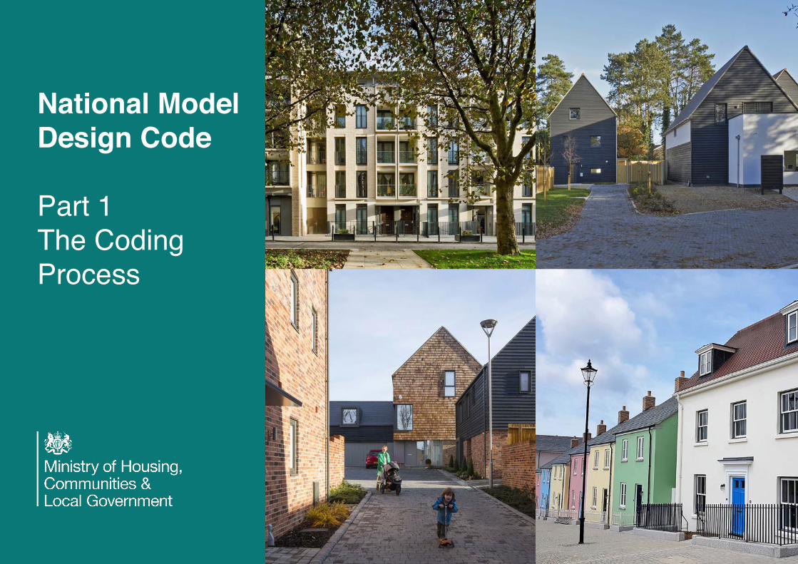
National Model Design Code Part 1 The Coding Process

Welcome message from author
This document is posted to help you gain knowledge. Please leave a comment to let me know what you think about it! Share it to your friends and learn new things together.
Transcript
National Model Design Code
Part 1The Coding Process

Contents.Part 1 - The Coding Process.
Purpose............................................1.Objectives.........................................2.Application..........................................4.Coding Process..................................6.
1. Analysis..............................................7.1.A. Scoping.......................................7.1.B. Baseline.......................................9.
2. Vision................................................11.2.A. Design Vision..............................11.2.B Coding Plan.................................13.2. C Masterplanning...........................15.
3. Code.................................................17.3.A. Guidance for Area Types............17.3.B. Code Wide Guidance.................29.
Glossary.References.Credits.
Part 2 -Guidance Notes.(separate document).
Code Content.Community Engagement.Appendix.
* Glossary, references and credits areincluded in this document and cover thecontent of both Part 1 - The Coding Processand Part 2 - Guidance Notes.
** Where reference is made to the NationalModel Design Code (NMDC) this refers to both Part 1 – The Coding Process and Part 2– The Guidance Notes.
© Crown copyright, 2021
Copyright in the typographical arrangement rests with the Crown.
You may re-use this information (not including logos) free of charge in any format or medium, under the terms of the Open Government Licence. To view this licence visit http://www.nationalarchives.gov.uk/doc/open-government-licence/version/3/This document/publication is also available on our website at www.gov.uk/mhclgIf you have any enquiries regarding this document/publication, complete the form at http://forms.communities.gov.uk/ or write to us at:
Ministry of Housing, Communities and Local GovernmentFry Building2 Marsham StreetLondonSW1P 4DFTelephone: 030 3444 0000
For all our latest news and updates follow us on Twitter: https://twitter.com/mhclg
July 2021

The Coding Process.

1
Purpose.
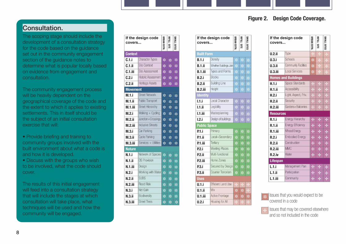
1. The purpose of theNational Model DesignCode is to provide detailedguidance on the productionof design codes, guidesand policies to promotesuccessful design. Itexpands on the tencharacteristics of gooddesign set out in the NationalDesign Guide, which reflectsthe government’s prioritiesand provides a commonoverarching framework fordesign.
2. The National Planning Policy Framework(NPPF) makes clear that all local planningauthorities should prepare design guides orcodes consistent with the principles set outin the National Design Guide and NationalModel Design Code, and which reflectlocal character and design preferences.Design codes and guides should provide aframework for creating high-quality places.
3. It also makes clear that the geographiccoverage, level of detail and degree ofprescription should be tailored to thecircumstances and scale of change in eachplace, and should allow a suitable degree ofvariety.
4. The tools, processes and outputsdescribed in this guidance can be appliedto the range of design advice produced bylocal authorities, including design codesand design guides. The content and level ofdetail in design codes or design guides willvary according to the scale at which a codeis applied, whether at county, local authority,neighbourhood or site level. For example, fora site with a masterplan and vision the codeshould be detailed and specific whereas acounty-wide code may be high level.
5. A design code is a set of simple, concise,illustrated design requirements that are visualand numerical wherever possible to providespecific, detailed parameters for the physicaldevelopment of a site or area. This guide is atoolkit to guide local planning authorities onthe design parameters and issues that needto be considered and tailored to their owncontext when producing design codes andguides, as well as methods to capture andreflect the views of the local community fromthe outset, and at each stage in the process.
6. The National Model Design Code formspart of the government’s planning practiceguidance and should be read as part of theNational Design Guide, and alongside theplanning practice guidance notes referencedin Part 3 of the National Design Guide,Manual for Streets, and other forthcomingguidance relating to the natural andenvironmental characteristics of development.This guidance is not a statement of nationalpolicy, however, the government recommendsthat the advice in this guidance on how toprepare design codes and guides is to befollowed.

2
Objectives.
7. This guidance sets outclear design parameters tohelp local authorities andcommunities decide whatgood quality design lookslike in their area, based onlocal aspirations for howtheir area will develop,following appropriate localconsultation.
8. The National Model Design Code sets outdesign considerations which local planningauthorities will be expected to take intoaccount when developing local design codesand guides and when determining planningapplications.
9. Design codes are important becausethey provide a framework for creating healthy,safe, green, environmentally responsive,sustainable and distinctive places, with aconsistent and high-quality standard ofdesign. This can provide greater certaintyfor communities about the design ofdevelopment and bring conversations aboutdesign to the start of the planning process,rather than the end. The built environmenthas a significant impact on people’s healthand wellbeing. It needs to feel safe andsecure for all including those who could bevulnerable. Creating more beautiful placesrequires a greener approach that supportsprogress towards our national environmentalgoals. This means more energy efficientbuildings, enhancing nature, integrating withthe natural environment creating more resilientplaces and delivering progress towards to thenet zero carbon target by 2050.
10. The government understands that qualitydesign does not look the same acrossdifferent areas of the country, for instance,that by definition, local vernacular differs anddesign priorities differ for scale and types ofdevelopment.
11. The National Model Design Code setsa baseline standard of quality and practicewhich local planning authorities are expectedto take into account when developinglocal design codes and guides and whendetermining planning applications, including;
• How the design of new developmentshould enhance the health and wellbeingof local communities and createsafe, inclusive, accessible and activeenvironments;
• How landscape, green infrastructureand biodiversity should be approachedincluding the importance of streets beingtree-lined;
• The environmental performance of placeand buildings ensuring they contribute tonet zero targets;
• The layout of new development, includinginfrastructure and street pattern;
• The factors to be considered whendetermining whether façades of buildingsare of sufficiently high quality and;
• That developments should take accountof local vernacular, character, heritage,architecture and materials.

3
12. Design codes can provide a more specific steer on what is acceptable when they are visual and numerical rather than relying on detailed policy wording, as well as being easier to engage with. They can also give developers greater certainty about what may be acceptable when seeking planning permission, and can help lead to faster decisions based on whether a proposal complies with a code, which can help to speed up the delivery of development.
13. For larger schemes, such as phased developments, design codes can help to maintain consistency in the delivery of development over a longer period of time. Codes also set out a necessary level of detail in sensitive locations, for example, with heritage considerations, and they can set out specific ways to maintain local character. Design codes and guides can also be helpful in facilitating custom and self-build. They can help facilitate the use of modern methods of construction and should not constrain technical and environmental innovation.
14. When preparing design codes and guides, communities need to be involved in the process in order to gain measurable community support that is appropriate for the scale and location of new development. Design codes should be prepared in light of information about what is popular locally, on the basis of evidence. This will address the ambition in a new planning system to bring democracy forward so that communities decide what good design means locally and that this is enshrined in design codes and guides.
15. The National Planning Policy Framework sets out that the National Design Guide and National Model Design Code should be used to guide decisions on applications in the absence of locally produced guides or codes. These documents provide guidance on what constitutes well-designed and beautiful places as well as providing a default checklist of issues that schemes will be expected to address.
Image Caption: 10 Characteristics of Well Designed Places. (National Design Guide Extract).

4
Application.
16. This document shouldbe used as a basis for theproduction of design codesand guides by local planningauthorities. It containsinformation that should bereadily available to the localauthority and is intended tobe applied flexibly accordingto local circumstances asnot all characteristics anddesign parameters may berelevant.
17. The document provides design guidanceand needs to be used alongside the NationalDesign Guide to inform local design guidesand codes as well as decisions on planningapplications. The area covered by thedesign code and the level of detail is to bedetermined locally. A coding plan will beneeded to show the area covered by thecode or guide. There is an option to use areatypes so that the guidance can be adjustedto reflect local character. The commentaryin Part 2 provides a checklist of contentfor design guidance or policies that localauthorities may consider including in theirlocal plans if a design code is not appropriate.
18. The National Model Design Code andGuidance Notes is to be applied withsimple clear requirements according to localcircumstances recognising that not all contentmay be relevant. Design guides and codesshould provide clear parameters within whichthere is scope for flexible application to allowfor innovation. Local authorities will be awareof the need to ensure that design guides
and codes are updated over time as social, technical and environmental circumstances change and subject to support from local communities.
19. The National Planning Policy Frameworkis clear that design policies should bedeveloped with local communities, so theyreflect local aspirations. Local authoritiesshould also collaborate with developers andlandowners on design codes, particularlyin relation to specific sites. Developers andlandowners may also choose to preparetheir own design code in support of aplanning application in collaboration withlocal authorities and communities, followingthe principles set out in the National ModelDesign Code and the National Design Guide.

5
20. The National Planning Policy Framework is also clear that local planning authorities should develop an overarching design vision and expectations that can inform design codes, guides and other tools that inform the design of the built and natural environment in their area, whether prepared by them or other parties. Local planning authorities should follow the advice in the plan making Planning Practice Guidance, particularly when producing design codes or guides as a supplementary planning document. Planning Practice Guidance Design: Process and Tools sets out guidance on design review and other design assessment approaches which should be considered when developing codes.
6
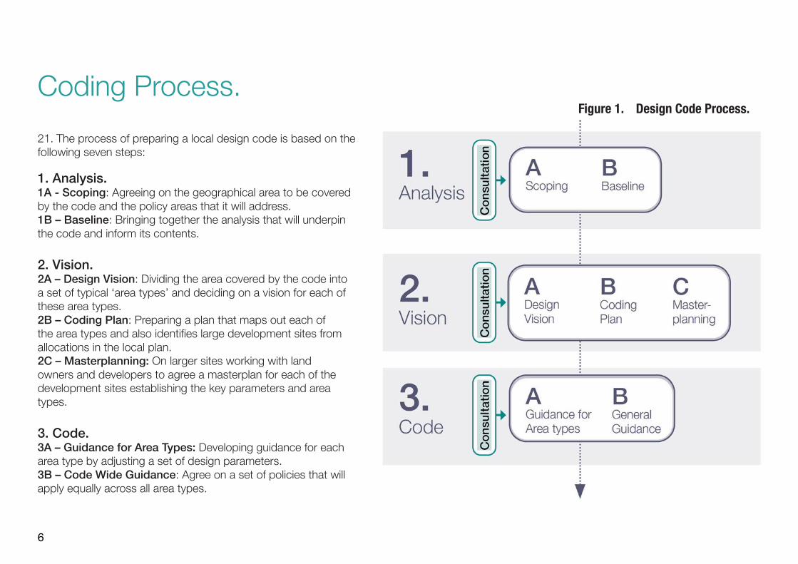
Coding Process.21. The process of preparing a local design code is based on thefollowing seven steps:
1. Analysis.1A - Scoping: Agreeing on the geographical area to be coveredby the code and the policy areas that it will address.1B – Baseline: Bringing together the analysis that will underpinthe code and inform its contents.
2. Vision.2A – Design Vision: Dividing the area covered by the code intoa set of typical ‘area types’ and deciding on a vision for each ofthese area types.2B – Coding Plan: Preparing a plan that maps out each ofthe area types and also identifies large development sites fromallocations in the local plan.2C – Masterplanning: On larger sites working with landowners and developers to agree a masterplan for each of thedevelopment sites establishing the key parameters and areatypes.
3. Code.3A – Guidance for Area Types: Developing guidance for eacharea type by adjusting a set of design parameters.3B – Code Wide Guidance: Agree on a set of policies that willapply equally across all area types.
Figure 1. Design Code Process.

7
1.A Scoping. 24. There are benefits in having a singledesign code covering one of the above options, rather than having separate design codes for each site.
Content:
25. The guidance notes include many of thepotential issues that might be covered by adesign code. These are organised under theten headings of the National Design Guideand include sub-headings. Codes are notexpected to cover all of these issues, andthe context and scale of development willdetermine the appropriate issues that need tobe included.
26. Some design parameters are an essentialcomponent of design codes for their effectiveuse such as movement pattern, built form,height, land use, character of buildings andpublic spaces, open space and density whileothers are discretionary (see Figure 2). Thelatter include, for example, housing standardsthat are crucial but may be dealt withelsewhere in local plans.
27. Design codes would be expected toinclude the following:
• Context - Local character and builtheritage.
• Movement - Design of the street network,active travel and public transport
22. The first step is todecide on the scope of thecode, in particular whichparts of the local area itneeds to cover, and whichpolicy areas it addresses.Coverage:
23. In terms of geographical coveragesome authorities may wish to create a codethat covers their entire area. Codes maycover all existing built-up areas, or just newdevelopment sites. The options are thereforethat the code covers:
• The whole local authority area includingall existing settlements and developmentsites.
• Selected parts of existing settlements anddevelopment sites.
• Just development sites.
• Nature - Design of green infrastructure,play spaces, SUDS and the protection ofbiodiversity.
• Built Form - Density, built form and urbandesign.
• Identity - character of buildings.• Public space - Design and of streets and
public spaces.• Homes and Buildings - Type and tenure of
homes.• Uses - Mix of uses and active frontage.• Resources - Environmental design,
renewable energy provision and lowenergy networks.
• Lifespan - Management and adoptionstandards.
Other related issues referred to in the National Model Design Code can be covered either in a Code or in other policies in local plans.
28. Some issues will depend on the decisionabout the coverage of the code. Codesthat cover larger schemes will need toinclude guidance on creating a new streetnetwork, public transport routes, planningand designing green spaces and providingschools and other facilities. By contrastin existing built-up areas where the streetnetwork etc. already exists, these elements ofthe code will be less relevant (see Figure 2).
8
Consultation.The scoping stage should include the development of a consultation strategy for the code based on the guidance set out in the community engagement section of the guidance notes to determine what is popular locally based on evidence from engagement and consultation.
The community engagement process will be heavily dependent on the geographical coverage of the code and the extent to which it applies to existing settlements. This in itself should be the subject of an initial consultation exercise that will:
• Provide briefing and training to community groups involved with the built environment about what a code is and how it is developed.• Discuss with the groups who wish to be involved, what the code should cover.
The results of this initial engagement will feed into a consultation strategy that will include the stages at which consultation will take place, what techniques will be used and how the community will be engaged.
Issues that you would expect to be covered in a code
Issues that may be covered elsewhere and so not included in the code
If the Design Code covers...
URBAN EXTN.
INFILL SITE
SMALL SITES
If the Design Code covers...
URBAN EXTN.
INFILL SITE
SMALL SITES
If the Design Code covers...
URBAN EXTN.
INFILL SITE
SMALL SITES
Context Built Form U2:2 Type ; ; ;C1:1 Character Types R R R B1:1 Density R R R U2:1 Schools R ; ; 4
C1:2 Site Context R R R B1:2 Party Wall R R R 4 U3:2 Community Facilities R ; ; 4
C1:3 Site Assessment R R R B1:3 Types and Forms R R R 4 U2:3 Local Services R ; ; 4
C2:1 Historic Assessment R R R B2:1 Blocks R R R 4 Homes and Buildings
C2:2 Heritage Assets R R R B2:2 Building Line R R R 4 H1:1 Space Standards ; ; ;
Movement B2:3 Height R R R H1:2 Accessibility ; ; ;
M1:1 Street Network R R R Identity H2:1 Light, aspect, priv. ; ; ; 4
M1:2 Public Transport R R R I1:1 Local Character R R R H2:2 Security ; ; ; 4
M1:3 Street Hierarchy R R R I1:2 Legibility R R R H2:3 Gardens+Balconies ; ; ; 4
M2:1 Walking + Cycling R R R I1:3 Masterplanning R R R Resources
M2:2 Junction+Crossings R R R I2:1 Design of buildings R R R R1:1 Energy Hierarchy ; ; ;
M2:3 Inclusive Streets R R R Public Space R1:2 Energy Efficiency ; ; ; 4
M3:1 Car Parking R R R 4 P1:1 Primary R R R R1:3 N’hood Energy ; ; ; 4
M3:2 Cycle Parking R R R 4 P1:2 Local+Secondary R R R R2:1 Embodied Energy ; ; ;
M2:3 Services + Utilities R R R 4 P1:3 Tertiary R R R R2:2 Construction ; ; ;
Nature P2:1 Meeting Places R R R R2:3 MMC ; ; ;
N1:1 Network of Spaces R R R P2:2 Multi-functional R R R R2:4 Water ; ; ;
N1:2 OS Provision R R R P2:3 Home Zones R R R Lifespan
N1:3 Design R R R P2:1 Secured by Design R R R 4 L1:1 Management Plan ; ; ;N2:1 Working with Water R R R 4 P3:2 Counter Terrorism R R R L1:2 Participation ; ; ;N2:2 SUDS R R R 4 Uses L1:3 Community ; ; ;
N2:3 Flood Risk R R R 4 U1:1 Efficient Land Use ; ; ;
N3:1 Net Gain R R R U1:2 Mix R R ;
N3:2 Biodiversity R R R 4 U1:3 Active Frontage R R R
N3:3 Street Trees R R R 4 U2:1 Housing for All ; ; ;
If the Design Code covers...
URBAN EXTN.
INFILL SITE
SMALL SITES
If the Design Code covers...
URBAN EXTN.
INFILL SITE
SMALL SITES
If the Design Code covers...
URBAN EXTN.
INFILL SITE
SMALL SITES
Context Built Form U2:2 Type ; ; ;C1:1 Character Types R R R B1:1 Density R R R U2:1 Schools R ; ; 4
C1:2 Site Context R R R B1:2 Party Wall R R R 4 U3:2 Community Facilities R ; ; 4
C1:3 Site Assessment R R R B1:3 Types and Forms R R R 4 U2:3 Local Services R ; ; 4
C2:1 Historic Assessment R R R B2:1 Blocks R R R 4 Homes and Buildings
C2:2 Heritage Assets R R R B2:2 Building Line R R R 4 H1:1 Space Standards ; ; ;
Movement B2:3 Height R R R H1:2 Accessibility ; ; ;
M1:1 Street Network R R R Identity H2:1 Light, aspect, priv. ; ; ; 4
M1:2 Public Transport R R R I1:1 Local Character R R R H2:2 Security ; ; ; 4
M1:3 Street Hierarchy R R R I1:2 Legibility R R R H2:3 Gardens+Balconies ; ; ; 4
M2:1 Walking + Cycling R R R I1:3 Masterplanning R R R Resources
M2:2 Junction+Crossings R R R I2:1 Design of buildings R R R R1:1 Energy Hierarchy ; ; ;
M2:3 Inclusive Streets R R R Public Space R1:2 Energy Efficiency ; ; ; 4
M3:1 Car Parking R R R 4 P1:1 Primary R R R R1:3 N’hood Energy ; ; ; 4
M3:2 Cycle Parking R R R 4 P1:2 Local+Secondary R R R R2:1 Embodied Energy ; ; ;
M2:3 Services + Utilities R R R 4 P1:3 Tertiary R R R R2:2 Construction ; ; ;
Nature P2:1 Meeting Places R R R R2:3 MMC ; ; ;
N1:1 Network of Spaces R R R P2:2 Multi-functional R R R R2:4 Water ; ; ;
N1:2 OS Provision R R R P2:3 Home Zones R R R Lifespan
N1:3 Design R R R P2:1 Secured by Design R R R 4 L1:1 Management Plan ; ; ;N2:1 Working with Water R R R 4 P3:2 Counter Terrorism R R R L1:2 Participation ; ; ;N2:2 SUDS R R R 4 Uses L1:3 Community ; ; ;
N2:3 Flood Risk R R R 4 U1:1 Efficient Land Use ; ; ;
N3:1 Net Gain R R R U1:2 Mix R R ;
N3:2 Biodiversity R R R 4 U1:3 Active Frontage R R R
N3:3 Street Trees R R R 4 U2:1 Housing for All ; ; ;
Figure 2. Design Code Coverage.

9
1.B Baseline.29. Design codes need tobe based on an analysisof the area covered. Thepurpose of the analysis isto understand the area andinform a vision that will, inturn, form the basis for thecode.30. Local planning authorities will needto have an understanding of their areainformed by up-to-date evidence such ascharacterisation studies or site analysis,with input from the community, to supportdesign coding. Local planning authoritiesmay already hold this information, so it ispossible that they will not need to carry outfurther analysis for the purpose of producinga design code. The analysis could include:
Topographical, geology, ecology, river and waterways, flood risk.Landscape character including wider area.Open space and green infrastructure.Local character.
Figure 3. Figure Ground Plan: A set of analysis plans can help understand the local area and inform area types described on the following pages.
Heritage and culture assets, including conservation areas.Land use, economic uses.Built form, density, massing.
Community infrastructure and schools.Public transport accessibility.Road/street hierarchy.
31. This analysis will feed into theidentification of the ‘area types’ described in the next two steps as well as providing a baseline on issues such as street hierarchy, open space provision, public transport and community facilities that will inform elements of the code.
10
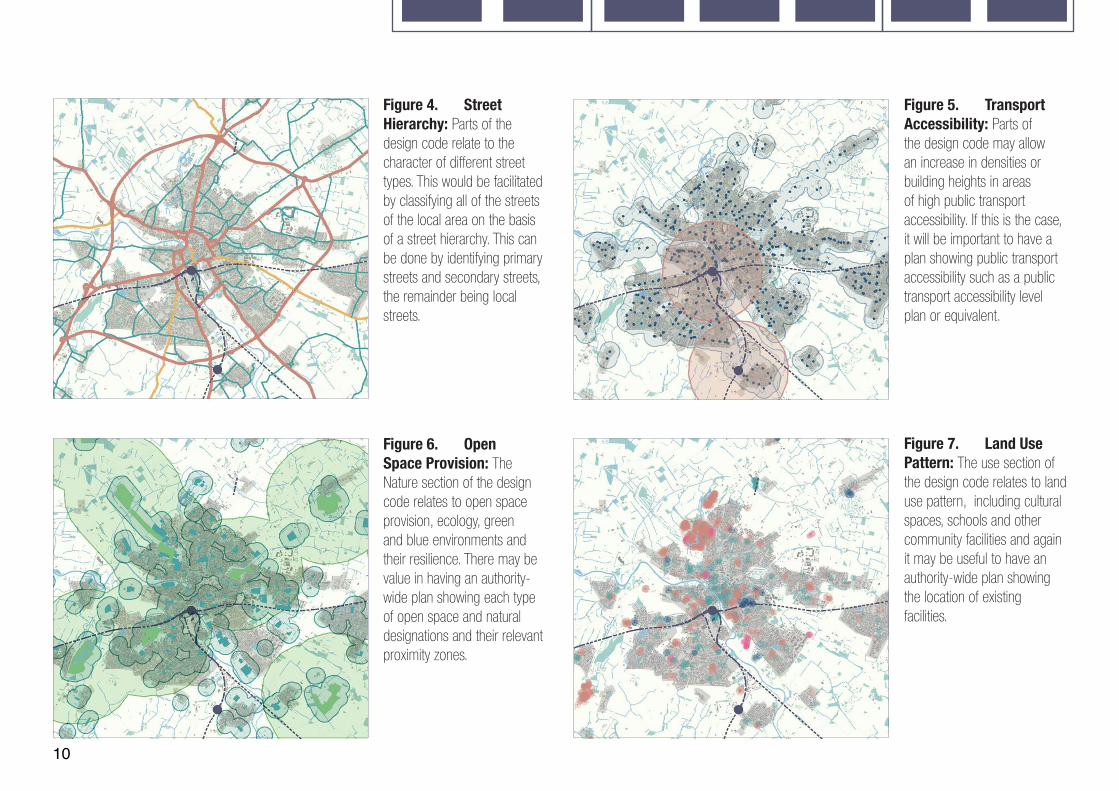
Figure 4. Street Hierarchy: Parts of the design code relate to the character of different street types. This would be facilitated by classifying all of the streets of the local area on the basis of a street hierarchy. This can be done by identifying primary streets and secondary streets, the remainder being local streets.
Figure 5. Transport Accessibility: Parts of the design code may allow an increase in densities or building heights in areas of high public transport accessibility. If this is the case, it will be important to have a plan showing public transport accessibility such as a public transport accessibility level plan or equivalent.
Figure 6. Open Space Provision: The Nature section of the design code relates to open space provision, ecology, green and blue environments and their resilience. There may be value in having an authority-wide plan showing each type of open space and natural designations and their relevant proximity zones.
Figure 7. Land Use Pattern: The use section of the design code relates to land use pattern, including cultural spaces, schools and other community facilities and again it may be useful to have an authority-wide plan showing the location of existing facilities.

11
32. Design codes need to bebased on a vision for how aplace will develop in the future,as set out in the local plan. Thisvision needs to be developedwith the local community andis likely to be an important partof the community engagementprocess.
33. Local planning authorities should createa vision statement which sets out the specificaims for the design code. These visions needto be aspirational and set the context forthe subsequent development of the codecovering:
An appreciation of the existing area or site, its natural, topographical, historical and heritage features.
Identifying Area Types.
34. When preparing a design code for thewhole local planning authority area, oneapproach is to divide the existing built-up areato be covered by the code into area types.These are areas of character that will be usedto set common parameters in the code. If thecode is covering a small area, then this stagemay not be necessary. However, many placeswill include a number of different area typeswhich will need to be analysed and mapped.
35. Area types can be identified throughcharacterisation studies, GIS analysis or acombination of these and the experience ofplanning officials and local communities.
36. Area types are based both on the existingcharacter of the place and how the localauthority and community expect the area todevelop in the future. In Step 2B we describeten possible area types as a starting point.Few areas will include all of these types.
Its character and appearance. The mix of uses and facilities. The amount of green infrastructure and character of green space. The way in which it deals with traffic, parking, public transport, walking and cycling.Sustainability including energy efficiency, net zero alignment and climate resilience.
37. The area types should be analysedusing a standard worksheet (See Fig 8). Thisis something that can be done as part ofconsultation events with local communities.This analysis will feed into a vision for whatthat area type should become in the future.
2.A DesignVision.
Consultation
The design visioning process will be an important focus for consultation. This could be undertaken through a series of workshops across the local area that involve communities and stakeholders in the analysis of existing character and visioning of how this character may change.
Wider surveys are likely to be necessary to ensure widespread local input beyond workshop attendees. This can include ‘walking workshops’, photographic surveys and visual preference surveys and sustainability/environmental surveys to understand the aspects of local character that people value and those that they would like to change.
12
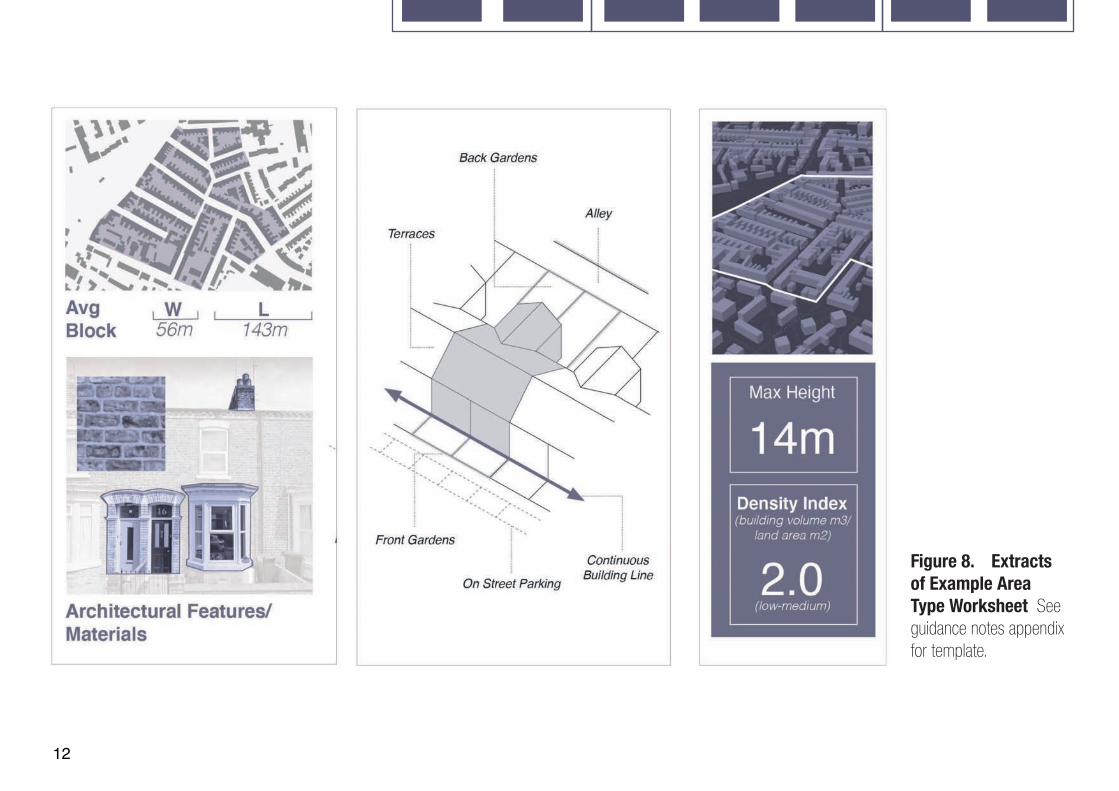
Figure 8. Extracts of Example Area Type Worksheet See guidance notes appendix for template.

13
High Rise City (not shown).
Town/City Centre.
Urban Neighbourhood.
Inner Suburb.
Industrial Area.
Business Park (not shown).
Local Centres and High Streets.
Outer Suburb.
Urban Green Space.
Rural.
Village.
Locally Designated.
Development Areas (see Step 2c).
Figure 9. Coding Plan: This planshows the area to be covered by the code and divides this up into a series of area types as described opposite. Most places will not include all of these area types, and some may include types that fall outside all of these examples.
38. The analysis will feed intoa plan similar to Figure 9, thatshows the areas of the authorityto which the code will applyalong with the distribution ofthe area types. The plan alsoshows major development sitesbased on local plan allocationsthat will be subject to themasterplanning exercise in Step2c.
2.B CodingPlan.
39. The existing built-up area to be coveredby the code needs to be identified as anarea type or a mixture of area types asillustrated in Figure 10.
40. Some places will include only a few areatypes, and some may include examples ofall ten types. A limited number of area types
should be identified to avoid the design code being too complex.
41. Area types can include other uses, such as asmall factory or school within a suburban area type.The principle being that, if that site came up fordevelopment, then it would be appropriate to be guidedby the identified area type.
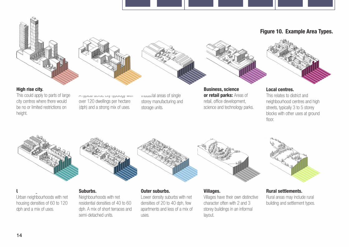
14
High rise city.This could apply to parts of large city centres where there would be no or limited restrictions on height.
Town/City centre.A typical dense city typology with over 120 dwellings per hectare (dph) and a strong mix of uses.
Urban neighbourhood. Urban neighbourhoods with net housing densities of 60 to 120 dph and a mix of uses.
Industrial areas. Industrial areas of single storey manufacturing and storage units.
Suburbs. Neighbourhoods with net residential densities of 40 to 60 dph. A mix of short terraces and semi-detached units.
Local centres. This relates to district and neighbourhood centres and high streets, typically 3 to 5 storey blocks with other uses at ground floor.
Outer suburbs. Lower density suburbs with net densities of 20 to 40 dph, few apartments and less of a mix of uses.
Rural settlements.Rural areas may include rural building and settlement types.
Villages.Villages have their own distinctive character often with 2 and 3 storey buildings in an informal layout.
Business, science or retail parks: Areas of retail, office development, science and technology parks.
Figure 10. Example Area Types.

15
42. If a design code isbeing prepared for largersites, it may be necessaryto produce a masterplan aspart of the design codingexercise. This masterplanwill establish a new streetnetwork, decide which areatypes apply, along withvarious other parameters.
43. These development sites will usuallyhave been allocated in the local plan and willgenerally be larger sites. Smaller sites can bedealt with within the area type framework.
Who is responsible?44. The coding framework for developmentsites can be produced by the local planning
Figure 11. Development SiteMasterplan (next page): The aim of the masterplan is to provide a framework for the application of the design code to the site. This is likely
to include:
The landscape strategy, taking account of existing natural features of the site and wider area, biodiversity and new structural elements.
Green infrastructure including the amount and position of open space provision.
The number, type and tenure of homes and other uses (from the local plan allocation).
The points of access and connection to the wider street network.
The broad position of the primary and secondary streets but not local streets.
The position of the local centre if relevant.
The area types that will apply to different parts of the site (which will in turn reference rules on density, height, street building line etc.)
Sustainability measures and supportive design in respect of masterplanning.
authority or the landowner/developer in partnership with a local planning authority. This would be done when the site is allocated for development in the local plan and included in a design code.
What the masterplan includes:45. Figure 11 shows a notional masterplanfor one of the development sites identified onthe coding plan in step 2b. The level of detailwill vary depending on whether the authorityor developer is preparing the masterplanand the complexity of the site. It will alsodepend on where the site is in the planningprocess – local plan preparation, pre-application, community consultation, outlineor detailed application stages. Landscapecan be a major driver in a design processat masterplanning scale. The exercise may
include an illustrative masterplan that shows what the area could be like in the future for the purposes of consultation, but the detailed plan would be illustrative.
2.C Master planning.
Consultation.
The masterplanning exercise for development sites needs to be subject to a separate community engagement exercise. This will need to be co-ordinated with the consultation on the local plan allocation as well as consultation being undertaken by the owner/developer.

16
Figure 11. Development Site Masterplan
17
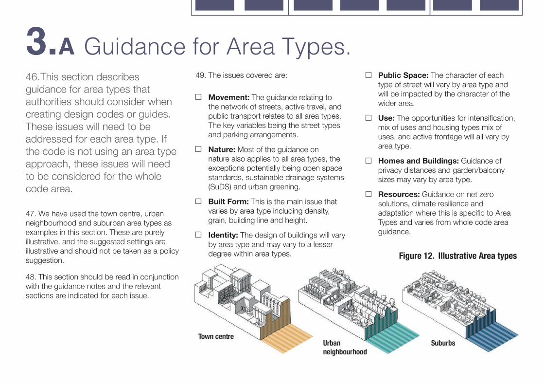
46. This section describesguidance for area types thatauthorities should consider whencreating design codes or guides.These issues will need to beaddressed for each area type. Ifthe code is not using an area typeapproach, these issues will needto be considered for the wholecode area.
47. We have used the town centre, urbanneighbourhood and suburban area types asexamples in this section. These are purelyillustrative, and the suggested settings areillustrative and should not be taken as a policysuggestion.
48. This section should be read in conjunctionwith the guidance notes and the relevantsections are indicated for each issue.
49. The issues covered are:
Movement: The guidance relating tothe network of streets, active travel, andpublic transport relates to all area types.The key variables being the street typesand parking arrangements.
Nature: Most of the guidance onnature also applies to all area types, theexceptions potentially being open spacestandards, sustainable drainage systems(SuDS) and urban greening.
Built Form: This is the main issue thatvaries by area type including density,grain, building line and height.
Identity: The design of buildings will varyby area type and may vary to a lesserdegree within area types.
Public Space: The character of each type of street will vary by area type and will be impacted by the character of the wider area.
Use: The opportunities for intensification, mix of uses and housing types mix of uses, and active frontage will all vary by area type.
Homes and Buildings: Guidance of privacy distances and garden/balcony sizes may vary by area type.
Resources: Guidance on net zero solutions, climate resilience and adaptation where this is specific to Area Types and varies from whole code area guidance.
3.A Guidance for Area Types.
Figure 12. Illustrative Area types
18
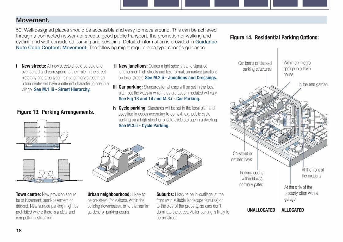
Movement.
i New streets: All new streets should be safe and overlooked and correspond to their role in the street hierarchy and area type - e.g. a primary street in an urban centre will have a different character to one in a village See M.1.iii - Street Hierarchy.
ii New junctions: Guides might specify traffic signalled junctions on high streets and less formal, unmarked junctions on local streets. See M.2.ii - Junctions and Crossings.
iii Car parking: Standards for all uses will be set in the local plan, but the ways in which they are accommodated will vary. See Fig 13 and 14 and M.3.i - Car Parking.
iv Cycle parking: Standards will be set in the local plan and specified in codes according to context. e.g. public cycle parking on a high street or private cycle storage in a dwelling. See M.3.ii - Cycle Parking.
Town centre: New provision should be at basement, semi-basement or decked. New surface parking might be prohibited where there is a clear and compelling justification.
Urban neighbourhood: Likely to be on-street (for visitors), within the building (townhouse), or to the rear in gardens or parking courts.
Suburbs: Likely to be in-curtilage, at the front (with suitable landscape features) or to the side of the property, so cars don’t dominate the street. Visitor parking is likely to be on-street.
Figure 13. Parking Arrangements.
50. Well-designed places should be accessible and easy to move around. This can be achieved through a connected network of streets, good public transport, the promotion of walking and cycling and well-considered parking and servicing. Detailed information is provided in Guidance Note Code Content: Movement. The following might require area type-specific guidance:
Figure 14. Residential Parking Options:
19
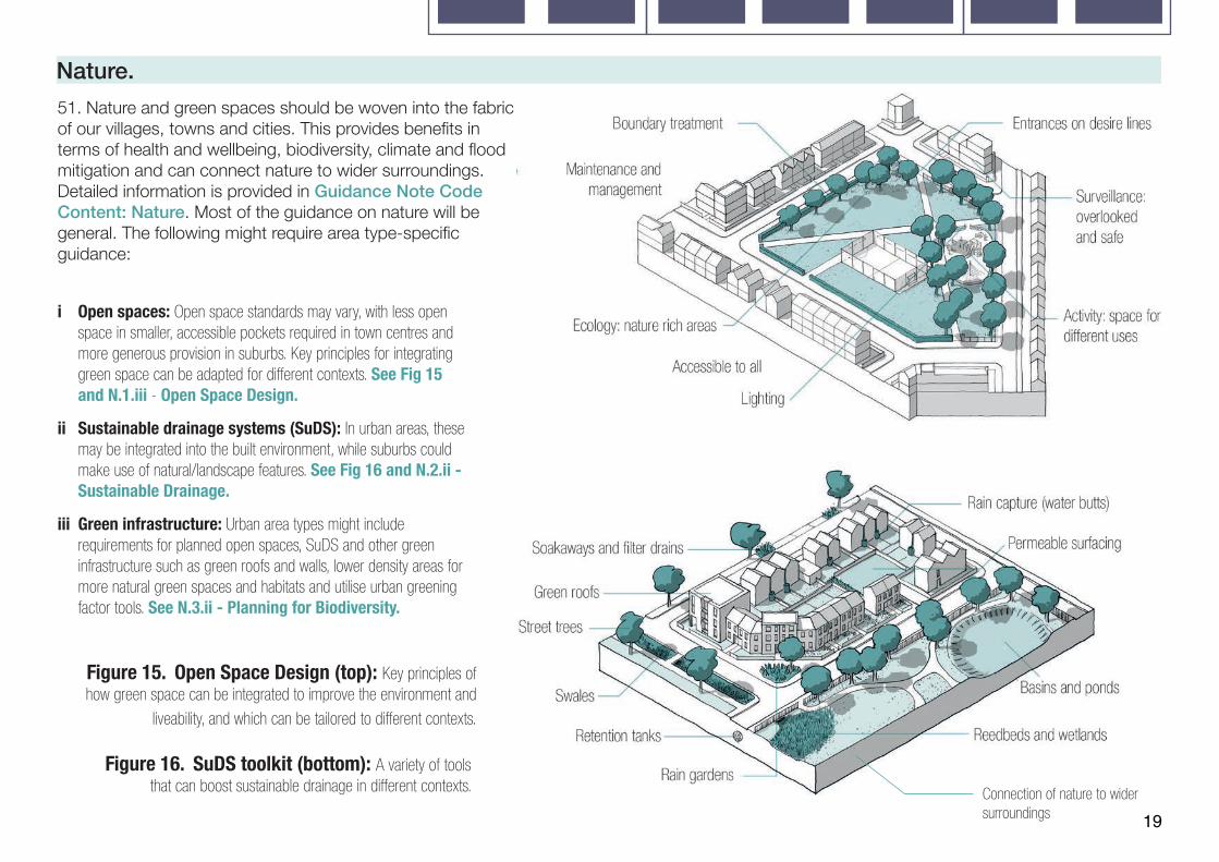
Nature.51. Nature and green spaces should be woven into the fabric of our villages, towns and cities. This provides benefits in terms of health and wellbeing, biodiversity, climate and flood mitigation and can connect nature to wider surroundings. Detailed information is provided in Guidance Note Code Content: Nature. Most of the guidance on nature will be general. The following might require area type-specific guidance:
Figure 15. Open Space Design (top): Key principles of how green space can be integrated to improve the environment and
liveability, and which can be tailored to different contexts.
Figure 16. SuDS toolkit (bottom): A variety of tools that can boost sustainable drainage in different contexts.
i Open spaces: Open space standards may vary, with less open space in smaller, accessible pockets required in town centres and more generous provision in suburbs. Key principles for integrating green space can be adapted for different contexts. See Fig 15 and N.1.iii - Open Space Design.
ii Sustainable drainage systems (SuDS): In urban areas, these may be integrated into the built environment, while suburbs could make use of natural/landscape features. See Fig 16 and N.2.ii - Sustainable Drainage.
iii Green infrastructure: Urban area types might include requirements for planned open spaces, SuDS and other green infrastructure such as green roofs and walls, lower density areas for more natural green spaces and habitats and utilise urban greening factor tools. See N.3.ii - Planning for Biodiversity.
Connection of nature to wider surroundings

20
i Density: Codes should define density ranges, which are likely to be higher for town and local centres and lower in suburbs (illustrative example below) Mixed use schemes can be calculated on a pro-rata basis. See B.1.i Density.
Town Centres: >200d/ha. Urban Neighbourhoods: 60-120d/ha. Suburbs: 30-50 d/ha.
ii Plot ratio: Calculated by dividing the gross floor area of the building by the area of the plot, plot ratios along with site coverage should be used alongside good urban design principles to regulate the density of mixed-use and non-residential uses (example below) See B.1.i Density.
Town Centres: >2. Urban Neighbourhoods: >1. Suburbs: <0.5.
Town centres: Buildings should be allowed to join on either side and to the rear.
Urban neighbourhoods: Buildings should be allowed/required to join on either side.
Suburbs (or rural areas): Buildings are either detached or only join on one side.
52. Built form refers to the three-dimensional arrangement of buildings, blocks, streets and spaces. This will form the core of the design code and the settings for each element of built form will vary considerably by area type. Detailed information is provided in Guidance Note Code Content: Built Form.
iii Whether buildings join: How buildings relate to neighbouring buildings has an important impact on urban form. Likely variation in guidance by area type is shown in Fig 17. See B.1.ii Whether Buildings Join.
iv Grain: The pattern of plots in an urban block/area. New development should, where possible, be sympathetic to the existing grain. The grain is likely to be finer (smaller plot size) in town/local centres and coarser (larger plot sizes) in suburbs. See B.1.iii Building Types and Forms.
Town centre - courtyard blocks.
Urban neighbourhood - perimeter blocks.
Suburban - informal blocks.
Figure 17. Whether buildings join. Figure 18. Typical Block Types.
Built Form.v Public/private: New development
should create a clear separation between the public fronts of buildings and the private rears within the centre of development blocks. This is normally achieved using blocks. Likely variation by area type is shown in Fig 18. See B.2.i Blocks.
vi Edges of development: Codes should demonstrate how the edges of plots are treated and how this relates to the landscape and wider context.

21
Built Form.vii Building line: The building line
is created by the primary front face of buildings along a street and is a key element of design codes. New development should follow the established building line where it exists. Where there is no building line (for example on the periphery of a town centre or a development site), codes should set one. Coding for building lines can include:
Town centre:Density: >200 dwellings per hectare.Plot Ratio: >2.Party Wall: Side and rear.Block Type: Courtyard. Building Line: Continuous. Set Back: 0-1 metersEaves Height: 18 meters.
Urban neighbourhood:Density: >60-120 dwellings per hectare.Plot Ratio: >1.Party Wall: Both sides.Block Type: Perimeter. Building Line: 75%. Set Back: 1-3 meters.Eaves Height: 12 meters.
Suburb:Density: 30-50 dwellings per hectare.Plot Ratio: >0.5.Party Wall: One side.Block Type: Informal. Building Line: 50%. Set Back: 3-6 meters.Eaves Height: 9 meters.
Figure 19. Examples of Typical Area Type Built Form Settings.
Variation: The extent to which buildings can be set forward or back from the line.
Projections: Allowance for elements such as balconies.
Compliance: The percentage of the building line that should be occupied by development.
Set-Back: The distance that buildings are set back from the pavement.
Figure 20 shows how building line guidance might change by area type.
See B.2.ii. Building Line.
22
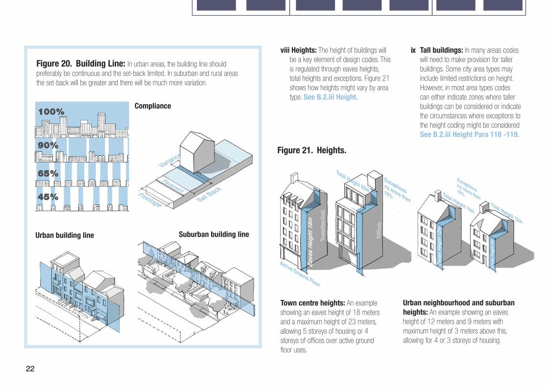
viii Heights: The height of buildings will be a key element of design codes. This is regulated through eaves heights, total heights and exceptions. Figure 21 shows how heights might vary by area type. See B.2.iii Height.
Figure 20. Building Line: In urban areas, the building line should preferably be continuous and the set-back limited. In suburban and rural areas the set-back will be greater and there will be much more variation.
ix Tall buildings: In many areas codes will need to make provision for taller buildings. Some city area types may include limited restrictions on height. However, in most area types codes can either indicate zones where taller buildings can be considered or indicate the circumstances where exceptions to the height coding might be considered See B.2.iii Height Para 118 -119.
Town centre heights: An example showing an eaves height of 18 meters and a maximum height of 23 meters, allowing 5 storeys of housing or 4 storeys of offices over active ground floor uses.
Urban neighbourhood and suburban heights: An example showing an eaves height of 12 meters and 9 meters with maximum height of 3 meters above this, allowing for 4 or 3 storeys of housing.
Figure 21. Heights.
Suburban building lineUrban building line
Compliance
23
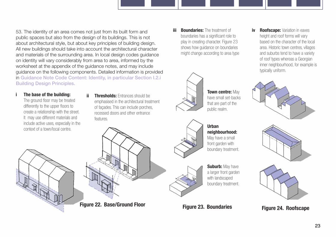
53. The identity of an area comes not just from its built form and public spaces but also from the design of its buildings. This is not about architectural style, but about key principles of building design. All new buildings should take into account the architectural character and materials of the surrounding area. In local design codes guidance on identity will vary considerably from area to area, informed by the worksheet at the appendix of the guidance notes, and may include guidance on the following components. Detailed information is provided in Guidance Note Code Content: Identity, in particular Section I.2.i Building Design Principles.
i The base of the building: The ground floor may be treated differently to the upper floors to create a relationship with the street. It may use different materials and include active uses, especially in the context of a town/local centre.
ii Thresholds: Entrances should be emphasised in the architectural treatment of façades. This can include porches, recessed doors and other entrance features.
iv Roofscape: Variation in eaves height and roof forms will vary based on the character of the local area. Historic town centres, villages and suburbs tend to have a variety of roof types whereas a Georgian inner neighbourhood, for example is typically uniform.
Town centre: May have small set-backs that are part of the public realm.
Urban neighbourhood: May have a small front garden with boundary treatment.
Suburb: May have a larger front garden with landscaped boundary treatment.
Figure 22. Base/Ground Floor Figure 23. Boundaries Figure 24. Roofscape
iii Boundaries: The treatment of boundaries has a significant role to play in creating character. Figure 23 shows how guidance on boundaries might change according to area type
24
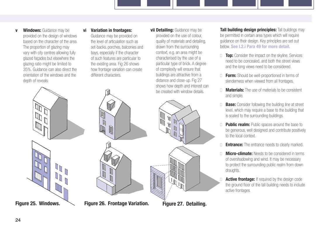
Identityv Windows: Guidance may be
provided on the design of windows based on the character of the area. The proportion of glazing may vary with city centres allowing fully glazed façades but elsewhere the glazing ratio might be limited to 35%. Guidance can also direct the orientation of the windows and the depth of reveals.
vi Variation in frontages: Guidance may be provided on the level of articulation such as set-backs, porches, balconies and bays, especially if the character of such features are particular to the existing area. Fig 26 shows how frontage variation can create different characters.
vii Detailing: Guidance may be provided on the use of colour, quality of materials and detailing, drawn from the surrounding context, e.g. an area might be characterised by the use of a particular type of brick. A degree of complexity will ensure that buildings are attractive from a distance and close-up. Fig 27 shows how depth and interest can be created with window details.
Tall building design principles: Tall buildings may be permitted in certain area types which will require guidance on their design. Key principles are set out below. See I.2.i Para 49 for more detail.
Top: Consider the impact on the skyline. Services need to be concealed, and both the street views and the long views need to be considered.
Form: Should be well-proportioned in terms of slenderness when viewed from all frontages.
Materials: The use of materials to be consistent and simple.
Base: Consider following the building line at street level, which may require a base to the building that is scaled to the surrounding buildings.
Public realm: Public spaces around the base to be generous, well designed and contribute positively to the local context.
Entrance: The entrance needs to clearly marked.
Micro-climate: Needs to be considered in terms of overshadowing and wind. It may be necessary to protect the surrounding public realm from down draughts.
Active frontage: If required by the design code the ground floor of the tall building needs to include active frontages.
Figure 25. Windows. Figure 26. Frontage Variation. Figure 27. Detailing.

25
15-20 meters.
13-16 meters.
10-14 meters.
25-35 meters.
Primary streets: Designed to take through traffic and public transport. See P.1.i Primary Streets.
Secondary streets: Taking local traffic into neighbourhoods and often the location of shopping parades and local services such as shops. See P.1.ii Local and Secondary Streets.
Local streets: Providing vehicle access only to the properties on the street but with through pedestrian and cycle traffic. See P.1.ii Local and Secondary Streets.
High streets: The focus for local shopping centres, often with traffic but sometimes traffic-free. See P.1.i Primary Streets.
Town centres. Urban neighbourhoods. Suburbs.
25-30 meters.
17-23 meters.
13-16 meters.
11-14 meters.
Urban neighbourhood.Enclosure Ratio: 1:1.Active Frontage: 30%.
Urban neighbourhood.Enclosure Ratio: 1:1.Active Frontage: 0%.
Urban neigh-bourhoodEnclosure Ratio: 1:1.5.Active Frontage: 70%.
28-35 meters.
17-22 meters.
14-18 meters.
17-22 meters.
Enclosure Ratio: 1:2.Active Frontage: 30%.
Enclosure Ratio: 1:2.Active Frontage: 10% .
Enclosure Ratio: 1:5.Active Frontage: 10%.
Town Centre.Enclosure Ratio: 1:1.Active Frontage: 80%.
Town Centre.Enclosure Ratio: 1:1.Active Frontage: 50%.
Town Centre.Enclosure Ratio: 1:1.Active Frontage: 30%.
Suburbs.Enclosure Ratio: 1:3.Active Frontage: 20%.
Suburbs.Enclosure Ratio: 1:2.5.Active Frontage: 0%.
Suburbs.Enclosure Ratio: 1:3.Active Frontage: 60%.
Figure 28. Street Matrix.

26
Public Space.
Figure 28. (Opposite) Street Matrix: An illustrative example showing how street character and form might change by area type and by position on the street hierarchy.
Figure 29. Street Types: The guidance notes contain a range of examples of the design of street types from major cities to market towns and villages. The excerpt below shows how the identity of a primary street can vary considerably depending on context; from an urban primary street with tall buildings and a public transport hub to a market town high street with mid-density buildings and a market square.
54. The quality of public space is partly about the way it is designed and partly about the way it is enclosed by well-proportioned buildings. Detailed information is provided in Guidance Note Code Content: Public Space. Streets are a component of public space which will vary considerably by area type. Section P.1 details different types of street, showing how urban form can be coordinated with the guidance in Manual for Streets.
i Streets: New development should contribute to the
character of the street on which it is located. This character will be different depending where the street sits in the street hierarchy and the context in which it is located. Figure 28 illustrates how the characteristics of a street might vary by area type and position on the street hierarchy. A similar diagram could form part of design code guidance at local level. See P.1 Streets.
Urban primary street. Market town high street.
27
Market town high street.
Use.
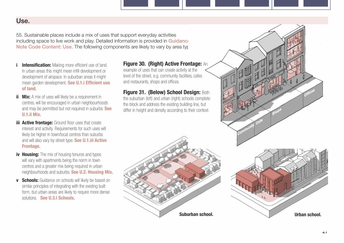
55. Sustainable places include a mix of uses that support everyday activities including space to live work and play. Detailed information is provided in Guidance Note Code Content: Use. The following components are likely to vary by area type.
i Intensification: Making more efficient use of land. In urban areas this might mean infill development or development of airspace. In suburban areas it might mean garden development. See U.1.i Efficient use of land.
ii Mix: A mix of uses will likely be a requirement in centres, will be encouraged in urban neighbourhoods and may be permitted but not required in suburbs. See U.1.ii Mix.
iii Active frontage: Ground floor uses that create interest and activity. Requirements for such uses will likely be higher in town/local centres than suburbs and will also vary by street type. See U.1.iii Active Frontage.
iv Housing: The mix of housing tenures and types will vary with apartments being the norm in town centres and a greater mix being required in urban neighbourhoods and suburbs. See U.2. Housing Mix.
v Schools: Guidance on schools will likely be based on similar principles of integrating with the existing built form, but urban areas are likely to require more dense solutions. See U.3.i Schools.
Figure 30. (Right) Active Frontage: An example of uses that can create activity at the level of the street, e.g. community facilities, cafes and restaurants, shops and offices.
Figure 31. (Below) School Design: Both the suburban (left) and urban (right) schools complete the block and address the existing building line, but differ in height and density according to their context.
Suburban school. Urban school.
28
Homes and Buildings.
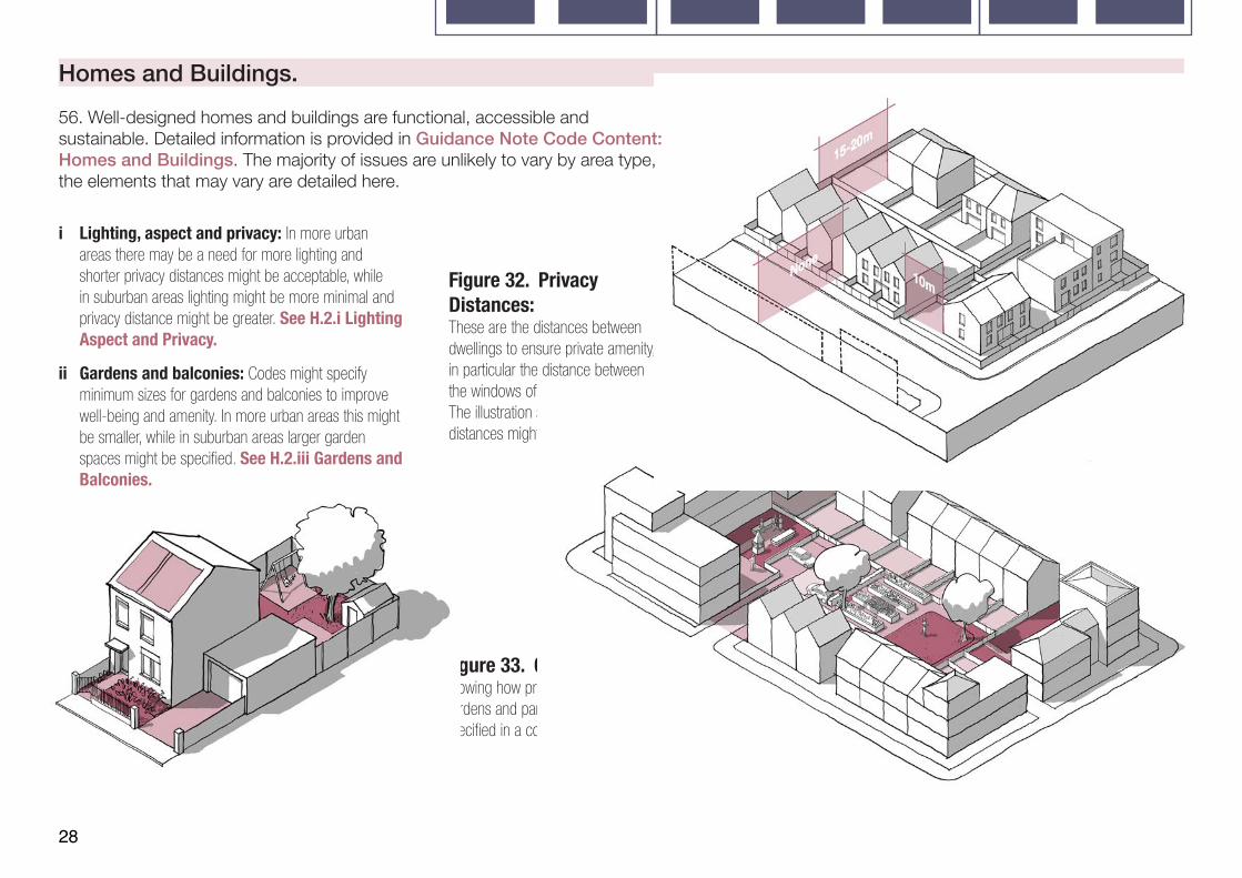
Figure 32. Privacy Distances: These are the distances between dwellings to ensure private amenity, in particular the distance between the windows of habitable rooms. The illustration shows how minimum distances might be specified.
Figure 33. Gardens: Illustration showing how private gardens, shared gardens and parking might be specified in a courtyard layout.
i Lighting, aspect and privacy: In more urban areas there may be a need for more lighting and shorter privacy distances might be acceptable, while in suburban areas lighting might be more minimal and privacy distance might be greater. See H.2.i Lighting Aspect and Privacy.
ii Gardens and balconies: Codes might specify minimum sizes for gardens and balconies to improve well-being and amenity. In more urban areas this might be smaller, while in suburban areas larger garden spaces might be specified. See H.2.iii Gardens and Balconies.
56. Well-designed homes and buildings are functional, accessible and sustainable. Detailed information is provided in Guidance Note Code Content: Homes and Buildings. The majority of issues are unlikely to vary by area type, the elements that may vary are detailed here.

29
Context.
58. An understanding of the context, historyand character of an area must influence thesiting and design of new development asset out in Guidance Notes Code Content:Context. This should be informed by:
i Character studies: All schemes should consider their context and schemes over a specified size should be accompanied by a context study. See C.1 Character Studies.
ii Historic assets: Schemes should respect the historic assets of the site and its surroundings, making use of existing structures where possible. See C.2 Cultural Heritage.
57. In addition to theguidance in step 3a thefollowing guidance relates toall development within thearea covered by the designcode or guide regardless ofarea type. All of this must bereferenced back to a policywithin the local plan.
Figure 34. Context Study Extract. See C.1.ii for example of context study content.
3.B Code Wide Guidance.
30
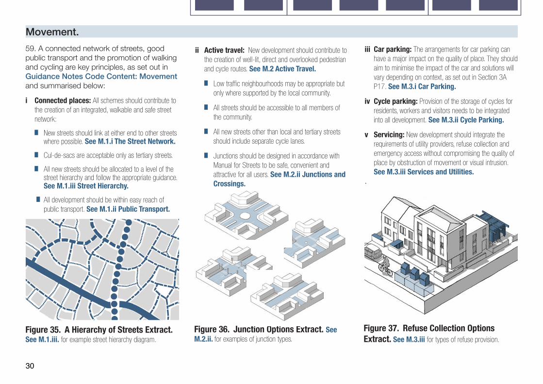
Movement.ii Active travel: New development should contribute to
the creation of well-lit, direct and overlooked pedestrian and cycle routes. See M.2 Active Travel.
Low traffic neighbourhoods may be appropriate but only where supported by the local community.
All streets should be accessible to all members of the community.
All new streets other than local and tertiary streets should include separate cycle lanes.
Junctions should be designed in accordance with Manual for Streets to be safe, convenient and attractive for all users. See M.2.ii Junctions and Crossings.
59. A connected network of streets, good public transport and the promotion of walking and cycling are key principles, as set out in Guidance Notes Code Content: Movement and summarised below:
i Connected places: All schemes should contribute to the creation of an integrated, walkable and safe street network:
New streets should link at either end to other streets where possible. See M.1.i The Street Network.
Cul-de-sacs are acceptable only as tertiary streets.
All new streets should be allocated to a level of the street hierarchy and follow the appropriate guidance. See M.1.iii Street Hierarchy.
All development should be within easy reach of public transport. See M.1.ii Public Transport.
iii Car parking: The arrangements for car parking can have a major impact on the quality of place. They should aim to minimise the impact of the car and solutions will vary depending on context, as set out in Section 3A P17. See M.3.i Car Parking.
iv Cycle parking: Provision of the storage of cycles for residents, workers and visitors needs to be integrated into all development. See M.3.ii Cycle Parking.
v Servicing: New development should integrate the requirements of utility providers, refuse collection and emergency access without compromising the quality of place by obstruction of movement or visual intrusion. See M.3.iii Services and Utilities.
.
Figure 35. A Hierarchy of Streets Extract. See M.1.iii. for example street hierarchy diagram.
Figure 36. Junction Options Extract. See M.2.ii. for examples of junction types.
Figure 37. Refuse Collection Options Extract. See M.3.iii for types of refuse provision.
31
Integrate sustainable drainage systems into the early stages of design to reduce flood risk and improve water quality, biodiversity and amenity. See N.2.ii Sustainable Drainage.
Take account of flood risk and the need for measures to address flood risk. See N.2.iii Flood Risk.
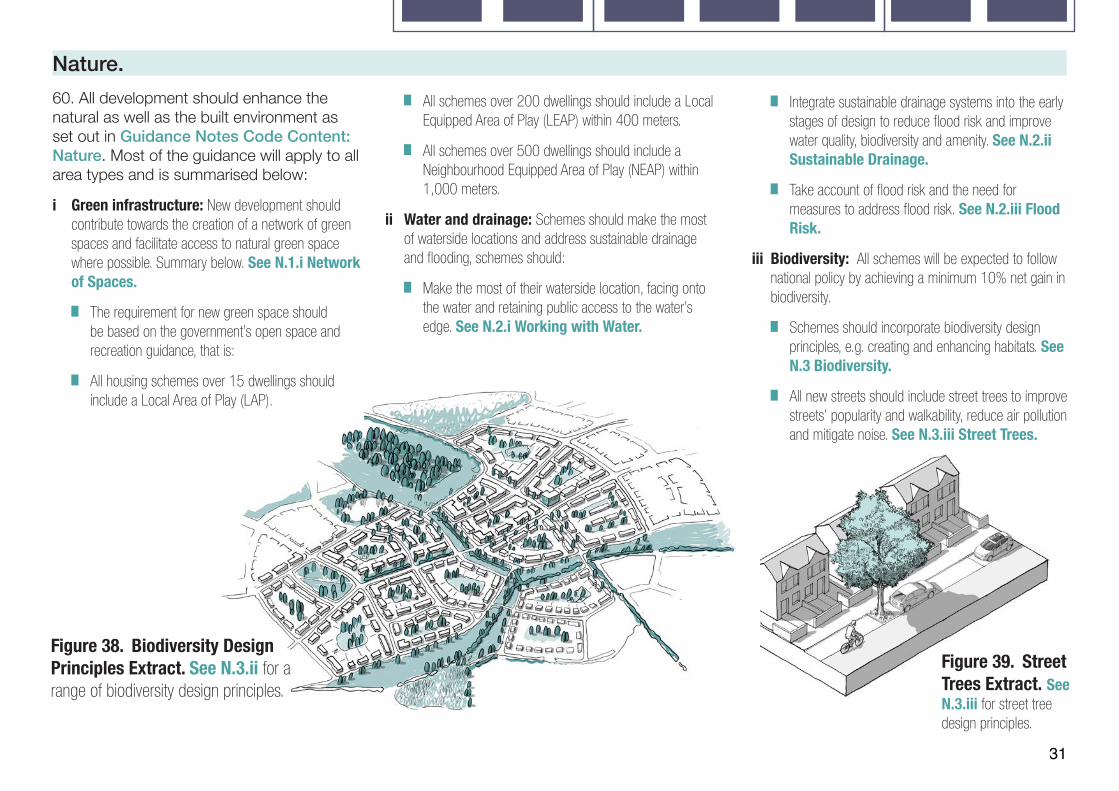
iii Biodiversity: All schemes will be expected to follow national policy by achieving a minimum 10% net gain in biodiversity.
Schemes should incorporate biodiversity design principles, e.g. creating and enhancing habitats. See N.3 Biodiversity.
All new streets should include street trees to improve streets’ popularity and walkability, reduce air pollution and mitigate noise. See N.3.iii Street Trees.
Nature. 60. All development should enhance the natural as well as the built environment as set out in Guidance Notes Code Content: Nature. Most of the guidance will apply to all area types and is summarised below:
i Green infrastructure: New development should contribute towards the creation of a network of green spaces and facilitate access to natural green space where possible. Summary below. See N.1.i Network of Spaces.
The requirement for new green space should be based on the government’s open space and recreation guidance, that is:
All housing schemes over 15 dwellings should include a Local Area of Play (LAP).
All schemes over 200 dwellings should include a Local Equipped Area of Play (LEAP) within 400 meters.
All schemes over 500 dwellings should include a Neighbourhood Equipped Area of Play (NEAP) within 1,000 meters.
ii Water and drainage: Schemes should make the most of waterside locations and address sustainable drainage and flooding, schemes should:
Make the most of their waterside location, facing onto the water and retaining public access to the water’s edge. See N.2.i Working with Water.
Figure 38. Biodiversity Design Principles Extract. See N.3.ii for a range of biodiversity design principles.
Figure 39. Street Trees Extract. See N.3.iii for street tree design principles.

32
Figure 40. Blocks Extract: See B.2.i for more detail on Blocks.
Figure 41. Creating Identity Extract: See I.1.iii for masterplanning principles to create a sense of place.
Figure 42. Street Design Extract: See P.1 for examples of street design in different contexts.
Built Form.
61. Most of this guidance will change based on context and area type as set out in Guidance Notes Code Content: Built Form. The following will apply to all development:
i Public and private: There should be a clear separation between public and private space, which will generally be achieved through development blocks. New development should repair the existing block structure, where possible. See B.2.i Blocks.
Identity.
62. All schemes should be designed to respect and enhance the existing character of the surrounding area. The principles set out in Guidance Notes Code Content: Identity will apply to most development (summary below)
i Sense of place: All schemes should be designed to enhance local character and legibility by:
Making use of local materials and detailing.
Incorporating legibility and wayfinding strategies
Being guided by a strong masterplan.
See I.1 A Sense of Place.
ii The identity of buildings: All buildings should take account of the principles set out in I.2 The Identity of Buildings.
Public Space.
63. Details about how guidance might change by context and area type is set out in Guidance Notes Code Content: Public Space. The key principles below will apply more broadly:
i Streets: The design of streets should be based on their place in the street hierarchy and their context. See P.1 Streets.
ii Social interaction: Public spaces should encourage activity and social interaction. See P.2.i Meeting Places.
iii Multi-functional streets: Streets should aim to accommodate a range of travel modes. See P.2.ii Multi-functional Streets.
iv Safety and Security: All schemes should aim to create a safe and secure environment and provide a sense of security for all users. Where development is for or has potential for a significant concentration of people, schemes should also consider appropriate and proportionate security measures. See P.3.i Secured by Design & P.3.ii Counter Terrorism
33
Use. Homes and Buildings.
65. Standards relating to the design of homes and buildings are important and can be included in design policies in local plans or design codes that are adopted in local plans, with the detailed design of inter-related requirements resolved at project level. The following may be included (See Guidance Notes Code Content: Homes and Buildings for more information):
i Space standards: Nationally described space standards may be included in codes. See H.1.i. Space Standards.
ii Accessibility: Codes can identify accessibility standards as set out in Part M of the Building Regulations. See H.1.ii Accessibility.
iii Lighting, aspect and privacy: All habitable rooms should receive adequate levels of daylight. Single aspect north-facing dwellings should be avoided. See H.2.i Lighting, Aspect and Privacy.
iv Secured by design relating to the home: Codes may incorporate guidance on the security of the home in accordance with Part Q of the Building Regulations. See H.2.ii Security.
64. Much of the guidance on use will vary by context or area type as set out in Guidance Notes Code Content: Use. The following guidance could apply more generally:
i Intensification: Making more efficient use of land is encouraged taking into account context and constraints. See U.1.i Efficient Use of Land.
ii Variety of activity: A mix of different uses is encouraged, to create variety and activity. See U.1.ii Mix.
iii Housing mix: All schemes should include a mix of tenures and house-types including specialist housing, live/work and custom-build units where possible. See U.2 Housing Mix.
iv Schools: Should be designed as part of the neighbourhood, integrating into the existing building line and block pattern. See U.3.i Schools.
v Community facilities: Larger schemes should make provision for new community facilities and related amenity space. See U.3.ii Community Facilities.
vi Local services: All new housing should be within easy access of a range of local services including shops and health facilities. See U.3.iii Local Services.
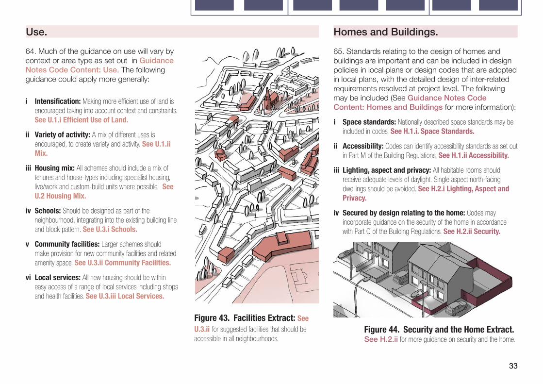
Figure 43. Facilities Extract: See U.3.ii for suggested facilities that should be accessible in all neighbourhoods.
Figure 44. Security and the Home Extract. See H.2.ii for more guidance on security and the home.
34
Resources.
66. Standards relating to sustainability are important and can be incorporated into codes or covered in other policy, and the detail design of inter-related requirements resolved at project level. They might include the following (See Guidance Notes Code Content: Resources):
Lifespan.
67. Lifespan relates to way schemes are managed and the way that residents are involved in design and management. These issues can be included in design codes and may include the following (See Guidance Notes Code Content: Lifespan for more information):
i Management plans: These set out the approach to adoption and management, including the potential for community management. They may be a requirement for schemes over a certain size. See L.1.i Management Plan.
ii Community participation: Codes may require that consultation take place on all schemes prior to the submission of a planning application. See L.1.ii Participation in Design.
i Energy efficiency standards: Local authorities can set policies in local plans or design codes that are adopted in local plans for higher energy efficiency standards for their area or specific development sites. See R.1.ii Energy Efficiency.
ii Passive energy design: Development should be designed to optimise passive solar gain without risking overheating. Orientation should be optimised in as far as it does not contradict other approaches in this guide. See R.1.ii Energy Efficiency.
iii Local low carbon, low energy networks: May be encouraged by codes. See R.1.iii Neighbourhood Energy Issues.
iv Environmental standards: Codes may set standards for new development to meet relating to:
• Embodied energy/carbon.
• Whole life-cycle carbon.
• BREEAM Ratings and other best practice guidance.
• Modern Methods of Construction.
• Water usage.
v Onsite renewable sources: The use of renewable energy sources should be maximised and a ‘fabric first’ approach where appropriate. See R.2 Sustainable Construction.
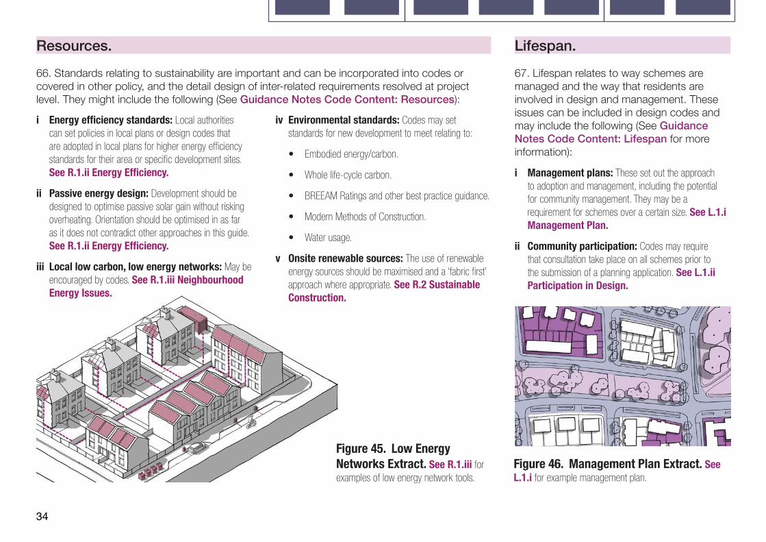
Figure 45. Low Energy Networks Extract. See R.1.iii for examples of low energy network tools.
Figure 46. Management Plan Extract. See L.1.i for example management plan.
Glossary.
Glossary. Area type.Parts of the local area that share common features and characteristics.
For example, a suburban area type might bring together a number of different housing estates with common densities, heights, building line, party wall condition etc.)under the umbrella term “outer suburbs”.
Common rules and parameters can then be applied to the “outer suburbs” area type in the design code.
Example area types are provided in the National Model Design Code, but in practice area types should be defined locally.
Area type matrix.
A table detailing the elements of the design code that are likely to differ between area types.
Area type work sheet.
A set of prompts and sections to be completed, detailing the key elements and features that should be considered when undertaking a character study. This is not an exhaustive list and should be adapted locally.
Character study.
A process of analysis at area type level to determine the elements and features that contribute to the unique character of a place. This process can be used to determine existing area types, using the area type work sheet.
Coding plan.
A plan at local authority level showing the local areas to which a code will apply. The coding plan can show:
• Existing built-up areas.• Landscape designated areas.• Heritage areas.• Protected open space.• Special policy areas.• Development areas.
Context study.
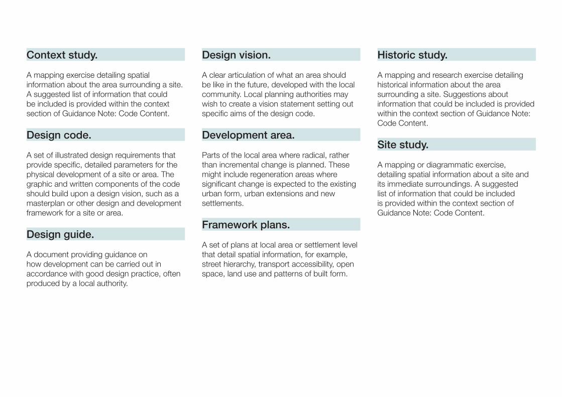
A mapping exercise detailing spatial information about the area surrounding a site. A suggested list of information that could be included is provided within the context section of Guidance Note: Code Content.
Design code.
A set of illustrated design requirements that provide specific, detailed parameters for the physical development of a site or area. The graphic and written components of the code should build upon a design vision, such as a masterplan or other design and development framework for a site or area.
Design guide.
A document providing guidance on how development can be carried out in accordance with good design practice, often produced by a local authority.
Design vision.
A clear articulation of what an area should be like in the future, developed with the local community. Local planning authorities may wish to create a vision statement setting out specific aims of the design code.
Development area.
Parts of the local area where radical, rather than incremental change is planned. These might include regeneration areas where significant change is expected to the existing urban form, urban extensions and new settlements.
Framework plans.
A set of plans at local area or settlement level that detail spatial information, for example, street hierarchy, transport accessibility, open space, land use and patterns of built form.
Historic study.
A mapping and research exercise detailing historical information about the area surrounding a site. Suggestions about information that could be included is provided within the context section of Guidance Note: Code Content.
Site study.
A mapping or diagrammatic exercise, detailing spatial information about a site and its immediate surroundings. A suggested list of information that could be included is provided within the context section of Guidance Note: Code Content.
References.
References to Further Guidance.
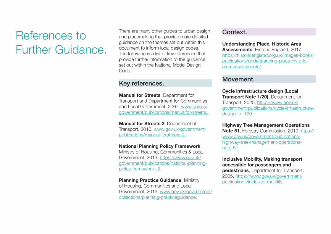
There are many other guides to urban design and placemaking that provide more detailed guidance on the themes set out within this document to inform local design codes.The following is a list of key references that provide further information to the guidance set out within the National Model Design Code.
Key references.
Manual for Streets, Department for Transport and Department for Communities and Local Government, 2007, www.gov.uk/government/publications/manualfor-streets.
Manual for Streets 2, Department of Transport, 2010, www.gov.uk/government/publications/manual-forstreets-2.
National Planning Policy Framework, Ministry of Housing, Communities & Local Government, 2019, https://www.gov.uk/government/publications/national-planning-policy-framework--2.
Planning Practice Guidance, Ministry of Housing, Communities and Local Government, 2016, www.gov.uk/government/collections/planning-practiceguidance.
Context.
Understanding Place, Historic Area Assessments, Historic England, 2017, https://historicengland.org.uk/images-books/publications/understanding-place-historic-area-assessments/.
Movement.
Cycle infrastructure design (Local Transport Note 1/20), Department for Transport, 2020, https://www.gov.uk/government/publications/cycle-infrastructure-design-ltn-120.
Highway Tree Management Operations Note 51, Forestry Commission, 2019 https://www.gov.uk/government/publications/highway-tree-management-operations-note-51.
Inclusive Mobility, Making transport accessible for passengers and pedestrians, Department for Transport, 2005, https://www.gov.uk/government/publications/inclusive-mobility.
Traffic Signs Manual, Chapter 6 Traffic Control, Department for Transport, 2019, https://www.gov.uk/government/publications/traffic-signs-manual.
Traffic Signs Regulations and General Directions, an Overview, Department for Transport, 2016, https://www.gov.uk/government/publications/traffic-signs-regulations-and-general-directions-2016-an-overview.
Nature.
Environment Bill 2020, Department for Environment, Food & Rural Affairs, https://www.gov.uk/government/publications/environment-bill-2020. (forthcoming).
National Framework of Green Infrastructure Standards. (forthcoming guidance to be announced).
A Green Future: Our 25 Year Plan to Improve the Environment, Department for Environment, Food and Rural Affairs, 2018, www.gov.uk/government/publications/25-year-environment-plan.
Flood risk assessments: climate change allowances, Environment Agency, 2020, https://www.gov.uk/guidance/flood-risk-assessments-climate-change-allowances.
Guidance for Outdoor Sport and Play Beyond the Six Acre Standard, England, Fields in Trust, 2015, http://www.fieldsintrust.org/guidance.
Improving access to greenspace A new review for 2020, Public Health England, 2020, https://assets.publishing.service.gov.uk/government/uploads/system/uploads/attachment_data/file/904439/Improving_access_to_greenspace_2020_review.pdf.
Flood risk emergency plans for new development, Environment Agency and ADEPT, 2019, https://www.adeptnet.org.uk/floodriskemergencyplan.
National Area Type Profiles, Natural England, 2014, https://www.gov.uk/government/publications/national-character-area-profiles-data-for-local-decision-making/national-character-area-profile.
Nature Nearby - Accessible Natural Greenspace Guidance (NE265), Natural England, 2010, https://webarchive.nationalarchives.gov.uk/20140605145320/http://publications.naturalengland.org.uk/publication/40004?category=47004.
Open space, sports and recreation facilities, public rights of way and local green space, Ministry of Housing, Communities and Local Government, 2014, https://www.gov.uk/guidance/open-space-sports-and-recreation-facilities-public-rights-of-way-and-local-green-space.
Sustainable drainage systems: non-statutory technical standards, Department for Environment, Food and Rural Affairs, 2015, https://www.gov.uk/government/publications/sustainable-drainage-systems-non-statutory-technical-standards.
The Biodiversity Metric 2.0 (JP029), Natural England, http://publications.naturalengland.org.uk/publication/5850908674228224.
The Mosaic Approach: Managing Habitats for Species (B2020-009), Natural England, 2013, http://publications.naturalengland.org.uk/publication/6415972705501184.

The Right Tree in the Right Place for a Resilient Future – Urban Tree Manual, Forestry Commission and Forest Research, https://www.forestresearch.gov.uk/tools-and-resources/urban-tree-manual/.
The SuDS Manual (C753), CIRIA, 2015, https://www.susdrain.org/resources/SuDS_Manual.html.
Built Form.
Increasing Residential Density in Historic Environments, Historic England, 2018, https://historicengland.org.uk/images-books/publications/increasing-residential-density-in-historic-environments/.
Identity.
Streets for All, Advice for Highway and Public Realm Works in Historic Places, Historic England, 2018, https://historicengland.org.uk/images-books/publications/streets-for-all/ .
Public Space.
Hostile Vehicle Mitigation, Centre for the Protection of National Infrastructure, https://www.cpni.gov.uk/hostile-vehicle-mitigation-0.
Influence of bollards on pedestrian evacuation flow (TAL 01/16), Department for Transport, 2017, https://www.gov.uk/government/publications/influence-of-bollards-on-pedestrian-evacuation-flow-tal-0116.
Integrated Security, A Public Realm Design Guide for Hostile Vehicle Mitigation - Second Edition, Centre for the Protection of National Infrastructure, 2014, https://www.cpni.gov.uk/system/files/documents/40/20/Integrated%20Security%20Guide.pdf.
Secured By Design, Police Crime Prevention Initiatives Limited, 2020, www.securedbydesign.com.
Using bollards to reduce threats from vehicles (TAL 02/13), Department for Transport, 2017, https://www.gov.uk/government/publications/tal-213-bollards-and-pedestrian-movement.
Vehicle security barriers within the streetscape (TAL 01/11), Department for Transport, 2011, https://www.gov.uk/government/publications/vehicle-security-barriers-within-the-streetscape.
Use.
DH health building notes, Department of Health and Social Care, 2017. https://www.gov.uk/government/collections/health-building-notes-core-elements.
School design and construction, Department of Education, 2020, https://www.gov.uk/government/collections/school-design-and-construction.
Homes and Buildings.
Technical housing standards – nationally described space standard, Ministry of Housing, Communities and Local Government, 2015, https://www.gov.uk/government/publications/technical-housing-standards-nationally-described-space-standard.
Resources.
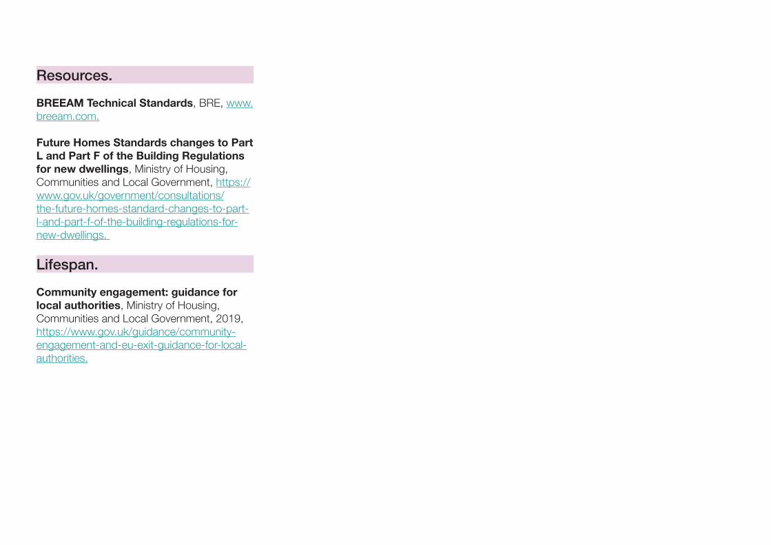
BREEAM Technical Standards, BRE, www.breeam.com.
Future Homes Standards changes to Part L and Part F of the Building Regulations for new dwellings, Ministry of Housing, Communities and Local Government, https://www.gov.uk/government/consultations/the-future-homes-standard-changes-to-part-l-and-part-f-of-the-building-regulations-for-new-dwellings.
Lifespan.
Community engagement: guidance for local authorities, Ministry of Housing, Communities and Local Government, 2019, https://www.gov.uk/guidance/community-engagement-and-eu-exit-guidance-for-local-authorities.

Credits.

Credits.
Section. Page. Information. Image Credit.Main Document.
Front Cover - Background. N/A. Masterplan for The Avenue, Saffron Walden, Pollard Thomas Edwards.
Pollard Thomas Edwards.
Front Cover - Images. N/A. Portobello Square, London, PRP Architects LLP.
PRP Architects LLP.
Front Cover - Images. N/A. Carrowbreck Meadow, Norwich, Hamson Barron Smith.
Jefferson Smith (Photographer).
Front Cover - Images. N/A. The Avenue, Saffron Walden, Pollard Thomas Edwards.
Tim Crocker Architectural Photography.
Front Cover - Images. N/A. Nansledan, Newquay, Cornwall, ADAM Architecture.
ADAM Architecture.
The Coding Process. Section Break. Gas holders, Kings Cross, Wilkinson Eyre Architects and Bell Phillips Architects.
James O Davies, Historic England.
Glossary. Section Break. Brandon Yard, Bristol. AWW Architects. James O Davies, Historic England.
References. Section Break. Beaulieu, Chelmsford, Gardner Stewart Architects.
The Land Trust/Countryside Properties.
Credits. Section Break. Brandon Yard, Bristol. AWW Architects. James O Davies, Historic England.
Unless otherwise stated the illustrations, diagrams and maps were produced by URBED for MHCLG.
Section. Page. Information. Image Credit.Guidance Notes.
Front Cover. As Main Document.
Code Content. Section Break. Brandon Yard, Bristol. AWW Architects. James O Davies, Historic England.
Context. P2. Nansledan, Newquay, Cornwall, ADAM Architecture.
ADAM Architecture.
Movement. P6. Kensington High Street, London. Public Domain, HTUK at English Wikipedia.
Movement. P8. PTAL Plan, Croydon, London. Interactive PTAL map- www.tfl.gov.uk.
Movement. P10. Thicket Mead, Midsomer Norton, Somerset, ADAM Architecture.
ADAM Architecture, Dylan ThomasPhotography.
Movement. P10. Orford Road, Waltham Forest, London, after public realm works.
Movement. P14. Public Cycle Parking Example. Public Domain, Cyclestreets.net.
Movement. P14. Apartment Cycle Parking Example. Cycle Works.
Movement. P14. Residential Street Cycle Parking Example. David Hawgood, licensed for reuse under Creative Commons Licence.
Movement. P14. Workplace Cycle Parking Example. Cycle Works.
Nature. P17. Freiburg, Germany. URBED.
Nature. P18. Stanage Edge, The Peak District. URBED.
Nature. P18. Victoria Mill Park, Manchester. URBED.
Nature. P18. Heaton Park, Manchester. URBED.
Section. Page. Information. Image Credit.Nature. P18. The University of Manchester, Burlington
Street Campus.URBED.
Nature. P18. Central Park, Chelmsford. Jane Houghton, Natural England.
Nature. P19. Grove Terrace Gardens, Highgate Road, London.
Forestry Commission.
Nature. P19. Communal Gardens, Accordia, Cambridge.
URBED.
Nature. P19. Food Growing, Levenshulme, Manchester.
URBED.
Nature. P19. Private Gardens, The Malings, Newcastle. URBED.
Nature. P19. Balconies, Timekeepers Square, Salford. URBED.
Nature. P19. Deansgate Castlefield Metrolink Stop Design by SimpsonHaugh.
Jan Chlebik (Photographer).
Nature. P22. Central Park, Chelmsford. Jane Houghton, Natural England.
Nature. P24. RIBA Home for All Seasons, JTP Architects.
JTP Architects/TEDS.
Nature. P25. Bee Brick. Green and Blue.
Nature. P25. Hedgehog Street. Peoples Trust for Endangered Species.
Built Form. P28. Mixed Use Development, Houlton, Rugby. Davidson Homes.
Built Form. P35. The Roof Gardens, Salford, Ollier Smurthwaite Architects.
URBED.
Section. Page. Information. Image Credit.Built Form. P34. The Pheasantry, Residential Scheme,
Crawley Down, West Sussex.AHR Architecture and Building Consultancy and Hastoe Housing Association.
Built Form. P34. Marmalade Lane, Cambridge, Mole Architects.
TOWN.
Built Form. P34. Accordia Sky Villas, Cambridge, Alison Brooks Architects.
URBED.
Built Form. P34. Donnybrook Quarter, Tower Hamlets, Peter Barber Architects.
Morley von Sternberg (Photographer).
Identity. P41. Tibby’s Triangle, Southwold , Ash Sakula Architects.
Peter Cook (Photographer).
Identity. P42. Chelmsford Wayfinding Project, IS Group. IS Group.
Identity. P42. Timekeepers Square, Salford, Buttress Architects.
Buttress Architects.
Identity. P48. 121 Upper Richmond Rd, London, Allford Hall Monaghan Morris.
Rob Parrish (Photographer).
Identity. P48. Blackfriars Circus, London, Maccreanor Lavington.
Tim Crocker Architectural Photography.
Identity. P48. 67 Southwark Street, London by Allies and Morrison.
Nick Guttridge (Photographer).
Identity. P48. Mapleton Crescent, London, Metropolitan Workshop.
Simon Kennedy (Photographer).
Public Space. P49. Goldsmith Street, Norwich, Mikhail Riches.
Tim Crocker Architectural Photography.
Public Space. P60. Abode at Great Kneighton, Proctor and Matthews Architects.
Tim Crocker Architectural Photography.
Section. Page. Information. Image Credit.Use. P63. Wapping Wharf, Bristol, Alec French
Architects.Alec French Architects.
Homes and Buildings. P72. Derwenthorpe, York, Joseph Rowntree Foundation.
Joseph Rowntree Foundation.
Resources. P77. Officers Field,Weymouth, HTA Design. Richard Downer (Photographer).
Resources. P79. Micro-climate Modelling. Dr Brian Miller of Wilde Analysis, part of the Wilde Group of Companies.
Resources P79. Electric Vehicle Charging Point. Polestar.
Resources P80. Window Shading. Colt Tollfab.
Lifespan. P82. The Malings, Newcastle, Ash Sakula. Jill Tate (Photographer).
Community Engagement. Section Break. Masterplanning Workshop. URBED.
Community Engagement. P86. Gleadless Valley Consultation 2018. URBED.
Community Engagement. P89 Hands-on Planning Co-designWorkshops at Fort Halstead CommunityPlanning Weekend.
JTP.
Community Engagement. P89. Digital Engagement Tool Commonplace.
Community Engagement. P89. Digital Engagement Tool for Places Commonplace.
Related Documents