Welcome message from author
This document is posted to help you gain knowledge. Please leave a comment to let me know what you think about it! Share it to your friends and learn new things together.
Transcript

Compendium of Task Force Sub Group Reports
on National Landslide Risk Management Strategy

Compendium of Task Force Sub Group Reports onNational Landslide Risk Management Strategy
A publication of:National Disaster Management AuthorityMinistry of Home AffairsGovernment of IndiaNDMA BhawanA-1, Safdarjung EnclaveNew Delhi - 110029
September 2019
When citing this manual, the following citation should be used: Compendium of Task Force Sub Group Reports onNational Landslide Risk Management StrategyA publication of the National Disaster Management Authority, Government of India.September 2019, New Delhi
These Compendium of Task Force Sub Group Reports on National Landslide Risk Management Strategy are formulated under the Chairmanship of Lt. Gen. N.C. Marwah (Retd.), Member, NDMA, in consultation with various stakeholders, regulators, service providers, and specialists in the subject field concerned from all across the country.
National Disaster Management AuthorityMinistry of Home Affairs
Government of India
Compendium of Task Force Sub Group Reports
on National Landslide Risk Management Strategy

iv
Compendium on national landslide Risk management stRategy
v
ContentsAbbreviations vii
1. Generation of User-Friendly Landslide Hazard Maps 1-481.1 Introduction 11.2 Identification of the Problem and Landslide Zoning 3 1.2.1 Landslide susceptibility zoning 3 1.2.2 Landslide hazard zoning 51.3 Landslide risk zoning 81.4 Where do we require landslide zoning 101.5 Purpose, type and levels of landslide zoning 101.6 Suggested descriptors of landslide susceptibility, hazard and risk zoning 141.7 Reliability and validation of landslide zoning maps 151.8 Indian scenario and future strategies: Landslide zoning 171.9 Financial implication 341.10 Implementation strategy 351.11 Monitoring Mechanism 361.12 Conclusion & recommendations 361.13 References 391.14 Annexure 1: National Landslide Susceptibility Mapping (NLSM) Programme 43 Annexure 2: Detailed geo-parametric attributes for landslide inventory 46
2. Development of Landslide Monitoring and Early Warning System 49-1182.1 Introduction 492.2 Identification of problem 512.3 Review of past work, best practices and present status 522.4 Earthquake triggered landslide 742.5 Monitoring mechanism 742.6 Identified gaps 772.7 Recommendations 792.8 Implementation strategy and action plan 812.9 Financial implications 882.10 Way forward 882.11 References 902.12 Annexure 1: Rainfall threshold equations: Global practices 102 Annexure 2: Important satellites and sensors for slope stability Analysis 111 Annexure 3: Surface deformation and landslides due to Kashmir 113 earthquake of 2005.
3. Awareness Programmes 119-1333.1 Introduction 1193.2 Identification of problem 119

vi
Compendium on national landslide Risk management stRategy
3.3 Reviewofpastworkandbestpractices 1203.4 Identifiedgaps 1213.5 Recommendations 1223.6 Implementationstrategyforawarenessprogrammeonlandslides 1243.7 Financialimplications 1333.8 Monitoringmechanism 133
4. Capacity Building and Training of Stakeholders 135-1764.1 Introduction 1354.2 Identificationofproblem 1354.3 Reviewofwork 1364.4 Identifiedgaps 1404.5 Recommendations 1464.6 Implementationstrategy 1604.7 Financialimplications 1614.8 Monitoringmechanism 1624.9 References 1624.10 Annexure 165
5. PreparationofMountainZoneRegulations&Policies 177-1985.1 Introduction 1775.2 Scopeofwork 1815.3 Proposedamendmentintownandcountryplanninglegislations 1825.4 Regulationsforlandusezoningfornaturalhazardproneareas 1835.5 Additionalprovisionsindevelopmentcontrolregulationsforsafety 188
innaturalhazardproneareas5.6 Additionalprovisionsinbuildingregulations/bye-lawsforstructuralsafety 192
inlandslidehazardproneareas5.7 Controlofsignsandoutdoordisplay 1945.8 Structuralrequirementsoflowcosthousing 1945.9 Recommendationsonlegalsupport,developmentcontrolandbuilding 196
bye-lawsrelatedtosafetyagainstlandslidehazard
6. StabilizationandMitigationofLandslidesandCreationof 199-205 SpecialPurposeVehicle(SPV)forLandslideManagement
6.1 Introduction 1996.2 Identificationofproblem 1996.3 Identifiedgaps 2006.4 TheGapsinSoP 2006.5 Recommendations 2016.6 Conclusion 205Annexure-I:CompositionofTaskForce 207
ContactUs 208
vii
AbbreviationsADB Asian Development BankADPC Asian Disaster Preparedness Centre ADRC Asian Disaster Reduction CentreAGS Australian Geomechnics SocietyAHP Analytical Hierarchy Process ATI Administrative Training InstituteAVVU Amrita Vishwa Vidyapeetham UniversityAWS Automatic Weather StationsBDMC Block Disaster Management CommitteeBIS Bureau of Indian StandardsBMTPC Building Materials and Technology Promotion Council’sBRO Border Road Organisation CADRI Capacity for Disaster Reduction InitiativeCBDRMS Community Based Disaster Risk Management SocietyCBFDP Community Based Family Disaster Preparedness and mitigationCBO Community Based OrganisationCBRI Central Building Research InstituteCCA Climate Change AdaptationCHC Community Health CentreCLRSM Centre for Landslide Research Studies & ManagementCR Central RegionCRRI Central Road Research InstituteCSIO Central Scientific Instruments OrganizationCSIR Council of Scientific and Industrial ResearchCSMRS Central Soil and Material Research StationCWC Central Water CommissionDART Dynamic Antecedent Rainfall ThresholdDDMA District Disaster Management AuthorityDDMC District Disaster Management CommitteeDEOG District Emergency Operations GroupDGM Department of Geology & MiningDInSAR Differential Interferometry Synthetic Aperture RadarDMC Disaster Management CellDMMC Disaster Mitigation and Management Centre DMSP Disaster Management Support Programme DoPT Department of Personnel and TrainingDPRI Disaster Prevention Research Institute DPR Detailed Project ReportDRDO Defence Research Development Organisation

viii
Compendium on national landslide Risk management stRategy
DRMP Disaster Risk Management ProgrammeDRR Disaster Risk ReductionDST Department of Science & TechnologyDTRL Defence Terrain Research LaboratoryEFC Expenditure Finance CommitteeEO Earth ObservationER Eastern RegionERT Electrical Resistivity TomographyEU European UnionFEMA Federal Emergency Management AgencyFLHW Front Line Health WorkersFoS Factor of SafetyGFR General Financial RulesGIS Geographical Information SystemGNSS Global Navigation Satellite SystemGLOFs Glacial Lake Outburst FloodsGoI Government of IndiaGPR Ground Penetrating RadarGPS Global Positioning SystemGSI Geological Survey of IndiaGTA Gorkha Territorial AdministrationIAEG International Association of Engineering GeologistsIAHE Indian Academy of Highway EngineersIEC Information Education and Communication IGNOU Indira Gandhi National Open UniversityIIRS Indian Institute of Remote SensingIIT Indian Institute of TechnologyIMD Indian Meteorological DepartmentISRO Indian Space Research OrganisationITC ITC, University of Twente, The NetherlandsIUGS International Union of Geological SciencesLC Land coverLEWS Landslide Early Warning SystemLiDAR Light Detection and RangingLHZ Landslide Hazard ZonationLHZMC LHZ Monitoring CommitteeLHM Landslide Hazard ManagementLSA Landslide Susceptibility AnalysisLSER Landslide Susceptibility Estimated RateLSI Landslide Susceptibility Index LSM Landslide Susceptibility ManagementLSV Landslide Susceptibility ValuesLSZ Landslide Susceptibility Zonation
ix
LU Land use MAP Mean Annual PrecipitationMEMS Micro-Electro Mechanical SystemsMHA Ministry of Home AffairsMHRD Ministry of Human Resource DevelopmentMNREGA Mahatma Gandhi National Rural Employment GuaranteeMoEFCC Ministry of Environment Forest and Climate ChangeMoES Ministry of Earth SciencesMoM Ministry of MinesMoR Ministry of RailwaysNBC National Building CodeNCC National Cadet Corps NCS National Centre of SeismologyNDMA National Disaster Management Authority NDRF National Disaster Response ForceNER North Eastern RegionNGI Norvegian Geotechnical InstituteNGO Non-Governmental OrganisationNHAI National Highway Authority of IndiaNIDM National Institute of Disaster ManagementNIT National Institute of TechnologyNLMP National Landslide Mitigation PolicyNLMS National Landslide Mitigation StrategyNLSM National Landslide Susceptibility MappingNOAA National Oceanic and Atmospheric AdministrationNPCBAERM National Programme for Capacity Building of Architects in Earthquake Risk
ManagementNPCBEERM National Programme for Capacity Building of Engineers in Earthquake Risk
ManagementNSS National Service Scheme NR Northern RegionNRDMS Natural Resource Data Management SystemNRSC National Remote Sensing CentrePHC Primary Health CentrePRI Panchayati Raj InstitutionPS InSAR Persistent Scatterer Interferometry Synthetic Aperture RadarPWD Public Works DepartmentQAR Quality Auditor on RecordQAAR Quality Auditor Agency on RecordRES Rural Engineering ServicesRIRD Regional Institutes of Rural DevelopmentRS Remote SensingRSAC Remote Sensing Applications Centre
AbbreviAtions

x
Compendium on national landslide Risk management stRategy
RT Rainfall ThresholdSASE Snow and Avalanches Studies EstablishmentSAR Synthetic Aperture RadarSDAR Structural Design Agency on RecordSDBR Structural Design Basis ReportSDMA State Disaster Management AuthoritySDRF State Disaster Response ForceSDRP Structural Design Review PanelSER Structural Engineer on RecordSFC Standing Finance CommitteeSFM Slope forming material SIL Seismicity Induced LandslidesSIRD State Institutes of Rural Development SLIM Seasonal Landslide Inventory MappingSMS Short Message ServiceSoI Survey of IndiaSOP Standing Operating ProceduresSR Southern RegionTAC Technical Advisory Committee TCPO Town and Country Planning OrganizationTDMC Tehsil Disaster Management CommitteeTEC Technical Evaluation CommitteeTESV Total Estimated Susceptibility ValuesTNA Training Need AssessmentTRMM Tropical Rainfall Measuring MissionUAV Unmanned Aerial VehicleUDPFI Urban Development Plan Formulation and ImplementationUGC University Grants CommissionULBs Urban Local BodiesUNDP United Nations Development ProgrammeUNESCO United Nations Education Scientific and Cultural OrganisationUNISDR United Nations International Strategy for Disaster ReductionUSGS United States Geological SurveyVDIT Village Disaster Intervention TeamsVDMC Village Disaster Management CommitteeVDMT Village Disaster Management TeamsWB World BankWHO World Health OrganisationWIHG Wadia Institute of Himalayan Geology WMIO Weighted Multi-class Index OverlayWSN Wireless Sensor Network
1
Generation of User-Friendly Landslide Hazard Maps1
1.1 Introduction Landslides are significant hazards that
can be disastrous to human life and property. Recent global disaster assessment studies (Petley et al., 2005; Nadim and Kjekstad, 2009; OFDA/CRED, 2010) reveal that the countries with the highest risk to such disasters are mostly located in the developing world such as Venezuela, Peru, Tajikistan, Philippines, Colombia, India, China, Nepal etc., where the estimated landslide fatality rate exceeds one per 100 km2 per year. According to the total landslide fatalities reported worldwide in the last decade, Kirschbaum et al. (2010) confirmed that the developing countries account to about 80%, of which in India, nearly 8% of landslide fatalities are reported. Landslides account for considerable loss of life and damage to communication routes, human settlements, agricultural fields and forest lands in India. Based on the general experience with landslides, a rough estimate of monetary loss is of the order of Rs. 100 crore to Rs. 150 crore per annum at the 2011 prices for the country as a whole (Disaster Management in India, MHA, Govt. of India, 2011).
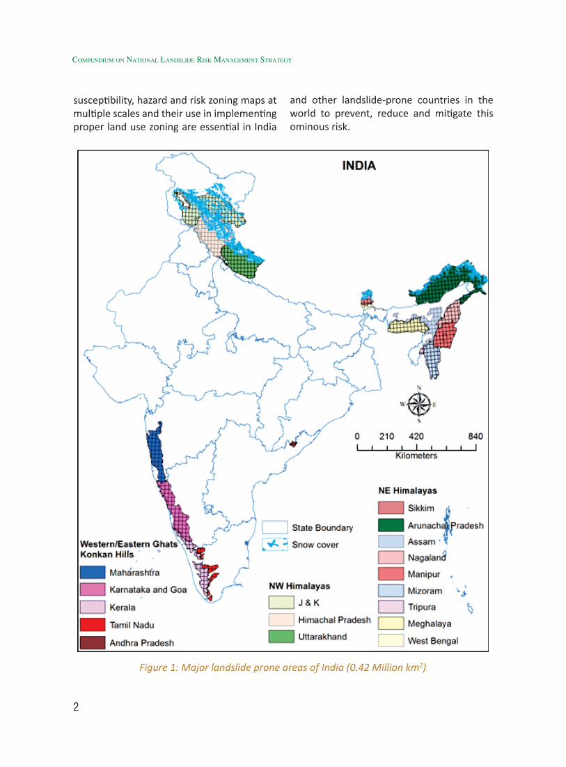
In India, excluding the permafrost regions in the north, about 0.42 Million km2 areas of the landmass (12.6%) is landslide-prone which are spread over 1127 Survey of India (SoI) Topographic map sheets (part or full) on 1:50K scale in 22 numbers of States/Union Territories and are spreading over more than
65,000 villages in hilly/ mountainous areas (Fig. 1). In this vast terrain, landslides occur most frequently in the Himalayas and some parts of Western Ghats and intermittently to very intermittently in rest of the locations, mostly during the monsoon periods (June-October), causing huge, varied and irreparable damages. Himalayan region has borne the worst consequences of landslides in the past and during recent times as well. The Himalaya is seismically the most active segment of Indian subcontinent and occurrences of landslides are common in such geo-dynamically sensitive belt (Valdiya, 1987). The cumulative effects of the natural processes and anthropogenic activities have often been cited as causative factors for many potential slide zones of Himalayas (Uniyal, 2004, 2006, 2008, 2010). Further, the anthropogenic interference and consequent obliteration of landscape of this geo-dynamically sensitive and extreme rainfall prone region (Himalayas) is one of the major triggering factor for frequent landslide occurrences in this region (Uniyal, 2012). To mitigate the effects of hazards and natural disasters, the Government of India has modified the disaster management policy by enacting the Disaster Management Act in 2005. This Act aims at adopting more proactive and multi-disciplinary approaches towards achieving disaster awareness and mitigation. Therefore, to properly allocate resources, planning and implementing landslide prevention and mitigation, preparation of landslide
2
Compendium on national landslide Risk management stRategy
Figure 1: Major landslide prone areas of India (0.42 Million km2)
susceptibility, hazard and risk zoning maps at multiple scales and their use in implementing proper land use zoning are essential in India
and other landslide-prone countries in the world to prevent, reduce and mitigate this ominous risk.
3
1.2 Identification of the Problem and Landslide Zoning
Major parts of the northern states of India namely Jammu & Kashmir, Himachal Pradesh, Uttarakhand and north-eastern states of the country viz. Sikkim, Arunachal Pradesh, Mizoram, Nagaland, Manipur, Meghalaya, Assam and Tripura are vulnerable to landslides due to fragile geology, active tectonics, high relief, critical slopes and intense rainfall and anthropogenic activities at various locations of these states. Western parts of Maharashtra, Karnataka, Goa and Kerala covering parts of western ghats and eastern parts of Andhra Pradesh and Tamil Nadu in eastern ghats are also vulnerable to landslides. Hence, there is an urgent need for holistic approach to landslide mitigation and management with region and area specific landslide hazard information and structural and non structural mitigation as the core theme.
Landslide Zoning is the division of hill or mountainous areas into homogeneous spatial areas/ slope according to their degrees of actual or potential landslide susceptibility, hazard or risk.
According to Varnes (1984) and UNESCO’s IAEG Commission on landslides and other mass movements, “landslide hazard” is defined as the probability of occurrence of a damaging landslide phenomenon in a given area and in a given period of time. This definition incorporates concepts about geographical location (susceptibility) and recurrence that answers where and when a damaging landslide phenomenon (i.e., hazard) will occur. Guzzetti et al. (1999) however, modified that definition of hazard by incorporating the concept of magnitude of future event and, thus, redefined landslide
hazard in a given area as a function of three parameters, namely, spatial, temporal and magnitude probabilities of landslide occurrence. In India, the available landslide hazard zonation maps are mostly qualitative landslide susceptibility maps because of severe scarcity of data on landslide dates and magnitudes, therefore, determination of temporal and magnitude predictions, converting susceptibility into hazard becomes quite difficult, if not impossible.
1.2.1 Landslide Susceptibility Zoning
Landslide susceptibility zoning uses an inventory of past landslide incidences together with an assessment or prediction of the spatial areas/ slope with a likelihood of landslides in the future. Landslide susceptibility zoning involves a degree of interpretation. Susceptibility zoning thus involves the spatial distribution and rating of the terrain units according to their propensity to produce landslides. This is dependent on the topography, geology, geotechnical properties, climate, vegetation and anthropogenic factors such as development and clearing of vegetation. It should consider all landslides which can affect the study area and include landslides which are above the study area but may travel onto it, and landslides below the study area which may retrogressively fail up-slope into it. It does not involve any assessment of the frequency (annual probability) of the occurrence of landslides.
The scale of susceptibility is usually a relative one and a very important aspect. The travel and regression of the landslides are dependent on different factors to those causing the landslides. Areas which may be affected by travel or regression of the landslides from the source will often
Generation of User-friendly landslide Hazard Maps
4
Compendium on national landslide Risk management stRategy
be assessed independently. There are however some differences of viewpoint amongst experts in landslide zoning as to whether susceptibility zoning should include an assessment of the potential travel or regression of landslides from their source. Some feel that this should be considered only in hazard zoning. However, in some situations it will be difficult to assess the frequency of landsliding and landuse zoning may be carried out based only on susceptibility zoning. In these cases, the important matter of travel or regression would be lost, if the same is not assessed in susceptibility analysis. In view of this, travel and regression should be considered in susceptibility zoning (Fell et al., 2008). It should also be recognized that the study area may be susceptible to more than one type of landslide or landslide domains e.g. rock fall and debris flows, and may have a different degree of susceptibility (and in turn hazard). In these cases, it will often be best to prepare separate susceptibility, and hazard zoning maps for each type of landslide and to combine them later to obtain the global landslide hazard map of the area. However, it mostly becomes difficult due to paucity of landslide data of different types.
Subjectively, landslide susceptibility zoning maps may be developed from landslide inventories and geomorphological maps produced from aerial photos, satellite images, and field work. A relative susceptibility is allocated in a subjective manner by the person doing the study. This method is known as Direct or Indirect Heuristic/ Knowledge driven method. This often leads to a map which is very subjective and difficult to justify or reproduce systematically. A more objective way of developing susceptibility zoning map is by correlating statistically a set of pre-disposing factors (such as geological–morphological factors) with slope instability
from the landslide inventory. Slope failure is caused by the concurrence of permanent/ pre-disposing conditioning and triggering factors. Permanent/ Pre-disposing factors are terrain attributes (i.e. lithology, soil types and depths, slope, watershed size, vegetation cover, among others) that evolve slowly (i.e. by weathering or erosion) to bring the slopes to a marginally stable state. Triggering events include ground shaking due to earthquakes or rise of groundwater levels and/or pressures due to infiltration of rainfall or snow melt. Only permanent/ pre-disposing conditioning factors are mapped and used to assess landslide susceptibility while the recurrence period of the triggers is usually used to assess the frequency of events which are subsequently used for landslide hazard analysis. The relative contribution of the pre-disposing factors generating slope failures is assessed and the land surface is classified into domains of different susceptibility levels. Finally, the results of the classification are checked by analyzing whether the spatial distribution of the existing landslides (landslide inventory) takes place in the classes rated as the most unstable. It should be kept in mind that the aim of landslide susceptibility mapping should be to include the maximum number of landslides in the highest susceptibility classes whilst trying to achieve the minimum spatial area for these classes.
At large to detailed scale, detailed susceptibility maps are based on deterministic geotechnical models such as the infinite slope with parallel plane failure, provided the landslides in the area are shallow translational slides in rocks or soils (i.e. consistent with infinite slopes). An assessment of geotechnical and pore water pressure parameters through deterministic slope stability modeling is necessary in order
5
to use this approach. The safety factor may be established in a GIS in pixel/unit cells and the results referred to susceptibility depending on the calculated factor of safety. Given the complexity of geotechnical conditions in slopes these methods are unreliable unless calibrated by correlating with the landslide inventory.
1.2.2 Landslide Hazard Zoning
Landslide hazard zoning uses the landslide susceptibility maps and assigns an estimated frequency (i.e. annual probability) to the potential landslides of certain magnitude. It should consider all landsliding events which can affect the study area including landslides which are above the study area but may travel onto it, and the landslides below the study area which may retro grade up-slope into it. The hazard may be expressed as the frequency of a particular type of landslide of a certain volume/ area (~magnitude), or landslides of a particular type, volume/ area and velocity (which may vary with distance from the landslide source), or in some cases as the frequency of landslides with a particular intensity, where intensity may be measured in kinetic energy terms. Intensity measures are most useful for rock falls and debris flows (e.g. depth × velocity). Hazard zoning may be quantitative or qualitative. It is generally preferable to determine the frequency of landsliding in quantitative terms so that the hazard from different sites can be compared, and the risk estimated consequently also in quantitative terms. However, in some situations it may not be practical to assess frequencies sufficiently accurate to use quantitative hazard zoning because of paucity of relevant input data and a qualitative system of describing hazard classes may be adopted. Usually, even for these cases, following internationally-accepted guidelines
(AGS 2007, Fell et al, 2007), it will be possible to give some approximate guidance on the frequency of landslides as descriptors in the zoning classes which must be attempted (Table 3) in Indian terrain to develop India’s own relevant descriptors. However, this hazard analysis is highly data-intensive which stresses more importance in comprehensive collection of landslide inventory data with all relevant inputs/attributes (a format is placed in this document in Annexure-II).
1.2.2.1 Frequency Assessment
IUGS (1997) advised that the frequency of landsliding may be expressed in terms of the followings as per different scale of observation.
• The number of landslides of certain characteristics that may occur in the study area in a given span of time (generally per year, but the period of reference might be different if required).
• The probability of a particular slope experiencing landsliding in a given period.
In case of local and site specific level of zoning, the driving forces exceeding the resistant forces in probability or reliability terms, with a frequency of occurrence determined by considering the annual probability of the critical pore water pressures (or critical ground peak acceleration) being exceeded in the analysis etc are considered. This should be done for each type of landslide which has been identified and characterized as affecting the area being zoned. Frequency is usually determined from the assessment of the recurrence intervals (the average time between events of the same magnitude) of the landslides. If the variation of recurrence interval is plotted against magnitude of the event, a magnitude–frequency curve is
Generation of User-friendly landslide Hazard Maps
6
Compendium on national landslide Risk management stRategy
obtained and using that magnitude-frequency curve, we can estimate temporal prediction of landsliding of certain magnitude, which becomes the key parameter for hazard analysis.
1.2.2.2 Methods of Determining Frequency
• Historical records: When complete series of landsliding events are available in an area, recurrence intervals can be obtained by assuming that of landslides will be similar to the past occurrence. Landslides have to be inventoried over at least several decades to produce a valid estimate of landslide frequency and the stability of temporal series has to be checked.
• Sequences of aerial photographs and/or satellite images. Average frequency of landslides may be obtained dividing the number of new landslides identified or the retreat of a cliff in meters by the years separating the images.
• Silent witnesses. They are features that are a direct consequence of the landslide phenomenon such as tree impacts produced by fallen blocks or organic soils buried by the slide deposits. They provide the age of the landslide event with a precision that depends on the method used to date the feature.
• Correlation with landslide triggering events. Rain storms and earthquakes are the most common landslide triggering mechanisms. Once the critical threshold rainfall and/or earthquake magnitude capable to trigger landslides has been assessed in a region, the recurrence intervals of the landslides triggered by similar triggering factors can be determined assuming that in the
future such landslides will be triggered by similar triggers.
• Subjective (degree of belief) assessment. If there is little or no historical data, it is necessary to estimate frequencies based upon the experience of the analysts doing the zoning. This is usually done by considering the likely response of the slope to a range of triggering events, such as the 1 in 1; 1 in 10; 1 in 100 etc. rainfall and combining the frequency of the triggering event to the probability, given the trigger occurs, the slope will fail. This should be summed over the full range of trigger frequencies.
Therefore, assessing the recurrence periods of the landslide events will usually require use of different and complementary methods. The frequency of the small size landslides may be obtained from the statistical treatment of the historical records. The frequency of large landslide events having long recurrence periods may be obtained for example from a series of dated old landslide deposits. Landslides of different types and sizes do not normally have the same frequency (annual probability) of occurrence. Small landslide events often occur more frequently than the larger ones. Different landslide types and mechanics of sliding have different triggers (e.g. rainfalls of different intensity, duration, and antecedent conditions; earthquakes of different magnitude and peak ground acceleration) taking place with different recurrence periods. Because of this, to quantify hazard, an appropriate magnitude–frequency relationship should in principle be established for every landslide type in the study area. In practice the data available to carry out such empirical analysis is often limited and wherever available, the same in general is meagre and insufficient, therefore hazard
7
estimation in most occasions, especially in data-scarce terrain like India can only be done approximately.
Deterministic approaches for estimating frequency by correlation with rainfall have been mostly performed at a site level (larger than 1:5000 scale). Recent developments in coupling hydrological and slope stability models have allowed the preparation of landslide hazard maps at a local level. These approaches require data of very high quality: detailed DTM (e.g., LIDAR DEM), relatively uniform ground conditions, landslide types easy to analyze and a well-established relationship between precipitation regime and groundwater level changes. This is usually only possible for shallow landslides which generally fit these conditions. The frequency of landsliding can be linked to the frequency of the precipitation. The complex geotechnical nature of slopes often makes it impractical to use these methods without calibration against field performance with landslide inventories in the study area.
1.2.2.3 Aspects to be noted during Landslide Frequency Estimation
The assessment of frequency of sliding from geomorphology is very subjective and approximate, even if experienced geomorphologists are involved. It should be supported with historic data as far as possible. In principle, the method should work best for frequent landsliding where fresh slide scarps and other features are evident. However, such features may be covered within weeks by farming and construction activity, even by natural vegetation in tropical areas within a very small period.
The incidence of landsliding of slopes to rainfall is usually non-linear. For smaller slides from natural slopes and cuts and fills there is
often a “threshold” rainfall below which little or no landsliding occurs, and then a greater frequency of landsliding for rainfall surpassing the threshold value. This is evident in the data for failures from cuts, fills and retaining walls in Hong Kong (Finlay et al., 1997), Jaiswal and van Westen (2009) for cuts and fills in the Nilgiris, India. For larger landslides it is often the combination of rainfall intensity and antecedent rainfall over a period which causes landslides to become active. When relating the frequency of landsliding to rainfall it should not be assumed that 24 h rainfall is the critical duration. The effect of shorter duration high intensity rainfall should also be assessed if such rainfall data is available, which is extremely rare.
The frequency of seismically induced landsliding is related to the peak ground acceleration at the site, and the magnitude of the earthquake. Studies by Keefer (1994), Harp and Jibson (1994; 1996) have shown that there is a critical magnitude and peak ground acceleration (or distance from the earthquake epicentre) above which landsliding will occur. This varies for different classes of landslide. Pre-earthquake rainfall and water tables also influence the response of slopes to earthquakes.
1.2.2.4 Methods of Landslide Intensity Assessment
Hungr (1997) defined landslide intensity as a set of spatially distributed parameters describing the destructiveness of the landslide. These parameters are varied; with the maximum movement velocity the most accepted one, although total displacement, differential displacement, depth of moving mass, depth of deposited mass and depth of erosion are alternative parameters. Keeping in mind the design of protective structures,
Generation of User-friendly landslide Hazard Maps
8
Compendium on national landslide Risk management stRategy
other derived parameters such as peak discharge per unit width, kinetic energy per unit area, maximum thrust or impact pressure may be also considered.
Landslide movements can range from imperceptible creep displacements of large and small masses to both large and very fast rock avalanches / debris flow. The likelihood of damage to structures and the potential for life-loss will vary because of this. Intensity is the measure of the damaging capability of the landslide. In slow-moving landslides, persons are not usually endangered while damages to buildings and infrastructures might be high although, in some cases, only evidenced after long periods of time. By contrast, rapid movements of small and large masses may have catastrophic consequences for both persons and structures. For this reason, it is desirable to describe the intensity of the landslides in the zoning study, if such data is available.
The same landslide may result in different intensity values along the path (for instance, the kinetic energy of a rock fall changes continuously along its trajectory upto deposition of material).
1.3 Landslide Risk ZoningLandslide risk zoning depends on the
elements at risk, their temporal–spatial probability (or exposure) and vulnerability and is the ultimate aim of any zoning exercise. Administrator/ Planners/ Insurers are mostly interested in risk maps for their accurate planning and allocation of resources etc. For new areas under planned developments, an assessment will have to be made of these factors. For areas with existing development, it should be recognized that risks may change with additional development and thus, risk
maps should be updated on a regular basis. Several landslide risk zoning maps may be developed for a single landslide hazard zoning study to show the effects of different development plans on managing risk.
1.3.1 Elements at Risk
For landslide risk zoning, the elements at risk have to be assessed and mapped. The elements at risk include the persons and property potentially affected by landsliding on, below and up-slope of the potential landslides. They may also include indirect impacts such as reduced economic activity resulting from the landslide; e.g. due to loss of a road, and environmental impacts.
1.3.2 Temporal-Spatial Probability and Vulnerability
Elements at risk may be damaged in multiple ways (Leone et al., 1996; Glade et al., 2005; Van Westen et al., 2006). In large landslides, there are sensitive areas where damage will be more likely (or much higher), no matter what the total landslide displacement or the released energy will be. This occurs, for instance, in the landslide boundaries, such as the head or sides, or at local scarps where tensile stresses develop with the result of cracks, surface ground depletion and local rotation. Similarly, large differential deformations are expected in the landslide toe where thrusting and bulging of the ground surface might take place.
The resistance of a building is dependent on the landslide mechanism. It might be sufficient to resist the impact of a falling block but it can be insufficient to avoid development of tension cracks due to differential displacements produced by a translational slide. It may be concluded that, for a similar structure or building, the
9
expected damage will depend on: (i) the landslide type (rock fall, debris flow, slide, etc.); (ii) the hazard intensity and (iii) the relative location of the vulnerable element in relation to the landslide trajectory or to the position inside the landslide affected area (i.e., Temporal-spatial variability or exposure of elements-at-risk).
1.3.3 Assessment of Vulnerability
The vulnerability of lives and properties are different. For instance, a house may have a similar high vulnerability to both slow-moving and rapid landslides, while a person living in it may have a low to negligible vulnerability in the first case. It is thus recommended that vulnerability of the elements at risk be estimated for each landslide type, and hazard intensity. In order to make reliable estimation of the vulnerability of the elements at risk, it is indispensable to carry out the analysis of the performance of structures during past landslide events and the inventory of the observed damages (Leone et al., 1996; Galli and Guzzetti, 2007), and unfortunately, in most of our past inventory, this critical information is missing.
Vulnerability mapping can be performed with the aid of approaches which, depending on both the scale and the intended map application, may be either qualitative or quantitative. A qualitative approach, coupled with engineering judgment, uses descriptors to express a qualitative measure of the expected degree of loss (Cascini, 2004). However, qualitative approaches, as recommended by AGS (2007), are applicable to consideration of risk to property and life (Table 4). Quantitative approaches, like that proposed by AGS (2007) for life-loss situations (Table 5) and Remondo et al. (2005), need data on both landslide phenomenon and
vulnerable element characteristics (Leone et al., 1996). Mostly this is empirical data. It should be noted that any errors introduced by uncertainty in vulnerability estimates are usually far outweighed by the uncertainty in frequency estimates.
1.3.4 Methods of Landslide Risk Zoning
Landslide risk zoning maps are prepared using the hazard zoning maps and allowing for the elements at risk, its spatial–temporal probability and vulnerability. Separate zoning maps will be required for life loss risk and property loss risk. The risk zoning maps should be at the same scale as the susceptibility and hazard zoning maps. They should also show the topography and cadastral information as well as the risk zoning classification of the area.
For life loss, the risk should be expressed as individual risk (annual probability of the person losing his/her life). For property loss, the map may show annualised loss (INR/year) but the report should also list the pairs of loss value and annual probability of the loss (e.g. 0.001 annual probability of INR 10 million loss).
For new development area, there will have to be an assessment made regarding the proposed development and the elements at risk. The risk will be unique to this proposed development.
If several landslide types occur in the same area (e.g. rock fall and shallow landslides) the risks associated with each type can be summed to give the total risk. However, it may be useful to present maps showing the risk from each type of landslide, as well as the total risk.
The ultimate aim of all the above zoning activities is to comprehensively manage the landslide risk in fragile hilly and mountainous
Generation of User-friendly landslide Hazard Maps
10
Compendium on national landslide Risk management stRategy
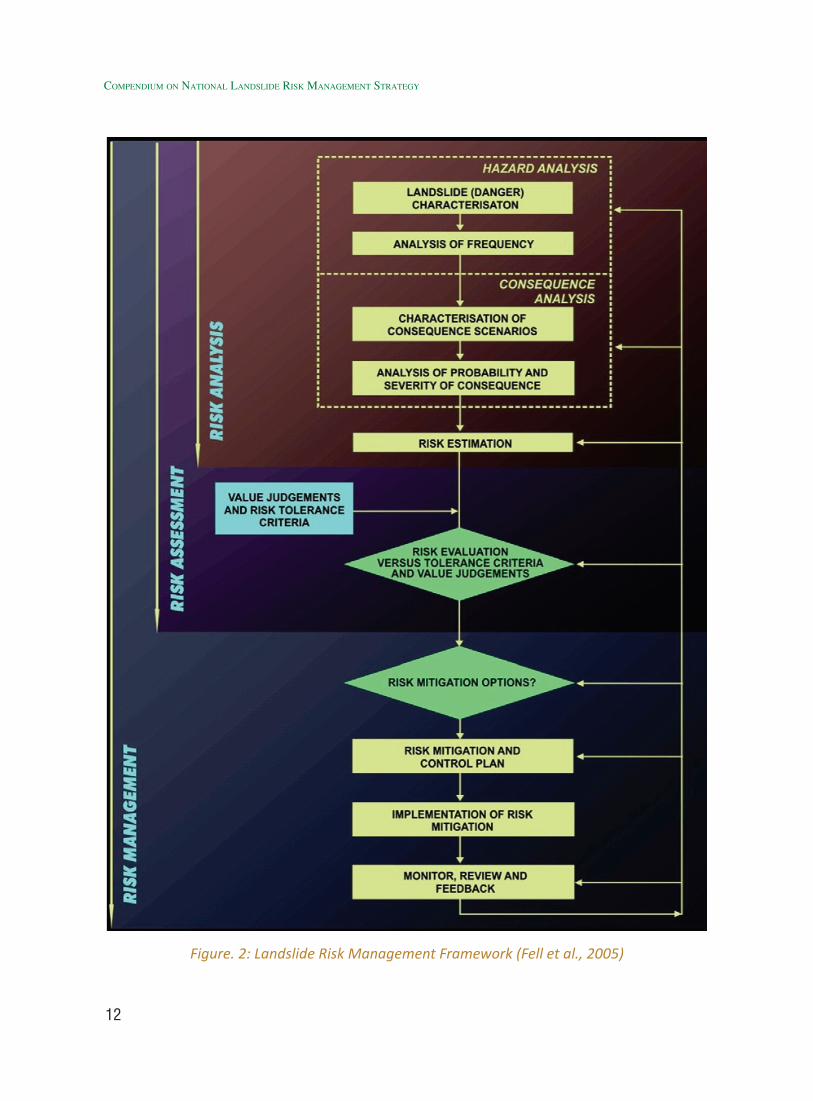
areas so that losses due to landslide hazards are substantially reduced. Therefore, landslide zoning is always to be construed and viewed as an integral part of the broader landslide risk management framework (Figure. 2), proposed by Fell at al. (2005), which has widely been accepted internationally. In India, we must make sincere and all-out attempts to convert our susceptibility maps into true hazard and risk maps following the above-mentioned internationally-accepted methodologies.
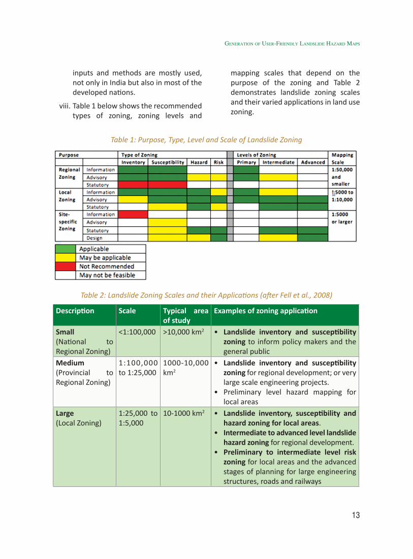
However, landslide zoning is being carried out for specific purposes and for regional, local and site-specific planning and safe and optimal use of landmass. The outputs are usually in the form of one or more of the following: landslide inventory map; landslide susceptibility map; landslide hazard and risk maps; and associated reports. In the subsequent section, Table 1 recommends types and level of landslide zoning that are being considered for different purpose of land use (Fell et al., 2008) which needs to be read with Table 2 demonstrating scale of landslide zoning and its different purpose and applications.
Further, it is strongly recommended that landslide zoning be carried out in a GIS-based system so that the zoning can be readily be applied for land use planning and can easily be updated as more information becomes available and/ or on occurrence of any major/ extreme landsliding event in the future.
1.4 Where do we require Landslide Zoning
Where there is a history of past landsliding, the most common reason for deciding that landslide zoning should be carried out or not.
Where there is no history of landsliding but the topography depicts that landsliding may occur, If slopes are steep enough they may be susceptible to landsliding for a wide range of geological conditions. If landsliding occurs, it is likely to be rapid and pose a hazard to lives of persons living below the slopes.
When there is no history of landsliding but geological and geomorphologic conditions are such that landsliding is possible. The list of conditions is not meant to be complete, and other situations may be known locally to be susceptible to landsliding. It should be noted that in many of the cases listed the areas susceptible to landsliding may be in relatively flat terrain, with sliding occurring on low strength surfaces of rupture.
Where there are constructed features or planning of new infrastructure development activity such as roads, railway lines, buildings, large dams and other related civil structures etc. which involves large scale land use modifications; Many of these cases relate to soils which lose a large amount of strength on sliding, and thus, will suffer a large drop in the factor of safety and travel rapidly after failure. The list is not meant to be complete but it is intended to give a reasonable range of examples.
1.5 Purpose, Type and Levels of Landslide Zoning
i. Landslide susceptibility and hazard zoning are more likely to be used in preliminary stages of development, and landslide hazard and risk zoning are required for more detailed stages. However, the choice depends mostly on the intended purpose of the zoning in land use management and on the
11
policies of the Government and related stakeholders.
ii. Landslide risk zoning is more likely to be used for existing urban development area where the elements at risk are defined/ exposed to the already-available landslide hazards or for existing and planned road and railway developments where the elements at risk (the road or rail and its users) are exposed readily to the predicted landslide hazard scenarios. For these situations, life loss is more likely, so it is useful to use risk zoning as this allows land use zoning to be determined using life and property loss risk criteria. However, the elements at risk often vary with space and time so risk zoning needs to be up-dated regularly.
iii. Since, landslide susceptibility zoning is less demanding than hazard zoning, and hazard zoning is far less demanding than risk zoning, so land use planners may opt for a lesser type and level of zoning or can use zoning maps at least in a staged manner in land use planning.
iv. Qualitative and/ or quantitative landslide hazard and risk zoning cannot be performed where data on frequency of landslides either do not exist or are so uncertain as not to be relied on, as been observed in many situations in India. In such a case, landslide susceptibility zoning at multiple scales is only recommended.
iv. The history of the area being zoned and its evolution in terms of land use must be carefully taken into account as human activities may modify the slope instability environment and modify the susceptibility to the likelihood of landsliding and hence the hazard.
v. Qualitative methods are often used for susceptibility zoning, and sometimes for hazard zoning. When feasible, it is better to use quantitative methods for both susceptibility and hazard zoning. Risk zoning should preferably be quantified. More effort is required to quantify the hazard and risk but there is not necessarily a great increase in cost compared to qualitative zoning.
vi. It will usually be appropriate to carry out landslide susceptibility zoning as a first stage in the development of landslide hazard or risk zoning for planning purposes. Staging will allow better control of the process and may reduce the costs of the zoning by limiting the more detailed zoning only to areas where it is necessary.
vii. The levels of landslide inventory, susceptibility, hazard and risk zoning are based in terms of geotechnical and other input data. It is important to match the level of the zoning to the required usage, the scale of mapping (Table 1) and in turn, match these to the level of the input data. It is not possible, for example, to produce a satisfactory advanced level hazard zoning maps without at least intermediate level assessment of frequency of landsliding. If only a basic level assessment of frequency can be made, then the result will be no better than preliminary level, and there is no point in spending large resources getting the other inputs to an intermediate or to an advanced level. On the other hand, if a preliminary level hazard zoning is required then the inputs may be at the basic level. The current practice shows that due to the scarcity of available data and cost restrictions, basic or intermediate
Generation of User-friendly landslide Hazard Maps
12
Compendium on national landslide Risk management stRategy
Figure. 2: Landslide Risk Management Framework (Fell et al., 2005)
13
inputs and methods are mostly used, not only in India but also in most of the developed nations.
viii. Table 1 below shows the recommended types of zoning, zoning levels and
Table 1: Purpose, Type, Level and Scale of Landslide Zoning
Table 2: Landslide Zoning Scales and their Applications (after Fell et al., 2008)
Description Scale Typical area of study
Examples of zoning application
Small(National to Regional Zoning)
<1:100,000 >10,000 km2 • Landslide inventory and susceptibility zoning to inform policy makers and the general public
Medium(Provincial to Regional Zoning)
1:100,000 to 1:25,000
1000-10,000 km2
• Landslide inventory and susceptibility zoning for regional development; or very large scale engineering projects.
• Preliminary level hazard mapping for local areas
Large(Local Zoning)
1:25,000 to 1:5,000
10-1000 km2 • Landslide inventory, susceptibility and hazard zoning for local areas.
• Intermediate to advanced level landslide hazard zoning for regional development.
• Preliminary to intermediate level risk zoning for local areas and the advanced stages of planning for large engineering structures, roads and railways
mapping scales that depend on the purpose of the zoning and Table 2 demonstrates landslide zoning scales and their varied applications in land use zoning.
Generation of User-friendly landslide Hazard Maps
14
Compendium on national landslide Risk management stRategy
Detailed(Site specific zoning)
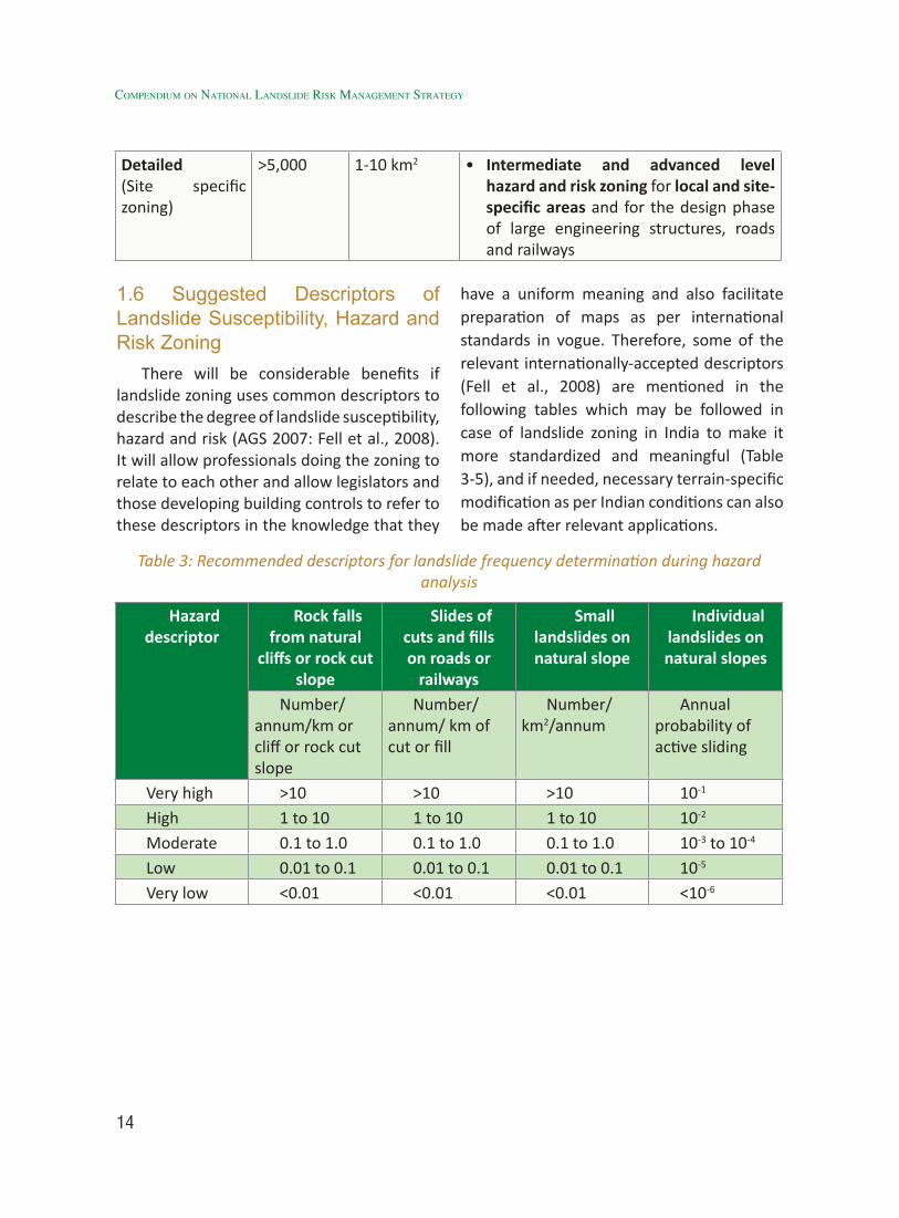
>5,000 1-10 km2 • Intermediate and advanced level hazard and risk zoning for local and site-specific areas and for the design phase of large engineering structures, roads and railways
1.6 Suggested Descriptors of Landslide Susceptibility, Hazard and Risk Zoning
There will be considerable benefits if landslide zoning uses common descriptors to describe the degree of landslide susceptibility, hazard and risk (AGS 2007: Fell et al., 2008). It will allow professionals doing the zoning to relate to each other and allow legislators and those developing building controls to refer to these descriptors in the knowledge that they
have a uniform meaning and also facilitate preparation of maps as per international standards in vogue. Therefore, some of the relevant internationally-accepted descriptors (Fell et al., 2008) are mentioned in the following tables which may be followed in case of landslide zoning in India to make it more standardized and meaningful (Table 3-5), and if needed, necessary terrain-specific modification as per Indian conditions can also be made after relevant applications.
Table 3: Recommended descriptors for landslide frequency determination during hazard analysis
Hazard descriptor
Rock falls from natural
cliffs or rock cut slope
Slides of cuts and fills on roads or
railways
Small landslides on natural slope
Individual landslides on natural slopes
Number/ annum/km or cliff or rock cut slope
Number/ annum/ km of cut or fill
Number/ km2/annum
Annual probability of active sliding
Very high >10 >10 >10 10-1
High 1 to 10 1 to 10 1 to 10 10-2
Moderate 0.1 to 1.0 0.1 to 1.0 0.1 to 1.0 10-3 to 10-4
Low 0.01 to 0.1 0.01 to 0.1 0.01 to 0.1 10-5
Very low <0.01 <0.01 <0.01 <10-6

15
Table 4: Recommended descriptors for landslide risk zoning using property loss criteria
Likelihood Annual Probability
Consequences to property (with indicative approximate cost of damage)(1)(3)
1: Catastrophic 2: Major 3: Medium 4: Minor 5: Insignificant200% 60% 20% 5% 0.5%
A – Almost Certain
10-1 VH VH VH H M or L
B-Likely 10-2 VH VH H M LC-Possible 10-3 VH H M M VLD-Unlikely 10-4 H M L L VLE-Rare 10-5 M L L VL VLF-Barely credible
10-6 L VL VL VL VL
Notes: (1) As a percentage of the value of the property. (2) For Cell A5, may be subdivided such that a consequence of less than 0.1% is low risk. (3) L Low, M Medium, H High, VL Very low, VH Very high.
Table 5: Recommended descriptors for landslide risk zoning using life loss criteria
Annual probability of death of the person most at risk in the zone
Risk zoning descriptors
>10-3/ annum Very high10-4 to 10-3/ annum High10-5 to 10-4/ annum Moderate10-6 to 10-5/ annum Low<10-6/ annum Very low
Generation of User-friendly landslide Hazard Maps
1.7 Reliability and Validation of Landslide Zoning Maps
It is extremely important to assess the reliability and validation of landslide zoning maps along with background knowledge of potential sources of errors.
1.7.1 Potential Sources of Errors
• Limitations in the generation of landslide inventory upon which the susceptibility and hazard zoning maps are based.
• Incomplete or insufficient information about landslide dates and magnitudes make hazard and risk estimation difficult (Van Westen et al., 2006; Ghosh et al., 2012).
• Van Westen et al. (1999) and Ardizzone et al. (2002) give examples showing gross mismatch of inventory maps for landsliding from the same area of natural slopes prepared by two groups. They point out that the greatest errors occur when inventories rely on air photo interpretation, particularly of
16
Compendium on national landslide Risk management stRategy
small scale photography. These errors are in part due to the subjective nature of aerial photo interpretation but also to vegetation covering the areas to be mapped.
• Aerial photographic mapping should be supported by surface mapping of selected areas to calibrate the mapping (Guzzetti et al., 2012). However, field validation suffers because of inaccessibility in steep and rugged mountainous terrains.
• Inventories of landsliding of cuts, fills and retaining walls on roads, railways and urban development will seldom be complete. So as to get a reasonable estimate of the number of slides those doing the zoning will have to make a judgment about what proportion of the slides have been recorded (Jaiswal et al., 2010).
• Topographic maps are most important input to zoning at intermediate and advanced levels. These maps allow zoning boundaries to be defined with an appropriate accuracy.
• For large scale zoning, contours at 2m or at most 5m will be required. Even then, zoning boundaries should be checked on the ground because the implications for land owners of errors in boundaries can be significant (Fell et al., 2008a).
• Limitations in the stability of temporal series. For example, the relationship between the triggering factor (e.g. rainfall) and the frequency of landslides may change if the area is deforested. Moreover, extreme spatial and temporal variability in rainfall distribution pattern within a smaller distance also invoke tremendous amount of uncertainty in such analysis.
• Limitations in the level of availability of detailed topography, geology, geomorphology, rainfall and other input data.
• Model uncertainty, meaning the limitations of the methods used to relate the inventory, topography, geology, geomorphology and triggering events such as rainfall to predicting landslide susceptibility, hazard and risk.
• Limitations in the skill of the persons carrying out the zoning. It must be recognized that landslide zoning is not a precise science and the results are only a prediction of performance of the slopes based on the available data (Fell et al., 2008a). In general, intermediate or advanced level zoning will be less subject to error than preliminary level zoning with each done at a suitable zoning map scale.
1.7.2 Peer Reviewing
In most of the landslide zoning studies for land use planning, there should be a peer reviewer appointed to provide independent assessment of the susceptibility, hazard and risk zoning. The peer reviewer should have a high level of the skills and experience. The peer reviewer should meet with those carrying out the study at the beginning of the study, and depending on the scale of the projects, perhaps after initial mapping, and then as the zoning is being finalized. This process is a basic form of quality control and a form of validation if the peer reviewer has appropriate wide experience.
1.7.3 Formal Validation
For more important advanced level mapping projects, there can be a process of validation within the study. To do this, the landslide inventory is randomly split in
17
two groups: one for analysis and second for validation. The analysis is carried out in part of the study area (model) and tested in another part with different landslides. An alternative approach for advanced mapping projects is for an analysis to be carried out with landslides that have occurred in a certain period, whilst validation is performed upon landslides that have occurred in a different period. Validation can also be carried out by this process after the mapping and land use planning scheme has been in place for some time. This is really only practical for high frequency landsliding because of the time frame required to gather performance data.
1.8 Indian Scenario & Future Strategies: Landslide Zoning
1.8.1 Identical Gaps in Landslide Mapping and Zoning in India
1. Landslide zoning maps so far available in India are mostly Landslide Susceptibility Zonation (LSZ) maps; however, in most of the cases, they are termed as Landslide Hazard Zonation (LHZ) maps despite not having any connotation about magnitude and temporal predictions.
2. The LSZ maps prepared till 2014 in India (Table 8.1) are concerned only to important route corridors and at some discrete locations (which have witnessed damage due to landslides) in some highly landslide prone states such as Jammu & Kashmir, Uttarakhand, Himachal Pradesh, Darjeeling district of West Bengal and north eastern states of Sikkim, Arunachal Pradesh and Mizoram, Meghalaya etc.
3. Single Seamless state-wise/ district-wise landslide zonation maps are mostly not available for landslide prone northern,
northeastern states and for Eastern and Western Ghats regions, which, however this has recently been taken care of on regional/ medium scale (1:50,000) by GSI’s National Landslide Susceptibility Mapping (NLSM) programme since 2014-15 (Annexure I).
4. In India, LSZ maps for the same area have also been created by different workers of different organizations following different methodologies. Hence, many landslide prone regions have more than one set of LSZ maps created by different agencies, departments and researchers. In such cases, which of the LSZ map is to be follow for mitigation measures is not clear to the users. Therefore, on national arena, operational programmes/ strategies for generation of landslide susceptibility maps of India at multiple scales needs to be defined with relevant techniques, selection of appropriate agencies etc.
5. Majority of the existing LSZ Maps are lacking details of the devastating landslide events of the past. Therefore, landslide incidence map prepared from multi-temporal and event-based sources along with its detailed geo-parametric attributes needs to be in landslide susceptibility analysis and its implications are to be measured while ranking and weighting the thematic geo-factors for preparation of landslide susceptibility zonation maps.
6. Most of the available LSZ maps are on 1:50,000 scale because of its easy availability of source datasets and methods but for effective developmental planning, its utility has some limitations. Moreover, on this macro/ regional scale (1:50,000), active landslide zones of smaller dimensions having sizes - 50 m ×
Generation of User-friendly landslide Hazard Maps
18
Compendium on national landslide Risk management stRategy
50 m appear as a dot (1 mm x 1 mm) on 1:50,000 scale map.
7. Slope cutting and blasting activity for construction and widening of hill roads are triggering many landslides, which are in many cases merely 10-30m wide and are juxtaposing the road on the hill side i.e. slope cut landslides (Uniyal et al, 2012). Such small landslides are often life-threatening on hill roads and are difficult to depict on 1:50,000 scale LSZ maps. However, to give importance to these features, problems of scale constricts and if required, some plausible exaggeration may be adopted.
8. Ranking and weighting of thematic geo factors varies because of data availability, terrain as well as scale of mapping. A suitable strategy based on scale of mapping be followed and terrain-specific ranking and weighting scheme must be developed, which has already been followed in NLSM projects by GSI.
9. From meso/large scale (1:10,000) analysis, reliance on more number of field-based inputs and analytically-determined attributes of slope forming material are needed, which are not only time consuming but also costly in nature and cannot be implemented for large areas. Therefore, areas/sectors undertaken for 1:10,000 (meso) scale landslide susceptibility zonation must be prioritized based on proper justification and evaluation of its risk scenarios. A preliminary list of 45 such sectors identified so far is mentioned in this document in Table 9.
10. Scope of finding linkages of structural mitigation measures with meso/ local scale LSZ, though difficult may be sought, so that more direct use of LSZ
maps can be justified, for which some research projects can also be launched by Department of Science & Technology (DST).
11. Most of the existing LSZ and landslide susceptibility maps are lacking administrative boundaries such as district, Tehsil, block and village boundaries superposed on hazard zones. This makes difficult the inter and intra district coordination aimed at structural and non-structural mitigation of those landslides in particular which are falling in more than one administrative or development units.
12. Drainage divides are rarely shown on LSZ maps and only little drainage are shown. Hence, lack of drainage divides in general and watershed, sub watershed, mini watershed and micro watershed boundaries in particular makes it almost impossible to integrate landslide mitigation measures with ongoing watershed development projects.
13. Names of the elements at risk (viz. roads, canals, railway line tunnels, bridges) falling within the high, very high and severe hazard zones are missing in the existing LSZ maps.
14. Presently landmarks are neither shown nor mentioned in LSZ maps. This makes it difficult for the users to understand the precise extent of severe, very high and high hazard zones.
15. Existing stability measures are neither shown not mentioned in the presently available LSZ maps because of scale constraints.
16. No detailed landslide inventory created on the basis of 1:10,000 scale macro level LSZ maps is available for formulation of Landslide mitigations planning at district,
19
Tehsil, and block and village level. Therefore, landslide inventory mapping be carried out using suitable remote sensing (RS) and adequate field sources at the highest possible level of larger scales (preferably 1:10,000 or larger), so that none of the smaller landslides are missed. Since landslide inventory map, associated with LSZ maps (of macro and meso scales) has two parts – spatial, which has some scale constraints but attribute data is scale –indifferent, so the same can be attached to the maps. Seasonal Landslide Inventory Mapping (SLIM) project currently executed at NRSC prepares landslide inventory from high resolution satellite images. The data for 2014 season is now available for 8 states at NRSC’s Bhuvan Portal. This method is a rapid RS-based technique to be followed after each monsoon season. All these landslide incidence maps must be taken up by the nodal agency with an aim to prepare a national landslide inventory database.
17. Landslide Susceptibility Management (LSM) maps are not available for all areas for which LSZ maps are available. Even the available Landslide Susceptibility Management (LSM) maps are lacking site specific structural and non-structural mitigation measures, since most of such LSZ maps are on 1:50,000 scale.
18. The mitigation measures recommended in the existing Landslide Susceptibility Management (LSM) maps are generalized one, such as “aforestation” and “biotechnical measures” without any mention of the particular varieties of the fast-growing trees and useful grasses to be grown or list of biotechnical measures to be taken for stabilizing the hill slope.
19. The available LSM maps address the
anthropogenic intervention (in landslide susceptible zones) with a casual approach by suggesting measures such as “Avoid further construction”. This makes it difficult for the authorities to ensure strict adherence to land use regulations such as complete ban on construction activity in a landslide hazard prone area.
20. Planned developmental activity, often mentioned in existing Landslide Hazard Management (LHM) maps does not elaborate which particular planned developmental activity is to be undertaken.
21. Existing Landslide Hazard Management (LHM) maps don’t address the crucial aspects of overloading and or under cutting of hill slope due to anthropogenic activities and therefore, provide no clear guidelines for removal of those manmade constructions in particular which are overloading or undercutting the hill slope or blocking, diverting or narrowing the natural drainage courses.
In the backdrop of all the above issues, it is pertinent to enumerate in detail, Landslide Susceptibility Analysis (LSA) of different scales because of their specific purpose and use.
1.8.2 National Scale (1:10, 00,000 or Smaller) Landslide Susceptibility Analysis
1.8.2.1 Purpose
To carry out a national level landslide hazard and vulnerability assessment, landslide susceptibility maps on national scale (1:10,00,000 or 1:1 Million or smaller) is required which can be used as a general guideline for the estimation of the vulnerability status of a country as a whole akin to a particular hazard. This is the first-level landslide susceptibility information available in any country through which
Generation of User-friendly landslide Hazard Maps

20
Compendium on national landslide Risk management stRategy
suitable information becomes available to the administrators/ planners about specific States/ Union Territories and localities which are exposed to higher level of landslide risk so that optimally resources for its mitigation can be planned and allocated beforehand.
1.8.2.2 Methodology
Globally a very few generic guidelines exist for this scale of zonation, although attempts to prepare national scale landslide susceptibility maps are not rare. The European Union (EU) has already developed some common guidelines in 2007 for landslide susceptibility mapping on such national scale and proposed a relatively more heuristic or knowledge driven approach of susceptibility zonation (Table 1). The proposed guidelines of EU (Table 6) on this smaller scale are also feasible and can easily be followed in Indian geo-environment. The Building Materials and Technology Promotion Council’s (BMTPC) national landslide hazard atlas of 2003 also followed almost similar approaches while
preparing the national scale landslide hazard/ susceptibility maps (Figure. 2).
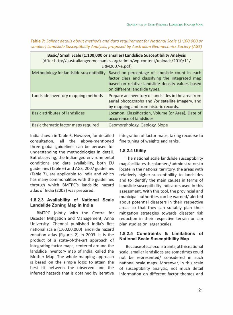
Another global guideline available for landslide susceptibility / hazard zonation on such smaller scales is from the Australian Geomechnics Society (AGS), published almost similar time in 2007 (http://australiangeomechanics.org/admin/wp-content/uploads/2010/11/LRM2007-GeoGuides.pdf).
Table 7 demonstrates salient details of such landslide zonation guidelines which is slightly different than the approach followed by EU and BMTPC. The following AGS guidelines have also been corroborated by guidelines proposed by JTC-1 of International Association of Engineering Geologists (IAEG) almost during the same time in 2007 (Fell et al., 2008b). However, in both the methodologies, consideration of ranges for so-called national scale is 100,000 or smaller, which is quite different that of the EU guidelines and also the scale followed in
Table 6: Salient details about the methods and data requirement for National Scale (1:10, 00, 000 or Smaller) Landslide Susceptibility Analysis, proposed by EU Guidelines
(Source:http://eusoils.jrc.ec.europa.eu/Esdb_Archive/eusoils_docs/Other/EUR23093.pdf).
National Scale (1:10, 00, 000 or smaller) Landslide Susceptibility Analysis (Afterhttp://eusoils.jrc.ec.europa.eu/ESDB_Archive/eusoils_docs/other/EUR23093.pdf)
Methodology for landslide susceptibility
Heuristic or Weighed factors
Landslide inventory scale 1:200,000Landslide inventory geometry Polygons PointsLandslide inventory size > 5 Ha 1 – 5 HaBasic attributes of landslides At least landslide type and locationBasic thematic factor maps required
Slope derived from SRTM DEM (90 m X 90 m)
Land Cover (available on 100,000 scale or smaller) Bedrock/ Soil Cover (available on 100,000 scale or smaller)
21
India shown in Table 6. However, for detailed consultation, all the above-mentioned three global guidelines can be perused for understanding the methodologies in detail. But observing, the Indian geo-environmental conditions and data availability, both EU guidelines (Table 6) and AGS, 2007 guidelines (Table 7), are applicable to India and which has many commonalities with the guidelines through which BMTPC’s landslide hazard atlas of India (2003) was prepared.
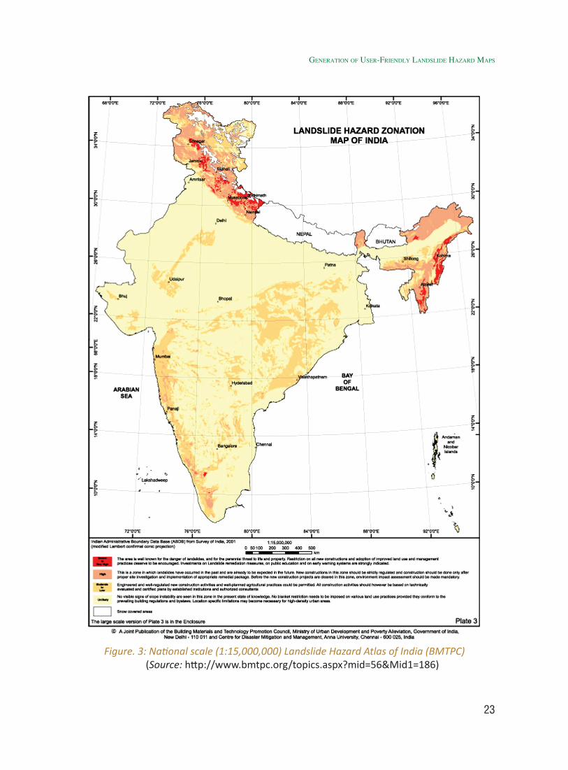
1.8.2.3 Availability of National Scale Landslide Zoning Map in India
BMTPC jointly with the Centre for Disaster Mitigation and Management, Anna University, Chennai published India’s first national scale (1:60,00,000) landslide hazard zonation atlas (Figure. 2) in 2003. It is the product of a state-of-the-art approach of integrating factor maps, centered around the landslide inventory map of India, called the Mother Map. The whole mapping approach is based on the simple logic to attain the best fit between the observed and the inferred hazards that is obtained by iterative
integration of factor maps, taking recourse to fine tuning of weights and ranks.
1.8.2.4 Utility
The national scale landslide susceptibility map facilitates the planners/ administrators to locate in the national territory, the areas with relatively higher susceptibility to landslides and to identify the main causes in terms of landslide susceptibility indicators used in this assessment. With this tool, the provincial and municipal authorities can be warned/ alerted about potential disasters in their respective areas so that they can suitably plan their mitigation strategies towards disaster risk reduction in their respective terrain or can plan studies on larger scales.
1.8.2.5 Constraints & Limitations of National Scale Susceptibility Map
Because of scale constraints, at this national scale, smaller landslides are sometimes could not be represented/ considered in such national scale maps. Moreover, in this scale of susceptibility analysis, not much detail information on different factor themes and
Table 7: Salient details about methods and data requirement for National Scale (1:100,000 or smaller) Landslide Susceptibility Analysis, proposed by Australian Geomechnics Society (AGS)
Basic/ Small Scale (1:100,000 or smaller) Landslide Susceptibility Analysis (After http://australiangeomechanics.org/admin/wp-content/uploads/2010/11/
LRM2007-a.pdf)Methodology for landslide susceptibility Based on percentage of landslide count in each
factor class and classifying the integrated map based on relative landslide density values based on different landslide types.
Landslide inventory mapping methods Prepare an inventory of landslides in the area from aerial photographs and /or satellite imagery, and by mapping and from historic records.
Basic attributes of landslides Location, Classification, Volume (or Area), Date of occurrence of landslides
Basic thematic factor maps required Geomorphology, Geology, Slope
Generation of User-friendly landslide Hazard Maps
22
Compendium on national landslide Risk management stRategy
landslides of smaller dimensions are available. Furthermore, field validation on national scale analysis cannot be undertaken mostly because of its redundancy scale limitations.
1.8.2.6 Current and Future Plan of Activity or Strategy
BMTPC’s landslide hazard atlas can be updated after completion of GSI’s ongoing NLSM project in 2020, where new information on landslide inventory and pre-disposing factors on 1:50,000 scale would be available.
1.8.3 Macro / Regional Scale (1:50,000 / 25, 000) Landslide Susceptibility Analysis
1.8.3.1 Purpose
Predictive maps of landslide susceptibility, preferably at macro or medium scales (1:50,000/ 25,000) are vital geo-information products that administrators/planners can use in formulating regional mitigation plans for landslide disasters. The aim of using medium-scale landslide hazard maps is to draft proper land-use planning in landslide-prone areas to alleviate, if not prevent potential loss of human life and damage to property. Moreover, 1:50,000 being a basic data generation scale facilitates generation of a regional geo database required for preparation of regional base maps to carry out any further up-scaling and detailed spatial analysis. Because of pre-dominance of data availability on thematic factors of this basic data generation scale, globally and also in India, maximum number of landslide susceptibility analyses is being carried out on this macro or medium scale (1:50,000/ 25,000).
1.8.3.2 Methodology
Macro/Medium scale (1:50,000/25,000) landslide susceptibility mapping in any terrain directly or indirectly considers the
importance of relevant spatial geo-factors to particular type of landsliding. These mutual inter-relationships and controls can be judged heuristically and through expert-driven opinions or can be drawn directly by establishing various spatial association analyses between the probable geo-factors and landslides in any area. The former in general is subjective and depends largely on the experience of the experts utilizing the method and the latter is an objective technique, less-biased but needs well-distributed information of past landsliding. In the Nilgiris, Seshagiri et al. (1982) of GSI carried out a five-category landslide zonation by assigning landslide susceptibility values (LSV) to different factors and computed landslide susceptibility index (LSI) on the basis of percentage of landslides in each category. Bhandari (1987, 1994, and 1996) described proposals for graded landslide hazard maps by overlying various states of nature maps. The operative parameters used in the preparation of present generation LHZ maps in Northwest Himalaya on 1:50,000 scales include (i) geology of the area, (ii) Morphometric features of slope segments and (iii) landslide incidences (Narula et al, 1996; Sharda, 1994 and Sharma, 1996).
Moreover, landsliding being a very complicated and varied geo-environmental phenomenon, its inter-relationships with various geo-factors are quite terrain and site-specific. The natural processes and in some instances the cumulative effects of the natural processes and anthropogenic activities have been the triggering factors for many potential slide zones (Uniyal, 2004, 2006, 2008, 2010). Further, the anthropogenic interference and consequent obliteration of landscape in geo-dynamically sensitive and extreme rainfall prone regions is one of the major triggering
23
Figure. 3: National scale (1:15,000,000) Landslide Hazard Atlas of India (BMTPC)(Source: http://www.bmtpc.org/topics.aspx?mid=56&Mid1=186)
Generation of User-friendly landslide Hazard Maps
24
Compendium on national landslide Risk management stRategy
factor for frequent landslide occurrences (Uniyal, 2012). In heuristic modeling such inter-relationships for varied geo-environmental terrains like India may not always be a trivial task, therefore, due to dearth of terrain-specific proper knowledge, adoption of any heuristically-driven techniques of landslide susceptibility mapping (e.g., BIS method-1998) which uses fixed number of geo-factors and pre-defined ratings/ weights sometimes lead to poor prediction in varied terrains. Whereas, empirically deriving ratings and weights of geo-factors that are solely based on local landslide occurrences are easy and just because the same can somehow portray the local terrain conditions and prevalent failure mechanisms. The macro/ medium scale (1:50,000/ 25,000) landslide susceptibility analysis ultimately renders an important spatial information wherein relative proneness to landslide initiation is demonstrated along with preparation of a vital spatial database of causal geo-factors on a basic mapping scale of an area. This basic susceptibility information is used as a regional base maps for any subsequent meso to large to micro/ site specific scale investigation. The three global guidelines (EU, AGS and IAEG) also dealt in detail broadly the methodologies on this scale and discussed about the generic thematic factors, reliance on historic landslide information, empirical analysis between factors and landslides to appropriately weigh the predictors.
1.8.3.3 Previous Studies
Sikdar (2004) gave a brief account of the previous landslide hazard zonation studies carried out in India by different workers and institutions. The preliminary studies in the field of landslide zonation in India, comprising identification of vulnerable slopes in the Himalaya on the basis of parameters like
geology, hydrology and slopes were initiated by workers from GSI namely Oldham (1880), Middle miss (1890) and Holland (1897). In the Nilgiris, Seshagiri et al. (1982) of GSI carried out a five-category landslide zonation by assigning Landslide Susceptibility Values (LSV) to different factors and computed Landslide Susceptibility Index (LSI) on the basis of percentage of landslides in each category. Bhandari (1987, 1994, and 1996) described proposals for graded landslide hazard maps by overlying various states of nature maps. The operative parameters used in the preparation of present generation LHZ maps in Northwest Himalaya on 1:50,000 scales include (i) geology of the area, (ii) Morphometric features of slope segments and (iii) landslide incidences (Narula et al, 1996; Sharda, 1994 and Sharma, 1996). Based on the above broad methodologies, various agencies carried out macro or medium scale (1:50,000) landslide susceptibility mapping along road-corridors, parts of catchments, basins etc. following varying methodologies. A list of such previous studies is mentioned in Table 8.1.
Out of the vast expanse of landslide prone areas (0.42 Million km2) in India (Fig. 1), till 2014, about 60,000 sq. km of target has been covered through landslide susceptibility mapping on basic data generation scale that is on 1:50,000 scale by GSI and other agencies Table 8.1 which leaves out a huge gap in target areas. Moreover, the earlier products being mostly analogue in format, its periodic updation though essential, is difficult, if not impossible.
1.8.3.4 Current activity and future plans
Because of the above limitations, a need was felt to prepare a base level landslide susceptibility database in a GIS seamlessly

25
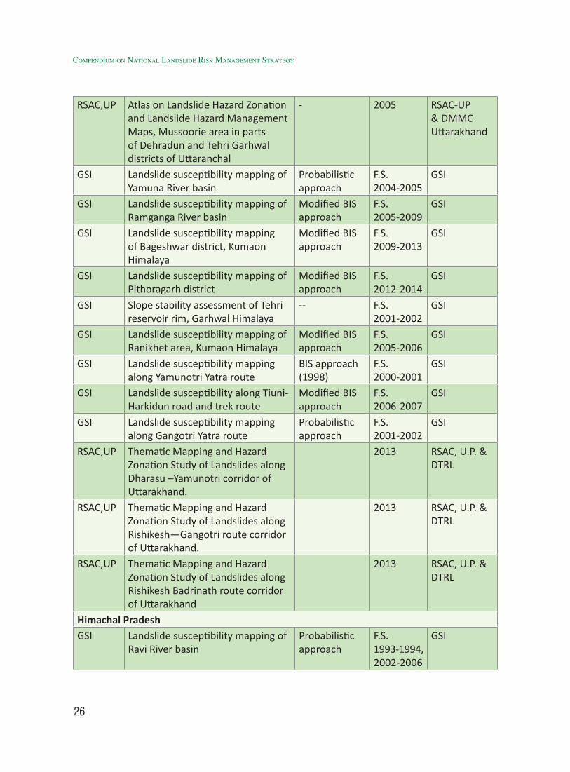
Table 8.1: List of some previous studies on macro scale (1:50,000/25,000) landslide susceptibility zonation in India (Prior to 2014)
Macro/ Medium (1:50000/ 25000) scale landslide susceptibility analysisAgency Areas/ Road-corridors Methodology Year AvailabilityUttarakhandGSI Landslide susceptibility mapping of
Nainital Town, Kumaon HimalayaAerial photo interpretation
F.S. 1982-1985
GSI
GSI Landslide susceptibility mapping of Bhagirathi River basin
Probabilistic approach
F.S. 1992-1995
GSI
GSI Landslide susceptibility mapping of Ganga River basin
Probabilistic approach
F.S.1995-1999
GSI
GSI Landslide susceptibility along Badrinath and KedarnathYatra routes
Probabilistic approach
F.S. 1999-2001
GSI
GSI Landslide susceptibility mapping along Kailash-MansarovarYatra route
Probabilistic approach
F.S. 1999-2002
GSI
GSI Landslide susceptibility mapping of Uttarkashi district, Garhwal Himalaya
Probabilistic approach
F.S. 1991-1993
GSI
NRSC Atlas on Landslide Hazard Zonation Mapping in the Himalayas of Uttaranchal and Himanchal Pradesh States using Remote Sensing and GIS Techniques, Volume 1: Uttaranchal
AHP 2001 NRSC & Uttarakhand Government (www.bhuvan.nrsc.gov.in)
RSAC,UP Atlas on Landslide Hazard Zonation and Landslide Hazard Management Maps of Agastmuni Okhimath – Kedarnath Area of Rudarprayag & parts of Chamoli Districts of Garhwal Himalaya, Uttaranchal.
AHP-based 2003 RSAC-UP & DMMC Uttarakhand
RSAC,UP Atlas on Landslide Hazard Zonation and Landslide Hazard Management Maps of Malpa Area of Pithoragarh District of Kumaun Himalaya, Uttaranchal
AHP-based 2003 RSAC-UP & DMMC Uttarakhand
RSAC,UP Atlas on Landslide Hazard Zonation and Landslide Hazard Management Maps of parts of Nainital and Almorah districts, Uttaranchal
AHP-based 2004 RSAC-UP & DMMC Uttarakhand
Generation of User-friendly landslide Hazard Maps
26
Compendium on national landslide Risk management stRategy
RSAC,UP Atlas on Landslide Hazard Zonation and Landslide Hazard Management Maps, Mussoorie area in parts of Dehradun and Tehri Garhwal districts of Uttaranchal
- 2005 RSAC-UP & DMMC Uttarakhand
GSI Landslide susceptibility mapping of Yamuna River basin
Probabilistic approach
F.S. 2004-2005
GSI
GSI Landslide susceptibility mapping of Ramganga River basin
Modified BIS approach
F.S.2005-2009
GSI
GSI Landslide susceptibility mapping of Bageshwar district, Kumaon Himalaya
Modified BIS approach
F.S.2009-2013
GSI
GSI Landslide susceptibility mapping of Pithoragarh district
Modified BIS approach
F.S.2012-2014
GSI
GSI Slope stability assessment of Tehri reservoir rim, Garhwal Himalaya
-- F.S.2001-2002
GSI
GSI Landslide susceptibility mapping of Ranikhet area, Kumaon Himalaya
Modified BIS approach
F.S.2005-2006
GSI
GSI Landslide susceptibility mapping along Yamunotri Yatra route
BIS approach (1998)
F.S. 2000-2001
GSI
GSI Landslide susceptibility along Tiuni-Harkidun road and trek route
Modified BIS approach
F.S. 2006-2007
GSI
GSI Landslide susceptibility mapping along Gangotri Yatra route
Probabilistic approach
F.S. 2001-2002
GSI
RSAC,UP Thematic Mapping and Hazard Zonation Study of Landslides along Dharasu –Yamunotri corridor of Uttarakhand.
2013 RSAC, U.P. & DTRL
RSAC,UP Thematic Mapping and Hazard Zonation Study of Landslides along Rishikesh—Gangotri route corridor of Uttarakhand.
2013 RSAC, U.P. & DTRL
RSAC,UP Thematic Mapping and Hazard Zonation Study of Landslides along Rishikesh Badrinath route corridor of Uttarakhand
2013 RSAC, U.P. & DTRL
Himachal PradeshGSI Landslide susceptibility mapping of
Ravi River basinProbabilistic approach
F.S. 1993-1994, 2002-2006
GSI
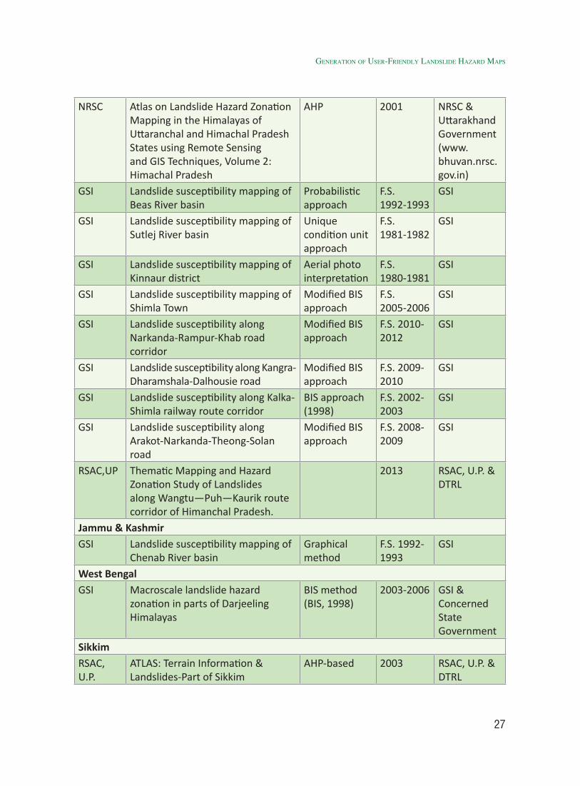
27
NRSC Atlas on Landslide Hazard Zonation Mapping in the Himalayas of Uttaranchal and Himachal Pradesh States using Remote Sensing and GIS Techniques, Volume 2: Himachal Pradesh
AHP 2001 NRSC & Uttarakhand Government (www.bhuvan.nrsc.gov.in)
GSI Landslide susceptibility mapping of Beas River basin
Probabilistic approach
F.S.1992-1993
GSI
GSI Landslide susceptibility mapping of Sutlej River basin
Unique condition unit approach
F.S.1981-1982
GSI
GSI Landslide susceptibility mapping of Kinnaur district
Aerial photo interpretation
F.S. 1980-1981
GSI
GSI Landslide susceptibility mapping of Shimla Town
Modified BIS approach
F.S. 2005-2006
GSI
GSI Landslide susceptibility along Narkanda-Rampur-Khab road corridor
Modified BIS approach
F.S. 2010-2012
GSI
GSI Landslide susceptibility along Kangra-Dharamshala-Dalhousie road
Modified BIS approach
F.S. 2009-2010
GSI
GSI Landslide susceptibility along Kalka-Shimla railway route corridor
BIS approach (1998)
F.S. 2002-2003
GSI
GSI Landslide susceptibility along Arakot-Narkanda-Theong-Solan road
Modified BIS approach
F.S. 2008-2009
GSI
RSAC,UP Thematic Mapping and Hazard Zonation Study of Landslides along Wangtu—Puh—Kaurik route corridor of Himanchal Pradesh.
2013 RSAC, U.P. & DTRL
Jammu & KashmirGSI Landslide susceptibility mapping of
Chenab River basinGraphical method
F.S. 1992-1993
GSI
West BengalGSI Macroscale landslide hazard
zonation in parts of Darjeeling Himalayas
BIS method (BIS, 1998)
2003-2006 GSI & Concerned State Government
SikkimRSAC, U.P.
ATLAS: Terrain Information & Landslides-Part of Sikkim
AHP-based 2003 RSAC, U.P. & DTRL
Generation of User-friendly landslide Hazard Maps
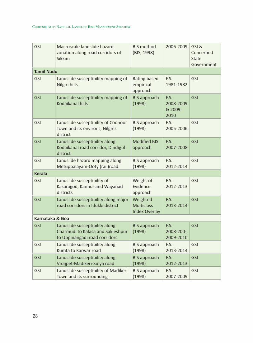
28
Compendium on national landslide Risk management stRategy
GSI Macroscale landslide hazard zonation along road corridors of Sikkim
BIS method (BIS, 1998)
2006-2009 GSI & Concerned State Government
Tamil NaduGSI Landslide susceptibility mapping of
Nilgiri hillsRating based empirical approach
F.S. 1981-1982
GSI
GSI Landslide susceptibility mapping of Kodaikanal hills
BIS approach (1998)
F.S.2008-2009 & 2009-2010
GSI
GSI Landslide susceptibility of Coonoor Town and its environs, Nilgiris district
BIS approach (1998)
F.S.2005-2006
GSI
GSI Landslide susceptibility along Kodaikanal road corridor, Dindigul district
Modified BIS approach
F.S.2007-2008
GSI
GSI Landslide hazard mapping along Metuppalayam-Ooty (rail)road
BIS approach (1998)
F.S.2012-2014
GSI
KeralaGSI Landslide susceptibility of
Kasaragod, Kannur and Wayanad districts
Weight of Evidence approach
F.S.2012-2013
GSI
GSI Landslide susceptibility along major road corridors in Idukki district
Weighted Multiclass Index Overlay
F.S.2013-2014
GSI
Karnataka & GoaGSI Landslide susceptibility along
Charmudi to Kalasa and Sakleshpur to Uppinangadi road corridors
BIS approach (1998)
F.S.2008-200-, 2009-2010
GSI
GSI Landslide susceptibility along Kumta to Karwar road
BIS approach (1998)
F.S.2013-2014
GSI
GSI Landslide susceptibility along Virajpet-Madikeri-Sulya road
BIS approach (1998)
F.S.2012-2013
GSI
GSI Landslide susceptibility of Madikeri Town and its surrounding
BIS approach (1998)
F.S.2007-2009
GSI
29
for the entire landslide prone areas of the country (12.6% areas of India), for better dissemination and easy updation in future. Accordingly, GSI, with the approval of the nodal Ministry-the Ministry of Mines (MoM), Government of India, launched National Landslide Susceptibility Mapping (NLSM) programme w.e.f. FS 2014-15, with an aim to produce a seamless landslide susceptibility mapping database across the country using both remote sensing and adequate field data. The details of this mapping activity, its methodology, perspective plan, targets already completed, deadlines etc. are mentioned in Annexure I. Since GSI being the nodal department has the requisite expertise and manpower to carry out this mammoth task, the same may be completely allotted to GSI for completion at a shorter period of time to avoid any duplication.
For the Priority 2 areas of NLSM (inaccessible terrain), if required GSI may undertake help from any remote sensing agency such as NRSC and/or other Regional Remote Sensing Centres of the concerned Himalayan States.
1.8.4 Meso / Large (1:10,000/5,000) Scale Landslide Susceptibility Zonation
1.8.4.1 Purpose
Meso scale (1:10,000) landslide susceptibility analysis of critical sectors/ areas is essential because the same helps planners in land use zoning of specific infrastructure development projects. Unlike macro/ medium (1:50,000) scale landslide susceptibility analysis, this up-scaled analysis on meso scale (1:10,000) takes into account weightage to more number of site-specific geo-factors and their minute spatial variation demonstrated on that larger scale, thereby, is more reliant in portraying the landslide failure/ causal
mechanisms and helps in developing a more specific geo-information tool for use in specific infrastructure development work in an fragile and potentially landslide-prone areas.
1.8.4.2 Methodology
In India proper methodology of landslide susceptibility analysis on meso scale (1:10,000) is absent. However, GSI is presently testing a deterministic cum knowledge-driven methodology in two pilot study areas (Mangan, North District, Sikkim and Chibbo-Pashyor, Kalimpong Sub-division, Darjeeling district, West Bengal) in Darjeeling-Sikkim Himalayas, whose results/ outcomes will soon be available. This method proposed by GSI (Ghoshal et al., 2013) incorporates a more detailed deterministic approach of modelling susceptibility against the available knowledge-based descriptive approach like that used in macro-scale (1:50,000) hazard zonation mapping (BIS, 1998). The suggested methodology essentially requires selection of (i) appropriate mapping unit and suitable thematic factors, (ii) rating of factor classes [Landslide Susceptibility Estimated Rate (LSER) rating], (iii) integration of the data [computation of Total Estimated Susceptibility Values (TESV)] and (iv) division of the area in different susceptibility classes based on knowledge-driven classification of TESV values. Apart from slope morphometry details on 1:10000 scale, this method also takes into account determination of physical as well shear attributes of slope forming material and their suitable combinations to determine the LSER ratings, thus, close observation of characteristics of slope forming material, sampling and geotechnical testing, reliance of more field-based deterministic inputs are required at this scale of analysis, which has also been corroborated to a great extent by
Generation of User-friendly landslide Hazard Maps
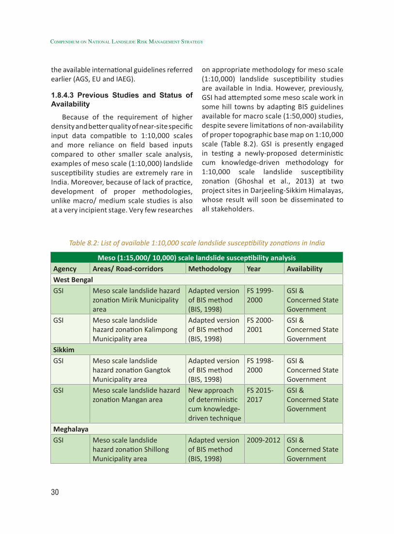
30
Compendium on national landslide Risk management stRategy
the available international guidelines referred earlier (AGS, EU and IAEG).
1.8.4.3 Previous Studies and Status of Availability
Because of the requirement of higher density and better quality of near-site specific input data compatible to 1:10,000 scales and more reliance on field based inputs compared to other smaller scale analysis, examples of meso scale (1:10,000) landslide susceptibility studies are extremely rare in India. Moreover, because of lack of practice, development of proper methodologies, unlike macro/ medium scale studies is also at a very incipient stage. Very few researches
on appropriate methodology for meso scale (1:10,000) landslide susceptibility studies are available in India. However, previously, GSI had attempted some meso scale work in some hill towns by adapting BIS guidelines available for macro scale (1:50,000) studies, despite severe limitations of non-availability of proper topographic base map on 1:10,000 scale (Table 8.2). GSI is presently engaged in testing a newly-proposed deterministic cum knowledge-driven methodology for 1:10,000 scale landslide susceptibility zonation (Ghoshal et al., 2013) at two project sites in Darjeeling-Sikkim Himalayas, whose result will soon be disseminated to all stakeholders.
Table 8.2: List of available 1:10,000 scale landslide susceptibility zonations in India
Meso (1:15,000/ 10,000) scale landslide susceptibility analysisAgency Areas/ Road-corridors Methodology Year AvailabilityWest BengalGSI Meso scale landslide hazard
zonation Mirik Municipality area
Adapted version of BIS method (BIS, 1998)
FS 1999-2000
GSI & Concerned State Government
GSI Meso scale landslide hazard zonation Kalimpong Municipality area
Adapted version of BIS method (BIS, 1998)
FS 2000-2001
GSI & Concerned State Government
SikkimGSI Meso scale landslide
hazard zonation Gangtok Municipality area
Adapted version of BIS method (BIS, 1998)
FS 1998-2000
GSI & Concerned State Government
GSI Meso scale landslide hazard zonation Mangan area
New approach of deterministic cum knowledge-driven technique
FS 2015- 2017
GSI & Concerned State Government
MeghalayaGSI Meso scale landslide
hazard zonation Shillong Municipality area
Adapted version of BIS method (BIS, 1998)
2009-2012 GSI & Concerned State Government
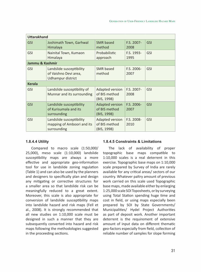
31
UttarakhandGSI Joshimath Town, Garhwal
HimalayaSMR based method
F.S. 2007-2008
GSI
GSI Nainital Town, Kumaon Himalaya
Probabilistic approach
F.S. 1993-1995
GSI
Jammu & KashmirGSI Landslide susceptibility
of Vaishno Devi area, Udhampur district
SMR based method
F.S. 2006-2007
GSI
KeralaGSI Landslide susceptibility of
Munnar and its surroundingAdapted version of BIS method (BIS, 1998)
F.S. 2007-2008
GSI
GSI Landslide susceptibility of Kurisumala and its surrounding
Adapted version of BIS method (BIS, 1998)
F.S. 2006-2007
GSI
GSI Landslide susceptibility mapping of Amboori and its surrounding
Adapted version of BIS method (BIS, 1998)
F.S. 2008-2010
GSI
1.8.4.4 Utility
Compared to macro scale (1:50,000/ 25,000), meso scale (1:10,000) landslide susceptibility maps are always a more effective and appropriate geo-information tool for use in landslide zoning regulation (Table 1) and can also be used by the planners and designers to specifically plan and design any mitigating or corrective structures for a smaller area so that landslide risk can be meaningfully reduced to a great extent. Moreover, this scale is also appropriate for conversion of landslide susceptibility maps into landslide hazard and risk maps (Fell et al., 2008). It is strongly recommended that all new studies on 1:10,000 scale must be designed in such a manner that they are subsequently converted into hazard and risk maps following the methodologies suggested in the proceeding sections.
1.8.4.5 Constraints & Limitations
The lack of availability of proper topographic base maps compatible to 1:10,000 scales is a real deterrent in this exercise. Topographic base maps on 1:10,000 scale prepared by Survey of India are rarely available for any critical areas/ sectors of our country. Whatever paltry amount of previous work carried on this scale used Topographic base maps, made available either by enlarging 1:25,000 scale SOI Toposheets, or by surveying using Total Station spending huge time and cost in field, or using maps especially been prepared by SOI by State Governments/ Municipalities/ Hydel Project Authorities as part of deposit work. Another important deterrent is the requirement of extensive amount of input data on different thematic geo-factors especially from field, collection of reliable number of samples for slope forming
Generation of User-friendly landslide Hazard Maps
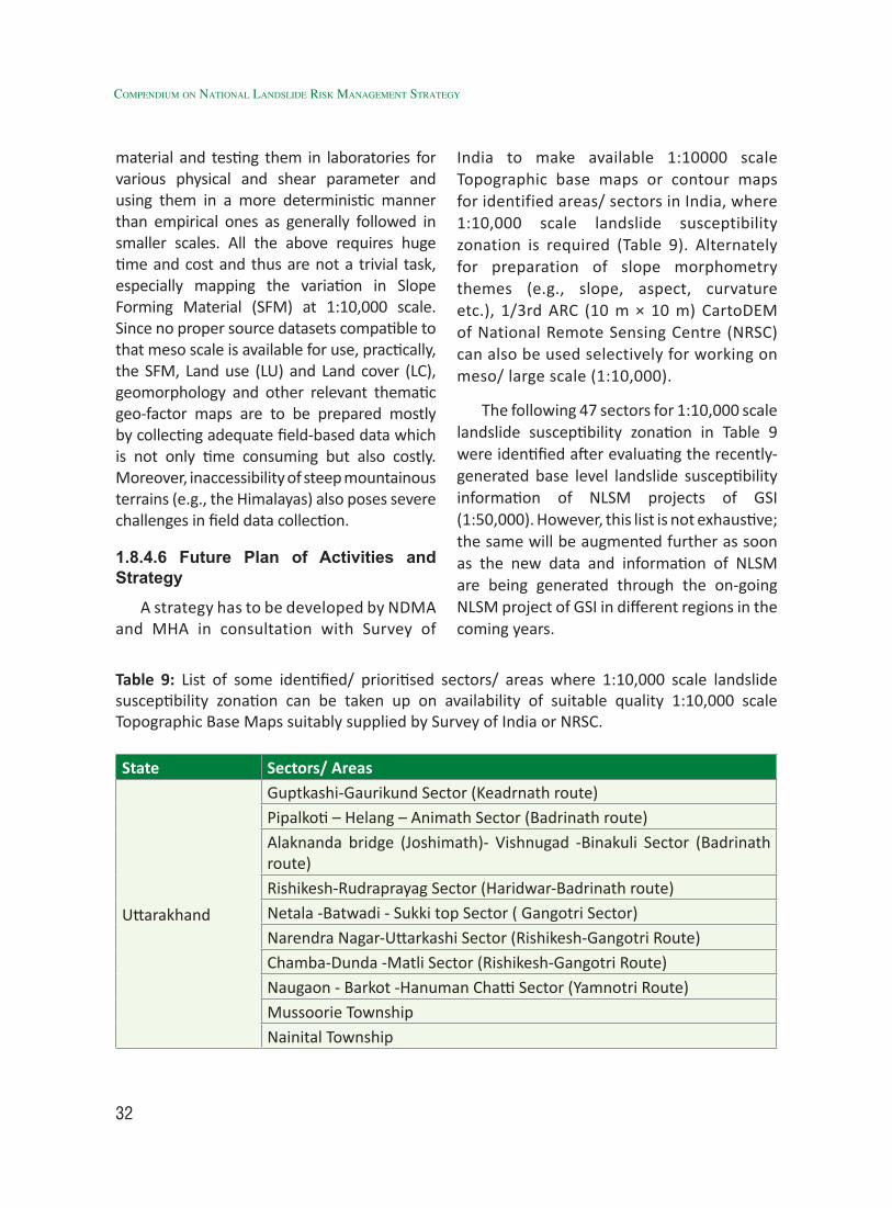
32
Compendium on national landslide Risk management stRategy
material and testing them in laboratories for various physical and shear parameter and using them in a more deterministic manner than empirical ones as generally followed in smaller scales. All the above requires huge time and cost and thus are not a trivial task, especially mapping the variation in Slope Forming Material (SFM) at 1:10,000 scale. Since no proper source datasets compatible to that meso scale is available for use, practically, the SFM, Land use (LU) and Land cover (LC), geomorphology and other relevant thematic geo-factor maps are to be prepared mostly by collecting adequate field-based data which is not only time consuming but also costly. Moreover, inaccessibility of steep mountainous terrains (e.g., the Himalayas) also poses severe challenges in field data collection.
1.8.4.6 Future Plan of Activities and Strategy
A strategy has to be developed by NDMA and MHA in consultation with Survey of
India to make available 1:10000 scale Topographic base maps or contour maps for identified areas/ sectors in India, where 1:10,000 scale landslide susceptibility zonation is required (Table 9). Alternately for preparation of slope morphometry themes (e.g., slope, aspect, curvature etc.), 1/3rd ARC (10 m × 10 m) CartoDEM of National Remote Sensing Centre (NRSC) can also be used selectively for working on meso/ large scale (1:10,000).
The following 47 sectors for 1:10,000 scale landslide susceptibility zonation in Table 9 were identified after evaluating the recently-generated base level landslide susceptibility information of NLSM projects of GSI (1:50,000). However, this list is not exhaustive; the same will be augmented further as soon as the new data and information of NLSM are being generated through the on-going NLSM project of GSI in different regions in the coming years.
Table 9: List of some identified/ prioritised sectors/ areas where 1:10,000 scale landslide susceptibility zonation can be taken up on availability of suitable quality 1:10,000 scale Topographic Base Maps suitably supplied by Survey of India or NRSC.
State Sectors/ Areas
Uttarakhand
Guptkashi-Gaurikund Sector (Keadrnath route)Pipalkoti – Helang – Animath Sector (Badrinath route)Alaknanda bridge (Joshimath)- Vishnugad -Binakuli Sector (Badrinath route)Rishikesh-Rudraprayag Sector (Haridwar-Badrinath route)Netala -Batwadi - Sukki top Sector ( Gangotri Sector)Narendra Nagar-Uttarkashi Sector (Rishikesh-Gangotri Route)Chamba-Dunda -Matli Sector (Rishikesh-Gangotri Route)Naugaon - Barkot -Hanuman Chatti Sector (Yamnotri Route)Mussoorie TownshipNainital Township
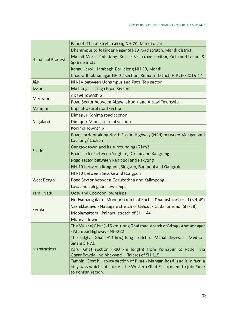
33
Himachal Pradesh
Pandoh-Thalot stretch along NH-20, Mandi districtDharampur to Joginder Nagar SH-19 road stretch, Mandi district,Manali-Marhi- Rohatang- Koksar-Sissu road section, Kullu and Lahaul & Spiti districtsKangu-Jarol- Harabagh-Bari along NH-20, MandiChaura-Bhabhanagar NH-22 section, Kinnaur district, H.P., (FS2016-17)
J&K NH-1A between Udhampur and Patni Top sectorAssam Maibang – Jatinga Road Section
MizoramAizawl TownshipRoad Sector between Aizawl airport and Aizawl Township
Manipur Imphal-Ukurul road section
NagalandDimapur-Kohima road sectionDimapur-Mao gate road sectionKohima Township
Sikkim
Road corridor along North Sikkim Highway (NSH) between Mangan and Lachung/ LachenGangtok town and its surrounding (6 km2)Road sector between Singtam, Dikchu and RangrangRoad sector between Ranipool and PakyongNH-10 between Rongpoh, Singtam, Ranipool and Gangtok
West BengalNH-10 between Sevoke and RongpohRoad Sector between Gorubathan and KalimpongLava and Lolegaon Townships
Tamil Nadu Ooty and Coonoor Townships
Kerala
Neriyamangalam - Munnar stretch of Kochi –Dhanushkodi road (NH-49)Vazhikkadavu - Nadugani stretch of Calicut - Gudallur road (SH -28) Moolamattom - Painavu stretch of SH – 44Munnar Town
Maharashtra
The Malshej Ghat (~15 km.) long Ghat road stretch on Vizag - Ahmadnagar - Mumbai Highway - NH-222The Kalghar Ghat (~11 km.) long stretch of Mahabaleshwar - Medha - Satara SH-73. Karul Ghat section (~10 km length) from Kolhapur to Padel (via GaganBawda - Vaibhavwadi – Talere) of SH-115. Tamhini Ghat hill route section of Pune - Mangan Road, and is in fact, a hilly pass which cuts across the Western Ghat Escarpment to join Pune to Konkan region.
Generation of User-friendly landslide Hazard Maps
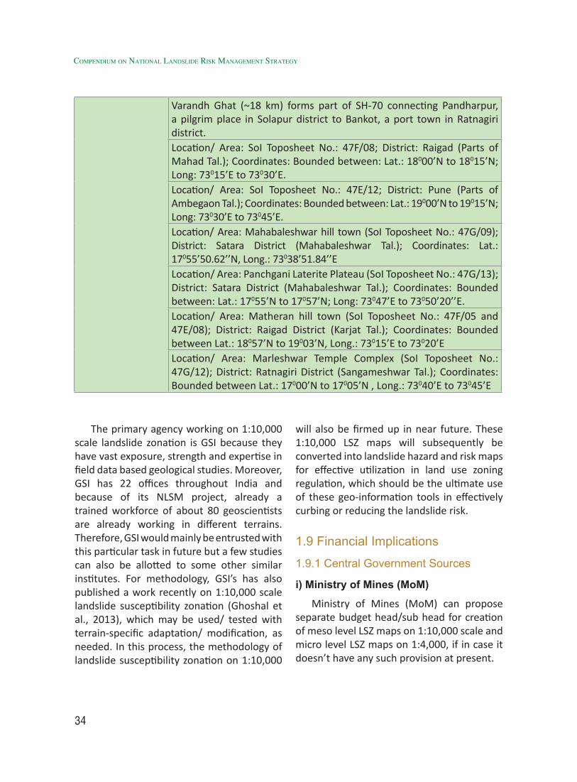
34
Compendium on national landslide Risk management stRategy
Varandh Ghat (~18 km) forms part of SH-70 connecting Pandharpur, a pilgrim place in Solapur district to Bankot, a port town in Ratnagiri district.Location/ Area: SoI Toposheet No.: 47F/08; District: Raigad (Parts of Mahad Tal.); Coordinates: Bounded between: Lat.: 18000’N to 18015’N; Long: 73015’E to 73030’E.Location/ Area: SoI Toposheet No.: 47E/12; District: Pune (Parts of Ambegaon Tal.); Coordinates: Bounded between: Lat.: 19000’N to 19015’N; Long: 73030’E to 73045’E.Location/ Area: Mahabaleshwar hill town (SoI Toposheet No.: 47G/09); District: Satara District (Mahabaleshwar Tal.); Coordinates: Lat.: 17055’50.62’’N, Long.: 73038’51.84’’ELocation/ Area: Panchgani Laterite Plateau (SoI Toposheet No.: 47G/13); District: Satara District (Mahabaleshwar Tal.); Coordinates: Bounded between: Lat.: 17055’N to 17057’N; Long: 73047’E to 73050’20’’E.Location/ Area: Matheran hill town (SoI Toposheet No.: 47F/05 and 47E/08); District: Raigad District (Karjat Tal.); Coordinates: Bounded between Lat.: 18057’N to 19003’N, Long.: 73015’E to 73020’ELocation/ Area: Marleshwar Temple Complex (SoI Toposheet No.: 47G/12); District: Ratnagiri District (Sangameshwar Tal.); Coordinates: Bounded between Lat.: 17000’N to 17005’N , Long.: 73040’E to 73045’E
The primary agency working on 1:10,000 scale landslide zonation is GSI because they have vast exposure, strength and expertise in field data based geological studies. Moreover, GSI has 22 offices throughout India and because of its NLSM project, already a trained workforce of about 80 geoscientists are already working in different terrains. Therefore, GSI would mainly be entrusted with this particular task in future but a few studies can also be allotted to some other similar institutes. For methodology, GSI’s has also published a work recently on 1:10,000 scale landslide susceptibility zonation (Ghoshal et al., 2013), which may be used/ tested with terrain-specific adaptation/ modification, as needed. In this process, the methodology of landslide susceptibility zonation on 1:10,000
will also be firmed up in near future. These 1:10,000 LSZ maps will subsequently be converted into landslide hazard and risk maps for effective utilization in land use zoning regulation, which should be the ultimate use of these geo-information tools in effectively curbing or reducing the landslide risk.
1.9 Financial Implications
1.9.1 Central Government Sources
i) Ministry of Mines (MoM)
Ministry of Mines (MoM) can propose separate budget head/sub head for creation of meso level LSZ maps on 1:10,000 scale and micro level LSZ maps on 1:4,000, if in case it doesn’t have any such provision at present.
35
ii) Border Road Organisation (BRO)
BRO can propose separate budget head for Landslide Management measures for the route corridors under its supervision, if in case it doesn’t have any such provision at present.
iii) Department of Science & Technology (DST)
Department of Science & Technology, Govt. of India as a stake holder in implementing the strategy can make it mandatory for the researchers submitting new project proposals on LHZ mapping or those already carrying out landslide studies (using DST funds) to follow this strategy document and to work for only those areas which are still unattended. This would bring new ideas and research finding from young researchers in consonance with the requirement at local regional and national level and would also help in avoiding duplication of work by various departments and researchers.
iv) Mahatma Gandhi National Rural Employment Guarantee (MNREGA)
Provisions can be made in MNREGA scheme for structural mitigation of landslides in hill areas.
1.9.2 State Government Sources
State Governments of landslide prone states can make provision for landslide management head in the budget allocation of Public Works Department, Irrigation Department, Rural Engineering Services and Department of Disaster Management.
1.10 Implementation Strategy
1.10.1 Short Term Implementation Strategy
• Formation of LHZ Monitoring
Committee (LHZMC) under NDMA in consultation with nodal agency (GSI) and other agencies competent in carrying out LHZ mapping work.
[Action: NDMA in consultation with GSI and other stakeholders]
• Collection of all the available Landslide Hazard Zonation (LHZ) and Susceptibility Zonation (LSZ) maps, reports and atlases created by various state and central government departments, institutions and agencies etc. by the nodal agency (GSI). Since all this information would be crucial in cataloging the history of landslides and their scientific records created by different agencies during past few decades.
[Action: Ministry of Mines (MoM)/Geological Survey of India (GSI) in consultation with Technical Advisory Committee (TAC) and LHZMC]
• Taking up pilot projects at least at 10 sites in next two years to firm up of existing methodology right up to hazard and risk level.
[Action: Ministry of Mines (MoM)/GSI, States and academic institutions in consultation with TAC and LHZMC]
• Hiring group of expert agencies for taking up the meso level LHZ map creation work in different parts of landslide prone regions of the country.
[Action: Ministry of Mines (MoM)/GSI in consultation with TAC and LHZMC]
1.10.2 Long Term Implementation Strategy
• Creation of meso level LHZ Maps on 1:10,000 scale in order to cater the requirements of Landslide Hazard Management planning at District, Tehsil and Block level.
Generation of User-friendly landslide Hazard Maps

36
Compendium on national landslide Risk management stRategy
[Action: Ministry of Mines (MoM)/GSI in collaboration with State Governments and other academic institutions]
• Meso level LHZ Maps on 1:10,000 Scale of the already prioritised sectors (47 sectors) should be created using very high resolution Remote sensing data, detailed field input, GPS, LiDAR and GIS techniques within four years and the same should be used by concerned State Governments for effective land use zoning regulation and planning proper mitigation to reduce landslide risk.
[Action: Ministry of Mines (MoM)/GSI in collaboration with States and academic institutions in consultation with TAC and LHZMC]
• Use of web-based and app-based dissemination tools for maps for common use not only by the administrators but also by the community, tourists etc.
[Action: Ministry of Mines (MoM)/GSI in consultation with TAC and LHZMC]
1.11 Mechanism for Monitoring
1.11.1 Formation of LHZ Monitoring Committee (LHZMC)
• LHZ Monitoring Committee (LHZMC) should be created under National Disaster Management Authority (NDMA) in consultation with nodal agency (GSI) and other expert agencies of Govt. of India and State Governments.
1.11.2 Roles and Responsibilities of LHZMC
• To identify the funding agencies and funding mechanism for preparation of user-friendly LHZ map, especially on 1:10,000 scale.
• To prioritize target areas in consultation with NDMA, nodal agency and State Disaster Management Authorities (SDMAs of landslide prone states of the country).
• To monitor the progress of LHZ map creation at meso level.
• To ensure the dissemination of user friendly meso level LSZ maps to various stakeholders using web-based and app-based platforms.
• To facilitate SDMAs of respective states in the implementation of landslide management strategy and measures suggested in Meso level landslide management maps.
• To prioritize in consultation with experts and State Disaster Management Authorities (SDMAs of landslide prone states of the country) those regions of the respective states where 1:4,000 scale Micro level landslide susceptibility zonation will be taken up (after Meso level landslide susceptibility zonation is completed for priority sectors) on priority basis.
1.12 Conclusions & Recommendations
i. BMTPC’s national scale (1:60,00,000) landslide susceptibility atlas be updated as and when new data and information are available. Methodology followed for preparation of BMTPC’s national-scale (1:10,00,000 or smaller) landslide susceptibility map be continued as an optimum methodology for that particular scale.
[Action: BMTPC]
ii. On macro scale (1:50,000/25,000), GSI’s terrain-specific methodology followed
37
in NLSM project can be considered as an optimal methodology pertinent to that scale. NLSM maps need to be made available in mobiles through app-based platforms.
[Action: Ministry of Mines (MoM)/GSI]
iii. Sectors for meso/large scale (1:10,000) landslide zonation preferably be chosen from the areas where previously created LHZ outputs by different agencies are available including those of NLSM, so that basic landslide and thematic database on macro scale can be used as base maps for this study. [Action: BMTPC]
iv. Survey of India (SoI)/National Remote Sensing Centre (NRSC) for arranging supply 1:10,000 scale Topographic base maps for already-prioritized sectors, so that 1:10,000 scale landslide susceptibility zonation in those prioritized sectors in different parts of the country can be taken up as early as possible.
[Action: SoI / NRSC]
v. There is an issue of methodology for landslide susceptibility mapping on 1:10,000 scale. GSI has already proposed one and the same is under testing in two pilot areas in Eastern Himalayas. Start for taking up new 1:10,000 scale LSZ projects, initially in 10 out of the 47 identified/prioritised sectors by 2020, so that a robust methodology on this scale can also be developed. Attempts should be made also to execute conversion of 1:10,000 scale landslide susceptibility maps into proper landslide hazard and risk maps.
[Action: Nodal Agency (GSI) and other stakeholders]
vi. Due to up-scaling to 1:10,000 scales, dependency on field-based data input, knowledge on geotechnical parameters, structural geology, rock/ soil mechanics will be required for meso/ large scale landslide studies. Moreover, unlike the empirical methods followed in macro scale (1:50,000), meso/ large scale (1:10,000) LSZ requires a more deterministic approach using in-situ knowledge and close spaced field observation, data on variation in slope morphometry, geomorphology, slope forming material, evaluation of the kinematic inter-relationships between rock structures and topography etc. Therefore, such type of analysis needs more field data collection, more time and cost. Therefore, this task needs to be shared by agencies competent in carrying out such task. GSI can be identified as the main agency for the targeted task and a few can be distributed amongst other similar agencies. A list of such agencies other than GSI is given below.
• Remote Sensing Applications Centre (RSAC), U.P., Lucknow
• Indian Institute of Remote Sensing (IIRS), Dehradun
• Defence Terrain Research Laboratory (DTRL)-DRDO, Delhi
• Central Building Research Institute (CBRI), Roorkee
• Department of Science & Technology (DST), Govt. of India
• Central Road Research Institute (CRRI), Delhi
• Wadia Institute of Himalayan Geology (WIHG), Dehradun
• Geology Departments of Central
Generation of User-friendly landslide Hazard Maps
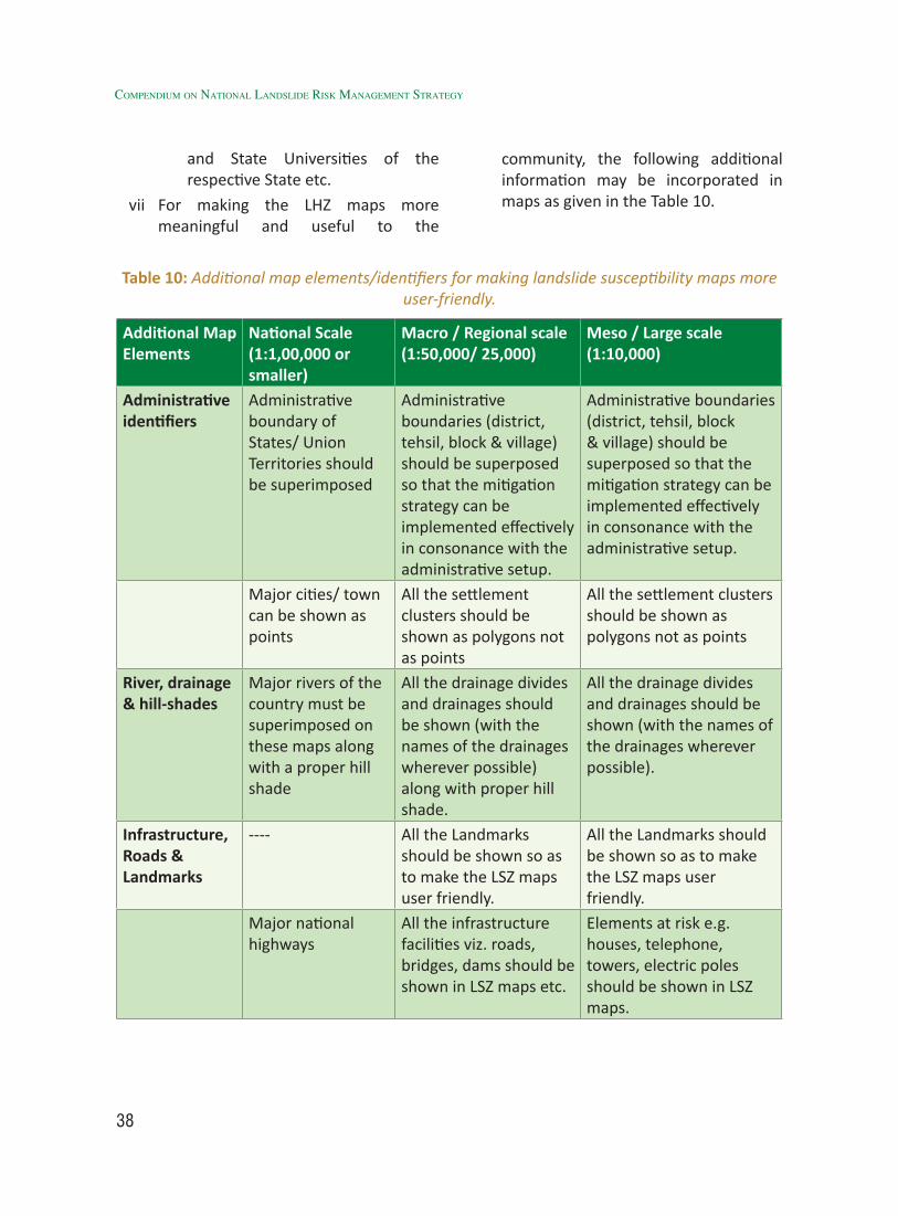
38
Compendium on national landslide Risk management stRategy
and State Universities of the respective State etc.
vii For making the LHZ maps more meaningful and useful to the
Table 10: Additional map elements/identifiers for making landslide susceptibility maps more user-friendly.
Additional Map Elements
National Scale (1:1,00,000 or smaller)
Macro / Regional scale (1:50,000/ 25,000)
Meso / Large scale (1:10,000)
Administrative identifiers
Administrative boundary of States/ Union Territories should be superimposed
Administrative boundaries (district, tehsil, block & village) should be superposed so that the mitigation strategy can be implemented effectively in consonance with the administrative setup.
Administrative boundaries (district, tehsil, block & village) should be superposed so that the mitigation strategy can be implemented effectively in consonance with the administrative setup.
Major cities/ town can be shown as points
All the settlement clusters should be shown as polygons not as points
All the settlement clusters should be shown as polygons not as points
River, drainage & hill-shades
Major rivers of the country must be superimposed on these maps along with a proper hill shade
All the drainage divides and drainages should be shown (with the names of the drainages wherever possible) along with proper hill shade.
All the drainage divides and drainages should be shown (with the names of the drainages wherever possible).
Infrastructure, Roads & Landmarks
---- All the Landmarks should be shown so as to make the LSZ maps user friendly.
All the Landmarks should be shown so as to make the LSZ maps user friendly.
Major national highways
All the infrastructure facilities viz. roads, bridges, dams should be shown in LSZ maps etc.
Elements at risk e.g. houses, telephone, towers, electric poles should be shown in LSZ maps.
community, the following additional information may be incorporated in maps as given in the Table 10.
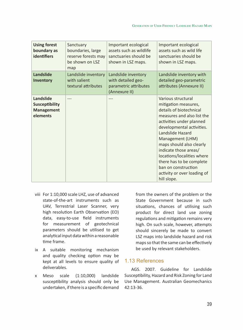
39
viii For 1:10,000 scale LHZ, use of advanced state-of-the-art instruments such as UAV, Terrestrial Laser Scanner, very high resolution Earth Observation (EO) data, easy-to-use field instruments for measurement of geotechnical parameters should be utilised to get analytical input data within a reasonable time frame.
ix A suitable monitoring mechanism and quality checking option may be kept at all levels to ensure quality of deliverables.
x Meso scale (1:10,000) landslide susceptibility analysis should only be undertaken, if there is a specific demand
from the owners of the problem or the State Government because in such situations, chances of utilising such product for direct land use zoning regulations and mitigation remains very high. On such scale, however, attempts should sincerely be made to convert LSZ maps into landslide hazard and risk maps so that the same can be effectively be used by relevant stakeholders.
1.13 ReferencesAGS. 2007. Guideline for Landslide
Susceptibility, Hazard and Risk Zoning for Land Use Management. Australian Geomechanics 42:13-36.
Using forest boundary as identifiers
Sanctuary boundaries, large reserve forests may be shown on LSZ map
Important ecological assets such as wildlife sanctuaries should be shown in LSZ maps.
Important ecological assets such as wild life sanctuaries should be shown in LSZ maps.
Landslide Inventory
Landslide inventory with salient textural attributes
Landslide inventory with detailed geo-parametric attributes (Annexure II)
Landslide inventory with detailed geo-parametric attributes (Annexure II)
Landslide Susceptibility Management elements
--- --- Various structural mitigation measures, details of biotechnical measures and also list the activities under planned developmental activities. Landslide Hazard Management (LHM) maps should also clearly indicate those areas/ locations/localities where there has to be complete ban on construction activity or over loading of hill slope.
Generation of User-friendly landslide Hazard Maps
40
Compendium on national landslide Risk management stRategy
Ardizzone F, Cardinali M, Carrara A, Guzzetti F, Reichenbach P. 2002. Impact of mapping errors on the reliability of landslide hazard maps. Natural Hazards and Earth System Sciences 2:3-14.
BIS. 1998. Preparation of landslide hazard zonation maps in mountainous terrains - Guidelines, Bureau of Indian Standards (BIS) IS 14496 (Part - 2).
Bhandari, R.K. and Kotuwegoda, V.P.P.K. (1996), Consideration of Landslide Geometry and Runout in a Landslide Inventory. Seventh Int. Symp. on landslides, Balhema, Rotterdam, pp: 73-78.
Bhandari, R.K. (1994) Landslide Hazard Mapping in Sri Lanka- A Holistic Approach, Proceeds of National Symposium on Landslides in Sri Lanka, pp: 271-284.
Bhandari, R.K., (1987), Slope Instability in Fragile Himalaya and Strategy for Development, Indian Geotechnical Journal, 1987.1.
Cascini L. 2004. Risk assessment of fast landslide - from theory to practice. In: Lacerda WA, Ehrlich M, Fontoura S, Sayao A, editors. Proc 9th International Symposium on Landslides. Landslides: Evaluation and Stabilization. ISL 04. Rio de Janeiro. p 20.
Fell R, Corominas J, Bonnard C, Cascini L, Leroi E, Savage WZ. 2008. Guidelines for landslide susceptibility, hazard and risk zoning for land use planning. Engineering Geology 102:85-98.
Fell, R., Ho, K.K.S., Lacasse, S., Leroi, E., 2005. A framework for landslide risk assessment and management. In: Hungr, O., Fell, R., Couture, R., Eberhardt, E. (Eds.), Landslide Risk Management. Taylor and Francis, London, pp. 3–26.
Fell, R, Corominas, J., Bonnard, C, Cascini, L., Leroi, E, Savage, W.Z.on behalf of the JTC-1 Joint Technical Committee on Landslides and Engineered Slopes (2008), Guidelines for landslide susceptibility, hazard and risk zoning for land use planning, Engineering Geology, Vol. 102: 85-92
Finlay PJ, Fell R, Maguire PK. 1997. The relationship between the probability of landslide occurrence and rainfall. Canadian Geotechnical Journal 34:811-824.
Galli M, Guzzetti F. 2007. Landslide Vulnerability Criteria: A Case Study from Umbria, Central Italy. Environmental Management 40:649-665.
Ghosh S. 2011. ITC dissertation number 190; ISBN 978-90-6164-310-4; Knowledge-guided empirical prediction of landslide hazard; Faculty of Geoinformation Science and Earth Observation (ITC), University of Twente, The Netherlands.
Ghosh S, Carranza EJM, van Westen CJ, Jetten VG, Bhattacharya DN. 2011. Selecting and weighting spatial predictors for empirical modeling of landslide susceptibility in the Darjeeling Himalayas (India). Geomorphology 131:35-56.
Ghosh S, van Westen CJ, Carranza EJM, Jetten VG, Cardinali M, Rossi M, Guzzetti F. 2012. Generating event-based landslide maps in a data-scarce Himalayan environment for estimating temporal and magnitude probabilities. Engineering Geology 128:49-62.
Ghoshal TB, Bodas MS, Ghosh S. 2013. A multi-thematic and deterministic-cum-heuristic methodology for mesoscale (1:5,000/10,000) landslide susceptibility zonation. Indian Journal of Geosciences 67:217-228.
41
Glade T, Anderson M, Crozier MJ. 2005. Landslide Hazard and Risk. Chichester, England: John Wiley & Sons, Ltd.
Guzzetti F, Carrara A, Cardinali M, Reichenbach P. 1999. Landslide hazard evaluation: a review of current techniques and their application in a multi-scale study, Central Italy. Geomorphology 31:181-216.
Guzzetti F, Mondini AC, Cardinali M, Fiorucci F, Santangelo M, Chang K-T. 2012. Landslide inventory maps: New tools for an old problem. Earth-Science Reviews 112:42-66.
Harp EL. 1994. Instrumental shaking thresholds for seismically induced landslides and preliminary report on landslides triggered by the October 17, 1989, Loma Prieta, California earthquake. Geografia Fisica e Dinamica Quaternaria 16:13-15.
Harp EL, Jibson RL. 1996. Landslides triggered by the 1994 Northridge, California earthquake. Seismological Society of America Bulletin 86:S319–S332.
Holland, T.H. (1897), Report on Geological Structures and Stability of Hill Slopes Around Nainital. Misc. publ. Geol.Sur.Ind.pp: 1-85.
Hungr O. 1997. Some methods of landslide hazard intensity mapping. In: Cruden D, Fell R, editors. Landslide risk assessment. Rotterdam: A.A. Balkema. p 215-226.
Jaiswal P. 2011. Landslide risk quantification along transportation corridors using historical information. PhD thesis. University of Twente, The Netherlands. ISBN 978-90-6164-311-1.
Jaiswal P, van Westen CJ. 2009. Estimating temporal probability for landslide initiation along transportation routes based on rainfall
thresholds. Geomorphology 112:96-105.
Jaiswal P, van Westen CJ, Jetten V. 2010. Quantitative landslide hazard assessment along a transportation corridor in southern India. Engineering Geology 116:236-250.
Keefer DK. 1994. The importance of earthquake-induced landslides to long-term slope erosion and slope-failure hazards in seismically active regions. Geomorphology 10:265-284.
Kirschbaum D, Adler R, Hong Y, Hill S, Lerner-Lam A. 2010. A global landslide catalog for hazard applications: method, results, and limitations. Natural Hazards 52:561-575.
Kumar, Kishor, Gupta, Pankaj, Yadav, O.P. and Bhandara, RMS (2000) Comparative Landslide hazard zonation study in Garhwal Himalaya- a case study –Proceedings of National Seminar on Geodynamics, Srinagar, Uttaranchal, pp 225-237.
Leone F, Asté JP, Leroi E. 1996. Vulnerability assessment of elements exposed to mass-movement: Working toward a better risk perception. In: Senneset K, editor. VII International Symposium on Landslide. Trondheim, Norway: A.A.Balkema. p 263-269.
Martha TR, Kerle N, van Westen CJ, Jetten V, Vinod Kumar K. 2012. Object-oriented analysis of multi-temporal panchromatic images for creation of historical landslide inventories. ISPRS Journal of Photogrammetry and Remote Sensing 67:105-119.
Middlemiss, C.S (1890) Geological Sketch of Nainaital with some remarks on Natural conditions governing the Mountain Slope. Rec.Geol.Surv.Ind. ,Vol.21, pp.213-234.
Nadim F, Kjekstad O. 2009. Assessment of Global High-Risk Landslide Disaster Hotspots.
Generation of User-friendly landslide Hazard Maps
42
Compendium on national landslide Risk management stRategy
In: Sassa K, Canuti P, editors. Landslides - Diaster Risk Reduction: Springer. p 213-221.
Narula, P.L; Gupta, S.K; Sharda Y.P and Singh, J(1996) Crustal Adjustments and Related Landslide Hazard. Proc. Seventh Int. symp. on landslides, Trondheim, pp.995-1000.
OFDA/CRED. 2010. EM-DAT International Disaster Database - www.em-dat.net. In: Université Catholique de Louvain, Brussels, Belgium.
Oldham, R.D. (1880) Note on Nainital Landslides (18th Sept.),Rec. Geol. Surv. Ind. Vol. 13, PP 277-281.
Petley DN, Dunning SA, Rosser NJ. 2005. The analysis of global landslide risk through the creation of a database of worldwide landslide fatalities. In: Hungr O, Fell R, Couture R, Eberhardt E, editors. Landslide risk management. London: Taylor & Francis Group. p 367-373.
Remondo J, Bonachea J, Cendrero A. 2005. A statistical approach to landslide risk modelling at basin scale: from landslide susceptibility to quantitative risk assessment. Landslides 2:321-328.
Seshagiri, D.N. and S. Badrinarayan (1982). The Nilgiri Landslides, Geol. Surv. Ind. Misc. Pub. 57.
Sharda, Y.P. (1994) Landslide Hazards Zonation in Parts at Chenab basin (J & K). Rec.Geol.Surv.Ind.,Vol. 127, pt.8., pp. 110-114.
Sharma, V.K. (1996), A Probabilistic Approach for Landslide Zonation in Parts of Garhwal Himalaya. Proc. Seventh Intern. Symp. Landslides, Trondheim, pp. 381-388.
Sikdar, P.K., (2004),Engineering for the mitigation of landslide disasters. World
Congress on Natural Disaster Mitigation,Proc. Vol 2, VigyanBhavan , New Delhi, pp 21-37.
Uniyal, A., Shah, P.N., Prakash, C., Gangwar, D. S., Dhar, S., Mishra, S.P., Sharma, S. & Malik, G.S., (2012), Anthropogenically induced mass movements along Dharasu-Yamunotri Route in Uttarakhand Himalaya, Current Science, Vol. 102, No. 6, 2012, pp 828-829.
Uniyal, A., (2010), Disaster management strategy for mass wasting hazard prone Kumarkhera area in Narendra Nagar township of Tehri Garhwal district of Uttarakhand, India; Disaster Prevention and Management : An International Journal, Vol.19, No. 3, pp 358-369.
Uniyal, A. (2008), Prognosis and mitigation strategy for major landslide prone areas : A case study of Varunavat Parvat landslide in Uttarkashi township of Uttrakhand (India)”, Disaster Prevention and Management : An International Journal, Vol.17 No.5, pp 622-644.
Uniyal, A. and Prasad, C., (2006), Disaster management strategy for mass wasting hazard prone Naitwar Bazar and surrounding areas in Upper Tons valley in Uttarkashi district, Uttaranchal (India)”, Disaster Prevention and Management: An International Journal, Vol.15, No. 5, pp. 821– 837.
Uniyal, A., (2004), Landslides at Karnaprayag: Another Uttarkashi in the making?,Current Science, Vol. 87, No. 8, pp. 1031 –1033.
Valdiya, K.S. (1987), Environmental Geology Indian Context, Tata McGraw-Hill, Noida.
Van Westen C. 1999. Comparing Landslide Hazard Maps. Natural Hazards 20:137-158.
Van Westen CJ, Ghosh S, Jaiswal P, Martha
43
TR, Kuriakose SL. 2013. From Landslide Inventories to Landslide Risk Assessment; An Attempt to Support Methodological Development in India. In: Landslide Science and Practice: Springer Berlin Heidelberg. p 3-20.
Van Westen CJ, van Asch TWJ, Soeters R. 2006. Landslide hazard and risk zonation—why is it still so difficult? Bulletin of Engineering Geology and Environment 65:167-184.
Varnes DJ. 1984. Landslide Hazard Zonation: a review of principles and practice. Darantiere, Paris: UNESCO Press.
1.14 ANNEXURE
Annexure I: National Landslide Susceptibility Mapping (NLSM) Programme
To foster better progress rate and to improve the quality of landslide susceptibility mapping, along with adequate amount of field inputs, NLSM programme also uses optimally a dedicated and trained human resources, very high-resolution Remote Sensing datasets for preparation of landslide and other geo-factor database, adequate field validation to prepare the landslide susceptibility maps in a GIS based on i) landslide-dependent empirical techniques for calculation of ratings and weighting of geo-factors, followed by data integration using Weighted Multi-class Index Overlay (WMIO) in a landslide proficient areas (e.g., the Himalayas), and ii) through Analytical Hierarchy Process (AHP) for
calculation of expert-driven ratings/ weights of geofactors and integration of rated and weighted maps using WMIO in areas where a-priori knowledge on landslides is absent or insufficient (e.g., Western Ghats, some parts of Northeast etc.). The main purpose of this national programme is to prepare a nation-wide seamless landslide inventory and susceptibility database for easy retrieval, use and updation in future whenever new events and large-scale changes in geo-environmental parameters are encountered. The methodology followed in NLSM has been developed through an intense 4-year long international collaborative research based in Indian geo-environmental conditions (the Himalayas, the Nilgiris) amongst GSI, NRSC and the Faculty ITC, University of Twente, The Netherlands, the outcomes of which have already been published in several ISI peer-reviewed journals like Geomorphology, Landslides, Earth Surface Processes & Landforms, Engineering Geology, Natural Hazards, Natural Hazards & Earth System Science etc. (Ghosh, 2011; Ghosh et al., 2011; Jaiswal, 2011; Ghosh et al., 2012; Martha et al., 2012; van Westen et al., 2013).The above intensive international research and application of its output in an operational programme in India, as outlined at page no. 7 in the NDMA Guidelines of Landslides & Snow Avalanches (2009)has actually been implemented by GSI through its NLSM programme w.e.f. 2014-15. The perspective plan and, the status of current progress of the on-going NLSM Project are enumerated in Tables 1 & 2 and Figure 1.
Generation of User-friendly landslide Hazard Maps
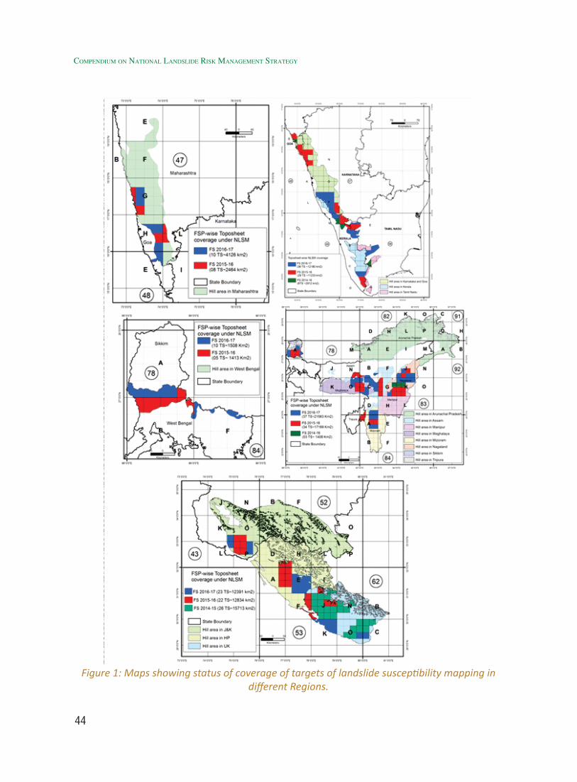
44
Compendium on national landslide Risk management stRategy
Figure 1: Maps showing status of coverage of targets of landslide susceptibility mapping in different Regions.
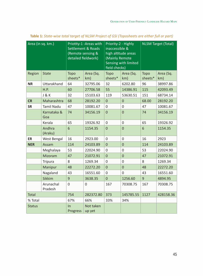
45
Table 1: State-wise total target of NLSM Project of GSI (Toposheets are either full or part)
Area (in sq. km.) Priotity-1 -Areas with Settlement & Roads (Remote sensing & detailed fieldwork)
Priority-2 - Highly inaccessible & high altitude areas (Mainly Remote Sensing with limited field checks)
NLSM Target (Total)
Region State Toposheets*
Area (Sq. km)
Toposheets*
Area (Sq. km)
Toposheets*
Area (Sq. km)
NR Uttarakhand 64 32795.06 32 6202.80 96 38997.86H.P. 60 27706.58 55 14386.91 115 42093.49J & K 32 15103.63 119 53630.51 151 68734.14
CR Maharashtra 68 28192.20 0 0 68.00 28192.20SR Tamil Nadu 47 10081.67 0 0 47 10081.67
Karnataka & Goa
74 34156.19 0 0 74 34156.19
Kerala 65 19326.92 0 0 65 19326.92Andhra (Araku)
6 1154.35 0 0 6 1154.35
ER West Bengal 16 2923.00 0 0 16 2923NER Assam 114 24103.89 0 0 114 24103.89
Meghalaya 53 22024.90 0 0 53 22024.90Mizoram 47 21072.91 0 0 47 21072.91Tripura 8 1269.34 0 0 8 1269.34Manipur 48 22272.20 0 0 48 22272.20Nagaland 43 16551.60 0 0 43 16551.60Sikkim 9 3638.35 0 1256.60 9 4894.95Arunachal Pradesh
0 0 167 70308.75 167 70308.75
Total 754 282372.80 373 145785.55 1127 428158.36% Total 67% 66% 33% 34%Status In
ProgressNot taken up yet
Generation of User-friendly landslide Hazard Maps
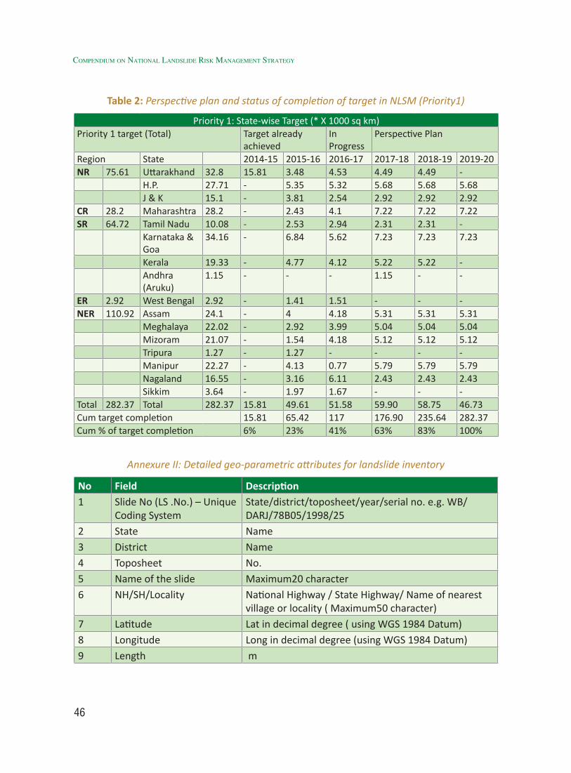
46
Compendium on national landslide Risk management stRategy
Table 2: Perspective plan and status of completion of target in NLSM (Priority1)
Priority 1: State-wise Target (* X 1000 sq km)Priority 1 target (Total) Target already
achievedIn Progress
Perspective Plan
Region State 2014-15 2015-16 2016-17 2017-18 2018-19 2019-20NR 75.61 Uttarakhand 32.8 15.81 3.48 4.53 4.49 4.49 -
H.P. 27.71 - 5.35 5.32 5.68 5.68 5.68J & K 15.1 - 3.81 2.54 2.92 2.92 2.92
CR 28.2 Maharashtra 28.2 - 2.43 4.1 7.22 7.22 7.22SR 64.72 Tamil Nadu 10.08 - 2.53 2.94 2.31 2.31 -
Karnataka & Goa
34.16 - 6.84 5.62 7.23 7.23 7.23
Kerala 19.33 - 4.77 4.12 5.22 5.22 -Andhra (Aruku)
1.15 - - - 1.15 - -
ER 2.92 West Bengal 2.92 - 1.41 1.51 - - -NER 110.92 Assam 24.1 - 4 4.18 5.31 5.31 5.31
Meghalaya 22.02 - 2.92 3.99 5.04 5.04 5.04Mizoram 21.07 - 1.54 4.18 5.12 5.12 5.12Tripura 1.27 - 1.27 - - - -Manipur 22.27 - 4.13 0.77 5.79 5.79 5.79Nagaland 16.55 - 3.16 6.11 2.43 2.43 2.43Sikkim 3.64 - 1.97 1.67 - - -
Total 282.37 Total 282.37 15.81 49.61 51.58 59.90 58.75 46.73Cum target completion 15.81 65.42 117 176.90 235.64 282.37Cum % of target completion 6% 23% 41% 63% 83% 100%
Annexure II: Detailed geo-parametric attributes for landslide inventory
No Field Description1 Slide No (LS .No.) – Unique
Coding SystemState/district/toposheet/year/serial no. e.g. WB/DARJ/78B05/1998/25
2 State Name3 District Name4 Toposheet No.5 Name of the slide Maximum20 character6 NH/SH/Locality National Highway / State Highway/ Name of nearest
village or locality ( Maximum50 character)7 Latitude Lat in decimal degree ( using WGS 1984 Datum) 8 Longitude Long in decimal degree (using WGS 1984 Datum)9 Length m
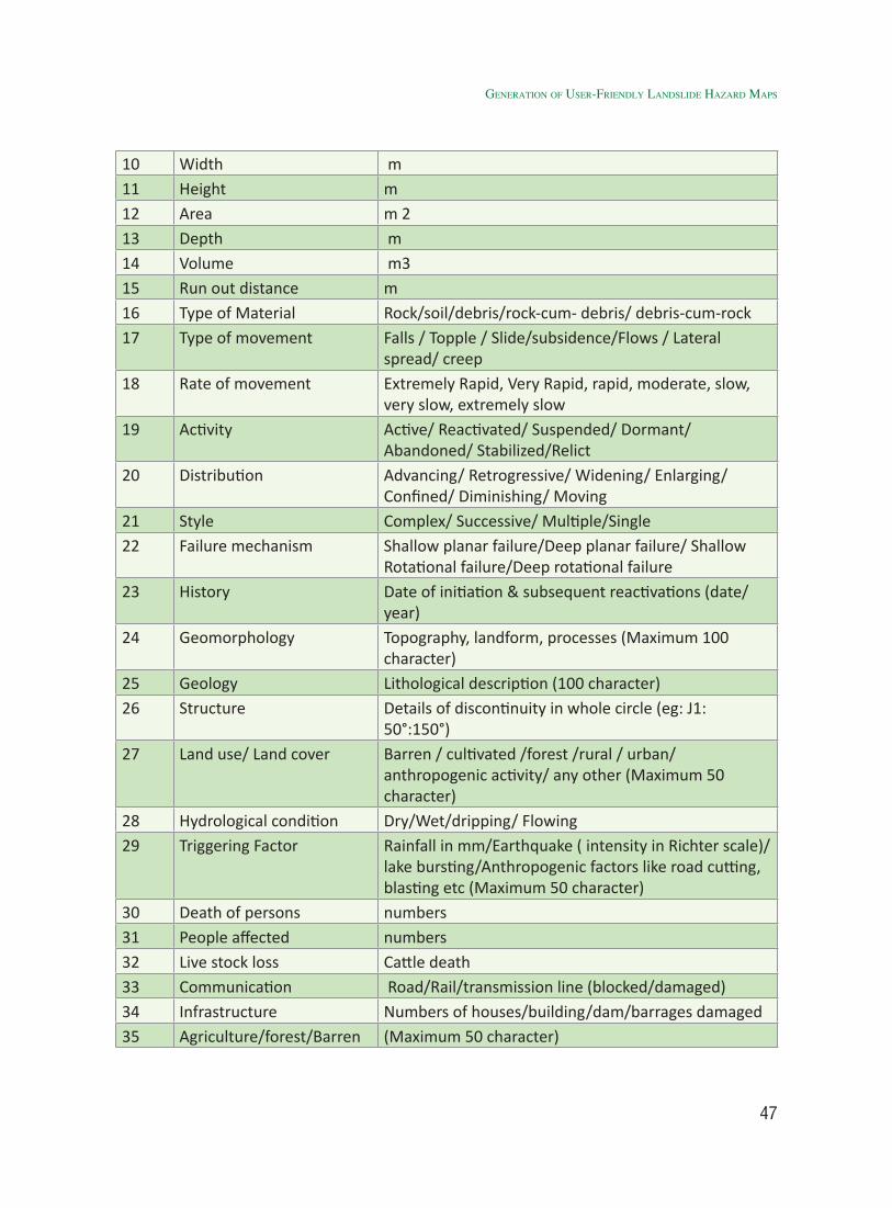
47
10 Width m11 Height m12 Area m 213 Depth m14 Volume m315 Run out distance m16 Type of Material Rock/soil/debris/rock-cum- debris/ debris-cum-rock17 Type of movement Falls / Topple / Slide/subsidence/Flows / Lateral
spread/ creep 18 Rate of movement Extremely Rapid, Very Rapid, rapid, moderate, slow,
very slow, extremely slow19 Activity Active/ Reactivated/ Suspended/ Dormant/
Abandoned/ Stabilized/Relict20 Distribution Advancing/ Retrogressive/ Widening/ Enlarging/
Confined/ Diminishing/ Moving21 Style Complex/ Successive/ Multiple/Single22 Failure mechanism Shallow planar failure/Deep planar failure/ Shallow
Rotational failure/Deep rotational failure23 History Date of initiation & subsequent reactivations (date/
year)24 Geomorphology Topography, landform, processes (Maximum 100
character)25 Geology Lithological description (100 character)26 Structure Details of discontinuity in whole circle (eg: J1:
50°:150°)27 Land use/ Land cover Barren / cultivated /forest /rural / urban/
anthropogenic activity/ any other (Maximum 50 character)
28 Hydrological condition Dry/Wet/dripping/ Flowing29 Triggering Factor Rainfall in mm/Earthquake ( intensity in Richter scale)/
lake bursting/Anthropogenic factors like road cutting, blasting etc (Maximum 50 character)
30 Death of persons numbers31 People affected numbers32 Live stock loss Cattle death33 Communication Road/Rail/transmission line (blocked/damaged)34 Infrastructure Numbers of houses/building/dam/barrages damaged35 Agriculture/forest/Barren (Maximum 50 character)
Generation of User-friendly landslide Hazard Maps
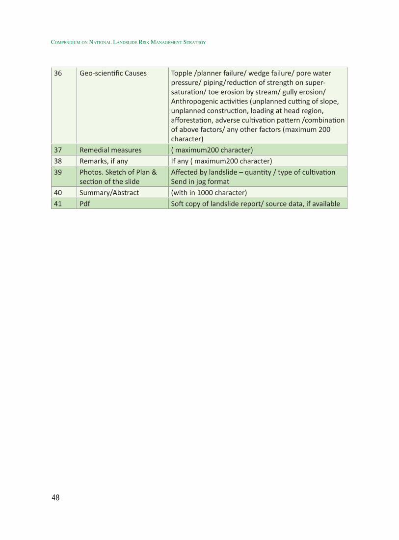
48
Compendium on national landslide Risk management stRategy
36 Geo-scientific Causes Topple /planner failure/ wedge failure/ pore water pressure/ piping/reduction of strength on super- saturation/ toe erosion by stream/ gully erosion/ Anthropogenic activities (unplanned cutting of slope, unplanned construction, loading at head region, afforestation, adverse cultivation pattern /combination of above factors/ any other factors (maximum 200 character)
37 Remedial measures ( maximum200 character)38 Remarks, if any If any ( maximum200 character)39 Photos. Sketch of Plan &
section of the slideAffected by landslide – quantity / type of cultivation Send in jpg format
40 Summary/Abstract (with in 1000 character)41 Pdf Soft copy of landslide report/ source data, if available
49
Development of Landslide Monitoring & Early Warning
System (EWS)
22.1 Introduction
In India, landslides and associated mass wasting processes are mainly controlled by factors such as geomorphology, topography, lithology and geological structure, hydrology and climatic conditions, landuse, seismicity, and anthropogenic activities. It is often triggered by intense rainfall or earthquake and most importantly the seismic high hazard zones and high rainfall areas coincide with high landslide hazard zones. Therefore, for early warning of landslides in India, it is pertinent to explore both the triggering factors i.e. precipitation and seismicity.
Occurrence of numerous rock/soil/debris slides/flows in landslide prone regions, triggered by heavy precipitation during monsoonal precipitation (June to September) in most part of the landslide prone areas and during winter in Nilgiri hills, is of prime concern to local population and administration as these largely affect the economy and the very existence of population. A devastating example is the Kedarnath Disaster 2013, Uttarakhand where at least 5,000 people died in flash floods, glacial lake outburst flood and landslides triggered by extreme precipitation event during 14th-17th June 2013. The contribution of landslides in the same disaster has come to the limelight by research findings published by Champati ray et al. (2015) and corroborated by other workers (Sundriyal et al., 2015).
Theoretically all hill slopes can be considered as vulnerable to mass movements depending on the denudation processes, human intervention and the triggering mechanism. The high rainfall event in Mirik (2015) in Darjeeling Himalaya, in Uttarakhand (2013) in NW Himalaya and in Nilgiris (2009) in Western Ghats have triggered slope failures even in areas which were otherwise considered safe from landslide hazard. Such unanticipated events often result in extensive damages to life and property. One way to minimize the disastrous effect of such rainfall-triggered landslides is by timely forecasting the rainfall condition that can initiate mass movements. It is therefore required to establish a relation between the landslide trigger (rainfall) and the event with some assessment on its magnitude (intensity). This is very much possible through analysis of rainfall-threshold, which is in short the minimum intensity or duration of rainfall required to trigger a landslide (Crozier, 1997; Jaiswal and Westen, 2009). However, the science of rainfall threshold for landslide initiation is much more complex than the stated simplistic approach, which is unfolded in subsequent sections.
World over many attempts have been made to use rainfall-threshold as an input for developing landslide early warning system (LEWS) for a large area. The first systematic use of such system in the early warning was
50
Compendium on national landslide Risk management stRategy
demonstrated in San Francisco Bay area of USA (Keefer et al., 1987) and recently in Italy (Rossi et al., 2012). The data studied from 14 institutions from 8 countries in charge of one or several EWS have indicated that ideally an EWS should be (1) robust, (2) simple, (3) redundant and (4) protected from power blackout and communication loss (Michoud et al., 2012). Based on hydro-climatic data mainly rainfall data, climatic thresholds have been established in Korea, Hong Kong, United States, Canada, and elsewhere where abundant weather stations are located at different elevations and data on temporal occurrence of landslides allow statistically meaningful results (Lumb, 1975; Kim et al., 1991; Larsen and Simon, 1993; Chleborad, 2000). Attempts have been made towards prediction of landslide initiation using intensity-duration data for rainstorms (Caine, 1980; Caine and Mool, 1982; Dai and Lee, 2001). Inclusion of antecedent rainfall has further improved the results (Jakob and Weatherly, 2003; Gabet et al., 2004).
In developing countries such as in India, developing high-tech technique for few landslides is relatively easy, whereas making a relatively low tech methodology with high impact factor in terms of applicability is a real challenge that needs to be explored. One way forward is to integrate weather forecast and locally monitored rain gauge data into rainfall-threshold model to compute warning precipitation level which represents cumulative effect of complex interaction between precipitation, infiltration, evapo-transpiration and geotechnical properties (static and dynamic) of sub-surface strata. Although the underlying principles are very complex, the front-end could be very simple as attempted by the Nilgiri district administration in designing one such simple
rainfall-threshold based warning system for shallow landslides.
In India, the problem of landslide trigger can be very complex as many vulnerable slopes lie in high seismic hazard zones. For example half of Uttarakhand and entire NE lies in zone-V that experiences number of earthquakes above magnitude 4Mw every year. Earthquakes can have a dual role i.e. it may trigger co-seismic landslides directly as a consequence of earthquakes as observed during all major earthquakes of Himalaya and Northeast India. It is also further complicated by the factor that some of the high relief areas in Himalaya experience change in precipitation pattern as a consequence of climate change. It may experience intensification of monsoon and change in precipitation pattern i.e. rainfall instead of snow fall, thus making it even more vulnerable to landslides.
Therefore, the problem is really very complex. However, in order to treat the problem in a simplistic manner, it is recommended to deal with both the triggering factors separately. The whole concept of Early Warning System for landslides revolves around developing a cost effective methodology for predicting a condition in which landslides are most likely to occur. Therefore, as a first choice, it is worthwhile to explore the role of precipitation threshold for initiation of landslides with the help of examples from across the globe and recent initiatives by ISRO, GSI, CBRI, other academic and Government Departments. However, in order to predict the time of landslide event, attempts are also made to demonstrate recent advances involving extensive ground-based instrumentation to predict the time of landslide event and communicate the same in almost real time to the stakeholders.
51
2.2 Identification of ProblemNorth-west Himalaya including
Uttarakhand, Himachal Pradesh and Jammu and Kashmir has emerged as highest landslide hazard prone region according to a report submitted in Parliament on July 27, 2016 by Minister of State for Earth Sciences, Science and Technology (Times of India, 2nd August, 2016). In Nainital, the three unstable zones identified include Naina Peak, Balia Nala, Sher Ka Danda hill and Jangli village. In addition to this, the Bareilly-Kathgodam road in Nainital has five spots as unstable zones. The report also mentioned the Haridwar-Badrinath road link and the Rudraprayag-Haridwar route in Chamoli district as having 35 unstable zones. In Himachal Pradesh, the report has pointed out 342 unstable zones spread over 13 locations while 15 such places have been identified in Jammu and Kashmir.
In Indian context, Uttarakhand has emerged as the hot-spot of landslide disasters and as a result various methodologies have been initiated in the same State and are being applied elsewhere. The oldest example can be cited from Gohna Tal landslide disaster and its very successful mitigation measures undertaken by the then British India government (Champati ray et al., 2013). The rainfall threshold based models were first tested in Alaknanda valley and later applied in many other places. For the first time Automatic Weather Stations (AWSs) were installed in the same area for the same purposes by ISRO in 2006, which is now followed by much higher level of instrumentation by DTRL and CBRI in the same region. In order to take this further, IIT, Mandi has envisaged a much more cost effective technique based on Micro-Electro Mechanical Systems (MEMS) based sensors in Himachal Pradesh, which could find much wider application due to low cost and easy deployment.
Landslides are a frequently occurring natural as well as man-made hazard in the mountainous terrains of Western Ghats and Konkan regions, which generally show preponderance of activity during both SW and NE monsoons from June to August and October to December, respectively. In these areas landslides occur mostly as debris/earth slides and debris flow, triggered by rainfall. Debris flows resulting due to torrent stream conditions are also common in the dissected hill slopes. But, majority of the slope failures are anthropogenically induced due to unscientific modification of slopes. In recent past, unprecedented monsoon rains have triggered numerous landslides in the region, noteworthy being the events of 1978, 1979, 1993, 2006 and 2009, where more than 200 landslides have been triggered in each case. In fact, since 1987 the Nilgiri hills have witnessed landslide events every year except in 1995. Landslides have caused substantial damage to life and property in Kerala. Between 1961 and 2012, a total of 265 valuable lives were lost in 64 major landslide events. The most severe, in terms of fatalities, was the Amboori landslide (Thiruvananthapuram) of 11 September 2001 that resulted in 39 casualties. Among the 14 districts of Kerala, 13 are prone to landslides; the worst affected being the Idukki district having 217 notable landslides. This is followed by Kozhikode (56 slides), Palakkad (52 slides), Thiruvananthapuram (53 slides), Kannur (43 slides), Wayanad (35 slides), Kasaragod (21 slides), Malappuram (29 slides), Kottayam (41 slides), Thrissur (23 slides) and Pathanamthitta with 15 notable landslide incidences (Kuriakose et al., 2010). In Maharashtra, the high rainfall zones of Western Maharashtra, particularly the Western Ghat Escarpment Zone and the Konkan region located due west of the Western Ghats, are prone to landslide
developMent of landslide MonitorinG & early WarninG systeM (eWs)
52
Compendium on national landslide Risk management stRategy
disasters. In past the monsoon of 2005, 2006, 2014 vast areas of Western Maharashtra (Western Ghats and Konkan Strip) were affected by numerous landslides. They were triggered by heavy rainfall and inflicted huge loss to life (more than 300 lives were lost due to landslide incidences: e.g. Malin gaon disaster) and property.
2.3 Review of Work, Best Practices and Present Status
A landslide early-warning system (LEWS) is envisaged as a system capable of modelling landslide occurrences and provide timely advance warning about the impending danger. It can be of different types, depending on the type of landslides, the target warning area and the communities to be warned. It can be for an individual landslide where warning is based on movement sensors or for small areas for one or more landslides where warning is based on rainfall threshold or for a very large area using weather prediction (Wadhawan et al., 2013). In order to develop a reliable LEWS, the processes leading to mass movement need to be understood and quantitatively measured for its spatial variation and temporal prediction. In recent years, use of (a variety) LEWS have become very popular because of low cost as compared to structural interventions and its efficacy to reduce landslide risk by timely alerting people about the impending danger.
In an international initiative under the SAFELAND project, coordinated by NGI (Norvegian Geotechnical Institute) to develop instruments for the evaluation and management of the risks caused by local, regional and European landslides in order to mitigate the damages and evaluate the areas with more risk by considering the ongoing climate change, a survey was carried out
to understand the functionality and design of EWS (Michoud et al., 2012). The study indicated that only Norway has developed a reliable LEWS and Slovakia has produced a guideline about general strategies to adopt. Most LEWS (81%) are based on displacement sensors and some on rainfall-threshold targeting a large area such as in Hong-Kong, Italy and USA. Once a threshold value is reached, almost all monitoring networks automatically notify alerts to operational units, using mainly SMS and/or e-mails services.
In the present context, a threshold may be defined as the rainfall, soil moisture, or hydrological conditions that when reached or exceeded, are likely to trigger landslides (e.g., Crozier, 1996; Reichenbach et al., 1998; Guzzetti et al., 2007). Wieczorek (1996) defined rainfall threshold as rainfall intensity that facilitates slope instability for a given region. In general, two types of rainfall thresholds are used; physical (process-based, conceptual) thresholds and empirical (historical, statistical) thresholds (Corominas, 2000; Aleotti, 2004; Wieczorek and Glade, 2005, Guzzetti et al., 2007). Physical threshold models require detailed spatial information on the hydrological, lithological, morphological, and soil characteristics that control the initiation of landslides. These process-based threshold models attempt to extend spatially the slope stability models widely adopted in geotechnical engineering (Wu and Sidle, 1995; Iverson, 2000). These models can determine the amount of precipitation required to trigger slope failures, and the location and time of the expected landslides.
Empirical rainfall threshold models are evolved by studying the rainfall events that have resulted in landslides. The threshold is usually obtained by drawing lower-bound

53
lines to the rainfall conditions that resulted in landslides plotted in Cartesian, semi-logarithmic, or logarithmic coordinates. Different types of empirical rainfall thresholds for the possible initiation of landslides have been proposed in the literature based on the extent of the geographical area for which they were defined, and the type of rainfall measurement used to establish the thresholds (Guzzetti et al., 2007). Empirical rainfall thresholds may also be grouped in three broad categories based on the type of rainfall measurements: (1) thresholds that combine precipitation measurements obtained for specific rainfall events, (2) thresholds that include the antecedent conditions (e.g., Govi et al., 1985; Kim et al., 1991; Pasuto and Silvano, 1998; Terlien 1998; Crozier, 1999; De Vita, 2000; Glade et al., 2000; Chleborad, 2003; Heyerdahl et al., 2003; Aleotti, 2004, Gabet et al., 2004; Cardinali et al., 2006), and (3) other thresholds, including hydrological thresholds (e.g., Reichenbach et al. 1998; Jakob and Weatherly 2003). Thresholds established using precipitation measurements obtained from individual or multiple rainfall events can be further subdivided into: intensity–duration (ID) thresholds, thresholds based on the total event rainfall (E), rainfall event–duration (ED) thresholds, and (4) rainfall event–intensity (EI) thresholds (Guzzetti et al., 2007). Further details are given in Table 1 and Annexure-1.
Based on the extent of the geographical area, rainfall thresholds for rain-induced landslides with different types of precipitation measurements can be broadly subdivided into global, regional, or local thresholds based on their geographical extent. A global threshold attempts to establish a general (“worldwide”) minimum level below which landslides do not occur, independent of local morphological, lithological, and land-use conditions and of local or regional rainfall pattern and history.
Global thresholds have been proposed by Caine (1980), Innes (1983), Jibson (1989), Clarizia et al. (1996), Crosta and Frattini (2001), and Cannon and Gartner (2005). Regional thresholds are defined for areas extending from a few to several thousand square kilometers of similar meteorological, climatic, and physiographic regions, and are potentially suited for landslide warning systems based on quantitative spatial rainfall forecasts, estimates, or measurements. Regional thresholds have been proposed by various researchers (Onodera et al., 1974; Campbell, 1975; Nilsen and Turner, 1975; Nilsen et al., 1976; Oberste-lehn, 1976; Guidicini and Iwasa, 1977; Govi and Sorzana, 1980; Moser and Hohensinn, 1983; Cannon and Ellen, 1985; Canuti et al., 1985; Tatizana et al., 1987; Jibson, 1989; Bhandari et al., 1991; Guadagno, 1991; Ceriani et al., 1992; Larsen and Simon, 1993; Sandersen et al., 1996; Zimmermann et al., 1997; Paronuzzi et al., 1998; Corominas and Moya, 1999; Calcaterra et al., 2000; Ahmad, 2003; Heyerdahl et al., 2003; Jakob and Weatherly, 2003; Kanji et al., 2003; Aleotti, 2004; Chien-Yuan et al., 2005; Corominas et al., 2005; Hong et al., 2005; Jan and Chen, 2005).
Local thresholds consider the local climatic regime and geomorphological setting and are applicable to single landslide or to groups of landslides in areas extending from a few to some hundreds of square kilometers (may be for local geographical area or for a highway corridor etc.). In some cases, distinction between regional and local thresholds is uncertain. Local rainfall thresholds have been given by Endo (1970), Lumb (1975), Cancelli and Nova (1985), Cannon and Ellen (1985), Wieczorek (1987), Cannon (1988), Jibson (1989), Rodolfo and Arguden (1991), Wilson et al (1992), Sorriso-Valvo et al (1994), Arboleda and Martinez (1996), Corominas and Moya
developMent of landslide MonitorinG & early WarninG systeM (eWs)
54
Compendium on national landslide Risk management stRategy
(1996), Tungol and Regalado (1996), Pasuto and Silvano (1998), Bolley and Olliaro (1999), Corominas and Moya (1999), Annunziati et al (2000), Bell and Maud (2000), Montgomery et al (2000), Wieczorek et al (2000), Aleotti et al (2002), Marchi et al (2002), Zezere and Rodrigues (2002), Bacchini and Zannoni (2003), Floris et al (2004), Baum et al (2005), Giannecchini (2005) and Zezere et al (2005).
Though the mountains of the Indian Himalaya have large landslide vulnerabilities governed by the monsoon precipitation, not many studies exist for portraying either regional or local models of rainfall thresholds for landslide occurrences in these hilly regions. A few studies report the relationship between rainfall amount or intensity and size of landslides and debris flows. For example, Starkel (1972) observed geomorphic effects of an extreme rainfall event in the eastern Indian Himalaya near Darjeeling. In a study in north Sikkim (part of eastern Indian Himalaya), Sengupta et al. (2010) found that the landslide at Lanta Khola gets initiated when normalized cumulative rainfall for more than 15 days exceeds 250 mm. It is also suggested that when this cumulative rainfall threshold is exceeded, the debris zone in the affected stretch becomes saturated and fails, causing landslides.
In a study along Chamoli-Joshimath national highway corridor, Kanungo and Sharma (2014) established an intensity–duration (ID) threshold based on daily rainfall data for shallow landslide occurrences. It is found that the rainfall events of shorter duration up to 24h with a rainfall intensity of 0.87 mm h−1 can trigger the landslides in this part and a long duration rainfall event for about 5 days with an average precipitation of 0.6 mm h−1 appears sufficient to trigger landslide activities. An analysis of antecedent
rainfall prior to landslide in relation to daily rainfall at failure could reveal that landslides in Chamoli-Joshimath region of Garhwal Himalayas, India are likely to occur when antecedent rainfall exceeds 55 mm over a 10-day period, and 185 mm over a 20-day period.
Landslide instrumentation and real-time monitoring can provide insight into the understanding of the dynamics of landslide movement. In addition, landslide monitoring in real time can provide immediate information on the landslide activity that may be critical to protect lives and property. Reliable landslide warning systems, the outcome of systematic landslide instrumentation and real time monitoring, require accurate short-term forecast of landslide movement which in turn demand a detailed understanding of present field conditions and a quantitative framework for interpreting these conditions. Real-time monitoring systems are also intended: (1) to ensure high-quality data sets about landslide behavior; (2) to promote the evolution of better landslide monitoring by identifying the need for additional or different sensors to better detect changing field conditions; (3) for improved geotechnical designs or emergency actions aimed at mitigating landslide hazards and (4) also for advancing scientific understanding of active landslide behavior.
Real-time monitoring systems have been used throughout the world to detect or forecast landslide activity. In Hong Kong, USA and Brazil, regional warning systems have been operationalized to forecast rainfall-induced shallow landslides based on real-time rainfall observations (Finlay et al., 1997; Ortigao and Justi, 2004; Wilson, 2005; Chleborad et al., 2006). Frameworks for similar systems have been developed for mountainous regions of Italy, New Zealand,
55
and Taiwan (Aleotti, 2004, Chien-Yuan et al., 2005, Schmidt et al., 2007). Site-specific real time systems have been applied in many countries to monitor critical structures, such as dams, or hazardous landslides (Angeli et al., 1994; Berti et al., 2000; Husaini and Ratnasamy, 2001; Froese and Moreno, 2007; Frigerio et al., 2014). Since 1985, researchers from the U.S. Geological Survey (USGS) have used real-time monitoring systems for regional warning systems (Keefer et al., 1987; NOAA-USGS Debris Flow Task Force, 2005) and for recording the dynamics of hazardous active landslides or landslide-prone hillslopes (Reid and La Husen, 1998; Baum et al., 2005). In India, there is hardly any successful attempt on real time monitoring of landslides. However, Mittal et al. (2008) have reported that an attempt had been made for a wired network of landslide instrumentation and monitoring in Mansa Devi Landslide, Haridwar, Uttarakhand during 2006. Subsequently, Central Building Research Institute (CBRI), Amrita Vishwa Vidyapeetham University (AVVU), Defense Terrain Research Laboratory (DTRL) and IIT Mandi in collaboration with NDMA have attempted instrumentation in different parts of country and early results as presented in various forums appear very promising.
2.3.1 Rainfall as a Triggering Factor: Concepts and Practices
Landslides as natural hazards as well as mountain building and denudation process have evoked interest in the scientific world resulting in many studies addressing different aspects of landslides. Due to advances in satellite remote sensing and GIS, landslide studies have multiplied many fold. These studies have attempted starting from causative factors, triggering factors, landslide geometry, hazard zonation to their
consequences and mitigation. Overall there has been more number of studies on landslide hazard zonation due to availability of satellite images and availability of spatial analysis tools using GIS and other image processing and statistical tools. In the present context this development i.e availability of methodology and initiatives for generation of medium to large scale landslide hazard zonation maps will be used as an advantage as these maps will further fine tune the regional rainfall threshold based modelling for LEWS. In the present context, outcomes of the Sub Group-I i.e., Generation of User-Friendly Landslide Hazard Maps will be integrated with LEWS.
Rainfall is considered as the main triggering factor of landslides and it is essential to study in detail the effects of rainfall on landslides because of the complexity, variability (in space and time), and scale dependency of the factors controlling slope instability. Although it appears fairly simple to assume that higher rainfall will lead to landslides, however, there exists a lot of variability in terms exact amount of rainfall, time of the rainfall-at the beginning of rainy season or later part of rainy season, size of the slide and underlying geological and geotechnical factors. This is mainly due to the fact that groundwater conditions are responsible for slope failures and are related to rainfall through infiltration, evapo-transpiration, soil characteristics, antecedent moisture content and rainfall history. All these parameters have to be considered for a meaningful analysis dealing with rainfall threshold and most importantly these are highly variable in space and time, thus adding to the complexity. Before, we deal with all complexities, aim is to understand the whole concept of rainfall-landslide relationship and implement LEWS at a scale feasible as per the existing data sets in data scarce region like in India.
developMent of landslide MonitorinG & early WarninG systeM (eWs)
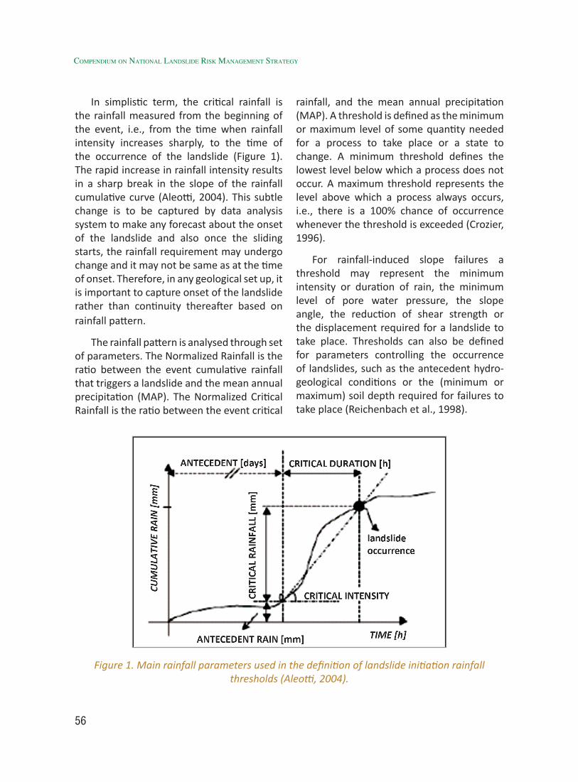
56
Compendium on national landslide Risk management stRategy
In simplistic term, the critical rainfall is the rainfall measured from the beginning of the event, i.e., from the time when rainfall intensity increases sharply, to the time of the occurrence of the landslide (Figure 1). The rapid increase in rainfall intensity results in a sharp break in the slope of the rainfall cumulative curve (Aleotti, 2004). This subtle change is to be captured by data analysis system to make any forecast about the onset of the landslide and also once the sliding starts, the rainfall requirement may undergo change and it may not be same as at the time of onset. Therefore, in any geological set up, it is important to capture onset of the landslide rather than continuity thereafter based on rainfall pattern.
The rainfall pattern is analysed through set of parameters. The Normalized Rainfall is the ratio between the event cumulative rainfall that triggers a landslide and the mean annual precipitation (MAP). The Normalized Critical Rainfall is the ratio between the event critical
rainfall, and the mean annual precipitation (MAP). A threshold is defined as the minimum or maximum level of some quantity needed for a process to take place or a state to change. A minimum threshold defines the lowest level below which a process does not occur. A maximum threshold represents the level above which a process always occurs, i.e., there is a 100% chance of occurrence whenever the threshold is exceeded (Crozier, 1996).
For rainfall-induced slope failures a threshold may represent the minimum intensity or duration of rain, the minimum level of pore water pressure, the slope angle, the reduction of shear strength or the displacement required for a landslide to take place. Thresholds can also be defined for parameters controlling the occurrence of landslides, such as the antecedent hydro-geological conditions or the (minimum or maximum) soil depth required for failures to take place (Reichenbach et al., 1998).
Figure 1. Main rainfall parameters used in the definition of landslide initiation rainfall thresholds (Aleotti, 2004).
57
Several authors have attempted to consider antecedent rainfall in the development of rainfall thresholds. Kim et al. (1991), working in Korea, studied the relationship between daily rainfall at failure and the 3-day cumulative rainfall before the failure. Crozier (1999) developed a rainfall-based landslide-triggering model in Wellington, New Zealand, to provide a 24-hour forecast of landslide occurrence. In a study of rainfall-induced landslides in Seattle area, Washington, Chleborad (2000) investigated 1300 mass movements, including flows, slumps, slides, and soil or rock falls. Therefore, although previous studies in other parts of the world have demonstrated the relationship between rainfall and landslides, this is less explored in Indian scenario except few examples and even lesser cases this has been explored as a viable tool for Landslide Early Warning mainly due lack of landslide incidence and reliable rainfall data.
The most commonly investigated rainfall parameters are: (i) Total (cumulative) rainfall; (ii) Antecedent rainfall; (iii) Rainfall intensity, and (iv) Rainfall duration. Various combinations of the listed parameters have been attempted. Thresholds have been defined considering: (i) Rainfall intensity; (ii) Maximum rainfall intensity for the duration of the event; (iii) Rainfall intensity at the time of the slope failure; (iv) Mean rainfall intensity for the event; (v) Duration above a pre-defined intensity level; (vi) cumulative rainfall, with or without the exact indication of the time of the slope failure; (vii) Intensity or cumulative rainfall normalized to MAP; (viii) Rainfall intensity normalized to the ratio between MAP and the yearly number of rainy days; (ix) Antecedent rainfall, for different time intervals before the occurrence of the event, or the starting time of the event; and (x) Daily rainfall versus antecedent soil moisture index.
Table-1 summarizes different methodologies applied world-wide to establish precipitation threshold for initiation of landslides.
The threshold based EWS is most cost-effective for a large area with instability problems where there is no possibility to monitor each landslide individually. Usually such LEWSs are much more reliable over broad regions than at the slope scale because thresholds are calibrated on landslides that happened in the past over a broad region, rather than at specific sites. However, these can be extremely useful if regions are smaller and models are well calibrated using good database on precipitation and landslides.
Rainfall-threshold based LEWSs for a large target area have been implemented in many parts of the world. Some of the well known implemented case studies include San Francisco Bay Area Debris Flow Warning System in USA (Keefer et al., 1987). The model was based on quantitative 24-hour weather forecasts provided by National Weather Service (NWS) and rain gauge measurement and consequently checked against pre-defined thresholds developed by USGS under the Landslide Initiation and Warning Project. The decision on warnings was jointly made by USGS and NWS. This system was successfully used to issue warning during the storms of 12-21 February 1986, which helped the local population to be better prepared thereby minimizing the resultant human loss in comparison to landslide event of 1982 that resulted in 26 deaths. In Hong Kong another case example has been demonstrated on regional-scale landslide EWS as implemented in 1977. The system has been jointly operated by the Hong Kong Observatory and the Geotechnical Engineering Office. The system utilizes data from more than 100 automatic rainfall gauges and a set of different rainfall
developMent of landslide MonitorinG & early WarninG systeM (eWs)
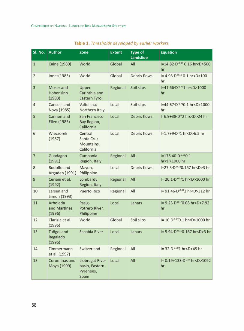
58
Compendium on national landslide Risk management stRategy
Table 1. Thresholds developed by earlier workers.
Sl. No. Author Zone Extent Type of Landslide
Equation
1 Caine (1980) World Global All I=14.82∙D-0.39 0.16 hr<D>500 hr
2 Innes(1983) World Global Debris flows I= 4.93∙D-0.49 0.1 hr<D>100 hr
3 Moser and Hohensinn (1983)
Upper Carinthia and Eastern Tyrol
Regional Soil slips I=41.66∙D-0.771 hr<D>1000 hr
4 Cancelli and Nova (1985)
Valtellina, Northern Italy
Local Soil slips I=44.67∙D-0.780.1 hr<D>1000 hr
5 Cannon and Ellen (1985)
San Francisco Bay Region, California
Local Debris flows I=6.9+38∙D-12 hrs<D>24 hr
6 Wieczorek (1987)
Central Santa Cruz Mountains, California
Local Debris flows I=1.7+9∙D-11 hr<D>6.5 hr
7 Guadagno (1991)
Campania Region, Italy
Regional All I=176.40∙D-0.900.1 hr<D>1000 hr
8 Rodolfo and Arguden (1991)
Mayon, Philippine
Local Debris flows I=27.3∙D-0.380.167 hr<D>3 hr
9 Ceriani et al. (1992)
Lombardy Region, Italy
Regional All I= 20.1∙D-0.551 hr<D>1000 hr
10 Larsen and Simon (1993)
Puerto Rico Regional All I= 91.46∙D-0.822 hr<D>312 hr
11 Arboleda and Martinez (1996)
Pasig-Potrero River, Philippine
Local Lahars I= 9.23∙D-0.370.08 hr<D>7.92 hr
12 Clarizia et al. (1996)
World Global Soil slips I= 10∙D-0.770.1 hr<D>1000 hr
13 Tuñgol and Regalado (1996)
Sacobia River Local Lahars I= 5.94∙D-0.150.167 hr<D>3 hr
14 Zimmermann et al. (1997)
Switzerland Regional All I= 32∙D-0.701 hr<D>45 hr
15 Corominas and Moya (1999)
Llobregat River basin, Eastern Pyrenees, Spain
Local All I= 0.19+133∙D-184 hr<D>1092 hr
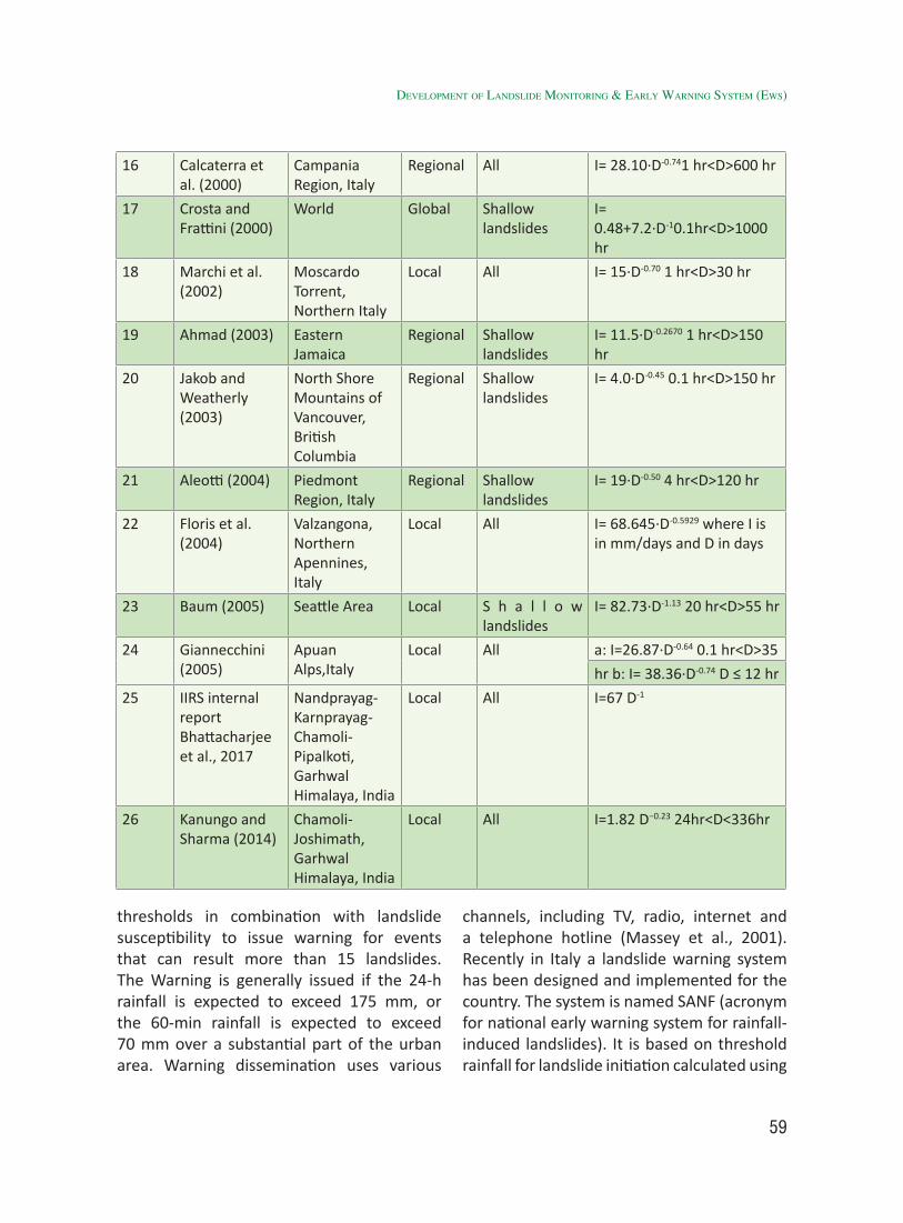
59
16 Calcaterra et al. (2000)
Campania Region, Italy
Regional All I= 28.10∙D-0.741 hr<D>600 hr
17 Crosta and Frattini (2000)
World Global Shallow landslides
I= 0.48+7.2∙D-10.1hr<D>1000 hr
18 Marchi et al. (2002)
Moscardo Torrent, Northern Italy
Local All I= 15∙D-0.70 1 hr<D>30 hr
19 Ahmad (2003) Eastern Jamaica
Regional Shallow landslides
I= 11.5∙D-0.2670 1 hr<D>150 hr
20 Jakob and Weatherly (2003)
North Shore Mountains of Vancouver, British Columbia
Regional Shallow landslides
I= 4.0∙D-0.45 0.1 hr<D>150 hr
21 Aleotti (2004) Piedmont Region, Italy
Regional Shallow landslides
I= 19∙D-0.50 4 hr<D>120 hr
22 Floris et al. (2004)
Valzangona, Northern Apennines, Italy
Local All I= 68.645∙D-0.5929 where I is in mm/days and D in days
23 Baum (2005) Seattle Area Local S h a l l o w landslides
I= 82.73∙D-1.13 20 hr<D>55 hr
24 Giannecchini (2005)
Apuan Alps,Italy
Local All a: I=26.87∙D-0.64 0.1 hr<D>35
hr b: I= 38.36∙D-0.74 D ≤ 12 hr
25 IIRS internal report Bhattacharjee et al., 2017
Nandprayag-Karnprayag-Chamoli-Pipalkoti, Garhwal Himalaya, India
Local All I=67 D-1
26 Kanungo and Sharma (2014)
Chamoli-Joshimath, Garhwal Himalaya, India
Local All I=1.82 D−0.23 24hr<D<336hr
thresholds in combination with landslide susceptibility to issue warning for events that can result more than 15 landslides. The Warning is generally issued if the 24-h rainfall is expected to exceed 175 mm, or the 60-min rainfall is expected to exceed 70 mm over a substantial part of the urban area. Warning dissemination uses various
channels, including TV, radio, internet and a telephone hotline (Massey et al., 2001). Recently in Italy a landslide warning system has been designed and implemented for the country. The system is named SANF (acronym for national early warning system for rainfall-induced landslides). It is based on threshold rainfall for landslide initiation calculated using
developMent of landslide MonitorinG & early WarninG systeM (eWs)
60
Compendium on national landslide Risk management stRategy
sub-hourly rainfall data from 1950 rain gauges and quantitative rainfall forecasts. Twice a day, the system compares the measured and the rainfall forecast against pre-defined intensity-duration (ID) thresholds, and assigns to each rain gauge a probability of landslide occurrence. This information is used to prepare synoptic-scale maps showing where rainfall-induced landslides are expected in the next 24 hours and the report is delivered via e-mail to the Italian National Department for Civil Protection (Rossi et al., 2012).
In India, initial attempts were made by IIRS (ISRO) in 2004 on precipitation induced landslide modelling using TRMM precipitation data and landslide occurrences from Border Road Organisation (BRO) in Uttarakhand (Champati ray et al., 2005). Subsequently, AWS were installed by IIRS (ISRO) in Alaknanda river valley and using rainfall data from ground observation and landslide occurrences data from BRO, various thresholds were established for different levels of landslide occurrences based on number of landslides. In recent time NRSC, has started an experiment to provide EW for landslides based on success of previous studies. In Nilgiris district, a rainfall threshold based EWS is being tested. The system is based on a locally derived rainfall-threshold model and daily rainfall data from few telemetric rain gauges. Software calculates the threshold exceedance and is designed to automatically send SMS. However, the system is still to be tested under real situation. Recently, Geological Survey of India, the nodal agency for landslide studies in India, in collaboration with British Geological Survey is working on a project called LANDSLIP (Landslide Multi-Hazard Risk Assessment, Preparedness and Early Warning in South Asia: Integrating Meteorology, Landscape and Society). The project aims to integrate Meteorological,
Landscape and Social dynamics for developing a relevant and effective tool for landslide multi-hazard risk assessment and to develop an early warning system for spatial scales from slope to catchment and temporal scales from a day to month. Two pilot areas: Nilgiri hills in Tamil Nadu and Darjeeling hills in West Bengal have been taken for LANDSLIP project which will be completed by 2020.
2.3.2 Case Study of IIRS, ISRO: Rainfall Threshold Based Modelling for Initiation of Landslides in Garhwal Himalaya
i) IntroductionA project was initiated by IIRS, ISRO in 2006-
07 on study of “Rainfall thresholds for initiation of landslides and decoupling of spatial variations in precipitation, erosion, tectonics in Garhwal Himalaya” under Disaster Management Support Programme (DMSP) of Indian Space Research Organisation (ISRO) with the main objectives of establishing Automated Weather Stations (AWS) along important road sectors for acquiring hourly rainfall data, assessment of spatio-temporal variation of precipitation (ground and satellite based) and its correlation with initiation of landslide, spatio-temporal modeling and establishment of rainfall threshold (RT) index for initiation of landslides in different areas and assessment of tectonics and climate control on landslides and mass wasting. This study is to generate an early warning system for landslide prediction, an attempt was made to establish an intensity-duration based rainfall relationship for predicting initiation of landslides in Alkananda valley, Garhwal Himalaya.
ii) Concepts and Methodology
In the study, first of all a statistical model was developed to derive thresholds for precipitation amounts that can trigger a landslide in upper Alaknanda valley (Nandprayag to Lambagarh) based upon
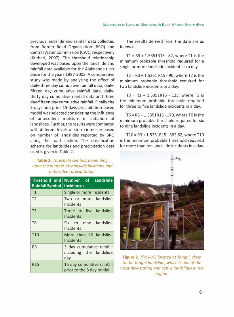
61
previous landslide and rainfall data collected from Border Road Organisation (BRO) and Central Water Commission (CWC) respectively (Kuthari, 2007). The threshold relationship developed was based upon the landslide and rainfall data available for the Alaknanda river basin for the years 1987-2005. A comparative study was made by analyzing the effect of daily-three day cumulative rainfall data, daily-fifteen day cumulative rainfall data, daily-thirty day cumulative rainfall data and three day-fifteen day cumulative rainfall. Finally the 3-days and prior 15-days precipitation based model was selected considering the influence of antecedent moisture in initiation of landslides. Further, the results were compared with different levels of storm intensity based on number of landslides reported by BRO along the road section. The classification scheme for landslides and precipitation data used is given in Table 2.
Table 2. Threshold symbols depending upon the number of landslide incidents and
antecedent precipitation.
Threshold and Rainfall Symbol
Number of Landslide Incidences
T1 Single or more IncidentsT2 Two or more landslide
IncidentsT3 Three to five landslide
IncidentsT6 Six to nine landslide
IncidentsT10 More than 10 landslide
IncidentsR3 3 day cumulative rainfall
including the landslide day
R15 15 day cumulative rainfall prior to the 3 day rainfall
The results derived from the data are as follows:
T1 = R3 + 1.5351R15 - 82, where T1 is the minimum probable threshold required for a single or more landslide incidents in a day.
T2 = R3 + 1.5351 R15 - 90, where T2 is the minimum probable threshold required for two landslide incidents in a day.
T3 = R3 + 1.5351R15 - 125, where T3 is the minimum probable threshold required for three to five landslide incidents in a day.
T6 = R3 + 1.5351R15 - 179, where T6 is the minimum probable threshold required for six to nine landslide incidents in a day.
T10 = R3 + 1.5351R15 - 382.62, where T10 is the minimum probable threshold required for more than ten landslide incidents in a day.
Figure 2. The AWS located at Tangni, close to the Tangni landslide, which is one of the
most devastating and active landslides in the region.
developMent of landslide MonitorinG & early WarninG systeM (eWs)

62
Compendium on national landslide Risk management stRategy
It has been observed that the threshold values increase diagonally across the graph indicating coincidence of higher levels of precipitation and landslides in the region, which could be represented by equations as mentioned. This model developed based on landslide and precipitation data of 1987-2005, has been validated for subsequent years such as 2009, 2010, 2013. As the threshold value varies daily, it may be referred as daily or dynamic antecedent rainfall threshold (DART).
The threshold equations for 6 (T6) and 10 (T10) landslides represent major storm events and therefore, T6 was considered for initiation of landslides. T1 to T3 were not considered as the reported landslides
were mainly from road section disturbed by excavations so 1-3 landslides can occur even during slightly higher precipitation level and during T6 and T10, landslides on natural slopes are expected as these represent major storm events. This assumption was validated during subsequent years.
iii) Results and Validation
a) Dynamic Antecedent Rainfall Threshold (DART) Based Model
At one critical location (Lambagarh) on the main Badrinath highway, during the observation period two peaks (on DART) were observed: one during 19-20th July 2009 coinciding with a large landslide completely damaging the road leading to traffic
Figure 3. Equations for different levels of thresholds based on 3-days and 15-days antecedent precipitation in Alaknanda valley (y-axis: 3-days precipitation including the day of landslide
occurrence, x-axis: 15 days prior precipitation).
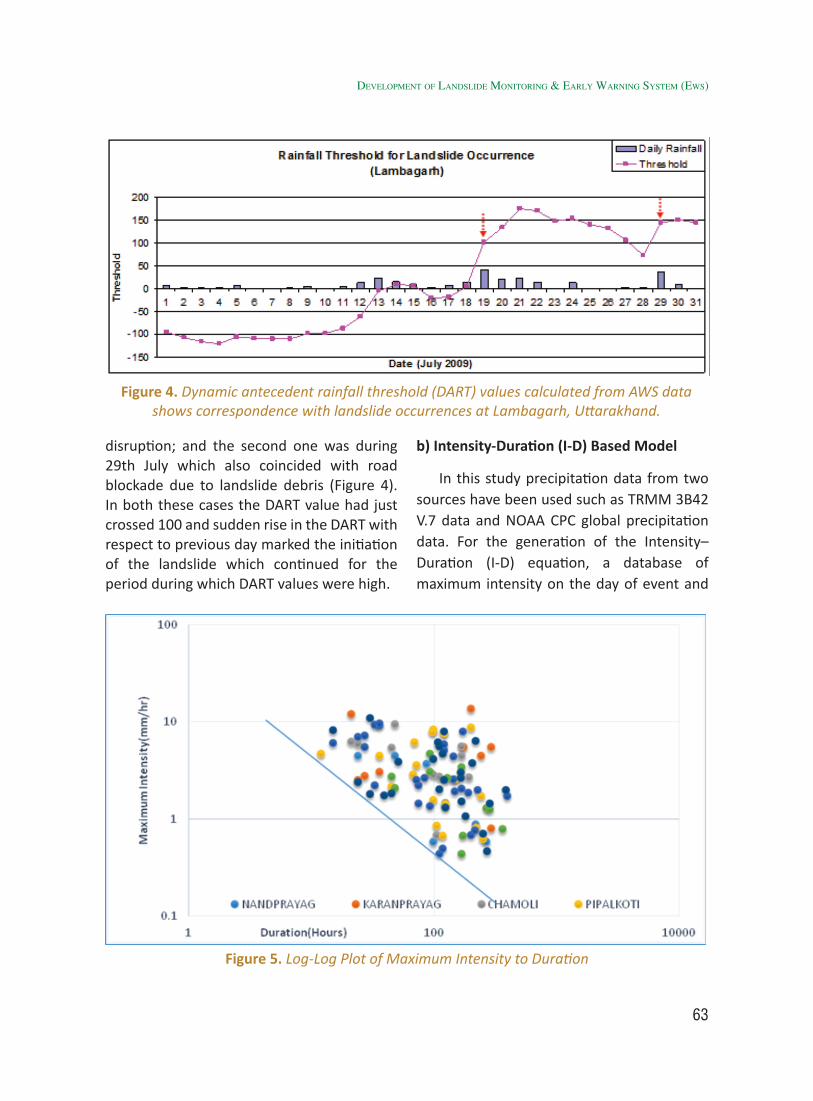
63
disruption; and the second one was during 29th July which also coincided with road blockade due to landslide debris (Figure 4). In both these cases the DART value had just crossed 100 and sudden rise in the DART with respect to previous day marked the initiation of the landslide which continued for the period during which DART values were high.
b) Intensity-Duration (I-D) Based Model
In this study precipitation data from two sources have been used such as TRMM 3B42 V.7 data and NOAA CPC global precipitation data. For the generation of the Intensity–Duration (I-D) equation, a database of maximum intensity on the day of event and
Figure 4. Dynamic antecedent rainfall threshold (DART) values calculated from AWS data shows correspondence with landslide occurrences at Lambagarh, Uttarakhand.
Figure 5. Log-Log Plot of Maximum Intensity to Duration
developMent of landslide MonitorinG & early WarninG systeM (eWs)
64
Compendium on national landslide Risk management stRategy
the total duration of rainfall till the event day for the 112 unique landslide events was prepared.
A graph of maximum intensity to total duration on a log-log plot was prepared to devise the I-D equation for landslide initiation (Figure 5). The log-log plot of maximum intensity (I in mm/hours) to total duration (D in hours) of rainfall events which resulted in landslides have been used to derive the I-D equation, by drawing a lower bound line to the graph, and the equation is expressed as
I=67 D^-1 (1)
The above equation can be used to determine the probable duration of events which can initiate slope failures. In total 112 landslide events from the year 2009 to 2014 were used for calculation of the intensity-duration equation.
Overall, it was observed that the threshold equation has successfully predicted landslide days by an accuracy of 87.5% and the overall error of omission was 12.5%, and the prediction accuracy for non-landslide days was 90.56% and the overall error of commission was 9.4% (Table 3).
c) Logistic Regression Based Modeling Using DART (LR-DART)
A landslide probability model using logistic regression was developed for two prime locations along NH-58 using both Climate Prediction Center (CPC-RFE V2.0) as well as Tropical Rainfall Measuring Mission (TRMM 3B42-daily data) rainfall data. Major storm events were identified near the above mentioned locations and corresponding landslides were taken from the BRO records for the year 2009 to 2013. For these days of the landslide incidences, the T6 (of 72 hrs and 15-days precipitation) and its derivative’s values were used to generate the logistic regression based equation. The regression equation generated is as follow:
t= (-2.6437) + 0.1132 * Daily Rainfall + 0.0062 * T6 +0.0769 * Derivative
This equation was validated for the year 2013, when the extreme precipitation caused wide spread landslides. The results quite accurately predicted high probability values for the days when a landslide had been reported and the accuracy of the CPC precipitation data based prediction model was 79.3 %.
Table 3. Overall Accuracy of Prediction
TOTAL No. OF DAYS NO OF LANDSLIDE DAYS NO OF NON LANDSLIDE DAYSTrue False True False
737 98 (87.5%) 14 (12.5%) 566 (90.56%) 59 (9.4%)
Table 4. Overall Accuracy of Logistic regression based Landslide Prediction Model
TOTAL No. OF DAYS
NO. OF LANDSLIDE DAYS (120) NO. OF NON LANDSLIDE DAYS (368)True False True False
488 108 (90%) 12 (10%) 271 (73.6%) 97 (26.4%)
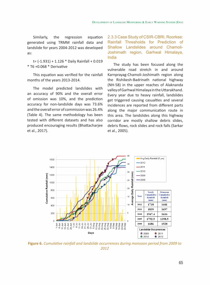
65
Similarly, the regression equation generated using TRMM rainfall data and landslide for years 2004-2012 was developed as:
t= (-1.931) + 1.126 * Daily Rainfall + 0.019 * T6 +0.068 * Derivative
This equation was verified for the rainfall months of the years 2013-2014.
The model predicted landslides with an accuracy of 90% and the overall error of omission was 10%, and the prediction accuracy for non-landslide days was 73.6% and the overall error of commission was 26.4% (Table 4). The same methodology has been tested with different datasets and has also produced encouraging results (Bhattacharjee et al., 2017).
2.3.3 Case Study of CSIR-CBRI, Roorkee: Rainfall Thresholds for Prediction of Shallow Landslides around Chamoli-Joshimath region, Garhwal Himalaya, India
The study has been focused along the vulnerable road stretch in and around Karnprayag-Chamoli-Joshimath region along the Rishikesh-Badrinath national highway (NH-58) in the upper reaches of Alaknanda valley of Garhwal Himalaya in the Uttarakhand. Every year due to heavy rainfall, landslides get triggered causing casualties and several incidences are reported from different parts along the major communication route in this area. The landslides along this highway corridor are mostly shallow debris slides, debris flows, rock slides and rock falls (Sarkar et al., 2005).
Figure 6. Cumulative rainfall and landslide occurrences during monsoon period from 2009 to 2012
developMent of landslide MonitorinG & early WarninG systeM (eWs)
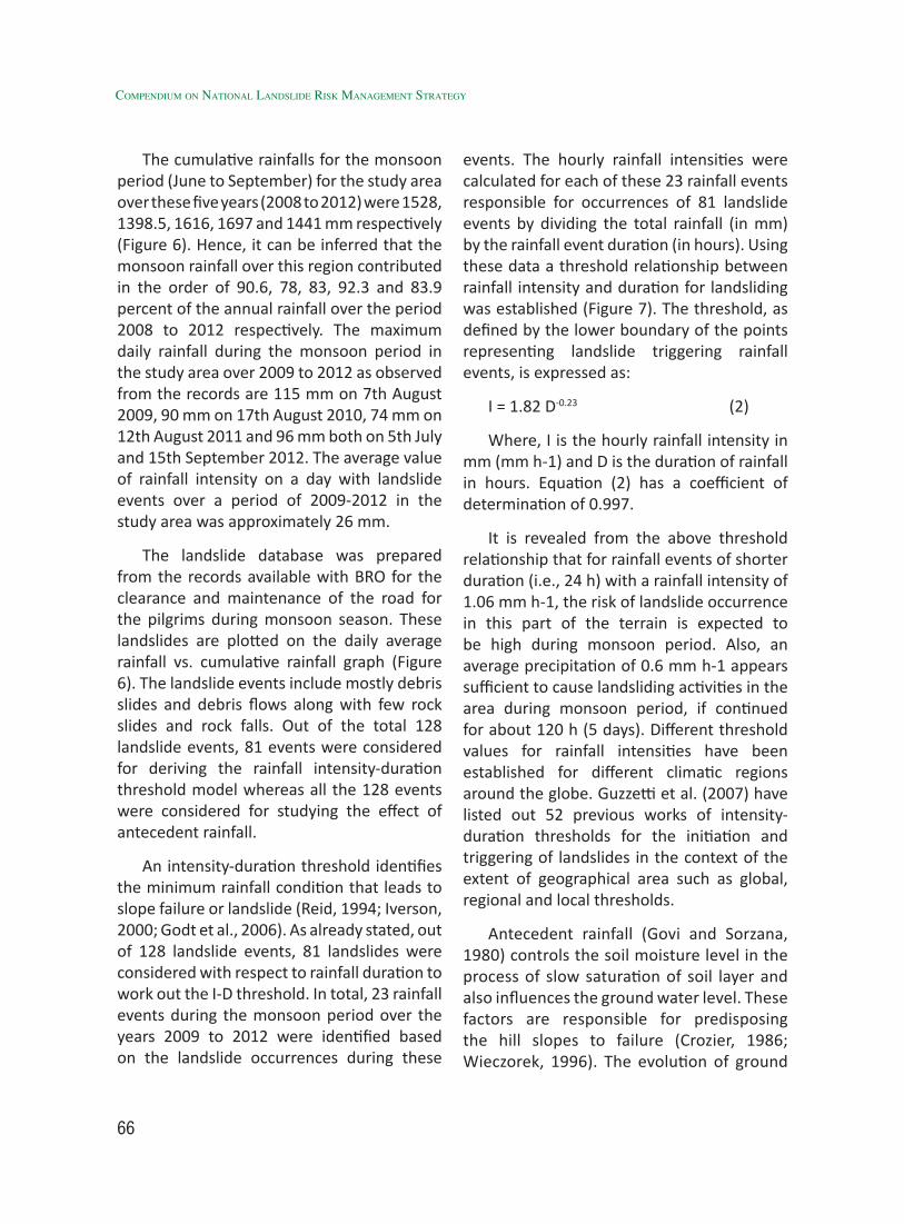
66
Compendium on national landslide Risk management stRategy
The cumulative rainfalls for the monsoon period (June to September) for the study area over these five years (2008 to 2012) were 1528, 1398.5, 1616, 1697 and 1441 mm respectively (Figure 6). Hence, it can be inferred that the monsoon rainfall over this region contributed in the order of 90.6, 78, 83, 92.3 and 83.9 percent of the annual rainfall over the period 2008 to 2012 respectively. The maximum daily rainfall during the monsoon period in the study area over 2009 to 2012 as observed from the records are 115 mm on 7th August 2009, 90 mm on 17th August 2010, 74 mm on 12th August 2011 and 96 mm both on 5th July and 15th September 2012. The average value of rainfall intensity on a day with landslide events over a period of 2009-2012 in the study area was approximately 26 mm.
The landslide database was prepared from the records available with BRO for the clearance and maintenance of the road for the pilgrims during monsoon season. These landslides are plotted on the daily average rainfall vs. cumulative rainfall graph (Figure 6). The landslide events include mostly debris slides and debris flows along with few rock slides and rock falls. Out of the total 128 landslide events, 81 events were considered for deriving the rainfall intensity-duration threshold model whereas all the 128 events were considered for studying the effect of antecedent rainfall.
An intensity-duration threshold identifies the minimum rainfall condition that leads to slope failure or landslide (Reid, 1994; Iverson, 2000; Godt et al., 2006). As already stated, out of 128 landslide events, 81 landslides were considered with respect to rainfall duration to work out the I-D threshold. In total, 23 rainfall events during the monsoon period over the years 2009 to 2012 were identified based on the landslide occurrences during these
events. The hourly rainfall intensities were calculated for each of these 23 rainfall events responsible for occurrences of 81 landslide events by dividing the total rainfall (in mm) by the rainfall event duration (in hours). Using these data a threshold relationship between rainfall intensity and duration for landsliding was established (Figure 7). The threshold, as defined by the lower boundary of the points representing landslide triggering rainfall events, is expressed as:
I = 1.82 D-0.23 (2)
Where, I is the hourly rainfall intensity in mm (mm h-1) and D is the duration of rainfall in hours. Equation (2) has a coefficient of determination of 0.997.
It is revealed from the above threshold relationship that for rainfall events of shorter duration (i.e., 24 h) with a rainfall intensity of 1.06 mm h-1, the risk of landslide occurrence in this part of the terrain is expected to be high during monsoon period. Also, an average precipitation of 0.6 mm h-1 appears sufficient to cause landsliding activities in the area during monsoon period, if continued for about 120 h (5 days). Different threshold values for rainfall intensities have been established for different climatic regions around the globe. Guzzetti et al. (2007) have listed out 52 previous works of intensity-duration thresholds for the initiation and triggering of landslides in the context of the extent of geographical area such as global, regional and local thresholds.
Antecedent rainfall (Govi and Sorzana, 1980) controls the soil moisture level in the process of slow saturation of soil layer and also influences the ground water level. These factors are responsible for predisposing the hill slopes to failure (Crozier, 1986; Wieczorek, 1996). The evolution of ground
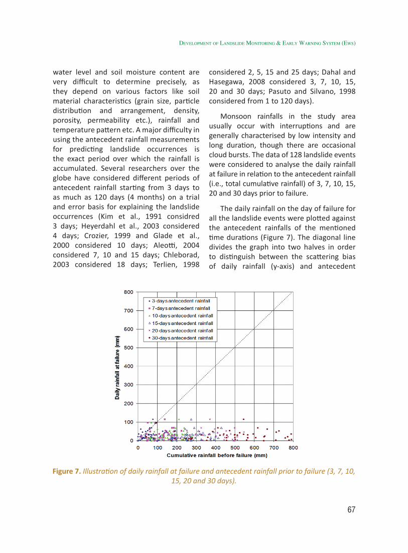
67
water level and soil moisture content are very difficult to determine precisely, as they depend on various factors like soil material characteristics (grain size, particle distribution and arrangement, density, porosity, permeability etc.), rainfall and temperature pattern etc. A major difficulty in using the antecedent rainfall measurements for predicting landslide occurrences is the exact period over which the rainfall is accumulated. Several researchers over the globe have considered different periods of antecedent rainfall starting from 3 days to as much as 120 days (4 months) on a trial and error basis for explaining the landslide occurrences (Kim et al., 1991 considred 3 days; Heyerdahl et al., 2003 considered 4 days; Crozier, 1999 and Glade et al., 2000 considered 10 days; Aleotti, 2004 considered 7, 10 and 15 days; Chleborad, 2003 considered 18 days; Terlien, 1998
considered 2, 5, 15 and 25 days; Dahal and Hasegawa, 2008 considered 3, 7, 10, 15, 20 and 30 days; Pasuto and Silvano, 1998 considered from 1 to 120 days).
Monsoon rainfalls in the study area usually occur with interruptions and are generally characterised by low intensity and long duration, though there are occasional cloud bursts. The data of 128 landslide events were considered to analyse the daily rainfall at failure in relation to the antecedent rainfall (i.e., total cumulative rainfall) of 3, 7, 10, 15, 20 and 30 days prior to failure.
The daily rainfall on the day of failure for all the landslide events were plotted against the antecedent rainfalls of the mentioned time durations (Figure 7). The diagonal line divides the graph into two halves in order to distinguish between the scattering bias of daily rainfall (y-axis) and antecedent
Figure 7. Illustration of daily rainfall at failure and antecedent rainfall prior to failure (3, 7, 10, 15, 20 and 30 days).
developMent of landslide MonitorinG & early WarninG systeM (eWs)
68
Compendium on national landslide Risk management stRategy
rainfall (x-axis). The diagonal divider itself indicates that the daily rainfall on the day of failure and the antecedent rainfall prior to the failure are same. As observed from Figure 7, majority of landslide events are biased towards the antecedent rainfall prior to failure in comparison to the daily rainfall at failure. This result gave a confidence to further analyse the daily rainfall in terms of antecedent rainfall prior to failure with individual time duration and to establish a threshold based on antecedent rainfall of a particular duration.
In the last three decades, the use of rainfall ID threshold and antecedent rainfall thresholds to derive the triggering of shallow landslides has been applied worldwide at global, regional as well as local scales. In this paper, an attempt has been made to define rainfall thresholds in terms of intensity-duration and antecedent rainfall for landslide occurrences around Chamoli-Joshimath region of Garhwal Himalaya, India at a local scale. The analysis of rainfall events over a period of four years (2009-2012) in relation to a number of landslide events could derive an intensity-duration (ID) threshold for shallow landslide occurrences along a stretch of national highway corridor. Further, it can be stated that landslides in Chamoli-Joshimath region of Garhwal Himalaya, India are likely to occur when antecedent rainfall exceeds 55 mm over a 10-day period, and 185 mm over a 20-day period. This attempt of establishing rainfall thresholds for landslide occurrences in parts of Garhwal Himalaya will encourage further research with better resolution rainfall and landslide data to improve upon the threshold models at both local and regional levels and finally to develop a landslide early warning system (LEWS) based on rainfall thresholds.
2.3.4 Ground instrument based LEWS
Ground instrument based Landslide Early warning System have been attempted at many places in different parts of world with varying degree of success. In the present context to highlight the complexities and issues involved, CBRI has shared valuable experience on implementation of the same at a test site in Garhwal Himalaya. A lot of valuable lessons can be learned from this experience.
2.3.5 Case Study of CSIR-CBRI, Roorkee: Ground Based Wireless Instrumentation and Real Time Monitoring System for Landslide Prediction
A Landslide observatory with wireless instrumentation for real time monitoring of ground deformation and hydrologic parameters has been established at Pakhi Landslide in Garhwal Himalaya, India. The field photograph of Pakhi Landslide selected for instrumentation and real-time monitoring is shown in Figure 8. For this study, commercially available sensors were selected and deployed. Special considerations have been kept in mind in selecting the sensors which need to be rugged, weather resistant and portable with low power consumption and can be powered by solar energy and battery. A real-time monitoring system implemented in Pakhi landslide site is shown in Figure 9.
In this attempt, both surface and sub-surface sensors were installed on the selected landslide area (Figure 9). Two types of information such as actual displacements/movements at different locations in the landslide area and environmental/weather conditions that affect the sliding activity have been targeted with the combination of
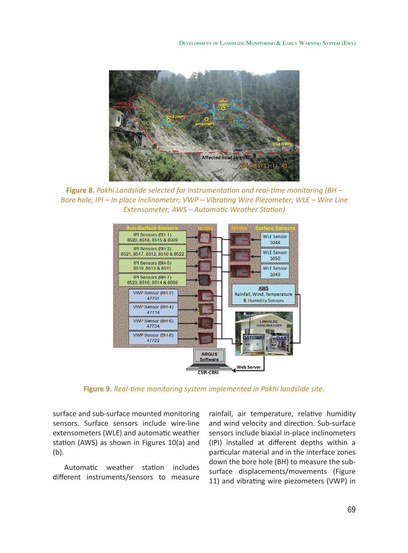
69
surface and sub-surface mounted monitoring sensors. Surface sensors include wire-line extensometers (WLE) and automatic weather station (AWS) as shown in Figures 10(a) and (b).
Automatic weather station includes different instruments/sensors to measure
rainfall, air temperature, relative humidity and wind velocity and direction. Sub-surface sensors include biaxial in-place inclinometers (IPI) installed at different depths within a particular material and in the interface zones down the bore hole (BH) to measure the sub-surface displacements/movements (Figure 11) and vibrating wire piezometers (VWP) in
Figure 8. Pakhi Landslide selected for instrumentation and real-time monitoring (BH – Bore hole; IPI – In place Inclinometer; VWP – Vibrating Wire Piezometer; WLE – Wire Line
Extensometer; AWS – Automatic Weather Station)
Figure 9. Real-time monitoring system implemented in Pakhi landslide site.
developMent of landslide MonitorinG & early WarninG systeM (eWs)
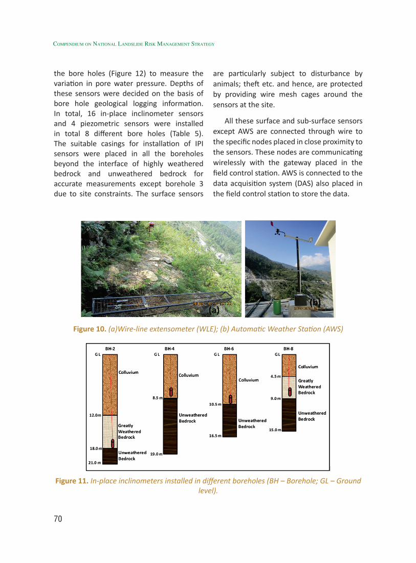
70
Compendium on national landslide Risk management stRategy
the bore holes (Figure 12) to measure the variation in pore water pressure. Depths of these sensors were decided on the basis of bore hole geological logging information. In total, 16 in-place inclinometer sensors and 4 piezometric sensors were installed in total 8 different bore holes (Table 5). The suitable casings for installation of IPI sensors were placed in all the boreholes beyond the interface of highly weathered bedrock and unweathered bedrock for accurate measurements except borehole 3 due to site constraints. The surface sensors
are particularly subject to disturbance by animals; theft etc. and hence, are protected by providing wire mesh cages around the sensors at the site.
All these surface and sub-surface sensors except AWS are connected through wire to the specific nodes placed in close proximity to the sensors. These nodes are communicating wirelessly with the gateway placed in the field control station. AWS is connected to the data acquisition system (DAS) also placed in the field control station to store the data.
Figure 10. (a)Wire-line extensometer (WLE); (b) Automatic Weather Station (AWS)
Figure 11. In-place inclinometers installed in different boreholes (BH – Borehole; GL – Ground level).
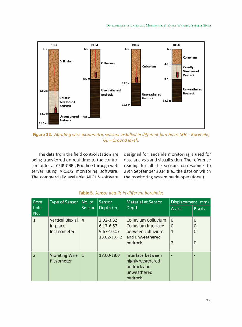
71
The data from the field control station are being transferred on real-time to the control computer at CSIR-CBRI, Roorkee through web server using ARGUS monitoring software. The commercially available ARGUS software
designed for landslide monitoring is used for data analysis and visualization. The reference reading for all the sensors corresponds to 29th September 2014 (i.e., the date on which the monitoring system made operational).
Figure 12. Vibrating wire piezometric sensors installed in different boreholes (BH – Borehole; GL – Ground level).
Table 5. Sensor details in different boreholes
Bore hole No.
Type of Sensor No. of Sensor
Sensor Depth (m)
Material at Sensor Depth
Displacement (mm)A-axis B-axis
1 Vertical Biaxial In-place Inclinometer
4 2.92-3.32 6.17-6.57 9.67-10.07 13.02-13.42
Colluvium Colluvium Colluvium Interface between colluvium and unweathered bedrock
001
2
000
0
2 Vibrating Wire Piezometer
1 17.60-18.0 Interface between highly weathered bedrock and unweathered bedrock
- -
developMent of landslide MonitorinG & early WarninG systeM (eWs)
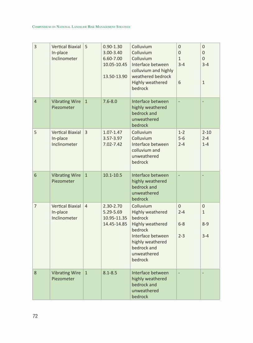
72
Compendium on national landslide Risk management stRategy
3 Vertical Biaxial In-place Inclinometer
5 0.90-1.303.00-3.406.60-7.0010.05-10.45
13.50-13.90
ColluviumColluviumColluviumInterface between colluvium and highly weathered bedrockHighly weathered bedrock
0013-4
6
0003-4
1
4 Vibrating Wire Piezometer
1 7.6-8.0 Interface between highly weathered bedrock and unweathered bedrock
- -
5 Vertical Biaxial In-place Inclinometer
3 1.07-1.473.57-3.977.02-7.42
ColluviumColluviumInterface between colluvium and unweathered bedrock
1-25-62-4
2-102-41-4
6 Vibrating Wire Piezometer
1 10.1-10.5 Interface between highly weathered bedrock and unweathered bedrock
- -
7 Vertical Biaxial In-place Inclinometer
4 2.30-2.70 5.29-5.69 10.95-11.35 14.45-14.85
ColluviumHighly weathered bedrockHighly weathered bedrockInterface between highly weathered bedrock and unweathered bedrock
02-4
6-8
2-3
01
8-9
3-4
8 Vibrating Wire Piezometer
1 8.1-8.5 Interface between highly weathered bedrock and unweathered bedrock
- -
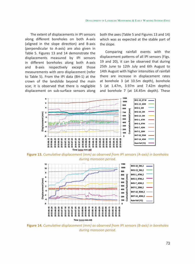
73
The extent of displacements in IPI sensors along different boreholes on both A-axis (aligned in the slope direction) and B-axis (perpendicular to A-axis) are also given in Table 5. Figures 13 and 14 demonstrate the displacements measured by IPI sensors in different boreholes along both A-axis and B-axis respectively except those measurements with zero displacement (refer to Table 5). From the IPI data (BH-1) at the crown of the landslide beyond the main scar, it is observed that there is negligible displacement on sub-surface sensors along
both the axes (Table 5 and Figures 13 and 14) which was as expected at the stable part of the slope.
Comparing rainfall events with the displacement patterns of all IPI sensors (Figs. 19 and 20), it can be observed that during 25th June to 12th July and 6th August to 14th August with higher intensities of rainfall there are increase in displacement rates at borehole 3 (at 10.5m depth), borehole 5 (at 1.47m, 3.97m and 7.42m depths) and borehole 7 (at 14.45m depth). These
Figure 13. Cumulative displacement (mm) as observed from IPI sensors (A-axis) in boreholes during monsoon period.
Figure 14. Cumulative displacement (mm) as observed from IPI sensors (B-axis) in boreholes during monsoon period.
developMent of landslide MonitorinG & early WarninG systeM (eWs)
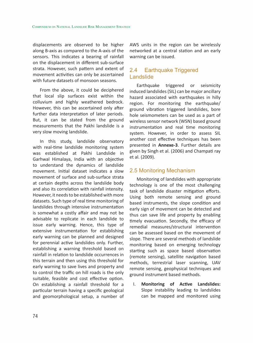
74
Compendium on national landslide Risk management stRategy
displacements are observed to be higher along B-axis as compared to the A-axis of the sensors. This indicates a bearing of rainfall on the displacement in different sub-surface strata. However, such pattern and extent of movement activities can only be ascertained with future datasets of monsoon seasons.
From the above, it could be deciphered that local slip surfaces exist within the colluvium and highly weathered bedrock. However, this can be ascertained only after further data interpretation of later periods. But, it can be stated from the ground measurements that the Pakhi landslide is a very slow moving landslide.
In this study, landslide observatory with real-time landslide monitoring system was established at Pakhi Landslide in Garhwal Himalaya, India with an objective to understand the dynamics of landslide movement. Initial dataset indicates a slow movement of surface and sub-surface strata at certain depths across the landslide body and also its correlation with rainfall intensity. However, it needs to be established with more datasets. Such type of real time monitoring of landslides through intensive instrumentation is somewhat a costly affair and may not be advisable to replicate in each landslide to issue early warning. Hence, this type of extensive instrumentation for establishing early warning can be planned and designed for perennial active landslides only. Further, establishing a warning threshold based on rainfall in relation to landslide occurrences in this terrain and then using this threshold for early warning to save lives and property and to control the traffic on hill roads is the only suitable, feasible and cost effective option. On establishing a rainfall threshold for a particular terrain having a specific geological and geomorphological setup, a number of
AWS units in the region can be wirelessly networked at a central station and an early warning can be issued.
2.4 Earthquake Triggered Landslide
Earthquake triggered or seismicity induced landslides (SIL) can be major ancillary hazard associated with earthquakes in hilly region. For monitoring the earthquake/ground vibration triggered landslides, bore hole seismometers can be used as a part of wireless sensor network (WSN) based ground instrumentation and real time monitoring system. However, in order to assess SIL another cost effective techniques has been presented in Annexe-3. Further details are given by Singh et al. (2006) and Champati ray et al. (2009).
2.5 Monitoring Mechanism Monitoring of landslides with appropriate
technology is one of the most challenging task of landslide disaster mitigation efforts. Using both remote sensing and ground based instruments, the slope condition and early sign of movement can be detected and thus can save life and property by enabling timely evacuation. Secondly, the efficacy of remedial measures/structural intervention can be assessed based on the movement of slope. There are several methods of landslide monitoring based on emerging technology starting such as space based observation (remote sensing), satellite navigation based methods, terrestrial laser scanning, UAV remote sensing, geophysical techniques and ground instrument based methods.
I. Monitoring of Active Landslides: Slope instability leading to landslides can be mapped and monitored using
75
high-resolution remotely sensed data as demonstrated during Kashmir earthquake, Sikkim earthquake and many other storm events including 2013 Uttarakhand extreme storm event. In recent time, data from aerial and UAV platforms are being considered as more cost effective and efficient for monitoring of landslides in extreme topography mainly in adverse terrain conditions.
II. Monitoring of Old Landslides: Mapping and monitoring of old landslides is as important as monitoring of active landslides as any disturbance to old landslide zone may further cause more landslides. Any development work in the old landslide zone can further destabilise the slope. In many cases, it is difficult to recognize due to growth of vegetation and alteration of the slope. However, using satellite images and geomorphic criteria, it can be recognized and it can be monitored for movement using remote sensing techniques.
III. Monitoring of Landslide Hazard Zones: LHZ maps provide information on susceptibility of slope to landslides in diverse geo-environmental set up. Using remote sensing and GIS techniques, landslide hazard zonation maps can be prepared on moderate and large scale in a more consistent, efficient and cost effective manner within very limited time. In all such maps in very high and high hazard zones, all areas may not have landslides due to various reasons, which is beyond the scope of present discussion. However, it is important to mention that high hazard zones at selected strategic locations should be
monitored by both satellite and aerial based (aircraft and UAV) and ground based observations that may include terrestrial laser scanning or GNSS based observation.
IV. Slope monitoring using UAV: It is a RS based method which has gained popularity in recent time mainly due to high resolution, flexibility in time of operation, low cost and ease in data acquisition in difficult terrains like steep mountainous often affected by landslides. Repetitive coverage can provide high resolution DEM (accuracy in the order of cm) and change detection thus enabling early detection of unstable parts of slope. This is a very good option in absence of any instruments on the slope for deformation monitoring.
V. Slope Deformation Monitoring Using GNSS: Global navigation satellite system (GNSS) including GPS and IRNSS has tremendous capability in temporal monitoring of slope deformation. It requires repetitive measurement of same location on landslide mass to determine rate of movement. This can be carried out at initial stage of deformation or at vulnerable slopes without any visible sign of failure. This is suitable for long term monitoring without building any instrument network at any site of interest.
VI. Slope Monitoring Using Terrestrial Laser Scanner: This technique and similar approach using terrestrial photography/photogrammetry can be used to monitor deformation of slopes in 3-D. Automated software and robotic hardware can be integrated to monitor slopes in real time and
developMent of landslide MonitorinG & early WarninG systeM (eWs)

76
Compendium on national landslide Risk management stRategy
issue warning based on deformation. Commercial products are available (e.g. Leica Geomos, Trimble 3D/4D control system). This can be considered as an alternative to drilling and deployment of ground sensors for deformation monitoring at critical locations.
VII. Slope Deformation Monitoring Using DInSAR: Slope deformation, subsidence and surface displacement of the order of few centimeters can be detected using DInSAR and PS InSAR techniques (Singh and Champati ray, 2009). Since SAR images cover larger area, this is an ideal technique to detect slope deformation in large inaccessible areas in cost effective manner. However, this technique depends heavily on data acquisition with favourable geometry, which is only possible with tasking satellite with some special arrangements with space agencies. Alternatively some researchers have used ground based SAR (GBSAR), which is technically possible but at a high
cost. This ground based SAR can be compared to laser scanning, however, the later is more developed, hence may be preferred. Space based DInSAR/PS InSAR may be very useful when satellite capability improves in future.
VIII. Wireless Sensor Network (WSN) Based Ground Instrumentation and Real Time Monitoring: The core components of the system include multiple sensors to node, multiple nodes to Gateway and Gateway to Control Station is given in flow chart below.
IX. Slope Monitoring Using Dynamic Modelling: Prediction of landslides based on deterministic modeling and factor of safety (FoS) analysis is very site specific and data requirements are enormous. However, RS and GIS can play a role in such analysis. Slope stability assessment using deterministic modeling can be implemented in GIS and spatial distribution of FoS can be determined using rock properties (cohesion, angle of friction and unit
77
weight) and the slope angle. Based on the dynamic precipitation and water table data, the slope can be monitored with respect to factor of safety. Further details have been reported by Champati ray et al. (2009) with respect to devastating La landslide in Uttarakhand. With some back analysis and calibration, this model has potential to yield high quality results at low cost. It requires only rainfall data and all other parameters can be calibrated using back analysis and some parameters can be derived in engineering geotech lab.
X. Slope Monitoring Using Geophysical Techniques: Geophysical techniques can be employed to collect very crucial sub-surface information mainly on slip surface and water saturated areas. Therefore, slope monitoring using shallow geophysics has emerged as one viable tool to monitor slope deformation and correlate with sub-surface features. One such geophysical technique which is can be used for sub-surface characterization is the electrical resistivity tomography (ERT) techniques, which is now being successfully applied to study the sub-surface and to identify the failure plane/slip surface of the landslide, which is the most fundamental and important requirement of the landslide investigation (Bichler et al., 2004; Lapenna et al., 2005, Meric et al., 2005, Godio et al., 2006). GPR (Ground Penetrating Radar) is also used to provide detailed images of the near surface. The combination of high-resolution GPR and ERT with different acquisition parameters can be considered as a viable combination of techniques that can be used to obtain high-resolution
imaging of sub-surface structures and strata at shallow depth and establish the slip surface parameters and identify water saturated zones.
This can be used as an ancillary technique to collect data on slip surface and water saturation zones without drilling, hence, can be very useful for low cost sensor deployment and other relevant analysis.
2.6 Identified gaps In Garhwal Himalaya, the poor network
of weather stations and lack of high elevation rain gauges mars the collection of useful data that can help establishing meaningful relation. Orographic uplift results in greater rainfall at higher altitudes (Patel and Endang, 2003) and secondly local slope aspect also influences as southern and eastern slopes receive more rainfall compared to the north facing slopes which are on the rain shadow region. Furthermore, accurate dates of landslides are seldom available due to sparsely population of the region and lack of media and official reporting of such events, although such reporting has improved in recent years. The variability of geological and terrain factors such as slope, lithology, availability of debris material, fluvio-glacial deposits, land use, vegetation cover and human interference (clearing of forest, cutting of slopes for road and other construction, blasting for road widening) further complicates the task of defining a clear-cut threshold for initiation/ triggering of landslides. However, very promising studies have been made on establishing relationship between precipitation (obtained from satellite based observation and very limited ground stations) and initiation of debris slides, based on which a minimum threshold could be determined for Garhwal Himalaya (source: IIRS/CBRI).
developMent of landslide MonitorinG & early WarninG systeM (eWs)
78
Compendium on national landslide Risk management stRategy
Overall the gap areas can be summarized as follows:
I. Well validated rainfall-threshold model is yet to be developed for all critical regions. For building rainfall threshold based model, date of past landslide events and corresponding representative daily/hourly rainfall data are required. Similarly for intensity-duration (ID) based threshold, it is also required time of past landslide events and rainfall for the same durations. In India, except for some cases, these data sets are not easily available for most part of the mountainous regions. Availability of rainfall data is another challenge as we do not have a very good network of rain gauges in the mountainous region, except for some specific areas such as hydro power project sites in Himalaya and tea estates in Nilgiri hills. However, there is a significant improvement in terms of rainfall data collection using AWSs by several agencies including IMD. Therefore, with some special effort, data on landslide occurrences (location and time) and precipitation from both ground and satellite based information can be obtained for developing the required model.
II. Information on most likely location of landslide occurrence and its downslope path/area is mostly not available. Most susceptibility models used for mapping landslide-prone zones provides a qualitative or probability-based quantitative susceptibility maps showing only probable initiation zones of landslides (e.g., Soeters and Van Westen, 1996; Guzzetti et al., 2005). Since, the threshold model itself does not provide information
on the spatial occurrence of potential landslides, it has to be combined with landslide susceptibility to forecast spatio-temporal initiation of landslides (Chattoraj et al., 2015).
III. Information on precise time of a landslide based on instrumentation and real time monitoring is mostly lacking. Till date, only a hand full of case studies have been carried out where temporal component of landslide initiation has been modelled for a specific area. This needs to be attempted at critical landslide locations using cost effective instruments as envisaged and attempted by CBRI, Amrita Viswa Vidayalaya University, IIT Mandi and DTRL (DRDO).
IV. In India, safe shelter and alternate route maps for landslide hazard are often not available. These maps are to be prepared for important road sections and settlements. People concerned should be aware of such maps and their physical representation on ground for timely response and re-routing to minimize the impact of landslides.
V. Another important aspect that makes early warning ineffective is the lack of public awareness. This tends to reduce the risk by increasing awareness among the public with an aim to timely response to the warning when the disaster strikes.
VI. Communication of warning or risk to all concerned stake holders remains a challenge as most of the hilly area population either remains isolated, unreachable, non-responsive due to remoteness of the region or lack of awareness. Therefore, a multimedia approach involving internet portal,
79
sms, social media, radio and print media is required and may be taken care by various interest groups but the essential component is to provide ‘Landslide bulletin’ for different regions like weather forecast.
VII. Access to secondary high quality rainfall prediction data, LHZ maps, and geotechnical data developed by other stakeholders at one platform.
2.7 Recommendations
2.7.1 Rainfall Threshold based Landslide Early warning System (RT-LEWS)
• Database on rainfall derived from satellite and ground based observation need to be compiled and analysed to understand variability in a region vis-à-vis landslides.
[Action: Ministry of Mines (MoM)/GSI in collaboration with IMD and in coordination with States]
• Road/railroad maintenance records of Border Road Organisation (BRO) and railway department in Nilgiri hills provide information of date and spatial distribution of landslides in the form of debris accumulated on the road, but is restricted to only defined road/railway sectors. The type of data available with them also requires intense field validation before making them useable for threshold modeling (Jaiswal and Van Westen, 2009). It is therefore, recommended that government agencies such as BRO, National Highways, PWD, and State Administration should give importance to timely collection of landslide data and proper repository.
[Action: BRO, NHAI, PWD, Ministry of Railways (MoR) and other stakeholders]
• Compilation of landslide database with information on typology, location, date and time of occurrence. High resolution satellite images need to be used to prepare the spatial database with good accuracy.
[Action: Ministry of Mines (MoM)/GSI in collaboration with NRSC and in coordination with concerned State Governments]
• Development of rainfall threshold models (I-D and antecedent rainfall based) using available information (rainfall and landslide) from IMD, BRO and other sources for regional and local level LEWS. It is envisaged to use I-D and RT based models using data mining and statistical approaches as demonstrated by IIRS, CBRI and GSI. There has to be models at two level: local-taluka level or topographically and geologically homogenous terrain (~25*25 km) and at regional level, which may include large river valleys spreading over couple of districts (~100 * 100 km).
[Action: Ministry of Mines (MoM)/GSI, CWC, other expert institutions and stakeholders in collaboration with States]
• Rainfall prediction by the Numerical Weather Prediction (NWP) models to increase the lead time of early warning. The NWP models can provide very accurate rainfall forecasts 72 hours in advance over the mountainous regions.
[Action: Ministry of Mines (MoM)/GSI, other expert institutions and stakeholders in collaboration with States]
developMent of landslide MonitorinG & early WarninG systeM (eWs)
80
Compendium on national landslide Risk management stRategy
• In order to address landslides induced by extremely localized high precipitation events known as “Cloud Burst”, it is desirable to increase the density of automated rain gauges (ARGs) or AWS in hilly regions with appropriate arrangement and analyse on real time hourly data or data at minutes interval using DART and I-D model to predict landslides at vulnerable locations. Validation and modification of developed models for increasing accuracy.
[Action: Ministry of Mines (MoM)/GSI in coordination with IMD, CWC and other stakeholders in collaboration with concerned States]
• Wireless networking of all landslide monitoring stations and establishment of real time rainfall monitoring control room. Also, development of early warning communication mechanism.
[Action: Ministry of Mines (MoM)/GSI in collaboration with IMD and in consultation with TAC and NDMA]
• Implementation of rainfall based landslide early warning system for regional and local use.
Alarm/broadcasting system for traffic control on hill roads/highways during monsoon seasons.
Alarm/broadcasting system for community use in hill habitats for landslide risk reduction.
[Action: Ministry of Mines (MoM)/GSI in collaboration with IMD and in consultation with TAC]
• The threshold model, as established for different regions, can be used to calculate probability of landslides
based on predicted rainfall and its accuracy would be as good as rainfall prediction accuracy which is improving significantly due to better weather forecast models. Rainfall forecast can improve significantly by using Doppler Weather Radar (DWR), which can further help the landslide prediction and early warning.
[Action: Ministry of Mines (MoM)/GSI in collaboration with IMD and in consultation with TAC and other stakeholders]
2.7.2 Ground Instrument based landslide early warning system (GI-LEWS)
• Selection of problematic severe landslides for instrumentation in different parts of hill states.
• Preliminary deformation monitoring using GNSS.
• Investigation of landslides and finalization of scheme of landslide instrumentation using cost effective smart techniques including space technology.
• Wireless sensor network (WSN) based instrumentation and real time monitoring of landslides.
• Greater emphasis should be on MEMS based sensors (e.g. accelerometer, soil moisture sensor, force sensor, tilt sensor etc.).
• Periodic data capture and analysis to develop multi-parametric threshold models for landslide early warning.
• Validation of landslide early warning thresholds and models.
• Development of early warning communication mechanism.
81
• Implementation of instrumentation based landslide early warning system for societal use.
[Action: Ministry of Mines (MoM)/GSI in collaboration with other stakeholders and in consultation with NDMA]
2.7.3 Seismicity induced landslide EWS (SI-LEWS)
• Selection of study area and compilation of seismic data and early records of SIL.
• Preparation of surface geological map and good quality slope map from DEM.
• Geotechnical characterization of surface geological materials.
• Seismic induced landslide (SIL) modelling for simulated events and result validation.
• Deployment of MEMS based seismometers and accelerometers for real time warning.
[Action: Ministry of Mines (MoM)/GSI in collaboration with NCS-MoES, IMD and other stakeholders]
2.8. Implementation Strategy and Action Plan
In order to develop a well-established threshold based EWS for a large area in India, it is proposed to provide a framework that can be adopted depending on the site condition and requirement. The LEWS is envisaged at three levels: RT/I-D based models (Local level and regional level). At critical locations LEWS is to be developed with ground instrumentation.
In this regard it is very important that appropriate Memorandum of Understanding (MoU) may be signed between the State Disaster Management Authority (SDMA)
and the Institute/Organisation having the expertise on such instrumentation and real time monitoring of landslides for development of LEWS. SDMA may implement the system with the technical guidance from the Institute/Organisation having the expertise. The financial aspects may be mutually decided as per the level of instrumentation and site conditions.
2.8.1 Development of RT and I-D Based Models for LEWS
Based on intensity and duration relationship, threshold can be established. The main advantage of this relationship is that for a given intensity, hourly prediction can be made.While the RT model provides information on landslide day, the I-D model will provide information after how many hours, the landside is going to take place. Both these models will complement to each other in terms of prediction. Although these are derived from the same data sets, both capture two different dimensions of precipitation.
In case of instrumented slopes, ancillary ground information can be used to fine tune the prediction and for most potential high risk zones flow modeling and rock fall modelling can be undertaken to determine the flow path, velocity of rock mass and run out distance based on which evacuation and traffic management can be undertaken. For all aspects as mentioned above, technology is available and demonstrated by research organisations and thus can be implemented.
2.8.2 Issue of Warning
The warning can be issued based on the actual threshold calculated with rainfall forecast. As the rainfall is dynamic, so also RT/I-D and based on exceedance of
developMent of landslide MonitorinG & early WarninG systeM (eWs)
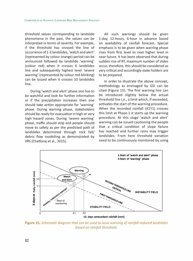
82
Compendium on national landslide Risk management stRategy
threshold values corresponding to landslide phenomena in the past, the values can be interpreted in terms of severity. For example, if the threshold has crossed the line of occurrence of 1-3 landslides, ‘watch and alert’ (represented by colour orange) period can be announced followed by landslide ‘warning’ (colour red) when it crosses 6 landslides line and subsequently highest level ‘severe warning’ (represented by colour red-blinking) can be issued when it crosses 10 landslides line.
During ‘watch and alert’ phase one has to be watchful and look for further information or if the precipitation increases then one should take action appropriate for ‘warning’ phase. During warning phase, stakeholders should be ready for evacuation in high or very high hazard zones. During ‘severe warning’ phase, traffic should stop and people should move to safety as per the predicted path of landslides determined through rock fall/debris flow modelling as demonstrated by IIRS (Chattoraj et al., 2015).
All such warnings should be given 1-day, 12-hours, 6-hour in advance based on availability of rainfall forecast. Special emphasis is to be given when warning phase rises from first level to next higher level in near future. It has been observed that during sudden rise of RT, maximum number of slides occur, therefore, this should be considered as very critical and accordingly stake holders are to be prepared.
In order to illustrate the above concept, methodology as envisaged by GSI can be cited (Figure 15). The first warning line can be introduced slightly below the actual threshold line i.e., a limit which, if exceeded, activates the start of the warning procedure. When the recorded rainfall (X1Y1) crosses this limit at Phase-1 it starts up the warning procedure. At this stage ‘watch and alert’ warning can be issued cautioning the people that a critical condition of slope failure has reached and further rains may trigger landslides. From here threshold variation need to be continuously monitored by using
Figure 15. Schematic diagram that can be used to issue warning of rainfall-induced landslides based on rainfall threshold.

83
different values of rainfall forecast. At this stage use of rainfall forecast is important in order to observe the trend of the rainfall in the next 24-hour. When rainfall in the next 24-hours is expected to exceed the threshold line (X2Y2) then Phase-2 warning (Warning) can be issued. The warning will alert the community about the possible occurrence of landslides. On further monitoring if the rainfall is expected to exceed further then the communities should be cautioned of major landslide events and instruct them to be prepared for immediate evacuation.
The warning for evacuation is not feasible using this system because it is very difficult to predict the precise location of landslide initiation based only on threshold information. The exact location of landslides is important if people are to be evacuated. In fact after the ‘watch and alert’ warning the people should be on the alert, and start looking for signs of instability to evacuate. Since, exceedance of the threshold indicates that the condition conducive for landsliding has set in. Therefore after the ‘watch and alert’ warning people should start working with the disaster preparedness plan so that the loss can be minimized.
2.8.3 Operating Procedure of the Warning System
Figure 15 describes the conceptual operating procedure of the warning system. The warning procedure activates when the recorded 5-days antecedent and previous day rainfall passes the warning line. At this stage (Phase-1) a general ‘watch and altert’ warning can be issued at least 12-hours in advance informing the local administration that the rainfall condition is critical and slope failures may result if a similar rainfall condition continues. It should also contain
information about emergency readiness, safe place for evacuation and precautions to reduce risk to life. This phase provides time to the authorities to disseminate information to the public and make equipment available for the potential disaster. The information can be disseminated through broadcasting/siren.
After Phase-1, continuous monitoring of the threshold rainfall can be carried out using different values of rainfall forecasts. If the rainfall forecast or the measured rainfall at a certain time touches or exceeds the threshold line then the ‘warning’ (Phase-2) can be issued informing the local administration about the specific areas (small catchment) where landslides can occur based on the hazard zonation map. At this stage people, through local representatives, can be advised to look for indications of landslides and be prepared for evacuation, if similar rainfall conditions persist. This phase gives relatively less time to the people and the authorities to react.
During Phase-2, risk maps can be consulted and specific hazardous areas can be outlined. This phase requires very rapid assessment of specific hazard and risk If the rainfall decreases below the threshold line then the warning can be withdrawn and if it increases further then the ‘warning’ remains and the authorities are advised to activate the emergency procedure for rescue and evacuation.
In addition to the above example, I-D based models will provide information in hourly mode based on observed intensity and duration. Subsequently run-out models and instrument based threshold can be analyzed before planning for evacuation and traffic halt.
developMent of landslide MonitorinG & early WarninG systeM (eWs)
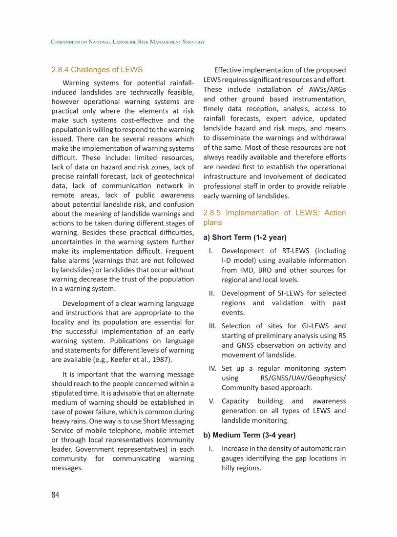
84
Compendium on national landslide Risk management stRategy
2.8.4 Challenges of LEWS
Warning systems for potential rainfall-induced landslides are technically feasible, however operational warning systems are practical only where the elements at risk make such systems cost-effective and the population is willing to respond to the warning issued. There can be several reasons which make the implementation of warning systems difficult. These include: limited resources, lack of data on hazard and risk zones, lack of precise rainfall forecast, lack of geotechnical data, lack of communication network in remote areas, lack of public awareness about potential landslide risk, and confusion about the meaning of landslide warnings and actions to be taken during different stages of warning. Besides these practical difficulties, uncertainties in the warning system further make its implementation difficult. Frequent false alarms (warnings that are not followed by landslides) or landslides that occur without warning decrease the trust of the population in a warning system.
Development of a clear warning language and instructions that are appropriate to the locality and its population are essential for the successful implementation of an early warning system. Publications on language and statements for different levels of warning are available (e.g., Keefer et al., 1987).
It is important that the warning message should reach to the people concerned within a stipulated time. It is advisable that an alternate medium of warning should be established in case of power failure, which is common during heavy rains. One way is to use Short Messaging Service of mobile telephone, mobile internet or through local representatives (community leader, Government representatives) in each community for communicating warning messages.
Effective implementation of the proposed LEWS requires significant resources and effort. These include installation of AWSs/ARGs and other ground based instrumentation, timely data reception, analysis, access to rainfall forecasts, expert advice, updated landslide hazard and risk maps, and means to disseminate the warnings and withdrawal of the same. Most of these resources are not always readily available and therefore efforts are needed first to establish the operational infrastructure and involvement of dedicated professional staff in order to provide reliable early warning of landslides.
2.8.5 Implementation of LEWS: Action plans
a) Short Term (1-2 year)
I. Development of RT-LEWS (including I-D model) using available information from IMD, BRO and other sources for regional and local levels.
II. Development of SI-LEWS for selected regions and validation with past events.
III. Selection of sites for GI-LEWS and starting of preliminary analysis using RS and GNSS observation on activity and movement of landslide.
IV. Set up a regular monitoring system using RS/GNSS/UAV/Geophysics/Community based approach.
V. Capacity building and awareness generation on all types of LEWS and landslide monitoring.
b) Medium Term (3-4 year)
I. Increase in the density of automatic rain gauges identifying the gap locations in hilly regions.
85
II. Improve the RT-LEWS based on AWS and better landslide inventory.
III. Selection of sites for instrumentation for SI-LEWS.
IV. Wireless networking of all these rain gauge stations and establishment of real time rainfall monitoring control room to communicate the early warning/fore warning information to the competent authority and the public concern.
V. Capacity building and awareness generation on all types of LEWS and landslide monitoring.
c) Long Term (5-6 year)
I. Wireless sensor network (WSN) based ground instrumentation and real time monitoring of landslides.
II. Development of early warning communication mechanism.
III. Implementation of GI-LEWS.
IV. Feedback analysis and LEWS improvement.
V. Capacity building and awareness generation on all types of LEWS and landslide monitoring.
2.8.6 Comprehensive Strategy and Work Flow
a) RT-LEWS
I. Collect satellite or ground based rainfall data (by installing AWS/ARGs at suitable locations) and analyses spatio-temporal variation.
II. Use satellite data in the absence of ground data.
III. Collect landslide data (location, time, size, mechanism) and carry out I-D
and DART analysis either with satellite based or ground based data.
IV. Validate the model with actual landslide observation. In the absence of data for longer observation period, even 2-3 years data is sufficient to start with.
V. Develop a better model using DART and daily precipitation and derivative of DART to yield a probability value that will be easier to interpret and integrate with LHZ maps (LR-DART).
VI. Evaluate DART and LR-DART and train the model to perform better in a dynamic manner.
VII. Use the rainfall forecast to evaluate DART based model for all future dates, closer the day, better is the forecast and this should be calculated daily with newer or better rainfall forecast in a running manner advancing in a daily manner.
VIII. Use an available LHZ map or develop one as per standard methodology and calculate either prior probability using existing landslide inventory or posterior probability derived from WoE modelling. This activity has a direct link with the outcome of Sub-Group-I (NDMA) on Landslide Hazard Maps.
IX. Combine LR-DART probability with LHZ probability to derive final probability of landslide occurrence in any area. The final probability should be assessed in comparison to prior probability of each zone. As the prior probability is a result of cumulative landslides in any region, single year probability would be much lesser than that value, therefore, care should be taken to interpret i-DART and LHZ combined probability in view of very low probability of LHZ map. Therefore,
developMent of landslide MonitorinG & early WarninG systeM (eWs)
86
Compendium on national landslide Risk management stRategy
for all practical purpose, the combined LR-DART and LHZ probability should be assessed for relative comparison across all zones of LHZ map.
X. At this stage look for the I-D based model to predict time of landslide. Like DART and LR-DART, evaluate its performance and using self-learning approach to improve the model.The I-D based modelling is complimentary to i-DART, hence should be carried out simultaneously using the same rainfall data and forecast.
XI. Once LR-DART and I-D values suggest landslides, in the next step, it is utmost important to look for visible and not so visible signs of deformation using ground observation (with help of local population), satellite images, UAV images, GNSS or terrestrial laser scanning if available. In case of instrumented slopes, it is desirable to see sign of sub-surface deformation to finally suggest the time of landslide.
XII. In any case after observation of high values of LR-DART and complimentary supportive observation of I-D values for critical areas under habitation or infrastructure, flow or fall modelling should be carried out to determine the flow path, velocity and run out distance to optimize evacuation and traffic flow.
In above strategy, the ground instrument (GI) based LEWS will be integrated at point XI and if there is any community (CB) based LEWS, it will also be integrated at the same stage. The pointXII will be activated based on the analysis at previous stage.
b) GI-LEWS
In order to implement GI based LEWS,
the following are the steps that needs to be taken.
I. Based on the type, activity, and stake (importance) the area should be selected for GI-LEWS.
II. At the preliminary stage attempts should be made to assess the level of movement using low cost GNSS observation.
III. GI-LEWS should be supported by RS and geophysical based investigation to ascertain actual extent, history and probable slip surface.
IV. Based on the dimension and slip surface and extent of landslide, suitable instrumentation is to be decided.
V. Choice between low-cost MEMS and traditional sensors are to be made. However, the emphasis should be on MEMS based technology as it is cost effective and many innovative approaches are expected in this domain.
VI. Based on precipitation, pore water pressure rise and deformation suitable threshold is to be worked out.
VII. As a follow up of the RT-LEWS, the GI-LEWS should provide the timing of landslide supported by ground observation.
c) SI-LEWS
In case of the SIL-EWS, the following points need to be addressed.
I. Areas need to be selected based on seismic zone (4 and 5), seismicity and past history of SIL.
II. For all representative rock types, geotechnical parameters (cohesion,
87
angle of friction and unit weight) are to be calculated.
III. Surface lithological map or surface deposit map is to be prepared based on lithology and geomorphology. In case such map cannot be prepared, basic lithological map with prominent depositional features from geomorphological map can be combined to prepare such maps. For each representative unit of this map, geotechnical properties are to be determined/estimated.
IV. Slope map is to be prepared from high resolution DEM.
V. Factor of safety and critical acceleration can be calculated as per equations explained in Annexe-3.
VI. In the event of earthquake or possible scenario earthquake, based on the epicenter, magnitude, distance, the Arias intensity (IA) can be calculated.
VII. Based on FOS and IA, Newmark displacement can be calculated, higher the displacement, higher is the chance of landslide.
VIII. In the event of actual earthquake, this can be calculated as soon as the epicenter and magnitude data are available. So in real sense, it will be possible to calculate the SIL hazard in near real time. There are some promising example in which the epicentre of the forthcoming earthquake (Mw > 7) can be known in advance (source: IIRS) and in such cases, the SIL hazard can be known in advance and accordingly warning can be issued.
IX. Some of the SIL are co-seismic and some are post-seismic (as observed in
case of Kashmir earthquake 2005 and Sikkim earthquake 2011), in case of the later, the SIL modelling can be very effective. Areas experiencing maximum displacement as per model can be under surveillance for detecting early sign of displacement and movement due to aftershocks or precipitation. This is significant considering the fact that after 11 days of Sikkim earthquake in 2011, a major landslide occurred in Darjeeling area due to high precipitation.
X. In a direct approach by deploying MEMS based accelerometer and seismometer, beyond a threshold, warning can be issued on vulnerable slopes.
2.8.7 Institutional Arrangements
I. Cluster Approach: In order to implement different types of LEWS, it is envisaged to follow a ‘cluster approach’. In which, an agency with known expertise and local presence can be the lead agency and others organizations (GSI, CBRI, DTRL, Amrita University, IIRS, IITs etc.) could join as team members to provide technical guidance. The implementing agency could be a government agency/stake holder and the whole task of setting up of the LEWS can be partly or completely out sourced as per the requirement. Attempts should be made to involve local universities/academic institutions so that awareness and capacity building can happen at much earlier date and academia may get an opportunity to contribute to the development of LEWS.
II. Capacity building: Capacity building and training for implementation of state of the art LEWS will be crucial for adaptation of research based
developMent of landslide MonitorinG & early WarninG systeM (eWs)
88
Compendium on national landslide Risk management stRategy
methodology as envisaged in the present endeavor. For capacity building of technical personnel of implementing agencies, industry and any other agency, IIRS in collaboration with other agencies can design and organize specialized training programmes in a sustainable manner. So that newer technologies and improvement of techniques would be part of the implementation strategy. This programme needs to be carried out in coordination with Sub Group-IV on “Capacity building and training of stakeholders”.
III. Ownership issues: For sustained use of LEWS, ownership issues are to be resolved through appropriate mainstreaming strategy. The stake holder organization or department should own and maintain the system with commitment for upgradation and improvement. It involves recruitment of appropriate manpower, budget allocation and capacity building and net working with research organisations.
IV. Industry development: Entrepreneurship and industry involvement is key to sustain innovation in development of LEWS such as Start Ups. Therefore, necessary attempts should be made to involve industry and provide right kind of atmosphere for innovation and risk taking efforts. The ultimate aim is to develop new techniques for LEWS that is not only suitable for Indian region but also the know-how and sensors can be exported abroad as embedded systems.
2.9 Financial ImplicationsLEWS based on ID and RT will require
mostly collection of data and analysis of the same with validation for at least 3-years. Cost
and time optimization can be worked out based on single site or multiple areas.
LEWS based on Ground instrument: Wireless sensor network (WSN) based ground instrumentation and real time monitoring of landslides will require time duration of 24 months. Cost and time optimization can be worked out based on actual site.
SI-LEWS depending upon the level of instrumentation and modelling, can be set up in 1.5 years time frame at a nominal budget including cost of one JRF per region. Final cost and time optimization can be worked out based on actual area of study.
Financial provisions for allocation of budget should be made for capacity building and awareness programmes related to development, implementation and popularization of LEWS. This should be a continuous activity and therefore, budget should be available in a long term basis.
2.10 Way ForwardIn spite of recent advances in mapping,
modelling and monitoring dealing with various aspects of landslides and allied phenomena, the damage tolls due to the same are on rise during monsoon months in hilly terrain across the country. Hence, landslide prediction on a temporal scale has emerged as one of the top most priority for landslide risk reduction. In India, most of the landslides are caused or reactivated primarily by monsoon rainfall. Depending on meteorological and physiographical conditions, individual rainfall events can cause slope failures in small or large areas. The relationship between landslide incidences and rainfall characteristics in the Indian Himalaya is broadly understood in some select sectors but largely remains an area of research or further investigation
89
in vast stretches of vulnerable slopes of Himalaya and other hilly regions.
In case of rainfall-induced landslides, the minimum intensity or duration of rainfall necessary to cause or reactivate a landslide can be known from rainfall threshold based models which broadly defines the rainfall, soil moisture, or hydrological conditions that when reached or exceeded, are likely to trigger landslides (e.g., Crozier, 1996; Reichenbach et al., 1998; Guzzetti et al., 2007). It is understood from the literature that, in general, two types of rainfall thresholds exist; physical (process-based, conceptual) thresholds and empirical (historical, statistical) thresholds (Corominas, 2000; Aleotti, 2004; Wieczorek and Glade, 2005, Guzzetti et al., 2007). Physical threshold models require detailed spatial information on the hydrological, lithological, morphological, and soil characteristics that control the initiation of landslides. These process-based threshold models attempt to extend spatially the slope stability models widely adopted in geotechnical engineering (Wu and Sidle, 1995; Iverson, 2000). These models can determine the amount of precipitation required to trigger slope failures and time of the expected landslides.
Empirical rainfall threshold models have evolved by studying the rainfall events that have resulted in landslides. The threshold is usually obtained by drawing lower-bound lines to the rainfall conditions that resulted in landslides plotted in Cartesian, semi-logarithmic, or logarithmic coordinates. Different types of empirical rainfall thresholds for the initiation of landslides have been proposed in the literature based on the extent of the geographical area for which they were defined, and the type of rainfall measurement used to establish the thresholds (Guzzetti et al., 2007). However,
in the present case, modified RT based approach (DART) has been envisaged and additionally LR-DART, a multivariate statistical analysis based approach has been suggested. Secondly complementary I-D based model has also been suggested to provide a reasonably comprehensive RT-LEWS.
As hilly regions (Himalaya and NE) of India coincide with earthquake hazard zones, it is desirable to develop seismicity induced landslide EWS (SI-LEWS). Therefore, an attempt was made to provide a GIS based model to assess slope performance and identify seismically induced landslide hazard zones. Additionally, seismometer and accelerometer based threshold is also suggested for real time SI-LEWS.
Landslide instrumentation and real-time monitoring can provide insight of the dynamics of landslide movement. In addition, landslide monitoring in real time can provide immediate information on the landslide activity that may be critical to protect lives and property. Reliable landslide warning systems, the outcome of systematic landslide instrumentation and real time monitoring, require accurate short-term forecast of landslide movement which in turn demand a detailed understanding of present field conditions and a quantitative framework for interpreting these conditions.Frameworks for similar systems have been developed for mountainous regions of Italy, New Zealand, and Taiwan. Site-specific real time systems have been applied in many countries to monitor critical structures, such as dams, or hazardous landslides. In India, some attempts have been made on field instrumentation and landslide monitoring in Nilgiri hills, Munnar; Mansa Devi (Haridwar); Pakhi and Tangni landslide (on Badrinath road, Chamoli district) Uttarakhand; Katropi/Gadhpa Hill,
developMent of landslide MonitorinG & early WarninG systeM (eWs)
90
Compendium on national landslide Risk management stRategy
Himachal Pradesh and Chandmari, Sikkim. Based on such valuable experience, strategy has been suggested for GI-LEWS, where in advance sensor technology like MEMS based sensors will be deployed to bring down cost and improve upon efficiency.
One of the key aspect of LEWS is deployment or application of appropriate methodology for monitoring of landslides and slope deformation. Monitoring can be carried out by space based as well as ground based approaches to observe the subtle changes before the catastrophic landslides. Several techniques have been suggested for real time, near real time as well as post-facto analysis using both traditional approach and innovative approaches like laser scanning, UAV, Radar and satellite navigation. The underlying principle is cost effectiveness and efficiency in providing information with unprecedented details.
Overall, the strategy suggested for implementing LEWS based on LR-DART and I-D and subsequently aided by instrument based real time monitoring (GI-LEWS) at select places is to effectively address the issue of landslide disaster mitigation in India in a phased but systemic manner by involving all stakeholders starting from scientific organisations to stakeholders on ground and decision makers involved in policy, planning and implementations. Every attempt is made to include all ongoing and envisaged efforts of various organisations on a common platform of landslide hazard mitigation through development of LEWS aided by technological innovations and infusion of advanced technologies like satellite navigation and imaging from space and near earth. The whole idea is not only to implement best practice or best technology but ‘Next Practice’ or ‘Next Technology’ with very significant innovative
ideas as postulated by Dr. R.A. Mashelkar, former DG, CSIR.
2.11 ReferencesAhmad, R.(2003). Developing early
warning systems in Jamaica: rainfall thresholds for hydrological hazards. National Disaster Management Conference, Ocho Rios, St Ann, Jamaica, 9–10 September 2003. At website: http://www.mona.uwi.edu/uds/rainhazards_files/frame.htm
Aleotti, P., Baldelli, P., Bellardone, G., Quaranta, N., Tresso, F., Troisi, C., Zani, A. (2002) Soil slips triggered by October 13-16, 2000 flooding event in the Piedmont Region (North West Italy): critical analysis of rainfall data. Geologia Tecnica e Ambientale 1: 15–25
Angeli, M.G., Gasparetto, P., Menotti, R.M., Pasuto, A., Silvano, S. (1994). A system of monitoring and warning in a complex landslide in northeastern Italy. Landslide News. 8: 12–15.
Annunziati, A., Focardi, A., Focardi, P., Martello, S., Vannocci, P. (2000) Analysis of the rainfall thresholds that induced debris flows in the area of Apuan Alps – Tuscany, Italy (19 June 1996 storm). In: Proceeding of, the EGS Plinius Conference on Mediterranean Storms. Maratea, Italy, 485–493
Arboleda, R.A., Martinez, M.L. (1996) 1992 lahars in the Pasig-Potrero River system. In: Fire and mud: eruptions and lahars of Mount Pinatubo (Newhall CG, Punongbayan RS, eds). Philippine Institute of Volcanology and Seismology, Quezon City and University of Washington Press, Seattle, 1126 pp
Arboleda, R.A., Martinez, M.L. (1996). 1992 lahars in the Pasig-Potrero River CG, Punongbayan RS, eds). Philippine Institute of Volcanology and Seismology. Seattle: Quezon
91
City and University of Washington Press, 1126 pp.
Bacchini, M., Zannoni, A. (2003). Relations between rainfall and triggering of debris-flow: acase study of Cancia (Dolomites, Northeastern Italy), Natural Hazards and Earth System Sciences, vol.3, pp. 71-79.
Barbero, S., Rabuffetti, D., Zaccagnino, M. (2004) Una metodologia per la definizione delle soglie pluviometriche a supporto dell’emissione dell’allertamento. In: Proceedings 29th Convegno Nazionale di Idraulica e Costruzioni Idrauliche. Trento: 7-10 September 2004, 211–217
Baum, R.L., Godt, J.W., Harp, E.L., McKenna, J.P. (2005) Early warning of landslides for rail traffic between Seattle and Everett, Washington. In: Landslide Risk Management, Proceedings of the 2005 International Conference on Landslide Risk Management (Hungr O, Fell R, Couture R, Ebdrhardt E, eds). New York: A.A. Balkema, 731–740
Bell, F.G., Maud, R.R. (2000) Landslides associated with the colluvial soils overlying the Natal Group in the greater Durban region of Natal, South Africa. Environ Geol 39(9): 1029–1038
Berti, M., Genevois, R., LaHusen, R. L., Simoni, A., Tecca, P.R. (2000). Debris flow monitoring in the Acquabona watershed on the Dolomites (Italian Alps). Physics and Chemistry of the Earth, Part B: Hydrology, Oceans and Atmosphere. 26(9): 707–715.
Bhandari, R.K., Senanayake, K.S., Thayalan, N. (1991) Pitfalls in the prediction on landslide through rainfall data. In: Landslides (Bell DH, ed). Rotterdam: A.A. Balkema, 2: 887–890
Bhattacharjee, S., Champati ray, P. K.,
Chattoraj, S.L., Dhara, M. (2017). Precipitation Intensity: Duration Based Threshold Analysis for Initiation of Landslides in Upper Alaknanda Valley. International Journal of Environmental, Chemical, Ecological, Geological and Geophysical Engineering Vol:11, No:2, 105-109.
Biafiore, M., Braca, G., De Blasio, A., Martone, M., Onorati, G., Tranfaglia, G. (2002) Il monitoraggio ambientale dei territori campani a rischio di frane e di alluvioni: lo sviluppo della rete idropluviometrica del Servizio Idrografico e Mareografico Nazionale. Unpublished report.
Bichler, A., Bobrowsky, P., Best, M., Douma, M., Hunter, J., Calvert, T., Burns, R. (2004). Three-dimensional mapping of a landslide using a multi-geophysical approach: the Quesnel Forks landslide, Landslides1:29-40.
Bolley, S., Oliaro, P. (1999) Analisi dei debris flows in alcuni bacini campione dell’Alta Val Susa. Geoingegneria Ambientale e Mineraria, Marzo: 69–74
Borga, M., Dalla Fontana, G., Da Ros, D., Marchi, L. (1998). Shallow landslide hazard assessment using a physically based model and digital elevation data, Environmental Geology, vol.35, pp.81-88.
Brand, E.W., Premchitt, J., Philipson, H.B. (1984). Relationship between rainfall and landslides in Hong Kong, in: Proceedings of the Fourth International Symposium on Landslides. Toronto, 377–384.
Buchroithner, M.F. (2002). Meteorological and Earth Observation Remote Sensing data for Mass Movement preparedness. Advance Space Research 29: 5-16.
Caine, N., Mool, P.K. (1982). Landslides in the Kolpu Khola drainage, Middle Mountains,
developMent of landslide MonitorinG & early WarninG systeM (eWs)
92
Compendium on national landslide Risk management stRategy
Nepal. Mountain Research and Development 2 (2): 157-173.
Calcaterra, D., Parise, M., Palma, B., Pelella, L. (2000) The influence of meteoric events in triggering shallow landslides in pyroclastic deposits of Campania, Italy. In: Proceedings 8th International Symposium on Landslides, (Bromhead E, Dixon N, Ibsen ML, eds). Cardiff: A.A. Balkema, 1: 209–214
Campbell, R.H. (1975). Soil slips, debris flows, and rainstorms in the Santa Monica Mountains and vicinity, southern California. In: US Geological Survey Professional Paper 851. US Government Printing Office, Washington, DC, 51 pp.
Cancelli, A., Nova, R.(1985). Landslides in soil debris cover triggered by rainstorms in Valtellina (central Alps – Italy). In: Proc. 4th Int. Conf. and Field Workshop on Landslides. Tokyo: The Japan Geological Society, pp 267–272.
Cannon, S.H. (1988) Regional rainfall-threshold conditions for abundant debris-flow activity. In: Landslides, Floods, and Marine Effects of the Etorm of January 3-5, 1982, in the San Francisco Bay Region, California (Ellen SD, Wieczorek GF, eds). US Geological Survey Professional Paper 1434, 35–42
Cannon, S.H., Ellen, S.D. (1985). Rainfall conditions for abundant debris avalanches, San Francisco Bay region, California. California Geology 38: 267-272.
Cannon, S.H., Gartner, J.E .(2005) Wildfire-related debris flow from a hazards perspective. In: Debris flow Hazards and Related Phenomena (Jakob M, Hungr O, eds). Springer Berlin Heidelberg, 363–385
Canuti, P., Focardi, P., Garzonio, C.A. (1985). Correlation between rainfall and
landslides. Bull Int Assoc Eng Geol 32: 49–54.
Cardinali, M., Galli, M., Guzzetti, F., Ardizzone, F., Reichenbach, P., Bartoccini, P. (2006). Rainfall induced landslides in December 2004 in Southwestern Umbria, Central Italy. Nat Hazard Earth Sys 6: 237–260.
Ceriani, M., Lauzi, S., Padovan, N. (1992) Rainfall and landslides in the Alpine area of Lombardia Region, central Alps, Italy. In: Interpraevent Int. Symposium. Bern: 2: 9–20
Champati ray, P.K, Chattoraj, S.L., Kannaujiya, S., Bisht, M.P.S., Pandey, K., Goswami, A. (2015). Kedarnath Disaster 2013. Causes, consequences and comparison with past event using remote sensing inputs, Natural Hazards (Springer), DOI 10.1007/s11069-015-2076-0.
Champati ray, P.K. (2013). A tale of two lakes from Uttarakhand. Indian Landslides, Vol. 6 (2), 1-8.
Champati ray, P.K., Parvaiz, I., Jayangondaperumal, R., Thakur, V.C., Dadhwal, V.K. and Bhat, F.A. (2009). Analysis of Seismicity Induced Landslides due to the October 8, 2005 Earthquake in Kashmir Himalaya, Current Science, Vol. 97, No. 3, 1742-1751.
Champati ray, P.K., Perumal, R.J.G., Thakur, V.C., Bhat, M.I., Mallik, M.A., Singh, V.K., and Lakhera, R.C., 2005. A quick appraisal of ground deformation in Indian region due to the October 8, 2005 earthquake, Muzaffarabad, Pakistan, Journal of ISRS, Vol 33, No. 4, 465-473.
Champati ray, P.K., Shukla, R., Chand, D.S., and Lakhera, R.C., (2009). An assessment of geological and terrain factors of the La Landslide, Uttarakhand, India, and hazard
93
mitigation measures, Indian Landslides, Vol. 2, No. 2, pp. 1-6.
Chattoraj, S.L., Champati ray, P.K., Kannaujiya, S., Ketholia, Y. (2015). Simulation and modelling of debris flows using satellite derived data: A case study from Kedarnath area, International Journal of Geomatics and Geosciences, Volume 6, No. 2, pp. 1498-1511.
Chen, H., Lee, C.F. (2003). A dynamic model for rainfall induced landslides on natural slopes, Geomorphology, vol.51, pp. 269-288.
Chien-Yuan, C., Tien-Chien, C., Fan-Chieh, Y., Wen-Hui, Y., Chun-Chieh, T. (2005). Rainfall duration and debris-flow initiated studies for real-time monitoring. Environ Geol 47: 715–724.
Chien-Yuan, C., Tien-Chien, C., Fan-Chieh, Y., Wen-Hui, Y., Chun-Chieh, T. (2005) Rainfall duration and debrisflow initiated studies for real-time monitoring. Environ Geol 47: 715–724
Chleboard, A.F. (2003). Preliminary Evaluation of a precipitation Threshold for Anticipating the occurrence of Landslides in the Settle, Washington, Area, U.S Geological survey Open file Report 03-463.
Chleborad, A. F., Baum, R. L., Godt, J. P. (2006). Rainfall thresholds for forecasting landslides in the Seattle, Washington, Area—exceedance and probability. U.S. Geological Survey Open-File Report 2006–1064.
Chleborad, A.F. (2000). Preliminary Evaluation of a Precipitation Threshold for Anticipating the Occurrence of Landslides in the Seattle, Washington, Area. U.S. Geological Survey Open-File Report 03-463.
Clarizia, M., Gullà, G., Sorbino, G. (1996).
Sui meccanismi di innesco dei soil slip. Int. conf. on Prevention of hydrogeological hazards: the role of scientific research. 1:585–597, (in Italian).
Corominas, J. (2000). Landslides and climate. In: Bromhead E, Dixon N, Ibsen ML (eds) Keynote lecture of Proc. of the 8th Int. Symp. on Landslides. A. A. Balkema, Cardiff, Wales, 4, pp 1–33.
Corominas, J., Ayala, F.J., Cendrero, A., Chac_on, J., Dı´az de Tera´n, J.R., Gonza´les, A., Moja, J., Vilaplana, J.M. (2005). Impacts on natural hazard of climatic origin. In: ECCE Final Report: A Preliminary Assessment of the Impacts in Spain due to the Effects of Climate Change. Ministerio de Medio Ambiente. http://www.mma.es/secciones/cambio_climatico/documentacion_cc/historicos_cc/pdf/prel minary_assessment_impacts_full_2.pdf
Corominas, J., Ayala, F.J., Cendrero, A., Chacón, J., Díaz de Terán, J.R., Gonzáles, A., Moja, J., Vilaplana, J.M. (2005) Impacts on natural hazard of climatic origin. In ECCE Final Report: A Preliminary Assessment of the Impacts in Spain due to the Effects of Climate Change. Ministerio de Medio Ambiente.
Corominas, J., Moya, J. (1996). Historical landslides in the Eastern Pyrenees and their relation to rainy events. In: Landslides (Chacon J, Irigaray C, Fernandez T, eds). Rotterdam: A.A. Balkema, pp 125–132.
Corominas, J., Moya, J. (1999) Reconstructing recent landslide activity in relation to rainfall in the Llobregat River basin, Eastern Pyrenees, Spain. Geomorphology 30: 79–93
Corominas, J., Moya, J. (1999) Reconstructing recent landslide activity in
developMent of landslide MonitorinG & early WarninG systeM (eWs)
94
Compendium on national landslide Risk management stRategy
relation to rainfall in the Llobregat River basin, Eastern Pyrenees, Spain. Geomorphology 30: 79–93
Corominas, J., Moya, J. (1999). Reconstructing recent landslide activity in relation to rainfall in the Llobregat River basin, Eastern Pyrenees, Spain. Geomorphology 30: 79–93.
Crosta, G. (1998). Rationalization of rainfall thresholds: an aid to landslide hazard evaluation, Environmental Geology, vol.35 (2-3), pp.131-145.
Crosta, G.B., Frattini, P. (2001). Rainfall thresholds for triggering soil slips and debris flow. In: Mugnai, A., Guzzetti, F., Roth, G. (eds) Mediterranean storms. In: Proc. of the 2nd EGS Plinius Conf. on Mediterranean Storms. Siena, Italy, pp 463–487.
Crozier, M. J. (1999). Prediction of rainfall-triggered landslides: a test of the antecedent water status model. Earth Surface Processes and Landforms 24: 825-833.
Crozier, M.J. (1986). Landslides: causes, consequences and environment. London: Croom Helm, 252 pp.
Crozier, M.J. (1996). The climate-landslide couple: a Southern Hemisphere perspective, Paleoclimate Research, 19 ESF, Special Issue, vol.12, pp. 329-350.
Crozier, M.J. (1999). Prediction of rainfall-triggered landslides: a test of the antecedent water status model. Earth Surf Processes Landf 24:825–833.
Crozier, M.J., (1997). The climate-landslide couple: a Southern Hemisphere perspective. Paleoclimate Research 19, 333-354.
Cruden, D.M., Varnes, D.J. (1996). Landslide types and processes. In Landslides-
Investigations and Mitigation, Turner AK, Schuster RL (eds). Transportation Research Board Special Report 247: 36-75.
Cui, P., Chen, X.-Q., Zhu, Y.-Y., Su, F.-H., Wei, F.-Q., Han, Y.-S., Liu H.-J., Zhuang J.-Q., 2011. The Wenchuan earthquake (May 12, 2008), Sichuan Province, China, and resulting geohazards. Natural Hazards, Vol. 56, pp.19 – 36.
Dahal, R.K., Hasegawa, S. (2008). Representative rainfall thresholds for landslides in the Nepal Himalayas. Science Direct. Geomorphology 100: 429-443.
Dai, F.C., Lee, C.F. (2001). Frequency- Volume relation and prediction of rainfall-induced landslides. Engineering Geology 59: 253-266.
De Vita, P. (2000). Fenomeni di instabilita` della coperture piroclastiche dei monti Lattari, di Sarno e di Salerno (Campania) ed analisi degli eventi pluviometrici determinanti. Quad Geol Appl 7(2):213–235.
Endo, T. (1970) Probable distribution of the amount of rainfall causing landslides. Annual report, Hokkaido Branch, Govern. Forest Experiment Station, Sapporo, 123–136.
Finlay, P.J., Fell, R., Maguire P K (1997). The relationship between the probability of landslide occurrence and rainfall. Canadian Geotechnical Journal. 34(6): 811–824.
Floris, M., Bozzano, F. (2007). Evaluation of landslide reactivation: A modified rainfall threshold model based on historical records of rainfall and landslides, Geomorphology, vol.94, pp. 40-57.
Floris, M., Mari, M., Romeo, R.W., Gori, U. (2004). Modelling of landslide-triggering

95
factors – a case study in the Northern Apennines, Italy. In: Lecture Notes in Earth Sciences 104: Engineering Geology for Infrastructure Planning in Europe (Hack R, Azzam, R., Charlier, R., eds). Berlin Heidelberg: Springer, pp 745–753.
Frattini, P., Crosta, G.B., Fusi, N., Dal Negro, P. (2004). Shallow landslides in pyroclastic soils: a distributed modelling approach for hazard assessment, Engineering Geology, vol.73, pp. 277-295.
Froese, C. R., Moreno, F. (2007). Turtle Mountain Field Laboratory (TMFL): Part 1—overview and activities. In: V.R. Schaefer, R.L. Schuster and A.K. Turner (eds), Conference Presentations: 1st North American Landslide Conference, AEG Special Publication 23: 971–980. Vail, Colorado: Assoc. of Engineering Geologists.
Gabet, E. J., Burbank, D.W., Putkonen, J.K., Pratt- Situala, B.A., and Ojha, T. (2004). Rainfall thresholds for landsliding in the Himamlayas of Nepal: Geomorphology, vol.63, pp.131-143.
Galde, T., Guzzetti, F., Vita, P. De., et al., (2000). Regional Rainfall Threshold and Hydrologic Thresholds for Landslide Occurrence, Examples from New Zealand and central Italy, proceedings of 2nd EGS plinius conference on Mediterranean storms-Siena, Italy, pp. 489- 506.
Gerad, F., Wieczorek, and Guzzetti, F. (2000). A review of rainfall thresholds for triggering landslides, Mediterranean Storms, Maratea, Italy, pp.407-414.
Giannecchini, R. (2005) Rainfall triggering soil slips in the southern Apuane Alps (Tuscany, Italy). Adv Geosci 2: 21–24.
Giannecchini, R. (2005) Rainfall triggering
soil slips in the southern Apuane Alps (Tuscany, Italy). Adv Geosci 2: 21–24
Giannecchini, R. (2006). Relationship between rainfall and shallow landslides in the southern Alps (Italy) Natural Hazards and Earth System Sciences, vol.6, pp.357 – 364.
Glade, T., Crozier, M.J., Smith, P. (2000). Applying probability determination to refine landslide-triggering rainfall thresholds using an empirical “Antecedent Daily Rainfall Model”. Pure Appl Geophys 157(6/8):1059–1079.
Godio, A., Strobbia, C .,De Bacco, G. (2006). Geophysical characterisation of a rockslide in an alpine region Engineering Geology 83:273–286.
Godt, J.W., Baum, R.L., Chleborad, A.F. (2006). Rainfall characteristics for shallow landsliding in Seattle, Washington, USA. Earth Surf Processes Landf 31:97–110
Govi, M., Mortara, G., Sorzana, P. (1985) Eventi idrologici e frane. Geologia Applicata & Ingegneria 20(2):359–375
Govi, M., Mortara, G., Sorzana, P. (1985). Eventi idrologici e frane. Geol Appl Ing 20(2):359–375.
Govi, M., Sorzana, P.F. (1980). Landslide susceptibility as function of critical rainfall amount in Piedmont basin (North-Western Italy). Stud Geomorphol Carpatho- Balc 14:43–60.
Guadagno, F.M. (1991) Debris flows in the Campanian volcaniclastic soil (Southern Italy). In: Proceedings of International Conference on slope stability. Isle of Wight: Thomas Telford, 125–130
Guidicini, G., Iwasa, O.Y. (1977). Tentative correlation between rainfall and landslides in
developMent of landslide MonitorinG & early WarninG systeM (eWs)
96
Compendium on national landslide Risk management stRategy
a humid tropical environment. Bull Int Assoc Eng Geol 16:13–20.
Gupta, V., Bist, K.S. (2004). The 23rd September 2003 Varunavat Parvat landslide in Uttarkashi township, Uttaranchal. Current Science 87: 1600-1605.
Guzzetti, F. et al., (2007). Rainfall Thresholds for the initiation of landslides in central and southern Europe, Springer- Verag, pp 239-267.
Guzzetti, F., Peruccacci, S., Rossi, M. (2005). Definition of critical threshold for different scenarios, Action 1.16, IRPI CNR, Perugia, Italy, p.38.
Guzzetti, F., Peruccacci, S., Rossi, M., Stark, C.P. (2007). Rainfall thresholds for the initiation of landslides. Meteorology and Atmospheric Physics 98: 239-267.
Guzzetti, F., Peruccacci, S., Rossi, M., Stark, C.P. (2008). The rainfall intensity-duration control of shallow landslides and debris flows: an update, Landslides, 5(1), 3–17.
Heyerdahl, H., Harbitz, C.B., Domaas, U., Sandersen, F., Tronstad, K., Nowacki, F., Engen, A., Kjekstad, O., Dévoli, G., Buezo, S.G., Diaz, M.R., Hernandez, W. (2003) Rainfall induced lahars in volcanic debris in Nicaragua and El Salvador: practical mitigation. In: Proceedings of International Conference on Fast Slope Movements – Prediction and Prevention for risk Mitigation, IC-FSM2003. Naples: Patron Pub, 275–282
Hong, Y., Hiura, H., Shino, K., Sassa, K., Suemine, A., Fukuoka, H., Wang, G. (2005). The influence of intense rainfall on the activity of large-scale crystalline schist landslides in Shikoku Island, Japan. Landslides 2(2): 97–105.
Husaini, O., Ratnasamy, M. (2001). An early warning system for active landslides. Quarterly Journal of Engineering Geology and Hydrogeology. 34: 299–305.
Innes, J.L. (1983) Debris flows. Prog Phys Geog 7: 469–501
Intrieri, E., Gigli, G., Casagli, N., Nadim, F. (2013). Landslide Early Warning System: toolbox and general concepts. Nat. Hazards Earth Syst. Sci., 13, 85–90.
Iverson, R.M. (2000). Landslide triggering by rain infiltration. Water Resour Res 36(7): 1897–1910.
Jaiswal, P., van Westen, C.J. (2012). Use of quantitative landslide hazard and risk information for local disaster risk reduction along a transportation corridor: a case study from Nilgiri district, India Nat Hazards, DOI 10.1007/s11069-012-0404-1.
Jakob, M., Weatherly, H. (2003). A hydroclimatic threshold for landslide initiation on the North Shore Mountains of Vancouver, British Columbia, Geomorphology 54: 137-156.
Jan, C.D., Chen, C.L. (2005) Debris flows caused by Typhoon Herb in Taiwan. In: Debris flow Hazards and Related Phenomena (Jakob M, Hungr O, eds). Springer Berlin Heidelberg, 363–385
Jan, C.D., Chen, C.L. (2005). Debris flows caused by typhoon Herb in Taiwan. In: Debris flow hazards and related phenomena (Jakob M, Hungr O, eds). Berlin Heidelberg: Springer, pp 363–385.
Jibson, R.W. (1989) Debris flow in southern Porto Rico. Geological Society of America, Special Paper 236, 29–55
97
Jibson, R.W., (1993). Predicting earthquake-induced landslide displacements using Newmark’s sliding block analysis. Transport Res. Rec., 1411, 9-17.
Jibson, Randall W, Harp Edwin L, and MichaelJohn A (1998) A Method for Producing Digital Probabilistic Seismic Landslide Hazard Maps: An Example from the Los Angeles, California Area,Open-File Report 98-113U.S. Department of the Interior U.S. Geological Survey
Kanji, M.A., Massad, F., Cruz, P.T. (2003) Debris flows in areas of residual soils: occurrence and characteristics. International Workshop on Occurrence and Mechanisms of Flows in Natural Slopes and Earthfills. Iw- Flows2003, Sorrento: Associacione Geotecnica Italiana 2: 1–11
Kanungo, D.P., Pain, A., Sharma, S. (2013a). Stability assessment of a potential debris slide in Garhwal Himalaya, India. Indian Landslides. 6(2): 9-20.
Kanungo, D. P., Pain, A., Sharma, S. (2013b). Finite element modeling approach to assess the stability of debris and rock slopes: a case study from the Indian Himalaya. Natural Hazards. 69: 1-24.
Kanungo, D. P., Sharma S. (2013). Rainfall thresholds for prediction of shallow landslides around Chamoli-Joshimath region, Garhwal Himalayas, India. Landslides. DOI 10.1007/s10346-013-0438-9.
Keefer, D.K., (1984). Landslides caused by earthquakes: Geological Society of America Bulletin, v.95, 406-421
Keefer, D.K., Wilson, R.C., Mark, R.K., Brabb, E.E., Brown, W.M., Ellen, S.D., Harp, E. L., Wieczorek, G. F., Alger, C. S., Zatkin, R. S .(1987). Real-time landslide warning during
heavy rainfall. Science. 238(4829): 921–925.
Kim, S.K., Hong, W.P., Kim, Y.M. (1991). Prediction of rainfall-triggered landslides in Korea. In: Bell DH (ed) Landslides, 2nd edn. A.A. Balkema, Rotterdam, pp 989–994
Kuriakose, S.L., Sankar G., Muraleedharan, C., (2010). Landslide fatalities in the Western Ghats of Kerala, India. Geophysical Research Abstracts Vol. 12, EGU2010-8645, 2010 EGU General Assembly 2010.
Kuthari, S. (2007). Establishing precipitation thresholds for landslide initiation along with slope characterisation using GIS-based modeling, M. Sc. Thesis, University of Twente, https://www.itc.nl/library/papers_2007/msc/iirs/kuthari.pdf.
Lapenna,V., Lorenzo, P., Perrone, A., ,Piscitelli, S., Rizzo, E., Sdao, F. (2005). 2D electrical resistivity imaging of some complex landslides in Lucanian Apennine chain southern Italy Geophysics v 70(3):B11-B18.
Larsen, M.C., Simon, A. (1993).A rainfall intensity-duration threshold for landslides in a humid-tropical environment, Puerto Rico. Geogr Ann A 75(1–2): 13–23.
Lumb, P. (1975). Slope failures in Hong Kong. Quarterly Journal of Engineering Geology 8: 31-65.
Lumb, P. (1975). Slope failure in Hong Kong. Q J Eng Geol 8: 31–65.
Mario Floris, Francesca Bozzan (2008). Evaluation of landslide reactivation: a modified rainfall threshold model based on historical records of rainfall and landslides, Geomorphology, Vol.94, pp. 40-57.
Mark, R.K., Newman, E.B., Northcut, C.R., Hamachi, B.R. (1988) Rainfall associated with the January 1982 rainstorm in the
developMent of landslide MonitorinG & early WarninG systeM (eWs)
98
Compendium on national landslide Risk management stRategy
San Francisco Bay Region , California: U.S.Geological Survey Open File Report: 83-16
Massey, J.B., Mak, S.H., Yim, K.P. (2001). Community based approach to landslide risk reduction, in: Proceedings of the Fourteenth Southeast Asian Geotechnical Conference. Hong Kong, China, 141–147.
Mathew, J., Giri Babu, D., Kundu, S., Kumar Vinod, K., Pant, C.C. (2013).Integrating intensity–duration-based rainfall threshold and antecedent rainfall-based probability estimate towards generating early warning for rainfall-induced landslides in parts of the Garhwal Himalaya, India. Landslides. DOI 10.1007/s10346-013-0408-2.
Matsushi, Y. (2006). Triggering Mechanisms and Rainfall Thresholds of Shallow Landslides on Soil- mantled Hillslopes with Permeable and Impermeable Bedrocks, M.Phil thesis, GSLES, University of Tsukuba, p.120.
Meric, O., Garambois, S., Jongmans, D., Wathelet, M., Chatelain, J., Vengeon, J. (2005). Application of geophysical methods for the investigation of the large gravitational mass movement of sechilienne france CANADIAN GEOTECHNICAL JOURNAL 42:1105– 1115.
Michoud, C., Bazin, S., Blikra, L.H., Derron, M.H., Jaboyedoff, M. (2012). Overview of Existing Landslide Early-Warning Systems in Operation. EGU General Assembly 2012, Vienna, Austria, p.2919.
Mittal, S.K., Singh, M., Kapur, P., Sharma, B.K., Shamshi, M.A. (2008). Design and development of instrumentation network for landslide monitoring and issue an early warning. Journal of Scientific and Industrial Research. 67: 361-365.
Moser, M., Hohensinn, F. (1983) Geotechnical aspects of soil slips in Alpine regions. Eng Geol 19: 185–211
Naithani, A.K. (1999). The Himalayan Landslides, Employment News, 23(47): 1-2, 20-26 February.
Newmark, N.M. (1965). Effects of earthquakes on dams and embankments: Geotechnique, vol 15, 139-159.
Nilsen, T.H., Taylor, F.A., Brabb, E.E. (1976) Recent landslides in Alamanda County, California (1940–71). US Geological Survey Bull 1398
Nilsen, T.H., Turner, B.L. (1975) Influence of rainfall and ancient landslide deposits on recent landslides (1950–1971) in urban areas of Contra Costa County, California. US Geological Survey Bull 1388.
NOAA-USGS Debris Flow Task Force (2005). NOAAUSGS Debris-FlowWarning System—Final Report. U.S. Geological Survey Circular 1283.
Oberste-lehn, D. (1976) Slope stability of the Lomerias Muertas area, San Benito County, California. PhD, Stanford University, California.
Onodera, T., Yoshinaka, R., Kazama, H. (1974). Slope failures caused by heavy rainfall in Japan. In: Proc. of the 2nd Int. Congress of the Int. Assoc. of Eng. Geol. Sao Paulo, Brazil, 11:1–10.
Ortigao, B., Justi, M.G. (2004). Rio-Watch: the Rio de Janeiro landslide alarm system. Geotechnical News. 22(3): 28-31.
Pandey, B. W., Mishra, P. (2005). Landslide hazard zonation: management in Kulu valley of Wester Himalaya, Gottinger Geographische Abhandulgen, Vol.113, pp.238-242.
99
Paronuzzi, P., Coccolo, A., Garlatti, G. (1998). Eventi meteoric critici e debris flows nei bacini montani del Friuli. L’Acqua, Sezione I=Memorie, pp 39–50.
Pasuto, A., Silvano, S. (1998). Rainfall as a triggering factor of shallow mass movements. A case study in the Dolomites, Italy. Environ Geol 35(2-3): 184-189
Patel, N.R., Endang, P. (2003). Spatial Variability Estimation of Moisture Index for Classifying Agroclimates in Kumaon Himalaya. Asian Journal of Geoinformatics 4: 59-60.
Rastogi B.K. and Chada, R.K. (1995). Intensity and isoseismals of Uttarkashi earthquake of October 20, 1991. In Uttarkashi earthquake, Gupta HK, Gupta GD (eds). Geological Survey of India, ISBN-81-85867-11-9: 19-24.
Ravindran K.V. and Philip G. (2002). Mapping of 29th March 1999 Chamoli earthquake induced landslide using IRS-1C/1D data. Himalayan Geology, vol. (1&2), 69-77.
Reichenbach, P., Cardinali, M., De Vita, P., Guzzeti, F. (1998). Regional hydrological thresholds for landslides and floods in the Tiber River Basin (Central Italy), Environmental Geology, vol. 35, pp. 146- 159.
Reid, M.E. (1994) A pore-pressure diffusion model for estimating landslide-inducing rainfall. J Geol 102: 709-717.
Reid, M.E., LaHusen, R. L. (1998). Real-time monitoring of active landsides along Highway 50, El Dorado County. California Geology. 51(3): 17–20.
Robin, C. and Phil, Fletje. (2002). Uncertainties in Rainfall-induced landslide hazard, Quarterly Journal of Engineering Geology and Hydrology, vol.35, pp.61-70.
Rodolfo, K.S., Arguden, A.T. (1991) Rain-lahar generation and sediment-delivery systems at Mayon Volcano, Philippines. In: Sedimentation in volcanic settings (Fisher RV, Smith GA, eds). Society of Economic Paleontologists and Mineralogists, Special Publication 45: 71–88
Rodolfo, K.S., Arguden, A.T. (1991). Rain-lahar generation and sediment-delivery systems at Mayon Volcano, Philippines. In: Sedimentation in volcanic settings (Fisher RV, Smith GA, eds), vol. 45. Society of Economic Paleontologists and Mineralogists, special publication, pp 71–88.
Rossi, M., Peruccacci, S.M., Brunetti, T., Marchesini, I., Luciani, S., Ardizzone, F., Balducci, V., Bianchi, C., Cardinali, M., Fiorucci, F., Mondini, A.C., Reichenbach, P., Salvati, P., Santangelo, M., Bartolini, D., Gariano, S.L., Palladino, M., Vessia, G., Viero, A., Antronico, L., Borselli, L., Deganutti, A.M., Iovine, G., Luino, F., Parise, M., Polemio, M., Guzzetti, F., Luciani, S., Fiorucci, F., Mondini, A.C., and Santangelo, M., (2012). SANF: National warning system for rainfall-induced landslides in Italy. In Eberhardt et al. (eds), Landslides and Engineered Slopes: Protecting Society through Improved Understanding, Taylor and Francis Group, London, ISBN 978-0-415-62123-6.
Sah M.P. and Bartarya A.K., (2003). The impact of March 29, 1999 Chamoli earthquake on slope stability and spring discharge in Chamoli and Rudraprayag districts of Garhwal Himalaya, Himalayan Geology, vol. (1&2), 121-134.
Sandersen, F., Bakkehøi, S., Hestnes, E., Lied, K. (1996). The influence of meteorological factors on the initiation of debris flows, rock falls, rockslides and rock mass stability. In: Landslides (Senneset, ed). Rotterdam: A.A. Balkema, pp 97–114.
developMent of landslide MonitorinG & early WarninG systeM (eWs)
100
Compendium on national landslide Risk management stRategy
Saraf AK and I. Sarkar (2002) Seismotectonic and Environmenatl aspects of the Chamoli earthquake using ground and satellite data. Himalayan Geology, 23(1&2): 77-86.
Sarkar, S., Kanungo, D.P., Chauhan, P.K.S. (2004). Landslide disaster of 24th September 2003 in Uttarkashi. Current Science 87:134-137.
Sarkar, S., Kanungo, D.P., Patra, A.K. (2005). Landslides in the Alaknanda Valley of Garhwal Himalaya, India. Quarterly Jour. Engineering Geology and Hydrogeology, 39: 79-82.
Schmidt, J., Turek, G., Clark, M., Uddstrom, M. (2007). Real-time forecasting of shallow, rainfall-triggered landslides in New Zealand. Geophysical Research Abstracts. 9: 5778.
Sengupta, A., Gupta, S. and Anbarasu, K. (2010). Rainfall thresholds for the initiation of landslide at Lanta Khola in north Sikkim, India. Nat Hazards, 52: 31-42.
Shrikhande M, JD Das, MK Bansal, A Kumar, S Basu, B Chandra (2001) Strong Motion Characteristics of Uttarkashi earthquake of 1991 and its engineering significance. In: Verma OP(Ed), Research Highlights in Earth System Science, DST’s Spl. Vol.2 on “Seismicity”, IGC, pp 337-342
Singh V.K., Champati ray P.K., Lakhera R.C., 2006. Spatial Modelling of Seismically induced landslide, ISG Newsletter, SAC, Ahmedabad, vol 12, n 3&4, 63-70.
Singh, V.K. and Champati Ray, P.K. (2009). Interferometry SAR for landslide Hazard Assessment in Garhwal Himalaya, India, International Journal of Earth Sciences and Engineering, Vol.- 02, No.05, October 2009, pp. 180-184.
Singh, V.K., Champati ray, P.K., Lakhera, R.C. (2006). Spatial Modelling of Seismically induced landslide, ISG Newsletter, SAC, Ahmedabad, vol 12, n 3and4, 63-70.
Soeters, R. and van Westen, C. J., (1996). Slope instability recognition, analysis and zonation. In: Landslide investigation and mitigation, A.K. Turner and R.L. Schuster (eds.), Special Report 247. National Research Council, Transportation Research Board, 129-177 p.
Sorriso-Valvo, M., Agnesi, V., Gullà, G., Merende, L., Antronico, L., Di Maggio, C., Filice, E., Petrucci, O., Tansi, C. (1994) Temporal and spatial occurrence of landsliding and correlation with precipitation time series in Montaldo Uffugo (Calabria) and Imera (Sicilia) areas. In: Temporal Occurrence and Forecasting of Landslides in the European Community (Casale R, Fantechi R, Flageollet JC, eds). Final Report 2: 825–869
Starkel, L. (1972). The role of catastrophic rainfall in the shaping of the relief of the lower Himalaya (Darjeeling Hills). Geographia Polonica 21: 103-147.
Sundriyal, Y., Shukla, A., Rana, N., Jayangondaperumal, R. and Srivastava, P., Chamyal, L., Sati, S. P., Juyal, N. (2015). Terrain response to the extreme rainfall event of June 2013: Evidence from the Alaknanda and Mandakini River Valleys, Garhwal Himalaya, India. Episodes. 38. 179-188.
Tatizana, C., Ogura, M., Rocha, M., Cerri, L.E.S. (1987) Analise de correlacao entre chuvas e escorregamentos,Serra do Mar, Municipio de Cubatao. Proceedings 5th Congress Brasiler, Geol Eng San Paolo: 225–236
Terlien, M.T.J. (1996). Modelling spatial and temporal variations in rainfall-triggeres
101
landslides: Ph.D thesis, ITC, Netherland, Enschede, Netherlands, 253p.
Terlien, M.T.J., (1998). The determination of statistical and deterministic hydrological landslide - triggering thresholds, Environmental Geology, vol.35 (2-3), pp. 125-130.
Thakur, V.C., Perumal, R.J.G., Champati ray, P.K., Bhat, M.I., Mallik, M.A., 2006. 8th October, Muzaffarabad Earthquake and Seismic Hazard Assessment of Kashmir Gap in Northwest Himalaya, JGSI, Vol. 68, 187-200.
Tungol, N.M., Regalado, M.T.M. (1996). Rainfall, acoustic flow monitor records, and observed lahars of the Sacobia River in 1992. In: Fire and mud: eruptions and lahars of Mount Pinatubo (Newhall CG, Punongbayan RS, eds). Philippine Institute of Volcanology and Seismology, Quezon City and University of Washington Press, Seattle, 1126 pp.
Vita, P.De., Reichenbach, P. et.al, (1998). Rainfall Triggered landslides a reference list, Environmental Geology, vol. 35 (2-3), pp.219- 233.
Wadhawan, S.K., Jaiswal, P., Ghosh, S., (2013). Landslide early warning in India–prospects and constraints. Indian Journal of Geosciences, Volume 67 (3-4), 229-236.
Wieczorek, G.F. (1987). Effect of rainfall intensity and duration on debris flows in central Santa Cruz Mountains, California. In Reviews in Engineering Geology 7, Costa JE, Wieczorek, GF (eds). Geological Society of America, Boulder, CO: 93-104.
Wieczorek, G.F. (1996). Landslide triggering mechanisms. In: Turner AK, Schuster RL (eds) Landslides: investigation and mitigation. Transportation Research Board,
National Research Council, Washington, DC, Special Report, pp 76–90
Wieczorek, G.F., Glade, T. (2005). Climatic factors influencing occurrence of debris flows. In: Jakob, M., Hungr, O. (eds) Debris flow hazards and related phenomena. Berlin, Springer, pp 325–362.
Wieczorek, G.F., Morgan, B.A., Campbell, R.H. (2000) Debris flow hazards in the Blue Ridge of Central Virginia. Environ Eng Geosci 6: 3–23
Wilson, R. C. (2005). The rise and fall of debris-flow warning system for the San Francisco Bay region, California. In T. Glade, M. Anderson and M.J. Crozier (eds), Landslide Hazard and Risk. John Wiley and Sons, West Sussex, United Kingdom. Pp. 493–516.
Wilson, R.C., (1993). Relation of Arias intensity to magnitude and distance in California: U.S. Geological Open-File Report 93-556, 41 p.
Wilson, R.C., and Keefer, D.K., (1983). Dynamic analysis of a slope failure from the 6 August 1979 Coyote Lake, California, earthquake: Bulletin of the Seismological Society of America, v. 73, 863-877.
Wilson, R.C., Jayko, A.S. (1997). Preliminary Maps Showing Rainfall thresholds for Debris-Flow Activity, San Francisco Bay Region, California, U.S. Geological survey Open file Report, 97-745 F.
Wilson, R.C., Torikai, J.D., Ellen, S.D. (1992) Development of rainfall thresholds for debris flows in the Honolulu District, Oahu. US Geological Survey Open-File Report 92-521, 45 pp
Wu, W., Sidle, R.C. (1995) A distributed
developMent of landslide MonitorinG & early WarninG systeM (eWs)
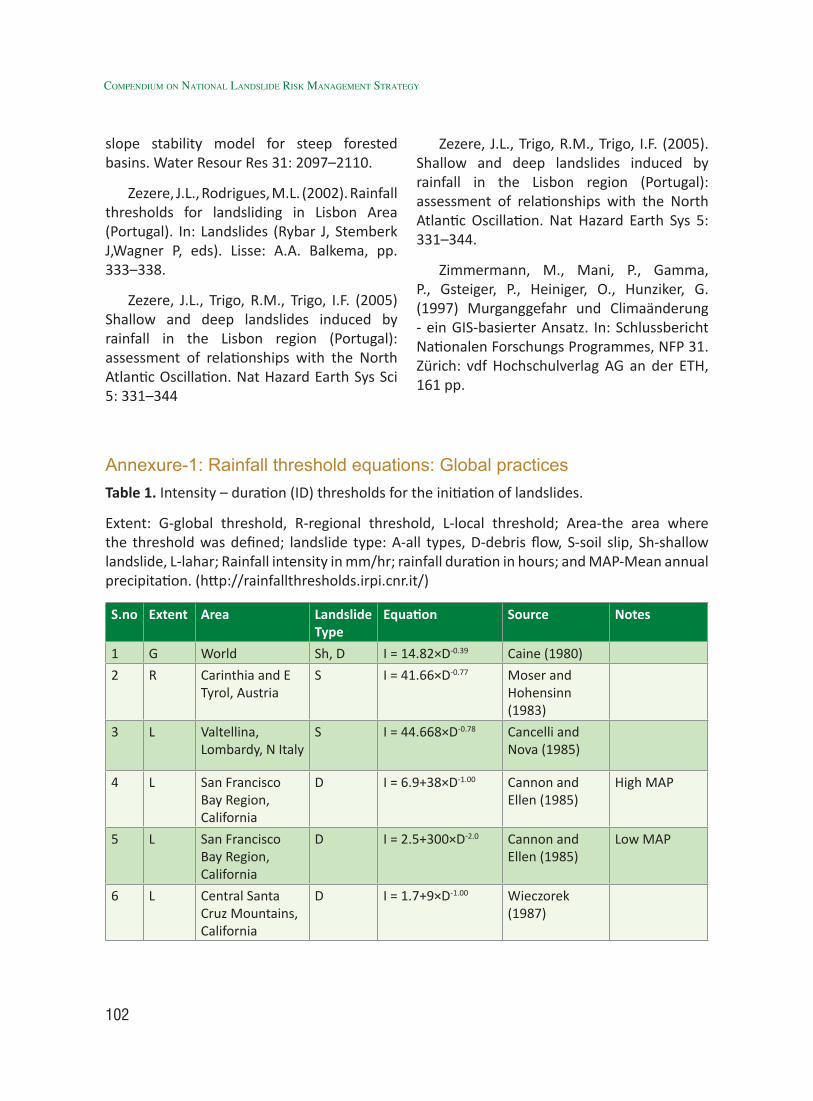
102
Compendium on national landslide Risk management stRategy
slope stability model for steep forested basins. Water Resour Res 31: 2097–2110.
Zezere, J.L., Rodrigues, M.L. (2002). Rainfall thresholds for landsliding in Lisbon Area (Portugal). In: Landslides (Rybar J, Stemberk J,Wagner P, eds). Lisse: A.A. Balkema, pp. 333–338.
Zezere, J.L., Trigo, R.M., Trigo, I.F. (2005) Shallow and deep landslides induced by rainfall in the Lisbon region (Portugal): assessment of relationships with the North Atlantic Oscillation. Nat Hazard Earth Sys Sci 5: 331–344
Zezere, J.L., Trigo, R.M., Trigo, I.F. (2005). Shallow and deep landslides induced by rainfall in the Lisbon region (Portugal): assessment of relationships with the North Atlantic Oscillation. Nat Hazard Earth Sys 5: 331–344.
Zimmermann, M., Mani, P., Gamma, P., Gsteiger, P., Heiniger, O., Hunziker, G. (1997) Murganggefahr und Climaänderung - ein GIS-basierter Ansatz. In: Schlussbericht Nationalen Forschungs Programmes, NFP 31. Zürich: vdf Hochschulverlag AG an der ETH, 161 pp.
Annexure-1: Rainfall threshold equations: Global practicesTable 1. Intensity – duration (ID) thresholds for the initiation of landslides.
Extent: G-global threshold, R-regional threshold, L-local threshold; Area-the area where the threshold was defined; landslide type: A-all types, D-debris flow, S-soil slip, Sh-shallow landslide, L-lahar; Rainfall intensity in mm/hr; rainfall duration in hours; and MAP-Mean annual precipitation. (http://rainfallthresholds.irpi.cnr.it/)
S.no Extent Area Landslide Type
Equation Source Notes
1 G World Sh, D I = 14.82×D-0.39 Caine (1980)
2 R Carinthia and E Tyrol, Austria
S I = 41.66×D-0.77 Moser and Hohensinn (1983)
3 L Valtellina, Lombardy, N Italy
S I = 44.668×D-0.78 Cancelli and Nova (1985)
4 L San Francisco Bay Region, California
D I = 6.9+38×D-1.00 Cannon and Ellen (1985)
High MAP
5 L San Francisco Bay Region, California
D I = 2.5+300×D-2.0 Cannon and Ellen (1985)
Low MAP
6 L Central Santa Cruz Mountains, California
D I = 1.7+9×D-1.00 Wieczorek (1987)
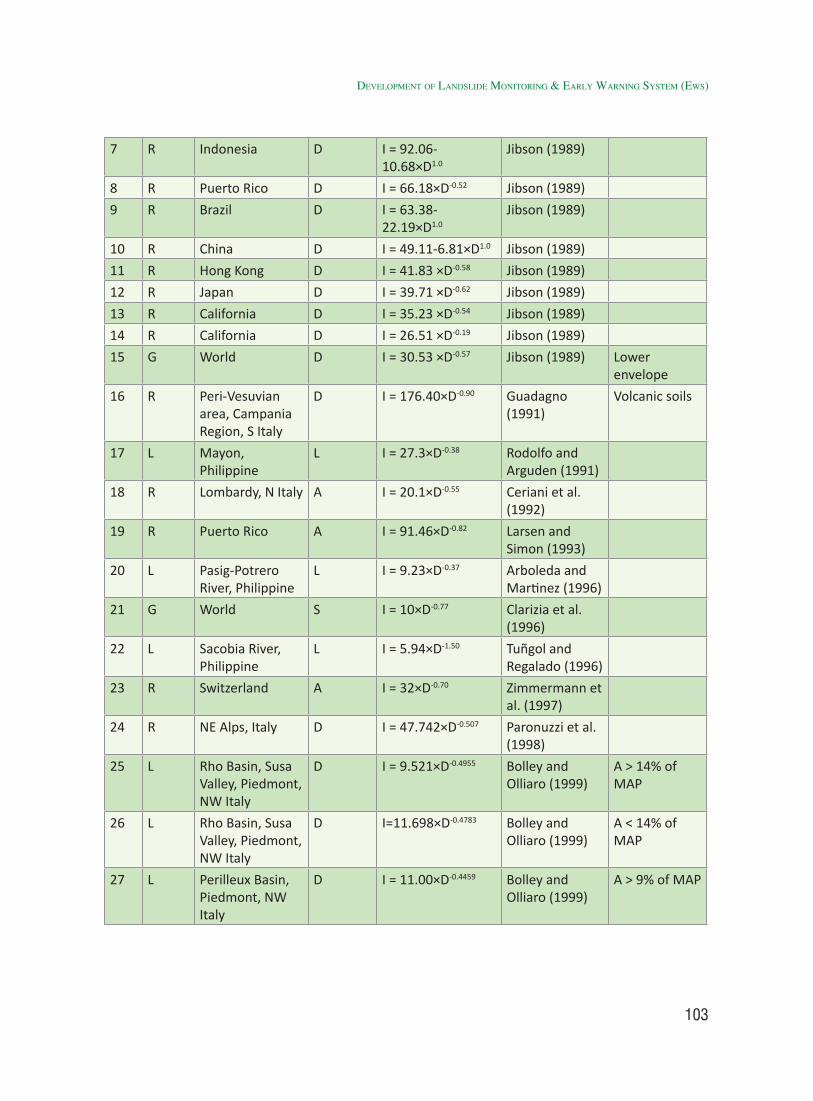
103
7 R Indonesia D I = 92.06-10.68×D1.0
Jibson (1989)
8 R Puerto Rico D I = 66.18×D-0.52 Jibson (1989)
9 R Brazil D I = 63.38-22.19×D1.0
Jibson (1989)
10 R China D I = 49.11-6.81×D1.0 Jibson (1989)
11 R Hong Kong D I = 41.83 ×D-0.58 Jibson (1989)
12 R Japan D I = 39.71 ×D-0.62 Jibson (1989)
13 R California D I = 35.23 ×D-0.54 Jibson (1989)
14 R California D I = 26.51 ×D-0.19 Jibson (1989)
15 G World D I = 30.53 ×D-0.57 Jibson (1989) Lower envelope
16 R Peri-Vesuvian area, Campania Region, S Italy
D I = 176.40×D-0.90 Guadagno (1991)
Volcanic soils
17 L Mayon, Philippine
L I = 27.3×D-0.38 Rodolfo and Arguden (1991)
18 R Lombardy, N Italy A I = 20.1×D-0.55 Ceriani et al. (1992)
19 R Puerto Rico A I = 91.46×D-0.82 Larsen and Simon (1993)
20 L Pasig-Potrero River, Philippine
L I = 9.23×D-0.37 Arboleda and Martinez (1996)
21 G World S I = 10×D-0.77 Clarizia et al. (1996)
22 L Sacobia River, Philippine
L I = 5.94×D-1.50 Tuñgol and Regalado (1996)
23 R Switzerland A I = 32×D-0.70 Zimmermann et al. (1997)
24 R NE Alps, Italy D I = 47.742×D-0.507 Paronuzzi et al. (1998)
25 L Rho Basin, Susa Valley, Piedmont, NW Italy
D I = 9.521×D-0.4955 Bolley and Olliaro (1999)
A > 14% of MAP
26 L Rho Basin, Susa Valley, Piedmont, NW Italy
D I=11.698×D-0.4783 Bolley and Olliaro (1999)
A < 14% of MAP
27 L Perilleux Basin, Piedmont, NW Italy
D I = 11.00×D-0.4459 Bolley and Olliaro (1999)
A > 9% of MAP
developMent of landslide MonitorinG & early WarninG systeM (eWs)
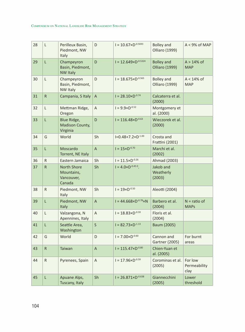
104
Compendium on national landslide Risk management stRategy
28 L Perilleux Basin, Piedmont, NW Italy
D I = 10.67×D-0.5043 Bolley and Olliaro (1999)
A < 9% of MAP
29 L Champeyron Basin, Piedmont, NW Italy
D I = 12.649×D-0.5324 Bolley and Olliaro (1999)
A > 14% of MAP
30 L Champeyron Basin, Piedmont, NW Italy
D I = 18.675×D-0.565 Bolley and Olliaro (1999)
A < 14% of MAP
31 R Campania, S Italy A I = 28.10×D-0.74 Calcaterra et al. (2000)
32 L Mettman Ridge, Oregon
A I = 9.9×D-0.52 Montgomery et al. (2000)
33 L Blue Ridge, Madison County, Virginia
D I = 116.48×D-0.63 Wieczorek et al. (2000)
34 G World Sh I=0.48+7.2×D-1.00 Crosta and Frattini (2001)
35 L Moscardo Torrent, NE Italy
A I = 15×D-0.70 Marchi et al. (2002)
36 R Eastern Jamaica Sh I = 11.5×D-0.26 Ahmad (2003)
37 R North Shore Mountains, Vancouver, Canada
Sh I = 4.0×D-0.45 0. Jakob and Weatherly (2003)
38 R Piedmont, NW Italy
Sh I = 19×D-0.50 Aleotti (2004)
39 L Piedmont, NW Italy
A I = 44.668×D-0.78×N Barbero et al. (2004)
N = ratio of MAPs
40 L Valzangona, N Apennines, Italy
A I = 18.83×D-0.59 Floris et al. (2004)
41 L Seattle Area, Washington
S I = 82.73×D-1.13 Baum (2005)
42 G World D I = 7.00×D-0.60 Cannon and Gartner (2005)
For burnt areas
43 R Taiwan A I = 115.47×D-0.80 Chien-Yuan et al. (2005)
44 R Pyrenees, Spain A I = 17.96×D-0.59 Corominas et al. (2005)
For low Permeability clay
45 L Apuane Alps, Tuscany, Italy
Sh I = 26.871×D-0.638 Giannecchini (2005)
Lower threshold
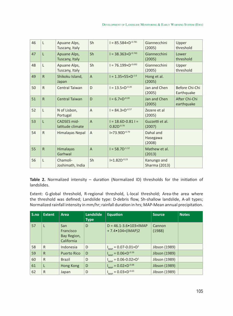
105
46 L Apuane Alps, Tuscany, Italy
Sh I = 85.584×D-0.781 Giannecchini (2005)
Upper threshold
47 L Apuane Alps, Tuscany, Italy
Sh I = 38.363×D-0.743 Giannecchini (2005)
Lower threshold
48 L Apuane Alps, Tuscany, Italy
Sh I = 76.199×D-0.692 Giannecchini (2005)
Upper threshold
49 R Shikoku Island, Japan
A I = 1.35+55×D-1.0 Hong et al. (2005)
50 R Central Taiwan D I = 13.5×D-0.20 Jan and Chen (2005)
Before Chi-Chi Earthquake
51 R Central Taiwan D I = 6.7×D-0.20 Jan and Chen (2005)
After Chi-Chi earthquake
52 L N of Lisbon, Portugal
A I = 84.3×D-0.57 Zezere et al (2005)
53 L CADSES mid-latitude climate
A I = 18.6D-0.81 I = 0.82D-0.79
Guzzetti et al. (2007)
54 R Himalayas Nepal A I=73.90D-0.79 Dahal and Hasegawa (2008)
55 R Himalayas Garhwal
A I = 58.7D-1.12 Mathew et al. (2013)
56 L Chamoli- Joshimath, India
Sh I=1.82D-0.23 Kanungo and Sharma (2013)
Table 2. Normalized intensity – duration (Normalized ID) thresholds for the initiation of landslides.
Extent: G-global threshold, R-regional threshold, L-local threshold; Area-the area where the threshold was defined; Landslide type: D-debris flow, Sh-shallow landslide, A-all types; Normalized rainfall intensity in mm/hr; rainfall duration in hrs; MAP-Mean annual precipitation.
S.no Extent Area Landslide Type
Equation Source Notes
57 L San Francisco Bay Region, California
D D = 46.1-3.6•103×IMAP + 7.4•104×(IMAP)2
Cannon (1988)
58 R Indonesia D IMAP = 0.07-0.01×D1 Jibson (1989)
59 R Puerto Rico D IMAP = 0.06×D-0.59 Jibson (1989)
60 R Brazil D IMAP = 0.06-0.02×D1 Jibson (1989)
61 L Hong Kong D IMAP = 0.02×D-0.68 Jibson (1989)
62 R Japan D IMAP = 0.03×D-0.63 Jibson (1989)
developMent of landslide MonitorinG & early WarninG systeM (eWs)
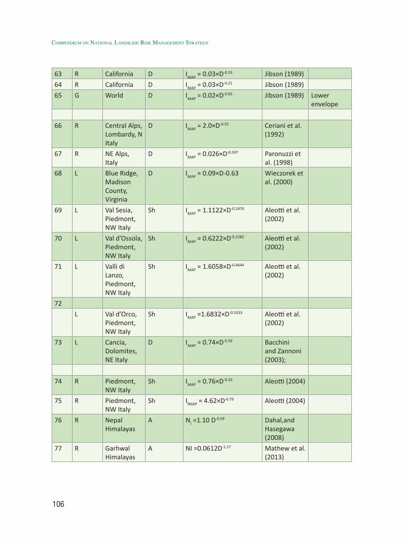
106
Compendium on national landslide Risk management stRategy
63 R California D IMAP = 0.03×D-0.33 Jibson (1989)
64 R California D IMAP = 0.03×D-0.21 Jibson (1989)
65 G World D IMAP = 0.02×D-0.65 Jibson (1989) Lower envelope
66 R Central Alps, Lombardy, N Italy
D IMAP = 2.0×D-0.55 Ceriani et al. (1992)
67 R NE Alps, Italy
D IMAP = 0.026×D-0.507 Paronuzzi et al. (1998)
68 L Blue Ridge, Madison County, Virginia
D IMAP = 0.09×D-0.63 Wieczorek et al. (2000)
69 L Val Sesia, Piedmont, NW Italy
Sh IMAP = 1.1122×D-0.2476 Aleotti et al. (2002)
70 L Val d’Ossola, Piedmont, NW Italy
Sh IMAP = 0.6222×D-0.2282 Aleotti et al. (2002)
71 L Valli di Lanzo, Piedmont, NW Italy
Sh IMAP = 1.6058×D-0.4644 Aleotti et al. (2002)
72
L Val d’Orco, Piedmont, NW Italy
Sh IMAP =1.6832×D-0.5533 Aleotti et al. (2002)
73 L Cancia, Dolomites, NE Italy
D IMAP = 0.74×D-0.56 Bacchini and Zannoni (2003);
74 R Piedmont, NW Italy
Sh IMAP = 0.76×D-0.33 Aleotti (2004)
75 R Piedmont, NW Italy
Sh IfMAP = 4.62×D-0.79 Aleotti (2004)
76 R Nepal Himalayas
A NI =1.10 D-0.59 Dahal,and Hasegawa (2008)
77 R Garhwal Himalayas
A NI =0.0612D-1.17 Mathew et al. (2013)
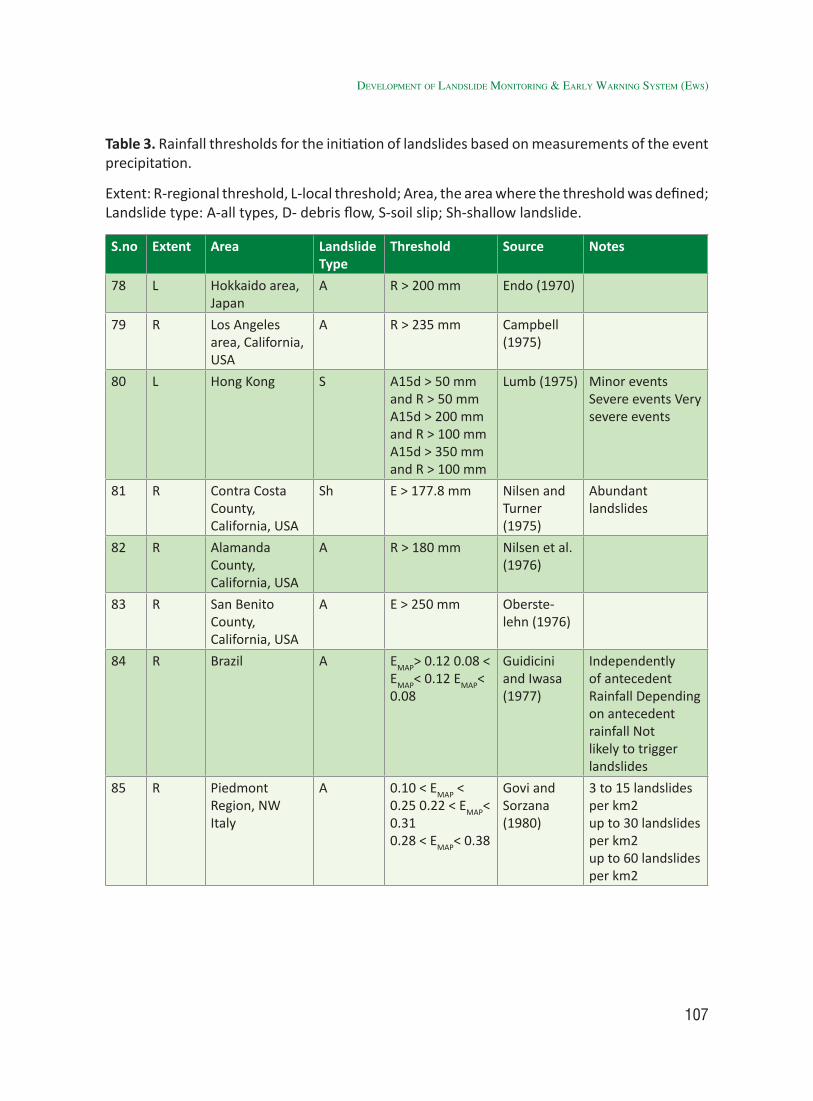
107
Table 3. Rainfall thresholds for the initiation of landslides based on measurements of the event precipitation.
Extent: R-regional threshold, L-local threshold; Area, the area where the threshold was defined; Landslide type: A-all types, D- debris flow, S-soil slip; Sh-shallow landslide.
S.no Extent Area Landslide Type
Threshold Source Notes
78 L Hokkaido area, Japan
A R > 200 mm Endo (1970)
79 R Los Angeles area, California, USA
A R > 235 mm Campbell (1975)
80 L Hong Kong S A15d > 50 mm and R > 50 mm A15d > 200 mm and R > 100 mm A15d > 350 mm and R > 100 mm
Lumb (1975) Minor events Severe events Very severe events
81 R Contra Costa County, California, USA
Sh E > 177.8 mm Nilsen and Turner (1975)
Abundant landslides
82 R Alamanda County, California, USA
A R > 180 mm Nilsen et al. (1976)
83 R San Benito County, California, USA
A E > 250 mm Oberste-lehn (1976)
84 R Brazil A EMAP> 0.12 0.08 <
EMAP< 0.12 EMAP< 0.08
Guidicini and Iwasa (1977)
Independently of antecedent Rainfall Depending on antecedent rainfall Not likely to trigger landslides
85 R Piedmont Region, NW Italy
A 0.10 < EMAP < 0.25 0.22 < EMAP< 0.310.28 < EMAP< 0.38
Govi and Sorzana (1980)
3 to 15 landslides per km2up to 30 landslides per km2up to 60 landslides per km2
developMent of landslide MonitorinG & early WarninG systeM (eWs)
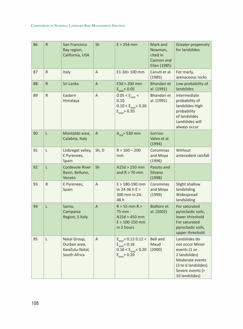
108
Compendium on national landslide Risk management stRategy
86 R San Francisco Bay region, California, USA
Sh E > 254 mm Mark and Newman, cited in Cannon and Ellen (1985)
Greater propensity for landslides
87 R Italy A E1-3d> 100 mm Canuti et al. (1985)
For marly, arenaceous rocks
88 R Sri Lanka A E3d > 200 mm EMAP< 0.05
Bhandari et al. (1991)
Low probability of landslides
89 R Eastern Himalaya
A 0.05 < EMAP < 0.100.10 < EMAP< 0.20EMAP> 0.20
Bhandari et al. (1991)
Intermediate probability of landslides High probability of landslides Landslides will always occur
90 L Montaldo area, Calabria, Italy
A A50d> 530 mm Sorriso- Valvo et al. (1994)
91 L Llobregat valley, E Pyrenees, Spain
Sh, D R > 160 – 200 mm
Corominas and Moya (1996)
Without antecedent rainfall
92 L Cordevole River Basin, Belluno, Veneto
Sh A15d > 250 mm and R > 70 mm
Pasuto and Silvano (1998)
93 R E Pyrenees, Spain
A E > 180-190 mm in 24-36 h E > 300 mm in 24-48 h
Corominas and Moya (1999)
Slight shallow landsliding Widespread landsliding
94 L Sarno, Campania Region, S Italy
A R > 55 mm R > 75 mmA15d > 450 mmE > 100-150 mm in 2 hours
Biafiore et al. (2002)
For saturated pyroclastic soils, lower threshold For saturated pyroclastic soils, upper threshold
95 L Natal Group, Durban area, KwaZulu-Natal, South Africa
A EMAP< 0.12 0.12 <
EMAP< 0.160.16 < EMAP< 0.20 EMAP> 0.20
Bell and Maud (2000)
Landslides do not occur Minor events (1 or 2 landslides) Moderate events (3 to 6 landslides) Severe events (> 10 landslides)
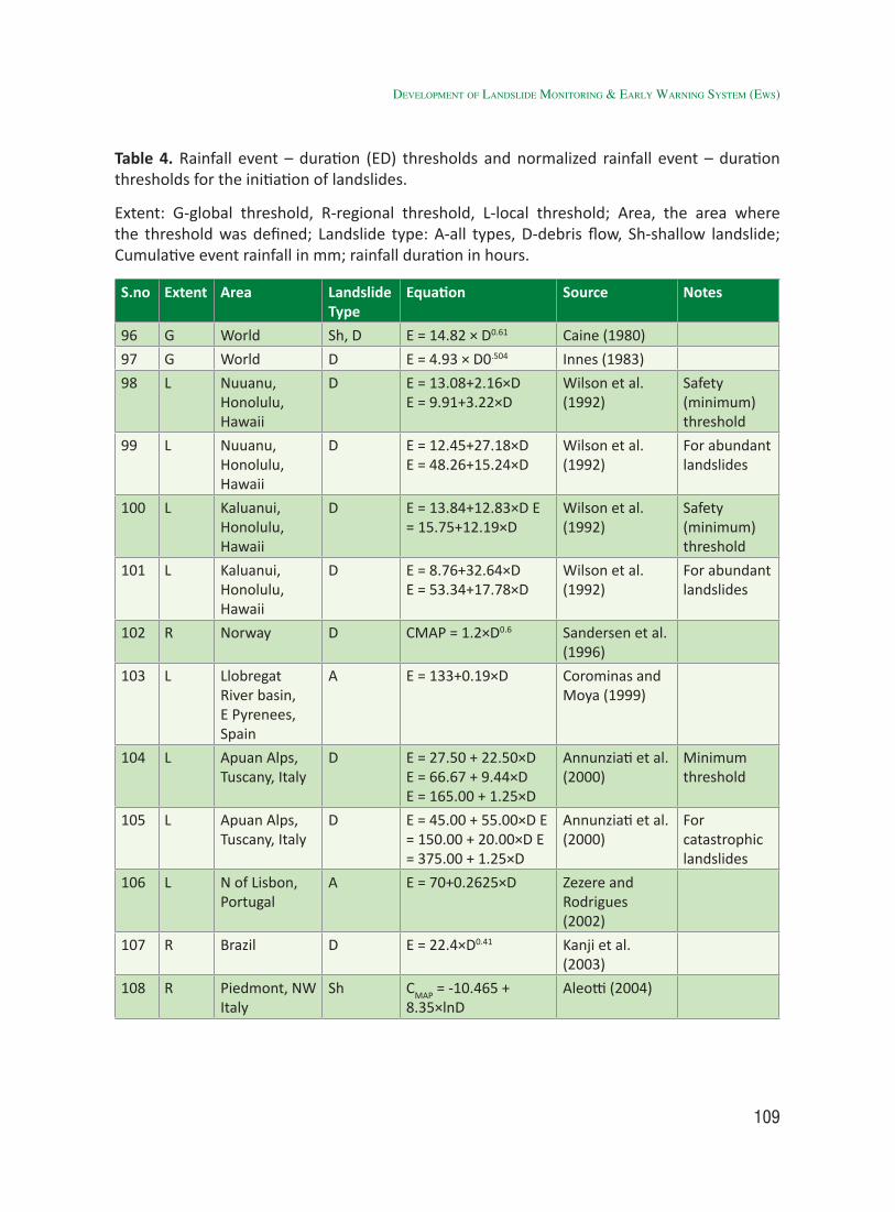
109
Table 4. Rainfall event – duration (ED) thresholds and normalized rainfall event – duration thresholds for the initiation of landslides.
Extent: G-global threshold, R-regional threshold, L-local threshold; Area, the area where the threshold was defined; Landslide type: A-all types, D-debris flow, Sh-shallow landslide; Cumulative event rainfall in mm; rainfall duration in hours.
S.no Extent Area Landslide Type
Equation Source Notes
96 G World Sh, D E = 14.82 × D0.61 Caine (1980)
97 G World D E = 4.93 × D0.504 Innes (1983)
98 L Nuuanu, Honolulu, Hawaii
D E = 13.08+2.16×DE = 9.91+3.22×D
Wilson et al. (1992)
Safety (minimum) threshold
99 L Nuuanu, Honolulu, Hawaii
D E = 12.45+27.18×DE = 48.26+15.24×D
Wilson et al. (1992)
For abundant landslides
100 L Kaluanui, Honolulu, Hawaii
D E = 13.84+12.83×D E = 15.75+12.19×D
Wilson et al. (1992)
Safety (minimum) threshold
101 L Kaluanui, Honolulu, Hawaii
D E = 8.76+32.64×DE = 53.34+17.78×D
Wilson et al. (1992)
For abundant landslides
102 R Norway D CMAP = 1.2×D0.6 Sandersen et al. (1996)
103 L Llobregat River basin, E Pyrenees, Spain
A E = 133+0.19×D Corominas and Moya (1999)
104 L Apuan Alps, Tuscany, Italy
D E = 27.50 + 22.50×DE = 66.67 + 9.44×DE = 165.00 + 1.25×D
Annunziati et al. (2000)
Minimum threshold
105 L Apuan Alps, Tuscany, Italy
D E = 45.00 + 55.00×D E = 150.00 + 20.00×D E = 375.00 + 1.25×D
Annunziati et al. (2000)
For catastrophic landslides
106 L N of Lisbon, Portugal
A E = 70+0.2625×D Zezere and Rodrigues (2002)
107 R Brazil D E = 22.4×D0.41 Kanji et al. (2003)
108 R Piedmont, NW Italy
Sh CMAP = -10.465 + 8.35×lnD
Aleotti (2004)
developMent of landslide MonitorinG & early WarninG systeM (eWs)
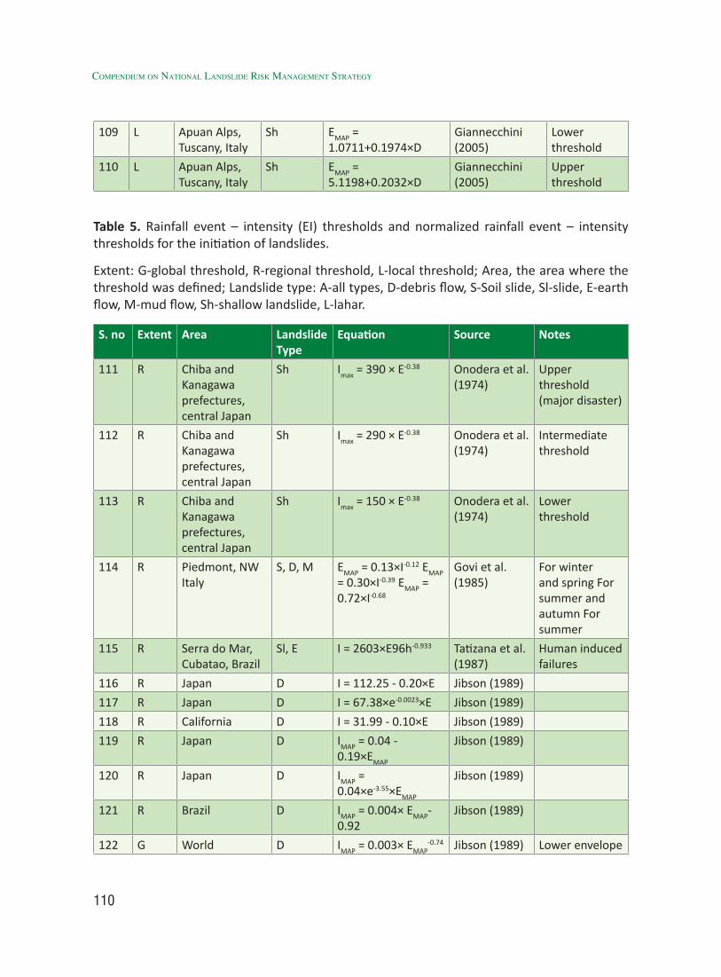
110
Compendium on national landslide Risk management stRategy
109 L Apuan Alps, Tuscany, Italy
Sh EMAP = 1.0711+0.1974×D
Giannecchini (2005)
Lower threshold
110 L Apuan Alps, Tuscany, Italy
Sh EMAP = 5.1198+0.2032×D
Giannecchini (2005)
Upper threshold
Table 5. Rainfall event – intensity (EI) thresholds and normalized rainfall event – intensity thresholds for the initiation of landslides.
Extent: G-global threshold, R-regional threshold, L-local threshold; Area, the area where the threshold was defined; Landslide type: A-all types, D-debris flow, S-Soil slide, Sl-slide, E-earth flow, M-mud flow, Sh-shallow landslide, L-lahar.
S. no Extent Area Landslide Type
Equation Source Notes
111 R Chiba and Kanagawa prefectures, central Japan
Sh Imax = 390 × E-0.38 Onodera et al. (1974)
Upper threshold (major disaster)
112 R Chiba and Kanagawa prefectures, central Japan
Sh Imax = 290 × E-0.38 Onodera et al. (1974)
Intermediate threshold
113 R Chiba and Kanagawa prefectures, central Japan
Sh Imax = 150 × E-0.38 Onodera et al. (1974)
Lower threshold
114 R Piedmont, NW Italy
S, D, M EMAP = 0.13×I-0.12 EMAP = 0.30×I-0.39 EMAP = 0.72×I-0.68
Govi et al. (1985)
For winter and spring For summer and autumn For summer
115 R Serra do Mar, Cubatao, Brazil
Sl, E I = 2603×E96h-0.933 Tatizana et al. (1987)
Human induced failures
116 R Japan D I = 112.25 - 0.20×E Jibson (1989)
117 R Japan D I = 67.38×e-0.0023×E Jibson (1989)
118 R California D I = 31.99 - 0.10×E Jibson (1989)
119 R Japan D IMAP = 0.04 - 0.19×EMAP
Jibson (1989)
120 R Japan D IMAP = 0.04×e-3.55×EMAP
Jibson (1989)
121 R Brazil D IMAP = 0.004× EMAP-0.92
Jibson (1989)
122 G World D IMAP = 0.003× EMAP-0.74 Jibson (1989) Lower envelope
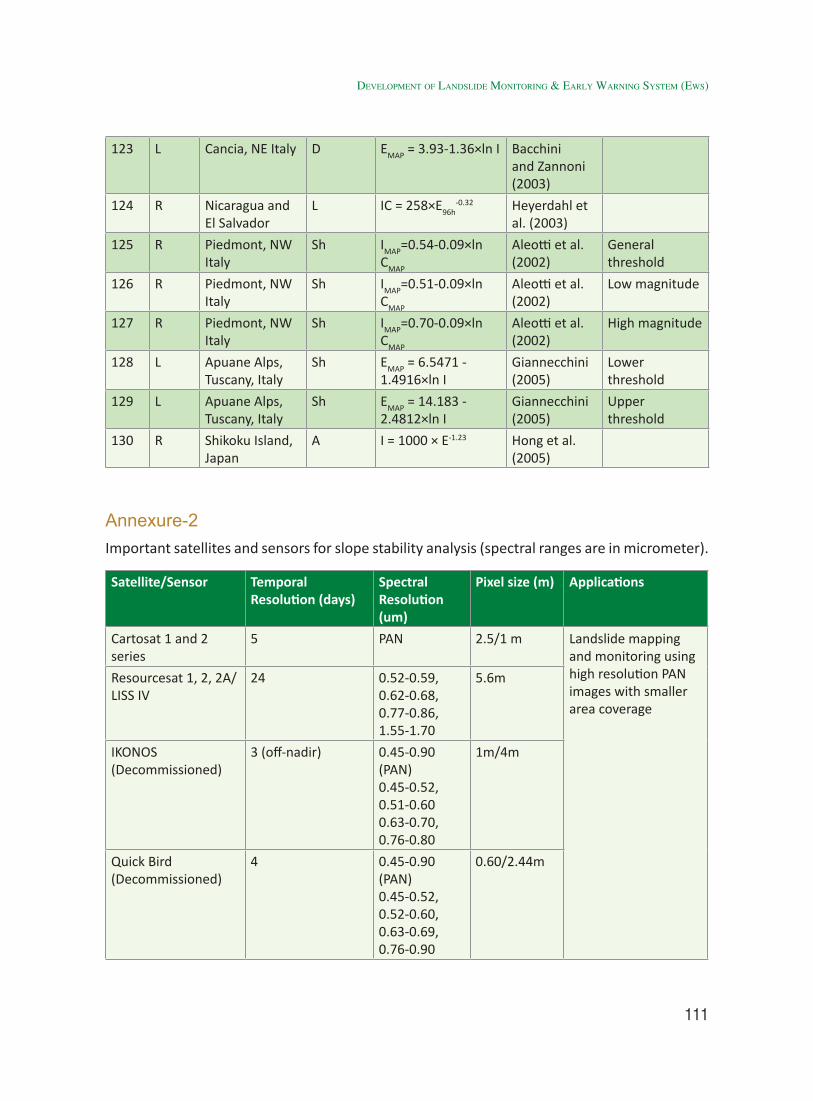
111
123 L Cancia, NE Italy D EMAP = 3.93-1.36×ln I Bacchini and Zannoni (2003)
124 R Nicaragua and El Salvador
L IC = 258×E96h-0.32 Heyerdahl et
al. (2003)
125 R Piedmont, NW Italy
Sh IMAP=0.54-0.09×ln CMAP
Aleotti et al. (2002)
General threshold
126 R Piedmont, NW Italy
Sh IMAP=0.51-0.09×ln CMAP
Aleotti et al. (2002)
Low magnitude
127 R Piedmont, NW Italy
Sh IMAP=0.70-0.09×ln CMAP
Aleotti et al. (2002)
High magnitude
128 L Apuane Alps, Tuscany, Italy
Sh EMAP = 6.5471 - 1.4916×ln I
Giannecchini (2005)
Lower threshold
129 L Apuane Alps, Tuscany, Italy
Sh EMAP = 14.183 - 2.4812×ln I
Giannecchini (2005)
Upper threshold
130 R Shikoku Island, Japan
A I = 1000 × E-1.23 Hong et al. (2005)
Annexure-2Important satellites and sensors for slope stability analysis (spectral ranges are in micrometer).
Satellite/Sensor Temporal Resolution (days)
Spectral Resolution (um)
Pixel size (m) Applications
Cartosat 1 and 2 series
5 PAN 2.5/1 m Landslide mapping and monitoring using high resolution PAN images with smaller area coverage
Resourcesat 1, 2, 2A/ LISS IV
24 0.52-0.59, 0.62-0.68, 0.77-0.86, 1.55-1.70
5.6m
IKONOS (Decommissioned)
3 (off-nadir) 0.45-0.90 (PAN)0.45-0.52, 0.51-0.60 0.63-0.70, 0.76-0.80
1m/4m
Quick Bird (Decommissioned)
4 0.45-0.90 (PAN)0.45-0.52, 0.52-0.60, 0.63-0.69, 0.76-0.90
0.60/2.44m
developMent of landslide MonitorinG & early WarninG systeM (eWs)
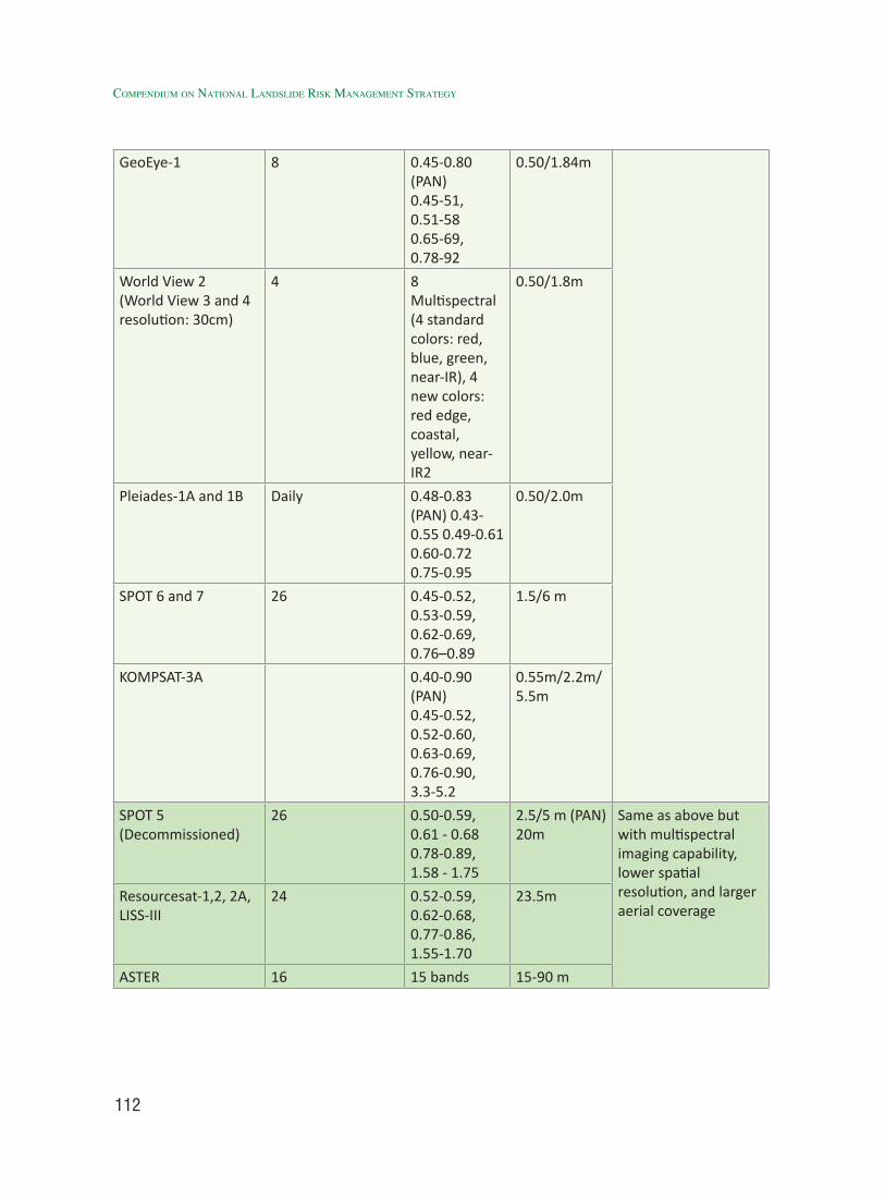
112
Compendium on national landslide Risk management stRategy
GeoEye-1 8 0.45-0.80 (PAN)0.45-51,0.51-580.65-69,0.78-92
0.50/1.84m
World View 2 (World View 3 and 4 resolution: 30cm)
4 8 Multispectral (4 standard colors: red, blue, green, near-IR), 4 new colors: red edge, coastal, yellow, near-IR2
0.50/1.8m
Pleiades-1A and 1B Daily 0.48-0.83 (PAN) 0.43-0.55 0.49-0.61 0.60-0.72 0.75-0.95
0.50/2.0m
SPOT 6 and 7 26 0.45-0.52, 0.53-0.59, 0.62-0.69, 0.76–0.89
1.5/6 m
KOMPSAT-3A 0.40-0.90 (PAN) 0.45-0.52, 0.52-0.60, 0.63-0.69, 0.76-0.90, 3.3-5.2
0.55m/2.2m/ 5.5m
SPOT 5(Decommissioned)
26 0.50-0.59, 0.61 - 0.68 0.78-0.89, 1.58 - 1.75
2.5/5 m (PAN) 20m
Same as above but with multispectral imaging capability, lower spatial resolution, and larger aerial coverage
Resourcesat-1,2, 2A, LISS-III
24 0.52-0.59, 0.62-0.68, 0.77-0.86, 1.55-1.70
23.5m
ASTER 16 15 bands 15-90 m
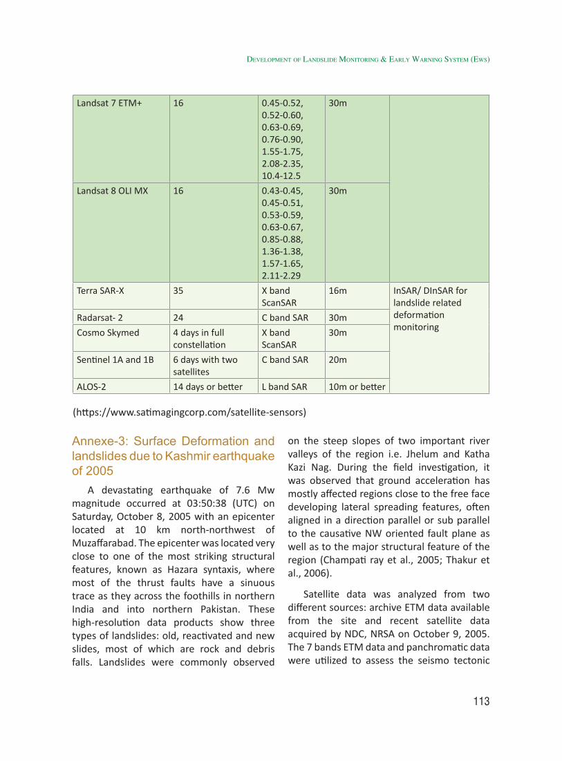
113
Landsat 7 ETM+ 16 0.45-0.52, 0.52-0.60, 0.63-0.69, 0.76-0.90, 1.55-1.75, 2.08-2.35, 10.4-12.5
30m
Landsat 8 OLI MX 16 0.43-0.45, 0.45-0.51, 0.53-0.59, 0.63-0.67, 0.85-0.88, 1.36-1.38, 1.57-1.65, 2.11-2.29
30m
Terra SAR-X 35 X band ScanSAR
16m InSAR/ DInSAR for landslide related deformation monitoring
Radarsat- 2 24 C band SAR 30m
Cosmo Skymed 4 days in full constellation
X band ScanSAR
30m
Sentinel 1A and 1B 6 days with two satellites
C band SAR 20m
ALOS-2 14 days or better L band SAR 10m or better
(https://www.satimagingcorp.com/satellite-sensors)
Annexe-3: Surface Deformation and landslides due to Kashmir earthquake of 2005
A devastating earthquake of 7.6 Mw magnitude occurred at 03:50:38 (UTC) on Saturday, October 8, 2005 with an epicenter located at 10 km north-northwest of Muzaffarabad. The epicenter was located very close to one of the most striking structural features, known as Hazara syntaxis, where most of the thrust faults have a sinuous trace as they across the foothills in northern India and into northern Pakistan. These high-resolution data products show three types of landslides: old, reactivated and new slides, most of which are rock and debris falls. Landslides were commonly observed
on the steep slopes of two important river valleys of the region i.e. Jhelum and Katha Kazi Nag. During the field investigation, it was observed that ground acceleration has mostly affected regions close to the free face developing lateral spreading features, often aligned in a direction parallel or sub parallel to the causative NW oriented fault plane as well as to the major structural feature of the region (Champati ray et al., 2005; Thakur et al., 2006).
Satellite data was analyzed from two different sources: archive ETM data available from the site and recent satellite data acquired by NDC, NRSA on October 9, 2005. The 7 bands ETM data and panchromatic data were utilized to assess the seismo tectonic
developMent of landslide MonitorinG & early WarninG systeM (eWs)
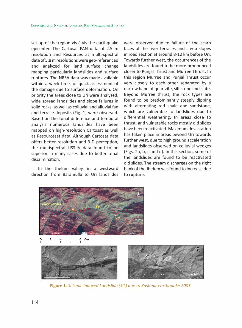
114
Compendium on national landslide Risk management stRategy
set up of the region vis-à-vis the earthquake epicenter. The Cartosat PAN data of 2.5 m resolution and Resources at multi-spectral data of 5.8 m resolutions were geo-referenced and analyzed for land surface change mapping particularly landslides and surface ruptures. The NRSA data was made available within a week time for quick assessment of the damage due to surface deformation. On priority the areas close to Uri were analyzed, wide spread landslides and slope failures in solid rocks, as well as colluvial and alluvial fan and terrace deposits (Fig. 1) were observed. Based on the tonal difference and temporal analysis numerous landslides have been mapped on high-resolution Cartosat as well as Resourcesat data. Although Cartosat data offers better resolution and 3-D perception, the multispectral LISS-IV data found to be superior in many cases due to better tonal discrimination.
In the Jhelum valley, in a westward direction from Baramulla to Uri landslides
were observed due to failure of the scarp faces of the river terraces and steep slopes in road section at around 8-10 km before Uri. Towards further west, the occurrences of the landslides are found to be more pronounced closer to Punjal Thrust and Murree Thrust. In this region Murree and Punjal Thrust occur very closely to each other separated by a narrow band of quartzite, silt stone and slate. Beyond Murree thrust, the rock types are found to be predominantly steeply dipping with alternating red shale and sandstone, which are vulnerable to landslides due to differential weathering. In areas close to thrust, and vulnerable rocks mostly old slides have been reactivated. Maximum devastation has taken place in areas beyond Uri towards further west, due to high ground acceleration and landslides observed on colluvial wedges (Figs. 2a, b, c and d). In this section, some of the landslides are found to be reactivated old slides. The stream discharges on the right bank of the Jhelum was found to increase due to rupture.
Figure 1. Seismic Induced Landslide (SIL) due to Kashmir earthquake 2005.
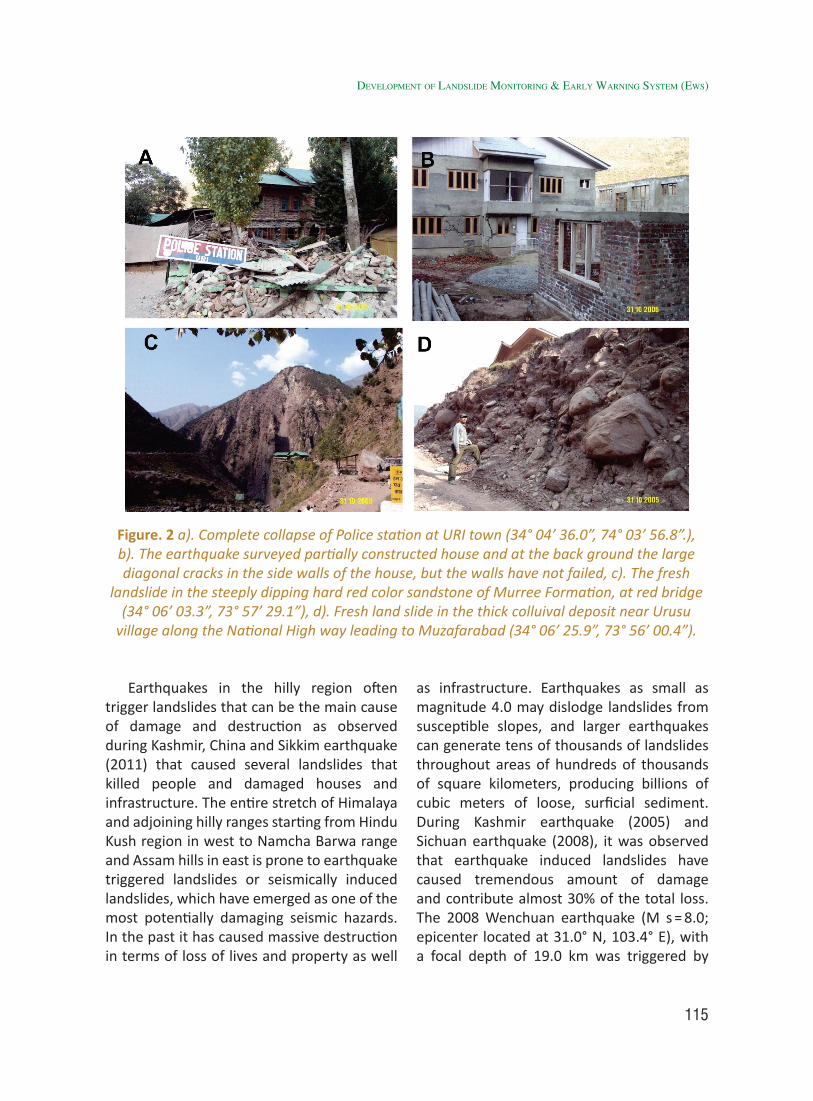
115
Earthquakes in the hilly region often trigger landslides that can be the main cause of damage and destruction as observed during Kashmir, China and Sikkim earthquake (2011) that caused several landslides that killed people and damaged houses and infrastructure. The entire stretch of Himalaya and adjoining hilly ranges starting from Hindu Kush region in west to Namcha Barwa range and Assam hills in east is prone to earthquake triggered landslides or seismically induced landslides, which have emerged as one of the most potentially damaging seismic hazards. In the past it has caused massive destruction in terms of loss of lives and property as well
as infrastructure. Earthquakes as small as magnitude 4.0 may dislodge landslides from susceptible slopes, and larger earthquakes can generate tens of thousands of landslides throughout areas of hundreds of thousands of square kilometers, producing billions of cubic meters of loose, surficial sediment. During Kashmir earthquake (2005) and Sichuan earthquake (2008), it was observed that earthquake induced landslides have caused tremendous amount of damage and contribute almost 30% of the total loss. The 2008 Wenchuan earthquake (M s = 8.0; epicenter located at 31.0° N, 103.4° E), with a focal depth of 19.0 km was triggered by
Figure. 2 a). Complete collapse of Police station at URI town (34° 04’ 36.0”, 74° 03’ 56.8”.), b). The earthquake surveyed partially constructed house and at the back ground the large diagonal cracks in the side walls of the house, but the walls have not failed, c). The fresh
landslide in the steeply dipping hard red color sandstone of Murree Formation, at red bridge (34° 06’ 03.3”, 73° 57’ 29.1”), d). Fresh land slide in the thick colluival deposit near Urusu
village along the National High way leading to Muzafarabad (34° 06’ 25.9”, 73° 56’ 00.4”).
developMent of landslide MonitorinG & early WarninG systeM (eWs)
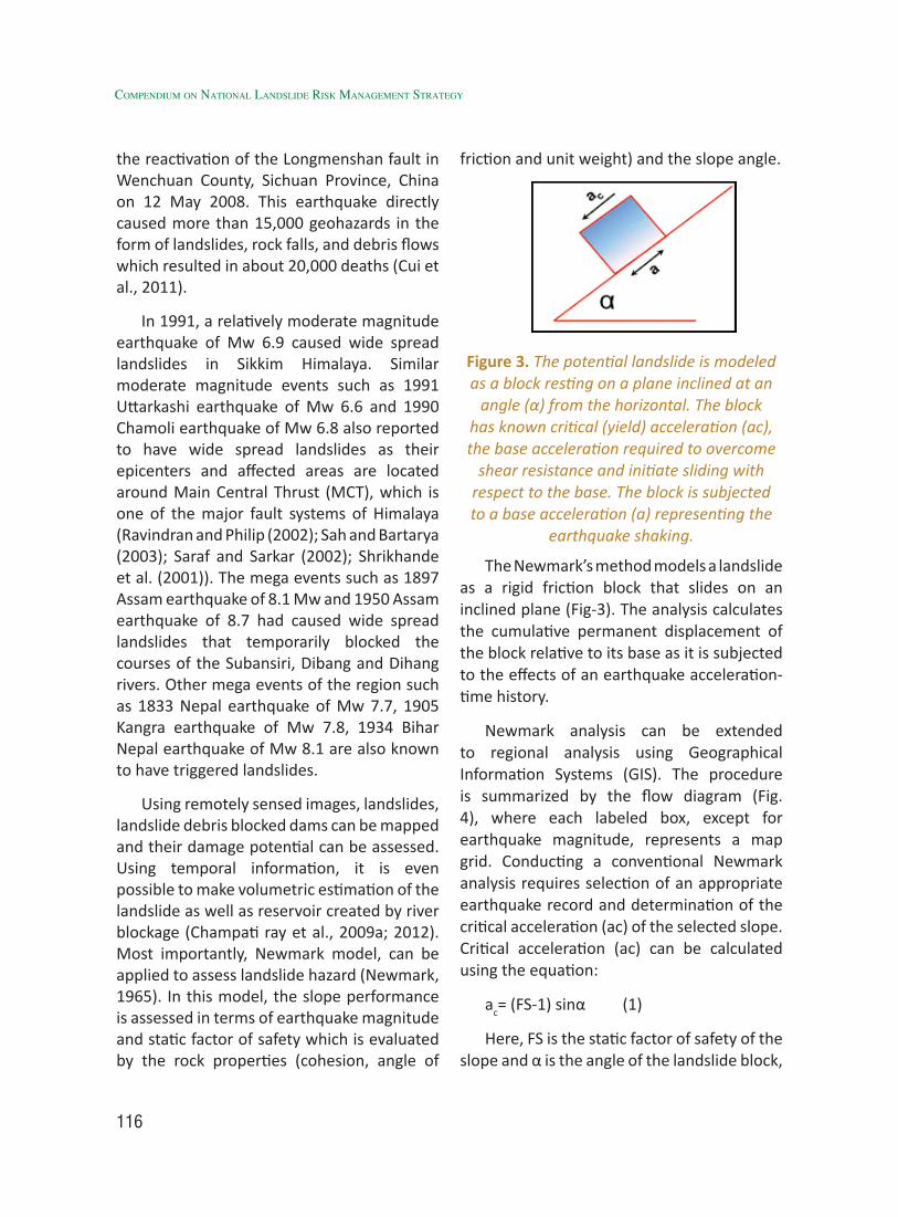
116
Compendium on national landslide Risk management stRategy
the reactivation of the Longmenshan fault in Wenchuan County, Sichuan Province, China on 12 May 2008. This earthquake directly caused more than 15,000 geohazards in the form of landslides, rock falls, and debris flows which resulted in about 20,000 deaths (Cui et al., 2011).
In 1991, a relatively moderate magnitude earthquake of Mw 6.9 caused wide spread landslides in Sikkim Himalaya. Similar moderate magnitude events such as 1991 Uttarkashi earthquake of Mw 6.6 and 1990 Chamoli earthquake of Mw 6.8 also reported to have wide spread landslides as their epicenters and affected areas are located around Main Central Thrust (MCT), which is one of the major fault systems of Himalaya (Ravindran and Philip (2002); Sah and Bartarya (2003); Saraf and Sarkar (2002); Shrikhande et al. (2001)). The mega events such as 1897 Assam earthquake of 8.1 Mw and 1950 Assam earthquake of 8.7 had caused wide spread landslides that temporarily blocked the courses of the Subansiri, Dibang and Dihang rivers. Other mega events of the region such as 1833 Nepal earthquake of Mw 7.7, 1905 Kangra earthquake of Mw 7.8, 1934 Bihar Nepal earthquake of Mw 8.1 are also known to have triggered landslides.
Using remotely sensed images, landslides, landslide debris blocked dams can be mapped and their damage potential can be assessed. Using temporal information, it is even possible to make volumetric estimation of the landslide as well as reservoir created by river blockage (Champati ray et al., 2009a; 2012). Most importantly, Newmark model, can be applied to assess landslide hazard (Newmark, 1965). In this model, the slope performance is assessed in terms of earthquake magnitude and static factor of safety which is evaluated by the rock properties (cohesion, angle of
friction and unit weight) and the slope angle.
Figure 3. The potential landslide is modeled as a block resting on a plane inclined at an
angle (α) from the horizontal. The block has known critical (yield) acceleration (ac), the base acceleration required to overcome
shear resistance and initiate sliding with respect to the base. The block is subjected to a base acceleration (a) representing the
earthquake shaking.
The Newmark’s method models a landslide as a rigid friction block that slides on an inclined plane (Fig-3). The analysis calculates the cumulative permanent displacement of the block relative to its base as it is subjected to the effects of an earthquake acceleration-time history.
Newmark analysis can be extended to regional analysis using Geographical Information Systems (GIS). The procedure is summarized by the flow diagram (Fig. 4), where each labeled box, except for earthquake magnitude, represents a map grid. Conducting a conventional Newmark analysis requires selection of an appropriate earthquake record and determination of the critical acceleration (ac) of the selected slope. Critical acceleration (ac) can be calculated using the equation:
ac= (FS-1) sinα (1)
Here, FS is the static factor of safety of the slope and α is the angle of the landslide block,
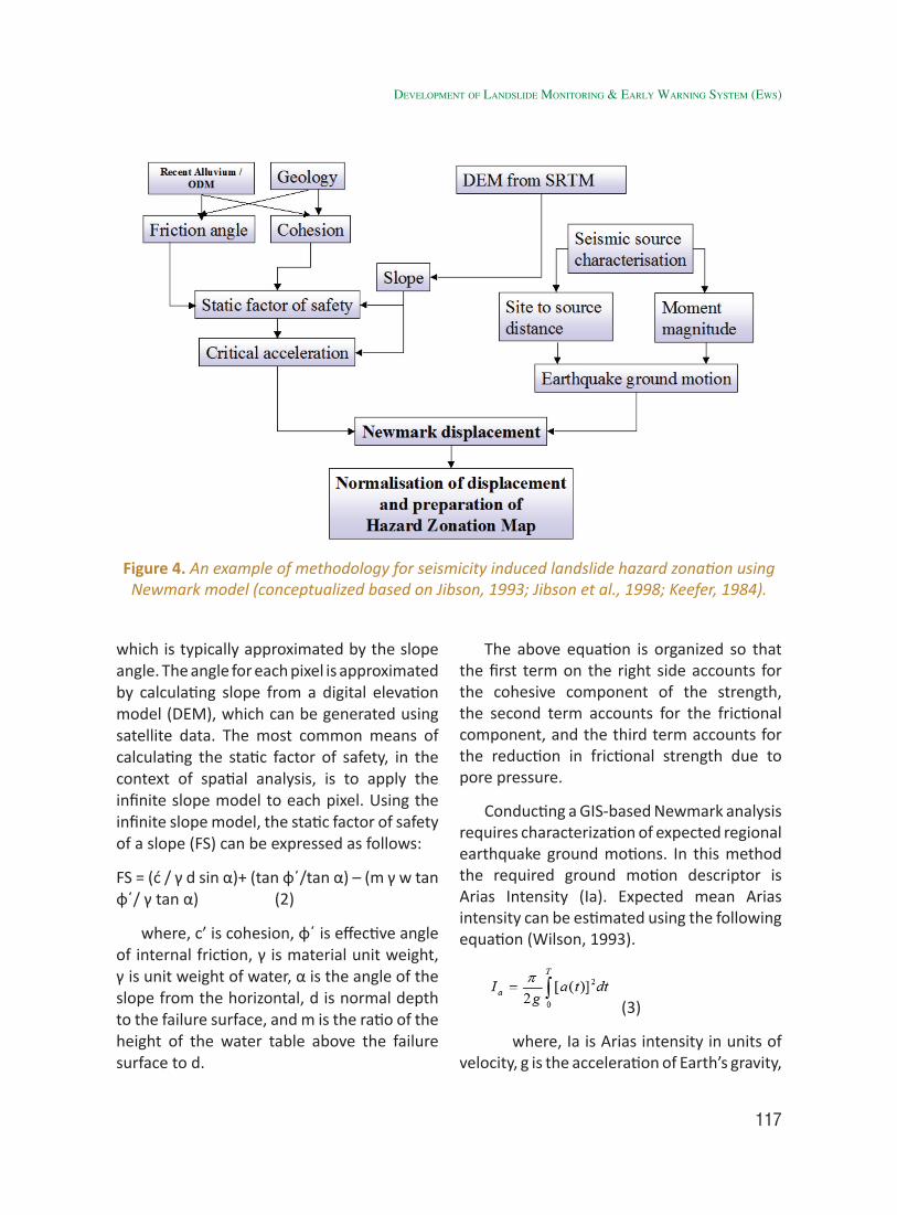
117
which is typically approximated by the slope angle. The angle for each pixel is approximated by calculating slope from a digital elevation model (DEM), which can be generated using satellite data. The most common means of calculating the static factor of safety, in the context of spatial analysis, is to apply the infinite slope model to each pixel. Using the infinite slope model, the static factor of safety of a slope (FS) can be expressed as follows:
FS = (ć / γ d sin α)+ (tan φ΄/tan α) – (m γ w tan φ΄/ γ tan α) (2)
where, c’ is cohesion, φ΄ is effective angle of internal friction, γ is material unit weight, γ is unit weight of water, α is the angle of the slope from the horizontal, d is normal depth to the failure surface, and m is the ratio of the height of the water table above the failure surface to d.
The above equation is organized so that the first term on the right side accounts for the cohesive component of the strength, the second term accounts for the frictional component, and the third term accounts for the reduction in frictional strength due to pore pressure.
Conducting a GIS-based Newmark analysis requires characterization of expected regional earthquake ground motions. In this method the required ground motion descriptor is Arias Intensity (Ia). Expected mean Arias intensity can be estimated using the following equation (Wilson, 1993).
(3)
where, Ia is Arias intensity in units of velocity, g is the acceleration of Earth’s gravity,
Figure 4. An example of methodology for seismicity induced landslide hazard zonation using Newmark model (conceptualized based on Jibson, 1993; Jibson et al., 1998; Keefer, 1984).
developMent of landslide MonitorinG & early WarninG systeM (eWs)
118
Compendium on national landslide Risk management stRategy
a(t) is the ground acceleration as a function of time, and t is the total duration of the strong motion.It can also be calculated from the moment magnitude as per the following attenuation law (Wilson and Keefer, 1985) :
where, Ia is Arias intensity, Mw is moment magnitude, R is closest distance to surface projection of fault rupture, and h is the focal depth of earthquake.
Newmark displacement, an index of seismic slope performance, can be estimated
as a function of critical acceleration (dynamic slope stability) and Arias intensity (ground-shaking intensity). In the final step, Newmark displacement is calculated based on the maps of critical acceleration and earthquake ground motion, as per the following equation:
log DN = 1.521 log Ia – 1.993 log ac -1.546 (5)
Results of this model has been tested for assessing slope performance in case of Uttarkashi earthquake (1991), Kashmir earthquake (2005) and Chamoli earthquake of (1999), the details of which has been reported by Singh et al. (2006).
119
3.1 IntroductionThe role of concerned State/UT’s
authorities and local communities are essential not only in the preparedness and mitigation phases of disaster management, but, also in the emergency situations during the event. Awareness and capacity development programmes will be successful, if involvement of local communities and authorities such as District Administration, Panchayati Raj Institutions and local communities are maximized.
There is an immense need of effective cooperation and coordination amongst various stakeholders for the implementation of activities in the landslide affected areas. Not only trickle down but also bottom to top approach will be beneficial to achieve the success in making landslide Disaster Risk Reduction (DRR) system in India. This approach would be helpful in the proper implementation and functioning of structural and non-structural mitigation measures at grass root level. Awareness generation programmes by identified Department / Institute, Agencies such as Geological Survey of India, ATI’s, NGO etc. will be conducted on the basis of landslide awareness modules, packages and other Information Education and Communication (IEC) material will be developed by Expert Department / Institute, Agency, NGO’s etc. on different themes.
Mass awareness generation programmes through the electronic and print media,
multimedia, interactive meets, mock drills, distribution of handbills and posters in local languages interlinked with Digital India campaign are indispensable for disaster preparedness and mitigation. State Disaster Management Authority (SDMA) / State Government may take pro-active measures and initiatives in collaboration with other stakeholders for minimizing losses.
3.2 Identification of ProblemThe identification of problems comprises
of three stages as given under:-
Stage 1: Identification of the States which are prone to landslides according to severity. The states will be classified into the following three categories based on the Landslide Hazard Zonation Map.
• State I - Very High & High Hazard Zone
• States II - Moderate & Moderately High Hazard Zone
• States III - Low & Very Low Hazard Zone
The need for the country-wide implementation of the awareness programme emanates from the fact that people from the States in low and very low landslide hazard zones also visit the states in very high and high hazard zone. Hence, the scale of the awareness programme should be nationwide.
Stage 2: Study of socio-economic profile of the communities residing in these areas: There is a need to gauge the level of awareness
Awareness Programmes3
120
Compendium on national landslide Risk management stRategy
among the people inhabiting these areas about disasters in general and landslides in particular and to determine the information requirements of the people inhabiting these areas.
Stage 3: Aspects to be covered in the awareness programme: The awareness and preparedness chapter in NDMA guidelines (2009) shall guide the design of the interventions. As mentioned in the guidelines; the core questions to be addressed by the awareness programme are as follows:
1. What are the major disaster threat perceptions in the localities of immediate concern to them, and what are the projected likely disaster scenarios (landslide included)?
2. What are the possible landslide hazard distribution scenarios and major known landslide spots and identified elements at risk in the area?
3. What are the lessons to be learned from past landslide disasters in the area and from their (mis) management?
4. What are the precursors and early indicators that can avert a landslide disaster?
5. What are the elements like roads, housing and schools etc., exposed to landslide risk?
6. What is the role and responsibility of the government and local bodies before, during and after a disaster?
7. What are the expected roles and responsibilities of communities and people at large -before, during and after a disaster? How much responsibility are the residents and communities willing to assume in choosing to live or do business in high risk areas?
8. What are the roles of the public sector, corporate sector, NGOs and other voluntary organisations?
3.3 Review of Work and Best Practices
In India, the main cause of the heavy losses during landslides is the lack of awareness among the people including local residents and tourists about the first aid, safety routes, warning signs and first response to landslide emergency situation. To study the level of awareness and preparedness level of communities and government is of utmost importance.
After the successful implementation of the Gol-UNDP Disaster Risk Management Programme (2002-2009), the Government of India, with the support from UNDP is now implementing the Gol-UNDP Disaster Risk Reduction Programme (DRR) from 2009-2012 with $12 Million support. The program is focused on strengthening the institutional structure to undertake disaster risks reduction and to develop preparedness for recovery.
A road map had been prepared by Natural Resource Data Management System (NRDMS), Department of Science and Technology for Landslide for Landslide Risk Management in India in the year 2010, covering the mechanisms of Landslide Risk Assessment by Landslide Hazard Zonation Mapping and by building capacity of indigenous communities living in the area of susceptible to landslide hazard. In the road map, efforts have also been made for landslide risk mitigation by learning from their previous events and shared experiences in the same regions or other. Early warning against landslides based on robust prediction, and Retrofitting of problematic slopes and unsafe buildings is essential. Landslide education and training,
121
and Landslide Response, Rescue and Reconstruction are also some of the other important steps included for risk mitigation in the road map of Natural Resource Data Management System (NRDMS) Department of Science and Technology.
The module on “Comprehensive Landslides Risk Management” which has been developed by National Institute of Disaster Management (NIDM), Ministry of Home Affairs covers five days rigorous training course focusing on transmitting basic and requisite knowledge/skills needed by stakeholders of the society at various levels in the field of landslide management. The module provides a comprehensive picture and has been divided into sub-modules, each targeting specific learning units to enable certain learning events through well-designed course sessions with the support of a good trainer in the particular field. The training module also provides the insights from different agencies like Geological Survey of India (GSI), Border Roads Organization (BRO), Central Road Research Institute (CRRI), Advanced Technical Engineering Services (ATES), Central Building Research Institute (CBRI), Defence Terrain Research Laboratory (DTRL), Snow and Avalanches Studies Establishment (SASE), Wadia Institute of Himalayan Geology (WIHG) and NGOs like Save The Hills, Community Based Disaster Risk Management Society (CBDRMS) and Sphere India. The module has been designed focusing on multi-hazards risk management approach and briefly discusses all types of vulnerabilities for all stakeholders in an integrated holistic manner.
Asian Disaster Preparedness Centre (ADPC) in the Program for Hydro-meteorological Disaster Mitigation in Secondary Cities in Asia has taken help of three different case studies of Baguio City in Philippines, Patong City in
Thailand and Kaluthara District, Sri Lanka by using risk assessments to reduce landslide risk. These three different case studies demonstrate how to reduce the impact in landslide hazard prone areas. Identifying the mapping process is the first step for landslide risk analysis, to establish zones in terms of degree of risk, and locate the landslide hotspots within the area. Further steps include monitoring the land movements and the rainfall patterns is then crucial; in each study area, scientific agencies have focused on the local communities and schools participation and using their traditional practices as part of their involvement in the landslide risk mitigation process. The good governance system is one of the substantial foundations for fostering an efficient policy framework for different stakeholders to adopt and implement together a coherent strategy of landslide risk adaptation.
3.4 Identified Gaps The existing work provides a comprehensive
work on the issues of landslide risk reduction. But it is also significant to identify the gaps at national and international level due to which things have not been getting implemented at grass root level.
3.4.1 National Level
In all the susceptible regions, local authorities have started to engage themselves, following up and implementing policies to build a comprehensive landslide risk mitigation framework, to reduce the exposure and the related vulnerabilities of the population. But still it provides the need to engage local communities also, because at the end of the day they are particularly susceptible and policies are formed for their betterment first. Bringing all the stakeholders
aWareness proGraMMes
122
Compendium on national landslide Risk management stRategy
of society together helps to ensure the durability and the expansion of landslide risk reduction in the society and also other geographical areas by involving the local people considered as catalysts of change.
3.4.2 International Level
The active engagement at the global level, linking and integrating their best practices by supporting technical experts tend to strengthen the knowledge dissemination channels on landslide risk mitigation and encourages further awareness among all the different stakeholders on the landslide risk situation. Subsequently, the disaster risk adaptation mechanisms can be expanded swiftly and more easily to other type of risks.
Today there is a crucial need of improved recommendations for improved recognition and smart management of landslides within rural-urban corridors of susceptible zones. It can be recognised that many of the recommendations at national and international level are both idealised and generalised for particular locations and there will be valid reasons in specific cases where they cannot be applied. The implementation of some of the recommendations will require a significant degree of institutional effort in collaboration with support at local level. For outweighing financial hurdles, it would be necessary to convince the authorities involved that the benefits outweigh the overall costs and logistical difficulties.
It is significantly clear that great achievements can be made in the area of landslide risk reduction without necessarily incurring large costs. Information dissemination and public awareness campaigns can achieve significant improvements and the development of simple landslide susceptibility mapping by
making local people aware of participating in district planning purposes. The skills are usually available in the country; the only need is to channelise their skills by mobilizing them for their active contribution in awareness for landslide risk reduction.
3.5 RecommendationOne of the main tasks before us is to focus
on prevention in disaster management at all levels. The culture of awareness generation and preparedness must be disseminated; so that all people in the society can become alert and aware in case of an emergency or before the disasters strikes to take some preventive measures. Now in India, we need to plan the key elements for prevention planning which is related to landslide. In India, a paradigm to shift from post disaster response to pre disaster prevention, preparedness and mitigation strategy should be focused on. There is an immediate need to make local people aware about the landslide to reduce losses.
The challenging role of geologist, geotechnical engineers, geographers, urban planners, rescue workers, social scientist, social workers, media, NGOs and technicians are important to improve capacity building to fight against landslide calamities. The development and enhancement of awareness generation and preparedness requires following necessary steps to be taken as under:-
Recommendation 1: Involvement of local masses
• The response time is poor due to difficult terrain and accessibility in mountainous regions of India. Therefore, involvement of local community, inhabited individuals,

123
youth clubs, NGOs in awareness programmes will improve knowledge associated through capacity building to fight / self-help during and after any event. Another important step is up-gradation of capacity building among the NDMA/SDMA staffs, geographers, urban planners, architect, geological and geotechnical engineers, communication media staffs, and decision makers of government bodies.
[Action: Ministry of Mines (MoM)/GSI, SDMA’s/DDMA’s and other expert institutions and stakeholders]
• The most important triggering mechanism for mass movements is the water infiltrating into the overburden during heavy rains and consequent increase in pore pressure within the overburden. Hence, the natural way of preventing this situation is by reducing infiltration and allowing excess water to move down without hindrance. As such, the first and foremost mitigation measure is drainage correction and promotion/adoption of water harvesting measures. This involves maintenance of natural drainage channels both micro and macro in vulnerable slopes.
[Action: States its concerned Departments such as PWD, Gram Panchayat and NHAI etc.]
Recommendation 2: Enhancement of education focusing upon youth especially
• A simplistic course (with informatics) at school level may be introduced which must elaborate do’s and don’ts to prevent/mitigate any type of landslide situation. A compulsory course on disaster risk reduction (as
Environmental Sciences at Graduation Level) may follow at University level.
[Action: MHRD, UGC, IIT’s, Universities, other academic institutions, States and its concerned Departments such as Education Department etc. in collaboration with NDMA/NIDM]
• Landslide management and awareness including geo-climatic region, landslide characteristics, landslide vulnerable zone, their participation in the times of landslide etc. of their own particular area should be taken as an academic compulsory subject for the local children from primary school level education. All board of elementary/secondary education (Class VI-X) could not introduce disaster education and its preparedness. Though the syllabus is only text based and not practically applied thus they are not mentally and physically prepared what is the role of them during and after the time of hazard. Mock Drills can be done in the schools by SDMA’s.
[Action: State Governments in collaboration with SDMA’s and other stakeholders]
• Community Education Programme of 10 to 15 days may be initiated by the governmental agencies. The specialists like the staff of NDMA/SDMA and NIDM may arrange training cum education programme for inhabitants particularly the elderly, woman, youth, physically challenged etc. The education programmes should not be more than 3 days in one stretch.
[Action: NDMA, NIDM, SDMA’s (ATI’s) / DDMA’s and other stakeholders in consultation with TAC and LHZMC]
aWareness proGraMMes
124
Compendium on national landslide Risk management stRategy
Recommendation 3: Involvement of educated mass for creating awareness amongst local people and school children
• The land use planner, urban planner should make the local people understand about the importance of landuse planning. But deforestation, urbanization, industrialization, maximum use of resource, heavy building construction and engineering structural work etc. increases the landslide vulnerability. Thus, proper scientific landuse planning and ban on non-biodegradable materials is necessary. The scientist and engineer should arrange awareness camp to increase geological, geo-hydrological investigation practice for contractor. They should also make local people understand about the importance and use of eco-friendly building materials in landslide prone area. An afforestation programme should be effectively implemented. The selection of suitable plant species is being done in such a manner that can stand the existing stress conditions of the terrain.
[Action: Ministry of Mines (MoM)/GSI, SDMA’s (ATI’s)/DDMA’s and other expert institutions and stakeholders]
• Organize village wise training cum workshops for youth / elderly people such as “What is the procedure to rescue yourself, your family, and your neighborhood in the time of landslide”.
[Action: Ministry of Mines (MoM)/GSI, NDMA and SDMA’s / DDMA’s]
Recommendation 4: Promotion of latest technology and techniques.
• Geologist, engineers and other disciplines related to the field of
landslides must be exposed to the latest development in the domain of landslides investigations and management that are globally followed on a regular basis, so that well trained people conversant with the latest technological advances are available in the country to manage the hazard effectively. The training program will be systematically planned and executed to management of landslides. The training modules are continuously updated based on evaluation and feedback from participants.
[Action: Ministry of Mines (MoM)/GSI, NDMA, NIDM and SDMA’s (ATI’s) / DDMA’s]
• The early warning system can reduce the maximum losses due to landslide hazard. It may be possible with the cooperation of inhabitants, government authorities, scientific and technical communities, remote sensing techniques, media and State Disaster Management Authorities. Monitoring and analysis of natural parameters such as rainfall patterns and water absorption, land movements and slope evolution is critical to landslide risk mitigation.
[Action: Ministry of Mines (MoM)/GSI in collaboration with IMD and other expert institutions in coordination with SDMA’s / DDMA’s]
3.6 Implementation Strategy for Awareness Programme on Landslides
The summary of strategies to be adopted in the various states as part of the awareness programme on landslides is shown in the Table 1 given below:-
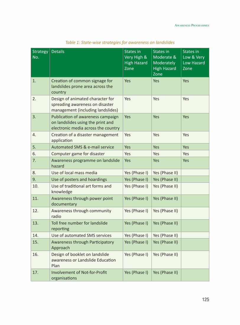
125
Table 1: State-wise strategies for awareness on landslides
Strategy No.
Details States in Very High & High Hazard Zone
States in Moderate & Moderately High Hazard Zone
States in Low & Very Low Hazard Zone
1. Creation of common signage for landslides prone area across the country
Yes Yes Yes
2. Design of animated character for spreading awareness on disaster management (including landslides)
Yes Yes Yes
3. Publication of awareness campaign on landslides using the print and electronic media across the country
Yes Yes Yes
4. Creation of a disaster management application
Yes Yes Yes
5. Automated SMS & e-mail service Yes Yes Yes6. Computer game for disaster Yes Yes Yes7. Awareness programme on landslide
hazardYes Yes Yes
8. Use of local mass media Yes (Phase I) Yes (Phase II)9. Use of posters and hoardings Yes (Phase I) Yes (Phase II)10. Use of traditional art forms and
knowledgeYes (Phase I) Yes (Phase II)
11. Awareness through power point documentary
Yes (Phase I) Yes (Phase II)
12. Awareness through community radio
Yes (Phase I) Yes (Phase II)
13. Toll free number for landslide reporting
Yes (Phase I) Yes (Phase II)
14. Use of automated SMS services Yes (Phase I) Yes (Phase II)15. Awareness through Participatory
ApproachYes (Phase I) Yes (Phase II)
16. Design of booklet on landslide awareness or Landslide Education Plan
Yes (Phase I) Yes (Phase II)
17. Involvement of Not-for-Profit organisations
Yes (Phase I) Yes (Phase II)
aWareness proGraMMes
126
Compendium on national landslide Risk management stRategy
18. Awareness among school children, their parents and teachers
Yes (Phase I) Yes (Phase II)
19. Awareness among local youth Yes (Phase I) Yes (Phase II)20. Awareness among members of
Panchayati Raj InstitutionsYes (Phase I) Yes (Phase II)
21. Creation of village task force Yes (Phase I) Yes (Phase II)22. Awareness among policy makers
and government officialsYes (Phase I) Yes (Phase II)
23. Human manpower Development or Capacity Building:
Yes (Phase I) Yes (Phase II)
The strategies which can be adopted
across the country are as follows:-
A. Short Term
1. Automated SMS and e-mail service: Most landslide prone areas are also tourist destinations. In view of this; NDMA can collaborate with the various government and private travel agencies including Indian Airlines, Indian Railways and mobile network operators to send automated SMS and e-mail messages on precaution to be taken while travelling in the landslide prone areas at the time of booking of tickets to these areas. The messages can also be sent on the date of travel.
2. Toll free number for landslide reporting: Each state in the very high and high risk zonation can initiate a toll free number for landslide reporting. Upon receiving reports of landslide / early signs of landslide from people; the State Disaster Management cell can depute disaster specialists to access the site and take further action.
3. Creation of common signage for landslides prone area across the country: A common signage for landslide prone area can be designed.
This signage can be put in landslide prone areas across the country.
4. Computer game for disaster: NDMA in collaboration with expert agencies / Institutes for computer application can design computer and mobile games on disaster management. The game will enable the users to learn about various disasters (including landslides) and preparedness.
5. Use of local mass media: A well designed mass media campaign (both print & electronic) can be undertaken in these states. The campaign must be designed in the local languages.
6. Use of posters and hoardings: Posters and hoardings on the various aspects of awareness regarding landslide can be designed and displayed at all important public places. The campaign material should be translated to the local languages. All the hotels in these areas should have a poster on landslide for the tourists. Each gram panchayat office should also have the poster.
7. Use of Global Disaster Preparedness Disaster Response Apps: There are number of globally recognized disaster preparedness disaster response apps
127
serving the needs of people affected by disasters. These top mobile apps could prove fruitful in providing assistance to aid workers and volunteers in better preparedness and respond to landslide and other disasters such as:
i) American Red Cross Apps - This app include interactive videos, quizzes and simple step-by-step advice. This app also includes customizable warning indicators for people living in areas vulnerable to natural disasters.
ii) Disaster Alert (Pacific Disaster Center’s World Disaster Alerts) - This is a freely available mobile application providing mobile access to multi-hazard monitoring of disasters and early warning for spatially distributed “Active Hazards”. It also provides facilities for viewing and sharing of additional information and reports about hazards.
iii) Global Emergency Overview (ACAPS) – This app provides weekly snapshot of current humanitarian priorities and recent events. The primary objective of this app is to keep updated the humanitarian decision makers by presenting a summary of major humanitarian crises, both recent and protracted.
iv) Humanitarian Kiosk (United Nations) – It provides a range of global news and updates regarding disaster emergencies. The application has multiple independent kiosks which reflect locations where UN Office for the Coordination of Humanitarian Affairs operates or ongoing international humanitarian emergency.
v) Federal Emergency Management Agency (FEMA) App – This smart app
contains number of disaster safety tips, an interactive emergency kit list, emergency meeting location information, and a map with open shelters and open FEMA Disaster Recovery Centers (DRCs).
B. Medium Term
1. Awareness through community radio: This is another powerful medium of awareness generation. The local community radio can broadcast programmes on awareness. It can also transmit early warning messages regarding the occurrence of landslides in the area.
2. Design of animated character for spreading awareness on disaster management (including landslides): An animated character ‘Sabu’ (a baby rhinoceros) can be designed in partnership with computer animators. The character can be used by NDMA to convey awareness messages on various disasters (including landslides). The effectiveness of the messages in a campaign shall increase with the adoption of such characters.
3. Publication of awareness campaign on landslides using the print and electronic media across the country: Awareness campaigns on landslides can be conducted using the print and electronic media. The campaign should be in the national and regional newspapers, radio and TV channels. While the campaign can be conducted throughout the year (Table 2 and 3); the periodicity can be increased during the following seasons:
• Before the onset of monsoon season
aWareness proGraMMes
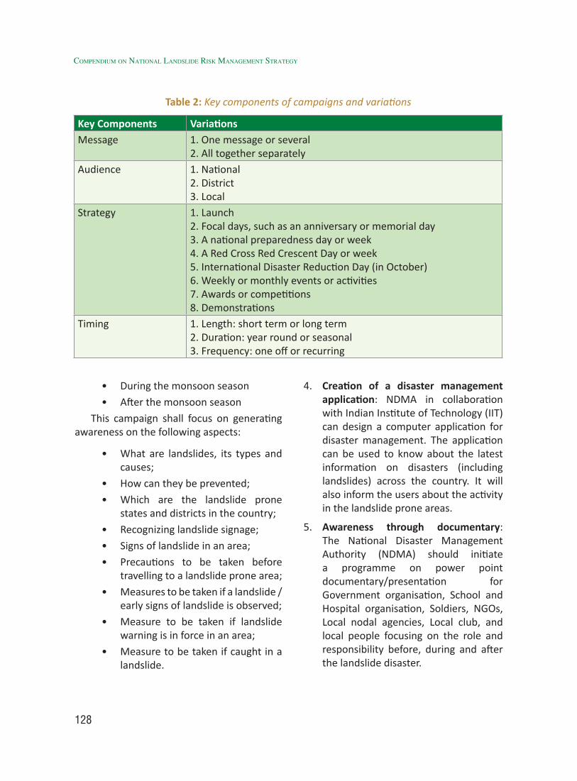
128
Compendium on national landslide Risk management stRategy
• During the monsoon season
• After the monsoon season
This campaign shall focus on generating awareness on the following aspects:
• What are landslides, its types and causes;
• How can they be prevented;
• Which are the landslide prone states and districts in the country;
• Recognizing landslide signage;
• Signs of landslide in an area;
• Precautions to be taken before travelling to a landslide prone area;
• Measures to be taken if a landslide / early signs of landslide is observed;
• Measure to be taken if landslide warning is in force in an area;
• Measure to be taken if caught in a landslide.
4. Creation of a disaster management application: NDMA in collaboration with Indian Institute of Technology (IIT) can design a computer application for disaster management. The application can be used to know about the latest information on disasters (including landslides) across the country. It will also inform the users about the activity in the landslide prone areas.
5. Awareness through documentary: The National Disaster Management Authority (NDMA) should initiate a programme on power point documentary/presentation for Government organisation, School and Hospital organisation, Soldiers, NGOs, Local nodal agencies, Local club, and local people focusing on the role and responsibility before, during and after the landslide disaster.
Table 2: Key components of campaigns and variations
Key Components VariationsMessage 1. One message or several
2. All together separatelyAudience 1. National
2. District3. Local
Strategy 1. Launch2. Focal days, such as an anniversary or memorial day3. A national preparedness day or week4. A Red Cross Red Crescent Day or week5. International Disaster Reduction Day (in October)6. Weekly or monthly events or activities7. Awards or competitions8. Demonstrations
Timing 1. Length: short term or long term2. Duration: year round or seasonal3. Frequency: one off or recurring

129
Table 3: Publication types
Types Target Audience DistributionGeneral Public
Youth Children Mass Quantities
As funds permit
Limited Print Run
Electronic
Bookmarks-reminders for key messages and contact information
• • • •
Factsheets, flyers, brochures -key campaign messages
• • • • •
Booklets-mitigation guidance, summaries, standard instructions
• • • • •
Information cards- fold-up pocket reminders of important procedures and methods such as evacuation, emergency routes, triage, first aid, cardio-pulmonary resuscitation and water and sanitation
• • • • • •
Magazines-whether production an entire title, a special issue, or content for other titles
• • • •
Comic books- regular strip, graphic novel, short, edutainment
• • • •
Colouring books- preparedness guidance, edutainment
• • •
Story books- true or fictional
• • • •
Paper games, card games, board games, models-make your own or professionally printed and boxed
• • • •
aWareness proGraMMes
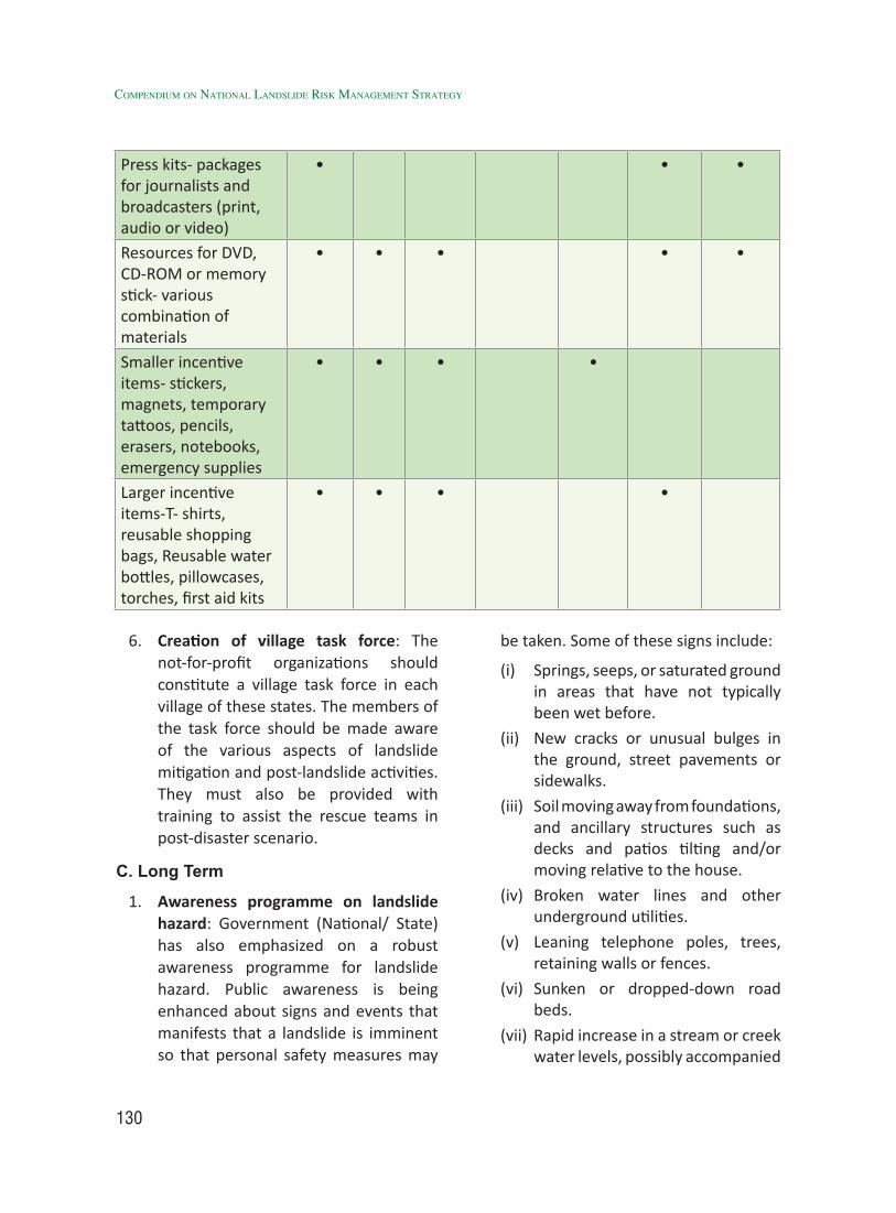
130
Compendium on national landslide Risk management stRategy
Press kits- packages for journalists and broadcasters (print, audio or video)
• • •
Resources for DVD, CD-ROM or memory stick- various combination of materials
• • • • •
Smaller incentive items- stickers, magnets, temporary tattoos, pencils, erasers, notebooks, emergency supplies
• • • •
Larger incentive items-T- shirts, reusable shopping bags, Reusable water bottles, pillowcases, torches, first aid kits
• • • •
6. Creation of village task force: The not-for-profit organizations should constitute a village task force in each village of these states. The members of the task force should be made aware of the various aspects of landslide mitigation and post-landslide activities. They must also be provided with training to assist the rescue teams in post-disaster scenario.
C. Long Term
1. Awareness programme on landslide hazard: Government (National/ State) has also emphasized on a robust awareness programme for landslide hazard. Public awareness is being enhanced about signs and events that manifests that a landslide is imminent so that personal safety measures may
be taken. Some of these signs include:
(i) Springs, seeps, or saturated ground in areas that have not typically been wet before.
(ii) New cracks or unusual bulges in the ground, street pavements or sidewalks.
(iii) Soil moving away from foundations, and ancillary structures such as decks and patios tilting and/or moving relative to the house.
(iv) Broken water lines and other underground utilities.
(v) Leaning telephone poles, trees, retaining walls or fences.
(vi) Sunken or dropped-down road beds.
(vii) Rapid increase in a stream or creek water levels, possibly accompanied
131
by increased turbidity (soil content).
(viii) Sudden decrease in creek water levels even though it is still raining or rainfall has recently stopped.
2. Use of traditional art forms/traditional knowledge: Due to modernization and tech-savvy nature of 21st century generation, old traditions disaster management practices are dying up. Therefore, it is necessary to document and disseminate old traditional best practices available in mountain regions of India through community participation in trainings. Traditional art forms are important mediums of awareness generation. Local art groups in these states have to be identified and awareness campaigns can be designed with them. The groups can perform in various community events. Their performance can also be recorded and broadcasted over radio and television. The traditional folk singers in these states should also be encouraged to actively participate and mobilize people in their local language on various landslide awareness related themes. Traditional knowledge can validate evidence of past landslide events, and helps to further understand the landslide perception among the local communities. Traditional knowledge and modern technologies are also useful in designing landslide Early Warning System (EWS).
3. Awareness through Participatory Approach: The planning and implementation process is recommended in order to maintain sustainability of the programs launched by the administration for disaster management.
People’s involvement is cardinal to the success of any initiative and it creates a self-regenerating process that requires less administrative interventions in the long run and eases pressure on the administration. It is necessary that the government and the communities together evolve a joint action plan aimed at enhancing community education and development of community leadership.
The elements of participatory learning can be applied at different levels:
• The organizational level – headquarters, branches, schools, businesses, workplaces, homes
• The community level – being scaled up to reach villages, towns, cities, school systems and regions
• The population level – being expanded to incorporate entire populations, by taking advantage of internet-based tools and social media
• Parallel tools specifically for use with children and for marginalized populations can be valuable as well since there are vulnerable sections within the communities.
4. Landslide education plan: An illustrated booklet with information on landslide awareness can be prepared in local languages. This can be circulated among the PRI members, Front Line Health Workers (FLHW), School Teachers, Youth Leaders, members and other important stakeholder groups in these areas. To create landslide education plan to address the multifaceted aspects of landslide management it is indispensable to develop high quality
aWareness proGraMMes
132
Compendium on national landslide Risk management stRategy
education materials, textbooks, field training and a high standard of teaching at all levels. The landslide expert needs to be educated that they should insist on scientific and systematic slope investigation. The process should involve geologists, hydrologists, geographers, planners and administration.
5. Involvement of Not-for-Profit Organisations: NDMA should identify not-for-profit organisations to undertake the awareness building activities in these States. The organisation should be asked to submit a targeted awareness generation plan. The work of the organisation should be stringently monitored as per work plan. The organisation will be responsible for generating awareness among the various stakeholders.
6. Awareness among school children, their parents and teachers: The not-for-profit organisations can organise sessions for school children, their parents and teachers from Class IX onwards on various aspects of landslide occurrence and their mitigation. A one day training module can be designed for the participants. The module should include videos, images, lectures and mock drills. The daylong session should end with a short quiz on the topics discussed.
7. Awareness among local youth: The not-for-profit organisation can hold a day long awareness generation camp with the members of National Cadet Corps (NCC), Scouts and Guides, and National Service Scheme (NSS) volunteers. These camps can comprise of both lectures and mock drills and should be conducted in coordination with the state and district teams of these organisations.
In addition to these youth involved in the above mentioned organizations, the not-for-profit organization can select a team of 5 youth from each gram panchayat in coordination with the elected Sarpanch. Care should be taken to ensure that youth from all the major communities inhabiting the gram panchayat are represented in the team. The team should also have female representation. The not-for-profit organisation can also hold a one day awareness generation workshop with the youth teams of all the gram panchayats in the block headquarter. These youth should be entrusted with the responsibility of spreading awareness in their respective gram panchayats.
8. National Data Centre on Landslide: It would integrate various data sources, a geo-portal to address the data needs and thus, enable an effective response (Table 4).
9. Awareness among members of Panchayati Raj institutions: On similar lines; the not-for-profit organizations can also hold a one day awareness generation workshop for the PRI members of the various panchayats in the district in the district headquarter. The Community Based Family Disaster Preparedness and mitigation (CBFDP) is a process to capacitate communities to prevent, mitigate and cope with disasters effectively. It is designed, managed and owned by the communities in consultation with professionals to be better prepared against landslide and associated hazards. The role of Panchayati Raj Institutions and communities in landslide risk mitigation and management is very important
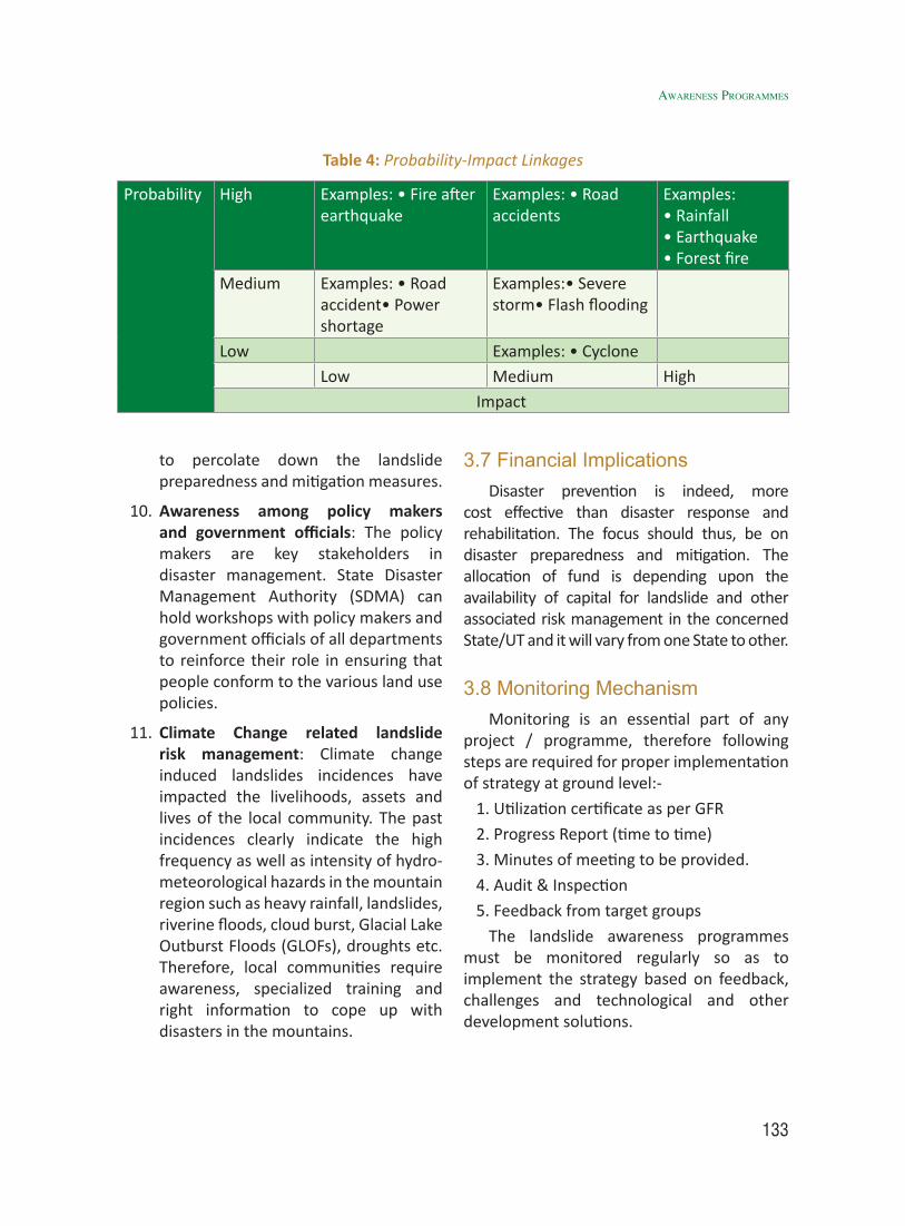
133
to percolate down the landslide preparedness and mitigation measures.
10. Awareness among policy makers and government officials: The policy makers are key stakeholders in disaster management. State Disaster Management Authority (SDMA) can hold workshops with policy makers and government officials of all departments to reinforce their role in ensuring that people conform to the various land use policies.
11. Climate Change related landslide risk management: Climate change induced landslides incidences have impacted the livelihoods, assets and lives of the local community. The past incidences clearly indicate the high frequency as well as intensity of hydro-meteorological hazards in the mountain region such as heavy rainfall, landslides, riverine floods, cloud burst, Glacial Lake Outburst Floods (GLOFs), droughts etc. Therefore, local communities require awareness, specialized training and right information to cope up with disasters in the mountains.
Table 4: Probability-Impact Linkages
Probability High Examples: • Fire after earthquake
Examples: • Road accidents
Examples:• Rainfall• Earthquake • Forest fire
Medium Examples: • Road accident• Power shortage
Examples:• Severe storm• Flash flooding
Low Examples: • CycloneLow Medium High
Impact
3.7 Financial ImplicationsDisaster prevention is indeed, more
cost effective than disaster response and rehabilitation. The focus should thus, be on disaster preparedness and mitigation. The allocation of fund is depending upon the availability of capital for landslide and other associated risk management in the concerned State/UT and it will vary from one State to other.
3.8 Monitoring MechanismMonitoring is an essential part of any
project / programme, therefore following steps are required for proper implementation of strategy at ground level:-
1. Utilization certificate as per GFR
2. Progress Report (time to time)
3. Minutes of meeting to be provided.
4. Audit & Inspection
5. Feedback from target groups
The landslide awareness programmes must be monitored regularly so as to implement the strategy based on feedback, challenges and technological and other development solutions.
aWareness proGraMMes

134
Compendium on national landslide Risk management stRategy
135
4.1 IntroductionLandslide is a major geological hazard,
which poses serious threat to human population and various other infrastructures like highways, rail routes and civil structures like dams, buildings and other structures, (DST, 2007). Every mountain terrain of the world is suffering from extensive mass wasting through a variety of slope processes such as landslides, rock fall, debris flow etc (Kumar et al, 2004). It is estimated that 30 percent of the world’s landslides occur in the Himalayas. Annual unfailing occurrences of landslides have caused widespread damage in different parts of India (Uniyal, 2008; Prakash & Kathait, 2014; Verma & Prasad et al, 2017). Rampant construction activity has drastically enhanced the vulnerability to landslides in mountainous regions (Uniyal, 2013; Verma & Prasad et al, 2017)
Barring the landslide prone locations along highways, the majority of landslide prone habitations are located in the hinterlands of the Himalayan States, northeastern States and also on the Eastern and Western Ghats of southern and south western coastal States of the country. Hence, it becomes a very cumbersome task for the district administration and response teams including NDRF and SDRF teams to reach the site of disaster within the short span of time due to remoteness and ruggedness of the terrain and poor infrastructure facilities. Higher incidences of landslides during
rainy season and prevalent bad weather conditions coupled with poor visibility make it difficult to carryout rescue operations using helicopters. Hence, local inhabitants by default become the first responders in multi-hazard (landslide, flash flood, and earthquake) prone hinter lands of Himalaya, Arakan and other mountain States. Scientific observation in north Sikkim and Garhwal regions in the Himalayas clearly reveal that there is an average of two landslides per sq. km. The mean rate of land loss is to the tune of 120 meter per km per year and annual soil loss is about 2500 tonnes per sq km. More or less similar is the case with the inhabitants of remote villages of eastern and western Ghats. In the Nilgiris, in 1978 alone, unprecedented rains in the region triggered about one hundred landslides, which caused severe damage to communication lines, tea gardens and other cultivated crops. The circumstances cited above necessitate for strengthening a community based approach for coping up with the disasters including the landslides in these areas.
4.2 Identification of Problem Inadequate infrastructure (roads, railways
etc.) with lack of disaster resilience makes these areas highly vulnerable during the rainy season which generally been the cause of major landslide disasters in the region. The disruption of the limited road network and other communication lines during a disastrous
Capacity Building & Training of Stakeholders4
136
Compendium on national landslide Risk management stRategy
event therefore adds to the problems. This scenario is often coupled with bad weather conditions, which further delay the arrival of responders from government departments such as Police, Fire Brigade, SDRF and NDRF. Consequently the golden hours to save lives are lost leading to the undesirable outcomes in terms of loss of lives and livestock which otherwise could have been saved through timely action by trained and well equipped first responders. Unfortunately, the first responders in such circumstances are locals/villagers and the affected community, who are ill equipped, and untrained with limited material and financial resources. This necessitates new approach aimed at capacity building and training of vulnerable communities and all other stakeholders including the line departments, local NGOs and CBOs. The capacity building of vulnerable communities residing in the landslide prone hinterlands also calls for their empowerment as one of the necessary ingredient of the capacity building initiative.
4.3 Review of Work During the past decade capacity building
and training of all the stakeholders in Disaster Management has gained momentum throughout the world. However, there are huge gaps in capacity building initiatives and training programs being developed and run in India. Initiatives are required in the form of national programmes like capacity building in Earthquake Risk Management i.e., National Programme for Capacity Building of Architects in Earthquake Risk Management (NPCBAERM) and the National Programme for Capacity Building of Engineers in Earthquake Risk Management (NPCBEERM) were launched by the Ministry of Home Affairs (MHA), Govt. of India in the year 2004.
4.3.1 National Level
In India, the need for Capacity Building and Training of the stakeholders in landslide risk management was realized not long ago. The realization came after two tragic events of Okhimath and Malpa landslides during in August, 1998. Following are some of the major initiatives taken in many of the landslide prone states (mainly Himalayan states) of the country:
(i) On 23 December 2005, the Government of India enacted the Disaster Management Act, which envisaged the creation of National Disaster Management Authority (NDMA), headed by the Hon’ble Prime Minister, and State Disaster Management Authorities (SDMAs) headed by respective Chief Ministers, to spearhead and implement a holistic and integrated approach to Disaster Management in India.
(ii) NDMA has released a Guideline on “Management of Landslides and Snow Avalanches” in June, 2009 to adopt a holistic approach for mainstreaming landslide DRR, besides strengthening of the State machinery and providing all necessary support to the concerned States and UT’s for addressing landslide problem in a sustainable manner, providing necessary action points for management of landslides and avalanches.
(iii) Institutional arrangement at various levels of administrative hierarchy was defined. Disaster Management Committees at District, Tehsil/Block and Village level were constituted with various names such as District Disaster Management Committee (DDMC)/
137
District Emergency Operations Group (DEOG); Tehsil/Block Disaster Management Committee (TDMC/BDMC). Further, the Village Disaster Management Committees (VDMCs) were also constituted in many landslide prone villages.
(iv) Under MHA (GoI) - UNDP sponsored Disaster Risk Management (DRM) Programme, the multi-hazard prone districts were selected for Training and Capacity Building in Disaster Management. Many of the multi-hazard prone districts of the country including all those districts of Himalayan states were selected for DRM programme which were prone to landslide hazard as well.
(v) A number of training and workshops have been organized by various States at State, District, Block and Village level on various aspects of Disaster Management. All these training programs included lectures on landslides along with other hazards and management aspects and some documentaries on one or two aspects of Disaster Management.
(vi) Trainings on Incident Command System were also imparted in different states at State and District level.
(vii) Many village level workshops on Disaster Management were also organized and a brief account of landslide hazard was also discussed in these workshops.
(viii) Disaster Management Action Plans (DMPs) at State and District level were also prepared by State Project Officers, District Project Officers and some other Disaster Management
experts on the basis of discussions with State and District Disaster Management Committees. Offices of Relief Commissioner and Department of Disaster Management of the respective states played a pivotal role of facilitator in this initiative.
(ix) Few village level Disaster Management Action Plans were also prepared through community participation with the government officials acted as facilitators to the community in this initiative in the states such as Uttarakhand.
(x) National Institute of Disaster Management (NIDM) also conducts many programs on Landslide Risk Management. The training module of NIDM on comprehensive landslide risk management includes varied aspects of landslides.
(xi) Department of Science and Technology (DST), Government of India has also been working on National Capacity Building in the area of Landslide Hazard and Risk Assessment. Wadia Institute of Himalayan Geology (WIHG), Dehradun also conducts training programmes on landslide DRR.
(xii) The Government of Mizoram and Geo-Hazards Society carried out a comprehensive fourteen-day ‘Geology Field School’ for practicing geologists from Mizoram and nominated representatives from Assam, Tripura and Manipur. The resource persons brought in by technical partner GeoHazards International were international experts in Landslides, Seismology and Engineering with sessions combining classroom and
CapaCity BUildinG & traininG of stakeHolders

138
Compendium on national landslide Risk management stRategy
field exercises in and around Aizawl and Lunglei.
(xiii) Indian Academy of Highway Engineers (IAHE) conducts regular training programmes on landslide mitigation and rock fall, for the Engineers & highway sector professionals of Central Government organizations, State Government organizations, Public sector units, private sector, stake holders of multi-lateral agencies like World Bank, Asian Development Bank, etc.
(xiv) Constituent establishment of CSIR such as Central Building Research Institute, Roorkee organizes many training programs on landslide management including national level training programs on landslide control measures.
(xv) CSIR- Central Road Research Institute also organizes a regular (Annual)
training programme and workshops like “Climate Change and Landslide”. Other than that it also conducts the customized training programs as per the need of the stakeholders like PWD, BRO, etc.
(xvi) Indian Institute of Remote Sensing (IIRS), Dehradun; National Remote Sensing Centre (NRSC), Hyderabad; State Remote Sensing Centers and Remote Sensing Applications Centre, U.P., Lucknow in particular have included Remote Sensing, GIS and GPS based landslide studies in their various training programs on Disaster Management.
(xvii) Local stakeholders like Disaster Mitigation and Management Centre (DMMC), Dehradun, Uttarakhand Governement during the district level training workshop for local stakeholders of District Disaster
Figure 1 a) Landslide at Karnaprayag before mitigation; b) after structural mitigation at the initiative of District & Tehsil/Block Disaster Management Committee through coordinated
efforts of the stakeholders (DMMC, 2003 & Uniyal, 2004 & 2016)
139
Management Committee (DDMC) at Gopeshwar (district headquarter of Chamoli district, Uttarakhand) had used their training lessons on field for locations namely Upper Bazar, Kotwali and Police Colony localities of Karnaprayag town in Chamoli district of Uttarakhand in year 2004 where the landsliding zone were structurally mitigated and made stable. (Uniyal, 2016). This is an excellent example of landslide DRR though training and participation of stakeholders in India (Fig 2a & b).
4.3.2 International Level
During past one and half decades or so a number of global initiatives such as Disaster Risk Management Programme, Disaster Risk Reduction Project, International Program on Landslides Risk Reduction by UN and other agencies contributed significantly for developing institutional capabilities at different levels. Further, the regional institutes like Asian Disaster Preparedness Centre (ADPC) – Bangkok, Asian Disaster Reduction Centre (ADRC), Kobe and Disaster Prevention Research Institute (DPRI), Kyoto have contributed for joint actions for landslides risk reduction by different countries (Prakash, 2013). ADPC has made programs for Hydro-meteorological Disaster Mitigation in Secondary Cities in Asia by giving case studies on mitigation disasters in Asia and Pacific. Demonstration projects in Baguio City, Philippines, Patong City, Phuket, Thailand, and Kaluthara District, Sri Lanka present how risk assessment and subsequent mitigation and preparedness activities contributed to reducing landslide risk according to local needs and resources.
National Landslide Mitigation Strategy of U.S. also emphasizes on building resilient
communities by providing training for federal, state and local emergency managers on landslide hazards, preparedness, response and recovery. Further, it also lays emphasis on developing a coordinated landslide rapid response capability to assist local state and federal emergency managers in determining the nature of landslide hazards and the extent of ongoing risks (USGS, 2000). The World Bank in 2013 introduced MoSSaiC (Management of Slope Stability in Communities) vision for engaging policy makers, project managers, practitioners, and vulnerable communities in reducing urban landslide risk in developing countries. Other developed countries such as Japan have a very advanced state of the art landslide management system wherein the landslide prediction mechanism and structural mitigation measures are also the ingredients of this management system and disaster management fraternity and community are adequately trained on landslide risk management. This in turn has drastically enhanced the resilience of community to landslides by reducing the vulnerability and decreasing the probability of hazard in many cases.
According to Westen and Krol one of the important requirements to carry out an effective disaster risk management is capacity building and training of disaster management experts and professionals. Hyogo framework of action 2005-2015 of the UN-ISDR also calls for risk assessment and education as two of the key areas in disaster management.
According to Sassa (2015) the Sendai Partnerships 2015–2025 proposed by the International Consortium on Landslides calls for open communication with society through integrated research, capacity building, knowledge transfer, awareness-raising, training and educational activities to enable
CapaCity BUildinG & traininG of stakeHolders
140
Compendium on national landslide Risk management stRategy
societies to develop effective policies and strategies for reducing landslide disaster risk, to strengthen their capacities for preventing hazards to develop into major disasters.
4.4 Identified Gaps: Various gaps pertaining to different
aspects of capacity building of stakeholders and the community in landslide DRR have been identified and elaborated below:
4.4.1 Need of Comprehensive Training Need Assessment (TNA):
A Comprehensive training needs assessment at various levels of administrative hierarchy viz. National, State, District, Tehsil, Block and Village level needs to be conducted in all landslide prone states. Different training modules should be prepared for each level, and the frequency of training in each region should be mentioned as part of a capacity building action plan.
4.4.2 Gaps pertaining to technological inputs in training programmes on landslide DRR
Geospatial technologies based input viz. precise location and extent of hazard zone and elements of risk are inadequately included in most of the training programs on landslide DRR. This is because very limited thematic information only for few locations is available in the form of large scale landslide hazard zonation and landslide management maps. Most of the landslide hazard maps displayed during the training programs are on regional scales and provide a generalized overview of landslide hazard scenario. However the trainees viz. disaster managers, planners, decision makers, official of line departments, engineers, NGO and CBO representatives and
locals participating in a training programme on landslide DRR require a precise site specific overview of landslide hazard, causes, vulnerability, risk and required mitigation measures. This type of information can be provided to the stakeholders only through meso and micro level LHZ/LSZ maps. Bhandari (2013) emphasized the need for user friendly validated maps of landslide hazard, data inventory, models etc. in the hands of disaster managers. Dissemination of the maps for local by developing user friendly apps, teaching them how to use these map and make them aware of technical terminologies. Monitoring site specific landslide prone areas by locals and updating the status in real time by using technology.
Capacity building programmes on GIS mapping of landslide areas are also required to enable Departments of Geology in the State Governments to develop landslide hazard maps in scales (~ 1:10,000 etc) suitable for use at a municipality level.
4.4.3 Gaps in capacity building of basic data, inventory, mapping etc. in large scale
There is no institutional framework for collection and preservation of basic landslide data. Similarly, the inventory maps of landslides are being prepared by different agencies in a scale not generally usable on the ground. The large scale mapping, which is must for landslide studies, is rarely done in the country which is therefore a huge gap to be filled for a meaningful mitigation and management of landslides. Therefore, capacity building of professionals in line department of States / UT’s will be carried out for creation of uniform landslide catalogue and mapping.
141
4.4.4 Gaps in capacity development of professionals i.e. Training of Trainers (ToT)
At present, no Ministry / Department of the Government of India have dedicated project for the training of professionals such as Civil Engineers, Geologist, Geotechnical Engineers, Disaster Managers etc. as trainers for mitigation and management of landslides to reduce risk in collaboration with other national and international agencies by involving new tools and methods. Geological Survey of India (GSI) which is the nodal agency for landslides in the country has been primarily carrying out study and investigation of landslides in the various States and undertaking Landslide Hazard Zonation mapping and few trainings of geologists on landslide investigation and studies only. Formulation and implementation of mitigation projects is invariably left to be carried out by the State governments.
4.4.5 Gaps in identification of target groups for training on landslide DRR
(i) The target groups to be trained are not clearly defined for most of the training programs at state, district and block level.
(ii) In most of the training programs the same heterogeneous group of trainees is imparted training to deal with various stages of disaster management cycle, whereas the involvement, roles and responsibilities of various stakeholders are different during the different phases of disaster management cycle.
(iii) Specific target groups for specific skill development are not identified in advance and are generally finalized
at the last minute without serious consideration to the facts such as background of trainees, their work sphere and area of expertise or specialization.
(iv) Many Community Based Organizations (CBOs) are left out in the capacity building and training initiatives aimed at DRR.
4.4.6 Gaps in the contents of training programmes on landslide DRR
(i) Most of the training programs on landslides DRR have generalized contents dealing more with the concept, definitions and types of landslides etc.
(ii) Theoretical part on concept of disaster management constitutes a large part of the course content. Fewer contents of practical aspects of landslide DRR do not serve the purpose of training and capacity building programs at the lower level of administrative hierarchy (tehsil, block and village level).
(iii) Case studies indicating effective preparedness, mitigation, response, recovery and rehabilitation pertaining to a landslide event are missing in most of the training programs. Collaboration with the other health and safety societies for better output.
(iv) Local hazard scenario, vulnerability and elements at risk are not included in detail in the contents of most of the training programs.
(v) Site visits of past landslide events are also not a part of the course content in many training programs.
CapaCity BUildinG & traininG of stakeHolders
142
Compendium on national landslide Risk management stRategy
(vi) In some instances inadequate course material is made available to the trainees.
(vii) Course material for various courses at different levels of administrative hierarchy viz state, district, tehsil, is more or less the same without any substantial change in the text of the content. This makes it rather difficult for the stakeholders at lower level of administrative hierarchy and for the affected communities to understand their role in the larger spectrum of landslide risk mitigation.
(viii) Clear guidelines in the form of separate manuals on involvement, role and responsibilities of different stakeholders in landslide DRR are missing.
(ix) Mock drills are generally not a part of the training programs on landslide DRR.
4.4.7 Gaps in capacity building at professional level
After 80’s the mushrooming of organizations working on landslide have spread across the country, but the quality of professionals engaged in such studies seems not matching to required level because they have taken the subject as an add-on to their established institutional framework and discipline as part-time and not completely dedicated to this profession.
4.4.8 Gaps in the capacity building initiative at grass root level
(i) Fewer training programs are organized at village and ward level.
(ii) Training programs at the village level are not linked to any financial
incentives and the villagers attend these programmes at the cost of their daily wages or farming hours.
(iii) There are virtually no trainings on landslide safe site selection for construction of new houses. Teaching of basic geology of the area differentiating rock types especially the one that are more prone for landslides.
(iv) No pace setter example has been identified till now even after so many years of research which could act as an example for the stakeholders to replicate them for their problems.
(v) Traditional practices evolved through accumulation of the knowledge gained through experiential learning by vulnerable communities for generations have not been adequately documented and are gradually getting abandoned due to large-scale migration to the cities and inclination of youth towards digital gadgets viz. smart phones etc. Presently, there is no initiative to prepare a catalogue of traditional disaster management practices or the do’s and don’ts during disasters including landslides.
(vi) There is a lack of initiative to combine the modern technical knowhow with the coping mechanism of local communities developed by them through experiential learning of generations.
(vii) Educating local women as key stakeholders needs to be promoted, as women and children tend to be victims of hazards, but can also be more effective change-makers in the community.
143
(viii) Remedial measures using the local slided material for instant temporary stability.
(ix) Educating locals about the landslide dam formation and LLOF (landslide lake outburst flow) and its consequences downstream is another aspect that has not been given due importance so far.
4.4.9 Gaps in coordination among various stakeholders of Landslide Hazard prone areas
Locals are the first and probably the best observers of the slow but progressive landslides in and around the place of their inhabitance. However, it may remain unnoticed in most of the cases due to a lack of awareness about the inherent hazard or due to communication gaps between the vulnerable community and disaster managers at tehsil and or district level.
(i) Implementation of development plans, regulated growth of new habitations, execution of landslide risk reduction programmes and such other activities would move much faster if bridges of understanding are built between teams of specialists, development planners, economists, decision makers and community leaders. National Institute of Disaster Management, Indian Institute of Public Administration, Indian Institutes of Management, GSI, CRRI, CBRI and other related knowledge institutions should organize joint training programmes to create common understanding and cross-fertilization of ideas between different players for speedy decision making and smoother project implementation.
(ii) Lack of proper training, awareness and in many cases, ignorance, non adherence to landuse regulations has encouraged unplanned slope cutting and overloading for commercial gains. To a certain extent this can be attributed to landuse policies and regulations that do not have enough detail to empower regulatory bodies to enforce restrictions on unplanned slope cutting that exacerbates the landslide hazard. The recently enacted slope modification regulations of the Aizawl Municipal Corporation can be a good model for other regulatory bodies in landslide prone areas to follow. This regulation covers slope modification and also guidance for the safe disposal hill slope cut waste material as well as land use policies and regulations
(iii) There is lack of regulations which covers slope modification and also guidance for the safe disposal hill slope cut waste material as well as inherent lack of coordination among various stakeholders in landslide DRR including the government departments, contractors, developers/builders and the community as well. This lack of coordination in turn has created a sea of problems pertaining to hill slope stability and some of these problems are elaborated below:
a) Most of the highways, in hilly region are suffering due to repeated occurrences of landslides responsible for not only economic losses but also number of lives, each year. One of the reasons for such repeated recurrences is the selection
CapaCity BUildinG & traininG of stakeHolders

144
Compendium on national landslide Risk management stRategy
of optimum alignment of the highway due to lack of awareness/knowledge/ professional ethics etc. of the users department. Similarly, the conclusion procedures and technology needed for constructions may at times not as what the circumstances/terrain demands.
b) Uncontrolled and sometimes unwanted blasting for construction activities including for Highways create unending problems of landslides and like phenomena causes opening of cracks of the rocks and in some cases even increases the joint apertures (openings) and these openings serve as easy pathways for percolation of rainwater (into the rock mass) which in turn increases the sliding force and decreases the resisting force and finally triggers the failure.
Blocking, narrowing or diverting the course of natural drains or otherwise causing choking of sewerage/drainage system of municipal body or local body or village and alteration of natural mechanism of draining out the surface runoff enhances slope failure (Uniyal, 2004; Uniyal & Rautela, 2005;Uniyal, 2008 & 2016).
c) Route alignments (including pony route alignments) on subsidence and or toe erosion prone lower or middle hill slopes (Uniyal, 2013).
d) Poor quality of infrastructure material / poor maintenance after construction and monitoring.
e) Extremely poor waste management
of hill slope cut waste material, particularly the unplanned disposal of debris material generated from the slope cutting or digging for mainly road and other construction activities. The unplanned disposal of slope cut debris not only blocks the natural drains but also provides loose unconsolidated material on hill slopes for the activation of new slide zones. The triggering of new slides from within the large dumps of slope cut debris causes damage to houses, agriculture and forest resources of the immediate down slope area.
4.4.10 Gaps in Community-Based Disaster Preparedness
The concept of disaster management has witnessed drastic change during past two decades or so with increasing resilience of the communities as one of the focal theme. The term community implies a group of people sharing common interests, ideas, resources, environment, aspirations, etc. In disaster preparedness a territorial area, a complex of organizations within an area and above all, a sense of ‘belonging’ are considerations for a community (Alley, 1993). There is no single platform for meeting of various level stakeholders so that the problems of each level could be disseminated to other level administrators for a combined solution for better output and learning.
Capacity building of vulnerable communities of landslide prone hinterlands is required due to following reasons (IGNOU, 2007):
(i) Lack of access to resources (material/economic vulnerability)
145
(ii) Disintegration of social patterns (social vulnerability)
(iii) Degradation of the environment and inability to protect it (ecological vulnerability)
(iv) Lack of strong local institutional structures (organizational vulnerability)
(v) Lack of access to information and knowledge (educational vulnerability)
(vi) Lack of public awareness (attitudinal and motivational vulnerability)
(vii) Certain beliefs and customs (cultural vulnerability)
(viii) Weak buildings or weak individuals (physical vulnerability) (Aysan, 1993).
4.4.11 Altitudinal Gaps in Capacity Building and Training on Landslide DRR
(i) The existing mechanism of capacity building and training of stakeholders is more or less a formal one where some of the stake holders send their middle level or junior representatives for training on DRR.
(ii) Enhanced field visit to monitor the conditions and awareness/training programs during monsoon seasons by local skilled administrators for early warning.
(iii) The representation of NGOs and local CBOs is far less in capacity building programs and most of the trainees are from various government departments; Hence, the term some of the stakeholders has been used in the above point (i).
(iv) In many instances the participants/some government officials attend the training on the first day or first session and are involved in some other official work in their local office in the next sessions or on the next day. This is because they are not fully deputed for training. This is a very common practice during DRR trainings organized at district, tehsil & block level.
(v) Most of the senior officials of the line departments at various levels of administrative hierarchy attend only the inaugural session of trainings on DRR and leave their juniors to attend the training for rest of the days. This may not be the case with all the training programs on DRR, but it is a usual practice in most of the training programs on DRR at state, district, tehsil and even at block level, where venue of training is at the same place where from the officers/staff are deputed for the training.
4.4.12 Gaps in the Presence of Professional Geologists in Municipalities prone to landslides
Even though staff engineers are considered necessary in Municipalities, the position of a staff geologist, geo-morphologist is not present in the line Department of States such as Municipalities of our country where over 12% of our land area is prone to landslides. It is important to create staff positions in Municipalities, PWD’s and districts administration with high landslide risks.
CapaCity BUildinG & traininG of stakeHolders
146
Compendium on national landslide Risk management stRategy
4.5 Recommendations4.5.1 Nation-wide Training Need Assessment (TNA) in Landslide Risk Management
SN Questionnaire for TNA Required Strategy and Action Points1 Name of training Institute
(Government or other) that provide training to staff members of organization/ department/ centre etc or engaged in advocacy on landslide risk management related Disaster Risk Reduction (DRR). For each Institute etc specify the training relevant to concerned organization/ department etc and state whether landslide management related DRR are covered in trainings.
1. National Institute of Disaster Management (NIDM), New Delhi
2. a) Disaster Management Cells (DMCs) under Administrative Academies/Academy of Administration and b) State Institutes of Rural Development (SIRDs) & c) Regional Institutes of Rural Development d) State Remote Sensing Centres of all the Himalayan States, North-eastern States and other States and UTs comprising western and eastern ghats (J&K, Himachal Pradesh, Uttarakhand, Sikkim, Arunachal Pradesh, Mizoram, Manipur, Meghalaya, Nagaland, Tripura, Maharashtra, Karnataka, Kerala, Tamil Nadu, West Bengal, Pondicherry and Andhra Pradesh etc.).
Note: Other institutes of other states working in this area can also be included depending upon the available information.
2 How many different kinds of training and other capacity development and trainings related to landslide risk management imparted?If yes, then give name of O rga n i s a t i o n / I n st i t u te / Centre etc.
Questionnaires can be sent by NIDM in consultation with NDMA to all the above said institutes/DMCs/SIRDs regarding training and other capacity building activities so far carried out by each of them and also by the NGOs and or CBOs associated with them in landslide risk management efforts.
3 Is Institute/Centre/Department etc engaged in any District/ State level activities to address issues related to landslide DDR?If yes, please elaborate:-
4 Has any landslide disaster risk assessment been conducted? If yes, please state the year, title of the report.
Questionnaires can be sent by NIDM in consultation with NDMA to all the above said institutes/DMCs/SIRDs/State Remote Sensing Centres regarding training and other capacity building activities so far carried out by each of

147
5 Have the finding of the assessment been used for designing and implementing plans/programmes/other initiatives? If yes, elaborate how they were used and for which initiatives.
them and also by the NGOs and or CBOs associated with them in landslide risk management efforts.
6 What are the key policy priorities for organization/ department and what key indicators are you working towards?
7 Is there any existing mechanism for data collection, systematic observation and monitoring of landslides and other disaster risk reduction initiatives or important weather parameters?If yes, please elaborate.
Questionnaires in this regard can be sent by NIDM in consultation with NDMA to IMD, DRDO, DST, New Delhi; National Remote Sensing Centre, Hyderabad and all the State Remote Sensing Applications Centres, State and Central Universities of Himalayan states, north-eastern states and states and UTs comprising western and eastern ghats.
8 Has this organization/Institute/Centre etc conducted any TNA for landslide disaster management, climate change mitigation and adaptation? If yes, please provide details of the assessment.
Questionnaires in this regard can be sent by NIDM in consultation with NDMA to all the SIRDs/ DMCs/State Remote Sensing Centres of all the Himalayan states, northeastern states and states comprising western and eastern ghats.
9 Describe the 3 key challenges for organisation/Institute/ centre in effectively preparing for natural disasters and mitigating risks related to weather and climate change (such as: knowledge, data/information, technology, funds, time, leadership or other), If yes, then elaborate.
I. Forecasting and fore-warning about the precise date, time and place of inevitable disaster.
II. Real time dissemination of the information among the vulnerable community, first responders & disaster managers about the irrepressible disaster.
III. Institutional framework with budget head and dedicated scientific and technical manpower with state of the art laboratories and equipments, aimed at disaster fore-warning and mitigation. Ad-hockism for disaster management activities will not serve the purpose.
10 Any budget is allocated for training and capacity building specific to landslide disaster risk reduction?
Questionnaires in this regard can be sent by NIDM in consultation with NDMA to all the SIRDs/ DMCs of all the Himalayan states, northeastern states and states comprising western and eastern ghats and UTs.
CapaCity BUildinG & traininG of stakeHolders
148
Compendium on national landslide Risk management stRategy
If yes, than how much per annum and if not, any initiatives been taken for the purpose? Please provide the status.
11 Please describe concerned Organisation/ Department/ Institute/ Centre’s institutional capacity to undertake DRR & Climate Change Adaptation trainings/initiatives in terms of the following:-
a. Resource Personsb. Infrastructurec. Fundsd. Training Materials
(Manuals/Modules etc)
Questionnaires in this regard can be sent by NIDM in consultation with NDMA to all the SIRDs/ DMCs of all the Himalayan states, northeastern states and states comprising western and eastern ghats and UTs.
12 Types of training modules are available on landslide risk management associated with Climate change related risk? If yes, than list it here:-
Questionnaires can be sent by NIDM in consultation with NDMA to the Disaster Management Cells (DMCs) and State and Central Government Universities of all the Himalayan States, north-eastern states and the States / UTs comprising western and eastern ghats, regarding existing training modules available with each of them on landslide risk management or with the NGOs or private training institutes (associated with them on landslide risk reduction).
13 In your opinion, what are the top 5 training program topics, which are required for building capacities of concerned Department/ Organization in landslide DRR and Climate Change Adaptation (CCA) by NIDM,SDMA’s/DDMA’s etc.? Please list them and indicate the target group and duration of course for each program.
Training Programme Topic
Target Group Duration Frequency of Training
1. Specific Skill Development in ‘Disaster Response’ Level-I
a) NDRFb) SDRFc) District Disaster Management Committeed) Tehsil/Block Disaster Management Committee
One week
Every six months (one of the training programme should be organized prior to monsoon season)
149
2. Specific Skill Development in ‘Disaster Response’ Level-II
a) NDRFb) SDRFc) Quick Reaction Teams of Police Department and Fire Brigaded) Village Disaster Management Committees of Landslide and cloudburst induced flash flood prone villages.
One week
Every six months (one of the training programme should be organized prior to monsoon season)
3. Specific Skill Development in ‘First aid to disaster victims’ Level-I
a) NDRFb) SDRFc)District/Tehsil/ Block and village Disaster Management Committeesd) Quick Reaction teams of departments (other than the Medical & Health Department) e) NGO’s & CBOs identified for disaster response.
One week
Every six months(one training programme should be organized prior to the monsoon season)
4. Specific Skill Development in ‘First aid to disaster victims’ Level-II
a) NDRFb) SDRFc) Quick Reaction Teams of Medical and Health Department at district, tehsil & block level.d) Doctors and paramedics of Civil Hospital,
One week
Every six months (one training programme should be organized prior to the monsoon season)
CapaCity BUildinG & traininG of stakeHolders
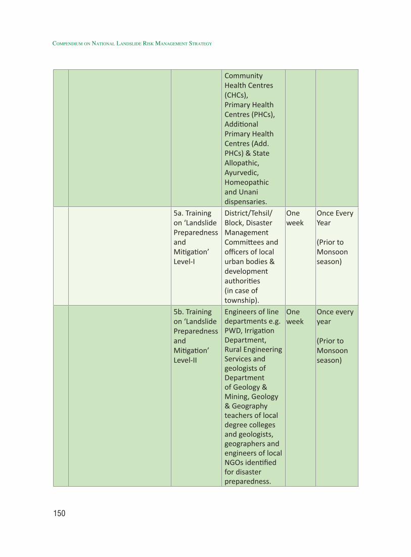
150
Compendium on national landslide Risk management stRategy
Community Health Centres (CHCs), Primary Health Centres (PHCs), Additional Primary Health Centres (Add. PHCs) & State Allopathic, Ayurvedic, Homeopathic and Unani dispensaries.
5a. Training on ‘Landslide Preparedness and Mitigation’ Level-I
District/Tehsil/Block, Disaster Management Committees and officers of local urban bodies & development authorities (in case of township).
One week
Once Every Year
(Prior to Monsoon season)
5b. Training on ‘Landslide Preparedness and Mitigation’ Level-II
Engineers of line departments e.g. PWD, Irrigation Department, Rural Engineering Services and geologists of Department of Geology & Mining, Geology & Geography teachers of local degree colleges and geologists, geographers and engineers of local NGOs identified for disaster preparedness.
One week
Once every year
(Prior to Monsoon season)
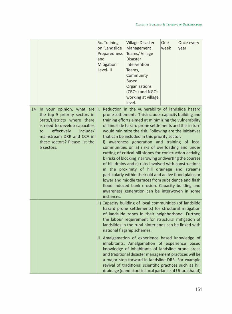
151
5c. Training on ‘Landslide Preparedness and Mitigation’ Level-III
Village Disaster Management Teams/ Village Disaster Intervention Teams, Community Based Organisations (CBOs) and NGOs working at village level.
One week
Once every year
14 In your opinion, what are the top 5 priority sectors in State/Districts where there is need to develop capacities to effectively include/mainstream DRR and CCA in these sectors? Please list the 5 sectors.
I. Reduction in the vulnerability of landslide hazard prone settlements: This includes capacity building and training efforts aimed at minimizing the vulnerability of landslide hazard prone settlements and this in turn would minimize the risk. Following are the initiatives that can be included in this priority sector:
i) awareness generation and training of local communities on a) risks of overloading and under cutting of critical hill slopes for construction activity, b) risks of blocking, narrowing or diverting the courses of hill drains and c) risks involved with constructions in the proximity of hill drainage and streams particularly within their old and active flood plains or lower and middle terraces from subsidence and flash flood induced bank erosion. Capacity building and awareness generation can be interwoven in some instances.
ii) Capacity building of local communities (of landslide hazard prone settlements) for structural mitigation of landslide zones in their neighborhood. Further, the labour requirement for structural mitigation of landslides in the rural hinterlands can be linked with national flagship schemes.
II. Amalgamation of experience based knowledge of inhabitants: Amalgamation of experience based knowledge of inhabitants of landslide prone areas and traditional disaster management practices will be a major step forward in landslide DRR. For example revival of traditional scientific practices such as hill drainage (dandakool in local parlance of Uttarakhand)
CapaCity BUildinG & traininG of stakeHolders
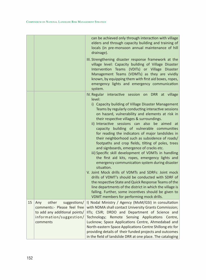
152
Compendium on national landslide Risk management stRategy
can be achieved only through interaction with village elders and through capacity building and training of locals (in pre-monsoon annual maintenance of hill drainage).
III. Strengthening disaster response framework at the village level: Capacity building of Village Disaster Intervention Teams (VDITs) or Village Disaster Management Teams (VDMTs) as they are vividly known, by equipping them with first aid boxes, ropes, emergency lights and emergency communication system.
IV. Regular interactive session on DRR at village level: i) Capacity building of Village Disaster Management
Teams by regularly conducting interactive sessions on hazard, vulnerability and elements at risk in their respective villages & surroundings.
ii) Interactive sessions can also be aimed at capacity building of vulnerable communities for reading the indicators of major landslides in their neighborhood such as subsidence of roads/footpaths and crop fields, tilting of poles, trees and signboards, emergence of cracks etc.
iii) Specific skill development of VDMTs in handling the first aid kits, ropes, emergency lights and emergency communication system during disaster situation.
V. Joint Mock drills of VDMTs and SDRFs: Joint mock drills of VDMT’s should be conducted with SDRF of the respective State and Quick Response Teams of the line departments of the district in which the village is falling. Further, some incentives should be given to VDMT members for performing mock drills.
15 Any other suggestions/comments:- Please feel free to add any additional points/information/suggest ion/ comments
I) Nodal Ministry / Agency (MoM/GSI) in consultation with NDMA shall contact University Grants Commission; IITs; CSIR; DRDO and Department of Science and Technology; Remote Sensing Applications Centre, Lucknow; Space Applications Centre, Ahmedabad and North-eastern Space Applications Centre Shillong etc for providing details of their funded projects and outcomes in the field of landslide DRR at one place. The cataloging
153
of this information will be a major step forward in adopting a holistic approach ina) avoiding duplication of R&D efforts on landslide DRR, b) optimally utilizing the nation-wide available resources, technical & scientific manpower and knowledge pool, c) involving all the stakeholders pertaining to landslide DRR, d) transforming the landslide risk management initiative into a National Mission. II) A centralized server should be maintained at NDMA for cataloging of database all the information pertaining to landslide DRR and climate change adaptation. This information shall be shared with SDMAs of landslide prone states, UTs and district control rooms of the landslide affected districts of the country.
4.5.2 Inclusion of new technology inputs for capacity building and training programs on landslide DRR
New Technology inputs should be included in the training programs on landslide DRR. The phenomenal power of geo-technology combined with instrumentation, remote sensing & GIS and information communication system for monitoring of unstable areas in real time during unfavorable weather conditions. Hence, there is a dire need to include new technology inputs in various training programs on landslide DRR especially for geologists and disaster managers. The technological inputs that are required to be included are given below:-
Remote Sensing techniques combined with high resolution satellite data on GIS platform, GPS, UAV etc. can be made available and proper training in handling these data should be imparted. The contribution of remote sensing to the mapping, monitoring, spatial analysis and hazard prediction of mass movements has largely been in the form of
stereo aerial photos and satellite images interpretations of landslide characteristics (e.g., distribution and classification) and factors (e.g., slope, lithology, geo-structure. Land use / land cover, rock anomalies).
Training programs at Block or Village level should include the realistic hazard, vulnerability, risk and worst case scenario which should be displayed through simplified models, video presentations of some landslide struck areas and people post disaster response and pictures.
The Unmanned Aircraft System (UAS) can be used for hazardous site inspection. Specific skill development in handling Unmanned Aircraft System (UAS) for landslide hazard mapping shall be introduced for the scientists and researches of geospatial fraternity for the purpose of precision mapping and better management of landslides.
[Action: Ministry of Mines (MoM)/GSI, NIDM, IIRS, NRSC and other expert institutions and stakeholders]
CapaCity BUildinG & traininG of stakeHolders
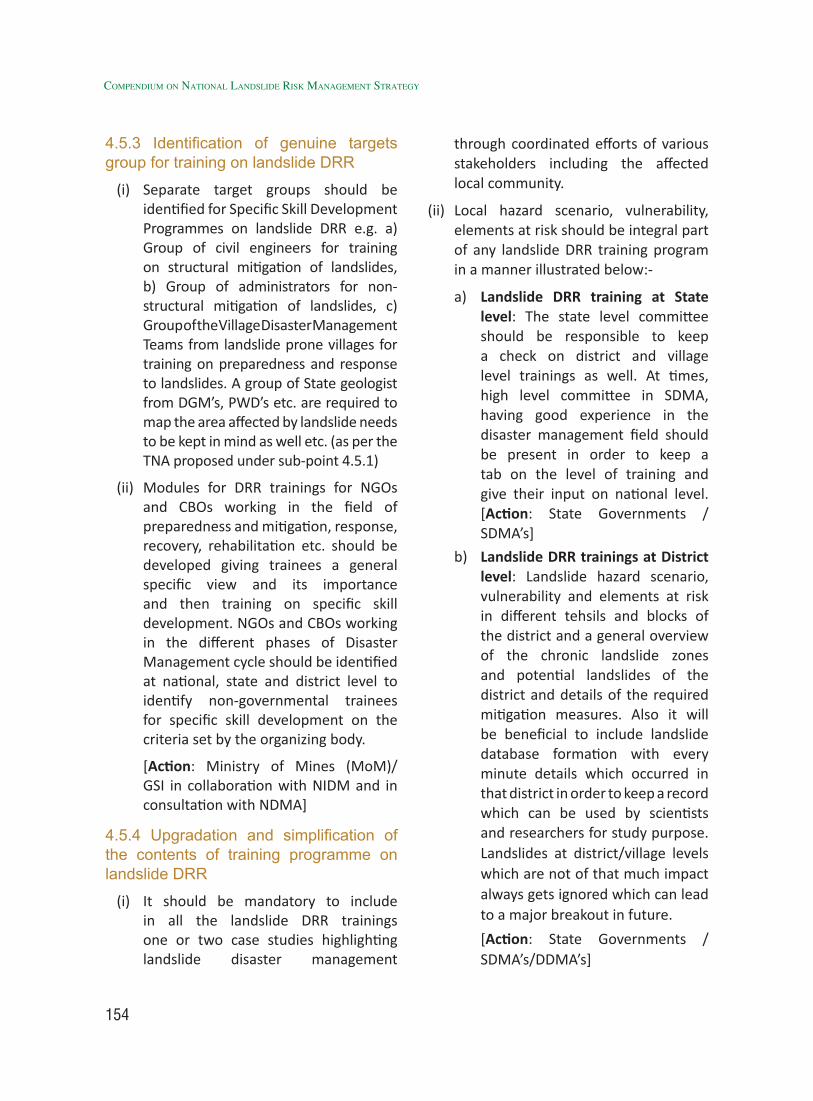
154
Compendium on national landslide Risk management stRategy
4.5.3 Identification of genuine targets group for training on landslide DRR
(i) Separate target groups should be identified for Specific Skill Development Programmes on landslide DRR e.g. a) Group of civil engineers for training on structural mitigation of landslides, b) Group of administrators for non-structural mitigation of landslides, c) Group of the Village Disaster Management Teams from landslide prone villages for training on preparedness and response to landslides. A group of State geologist from DGM’s, PWD’s etc. are required to map the area affected by landslide needs to be kept in mind as well etc. (as per the TNA proposed under sub-point 4.5.1)
(ii) Modules for DRR trainings for NGOs and CBOs working in the field of preparedness and mitigation, response, recovery, rehabilitation etc. should be developed giving trainees a general specific view and its importance and then training on specific skill development. NGOs and CBOs working in the different phases of Disaster Management cycle should be identified at national, state and district level to identify non-governmental trainees for specific skill development on the criteria set by the organizing body.
[Action: Ministry of Mines (MoM)/GSI in collaboration with NIDM and in consultation with NDMA]
4.5.4 Upgradation and simplification of the contents of training programme on landslide DRR
(i) It should be mandatory to include in all the landslide DRR trainings one or two case studies highlighting landslide disaster management
through coordinated efforts of various stakeholders including the affected local community.
(ii) Local hazard scenario, vulnerability, elements at risk should be integral part of any landslide DRR training program in a manner illustrated below:-
a) Landslide DRR training at State level: The state level committee should be responsible to keep a check on district and village level trainings as well. At times, high level committee in SDMA, having good experience in the disaster management field should be present in order to keep a tab on the level of training and give their input on national level. [Action: State Governments /SDMA’s]
b) Landslide DRR trainings at District level: Landslide hazard scenario, vulnerability and elements at risk in different tehsils and blocks of the district and a general overview of the chronic landslide zones and potential landslides of the district and details of the required mitigation measures. Also it will be beneficial to include landslide database formation with every minute details which occurred in that district in order to keep a record which can be used by scientists and researchers for study purpose. Landslides at district/village levels which are not of that much impact always gets ignored which can lead to a major breakout in future.
[Action: State Governments / SDMA’s/DDMA’s]
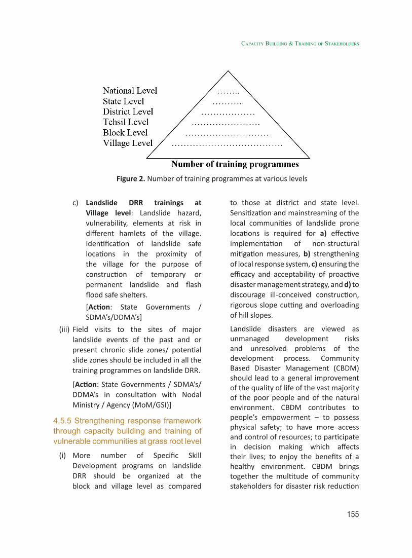
155
c) Landslide DRR trainings at Village level: Landslide hazard, vulnerability, elements at risk in different hamlets of the village. Identification of landslide safe locations in the proximity of the village for the purpose of construction of temporary or permanent landslide and flash flood safe shelters.
[Action: State Governments / SDMA’s/DDMA’s]
(iii) Field visits to the sites of major landslide events of the past and or present chronic slide zones/ potential slide zones should be included in all the training programmes on landslide DRR.
[Action: State Governments / SDMA’s/DDMA’s in consultation with Nodal Ministry / Agency (MoM/GSI)]
4.5.5 Strengthening response framework through capacity building and training of vulnerable communities at grass root level
(i) More number of Specific Skill Development programs on landslide DRR should be organized at the block and village level as compared
to those at district and state level. Sensitization and mainstreaming of the local communities of landslide prone locations is required for a) effective implementation of non-structural mitigation measures, b) strengthening of local response system, c) ensuring the efficacy and acceptability of proactive disaster management strategy, and d) to discourage ill-conceived construction, rigorous slope cutting and overloading of hill slopes.
Landslide disasters are viewed as unmanaged development risks and unresolved problems of the development process. Community Based Disaster Management (CBDM) should lead to a general improvement of the quality of life of the vast majority of the poor people and of the natural environment. CBDM contributes to people’s empowerment – to possess physical safety; to have more access and control of resources; to participate in decision making which affects their lives; to enjoy the benefits of a healthy environment. CBDM brings together the multitude of community stakeholders for disaster risk reduction
Figure 2. Number of training programmes at various levels
CapaCity BUildinG & traininG of stakeHolders
156
Compendium on national landslide Risk management stRategy
to Integrating Poverty Reduction Programs with Disaster Management such as Capacity for Disaster Reduction Initiative (CADRI).
[Action: State Governments / SDMA’s/DDMA’s]
(ii) Capacity building strategy for DRR at micro level shall include following measures for strengthening ‘Disaster Response Framework’ at the village level:-
a) Village Disaster Management Teams (VDMTs) should be sensitized about the hazard, vulnerability and elements at risk in their respective village and surroundings. It is very important to train the locals and prepare them better since when the disaster hits, they the first one to get affected.
b) VDMTs should be equipped with solar lights, first aid boxes, ropes and emergency communication systems such as HAM Radios.
c) Regular training sessions should be conducted for specific skill development of VDMTs in search and rescue and medical first aid in order to ensure the effective and prompt action by them in the event of a disaster. Trained and well equipped Village Disaster Management Teams (VDMTs) can certainly enhance the level of community preparedness and response and this can ultimately improve the rate of survival in the remote areas in the event of disasters.
[Action: State Governments / SDMA’s/DDMA’s]
(iii) Prioritization of following activities of Village Disaster Management Teams (VDMTs)/Village Disaster Intervention Teams (VDITs) as suggested by some earlier workers is required as a part of effective Capacity Building & Training Strategy:
a) Bringing forth the awareness with consciousness among community about the hazard, vulnerability and elements at risk, do’s and don’ts during and after the disaster by jointly organizing interactive sessions along with the line departments like Medical and Health Department, Public Works Department, Department of Disaster Management , disaster management experts and NGOs etc.
b) Creation of Village Disaster Management Plans (VDMPs) through participatory risk assessment with the participation of VDMTs, locals and students while the government agencies and NGO’s can act as facilitators.
[Action: State Governments / SDMA’s/DDMA’s in coordination with line Departments in the States and other Stakeholders]
(iv) The traditional knowledge accumulated through experiential learning of generations, needs to be documented and this is only possible through interactive sessions, where in the participating village elders may share their experience or impart the knowledge and the youngsters particularly school children can acquire and document it in the form
157
of small projects/ dissertation work etc. The school safety projects aimed at school disaster education trainings to teachers and students. Since, teachers and students become actors to disseminate information on disaster risk reduction to other community members.
Participation of Disaster Management experts in such interactive sessions will facilitate the inclusion of modern technical know-how and its amalgamation with the traditional knowledge about landslide management.
[Action: MHRD, State Governments / SDMA’s in coordination with line Departments in the States and other Stakeholders]
4.5.6 Elimination of communication gaps in reading the signs of landslides and for necessary pre-emptive action
(i) There is a dire need for coordinated efforts of community and the authorities for reading the indicators of landslides in the inhabited areas of high vulnerability with a number of elements at risk, so as to make efforts aimed at minimizing the risk to the extent possible. In order to enhance the resilience of community to landslide disaster risk, the vulnerable communities of landslide prone locations should be trained through specific skill development program (in landslide DRR) in reading the following indicators of landslides as elaborated below:
a) Subsidence of road, foot/mule track, crop fields, displacement
of canals, tilting of fencing pillars, trees, telephone towers and poles etc. Furthermore, a gradual or sudden increase in the amount of tilt is also noticed in some cases.
b) Emergence of large cracks or sudden widening of existing cracks in the upper reaches of hill slope.
c) Emergence of small slide zones (in the vicinity of a large active slide zone) and their head-ward shifting towards the neighboring large active slide zone.
d) Sudden disappearance of some seepage zones and emergence of new springs and seepage zones in their proximity.
[Action: State Governments / SDMA’s/DDMA’s]
(iii) The dissemination of knowledge aimed at reducing the vulnerability of the community and to some extent the severity of the hazard. In case of rocks falls, earthquake and cloud burst or heavy rainfall induced landslides the above indicators are often not witnessed.
Local engineers and geologists need to be trained to use the modern technology tools of high resolution remote sensing. GPS and GIS for precise monitoring of the areas showing some of the above discussed signs of slope instability. Disaster Managers at village, block or district level should be trained for opting the immediate evacuation of the population at risk if following indications are there:
a) Sudden tilting of walls of houses
CapaCity BUildinG & traininG of stakeHolders
158
Compendium on national landslide Risk management stRategy
coupled with the development of cracks on walls, roof and gradual subsidence of floor.
b) Flow of muddy water in small streams and sudden increase in the water level of such stream indicates very high rainfall and cloud burst in the upstream catchment with strong probability of flow slide or flash flood in the area.
c) External partners (WHO, CADRI, WORLD BANK etc) can play an important role in giving legitimacy to nationally led initiatives and processes, by engaging in providing support for establishing and strengthening national coordination mechanisms, and contributing to the identification of needs and priorities. External partners can also seek to link or base their disaster risk reduction assistance (funding, technical or process expertise, advocacy, information/knowledge, advisory services) with national strategies (CADRI).
d) There is a need to keep the record of every landslide not just in Himalayan States but in other parts of the country as well. The database maintained will help scientists and research scholars in order to persuade their study in landslide disasters. Till now, there isn’t any organization which has landslide database (date, place, mode of occurrence, loss of life, loss of property, lithology of the area, anthropogenic activity) maintained and accessible.
e) Create pace-setting best practices
of scientifically designed and implemented community-centric Early Warning Systems (EWS) which includes geotechnical and geological expertise.
The coordinated efforts of community and disaster management fraternity can help in avoiding or minimizing the losses due to major landslides.
[Action: Ministry of Mines (MoM)/GSI in collaboration with NIDM and other stakeholders in consultation with NDMA]
4.5.7 Provisions for financial incentives
Linking village level capacity building and training programmes on landslide DRR to financial incentives is need of the hour. It can be done in the following ways:
(i) Provisions shall be made under MNREGA scheme for undertaking small scale structural mitigation of landslides. This will not only help in reducing the severity of the probable hazard but would also reduce the economic vulnerability of the vulnerable communities. However, the design of these programmes will need involvement of experts.
[Action: Ministry of Rural Development (MoRD) in consultation with Niti Aayog]
(ii) The village training level programmes on landslide DRR shall have some well-defined tasks in the form of mock drills and simulation exercises (in the course module) to be executed by the trainees in separate categories of (a) Men, (b) women, (c) Children in the sub- categories of 6-10 years and 11-15 years, (d) Old aged persons etc. The
159
winners should be given some financial remuneration.
[Action: State Governments / SDMA’s/DDMA’s]
(iii) Village Disaster Management Team (VDMT) or Village Disaster Intervention Team (VDIT) members should also be given some honorarium after successful completion of the training on landslide DRR.
[Action: State Governments / SDMA’s/DDMA’s]
(iv) To avoid any conflict of interests the VDMT/VDIT members should have a tenure of two years and thereafter they be replaced with other new members. However, exception can be applied to ex-army, ex-paramilitary, ex-police, serving or ex-doctors/paramedics. Since, they can be retained as the permanent members of VDMT/VDIT depending upon their medical fitness.
[Action: State Governments / SDMA’s/DDMA’s]
(i) Fortify Landslide risk management by introducing Innovative Techno-Legal and Techno-Financial Practices. For all ongoing and new development projects involving Landslide risk management, the project construction, and the corrective action for countering the construction related, visible or anticipated slope failures and environmental damage, before, during or after the construction stage, ought to be considered in design as its inseparable parts. It should be mandatory to provide adequate
budget for the above purpose as a package, which must also include long term maintenance costs.
[Action: Central Ministries in collaboration with State Governments / SDMA’s/DDMA’s]
4.5.8 Elimination of attitudinal gaps in capacity building and training on landslide DRR
(i) Government officials nominated for participation in the training on DRR must be spared full time for that very training (on DRR) for which they have been nominated in order to ensure their holistic exposure to the training on DRR. There is a need for a Government Order which states that the participating officers be fully spared for the duration of the training. The exception to this can be an emergency with the individual participant and or an emergency or disaster situation.
[Action: DoPT, Central Ministries, State Governments / SDMA’s/DDMA’s]
(ii) Clear guidelines should be issued by the Department of Personnel and Training (DoPT), Government of India to various departments regarding nomination of suitable rank and subject related official for the trainings on DRR.
[Action: DoPT]
(iii) State and District level Disaster Management Authorities in every landslide prone State shall identify at least one knowledge institution with expertise in Engineering geological and Geotechnical investigations and adequately equip it to undertake
CapaCity BUildinG & traininG of stakeHolders

160
Compendium on national landslide Risk management stRategy
scientific investigations of landslides, when needed.
[Action: State Governments / SDMA’s/DDMA’s]
(iv) Review and revise BIS Codes, Standards and Guidelines (e.g., IS 14458, IS14496, IS14680, IS14804 and IS 14961 etc.) to enable tapping the potential of new knowledge and design softwares along with new Codes to support national landslide risk reduction initiatives. We need drafting of some new codes, especially to ensure sound engineering practices in Geotechnical investigation of landslides, elucidation of boundary shears, measurement of piezometric pressures on boundary shears, undisturbed sampling from landslide boundaries, simulated stress path testing for shear strength parameters and stability analysis in terms of total and effective stress etc.
[Action: Bureau of Indian Standards (BIS) in consultation with NDMA and Ministry of Mines (MoM)/GSI]
(v) Landslide disasters occur many a time because of the non-engineered or illegal constructions. And it should be upto stakeholders to keep a check on the ongoing projects in their particular States and review their progress from time to time in order to avoid any kind of mis-happeneing.
[Action: State Governments / SDMA’s/DDMA’s]
(vi) Accord the highest priority to R & D in landslide risk reduction. Priority should be given to more R&D projects related to landslides and other related disasters in order to come up with a better
solution for the respective States. The highest priority and adequate funding should be accorded for advanced R & D in the hither to neglected areas, some of which are (a) Earthquake-induced Landslides; (b) Role of Extreme Weather Events in landslide study, occurrence and behavior; (c) Approaches to landslide risk and damage assessment; (d) Development of Innovative technologies for effective utilization of landslide waste; and (e) Unfolding of fundamental mechanisms of the most problematic Indian landslides etc.
[Action: MHRD, DST, State Governments and other academic institutions and stakeholders]
4.6 Implementation StrategyThe multi-faceted aspects of landslide
management, especially risk assessment, prevention, mitigation, preparedness and response require an inter disciplinary cross-sectoral and multi-level action strategy to be implemented through education, training and capacity building of all the stakeholders, so as to make them act in an integrated manner towards a convergent holistic approach for mainstreaming landslide risk management.
4.6.1 Implementing Agency:
Various agencies can be identified for implementation of the strategy on capacity building and training of stakeholders. Some of these are listed below:
1. National Institute of Disaster Management (NIDM), New Delhi
2. Institutes of Department of Science and Technology, Govt. of India such as Wadia Institute of Himalayan Geology (WIHG), Dehradun
161
3. Constituent establishment of CSIR such as Central Building Research Institute (CBRI), Roorkee and Central Road Research Institute (CRRI), Delhi
4. Indian Institute of Remote Sensing (IIRS), Dehradun
5. National Remote Sensing Centre (NRSC), Hyderabad
6. Defense Terrain Research Laboratory (DTRL), DRDO, New Delhi
7. Following institutes/centres of the Himalayan States, North-eastern States, Western and Eastern Ghats:
(i) Disaster Management Centres under Department of Disaster Management
(ii) Disaster Management Cells (DMCs) under Administrative Academies/Academy of Administration
(iii) State Remote Sensing Applications Centres of landslide prone states and any other state Remote Sensing Applications Centre interested in imparting training on landslide DRR
(iv) Indian Institute of Technology (IIT’s) / National Institute of Technology (NIT’s)
(v) State Institutes of Rural Development (SIRDs)
(vi) Regional Institutes of Rural Development (RIRDs)
(vii) Central / State Government Universities located in landslide affected States
(viii)Voluntary commitment by NGOs to the capacity building and training of stakeholders on landslide DRR at grass root level should also
be encouraged in a big way. Any other international, national, state, regional or local organization/institution/centre (owned either by government or NGO) having experience of imparting training on landslide DRR.
4.7 Financial Implications:
4.7.1 Centre-State and Public-Private Partnership
Initiatives like this can help in mobilizing financial resources for capacity building and training of stakeholders in landslide DRR. Business houses, business consortiums and companies involved in the developmental infrastructure projects in landslide prone hill regions can be involved through CSR in the initiatives aimed at the capacity building & training on landslide DRR.
4.7.2 Fund provision in budget estimates of BRO & State PWDs:
Separate provisions shall be made for landslide mitigation measures in the budget estimates for new roads planned by various departments and agencies of central and the state governments in the landslide prone states and UTs. This would help in handling the resource crunch in ensuring the proper disposal of hill slope cut debris material.
Hiring the local workforce for this initiative will not only decrease the possibility of anthropogenically induced landslides but will also help in reducing the economic vulnerability of local labor workforce.To ensure that the safety of slopes are adequately managed and their stability maintained, there is need set up appropriate slope management systems commensurate with the number of slopes and size of slopes
CapaCity BUildinG & traininG of stakeHolders
162
Compendium on national landslide Risk management stRategy
related problems that have to be managed to mitigate economic losses and hardships including loss of life inflicted on common public in the affected areas.
Forecasting System which would help interested people, such as the manager of communication, road construction units or the public to visually inquire all or part of information of landslide issues along road through the Internet. Here slope stability monitoring factor can also be included so that the amount being sanctioned contains for the slope stability monitoring as well. This will ensure that the common people of hazardous areas as well as the concerned agencies are kept informed about the risk during the recurrence period of such disasters so that they can take appropriate steps to avoid loss of life.
4.7.3 Fund Provision by DoPT for training on landslide DRR:
Department of Personnel and Training (DoPT), Government of India can also make some additional provisions for trainings aimed at specific skill development in landslide DRR for the landslide prone states and UTs.
4.8 Monitoring MechanismA three tier monitoring mechanism
(in synergy with the existing institutional arrangement for disaster management) is proposed for monitoring the progress of capacity building and training of stakeholders.
4.9 ReferencesAlley, E.E. (1993), Combating the
Vulnerability of Communities, in P.A. Merriman and C.W.A Browitt (Eds), Natural Disasters Protecting Vulnerable Communities. 67 Thomas, Telford, London.
Aysan, U.F., (1993), “Vulnerability Assessment” (Key Note Paper) in P.A. Merriman and C.W.A. Browitt (Eds.), op.cit.
Bhandari, R.K. (2013), Challenges of the devastating Indian Landslides, Current Science 105(5), pp 563-64.
Bhandari, R.K. (2015), Recommendations of the INAE-CRRI roundtable meeting on engineering interventions in landslide risk reduction, held at CRRI on 11th May, 2015.
Basics of Capacity Development for
S.N. Administrative Unit/Level Activities Monitoring Authority1. Village, Block & Tehsil All the Capacity Building
and Training programmes on landslide DRR & CCA
District Disaster Management Authority (DDMA)
2. District and Division All the Capacity Building and Training programmes on landslide DRR & CCA
State Disaster Management Authority (SDMA)
3. State, National and International Level (with participation of the country)
All the Capacity Building and Training programmes on landslide DRR & CCA
National Disaster Management Authority (NDMA)
163
Disaster Risk Reduction, CADRI (Capacity for Disaster Reduction Initiative).
DMMC (2003), Interim Report on Landslides in Karnaprayag town of District Chamoli, Uttarachnchal (Based on the field Investigations by DMMC Team during November 15th to 17th, 2003) Unpublished Technical Report of Disaster Management and Mitigation Centre (DMMC), Dehradun, submitted to Govt. of Uttaranchal and District Authorities in Nov., 2003.
DRM Programme District Chamoli (2004), Report on training Programme of Committees, Disaster Risk Management Programme by MHA, GoI and UNDP.
DST (2007), “A field manual for landslide investigations”, A Publication of Department of Science & Technology, Govt. of India, pp. 1-153.
Gupta SG., Ghonge MM., and Jawandiya P.M. (2013), Review of Unmanned Aircraft System (UAS). IJARCET Volume 2, Issue 4, pp 1646-1658.
IGNOU (2007), Disaster Preparedness. Indira Gandhi National Open University, Delhi, pp 249.
Kumar K. Gupta, P. Gupta and Sikdar, P.K. (2004), Devastating events of clouds burst leading to land slide disaster and its consequences in Garhwal Himalayas.Proceedings Volume-2 World Congress on Natural Disaster Mitigation, Vigyan Bhawan, New Delhi,pp 276 - 282.
Prakash, S. (2013), Landslide Science and Practice, pp. 257-264.
Prakash, S. (2013), Capacity Development for Landslides Risk Reduction, “Landslides: Global Risk Preparedness” IPL Project # 166
– Documentation, Training and Capacity Building on Landslides Risk Management.
Prakash, S &Kathait, A., (2014), A Selected Annotated Bibliography and Bibliography on Landslides in India. NIDM, New Delhi, pp186.
Sassa, K. (2015), ISDR-ICL Sendai Partnerships 2015–2025 for global promotion of understanding and reducing landslide disaster risk. Landslides (2015) 12:631–640.
Tsunozakia, E., Nakagawab, Y., Shikada, M., (2010), Capacity Building for Disaster Risk Reduction (DRR) at Community Level – A Myanmar’s Case – (www.iawe.org/WRDRR/2010/ Tsunozakia.pdf).
Uniyal, A. (2003), Overview of mitigation strategy. Workshop on State Disaster Management Strategy, Disaster Mitigation and Management Centre, Uttaranchal Secretariat, Dehradun.
Uniyal,A. (2004), Landslides at Karnaprayag: Another Uttarkashi in the making? Current Science, Vol. 87, No. 8, 2004; pp. 1031 –1033.
Uniyal, A. and Rautela, P. (2005), Disaster management strategy for avoiding landslide induced losses to the villages in the vicinity of the Himalayan township of Mussoorie in Uttaranchal (India). Disaster Prevention and Management: An International Journal, Vol. 14, No. 3, pp 378 – 387
Uniyal, A. and Prasad, C. (2006) Disaster management strategy for mass wasting hazard prone Naitwar Bazar and surrounding areas in Upper Tons valley in Uttarkashi district, Uttaranchal (India). Disaster Prevention and Management: An International Journal, Vol.15, No. 5, pp. 821– 837
Uniyal, A. (2008), Prognosis and mitigation
CapaCity BUildinG & traininG of stakeHolders
164
Compendium on national landslide Risk management stRategy
strategy for major landslide prone areas: A case study of Varunavat Parvat landslide of Uttrakhand (India), Disaster Prevention and Management: An International Journal, 17 (5), 2008; pp 622-644;
Uniyal, A. (2009), Reading Indicators of major landslides through amalgamation of experiential learning based knowledge of communities and modern technical know-how to remote sensing, GIS and GPS, National Conference on Quaternary Geological Processes, Centre of Advance Studies in Geology, Univ. of Lucknow.
Uniyal, A., (2010) Disaster management strategy for mass wasting hazard prone Kumarkhera area in Narendra Nagar township of Tehri Garhwal district of Uttarakhand. Disaster Prevention and Management: An International Journal Vol.19, No. 3, 2010, pp 358-369
Uniyal, A.(2011a), Need for Strengthening Disaster Response Framework at the village level”, National Seminar on Late Quaternary Geology of the Himalayan Orogen and the Foreland Basin, Centre of Advance Studies in Geology, University of Lucknow.
Uniyal, A. (2011b) Bhuskhlan tatha badal phatne se utpann kichar ki baar se bachao”, (Hindi language article on Public Awareness for safety from landslides and cloud burst
induced mud flows), Vigyan Pragti, June, 2011 pp 22-26 (ISSN 0042-6075), Published by National Institute of Science Communication & Information Resources (NASCAIR), New Delhi.
Uniyal, A. (2013), Lessons from Kedarnath Tragedy of Uttarakhand, Current Science, 105 (11), 2013, pp 1472-1474.
Uniyal, A. (2016), Anthropogenic Actions Worsen the Impact of Natural Disasters, Key Note Address, National Seminar on Anthropogeographie: Contemporary Issues, Problems and Sustainable Development, sponsored by Indian Council of Social Sciences Research (ICSSR), organized by Avadh Girls Degree College, Lucknow, India, Feb. 10-11, 2016.
USGS (2000), National Landslide Hazards Mitigation Strategy A Framework for Loss Reduction Department of the Interior, U.S. Geological Survey, Open-File Report 00-450.
Verma, V.K., Prasad, C. and Uniyal, A. (2017), Aspects of Earth Environment, LAMBERT Academic Publishing, Saarbrücken, Deutschland/Germany, pp-161.
Westen, C. and Krol, B. (u.d.), Combining landslide research with capacity building: the experience of the United Nations University-ITC School for Disaster Geo-information Management.
165
Strategy on Training & Capacity Enhancement on Landslide Monitoring and Early Warning System (EWS)
1.0 IntroductionThe term early warning includes the whole
range of actions and operations right from planning and instrumentation of problematic slopes and landslides to their monitoring, analyses, fixing of early warning alert thresholds, decision making, dissemination of early warning alerts and improvements in early warning practices through sustained location-specific feedback and innovations. The effects of landslides can also be reduced to some extent or minimized in certain cases, if the threatened communities, are forewarned about impending disaster and are prepared against the likely threats.
Steps involved in landslide monitoring and early warning system are as under: -
a) Pre-requisites for Monitoring of Slope Movement(i) Collection of History, Existing Data and
Data Review(ii) Topographic Investigations(iii) Geological, Geophysical and
Geotechnical Investigations(iv) Kinematic Analysis, if applicable(v) Geomorphological and Morphometric
Studies
b) Detailed Investigation Plan Detailed investigations with the following
objectives, should be planned. • areal extent of the slide, differentiation
of moving blocks and identification of the type, direction and extent of movement; if possible, the time and
duration of movement as well• location and shape of slide planes • nature of landslide blocks • possibility of further or future
movement on slopes above the existing slide
• possibility of further, future or accelerated sliding
• distribution of ground water and heterogeneity of slope mass
c) Monitoring of Landslides Monitoring of landslides movements
consists of:-• Selection of specific location depending
upon the type of movement, location and hazard and risk value of slope failure.
• Selection of monitoring methods and frequency of data collection.
• Data processing and methods of presentation / communication of results.
Methods generally used for monitoring landslide can be divided into surface and subsurface measurements of the landslide activity and total regime measurements.
d) Methods of Monitoring Slope Movements
Methods for monitoring of slope movements can be broadly classified in three categories.
(i) Conventional Field Observations on a periodic basis of features like trees, fencing, poles, walls, cracks and recording changes in them with time using traditional simple measurements like marking on a sheet of paper across a crack, use of glass plates to find the time of movement, measuring between two fixed features on a slope across a crack and so on.
Annexure
CapaCity BUildinG & traininG of stakeHolders

166
Compendium on national landslide Risk management stRategy
ii) On-site Instrumental Observation of slope displacement, movements or failures using technique like Digital Tape Measurements, Single or Multi-point Bore-hole Extensometers, Magnetic Extensometer, Inclinometers, Tiltmeters, Crack Meters, Spies, Convergence Gauges, Settlement Gauges, Abney levels, Compass, Theodolite, Electronic Distance Meter, Total Stations, Global Positioning Systems (Handheld GPS and Differential GPS), Automated Target Recognition System, Laser Scanners, Acoustic Emission Measurements, Ground Based Synthetic Aperture Radar (SAR) etc. in the field and recording of observation on a periodic or regular / real-time basis
iii) Off-Site Monitoring Techniques like Remote Sensing Technology for slope movements include application of SAR Interferometry, Optical Reflectometry, Differential Interferometry, Light Detection and Ranging (LiDAR), Persistent Scaterrer, High Resolution Satellite Imagery technique that utilize the correlations between landslip morphology, motion and topography of the site for monitoring purposes.
2.0 Problem & ChallengesThere are no standard ready-made
packages or systems for early warning but all the instrumentation, tools, equipment, observation and data processing systems are available in multiple choices. They are necessarily to be customized to suit a particular slope or a landslide according to its type, magnitude, hazard potential of a landslide and the purpose of early warning alert. The hazard detection and early warning systems for different types of landslides are also usually different. For example, planning for instrumentation and early warning for a pre-existing (repetitive) landslide will be very different from the schemes for early warning against anticipated first time landslides. Likewise, early warning schemes for mass movements such as a debris flow or a rock fall will be very different from those for a block slide or a classical landslide with discrete boundary shears.
After installation of instrumentation and generation of landslide early warning, it would be great challenge for mainstreaming and capacity building of local authority and community to understand the alert signals of landslide movement and to take necessary action in advance.
3.0 Review of past work done & best practices
The status of past work done is summarized in tabulated form as shown below:-
Table 1. Status of Monitoring Studies for Slope Movements in India (Parkash et al., 2008)
Landslide Location
Period of Study
Type of Measurements
Instruments Used Organization(s) Involved
Remarks
Sher ka Danda Landslide, Nainital, Uttarakhand State
1880 & 1942
Surface Movements
Theodolite, Pegs Geological Survey of India (GSI)
Monitoring was continued for several years but discontinued after 1945
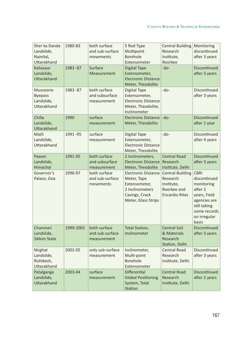
167
Sher ka Danda Landslide, Nainital, Uttarakhand
1980-83 both surface and sub-surface movements
5 Rod Type Multipoint Borehole Extensometer
Central Building Research Institute, Roorkee
Monitoring discontinued after 3 years
Kaliasaur Landslide, Uttarakhand
1983 -87 Surface Measurement
Digital Tape Extensometer, Electronic Distance Meter, Theodolite
-do- Discontinued after 3 years
Mussoorie Byepass Landslide, Uttarakhand
1983 -87 both surface and subsurface measurement
Digital Tape Extensometer, Electronic Distance Meter, Theodolite, Inclinometer
-do- Discontinued after 3 years
Chilla Landslide, Uttarakhand
1990 surface measurement
Electronic Distance Meter, Theodolite
-do- Discontinued after 1 year
Matli Landslide, Uttarakhand
1991 -95 surface measurement
Digital Tape Extensometer, Electronic Distance Meter, Theodolite
-do- Discontinued after 4 years
Pawari Landslide, Himachal
1991-95 both surface and subsurface measurement
2 Inclinometers, Electronic Distance Meter, Theodolite
Central Road Research Institute, Delhi
Discontinued after 3 years
Governor’s Palace, Goa
1996-97 both surface and sub-surface movements
Electronic Distance Meter, Tape Extensometer, 2 Inclinometers Casings, Crack Meter, Glass Strips
Central Building Research Institute, Roorkee and Encardio Rites
CBRI discontinued monitoring after 2 years, Field agencies are still taking some records on irregular basis
Chanmari Landslide, Sikkim State
1999-2002 both surface and sub-surface measurement
Total Station, Inclinometer
Central Soil & Materials Research Station, Delhi
Discontinued after 3 years
Nirghat Landslide, Rishikesh, Uttarakhand
2002-05 only sub-surface measurement
Inclinometer, Multi-point Borehole Extensometer
Central Road Research Institute, Delhi
Discontinued after 3 years
Patalganga Landslide, Uttarakhand
2003-04 surface measurement
Differential Global Positioning System, Total Station
Central Road Research Institute, Delhi
Discontinued after 2 years
CapaCity BUildinG & traininG of stakeHolders
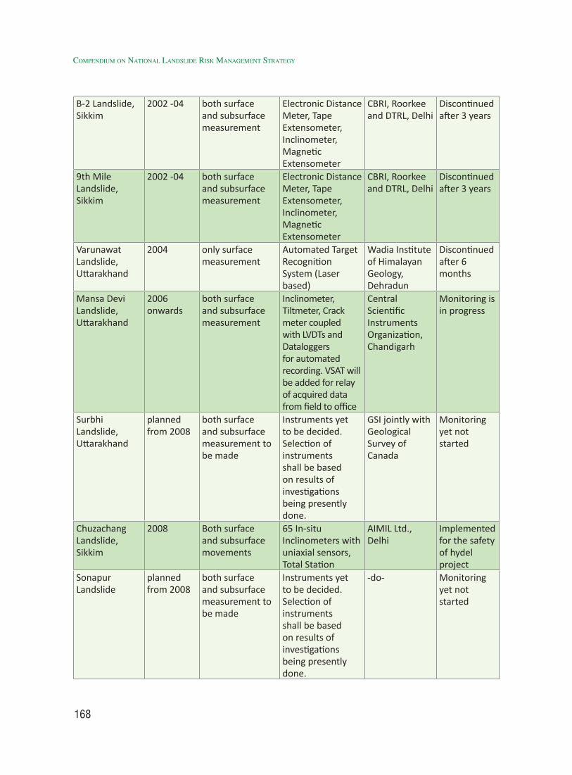
168
Compendium on national landslide Risk management stRategy
B-2 Landslide, Sikkim
2002 -04 both surface and subsurface measurement
Electronic Distance Meter, Tape Extensometer, Inclinometer, Magnetic Extensometer
CBRI, Roorkee and DTRL, Delhi
Discontinued after 3 years
9th Mile Landslide, Sikkim
2002 -04 both surface and subsurface measurement
Electronic Distance Meter, Tape Extensometer, Inclinometer, Magnetic Extensometer
CBRI, Roorkee and DTRL, Delhi
Discontinued after 3 years
Varunawat Landslide, Uttarakhand
2004 only surface measurement
Automated Target Recognition System (Laser based)
Wadia Institute of Himalayan Geology, Dehradun
Discontinued after 6 months
Mansa Devi Landslide, Uttarakhand
2006 onwards
both surface and subsurface measurement
Inclinometer, Tiltmeter, Crack meter coupled with LVDTs and Dataloggers for automated recording. VSAT will be added for relay of acquired data from field to office
Central Scientific Instruments Organization, Chandigarh
Monitoring is in progress
Surbhi Landslide, Uttarakhand
planned from 2008
both surface and subsurface measurement to be made
Instruments yet to be decided. Selection of instruments shall be based on results of investigations being presently done.
GSI jointly with Geological Survey of Canada
Monitoring yet not started
Chuzachang Landslide, Sikkim
2008 Both surface and subsurface movements
65 In-situ Inclinometers with uniaxial sensors, Total Station
AIMIL Ltd., Delhi
Implemented for the safety of hydel project
Sonapur Landslide
planned from 2008
both surface and subsurface measurement to be made
Instruments yet to be decided. Selection of instruments shall be based on results of investigations being presently done.
-do- Monitoring yet not started
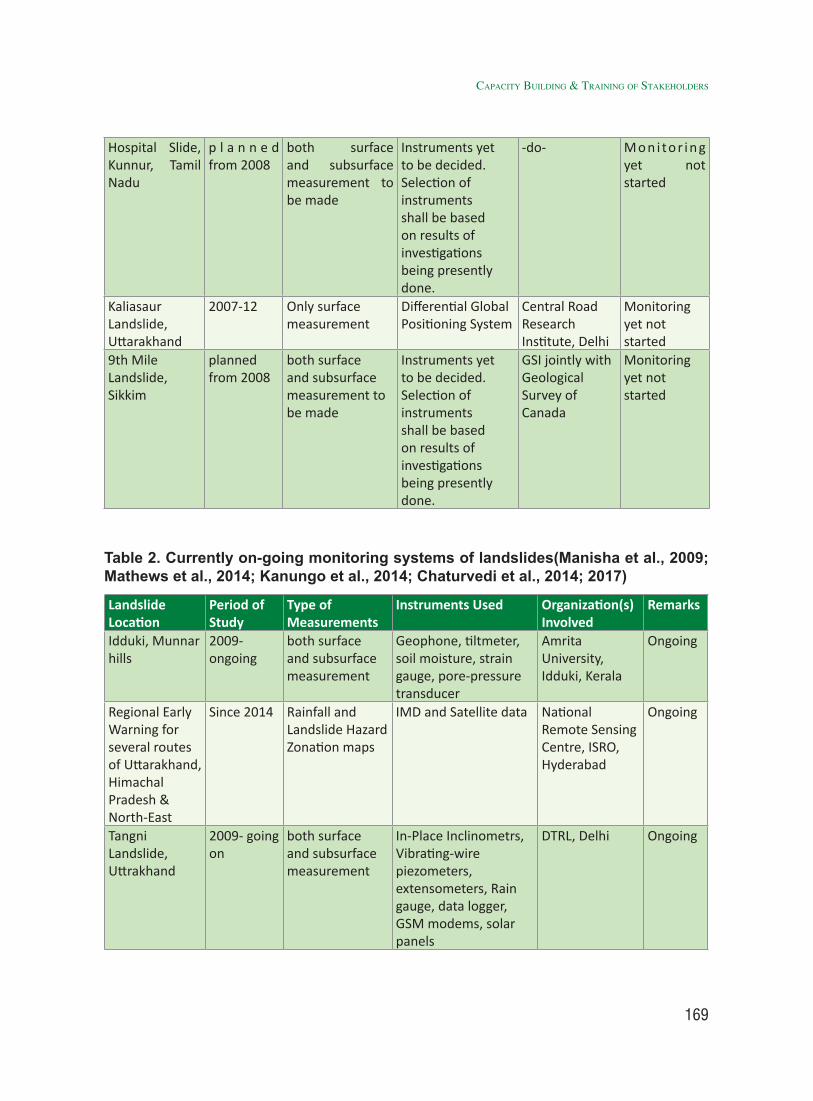
169
Hospital Slide, Kunnur, Tamil Nadu
p l a n n e d from 2008
both surface and subsurface measurement to be made
Instruments yet to be decided. Selection of instruments shall be based on results of investigations being presently done.
-do- M o n i to r i n g yet not started
Kaliasaur Landslide, Uttarakhand
2007-12 Only surface measurement
Differential Global Positioning System
Central Road Research Institute, Delhi
Monitoring yet not started
9th Mile Landslide, Sikkim
planned from 2008
both surface and subsurface measurement to be made
Instruments yet to be decided. Selection of instruments shall be based on results of investigations being presently done.
GSI jointly with Geological Survey of Canada
Monitoring yet not started
CapaCity BUildinG & traininG of stakeHolders
Table 2. Currently on-going monitoring systems of landslides(Manisha et al., 2009; Mathews et al., 2014; Kanungo et al., 2014; Chaturvedi et al., 2014; 2017)
Landslide Location
Period of Study
Type of Measurements
Instruments Used Organization(s) Involved
Remarks
Idduki, Munnar hills
2009- ongoing
both surface and subsurface measurement
Geophone, tiltmeter, soil moisture, strain gauge, pore-pressure transducer
Amrita University, Idduki, Kerala
Ongoing
Regional Early Warning for several routes of Uttarakhand, Himachal Pradesh & North-East
Since 2014 Rainfall and Landslide Hazard Zonation maps
IMD and Satellite data National Remote Sensing Centre, ISRO, Hyderabad
Ongoing
Tangni Landslide, Uttrakhand
2009- going on
both surface and subsurface measurement
In-Place Inclinometrs, Vibrating-wire piezometers, extensometers, Rain gauge, data logger, GSM modems, solar panels
DTRL, Delhi Ongoing
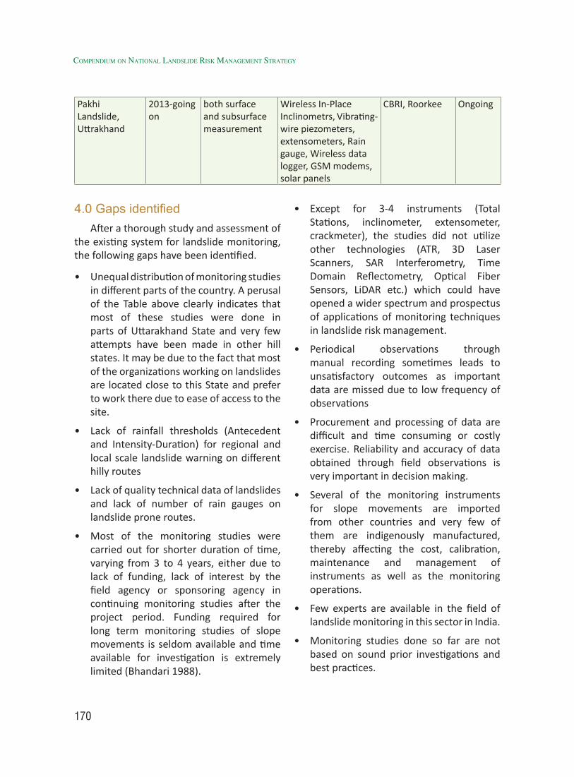
170
Compendium on national landslide Risk management stRategy
Pakhi Landslide, Uttrakhand
2013-going on
both surface and subsurface measurement
Wireless In-Place Inclinometrs, Vibrating-wire piezometers, extensometers, Rain gauge, Wireless data logger, GSM modems, solar panels
CBRI, Roorkee Ongoing
4.0 Gaps identifiedAfter a thorough study and assessment of
the existing system for landslide monitoring, the following gaps have been identified.
• Unequal distribution of monitoring studies in different parts of the country. A perusal of the Table above clearly indicates that most of these studies were done in parts of Uttarakhand State and very few attempts have been made in other hill states. It may be due to the fact that most of the organizations working on landslides are located close to this State and prefer to work there due to ease of access to the site.
• Lack of rainfall thresholds (Antecedent and Intensity-Duration) for regional and local scale landslide warning on different hilly routes
• Lack of quality technical data of landslides and lack of number of rain gauges on landslide prone routes.
• Most of the monitoring studies were carried out for shorter duration of time, varying from 3 to 4 years, either due to lack of funding, lack of interest by the field agency or sponsoring agency in continuing monitoring studies after the project period. Funding required for long term monitoring studies of slope movements is seldom available and time available for investigation is extremely limited (Bhandari 1988).
• Except for 3-4 instruments (Total Stations, inclinometer, extensometer, crackmeter), the studies did not utilize other technologies (ATR, 3D Laser Scanners, SAR Interferometry, Time Domain Reflectometry, Optical Fiber Sensors, LiDAR etc.) which could have opened a wider spectrum and prospectus of applications of monitoring techniques in landslide risk management.
• Periodical observations through manual recording sometimes leads to unsatisfactory outcomes as important data are missed due to low frequency of observations
• Procurement and processing of data are difficult and time consuming or costly exercise. Reliability and accuracy of data obtained through field observations is very important in decision making.
• Several of the monitoring instruments for slope movements are imported from other countries and very few of them are indigenously manufactured, thereby affecting the cost, calibration, maintenance and management of instruments as well as the monitoring operations.
• Few experts are available in the field of landslide monitoring in this sector in India.
• Monitoring studies done so far are not based on sound prior investigations and best practices.
171
• Whatever attempts on landslide monitoring have been made till date, did not make much impact on the society and hence, these were not encouraged.
• Standards and codes of practice for monitoring of slope movements are not well followed.
• Regulations and enforcement promoting monitoring of potential / existing landslides that pose risk to life, economy and environment to large extents are weak.
• Low level of interest and encouragement from Civil, Political, Financial and Legal Bodies at Local Levels
5.0 RecommendationsThe strategy envisions bringing together
various tools instrumental, satellite based and observations for effective monitoring of slope movements. It suggests the following action points to be implemented.
• Encouragement in development of indigenous sensors and monitoring equipments / softwares through skill based trainings in IIT’s, ITI’s, Universities, concerned Departments etc. through central funding system.
• Ensuring long term funding mechanism for better understanding about the nature and behaviour of chronic landslides such as Kaliasaur Landslide, which have been active since 1920.
• Pooling of Resources (physical, financial, technological), Information and Experiences to derive maximum benefits out of monitoring efforts.
• Creating capacity amongst community through training to understood landslide
signs and handover of low cost warning system and its maintenance by community itself.
• Encouragement of skill development based trainings on landslide DRR by involving community and other stakeholder through PPP model.
• Generation of new and innovative ideas for development of low cost landslide monitoring and early warning system by involving scholars, school children, villagers through competitions, fairs, users meets, interactive workshops etc.
• Promoting use of monitoring data in predicting the nature and behavior of landslide, providing early warning, evacuation of unsafe sites, implementation risk reduction measures and legal issues.
• Timely and reliable monitoring studies are important to make prompt decisions for mitigation and warning.
• Fast processing of monitored data for taking urgent measures for prevention and mitigation of risks.
• Encouraging pilot projects to establish the applicability, credibility and reliability of an effective / efficient landslide monitoring system.
[Action: Ministry of Mines (MoM)/GSI, NIDM, other expert Institutions and Stakeholders in collaboration both States]
6.0 Need/ Justification for a Training Program on capacity Building on Community based Low Cost Early Warning System of Landslide
Community participation has been acclaimed as the additional element in landslide disaster management necessary
CapaCity BUildinG & traininG of stakeHolders
172
Compendium on national landslide Risk management stRategy
to reverse the trend of increase in loss from landslides. It will also build a culture of safety, and ensure sustainable development. The multifaceted aspects of Early Warning System of landslide need to be addressed through capacity building program at Community level. Education programs need to be designed, with greater focus on capacity development of Community, Geologist, Engineers and Students in landslides risk reduction. Government and the communities together should evolve joint action plan aiming at spreading of community education and development of community leadership. Such an education will enable communities in ensuring safer constructions. Need arises in educating professionals in damage and loss assessment due to landslides and create simple tools and uniform procedures by which objective assessment becomes possible. One of the cost effective tool or technology that can help the community at ground level and various stakeholders is the Early Warning System involving Low cost sensors. Effective early warning systems can play supreme role in remote mountain communities where advance communication systems are inaccessible that can instantly warn of possible danger of landslides. Low cost Early Warning System of Landslide is focussed to address this need.
The Low Cost Community based EWS combines high-end technology of sensors with a simple but unconventional approach to alert people of landslide risk. It makes use of various low cost sensors which include tipping rain gauges, Accelerometer sensor, Tilt Sensors, GSM module and a Piezo speaker (Buzzer) which records the live movement if any and once the threshold values crosses, it rings to warn the nearing
risk of landslide. Locals are trained to determine alert levels using installed rain gauges and various other sensors. When required, a buzzer sounds and subsequently alert message sends to the stakeholders to warn the entire community.
Involvement of the people in the community may prove the productiveness of the Low cost EWS. Locals need to be organized, educated, and trained in using hazard-risk information provided by the EWS. This will allow them to reliably read the rain gauges and other low cost sesnsors’ readings and respond to these readings appropriately.
To realize the effectiveness of Low cost EWS, entire setup involving sensors their communication system should be installed, critical rainfall threshold chart of landslide need to be set and training of various target group need to be done. This system aims to enhance community-based responses to landslides by providing them with information and supporting community-based activities that will reduce their fragility or to prepare them to evacuate. Moreover, a capacity enhancement programme is necessary to increase the awareness among the practitioners and engineers working at various agencies in the concerned States / UT are located in the various Himalayan region of India. Landslide risk in the Himalayan States in India has increased due to increasing population, rapid infrastructure development and due to the changing climate (including extreme weather event e.g. cloud burst, high intensity short duration rainfall, snow melting). There is a need to implement proper strategies for landslide monitoring and early warning system. To succeed in this, officials working in SDMAs, BRO, PWDs, Geology

173
and Mineral Deptt., school-college students, community etc. and other agencies must be trained.
7.0 Draft Training programme A training module on landslide monitoring
and early warning system will have a purposeful and systematic role to play in skill based capacity building by providing the knowledge about reliable tools and techniques that can be used for the monitoring and warning of landslide events. Moreover, the training series will also cover the aspects related to the preparedness work for the landslide risk at an acceptable level. The training module will aim for providing input in the evaluation of hazard, vulnerability and risk associated with landslides. This training program also aims to maintain the high professional level training, which will also serve as a direction for research and development within landslides to ensure a good knowledge base for concerning authorities and to create master trainers. The following issues will be covered during the proposed training.
• What are various landslide types?
• How to assess landslide hazards?
• What are the precautionary measures?
• Selection of appropriate measures to avoid risk?
• How to build safe environment?
• How to stabilize soil slopes?
• Strategies of taking proactive actions and measures?
• What are different landslide monitoring sensors and techniques?
• Landslide Modelling and Prediction
• Case Studies on Landslides Monitoring and Early Warning
7.1 Aims & objectives
This training program will be of two weeks duration. The aim of the training program is to involve the relevant disaster managers, engineers/geologists/geo-technical engineers, school-college students, community etc (referred as participants hereafter) of the concerned States / UT’s and expose them to the various modes of capacity building and training on landslide risk assessment along with hands-on-experience on landslide monitoring instrumentation, monitoring, maintenance etc. Also, know-how on early warning systems and landslide prediction methods would be introduced in particular built environment conditions.
1. Capacity Building for participants responsible for landslide mitigation and management.
2. Awareness about methods of early warning systems and practical methods for landslide assessment.
3. Training the participants for the preparedness against pre and post landslide events.
4. To give hands-on experience to the participants on the landslide monitoring and instrumentation.
7.2 Duration of the program and dates and complete schedule
This concept paper provides training module that can be replicated for several years at different locations in India to conduct similar kind of training program for remaining concerned States / UT’s. The prepared training module will be implemented and tested.
CapaCity BUildinG & traininG of stakeHolders
174
Compendium on national landslide Risk management stRategy
In between the training, the participants will be asked to install low-cost sensors for a real landslide case for monitoring of a problematic landslide. The case and target groups/ participants will be selected in a close cooperation between the NDMA, NIDM, SDMAs, DDMAs, Revenue and DM, GSI, DGM. During the evaluation, the problems faced by the participants will be discussed and
the hands-on session with suggestions for possible corrections.
A detailed plan for the Week 1 and Week 2 is shown in a table. Week 1 is focused on theoretical aspect of monitoring and early warning of landslides, whereas Week 2 is dedicated to hands-on training and then assessment of the trained individual in developing required monitoring and warning system for a case study purpose.
7.3 Detailed Schedule of Training Program:Training Module
Course details
Detailed Schedule of Training Program & Module Duration Remark
Week -1
A.1 Understanding of LandslidesOverview of Landslide problems in India; definition, terminology and classification (based on material, velocity, mechanism etc); features for their identification (morphological) - potential landslide indicator; direct and indirect impact of landslides on socio-economic and environmental conditions.
1 day
A.2 Conditions / Causes / factors for landslide occurrences: Why, when, where and how may landslide occur?Inherent preparatory factors: geological, geo-morphological and geo-environmental conditions; Extrinsic triggering factors: precipitation, snow melting, earthquake/vibration, undercutting of slopes by streams/glaciers/human activities, glacial lake outburst and other anthropogenic actions. Stages of landslides: pre-failure, failure, post failure. Factors governing these stages and key elements to investigate the different stages of a landslide.
1 day
A.3 Survey, mapping and investigationApplication, importance, methods and scale of survey and mapping of landslide/slopes.Surface & sub-surface investigation / mapping: Ground based, engineering geological, Geomorphological, geophysical methods.
2 day
A.4 Landslide Monitoring and Early Warning SystemBackground of landslide early warning system in India and World.
1 day
175
A.5 Types of sensorsa) High end / Costly: Piezometers, extensometer, rain-
gauge, soil moisture sensors, geo-phones etc.b) Low cost sensors: Aurdino board, rain gauge, sirens,
indicators etc.
1 day
Week 2
A.6 Hands-on exercise: Preparation and development of low cost landslide monitoring models.
2 days
A.7 Field Exercise/Presentation: a) Identification of landslide prone site in your vicinity.b) Mapping / sketching of identified landslide prone site. c) Suggestion of preventive measures and disaster
management plan through instrumentation and early warning system.
2 days
Feedback & Suggestions by participants for improvements in training capsule/module.
2 Weeks 60 hours of training
CapaCity BUildinG & traininG of stakeHolders
7.4 Expected outcome:1. The trained individuals/groups can
technically identify the possible landslide prone regions and prepare report against the actions to be taken.
2. Hands-on experience on landslide inventory and generating reports for the engineers/geologists involved in various government organizations.
3. An insight of the monitoring instrumentation for vulnerable areas shall be investigated with feasible options.
4. This program also trains the engineers in the area of preparedness and management for post landslide and other related disasters.
8.0 List of Institutes / Departments to Organize Training
Training programme will be replicated in other concerned States / UT’s to develop
capacity of State Machinery in Community Based Landslide Monitoring and Early Warning System in scientific and technical manner and create master trainers to impart training to other officials in their respective States / UT’s. A suggestive list of Institutes / Departments etc. could be useful in organizing training programs are given as below:-
SN Institutes / Departments1 National Institute of Disaster
Management, New Delhi2. Central Building Research Institute
(CBRI)-CSIR, Roorkee3 Defence Terrain Research Laboratory4 Central Scientific Instruments
Organization, Chandigarh5. Wadia Institute of Himalaya Geology
(WIHG), Dehradun6. Indian Institute of Technology (IIT),
Roorkee7. Indian Institute of Technology (IIT),
Delhi
176
Compendium on national landslide Risk management stRategy
8. Indian Institute of Remote Sensing (IIRS), Dehradun
9. Indian Institute of Technology (IIT), Mandi, Himachal Pradesh
10. Punjab Engineering College (PEC) University, Chandigarh
11 National Institute of Technology (NIT), Shillong, Meghalaya / North Eastern Hill Council (NEHU)
12. National Institute of Technology (NIT), Aizawl / Mizoram DMR
13. Institute of Land and Disaster Management, Kerala Government
14. National Geophysical Research Institute (NGRI)-CSIR, Hyderabad
15. Central Road Research Institute (CRRI)-CSIR, Delhi
16. Central Soil and Material Research Station (CSMRS), Delhi
17. Central Water and Power Research Station (CWPRS), Pune, Maharashtra
18. State Administrative Training Institutes (ATI’s) in landslide prone States
References:[1] Victoria, L. P. (2002, September).
Community based approaches to disaster mitigation. In Proceeding Regional Workshop on Best Practices in Disaster Mitigation. Bali (pp. 24-26).
[2] Parkash, S. (2013). Education, training and capacity development for mainstreaming landslides risk management. In Landslide Science and Practice (pp. 257-264). Springer Berlin Heidelberg.
[3] Van Westen, C., & Krol, B. Combining landslide research with capacity building: the experience of the United Nations University–ITC School for Disaster Geo-Information Management.
177
5.1 IntroductionThe country is vulnerable to one or
multiple disasters including landslide and related hazards like cloud burst and flash flood, which are considered to be one of the most dangerous and destructive natural hazards in terms of loss of live and property in Himalaya and Western Ghats. The wide spread property loss during recent landslide and related hazards like cloud burst and flash flood have shown that most of the constructions plans are ill-conceived and do not follow standard norms. The design codes are generally not followed even by the government departments. This has created an alarming situation, where large number of unsafe building stock is added each year to the already huge number of existing unsafe buildings in hostile climate, fragile environment and tectonically active unstable of hilly terrain. Malpa and Okhimath landslides of 1998 and Kedarnath Tragedy of 2013 have clearly highlighted the vulnerability of lives and property. The collapse of engineered and non-engineered building during landslide is the main contributor to the loss of lives and injuries to the people.
The experts of Sub-Group V i.e., Preparation of Mountain Zone Regulations & Policies pointed out that there is no landuse policy in the country at National, State and local level for implementation. The cities of the Himalayas are growing and beginning
Preparation of Mountain Zone Regulations & Policies 5
to turn into the mountains of garbage and plastic, untreated sewage, chronic water shortages, unplanned urban growth and even local air pollution because of vehicles. These towns need to be planned, particularly keeping in mind the rush of summer tourists. Many states have experimented from banning plastics, to taxing tourists to better respond to these issues. But they need support and new thinking on everything on traditional architecture practices, local water management through protection of lakes and different systems of sewage and garbage management.
The meeting of Sub-Group V i.e., “Preparation of Mountain Zone Regulations and Policies” was conducted at Melli, Kalimpong, West Bengal on 23 Oct 2016. An informal discussion on issues and challenges of the task given to Sub-Group V was held.
In the meeting following points were discussed:
1) Existing regulations and building bye-laws needed to be stringently enforced.
2) There is requirement of implementation of policies by multiple agencies in holistic manner
3) The issues of land loss in landslide affected areas were highlighted and use of bamboo in bio-engineering was emphasized.
4) It was also decided to review the State
178
Compendium on national landslide Risk management stRategy
Town and Country Planning Act was well as the zoning regulations so as to ensure that these are in conformity.
Certain issues were very prominent in the deliberations of almost all the members, such as:
1) There are general issues which are almost commonly spread over the entire Himalaya. However, there are certain problems which are area/region specific and hence cannot be generalized. They should be treated as case studies.
2) National Landslide Mitigation Policy (NLMP) which is a must for National Landslide Mitigation Strategy (NLMS) should be common all over the country while NLMS must be developed by the States and be area/problem specific but must reflect the NLMP.
3) Slope instability management, reflecting the potential for sliding and landslide management, representing the ongoing event/process should be two separate components of NLMS.
4) The existing bye laws/regulations at local body or state level should be incorporated in the NLMP and NLMS. They should not contradict each other.
5) NLMP and NLMS should not contradict National Environment Policy and therefore, they should be validated by the MoEF&CC.
6) Best practices which are used to mitigate landslide at local level and activities which can be held responsible for the landslide hazard should be documented in the NLMP.
7) Since preventing /preparing for the landslides/slope instability is much
easy and cost effective than mitigating/reclaiming the landslide/slope instability or responding to. Emphasize must be given to prevention /preparedness in NLMP and NLMS.
8) Complexity of issues in Darjeeling district due to dual administration. The political imbroglio in the district results in West Bengal Govt and GTA (Gorkha Territorial Admin) being constantly at logger heads with each other. As such, there is dual control over Disaster Management which (as per the DM Act 2005) is under the DM, Darjeeling but most resources and line departments are under CEO (GTA).
9) Unplanned developmental activities in mountains including huge investments in construction of non-engineered roads in rural areas and lack of drainage which are exacerbating and increasing risk.
10) Necessity of load bearing tests, hazard zonation, slope and land-use maps to guide urban planners for clearing constructions.
11) Impact of landslides on rural communities where loss of large areas of farmland has ruined livelihoods and puts a big question mark on food security in the mountains. Compensation for land lost in landslides for farmers needs to be addressed.
12) Necessity of DDMAs to apply for and utilize disaster mitigation funds.
13) DDMA to obtain land-use, asset and other useful maps from WB State Remote Sensing Centre.
14) Paucity of basic data (e.g., rainfall) in mountainous areas and especially in the North East.
179
(15) Necessity of inducting representations from North Eastern states in the formulation of landslide strategy.
(16) Need for the National Strategy on Landslide Risk Management to focus on implementation and enforcement of laws/ regulations and accountability.
(17) Need for better all round coordination between the Panchayats, Line departments, Forest department and Municipal authorities for management of jhoras and drainage outside municipal limits.
(18) State specific landslide mitigation strategies to be formulated to address specific issues of each mountain state.
(19) Urban centers and towns in mountain areas being burdened beyond the carrying capacity by tourism and rural-to-urban migration. Need for satellite towns.
It is important, given the ecological fragility of the mountain areas that we plan carefully for urban growth and its spill over into newer settlements. It would be important to devise strategies for consolidation of urban settlements, which are governed through land-use planning incorporated in the municipal master plan and are provided all facilities, before further growth is permitted. In other words, unmanaged and unchecked urban growth should not be permitted. It is also important that buildings in these towns should suit to the local ecosystem, taking into account seismic and slope stability fragility. All this will require the creation of strong regulatory mechanism in the towns.
The municipal byelaws must provide for construction activity to be regulated in areas, which fall in hazard zones or areas close to
rivers, springs and watersheds of the towns. In many cases these provisions exist in the byelaws, but have not been strictly enforced. There needs to be a zero-tolerance policy on these matters.
These issues are not new. But what is new is the need to respond more urgently to the changes that are beginning to be seen in this climate vulnerable region. It is also clear that development will be critical for the region to cope with climate change and its variability. This is the opportunity to use new models of development, based on the region’s ecology and traditional knowledge and culture, to build an economy capable of withstanding these changes.
All the major sub-components of Mountain Zone Regulations and Policies are discussed by the experts of sub-group V at Kalimpong.
1. In the section, Formulation of land-use policies and techno legal regime of first sub-component all the members felt that numerous developmental activities demand land and in the process of progression of development, landuse changes are taking place, legally or illegally, in the mountain zones. Due to growing population in Indian Himalayan Region (IHR) and Western Ghats (WG), the per capita availability of land has reduced. Such reducing per capita availability of land will have a direct bearing on the land requirements of various developmental purposes and community development. The concerns become severe when the land availability is reduced directly in urban areas. In the absence of a specific landuse policy for Indian Himalayan Region (IHR) and Western Ghats (WG) such changes will
preparation of MoUntain zone reGUlations & poliCies
180
Compendium on national landslide Risk management stRategy
become detrimental in the long run for the sustainable landslide mitigation strategy. The members felt that there is a need to strategies utilization of land and its management for sustainable development of IHR and WG. It was noticed that the country already has a National Landuse Policy (NLP) which has been updated in 2013. However, in the NLP 2013 there is no specific mention of any landuse policy for IHR and WG.
Apart from this, members of the sub-group felt that the Sub-group should also study the State Land Utilization Policy (SLUP) of IHR and WG States, which, as per the recommendation of the NPL 2013, every State Government shall prepare within a period of one year. For the States having total area under mountain zone SLUPs, it is assumed, must have taken all their specific requirements into consideration. However, for the States having partial coverage of mountain zone such as West Bengal there must be a separate mention of hill area land use policy. Then there are the jurisdictional issues of State Government and GTA.
In the micro-level the Urban Local Bodies (ULBs) of IHR and WG States are either not having local landuse planning or if they have it not being updated. It is resulting into ill-conceived planning unplanned development and ultimately slope instability.
2. In the section Updation and enforcement of building regulations and bye laws by State Governments/Local bodies, it is observed that almost in every Sate there is a provision of State Municipal Act. However, the Acts
of almost all the IHR and WG states are more focused on other issues than landslide problems. It is noticed that (1) the building regulations and bye laws are not either updated as per the requirement or (2) they are not having any strong implementation mechanism support. There are lots of issues which have been marked during the Sub- Group V visit to Kalimpong and interaction with the local people.
3. The third section of sub-component is on Review and revision of BIS code/guidelines for landslide management. The following observations have been made by the Sub-Group V:
I. Master Plan/Development Plan provides a legal framework within which development of an area takes place.
II. Landuse zoning and development promotion/control regulations serve as legal instruments for planning and executing proposals contained in the plan.
III. The zoning and development promotion regulations are generally too many, very complex and difficult to comprehend and enforce.
IV. There is therefore, need to have simplified regulations so that these are adoptable and enforceable within the changing socio-economic and physical development.
V. Zoning and development promotion regulations include:
A. Land use classificationa. For perspective plans
b. For development plans
c. For layouts of projects/schemes
181
B. Land use zoning regulationsa. The main purpose of landuse
zoning is to provide regulations for development of an area to serve the desired purpose efficiently and to preserve its character.
b. To promote a healthy and balanced development, it is necessary to apply reasonable limitations on use of lands and buildings – USE ZONES.
c. Zoning protects residential areas from harmful invasions of other NON-CONFORMING uses.
C. Development promotion/control regulations
a. The basic purpose of such regulations is to promote quality of life of people by organizing the appropriate development of land in accordance with the developmental policies and the land use proposals contained therein.
b. The development promotion regulations deal with designated use zones and use premises.
c. Development promotion/control regulations are generally provided as part of the development plan under the (urban/special area) planning legislation of the State Government.
d. These regulations are mainly to specify the quantum of construction, specific location of the structure in various use zones for the activities to be developed/ provided.
National Building Code of India, taking into consideration the Indian Standards & Guidelines for Landslide safety are:-
• IS 14458 (Part 1): 1998 Guidelines
for retaining wall for hill area; Part 1 Selection of type of wall.
• IS 14458 (Part 2): 1997 Guidelines for retaining wall for hill area; Part 2 Design of retaining/ breast walls.
• IS 14458 (Part 3): 1998 Guidelines for retaining wall for hill area; Part 3 Construction of dry stone walls.
• IS 14496 (Part2): 1998 Guidelines for the preparation of landslide Hazard zonation maps in mountainous terrains; Part 2 Macro Zonation.
Note: The latest version of National Building Code shall be followed.
5.2 Scope of WorkKeeping in view the term of reference
the Sub-Group V identified some specific legislations and development control/building regulations for detailed examination to incorporate and to modify these documents to take care of Natural Hazard Proneness. To understand various problems/issues related to existing building regulations in hill towns, study is done related to different regulations of residential buildings in major hill towns like Shimla, Manali, Dalhousie, Mussoorie, Nainital, Shillong, Srinagar and Gangtok located in the Indian Himalayan region to identify various similarities and variations, and attempts are being made to understand reasons for similarities and variations. Building regulations considered for study are taken from the latest development plans and building bye-laws available on websites of local governing authorities.
Different documents used in the study are as follows:
1. Draft Development plan for the Shimla planning area, 2021.
preparation of MoUntain zone reGUlations & poliCies
182
Compendium on national landslide Risk management stRategy
2. Draft Development plan for the Manali Planning area, 2021.
3. Draft Development plan for the Dalhousie Planning area, 2021.
4. Nainital Lake Region Special Area Development Authority Building Regulations.
5. The Sikkim Building Construction (Amendment) Regulations, 2000.
6. Meghalaya Building-Bye Laws, 2011.
7. Building Regulations and Bye-Laws (Kashmir Division), 2010.
8. Mussoorie Dehradun Development Authority Building Construction and Development bye-laws (Amendment), 2003.
9. Town and Country Planning Legislation
a. Model Town & Country Planning Act 1960
b. Model Regional and Town Planning and Development Laws 1985
c. Model Urban and Regional Planning and Development Law (Revised) (Part if UDPFI Guidelines)
10. Land use Zoning, Development Control and Building Regulations
a. Land use Zoning and Protection of Buildings of Essential Services – Guidelines for Disaster Preventions (document prepared by BMTPC/ADPC)
b. Review of Current State Legislation on Earthquake Safety in the State of Uttarakhand – a study conducted by BMTPC-ADPC.
c. Development Control Rules, Master Plan Regulations & Building Bye-laws in the local bodies.
d. Development Control Regulations of Ahmedabad Urban Development Authority (AUDA)
e. Development Control Regulations of Mumbai
f. Development Control Regulations of Pune
g. Development Control Regulations of Delhi
h. Draft National Building Code – Part 2 pertaining to administration, and Part 4 pertaining to fire & life safety.
i. Urban Development Policies and Disaster Risk in Shimla
j. THE NAGALAND BUILDING BYE-LAWS 2012
k. THE SIKKIM BUILDING CONSTRUCTION REGULATIONS, 1991
(As amended by the Sikkim Building Construction (Amendment) Regulations, 2000
l. Special Task Force to review Nagaland building byelaws
5.3 Proposed Amendment in Town & Country Planning Legislations
Indian hill towns, especially in the Himalayan region, are peculiar examples of massive urban development in environmentally sensitive areas, which are growing exponentially over and above their carrying capacities and hampering/affecting the environment and ecology at large. These hill towns have numerous problems related to planning and design of buildings, inadequate infrastructure (roads, water supply, sewage, garbage collection and disposal), improper housing/building stock having insufficient strength, unprecedented cutting of vegetation and slopes, pollution,
183
chaos, congestion and degraded living and harm to the natural environment which affects the ecological balance in and around hill towns. Most of these issues/problems of existing development in Indian hill towns are due to inappropriate planning proposals and building regulations enforced in different hill towns. Existing building regulations enforced in Indian hill towns are mostly inspired from Delhi Master Plan(s), which are not appropriate to the context of hill towns, as the geo-environmental and socio-developmental context of Delhi is varied to a greater extent from that of hill towns. Contextual inappropriateness, uniformity, rigidity, incompleteness, lack of clarity, and cumbersome enforcement mechanisms are major characteristics of existing building regulations in hill towns.
The Town and Country Planning Organization (TCPO), which is an organization of Central Government to deal with the subject of planning (regional, urban and rural) and developmental policies, formulated a Model Town and Country Planning Act in the year 1960. The Model Act provides as follows:
a. Provisions for preparation of comprehensive Master Plan for urban areas of various states. The states may adopt the Model legislation with suitable modifications for this purpose.
b. To constitute a board to advise and to coordinate in the matter of planning and plan formulation by the Local Planning Authorities in the State.
c. Provisions for implementation and enforcement of the Master Plans and the miscellaneous provisions to achieve planned urban growth of various urban areas in the state.
The above model was revised in
1985 by the Central Town and Country Planning Organisation (TCPO). The revised model regional and town planning and development law has largely been the basis for the enactment of comprehensive urban and regional planning legislation in the States and UT’s. This model is in the nature of a guideline and is the outcome of several reviews and revisions undertaken on the recommendations of the State Ministers Conference held from time to time. The legality of this model has been confirmed by the Ministry of Law. With a view to ensuring better overseeing and coordination of planning with plan implementation, the Model Law which dealt with the planning aspect only has been reviewed and revised and now a combined planning and development law has been formulated in consultation with the concerned Central Government Ministries. Under this law, planning and plan implementation have been combined together so that a single agency could undertake both these functions. To do this, the planning and development authority to be constituted under the Law has been equipped with full planning and development powers to discharge this task.
A revised model for Urban & Regional Planning and Development law was brought out, and guidelines on Urban Development Plan Formulation and Implementation (UDPFI) have been formulated in 1991.
5.4 Regulations for Land Use Zoning for Natural Hazard Prone Areas
The regulations for Land Use Zoning for Natural Hazard Prone Areas are to be notified under section:
a. u/s 73(f) of Model Town & Country Planning Act, 1960; OR
preparation of MoUntain zone reGUlations & poliCies
184
Compendium on national landslide Risk management stRategy
b. u/s 143(f) of Model Regional and Town Planning and Development Law; OR
c. u/s 181(f) of Model Urban & Regional Planning and Development Law (Revised) of UDPFI
Guidelines as may be applicable in the respective States under the existing provisions of Town & Country Planning Legislation as and when Master Plan/ Development Plan of different cities/ town/ areas are formulated. However, these zoning regulations are to be implemented through the provisions of Development Control Regulations/ Building Bye-Laws, wherever the Master Plan is not in existence or not formulated.
Classification of urban land uses is based upon the requirements of the various plans. For example, a perspective plan, which is a policy document, need not show many details of a specific land use and may only show the main use which could be, say, residential or commercial. In the case of a development plan, which is a comprehensive plan indicating use of each parcel of land, there is a need to show more details of a specific land use. It has to indicate for the land designated as, say, commercial, the further details as to which land is for retail commercial, or for wholesale trade or for godowns. In the case of layouts of projects of a shopping centre further details shall be necessary, indicating which block of retail commercial is for, say, cloth or electronics or vegetables.
There could be three levels in land use classification shown under:
Level I For Perspective Plans
Level II For Development Plans
Level III For Layouts of Projects/Schemes
5.4.1 Land Use Zoning
The main purpose of the land use zoning is to provide regulations for development of a particular area to serve the desired purpose efficiently and to preserve its character. It also provides for the kind of buildings to be constructed. Zoning regulations are legal tools for guiding the use of land and protection of public health, welfare and safety. Such regulations also include provisions for the use of premises/property and limitations upon shape, size and type of buildings that are constructed or occupy the land. Further, these provide both horizontal as well as vertical use of land. These regulations also improve the quality of life in urban centres. For instance in landslide zones, the land use may be forest/plantation while restricting any building activity in such vulnerable areas. Similarly, along the drains green belts can be planned which may facilitate improvements of these drains in future. Life line structures should also be protected likewise while either proposing land uses or otherwise.
5.4.2 Use Zones
In order to promote a healthy and balanced development, it is necessary to apply reasonable limitations on use of lands and buildings. For desirable development, the city is divided into a number of ‘use zones’ such as residential, commercial, industrial recreational, etc. For each zone, specific regulations are provided for. A single set of regulations cannot be applied for the whole city.
5.4.3 Non-Conforming Use
Zoning protects residential areas from harmful invasions of other uses like industrial use and commercial use. However, it does not prohibit use of lands and buildings that
185
are lawfully established prior to coming into effect of such zoning regulations. If such uses are contrary to regulations in a particular ‘use zone’ and are not to be allowed, such uses are designated as ‘non-conforming uses’. These are to be gradually eliminated without inflicting unreasonable hardship on the property owners/users. For implementation and enforcement of proposals under each land use category, contained in a development plan, there is a need to list out various uses and activities that are permitted, permissible on an application to the Competent Authority and prohibited. Land use zoning regulations precisely provide this list for various use zones.
The suggested list of uses/activities for various use zones should be comprehensive, keeping in mind the local and special characteristics of various sizes of settlements (large, medium and small). Depending upon the specific situation this list could be further enhanced or reduced, as the case may be.
5.4.4 Definitions
5.4.4.1 Natural Hazard
The probability of occurrence, within a specific period of time in a given area, of a potentially damaging natural phenomenon.
5.4.4.2 Natural Hazard Prone Areas
Areas likely to have (a) moderate to very high damage risk zone of earthquakes, OR (b) moderate to very high damage risk of landslide OR (c) significant flash flood flow, OR (d) subsidence proneness or potential, OR (e) one or more of these hazards.
5.4.4.3 Natural Disaster
A serious disruption of the functioning of a society, causing widespread human,
material or environmental losses caused due to landslide and associated hazards which exceeds the ability of the affected society to cope using only its own resources.
5.4.4.4 Mitigation
Measures taken in advance of a disaster aimed at decreasing or eliminating its impact on society and on environment including preparedness and prevention.
5.4.5 Objectives
5.4.5.1 The objective of land use zoning is to regulate land use in hazard prone areas to minimise the damage caused to the habitat, as a result of landslide hazards which recur from time to time. Land Use Zoning, therefore, also aims at determining the locations and the extent of areas likely to be adversely affected by the hazards of different intensities and frequencies, and to develop such areas in a manner that the loss to the development is reduced to the minimum.
5.4.5.2 Land Use Zoning envisages certain restrictions on the indiscriminate development of the “unprotected” hazard prone areas and to specify conditions for safer development by protecting the area from severe losses. In the former case, boundaries of different zones are to be established to prevent unrestricted growth there.
5.4.5.3 Another objective of Land Use Zoning in the hill areas will be to ensure the forest cover and to preserve the green areas for environment protection.
5.4.6 Applicability
5.4.6.1 Areas planned under State Perspective Plan/Regional Plan/ Master Plan/ Development Plan
• State Perspective Plan/Regional Plan
preparation of MoUntain zone reGUlations & poliCies
186
Compendium on national landslide Risk management stRategy
• Development Plan (Master Plan/Zonal Development Plan)
While formulating Perspective Plan/Regional Plan, Development Plan (Master Plan/Zonal Development Plan) for any notified area, the proposals should indicate natural hazard prone areas with the type and extent of likely hazards.
5.4.6.2 Areas not covered under Master Plan
In such areas where there are no Master Plans or Development Plans, general guidelines and recommendations on natural disaster mitigation should be issued to the various local bodies, Municipalities and Town Area Committees and Panchayats to enable them to take these into consideration while sitting various projects and deciding on construction of buildings etc. Technical help may be required by some of the local bodies in the implementation of the recommendations and for interpretation of the guidelines.
5.4.7 Identification of Natural Hazard Prone Zones
5.4.7.1 While it is known that most hilly areas are prone to landslides/landslips, the susceptibility of the various areas to landslide varies from very low to very high. Landslide zoning naturally requires mapping on large scale. Normally medium scale of 1:25000 is at least chosen. In preparation of the landslide zone map, two types of factors are considered important as listed here below:
a) Geological/Topographic Factors/Parameters
- Lithology
- Geological Structures/Lineaments
- Slope-dip (bedding, joint) relation
- Geomorphology
- Drainage
- Slope angle, slope aspect and slope morphology
- Land use
- Soil texture and depth
- Rock weathering
b) Triggering Factors
- Rainfall
- Earthquake
- Anthropogenic
5.4.7.2 Whereas the factors listed under geological/topographic parameters have been considered as basic inputs for the landslide potential model, the three triggering factors namely, rainfall, earthquake and anthropogeny were considered external factors which trigger the occurrence of a landslide.
5.4.7.3 Whereas, the landslide prone areas under ‘a’ are available for some parts of the country on the maps given in Landslide Hazard Zonation Mapping in the Himalayas of Uttranchal and Himachal Pradesh States using Remote Sensing and GIS Techniques, pub. By National Remote Sensing Agency, Department of Space, Government of India, Hyderabad and Landslide Hazard Zonation Atlas of India – Landslide Hazard Maps and Cases Studies prepared by Building Materials & Technology Promotion Council, Ministry of Urban Development & Poverty Alleviation, Govt. of India, the risky areas in other parts of the country have to be determined specially for the planning areas under consideration through special studies to be carried out by the State/UT governments and the concerned Competent Authorities.
5.4.8 Approach for Landuse Zoning
Having identified the hazard prone areas
187
the following alternatives can be adopted for dealing with the disaster risk problems.
a. Leaving the area unprotected. In this case it will be necessary to specify Land Use Zoning for various development purposes as recommended,
b. Using protection methods for the areas as a whole or in the construction of buildings, structures and infrastructure facilities to cater for the hazard intensities likely in the planning area.
c. It will be appropriate to prioritise buildings, structures and infrastructures in terms of their importance from the point of view of impact of damage on the socio-economic structure of the society.
5.4.9 Prioritization
In regard to Land Use Zoning, different types of buildings and utility services are grouped under three priorities as indicated below.
Priority 1. Defence installation, industries, public utilities, life line structures like hospitals, electricity installations, water supply, telephone exchange, aerodromes and railway stations; commercial centres, libraries, other buildings or installations with contents of high economic value.
Priority 2. Public and Semi Public institutions, Government offices, and residential areas.
Priority 3. Parks, play grounds, wood lands, gardens, green belts, and recreational areas.
5.4.10 Planning in Hill Areas
In order to ensure environmentally sound development of hill towns, the following
restrictions and conditions may be proposed for future activities.
a. An integrated development plan may be prepared taking into consideration environmental and other relevant factors including ecologically sensitive areas, hazard prone areas, drainage channels, steep slopes and fertile land.
b. Water bodies including underground water bodies in water scares areas should be protected.
c. Where cutting of hill slope in an area causes ecological damage and slope instability in adjacent areas, such cuttings shall not be undertaken unless appropriate measures are taken to avoid or prevent such damages.
d. No construction should be ordinarily undertaken in areas having slope above 300 or areas which fall in landslide hazard zones or areas falling on the spring lines and first order streams identified by the State Government on the basis of available scientific evidence.
e. Construction may be permitted in areas with slope between 100 to 300 or spring recharge areas or old landslide zones with such restrictions as the competent authority may decide.
5.4.11 Identification of Open Spaces
Out of the open spaces ear-marked as district parks, neighborhood parks and local parks in the development plan, zonal plans and local plans, suitable and approachable parks/ open spaces should be identified for the use during the emergency to provide shelter and relief caused by a natural hazard. Such pockets should be clearly marked on the city maps.
preparation of MoUntain zone reGUlations & poliCies

188
Compendium on national landslide Risk management stRategy
5.4.12 Savingsa. Notwithstanding anything contained in
any other regulation for the time being in force, the Regulations for Land Use Zoning for Natural Hazard Prone Areas shall have an over-riding effect for planning and development purposes.
b. In any specific circumstances, if any part of the Regulations has to be relaxed then it will be incumbent on the part of the user to adopt safe guard and protective measures to the satisfaction of the Competent Authority.
5.4.13 RecommendationsAdditional provisions with regard to Land
Use Zoning for Natural Hazard Areas are suggested in various existing Model Planning Legislation –
a. Sub-Section 73(f) of Model Town & Country Planning Act, 1960; OR
b. Sub-Section 143(f) of Model Regional and Town Planning and Development Law; OR
c. Sub-Section 181(f) of Model Urban & Regional Planning and Development Law (Revised) of UDPFI Guidelines
It is recommended that the State Government(s) may be advised to suitably incorporate the above suggested sub-sections in their respective Planning Legislation(s), so that Regulations for Land Use Zoning for Natural Hazard Prone Areas may be notified by the competent authority under the above added legal provisions.
5.5 Additional Provisions in Development Control Regulations For Safety in Natural Hazard Prone Areas
Development Control Regulations and
Building Bye-laws already exist. These additional provisions should be notified under the relevant provision of the applicable legislation in this behalf, where these do not exist, these provide guidelines.
In the Scope it may be added that this part deals with the development control rules and general building requirements to ensure health and safety of the public. The regulations for Land Use Zoning in Hazard Prone Areas are to be taken into consideration while formulating the Development Plan and Area Plan under the Town Planning and Urban Development Act.
A Savings clause may be added, such as, not withstanding such modifications and revision, anything done or any action taken under the regulations in force prior to such modification shall be deemed to be valid and continue to be so valid, unless otherwise specified.
5.5.1 Definitions
5.5.1.1 Additions and/or Alterations
Means any change in existing authorized building or change from one use to another use, or a structural change such as additions to the area or height, or the removal of part of a building, or a change to the structure such as the construction or cutting into or removal of any structural wall or part of a structural wall, column, beam, joist, floor including a mezzanine floor or other support. The addition to any existing structure shall only be permitted if it complies with the provisions of these regulations.
5.5.1.2 Building
Means all types of permanent building defined below, but structure of temporary nature like tents, hutment as well as
189
shamianas erected for temporary purposes for ceremonial occasions, with the permission of the Competent Authority, shall not be considered to be “buildings”. Definition of building shall also include “Unsafe Building” means a building which,
• is structurally unsafe,
• is insanitary,
• is not provided with adequate means of egress,
• constitutes a fire hazard,
• in relation to its existing use constitutes a hazard to safety or health or public welfare by reasons of inadequate maintenance, dilapidation or abandonment.
5.5.1.3 Natural Hazard
The probability of occurrence, within a specific period of time in a given area, of a potentially damaging natural phenomenon.
5.5.1.4 Natural Hazard Prone Areas
Areas likely to have (i) moderate to very high damage risk zone of earthquakes, OR (ii) moderate to very high damage risk of landslide OR (iii) significant flash flood flow, OR (iv) subsidence proneness or potential, OR (v) one or more of these hazards.
5.5.1.5 Lifeline Building
Those buildings which are of importance such as hospital building, power house building, telephone exchange building and the like.
5.5.1.6 Special Building
Those buildings housing large gathering at a time such as cinemas, theatres, meeting halls, assembly halls, lecture halls, town halls and the like.
5.5.1.7 Retrofitting
Retrofitting mean upgrading the strength of an unsafe building by using suitable engineering techniques.
5.5.1.8 Quality Control
This is related to construction quality and to control of variation in the material properties and structural adequacy. In case of concrete, it is the control of accuracy of all operations which affect the consistency and strength of concrete, batching, mixing, transporting, placing, curing and testing.
5.5.1.9 Quality Audit
Third party quality audit is a requirement for an independent assessment of the quality and seismic or slope instability resistance resistant features of all the high-rise buildings. The quality audit report shall consist of conformance or non-conformance of structures with the technical specifications for earthquake and slope instability resistance and to suggest remedies/ rectification if any.
5.5.1.10 Quality Assurance
All planned and systematic actions necessary to ensure that the final product i.e. structure or structural elements will perform satisfactorily in service life.
5.5.1.11 Compliance
This is the verification of the properties of construction materials based on test data and verification of the strength and structural adequacy for various components of buildings and structures.
5.5.1.12 Non-Structural Component
Those components of buildings which do not contribute to the structural stability such as infill walls in reinforced concrete frame
preparation of MoUntain zone reGUlations & poliCies
190
Compendium on national landslide Risk management stRategy
buildings, glass panes, claddings, parapet walls, chimneys etc.
5.5.2 Procedure for Securing Development Permission
5.5.2.1 Forms of Application
Every person who gives notice under relevant section of the Act shall furnish all information in forms and format prescribed and as may be amended from time to time by the Competent Authority. The following particulars and documents shall also be submitted along with the application.
i. Certificate of undertaking: Certificate in the prescribed format by the “Owner, Developer, Structural Engineer on Record and Architect on Record”;
ii. Certificate by the “Architect on Record”/ “Engineer on Record”; and
iii. Certificate by the “Structural Engineer on Record;
iv. Certificate by the “Construction Engineer on Record”.
5.5.2.2 Documents to be Furnished with the Application
A. The forms, plans, sections and descriptions to be furnished under these Development Control Regulations shall all be signed by each of the following persons:
i) A person making application for development permission under relevant section of the Act.
ii) A person who has prepared the plans and sections with descriptions who may be Architect on Record or Engineer on Record.
iii) A person who is responsible for the structural design of the construction i.e. a Structural Engineer on Record.
iv) A Construction Engineer on Record who is to look after the day-today supervision of the construction.
v) A Developer, Promoter
B. A person who is engaged either to prepare plan or to prepare a structural design and structural report or to supervise the building shall give an undertaking prescribed under these Development Control Regulations.
C. Approval of drawings and acceptance of any statement, documents, structural report, structural drawings, progress certificate, or building completion certificates shall not discharge the Engineer on Record, Architect on Record, Construction Engineer on Record, Structural Engineer on Record, Developer and Owner from their responsibilities imposed under the Act, the Development Control Regulations and the laws of tort and local acts.
D. The landowner shall be held responsible if any Unauthorized Construction, addition & alteration is done without prior permission of competent Authority.
5.5.3 General Requirements for Development
5.5.3.1 Requirements of Site
No land shall be used as a site for the construction of building, if the site is found to be liable to unstable/liquefaction by the Competent Authority under the landslide potential/earthquake intensity of the area, except where appropriate protection measures are taken.
191
5.5.3.2 Requirement of Site Plan
i) In hilly terrain, the site plan should include location of land slide prone areas, if any, on or near the site, detected during reconnaissance. The Authority in such case shall cause to ensure that the site is away from such land slide prone areas.
ii) The site plan on a sloping site may also include proposals for diversion of the natural flow of water coming from uphill side of the building away from the foundation.
5.5.4 Decision of the Authority
5.5.4.1. Grant or Refusal of the Permission for Development
On receipt of the application for Development Permission, the Competent Authority after making such inquiry and clearance from such an expert whenever considered necessary for the safety of building, as it thinks fit may communicate its decisions granting with or without condition including condition of submission of detailed working drawing/ structural drawing along with soil investigation report before the commencement of the work or refusing permission to the applicant as per the provisions of the Act.
On receipt of the application for Development Permission, the Competent Authority after making such inquiry as it thinks fit may communicate its decisions granting or refusing permission to the applicant as per the provisions of the Act. The permission may be granted with or without conditions or subject to any general or special orders made by the State Government in this behalf.
The Development permission shall be in the prescribed format and it should be issued
by an officer authorized by the Competent Authority in this behalf. Every order granting permission subject to conditions or refusing permission shall state the grounds for imposing such conditions or for such refusal.
5.5.4.2 Exception for Small Building
The Competent Authority, however, may consider to grant exemption for submission of working drawing, structural drawing and soil investigation report in case the Competent Authority is satisfied that in the area where the proposed construction is to be taken, similar types of structure and soil investigation reports are already available on record and such request is from an individual owner/developer, having plot of not more than 500 square meter in size and for a maximum three storeyed residential building.
If the local site conditions do not require any soil testing or if a soil testing indicates that no special structural design is required, a small building having upto ground +2 floors, having load bearing structure, may be constructed.
If the proposed small house is to be constructed with load bearing type masonry construction technique, where no structural design is involved, no certificate from a Structural Engineer on Record will be required. However, a Structural Design Basis Report, has to be submitted, duly filled in.
5.5.4.3 Suspension of Permission
Development permission granted under the relevant section of the Act shall deemed to be suspended in cases of resignation by any professional namely Architect on Record/ Engineer on Record, Structural Engineer on Record, and Construction Engineer on Record, till the new appointments are made. During this period construction shall not be
preparation of MoUntain zone reGUlations & poliCies
192
Compendium on national landslide Risk management stRategy
carried out at the site. Any work at site during this time shall be treated as unauthorized development without any due permission.
5.5.4.4 Structural Deviation During Course of Construction
Not-withstanding anything stated in the above regulations it shall be incumbent on every person whose plans have been approved to submit revised (amended) plans for any structural deviations he proposes to make during the course of construction of his building work and the procedure laid down for plans or other documents here to before shall apply to all such Revised (amended) plans.
5.6 Additional Provisions in Building Regulations/ Bye-Laws for Structural Safety in Landslide Hazard Prone Areas
5.6.1 Structural Design
For any building under the jurisdiction of these regulations structural design/ retrofitting shall only be carried out by a Structural Engineer on Record (SER) or Structural Design Agency on Record (SDAR). Proof checking of various designs/ reports shall be carried out by competent authority.
Generally, the structural design of foundations, elements of masonry, timber, plain concrete, reinforced concrete, pre-stressed concrete and structural steel shall conform to the provisions of part VI Structural Design Section – 1 Loads, Section – 2 Foundation, Section – 3 Wood, Section – 4 Masonry, Section – 5 Concrete & Section – 6 Steel of National Building Code of India (NBC), taking into consideration the Indian Standards as given below:
5.6.2 For General Structural Safety
1. IS 456:2000 “Code of Practice for Plain and Reinforced Concrete
2. IS 800-1984 “Code of Practice for General Construction in Steel
3. IS 801-1975 “Code of Practice for Use of Cold Formal Light Gauge Steel Structural Members in General Building Construction
4. IS 875 (Part 2):1987 Design loads (other than earthquake) for buildings and structures Part 2 Imposed Loads
5. IS 875 (Part 3):1987 Design loads (other than earthquake) for buildings and structures Part 3 Wind Loads
6. IS 875 (Part 4):1987 Design loads (other than earthquake) for buildings and structures Part 4 Snow Loads
7. IS 875 (Part 5):1987 Design loads (other than earthquake) for buildings and structures Part 5 special loads and load combination
8. IS 883:1966 “Code of Practice for Design of Structural Timber in Building
9. IS 1904:1987 “Code of Practice for Structural Safety of Buildings: Foundation”
10. IS 1905:1987 “Code of Practice for Structural Safety of Buildings: Masonry Walls
11. IS 2911 (Part 1): Section 1: 1979 “Code of Practice for Design and Construction of Pile Foundation Section-1
Part 1: Section 2 Based Cast-in-situ Piles
Part 1: Section 3 Driven Precast Concrete Piles
Part 1: Section 4 Based precast Concrete Piles
193
Part 2: Timber Piles
Part 3 Under Reamed Piles
Part 4 Load Test on Piles
5.6.3 For Protection of Landslide Hazard
i. IS 14458 (Part 1): 1998 Guidelines for retaining wall for hill area: Part 1 Selection of type of wall.
ii. IS 14458 (Part 2): 1997 Guidelines for retaining wall for hill area: Part 2 Design of retaining/breast walls
iii. IS 14458 (Part 3): 1998 Guidelines for retaining wall for hill area: Part 3 Construction of dry stone walls
iv. IS 14496 (Part 2): 1998 Guidelines for preparation of landslide – Hazard zonation maps in mountainous terrains: Part 2 Macro-zonation.
Note: Whenever an Indian Standard including those referred in the National Building Code or the National Building Code is referred, the latest revision of the same shall be followed except specific criteria, if any, mentioned above against that code.
5.6.4 Structural Design Basis Report (SDBR)
In compliance of the design with the above Indian Standard, the Structural Engineer on Record will submit a structural design basis report in the Proforma attached herewith covering the essential safety requirements specified in the Standard.
(i) The “Structural Design Basis Report (SDBR)” consists of four parts
Part-1 - General Information/ Data
Part-2 - Load Bearing Masonry Buildings
Part-3 - Reinforced Concrete Buildings
Part-4 - Steel Buildings
(ii) Drawings and Documents to be submitted for approval of appropriate authorities shall include SDBR as detailed below:
Part - 1 Completed
Part - 2 (if applicable) – completed
Part - 3 (if applicable) – undertaking that completed Part 3 will be submitted before commencement of construction.
Part - 4 (if applicable) – undertaking that completed Part 4 will be submitted before commencement of construction.
(iii) SDBR as detailed below shall be submitted to the appropriate authority as soon as design of foundation is completed, but not later than one month prior to commencement of construction.
5.6.5 Review of Structural Design
The Competent Authority shall create a Structural Design Review Panel (SDRP) consisting of senior SER’s and SDAR’s whose task will be to review and certify the design prepared by SER or SDAR whenever referred by the competent authority.
Notes:
• Public building means assembly of large number of people including schools, hospitals, courts etc.
• Special structure means large span structures such as stadium, assembly halls, or tall structures such as water tanks, TV tower, chimney, etc.
5.6.6 Certification Regarding Structural Safety Design
Structural Engineer on Record (SER) or Structural Design Agency on Record (SDAR) shall give a certificate of structural safety of
preparation of MoUntain zone reGUlations & poliCies
194
Compendium on national landslide Risk management stRategy
design as per proforma given in prescribed format at the time of completion.
5.6.7 Certification of safety in quality of construction
(i) Quality Auditor on Record (QAR) or Quality Auditor Agency on Record (QAAR) shall give a certificate of quality control as per proforma given in the prescribed format.
(ii) Quality Inspection Programme to be carried on the site shall be worked out by QAR/ QAAR in consultation with the owner, builder, CER/ CMAR.
5.7 Control of Signs (Hoardings) and Outdoor Display, Structures and TV Tower and Telephone Tower and Outdoor Display Structures
Following provisions shall apply for tele-communication infrastructure:-
a) Location: The Telecommunication Infrastructure shall be either placed on the building roof tops or on the ground or open space within the premises subject to other regulations.
b) Type of structure
(i) Steel fabricated tower or antennae’s on M.S. pole.
(ii) Pre-fabricated shelters of fibre glass or P.V.C. on the building roof top/terrace for equipment.
(iii) Masonry Structure/ Shelter on the ground for equipment.
(iv) D.G. Set with sound proof covers to reduce the noise level.
c) Requirement
(i) Every applicant has to obtain/ procure
the necessary permission from the “Standing Advisory Committee on Radio Frequency Allocation” (SACFA) issued by Ministry of Telecommunications.
(ii) Every applicant will have to produce the structural safety & stability certificate for the tower as well as the building from the Structural Engineer on Record (SER) which shall be the liability of both owner and SER.
(iii) Applicant has to produce / submit plans of structure to be erected.
d) Projection: No TV and/or Telephone Tower shall project beyond the existing building line of the building on which it is erected in any direction.
5.8 Structural Requirements of Low Cost Housing
Not-with-standing anything contained herein, for the structural safety and services for development of low cost housing, the relevant provisions of applicable IS Codes shall be enforced.
5.8.1 Inspection
The general requirement for inspection of the development shall also include the following regulation.
5.8.2 General Requirements
The building unit intended to be developed shall be in conformity with Regulation on requirement of site. Generally all development work for which permission is required shall be subject to inspection by the Competent Authority as deemed fit.
The applicant shall keep a board at site of development mentioning the survey No, city survey No, Block No, Final Plot No., Sub
195
plot No., etc. name of owner and name of Architect on Record, Engineer on Record , Developer, Structural Engineer on Record , Construction Engineer on Record.
5.8.3 Record of Construction Progress
(a) Stages for recording progress certificate and checking:-
i) Plinth, in case of basement before the casting of basement slab.
ii) First storey.
iii) Middle storey in case of High-rise building.
iv) Last storey.
(b) At each of the above stages, the owner / developer / Builder shall submit to the designated officer of the Competent Authority a progress certificate in the given formats. This progress certificate shall be signed by the Construction Engineer on Record.
(c) The progress certificate shall not be necessary in the following cases:
i) Alteration in Building not involving the structural part of the building.
ii) Extension of existing residential building on the ground floor upto maximum 15 sq mt. in area.
(d) Completion Report
i) It shall be incumbent on every applicant whose plans have been approved, to submit a completion report in the prescribed format.
ii) It shall also be incumbent on every person / agency who is engaged under this Development Control Regulations to supervise the erection or re-erection of the building, to submit the completion report prescribed
under these Development Control Regulations.
iii) No completion report shall be accepted unless completion plan is approved by the Competent Authority.
(e) The final inspection of the work shall be made by the concerned Competent Authority within 21 days from the date of receipt of notice of completion report.
5.8.4 Issue of Occupancy CertificateThe Authority issuing occupancy
certificate before doing so shall ensure that following are compiled from consideration of safety against natural hazard.
(i) Certificate of lift Inspector has been procured & submitted by the owner, regarding satisfactory erection of Lift.
(ii) The Certificate of Competent Authority and or fire department for completion and or fire requirements as provided in these regulations has been procured and submitted by the owner.
(iii) If any project consists of more than one detached or semi detached building / buildings in a building unit and any building / buildings thereof is completed as per provisions of D.C.R. (Such as Parking, Common Plots, Internal Roads, Height of the Building, Infrastructure facilities, lift and fire safety measures), the competent authority may issue completion certificate for such one detached or semi detached building / buildings in a building unit.
The occupancy certificate shall not be issued unless the information is supplied by the Owner and the Architect on Record/ Engineer on Record concerned in the schedule as prescribed by the Competent Authority from time to time.
preparation of MoUntain zone reGUlations & poliCies
196
Compendium on national landslide Risk management stRategy
5.8.5 Maintenance of Buildings
In case of building older than fifty years, it shall be the duty of the owner of a building, to get his building inspected by a Registered Structural Engineer (RSE) within a year from the date of coming into force of these regulations. The Structural Inspection Report (in the prescribed format) shall be produced by the Owner to the Appropriate Authority. If any action, for ensuring the structural safety and stability of the building is to be taken, as recommended by SER, it shall be completed within five years.
For other buildings, the owner shall get his building inspected after the age of building has crossed forty years. The procedure shall be followed as per above regulation.
5.8.6 Protective Measures in Natural Hazard Prone Areas
In natural hazard prone areas identified under the land use zoning regulations, structures buildings and installations which cannot be avoided, protective measures for such construction/ development should be properly safeguarded based on the suggestion.
5.8.7 Registration of Professionals
Presently, the legislation for profession of architecture is applicable in the country in the form of Architects Act 1973. Accordingly, the qualifications of architects, competence and service conditions followed in the profession of architecture are in accordance of the provision of the said Act and the rules made there under. Whereas, for other professions and professionals like engineers, developers/promoters for taking up the projects there is no legislative frame available/applicable in the country. In the absence of any such legislation, the appropriate qualifications,
service conditions, professional fees and charges in the engineering profession etc. are varying and are not based on any uniform formula, therefore, the Committee, keeping in view that the responsibility of safety of development/projects, is that of the engineers, the Committee has worked out the detailed qualifications/responsibilities for different type of development.
5.9 Recommendations on Legal Support, Development Control and Building Bye-Laws Related to Safety Against Landslide Hazard
5.9.1 Policy Level Recommendations
a. Government Orders issued by the various State Governments contain a number of provisions to be followed while sanctioning the building plans by the Development Authority, Special Area Development Authority, Corporation, Municipal Board and also by the concerned government department while selecting the site for construction the building. During the discussions, members of the Sub-Group V pointed out that due to the lack of technically qualified manpower either with the sanctioning authority or with different cities / towns, the implementation is very difficult and could not be followed. The State Governments / Sanctioning authorities should have a panel of reputed and technical personnel including SDMA, who can assist as and when required to the building sanctioning authority.
[Action: Central Ministries and State Governments / SDMA’s/DDMA’s in consultation with Ministry of Mines (MoM)/GSI and NDMA]

197
b. Central Government may consider giving suitable incentives for adopting landslide safe construction.
[Action: Central Ministries and State Governments / SDMA’s/DDMA’s in consultation with Ministry of Mines (MoM)/GSI and NDMA]
c. Necessary amendments in Section 26 of Special Area Development Authority Act 1986, as provided in Section 28 (k) of UP Planning and Development Act, 1973, regarding sealing of building, should be made.
[Action: Central Ministries and State Governments / SDMA’s/DDMA’s in consultation with Ministry of Mines (MoM)/GSI and NDMA]
d. It is observed that most of the government projects are outside the purview of sanctioning authority. Therefore all such projects when designed should take care of safety provisions and certified by the concerned architects / engineers.
[Action: Central Ministries and State Governments / SDMA’s/DDMA’s in consultation with Ministry of Mines (MoM)/GSI and NDMA]
e. At present there are number of Acts/Rules/Regulations applicable in the states. There should be single legislation to control development and building activity which could be formed taking into consideration present legislative framework and incorporating the suggestions made.
[Action: Central Ministries and State Governments / SDMA’s/DDMA’s in consultation with Ministry of Mines (MoM)/GSI and NDMA]
f. Government and government agency buildings, which are designed by the Government technical department should follow strictly the provisions suggested for safety against natural hazards.
[Action: Central Ministries and State Governments / SDMA’s/DDMA’s in consultation with Ministry of Mines (MoM)/GSI and NDMA]
g. Buildings constructed under the Pradhan Mantri Awas Yojana (PMAY) and other Government Schemes should strictly follow the provision of Indian Standards.
[Action: Central Ministries and State Governments / SDMA’s/DDMA’s in consultation with Ministry of Mines (MoM)/GSI and NDMA]
5.9.2 Technical Level Recommendations
a. As most of the government projects like hospital buildings, schools and others are of standard ‘type’ design, the provision of structural safety against natural hazards should be reflected in all such project in the drawings, and used/implemented on the site.
[Action: Central Ministries and State Governments / SDMA’s/DDMA’s in consultation with Ministry of Mines (MoM)/GSI and NDMA]
b. Government departments like Public Works Department (PWD)/ Rural Engineering Services (RES) should incorporate in their curriculum related to construction of buildings, the requirements of IS4326. Corresponding schedule of rates should also include the detail of additional features which are required to be done as per IS 4326.
preparation of MoUntain zone reGUlations & poliCies
198
Compendium on national landslide Risk management stRategy
[Action: State Governments / SDMA’s/DDMA’s in consultation with Ministry of Mines (MoM)/GSI, BIS and NDMA]
5.9.3 Community Level Recommendations
a. Standard Building Plans, having provision of safety should be made available at the community level, which may consider standard house design of different types of plots, community halls and other common use buildings.
[Action: Central Ministries and State Governments / SDMA’s/DDMA’s in consultation with Ministry of Mines (MoM)/GSI and NDMA]
b. There is a need to bring awareness at all levels of society, first of all, a high-level awareness program for decision makers regarding safety against natural hazards.
[Action: Central Ministries and State Governments / SDMA’s/DDMA’s in
coordination with Ministry of Mines (MoM)/GSI and NDMA]
c. Awareness / training program is also required to be systematically arranged for engineers / officials working with local authorities regarding safe site selection, construction, bye-laws, regulations, quality control etc.
[Action: Central Ministries and State Governments / SDMA’s/DDMA’s in consultation with Ministry of Mines (MoM)/GSI, NDMA and NIDM]
d. To further increase awareness at Community level in rural areas, a combined training of BDOs/ADOs at district level should be arranged. BDOs should be capacitated to further train people at block level.
[Action: State Governments / SDMA’s/DDMA’s in consultation with Ministry of Mines (MoM)/GSI and NDMA]
199
6.1 IntroductionLandslide affects not only the human
beings but also causing the destruction of our nature and affects economy and development of the regions. Therefore, there is an immense need of national project for mitigation of landslides and reconstruction-rehabilitation of affected community. At present, no Ministry / Department of the Government of India have any scheme for landslide risk management in the country. The Geological Survey of India (GSI) under the Ministry of Mines (MoM) who are the Nodal Agency for landslide management in India has not yet undertaken any mitigation measures at site. Their role has remained mainly to Landslide investigations, R&D and advice to States for Landslides management. It is noticed that due to resource crunch, most of the States particularly Hilly States are unable to take up mitigation, rehabilitation and reconstruction measures.
In order to fill-in this gap, this strategy document is aims at providing necessary full techno-financial support to landslide prone States, who would submit Detailed Project Reports (DPRs) to project sanctioning agency for taking up site specific landslide mitigation measures. Landslides are site specific in nature and since the vulnerability is different in different locations, the methodology / technology for mitigation of each landslide will be different, involving different activities.
6.2 Identification of ProblemThe story of landslides and related
disasters in India is both directly and indirectly linked with caring for safety of lives and property, along-with that for the country’s socio-economic development and growth. Landslide hazards rank high among the hydro- geological hazards because they pose a threat to life and livelihood ranging from disruptions of normal activities to widespread loss of life and destruction, in large parts of mountainous, so also coastal and offshore India. As many as 22 States and Union Territories of India are directly affected by landslides with potential to cause social and economic disturbances, setting back the clock of development. The most vulnerable of all areas are the Himalayas, the north-eastern hill ranges, and to a lesser extent, the Western Ghats, the Nilgiris, the Eastern Ghats and the Vindhyas, in that order.
As our development plans get rolled out, we will have more and more of townships, roads, railway lines, tunnels, bridges, Water Resources projects including irrigation and hydroelectric projects and associated multi-purpose infrastructure in these very landslide prone areas. India has the twin responsibility of defending itself on its borders against neighbouring countries and against natural disaster throughout its length and breadth.
At present no well-defined institutional
Stabilization & Mitigation of Landslides & Creation of Special Purpose Vehicle
(SPV) For Landslide Management6
200
Compendium on national landslide Risk management stRategy
mechanism exist which can deal effectively stabilisation and mitigation of landslides in our country. The past experience has taught us that, for achieving success on the ground, interalia, a strong Institutional mechanism and competence building for plan implantation are essential.
6.3 Identified GapsThe Geological Survey of India (GSI) alone
cannot take the entire load of conducting the geological and geo-technical studies for landslides especially landslide treatment that are expected to be taken under the project mode in collaboration with the affected State Govts. Because, GSI is presently having a priority national programme on landslide susceptibility mapping (NLSM) operational throughout the country. The most prominent gaps and challenges identified are as given below:-
i) Scattered pool of expertise and peace meal project mode work by expert institutions.
ii) Strengthening education, research and training in landslide mitigation and management of professionals, State Officials and other stakeholders.
iii) Lack of pace-setting best practices of landslide treatment / mitigation.
iv) Updation of Science-Technology-Innovation based holistic, eco-friendly and sustainable approaches in addressing landslide mitigation and management.
v) Non-coherence of landslide mitigation with the challenges posed by extreme weather events, natural resource management, urbanization, industrialization and constructions
that unfortunately remain largely unregulated.
vi) Lack of mainstreaming of landslide mitigation with environmental protection and development planning.
Therefore, it is necessary for creation of Special Purpose Vehicle (SPV) and Centre for Landslide Research Studies and Management (CLRSM) to create a techno-scientific pool of expertise in the country. Necessary geo-technical / geological studies required to prepare the DPR may also be allowed to prepare by suitable and authorized technical concerned Department / consultant group of the State Govt.
The design and construction part of the protective structures for landslide mitigation may be undertaken by the concerned Department of the particular State such as Public Works Department (PWD) and if required they can approach technical expert institution for necessary technical advice. The work of monitoring such endeavour can be entrusted on some expert groups involving Geologists, Geo-morphologist, Civil Engineers, Geotechnical Engineers from NHAI, BRO, GSI, Railway, CRRI, CPWD, Expert PSU’s, State Govt etc. The successful and long-term implementation of project needs creation of Special Purpose Vehicle (SPV) with following important objectives: (a) Substantial investments (b) Innovative technique for economical & faster execution (c) Collaborative efforts of all stakeholders at one platform (d) Building up capacity of affected States / UTs.
6.4 The Gaps in SoPThe present available GSI’s SOP on
Landslide Investigation, which is long outdated, need to be up-dated and
201
improvement in this required at the earliest and needs to be replaced by region-specific Standing Operating Procedures (SOP), respecting the enormous diversity and widely varying nature of landslide dangers faced on one hand, and utilizing the state-of-the-art in the science, technology and practice of landslide investigation on the other hand. The strategy of one size fit all approach is undesirable and needs to be discouraged.
6.4.1 The gaps in suitable methodology
At present we do not have any nodal agency to fine tune methodology. The nodal agency and respective state governments needs to constitute multi-institutional and multi-disciplinary teams for carrying out post landslide field investigations to assess the hazard potential and estimate the risk involved. They will also document the lessons and disseminate the same to target audiences within the state and recommend cost effective practical measures. The nodal agency will oversee the progress of these efforts in a systematic manner.
6.4.2 The gaps in mitigation of critical landslides
In the absence of proper road map for mitigation with majority of agencies dealing mitigation of landslides in Himalaya and other Hilly region. Policy intervention is essential to ensure that a technological option finally chosen for fixing a major landslide or a hazardous zone, in a given case, is based on comparative evaluation of several possible technological options after due deliberation of all related aspects including environmental friendly design features. Every major DPR should, by design, provide comparative evaluation of the options considered. Landslide risk reduction policy must reward innovation in design and implementation
of risk reduction measures leading to lasting remedy for complex slope instability problems.
6.5 Recommendations6.5.1 Preparation of methodology / SOP
for identification of most vulnerable landslide sites in States for mitigation purpose
A state wise data base of all critical landslides on various important lines of communications needs to be created at national level. Based on criticality and resources/fund available for mitigation needs to be assigned inter-se priority among critical landslides.
A time-bound national programme for controlling all major landslides should be undertaken, for which;
(i) A National Task Force of expert / committee of professionals should be constituted to catalogue, study and decide management strategies for all the known problematic landslides in the country in consultation with the State Governments, district administration and the civil society,
(ii) Appropriate agencies, institutions and teams should be identified, shortlisted and mandated to implement the programme in a phased manner,
(iii) Rational criteria to classify an individual landslide as minor, medium or major should be prescribed at the outset for uniform adoption and
(iv) Adequate funding should be provided through national landslide mitigation and management projects or by one-time funding from the Central Government.
staBilization & MitiGation of landslides & Creation of speCial pUrpose veHiCle (spv) for landslide ManaGeMent
202
Compendium on national landslide Risk management stRategy
The present engineering practice relies on fragmentary approaches involving quick-fix treatments of landslides, which end up in their recurrence, year after year, at the very same locations. Paucity of funds, absence of delivery capacity, and urgency to deal with immediate landslide danger are generally cited as reasons for this continuing practice.
The permanent solutions to our major landslide problems may appear at the face value to be capital intensive and even unaffordable, but in the true analysis, the benefits of permanently fixing landslides will far overweigh. This point is illustrated by taking examples of landslides at Sonapur in Meghalaya. With an investment of Rs. 11.0 Crores on mitigation of old perpetual trouble spot on important NH and in last eight years of its service it had saved more than 350 Crores direct/indirect cost of road closure, which was proposed and completed by Dr. S. S. Porwal, ADG (Retd.), BRO in record period.
The answer to face a landslide crisis is not to end up doing patch work of control but achieve economy and bring speed in implementation by use of modern technology. Geotechnical engineering practice is sufficiently advanced to blend the short and the long term recommendations in a design package by taking recourse to the well established observational method of design and construction. This method makes use of field observations and their analysis during the process of implementation to alter the design as the work proceeds.
Many landslides are the result of human actions, which fail to prevent violence against our mountain and river systems. Every major slope failure and landslide generally begins as a minor landslip or small slope movement, which can be easily nipped in the bud. By
preventing small landslips at a modicum of expenditure, we can prevent future landslide catastrophes.
This one step taken to fix all major landslides will bring lasting safety and quicker economical development to many areas. Good examples of stabilizing hitherto intractable landslides will be both inspirational, educative and pace setter. By highlighting and rewarding such examples of success stories, we will achieve a generational shift in our approach to landslide risk reduction. Also, modify SOP’s by removing the gaps identified in existing policies and procedures in order to improve overall landslide management.
[Action: Ministry of Mines (MoM)/GSI in consultation with NDMA and TAC and in coordination with concerned State Governments / SDMA’s]
6.5.2 The suitable methodology for planning, engineering and control measures for execution of landslide stabilization work and tools/methods for monitoring, inspection, audit and timely lines for completion of the work.
The major sub-components of above mentioned recommendation are:-
6.5.2.1 Site specific landslide stabilization and mitigation of problematic landslides and reconstruction-rehabilitation of affected community by State Govt’s.
a) Preparation of DPRs on the basis of NDMA Template by the States/ Agencies.
The States / Agency will be requested to identify most vulnerable landslide sites in their States, where mitigation measures are immediately required. Mitigation of landslide sites will be done on the basis of Detailed Project Reports (DPRs) submitted
203
by the concerned States / UTs as per NDMA Template for preparation of DPR for landslide risk mitigation. The States may consider following site selection parameters as under:-
i) Recurring / problematic landslides
ii) Human habitation
iii) Trade Routes
iv) Communication roads or routes
v) Tourist / pilgrimage routes
vi) Other State specific factors like border areas etc.
b) DPR’s will be scrutinized by the Group of Experts on the basis of Cost-Benefit Analysis (CBA).
The total cost of the DPR proposal (excluding cost of DPR preparation) submitted by the State Govt. / UTs shall be borne by the Project Sanctioning agency, after getting approval of project by Technical Evaluation Committee (TEC) on the basis of Cost Benefit Analysis (CBA). The other element of overall cost shall also include cost towards TEC meetings, site visits project consultant & support staff and cost of project appraisal.
c) Monitoring, inspections & audit of mitigation work by Expert Group.
The successful stabilization and mitigation of landslides will be duly reviewed and evaluated in gap of 2 years. The DPRs drawn by the States may also covers (i) Comprehensive model for landslide management and remedial measure; (ii) Real time monitoring of landslides along with remotely operated real time early warning system (iii) Training and capacity building (iv) Evaluation and validation of different remedial measures and (v) Mechanism for coordination such as
workshops etc. between Project Sanctioning agency and interested State Governments to make them suitable for project.
Approval of the Competent Authority, under delegation of financial powers, will be taken for the Scheme through EFC / SFC. The cost of project will also include cost of Project Monitoring Unit (PMU) to be established in Project Sanctioning agency, other incidental expenditure on meetings etc, and site visit by Technical Evaluation Committee (TEC) to assess suitability of mitigation, rehabilitation and reconstruction measures proposed by State Govt. / UT in DPR as well as during execution of project. A Technical Evaluation Committee (TEC) will be formed by Project Sanctioning agency drawing experts on landslides from diverse background. The TEC will essentially, ensure consistency of approach in a sound scientific manner extending hand holding support to States / UTs. Member of TEC may also visit to access the technical adequacy of provisions in DPR. The TEC may consult other Department about the feasibility of the mitigation proposals.
The Technical Evaluation Committee (TEC) may clearly indicate the type of solutions required for each location. Thereafter, the due appraisal process in terms of the estimated cost will be followed as per the approved guidelines of Ministry of Finance and approval of the competent authority will be taken for taking up the projects. The observation raised by TEC on DPR shall be got attended and modified by each State Govt. and after receipt; modified proposal shall be examined by the TEC again. It will be the responsibility of the State Governments, who are implementing the project, to ensure the quality of the works done under the scheme. To this end, all works will be effectively
staBilization & MitiGation of landslides & Creation of speCial pUrpose veHiCle (spv) for landslide ManaGeMent

204
Compendium on national landslide Risk management stRategy
supervised to regulate the quality control process at works level.
Funds for supporting individual DPR will be released on the basis of four criteria:-
i) Utilization Certificate for the funds released earlier, quarter-wise in the forms prescribed.
ii) A Certificate regarding the requisite physical completion of works.
iii) Certificate that the grant released to the scheme will be used for mitigation of landslide and reconstruction and rehabilitation works only.
iv) The grant should be released only after firm commitment is given by the State Government for completion of task in a time bound manner.
The States will ensure that the accounts are audited by a CAG / Chartered Accountant selected from a panel approved by the CAG. A statement of reconciliation from the competent authority will support this account.
[Action: Ministry of Mines (MoM)/GSI in consultation with NDMA and TAC and in coordination with concerned State Governments / SDMA’s]
6.5.3 Creation of Special Purpose Vehicle (SPV) out of expert agencies or scientific institutes who could be entrusted with mitigation of identified critical or most vulnerable landslides.
An expert professionals group should be constituted at the national level to catalogue, study and decide risk mitigation strategy for all the known, problematic landslides in the country in consultation with State governments, district administration and
the civil society to recommend permanent fixing of the identified landslide hotspots to be undertaken as a national mission with one time funding by the Central Government.
The successful and long-term implementation of project needs creation of Special Purpose Vehicle (SPV) with following important objectives:-
i) Substantial investments with creation of SPV capable of ground execution
ii) Innovative technique for economical & faster execution.
iii) Collaborative efforts of all stakeholders at one platform.
iv) Building up capacity of affected States / UTs.
v) The Core group to study and execute some critical landslide projects
vi) Building team multidisciplinary team of expert to deal critical landslide
viii) Formulation of concept paper with consultation to all concerned experts
It is therefore proposed to either create a Special Purpose Vehicle (SPV) / Mechanism for mitigation of critical landslides by drawing experts from various organizations like NHAI, BRO, GSI, Railway, CRRI, CPWD, Expert PSU’s, State Govt etc. or to identify the road map for establishment of Centre for Landslide Research Studies and Management (CLRSM) having experts from diverse fields such as Geomorphology, Geo-technical Engineers, Geologist, Civil Engineers, Seismology, Hydrologist, Architecture, Planner etc.
[Action: Ministry of Mines (MoM)/GSI in consultation with NDMA and TAC and in coordination with concerned State Governments / SDMA’s]
205
6.5.4 Creation of Centre for Landslide Research Studies and Management (CLRSM)
NDMA Guidelines (2009) on Management of Landslides and Snow Avalanches envisages the creation of national level “Centre for Landslide Research Studies and Management (CLRSM)”. After detailed study and wide consultations a concept paper has already been submitted to NDMA on Centre for Landslide Research, Studies and Management (CLRSM) for creation and same is under process with competent authorities and it attached with this report. There is an urgent need to create the Centre on highest priority. An autonomous and empowered centre should be created by the Government of India very early for focused, coordinated and holistic attention on landslide mitigation and management on priority basis.
A detail proposal on creation of CLRSM has been prepared by Task Force experts and submitted by NDMA to the Ministry of Mines (MoM)/Geological Survey of India (GSI) in consultation with MHA for taking up action.
[Action: Ministry of Mines (MoM)/GSI in consultation with NDMA and TAC]
6.5.5 Need for Procedure for specialized trainings of professionals/personnel in landslide mitigation and management at national level.
There is an urgent need to devise procedure and well defined mechanism to impart specialized training professional and personnel dealing with landslide mitigation and management. The proposed CLRSM will facilitate and create guidelines, procedure and will impart specialized training to enhance the functioning level of various professional, State Government officials and other stakeholders.
[Action: Ministry of Mines (MoM)/GSI in consultation with NDMA and TAC]
6.6 ConclusionThe stabilizations of hill slopes and
mitigation of landslides is very important and vital aspect in overall landslide management. There is urgent need to give all thrust in order to minimise overall suffering to human settlement and natural habitat in affected area. The various issues identified and covered in these documents needs to be considered on priority by the concerned competent authority.
staBilization & MitiGation of landslides & Creation of speCial pUrpose veHiCle (spv) for landslide ManaGeMent

206
Compendium on national landslide Risk management stRategy
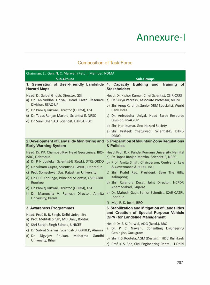
207
Annexure-I
Composition of Task Force
Chairman: Lt. Gen. N. C. Marwah (Retd.), Member, NDMA
Sub-Groups Sub-Groups1. Generation of User-Friendly Landslide Hazard MapsHead: Dr. Saibal Ghosh, Director, GSIa) Dr. Aniruddha Uniyal, Head Earth Resource
Division, RSAC-UP
b) Dr. Pankaj Jaiswal, Director (GHRM), GSI
c) Dr.TapasRanjanMartha,Scientist-E,NRSC
d) Dr.SunilDhar,AD,Scientist,DTRL-DRDO
4. Capacity Building and Training of StakeholdersHead:Dr.KishorKumar,ChiefScientist,CSIR-CRRIa) Dr. Surya Parkash, Associate Professor, NIDM
b) Shri Anup Karanth, Senior DRM Specialist, World Bank India
c) Dr. Aniruddha Uniyal, Head Earth Resource Division, RSAC-UP
d) Shri Hari Kumar, Geo-Hazard Society
e) Shri Prateek Chaturvedi, Scientist-D, DTRL-DRDO
2.Development of Landslide Monitoring and Early Warning SystemHead:Dr.P.K.ChampatiRay,HeadGeoscience,IIRS-ISRO,Dehraduna) Dr.P.N.Joglekar,Scientist-E(Retd.),DTRL-DRDO
b) Dr.VikramGupta,Scientist-E,WIHG,Dehradun
c) Prof. Someshwar Das, Rajasthan University
d) Dr.D.P.Kanungo,PrincipalScientist,CSIR-CBRI,Roorkee
e) Dr. Pankaj Jaiswal, Director (GHRM), GSI
f) Dr. Maneesha V. Ramesh Director, Amrita University, Kerala
5. Preparation of Mountain Zone Regulations & PoliciesHead: Prof. R. K. Pande, Kumaun University, Nainitala) Dr.TapasRanjanMartha,Scientist-E,NRSC
b) Prof. Amita Singh, Chairperson, Centre for Law & Governance & SCDR, JNU
c) Shri Praful Rao, President, Save The Hills, Kalimpong
d) Shri Rajendra Desai, Joint Director, NCPDP, Ahemadabad, Gujarat
e) Dr.MaheshGaur,SeniorScientist, ICAR-CAZRI,Jodhpur
f) Maj.R.K.Joshi,BRO
3. Awareness ProgrammesHead: Prof. R. B. Singh, Delhi Universitya) Prof. Mehtab Singh, MD Univ., Rohtak
b) Shri Sarbjit Singh Sahota, UNICEF
c) Dr.SubratSharma,Scientist-D,GBIHED,Almora
d) Dr. Digvijoy Phukan, Mahatma Gandhi University, Bihar
6. Stabilization and Mitigation of Landslides and Creation of Special Purpose Vehicle (SPV) for Landslide ManagementHead:Dr.S.S.Porwal,ADG(Retd.),BROa) Dr. P. C. Nawani, Consulting Engineering
Geologist, Gurugram
b) Shri T. S. Routela, AGM (Design), THDC, Rishikesh
c) Prof.K.S.Rao,CivilEngineeringDeptt.,IITDelhi

208
Compendium on national landslide Risk management stRategy
Joint Secretary (Mitigation),National Disaster Management Authority (NDMA)NDMA BhawanA-1 Safdarjung EnclaveNew Delhi–110029
Tel: (011) 26701720Fax: (011) 26701713Email: [email protected]: www.ndma.gov.in
Contact Us


Related Documents