1 NASA’s Science Missions and Student Internship/Fellowship Opportunities For the NASA/FIU Hurricane and Remote Sensing Summer Education and Research Internship Program (HRSSERP) Aug. 8-19, 2011

Welcome message from author
This document is posted to help you gain knowledge. Please leave a comment to let me know what you think about it! Share it to your friends and learn new things together.
Transcript

1
NASA’s Science Missions and
Student Internship/Fellowship
Opportunities
For the NASA/FIU Hurricane and Remote Sensing Summer
Education and Research Internship Program (HRSSERP)
Aug. 8-19, 2011

NASA Science:
Earth Science
Heliophysics
Planetary Science
Astrophysics
3
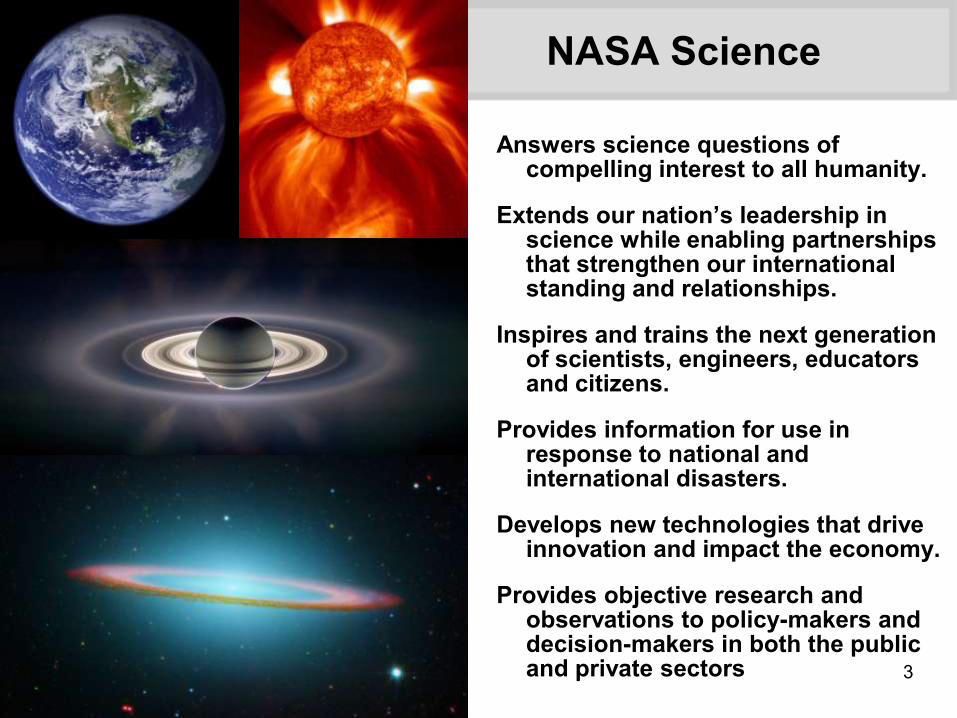
NASA Science
Answers science questions of compelling interest to all humanity.
Extends our nation’s leadership in science while enabling partnerships that strengthen our international standing and relationships.
Inspires and trains the next generation of scientists, engineers, educators and citizens.
Provides information for use in response to national and international disasters.
Develops new technologies that drive innovation and impact the economy.
Provides objective research and observations to policy-makers and decision-makers in both the public and private sectors

4
NASA’s Journey of Discovery
NASA’s science program seeks answers to profound questions that touch or may affect us all:
• How and why are Earth’s climate and the environment changing?
• How and why does the Sun vary and affect Earth and the rest of the solar system?
• How do planets and life originate?
• How does the universe work, and what are its origin and destiny?
• Are we alone?
5
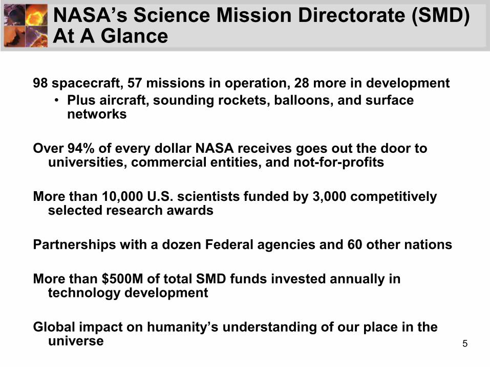
NASA’s Science Mission Directorate (SMD) At A Glance
98 spacecraft, 57 missions in operation, 28 more in development
• Plus aircraft, sounding rockets, balloons, and surface networks
Over 94% of every dollar NASA receives goes out the door to universities, commercial entities, and not-for-profits
More than 10,000 U.S. scientists funded by 3,000 competitively selected research awards
Partnerships with a dozen Federal agencies and 60 other nations
More than $500M of total SMD funds invested annually in technology development
Global impact on humanity’s understanding of our place in the universe

6
Recommendations from the U.S. Scientific Community Through NRC Decadal Surveys
Astrophysics
2010
(2020)
Heliophysics
2003
(2012)Earth Science
2007
(2017)
Planetary Science
2002
(2011)

7
Engaging the Next Generation
• SMD policy calls for each mission to allocate at least 1% of the mission budget for education and public outreach (E/PO activities
• SMD funds E/PO activities as elements proposed as part of competitively-selected research and research-enabling programs
• Each SMD Division has a Science Education and Public Outreach Forum (SEPOF) to help better connect NASA and the broad national education community
• SMD engages in collaborations with such organizations as:
• NASA Museum Alliance for science centers, museums, and planetariums
• Boys Scouts/Girl Scouts, 4-H clubs, and Boy’s and Girl’s Clubs of America
• SMD’s E/PO programs are coordinated with the NASA Office of Education
To share the story, the science, and the adventure of
NASA’s scientific explorations of our home planet, the
solar system, and the universe beyond…


9

10
Astrophysics
• How do matter, energy, space, and time behave under the extraordinarily diverse conditions of the cosmos?
• How did the universe originate and evolve to produce the galaxies, stars, and planets we see today?
• What are the characteristics of planetary systems orbiting other stars, and do they harbor life?
Discover how the universe works, explore how the universe
began and evolved, and search for Earth-like planets
Visible view of Pillar and Jets HH
901/902 from Hubble Space Telescope
Credit: NASA, ESA, STScI
11
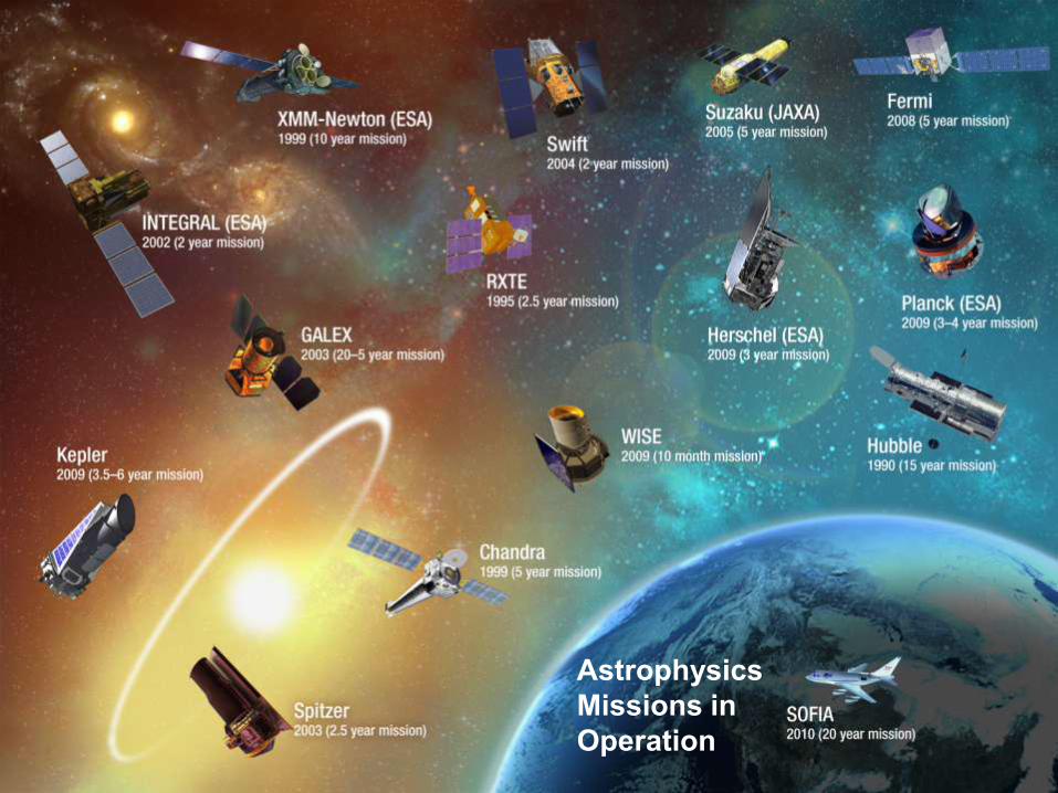
Astrophysics
Missions in
Operation

12
Stratospheric Observatory For Infrared Astronomy (SOFIA)
First Science FlightDecember 1, 2010
In-Flight MissionControl Operations
1st Flight (Aircraft Functional Checks) December 2009
1st Open Door Flight December 2009
First Light Opportunity May 2010
Envelope Expansion #2 July 2010
Initiation of Science Flights with
FORCAST (US-developed imager) December 2010
Science Flights with GREAT begin August 2011
Guest Observation Flights Begin October 2011
Commissioning of HIPO & FLITECAM
beginsFebruary 2012
End of Development Segment 2; Start
of Major System UpgradesJune 2012
Commissioning of Fourth Instrument
beginsJuly 2013
Full Operational Capability (FOC) December 2014
Open Door FlightDecember 18, 2009
Crew Members withFORCAST Instrument

13
James Webb Space Telescope (JWST)
The James Webb Space Telescope (JWST) was the #1 priority from the NRC’s 2001 Decadal
Survey “Astronomy and Astrophysics in the New Millennium” and is the most complex
spacecraft ever attempted. JWST is a large infrared space telescope that will look back in time
to find the first galaxies that formed in the early Universe, connecting the Big Bang to our own
Milky Way Galaxy. JWST will peer through dusty clouds to see stars forming planetary
systems, connecting the Milky Way to our own Solar System.
The JWST Project at Goddard Space Flight Center is working with the contractors to establish
a baseline budget, expected in late March. Once that work is complete, we will have a better
idea of the launch date.

14
15

16
Hubble’s Deepest View of the UniverseHubble’s Deepest View of the Universe
The Hubble Space Telescope has acquired the deepest image of the universe ever taken in near-infrared light using the newly installed Wide Field Camera 3.
2009 Infrared Ultra Deep Field

17
Title Goes Here

18
Planetary Science
• What is the inventory of solar system objects and what processes are active in and among them?
• How did the Sun’s family of planets, satellites, and minor bodies originate and evolve?
• What are the characteristics of the solar system that lead to habitable environments?
• How and where could life begin and evolve in the solar system?
• What are characteristics of small bodies and planetary environments that pose hazards and/or provide resources?
Ascertain the content, origin, and evolution of the
solar system and the potential for life elsewhere
Victoria Crater from the Mars
Reconnaissance Orbiter, July 18, 2009
Credit: NASA/JPL-Caltech/University of
Arizona

19
Planetary Science
Missions in
Operation

20
Hale Crater showing gullies on side of crater wall.
Crater is approximately 149km across, located in Argyre basin, 38.8oS, 36.5oW
Gullies on Mars: Are the Flow Features from Water?

21
Martian Ice Found Just Below the Surface
• Fresh small impact craters show:
• Ice layer ~0.5 – 1m below surface
• Sublimates over several weeks
• Spectral analysis shows ~99% pure water
• Ice more extensive than expected from current climate
• Mars had a wet history
35m
88 days
50 days
43.3° N 164.2°E
46.2° N 188.5° E
21

22
Life in Extreme Environments: Yellowstone N.P.

23
The Icy Surface of Europa

24
Water Vapor in Geyser-like Jets on
Saturn’s Moon Enceladus

25
Mars Rover Family Portrait
Spirit and
Opportunity
2003
Sojourner
1996
Curiosity
2011
MSL “Curiosity” is the largest rover yet…to assess whether Mars ever was, or is still today, an environment able to support microbial life. In other words, its mission is to determine the planet's "habitability.

26
Mars Science Laboratory
SAM Installation
Assembled Spacecraft
Descent Stage
Rover Driving Test

27

28
Heliophysics
• What causes the Sun to vary?
• How do the Earth and the heliosphere respond?
• What are the impacts on humanity?
Understand the Sun and its interactions with
the Earth and the solar system
First light SDO image from March 30, 2010
Credit: NASA/GSFC/AIA

29
Applications of Heliophysics Science
Modern society depends on a variety of technologies susceptible to the extremes of space weather
• Electric power grids and oil & gas pipelines
• High frequency radio communication and GPS navigation
• Satellites and spacecraft in Earth orbit
Human and robotic explorers across the solar system are also affected by solar activity
SMD makes its Heliophysics
research data sets and models
continuously available to all
users via Internet sites, including:
• Combined Community Modeling
Center
• Integrated Space Weather
Analysis System
STEREO Views a Solar Storm in October 2009

30
Heliophysics
Missions in
Operation

31
3D Sun App Allows Over A Million Users to Hold the Sun in the Palm of Their Hand
This free iPhone and iPad app can be downloaded from http://3dsun.org.
Left:
Screenshot
of SDO
gallery
Right:
iPad
screenshot
of recent
news items
32

33
Earth Science
• How is the global Earth system changing? (Characterize)
• What are the sources of change in the Earth system and their magnitudes and trends? (Understand)
• How will the Earth system change in the future? (Predict)
• How can Earth System Science improve mitigation of and adaptation to global change? (Apply)
Advance Earth System Science to meet the
challenges of climate and environmental change
Terra satellite image of
plume from the Iceland
volcano in April 2010
An end-to-end program encompassing space missions, suborbital platforms,
data and information systems, fundamental research, data assimilation and
modeling, applications research, and technology development.

34
Earth Science Research and Applications
Observed trends in groundwater levelsfrom GRACEOctober 2003 – March 2009
Applications Themes:
• Agriculture
• Air Quality
• Climate
• Ecological Forecasting
• Public Health
• Natural Disasters
• Water Resources
• Weather
Science Focus Areas:
• Atmospheric Composition
• Carbon Cycle & Ecosystems
• Climate Variability & Change
• Weather
• Water & Energy Cycle
• Earth Surface & Interior

Earth Science
Missions in
Operation

36

37
Hurricane Danielle’s Hot Towers from TRMMAugust 27, 2010

38
April 7, 2001
April 11, 2001
April 13, 2001
April 16, 2001
China Dust Storm
Pollutes the Air in
the Eastern US in
April 2001

39
39
Response to Gulf Oil Spill
Satellite instruments: continually monitored the extent of the spill•Terra & Aqua / MODIS – visible and infrared daily synoptic
•Terra / ASTER – visible, near IR and thermal IR high res
•EO-1 / Advanced Land Imager and Hyperion – highest res
•Terra / MISR
•CALIPSO / CALIOP
Airborne instruments: measured surface extent and volume •ER2 / AVIRIS and DCS, MASTER – May, Jul, Aug, Sept
•Twin Otter / AVIRIS (July 1-12)
•B200 / HSRL– 10-11 May; two FOO; CALIOP studies
•UAVSAR– 22-24 June
Data and provided to USGS for use by first responders;
NOAA using radiances to initialize trajectory model, USGS for oil concentration
UAVSAR 23 June 2010 ASTER 24 May 2010
ER-2 Flights
MODIS 31 May 2010
Visible/IR false color
Visible

40
Launched in Dec. 1997.
TRMM’s goal is to determining rainfall in the tropics and subtropics of the Earth.
13 years (1998-current) of data available, very unique dataset for precipitation and convection studies in tropical cyclones
TRMM satellite orbit: circular (Non-Sun Synchronous)
Observation frequency: 16 times per day.
Tropical Rainfall Measurement Mission (TRMM)
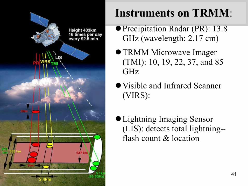
41
Instruments on TRMM:
Precipitation Radar (PR): 13.8 GHz (wavelength: 2.17 cm)
TRMM Microwave Imager (TMI): 10, 19, 22, 37, and 85 GHz
Visible and Infrared Scanner (VIRS): 0.63, 1.6, 3.75, 10.80, and 12.0 µm
Lightning Imaging Sensor (LIS): detects total lightning--
flash count & location

42
TERRA - Launch Date: December 18, 1999
Terra simultaneously studies clouds,
water vapor, aerosol particles, trace
gases, terrestrial and oceanic
properties, the interaction between
them and their effect on atmospheric
radiation and climate. Moreover, Terra
will observe changes in Earth's
radiation budget (a measurement of all
the inputs and outputs of the Earth's
radiative energy), together with
measurements of changes in
land/ocean surface and interaction
with the atmosphere through
exchanges of energy, carbon, and
water. Comprehending these
interactive processes is essential to
understanding global climate change.

43
Instruments on TERRA
Clouds and the Earth's Radiant
Energy System (CERES)
Multi-angle Imaging
SpectroRadiometer (MISR)
Moderate- Resolution Imaging
Spectroradiometer (MODIS)
Measurements of Pollution in The
Troposphere (MOPITT)
Advanced Spaceborne Thermal
Emission and Reflection
Radiometer (ASTER)
Terra MODIS, 28 October
2003, 1825 UTC: Fires in
Southern California
Terra MODIS, 21 October
2005, 1625 UTC:
Hurricane Wilma

44
Active Cavity Radiometer Irradiance Monitor (ACRIMSAT)
Launch Date:
December 20,
1999.
The purpose of the Active Cavity Radiometer Irradiance Monitor III
(ACRIM III) instrument is To study total solar irradiance from the Sun

45
Arua-- Launch Date: July 15, 2004
Aura's objective is to study the chemistry and dynamics of the Earth's
atmosphere with emphasis on the upper troposphere and lower
stratosphere (0-30km) by employing multiple instruments on a single
satellite. The satellite's measurements enable scientists to investigate
questions about ozone trends, air quality changes and their linkages to
climate change. These observations provide accurate data for
predictive models and provide useful information for local and national
government agencies.

46
Aqua-- Launch Date: May 04, 2002
Aqua, Latin for "water," is named for
the large amount of information that
the Aqua spacecraft will collect
about the Earth's water cycle. In
particular, the Aqua data will include
information on water vapor and
clouds in the atmosphere,
precipitation from the atmosphere,
soil wetness on the land, glacial ice
on the land, sea ice in the oceans,
snow cover on both land and sea
ice, and surface waters throughout
the world's oceans, bays, and
lakes.

47
Cloud-Aerosol Lidar and Infrared Pathfinder Satellite Observations (CALIPSO)
The CALIPSO satellite was developed to help scientists answer
significant questions and provide new information about the effects of
clouds and aerosols (airborne particles) on changes in the Earth's
climate.
Launch Date:
April 28, 2006

48
CloudSat
CloudSat is an experimental satellite that uses radar to
observe clouds and precipitation from space. CloudSat orbits
in formation as part of the A-Train constellation of satellites
(Aqua, CloudSat, CALIPSO, PARASOL, and Aura).
Launch Date:
April 28, 2006

49
Geostationary Operational Environmental Satellite, I-M Series (GEOS I-M)
The GOES I-M satellites are the primary element of U.S. weather
monitoring and forecast operations and are a key component of NOAA's
National Weather Service operations and modernization program.
Spacecraft and ground-based systems work together to accomplish the
mission of providing weather imagery and quantitative sounding data that
form a continuous and reliable stream of environmental information used for
weather forecasting and related services.
Launch Date:
April 13, 1994

50
Gravity Recovery and Climate Experiment (GRACE)
GRACE, twin satellites launched in March 2002, are making detailed
measurements of Earth's gravity field which will lead to discoveries
about gravity and Earth's natural systems. These discoveries could
have far-reaching benefits to society and the world's population.
Launch Date:
March 17, 2002
51
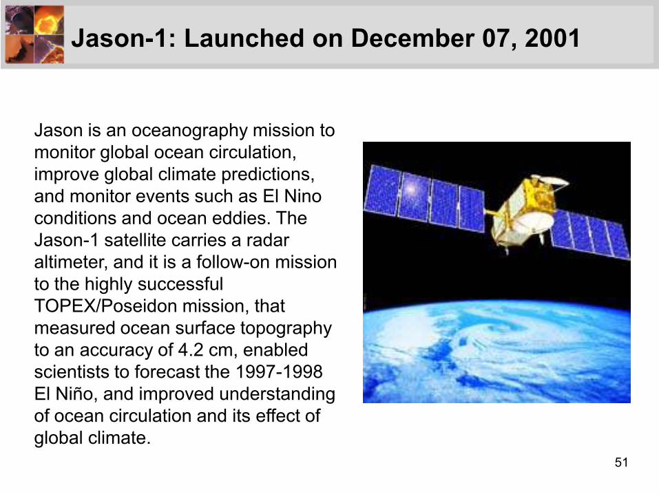
Jason-1: Launched on December 07, 2001
Jason is an oceanography mission to
monitor global ocean circulation,
improve global climate predictions,
and monitor events such as El Nino
conditions and ocean eddies. The
Jason-1 satellite carries a radar
altimeter, and it is a follow-on mission
to the highly successful
TOPEX/Poseidon mission, that
measured ocean surface topography
to an accuracy of 4.2 cm, enabled
scientists to forecast the 1997-1998
El Niño, and improved understanding
of ocean circulation and its effect of
global climate.
52
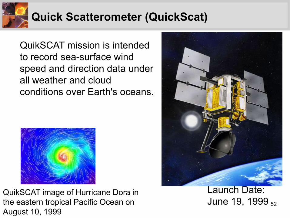
Quick Scatterometer (QuickScat)
QuikSCAT mission is intended
to record sea-surface wind
speed and direction data under
all weather and cloud
conditions over Earth's oceans.
Launch Date:
June 19, 1999 QuikSCAT image of Hurricane Dora in
the eastern tropical Pacific Ocean on
August 10, 1999

53
Global Precipitation Measurement (GPM)
Launch Date:
July 01, 2013
Building upon the success of the Tropical Rainfall Measuring Mission
(TRMM), GPM will initiate the measurement of global precipitation, a key
climate factor. Its science objectives are: to improve ongoing efforts to
predict climate by providing near-global measurement of precipitation, its
distribution, and physical processes; to improve the accuracy of weather
and precipitation forecasts through more accurate measurement of rain
rates and latent heating; and to provide more frequent and complete
sampling of the Earth's precipitation.

54
NPOESS Preparatory Project (NPP)
Launch Date:
October 25, 2011
NPP is the bridge between the major Earth Observing System
satellites( Terra, Aqua, and Aura) and the forthcoming series of Joint
Polar Satellite System (JPSS) satellites which will compose the
civilian polar-orbiting weather satellites. NPP data will be used for
both climate research and operational weather prediction.

55
Soil Moisture Active/Passive (SMAP) - 2015
SMAP will provide
the first global
measurements of
soil moisture, a key
missing element in
modeling the global
water cycle.

56
NASA’s Undergraduate and
Graduate Internship/Fellowship
Opportunities

57
NASA Undergraduate Student Research Program (USRP)
•NASA USRP is an internship program that offers NASA research and
development opportunities to undergraduate students.
•Spring 2012 NASA Undergraduate Student Research Project
NASA's USRP offers U.S. undergraduate students with a minimum 3.0
grade point average mentored research experiences at NASA centers.
Upcoming sophomores, juniors or seniors with a major or concentration
in engineering, mathematics, computer science, or physical or life
sciences may apply. Participants work practical problems to provide
solutions that will be applied in aerospace or on future NASA missions.
Applications for the 2012 spring session are due Oct. 31, 2011.
•Apply now and join NASA for the experience of a lifetime!
Now Accepting Applications in SOLAR
Spring 2012 Applications Being Accepted; Due on October 11, 2011
http://usrp.usra.edu/
http://intern.nasa.gov/

58
NASA Earth and Space Science Fellowship (NESSF)
•For students pursuing MS or PhD degree.
•Solicitation every year, due Feb. 1
•Very competitive.
• Application materials: a 6-page research proposal,
Transcripts, recommendation letter from your advisor
• Award: $30,000 per year renewable up to 3 years
•Information: You can register in NSPIRES at
http://nspires.nasaprs.com/.
•For further information contact Ming-Ying Wei, Program Administrator
for NESSF Earth Science Research, Telephone: (202) 358-0771, E-mail:

59
NASA Graduate Student Researchers Project (GSRP)
•For students pursuing MS or PhD degree.
•Solicitation every year, due date: usually Feb. 1
•This twelve month award requires students to participate in
a 10 week NASA Center or HQ-based research experience
at the NASA Center/HQ extending the GSRP Fellowship
award.
• Underrepresented groups in science, technology,
engineering, and mathematics fields (STEM) are
encouraged to apply.
•Application materials: a 6-page research proposal,
Transcripts, recommendation letter from your advisor
•https://fellowships.nasaprs.com/gsrp/nav/

60
Other Opportunities at NASA: http://www.nasa.gov/audience/forstudents/postsecondar
y/programs/index.html
•Langley Aerospace Research Summer Scholars
Project: Participants spend 10 weeks conducting state-of-
the-art research with other students from across the nation.
They work with NASA researchers exploring an array of
high-technology development projects and activities in
pursuit of space exploration. http://www.nianet.org/larss/
•Student Employment at NASA:
http://nasajobs.nasa.gov/studentopps/employment/defa
ult.htm
•Jobs at NASA:
http://nasajobs.nasa.gov/default.htm
Related Documents