and NAMPORT TENDER 674/ 2008 EIA Study for Strategic Expansion of the Walvis Bay Container Terminal Final Scoping Report September 2009 NAMIBIAN PORTS AUTHORITY (Established in terms of the Namibian Ports Authority Act No.2 of 1994) EIA Study for Strategic Expansion of the Walvis Bay Container Terminal Final Scoping Report Report No. CSIR/CAS/EMS/ER/2009/0017/A September 2009 and

Welcome message from author
This document is posted to help you gain knowledge. Please leave a comment to let me know what you think about it! Share it to your friends and learn new things together.
Transcript

and
NAMPORT TENDER 674/ 2008
EIA Study for Strategic Expansion of the Walvis Bay Container Terminal
Final Scoping Report September 2009
NAMIBIAN PORTS AUTHORITY (Established in terms of the Namibian Ports Authority Act No.2 of 1994)
EIA Study for Strategic Expansion of the Walvis Bay Container Terminal
Final Scoping Report
Report No. CSIR/CAS/EMS/ER/2009/0017/A
September 2009
and

Final Scoping Report, September 2009
Scope of this report
Title:
EIA Study for Strategic Expansion of the Walvis Bay Container Terminal.
Date: September 2009 CSIR Report no: CSIR/CAS/EMS/ER/2009/0017/A Prepared for: Namibian Ports Authority
P O Box 361 17 Rikumbi Kandanga Road, Walvis Bay, Republic of Namibia.
Prepared by: CSIR DMC
P O Box 320, Postbus 269 7599 Stellenbosch, 2800 AG Gouda South Africa Netherlands
Author: Henri HG Fortuin Scope: This Final Scoping Report (FSR) is a part of the process of planning and
decision making for the proposed strategic expansion of the container terminal at the Port of Walvis Bay. Its purpose is to:
� Give an overview of the proposed project and its alternatives; � Present the issues raised during Scoping, and identify those that
need further investigation by specialists; � Describe the Terms of Reference for such specialist studies.
The FSR is the second in a series of reports and information documents issued during the environmental impact assessment process.
Citation: DMC-CSIR (2009) EIA Study for Strategic Expansion of the Walvis Bay
Container Terminal. Final Scoping Report. 115 pp. CSIR/CAS/EMS/ER/2009/0017/A. Stellenbosch. With Summary and Appendices, prepared for Namibian Ports Authority.
Acknowledgements : Elzevir Gelderbloem (Namport), Nobuo Endo and Hayao Teshima
(JICA), and report reviewers are thanked for their co-operation and support in the preparation of this report.

and
NAMPORT TENDER 674/ 2008
EIA Study for Strategic Expansion of the Walvis Bay Container Terminal
Final Scoping Report September 2009
Summary Namport recognises that the existing container terminal at the Port of Walvis Bay facility will, by 2012, reach its full capacity with no possibility for expanding the stacking area. It therefore intends to construct a new container port facility on reclaimed land inside current port limits, just northwest of the current Berths 1 to 8. This will alleviate increasing pressure on the existing container terminal facility, and provide ample room for future expansion of throughput volumes. The project is also of national strategic importance, because it is believed that the Port of Walvis Bay can play an important role in facilitating trade in Sub-Saharan Africa. In order for the Namibian Ministry of Environment and Tourism (MET) to make an informed decision as to whether or not the project should receive an environmental clearance certificate and be allowed to proceed, it is essential that potentially significant environmental and social impacts (both negative and positive) are investigated and well understood. It is therefore necessary to conduct an Environmental Impact Assessment (EIA) process. This led to DMC-CSIR being appointed by Namport to undertake the EIA for the proposed project, with Enviro Dynamics conducting the public participation component. The findings of the EIA Scoping Phase are presented in this Final Scoping Report, and is made available to Interested and Affected Parties (I&APs) for comment. The purpose of the Scoping Report is to:
• Provide a description of the proposed project, including a sufficient level of detail to inform the Ministry of Environment and Tourism;
• Describe the local environment within which the project is proposed, to assist further in identifying issues and concerns;
• Provide an overview of the process being followed in the Scoping Phase, in particular the public participation process, as well as present the draft Plan of Study for EIA that would be followed in the subsequent EIA phase;
• Present the issues and concerns identified to date by specialists and stakeholders, together with an explanation of how these issues will be addressed through the EIA process.
I&APs (including organs of state) were invited to submit comments on the Draft Scoping Report, to Carla Biewenga at Enviro Dynamics by 28 August 2009. Issues raised in response to the Draft Scoping Report are included in the New Issues Trail (Appendix J) of this Final Scoping Report. The following specialist studies are proposed to address the following issues identified in the Scoping Phase:
• Impacts on marine and lagoon ecosystems
• Impact on lagoon bird life
• Noise impact
• Impact on traffic
• Socio-economic impacts (incl. tourism, planning & land use) All information on the EIA process, including I&AP inputs, are hosted on Namport’s project website: http://www.namport.com.na/

and
NAMPORT TENDER 674/ 2008
EIA Study for Strategic Expansion of the Walvis Bay Container Terminal
Final Scoping Report September 2009
Glossary and Abreviations
Algal blooms An abundant growth of phytoplankton, typically triggered by sudden favourable environmental conditions e.g. excess nutrients.
Benthos The sum total of organisms living in, or on, the sediments of aquatic habitats.
Chart datum (CD) The level of water that from which charted depths on nautical charts are measured. It is the level below which depths are indicated and above which heights of tides are expressed. Usually it is the mean level of low water at a spring tide, or even the level of the lowest tide there has ever been at a particular place.
COD
(Chemical Oxygen Demand)
A measure of the amount of oxygen required to oxidise all compounds, both organic and inorganic, in water.
Draught The vertical distance between the waterline and the bottom of the hull (keel), including the thickness of the hull, i.e., how much water needed to float
Dredge spoil Spoil is the material from dredge excavations that is discarded at a disposal site.
EA, EIA, EMP
Environmental Assessment, Environmental Impact Assessment, Environmental Management Plan
I&AP Interested and Affected Party
NDP3 Third National Development Plan
Phytoplankton Tiny plant species that float freely in the water and that obtain energy by photosynthesis. These are an important source of atmospheric oxygen and form the base of the aquatic food chain.
Plankton Minute floating forms of microscopic plants and animals in water that passively float in a body of water. They form the beginnings of food chains for larger animals animal and plant life.
Plume A column of fluid, mixed with sediment released by dredging, which moves through the water column that is clear of the sediment.
Suspended sediment Unconsolidated mineral and organic particulate material that is suspended in a given volume of water, measured in mg/l
TBT
(Tributyltin)
Tributyltin compounds are used in paint to reduce the growth of aquatic organisms on ship’s hulls. These compounds are toxic chemicals that have negative effects on human and environment. They are moderately to highly persistent organic pollutants that are absorbed by organisms to levels higher than the surrounding environment, with levels increasing up the marine predators' food chain.
Toxicity The inherent potential or capacity of a material to cause adverse effects in a living organism.
Turbidity Measure of the light-scattering properties of a volume of water, usually measured in nephelometric turbidity units.
Zoobenthos Zoobenthos are the animal subset of organisms more generally known as benthos.
Zooplankton Small or microscopic aquatic animals that float or drift in fresh or salt water, including the eggs and larvae from larger animals such as krill and fish.

and
NAMPORT TENDER 674/ 2008
EIA Study for Strategic Expansion of the Walvis Bay Container Terminal
Final Scoping Report, September 2009 page i
Contents
Summary
1 Introduction ______________________________________ ______________ 1
1.1 The Port of Walvis Bay ____________________________ __________________ 1
1.2 Market environment for the Port of Walvis Bay _____ _____________________ 4
1.3 The need for the project __________________________ ___________________ 5
1.4 The proposed container terminal expansion _________ ___________________ 7
1.5 The purpose of the EIA process and this report ____ ______________________ 8
1.6 Structure of this report __________________________ ____________________ 9
1.7 Comment on the draft Scoping Report _______________ __________________ 9
2 Description of the EIA process ____________________ ________________ 10
2.1 Policy and statutory framework ____________________ __________________ 10
2.1.1 The Constitution of the Republic of Namibia (1990) ____________________________ 10
2.1.2 National Policies _______________________________________________________ 10
2.1.3 National statutes _______________________________________________________ 12
2.1.4 International Standards and Guidelines _____________________________________ 19
2.1.5 Water Quality Guidelines _________________________________________________ 20
2.2 Terms of Reference for the EIA ____________________ __________________ 20
2.3 EIA procedure _____________________________________ ________________ 21
2.3.1 Public participation programme (stakeholder engagement) ______________________ 25
2.3.2 Scoping phase _________________________________________________________ 25
2.3.3 Tasks for the Scoping process ____________________________________________ 26
2.3.4 Impact assessment phase ________________________________________________ 27
2.4 Issues for consideration by the EIA _______________ ____________________ 29
2.4.1 Hydrodynamic and sedimentary regime _____________________________________ 30
2.4.2 Marine sediment quality _________________________________________________ 31
2.4.3 Water quality __________________________________________________________ 33
2.4.4 Marine ecology ________________________________________________________ 34
2.4.5 Marine and coastal ornithology ____________________________________________ 36
2.4.6 Road traffic ___________________________________________________________ 37
2.4.7 Noise and vibration _____________________________________________________ 38
2.4.8 Socio-economics _______________________________________________________ 39
2.4.9 Soil quality and geology _________________________________________________ 40
2.4.10 Terrestrial ecology ______________________________________________________ 40
2.4.11 Fisheries and/or aquaculture resources _____________________________________ 41
2.4.12 Landscape and visual setting _____________________________________________ 42
2.4.13 Recreation ____________________________________________________________ 45
2.4.14 Commercial and/or private navigation _______________________________________ 46
2.4.15 Rail _________________________________________________________________ 47
2.4.16 Air quality _____________________________________________________________ 48
2.4.17 Coastal protection and flood defence _______________________________________ 49
2.4.18 Infrastructure and land drainage ___________________________________________ 50
and
NAMPORT TENDER 674/ 2008
EIA Study for Strategic Expansion of the Walvis Bay Container Terminal
Final Scoping Report, September 2009 page ii
2.5 Issues that will require further investigation in t he EIA ___________________ 51
2.5.1 Specialist investigations for the EIA ________________________________________ 53
2.6 EIA team __________________________________________ _______________ 53
3 Project description _______________________________ _______________ 55
3.1 Existing situation ________________________________ __________________ 55
3.1.1 Port operations ________________________________________________________ 55
3.2 Future growth for the port ________________________ ___________________ 61
3.3 The consequences of not expanding the container ter minal ______________ 63
3.4 Project alternatives ______________________________ __________________ 64
3.4.1 Location alternatives ____________________________________________________ 64
3.5 The proposed terminal expansion ___________________ _________________ 67
3.5.1 Optimisation measures __________________________________________________ 69
3.5.2 Construction activities ___________________________________________________ 70
3.6 Description of dredger types ______________________ __________________ 72
3.6.1 Trailing Suction Hopper Dredger ___________________________________________ 72
3.6.2 Cutter Section Dredger __________________________________________________ 73
3.6.3 Grab Bucket Dredger ___________________________________________________ 74
4 Description Of The Affected Environment ___________ ________________ 76
4.1 Location of proposed project ______________________ __________________ 76
4.2 Biophysical environment ___________________________ ________________ 76
4.2.1 Climate ______________________________________________________________ 76
4.2.2 Temperature __________________________________________________________ 77
4.2.3 Rainfall and evaporation _________________________________________________ 77
4.2.4 Surface Wind __________________________________________________________ 77
4.2.5 Landscape ____________________________________________________________ 78
4.2.6 Geology ______________________________________________________________ 78
4.2.7 Physical and Biological Oceanography ______________________________________ 78
4.2.8 Sedimentology _________________________________________________________ 83
4.2.9 Marine Ecology ________________________________________________________ 83
4.2.10 Water quality __________________________________________________________ 86
4.2.11 Socio-economics of Walvis Bay ___________________________________________ 87
4.3 Summary of biophysical and socio-economic baseline information ________ 89
5 Summary of the Issues for the EIA _________________ ________________ 91
5.1 Identification of key issues ______________________ ____________________ 91
5.2 Summary of Issues _________________________________ _______________ 92
6 Plan of study for the EIA _________________________ ________________ 95
6.1 Overview of approach to preparing the EIA Report an d EMP ______________ 95
6.2 Public consultation process _______________________ __________________ 95
6.2.1 Review of Draft EIA Report and EMP _______________________________________ 96
6.2.2 Comments and Responses Trail ___________________________________________ 96

and
NAMPORT TENDER 674/ 2008
EIA Study for Strategic Expansion of the Walvis Bay Container Terminal
Final Scoping Report, September 2009 page iii
6.2.3 Compilation of Final EIA Report for submission to Authorities ____________________ 96
6.2.4 Environmental Authorisation and Appeal Period _______________________________ 97
6.3 Authority consultation during the EIA phase _______ ____________________ 97
6.4 Linkage of specialist studies with studies for desi gn and optimisation _____ 97
6.5 Specific issues to be addressed in specialist studi es ____________________ 97
6.5.1 Marine ecology and ornithology ___________________________________________ 98
6.5.2 Noise ________________________________________________________________ 99
6.5.3 Traffic and roads _______________________________________________________ 99
6.5.4 Socio-Economics and Planning___________________________________________ 100
6.6 Approach to specialist studies and impact assessmen t _________________ 100
6.6.1 Generic Terms of Reference for the assessment of impacts ____________________ 100
7 References and Bibliography _______________________ _____________ 103
and
NAMPORT TENDER 674/ 2008
EIA Study for Strategic Expansion of the Walvis Bay Container Terminal
Final Scoping Report, September 2009 page iv
Figures Figure 1.1 Walvis Bay port and the lagoon Figure 1.3 Three phases of proposed container terminal expansion Figure 2.1 London Convention: Dredged Material Assessment Framework Figure 2.2 EIA process: Scoping phase Figure 2.3 EIA process: EIR and EMP phase Figure 2.4 Linkages between impact assessment and studies for design and optimisation Figure 2.5 Summary of the ISO 14001 process for Environmental Management Systems Figure 2.6 View towards the port from the Swakopmund road. The landscape is dominated by cranes
and ships Figure 2.7 View towards the port from the airport access road. Landscape dominated by cranes and
oil rig. Figure 3.1 Aerial view of the container terminal. Figure 3.2 Noise from stacking area intrudes into residential and waterfront areas Figure 3.3 Schematic of planned future cargo handling operations for the container terminal Figure 3.4 Demand forecast of container throughput with new container terminal Figure 3.5 Proposed layout of three phases for expansion of the container terminal Figure 3.6 Proposed layout of Phase 1 for the new expansion Figure 3.7 Target areas for the dredging and reclamation programme Figure 3.8 Approach to derive at recommended dredging strategies and management Figure 3.8 Schematic diagram of a trailing suction hopper dredger Figure 3.9 Schematic diagram of a cutter suction dredger Figure 3.10 Example of a grab bucket dredger Figure 4.1 Landscape in Namibia Figure 4.2 Satellite image shows discoloured water from a nearshore sulphur eruption offshore of
the Namib Desert Figure 4.3 Positions of upwelling cells on the Namibian coastline, and formation zone of low oxygen water Figure 4.4 Summary of current circulation in Walvis Bay Figure 4.5 Walvis Bay Lagoon – bird breeding areas Figure 5.1 Decision making framework for identification of key issues for the EIA

and
NAMPORT TENDER 674/ 2008
EIA Study for Strategic Expansion of the Walvis Bay Container Terminal
Final Scoping Report, September 2009 page v
Tables Table 1.1 Port of Walvis Bay – core cargo handling equipment Table 1.2 Port of Walvis Bay – cargo handled from 1999/00 to 2004/05 Table 1.3 Port of Walvis Bay – containers handled from 1999/00 to 2005/06 Table 2.1 Media announcements at the commencement of the EIA process Table 2.2 BCLME guideline values for concentration of metals in sediments Table 2.3 BCLME guideline values for concentration of metals in water Table 2.4 Qualitative risk rating of impacts – likelihood and intensity Table 2.5 Risk matrix to determine level of risk Table 2.6 Key issues that require new specialist studies Table 2.7 Members of the EIA team Table 3.1 Berthing facilities in the Port of Walvis Bay Table 3.2 Historical performance of container cargoes in the Port of Walvis Bay Table 3.3 Number of calls by container vessels by capacity Table 3.4 Share of container cargo volumes by cross-border corridor Table 3.5 Forecasts of container demand under NDP3 and Vision 30 growth scenarios Table 3.6 Secondary consequences of decline in container terminal business in Walvis Bay Table 3.7 Evaluation of location alternatives within the Port of Walvis Bay Table 4.1 Tide statistics for Walvis Bay from SA Tide Tables (SAN 2007). Table 4.2 Sources and impact areas, most prominent pollution parameter in bold Table 4.3 Summary of environmental characteristics in Walvis Bay Table 6.1 Specialists and their roles in the EIA Table 6.2 Standard format of the table for rating of impacts
Appendices Appendix A Application to the Ministry of Environment and Tourism Appendix B Newspaper Advertisements Appendix C Correspondence to I&APs Appendix D Comments from I&APs Appendix E Newspaper articles Appendix F Minutes of Scoping meetings Appendix G Issues Trail from the Scoping process Appendix H Background Information Document Appendix I Evaluation of location alternatives within the Port of Walvis Bay Appendix J Comments on Draft Scoping Report

and
NAMPORT TENDER 674/ 2008
EIA Study for Strategic Expansion of the Walvis Bay Container Terminal
Final Scoping Report, September 2009 page 1
1 Introduction This Final Scoping Report (FSR) is part of the first phase of an Environmental Impact Assessment (EIA) that will determine what environmental issues need to be considered for a decision on whether the proposed strategic expansion of the container terminal at the port of Walvis Bay should be authorised or not. The project proponent, Namibian Ports Authority (Namport) has appointed DMC-CSIR as the independent consultant for this EIA process. Enviro-Dynamics (Pty) Ltd are responsible for stakeholder engagement throughout the process. This FSR describes key issues that have been identified, the process followed to date, and the process that will follow the publication of this FSR. Stakeholders were asked to comment on this document, and Section 1.3 provides information on this process of public review. Sources for the information used in this report are listed in the Bibliography in Chapter 7.
1.1 The Port of Walvis Bay
Walvis Bay is situated on the western coast of Africa midway between the northern and southern borders of Namibia. The bay is formed by the Walvis Bay Peninsula protecting it with a long narrow sand spit up to Pelican Point in the north, about 10 km from the Port. A 7 km long Lagoon with approximately 10 km2 of wetland conditions is a Ramsar protected site in the southern part of the Bay (Figure 1.1). The Port of Walvis Bay is multifunctional and offers a range of specialised berthing and support facilities. This includes the current purpose-built container terminal that covers about 20 hectares. The entrance channel is 6 200 m long, with a width of 134 m and depth of –12.8 m CD. Ships are not subject to weather delays. It is a compulsory pilotage area, with Port Control directing all shipping movements within port limits. Ships anchor within port limits, and are protected by the bay. Tug assistance is normally required. The port has two firefighting tractor tugs, two tractor tugs and two pusher tugs. There is also a grab dredger/anchor-handling barge with an 80m3 self-propelled hopper. Its Pelican Point lighthouse is fully automated.

and
NAMPORT TENDER 674/ 2008
EIA Study for Strategic Expansion of the Walvis Bay Container Terminal
Final Scoping Report, September 2009 page 2
Figure 1.1 Walvis Bay port and the lagoon

and
NAMPORT TENDER 674/ 2008
EIA Study for Strategic Expansion of the Walvis Bay Container Terminal
Final Scoping Report, September 2009 page 3
Access is controlled with 24 hour security, and services available through the Port include:
• Equipment - reach stackers, forklifts, tractors, haulers, trailers, mobile cranes and haulage transport.
• Fuel - via pipeline at Berths 1–5, or by road transport for other berths.
• Fresh water - supplied at any quay at a rate of 15t an hour (maximum of four hoses per vessel). Also by tug with the Port Captain’s prior approval.
• Engineering services - planning and coordinating maintenance and development projects for the port;
• Technical Services - workshops for mechanical, civil, marine, electrical, vehicle and communication equipment repairs.
• Fire brigade services are available on a 24-hour basis. The port’s core cargo handling equipment is described in Table 1.1. Future plans include the purchase of rubber-tyred gantries (RTGs) and ship-to-shore cranes (STSs).
Table 1.1: Port of Walvis Bay – Core Cargo Handling Equipment
Source: Namport Equipment type Size (tons) Quantity Total
Mobile harbour crane 104 140
4 1
5
Reach stacker 45 42
15 1
16
Empty handler 9 2 2 Forklift 4
16 45
23 2 1
26
Hauler 75 25 25 Container trailer 40
60 11 17
28
MHC spreader 35 41 50
2 2 3
7
MHC grab 16 40
1 1
2
Wharf crane 4 7 7 Gantry crane 25 2 2
Front end loader 2 2 Tractor 2 2

and
NAMPORT TENDER 674/ 2008
EIA Study for Strategic Expansion of the Walvis Bay Container Terminal
Final Scoping Report, September 2009 page 4
1.2 Market environment for the Port of Walvis Bay 1
Business volumes in Namibia’s ports – and Walvis Bay, in particular - are increasing. This can be attributed to:
• An increase in containerisation and transshipment. Low service levels of ports along the west coast of Africa have made the Port of Walvis Bay a preferred regional transhipment hub. How transshipments have increased can be gleaned from Table 1.2 that provides more details on cargo handled in Walvis Bay over the 5-year period between 1999 and 2004/5, and Table 1.3 that gives the amount of containers handled between 1999 and 2005/6. These illustrate how Walvis Bay is growing to achieve its objective of becoming the gateway to the hinterland from the west coast of Southern Africa.
• The opening of a Walvis Bay Corridor Group (WBCG) office in Gauteng, South Africa. The WBCG represents all the public and private stakeholders in the transport sector in SADC, and cargo through the corridors is increasing.
• The overall growth in the Namibian economy. Mining activities, particularly in the Erongo region, contributed substantially to the growth in port throughput.
• The Port of Luderitz is benefiting from containerisation of export zinc products and import of sulphur for the mining industry.
Table 1.2: Port of Walvis Bay – cargo handled from 1999/00 to 2004/05
Source: Namport Oct/Sep
1999/00 Base (tons)
Sep/Aug 2000/01 increase (%)
Oct/Sep 2001/02 increase (%)
Sep/Aug 2002/03 increase (%)
Sep/Aug 2003/04 increase (%)
Sep/Aug 2004/05 increase (%)
1999 – 2004 increase (%)
Cargo landed
Bulk/break bulk 252 969 18 11 -39 18 -13 7 Containerised 211 696 9 10 14 5 5 57 Sulphuric acid 156 963 -9 23 -28 34 -7 32 Petroleum 838 676 -10 -18 8 -3 14 -6 Total 1 460 304 -1 -1 -3 8 5 10 Cargo shipped
Bulk/break bulk 593 827 -5 8 15 17 -3 44 Containerised 129 597 15 49 -72 7 25 92 Total 723 424 0 21 -2 16 3 53 Transshipments Bulk/break bulk 35 322 30 9 -49 -11 -69 -44 Containerised 4 648 22 -26 51 93 55 6523 Total 39 970 29 6 -28 73 48 720 Total Cargo 2 223 698 0.3 8 -3 15 9 36 1 Source: Namport Chairman’s Review 2007/08

and
NAMPORT TENDER 674/ 2008
EIA Study for Strategic Expansion of the Walvis Bay Container Terminal
Final Scoping Report, September 2009 page 5
Table 1.3: Port of Walvis Bay – containers handled from 1999/00 to 2005/06
Numbers in twenty-foot equivalent units (TEUs) Source: Namport
Oct/Sep
1999/00 Base
Sep/Aug 2000/01 annual increase (%)
Oct/Sep 2001/02 annual increase (%)
Sep/Aug 2002/03 annual increase (%)
Sep/Aug 2003/04 annual increase (%)
Sep/Aug 2004/05 annual increase (%)
Sep/Aug 2005/06 annual increase (%)
1999/00 – 2005/06 6-year increase (%)
Landed 12 725 5 21 8 7 8 10 86 Shipped 11 721 2 16 23 -5 14 10 94 Transshipped 413 9 17 48 92 56 20 8804 Total TEUs 24 859 4 18 17 25 30 14 235
Vessel visits 1 005 -1 17 5 -7 -11 -
With the size of container ships increasing, throughput of container volumes from landlocked countries in southern and central Africa countries (30% of traffic), and from transhipment (60%) to other West African countries, is expected to grow. Only about 10% of the throughput volumes are cargo to be imported into and exported from Namibia itself. The Port of Walvis Bay therefore envisages becoming a hub port where scheduled mainline services call regularly and smaller feeder services distribute to and from other surrounding ports.
1.3 The need for the project
The Port of Walvis Bay is able to offer a year-round congestion-free and efficient operation, with good inland transport. Namport has adopted a master plan to facilitate growth aligned with its strategy of being the first-choice gateway port to Southern Africa. Various short term initiatives cater for intermediate demands and short term growth; this includes contingency plans for increasing cargo handling equipment and training/recruiting personnel when required. The Port currently has no berths capable of handling large container vessels with capacities greater than 3 500 TEUs. It has only two container berths with a total maximum water depth of -12.8m CD. Forecasts of growth in container demand under the low, medium and high growth scenarios of Namibia’s Vision 30 and the Third National Development Plan (NDP3) demonstrate that the current facilities will not be able to accommodate such growth in the medium- to long-term. Indeed, Namport recognises that the existing facility will reach its full capacity with no possibility for expanding the stacking area by 2012 – what it terms a “boiling point”, with associated delays in container throughput. The biggest constraint on planning new facilities to accommodate increasing demand, is the shortage of land for the port. Namport therefore proposes construction of a new container facility on reclaimed land inside current port limits, just northwest of the current Berths 1 to 8. This will alleviate increasing pressure on the existing container terminal facility, and provide ample room for future expansion in throughput volumes. The project is also of national strategic importance, because it is believed that the Port of Walvis Bay can play an important role in facilitating trade in Sub-Saharan Africa.

and
NAMPORT TENDER 674/ 2008
EIA Study for Strategic Expansion of the Walvis Bay Container Terminal
Final Scoping Report, September 2009 page 6
A number of environmental studies previously carried out in Walvis Bay are listed in the Bibliography of this report. The following tasks or studies for port development in Walvis Bay have been completed; these informed Namport’s decision to pursue the land reclamation option for expansion of the container terminal: 1. Feasibility of Port Extensions at Walvis Bay (CS IR, 1994) This study assessed the following key issues associated with the proposed extensions:
• Movement of sediment in the bay;
• Associated future maintenance dredging;
• Port capacity;
• Navigational aspects of proposed berth and channel layout;
• Ecological effects on the Walvis Bay lagoon and other ecologically sensitive areas in the southern part of the bay.
Amongst its conclusions were a preference for the extension of the harbour to the north-east, away from the lagoon and the yacht club and their associated recreational usage. It also proposed that all future bulk cargo quays be located north-east of the existing port, that the orientation of the main channel be north-west instead of north, and that the turning basin and access channel to the bulk cargo handling platform be merged with the main entrance channel. 2. Feasibility Study for Deepening the Port of Walv is Bay (Sogreah, and others , 1999) This study evaluated the economic and financial feasibility of deepening the navigation channel and Berths 1 to 3 from CD −10.0 m to CD −12.8 m. It concluded that deepening was feasible, and this was carried out in 2000. The increase of cargo after this is evidence of the timeliness of the decision. 3. Study on the Long-term Development of the Ports of Walvis Bay and Lüderitz, Namibia (HPC, and others , 2007) This study covered all aspects of port development for both the Port of Walvis Bay and the Port of Lüderitz. For Walvis Bay it proposed construction of a new berth called Berth 0 (“Berth 0 option”), to extend the quay length by 320 m so that larger container vessels could be effectively accommodated. It also proposed renovation of the container stacking yard behind Berths 1 to 3 for use by SSG cranes for efficient cargo handling. 4. Design, Feasibility and Tender Berth 0/1 Concept s and Feasibility for Ship Repair Hub & Dedicated Fish Terminal (WML/ILAG, 2008) This study was the detailed engineering study of the recommendations from the HPC (2007) study, namely, the Berth 0 option and the area renovations behind Berths 1 to 3. In addition, the study examined the feasibilities of facility development for ship repair and fish terminal. It concluded that the non-beneficial costs were too high, and that renovation of Berths 1 to 3 would take longer than originally thought, and would hamper port operations and container cargo handling, in particular. However, it recommended that renovation of Berths 1 to 3 and the construction of Berth 0 be implemented after Berths 1 to 3 had been relieved of the burden of handling the increased number of

and
NAMPORT TENDER 674/ 2008
EIA Study for Strategic Expansion of the Walvis Bay Container Terminal
Final Scoping Report, September 2009 page 7
containers. This would require building a separate container terminal whose construction would not interfere with cargo handling. 5. Technical Pre-Feasibility Study for New Containe r Terminal (WML/ILAG, 2008) This was a pre-feasibility study of the extension of port facilities offshore. It showed that land reclamation was a technically feasible option and that a new container terminal should be gradually implemented in phases. It recommended that a financial feasibility study and an environmental impact assessment (EIA) be undertaken. A detailed EIA will determine whether a new container terminal on reclaimed land will have any adverse effects on Walvis Bay and the associated lagoon - an environmentally protected Ramsar site - and what the mitigation measures for such effects should be.
1.4 The proposed container terminal expansion
The proposed expansion is planned to cater for vessels with capacities of 5 000 to 8 000 TEUs, and for future port development, in three phases, shown in Figure 1.2. Phase 1 is anticipated to add a throughput capacity of at least 250 000 TEUs per annum to existing volumes. With a quay length of 550 m, this new berth will be able to accommodate 5 000 TEU container vessels. The entrance channel, turning basin and the area alongside the berth will have to be dredged to a depth of about – 14.1 m CD, to accommodate this vessel’s draught, which averages around 12.5 m.
Figure 1.2 Three phases of proposed container terminal expansion
Source: Namport

and
NAMPORT TENDER 674/ 2008
EIA Study for Strategic Expansion of the Walvis Bay Container Terminal
Final Scoping Report, September 2009 page 8
1.5 The purpose of the EIA process and this report
This EIA will be produced in accordance with the principles of integrated environmental management, the Environmental Assessment Policy of Namibia (1995), and the Environmental Management Act , 2007 (Act 7 of 2007), namely, to:
• Better inform decision makers and promote accountability for decisions taken;
• Strive for a high degree of public participation and involvement by all sectors of the Namibian community in the Environmental Assessment process;
• Take into account the environmental costs and benefits of proposed policies, programmes and projects;
• Incorporate internationally accepted norms and standards where appropriate to Namibia;
• Take into account the secondary and cumulative environmental impacts of policies, programmes and projects;
• Promote sustainable development in Namibia, and especially ensure that a reasonable attempt is made to minimise anticipated negative impacts and maximise the benefits of all developments;
• Be flexible and dynamic, thereby adapting as new issues, information and techniques become available.
The purpose of the EIA process is to:
• Identify any interactions between the proposed activity and the environment;
• Consider which of these aspects, if any, are likely to have a significant impact on the environment; and
• Recommend measures that will enhance any positive impact and avoid any adverse negative impact, and if the latter cannot be avoided, to reduce its impact and ensure adequate protection during construction and operation of the proposed activity.
The Scoping Phase of the EIA refers to the process of determining the spatial and temporal boundaries for the EIA. In broad terms, this involves three important activities:
• Confirm the process to be followed and opportunities for stakeholder engagement;
• Clarify the project scope and alternatives to be covered; and
• Identify key issues to be addressed in the impact assessment phase and the approach to be followed in addressing these issues.
This is done through parallel processes of consulting with lead authorities that are associated with this EIA; with the public to ensure that local issues are well understood, and with the EIA specialist team to ensure that their scientific and professional expertise informs the identification of issues. The scoping process is supported by a review of relevant background literature on the local area. Through this comprehensive process, the environmental assessment can identify and focus on key issues requiring assessment and identify reasonable alternatives. The primary objective of the Scoping Report is to present key stakeholders (including affected organs of state) with an overview of the project and key issues that require assessment in the EIA Phase; and allow the opportunity for the identification of additional issues that may require assessment.

and
NAMPORT TENDER 674/ 2008
EIA Study for Strategic Expansion of the Walvis Bay Container Terminal
Final Scoping Report, September 2009 page 9
1.6 Structure of this report
Chapter 1 of this Final Scoping Report presents the need for the project and the requirement for an EIA to be conducted. Chapter 2 outlines the relevant environmental legislation that applies to this project, and the approach and methods used in the EIA and public participation. Chapter 3 provides an overview of the proposed project. The affected environment of Walvis Bay is described in Chapter 4, in order to assist stakeholders in identifying potential impacts that could arise from the project. A summary of the issues identified to date from the Scoping process is provided in Chapter 5. Chapter 6 presents the plan of study for the subsequent EIA phase, listing the issues that are to be addressed in the specialist studies. Lastly, a Bibliography used in preparing this report is provided in Chapter 7. Appendices at the end of this report provide copies of newspaper advertisements regarding the EIA process, an issues trail with responses to the issues from the EIA team, records of correspondence and notes from meetings with stakeholders, and comments received from I&APs.
1.7 Comment on the draft Scoping Report
As part of the EIA process all Interested and Affected Parties were invited to provide comment on the Draft Scoping Report. The comments period for this report was from 12 August 2009 to 28 August 2009. All comments received are responded to and included in Appendix J. Comments were submitted to the following address:
Carla Biewenga P O Box 20837
Windhoek Tel: 264 61 223336 Fax: 264 61 307437
E-mail: [email protected]
and
NAMPORT TENDER 674/ 2008
EIA Study for Strategic Expansion of the Walvis Bay Container Terminal
Final Scoping Report, September 2009 page 10
2 Description of the EIA process
2.1 Policy and statutory framework
The Government of the Republic of Namibia wants to ensure that the aims and objectives of sustainable development are achieved and maintained. Policies and statutes, and structures within Ministries, such as the Directorate of Environmental Affairs in the Ministry of the Environment and Tourism, have been established to deal with environmental issues. 2.1.1 The Constitution of the Republic of Namibia ( 1990) Article 95 (1) of the Constitution provides that
“…the State shall actively promote and maintain the welfare of the people by adopting, inter alia, policies aimed at.... maintenance of ecosystems, essential ecological processes and biological diversity of Namibia and utilization of natural resources on a sustainable basis for the benefit of all Namibians both present and future; in particular the Government shall provide measures against dumping or recycling of foreign nuclear and toxic waste on Namibian Territory."
Article 101 of the Namibian Constitution further states that the principles embodied within the constitution
"shall not of and by themselves be legally enforceable by any court, but shall nevertheless guide the Government in making and applying laws .... The courts are entitled to have regard to the said principles in interpreting any laws based on them."
2.1.2 National Policies In 1992, Namibia’s Green Plan was formally tabled at the United Nations Conference on Environment and Development (“Earth Summit”) in Rio de Janeiro, on behalf of the Republic of Namibia. It created a national common vision around its environmental issues, priorities and future actions, and drew together government, non-goverment organisations (NGOs), private sector and civil society towards a common future. The Green Plan led to Namibia’s 12-Point Plan for Integrated and Sustainable Environmental Management in 1993, which was incorporated into the first 5-year National Development Plan (NDP1), 1994/5 – 1999/2000. 2.1.2.1 Vision 2030: Third National Development Plan of Nam ibia, 2006/7 – 20011/12 President Hifikepunye Pohamba launched the ambitious Third National Development Plan (NDP3) on 26 November 2008, which requires investments of N$60 billion over the next five years until March 2012. The broad thrusts and goals of the NDP3 are derived from the Vision 2030, the 2004 SWAPO Party Manifesto, the directions from the November 2005 Cabinet Retreat, the Millennium Declaration, and the lessons learned from implementing the NDP2. Vision 2030 states that
“The nation shall develop its natural capital for the benefit of its social, economic and ecological well-being by adopting strategies that: promote the sustainable, equitable and efficient use of natural resources; maximize Namibia’s comparative advantages; and reduce all inappropriate use of resources. However, natural

and
NAMPORT TENDER 674/ 2008
EIA Study for Strategic Expansion of the Walvis Bay Container Terminal
Final Scoping Report, September 2009 page 11
resources alone cannot sustain Namibia’s long-term development, and the nation must diversify its economy and livelihood strategies.”
The overall theme of the NDP3 – Accelerating Economic Growth and Deepening Rural Development – is based on these directions. Furthermore, it explicitly requires the expansion of the port of Walvis Bay – stating, amongst others, that “ … Key activities include expansion of the Walvis Bay Port, upgrading the national
and regional corridor routes, expanding and upgrading the ship and rig repair industry, providing adequate Maritime rules, providing a rail link to Lüderitz Port and investigating other ports’ developments in Namibia.”
2.1.2.2 Environmental Assessment Policy, 1995 The Cabinet of the government of Namibia approved the Environmental Assessment (EA) Policy in August 1994, published as "Environmental Assessment Policy for Sustainable Development and Environmental Conservation, January 1995". It provides that all policies, projects and programmes should be subjected to EA procedures, regardless of where these originate. These procedures must aim for a high degree of public participation, and consider the environmental costs and benefits of projects proposed. Policies, areas and activities that may have significant environmental effects are specified. In line with best practice, EAs are conducted at an early phase of project development, allowing for identification and avoidance of adverse impacts. The Policy provides that once a project has been approved, the proponent (both Government and private enterprise) shall enter into a binding agreement based on the procedures and recommendations in the EA report for construction, operational and decommissioning phases, as well as monitoring and auditing. This ensures that mitigation and other measures recommended in the EA, and accepted by all parties, are complied with. The Policy contains two appendices. Appendix A explains the EA procedure that should be followed, Appendix B contains the listed activities that require an EA. These include ports and harbours (activity 24), and waste disposal (activity 50) that includes land and sea disposal of harbour sediment. The Environmental Management Act 7 of 2007 supports this policy, and is discussed later in this chapter. 2.1.2.3 Green Paper: Coastal Policy for Namibia (Feb 2009) The Green Paper sets the overall framework for development in the coastal area. This will be used to draft Coastal Policy in the form of a White paper, with the final Namibian Coastal Policy planned to be completed by 2011. This will be followed by an Integrated Coastal Area Act to replace the outdated Sea Shore Ordinance (1958) referred to later in this chapter. The coastal policy process does not impact on the project at this time, but its general tenor should serve as a guideline.
2.1.2.4 Draft Wetland Policy of 2003 The proposed terminal expansion is immediately adjacent to the Walvis Bay lagoon. Statutory measures for the management of wetlands include the Aquaculture Act 18 of 2002, Inland Fisheries Resources Act 1 of 2003, the Water Resources Management Act 24 of 2004, the Environmental Management Act of 2007, the Parks and Wildlife Management Bill, and the Ramsar Convention.

and
NAMPORT TENDER 674/ 2008
EIA Study for Strategic Expansion of the Walvis Bay Container Terminal
Final Scoping Report, September 2009 page 12
The Wetland Policy of 2003 aims to integrate sustainable management into decision-making at all levels by stating that:
“Namibia shall manage national and shared wetlands wisely by protecting their biodiversity, vital ecological functions and life support systems for the current and future benefit of people’s welfare, livelihoods and socio-economic development.”
The objectives of the policy are to:
• Protect and conserve wetland diversity and ecosystem functioning without compromising human needs;
• Promote the integration of wetland management into other sector policies; and
• Recognise and fulfil Namibia’s international and regional obligations concerning wetlands, including those laid down in the Ramsar Convention and the SADC Protocol on Shared Water Systems.
2.1.2.5 The National Environmental Health Policy Throughout construction, implementation and decommissioning of any of its components, operations in the port of Walvis Bay must be guided by the aim of this Policy, which includes the following:
• Facilitate the improvement of the living and working environments of all Namibians, through pro-active preventative means, health education and promotion and control of environmental health standards and risks that could result in ill-health; and
• Ensure provision of a pro-active and accessible integrated and co-ordinated environmental health services at national, regional, district and local levels.
2.1.2.6 Namport’s Safety, Health, Risk, and Environmental Policies Namport conducts its business and planning in a manner that ensures the health and safety of their employees and of other persons, and gives proper regard to environmental protection. The responsibility for safety lies with all levels of operational management. All new infrastructure developments are required to follow the Environmental Impact Assessment process in order to minimise significant environmental risks and impacts and enhance social benefits. Environmental management and continual environmental improvement are thus an integral part of the Company’s business, underpinned by:
• ISO 14001 Environmental Management System (2000)
• OHSAS 18001 (2007)
• NOSCAR (annually) 2.1.3 National statutes Promulgated statutes as well as proposed Bills are discussed in this section.
2.1.3.1 Environmental Management Act 7 of 2007 The Environmental Management Act (2007) (EMA) was promulgated in December 2007 and will be administered by the Directorate of Environmental Affairs (DEA), under the auspices of the Ministry of the Environment and Tourism. It has not commenced yet. Its main objectives are to ensure that:

and
NAMPORT TENDER 674/ 2008
EIA Study for Strategic Expansion of the Walvis Bay Container Terminal
Final Scoping Report, September 2009 page 13
• Significant effects of activities on the environment are considered carefully and timeously;
• There are opportunities for timeous participation by interested and affected parties throughout the assessment process; and
• Findings are taken into account before any decision is made in respect of activities. Section 3(2) provides a set of principles which give effect to the provisions of the Constitution for integrated environmental management. Decision makers must take these principles into account when deciding on the approval of a project. Schedule 1 specifies a list of 35 activities that require an EIA, broadly grouped as follows:
• Construction and related activities that include roads, dams, factories, pipelines and other infrastructure;
• Land-use planning and development activities that include rezoning and land-use changes;
• Resource extraction, manipulation, conservation and related activities, such as mining and water abstraction; and
• Other activities such as pest-control programmes. The Act promotes public participation, and makes provision for external review by the Environmental Commissioner, where required, at the proponent’s expense. The Minister may, on the recommendation of an Advisory Council, make regulations that include:
• Disposal of certain types of waste;
• Requirements for listing or delisting of projects in Schedule 1, and what constitutes a project for purposes of listing or delisting, in terms of size, production or storage capacity, timing, geographical location, potential for significant effects, type of industry to which the projects are related, and type of proponent;
• Form and content of an application, for environmental clearance certificate;
• Fees payable for any application made in terms of this Act;
• The assessment process, the form and content of an assessment report; and
• The procedure and time limits within which organs of state must do anything required to be done in terms of this Act.
Contravention of the Act, or failure to comply with any provision in the Act, may incur a penalty not exceeding a fine of N$ 500,000 or imprisonment for a period not exceeding 25 years or to both such fine and imprisonment. 2.1.3.2 The Water Resources Management Act 24 of 2004 This Act is administered by the Department of Water Affairs, Ministry of Agriculture, Water and Forestry (MAWF), and came into operation on 8 December 2004. It repeals the Water Act of 1956. Its objective is to ensure that Namibia's water resources are managed, developed, protected, conserved and used in ways which are consistent with or conducive to fundamental principles set out in section 3 of the Act.

and
NAMPORT TENDER 674/ 2008
EIA Study for Strategic Expansion of the Walvis Bay Container Terminal
Final Scoping Report, September 2009 page 14
2.1.3.3 Territorial Sea and Exclusive Economic Zone of Nami bia Act 3 of 1990 The objective of this Act is to determine and define the territorial sea, internal waters, contiguous zone, exclusive economic zone and continental shelf of Namibia; and to provide for matters incidental thereto. 2.1.3.4 The Marine Resources Act 27 of 2000 The Act provides for the conservation of the marine ecosystem; for the responsible utilisation, conservation, protection and promotion of marine resources on a sustainable basis; and for the control of marine resources for these purposes. It replaces the Sea Fisheries Act 29 of 1992, which in turn replaced the Sea Fisheries Act 58 of 1973. The Sea Fisheries Act dealt mainly with:
• Dumping at sea;
• Discharge of wastes in marine reserves;
• Disturbance of rock lobsters, marine invertebrates or aquatic plants; and
• Areas in which catching/disturbing fish or aquatic plants or disturbing/damaging the seabed are prohibited.
It also replaces the Sea Birds and Seals Protection Act 46 of 1973. The Act commenced on 1 August 2001. Regulations made under previous legislation remain in force, in terms of section 64(2) of the Act. 2.1.3.5 The Namibian Ports Authority Act 2 of 1994 This gives the Port Authority jurisdiction within a demarcated port area, and places responsibility for protecting the environment within the port with the Port Authority. It does this in concurrence with other legislation and organs of state, for example:
• The Port Authority complies with health and safety regulations of the Labour Act 15 of 2004. This includes demolition and excavations.
• Pollution from fish factory effluent is dealt with by Namport and MFMR in terms of the Marine Resources Act 27 of 2000 and Regulation 47 of the Namibian Ports Authority Act.
• Compliance with the Atmospheric Pollution Prevention Ordinance 11 of 1976 for air pollution that affects occupational health and safety.
• For marine biota, compliance with the Marine Resources Act 27 of 2000, Nature Conservation Ordinance 4 of 1975 and Article 100 of the Constitution.
• For pollution of the sea, compliance with the Prevention and Combating of Pollution of the Sea by Oil Act 6 of 1981 (as amended).
2.1.3.6 Labour Act of 1992: Regulations for the Health and Safety of Employees at Work The Regulations relating to Health and Safety at the Workplace in terms of the Labour Act 6 of 1992 came into force on 31 July 1997. These regulations prescribe conditions at the workplace, and inter alia deal with the following:
• Welfare and facilities at work-places, including lighting, floor space, ventilation, sanitary and washing facilities, usage and storage of volatile flammable substances, fire precautions, etc.;
• Safety of machinery;
and
NAMPORT TENDER 674/ 2008
EIA Study for Strategic Expansion of the Walvis Bay Container Terminal
Final Scoping Report, September 2009 page 15
• Hazardous Substances including precautionary measures related to their transport, labelling, storage, and handling. Exposure limits, monitoring requirements, and record keeping are also covered;
• Physical hazards including noise, vibration, ionising radiation, non-ionizing radiation, thermal requirements, illumination, windows and ventilation;
• Requirements for protective equipment;
• Emergency arrangements;
• Construction safety; and
• Electrical safety. The new Labour Act 11 of 2007 commenced on 31 December 2007. 2.1.3.7 Nature Conservation Ordinance 4 of 1975 (as amended 1996) The Nature Conservation Ordinance deals with in situ and ex situ conservation by providing for the declaration of protected habitats as national parks and reserves, and for the protection of scheduled species wherever they occur. It regulates hunting and harvesting, possession of, and trade in listed species. 2.1.3.8 Atmospheric Pollution Prevention Ordinance 11 of 19 76 The Ordinance provision on air pollution is administered by the Namibian Ministry of Health. In terms of Section 5 any person carrying on a “scheduled process” within a “controlled area” has to obtain a registration certificate from the administering authority, in this case the Department of Health. The Act lists 72 processes in Schedule 2 which must be registered and a registration certificate (air pollution permit) obtained. 2.1.3.9 Petroleum Products and Energy Amendment Act of 2000 The Act grants more comprehensive powers to the Minister of Mines and Energy to make regulations, provide for reasonable and just contractual rules and principles in the petroleum industry, and for increased penalties for contravention in certain cases of the regulations and the Act. In particular, in terms of Section 2A(1)(h) the Minister may regulate
“the cleaning-up of petroleum product spills, leaks and other accidents or incidents relating thereto, and the insurance and recovery of costs in respect thereof;”
2.1.3.10 Hazardous Substances Ordinance 14 of 1974, and amen dments This ordinance provides for the control of toxic substances. It covers manufacture, sale, use, disposal and dumping as well as import and export. 2.1.3.11 Draft Pollution Control and Waste Management Bill ( 1999) The Bill amalgamates a variety of Acts and Ordinances that provide protection for particular species, resources or components of the environment. These include, but are not limited to, the Nature Conservation Ordinance No.4 of 1975, the Sea Fisheries Act 29 of 1992, the Sea Birds and Seals Protection Act 46 of 1973, Seashore Ordinance No. 37 of 1958, Hazardous Substances Ordinance No. 14 of 1974 and amendments, the Namibia Ports Authority Act 2 of 1994, and the Atmospheric Pollution Prevention Ordinance No. 11 of 1976.

and
NAMPORT TENDER 674/ 2008
EIA Study for Strategic Expansion of the Walvis Bay Container Terminal
Final Scoping Report, September 2009 page 16
2.1.3.12 International Conventions and Protocols Multilateral environmental agreements that are most relevant for the project are discussed in the sections that follow. 2.1.3.13 The Stockholm Declaration on the Human Environment, Stockholm 1972 The United Nations Conference on the Human Environment, which led to the Stockholm Declaration on 16 June 1972, aimed to provide “a common outlook and common principles to inspire and guide the peoples of the world in the preservation and enhancement of the human environment” (UNEP 1972). Namibia adopted the Stockholm Declaration on the Human Environment on 28 August 1996; it includes
• Principle 2. The natural resources of the earth, including the air, water, land, flora and fauna and especially representative samples of natural ecosystems, must be safeguarded for the benefit of present and future generations through careful planning or management, as appropriate
• Principle 4. Man has a special responsibility to safeguard and wisely manage the heritage of wildlife and its habitat, which are now gravely imperilled by a combination of adverse factors. Nature conservation, including wildlife, must therefore receive importance in planning for economic development.
• Principle 7. States shall take all possible steps to prevent pollution of the seas by substances that are liable to create hazards to human health, to harm living resources and marine life, to damage amenities or to interfere with other legitimate uses of the sea.
2.1.3.14 Convention on Biological Diversity, Rio de Janeiro, 1992 Namibia signed the Convention on Biological Diversity (CBD) on 12 June 1992 in Rio de Janeiro, at the United Nations Conference on Environment and Development, and ratified it on 18 March 1997. Namibia is accordingly now obliged under international law to ensure that its domestic legislation conforms to the CBD’s objectives and obligations. Article 14 requires each contracting party to carry out EIAs for projects that are likely to adversely affect biological diversity. It further requires that the EIA be aimed at avoiding or minimising such effects and, where appropriate, allow for public participation in the assessment. 2.1.3.15 United Nations Law of the Sea Convention (1982) This Convention is of relevance for marine pollution from seabed activities. Part XII, titled “Protection and Preservation of the Marine Environment” deals more specifically with marine pollution. Article 192 states that “States have an obligation to protect and preserve the marine environment’. Article 194 requires States to take necessary measures to ensure that activities under their jurisdiction or control do not “cause damage by pollution to other States and their environment”(2) and to take measures to minimise “the release of toxic, harmful or noxious substances, especially those that are persistent, from land based sources, from or through the atmosphere, or by dumping” (3(a)), as well as “pollution from vessels, installations and devices used in exploration or exploitation of the natural resources of the seabed and subsoil” and “pollution from other installations and devices operating in the marine environment” (3)(b)).

and
NAMPORT TENDER 674/ 2008
EIA Study for Strategic Expansion of the Walvis Bay Container Terminal
Final Scoping Report, September 2009 page 17
Article 196 requires states to take necessary measures to “prevent, reduce and control pollution of the marine environment resulting from the use of technologies under their jurisdiction or control, or the intentional or accidental introduction of species, alien or new, to a particular area of the marine environment, which may cause significant and harmful changes thereto”. 2.1.3.16 International Convention for the Prevention of Poll ution from Ships (MARPOL
73/78) Although not a signatory of MARPOL, the guidelines provided by the Convention on the prevention of pollution from ships 1973/1978 (MARPOL) are applied by Namport as an internal policy. More specifically, Annex I of MARPOL provides regulations for the prevention of pollution by oil, Annex IV deals with prevention of pollution by sewage from ships, and Annex V with prevention of pollution by garbage from ships. 2.1.3.17 Convention on the Prevention of Marine Pollution by Dumping Wastes and Other
Matter (London Convention, 1972) The Convention contributes to the international control and prevention of marine pollution. It prohibits the dumping of certain hazardous materials, requires a prior special permit for the dumping of a number of other identified materials and a prior general permit for other wastes or matter. "Dumping" has been defined as the deliberate disposal at sea of wastes or other matter from vessels, aircraft, platforms or other man-made structures, as well as the deliberate disposal of these vessels or platforms themselves. The provisions do not apply when the safety of human life or vessels are at stake. In 1986, a special set of guidelines for dredged material was adopted as part of the Convention on the Prevention of Marine Pollution by Dumping Wastes and Other Matter (London Convention 1972). These have recently been revised as the Dredged Material Assessment Framework (DMAF), which is a generic guideline for decision-makers in the field of management of dredged material. The DMAF provides a clear set of guidelines for dredging and disposal operations to ensure that these are carried out in such a way as to limit environmental damage. It includes land-based disposal and treatment options, which are not incorporated by the Convention or its 1996 Protocol. The framework is illustrated in Figure 2.1. Although a signatory, Namibia has not yet ratified the agreement. 2.1.3.18 Ramsar Convention (1971) Wetlands are among the world's most productive environments, on which large numbers of plant and animal species depend for survival. They are also among the world's most threatened ecosystems. The Ramsar Convention is, more properly, The Convention on Wetlands of International Importance especially as Waterfowl Habitat. It was adopted in 1971 at a conference held in Ramsar, Iran, and entered into force in December 1975. It covers all aspects of wetland conservation and wise use, with three main focus areas:
• Designation of wetlands of international importance as Ramsar sites;
• Promotion of wise-use of all wetlands in the territory of each country; and
• International co-operation with other countries to further the wise-use of wetlands and their resources.

and
NAMPORT TENDER 674/ 2008
EIA Study for Strategic Expansion of the Walvis Bay Container Terminal
Final Scoping Report, September 2009 page 18
Figure 2.1 London Convention: Dredged Material Assessment Framework

and
NAMPORT TENDER 674/ 2008
EIA Study for Strategic Expansion of the Walvis Bay Container Terminal
Final Scoping Report, September 2009 page 19
2.1.3.19 Bonn Convention The Convention on the Conservation of Migratory Species of Wild Animals was concluded in Bonn, Germany, in 1979. It is usually referred to as the CMS, or the Bonn Convention. It covers migratory species, including whole populations or geographically separated populations. Contracting Parties to the Convention must:
• Prohibit the killing or other taking of any endangered migratory species that occur in their territories, conserve and restore important habitats, eliminate impeding activities or obstacles to migration, and tackle other factors that endanger them. These species are listed in Appendix I of the Convention, and include the Blue Whale Balaenoptera musculus, Over 60 birds are included, from albatrosses to warblers.
• Parties must endeavour to conclude Agreements with other states for a list of species appearing on Appendix II. These species are not threatened, but they would benefit from international co-operation.
Namibia has not signed nor ratified the CMS, but it monitors and implements its main provisions through national programmes that support the CBD and Ramsar Convention. 2.1.3.20 Agenda 21 Agenda 21 was adopted by the United Nations Conference on Environment and Development, also known as the Earth Summit, on 14 June 1992, in Rio de Janeiro, Brazil. It is a comprehensive 700-page global plan of action for the 21st century, representing the consensus reached by 178 States. The programme should be studied in conjunction with the Rio Declaration on Environment and Development and the principles for the sustainable management of forests. These were also adopted at the Conference. Agenda 21 addresses critical issues such as continuing damage to ecosystems, the worsening of poverty, hunger and ill health, increasing world population and illiteracy. It contains 40 chapters that propose solutions to specific challenges. 2.1.4 International Standards and Guidelines In addition to the regional, national and international legislative requirements, there are international standards, protocols and guidelines that are applicable as best practice.
• The International Finance Corporation (IFC), a member of the World Bank Group, has developed operational policies that, inter alia, require an impact assessment to be undertaken within the country’s overall policy framework and national legislation, as well as international treaties, and that natural and social aspects are to be considered in an integrated way. IFC in 2007 published Environmental, Health, and Safety Guidelines (known as the 'EHS Guidelines') containing guidelines and standardsthat are technical reference documents with general and industry-specific examples of Good International Industry Practice (GIIP). The objective is to avoid and minimize adverse impacts on human health and the environment by avoiding or minimizing pollution from project activities. It outlines a project approach to pollution prevention and abatement in line with internationally disseminated pollution prevention and

and
NAMPORT TENDER 674/ 2008
EIA Study for Strategic Expansion of the Walvis Bay Container Terminal
Final Scoping Report, September 2009 page 20
control technologies and practices. Other institutions, such as the European Bank for Reconstruction and Development (EBRD) and the Japan International Cooperation Agency (JICA), have similar guidelines and standards for EIAs. In terms of JICA’s environmental guidelines, for example, the proposed terminal expansion is classed as a Category A project because of its proximity to a lagoon that is protected under the Ramsar Convention.
• The Rio Declaration of 1992 on Environment and Development calls for the use of EIA as an instrument of national decision making (Principle 17), and establishes important principles for sustainable development that should be reflected in EIAs, such as the application of the precautionary principle (Principle 15).
2.1.5 Water Quality Guidelines The Water Resources Management Act 24 of 2004 does not contain any target values for water quality. South Africa is the only southern African country that currently has an official set of water quality guidelines for coastal marine waters. Environmental quality objectives for the marine environment are based on the requirements of the site-specific marine ecosystems, as well as other designated beneficial uses (both existing and future) of the receiving environment. To ensure that environmental quality objectives are practical and effective management tools, they need to be set in terms of measurable target values, or ranges for specific water column and sediment parameters, or in terms of the abundance and diversity of biotic components. The South African Water Quality Guidelines for Coastal Marine Waters (DWAF, 1995) provide recommended target values (as opposed to standards) for a range of substances, but these are not exhaustive. This must be supported by published literature and best available international guidelines, such as target values reviewed and summarized in the Benguela Current Large Marine Ecosystem (BCLME) document on water quality guidelines for the BCLME region (CSIR 2006).
2.2 Terms of Reference for the EIA
The joint venture of Delta Marine Consultants (DMC) from the Netherlands and the Council for Scientific and Industrial Research (CSIR) from South Africa were appointed to undertake this EIA. They are supported by Enviro Dynamics (Pty) Ltd from Namibia, who will manage the public consultation process. The Scope of Works for the EIA are set out by the Namibian Ports Authority in Volume 3 of Namport Tender 674/2008, as follows: “It is expected from the consultant [DMC-CSIR] to conduct or carry out a complete Environmental Impact Assessment Study which includes setting up a detailed Environmental Management Plan for the specific Project: The Strategic Expansion of the Walvis Bay Container Terminal. The study must treat the three phases of the project separately [ … ]. A major aspect of this project will be using suitable dredged material for land reclamation for the new container terminal. Included in this Environmental Impact Assessment study must be the following sub studies:
• Approach channel design has a huge overlap with an environmental impact assessment study for a project such as this. As part of this environmental impact assessment study, the consultant will be required to carry out a detailed design or optimization of the

and
NAMPORT TENDER 674/ 2008
EIA Study for Strategic Expansion of the Walvis Bay Container Terminal
Final Scoping Report, September 2009 page 21
extension, widening and deepening of the entrance channel, turning basin and basin pockets to accommodate the design vessel, which is the 8000TEU capacity container vessel for this project. It is however required to also carry out the detailed design to cater for the 5000TEU vessel in the short term to save on dredging costs because the 8000TEU vessel is not expected to call here anytime before 2020. Detailed design will be carried out by using PIANC guidelines and it is anticipated that ship manoeuvering real time simulations will have to be carried out using a numerical modeling approach on a suitable software program or ship simulator. Physical modeling will not be required. Also, detailed recorded interviews will have to be conducted with experienced mariners, pilots and current and past port captains. The aim is to minimize dredging costs as far as possible while maintaining an acceptable level of safety in ship maneuvering and berthing of the expected vessel sizes.
• Finally, it will be a critical requirement for the consultant to carry out a final layout optimization study for the layout of the new container terminal footprint. This layout optimization will take into account all of the above studies, i.e., environmental impacts, navigational and berthing factors, cost implications specifically relating to quantities of dredging and reclamation etc. A multi criteria system must therefore be used to evaluate and arrive at the best layout option. [ … ]. In arriving at this conceptual layout Namport have internally considered factors such as wind direction, maximum new quay length, safe required distance between moored ships for berthing and unberthing maneuvers, balance of cut and fill (dredging and reclamation using suitable sediments or material only), navigation through the entrance channel and turning basin requirements in the short and long term. The consultant must however check this layout and further optimize it in terms of all the role playing factors. [ … ]
• The consultant will also be required to investigate in detail cheaper options of disposing of dredged material which is considered unsuitable for land reclamation purposes for this project. This component of the study will therefore also look at options for the beneficial use of dredged material. Currently all material dredged in the Port of Walvis Bay is spoiled at the designated dump site at sea which is very expensive because of the distance to be travelled to the dump site.”
2.3 EIA procedure
This EIA is produced in accordance with the principles of integrated environmental management, the Environmental Assessment Policy of Namibia (1995), and the Environmental Management Act, 2007 (Act 7 of 2007), namely, to:
• Better inform decision makers and promote accountability for decisions taken;
• Strive for a high degree of public participation and involvement by all sectors of the Namibian community in the Environmental Assessment process;
• Take into account the environmental costs and benefits of proposed policies, programmes and projects;
• Incorporate internationally accepted norms and standards where appropriate to Namibia;
• Take into account the secondary and cumulative environmental impacts of policies, programmes and projects;

and
NAMPORT TENDER 674/ 2008
EIA Study for Strategic Expansion of the Walvis Bay Container Terminal
Final Scoping Report, September 2009 page 22
• Promote sustainable development in Namibia, and especially ensure that a reasonable attempt is made to minimise anticipated negative impacts and maximise the benefits of all developments;
• Be flexible and dynamic, thereby adapting as new issues, information and techniques become available.
The EIA process consists of overlapping, interactive “streams”:
• A central assessment process involving DMC-CSIR and Namport, where inputs are integrated and presented in documents that are submitted for approval by the authorities;
• A public participation process which facilitates communication between the project proponent, DMC-CSIR team and wider public;
• An authority process that interacts with the central process. The proposed EIA process is illustrated in Figures 2.2 and 2.3 that follow. The EIA consists of the following steps: 1. Project inception workshop/site visit
• Project registration with DEA/MET.
• Compile Background Information Document (BID) 2. Scoping phase
• Identification of Interested and Affected Parties (I&APs)
• Announcement of EIA Process and Identification of Issues
• Preparation of Scoping Report, with Public review 3. Impact assessment phase
• Prepare specialist studies
• Studies for port design and layout optimisation
• Preparation of EIA Report 4. Environmental Management Plan (EMP)

and
NAMPORT TENDER 674/ 2008
EIA Study for Strategic Expansion of the Walvis Bay Container Terminal
Final Scoping Report, September 2009 page 23
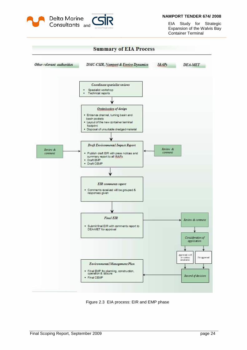
Figure 2.2 EIA process: Scoping phase
and
NAMPORT TENDER 674/ 2008
EIA Study for Strategic Expansion of the Walvis Bay Container Terminal
Final Scoping Report, September 2009 page 24
Figure 2.3 EIA process: EIR and EMP phase

and
NAMPORT TENDER 674/ 2008
EIA Study for Strategic Expansion of the Walvis Bay Container Terminal
Final Scoping Report, September 2009 page 25
2.3.1 Public participation programme (stakeholder e ngagement) The public participation programme (PPP) is an integral part of the EIA process, and continues throughout this process. By its very nature, it is a dynamic process where different societal needs, values and interests must be recognised and managed. This requires that public participation provide the opportunity for participation in an open and transparent manner. The fact that Interested and Affected Parties (I&APs) do not always agree is acknowledged and accommodated in the process. The objectives of the public participation process are to:
• Build credibility through instilling confidence in the integrity and independence of the team conducting the EIA.
• Educate the stakeholders on the process to be undertaken and opportunities for their involvement.
• Empower stakeholders through establishing an agreed framework according to which the process will be conducted. This requires accessible, fair, transparent and constructive participation at every stage of the process.
• Inform stakeholders on the proposed project and associated issues, impacts and mitigation, using the most effective manner to disseminate information.
2.3.2 Scoping phase The Scoping process is intended to provide sufficient information for the authorities to be assured about the scope of issues to be addressed in this EIA process, and to identify specialist studies to be included as part of the Environmental Impact Reporting Phase of the EIA, as well as the approach to these studies. The objectives for this Scoping process are to:
• Identify and inform all stakeholders about the proposed development;
• Clarify the scope and nature of the proposed activities and the alternatives being considered;
• Conduct an open, participatory and transparent approach to facilitate the inclusion of stakeholder concerns in the decision-making process;
• Identify and document the key issues to be addressed in the forthcoming Environmental Impact Reporting Phase of the EIA;
• Ensure due consideration of alternative options in regard to the proposed development, including the “No development” option.
The following outcomes should follow the conclusion of the Scoping process:
• Stakeholders have been effectively identified and incorporated into the scoping process;
• Alternatives for achieving the objectives of the proposed activity have been given due consideration;
• Closure has been reached on the significant issues to be addressed;
• The roles and responsibilities of various stakeholders in the process have been clarified;
• All participants have agreed on the process to be followed;

and
NAMPORT TENDER 674/ 2008
EIA Study for Strategic Expansion of the Walvis Bay Container Terminal
Final Scoping Report, September 2009 page 26
• Adequate terms of reference for specialist investigations that are acceptable to all participants.
2.3.3 Tasks for the Scoping process The following tasks have been been undertaken, or are still in progress:
• Compile Background Information Document (BID) A Background Information Document (BID) was distributed. As the name implies, it provides a description of the proposed project, the EIA process, the project proponent and the EIA team. The BID is intended both to encourage interest in the project and provide adequate information for stakeholders to start identifying issues and possible concerns regarding the proposed activity.
• Identification of Interested and Affected Parties ( I&APs)
The public participation activities to be undertaken for this EIA process are integrated into the overall approach to the EIA. Key I&APs in and around Walvis Bay were identified through reviewing and updating Enviro Dynamics’ database for the Walvis Bay area and the Erongo Region, which includes relevant authorities and specific interest groups. The newspaper advertisements that requested I&APs to register for the EIA supplemented this database, which is updated regularly during the EIA process.
• Announcement of EIA Process
The start of the EIA process was announced publicly through placement of newspaper adverts and distribution of notices to all I&APS in the database. The notices included the Background information Document (BID) for the EIA. Advertisements requesting I&APs to register their interest in the project were placed in the Namib Times (local newspaper), the Republikein and the Namibian, as detailed in Table 2.1. Included in these communications was a referral to information on the Namport website at http://www.namport.com.na
• Identification of issues and concerns
A first round of public consultation in the Scoping process was held on 19-20 May 2009. Meetings were held with relevant Authorities and the NACOMA coastal initiative on 19 May, and with the port’s users on 20 May. Because of the school holidays from April 29 to May 26 2009, the public meeting was delayed and held on 11 June 2009. Minutes of these meetings are provided in Appendix F
Issues and concerns raised by I&APs have been integrated into an Issues and Response
Trail (Appendix G that have been identified through: o Written submissions in response to invitations to comment; o Meetings with Authorities, port users and general public.
In the Issues Trail, responses and clarification are provided where possible, or deferred to the Environmental Impact Report phase for resolution.

and
NAMPORT TENDER 674/ 2008
EIA Study for Strategic Expansion of the Walvis Bay Container Terminal
Final Scoping Report, September 2009 page 27
• Preparation of Draft Scoping Report This Draft Scoping Report concludes the consultation process for the scope of the EIA.
Table 2.1: Media announcements at the commencement of the EIA process
Newspaper Area of distribution
Language Date placed
Namib Times Coastal. Limited number of copies available nationally
English 29 May 2009 05 June 2009
Namibian National English 28 May 2009 Republikein National Afrikaans 29 May 2009 Additional sources Bay News website Coastal English June edition Posters Coast English 03 June 2009
(Kuisebmond, Narraville, Walvis Bay Municipal offices, Erongo RED offices, Woermann Brock and Pick ’n Pay, Meersig)
Flyers Coast English Millionnaire Land, 5th Road and residents near schools along 5th Road
• Public review of Draft Scoping Report
The Draft Scoping Report (DSR) was placed in the public domain for a review period of 14 days. The report was made available as hard copies at the municipal offices and public library in the Walvis Bay, and the public libraries in Narravile and Kuisebmond.
• Final Scoping Report On the basis of the public review, this Final Scoping Report (FSR) will be submitted to the lead authority (MET).
2.3.4 Impact assessment phase 2.3.4.1 Finalise specialist terms of reference The Scoping Report presents a Plan of Study for the EIA, which has detailed Terms of Reference for the specialist studies, and any additional issues that need to be taken account of by the design and optimisation studies. 2.3.4.2 Prepare draft specialist studies Specialists will conduct their specialist studies to address issues and concerns and other requirements that emerge from the Scoping process. Any findings relevant to the design and optimisation studies will be passed over to those specialists also. The linkage between the

and
NAMPORT TENDER 674/ 2008
EIA Study for Strategic Expansion of the Walvis Bay Container Terminal
Final Scoping Report, September 2009 page 28
specialist studies, impact assessment and the design studies on dredge management and optimization of terminal footprint and channel access are illustrated in Figure 2.4. The potential risks and associated impacts of various environmental factors (water levels, flow velocities, waves, sediments) of the proposed new container terminal will be assessed in the EIA for both construction and operations. If unacceptable changes are determined, modifications to the terminal layout or mitigating measures shall be investigated for optimised solutions, so that the impacts on the environment are reduced to acceptable levels. 2.3.4.3 Draft EIA Report A draft EIA Report will be compiled on the basis of the specialist and design and optimization studies. In broad terms this report will include the following structure:
• Introduction
• Approach and methodology for the EIA
• Legal and Planning framework
• Description of project and alternatives
• Description of affected biophysical and socio-economic environments
• Public issues and concerns
• Impact assessment
• Recommended management actions
• Conclusions
• Supporting information.
Figure 2.4 Linkages between impact assessment and studies for design and optimisation
Data/ Requirements• Boundary conditions • Port development
EIA -Construction Phase
• Dredging • Reclamation• Construction works• Risks• Mitigation measures
Dredging Management• Land reclamation• Alternative disposal concepts • Minimization of spoil
Appraisal
Optimization Container Terminal Footprint
• Hydrodynamic models• Mitigation measures
EIA -Operational Phase
• Emissions (noise etc.)• Fauna/ Flora/ Soil• Hydraulic regime• Sediment regime• Risks • Social impacts• Mitigation measures
Optimization Access Channel and Port basins
• Ship manoeuvre simulations
EIA Study / Optimization Container
Terminal Footprint and Port Access

and
NAMPORT TENDER 674/ 2008
EIA Study for Strategic Expansion of the Walvis Bay Container Terminal
Final Scoping Report, September 2009 page 29
2.3.4.4 Draft specialist studies, EIA Report and EMPs in th e public domain The draft specialist studies, EIA Report and EMP will be placed in the public domain for review. In addition to the availability of the reports in the public domain, public meetings and presentations to the authorities will also be used to solicit further comment on the documents. A Comments and Response Trail will be formulated to detail how the comments raised by I&APs have been addressed in the EIA Report. The Comments and Response Trail will be included in a Final EIA Report along with an outline of the process implemented, database of I&APs and record of proceedings for the EIA phase of the Project. 2.3.4.5 Draft Environmental Management Plan (EMP) In parallel to the drafting of the EIA Report, a stand-alone EMP Report will be compiled for the construction and operation phases. The EMP Report will be practical and effective, based on the environmental management philosophy of the ISO 14001 Environmental Management Systems standard and will thus be structured to define an environmental policy, planning, implementation and operation, checking and corrective action and management review (see Figure 2.5).
Figure 2.5 Summary of the ISO 14001 process for Environmental Management Systems
2.4 Issues for consideration by the EIA
Baseline information on the environmental setting of Walvis Bay is presented in Chapter 4 of this report. Information in previous EIAs for Walvis Bay, and for similar developments in other ports, was reviewed in order to identify potential issues and their associated impacts that should be considered by the EIA. These are the following:
• Hydrodynamic and sedimentary regime
• Marine sediment quality
• Water quality

and
NAMPORT TENDER 674/ 2008
EIA Study for Strategic Expansion of the Walvis Bay Container Terminal
Final Scoping Report, September 2009 page 30
• Marine ecology
• Marine and coastal ornithology
• Road traffic
• Noise and vibration
• Socio-economics
• Soil quality and geology
• Terrestrial ecology
• Fisheries and/or aquaculture resources
• Landscape and visual setting
• Recreation
• Commercial and/or private navigation
• Rail
• Air quality
• Coastal protection and flood defence
• Infrastructure and land drainage In the sections that follow, these issues are separated into construction and operational phases. Together with environmental objectives and management goals that will form part of the ISO 14001 environmental management programme, a methodology and approach for the EIA is then discussed for each issue. 2.4.1 Hydrodynamic and sedimentary regime
Significant influences on the hydrodynamic and sedimentary regime of Walvis Bay are the Benguela Current and its associated upwelling offshore, with diurnal tides that flush the Bay twice daily with nutrient-rich water. Main issues to be considered for this EIA are described below.
2.4.1.1 Construction phase
Potential for: • Sediment runoff from reclamation. • Suspension, dispersion and deposition of sediment during capital and/or maintenance
dredging. • Dispersion and deposition of sediment released at the disposal site. • Temporary hydrodynamic effects of the construction stages. • Potential increases in spread of spilled dredge sediment into the Lagoon under extreme
northerly winds.

and
NAMPORT TENDER 674/ 2008
EIA Study for Strategic Expansion of the Walvis Bay Container Terminal
Final Scoping Report, September 2009 page 31
2.4.1.2 Operational phase Potential changes to: • Tidal propagation. • Tidal currents. • Wave conditions. • Sediment transport patterns. • Nearby intertidal morphology. • Lagoon morphology/bathymetry • Maintenance dredging requirements.
2.4.1.3 Methodology and approach to EIA Environmental quality objective : Maintenance of ecosystem integrity. Environmental management goals : Ensure the development does not impact significantly on
existing hydrodynamics and coastal processes. Maintain the integrity and ecological functions of the seabed, lagoon and coast.
The EIA studies will have three components, namely,
• Project baseline, i.e., understanding the characteristics of the existing physical environment;
• Identifying temporary effects on the environment during construction and reclamation;
• Identifying any permanent effects after construction and reclamation, and during operation of the new container terminal.
Hydrodynamic modelling studies will address the fol lowing processes: • Tidal propagation; Pollution flow (advection/dispersion); Current strength and direction;
Wave conditions; Sediment transport, erosion and deposition, including within maintained areas; lagoon morphology; Dispersion of sediment released by construction activity; this includes dredging, reclamation; Harmonic influence in the Bay.
The impact of the proposed activity will be assesse d in terms of changes to:
• Tide heights; Current velocities and directions at different tidal states; Wave conditions;
• Sediment transport patterns and volumes; Distribution of sediment contaminants. A detailed pre-construction bathymetric survey of the Lagoon will be supplemented with a post-construction survey, followed by a regular long-term survey programme. 2.4.2 Marine sediment quality The sea bottom of Walvis Bay consists of fine- to medium-grained sand that is overlain with a layer of thick dark green diatomaceous mud. Fine, muddy sediments are found at the southern end of the Lagoon, gradually increasing to coarser sand near the mouth. The mouth and lower reaches of the Lagoon are presently in a state of equilibrium with the coastal processes that control their dynamics and basic configuration. The dredging, reclamation and construction activities will affect water quality when bottom material is resuspended and turbidity in the water column increases. Heavy metal contaminants are present in

and
NAMPORT TENDER 674/ 2008
EIA Study for Strategic Expansion of the Walvis Bay Container Terminal
Final Scoping Report, September 2009 page 32
the Bay sediments, though they are mostly below guideline values recommended by the Benguela Current Large Marine Ecosystem (BCLME) study. The Lagoon sediments are high in organic matter, but none of the bioaccumulative or toxic substances normally of concern have been found here. Dredging will result in the mobilization of metals and organic compounds. It could also release hydrogen sulphide and methane gasses that are contained in the organic-rich diatomaceous “ooze” of anaerobically decaying phytoplankton that has accumulated in sheltered parts of Walvis Bay. The main issues to be considered for the EIA are described below. 2.4.2.1 Construction phase Potential for: • Remobilization, dispersion and redistribution of potentially contaminated sediments during
capital dredging. • Release of potentially contaminated sediments during quay construction. • Run-off of contaminated material from the reclamation works. 2.4.2.2 Operational phase • Potential remobilization of sediment by localized erosion resulting from changes in tidal flows
or wave action. 2.4.2.3 Methodology and approach to EIA Environmental quality objective : Maintenance of ecosystem integrity. Environmental management goals : Ensure the development does not impact significantly on
existing marine sediment quality. Maintain the integrity and ecological functions of the seabed, lagoon and coast.
The EIA study will determine whether the dredged sediments are suitable for disposal in the marine environment. It will do this by using the guideline values for sediment quality from the “Proposed Water and Sediment Guidelines for Coastal Areas in the BCLME Region” to assess the impact of discharges that move into the water column due to dredge, reclamation and construction activities, and after the new container terminal has started operations. These guideline values are shown in Table 2.2 below.
Table 2.2 BCLME guideline values for concentration of metals in marine sediments
Unit Chromium
(Cr) Mercury
(Hg) Cadmium
(Cd) Lead (Pb)
Zinc (Zn)
Copper (Cu)
TBT
mg/kg (dry weight)
81 0.15 1.2 46.7 150 34 0.005
- Preliminary (desktop and site visit) physico-biogeochemical characterisation of marine sediments; - Field surveys and sampling of sediments:
• Bathymetric and geophysical surveys must be done at the start of the EIA to provide information on how the “ooze” is layered through the Bay.
• Vibrocoring - geochemical and geotechnical analysis of cores to understand how chemical constituents, e.g., heavy metals, are distributed throughout the “ooze”
and
NAMPORT TENDER 674/ 2008
EIA Study for Strategic Expansion of the Walvis Bay Container Terminal
Final Scoping Report, September 2009 page 33
column and underlying sediments. Contaminated dredge spoil will be isolated from the ecosystem if it is used as fill for the container berths. If the material is geotechnically unsuitable for use as fill, consideration will then need to be given to sourcing fill material from other sources. If any substances or materials listed in the Annexes of the London Convention are found, dredged material must then be treated in accordance with the relevant provision of the Convention, that is, use of a designated disposal site.
- Assessment of impacts for construction and operations, based on Bay and lagoon ecosystem sensitivities to quantity and character of dredge sediments, and dredging and dredge disposal options. 2.4.3 Water quality The water quality in the Bay is the result of physical and biological processes and the outputs of human activity in the town and the port. As discussed in the previous section on sediment quality, water quality will be affected by dredging, reclamation and construction activities that resuspend bottom material, increase turbidity in the water column and liberate metal contaminants and sulphur and methane gasses contained in the sediments. The issues that are most relevant for the EIA are described below. 2.4.3.1 Construction phase Potential for: • Increase in suspended sediment concentrations and increased turbidity during capital
dredging and dewatering of reclaimed material. • Impact of re-suspended solids on the concentrations of oxygen in the water column. • Increase in suspended sediment concentrations and potential for the release of heavy
metal contaminants into the water column. • Impacts on water quality associated with disposal of capital dredged material. • Impact of fine sediments with high organic content spreading into areas with higher
than background levels of oxygen levels. • Accidental spillages of building materials such as cement, hydraulic fluids, oils.
2.4.3.2 Operational phase
Potential for: • Increases in spread of organic discharge from fishing industries to the Lagoon, as a
result of harbour deepening. • Increases in suspended sediment concentrations and increased turbidity during
maintenance dredging. • Changes in water quality due to erosion and remobilization of sediment caused by
changes in tidal flows or wave action. • Accidental spillages of materials.
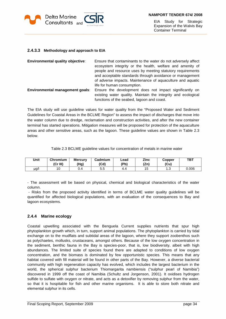
and
NAMPORT TENDER 674/ 2008
EIA Study for Strategic Expansion of the Walvis Bay Container Terminal
Final Scoping Report, September 2009 page 34
2.4.3.3 Methodology and approach to EIA
Environmental quality objective : Ensure that contaminants to the water do not adversely affect
ecosystem integrity or the health, welfare and amenity of people and resource uses by meeting statutory requirements and acceptable standards through avoidance or management of adverse impacts. Maintenance of aquaculture and aquatic life for human consumption.
Environmental management goals : Ensure the development does not impact significantly on existing water quality. Maintain the integrity and ecological functions of the seabed, lagoon and coast.
The EIA study will use guideline values for water quality from the “Proposed Water and Sediment Guidelines for Coastal Areas in the BCLME Region” to assess the impact of discharges that move into the water column due to dredge, reclamation and construction activities, and after the new container terminal has started operations. Mitigation measures will be proposed for protection of the aquaculture areas and other sensitive areas, such as the lagoon. These guideline values are shown in Table 2.3 below.
Table 2.3 BCLME guideline values for concentration of metals in marine water
Unit Chromium
(Cr III) Mercury
(Hg) Cadmium
(Cd) Lead (Pb)
Zinc (Zn)
Copper (Cu)
TBT
µg/l 10 0.4 5.5 4.4 15 1.3 0.006 - The assessment will be based on physical, chemical and biological characteristics of the water column. - Risks from the proposed activity identified in terms of BCLME water quality guidelines will be quantified for affected biological populations, with an evaluation of the consequences to Bay and lagoon ecosystems. 2.4.4 Marine ecology Coastal upwelling associated with the Benguela Current supplies nutrients that spur high phytoplankton growth which, in turn, support animal populations. The phytoplankton is carried by tidal exchange on to the mudflats and subtidal areas of the lagoon, where they support zoobenthos such as polychaetes, mollusks, crustaceans, amongst others. Because of the low oxygen concentration in the sediment, benthic fauna in the Bay is species-poor, that is, low biodiversity, albeit with high abundances. The limited suite of species found there are adapted to conditions of low oxygen concentration, and the biomass is dominated by few opportunistic species. This means that any habitat covered with fill material will be found in other parts of the Bay. However, a diverse bacterial community with high regeneration capacity has evolved, which includes the largest bacterium in the world, the spherical sulphur bacterium Thiomargarita nambiensis (“sulphur pearl of Namibia”) discovered in 1999 off the coast of Namibia (Schultz and Jorgenson, 2001). It oxidises hydrogen sulfide to sulfate with oxygen or nitrate, and acts as a detoxifier by removing sulphur from the water, so that it is hospitable for fish and other marine organisms. It is able to store both nitrate and elemental sulphur in its cells.

and
NAMPORT TENDER 674/ 2008
EIA Study for Strategic Expansion of the Walvis Bay Container Terminal
Final Scoping Report, September 2009 page 35
The main issues to be considered for the EIA are mainly related to water quality, and are described below. 2.4.4.1 Construction phase Potential for: • Direct loss of benthic habitat and community within the footprint of the proposed terminal
and capital dredged area. • Potential smothering effect caused by sedimentation of material by capital dredging. • Implications for benthic communities arising from an increase in suspended sediment
concentrations and turbidity due to capital dredging. • Remobilization of potentially contaminated sediments and subsequent effects on the
intertidal and sub-tidal communities due to capital dredging. • Potential impacts on Lagoon communities as a result of a deterioration of water quality
associated with capital dredging. • Potential impacts on subtidal habitats associated with the disposal of capital dredged
material.
2.4.4.2 Operational phase • Potential impact on marine habitats and communities as a result of effects on the
hydraulic and sedimentary regime. • Effect of maintenance dredging on benthic communities.
2.4.4.3 Methodology and Approach to EIA Environmental quality objective : Maintenance of ecosystem integrity – the Lagoon, in particular. Environmental management goals : Minimise direct loss and disturbance to marine habitat during
dredging and disposal of dredge spoil, and indirect loss through turbidity. Minimise the risk of introduction of unwanted marine organisms. Maintain the integrity and ecological functions of the seabed, lagoon and coast.
During dredging, material brought into suspension is spread by the prevailing currents around the Bay. Any heavy metals or toxic substances will, therefore, also be spread and pose risks for the marine ecology in the Bay due to the impacts on water quality by these sediment plumes. The invertebrate fauna are the primary food source for large numbers of waders, flamingoes and other birds that use the lagoon. Direct, long-term effects of the container terminal expansion on the benthic fauna will therefore indirectly affect the birdlife in the lagoon and tourism associated with this Ramsar site. - Review existing information on marine ecology, e.g., the Agenda 21 study for Walvis Bay. - Outputs from the hydrodynamic modelling must be used to predict effects on the ecosystem, particularly the Lagoon. - Dredge sediment properties assessed in terms of particle size distributions, contaminant concentrations, and toxicity. Data from previous studies supplemented with analyses from sub-soil investigations. - Identify biological communities at risk from proposed activity, and associated consequences. - Direct (construction) and indirect (operations) impacts identified and assessed.

and
NAMPORT TENDER 674/ 2008
EIA Study for Strategic Expansion of the Walvis Bay Container Terminal
Final Scoping Report, September 2009 page 36
2.4.5 Marine and coastal ornithology A unique and abundant birdlife is present in Walvis Bay as a consequence of high productivity of sea life and plankton, due to the nutrient-rich Benguela current. In the Lagoon wading birds, rather than seabirds, predominate. The Important Bird Area encompasses the Ramsar-protected lagoon, artificially-flooded areas of the Salt Works, intertidal areas of Pelican Point and the “30 mile beach” north of Walvis Bay. The Salt Works support up to half of the birds in the Lagoon, where they like to feed in the shallow pans that have a steady artificial influx of particles and nutrient-rich water that fuels the benthic and pelagic food-chain. These pans, through their extensive land reclamation and physical barrier to changing tides, have changed the ecology of the Lagoon. The main issues to be considered for the EIA are described below. 2.4.5.1 Construction phase • Direct loss of potential sea- and shore-bird feeding and roosting sites. • Potential disturbance to sea- and shore-bird populations.
2.4.5.2 Operational phase • Potential disturbance to sea- and shore-bird populations. • Potential for impact on sea- and shore-bird habitats due to effects on the hydraulic and
sedimentary regime of the Lagoon. • Potential for impact on bird movements. • Potential for impact associated with noise and light generated by the terminal
operation. 2.4.5.3 Methodology and approach to EIA Environmental quality objective : Maintenance of ecosystem integrity – the Lagoon, in
particular. Environmental management goals : Maintain the abundance, diversity, geographic distribution
and productivity of avifauna through the avoidance or management of adverse impacts and improvement in knowledge. Maintain the integrity and ecological functions of the lagoon and coast.
Changes in the hydraulic and sedimentary regime due to dredging, reclamation and operations would potentially have an impact on the lagoon habitat for resident and migratory sea- and shore birds. These might be negative, e.g., increase in lagoon sedimentation could reduce tidal flux and increase the likelihood of a permanent reduction of the intertidal area that forms the feeding grounds for wading birds, or positive, e.g., new hard structures for the container terminal and associated maintenance dredging could reduce wave action and southbound wave-driven longshore sediment transport and reduce the amount of sediment carried into the lagoon mouth by tidally-driven currents. - Review existing information on marine and coastal ornithology, e.g., the Agenda 21 study for Walvis Bay. Any species that may have value as indicators of environmental stress should be identified for post-construction monitoring. - Outputs from the hydrodynamic modelling must be used to predict effects on the Lagoon and how these will bring changes to the avifaunal ecosystem.

and
NAMPORT TENDER 674/ 2008
EIA Study for Strategic Expansion of the Walvis Bay Container Terminal
Final Scoping Report, September 2009 page 37
- Assessment of impacts from dredging, reclamation and operations on the resident and migratory sea- and shore-birds (waders). 2.4.6 Road traffic Roads to the Port of Walvis Bay pass through urban and residential areas. An increase in traffic during construction and operation of the new container terminal will increase the levels of noise, nuisance and vehicle emissions, and risks associated with traffic accidents. The main issues for the EIA are described below. 2.4.6.1 Construction phase • Potential increased congestion and loads due to construction vehicles on the road network.
2.4.6.2 Operational phase Potential impact on: • Existing road network capacity due to generation of additional traffic. • Existing community on the possible changes to major container traffic routes. 2.4.6.3 Methodology and approach to EIA Environmental quality objective : Maintenance of business efficiency and urban amenity. Environmental management goals : Protect amenity values and business efficiency by ensuring
that adverse impacts from traffic density, haulage loads and associated noise are minimised or avoided.
The development of the Namib and Walvis Bay Corridors, and Trans-Caprivi and Trans-Kalahari Highways will link the Port of Walvis Bay to most of Namibia’s neighbours. Construction of the container terminal will lead to an increase in traffic from these corridors, with concomitant increases in traffic accidents, noise and vehicle emissions. Construction vehicles will be required to transport building material during the construction of quay walls, rock revetments, container terminal surfacing, buildings and workshops. The traffic study will assess impacts on the community and infrastructure of Walvis Bay from: • Construction traffic and • Operational traffic, that is, container haulage. - In particular, traffic routing will be assessed, as well as the effect of increased and sustained heavy haulage on roads, traffic safety and noise.

and
NAMPORT TENDER 674/ 2008
EIA Study for Strategic Expansion of the Walvis Bay Container Terminal
Final Scoping Report, September 2009 page 38
2.4.7 Noise and vibration Sources of noise in the port include cargo handling, vehicular traffic, and loading/unloading containers from ships, maintenance of infrastructure and equipment, servicing of vessels and rigs, and operation of cranes, synchrolift and floating dock. The expansion of the container terminal will introduce new sources of noise during construction and operation of the new facilities, such as the new ship-to-shore and rubber-tyred gantry cranes. This will necessarily introduce changes in ambient noise levels in the port and its environs and, in particular, for residential areas in close proximity to the new terminal. The main issues for the EIA are described below. 2.4.7.1 Construction phase • Potential increase in noise and vibration levels due to construction activities.
2.4.7.2 Operational phase
• Potential increase in the ambient noise levels due to the operation of the new container terminal.
2.4.7.3 Methodology and approach to EIA Environmental quality objective : Maintenance of social amenity values. Environmental management goals : Protect amenity values by ensuring that noise levels from
construction and operations are minimised. Ensure that noise levels meet the statutory requirements and acceptable standards.
The impact of noise associated with construction and operation of the container terminal will be compared with baseline conditions and assessed against international criteria developed by the World Health Organisation (WHO), World Bank Group and South African National Standards (SANS) for environmental noise. The noise assessment study must account for:
• Changes in port layout – if required by changes predicted in the hydrodynamics modeling;
• Alternative haulage routes;
• Wind direction. - Potential noise sources will be identified, with operating times; - Adjoining land uses will be identified; - Noise levels will be estimated and impacts assessed. - Test method employed will be SANS 10103:2008, with results compared to, amongst others:
• SANS 10103:2008 Version 6 - The measurement and rating of environmental noise with respect to annoyance and to speech communication.
• SANS 10210, Calculating and predicting road traffic noise.
• SANS 10328, Methods for environmental noise impact assessments.
• SANS 10357, The calculation of sound propagation by the Concawe method.
• World Bank Guidelines on Pollution Prevention.

and
NAMPORT TENDER 674/ 2008
EIA Study for Strategic Expansion of the Walvis Bay Container Terminal
Final Scoping Report, September 2009 page 39
• World Health Organisation guidelines for community noise limits for outdoor living areas and to prevent sleep disturbance.
2.4.8 Socio-economics Expansion of the container terminal will impact on the economy at local, regional and national scale by raising the gross value added (GVA) of the port. It is expected that direct employment in the port and in the transport sector will be generated during construction and operation of the new facilities. The new facilities will also have an effect on the local fishing industry, aquaculture activities and the local tourism sector. Through capital expenditure associated with the container terminal expansion, suppliers in the local economy will have a multiplier effect by distributing part of their income for taxes, wages, and goods and services through their own supply chains. However, the increase in revenue for the local, regional and national fiscus through such multiplier effects, will be offset by the cost to Government of supplying additional infrastructure in Walvis Bay and the Erongo region as its economic base grows. The main issues for the EIA are described below. 2.4.8.1 Construction phase • Potential direct socio-economic impacts. • Potential indirect effect on local and national economy.
2.4.8.2 Operational phase
• Potential increase in direct employment. • Potential multiplier effects. • Strategic importance.
2.4.8.3 Methodology and approach to EIA Environmental quality objective : Optimise benefits to the people of Namibia. Environmental management goals : Strike a balance between economic, social and
environmental responsibilities. Provide opportunities for local business, promote industrial relations, and otherwise contribute to socio-economic stability
The proposed container terminal expansion will have social impacts that may be both positive and negative. An example is the creation of new job opportunities that leads to in-migration of people and increases the number of people in the area, with the concomitant increase in the demand for infrastructure and services from local and regional authorities. - The change in worker demographics, and any social impacts, such as increases in crime and sexually transmitted diseases, will be assessed. - Other issues to be considered are impacts on aesthetics, recreation, fisheries and aquaculture, land-use and settlements, traffic, tourism, municipal services and livelihoods.

and
NAMPORT TENDER 674/ 2008
EIA Study for Strategic Expansion of the Walvis Bay Container Terminal
Final Scoping Report, September 2009 page 40
2.4.9 Soil quality and geology The deep unconsolidated sediments from Tertiary to Recent Age that characterize the geology of Walvis Bay were formed through a combination of processes with origins in the river, estuary, wind and coastal environments. Around Walvis Bay, the topography is dominated by rolling hills and dunes not higher than 100 m. Within the Bay, fine- to medium grained sand is overlain by diatomaceous mud. Though heavy metal contaminants have been found in Bay soils, the quality of these soils is not significantly different from those at other ports and harbours around the world. Groundwater for potable use in Walvis Bay is extracted from aquifers associated with the Kuiseb River and piped from there to the town. The main issues for the EIA are described below. 2.4.9.1 Construction phase • Potential risk to construction workers 2.4.9.2 Operational phase • Potential for contamination of groundwater and surface water 2.4.9.3 Methodology and approach to EIA Risks to construction workers would arise from their exposure – through inhalation and touch - to heavy metal contaminants if dredged material not suitable for use as fill at the reclamation site is disposed of onshore. These contaminants could also leach into the groundwater at such a disposal site. Environmental quality objective : Maintenance of ecosystem integrity. Environmental management goals : Ensure that the development does not impact significantly
on existing soil quality and geology. Maintain the integrity and ecological functions of the seabed, lagoon and coast.
- Namport does not plan to source reclamation material on land, nor to dispose of it there. A separate investigation and assessment of impacts from soil quality on ground- and surface water, and on workers, is therefore not required. However, health and safety issues for workers must always be taken into consideration. 2.4.10 Terrestrial ecology Terrestrial biodiversity in Walvis Bay is low, and most fauna are to be found in the lagoon, at Pelican Point and at the Salt Works. Within Walvis Bay, reptiles are rare, and the Black-backed jackal (Canis mesomelas) has been observed along the shores of the lagoon. At Pelican Point there are terrestrial insects, for which no inventory of species has been compiled, sand hoppers and white mussels. The main issues for the EIA are described below.

and
NAMPORT TENDER 674/ 2008
EIA Study for Strategic Expansion of the Walvis Bay Container Terminal
Final Scoping Report, September 2009 page 41
2.4.10.1 Construction phase • Direct habitat loss. • Potential loss of fauna and flora only if fill material is obtained from land sources, or disposed of
on the land.
2.4.10.2 Operational phase None.
2.4.10.3 Methodology and approach to EIA Environmental quality objective : Maintenance of ecosystem integrity. Environmental management goals : Minimise the loss and adverse impacts to vegetation and
plant habitats. Maintain the integrity and ecological functions of terrestrial ecology.
- The effect of the container terminal expansion on the bird life and marine benthos will be assessed in the ornithology and marine ecology specialist studies. - Namport does not plan to source reclamation material from the land, nor to dispose of it on land. A separate investigation and assessment of impacts on terrestrial ecology is therefore not required. 2.4.11 Fisheries and/or aquaculture resources The fishing industry in Walvis Bay is an important component of the local economy. Aquaculture is a key result area for the Third National Development Plan of Namibia, and clean water is critical for this industry because the oysters are produced for human consumption. Industrial fishing occurs outside Walvis Bay on the inner continental shelf and further offshore. Artisanal and subsistence fishing is conducted within the sheltered waters of the Bay, mainly north of the Port. The main issues for the EIA are described below.
2.4.11.1 Construction phase
Potential impacts on: • Resident fish, oyster, mussels or other aquatic species caused by effects of capital
dredging on water quality. • Fish, oyster, mussels or other aquatic species caused by negative change in water
quality due to disposal of capital dredged material. • Potential effect of noise and light on fish, oyster, mussels or other aquatic populations.

and
NAMPORT TENDER 674/ 2008
EIA Study for Strategic Expansion of the Walvis Bay Container Terminal
Final Scoping Report, September 2009 page 42
2.4.11.2 Operational phase Potential impact on: • Changes in currents that affect sensitive fish eggs and larvae, other eggs and larvae, and feeding
resources for oyster, mussels or other aquaculture species. • Migration routes. 2.4.11.3 Methodology and approach to EIA Environmental quality objective : Maintenance of aquaculture. Maintenance of aquatic life for
human consumption. Environmental management goals : Minimise the loss and adverse impacts to recreational
amenity and aquaculture resources. Dredging will release fine sediment particles into the water column and affect turbidity and water quality, which are potentially harmful to aquatic species. Under prevailing southerly winds, such plumes would be moved away from the present aquaculture sites; the situation would be reversed under northerly wind conditions. The impact of the proposed causeway on the movement of water out of the lagoon – some of it poor-quality – will be clarified. Associated with increased turbidity is the oxygen demand of resuspended sediments; how any impacts on the oxygen regime will affect fisheries and aquaculture is also an issue that will be considered. - The effects of sediment plumes will be covered by the hydrodynamic modeling and studies on marine sediment and water quality, marine ecology and socio-economic impacts. A separate investigation and assessment of impacts on fisheries and aquaculture is therefore not required. 2.4.12 Landscape and visual setting The area that will house the proposed container terminal expansion, and its immediate surroundings, is characterized by infrastructure and land-use that is typical of ports and harbours around the world. New infrastructure would be similar to what is already in the port. Residents who live in the shadow of this infrastructure have always lived with a skyline dominated by cranes, warehouse buildings and cargo handling facilities. However, the new terminal would have an intrusive visual impact on recreational users of the lagoon, Pelican Point and the proposed new waterfront development that will be adjacent to the new facilities – both during the day and at night with associated lighting.
In the town, tourism is a focus for growth in the residential and holiday accommodation sectors. The value of landscape views for tourists is very important for this burgeoning sector in Walvis Bay.
The main issues for the EIA are described below.
2.4.12.1 Construction phase • Potential impact on the visual environment due to the presence of construction plant. 2.4.12.2 Operational phase • Potential for impact on landscape and visual character.

and
NAMPORT TENDER 674/ 2008
EIA Study for Strategic Expansion of the Walvis Bay Container Terminal
Final Scoping Report, September 2009 page 43
2.4.12.3 Methodology and approach to EIA Environmental quality objective : Maintenance of aesthetic values. Environmental management goals : Ensure that aesthetic values and public experience of the
landscape are considered. By intruding on the view towards Pelican Point, the new container terminal will impact on the landscape, and on the nightscape with its safety and security lighting. The new ship-to-shore cranes will be prominent new landmarks, but within the context of an existing port landscape with its tall permanent structures and temporary ones such as visiting oil rigs. The new facilities will intrude on the open view of the horizon from the coast, lagoon and the town, and mitigation measures would be required to reduce the starkness of such an intrusion. - The new container terminal will be in a location that is highly suitable for such a facility of national strategic importance. Except for its visual intrusion into the view from the area around the Yacht Club, its visual impact will be incremental – that is, it will add elements to an existing context, and will not change the intrinsic character of its surroundings which are typical of a port – see Figures 2.6 and 2.7. - This compatibility with, and high visual absorption capacity of, the existing landscape and nightscape increases its acceptability. The significance of its visual impact, therefore, is low to moderate, and a separate investigation and assessment of visual impact is not required. - Recommendations on mitigation that are based on best practice for aesthetics and visual impact will be included in the specialist study on socio-economics.

and
NAMPORT TENDER 674/ 2008
EIA Study for Strategic Expansion of the Walvis Bay Container Terminal
Final Scoping Report, September 2009 page 44
Figure 2.6 View towards the port from the Swakopmund road. The landscape is dominated by
cranes and ships.
Figure 2.7 View towards the port from the airport access road. Landscape is dominated by cranes
and an oil rig.

and
NAMPORT TENDER 674/ 2008
EIA Study for Strategic Expansion of the Walvis Bay Container Terminal
Final Scoping Report, September 2009 page 45
2.4.13 Recreation Walvis Bay is both a working harbour and an area for recreation. It is a popular destination for both internal and external tourists, especially during the hot Namibian summer, and tourism in the area is steadily growing. Ocean passenger liners are regular visitors to the port. The Yacht Club is adjacent to the existing Berth 8, close to the mouth of the lagoon. Regular boat trips and kayak tours are organized from the environs of the Yacht Club. Other recreational activities on the lagoon are bird watching, wind and kite surfing, with small boating restricted to fishing competitions. Recreational fishing is spread along the coastal beaches of the Bay, and important beaches for swimming are Kuisebmond Beach, Dolphin Park and Long Beach. The construction of a new road along the eastern and southern shores of the lagoon has facilitated access to Sandwich Harbour, Paaltjies and the Salt Works for tourist groups. The main issues for the EIA are described below. 2.4.13.1 Construction phase • Potential impact on water-based recreation due to construction activities so close to the lagoon.
2.4.13.2 Operational phase • Potential conflict between water-based recreation due to changes in commercial or
private shipping traffic. • Potential loss of amenity value in the Lagoon due to morphological changes
2.4.13.3 Methodology and approach to EIA Environmental quality objective : Maintenance of recreational opportunities. Environmental management goals : Protect amenity values by ensuring that loss and adverse
impacts to the Lagoon are minimised or avoided. Maintain the integrity and ecological functions of Lagoon ecology.
Recreation along the coast is an important component of tourism activities. Since construction activities will not extend into the lagoon, it is unlikely that water-based recreation activities in the lagoon will be negatively affected. However, if toxic substances from the dredging activities intrude into the lagoon, these could pose a threat to its fauna and to human health and safety. Changes in patterns of sedimentation as a result of the new container terminal could also impact negatively on recreational activities opportunities in the lagoon. Land reclamation for the new container terminal in the southern part of the Bay will decrease the area of open water for recreation. The increase in the number of ships visiting the new terminal could also reduce opportunities for water-based recreation. - The effects of sediment plumes will be covered by the hydrodynamic modeling and studies on marine sediment and water quality. - The impact on recreation will be dealt with in the socio-economic study. A separate investigation and assessment of impacts on recreation is therefore not required.

and
NAMPORT TENDER 674/ 2008
EIA Study for Strategic Expansion of the Walvis Bay Container Terminal
Final Scoping Report, September 2009 page 46
2.4.14 Commercial and/or private navigation The National Port Authority is the harbour authority. Its duty is to ensure the safe navigation of all vessels within port limits, and its responsibilities include the regulation of navigation, management of pilotage, and the provision and maintenance of aids to navigation, such as buoys, markers, and lights. The Port is a compulsory pilotage area, and its pilots will contribute to the optimization of the terminal layout and approach channel through their participation in the ship maneuvering study. The main issues for the EIA are described below.
2.4.14.1 Construction phase Potential for: • Navigational conflict arising from the presence of construction equipment. • Navigational conflict arising from the disposal of sediments. • Construction activities and lighting to impact on navigational aids.
2.4.14.2 Operational phase
Potential for: • Navigational conflict arising from the presence of maintenance dredging equipment. • Navigational conflict arising from vessels manoeuvring at the new container terminal. • Changes in flows on flow alignment to berths and approach channels. • New channel markings. • Terminal lighting to impact on existing navigational aids. • Impact on navigation channels as a result of effects on the hydraulic and sedimentary regime.
2.4.14.3 Methodology and approach to EIA Environmental quality objective : Maintenance of port operational efficiency. Environmental management goals : Resolve operational problems with an efficient Traffic Management System. The dredging programme could interfere with the navigation of ships due to interaction of ships moving in and out of the port with dredgers at the reclamation site, or en route to the disposal site for dredge spoil. However, only limited impact is expected, as the Port’s pilots are highly skilled with knowledge of the area, and they can ensure that inconvenience for commercial and/or private traffic will be limited. - Navigation issues will be dealt with in the hydrodynamic modeling, ship maneuvering and terminal layout optimization studies. A separate investigation and assessment of impacts on commercial and/or private navigation is therefore not required.

and
NAMPORT TENDER 674/ 2008
EIA Study for Strategic Expansion of the Walvis Bay Container Terminal
Final Scoping Report, September 2009 page 47
2.4.15 Rail A container distributed on the rail network will not contribute to road congestion. Distributing containers via the rail network would, therefore, lessen transport impacts of the new container terminal development on the road network, with wider environmental benefits. TransNamib is the rail operator that connects the port to its hinterland. Freight trains out of the port currently do not run according to a timetable, but depart when they have been loaded. The rail network throughout Namibia needs improvement, which includes routes from Walvis Bay to its hinterland. Based on forecasts of container demand (JICA, 2009) up to 2025, the rail capacity for the new container terminal will be 2 trains a day in 2015, and 4 trains daily in 2025. Issues of relevance for the EIA are described below.
2.4.15.1 Construction phase • Potential implications of the construction works on existing rail operations in the port and in town
2.4.15.2 Operational phase
Potential implications for: • Network capacity and path availability • Gauge clearances • Road traffic
2.4.15.3 Methodology and approach to EIA Environmental quality objective : Maintenance of business efficiency. Environmental management goals : Protect business efficiency by ensuring that adverse impacts
from construction and operations are minimised or avoided. It is expected that the proposed new container terminal can transport up to about 38% of the predicted container throughput by rail under a high growth scenario. This will have implications for network capacity. However, none of the existing services will be affected by construction works within the port’s boundary. - JICA (2009) have done a review of the railway network, and have forecast cargo demand for the new container terminal, with the modal split between road and rail haulage. These findings will be incorporated into the traffic specialist study, and a separate investigation and assessment of impacts of rail haulage is therefore not required.

and
NAMPORT TENDER 674/ 2008
EIA Study for Strategic Expansion of the Walvis Bay Container Terminal
Final Scoping Report, September 2009 page 48
2.4.16 Air quality Walvis Bay does not house heavy industries that are the source of substantial amounts of harmful emissions and pollutants. The main complaint over the years has been the unpleasant odour from the fish processing industry. The prevailing southerly winds that blow northerly to north-westerly help to dissipate any pollution, but these are blown towards the manufacturing precincts and residential areas of Kuisebmond and Narraville when the winds are south-westerly. Pollutants associated with the new container terminal would originate from construction work (including any sulphur eruptions due to sediments being disturbed by dredging), dry bulk cargo handling and storage, and emissions from exhausts of port equipment and road, rail and ship traffic. These pollutants are nitrogen oxides (NOx, carbon monoxide (CO), volatile organic compounds (VOCs), sulphur oxides (Sox) and particulate matter (TSP/PM10). The main sources of air pollution in ports are shipping vessels such as container ships because of their use of heavy fuel oil. Dust emissions that escape from construction areas can be a nuisance to residential properties by soiling of surfaces. A Proportion of the dust emitted will also be in the form of fine particles, which can have an adverse effect on human health. Once the new container terminal starts operating, additional shipping in and out of the port will increase emissions from ship engines and any quayside auxiliary power units whilst at berth. Since emissions from tall vessel stacks are more readily dispersed than those from ground level sources at ambient temperatures, their impact on will be limited to a short distance around the port. However, reach stackers and new container handling equipment such as rubber-tyred gantry cranes are typically diesel powered and will release exhaust emissions over the work area. Increased truck traffic during construction and operation of the new terminal will also add to the existing inventory of exhaust fuel emissions. Issues of relevance for the EIA are described below.
2.4.16.1 Construction phase
• Potential for dust and pollutant emissions during construction works
2.4.16.2 Operational phase
• Potential for increased emission pollutants due to: • Increased shipping movements. • The new terminal. • Increased road and rail traffic.

and
NAMPORT TENDER 674/ 2008
EIA Study for Strategic Expansion of the Walvis Bay Container Terminal
Final Scoping Report, September 2009 page 49
2.4.16.3 Methodology and approach to EIA Environmental quality objective : Maintenance of social amenity and health values. Environmental management goals : Protect social health and amenity by ensuring that dust and
pollutant from construction and operations are minimised or avoided. Ensure that such emissions meet statutory requirements and acceptable standards.
Quantifying accurately the effect of construction dust is influenced by the activity taking place, the type of dust emitted, local dispersion conditions and the location and nature of sensitive environmental and human receptors. Mitigation measures to minimize dust would therefore be dealt with qualitatively, following best practice guidance. Changes made to MARPOL Annex VI will see a progressive reduction in sulphur oxide (SOx) emissions from ships, with initial reductions from 4.5 % to 3.5 %, effective from 1 January 2012. This will then reduce progressively to 0.5 %, effective from 1 January 2020, subject to a feasibility review to be completed no later than 20182. The revised Annex VI also allows for an Emission Control Area (ECA) to be designated for Sox, NOx or particulate matter, or all three, if supported by a demonstrated need to mitigate these emissions. The limits applicable in such ECAs will be reduced to 1.0% from July 2010, and finally to 0.1 %, effective from 1 January 2015. This revised Annex VI will enter into force on 1 July 2010, under the tacit acceptance amendment procedure. Responsibility for air quality monitoring in the Port lies with its SHREQ department, and with the Walvis Bay municipality outside the Port’s limits. Typical indicators measured are nitrogen dioxide (NO2), sulphur oxides (So2), carbon monoxide (CO), and particulate matter (TSP/PM10). This should be preceded by the compilation of a qualitative fuel-based baseline inventory of emissions from ship and vehicle traffic, and terminal equipment such as reach stackers and cranes. In the absence of air quality guidelines in Namibia, South African and international standards such as those by the World Health Organisation would be applied. - Air quality will not be dealt with through a separate specialist study, but through the construction environmental management plan, where mitigation measures will be recommended for minimizing vehicle emissions and dust generation. - Namport’s ISO 14001 environmental management system will be the foundation for the critical air quality monitoring that must be undertaken once the new container terminal starts operating. This would include mitigation measures for emissions from ships, for example, variable scheduling that takes account of atmospheric conditions. 2.4.17 Coastal protection and flood defence Only high seas from a west or north-west direction will affect Walvis Bay in the event of a breach in Pelican Point, e.g., at Donkey Bay. Then, wave penetration into the port will increase, and new erosion patterns could develop with potentially serious consequences for the Port and the Bay. Such erosion, however, is unlikely to be the result of harbour development. However, a breach such as this
2 Annex 13. Resolution MEPC.176(58). Adopted on 10 October 2008. “Amendments to the annex of the protocol of 1997 to amend the International convention for the prevention of pollution from Ships, 1973, as modified by the protocol of 1978 relating thereto”.

and
NAMPORT TENDER 674/ 2008
EIA Study for Strategic Expansion of the Walvis Bay Container Terminal
Final Scoping Report, September 2009 page 50
at Pelican Point would close once normal wave conditions resume, and would thus not be a permanent feature. River floods are extremely unlikely since the erection of the deflection wall at Rooibank on the Kuiseb River. Floods in the river are dissipated south of the Salt Works. Issues of relevance for the EIA are described below.
2.4.17.1 Construction phase
• Potential effect on the natural coastal defence structures
2.4.17.2 Operational phase
• Potential effect on the standard of flood defence at the new container terminal • Potential impact of capital dredging on flood defence throughout the bay • Potential benefit of the new container terminal on providing flood defence to the town and to the
port in case of a breach in the Pelican Peninsula
2.4.17.3 Methodology and approach to EIA
Environmental quality objective : Maintenance of coastal protection and flood defence. Environmental management goals : Protect port, the Bay and Lagoon from extreme sea and river events.
With reclamation of land for the new facilities, flood defence would be improved because the container terminal would provide an additional barrier to any coastal induced flood. Capital dredging and further maintenance dredging are unlikely to induce hydrodynamic and sedimentary changes serious enough to increase the risk of coastal flooding for either the Port or the lagoon. - A separate investigation and assessment of impacts of coastal protection and flood defence will not be conducted. - Any mitigation measures will be derived from reviewing the Local Agenda 21 report for Walvis Bay, and the CSIR (1994) report on port extensions together with the findings of the hydrodynamic modeling. 2.4.18 Infrastructure and land drainage The water and sewerage systems in Walvis Bay are in good condition, and Namwater supplies water via pipeline from the Kuiseb Scheme. These are all in the town, on land. There are no outfalls in the Port. The new facilities will be built in an area that is currently in use by the Port, and there is no major undersea infrastructure in the areas that will be dredged. Issues that might be relevant for the EIA are described below.

and
NAMPORT TENDER 674/ 2008
EIA Study for Strategic Expansion of the Walvis Bay Container Terminal
Final Scoping Report, September 2009 page 51
2.4.18.1 Construction phase Potential for impacts on: • Infrastructure during capital dredging • Tunnels, pipelines, outfalls and abstractions
2.4.18.2 Operational phase
Potential for impacts on: • Infrastructure during maintenance dredging • Outfalls and abstractions
2.4.18.3 Methodology and approach to EIA Environmental quality objective : Maintenance of infrastructure and land drainage. Environmental management goals : Protect infrastructure and land drainage. by ensuring that
adverse impacts from construction and operations are minimised.
Fill material for reclamation will not be sourced from land, nor will dredge material be disposed of on land. This means that the town’s e potential for impacts - There are no outfalls that discharge to the lagoon or in the Port, neither are there any surface and groundwater abstractions from the lagoon or undersea infrastructure. Therefore, infrastructure and land drainage will not require its own investigation and assessment.
2.5 Issues that will require further investigation in the EIA
In order to confirm which issues will require further investigation in the EIA, a risk assessment method based on the qualitative method recommended by the UK Department for Environment, Food & Rural Affairs (DEFRA)3 was used to filter the aforementioned list of potential impacts in Section 2.4. This method consisted of the following steps:
1: Identify the hazard4. 2: Estimate the likelihood of the consequences, namely, that:
- The hazard will occur; - Receptors are exposed to the hazard; - Harm will result from exposure to the hazard.
3: Estimate the magnitude of consequences: 4: Evaluate the significance of a risk.
3 “Guidelines for Environmental Risk and Management.” Online at http://www.defra.gov.uk/environment/risk/eramguide/, accessed 14 January 2008. 4 The term hazard used in the assessment is defined as a situation that in particular circumstances could lead to damage to, or changes in, the ecosystem.

and
NAMPORT TENDER 674/ 2008
EIA Study for Strategic Expansion of the Walvis Bay Container Terminal
Final Scoping Report, September 2009 page 52
The risk associated with an impact was defined as a combination of the likelihood of the impact occurring, and the intensity of the consequences in relation to the sensitivity of the receiving environment. This is illustrated in Table 2.4 below. Since this method is qualitative, it doesn’t easily accommodate uncertainty about predictions – for example, the absence of results from hydrodynamic modeling of currents in the Bay. The conservative approach was then adopted, where “worst-case” likelihood values are adopted.
Table 2.4 Qualitative risk rating of impacts – likelihood and intensity
A. Likelihood
Rare The incident may occur only in exceptional circumstances and may never happen
E
Unlikely The incident could occur at some time during the life of the project D
Moderate The incident should occur at some time C
Likely The incident will probably occur in most circumstances B
Almost certain The incident is expected to occur most of he time A
B. Intensity
Insignificant No detectable impact to the existing environment. 1
Minor Short term of localised impact 2
Moderate Prolonged but recoverable impact on the environment and commercial industries.
3
Major Prolonged impact to the environment which may not be recoverable and threatens an ecological community, the conservation of a species or the sustained viability of commercial industries.
4
Catastrophic Non-recoverable change to existing environment leading to loss of endangered species or creation of human health risk
5
The level of risk was determined using the Risk Matrix in Table 2.5, to determine the level of risk from the point at which the consequence severity and likelihood rankings intercept.
Table 2.5 Risk matrix to determine level of risk
Consequences 1 2 3 4 5
Likelihood Insignificant Minor Moderate Major Catastrophic A Almost
certain S S H H H
B Likely M S S H H C Moderate L M S H H D Unlikely L L M S H E Rare L L M M S

and
NAMPORT TENDER 674/ 2008
EIA Study for Strategic Expansion of the Walvis Bay Container Terminal
Final Scoping Report, September 2009 page 53
Where: H High impact Senior management involvement and planning needed; MET must
be consulted. S Significant impact Senior management attention needed and careful planning and
implementation. M Moderate impact Management responsibility must be specified. L Low impact Manage by routine procedures. All impacts categorized with a risk level of High, summarised in Table 2.6 below, will require new specialist investigations for assessment in this EIA. Any new issues arising from the Scoping process will be integrated with this list in Chapter 5 of this report.
Table 2.6 Key issues that require new specialist studies
Construction impacts Operations impacts Water quality - Increased turbidity. - Spread of pollutants.
Sediment quality and benthic fauna - Increased contaminants at disposal/reclamation site
Ecology of Walvis Bay and Lagoon - Birds in the Ramsar area - Fisheries and aquaculture - Increased siltation of the Lagoon.
Ecology of Walvis Bay and the Lagoon - Increased siltation of the Lagoon.
Social - and economical environment - Noise - Traffic and haulage - Mariculture
Social - and ec onomical environment - Impact on employment and industry - Noise - Traffic and haulage
2.5.1 Specialist investigations for the EIA Pursuant to this, specialist scientists have been commissioned to review existing information and collect new data in order to assess the following topics:
• Socio-economics
• Marine ecology
• Coastal and lagoon ornithology
• Noise
• Traffic
2.6 EIA team
The EIA team listed in Table 2.7 consists of three groups, namely,
• EIA project manager team;

and
NAMPORT TENDER 674/ 2008
EIA Study for Strategic Expansion of the Walvis Bay Container Terminal
Final Scoping Report, September 2009 page 54
• Public participation consultants; and,
• Specialist consultants
o Design and optimisation studies
o Specialist environmental studies
Table 2.7 Members of the EIA team
EIA PROJECT MANAGEMENT TEAM
Team member Role Organisation Jos van Rijen Project director DMC Hendrik Bergmann Project manager DMC Henri Fortuin Manager, EIA process CSIR
PUBLIC PARTICIPATION CONSULTANTS Stephanie van Zyl Public participation facilitator Enviro Dynamics (Pty) Ltd Carla Biewenga Public participation coordinator Enviro Dynamics (Pty) Ltd
SPECIALISTS Design and optim ization studies
JS Reedijk Coastal advisor DMC LAM Groenewegen Port consultant DMC I Vos-Rovers Coastal engineering DMC M Meijer Coastal engineering DMC Erik ten Oever Numerical modeling DMC
Milcar Vijlbrief Dredge management DMC Hans Moes Ship motion studies CSIR Wim van der Molen Ship motion studies CSIR
Specialist environmental studies Patrick Morant Marine Biology/Ornithology Independent consultant Lizette Voges Marine Ecology/Fisheries Ocean and Land Resource Assessment
Consultants (OLRAC)
Brett Williams Noise SafeTech SA Roy Bowman Traffic and Roads SSI Engineers and Environmental
Consultants (Pty) Ltd Stephanie van Zyl Socio-economics Enviro Dynamics (Pty) Ltd Pierre Botha Soils/water Chemistry GeoPollution Technologies

and
NAMPORT TENDER 674/ 2008
EIA Study for Strategic Expansion of the Walvis Bay Container Terminal
Final Scoping Report, September 2009 page 55
3 Project description
3.1 Existing situation
The Port of Walvis Bay has retained its current form for much of the last 30 years, with the most recent construction activity being the reconstruction of the current container berths. It has developed a competitive advantage over other ports in South and West Africa because its smooth berthing operations significantly reduce delays in ship scheduling and cargo handling. The Republic of Namibia’s strategic goal is for Walvis Bay to become a regional gateway for Southern Africa. In this role, imports and exports from SADC, West Africa and other sub-Saharan countries shall pass through its port. The new proposed container terminal will ensure that Walvis Bay can play this role of a container transshipment hub on the southwest coast of Africa as well as the role of a gateway to land-locked countries. Namport has an economic imperative for further development of the port. Gross domestic product (GDP) growth targets for Namibia’s Third National Development Plan (NDP3) are an annual average of 5 % under a Baseline Scenario with no new policy interventions, and 6.5 % under a Higher Growth Scenario with strategic policy interventions. The targets for Namibia’s exports are an average of 7 % per year under the Baseline Growth Scenario, and 9 % under the Higher Growth Scenario. One of the key result areas (KRA) in the NDP3 is that of Competitive Economy5. This KRA has a sub-KRA of Infrastructure that, amongst others, includes road, railway, air and maritime transport. Its goals are to maintain, improve and expand infrastructure for the development of the country and achievement of the country’s growth targets, and integration with the southern African region. Namport also has to balance this with an environmental imperative under the NDP3, namely,
• Aquaculture development, under the KRA of Productive Utilisation of Natural Resources and Environmental Sustainability and sub-KRA of Sustainable Utilisation of Natural Resources; and
• Control of pollution, safe disposal of waste and improvement of the urban environment, and raising awareness, education and capacity building on environmental impact assessments and social and environmental assessments under the sub-KRA of Environmental Sustainability.
3.1.1 Port operations
3.1.1.1 Berthing facilities The Port of Walvis Bay consists of a commercial and a fishing harbour. The proposed expansion of the container terminal will increase the capacity of the commercial harbour, which has 8 berths that handle container, bulk cargo, and other cargo. These are described in Table 3.1. Berths 1 to 3 have a depth of - 12.8 m, and two rail-mounted wharf cranes on rail track 2. Containerised cargo is being handled on a 24-hour basis, 7 days a week. Quayside mobile tower cranes, with Reach stackers and
5 [Online] URL: http://www.npc.gov.na/docs/NDP3_Executive_Summary.pdf. Accessed 23 November 2009

and
NAMPORT TENDER 674/ 2008
EIA Study for Strategic Expansion of the Walvis Bay Container Terminal
Final Scoping Report, September 2009 page 56
forklifts are used for handling and moving containers within the container yard for Berths 1, 2 and 3. Ro-Ro vessels are accommodated at Berths 3 and 6, while Berths 6 and 7 are used for excess cargo.
Table 3.1: Berthing facilities in the Port of Walvis Bay
Source: Namport
Berth Draught (m) Cargo handled Berth 1 12.8 Containers Berth 2 12.8 Containers; Bulk fluorspar Berth 3 12.8 Containers; Ro-ro, Bulk fluorspar, salt Berth 4 10.6 Cold storage (fish) Berth 5 10.6 Cold storage (fish); sulphuric acid Berth 6 10.6 General cargo; break bulk; Ro-ro Berth 7 10.6 General cargo, break bulk; coal in bulk Berth 8 10.6 General cargo, break bulk, manganese and
lead concentrate in bags Petroleum Berth 10.0 Tankers, liquid bulk petroleum products
3.1.1.2 Cargo volumes in the port Namibia’s main export destinations are South Africa (32%), Angola (25%), Spain (13%), and the United Kingdom (10.4%); its main import origins are South Africa (74%) Germany (23.3%), China (1.3%) and Spain (1.4%) (JICA, 2009). About 1 200 ships, on average, visit the Port of Walvis Bay every year. Total container throughput from 2002/3 to 2005/6 increased markedly by 164 % over the 4-year period, from a total of 31 569 to 83 263, as described in Table 3.2. Since then, it has increased by 141% over three years to a total of 200 719 TEUs for 2008. From the first quarter total of 65 169 TEUs for 2009, the forecast for the annual container demand for low, medium and high growth scenarios is 285 099, 290 721 and 303 491, respectively (JICA, 2009, p. 3-29). This represents possible growths of 42.5 %, 44.8 % or 51.2 % for 2009 over 2008.
Table 3.2: Historical performance of container cargoes in the Port of Walvis Bay (TEUs) Source: JICA (2009), Namport
Category
of Handling 2000 2001 2002 2003 2004 2005 2006 2007 2008 Average
Growth 2000/2008
Imports 12 989 12 922 16 076 17 968 19 274 21 245 23 842 28 632 35 453 13.7 Exports 12 391 12 970 17 619 18 151 20 377 21 825 24 495 29 495 38 274 15.7
Transshipments
(Landed) 216 249 233 993 10 285 14 602 36 216 44 100 66 206 191.6
Transshipments
(Shipped) 221 221 242 1 026 9 990 13 907 33 301 41 579 54 169 180.1
Empty (Landed) 8 505 10 572 11 357 15 009 15 065 15 538 20 029 39.448 62.908 31.6
Empty (Shipped) 12 989 12 922 16 076 17 968 19 274 21 245 23 842 28 632 35 453 13.7

and
NAMPORT TENDER 674/ 2008
EIA Study for Strategic Expansion of the Walvis Bay Container Terminal
Final Scoping Report, September 2009 page 57
The number of container vessels in their different sizes that have called at Walvis Bay in 2007 and 2008 are presented in Table 3.3. It shows a 16% increase in the 1 000 – 1 500 TEUs class, a displacement from the 2 000 - 3 000 TEUs classes and significant increases in classes of capacities greater than 3 000 TEUs.
Table 3.3: Number of calls by container vessels by capacity
Source: Namport
Capacity of vessel (TEUs) 2007 2008 < 500 1 0 500-1000 45 30 1000-1500 85 100 1500-2000 63 67 2000-2500 29 16 2500-3000 21 15 3000-3500 0 30 3500-4000 1 12 4000-4500 0 2 4500-5000 0 1 Total 245 273
3.1.1.3 Current cross-border transport linkages The Port of Walvis Bay is linked to neighbouring countries through four major cross-border corridors. The Walvis Bay Corridor Group (WBCG) was established in 2000 in order to promote the use of those four corridors, which are:
• Trans-Cunene Corridor Highway. The Trans-Cunene Corridor Highway links the Port of Walvis Bay with southern Angola up to Lubango. Import traffic currently represents around 80% of the corridor traffic through the Port of Walvis Bay. The railway line of the Trans-Cunene Corridor diverges from the line of the Trans-Caprivi Corridor at Otavi. It runs up to Ondangwa.
• Trans-Caprivi Highway . The Trans-Caprivi Highway links the Port of Walvis Bay to the inland areas of Zambia (Livingstone, Lusaka, Ndola and Kitwe) and south-eastern Democratic Republic of Congo (Lubumbashi area) via the bridge across the Zambezi at Katima Mulilo. It is supported by a railway line between Walvis Bay and Grootfontein, where transload facilities are available. There is a daily freight train to Grootfontein.
• Trans-Kalahari Corridor . The Trans-Kalahari Highway connects to Johannesburg/Pretoria through Windhoek and Gaberone. It is supported by a railway line from the Port of Walvis Bay to transload facilities at Gobabis via Windhoek, and continues from Lobatse in Botswana. There is a daily freight and passenger service to Windhoek.
• Trans-Oranje Corridor Highway . The Trans-Oranje Corridor Highway is a tarred road that links the Ports of Lüderitz and Walvis Bay to Johannesburg in South Africa, through Keetmanshoop, Windhoek and Upington. It is complemented by a railway line from Lüderiz to the Northern Cape Province via Upington.
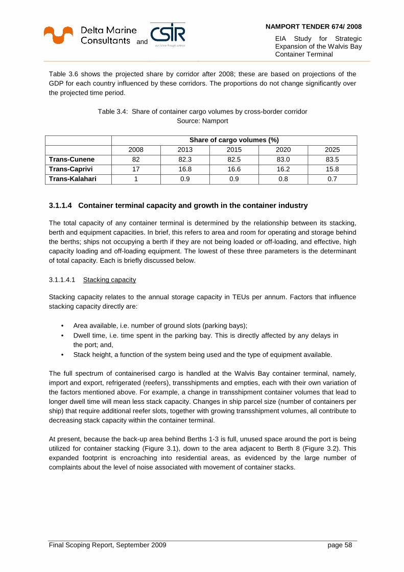
and
NAMPORT TENDER 674/ 2008
EIA Study for Strategic Expansion of the Walvis Bay Container Terminal
Final Scoping Report, September 2009 page 58
Table 3.6 shows the projected share by corridor after 2008; these are based on projections of the GDP for each country influenced by these corridors. The proportions do not change significantly over the projected time period.
Table 3.4: Share of container cargo volumes by cross-border corridor Source: Namport
Share of cargo volumes (%) 2008 2013 2015 2020 2025 Trans -Cunene 82 82.3 82.5 83.0 83.5 Trans -Caprivi 17 16.8 16.6 16.2 15.8 Trans -Kalahari 1 0.9 0.9 0.8 0.7
3.1.1.4 Container terminal capacity and growth in the conta iner industry The total capacity of any container terminal is determined by the relationship between its stacking, berth and equipment capacities. In brief, this refers to area and room for operating and storage behind the berths; ships not occupying a berth if they are not being loaded or off-loading, and effective, high capacity loading and off-loading equipment. The lowest of these three parameters is the determinant of total capacity. Each is briefly discussed below. 3.1.1.4.1 Stacking capacity Stacking capacity relates to the annual storage capacity in TEUs per annum. Factors that influence stacking capacity directly are:
• Area available, i.e. number of ground slots (parking bays);
• Dwell time, i.e. time spent in the parking bay. This is directly affected by any delays in the port; and,
• Stack height, a function of the system being used and the type of equipment available. The full spectrum of containerised cargo is handled at the Walvis Bay container terminal, namely, import and export, refrigerated (reefers), transshipments and empties, each with their own variation of the factors mentioned above. For example, a change in transshipment container volumes that lead to longer dwell time will mean less stack capacity. Changes in ship parcel size (number of containers per ship) that require additional reefer slots, together with growing transshipment volumes, all contribute to decreasing stack capacity within the container terminal. At present, because the back-up area behind Berths 1-3 is full, unused space around the port is being utilized for container stacking (Figure 3.1), down to the area adjacent to Berth 8 (Figure 3.2). This expanded footprint is encroaching into residential areas, as evidenced by the large number of complaints about the level of noise associated with movement of container stacks.

and
NAMPORT TENDER 674/ 2008
EIA Study for Strategic Expansion of the Walvis Bay Container Terminal
Final Scoping Report, September 2009 page 59
3.1.1.4.2 Berth capacity Berth capacity is the total number of containers that can be landed or shipped per annum. It is a function of the number of berths, number of ships per time period, parcel sizes (number of containers per ship) and average number of containers handled per crane. It is also influenced by the length and depth of the quay, and types of vessels. There is a developing trend of more vessels with parcel sizes of greater than 3 000 TEUs calling at Walvis Bay of (Table 3.3). Walvis Bay presently has only two berths for vessels of approximately 3 500 TEUs, with available water depth of -12.8 m without restrictions. Current berth utilization exceeds 90 %.
Figure 3.1: Aerial view of the container terminal.
The area next to the road will be paved for container stacking. Source: Namport

and
NAMPORT TENDER 674/ 2008
EIA Study for Strategic Expansion of the Walvis Bay Container Terminal
Final Scoping Report, September 2009 page 60
(A) (B)
Figure 3.2: Noise from stacking area intrudes into residential and waterfront areas Source: Namport

and
NAMPORT TENDER 674/ 2008
EIA Study for Strategic Expansion of the Walvis Bay Container Terminal
Final Scoping Report, September 2009 page 61
3.1.1.4.3 Equipment Capacity Equipment capacity refers to moving TEUs over the quayside. Current vessel productivity is 25 moves per hour. In order to be competitive and the Gateway to Southern Africa, modern ship-to-shore (STS) cranes and rubber-tyred gantry (RTG) cranes are a prerequisite for Walvis Bay. Figure 3.3 is a schematic of future planned cargo handling operations; specialised facilities and high infrastructure investment are required.
Figure 3.3: Schematic of planned future cargo handling operations for the container terminal
Source: Namport
3.1.1.4.4 Efficiency improvements Improvements to stacking and equipment efficiencies depend on the availability of equipment and methods that are used for stacking. Improved stacking and equipment configurations can be instituted in the immediate future, in order to deal with the growth in container traffic. Improving these efficiencies alone, however, will not remove the need for building new container terminal facilities.
3.2 Future growth for the port
The Port of Walvis Bay has committed itself to providing a world-class port service to all local, regional and international seaborne trade through excellent customer service, sustainable growth and responsibility. It is able to offer a year-round congestion-free and efficient operation, with good inland transport, at a time when its neighbours in South Africa and Angola are grappling with constrained port facilities. The opportunities from the Walvis Bay Corridor Group will also enable it to grow continually and position itself as a world-class hub port and gateway for Southern Africa and beyond. After deepening its harbour in 2000, the Port of Walvis Bay attracted more container cargo. Throughput is expected to reach at least about 285 100 TEUs in 2009 (JICA, 2009), an increase of
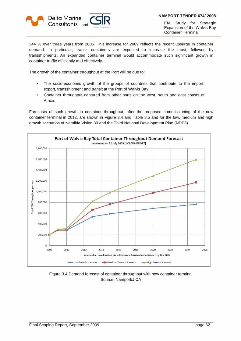
and
NAMPORT TENDER 674/ 2008
EIA Study for Strategic Expansion of the Walvis Bay Container Terminal
Final Scoping Report, September 2009 page 62
344 % over three years from 2006. This increase for 2009 reflects the recent upsurge in container demand. In particular, transit containers are expected to increase the most, followed by transshipments. An expanded container terminal would accommodate such significant growth in container traffic efficiently and effectively. The growth of the container throughput at the Port will be due to:
• The socio-economic growth of the groups of countries that contribute to the import, export, transshipment and transit at the Port of Walvis Bay.
• Container throughput captured from other ports on the west, south and east coasts of Africa.
Forecasts of such growth in container throughput, after the proposed commissioning of the new container terminal in 2012, are shown in Figure 3.4 and Table 3.5 and for the low, medium and high growth scenarios of Namibia Vision 30 and the Third National Development Plan (NDP3).
Figure 3.4 Demand forecast of container throughput with new container terminal
Source: Namport/JICA

and
NAMPORT TENDER 674/ 2008
EIA Study for Strategic Expansion of the Walvis Bay Container Terminal
Final Scoping Report, September 2009 page 63
Table 3.5: Forecasts of container demand under NDP3 and Vision 30 growth scenarios
Source: JICA
Container cargo demand (TEUs) (With-the-Project)
Foregone container cargo demand (Project-not-Implemented)
Low Medium High Low Medium High
2008 200 719 - 2009 285 099 292 149 303 491 0 1 428 0
2010 285 529 298 729 320 206 1 688 4 791 4 342 2013 535 590 663 454 819 019 213 430 305 770 410 015 2015 588 776 765 130 981 865 236 587 356 366 495 398 2020 688 136 976 368 1 290 501 279 807 458 409 655 024 2025 764 906 1 168 686 1 594 203 313 335 549 164 803 582
3.3 The consequences of not expanding the container terminal
The economic consequences of not proceeding with the proposed expansion of the container terminal are apparent from Figure 3.4 and the estimates in Table 3.5 of container throughput that is foregone, that is, the difference between throughput “with-the project” and throughput “without-the-project”. About 80 – 85 % of this throughput not taken up would be transshipments, namely, cargo that is unloaded at an intermediary port like Walvis Bay, then reloaded at a later time for shipment to its final destination. It is obvious that if Walvis Bay does not have the capacity to accept this business, another intermediary port with this capacity shall enjoy the economic benefits that flow from accepting the business. The estimates in Table 3.5 also demonstrate that the current facilities are not able to accommodate such growth in the medium- to long-term. Indeed, though the existing container stacking yard is currently being expanded, throughput is predicted to reach the limit of existing handling capacity by 2012, with no capacity to take advantage of the opportunities represented by the predicted jump in demand by 2013. The secondary consequences costs of not expanding the container terminal facilities will be additional losses to supply chains in the local, regional and national economy due to missed business opportunities. Some examples of such multiplier effects are set out in Table 3.6.

and
NAMPORT TENDER 674/ 2008
EIA Study for Strategic Expansion of the Walvis Bay Container Terminal
Final Scoping Report, September 2009 page 64
Table 3.6: Secondary consequences of decline in container terminal business in Walvis Bay Decrease in: Community affected Increase in: Port dues Port operations Per unit port costs Revenues from cargo handling Port terminal operations Per unit handling cost Income from service industries Service industries (land
transport operators, port and ship service providers)
Export income Exporters Cost of exports Inland transport costs
Employment Employers Unemployment and poverty Production Producers Gross regional product Region/nation Economic growth Region/nation
3.4 Project alternatives
A number of alternatives were considered before a final recommendation was made on the preferred alternative for the proposed project. The option of not expanding container terminal facilities, i.e., “do nothing”, is the base case against which to measure the relative performance or benefits of the proposed project. Impacts are then expressed as changes to this base case, which is described as the affected environment in Chapter 4 of this report. However, the “do nothing” alternative is, more properly, a “do minimum” alternative, since Namport is already investing in measures to accommodate growth in container traffic. For example, container stacks have been created at sites away from the terminal, together with paving of open areas closer to the container berths (cf. Figure 3.1). Alternatives that were considered during the planning phase of the project are discussed below. 3.4.1 Location alternatives Various location alternatives were analysed. These were:
• Extension of existing container berths northward towards Etosha Fishing (Berth 0);
• Reconstruction of existing container terminal quay walls (Berths 1-3);
• Conversion of adjacent general cargo berths and terminal into container berths, with reconstruction;
• New container terminal with access causeway on reclaimed land off shore in the south of the harbour near Berth 8;
• A new facility on shore north of the small breakwater, north to the Navy area;
• A new facility with access causeway on reclaimed land off shore shore north of the small breakwater;
• New facility on the Pelican peninsula.
and
NAMPORT TENDER 674/ 2008
EIA Study for Strategic Expansion of the Walvis Bay Container Terminal
Final Scoping Report, September 2009 page 65
The main criteria used to evaluate the various locations were:
• Scope for potential expansion;
• Project capital costs;
• Project operational costs;
• Non-beneficial costs (e.g., demolition, relocations, etc.);
• Amount of new stacking space created by Phase 1 of the proposed project;
• Operational interruption during construction;
• Time for completion of Phase 1 of the proposed project;
• Possible environmental and social impacts;
• Technical feasibility;
• Logistics, that is, proximity to existing port and container terminal;
• Benefits for other port facilities. A summary of the evaluation for each is given in Table 3.7, with a more detailed explanation in Appendix I. Namport’s preferred alternative is Option D, namely, the construction of a new container terminal by filling in an area adjacent to Berth 8.

and
NAMPORT TENDER 674/ 2008
EIA Study for Strategic Expansion of the Walvis Bay Container Terminal
Final Scoping Report, September 2009 page 66
Table 3.7: Evaluation of location alternatives within the Port of Walvis Bay
Source: Namport
Extension of existing container berths northward towards Etosha Fishing (Berth 0)
(A)
Reconstruction of existing container terminal quay walls (Berths 1-3)
(B)
Conversion of adjacent general cargo berths and terminal into container berths, with reconstruction
(C)
New container terminal with access causeway on reclaimed land off shore, south of the harbour near Berth 8
(D)
A new facility on shore north of the small breakwater
(E)
A new facility with access causeway on reclaimed land off shore shore north of the small breakwater
(F)
New facility on the Pelican peninsula
(G) Scope for potential expansion
Poor Not acceptable Not acceptable Excellent Not acceptable Excellent Not acceptable
Project capital costs Good Excellent Poor Project operational costs Good Good Poor Non-beneficial costs (e.g., relocations, etc.)
Poor Excellent Excellent
Amount of new stacking space created by Phase 1
Poor Excellent Excellent
Operational interruption during construction
Poor Excellent Excellent
Time for completion of Phase 1
Excellent Excellent Poor
Possible environmental and social impacts
Excellent To be investigated Poor
Technical feasibility Poor Excellent Good Logistics, that is, proximity to existing port and container terminal
Excellent Excellent Poor
Benefits for other port facilities
Good Excellent Poor

and
NAMPORT TENDER 674/ 2008
EIA Study for Strategic Expansion of the Walvis Bay Container Terminal
Final Scoping Report, September 2009 page 67
3.5 The proposed terminal expansion
The proposed expansion is planned to cater for vessels with capacity of 5 000 to 8 000 TEUs, and for future port development, in three phases, illustrated in Figure 3.5, namely:
• Phase 1 – 27.5 hectares, 550 m quay length
• Phase 2 – 27.5 hectares, 550 m quay length
• Phase 3 - 60 hectares, 1 200 m quay length.
Figure 3.5: Proposed layout of three phases for expansion of the container terminal Source: Namport
Berths 1 to 3 of the existing container terminal are able to handle about 250 000 TEUs per year. It is estimated that the new terminal will have to handle about 413 000 TEUs in 2013 and 632 000 in 2017/2018 (JICA, 2009). To meet this demand, dimensions and depths for the entrance channel, turning basin and the area alongside the berth are described in Table 3.8. The following container handling equipment will also be commissioned with Phase 1:
• Two Ship-to-Shore Gantry Cranes, post panamax size, to handle vessels that stow containers up to 18 TEUs wide,
• A minimum of 6 Rubber Tired Gantry cranes and miscellaneous smaller support equipment such as reach stackers, tractors and haulers and empty container handlers.

and
NAMPORT TENDER 674/ 2008
EIA Study for Strategic Expansion of the Walvis Bay Container Terminal
Final Scoping Report, September 2009 page 68
Table 3.8: Design dimensions for Phases 1 and 2 of proposed new container terminal
Source: DMC-CSIR
Phase 1 Phase 2 Approach channel Width 134 m 191 m
Design vessel Panamax 8 000 TEUs
Depth -14.1 m CD -16.35 m CD Design vessel Panamax 8 000 TEUs
Turning circle Diameter 450 m 525 m Design vessel Panamax 8 000 TEUs Depth -13 5 m CD -15.5 m CD Design vessel Panamax 8 000 TEUs
Quay Length 550 m 1 100 m
Design vessel Panamax + feeder Panamax + feeder Depth -15.5 m CD -15.5 m CD Design vessel Panamax 8 000 TEUs
QGC crane Containers 17 rows 17 rows Design vessel 8 000 TEUs 8 000 TEUs
Namport’s goal is for Phase 1 to be commissioned by 2012. It proposes that the new container terminal be constructed entirely on reclaimed land. For this proposed facility, a total surface area of about 135 hectares will have to be reclaimed for Phases 1 to 3; it shall be linked to existing port land with a 65 m wide access causeway near Berth 8. It is intended to have the most modern container handling equipment available to ensure productivity for fast ship turnaround. Maintenance dredging would have to be done annually along the quays and in the turning basin. Major maintenance dredging every 3-5 years will include the access channel. The proposed layout for Phase 1 of the new container terminal is shown in Figure 3.6 (JICA, 2009). It provides ground slots that accommodate 3 172 TEUs, including 576 TEU slots for reefer containers. The rail gauge for the STS cranes is 30 m; the distance between the centres of the wheels of the RTGs is 23.45 m, that is, spanning 6 bays and one truck lane.

and
NAMPORT TENDER 674/ 2008
EIA Study for Strategic Expansion of the Walvis Bay Container Terminal
Final Scoping Report, September 2009 page 69
Figure 3.6: Proposed layout of Phase 1 for the new expansion Source: Namport, JICA
3.5.1 Optimisation measures 3.5.1.1 Approach channel and turning circles The alignment of the existing approach channel shall be maintained, and slightly deepened toward the channel entrance to CD – 14.5 m. As the width of the existing channel is 134 m and is sufficient for Panamax vessels, no widening of the approach channel is required for Phase 1. A new turning basin is required in front of the new container quay; calling vessels will turn here and berth portside to the new quay. To enable an 5 000 TEU container vessel to turn, the water area between the new quay and existing berths has to be 450 m wide and CD −13.5 m deep. The turning basin for 8 000 TEU container vessels will be based on an enlargement of the turning basin for Phase 1 to 525 m in diameter and CD −15.5 m in depth.

and
NAMPORT TENDER 674/ 2008
EIA Study for Strategic Expansion of the Walvis Bay Container Terminal
Final Scoping Report, September 2009 page 70
3.5.1.2 Container terminal footprint The entrance towards the shallow lagoon, where the tidal flow is passing through one or two main channels between the Lagoon and the Bay, is an environmentally vulnerable area in Walvis Bay. The numerical modelling study of the hydrodynamics in the bay and the lagoon reveals that the new container terminal will have a negligible effect on the water levels in the Bay and the lagoon as well as on sediment transport. Due to the causeway and reclaimed terminal artificially extending the “neck” of the Lagoon, the large scale eddy near the mouth of the lagoon will be shifted further to the north. This will lengthen the tidal refreshment cycle in the Lagoon, most distinctly during spring tides and near the lagoon entrance.
3.5.1.3 Disposal/ Beneficial use of dredged material During dredging most of the material will be suitable for reclamation of the new container terminal. Unsuitable dredged material - as is done for maintenance dredging – shall be disposed of at the existing spoil site approved by the Namibian authorities and according to the conditions stipulated in the approvals for this site. A further option is to dump soft sediments into the footprints of the later port development phases and implement suitable soil improvement measures to accommodate the settlement criteria of the terminal area. Potential impacts from dredging may include:
• Resuspension of very fine sediment that increases turbidity of the water;
• Release of methane and hydrogen sulphide from the organic sea bed material, resulting in odour problems and potential health problems.
3.5.2 Construction activities The scope of works for construction will consist of dredging, reclamation and terminal construction, as follows:
• Dredging o Deepening of the approach channel. o Dredging the basin between the proposed new container terminal and existing
berths. o Dredging at the quay wall of the new container terminal.
• Reclamation o Reclamation of the new container yard.
• Terminal construction o Construction of quay walls, rock revetments, container terminal surfacing,
operations buildings and workshops ` The intention is to obtain material for reclamation from two sources:
• Dredging of the basins in front of the new berths, and
• The extension, widening and deepening of the entrance channel.

and
NAMPORT TENDER 674/ 2008
EIA Study for Strategic Expansion of the Walvis Bay Container Terminal
Final Scoping Report, September 2009 page 71
Dredging is an excavation activity that sucks up bottom sediments and disposes of them at a different location from where they’ve been gathered. Excess material, known as “spoil”, is disposed of at a location different from the dredged area. Typically, cutter section dredgers and trailing suction hopper dredgers are used for the dredging works in the target areas shown in Figure 3.7.
Figure 3.7: Target areas for the dredging and reclamation programme Source: Namport/JICA

and
NAMPORT TENDER 674/ 2008
EIA Study for Strategic Expansion of the Walvis Bay Container Terminal
Final Scoping Report, September 2009 page 72
The presently envisaged construction sequence is as follows:
• Construction of the causeway with rock and sand fill.
• Dumping of rock bund to form the outer perimeter of the reclamation area, and the installation of a geofabric membrane at the inner slope to retain the sand fill.
• Capital dredging of the approach channel. The entrance channel must be extended, widened and deepened.
• Capital dredging of a new turning circle, and deepening to -15.5 m opposite Berths 1-8. Basin dredging between the new container terminal and existing berths, and at the quay structures of the new terminal. Land reclamation for the new terminal area opposite Berths 4-8. For dredged sand spoil (lower layer) assumed to be relatively “clean”, two alternatives are possible:
o Land reclamation; o Designated spoil site outside the Bay (Figure 3.7);
• Treatment/Compaction of reclamation to consolidate and construct the pavement.
• Construction and installation of buildings, services/utilities, roads and railway lines.
• Installation of equipment such as ship-to-shore quay cranes, rubber-tyred gantry cranes, etc.
• Finishing off.
3.6 Description of dredger types
Different dredger types will be used for dredge operations. Channel dredging will most likely be done by Trailer Hopper Suction Dredge (THSD) because it has less of an impact on ship traffic and has longer travel distances. A cutter dredge is suitable for areas with limited space, and is more suitable for dredging of the future turning basin, with shallow water depth and where bulk material has to be dredged. Namport has a grab dredger/anchor-handling barge with an 80 m3 self-propelled hopper. These are described below.
3.6.1 Trailing Suction Hopper Dredger A Trailing Suction Hopper Dredger (TSHD) is a self-propelled ship. It trails a suction pipe that ends in a draghead which dislodges compacted material that is lifted by one or more pumps into an onboard hold called a “hopper”. These are usually emptied through doors or valves in the hopper bottom; some dredgers split their hulls on giant hinges. As heavier solids in the dredged material settle to the bottom of the hopper, excess water is spilled off to increase the amount of solid material in a load. Once the hopper has filled to load capacity, the trail pipe is raised and the dredger sails to the discharge point. An illustration is provided in Figure 3.8. A TSHD is like a floating vacuum cleaner, and its general cycle of operation is:
• Load at the dredging area.
• Sail to the discharge area.
• Discharge the dredged material.
• Sail back to the dredging area.

and
NAMPORT TENDER 674/ 2008
EIA Study for Strategic Expansion of the Walvis Bay Container Terminal
Final Scoping Report, September 2009 page 73
Figure 3.8 Schematic diagram of a trailing suction hopper dredger
Source: http://www.jandenul.com/
3.6.2 Cutter Section Dredger A Cutter Suction Dredger (CSD) is an efficient structure for precise dredging in hard soils and shallow water. It is stationary, moored with anchors and/or poles that are known as “spuds”. It makes use of a rotating cutter head at the end of a hinged ladder that is lowered to the seabed to loosen material in front of its suction inlet. The loosened material enters the suction inlet, and passes through the suction pipe and large centrifugal pumps as a fluid mixture through a pipeline to the disposal site, or into barges. Pipe diameters can range from 100 mm to 1 500 mm. The CSD may also be used to loosen material for rehandling by another type of dredger. Its main advantages are its ability to dredge a wide range of materials that include rocks, and its suitability for dredging in shallow waters. Some of the larger CSDs are self-propelled and can therefore be moved easily from site to site. An illustration is provided in Figure 3.9.
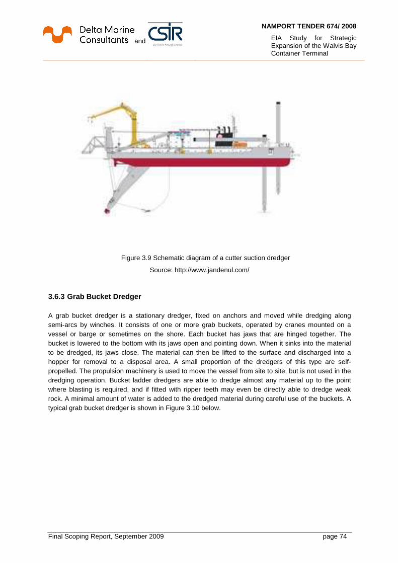
and
NAMPORT TENDER 674/ 2008
EIA Study for Strategic Expansion of the Walvis Bay Container Terminal
Final Scoping Report, September 2009 page 74
Figure 3.9 Schematic diagram of a cutter suction dredger
Source: http://www.jandenul.com/
3.6.3 Grab Bucket Dredger A grab bucket dredger is a stationary dredger, fixed on anchors and moved while dredging along semi-arcs by winches. It consists of one or more grab buckets, operated by cranes mounted on a vessel or barge or sometimes on the shore. Each bucket has jaws that are hinged together. The bucket is lowered to the bottom with its jaws open and pointing down. When it sinks into the material to be dredged, its jaws close. The material can then be lifted to the surface and discharged into a hopper for removal to a disposal area. A small proportion of the dredgers of this type are self-propelled. The propulsion machinery is used to move the vessel from site to site, but is not used in the dredging operation. Bucket ladder dredgers are able to dredge almost any material up to the point where blasting is required, and if fitted with ripper teeth may even be directly able to dredge weak rock. A minimal amount of water is added to the dredged material during careful use of the buckets. A typical grab bucket dredger is shown in Figure 3.10 below.

and
NAMPORT TENDER 674/ 2008
EIA Study for Strategic Expansion of the Walvis Bay Container Terminal
Final Scoping Report, September 2009 page 75
Figure 3.10 Example of a grab bucket dredger
Source: http://www.jetro.go.jp

and
NAMPORT TENDER 674/ 2008
EIA Study for Strategic Expansion of the Walvis Bay Container Terminal
Final Scoping Report, September 2009 page 76
4 Description Of The Affected Environment This chapter provides an overview of the affected environment and local planning context for the proposed expansion of the container terminal at Walvis Bay, Namibia. The term ‘environment’, includes the biophysical and socio-economic dimensions. This chapter therefore assists the reader in identifying potential impacts on the environment (positive or negative); and opportunities or constraints which the affected environment may present for the proposed development. The environmental baseline description is based on information extracted sources listed in the bibliography in Chapter 6.
4.1 Location of proposed project
Walvis Bay is situated on the western coast of Africa midway between the northern and southern borders of Namibia (cf. Figure 1.1). It is the biggest town along the Namibian coast, in the coastal zone of the Erongo Region in Namibia, with a population of about 55 000. The Bay is formed by the Walvis Bay Peninsula protecting it with a long narrow sand spit up to Pelican Point in the north, about 10 km from the Port. A 7 km long Lagoon with approximately 10 km2 of wetland conditions is a Ramsar-protected site in the southern part of the Bay. It is home to a large population of flamingos and is a migration point for thousands of wading, resident and migratory birds. The port and proposed container terminal expansion are integrated into the town of Walvis Bay. The closest major road is the C14 that connects the town to Windhoek, the capital of Namibia, and the B2 that goes north along the coast. Human activities are on the eastern side of the Bay. The port is composed of the commercial harbour southward that handles both containerised and bulk cargo, and the fishing harbour northward that houses about 15 processing factories and their vessels. In the shallow south of the Bay salt works cover large areas of the inlet to the Lagoon. The area between Swakopmund and Walvis Bay is expected to achieve conservation status through forming a part of the Namib-Skeleton Coast National Park. In terms of the Namibian Ports Authority Act 2 of 1994, the port is bounded by the high water marks at coordinates 23° 05’S to 25° 52’S, and 14° 32’E.
4.2 Biophysical environment 4.2.1 Climate The coastal zone at Walvis Bay lies within a “cool desert” region of Namibia, a unique biophysical environment caused by the specific climatic conditions in the area that are influenced by the South Atlantic anticyclone, the northward-flowing Benguela Current (with its associated upwelling) and the divergence of the south-east trade winds along the coast. The nutrient-rich water from the upwelling is flushed into the Lagoon, and provides food for its phyto- and zooplankton. Climatic conditions in the region vary from cool, foggy, windy and hyper-arid conditions along the coast, to dry and hot weather towards the inland areas from which it is separated by the Great Escarpment.

and
NAMPORT TENDER 674/ 2008
EIA Study for Strategic Expansion of the Walvis Bay Container Terminal
Final Scoping Report, September 2009 page 77
4.2.2 Temperature Namibia is considered to be hot; however, temperatures are highly variable daily and seasonally. Therefore, animals and plants have evolved to tolerate a broad range of temperatures. In the coastal area, temperatures are relatively constant, only exhibiting a slight decrease from north to south. The average temperature maximum varies between 24 °C an d 19.3 °C, and the average minimum between 9.1 °C and 16.5 °C. Highest temperatures ar e recorded during Berg Wind episodes when cold air from the interior flows towards the coast and is heated by compression (catabatic wind). 4.2.3 Rainfall and evaporation The Bay has a mean annual rainfall of 13.5 mm. Most rain falls in summer between January and April, with the wettest month being March when about 50% of annual rainfall is recorded. Fog is a distinctive feature, and the Bay gets some moisture from 900 hours of coastal sea fogs per year. Monthly average humidity varies between 65% in December and 81% in January/March. Namibia, as a country, loses more water through evaporation than it receives in rain. Lower rates of evaporation at the coast are mainly due to cooler and more humid coastal conditions.
4.2.4 Surface Wind The presence of the subtropical South Atlantic Anticylcone (SAA) off the coast of Namibia strongly influences the wind pattern, generating gale force winds along the coast in all seasons, but being most frequent during mid-summer and spring. Although their strength decreases inland, their effect is noticeable for distances of up to 200 km from the coast. These strong coastal south-westerly winds carry sand inshore from the coast to the Namib Sand Sea and create upwelling cells which allow nutrient-rich water to be brought to the surface, therefore increasing fish resources. At the coast, the prevailing wind is southerly to south south-westerly6 with speeds reaching 10m/s, while the predominant wind inland is north-easterly to easterly with speeds reaching approximately 3 m/s. The coastal south-westerly winds bring cool, moist air into the coastal region. Occasional hot, dry and powerful easterly wind during winter (or Berg wind) causes large quantities of dust and sand to be blown offshore, affecting sediment input into the coastal marine environment. These powerful offshore winds can exceed 50 km/h, producing sandstorms that considerably reduce visibility at sea and on land. Although they occur intermittently for about a week at a time, they have a strong effect on the coastal temperatures, which often exceed 30°C during ‘berg’ wind periods. Air quality in Walvis Bay changes between March and August, when there are air emissions and odour from fish canneries and fish meal factories. The prevailing SW winds blow these emissions and dust towards the residential and manufacturing areas. Temperature inversions typically occur between 600 m and 1 800 m above ground, and these could adversely affect air quality by restricting dispersal through trapping and concentrating pollutants beneath the inversion layer.
6 Direction from which wind blows

and
NAMPORT TENDER 674/ 2008
EIA Study for Strategic Expansion of the Walvis Bay Container Terminal
Final Scoping Report, September 2009 page 78
4.2.5 Landscape The study area is located on the Namib Central-western plains (Figure 4.1) that stretch from the coast inland for about 450 km in places. The plains were largely formed by erosion cutting back into higher ground and carving out the catchment areas of several major rivers. The peneplain is dissected by numerous dry riverbeds, draining towards the coast. The coastline of central Namibia is dominated by sandy beaches, with rocky habitats being represented only by occasional small rocky outcrops. The largest dune seas occur in the central Namib south of Walvis Bay, but for approximately 250 km north of Swakopmund, the coastal area is relatively free of dunes. The coastal strip around Swakopmund is covered by a 2-3 m thick layer of very loose, medium to fine grained sea sand, which stretches for approximately 200 m inland. Only in the vicinity of Henties Bay is the shore backed by low sandy cliffs. Namibia is a hyper-arid country, with only 4 km3 of surface water produced internally, and a groundwater recharge of 2 km3. The central portion of Namibia is drained by a number of westward flowing ephemeral rivers that occasionally reach the sea when they flood after heavy rains in the interior. These include the Omaruru, Swakop and the Kuiseb rivers that are very important ecologically, as they support a diverse biota that depends on the groundwater associated with the river course. 4.2.6 Geology The study area is underlain by schist (with granitic intrusions) of the Swakop group which forms part of the Damara Supergroup and Gariep Complex, a group of rocks laid down approximately 850-600 millions years ago. Much of the geology is exposed, because the harsh climate limits soil development and vegetation growth. Extensive gypsum and calcrete deposits have developed where the relief is low. Gypsum plains are found within 60 km of the coast, coinciding with the zone of regular occurrence of fog. Calcrete crusts are a feature of the soils further inland in the eastern part of the central Namib and pro-Namib and represent a moister period of in situ formation of calcrete and calcareous soil. Groundwater reserves are limited to the Kuiseb and Omaruru alluvial bed aquifers, which supply Henties Bay, Swakopmund and Walvis Bay as well as Arandis, Rössing and Langer Heinrich Mines. These aquifers are situated within the alluvial beds of the Kuiseb and Omaruru rivers. 4.2.7 Physical and Biological Oceanography Along much of the coastline, there is a prominent berm on the upper beach. From the berm, the beach slopes steeply to the low water mark. At 1-2 m depth the slope flattens and the sand is replaced by gently sloping, low-relief rocky seabed. This extends approximately 400 m offshore to about the 5 m isobath (depth contour). Seaward of the 10 m depth contour, the seabed is dominated by a gently sloping flat featureless sandy area. Further offshore to beyond the 100-m depth contour, the seabed is dominated by a tongue of sandy mud, which extends from south of Sandwich Harbour to the north past Henties Bay.

and
NAMPORT TENDER 674/ 2008
EIA Study for Strategic Expansion of the Walvis Bay Container Terminal
Final Scoping Report, September 2009 page 79
Figure 4.1 Landscape in Namibia
Source: Mendelsohn, Jarvis, Roberts and Robertson (2002) Red tides (dinoflagellate and/or ciliate blooms), also referred to as Harmful Algal Blooms (HABs), low oxygen events and sulphur eruptions occur periodically in the Benguela system, with potentially catastrophic effects on the ecology of the system. Sulphur eruptions (figure 4.3) are associated with the generation of toxic hydrogen sulphide and methane within the organically-rich, anoxic muds (biogenic muds) following decay of extensive algal blooms. The major feature of the Benguela system is upwelling and the consequent high nutrient supply to surface waters leading to high biological production and large fish stocks. A small upwelling cell just north of Walvis Bay near Swakopmund can be seen in Figure 4.2.

and
NAMPORT TENDER 674/ 2008
EIA Study for Strategic Expansion of the Walvis Bay Container Terminal
Final Scoping Report, September 2009 page 80
The central Namibian coastline is influenced by major swells generated in the Roaring Forties, as well as significant sea waves generated locally by the persistent south-westerly winds. Apart from Walvis Bay and Swakopmund, wave shelter - in the form of west to north-facing embayments and coasts lying in the lee of headlands - is extremely limited.
Dominant deep sea waves originate in the SSE-SSW quadrant, with 60 % from southerly, 23 % south-south-westerly, 7% south-westerly, and 2 % between westerly and northerly directions. Seasonal differences are negligible. Median significant wave height is 1.1 m, and median peak wave period is 11.6 s. The Port is in a protected position from these deep sea waves behind Pelican Point.
Figure 4.2 Satellite image that shows discoloured water from a nearshore sulphur eruption
offshore of the Namib Desert .
Satellite image source: www.intute.ac.uk. Inset: Observation of such an at Sylvia Hill, north of Lüderitz, in March 2002.
Photograph: J. Kemper, MFMR, Lüderitz

and
NAMPORT TENDER 674/ 2008
EIA Study for Strategic Expansion of the Walvis Bay Container Terminal
Final Scoping Report, September 2009 page 81
Figure 4.3 Positions of upwelling cells on the Namibian coastline, and formation zones of low
oxygen water
(Source: Shannon, 1985) In common with the rest of the southern African coast, tides in Walvis Bay are regular and semi-diurnal, flushing the Bay twice daily with nutrient-rich water. From Table 4.1 that lists mean tidal levels for Walvis Bay, it can be seen that mean spring tide range is 1.42 m (0.27 m – 1.69 m), and for mean neap tide it is 0.62 m (0.67 m – 1.29 m). An harmonic influence, with a period of 90 minutes and amplitude of 0.15 m, generates flows and velocities that are of the same order of magnitude, or even greater than the tide (CSIR, 1989). Variations in the absolute water level as a result of meteorological conditions such as wind and waves can, however, occur adjacent to the shoreline and differences of up to 0.5 m in level from the tidal predictions are not uncommon. Tidal currents are minimal with measurements of 0.1 m/s reported at Walvis Bay.
Table 4.1: Tide statistics for Walvis Bay from SA Tide Tables (SAN 2007). All levels are referenced to Chart Datum.
Description Level in m
Highest Astronomical Tide HAT +1.97 Mean High Water of Spring Tide MHWS +1.69 Mean High Water of Neap Tide MHWN +1.29 Mean Level ML +0.98 Mean Sea Level MSL +0.966 Mean Low Water of Neap Tide MLWN +0.67 Mean Low Water of Spring Tide MLWS +0.27 Lowest Astronomical Tide LAT 0.00

and
NAMPORT TENDER 674/ 2008
EIA Study for Strategic Expansion of the Walvis Bay Container Terminal
Final Scoping Report, September 2009 page 82
The Benguela current is part of the counter-clockwise circuit in the South Atlantic ocean and runs north-westerly along the Namibian coastline at a speed between 0.25 m/s to 0.35 m/s. The flows are predominantly wind-forced, barotropic and fluctuate between poleward and equatorward flow. Fluctuation periods of these flows are 3 to 10 days, although the long-term mean current residual, i.e. net flow, is in an approximate NW (alongshore) direction. Current speeds in reverse flows observed between Walvis Bay and Henties Bay range between 0.02 m/s and 0.17 m/s. Near bottom, shelf flow is mainly poleward with low velocities of typically 0.05 m/s. Its deviation off the coast due to the Coriolis effect results in the deep water upwellings that make this part of the coast an area of high productivity. Water circulation in the Bay takes place mainly in the upper layer, and depends on the direction of the wind. The current pattern is clockwise in the morning, towards the south, and reverses towards the north along the harbour quays in the afternoon. At Pelican Point the current moves mostly northward for the whole day. The circulation pattern is summarised in Figure 4.4; waters enter the Bay through the bottom layer at Pelican Point, and exit through the surface layer at the same point. Current velocities are about 0.12 m/s, with occasional high flow velocities of 0.25 m/s. The currents in the Lagoon have inflow and outflow velocities of the order of 0.30 m/s at the mouth of the Lagoon. Water depths within the Bay vary from about -16.5 m chart datum (CD) at Pelican Point to approximately -2.5 m CD at the mouth of the lagoon.
Figure 4.4 Summary of current circulation in Walvis Bay.
Source: Tractebel (1998)

and
NAMPORT TENDER 674/ 2008
EIA Study for Strategic Expansion of the Walvis Bay Container Terminal
Final Scoping Report, September 2009 page 83
4.2.8 Sedimentology Sedimentation of phytoplankton that thrives on the upwelled nutrients is a natural process in the Bay and its offshore environs. Nutrients brought to the surface with the up-welling deep-water are taken up by phytoplankton. Some of the phytoplankton are not grazed by zooplankton and they settle before the surface nutrient-poor water moves west. Most of the settled particles are then metabolised in the sediment, to enrich the incoming deep-water and taken to the surface again by upwelling. Production and sedimentation is higher than the decomposition rate and a deep layer of diatomaceous “ooze” of anaerobically decaying phytoplankton has accumulated in the sheltered Walvis Bay at depths below about 3 - 4 m. This rich organic sediment has a high oxygen demand and is usually anoxic. Since the Walvis Bay area is dominated by decomposition and respiration, the oxygen saturation is generally less than 100 %. Once the phytoplankton die and decay, they sink to the seabed where there is further decay due to anaerobic, sulphur-reducing bacteria. This releases toxic hydrogen sulphide into the sediment, which then bubbles into the water column and turns it anoxic, known as "sulphur eruptions". This natural pollution isn’t flushed by the slow circulation in the Bay. One result of these frequent anoxic conditions is that most of the sediment surface in the Bay is devoid of other than bacterial life below a water depth of a few meters and even in this zone the diversity is reduced to few opportunistic species that can stand recurrent anoxic conditions or can recover fast after oxygen problems. The sea bottom in Walvis Bay thus consists of a thick dark green diatomaceous mud over bottom sediments of fine to medium sand. Fine, muddy sediments are found at the southern end of the Lagoon, gradually increasing to coarser sand near the mouth. The mouth and lower reaches of the Lagoon are presently in a state of equilibrium with the coastal processes that control their dynamics and basic configuration. Much of the western shore of the Lagoon has been modified by the construction of the evaporation ponds for the Saltworks. The Lagoon is in the path of sand blown by the prevailing south-westerly wind; without human interference it would fill up with sand and encroach into the harbour area. Two factors have contributed to a reduction of sedimentation in the lagoon:
• Expansion of residential areas along the eastern shores have led to the amount of this wind-blown sand into the Lagoon being reduced.
• The south-westward longshore transport of sediment within the Bay towards the Lagoon mouth has been modified significantly by the hard structures of the harbour and associated maintenance dredging. These hard port structures reduce wave action and southbound wave-driven longshore sediment transport. Less sediment is thus available for transport into the lagoon mouth by tidally-driven currents.
If impacts associated with construction of the new container terminal adds to sedimentation of the Lagoon, the tidal flux will be reduced. This could lead to a permanent reduction of the intertidal area that forms the feeding grounds for wading birds. 4.2.9 Marine Ecology Biogeographically the central Namibian marine and coastal environment falls into the warm-temperate Namib Province, which extends northwards from Lüderitz into southern Angola. The wind-induced upwelling characterising the Namibian coastline is the principal physical process which shapes the marine ecology of the central Benguela region. The harsh aridity of the Namib coastline contrasts with the rich productive marine environment offshore.

and
NAMPORT TENDER 674/ 2008
EIA Study for Strategic Expansion of the Walvis Bay Container Terminal
Final Scoping Report, September 2009 page 84
The coastline of central Namibia is dominated by sandy beaches, with rocky habitats being represented only by occasional small rocky outcrops. Consequently, marine ecosystems along the coast comprise a limited range of habitats that include:
• Sandy intertidal and subtidal substrates;
• Intertidal rocky shores and subtidal reefs; and
• The water body. The benthic communities within these habitats are generally ubiquitous throughout the Southern African West Coast region, being particular only to substratum type, wave exposure and/or depth zone. The central Namibian coast is characterised by low species richness, but the high productivity supports large numbers of organisms. The Pelican Point peninsula provides protection to the harbour, and its beach supports sandy shore animals such as sand hoppers and white mussels as well as many terrestrial insects. Other mammals include jackals and a non-breeding colony of Cape fur seals. The bird count in summer averages out at about 15 000. White mussels and other organisms occur in the sand of the surf zone. Jackals patrol the area. The biodiversity in this zone is threatened by the sand that is trapped by the peninsula and remobilised by wind into the harbour and lagoon. Visitors also disturb the seals and birds, and contribute to littering. Oil and debris from offshore vessels also pollute the Point . The harbour wall offers rare surfaces for the attachment of indigenous sessile marine animals such as mussels, barnacles, tube worms, sea squirts and lace-animals. Pollution from fish factory effluent within the harbour is thought to have reduced marine invertebrate biodiversity significantly. An artificial guano platform for nesting birds is located north-east of the port limits. Because of the low oxygen concentration in the sediment, benthic fauna in the bay is species-poor. The limited suite of species found there are adapted to conditions of low oxygen concentration, and the biomass is dominated by few opportunistic species. Polychaete worms are the most important component, and fishes in the northern Bay are a subset of those found on the adjacent coastline. Southern mullet is the basis of a subsistence beach-seine fishery, and is the most abundant fish within the Lagoon. Due to its shallowness and dynamic nature, the Lagoon‘s temperature and salinity differ in different parts of the Lagoon and at different times. It is characterised by two main habitats: extensive shallow, sandy shores that are regularly covered and exposed by tidal action and the sub-tidal deeper (up to 5 m) waters of the southern harbour area (Figure 4.5). Coarse and medium sands are found near the mouth, with fine, muddy sediments at the central and southern end. The inter-tidal flats have increased, and sub-tidal areas have decreased, due to progressive siltation. This has affected population composition in different parts of the Lagoon. No saltmarshes surround it. There is a relatively large degree of mixing of Lagoon and Bay water, and nutrients are imported from the Bay through tidal flux. No macroalgae or emergent macrophytes are found there; the largest biomasses are found in the central and northern third of the Lagoon. The inter-tidal flats are nearly devoid of zoobenthos and the sub-tidal part of the southern end of the Bay close to the intake (second Lagoon) is sparsely populated. It has no endangered or rare species of benthic and planktonic invertebrates. Water from the harbour vicinity reaches the Lagoon. However, there is no significant difference between the impact of pollution from man-made sources on the ecological and biological conditions in the Lagoon and that from the natural high load of nutrients and organic matter. Filter-feeding

and
NAMPORT TENDER 674/ 2008
EIA Study for Strategic Expansion of the Walvis Bay Container Terminal
Final Scoping Report, September 2009 page 85
organisms such as mussels are a good indicator for influence of metals in the environment, as they act as a conduit to higher levels such as birds and humans. Metals will be accumulated in the filter-feeding organisms. Monitoring of trace metals in mussels has shown an acceptable level of metal concentrations for human consumption. A unique and abundant birdlife is present in Walvis Bay as a consequence of high productivity of sea life and plankton, due to the nutrient-rich Benguela current. In the Lagoon wading birds, rather than seabirds, predominate. It supports more waterbirds than any other coastal wetland on the southern African coast. More than 10% of 14 southern African, and 1% of the world population of 12 wader species, use the Lagoon as a feeding ground. About 200 000 migratory birds join the resident population every year; up to 250 000 birds are supported at peak times during the summer season. Together, the Lagoon and Sandwich Harbour are irreplaceable national assets.
Figure 4.5 Walvis Bay Lagoon – bird breeding areas.
Source: LAB (2008)

and
NAMPORT TENDER 674/ 2008
EIA Study for Strategic Expansion of the Walvis Bay Container Terminal
Final Scoping Report, September 2009 page 86
The salt pans support up to half of the birds in the Lagoon, where they like to feed in the shallow pans that have a steady artificial influx of particles and nutrient-rich water that fuels the benthic and pelagic food-chain. These pans, through their extensive land reclamation and physical barrier to changing tides, have changed the ecology of the Lagoon. 4.2.10 Water quality The water quality of the harbour changes seasonally as a result of organically polluted sea- and freshwater discharges from the fish processing industry. Water transparency declines in the direction from Pelican Point toward the Bay, into the harbour and further into the Lagoon. The suspended matter at Pelican Point is approximately 5 mg/l, and rises to 60 mg/l in the southern part of the Lagoon. Other data indicate a high variation on the turbidity of the water. Effluent and waste discharges from the fish processing industry can require high oxygen for neutralisation, which diminishes oxygen levels in the water. This forces mobile fauna to migrate away, and causes the death of sessile and sediment-dwelling organisms. In these oxygen-poor conditions, microbial communities such as anaerobic sulphate-reducing species take over and cause more emissions of sulphide. Dredging affects water quality when bottom material is resuspended. This leads to increased turbidity in the water column. In the vicinity of the dredging activity, the water can become anoxic and toxic because of high levels of hydrogen sulphide and presence of heavy metal contaminants. Table 4.2 summarises primary impacts and contamination sources in the Bay, harbour and Lagoon. Average effluent is 1.7 times higher in chemical oxygen demand (COD) than the influent. Though it seems that measurements show the fishing processing industry contributes about 700 mg COD/l against a maximum discharge limit of 75 mg COD/l in the Water Act of 1956, caution should be exercised when interpreting these results. This is because there is a high level of uncertainty about correcting for chloride in seawater in the measuring of COD in marine water. Tributyltin (TBT) is commonly used for antifouling in shipping industries; however, because of the toxicity of TBT the chemical is phased out in many countries. Concentrations have ranged from < 2.5 ng/l to 205 ng/l, with values exceeding guidelines around Berths 1 and 8. Concentrations of heavy metals in the water column are low, with most analyses below the BCLME recommended guideline values, though the reliability of the analyses hasn’t been assessed. The concentrations of metals in the sediment are of the same order of magnitude as the BCLME recommended guideline values. This compares favourably with sediment from other harbours around the world. The only metal with a potentially significant impact that was measured is cadmium, which can negatively affect the immune systems of organisms. Since its toxicity is inversely related to salinity, its potential impact must be assessed in relation to the salinity of the water. The Lagoon sediment is high in organic matter, which may lead to higher levels of a number of environmental contaminants. Chemicals like phthalic anhydride, phenol, methylphenols, and indole are found in Lagoon sediments, but the amounts are too low to have any environmental effect. None of the highly persistent, bioaccumulative or toxic substances normally of concern (e.g. TBT, PAHs or chlorinated substances) occur in the Lagoon. Lead, mercury and cadmium levels are low.

and
NAMPORT TENDER 674/ 2008
EIA Study for Strategic Expansion of the Walvis Bay Container Terminal
Final Scoping Report, September 2009 page 87
The effect of higher sediment concentrations during the dredging works on salt work operations in the southern areas of Walvis Bay should be borne in mind. Table 4.2: Sources and impact areas, most prominent pollution parameter in bold (COWI, 2003) Impact area
Inner Lagoon
Outer Lagoon
Commercial harbour
Fishing harbour
Bay Inner Lagoon
Sources Pelagic fishing industry, incl. canning
Possibly COD
COD high COD high COD COD Possibly COD
White fish industry
Possibly COD
COD high COD high COD COD Possibly COD
Vessels in harbour
- - bilge water TBT
bilge water - -
Vessels on roadstead
- - - - bilge water litter
-
Synchrolift - - TBT - - - Oil pier - - Oil/diesel Oil/diesel - - Small craft harbour area
- Organics Organics Organics - -
Berth 1-3 (bunkering)
- Oil/diesel Oil/diesel - - -
Berth 4-6 (other bulk)
Organics Organics Organics - Organics
Berth 7-8 (Ore)
- Pb/Mn ore Pb/Mn ore - Metal -
Berth 7-8 (Organics)
Phthalic substance
Phthalic substance
Phthalic substance
Phthalic substance
Phthalic substance
Phthalic substance
Possibly COD
COD high COD high COD COD Possibly COD
4.2.11 Socio-economics of Walvis Bay Walvis Bay is situated in the Erongo region. Social and economic trends in the Erongo region are presented first in this section, followed by a brief overview of Walvis Bay. Demography in Erongo The Erongo Region is one of the most affluent regions in Namibia, with the second highest per capita income in Namibia of N$ 16 819 per annum. Only 0.4% of households in the Erongo Region spend more than 80% of their income on food while 5.3% of households spend 60 – 79% of their income on food. In comparison to this, 0.6% of households in the Khomas Region spend more than 80% of their income on food while 3% of households spend between 60 and 79% of their income on food, and in the Kunene Region, 11.2% of households spend more than 80% of income on food while 25.7% spend between 60 and 79% on food. Excluding the figures for Walvis Bay, the regional population grew from 55 470 to 79 722, at an annual rate of some 3.7%. If this is compared to the national growth rate of 2.6%, and a fertility rate that is lower than the national average, the high rate of population growth in the region should clearly be

and
NAMPORT TENDER 674/ 2008
EIA Study for Strategic Expansion of the Walvis Bay Container Terminal
Final Scoping Report, September 2009 page 88
contributed to in-migration to the main coastal towns. The mining development in the Region resulted in an increased in-migration to the coastal towns. Its sex ratio is 115 males for every 100 females, and the average number of children per woman declined from 5.1 in 1991 to 3.2 in 2001. Average household size is 3.8, and the mortality index declined from 51 per 1000 live births in 1991 to 42 in 2001. Males head 65% of all households in the Erongo region. The literacy rate for 15 years and older is 92%, 7% more than the 85% recorded in 1991 and higher than the national average of 81%. Walvis Bay town is the most populous with 26% of the total regional population. About 20% of the population in the Erongo region were born in other regions; 65% of these are male, indicating the migration of mainly male workers from the other regions to the coast in search of employment. Employment in Erongo The economy of the region is mainly based on natural resources and is slowly becoming more diversified due to expansion in the mining industry. The largest industry in the region is the fishing industry, mostly based at Walvis Bay, followed by the mining and exploration industry. The third biggest income generating activity of the Erongo Region is tourism. In 1998 three times as many foreign tourists visited the Erongo region than Namibians. Corresponding figures for 2008 are not yet available. Over a ten-year period to 2001, there was an increase in the proportion of the population inside the labour force who were unemployed, which suggests that not all migrants to the region succeed in finding gainful employment. The proportion of employed females is 58 % compared to 72% for males. Over this same period, though wages and salaries decreased by 6 %, business activities increased by 5 %. This indicates that more people in the region are establishing their own businesses, with the economy slowly diversifying. Access to Services in Erongo Access to safe water and proper sanitation are two indicators for development and poverty. From 1991 to 2001 there was no increase or decrease of access to safe drinking water. However, the Regional Poverty profile of the Erongo region for 2005 indicates that 3% of the population has to cover 1 km or more to get water. One out of 5 households in the rural areas relies on unsafe water for drinking and cooking. From 1991 to 2001, the proportion of the population that did not have access to toilet facilities increased by 11%, showing that access to proper sanitation in the Erongo region is decreasing instead of improving. The medical services in the Erongo region is provided by three state hospitals, two private hospitals and 6 health centres. In urban areas, 90% of households have their garbage regularly collected, while 1 out of 5 people in rural households dump their garbage at the roadside.

and
NAMPORT TENDER 674/ 2008
EIA Study for Strategic Expansion of the Walvis Bay Container Terminal
Final Scoping Report, September 2009 page 89
Settlement Patterns in Erongo About 80 % of the population in the Erongo region live in the urban areas. Only 20% of households live in improvised housing (shacks). Compared to other regions in the country, relatively little land has been acquired for resettlement purposes, mainly because the Erongo Region has an arid landscape which is not suitable for resettlement purposes. Socio-economic overview of Walvis Bay The Port of Walvis Bay has a potential for considerable expansion; more than 70% of the industries in Walvis Bay are either directly or indirectly dependent on the fishing industry. The container terminal expansion is likely to diversify the industry base and have a positive impact on the development of Walvis Bay. Mariculture is promoted in the Bay because of the benefits associated with the general high productivity of the upwelling Benguela current and protection from its high energy by the Pelican Point spit. Oyster farming is the most commercially successful. Aquapark was established in the Bay by MFMR as part of its objective to have a fully established aquaculture industry by 2030. The first phase of the Aquapark consists of 26 allotments, of which 25 are for mariculture. The population of Walvis Bay was 60 000 in 2006, and it is expected double within 11 to 12 years – mainly through in-migration. Most people are employed by Namport, in the fishing industry and the processing of sea salt. Its population increases by up to 10 000 in the period March to August when workers come to Walvis Bay for jobs in the fishing industries. With cargo handling expected to increase after the expansion of the container terminal, this will most likely result in increased employment levels. Walvis Bay has about 15 operating fish processing industries. Potential negative impacts from dredging include spreading of pollutants to mariculture farms, and clogged factory intakes if turbidity levels are high.
4.3 Summary of biophysical and socio-economic basel ine information
The most important environmental characteristics of Walvis Bay are summarized in Table 4.3 below.

and
NAMPORT TENDER 674/ 2008
EIA Study for Strategic Expansion of the Walvis Bay Container Terminal
Final Scoping Report, September 2009 page 90
Table 4.3 Summary of environmental characteristics in Walvis Bay (COWI, 2003)
Environmental component Characterisation Hydrodynamics Currents are mainly tidal driven as a result of the diurnal water
level variation. Velocities are less than 10 cm/s. A general north-ward current is predominantly counter-clockwise.
Water quality Turbidity increases from Pelican Point into the bay and harbour, and further into and along the Lagoon. Concentration of TBT varies with the highest concentrations at berth 1 and 8 above recommended guideline values. Low concentrations of heavy metals below recommended guideline values from latest analyses in 2004-2005; Analyses from 1998-1999 indicate high concentrations of metal in water. No detectable concentrations of polyaromatic hydrocarbons. High load of COD and BOD from fishing industries above discharge limits of the Water Act 54 of 1956.
Sediment quality The sediment in Walvis Bay consists of a thick layer of dark green mud containing organic matter. The sediment is anoxic. The concentration of metal in the sediment is higher than the guideline values but lower than usually found in sediment in large commercial harbours. The sediment samples from Berths 8, 7 and 5 in the commercial harbour and the basin outside the Etosha plant show the highest concentrations of metals.
Benthic fauna Benthic fauna is species-poor, mainly anoxic tolerant bacteria. Ecology The Lagoon is a Ramsar site, with up to 40 000 foraging flamingos
and thousand of other seabirds. Archaeology and history No known historical monuments in the area Mariculture industries Mariculture in the Bay and at the salt works Fishing industries Fish industries are major employers; water intake and discharge to
the harbour.

and
NAMPORT TENDER 674/ 2008
EIA Study for Strategic Expansion of the Walvis Bay Container Terminal
Final Scoping Report, September 2009 page 91
5 Summary of the Issues for the EIA
5.1 Identification of key issues
An important element of the Scoping process is to evaluate the issues raised through the Scoping interactions with authorities, interested and affected parties (I&APs), the specialists on the EIA team and the project proponent, and then to focus the EIA on the key issues. To assist in the identification of key issues, a decision-making process is applied to the issues and concerns raised, based on the following criteria (Figure 5.1):
• Whether or not the issue falls within the scope and responsibility of the EIA process for the proposed strategic expansion of the Walvis Bay container terminal; and
• Whether or not sufficient information is available to respond to the issue or concern raised without further specialist investigation.
Section 5.2 below provides a summary of the issues identified by all stakeholders and the EIA team, at the time of the release of the Draft Scoping Report. Appendix G contains the complete issues trail, with all comments received to date from I&APs as part of this Scoping process; Appendix D contains written correspondence received from I&APs; and Appendix F contains meeting notes. Comments received in response to the Draft Scoping Report are in Appendix J The issues in Section 5.2 are grouped according the following categories:
• Physical dynamics of the lagoon
• Water quality
• Marine ecology and bird life
• Socio-Economic
• Traffic and roads
• Noise. A synthesis of issues to be addressed in the Specialist Studies is provided in the Plan of Study for EIA (Chapter 6). The results of the Specialist Studies will be made available to I&APs for comment as part of the Draft EIA Report.
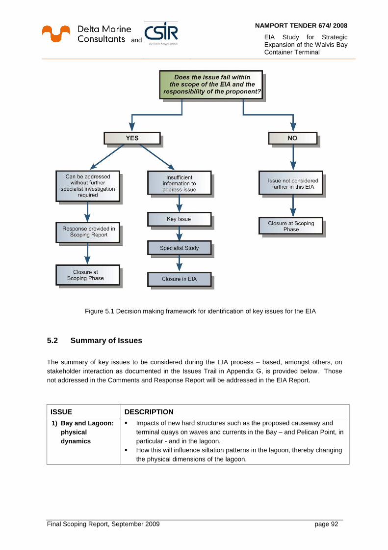
and
NAMPORT TENDER 674/ 2008
EIA Study for Strategic Expansion of the Walvis Bay Container Terminal
Final Scoping Report, September 2009 page 92
Figure 5.1 Decision making framework for identification of key issues for the EIA
5.2 Summary of Issues
The summary of key issues to be considered during the EIA process – based, amongst others, on stakeholder interaction as documented in the Issues Trail in Appendix G, is provided below. Those not addressed in the Comments and Response Report will be addressed in the EIA Report.
ISSUE DESCRIPTION
1) Bay and Lagoon: physical dynamics
� Impacts of new hard structures such as the proposed causeway and terminal quays on waves and currents in the Bay – and Pelican Point, in particular - and in the lagoon.
� How this will influence siltation patterns in the lagoon, thereby changing the physical dimensions of the lagoon.

and
NAMPORT TENDER 674/ 2008
EIA Study for Strategic Expansion of the Walvis Bay Container Terminal
Final Scoping Report, September 2009 page 93
ISSUE DESCRIPTION 2) Marine ecology
and birdlife � Impact of construction activities and new hard structures on water
quality in the Bay and the lagoon. � How will this affect fisheries in the Bay and, consequently, feeding
resources for migratory cetaceans in the Bay. � Will migration and breeding patterns of birds, particularly Red Listed
species, be disturbed or disrupted as a consequence of these impacts. � Will there be significant changes to ecological systems in the Bay and
lagoon. � What will the impact of changed noise levels be on acoustically-sensitive
marine mammals.
3) Socio-Economic (including tourism, planning and land use)
� What will be the visual impact of new buildings and structures. � Can dredging be extended to the lagoon, so that its amenity value can
be improved. � How will the bad odours released during dredging be managed. � What opportunities and constraints will there be for the Yacht club, the
proposed marine development and possibility of dedicated passenger liner berths.
� What will the impact on tourism be. � How will the increased population influx increase pressure on resources
and services, and exacerbate growth in unemployment, informal settlements and communicable diseases.
� What temporary (construction phase) and permanent (operations phase) employment will be created. What further employment would result from downstream developments.
� What will be the effect on container companies – will higher tariffs lead to an increases in consumer prices.
� Will health and safety aspects be taken care of. � Will reclaimed land belong to the Walvis Bay municipality.
4) Traffic and roads � Will traffic densities increase during construction and operations, and how will this affect road and pedestrian safety.
� Will the quality of the roads be reduced as a consequence of increased trucking, or will the roads be upgraded.
� Will alternative routes that avoid residential areas be used for container traffic.
� How will parking for the larger numbers of heavy vehicles that will visit the port be improved.
� Will rail haulage be better for container transport.
5) Noise � What is the current noise profile by day and night. � What will be the social impact of changes in noise levels during
construction and operation of the terminal on residential areas. In other words, noise caused by road and rail traffic and port operations such as container handling.

and
NAMPORT TENDER 674/ 2008
EIA Study for Strategic Expansion of the Walvis Bay Container Terminal
Final Scoping Report, September 2009 page 94
ISSUE DESCRIPTION 6) Issues related to
the EIA Process � How does the EIA link up with the SEA for the Erongo coast. � An alternative location should be considered – in particular, a site north
of the town. � Will the project be stopped if the EIA uncovers highly significant impacts
that will result in irreversible negative changes economically and environmentally.
� Who will take responsibility for errors in impact prediction, and how can this risk be reduced or avoided.
� Where will alternative fill material be sourced if insufficient dredge material is found to be suitable.
� How will maximum participation of the general public be ensured.
7) Issues Related to Project Planning, Design and Operation
� Will the expansion still be required if port operations are made more efficient, there is better planning, more cranes and berths are utilised for container operations, and more space for stacking containers is made available by removing Transnamib operations.
� The reasoning and justification for only one location alternative must be properly communicated.
� Do present and predicted container volumes justify undertaking this project.

and
NAMPORT TENDER 674/ 2008
EIA Study for Strategic Expansion of the Walvis Bay Container Terminal
Final Scoping Report, September 2009 page 95
6 Plan of study for the EIA The Guide to the Environmental Management Act 7 of 2007, states that the competent authority will make a decision on the scope and procedure of assessment before the EIA phase may commence. The purpose of the EIA phase is to:
• Address issues that have been raised through the Scoping Process;
• Assess any alternatives to the proposed activity in a comparative manner;
• Assess all identified impacts and determine the significance of each impact; and
• Formulate mitigation measures. The Plan of Study for EIA (PSEIA) sets out the process to be followed in the EIA phase and is shaped by the findings of the Scoping process.
6.1 Overview of approach to preparing the EIA Repor t and EMP
The results of the specialist studies and other relevant project information such as the design and optimization studies will be summarised and integrated into the Draft EIA Report. The Draft EIA Report will be released for a 14 day I&AP and authority review period, as outlined in Chapter 5. All I&APs on the project database will be notified in writing of the release of the Draft EIA for review. Comments from written correspondence (emails, comments, forms) and at meetings (public meeting and focus group meetings) will be captured in a Comments and Responses Trail for inclusion in the Final EIA Report. Comments raised will be responded to by the EIA team and/or the project proponent, Namport. These responses will indicate how the issue has been dealt with in the EIA process. Should the comment received fall beyond the scope of this EIA, clear reasoning will be provided. All comments received will be attached as an appendix to the Final EIA Report. The Draft EIA Report will include a draft EMP, which will be prepared in compliance with the relevant regulations. This EMP will be based broadly on the environmental management philosophy presented in the ISO 14001 standard, which embodies an approach of continual improvement. Actions in the EMP will be drawn primarily from the management actions in the specialist studies for the construction and operational phases of the project. If the project components are decommissioned or re-developed, this will need to be done in accordance with the relevant environmental standards and clean-up/remediation requirements applicable at the time. A construction EMP (CEMP) will be based on this EMP.
6.2 Public consultation process
The public consultation process for the EIA phase is described below.
and
NAMPORT TENDER 674/ 2008
EIA Study for Strategic Expansion of the Walvis Bay Container Terminal
Final Scoping Report, September 2009 page 96
6.2.1 Review of Draft EIA Report and EMP The first stage in the process will entail the release of a Draft EIA Report for a 14 day public and authority review period. Relevant organs of state and I&APs will be informed of the review process in the following manner:
• Advertisements will be placed in two national and one regional newspaper, i.e. the Namibian, the Republikein and the Namib Times.
• A notice will be sent to all I&APs (including authorities), with notification of the 14 day public review period for the Draft EIA and invitation to attend the public meeting (this letter will include a summary of the Draft EIA Report and a Comments Form).
• Public meetings on the Draft EIA Report will be held. Key findings of the EIA report will be communicated and I&APs will have the opportunity to provide comments and engage with the EIA team and project proponent.
Separate meetings with key stakeholders will be held, where suitable. The Draft EIA Report and EMP will be made available and distributed as follows, to ensure comprehensive access to information:
• A hard copy or CD version of the report will be made available to relevant organs of state and key stakeholders, as well as in public libraries in Walvis Bay and surrounding suburbs.
• The report will be placed on the project website at: http://www.namport.com.na.
6.2.2 Comments and Responses Trail A key component of the EIA process will be documenting and responding to the comments received from I&APs and the authorities. The following comments on the Draft EIA Report and EMP will be documented:
• Written and email comments (e.g. letters and completed comment forms)
• Comments made at focus group meetings
• Telephonic communication with CSIR and Enviro Dynamics contact person
• One-on-one meetings with key authorities and/or I&APs. All comments received will be compiled into a Comments and Responses Trail for inclusion in the Final EIA Report. The Comments and Responses Trail will indicate the nature of the comment, when and who raised the comment. The comments received will be considered by the EIA team and appropriate responses provided by the relevant member of the team and/or specialist. The response provided will indicate how the comment received has been considered in the Final EIA Report, in the project design or EMP for the project. 6.2.3 Compilation of Final EIA Report for submissio n to Authorities The Final EIA Report, including the Comments and Responses Trail and EMP, will be submitted to the authorities for decision making. A notification will be sent to all I&APs on the project database notifying them of the submission of the final report.

and
NAMPORT TENDER 674/ 2008
EIA Study for Strategic Expansion of the Walvis Bay Container Terminal
Final Scoping Report, September 2009 page 97
6.2.4 Environmental Authorisation and Appeal Period The following process will be followed for the distribution of Environmental Authorisation:
• A notice will be sent to all on the stakeholder database informing them that Environmental Clearance has been issued, with access to an online copy on the Namport website.
6.3 Authority consultation during the EIA phase
Authority consultation is integrated into the public consultation process, with additional one-on-one meetings held with the lead authorities where necessary. It is proposed that the competent authority (MET) as well as other lead authorities be consulted at various stages during the EIA process.
6.4 Linkage of specialist studies with studies for design and optimisation
Design studies to be undertaken in advance of, and in parallel with specialist studies, are:
• Detailed design/ optimisation of the extension, widening and deepening of the entrance channel, turning basin and basin pockets. This shall minimise dredging costs as far as possible, while maintaining an acceptable level of safety in ship manoeuvring and berthing of expected vessel sizes.
• Final layout optimisation study for the new container terminal footprint. This will take into account potential environmental impacts on the Bay and lagoon. It will utilize hydrodynamic modeling and – to a lesser extent, include navigation simulation exercises.
• Investigate economic alternative options of disposing of dredged material. This will identify material that is considered unsuitable for land reclamation purposes for the terminal and advise on their disposal. It will also investigate and assess options for the beneficial use of dredged material.
These studies will interact with the specialist studies (cf. Chapters 5.2 and 6.5) in an iterative manner. At the conclusion of this process, an optimized project description will be the subject of the EIA report that will be presented for review by stakeholders and MET. How these design and opimisation studies connect with each other has already been illustrated in Figure 2.4. The hydrodynamic modelling forms part of the design and optimization studies.
6.5 Specific issues to be addressed in specialist s tudies
Table 6.1 shows which specialist studies will be undertaken by specialists as part of the EIA phase. Assessment will be done on impacts from the optimised terminal footprint.

and
NAMPORT TENDER 674/ 2008
EIA Study for Strategic Expansion of the Walvis Bay Container Terminal
Final Scoping Report, September 2009 page 98
Table 6.1 Specialists and their roles in the EIA
Specialist Study Specialist Marine ecology Lizette Voges, Ocean and Land Resource Assessment
Consultants Avifauna (birds) Pat Morant, independent consultant- CSIR Associate
Traffic and Roads Roy Bowman, SSI Engineers and Environmental Consultants (Pty) Ltd
Socio-Economic (incl. tourism, planning & land use)
Stephanie van Zyl, Enviro Dynamics (Pty) Ltd
Noise Brett Williams, Safetech SA
The Terms of Reference (TORs) for the specialist studies will essentially consist of the generic assessment requirements and specific issues identified for each study. These issues will have been identified through the baseline studies, I&AP and authority consultation, as well as input from the proposed specialists based on their experience. As part of the review of the Draft Scoping Report, specialists propose any additional issues for inclusion in the specialist studies. Additional issues, identified through public and authority consultation during the Scoping phase, as well as specialist inputs, are included in the final Terms of Reference for specialists.
6.5.1 Marine ecology and ornithology
6.5.1.1 Marine ecology
• Prepare a marine baseline report, based on available information, that will describe the baseline marine ecology in Walvis Bay. It will emphasise, but not be limited to, sensitive and threatened habitats, and threatened or rare marine fauna and flora. All pertinent characteristics of the marine environment will be described, that is, physical environment, biological environment and sensitive areas.
• Review similar studies that involve dredging activities in harbour areas and do further literature research if needed.
6.5.1.2 Avifauna (birds)
• Do a rapid desktop review of available information that can support and inform the specialist study, i.e. potential impacts on avifauna. Identify trends and conditions in the environment that currently affect the avifauna within the zone of influence.
• Describe the existing environment and the bird communities that use the habitats within the zone of influence of the proposed expansion of the container terminal. Highlight and discuss gaps in baseline data.
• Map bird sensitive areas in a sensitivity map for easy reference, with particular emphasis on habitat for Red Data and endemic species, and migratory species. Give an indication of confidence levels.
and
NAMPORT TENDER 674/ 2008
EIA Study for Strategic Expansion of the Walvis Bay Container Terminal
Final Scoping Report, September 2009 page 99
6.5.1.3 Integrated marine ecology and ornithology assessmen t
• Based on the hydrodynamics design studies, assess the impact of dredge operations on the marine ecology of Walvis Bay, and bird life in the Bay and the lagoon.
• Based on the optimized footprint of the proposed expansion, assess the impact of any changes in the tide/wave/current regime of Walvis Bay on the marine ecology of Walvis Bay, and bird life in the Bay and the lagoon.
• Compile an integrated Marine Specialist Report that uses accepted impact assessment conventions, and recommend management actions to avoid or reduce negative impacts and enhance benefits.
6.5.2 Noise
• Conduct a desktop study of available information that can support and inform the specialist noise study.
• Measure the existing ambient noise at the proposed site, and other locations along the recommended traffic routes, during both the day and night time.
• Conduct a noise study of the future impact during construction and operation of the expanded container terminal, taking into account sensitive receptors such as adjoining residential areas, and issues raised during Scoping.
6.5.3 Traffic and roads The issues to be investigated to determine the extent of the traffic and transportation impacts and the need for mitigation measures will include the following:
• During Construction. The transport of labour, materials and equipment to the sites for construction of the container terminal, possibly including fill material if reclaimed dredge material is not suitable. The need for any special traffic control measures to handle peak hour vehicle flows or the transportation of abnormally large or heavy equipment to the sites.
• During Operation. The routes and vehicles to be used to transport containers, including the ability of the existing roads to carry the additional traffic. Transport of containers into the hinterland.
The traffic impact assessment will be conducted as follows:
• Compile relevant information with regard to the container terminal access road requirements and the amount of labour, materials and equipment required during construction and the number of containers to be transported during operation will be obtained.
• Evaluate the safety of traffic operations at proposed access road intersections, and others identified during Scoping, with regard to sight distances and the need for traffic control measures.
• Analyse the impact of the amount of traffic that will travel to and from the port with regard to the capacity of the roads, taking into account the cumulative effect of other developments which will occur during the construction and operation phase. Any mitigation measures required must be stipulated.
and
NAMPORT TENDER 674/ 2008
EIA Study for Strategic Expansion of the Walvis Bay Container Terminal
Final Scoping Report, September 2009 page 100
• Investigate transportation of any large equipment to the port on public roads.
• Prepare a traffic and transportation impact assessment and mitigation report.
6.5.4 Socio-Economics and Planning
• Conduct a desktop study and Identify issues informed by the Issues Trail to gain an understanding of the socio-economic concerns raised during scoping.
• Consult with relevant authorities, particularly the Walvis Bay Municipality, Namport, the Erongo Regional Council.
• Investigate the following: o Expected increase in population size; o The benefits and risks associated with additional employment creation and job
seekers, including job creation and poverty reduction, increased informal settlement, increased pressures on local housing, facilities and services;
o Increased educational opportunities and skills transfer; o Economic benefits from the project - contribution to economic structure and existing
socio-economic trends in the town; o Impacts on the existing industrial base; o Waste disposal and sewerage issues; o Interaction with social, recreational and tourism facilities; o Implications of the project for current land use planning and compatibility with existing
land usage; o Beneficiaries and losers of the project.
• Investigate health and safety and security issues associated with the project.
• Provide a baseline description of the socio-economic profile to be addressed at local, regional and national levels.
6.6 Approach to specialist studies and impact asses sment
This section outlines the assessment methodology for specialist studies.
6.6.1 Generic Terms of Reference for the assessment of impacts The identification of potential impacts should include impacts that may occur during the construction and operational phases of the activity. The assessment of impacts is to include direct, indirect as well as cumulative impacts. In order to identify potential impacts (both positive and negative) it is important for the nature of the proposed activity to be well understood, in order for the impacts associated with it to be analysed. The process of identification and assessment of impacts will include:
• Determination of current environmental conditions in sufficient detail so that there is a baseline against which impacts can be identified and measured.
• Determination of future changes to the environment that will occur if the activity does not proceed (“no project” alternative).
• An understanding of the activity in sufficient detail to understand its consequences; The identification of significant impacts which are likely to occur if the activity is undertaken.

and
NAMPORT TENDER 674/ 2008
EIA Study for Strategic Expansion of the Walvis Bay Container Terminal
Final Scoping Report, September 2009 page 101
For the assessment of alternatives and impacts the following methodology is to be applied to the predication and assessment of impacts. Potential impacts should be rated in terms of the direct, indirect and cumulative affects:
• Direct impacts are impacts that are caused directly by the activity and generally occur at the same time and at the place of the activity. These impacts are usually associated with the construction, operation or maintenance of an activity and are generally obvious and quantifiable.
• Indirect impacts of an activity are indirect or induced changes that may occur as a result of the activity. These types of impacts include all potential impacts that are not immediately apparent when the activity is undertaken, or which occur at a different place as a result of the activity.
• Cumulative impacts are impacts that result from the incremental impact of the proposed activity on a common resource when added to the impacts of other past, present or reasonably foreseeable future activities. Cumulative impacts can occur from the collective impacts of individual minor actions over a period of time and can include both direct and indirect impacts.
• Spatial extent – The size of the area that will be affected by the impact: o Site specific o Local (<2 km from site) o Regional (within 30 km of site) o National.
• Intensity –The anticipated severity of the impact: o High (severe alteration of natural systems, patterns or processes) o Medium (notable alteration of natural systems, patterns or processes) o Low (negligible alteration of natural systems, patterns or processes).
• Duration –The timeframe during which the impact will be experienced: o Temporary (less than 1 year) o Short term (1 to 6 years) o Medium term (6 to 15 years) o Long term (the impact will cease after the operational life of the activity) o Permanent (mitigation will not occur in such a way or in such a time span that the
impact can be considered transient). Using the criteria above, the impacts will further be assessed in terms of the following:
• Probability –The probability of the impact occurring: o Improbable (little or no chance of occurring) o Probable (<50% chance of occurring) o Highly probable (50 – 90% chance of occurring) o Definite (>90% chance of occurring).
• Significance – Will the impact cause a notable alteration of the environment? o Low to very low (the impact may result in minor alterations of the
environment and can be easily avoided by implementing appropriate mitigation measures, and will not have an influence on decision-making)
o Medium (the impact will result in moderate alteration of the environment and can be reduced or avoided by implementing the appropriate mitigation measures, and will only have an influence on the decision-making if not mitigated)

and
NAMPORT TENDER 674/ 2008
EIA Study for Strategic Expansion of the Walvis Bay Container Terminal
Final Scoping Report, September 2009 page 102
o High (the impacts will result in major alteration to the environment even with the implementation on the appropriate mitigation measures and will have an influence on decision-making).
• Status - Whether the impact on the overall environment will be: o positive - environment overall will benefit from the impact o negative - environment overall will be adversely affected by the impact o neutral - environment overall not be affected.
• Confidence – The degree of confidence in predictions based on available information and specialist knowledge:
o Low o Medium o High.
• Management Actions and Monitoring of the Impacts (E MP) o Where negative impacts are identified, mitigatory measures will be
identified to avoid or reduce negative impacts. Where no mitigatory measures are possible this will be stated
o Where positive impacts are identified, management actions will be identified to potentially enhance positive impacts
o Quantifiable standards for measuring and monitoring mitigatory measures and enhancements will be set. This will include a programme for monitoring and reviewing the recommendations to ensure their ongoing effectiveness.
Table 6.2 below will be the standard format used by specialists for the rating of impacts.
Table 6.2 Standard format of the table for rating of impacts
Impact Spatial Extent
Intensity Duration Probability Significance & Status
Mitigation Confidence Without Mitigation
With Mitigation
Operations phase Impact of
noise from the container terminal on residents in Walvis Bay
... ... ... ... ... ... ... ...
Other aspects to be taken into consideration in the assessment of impact significance are:
• Impacts will be evaluated for the construction and operation phases of the development. The impact evaluation will, where possible, take into consideration the cumulative effects associated with this and other facilities/projects which are either developed or in the process of being developed in the port environs.
• The impact assessment will attempt to quantify the magnitude of potential impacts (direct and cumulative effects) and outline the rationale used. Where appropriate, national standards are to be used as a measure of the level of impact.
• The impact assessment will take into consideration relevant national and international guidelines, standards or recognised best practice that are practical and feasible for this particular project.

and
NAMPORT TENDER 674/ 2008
EIA Study for Strategic Expansion of the Walvis Bay Container Terminal
Final Scoping Report, September 2009 page 103
7 References and Bibliography Belous, O. and Gulbinskas, S. (2007) Klaipeda deep-sea seaport development. Klaipedia University. Barnard, P. (ed.) (1998). Biological diversity in Namibia - a country study. Namibian National Biodiversity Task Force, Windhoek. CES (1995) Lantau Port Development Stage 1. Design of reclamation and edge structures for container terminals 10 and 11 and back-up areas. Environmental impact assessment. Final report. Coastal Zone Management Project (1999) Coastal profile of the Erongo Region, Windhoek, Namibia.
COWI (2003) Walvis Bay Local Agenda 21 Project Namibia. Coastal area study. Marine pollution review. Final report. COWI (2006). Update of Environmental Impact Assessment and Environmental Management Plan. Port of Walvis Bay Dredging Activities 2006-2010. Project 44/98 - COWI for Namibian Ports Authority. CSIR (1989) A study of some of the physical and biotic processes affecting dredging within the Walvis Bay Lagoon. CSIR Report EMA-C-89109 for Cape Department of Nature and Environmental Conservation. CSIR (1992). Preliminary baseline study prior to exploration activities by Sasol on the Namibian continental shelf in licence area 2012. CSIR (1994) Feasibility of port extensions at Walvis Bay. CSIR Report EMAS-C 94031 for Namibian Ports Authority. Ecologia Environment (2007) Albany Iron Ore Project. Public Environmental Review. Albany Port Expansion Proposal. EPA Assessment 1594. EnviroSolutions (2008) Environmental impact assessment (Phase 1 Report). The construction of Berth 0/1 to expand the existing container terminal. Project 618/2007 – EnviroSolutions Cc for Namibian Ports Authority. Environmental Management Act 7 of 2007. Government Gazette, Republic of Namibia. GHD (2000) Development and Maintenance Dredging at Walvis Bay. Report on the Assessment of the Fate and Impact of Dredged Material. Project 44/98 - Gutteridge, Haskins and Davey (Pty) Ltd for Namibian Ports Authority. JICA. (2009) The preparatory survey on the Walvis Bay Port Container Terminal development project in the Republic of Namibia. Interim Report. August 2009, prepared by Padeco Co. Ltd. and Oriental Consultants Co., Ltd, for Japan International Cooperation Agency. Kirkman SP, Oosthuizen WH, Meyer MA, Kotze PGH, Roux J-P. and Underhill L.G. (2007), Making sense of census and dealing with missing data: trends in pup counts of Cape fur seal Arctocephalus pusillus pusillus for the period 1972-2004, African Journal of Marine Science, Volume 29(2).

and
NAMPORT TENDER 674/ 2008
EIA Study for Strategic Expansion of the Walvis Bay Container Terminal
Final Scoping Report, September 2009 page 104
LAB (2008) Walvis Bay Biodiversity Report – 2008. Local Action for Biodiversity Project. Lass, HU and Mohrholz, V (2005) On the fluctuations and vertical structure of the shelf circulation off Walvis Bay, Namibia. Continental Shelf Research 25(12-13): 1473-1497. Mendelsohn J, Jarvis A, Roberts C. and Robertson T. (2002). Atlas of Namibia – A portrait of the land and its people. Ministry of Environment and Tourism (2008) Strategic Environmental Assessment (SEA) for the coastal areas of the Erongo and Kunene Regions. Windhoek, Namibia. Ministry of Environment and Tourism (2008) Draft Management and Development Plan for the Central Coastal Area of the Namib-Skeleton Coast National Park, Windhoek, Namibia.
Molloy F. and Reinikainen T. (2003). Namibia’s marine environment. Edited by Molloy F. and Reinikainen T. on behalf of the Directorate of Environmental Affairs of the Ministry of Environment and Tourism, Namibia.
Namlex, Index to the Laws of Namibia. 2004. ISBN: 99916-740-6-3. Namport (2003) Internal Environmental Impact Assessment. Extension of the Syncrolift National Planning Commission (1996) 1991 Population and Housing Census, Windhoek, Namibia. National Planning Commission (2006) 2003/04 Namibia Household Income and Expenditure Survey, Windhoek, Namibia. National Planning Commission (2003) 2001 Population and Housing Census, Windhoek, Namibia. National Planning Commission (2007) 2005/06 Regional Poverty Profile, Windhoek, Namibia. Olivier, J (1995). Spatial fog distribution pattern in the Namib using Meteosat images. J. Arid Environments 29:129-138.
Olivier, J (1992). Aspects of the climatology of fog in the Namib. SA Geographer 19 (2): 107-125. Schulz HN and Jorgensen BB. (2001) Big bacteria. Annual Review of Microbiology 55: 105–137. ScandiaConsult (2003) Ust-Luga Port Development Project. Multi-purpose terminal. Environmental impact assessment. Seely M. and Pallett J. (2008). Namibia - Secrets of a desert uncovered, Windhoek, Namibia.
Shannon, LV (1985). The Benguela Ecosystem. Part 1: Evolution of the Benguela physical features and processes. Oceanogr. Mar. Biol. Ann. Rev., 23, 105-182. Sogreah, WCE & CMS (1999) Feasibility Study for Deepening of the Port of Walvis Bay. SADC Project NAM 4.23 - Sogreah, WCE and CMS for Namibian Ports Authority.

and
NAMPORT TENDER 674/ 2008
EIA Study for Strategic Expansion of the Walvis Bay Container Terminal
Final Scoping Report, September 2009 page 105
Southern Africa Data Centre for Oceanography (21 March 1960 to 27 December 2008). Seasonal wind roses for the offshore area near Swakopmund - Voluntary Observing Ship (VOS) data. Southern Africa Data Centre for Oceanography (21 March 1960 to 23 December 2008). Seasonal wave roses for the Swakopmund Area - Voluntary Observing Ship (VOS) data. Tractebel (1998) Environmental Impact Assessment for the Dredging of the Port of Walvis Bay. Final Report. Project 44/98 - Tractebel Development - SECA for Namibian Ports Authority. Turgis Consulting (Pty) Ltd (2008). Report of the Environmental and Social Impact Assessment Trekkopje Desalination Project, Erongo Region, Namibia. Prepared by Turgis Consulting (Pty) Ltd for UraMin Namibia (Pty) Ltd. Final Draft January 2008. pp. 275 + Appendices. UN (1992) Assessment of the environmental impacts of port development. Van Wieringen (1999a) Geotechnical investigation for dredging the Port of Walvis Bay, Namibia. Project 44/98 - Van Wieringen and Associates for Namibian Ports Authority. Van Wieringen (1999b) Preliminary geotechnical desk study for expansion of the container terminal (Berths 9-14) Port of Walvis Bay. Project 120/08 - Van Wieringen and Associates for Namibian Ports Authority. Van Wieringen (2008a) Geotechnical Report for Namport Contract 681/2007 of Walvis Bay. Expansion to container quay, ship repair hub and fishing terminal. Project 13/08 - Van Wieringen and Associates for Namibian Ports Authority. Van Wieringen (2008b) Preliminary desk study for expansion of the Container Terminals (Berths 9-14) Van Wieringen and Associates for Namibian Ports Authority. Willemse, N. (2008) Baseline establishment and the assessment of environmental impacts on the marine, coastal and fisheries environment for Preparation of a full-size environmental impact assessment (EIA) for the expansion of Berth 0/1 in the Port of Walvis Bay. WML (2008) Report on wave, wind, and water level conditions at Walvis Bay. Report WB 12-2008/1 - WML Coast (Pty) Ltd for Namibian Ports Authority. WML Coast & IL (2008) Design, feasibility and tender Berth 0/1. Concepts and feasibility for ship repair hub and dedicated fish terminal. Project 618/2007 - WML Coast and Inros Lackner AG for Namibian Ports Authority. WML Coast & IL (2008). Technical Pre-Feasibility Study for New Container Terminal. WML Coast and Inros Lackner AG for Namibian Ports Authority.

and
NAMPORT TENDER 674/ 2008
EIA Study for Strategic Expansion of the Walvis Bay Container Terminal
Final Scoping Report, September 2009 page 106
Appendices
Related Documents