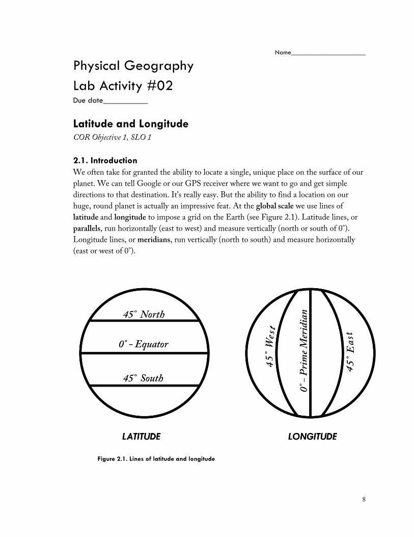
8 Name______________________ Physical Geography Lab Activity #02 Due date___________ Latitude and Longitude COR Objective 1, SLO 1 2.1. Introduction We often take for granted the ability to locate a single, unique place on the surface of our planet. We can tell Google or our GPS receiver where we want to go and get simple directions to that destination. It’s really easy. But the ability to find a location on our huge, round planet is actually an impressive feat. At the global scale we use lines of latitude and longitude to impose a grid on the Earth (see Figure 2.1). Latitude lines, or parallels, run horizontally (east to west) and measure vertically (north or south of 0°). Longitude lines, or meridians, run vertically (north to south) and measure horizontally (east or west of 0°). Figure 2.1. Lines of latitude and longitude

Welcome message from author
This document is posted to help you gain knowledge. Please leave a comment to let me know what you think about it! Share it to your friends and learn new things together.
Transcript
8
Name______________________ Physical Geography
Lab Activity #02 Due date___________
Latitude and Longitude COR Objective 1, SLO 1 2.1. Introduction We often take for granted the ability to locate a single, unique place on the surface of our planet. We can tell Google or our GPS receiver where we want to go and get simple directions to that destination. It’s really easy. But the ability to find a location on our huge, round planet is actually an impressive feat. At the global scale we use lines of latitude and longitude to impose a grid on the Earth (see Figure 2.1). Latitude lines, or parallels, run horizontally (east to west) and measure vertically (north or south of 0°). Longitude lines, or meridians, run vertically (north to south) and measure horizontally (east or west of 0°).
Figure 2.1. Lines of latitude and longitude

9
When we put the two sets of lines together we get a grid system typically referred to as the graticule. When given the latitude and longitude, we can easily find any point on the Earth. 2.2. The Hemispheres Our graticule divides the globe into four hemispheres, northern, southern, eastern, and western. If it is easier, you can think of the graticule as an x,y graph like you’ve encountered in an algebra class. Rather than using positive and negative values, geographers use direction to distinguish where coordinates go. As you can see in the graphic below, having a set of longitude and latitude coordinates without the proper direction can place you into any one of the four hemispheres. Direction is crucial!
Figure 2.2.Graticule as Cartesian grid
Using Figure 2.2, answer the following questions
1. If we treat the graticule like an algebraic x,y grid, i.e. using positive and negative values, would the latitude in the coordinates 75°N, 50°W be positive or negative?
2. If we treat the graticule like an algebraic x,y grid, how would we express the coordinates for 75°S, 50°E?
10
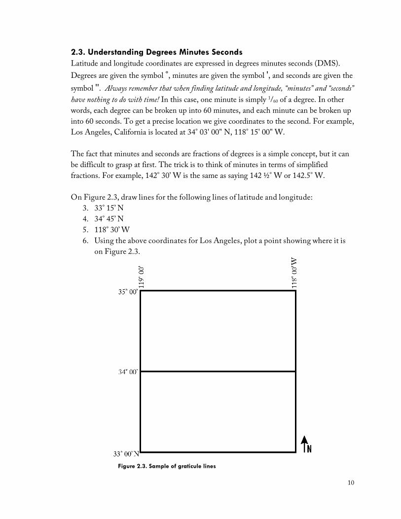
2.3. Understanding Degrees Minutes Seconds Latitude and longitude coordinates are expressed in degrees minutes seconds (DMS). Degrees are given the symbol °, minutes are given the symbol ', and seconds are given the symbol ''. Always remember that when finding latitude and longitude, “minutes” and “seconds” have nothing to do with time! In this case, one minute is simply 1/60 of a degree. In other words, each degree can be broken up into 60 minutes, and each minute can be broken up into 60 seconds. To get a precise location we give coordinates to the second. For example, Los Angeles, California is located at 34° 03' 00" N, 118° 15' 00" W. The fact that minutes and seconds are fractions of degrees is a simple concept, but it can be difficult to grasp at first. The trick is to think of minutes in terms of simplified fractions. For example, 142° 30’ W is the same as saying 142 ½° W or 142.5° W. On Figure 2.3, draw lines for the following lines of latitude and longitude:
3. 33° 15’ N 4. 34° 45’ N 5. 118° 30’ W 6. Using the above coordinates for Los Angeles, plot a point showing where it is
on Figure 2.3.
Figure 2.3. Sample of graticule lines
11
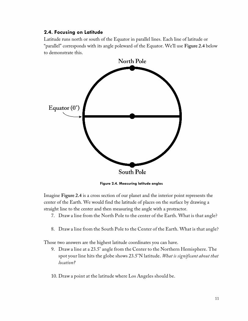
2.4. Focusing on Latitude Latitude runs north or south of the Equator in parallel lines. Each line of latitude or “parallel” corresponds with its angle poleward of the Equator. We’ll use Figure 2.4 below to demonstrate this.
Figure 2.4. Measuring latitude angles
Imagine Figure 2.4 is a cross section of our planet and the interior point represents the center of the Earth. We would find the latitude of places on the surface by drawing a straight line to the center and then measuring the angle with a protractor.
7. Draw a line from the North Pole to the center of the Earth. What is that angle?
8. Draw a line from the South Pole to the Center of the Earth. What is that angle?
Those two answers are the highest latitude coordinates you can have. 9. Draw a line at a 23.5° angle from the Center to the Northern Hemisphere. The
spot your line hits the globe shows 23.5°N latitude. What is significant about that location?
10. Draw a point at the latitude where Los Angeles should be.

12
11. Use your Essential World Atlas to find the following cities, which are roughly found on the 42nd parallel in the Northern Hemisphere. Based on the maps, first estimate the city’s latitude to the nearest minute. Write that down and then check your answer in the atlas’ index.
City & pg. number Estimated lat. & min. Exact lat. & min. Medford, OR, USA (pg. 76) Shenyang, China (pg. 33) Tbilisi, Georgia (pg. 19) Girona, Spain (pg. 21) Samsun, Turkey (pg. 19)
12. Now do the same for these cities located near the 32nd parallel in the Southern Hemisphere:
City & pg. number Estimated lat. & min. Exact lat. & min. Cordoba, Arg. (pg. 94) Perth, Australia (pg. 61) Queenstown, S. Africa (pg. 56) 2.5. Focusing on Longitude There are 360° of longitude running around the globe, east or west of the Prime Meridian. We also call them “meridians.” We will use meridians much more in the next lab when you practice navigational techniques and finding your location out at sea.
13. Estimate the longitude of the following cities, then look up the exact location:
City & pg. number Estimated long. & min. Exact long. & min. Timbuktu, Mali (pg. 52) Minsk, Belarus (pg. 17) Seattle, WA, USA (pg. 78)
13
2.6. Test yourself Without using any references, write definitions for latitude and longitude. Check your definitions using De Blij et al’s Physical Geography and this lab manual and improve and/or correct your definitions as needed.
14. Latitude –
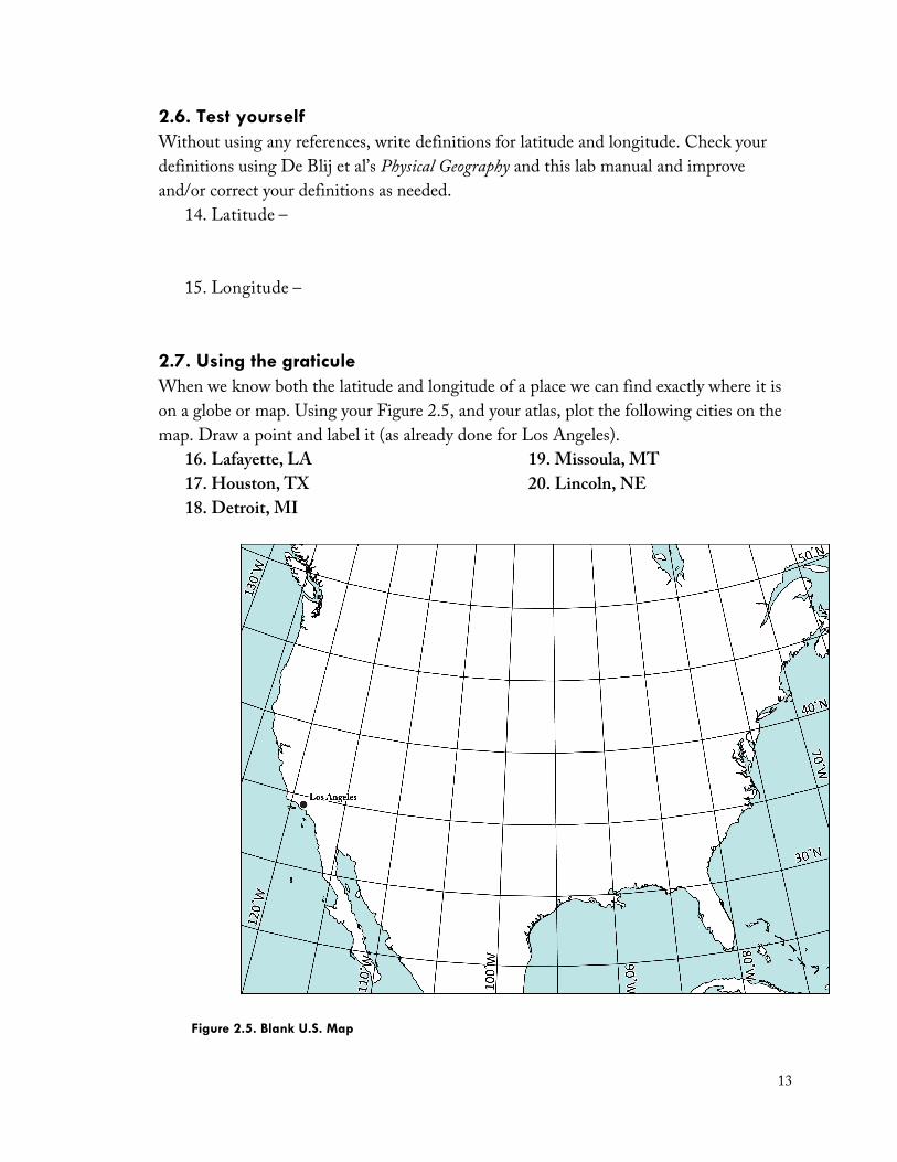
15. Longitude – 2.7. Using the graticule When we know both the latitude and longitude of a place we can find exactly where it is on a globe or map. Using your Figure 2.5, and your atlas, plot the following cities on the map. Draw a point and label it (as already done for Los Angeles).
16. Lafayette, LA 17. Houston, TX 18. Detroit, MI
19. Missoula, MT 20. Lincoln, NE
Figure 2.5. Blank U.S. Map
14
Now it is time to do this in reverse. Below you are given coordinates for five cities around the world. Using your Essential World Atlas and/or a world globe locate the cities that correspond with the latitude and longitude
21. 55° 0’ N, 83° 5’ E = ________________________________________________
22. 16° 20’ S, 68° 10’ W = _____________________________________________
23. 35° 30’ N, 51° 30’ E = ______________________________________________
24. 9° 2’ N, 38° 42’ E = _______________________________________________
25. 12° 59’ N, 77° 40’ E = ______________________________________________
End of Lab 02
Related Documents