GOVERNMENTOF THE PEOPLE'S REPUBUC OF BANGLADESH ROADS AND HIGHWAYS DEPARTMENT OFFICE OF THE ADDMIONALCHIEF ENGINEER SARAKBHABAN, RAMNA,DHAKA DETAILED ENGINEERING, PREPARATION OF BID DOCUMENTS ENVIRONMENTAL IMPACT ASSESSMENT AND RESETTLEMENT PLAN OF NALKA - HATIKAMRUL - BONPARA NEW ROAD E-236 VOL. 8 DETAILED ENVIRONMENTAL STUDY panS Environmental Management and Monitoring Plan Air and Noise Pollution Assessement DECEMBER 1996 DHV Consultants BV ConsultingEngineering Services (India) Pvt., Ltd. The Netherlands DevelopmentDesign 'Consultants Ltd., Bangladesh in association wrth DeshUpodesh Ltd., Bangladesh Public Disclosure Authorized Public Disclosure Authorized Public Disclosure Authorized Public Disclosure Authorized

Welcome message from author
This document is posted to help you gain knowledge. Please leave a comment to let me know what you think about it! Share it to your friends and learn new things together.
Transcript
GOVERNMENT OF THE PEOPLE'S REPUBUC OF BANGLADESHROADS AND HIGHWAYS DEPARTMENT
OFFICE OF THE ADDMIONAL CHIEF ENGINEERSARAK BHABAN, RAMNA, DHAKA
DETAILED ENGINEERING, PREPARATION OF BIDDOCUMENTS
ENVIRONMENTAL IMPACT ASSESSMENT ANDRESETTLEMENT PLAN
OF
NALKA - HATIKAMRUL - BONPARA
NEW ROAD
E-236 VOL. 8
DETAILED ENVIRONMENTAL STUDYpanS
Environmental Management and MonitoringPlanAir and Noise Pollution Assessement
DECEMBER 1996
DHV Consultants BV Consulting Engineering Services (India) Pvt., Ltd.The Netherlands Development Design 'Consultants Ltd., Bangladeshin association wrth Desh Upodesh Ltd., Bangladesh
Pub
lic D
iscl
osur
e A
utho
rized
Pub
lic D
iscl
osur
e A
utho
rized
Pub
lic D
iscl
osur
e A
utho
rized
Pub
lic D
iscl
osur
e A
utho
rized

DHV CES DDC DUL
The Government of the People's Republic of Bangladesh
NALKA - HATKAMRUL - BONPARA NEW ROAD
Loan Agreement 2638 BD
DETAILED ENVIRONMENTAL STUDY
Part 1 Executive SummaryPart 2 Socio-Economic SurveyPart 2a Appendices Socio-Economic SurveyPart 3 Base Line SurveyPart 4 Resettlement IssuesPart 5 ENVIRONMENTAL MANAGEMENT AND MONITORING PLANPart 5a AIR POLLUTION ASSESSMENTPart 5b NOISE POLLUTION ASSESSMENT
Subject Detailed Enviromnental StudyFile K4008.01.001Date December 1996Status Version IOur reference NHB/LJW/DES.VR1

I

TABLE OF CONTENTS Page
PART I PROJECT SETTING1. Introduction 4
1.1 Terms of Reference 41.2 Scope of Assessment and Management Action. Plan 61.3 Approach and Methodologies 61.4 Policy, Legal and Administrative Framework 8
2. Project Description 102.1 Project Rationale and Justification 102.2 Project Components and Technical Layout 102.3 Civil works and Construction Methods 112.4 Construction Planning and Implementation Schedule 12
PART II ENVIRONMENTAL IMPACT ASSESSM:ENT3. Existing Environmental Impacts in the Project Area 12
3.1 Natural Impacts 123.1.1 Flooding 123.1.2 Storms 133.1.3 Seismic Activities 14
3.2 Man-made Impacts 173.2.1 Destruction and Modification of Natural Habitats 173.2.2 Pollution of Water Resources and Associated Health Hazards 173.2.3 Impacts Influencing the Hydraulic Regime 183.2.4 Air Pollution 213.2.5 Noise Pollution 21
3.3 Development in the Project Region 22
4.- Environmental Impacts Anticipated Due to the NHBNR Project 234.1 Issues at Stake 23
4.2 Construction and Operation Related Physical Impacts 254.2.1 Disruption of Flood and Surface Drainage Pattern 274.2.2 Interruption of Local Transport & Communication 27
4.3 Construction and Operation Related Ecological Impacts 284.3.1 Destruction and Modification of Habitats 284.3.2 Impacts on Wildlife 304.3.3 Risks of Deterioration of Surface and Groundlwater Resources 314.3.4 Disposal of-Construction Materials and Solid Waste 31
4.4 Construction and Operation Related Socio-Economic Impacts 324.4.1 Impacts on Agriculture 324.4.2 Impacts on Fisheries 334.4.3 Construction and Traffic Hazards 354.4.4 Air Pollution 364.4.5 Noise Pollution 364.4.6 Health and Sanitation Hazards 374.4.7 Social Life Disruption 37
4.5 Potential Environmental Benefits due to the Project 38
DHV Consultants BV
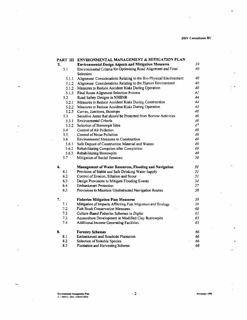
PART m[I ENVIRONMENTAL MANAGEMENT & MITIGATION PLAN5. Environmental Design Aspects and Mitigation Measures 39
5.1 Environmental Criteria for Optimising Road Alignment and Final 40Selection
5.1.1 Alignment Considerations Relating to the Bio-Physical Environment 405.1.2 Alignment Considerations Relating to the Human Environment 405.1.2 Measures to Reduce Accident Risks During Operation 405.1.3 Final Route Alignment Selection Process 41
5.2 Road Safety Designs in NHBNR 445.2.1 Measures to Reduce Accident Risks During Construction 445.2.2 Measures to Reduce Accident Risks During Operation 445.2.3 Curves, Junctions, Busstops 46
5.3 Sensitive Areas that should be Protected from Borrow Activities 465.3.1 Environmental Criteria 465.3.2 Selection of Borrowpit Sites 47
5.4 - Control of Air Pollution 485.5 Control of Noise Pollution *485.6 Environmental Measures in Construction 49
5.6.1 Safe Deposit of Construction Material and Wastes 495.6.2 Rehabilitating Campsites after Completion 495.6.3 Rehabilitating Borrowpits 49
5.7 Mitigation of Social Tensions 50
6. Management of Water Resources, Flooding and Navigation 516.1 Provision of Stable and Safe Drinking Water Supply 516.2 Control of Erosion, Siltation and Scour 516.3 Design Provisions to Mitigate Flooding Events 546.4 Embankment Protection 576.5 Provisions to Maintain Unobstructed Navigation Routes 58
7. Fisheries Mitigation Plan Measures 597.1 Mitigation of Impacts Affecting Fish Migration and Ecology 597.2 Fish Stock Conservation Measures 607.3 Culture-Based Fisheries Schemes in Dighis 617.3 Aquaculture Development in Modified Clay Borrowpits 637.4 Additional Income Generating Facilities 65
8. Forestry Schemes 668.1 Embankment and Roadside Plantation 668.2 Selection of Suitable Species 668.3 Plantation and Harvesting Scheme 68
Envizonranl Manageneat Plan - 2 Novmeiber 1996C: \ MMA \ EIA \ EMAP.DOC

DHV Consultants BV'
PART IV ORGANISATION AND MONOTORING PLAN
9. Organisation of the Environmental Management Plan 719.1 Organisational Framework 729.2 Tasks and Responsibilities of the Technical Team / Contractor 739.3 Tasks and Responsibilities of the Environmental Team 809.4 Tasks and Responsibilities of the Resettlement Co-ordinating Team 85
10. Monitoring opf the EMAP 8610.1 Elements of Monitoring 8610.2 Sectoral Monitoring Activities 87
Annex A Legal Framework to conduct this Environmental Impact Assessment
Annex B Detailed Inventory of Trees which have to be Removed by NHBNR
Annex C Fishpond Management for Rehabilitated Clay Borrowpits
Annex D Cost Estimate Tables for EMAP Elements
Enviromeaj Managem Plan - 3 - Novenber 1996C: \ MMA \ EIA \ EMAP.DOC

A I I~~~~~~~~~~~~~~~~~~~~~~~~~~~~
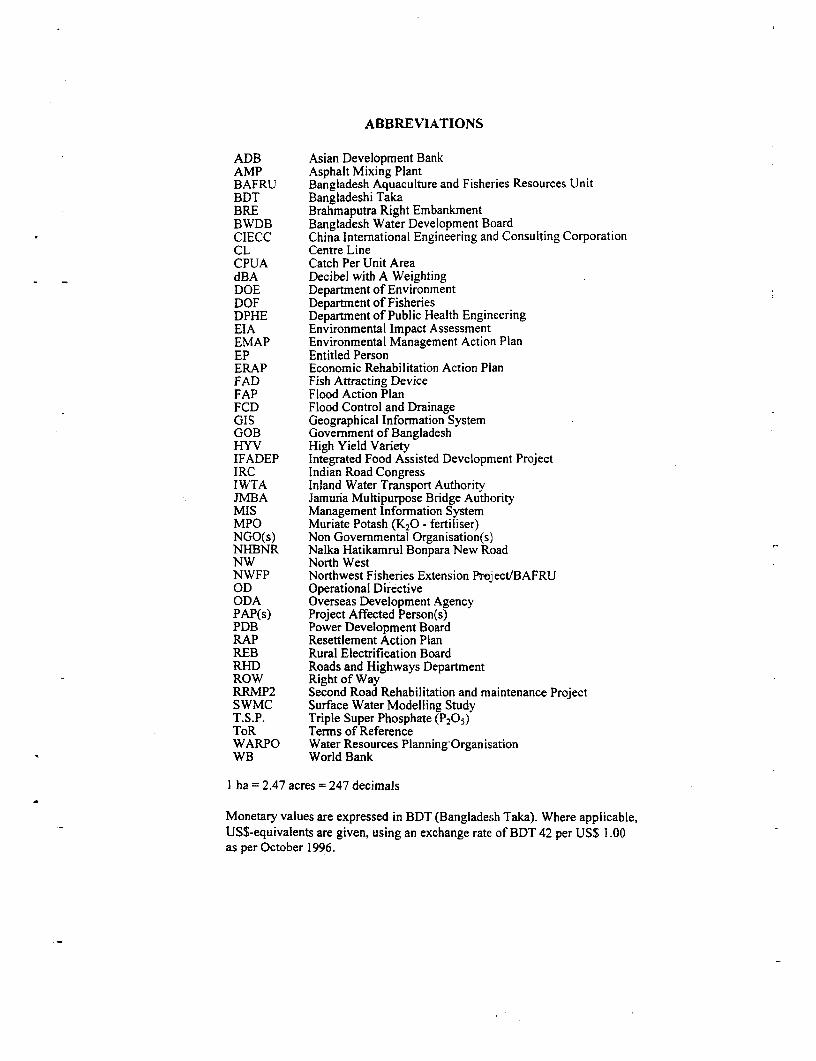
ABBREVIATIONS
ADB Asian Development BankAMP Asphalt Mixing PlantBAFRU Bangladesh Aquaculture and Fisheries Resources UnitBDT Bangladeshi TakaBRE Brahmaputra Right EmbankmentBWDB Bangladesh Water Development BoardCIECC China International Engineering and Consulting CorporationCL Centre LineCPUA Catch Per Unit AreadBA Decibel with A WeightingDOE Department of EnvironmentDOF Department of FisheriesDPHE Department of Public Health EngineeringEIA Environmental Impact AssessmentEMAP Environmental Management Action PlanEP Entitled PersonERAP Economic Rehabilitation Action PlanFAD Fish Attracting DeviceFAP Flood Action PlanFCD Flood Control and DrainageGIS Geographical Information SystemGOB Government of BangladeshHYV High Yield VarietyIFADEP Integrated Food Assisted Development ProjectIRC Indian Road CongressIWTA Inland Water Transport AuthorityJMBA Jamuria Multipurpose Bridge AuthorityMIS Management Information SystemMPO Muriate Potash (K20 - fertiliser)NGO(s) Non Governmental Organisation(s)NHBNR Nalka Hatikamrul Bonpara New RoadNW North WestNWFP Northwest Fisheries Extension Prejject/BAFRUOD Operational DirectiveODA Overseas Development AgencyPAP(s) Project Affected Person(s)PDB Power Development BoardRAP Resettlement Action PlanREB Rural Electrification BoardRHD Roads and Highways DepartmentROW Right of WayRRMP2 Second Road Rehabilitation and maintenance ProjectSWMC Surface Water Modelling StudyT.S.P. Triple Super Phosphate (P2 05 )ToR Terms of ReferenceWARPO Water Resources Planning OrganisationWB World Bank
I ha = 2.47 acres = 247 decimals
Monetary values are expressed in BDT (Bangladesh Taka). Where applicable,US$-equivalents are given, using an exchange rate of BDT 42 per US$ 1.00as per October 1996.

I

.. .........~~~~~~~~~~~~~~~~~~~~~~~~~~~~~~~~~~~~~~~~~~~~~~~~~~~~~~~~~~~~~~~~~~~~~~~~~~~~~~~~~~~~~~~~~~~~~~~~~~~~
~~~~~~~~~~~~~~~~~~~~~~~~~~~~~~~~~~~~~~~~~~~~~~~. :i n .

I
DHV Consultants BV
ENVIRONMENTAL MANAGEMENT PLAN
1. Introduction
The main objective of the Consultancy Services is to assist the Government of Bangladesh inpreparation of detailed engineering design and detailed environmental studv for the proposed newroad (NHBNR) connecting Nalka-Hatikamrul and Bonpara/Ahmedpur. This report includes allfindings and assessments with respect to the environmental issues related to NHBNR. It alsoelaborates an Environmental Management Action Plan for the major interventions of this project inorder to mitigate, minimise or to avoid potential environmental hazards.
1.1 Terms of Reference
During its screening and assessment procedures, the Feasibility Study (CIECC, 1993) has identifiedmany issues relating to engineering and environmental aspects as needing more detailed investigationduring a detailed design phase. Based on this analysis, the ToR.) that relate directly and indirectly toboth the EIA and the EMAP are as follows:
Scope of Services
Taking into account the findings of the feasibility analysis and preliminary engineering, as well asthe relevant environmental impact studies, the Consultants shall perform detailed environmentalstudies, economic analysis, detailed field surveys, surface and subsurface investigation, includingspecific soils and materials investigations, laboratory testing and related works, and proceed with thedetailed design of the road, bridges and other drainage structures. A master plan for environmentalmitigation shall be drawn up, and implementation procedures established.
During the course of their services the Consultant was supposed to carry out inter alia, a detailedenvironmental Study in accordance with World Bank Operational Directive 4.01 and 4.30 for aCategory A project.
*) Selected text. adopted and modified. where applicable. from ToR provided by the Client.
Ewramnww Mamsrem PLia - 4 - Novmber 1996C: \ MMA X EIA \ EMAP.DOC

DHV Consultants BV
Specific Environmental Issues to be Addressed:
The environmental study will include, but not be limited to, the following environmental issues:
* Carry out a survey to identify the distribution and remaining value of Chalan Beel wet landswithin the impact zone of the proposed road.
* Assess impacts of embankmnents on surface drainage patterns and natural fish production to assistthe engineering team in designing appropriate road cross-drainage.
* Carry out a base line survey to identify sensitive areas which should be protected from borrowactivities.
* Develop criteria and procedures for rehabilitating the sites after the earth work is completed.• Assess air pollution and noise problems principally during operation phase, base rmainly on a
survey for those of existing roads; and* Develop a comprehensive environmental management: plan and an environmental monitoring plan,
based on the results of above.
As for the route choice, the Environmental Team will work in close consultation with TechnicalDesign Team and with the Client fmalising the choice of alignment. To meet these requests. theEnvironmental Team will
* undertake detailed topographic surveys of the proposed road alignment and prepare route planand profile drawings with relevant cross-sectional details.
• contribute to the site survey and assessment of proposed and existing bridges and culverts on theroute;
* assist with hvdrological analyses for all bridges t culvert sites and finalising length, andnavigational clearance formal bridges;
* determine number, size and location of all culverts required on the routes chosen. Specialattention will be given in determining the opening of the culverts so that velocity of water flow beminimum so that obstruction is not created in the movement of fish.
* review the data obtained during the feasibility study and undertake additional soils and materialsinvestigations as required to find suitable materials for road embankment, pavement andreinforced concrete works. For all materials proposed, the Environmental Team will also assessthe environmental compatibility with respect to obtaining and processing these materials, andassess potential adverse effects due to waste disposal;
* ascertain the possibilities to cater for the uninterrupted flow of traffic for the period concerned.* undertake an inventory of the road side trees and make a detailed report on such removal of trees
affected by the alignment.
The main output of this EIA is the definition of the final road alignment in accordance withminimisation of environmental impacts and technical and economic feasibility.
Envrmnmenial ManaSe M - 5 - N a nh 1996C: \ MMA \ EIA \ EMAP.DOC
DHV Consultants BV
1.2 Scope of Assessment and Management Action Plan
The initial screening undertaken at the stage of project identification (CIECC, 1993) came to theconclusion to include this project as Categorv A in accordance with OD 4.01, i.e. requiring a fullenvironmental assessment. This classification seems justified given the type, location, ecologicalsensitivity as well as the nature of the expected adverse impacts of NHBNR project that mray beirreversible and multifold.
This ELA is based on the results presented in the Baseline Environmental Survey which covers themajor bio-physical, ecological and human aspects pertaining to the Project Area. The EIA alsoanalyses all major cross-sectoral issues (e.g. socio-economic, resource uses, health, culture) and theexisting environmental impacts (the without project situation). All areas which are directly affectedbv the road alignment are assessed to the degree where changes in the environmental setting areexpected. Depending on the factor assessed, these areas are approximately I to 5 km adjacent to theCL (see Tab. 1.3.2.1). This study excludes, however, more distant areas where major economicchanges are likelv to follow as a result of improving the regional communication network.
The Management Action Plan focuses mainly on appropriate measures in those sectors where majoradverse effects are expected which could be mitigated by employing specific technical solutions andmanagement options. Major sectors of interventions with mitigation actions are (i) ) mnaintenance ofdrainage pattern, (ii) flood protection (iii) income generating facilities for PAP's in the field ofaquaculture, forestry and agriculture, (iv) rehabilitation of borrowpits. The Management Action Planwill also take into consideration control and mitigation measures for a variety of impacts that arecommonly associated with this type of project, such as air and noise pollution, health and accidentrisks, impairment of communication and social disturbances.
This EMAP will not elaborate the RAP as the RAP is not part of Consultant's assignment. The RAPis to be defined after the PAP census and is part of the "to be appointed NGO's assignment". Oncethe ERAP and the RAP will be defined, the adequate nmitigation measures for PAPs like IGP,training, and the MIS can be worked out.
The Consultants are fully aware that this omission renders the environmental management plansomewhat incomplete, but it is not under the Consultant's responsibility to tackle these tasks. Asdefined in the ToR for the RAP (see Report on "Resettlement Issues") the entire resettlement part ofthe EMAP is to be provided by the selected NGOs. Nevertheless, this report discusses some ofsuggestions that evolved during this EIA on the linkage of linking income generating activities (e.g.modification of borrowpits into fish farms, roadside plantation schemes) with a future resettlementaction plan.
1.3 Approach and Methodologies
1.3.1 Data Collection and Analysis
Essentially the methodological approach in collecting, analysing and processing the primary andsecondary data for the EIA was identical with the one outlined in Section 1.5 of the EnvironmentalBaseline Study. Reference is also made to the respective sources of information quoted in theAnnexes of this report (e.g. maps, institutions contacted, interviews and questionnaires, publicinvolvement and participation of the PAPs, documents) and the specific field surveysundertaken.
Esyivmneil Maugmcrat Pn - 6 Novemnber 1996C: % MMA \ EIA \ EMAP.DOC
DHV Consultants BV
The issues associated with resettlement of PAP are nol: considered in this ELA and in the EMAP asthey are not included in the Consultants ToR. The Consultant prepared, as requested, the ToR foran "Resettlement Action Plan" as outlined in the reporl: on "Resettlement Issues on the PAPs". Thisreport also identifies the needs for a comprehensive PAP census. Eventually, the elaboration of theRAP and the MIS for planning, implementation and monitoring of the resettlement program, togetherwith the income generating and training program fully depends on the outcome of the PAP censusand the furthter requirements of the Client.
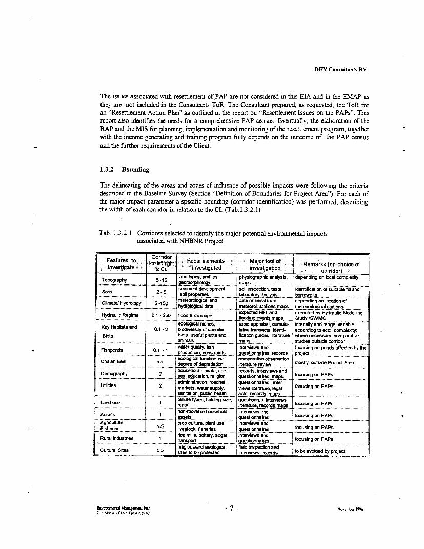
1.3.2 Bounding
The delineating of the areas and zones of influence of possible impacts were following the criteriadescribed in the Baseline Survey (Section "Definition of Boundaries for Project Area"). For each ofthe major impact parameter a specific bounding (corridor identification) was performed, describingthe width of each corridor in relation to the CL (Tab. 1.3.2. 1)
Tab. 1.3.2.1 Corridors selected to identify the major potential environmental impactsassociated with NHBNR Project
CorridorFeatures to h Focal elements MajorAtoloRo.investigae to 1 CL : Investigated investigation c~ orridor)
Topography 5 -15 land types, profiles, physiographic analysis, depending on local complexity................................... 'eo,m9h,oog ma,s .............mal.s,,.... .. , , , , , .................................................................................................. .
sediment development soil inspection, tests, identification of suitable fill and.Soils 2 -es 5 sois rowit
Climatel Hydrology_5 -150 meteorological and data retrieval from depending on location oflimate/ Hydrology 5 -150 hydrologicaldata,,,,,,,,,,,,,,, meerl. staio,ma meteoro a !° al st tins -IC
Hydraulic Regime 0.1 - 250 flood & drainage expected HFL and executed by Hydraulic Modelling.-. _flooding events,rnaps Study tSWMCI
ecological niches, rapid appraisal, cumula- intensity and range varableKey Habitats and 0.1 - 2 biodiversity of specific latiwe transects, identi- according to ecol. complexity,
Biota biota, useful plants and fication guides, literature where necessary, comparativel ~~~~~~~animals, ,,,,,,,,,,,, maps-- - studies outsid,e,,corri,,do9rl
l Fishpnd 0.1 1 water quaiity, fish interviews and focusing on ponds affected by the................................. in,contrants questionnaires, records project
Chalan Beel na aecological function tvz, comnparative observation. ianerature review , mostly outside Project Area
Demography 2 household biodata, age, records, interviews andlDemography 2 sex, education religion guestiggn ires maps focusing on PAPs
Utilities 2 administration, roadnet, questionnaires, inter-markets, water supply, views literature, legal focusing on PAPs.-_ sanitation, public health acts, records, maps ..
land use tenure types, holding size, questionn. i, intrvienws lLand use 1 rental..... li.,_ ............ lIRerature, record.. . .aps _ focusing on PAPs l
non-movable household interviews and l-Assets 1 assets .questionnaires focusing on PAPs
lAgrcuiture, crop culture, plant use, interviews andFisheries 1-5 livestock, fisheries questionnaires focusing on PAPs
Rural industries 1 rice mills, pottery, sugar, interviews and f - PAPs.urai-...ustnes _ ._ transp _ questionnaires focusing on PAPsreligious/archaeological field inspection and l
Cultural Sites 0.5 sites to be protected interviews, records to be avoided by project
Envimwml Mamgcmes Ptan - 7 - Noember 1996C: t MMA \ EIA t EMAP.DOC
DHV Consultants BV
1.3.3 Defining Project-Specific Environmental Criteria and Guidelines
Above all, the en%ironmental assessment ensured to the maximum possible and applicable to keepthe number of people who would loose their homestead or only source of income due to the new roadconstruction as low as possible. All analytical results were extensively discussed with the technicaldesign team to ensure the feasibility of both the selected alignment and the proposed mitigationmeasures.
By the nature of this project, a number of sites had to be selected in which specific impacts ofconstruction elements (e.g. CL, borrowpits, newly created lakes, construction sites) needed to beassessed and, to the maximum possible, to be avoided. In achieving this goal, environmental criteriawere taken account while
(i) selecting the sites for* access (temporary) roads* borrowpits (including possible later use for income generating activities such as fish or rice
production)* sand excavation (or, if technically applicable, hydraulic dredging) sites* material deposits* campsites and sanitation facilities
(ii) choice ofproper materials and construction proceduresfor* access (temporary) road construction* borrowpit material options* excavating and dredging operationse depositing waste material and surface water runoffs* pavement material and hot air emission* hazardous construction material
(iii) confining air pollution with respect to* during construction and operation phase* vehicle gas emission. dust* hot air
(iv) confining noise problems during construction and operation phase
1.4 Policy, Legal and Administrative Framework
Above all, the Client was consulted about the policy oi. this project, and the overall objective theNHBNR will pursue. Taking the broad range of assessment for the parameters ascribed to theproject into account, a variety of institutions and organisations were contacted which could eithercontribute direct information (documentation, reports, maps etc.) or give for valuable commentswhile analysing data. The project team contacted therefore organisations which are eitheradministratively involved with the project, or which pursue vested interests and policies in properexecution of this project. Annex B of the Environmental Baseline Survey Report enlists allinstitutions and organisations which were contacted during the execution of this work.
Ew,rmsW Mamgcm pLan - 8 - Nvobe 1996
C: \ MMA \ EIA \ EMAP.OC
DHV Consultants BV
By nature of the many surveys conducted in the field, the project personnel and management stayedcontinuouslv in constant contact and dialogue with the communities affected by NHBNR. Majorissues were discussed at village meetings and during the household surveys (see Socio-EconornicSurvey of the PAP). Village people information, concerns and response to the project contributedtherefore significantly to the specific assessment described in this report.
To the extent necessary (and depending on the degree of actuality and availability) thedocuments/acts enlisted in this report in Annex A were consulted to assess the legal framework inwhich this project is embedded. More specific, the purpose of this approach was
* to find out whether the project proposals are in conformity with the existing policies, laws andregulations;
• to identify any part of the project recommendations and mitigation measures which would be incontradiction with the existing policies, laws and environmental standards;
• to elaborate at the stage of preparing the tender documents the guidelines which would ensure thelong-term environmental protection interest of both the Government and the communities;
. to discover at an early stage of planning whether any proposed action may infringe on thefundamental or traditional (cultural) rights and perceptions of the people;
* to ascertain that there exists relevant legislation in force. but is inoperative because of prevailingsetbacks due to poor socio-economic conditions.
* to identify the degree of legal support the project may expect with regard to safeguarding thefragile ecological conditions in the floodplain, and to enhance environmental awareness amongthe communities involved.
Ez,rm l Mtmgneme Plan -9- Nomeanbr 1996C M MMA \ EIA \ EMAP.DOC
DHV Consultants BV
2. Project Description
2.1 Project Rationale and Justification
The NHBNR project will provide a direct link to the West of Rajshahi division leading from thewestern approach of the proposed Jamuna Bridge. Thie junction point at Bonpara is on theNatore-Pabna road. The distance between Nalka and Bonpara is about 55 km. The firstapproximately 4 km. between Nalka and Hatikamrul involving the upgrading of an existing route.
The main objective of NHBNR is to provide direct link to the west of Rajshahi Division leading fromthe western approach of the proposed Jamuna Bridge. The highway will equally represent a majorlink between the North Western Districts and the capitil. As such, the NHBNR will definitelyachieve major positive socio-economic impacts in many parts of the area by improving bettercommunication, transport and social services which ultimately create better environment for humanlife. It is expected to have a significant affect on improved traffic movement and related economicdevelopment in this region.
The Preliminary Engineering, Economic Feasibility and Environmental Impact Assessment study fora new road betveen Nalka and Bonpara via Hatikamrul has been prepared by N/S. ChinaInternational Engineering and Consulting Corporation in association with O'Sullivan & Graham
iimited and Development Design Consultant Ltd. Two routes, Route 1 complying with the projectdescription and Route 3A, terminating at Ahmedpur rather than at Bonpara, and passing close toimportant Thana centers such as Tarash, Gurudaspur and Baraigram, have been identified as givinggood economic rates of retum. This is conditional upon the Jamuna Bridge project going ahead.Route I is cheaper but route 3A currently shows the better rate of retum. The Consultants have, onbalance, recommended Route I which was subsequently approved by GOB as final selected route forthe project.
2.2 Project Components and Technical Layout
The road will be constructed on an earth embankment with an average height of almost 4 meter. Thehighest embankment will be situated at the approach of the Atrai River Bridge where theembanlcnent will be 11 m high to assure navigational clearance for this river.
The total top width of the road embankment will be 18 in. The road generally consist of a 7.3 mpaved highway with hard and tufted shoulders of 1.25 m width each on both sides making the totalpavement width 12.3 m. 0.6 m below the top main pavement a secondary shoulder will beconstructed to accommodate a slow traffic lane of 3.8 m width.
The core of the embanlament consists of sand whilst a 0.5 m cladding layer of clay will be used forinitial slope protection. In places where long and intensive flooding is expected the cladding layerwill be increased to 0.75 m. In the newly constructed road 12 bridges are projected to accommodatethe calculated 25 year flood return discharge through main rivers and khals. In addition, about 85culverts are included to drain off all surface water and minor rivers in the Project Area.
For the construction of the road a ROW of 50 m is required over the total length of the alignment.For bridge approaches and junction additional land is required. According to the Land AcquisitionPlan more than 3,000 plots are affected. The extend of land loss for individual landowners variesfrom 1 to 100 %. The land acquisition analysis showed ithat some landowners will loose so much
E nwirmxl MaagmaSrA Plan - 10- November 1996C: \ MMA \ EIA \ EMAP.DOC
DHV Consultants BV
land that they would not be able to generate sufficient income to sustain living with their remainingland. These landowners are to be provided with new land and/or adequate compensation and analternative source of income. The NHBNR project also requires that 28 homesteads are to beremoved. The concerned households are to be resettled.
2.3 Civil Works Construction Methods
The total project will be divided into four contracts which aLre provisionallY allocated to the followinglots:
Nalka - Hatikamrul 5 kmHatikamrul - Atrai River 20 kmAtrai River - Baraigram 20 kmBaraigram - Bonpara 10 km
To a certain extend the Contractor(s) executing the works can choose his (their) own constructionmethod. As the Contract describes the materials to be used, some of the production and constructionmethods will be established by the Contract.
The main part of the fill material will be transported by truck from borrowpit to the constructionsite. The transport distance depends on the location of the borrov%pits. The total quantity of requiredfill material for the entire project is approximately 5 million m3
. It is estimated that more than 95 %of this material will be transported by truck via (temporary) roads or tracks or via the (partly)established embankment. However, the possibility of hydraulic dredging is not to be ruled out butdepends on the option chosen by the Contractor.
All building materials required for the construction of the road like stones, gravel, bitumen, cement,reinforcement steel etc. is to be transported by road or by boat during the monsoon season. Riverboat transport may play a more important role since the ge:neral infrastructure in the Project Area ispoor and the low quality of the existing roads will further deteriorate.
For each of the contracts an Asphalt Mixing Plant (AMP) will be used. The asphalt concrete will betransported by truck to the paving site where it will be spread and compacted. For the constructionof culverts and bridges different concrete mixers will be used.
Where necessary, e.g. at bridge locations, drainage is required for bored piling.
2.4 Construction Planning and Implementation
At this stage the period of execution of the works is not delined. It is assumed that the reconstructionof the Nalka - Hatikamrul section will be accelerated to ensure a appropriate connection between thewestem approach of the Jamuna Bridge and the Nagarbari - Bogra road when the Jamuna Bridge isopened to traffic. This means that the construction of Nalka - Hatikamrul is to start latest in the firstpart of 1997. It is expected that the total construction period for the Nalka - Hatikamnrul section willbe 18 months whilst the road will be open to traffic after 12 months. As for the completion of theother sections of NHB (Ch. 4+000 to 54+820) present estimates range between 30 to 36 months.
Enviroal Muugmemn Plan - 1 | Ncnvenber 1996C: \ MMA \ EIA \ EMAP.DOC
'' X '..,......
,
.....................
.<~~~.~~y<.Cy..., ~~~~~ ..~... ........... .. .....

I I I

DHV Consultants BV
3. Existing Environmental Impacts in the Project Area
Like most areas in the country, the Project Area is affected by a number of environmental impactsrelating to both natural catastrophes and human activities.
3.1 Natural Impacts
3.1.1 Flooding
In the Project region, like in many regions in Banglades.h, flood is a regular phenomenon, oftencausing substantial problems problem when the entire infrastructure together with the people's live,their belongings and the cropland they depend on are affected.
As NHBNR is crossing the major depression at the Lower Atrai Basin, forming the so-called "GreenRiver" it will be often exposed to severe and long-lasting flooding caused both by major spills fromthe Atrai River. The area is also influenced from the Chalan Beel area where flood, volume quicklydrains from the upper part of the Atrai basin. Flooding intensifies locally when there is coincidenceof temporary heavy run-off in the Atrai, Karotoa and Bangali system. Apart from that, there areother lowland areas in the western part of the Project Area flooded by minor rivers.
The Project Area is partly affected by the backwater flow from the Jamuna River. In the early stageof the annual monsoon the Jamuna level remains quite high and there is substantial back waterflooding into the Hurasagar when the river spills over and engulfs the Lower Atrai Basin.
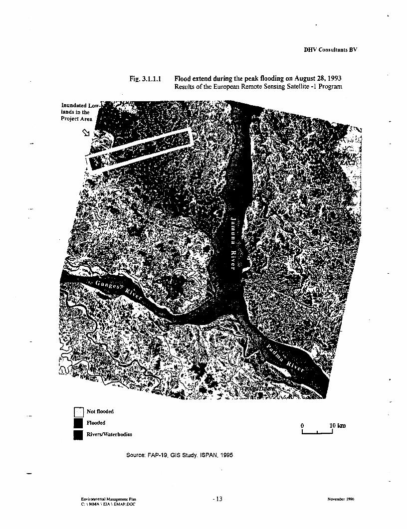
The area experience severe flooding in the years 1987, 1988, 1991 and 1993 following breaches ofthe Brahamputra Right Embankment and high levels in the Brahmaputra and the Ganges. Fig.3.1.1.1 shows the magnitude of inundation during one of' the peak flooding occurring in August1993. The security of Brahmaputra Right Embankment (BRE) needs to be taken into due account asthis construction and the hinterland to be protected (partly being the project area) are seriouslythreatened by continued bank erosion. Of particular concern is the imminent breach of BR.E atMathurapara, some 40 km to the North of Nalka, where the Jamuna River bank erosion has alreadyapproached the Bengali River in less than 1 km distance. The scenario that may have far-reachingconsequences, also for the NHBNR, when the BRE protection will break is simulated and broadlydiscussed in the Hydraulic Modelling Study.
Infrastructure development like polder construction is continually taking place in the uppercatchment of the rivers, namely in the Atrai River Basirn. This is impeding the free flow of thegenerated run-offs and causes a variety of enviromnental impacts and economic setbacks in someareas. The effects are multifold, ranging from climatic; changes, change of drainage pattern,deterioration of surface water quality, disruption of fish population and recruitment, loss of crops, tosocial disturbances (FAP-2, 1992).
Envirmneul Maugeme Plan - 12 - November 1996C: \ MMA \ EIA \ EMAP.DOC
DHV Consultants BV
Fig. 3.1.1.1 Flood extend during the peak flooding on August 28, 1993Results of the European Remote Sensing Satellite -1 Program
Inundated Low " ;7lands in theProject Area
[II Not flooded
Flooded O 10 hn
Rivers/Waterbodies
Source: FAP-19, GIS Study. ISPAN, 1995
EnviromicnLal Managemen Plan - 13 - November 1996C: \ MMA \ EIA \ EMAP.DOC

DHV Consultants BV
3.1.2 Storms
Storns that ravage the region are mostly of local nature. Typical storms are Nor' Westers.tornadoes, and thunderstorms with wind speeds ranging from 90 to 200 km/hr. The storms'damaging capacity is high but their area extent is limited. They can uproot trees, blow always Kachahouses (at least all roofs), causing severe damages to peoples' life, livestock and properties. Thistypes of storms are generally expected during the months MLarch - May and again in September -October. Two to three storms of such nature occur in average each year in the region.
The local storms may create considerable wave run-up in the project area on exposed embankmentstructures. Particularly in the central area of the "Green River" (at Nimacharai khal) there issufficient effective fetch distance for wave to build up to 1.5 meters. Embankment erosion and scourare often resulting from these hydrodynamic forces.
Cyclones which are generated due to deep depressions in the Bay of Bangal, proceeding towards thecoast and hitting coastal areas associated with high speed wind, extensive rainfall and surges do notreach the Project Area (see Fig. 3.1.2.1) as they prevail in the coastal areas of Bangladesh.
3.1.3 Seismic Activities
Bangladesh, particularly the north-eastern zone has experienced in the past earthquakes of moderateto high intensity. The great earthquake of 1897 which had its epicentre in the Shillong Plateau ofIndia caused widespread damages. Two other major earthquakes, the Bengal earthquake of 1885and Srimongal earthquake of 1918 caused severe damages on limited areas surrounding theirepicentres.
According to BNBC (1993) Bangladesh has seismic zones. It appears the project area falls withinthe limit of two zones with moderate and low seismic activity (Fig. 3.1.3.1). The errtire eastern partof the Project Area fall in zone 2, i.e. moderate seismic zone. The eastern part lie within a zonewhere negligible shocks are observed.
Enviromuemal Managenmn Plan - 14 - November 1996C: MMA \ EIA \ EMAP.DOC

DHV Consultants BV
Fig. 3.1.2.1 Basic Areas of Wind Impacts in Bangladesh
(Mnd Speeds are In knVh)
89 90- 91- 92-
.... ......
(T- ~ ~ ,
26' _F BEG2 L 2 *.
I N D I n | i 8 able
21£ ?wu fo Dt sgnslt be .
NOT *)r location lyig on any h soat in Due nf Die vaue Di\ isl shl be
Reproduced fom Fig. 62. of *i Fxiona Drf hof mBnbb .C- vl.d h 1rcvn9S3 orlb
2zaV - 25'agmn Pa 1 Nvmet19
C.t7 Cm MMA EA P
.~~ ~ ~ ~~~~ ~ ~~~~~~ N D I A
C M MMA \ EIA \ EMAP.DOFM

DHV Consultants BV
Fig. 3.1.3.1 Seismic Zoning Map of Bangladesh
89' 90' 91' 92'
C.~~~~~~~~~~~~~~~~~T
A
26 2
INDIA --- Z-- ' ; l
fj~~~~~~~~~~~~~~~~~~~~~~~2 sgeb so DO> 10 W.Z
.i= = . . rv ~~~~~~~~~~~~SCAlEw- =-=-= .-. *. ,-1 0~~~ N D I A
e--m=-- :::S<-_#. . .. . . . . . . . . . . . .,tv'-- :-
- = =- ~........... .. .25' ~ ~~~~~~~~~~~ .:- -= = .. .a -........... . -.-..-.-. '-.-.-.--. .5
j~~~~~ ~~ ~~~~~ . . .= . . . . .2 .'. . .
Rser~~~~~~~~~~~~ . .d . . . . ... . . .{
24' _Sc 1 E 3 > _24-
-~~~~~~U=
I W I L A S
22' -2290 91 92
C: tw d 8 MMA Y EIA F EMAP.WC A ?L 61
R1 sw" Zoe 5... ... ... .... 21
*Reproduced from Fig. 6.2.10 of the Final Draft of BNBC-1993
Enviromemi Mamgcffwg pl&n - 16.November 1996

DHV Consultants BV
3.2 Man-made Impacts
3.2.1 Destruction and Modification of Natural Habitats
Almost all of the land in the Project Area is privately owned and almost completely mnodified by maninto agricultural plots (mainly paddy fields) and elevated homestead sites with horticulture.
In spite of these massive anthropogenic interferences, the region still contains some importanthabitats for wildlife like the Chalan Beel, although much of the forner characteristic wetlandlandscape has long been lost (see Baseline Survey). With the loss of valuable wetlands supportingrich wildlife (predominantly waterfowl) the region suffered critical losses in vital habitats.
Man has modified vast areas of former floodplains into culture land by drainage and polderconstruction. Similarly, the number of so-called refuge forests, e.g. stands of mixed tree and shrubvegetation on medium highlands, has been drastically reduced due to settlement and landreclamation. In fact, all medium highlands in the large floodplain area became reshaped by man,establishing homesteads and associated homestead gardens. It is thus justified to conclude thatalmost no pristine habitat exists in the entire Project Area except the barren lands adjacent to thekhals, particularly Nimacharai khal.
3.2.2 Pollution of Water Resources and Associated H[ealth Hazards
The Project Area experiences a wide range of detrimental interferences with its water resources.Poor sanitation and hazardous drinking water supply, together with malnutrition and limited healthcare are the main causes of high morbidity and mortality in the region. Groundwater drawdown haslocally reached alarming low levels.
Poor Sanitation Facilities and Hazardous Defecation Practices
About 90% of the population in the Project Area have no latrines and therefore defecate in openplaces indiscriminately. Kutcha latrines are usually constructed by the sides of ponds, ditches, riversand khals. According to field surveys only 1.4% had V.S latrines which are, however, not regularlyused by all the family members. Given this hazardous defecation practices and the fact that livestockalso uses these resources, surface waters are seriously polluted and pose substantial risks uponhuman health. Faecal bome diseases and parasites such as hookworm are common in the area.
Water and Vector Borne Diseases
It is assumed that the Project Area is representative for rural Bangladesh where about 80% ofpeople, prevailingly children, suffer from water and faecal bome diseases. Among the mostcommonly reported diseases are diarrhoea, dysentery, gastro-enteritis, typhoid fever, diphtheria,and hepatitis. Peaks widespread outbreaks of diseases are: shortly after the monsoon and during thedry season. In 1993, the region was affected by epidemic cholera, reportedly caused by shortage ofdrinking water and inadequate rural sanitation.
The existing FCD projects can encourage waterlogging, providing the main breeding areas formosquitoes. In addition, small borrow pits of rural roads, and minor khals develop stagnant poolsduring the pre-monsoon and post-monsoon period. The vector-borne diseases such as malaria andkala azar are common in the Project Area.
Envrnemial Managemau Plan - 17 - November 1996C: \ MMA \ EIA I EMAP.DOC
DHV Consultants BV
Pollution with Agro-Chemicals
With the introduction of HYV boro paddv culture the extensive use of agro-chemicals such aschemical fertilisers and pesticides represents another ubiquitous source of surface water and soilpollution. It remains for further investigation to which extent this will have long-term effects on bothwildlife and human health. Apart from agro-chemicals there are other pollutants, however limited tolocal interferences such as poorly controlled waste disposals from sugar mills.
Prelimrinary water quality tests on main chemical components and bacteriological tests were carriedout during the Feasibility Study from tube-well sources. .The results showed that the pH value,hardness, chloride and Fe2+ contents were within acceptable limits, except for four samples whoseiron contents exceeded the Bangladeshi standard. The reason of this excessive iron content mav bedue to the geological formation of the soil at these villages as Sirajganj district falls within the areaidentified by DPHE as having an iron problem. Regarding bacteriological results, all samples werebacteria free except two taken at Baraigrarn and Ullapara Thana respectively.
3.2.3 Impacts Influencing the Hydraulic Regime
The land slope is low. As such the flood flow of the area is controlled by the downstream flow intothe so-called "Green River" (Fig. 3.2.3.1). The hydrology and flooding of the Lower Atrai iscomplex and includes surface water runoff due to heavy monsoon rains, occasional spills fromadjacent main and secondary rivers, occasional severe flooding following breaches of theBrahmaputra Right Embankment and seasonal backwater flooding from the confluence area of theJamuna and Ganges rivers. Various structures and man-made activities tend to interfere with thenatural flooding and drainage system. The water uses prevailing in the Project Area are, at leastseasonally, not sustainable.
Disruption in Water Supply
Due to the remoteness and economic under-development the water supply facilities in the ProjectArea are below the average standard in Bangladesh. The field survey showed that tube-well coverageis one tube well for 150 people. However, many shallow tube-wells remain defunct during the dryperiod due to the decline of static water level below the critical depth. As a result people of thisregion use surface water resources from the surroundings, such as fishponds, ditches, beels, rivers.In these times only few people can fully rely on dug wells.
Excessive Water Use Impeding Groundwater Recharge
The field survey identified that tube-well water is used mainly for drinking and surface water forother domestic purposes, e.g. bathing, washing of utensils, cloth-washing, gardening, cattle washing,cattle feeding and sanitation purposes after defecation. During the dry period, when almost allshallow tube-wells become non-operational, people depend on the Tara-pump deep tube-wells whichmay be more than 400 metres distant; very few rural people collect clean drinking water from suchdistant Tara-pump deep tube wells. Rather they collect river water, pond water and dug-well waterfor their drinking purposes. During the crisis period out of 51.8 litres per capita/day, the rural peopleof the Project Area collect up to 2 litres of tube-well water from distant tube-wells and the rest oftheir requirements are met from nearby available surface water sources.
Environmenul Managem Plan - 18- November 1996C: \ MMA \IA \ EMAP.DOC

DHV Consultants BV
Groundwater recharge depends mainly on rainfall less surface runoff. Due to the concentration oftube-wells (either hand pump or moton'sed) in some locations in the Project Area the use ofgroundwater is already extensive and reportedly reaches the limit. This conclusion is supported byfield investigations and data collection from the DPHE Thana offices, confirming that during the dryperiod the groundwater level goes down, varving from 7.0m to 10.5 m below ground level in April toMay. As a result almost 90% of shallow tube wells become inoperational for a period fromDecember to May ever year. The DPHE Thana office supplied their water level monitoring datawhich showed a maximum decline of 10.4 m in Baraigrarm Thana (CIEC, 1993). It must be stated,however, that excessive use of groundwater resources due to the high numbers of tube-wells are buttwo of the reasons for the general drawdown of groundwater in the Project Area. Other causes relateto reduced rainfall, less flood, increased temperature and, reduction in river flow in the dry periodduring the past years.
Polder Construction
The Bangladesh Water Development Board BWDB in a bid to mitigate flooding in the Chalan Beelarea implemented some flood control projects. For their location in relation to the Project Area,reference is made to Fig. 3.2.3.1. The project included construction of Polders A,. B, C & D andexcavation of canals for drainage and diversion. Polders C & D are nearly fully implemented andthese are located in the upper reaches of the Chalan Beel. Polder A & B are only partially completed.Due to creation of adverse conditions outside the polders, people often cut them to redress theirsufferings from losses in agriculture, increased flooding, development of stagnant waters,impairment of mobility etc. The problem of dissatisfied people cutting these embankmnents hasbecome a recurring problem. One such a problem spot is situated right next to the alignment at km24 where people from nearby Ambaria and Hamkuria villages cut deeply the South Tarashembanlanent, making road passage impossible since 1998.
Blockage of Channels
Drainage channels and rivers such as the Atrai and Mora Boral have experienced during the pastthree decades a number of blockages by villagers establishing bunds to deviate water for irrigationpurposes. Obviously this action contributes to substantial alterations in the flooding and siltationpattem in both upstream and downstream areas.
Insufficiency of Hurasagar Sluice to Control Backflooding in the Lower Atrai Basin
The entire river system draining the Chalan Beel and its eastern periphery converge at Baghabariand drain into the Brahmaputra-Jamuna through the Hurasagar. The tail end of the Atrai-Baral-Karotoa-Bangali system from Baghabari to - Jamuna out fall is known as Hurasagar. The waterlevel of Jamuna rises first in the early part of the monsoon season, when levels in the Atrai-Baralsystem remain lower. As a result, Jamuna water backs up and flows upwards through the Hurasagarand reaches up to the lower part of the Chalan Beel. (Fig. :3.2.3.1).
Mitigation measures so far conceived and implemented by the BWDB approved to be ineffective. Inthe light of recent studies by FAP-2 in association with the Surface Water Modelling Center, somemeasures for flooding in the Atrai Basin has been put forward. But considering as a whole the floodproblem in the Chalan Beel area no tangible measure is forth coming. As an instance, a sluice at theoutfall of the Hurasagar was conceived. Its effectiveness was judged insufficient to cope with theproblem of backflooding unless a complete reconstruction of the sluices are considered, estimated byBWDB planners to be in the range of several hundred billion BDT.
Enviraimen Mangetnm Plan . 19 Novenber 1996C: \ MMA \ EIA \ EMAP.DOC

o ~~~~~Mohadevpur Staed
00
> Jotebuat~~~~~~~~~~~~~~~~~~~~~~~~~~~~~~~~~~~~~~~~~~~~~~~~~~~~~~~~~~~~'
(fl
zn
Hingcgkandi OLDER 3~~~~~~~~~~~~~~~~~~~~~~~~~~-
npu,~~~~~~~~~~~~~~~-
0~~~~~~~ODF
POLDER 4 Bhulyal At~~~~~~~~~~~~
DHV Consultants BV
Railwav alignment South of N}BNR
The southernmost area of the "Green River" is traversed by a railway track between Ishurdi andSirajganj, constructed some 75 years ago. According to the magnitude of bac,water pondingcalculated in the Hydraulic Modelling Study (see Report) it is not believed that there is any far-reaching hydrological impact from the railway ali gnment on the project or vice versa.Notwithstanding, the openings kept in the rail track may serve as a guideline for the proposed road.But due to continuous development in that area the hydrological scenarios are changing, some ofwhich give reason for careful monitoring.
3.2.4 Air Pollution
At present, air pollution is not an issue to be concerned in the Project Area since it is primarily arural agricultural setting without pronounced traffic network and without notable industrialdevelopment.
According to the "Air Pollution Study" undertaken during this EIA, increased values of CO. HC andNO, emissions reach measurable quantities in the vicinity of the existing junctions at Hatikamrul andBonpara. Reference is made to the specific Report.
3.2.5 Noise Pollution
There is virtually no significant noise level due to the remoteness and absence of heavy traffic. Mostof the road alignment for the newly constructed highway (between Hatikamrul and Bonpara) passesthrough vacant agricultural low lands and floodplain depressions with few scattered villages.
Currently there are only two spots at NHBNR alignmenf which are subject to the comrnon level ofnoise as they are located at the junctions of large highways. One such place is Bonpara junctionwhere the new road meets the newly rehabilitated Natore-Pabna Highway, the other is at Hatikamruljunction where the National Highway Bogra-Nagarbary-Pabna meets with the trunk road fromSirajgonj and Nalka. Both localities have bazaar facilities, with bus and lorry stops. Trafficcongestion is frequent, thus the noise level from both moving and starting heavy vehicles is high.Additional noise is created from drivers utiLising excessively their horns and rikshas ringing bells insuch localities where traffic congestion is common and/or traffic flow is not constant.
At these location noise levels are particularly high between 8.00 hrs and 20.00 hrs with levels of 60to 70 dBA (see Report on Noise Pollution). At the 4 km road connecting Nalka and FIatikamrul thereis less noise (45-55 dBA) because of the reduced traffic load identified by the Traffic Survey.
Erwuraonenul Maugeanrm Plan -21 November 1996
C: \ MMA % EIA \ EMAP.DOC
DHV Consultants BV
3.3 Development in the Project Region
The area is expected to become subject to major economic development in the near future due to thedevelopment of the Jamuna Multipurpose Bridge and its highway network of which NHBNR is oneof the major elements. Apart from this evolvement there is r elative few other development going onin this region which is sparsely populated and predominantly an agricultural domain. There is noindustrial development in or adjacent to the Project Area. Major small-scale industries and familybased enterprises are rice mills, potteries and sugar molasses production.
Jamuna Multipurpose Bridge Construction
The Jamuna Bridge wNill consist of a multi-span high level bridge totalling some 4.8 km in length,with bridge end facilities on reclaimed land. The entire project, forecast to be completed by the endof 1998, includes also extensive river training works and access roads. On the west side the accessroad is designed to meet after a distance of some 15 km the existing Nalka Bridge. From that pointonwards (Ch.0.000) it would directly link to the NHBNR.
Road Upgrading Projects
The second Road Rehabilitation and Maintenance Project (RRMP2) aims to imnprove the existinghighways and roads in the Northwest through rehabilitation and maintenance activities. This projectinvolves constructing six by-passes and additions to the existing network designed to avoid both themore congested cities and the riverbank erosion along the Padma river.
The upgrading on the rural road network includes the following projects: Rehabilitation of theexisting federal road network from Kashinathpur to Bogra (almost completed), whilst fromKashinathpur to Pabna and Natore is a committed scheme intended to be completed in 1996. Inaddition, the section of road from Bogra to Natore is due to be overlaid this year at the existingstandard. The Rural Roads Market Improvement and Maintenance Project (RD7) includesrehabilitating markets and upgrading Type B feeder roads throughout the North West Region.
Flood Control Structures and FAP Projects
The continuing development of flood control measures for Bangladesh is being carried out under theFlood Action Plan (FAP). In the entire North West Region the existing polder schemes are currentlyreviewed with respect to their environmental impacts. The poldering development (e.g. Chalan Beelpolder A) in the adjacent and immediate realm of the Project Area has considerable influence on bothtechnical and environmental design of this project. Of particular importance is the interception of theAtrai River by a dam construction between Gurudaspur and Katchikata to deviate surface irrigationwaters West to the Tarash region. Consequently, the downstream Lower Atrai hydrological regime isaffected in many ways.
River Navigation and Dredging of Navigation Routes
The Lower Atrai Basin has traditionally been served by a wide network of river transport. TheIWTA have proposed the use of the Atrai River, currently a Class IV route, to import rock fromIndia. The navigability of this main water artery in the Garges/Brahmaputra floodplain, however,vill be largely affected by high sediment transport rate, leading to rapid morphological changes in
this riverine system, probably in the order of 15 to 20 years. The Regional Plan (FAP-2)recommended excavation and reshaping of the channel in order to keep the river open for navigationduring the monsoon period. The FAP-2 Study shows that a substantial number of river locations willrequire dredging, some of which are located near the site where NHBNR crosses the Atrai River.
Envirmnenal Margement Plan -22 - November 1996C: \ MMA \ EIA \ EMAP.OC

I I

DHIV Consultants BV
4. Environmental Impacts Anticipated Due to NHBNR-Project
4.1 Issues at Stake
Given the scope and complexity of the construction of this new highway crossing a, highly dynamicfloodplain, which is well populated and intensively used for agriculture, a number of (direct) short-term, long-term and (indirect) chain effects can be expected. It seems justified to include this project,following WB/OD 4.01, under Category A, i.e. a project that requires a full and comprehensive EIAdue to the nature of potential impacts associated uith the planned interventions.
The expected impacts are compounded with a number of specific potential impacts that are related.tothe sensitive nature of this vast floodplain extending between the Rivers Padma and Jamuna. Thelikely increase in surface water pollution, groundwater problems, local congestion of floodwaters,progressive erosion, solid and hazardous material deposit problems, creation of stagnant waterbodies and associated public health risks, gains in agriculture and rural development versus losses infisheries, interference with wildlife and ecologically important habitats, socio-economic disturbancesdue to resettlement and influx of labour are the prominent effects that are at stake with this project,and that will duly addressed in Part III dealing with managemient and mitigation measures.
Given the complexity of the different effects which are associated with this linear project, thefollowing qualitative matrix of the composite possible environmental impacts are summarised below:
Fig 4.11: Matrix of potential environmental impacts caused by different project elements
IMPACTS AFFECTED ENVIRONMENTAL ASSETS
CAUSED _ BO - PHYSICAL ENVIRONM ENT HUMAN ENVIRONENT-* BY <surtt,s driXe ~~~Cliittnt Soil Surfalce GrudFauna Agri & Cauh SdDle HaJtL land-
BY COIF Ope Air Proper- Water, WStr and Horti. Culture rmea Waer cape
PROJECT tuun ration ties Draniage Flor culture Fihmnrs Pattern Use
Requirement X V * * * 0 * * V
ConstrctionCamnpsites X V V V V V * V
BorrowPits X V * * V t V
Consolidation
and Accretion X X 0 * *
Impairment ofWater Regime X X !14 ~*
AirPouution X x V V _ _ V _ V * _
Pollution _ X V V V V _ V
HazardousMaterials x x v * * * * % v v *HazardousEffluents from x x V *Road
Oi indirect impact(s) 0 strong direct impact(s) V limited direct impact(s)
Envirotnel Management Plan -23 - Novmnber 1996C: \ MMA \ EIA \ EMAP.DOC
DHV Consultants BV
4.2 Construction and Operation Related Physical Impacts
The single impacts described in the matrix described can be subdivided short-term and long-termimpacts wshich may originate both during the Oonstruction and the Operation Phase of NHBNR. Asummary list of these impacts is given below:
Tab 4.2.1 Potentially Short-term (temporary) Negative Impacts of NHBNR
' Duiring Construction:Phaset:;t0 l Dnng Operation Phase
* ;0Destruction of habitats and rernoval/disposal --.' i Surface water.ollXution by accidents0 0fSofvgtaio:: 0.;:: ;00ti:.:;-':' ;: ; ;:- 0:0.:0000:;0 -0; 0. iGroundwater-pollutiorz t :: 0 :Temporaryvwaterlogging due toAdrainage * Groundwater Pollution
- problems behind new embankment .. .Drnkingwatershortage:. Closure :blockage of rivers. andkhaitisj Groundwater pollution, disruption of water : S f hazardou mateials
| supply -Public health risks (dust, diseases,| Surfacewater pollution, siltation, problems re- faecal pollution, accident risks)
lated to disposal of material wastes/dredge h e o loa a1 spoil Alteration.of local:and regional
*: tSolid waste problems drainage pattemr,:n:* Spillage and/or (intended or accidental).deposit . Progressiveerosion behind culverts
ofhazardous materials.W* ;:Noise problems.. . Db of viage community.*. Air pollution- .. ....... fa :Sanitation problems D Disturbances on terrestrial & aquatici :nGeneral const-rucionhazards, related tofill wildlife.
; -excavation, cstruction of campsites, accessro....Tads, bridge ts w Effectsn ocal vegetation::
A Public heathtriisks (diseases.U aecal pollution.:~::accident risks) ...
* .-0Disturbances on agriculturalac,tiviti4 Disturbancesi on catch and culture fisheries:* Interruption! disturbance of river navigation* Interruption of local transp,ort& communication.Disturbances of villageZcommunity :life.-* -:0Soclo-cultural disturbanes due to .campsitesi;tS-;-Q0.t;t-0i ; :0* DisturbancesvonAterrestrial1 &aquatic wildlife* Effects on local vegetation-
Envirruuemal Maagcnmne Plan -24 - November 1996C: \ MMA \ EIA N EMAP.DOC

DHV Consultants BV
Tab 4.2.2 Fields of the potentially long-term negative impacts on the bio-physical sphere,due to the construction of NHBNR
l . ~~Surface Water Resources Groundwater
* Disruption of drinking water quality * Depletion due to reduction of flood-* Increased agrochemical runoff, related aquifer recharge
contaminating surface waters * Depletion due to increased local* Impacts on surface runoff & drainage tube-well construction and use for
pattern irrigation* Intentional cutting of access road b I'ublic health risks (diseases, faecal
embankments pollution, accident risks)p Establishment of permanent waterlogged l Hampering of natural aquifer(stagnant water) areas rechargee Risks of waterborne diseases
Soil Conditions Agriculture
* Sedimentation and accretion * Loss of farmland* Erosion and scour ILoss of crop produtoction* Choking of river channels due to increased * Change in crop pautern
sedimentation, increased risk of sudden * ILoss of pasture groundsriver bank collapse to altered river flow in * Disturbances on irrigation activitiesvicinity of bridge pilings * Impact on dry season agriculture
_ ___ *~~~~~~~~~~~ Disturbances on horticultures
Wc idlife & Fasheries Public Health
* Destruction of habitats and removal of . Increase of waterborne diseasesvegetation i Water hyacinth development
| * Effect on the wetland's overall nutritive and * Transport / spillage of hazardous= Arecruitment function substances
* impairment of migratory pathways of * Noise problemsli wildlife (terrestrial/aquatic) * Air pollution* Direct and chain effects on wildlife, * Changes in epidemiology due to
particular on endangered species labour force aggregations* Increased soil contamination (followed by * Increased traffic accident risks,
effects on vegetation due to increased associated with lack of adequateagrochemical pollution and embankment medical care
.misuse * Nutritional declines, particularly for0 Disturbances on catch 8 culture fisheries poorer population, due to reduction0 Loss of formerly flooded habitats for major of fish protein resources readily
capture fishery species accessiblei| Net reduction of regional fisheries * Decreased food autonomy for the l
| production in spite of aquaculture increases landless and the very poor, resulting .* loss of local landscape aesthetics in poorer dietl
E _vrr Mmuce Pi - 25 - November 1996c: \ MMA k EIA \ EMAPMrOC
DHV Consultants BV
Tab 4.2.3 Fields of the potentiallv long-term negative impacts on the human sphere,following the regional development after NHBNR completion
Impacts following regional development iriduced by the road project
(Spin-offs and cumulaitive impacts)
* Undesired development beyond control of Project, e.g. squatters, encroachment onembankment, illegal use of embankment vegetation, break-up of rural social structuresand linkages, appearance of formerly unknown diseases for humans, livestock andcrops, etc.
* Inequities in future distribution of benefits and disbenefits* Population growth and subsequent pressure on local resources, including health risks* Increased demand on fuelwood triggering local deforestation* Future urbanisation trends and changes in land-use patterns* Disturbances of community life in villages* Effects on land and water resources* Socio-cultural conflicts* Depletion of biological resources (e.g. fish stocks, wild life, wild medicinal plants)* Increased dependence on agricultural inputs and credit leading to increased economic
vulnerability of poorer classes, concentration of wealth, decreased incomes anddecreasing quality of life for some
* Local social and land tenure conflicts due to migration induced by the new road. Navigation boftlenecks, impeding localiwaterway netvork.
Envraumcnlai Manageme Plan -26 - November 1996C: \ MMA \ EIA \ EMAP.DOC
DHV Consultants BV
4.2.1 Disruption of the Flooding and Surface Draining Pattern
The construction of a highway embankment perpendicular to the main flow stream and drainagesystem of a large floodplain is to be viewed with care and caution. The flooding pattern, itsseasonal occurrence and duration, main and secondary river and drainage outlet discharges andscenarios of Jamuna spills and embankment break through events have carefully been analysed inthe Hydraulic Modelling Study. The conclusion of this assessment is that, in general the NHBNRis unlikely to cause significant change in the overall flooding regime of the so-called "Green River"given the number and design of bridges and culverts. According to the calculations made in theHydraulic Modelling Study, the overall drainage of the Project Area is fully maintained.Nevertheless, local ponding problems cannot be ruled out, and it is assumed that in the upstreamregion of the road, the flooding duration may be slightly more than at present due to lack of lateralflow of water only during monsoon. This increase is less than 15 cm and only occurs during flashfloods.
In the recent past few flood control polders have been built in the Chalan Beel which verv ofteneither fail or are willingly cut by dissatisfied people. Thus, the project must ensure that no majorimpairment of flooding and drainage pattem occurs to avoid similar interferences and deliberatedestruction.
Local rainfall excess may accumulate in some low-lying areas and khals, resulting in increased localwater level. increase. On the other hand, at the end of monsoon, local drainage will be prolongedwhich will further extend the presence of stagnant waters and may create environmental problemsdiscussed above.
Due to construction (earthwork) activities, sedimentation in adjacent lowlands can increase atcoincidence of heavy rainfall. In case of khals intercepted by the alignment, equally there might beadditional silting up of these channels during the construction of bridges and culverts. This wouldimply that local drainage conditions will worsen.
4.2.2 Interruption of Local Transport and Communication
The project implementation foresees that during the construction phase considerable quantities ofmaterial and equipment will have to be brought in by the Atrai River using barges. This may disruptor at least impede the regular riverine traffic. Furthermore, piling installation and installation ofprefabricated bridge spans by floating cranes can result in partial blockage of the navigationalchannel.
In the eastern part (Hatikamrul - Nalka) and in the vicinity of Bonpara and Baraigram a significantincrease in road transport and traffic with heavy construction machinery will affect the local trafficflow. To some extent, the rural road net and inter-village communication will also be affected by theconstruction of access roads and heavy machinery plying between construction and campsites.
The alignment of NHBNR will cross 36 electric power lines, out of which one (Hatikamrul) is amain line (132.000 Volt), while the rest are distribution lines. A total of 123 poles carrying electricalpower line will be affected, out of which 47 will need to be removed out of ROW. Early notice needsto be made to both the Power Development Board (PDB) and the Rural Electrification Board (REB)to ensure uninterrupted power supply to the respective outlets.
EnvrmmnWl ManagTm Plan -27. November 1996C: \ MMA \ EIA \ EMAP.DOC
DEIV Consultants BV
4.3 Construction and Operation Related Ecological Impacts
4.3.1 Destruction and Modification of Habitats and Vegetation
For the road construction of the highway, junctions, busstops and campsites all vegetation in the landacquired will be cleared. Besides, the excavation of the borrow pits to raise the embankments foraccess roads will add to the destruction of the vegetation.
Destruction and Alteration of Habitats
The major part (approximately 85%) of the new road alignment (km 4 to 54) will pass through moreor less uniform paddy fields. In these agro-ecological zone, impacts on biological resources will berather limnited. In addition to the monocultural crop pattern. high residual values and applications ofagro-pesticides are responsible for the paucity of fauna and flora in these habitats. In contrast, thenumber of species affected will drastically increase if mnore complex habitats are affected (Fig.4.3.1.3).
A total of 30 ditches of different sizes are affected by the NHBNR. Partly these ditches are resultfrom the construction of embankments, partly from the creation of highlands to establish homesteadsand associated horticultures. Besides, 24 ponds will be affected, some of them being intensivelv usedfor pisciculture. The ditches are semi-natural habitats, principally used by the public for fishing,washing animals, and grazing of livestock. Commonly the slopes of the ditches are surrounded byvarious types of herbs and shrubs, all of them providing a habitat for smaller animals. The removaland alteration of these elements will therefore contribute to a local reduction of floristic biodiversityand of natural living space for a diverse fauna. The pond dikes are often similarly vegetated like theditches, but sometimes useful plants (e.g. mango trees, bananas, medicinal shrubs) are planted. Theremoval and/or alteration of pond habitats will have similar adverse effects on the local ecology likethe removal of ditches. In addition, semi-intensively or extensively used ponds are a vital source offood for resident birds (e.g. kingfisher, egret, herons) and aquatic reptiles.
At about 65 locations the NHIBNR will affect homestead gardens and horticultural plots. Inparticular, the bird and insect fauna is rich in these micro-habitats due to the absei4ce of pesticidesand high structural heterogeneity of ecological niches. Other groups of wildlife, too, find their refugein these habitats. The homestead gardens also harbour a large number of wild plants and are vital forboth replenishment and propagation of these plants.
Two Sissoo plantations and 5 bamboo groves will be affected along the selected route alignment.The ecological damage following their removal will be less pronounced than in small refuge forestswhich are partly affected in 3 cases. The latter are composed of a highly diverse mix of trees, shrubsand a dense undergrowth. Again, this habitat provides plentiful niches to support a relative highspecies diversity. Some of these habitats, particularly in the surroundings of river embankments andkhals have an undisputed value for their landscape aesthetics.
Apart from the physical removal of habitats and vegetation, which will create an irreversible damageif no countermeasures are taken, physical interference with the local vegetation may be expectedduring the construction phase. Dust from the vehicle movement at the construction site and emissionsfrom asphalt plants will settle on plants and crops in the surrounding area which will contribute to
Envuvnmemal Magemcu Plman -28 - November 19C: \ MM \ EA \ EMAP.DOC

Fig. 4.3.1.3 Estimated Number of Species in Single Affected HabitatsAlong the Road Alignment
Plant Diversity in Different Floodplain Habitats
Refug FaaatEnt~~~~~*Tu. r-- ... .... . .... r ^. = -
Tbu ~errsralVrebaFPnmlDiest
Wuat iFiferniFooplnHaitt
n.-..... -.. .:;..::
PacklyFeld ~ ~ ~ ~ ~ Rlu
o i o 20 30 40 s0 60 70 80
Number of Plnte Spece s .Terrestr . Fal §acophys)
Daa omiedf in fr FloPopn Hai.14ats94
Emwomrznul. .-gei Pla 29 :. Novmbe 19... . -% ...... R...
C: \ MMA \ EIA EnEMAPMOC
k~~~~~~r Ow , -
o 10 20 30 40 50 60 70 80
Number of VeantSebraes Speiestra (MacropFihye)
Datacompled rom DPiffrn Floldlan4Hbitat
Envium~iw- -aacmi -. .. -29. .. Novmbe 1996 . ..-C: \_ ,;A ',/\1 EIA \ FxeMHAPd.'.
DHV Consultants BV
Removal of Trees
According to detailed and repeated field survevs along the selected alignment, a total of 852 treesneed to be removed for the construction of NHBNR. Annex B gives a detailed account on thenumber of trees affected in the main categories.
It needs to be noted that not all trees enumerated in this survey are large in girth. This holdsparticularlv true for mango trees. As for bamboo, the accurate number of trees is somewhat difficultto assess due to the complex growth pattem of this plant. Among the category "other trees" Bablaand Sissoo trees used in roadside embankment planting in the first four kilometres (Nalka-Hatikamrul) represent the major part (totalling 285 trees).
The detailed inventory of the trees which need to be removed in the NHBNR project show that 350trees, representing 42% of the total, are located between 'Ch. 0+000 and 4+000, i.e. the stretch thatwill be completely rehabilitated while using the former alignment. Unfortunately it was not possibleto spare at least one side of the alley in that chainage because of the technical need to level the entireembankment for rehabilitation work according to the technical standard required (see DesignReport).
No other impacts on forest and vegetation resources are identified since brick buming and crushinghas been excluded from the technical design of base construction. Thus, the common environmentalimpacts associated with brick making, such as forest depletion, air pollution and surface waterpollution need not to be addressed in this EIA.
4.3.2 Impacts on Wildlife
Some parts of the lowland areas as well as semi-natural small forest refuges eliminated by the roadconstruction may include the temporary or permanent habitat for wildlife. The available data andobservations made during the Baseline Survey indicate thaLt more than 30 (migrant and resident) birdspecies use the flooded wetlands during the winter season. In addition, the banks of Nimacharai khalalso serve a number of rare insectivorous birds and several reptile species as homestead.
In the affected lowlands, the Nimacharai khal and the Mora Boral wil] be among the principalborrow sites for excavation of sand material. Thus, earthwork activities, transportation etc. willdisturb wildlife in the directly affected area and the adjacent environs. It is anticipated that at leasttemporary dislocation of all wildlife inhabiting the respective areas (in total some 100-150 ha) willoccur. On the other hand, rehabilitation measures to re-establish natural lake systems (4 to 7 haeach) in these excavation sites are assumed to mnitigate all potential interferences with wildlife.
The possible impacts on fish in different habitats will be discussed separately in Section 4.4.2.
Envmrneu Managemau Plan -30 - November 1996C: \ MMA \ EIA \ EMAPDOC
DHV Consultants BV
4.3.3 Risks of Deterioration of Surface and Groundwater Resources
Impairment of Surface Drainage
Disruption of surface drainage is a common problem associated with major earthworks infloodplains. These works have the potential to disrupt the natural cross drainage facility whichconsequently will have negative effects on crop production. Surface irrigation using low lift pumpsand other indigenous devices may be disrupted temporarily as a result of unavoidable closure ofwater supply channels during the irrigation season. Although, the extent of damage may not besignificant compared to the entire project, the livelihood of small farmers may be affected.
Water Quality Deterioration due to Drainage Disruption
The establishment of local stagnant water bodies due to drainage disruption will create a number ofenvironmental problems, ranging from public health risks (disease transmitting insects),eutrophication (high bio-degradation of organic wastes, faeces, removed vegetation) to contaminationwith spillage from construction activities (fuels, solvents, lubricants, tank leakage, chemical wastes).Soil pollution and ground water pollution by liquid wastes can have serious effects on the quality ofdrinking water, peoples' health condition and grazing livestock.
Disruption of Domestic Water Supply and Effects on Groundwater Recharge
Groundwater recharge depends mainly on rainfall less surface runoff. Rural people in the regionsatisfy their domestic water demand with dug wells, ponds and tube-wells (either hand pump ormotorised). In some locations in the Project Area the use of groundwater is already extensive andreportedly reaches the limit. Due to increase of activities and labour influx it is likely that futurerecharge becomes less than the consumption. If locally reduced flooding will occur due to NHBNRthis will have an adverse impact in that area on the groundwater use. In cases where deep drainagewill be necessary for the construction of bridges and culverts, local groundwater drawdown maycause a disruption in the water supply for the adjacent settlerments.
Disposal of Harmful Material Affecting Surface Water Resources
Depending on the disposal methods for the dredged and excavated fill material certain environmentalrisks may appear: Disposal of dredged spoils in the river will increase turbidity of the river water inthe downstream which may cause significant damage to breeding of fish and alter the aquaticecology, mainly due to reduced phytoplankton production.
Hydraulic dredging processes, particularly the outflow frorm the wet spoils, commonly create majorenvironmental impacts. With this technique, enornous quantities of outflow will be generated fromdredged spoils. Improper disposal of this water may cause water-logging in the surrounding area,leading among others to stagnant puddles that become mosquito breeding places. The improperdisposal of dredged spoils in the river may equally impose downstream hazards to the aquatic lifeand habitats as well as silting up of the navigable channel. Before disposal, the quality of the watershould be checked carefully.
Disposal of Construction Materials and Solid Waste
During construction an essential part of the construction material will be wasted. This waste materialwill be, for example, the unsuitable material for fill, excess of concrete, wrongly produced asphaltconcrete, residue from cleaning bitumen distributors, used engine oil, etc.. A part of this type ofmaterials can be re-used, but still a considerable part is to be disposed off. Uncontrolled disposalmay lead to severe pollution of soil and water resources.
Envirmimea] Managemui Plan -31 - Ncovember 1996C: \ MMA \ EIA \ EMAP.DOC

DHV Consultants BV
4.4 Construction and Operation Related Socio-Economic Impacts
4.4.1 Impacts on Agriculture
In the Project Area, like in the entire floodplain region, the agricultural system and cropping pattemprimarily depend on the flood regime (kharij) season and the water availability in the dry (rabi)season. Changes in the water regime due to the NHBNR project are therefore expected to have animpact in the immediate and nearby corridor of the road alignment. The width of the impact corridorvanes with land elevation. In highlands it will be mostly negligible, but in lowlands the influence ofthis impact may be felt up to 10 km from the CL.
Farmers growing deepwater aman in medium to low land will presumably experience increasedyields in areas which will be subject to less flood depth and faster drainage. Such areas mightdevelop to some extent in the areas located South of the road embankment and near intersectionswith rural roads. On the other hand, farmers cultivating fields in the North of the CL mightencounter longer and higher flood depth due to the physical barrier of the embankment establishedperpendicularly to the main flood direction from North. Crop losses are anticipated due to increasedflooding.
In the other hand, a reversed effect may become felt in areas which will drain faster during the earlyflood recession. In case of partial dry up of the land during the pre- and post monsoon period loweraverage crop yields may be experienced. This will be particularly the case in locations where boro isplanted.
The net result of these two adverse effects are difficult to assess as they depend entirely on the localcondition and crop pattem. Production losses and gains will be felt be different farmers, dependingon the vicinity and the side of their plot is located with respect to the road alignment. In thoselocations where the flood regime changes permanently due to the NHBNR, farmers are bound toadjust their cultivation system. In case of boro plantation, however, the production losses almostseem inevitable unless specific irrigation arrangements can be made.
Agricultural practices may be disrupted at the immediate construction sites and earthworks (e.g. nearborrowpits) as a result of temporary but unavoidable disruption of surface water hydrology.Agricultural land required for borrow pits, access roads, campsite construction and stock piling offill .ill cause loss of production. Even after the rehabilitation of borrowpits after excavation,agricultural production will be reduced for some time due to the damage to the soil structure. Inaddition, some minor damage to the agricultural land may be expected from uncontrolled driving oftransportation vehicles and soil deposits on the adjacent agricultural land.
The local impairment of drainage and establishment of stagnant water bodies may also affect small-scale jute processors: Jute retting requires floating water, it cannot be executed in stagnant water.
Envrmiml Managemniu Pin -32 Novembcr 1996C: \ MMA \ EIA \ EMAP.DOC

DHV Consultants BV
4.4.2 Impacts on Fisheries
Obviously, the potential impacts of this road project on culture fisheries are easier to assess than thoserelating to capture fisheries. Following the results of the field survey. some 44 structures of fishponds willbe completely or partially affected. No hatchery is affected by ithe NHBNR. Few of the fishponds in theProject Area are operated at intensive level. Accordingly, production yields vary and are generally low.The actual loss (fishfrmi, production) to the respective fish farmer will be anaiysed at a later stage incontext with the PAP census.
The potential effects of NHBNR on capture fisheries are more complex in nature. Production losses andsubsequent consequences for the fishermen and fish marketers are based on the general perception that thenatural flooding on certain portions of the regional floodplain (the so-called Green River) will becomealtered. Besides, the blocking of drainage channels and alteration of flooding and drainage pattem in theimmediate surroundings of the new road embankment might, in spite of bridges and culverts, cause localdisturbances and losses for fisheries. Among the potential adverse on impacts the following were identified:
Reduced Fish Migrations
Full flood control and controlled flooding reduces lateral fish migrations between rivers and floodplains intwo ways; firstly, by reducing the number of entry points on to floodplains and thereby concentrating fishinto fewer channels where they were more susceptible to capture, and secondly, by intensified captureduring pre-monsoon and monsoon period at the openings in the obstructing structure, i.e. the culverts ofthe road embankment. It was observed by previous stucies (ODA, 1994) that even submersibleemnbankments of secondary rural roads blocked or delayed the entry of fish hatchlings carried downstreamby passive drift to reach their nursery areas in the lowlands.
Reduced Fish Abundance and Diversity
To assess this kind of impact, the NHBNR is compared with polder constructions that experienced cuts inthe embankment. Following polder construction in the NW Region significarny lower densities of fishwere found prior to cuts in ernbanlrnents and significantly higher densities later in the year followingseveral cuts which allowed fish through the embankments. It is concluded from the results of FAP-17Studies that flood control can result in a significant reduction in biological productivity by decreasing fishabundance even when sluice gates provide restricted access tO floodplains (ODA,1995). Similarly, thiskind of construction has an adverse impact on fish diversity. Particularly among the migratory speciessuch as high-valued major carps and catfish reductions were observed between 19 and 95% (ODA, 1995).
Disruption of Fish Community Structure
The FAP-17 Research undertaken in the NW Region concluded from comparison between of catchcompositions in unobstructed floodplain and flood control structures that the fish community structure inflood controlled areas was disrupted not only by a loss of riverine and nugratory species but also by majorchanges in the composition of the remaining floodplain resident species. As the degree of flood controlincreased there was a corresponding loss in community heterogeneity and catches were increasinglydependent on a relatively small nunber of abundant floodplain resident (small-sized) species. Under theseconditions there is a danger that the capability of fish stocks to sustain increased fishing pressure may beimpaired and that disease outbreaks may be more frequent and damaging. Hence the fish stocks m suchareas with reduced flooding and migration potential are regarded as being highly vulnerable tooverexploitation and collapse.
Envirronal Manage-em Ptan 33 - Novanber 1996C: \ MMA \ EIA \ EMAP.DOC

DHV Consultants BV
Possible Loss of Catch through Loss ofHabitat
It is widely accepted that flood control structures reducing the area of flooded land there will be a loss ofhabitat for fish production (FAP-17, 1995). It is assumed that about 19.5 km of the existing alignrmentcrosses lowlands that are deeply flooded dunng the monsoon period. In this stretch the elevatedembankmnent has an average width of 46 m at the toe of embanknent. Phvsically, the road would thereforeoccupy about 90 hectare of flooded lowlands. The respective embankment sections, however, will have forhvdraulic reasons a considerable number of openings (bridges and culverts), adding up to a total width of1440 m. In terms of hectarage, this accounts for about 6.6 hectares. Thus, the total area lost for potentialfish production will eventualy be in the range of 83 hectares. With an estimated fish production ofaverage 150 kg/ha (WORLD BANK, 1991)* the total loss of openwater capture fisheries due to theproject is calculated as 12.45 metric tons/year, with a local commercial value of approximately 500.000BDT.
Increased Fishing Effort
In regulated floodplains there is a complex relationship between catch, the degree of flood reduction, fishdensities and- the amount of fishing effort. FAP-17 studies undertaken in the NW Region showed thatunder fill flood control the annual catch per unit area (CPIJA) was reduced by 81%;'under controlledflooding for deepwnater rice catches increased in two projects due to higher fishing effort, while theydecreased in a third project by 37%. Under partial flood control CPUA values were sirmilar inside andoutside three projects but were reduced in a fourth by 20%/o because of restricted entry of fish (ODA,1995). The greatest reduction in catch from regulated canals was observed during this Study in the fullflood control project (BRE) in which the catch was 70% lower than at from an unregulated canal.
Increased captzre at culverts
In the Project Area there exist vast examples where canals, ioad culverts and cuts in embankments weredeliberately used to prevent or hinder the passage of fish and facilitate their capture. These locationsprovide the opportunity for the establishnent of active fishing techniques (ift nets) and passive gear (fishfences, rows of barnboo traps). The result is to block almost entirely the fish on their attempts to migatethrough these passages and to allow in a relatively short tire the capture of a large amount of fish. TheNHBNR with its design of 85 culverts will undoubtedly be used for this kind of intensive fishing unlessregulatory measures by the Fisheries Authorities are taken. It is not known at present what effect suchincreased fishing pressure has on the long-term sustainability of fish stocks.
*) Comparative figures are also provided by FAP-17 Study conducted in 1993:The results from unregulated floodplains, beel and canals outside eight flood control projects in four areas in theNW Regions showed that the annual fish yield or catch per unit area from tius lost habitat varied geographicallybetween regions and between different land heights. The yields given here refer to land heights within the floodphase series F2-F4 and ranged from 68 kg/ha to 202 kg/ha.
Envhrm!nenal MaagemOer Plan -34- Novenber 1996C: k MMA \ EIA I EMAP.OC
DHV Consultants BV
Possible Impacts on People Depending on Fisheries
There are several dozens of households, particularly small and landless fanners interviewed during thefield survey, whose income and livelihood depend largely on capture fisheries (see Baseline SurveyReport). The adverse irnpacts by the NHBNR project will affect subsistence, seasonal and professionalfishermnen likewise in the following ways:
* Whenever the high road embankment would effectively reduce the magnitude, extent and duration offlooding a decrease in fish production would be expected. Consequently, those depending on fish catchin that area will lose income, a cheap source of animal protein and employment opportunities.
* In areas which may newly be developed into deepwater aman cultivation plots adjacent to NHBNRprofessional fishermen may lose income through a reduction in the extent of public water bodies whichthey traditionally fished and through increased competition from agncultural communities.
* On the other hand, with the creation of new, deepwater amcn cultivation plots adjacent to NHBNR,both subsistence and seasonal fishernen can gain through increased fishing opportunity as long as theyhave access to waters.
* Where ponding occurs alongside the embankment, fishenTLen may make short-term gains throughincreased catches in these locations where fish will concerntrate. In the longer-term, however, thesepractices may be detrimental to the sustainability of fishenes.
4.4.3 Construction and Traffic Hazards
Road construction implies the use of heavy machinery and thLe handling of hazardous materials. Thematerial transport system (by land and by river) designed with this project, too, bears a number ofhazards that need to be taken into account.
As for the entire project it is estimated that 6 million m3 of material is to hauled, the traffic intensityon existing and temporary roads will increase considerably. All these activities bear certain accidentrisks for both the construction workers as well as passers-by and casual observers. Constructionworks also attract a crowd of spectators which for one or other reason want to be as close aspossible to the working equipment without knowing the potential hazards. Especially curiouschildren are at risk in the vicinity of the construction works and borrowpits. Children do not perceiverisks and will, for instance, try to climb on construction equipment or run after vehicles.
As a part of the haul roads will be temporary, the surface quality will not be like in existing roads.Thus, these temporary roads will be less safe than existing roads. Contractors sometime deny thenormally required safety standards for site equipment as it is only used outside public roads (nolights and/or insufficient brakes on graders, trucks, front end loaders, etc.).
After the opening of the road to traffic, high speed circulation will undoubtedly occur. People livingwithin the vicinity of the new road are not used to these high speed and especially during the firstmonth after the opening of the road the they will misjudge the speed of the vehicles and wronglyreact on fast moving traffic.
Envrseanl Managemenu Plan -35 - No.'eber 1996C: \ MMA \ EIA \ EMAP.DOC
DHV Consultants BV
4.4.4 Air Pollution
During construction phase, air quality may be locally affe:cted at roadside locations near constructioncampsites and during pavement works. Main air pollutants will be CO, HC, NO,, S02, leadcompounds and dust will be expected, resulting from earthworks, heavy vehicle movements, dippers.supply transport etc. Depending on the technical production of asphalt and the quality of crude oilfor bitumen processing, toxic heat emissions (SO2) and black soothe are anticipated during thiswork stage.
Air pollution and emissions will be unevenly distributed along the road alignment due to the windblowing predominantly with 1-2 Bft from NNW direction'. Thus, linear areas South of the CL or-therespective construction sites will be generally more affected than those located North to the source ofemission. Campsite selection, particularly for positioning the asphalt plants, will have to take theimpact zone of the emission plumes into due account.
Permanent air pollution will be inevitably occur at various levels after completion of the road.Exhaust emissions from heavy and light duty vehicles will, be the principal mix of agents (CO2, NO,,HC, CO, SO2 and Pb). Both the nature and magnitude, as well as seasonal and local variations ofair pollution will depend on the overall traffic development which is analysed in the respectivereports.
4.4.5 Noise Pollution
Inevitably, noise pollution during construction works (e.g. excavations, pilings; transportation,various machinery) will affect relative few people who live within 100 or less meter from therespective construction site. With exception of two schools, no specific infrastructures like hospitalsand hat-bazaars are likely to be affected by acoustic problems during and after the construction ofthe road.
Noise pollution will occur due to heavy traffic when NHBNR is completed. However, theintemationally accepted maximum noise level of 50 dEtA as average day-night level, cannot beapplied to Bangladesh. Because of the conditions of the vehicles, sound level of horns and thefrequency of its use by the drivers of different vehicles Bangladesh is considering to set the averagestandard sound level to 55 dBA for residential area, 65 dBA for commercial area and 75 dB forindustrial area (DOE, 1991).
In spite of the high noise level people apparently have no great discomfort to live near the highwaymargins where many small shops and stalls are aligned. Notably sensitive areas like schools andhospitals are also situated in relative close distance to existing highways. It needs to be stated thatambient noise perception as such is seemingly less problematic than it would be expected in othercountries.
Envirornm Management Plan -36 - November 196C: \ MMA \ EIA \ EMAP.DOC
DHV Consultants BV
4.4.6 Health and Sanitation Hazards
Major health and sanitation concerns relate to the influx of labour force during construction and thefacilities and waste disposal performance in the respective campsites. Although not quantifiable thefollowing potential impacts may be considered:
Hazards Resultingfrom the Lack of Excreta Disposal System
Good sanitarv facilities, such as an excreta disposal system, is essential for better health of acommunity, especially at labour camps. At the Jaamuna Multipurpose Bridge construction site it isessential that a good excreta disposal system is provided. The latrines provided with water sealsshould be connected to a treatment plant or septic tank with sufficient capacity to store the solids fortwo to three years. Care should be taken, that the effluent from the septic tank is not discharged intoopen drains but is treated by subsurface infiltration through absorption trenches or soak pits withoutcontaminating ground water.
Hazards Resultingfrom the Lack of Drainage System of l;astewater
Lack of proper drainage system is likely to cause accumulation of sludge water creating breedingground for mosquito and water borne diseases. Wastewater from washing. bathing. kitchen etc. canbe treated separately from excreta by infiltration in the sub-soil or direct discharge into the flowingwater via storm water drainage.
Hazards Resultingfrom the Contamination of Drinking WKater
Deterioration of community health is compounded by contaminated drinking water. In constructionsite without proper sanitation the possibility of contamination of drinking water is very high.Drinking water should meet the WHO guideline values (1984) or proposed Bangladesh Standards(DOE, 1991). Special attention should be paid to the bacterial water quality. Deep tube-well watercan be used with post treatment. Depending on the mangEmese and iron concentrations in groundwater, removal of iron and manganese may be required.
Risk of Waterborne Vector Diseases and Spread of Communicable Diseases
The excavation of borrowpits may also create breeding grounds for mosquito and water-bornediseases if no proper precautions are made. Besides, if not adequately rehabilitated (e.g. levelled forpaddy culture or re-shaped into a fishpond) this plot will be lost for economic production. Threat ofcommunicable diseases among the labour force is very much likely. Regular health inspection andvaccination program will control spreading of any communicable diseases.
4.4.7 Social Life Disruption
In the four contract labour camps will be constructed with temporary accommodation for estimated500 workers during the peak of construction activities. Social disturbances and conflicts are possiblebetween the local communities and the influences attributed to the large number of labour forces thatwill enter the Project Area. The project will also, inadvertedly, attract landless who sill seektemporary employment and will settle in squatters near the campsites.
Major health and sanitation concerns are to be taken unto due account for both the communitiesresiding next to the aligrunent and the labour camps. Such concerns relate to:
Envwirmne,ta Manaemm Plan - 37 November 1996C: X MMA I EIA I EMAP.DOC

DHV Consultants BV
* Problems compounded with the actual lack of a proper excreta disposal system (effluents anddischarges of untreated excreta into open drains and subsequent contamination of groundwater):
* Accumulation from wastewater from washing (detergents), bathing and kitchen offal;* Uncontrolled disposal of garbage may create additional nuisance and health threats;* transmission of communicable diseases among the labour force
Inevitably the concentration of both resident and non-resident labour will bring social conflicts andcultural clashes. To name but a few, problems commonly associated with the establishment ofconstruction carnpsites within or adjacent to traditional rural village communities may be* Violence* Job ,,snatching"* Theft in campsites* Theft in homestead gardens* Poaching in fishponds
4.5 Potential Environmental Benefits due to the Project
There are a number of direct and cumulative positive effects which could be associated with theproject. The following summarises the main benefits that vere identified:
(i) Environmental enhancement- Reduction of local surpluses of surface water
Creation of new fish wintering habitats (ponds, lakes) by reshaping borrowpits* Enrichment planting along road embankment
(ii) Agricultural benefits:* Irnproved flood protection for homesteads* Improved local drainage* Improved irrigation schemes / higher and more staLble yieldsa Potential use of reshaped borrowpits for agricultural purposes* Reduced flood hazards to livestock
(iii) Life quality and public health benefits* improved rescue facilities for local population (including livestock) in case of major flood
evacuation efforts improved water quality by newly excavated deep tube wells* reduction of surface water contamination by increased local sanitation facilities
(iv) Social benefits for PAPs* Improved housing and consequently, improved health conditions* Creation of local highlands to provide flood-protected sites for homesteads* Employment in the social forestry / embankment replanting scheme* Partake in special aquaculture training programs* Incentives and encouragement for investments
(v) General income creating opportunities for local communities* Creation of new fish culture enterprises and enhancement of local fish fry* Supplies training of unskilled labour (construction, mechanics) opportunities for small
enterprises to develop.
Envumnul Marageme PM -38 - November 1996C: \ MMA \ EJA \ EMAP.DOC

-
! l Wg 2>XEWEWgB B| | WE WW g m | dSSa ldE
§ SX:,
g

I I~~~~~~~~~~~~~~~~~~~~~~~~~~~~~~~~~~~~~:
DHV Consultants BV
Development of the Management and Mitigation Plan
The following summarises the major components for the environmental management and mitigationplan relating to this project. If applicable, all elements discussed thereunder will enter the specificsections in the Contractor documents or the agreements/ToR for selected NGO's to execute the MIS.
(i) Rehabilitation Works and Provision of Local Infrastructure
* Rehabilitation of construction campsites* Rehabilitation and re-shaping of nearby access roads and culverts* Embankment planting at ROW, new homesteads and modified borrowpits* Re-Shaping of borrowpits into. fish production ponds* Landscaping of borrowpits for other purposes* Measures facilitating fish migration* Provision of new water supply facilities for PAPs settlements* Provision of new sanitation facilities for PAPs settlements
fii) Safety and Security Precautions
* General safety measures addressing safety risks inherent to this type of project* Development of a contingency plan coping with environmental hazards associated with
traffic accidents, e.g. oil spillage or roadside effluents of other toxic materials
(iii) Protection and Conservation of Ecological Resources
* Wildlife protection3 Pollution prevention and control* Environmental enhancement in newly created lakes from sand borrowpits* Protective measures against local overfishing at culvert sites
(iv) Technical Assistance through NGO's in Shaping of New Homesteads
- Construction advice* Environmental advice* Plant cultivation advice
(v) Technical Assistance to Create Aquaculture Opportunities
* Assistance in appropriate design for shaping borrowpits into different fishpond types* Extension service for enhancing skills (operation stocking, feeding, marketing)
Assistance in group formation (co-operatives) and in obtaining credits
(vi) Creation of Envirohmental Awareness
* Public awareness campaigns using different media* Involvement of NGO's while implementing the RAP, e.g., while working with Paps
in embankment plantation, new aquaculture and agriculture schemes* Environmental training of trainers associated with NGO's
Ewvromieml Managenmm Pbn - 39 - November 1996C: \ MMA \ EIA \ EMAP.DOC

I I I
DHV Consultants BV
5. Environmental Design Aspects and Mitigation Measures
As outlined in the previous chapter, the project has the potential of various impacts on theenviromnent, both temporary and pernanent in nature. The following identifies suitable mitigatonmeasures with respect to road design to avoid and/or minirnise these impacts and/or to enhance thepositive impacts for the bettennent of both the bio-physical environment and the conmnunities livingwith and nearby the new road.
5.1 Environmental Criteria for Optimising the Road Alignment and Final Selection
The Initial Alignment as defined in the Feasibility Study (CIECC, 1993) was projected atrecognisable points in the field from aerial photographs using permanent structures like buildings,paved roads, etc.. With this method, however, a fair number of villages are bisected or at leastseverely affected, not to speak of other areas which are sensitive in ecological and cultural aspects.
5.1.1 Alignment Considerations Relating to the Bio-phlysical Environment
Above all, the alignment should match the particular hydrological conditions governing thefloodplain. The alignmnent should also take all biological and ecological assets into account as longas they represent valuable habitats and spots of relative high biodiversity. The BaselineEnvironmental Survey yielded as one result the classification of characteristic terrestrial and aquatichabitats. Taken from this observations, superimposed on an approximately 100 m corridor along theCL, the project is likely to affect different groups of biota with different intensities. The diagram(Fig. 4.3.1.1) gives an approximate estimate of the magnitude of interference with local biota whencertain habitats will be affected.
5.1.2 Alignment Considerations Relating to the Human Environment
Road alignment was designed in such a way that no cultural heritage will be disturbed/destroyed.This was equally observed while selecting provisional sites for borrowpits.
Besides, the project does not affect scenic qualities or other aesthetic elements and architecturalstructures. The general conclusion is that the cultural continuity in the Project Area remainsunaffected.
In order to avoid the set of social, psychological and economic impacts associated with involuntarydisplacement and resettlement, it is foremost intended to keep the number of homesteads affected bythe CL and the ROW as low as possible.
Constraints for identifying a minimum risk and impact road corridor appear essentially in thosezones with a high population density. As the area crossed by the new road is prevailingly ofagricultural nature, and the CL was selected to the maximum possible to by-pass human settlements,the entire project requires apparently limited displacement of population. Likewise, the destruction ofvaluable habitats will be small in comparison to the area of paddy fields taken up by the roadcorridor. The following diagram summarises the estimated percentage of both natural and humansystems that are likely to be affected by NHBNR.
Ewim,airal Manzgemen Plan _40 - November 1996C: \ MMA \ EIA \ EMAP.DOC

DHV Consultants BV
Fig. 5.1.2.1 Estimate (%) of Area Requirement for N:HBNR. new construction betweenCh. 4+000 and 54+820
Estimate number of~PAP-Homnesteads =30~
g.S Ho ''i_e
Paddy Fields75%
5.1.3 Final Route Alignment Selection Process
The exercise of defining the final route alignment as presented to the Client is based on bothempirical and analytical steps, illustrated in Fig.5. 1.3.1. The rationale of the final alignment choicewas to minimise any impact risk and loss of assets in bolh the short term and long-term range, be itduring the construction phase or when the road will be in operation. Care was also taken to keep thecosts of necessary preventive and mitigative measures low while making the choice for positioningthe CL in situ. The CL selection process combines the classification and weighing of all parametersoutlined hereunder:
Selection Criteria Relating to Technical Considerations
* Standard design criteria for engineering (e.g. curves, bridges, interceptions)* Sufficient free sight distances* Geometric design: Obtaining a straight alignment between chainages to the extent possible* Hydraulic design and dimensioning of bridges and culverts* Distance between construction site and borrowpits* Speed reducing elements like curves where villages are approached (if required)* Siting of supplementary structures in relation to construction work site (access roads,
campsites, equipment storage, workshops).
Envira=enmal Mmnemnm Plan -41 November 1996C: \ MMA \ EIA \ EMAP.DOC
DHIV Consultants BV
CL Selection Criteria Relating to the Bio-physical Environment
* minimising impacts or avoiding removal) of valuable vegetation (e.g. refuge forests, largeBanjan trees, Flame of India, Mango etc.)
* avoidance of ROW bypassing or cutting of ecologically sensitive smaller habitats (e.g. beels,mixed vegetation stands near graveyards and embankments, fish fry wintering sites, waterbirdcolony breeding sites, important stopover sites on migratory bird's flyways)
* avoidance of sites where water run-off scours are present (e.g. gullies, regressive erosionmarks at highlands, eroded river banks)
* avoidance of close vicinity to sluice gates on polder embankments* avoidance of newly planted Sissoo tree plantations
CL Selection Criteria Relating to the Human Environment
* minimising the number of homesteads to be relocated* mininimising loss of valuable agricultural land
mininising loss of existing rural small-scale enterprises (e.g. pottery industries, aquaculture)* minumising impacts on existing rural infrastructure, e.g. rural roads, administrative buildings,
schools, health centres• minimising impacts on valuable agricultural land* keeping a miniimum distance of 100 m between CL and schools and madrashes
keeping a minimum distance of 200 m between CL and health centres* usage, when applicable, of existing embankments or roads for alignrment* keeping minimum distance of 150 m between ROW and local bazaars and hats* avoidance to bisect villages (accident risks, disturbance of community bonds and contacts)
by fixing, whenever possible, the CL at the village margin* if possible, positioning of CL passing a village at leeward side of main wind direction* avoidance of cultural heritage sites (e.g. temples, mosques, graveyards, tombs)* avoidance of interference with sites of extraordinary landscape aesthetics
Enviromal Managemom Plan -42 - Novembcr 1996C: X MMA \ EIA \ EMAPDOC

Fig 5.1.3.1 Methodological Approach for Identification of Optimal Route Alignment
Data Collection 'different ~m~VSources andAgencies &Pre-Feasibility oStudy
Map Study Settlement Settlement BaselineStudy
and Habitation Habitation describing thesensitivity Infrastructure.... Infrastructure existinganalysis Road Links Road Links Environmentrelating to Water Use Water Use withoutcartographic A t d Agncuft.re Priect
elements
Field Survey Settlement Verificationwith Road Habitation in subsequentSurvey Team Infrastructure Field Surveysand in-situ Road Links
comparison with Water Useformer alignment
Assessment Superposition of Multipleprocess sensitivity maps criterausing and definition analysis
impact matrix of corridor with wthleast possible weighted
impact parameters
Decision
Process
Envirmental Maagema Plan -43lC: \ MMA \ EIA \ EMAP.DOC

DHV Consultants BV
5.2 Safety Designs and Measures in NHBNR
5.2.1 Measures to Reduce Accident Risks During Construction
The construction works require adequate safety measures against accidents. The workers may haveto handle materials hazardous to health. Proper precautionary measures must be adopted in suchcases in accordance with safety regulations. Plying of vehicles on unmetalled road will also increaselocal deposit of sand, dirt and dust. Rains will create slippery road surfaces. A large part of theconstruction haulage will be done over temporary roads. To avoid accidents during constructionthese roads are solely to be used by construction traffic. Other traffic is to be barred from theseroads. Diversion roads are to be maintained in good condition to avoid-accidents due to poor roadsurface. It is the Engineer's responsibility to assure that brakes and other safety devices of vehiclesand equipment are in good working condition. Vehicles and equipment used outside the project andin particular on public roads are to comply with the normal roadworthiness items like lights,indicators, brakes etc. Crossing with public and site roads are to be indicated clearly for constructiontraffic as well as normal road traffic.
5.2.2 Measures to Reduce Accident Risks During Operation
The design of the road including roadmarking, roadsign, curves, lane separation, etc. will bescrutinised by the Client on actual road safety. Precautions to reduce risks at dangerous points likemajor road crossings (Hatikamrul and Bonpara) will be taken up in the design.
A major measure to reduce accidents is the design of a slow traffic lane (see Fig. 5.2.1) With asecondary lane slow and fast moving traffic is separated. As such the speed difference betweendifferent road users on the same lane is far less and fewer accidents are most likely.
Fig. 5.2.1 Schematic View of NHB Road Design;Note Separation of Main and Slow Traffic Lane
.. t :.~ ~~~--------- . . .....
Sand Fill Embankment (planted)
Clay Cladding Pavement
Ewnvuumxmu Mar2genmar Phan -44 - Nmnmber 1996C: \ MMA \ EIA \ EMAPDOC
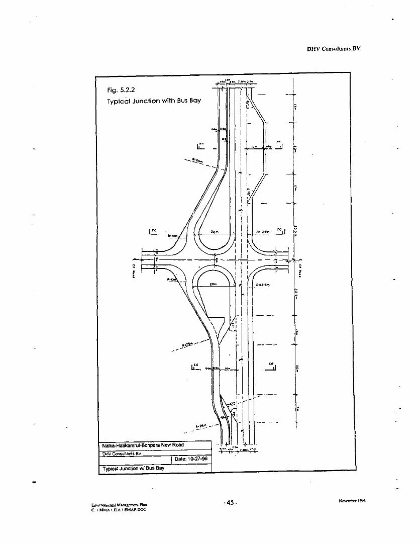
DHV Consultants BV
Fig. 5.2.2 .-
Typical Junction with Bus BayL~~~~~~~~
2o..
0~~~~~~~~~~2-
P~~ s'
Ffy Junction wt Bus B0y 1I -
E'irncnLi - m -ue- - -P1': -45 Novemblr 19-9 -6
_ _ _ __MA EIA\ E7PDO 1 .
Nalk.HaikaRul-BflPa Ne Roa + - |--
Dat: 10-27-'96tz
NyialkauHatikmu-onpr Wi' Buad Bayus
EswnvirwuaI Manzgemcm Plan -45 Nombe -99C ~M MMA EIA '. E MAP.D)C

DHV Consultants BV
Adequate measures will be taken to avoid mixing of slow aLnd fast moving traffic at junctions andintersections. In case the contour of the road changes, for example from embankment to bridge, two-tone painted pillars will be placed to indicate the changes. 'These pillars also serve as guard posts.Sign boards are to be erected to indicate dangerous spots or possible occurrences which mightendanger traffic (junctions, schools, etc.).
Wide roads tempt users to higher speeds than narrow roads. As the pavement width of the NHBNRwill be 7.3 m, high speeds up to 80 to 100 km/hr can be expected. Also, as in the design the slowtraffic has his own lane, the speed of vehicles will be higher than on roads which also accommodateslow traffic. Speeds over 50 km/hr are too high for built-up areas and are to be reduced. Onlyplacing a signboard to indicate a maximum speed will not be adequate. A driver feels that a speedreduction from 90 to 70 km/hr is significant, but this speed is still to high in built-up areas.Therefore, artificially speed reduction elements are included in the design. Speed bumps are anoption, but in the Consultant's opinion only as final option. lTo reduce speed in housing areas, curvesare designed in such a way that speed will be reduced to a more acceptable level.
5.2.3 Curves, Junctions, Busstops
For safe traffic sufficient visibility is required. Therefore no, trees will be planted close to junctionsand in the inner sides of curves. In curves super elevation will be constructed to maintain therequired safety. At the two major junctions (Hatikamrul and Bonpara) roundabouts are projected asadditional safety measure. All other junctions with existing rural roads will be made withperpendicular crossings according to the typical design for junctions (see Fig. 5.2.2). Busstops willbe made to separate parked busses from the moving traffic. AUl major villages or connecting roads tomajor villages will be provided with busstops. The actual busstop will be separated from the mainroad by large kerbs.
5.3 Sensitive Areas that should be Protected fromn Borrow Activities
Generally, all wetlands in Bangladesh have been recognised as extremely endangered by variousadverse impacts, partly due to natural catastrophes (e.g. storms, flooding, high sedimentation,drought), but mainly due to man-made interventions (e.g. land reclamation for agriculture,settlement, and overexploitation of certain species). As the NHBNR will also bisect the lowlanddepression between Padma and Jamuna rivers it will, to some degree, inevitably take its part in beingresponsible for the overall decline and/or deterioration of Bangladesh wetlands.
5.3.1 Environmental Criteria
Next to the selection of an enviromnentally acceptable corridor for the route alignment theConsultant paid special attention to selecting suitable sites for both sand and clay borrowpits. Bothstructures will be substantial in size as the new road construction requires some 4 mio m3 of sand filland another 1 mio m3 for clay cladding.
Basically the selection process for borrowpits was undertak:en with a similar approach as specifiedearlier for selection of road aligmnent (see previous sections and Fig. 5.1.3.1). The assessment wasbased, above all, on a comprehensive soils and land survey to identify all potential localities where inrelative close distance to the future construction sites the required material would be found insufficient quantity and quality. The rationale for selecting borrowpit sites was primarily that theproject should contribute in the national efforts to avoid destruction and maintain the intactness ofsensitive habitats. The identification of the parameters which would attribute to ecologically andsocio-culturally sensitive are derived from the comprehensive baseline survey carried out under thisassigmnent (see Report).
Environmenal Managewme Plan -46 - November 1996C: \ MMA \ ElA N EMAP.DOC
DHV Consultants BV
Taking these objectives into consideration, guidelines to select sites versus protecting specific sitesfrom borrow activities were as follows:
> avoid habitats known to be homestead for rare and/or endangered species
> avoid habitats with refuge forests and homestead gardens
> avoid habitats with large and/or rare trees (]Banjan trees, Flame of India, Mango)
> avoid habitats/landscapes which have scenic value
> avoid areas which would be functional transient areas between ecologicallysensitive smaller habitats (e.g. beels, mixed vegetation stands near graveyardsand embanlanents, fish fry wintering sites, waterbird colony breeding sites,important stopover sites on migratory bird's flyways)
> avoid areas which locate cultural assets (e.g. mosques, prayer fields, temples)
> avoid graveyard sites
> avoid sites which are in close vicinity to densely populated settlements (mainlyapplicable for sand borrowpits)
> if possible, positioning of the borrowpit site at leeward side of main winddirection in relation to adjacent village
v avoid areas of newly planted Sissoo tree plantations
> avoid areas where water run-off scours are present (e.g. gullies, regressiveerosion marks at highlands, eroded river banks)
0 avoid or minimise the relocation of small-scale enterprises and ruralinfrastructures, including rural roads
> Siting of supplementary structures in r elation to construction work site(accessory roads, campsites, equipment storage, workshops).
> avoid sites of close vicinity to sluice gates on polder embankments
> avoid sites of close vicinity to schools and health posts
5.3.2 Selection of Borrowpit Sites
The following maps (figs. 5.3.1 to 5.3.3) illustrate the result of the fact finding and selecting process,i.e. the location which would combine to the maximum extent the above technical and environmentalcriteria. The maps only show the sites identified for sand excavation. Each of these borrowpits willbe about 3 to 4 ha in area, excavated to depth between 3 and 7 m.
As for the sites for clay borrowpits".survey maps have been made which also refer to the suitabilityof these sites for becoming transformed after completion into fish farms (see Chapter 7.4). It isassumed that in the entire NHBNR project this option is given preference over the conventionalmethod of having narrow borrowpits all or most along the roadside. Not only would this result insubstantial more land acquisition (estimated 550 ha, see Embankment Report) but also haveinevitably more environmental impacts.
' about 40 in number, each of rectangular size and 11 to 1.5 hectare in area, to be excavated to therequired depth of 1.5 to 2.5 m.
EnviroenIal Mmnagemem Pban -47 - Novembcr 1996C: \ MMA \ EIA \ EMAP.DOC

IAjvI
A Pi 1.166:11MW p4cwts/M.
411coblij.pacd huko
imid'[1K414
V*M.
.10
UK Irrdo
TO
L
curli-pulpq�1Y1_11 bli.�pcghl r Aignarid
tuAi I Sadonandepur8 bi; Kal.7ho Kqshnadi
iL CHALAN. ginsera -1, f Ah.,-mi
fm .4 T r MaLhualt S n le-lkg
PO
pamidsio
1. Dur0purs ul
n .1tuff.81"all Mature 8's
ri ti MM
CoV.4
c
Ia
all ul I I"
I . rail rent songbtoFe -Fr.tih rfilm di anRdom
riram;� ' .d aftf
PrIk., I
U,
'Ich-'a k to
Uliding ti PFSOM Ah, 111pulbo n
IN ri.
patull,bi MOlliKpag #7
chok Ho'lp.
Chatt!" ko-;r%j6*
fWfvreb AS Onza
pQf5)ioGoal, t Khbg,,
U'd, Voh N4,10
h.jap NALKA -HATIKAMRUL -B
0 NEw ROAD%-o .................. ......................
I i I- . Noo, . tI ; cha.bal ph
Al PROPOSED ROAD ALIGNMENT
0131 td 0 PROPOSED SITI: FOP. SAND BORROWPIT
DHV Consultants BV
5.4 Control of Air Pollution
With respect to noise and air pollution the final alignment has been selected in a manner to avoidhuman habitat vicinity as far as possible for affecting less by air and noise pollution both during andafter the construction. While during the Feasibilitv Study the selected route still passed at closevicinity or even bisecting villages, the new final alignment tried to minimise this long-term effect.Nonetheless, short term impacts during construction phase, particularly in the close vicinitv ofborrowpits and construction campsites wvill be unavoidable.
During construction phase, special preventive measures will be included
* to contain the air pollution through dust emission created by asphalt plants. This can be achievedby collecting dust by using cloth filters, cyclones etc.
* to control soil dust (particularly during the dry season) by spraying water wherever applicableand necessary
* to airclean equipment in the night and use covering whenever applicable.
Motor vehicle emissions from heavy traffic will be the rnajor source of air pollution after completionof the road. By designing the road with a fast and a slow traffic lane separated, a more constanttraffic flow is maintained which will considerable reduce the relative air pollution. Speed limits arealso incorporated in the design to avoid, among others, excessive emissions of NO. gases.
Unless the use of lead free fuels and a higher standard of exhaust emissions are introduced by theGoB air pollution impacts will inevitably remain high due to reduced traffic speed and possibletraffic congestion at busstop locations and junctions. Mitigation of these impacts, however, arebeyond the control and scope of this project.
5.5 Control of Noise Pollution
Since the sound level around the construction site is expected to exceed the limit of noise standardlevels, measures have to be taken during the construction phase. However, the effect of thesemeasures on the project costs and the planning schedule will be an important consideration as towhether or not apply these noise reduction measures. For example, sound from a power generationplant can be reduced to an acceptable Level without excessive cost by installing the generators insidea sound proof building. Many noisy transport equipment can be furnished with adequate silencerboxes. Construction materials should be handled during daytime and not in the night. On the otherhand, although dredging piling works or crushing operatlons may be confined to daytime, it will bevirtually impossible to meet the required schedule. Moreover, the unit price of per cubic meterdredged sand will increase considerably if continuous dredLging is restricted.
Special consideration will be given to protect workers from harmful and long exposure to noiseoriginating from construction machinery. The wearing of ear muffs for compressor and crushingoperators is obligatory.
The road design includes large-scale plantation of the embankment with trees and bushed. Suchnatural barriers will reduce to a certain extent the lateraal transmission of noise which affects thenearby settlements. Signboards will be established to prohibit the use of horns and to limit speed. Itis beyond the control of this project, however, to predict the effectiveness of these measures.
Ejwiwu,eml Mangemm Ptbn -48. November 1996C: \ MMA \ EIA \ EMAP.DOC

DHV Consultants BV
5.6. Environmental Measures Relating to Construction
5.6.1 Safe Deposit of Construction Material and 'Wastes
During construction phase of the road, soils of different: consistence, asphalt, fuels, hazardouschemicals and general waste matters have to be handled and deposited safely. Site selection forestablishing the campsites and adjacent stackyards will basically followv the environrmental criteriathat have been set up for selecting sites for borrowpits. Organised storage and handling and strictmonitoring can reduce the chance of accidental spillage of the above mentioned contaminants.
If necessary, waste deposit sites have specially construction elements (e.g. sealed and coveredcontainers) to avoid seepage of hazardous liquids into surrounding surface and groundwater.Garbage, rubbish, construction wastes, etc. (solid wastes) may pose additional health threat andnuisance. Propagation of rats and breeding of flies may occur if the waste disposal site is not coveredproperly. Waste dumps have to be fenced and guarded against public interference, particularly fromchildren roaming through hazardous material. Guarded stackyards will be required where handlingand depositing of these materials will be mainly confined. The construction management will need totake necessary precautions and ensure the effectiveness of an environmentally appropriate wastecollecting and deposing system.
5.6.2 Rehabilitating Campsites after Completion
The contractors will require several sites to accommodaLte their equipment, offices and camps.Additional sites will be established to accommodate the Engineers. These sites will be of temporaryuse during construction period. The remaining of the campsites after construction are to be removedand the site is to be left behind in it's original condition as before the construction works, or in sucha state that all negative effects of it's use are rehabikitated. The condition of the campsite afterconstruction is one of the factors for reimbursement of retention money.
As discussed in Chapter 4, the sites for equipment like asphalt plants, concrete mixers, workshopsbear various risks for environmental hazards, such as pollution of the soil, ground water and air.Although it will practically be impossible to avoid completely pollution events during theconstruction activities, the project has to make all efforts to minimise them. The main measure takeninto account is to prescribe in the Contract Documents technically and environmentally soundprocedures which follow the regulations and standards.
Special care will be taken to minimise the uncontrolled disposal of both solid and liquid wastematerial. Disposal procedures will be elaborated in the Contract Documents according to the natureand toxicity of waste materials.
5.6.3 Rehabilitation of Borrowpits
Sand Borrowpits
The project will create (five to seven) large waterbodies as result of the excavation of sandborrowpits. These borrowpits will become permanent lakes (dighis) due to their depth anddimension. The shape and depth of these structures will be defined by plot borders, sand layer depth,etc. The lakes are to be rehabilitated after construction while taking both environmental, landscapingirrigation and fisheries aspects into account (see Chapter 7).
Envarw,menal Manemm Plan -49 Noember 1996C: \ MMA \ EIA \ EMAP.DOC

DHV Consultants BV
Depending on the grading and composition of the sand, the natural slope will be reasonable flat. Forexample, fine sand with a 20 % mica content will give a natural slope of 1:7. In cases where theslope will be to steep, additional levelling of the slope is foreseen. The rationale of having rather flatslopes is to establish various belts of (depth-depending) wetland vegetation at the periphery of theseartificial lakes to facilitate fish spawning and shelter. After establishment of a biological equilibrium (3-4 years) and proper fish stocking and management, it is expected that these newly created lakes willenhance the local fish production. In addition, they will add toD the landscape aesthetics.
Clay Borrowpits
Few dozens of clay borrow pits will be created due to excavation for the cladding of the slopes. Forthis cladding also the topsoil from the clearing and grubbing will be used. Suitable for cladding willalso be a part of the overburden from the sand borrowpits. However, this material will not besufficient and/or too expensive to transport to the required location. Therefore, additional borrowmaterial is to be acquired.
The project envisages an innovative approach in linking the rehabilitation of these borrowpits withthe crucial need to find adequate land and income generating facilities for the PAP's. TheEnvironmental Management Plan foresees the modification of these clay borrowpits into fishpondswith adjacent resettlement plots. Further details referring to design and management considerationsare given in Chapter 7 and Annex C.
5.7 Mitigation of Social Tensions
Much of the social work dealing with human interference and potential social conflicts between localcommunities, foreign labour and undesired external influrnces associated with modemr constructionsites is to be addressed by the NGO working in the area to implement the RAP (see also Chapter 9).
The key to reduce social tensions and disturbances lies in communication between the project and theaffected communities. Regular village meetings between representatives of the communities, PAPsand the construction personnel, as well as public awareness campaigns in the area should mitigatepossible social disruption which is anticipated from the large labour force employed in the project.These labour group will come mostly from outside the project area with better econoniic conditionand may disrupt the local economy and social order. Social tension may be reduced through betterplanning and setting up markets, mosques, etc. around the campsites.
It remains to further decision whether a part of the campsites will be used by the maintenancepersonnel and rest of the facilities will be dismantled. The respective conditions will be settled in theContractor Documents.
Envirrmnaal Managent Plan -50 - Novefiber 1996C: \ MMA \ EIA \ EMAP.DOC
DHV Consultants BV
6. Management of Water Resources, Flooding and Navigation
6.1 Provision of Stable and Safe Drinking Water Supiply
Local drinking water resources, mainly drawn from groundwater by tube-wells, need to besafeguarded. The project aims to minimise to the extent possible impacts (loss, removal,disturbances, disruptures) of all kind of rural infrastructures that are important for safe drinkingwater supply. To avoid excessive groundwater drawdown thie tube-well capacities in each location(chainage) will separately calculated and adjusted to the actual requirements, also taking temporaryadditional water supply for construction campsites into account. For drinking water supply, nosurface water from ponds, ditches and borrowpits are to be used.
Care is to be taken, via the Contractor's obligations specified in the contracts, to remove andnewly establish adequate deep-well pumps. The Contractor will be requested to submit an advanceplanning as to location and number of deep-well pumps he will install prior to setting upcampsites and starting construction. This plan is to be scrutinised by the supervising agency towarrant within a corridor of at least 100 m from the ROW safe and sufficient drinking watersupply for the both the villages adjacent to the road and the anticipated number of external labourforces. The presence of coliforn bacteria in tube-well water identified in quality tests conductedin 1993 by CIEC is attributed to contamination at the well head. It therefore requires specialattention to construct, protect and maintain the well-head a[rea. Shallow tube wells are sunk intothe sand aquifer at 30 m or more depth, so direct surface infiltration of contaminated watershould not be a cause of the problem.
The Contractors is to take suitable measures to avoid excessive drawdown of groundwater in areaswhere deep drainage is required (e.g. while constructing bridges and culverts).
6.2 Control of Erosion, Siltation and Scour
Rivers of the deltaic region flowing through alluvial soil generally cause erosion of river beds andscour of bed. If the river banks are formned of clay, little scour is anticipated. The soil in the projectarea is mainly composed of clayey material. The river becls show deposits of medium fine sandand silts. From the river bed deposits characteristics, the Atrai River may be classed as a quasi-alluvial river. The Nimaicharai Khal shows deposits of course sand and the Kaladuha Rivershowed deposits of fine sand and silts. This makes both also quasi-alluvial rivers. The alluviumdeposits in the river beds is carried away by the floods during monsoon and deposited again andthe end of the monsoon season. The Mora Boral River is cut-off from its original source and actsnow only as a local drainage system. This made the river bed silted up and made the Mora Boralloose its conveyance capacity.
Loose soil particles are carried away by the surface run-off waters to nearby rivers or canals. Run-off waters often cause erosion in roads, embankments and slopes. This type of erosion is also to beexpected in the Project Area. Erosion and scours in watenvays are generally expected during thefalling and the rising of the water levels. With the on-rush of flood flows, the river bed is scouredand the material is carried downstream till the water velocity is reduced to such a speed that thewater cannot carry the soil particles anymore. During these floods the thalweg of the rivers mayundergo changes. If a high current happens to impinge on a river banks, bank erosion may occur.This phenomenon makes river meander. The Atrai River is a meandering river and causes bankerosion of comparative lesser magnitude.
Envirouiml Maaenumn Plan -51 - Novenbef 1991
C: \ MMA \ EIA k EMAP.DOC
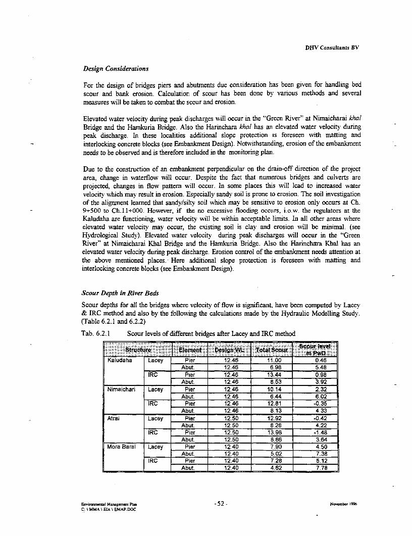
DHV Consultants BV
Design Considerations
For the design of bridges piers and abutments due consideration has been given for handling bedscour and bank erosion. Calculation of scour has been done by various methods and severalmeasures will be taken to combat the scour and erosion.
Elevated water velocity during peak discharges will occur in the "Green River" at Nimaicharai khalBridge and the Hamkuria Bridge. Also the Harinchara khal has an elevated water velocity duringpeak discharge. In these localities additional slope protection is foreseen with matting andinterlocking concrete blocks (see Embankment Design). Notwithstanding, erosion of the embankmentneeds to be observed and is therefore included in the monitoring plan.
Due to the construction of an embankment perpendicular on the drain-off direction of the projectarea, change in waterflow will occur. Despite the fact that numerous bridges and culverts areprojected, changes in flow pattern will occur. In some places this will lead to increased watervelocity which may result in erosion. Especially sandy soil is prone to erosion. The soil investigationof the alignment learned that sandy/silty soil which may be sensitive to erosion only occurs at Ch.9+500 to Ch.l 1+000. However, if the no excessive flooding occurs, i.o,w. the regulators at theKaludaha are functioning, water velocity will be within acceptable limits. In all other areas whereelevated water velocity may occur, the existing soil is clay and erosion will be minimal. (seeHydrological Study). Elevated water velocity during peak discharges will occur in the "GreenRiver" at Nimaicharai Khal Bridge and the Hamkuria Bridge. Also the Harinchara Khal has anelevated water velocity during peak discharge. Erosion control of the embankment needs attention atthe above mentioned places. Here additional slope protection is foreseen with matting andinterlocking concrete blocks (see Embankment Design).
Scour Depth in River Beds
Scour depths for all the bridges where velocity of flow is significant, have been computed by Lacey& IRC method and also by the following the calculations; made by the Hydraulic Modelling Study.(Table 6.2.1 and 6.2.2)
Tab. 6.2.1 Scour levels of different bridges after Lacey and IRC method
.......... . l ee.Ta. .e..t e W Tb
Kaludaha Lacey Pier 12.46 11.00 0.46Abut. 12.46 6.98 5.48
IRC Pier 12.46 13.44 0.98l__________ Abut. 12.46 8.53 3.92Nimaichari Lacey Pier 12.46 10.14 2.32
Abut. 12.46 6.44 6.02IRC Pier 12.46 12.81 -0.35
Abut. 12.46 8.13 4.33
Atrai Lacey Pier 12.50 12.92 -0.42Abut. 12.50 8.28 4.22
IRC Pier 12.50 13.98 -1.48Abut. 12.50 8.86 3.64
Mora Barai Lacey Pier 12.40 7.90 4.50Abut. 12.40 5.02 7.38
IRC Pier 12.4 7.28 5.12___________ Abut. 1240 4.62 7.78
Emiroml Mamgemer Pla -52. Now-mber 1996C: MMA X EIA \ EMAP.DOC
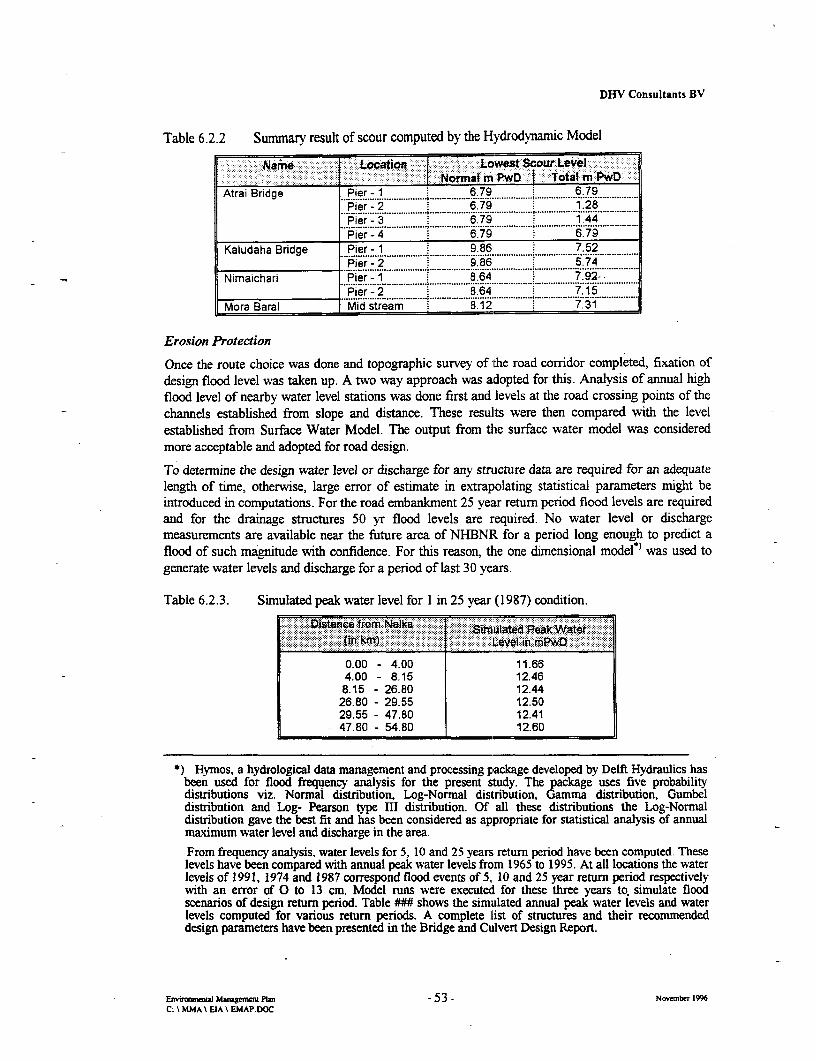
DHV Consultants BV
Table 6.2.2 Summary result of scour computed by the Hydrodynamic Model
-Name LoatiL Lowest Scour Level-: -Normal mPwD j Total m:Pw)
Atrai Bridge Pier - 1 6.79 6.79| Atrai srid9e Pier ? 2 6. ,7,,9,,,,,,,,,,,,,,,,,,,,1,,,,,,,,,,,,,,,,6. . 1....................................8...............................,,lPier- 3 6.79 1.44Pier - . 6.79 6.73 .
Kaludaha Bridge Pier - 1 9.86 7.52........ ..;i ............................................ ..............................................................
l _______________ Pier-2 9 86 5.74Nimaichari Pier -1 8.64 7.92-
Pier -2 8.64 7.15... .......................... ............ . . ........ ........ ...........Mora Baral Mid stream 8.12 7.31
Erosion Protection
Once the route choice was done and topographic survey of the road corridor completed, fixation ofdesign flood level was taken up. A two way approach was adopted for this. Analysis of annual highflood level of nearby water level stations was done first and levels at the road crossing points of thechannels established from slope and distance. These resullts were then compared with the levelestablished from Surface Water Model. The output from the surface water model was consideredmore acceptable and adopted for road design.
To determine the design water level or discharge for any stnrcture data are required for an adequatelength of time, otherwise, large error of estimate in extrapolating statistical parameters might beintroduced in computations. For the road embankment 25 year return period flood levels are requiredand for the drainage structures 50 yr flood levels are required. No water level or dischargemeasurements are available near the future area of NHBNR for a period long enough to predict aflood of such magnitude with confidence. For this reason, the one dimensional model*) was used togenerate water levels and discharge for a period of last 30 years.
Table 6.2.3. Simulated peak water level for 1 in 25 year (1987) condition.
' istance itfrom Nka . iue (in kin) L~evel in. mP
0.00 - 4.00 11.654.00 - 8.15 12.468.15 - 26.80 12.4426.80 - 29.55 12.5029.55 - 47.80 12.4147.80 - 54.80 12.60
*) Hymos, a hydrological data management and processing package developed by Delft Hydraulics hasbeen used for flood frequency analysis for the present study. The package uses five probabilitydistributions viz. Normal distribution, Log-Normal distribution, Gamma distribution, Gumbeldistribution and Log- Pearson type III distribution. Of all these distributions the Log-Normaldistribution gave the best fit and has been considered as appropriate for statistical analysis of annualmaximum water level and discharge in the area.From frequency analysis, water levels for 5. 10 and 25 years return period have been computed Theselevels have been compared with annual peak water levels frcm 1965 to 1995. At all locations the waterlevels of 1991, 1974 and 1987 correspond flood events of 5, 10 and 25 year return period respectivelywith an error of 0 to 13 cm. Model runs were executed for these three years to. simulate floodscenarios of design return period. Table ### shows the simulated annual peak water levels and waterlevels computed for various return periods. A complete list of structures and their recommendeddesign parameters have been presented in the Bridge and Culvert Design Report.
Enviromma Majgee Plan -53 - November 1996C: \ MMA \ EIA \ EMAP.DOC

DHV Consultants BV
Design Criteria taken into Account as Result of the Hydraulic Modelling Study
The Hydraulic Modelling Study undertook detailed investigations of the with and without projectscenario under various hydrologic and hydraulic conditions in the study area. A one dimensional andtwo dimensional model has been employed. The study was supported by using GeographicalInformation System (GIS) to determine the impact of the proposed project in terms of depth andextent of inundation. While analysing the potential impact of the intervention by the road project inan area of highly complex flood and flow conditions, the Study came to design recommendations forculverts, bridges and the road embankments which have been fully incorporated in the technicaldesign of NHBNR, referring to
> number, location and opening of various structures;> design discharge, velocity, scour depth and water levels for the culverts and bridges;> design peak water levels and wave run-up for the road embankment.
The Study pointed out that structures along the proposed road between Hatikamrul and the proposedKaludaha bridge will be threatened if the Kaludaha offtake fails (opening due to natural or humaninterference) The situation will be more critical if aL Jamuna River breakthrough occurs atMathurapara to Bangali river. Technical solutions to protect the structures are ruled out under thebudget and scope of this project. A causeway of 500 m reduces the impact on the bridge (velocityreduced from 2.1 to 1.2 mls) but will force around 500 cumecs to flow overland and thus will causeextensive damages to crops and infrastructures. The solution to the problem is to close the Kaludahaofftake by permanent structural measures.
The velocity at the Nimaichari bridge was found high (2.7 m/s) in simulation # 1 which might becritical in terms of scouring and erosion at this location. H-ere, the floodplain depression drains largeflow volumes in the monsoon. Therefore, an additional bridge is proposed over the Hamkuriadepression between Nimaichari and Atrai rivers to alleviate this imminent problem and to reduce theflow volume through the Nimacharai khal. The Haikuria Bridge, together with bridges onChakroyhali khal and the Khalkola depression, will assist to reduce the anticipated impact of floodwaters on the Nimaichari Bridge, reducing the flow velocily there to an acceptable 1.27 mI/s.
6.3 Design Provisions to Mitigate Flooding Events and Drainage Congestion
With reference to MPO/WARPO land classification the road alignment falls within the followingland categories:
I~~~~~~~~~~~~~~~~~~~~~~~~~~~~~~~~~~..... .....W.,;..........
00 - 22 F3 Flood depth 1.80m s 3.60m22 - 29 F4 Flood depti above 3.60m29 - 37 F3 Flood depthi above 3.60m37 - 44 F2 Flood depth 0.90m s 1.80m44 - 49 Fl Flood depth 0.30m s 0.90m49 - 53 FO Flood depth 0.0 m S 0.30m
Envenmunenual Manageren Plan -54 - November 1996C. \ MMA \ EIA \ EMAP.DOC

DHV Consultants BV
The road embankment height was fixed according to these flood elevation data. Seven kilometre ofthe road falls in the very deeply flooded area where road embankment height has to becorrespondingly higher. It appears that 30 km of road falls in the F3 land category by flood phase of20 years recurrence interval. It means that the said category to land goes under water ranging 1.80 mto 3.60 m during the flood of the magnitude of 20 year return period.
Technical safety and mitigation measures to prevent floodi.ng impacts:
The first four kilometres of the road lie within the influence of the Jarnuna River spills. Due tobreaches in the right Embankment flood flows hit this portion of the road, as a result the culverts aredamaged. The west bank of the Brahmaputra is continually rnoving towards the west. It is now onlya few hundred meter away from the Bangali River flowing parallel to it. In the event the Jamunacontacts the Bangali, its flow w"ill increase tremendously and a substantial amount of flow will gointo the Kaludaha River and its basin. To mnitigate to the extent possible the expected floodingimpact - and to give a reasonable protection to the newly created highway - to include thereconstruction of the dilapidated regulator at Bhuyagati to maintain a regular and controllable flowat its offitake at Kaludaha River is a must.
Siltation will occur in some places but it will be to a limited extend as envisaged in the HydrologicalModeling Survey.
Bridges
After thorough investigation and surveys of the road alignment, bridges required to be built along theroad are shown in Table 4.3.2. It may be mentioned that though initially it was envisaged that fourbridges will be built on four waterways, notably: Kaludaha, Nimaichari, Atrai and Mora Boral, butsubsequent field verification and hydraulic survey confirmed that bridges are to be constructed atadditional points, details of which are shown in Table 6.3.1.
Water way openings or length of bridges have been computed from various considerations viz. fromLacey's regime equation based on design discharge and also by application of a Hydraulic Model.The results obtained by the methods were close enough. Tle application of model established thatthere will be substantial flow through the Hamlkuria depression with quite high velocity. As such a150m bridge is recommended for that location.
The breakthrough condition (Jamuna breaks through into Karatoa [Bengali] River) will create ahavoc situation in the Kaludaha and its basin. As such regullator on the offtake point of Kaludaha isa must. Bridge openings on Nimaicharai, Hamkuria and Atrai were defined at 150 m each. MoraBaral does not receive any upland flow. As such, its present flow is very low. Bridge opening hasbeen recommended as 30 meter. A complete list of bridge and culverts locations and designparameter is provided in Table 6.3.1.
ESwmenml Magegum Plan 55 - November 1996C: \ MMA \ EIA \ EMAP.DOC
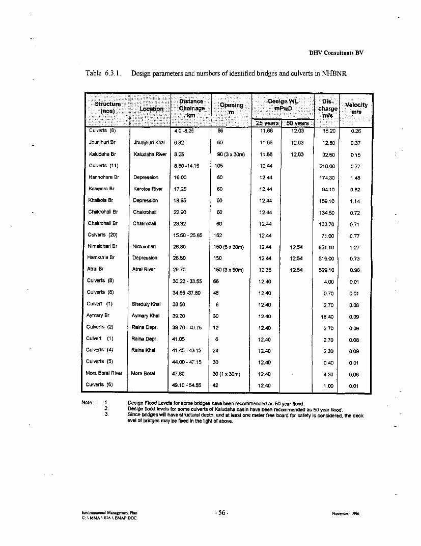
DHV Consultants BV
Table 6.3.1. Design parameters and numbers of identified bridges and culverts in NHBNR
ucStrure esn e WL D-0I Velocity: (nos);: Locatio. Chamnage snPwD charge00 0 0 -; miPScm in it:~~~~~n ch rg
____________ ___________ __________ ~25 years: 50 Years _ _ _
Culverts (8) 4.0 -8.25 66 11.66 12.03 15.20 0.26
Jhurijhuri Br Jhurijhuri KOal 6.32 60 11.66 12.03 12.80 0.37
Kaludaha Br Kaludaha River 8.25 90 (3 x 30m) 11.66 12.03 32.50 0.15
Culverts (11) 8.60-14.15 105 12.44 210.00 0.77
Hannchara Br Depression 16.00 60 12.44 174.30 1.48
Kalupara Br Karotoa River 17.25 60 12.44 94.10 0.82
Khalkola Br Depression 18.65 60 12.44 159.10 1.14
Chakrohali Br Chakrohaii 22.90 60 12.44 134.50 0.72
Chakrohali Br Chakrohali 23.32 60 12.44 133.70 0.71
Culverts (20) 15.50 - 25.85 162 12.44 71.00 0.77
Nimaichan Br Nimaichari 26.80 150 (5 x 30m) 12.44 12.54 851.10 1.27
Hamkuria Br Depression 28.50 150 12.44 12.54 516.00 0.73
Atrai Br Atrai River 29.70 150 (3 x 50m) 12.35 12.54 529.10 0.98
Culverts (8) 30.22- 33.55 66 12.40 4.00 0.01
Culverts (8) 34.65 -37.80 48 12.40 0.70 0.01
Culvert (1) Sheduly Khal 38.50 6 12.40 2.70 0.08
Aymary Br Ayrnary Khal 39.20 30 12.40 15.40 0.09
Culverts (2) Raina Depr. 39.70 - 40.75 12 12.40 2.70 0.09
Culvert (1) Raina Depr. 41.05 6 12.40 2.70 0.08
Culverts (4) Raina Khal 41.45 - 43.15 24 12.40 2.30 0.09
Culverts (5) 44.00- 47.15 30 12.40 0.40 0.01
Mora Boral River Mora Boral 47.80 30 (1 x 30m) 12.40 4.30 0.06
Culverts (6) 49.10 - 54.55 42 12.40 1.00 0.01
Note: 1. Design Flood Levels for some bridges have been recommended as 50 year flood.2. Design flood levels for some cuSverts of Kaludaha basin have been recommended as 50 year flood.3. Since bridges vill have structural depth, and at least one meter free board for safety is considered, the deck
level of bridges may be fixed in the light of above.
Emtrona] Manageenim Plan 56 - November 1996C: \ MMA \ EIA \ EMAP.RDOC
DHV Consultants BV
Culverts
In addition to the bridges recommended for the road, culverts of adequate numbers are required to beprovided for proper drainage. The issues at stake were studied form different angles. The resultsobtained from the Surface Water Modelling Study is considered more realistic and acceptable.
The Surface Water Modelling Study showed the amount of discharge and velocity of flow accordingto a selected design condition. Based on the above result length of openings was determinedconsidering the velocity and area influenced. The locations of culverts were finalised on thelongitudinal section of the road alignment after i) thorough scrutiny of the topographic surveysheets, ii) survey findings on ground elevations, and iii) final site inspection by a survey team.
6.4 Embankment Protection
The proposed embankmnent is situated in an area subject to inundation. This fact requiresembankment protection.
Three locations were identified by the SWMC where elevated water velocity will occur during peakdischarges. In areas with deep water inundation like the "Green River" wave run-up will occur. Thedesign height of the embankment has been adapted at the pLaces where wave run-up is expected andan additional 1.60 m is added to the embankment height. The increased embankment height isforeseen between Ch. 24+100 and Ch.30+000. The Consultant has designed a interlocking concreteblock slope protection not only to protect the slope from erosion but also to reduce the wave run-up.In addition to the increased embankmnent level, this concrete block slope protection with wave run-upreducing surface will be added to critical places.
Trhe places with elevated water velocity are:Harinchara Khal 1.48 n/secNimaicharai Khal 1.27 n/secKhalkola Bridge 1.14 rnsec
Three possible options, elaborated in detail in the Embankment Design Report, are envisaged toprotect the embankment from erosion:
* Concrete block slope protection* Matting
* Plantation of grasses, shrubs and trees (see also Chapter 8)
Concrete Block Slope Protection
For Harinchara Khal Bridge additional slope protection by concrete blocks is required over anestimated distance of 50 m on each site of the abutment. between 50 and lOOm from the abutmentadditional geo-matting with grassing is requiredFor the Nimaicharai Khal Bridge concrete block slope protection over 25 m from the abutment isestimated to be required.
Envir la Managenmm Plan 57 - November 1996C: \ MMA \ EIA \ EMAP.DOC

DHTV Consultants BV
Geo Matting Slope Protection
Geo matting will be placed in some locations which are strongly exposed to heav flood, wind andwave actions.,This type of slope protection comes in-between embankment plantation and concreteblocks The proposed geomatting is a polypropylene filament wire mat for soil erosion protectionfrom rainfall and flooding. This matting is laid on the slope an planted or sewed-in with grass toobtain a uniform mat. (see embankment design)
6.5 Provisions to Maintain Unobstructed Navigation Routes
The Atrai is the main river in the project area. It was a good navigable intemal river some 40-50years back. During monsoon it remains navigable and considerable boat traffic use this route.
As such navigational clearance as per IWTA'S route standard has been recommended for the bridge.The standard clearance for this route is 100 ft. horizontal and 25 ft. vertical clearance. Consideringstandard high water level at the site as 12.11 and structural depth 1 .75m and Navigational clearance25 ft. (7.60m), the bridge deck level comes to 21.49m PwD.
The placement of buoys and navigational instructions to cargo vessels will ensure least possibleinterference.
E.nvarunenal Manageum Plrn -58- November 1996C: \ MMA I EIA \ EMAPDOC
DHV Consultants BV
7. Fisheries Mitigation Plan
The NIBNR Project is not expected to cause significant changes and/or losses in the regional fisheriessector, although some impacts will occur which relate to the following facts:
* About 50 households with fishing as main or additional source of income are among the PAP, (beingestimated with an estimated average 53.6 kg of fish/household/year)
* 44 ditches and fishponds of different size along the road alignment are to be removed within 25 m ofboth sides of the CL. Many of the fishponds, however, have low production due to low level ofmanagement. Many of the ponds remain submerged during monsoon.
* Local reduction of drainage will have effects on fish migration
* Local siltation will have adverse effects of fish populations
The mitigation plan addresses these environmental problems to the extent possible and justifiablewith the scope of this project. A clear distinction was dravvn between mitigation and compensationstrategies*). Mitigation measures are designed to reduce or avoid losses to capture fisheries. In contrast,compensation measures rely on aquaculture and culture-based techniques to increase fish production andthereby compensate, to varying degrees, for the lost tonnage of fish due to flood control and/or removal offishponds.
7.1 Mitigation of Impacts Affecting Fish Migration and Ecology
No important dry season fish habitats such as perennial beels are affected by the road alignrent. Thusthere will be no negative impact of this project on fish production caused by loss of winter and pre-monsoon habitats. On the other hand, new perennially watered structures (borrowpits) will result from thisproject which will have positive impact on the regional fisheries sector (see below).
The project also considers the rehabilitation of channels nearby the alignment which currently have beenseverely reduced by flood control activities and siltation. It is anticipated that canal re-excavation work willbe applicable in higher land areas where connections to some rivers (Atrai, Mara Boral; Karatoa) can bemade via rehabilitating old canal systems. Such measures will positively influence both acive and passivemigration of fish whose life cycle depends on seasonal movements between different riverine andfloodplain habitats.
Unplanned rural road development in the Project Area have resulted in several locations in blockage tofloodwaters and fish on floodplains. To reduce the adverse impacts the project made provision to constructadditional culverts or rehabilitating them in the near vicinity of the ROW, particularly wherever they crossexisting canals nearby.
' The organisation and monitoring of the single components are discussed in Chapters 9
Eavironeral Mamgemet Pbn -59 - November 1996C: \ MMA \ EIA \ EMAP.DOC
DLiV Consultants BV
The construction of the main road embankment intends to avoid to the maximum possible negative impactson the migratory pathways of commercially important fish. Therefore, an adequate number of bridges andculverts have been incorporated in the NHBNR alignment. Special care was taken in site selection andtechnical design of these structures along the most critical stretches of flood events (see Technical Reportson Bridge and Culverts). Openings in the embankment have been calculated according to the floodsimulation models provided by the SWMC. The structures are designed to allow drainage to an extentclose to that without project. It is anticipated that this measure would maintain the actual species diversitvas the migratory adult and juvenile fish would be able to reach floodplains together with hatchlings broughtin by passive downstream drift.
The Consultant bad been asked to assess the necessity to include fish passes in the embankment designwhich may facilitate fish migration. Fish passes need apparendy not to be installed as theupward/downward nigration of adult and juvenile fish will be sufficiently secured by the incorporation of80 culverts and 12 bridges in the new construction design. It is noteworthy that culverts are sufficientlypresent particularly in those areas which are deeply flooded and, correspondingly, major habitats formigratory fish. As most of the rivers in the Project Area rum from North to South, while the alignment ofNHBNR is from East to West, it is expected that the lateral migration of both adult and juvenile fish fromrivers into khals and floodplain depressions and vice-versa would be lirnited.
7.2 Fish Stock Conservation Measures
Uncontrolled exploitation of fish poses a general threat to the fish communities in the region. In placeswhere fish become concentrated due to drainage congestion. or drawdown in depressions, fishing activitiesoften increase. The use of gear that eliminates all fish frorn a certain water body is not uncommon. Theproject will take measures to control these unsustainable practices wherever there is a linkage to itsstructures.
Fisheries Conservation and Catch Control Structures in Front of Culverts
Culverts tend to block or delay movements of fish thereby increasing their susceptibility to easy capture.Culverts should be classified as prohibited fishing zones. Fishing from the structure itself and from a setdistance upsteam or downstream from it should be made illegal. Distances will vary depending on the sizeand location of the structure and the size and nature of the regulated water course. Respective regulationsshould be enacted through the local fisheries authorities.
Fisheries Conservation in Dighis
Control of fishing activities and prevention of overexploitation is of paramount importance if the newlyestablished lakes shall become functional and viable for fish production. The management scheme shouldtherefore incorporate respective measures, e.g. declaring the lakes (or part of it) as temporary fishsanctuaries dunng certain periods. Enforcement can be aclieved by regular controls by members of theentitled user group and by installation of large katha which prevent most opportunistic fishing methodsand provide shelter for fish.
Environmewl Managemem Plan -60 - November 1946C: \ MMA \ EIA \ EMAP.DOC

DHV Consultants BV
Fisheries conservation: protection of river (duar)fisheries
Studies carried out by the Flood Action Plan throughout the region have demonstrated the greatimportance of river duar (scour holes) as winter refuges for large species of fish, particularly catfish andmajor carps. Duar are presently included in riverine jalmahal where they are intensively fished byleaseholders during the dry season. FAP has recommnended prohibition of fishing duar during the dryseason and the establishment of river patrols by DoF to enforce protective fisheries regulations. Thismeasure needs to be taken in due consideration in the area where NHBNR crosses the Atmu River as ameans of conserving important overwintering broodstock of high value species which form the basis ofboth riverine and floodplain fisheries.
Awareness Campaign
The project emphasises that the local NGO's implementing the RAP and training programs contactschools, educational personnel, construction management personnel, construction workers representativesetc. to launch environmental awareness programmes, with emptasis on fisheries and wildlife conservation.The campaigns should focus on basic understanding of the water requirements within each naturalresource sector, linking both fisheries and agriculture. The awareness programs also should addressadverse impacts of flood control and various methods of mitigation against such impacts.
7.3 Culture-Based Fisheries Schemes in Dighis
To encounter to some degree the anticipated losses in catch fisheries the mitigation measures focus onnewly created fishing grounds which will be established in the former large-sized sand borrowpits. Withappropriate arrangements and organisation of water-user groups (preference to PAP's) these schemes areconsidered to provide greater and more extensive potential increases in catch which can be shared moreequitably between the members of newly established groups.
Rehabilitation of Borrowpits to Suit Fisheries Purpose
To create an enviromnent in the new dighis that is conducive to fish production, the slopesdescending from the embankment will be rather flat. An inclination of min. 1:7 will be maintainedafter completion of excavation work. The rehabilitation will also require to refill the borrowpits withthe remaining overburden and former topsoil to facilitate vegetation growth. It is assumed that theoverburden contains sufficient clay material to reduce the permeability of the dighis. Fertilising theslopes will be required to initialise vegetation growth and stimulate phytoplankton development oncethe lake is waterfed.
Stocking and Fisheries Management of Flooded and Non-Flooded Dighis
Depending on the degree of seasonal flooding, the lakes will be stocked with varying densities offingerlings of fast growing carp species such as Major Indian Carps, Thai Shorputi and Tilapia.
For lakes that are not regularly flooded it is advisable to stock fingerlings of Major Indian Carps,Silver Carp and Grass Carp. The suggested ratio of stockling would be according to the followingscheme (Tab. 7.3.1). The stocking would be performed under a regional DoF aquaculture promotionprogram. For ecological considerations it is not recommnended to stock these lakes with exotic species(e.g. Thai Shorputi, Tilapia).
Envirwwmnem Mamgemein Plan -61 - Novembbr 1996C. \ MMA \ EIA \ EMAP.DOC

DFfV Consultants BV
Tab 7.3.1 Proposed fish stocking of newly created lakes (perennial, not regularly flooded type)
---- E -Iti:i-l i--iEyi0%iof;:0 0 * i: } i - - i . I Expected weight Ikg)--ct-es W t tOeekg' ~aracerscs aft;- er- ne year
Catla 2 0 surface feeder 1.0 - 1.2............................................................. ................ ~....... ...................................................................................
Silver Carp 30 surface feeder 1.0 - 0.2.................. p............ ................... ....... .:............. . ........................................
Rui 20 column feeder 0.8 -1.0~~~~~~~~~~~~~. ............... ............................................................ ;Mriga. 20 bottom feeder 0.5 - 0.6. .................... .................. . ................ .....Grass Carp 10. macro-vegetation feeder. 2.0 - 2.5
Note: a) total number of advanced fingerings is 3.000 to 5.000 per hab) based on stocking with advanced fingerlings, size 100-150mmc) if intensive gorwth of macro-vegetaion occurs, stocking rate might be higher
Ideally, the advanced fingerlings are reared in pen cultures placed in a well-prepared shallow part ofthe lake. The pen structures are set out at the end of monsoon. Regular and thorough net clearance ofpredators is required before stocking the pens Aith fry and fingerlings, available from April to June.As pen culture is only productive when a certain soil and water quality can be established, it mightbe necessary to rely on the conventional rearing of fingerlings in nearby ponds. The ponds (V2 to oneha in area) would include sealed dikes, levelled bottom, drainage canal and/or water supply pipe andpump, and outlet structures including a harvesting box. These ponds should be drainable by gravitv.
For those lakes that are seasonally flooded no fry should be stocked due to active and passive outmigration and the increased pressure from migrating predators (mainly catfish). In suchcircumstances it may be considered to stock advanced fingerlings of species with a short life cyclelike Thai Shorputi and Tilapia only. Stocking rates for this type of lake may be 5.000 to 8.000fingerlings per ha.
Fish attracting devices (FADs) are recommended for enhancing the bio-productivity and fishproduction in seasonally flooded dighis. These devices, introduced at different depths, will attractmigrating fish when passing during the flood season the lake area. The Fads consist of dry plantmaterial (bushes, palm fronds, sticks etc.) which are inserted in clusters in the lake. These structureswill be soon overgrown with small algae (periphyton) which will provide additional food supply forthe fish and other aquatic organisms. They will offer, at the same time, shelter from predators andprevent to some degree fish poaching. FADs established in shallow water zones will be fished withencircling nets and replaced seasonally.
All rearing operations, particularly when advanced fingerling production in pen culture is involved,make proper training and technical advice through regionally operating NGO's working in closeconsultation with the DoF and the Joyshagar Fish Farm in Neemgachi mandatory.
In the newly created lakes control of fishing is essential to mnaintain the sustainability of the fish stocks.Closed seasons and restriction of fishing gear are the two main measures to increase the survival of fishbroodstock duning the dry season, a critical period in their life, when they are vulnerable to over-fishing inflood controlled areas. Increased survival of broodstock should result in a greater recruitmrent of juvenilesinto the folowing year's fishery which in turn should lead to increased fish productivity. Good care of thevegetation belts is also essential to provide shelter and natural food resources for fish fry.
Enviromctal MaagemenL Plan -62 - November 1996C: \ MMA \ EIA \ EMAP.DOC

DHV Consultants BV
EcononucBenefits
Being rather an innovative approach in culture fisheries it needs to be stated that stocking of open waterbodies, particularly when they are regularly flooded, has yet to be proven successful in Bangladesh(Rajts/IFADEP, pers. comm.). Estimates based on small reservoir in India wtth similar climatic conditionsshow that yields of 400 and more kg/la/yr can be anticipated when stocking reservoirs that are rarely ornever flooded. In regularly flooded lakes production may be less due to less suitable species that can bestocked, out-migration of fish, limited control of predators and outwelling of nutrients.
To reach economic dimensions for fish production, however, the number of beneficiaries (members ofwater user group) should be adjusted to the anticipated yield. In order to establish viable sustenance it is, atthis stage, foreseen to allocate about 1.5 ha of mean annual lakewater surface to one fishing household.Notwithstanding, the suggested production rates need careful assessment since production depends on anumber of variables such as stocking density, size of stocked fingerlings, fish mortality (natural,poaching), growth rates, development of nutrient level and bioproductivity, and last but not least onfisheries management.
Environmental Benefits
The vegetation belts around the new lakes that will be naturally established and, if necessary,supplemented with planted trees and bushes will provide habitats for both aquatic and terrestrialwildlife. Depending on the flooding condition, fish and waterfowl will find shelter and food in thesehabitats.
It is understood that part of the habitats and vegetation losses due to the road project can benaturally compensated. It is also believed that part of the wildlife which has left the area duringconstruction disturbances will retum. Last but not least the newly created lakes-will add to thelandscape aesthetics and may be of value for future tourism projects (e.g. at the Mora Boral)following the overall development of the region after becoming linked to the national highwayroadnet.
7.4 Aquaculture Development in Modified Clay Borrowpits
In previous progress reports and discussions with the Client the Consultants have proposed toacquire the land for the clay borrowpits so they can be converted to fish ponds for PAPs. To avoidresettlement far from the present housing of PAPs, the location of these borrowpits are to be defined(within an economical acceptable range) after the PAP census.
The borrowpits will be rehabilitated according to standard clesigned fish farm units, each comprising4-5 large rearing ponds and a set of nursery ponds for fry/fingerling production of Major IndianCarp. Ponds will have a maximum width of 30 m to facilitate net harvesting. Pond bottom will belevelled and provided with drainage channel and box, if circumstances allow. Dikes will becompacted, outer and inner dikes will have different slopes, depending on exposure to flooding. Thedikes will be planted (see below). In junction with the rectangular shaped fish farm (see diagram)there will be two elevated highland platforms on which both. new homesteads, working sheds, storageroom and, if applicable, a mini-hatchery will be established. The platforms, too, will be planted withuseful vegetation. The fishfarm unit will also have an access road/embankment to link it with thenearby highway. This will enable the aquaculturists easy transport of materials and products to andfrom the farm.
I-
EnviaMnerAal Managemen Plan -63 - November 1996C: \ MMA \ EIA \ EMAP.DOC
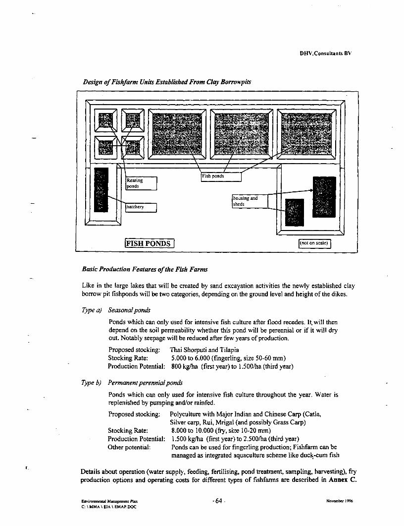
DHV.Consultants BV
Design of Fishfarm Units Established From Clay Borrowpits
15~~~~~ s
Rearing | Fish ponds C_
1|11 I |ponds ._
housing andhasche,y~ ~~~~~~~shd
|FISH PONDS l(not on scale)
Basic Production Features of the Fish Farms
Like in the large lakes that will be created by sand excavation activities the newly established clayborrow pit fishponds will be two categories, depending on the ground level and height of the dikes.
Type a) Seasonalponds
Ponds which can only used for intensive fish culture after flood recedes. It will thendepend on the soil permeability whether this pond will be perennial or if it will dryout. Notably seepage will be reduced after few years of production.
Proposed stocking: Thai Shorputi and TilapiaStocking Rate: 5.000 to 6.000 (fingerling, size 50-60 mm)Production Potential: 800 kg/ha (first year) to 1.500/ha (third year)
Type b) Permanentperennialponds
Ponds which can only used for intensive fish culture throughout the year. Water isreplenished by pumping and/or rainfed.
Proposed stocking: Polyculture with Major Indian and Chinese Carp (Catla,Silver carp, Rui, Mrigal (and possibly Grass Carp)
Stocking Rate: 8.000 to 10.000 (fry, size 10-20 mm)Production Potential: 1.500 kg/ha (first year') to 2.500/ha (third year)Other potential: Ponds can be used for fingerling production; Fishfarm can be
managed as integrated aquaculture scheme like duck-cum fish
Details about operation (water supply, feeding, fertilising, pond treatment, sampling, harvesting), fryproduction options and operating costs for different types of fishfarms are described in Annex C.
Enviromneni Mmnagem=n Plan -64 - November 1996C: \ MMA \ EIA \ EMAP.DOC

DHV Consultants BV
Planting of the Dikes
Dike planting programs will be promoted through the RAP. It is recommnended to plant the dikeswith plants that fulfill similar criteria as those specified for roadside plantation (see Chapter 8). Ofdistinctive value for dike plantation are fruit trees (e.g. bananas), silkworm trees, coconut palms andmedicinal shrubs). Stabilisation of dikes not planted with one of these types of vegetation should bemade with Vetiver grass.
Produdion Target
In conventional carp polyculture and under stringent supervision of the responsible NGO productionshould reach in the first year 1000 to 1500 kg/ha which will gradually increase to 2500 kg/ha in thethird year. The net income for both seasonal and perennial type fishponds are illustrated in Annex D.It needs to be noted that additional income from rearing cash crops and livestock in the diked areawill give aditional economic benefits to the user group.
Environmental Benefits
Apart from income generating facilities (see below) the planted trees and bushes will provide habitatsfor wildlife, particularly good shelter for migratory and resident birds. With this environmentalenhancement a good deal of the losses of habitats and vegetation due to the road project can bemitigated.
7.5 Additional Income Generating Facilities
The proposed action plan makes provision of new skills and credits for the development of activitiesand small rural businesses that are in combination with, the above mentioned. The process ofselection will be left fully to the discretion of the groups aLnd the NGO's working in the area. Thedevelopment of such schemes will require comprehensive training and follow-up through appointedNGO's.
Possible income generating facilities are integrated aquaculkure schemes such as
* Paddy-cum-fish-culture
* Duck-cum-fish farming
* Duckweed culture and duckweeed-based fish culture
* Development of mini-hatcheries to produce carp seed.
Depending on the response and skill developing in the different groups small-scalefish processingenterprises can also be considered as a valuable opportunity to upgrade the cultured product andopen new marketing facilities.
With the allocation of funds integrated aquaculture schemes include a variety of income generatingfacilities through well-managed horticultures associated with the fish farms. For example, viablesources of income can be generated from adequate dike plantation with a well-balanced mix ofuseful plants.
Envenair Managneme Phan -65 - November 1996C: \ MMA \ EIA \ EMAP.DOC

I I

DHV Consultants BV
8. Forestry Schemes
The NHBNR project offers various possibilities to combine design elements on
* the road embankments,
* roadsite habitats,
* rehabilitated borrowpits and
* newly constructed homestead sites,
with the development of forestry schemes that are beneficial both to the technical structure and thebiological and sociological environment. Embankment plantation and other planting activitiesassociated with the RAP represent a major component in the effectiveness of the EMAP. Theincorporation of the planting activities is to make part of the social forestry scheme designed for thePAP income generating plan. Its linkage with the RAP and organisation are discussed in Chapter 9.
8.1 Embankment and Roadside Plantation
The objectives of embankment plantation are
> natural slope protection against wind and wave action and mechanical impacts
>b mitigate to some extent the loss of plants removed by the project
> prevent illegal encroachment (establishment of squatters) on embankment
> provide useful commodities for PAP's and EP's (timber, fuel, food, medicine)
> create tree habitats to enhance ecological properties and landscape aesthetics
8.2 Selection of Suitable Species
For afforestation on the slopes (average 7.5m) of the NHBHNR, eight species were selected for bothenvironmental and economic importance. Selection criteria for these species were on the basis of
* habitat preference and suitability only locally occurring plants were chosen
* adequate rooting system to support embankment stability, slope protection andto control erosion
* canopy structure to support undergrowth and ecological niches, andto provide sufficient traffic security
* good timber quality to provide income generating commodities for EPs
* good fuelwood quality to provide general commodities for EPs
* fruit bearing to provide food resources for EPs
* medicinal properties to provide plant rnedicines for the community
* other marketable uses to provide, for instance, paper pulp production
Environmenal Management Plan -66 - Novenber 1996C: \ MMA \ EIA \ EMAP.DOC

DHV Consultants BV
Tab. 8.1.1 I List of tree species that were selected for NHBNR embankment planting:
Name of Tree Root Economic | Remarks
Scientific | English Local System Value
A. Flood Tolerant
Erythnna indica Madar Extensive Fuel and Fence Fast growing, Growswith little care
Dalbergia sisso Sissoo Sisso Extensive .rimber and Fuel Medium fast growing
Acacia nilotia Acacia Babla Extensive I imber and Fuel Medium fast growing
B. Timber and Fuel
Samanea saman Rain tree .Koroi Extensive Good timber, fuel Wide canopy
Swietenia Mahogoni Mehogoni Extensive Very good timber Deep green andmehogoni medium canopy
Syzizium cumini Black berry Jam 1 Extensive Fruit and timber rich in protein
Borassus flabellifer Fan Palm Palmn Extensive Fruit,Fan & timber nch in protein
C. Medicine
Azadirechta indica Margosa Neem Extensive Timber Leaves & branches usedMedicine to clean teeth & medical
________________ _______=__ _.___._. purposes
In places where erosion is to be expected from rainfall and wind grasses are proven means fornatural slope protection. Grasses with extensive and deep rooting systems are required. Suchproperties are ideally combined in Vetiver (Vetiveria zizanioides), a grass common in the ProjectArea. This grass has proven ability to fulfill a cost-effective erosion control, soil compacting andslope stabilization, especially in canal-bank erosion, gully erosion, protection of abutments ofstream and river bridges as living wing walls, outside of irrigation canal bunds and at entrances toreservoirs (World Bank, 1988). Vetiveria zizanioides is rapid-growing, yet non-invasive. It formsdensely growing hedges which filter out water-borne eroded material whilst reinforcing adjacentsoil preventing local slumping associated with constructed terracing systems. Vetiver is also notcompetitive to adjacent plants, due to its tapering or conical root architecture. It can be harvestedin without affecting its root stability, and it yields a variety of products ). The grass is also tolerantto intensive rainfall and tt a wide range soil types. It can be established on soils with pH rangingfrom 4 to 8.5, and it also grows on infertile polluted soils. Once established, Vetiver grass isresistant to drought, fire and livestock. It is able to resist flood and inundation due to its deep rootsand strong leaves and stems (Grimshaw, 1988).
*) Among commercial uses are oil extracted from roots, stems and leaves are good for mulchingpurposes, prevents spread of creeping grasses, stop pests such as snakes and rats
Envirmunmaul Managentu Plan -67 - November 1996C: MMA \ EIA \ EMAP.DOC

DHV Consultants BV
Vetiver planting should be synchronized with the monsoon, i.e. by the end of August. Care mustbe taken to ensure that slips transferred from nurseries do not dry out either before or afterplanting in well prepared furrows. One hectare requires 150,000-225,0000 slips for planting; eachslip consisting of about 5 tillers, cut to 300 mm blade length with roots trimmed to a length of 200mm (CIEC, 1993). Vetiver needs three or four tomes weeding in the first year and two or three inthe second. Nurseries need to be set up locally adjacent to the project road - or even within theProject site boundaries
8.3 Plantation and Harvesting Scheme
The plantation will not follow the rather dense plantation of monoculture as was done inNagarbari-Bogra Highway. The option is rather a mix and balance of species which combine thedesired properties to give sufficient protection and provide a wide range of commodities to theEP's involved in this planting scheme,
The general establishment of embankment vegetation belt according to the outlined design wouldbe timed to follow the initial priority planting of vulnerable areas-such as flood openings, culvertsand other exposed areas and the general grassing of large slope surfaces. The proposed roadsideplantation design for NHBNR will have a dense canopy of a well-balanced species mix which areplanted with specific spacing.
Each row is duplicated such as I and 1'; 2 and 2'; 3 and 3' and so on. To start plantation, 7seedlings will be planted in each row with a spacing of 1.2'i m. The distance between the rows willbe initially 1.5 m; after harvesting the duplicated rows in year 4-5, the distance between the rowsto be kept will be 3 m. The proposed plantation design is illlustrated in Fig. 8.2.1.
The position of the seedlings in the vertical line will be harvested after 4-5 years; this measure willwarrant not only the first economic return but also enable good growth and girth size for theremaining trees. This will allow the plants of (0) circle position to establish and grow successfullywith four plants in each row. Accordingly, the final distance between the plants in each row willbe 2.5 m. The plants of the duplicated rows (1', 2' and 3') will be harvested after 7-9 years. Theplants of rows 1, 2 and 3 (marked as x in Fig. 8.2.1) will further remain to be cropped only forspecific products and/or slash wood. In every second row, 2nd position and third row 3rd positionfrom top of the slope the additional plantation of Fan Palrm (Borassusflabellifer) is suggested forthe following reasons:
i) the plant is common in the Project Area.ii) it has monopodial branching, hence will allow the surrounding plants to
spread unhindered their canopy.iii) the fruit juice of this plant is very popular in this region and is used not
only for the preparation of brown (solidified) sugar, but also for thepreparation of cake in the months of AuguLst and September. The plant isalso commonly used in local rituals and festivities.
iv) the leaves are widely used for making hand fan, an appreciatedcommodity in this region.
Environenml Managaem PMan 68 - Novemxbr 1996C: \ MMA \ LIA \ EMAP.DOC

DHV ConsuJtants BV
Fig. 8.Z.I Diagram of the proposed embankment plantation for NHBNR
LOWER SLOPE UPPER SLOPE
Sisso Sam Maho Aca
Aca Sisso Sam
Aca ~~Sisso Sam Mh
l l ~Maho Aca Maho| T
St so Maho Palm Syz i 1. |
Aca Sam Aza
i Ssso SAca Sm AOa
/ l Sam Sisso Maho
Eryth Polm Sam Aza I
I | Sisso Maho Aca
Stsso Sam Aca MaGo r
3'E 0 * ---- @OO * _I l Maho Sisso Sam
Sisso Sam Maho A
{ Ery = Erythrina indicra ® Sam Samrnea samon
)Sisso z Dalbergi0 sisso 0 Syzi Syzizium cumini
@PAca zAcacia nilotica * Palm= BorassusflfabelliferL Mahoa Swietenbo mehogon 4 za m Azodirechta indica
Envir.ru l Muneiu P(nC: \ MMA ' EMA EMAP.DOC
- 69 -N 1996
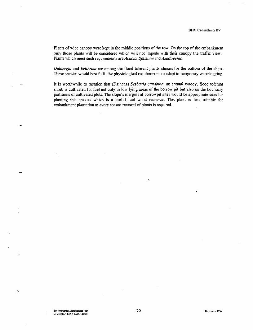
DHV Consultants BV
Plants of wide canopy were kept in the middle positions of the row. On the top of the embankmentonly those plants will be considered which will not impede with their canopy the traffic view.Plants which meet such requirements are Acacia, Syzizium and Azadirechta.
Dalbergia and Erithrina are among the flood tolerant plants chosen for the bottom of the slope.These species would best fulfil the physiological requirements to adapt to temporary waterlogging.
It is worthwhile to mention that (Daincha) Sesbania canabina, an annual woody, flood tolerantshrub is cultivated for fuel not only in low lying areas of the borrow pit but also on the boundarypartitions of cultivated plots. The slope's margins at borrowpit sites would be appropriate sites forplanting this species which is a useful fuel wood resource. This plant is less suitable forembankment plantation as every season renewal of plants is required.
.
Environmental Muagement Plan -70 - November 1996C: \ MMA \ EIA \EMAP.DOC

4

PART IV
OGRANISATION
AND
MONITORING

I I

DHV Consultants BV
9. Organisation of the Environmental Management Plan
9.1 General Organisation and Framework of Institutional Responsibilities
As the environmental management of this project requires the right mix of expertise in technical,physical, hydrological, ecological and sociological disciplines, the organisation has to supply thecorresponding specialists and institutions to become functional in achieving proper and timelyexecution of EMAP. Thus, the management of the proposed elements and activities of the EMAPwill be an interdisciplinary approach, involving various components of co-ordination, supervision,training and monitoring.
The three-level organisational arrangement of the EMAP is illustrated by the organigramm (Fig.9.1. 1). It also shows the line of responsibilities for each of the respective components.
The overall organisational responsibility for implementing and monitoring the EMAP will restwith the Government of Bangladesh, Roads and Highway Department through the ProjectDirector and his Senior Superintendent Engineer/Chief Resettlement Officer (SSE/CRO),represented by the "Engineer". For the Land Acquisition the responsibility lies with the DC's fromthe Natore and Sirajgonj District.
The Engineer heading the Engineering Team will be given the responsibility of the supervision ofall project activities in
1) the technical field (represented by-the Technical Supervision Team/Contractors)
2) the environmental field (represented by the Environmental Management Team), and
3) the socio-economic field (represented by the ResettlementTeam/NGOs).
His -main duty is the supervision of the four Contractors working in four sections of roadconstruction. In liaison with the Environmental Management Team he will ensure environmentalquality and observance of all ongoing activities in accordance with the standards and measuresoutlined in this report and subsequently in the Contract. He also will oversee the monitoringprogram with respect to the single components. The third complex of his duties is to link andcontrol all technical and environmental issues with the work program implemented by theResettlement Co-ordinating Team which is implementing the resettlement plan through twoselected NGOs.
K
Envirmnmenitl Management Plan -71 November 1996
C: \ MMA \ EIA \ EMAP.DOC

DHV Consultants BV
Fig. 9.1.1 Organisational Framework of the EMAP
Project Director
SDE SSE (CRO) SD
SA:E1 r SAE
|> -@' : | Engineer
1 I Team Leader
Technical Environmental Resettlement-. supervision team management team co-ordinating team
: Section I one team 1section 1, 2,3 & 4 one tIea Section I & 2 one team
X Section 2 one team I - Section 3 & 4 one team' Section 3 one team Additional experts: _
: Section 4 one team Forestry ExpertFisheries ExpertAqua-culture ExpertEnvironment Expert
NGO's'A 1|Residual land surveyo | Socio economic survey. | - 0Joint verification survey
Preparation of RAP
NGO'sRAP Implementation Team
E Trainers> I ,GP Specialist
MIS Specialist0 Sociologistz
Ewirownml Mauagnx Plan - 72 November 1996C: t MMA k EIA EMAP.DOC

DHV Consultants BV
9.2 Tasks and Organisation of the Technical Supervision Team /Contractor
The obligations and tasks of Contractors with respect to appropriate implementation of the project,particularly the environmental mitigation measures during construction works will all be specifiedin the Contract Documents.
To a large extent the Contractor will be need the approval of the Engineer (and/or his appointedrepresentatives and affiliated experts) who will focus on and examine the following workcomponents:
* Assurance that all construction works in accordance with the design, specifications andmethodology outlined in the Contractor Documents;
* Verification of the Contractor's performance while rehiabilitating all structures and physicalinterferences related to the work to conditions same as prior to the work, if not better inenvironmental and socio-economic terms.
The Engineer will, after consultation with the Client, approve the four the contractors working inassigned sections the locations their construction camps, offices, stores, labour dormitories,canteens, workshops and facilities. Special wishes of the Contractor and adaptations to localconditions will be determinant factors for the final location of these sites.
The Engineer will also organise, in consultation with the Resettlement Co-ordinating Team and theNGOs, site meetings at specified intervals for evaluating the progress of the Contract and fordiscussing matters pertaining to the Contract, and to the compliance with the technical, social andenvironmental requirements of this project. He will verify, through authorised representatives ofGoB, the correct removal of houses, walls, fences, poles of utility services and other objects withinthe right of way of NHBNR.
The Engineer will frequently liaise with RHD and the sponsor to report on the works progress andissues that may arise during the work. As for issues discussed in this EMAP, he will consult theEnvironmental Expert(s) to elaborate specific strategies and solutions to mitigate (or, ifunavoidable) to reduce adverse environmental impacts. This applies particularly for final selectionof borrowpits and campsites, access roads, drainage works, excavation works, and establishing ofhazardous machinery (e.g. asphalt plant, crusher).
Tasks of the Contractor, with Special Reference to Environmental Issues
The Contractor will be basically the sole responsible for accurate and environmentally benignexecution of all works associated with the construction of the road. For any change inmethodology and design specified in the Contract Documents he has to consult the Engineer forapproval. The Contractor shall submit in advance to the Engineer for approval full details (designplan) of campsites, access roads and facilities he proposes to build. He shall take intoconsideration the prevailing wind direction to secure a minimum of nuisance to neighbouringhouses, schools and general rural economic activities.
Should the Contractor wish to use land other than the area approved by the Engineer for storing orkeeping material or equipment required for the construction of the permanent works, it will besubject to the following:* the Engineer approve any area selected for this purpose.* such land be physically separated and suitably fenced in.
73
DHV Consultants BV
* the area used for the aforesaid purpose be surveyed by the specialists affiliated with the project* he shall enter into contract agreements of lease with the owner of such land
Prior to starting with construction, the Contractor shall start with establishment of new watersupply and sanitation facilities specified by contract. The Contractor himself shall makearrangements for procuring, transporting, storing, distributing and applying the water needed forconstruction purposes.
Where campsites, access roads and diversions shall be constructed so as not to damage or displaceproperty or ecologically sensitive habitats (for definition, see Chapter 5). In exceptional caseswhere this is not possible the Contractor shall notify the Engineer and the EnvironmentalSpecialist in good time so that he may arrange to have assessed potential impacts and respectivemitigation measures.
For any kind of necessary temporary drainage works such as side drains, catchwater drains, mitredrains, culverts, etc., the work activities shall only begin after approval of the Engineer and inconsultation with the Environmental Management Team's Specialist.
If not specified differently, the Contractor must remove, on completion of. the work, allconstructional plant, buildings, fencing and other temporary structures or premises. In such casesthe sites of constructional plants, haul roads and any other sites and plots used for the Contractor'sservices, are to be restored to its original condition and left neat and tidy.
Precautions and responsibilities Relating to Safety Considerations
For safety considerations, the contractor shall be responsible for* the physical and mental safety of all persons engaged in the execution of the works and shall
take such safety precautions as are generally accepteid as good civil engineering practice.* carefully protecting his labourers from injury by rain, flooding, heat or inclement weather, all
likely to happen in the Project Area.= protect the environment from pollution due to the works, particularly avoiding spillage of
(gas)oil, paint, and bitumen. In his plans for the site installation, he will duly incorporatemeasurements to avoid pollution.
* keeping the site and premises clean and free of hazardous waste material
In order not to interfere with public life, cultural assets and ongoing rural development programs,the Contractor will:* check on the site the locations of any remaining cultural items, particularly those buried. He
shall take all reasonable precautions not to damage or inflict upon cultural heritage andreligious infrastructure in the vicinity of work sites.
* work in close co-operation with the NGO appointed to execute the RAP, TA, training andmotivation programs through the IEngineer.
* work in close co-operation with private owners or public authorities controlling services whichhave to be protected, moved or relocated during, before or after the Works. The Contractorshall communicated with those concerned through the Engineer.
The Contractor is responsible for the provision of temporary drainage works such as drains, openchannels, banks, etc. and providing and operating temporary pumps and such other equipment asmay be necessary for adequately protecting, draining and de-watering the work and temporary
74
DHV Consultants BV
works. This will be in addition to any perrnanent drainage works specified and installed and inaddition to any temporary drainage works specifically paid for separately as in the case of detours.
When any part of the Works or any equipment or material is found, upon examination by theEngineer, not conform to the technical and environmental requirements or at any stage before finalacceptance, is damaged so that it no longer conform to the requirements of the Contract, theEngineer may order its repair or removal and replacement, at the Contractor's expense. Allmaterials refused or rejected by the Senior Engineer shall immediately be removed from site bythe Contractor at his own costs.
Environmental Considerations Relating to Site Preparation Works
For removal of biological resources (e.g. trees) the Contractor should make any effort to reducesuch actions to the absolute necessary minimum.
The clearing and grubbing shall consist of clearing the designated areas of all trees, shrubs, brush,other vegetation, rubbish, and all other objectionable material. No trees with a diameter of 30 cmgirths at breast height or more shall be cut prior to the Engineers approval. The cleaning includesgrubbing stumps, roots, and disposing of all spoil material resulting from the clearing andgrubbing.
All merchantable timber within the area to be cleared shall become the property of the Contractor,unless otherwise specified by the Engineer (e.g. to ensure the appropriate utilisation of theseresources after their removal by entitled persons). Material from the cleaning and grubbing shallbe placed on designated (dry) places and only be burned after the Engineers approval.
The Contractor is responsible for the removal, wholly or in part and the satisfactory disposal of allother structures, old pavements, derelict culverts, paved structures (e.g. rice mills) and otherobstructions that are not designated or permitted to remain. This work shall include the salvagingof designated materials and backfilling the resulting trenches, holes, and pits as applicable.
In the stretch between Nalka and Hatikamul, the Contractor shall remove the existing pavement ofthe road sections and re-use for construction as far as feasible. All designated salvable materialshall be removed, without unnecessary damage, in sections or pieces which may be readilytransported, and shall be stored by the Contractor at approlved places on the project or as otherwiseapproved by the Engineer.
Handling and Use of Hazardous Materials
The Contractor will ensure that he uses materials that are environmentally benign whileestablishing paint for road markings, signboards, traffic signs, and applying adhesives.
When the Contractor encounters during the works materials within the Right of Way which areunsuitable for the works, he shall inform immediately the Engineer who will take the appropriatedecisions.
The Contractor will submit a list of materials which will ultimately be dumped, specifying bycategory and quantity, if applicable, the chemical components, possible toxicity and dilutioncharacteristics.
75

DHV Consultants BV
Asphalt Mixing Plant
The dryer of the AMP shall be equipped with an approved dust-collector for recycling of the fines.The hourly production rate shall not exceed the manufacturers recommendations to avoid blacksmoke. Should the Engineer determine that the equipment furnished does not meet theserequirements, the deficiencies shall be corrected by the Contractor before further use of thedeficient equipment shall be replaced with satisfactory equipment.
Disposal of Waste Material
Nonperishable material may be disposed of outside the limits of view from the project with writtenpermission of the property owner on whose property the material is placed. Copies of allagreements with property owners shall be furnished to the Engineer. Basements or cavities left bystructure removal, not affecting the Works, shall be filled with acceptable material to the level ofthe surrounding ground and shall be compacted in accordance with the requirements forembankments.
All timber and all brush, stumps, roots, rotten wood, and other refuse from the clearing andgrubbing operations shall be disposed off at locations out of sight of the roadway, provided,however, when permitted in writing by the authority having jurisdiction over the area.
The Contractor is responsible for the disposal of all deleterious material from the cleaning ofditches, culverts and the surface of the road as part of his cleaning and construction activitiesdescribed in the following Sections.
The Contractor shall notify the Senior Engineer sufficiently in advance of the opening of anyborrow pit so that elevations and measurements may be taken of the undisturbed ground surface orof the surface of the borrow material after stripping, so that any desired tests may be made of thematerial.
Overburden and other spoil material shall be disposed of or used for purposes as dlirected. Slopesof borrow pits shall be flattened and rounded or shapecd as required. All sand borrow pits shall beneatly trimmed and shall be landscaped as approved by the Senior Engineer. The costs of thislandscaping will be deemed to be covered by the rates tendered and paid for the various items ofwork included in the Contract
Care shall be taken not to allow material in borrow pits to become excessively wet, to keep allcompleted layers properly drained, not to cause dumps of material on completed layer work toinhibit surface drainage or to form wet spots under and around dumps, and to protect all parts ofthe work against erosion by floods and rain. The Contractor shall prevent fill material fromescaping beyond the embankment slope stakes by the construction of the ditches or earth, or logbarriers at the toes of embankments, or by the other suitable methods satisfactory to the Engineer.
All stump holes and surface irregularities caused by the Contractor in the area between the slopelines and the outside boundary of clearing and grubbing shall be filled and otherwise corrected bythe Contractor.
76

DHV Consultants BV
When necessary to dispose of surplus material, embankmerits may be widened uniformly and/orslopes flattened as directed by the Engineer.
The Contractor will submit a plan of transport of earth matertial to the Engineer for approval, priorto the start of the earthworks. This schedule will have to show the relation between fill and theborrow pits. The plan of transport of earth material will indicate:* all materials (including their quantities) to be ultimately dumped* surplus soils* excavation materials to be used in embankments and fill on the existing road.* fill material to be extracted from borrow pits.* usable vegetable soils.
Measures to Reduce Interferences with Public Traffic
The Contractor shall be responsible for the safe and easy passage of public traffic past and/or oversections of roads of which he has occupation. The Contractor shall at all times in all his operationsand in using his constructional plant take the necessary care to protect the public and to facilitatethe flow of traffic. Need for and details concerning diversions shall be approved by the Engineerbefore the construction of such diversions commences. He shall also provide and allow free-of-charge access to persons whose properties fall within or adjoin the area over which he is working.Diversions should include the construction of temporary gates, grid gates, fences, drainage works,and other items considered by the Engineer to be necessary.
The Contractor, in co-operation with the Engineer, shall make arrangements for all public servicessuch as power lines and telephone lines to be moved where required for the construction ofdiversions.
Where existing roads are to be used as diversions, the Contractor shall, after consultation with theowner or authority having control of such road, carry out any repairs, alterations or additions tosuch roads as may be required to bring them in a condition at least equal to prior condition andsuitable for traffic. All potholes shall be repaired immediately. Such roads shall be obliterated andtheir surfaces properly reinstated when no longer required, all at the Contractor's own cost. In allother cases, access roads shall removed and rehabilitated in the terrain's original or to anenvironmentally improved condition as specified by the advisory personnel.
The Contractor will ensure to water the diversions to keep down dust development on temporaryaccess and diversion roads.
Where regulation of the Contractor's traffic does not alleviate the public traffic hazardsatisfactorily or the maintenance of the diversions cannot be or is not properly executed, theContractor shall, where conditions permit, divert his trafftc over construction roads provided andmaintained at his own cost,Providing and maintain the necessary traffic-control devices, road signs, channelisation devices,barricades, warning devices and road markings to ensure public traffic safety standards.
Inspecting daily all traffic control devices at least once daily, and report to the Engineer anyshortcomings.
77

DHV Consultants BV
The Contractor shall indemnify the Engineer against all proceedings, claims, actions, damages andcosts which may arise from or be related to the absence or improper functioning or placement ofroad-traffic signs, barricades, traffic-control devices, channelisation devices, warning devices androad-traffic marks.
Transportation Facilities and Safety
The Contractor will take care for
* Verification that all vehicles shall be maintained to comply with the Laws of Bangladesh* Employment supervision to ensure that experienced driver are operating at all weather
conditions.* Treatment of access and other roads within the campsite to make them mud and dust free either
by crushed stone, bituminous surfacing being used or other approved means being adopted.* Ensuring that access roads are well-drained and kept trafficable and free from mud at all times.
Footpaths shall be similarly treated to provide convenient access to all buildings.* Proper maintenance of all vehicles, including replacement parts, and environmentally safe
operation of maintenance worksholps (e.g. oil and lubricant collection systems)
Environmental Safety Measures Against Environmental Hazards
The Contractor will make the following provisions:* In places where dangerous fumes and gases might occur, (bitumen extraction tests) installation
of fans of sufficient power in such a way that these fumes cannot spread in the labour camps ofnearby settlements.
* Employment of sufficient number of day and night watchmen to guard stackyards and assets incampsites.
* Stackyards and storage rooms supplied with cranked top with 3 strands of barbed wire and onlyone gate.
= Installation of good quality locks on all doors and gates to hazardous material storage rooms,power rooms and stackyard..
* Sufficient illumination of the construction sites and stackyards during the hours of darkness.
Provision of Safety Items and Safety Supervision
The Contractor will be responsible for* Safe storage and handling of material and equipment, bitumen and asphalt mixing plant, etc.* Control/contain spillage of oil, grease, fuel, paints, bitumen may spill out from these stockyards
and then may contaminate soil and adjacent water bodies.* Health and work precautionary measures for labourers exposed to hazardous works and
materials.* Provision of adequate number of First Aid outfits* Provision of adequate number of fire extinguishers* Telephone extension and telephone* (heating/cooling system)* Equipment which enhances/warrant safe working conditions, such as ear-muffs, umbrellas,
working boots, rubber boots, walkie talkies* Vehicles shall be insured comprehensively to cover any driver and registered.
78

DHV Consultants BV
Maintaining Health and Sanitation Standards
* Provision of kitchen waste collection system* Provision of all safety requirements while installing gas (gas cylinders, regulators, tubing, and
taps)* Provision of adequate number and safe fitting of fire extinguisher in all premises of campsite
and at stackyard. Regular check-ups have to be performed as specified by the maker.* Installation of 380 volt 3-phase electric power supply at water-protected heights, i.e. 1,5 m
above floor level
Responsibility for Utility Services
* provide a constant supply of clean potable water suitable for human consumption* necessary electric power at 220/250 volts to the offices and labour camp housing.* Power source shall be suitable for domestic, office and machinery use with an anticipated large
variance in load factor. (Three-phase power at a nominal voltage of 400/231 volts and anominal frequency of 50 Hz. The source of power shall be either from a recognised power-supply authority or by an on-site alternator).
- A detailed load estimate shall be submitted to the Senior Engineer for approval prior to anyfinal arrangements being made for a source of power.
* In the event of electricity being generated by the Contractor, the motor-alternator shall besuitable to maintain the voltage according to load specifiications and requirements.
. Provision of safe power distribution and accessory appliances. Placing, sizing of cables,isolation and rating of protective and control devices shall take into account the load and faultcurrents that can occur on the system.
* Provision of fans in labour dormitories* Provision of mosquito net fitted bedrooms for engineering personnel and labourers* Provision of basic cooking equipment for labour canteens• Provision of gas for the burners used in the labour dorrnitories and canteens. Gas, paraffin and
any other items of work must ensure good working order at all times..Provision of all labour, equipment and material which may be necessary for keeping all thebuildings, dormitories, kitchens, washrooms, sanitary installations etc. in tidy and hygieniccondition; any repairs shall be made immediately at the request of the Engineer.
Water Supply & Sanitary Installation
* Identify need (approx. I pump well per 20 households) and provide additional water supplyalong the zone immediately outside the land acquisition zone and install adequate number ofthese appliances at an early stage of the main construction activities.
* construction of tube-wells and latrines according to health requirements and standards* Supervision of siting of kutcha latrines near khals, dead rivers, beels, ditches, etc.* Control collection and deposit of night (prevent contact with surface run-off surface waters
used by the public)* provide sufficient drinking water for labourers available to their nearby work-sheds, for their
bathing, cooking, utensil washing, washing, etc.* Contain and counteract waterlogging in the area of construction* Spraying stagnant pools which may temporarily develop into breeding habitats for disease
vectors* Safe deposit and disposal of garbage and solid wastes produced from the kitchen and camp
79
DHV Consultants BV
9.3 Tasks and Responsibilities of the Environmental Management Team
The Environmental Management Team acts as interface between the Technical Supervision Teamand the Resettlement Co-ordinating Team. Its tasks, performed by full-time field officers, short-and long-term consultant specialists and affiliated NGOs, are grouped in two major fields,
(i) to identify ad hoc environmental issues in context with the ongoing constructionwork (see above, relating to the Contractor's obligations)
(ii) to oversee and manage the activities associated with the resettlement program,mainly provide and monitor the inputs for the TA and training inputs for thePAP in the field afforestation, fish culture, capture fisheries and appliedagriculture/ horticulture
While performing its task the Team will regularly report to the Engineer the observances andenvironmental guidance which will be established in the day-to-day liaison with the ongoing fieldactivities. In addition, it will maintain close contacts to the head organisations and affiliatedgovernmental agencies of the NGOs performing the extension training (e.g. Dept. of Fisheries,Dept. of Forestry, Universities and Research Laboratories).
9.3.1 Supervision and Verification of the Construction Activities with Respect to theirEnvironmental Acceptability
The Environmental Management will assess the environmental changes due to the ongoingconstruction activities and convey, if applicable, its recomrmendations to the Technical SupervisionTeam which will then communicate them to the Contractor to avoid conflicts and interferenceswith the training and extension service working in the Project Area to assist the entitled groups indeveloping income generating facilities.
The Team will also select local consultants and NGOs to implement the different sub-componentsof the EMAP.
If required, the Team will supervise, verify and monitor all construction related environmentalimpacts, as well as the adherence of the environrnental guidelines for construction andrehabilitation of structures described in this report. Basically, the Team will assess and monitor allparameters and aspects which are summarised in the tables presented in Section 4.2 of this Report.
9.3.2 Supervision and Co-ordination of Training Schemes for PAPs
The Environmental Management will assess the environmental changes due to the ongoingtechnical assistance and sociological programmes and convey, if applicable, its recommendationsto the Sociological Team.
The major field of co-ordination will be the training secto!r in the different income generating optionsthat have been devised for the PAP. The beneficiary groups should receive training in fisheries (bothcapture and culture, depending on location and resettlement options), afforestation andagriculture/horticulture.
80

DHV Consultants BV'
The set-up of a demonstration farm, established from rehabilitated borrowpits, is recommended. Inthis farm, located in the Project Area with relative good access by rural roads, an integratedaquaculture-aquaculture farm system should be set up to demonstrate to the trainees respectivetechniques and operational aspects.
Organising the Capture Fisheries Action Plan
The sand borrowpit rehabilitation concept foresees that water-user groups will be identified (by theNGOs affiliated with the Sociological Team) who will be entitled to the full range of benefits fromthese artificial lakes. Prevailing use should be capture fisheries while irrigation purposes should besecond. Representatives from each group should form a local committee in association with the NGOsupervising the project to establish operating procedures of regulatory structures. The committeewould provide the mechanism for the establishment of integrated water management for these lakes.
Organising the Culture Fisheries Action Plan
The concept for clay borrowpit rehabilitation is that the NGOs performing the PAP census inconnection with the RAP will identify the persons who will be entitled to the full range of benefitsfrom the newly established fishfarms. The entitled persons will receive proper traininrg in fish cultureto ensure an economic viable sustenance. Conceived training topics are fish farm management, co-operative business planning, water quality control, aquaculture techniques, storage, processing,transport, marketing, access and use of credit.
If required, courses have to be organised to train trainers. These trainers will then provide day to day"hands on" training for the beneficiary groups on a regular basis at the local site level.
The envisaged training program is to be executed by NGOs that have proven capability and recordsin aquaculture development and training projects in the area, such as BAFRU/ODA, IFADEP andJoyshagar Fish Farm in Neemgachi. The NGOs will work in co-operation and co-ordination with theThana Fisheries Officer. Credit lines have to be developed through the assisting NGOs to enable thebeneficiaries initial investments for operating the fish fanns (ref. Annex C) and marketing theirproducts.
Organising Extension Services for Horticulture, Agriculture and Planting Techniques
With the predicted local changes of floodwater levels and duration, changes in crop pattern mightbe unavoidable. In order to adjust to the optimal agriculture practice specific extension will needto be established to assist the PAP in the field of
* choice of crop and cropping techniques according to land type and land capability* irrigation and drainage requirements* horticulture* planting techniques (e.g. for embankment planting on pond dikes, or at new homesteads)
Extension officers will have to train PAPs in relationship to actual changes of the environmentalsetting. Changes in the agriculture practice will depend on the long-term development of theaffected area with respect to their flooding characteristics. The mitigation measures may beoriented at the following table:
81

DHV Consultants BV
Table 9.3.2.1 Land Capability, and Suitable Crops in the Affected Area
Land Type and Water Suitable . Growlng SeasonFlood Depth (cm) Source Crop J F M A M J J A S O N
Highland (0-30) Rainfed aus
t.aman 2j
Wheat
Pulsesl
Onion S l iilD
Potato
Medium Highland Irrigated t.boro HYV V,
(30 - 90) t.DWaman
Jute
Potato
Medium Lowland Rainfed t.boro HYV(90 - 180)
Lowland (>180) Rainfed tDWaman
Source. JMBA, 1995
Planting advice for the large-scale embankment forestation program will require supervision oflocal forestry and planting officers. They will be responsible for proper the advice on maintenanceof the newly planted embankments. Besides, they will look after the forestation of rehabilitatedborrowpits during the first two years.
The design of this forestry program lays emphasis to use readily available skills and relativesimple techniques. Like in ensuring the local communities skill in agriculture and horticulture, theprogram is likely not to cause major organisational problems or failing to be cost effective.Materials are derived from local resources, while seedlings will be produced in newly establishednurseries.
A Horticulture Specialist will be employed to give organisation and technical advice to beneficiarygroups while establishing their new homesteads and planting dikes of fishfarms. If applicable, theproject will foresee the fielding of an expert for integrated agriculture-aquaculture farming system,who will work in co-operation with the fisheries training and extension personnel.
82
DHV Consultants BV
9.4 Tasks and Responsibilities of the Resettlement Co-Ordinating Team(Sociological Team) with Environmental Considerations
The major tasks of the Sociological Team is to make organisational arrangements for the Non-Governmental Organisations to conduct the PAP census to identify the magnitude of persons whowill become entitled to participate in the PAP. The response of the PAP, their perception of theproject and aspirations for new job and income opportunities will be instrumental in elaborating theRAP. Thus the exact description of the single tasks relating to this project component and itspersonnel is left to a later stage, based on the results of the census.
Aspects that might be taken into account while elaborating and organising the RAP, but not limited tothem, are summarised as below:
Identif7cation of Entitled Persons, Group Formation and Management
Selection and formation of the beneficiary groups should be undertaken by the NGO who arecontracted to provide long term support and training. While technical skills can be learnt through theDepartment of Fisheries and affiliated organisations (e.g. BAFRU, IFADEP), the issues of groupformation, long terrn security of tenure, availability of credit and access to other developmentopportunity are to be provided the two main NGOs implementing the RAP. The group wouldnormally be forned from landless, marginal farmners (less than 0.5 ha), assetless women and thosepersons affected by land acquisition for the borrowpit. Selection criteria for beneficiary groupmembers should also give priority to those agricultural workers who have been impacted by loss ofland due to the NHBNR project.
In return for the inputs of group management, training, and the provision of credit the selected NGOscan be paid by receiving a proportion of the net profit of the fishpond harvest. Alternatively a leasearrangement of the fishfarm could be made in favour of the NGO who would be contracted toprovide a beneficiary group. Experience indicates that long term support from the NGO is required toprotect the rights of the beneficiary group, as well as supporting the marketing of produce. At thepresent time there is no risk of market saturation for the products that will be generated by theenvisaged programs. Both fresh fish and vegetables are always in high demand. However, marketingadvice through the NGOs will be necessary to avoid exploitation of the beneficiary group bymiddlemen.
Land Ownership and Leasing Arrangements for Rehabilitated Borrowpits
Beneficiary groups should be formed from members of the PAP community who live (or will live)adjacent to the pit. If the beneficiary group is formed prior to rehabilitation of the borrowpit, they canbe actively involved in the development work (e.g. shaping the place of their new homestead areaadjacent to the ponds, see fig, p.64). In this way they are provided with short term incomeopportunity while being allowed to develop a sense of group ownership. Aquaculture is quitecomplex group activity and there is some evidence that successful groups are normally those whichhave had chance to bond and work together. Thus the sooner groups are identified and formed thegreater the chance of success.
83
DHV Consultants BV
Organisation and Motivation of the PAPs to the New ][ncome Generating Programs
Aquaculture production requires a higher labour input than that necessary to achieve rice cultivationon the same land area. It can also be combined with other activities such as ducks or livestock rearingand vegetable growing. It can therefore provide more (approximately double) employmentopportunity than was available on the equivalent displaced area of rice paddy. A regular revenue forapproximately 6 beneficiaries per hectare can be provided. In addition improved nutritional inputs forthe group are achieved. The level of financial return is dependent on the system of production usedand the cash available for inputs.
The forestry action plan and revegetation scheme designed with this project offers the PAPs toparticipate and benefit from a variety of long-term and sustaining income options. The localpopulation needs to be motivated and to be directly engaged in the revegetation scheme. Only bysecuring their commitment to the goals of the forestry scheme for the protection of the road theplan will have long-term success and the maintenance / replacement costs of the embankmentprotection can be kept low.
It is therefore necessary to organise an efficient awareness program which will focus, amongothers, to the benefits the PAPs eventually will gain in co-operating with the opportunities offeredby the project.
The entire income generating scheme (including the vast number of job opportuinities on theconstruction sites and possibilities to develop certain skills) should, however, not exclude otherlocal inhabitants as direct participants and beneficiaries in some programs if they prove bothwillingness and commitment.
84
DHV Consultants BV
10. Monitoring of the EMAP
10.1 Elements of Monitoring
Unlike civil engineering works which can readily be monitored for progress and success byphysical and financial measurements, environmental performance and associated development,particularly in the long range, are difficult to monitor. Of prime concern will be the
(i) Areas of intervention and application of environmental indicators(as defined by the Environmental Team)
* Elaborating the ToR and responsibilities for specific monitoring services
Monitoring during construction phase
* Monitoring during operation phase
(ii) Assignment of monitoring tasks
e Environmental hazard monitoring
* Environmental performance during the two project phases
* MSI, performed by local NGO's
(iii) Monitoring the training and personnel requirement
* Scope
* ,Location
* Performance
* Results achieved
(iv) Monitoring of time schedule for specific interventions
(v) Monitoring of reporting
I.
85

DHV Consultants BV
10.2 Sectoral Environmental Monitoring Activities
With respect to the different kind of potentially adverse environmental impacts identified underthis EIA, the Environmental Supervision Team will execute monitoring activities in the followingsectors:
Potential Impact Monitoring ActIvitIes....................................................................................... .... ............................................................................................................................ .........
Destruction of habitats and Analysing, with transect methods, the occurrence and abundanceremoval/disposal of vegetation I of rare/endangered plants and animals in the vicinity of ROW,
and make comparative transects in unaffected areas;* Direct and chain effects on wildlife,
particular on endangered species Identify major palhways of terrestrial wildlife migration, mainlyfollowing embanknients;
* Effect on the wetland's overallnutritive and recruitment function Monitor return of animals (birds, reptiles, mammals) which return
to site after completion of sand borrowpit excavation;* Impairment of migratory pathways
ofImtairmentriofwmigrator pathways Analyse nos of wildlife and waterbird that occupies highlandsof terrestrial wildlifenear ROW durng peak flooding;
• ImpairmentoffsmirtnImpairmentof fish migration Monitor fish migration, differentiated in species, season, active/passive drift, life cycle and changes in population dynamics.
Assess species composition, population changes and nos ofroosting colonies of waterfowl near ROW
........... ................................................... ....... ..................................... I... .............................. ..........- ..... ...* Negative perception of people .. Assess present valuation and perception of local people with
versus the NHBNR Project respect to landscape aesthetics, and repeat similar assessment. Loss olafter completion ol work (e.g. after rehabilitation of borrowpits)
*Loss of local landscape aesthetics
* Loss of formeriy flooded habitats for A ssessment of actual and potential fish breeding grounds prior tomajor capture fishery species start of construction;
* Disturbances on catch & culture Assess catch production and catch effort per area on floodplainfisheries areas in ROW used by local fishermen;
................................................... I......................................................................... ...........................'* Increased soil contamination due to Quantify present local impacts followed by effects on vegetation
hazardous material deposit due to increased agrochemical pollution and embankment misuse;
* Solid waste problems Qualify and quantify local water pollution due to projectinterventions and not due to project interventions;
* Spillage and/or (intended oraccidental) deposit of hazardous Monitor frequency and nature of uncontrolled waste disposal, andmaterials surface water pollution, and relate such incidents to performance
standards outlined in the Contractor's Documents. Monitoring* Surface and groundwater includes the account of local peoples, police reports and reports
pollution, siltation, problems from govemment, authorities about environmentally harmfulrelated to disposal of material activities. Monitor handling processes on construction sites.wastes/dredge spoil Monitoring the construction and quality of latrines
* Sanitation problems Regular monitoring samples of drinking water resources for bothPAP and labour; water test by qualified test laboratory for standard
C Publichealth risks (diseases, hydro.physical, hydro-chemical and pollution/bacteriologicalfaecal pollution, accident rsks) parameters.
..........................................................................................................................................................................................................................
86

DHV Consultants BV
Potential Impact Monitoring ActivitIes..................................................................................... ..... .............................................................. .... ................................................... ..................................................
* Temporary waterlogging due to Assess and quantify waterlogging with respect to area extent,drainage problems behind new I duration and development of mosquito breeding;embankment Regular medical checkups of people near RoW (PAPs as well as
* Closure / blockage Of rivers and *. non-PAPs in the village) with respect to transmittable diseases;khs ! ',Record of all diseases occurring in labour camps.
Record of water uses in PAP villages and campsites, in* Disruption of water supply relationship to local population increase.
Monthly record of aquifer recharge in the Project Area...................................................................................... ................................................ ....................... ............... . ..........................
* Noise problems Measurement of dBA at selected spots, times of the day/night, andrelationship to nature of noise source and direction of wind
...................................................................................... ............................. .......................... ................... .................... ........ ..... I...............................
* Air pollution Measurement of sources of air pollutants at selected spots, timesof the day/night, and relationship to nature of pollution source anddirection of wind
* General construction hazards, Monitoring of Contractor's work performance as outlined inrelated to fill excavation, . Section 9.2construction of campsites,access roads, bridges, culverts,borrowpit etc.)
~~~~~~~~~~~~~~~~~~~~~............................................................................................. ..........................'* Interruption/ disturbance of inver Monitoring of Contractor's work performance as outlined in
navigation Section 9.2. Interruption of local transport &
communication* Increased traffic accident riskl * Disturbances of village community Conduct village meetings and structured interviews to identify and
life quantify alleged disturbances.* Socio-cultural disturbances due to Conduct awareness programmes, including environmental
campsites education, * --.t... ....... .............................................. I....................................................* Change in crop pattem. Monitor respective changes in relationship to distance of RoW,* Loss of pasture grounds season and compounded impacts outside the control of the* Disturbances on irrigation activities project* Impact on dry season agriculture Relate changes to flooding and drainage pattem, and to man-made* Disturbances on horticultures interferences (e.g. pokier construction)
87

DHV Consultants BV
Potential Impact Monitoring Activities
* Temporary waterlogging due to Assess and quantify waterlogging with respect to area extent,drainage problems behind new . duration and development of mosquito breeding;embankment Regular medical clheckups of people near RoW (PAPs as well as
non-PAPs in the village) with respect to transmittable diseases;khals ~~~~~~~Record of all diseases occurring in labour camps.
Record of water uses in PAP villages and campsites, in* Disruption of water supply relationship to local population increase.
Monthly record of aquifer recharge in the Project Area.... ................................................................................................................. ...... ...................
*.Noise problems Measurement of dBA at selected spots, tmes of the day/night, andrelationship to nature of noise source and direction of wind
* Air pollution Measurement of sources of air pollutants at selected spots, timesof the day/night, and relationship to nature of pollution source anddirection of wind
....... ....... l ...................... I................................. ...................................................................................................................................................* General construction hazards, Monitoring of Contractor's work performance as outlined in
related to fill excavation, Section 9.2construction of campsites,access roads, bridges, culverts,borrowpit etc.)
....... f ~ .... ................................................................................................................ _'* Interruptionl disturbance of river Monitoring of Contractor's work performance as outlined in
navigation Section 9.2. Interruption of local transport &
communication* Increased traffic accident nsk.... W i ................................... ......................................................................... . .....................................* Disturbances of village community Conduct village meetings and structured interviews to identify and
life quantify alleged disturbances.* Socio-cultural disturbances due to Conduct awareness programmes, including environmental
campsites education* Change in crop pattem Monitor respective changes in relationship to distance of RoW,* Loss of pasture grounds season and compounded impacts outside the control of the* Disturbances on irrigation activities I project* Impact on dry season agriculture Relate changes to flooding and drainage pattem, and to man-made* Disturbances on horticultures interferences (e.g. polder construction)
Ervifonmaual Maugement Plan -88- Novmnber 1996C: \ MMA \ EIA \ EMAP.DOC

COLOPHON
Client THE GOVERNMENT OF THE PEOPLE'SREPUBLIC OF BANGLADESH
..... ...................................................................................................................................I....................................Project NALKA -HATIKAMRUL - 13ONPARA NEW
ROAD
File K 4008.01.001......... I .................
Length of Report 105 pages
Author Michael Mastaller~~~~~~~~~~..... ...... i .................................I............... ....................
Contributions L': L.Wetsteijn, K.H. Nazrul-Isl am, Md.Shahidullah,'S..M.Abdun Noor Mahbub
Project Leader L.J. Wetsteijn
Project Manager R.Vaandrager............................................. .............................................................................. ............... .. ....................................
Date 31 October 1996........................ .............................................................. .......................
Approved L.J. Welsteijn

|~~ ~ ~~~~~~~~~~~~~~~~~~~ I
APPENDIX A
LIST OF ENVIRONMENTAL POLICY AND
LEGAL FRAMEWORK I)OCUMENTS
CONSULTED FOR THE E.I.A. OF THE NHBNR PROJECT
[

I I

a) Environmental Policy:Environmental Protection Regulations and Policies by the GoBEnvironment Policy 1992 and Implementation Prograam, published by theMinistry of Environment and Forest, Government of Bangladesh, on 9 May 1992 (in Bangla)The Fourth Five Year Plan, 1990-95; chapter IX on Environment & Sustainable DevelopmentRHD policies for regional national highway developmentreferring particularly to the rationales and objectives for Road Development in BangladeshGoB policies related to Jamuna Bridge Project (ref. to var. JMBA Reports)Policies pursued Floodplain Action Plan (var. IFAP-Documents)Wetland area administration review by the Asian Wetland Bureau
b) Pollution and Water Quality Standards- The Smoke - Nuisances Act, 1905 (Bengal Act Ill of 1905)- The Environment Pollution Control Ordinance, 1977 (Ordinance No.XIII of 1977)- List of adopted water quality standards in Bangladesh- RHD Standards of road construction (referring particularly to air, water and soil
contamination, as well as noise pollution
c) Water Resources (Use and Protection)The Bangladesh Water and Power Development Boards Order, 1972(Presidents Order No.59 of 1972)The Bangladesh Irrigation Water Rate (Amendment) Act. 1990/10
d) Health, Sanitation and Water SupplyThe East Pakistan Water Supply and Sewerage Authority Ordinance, 1963(E.P. Ordinance No. XIX of 1963)
e) Agriculture- The Agricultural and Sanitary Improvement Act, 1920 (Bengal Act VI of 1920)- The Agricultural Pesticides Ordinance 1971 (Ordinance No. 11 of 1971)- The Agricultural Pesticides (Amendment) Act (Act V of 1980)- The Seeds Ordinance, 1977 (Ordinance No. XXXIII of 1977)- The Pesticide Rules, 1985
]) Forestry ProtectionThe Forest Act, 1927
g) Lands and SoilsThe East Bengal Building Construction (Amendment) Act. 1952 (E.B. Act 11 of 1953)The Building Construction (Amendment) Act. 1990
h) Fisheries Regulations (mostly provided through BAFRU and IFADEP/DoF)- The Tanks Improvement Act, 1939- The East Bengal Protection and Conservation of Fish Act, 1950
(East Bengal Act XVIII of 1950)- The East Bengal Protection and Conservation of Fish (Amendment) Act, 1963
(E.P. Act 11 of 1964)- The Protection and Conservation of Fish Rules, 1985- The Protection and Conservation of Fish (Arnendment) Ordinance, 1982- The East Pakistan Fisheries Development Corporation Ordinance, 1964
(E.P. Ordinance No.IV of 1964)- List of Carp Catch Closed Season- List of Sale of Fish of Certain Species and Size Prohibited During Specified Periods
i) Wildlife Protection and Game HuntingBangladesh Wild Life (Preservation). (Amendment) Act, 1974(President's order No.23 of 1973)
- List of Wildlife that may be hunted on an ordinary game hunting pennit- List of Wild Life for the Hunting of Which a Special Permit is Required- Wild Animals, Trophies or Meat for Which a Certificate of Lawful Possession is Required- Protected Animals in Bangladesh
j) Local Government Ordinances- The Local Government Ordinance, 1976 (Ordinance No. XL of 1976)- The Paurashava Ordinance, 1977 (Ordinance No.XXVI of 1977) 79- The Local Government (Upazila Parishad and Upazila Administration Reorganization)- Ordinance, 1982 (Ordinance No. LIX of 1982)
k) Tenancy and Land Administration (with particular reference to RAP)- The East Bengal Non-Agricultural Tenancy Act, 1949 (E.B. Act XXII of 1949)- The East Bengal Acquisition of Waste Land Act, 1950 74- State Acquisition and Tenancy Act, 1950 (E,ast Bengal Act XXVIII of 1951)- Land Administration Manual, 1982- The Land Reforms Ordinance, 1984 (Ordinance No.X of 1984)- The Laws of Inheritance
1) Population, SocialBetterment and Involvement of ,GO's- The Voluntary Social Welfare Agencies (Registration & Control) Ord., 1961
(Ordinance No. XLVI of 1961)
m) Cultural and National Heritage- Antiquities Act, 1968- List of Archaeological Resources in the Project Region
n) Navigation and Water Transportation- The Canals Act 1864 (Bengal Act V of 1964)- The East Pakistan Inland Water Transport Authority Ordinance, 1958
(E.P. Ordinance No. LXXV of 1958)
r
ANNEX B
Detailed Inventory of Trees
which need to be removed due to NHBNR construction

I I
Detailed inventory of trees which need to be removed due to NHBR construction
From to chainage no. off no. of no. of no. coff no. of no. of no. of no. ofmangoj coconut datepalm palni betelnut bamboo banana other
0- 500. 1. 0 ~~ ~~ ~~ ~~~ ~~ ~~~~~~~~0 0 0. 0 2100 - 1500 3I0 0 I0 0 0 20
2,000 . 2500... 0 0 000 0 0 2
4000- 4500 4 5 0 0 ~ ~~ ~~ ~~ ~~~~~~~~~~~~~~~~~~ 0 0 0 3
5,500 - 6,000 0 0 0 0 ~~ ~~ ~~ ~~~~~~~~~~~~~~~~~~~0 0 0 0.
6,500 2 ,000 0 0I0 03100
7,500 -8000 0 ~~ ~~ ~~ ~~ ~ ~ ~ ~~0 0 0 0) 0 0 08,000 - 8500: 1 124 203
9,5000 - 35000 022 0 00 9,500 -10000 0 0 ~ ~~ ~~ ~ ~ ~ ~ ~~~ 0 0 0 0 0
10,000 - 10500 0 078 000
114,000 I 10 2 0 0 0) 0 0 0 5.311,500 -12000 0 0 ~~ ~~ ~~ ~~ ~~ ~~~~~~~~~0 0 0 0 0.
12,000 12500 0 0 0I0 03 12,500 - 1000 0 0 0 0D 0 0 0 0
15,000...... . 15500.. 0 0 00D 0 0 0 0.
16,500 - 17~~~~6,000 4 1 0 03
17,500 ..18000.00.0.0.06 0...... 0 ........
19,000 - 19500 0 ~ ~~ ~~ ~ ~ ~ ~ ~ 0 0 0 0 0 .00
2050 - 21000 0 0 0 0 0D 0 0 0
21,000 - 21500 0 ~ ~~ ~~ ~ ~ ~~~ I 0 0 00 0
21,500 - 2000 0 0 0 0 0 0 0 0
22,500- 23000 0~~~ ~~ ~ ~~ ~~ 0 0 0 0 0 0 023,000 - 23500 0 0 000000
24,500 - 25,000 0D 0 0 0D 0 0 0 0
2,0- 26,500 0 0 0 0 0 0 0
26,500 ....i'",6 ..27000 0 0 0 0 0 0027,000 -27500 0 0 0 0 ~ ~~ ~~ ~~ ~~~~~~~~~~~~~~~ 0 002
......... UB..........OTAL ... 32..... 12. ........3 .. 618 .... 11*11 28.0.3141 1 .......... -.......... ...
Tree Inventory of NHBNR - cont.-
From to chainage no. of no. of no. of no. of no. off no. of no. of no. ofjmangoj coconut datepaim palmJ betelnut bamboo banana other27,500 - 28,000 0 0 ~ 0 0 0 0 .0 0
28,000 - ~~~~~28,500 0 0 0 0 000 028.500 - ~~~~~29,000 0 0 0 0) 0 0 0 029,000- ~~~~~29,500 0 0 I 0 0 0 00
29,500- 30,000 0 I 1 0 ~ 2 2 ~ 1
0,0- 30,500 0 2 0 2 001O 30,500 - 31,000 2 2 1 0 0 ~ 1 0 ~ 5
31,0006 . .......... 3'1-,500 0 . 0 0 0 0 0 0 7
- 31,500- ~~~~~~ ~~ ~~ ~~ ~ ~ ~ ~~32,000 7 7 2 0) 1 9 2 232,000 .. ...........................32500..................0.......0.......0.......0.......0.......0.......0 ....... 0..
32,50 - 3000 0 0 0 0 0 0 0 0~~~~~~~~~33,000 - 350 0 0 0 0 00
3400 - 345000 0 0 0 0 0 0 1
3450 - 300 0 i'6 06 0 0 06 0 335,000- 35.500: ~~~ ~~ ~~~~~0: 0 0 0: 0: 0 0 30
36,500- 37000' ~~ ~~ ~~ ~ ~ ~ ~~0 0 0 1 0 9 01
38,500 - 39,000 0 0 0 0 0 0 0 0
39,500 - 40000 0 ~ ~ ~~ ~ ~ ~ ~~0 0 0 0 00040,000 - 40~~~~36500 0 0 00000 0
41,000 ... .... - 41500"O 0 0 0 0 0 0 0 0
4200 - 42,500. 0 0 0 0 0 10 0 0
43,000 - 43500 0 ~ ~~ ~~ ~ ~ ~ ~ ~ ~ 0 0 0 0 0 0 437,500 - 44,000 0I 000
45,000 - 45,500 0 0 0 0) 0 0 004550 - 46,000 3 0 2 0 0 0 0
47,000 - ~~~~~475000 1 0 1 1 0 0 0 047,500...... . 48000.7.2 0 2..................................0...............I..2.. .......... ... 0...... ......... 3........48,000 - 48,500 2 0 0 0 0 4 0 48,500 - 49,000 2 0 0 0 0 0 0 0
49,0006 .-..... ... 49,500 0 0 0 0 0 000
5 .000 ......... 42 50500"--- 0 0 0 0 0 0 0 0
51.500 - 52000 ~~ ~~ ~~ ~ ~ ~ ~~0 0 0 0 0 0 0 052,000 - 5~~~~2,500 6 30 00
53,500- 54000 0~~~ ~~ ~ ~~ ~~ ~~ 5 3 0 0 0 0 544,000 2 40 4 0
54,500 -55000 5 4 2 1 ~ ~~ ~~ ~~ ~~~~~~~~~~~~~~~~~~ 0 0 06
4 . ... O.... 92 6 7 3 18 12 481
APPENDIX C
Fishpond Management
for
Rehabilitated Clay Borrowpits

Ia

Principles for Fishpond Manageiment for
Rehabilitated Clay Borrowpits
Pond Preparation
Basically, the borrowpits which represent the structural basis of this aquaculture program will bemodified by the Contractor according to the specification provided in the Contract Documents*). Assuch, all design features referring to pond bottom levelling, dikes, outlet and drainage structures willbe at the discretion of the Contractor's duties while completing the rehabilitation works. Thus, thefollowing is conceived on the assumption that the user group (fishfarmers being recruited from thePAPs of this project) will receive a ready-made fish farm which can start immediate operation.
Among the pond preparatory steps, the new fish farmers will be required to* watering and tendering the newly planted vegetation on dikes. Additional turfing may be necessary
to give sufficient slope protection.* remove all predatory and other wild fish before stocking, otherwise mortality rates in fry or
fingerling may become unacceptably high.e take care not to overstock the ponds. If fish are stocked at nnore than 60/decimal then expensive
supplementary feeds will be required needed to give satisfactory growth rates.
Water Supply
Better fish production can be achieved if a water supply indepenident of rain and flooding is available.For perennial ponds maintenance of the correct water level is necessary for good fish production whilefor seasonal ponds the growing season may be considerably extended. The depth of water in the pitdepends on the following factors:
Physical depth of pond,Depth of the water tabte,Maximum depth of water at the end of the rainy season.Evaporation loss (varies according to season/climate),Seepage loss (varies according to soil quality),Use of water for irrigation.
) Standard design features of borrowpit rehabilitated fishfarms:
Length of pit 100 to 200 mWidth of pit : max 50 m (to facilitate harvesting)Dimension of rearing ponds max 50 x 25 m (to facilitate harvesting)Dimension of nursery ponds : 10x 15 mDepth of rearing ponds : max 2.5 m (depending on elevation)Depth of nursery ponds max 1.5 m (depending on elevation)Pond bottom covered with clay to prevent losses due to seepage
levelled, with 5% sloping to outletDike slope : Sand 1:3
Clay 1:1MSandy Silt 1:2exposed to wind/wave 1:5 (plus protection)
For drainable ponds : installation of drainage pipe, & harvest boxSlope preparation : Adding topsoil, clay & embankiment plantation, using
mix of useful plants, turfing and newly plantedgrasses (see Chapter 8)
Water provision : if applicable, a tube-well will be sited close by;minimum discharge 25 m3/hr to cope withevaporation losses.
ANNEX -C, page I

The seepage ioss of the pit or pond will reduce each successive year as a result of the accumulation oforganic wastes on the bottom, if semi-intensive fish culture practised. Seepage can be further reduced byproviding a layer of highly cohesive clay/organic soil on the bottom and submerged slopes of the pit.The thickness of this layer must be at least 15 cm.
Planting high density Doncha on the bottom of a dried pit at the end of the dry season may also reduceseepage by it's decomposition while over flooded. Doncha may also be mixed into the bottom soil byploughing.
A tube-well sited close to the pit is therefore highly desirable. Excess water from the tube-well can besold /used to support irrigation of the surrounding area. The minimum water discharge capacity shouldbe 25 cubic metres per hour, as in the month of April the evaporation loss can be as.high as 100m3 /ha/day.
Maintenance and Control of Water Quality
Part of the training and extension program which will be provided for the user group will be devoted toregular water quality monitoring. The required water quality parameters for standard fishpond (carppolyculture) operations are as follows:
Table C-1: Required water quality for cultured fresh water fishes
Temperature : (75 - 85m F) 24 'C -29.5 °CTransparency : 25 - 30 cm [secchi disc]Oxygen : 4.8 - 7.5 mgAAlkalinity : 40 - 200 mgA Ca Co3Hardness : 100 - 250 mgA CaCo3pH : 7.5 - 8.5Carbon dioxide CO2 : 4 - 5 mgAAmmonia NH3 1 - 2 mgA (pH 8.5 - 7.5 respectively)Hydrogen sulphide H2S : 0Iron : Max. 2 ppm (tubie-well water for hatchery use)Methane CH4 : 0Ca : 75 mgA CaCO3Potassium (K) : 1 mgAiPhosphorus as P205 : 0.1 - 0.5 mgANitrogen (N), total : 4 mgA
Salinity tolerance Catla slightly brackish waterRui slightly brackish waterGrass Carp 12.0 pptSilver Carp 8.0 pptRed Tilapia 18.9 ppt0. niloticus : 24.0 pptT. mosambica 30.0 pptCommon Carp : 9.0 pptPuntius gonionotus : 7.0 ppt
(Source: Shahadat A, & Kabir A.: Fresh water fish culture in Bangladesh in 1995)
ANNEX C, page 2
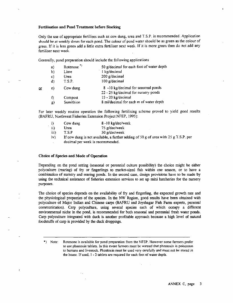
Ferdlisation and Pond Treatmnent before Stocking
Only the use of appropriate fertilises such as cow dung, urea and T.S.P. is recommended. Applicationshould be at weekly doses for each pond. The colour of pond water should be as green as the colour ofgrass. If it is less green add a little extra fertiliser next week. If it is more green then do not add anyfertiliser next week.
Generally, pond preparation should include the following applications
a) Rotenone 50 g/decimal for each foot of water depthb) Lime I kg/decimalc) Urea 200 g/decimald) T.S.P. 100 g/decimal
or e) Cow dung 8 -10 kg/decimal for seasonal ponds22 - 25 kg/decimal for nursery ponds
f) Compost 15 - 20 kg/decimalg) Sumithion 8 ml/decimal for each m of water depth
For later weekly routine operation the following fertilising scheme proved to yield good results(BAFRU, Northwest Fisheries Extension Project NFEP, 1995):
i) Cow dung 8 -10 kg/dec/weekii) Urea 75 g/dec/weekiii) T.S.P 50 g/dec\weekiv) If cow dung is not available, a further adding of 50 g of urea with 25 g T.S.P. per
decimal per week is recommended.
Choice of Species and Mode of Operation
Depending on the pond setting (seasonal or perennial culture piossibility) the choice might be eitherpolyculture (rearing) of fry or fingerlings to market-sized fish within one season, or to have acombination of nursery and rearing ponds. In the second case, design provisions have to be made byusing the technical assistance of fisheries extension services to set up mini hatcheries for the nurserypurposes.
The choice of species depends on the availability of fry and fingerling, the expected growth rate andthe physiological properties of the species. In the NW Region, good results have been obtained withpolyculture of Major Indian and Chinese carps (BAFRU and Joyshagar Fish Farm experts, personalcommunication). Carp polyculture, using several species each of which occupy a differentenvironmental niche in the pond, is recommended for both seasonal and perennial fresh water ponds.Carp polyculture integrated with duck is another profitable approach because a high level of naturalfoodstuffs of carp is provided by the duck droppings.
*) Note: Rotenone is available for pond preparation from the NFEP. However some farmers preferto use phostoxin tablets. In this event farners must be warned that phostoxin is poisonousto humans and livestock. Phostoxin must be used very carefully and must not be stored inthe house. If used, I - 2 tablets are required for each foot of water depth.
ANNEX C, page 3

For the recommended aquaculture program, a combination of six species fulfils the criteria mentionedabove:
Catla: Fast growing carp, abundant, river breeder, can reach 1.2 kg in one year; surfacewater filter feeder (zooplankton), readily takes prepared feed.
Mrigal: Slow growing Indian Carp, attains 500 g in first year. Bottom feeder, omnivore(worms, decaying plant material, insects, zooplankton. Takes prepared feed and iseasy to spawn.
Rui: Popular fish in NW Region; not so fast growing, attains 500 g after one yearunder natural riverine conditions. Omnivore, feeds on a variety of plants andinsects, but also prepared feed. Reaches matarity at 2 kg after 2 years.
Silver Carp: Adapted to a riverine life, introduced into Bangladesh in the 1970's. Successfulspawning of these species has been possible since the early 80's. Columnphytoplankton filter feeder; reaches a size of I - 2 kg in a year under goodconditions. The fish will not generally take pelleted foods but will take fine feedssuch as rice or wheat bran.
Grass Carp: Stocked in ponds primarily for the control of aquatic weeds; feeding on softsubmerged or floating aquatic vegetation; capable to will take cut grasses due towell-developed pharyngeal teeth. Requires atbout 40 - 60 kg of aquatic weeds toreach 1 kg of weight, and can attain 2 - 3 kg in one year. If vegetation is notavailable it will also feed on insects, worms and prepared feeds.
Common Carp: Introduced to Bangladesh in the 1960's. Orimivore bottom feeder on worms andinsects; can attain 1 - 1.5 kg in one year. Increases stirring up of surface bottomlayers and thereby enhances nutrient development and fish production. The fish iseasy to breed and unlike the Indian Major Carps or Chinese Carps will breednaturally without application of hormones.
For further development of the aquaculture program, two more species might be considered whichhave successfully been introduced for culture purpose in Bangladesh since more than 2 decades:
Tilapia: Three types are common in Bangladesh (Mozambique Tilapia, Nile Tilapia andRed Tilapia); Feed on a wide variety of plant and animal material includingphytoplankton (trapping in mucus produced on their gill rakers and then swallowboth mucus and plankton); able to cope with high stocking densities whilemaintaining standard growth rates; capable to endure poor environmentalconditions such as high itemperatures and low oxygen. Breeds naturally andproliferous in ponds.
7hai Shorputi: Fast growing, will reach market size in 4-6 mronths; Herbivorous, good growth onduckweed diet; accepts supplementary food (rice bran). Best yields are obtainedwhen raised in monoculture.
ANNEX C, page 4

Stocking Rates
The rate of stocking depends on the type of pond operation (nursery / rearing), the fertility of the pondand the measures adopted to increase the bioproductivity in the pond by manuring, fertilising andsupplemental feeding. Negative effects might be resulting from excessive stocking densities. Forrearing purposes, hood results are obtained with average stocking rates for carps of 5.000 - 6.000. fryor fingerling per ha. Practical recommended (indicative) stocking rates for different types of cultureponds are:
For NurserX Ponds for Seasonal Rearing Ponds
a) Carp species 20 g/decimal a) Indian Major Carp 50 g/decimalor b) Thai shorputi 10 g/decimal b) Chinese Carp lOg/decimal
Source of Fry and Fingerlings
As with most river breeders the carps specified for pond culture will not readily breed in ponds. Eggsand milt are formed by the fish but they will spawn. The fish must Ibe induced to release eggs and milt byhormone injections. However, hatcheries have now been established all over Bangladesh, which willsupply fish to local pond owners. In the Project Area, viable fry supply can be obtained from hatcheriesin Neemgachi (Joyshagar Fish Farm) and Ullapara.
Development of Carp Mini-Hatcheries
In addition to aquaculture development through the envisaLged aquaculture program may beopportunities for the production of Carp and Tilapia fry and fingerlings. This would apply for most ofthe newly established fishfarms as no other similar hatchery is within a range of 20 kilometres. Theadditional costs of building a hatchery on a reshaped borrowpit are relatively small (Rajts, pers. comm.)since a tube-well and fingerling / brood stock ponds will already available. Such hatcheries cancontribute substantially to the income of the user group, particularly in post-flooding conditions byquickly producing fry and fingerlings to restock regional ponds. The work in this sector can also beundertaken by women.
The basic criteria to develop a carp mini-hatchery are as follows:
* The beneficiary group must be specially trained and routinely producing fishfry and fingerlings.
* A tube-well is required producing at least 50 m3/hr (0.5 cusec) of fresh water.* A 2 bigha pond is required for the carp mini Ihatchery. These should be sited
inside the fishfarm.* The construction cost for the carp mini hatchery is approximately 100.000
BDT excluding tube-well and ponds. The construction cost for the prawnhatchery is 200.000 BDT excluding tube-welll and ponds.For the first 3 years hatcheries require that an experienced fish culturist beengaged. A target group member with low level of education can only
* successfully operate a hatchery after approximately three years experience.
The output of a standard type carp mini-hatchery is 50,000,000 hatchlings per year from whichapproximately 600 tonnes of table fish can be produced in 300 ha of local ponds.
ANNEX C, page 5
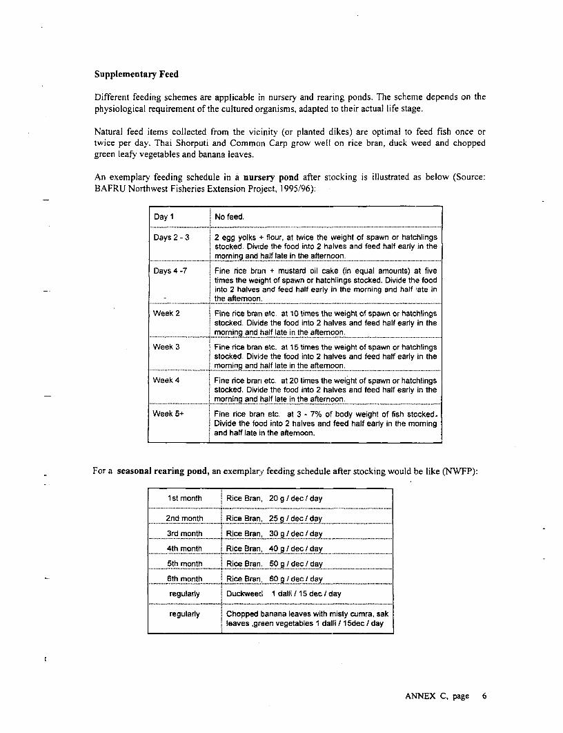
Supplementary Feed
Different feeding schemes are applicable in nursery and rearing ponds. The scheme depends on thephysiological requirement of the cultured organisms, adapted to their actual life stage.
Natural feed items collected from the vicinity (or planted dikes) are optimal to feed fish once ortwice per day. Thai Shorputi and Common Carp grow well on rice bran, duck weed and choppedgreen leafy vegetables and banana leaves.
An exemplary feeding schedule in a nursery pond after sitocking is illustrated as below (Source:BAFRU Northwest Fisheries Extension Project, 1995/96):
Day 1 No feed.
Days 2 - 3 2 egg yolks + flour, at twice the weight of spawn or hatchlingsstocked. Divide the food into 2 halves and feed half early in the
. moring and half late in the afternoon.... .. .. .. .......... .... _..................................... ................................
Days 4 -7 Fine rice bran + mustard oil cake (in equal amounts) at fivetimes the weight of spawn or hatchlings stocked. Divide the foodinto 2 halves and feed half early in the morning and half late in
- . . . . . . . . . ..the afternoon ..
Week 2 Fine rice bran etc. at 10 times the weight of spawn or hatchlingsstocked. Divide the food into 2 halves and feed half early in themorning and half late in the aftemoon......................... ........... ............................. ........... ............................................................. .....................................
Week 3 Fine rice bran etc. at 15 times the weight of spawn or hatchlingsstocked. Divide the food into 2 halves and feed half early in themoming and half late in the afternoon.
Week 4 Fine rice bran etc. at 20 times the weight of spawn or hatchlingsstocked. Divide the food into 2 halves and feed half early in themorning and half late in the afternoon.
Week 5+ Fine rice bran etc. at 3 - 7% of body weight of fish stocked-Divide the food into 2 halves and feed half early in the morningand half late in the aftemoon.
For a seasonal rearing pond, an exemplary feeding schedule after stocking would be like (NWFP):
1 st month Rice Bran, 20 g 9 dec I day
2nd month . Rice Bran, 25 g / dec / day........................................... ...........................................................................
3rd month . Rice Bran, 30 g / dec I day........................................... ........................ a
4th month Rice Bran 40 g / dec / day................................................- .......... ! . ......... ..... .........................................
5th month *Rice Bran, 50 g / dec / day........................................... ................................................ ....
6th month Rice Bran 60 9 / dec / day........................................... ................................... ......................7...........................................regularly Duckweed 1 dalli / 15 dec / day
........................................... ......................................................................................................
regularly Chopped banana leaves with rnisty cumra, sakleaves green vegetables 1 dalli /15dec I day
ANNEX C, page 6

Thinning and Harvesting
All netting is executed by cast or seine net. The thinning and harvest scheme should be 20% of thestocked fish in November, while selecting out the biggest fish and this will allow the smaller fish togrow more quickly. Reducing the-number of fish in the pond will also help prevent the occurrenceand spread of disease. Generally, a mortality rate of more than 60% (at a culture period of 4-6months) is desirable standard to be achieved in the envisaged aquiaculture program.
A typical thinning scheme in seasonal ponds, as propagated by the NFEP would be every 15 days,stocked at 450 - 600/dec (15,000 - 20,000/bigha) into another pond.
In a season with early rains and no flooding, a pond can be used for two or crops.
Production Targets
The production target with carp polyculture in seasonal ponds should be, for the first year in the range7-9.0 kg./dec, with possible increase in the subsequent years. I)etails on potential production rates,including a breakdown of costs and benefits for 6 different types of fish culture are given in Annex D.
Flooding Risks
The Project Area is prone to intensive flooding. Therefore, one total loss of input and harvest shouldbe assumed when estimating return on investment for each 15 year period of operation due toextraordinary flood events (e.g. the scenario following a break of the BRE). The quantity of actual fishstock lost by migration will depend on the height and duration of the flood but under mostcircumstances some residual stock would remain. At the same time the flood would allow an inwardmigration of predatory fish into the fishfarm which cause further damage to stocks. In addition to lossdue to migration and the introduction of predators, some species are better able to adapt to suddenenvironmental change than others. In this regard Tilapia are more resilient than the other species.
Disease
Good water quality management will normally prevent the outbreak of fish disease in ponds. To avoidthe introduction of infectious fish diseases and fish parasites to the pond, the source of fry orfingerlings should be carefully checked. Under no circumstances should fry or fingerlings from naturalsources be used. Care should also be taken to prevent entry of water from adjacent lands since thewater may contain undesirable predators, competitive wild fishes, as well as infectious diseases.
Prevention of Theft
Theft of cultured fish stock is a major problem in Bangladesh. While physical measures are sometimesused such as the use of twigs and branches to prevent netting, these frequently promote thereproduction of parasites and are not recommended. It is advisable that provision is made for somemembers of the target group to guard the pond on a 24 hour basis. Theft can reduced, however, whenbeneficiaries are housed next to the fishfarm, as foreseen in the rehabilitation design of the borrowpits.
ANNEX C, page 7
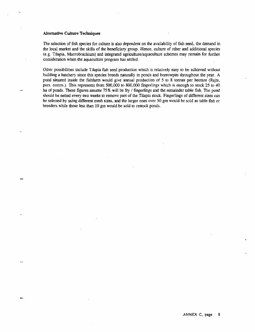
Alternative Culture Techniques
The selection of fish species for culture is also dependent on the availability of fish seed, the demand inthe local market and the skills of the beneficiary group. Hence, culture of other and additional species(e.g. Tilapia, Macrobrachium) and integrated agriculture/aquaculture schemes may remain for furtherconsideration when the aquaculture program has settled.
Other possibilities include Tilapia fish seed production which is relatively easy to be achieved withoutbuilding a hatchery since this species breeds naturally in pondls and borrowpits throughout the year. Apond situated inside the fishfarm would give annual production of 5 to 8 tonnes per hectare (Rajts,pers. comm.). This represents from 500,000 to 800,000 fingerlings which is enough to stock 25 to 40ha of ponds. These figures assume 75 % will be fry / fingerlings and the remainder table fish. The pondshould be netted every two weeks to remove part of the Tilapia stock. Fingerlings of different sizes canbe selected by using different mesh sizes, and the larger ones over 50 gm would be sold as table fish orbreeders while those less than 10 gm would be sold to restock ponds.
ANNEX C, page 8
APPENDIX D
Cost Estimate Tables
for
EMAP Elements
7

I
I
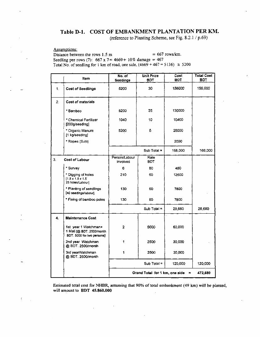
Table D-1. COST OF EMBANKMENT PLANTATION PER KM.(reference to Planting Scheme, see Fig. 8.2.1 / p.69)
Assumptions:Distance between the rows 1.5 m = 667 rows/mn.Seedling per rows (7): 667 x 7= 4669+ 10% damage = 467Total No. of seedling for I km of road, one side, (4669 + 467 = 5136) _ 5200
No. of Unit Price Cost Total CostItem Seedings BDT BDT BDT
. Cost of Seedlings 5200 30 156000 156,000
2. Cost of materials
* Bamboo 5200 25 130000
' Chemical Fertilizer 1040 10 10400[200g/seeding]
* Organic Manure 5200 5 26000(1 kg/seeding]
Ropes (Sutli) 2000
Sub Total = 168,000 168,000
3. Cost of Labour PersonvLabour BDT
* Survey 6 80 480
' Digging of holes 210 60 12600(1. 5x 1.5 x 1.5'25 holes/Labour]
* Planting of seedlings 130 60 7800[40 seedingsnlabour]
Fixing of bamboo poles 130 60 7800
Sub Tctal = 28,680 28,680
4. Maintenance Cost
1 st year 1 Watchman+ 2 5000 60,0001 Mali [@ BDT. 2500/monthBDT. 5000 for two persons]
2nd year Watchman 1 2500 30,000@ BDT. 2500/month
3rd yearWatchman 1 2500 30,000@ BDT. 2500/month
Sub Total = 120,000 120,000
Grand Total for I km, one side 472,680
Estimated total cost for NHBR, assuming that 90% of total embankment (49 km) will be planted,will amnount to BDT 45.860.000

Table D--2
Model Calcualtion for I ha Seasonal Pond
Carp Polyculture (Period 6 Months)
Unit Unit Price Year-I Year-2 Year-3Tk. Tk. Tk. Tk.
Income (2 tons at year 3) Kg. 40.00 64,000.00 72,000.00 80,000.00,....................... ................... ............................. ................. ....... ......... .... ,........ ............ . ..... ....................... .......... .1--- -.......... .........
O era io --.. ....-....... --- ............................I........ ....................... .................. .............................. .........--.-- ..................... ....... .... .................Operation CostT i,e~ 6~ .............................................................. ......................... ...................5.......... ...... ....................... ..... ............................. ...... ... ,..................................Lime 200 kg. Kg. 5.00 1,000.00 1,000.00 1,000.00
.................................................................. ............. ......... ........................ ................... ....... ........................... .......... ....................... ......... ........... ..................... ....Manure 5 tons Kg. 0.50 2,500.00 2,500.00 2,500.00
.........................- ....................... ........... .................. . ..... ............................ ......... ....................... .... ............................. ....... .............................. ..... .....................Urea 350 kg Kg. 7.00 2,450.00 2,450.00 2,450.00
TSP 200 kg Kg. 10.00 2,000.00 2,000.00 2,000.00
Fing,erlings 7 50 p P............................. 1.0. ...... oo 7;50 00 7,500.00 7,500.00................................................................................. ....................... ............ ........I............ ....... ........................... .......... ...................... .......... ........... ...............................
Rice bran 3000 Kg. 5.00 1,500.00 1,500.00 1,500.00
Mustard Oil Cake Kg. 7.00 2,100.00 2,100.00 2,100.00F ishmeai (2nd grade) ...... ............................. .... ............................
Manpower, netting 500.00 500.00 500.00........................... .......................*................ ................................... ..................I.. ....... ........................ .......... ................................ ........... ...................... .......... ........... .......
Miscellaneous, Transport 3,200.00 3,200.00 3,200.00
Maintenance/Equipment 5,000.00 5,000.00 5,000.00......... ......................................................................... ....................... ............ .................... ....... ..........I................. .......... ...................... .......... ........... ......................... ....
Sub total Operation Cost 27,750.00 27,750.00 27,750.00
Risk (Total loss every 15th year) 1,850.00 1,850.00 1,850.00
Net income 34,400.00 42,400.00 50,400.0020% of income net 6,800.00 8,480.00 10,080.00
NGO fees 15% of net income 5,160.00 6,360.00 7,560,00............................................................................... ....................... ............ .................... ....... ........................... .......... ....................... ......... ........... ...............................
Sub Total fees 12,040.00 14,840.00 17,640.00
etic ...e......................... ....................... ............................. ....... ...2 -,36O .... 0- .........27---... 6-- .....-. ....3 --,-7---6 .. 0--.1- ---- --.---.............. ...... ...................................................... ............. ......... .................................... ...... ............................ ..... ............................... ......... ......................... .........Net income for ben. group(6) 22,360.00 27,560.00 32,760.00
Net come/fisherman/year (6 months) 3,726.00 4,593.00 5,460.00................................................................... .............. ...............*....... ... . .....................*.......... ..........*..................... ...................
Net income/fisherman/month 621.00 765.00 910.00..........................I........................................................... ....... ...................... ....................... ... .. ............. ................. .. ............... ...........
Source: Rajts / IFADEP. pers. communication
ANNEX D page 2

Table D-3
Model Calculation for 1 ha Perennial Pond
Carp Polyculture
Unit Unit Price Year-I Year-2 Year-3Tk. Tk. tk. Tk.
Income (5.5 Tons at year-3) Kg. 40.00 176,000.00 198,000.00 220,000.00............. ............................... ................... ... ..................... ...... ........ ..................................... ...... ............................... ..........................
Operation CostLine 200 Kg. 5.00 1,000.00 1,000.00 1,000.00
Manure 10 Tons Kg. 0.50 5,000.00 5,000.00 5,000.00
Urea 750 Kg. 7.00 5,250.00 5,250.00 5,250.00.i F 6.................................... ...................................................... ............................... .................. I............| TSP 400 ...............Kg. 10.00 4,000.00 4,000.00 4,000.00
Fingerlings 5000 Pc. 1.00 5,000.00 5,000.00 5,000.00
Rice Bran.7000 Kg. 5.00 :35,000.00 35,000.00 35,000.00
Mustard Oil Cake 6500 Kg. 7.00 45,500.00 45,500.00 45,500.00
Fish Ma(iind grade)I]~ ........ I............... ............. ........................... ............. ......................................... ........ ............................... ...........................
Manpower, Netting 1,000.00 1,000.00 1,000.00.................................... .......................................... .................................................................. ....-
Miscellaneous, Transport 6,500.00 6,500.00 6,500.00....................................................... 111--1.............. ............ ..........
Maintenance/Equipment 10,000.00 10,000.00 10,000.00
Sub total Operation Cost 118,250.00 118,250.00 118,250.00
R isk (Totai loss every 5th year) 7,880.00 7,880.00 7,880.00
Net income (Pond) .49,870.00 71,870.00 93,870.00.T ........................................................................................ ............. ...............................................
Interest 20% of operating cost 9,374.00 14,374.00 18,774.00
NGO fees 15% of net income 7,480.00 10,780.00 14,080.00
Sub Total fees 17,454.00 25,154.00 32,854.00I................... .... ................................................ .............. ........................... ...... ................ ............................... ........ ..................
....... .................I.............I.......................................... .... ........... ................. ................................... I.............Net income for ben. group(6) 32,416.00 46,715.00 61,015.00
................. 1-1,.......... ,"- "--,11,'I... ......... ................. ..................* ......... ........ ...........................I............. ........Net income/Fisherman/Year (6 months) ....... ................. 5,402.00 7,786.00 10,169.00
.............................. ......................... .......,.......... ..... ....... "I',"-"... ................. ............................ ............. ..... .............Net income/Fisherman/month - 450.00 649.00 847.00
................................. ...................... ........................... ............. ........................................... ... .. ............................. ..........................
Source: Rajts / IFADEP. pers. communication
ANNEX D page 3

Table D-4
Calculation for 1 ha Seasonal Pond
Fingerling Production - Carp Polyculture
Production Period: 6 Months
Unit Unit Price Year-] Year-2 Year-3Tk. Tk. Tk. Tk.
Income 3 Tons Kg. 50.00 120,000.00 135,000.00 150,000.00........................................................... ................................. ...................... ..... ..................... ............................ ................................. ....................
................. .......................................................... ........... ........... .......................... ............................ 1-...... ...................... .............. ....................... ................. ................................
Operation Cost
Lime 200 Kg. 5.00 1,000.00 1,000.00 1,000.00............................................................................................ ..................... .......................... .............................. ........I......................... .....................Manure 6 Tons Kg. 0.50 3,000.00 3,000.00 3,000.00
..... ...................................................................................... ..................... ......I.................... .......................o....... ................................. .....................Urea 400 Kg. 7.00 2,800.00 2,800.00 2,800.00
TSP 300 Kg. 10.00 3,000.00 3,000.00 3,000.00T ,.......... ....................................................................... ..................... .......................... ..................... .... ................ ............... ...................
l Fry 120000 Pcs. 0.10 12,000.00 12,000.00 12,000.00I .. ~~~~~~~..... ....... ..................... ....... ............... a........... ......... ............................ ................................... ...... ............ ...........
Rice Bran 3.5 Ton Kg. 5.00 17,500.00 17,500.00 17,500.00 l
Mustard oil Cake 3.5 Ton Kg. 7.00 24,500.00 24,500.00 24,500.00Fishmeal (iind grade)......idg e ............................................. . ........... ........................ *.............. ................ ........ ......................... ........ ..............................
Manpower, Netting 1,000.00 1,000.00 1,000.00
Miscellaneous, Transport 3,000.00 3,000.00 3,000.00I....... .......... ..................... ..... .........I............. ..... ........... .... .......................... .............-.............. ......... ................ ....... .......... ............. ..........
Maintenance/Equipment 5,000.00 5,000.00 5,000.00
Sub total Operation Cost 72,800.00 72,800.00 72,800.00I~~~~~~~......... ................................. ............... ................. .............................. ................................. ........... .........
l Risk (Total loss every 15th year) 4,850.00 4,850.00 4,850.00W J I'nc~ 6 ... nd).................. ....... ........................... ......... ............ ...................... ........4... 2"''... 0 ....0 ... ...........5... 7,3...5... 0.'" .. ........... 72." ...5.... 00....lNet income (pond) 42,350.00 57,350.00 72,350.00
I~ ~ ~ ~ ~ ~ ~~~~.... ........._ .............................. .......................... .............................. ................................. ......... 14'''...7 -..l Rent of Pond 20% of income net 8,470.00 11,470.00 14,470.00
l NGO fees 15% of net income 6,350.00 8,600.00 10,850.00l .......................................................... ................................................... I...............................................................
Sub Total fees 14,820.00 20,070.00 25,320.00
I ~~~~~~~~~~~~~~~~~.. ................... ..... ................ .......... ....... ......... ..................... ......... ................................. ........... ...............Net income for ben. group(6) 27,530.00 37,280.00 47,030.00
Net income/Fisherman/Year (6 months) 4,588.00 6,213.00 7,838.00.. ........................................................................................ ................ ....................... .................. ........................... ..........
Net income/Fisherman/month 768.00 1,035.00 1,306.00
Source: Rajts I IFADEP. pers. communication
ANNEX D page 4

Table D-5
Model Calculation for 1 ha Seasonal Pond
Tilapia Culture
Production Period :6 months
Unit Unit Price Year- I Year-2 Year-3Tk. Tk. tk. - Tk.
Income total 40000 nos = 4 Tons Kg. 40.00 128,000.00 144,000.00 160,000.00......................... ......................................................... .................... ........................... ................................ ................................ ...........I........
Magur 500 no, 100 kg Kg. 60.00 6,000.00 6,000.00 6,000.00.................................................................................................. ............................................................... ................................... .............I.. ............Operation Cost
Lime 300 Kg. 5.00 1,500.00 1,500.00 1,500.00.....................................................................................................................................................Manure 8 Ton Kg. 0.50 4,000.00 4,000.00 4,000.00
T ~..................................................................................... ............................................................................Urea 500 7.00 3,500.00 3,500.00 3,500.00
................................................................................... ................... .................... o--o...... .........................-O-.... .............2................... .....................TSP 250 10.00 2,500.00 2,500.00 2,500.00
T ...................................................... .............................................................. ..............................Fr: Tilapia 50000 + Magur 1000 No 0.10 5,500.00 5,000.00 5,000.00
....................................................................................................................................IFingerlins-magur 50 so. 1.00........ 1,0.00 1fooo ,000.00
Rice Bran 80000 Kg. 5.00 40,000.00 40,000.00 40,000.00.... ....................................................................................... ................... ............................ ........... ..................... ................................ ........ f ........Mustard oil Cake 2000 Kg. 7.00 :14,000.00 14,000.00 14,000.00
Fis e i iin gr ~.............. ........................... ....... ............. ................ .......... ............................ ... ........... ..........I.........................I ....................... .......................................................................................................................
l Manpower, Netting 1,000.00 1,000.00 1,000.00.. ................................................................................ ............... ........................... ........... I.......................................... ..................
Miscellaneous, Transport 5,000.00 5,000.00 5,000.00
l Maintenance/Equipment 5,ooo.oo 5,000.00 5,000.00
Sub total Operation Cost 82,000.00 82,500.00 82,500.00
l Risk (Total loss every 15th year) 5,470.00 5.500.00 5,500.00.........Net~~~~~~~~~~~~~............. inom (Pond) .... . ........ ........................... .............................. .................... i6;530.00...62;000.00.78.000.00Nemicome (Pond) .46,530.00 62,000.00 78,000.00
................................................................................................................................................................Rent of Pond 20% of income net 9,300.00 12,400.00 15,600.00
NGO fees 1 5% of net income 6,980.00 9,300.00 11,700.00
l Sub Total fees 16,280.00 21,700.00 27,300.00. .-- - -- - - 1 - .-........... -.-
I. . . . .................. .. ........................... ..... ................................ ...... . ............Net mcome for ben. group(6) 30,250.00 40,300.00 50,700.00
Net income/Fisherman/Year (6 montihs) ............................................ 5..041.00 6,716.00 8,450.00
Net income/Fisherman/month 840.00 1.119.00 i .408.00...................................................................................I.......I........... . ........................ .......................... .......................... ......T ....................
Source: Rajts I IFADEP. pers. communication
ANNEX D page 5

Table 6
Calculation for 1 ha Perennial Pond
Continuous Culture of Tilapia
Unit Unit Price Year-I Year-2 Year-3Tk. Tk. tk. Tk.
Income 5 Tons Kg. 40.00 160,000.00 180,000.00 200,000.00
1, ...., .,......... ,............................. .... ...... .... . .. ...... ..... -.-.-..-.. .............. ................. ................. ..................Operation Cost
T, ,m, .., , .,.,, e-, , ................... ............................................ K.g....... ......... 5J-, .... .......... ,"o -....0...0... ........ I"O00'O0........ " .. 0 0-Lime 200 Kg. 5.00 1,000.00 1,000.00 1,000.00...... , , , ........................................... ..,........ ........................... ................... ............................... .............. ........
Manure 10000 Kg. 0.50 5,000.00 5,000.00 5,000.00
Urea 750 Kg. 7.00 5,250.00 5,250.00 5,250.001,,,,.,, .................. I....................... .................... . ................ ................... , ..,,,....................... .,............. ........| TSP 400 Kg. 10.00 4,000.00 4,000.00 4,000.00
Breaders 100 T 25 Pc. 20.00 2,500.00 2,500.00 2.500.00
Rice Bran 8000 Kg. 5.00 40,000.00 40,000.00 40,000.00
Mustard Oil Cake 5000 K. 7.00 35,000.00 35,000.00 35,000.00T i..... .,,,,,,,,,,................... ................................................ .. ,.......,.. ......................... ................ ................. ................Fish Meal (2nd grade)
I ..,,,,,,,,........... -1 1 ........ ............... I.........I....... ............... ............I.... .....I........ .................. .............Manpower, Netting 1,000.00 1,000.00 1,000.00
Miscellaneous, Transport 6,500.00 6,500.00 6,500.00
Mantenance/Equipment 10,000.00 10,000.00 10,000.00,., , i ,,, .,, .....Co ,s -......... ................... ............ ........................ ........... ........................1-IO-,2 0 ..... 06.... ....... -]O-,25-0... ........II......,2- 0.... ..........Sub total Operation Cost 110,250.00 110,250.00 .. 110,250.00
Risk (Total loss every 15th year) 7,350.00 7,350.00 7,350.00........ .... , ..,................................. ............. .. ,............ ......................... ............ ......... ................
Net income (Pond) 42,400.00 62,400.00 89,750.00
Rent of Pond 20% of income net 8,480.00 12,480.00 17,950.00..jZ ..f... ............................................................................. ................................ .................I..................... ............................... ............................... ......NGO fees 15% of net income 6,360.00 9,360,00 13,460.00
~~~~~~~........................ ............................ ...................................... ................................ . ............................ ,............ .........Sub Total fees 14,840.00 21,840.00 31,410.00
K J .111,1,1 1 ... "Il , " 'l,.... " 'l....... ......,.......,.,,, ......................... ............................ . .......................... ..... ...........................Net income for ben. group(6) 27,560.00 40,560.00 58,340.00
Net income/Fisherman/Year (6 months) 4,593.00 6,760.00 9,723.00~~~~~~~~~~~~~~~~~~~...,..............I...... . ..... I........................... ................................ .............I.................. .............. ......
Net income/Fisherman/month 383.00 563.00 810.00
Source: Rajts I IFADEP. pers. communication
ANNEX D page 6

Table D-7
COMPARISON RICE AND DUCK/FISH INTEGRATED CULTURE IN I Ha LAND
EXAMPLE: DUCK CUM FISH INTEGRATED CULTURE
LabourTaka Man Day
Operating Cost
Lime Manure, Fertii zer 7,00000 15Fingerlings I 0.00p 10,000.00 5*
......................................................... , .......................... ,,,,,,,,............ - --------..... .................. --.-t.----------------"'-.*''A'.--.---.Rice Barn 300 kg. 15,000.00v 50Mustard Oil Cake 3000 kg. 21,000.00 50Maintenance of Pond 10,000.00 178/.Miscellaneous/pumping 6,500.00Netting/Partial/Final harvest Group 108iInitital/Periodical deweeding Group .0
,, .............................................................................. ....... ............................ ...........................
Water quality management/supervision Group 365Total Operation Cost/Labour .69,500.00 781
....... ....... ...... ....... ...... ....... ...... ....... ....... ...... ....... ...... ....... ...... ....... ....... ...... ....... ...... ....... ...... ....... ......
Income 500 kg. x Tk. 40.00 200,000.00Net income 130,500.00
............................................................................................................. .......................................... ............................................
Duck Culture
Duckhousing Tk. 5/duck 1,000.00 3....... ..
* Labour (other labour included in fisheries) 91Duck pullet 200p x Tk. 100.00 :20,000.00 .Food 13,870 kg. x Tk. 9.00 124,830.00......................................................... I............................ .............. .......................... ..................................
Total Cost ~~~~~~~~~~~~~~~~~~~~~~~~~~~~~~~~~~145,830.00 194- ~~~~~~~~~~~~~~~~~~~~~~~~~~~~... . .......................................................... . . .............................................................................
Inconie
, ....................... ................................................................................................................................ ........................................................
Egg 250x 190 x Tk3.00 142,500.00,.................................................................................................... ................................................................ ................ I...............................................
Ducks 190 x 1.25 kg. x Tk. 60.00 14,250.00; .................................................................................................... .................................Total Income 156,750.00Net Income 10,920.00
L............ .............................................. I............................................. ... ................................... .......................................................
...........................................................................................................................................................................................................
!Total Net income Fish + Duck 1. ]41,420.00.Total Labour Duck + Fisheries 87,
.................................................................................................... ................................................................................................................................
Source: Rajts I IFADEP. pers. communication
ANNEX D page 7

I

DHV CES DDC DUL
GOVERNMENT OF TBE PEOPLE'S REPUBLIC OF BANGLADESH
NALKA - HATIKAMRUL - BONPARA NEW ROAD
Loan Agreement 2638 BD
Air Pollution Assessment
Subject Detailed Engineering StudyFile K4008.01.001Date 22 August 1996Status Revision 2Our reference NHB/AHM/REP/AIRPOL.VR2
Roads amd Highways Department August 1996NHB/AHM/ REP/ AIRPOL.VR2 2

DHV CES DDC DULAbbreviations and Acronyms
DOE Department of EnvironmentEQS Environmental Quality Standard4/M3 Micrograms per cubic meterMg/m3 Milligram per cubic meterppm Parts per millionRHD Roads and Highways DepartmentBRTA Bangladesh Road Transport AuthorityWHO World Health OrganizationUSA United States of AmericaUK United KingdomNGO Non Government OrganizationJMBA Jamuna Multipurpose Bridge AuthorityCO Carbon mon-OxideCO2 Carbon di-OxideNOx Nitrogen OxideHC Hydro Carbonso2 Sulfur di-Oxide03 OzoneSPM Suspended Particulate MatterLDV Light duty petrol car VehiclesHDV Heavy duty Vehicles
Roads and Highways Deparment August 1996
NHB/AHM/ REP/ AIRPOL.VR2 3

DHV CES DDC DUL
Table of Contents
I Introduction - General 5
2 Objectives 5
3 Policy, Legal and Administrative Framework on Environmental Pollution Control inBangladesh 5
4 Alignment Study 7
5 Air Pollution Impacts 95.1 During construction phase 95.2 During running phase 95.2.1 Motor Vehicle Exhaust Emission 95.2.2 Exhaust Emission Characteristics 105.2.3 Effect of Pollutants upon Community Environment 105.2.4 Air Pollution Standard of Bangladesh 12
6 Air Pollution Assessment for Traffic 166.1 Localized Air Pollution 176.2 Overall Air Pollution 18
7 Mitigation Measures 197.1 During Construction Phase 197.2 During Running Phase 207.2.1 Measures to be taken by the GoB 217.2.2 Measures to be taken into the Design 21
8 Conclusion 22
9 References 23
Colophon 24
Roads and Highways Department August 1996
NHB1AHMI REP/ AIRPOL.VR2 4

I I
DHV CES DDC DUL
1 Introduction - General
The environmental impacts of roads and highway construction are divided into two types. The firsttype is the environmental impact during construction, maintenance or rehabilitation The second type isthe traffic using the road. E.g. (a) during construction phase and (b) during running phase. Thesignificant impacts are many, of which air pollution is prominent. Air pollution may affect air qualityof the road side areas causing adverse impacts upon natural environment and human health. Airpollution may cause the diseases like allergy, asthma, bronchitis, lung cancer, heart disease,respiratory diseases, headache, cough, shortness of breath, pulmonary tuberculosis and aggravates thesick persons already suffering from chronic bronchitis, coronary heart diseases and cardiovasculardiseases. So to protect the health of the recipients within the impact zone of two sides of the roadalignment, the assessment of traffic load and probable air pollution impacts at different stages deservedetailed studies.
During construction phase the main pollutants are dust and black smokes from crushers, asphalt plantsand other construction equipment. During running phase, the pollutants are mainly from vehiculartraffic. The vehicle exhaust emissions are composed of CO, HC, NOx, lead compound, SO2 andsmoke which affects the community environrnent and human health. In Bangladesh, air pollution fromvehicle exhaust emission is particularly important in urban areas where thickness of traffic is high. Inrural areas where highways passing through villages with few sensitive areas this may not have yetcreated major air pollution problems due to low traffic density. After bridging the existing big riversand canals and improvement of communication systems the traffic: density in rural areas is expected tobe increased and thus air quality of road side areas may be deteriorated by vehicle exhaust emission,effecting the road side sensitive areas. Therefor air pollution deserves proper assessment andappropriate mitigation measures is required.
2 Objectives
After the construction of the "Jamuna Multipurpose Bridge Project", traffic loads will be increasedconsiderably for the Nalka-Hatikamrul-Bonpara road. Under the envirornmental issues in the ToRspecial attention is asked for the pollution during the operation phase. The outcome of this study is tobe implemented in the environmental management and monitoring plan to reduce the adverse impactof the construction of the road. This study also assesses the air po:llution during the construction phase.
3 Policy, Legal and Administrative Frameworks on Enviromnental PollutionControl in Bangladesh.
The following policy papers, acts and standards are implemented in this study.
1) Environmental policy 1992 and implementation activities Ministry of Environment and Forest,Bangladesh.
In the above policy, the clause (4) and 11 mentioned regarding control of emitting smoke andsound of motor vehicles, plying on the road, by controlling lead mixed patrol and sulfurmixed diesel.
Roads and Highways Deparunent August 1996NHBtAHM/ REP/ AIRPOL.VR2 5
DHV CES DDC DUL2) Highway Act, 1925 and Amendment of the Act in 1994 (Ministry of Communication), Govt.
of Bangladesh.
In this Act, some rules have been framed on (a) new road construction,(b) maintenance, (c)road boundary, (d) borrow pits etc. But nothing has been mentioned regarding environmentalpollution control of vehicular traffic.
Bangladesh Road Transport Authority (BRTA) has not yet framed any Acts or Rules andregulation on air pollution and noise pollution control from road traffic. But a "Motor vehicleAct" 1984, is under operation by the Road traffic sector at present. In chapter 10, Clause-(139)-horn and noise, Clause (85)- & (142) speed lirnit, Clause (150)-black smoke emission,Clause (154)-overweight etc. are relevant in connection with air pollution caused fromvehicular traffic, but it deserves strict enforcement to achieve the objectives.
3) Draft Environmental Quality Standard (EQS) for Bangladesh prepared by the Department ofEnvironment, July 1991.
In this draft EQS standards have been set for air and Noise pollution. This is the first time inBangladesh to make such standards for such vital environmental issues. After approval of thisdraft proposal by the government, Acts/Regulations will be framed for implementation.
Roads and Highways Department August 1996
NHB/AHM/ REP/ AIRPOL.VR2 6

DHV CES DDC DUL
4 Alignment Study.
The tentative alignment of this road project. recommended in the feasibility study report e.g. Route 1has been optimized during this present study phase by an expert environmental team. The finalalignment has been studied in the light of air pollution and noise pollution impact zone up to 200 mand 300 m respectively from the center of the road. During this ;study it was found that route corridorof about 50 km in length and 100 m wide has crossed over the vast Chalan Beel area, affected mostlypaddy land with some 35 villages and 118 house holds or 60 homesteads. The impact zone of airpollution of 600 m wide corridor has been surveyed and 590 households were recorded affecting3,540 people approximately with few schools without any health center, hospitals, and archeologicalspots. The field survey result has been shown in Table 1. Again a key map of route corridor showingthe impact zone of air and noise pollution is shown in Figure 1.
Table 1: Field survey impact zone for air pollution
SL Sensitive Strips surveyed at each side of theNo Areas centerline
40m 60m 100m
1 Schools x x 2
2 Hospitals x x x
3 Mosques -1 x 1
4 Community centers x x x
5 Homesteads x 56 93
Remarks: Total no. of households within 400 m strip (both sides) 298 no.Total population within 400 m on both sides = 1.788 personsTotal households within 100 m on both sides = 112 no.Total population within 100 m on both sides = 672 persons
Roads and Highways Deparmnent August 1996NHB/AHM/ REP/ AIRPOL.VR2 7

,li ' I I I~~~~~~~~~~~~~~~~~~~~~~~~a
ss-oo ~ ~ ~ - - 8'J- I 5 _ t89-'1Na0' granI I
*n 1 - - 4 ,' X ;/ -- '''--1;; 'sssE-K;,-'2l)lXlti'-XhS '-- -6
| ; \ > ' i-s XI Nandler<- - i','-- . tx ,_ jS l. wialgan
l -_ -.>X- ( ,!; t4, - > ' |X: ~~~~~~~~~~~~~~~~~~~~~~~~~~~0-,,-t_-. }'
,- -, a. Cy 's ' '\ ',17-'-' '' 1l'-/t,-Y' i,
] ! . / - --- f-;- >->> -0 ! ;j \ t \; - *SV |~~~~~VP U.r //tirlgt a . * l > ~~~~~~~~~~~~4 'lo-
, , } , , , ; / , t ¢ / .> tRalt';lill ?, ) '<'~~~~~~~~~
| <; \9) t W ; ) | s X \ // t' 'tt J |~~~~~~~~~~~~~~~~~~~~~~~~~~~~~~ i(l
\ ? ;X X X Ullpaa. tAR;<Vl-uv'S)( /,X\B¢
ow VX-- A = 4 LBaratgra
L8ibe) X--- 1' "k30 89t, -4[

DHV CES DDC DUL5 Air Pollution Impacts
Air pollution impacts caused by the new road project are assessed in two stages such as: (i) duringconstruction phase (temporary impact) and (ii) during running phase (permanent impact).
5.1 During Construction Phase (Temporary inpact)
Type of air pollution during construction:
a) Dust raised from earthwork activities and unpaved road surface
b) Dust raised from crushing of rocks and bricks and asphalt mixing.
c) Smoke from the asphalt plants, earth carrying vehicles and construction equipment andmachinery.
* Soil dust:- The soil dust is raised during earth filling of road embankment and from theunpaved road surface blown by the vehicles. This can pose health hazard to the road sidepeople till the road pavement is completed. Dust is a real health hazard and should beminimized as far as possible. Soil dust-also affects the :road side vegetables, fruit trees andagricultural crops etc. which effects the earning sources of the road side people.
* ..Dust:- Dust is also raised from other road construction activities at sitedue to equipment andespecially by rock and brick crushing. This has impact on the occupational health of the worksite laborers and other people in the environment.
- Black smoke:- Black smoke and vehicle exhaust emission may be caused fromvariousvehciles, construction equipment, asphalt plants etc. cluring the whole road constructionperiod. This air pollution has direct impact upon the occupational health plus the communityhealth of the project site..
5.2 During Running Phase (permanent impacts)
During running phase the main sources of air pollution will be from (a) Road transport emission fromthe vehicular traffic.
5.2.1 Motor Vehicle Exhaust Emissions.
The combustion of fossil fuels with air produces mainly carbon di-oxide (CO2), Nitrogen Oxides(NOx) and Water (H20). But combustion engines are not perfectly efficient, so some fuel is not burntor only partly burnt which results the following pollutants in the exhaust emission;
a) Carbon di-oxide CO2b) Nitrogen Oxides NOxc) Assorted Hydrocarbons HCd) Carbon Mon-oxide COe) Lead Compounds Pbf) Black smoke (soot)
Roads and Highways Departnent August 1996NHBIAHMI REP/ AIRPOL.VR2 9
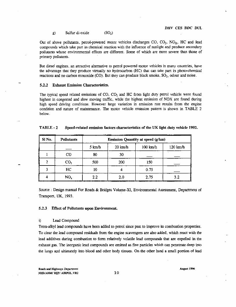
DHV CES DDC DULg) Sulfur di-oxide (SO2)
Out of above pollutants, petrol-powered motor vehicles discharges CO, CO2, NOx, HC and leadcompounds which take part in chemical rea_tion with the influence of sunlight and produce secondarypollutants whose environmental effects are different. Some of which are more severe than those ofprimary pollutants.
But diesel engines, an attractive alternative to petrol powered motor vehicles in many countries, havethe advantage that they produce virtually no hydrocarbon (HGC) that can take part in photo-chemicalreactions and no carbon monoxide (CO). But they can produce black smoke, SO2, odour and noise.
5.2.2 Exhaust Emission Characteristics.
The typical speed related emissions of CO., CO2 and HC from light duty petrol vehicle were foundhighest in congested and slow moving traffic, while the highest emission of NOX are found duringhigh speed driving conditions. However large variation in emission rate results from the enginecondition and nature of maintenance. The motor vehicle ernission pattern is shown in TABLE 2below.
TABLE - 2 Speed-related emission factors characteristics of the UK light duty vehicle 1992.
SI No. Pollutants Emission Quantity at speed (g/km)
5km/h 20 km/h 100 km/h 120 kmlh
I CO 80 30
2 CO2 500 200 150
3 HC 10 4 0.75
4 NO, 2.2 2.0 2.75 3.2
Source: Design manual For Roads & Bridges Volume-XI, Environmental Assessment, Department of
Transport, UK, 1993.
5.2.3 Effect of Pollutants upon Environment.
i) Lead Compound
Tetra-alkyl lead compounds have been added to petrol since past to improve its combustion properties.
To clear the lead compound residuals from the engine scavengers are also added, which react with the
lead additives during combustion to form relatively volatile lead compounds that are expelled in the
exhaust gas. The inorganic lead compounds are emitted as fine particles which can penetrate deep into
the lungs and ultimately into blood and other body tissues. On the other hand a small portion of lead
Roads and Highways Departnent August 1996
NHB/AHM/ REP/ AIRPOL.VR2 10

DHV CES DDC DULcompound is emitted as volatile organic lead compounds which are very toxic and rapidly absorbed by
the body as they dissolve in fats.
ii) Carbon Mon-oxide (CO)
Out of total vehicle emission, CO holds the highest percentage. It is rapidly absorbed by the blood,
reducing its oxygen carrying capacity. It is relatively stable compound that takes part very slowly in
atmospheric chemical reaction. It contributes indirectly to the green house effect by depleting
atmospheric levels of hydroxyl radicals.
iii) Oxides of Nitrogen (NOx)
This pollutants is emitted as nitric oxide (NO). In the air it is oxidized into Nitrogen di-oxide (NO)
which is very toxic, affecting the respiratory system. NOx is important in atmospheric Chemistry
contributing to "photo-chemical smog" formation and acid deposition. Nitrous oxide (No) is a very
powerful green house gas.
iv) Assorted Hydro Carbons (HC)
This volatile compound are created by the incomplete combustion of fuel and a mixture of all organic
compounds emitted and embraces many hundreds of different compounds. Some are toxic and
carcinogenic. Their reactivity varies widely but they are important precursors of photo-chemical
smog, acidic and oxidizing compounds. The composition of HC emission is strongly influenced by the
composition of the fuel.
v) Smoke (particle matter)
The black smoke are mainly emitted from diesel vehicles and are carbon particles into which a wide
range of organic and other compounds are absorbed. Diesel exhaust particle in very high
concentration causes lung cancer. They have a high staining power on soils, buildings and other
materials.
vi) Sulfur di-oxide (SO2)
This pollutant is emitted from the diesel vehicle, linked to the sulfur contained in the fuel. This can
remain in the atmosphere from a few hours to several weeks. SO:, is a water soluble gas that act as a
powerful irritants to the mucous membranes of the eyes and the upper respiratory tract causing cough,
shortness of breath and spasm of the larynx.
vii) Carbon- di-oxide(CO2)
Roads and Highways Department August 1996
NHBIAHM/ REP/ AIRPOL.VR2 11
DHV CES DDC DULIt is a major product of the combustion of all carbon containing materials. But very minor percentage
of C02 is produced from motor vehicle. It is considered to be the least harmful of the major
greenhouse gases, for a given volume but the largest contributor to total greenhouse gases in the
atrnosphere
5.2.4 Air Pollution Standard of Bangladesh
The air pollution is caused from different sources such as: (i) Motor vehicle exhaust emission (ii)
industrial emissions (iii) emission from different types of plants, factories and workshops. (iv) and
obnoxious odour from different raw material processing industries such as tannery processing
industry, fish processing industries, wastage of slaughter houses, solid waste dumping depots, night
soil trenching grounds etc. Out of above sources, the air pollution by motor vehicle emission and
industrial pollution topped the list. The motor vehicles emit CG, NOx, HC, S02 and smoke which are
most detrimental to human health. The industrial plants emit S02 and emission of toxic substances etc.
the concentration level of all the air pollutants when increases in the air, this affect human health byincreasing mortality and morbidity of the related diseases.
Many developing countries fixed allowable limits of concentration of air pollutants particularly for
GO, NOX, HC, SO2 and smoke etc. to protect the human health. But these standard values vary
country to country due to different factors such as geographic position, climate, tolerance habit of the
people etc. Air quality standards of different countries and organizations are shown in the Table - 3.
Roads and Highways Depanment August 1996NHB/AHM/ REP/ AIRPOL.VR2 12

DHV CES DDC DULTable - 3 Air Quality Standard
Si. Ponutants Time factor criteria Bangladesh W..H.O U.S.A EC EuropeanNo (ambient air Community
quality)
1. CO Annual mean x x x
98% of annual-mean 5000pLg/mr3
8-hrs.- av. x 10 mg/mr
1-hr.- max. x 40 mg/m3 55 mg/m3 55 mg/m3
2. SO2 Annual mean 60pg/mn
98% of annual mean 100lg/m3 200ptgy/m3 350pg/m3
8-hrs.- av.
I-hr.- max. x x 10-13mg/mr3
3. NOx Annual mean
98% of annual-mean 1001g/mr_ 200pg/m3
8-hrs.- av. x 60pg/m3
1-hr.- max. 190-320gg/m 3
4. SMP Annual mean 40pg/m3
(dust)suspendedparticulatem atter __ _ _ _ _ _ _ _ __ _ _ _ _
98% of annual-mean 400pg/m3 120=.g/m3
8-hrs.- av.
1-hr.- max. 0.5 mg/M3 0.5Mg/r 3
5. Pb (lead) Annual mean 0.15 2gg/m 3
mg/mr3
98% of annual-mean
8-hrs.- av.
1-hr.- max.
6. 03 1-hr.- max. 120pg/m3 360±g/m3(Ozone) II
7. Smoke Annual mean 60 HSU 80gg/m3 x 80pg/m3
(HSU Hartridge Smoke Unit)
Roads and Highways Departnent August 1996NHB/AHM/ REP/ AIRPOL.VR2 13

DHV CES DDC DULSources :- EQS of DOE, Bangladesh-1991, Human Environment WHO, - 1963, Manual of
Roads and Bridges, Environmental Assessment, department of transport UK, - 1993, and
World Bank practical guide on Road Infrastructure-1992.
In Bangladesh no such air pollution standard has yet been sel: up for the safety of the human health,
particularly in urban areas. But the DOE, Bangladesh prepared one draft EQS, 1991 wherein (a)
ambient air Quality standard and (b) Motor vehicle emission standard have been set up, as shown in
Table 4 and Table 5.
To assess the total emission concentration and the quantity of pollutants emitted per year, no standard
vehicle emission rate for both LDV and HDV has been determined in Bangladesh. As such air
pollution assessment study of any new road project in this country is difficult and no other solution
remains than following the standard procedures of other countries where intensive research of air
pollution by vehicles has been executed..
TABLE - 4 Bangladesh National Ambient Air Quality Standards.
Si Category of Zone 8-hour av. concentration in gg/m3No.
CO NOX SO2 SPM
1 Industrial & mixed use 5000 100 120 500
2 Commercial & Mixed use 5000 100 100 400
3 Residential & rural 2000 80 80 200
4 Sensitive areas 1000 30 30 100
* Sensitive areas includes national monuments, health resorts, hospitals, hostels, archeological
spots and educational institutions.
,ug/m3 = micrograms per cubic meter (1 micron = 1 x 10⁴')
SPM = Suspended particulate matter,
SO2 = Sulfur di-oxide
NO, = Oxides of nitrogen,
CO = Carbon mon-oxide
Roads and Highways Department August 1996
NHB/AHM/ REP/ AIRPOL.VR2 14

DHV CES DDC DUL
TABLE - 5 Motor Vehicle Emission Standard Bangladesh, 1991
Si. Pollution Sampling criteria Standard valueNo. parameters
1. CO Random sampled air 24 g/lkm
2. NOx do 600 ppm.
3. HC do 180 ppm.
4. Smoke do 655 HSU
HSU = Hartridge Smoke Unit
Roads and Highways Depamnent August 1996NHB/AHM/ REPI AIRPOL.VR2 15
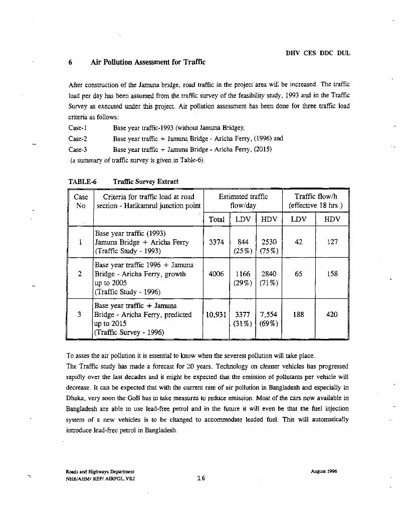
DHV CES DDC DUL6 Air Pollution Assessment for Traffic
After construction of the Jamuna bridge, road traffic in the project area will be increased. The traffic
load per day has been assumed from the traffic survey of the feasibility study, 1993 and in the Traffic
Survey as executed under this project. Air pollution assessment has been done for three traffic load
criteria as follows:
Case-I Base year traffic-1993 (without Jamuna Bridge);
Case-2 Base year traffic + Jamuna. Bridge - Aricha Ferry, (1996) and
Case-3 Base year traffic + Jamuna Bridge - Aricha Ferry, (2015)
(a summary of traffic survey is given in Table-6).
TABLE-6 Traffic Survey Extract
Case Criteria for traffic load at road Estimated traffic Traffic flow/hNo section - Hatikamrul junction point flow/day (effective 18 hrs.)
Total LDV HDV LDV |HDV
Base year traffic (1993)1 Jamuna Bridge + Aricha Ferry 3374 844 2530 42 127
(Traffic Study - 1993) (25%) (75%)
Base year traffic 1996 + Jamuna2 Bridge - Aricha Ferry, growth 4006 1166 2840 65 158
up to 2005 (29%) (71%)'!____ (Traffic Study - 1996) l
Base year traffic + Jamuna3 Bridge - Aricha Ferry, predicted 10,931 3377 7,554 188 420
up to 2015 (31%) (69%)(Traffic Survey - 1996)
To asses the air pollution it is essential to know when the severest pollution will take place.
The Traffic study has made a forecast for 20 years. Technology on cleaner vehicles has progressed
rapidly over the last decades and it might be expected that the emission of pollutants per vehicle will
decrease. It can be expected that with the current rate of air pollution in Bangladesh and especially in
Dhaka, very soon the GoB has to take measures to reduce emission. Most of the cars now available in
Bangladesh are able to use lead-free petrol and in the future it will even be that the fuel injection
system of a new vehicles is to be changed to accommodate leaded fuel. This will automatically
introduce lead-free petrol in Bangladesh.
Roads and Highways Department August 1996
NHB/AHM/ REP/ AIRPOL.VR2 16
DHV CES DDC DUL
As it is the intention of the GoB to implement measures to reduce the axle load to the legal limits,
automatically the truck engines are less overloaded and the ejection of unburned fuel will be reduced.
It is also expected that with an improved infrastructure the type of vehicles will change and the
number of trucks with more than two axles and greater engine output (Horse Power) will be increase.
This will renovate the national truck park and consequently the fuel efficiency of the engines will be
improved.
On the other hand it is expected that the traffic will rapidly increase as shown in table -6.
Air pollution will have its greatest impact in zones where speed is low or zero and where different
traffic flows come together. The queuing of traffic and slow movement of vehicles at this junction will
emit maximum exhaust emission resulting high pollution concentration in this vicinity, affecting the
surrounding recipients. The pollutants will disperse rapidly within a close proximity to the road where
duration of exposure is likely to be prolonged affecting the susceptible people. Thus, the junctions
with busstops at Hatikamrul and Bonpara are the most affected places. Second in line will be the
junctions along the road side to villages and towns like Baraigram etc. Therefor the first air pollution
assessments are based on the situations prevailing on the Hatikamrul and Bonpara roundabouts.
For this air pollution assessment a speed of 10 km/hr over a distance of 100 m at each side having
receptor distance 40 m from the center of the road surface, have been considered. This assessment has
been made both for (a) Localized air pollution assessment and (b) Overall air pollution assessment
following the standard procedure of "Design Manual for Road and Bridges, Vol.-11, Environmental
Assessment, Department of Transport, UK-1993"
6.1 Localized Air Pollution
In this localized air pollution assessment, the vehicle emission concentration of CO, HC and NO, is
calculated both for light duty petrol car and heavy duty vehicles on the basis of standard graphs, tables
at multiple stages. The main criteria of this assessment procedure is the values for no of vehicles as
given in table 6 per day at the speed of 10 km/hr; from which concentration at design speed and
distance has been assessed per vehicle and then adjusting the result with the US National Ambient Air
Quality Standard. The fmnal result of assessment is presented in table below:
Roads and Highways Departnent August 1996
NHB/AHMI REP/ AMRPOL.VR2 17
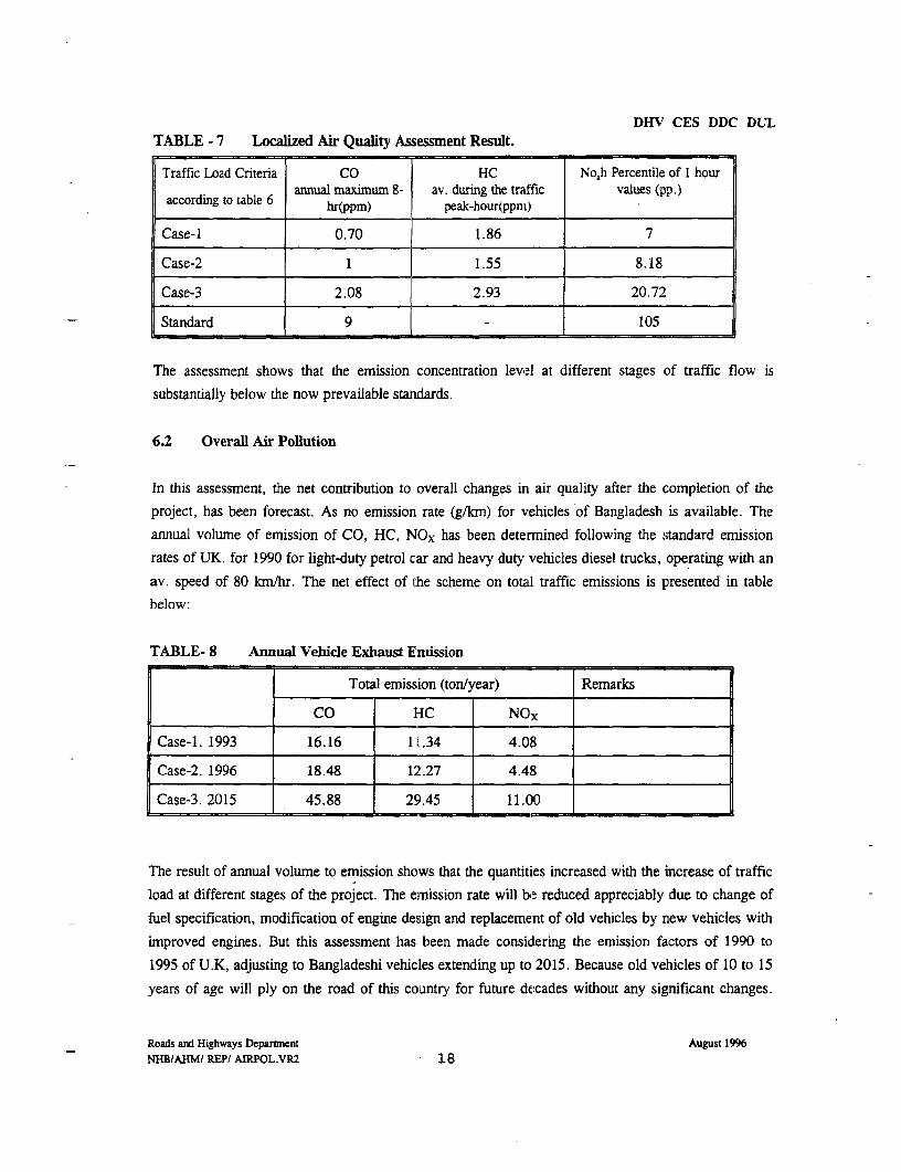
DHV CES DDC DULTABLE - 7 Localized Air Quality Assessment Result.
Traffic Load Criteria CO HC No,h Percentile of I hourannual maximum 8- av. during the traffic values (pp.)
according to table 6 hr(ppm) peak-hour(ppni)
Case-I 0.70 1.86 7
Case-2 1 1.55 8.18
Case-3 2.08 2.93 20.72
Standard 9 - 105
The assessment shows that the emission concentration level at different stages of traffic flow is
substantially below the now prevailable standards.
6.2 Overall Air Pollution
In this assessment, the net contribution to overall changes in air quality after the completion of the
project, has been forecast. As no emission rate (g/km) for vehicles of Bangladesh is available. The
annual volume of emission of CO, HC, NOx has been determined following the standard emission
rates of UK. for 1990 for light-duty petrol car and heavy duty vehicles diesel trucks, operating with an
av. speed of 80 km/hr. The net effect of the scheme on total traffic emissions is presented in tablebelow:
TABLE- 8 Annual Vehicle Exhaust Emission
Total emission (ton/year) Remarks
CO HC NOX
Case-1. 1993 16.16 1.1.34 4.08
Case-2. 1996 18.48 12.27 4.48
Case-3. 2015 45.88 29.45 11.00
The result of annual volume to emission shows that the quantities increased with the increase of traffic
load at different stages of the project. The emission rate will be reduced appreciably due to change of
fuel specification, modification of engine design and replacement of old vehicles by new vehicles with
improved engines. But this assessment has been made considering the emission factors of 1990 to
1995 of U.K, adjusting to Bangladeshi vehicles extending up to 2015. Because old vehicles of 10 to 15
years of age will ply on the road of this country for future decades without any significant changes.
Roads and Highways Department August 1996NHBIAHMI REP/ AIRPOL.VR2 18

DHV CES DDC DULBut this annual emission rate may be reduced if the condition of engines are improved along with strict
enforcement of existing rules and regulation.
7. Mitigation Measures
The air pollution impacts caused by the road project, can be mitigated or reduced as follows:
7.1 During Construction Phase
i) Soil dust:- This pollutants is raised from earth fills and unpaved road surfaces. As a
mitigatory measures, water spraying required to be done, by the contractor during the dry
period from time to time. The embankment is to made with (hydraulic) sand fill. Sand is
courser than silt and/or clay and as such contains less fine elements. This type of embankment
construction will reduce the air pollution considerably. As the sand is gained by hydraulic
dredging, the sand is wet and thus only a little dust will be thrown in the air. Transport by
axle is minimized and as such the soil dust pollution.
ii) Dust:- Dust is raised while crushing stone and/or bricks. During crushing water should be
added to catch the dust. The cleaning of construction equipment at site can be mitigated by
doing cleaning work in the night and by putting necessary covering. Asphalt plant are to be
furnished with the necessary dust collecting equipment.
iii) Black smoke:- This pollutant may be caused from asphalt plant and other construction
equipment at site. As a mitigatory measures asphalt pLnts are to be set at a vacant place on
the road alignment, not in the neighborhood of settlements. Smoke emitted from the plant may
disperse in the vast air without affecting any recipients of the area. A efficient burning of the
fuel is required and environmental friendly production is to be prescribed in the tender
documents.
Burning of bricks is avoided as no burnt brick gravel is taken up in the construction. This will
reduce emission of black smoke in the vicinity of the project.
The above temporary impacts can be managed by the contractors at site and these can be included in
the tender documents as a special terms and condition in the contract of the implementation phase. The
supervision is to adhere strictly to these prescriptions.
Roads and Highways Deparunent August 1996
NHB/AHM/ REP/ AIRPOL.VR2 19
DHV CES DDC DUL7.2 During Running Phase
Different factors influence the air pollution from traffic. The condition and the tuning of the enginehas an important impact on the emission of pollutants. Also certain design measures can influence
emission of air pollutants. If motor vehicles can maintain a constant speed, pollution will be less from
hydro carbons. A slow traffic lane is suggested for maintaining a constant speed of vehicles.
7.2.1 Measures to be taken by the GoB
Reducing air pollution from vehicles is to be regulated by law and strict enforcement of these laws. It
is beyond the capacity of the Consultants to implement these laws. However the Consultants have
recommended in their report for enforcing the existing regulations and laws. Nevertheless, to reduce
air pollution from traffic, the competent authorities should implement air pollution measures by strict
enforcement of existing environmental policy, Rules and Regulation of Motor vehicles Acts, Traffic
Rules and EQS of DOE Bangladesh as follows:
(i) Motor vehicle emission rate :- This may be controlled by annual vehicle test from a
standard testing laboratory to enforce the EQS standards.
ii) Changing fuel specification :- The use of Lead and sulfur mixed fuels may be
controlled gradually to make the vehicle exhaust emission free from poisonous lead
compounds and SO2.
iii) Speed limit :- High speed emits more NOx gasses from a vehicle, which causes
serious environmental impacts. Maximum vehicle speed should be limited in the
highway, to reduce the extent of NOx pollutants.
7.2.2 Measures to be taken in the Design
Mitigation measures to reduce the impact of air pollution by vehicles can be implemented in the
design. As shown in Table-2, the emission quantity per lkm is considerably reduced if a constant
average speed is maintained. To remove the slow traffic from the mainroad, acceleration and
deceleration of the fast traffic is reduced and consequently dte emission quantities of hydro carbons. If
constant speed is maintained the dispersion of pollutants covers a larger area due to the generated air
movement by the vehicles.
Roads and Highways Departnent August 1996NHB/AHMl REP/ AIRPOL.VR2 2 0
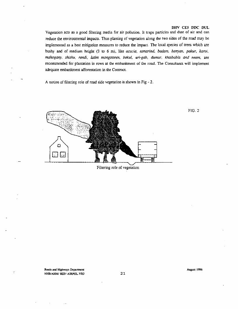
DHV CES DDC DULVegetation acts as a good filtering media for air pollution. It traps particles and dust of air and can
reduce the envirornmental impacts. Thus planting of vegetation along the two sides of the road may be
implemented as a best mitigation measures to reduce the impact The local species of trees which are
bushy and of medium height (3 to 6 m), like acacia, tamarind, badam, banyan, pakur, karoi,
mahogany, shishu, rendi, latim mongosteen, bokul, uri-gab, dumur, khaibabla and neem, are
recommnended for plantation in rows at the embankment of the road. The Consultants will implement
adequate embankment afforestation in the Contract.
A notion of filtering role of road side vegetation is shown in Fig - 2.
FIG. 2
Filtering role of vegetation
Roads and Highways Deparennt August 1996NHBJAHMI REP/ AIRPOL.VR2 21

DHV CES DDC DUL
8 Conclusion
Air pollution assessment of this new roacl project has been made in accordance with the guidelines of
the 'Design Manual for Roads and Bridges", Environmental Assessment, Departrnent of Transport
UK, 1993. The vehicle emission rate of UK. is not equivalent to Bangladeshi vehicles because about
90% vehicles of Bangladesh are of 10 to 15 years of age. These vehicles plying the roads emit
excessive exhaust from unburned fuels. Such status of vehicles is expected to continue in this country
for several decades. So the emission rates of UK. 1990, 1993 and 1995 have been used, equivalent toBangladeshi vehicles for the year 1993, 1998 and 2020 respectively to make this assessment more
viable. Again by optimization of the road alignrment, very less numbers of villages have been
intersected, leaving minimal recipients within the impact zone of 300 m from the center of the road.
This has been confirmed by the detailed field survey of impact zone for air pollution and noise
pollution. The result of air pollution assessment raised from the road traffic, for critical condition,
shows the concentration level of air pollutants are substantially much lower than the UK.Standard at
the different stages up to the predicted period 2015. Moreover, adopting possible mitigation measures
and its strict enforcement, as suggested,, will be quite sufficient to protect the community environment
along this road side area, for the near future.
Roads and Highways Departnent August 1996NHBIAHM/ REP/ AIRPOL.VR2 22

DHV CES DDC DULL9 References.
i) Design Manual For Roads and Bridges, Vol.-XI,
Environmental Assessment, Dept. of Transport, UK, 1993.
ii) Jamuna Bridge Project, Feasibility Report-Phase-Il,
Vol.-VIII, Annex M. Environmental Impact Assessment, 1991
iii) World Bank -OD 4.01, Operational Manual, Environmental Department 1991.
iv) World Bank - Technical Paper Number - 140
Sectoral guide lines For Roads and Highways,
Environmental Dept. - 1991
v) World Bank - Environmnental Evaluation and Road Infrastructure,
Practical guide, Part 3 - Technical Data Sheet, 1992
vi) Health Hazards of the Human Environment, W.H.O - 1972.
vii) Initial Environmental Examination Report
Jamuna Bridge Access Roads Project, Bangladesh, by Balloffet and Associate Inc.
USA, January - 1996.
viii) Environmental Quality Standards (EQS), Bangladesh
Dept. of Environment (DOE), July - 1991.
ix) TRRL Laboratory Report 1052, Department of Transport.
The estimation of Air Pollution concentrations from Road Traffic UK, 1978.
Roads and Highways Departnent August 1996NHBIAHM/ REP/ AIRPOL.VR2 23

b I .
DHV CES DDC DUL
COLOPHON
Client : The Government of the People's Republic of Bangladesh
Project Nalka - Hatikamrul - Bonpara New Road Project
File : K4008.01.001
Length of report 23 pages
Author Abdul Hoque Molla
Contributions L.J. Wetsteijn, 1. Wilkinson
Team Leader L.J. Wetsteijn
Project manager R. Vaandrager
Date 21 August 1996
Approved L.J. Wetsteijn
Roads and Highways Department August 1996
NHB/AHMI REP/ AIRPOL.VR2 24

I I I I

THE GOVERNMENT OF THE PEOPLE'S REPUBLIC OF BANGLADESH
ROADS AND HIGHWAYS DEPARTMENT
NALKA - HATIKAMRUL - BONPARA NEW ROAD
Loan Agreement 2638 BD
NOISE POLLUTION ASSESSMENT
Subject Detailed Engineering Study
File : K4008.01.001
Date 31 August 1996
Status Revision 2
Our ref NHB/AHM/REPORT/ N0ISEPOL.VR2
DHV CES DDC DUL
Abbreviations and Acronyms
dBA Scale Decibel with A Weighting
Hz Hertz (number of cycles per second) for sound) for Sound frequency
Leq. Equivalent continuous sound level.
LA1O, 18 hrs. Arithmetic mears of the noise levels exceeded for 10% of the time, in each of 18
one hour period between 6 A.m. and midnight.
DOE Departnent of Envirornent
NHBNRP Nalka - Hatikamrul - Bonpara Newv Road Project
TRRL Transport and Road Research Laboratory.
UK United Kingdom
USA Unted States of America
VPD Vehicles per Day
VPH Vehicles per Hour
WHO World Health Organisation
Roads and Highwaus Department August 1996NHB/RHD/REPORTSINOIPOL.VER2
3
DHV CES DDC DUL
Table of Contents
1. Introduction 5
2. Perception of Noise and Measurement Units 62.1 Road Noise Sources and Characteristics. 72.1.1 Sources 72.1.2 Characteristics 7
3. Effect of Road Noise upon Human Health. 8
4. Standards for Noise Pollution in Bangladesh. 8
5. Alignment Study. 10
6. Noise Impact Assessment 116.1 During Construction Phase 116.2 During Running Phase. 1 16.2.1 Stages in the Assesment of Noise Impacts 11
7. Noise Mitigation Measures. 17
8. Conclusion 18
9 References 19
Colophon 20
Appendix A 21
Appendix B 22
Appendix C 23
Roads and Highwaus Department August 1996NHBIRHD/REPORTSINOIPOL.VER2
4

I I I I i I~~~~~~~~~~~~~~~~~~~~~~~~~~~~~~~~~~~~~~~~~~~~~~~~~~~~~~~~~~~~~~~~~~~~~~~~~~~~~~~~~~~~~~~
DHV CES DDC DUL
1 Introduction
Noise pollution is a problem for populated urban areas. The sources of noise are many in the city, of
which noise from vehicular traffic, industrial plants, mechanical workshops, construction sites and
other man-made activities are notable. The road traffic noise has been recognized as a significant noise
pollutant for community environment. Noise pollution has an adverse impact on the human health,
affecting the people mentally, physiologically and sociologically. In Bangladesh, traffic noise pollutionis becoming problematic in big cities like Dhaka and other major cities, due to rapid population
growth and increase of vehicular traffic. In rural areas, noise pollution has not yet become a problem,because of thin population and low traffic flow.
To meet the growing demand of the increasing population all over the country, the traffic is increasing
on the existing national highways for transporting necessary commodities everyday from one place to
another. In Bangladesh heavy duties vehicles like trucks and buses are found more in number on theroad than light vehicles. Moreover, majority of these heavy vehicles are 10 to 15 years old with poorengine condition, which produce more noise during their movement.
With the completion of Jamuna Bridge, the new road under study will have an almost similar traffic
load as the Jamuna Bridgealong with overall increase of traffic load in the road network of this North-
Bengal zone. So, the noise level from road traffic will be invariably increased along this alignment. A
key map showing location of the proposed Nalka-Hatikamrul-Bonpara New Road is shown in AppedixC. Besides this, new road project will cause temporary noise impact during construction phase. The
people living along the road side will have to face discomfort out of these noise impacts, during the
above mentioned two phases, These impacts requires a detailed study for the interest of conmmunity
health of the project area.
2 Perception of Noise and Measurement Units
The response of the ear to noise depends on the sound pressure. The intensity of the response is
related to the logarithmic function of a sound pressure. The amplitude of audiabie pressure 2 x 10-52N/mi is considered as the weakest sound pressure dectectabe by an human ear under very quiet
condition and maximum sound level is considered above 103 N/M2. By taking logarithms of these two
levels, scale is reduced to 0 to 15 Bels or 0 to 150 deci-bels or dB. The notion of decibel is
insufficient to take the sound sensation efficiently perceived by the human air into account. To take
sensitivity of the human ear into consideration, a series of weighing filters has been developed, out ofwhich weight "A" filter has a wide spread use. Therefore, the dBA scale (decibel with A weighing)
Roads and Highwaus Departnnt August 1996
NHB/RHDIREPORTS/NOIPOL.VER2
5
DHV CES DDC DUL
enables a sound or a noise to be synchronized by taking the reactions of the human ear into account.
In practice, a noise level from 30 to 50 dB(A) considered as ambient level of a calm surroundings.
Again the frequency of sound is the rate at which a sound wave oscillates, measured in number of
cycles per second or Hertz (Hz). With regard to frequencies, the auditory field of the human ear
extends from 20 to 20,000 Hz. Hearing sensitivity increases with the higher number of hertz and
reduces with the low number of Hertz. The threshold of hearing varies with the frequency of sound.
But the characteristics of audiable threshold is that it differs very little between 1,000 Hz. and 4,000
Hz. The audibility threshold at 4,000 Hz. is such that it occurs in the early stage of hearing
impairment.
Again, the noise from a traffic stream is not constant but varies from moment to moment and as such
it is necessary to use an index to arrive at a single figure estimate of the overall noise level for
assessment purposes. The index adopted by the U.K. government to assess traffic noise is LAIO,18 h,
which is the arithmetic means of the noise levels exceeded for 10% of the time in each of 18-one hour
period between 6 am. and midnight. This index showed a very good correlation between resident's
dissatisfaction with the existing traffic noise.
The index LAeq is the equivalent continuous sound level, used for measuring fluctuating noise, for
example to assess noise from construction and demolition sites and from railways and aircrafts.
A scale which is sometirnes used to describe background noise levels is LA90, which is the level
exceeded for 90% of the time. This index may give a mcre realistic indication of noise changes in
rural areas at a considerable distance from a new road because the main noise effect is likely to be on
background noise level. But its usefulness is uncertain at the present time.
Out of above sound measuring scales, L.q of dBA scale is suitable for measuring traffic noise. Road
noise is variable in the course of time, and it is not possible to express all these sound frequencies by
an instantanious level. Therefor, road noise is characterized by a mean value over a given time. L.q(equivalent acoustic level) is the sound level of a stable noise which contains the same energy as the
variable noise over the same period. It represents the mean of the acoustic energy perceived during theperiod of observation. The period usually considered is that from 08.00 hrs. to 20.00 hrs. Theequivalent acoustic level will be Leq (08.00 hrs.-20.00 hrs.). Sound level measured in dBA scale,
caused from different sources, at different environments are presented in the Figure-2 and Figure-3.
Roads and Highwaus Department August 1996
NHB/RHD/REPORTS/NOIPOL.VER2
6
DHV CES DDC DUL
2.1 Road Noise Sources and Characteristics.
2.1.1 Sources
The main sources of road noise, is caused by the vehicular itraffic and the traffic noise is again
influenced by the factors as follows:
a) Noise from engine, exhaust pipe and horns
b) Density of traffic flow
c) Noise from vehicle speed (wind)
d) Noise of rolling tyres on the road surface
e) Road surface characteristics and road gradients
2.1.2 Road Noise Characteristics.
On road noise characteristics the following remarks are applicable:
i) The noise from a traffic flow is not constant but varies from moment to moment and
thus road noise is characterized by a mean value over a given time. The equivalent,
acoustic level (Leq) is a stable noise level which contains the same energy as the variable
noises over the same period.
ii) The traffic noise at a particular reception Tpoint, received from many vehicles at
different distances for a given time, do not add up according to conventional arithmetic rules,
since the decibel is a logarithmic function of the acoustic pressure.
iii) Propagation of traffic noise to a reception point depends on the characteristic of the
surroundings such as obstructing walls, fencing, barricades, soils, wind and climatic
conditions.
iv) The sound level decreases with the distances. Any doubling of distance of a linear
source is expressed by reduction in the sound level of 3 dBA.
v) Doubling the energy level (for example, the volume of traffic) increases noise level by 3
dBA.
Roads ard Highwaus Dcpatrment August 1996
NHB/RHD/REPORTS/NOIPOL.VER2
7
NALIKA-HATKAMR11,BONPARA NEW ROAD PROJECT
Environmental Studies - Traffic Noise Figure.
dB(A) SCALE
t _ Z 0 < ~~~~- Thres.cCo':af
Pneumatic drillWfsRenced) 7m distanc e * Z~~~ m lb. ~~~High specd
FB__ _ _ _ - Passengcr tr.1i:
Haz3rd to hearing at 25rn
from continuousexposure exposure , } FJena~~~~~~~~~~~~~~eiy diesel Lorry
80 igerc3r or 80i U8at 40km/Vh 7m diz;ncehmnger car or so X ,
ht van } |0 $ Pm(rlstanc ~ ~~~~~~~~~~~~~~~~~~~~Twin engincd
modern jet
co <Busy qenerc
Commun,cat.on otizceslarts becoming- // )t
40
ibedroom
Thresholdc0.0
hearing
The Level of Common St_nds on the dB(A) Scale
Source:- Design Manual for Roads and Bridges. VDI-XIA, -Envirornental Assessments
Department of Transport, UYK, 1993.

DHV CES DDC DUL
Roads and Highwaus Department Augusst 1996
NHB/RMD/REPORTSfNOIPOL.VER2
8

I . I I

MINII CES Dl)C DUI.
NALKA-HATIKAMRIL-BC.N-.--ZA NEW ROAD ?R7CECT
Environmental Stf -^-s - . r a .3f; c 1 s-
Basic Acovs.-cz rlti-ns Fi ure.
dBA100o, 100
sot P.
40art AOTcuia aa hcs ueiS
Roads a_11NHB/RHD/REPORTS/NOIPOI. VER'
9
20~~~
&ob~~~~~~~~ _ _ _ _ _ _ _ _~~~~~~~~~~~~~~~~I
Ccuntryzi4o Countrymide o~~ c ~AirporIby night by day
ScaIe of St-und L-evels
Source:- World Bank, Enviroun.-eral Evaluation an" .~ ~ weF- .
Part 3: Teclinical Data Shiects, June 1992.
Roads and Highlwaus Dep;rtimnat August I'N(6
NHB/RHDIREP'ORTS/NOIP'Ol. VER2
DHV CES DDC DUL
3 Effects of Road Noise Upon Human Health.
The effects of noise have been recognized as a significant impact on the community environment and
also on human health. The impact from noise pollution has a long-term effect which can be perceived
very slowly in course of time. The effect of road noise upon human health can be manifested in
number of ways, such as auditory fatique, loss of sleep, mental stress, increase of heart diseases,
increased of blood pressure, diminution of hearing communication etc.
4 Standards for Noise Pollution:
Normally 50 dBA is considered as standard value for noise pollution by the international experts e.g.
WHO experts but L,q of 60 dBA may be considered as maximum limitation value for rural areas as
suggested by the experts of World Bank's Environmental Department, USA, 1992.
With the rapid development of the infrastructure in Bangladesh, the traffic load has been increasing
both on the urban roads and on the highways passing through the rural areas. In trunk roads the
percentage of HDV is higher than the LDV. This implements also that the road noise level isincreasing more than average every year. To control the ever-growing problem of noise pollution in
Bangladesh, the DOE has promulgated an Ambient Noise Standard Level for Bangladesh and noise
standard level for vehicles, in 1991. These are presented in Table-1 and Table-2 below.
Table-I Ambient Noise Standard of Bangladesh
No. Area Description of Area Unit Standard LevelsCategory
Day Night TimeTime
1. A Sensitive areas e.g. schools dBA 45 35hopitals, blind hostels andaged homes.
2. B Purely residential areas dBA 50 40
3. C Residential-cum-commercial- dBA 60 50cum-industrial areas
4. D Purely commercial areas dBA 70 60
5. E Purely industrual areas dBA 75 70
Source: EQs, DOE-Bangladesh, 1991.
Roads and Highwaus Department August 1996
NHB/RHD/REPORTS/NoIPOL.VER2
10
DHV CES DDC DUL
TABLE - 2 Noise Standards for Motor Vehicles of Bangladesh
Si. Vehicle Type Unit Standard Value Receptor distance (m)No. from the exhaust pipe.
1. Heavy vehicles and light dBA 100 0.5 mpetrol car. vehicles
2. Heavy vehicles and light dBA 80 7.5 mpetrol car. vehicles
Source: EQs, DOE-Bangladesh, 1991.
Note When sound level is measured, motor vehicle is stationary and engine condition are as
follows:-
i) Diesel engine - max. rotating speed.
ii) Petrol engine - 3/4 of max. rotating speed.
iii) Motor cycle - 1/2 of max. rotating speed for rpm 5000 max. and 3/4 for less than5000 rpm.
Roads and Highwaus Department August 1996
NHBIRHDIREPORTSINOIPOL.VER2
11

DHV CES DDC DUL
S Alignment Study
i) Horizontal alignment:
The route alignment of this new road project of about 54 kcm. in length. For this study it is divided
into two sections, notably:
(i) section 1 from Chanaige 0 to 4+000, (this portion starts from the existing Nalka bridge and
ends at the Hatikamrul junctions.
(ii) section 2, Chanaige 4+000 to 54 +000 (e.g. from Hatikamrul junction to Bonpara junction).
Section 2 is a new to be constructed road. This alignment passes through vast Chalan beel area passing
a few scattered villages. Therefore, most of the alignment will not have any recipients for noise
pollution within impact zone of 300m width, at both sides of the road except the villages involving 484
households and 2904 people approx. and 2: rural primary schools.
ii) Vertical aligmnent:
The vertical alignment of the route corridor has been surveyed and it was observed that the ground
elevation of villages is 10.85 RL (PWD) average as per recent topographic survey record, The
proposed road surface level will be 13.70 RL average (PWD). Therefore, there will be a level
difference of approx. 3 m. between the road surface and the existing households, along two sides of
route corridor. This has a great influence of noise impacts upon the recepients along the road sides, as
shown in a picture below.
Noise impact
A typical view of road side village household in respect of vertical alignments showing
effect of traffic noise.
Roads and Highwaus Depanmemn August 1996
NHBIRHD/REPORTSINOIPOL.VER2
12
DHV CES DDC DUL
6 Noise Impact Assessment, For the Proposed New Road Project.
The proposed new road project generates noise pollution in two phases:
* during the construction phase
* during the running phase
6.1 During construction phase
During this phase, the main sources of noise pollution can be divided into two components.
(a) earth embanlanent construction as per geometric design of road which include earth
excavation, carrying, dumping, compaction, levelling, etc.
(b) road pavement works which include stone crushing, paving, levelling, etc.
For the above two components of works the following construction equipments, machineries, plants
and vehicles will be used e.g. excavator, bulldozer, grader, sheep-foot roller, earth removing trucks,
stone crushing plants, pile driving equipments, road roller, aphalt mixing plants etc. The activities of
above construction equipment will continue for a period of 3 years (approx.) and will create noise
pollution, affecting the occupational health of the site labours andi surrounding environment. The noise
produced during the construction phase will not be constant but of intermittent nature, ranging from 70
dBA to 90 dBA (approx.). This will create discomfort and sleep disturbances to the working staff at
site plus surrounding people, inflicting adverse impact upon their health.
6.2 During the Running Phase.
During running phase, the main source of noise will be from traffic. This has been discussed in details
in para (2.1) of this report. This traffic noise will be of permanent nature. The intensity of noise level
will vary with the traffic density, speed of vehicles and distance of the recipients from the noise
sources.
6.2.1 Stages in the Assessment of Noise Impacts.
Stage-I: indentification of ambient noise level in the project area before construction
Ambient noise level is defined as the level of noise in an area before the change produced by the
scheme. It may include traffic noise, as well as noise from other sources.
Roads and Highwaus Department August 1996
NHB/RHDIREPORTS/NOIPOL.VER2
13
DHV CES DDC DUL
As the new road alignment is passing through a thinly populated rural area, including vast agricultural
land. At present there is practically no traffic noise perceived around the route corridor, except few
motor-cycles, and bullock-carts in the day time. In the night there is almost quiet except noises from
some domestic and wild animals and birds. Therefore, the ambient noise level will be very normal
similar to 40 dBA and 30 dBA for the day and night respectively, as per standard sound level chart
shown in figure-2.
Stage-Il: identification of noise related sensitive locations within impact zone
The noise impact zone is delineated by a 300 m wide strip from the centre of the road at both sides.
This 600 m wide band is considered as the impact zone. Each 300 m strip is divided into 3 parts of
100 m each. The strip neares to the centreline is again divided into two parts, one of 40 m and one of
60 m with the 40 m wide strip closest to the centreline. Thus creating four strips at each side of the
centre line, notably:
A 0-40m
B 40 - 100 m
C 100 - 200 m
D 200 - 300 m
In this case the first strip A from 0 to 40 m covers mainly the road embankanent. Strips B, C and D
contain rural village and agricultural land. All strips have been surveyed to identify the sensitive
locations like schools, hospitals, mosques and households, and the result is shown in Table-3.
TABLE -3 Field Survey of impact zone for Air amiLd Noise Pollution.
Si Sensitive Areas Strips surveyed at each side, from the center lineNo.
40 m 60 m 100 m 200 m
1. Schools x x 2 x
2. Hospitals x x x x
3. Mosques x 2 x x
4. Community centers x x x x
5. House holds X 56 93 225
* Total nos. of households within impact zone (both sides) = 484
Total population at (both sides) = 2904 nos.
Total Household within 50 m (both sides) = 112
Total population within 100 m (both sides) = 672 nos.
Roads and Highwaus Department August 1996
NHBIRHD/REPORTS/NOIPOL.VER2
14

DHV CES DDC DUL
Stage-Ill: Identification of traffic on the proposed new road.
The rural people living within the impact zone of the road alignment are experienced with the ambient
noise of rural areas at present. After the construction of this new road, the vehicle movement will
start on this road with a certain volume of traffic per day. This traffic density will be increased
gradually within the space of time in future. To assess road noise level, the role of this traffic load per
day or traffic density per hour, speed of vehicles, types of vehicles etc. are very essential. The traffic
load at different stages, assessed for this proposed road by the traffic studies, have been collected in
connection with noise impact assessment, is presented in the Table4 below:
Roads and Highwaus Department August 1996
NHB/RHDIREPORTS/NOIPOL.VER2
15

DHV CES DDC DUL
TABLE 4 Nalka-Hatikamrtl-Bonpara New Road Project
Environmental Studies (Noise Pollution)(Traffic Survey Data Sheet 1993 and 1996)
Year Criteria of Traffic density for Portion of Road (Low Growthed)Traffic Load
Nalka-Hatikamrul Hatikamrul-Baraigram Baraigrarn-Bonpara
Total Classification Total Classification Total Classification
HDV LDV HDV LDV HDV LDV
Without project 3374 2530 844 0 . 0 -
per day (75%)1993
Per hour - 188 141 47 0 0 l
(effective 18hrs.)
Base year 4006 2840 1166 1834 1524 310 2179 1692 487(opening year) (71%) (83%) (78%)Per day
1996 _ _ _ _ _ _ _ _ _ _
f Per hour 223 158 65 102 85 17 121 94 27(effective 18hrs.)
2015 Predicted year 10,931 7,554 3,377 5,044 4,106 938 6,037 4,563 1,474Per day l (69%) (81%) _ (76%)
Per hour 608 420 188 280 228 52 335 254 81(effective 18hrs.)
Source: Traffic Survey, 1993 Feasibility Study NHBNR Project
Traffic Survey, 1996 Design Study NHBNR Project
Stage IV Forecasting of Noise Level and Measurement For This New Road Project
To forecast the noise level of the new road, the basic data were obtained by using formulae developed
by the Transport and Road Research Laboratory (TRRL), Department of Environment, under the
Department of Transport, UK, 1977.
Secundary data were like wind impact were calculated following (I) the guidelines of the World
Bank's e.g. practical guide - Technical data Sheet On Road Infrastructures, 1992, (ii) Design Manual
Roads and Highwaus Depar. ent August 1996
NHBIRHDMREPORTSINOIPOL.VER2
16

DHV CES DDC DUL
for Roads and Bridges - Vol -XI , Department of Transport, UK, 1993 and (iii) TRRL Supplementary
Report - 425, 1978, Department of Envirornet under the Department of Transport, UK. and
consulting the related data, charts, tables, figures, reports of above agencies and collecting
informations from other secondary sources the noise impact studies has been performed as follows:
The noise level can be determined in L1o (18 hrs.) of dBA scale and L1o (I hr.) of dBA scale by the
following formulae:
LIO (18hrs.) = - 40.7 + 10 log10 Q+ 33 loglo (V+40+500/V) + 10. log10 (1+5
p/v)+0.2G .... (1)
and
L1O (1 hrs.) = - 27.6 + 10 loglo q+ 33 log2o (V+40+500/V) ± 10 log1o (1+5
p/v)+0.2G ... (2)
Whereas:
L1o (18 hrs.) av. LIo for the hours between 0600 to 2400 hrs.
Q = Total traffic flow between 0600 hr. to 2400 hrs.
L1O (1 hr.) = LIo level for any one hr.
q Total traffic flow in the hour considered.
V = Mean traffic speed in km/h.
p = Percentage of heavy vehicles in the traffic flow.
G = Gradient of the road expressed in %.
Considering the following values for this proposed new road,
1996 2015
Q = Total traffic load/day = 4006 10915
V = Mean traffic velocity/h = 50 km 60 km
p = % heavy vehicle = 75% 75%
q = Traffic flow/hour = 223 608
G % of road gradient = 3 3
The value of Llo (18 hrs.) for 1996. Comes 70.92 dBA and 76.33 dBA for the year 2015. These
values may be considered at the edge of the road. To determine the noise levels at distances, it
involves some other factors such as distance correction factors, vertical alignment factor, effects of
soil, air and wind etc.
Roads and Highwaus Deparnment August 1996
NHB/RHD/REPORTS/NOIPOL.VER2
17
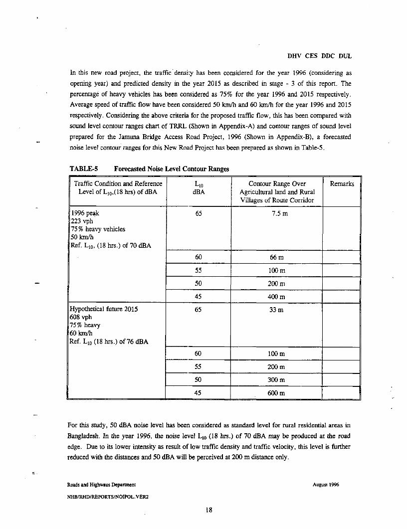
DHV CES DDC DUL
In this new road project, the traffic density has been considered for the year 1996 (considering as
opening year) and predicted density in the year 2015 as described in stage - 3 of this report. The
percentage of heavy vehicles has been considered as 75% for the year 1996 and 2015 respectively.Average speed of traffic flow have been considered 50 km/h and 60 km/h for the year 1996 and 2015
respectively. Considering the above criteria for the proposed traffic flow, this has been compared with
sound level contour ranges chart of TRRL (Shown in Appendix-A) and contour ranges of sound level
prepared for the Jamuna Bridge Access Road Project, 1996 (Shown in Appendix-B), a forecasted
noise level contour ranges for this New Road Project has been prepared as shown in Table-5.
TABLE-5 Forecasted Noise Level Contour Ranges
Traffic Condition and Reference LIo Contour Range Over RemarksLevel of L10,(18 hrs) of dBA dBA Agricultural land and Rural
Villages of Route Corridor
1996 peak 65 7.5 m223 vph75% heavy vehicles50 km/hRef. L 1o, (18 hrs.) of 70 dBA l
60 66 m
55 100ml
50 200 m
45 400 m
Hypothetical future 2015 65 33 ml608 vph75% heavy60 kn/hRef. L1o (18 hrs.) of 76 dBA
60 200 m
55 200 m
50 300 m
45 600 m
For this study, 50 dBA noise level has been considered as standard level for rural residential areas in
Bangladesh. In the year 1996, the noise level L1O (18 hrs.) of 70 dBA may be produced at the road
edge. Due to its lower intensity as result of low traffic density and traffic velocity, this level is further
reduced with the distances and 50 dBA will be perceived at 200 m distance only.
Roads and Highwaus Deparmnent August 1996
NHB/RHD/REPORTS/NOIPOL.VER2
18

DHV CES DDC DUL
In the year 2015, the noise level L1o (18 hrs.) of 76 dBA is produced at the road edges, but as its
intensity is higher due to its higher traffic density and higher speed, the noise level of 50 dBA may be
perceived at distance 300m. A key map showing the impact zone of the proposed road along with a
motion of impacts of noise pollution, is shown in Appendix-C.
The recipients within first 100 m strip is about 93 households, they will get a noise impact of 55 dBAin the starting year of this project and 60 dBA in the predicted year 2015, which are within theambient standard level of Bangladesh.
7 Noise Mitigation Measures
The mitigation measures can be adopted to reduce the noise level caused
(i) during construction phase and(ii) during running phase for the new road project
(i) During construction phase
- EEar muffs to the site workers should be provided by the employer(s) along with providingshielding for generators compressor and other construction equipments and silencer boxes intrucks and other equipments where applicable.
Construction materials should be handled in day time and not at night time.
Noisy operations like pile driving, crsrushing, etc. should be restricted to day time only.
(ii) During running phase:
By the GoB:
To control induced development along the road sides, Highway Act, 1993, for land usecontrol, to avoid constructions within 10 m from the road boundary.
To enforce the existing Motor Vehicle act and the standard setforth by the DOE to controlvehicle sounds in the road.
- To control or banning of loud air horns which are conunonly used by buses and truck
By the Consultants to be implemeted in the design:
- By optimizing the horizontal alignment to avoid households and sensitive locations to savethem from noise pollution.
Roads and Highwaus Departnent . August 1996
NHB/RHD/REPORTS/NOIPOL.VER2
19
DHV CES DDC DUL
Plantation with trees and bushes on the earth mounds along the road in front of sensitivelocations and households, may reduce the noise pollution to some extent.
8 Conclusion
Road noise is recognized as a source of pollution to the community environment. This problem has a
permanent nature affecting people living along the road side. Noise pollution is a relative new issue in
this country and DOE has not yet developped any approved methods for assessment of road noise
except direct measurement of sound level at different points by noise level meter. Again no data in
relation between noise level and distances are available in Bangladesh. So to perform the noise
pollution study for this road project, the standard methods of World Bank's practical guide line,Design Manual for Roads and Bridges, Vol XI, Env. assessment, Department of Transport, UK, 1993
and TRRL, Department of Enviroment, Departrnent of Transport, UK (TRRL Supplementary Report
425, 1978, for rural traffic noise prediction were followed.
The protective measures for reducing the noise impact for rLral areas have been suggested of whichvehicle maintenance and annual testing of motor vehicle should have the priority for strict enforcement
to achieve the DOE's Standards for sound level for vehicles.
The noise level of road traffic may rise fromn 70 dBA to 80 dBA at road at the road side, but this noise
is not constant and moreover the households along the road sides are located at appreciable distances,
so this road traffic noise may not have so much effect on the rural people except a discomfort oftolerable nature. Regarding for the predicted year 2015; although the traffic volume will be increasedby several times compared to the base year, the noise level will not increase by more than 3 dBA andwill still remain within the currently accepted limits.
Roads and Highwaus Dcparnnent August 1996
NHBIRHD/REPORTSINOIPoL.VER2
20

DHV CES DDC DUL
9 References
* Design Manual for Roads and Bridges, Vol-XI Environmental Assessment,
Department of Transport UK, 1993.
* World Bank - Practical Guide, Part-3, Technical DaLta Sheet, 1992.
* Health Hazards of the Human Environment WHO, 1972
* Initial Environmental Examination Report Jamuna Bridge Access Road Project,
Bangladesh by Balloffet and Associates Inc., USA, January 1996.
* Environrental Quality Standards (EQs) Bangladesh Department of Environment, July
1991.
TRRL Supplementary Report 425, 1978. UK.
"Rural traffic noise prediction," by D.G. Harland.
Roads and Highwaus Dcparaent August 1996
NHBIRHD/REPORTS/NOIPOL.VER2
21

I
DHV CES DDC DUL
COLOPHON
Client The Government of the People's Republic of BangladeshProject Nalka - Hatikamrul - Bonpara New Road
File K4008.01.001
Length of Report 22 pages
Author Abdul Hoque Molla
Contributions L.J. Wetsteijn
Team Leader L.J. Wetsteijn
Project Manager R. Vaandrager
Date 31 August 1996
Approved L.J. Wetsteijn
Roads and Highwaus Dcparunent August 1996
NHB/RHD/REPORTS/NOIPOL.VER2
22


DHV CES DDC DUL
APPENDIX A
Roads and Highwaus Departnent August 1996
NHB/RHD/REPORTS/NOlPOL.VER2
23

I
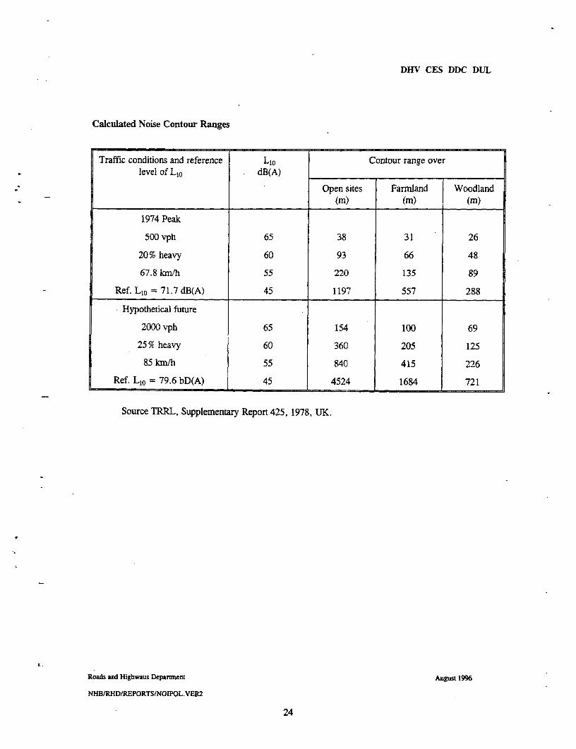
DHV CES DDC DUL
Calculated Noise Contour Ranges
Traffic conditions and reference L1o Contour range overlevel of L1o dB(A)
Open sites Farmland Woodland(m) (m) (m)
1974 Peak
500 vph 65 38 31 26
20% heavy 60 93 66 48
67.8 km/h 55 220 135 89
Ref. L1o = 71.7 dB(A) 45 1197r 557 288
Hypothetical future
2000 vph 65 154 100 69
25% heavy 60 360 205 125
85 km/h 55 840 415 226
Ref. LIO = 79.6 bD(A) 45 4524 1684 721
Source TRRL, Supplementary Report 425, 1978, UK.
Roads and Highwaus Departnent August 1996
NHB/RHD/REPORTS/NOIPOL.VER2
24


DHV CES DDC DUL
APPENDIX B
Roads and Highwaus Deparineni Augulst 1996
NHBIRHD/REPORTSINOIPOL.VER2
25

I . I - I
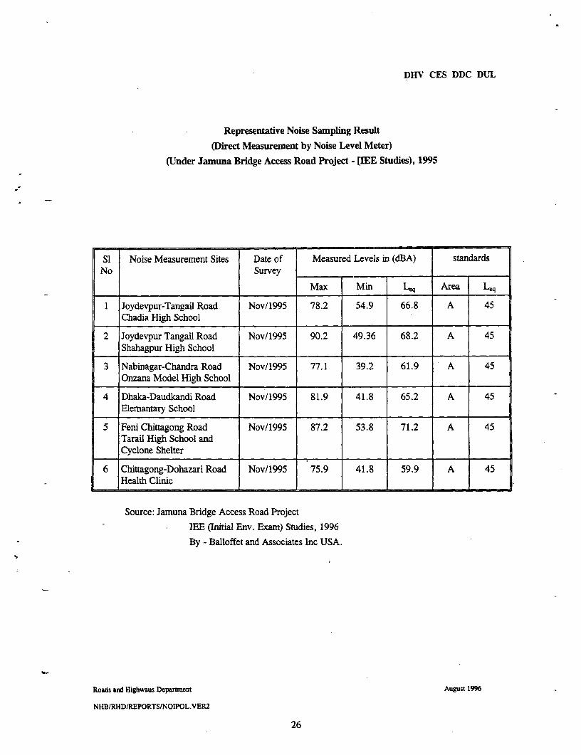
DHV CES DDC DUL
Representative Noise Sampling Result
(Direct Measurement by Noise Level Meter)
(Under Jamuna Bridge Access Road Project - [IEE Studies), 1995
SI Noise Measurement Sites Date of Measured Levels in (dBA) standardsNo Survey l
Max Min Le Area Leq
1 Joydevpur-Tangail Road Nov/1995 78.2 54.9 66.8 A 45Chadia High School
2 Joydevpur Tangail Road Nov/1995 90.2 49.36 68.2 A 45Shahagpur High School
3 Nabinagar-Chandra Road Nov/1995 77.1 39.2 61.9 A 45Onzana Model High School
4 Dhaka-Daudkandi Road Nov/1995 81.9 41.8 65.2 A 45Elemantary School
5 Feni Chittagong Road Nov/1995 87.2 53.8 71.2 A 45Tarail High School andCyclone Shelter
6 Chittagong-Dohazari Road Nov/1995 75.9 41.8 59.9 A 45Health Clinic
Source: Jamuna Bridge Access Road Project
lEE (Initial Env. Exam) Studies, 1996
By - Balloffet and Associates Inc USA.
Roads and Highwaus Department August 1996
NHB1RHD/REPORTS/NOIPOL.VER2
26

DHV CES DDC DUL
Representative Noise Samnpling Results
Sound Level Contouring by Direct Measurement
with Noise Level Meter
SI Noise Measurement Sites Noise Level Contoured Hypothetical Noise Level Contour withNo By Field Measurement the Distances in dBA Scale
with Receptor Distance,Fronm the Road Edge
0.5m 7.5m 100m 800m 300m 400m |500m 600m
1 Joydevpur-Tangil Road 70 65 60 55 50 45 40Chandia High School
2 Joydevpur-Tangail Road - 70 65 60 55 50 45Shohagpur High School I_I__
3 Nabinagar-Chandra Road 65 60 55 50 45 40 35Onzona Model High School
4 Dhaka-Daudkandi Road 70 65 60 55 50 45 40Elementary School
5 Feni-Chittagong Road - 70 65 60 55 50 45Terail High School .
6 Chittagong-Dohazari Road - 65 60 55 50 45 40Health Clinic
Source: Jamuna Bridge Assess Road Project.
(IEE Studies) - ADB - January, 1996.
Roads and Highwaus Department August 1996
NHB/RHD1REPORTS/NOIPOL.VER2
27

DHV CES DDC DUL
APPENDIX C
Roads and Highwaus Department August 1996
NHBIRHDIREPORTS/NOIPOL.VER2
28
Related Documents