N20 N8 N25 East N8 N25 West N22 N25 N27 N71 N22 N71 ©Ordnance Survey Ireland. All rights reserved. License number 2003/07CCMA/Cork City Council. ±

Welcome message from author
This document is posted to help you gain knowledge. Please leave a comment to let me know what you think about it! Share it to your friends and learn new things together.
Transcript

N20
N8 N25 East
N8 N25 West
N22 N25 N27 N71
N22 N71
©Ordnance Survey Ireland. All rights reserved. License number 2003/07CCMA/Cork City Council.
±
YO
U A
RE
APP
RO
AC
HIN
G T
HE
OR
BIT
AL
RO
UT
E
AT
JU
NC
TIO
N 2
6
G
O L
EFT
AH
EA
D
F
OR
JU
NC
TIO
N 1
,
N8,
N22
, N
25,
N27
AIR
POR
T, C
AR
FE
RR
Y
G
O R
IGH
T F
OR
JU
NC
TIO
N 2
5 N
20,
T
OU
RIS
T O
FFIC
E
YO
U A
RE
TR
AV
EL
LIN
G O
N T
HE
OR
BIT
AL
RO
UT
E,
APP
RO
AC
HIN
G J
UN
CT
ION
22
G
O S
TR
AIG
HT
AH
EA
D
FO
R N
8, N
20, N
25
PA
RK
ING
AN
D
HU
GU
EN
OT
QU
AR
TE
R
GO
RIG
HT
FO
R H
IST
OR
IC C
EN
TR
E
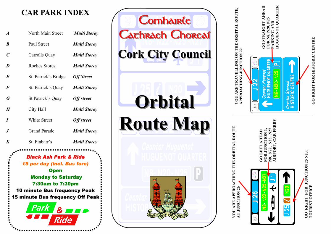
ORBITAL JUNCTION INDEX
J1 Anderson’s Quay/Michael Collins Bridge J2 De Valera Bridge/Albert Quay J3 Albert St. / Albert Road J4 Albert St/South City link J5 Station Rd/Anglesea St. J6 Anglesea St./South Terrace J7 South Terrace/Union Quay J8 Copley St./Union Quay J9 Georges Quay/Parliament Bridge J10 Sullivan’s Quay/South Main St. J11 Bishop St./Sharman Crawford St. J12 Sharman Crawford St/Wandesford Quay J13 St. Finbarr’s Bridge/Lancaster Quay J14 Courthouse St./Washington St. J15 Lancaster Quay/Mardyke St. J16 Western Rd./Bandfield J17 Dyke Parade/Grenville Place J18 Sheares St/Grattan St. J19 Grattan St./Henry St. J20 Grattan St./Batchelor’s Quay J21 Batchelor’s Quay/North Gate Bridge J22 Coal Quay/Cornmarket St. J23 Lavitts Quay/Christy Ring Bridge J24 Lavitt’s Quay/St.Patrick’s Bridge J25 Merchant’s Quay/Parnell Place J26 Merchant’s Quay/Brian Boru Bridge
Car Chlos Chomhairle Cathrach Chorcaí
Cork City Council Car Parks
PAUL STREET MULTI-STOREY CAR PARK
735spaces
OPEN 07:30 to MID-NIGHT, MON to SAT
HOURLY RATES APPLY
NORTH MAIN STREET MULTI-STOREY
CAR PARK
410spaces
OPEN 08:30 to 19:00, MON to SAT,
LATE OPENING THURS & FRI to 21:30
HOURLY RATES APPLY
WHITE STREET CAR PARK
160spaces
OPEN 07:30 to 19:30, MON to FRI
€10 FLAT FEE (FREE after 15:30)
BLACK ASH PARK & RIDE (off N27)
920spaces
OPEN 07:30 to 19:30, MON to SAT
€5 FLAT FEE (Includes Return Bus to City Centre
for Driver & Passengers)
NEW ORBITAL ROUTE & SIGNAGE SYSTEM FOR CORK
Cork City Council has introduced a major new directional signage system for the city. The new system is designed to make it easier for motorists to find their way to and from major national and regional routes and to access parking in the city centre. It will also help to redirect unnecessary traffic away from the city centre, thereby reducing overall traffic numbers, alleviating congestion levels and improving the environment. Bus, cycle and pedestrian priority will also be improved.
HOW DOES THE ORBITAL ROUTE WORK ?
The Route corresponds roughly to the outline of the City Centre Island area. The signage system is colour coded blue and white. Each junction on the orbital route has a unique number. This is displayed in a BLUE rectangle at the top of each sign. When driving on the Orbital route the signs have a BLUE background. As you approach the Orbital route the signs have a WHITE background. Directional information relating to parking, routes, tourist office, areas of interest, will be shown on these signs. The Orbital route can also be used in conjunction with a route map to plan your journey around the city and onwards to the nearby National road network.
CAR PARK INDEX
A North Main Street Multi Storey B Paul Street Multi Storey C Carrolls Quay Multi Storey D Roches Stores Multi Storey E St. Patrick’s Bridge Off Street F St. Patrick’s Quay Multi Storey G St Patrick’s Quay Off street H City Hall Multi Storey I White Street Off street J Grand Parade Multi Storey K St. Finbarr’s Multi Storey
Comhairle Comhairle Cathrach ChorcaíCathrach Chorcaí
Cork City CouncilCork City Council
Orbital Orbital Route MapRoute Map
Black Ash Park & Ride €5 per day (incl. Bus fare)
Open Monday to Saturday
7:30am to 7:30pm 10 minute Bus frequency Peak
15 minute Bus frequency Off Peak

YO
U A
RE
APPR
OA
CH
ING
TH
E O
RB
ITA
L R
OU
TE
A
T JU
NC
TIO
N 26
G
O L
EFT
AH
EA
D
FOR
JUN
CT
ION
1, N
8, N22, N
25, N27
AIR
POR
T, C
AR
FER
RY
GO
RIG
HT
FOR
JUN
CT
ION
25 N20,
TO
UR
IST O
FFICE
YO
U A
RE
TR
AV
EL
LIN
G O
N T
HE
OR
BIT
AL
RO
UT
E,
APPR
OA
CH
ING
JUN
CT
ION
22
GO
STR
AIG
HT
AH
EA
D
FO
R N
8, N20, N
25
PAR
KIN
G A
ND
H
UG
UE
NO
T Q
UA
RT
ER
G
O R
IGH
T FO
R H
ISTO
RIC
CE
NT
RE
ORBITAL JUNCTION INDEX
J1 Anderson’s Quay/Michael Collins Bridge J2 De Valera Bridge/Albert Quay J3 Albert St. / Albert Road J4 Albert St/South City link J5 Station Rd/Anglesea St. J6 Anglesea St./South Terrace J7 South Terrace/Union Quay J8 Copley St./Union Quay J9 Georges Quay/Parliament Bridge J10 Sullivan’s Quay/South Main St. J11 Bishop St./Sharman Crawford St. J12 Sharman Crawford St/Wandesford Quay J13 St. Finbarr’s Bridge/Lancaster Quay J14 Courthouse St./Washington St. J15 Lancaster Quay/Mardyke St. J16 Western Rd./Bandfield J17 Dyke Parade/Grenville Place J18 Sheares St/Grattan St. J19 Grattan St./Henry St. J20 Grattan St./Batchelor’s Quay J21 Batchelor’s Quay/North Gate Bridge J22 Coal Quay/Cornmarket St. J23 Lavitts Quay/Christy Ring Bridge J24 Lavitt’s Quay/St.Patrick’s Bridge J25 Merchant’s Quay/Parnell Place J26 Merchant’s Quay/Brian Boru Bridge
Car Chlos Chomhairle Cathrach Chorcaí
Cork City Council Car Parks
PAUL STREET MULTI-STOREY CAR PARK
735spaces
OPEN 07:30 to MID-NIGHT, MON to SAT
HOURLY RATES APPLY
NORTH MAIN STREET MULTI-STOREY
CAR PARK
410spaces
OPEN 08:30 to 19:00, MON to SAT,
LATE OPENING THURS & FRI to 21:30
HOURLY RATES APPLY
WHITE STREET CAR PARK
160spaces
OPEN 07:30 to 19:30, MON to FRI
€10 FLAT FEE (FREE after 15:30)
BLACK ASH PARK & RIDE (off N27)
920spaces
OPEN 07:30 to 19:30, MON to SAT
€5 FLAT FEE (Includes Return Bus to City Centre
for Driver & Passengers)
NEW ORBITAL ROUTE & SIGNAGE SYSTEM FOR CORK
Cork City Council has introduced a major new directional signage system for the city. The new system is designed to make it easier for motorists to find their way to and from major national and regional routes and to access parking in the city centre. It will also help to redirect unnecessary traffic away from the city centre, thereby reducing overall traffic numbers, alleviating congestion levels and improving the environment. Bus, cycle and pedestrian priority will also be improved.
HOW DOES THE ORBITAL ROUTE WORK ?
The Route corresponds roughly to the outline of the City Centre Island area. The signage system is colour coded blue and white. Each junction on the orbital route has a unique number. This is displayed in a BLUE rectangle at the top of each sign. When driving on the Orbital route the signs have a BLUE background. As you approach the Orbital route the signs have a WHITE background. Directional information relating to parking, routes, tourist office, areas of interest, will be shown on these signs. The Orbital route can also be used in conjunction with a route map to plan your journey around the city and onwards to the nearby National road network.
CAR PARK INDEX
A North Main Street Multi Storey B Paul Street Multi Storey C Carrolls Quay Multi Storey D Roches Stores Multi Storey E St. Patrick’s Bridge Off Street F St. Patrick’s Quay Multi Storey G St Patrick’s Quay Off street H City Hall Multi Storey I White Street Off street J Grand Parade Multi Storey K St. Finbarr’s Multi Storey
Comhairle Comhairle Cathrach Chorcaí Cathrach Chorcaí
Cork City Council Cork City Council
Orbital Orbital Route Map Route Map
Black Ash Park & Ride €5 per day (incl. Bus fare)
Open Monday to Saturday
7:30am to 7:30pm 10 minute Bus frequency Peak
15 minute Bus frequency Off Peak
Related Documents