MUSCAMAGS MUSCAMAGS Multi Multi - - Scale Geo Scale Geo - - Simulation Simulation based on Software Agents based on Software Agents Content of a Poster presented at GEOIDE Content of a Poster presented at GEOIDE ’ ’ s s Annual Meeting, Banff, Alberta June 1st 2006 Annual Meeting, Banff, Alberta June 1st 2006 Researchers: Laval University: Yvan Bédard, Bernard Moulin (Project Leader) , Marius Thériault, Queens University: Robin Harrap, Wilfried Laurier University: Sean Doherty, McMaster University: Darren Scott Supporting Organizations: Defense RDDC Valcartier, Alberta Sustainable Resource and Development, Quebec SOPFEU, Center for Spatial Analysis (Mc Master Univ.), CRAD (Univ. Laval), Canadian PROCESSUS Network, Ville de Québec, Sûreté du Québec, National Research Council Canada, Ministère des transports du Québec, Ministère de la sécurité publique du Québec, Ministère des ressources naturelles et de la faune, Institut de santé publique du Québec, Nsim Technology

Welcome message from author
This document is posted to help you gain knowledge. Please leave a comment to let me know what you think about it! Share it to your friends and learn new things together.
Transcript
MUSCAMAGSMUSCAMAGSMultiMulti--Scale GeoScale Geo--SimulationSimulationbased on Software Agentsbased on Software Agents
Content of a Poster presented at GEOIDEContent of a Poster presented at GEOIDE’’s s Annual Meeting, Banff, Alberta June 1st 2006Annual Meeting, Banff, Alberta June 1st 2006
Researchers: Laval University: Yvan Bédard, Bernard Moulin (Project Leader) , Marius Thériault, Queens University: Robin Harrap, Wilfried Laurier University: Sean
Doherty, McMaster University: Darren Scott
Supporting Organizations: Defense RDDC Valcartier, Alberta Sustainable Resource and Development, Quebec SOPFEU, Center for Spatial Analysis(Mc Master Univ.), CRAD (Univ. Laval), Canadian PROCESSUS Network, Ville de Québec, Sûreté du Québec, National Research Council Canada,
Ministère des transports du Québec, Ministère de la sécurité publique du Québec, Ministère des ressources naturelles et de la faune, Institut de
santé publique du Québec, Nsim Technology

Second MUSCAMAGS Workshop, Québec Dec. 05
Objective: To develop a methodology and a software platform to create multi-scale multi-agent geo-simulations to support operational decision support systems for Multi-Actor Dynamic Spatial Situations (MADSS)
MADSSs involve a large number of actors of different types (human, animal, etc.) acting in geographic spaces of various extents
MADSSs need to be monitored to insure :– human security and equipment preservation (flood, wildfire, oil slicks), – the respect of public order (population evacuation, crowd monitoring and control, peace-
keeping, etc.)– the adequate use of infrastructures (monitoring of people and households transportation
and shopping habits in a urban area to better plan transportation infrastructures, location of services’ and retailers, etc.)
– Impact of emergency response plans
• Certain MADSSs occur on a regular basis (ex. daily traffic patterns in a urban area) whereas other MADSSs can evolve rapidly as a consequence of the occurrence of particular events and/or changes in individual behaviors (often in crisis situations)• Certain MADSSs occur within the context of another MADSS of larger extent • Decision makers need an overall understanding of the situation to monitor its evolution, to develop strategies to adequately intervene, to develop and compare alternative intervention scenarios and to anticipate the consequences of these interventions. • We intend to use a multi-agent geo-simulation approach to simulate at different (spatio-temporal) scales different interacting MADSSs in order to support the decision making process

Preliminary ideas to create a multiscale environment
Current Approaches: Current multi-scale simulations are done for traffic simulations based on different spatial models at the macro, meso and micro level. Problems related to the detection of incoherencies between heterogeneous models
Our Goal: To develop a unique geographic environment that can be used at different scales, integrating different levels of detail for areas as well as for transportation networks.
Montreal
Québec City
Québec City Current work:
Find the most appro- priate data structures to create our multi-scale virtual geographic environment
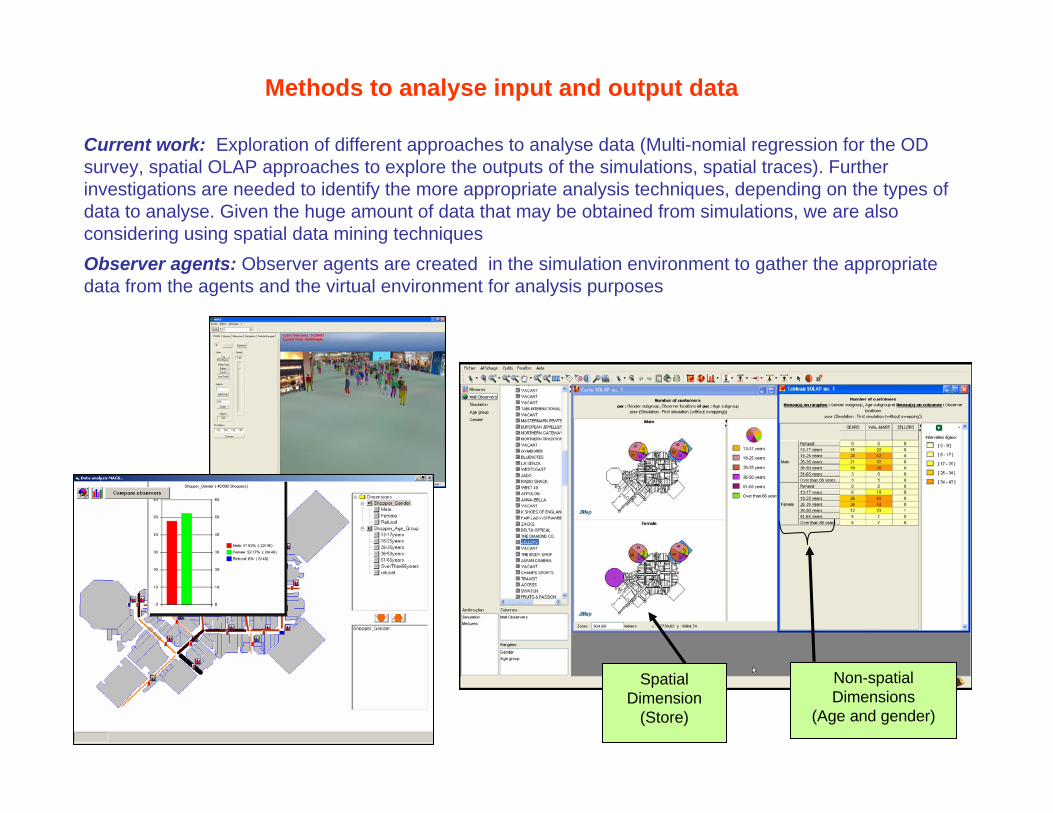
Methods to analyse input and output data
Current work: Exploration of different approaches to analyse data (Multi-nomial regression for the OD survey, spatial OLAP approaches to explore the outputs of the simulations, spatial traces). Further investigations are needed to identify the more appropriate analysis techniques, depending on the types of data to analyse. Given the huge amount of data that may be obtained from simulations, we are also considering using spatial data mining techniques Observer agents: Observer agents are created in the simulation environment to gather the appropriate data from the agents and the virtual environment for analysis purposes
Spatial Dimension
(Store)
Non-spatial Dimensions
(Age and gender)

Creation of a synthetic population
Current work: Compilation of Quebec city’s 2001 Origin Destination survey to identify the characteristics of the sample population (MNL: multi-nomial logistics). Households and individuals are created and assigned to residence places in the hexagonal grid . We are able to demonstrate the representativity of the synthetic population with respect to the OD survey sampleWork in progress: We assign to each grid cell the percentages of the different types of activities that may be done in it (work, leisure, shopping, health care activities) based on the real locations of the different organizations obtained from various data sources. We also use the MNL approach to identify for each individual (according to its characteristics: gender, profession, etc.) its workplace, its preferred shopping places (malls, shops, etc.), its preferred leisure places, health care places. We will also determine for each individual the preferred routes to go to its preferred places, using TransCad route determination facilities.Future works: After the creation of the synthetic population, we will be able to start the first simulations of people displacements in the Greater Quebec urban area (Week-day car traffic MADDS)
Fastest route34.25 minutes
Shortest path43.1 kilometers

Towards more sophisticated behavioral models for synthetic populations
Motivation: The OD survey has limitations (the interviews are done with one individual per househlod for the activities of all members during one week day, we do not know what was intended, information about displacements are limited, etc.). Hence, the models that we will get will lack details about the decision making process and activity scheduling done by individuals. Such information can be obtained from more detailed panel surveys which were done by the PROCESSUS Network in 2002-04Goals: 1) Find an adequate model for constrainted activity scheduling, 2) Find an adequate model for constrainted destination choice, 3) Develop these models from appropriate data surveys (panel surveys done by the PROCESSUS Network), 4) Derive from these models the corresponding agent’s behavior models
Work in progress: 1) Work with an approach based on a Prism Constrained Scheduling Process; 2) Assess the available data from the Panel surveys, 3) Calibrate the activity pre-planning choice rules, 4) Refine the space-time prism algorithm (Constrained destination choice sets for more in-day and impulsive activities, Minimum assumed participation time)
time of daytime of day
xx
yy
homehome
workworkshopshop
Travel betweenTravel betweenactivityactivitylocationslocations
Time spent Time spent conducting conducting activityactivity
Activity Activity LocationLocation
Space-time Prism Constraints within the Scheduling Process

Snapshots of some projects done with
partners
Accessibility maps using the transit bus
system (case of Quebec Galleries de la
capitale)
Person-based Raw GPS Traces
(home to work)
BlackBerry with GPS Diary
GPS Prompted Recall Diary (spatial summary)
Related Documents


![Tópicos 2] geo 2° ano geo](https://static.cupdf.com/doc/110x72/5572601dd8b42a761d8b4c36/topicos-2-geo-2-ano-geo.jpg)


