PL 18/113 C MUNICIPAL YEAR 2018/2019 REPORT NO. 167 MEETING TITLE AND DATE: Cabinet 13 th February 2019 REPORT OF: Doug Wilkinson Director of Environment and Operational Services Contact officer and telephone number: Ian Russell tel. 020 8379 3499 1. EXECUTIVE SUMMARY 1.1 1.2 It is proposed to use Natural Flood Management measures such as creating ponds, wetlands and woodland to reduce flood risk in the Salmons Brook catchment. It is also proposed to carry out a feasibility study to investigate the additional benefits and costs associated with creating a significant amount of publicly accessible woodland in rural areas of Enfield. The Salmons Brook Natural Flood Management project has been awarded £303k funding by the Thames Regional Flood and Coastal Committee and the Environment Agency. Additional external funding will be sought and used to expand the scope of the project where bids are successful. 2. RECOMMENDATIONS 2.1 2.2 2.3 2.4 To approve the works to deliver the Salmons Brook Natural Flood Management project. To note the proposal to use grants to fund a feasibility study to investigate the benefits and costs of creating up to 100 hectares of woodland in rural areas of Enfield with associated access improvements. To delegate authority to the Cabinet Member for Environment to approve delivery of the Woodland Creation scheme based on the findings of the feasibility study in consultation with the Cabinet Member for Property and Assets. To delegate authority to the Director of Environment and Operational Services to authorise the placing of orders through any of the Council’s existing relevant term contracts or to invite and evaluate tenders/quotations and, where suitable tenders/quotations are received, to authorise the award of contracts for the works in compliance with the Council’s procurement rules. Subject: Enfield Rural Catchment Project Wards: Chase, Cockfosters and Highlands Key Decision No: 4795 Agenda – Part: 1 Cabinet Member consulted: Cllr Guney Dogan Item: 12

Welcome message from author
This document is posted to help you gain knowledge. Please leave a comment to let me know what you think about it! Share it to your friends and learn new things together.
Transcript

PL 18/113 C
MUNICIPAL YEAR 2018/2019 REPORT NO. 167 MEETING TITLE AND DATE: Cabinet 13th February 2019 REPORT OF: Doug Wilkinson Director of Environment and Operational Services
Contact officer and telephone number: Ian Russell tel. 020 8379 3499
1. EXECUTIVE SUMMARY 1.1 1.2
It is proposed to use Natural Flood Management measures such as creating ponds, wetlands and woodland to reduce flood risk in the Salmons Brook catchment. It is also proposed to carry out a feasibility study to investigate the additional benefits and costs associated with creating a significant amount of publicly accessible woodland in rural areas of Enfield. The Salmons Brook Natural Flood Management project has been awarded £303k funding by the Thames Regional Flood and Coastal Committee and the Environment Agency. Additional external funding will be sought and used to expand the scope of the project where bids are successful.
2. RECOMMENDATIONS 2.1 2.2 2.3 2.4
To approve the works to deliver the Salmons Brook Natural Flood Management project. To note the proposal to use grants to fund a feasibility study to investigate the benefits and costs of creating up to 100 hectares of woodland in rural areas of Enfield with associated access improvements. To delegate authority to the Cabinet Member for Environment to approve delivery of the Woodland Creation scheme based on the findings of the feasibility study in consultation with the Cabinet Member for Property and Assets. To delegate authority to the Director of Environment and Operational Services to authorise the placing of orders through any of the Council’s existing relevant term contracts or to invite and evaluate tenders/quotations and, where suitable tenders/quotations are received, to authorise the award of contracts for the works in compliance with the Council’s procurement rules.
Subject: Enfield Rural Catchment Project Wards: Chase, Cockfosters and Highlands Key Decision No: 4795
Agenda – Part: 1
Cabinet Member consulted: Cllr Guney Dogan
Item: 12
PL 18/113 C
3. BACKGROUND 3.1 Context and Opportunities 3.1.1 The rural north-west of Enfield is designated as Green Belt land and consists
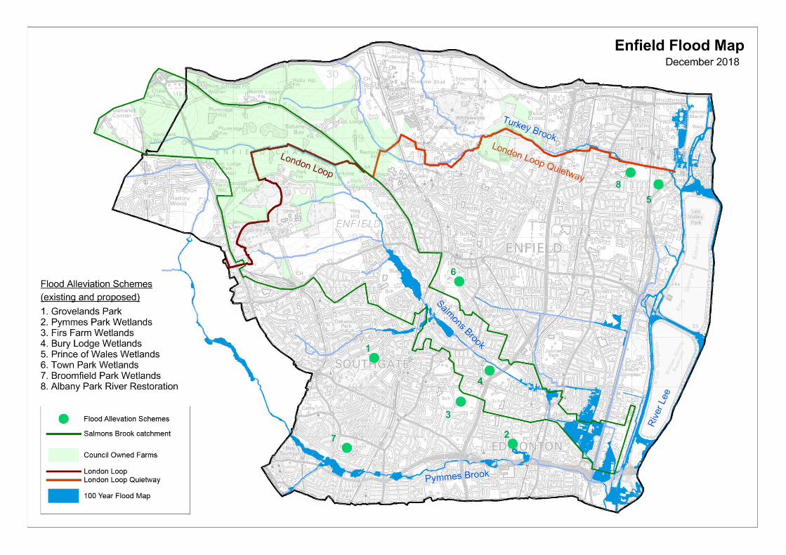
primarily of Council-owned leasehold farms with a number of large public parks including Trent Park and Whitewebbs – please refer to the attached maps for further information on the extent and location of these features. The farmland is a mixture of arable and pastoral land. Public access to these agricultural areas is currently very limited as most of the public rights of way are un-paved footpaths of varying quality.
3.1.2 These hilly fields are the highest part of the borough. All of the rain falling
here ultimately drains to the Lee valley in the east. The rainfall runoff from this catchment area is a major cause of flood risk in local rivers such as the Salmons Brook. The current Environment Agency fluvial flood mapping for this catchment estimates that there are 20 properties with a ‘very significant’ risk of flooding (annual probability higher than 1 in 20) and 1,075 properties with a ‘moderate’ risk of flooding (annual probability between 1 in 75 and 1 in 200) in the Salmons Brook catchment. The properties with the highest risk are in the Grange ward near Enfield Town; however, most of the properties at risk are in the Edmonton area further downstream. Another issue is that the water draining from these areas is often polluted by diffuse sources such as fertiliser and sediment; these are associated with agricultural activities which are significant contributors to poor water quality in Enfield’s rivers.
3.1.3 There is potential to increase the benefit of this resource for both people and the environment by improving access and converting a proportion of farmland into woodland, meadow and wetlands. This approach can deliver the following benefits:
Reduced flood risk to all at risk properties in the Salmons Brook catchment through the use of natural flood management techniques such as the creation of ponds, wetlands and woodlands that slow the flow of water and reduce rainfall runoff
Improved places for recreation such as walking and cycling
Linking communities through improved access, encouraging active lifestyles
Increased access to nature including creating opportunities for education in a natural environment
Addressing the adverse impact of rural diffuse pollution on Enfield’s streams and rivers
Enhanced areas of biodiversity through the creation of a wide range of habitats including woodland, meadow and wetlands
Economic benefits associated with the creation of productive woodland; an appropriate proportion of any new woodland could be productive to benefit the local economy and provide useful, sustainable products for local residents, these could include biomass fuel, firewood and other timber products
PL 18/113 C
3.1.4 Through discussions with the Greater London Authority (GLA) and Environment Agency (EA) two main themes have been developed to form this project outline:
Focus on the Salmons Brook catchment – this is due to the high flood risk downstream in this catchment relative to the adjacent Turkey Brook catchment
Create a swathe of woodland following the route of the London Loop footpath from Trent Park towards Whitewebbs Park – this would create publicly accessible areas of enhanced amenity and biodiversity; this approach increases the overall benefit and the potential funding available
3.2 Salmons Brook Natural Flood Management 3.2.1 Natural Flood Management (NFM) refers to the alteration, restoration or use of
landscaped features to slow runoff rates and reduce flood risk downstream, this involves using techniques such as:
Creating ponds and wetlands which store water during extreme rainfall
Creating woodland which increases infiltration and reduces runoff
Restricting the capacity of drainage channels to restore natural flood storage features
Changing land management practices – for example maintaining vegetative cover over the winter to reduce runoff and soil erosion
3.2.2 NFM is recognised as a cost-effective method of reducing flood risk and is
therefore recommended by Enfield’s Local Flood Risk Management Strategy that was published in 2016. The Salmons Brook catchment is considered to be the most suitable location for implementing NFM measures. This is largely because of the extent of flood risk in the lower part of the catchment, but also because it is almost wholly within Enfield’s boundaries on land owned by Enfield Council so there is significant potential for the Council to take action to mitigate this risk in a cost-effective way.
3.2.3 In recognition of this opportunity the Salmons Brook Natural Flood
Management project was initiated by Enfield Council in partnership with the waterways charity Thames21 in 2018. Thames21 were selected as a partner based on their previous experience in successful catchment management projects in Enfield and their involvement in several other NFM projects across London. This is a 4-year project running from 2018 to 2022, the focus in the early stages is to evaluate the feasibility of implementing various NFM measures and identify the most suitable locations. In years 2, 3 and 4 the focus will shift to delivery and monitoring. This will involve working with local landowners and residents to test the effectiveness and deliverability of different NFM measures and using hydraulic modelling to assess the impacts on flood risk in the lower part of the catchment.
3.2.4 The Salmons Brook Natural Flood Management (NFM) project has been
awarded £303k funding by the Thames Regional Flood and Coastal Committee and the Environment Agency. It is expected that the overall scope will expand during the project as further external funding is sought. To support
PL 18/113 C
the Salmons Brook NFM project a £240k funding bid has recently been submitted to Natural England for a Water Environment Grant (WEG). This grant is aimed at reducing the impact of diffuse rural pollution on Enfield’s rivers. It is expected that a decision regarding the WEG will be made in early 2019. If successful the funding would be used to create up to 30 small ponds distributed across the six Council owned farms in the Salmons Brook catchment.
3.2.5 Successful delivery of this project will reduce flood risk to potentially hundreds
of properties in the Edmonton area, a further 20 properties in the Grange ward will also benefit from reduced flood risk. These measures form part of a wider strategy to manage flood risk by reducing rainfall runoff and storing water in parks and open spaces – as described in Enfield’s Local Flood Risk Management Strategy. They complement and extend the benefits of recently completed projects such as the wetlands at Firs Farm Playing Fields and Prince of Wales Open Space. The flood map shows the location of several flood alleviation schemes that have been completed by Enfield Council in recent years as well as ongoing and planned projects such as the Enfield Town Park flood storage area and Albany Park river restoration scheme.
3.3 Woodland Creation 3.3.1 There are several areas of existing woodland in Enfield’s rural areas; however,
aside from larger woods such as those in Trent Park and Whitewebbs, these mainly consist of small fragmented pieces of woodland – increasing their extent and linking them together would significantly increase their value to both local people and the environment.
3.3.2 The benefits of creating new woodland on Enfield’s rural land needs to be
considered against potential adverse impacts on farming. An initial economic assessment has been carried out to identify and evaluate potential sources of income to compensate for lost income associated with reduced areas of farmland – this is included with the attached background papers to this report. However, further feasibility work is required to establish the costs and long-term viability of creating new woodland, a programme for developing this is described below.
3.3.3 Additional funding to support woodland creation in London has recently been
allocated by the Greater London Authority (GLA). In July 2018 the Mayor of London invited public-sector landowners to submit expressions of interest for a woodland creation project. The GLA have set aside £1.5m from the Greener City Fund to support the woodland creation project in London. It is estimated that 33% of all Council-owned Green Belt land in London is in Enfield; consequently Enfield is considered to be one of the main opportunity areas for woodland creation. Initial discussions between Council officers and the GLA have identified opportunities to create up to 100 hectares of new woodland – in comparison the existing area of farmland in the Salmons Brook catchment is around 600 hectares. As one of the GLA’s main aims is to create publicly accessible woodland it is proposed to focus woodland creation alongside existing public rights of way such as the London Loop footpath.

PL 18/113 C
3.3.4 The London Loop is a 150-mile (242km) footpath that runs around Outer
London. There is a 3.3km section that passes through Council owned farmland that offers an excellent opportunity to create a publicly accessible swathe of woodland. This approach also helps to link together some of the many fragmented segments of existing woodland that have been retained in this area. Much of this footpath runs alongside the Salmons Brook itself, creating woodland here would further enhance the benefits associated with amenity, biodiversity and reduced flood risk.
3.3.5 An Expression of Interest (EOI) for the Woodland Creation project was
submitted to the GLA in October 2018. The EOI has been developed in line with the funding and benefit realisation opportunities described in this paper. Initial feedback from the GLA has been very positive, they are now proposing to provide funding in two stages as described below:
Stage 1 Feasibility Study (2019) – develop woodland creation proposals by engaging with land managers, identifying preferred sites, designing woodlands and carrying out an Environmental Impact Assessment
Stage 2 Woodland Creation (2019-2021) – finalise designs and carry out planting
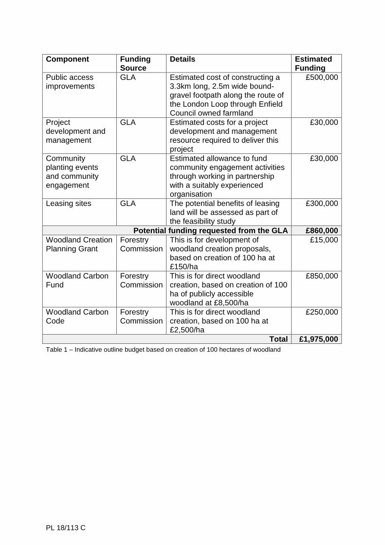
3.3.6 The EOI submitted to the GLA includes an indicative outline project budget of
£1,975,000 that is based on the hypothetical creation of 100 hectares of woodland; please refer to the table in the Economic Assessment included in the background papers for further information about the project outline. If this amount of woodland was to be created, up to £860,000 of funding would potentially be sought from the GLA, the rest would be derived from Government grants administered by the Forestry Commission. It is expected that the capital cost of creating new woodland would be covered by the Forestry Commission grants. The GLA funding would be used primarily to improve access to the new woodland to ensure that they can be accessed and enjoyed by a wide range of people. The section of the London Loop running through this area connects to a longer stretch that was widened and re-surfaced in 2014 as part of a Transport for London funded project to create a Quietway route for walking and cycling. Bringing the 3.3km section through Enfield’s farmland up to a similar standard would create a high quality green link connecting Trent Park in the west half of the borough all the way through to the Lee Valley in the east, passing through Forty Hall and Albany Park on the way – as shown in the attached maps.
3.3.7 It is expected that any new woodlands will be managed by the current land
managers; however, it is possible that in some cases alternative arrangements that require modifications to the existing leases between Enfield Council and the tenant farmers will be required. These options will be explored as part of the Project Development phase.
3.3.8 The measures described in this report can only be carried out in full
cooperation with the tenant farmers. Due to the potential mutual benefits of implementing these measures it is expected that there will be considerable
PL 18/113 C
scope for delivering a significant number of these measures across the seven farms in the area of interest.
3.3.9 Many of the proposed interventions described in this report can be carried out
under the Council’s powers of Permitted Development – for example modifying existing watercourses, creating ponds and small areas of woodland. Larger interventions such as creating more extensive wetland areas or significant areas of woodland would require planning permission. The permissions required for these larger interventions will be further explored during the project development phase.
4. ALTERNATIVE OPTIONS CONSIDERED
Do nothing: This scheme is part of a series of improvements to reduce the risk of flooding in the Salmons Brook catchment. To do nothing will lose an opportunity to attract significant funding to the London Borough of Enfield, improve the environment, for both people and wildlife, and reduce flood risk to local residents and infrastructure. Furthermore, it would mean the loss of an opportunity to comply with one of the actions identified in the Local Flood Risk Management Strategy.
5. REASONS FOR RECOMMENDATIONS 5.1 Improved flood protection through the creation of Natural Flood Management
features which will reduce the risk of flooding to properties downstream. This complies with the recommendation in Enfield’s Local Flood Risk Management Strategy to reduce flood risk using this approach.
5.2 Improvements to the environment through the creation of ponds, wetland and
woodland features that contribute to a diverse range of habitats and improve biodiversity within Enfield’s rural areas.
5.3 Increased access to nature including creating opportunities for education in a
natural environment. 5.4 External investment of £303k through the Thames Regional Flood and Coastal
Committee’s Local Levy and the Environment Agency. 5.5 Improved public perception and understanding of flood risk and increased
interaction with local waterways. 6. COMMENTS FROM OTHER DEPARTMENTS 6.1 Financial Implications 6.1.1 The Salmons Brook Natural Flood Management (NFM) project has been
awarded £303k funding by the Thames Regional Flood and Coastal Committee and the Environment Agency. To support this external funding a £40k contribution from the Council is required. A contribution of £20k has
PL 18/113 C
been allocated from the Council’s Watercourses Borough Capital funding for 2018/19; it is proposed that a further £20k will be allocated in 2019/20.
6.1.2 It is expected that the overall scope will expand during the project as further
external funding is sought – for example a £240k funding bid has recently been submitted to Natural England for a Water Environment Grant (WEG).
6.1.3 The cost of carrying out the proposed woodland creation feasibility study is
estimated to be £25k. It is expected that this will be fully funded by grants that are available from the Forestry Commission and the GLA.
6.1.4 It is expected that maintenance costs from this project will be contained within
existing budgets. 6.2 Legal Implications 6.2.1 Section 111 of the Local Government Act 1972 permits local authorities to do
anything which is calculated to facilitate, or is conducive or incidental to, the discharge of their functions.
6.2.2 The Council has a general power of competence under section 1(1) of the
Localism Act 2011 to do anything that individuals may do, provided it is not prohibited by legislation and subject to Public Law principles. The proposals in this report are compliant with the Council’s general power.
6.2.3 Furthermore, the recommendations in this report relating to the Salmons
Brook Natural Flood Management Project will enable the Council to fulfil its statutory duty as a Lead Local Flood Authority (LLFA). The Flood and Water Management Act 2010 requires LLFAs to act in a manner that is consistent with the Local Flood Risk Management Strategy. The proposals in this report implement the actions identified in the Local Flood Risk Management Strategy.
6.2.4 This will be a Key Decision and therefore compliance with the Council’s Key
Decision process is required including publication in the Forward Plan. If the Council will be procuring contracts using the grant monies, it must comply with all requirements of its Constitution, Contract Procedure Rules (“CPRs”) and the Public Contracts Regulations 2015 (“Regulations”), should the value of any contracts be above the relevant EU Thresholds.
6.2.5 The receipt of grant funding by the Council does not appear to contravene the
EU State Aid rules as set out in the Treaty for the Functioning of the EU (TFEU) Article 107(1) as the Council is not an undertaking engaged in economic activity.
6.2.6 The Council must at all times also adhere to the Duty of Best Value in
accordance with the Local Government Act 1999. 6.2.7 All legal agreements arising from the matters described in this report must be
approved in advance of contract commencement by Legal Services
PL 18/113 C
6.3 Property Implications 6.3.1 Much of the land proposed to have new Natural Flood Management (NFM)
measures implemented on is designated as green belt and lies within the Councils freehold title ownership. Predominantly such land is occupied by agricultural tenants by way of agricultural tenancy agreements.
6.3.2 Initial consultations with the Councils tenant farmers, who occupy much of the
green belt land adjoining Salmon’s Brook is currently being undertaken and through the consultation process, proposals are being invited for how to deliver the project’s objectives. It will be necessary to undertake a review of the emerging proposals against the relevant tenancy agreements and governing legislation to assist project officers in feasibility studies and project delivery.
6.3.3 It will need to be established whether project infrastructure can be delivered
without the explicit voluntary agreement of LBE’s tenants and what if any consideration needs to be offered to realise the project’s goals. Due to the constraints of traditional agricultural tenancy agreements (and the security of tenure that goes this them) there is concern that delivery may not be feasible without tenants’ voluntary agreement.
6.3.4 Alterations to the farms, to include creating ponds/diverting water courses and
tree planting will also have to be given formal consent from the Council as Landlord in accordance with the leases affected. All such requests would ordinarily be considered on a case by case basis and any terms of such consent will have to be given careful consideration by Strategic Property Services.
6.3.5 It is noted that an extensive woodland creation project could significantly
reduce the capital value and income generation capacity (for landlord and tenant) of an agricultural holding with woodland typically valued at a discount to productive arable farmland. There may be circumstances where income arising from NFM measures can be obtained and secured for the benefit of the Council and its farm tenants although this needs to be reviewed and is not yet established due to insufficient information about what is proposed. Further, changes to the UK’s agricultural subsidy/entitlements schemes are ongoing (the Agriculture Bill is being consulted on) and the likely changes to such agricultural subsidy schemes needs to be considered. It must be remembered that any woodland will take many years to mature until a commercial return can be expected.
6.3.6 External stakeholder engagement is recommended due to the sensitivities of
alterations to sensitive green belt land in the Council’s ownership. 6.3.7 The project needs to be mindful of emerging strategic asset management
plans and the possibility that NFM could conflict with any longer term strategic property objectives. Strategic Property Services need to review any proposals with this in mind at an early stage to minimise the likelihood of abortive costs.
PL 18/113 C
6.3.8 It is essential that careful consideration is given to any measures that may improve the NFM capacity while limiting any negative impact to LBE’s freehold income potential and capital value. Similarly, the extent of the opportunity to improve the Councils freehold value and income through project delivery also needs to be established.
6.3.9 Any alterations to the leases will need to be documented in a format agreed by
the Director of Law and Governance. The Council May need to pay for the tenants costs in this matter.
7. KEY RISKS 7.1 The following key risks relate to not implementing the project:
Loss of opportunity to reduce flood risk downstream and compliance with an action in Enfield’s Local Flood Risk Management Strategy
Loss of attraction of up to £303k of external funding to Enfield
Loss of opportunity to increase biodiversity and wildlife habitat
Loss of opportunity to cooperate with the local community 8. INTERNAL DEPARTMENT IMPLICATIONS/CONSULTATION 8.1 Parks and Street Scene 8.1.1 The proposals have been discussed with the Parks Operations team. It has
been agreed that although the proposals will require a change in the pattern of maintenance activities, the overall cost of future maintenance will not be significantly increased.
8.2 Strategic Planning 8.2.1 The proposals have been discussed with the Strategic Planning team in the
context of Enfield’s emerging new Local Plan and the emerging spatial options for growth. It has been agreed that these early proposals and EOI would be supported by emerging policies to proactively manage climate change and enhancing the borough’s green and blue spaces, in particular measures for reducing flood risk and enhancing opportunities for greater accessibility to the Enfield’s Green Belt. As detailed proposals emerge for the Local Plan the Project will be closely coordinated to ensure no conflicts arise with the borough’s future growth options.
9. IMPACT ON COUNCIL PRIORITIES – CREATING A LIFETIME OF
OPPORTUNITIES IN ENFIELD 9.1 Good homes in well-connected neighbourhoods 9.1.1 By reducing flood risk, and potentially improving infrastructure for walking and
cycling, this project contributes to the aim of creating good homes in well-connected neighbourhoods.
PL 18/113 C
9.2 Sustain strong and healthy communities 9.2.1 This project has potential to significantly improve the green environment in
Enfield’s rural areas. Encouraging residents to visit these areas improves quality of life and supports community activities. Reducing flood risk and pollution also helps to sustain strong and healthy communities.
9.3 Build our local economy to create a thriving place 9.3.1 Reducing flood risk and investigating opportunities to diversify the rural
economy helps to create a thriving place to live and supports the local economy.
10. EQUALITIES IMPACT IMPLICATIONS 10.1 Corporate advice has been sought in regard to equalities and an agreement
has been reached that an equalities impact assessment is neither relevant nor proportionate for the approval of this report to approve the Salmons Brook Natural Flood Management project and investigate opportunities for woodland creation in rural areas of Enfield.
10.2 The scheme will be designed in accordance with good practice to ensure it is
reasonably accessible for all users; any new footpaths will be compliant with the Equalities Act 2010.
10.3 It should be noted that any contracts awarded should include a duty on the
successful applicant to assist us with meeting our obligations under the Equalities Act 2010.
11. PERFORMANCE AND DATA IMPLICATIONS 11.1 The implementation of this project will satisfy actions derived from the Local
Flood Risk Management Strategy by reducing surface water runoff rates (Objective 4) and helping to protect existing properties from flooding (Objective 5).
12. HEALTH AND SAFETY IMPLICATIONS 12.1 The scheme will be designed in accordance with the Construction Design and
Management Regulations 2015, and industry good-practice standards, to be safe for members of the public. For example, open water features are surrounded by vegetated margins and slopes are designed to be shallow to reduce the risk of accidental entry into the water.
12.2 As the flood alleviation measures have potential to reduce flood risk to a large
number of residential properties, the scheme will have a significant positive impact on health and safety during flood events.
PL 18/113 C
13. PUBLIC HEALTH IMPLICATIONS 13.1 These improvements to the environment will reduce the risk of flooding,
improve the environment and encourage residents to visit this area so increasing the physical activity offer in Enfield. Creating opportunities for recreational activities such as walking and cycling, by improving green links between the east and west of the borough, is an important aspect of promoting improved public health for a wide range of Enfield’s residents. The creation of a large area of publicly accessible woodland on land that is currently relatively inaccessible to most residents would significantly enhance the amenity value of this Council asset and align very well with the aim of creating well-connected, liveable neighbourhoods. Climate change has been described as the greatest public health threat of the 21st century; these measures will help to mitigate that threat.
Background Papers None Appendices
1. Woodland Creation in Enfield – Preliminary Economic Assessment 2. Enfield Flood Map 3. Enfield Rural Catchment Map

PL 18/113 C
Woodland Creation in Enfield – Preliminary Economic Assessment The importance of creating new woodland is recognised at a national level and consequently this activity is supported by the following Forestry Commission administered grants:
Woodland Creation Planning Grant (WCPG) – this is used to develop proposals, £1,000 is available for a Stage 1 desk survey, £150 per hectare is available at Stage 2 (capped at £30,000)
Woodland Carbon Fund (WCF) – this is for direct woodland creation, up to £8,500 per hectare is available for publicly accessible woodland (plus a £1,000 one-off payment after Year 5 following a successful inspection), this is for capital funding to establish new woodland, including planting trees and installing tree guards, fencing and gates (up to 80% of the standard costs for these items and a contribution of 40% of the cost of roads and tracks needed to support the woodland’s establishment)
Woodland Carbon Code (WCC) – this is for direct woodland creation, this amount depends on the price of Carbon Credits, typical sum is £2,500 per hectare (range is £900-5,000)
A feasibility study is required to identify the preferred areas of planting and evaluate costs. The WCPG funding will be used to deliver this study. Based on current information it is estimated that the cost of woodland creation will be fully covered by the grants described above. It is proposed that an appropriate proportion of the new woodland will be productive, this will provide a sustainable source of income to cover management costs and replace some, if not all, of the income lost to traditional farming. Productive woodland includes:
Firewood or charcoal – such as Ash/Hornbeam coppice woodland
Biomass – fast growing species such as Willow/Poplar
Timber – mixed hard and softwood for construction and other uses The estimated potential income derived from standing (i.e. un-processed) timber is £250-350/ha/year (based on figures from the Forestry Commission). Harvesting and processing the timber, whether for firewood, construction or other uses, significantly increases its value and has potential to make a significant contribution to the local economy – this can offset the impact of lost farmland and diversifies the rural economy. In addition, farming payments received under the Basic Payment Scheme can still be claimed – these are in the order of £150-200/ha/year. Once the woodland is established, future management costs are relatively low – the main activity required is thinning, this is required only every 10-15 years and typically pays for itself due to the timber recovered during the process. With opportunities for new sources of income, continued farm payments and relatively low management costs, it is considered that the creation and management of new woodland in Enfield is likely to be financially viable; however further feasibility work is required to confirm this.
PL 18/113 C
Component Funding Source
Details Estimated Funding
Public access improvements
GLA Estimated cost of constructing a 3.3km long, 2.5m wide bound-gravel footpath along the route of the London Loop through Enfield Council owned farmland
£500,000
Project development and management
GLA Estimated costs for a project development and management resource required to deliver this project
£30,000
Community planting events and community engagement
GLA Estimated allowance to fund community engagement activities through working in partnership with a suitably experienced organisation
£30,000
Leasing sites GLA The potential benefits of leasing land will be assessed as part of the feasibility study
£300,000
Potential funding requested from the GLA £860,000
Woodland Creation Planning Grant
Forestry Commission
This is for development of woodland creation proposals, based on creation of 100 ha at £150/ha
£15,000
Woodland Carbon Fund
Forestry Commission
This is for direct woodland creation, based on creation of 100 ha of publicly accessible woodland at £8,500/ha
£850,000
Woodland Carbon Code
Forestry Commission
This is for direct woodland creation, based on 100 ha at £2,500/ha
£250,000
Total £1,975,000
Table 1 – Indicative outline budget based on creation of 100 hectares of woodland
PL 18/113 C

PL 18/113 C
Properties in or near the Salmons Brook catchment
Area (ha)
Trent Park 180
Chase & Slopers Pond Farm 127
Plumridge Farm 168
Beech Barn Farm 85
Botany Bay Farm 41
Parkside Farm 128
Ferny Hill Farm 101
Rectory Farm 120
Total 950
Related Documents