Joint Int Symposium & Exhibition on Geoinformation and GPS/GNSS 2007, Johor Bahru, Malaysia. 5-7 Nov 2007 MULTIPURPOSE CADASTRE: EFFECTIVENESS AND UPGRADING OF GIS LAYER MANAGEMENT SYSTEM (GLMS) Abdullah Hisam Omar 1 , Hasan Jamil 2 ,Ahmad Bin Mohamed Zin 2 1 Faculty of Geoinformation Science and Engineering, Universiti Teknologi Malaysia 81300 Skudai, Johor, Tel: 07-5530874 Email: [email protected] 2 Department of Survey and Mapping Malaysia Jalan Semarak,50578 Kuala Lumpur. Tel : 03-26170800 Email:[email protected] Abstract DSMM is responsible in providing land related records through the Cadastral Database Management System (CDMS). The system will extract or retrieve cadastral information from the Digital Cadastral Data Base (DCDB) which is the main product of DSMM. In order to comply with the increasing demands from government agencies, private firms and publics, therefore DSMM has took proactive measures in improving the system by introducing GIS Layers Management System (GLMS). With the introduction of GLMS, various layers in GIS ready environment can be provided to the private entities and public usage. GLMS will facilitate the government’s vision towards the establishment of modern cadastre in Malaysia. GIS Layer Management System (GLMS) has been introduced under the “SPDK Upgrade” project since 2002 by Department of Survey and Mapping Malaysia. GLMS facilitates the creating, capturing and maintaining of spatial data using layers approach. GLMS will become an important system for land development management because of its functionalities and increasing of demands of land-related datasets. Main objective of this research is to study the effectiveness of the GLMS. New layers (GLMS 2) such as building, gazette area, Malay reserved, railway, hydrographic and election region have been created. Analyses shown that GLMS 2 is an effective mechanism towards the development and realization of multipurpose cadastral and e-Cadastre in Malaysia. Keywords:e-Cadastre, DCDB, GLMS, Multipurpose Cadastre 1.0 INTRODUCTION In Malaysia, cadastral survey is a responsibility of the federal government but land is exclusively a state matter. Therefore, the Department of Survey and Mapping Malaysia (DSMM) is a federal department that been given responsibility for carrying out cadastral survey Malaysian’s state. DSMM is responsible in providing geospatial data through the Cadastral Database Management System (CDMS). The system will extract or retrieve data from the Digital Cadastral Data Base (DCDB) which is the main product of DSMM.

Welcome message from author
This document is posted to help you gain knowledge. Please leave a comment to let me know what you think about it! Share it to your friends and learn new things together.
Transcript
Joint Int Symposium & Exhibition on Geoinformation and GPS/GNSS 2007, Johor
Bahru, Malaysia. 5-7 Nov 2007
MULTIPURPOSE CADASTRE: EFFECTIVENESS AND UPGRADING OF GIS LAYER
MANAGEMENT SYSTEM (GLMS)
Abdullah Hisam Omar
1, Hasan Jamil2 ,Ahmad Bin Mohamed Zin
2
1 Faculty of Geoinformation Science and Engineering, Universiti Teknologi Malaysia
81300 Skudai, Johor, Tel: 07-5530874
Email: [email protected]
2Department of Survey and Mapping
Malaysia
Jalan Semarak,50578 Kuala Lumpur. Tel : 03-26170800
Email:[email protected]
Abstract
DSMM is responsible in providing land related records through the Cadastral
Database Management System (CDMS). The system will extract or retrieve
cadastral information from the Digital Cadastral Data Base (DCDB) which is the
main product of DSMM. In order to comply with the increasing demands from
government agencies, private firms and publics, therefore DSMM has took
proactive measures in improving the system by introducing GIS Layers
Management System (GLMS). With the introduction of GLMS, various layers in
GIS ready environment can be provided to the private entities and public usage.
GLMS will facilitate the government’s vision towards the establishment of
modern cadastre in Malaysia. GIS Layer Management System (GLMS) has been
introduced under the “SPDK Upgrade” project since 2002 by Department of
Survey and Mapping Malaysia. GLMS facilitates the creating, capturing and
maintaining of spatial data using layers approach. GLMS will become an
important system for land development management because of its
functionalities and increasing of demands of land-related datasets. Main objective
of this research is to study the effectiveness of the GLMS. New layers (GLMS 2)
such as building, gazette area, Malay reserved, railway, hydrographic and
election region have been created. Analyses shown that GLMS 2 is an effective
mechanism towards the development and realization of multipurpose cadastral
and e-Cadastre in Malaysia.
Keywords:e-Cadastre, DCDB, GLMS, Multipurpose Cadastre
1.0 INTRODUCTION
In Malaysia, cadastral survey is a responsibility of the federal government but
land is exclusively a state matter. Therefore, the Department of Survey and Mapping
Malaysia (DSMM) is a federal department that been given responsibility for carrying out
cadastral survey Malaysian’s state. DSMM is responsible in providing geospatial data
through the Cadastral Database Management System (CDMS). The system will extract or
retrieve data from the Digital Cadastral Data Base (DCDB) which is the main product of
DSMM.

2
DCDB consists of lot, boundary and station layers which does not comply to the
public demand as well as to the private entities. Therefore DSMM has to take proactive
measures in improving the system. With the introduction of GIS Layer Management
System (GLMS), various layers in GIS ready environment can be provided to the private
entities and public usage. GLMS will facilitate the government’s aim towards the
establishment of a multipurpose cadastral system. In order to realize the concepts of
multipurpose cadastral in Malaysia, improvement of existing GLMS has to be conducted
in the next ten years. This study is intends to evaluate the effectiveness of the current
GLMS in providing information to the various applications and purposes and
recommend the GLMS upgrading exercise for creating Multi Purpose Cadastre in
Malaysia.
2.0 MULTIPURPOSE CADASTRE
The increasing of difficulty level in planning, development and management of
land has introduced the needs for complex geospatial that cannot be handled by
conventional procedure. Parallel to the rapid development in this country and the current
trends in management of accurate land related records then few optimum management
and implementation concepts have been introduced for instances e-cadastre and
multipurpose cadastre. The concepts of e-cadastre involved the use of information
technology and survey accurate cadastral record for title generation and can be integrated
with other land-related information.
E-cadastre is the Basic component towards the development of multipurpose-
cadastre. Multipurpose-cadastre involves the integration of land related records with
taxation/fiscal, utility, land registration, natural resource record, and other cultural record
as shown in Figure 2.0.
Figure 2.0: Multipurpose Cadastre Data Themes

3
2.1 GIS Layer Management System (GLMS)
GIS layer management system (GLMS) has been introduced under the SPDK upgrade
project since 2002. In GLMS module information like cadastral first class and second
class surveys, are stored in CDMS using spatial data layers method. This information can
be used to determine boundaries, town/village names and road name. GIS-based GLMS
is an important tool for planning, natural resources, efficient land management,
government administration and executive decision making processes.
3.0 IMPLEMENTATION OF RESEARCH APPROACH
The research methodology is basically a series of research activities in order to
complete the research. Figure 2 shows the research flow in graphic representation.
Figure 4.0: Research Methodology
4
4.0 ANALYSES OF STUDY
The effectiveness of the existing GLMS and the upgrading process of GLMS
(GLMS 2) have been evaluated and developed. Analysis will be based on few aspects
such as:
i. Questionnaires to government agencies, privates and public users.
ii. Recommended of upgrading existing GLMS to GLMS 2.
4.1 GLMS Questionnaire Statistic
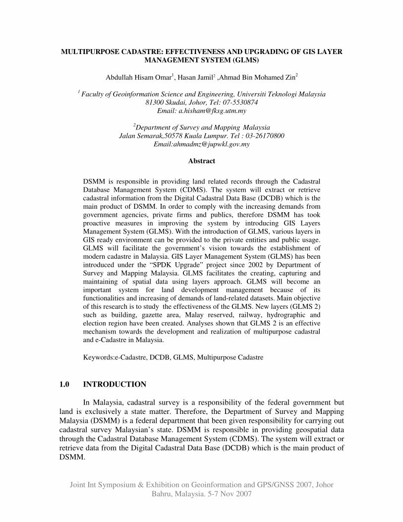
Questionnaires have been conducted to 20 samples which comprises of
government agencies, land office, local authority (DBKL), licensed land surveyor firms
and public users. Feedbacks from above mentioned agencies and firms are tabulated in
Table 4.2 .
Figure 4.1 Respondent Percentage
Based from Table 4.2, it shows that 20 respondent feedback questionnaires from
Government department, Boards, Licensed Land surveyors, Private sector and Personals
in charts format. Contents of Questionnaire cover few aspects of existing development of
GLMS, the use of digital data, usage and recommendation of new layers in GLMS
upgrading process.

5
Figure 4.2: Standard sheet users
Based from the information on Figure 4.2, 18 respondent use to acquire standard
sheet issued by JUPEM and 2 respondent never use standard sheet in their applications.
Figure 4.3: Usage of GLMS Data/Standard Sheet
Based on the information visualized Figure 4.3, it shows that GIS application is
the main driven factor for upgrading the existing standard sheet followed by location
finding purpose. Land Valuation discipline also used standard sheet for land appraisal
purpose. Surveying firms use standard sheet to identify the location of the particular land
parcel and standard sheet also been used for academic research purposes.

6
Figure 4.4: Respondent feedback
According to the respondents, layers information in GLMS did not 100% satisfied
the users requirements. Almost 90% ( Figure 4.4) users need more information attached
with the layers.
Figure 4.5: Additional information from respondent
According to respondents, 8 primary new layers has been suggested in order to
improve existing GLMS. New suggestions are road layers and certified plan (building)
PA(B), which get 17 respond out of 20 respondent. JUPEM WPKL/PUTRAJAYA is one
of the state’s JUPEM to produce more PA(B) than other state. Table 4.6 shows 8 new
additional layers recommended by the respondents.
7
4.2 Analysis of New Layers (GLMS)
Newly upgraded layers and updated data created a new system that easy to
browse and read by users. It is because attribute data in layers can be browsed in table
format. Users can view information in Table and also can view plans at same time. It
makes easier to users, to view spatial data and attribute data at same time. New road
layers, building layers, election boundary layers and including other layers are added in
GLMS database (Figure 4.5) .
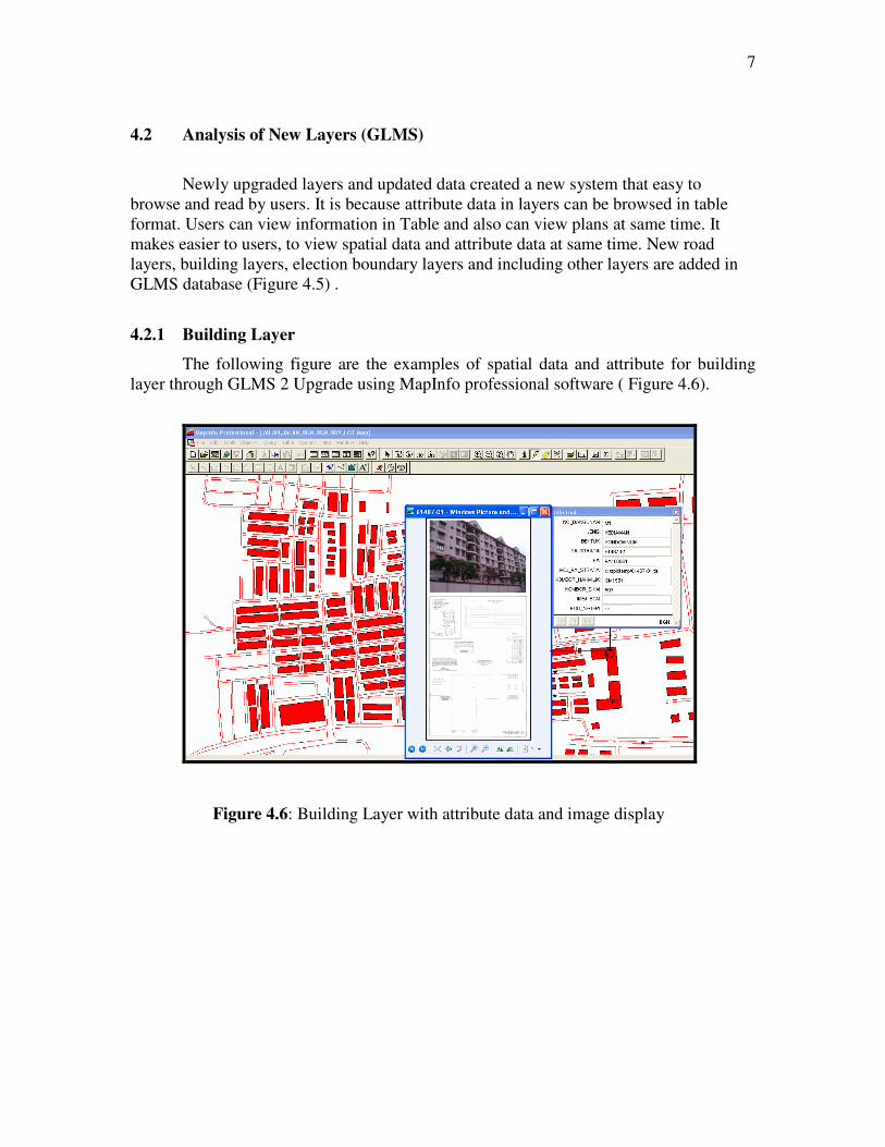
4.2.1 Building Layer
The following figure are the examples of spatial data and attribute for building
layer through GLMS 2 Upgrade using MapInfo professional software ( Figure 4.6).
Figure 4.6: Building Layer with attribute data and image display

8
4.2.2 Election Boundary Layer
Due to the high demand in additional layer purposely for political application,
GLMS 2 will provided election boundary layer as shown in the following figures below (
Figure 4.17 and Figure 4.18).
Figure 4.17: Attribute data for election boundary layer
Figure 4.18: Display of name and areas election location
9
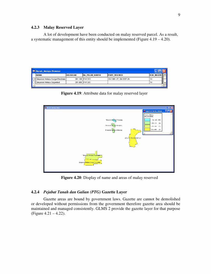
4.2.3 Malay Reserved Layer
A lot of development have been conducted on malay reserved parcel. As a result,
a systematic management of this entity should be implemented (Figure 4.19 – 4.20).
Figure 4.19: Attribute data for malay reserved layer
Figure 4.20: Display of name and areas of malay reserved
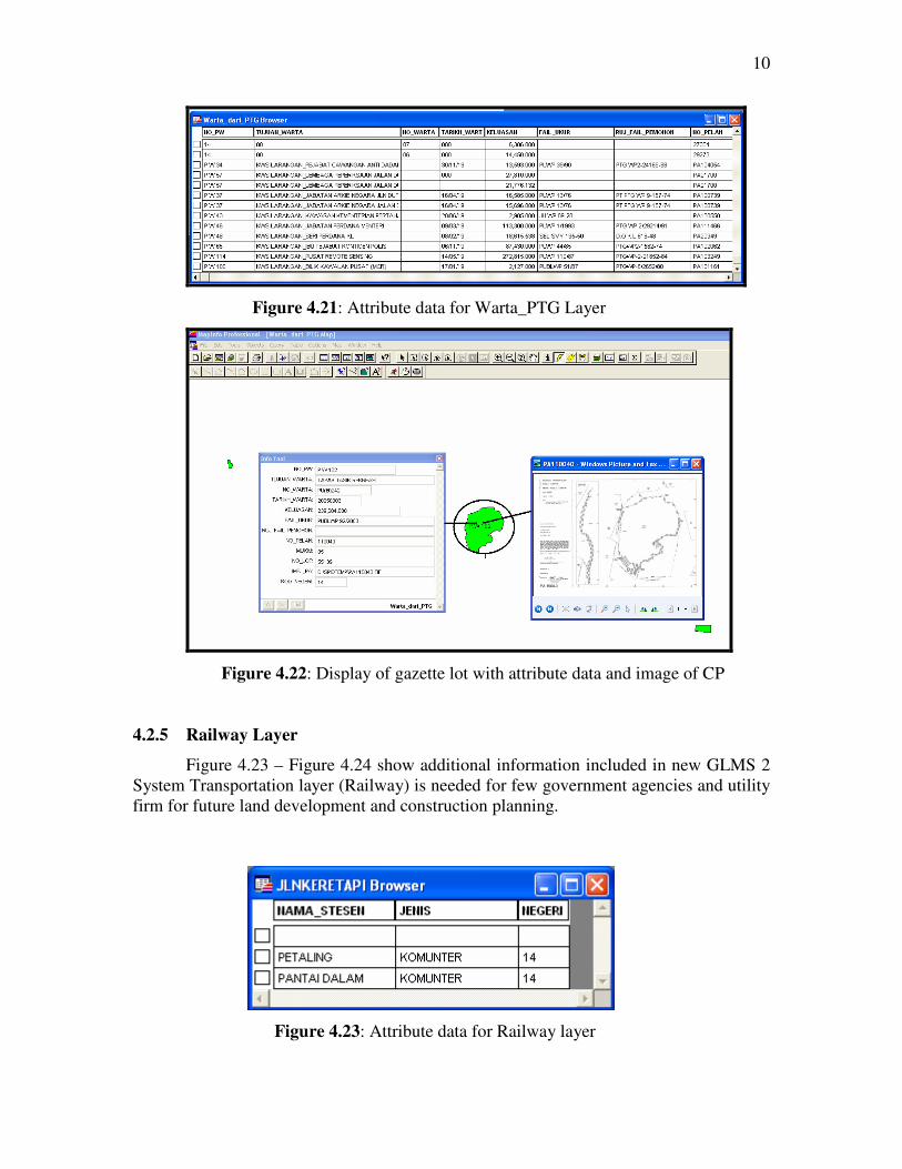
4.2.4 Pejabat Tanah dan Galian (PTG) Gazette Layer
Gazette areas are bound by government laws. Gazette are cannot be demolished
or developed without permissions from the government therefore gazette area should be
maintained and managed consistently. GLMS 2 provide the gazette layer for that purpose
(Figure 4.21 – 4.22).
10
Figure 4.21: Attribute data for Warta_PTG Layer
Figure 4.22: Display of gazette lot with attribute data and image of CP
4.2.5 Railway Layer
Figure 4.23 – Figure 4.24 show additional information included in new GLMS 2
System Transportation layer (Railway) is needed for few government agencies and utility
firm for future land development and construction planning.
Figure 4.23: Attribute data for Railway layer

11
Figure 4.24: Display of railway information
4.3 Data Quality
All new layers are based on the existing plans; gazette plan and standard sheet in
1:8 scale (chain) or 1:6336 scale (chain). The digitizing process shows the RMS of
control point (reference point) is acceptable (below 0.05 pixel).
5.0 CONCLUSION AND RECOMMENDATION
GLMS concepts is one initiative towards the development of Multipurpose
Cadastral in Malaysia. The integration between Digital Cadastral Database and GLMS
has provided a good infrastructure for many Geomatic and GIS Communities. Due to the
high demands and request from public users, GLMS has been improved in this study
with additional layers. The new layers are :
i) Building Layer
ii) Hydrographic layer
iii) Road layer
iv) Railway layer
v) Gazetted layer
vi) Political layer
vii) Malay reserved layer

12
Evaluation of the GLMS has been executed based on few aspects such
comparative study, questionnaire, and spatial database. Analyses show that the new
GLMS is able to satisfy public requirements and demands. GLMS can be a model for
government authority to enhance the existing GLMS towards the realization of
Multipurpose Cadastre in Malaysia.
6.0 REFERENCES AND BIBLIOGRAPHIES
Abd. Majid Kadir, Ghazali Desa dan Chandrasekhar (1998). Cadastral Database Design
For Coordinated Cadastral System. B.Sc Thesis. Universiti Teknologi Malaysia.
Abdul Majid Mohamed (1988). Cadastral Reforms in Malaysia, Seminar Paper. Jabatan
Ukur dan Pemetaan Malaysia.
Abdullah Hisam Omar (2005). A friendly Introduction to Geographic Information
Systems, Nota Kuliah. Universiti Teknologi Malaysia.
Azhari Husin dan Mohamad Nor Said (1992). Geographic Information System And It’s
Application To Local Authority : A Pilot Study Of Majlis Daerah Kulai. CPD
Talk : Information Technology – It’s Role On Property Development, Inspen. 4.
Burrough, P.A. (1986). Principles of Geographic Information Systems for Land
Resources Assessment. Oxford : Clarden Press
Department of Survy and Mapping, Malaysia (1998). Cadastral Management System –
user Manual. Imatera Digital Image Services Sdn. Bhd.
Department of Survy and Mapping, Malaysia (2002). SPDK Upgrade – User Guide. Map
Information Solutions Sdn. Bhd.
Norliza Binti A.Patah (2001). Feasibility study of Digital Cadastral Database For
Development of National Digital Cadastral Database. B.Sc Thesis. Universiti
Teknologi Malaysia.
Peter Rob and Carlos Coronel (1997). Database System : Design, Implementation And
Management. A Division Of International Thomson Publishing.
Rohayu Binti Yahaya (2001). Development of Digital Cadastral Database. B.Sc Thesis.
Universiti Teknologi Malaysia.
Related Documents