MULTI-USE OF STORMWATER DETENTION PONDS IN PARKS AND OPEN SPACES by PALLAVI SHASHANK SHINDE (Under the Direction of Bruce K. Ferguson) ABSTRACT Water possesses several qualities that contribute to positive aesthetic experience. But these qualities are rarely exploited in our cities. On one hand we treat water as an exciting element adorning our city squares in the form of fountains, while on the other hand is the merely functional drainage system. We overlook the possibility of utilizing stormwater for recreational and aesthestic purposes. The detention basins being designed today are still a single purpose facility. Some are rectangular boxes and look like mud holes in the ground, surrounded by fences. This thesis proposes a design that transforms such detention basins in the Southeast Clarke County Community Park, Athens, GA, into a multi-use amenity providing recreation, aesthetic value and wildlife habitat along with flood control. The design proposal exposes the flow of stormwater and brings people in contact with it, putting it back into the social consciousness of the urban society. The proposal illustrates that detention ponds do not have to be sterile and ugly but can be attractive and form sustainable systems. INDEX WORDS: Stormwater, detention, parks, open spaces, Southeast Clarke County Community Park, multiple-use, wetland.

Welcome message from author
This document is posted to help you gain knowledge. Please leave a comment to let me know what you think about it! Share it to your friends and learn new things together.
Transcript

MULTI-USE OF STORMWATER DETENTION PONDS IN PARKS AND OPEN
SPACES
by
PALLAVI SHASHANK SHINDE
(Under the Direction of Bruce K. Ferguson)
ABSTRACT
Water possesses several qualities that contribute to positive aesthetic experience. But these qualities are rarely exploited in our cities. On one hand we treat water as an exciting element adorning our city squares in the form of fountains, while on the other hand is the merely functional drainage system. We overlook the possibility of utilizing stormwater for recreational and aesthestic purposes. The detention basins being designed today are still a single purpose facility. Some are rectangular boxes and look like mud holes in the ground, surrounded by fences. This thesis proposes a design that transforms such detention basins in the Southeast Clarke County Community Park, Athens, GA, into a multi-use amenity providing recreation, aesthetic value and wildlife habitat along with flood control. The design proposal exposes the flow of stormwater and brings people in contact with it, putting it back into the social consciousness of the urban society. The proposal illustrates that detention ponds do not have to be sterile and ugly but can be attractive and form sustainable systems.
INDEX WORDS: Stormwater, detention, parks, open spaces, Southeast Clarke
County Community Park, multiple-use, wetland.

MULTI-USE OF STORMWATER DETENTION PONDS IN PARKS AND OPEN
SPACES
by
PALLAVI SHASHANK SHINDE
B. Arch, University of Bombay, India, 1997
A Thesis Submitted to the Graduate Faculty of The University of Georgia in Partial
Fulfillment of the Requirements for the Degree
MASTER OF LANDSCAPE ARCHITECTURE
ATHENS, GEORGIA
2002

© 2002
Pallavi Shashank Shinde
All Rights Reserved
MULTI-USE OF STORMWATER DETENTION PONDS IN PARKS AND OPEN
SPACES
by
PALLAVI SHASHANK SHINDE
Major Professor: Bruce K. Ferguson
Committee: Marianne Cramer Michael Tarrant Robby Bryant
Electronic Version Approved: Maureen Grasso Dean of the Graduate School The University of Georgia December 2002
iv
ACKNOWLEDGEMENTS
I would like to thank Bruce Ferguson, my major professor, for his valuable
guidance and advice, which helped me in realizing my ideas and goals for this thesis.
Thank you to Marianne Cramer, Michael Tarrant and Robby Bryant, my reading
committee, for their help, suggestions and time. I extend my gratitude to Kenneth Wright,
president of Wright Water Engineers, Denver, Colorado, for providing information on
Skyline Park; Jonathan Jones, vice-president, for supplying information related to my
thesis concept. Special thanks to Frank Henning, of the University of Georgia Extension
Services, for providing valuable information about the design application site; Walter
Cook for offering his time and expertise to inventory the existing vegetation on site;
Darrel Morrison, for his planting recommendations for the design proposal; and Eleonora
Machado, for sharing her software expertise. Additional thanks to Donna Gabriel for
helping me with the graduation formalities over the past few months.
I would also like to express my appreciation to all my classmates for their
companionship during my time at the University of Georgia. Thank you to all my
professors, from whom I learnt a lot. I am thankful to my parents for guiding me to the
profession of architecture, which led to landscape architecture. Also, thank you to my
sister, for her love and support. And finally, thank you to my husband, Shashank Shinde,
for his enormous encouragement, support, help and love.

v
TABLE OF CONTENTS
Page
ACKNOWLEDGEMENTS............................................................................................... iv
CHAPTER
1 INTRODUCTION .............................................................................................1
2 STORMWATER MANAGEMENT..................................................................4
3 MULTI-USE DETENTION PONDS IN PARKS AND OPEN SPACES ......21
4 CASE STUDIES..............................................................................................42
5 DESIGN APPLICATION................................................................................56
SELECTED BIBLIOGRAPHY.........................................................................................88

CHAPTER ONE
INTRODUCTION
The everyday increase in the impervious and contaminated surfaces of the urban
landscapes is resulting in severe floods and degraded waterways. This has led to an
increased number of studies on stormwater. Many municipalities have adopted a dual
approach to stormwater management that incorporates flood control and water quality
improvement. This approach still fails to address broader needs of the community such
as recreation and aesthetic enjoyment. Though water forms an important element of our
landscapes in the form of streams, lakes, ponds, fountains and cascades, we too often
overlook the possibility of utilizing stormwater for recreational and aesthetic purpose.
An integrated approach should not only address the dual-purpose approach, but also aim
at making the system a part of the community. This would have a positive impact on
life in urban areas.
Impacts of urbanization
Urbanization is replacing pervious ground cover and resulting in compacted soil.
This allows only a small amount of water to infiltrate into the ground. The rate of runoff
in urban areas is high due to the absence of vegetation or depressions that could have
held and delayed the runoff. As runoff gains volume and speed, the flow becomes
strong enough to transport materials, damage property and degrade streams. Chemicals
and biological pollutants are discovered in urban stormwater, resulting from automobile
greases and oils. The result is contamination of our streams and rivers, and adverse
effects on aquatic flora and fauna.
1

The potential for integration
In response to the federal guidelines and growing awareness, efforts are made to
detain stormwater. These usually take the form of detention ponds or structures in open
spaces that are sometimes covered or fenced off and are considered an eye sore. They
are often not very popular within communities. It is beneficial to make the hydrological
system a part of the space not just physically but also socially. Stormwater if treated in
an appropriate way can provide amenities in communities, especially when it is
incorporated in open space and recreation grounds. It can have multiple functions like
water quality enhancement, wildlife habitat and flood control while providing aesthetic
value and community recreation.
Thesis intent
The intent of this thesis is to study the new integrated approaches to the urban
stormwater problem used by a selected group of designers and to apply this knowledge
to a site in Athens, Georgia. This thesis explores the possibility of a stormwater
detention facility as a multiuse facility in parks and open spaces. In the process this
thesis sheds light on the following questions,
Why is there a need to make a detention pond a multiuse facility?
What are the benefits of making a detention pond a multi-use facility?
Can recreational amenities be successfully incorporated with the functional
needs of stormwater? If yes, then what kind of recreational facilities can be
incorporated?
What kind of maintenance is required for such a system?
Can there be a problem with the toxic materials in stormwater from the
urban areas on vegetation, water, soil and wildlife?
What are the safety concerns?
2

What are the general planning considerations to make a detention facility
into a recreational amenity?
Structure of the following chapters
Chapter two examines the importance of water in our landscapes, its symbolism
and qualities, the impact of urbanization on the watersheds and the subsequent
stormwater issues. It explores conventional and alternative methods of stormwater
management. Chapter three deals with incorporation of stormwater detention facilities
into parks and open spaces as multi-use facilities and the issues related to it. Chapter
four presents, in detail, the case studies of Mill Creek Park in King County,
Washington, Fishtrap Creek in Abbotsford, British Columbia and Skyline Park in
Denver, Colorado. Chapter five applies the knowledge from the previous chapters to a
site in Athens, Georgia. The design intent is to address the flood problem and water
quality issues while providing recreation for the community, habitat for wildlife and
aesthetic pleasure.
3
CHAPTER TWO
STORMWATER MANAGEMENT
Water in landscapes
Water is life itself- the magical element that connects all creation. It is the
magnet and mirror of life and genesis of settlement. Throughout history man has
utilized it for various utilitarian, recreational and aesthetic purposes. Through sight and
sound water enriches the place and its surroundings, whether in a city or in the
wilderness. Everyday life can be enriched through sensitive relationship with water
(Litton, Tetlow, Sorensen and Betty, 1974, 1-2). Water offers a primal attraction and
provides an elemental form of open space and high contrast relief from the city (Don,
1980, 43). It has the potential to forge an emotional link between man and nature in the
city (Spirn, 1984, 142).
Symbolism of water
Water is a cooler, quencher and cleanser. It symbolizes life, purity, power,
timelessness, refreshment, wildness, unpredictability and solace in hospitable
surroundings. Blue water suggests coolness while white water suggests roaring power
and sound (Litton, Tetlow, Sorensen and Betty, 1974, 4, 297). In the eastern philosophy,
water is regarded as one of the five forces of the earth.
Qualities of water
4
"Water is not just a vital element in our lives; it can also be experienced in a whole variety of ways. It creates differentkinds of atmosphere and mood that appeal to our feelings."
-Robert Woodward, Waterscapes, 2001, 12

Water possesses several qualities that can contribute to positive aesthetic
experience. Following are some of these qualities of water.
Sound: The sound of water can be powerful as the roar of the ocean or gentle as the
gurgle of a small stream. Sound of water allows people to connect to nature, refresh
spent minds or block out less desirable noises (Moore, 1995, 26). This quality has been
exploited since ancient times by the use of water fountains and cascades in gardens,
plazas and palaces. The sound of water is manipulated in musical fountains, where
water is the artist; the fountain is the musical instrument (Dreiseitl, 2001, 40). Water's
sound has all the characteristics of music, variety of volume and pitch, sharpness and
softness, rhythm and harmony (Woodward, 2001, 13).
Touch: Water touching our skin is the most personally intimate experience we can have
of it (Moore, 1995, 27). This quality of water entices us to walk along the shores in
ankle deep water, to play in the streams, to take part in water sports and to be thrilled at
water amusement parks. Emotional contact with water occurs when people are allowed
to get close without actually touching it, resulting in our 'mental leaning out over'
(Moore, 1995, 27).
Movement: Movement is the most exciting and vivid quality associated with water. It
may be gravity descent, wind driven or forced movement. Chutes, cascades, boils,
rollers, rapids and ripples are some of the falling and turbulent forms of water (Litton,
Tetlow, Sorensen and Betty, 1974, 79). Water running in channels acts as a unifying
element, linking spaces and providing continuity (Moore, 1995, 23).
Stillness: Still water instills peace of mind. Stillness of water symbolizes sacredness and
serene dignity (Moore, 1995, 27).
Transparency: Transparency imparts depth to water. Light is absorbed as it passes
through the medium, facilitating glimpses of the aquatic world below.
Reflection: Water can be described as nature's mirror of the landscape (Litton, Tetlow,
5

Sorensen and Betty, 1974, 79). Sometimes the gentlest light from the moon accentuates
mysticism. The intensity of light creates varied moods in people - from depressed to
delighted. Reflective water adds an element of fantasy to architecture by filling
shadows with light (Moore, 1995, 26). This quality of water has been used in Islamic
gardens, where a large pool is built in front of a monument to produce its reflection;
e.g., The Taj Mahal (Figure 2.1). Reflective water idealizes the places we build to
symbolize the Gods we worship, the heroes we intend to remember or the ideals we
cherish (Moore, 1995, 26)
Color: Water in nature is rarely colorless. It is often stained with vegetative stains or
colored with suspended clay particles. Most color we see in water is from the reflection
of the surrounding or from underwater objects seen from its transparent body
(Woodward, 2001, 13).
These qualities of water are seldom fully exploited in cities. On one hand we
treat water as an exciting element adorning city squares in the form of fountains while
on the other hand is the merely functional drainage system buried underground, far
from the eyes of the people. Rapid urbanization has altered our perception of water.
6
Figure 2.1 Taj Mahal, Agra, India(http://www.allindiatravels.com/gifs/taj-mahal)

Impacts of urbanization
In nature when precipitation occurs, 50% of it is absorbed by the soil and
vegetation and the rest is evaporated or transpired back into the atmosphere or carried
over the land as surface runoff. Infiltration replenishes the ground aquifers thereby
securing our supply of fresh water. Vegetated soils and woodlands provide storage by
trapping and percolating water through the ground with minimum runoff and maximum
benefit to the ground water recharge. Natural flood plains and lakes act as storage
reservoirs for rivers that further reduce the magnitude of peaks down stream by
spreading flows over a longer period of time. Nature takes care of itself, replenishing
life forms and rejuvenating the landscape, forming a sustainable ecosystem.
7
Figure 2.2 Impact of impervious surfaces (Hough, 1994, 39)
Undeveloped Land
Developed Land
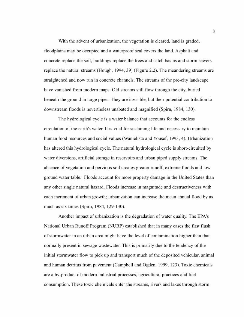
With the advent of urbanization, the vegetation is cleared, land is graded,
floodplains may be occupied and a waterproof seal covers the land. Asphalt and
concrete replace the soil, buildings replace the trees and catch basins and storm sewers
replace the natural streams (Hough, 1994, 39) (Figure 2.2). The meandering streams are
straightened and now run in concrete channels. The streams of the pre-city landscape
have vanished from modern maps. Old streams still flow through the city, buried
beneath the ground in large pipes. They are invisible, but their potential contribution to
downstream floods is nevertheless unabated and magnified (Spirn, 1984, 130).
The hydrological cycle is a water balance that accounts for the endless
circulation of the earth's water. It is vital for sustaining life and necessary to maintain
human food resources and social values (Wanielista and Yousef, 1993, 4). Urbanization
has altered this hydrological cycle. The natural hydrological cycle is short-circuited by
water diversions, artificial storage in reservoirs and urban piped supply streams. The
absence of vegetation and pervious soil creates greater runoff, extreme floods and low
ground water table. Floods account for more property damage in the United States than
any other single natural hazard. Floods increase in magnitude and destructiveness with
each increment of urban growth; urbanization can increase the mean annual flood by as
much as six times (Spirn, 1984, 129-130).
Another impact of urbanization is the degradation of water quality. The EPA's
National Urban Runoff Program (NURP) established that in many cases the first flush
of stormwater in an urban area might have the level of contamination higher than that
normally present in sewage wastewater. This is primarily due to the tendency of the
initial stormwater flow to pick up and transport much of the deposited vehicular, animal
and human detritus from pavement (Campbell and Ogden, 1999, 123). Toxic chemicals
are a by-product of modern industrial processes, agricultural practices and fuel
consumption. These toxic chemicals enter the streams, rivers and lakes through storm
8
runoff (Spirn, 1984, 136). Algae growth causes taste and odor problems in drinking
water supplies and reduces recreational value of lakes and fundamentally alters its
biological balance (Logan and Yaksich, 1990, 26). Every rainfall sweeps dirt and debris
of the city streets into storm sewers and with it, heavy metals and other toxic materials
such as oil and grease.
Pollutants from roads, paved surfaces and rooftops include a range of organic
and chemical compounds and heat from paved surfaces, making urban stormwater
hostile to aquatic life (Hough, 1994, 78). In nature sediment from gradually meandering
stream bank builds point bars and aquatic habitats. In urban areas, the excess sediment
in suspension makes water turbid, inhibiting plant growth and reducing species
diversity. On settling at the bottom, excess sediment destroys spawning beds and
habitats of bottom dwelling biota that depend on the interstices of sand and gravel
particles for their habitat (Ferguson, 1998, 7). Turbidity and warmer temperatures,
increase of nutrient and salts, and loss of dissolved oxygen further degrade the water
quality in urban rivers, streams and lakes.
Conventional stormwater management practices
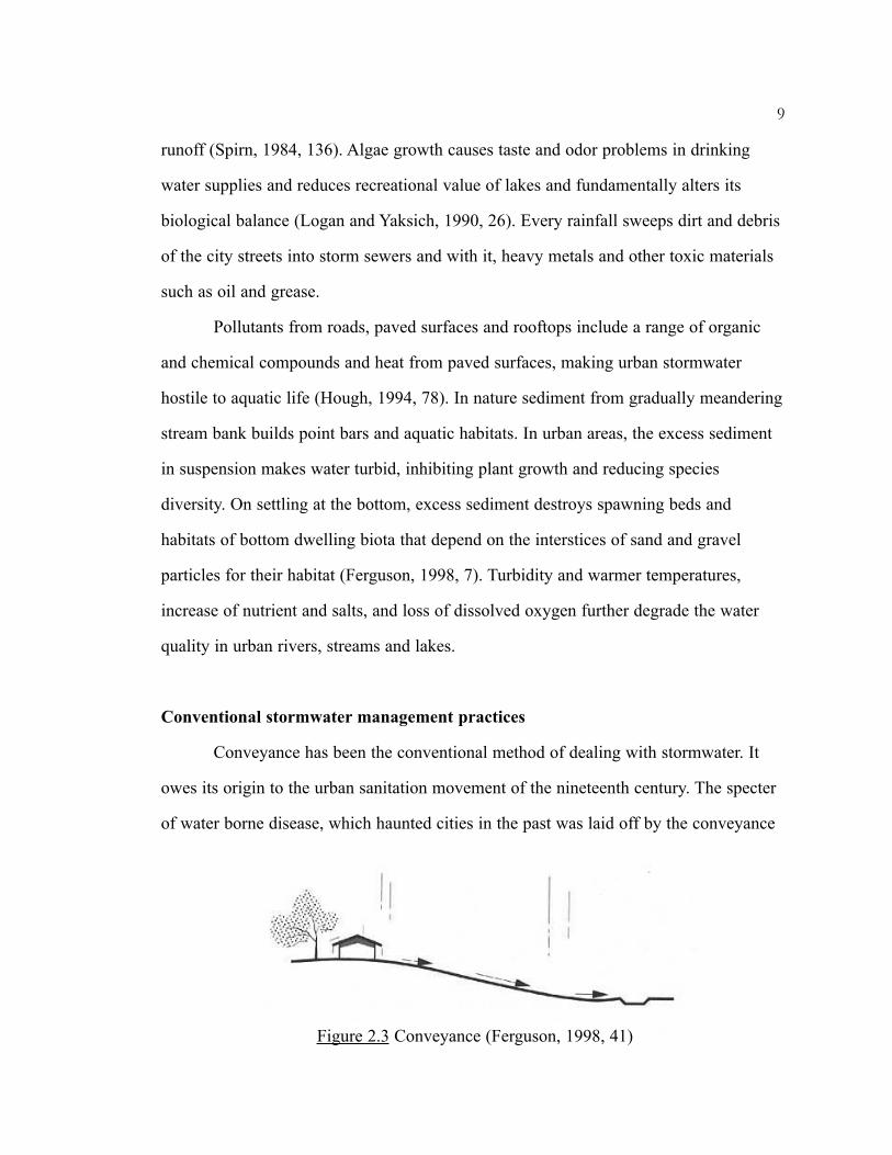
Conveyance has been the conventional method of dealing with stormwater. It
owes its origin to the urban sanitation movement of the nineteenth century. The specter
of water borne disease, which haunted cities in the past was laid off by the conveyance
9
Figure 2.3 Conveyance (Ferguson, 1998, 41)

system. Conveyance is the moving of surface runoff from one place to another by a
network of pipes, channels, swales and culverts draining into one another, until runoff
disappears from the site (Ferguson, 1998, 40) (Figure 2.3). The pipes are usually buried
underground and the surface of the conveyance system is essentially impervious.
Problems with the conventional system
The benefits of conventional stormwater design - well drained streets and civic
spaces is paid for by the environmental costs of eroded streams, flooding, and
impairment of water quality and aquatic life in downstream water courses. Gutters,
curbs and drains collect rainfall and direct it to sewers, which transport it rapidly to
streams and lakes. Storm sewers transport water from one point to another, merely
changing its location and not reducing or eliminating water. As urban storm drainage
system drains water efficiently from roofs, streets and sidewalks, the flood control
system must be continually augmented to prevent flooding downstream (Spirn, 1984,
131-132). The impervious system provides no scope for infiltration of water thereby
reducing the ground water recharge.
The system also separates urban society from environmental values that embrace
both the city and the land. The natural processes are hidden away; buried underground
far from the eyes of city dwellers. Conventional system fails to recognize the potential
of stormwater as an environmental resource. The present problems associated with
conventional stormwater management have promoted research and alternative methods
have been explored in recent years.
Alternative stormwater management methods
The detrimental effects of stormwater runoff have prompted many municipalities
to pass regulations that require that post-development runoff peak volumes and water
10

11
quality not exceed pre-development levels. This measure focuses on capturing
stormwater on-site, immediately after rainfall and releasing it slowly at controlled rates
downstream or allowing it to infiltrate back into the soil. It is achieved by detention,
extended detention, infiltration and rainwater harvesting.
Detention
Detention is the slowing down of surface flows as they move over the ground
(Figure 2.4). Its purpose is to suppress downstream flooding and erosion by reducing
the rate of flow (Ferguson, 1998, 41). Urban detention was started in the 1960's when it
was discovered that development is followed by increase in storm runoff and
aggravated flood damage (Ferguson, 1998, 149). The main aim of detention is to
control the peak rate of runoff. The basic elements of a detention facility are an inlet, a
storage basin and a constricted outlet. There can be multiple inlets. A secondary
overflow or emergency spillway is necessary to allow water to pass, if it exceeds the
capacity of the basin. This can be in the form of earthen channels excavated on the
sides of the dam or large weirs, higher than the principal outlet. The principal outlet can
also be designed to act as emergency spillway. The detention storage is the volume of
the reservoir above the outlet's invert elevation. In a dry basin the outlet is flushed to
the basin's floor. It drains completely after a few hours of the flood event (Ferguson,
Figure 2.4 Detention (Ferguson, 1998, 41)

1998, 150). Detention facility can be of two types depending on its proximity to the
water source - source control (on-site) and downstream control (regional) (Stahre and
Urbonas, 1990).
Extended detention
Extended detention stores water for a longer period of time thereby improving
the quality of water. The extended detention basins can be dry or wet. The dry extended
basin drains water completely like a dry detention basin but additionally contributing to
water quality enhancement. In a wet basin the outlet is raised creating a permanent pool
of water (Figure 2.5). Due to the extended period of detention, suspended particles
settle out, chemicals get absorbed in the bottom sediment or by biota and biodegraded
(Ferguson, 1998, 42). The permanent pools can be deep open ponds, shallow vegetated
ponds or wetlands. The residence time of water is a crucial factor when designing an
extended detention basin. This kind of basin is generally used for small frequent storms
since design for a large storm would increase the basin size and subsequently the cost
out of proportion. Water quality treatment is adequate when designed for small storms
(Ferguson, 1998, 167). A consideration in a wet pond is the sediment. The pond must be
designed for sediment storage. In a typical urban watershed with stable land use,
12
Figure 2.5 Extended Detention (Ferguson, 1998, 182)
sediment storage volume of half-inch runoff may allow sediment removal once every
twenty years (Ferguson, 1998, 179).
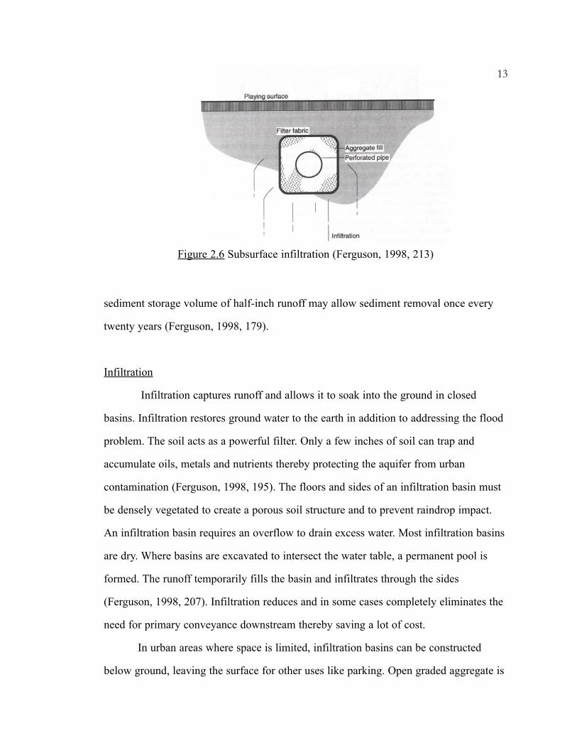
Infiltration
Infiltration captures runoff and allows it to soak into the ground in closed
basins. Infiltration restores ground water to the earth in addition to addressing the flood
problem. The soil acts as a powerful filter. Only a few inches of soil can trap and
accumulate oils, metals and nutrients thereby protecting the aquifer from urban
contamination (Ferguson, 1998, 195). The floors and sides of an infiltration basin must
be densely vegetated to create a porous soil structure and to prevent raindrop impact.
An infiltration basin requires an overflow to drain excess water. Most infiltration basins
are dry. Where basins are excavated to intersect the water table, a permanent pool is
formed. The runoff temporarily fills the basin and infiltrates through the sides
(Ferguson, 1998, 207). Infiltration reduces and in some cases completely eliminates the
need for primary conveyance downstream thereby saving a lot of cost.
In urban areas where space is limited, infiltration basins can be constructed
below ground, leaving the surface for other uses like parking. Open graded aggregate is
13
Figure 2.6 Subsurface infiltration (Ferguson, 1998, 213)

14
used to create storage in subsurface basins. Perforated pipe, which is covered with
aggregate and wrapped with filter fabric, is used in subsurface basins (Ferguson, 1998,
212) (Figure 2.6). Nowadays, different kinds of porous pavements are available to aid
infiltration.
Vegetated swales referred to, as 'Bioswales' are another way of facilitating
infiltration. These swales store runoff while conveying it downstream at a low velocity
providing biophysical treatment and infiltration. Weirs or check dams facilitate ponding
of water and help to slow down runoff. A raised outlet at the lowest point along the
swale provides overflow for excess runoff (Figure 2.7). Swales can be used along
streets, replacing curbs and gutters (Ferguson, 1998, 123).
Another concept, 'Rain garden' is also gaining popularity. A rain garden is a
small-scale infiltration device that provides benefits of groundwater recharge, beauty
and wildlife habitat. Rain gardens are 2 to 6 inches deep infiltration areas planted with
native species. Runoff is captured in these depressions. The plants and soil filter
pollutants in the stormwater allowing cleansed water to recharge the ground. These
gardens can fit in small spaces like traffic islands and parking lots. Roads can be
Figure 2.7 Bioswale (Thompson andSorvig, 2000, 154)

designed without curbs, allowing water to flow overland, further increasing infiltration
and eliminating the cost of curb and gutter (Russell, 2000, 24).
An example of rain garden is the design by William Wenk at his office building
in Denver, Colorado (Figure 2.8). The design captures all roof runoff water from the
building and provides controlled distribution to water landscape plants carefully
selected and placed in a sequence of moisture requirements ranging from high to low,
each area allowing infiltration into the ground. The site creates virtually no runoff. The
downspouts used to convey water from the roof to the landscape also form a striking
visual element (Campbell and Ogden, 1999, 136).
Water Harvesting
Water harvesting is the collection and storage of rainwater from roofs, paved
surfaces and the landscape. Harvested rainwater can be used for various utilitarian
purposes, irrigation, recreation, drinking or as a visual element in the landscape. Water
harvesting is common in Australia and the Caribbean islands. Harvesting from a ground
15
Figure 2.8 Wenk and Associates Office Garden (Greggand Wenk, 1998, 25)
surface catchment area has a longer history. Ancient Israelites, Chinese, Pueblo,
Australians and other Indians of the American southwest have used such water
harvesting systems to survive (Thompson and Sorvig, 2000, 154). In United States, in
the nineteenth and early twentieth centuries, small concrete cisterns were common
storage structures serving families settling the high plains. The systems ranged from
large civic infrastructures to small cisterns for individual homes.
Underground stormwater management system
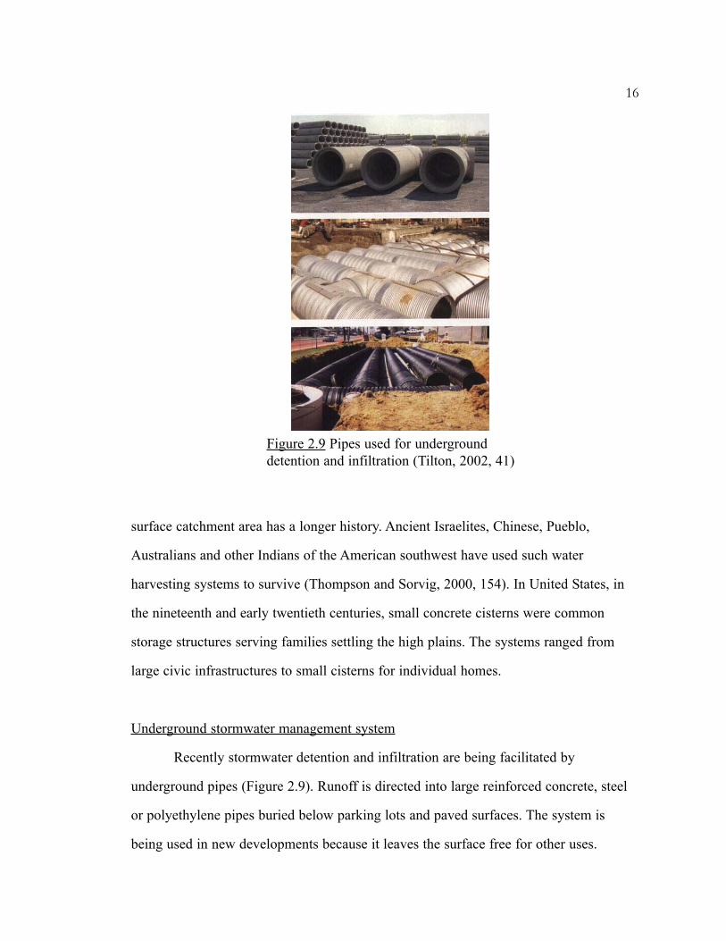
Recently stormwater detention and infiltration are being facilitated by
underground pipes (Figure 2.9). Runoff is directed into large reinforced concrete, steel
or polyethylene pipes buried below parking lots and paved surfaces. The system is
being used in new developments because it leaves the surface free for other uses.
16
Figure 2.9 Pipes used for undergrounddetention and infiltration (Tilton, 2002, 41)

Evaluation of alternative methods
Detention and Extended Detention
Almost all state and local governments require developers to reduce peak
stormwater discharge to its pre-development level. To comply with this regulation, a
detention pond is built on every development site. A detention basin considered in
isolation, reduces the peak rate of flow but uniform on-site detention practiced in a
large watershed can have a negative impact. A detention basin does not eliminate the
runoff; it only delays it. The total volume of discharge from a detention pond is the
same as the inflow but the discharge is delayed with a lower peak and elongated flow
period (Figure 2.10). When the flows from different tributaries join downstream, the
result is a peak rate greater than the pre-development peaks and possibly even greater
than the developed watershed would produce without the basins.
According to Debo (1982) randomly sited detention ponds cause concentrated
discharge and increased flood peaks. They fail to control floods smaller than those of
the design storm. Detention basins can reduce flood peaks if they are selectively
located. A proposed detention basin should be evaluated on a site-by-site basis. In this
scenario regional detention basins can sometimes work best. Municipalities can collect
17
Figure 2.10 Effect of detention basin on a storm hydrograph(Ferguson, 1998, 150)
stormwater impact fees from developers and use them to construct regional detention
basins (Ferguson, 1991, 76).
Extended detention can be effective in treating surface water quality but fails to
address volume of runoff, groundwater recharge or water conservation (Ferguson, 1998,
42). A shortcoming of dry extended detention is its inability to treat the "first flush",
which tends to be highly polluted. The residence time in a dry extended basin is too
short for the pollutants to settle (Ferguson, 1998, 172). Wet extended detention has
advantages over dry detention. It is effective in treating the "first flush". Due to the
longer residence time, it continues settling and biochemical decomposition of
pollutants. However, it is difficult to achieve sediment trap efficiency higher than 80%
even in the most favorable ponds (Ferguson, 1998, 176-177).
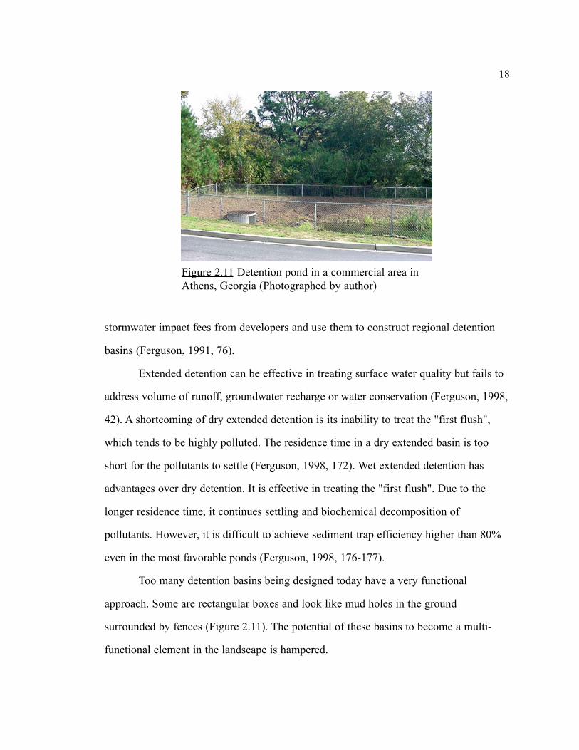
Too many detention basins being designed today have a very functional
approach. Some are rectangular boxes and look like mud holes in the ground
surrounded by fences (Figure 2.11). The potential of these basins to become a multi-
functional element in the landscape is hampered.
18
Figure 2.11 Detention pond in a commercial area inAthens, Georgia (Photographed by author)
Infiltration
An infiltration basin is the only structural management practice that reduces
both the peak flow rate and the volume of runoff from developed landscapes. By
allowing the soil to absorb runoff, it diminishes erosion and flooding problems and
supports groundwater recharge (MacElroy and Winterbottom, 2000, 52). Ferguson
describes infiltration as environmentally the most complete solution to the problem of
urban runoff. Infiltration, unlike detention, is recommended in numerous small upland
basins or swales at the source of urban runoff. It gives the advantage of water traveling
through the subsurface before discharging into streams. This aids in the filtration of
water (Ferguson, 1991, 79). Some places like Long Island, Maryland and Florida have
rigorously implemented infiltration technique to tackle development runoff.
Underground detention system
Underground stormwater systems present fewer public hazards than open ponds,
don't present aesthetic challenges and do not compete for surface acreage (Tilton, 2002,
41). This system is suitable for high-density urban areas where allotting a space for
detention ponds is almost impossible. However, the main problem with this system is
that it is an 'out of sight' and 'out of mind' approach. It is a purely technical solution,
which does not provide any wildlife habitat, aesthetic pleasure or public involvement
that a surface detention pond could offer. The construction and maintenance cost can be
high depending on the amount of runoff to be treated. A full and clogged underground
stormwater system is difficult to see and therefore regular inspection and maintenance
are required (Northcutt, 2001, 3, 10). Due to these concerns it is best to use surface
ponds and basins where space permits (Northcutt, 201, 16).
19
Conclusion
Some of the alternative stormwater management practices such as extended
detention, infiltration and water harvesting, offer a better chance for managing the
urban runoff than conveyance. The various benefits include groundwater recharge,
water quality enhancement, flood control and wildlife habitat. Water harvesting reuses
the stormwater reducing the load on municipal supplies and eliminating the need for
conveyance downstream.
But there is still a lack of public participation in and awareness of these
facilities. The facilities are still predominantly designed for single use and are located in
remote places representing a missed opportunity to design them for multiple uses such
as recreation. They are often neglected due to the lack of public awareness. The
aesthetic potential of such facilities needs to be exploited. There is a need for a design
language that makes the most of available opportunities, one that re-establishes the
concept of multi-functional, productive and working landscape that integrates ecology,
people and economy (Hough, 1994, 31). The following chapter explores this multi-use
potential of detention facilities in parks and open spaces.
20
CHAPTER THREE
MULTI-USE DETENTION PONDS IN PARKS AND OPEN SPACES
Need to expose the natural process of stormwater
City development patterns have evolved. Cities no longer grow around rivers,
cataracts, springs, pools and ports, but around airports or highways, in amorphous
patterns that defy the presence of water and yet demand it all the same (Betsky, 1995,
13). We are forgetting how fundamental the vast systems of extraction, purification,
distribution and drainage are to our urban life. There is little or no trace of it in our
man-made environment. When we have to see water, we make trips to dams, the coasts
and aquariums (Betsky, 1995, 13). Today’s water is becoming increasingly domesticated
and decreasingly appreciated. Modern treatment plants have replaced the natural water
cycle with a mechanized hydrological cycle. The water supply and disposal systems
today leave no indication that the water supplied to our tap has its origin to the rain
falling on the roof tops and paved surfaces. Many of us have grown accustomed to
taking fresh clean water for granted (Moore, 1995, 23).
The urban environment today isolates us from the natural processes that support
life. Much of our daily existence is spent in the surroundings that conceal the natural
processes. The curb and catch basin that make rainwater disappear without trace below
ground cut the visible links with natural water cycle. We are unaware of the ecological
damage being done to the receiving waters (Hough, 1994, 30). The abundance and
security of water supply has led to the perception of water as a free commodity and an
infinite resource. The recent drought situation in southeast United States and some other
parts of the world now questions the infinity of this resource. This situation coupled
21
with the ever-increasing water charges are a valid indication that we have been getting
it very wrong, and that a complete rethink is now needed (Jones, 1995, 17). This can
only take place by changing the public perception of water and increased environmental
consciousness.
Making the processes visible is an essential component of environmental
education, which can be brought about by constant and direct experience assimilated
through daily exposure and interaction with the place one lives in (Hough, 1994, 24,
31). Exposing the flow of water - where it comes from, how and where it is used, where
it is treated and released, and the seasonal variation will help people in understanding
the hydrological cycle and influence them to conserve water.
Incorporating multi-use detention ponds in parks and open spaces
With the growing human population, land is becoming scarce. McHarg noted
that, “Urbanization proceeds by increasing the density within and extending the
periphery, always at the expense of open space. As a result, unlike other facilities, open
space is the most abundant where people are the scarcest.” In cities it is difficult to hold
stormwater due to limited space. In such situations it makes sense to design landscapes
for multiple uses. Multiple-use can help in conserving space. There is a need to change
our aesthetic conventions that have created a landscape of parks and playgrounds whose
character rests on uniform application of cultivated turf and whose sole purpose is
recreation (Hough, 194, 13). Instead of assigning recreation as the exclusive use of
parks, parks can be designed to serve as temporary storage areas that can fulfill
hydrological roles. Open spaces can thus become spaces for restoring the damage done
by urban development rather than passive recreational space.
Skillful planning can provide play and sun bathing areas in basins when weather
is dry, as they will not be used for this purpose when it is raining anyway (Dreiseitl,
22

2001, 43). The land thus serves dual purpose, assisting hydrological functions but
providing space for other uses. Golf courses, playing fields and parks are some of the
landscapes where management could accommodate compatible uses (Hough, 1994, 79).
Multi-purpose open spaces can define the shape of future growth, rather than vice versa.
Online detention facilities, which pass the entire flood through them, are well
suited for joint uses such as open space, wetlands and wildlife habitat that can tolerate
frequent inundations. Off-line detention facilities, which bypass the frequent flows and
allow only the excess flow into the detention area are well suited for intensive
recreational uses such as playgrounds and play fields since they are flooded less
frequently (DeGroot and Lloyd, 1992, 20). The uses can be combined at the time of
development or could be retrofitted, either putting detention into an existing park or
putting recreational facilities into an existing detention facility. If done well, the
facilities become an asset to the community (DeGroot and Lloyd, 1992, 19).
In order for natural processes to be appreciated and maintained by people,
human intention and care for land must be evident (Nassauer, 1995). Thus by placing
stormwater systems right in the heart of the city in parks and open spaces, there are
better chances of it being noticed and therefore cared for by the people.
Benefits of multi-use detention ponds
Economic benefit
Local governments are facing demands for services like parks, open spaces,
recreation, drainage and flood control; increasing mandates from federal and state
government and limited revenues to meet these demands. In such situation multiple-use
can provide economic and political advantages. It increases the beneficiaries of the
project and therefore makes administrative allocation of funds more justifiable. It also
23
spreads the cost of land, design, construction and maintenance among more agencies
(DeGroot & Lloyd, 1992, 20).
Increased property values
It has been noted that stormwater ponds and wetlands raise property values
where they have been integrated into communities. Communities derive more property
values when houses are fronted on stormwater ponds. Residents are willing to pay more
for the maintenance and upkeep if they are provided access to these ponds and can
utilize the recreational facilities located on the lakeshore (Ferguson, 1998, 14).
Communities often resist single purpose storage facilities while multi-purpose facilities
featuring parks, open spaces and recreation generally receive strong community support
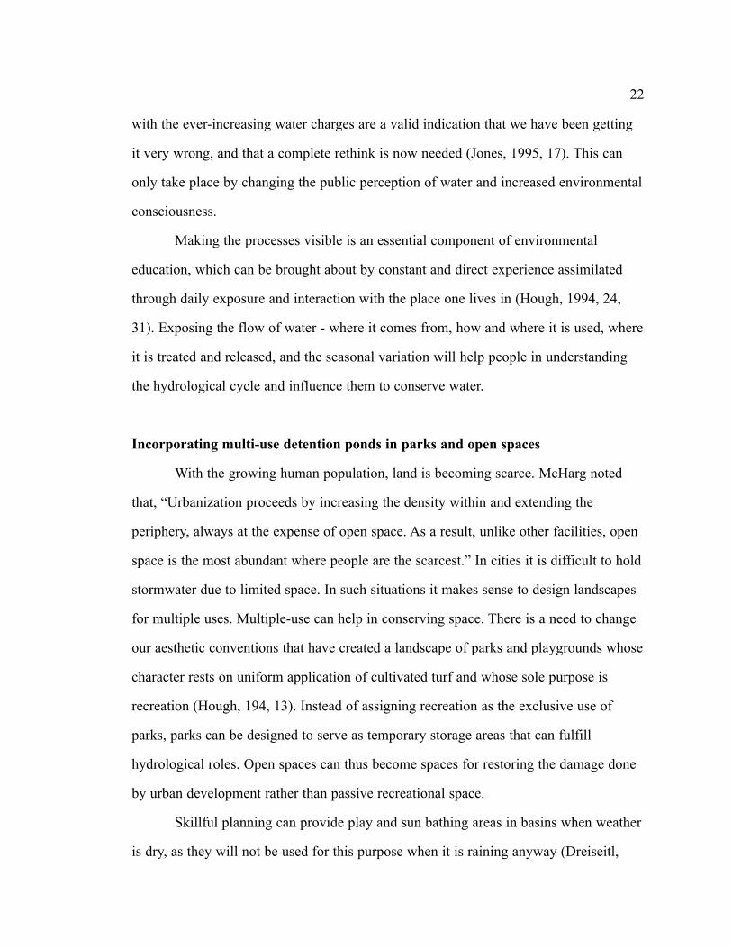
(Wright, 1982, 292). Figure 3.1 shows a detention pond in a housing complex in
Indianapolis. The pond is provided with a deck, a shelter and picnic tables along the
edge. It forms an integral part of the community and is extensively used for picnicking,
fishing, bird watching or just hanging around.
24
Figure 3.1 Detention pond in a Housing Complex,Indianapolis (Photographed by author)

Wildlife habitat
There is evidence that people living in metropolitan areas have a genuine
interest in wildlife and in opportunities to view wildlife (Figure 3.2). It was discovered
in a survey of children aged six to ten that fifty percent of their outdoor activities
involved wildlife (e.g., observing, collecting) and that children unlike adults were more
interested in “creepy-crawly” varieties such as amphibians, reptiles and insects.
Research has also indicated that contact with plants and animals is therapeutic and
enriches the lives of elderly people and others requiring specialized care (Campbell and
Ogden, 1999, 191-192).
Many wildlife habitats are destroyed by urbanization. Detention ponds provide
an opportunity to replace these habitats. Created wetlands can provide a number of
aquatic and terrestrial habitats with opportunity for photography and nature study. Birds
are particularly important for urban wildlife observers, many of whom are unable to
travel long distances to see wildlife (Adams, Leedy and Franklin, 1982, 384, 386). A
survey of the residents of Columbia, Maryland indicated that residents preferred future
stormwater ponds to be managed for wildlife in addition to flood and sediment control.
25
Figure 3.2 Wildlfe in a detention pond, Indiannapolis(Photographed by author)

There is also a movement within the golf course development industry to incorporate a
wide variety of vegetation to create wildlife habitat (Campbell and Ogden, 1999, 191-
192).
If designed well stormwater detention can serve as an amenity and be
compatible with other park uses. It can provide a creative and practical alternative to
traditional site development practices.
Review of multi-use detention ponds
One of the earliest examples of multi-use detention in a park is Boston’s
‘Emerald Necklace’ park system, designed by Frederick Law Olmsted (Figure 3.3).
Olmsted created the Fens and the riverway to combat the flooding and pollution
problems of Boston’s Back Bay tidal flats (Spirn, 1984, 147). Originally a muddy and
foul smelling area, he converted it into an idealized stream and salt marsh meadow with
a park-like setting (Tucker, 2001, 36) (Figure 3.4). It was a brilliant multi-functional
design with bridle paths, walkways, canoeing and park drives in addition to sanitary and
flood control feature (Tunney, 2002).
Olmsted forged a role for urban parks, which was bound in the alleviation of the
nineteenth century city’s social and environmental problems through the design of parks
and parkways. He sought to improve the city’s climate, to alleviate air and water
pollution, to mitigate floods and to provide a naturalistic counter point to the city’s
modern infrastructure (Spirn, 1984, 243).
In recent years some municipalities have started encouraging the design of
stormwater ponds for multi-use like Olmsted’s design for the Fens. The Denver metro
area has a long history of combining stormwater with parks and open spaces. The Flood
Control District of Denver has designed numerous parks to contain stormwater.
26

Examples
Herbert Hosana Park, Colorado
The Herbert Hosana Park is a school site being used as an off-line detention
pond (Figure 3.5). Adjacent channels can carry flows up to the 25-year flood peak. The
school grounds thus provide flood protection and are used as playfields including soccer
fields and baseball fields, complete with press box and bleachers (DeGroot and Lloyd,
1992, 20).
27
Figure 3.3 Olmsted’s 1894 plan for the Back Bay Fensand the Riverway (Tucker, 2001, 35)
Figure 3.4 View of Boston Riverway, 1920 (Tucker,2001, 34)

28
Jefferson High School Athletic Fields, Colorado
The athletic fields of the Jefferson High School in the city of Edgewater,
Colorado, were built across a tributary to Sloans Lake with only an 18” pipe for
drainage. As the upstream basin urbanized, flooding became a frequent occurrence. The
solution was an off-line detention pond in the athletic fields. The excess flows of a 5-
year peak are now detained on the athletic fields resulting in a 100-year flood protection
downstream (DeGroot and Lloyd, 1992, 20).
Wallace Park, Colorado
Wallace Park is a 25-acre park designed by Wenk Associates, Denver. This park
facilitates stormwater detention of 10-year or greater flood events thus providing flood
protection and also park facilities to the adjoining offices and neighborhood (DeGroot
and Lloyd, 1992, 20). The open areas are utilized for soccer and Frisbee games. The
concrete low flow channel, which cuts through the center of the park, is combined with
a walking path. The foot deep stream and the drop-structure “plazas” that punctuate the
flow in three places, form play areas for children. These sandstone-colored plazas are
studded with the “dragon’s teeth”, used by hydrologists in baffle-chute drop structures
Figure 3.5 Herbert Hosana School Park,Colorado (Stahre and Urbonas, 1990, 34)

to slow down water (Fig 3.6). These form elements of children’s play and due to its
sculptural quality it also draws park visitors to the water’s edge, where it swirls around
the baffles. The adjoining offices also utilize it during lunch hours (Strutin, 1991, 87).
The Wallace Park has become a valuable part of the community due to its multi-purpose
amenities.
Olympic Park, Colorado
The Olympic Park in Aurora, Colorado, also designed by Wenk Associates,
includes softball and soccer fields along with other park amenities. A three-quarter acre
all-season wet detention pond holds runoff from the parking lot and surrounding
area (Figure 3.7). The pond holds a maximum depth of three feet water; the excess
travels through a system of perforated pipes and recharges the ground water. The pond
is accessible by concrete steps. Children use the wading pond for recreation (MacElroy
and Winterbottom, 2000, 102). The fountains, which aerate the water, also form a visual
element and enliven the space.
29
Figure 3.6 Wallace Park, Colorado (Strutin, 1991, 87)

Other examples
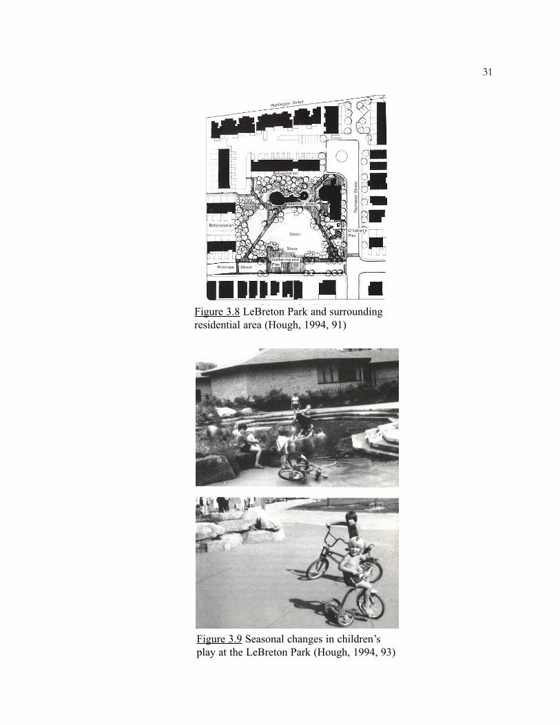
LeBreton Park, Canada
The LeBreton Park is an inner-city Park within a housing development in
Ottawa, Canada (Figure 3.8). It has a hard surfaced detention area to hold a 2-year flood
peak. This detention area provides an ephemeral pond for play and recreation that is
linked to the hydrological cycle (Figure 3.9). Roof water from adjacent housing and
overland flow within the park is conveyed by a series of drainage channels into the
pond. The pond fills up to a depth of 18 inches. The hard surfaced bottom is designed to
permit many different activities. During winter it becomes an ice skating rink. During
summer, after rain, the activity focuses on water play. When the water dries out, the
area is taken over by roller skaters and skateboarders. Thus the children’s activities
respond to the changing environment. By accommodating such multiple uses of the
detention area, children are brought close to the cycles of rain and sunshine (Hough,
1994, 92).
30
Figure 3.7 Detention pond in Olympic Park, Aurora, Colorado (McElroy andWinterbottom, 2000, 54)
31
Figure 3.8 LeBreton Park and surroundingresidential area (Hough, 1994, 91)
Figure 3.9 Seasonal changes in children’splay at the LeBreton Park (Hough, 1994, 93)

Arlington Heights, Chicago
Arlington Heights, located to the northwest of Chicago, is an example of a
community that works with the local government to develop stormwater facilities that
serve dual purposes. Developers in Arlington Heights were required to provide on-site
stormwater detention. They often turned these detention basins over to the community,
which made agreements with the park district to maintain these areas as park or open
space. But in the past these areas did not receive any design directions from the park
district and often turned into a wasted space and a maintenance problem. Now the park
district has an agreement with the community that they will only take over and maintain
stormwater detention facilities that have a recreational use. Since then several
recreational facilities like golf courses, ball diamonds, tennis courts, ice skating rinks,
sledding hills and nature areas have been incorporated into detention ponds (Figure
3.10).
In addition to providing flood control and aesthetic enhancement, the Arlington
Lakes Golf Course uses its detention lakes for irrigation purposes. The facility also
32
Figure 3.10 Playfield in Sunset MeadowPark, Arlington, being used as adetention facility (Cappulli, 1984, 48)
provides year round use by offering the course as a cross country ski trail in the winter
(Capulli and Jacobson, 1984, 49)
Yauger Park, Washington
The Yauger Park, located in Olympia, Washington is a 40-acre park and regional
stormwater detention facility. It provides stormwater control as well as varied active and
passive recreational opportunities. The park has three baseball fields, a playground,
horseshoe pits, picnic tables, picnic shelter, one-mile jogging trail and a community
garden. The park is designed to detain a 100-year storm event. Two settling ponds, the
south parking lot and sports fields serve as stormwater detention areas. The park
protects a commercial area downstream from flooding. Some of the playfields are built
higher than the overflow structure hence they are rarely flooded (Weber, 1991, 61-62).
Conclusion
The examples above indicate that different kinds of recreational amenities can
be incorporated in a stormwater detention facility and when these detention facilities are
incorporated in parks and open spaces, they conserve space in urban areas while
becoming community assets. Even the components of a detention facility can be
designed as elements of play and to be visually attractive. Depending on the desired use
of the facility, it can be natural or hard surfaced and have a hard edge or planted edge.
Planning considerations for multi-use stormwater detention facilities
There are several issues to be considered when planning for a multi-use
stormwater detention facility, to make the facility acceptable by people. The primary
considerations are regarding recreation, aesthetics, maintenance, safety, water quality
and wildlife habitat. Care has to be taken to see that the recreational function does not
33
interfere with the hydrological function and vice versa. Multi-use would also involve
interdisciplinary planning. It would require planners, designers, ecologists and managers
of the city to work together on stormwater problems.
Recreation
As seen in the previous section, stormwater ponds can be designed for active
and passive recreation like playfields, game courts, golf course, ice skating rink, skate
boarding, nature trailing and picnicking. For many non-water oriented recreation
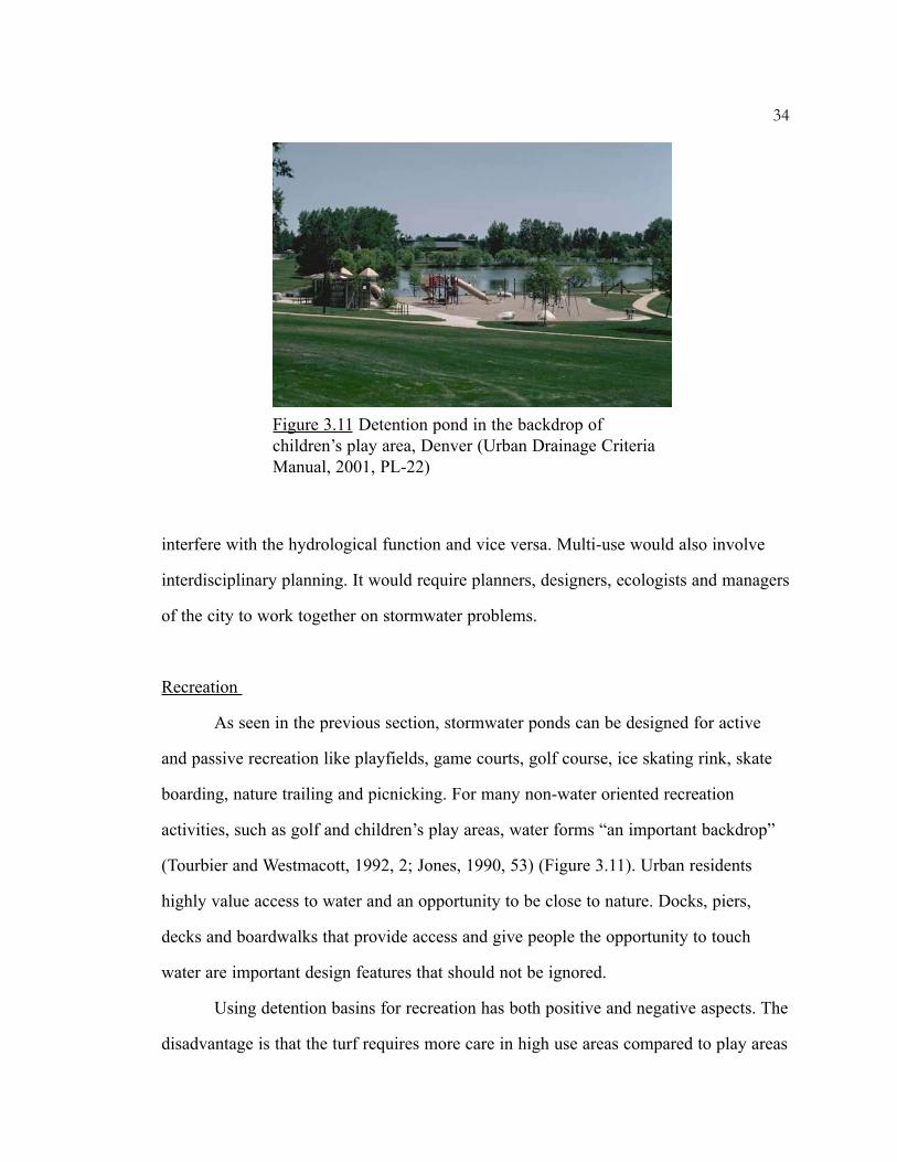
activities, such as golf and children’s play areas, water forms “an important backdrop”
(Tourbier and Westmacott, 1992, 2; Jones, 1990, 53) (Figure 3.11). Urban residents
highly value access to water and an opportunity to be close to nature. Docks, piers,
decks and boardwalks that provide access and give people the opportunity to touch
water are important design features that should not be ignored.
Using detention basins for recreation has both positive and negative aspects. The
disadvantage is that the turf requires more care in high use areas compared to play areas
34
Figure 3.11 Detention pond in the backdrop ofchildren’s play area, Denver (Urban Drainage CriteriaManual, 2001, PL-22)

without detention facility. Poor drainage and excessive sedimentation can damage the
turf. Hence turf should be of a species of grass, which can withstand inundation.
Overseeding needs to be done frequently. Ball fields are more difficult to maintain in
detention basins because they need a smooth and even turf (Cappulli and Jacobson,
1984, 70). The recreation facilities should not be placed near the bottom of the
detention pond as it might become subjected to frequent flooding. Hard-surfaced game
courts and playgrounds incorporated into detention basins may require greater
maintenance due to the occasional silt deposition (Weber, 1991, 21)
The detention ponds should be available for recreational activities as quickly as
possible, following their use for runoff detention. Hence it is desirable to install a low
flow channel to facilitate drainage. Bottom slopes should assure rapid drainage but
should be carefully planned to minimize the likelihood of injury to sports participants
(Jonathan Jones and Earl Jones, 1982, 325). Drainage of the pond bottom between
storms has to occur efficiently if it is going to be used for recreation. To achieve this,
the bottom has to be cross-sloped at no less than 2% towards the low flow channel
(Stahre and Urbonas, 1990, 39)
In case of dry detention basins, which are used as playgrounds between storm
events, there is concern about the possible buildup of metals and other substances on to
the dirt comprising the floor of the basin, and its effect on children playing in the
material and inhaling the dust (Cobb, 1982, 19). For this purpose the soil should be
monitored for levels of toxins and harmful metals like lead. It usually takes a very long
period for the soil to reach any objectionable level of contamination. The sources of
toxic contaminants upstream can be inventoried prior to building the facility and
necessary action can be taken.
35

Aesthetics
Aesthetics plays a major role in the public acceptance or rejection of a detention
facility. For a detention pond to be an integral part of the community, it needs to blend
into the landscape and into the community. Detention facilities can take a park-like
appearance and actually enhance the aesthetics of an area (Debo, 1982, 334) (Figure
3.12). Wet ponds can be aesthetically pleasing and increase property values due to the
waterfront effect. However there are differences in regional taste among people. For
example, people in some areas enjoy a natural look with cattails and other aquatic life
growing at the edge of the pond while others prefer a manicured lawn appearance
around the pond. Dry ponds, on the other hand, may be perceived as unattractive by the
public unless they are maintained as a lawn.
Wet ponds can be unattractive if the pond regularly develops heavy algae
growths and weeds (Cobb, 19, 1982). Excessive algae can cause odor and aesthetic
problems. Lowering the impounded water surface for a time, then re-establishing it can
sometimes accomplish effective algae and weed control (Jonathan Jones and Earl Jones,
1982, 327). Dry ponds do not have algae problems since water is drained frequently in-
36
Figure 3.12 Detention pond near a Housing Complex,Colorado (Urban Drainage Criteria Manual, 2001, DP-11)

between storms (Stahre and Urbonas, 1990, 52). In wet ponds, aeration and introduction
of algae-eating fish can reduce the growth of algae.
Fences, though used extensively for safety purposes, are considered unattractive.
The use of natural landforms, meandering channels, water fountains, irregular
configuration, gentle side slopes, mosquito control, planting of native trees and shrubs,
concealment of inlets and outlets and other landscaping features can transform a
detention facility into an attractive amenity for the neighborhood (Stahre and Urbonas,
1990, 32) (Urbonas, Carlson and Tucker, 1993, 17).
Maintenance
Maintenance of detention facilities is necessary for their hydrological
functioning and acceptability by the community (Weber, 1991, 23). Easy and rapid
access for maintenance equipment is essential to remove debris and sediment (Jonathan
Jones and Earl Jones, 1982, 327). A maintenance access of width 12 feet is
recommended to reach the key maintenance areas like inlet and outlet structures (Urban
Stormwater Drainage Criteria Manual, 2001, MD-52)
Sediment removal is one of the most expensive maintenance activities for
detention ponds. When the suspended solids load is high, the ponds will have to be
cleaned more often. Special considerations are necessary if the sediment contains
elevated concentrations of metals and organics (Jones, 1990, 52). Limitation of
sediment removal, hauling and disposal costs require acquisition and preparation of a
nearby sediment disposal site when the detention pond is conceived and constructed
(Jonathan and Earl D. Jones, 1982, 328)
Other maintenance activities involve mowing, weed control, trash removal,
algae control and mosquito control. Seeding the wetland with mosquito fish (Gambusia
affinis) and dragonfly larvae, in addition to aeration, can control mosquitoes (Campbell
37
and Ogden, 1999, 121). Ponds should not be designed with steep slopes as they pose a
difficulty in mowing. Generally, construction, operation and maintenance costs will be
less for one large pond than for a series of smaller ponds (Jonathan and Earl Jones,
1982, 324).
Safety
Human safety is another concern in the design of detention basins. The outlet of
the basin is essentially a constricted culvert or a narrow pipe. The large volume of water
exerts a lot of pressure on these narrow outlets leading to faster flow. According to
Ferguson, conveyance should be as open and free flowing as possible. It should be
slow, shallow and free of constrictions. Broad open weirs are much safer than narrow
outlets. The basins are usually designed with steep slopes and located out of sight. This
makes them more hazardous. The basin should be open and visible and accessible so
that people can appreciate any hazard, take the necessary precaution, monitor others and
provide rescue when needed (Ferguson, 1998, 26).
Proper landscaping is a fundamental element in safety design. Fencing of
detention ponds should be discouraged wherever possible. Fences are expensive to
install and maintain, tend to be unsightly, produce “edges”, which increase grounds
maintenance needs, exists as a challenge to some of those they are intended to protect,
and they impede emergency access in the unlikely event it becomes necessary (Jonathan
Jones and Earl Jones, 1982, 325). Although safety should remain a concern, a properly
designed detention pond should not be more hazardous than an urban lake, a
playground, a hiking trail, or any other recreational or park facility in a city. It is
definitely a safer facility than a city street, yet no one fences off the streets (Stahre and
Urbonas, 1990, 36).
38

Hydraulic structures
The planning, design, construction and maintenance of hydraulic structures must
include considerations of aesthetics, safety and effects on the environment. Structures
such as channels, inlet, outlet, overflow, grade controls, energy dissipators, maintenance
roads and others can blend in with the park environment (Figure 3.13). The combination
of diversity of forms, lines, colors and textures creates visual experience. Material
selection and placement of vegetation can provide visual character and create
interesting spaces in and around hydraulic structures. The use of planting that reduces
erosion and dissipates residual energy are fundamental to good aesthetics and
environmental quality as well as hydraulic function.
In highly developed streamside areas, concrete plazas and edge treatment can be
combined to increase channel efficiencies while providing access to waterway area.
Natural materials like rock and vegetation can be used for bank stability while
providing interesting spatial character and diversity. Some hydraulic and drainage
features offer an invitation to play and hence should be made structurally safe and
attractive (Urban Stormwater Drainage Criteria Manual, 2001, HS-107).
39
Figure 3.13 Hydraulic stucture blended into thelandscape, Colorado (Urban Drainage CriteriaManual, 2001, HS-7)

40
Water quality
Urban detention ponds play an important role in stormwater quality management
because they trap substantial quantities of pollutants. The pond should provide an
average residence time of 24 hours for water quality. This will also eliminate mosquito
problems since mosquitoes generally require 48 hours to breed and hatch. In a study
conducted in New Jersey, it was found that the detention basins trap 60 to 70 percent of
lead, total suspended solids and hydrocarbons during a detention time of 32 hours. Even
during an 8-hour detention time, 30 to 40 percent of the pollutants are precipitated. A
series of ponds can be more effective in removing about 80 percent of the pollutant
(Jonathan Jones and Earl Jones, 1982, 321). Regular monitoring of water and sediment
from the detention ponds should be done to ensure that they meet safety standards
(Weber, 1991, 24)
Wildlife habitat
There is an opportunity to enhance wildlife in urban areas by creating wetlands
as a by-product of stormwater management. Research initiated by the National Institute
for Urban Wildlife (NIUW) in 1982 found that typical grass detention basins were of
little use to wildlife. Permanent shallow water impoundments with a variety of aquatic
plants, gentle slopes and less open water provided good wildlife habitat (Campbell and
Ogden, 1999, 196). A native vegetation edge will encourage wildlife to use the area and
is also more consistent with enhanced pollutant removal (Jones, 1990, 53). Creation of
islands, bays and particular aquatic plantings like pondweeds, wild rice, wild celery and
duckweed that provide maximum food and cover, help in assisting wildlife habitat. The
addition of nesting and roosting boxes along with feeding stations, floating platforms,
bird houses, shelters for squirrels, cover for chipmunks and other wildlife can increase
the attractiveness and functioning of wildlife habitats (Campbell and Ogden, 1999, 200-

201). Maintaining an unmowed buffer of at least 25 feet can provide a good terrestrial
and aquatic habitat. Also varying the pond depth, with at least 25 percent area at less
than 2 feet depth can diversify the habitat (Schueler, 1987).
41

CHAPTER FOUR
CASE STUDIES
This chapter looks closely at three case studies; Mill Creek Park in King County,
Washington, Fishtrap Creek Nature Park in British Columbia and Skyline Park in
Denver, Colorado. Among the facilities available for discussions, these three were
specifically chosen due the difference in their location, setting, character and design
approach. Mill Creek Park was designed by an artist and has a sculptural quality;
Fishtrap Creek Nature Park was designed by an interdisciplinary team and has a very
natural appeal whereas the Skyline Park is a hard-surface urban plaza in downtown
Denver and is a part of an urban renewal scheme.
CASE STUDY 1: MILL CREEK PARK
The city of Kent is located in the south of the Seattle metropolitan region.
Development of land in Kent, along Mill Creek had resulted in excessive flows of water
during periods of heavy rain and the city needed a way of containing it and allowing it
to recede slowly through the town (Beardsley, 1998, 94). In the late 1970’s, the City’s
Public Works Department decided to fund and build a large regional detention pond
along Mill Creek in response to the increasing volume of runoff generated in the 1500-
acre watershed.
Meanwhile, the King County Arts Commission had decided to fund an
earthwork project. The Mill Creek Park site was selected for this project and it was
decided to design a large multi-use stormwater detention facility. Herbert Bayer, the
artist selected for the project, designed a park containing a group of earth forms (Figure
42
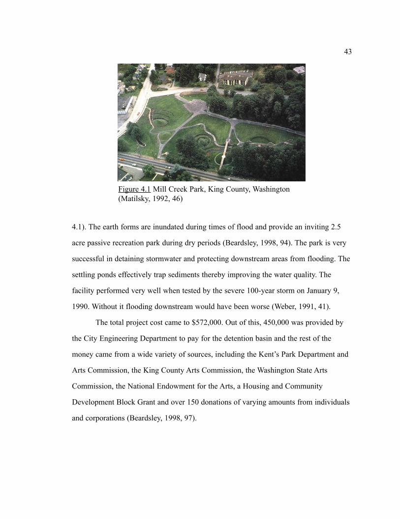
4.1). The earth forms are inundated during times of flood and provide an inviting 2.5
acre passive recreation park during dry periods (Beardsley, 1998, 94). The park is very
successful in detaining stormwater and protecting downstream areas from flooding. The
settling ponds effectively trap sediments thereby improving the water quality. The
facility performed very well when tested by the severe 100-year storm on January 9,
1990. Without it flooding downstream would have been worse (Weber, 1991, 41).
The total project cost came to $572,000. Out of this, 450,000 was provided by
the City Engineering Department to pay for the detention basin and the rest of the
money came from a wide variety of sources, including the Kent’s Park Department and
Arts Commission, the King County Arts Commission, the Washington State Arts
Commission, the National Endowment for the Arts, a Housing and Community
Development Block Grant and over 150 donations of varying amounts from individuals
and corporations (Beardsley, 1998, 97).
43
Figure 4.1 Mill Creek Park, King County, Washington(Matilsky, 1992, 46)
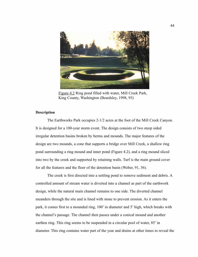
Description
The Earthworks Park occupies 2-1/2 acres at the foot of the Mill Creek Canyon.
It is designed for a 100-year storm event. The design consists of two steep sided
irregular detention basins broken by berms and mounds. The major features of the
design are two mounds, a cone that supports a bridge over Mill Creek, a shallow ring
pond surrounding a ring mound and inner pond (Figure 4.2), and a ring mound sliced
into two by the creek and supported by retaining walls. Turf is the main ground cover
for all the features and the floor of the detention basin (Weber, 91, 36).
The creek is first directed into a settling pond to remove sediment and debris. A
controlled amount of stream water is diverted into a channel as part of the earthwork
design, while the natural main channel remains to one side. The diverted channel
meanders through the site and is lined with stone to prevent erosion. As it enters the
park, it comes first to a mounded ring, 100’ in diameter and 5’ high, which breaks with
the channel’s passage. The channel then passes under a conical mound and another
earthen ring. This ring seems to be suspended in a circular pool of water, 85’ in
diameter. This ring contains water part of the year and drains at other times to reveal the
44
Figure 4.2 Ring pond filled with water, Mill Creek Park,King County, Washington (Beardsley, 1998, 93)

full contours of the grass ring. Then comes the high berm topped with another cone.
Below it is a final oval mound (Beardsley, 1998, 94) (Figure 4.3).
Two sets of stairs with a viewing platform and a viewing tower are incorporated
with the overflow structure. Benches and picnic tables are placed along an asphalt path,
which meanders through the site. An amphitheater and a concert stage are located
upstream of the earthworks by the settling pond (Weber, 1991, 37).
Recreational amenities
Bayer’s Mill Creek earth forms are the focal point of the one hundred acre park.
The park serves as a gathering place for community. The grass covered mounds, berms
and level areas create a variety of spaces for people to stroll through and play on.
Children enjoy climbing on top of the berms and rolling down the hill. The benches,
picnic tables and viewing platforms provide opportunities for resting, picnicking and
viewing (Figure 4.4). The settling pond, which provides habitat for salmon, offers
nature watching and fishing opportunities. The ring pond and stream channel are
aesthetically pleasing, especially when filled with water (Weber, 1991, 45).
45
Figure 4.3 Oval mound with a bridge, Mill Creek Park,King County, Washington (Bourdon, 1995, 227)
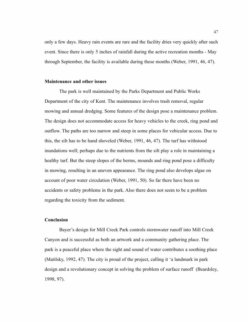
Dances, concerts, weddings and a variety of other activities are scheduled every
weekend (Figure 4.5). The park’s landscape provides a beautiful backdrop for recreation
activities. The ‘Canterbury Faire’ is held every year in the park (Weber, 1991, 46). The
park is closed during heavy rain and during maintenance. The maintenance requires
46
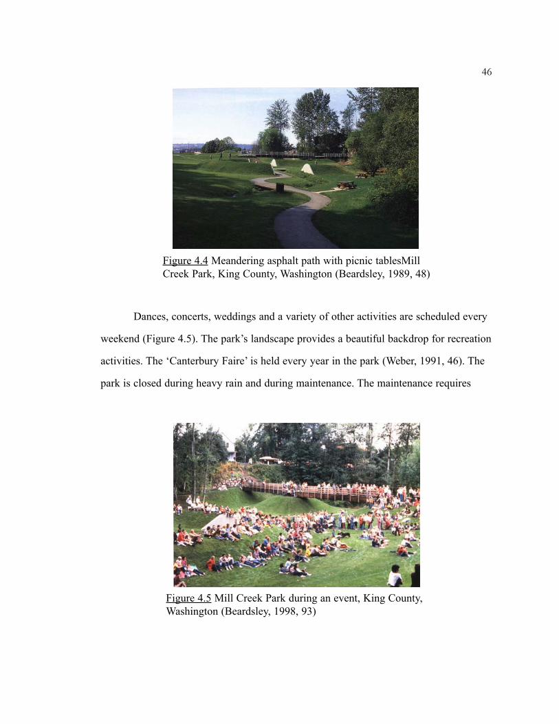
Figure 4.4 Meandering asphalt path with picnic tablesMillCreek Park, King County, Washington (Beardsley, 1989, 48)
Figure 4.5 Mill Creek Park during an event, King County,Washington (Beardsley, 1998, 93)
only a few days. Heavy rain events are rare and the facility dries very quickly after such
event. Since there is only 5 inches of rainfall during the active recreation months - May
through September, the facility is available during these months (Weber, 1991, 46, 47).
Maintenance and other issues
The park is well maintained by the Parks Department and Public Works
Department of the city of Kent. The maintenance involves trash removal, regular
mowing and annual dredging. Some features of the design pose a maintenance problem.
The design does not accommodate access for heavy vehicles to the creek, ring pond and
outflow. The paths are too narrow and steep in some places for vehicular access. Due to
this, the silt has to be hand shoveled (Weber, 1991, 46, 47). The turf has withstood
inundations well; perhaps due to the nutrients from the silt play a role in maintaining a
healthy turf. But the steep slopes of the berms, mounds and ring pond pose a difficulty
in mowing, resulting in an uneven appearance. The ring pond also develops algae on
account of poor water circulation (Weber, 1991, 50). So far there have been no
accidents or safety problems in the park. Also there does not seem to be a problem
regarding the toxicity from the sediment.
Conclusion
Bayer’s design for Mill Creek Park controls stormwater runoff into Mill Creek
Canyon and is successful as both an artwork and a community gathering place. The
park is a peaceful place where the sight and sound of water contributes a soothing place
(Matilsky, 1992, 47). The city is proud of the project, calling it ‘a landmark in park
design and a revolutionary concept in solving the problem of surface runoff (Beardsley,
1998, 97).
47

CASE STUDY 2: FISHTRAP CREEK NATURE PARK
The Fishtrap Creek Nature Park in Abbotsford, British Columbia is a 57 acre
park surrounded by suburban development in a small city in Fraser Valley (Figure4.6).
The town of Abbotsford is located about 20 miles east of Vancouver in the district of
Matsqui. Due to rapid development in the past thirty years and a heavy annual rainfall
of 60 inches, the town faced increased flooding of farmlands. As a solution to this
problem the municipality proposed two detention ponds in the Fishtrap Creek, which
drains 7,526 acres of upland developed land and lowland farms as it flows south across
the Canada-U.S border and joins the Nooksack River in Washington (Mooney, 2001,
66). The original purpose of the project was expanded by the landscape architects to
include a variety of ecological and recreational objectives (Berris, 2000). The
municipality acquired 57 acres of unused, overgrown farmland and woodland in the
upper watersheds of the creek for the project.
48
Figure 4.6 Aerial view of Fishtrap Creek Park, Abbotsford,British Columbia (www.dayton-knight.com)

Description
The existing creek was relocated to include meandering and a wider cross
section (Figure 4.7). During peak flows, water overflows from the stream channel
filling the adjacent created wetlands. Floodwater from the wetland is released
downstream over a period of time through a control structure. The wetlands provide a
detention area of 10 acre-feet accommodating a floodwater rise of 5 feet. The wetland is
designed to capture 60 percent of the suspended solids from a one-hour duration storm
of a 10-year storm event. A sediment pond between the northern and southern areas of
the park removes further sediment from the runoff. Year round flow of the creek is
maintained by infiltration of water (Mooney, 2001, 66). The detention ponds and the
walkway around it have a naturalistic form with side slopes of 1:3 or 1:5 and are
planted with native dogwood and willow shrubs. The floor of the wetland is planted
with cattails (Typha latifolia) due to its biofiltration property, ability to colonize quickly
and to withstand water fluctuations. A buffer of mature forest is retained along the steep
southern boundary of the site (Mooney, 2001, 69).
49
Figure 4.7 Plan of Fishtrap Creek Park, Abbotsford, British Columbia(www.cbainc.bc.ca/services/parksite.html)

Recreation amenities
The Fishtrap Creek is extensively used by neighboring residents and people
throughout the area. The park provides better shading, viewing and habitat possibilities,
public recreation and education through ecological and cultural signage. The
recreational uses are supported by a two-lane loop trail and six structures set within the
50
Figure 4.9 Picnic Shelter, Fishtrap Creek Park, Abbotsford,British Columbia(www.cbainc.bc.ca/services/parksite.html)
Figure 4.8 Entry Pier, Fishtrap Creek Park, Abbotsford,British Columbia(www.cbainc.bc.ca/services/parksite.html)
park. These six structures, an entry pier (Figure 4.8), picnic shelter (Figure 4.9), reading
shelter, pedestrian bridge, wetland boardwalk and a railway deck, support viewing,
access and interpretation. The structures are made of massive timber posts that are
reminiscent of the historical agricultural buildings of the region. The railway deck is
located at a high point on the site and serves as an overlook point. Park activities
include walking, bird watching and picnicking. Active recreation includes jogging,
roller blading, cycling and softball (Mooney, 2001, 69).
Wildlife habitat
The site is heterogeneous and includes meadow, old-field habitats, mixed
woodlands, and riparian and wetland habitats. The park is home to beavers, muskrats,
turtles and a wide variety of birds like owls, migratory waterfowls and the blue and
green herons, which annually visit the park (Mooney, 2001, 69). The shoreline of the
detention ponds provides good wildlife habitat because of the gentle slopes and a
variety of edge effect. The peninsulas and islands, which are inaccessible to humans
provide very good nesting habitats (Berris, 2000). Although cattail was required due to
large water fluctuations, the predominance of a single species reduces the habitat value.
Also to achieve a large stormwater storage capacity, the woodland habitat was
excavated and replaced with a wetland and riparian habitat thereby increasing riparian
species and decreasing forest species (Mooney, 2001, 125).
Maintenance
Maintenance of most of the areas in the park is kept to a minimum, allowing it
to undergo natural succession. Only the walking path is mowed and the rest of the areas
are allowed to grow into a grassy meadow. Invasive species are removed manually
(Mooney, 2001, 125).
51
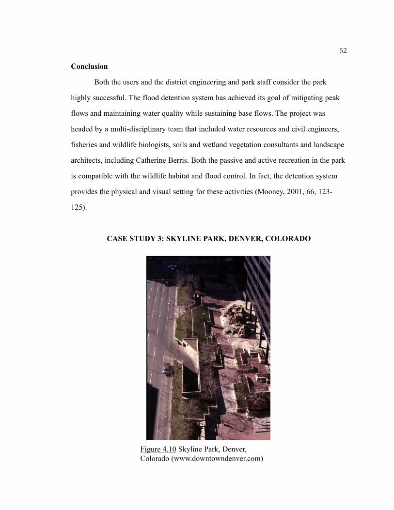
Conclusion
Both the users and the district engineering and park staff consider the park
highly successful. The flood detention system has achieved its goal of mitigating peak
flows and maintaining water quality while sustaining base flows. The project was
headed by a multi-disciplinary team that included water resources and civil engineers,
fisheries and wildlife biologists, soils and wetland vegetation consultants and landscape
architects, including Catherine Berris. Both the passive and active recreation in the park
is compatible with the wildlife habitat and flood control. In fact, the detention system
provides the physical and visual setting for these activities (Mooney, 2001, 66, 123-
125).
CASE STUDY 3: SKYLINE PARK, DENVER, COLORADO
52
Figure 4.10 Skyline Park, Denver,Colorado (www.downtowndenver.com)

The Skyline Park in downtown Denver, Colorado is a major public open space
(Figure 4.10). The park is a part of the on-site stormwater detention scheme that was
adopted for the 80-acre downtown Denver business area of the Skyline Urban Renewal
Project. The scheme called for storage of 3 inches of rainfall on all rooftops, in parking
areas and pedestrian plazas (Wright, 1982, 297).
Description
The park, designed by Lawrence Halprin, is a three-block long detention basin
with a width of 100 ft and an approximate area of 3.2 acres (Figure 4.11). The park
comprises of a set of depressed walkways, raised planters with shade trees and a
53
Figure 4.11 Skyline Park, Denver, Colorado (Greenbergconsultants, 2001, 8)(www.downtowndenver.com)
Figure 4.12 Skyline Park, Denver, Colorado (Mooney, 2001, 66)
sculpted fountain in each of the three blocks. It also has a series of steps and levels, and
is paved with concrete and brick. It is at a lower grade than the adjoining area and is
surrounded by grass and concrete berms (Figure 4.12). The park is designed for a
10year and 100year flood event and detains water from rooftops and surrounding paved
surfaces thereby reducing the storm flow rates to the available capacity of the
downstream sewers. The park has flooded several times after its construction and
functions very well. Since it receives runoff from paved surfaces, there are no sediment
problems (Kenneth Wright, Personal communication).
Recreation
The park is used by people for strolling, eating lunch or just relaxing in the sun.
Children use the park for skateboarding (Stahre and Urbonas, 1990, 33-34). Even when
the plaza is filled with water, the upper levels provide seating and access across the
plaza (Weber, 1991, 19).
Revitalization of the Park
The changing context, in particular, the fact that Skyline Park is literally
bisected by the 16th Street Mall, which did not exist at the time of its creation and the
fact that the Park has begun to experience some difficulties, including physical
deterioration, set the stage for a fundamental reconsideration of its role and form
(Greenberg, 2001, 8). Two ideas that strongly emerged in the revitalization project were
the notion of the ‘piazza’ at the junction with the 16th Street Mall - the hard surface;
multipurpose ever-changing city space and the more pastoral soft and vegetated
‘gardenesque’ park. Some modifications were also suggested which would open up the
park visually, improve the relationship between Skyline Park, the immediately adjacent
buildings and the adjoining streets.
54

55
The presence of water has been identified as a permanent element in the
proposed design, as in the present design by Halprin. Water would link and unify all the
three blocks of the Park and would animate the space throughout the year in its various
states of ice, liquid and vapor. Although the new design calls for a number of changes,
it will still retain the stormwater detention function. The new vision for the park will
allow for the necessary on-site stormwater detention of approximately 5000cu.ft of
water per block (Greenberg, 2001, 47).
56
CHAPTER FIVE
DESIGN APPLICATION
Design intent
This chapter presents an additional design proposal for part of the Southeast
Community Park in Athens, Georgia. The site has three detention ponds, which collect
the runoff generated on site and from other uphill areas. The excess stormwater is
directed to a creek that runs through the site. The ponds are a purely technical solution
to the urban runoff problem and do not, in any way, contribute to recreational or
aesthetic experience. They are located along the edge of the park and are hidden from
the people visiting the park. The design intent of this thesis is to facilitate multiple-uses
of these detention facilities by re-shaping the ponds into a more naturalistic form to
provide recreational and wildlife benefits. The design also tries to integrate them into
the park, making them more accessible. The aim is to make the natural process of
stormwater visible and understandable to people through sight and sound and thus
establish a connection between the urban environment and natural processes.
The Site
The site is located at the corner of Lexington and Whit Davis Road (Figure 5.1).
It is an undeveloped tract of land measuring 146.39 acres. A creek runs diagonally
northwest to southeast through the central portion of the site and divides the site into
northern and southern parts. It is surrounded by undisturbed oak-hickory forest
vegetation covering an area of about 51acres. A spring located in the northwestern part
of this creek provides a continuous source of water. The water drains into Shoal Creek

57
Figure 5.1 Location of Southeast Clarke County Community Park in Athens-Clarke County (Courtesy - Robby Bryant, Robert and Company, 2002)
KEYLocation of the Park in Southeast section of Clarke County
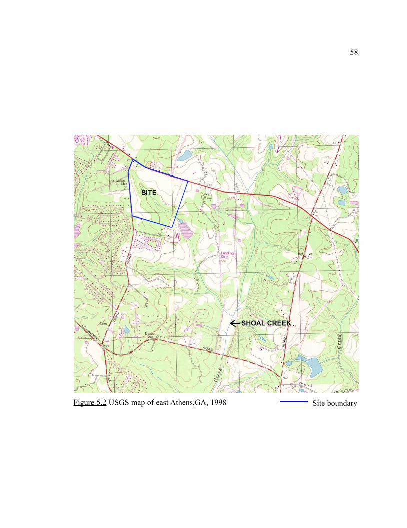
58
Figure 5.2 USGS map of east Athens,GA, 1998 Site boundary

59
Figure 5.3 Aerial view of the site before development,January 1999 (www.terraserver.com)
Site boundary

located beyond the eastern boundary of the site (Figure 5.2). The northern part of the
site is accessible by Lexington Road and the southern part is accessible by Whit Davis
Road. The entire site slopes about 5 to 10% towards the creek. The slopes are steeper at
the edge of the creek. Before development of the park in 2000-2002, more than 50
percent of the site had been cleared and maintained as a farmland (Figure 5.3). Single-
family residences surround the site on the south and west. A commercial driving range
borders the eastern edge of the site. The northern side is mostly undeveloped and
consists of a mobile home park. A small tract of land measuring 9.743 acres, located on
the northwest corner of the site, is designated as a future commercial area.
At present the site contains two baseball fields, a football/soccer field, two
tennis courts, a jogging/walking trail around the play fields, a concession building, a
nature trail, and parking lots. All these facilities, except a parking lot, are located in the
northern half of the site (Figure 5.4). The nature trail that runs through the wooded area
is the only connection between the two parts of the site. Additional recreational
facilities that may be constructed in the future, depending on the funds available,
include two baseball fields, a football/soccer field, another concession building, a
community building, some hard-surface courts and additional parking in the northern
part and two baseball fields, three tennis courts and a community garden in the southern
part (Robert and Company,1999). The vehicular access roads in both parts of the site,
which are unconnected at present, would be connected in the future.
There are three rectangular detention ponds located in the steeper northern part
of the site, close to the creek. The ponds are designed for a 25year flood event. The first
pond is located towards the north and is the largest of the three ponds. It occupies an
area of 28,000sq.ft and has a depth of 10ft. It receives runoff primarily from the parking
lot and the area designated for future commercial. The second pond is the smallest,
occupying an area of 8,790sq.ft and has a depth of 6ft. The third pond has an area of
60
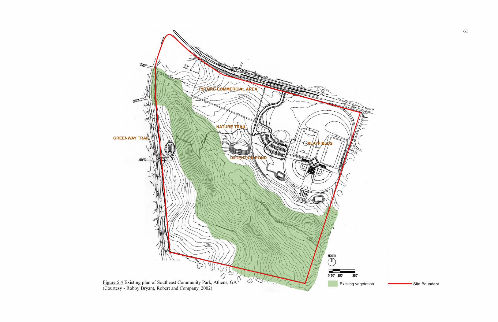
PLAYFIELDS
FUTURE COMMERCIAL AREA
DETENTION POND
GREENWAY TRAIL
61
Site BoundaryExisting vegetation
NATURE TRAIL
Figure 5.4 Existing plan of Southeast Community Park, Athens, GA(Courtesy - Robby Bryant, Robert and Company, 2002)

11,600sq.ft and a depth of 6ft. The second and third ponds receive runoff from the play
fields. The ponds are not hydraulically connected to each other and act as isolated
stormwater detention systems. The ponds are provided with an outlet and an emergency
spillway.
Apart from the natural forest in the central portion on the site, the only
vegetation in the park is street trees. The site exhibits high contrast between the turf-
covered playfields and the natural forest vegetation. The following is a list of existing
vegetation on site (Walter Cook, Personal communication).
Existing vegetation on site
62
A) Natural vegetation in the wooded section
i) Canopy Trees
Blackgum Nyssa sylvatica Eastern Red Cedar Juniperus virginiana Hickory Carya spp Loblolly Pine Pinus taeda Post Oak Quercus stellata Red Maple Acer rubrum Shortleaf Pine Pinus echinata Southern Red Oak Quercus falcata Sweetgum Liquidambar styraciflua Water Oak Quercus nigra White Oak Quercus alba Willow Oak Quercus phellos Winged Elm Ulmus alata Yellow Poplar Liriodendron tulipifera
ii) Understory
Black cherry Prunus serotina Blueberry Vaccinium spp Dogwood Cornus florida Hawthorne Crataegus spp Japanese Honeysuckle Lonicera japonica Sparkleberry Vaccinium arboreum Sumac Rhus spp Tag Alder Alnus serrulata

63
Existing and potential wildlife on-site
Raccoon, opossum, rabbit, squirrel, chipmunk, beaver, deer, wood duck,
waterfowls, frog, toads, geese, owls, hawks, migratory song birds and other birds
(Frank Henning and Walter Cook, Personal communication).
Design Process
Community suggestions
The Athens-Clarke County held community input meetings for the purpose of
selecting a suitable site and program for the park. The facilities recommended during
these meetings included multi-purpose building, children’s nursery, multi-purpose
iii) Vines
Muscadine Vitus rotundifolia Poison ivy Toxicodendron radicans Smilax Greenbrier
iv) Groundcover
Ground cedar (clubmoss) Lycopodium complanatum v) Invasives
Chinese privet Ligustrum sinense B) Vegetation planted on site i) Trees
Crape myrtle Lagerstroemia indica Maidenhair tree Ginkgo biloba Plum cherry Prunus sp. Scarlet oak Quercus coccinea Willow oak Quercus phellos
athletic fields, baseball fields, softball fields, soccer fields, football fields, swimming
pool, picnic shelters, playgrounds, recycling center, nature trail, tennis courts, parking,
indoor soccer, batting cages, mountain bike trails, linkage to the greenway, barbeque
shelter, walking trail, street hockey court, restrooms, a dog park, exercise trail,
basketball court, open areas, canoeing/boating, fishing lake, amphitheatre and gardens.
The recommendations were then ranked according to their priority. Following is the
result of this prioritization (Robert and Company, 1997, 1, 3).
1) Athletic fields (including soccer, football, softball and baseball)
2) Passive nature areas (to include undisturbed land, nature trails and
picnicking)
3) Paved paths (to include walking trail, greenway trail, exercise trail and
bicycle trail)
4) Water features (to include naturally occurring features such as lakes and
streams)
5) Tennis courts
6) Multi-purpose fields (to allow for unorganized free play, pick-up games and
other games)
7) Multi-purpose buildings (to include classrooms and gymnasium)
8) Recycling center
9) Basketball courts
10) Playground (to serve all ages including pre-school and toddlers)
11) Picnic shelter (to serve large groups up to 500, moderate size up to 75, and
small individual families)
12) Enclosed pool
13) Fitness center
14) Street hockey (to allow use for roller blade hockey)
64
15) Dog park
16) Swimming pool
17) Amphitheater – Outdoor terraces sited to blend with the existing topography.
Seating capacity should be 500.
National Recreation and Park Association Suggestions
The National Recreation and Parks Association (NRPA) suggests that a
community park should include an area of diverse environmental quality. It may include
areas for intense recreational facilities, such as athletic complexes and swimming pools.
However, the park should also include areas of natural quality for outdoor recreation,
such as walking, viewing, sitting, and picnicking. The park should include a
combination of the above facilities, depending upon site suitability and community
needs (Robert and Company, 1997, 4).
Initial Proposal
Based on community recommendations and NRPA’s suggestions, the Athens-
Clarke County authorities and the landscape firm ‘Robert and Company’ came up with
an initial program and design for the Southeast Community Park (Figure 5.5). The
design called for creation of a lake on the creek, at the center of the site. The lake
would provide recreational activities like canoeing, fishing and bird watching, and
would also detain the runoff from the site. A trail around the lake would serve for
walking and jogging. Some spots along the trail would serve as picnicking and viewing
areas. This trail and a vehicular road would connect the two parts of the site. The lake
would be supplied with water from the spring situated in the wooded area. However the
construction of the lake required clearing of most of the existing natural vegetation and
also cutting off the flow of the spring downstream for thirty days so that the water
65
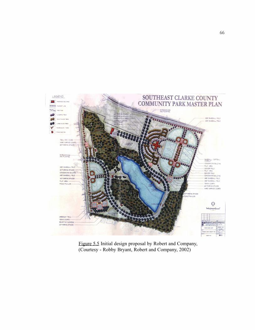
66
Figure 5.5 Initial design proposal by Robert and Company,(Courtesy - Robby Bryant, Robert and Company, 2002)

would pond up in the lake. As soon as the desired level of water in the lake was
reached, the water would then continue flowing downstream. The loss of considerable
forest vegetation and interruption of the flow of the stream raised several environmental
concerns, finally leading to the rejection of this initial proposal by the Athens-Clarke
authorities (Robby Bryant, Personal communication).
Present Site Condition
The site is presently devoid of the lake feature and all the recreational facilities
that the lake would have provided (Figure 5.6). Only a part of the nature trail exists on
site (Figure 5.7). The site lacks any kind of water feature or areas for seating and
viewing. The facilities like the community center and additional play fields might be
incorporated in various phases in the future. Due to the rejection of the lake feature in
the design, the three detention ponds that were constructed temporarily on site to take
care of the runoff prior to construction of the lake are now a permanent feature of the
site. These ponds have very steep slopes and are devoid of any aesthetics (Figure 5.8).
They could be fenced off in the future to avoid people from getting close to them. The
situation is another example of the conventional treatment and attitude towards
stormwater detention ponds.
Further proposal
This thesis proposes a design that broadens the recreational and landscape
program of the site by redesigning the detention ponds and the area around them. It tries
to achieve the recreational goals of the initial proposal along with additional community
needs, which had been rejected due to space constraints. The design deals only with on-
site runoff and avoids changes to the existing recreational features on site. The design
did not attempt to determine the runoff and detention volumes for the ponds since this
67

68
Figure 5.6 View of the site from the trail towardsplayfields (Photographed by author)
Figure 5.7 View of the nature trail (Photographed byauthor)
Figure 5.8 View of the large detention pond with playfields in the background (Photographed by author)

had been already determined. However care was taken not to reduce the existing storage
volume of the detention ponds while re-shaping thereby maintaining their original
detention function (Ferguson, 1998, 165). The design will mainly concentrate on the
linear strip of land that measures about 17.32 acres with the detention ponds.
Site assets
The site is easily accessible and highly visible from the adjoining roads (Refer
figure 5.4). The central portion of the site containing the creek and undisturbed forest
vegetation forms a major asset to the site. It enhances the potential to provide wildlife
habitat, nature trails and create viewing area. It also forms a beautiful backdrop for the
site. Excess stormwater can continue to be directed to the creek, not requiring any
connection to municipal drain. The overall slope towards the creek provides advantage
in directing the stormwater to the creek. The site adjoins a trail on the western edge that
is a part of the regional greenway masterplan. Hence a design, which provides wildlife
habitat and various passive recreational opportunities, can be an attraction along this
greenway corridor.
Design constraints and considerations
The main design constraint is the availability of space. Play fields and parking
lots occupy most of the site hence there is little room to enlarge the detention ponds in
order to incorporate shallow slopes while maintaining the same volume to detain
stormwater. The wooded section of the site places a further constraint along the
southern border. Because the site slopes towards the creek, there would be a need to
build embankments to enlarge and re-shape the detention ponds. The slope is steep in
some sections near the creek making it difficult to construct trails that would be
consistent with ADA (Americans with Disabilities Act) access codes. Because the
69

detention ponds lie between an urban park setting and undisturbed natural vegetation,
the design would need to respond to the character of both these settings. The design
would also need to provide adequate handicapped access to the additional facilities that
would be proposed.
Proposal description
The design celebrates stormwater and educates us to its fate in the urban
environment. By incorporating various features like water channels, swales and
fountains, the journey of stormwater is made more enjoyable and pleasurable (Figure
5.9). An 8ft wide two-way pedestrian trail paralleling the flow of stormwater provides
access and view of stormwater as it makes its way from the high pond to the lower
pond. The trail is constructed of porous concrete to absorb rain water. This also reduces
maintenance and provides easy universal access. The detention ponds are re-shaped into
naturalistic forms with slopes of 1:5 or 1:10 and planted with native vegetation and
willow shrubs to absorb the pollutants and stabilize the banks. Boulders placed along
some sections of the channels act as energy dissipators.
An additional pond is proposed in the northwestern part of the site to treat the
first flush of stormwater from the future commercial area (Figure 5.10). The pond is
shaped and oriented to capture maximum possible runoff from the future commercial
site above and is lined with native vegetation to absorb pollutants. Trash and sediment
traps are located at the inlet and outlet of this pond to enhance the water quality. Excess
water overflows from the pond through the outlet into a swale. It is joined by another
swale that carries stormwater from the proposed parking lot. The water then pools up
into a small pond. This helps in slowing down water and also facilitates infiltration. The
water then flows over the concrete tiers of a proposed amphitheater. The tiers are
depressed into the ground where water flows over them. These depressions act as flow
70

Figure 5.9 Proposed design masterplan for part of Southeast Community Park, Athens, GA
71
SCALE0’ 50’ 100’ 200’

Figu
re 5
.10
Det
ail p
lan
of la
rge
dete
ntio
n po
nd a
nd s
urro
undi
ng a
rea
72
0’25’
50’
100’
SCALE

73
Figure 5.11 Section through amphitheater and water channel
Figure 5.12 General section through amphitheater and large detention pond
SCALE0’ 5’ 10’ 20’
SCALE0’ 10’ 25’ 50’
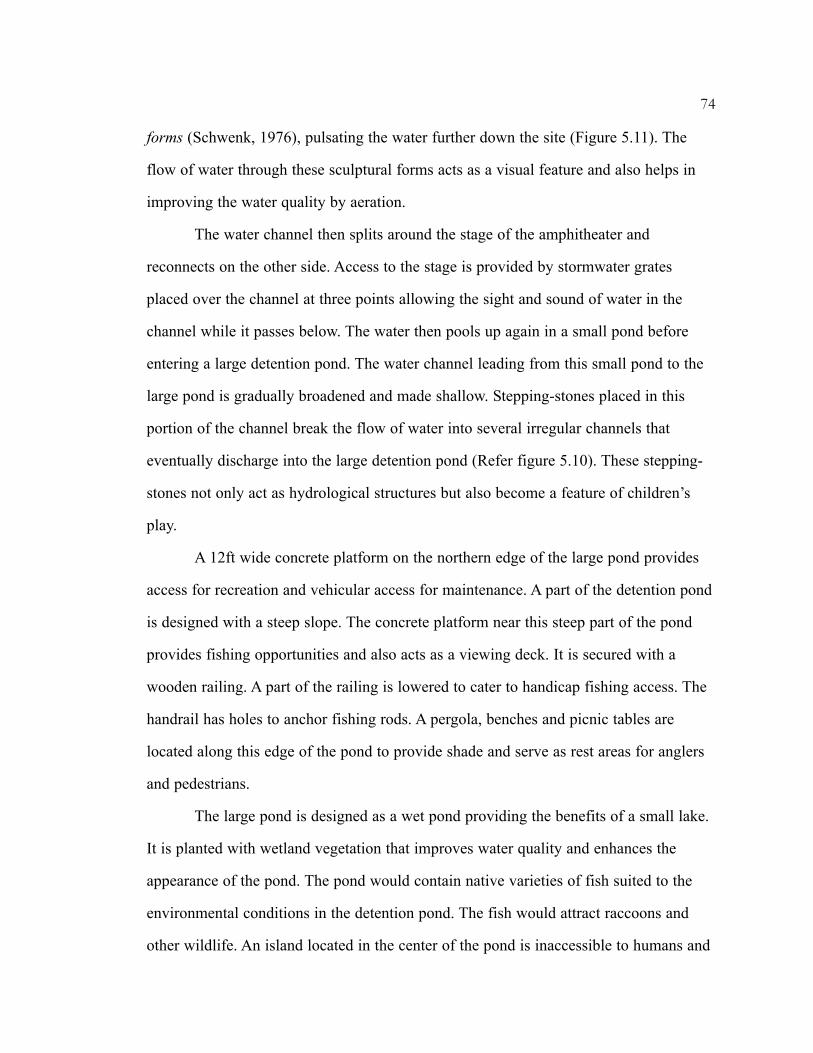
forms (Schwenk, 1976), pulsating the water further down the site (Figure 5.11). The
flow of water through these sculptural forms acts as a visual feature and also helps in
improving the water quality by aeration.
The water channel then splits around the stage of the amphitheater and
reconnects on the other side. Access to the stage is provided by stormwater grates
placed over the channel at three points allowing the sight and sound of water in the
channel while it passes below. The water then pools up again in a small pond before
entering a large detention pond. The water channel leading from this small pond to the
large pond is gradually broadened and made shallow. Stepping-stones placed in this
portion of the channel break the flow of water into several irregular channels that
eventually discharge into the large detention pond (Refer figure 5.10). These stepping-
stones not only act as hydrological structures but also become a feature of children’s
play.
A 12ft wide concrete platform on the northern edge of the large pond provides
access for recreation and vehicular access for maintenance. A part of the detention pond
is designed with a steep slope. The concrete platform near this steep part of the pond
provides fishing opportunities and also acts as a viewing deck. It is secured with a
wooden railing. A part of the railing is lowered to cater to handicap fishing access. The
handrail has holes to anchor fishing rods. A pergola, benches and picnic tables are
located along this edge of the pond to provide shade and serve as rest areas for anglers
and pedestrians.
The large pond is designed as a wet pond providing the benefits of a small lake.
It is planted with wetland vegetation that improves water quality and enhances the
appearance of the pond. The pond would contain native varieties of fish suited to the
environmental conditions in the detention pond. The fish would attract raccoons and
other wildlife. An island located in the center of the pond is inaccessible to humans and
74
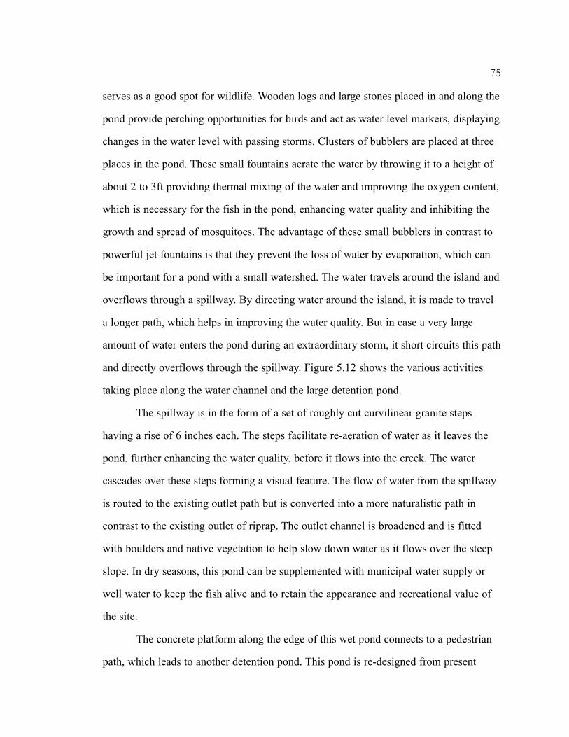
serves as a good spot for wildlife. Wooden logs and large stones placed in and along the
pond provide perching opportunities for birds and act as water level markers, displaying
changes in the water level with passing storms. Clusters of bubblers are placed at three
places in the pond. These small fountains aerate the water by throwing it to a height of
about 2 to 3ft providing thermal mixing of the water and improving the oxygen content,
which is necessary for the fish in the pond, enhancing water quality and inhibiting the
growth and spread of mosquitoes. The advantage of these small bubblers in contrast to
powerful jet fountains is that they prevent the loss of water by evaporation, which can
be important for a pond with a small watershed. The water travels around the island and
overflows through a spillway. By directing water around the island, it is made to travel
a longer path, which helps in improving the water quality. But in case a very large
amount of water enters the pond during an extraordinary storm, it short circuits this path
and directly overflows through the spillway. Figure 5.12 shows the various activities
taking place along the water channel and the large detention pond.
The spillway is in the form of a set of roughly cut curvilinear granite steps
having a rise of 6 inches each. The steps facilitate re-aeration of water as it leaves the
pond, further enhancing the water quality, before it flows into the creek. The water
cascades over these steps forming a visual feature. The flow of water from the spillway
is routed to the existing outlet path but is converted into a more naturalistic path in
contrast to the existing outlet of riprap. The outlet channel is broadened and is fitted
with boulders and native vegetation to help slow down water as it flows over the steep
slope. In dry seasons, this pond can be supplemented with municipal water supply or
well water to keep the fish alive and to retain the appearance and recreational value of
the site.
The concrete platform along the edge of this wet pond connects to a pedestrian
path, which leads to another detention pond. This pond is re-designed from present
75

Figure 5.13 Detail plan of ‘Splash pond’ and surrounding area
76
SCALE0’ 25’ 50’ 100’
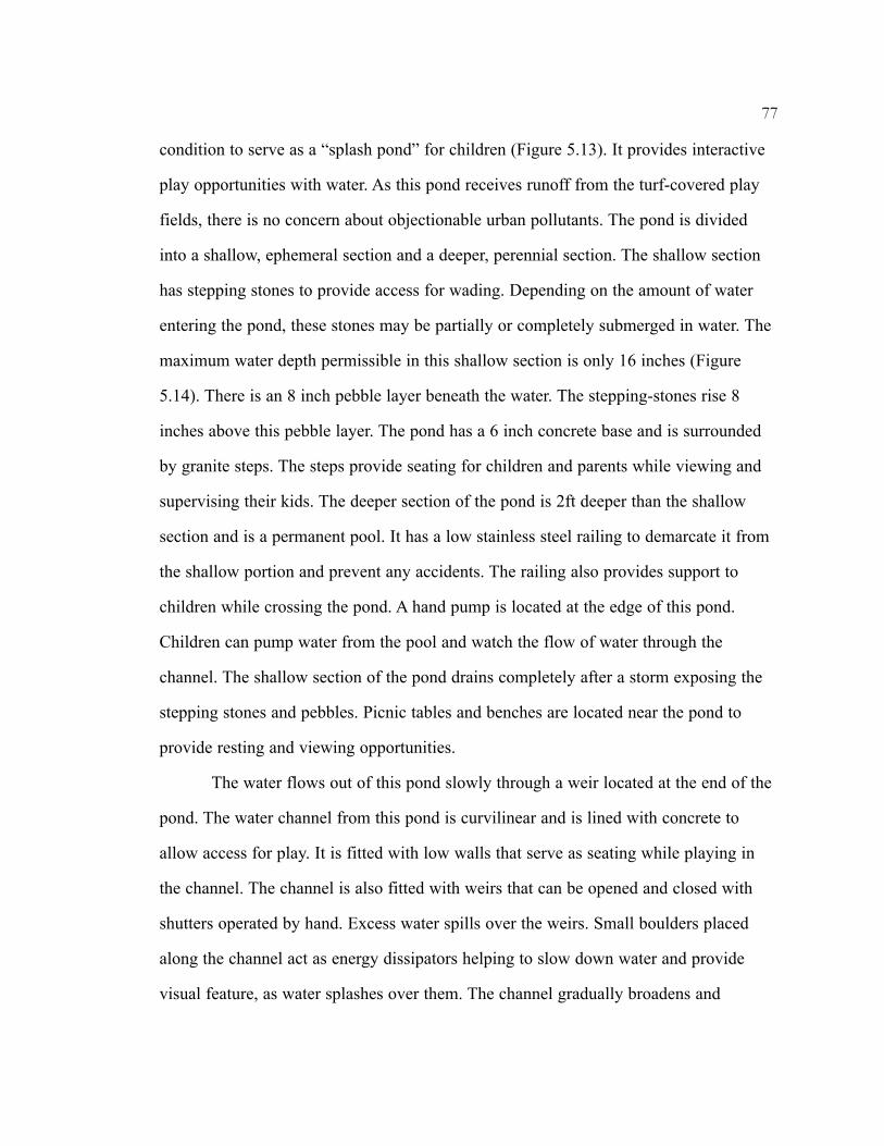
condition to serve as a “splash pond” for children (Figure 5.13). It provides interactive
play opportunities with water. As this pond receives runoff from the turf-covered play
fields, there is no concern about objectionable urban pollutants. The pond is divided
into a shallow, ephemeral section and a deeper, perennial section. The shallow section
has stepping stones to provide access for wading. Depending on the amount of water
entering the pond, these stones may be partially or completely submerged in water. The
maximum water depth permissible in this shallow section is only 16 inches (Figure
5.14). There is an 8 inch pebble layer beneath the water. The stepping-stones rise 8
inches above this pebble layer. The pond has a 6 inch concrete base and is surrounded
by granite steps. The steps provide seating for children and parents while viewing and
supervising their kids. The deeper section of the pond is 2ft deeper than the shallow
section and is a permanent pool. It has a low stainless steel railing to demarcate it from
the shallow portion and prevent any accidents. The railing also provides support to
children while crossing the pond. A hand pump is located at the edge of this pond.
Children can pump water from the pool and watch the flow of water through the
channel. The shallow section of the pond drains completely after a storm exposing the
stepping stones and pebbles. Picnic tables and benches are located near the pond to
provide resting and viewing opportunities.
The water flows out of this pond slowly through a weir located at the end of the
pond. The water channel from this pond is curvilinear and is lined with concrete to
allow access for play. It is fitted with low walls that serve as seating while playing in
the channel. The channel is also fitted with weirs that can be opened and closed with
shutters operated by hand. Excess water spills over the weirs. Small boulders placed
along the channel act as energy dissipators helping to slow down water and provide
visual feature, as water splashes over them. The channel gradually broadens and
77

SCALE
0’5’
10’
20’ 78
Figu
re 5
.14
Sect
ion
thro
ugh
‘Spl
ash
pond
’

becomes more naturalistic. It is lined with vegetation and fitted with boulders. It finally
drains into the large detention pond.
A circular shelter and a circular open plaza measuring 40ft in diameter are
located alongside this channel, near the existing parking lot, to provide rest and picnic
opportunities along the trail while viewing water (Figure 5.15). The shelter is fitted with
benches. These structures overlook the large detention pond and provide opportunities
to view wildlife. They are surrounded by vegetation to conceal their presence and
merge them with the natural setting. They are accessible by bridges connected to the
pedestrian trail. A flight of steps from the parking lot to the trail provides direct access.
The floor of these structures is made of granite tiles cut in circular patterns. The roof of
the shelter is located at a height of 12ft and is made up of red cedar wood and
supported by posts of the same material (Refer Figure 5.14).
The trail further connects to another, more isolated pond. Benches are placed
along this part of the trail. The pond is re-designed from present condition into a natural
wetland (Refer figure 5.9). A 6ft wide secondary trail loops around the main trail
providing wildlife viewing opportunities. A boardwalk from this secondary trail leads to
a viewing deck, which is provided with benches. The main trail is then connected to the
existing trail that runs around the playfields. The wetland area is a detention basin. It
receives runoff from the play fields and stores it to facilitate infiltration. The wetland
vegetation helps to remove sediments and facilitates infiltration of water. Excess water
flows, flowing detention, through the spillway to the creek. This spillway is designed in
a similar manner as the one for the large detention pond but without the re-aeration
feature.
A building proposed in the northwestern part of the site, covering an area of
about 6900sq.ft, serves as a Nature Center (Refer figure 5.10). It would contain
classrooms, auditorium and facilities for staff. The building facilities would provide
79

80
Figu
re 5
.15
Vie
w o
f the
she
lter a
nd o
pen
plaz
a

information about the hydrological function of the park and educate people about the
wildlife and vegetation existing on site. It would provide opportunities for community
gatherings, school field trips and special events. Vehicular access to the building is by
the existing road on site. Additional parking with handicap facilities for the Nature
Center is also provided on the eastern side of the building. The roof of the Nature
Center building is arched towards the south and fitted with solar panels that provide
energy to run the bubblers placed in the large detention pond.
The existing nature trail that connects to the sidewalk on the main access road is
re-designed into a smooth curve. This trail runs through the wooded section of the site
and connects to the other side of the park. A pedestrian path proposed in front of the
Nature Center and along the parking lot connects to the existing road, providing access
to the Center from the road. This path is also connected to the curvilinear trail. Wooden
bridge is provided at the point where the path and trail intersect the water channel. The
road connecting the main road and the existing parking lot is re-aligned to provide
vehicular access from the main road to the proposed parking lot for the Nature Center.
A 12ft wide road continues further to provide access to the proposed maintenance
building located in the northwestern part of the site. A swale around the Nature Center
discharges water into the channels. The Nature Center overlooks the whole area of the
paths, channel, amphitheater and the large detention pond.
Being consistent with the expressed community needs, an outdoor informal
amphitheater is planned as one of the facilities on site. The amphitheater takes a semi-
circular form (Refer figure 5.10). Flights of steps on either side of the amphitheater
provide access to the tiers and the stage. The tiers are extended on the northwestern side
to merge with the topography of the site. The amphitheater would be used for small
concerts, community gatherings and outdoor classes or just hanging around, viewing
and other leisurely activities. The extended tiers provide opportunities for seating and
81

viewing even when the amphitheater is being used for a different purpose. A secondary
trail on either side of the amphitheater connects it with the main trail. The space
between the tiers would be maintained as turf.
Proposed vegetation
Trees and other vegetation are proposed to provide shade and to blur the contrast
between the design area and the wooded section along the creek. The design proposes
various zones of vegetation like turf, wildflower meadow, forest vegetation, riparian and
wetland areas, exhibiting a heterogeneous character. This helps in diversifying wildlife
and provides different recreational opportunities. The pedestrian trails cut through these
varied vegetation zones providing people different experiences of nature. Trees
proposed along some of the detention ponds help in preventing loss of water due to
evaporation and reducing the temperature of the water, which increases its oxygen
content. The vegetation also provides food, shelter, cover and nesting opportunities for
wildlife. Bird houses, nesting and shelter boxes placed in appropriate vegetation zones
and concealed from the pedestrian circulation areas will help in increasing the use of
this area by wildlife.
The trees were selected based on the existing trees in the wooded section.
Bermuda grass is proposed in the amphitheater area. Centipede grass is selected along
the trails as it requires low maintenance and is also drought tolerant. Some of the
species selected for the meadow, like chickweed, provide food for birds. The wetland
plants were selected based on their pollutant removal properties and ability to withstand
frequent changes in water level. The design proposes bioengineering techniques for
stabilizing the edges of the large detention pond. Vegetation proposed along the future
commercial area, existing parking lot and wetland pond helps in reducing noise
pollution and acts as a buffer. Following is a list of the proposed vegetation.
82

83
Proposed vegetation i) Turf areas
Bermuda grass Cynodon dactylon Centipede grass Eremochloa ophiurides
ii) Wildflower meadow
Aster divaricatus Aster sp. Blazing star Liatris microcephala Blue-eyed Susan Rudbeckia sp. Broomsedge Andropogon virginicus Chickweed Stellaria sp. Cone flower Echinacea sp. Fringed loosestrife Lysimachia ciliata Goldenrod Solidago sp. Indian grass Sorghastrum nutans Joe Pye weed Eupatorium fistulosum Purpletop Tridens flav us Spitheara Bluestem Andropogon ternaries St. John’s Wort Hypericum multilum Sunflower sp. Helianthus sp. Switch grass Panicum virgatum
iii) Canopy Trees
Blackgum Nyssa sylvatica Hickory Carya sp. Post Oak Quercus stellata Red maple Acer rubrum Southern Red Oak Quercus falcata Tulip Poplar Liriodendron tulipefera White Oak Quercus alba
iv) Understory
Buttonbush Cephelanthus occidentalis Silky dogwood Cornus amomum
v) Bioengineering
Alder Alnus sp. Black willow Salix nigra
Cephelanthus occidentalis

Maintenance
Vehicular access to the detention pond for maintenance is provided from the
existing parking lot. This access road connects to the pedestrian trail. The 8ft wide trail
with 2ft grass shoulder on either side serves as the vehicular access paralleling the
water channel. The maintenance of this section of the park, with the detention ponds,
will be kept to a minimum. The detention ponds may require dredging at interval of
years depending on the amount of sediment. The inlets, outlets and other hydraulic
structures will require regular inspection and cleaning to prevent clogging from trash
and sediments. The park, outside grass and meadow areas, would be allowed to undergo
natural succession. The turf in the amphitheater area will require mowing every 2 to 3
weeks. The grass along the trail would not require frequent mowing as centipede grass
is a slow growing grass and does not grow very tall. The vegetation along the detention
ponds would require harvesting to control overgrowth. Other maintenance would
involve clearing and litter removal, keeping the trail surface in good condition, removal
of obstructions along pedestrian and vehicular routes, removal of dead vegetation and
keeping the views unobstructed.
84
vi) Wetland
Arrow arum Peltandra virginica Arrowhead Sagittaria latifolia Bulrush Scirpus sp. Pickerel weed Pontederia cordata Soft rush Juncus effusus Spatter dock Nuphar luteum Swamp milkweed Asclepias incarnata Water lily Nymphaea sp.
Additional recommendations
The proposal recommends monitoring water quality of the facility by taking
regular samples from the detention ponds. School groups and volunteers can take active
part in this activity thereby increasing their understanding of water quality issues and
solutions.
The proposal goes beyond the design area limits and proposes the restoration of
the creek. At present the creek is occupied by a lot of invasive species, privet being the
most dominant. Due to the massive presence of these invasive species, there is absence
of ground cover. Removal of the invasive species would help in the colonization of
native species. It would have an added advantage of providing better views along the
nature trail and benefit the wildlife. The spring, which at present is visible only at a few
points along the trail, will also be visible and enhance the aesthetics of the site. The
spring channel should be planted with ferns and other wetland species recommended in
this thesis, which would help in stabilization of the channel and enhance its appearance.
Public awareness and involvement
Many ecological designs in the past have failed due to lack of awareness of their
functions by the people using them. Hence this design recommends interpretive signage
and information kiosks along the trail and other pedestrian areas that would make the
visitors aware of the hydrological function of the park and its benefits. This would help
in preserving the landscape and assist in its proper functioning. It would also help in
respecting the presence of wildlife by humans, as the wildlife is intended to be an
integral part of this part of the park. A program should be designed for the Nature
Center that helps in getting the communities involved in the working of the park.
School trips, visitor orientation, informative brochures and special weekly or monthly
events related to the park can be organized to educate the people about the park.
85
Volunteer programs can be organized for the planting, cleaning and overall maintenance
of the park to get people and surrounding neighborhoods involved in the working of the
park. Only through public involvement can a park become an integral part of the
community.
Conclusion
The design converts a currently wasted space into a recreational and educational
amenity while providing detention facilities. The proposal takes advantage of the fact
that the interface of land and water holds attraction for most people. The design brings
together geometric and naturalistic forms creating a harmony in the landscape. By
incorporating various kinds of water features and structures, the design caters to all age
groups and varied interests. Some of the hydraulic structures also become a part of
natural setting and provide recreational opportunities. The design exposes the flow of
stormwater and brings people into contact with it, putting it back into the social
consciousness of urban society. The debris and trash collected in the sediment pond will
heighten awareness among people about their role in keeping the environment clean.
The proposal attempts to serve not only human needs but also respects wildlife and
vegetation, and tries to provide for their benefit. It returns cleansed water back into the
system, completing the hydrological cycle. The design also enhances the regional
greenway corridor. The overall project cost would be about $1,484,800.
The proposal illustrates that detention facilities do not have to be sterile and
ugly but can be attractive and form sustainable systems. The design attempts to change
the perception of stormwater systems. It displays that stormwater can be transformed
from a liability to an asset. It is a step toward increasing public awareness of
stormwater. By recommending restoration of the creek, the proposal goes beyond its
design area thereby taking care of the complete hydrological system. By recommending
86
natural succession and minimum maintenance, the proposal tries to increase people’s
respect for lightly maintained open spaces in contrast to the highly maintained park
areas.
Although the proposal demonstrates that such multi-use stormwater systems can
be retrofitted, incorporating such ideas early into the design process has additional
benefits. The design constraints will definitely be less and the project could be more
economical. The present proposal being a retrofit faced several design constraints, space
being one of the most important. Although the proposal tried to retain the existing
topography, considerable re-grading would have to be done. But the benefits would
certainly be worth it. Had the proposal been thought of in the beginning of the design
process, it would have been more integrated with the rest of the park facilities.
The design sets an example to be followed for future stormwater management
projects illustrating that active and passive recreation, and wildlife habitats can be
compatible with stormwater detention facilities. Such multi-use designs can make
stormwater facilities acceptable and desirable in communities and thus encourage
municipalities to change their approach to treating stormwater. Stormwater should be
viewed as an opportunity to go beyond the basics of civil engineering, to involve
landscape architecture and aesthetics, in creating sustainable landscapes. Architects and
landscape architects should play an important role in designing, developing and
marketing such multi-use and sustainable landscapes, which are the growing need of
today’s urban environment. All parks and open spaces should incorporate such
hydrological systems forming a network and thus alleviate the landuse pressure.
87

SELECTED BIBLIOGRAPHY
Water and Stormwater management
Adams, Lowell W., Daniel L. Leedy and Thomas M. Franklin, “Wildlife Enhancementin Urban Stormwater Control”, Proceedings of the Conference on StormwaterDetention Facilities: Planning, Design, Operation and Maintenance, AmericanSociety of Civil Engineers, New York, 1982: 384.
Betsky, Aaron, “Take me to Water”, Architecture and Water, Architectural DesignMagazine, 1995: 8.
Campbell, C. S., and Ogden, M. H., Constructed Wetlands in the SustainableLandscape, New York: John Wiley and Sons, 1999.
Capulli, Angelo J., and Susan L. B. Jacobson, “Water, Water, Everywhere”, Parks andRecreation, volume 19, number 2, February 1984: 48-49, 69-70.
Cobb, Ernest D., “Planning Considerations for Detention Basins”, Proceedings of theConference on Stormwater Detention Facilities: Planning, Design, Operationand Maintenance, American Society of Civil Engineers, New York, 1982: 16.
Dapkus Kathleen, “Vegetation Alternatives for a Detention Basin with SevereConditions”, Unpublished MLA Thesis, Athens: University of Georgia, 1993.
Debo Thomas N., “Detention Ordinances – Solving or Causing Problems?”Proceedings of the Conference on Stormwater Detention Facilities: Planning,Design, Operation and Maintenance, American Society of Civil Engineers, NewYork, 1982: 332.
DeGroot, William G., and David W. Lloyd, “Detention in Parks and Open Spaces-Good, Bad and Ugly”, Flood Hazard News, Urban Drainage and Flood controlDistrict, volume 22, number 1, December 1992: 19-21.
Don, Henry, “America’s Waterfronts are Looking Better”, Water Spectrum, U.S ArmyCrops of Engineers, volume 12, number 4, Fall 1980: 43-46.
Dreiseitl, Herbert, “Water is Universal”, Waterscapes: Planning, Building andDesigning with Water, Dreiseitl, Herbert, Dieter Grau and Karl H. C. LudwigEds. Basel, Berlin, Boston: Birkhauser, 2001.
88

Ferguson, Bruce K., “ The Failure of Detention and the Future of Stormwater Design”,Landscape Architecture, volume 81, number 12, December 1991: 76-79.
Ferguson, Bruce K., Introduction to Stormwater: Concept, Purpose, Design, New York:John Wiley and Sons, 1998.
Gregg, Billy and William Wenk, “Stormwater Gardens (Convey, Capture and Reuse:Stormwater)”, Landscape Journal Special Issue, 1998: 24-25.
Jones, Jonathan E., “Multi-purpose Stormwater Detention Ponds”, Public Works, NewYork, December 1990, volume 121, number 13: 52-53.
Jones, Jonathan E., and Earl Jones, “Interfacing Considerations in Urban DetentionPonding”, Proceedings of the Conference on Stormwater Detention Facilities:Planning, Design, Operation and Maintenance, American Society of CivilEngineers, New York, 1982: 317.
Jones, Julian, “Water: Designing for Plenty and Purity”, Architecture and Water,Architectural Design Magazine, 1995: 16.
Litton, B. R., Tetlow, R. J., Sorensen, J., and Beatty, R. A., Water and Landscape: Anaesthetic overview of the role of water in the landscape, New York: WaterInformation Center, Inc. Port Washington, 1974.
MacElroy, William P., and Winterbottom, Daniel P., “Stormwater Ponds”, LandscapeArchitecture, volume 90, number 4, April 2000: 48-54, 102-103.
Magnarella, Christine Jo, “The Creation of Multifunctional Wetlands for WastewaterTreatment and Wildlife Habitat”, Unpublished MLA Thesis, Athens: Universityof Georgia, 1997.
Moore, Charles, “The Potential for Wonder”, Architecture and Water, ArchitecturalDesign Magazine, 1995: 22.
Northcutt, Greg, “When Sediment Control goes Underground”, Erosion Control, July-August 2001. (http:forester.net/ec_0107_when.html)
Russell, Zolna, “Rain Gardens”, Landscape Architecture, volume 90, number 7, July2000: 24.
Schueler, T. R., Controlling Urban Runoff: A Practical Manual for Planning andDesigning Urban BMPs, Washington D.C: Metropolitan Washington Council ofGovernments, 1987.
89

Stahre, Peter, and Ben Urbonas, Stormwater Detention for Drainage, Water Quality,and CSO Management, Englewood Cliffs, New Jersey: Prentice Hall, 1990.
Strutin, Michele, “Two Parks that Quiet the Storm”, Landscape Architecture, volume81, number 10, October 1991: 84-87.
Terry J. Logan, and Stephen M. Yaksich, “Lake Erie: A New Prognosis”, WaterSpectrum, U.S Army Corps of Engineers, volume 12, number 3, Summer 1990:26-29.
Tilton, Joseph L., “Helping Stormwater Keep its Place”, Stormwater, volume 3, number6, September/October 2002: 40-51.
Tourbier, Toby J., and Richard Westmacott, Lakes and Ponds, The Urban LandInstitute, Washington, D. C., 1992.
Toy, Maggie, “Editorial”, Architecture and Water, Architectural Design Magazine, StMartin’s Press, 175 Fifth Avenue, New York, NY, 1995: 6.
Tucker, Mathew, “Rants and Raves: Boston’s Emerald Necklace”, Land Forum, Issue10, 2001: 34-37.
Tunney, Kathleen W., “Stormwater Innovative Design: The Role of LandscapeArchitect”, Stormwater, 2002.(http://www.forester.net/sw_0101_innovative.html)
Urban Stormwater Drainage Criteria Manual Volume 1 and 2, Denver, Colorado:Urban Drainage and Flood Control District, June 2001.
Urbonas, Ben, Jay Carlson, Scott Tucker, “Detention in Parks and Open Spaces- Good,Bad and Ugly”, Flood Hazard News, Urban Drainage and Flood controlDistrict, volume 23, number 1, December 1993: 1, 17.
Wanielista, Martin P., and Yousef A. Yousef, Stormwater Management, New York: JohnWiley and Sons, 1993.
Weber, Mary M., “Incorporating Stormwater Detention into Parks with Multi-useAmenities: Two Case Studies”, Unpublished Masters Thesis, University ofWashington, 1991.
Woodward Robert, “Water in the Landscape”, Waterscapes: Planning, Building andDesigning with Water, Dreiseitl, Herbert, Dieter Grau and Karl H. C. LudwigEds. Basel, Berlin, Boston: Birkhauser, 2001.
90

Wright, Kenneth R., “Stormwater Acceptance and Rejection Issues”, Proceedings of theConference on Stormwater Detention Facilities: Planning, Design, Operationand Maintenance, American Society of Civil Engineers, New York, 1982: 284.
Land Art and Design
Beardsley, John, Earthworks and Beyond: Contemporary Art in the Landscape, NewYork: Abbeville Press, 1998.
Bourdon David, Designing the Earth: The Human Impulse to Shape Nature, New York:Henry N. Abrams, Inc., 1995.
Calabria, Tamara G., “Representation of Stormwater Management in Design: Toward anEcological Aesthetic”, Unpublished Masters Thesis, Athens: University ofGeorgia, 1995.
Healan, Ryan, “The Potential of Stormwater as Design Element”, Unpublished MastersThesis, Athens: University of Georgia, 2001.
Kastner, Jeffery and Wallis, Brian Eds, Land and Environmental Art, Phaidon Press,1998.
Matilsky, Barbara C., Fragile Ecologies: Contemporary Artists’ Interpretations andSolutions, New York: Rizzoli, 1992.
Oakes, Baile, Ed., Sculpting with the Environment - A Natural Dialogue, New York:Van Nostrand Reinhold, 1995.
Renneker, Marion L., “Go with the Flow”, Unpublished Masters Thesis, Athens:University of Georgia, 2002.
Ecology and Urban Planning
Hough, Michael, Cities and Natural Process, New York: Routledge, 1994.
McHarg, Ian L., Design with Nature, Garden City, New York: Double Day/NaturalHistory Press, 1969.
Nassauer, Joan Iverson, “Messy Ecosystems, Orderly Frames”, Landscape Journal.Landscape Architecture, volume 14, number 2, Fall 1995: 161-170.
91
Schwenk, Theodore, Sensitive Choas, New York: Schocken Books, 1984.
Spirn, Anne Whiston, The Granite Garden, New York: Basic Books, 1984.
Thompson, W. J., and K. Sorvig, Sustainable Landscape Construction: A Guide toGreen Building Outdoor, Washington, D. C.: Island Press, 2000.
Recreational Planning
Charles A. Flink, Kristine Olka and Robert M. Searns, Trails for the Twenty-FirstCentury: Planning, Design, and Management Manual for Multi-Use Trails,Island Press, Washington, 2001.
PLAE, Inc, A Design Guide: Universal Access to Outdoor Recreation, Berkeley, CA,1993.
Southeast Clarke County Community Park
Robert and Company, “Site Identification and Evaluation, SPLOST IV Project No. 28,Southeast Clarke County Community Park”, Athens-Clarke County, GA,February 1999.
Robert and Company, “Hydrology Study for the Design of Southeast Clarke CountyCommunity Park”, Athens-Clarke County, GA, 2000.
Robert and Company, and Planners for Environmental Quality, “Southeast ClarkeCounty Community Park Program Development”, Athens-Clarke County,Athens-Clarke County, GA, 1997.
Case Studies
Greenberg Consultants, “Skyline Park Revitalization Initiative”, City and County ofDenver and the Downtown Denver Partnership, April 2001.(www.downtowndenver.com)
Leccese, Michael, “To Repair or Replace”, Landscape Architecture, volume 89, number12, December 1999: 48-51.
Mooney, Patrick, “Revisiting Fishtrap Creek”, Landscape Architecture, volume 91,number 9, September 2001: 66-69, 123-127.
92

93
Planting
Duncan H. Wilbur, and Marion B. Duncan, Wildflowers of the Eastern United States,The University of Georgia Press, Athens, 1999.
Web Resources
www.downtowncever.com/skylinepark.htmlwww.forester.net/sw.htmlwww.harvard.gsd.water/symp
Related Documents